Shoalhaven Traffic Committee
Meeting Date: Tuesday,
08 April, 2025
Location: Manyana
Meeting Room, City Administrative Centre, Bridge Road, Nowra
Time: 9.30am
Please note: Council’s Code of Meeting Practice
permits the electronic recording and broadcast of the proceedings of meetings
of the Council which are open to the public. Your attendance at this meeting is
taken as consent to the possibility that your image and/or voice may be
recorded and broadcast to the public.
Agenda
1. Apologies
2. Confirmation of Minutes
· Shoalhaven
Traffic Committee - 11 March 2025......................................................... 1
3. Business Arising from Previous Minutes
4. Reports of the Convenor
TC25.9........ Berry - Celtic Festival Street Parade (2025) (PN
3836)................................ 7
TC25.10...... Berry - Open Field Arts Festival (2025) (PN 3837)...................................... 34
TC25.11...... Pedestrian Crossing & Bus Zone Timing - Lot 7
DP 3061 - 107 Cambewarra Road - Bomaderry - RW24/1428 (PN 3842)............................................................ 66
TC25.12...... Shared Path, Signage/Linemarking - Lot 1 DP
1304537 - 1-7 Nowra Hill Road - South Nowra - RW24/1522 (PN 3838)................................................................... 70
TC25.13...... Footpath, Signage/Linemarking - Sheaffe Street -
Callala Bay (PN 3840). 77
TC25.14...... Signage & Parking Restrictions - Cyrus Street
- Hyams Beach (PN 3841) 83
TC25.15...... LGA Wide - Road Closures for ANZAC Day Services
and Marches (PN 3839) 86
5. General Business
Note: The next meeting will be
held on Tuesday 13 May 2025.
|

|
Shoalhaven
Traffic Committee – Tuesday 08 April 2025
Page
|
Membership
Mr David Pieresko – Convenor
Clr Peter Wilkins
Clr Patricia White
Mr Brad Ross - TfNSW
Ms Donna Bins - TfNSW
Insp. Nathan Atfield – NSW Police
Insp. David Cockram – NSW Police
Sgt Simon Pugh – NSW Police
Ms Liza Butler MP for South Coast (or representative)
Mr Jake Khourey – MP for South Coast Representative
Mr Gareth Ward – MP for Kiama (or representative)
Mr Stuart Coughlan - MP for Kiama Representative
The Shoalhaven Traffic Committee is a technical review
committee, not a committee of Council under the Local Government Act 1993. Transport
for NSW (TfNSW) has delegated certain powers to Council under the Transport
Administration Act 1988 (Section 50). A condition of this delegation is
that Council must take into account the Traffic Committee recommendations.
There are four formal members of the Traffic Committee, each
of whom has a single vote only. The members are representatives from:
- NSW Police Force
- TfNSW
- Shoalhaven City Council
- Local State Member of Parliament (for the location of the
issue to be voted upon)
If TfNSW or NSW Police Force disagrees with any Traffic
Committee recommendation, or Council’s resolution (on any Traffic
Committee recommendation), they may lodge an appeal with the Regional Traffic
Committee for determination. The appeal must be lodged in writing within
14 days of the date of notification in writing. Any action relative to
any issue under appeal must cease until the matter is determined. The
Regional Traffic Committee is chaired by an independent chairperson and
submissions and representations are welcomed from all interested parties.
Council cannot amend a Traffic Committee recommendation. The
Council can only: adopt the Traffic Committee recommendation; not adopt the
Traffic Committee recommendation, or request the Traffic Committee reconsider
the issue.
The full guide to the delegation to Council’s for
the regulation of traffic can be viewed at TfNSW
Website
Minutes of the Shoalhaven Traffic Committee
Meeting Date: Tuesday,
11 March 2025
Location: Manyana
Meeting Room, City Administrative Centre, Bridge Road, Nowra
Time: 9.30am
The following members
were present:
Convenor Micaiah Tipton -
Asset Program Planning Manager
Sgt Simon Pugh - Nowra
Highway Patrol
Ms Liza Butler - MP for South
Coast
Mr Brad Ross - TfNSW
(Remotely)
Ms Donna Binns - TfNSW
(Remotely)
Others present:
Clr Selena Clancy
(Remotely)
Ms Simone King - Premier
Bus NSW (Remotely)
Mr Isaac Nagawidjaja -
TfNSW (Remotely - Observer)
Mr Craig Exton - Manager
- Technical Services
Ms Melinda Grobbe - Road
Safety Officer
Mr Adrian Vaquera - Civil
Engineer
Note: Mr Stuart Coughlan
– MP for Kiama Representative submitted an email vote confirming support
in favour of the agenda items.
An
apology was received from Mr Stuart Coughlan – MP for Kiama
Representative.
|
Confirmation of the
Minutes
|
|
RESOLVED (By consent)
That
the Minutes of the Shoalhaven Traffic Committee held on Tuesday 11 February
2025 be confirmed.
CARRIED
|
|
Business Arising from
Previous Minutes
|
Nil
Reports of the Convenor
|
TC25.2 No Stopping
(Intersection) - Host Place - Ford Street - Berry (PN 3828)
|
HPERM Ref: D25/82293
|
|
Recommendation
That:
1. The
Chief Executive Officer (Director City Services) be advised that the
Shoalhaven Traffic Committee has no objection to the proposed ‘No
Stopping’ signage at the intersection of Host Place and Ford Street,
Berry as per Plan No. D25/82301;
2. The
recommendation be approved by the Director City Services under delegated
authority from Shoalhaven City Council - refer MIN21.411
|
|
RECOMMENDATION (By consent)
That:
1. The
Chief Executive Officer (Director City Services) be advised that the
Shoalhaven Traffic Committee has no objection to the proposed ‘No
Stopping’ signage at the intersection of Host Place and Ford Street,
Berry as per Plan No. D25/82301;
2. The
recommendation be approved by the Director City Services under delegated
authority from Shoalhaven City Council - refer MIN21.411.
Note: This
Recommendation was approved by the Acting Director City Services, 24 March
2025.
CARRIED
|
|
TC25.3 No Stopping
(Emergency Vehicles Excepted) - Currambene Street - Huskisson (PN 3829)
|
HPERM Ref: D25/82419
|
|
It was discussed if Marine Rescue
are classified as emergency vehicles. TfNSW advised that under legislation it
is ambiguous on what an emergency vehicle is, however, Marine Rescue and Surf
Life Saving Clubs are listed as ESO (Emergency Service Organisations) within
the State Emergency and Rescue Management 1989 Act.
It was suggested that Council change their signage to
include ‘Emergency Service Vehicles and Marine Rescue Vehicles
exempt’.
|
|
Recommendation
That:
1. The
Chief Executive Officer (Director City Services) be advised that the
Shoalhaven Traffic Committee has no objection to the proposed ‘No
Stopping’ (Emergency Vehicles Excepted) in Currambene Street, Huskisson
as per Plan No. D25/82442
2. The
recommendation be approved by the Director City Services under delegated
authority from Shoalhaven City Council - refer MIN21.411.
|
|
RECOMMENDATION (By consent)
That:
1. The Chief Executive Officer
(Director City Services) be advised that the Shoalhaven Traffic Committee has
no objection to the proposed ‘No Stopping’ (Emergency Vehicles
Excepted) in Currambene Street, Huskisson as per Plan No. D25/82442 subject
to the following amendment:
a. Council change the signage to
include ‘Emergency Service Vehicles and Marine Rescue Vehicles exempt’.
2. The recommendation be approved by
the Director City Services under delegated authority from Shoalhaven City
Council - refer MIN21.411.
Note:
This Recommendation was approved by the Acting Director City Services, 24
March 2025.
CARRIED
|
|
TC25.4 No Stopping
(Removal) - Patrina Circuit - St Georges Basin (PN 3830)
|
HPERM Ref: D25/83326
|
|
Recommendation
That:
1. The
Chief Executive Officer (Director City Services) be advised that the
Shoalhaven Traffic Committee has no objection to the proposed removal of
‘No Stopping’ restrictions along Patrina Circuit, St Georges
Basin as per Plan No. D25/83331.
2. The
recommendation be approved by the Director City Services under delegated
authority from Shoalhaven City Council - refer MIN21.411.
|
|
RECOMMENDATION (By consent)
That:
1. The
Chief Executive Officer (Director City Services) be advised that the
Shoalhaven Traffic Committee has no objection to the proposed removal of
‘No Stopping’ restrictions along Patrina Circuit, St Georges
Basin as per Plan No. D25/83331.
2. The
recommendation be approved by the Director City Services under delegated
authority from Shoalhaven City Council - refer MIN21.411.
Note: This
Recommendation was approved by the Acting Director City Services, 24 March
2025.
CARRIED
|
|
TC25.5 Signage & Linemarking
- Lot 2 DP 24022 - 3-5 Shepherd Street - Mollymook - DA22/1143 (PN 3831)
|
HPERM Ref: D25/83592
|
|
It was
discussed re-locating the ‘No Stopping’ sign due to the Waste
Services truck will be unable to effectively service and empty the residents
bins in this area.
The Committee agreed to
change the sign to a ‘No Parking’ sign in this area to ensure the
bins are able to be serviced with no hazards or vehicles in the way. This
would ensure a vehicle is no more than 3 metres away from this area at one
time.
|
|
Recommendation
That:
1. The
Chief Executive Officer (Director City Services) be advised that the Shoalhaven
Traffic Committee has no objection to the proposed signage and linemarking
associated with the development application (DA22/1143) at 3-5 Shepherd
Street, Mollymook as per Plan No. D25/83599.
2. The
recommendation be approved by the Director City Services under delegated
authority from Shoalhaven City Council - refer MIN21.411.
|
|
RECOMMENDATION (By consent)
That:
1. The Chief Executive Officer
(Director City Services) be advised that the Shoalhaven Traffic Committee has
no objection to the proposed signage and linemarking associated with the
development application (DA22/1143) at 3-5 Shepherd Street, Mollymook as per
Plan No. D25/83599 subject to the following amendment:
a. Change the ‘No
Stopping’ sign to a ‘No Parking’ sign and extend the zone
to include the entirety of the waste pick-up area.
2. The recommendation be approved by
the Director City Services under delegated authority from Shoalhaven City
Council - refer MIN21.411.
Note:
This Recommendation was approved by the Acting Director City Services, 24
March 2025.
CARRIED
|
|
TC25.6 Give Way
Controls (intersection) - Lot 3 DP 609294 - Yanderra / Bangalee Road -
Tapitallee - SF10664 (PN 3832)
|
HPERM Ref: D25/86382
|
|
Recommendation
That:
1. The
Chief Executive Officer (Director City Services) be advised that the
Shoalhaven Traffic Committee has no objection to the proposed Give Way
signage and linemarking associated with the development application (SF10664)
at Yanderra Road / Bangalee Road, Tapitallee as per Plan No. D25/86390.
2. The
recommendation be approved by the Director City Services under delegated
authority from Shoalhaven City Council - refer MIN21.411.
|
|
RECOMMENDATION (By consent)
That:
1. The
Chief Executive Officer (Director City Services) be advised that the
Shoalhaven Traffic Committee has no objection to the proposed Give Way
signage and linemarking associated with the development application (SF10664)
at Yanderra Road / Bangalee Road, Tapitallee as per Plan No. D25/86390.
2. The
recommendation be approved by the Director City Services under delegated
authority from Shoalhaven City Council - refer MIN21.411.
Note: This
Recommendation was approved by the Acting Director City Services, 24 March
2025.
CARRIED
|
|
TC25.7 Private Use of
Public Car Parking Spaces - Lot 51 DP 625969 - 41 Berry Street - Nowra - (PN
3833)
|
HPERM Ref: D25/86884
|
|
Recommendation
That:
1. The
Chief Executive Officer (Director City Services) be advised that the
Shoalhaven Traffic Committee has no objection to the proposed Private Use of
Public Car Parking Spaces associated with remediation works at 41 Berry
Street, Nowra as per Plan No. D25/86887.
2. The
recommendation be approved by the Director City Services under delegated
authority from Shoalhaven City Council - refer MIN21.411
|
|
RECOMMENDATION (By consent)
That:
1. The
Chief Executive Officer (Director City Services) be advised that the
Shoalhaven Traffic Committee has no objection to the proposed Private Use of
Public Car Parking Spaces associated with remediation works at 41 Berry
Street, Nowra as per Plan No. D25/86887.
2. The
recommendation be approved by the Director City Services under delegated
authority from Shoalhaven City Council - refer MIN21.411.
Note: This
Recommendation was approved by the Acting Director City Services, 24 March
2025.
CARRIED
|
|
TC25.8 Signs, Lines
& Median Island - Lot 6 Sec 9 DP 758530 - 44 Duncan / Keppel St -
Huskisson - DA19/1841 (PN 3834)
|
HPERM Ref: D25/87634
|
|
Recommendation
That:
1. The
Chief Executive Officer (Director City Services) be advised that the
Shoalhaven Traffic Committee has no objection to the proposed signage,
linemarking and median island associated with the development application (DA19/1841)
at 44 Duncan Street / Keppel Street, Huskisson as per Plan No. D25/87659,
subject to;
a. The
proposed signage and linemarking for the “No Stopping (Emergency
Vehicles Excepted)” bay being changed to “No Parking (Emergency
Vehicles Excepted)” to allow for waste collection.
2. The
recommendation be approved by the Director City Services under delegated
authority from Shoalhaven City Council - refer MIN21.411.
|
|
RECOMMENDATION (By consent)
That:
1. The
Chief Executive Officer (Director City Services) be advised that the
Shoalhaven Traffic Committee has no objection to the proposed signage,
linemarking and median island associated with the development application (DA19/1841)
at 44 Duncan Street / Keppel Street, Huskisson as per Plan No. D25/87659,
subject to;
a. The
proposed signage and linemarking for the “No Stopping (Emergency
Vehicles Excepted)” bay being changed to “No Parking (Emergency
Vehicles Excepted)” to allow for waste collection.
2. The
recommendation be approved by the Director City Services under delegated
authority from Shoalhaven City Council - refer MIN21.411.
Note: This
Recommendation was approved by the Acting Director City Services, 24 March
2025.
CARRIED
|
General Business
· No Pedestrian
Crossing in Main St of Huskisson
Ms Liza Butler – MP for South Coast raised concerns and
safety issues that in the main street of Huskisson there are no pedestrian
crossings. It was advised that grant funding has been received from TfNSW and
implementing pedestrian crossings is in the design phase however, community
consultation will be undertaken to seek feedback on the options and locations
prior to installation.
· Speed Limit in
Depot Beach
Ms Butler raised concerns regarding the current speed limit in
Depot Beach near the National Park and camping area. There has been feedback
from residents nearby of near misses frequently and have requested for the
speed limit to be reduced to 40km p/h. It was further noted that the National
Park and the Ministers Office are in agreeance with this request. TfNSW advised
on the ‘Have
Your Say Portal’ you can log your feedback and this will go through
the review process by TfNSW. Generally, this can take up to 12-18 months for
approval and it must fit into the priorities of the road network.
There being no further
business, the meeting concluded, the time being 10.10am.
Mr Micaiah Tipton
CONVENOR
|

|
Shoalhaven
Traffic Committee – Tuesday 08 April 2025
Page
0
|
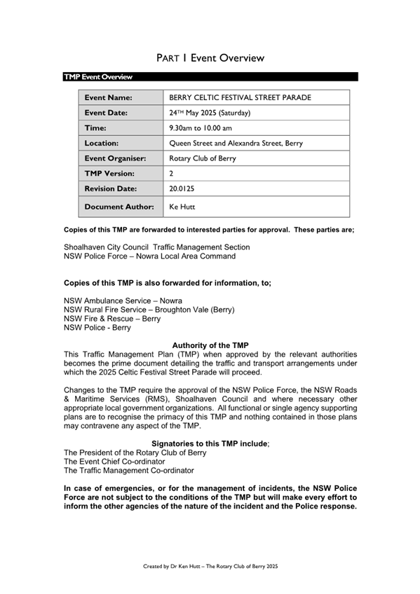
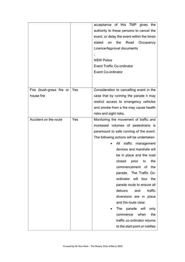
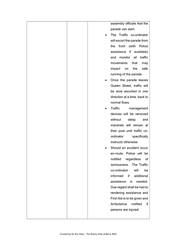
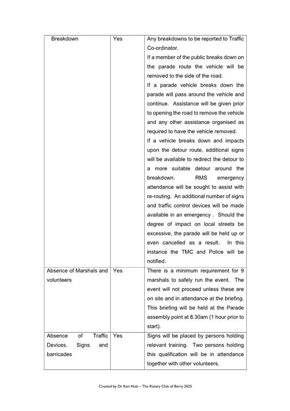
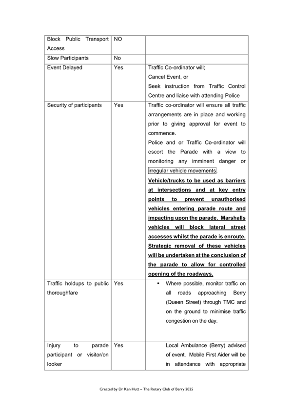
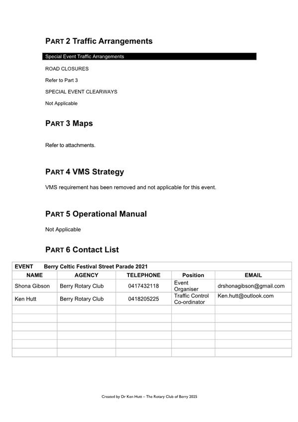
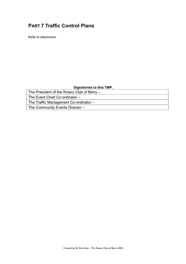
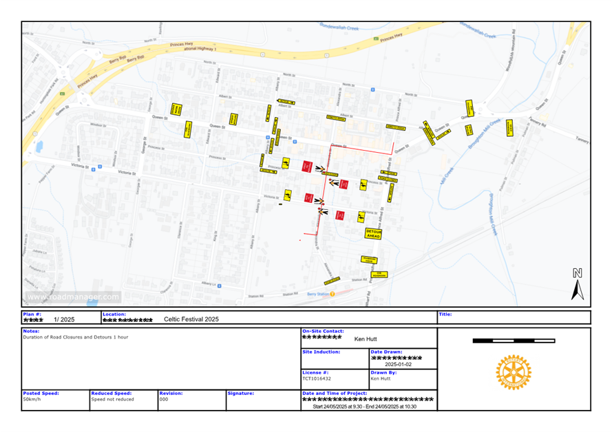
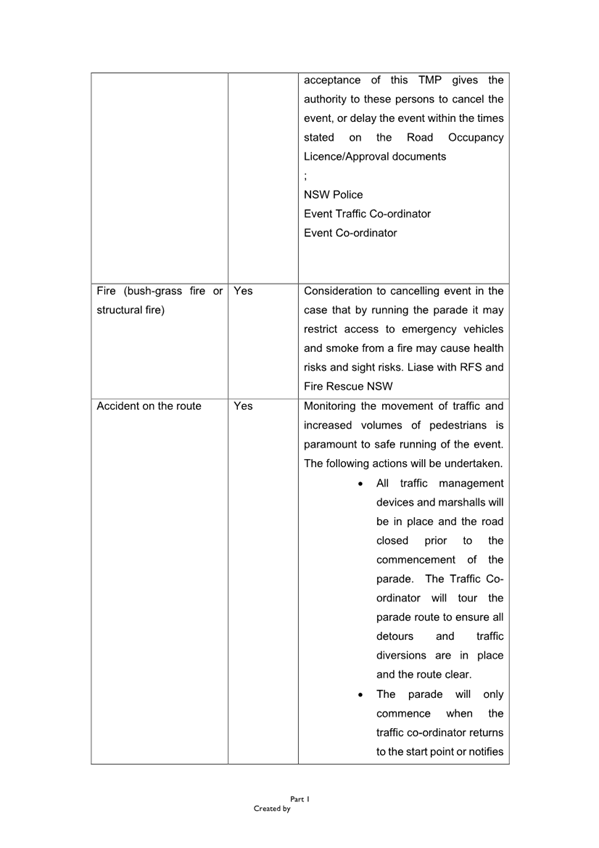
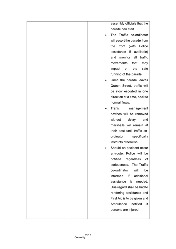
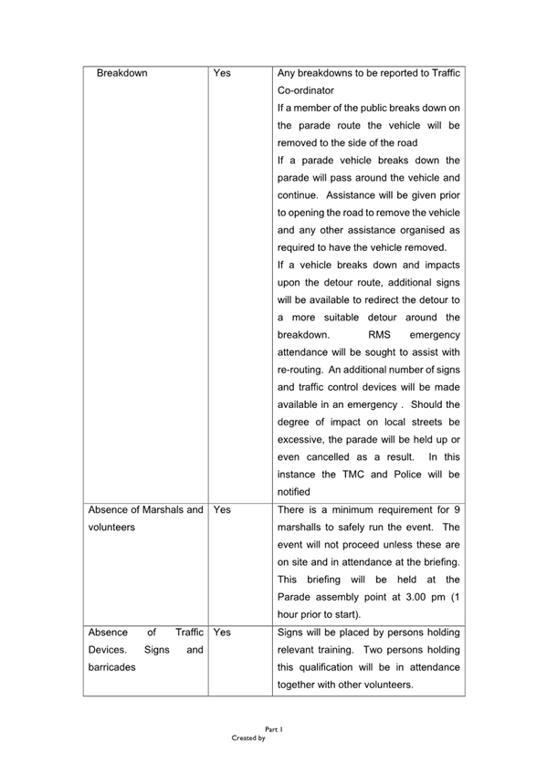
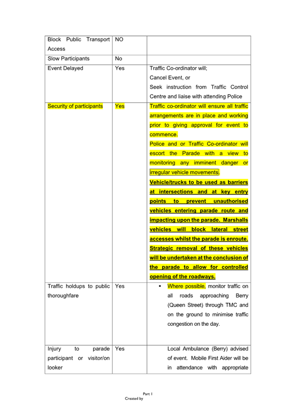
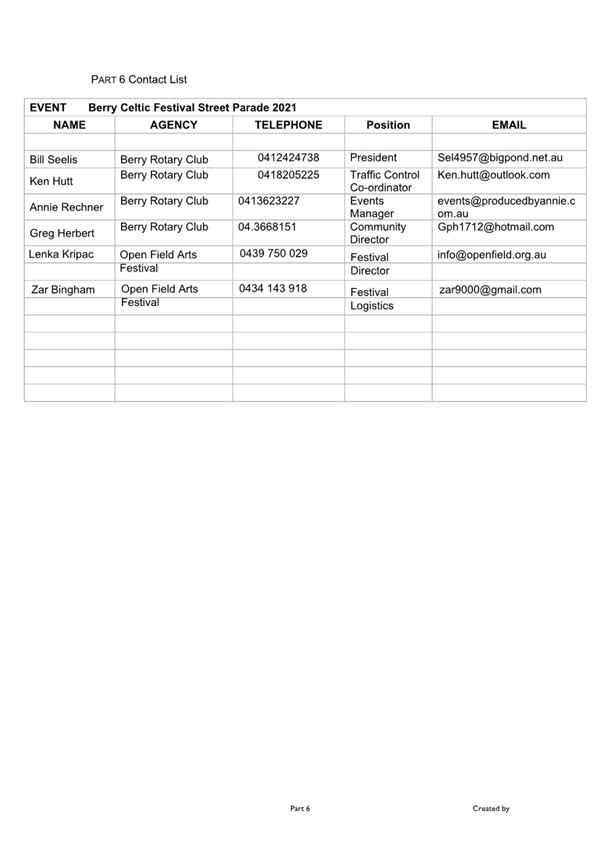
TC25.9 Berry
- Celtic Festival Street Parade (2025) (PN 3836)
HPERM Ref: D25/133287
Convenor: David
Pieresko
Attachments: 1. D25/133376
- Traffic Management Plan (TMP) ⇩
2. D25/133378 - Traffic Guidance
Scheme (TGS) ⇩
Reasons for Report:
The reason for this report is to seek Shoalhaven Traffic
Committee approval for the proposed
Berry Celtic Festival Street Parade (24 May 2025) at Berry
as per Traffic Management Plan (TMP) and Traffic Guidance Scheme (TGS) No. D25/133376
and D25/133378.
|
Recommendation
That
1. The Chief Executive Officer
(Director City Services) be advised that the Shoalhaven Traffic Committee has
no objection to the proposed Berry Celtic Festival Street Parade (24 May
2025) at Berry as per Traffic Management Plan (TMP) and Traffic Guidance Scheme
(TGS) No. D25/133376 and D25/133378.
2. The
recommendation be approved by the Director City Services under delegated
authority from Shoalhaven City Council - refer MIN21.411.
|
Background
The Berry Celtic Festival Street
Parade is proposed to take place on the 24 May 2025. The event is a street
parade held along Queen and Alexandra Streets, Berry. According to the Guide to
Traffic and Transport Management for Special Events, this event is classified
as a ‘Class 2’ event that will require altered traffic arrangements
throughout the duration of its activities with multiple local road traffic
restrictions and closures.
The parade is an annual event
that attracts between 500 to 1000 onlookers, predominantly from Berry. The
participants of the parade include representatives from the Celtic community
groups, pipe bands, local charities, and schools. As such, the proposed Management
Plan (TMP) and Traffic Guidance Schemes (TGS) are attached for the
committees’ consideration.
Details of Submission
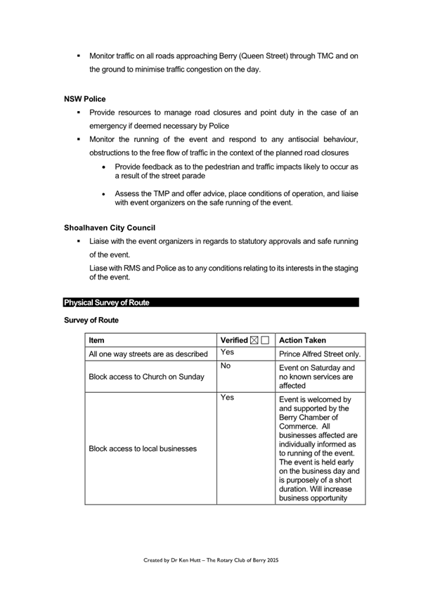
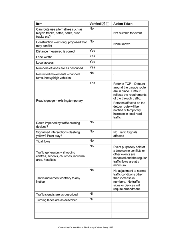
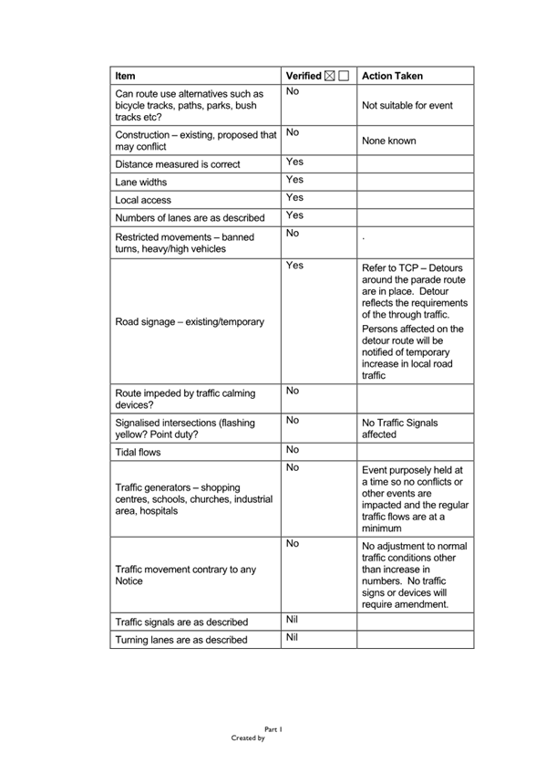
1. Road Closures
Southbound traffic in Queen
Street will be detoured at 9:30am into Albert Street and then
re-routed to Queen Street at Albany Street – refer TGS attached.
Northbound Traffic in Queen
Street will be detoured at 9:30am into Albany Street (both
ways).
Motorists enroute to Sydney will
continue into Albert Street and re-join Princes Highway from Albert
Street. Motorists heading towards Shoalhaven Heads/Gerroa will be
detoured right into Albany Street and detour signs directing them to Prince
Alfred Street.
Both Princess Street and
Victoria Street intersections with Alexandra Street will have soft road
closures and Authorised Traffic Controllers to allow any vehicles to pass
without risk to parade participants. There will be a detour of approximately
30-60 minutes to motorists, whilst the parade passes.
2. Event
Infrastructure
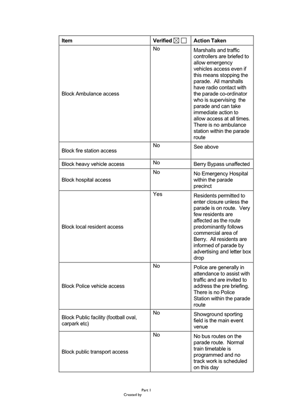
NSW Ambulance, Police and
Fire Brigade: The road closures allow for emergency vehicle access.
NSW Ambulance, Police and Fire Brigade will be informed of changed conditions
by Event organisers. A copy of the TMP will be provided for their information
and they are invited to contact the event organisers at any time
Medical: There are
paramedics onsite for the duration of the event, however NSW ambulance is aware
of the event. First Aid Station is at the Berry Showground.
Port-A-Loos: No
additional conveniences will be provided as the event is of half hour duration
and there are local toilet facilities in Apex Park, Alexandra Street, and Berry
Showground
Cleaning/Disposal: It is
not envisaged that the event will cause additional pressure on street garbage
bins.
Barricades: Traffic
Management to be installed by Accredited Traffic Controllers.
3.
Transportation, Awareness of Event and Access
Public Transport: The
impacts to public transport are expected to be minimal during the parade.
Parking: Parking of event
participants will be made available in the showground. Alternative parking is
available on local streets and in the public carparks close by.
Access/Awareness: Access
will only be restricted during the physical running of the event (estimated to
be 30-60 minutes). Provision of emergency access will be maintained at all
times, by placing marshals along detour routes who are in radio/telephone
contact with escort vehicles and Traffic Supervisory staff. All local
residents and businesses will be notified of the event and altered traffic
conditions by a letterbox drop directly to their place of residence or
business.
Risk Implications
1. Parking Limitations and Potential Congestion
The event is proposed to take place over the weekend in May,
when there is typically a high volume of day trippers and visitors to the
region. With the higher vehicle and pedestrian demand and combination of event
patrons, there is the potential for traffic flow issues, parking constraints
and delays throughout Berry.
2. Local Business and Resident Impact
Large events can impact local businesses and residents
negatively. Road closures and increased traffic may make it challenging for
customers to reach businesses, and residents may experience noise disturbances,
limited access to their properties, or inconvenience due to traffic
restrictions.
Financial Implications
This event is funded by the event organiser (Rotary Club of
Berry) and there will be no financial implications to Council.
|

|
Shoalhaven
Traffic Committee – Tuesday 08 April 2025
Page
0
|


|

|
Shoalhaven
Traffic Committee – Tuesday 08 April 2025
Page
0
|
|

|
Shoalhaven
Traffic Committee – Tuesday 08 April 2025
Page
0
|
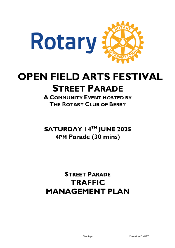
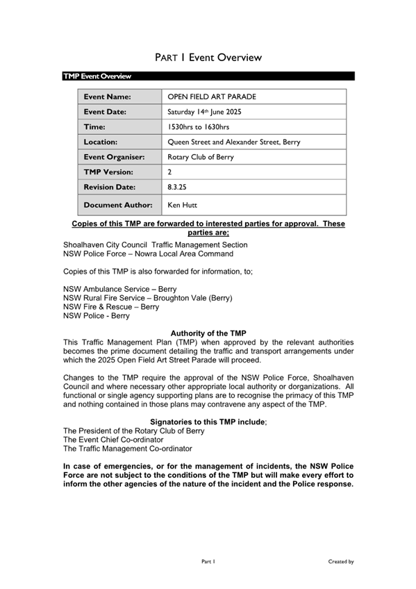
TC25.10 Berry
- Open Field Arts Festival (2025) (PN 3837)
HPERM Ref: D25/133686
Convenor: David
Pieresko
Attachments: 1. D25/105138
- Traffic Management Plan (TMP) ⇩
2. D25/105145 - Traffic Guidance
Scheme (TGS) ⇩
Reasons for Report:
The reason for this report is to seek Shoalhaven Traffic Committee
approval for the proposed
Berry Open Fields Arts Festival (14 June 2025) at Berry as
per Traffic Management Plan (TMP) and Traffic Guidance Scheme (TGS) No. D25/105138
and D25/105145.
|
Recommendation
That:
1. The Chief Executive Officer
(Director City Services) be advised that the Shoalhaven Traffic Committee has
no objection to the Berry Open Fields Arts Festival (14 June 2025) at Berry
as per Traffic Management Plan (TMP) and Traffic Guidance Scheme (TGS) No. D25/105138 and
D25/105145.
2. The
recommendation be approved by the Director City Services under delegated
authority from Shoalhaven City Council - refer MIN21.411.
|
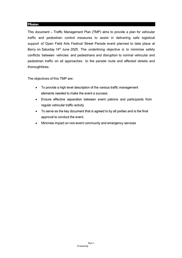
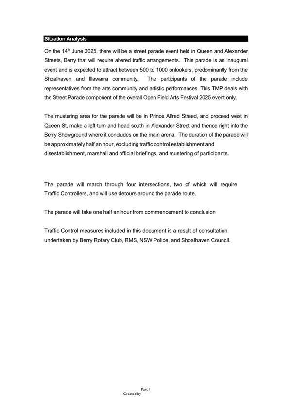
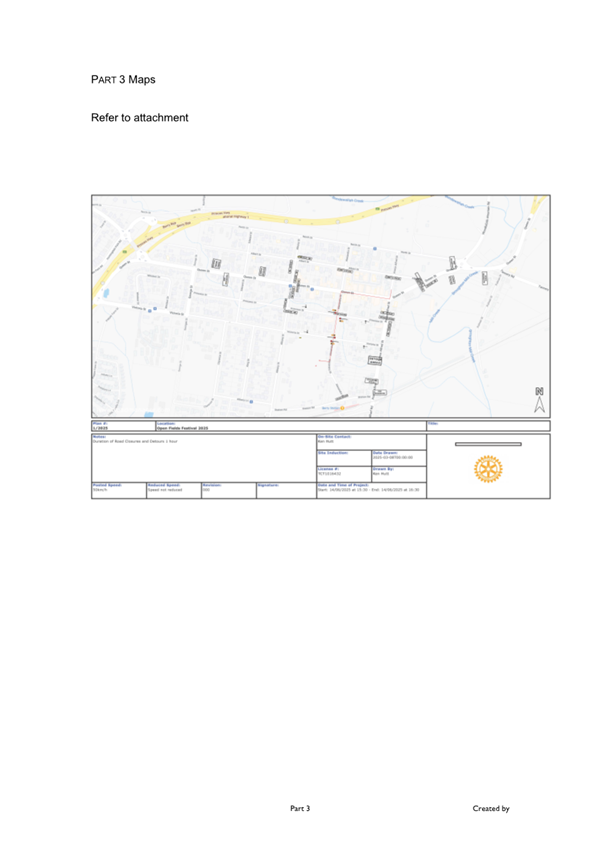
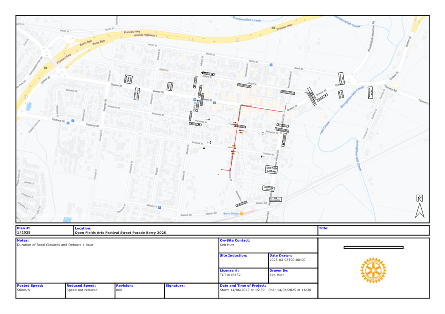
Background
The Berry Open Fields Art
Festival is proposed to take place on 14 June 2025. The event is a street
parade held along Queen and Alexandra Streets, Berry. According to the Guide to
Traffic and Transport Management for Special Events, this event is classified
as a ‘Class 2’ event that will require altered traffic arrangements
throughout the duration of its activities with multiple local road traffic
restrictions and closures.
This parade is an inaugural event
that is expected to attract between 500 to 1000 onlookers, predominantly from
the Shoalhaven and Illawarra community. The participants of the parade include
representatives from the arts community and artistic performances. As such, the
proposed Management Plan (TMP) and Traffic Guidance Schemes (TGS) are attached
for the committees’ consideration.
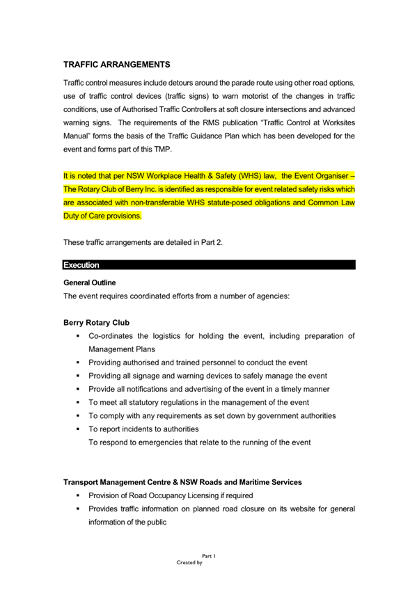
Details of Submission
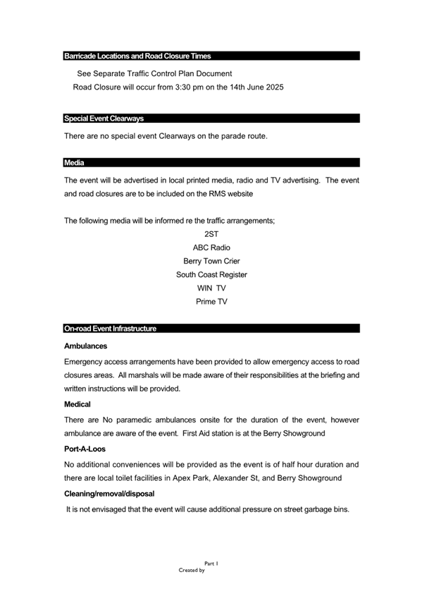
1. Road Closures
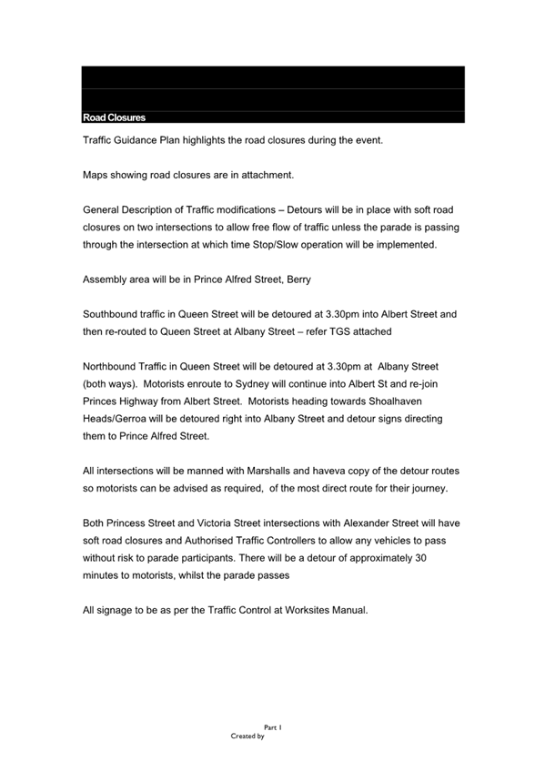
Southbound traffic in Queen
Street will be detoured at 3:30pm into Albert Street and then
re-routed to Queen Street at Albany Street – refer TGS attached
Northbound traffic in Queen
Street will be detoured at 3:30pm into Albany Street (both
ways).
Motorists enroute to Sydney will
continue into Albert Street and re-join Princes Highway from Albert
Street. Motorists heading towards Shoalhaven Heads/Gerroa will be
detoured right into Albany Street and detour signs directing them to Prince
Alfred Street.
Both Princess Street and
Victoria Street intersections with Alexander Street will have soft road
closures and Authorised Traffic Controllers to allow any vehicles to pass
without risk to parade participants. There will be a detour of approximately
30-60 minutes to motorists, whilst the parade passes.
2. Event
Infrastructure
NSW Ambulance, Police and
Fire Brigade: The road closures allow for emergency vehicle access.
NSW Ambulance, Police and Fire Brigade will be informed of changed conditions
by Event organisers. A copy of the TMP will be provided for their information
and they are invited to contact the event organisers at any time
Medical: There are no
paramedics onsite for the duration of the event, however NSW ambulance is aware
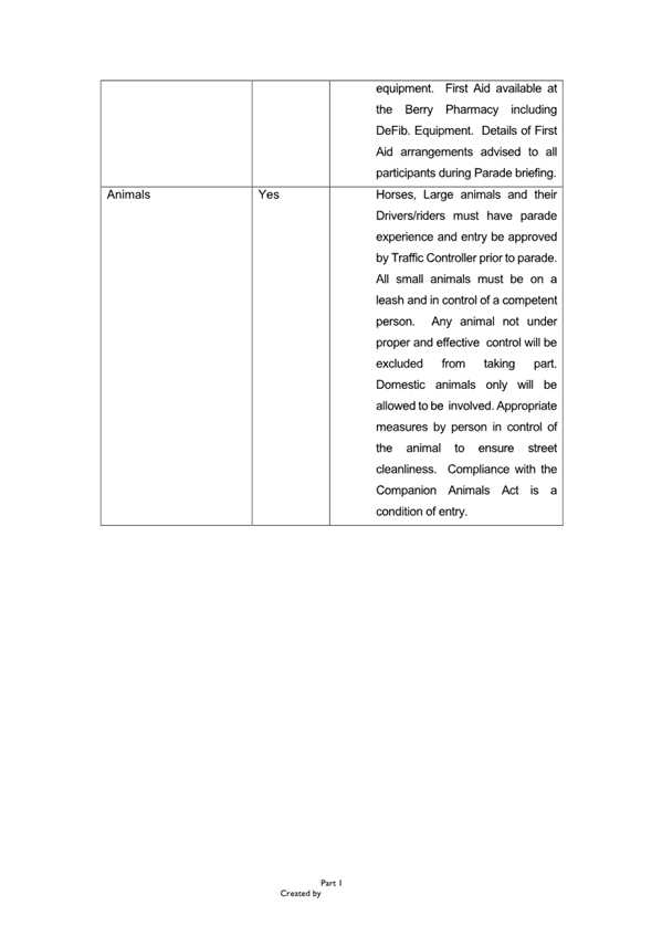
of the event. First Aid Station is at the Berry Showground.
Port-A-Loos: No
additional conveniences will be provided as the event is of half hour duration
and there are local toilet facilities in Apex Park, Alexandra Street, and Berry
Showground
Cleaning/Disposal: It is
not envisaged that the event will cause additional pressure on street garbage
bins.
Barricades: Traffic
Management to be installed by Accredited Traffic Controllers.
3.
Transportation, Awareness of Event and Access
Public Transport: The
impacts to public transport are expected to be minimal during the parade.
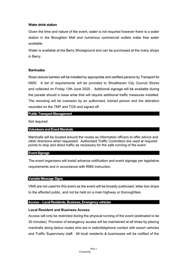
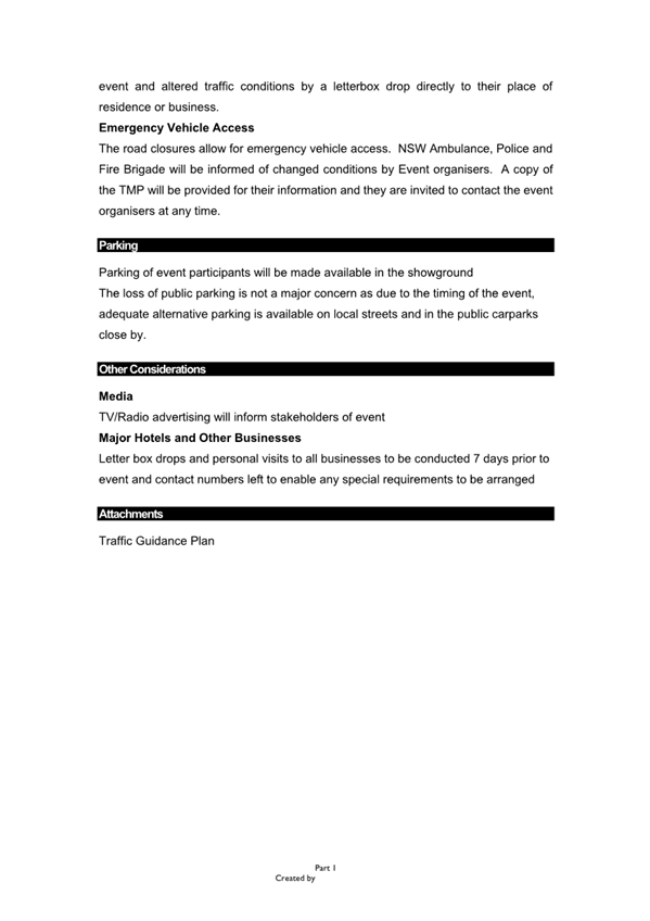
Parking: Parking of event
participants will be made available in the showground. The loss of public
parking is not a major concern as due to the timing of the event, adequate
alternative parking is available on local streets and in the public carparks
close by.
Access/Awareness: Access
will only be restricted during the physical running of the event (estimated to
be 30-60 minutes). Provision of emergency access will be maintained at all
times, by placing marshals along detour routes who are in radio/telephone
contact with escort vehicles and Traffic Supervisory staff. All local
residents and businesses will be notified of the event and altered traffic
conditions by a letterbox drop directly to their place of residence or
business.
Risk Implications
1. Parking Limitations and Potential Congestion
The event is proposed to take place over the weekend in June,
when there is typically a high volume of day trippers and visitors to the
region. With the higher vehicle and pedestrian demand and combination of event
patrons, there is the potential for traffic flow issues, parking constraints
and delays throughout Berry.
2. Local Business and Resident Impact
Large events can impact local businesses and residents
negatively. Road closures and increased traffic may make it challenging for
customers to reach businesses, and residents may experience noise disturbances,
limited access to their properties, or inconvenience due to traffic
restrictions.
Financial Implications
This event is funded by the event organiser (Rotary Club of
Berry) and there will be no financial implications to Council.
|

|
Shoalhaven
Traffic Committee – Tuesday 08 April 2025
Page
0
|


|

|
Shoalhaven
Traffic Committee – Tuesday 08 April 2025
Page
0
|
|

|
Shoalhaven
Traffic Committee – Tuesday 08 April 2025
Page
0
|
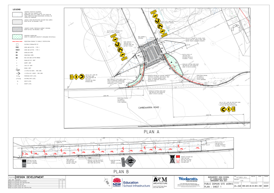
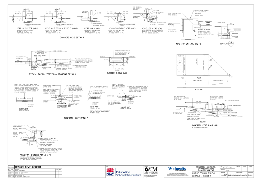
TC25.11 Pedestrian
Crossing & Bus Zone Timing - Lot 7 DP 3061 - 107 Cambewarra Road -
Bomaderry - RW24/1428 (PN 3842)
HPERM Ref: D25/140361
Convenor: David
Pieresko
Attachments: 1. D25/140373
- Signage and Linemarking Plan ⇩
Reason for
Report:
The reason for this report is to seek Shoalhaven Traffic
Committee approval for the proposed pedestrian crossing, bus zone signage
changes and linemarking associated with the development application (RW24/1428)
at 107 Cambewarra Road, Bomaderry as per Plan No. D25/140373.
|
Recommendation
That:
1. The Chief Executive Officer
(Director City Services) be advised that the Shoalhaven Traffic Committee has
no objection to the proposed pedestrian crossing, bus zone signage changes
and linemarking associated with the development application (RW24/1428) at
107 Cambewarra Road, Bomaderry as per Plan No. D25/140373.
2. The recommendation be approved by the Director City Services under delegated authority
from Shoalhaven City Council - refer MIN21.411
|
Background
APPLICANT: Patterson
Building Group Pty Ltd / Woolacotts Consulting Engineers
OWNER: NSW
Department of Education | School Infrastructure
107 Cambewarra
Road, Bomaderry - Lot 7 DP 3061 – Pedestrian Crossing & Changes to
Bus Zone Timing
As part of RW24/1428, various improvements surrounding and
connected to the Bomaderry High School at 107 Cambewarra Road, Bomaderry have
been proposed within the road reserve. This proposal aims to provides a safe
crossing location for students and parents/carers and create coherent bus zone
timings.
Details of Submission
This proposal involves the
installation of pedestrian signage and other changes to bus zone timing, as per
the below:
- A
‘Raised Pedestrian Crossing’ is proposed in proximity to Bomaderry
High School’s entrance on Cambewarra Road, with associated signage,
linemarking, footpath works and landscaping. Please note that whilst the
subject area is currently within private property, the applicant has advised
that this section will be dedicated to Council’s road reserve upon
completion.
- ‘Bus
Zone’ signage – The frontage of Bomaderry High School along
Cambewarra Road will be modified to be consistent with other signage along this
section (“Bus Zone - 8:30am – 4:00pm // School Days)
- The
existing footpath east of the school entry along Cambewarra Road will be
demolished and reconstructed as a single, uniform hardstand area for bus
pickups / drop offs.
Consultation
This Development Application (RW24/1428) was on public
exhibition regarding the public lighting required for the pedestrian crossing,
between 11 January 2025 and 24 January 2025. No submissions were received.
The applicant had previously
advised Transport Working Groups of the proposal, including representatives
from Shoalhaven City Council, local bus services and Transport for NSW, dating
back to 13 December 2023 and 24 January 2024. The applicant advises that they
did not receive any in-principal objections to their proposal at these
meetings.
Risk Implications
The works are proposed to facilitate improvements in
pedestrian access, providing a safe, raised crossing point at the Bomaderry
High School entrance.
Financial Implications
The implementation of this proposal will be funded by the
NSW Department of Education and there will be no financial implications to
Council. However, Council will be responsible for the ongoing maintenance of
these assets once they are dedicated to Council.
|

|
Shoalhaven
Traffic Committee – Tuesday 08 April 2025
Page
0
|
|

|
Shoalhaven Traffic
Committee – Tuesday 08 April 2025
Page
0
|
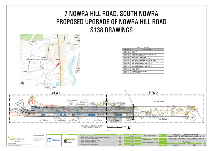
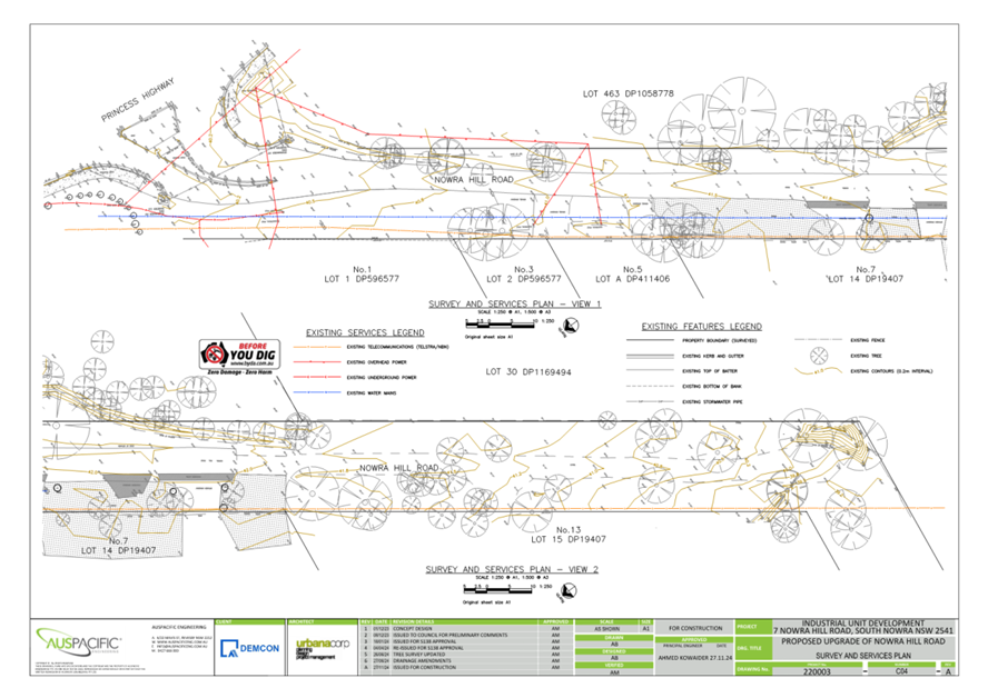
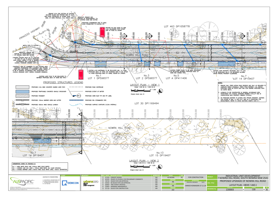
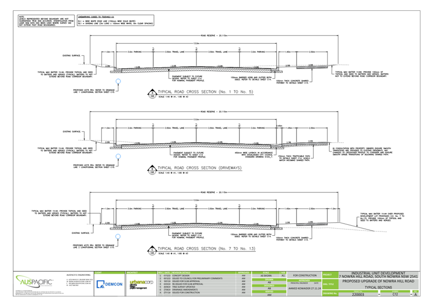
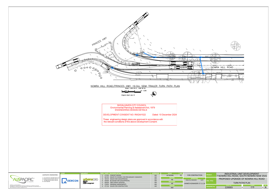
TC25.12 Shared
Path, Signage/Linemarking - Lot 1 DP 1304537 - 1-7 Nowra Hill Road - South
Nowra - RW24/1522 (PN 3838)
HPERM Ref: D25/135102
Convenor: David
Pieresko
Attachments: 1. Signage
/ Linemarking & Engineering Plans ⇩
Reason for Report:
The reason for this report is to seek Shoalhaven Traffic
Committee approval for the proposed shared path, signage and linemarking
associated with the development application (RW24/1522) at 1-7 Nowra Hill Road,
South Nowra as per Plan No. D25/135112.
|
Recommendation
That:
1. The Chief Executive Officer
(Director City Services) be advised that the Shoalhaven Traffic Committee has
no objection to the proposed shared path, signage and linemarking associated
with the development application (RW24/1522) at 1-7 Nowra Hill Road, South
Nowra as per Plan No. D25/135112.
2. The
recommendation be approved by the Director
City Services under delegated authority from Shoalhaven City Council - refer
MIN21.411
|
Background:
APPLICANT: UrbanaCorp
Pty Ltd
OWNER: Demcon
Pty Ltd
1-7 Nowra Hill
Road, South Nowra - Lot 1 DP 1304537– Road Works (Kerb and Gutter, Shared
Path, Driveways, Signage and Linemarking)
As part of RW24/1522, Traffic
Committee’s approval is being sought for the proposed road works (kerb
and gutter, shared path, driveways, signage and linemarking) along the length
of 1-7 Nowra Hill Road, South Nowra.
As per
the Section 138 approval for the development, the following is required:
1. Section 138
Approval
Approval was granted under
the s138, with the requirement that the design must comply with the Council's
Design and Construction Guidelines, as well as any relevant Australian
Standards.
Details of Submission:
This proposal
involves the relocation of regulatory ‘No Stopping’ signage and
other road related works, as per the below:
- Proposed
‘No Stopping’ signage at the entrance to Nowra Hill Road
- Kerb
and Gutter along 1-7 Nowra Hill Road
- Shared
Path along 1-7 Nowra Hill Road
- x6
Vehicle Crossings (Driveways)
- Edge Line
(EL1), Single Broken Dividing Line (DL1) and renew of existing Double Two-Way
Barrier Line (BL2) linemarking along 1-7 Nowra Hill Road
Consultation:
This Development Application
(DA22/1143) was on public exhibition between 5 March 2025 and 28 March 2025.
One submission was received. The response was regarding the location of signage
as per a future development at the entrance of Nowra Hill Road. However, it is
noted that it will be more appropriate to undertake changes to the signage and
linemarking when that future development goes ahead.
Council approved of the
engineering design associated with this application on 11 November 2024.
Concurrence to the proposal by Transport for NSW (TfNSW) was provided on 16
December 2024.
Risk Implications:
The proposal aims to improve
road conditions, delineate road/lane widths, manage stormwater with kerb and
gutter, and improve pedestrian access through the implementation of a shared
path.
Furthermore, the works are
stipulated in a valid development consent. Undue prevention of, delay to, or
alteration to the completion of requirements of the consent may expose Council
to legal action.
Financial Implications:
The implementation of this
proposal will be funded by the private developer and there will be no financial
implications to Council. However, Council will be responsible for the ongoing
maintenance of these assets.
|

|
Shoalhaven
Traffic Committee – Tuesday 08 April 2025
Page
0
|
|
|
Shoalhaven
Traffic Committee – Tuesday 08 April 2025
Page
0
|
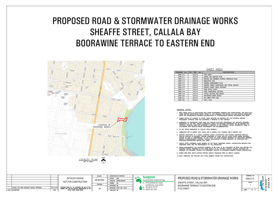
TC25.13 Footpath,
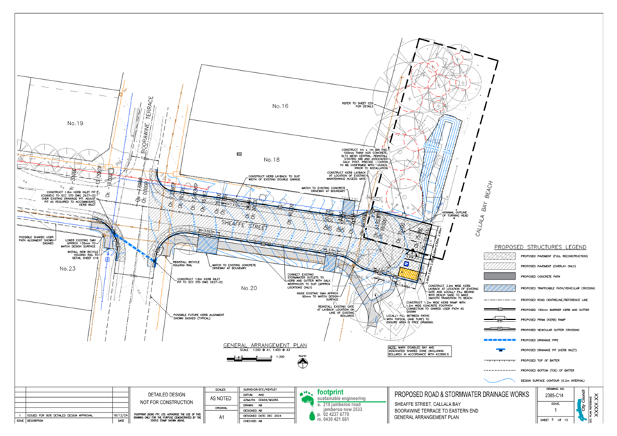
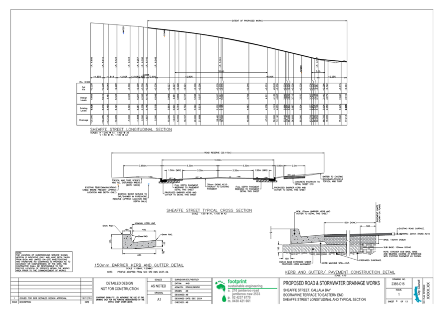
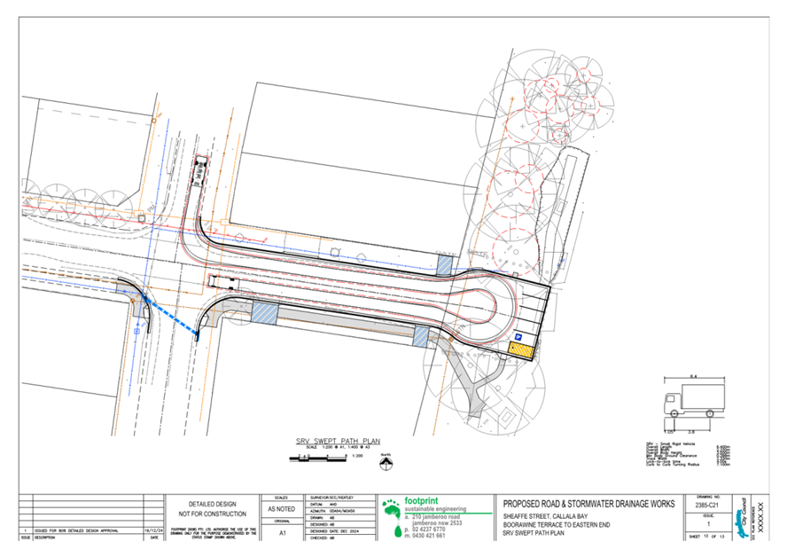
Signage/Linemarking - Sheaffe Street - Callala Bay (PN 3840)
HPERM Ref: D25/138576
Convenor: David
Pieresko
Attachments: 1. D25/138587
- Signage / Linemarking & Engineering Plans ⇩
Reason for Report:
The reason for this report is to seek Shoalhaven Traffic
Committee approval for the proposed car parking signage & linemarking at
Sheaffe Street, Callala Bay as per Plan No. D25/138587.
|
Recommendation
That:
1. The Chief Executive Officer
(Director City Services) be advised that the Shoalhaven Traffic Committee has
no objection to the proposed car parking signage & linemarking at Sheaffe
Street, Callala Bay as per Plan No. D25/138587.
2. The recommendation be approved by the Director City Services under delegated authority
from Shoalhaven City Council - refer MIN21.411
|
Background
As part of the Transport for NSW’s Active
Transportation Shoalhaven Footpaths Grant received by Shoalhaven City Council,
Council has progressed the detailed design for the proposed footpath, drainage
upgrades, and formalisation of the car parking area at Sheaffe St, Callala Bay.
Approval from the Traffic Committee is now being sought for the improvements to
car parking signage and linemarking.
Details of Submission:
Proposed change to road conditions:
- Signage
and linemarking to formalise five standard vehicle parking spaces and one
disabled parking space within the cul-de-sac area.
Consultation:
Consultation was undertaken with and the Callala Bay
Community Association and closed on 31 March 2025. One
submission was received in relation to the signage/linemarking.
This submission was in favour of the proposal. The other responses received
related to the proposed footpath and stormwater upgrades.
Risk Implications
The overall proposal aims to improve road and parking
conditions, manage stormwater, and improve pedestrian access through the
implementation of a footpath along Sheaffe Street.
Financial Implications
This project is partially funded
by Transport for NSW’s Active Transportation Shoalhaven Footpaths Grant
with additional co-contributions from Council. Council will be responsible for
the ongoing maintenance of these assets.
|

|
Shoalhaven
Traffic Committee – Tuesday 08 April 2025
Page
0
|
|

|
Shoalhaven
Traffic Committee – Tuesday 08 April 2025
Page
0
|
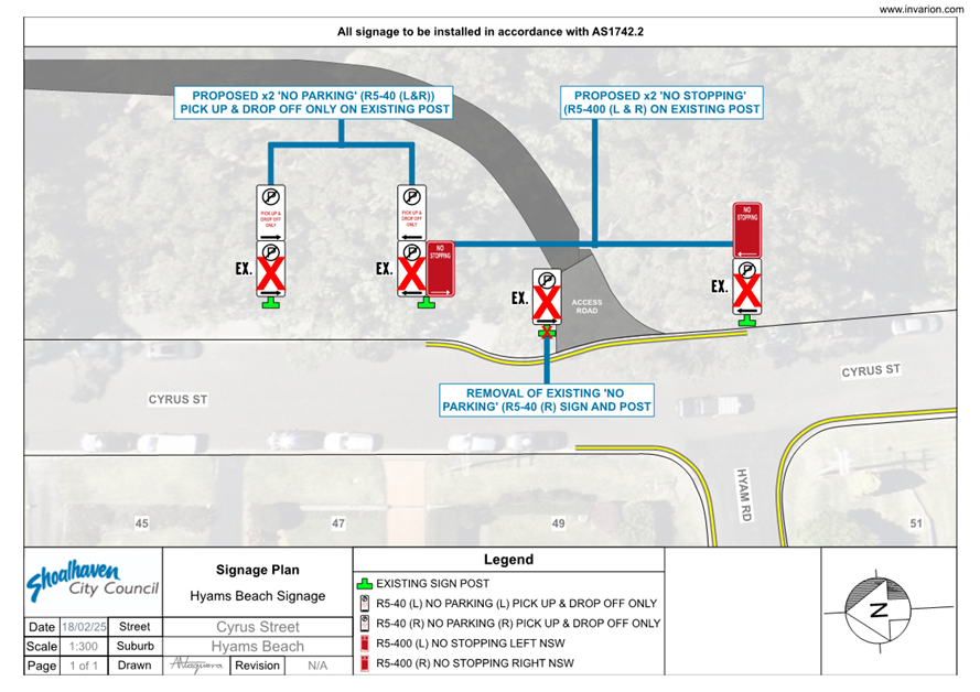
TC25.14 Signage
& Parking Restrictions - Cyrus Street - Hyams Beach (PN 3841)
HPERM Ref: D25/140072
Convenor: David
Pieresko
Attachments: 1. D25/140077
- Signage Plan ⇩
Reason for Report:
The reason for this report is to seek Shoalhaven Traffic
Committee approval for the proposed signage and parking restrictions along
Cyrus Street, Hyams Beach as per Plan No. D25/140077.
|
Recommendation
That:
1. The Chief Executive Officer
(Director City Services) be advised that the Shoalhaven Traffic Committee has
no objection to the proposed signage and parking restrictions along Cyrus
Street, Hyams Beach as per Plan No. D25/140077.
2. The recommendation be approved by the Director City Services under delegated authority
from Shoalhaven City Council - refer MIN21.411
|
Background
Shoalhaven City Council has recently completed an
investigation of the existing parking signage along Cyrus Street, Hyams Beach.
This investigation has concluded that some improvements are warranted to
improve the clarity of the existing ‘No Parking’ drop-off and
‘No Stopping’ signage along Cyrus Street for all road users.
Details of Submission
Proposed change to parking conditions:
· ‘No
Parking’ signage: Add “Pick up & Drop Off Only” text to
existing ‘No Parking’ signage to reinforce the drop-off zone
functionality along Cyrus Street, opposite 47 Cyrus Street.
· ‘No
Stopping’ signage: Reinforce existing yellow ‘No Stopping’
linemarking that is currently installed along Cyrus Street, opposite Hyam Road.
Consultation
Consultation was undertaken with and the Hyams Beach
Villagers Association and closed on 28 March 2025. Three submissions were received. Two were in favour of the proposal,
and one ‘objected’ the proposal. The ‘objection’
response argued the existing signs are adequate. However, Council has assessed
the existing signage as inaccurate and inconsistent with existing yellow (NS1)
‘No Stopping’ linemarking.
Risk Implications
The proposal aims to improve parking conditions, improving
traffic flow and clearly delineate parking requirements through the
implementation of these signage adjustments.
Financial Implications
The linemarking and signage for this proposal would be
funded by Transport for NSW’s Block Grant Funding allocated to Council
for new signage and linemarking.
|

|
Shoalhaven
Traffic Committee – Tuesday 08 April 2025
Page
0
|
|

|
Shoalhaven
Traffic Committee – Tuesday 08 April 2025
Page
0
|
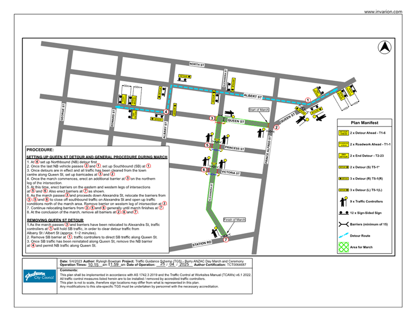
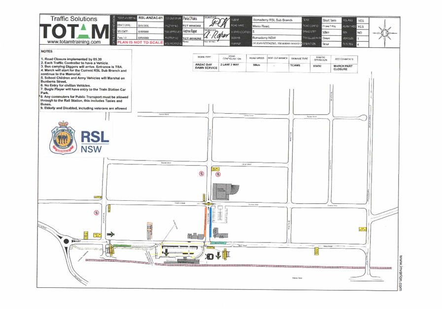
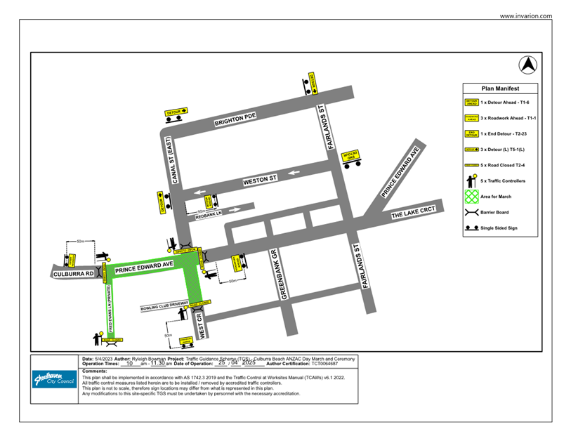
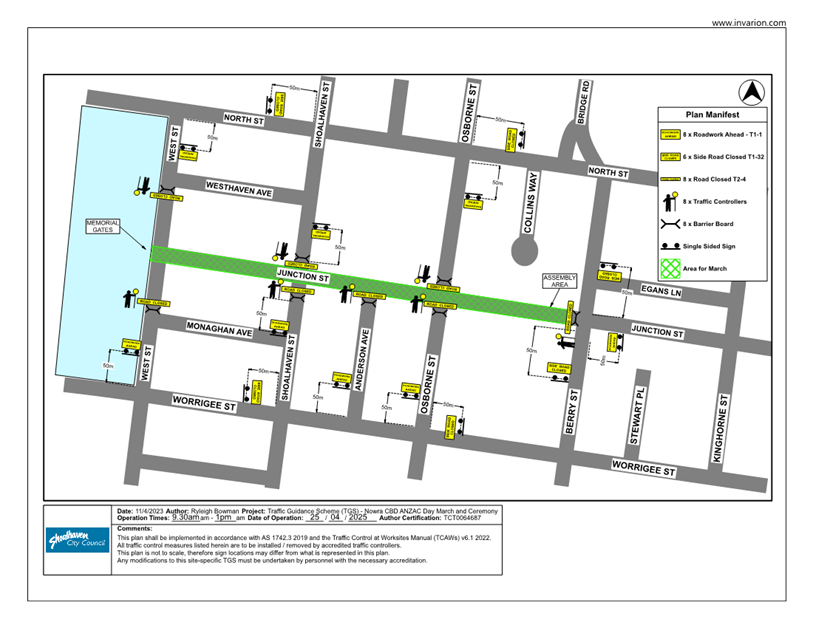
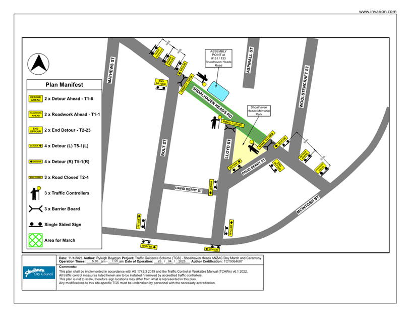
TC25.15 LGA
Wide - Road Closures for ANZAC Day Services and Marches (PN 3839)
HPERM Ref: D25/135845
Convenor: David
Pieresko
Attachments: 1. Traffic
Guidance Scheme (TGS) - Berry ⇩
2. Traffic
Guidance Scheme (TGS) - Bomaderry ⇩
3. Traffic
Guidance Scheme (TGS) - Culburra Beach ⇩
4. Traffic
Guidance Scheme (TGS) - Greenwell Point ⇩
5. Traffic
Guidance Scheme (TGS) - Kangaroo Valley ⇩
6. Traffic
Guidance Scheme (TGS) - Huskisson ⇩
7. Traffic
Guidance Scheme (TGS) - Milton ⇩
8. Traffic
Guidance Scheme (TGS) - Nowra ⇩
9. Traffic
Guidance Scheme (TGS) - Shoalhaven Heads ⇩
10. Traffic Guidance
Scheme (TGS) - Sussex Inlet ⇩
Reasons for Report:
The reason for this report is to seek Shoalhaven Traffic
Committee approval for the proposed
temporary road closures associated with LGA wide Anzac Day
Services and Marches for April 2025 as per the attached Traffic Guidance
Schemes (TGS).
|
Recommendation
That
1. The Chief Executive Officer
(Director City Services) be advised that the Shoalhaven Traffic Committee has
no objection to the proposed temporary road closures associated with LGA wide
Anzac Day Services and Marches for April 2025 as per the attached Traffic
Guidance Schemes (TGS).
2. The recommendation be approved by
the Director City Services under delegated authority from Shoalhaven City
Council - refer MIN21.411.
|
Background
The LGA wide Anzac Day services
and marches are proposed to take place on Anzac Day (25 April 2025). The events
are held along Shoalhaven City Council local roads LGA wide. According to the
Guide to Traffic and Transport Management for Special Events, this event is
classified as a ‘Class 2’ event that will require altered traffic
arrangements throughout the duration of its activities with multiple local road
traffic restrictions and closures.
The services and marches are expected
to attract residents predominantly from the Shoalhaven and Illawarra community.
The proposed Management Plan (TMP) and Traffic Guidance Schemes (TGS) are
attached for the committees’ consideration.
Details of Submission
1. Road
Closures
Berry:
Alexandra Street and Queen
Street detoured at 10:00am until 12:00pm into Albert
Street and then re-routed to Queen Street– refer to attached TGS
(Berry).
Bomaderry:
Meroo Street at 5:30am
into Tarawana Street and then re-routed to Coomea Street –
refer to attached TGS (Bomaderry).
Culburra Beach:
Culburra Road closed from
10:00am until 11:30am – refer to attached TGS (Culburra
Beach).
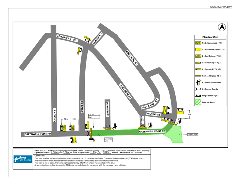
Greenwell Point:
Greenwell Point Road
detoured at 4:30am until 6:30am into Jervis Street and
then re-routed to Comarong Street – refer to attached TGS (Greenwell
Point).
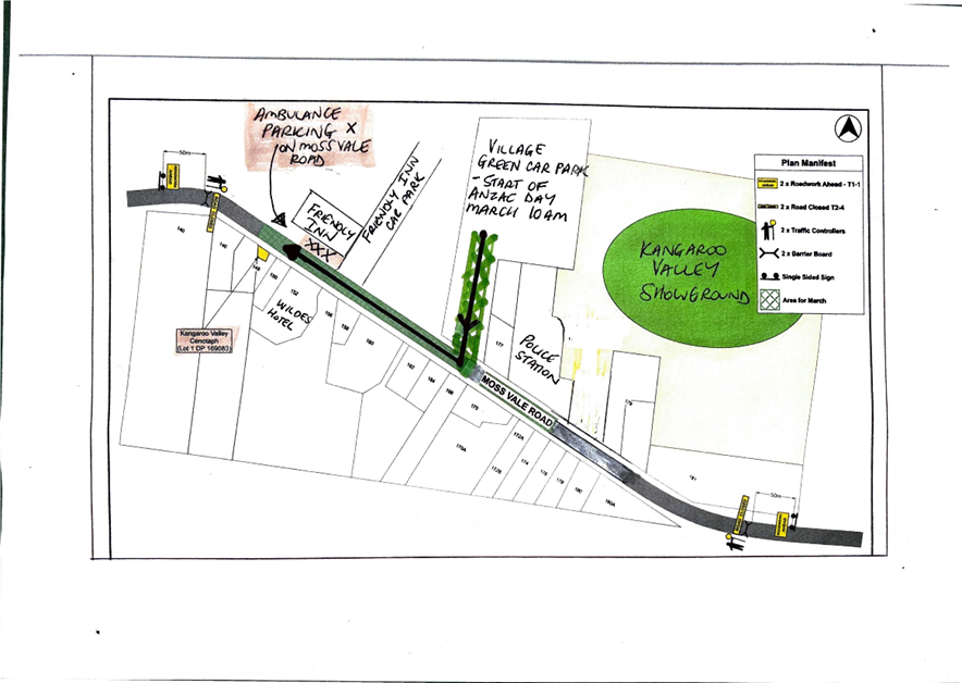
Kangaroo Valley:
Moss Vale Road closed
from 9:00am until 12:00pm – refer to attached TGS (Kangaroo
Valley).
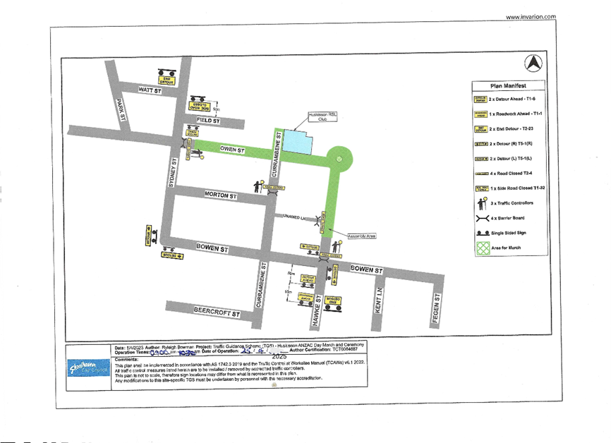
Huskisson:
Owen Street detoured at 9:00am
until 10:30am into Sydney Street and then re-routed to Bowen
Street – refer to attached TGS (Huskisson).
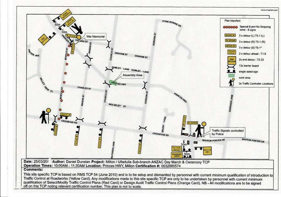
Milton:
Princes Highway detoured
at 10:00am until 11:30am into Myrtle Street and then
re-routed to Croobyar Road – refer to attached TGS (Milton).
Nowra:
Junction Street detoured
at 9:30am until 1:00pm into North Street and then
re-routed to Berry Street – refer to attached TGS (Nowra).
Shoalhaven Heads:
Shoalhaven Heads Road
detoured at 5:30am until 7:00am into Bolt Street and then
re-routed to Mcintosh Street – refer to attached TGS (Shoalhaven Heads).
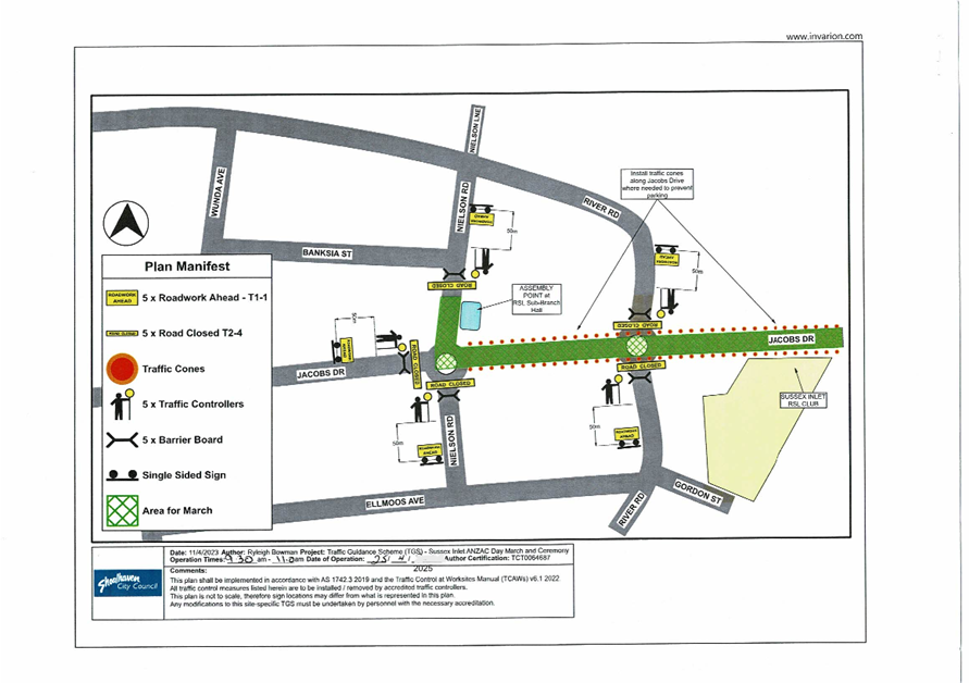
Sussex Inlet:
Jacobs Drive detoured at 9:30am
until 11:00am into Wunda Avenue and then re-routed to River
Road – refer to attached TGS (Sussex Inlet).
2. Event
Infrastructure
NSW Ambulance, Police and
Fire Brigade: The road closures allow for emergency vehicle access.
NSW Ambulance, Police and Fire Brigade will be informed of changed conditions
by Event organisers. A copy of the TMP will be provided for their information
and they are invited to contact the event organisers at any time.
Port-A-Loos: No
additional conveniences will be provided.
Cleaning/Disposal: It is
not envisaged that the event will cause additional pressure on street garbage
bins.
Barricades: Traffic
Management to be installed by Accredited Traffic Controllers.
3. Transportation,
Awareness of Event and Access
Public Transport: Some
potential impacts to public transport are expected due to temporary road
closures. Public transport providers will be notified of these closures as per
prior years.
Parking: Adequate parking
is available on local streets and in nearby the public carparks.
Access/Awareness: Access
will only be restricted during the physical running of the events (estimated to
be 1-3 hours). Provision of emergency access will be always maintained.
Risk Implications
1. Parking Limitations
and Potential Congestion
The events are proposed to take
place over the long weekend in April, when there is typically a high volume of
day trippers and visitors to the region. With the higher vehicle and pedestrian
demand and combination of event patrons, there is the potential for traffic
flow issues, parking constraints and delays throughout the LGA.
2. Local
Business and Resident Impact
Large events can impact local
businesses and residents negatively. Road closures and increased traffic may
make it challenging for customers to reach businesses, and residents may
experience noise disturbances, limited access to their properties, or
inconvenience due to traffic restrictions.
Financial Implications:
The temporary traffic control measures will be implemented
by each respective event organiser.
|

|
Shoalhaven
Traffic Committee – Tuesday 08 April 2025
Page
0
|
|

|
Shoalhaven
Traffic Committee – Tuesday 08 April 2025
Page
0
|
|
|
Shoalhaven
Traffic Committee – Tuesday 08 April 2025
Page
0
|
|
|
Shoalhaven
Traffic Committee – Tuesday 08 April 2025
Page
0
|
|
|
Shoalhaven
Traffic Committee – Tuesday 08 April 2025
Page
0
|
|

|
Shoalhaven
Traffic Committee – Tuesday 08 April 2025
Page
0
|
|
|
Shoalhaven
Traffic Committee – Tuesday 08 April 2025
Page
0
|
|
|
Shoalhaven
Traffic Committee – Tuesday 08 April 2025
Page
0
|
|
|
Shoalhaven
Traffic Committee – Tuesday 08 April 2025
Page
0
|
|

|
Shoalhaven
Traffic Committee – Tuesday 08 April 2025
Page
0
|