Shoalhaven Traffic Committee
Meeting Date: Tuesday,
14 November, 2023
Location: Jervis
Bay Rooms, City Administrative Centre, Bridge Road, Nowra
Time: 9.30am
Please note: Council’s Code of Meeting Practice
permits the electronic recording and broadcast of the proceedings of meetings
of the Council which are open to the public. Your attendance at this meeting is
taken as consent to the possibility that your image and/or voice may be
recorded and broadcast to the public.
Agenda
1. Apologies
2. Confirmation of Minutes
· Shoalhaven
Traffic Committee - 10 October 2023...................................................... 1
· Special
Shoalhaven Traffic Committee - 18 October 2023......................................... 4
3. Business Arising from Previous Minutes
4. Reports of the Convenor
TC23.49...... Signage, Linemarking and LATM Plan - Lot 60
DP1281408 - Old Southern Road - South Nowra - PN (3781)............................................................................... 6
TC23.50...... Signage, Linemarking, LATM Plan and New
Roundabout - 41 Main Road - Cambewarra - Lot 4 DP 542936 PN (3783)................................................. 11
TC23.51...... Huskisson - Husky Ultra Festival 2024 - (PN 3785).................................... 19
TC23.52...... Signage, Linemarking and AUL/CHR Plan for
Driveway Intersection- Bolong Road - Bolong - PN (3786)....................................................................................... 22
TC23.53...... Signage, Linemarking and Wildlife Warning Signs
Plan for Lots 6 and 7 DP1236686 Worrigee Road - Worrigee - PN (3787)....................................................... 31
TC23.54...... Timed Parking Restrictions - Balmoral Road -
Burrill Lake (PN 3788)........ 34
TC23.55...... Signage, Linemarking and Raised Kerb Blisters -
DA22/1716 - Wason Street - Ulladulla (PN 3789)...................................................................................... 37
5. General Business
Note: The next meeting will be
held on Tuesday 12 December 2023.
|

|
Shoalhaven
Traffic Committee – Tuesday 14 November 2023
Page
i
|
Membership
Mr David Pieresko – Convenor
Clr Patricia White
Clr Matthew Norris
Ms Nicole Brodie - TfNSW
Sgt Kelly Thomas – NSW Police
Sgt Simon Pugh – NSW Police
Ms Liza Butler MP (or representative)
Mr Stuart Coughlan
The Shoalhaven Traffic Committee is a technical review
committee, not a committee of Council under the Local Government Act 1993. Transport
for NSW (TfNSW) has delegated certain powers to Council under the Transport
Administration Act 1988 (Section 50). A condition of this delegation is
that Council must take into account the Traffic Committee recommendations.
There are four formal members of the Traffic Committee, each
of whom has a single vote only. The members are representatives from:
- NSW Police Force
- TfNSW
- Shoalhaven City Council
- Local State Member of Parliament (for the location of the
issue to be voted upon)
If TfNSW or NSW Police Force disagrees with any Traffic
Committee recommendation, or Council’s resolution (on any Traffic
Committee recommendation), they may lodge an appeal with the Regional Traffic
Committee for determination. The appeal must be lodged in writing within
14 days of the date of notification in writing. Any action relative to
any issue under appeal must cease until the matter is determined. The
Regional Traffic Committee is chaired by an independent chairperson and
submissions and representations are welcomed from all interested parties.
Council cannot amend a Traffic Committee recommendation. The
Council can only: adopt the Traffic Committee recommendation; not adopt the
Traffic Committee recommendation, or request the Traffic Committee reconsider
the issue.
The full guide to the delegation to Council’s for
the regulation of traffic can be viewed at TfNSW
Website
Minutes of the Shoalhaven Traffic Committee
Meeting Date: Tuesday,
10 October 2023
Location: Email
Meeting
The following members
participated:
Convenor David Pieresko -
Senior Civil Engineer
Mr Stuart Coughlan
Sgt Simon Pugh
Ms Liza Butler - MP
Ms Nicole Brodie –
Transport NSW
Others:
Clr Patricia White
|
Apologies / Leave of Absence
|
Nil
|
Confirmation of the
Minutes
|
|
RESOLVED (By consent)
That the Minutes of the
Shoalhaven Traffic Committee held on Tuesday 12 September 2023 be confirmed.
CARRIED
|
|
Business Arising from
Previous Minutes
|
Nil
Reports of the Convenor
|
TC23.46 Conversion of Pedestrian
Crossing into Children Crossing - Victoria Street - Berry - (PN 3777)
|
HPERM Ref: D23/392488
|
|
Recommendation (Item to be determined under
delegated authority)
That
1. The
Chief Executive Officer (Director City Services) be advised that the
Shoalhaven Traffic Committee has no objection to the proposed conversion of
the permanent Pedestrian Crossing facility in Victoria St, Berry to a
Children Crossing facility, as per Plan D23/392518.
2. The
recommendation be approved by the Director City Services under delegated
authority from Shoalhaven City Council - refer MIN21.411
|
|
REcommendation (By consent)
That
1. The
Chief Executive Officer (Director City Services) be advised that the
Shoalhaven Traffic Committee has no objection to the proposed conversion of
the permanent Pedestrian Crossing facility in Victoria St, Berry to a
Children Crossing facility, as per Plan D23/392518.
2. The
recommendation be approved by the Director City Services under delegated
authority from Shoalhaven City Council - refer MIN21.411
CARRIED
Note:
This Recommendation was approved by the Director City Services 12 October
2023.
|
|
TC23.47 Huskisson - Little Husky
Triathlon 2023 - Contingency TGS (PN 3778)
|
HPERM Ref: D23/397055
|
|
Recommendation (Item to be determined under
delegated authority)
That
1. The
Chief Executive Officer (Director City Services) be advised that the Shoalhaven
Traffic Committee has no objection to the proposed contingency Traffic
Management Plan (TMP) and Traffic Guidance Schemes (TGS) for the
Huskisson Triathlon 2023, as per D23/402197, D23/397002 and D23/397010,
subject to the following:
a. The
TGS being implemented in accordance with ‘TS05492 – Traffic
Control at Work Sites 20.346’, Clause 4.3.2 for Lane Widths and Clause
4.4.5 for Heavy Vehicles.
b. Plan
SZA1 being updated to display the correct speed limits for Woollamia
Road.
c. Plan
6 being updated to include street names.
d. All
North and directional arrows being updated to be consistent and accurate.
e. Part
3 – Maps’ and ‘Part 4 – VMS Strategy’
sections from the TMP being updated to reflect contingency routes and times.
2. The
recommendation be approved by the Director City Services under delegated
authority from Shoalhaven City Council - refer MIN21.411.
|
|
REcommendation (By consent)
That
1. The
Chief Executive Officer (Director City Services) be advised that the
Shoalhaven Traffic Committee has no objection to the proposed contingency
Traffic Management Plan (TMP) and Traffic Guidance Schemes (TGS) for
the Huskisson Triathlon 2023, as per D23/402197, D23/397002 and D23/397010,
subject to the following:
a. The
TGS being implemented in accordance with ‘TS05492 – Traffic
Control at Work Sites 20.346’, Clause 4.3.2 for Lane Widths and Clause
4.4.5 for Heavy Vehicles.
b. Plan
SZA1 being updated to display the correct speed limits for Woollamia
Road.
c. Plan
6 being updated to include street names.
d. All
North and directional arrows being updated to be consistent and accurate.
e. Part
3 – Maps’ and ‘Part 4 – VMS Strategy’
sections from the TMP being updated to reflect contingency routes and times.
2. The
recommendation be approved by the Director City Services under delegated
authority from Shoalhaven City Council - refer MIN21.411.
CARRIED
Note:
This Recommendation was approved by the Director City Services 12 October
2023.
|
There being no further
business, the e-meeting concluded.
David Pieresko
CHAIRPERSON
Minutes of the Special Shoalhaven Traffic Committee
Meeting Date: Wednesday,
18 October 2023
Location: Email
Meeting
The following members
participated:
Convenor David Pieresko -
Senior Civil Engineer
Sgt Simon Pugh
Sgt Ian McManus
Mr Stuart Coughlan
Ms Liza Butler - MP
Ms Nicole Brodie –
Transport NSW
Others:
Clr Matthew Norris
|
Apologies / Leave of
Absence
|
Nil
Reports of the Convenor
|
TC23.48 Proposed Pedestrian
Refuge – Old Southern Road - Nowra - (PN3776)
|
HPERM Ref: D23/391008
|
|
Recommendation
That
1. The
Chief Executive Officer (Director City Services) be advised that the
Shoalhaven Traffic Committee has no objection to the proposed pedestrian
refuge located on Old Southern Road, Nowra, near Greenwell Point Road; as
detailed in the attached plan D23/391110.
2. The
recommendation be approved by the Director City Services under delegated
authority from Shoalhaven City Council - refer MIN21.411.
|
|
Recommendation (By consent)
That
1. The
Chief Executive Officer (Director City Services) be advised that the
Shoalhaven Traffic Committee has no objection to the proposed pedestrian
refuge located on Old Southern Road, Nowra, near Greenwell Point Road; as
detailed in the attached plan D23/391110.
2. The
recommendation be approved by the Director City Services under delegated
authority from Shoalhaven City Council - refer MIN21.411.
CARRIED
Note:
This Recommendation was approved by the Director City Service 25 October
2023.
|
There being no further
business, the e-meeting concluded.
David Pieresko
CHAIRPERSON
|

|
Shoalhaven
Traffic Committee – Tuesday 14 November 2023
Page
1
|
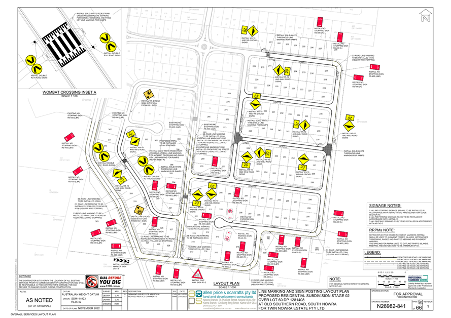
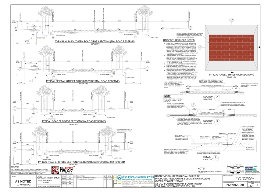
TC23.49 Signage,
Linemarking and LATM Plan - Lot 60 DP1281408 - Old Southern Road - South Nowra
- PN (3781)
HPERM Ref: D23/422477
Convenor: David
Pieresko
Attachments: 1. PN
3781 Plans ⇩
2. Swepth Path Analysis (under
separate cover)
|
Recommendation
That:
1. The Chief Executive Officer
(Director City Services) be advised that the Shoalhaven Traffic Committee has
no objection to the proposed regulatory signage, linemarking and Local Area
Traffic Management devices relating to the subdivision at Lot 60 DP1281408,
Old Southern Road, South Nowra as per D23/378029.
2. The
recommendation be approved by the Director City Services under delegated
authority from Shoalhaven City Council – refer MIN21.411.
|
Background
APPLICANT: Allen Price and
Scarratts Pty Ltd
OWNER: Twin
Nowra Estate Pty Ltd
Lot 60 DP1281408 – Old
Southern Road – South Nowra - Residential Subdivision
A new subdivision development
application for a 166-lot residential subdivision at Old Southern Rd, South
Nowra was approved on 5 December 2022. As per the development consent
requirements, the developer has submitted a proposal for local area road safety
measures which focus on emergency access, and on improving pedestrian and road
safety for the community.
Details of Submission
The proposed measures include:
· The
reinforcement of ‘No Stopping’ zones with ‘C3’
linemarking and ‘No Stopping’ signage at all intersections with
Firetail St.
· ‘No
Parking’ signage at the cul-de-sac in Road 04.
· Raised
thresholds on Firetail St and Road 04.
· A
raised Wombat (pedestrian) Crossing on Road 02.
· Raised
threshold pavements at the T-intersections of Road 07 and 05, and Road 07 and
Road 04.
· ‘C3’
linemarking for the southern side of Road 10 and for sections of Road 04.
· Centreline
and ‘C3’ linemarking along Old Southern Rd and Firetail St to
clearly delineate travel lanes.
These facilities will be
accompanied by their associated signage and linemarking.
Consultation
The Development Application was on Public Exhibition
from 12 June 2021 to 12 July 2021. To date, Council received one submission
advocating for the widening of Old Southern Rd and its connection to Warra
Warra Road. However, no widening or connection to Warra Warra Road is being
proposed as part of these works. The development was approved on 5 December
2022.
Risk Implications
The proposed controls, signage
and linemarking measures would enable bushfire access, regulate vehicle speeds,
and provide a safer road network within the subdivision. Furthermore, these
conditions have been stipulated in the development consent.
Financial ImplicationsThe
proposed works are to be funded by the private Developer in accordance with
development consent. Following the dedication of these roads, Council will be
responsible for their ongoing maintenance.
|
|
Shoalhaven
Traffic Committee – Tuesday 14 November 2023
Page
1
|
|

|
Shoalhaven
Traffic Committee – Tuesday 14 November 2023
Page
1
|
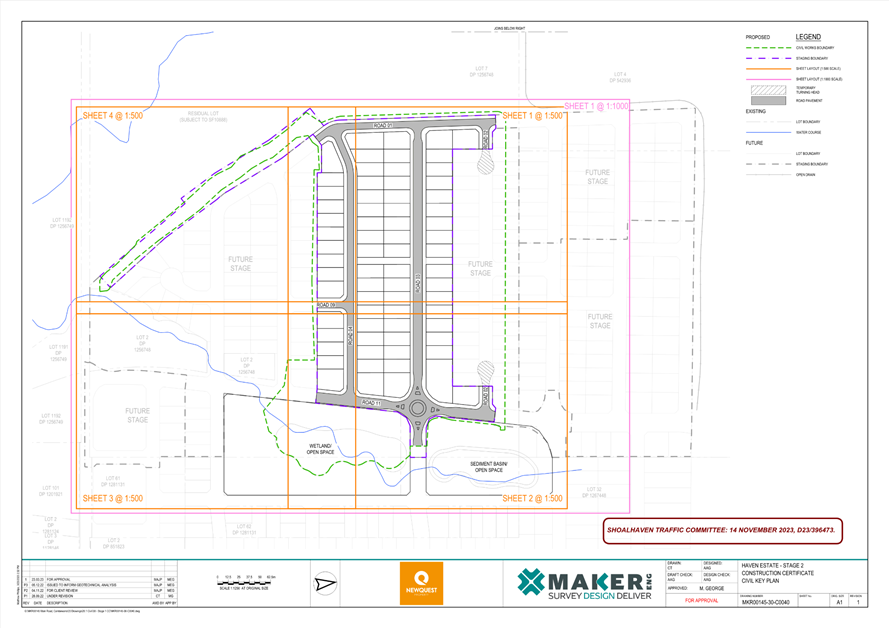
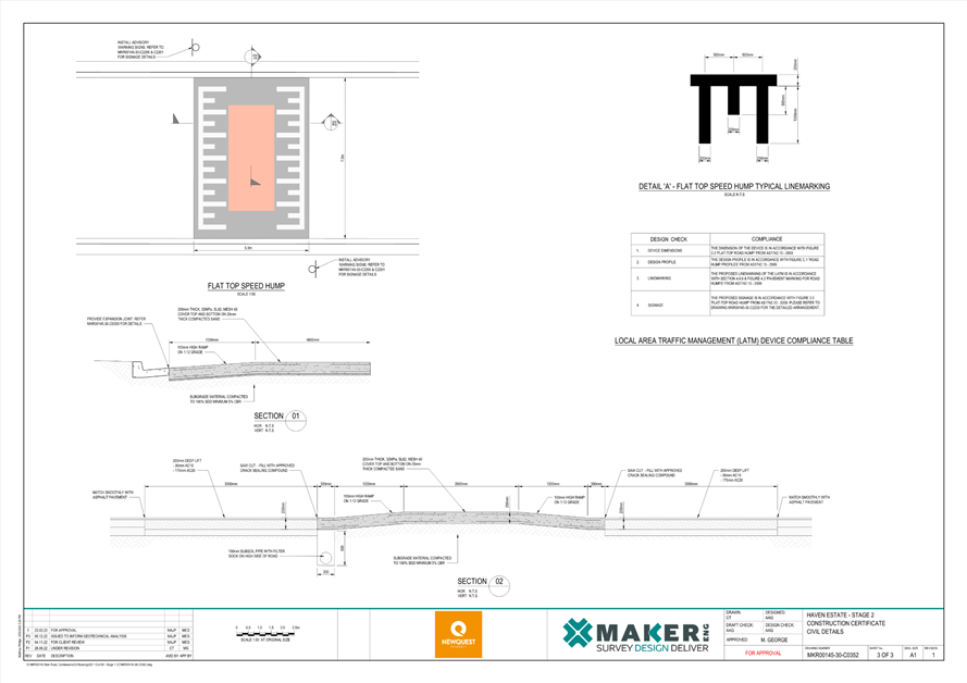
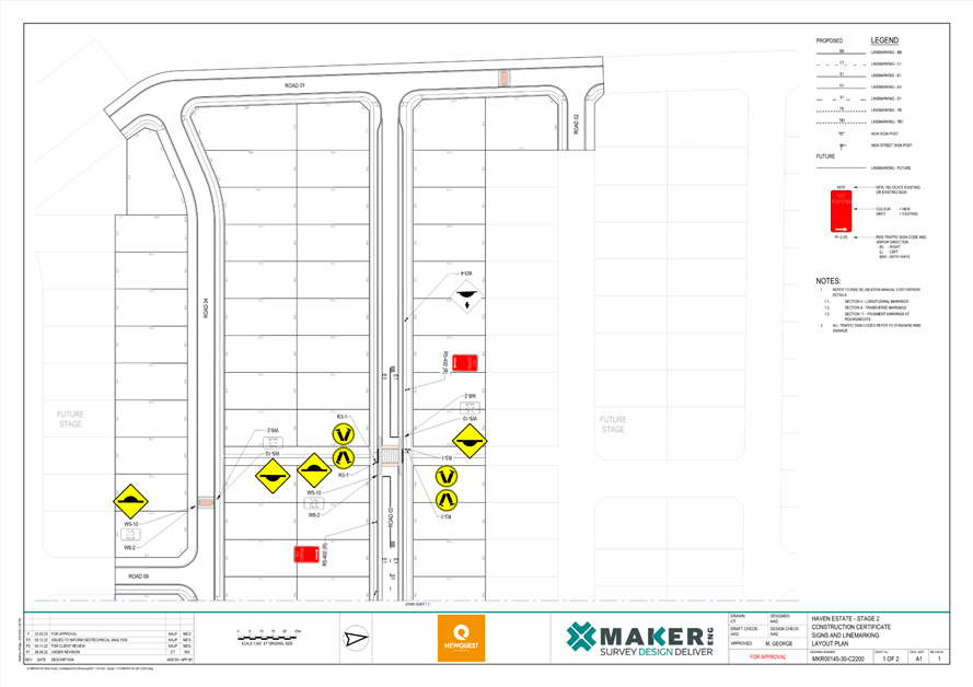
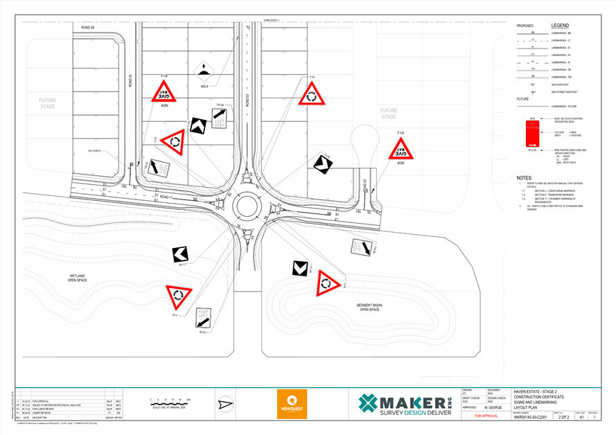
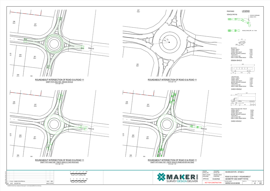
TC23.50
Signage, Linemarking, LATM Plan and New Roundabout - 41 Main Road - Cambewarra
- Lot 4 DP 542936 PN (3783)
HPERM Ref: D23/423397
Convenor: David
Pieresko
Attachments: 1. PN
3783 ⇩
|
Recommendation
That:
1. The Chief Executive Officer
(Director City Services) be advised that the Shoalhaven Traffic Committee has
no objection to the proposed regulatory signage, linemarking, LATM devices
and roundabout for the subdivision at 41 Main Road Cambewarra as per D23/396473.
2. The
recommendation be approved by the Director City Services under delegated
authority from Shoalhaven City Council – refer MIN21.411
|
Background
APPLICANT: Maker
Engineering Pty Ltd
OWNER: Newquest
Property Pty Ltd
41 Main Rd, Cambewarra - Lot 4
DP542936 – Main Road – Cambewarra - Residential Subdivision
A 258-lot residential
subdivision (RA21/1003/7) at Main Road, Cambewarra was approved on 15 March
2023. In accordance with conditions 33 and 34 of the development consent, the
developer has now submitted plans for traffic committee’s consideration.
Details of Submission
The proposed measures include:
· A
roundabout at the junction of Road 03 and Road 11.
· A
raised flat top speed humps on Road 01 and Road 04.
· A
raised pedestrian crossing on Road 03.
All these facilities will be
accompanied by their associated signage and linemarking.
Consultation
The Development Application was on Public Exhibition from
12/1/2020 to 11/2/2022, 17/10/2022 to 30/10/2022, and 17/10/2020 to 7/11/2022.
To date, no concerns or objections have been received regarding the proposed
traffic measures. The development was approved on the 15/3/2023.
Risk Implications
The proposed measures will assist in mitigating traffic
related risks associated with traffic volumes and speeds within the
subdivision. The roundabout will improve traffic flow and safety. The speed
humps will reduce the likelihood of speeding in key locations. The raised
pedestrian crossing will increase the visibility of pedestrians crossing the
road and provide them with priority over vehicles. Furthermore, these
conditions have been stipulated in the development consent.
Financial ImplicationsThe
proposed works are to be funded by the private developer in accordance with
their development consent. Following the dedication of these roads, Council
will be responsible for their ongoing maintenance.
|

|
Shoalhaven
Traffic Committee – Tuesday 14 November 2023
Page
1
|
|

|
Shoalhaven
Traffic Committee – Tuesday 14 November 2023
Page
1
|
TC23.51 Huskisson
- Husky Ultra Festival 2024 - (PN 3785)
HPERM Ref: D23/427221
Convenor: David
Pieresko
Attachments: 1. (PN
3785) - Traffic Management Plan (TMP) (under separate cover)
2. (PN
3785) - Traffic Guidance Scheme (TGS) - 21 February 2024 (under separate cover)
3. (PN
3785) - Traffic Guidance Scheme (TGS) - 22 February 2024 (under separate cover)
4. (PN 3785) - Traffic Guidance
Scheme (TGS) - 23 February 2024 (under separate cover)
|
Recommendation
That
1. The Chief Executive Officer
(Director City Services) be advised that the Shoalhaven Traffic Committee has
no objection to the proposed traffic management plan (TMP) and associated
Traffic Guidance Schemes (TGS) for the Husky Ultra Festival 2024, as per D23/427073,
D23/427078, D23/427084 and D23/427089,
a. The TGS being implemented in
accordance with ‘TS05492 – Traffic Control at Work Sites
20.346’, Clause 4.3.2 for Lane Widths and Clause 4.4.5 for Heavy
Vehicles.
2. The
recommendation be approved by the Director City Services under delegated
authority from Shoalhaven City Council - refer MIN21.411.
|
Background
The Husky Ultra Festival is
proposed to be held between the 21st and 23rd February 2024. According to the
Guide to Traffic and Transport Management for Special Events, this event is
classified as a ‘Class 2’ event that will require altered traffic
arrangements throughout the duration of its activities with multiple local road
traffic restrictions and closures. As such, the proposed Management Plan (TMP)
and Traffic Guidance Schemes (TGS) are attached for the committees’
consideration.
Details of Submission
1. Road Closures
The following controlled access
(emergency & official vehicles exempt and limited residents’ access
only) are requested for Wednesday 21 February 2024 for the safety of
competitors and the public during the running of the Husky Ultra Festival.
Major intersections along Forest
Rd, Callala Beach Rd, Quay Rd and Currarong Rd are managed by traffic
control to ensure safety of cyclists. All competitors will have a support
vehicle with them ensuring cyclist safety. Yalwal Rd, Burrier Rd, Cabbage
Tree Lane, Stringy Bark Rd, Albatross Rd, Braidwood Rd - Wherever
the posted speed limit exceeds 60km/hr a speed reduction of 60km/hr will be
implemented.
The following controlled access
(emergency & official vehicles exempt and limited residents’ access
only) are requested for Thursday 22 February 2024 for the safety of
competitors and the public during the running of the Husky Ultra Festival.
Major intersections along Longreach
Rd, Yalwal Rd, Burrier Rd, Cabbage Tree Lane, Albatross Rd, Braidwood Rd, and
Nerriga Rd are managed by traffic control to ensure safety of cyclists. All
competitors will have a support vehicle with them ensuring cyclist safety Yalwal
Rd, Burrier Rd, Cabbage Tree Lane, Stringy Bark Rd, Albatross Rd, Braidwood Rd
- Wherever the posted speed limit exceeds 60km/hr a speed reduction of 60km/hr
will be implemented.
The following controlled access
(emergency & official vehicles exempt and limited residents’ access
only) are requested for Friday 24 February 2024 for the safety of
competitors and the public during the running of the Husky Ultra Festival.
•
Road Closures – Bowen St, Fegan St, Nowra St and Beach St
– 7.15am to 7.45am
2. Event
Infrastructure
NSW Ambulance, Police and
Fire Brigade: Emergency access lanes have been designated to facilitate the
entry of emergency vehicles into the areas where road closures are in effect.
Medical: Throughout the
event at Callala Beach, Yerriyong, and Huskisson, there will be medical
personnel present to provide necessary medical assistance.
Port-A-Loos: The quantity
of Port-A-Loos (portable toilets) will be determined closer to the event in
accordance with the SCC Event Guidelines.
Cleaning/Disposal:
Wheelie bins and skips will be strategically placed at various locations in the
event central area for the collection, removal, and disposal of waste. Staff
members will be responsible for maintaining cleanliness during the event.
Barricades: Traffic
Management to be installed by Accredited Traffic Controllers.
3.
Transportation, Awareness of Event and Access
Public Transport: The
event organisers will inform public transport companies about the event, and
they will make necessary adjustments to their regular routes, ensuring safety
and minimal delays.
Parking: There is no
dedicated on-site parking available for this event.
Access/Awareness: A
notice will be delivered to the letterboxes of residents and businesses in and
around Huskisson, providing them with at least 21 days' notice. The notice will
contain information regarding road restrictions and alternative routes.
Resident access will be ensured throughout the day, if it is safe to do so.
Risk Implications
1. Parking Limitations and Potential
Congestion
The event is proposed to take
place over the second last week of February and is within peak summer period,
when there is typically a high volume of day trippers and visitors to the
region. With the higher vehicle and pedestrian demand and combination of event
patrons, there is the potential for traffic flow issues, parking constraints
and delays throughout Huskisson.
2. Local Business and
Resident Impact
Large events can impact local
businesses and residents negatively. Road closures and increased traffic may
make it challenging for customers to reach businesses, and residents may
experience noise disturbances, limited access to their properties, or inconvenience
due to traffic restrictions.
The festival will be conducted
by Elite Energy Pty Ltd and will be approved, sanctioned & insured by the
national governing body, Triathlon Australia. All athletes must abide by the
current rules & regulations of Triathlon Australia endorsed by the
International Triathlon Union (ITU).
3. Unsafe Lane Widths:
To reduce safety concerns
regarding unsafe lane widths, the TGS is to be implemented in accordance with
TS 05492 - Traffic control at work sites” 20.346 | Issue No.6.1 28
February 2022 Transport for NSW with and the subsequently listed considerations:
· Clause
4.3.2 on Lane Widths: The minimum width for lanes carrying traffic around,
past or through a work site must be in accordance with Table 4-2.
· Lane
widths should also consider accommodating the turn paths of large vehicles
expected to negotiate the work site as per Clause 4.4.5 for Heavy Vehicles.
· Where
existing lane widths are narrower than those specified in the table above, the
lane widths may be maintained. However, the TMP must document provisions for
turning paths, sight distances and vulnerable road users.
· Where
fixed vertical obstructions such as fences or safety barriers are restricting
the available shoulder width, consideration should be given to increasing lane
widths to accommodate larger vehicles.
|
|
Shoalhaven
Traffic Committee – Tuesday 14 November 2023
Page
1
|
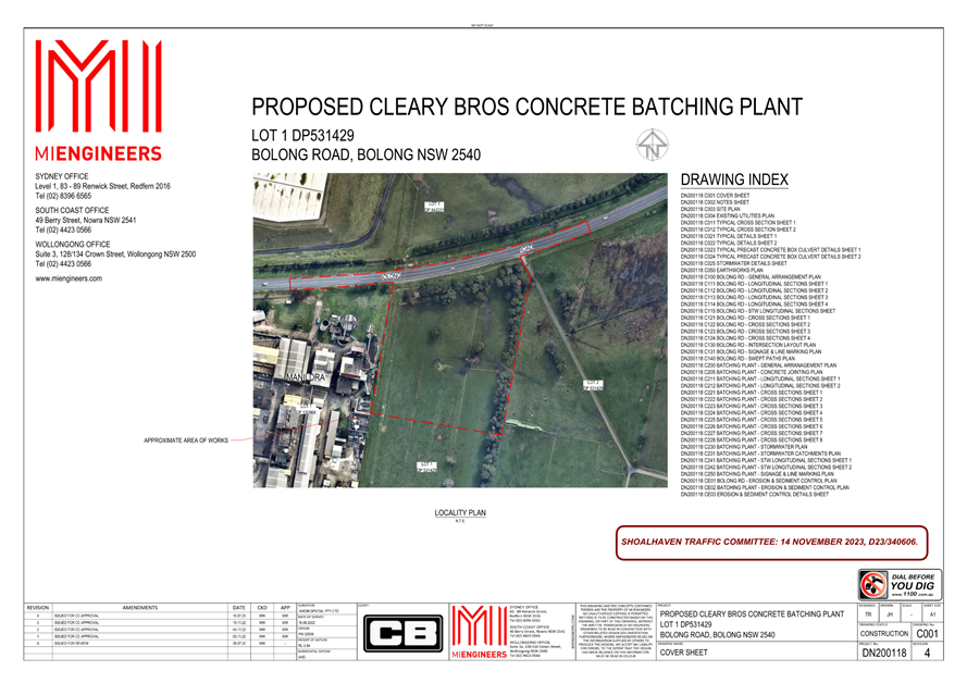
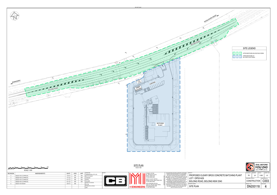
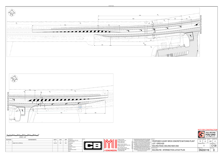
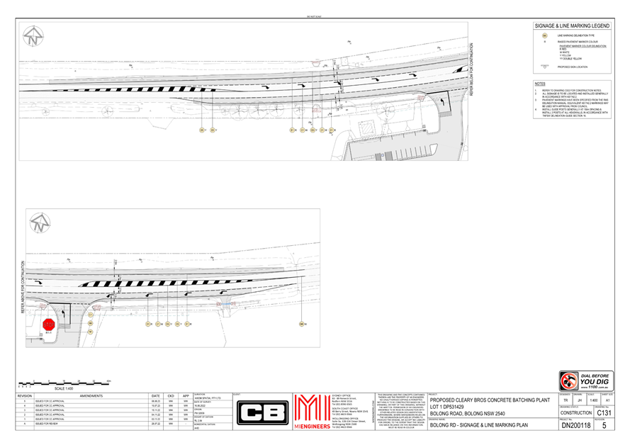
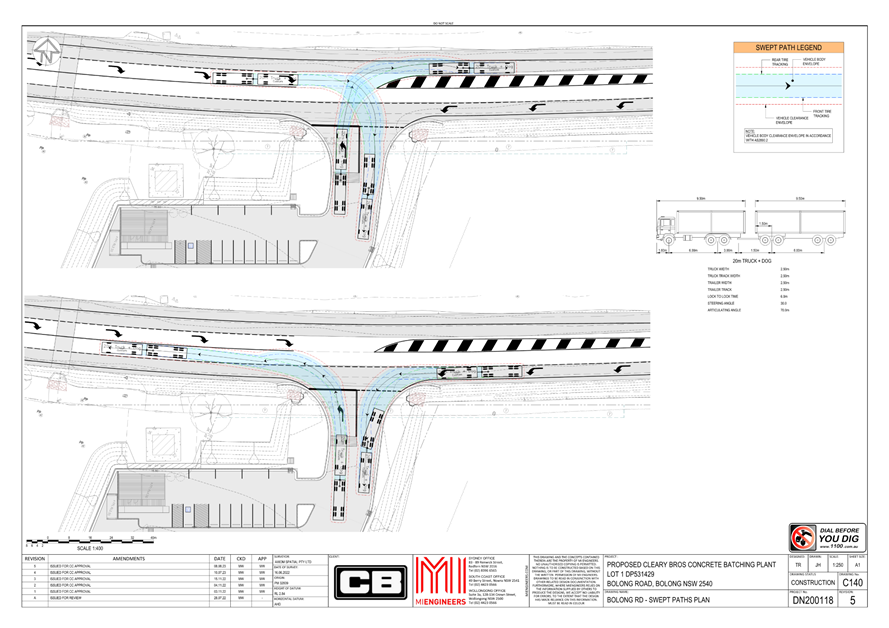
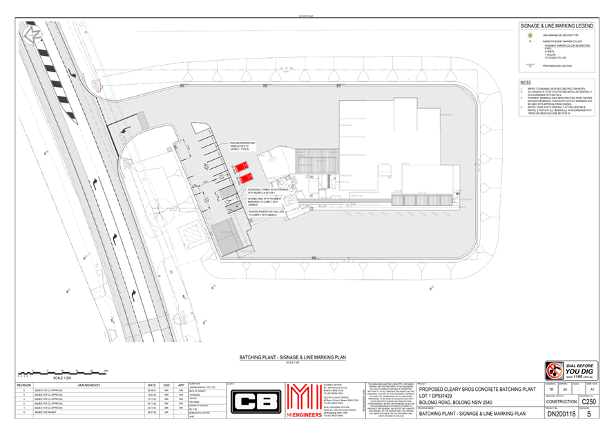
TC23.52 Signage,
Linemarking and AUL/CHR Plan for Driveway Intersection- Bolong Road - Bolong -
PN (3786)
HPERM Ref: D23/428928
Convenor: David
Pieresko
Attachments: 1. PN
3786 Plans ⇩
|
Recommendation
That:
1. The Chief Executive Officer (Director City Services) be
advised that the Shoalhaven Traffic Committee has no objection to the
proposed signage and linemarking plan for the new concrete batching plant
located Lot 1 DP531429, Bolong Road, Bolong, as per D23/340606.
2. The recommendation be approved by the Director City
Services under delegated authority from Shoalhaven City Council – refer
MIN21.411
|
APPLICANT: MI Engineers Pty Ltd
OWNER: Cleary
Brothers Pty Ltd
Background:
A commercial development
application DA21/1612 for a proposed concrete batching plant at 340 Bolong Rd
was approved by Council on 14 March 2022. As part of their development consent
(Condition 27), the applicant is required to construct a Rural Channelised
T-Junction (CHR) and Rural Auxiliary Left-turn Lane Treatment
(AUL) at the site entrance to ensure that safe vehicle turning movements
are managed at the driveway intersection. This proposal has now been submitted
for Traffic Committee’s consideration.
Condition 27. Road Design
Standards
Prior to the
issue of a Construction Certificate,
certified road design engineering plans
must be prepared by a suitably qualified engineer or surveyor and
approved by Council. The road design must comply with the following:
a) to facilitate right turn
movements from Bolong Road into the site, a CHR is to be designed and
constructed. The works are to include all required road and shoulder widening.
The current existing road shoulder width is to be maintained. Where additional
width is required for the CHR additional shoulder pavements is to be
constructed. The storage length is to be at least the length of the largest
vehicle expected to enter the site.
b) To facilitate left turn
movements from Bolong Road into the site, a AUL is to be designed and
constructed. The works are to include all necessary road and shoulder widening.
The current existing road shoulder width is to be maintained. Where additional
width is required for the AUL additional shoulder pavements is to be
constructed.
c) Councils Engineering
Design Specifications Sections D1 – Geometric Road Design and D2 –
Flexible Pavement Design.
d) AUSTROADS Design
Requirements and Specifications except in relation to overtaking sight distance
where the design must be consistent with the approved concept design in
Appendix U of the EIS (plan SK02 Rev P2) and the line marking measures
recommended by TTW in their letter to Council of 25/8/21 as included in
Condition 1.
e) The road table drain
adjacent Bolong Road is to be reconstructed as required to prevent ponding of
water, including any adjustment or reconstruction of nearby driveways.
Details of Submission:
This proposal would involve the
installation of Rural Channelised T-Junction (CHR) and Rural
Auxiliary Left-turn Lane Treatment (AUL) due to Condition 27 of the
development consent. An acceleration lane is also proposed for drivers
travelling westbound from the site.
To facilitate right-turn movements from Bolong Rd into the
site, a CHR turn lane is proposed in the east-bound lane. The dedicated
right-turn lane will have a width of 3.5 meters , while a 3.0-meter-wide lane
will be maintained for through traffic. The existing road shoulder width will
remain unchanged.
To facilitate left-turn movements from Bolong Road into the
site, a rural AUL in the west-bound lane is proposed as per Table 8.2, of Austroads
Guide - AGRD04A-23-Ed3.2. The turning lane will be 3.0 meters wide and 75
meters long, accompanied by a 1.0-meter-wide shoulder. A 30-meter-long taper
zone will allow vehicles to merge into the turning lane.
For drivers exiting the driveway, the proposed plan is to
install a ‘STOP’ sign, complemented by continuous linemarking (TF).
From there, a 125-meter-long acceleration lane is proposed for drivers
travelling westbound to merge back into the traffic lane. However, it is noted
from the swept paths provided that the turning radius has not designed to
accommodate 20m (the largest vechile using the site) trucks.
Consultation:
Consultation with adjacent
residents and stakeholders took place from June 30, 2021 to July 30, 2021. Nine
(9) responses opposing the development were received for Council’s
consideration. Three (3) of the responses raised concerns about traffic issues:
1. The first respondent
requested the extension of the turning lanes up to the property entry to reduce
the likelihood of near-miss incidents from vehicles seeking to overtake
slow-moving vehicles turning in and out of the site.
2. The second respondent
expressed concerns about having trucks confusing other drivers by decelerating
to turn right into the site in an area transitioning from 60kph to 100kph.
3. The third respondent was
concerned that the originally proposed 90m merging lane would be insufficient
for trucks turning left from the site to accelerate to 100kph before merging
into the traffic lane. Similar concerns were expressed regarding the safety
impacts of slow-moving trucks turning right.
The proposed CHR and AUL lanes
in the current proposal have been extended to comply with Austroads Guide -
AGRD04A-23-Ed3.2. While the length of the westbound acceleration lane for
vehicles complies with Austroads, the kerb return radius has not been designed
to allow for the left hand turn of 20m (the largest
vechile using the site) trucks into it. The development was approved by
Council on 14 March 2022.
Risk Implications:
This proposal aims to enhance
road safety during the ingress and egress of vehicles at the concrete plant.
The implementation of AUL and CHR measures will contribute to improved reaction
times for vehicles traveling in both west and east directions. Where necessary,
shoulder lanes will be widened, and their maintenance will be ensured to
bolster these safety measures.
Financial Implications:
The proposed works are to be funded by the private Developer
in accordance with their development consent. Following this, Council will be
responsible for the ongoing maintenance of these facilities.
|

|
Shoalhaven
Traffic Committee – Tuesday 14 November 2023
Page
1
|
|

|
Shoalhaven
Traffic Committee – Tuesday 14 November 2023
Page
1
|
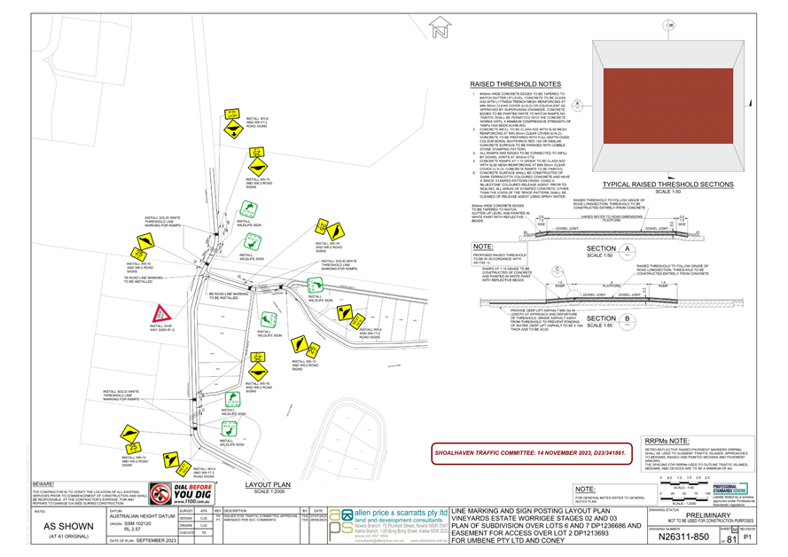
TC23.53 Signage,
Linemarking and Wildlife Warning Signs Plan for Lots 6 and 7 DP1236686 Worrigee
Road - Worrigee - PN (3787)
HPERM Ref: D23/437299
Convenor: David
Pieresko
Attachments: 1. PN
3787 Plans ⇩
|
Recommendation
That:
1. The Chief
Executive Officer (Director City Services) be advised that the Shoalhaven
Traffic Committee has no objection to the proposed signage and linemarking,
raised thresholds and wildlife warning signs plan for the Subdivision located
Lot 6 and 7 DP1236686, Worrigee Road Worrigee as per development consent SF10570
and as per D23/341861.
2. The
recommendation be approved by the Director City Services under delegated
authority from Shoalhaven City Council – refer MIN21.411
|
APPLICANT: Allen Price and Scarratts Pty Ltd
OWNER: Umbene
Pty Ltd
Background:
The development application (SF10570) for a proposed subdivision in stages 2 and 3
located at 369 Worrigee Rd, and 23A Aldous Pl, Worrigee, gained development
approval on 26 July 2021. As part of their development consent, the applicant
was requested to install speed control devices at all waterway crossings to
reduce vehicular traffic speeds at Green and Golden Bell Frog crossing points
in the road (Condition 44).
Details of Submission:
This proposal would involve the
installation of six (6) raised thresholds, road linemarking, and LATM devices
as per Australian Standards, and development consent Condition 44.
To
reinforce the presence of upcoming raised thresholds, warning signs W3-4
“Speed Hump Ahead (Symbolic)” sign and W8-17-2 “NEXT
50m” supplementary plates would be provided at the following locations:
· 40m south of the
southern raised threshold on Worrigee Road
· 40m north of the
northern raised threshold on Worrigee Road
· 40m
east of the eastern threshold on Stevens Road
Advisory “Care for Our Wildlife” signage is
proposed for all wildlife crossings. These signs would be located 10m after the
raised thresholds on both directions.
Consultation:
Council consulted with adjacent
residents and stakeholders from 17th May 2017 to 23rd
June 2017 and again between 13th November 2017 to 27th
November 2017. The development was subsequently submitted to the Land &
Environmental Court for determination, leading to an additional community
consultation, which took place between the 29th of May 2019. From
the six (6) responses received, only one (1) response pertained to traffic
matters. This respondent opposed access from Forrest Road or Worrigee Road and
advocated for exclusive access either via Stevens Road or through the proposed
private road.
Risk Implications:
This proposal aims to enhance
road safety during the ingress and egress of vehicles on local roads. The
raised threshold, signage and linemarking measures seek to improve reaction
times for vehicles by reducing their travel speed in this area. These LATM
devices are expected to reduce the overall likelihood of harm to wildlife.
Financial Implications:
The proposed works are to be funded by the private Developer
in accordance with the development consent. Following this, Council will be
responsible for ongoing maintenance following the dedication of roads within
the subdivision.
|
|
Shoalhaven
Traffic Committee – Tuesday 14 November 2023
Page
1
|
|
|
Shoalhaven
Traffic Committee – Tuesday 14 November 2023
Page
1
|
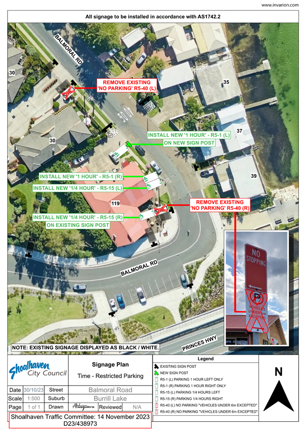
TC23.54 Timed
Parking Restrictions - Balmoral Road - Burrill Lake (PN 3788)
HPERM Ref: D23/438947
Convenor: David
Pieresko
Attachments: 1. PN
3788 Plan ⇩
|
Recommendation
That:
1. The Chief Executive Officer (Director City Services) be
advised that the Shoalhaven Traffic Committee has no objection to the proposed
time restricted parking signage at Balmoral Road, Burrill Lake as per
D23/438973.
2. The recommendation be approved by the Director City
Services under delegated authority from Shoalhaven City Council - refer
MIN21.411
|
Background:
Shoalhaven
City Council has received a request for timed parking in front of the Burrill
Lake shopping complex (No. 119 Princes Hwy) and part of No. 30 Balmoral Road to
maximise parking efficiency and improve traffic flow.
Council
staff have recently conducted a site inspection with a member of the Burrill
Lake Community Association (BLCA), taking note of existing signage, current
parking restrictions and the road condition. From this inspection, it was noted
that timed parking could be implemented at this location. Due to the limited
parking provisions and turnover, Council is proposing the installation of timed
parking restrictions along Balmoral Road to improve safety and short-term
parking flexibility.
Details of Submission:
The proposed
changes shown on the attached plan include replacing the existing “No
Parking – Vehicles under 6m Excepted” signage with the following.
· ‘1/4P’
(15-minute restriction) – approximately 2 parking spaces.
· ‘1P’
(1-hour restriction) – approximately 2 parking spaces.
The
remaining unrestricted parking for vehicles under 6m is proposed to remain
unaltered.
Consultation:
Consultation has been undertaken
with adjacent residents, other stakeholders, the BLCA and closed on the 27th of
October 2023. To date, Council has received five (5) submissions, two (2)
submissions were ‘in favour’, one (1) ‘opposed’, and
two (2) supported the proposal, but with some changes.
The submission opposing the
proposal was in support of the ‘1P’ parking restrictions, but did
not support parking restrictions of less than thirty minutes. Council is
proposing to proceed with the ‘1/4P’ parking restriction for these
two spaces to keep the measures consistent with similar parking restrictions
throughout Burril Lake.
Two other submissions supported
the proposal but would like to see more of the ‘unrestricted’ zones
being turned into timed parking. Council is proposing to proceed with the
proposal as is before assessing whether further timed restrictions are
warranted.
Risk Implications:
This proposal aims to enhance the flexibility of parking and
encourage quicker turnover of vehicles in ‘peak’ periods, leading
to a safer and less congested parking situation at Balmoral Road. This is
viewed to be a low-impact proposal as there is ample on-street parking along
the remainder of Balmoral Road.
Financial Implications:
The signage for this proposal would be funded by Transport
for NSW’s Block Grant Funding allocated to Council for new signage and
linemarking.
|
|
Shoalhaven
Traffic Committee – Tuesday 14 November 2023
Page
1
|
|
|
Shoalhaven
Traffic Committee – Tuesday 14 November 2023
Page
1
|
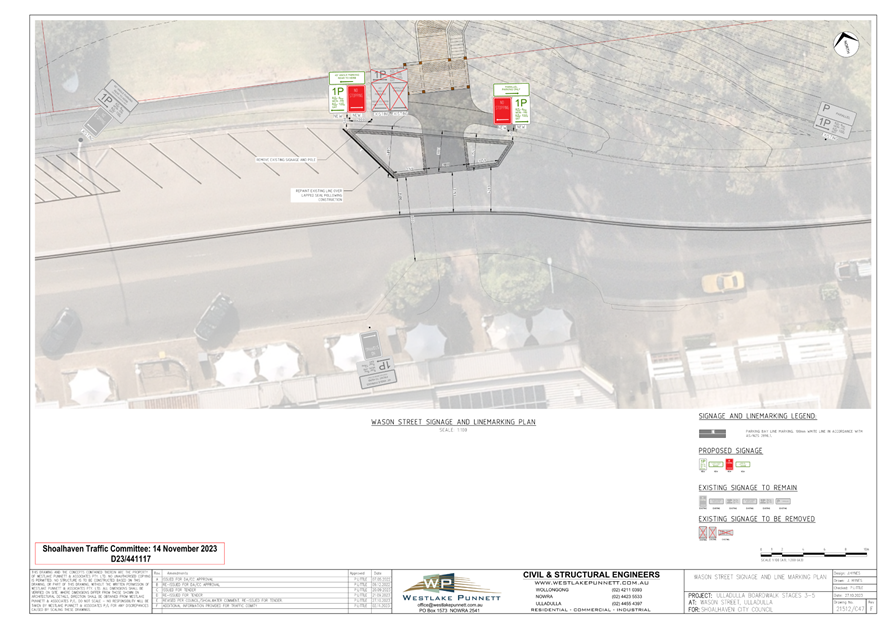
TC23.55 Signage,
Linemarking and Raised Kerb Blisters - DA22/1716 - Wason Street - Ulladulla (PN
3789)
HPERM Ref: D23/447594
Convenor: David
Pieresko
Attachments: 1. PN
3789 Plan ⇩
|
Recommendation
That:
1. The Chief Executive Officer
(Director City Services) be advised that the Shoalhaven Traffic Committee has
no objection to the proposed parking
signage, linemarking and raised kerb blisters
at Wason Street, Ulladulla as per D23/441117.
2. The
recommendation be approved by the Director City Services under delegated
authority from Shoalhaven City Council - refer MIN21.411
|
Background:
APPLICANT: Westlake
Punnett & Associates Pty Ltd
OWNER: Shoalhaven
City Council
As part of DA22/1716, approval
is being sought for new regulatory parking signs, linemarking and raised kerb
blisters on Wason Street, Ulladulla, associated with the development of the
Ulladulla Harbour Raised Boardwalk project. To accommodate two raised kerb
blisters on Wason Street, adjustments to the existing parking arrangements are
required.
Related Condition of Consent:
29. Kerb Blister – Wason St
Prior to the issue of a
Construction Certificate, certified engineering design plans and specifications
must be prepared by a professional engineer, (as defined in the National
Construction Code) or surveyor and approved by the Certifier.
The kerb blister design must
comply with the following:
a) Provide minimum lane width of 3.5m or as otherwise
agreed by the Roads Asset Manager or delegate between the edge of the blister
and the centreline marking.
b) Align with the existing crossing point on the opposite
side of Wason St.
31. Design Standards – Traffic Committee Referral
Prior to the issue of a Construction Certificate details of
proposed traffic management and traffic control devices must be submitted to
the satisfaction of Council for referral and endorsement of the Shoalhaven
Traffic Committee.
Note: This process can take six to eight weeks.
Details of Submission:
This proposal consists of the
installation of two raised kerb blisters on Wason Street, and the adjustment of
the current parking arrangements. The existing signpost that currently
designates ‘1P’ timed ‘45-degree’ angle parking restrictions
on the west side and ‘parallel’ parking on the east side will be
moved approximately 3 meters towards the western end of the raised kerb
blister.
The sign indicating
‘parallel’ parking will be taken down from this post and replaced
with ‘No Stopping’ controls, which will be applied to the east side
and across both kerb blisters. A new signpost is proposed for the eastern end
of the raised kerb blister, aligning with the ‘No Stopping’
restrictions on the west side and allowing for ‘1P’ time restricted
parallel parking on the east side. As a result of this proposal, one
‘45-degree’ angle parking space and one ‘parallel’
parking space will be removed.
Consultation:
Consultation with adjacent residents, stakeholders and the
Ulladulla & Districts Community Forum closed on 20 July 2022. No
specific concerns were raised regarding the signage, linemarking and kerb
blisters that form part of this submission.
Risk Implications:
The works are proposed to
improve connectivity to the Ulladulla Harbour raised boardwalk and address
pedestrian safety at the crossing onto Wason Street. This kerb blister will
assist in reducing the pedestrian crossing time and distance, and in increasing
visibility.
Financial Implications:
The proposal would be funded by
grant funding streams provided to Council by:
· NSW
DPIE – Public Spaces Legacy Program.
· Department
of Infrastructure Projects – Building Better Regions Fund 5.
|
|
Shoalhaven
Traffic Committee – Tuesday 14 November 2023
Page
1
|