Shoalhaven Traffic Committee
Meeting Date: Tuesday,
14 February, 2023
Location: Manyana
Meeting Room, City Administrative Centre, Bridge Road, Nowra
Time: 9:30
am
Please note: Council’s Code of Meeting Practice
permits the electronic recording and broadcast of the proceedings of meetings
of the Council which are open to the public. Your attendance at this meeting is
taken as consent to the possibility that your image and/or voice may be
recorded and broadcast to the public.
Agenda
1. Apologies
2. Confirmation of Minutes
· Shoalhaven
Traffic Committee - 13 December 2022................................................... 1
3. Business Arising from Previous Minutes
4. Reports of the Convenor
TC22.41...... Proposed Centreline Modifications - Bawley Point
Road - Bawley Point (PN 3723)........................................................................................................................ 9
TC23.1........ Bus Zone / Parking Restrictions - Moss Vale Road
- Kangaroo Valley (PN 3732)...................................................................................................................... 13
TC23.2........ Signage, Linemarking and Traffic Control
Facilities Plans - Lot 3 DP 851823 - 104 Taylors Lane, Cambewarra - MVRS URA
Stage 2 - Sub-Stage 1A (PN 3733) 16
TC23.3........ Signage, Linemarking and Traffic Control
Facilities Plans - Lot 3 DP 851823 - 104 Taylors Lane, Cambewarra - MVRS URA
Stage 2 - Sub-Stage 1B (PN 3734) 23
TC23.4........ Signage, Linemarking and Traffic Control
Facilities Plans - Lot 6 DP 1256748 - 126 Taylors Lane, Cambewarra - MVRS URA
Stage 4 (PN 3735).................... 30
TC23.5........ Proposed Parking Signage Modifications - Princes
Highway - Milton (PN 3737) 37
TC23.6........ Proposed Relocation of Parking Spaces - Camden
Street - Ulladulla (PN 3738) 40
TC23.7........ Proposed Intersection Improvements - McArthur
Drive & Jervis Bay Road - Falls Creek (PN 3739)........................................................................................... 43
5. General Business
TC23.8........ TfNSW - Nowra Bridge Project - Traffic Switch
Mr Dan Farrugia, member from
the Nowra Bridge Project Team, will address the Committee regarding an
up-coming traffic switch on the Nowra Bridge.
Note: The next meeting will be
held on Tuesday 14 March 2023.
|

|
Shoalhaven
Traffic Committee – Tuesday 14 February 2023
Page
i
|
Membership
Mr David Pieresko – Convenor
Clr Patricia White
Clr Matthew Norris
Ms Nicole Brodie
Sergeant Kelly Thomas
Ms Shelley Hancock MP (or representative)
Mr Stuart Coughlan
The Shoalhaven Traffic Committee is a technical review
committee, not a committee of Council under the Local Government Act 1993. Transport
for NSW (TfNSW) has delegated certain powers to Council under the Transport
Administration Act 1988 (Section 50). A condition of this delegation is
that Council must take into account the Traffic Committee recommendations.
There are four formal members of the Traffic Committee, each
of whom has a single vote only. The members are representatives from:
- NSW Police Force
- TfNSW
- Shoalhaven City Council
- Local State Member of Parliament (for the location of the
issue to be voted upon)
If TfNSW or NSW Police Force disagrees with any Traffic
Committee recommendation, or Council’s resolution (on any Traffic
Committee recommendation), they may lodge an appeal with the Regional Traffic
Committee for determination. The appeal must be lodged in writing within
14 days of the date of notification in writing. Any action relative to
any issue under appeal must cease until the matter is determined. The
Regional Traffic Committee is chaired by an independent chairperson and
submissions and representations are welcomed from all interested parties.
Council cannot amend a Traffic Committee recommendation. The
Council can only: adopt the Traffic Committee recommendation; not adopt the
Traffic Committee recommendation, or request the Traffic Committee reconsider
the issue.
The full guide to the delegation to Council’s for
the regulation of traffic can be viewed at TfNSW
Website
Minutes of the Shoalhaven Traffic Committee
Meeting Date: Tuesday,
13 December 2022
Location: Manyana
Meeting Room, City Administrative Centre, Bridge Road, Nowra
Time: 9:35am
The following members
were present:
Convenor David Pieresko -
Senior Civil Engineer (Remotely)
Clr Patricia White
Ms Nicole Brodie - TfNSW
(Remotely)
Mr Ankit Bhangale - TfNSW
(Remotely)
Sgt Simon Pugh - NSW Police
Mr Stuart Coughlan - Representing Mr Gareth Ward MP
Mr Adam Carney -
Representing Ms Shelley Hancock – MP (Remotely)
Others Present:
Mr Micaiah Tipton -
Manager Design Services
Mr Ryleigh Bowman - Design Engineer (Remotely)
|
Apologies / Leave of
Absence
|
Apologies were received from Sgt Ian McManus – NSW
Police and Craig Exton - Manager Technical Services.
|
Confirmation of the
Minutes
|
|
RESOLVED (Stuart Coughlan /
Nicole Brodie)
That the Minutes of the
Shoalhaven Traffic Committee held on Tuesday 08 November 2022 be confirmed.
CARRIED
|
|
Business Arising from
Previous Minutes
|
Mr David Pieresko - Senior Civil Engineer advised that item
TC22.41 - Proposed Centreline Modifications - Bawley Point Road - Bawley Point
(PN 3723) from the previous meeting is continuing to be reviewed and an update
will be provided once the investigation is completed at a future Shoalhaven
Traffic Committee meeting.
Reports of the Convenor
|
TC22.49 Proposed Roundabout -
Burrill Street - Jervis Street - Huskisson (PN 3696)
|
HPERM Ref: D22/229054
|
|
Recommendation
That:
1. The
Chief Executive Officer (Director City Services) be advised that the
Shoalhaven Traffic Committee has no objection to the proposed roundabout at
intersection on Burrill Street and Jervis Street, Huskisson as per Plan No
D22/229084;
2. The recommendation be
approved by the Director City Services under delegated authority from
Shoalhaven City Council - refer MIN21.411
|
|
RESOLVED (By consent)
That:
1. The
Chief Executive Officer (Director City Services) be advised that the
Shoalhaven Traffic Committee has no objection to the proposed roundabout at
intersection on Burrill Street and Jervis Street, Huskisson as per Plan No
D22/229084;
2. The recommendation be
approved by the Director City Services under delegated authority from
Shoalhaven City Council - refer MIN21.411
CARRIED
Note: This Recommendation was approved by the Director
City Services – 16 December 2022.
|
|
TC22.50 Parking Restrictions -
Leonard Street - Bomaderry (PN 3727)
|
HPERM Ref: D22/472266
|
|
Recommendation (Item to be determined under
delegated authority)
That
1. The
Chief Executive Officer (Director City Services) be advised that the
Shoalhaven Traffic Committee has no objection to the proposed parking
restrictions at Leonard Street, Bomaderry as per Plan No. D22/472273;
2. The
recommendation be approved by the Director City Services under delegated
authority from Shoalhaven City Council - refer MIN21.411
|
|
RESOLVED (By consent)
That
1. The
Chief Executive Officer (Director City Services) be advised that the
Shoalhaven Traffic Committee has no objection to the proposed parking
restrictions at Leonard Street, Bomaderry as per Plan No. D22/472273;
2. The
recommendation be approved by the Director City Services under delegated
authority from Shoalhaven City Council - refer MIN21.411
CARRIED
Note: This Recommendation was approved by the Director
City Services – 16 December 2022.
|
|
TC22.51 Parking Restrictions -
Cavan Road - Barrengarry (PN 3728)
|
HPERM Ref: D22/476124
|
|
Recommendation (Item to be determined under
delegated authority)
That:
1. The
Chief Executive Officer (Director City Services) be advised that the
Shoalhaven Traffic Committee has no objection to the proposed parking
restrictions at Cavan Road, Barrengarry as per Plan No. D22/476126;
2. The
recommendation be approved by the Director City Services under delegated
authority from Shoalhaven City Council - refer MIN21.411
|
|
RESOLVED (By consent)
That:
1. The
Chief Executive Officer (Director City Services) be advised that the
Shoalhaven Traffic Committee has no objection to the proposed parking
restrictions at Cavan Road, Barrengarry as per Plan No. D22/476126;
2. The
recommendation be approved by the Director City Services under delegated
authority from Shoalhaven City Council - refer MIN21.411
CARRIED
Note: This Recommendation was approved by the Director
City Services – 16 December 2022.
|
|
TC22.52 Proposed Mid Block
Pedestrian Crossing - Junction St Nowra (PN3729)
|
HPERM Ref: D22/508565
|
|
· The
Crossing will be lit to Design Standards
· Ms Nicole
Brodie – TfNSW recommended that information regarding the changes to
the Crossing be made available to the wider public via media release. Mr
Micaiah Tipton - Manager Design Services agreed this was a very good idea and
could definitely be managed by Council.
· Mr Micaiah
Tipton - Manager Design Services advised that this Crossing is subject to
funding. If funding is secured, Council can start the information release to
the public.
· Sgt Simon Pugh
asked if Council had considered monitoring the Crossing during busy periods
in relation to traffic banking up on Kinghorne and Berry Streets. Mr Micaiah
Tipton - Manager Design Services advised that traffic modelling has been
undertaken however, monitoring will be addressed by Council if banking up of
traffic occurs.
|
|
Recommendation (Item to be determined under
delegated authority)
That
1. The
Chief Executive Officer (Director City Services) be advised that the
Shoalhaven Traffic Committee has no objection to the proposed mid-block pedestrian
crossing in Junction Street, Nowra as per Plan No. D22/509009.
2. The
recommendation be approved by the Director City Services under delegated
authority from Shoalhaven City Council - refer MIN21.411
|
|
RESOLVED (By consent)
That
1. The
Chief Executive Officer (Director City Services) be advised that the
Shoalhaven Traffic Committee has no objection to the proposed mid-block
pedestrian crossing in Junction Street, Nowra as per Plan No. D22/509009.
2. The
recommendation be approved by the Director City Services under delegated
authority from Shoalhaven City Council - refer MIN21.411
CARRIED
Note: This Recommendation was approved by the Director
City Services – 16 December 2022.
|
|
TC22.53 Signage and Linemarking
Plans - Lot 51 DP 1047471 - 169 Princes Highway - Ulladulla (PN 3730)
|
HPERM Ref: D22/509113
|
|
Recommendation
That
1. The
Chief Executive Officer (Director City Services) be advised that the
Shoalhaven Traffic Committee has no objection to the proposed signage and
line marking related to the development at Lot 51 DP 1047471, 169 Princes
Highway, Ulladulla (per development consent conditions 26,30 and 33), as per
Plan No: D22/509196.
2. The
recommendation be approved by the Director City Services under delegated
authority from Shoalhaven City Council - refer MIN21.411.
|
|
RESOLVED (By consent)
That
1. The
Chief Executive Officer (Director City Services) be advised that the
Shoalhaven Traffic Committee has no objection to the proposed signage and
line marking related to the development at Lot 51 DP 1047471, 169 Princes
Highway, Ulladulla (per development consent conditions 26,30 and 33), as per
Plan No: D22/509196.
2. The
recommendation be approved by the Director City Services under delegated
authority from Shoalhaven City Council - refer MIN21.411.
CARRIED
Note: This Recommendation was approved by the Director
City Services – 16 December 2022.
|
|
TC22.54 Proposed No Stopping Zone
- No. 9 Beach St, Huskisson (PN 3731)
|
HPERM Ref: D22/509520
|
|
Recommendation
That:
1. The
Chief Executive Officer (Director City Services) be advised that the Shoalhaven
Traffic Committee has no objection to the proposed No Stopping Zone at No. 9
Beach St, Huskisson as per Plan No D22/509626.
2. The recommendation be
approved by the Director City Services under delegated authority from
Shoalhaven City Council - refer MIN21.411
|
|
RESOLVED (By consent)
That:
1. The
Chief Executive Officer (Director City Services) be advised that the
Shoalhaven Traffic Committee has no objection to the proposed No Stopping
Zone at No. 9 Beach St, Huskisson as per Plan No D22/509626.
2. The recommendation be
approved by the Director City Services under delegated authority from
Shoalhaven City Council - refer MIN21.411
CARRIED
Note: This Recommendation was approved by the Director
City Services – 16 December 2022.
|
|
TC22.55 Shared User Path &
Parking Restrictions - Thomson Street - Sussex Inlet (PN 3726)
|
HPERM Ref: D22/509633
|
|
Clr White advised that she has
met with Sussex Inlet Public School P&C in relation to this proposal. The
following comments were provided as feedback:
· The P & C
are overall happy with the proposed Shared User Path however, there are
safety concerns as parents currently parallel park all the way along Thomson
Street.
· Clr White will
contact Council to consider a drop off zone adjacent to the School, at the
Thomson St Complex behind the Ambulance and Fire Station.
· The school buses
are currently using the Fire & Ambulance Station driveway to conduct
illegal U-turns to turn around on Thomson Street to return along Springs
Road.
· Clr White
suggests that Council contact the bus company to advise of the legality of
the U-turns and recommend using the Thomson Street Community Carpark as a
safer space to turn around.
|
|
Recommendation
That:
1. The
Chief Executive Officer (Director City Services) be advised that the
Shoalhaven Traffic Committee has no objection to the proposed parking
restrictions at Thomson Street, Sussex Inlet as per Plan No. D22/470242;
2. The
recommendation be approved by the Director City Services under delegated
authority from Shoalhaven City Council - refer MIN21.411
|
|
RESOLVED (By consent)
That;
1. The
Chief Executive Officer (Director City Services) be advised that the
Shoalhaven Traffic Committee has no objection to the proposed parking restrictions
at Thomson Street, Sussex Inlet as per Plan No. D22/470242;
2. The
recommendation be approved by the Director City Services under delegated
authority from Shoalhaven City Council - refer MIN21.411
CARRIED
Note: This Recommendation was approved by the Director
City Services – 16 December 2022
|
GENERAL BUSINESS
|
TC22.56 Additional
Item - Stop Sign - Sussex Inlet Turnoff
|
|
Clr White advised the Committee
that the Stop Sign has been removed at the intersection of Sussex Inlet Road
and Princes Highway. In addition the white hold line has worn off the road.
This requires urgent action prior to the holiday period.
Mr David Pieresko - Senior Civil
Engineer advised that this matter would be urgently referred for action to
the Southern District Engineer for actioning.
Note: This Recommendation
was approved by the Director City Services – 16 December 2022
|
|
TC22.57 Additional
Item - Reduction of Bus Size - Hyams Beach
|
|
Clr White advised that she met
with the Hyams Beach Community Association who have written to Council in
relation to concerns over 50-seater tourist buses visiting the village.
With the current works being done
by Council at Hyams Beach, there is no parking available for the buses so
they are double parking to let people off the bus.
Clr White asked whether Council
is able to restrict the size of the buses being allowed in to the village.
David Pieresko - Senior Civil
Engineer advised that this matter will be referred to the Basin District
Engineer for their investigation and consideration.
Note:
This Recommendation was approved by the Director City Services – 16
December 2022
|
· Clr White also
raised the following matters under General Business:
o There
is community concern regarding parking and the sight distances at Inasmuch
Retirement Village, Iverison Road, Sussex Inlet. Mr David Pieresko –
Senior Civil Engineer advised that Council is aware of this issue and it is
currently being investigated.
o The
School Crossing Supervisor at Milton has been holding up traffic along Wason
Street, Milton which has resulted in gridlocking the Highway. It was suggested
that TfNSW speak with the School Crossing Supervisor to retrain them. Sgt Simon
Pugh also noted that if this happens again, to notify the Police who can attend
to the situation and advise the Crossing Supervisor of the correct way to do
it.
Ms Nicole Brodie - TfNSW will follow up with TfNSW’s
School Crossing Supervisor Team as a matter of urgency.
· Sgt Simon Pugh
asked about the location and source of the trigger point for the lights to come
into operation at the Roundabout at the intersection of the Princes Highway and
Cambewarra / Moss Vale Road at Bomaderry. Ms Nicole Brodie – TfNSW advised
that it operates similarly to the one located at Albion Park Rail with the
excess traffic flow trigger.
Ms Nicole Brodie – TfNSW to forward further
information to Sgt Simon Pugh.
· There
was discussion regarding the temporary speed reductions in Berry and surrounds.
Ms Nicole Brodie – TfNSW advised that the best way for reviews to be
undertaken by TfNSW is to submit a request via the website Have your say about speed limits - Safer Roads NSW.
Nicole further advised that the volume of requests doesn’t impact the
review process, TfNSW undertakes the review regardless of number of requests.
There being no further
business, the meeting concluded, the time being 10:17am.
David Pieresko
CONVENOR
|

|
Shoalhaven
Traffic Committee – Tuesday 14 February 2023
Page
1
|
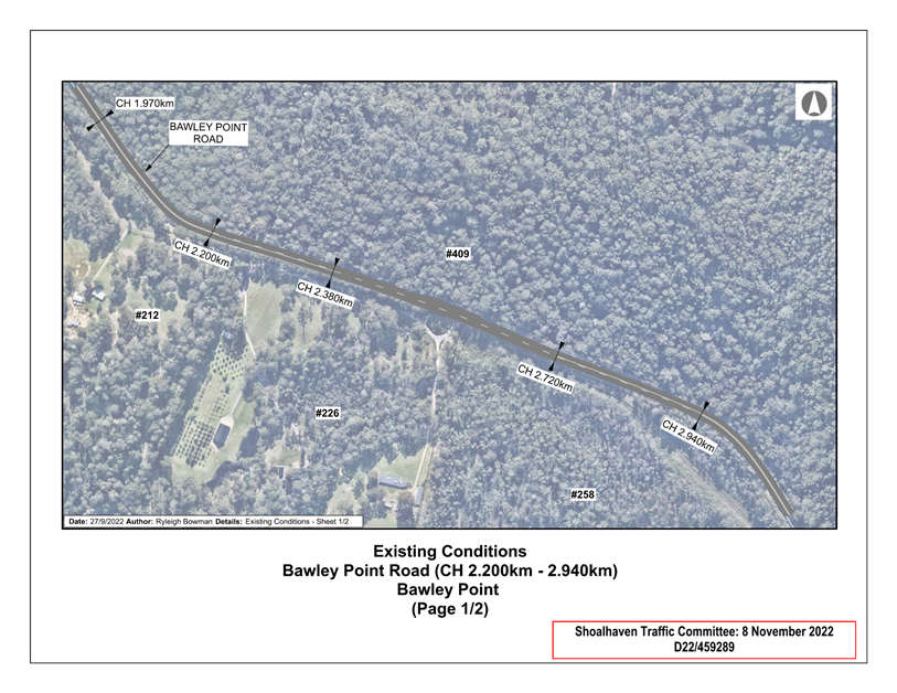
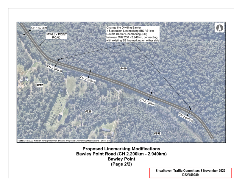
TC22.41 Proposed
Centreline Modifications - Bawley Point Road - Bawley Point (PN 3723)
HPERM Ref: D22/459258
Convenor: David
Pieresko
Attachments: 1. PN
3723 Plans ⇩
|
Recommendation
That:
1. This report be received for information.
2. The Committee note that, based on discussions with the
Southern District Engineer and Transport for NSW, it has been decided to not
proceed with the proposed centreline modifications. Additional W2-206
‘CAUTION DRIVEWAYS’ warning signage on both approaches along
Bawley Point Road will be considered to enhance driver awareness and improve
road safety at this location.
|
Background:
Shoalhaven City Council has
received concerns regarding road safety issues along Bawley Point Road, Bawley
Point. In particular, it has been brought to Council’s attention that the
section of permitted overtaking between Council Chainage Points (CH) 2.200km
– 2.940km presents a potential risk of limited driver awareness with
turning vehicles entering and exiting from private properties.
Council staff have recently
conducted a sight distance inspection at this location (as per AS2890.1) and a
technical assessment of the existing linemarking along this road (as per
AS1742.2). As a result, Council is considering the modification of linemarking
at this location.
Details of Submission:
The extent of this proposal would be to replace the 740m
section of dividing barrier and separation linemarking (BS / S1) with double
barrier linemarking (BB) between the above-mentioned chainage points.
The impact of this proposal will remove the opportunity to
overtake in both directions along this section of Bawley Point Road. This will
eliminate any potential driver confusion or risks to road safety created by
vehicles turning into private properties conflicting with another vehicle
attempting to overtake. Please note that access to driveways will not be
affected by the proposal as residents and visitors are permitted to cross the
BB centreline in order to enter and leave driveways (as per s134(3-1) of the
NSW Road Rules).
Consultation:
Council commenced consultation
with affected residents, businesses and the Bawley Point, Kioloa & Termeil
Community Association. To date, Council has received no objections to this
proposal.
Risk Implications:
This proposal will assist in reducing potential driver
confusion and associated risks to road safety produced by vehicles turning into
private properties conflicting with another vehicle attempting to overtake.
Financial Implications:
This proposal would be funded by Transport for NSW’s
Block Grant Funding allocated to Council for new signage and linemarking.
|

|
Shoalhaven
Traffic Committee – Tuesday 14 February 2023
Page
1
|
|
|
Shoalhaven
Traffic Committee – Tuesday 14 February 2023
Page
1
|
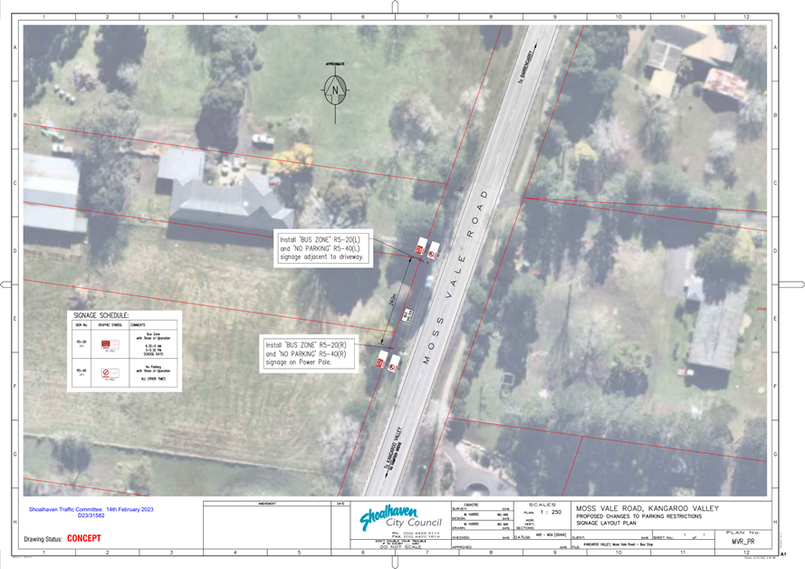
TC23.1 Bus
Zone / Parking Restrictions - Moss Vale Road - Kangaroo Valley (PN 3732)
HPERM Ref: D23/31575
Convenor: David
Pieresko
Attachments: 1. PN
3732 Plan ⇩
|
Recommendation
(Item to be determined under delegated authority)
That:
1. TfNSW
be advised that the Shoalhaven Traffic Committee has no objection to the
proposed parking restrictions at Moss Vale Road, Kangaroo Valley as per Plan
No. D23/31582;
2. The
recommendation be noted by the Director City Services.
|
Background:
Council has received concerns from bus operators and residents
regarding the safety around the bus stop at 2053 Moss Vale Road in Kangaroo
Valley. Moss Vale Road is a TfNSW road and has similarly received the same
concerns. Council and TfNSW have worked collaboratively to improve safety
however TfNSW has jurisdiction.
Details of Submission:
The extent of this proposal would involve the installation of
both “Bus Zone” and “No Parking” restrictions for
approximately 24 metres, encompassing the bus shelter on the western side of
the roadway outside 2053 Moss Vale Road.
The proposal is to install the following signage containing
restrictions:
R5-20 – “Bus
Zone // 6:30 – 9:00AM // 3:00 – 5:30PM // School Days”,
R5-40 – “No Parking // All Other Times”.
This proposal will allow the area to be safely utilised as a
bus stop, without potential conflict with parked vehicles.
Consultation:
Council commenced consultation with affected residents,
stakeholders and the Kangaroo Valley Community Consultative Body in December
2022 to discuss the proposal. To date, Council has received two submissions,
both in support of the proposal.
Risk Implications:
This proposal will assist in facilitating unimpeded access to
the bus stop, removing potential hazards to the safe operation of buses when
setting down or picking up passengers. No further risks are associated with
this project.
Financial Implications:
The signage for this proposal would be installed by Transport
for NSW at their cost.
|
|
Shoalhaven
Traffic Committee – Tuesday 14 February 2023
Page
1
|
|
|
Shoalhaven
Traffic Committee – Tuesday 14 February 2023
Page
1
|
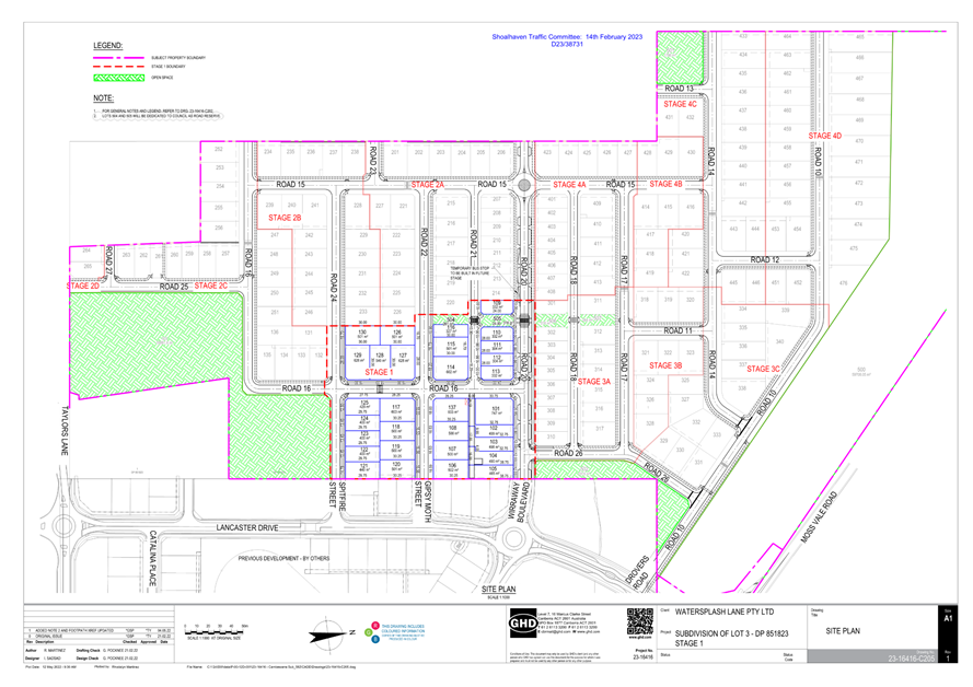
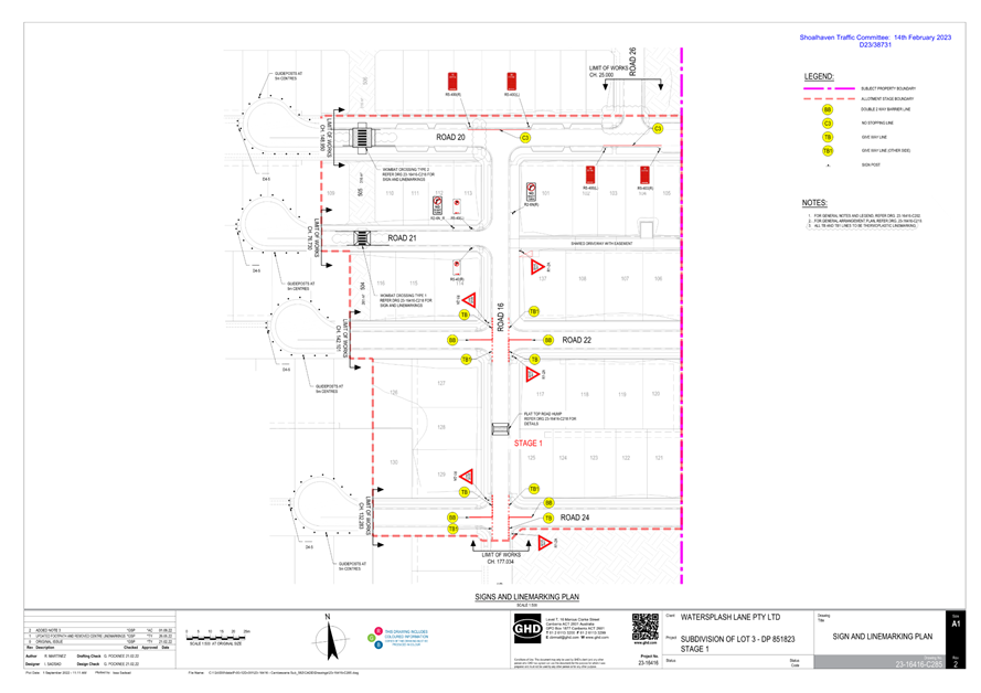
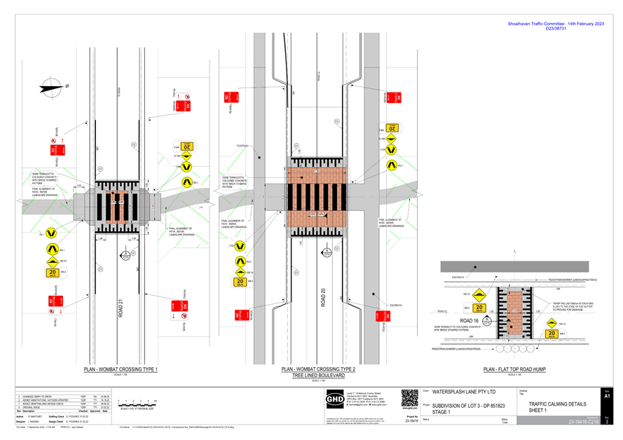
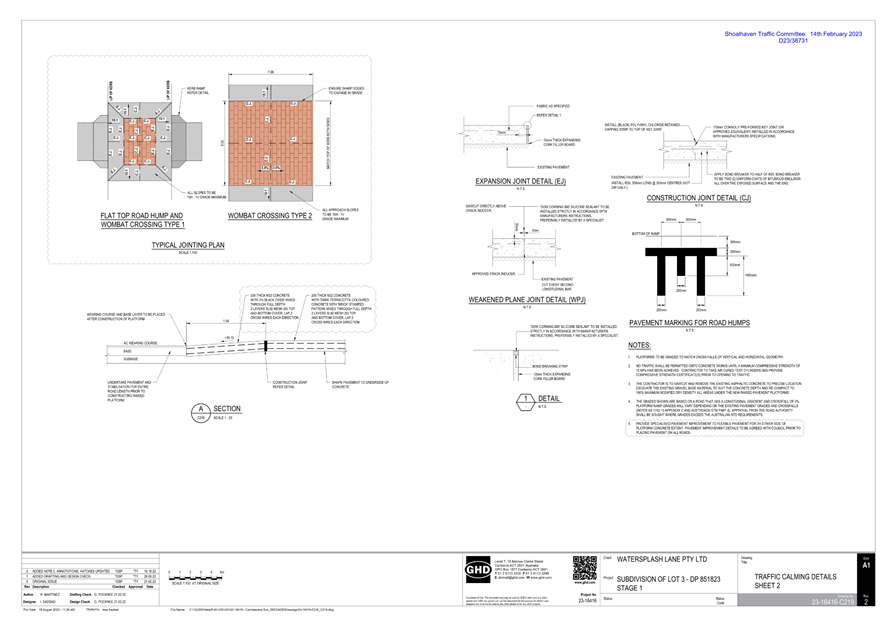
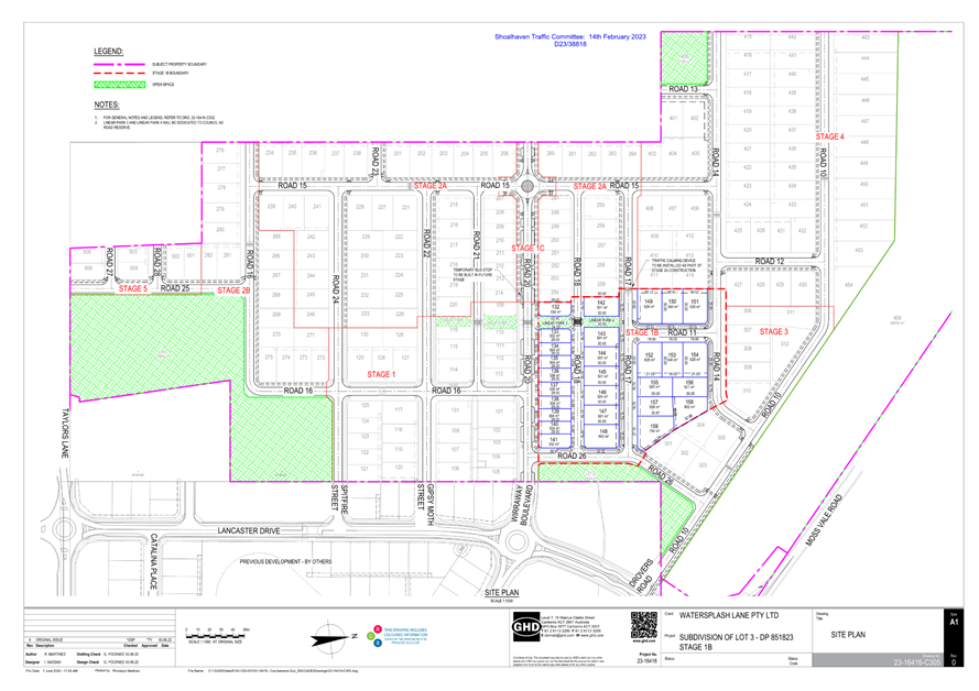
TC23.2 Signage,
Linemarking and Traffic Control Facilities Plans - Lot 3 DP 851823 - 104
Taylors Lane, Cambewarra - MVRS URA Stage 2 - Sub-Stage 1A (PN 3733)
HPERM Ref: D23/38716
Convenor: David
Pieresko
Attachments: 1. PN
3733 Plans ⇩
|
Recommendation
(Item to be determined under delegated authority)
That:
1. The
Chief Executive Officer (Director City Services) be advised that the
Shoalhaven Traffic Committee has no objection to the proposed signage, linemarking
and traffic control facilities associated with the development at Lot 3 DP
851823 – 104 Taylors Lane, Cambewarra (per development consent
condition(s) 39 & 40), as per Plan No. D23/38731.
2. The
recommendation be approved by the Director City Services under delegated
authority from Shoalhaven City Council - refer MIN21.411
|
Details
Applicant: Watersplash
Lane Pty Ltd
Owner: Watersplash
Lane Pty Ltd
104 Taylors Lane, CAMBEWARRA – Lot 3 DP 851823 –
Residential Subdivision
As per Condition(s) 39 & 40 of the development consent
(SF10804), the following is required:
39. Design
Standards – Traffic Committee Referral
Prior to the issue of a
Subdivision Works Certificate details of proposed traffic management and
traffic control devices must be submitted to the satisfaction of Council for
referral and endorsement of the Shoalhaven Traffic Committee.
Note: This process can take
six to eight weeks.
40. Road
Design Standards (Urban) – Greenfield Subdivision (modified by DS21/1301)
Prior to the issue of a
Subdivision Works Certificate, certified road design engineering plans must be
prepared by a professional engineer, (as defined in the National Construction
Code) or surveyor and approved by the Certifier. The road design must comply
with the following:
a) Council’s
Engineering Design Specifications sections D1 – Geometric Road Design and
D2 – Flexible Pavement Design.
b) AUSTROADS Design
Requirements and Specifications.
c) In accordance with
the concept general arrangement plans by GHD (Drawing No. 23-16416-C110 to
C113, Revision E, dated 11/03/2021 and Drawing No. 23-16416-C114, Revision D,
dated 18/12/2020) except where specified by relevant conditions of consent.
d) Avoid trapped low
points and ensure that overland flow is passed safely over public land.
e) Design Vehicles
– 14.5m rigid bus for all temporary and permanent bus routes.
f) Local Area
Traffic Management (LATM) devices to be provided on all roads that exceed the
maximum street leg lengths outlined within Council’s DCP Chapter
G11. All LATM devices must be designed with consideration of the
road’s status as a bus route where relevant, and be in accordance with
Chapter G11, Shoalhaven Development Control Plan 2014, Austroads Guidelines
and/or AS1742.13.
g) Integral kerb and
gutter / layback kerb and gutter in accordance with Council’s Standard
Drawings.
h) Frontages of all
open space and linear park lots to be constructed with upright kerb and gutter.
i) Subsoil
drainage behind the kerb line on the high side of the road or both side if the
cross fall is neutral or the road is in cut.
j) A temporary
vehicle turning area must be provided at the end of each terminating road
and/or stage. The turning area must be designed to have a 9.5m radius for
cul-de-sacs or to accommodate a medium rigid vehicle (MRV) as per AS2890.2 for
a T-shaped turning head and be provided with a minimum pavement thickness of
200mm. The turning area is to be delineated by the use of guideposts at
maximum 5m spacing with a D4-4A and/or D4-5 traffic signs at the end on the
centreline. Access to private land is to be prevented though concrete barriers
or similar obstructions. (modified by DS21/1301)
k) Property boundaries
at road intersections must have minimum 2m corner splays. The dimensions of
splays on local access roads and other roads of a higher hierarchy must be
based on the size of kerb returns needed to cater for the appropriate design
vehicle. (modified by DS21/1301)
l) A roundabout
must be designed at the intersection of Road 15 and Road 20 in accordance with
Austroads Guidelines. The roundabout must permit movements of 14.5m rigid buses
and include raised concrete splitter islands and pedestrian facilities on all
legs in accordance with Austroads Guide to Road Design Part 4B (Clause 4.5.4),
and appropriate lighting, signage and line markings.
A signage and line marking plan has been submitted to the
Committee for consideration.
Consultation:
This Development Application had been on Public Exhibition
between 25 November 2020 and 9 December 2020 with feedback requested from the
community, directly affected residents and local community consultative body.
During this period, Council had received no submissions relating to the
infrastructure proposed.
Council's Planning and Development Services Team approved
this development on 11 June 2021.
Risk Implications:
The proposed measures are expected
to provide safe traffic management for this proposed subdivision. Furthermore,
the works are stipulated in a valid development consent. Undue prevention of,
delay to, or alteration to the completion of requirements of the consent may
expose Council to legal action.
Access to and from Road 21, being a laneway, to be
controlled by “No Right Turn” R2-6N(R) signage to ensure safe
clearance from adjacent intersections when turning into and out of the laneway.
Financial Implications:
The proposed works are to be funded
by the developer in accordance with the development consent. Following this,
Council will be responsible for ongoing maintenance after the dedication of
roads within the subdivision.
|

|
Shoalhaven
Traffic Committee – Tuesday 14 February 2023
Page
1
|
|

|
Shoalhaven
Traffic Committee – Tuesday 14 February 2023
Page
1
|
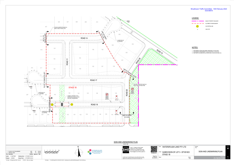
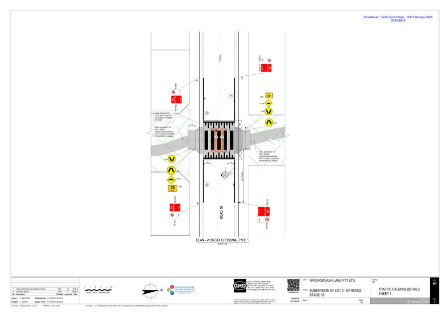
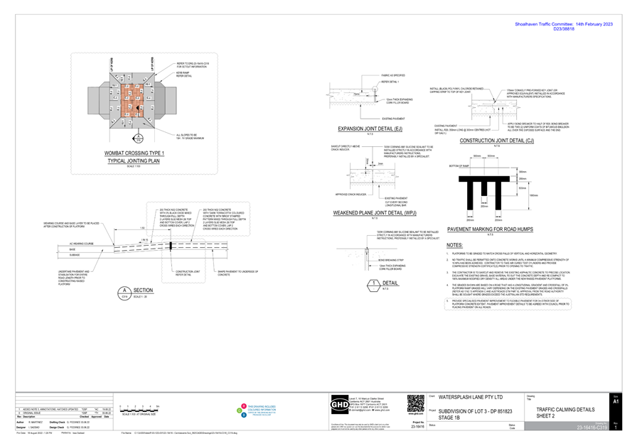
TC23.3 Signage,
Linemarking and Traffic Control Facilities Plans - Lot 3 DP 851823 - 104
Taylors Lane, Cambewarra - MVRS URA Stage 2 - Sub-Stage 1B (PN 3734)
HPERM Ref: D23/38814
Convenor: David
Pieresko
Attachments: 1. PN
3734 Plans ⇩
|
Recommendation
(Item to be determined under delegated authority)
That:
1. The
Chief Executive Officer (Director City Services) be advised that the
Shoalhaven Traffic Committee has no objection to the proposed signage,
linemarking and traffic control facilities associated with the development at
Lot 3 DP 851823 – 104 Taylors Lane, Cambewarra (per development consent
condition(s) 39 & 40), as per Plan No. D23/38818.
2. The
recommendation be approved by the Director City Services under delegated authority
from Shoalhaven City Council - refer MIN21.411
|
Details
Applicant: Cambewarra Ventures
Owner: Cambewarra
Ventures
104 Taylors Lane, CAMBEWARRA – Lot 3 DP 851823 –
Residential Subdivision
As per Condition(s) 39 & 40 of the development consent
(SF10804), the following is required:
39. Design
Standards – Traffic Committee Referral
Prior to the issue of a
Subdivision Works Certificate details of proposed traffic management and
traffic control devices must be submitted to the satisfaction of Council for
referral and endorsement of the Shoalhaven Traffic Committee.
Note: This process can take
six to eight weeks.
40. Road
Design Standards (Urban) – Greenfield Subdivision (modified by DS21/1301)
Prior to the issue of a
Subdivision Works Certificate, certified road design engineering plans must be
prepared by a professional engineer, (as defined in the National Construction
Code) or surveyor and approved by the Certifier. The road design must comply
with the following:
a) Council’s
Engineering Design Specifications sections D1 – Geometric Road Design and
D2 – Flexible Pavement Design.
b) AUSTROADS Design
Requirements and Specifications.
c) In accordance with
the concept general arrangement plans by GHD (Drawing No. 23-16416-C110 to
C113, Revision E, dated 11/03/2021 and Drawing No. 23-16416-C114, Revision D,
dated 18/12/2020) except where specified by relevant conditions of consent.
d) Avoid trapped low
points and ensure that overland flow is passed safely over public land.
e) Design Vehicles
– 14.5m rigid bus for all temporary and permanent bus routes.
f) Local Area
Traffic Management (LATM) devices to be provided on all roads that exceed the
maximum street leg lengths outlined within Council’s DCP Chapter G11. All
LATM devices must be designed with consideration of the road’s status as
a bus route where relevant, and be in accordance with Chapter G11, Shoalhaven
Development Control Plan 2014, Austroads Guidelines and/or AS1742.13.
g) Integral kerb and
gutter / layback kerb and gutter in accordance with Council’s Standard
Drawings.
h) Frontages of all
open space and linear park lots to be constructed with upright kerb and gutter.
i) Subsoil
drainage behind the kerb line on the high side of the road or both side if the
cross fall is neutral or the road is in cut.
j) A temporary
vehicle turning area must be provided at the end of each terminating road
and/or stage. The turning area must be designed to have a 9.5m radius for
cul-de-sacs or to accommodate a medium rigid vehicle (MRV) as per AS2890.2 for
a T-shaped turning head and be provided with a minimum pavement thickness of
200mm. The turning area is to be delineated by the use of guide posts at
maximum 5m spacing with a D4-4A and/or D4-5 traffic signs at the end on the
centreline. Access to private land is to be prevented though concrete barriers
or similar obstructions. (modified by DS21/1301)
k) Property boundaries
at road intersections must have minimum 2m corner splays. The dimensions
of splays on local access roads and other roads of a higher hierarchy must be
based on the size of kerb returns needed to cater for the appropriate design
vehicle. (modified by DS21/1301)
l) A roundabout
must be designed at the intersection of Road 15 and Road 20 in accordance with
Austroads Guidelines. The roundabout must permit movements of 14.5m rigid buses
and include raised concrete splitter islands and pedestrian facilities on all
legs in accordance with Austroads Guide to Road Design Part 4B (Clause 4.5.4),
and appropriate lighting, signage and line markings.
A signage and line marking plan has been submitted to the
Committee for consideration.
Consultation:
This Development Application had been on Public Exhibition
between 25 November 2020 and 9 December 2020 with feedback requested from the
community, directly affected residents and local community consultative body.
During this period, Council had received no submissions relating to the
infrastructure proposed.
Council's Planning and Development Services Team approved
this development on 11 June 2021.
Risk Implications:
The proposed measures are expected to provide safe traffic
management for this proposed subdivision. Furthermore, the works are stipulated
in a valid development consent. Undue prevention of, delay to, or alteration to
the completion of requirements of the consent may expose Council to legal
action.
Access to and from Road 18, being a laneway, to be
controlled by “No Right Turn” R2-6N(R) signage to ensure safe
clearance from adjacent intersections when turning into and out of the laneway.
Financial Implications:
The proposed works are to be funded by the developer in
accordance with the development consent. Following this, Council will be
responsible for ongoing maintenance after the dedication of roads within the
subdivision.
|
|
Shoalhaven
Traffic Committee – Tuesday 14 February 2023
Page
1
|
|
|
Shoalhaven
Traffic Committee – Tuesday 14 February 2023
Page
1
|
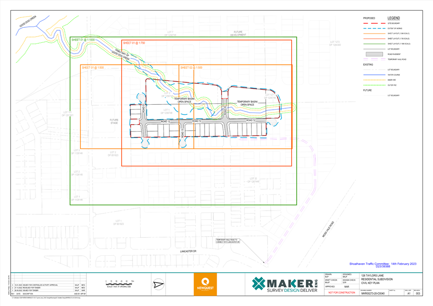
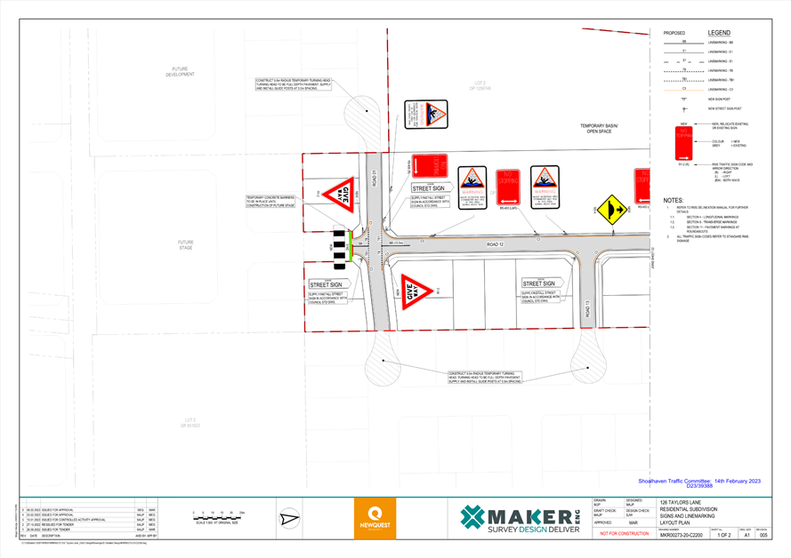
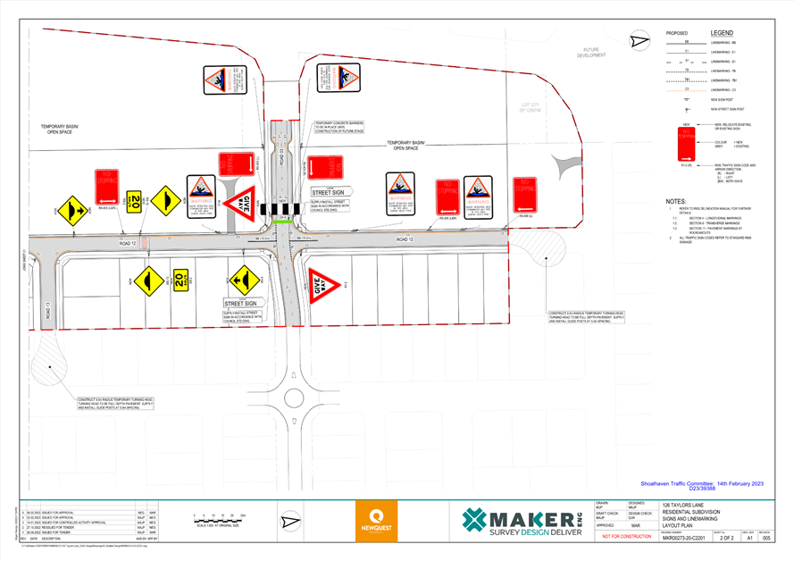
TC23.4 Signage,
Linemarking and Traffic Control Facilities Plans - Lot 6 DP 1256748 - 126
Taylors Lane, Cambewarra - MVRS URA Stage 4 (PN 3735)
HPERM Ref: D23/39374
Convenor: David
Pieresko
Attachments: 1. PN
3735 Plans ⇩
|
Recommendation
(Item to be determined under delegated authority)
That:
1. The
Chief Executive Officer (Director City Services) be advised that the
Shoalhaven Traffic Committee has no objection to the proposed signage,
linemarking and traffic control facilities associated with the development at
Lot 6 DP 1256748 – 126 Taylors Lane, Cambewarra (per development
consent condition(s) 42 & 44), as per Plan No. D23/39388.
2. The
recommendation be approved by the Director City Services under delegated
authority from Shoalhaven City Council - refer MIN21.411
|
Details
Applicant: MAKER
Eng Pty Ltd
Owner: Newquest
Property Pty Ltd
126 Taylors Lane, CAMBEWARRA – Lot 6 DP 1256748
– Residential Subdivision
As per Condition(s) 42 & 44 of the development consent
(SF10895), the following is required:
42. Design
Standards – Traffic Committee Referral
Prior to the issue of a
Subdivision Works Certificate, details of proposed traffic management and
traffic control devices must be submitted to the satisfaction of Council for
referral and endorsement of the Shoalhaven Traffic Committee.
Note: This process can take
six to eight weeks.
44. Road Design
Standards (Urban) – Greenfield Subdivision
Prior to the issue of a
Subdivision Works Certificate, certified road design engineering plans must be
prepared by a professional engineer, (as defined in the National Construction
Code) or surveyor and approved by the Certifier. The road design must
comply with the following:
a) Council’s
Engineering Design Specifications sections D1 – Geometric Road Design and
D2 – Flexible Pavement Design.
b) AUSTROADS Design
Requirements and Specifications.
c) In accordance with
the concept general arrangement plans by Maker ENG (Drawing No. MKR00273-10-C010
to C011, Revision 6, dated 13/10/2022) except where specified by relevant
conditions of consent.
d) The Taylors Lane
frontage for the development must be designed and constructed as part of Stage
1 of the development in accordance with DCP Chapter NB3 and adjoin the
alignment from other stages of the URA. The design must include the half
carriageway width, parking bays, footpath, verge embellishments, etc.).
e) Design Vehicles
– 14.5m rigid bus for all temporary and permanent bus routes (as identified
under Council’s DCP Chapter NB3) and 8.8m service vehicle for all other
roads.
f) Local Area
Traffic Management (LATM) devices to be provided on all roads that exceed the
maximum street leg lengths outlined within Council’s DCP Chapter
G11. All LATM devices must be designed with consideration of the
road’s status as a bus route where relevant, and be in accordance with
Chapter G11, Shoalhaven Development Control Plan 2014, Austroads Guidelines
and/or AS1742.13. All LATM devices require a specialised pavement design
for the approaches.
g) Integral kerb and
gutter / layback kerb and gutter in accordance with Council’s Standard
Drawings.
h) Frontages of all
open space lots to be constructed with upright kerb and gutter.
i) Subsoil
drainage behind the kerb line on the high side of the road or both side if the
cross fall is neutral or the road is in cut.
j) A temporary
vehicle turning area must be provided at the end of each stage. The
turning area must be designed to have a 9.5m radius and a minimum pavement
thickness of 200mm. The turning area is to be delineated by the use of
guide posts at maximum 5m spacing with a D4-4A sight board at the end on the
centreline. The western termination of Road 03 and the southern
termination of Road 12 are to be terminated by concrete barriers and D4-4A
signage to prevent unauthorised access.
k) Property boundaries
at road intersections must have minimum 2m x 2m corner splays. The
dimensions of splays on local access roads and other roads of a higher
hierarchy must be based on the size of kerb returns needed to cater for the
appropriate design vehicle.
A signage and line marking plan has been submitted to the
Committee for consideration.
Consultation:
This Development Application had been on Public Exhibition
between 6 October 2021 and 20 October 2021 with feedback requested from the
community, directly affected residents and local community consultative body.
During this period, Council had received no submissions relating to the
infrastructure proposed.
Council's Planning and Development Services Team approved
this development on 22 December 2022.
Risk Implications:
The proposed measures are expected to provide safe traffic
management for this proposed subdivision. Furthermore, the works are stipulated
in a valid development consent. Undue prevention of, delay to, or alteration to
the completion of requirements of the consent may expose Council to legal
action.
Financial Implications:
The proposed works are to be funded by the developer in
accordance with the development consent. Following this, Council will be
responsible for ongoing maintenance after the dedication of roads within the
subdivision.
|
|
Shoalhaven
Traffic Committee – Tuesday 14 February 2023
Page
1
|
|
|
Shoalhaven
Traffic Committee – Tuesday 14 February 2023
Page
1
|
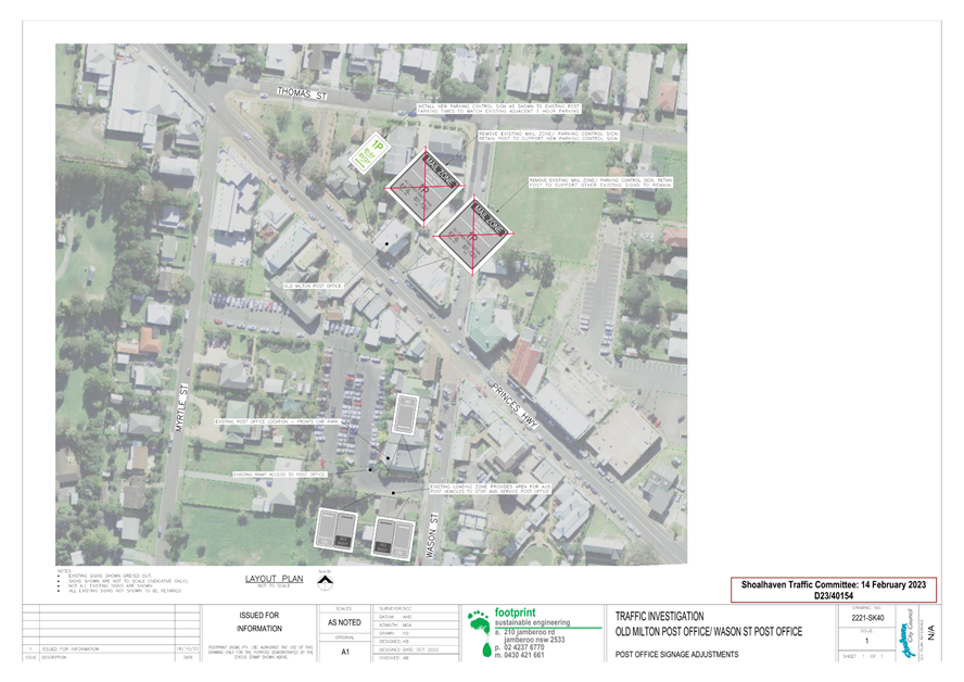
TC23.5 Proposed
Parking Signage Modifications - Princes Highway - Milton (PN 3737)
HPERM Ref: D23/40070
Convenor: David
Pieresko
Attachments: 1. PN
3737 Plans ⇩
|
Recommendation
That:
1. The Chief Executive Officer
(Director City Services) be advised that the Shoalhaven Traffic Committee has
no objection to the proposed removal of the redundant ‘Mail Zone’
signage and replacement with equivalent time restricted parking signage on
the Princes Highway, Milton as per Plan No. D23/40154
2. The
recommendation be approved by the Director City Services under delegated authority
from Shoalhaven City Council - refer MIN21.411
|
Background:
Shoalhaven City Council has
received concerns regarding parking restrictions along the Princes Highway,
Milton. As the Post Office has been relocated to Wason Street, the existing
‘Mail Zone’ parking signage along the Princes Highway is no longer
required.
As such, Council is considering
the modification of parking signage at this location.
Details of Submission:
The extent of this proposal
would be to remove the existing ‘Mail Zone’ parking restrictions on
the north-eastern side of the Princes Highway and replace with 1P timed parking
signage. This would be an extension of the existing parking restrictions along
this side of the Princes Highway and would be active during the same hours of
operation (i.e. 8:30am – 5:30pm on Monday – Friday and 8:30am
– 12:30pm on Saturday).
As a result of this proposal,
there will be an increase of three time restricted parallel parking spaces
provided along the Princes Highway, in place of the redundant Mail Zone.
Consultation:
Council commenced consultation
with affected residents, businesses and the Milton 2538 Community Consultative
Body between December 2022 and January 2023 to discuss the proposal. To date,
Council has received two submissions in favour of the proposal.
Risk Implications:
This proposal would improve
parking efficiency through the removal of the redundant ‘Mail Zone’
signage and replacement with equivalent timed parking signage.
Financial Implications:
This proposal would be funded by Transport for NSW’s
Block Grant Funding allocated to Council for new signage and linemarking.
|
|
Shoalhaven
Traffic Committee – Tuesday 14 February 2023
Page
1
|
|
|
Shoalhaven
Traffic Committee – Tuesday 14 February 2023
Page
1
|
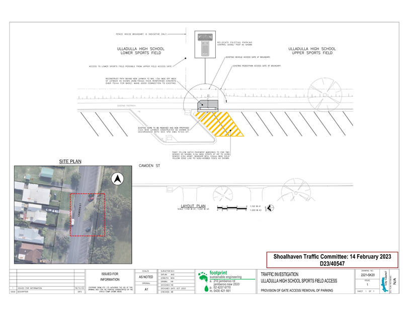
TC23.6 Proposed
Relocation of Parking Spaces - Camden Street - Ulladulla (PN 3738)
HPERM Ref: D23/40196
Convenor: David
Pieresko
Attachments: 1. PN
3738 Plans ⇩
|
Recommendation
That:
1. The Chief Executive Officer (Director City
Services) be advised that the Shoalhaven Traffic Committee has no objection
to the proposed signage and linemarking modifications to Camden Street,
Ulladulla as per Plan No D23/40547.
2. The recommendation be approved by the
Director City Services under delegated authority from Shoalhaven City Council
- refer MIN21.411.
|
Background:
Shoalhaven City Council has received concerns regarding
emergency access to the Ulladulla High School’s northern ovals from
Camden Street, Ulladulla. In the event of an emergency, where Ambulances may be
required to access the northern ovals on site, there is currently no dedicated
parking spaces or restricted zone to provide this access. Council staff have
recently inspected this location, taking note of the existing condition and
signage along the road.
From these investigations, Council is considering the
modification of parking spaces at this location.
Details
of Submission:
The extent of this proposal would be to relocate the
‘No Stopping’ parking restrictions on the eastern side of Camden
Street by two parking spaces south of the kerb blister at this location. This
restricted parking area will then be delineated with yellow hatched linemarking
to highlight the clearance area. Future works will remove the existing upright
kerb and replace with a 3m wide layback driveway to provide direct access to the
High School’s gate into the northern ovals.
As a result of this proposal, there will be a reduction of
two parking spaces on the eastern side of Camden Street.
Consultation:
Council commenced consultation
with affected residents, the Ulladulla High School, bus companies and the
Ulladulla and Districts Community Forum between December 2022 and January 2023
to discuss the proposal. To date, Council has received two submissions in
favour of the proposal.
Risk Implications:
The impact of this proposal will remove two angled parking
spaces on the eastern side of Camden Street, to ensure permanent access to the
High School’s ovals for emergency purposes.
Financial Implications:
This proposal would be funded by Transport for NSW’s
Block Grant Funding allocated to Council for new signage and linemarking.
|
|
Shoalhaven
Traffic Committee – Tuesday 14 February 2023
Page
1
|
|
|
Shoalhaven
Traffic Committee – Tuesday 14 February 2023
Page
1
|
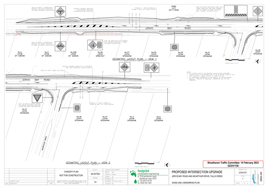
TC23.7 Proposed
Intersection Improvements - McArthur Drive & Jervis Bay Road - Falls Creek
(PN 3739)
HPERM Ref: D23/40742
Convenor: David
Pieresko
Attachments: 1. PN
3739 Plans ⇩
|
Recommendation
That:
1. The Chief Executive Officer (Director City
Services) be advised that the Shoalhaven Traffic Committee has no objection
to the proposed intersection improvements at McArthur Drive and Jervis Bay
Road, Falls Creek, as per Plan No D23/41158.
2. The recommendation be approved by the
Director City Services under delegated authority from Shoalhaven City Council
- refer MIN21.411.
|
Background:
Shoalhaven City Council has received concerns regarding road
safety at the intersection of McArthur Drive and Jervis Bay Road, Falls Creek.
Council staff have recently inspected this location, taking note of the
existing condition, signage and linemarking at the intersection.
From these investigations, Council is considering road
safety improvements to this intersection.
Details
of Submission:
The extent of this proposal would be to upgrade the
intersection with a Channelised Right- turn treatment (CHR) for southbound
vehicles along Jervis Bay Road to access McArthur Drive. An Auxiliary Left-
turn treatment (AUL) will also be considered for northbound vehicles along
Jervis Bay to access McArthur Drive. Modifications to the centreline and
installation of chevron pavement markings will also be considered for this
proposal.
Consultation:
Council commenced consultation
with affected residents and the Huskisson Woollamia Community Voice between
January and February 2023 to discuss the proposal. To date, Council has
received three submissions, consisting of two in favour and one opposed to this
proposal.
The submissions received raised
concerns regarding vehicle speeds along Jervis Bay Road and limited sight
distance at the intersection. From this, there were requests made for Council
to consider the reduction of the existing 80km/h speed limit along Jervis Bay
Road and the installation of speed cameras and convex mirrors at the
intersection.
Residents who raised these
concerns as part of the consultation were notified that the responsibility of
reviewing and modifying speed zones on all roads within New South Wales comes
under the control of Transport of NSW (TfNSW). Subsequently, it was suggested
to make a separate submission to request a speed zone investigation with TfNSW
via the Safer Roads NSW website.
Similarly, residents were
notified that TfNSW is responsible for the deployment of mobile speed cameras
on all roads. Residents were directed to make a separate submission to request
a mobile speed camera at this location via the Safer Roads NSW website.
Residents were also notified
that Council does not support the installation of new convex mirrors. This is
due to several inherent problems with convex mirrors, such as distorting the
image, speed and distance of an object being viewed. With these concerns in
mind, the installation of a convex mirror at this location would potentially be
more detrimental than beneficial.
Lastly, residents raised
concerns regarding the scope of the works impacting private property and
limiting access to No. 3 Stapleton St (No. 3 Lot 49 on the plan). No impact is
foreseen as per the proposed plan, but this will be investigated and addressed
in the detailed design to ensure access is maintained.
Risk Implications:
The impact of this proposal will improve road safety and
provide dedicated turning lanes for vehicles wishing to access McArthur Drive
on both northbound and southbound approaches along Jervis Bay Road. As
indicated above, this design will not restrict access to properties with
driveways fronting Jervis Bay Road.
Financial Implications:
This proposal is subject to the acquisition funding for the
intersection improvement works.
|
|
Shoalhaven
Traffic Committee – Tuesday 14 February 2023
Page
1
|