Northern Floodplain Risk Management Committee
Meeting Date: Wednesday,
07 December, 2022
Location: Jervis
Bay Rooms, City Administrative Centre, Bridge Road, Nowra
Time: 4:00pm
Please note: Council’s Code of Meeting Practice
permits the electronic recording and broadcast of the proceedings of meetings
of the Council which are open to the public. Your attendance at this meeting is
taken as consent to the possibility that your image and/or voice may be
recorded and broadcast to the public.
Agenda
1. Apologies
2. Confirmation of Minutes
· Northern
Floodplain Risk Management Committee - 21 March 2022......................... 1
3. Declarations of Interest
4. Reports
NFM22.6..... Notification of Council Resolution - Northern
Floodplain Risk Management Committee Re-establishment............................................................................................ 5
NFM22.7..... Lower Shoalhaven River Final Flood Study................................................. 23
NFM22.8..... General Update on Flood Projects............................................................... 38
5. General Business
|

|
Northern
Floodplain Risk Management Committee – Wednesday 07 December 2022
Page
|
Membership
Clr
Patricia White - Chairperson
All
Councillors
CEO or nominee
Community representatives:-
John Gould
David Brawn
Mark Kielly
Plaxy Rowe
Leonard White
Phil Guy
Government Agency representatives:-
Local Aboriginal Land Council
NSW State Emergency Services
Department of Planning & Environment (DPE)
Other relevant Government Agency
representatives
Quorum – Three (3) provided that a minimum of the Chairperson
and two community representatives are present.
Note: Any non-voting Councillor in
attendance at any of the above Committees may act as an alternate voting member
in circumstances where achievement of a quorum is required.
Purpose:
The principal objective of the
North Floodplain Risk Management Committee is to assist Shoalhaven City Council
in the development and implementation of one or more floodplain risk management
plans for the north area of the Council. This will need to be in accordance
with the NSW Floodplain Development Manual. The north area applies to the
following catchments:
· Lower
Shoalhaven River;
· Crookhaven
River;
· Kangaroo
River;
· Broughton
Creek;
· Bomaderry
Creek;
· Nowra
and Browns Creek; and
· Lake
Wollumboola.
Role:
1. To assist the Council in the
development and implementation of a Flood Study, Floodplain Risk Management
Study and Floodplain Risk Management Plan for the areas listed under
‘Purpose’ (see above);
2. To assist the Council monitoring
and assessing the effectiveness of the management plans during and after their
implementation;
3. To assist the Council by
providing input into known flood behaviour as part of the Flood Study; and
4. Facilitate broader
community consultation and participation in floodplain risk management through
informing and liaising with member community groups.
Minutes of the Northern Floodplain Risk Management Committee
Meeting Date: Monday,
21 March 2022
Location: Council
Chambers, City Administrative Centre, Bridge Road, Nowra
Time: 4:07pm
The following members
were present:
Clr Patricia White -
Chairperson
Clr Serena Copley
(remotely) – left meeting at 6:06pm
Clr Evan Christen
Mr John Gould –
Shoalhaven Riverwatch
Mr David Brawn
Mr Mark Kielly
Mr Phil Guy
Mr Michael Roberts -
Manager - Environmental Services
Mr Adam Carney –
(remotely) – joined at 4:25pm
Others Present:
Mr James Ruprai –
Director City Development
Mr Michael Roberts - Manager - Environmental Services
Mr Mark Stone –
Senior Floodplain Engineer
Mr Alexander Aronsson
– Floodplain & Stormwater Quality Engineer
Mr David Whyte –
Cardno (remotely)
Mr Robin Byrne - SES
Nowra Unit Flood control (remotely)
Mr Nathan Pomfret –
Department of Planning and Environment (remotely)
|
Apologies / Leave of
Absence
|
Apologies were received
from Len White and Clr Wells.
|
NFM22.5 Election
of Chairperson
|
|
RESOLVED (John Gould / Phil Guy)
Michael
Roberts - Manager - Environmental Services assumed the Chair and asked the members
present if there were any nominations for the role of Chairperson.
Clr Patricia White was nominated by John Gould
for the position of Chairperson, seconded by Phil Guy. There were no
additional nominations received.
The Committee agreed the election process was conducted
fairly and reasonably. Michael Roberts - Manager - Environmental Services -
declared Clr Patricia White as Chairperson.
Clr
White resumed the Chair.
CARRIED
|
|
Confirmation of the
Minutes
|
|
Mark Stone - Senior Floodplain Engineer –
advised that there was an error in the Agenda which showed the minutes of the
last meeting being held on 19 May 2021. However, the last meeting was
held on 25 November 2020. This was noted and the Minutes of the meeting of 25
November 2020 were confirmed.
|
|
RESOLVED (Clr White / John Gould)
That the Minutes of the Northern
Floodplain Risk Management Committee held on 25 November 2020 be confirmed.
CARRIED
|
Nil.
Presentations
|
NFM22.3 Presentation - Purpose of the
FRMC and NSW Government Flood Program – Department of Planning and
Environment.
|
HPERM Ref: D22/107705
|
|
Mark Stone - Senior Floodplain Engineer –
advised that this presentation has previously been presented to the FRMC by
John Murtagh - Senior Natural
Resource Officer, Environment,
Energy & Science, Department of Planning and Environment.
Nathan Pomfret - Environmental, Energy & Science -
Department of Planning and Environment - made a presentation to the meeting
for the benefit of new members on the Committee.
· Council has 13 adopted Flood Studies and
12 adopted Floodplain Risk Management (FRM) Plans which identify risk and
management options across the Shoalhaven. The plans are being progressively
implemented across the Shoalhaven in a prioritised manner.
· Council has continued to prepare flood
studies for unmapped catchments and to review adopted Plans in a prioritised
order such as the current review of the Lower Shoalhaven River Floodplain
Risk Management Study and Plan.
· Current Works and Studies that are being
undertaken are:
o Maintenance of Lower Shoalhaven River
Flood Mitigation Scheme – Annual NSW Government grant to assist with
the costs in maintaining existing flood mitigation assets
o Lower Shoalhaven River Floodplain Risk
Management Study and Plan Review
o St
Georges Basin Floodplain Risk Management Study and Plan Review – this
will be discussed at the Central Floodplain Risk Management meeting to be
held on 30 March 2022.
· The NSW Floodplain Development Manual
(2005) is currently under review and on public exhibition until 4 April 2022.
The reviewed name is the NSW Flood Risk Management Manual.
· Flood Prone Land Policy – primary
objective is to reduce the impact of flooding and flood liability on
individual owners and occupiers of flood prone property, and to reduce
private and public losses from floods utilising ecologically positive
methods, where possible.
The presentation will be forwarded with these minutes
to members of the Committee.
|
Note: Mayor Amanda
Findley joined the meeting remotely at 4:45pm.
|
NFM22.4 Presentation - Lower Shoalhaven
River Flood Study – Cardno
|
HPERM Ref: D22/107712
|
|
David Whyte – Cardno – made a presentation
to the meeting. The topics covered in the presentation were:
1. Background
on the Flood Study process and Study Objectives
2. Model
Development – hydrological and hydraulic models
3. Design
Event Modelling
4. Results
and Impacts of Flooding
5. Next Steps
– public exhibition and community consultation, complete the Final
Flood Study based on feedback, complete the Floodplain Risk Management Study
and Plan including assessment of available flood mitigation options
The
presentation will be forwarded with these minutes to members of the
Committee.
|
Note: Clr Copley left the
meeting at 6:06pm.
Reports
|
NFM22.1 Lower Shoalhaven River
Floodplain Risk Management Study and Plan Update
|
HPERM Ref: D22/87287
|
|
Mark Stone - Senior Floodplain Engineer - provided an
update on the Lower Shoalhaven River Floodplain Risk Management Study and
Plan:
· The Draft Lower
Shoalhaven River Flood Study Report has been completed. A Summary Report has
also been prepared to assist with community engagement.
· Independent
expert peer review of the study has been completed and comments implemented.
· Feedback has
been provided by Council, Department of Planning and Environment, and SES.
· Next step is to
put the Draft Lower Shoalhaven River Flood Study Report on public exhibition
and community consultation to seek input on the report and suggestions for
flood mitigation measures to be considered in the FRMS&P.
· Council has
received an extension to the DPE funding term completion date to 21 November
2022.
Discussion
took place in relation to the various methods to be considered for
community engagement phase:
· Clr White
suggested that a webinar option be considered as part of the community consultation
process.
· Phil Guy
recommended that Council utilise the existing CCB network for the
presentation and hold a Q&A session.
· The community engagement phase is
suggested to be held for a four week period, which was planned for the end of
April but will likely be moved to mid to late-May to ensure any necessary
changes are made to the report prior to public exhibition and community
consultation and to prepare required community consultation material.
· David
Whyte – Cardno – will prepare a video recording of the
presentation which will be available on the “Get Involved” page.
Action: Mark Stone - Senior Floodplain Engineer - to
send out the adopted methods and planning for the community consultation
process to FRMC members prior to any public exhibition or community
involvement.
|
|
Recommendation
The Committee receive the
draft Lower Shoalhaven River Flood Study report for information and endorse
the commencement of public exhibition and community engagement for the Draft
Flood Study.
|
|
RECOMMENDATION
(Phil Guy / John Gould)
The Committee receive the draft
Lower Shoalhaven River Flood Study report for information and endorse the
commencement of public exhibition and community engagement for the Draft
Flood Study.
CARRIED
|
|
NFM22.2 General Update on Flood
Projects
|
HPERM Ref: D22/87503
|
|
The report provided an update on
Council’s grant funding and the current status of the flood projects.
Clr White advised that most importantly that Council
will be conducting a visual audit of all flood mitigation drains and levies
during April 2022.
|
|
Recommendation (Item to be determined under
delegated authority)
The Committee receive the
General Update on Flood Projects report for information.
|
|
RESOLVED (Clr White / John Gould)
The Committee receive the General Update on Flood Projects
report for information.
CARRIED
|
There being no further
business, the meeting concluded, the time being 6:38pm.
Clr Patricia White
CHAIRPERSON
|

|
Northern
Floodplain Risk Management Committee – Wednesday 07 December 2022
Page
0
|
NFM22.6 Notification
of Council Resolution - Northern Floodplain Risk Management Committee
Re-establishment
HPERM Ref: D22/483079
Department: Business
Assurance & Risk
Approver: Michael
Roberts, Manager - Environmental Services
Attachments: 1. Terms
of Reference - North/Central/Southern Floodplain Risk Management Committee ⇩
Reason for Report
Advise of Council’s
resolution in relation to the new members and re-establishment of the Northern
Floodplain Risk Management Committee.
|
Recommendation (Item to be determined under delegated authority)
That the Northern Floodplain
Risk Management Committee receive the Notification of Council Resolution
– Northern Floodplain Risk Management Committee Re-establishment report
for information.
|
Options
1. As recommended.
Implications: The membership structure as resolved
by Council is adopted for the period to 30 September 2023.
2. Propose a
different membership arrangement.
Implications: Should the Northern Floodplain Risk
Management Committee wish to make an alternative recommendation in relation to
membership, this would need to be reported to Council for
consideration/endorsement.
Background
Each year, Council reaffirms all
Committees for the next 12 months - Council has the option to: reaffirm
Committees; make any change to the membership, purpose, delegation, quorum, and
the number of meetings required for those Committees; or disband Committees.
This report is provided to
inform the Group members of the resolution of the Council. Should the Group
wish to make any changes to the above, a recommendation to Council will be
required to that effect.
At the Ordinary meeting on 26 September 2022 Council
resolved as follows:
|
Meetings per year – As required
Commencement time – 4pm
|
Quorum – Three (provided that a minimum of one (1)
Councillor as the Chair or Acting chair and two community representatives are
present)
|
|
Terms of Reference: POL22/28 –
Amended 1 August 2022 (59952E)
|
|
Purpose
The principal objective of the Northern Floodplain Risk
Management Committee is to assist Shoalhaven City Council in the development
and implementation of one or more floodplain risk management plans for the
north area of the Council. This will need to be in accordance with the NSW
Floodplain Development Manual. The north area applies to the following
catchments:
· Lower
Shoalhaven River;
· Crookhaven
River;
· Kangaroo
River;
· Broughton
Creek;
· Bomaderry
Creek;
· Nowra
and Browns Creek; and
· Lake
Wollumboola.
|
|
Role of the Committee
a) To assist the Council in the development and
implementation of a Flood Study, Floodplain Risk Management Study and
Floodplain Risk Management Plan for the areas listed under
‘Purpose’ (see above).
b) To assist the Council monitoring and assessing the
effectiveness of the management plans during and after their implementation.
c) To assist the Council by providing input into known flood
behaviour as part of the Flood Study; and
d) Facilitate broader community consultation and
participation in floodplain risk management through informing and liaising
with member community groups.
|
|
Delegation – NIL
|
|
Chairperson – Appointed by Council
|
|
2022-2023 Councillor / Staff Membership
Clr White - Chairperson
All other Councillors (non-voting members)
CEO or nominee
Note:
Any non-voting Councillor in attendance at any of the above Committees may
act as an alternate voting member in circumstances where achievement of a
quorum is required.
|
|
Community/Organisational Representatives
Community representatives (including a maximum of five (5)
local community representatives, one (1) youth representative between ages 16
and 30, and one (1) indigenous representative)
Relevant government agency representatives (Non-voting)
|
CARRIED
Policy Implications
Any non-voting Councillor in attendance at the Northern Floodplain Risk Management Committee meetings
may act as an alternate voting member in circumstances where achievement of a
quorum is required.
|
|
Northern
Floodplain Risk Management Committee – Wednesday 07 December 2022
Page
0
|
Terms of Reference
Northern /
Central / Southern Floodplain Risk Management Committees
|
Adoption Date:
|
20/07/2020
|
|
Amendment Date:
|
06/10/2020, 01/08/2022, 26/09/2022
|
|
Minute Number:
|
MIN20.479,
MIN20.736, MIN22.509, MIN22.673
|
|
Review Date:
|
01/12/2024
|
|
Directorate:
|
City Development
|
|
Record Number:
|
POL22/28
|
Northern
Floodplain Risk Management Committee
1. Purpose
The principal objective of the Northern
Floodplain Risk Management Committee is to assist Shoalhaven City Council in
the development and implementation of one or more Floodplain Risk Management
Study and Floodplain Risk Management Plan for the northern area of the Council.
This will need to be in accordance with the NSW Floodplain Development Manual.
The northern area applies to the following
catchments:
· Lower Shoalhaven River
· Crookhaven River
· Kangaroo River
· Broughton Creek
· Bomaderry Creek
· Nowra and Browns Creek
· Lake Wollumboola
2. Interpretation
For the purpose of this document:
Member means a member of the committee
Committee means Northern Floodplain Risk Management
Committee
Council means Shoalhaven City Council
Chairperson / Chair means the chairpersons of the Committee
Elected members means the elected Councillors of
Shoalhaven City Council
3. Status of the
Committee
The Committee provides non-binding advice to Council
for consideration.
4. Role of the
Committee
a) To
assist the Council in the development and implementation of a Flood Study,
Floodplain Risk Management Study and Floodplain Risk Management Plan for the
areas listed under ‘Purpose’ (see above).
b) To
assist the Council monitoring and assessing the effectiveness of the management
plans during and after their implementation.
c) To
assist the Council by providing input into known flood behaviour as part of the
Flood Study; and
d) Facilitate
broader community consultation and participation in floodplain risk management
through informing and liaising with member community groups.
5. Delegations
Advisory committees may make
recommendations to Council on all matters within the role as outlined above.
These recommendations are submitted via the minutes of each meeting to Council
for consideration.
Substantial issues and recommendations
(possibly including expenditure) raised by the advisory committee will be
reported to Council by a separate report from the Manager – Environmental
Services.
1.
The committee does not
have the power to incur expenditure, or the power to bind Council.
2.
6. Membership
The Committee will be chaired by a
Councillor, elected by Council. The committee is expected to act in accordance
with the Role of the Committee as defined above in Section 4. The Committee
will comprise the following:
· Appointed Chair (Councillor)
· Elected members of Council
· Chief Executive Officer or nominee
· Community representatives
· New South Wales State Emergency Services (NSW SES) representatives
· Department of Planning and Environment (DPE) representatives
· Local Aboriginal Land Council (LALC) representatives
· Other relevant government agency representatives
Councillors
Representatives
Council
appoints one (1) Councillor to be the voting Chair of the Committee. All other
Councillors are welcome to attend meetings of the Committee as observers and
contribute to discussions but are not entitled to vote.
Note: Any
non-voting Councillor in attendance at a meeting may act as an alternate voting
member in circumstances where achievement of a quorum is required.
If no Councillors are appointed as
members, the Chief Executive Officer or nominee represents the elected member
to chair the meeting.
Local
Representatives
Following an expression of interest
process, the Chief Executive Officer appoints a
maximum of five (5) local community
representatives, one (1) youth representative between ages 16 and 30, and one
(1) indigenous representative, that meet the following criteria:
· A broad interest, knowledge and understanding of floodplain
management and the areas within the committee’s jurisdiction.
· A commitment to floodplain management in the nominated Council
area; and
· Local resident or business person living or working in or near a
flood prone area.
Local community representatives have
voting rights.
Community Member
Appointments:
· Nominations should be advertised throughout the
community via an Expression of Interest (EOI) process.
· Appointments to the Committee will be for a three (3)
year term with a set commencement and finish date. Vacancies which are filled
during the committee’s term will have the same finish date.
· Vacancies will be advertised locally via media and
Council communication networks.
· Council will manage the application process; and
· An assessment panel consisting of a Council staff
member (Manager – Environmental Services), the Chairperson of the
Committee and one (1) suitably qualified independent representative will assess
the applications and make recommendations for appointments to Council. Each
member of the assessment panel will vote on recommendations with a majority
ruling.
Council
Officers
Council officers attend meetings to provide
specialist professional advice in engineering, strategic planning, development
assessment and environmental management. Council officers do not have voting
rights.
Government
Agencies
The Chief Executive Officer (or nominee)
invites a range of State Government agencies to nominate representatives.
The nominated agency representatives
provide advice in relation to their functions
and areas of expertise, however, are
non-voting members.
Chair and
Deputy Chair
Council appoints one (1) Councillor to be
the Chair of the Committee.
In the absence of the nominated Chair at a
particular meeting, the members elect a Chair for that meeting.
Terms of
Office
The term of the Chair will be one (1) year
which will be reviewed annually in September. Councillors continue as members
of the Committee until the next Local Government election, or until the
Committee is disbanded or completes its purpose in accordance with these Terms
of Reference.
7. Committee
Meetings
Agenda
The agenda will be developed by the Director - City
Development with support from the Manager - Environmental Services in view of
the prevailing issues. Councillors and members can contribute to the agenda by
requesting a report on a particular issue four (4) weeks prior to the meeting,
subject to approval of the Chair and the Director- City Development.
Quorum
Three (3) provided that a minimum of one (1)
Councillor as chair or acting chair with voting rights and two (2) community
representatives are present. If a quorum is not present within 30 minutes of
the scheduled commencement time, the meeting lapses.
Voting
It is expected that the committee,
and any working group, develop recommendations by consensus. If voting is
required, the Chair has a casting vote. Any votes against will be recorded in the minutes.
Meeting
Schedule
In general, meeting frequency should
be conducted on an as required basis.
Minutes
The Committee provides
advice to the Council for consideration. The Committee’s advice is posted
on the Council website with minutes reported to the elected Council. Following
consideration of the advice from the Committee, any resolution determined by
Council, will be posted on the Council website.
Confidentiality
And Privacy
Members may have contact
with confidential or personal information retained by Council. If so, members
are required to maintain the security of any confidential or personal information
and not access, use, or remove any information, unless the member is authorised
to do so.
Communication
3.
In
relation to the communication functions of the Committee, the following
applies:
· Members of the Committee are not permitted to speak to
the media as Council representatives of the Committee unless approved by the
Chairperson.
· Where approval has been given by the Chairperson,
views and opinions expressed are those of the Committee and not of Shoalhaven
City Council.
· Where endorsement is required from Shoalhaven City
Council, approval must be sought through the formal processes; and
· The Chair of the Committee is the point of contact for
communication between Committee members and Council staff.
8. Code of
Conduct
All members of the Committee are required
to observe the provisions of Council’s Code of Conduct and any other
policy or requirement applicable to the proper functioning of the Committee.
A breach of the Code of Conduct may lead
to the member being expelled from the Committee.
9. Document
Control
These Terms of Reference are reviewed at
the commencement of each term of Council. Amendments to these Terms of
Reference are to be reported to Council for approval. A version history
(footnote on front page) is included if amendments have been approved.
Central Floodplain Risk Management
Committee
1. Purpose
The principal objective of the Central
Floodplain Risk Management Committee is to assist Shoalhaven City Council in
the development and implementation of one or more Floodplain Risk Management
Study and Floodplain Risk Management Plan for the central area of the Council.
This will need to be in accordance with the NSW Floodplain Development Manual.
The central area applies to the following
catchments:
· St Georges Basin (includes Sussex inlet)
· Jervis Bay
· Currambene Creek
· Moona Moona Creek
· Currarong Creek
· Berrara Creek
· Callala Creek
· Swan Lake
2. Interpretation
For the purpose of this document:
Member means a member of the committee
Committee means Central Floodplain Risk Management
Committee
Council means Shoalhaven City Council
Chairperson / Chair means the chairpersons of the Committee
Elected members means the elected Councillors of
Shoalhaven City Council
3. Status of the
Committee
The Committee provides non-binding advice to Council
for consideration.
4. Role of the
Committee
a) To
assist the Council in the development and implementation of a Flood Study,
Floodplain Risk Management Study and Floodplain Risk Management Plan for the
areas listed under ‘Purpose’ (see above).
b) To
assist the Council monitoring and assessing the effectiveness of the management
plans during and after their implementation.
c) To
assist the Council providing input into known flood behaviour as part of the
Flood Study; and
d) Facilitate
broader community consultation and participation in floodplain risk management
through informing and liaising with member community groups.
5. Delegations
Advisory committees may make
recommendations to Council on all matters within the role as outlined above.
These recommendations are submitted via the minutes of each meeting to Council
for consideration.
Substantial issues and recommendations
(possibly including expenditure) raised by the advisory committee will be
reported to Council by a separate report from the Manager – Environmental
Services.
The committee do not have the power to
incur expenditure, or the power to bind Council.
6. Membership
The Committee will be chaired by a
Councillor, elected by Council. The committee is expected to act in accordance
with the Role of the Committee as defined above in Section 4. The Committee
will comprise the following:
· Appointed Chair (Councillor)
· Elected members of Council
· Chief Executive Officer or nominee
· Community representatives
· New South Wales State Emergency Services (NSW SES) representatives
· Department of Planning and Environment (DPE) representatives
· Local Aboriginal Land Council (LALC) representatives
· Other relevant government agency
representatives
Councillors
Representatives
Council
appoints one (1) Councillor to be the voting Chair of the Committee. All other
Councillors are welcome to attend meetings of the Committee as observers and
contribute to discussions but are not entitled to vote.
Note: Any
non-voting Councillor in attendance at a meeting may act as an alternate voting
member in circumstances where achievement of a quorum is required.
If no Councillors are appointed as
members, the Chief Executive Officer or nominee represents the elected member
to chair the meeting.
Local
Representatives
Following an expression of interest
process, the Chief Executive Officer appoints a
maximum of five (5) local community
representatives, one (1) youth representative between ages 16 and 30, and one
(1) Indigenous representative, that meet the following criteria:
· A broad interest, knowledge and understanding of floodplain
management and the areas within the committee’s jurisdiction.
· A commitment to floodplain management in the nominated Council
area; and
· Local resident or business person living
or working in or near a flood prone area.
Local community representatives have
voting rights.
Community Member
Appointments:
· Nominations should be advertised throughout the
community via an Expression of Interest (EOI) process.
· Appointments to the Committee will be for a three (3)
year term with a set commencement and finish date. Vacancies which are filled
during the committee’s term will have the same finish date.
· Vacancies will be advertised locally via media and
Council communication networks.
· Council will manage the application process; and
· An assessment panel consisting of a Council staff
member (Manager – Environmental Services), the Chairperson of the
Committee and one (1) suitably qualified independent representative will assess
the applications and make recommendations for appointments to Council. Each
member of the assessment panel will vote on recommendations with a majority
ruling.
Council
Officers
Council officers attend meetings to
provide specialist professional advice in engineering, strategic planning,
development assessment and environmental management. Council officers do not
have voting rights.
Government
Agencies
The Chief Executive Officer (or nominee)
invites a range of State Government agencies to nominate representatives.
The nominated agency representatives provide
advice in relation to their functions
and areas of expertise, however, are
non-voting members.
Chair and
Deputy Chair
Council appoints one (1) Councillor to be
the Chair of the Committee. In the absence of the nominated Chair at a
particular meeting, the meeting elects a Chair of the meeting.
Terms of
Office
The term of the Chair will be one (1) year
which will be reviewed annually in September. Councillors continue as members
of the Committee until the next Local Government election, or until the Committee
is disbanded or completes its purpose in accordance with these Terms of
Reference.
7. Committee
Meeting
Agenda
The agenda will be developed by the Director - City
Development with support from the Section Manager Environmental Services in view
of the prevailing issues. Councillors and members can contribute to the agenda
by requesting a report on a particular issue four (4) weeks prior to the
meeting, subject to approval of the Chair and the Director - City Development.
Quorum
Three (3) provided that a minimum of one (1)
Councillor as chair or acting chair with voting rights and two (2) community
representative are present. If a quorum is not present within 30 minutes of the
scheduled commencement time, the meeting lapses.
Voting
It is expected that the committee, and any
working group to develop recommendations by consensus. If voting is required, the Chair has a
casting vote. Any votes against will be recorded in the minutes.
Meeting
Schedule
In general, meeting frequency should be
conducted on an as required basis.
Minutes
The Committee provides advice to the Council for
consideration. The Committee’s advice is posted on the Council website
with minutes reported to the elected Council. Following consideration of the
advice from the Committee, any resolution determined by Council, will be posted
on the Council website.
Confidentiality
And Privacy
Members may have contact
with confidential or personal information retained by Council. If so, members
are required to maintain the security of any confidential or personal
information and not access, use, or remove any information, unless the member
is authorised to do so.
Communication
4.
In
relation to the communication functions of Committee, the following applies:
· Members of the Committee are not permitted to speak to
the media as Council representatives of the Committee unless approved by the
Chairperson.
· Where approval has been given by the Chairperson,
views and opinions expressed are those of the Committee and not of Shoalhaven
City Council.
· Where endorsement is required from Shoalhaven City
Council, approval must be sought through the formal processes; and
· The Chair of the Committee is the point of contact for
communication between Committee members and Council staff.
8. Code of
Conduct
All members of the Committee are required
to observe the provisions of Council’s Code of Conduct and any other
policy or requirement applicable to the proper functioning of the Committee.
A breach of the Code of Conduct may lead
to the member being expelled from the Committee.
9. Document
Control
These Terms of Reference are reviewed at
the commencement of each term of Council. Amendments to these Terms of
Reference are to be reported to Council for approval. A version history (footnote
on front page) is included if amendments have been approved.
Southern Floodplain Risk Management
Committee
1. Purpose
The principal objective of the Southern
Floodplain Risk Management Committee is to assist Shoalhaven City Council in
the development and implementation of one or more Floodplain Risk Management
Study and Floodplain Risk Management Plan for the southern area of the Council.
This will need to be in accordance with the NSW Floodplain Development Manual.
The southern area applies to the following
catchments:
· Lake Conjola
· Narrawallee
· Mollymook
· Ulladulla
· Burrill Lake
· Clyde River
· Lake Tabourie
· Willinga Lake
2. Interpretation
For the purpose of this document:
Member means a member of the committee
Committee means Southern Floodplain Risk Management
Committee
Council means Shoalhaven City Council
Chairperson / Chair means the chairpersons of the Committee
Elected members means the elected Councillors of
Shoalhaven City Council
3. Status of the
Committee
The Committee provides non-binding advice to Council
for consideration.
4. Role of the
Committee
a) To
assist the Council in the development and implementation of a Flood Study,
Floodplain Risk Management Study and Floodplain Risk Management Plan for the
areas listed under ‘Purpose’ (see above).
b) To
assist the Council monitoring and assessing the effectiveness of the management
plans during and after their implementation.
c) To
assist the Council by providing input into known flood behaviour as part of the
Flood Study; and
d) Facilitate
broader community consultation and participation in floodplain risk management
through informing and liaising with member community groups.
5. Delegations
Advisory committees may make
recommendations to Council on all matters within the role as outlined above.
These recommendations are submitted via the minutes of each meeting to Council
for consideration.
Substantial issues and recommendations
(possibly including expenditure) raised by the advisory committee will be
reported to Council by a separate report from the Manager – Environmental
Services.
The committee do not have the power to
incur expenditure, or the power to bind Council.
6. Membership
The Committee will be chaired by a
Councillor, elected by Council. The committee is expected to act in accordance
with the Role of the Committee as defined above in Section 4. The Committee
will comprise the following:
· Appointed Chair (Councillor)
· Elected members of Council
· Chief Executive Officer or nominee
· Community representatives
· New South Wales State Emergency Services (NSW SES) representatives
· Department of Planning and Environment (DPE) representatives
· Local Aboriginal Land Council (LALC) representatives
· Other relevant government agency representatives.
Councillors
Representatives
Council
appoints one (1) Councillor to be the voting Chair of the Committee. All other
Councillors are welcome to attend meetings of the Committee as observers and
contribute to discussions but are not entitled to vote.
Note: Any
non-voting Councillor in attendance at a meeting may act as an alternate voting
member in circumstances where achievement of a quorum is required.
If no Councillors are appointed as
members, the Chief Executive Officer or nominee represents the elected member
to chair the meeting.
Local
Representatives
Following an expression of interest
process, the Chief Executive Officer appoints a
maximum of five (5) local community
representatives, one (1) youth representative between ages 16 and 30, and one
(1) Indigenous representative, that meet the following criteria:
· A broad interest, knowledge and understanding of floodplain
management and the areas within the committee’s jurisdiction.
· A commitment to floodplain management in the nominated Council
area; and
· Local resident or business person living or working in or near a
flood prone area.
Local community representatives have
voting rights.
Community Member Appointments:
· Nominations should be advertised throughout the
community via an Expression of Interest (EOI) process.
· Appointments to the Committee will be for a three (3)
year term with a set commencement and finish date. Vacancies which are filled
during the committee’s term will have the same finish date.
· Vacancies will be advertised locally via media and
Council communication networks.
· Council will manage the application process; and
· An assessment panel consisting of a Council staff member
(Manager – Environmental Services), the Chairperson of the Committee and
one (1) suitably qualified independent representative will assess the
applications and make recommendations for appointments to Council. Each member
of the assessment panel will vote on recommendations with a majority ruling.
Council
Officers
Council officers attend meetings to
provide specialist professional advice in engineering, strategic planning,
development assessment and environmental management. Council officers do not have
voting rights.
Government
Agencies
The Chief Executive Officer (or nominee)
invites a range of State Government agencies to nominate representatives.
The nominated agency representatives
provide advice in relation to their functions
and areas of expertise, however, are
non-voting members.
Chair and
Deputy Chair
Council appoints one (1) Councillor to be
the Chair of the Committee. In the absence of the nominated Chair at a
particular meeting, the meeting elects a Chair of the meeting.
Terms of
Office
The term of the Chair will be one (1) year
which will be reviewed annually in September. Councillors continue as members
of the Committee until the next Local Government election, or until the
Committee is disbanded or completes its purpose in accordance with these Terms
of Reference.
7. Committee
Meetings
Agenda
The agenda will be developed by the Director - City
Development with support from the Manager - Environmental Services in view of
the prevailing issues. Councillors and members can contribute to the agenda by
requesting a report on a particular issue four (4) weeks prior to the meeting,
subject to approval of the Chair and the Director - City Development.
Quorum
Three (3) provided that a minimum of one (1)
Councillor as chair or acting chair with voting rights and two (2) community
representatives are present. If a quorum is not present within 30 minutes of
the scheduled commencement time, the meeting lapses.
Voting
It is expected that the committee, and any
working group, develop recommendations by consensus. If voting is required, the Chair has a
casting vote. Any votes against will be recorded in the minutes.
Meeting
Schedule
In general, meeting frequency should be
conducted on an as required basis.
Minutes
The Committee provides advice to the Council for
consideration. The Committee’s advice is posted on the Council website
with minutes reported to the elected Council. Following consideration of the
advice from the Committee, any resolution determined by Council, will be posted
on the Council website.
Confidentiality
And Privacy
Members may have contact
with confidential or personal information retained by Council. If so, members
are required to maintain the security of any confidential or personal
information and not access, use, or remove any information, unless the member
is authorised to do so.
Communication
5.
In
relation to the communication functions of Committee, the following applies:
· Members of the Committee are not permitted to speak to
the media as Council representatives of the Committee unless approved by the
Chairperson.
· Where approval has been given by the Chairperson,
views and opinions expressed are those of the Committee and not of Shoalhaven
City Council.
· Where endorsement is required from Shoalhaven City
Council, approval must be sought through the formal processes; and
· The Chair of the Committee is the point of contact for
communication between Committee members and Council staff.
8. Code of
Conduct
All members of the Committee are required
to observe the provisions of Council’s Code of Conduct and any other
policy or requirement applicable to the proper functioning of the Committee.
A breach of the Code of Conduct may lead
to the member being expelled from the Committee.
9. Document
Control
These Terms of Reference are reviewed at
the commencement of each term of Council. Amendments to these Terms of
Reference are to be reported to Council for approval. A version history (footnote
on front page) is included if amendments have been approved.
|

|
Northern
Floodplain Risk Management Committee – Wednesday 07 December 2022
Page
0
|
NFM22.7 Lower
Shoalhaven River Final Flood Study
HPERM Ref: D22/466873
Department: Environmental
Services
Approver: James
Ruprai, Director - City Development
Attachments: 1. POL22/19
Flood Planning Levels for the Lower Shoalhaven River Floodplain DRAFT ⇩
Reason
for Report
To provide the Northern Floodplain Risk Management Committee
(FRMC) with an update on the outcomes of the draft Lower Shoalhaven River Flood
Study public exhibition and community consultation phase and seek endorsement
from the FRMC for adoption of the Lower Shoalhaven River Flood Study and
revised Flood Planning Level for the Lower Shoalhaven River Floodplain Policy.
|
Recommendation
That the Committee:
1. Receive
the final Lower Shoalhaven River Flood Study (Cardno, 2022) report and
revised Flood Planning Level for the Lower Shoalhaven River Floodplain Policy
for information; and
2. Endorse
the adoption of the Lower Shoalhaven River Flood Study (Cardno, 2022) and
revised Flood Planning Level for the Lower Shoalhaven River Floodplain
Policy.
|
Options
1. That the
Committee:
a. Receive the final
Lower Shoalhaven River Flood Study (Cardno, 2022) report and revised Flood Planning
Level for the Lower Shoalhaven River Floodplain Policy for information; and
b. Endorse
the adoption of the Lower Shoalhaven River Flood Study (Cardno, 2022) and
revised Flood Planning Level for the Lower Shoalhaven River Floodplain Policy.
Implications: Nil.
2. The
Committee could choose to provide an alternative recommendation for
consideration by Council.
Implications: This option
could delay the progress of the project, result in additional project costs,
prevent the completion of the Flood Study and/or delay the commencement of the
Floodplain Risk Management Study & Plan Review phase and prevent the
utilisation of updated flood intelligence for flood planning purposes.
Background
The study area comprises the
Lower Shoalhaven River floodplain from Burrier to the primary entrance to the
Tasman Sea at Crookhaven Heads and the intermittently open and closed entrance
at Shoalhaven Heads.
The objective of this study is
to improve understanding of flood behaviour and impacts, and better inform
management of flood risk in the study area in consideration of best available
information and current best practice. The study will also provide a sound
technical basis for any further studies.
The previous Floodplain Risk
Management Study and Plan (FRMS&P) for the Lower Shoalhaven River was
completed in 2011. A review was recommended as per the NSW Floodplain
Development Manual. It is noted that the Australian Rainfall and Runoff (ARR)
Guidelines were updated in 2019 and this resulted in several changes to input
parameters for design event flood modelling such as Bureau of Meteorology
design rainfall depths and ARR rainfall losses and design temporal patterns, in
addition to significant advancements in computing power and modelling
techniques. Hence, the Lower Shoalhaven River FRMS&P update will result in
updated contemporary flood intelligence which utilise industry best practice
guidelines.
The study outputs will inform
decision making for investing in the floodplain, managing flood risk through
prevention, preparedness, response and recovery activities, and informing and
educating the community on existing and future flood risk and response to
floods.
Funding was approved by the NSW
Department of Planning and Environment (DPE) for this study in October 2017 and
Cardno was engaged to prepare the Lower Shoalhaven River FRMS&P update in
June 2018.
The Shoalhaven River entrance
behaviour at Shoalhaven Heads has been investigated using
a detailed coastal hydrodynamic and morphological numerical model. The objective
of this investigation was to better understand the relationship between the
Shoalhaven River inflow (from catchment flooding), the rate at which the berm
opens, and the maximum width of the entrance under different flow conditions,
and what this means for flood levels in the lower reaches of the river. The
findings from this modelling were used to inform and improve confidence in the
entrance condition assumptions for design flood events in the Lower Shoalhaven
River.
Public Exhibition and
Community Consultation
The first round of community
consultation was undertaken between November 2018 and February 2019. A project
Get Involved website was published by Council to inform the community about
this project. The website has been developed to provide the community with
detailed information about the study and gather information. The website is
updated during the duration of the project to provide relevant information at
each stage of the study.
Council received endorsement
from the FRMC in March 2022 to undertake public exhibition and community
consultation of the draft Lower Shoalhaven River Flood Study (Cardno, 2022).
The aim of the public exhibition
and community consultation phase was for Council to seek feedback from the
community regarding the draft Lower Shoalhaven River Flood Study (Cardno,
2022) such that comments could be considered prior to finalisation of the Flood
Study. Furthermore, Council requested input regarding specific flood mitigation
options to be considered as part of the upcoming FRMS&P Review phase.
The public exhibition and
community consultation was held over a five-week period from 6 June to 8 July
2022. The following community consultation was undertaken:
§ Media
release to inform the community of the public exhibition and community
consultation period.
§ Notification
of the public exhibition and community consultation period in the In Your
Neighbourhood Community Newsletter and on Council social media pages.
§ Notification
of Community Consultative Boards (CCBs) and community groups of the public
exhibition and community consultation period.
§ Mail
out to property owners within the study area, which comprise flood prone land
and/or may experience flood isolation or flood evacuation difficulties during
extreme flood events. This letter provided a link to the project Get Involved
webpage. 3,150 letters were sent.
§ Get
Involved webpage, including the following:
o A
Summary Report of the Lower Shoalhaven River Flood Study (Cardno, 2022).
o Lower
Shoalhaven River Flood Study (Cardno, 2022) draft report.
o A
Video Presentation that discusses the Flood Study development and key outcomes.
o Link
to an online Community Survey.
o Lower
Shoalhaven River Flood Study Fact Sheet.
o Option
to “Ask a Question”.
o NSW
State Emergency Service (NSW SES) FloodSafe brochure for the Lower Shoalhaven
River. This FloodSafe brochure provides useful information on what to do
when flooding is likely, how to stay informed during a flood event, flood
evacuation information and contact details for emergency services.
§ Hard
copies of the Flood Study reports were made available at Council for viewing.
§ General
enquiries via phone calls and community members visiting the Nowra
Administration Building throughout the community consultation period.
§ No
drop-in sessions were held due to uncertainties relating to the COVID-19
pandemic environment at the time.
The following lists some key
statistics from the Get Involved webpage for the community engagement period:
§ 419
total page visits (13.3% of total mail outs to property owners).
§ 3
new registration for project updates.
§ 54
surveys completed (1.7% of total mail outs to property owners).
§ 4
questions asked using the online “Ask a Question” option.
§ 21
participants viewed the community engagement video.
§ 27
participants downloaded a document, including:
o 17
downloads of the Summary Report for the Lower Shoalhaven River Flood Study.
o 15
downloads of the Lower Shoalhaven River Flood Study draft report.
o 14
downloads of the Lower Shoalhaven River Flood Study Fact Sheet.
o 6
downloads of the NSW SES Lower Shoalhaven River FloodSafe Guide.
The general theme of phone calls to Council during the
consultation period were predominantly associated with concerns about insurance
and property values, vegetation maintenance requests, concerns regarding local
stormwater management issues and comments on entrance management of the
Shoalhaven River entrance at Shoalhaven Heads.
It is noted that investigations into any long-term
management options associated with the Shoalhaven River entrance at Shoalhaven
Heads is being investigated as part of the Lower Shoalhaven River Coastal
Management Program.
Lower Shoalhaven River Flood
Study Feedback from Community Consultation and Amendments to Final Flood Study
Report
Below is a summary of the themes
of community feedback from the draft Lower Shoalhaven River Flood Study
community consultation phase. Details on how these will be addressed by
Council are also noted in italics.
The majority of feedback was
associated with suggested mitigation measures to be considered during the
FRMS&P Review. This feedback is summarised separately later in this report.
§ Numerous
comments regarding entrance management for the Shoalhaven River – Not
applicable to Flood Study phase. The Shoalhaven River entrance is opened in
accordance with the Shoalhaven River Entrance Management Plan (EMP) for Flood
Mitigation. In relation to the EMP, Council will undertake a review utilising
information from the Flood Study and as a strategic action derived from the
future finalisation of the Lower Shoalhaven River Coastal Management Program.
This will include a review of the existing trigger levels, amongst other
factors. An updated EMP requires approval from the state government before it
can be implemented. As such, it is not within Council’s jurisdiction to
freely set the trigger levels and procedures for a mechanical entrance opening
as there is a reliance on approval and endorsement from various state
government agencies.
§ Request
to graph:
o Flood
frequency versus level at Nowra Bridge – The Grassy Gully gauge
location was selected for the flood frequency analysis as this is beyond the
tidal limits of the Lower Shoalhaven River and associated tailwater level
influence. It is therefore technically more challenging to prepare a reliable
flood frequency analysis for the Nowra Bridge water level gauge location. The
flood frequency analysis was required for comparison against the hydrologic
model peak flows. The river flows at the Grassy Gully and Nowra Bridge gauges
are similar and therefore an additional flood frequency analysis at Nowra
Bridge would not add any further value. No changes to the Flood Study are
considered necessary.
o Flood
frequency versus houses flooded in each village – Section 11
“Impacts of Flooding on the community” identifies the estimated
number of flood affected properties by AEP event and location. Further flood
intelligence and emergency management information will be prepared as part of
the FRMS&P Review in accordance with the Floodplain Risk Management
Guideline - SES Requirements from the FRM Process (DECC, 2007). No changes to
the Flood Study are considered necessary.
o Height
at Tallowa Dam versus level at Nowra Bridge – The depth of floodwater
over Tallowa Dam versus indicative flood level at Grassy Gully and Nowra Bridge
are included in Table 11-3 of the Flood Study report. The flood levels at
Grassy Gully and Nowra are also influenced by inflows from Danjera Creek which
enters the Lower Shoalhaven River downstream of Tallowa Dam. Further flood
intelligence and emergency management information will be prepared as part of
the FRMS&P Review in accordance with the Floodplain Risk Management
Guideline - SES Requirements from the FRM Process (DECC, 2007). No changes to
the Flood Study are considered necessary.
§ Belief
that flooding never occurs from the ocean or when the Shoalhaven River entrance
is open based on recent flood events – Experience has shown that the
major factor determining the degree of flood readiness of a community is
usually the frequency of moderate to large floods in the recent history of the
area. The more recent the flooding, the greater the community flood awareness
and readiness is likely to be. The last moderate to large floods in the Lower
Shoalhaven River was in the 1970’s and there has been a relatively long
period since then of small flood events typically lower than a 10% AEP event.
Over the past few years flood events have to date been of a 20% AEP event
magnitude for events with an open or closed entrance prior to the flood
occurring. The historic flood record includes a number of large to extreme
flood events and there is a small chance of these events occurring in any given
year. The overall level of flood awareness in the Lower Shoalhaven River
catchment is considered to be low and further flood education is required. The
Shoalhaven River entrance has also been included in the hydraulic model open as
per the findings from the entrance breach modelling. No changes to the Flood
Study are considered necessary.
§ Question
regarding why the model is not calibrated against larger flood events – As
noted in Section 6 of the Flood Study, the selection of calibration events is
influenced by the available historic rainfall and water level records. There is
limited historical records for continuous rainfall and water levels at the time
of previous larger historic flood events. The March 1978 event was used as a
calibration event in the hydrology model (Section 6.6), and this is the fifth
largest recorded event since 1978. Extensive time and effort were spent on the
model calibration and validation phase of the project and the events were
selected based on available information. No changes to the Flood Study are
considered necessary.
§ Question
regarding why the Lower Shoalhaven River Flood Study report does not include
the Nowra Creek, Browns Creek, and Broughton Creek – The objective of
the Lower Shoalhaven River Flood Study is Shoalhaven River flood events.
Council has an adopted Flood Study and FRMS&P for the Nowra and Browns
Creek, Bomaderry Creek, and Broughton Creek catchments. The Nowra and Browns
Creek, Bomaderry Creek and Broughton Creek catchments are included in the Lower
Shoalhaven River Flood Study hydrologic and hydraulic models and the results
are mapped but with a hatch indicating that the local catchment FRMS&Ps
takes precedence in these areas. Section 10 of the flood study report notes
that “Whilst results are presented in the Bomaderry Creek, Broughton
Creek and Nowra & Browns Creek areas in the mapping, there are limitations
with the results due to model grid size being too large to accurately represent
smaller tributary creeks and flow calibration/validation has focussed on the
mainstream Shoalhaven River. Modelling results from the Bomaderry Creek
FRMS&P, Broughton Creek FRMS&P and Nowra & Browns Creek FRMS&P
take precedence in these areas.” As per the General Update on Flood
Projects report at the 21 March 2022 FRMC meeting, Council have requested DPE
grant funding to update the Broughton Creek Flood Study. This report also
provided a summary of Flood Program priorities associated with new and revised
flood investigations, including the Nowra and Browns Creeks and Bomaderry Creek
catchments. No changes to the Flood Study are considered necessary.
§ Comment
that the floodgate network was not included in study – Floodgate
structures have been included in the hydraulic model as noted in Section 5.2.5
of the Flood Study report. No changes to the Flood Study are considered
necessary.
§ Concerns
regarding local stormwater drainage issues in road corridors and private
property – Not applicable to Flood Study phase. These details were
provided to City Services to investigate.
§ Concerns
regarding implications on flood insurance – Not applicable to the
Flood Study phase. The insurance industry utilise their own flood modelling to
identify flood prone land and determine insurance premiums.
§ Comments
that the PMF mapping should not be shown due to concerns this may have on
insurance – As noted above, the insurance industry utilise their own
flood modelling to identify flood prone land. The PMF is used for emergency
management planning by the NSW SES and hence cannot be excluded from the Flood
Study mapping. It is a requirement of the NSW Floodplain Development Manual to
consider the full range of possible flood events.
§ Positive
feedback on the Lower Shoalhaven River Flood Study.
§ Question
regarding the aim of the Flood Study and why It does not include any mitigation
measures – The aim of the Flood Study is included in the project
objectives. The report clearly identifies that the completed Flood Study will
form the basis of the FRMS&P which includes the identification and analysis
of flood risk and floodplain risk management options assessment. The aim of the
Flood Study and process in which mitigation measures will be investigated was
also clearly identified on the Get Involved website and letter to property
owners. No changes to the Flood Study are considered necessary.
§ Feedback
on potentially removing existing vegetation and sediment in natural waterways
– Not applicable to the Flood Study phase. However, the potential
benefits of some targeted vegetation and/or sediment removal on flood behaviour
(level, velocity, hazard etc) can be investigated as part of the Lower
Shoalhaven River FRMS&P Review.
§ Comments
on maintenance of flood mitigation drains – Not applicable to Flood
Study phase. However, Council has engaged Public Works to undertake a visual
audit of all flood mitigation drains. The outcome from this audit of all flood
mitigation drains will allow Council to prioritise drain maintenance and repair
of any defects. It is noted that Council has encountered difficulties accessing
properties over the past two years to undertake flood mitigation drain
maintenance due to boggy soils from the wetter than average rainfall
experienced.
§ Community
feedback on their experience with floods – No specific feedback on
Flood Study phase provided.
§ Question as to why Coomonderry
Swamp was not included – The Coomonderry Swamp catchment has been
included in the hydrologic model, but not the hydraulic model extent. This is
similar to the Shoalhaven River catchment upstream of Grassy Gully which is
also included in the hydrologic but not hydraulic model extent. The hydraulic
model extent is sufficient to investigate any potential mitigation measures
associated with flows from Coomonderry Swamp to the Lower Shoalhaven River. No
changes to the Flood Study are considered necessary.
The following amendments have been made to the final Lower
Shoalhaven River Flood Study (Cardno, 2022) report. These changes are both
from community feedback and some final Council review comments.
§ The
report has been updated to be labelled as “Lower Shoalhaven River Flood
Study” rather than “Lower Shoalhaven River Floodplain Risk
Management Study and Plan” as it will be a standalone Flood Study report.
This change occurs on the front cover, document control page, headers,
executive summary and introduction sections.
§ Report
updated to final revision.
§ Section
11.1 (Impacts of Flooding). Additional text as follows was added to identify
that the Table 11-1 information and the following sub-sections is based on a
database of actual and assumed floor levels. “The number of buildings
with predicted overfloor flooding for each design flood event has been calculated
based on a database of actual surveyed floor levels which has been supplemented
with some assumed floor levels based on building type for buildings where the
actual floor level was unknown at the time of this Flood Study preparation. The
number of buildings with predicted overfloor flooding for each design flood
event can be updated as part of the Floodplain Risk Management Study & Plan
following the completion of additional floor level survey.”
§ Appendix
J mapping. Section 11.5 of the report identifies locations that are suitable
for use as evacuation centres or assembly areas dependent on the scale of the
event. The Appendix J mapping legends labels these locations as
“evacuation centres”. The legend on Appendix J mapping has been updated
from “Evacuation Centre” to “Evacuation Centre or Assembly
Area”.
§ Section
6.3 (August 2015 Calibration Event). Additional plots included for the August
2015 calibration event at the Grassy Gully gauging location.
§ Probable
Maximum Flood. Further analysis has been completed for the Probable Maximum
Precipitation (PMP) and Probable Maximum Flood event. This included analysis of
the AEP of the PMP and comparison against PMF values calculated by WMAwater (as
part of the peer review) and WaterNSW. This has resulted in an increase to the
Probable Maximum Flood magnitude, depth and inundation extent in the Lower
Shoalhaven River. Section 8.1.7, Table 8-4, Table 8.4.2, Section 10, Table
10-1, Table 10-2, Table 10-3, Table 10-5, Section 11.1, Table 1-1, Section
11-4, Table 11-9 and Section 11.4 of the final Flood Study report have all had
minor changes based on the increased PMF magnitude. PMF mapping in Appendix G
and H have been updated. The flood emergency response classification maps in
Appendix J have also been updated based on the increased PMF magnitude.
§ The
draft report noted in Section 11.3 (Flood Planning Area) that “However,
given the 1% AEP flood level is lower than the previous Flood Study, adopting a
higher defined flood event (such as a 0.5% AEP event) for the FPL would
maintain a similar FPL to what has currently been adopted across the Lower
Shoalhaven River floodplain and could further reduce future flood risk.” Further
analysis has been completed which investigated a 0.5% AEP defined flood event
for the Flood Planning Level. The flood planning level from the 1% AEP, 0.5%
AEP and currently adopted values (WMAwater, 2011) have been compared. It was
found that flood planning levels based on a 0.5% AEP defined flood event result
in similar flood planning levels to the currently adopted values (WMAwater,
2011). The report has been updated to recommend a Flood Planning Level based on
the 0.5% AEP defined flood event, including sea level rise and RCP 8.5 rainfall
increase. Section 11.3 and the Flood Planning Area mapping in Appendix I have
been updated in the final Flood Study.
§ Minor
amendments to the list of Abbreviations.
The recently
released NSW Government Flood Prone Land package allows Council’s to set
local flood planning levels based on the flood behaviour and risk identified in
Flood Studies and Floodplain Risk Management Studies and Plans. This allows
Councils to adopt higher planning levels in response to higher flood risks.
During the final stages of this Flood Study, the NSW 2022
Flood Inquiry report was released. It is noted that this process is still
underway, and the outcomes and consequences of the Flood Inquiry with regard to
planning and emergency management are not yet clear. Early indications from the
recommendations in the Flood Inquiry report are that there is the potential for
changes to practises and policies related to a number of areas, including the
determination of appropriate flood planning levels, particularly for catchments
with a high flood risk. The Shoalhaven River floodplain is noted in the Flood
Inquiry report as one of the high-risk floodplains within NSW.
The Summary Report for the Lower
Shoalhaven River Flood Study (Cardno, 2022) has been updated as per the
same comments listed above for the Lower Shoalhaven River Flood Study (Cardno,
2022). It is noted that the Summary Report for the Lower Shoalhaven River Flood
Study was prepared for the public exhibition and community consultation phase
only and is not intended to be adopted by Council.
A link to the final Lower Shoalhaven River Flood Study
(Cardno, 2022) report will be provided with the FRMC meeting agenda.
Flood Planning Level for the Lower Shoalhaven River
Floodplain Policy
The Lower Shoalhaven River Flood Study (Cardno, 2022)
has now been completed which allows Council to move onto the FRMS&P Review
phase. Further details on the delivery of this FRMS&P Review are provided
in this report.
The Flood Study provides updated
contemporary flood intelligence based on industry best practice guidelines and
technology and will provide a sound technical basis for the FRMS&P Review.
It is recommended that the 2050
and 2100 scenario Flood Planning Levels from the Lower Shoalhaven River
Floodplain Risk Management Study & Plan – Climate Change Assessment (WMAwater,
2011) continue to be used until the Lower Shoalhaven River FRMS&P Review
has been completed. The Flood Planning Levels in the adopted FRMS&P
(WMAwater, 2011) is considered to be the best available information in relation
to assessing flood risk within the catchment until the completion
and adoption of the FRMS&P Review. This is consistent with guidance
provided from the NSW Department of Planning and Environment (DPE).
Other information from the Lower
Shoalhaven River Flood Study (Cardno, 2022) such as hazard and hydraulic
category, flood velocities and flood levels are considered suitable for use
following the adoption. The adoption of the Flood Study would also allow
Council to make the flood model files available for developers undertaking
flood impact assessments in accordance with the Development Control Plan
requirements.
Therefore, a hybrid approach is
recommended in which the Lower Shoalhaven River Flood Study (Cardno,
2022) is adopted in addition to some minor amendments to the existing Flood
Planning Level for the Lower Shoalhaven River Floodplain Policy. When the
FRMS&P Review has been completed it can be adopted in full and the Flood
Planning Level Policy rescinded.
A link to the revised Flood Planning Level for the Lower
Shoalhaven River Floodplain Policy will be provided with the FRMC meeting
agenda.
Lower Shoalhaven River
Floodplain Risk Management Study & Plan Review Delivery
As noted at the previous FRMC
meeting, Council received a final extension to the DPE funding term completion
date for this project. The project funding term completion date is 21 November
2022.
There have been ongoing
challenges associated with the delivery of the Lower Shoalhaven River
FRMS&P project. Whilst there were challenges with the scope of works from
the original grant, Australian Rainfall and Runoff Guidelines (2019)
implementation and COVID-19 pandemic, a key issue has been the performance of
the consultant. The consultant has struggled to retain staff (project managers
and flood modellers) throughout the project which has resulted in frequent
mobilisation time for new project staff, impacting their ability to deliver in
accordance with project milestones. Furthermore, the consultant’s project
manager and technical lead left Cardno around the time of the community
consultation phase. This has resulted in further delays to update the Flood
Study to a final report.
The key impact of these
challenges is associated with the ability for the consultant to complete the
Lower Shoalhaven River FRMS&P Review within the DPE funding term. This
means that any work completed after 21 November 2022 would need to be fully
funded by Council.
Council has considered a number
of options to complete the Lower Shoalhaven River FRMS&P Review. The
outcome from this process was that Cardno have been released from their
contract and Council has requested further DPE grant funding as part of the DPE
2022/23 Flood Program to complete the Lower Shoalhaven River FRMS&P Review
phase. The outcomes from the new DPE grant funding request should be known
later this year. Council applied for a variation to the current DPE grant to
exclude the FRMS&P phase, including associated funding, and finalise the grant
upon the completion of the Flood Study.
This approach will allow for a fresh start in 2023 following
a new procurement process. The costs to complete the FRMS&P Review would be
2/3 funded by DPE (assuming we are successful with the grant application), the
increased timeframe will allow a quality FRMS&P Review to be produced and
increased confidence within Council and the community of the outcome.
Feedback on Flood Mitigation
Options from Community Engagement Phase
As part of the community
consultation phase, Council requested input regarding specific flood mitigation
options to be considered as part of the upcoming FRMS&P Review.
Whilst not applicable to the
Flood Study completion, this feedback is provided below for information:
§ Entrance
Management Options, including: a permanently open entrance, opening the berm in
advance when major flood is predicted by the Bureau of Meteorology, reducing
the entrance opening trigger level, automated floodgates at the Shoalhaven
River entrance and installing a gate at Berry’s Canal to pass more water
towards the Shoalhaven River entrance.
§ Road
raising at Greens Rd and Bolong Rd.
§ Raise
levee at Numbaa.
§ Levee
at Broughton Creek near Back Forest Rd.
§ Options
to improve flooding at Shoalhaven Heads from Coomonderry Swamp outflow.
A number of preliminary mitigation options have also been
developed by Cardno and Council prior to the community consultation phase.
These were included in the community consultation video and are provided below
for information.
§ Flood Modification:
o Review levees – upgrade,
maintain, designated overflow from Shoalhaven River through Terara.
o Greenwell point levees/fill
strategy/house raising.
o Moorhouse Park fill
strategy/house raising.
o Comerong Island levees along
south.
o Hay Avenue/Jerry Bailey Road
levees.
o Review Entrance Management
Policy as part of Lower Shoalhaven River Coastal Management Program.
o Broughton Creek connectivity
improvements to Shoalhaven River.
o Safe refuge mounds.
o Cumulative fill strategy for designated
development areas.
§ Emergency Management:
o Greenwell Point Road raising.
o Raising of Terara Road to
ensure that vehicles leaving Terara during a flood can reach high ground at
Ferry Lane.
o Other evacuation route road
raising.
o Flood
Education to Improve Flood Awareness and Preparedness.
§ Planning and Property:
o Voluntary house raising, house
purchase or land swap.
o Hay Avenue/Jerry Bailey Road
house raising.
o Greenwell Point fill
strategy/house raising.
o Orient Point, Culburra Beach
house raising.
o Review flood planning levels
for future development.
o Strategic designated
cumulative fill policy for future development.
The feasibility of potential
mitigation measures, along with preliminary environmental and aboriginal
heritage due diligence will be completed for all potential options prior to
further assessment in the FRMS&P Review.
Council welcomes any suggestions
from the FRMC on potential mitigation measures to be considered in the upcoming
FRMSP Review. Further engagement with the FRMC and community will be held when
the Lower Shoalhaven River FRMS&P Review commences.
Financial
Implications
The Lower Shoalhaven River Flood
Study is 2/3 funded by DPE and 1/3 funded by Council. This funding has been
approved under the NSW State Government ‘Floodplain Management
Program’ on a 2:1 basis.
The Lower Shoalhaven River Flood
Study milestone has been completed and all DPE funding paid to Council. As
noted earlier in this report, Cardno have been released from their contract
following the completion of the Flood Study and Council have requested further
DPE grant funding as part of the DPE 2022/23 Flood Program to complete the
Lower Shoalhaven River FRMS&P Review phase. The outcomes from the new DPE
grant funding request should be known later this year.
The existing DPE grant funding
has been acquitted.
This approach will allow for a
fresh start in 2023, including an updated budget. The costs to complete the
FRMS&P Review would be 2/3 funded by DPE (assuming Council is successful
with the grant application), the increased timeframe will allow a quality
FRMS&P Review to be produced and increased confidence within Council and
the community of the outcome.
Policy
Implications
As noted earlier in this report,
it is recommended that the Lower Shoalhaven River Flood Study (Cardno,
2022) is adopted in addition to some minor amendments to the Flood Planning
Level for the Lower Shoalhaven River Floodplain Policy. When the FRMS&P
Review has been completed it can be adopted in full and the Flood Planning
Level Policy rescinded.
A link to the revised Flood
Planning Level for the Lower Shoalhaven River Basin Floodplain Policy will
be provided with the FRMC meeting agenda.
All flood information completed
in the Lower Shoalhaven River Flood Study will be provided to the NSW SES.
|

|
Northern Floodplain
Risk Management Committee – Wednesday 07 December 2022
Page
0
|
|

|
Northern
Floodplain Risk Management Committee – Wednesday 07 December 2022
Page
0
|
NFM22.8 General
Update on Flood Projects
HPERM Ref: D22/466874
Department: Environmental
Services
Approver: James
Ruprai, Director - City Development
Reason for Report
To
provide the Northern Floodplain Risk Management Committee (FRMC) with an update
on various flood related projects in the Northern FRMC region.
|
Recommendation
(Item to be determined under delegated authority)
The Committee receive the General Update on Flood
Projects report for information.
|
Options
1. The Committee receive the General Update on Flood
Projects report for information.
Implications: Nil.
2. The
Committee could choose to provide an alternative recommendation for
consideration by Council.
Implications: Unknown.
FRMC Terms of Reference
The Terms of Reference for the
Northern, Central and Southern Floodplain Risk Management Committee policy
POL22/28 have recently been reviewed. The policy includes some minor amendments
to the number of local representatives, with an increase from a maximum of 4 to
5 local community representatives. The policy allows a maximum of five (5)
local community representatives, one (1) youth representative between ages 16
and 30, and one (1) indigenous representative.
Each of the Northern, Central
and Southern committees have local representative vacancies and Council will
look to undertake an Expression of Interest process in the new year to attempt
to backfill current committee vacancies.
DPE Grant Funding
Council has applied for grant
funding through the 2022-23 NSW Department of Planning and Environment (DPE)
Floodplain Management Program grants round. Grant funding applications were
submitted for the following projects:
§ Lower
Shoalhaven River Floodplain Risk Management Study & Plan Review.
§ Broughton
Creek Flood Study.
§ St
Georges Basin Floodplain Risk Management Study & Plan Review.
§ Review
of Tabourie Lake Floodplain Risk Management Study and Plan and Climate Change
Adaptation Study.
The outcomes from these grant funding applications are
expected to be known later this year. Two of these projects are included in the
northern FRMC region. Technical project briefs will be prepared as soon as DPE
funding has been successfully obtained, if applicable. These technical briefs
will be shared with the FRMC for comment prior to commencing the procurement
process.
Federal
Grant Funding
Council has received grant
funding through the Federal Government’s Preparing Australian Communities
– Local Stream Program. This program provides funding for projects that
improve the resilience of communities associated with large-scale natural
hazards (including bushfire, flooding, and tropical cyclones). This program
pays 100% of eligible project expenditure for non-infrastructure projects. The
following flood investigations are included in the Shoalhaven Flood Preparation
and Emergency Response for Community Resilience project:
§ Lower
Shoalhaven River & St Georges Basin Catchment Flood Evacuation Capability
Assessment and Planning – Focusing on Greenwell Point, Orient Point and
parts of Culburra Beach, Sussex Inlet, and rural properties within these
floodplains.
§ Scoping
study for an Intermittently Closed and Open Lakes and Lagoons (ICOLLs)
Catchment Flash Flood Warning Network – Covering Lake Conjola, Burrill
Lake, and Lake Tabourie.
§ Clyde
River Flood Study and Floodplain Risk Management Study & Plan.
§ Willinga
Lake Flood Study and Floodplain Risk Management Study & Plan.
§ Floodplain
Project Officer – Temporary full time for two years.
Technical briefs are currently
being prepared for these projects along with recruitment for the temporary
Floodplain Project Officer to assist with the delivery of these projects.
Resilience NSW Grant Funding
Council has applied for grant
funding through Resilience NSW to complete targeted floor level survey across
the Shoalhaven LGA. The Lower Shoalhaven River, St Georges Basin, Lake Conjola,
Burrill Lake and Tabourie Lake catchments are all high priority catchments for
floor level survey. This would allow Council to update the existing floor level
survey database for use in the Lower Shoalhaven River Floodplain Risk
Management Study & Plan Review when assessing the flood risk within the
catchment.
Lower Shoalhaven River Flood
Forecast Model
As noted at the March 2022 FRMC
meeting, Council engaged a consultant to develop a flood forecast model using
the WaterRIDE software for the Lower Shoalhaven River (and St Georges Basin
floodplain). These flood forecast models are now complete.
This model includes all the
design event results for the full range of events modelled in the Lower
Shoalhaven River Flood Study (20% AEP to PMF) and allow a surface to be
interpolated from the library of flood layers based on a predicted or actual
flood level at the Nowra Bridge water level gauge location.
This software allows roads and
floor levels to be included, so when a surface is interpolated based on a
predicted flood level, Council has access to flood depth, level, hazard, which
roads would be inundated, and which floors would be inundated to assist with
flood intelligence and evacuation.
This model will assist
Council’s Flood Engineers to provide flood intelligence during Lower
Shoalhaven River flood events. The models will be provided to the NSW SES.
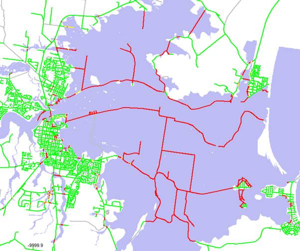
Figure 1
Road Inundation in 1% AEP Event (‘green’ is flood free,
‘yellow’ is potentially inundated but to less than 0.3m deep and
‘red’ is inundated to a depth greater than 0.3m)
Flood Mitigation Structures
Council has engaged Public Works
to undertake a visual audit of all flood mitigation drains on the Lower
Shoalhaven River floodplain. The outcome from this audit of all flood
mitigation drains will allow Council to prioritise drain maintenance and repair
of any defects.
Public Works have completed a
visual audit of flood levees and Council is seeking natural disaster recovery
funding to repair levee damage identified from this audit.