Ordinary Meeting
Meeting Date: Monday,
05 December, 2022
Location: Council
Chambers, City Administrative Building, Bridge Road, Nowra
Time: 5.30pm
Membership (Quorum - 7)
All Councillors
Please note: The proceedings of this meeting (including presentations,
deputations and debate) will be webcast, recorded and made available on
Council’s website, under the provisions of the Code of Meeting
Practice. Your attendance at this meeting is taken as consent to the
possibility that your image and/or voice may be recorded and broadcast to the
public.
Shoalhaven City Council live
streams its Ordinary Council Meetings and Extra Ordinary Meetings. These
can be viewed at the following link
https://www.shoalhaven.nsw.gov.au/Council/Meetings/Stream-a-Council-Meeting.
Statement
of Ethical Obligations
The Mayor and Councillors are
reminded that they remain bound by the Oath/Affirmation of Office made at the
start of the council term to undertake their civic duties in the best interests
of the people of Shoalhaven City and to faithfully and impartially carry out
the functions, powers, authorities and discretions vested in them under the
Local Government Act or any other Act, to the best of their skill and
judgement.
The Mayor and Councillors are also reminded of the
requirement for disclosure of conflicts of interest in relation to items listed
for consideration on the Agenda or which are considered at this meeting in
accordance with the Code of Conduct and Code of Meeting Practice.
Agenda
1. Acknowledgement of Country
2. Moment of Silence and Reflection
3. Australian National Anthem
4. Apologies / Leave of Absence
5. Confirmation of Minutes
· Ordinary
Meeting - 28 November 2022
6. Declarations
of Interest
7. Presentation
of Petitions
8. Mayoral
Minute
9. Deputations
and Presentations
10. Call Over of the
Business Paper
11. A Committee of the
Whole (if necessary)
12. Committee Reports
CL22.632..... Report of the Aboriginal Advisory Committee -
8 November 2022................ 1
AA22.20...... Notification of Council Resolution - Aboriginal
Advisory Committee Re-establishment and Nomination of Chairperson
AA22.21...... Cultural Immersion Workshops
AA22.23...... Membership Appointment
AA22.25...... Additional Item - Naming of Boongaree
AA22.28...... Additional Item - Council Advisory Committees -
Indigenous Representation
AA22.29...... Additional Item - Freeze of Development Sites -
Newcastle University
AA22.31...... Additional Item - Aboriginal Cultural Centre -
Funds
AA22.32...... Additional Item - Scar Tree Desecration - Warra
Warra Rd
13. Reports
City Performance
CL22.633..... Annual Report 2021-2022.............................................................................. 4
CL22.634..... Ongoing Register of Pecuniary Interest Returns -
November 2022.............. 7
CL22.635..... 2023 National Forum on Coastal Hazards
(Australian Coastal Councils Association)........................................................................................................................ 9
City Futures
CL22.636..... Exhibition Outcomes and Proposed Next Steps -
Review of Planning Options for Taylors Lane................................................................................................. 11
CL22.637..... Proposed New Strategic Planning Direction................................................ 39
City Services
CL22.590..... Proposed Land Disposal - North Crescent Culburra
Beach........................ 42
CL22.638..... Proposed Licence - T & C Hoskin - Part
Mahogany Creek Reserve North Nowra...................................................................................................................... 47
City Development
CL22.639..... Quarterly Review for Compliance Matters................................................... 52
CL22.640..... RA22/1003 - McIntosh Street Shoalhaven Heads -
Part Lot 7005 DP 1075719 68
CL22.641..... Development Application - DA22/1614 - 5 Flora
Street, Sanctuary Point... 76
CL22.642..... Development Application - DA21/2438 - Currambene
St & Hawke St Huskisson - Lot 1 DP 209436, Part Lot 7010 DP 1076858 & Lot
7012 DP 1021163........... 87
CL22.643..... Development Application - DA22/1710 - 12 Milham
Street, Lake Conjola - Lot 3 DP 515751........................................................................................................ 104
City Lifestyles
CL22.644..... Worrigee / South Nowra / East Nowra Community
Infrastructure Investigations 116
CL22.645..... Draft Berry Showground Master Plan - Update to
Council and Progress to Exhibition.................................................................................................................... 128
CL22.646..... Policy - Private Functions on Public Reserves.......................................... 134
Shoalhaven Water
CL22.647..... Acquisition of Easement for Water Supply - Lot 28
DP 1282389 Taylors Lane Cambewarra............................................................................................... 136
CL22.648..... Tenders - Moss Vale Road Urban Release Area Water
Infrastructure Illaroo Road Water Pumping Station and Stage 2 Water Mains
Construction Project.. 139
CL22.649..... Tenders - Danjera Dam Camping Ground and
Recreational Area Construction 142
14. Notices of Motion / Questions on Notice
Notices of Motion / Questions on Notice
CL22.650..... Notice of Motion - Hyams Beach Fire Shed............................................... 145
CL22.651..... Notice of Motion - Sussex Inlet Road Completion
of Footpath to Marine Rescue.................................................................................................................... 148
15. Confidential Reports
Reports
CCL22.34.... Tenders - Moss Vale
Road Urban Release Area Water Infrastructure Illaroo Road Water Pumping Station
and Stage 2 Water Mains Construction Project
Local Government Act - Section 10A(2)(d)(i) - Commercial
information of a confidential nature that would, if disclosed prejudice the
commercial position of the person who supplied it.
There is a public interest
consideration against disclosure of information as disclosure of the
information could reasonably be expected to reveal commercial-in-confidence
provisions of a contract, diminish the competitive commercial value of any
information to any person and/or prejudice any person’s legitimate
business, commercial, professional or financial interests.
CCL22.35.... Tenders
- Danjera Dam Camping Ground and Recreational Area Construction
Local Government Act - Section 10A(2)(d)(i) - Commercial
information of a confidential nature that would, if disclosed prejudice the
commercial position of the person who supplied it.
There is a public interest
consideration against disclosure of information as disclosure of the
information could reasonably be expected to reveal commercial-in-confidence
provisions of a contract, diminish the competitive commercial value of any
information to any person and/or prejudice any person’s legitimate
business, commercial, professional or financial interests.
|

|
Ordinary
Meeting – Monday 05 December 2022
Page
0
|
CL22.632 Report
of the Aboriginal Advisory Committee - 8 November 2022
HPERM Ref:
D22/500466
|
AA22.20 Notification of Council
Resolution - Aboriginal Advisory Committee Re-establishment and Nomination of
Chairperson
|
HPERM Ref: D22/445886
|
|
Recommendation
That Council
1. Accept
Mr Jared Brown’s resignation as Chairperson and,
2. Accept
Mr Jared Brown’s membership resignation from the Committee for the
period of 12 months.
3. Thank Mr Jared
Brown for his contribution to the Committee and his time as Chairperson.
4. Conduct an
election of Chairperson at the next Aboriginal Advisory Committee meeting to
be held, 6 December 2022 for the period to September 2023, noting that the
appointment will be reaffirmed by Council.
|
|
AA22.21 Cultural Immersion
Workshops
|
HPERM Ref: D22/397800
|
|
Recommendation
That Council
1. Note the
Aboriginal Advisory Committee received the report regarding Cultural
Immersion Workshops for information.
2. Suggest
Council staff to investigate other organisations with the capacity to deliver
Cultural Immersion workshops targeted towards men’s business in
addition to the Waminda facilitated training.
|
|
AA22.23 Membership Appointment
|
HPERM Ref: D22/418803
|
|
Recommendation
That Council:
1. Endorse and
accept the appointment of David Blakely as a member of the Aboriginal
Advisory Committee.
2. Provide an
unsuccessful outcome letter to the unsuccessful applicant’s and thank
them for their application.
3. Review the
Terms of Reference regarding,
a. Youth
membership age bracket and consider engaging with the Shoalhaven University
and TAFE campuses to fill vacant roles of the youth representatives.
b. The requirement
for members to live in the Shoalhaven LGA.
c. Consider
adding an extra community member position, noting it will be filled by Mr
Jared Brown following the conclusion of appointment with Council.
Note by the CEO:
Staff will provide a report, taking into consideration
the Committee’s request, as part of a Terms of Reference (TOR) review
that will take place at the first Aboriginal Advisory Committee meeting of
2023 (28 February 2023). Proposed amendments will align with the recently
endorsed TOR template for Advisory Committees.
|
|
AA22.25 Additional
Item - Naming of Boongaree
|
|
Recommendation
That Council endorse the Aboriginal Advisory Committee
to receive further background information on how the naming of the Boongaree
Reconciliation Garden was decided, and request to be involved in the
consultation process of all future naming’s of such Council assets.
|
|
AA22.28 Additional
Item - Council Advisory Committees - Indigenous Representation
|
|
Recommendation
That Council as recommended by
the Aboriginal Advisory Committee, encourage the appointment of two (2)
Indigenous representatives, male and female, on all Council Advisory
Committees.
|
|
AA22.29 Additional
Item - Freeze of Development Sites - Newcastle University
|
|
Mr Jason Groves discussed how massacre sites are
registered and through Newcastle University registered development sites are
frozen. It was discussed whether Husky Church site could be registered as a
massacre sight, and suggested Council investigate putting freezes on
registered development sites through the University of Newcastle.
|
|
Recommendation
That Council as recommended by the Aboriginal Advisory
Committee, request the appropriate Council staff within City Futures to
initiate discussions with Newcastle University regarding the process to have
the Husky Church site registered as a Massacre site.
|
|
AA22.31 Additional
Item - Aboriginal Cultural Centre - Funds
|
|
Ms Sylvia Timbrey queried the whereabouts of the funds
from the sale of the previous Aboriginal Cultural Centre.
|
|
Recommendation
That Council as recommended by the Aboriginal Advisory
Committee, request relevant Council staff to investigate the sale and the
proceeds of the previous Aboriginal Cultural Centre and request a report back
to a future meeting regarding the whereabouts of the funds.
|
|
AA22.32 Additional
Item - Scar Tree Desecration - Warra Warra Rd
|
|
Mr Jared Brown raised a concern that whilst conducting
surveys for the Glossy Black Cockatoo, they came across a site possibly under
Council ownership, located on the left hand side of Warra Warra Road and
identified fencing with Council signage that had been wired through a Scar
Tree. This was confronting and culturally insensitive for the Aboriginal
Community.
It was also noted that
it is a highly desecrated site due to excessive dumping.
|
|
Recommendation
That Council, as
recommended by the Aboriginal Advisory Committee:
1. Advise the
relevant department within Council of the cultural insensitivity in the
desecration of a Scar Tree with Council fencing, and
2. Request
Council to investigate the possibility of removal of the fencing.
|
|

|
Ordinary
Meeting – Monday 05 December 2022
Page
0
|
CL22.633 Annual
Report 2021-2022
HPERM Ref: D22/478426
Department: Corporate
Performance & Reporting
Approver: Kevin
Voegt, Director - City Performance
Attachments: 1. Annual
Report 2021-2022 - Section 1 (under separate cover) ⇨
2. Annual Report 2021-2022 -
Section 2 (under separate cover) ⇨
Reason for Report
In accordance with the
requirements of the Local Government Act, Council must produce an Annual Report
outlining progress towards achieving the objectives and actions in the Delivery
Program and Operational Plan. The report must also include mandatory reporting
as prescribed by the Local Government (General) Regulation 2021.
|
Recommendation
That
Council receive and endorse the Annual Report 2021-2022.
|
Options
1. Adopt the
recommendation.
Implications: Nil.
2. Further
information be requested for inclusion in the Annual Report.
Implications: Council
will need to amend and renotify the Office of Local Government of the updated
Annual Report.
Background
Council received an extension to
finalise and submit Financial Statements for the year ended 30 June 2022 year
to the Office of Local Government (OLG) to 23 December 2022. Once the Financial
statements have been audited and lodged, Council will update the Annual Report
and include a full set of its audited Financial Statements as required under
the Local Government Act.
In order to meet the legislative
timeframe, Council’s Annual Report 2021-22 has been uploaded to
Council’s website and advice provided to OLG to meet the 30 November 2022
deadline.
The Annual Report 2021-2022 has
been prepared as per the requirements under the Local Government Act consists
of the following sections:
Section 1 – Delivery Program and Operational
Plan Performance
This section includes a report
on Council’s achievements in implementing the Delivery Program and the
effectiveness of the activities undertaken in achieving the objectives in the
Shoalhaven 2027 Community Strategic Plan (CSP).
The report also outlines the key highlights, status and
comments against each of the actions in the 2021-2022 Operational Plan. The 157
deliverables set by Council in our 2021-2022 Operational Plan represents our
services, key projects and works program. The final performance showed that 92%
of actions we set out to achieve were completed or on track. The remaining 8%
were delayed or off track as at 30 June 2022.
Key Highlights
· Delivery
of Local Information Hubs through the Recovery into Resilience project at 19
halls and community centres with solar panels, batteries and information
screens which can display trusted information during emergencies
· Economic
Development Office co-ordinated a series of business training sessions specifically
aimed at assisting businesses following the natural disaster setbacks and COVID
impacts
· The
Shoalhaven has received the highest proportion of regional events funding
across Regional NSW, testament to the adaptability of the industry
· Progression
of all Rural Fire Service seed funded projects at Conjola Station Extension,
Currarong Station Extension and Manyana Station New Facility
· Official
opening event at Boongaree Nature Play Park hosted in January 2022
· Shoalhaven
Water’s Reclaimed Water Management Scheme Stage 1B awarded winner in the
LGNSW - Excellence In The Environment Awards
· Millards
Creek and Currarong Creek Flood Studies have been completed and adopted by
Council
· Water
supply work for Southern Moss Vale Road Urban Release Areas now complete and
ready for developer connection
· Major
local road repair programs complete include Browns Road, Brinawarr Street, BTU
Road rehabilitation, Orient Point Road (Flora to Raglan Street) Rehabilitation,
Riversdale Road reconstruction, Forest Road Heavy Patching and construction
complete for Coonemia Road rehabilitation
· Destination
Parks hosted activities including Arts classes and Plein Air Painting,
Disability Expo, Open Air Cinema, Family Movie Nights, Pilates in the Park and
Beach Volleyball
· The
Rivoli dance production was performed at Ulladulla Civic Centre and Kangaroo
Valley Hall in March
· Increased
tonnes of material recycled to 39,894 tonnes, up 5% on last year
· Ulladulla
Town Centre DCP Amendment (update) finalised
· Achieving
a zero vacancy rate with all suitable Council properties currently leased
· Sustainable
Energy Strategy initiatives commenced include installation of LED lights in
Council buildings and sports fields, installation of additional solar PV and
preparation of a tender for a renewable Power Purchase Agreement
· 52
Coastal Zone Management Plan short term implementation actions are completed,
ongoing, or significantly progressed
· Two new Parkcare
Groups had their action plans adopted by Council and a quarterly newsletter has
been established
Measuring Progress - Are we
making a difference?
Annual progress towards
achieving the Community Strategic Plan (CSP) objectives are included under each
theme as How we’re doing – Are we making a difference? These
measures were established alongside the adoption of the CSP in 2017.
A full evaluation of 2027 CSP
objectives was included in Council’s End of Term Report which was
submitted at the 2 November 2021 Council meeting and is available on
Council’s website.
With the adoption of the updated
Community Strategic Plan 2032, tracking the progress of these measures has now
commenced and will be reported from the 2022-23 Annual Report.
A copy of the Annual Report
2021-2022 Section 1 is included as Attachment 1.
Section 2 – Additional Local Government Act
reporting requirements
This section of the report
includes information that is prescribed by the Local Government (General)
Regulation 2021. This includes details of contributions and donations,
contracts, legal proceedings, public interest disclosures, planning agreements,
Companion Animals Act reporting and progress on implementation of
Council’s Disability Inclusion Action Plan. A copy of Annual Report
2021-2022 Section 2 is included as Attachment 2.
Section 3 – Annual Financial Statements
2021-2022
The annual financial statements
once finalised will be included as part of the annual report.
Community Engagement
The Annual Report is available
on Council’s website and a link to the report will be promoted through Council’s
weekly newsletter. A range of other methods will also be used to communicate
the outcomes of Council’s 2021-2022 performance highlights including
across Council’s social media platforms.
|

|
Ordinary
Meeting – Monday 05 December 2022
Page
0
|
CL22.634 Ongoing
Register of Pecuniary Interest Returns - November 2022
HPERM Ref: D22/479021
Department: Business
Assurance & Risk
Approver: Kevin
Voegt, Director - City Performance
Reason for Report
To provide the Council with the Register of Pecuniary
Interest Returns from newly designated persons lodged with the Chief Executive
Officer for the period of 1 November to 30 November 2022 as required under
Section 440AAB of the Local Government Act 1993 and Part 4.26 of the Code of
Conduct.
|
Recommendation
That the report of the Chief
Executive Officer regarding the Ongoing Register of Pecuniary Interest
Returns lodged for the period of 1 November to 30 November 2022 be received
for information.
|
Background
Under Section 440AAB of the Local
Government Act 1993 and Part 4.26 of the Model Code of Conduct, newly
designated persons are required to complete an Initial Pecuniary Interest
Return within 3 months of becoming a designated person.
Section 440AAB (2) of The
Local Government Act 1993 states:
Returns required to be lodged with the general manager
must be tabled at a meeting of the council, being the first meeting held after
the last day specified by the code for lodgement, or if the code does not
specify a day, as soon as practicable after the return is lodged.
Part 4.26 of the Model Code of
Conduct states:
Returns required to be lodged with the general manager
under clause 4.21(c) must be tabled at the next council meeting after the
return is lodged.
This report is one of a series
of reports of this nature which will be provided throughout the year to align
with the legislative requirements.
Those persons who have submitted
a return within the period in accordance with their obligation to lodge an
initial pecuniary interest return are listed below:
|
Directorate
|
Name
|
Designated Position Start
Date
|
Returned
|
|
City Development
|
Rochelle MacKay
|
07/11/2022
|
14/11/2022
|
|
City Services
|
Rachael Proksch
|
10/10/2022
|
14/11/2022
|
|
City Services
|
Bhavya Dawar
|
17/10/2022
|
15/11/2022
|
|
City Services
|
Michael Berzins
|
19/09/2022
|
17/11/2022
|
|
Shoalhaven Water
|
Andrew Solari
|
07/11/2022
|
18/11/2022
|
|
City Lifestyles
|
Paul Donnelly
|
07/11/2022
|
25/11/2022
|
Electronic versions of the
disclosure documents (with relevant redactions) are available on the Council
website, in accordance with requirements under the Government Information
(Public Access) Act, 2009.
Risk Implications
A failure of meeting the obligations
with respect to the Pecuniary Interest Returns by a designated officer leaves
Council at risk of non-compliance with legislative requirements, conflicts of
interest and limited transparency.
|

|
Ordinary
Meeting – Monday 05 December 2022
Page
0
|
CL22.635 2023
National Forum on Coastal Hazards (Australian Coastal Councils Association)
HPERM Ref: D22/485883
Department: Business
Assurance & Risk
Approver: Kevin
Voegt, Director - City Performance
Reason for Report
To consider Councillor
attendance at the 2023 National Forum on Coastal Hazards scheduled for 29-31
March 2023 in Freemantle, WA.
|
Recommendation
That Council
1. Notes the details of the 2023
National Forum on Coastal Hazards scheduled for 29-31 March 2023 in
Freemantle, WA.
2. Authorises available Councillors to
attend the conference and such attendance be deemed Council Business.
3. Travel, registration fees,
accommodation and all reasonable out-of-pocket expenses be met in accordance
with its adopted policy.
4. Request Councillors attending the
conference to provide a written report within 30 days of returning from the
conference.
|
Options
1. As per the
recommendation.
2. That Council
limit the number of Councillors attending the Conference and such attendance be
deemed Council Business.
3. That Council
does not approve Councillor attendance at the Conference as Council Business.
Background
The 2023 National Forum on
Coastal Hazards (Australian Coastal Councils Association) is considered
relevant to local government, particularly coastal councils such as Shoalhaven
Council. Information in relation to the conference can be found at the
following link:
Come and join us at the 2023 National Forum on Coastal
Hazards – Australian Coastal Councils Association
Costs associated with the
conference are estimated as follows:
· Registration
|
Registration fees:
|
Delegates from
ACCA LGAs (Includes Shoalhaven City Council delegates )
|
|
Early Bird – Full Forum only - Early Bird 19 Dec
2022
|
$ 1,100.00
|
|
Early Bird Special Discount
Package – includes Full Forum, Reception and Dinner tickets - Early
Bird 19 Dec 2022
|
$ 1,331.00
|
|
Standard Registration –
Full Forum only
|
$ 1,320.00
|
|
Standard Special Discount
Package – includes Full Forum, Reception and Dinner tickets
|
$ 1,551.00
|
|
One Day - 29 or 30 March 2023
|
$ 550.00
|
|
One Day - FRIDAY 31 March 2023
|
$ 440.00
|
· Travel,
accommodation and out of pocket expenses: not yet determined.
An option available to Council
is to define the number of Councillors attending the conference and for Council
to determine the appropriate Councillors authorised to attend. This
option is presented having regard to the increase in Councillor expenses in
recent years, so that Council may pro-actively control this area of expenses
when appropriate.
The
Conference commences at 7.30am, Wednesday 29 March 2023 and concludes at
12.30pm, Friday 31 March 2023 and the following Council Business is scheduled
within the period of the conference:
· Nowra
CBD Revitalisation Strategy Committee - Tuesday 28 March 2023.
· Councillor
Briefing - Thursday 30 March 2023.
Policy Implications
The Council Members –
Payment of Expenses and Provision of Facilities Policy limits attendance at
conferences to three per annum per councillor exclusive of any conference
arranged by either the State or National Local Government Associations.
Financial Implications:
Funds are available for
Councillors to attend this conference.
|

|
Ordinary
Meeting – Monday 05 December 2022
Page
0
|
CL22.636 Exhibition
Outcomes and Proposed Next Steps - Review of Planning Options for Taylors Lane
HPERM Ref: D22/478527
Department: Strategic
Planning
Approver: Carey
McIntyre, Director - City Futures
Attachments: 1. Option
Concept Layout Plans (drawing SK001 - SK008) ⇩
2. Summary of Submissions -
Taylors Lane Planning Options Nov 2022 ⇩
Reason for Report
The purpose of this report is to
present to Council the outcomes of the recent public exhibition of the planning
options review for the Taylors Lane area, Cambewarra (to be renamed Badagarang
in due course), identify the preferred options and recommend the next steps
to conclude/advance the outcomes of the review.
|
Recommendation
That
Council:
1. For the ‘West’ section
of Taylors Lane:
a. Adopt Option W1 as shown in
Attachment 1 drawing SK001 being upgrade of Taylors Lane to a ‘Tree
Lined Boulevard’ in accordance with the adopted Shoalhaven DCP 2014
Chapter NB3:
i. Widen
the road ~5m each side of the existing centreline.
ii. Remove
the existing mature trees on the northern side of the existing pavement.
iii. Plant
suitable Street Trees along the upgraded Taylors Lane consistent with the
adopted Moss Vale Road South Species List
b. Receive a further report on options
that may help to deliver the required road upgrade in a timely manner to
support the overall Moss Vale Road South URA.
2. For the ‘East’ section
of Taylors Lane:
a. If it wishes to retain the trees,
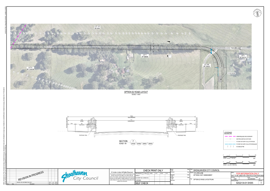
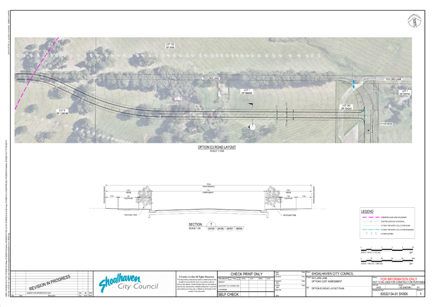
proceed to upgrade Taylors Lane in accordance with Option E3 as shown
in Attachment 1 drawing SK006, with Option E1 as shown in
Attachment 1 drawing SK004 as a ‘backup’ option, and
commence negotiations for a possible joint funding and delivery arrangement
with the landholder/developer of DA SF10898;
OR
b. If it does not wish to retain the
trees, proceed with the upgrade of Taylors Lane in accordance with Option
E2 as shown in Attachment 1 drawing SK005.
3. Notify those who made submissions
during the public exhibition period of this decision.
|
Options
1. As recommended.
Implications: Council will adopt a policy
position on Taylors Lane and resolve the current uncertainty for local
landholders and developers. Taylors Lane within Moss Vale Road South Urban
Release Area (URA) will be upgraded to a ‘Tree Lined Boulevard’ in
accordance with adopted DCP 2014 Chapter NB3 as the adjoining land is
developed. Council will advance with project detailed design, land
acquisitions, negotiations for a joint funding / delivery arrangement and construction
for the Taylors Lane upgrade East of the URA as part of the Far North Collector
Road Network.
2. Defer a decision
and receive a further briefing from staff.
Implications: Council will receive a briefing from
staff on the outcomes of the public exhibition, the preferred options and
recommended actions before deciding what steps to take next. This is likely to
delay the adoption of a policy position on Taylors Lane and the delivery of the
required road upgrades by several months and is not the preferred option.
3. Adopt an
alternative recommendation.
Implications: This will depend on the nature of the
alternate resolution. The review has identified a number of alternate options
for Taylors Lane that are not considered to be feasible. Further investigation
of alternate options will delay the required road upgrade, prolong the
uncertainty for local landholders and development and may yield little or no
benefit. As such this is not the preferred option.
4. Do not adopt the
recommendation.
Implications: Council will not adopt a policy position on
Taylors Lane. This is likely to create ongoing uncertainty for local
landholders and developments, delay the release of new housing supply, and
delay the required upgrade of Taylors Lane. As such this is not the preferred
option.
Background
Council
resolved in June 2020 (MIN20.419) to ‘defer’ a decision on the
planned upgrade of the Taylors Lane area, Cambewarra (to be renamed Badagarang
in due course), as part of the Far North
Collector Road project and commence a review of options for how the existing
trees that are currently a feature of Taylors Lane can feasibly be retained and
how the required road upgrade could still be provided as part of the future
development of the broader area.
The
review considers potential changes to planning controls that may be required to
support the long-term retention of the trees, given the development that is
enabled under the existing zones. It also considers the ongoing appropriateness
of the existing urban zones (R3 Medium Density, B1 Neighbourhood Centre and SP2
Infrastructure) at the eastern end of Taylors Lane.
The
review area includes the full length of Taylors Lane and adjoining land as
shown in the figures below. The existing zoning of the review area is shown in Figure
2.
The
‘Indicative Layout Plan’ in the adopted DCP Chapter NB3: Moss Vale
Road South URA identifies Taylors Lane within the URA as a future ‘Tree
Lined Boulevard’. This would see the existing trees removed and replaced
with new urban street trees through time. The adjoining residential zoned land
within the URA is currently being subdivided and developed and will be a major
source of new housing supply for the next 5-10 years.
The
upgrade of the section of Taylors Lane east of the URA boundary is currently in
the scope of the Far North Collector (FNC) Road project (see Figures 1
and 2).
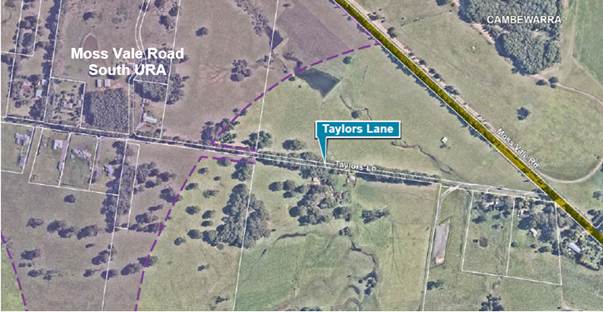
Figure 1: Aerial view of review area
Figure 2: Existing zoning of review area
Council considered an initial Options Report (prepared
Studio GL in 2021) on 7 September 2021. The report included a range of options
that could retain the trees based on planning, urban design and transport
considerations. The review however did not investigate/consider the potential
costs, technical feasibility or environmental impacts of the options in any
detail.
Options were presented and considered separately for the
‘West’ and ‘East’ sections of Taylors Lane as shown in Figure
3 and Figure 4.
Concept Layout Plans for each option are shown in Attachment
1 drawings SK001 - SK008.
Figure 3:
‘West’ Options
Figure 4:
‘East’ Options
The Council resolution from 7 September 2021 is below (MIN21.619).
That
Council:
1. Receive
the review of options for Taylors Lane, as detailed in the report prepared by
Studio GL at Attachment 1 for information.
2. Request
that Council staff undertake further investigations into the indicative costs
(construction, land acquisition, habitat loss, cultural heritage loss and
environmental heritage loss) associated with each option, including
identification of a preferred option/s, and receive a Councillor briefing from
staff at the appropriate point on this work.
3. Place
the consultant’s report and additional information (point 2 above) on
public exhibition for at least 30 days, invite comment on it from local
stakeholders and the broader community.
4. Receive
a further future report to consider the outcomes of the public exhibition and
decide how to proceed with the review of planning controls associated with
Taylors Lane, Cambewarra.
5. Notify
local stakeholders (landowners and developers around Taylors Lane),
participants in the stakeholder workshops, development industry representatives
and the Cambewarra Residents and Ratepayers Association and Pride of Bomaderry
of this decision and of the exhibition arrangements when they are known.
Strategic Options Assessment report
Consistent with Part 2 of the above resolution, a Strategic
Options Assessment report was prepared for Council by engineering etc.
consultancy Cardno Pty Ltd (now Stantec Pty Ltd) to address part 2) of the
resolution. It provides the following fuller assessment of the options:
· Preliminary
cost estimate - including design, construction and land acquisition.
· Potential
environment and cultural heritage impacts.
· Review
of technical feasibility including civil design, utilities, geotechnical
conditions, flooding/hydrology and traffic/connectivity.
· Options scored and
ranked on ‘Cost’ and ‘Environment/cultural heritage
impact’.
The analysis is at a ‘desktop’ level; as such,
the results are indicative and are subject to potential change as more detailed
investigation is undertaken in the future.
Councillors received a briefing on the results of these
investigations on 28 July 2022.
Summary of Findings
Several options that retain the
trees are considered ‘not feasible’ for two main reasons:
Long
term impact on tree health:
Options W2, W3, W3a & E1a
will require earthworks, construction and drainage work in tree root zones. The
impact of any resulting damage to roots and altered drainage on the long-term
health of the trees is not known in any detail at this point.
Unacceptable or unknown
traffic outcome:
Council’s long term
planning strategies (Nowra-Bomaderry Structure Plan etc) identify a two-way
Taylors Lane as part of the required local road network supporting the
development of the Moss Vale Road URA’s.
Options W3 and W3a do not meet
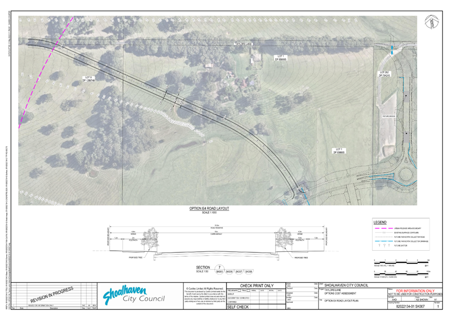
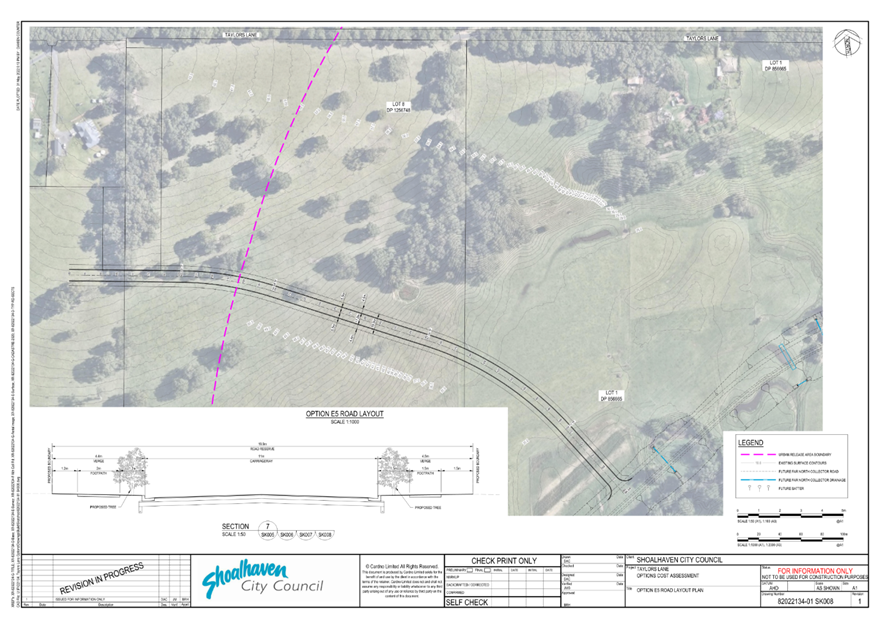
that requirement. Options E4 and E5 reduce connectivity for traffic travelling
to North Nowra due to left-in-left-out intersections with the Far North
Collector Road (FNC). They would potentially make a new roundabout further east
on the FNC redundant once the existing Taylors Lane is closed to traffic.
The options considered
‘not feasible’ are highlighted red in Figure 5. The
remaining options considered ‘feasible’ (subject to further
investigation) are E1, E2, E3 and W1. They are highlighted green in Figure 5.
Figure
5: Summary of options considered Feasible (green) and Not Feasible (red)
The scores/ranks of East and West options are shown in
Table 1 and Table 2 respectively (higher rank/score indicates a more
favourable option).
Table 1: Scores -
East Options (green = feasible, red = not feasible)
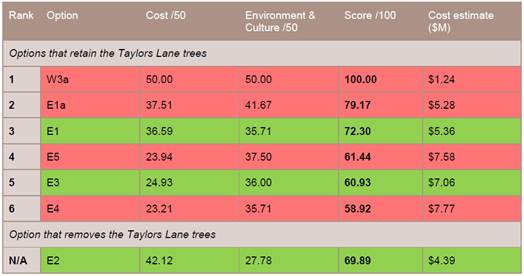
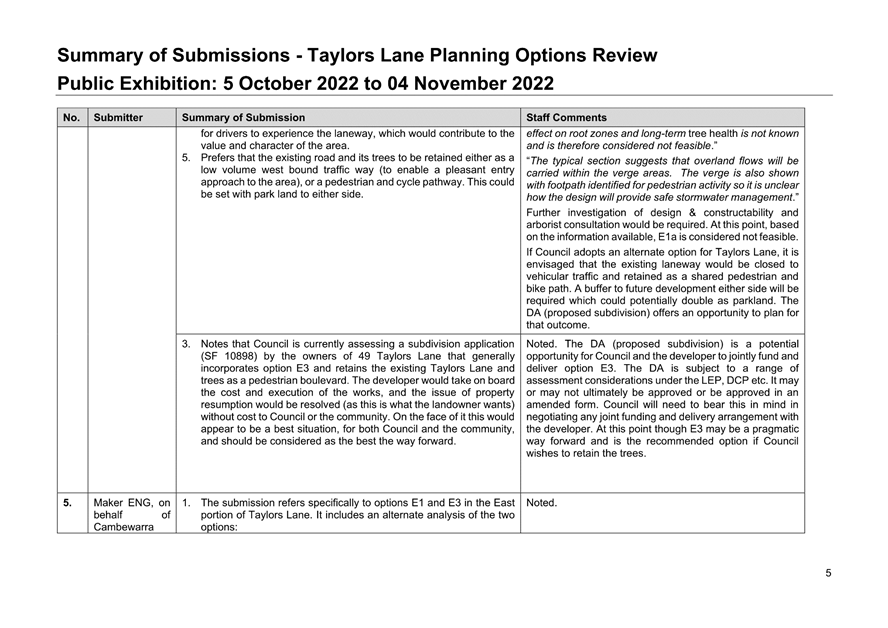
Table 1 indicates that the options that retain the trees (E1
and E3) will cost approximately $1M and $2.6M more respectively than the option
that removes the trees (E2). E1 and E3 score similar on environment/cultural
heritage impact but the nature of impact differs - E3 impacts more vegetation,
whilst E1 encroaches into a waterway. Cultural heritage was not a
differentiating factor – all options were found to have the same
potential to impact on cultural heritage that may be present.
Table 2: Score
results - West Options (green = feasible, red = not feasible)
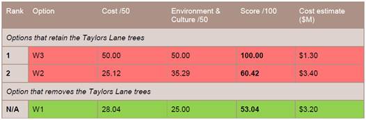
Table 2 indicates that W1 is the
only ‘West’ option considered to be feasible at this point.
Community Engagement
The Review of Planning Options
for Taylors Lane was publicly exhibited from Wednesday 5 October to Friday 4
November 2022 (31 days) in accordance with part (3) of Council’s 7
September 2021 resolution.
Notification of the exhibition
arrangements was sent to local landholders and developers of land around
Taylors Lane, the Cambewarra Village CCB, Pride of Bomaderry CCB, development
industry representatives, persons subscribed to the ‘Get Involved’
pages for the Nowra-Bomaderry URAs and the FNC and all who have previously made
submissions throughout the review.
The exhibition package which is
still available for viewing on Councils exhibitions webpage included:
1. Explanatory
Document
2. Options
Report (Studio GL, 2021)
3. Strategic
Options Assessment Report (Stantec, 2022)
4. Public
Notice
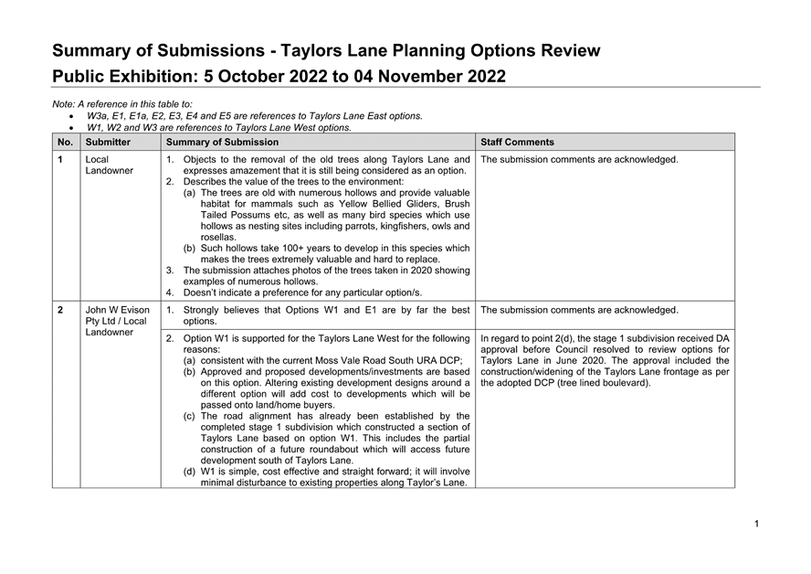
Six submissions were received - five from local
residents/landholders and one from the developer of the R3 zoned land around
the eastern end of Taylors Lane. The submissions from local
residents/landholders are summarised in Table 3 and Attachment 2.
Copies of the actual submissions can be made available to Councillors if needed
on request.
Table 3: Summary of local resident/landholder submissions
|
Option
|
For (Against)
|
Summary of comments
|
|
W1
|
2 (2)
|
For – Simple and cost-effective.
Aligns with the adopted URA masterplan upon which developments are based.
Minimal disturbance to existing properties. Avoids having to redesign
approved developments around another option. The trees in ‘West’
are of lesser scenic quality than those in ‘East’.
Against - Loss of existing character,
habitat value and natural/scenic amenity.
Neither – one submission noted the
removal of the trees is the most likely outcome and asked that they be
retained for as long as practical.
|
|
W2
|
1
|
For -
Appears to have least impact on the existing trees.
|
|
W3 / W3a
|
-
|
-
|
|
E1
|
2
|
For – generally aligns with the
adopted URA masterplan.
|
|
E1a
|
1
|
For – would enhance ability for
drivers to experience the laneway, enhancing its value and character of the
area. Would like to see more detail on this option.
|
|
E2
|
(4)
|
Against – Permanent loss of natural
character/amenity and a rare feature of exceptional beauty. Valued community
and recreational asset. The only scenic buffer and east-west wildlife
corridor in the URA. Many hollow bearing trees (>100yrs) which provide
important habitat. Trees are important for the mental health of the
residents. Need to retain some of the existing character that will disappear
with the future housing development.
|
|
E3
|
2 (1)
|
For – Considered the most
favourable option. Opportunity to deliver as part of the development of the
R3 zoned land with the landholder/developer’s support, a good way
forward.
Against – Prevents access to an
existing farm south of Taylors Lane. Further fragments farmland. Interferes
with existing services (gas pipeline, electricity, sewer). The land is flood
prone. May interfere with the future Western Bypass.
|
|
E4
|
1 (1)
|
For – retains the trees and
character laneway.
Against – Prevents access to an
existing farm south of Taylors Lane. Further fragments farmland. Interferes
with existing services (gas pipeline, electricity, sewer). The land is flood
prone. May interfere with the future Western Bypass.
|
|
E5
|
(1)
|
Against – Prevents access to an existing farm
south of Taylors Lane. Further fragments farmland. Interferes with existing
services (gas pipeline, electricity, sewer). The land is flood prone. May
interfere with the future Western Bypass.
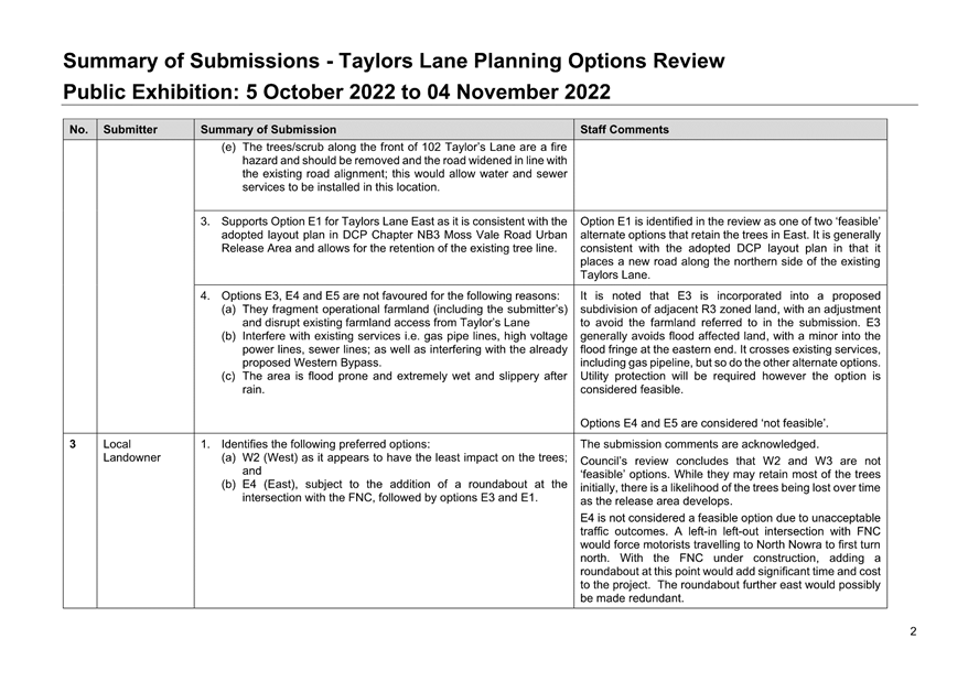
|
The submission provided for a developer operating in the URA
presents an analysis that draws different conclusions about the cost and
environmental impact of options E1 and E3:
· E1
is estimated to cost $7.6M, not $5.36M. The road is aligned over a watercourse
which will most likely need to be diverted, with no consideration given to the
associated costs or whether the Department of Planning & Environment -
Water would support this approach. Flood modelling has not been done to verify
whether the design is feasible. Council’s cost estimate does not account
for the 10m strip of R3 zoned land between existing Taylors Lane and E1 which
would need to be acquired by Council.
· E3
is estimated to cost $5.6M, not $7.06M.
Council’s costing includes a bridge span, however earthworks and culverts
would be capable of addressing drainage flows. The inclusion of a bridge
significantly inflates Council’s costing.
· Based
on analysis Option E1 actually has a higher estimated cost than E3 when all
relevant factors are considered.
· Many
of the trees impacted by option E3 are in the R3 zone. As such it is likely
that those trees will be impacted (either immediately or over time) when the
land is developed, and this reduces the relative environmental impact of E3.
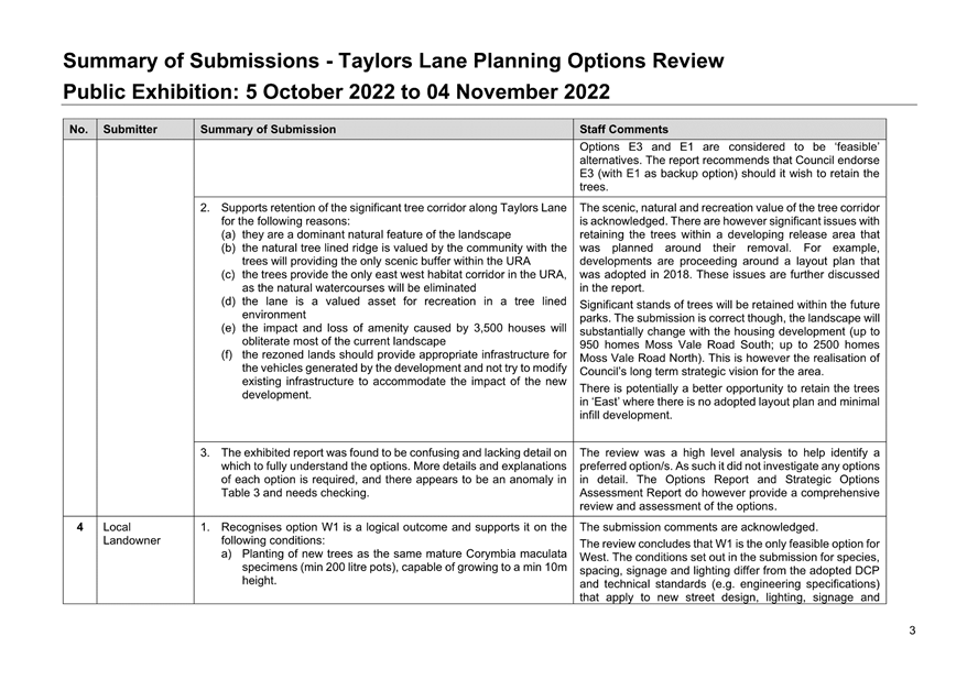
Discussion
Taylors Lane West
Submissions on the
‘West’ options were mixed, with some opposed to the removal of the
trees and others supportive and/or accepting of that ultimate outcome. The
support in some submissions to retain the trees for their character/amenity and
habitat value is acknowledged, however, there are significant practical issues
with retaining the trees in a developing URA that was essentially planned
around removing them.
Approved developments on either
side of Taylors Lane are predicated on a URA layout plan adopted by Council in
2018. Adopting a different outcome at this stage may have unintended effects on
developments and possibly further delay housing release. Planned street
intersections with Taylors Lane will require trees to be removed whichever
option is adopted.
Works associated with the
construction of Options W2 and W3 and dwellings on adjoining lots will occur in
the tree root zone. The Options Report suggests that a 13 metre tree protection
zone (TPZ) is required to ensure the long term health of the trees. It would
encroach significantly into adjoining residential lots and may require
Council to acquire the land to ultimately facilitate this outcome and this
would be a significant extra cost that is not factored into the cost estimates.
As noted in submissions, the
trees are a feature of the existing landscape but the area is however
transforming into an urban landscape. The trees are less likely to be
compatible in that new landscape. For example, there is likely to be pressure
from future residents to remove trees considered dangerous to dwellings.
Piecemeal removal of trees is likely to compromise the remaining trees. There
is a likelihood that the existing trees will be lost through time, even if they
are retained initially with the best intentions.
For these reasons options W2 and
W3 are not considered feasible and it is recommended that Council adopt option
W1 being the upgrade of Taylors Lane to a new ‘tree lined
boulevard’ consistent with the adopted DCP.
It may be some time before the
existing concessional lots along Taylors Lane develop and upgrade their
respective sections of road. To ensure the road is delivered in a timely manner
to support the overall URA it may be necessary to include it in the
Contributions Plan or establish another appropriate mechanism. In this regard
it is recommended that Council review potential options/mechanisms and receive
a further report on them at the appropriate point.
Taylors Lane East
Submissions were generally very
opposed to removing the trees (option E2) in this section. They are regarded as
an asset to the community, an important wildlife corridor and an integral part
of the local character. With no adopted area specific DCP or infill development
in ‘East’ there may be more of an opportunity to adopt an alternate
option and retain the trees.
The two alternate options
identified as ‘feasible’, E1 and E3, generally received the most
support in submissions. It is recommended that the other options W3a, E1a, E4
and E5 that are considered ‘not feasible’ be ruled out from further
consideration at this point. E2 does remain a ‘feasible’ option
should Council decide to proceed with it.
The costs of E1 and E3 are
estimated to be $1 million and $2.6 million higher than E2 respectively. The
developer submission suggests cost will be higher for E1 and lower for E3 for
several reasons. These conclusions may or may not be accurate and can only be
confirmed with further investigation. The submission suggests that the trees
impacted by option E3 will be impacted by future development regardless,
reducing the relative impact of E3. This also may be a valid conclusion.
There is the potential for
Council and the developer to possibly jointly fund and deliver option E3 as
part of the proposed development application (DA) for the R3 zoned land (DA
SF10898). The DA proposal (see Figure 6) generally incorporates
E3 as a ‘new’ Taylors Lane. The western end is modified to address
concerns raised in another submission about access to farmland on the southern
side of Taylors Lane. The proposed road that crosses Taylors Lane is at an
existing gap in the trees.
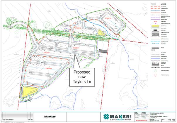
Figure 6: Proposed
subdivision - R3 zoned land (SF10898)
The DA is subject to a range of
assessment considerations under the LEP, DCP and other planning instruments. It
may or may not ultimately be approved or be approved in an amended form.
Council will need to bear this in mind in negotiating any joint funding and
delivery arrangement with the developer. At this point though E3 may be a
pragmatic way forward and is the recommended option if Council wishes to retain
the trees.
Option E1 does not
‘fit’ with the developer’s current proposal and it may be
more difficult to achieve and reach agreement on cost-sharing. It is
recommended that Council adopt E1 as a potential ‘backup’ option if
Council wishes to retain the trees.
If Council adopts either option
it will need to carefully manage its role as proponent for the adopted option
and its role as consent authority for the DA to ensure probity.
Potential Planning Controls
It has been envisaged throughout
the review that the existing Taylors Lane will ultimately become a shared
pedestrian and cycleway if the trees are retained. It is understood that the
current DA proposal incorporates that outcome.
A range of related issues will
need to be resolved including connections into existing/planned shared paths,
provision of tree protection zones, the long-term ownership/management of the
Tree Protection Zones, lot/dwelling orientation relative to Taylors Lane etc.
These issues could possibly be addressed as part of the DA and in the
development of option E3 by Council.
Alternatively, Council could
prepare site-specific DCP provisions. Ideally they would encompass the
adjoining B1 and SP2 zones and be coordinated with any proposed changes to those
adjoining zones (discussed below). this is not likely to be a practical option
given that the current DA process is now driving the outcome on a large part of
the site.
The public exhibition package
reviewed possible changes to the existing R3 Medium Density, B1 Neighbourhood
Centre and SP2 Infrastructure - Educational Establishment zones at the eastern
end of Taylors Lane shown in Figure 7. No comment was made on the
options in the submissions.
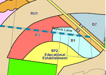
Figure 7: Existing
R3/B1/SP2 zones
Potential options for adjusting/reviewing the zones are
generally limited. The R3 zone is the subject of a current development
proposal. The SP2 land is no longer considered suitable as a school site and is
constrained by flooding, the regional services easement and the FNC alignment.
There may be value in rezoning the land around the final FNC-Taylors Lane
alignment to create consolidated parcels of R3 and B1 zoned land. This could be
considered when the FNC-Taylors Lane projects are completed and the final
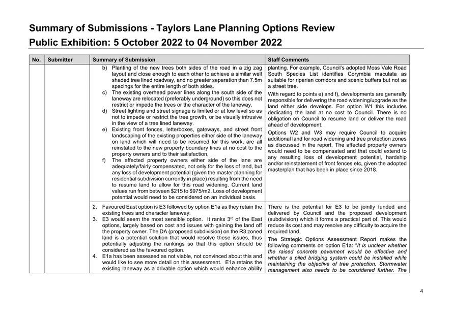
alignments known.
Policy Implications
The review of options for
Taylors Lane commenced more than 2 years ago and now needs to be drawn to a
conclusion and a policy position resolved on the future of Taylors Lane. This
is important to enable new planned housing developments to proceed with
certainty and the required connection to be delivered between Moss Vale Road
South URA and the FNC.
The recommended West option (W1)
is consistent with the adopted Shoalhaven DCP 2014 Chapter NB3: Moss Vale Road
South URA.
LEP and/or DCP amendments could
be prepared with the preferred East options (E3 and E1) but are not recommended
at this time.
Supporting amendments to
existing LEP and/or DCP controls may be required if Council resolves to adopt
alternate options.
Financial Implications
The cost estimates provided in
this review are indicative only. The costs associated with the options that
move forward will become clearer as further design and investigation is
undertaken. Council will receive updates at the appropriate points as work
progresses.
Taylors Lane West
The options would ordinarily be
delivered by development in accordance with the adopted DCP as the adjoining
land is developed. This includes the dedication of land for road widening.
However, options W2 and W3 are
likely to have extra costs that need to be met by Council. Both may require
Council to acquire land along the northern side for a tree protection zone, a
significant additional cost that is not factored into the current cost
estimates. W2 may also require Council to acquire more land along the southern
side.
Taylors Lane East
There is currently $3 million
grant funding allocated to the upgrade of Taylors Lane as part of the FNC Road
project. The cost estimates for E1, E2 and E3 exceed that amount. Council could
seek more grant funding however it is likely that any excess cost will be borne
by Council.
Option E3 (recommended) has the
highest estimated cost ($7.06 million) compared to E1 ($5.36 million) and E2
($4.39 million). There is however the potential for the costs of E3 to be
shared with the developer to lower the cost to Council.
Costs associated with repurposing the existing Taylors Lane
to a shared path and ongoing tree management/maintenance are not included in
the cost estimates. These will be an additional cost to Council for options
that retain the trees.
Risk Implications
The risks associated with the
preferred options will become clearer with further design and investigation. At
this point the general risks that are identified include:
Feasibility - Options W2,
W3, W3a & E1a are considered ‘not feasible’ because they risk
long term impacts on the health of the trees due to works in the root zone.
Options W3, W3a, E4 and E5 are considered ‘not feasible’ because
they risk unknown and/or unacceptable traffic outcomes.
Financial – Options
W2 and W3 carry potentially significant additional costs for land acquisition
that are not factored into the cost estimates.
Probity – Council
will need to carefully manage its role as DA consent authority and proponent
for option E3 or E1.
Timing – The
absence of a Council policy position on Taylors Lane risks additional costs and
delays to new housing development in Moss Vale Road South URA.
|

|
Ordinary
Meeting – Monday 05 December 2022
Page
0
|
|

|
Ordinary
Meeting – Monday 05 December 2022
Page
0
|
|

|
Ordinary
Meeting – Monday 05 December 2022
Page
0
|
CL22.637 Proposed
New Strategic Planning Direction
HPERM Ref: D22/496137
Department: Strategic
Planning
Approver: Carey
McIntyre, Director - City Futures
Reason for Report
The purpose of this report to is
seek Council endorsement to progress a new land use planning strategy and
scheme for Shoalhaven, following consideration at the 26 November 2022
extraordinary Strategic Planning Working Party meeting (workshop).
|
Recommendation
That
Council:
1. Endorse the preparation of revised
land use planning strategies and Local Environmental Plan, Development Control
Plan and Developer Contributions Plan (collectively a Planning scheme) for
Shoalhaven City.
2. Include in the work in
Recommendation 1 an investigation and inclusion of local character.
3. Receive a further report that
provides a Project Plan and Terms of Reference for this work, which informs
the Council on how this work would be best achieved, including scope,
timing/staging and resourcing.
|
Options
1. As recommended.
Implications: This option is favoured as it is
consistent with the general consensus from the 26 November 2022 extraordinary
Strategic Planning Working Party meeting (workshop) and it enables Council to
strategically respond to a range of recent events/pressures, ongoing and
emerging legacy issues and the age of a number of key policy and strategy
documents in a staged comprehensive process. This approach will also see
a range of recent community concerns (including character) addressed throughout
the process. Council will receive a future report on scope,
timing/staging and resourcing as soon as possible.
2. Adopt an
alternative recommendation, which may include not progressing with a new land
use planning strategy and scheme for Shoalhaven.
Implications: This option is not preferred as there
is a clearly demonstrated need to resolve a range of recent events/pressures
and ongoing and emerging legacy issues across the City. The comprehensive
review allows for a concentrated strategic planning effort to work through
these issues in a coordinated way.
Background
Since 2018, the current
iteration of the Strategic Planning Works Program (SPWP) has been reported to
Council annually to set the Strategic Planning direction for the coming
financial year. The SPWP aims to guide Council’s Strategic Planning
work by setting out current and planned projects and anticipated tasks (such as
responding to planning reforms), helping to prioritise projects and allocate
resources. In simple terms, the projects that are contained in the SPWP
are predominantly undertaken under the provisions of the Environmental
Planning & Assessment Act 1979 (e.g., Local Environmental Plan (LEP),
Development Control Plan (DCP), Contributions Plan (CP)) or are related
strategy or policy work that could ultimately lead to a specific project of
this nature.
As a result of community
feedback, pandemic experiences and the resultant demographic pressures/growth
that is now being experienced, Council continues to receive a range of feedback
about the need for new and contemporary strategic land use plans (i.e., growth
management strategies) and planning scheme (LEP, DCP, CP) for Shoalhaven.
At its 25 July 2022 Ordinary
meeting, Council considered the proposed 2022-2023 SPWP. It also considered
the potential opportunity to undertake a holistic review of its land use
planning strategy across the City that could also inform a new or alternate
direction for Shoalhaven’s planning scheme (LEP, DCP, CP) into the
future. Ultimately, Council resolved (MIN22.465) to:
1. Receive
the report for information.
2. Defer
to the Strategic Planning Working Party to discuss and consider the Planning
Instruments for the City and appropriate SPWP for term of Council;
3. Directs
the CEO (or nominee) to consider the ways this could be undertaken and
delivered in a timely manner;
4. Continue
working under the current SPWP until outcomes of the Working Party are reported
back to Council.
In response to Part 2 of the resolution, an extraordinary
Strategic Planning Working Party meeting (workshop) was held on 26 November
2022. The workshop identified that a dedicated focus was needed on the
following key priorities (not exclusively, and all not necessarily managed by
Strategic Planning):
· Affordable housing.
· Better
connectivity (e.g., transport, between villages, footpaths).
· Character.
· Climate proofing
(housing and infrastructure).
· Contemporary
planning controls for Nowra CBD and Riverfront.
· Family focused
tourism.
· Growth management
and housing supply (infill and greenfield opportunities).
· Improvements to
the infrastructure contributions system.
· Nowra bypass and
community recovery.
· Protecting coastal
villages and rural land.
· Protecting tree
canopies and corridors.
· Resolving legacy
issues in the existing scheme (e.g., Nebraska Estate).
The general consensus of the
Working Party was that a contemporary and wholistic review of Council’s
existing land use planning strategy and scheme is now needed to address these
priorities, and that a range of existing projects may need to be removed from
the SPWP whilst other mandatory tasks will need to continue. As such,
this report seeks endorsement from Council to commence the preparation of a new
land use planning scheme.
A further report will be
presented to the Strategic Planning Working Party and then Council as soon as
possible, to enable consideration of:
i. A
Project Plan to deliver the new scheme and advise how this could be best
achieved, including scope, timing/staging and resourcing and what could
realistically be achieved in the current term of Council.
ii. A
Terms of Reference to outline the parameters and commitments associated with a
review of the scheme.
At this stage, it may be advantageous for the remaining term
of Council to focus on reviewing and updating existing land use planning
strategies and implementing character provisions which would set the strategic
direction for Shoalhaven into the future. This direction could then
facilitate a subsequent comprehensive review of Shoalhaven’s planning
scheme (LEP, DCP, CP) in subsequent terms of Council. Opportunities in
this regard will be discussed further in the next report to Council.
Community Engagement
The decision to embark upon a contemporary and wholistic
review of Council’s existing land use planning strategy and scheme does
not require any community consultation; however, it is noted that substantial
community consultation will be undertaken through the resulting process.
Policy and Risk Implications
Due to a range of recent events/pressures, ongoing/emerging
legacy issues and the age of a number of key policy and strategy documents, it
is considered timely to consider a contemporary land use planning strategy and
scheme for Shoalhaven that reflects the expectations of the community. The Strategic
Planning Working Party generally acknowledged this need at the 26 November
workshop, as well as the risks associated with not progressing change in this
space.
Financial/Resourcing Implications
Should Council ultimately commit
to the preparation of a new and contemporary land use planning strategy and
scheme for Shoalhaven, then this will need to be appropriately resourced.
Council’s Strategic Planning Working Party/Council will receive a report
in due course that will consider the possible financial and resourcing
implications.
|

|
Ordinary
Meeting – Monday 05 December 2022
Page
0
|
CL22.590 Proposed
Land Disposal - North Crescent Culburra Beach
HPERM Ref: D22/173460
Department: Technical
Services
Approver: Craig
Exton, Manager - Technical Services
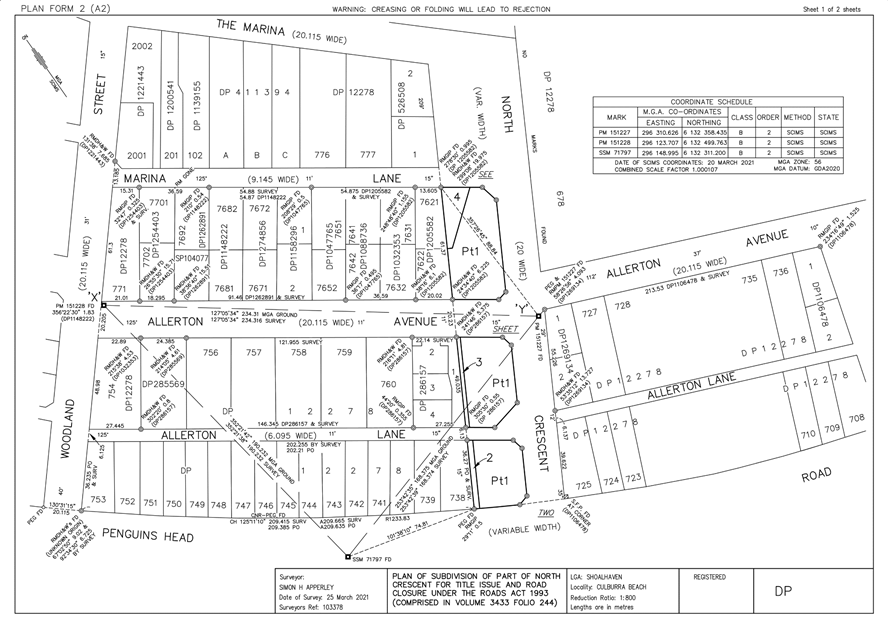
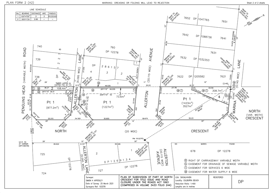
Attachments: 1. Plan
of Subdivision of part of North Crescent for Title Issue and Road Closure ⇩
Note: This item was deferred from
the Ordinary Meeting 14 November 2022.
Reason for Report
This report provides Council
with an opportunity to consider the sale of part North Crescent Culburra Beach,
being part of a closed Council Road, to the adjoining landowners. The proposed
land disposal relates to Lots 2, 3 and 4 DP 1287563 as shown in Attachment 1
(D22/446587).
|
Recommendation
That
Council
1. Authorise the sale and consolidation
of:
a. Proposed Lot 2 (108.4m2)
to the owner of Lot 738 DP 12278 (112 Penguin Head Road, Culburra) for $6,600
(plus GST if applicable).
b. Proposed Lot 3 (73.6m2)
to the owner of Lot 1 DP 28615 (37 Allerton Ave, Culburra), for $4,500 (plus
GST if applicable).
c. Proposed Lot 4 (308.7m2)
to the owner of Lot 7621 DP 1205582 (118 Marina Lane, Culburra), for $110,000
(plus GST if applicable).
2. The purchasers of proposed Lots 2, 3
and 4 are responsible for all costs involved with lot consolidation and their
legal costs;
3. Authorise the proceeds from sale of
the closed road to be allocated to the Property Reserve – Roads, in
accordance with the Roads Act 1993;
4. Authorise for the Common Seal of the
Council of the City of Shoalhaven to be affixed to any documentation
requiring to be sealed and delegate to the CEO authority to sign any
documentation necessary to give effect to this resolution.
|
Options
1. Resolve as
recommended.
Implications: This resolution provides Council the
ability to progress Council resolution MIN21. 716 dated 12 October 2021 to
realign boundaries as agreed with local residents.
2. Not resolve as
recommended.
Implications: Current negotiation and agreed sale
with adjoining property owners will cease and may cause ill relations between
Council and residents. The matter has been delayed several times due to
reporting requirements and external review and approval matters. The
current owners have been patient whilst Council continued to support the road
closure and realignment of boundaries.
Background
The road reserve North Crescent Culburra Beach is almost 50m
wide. Figure 1 below shows the locality of North Crescent subject to the road
closure.
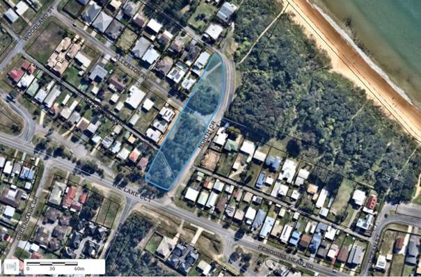
Figure 1:
Location of partial road closure of North Crescent Culburra – highlighted
in blue
On 12 October 2021, via MIN21.716, Council resolved:
That Council
1. As
required by MIN21.188, receive this report for information and continue
progressing with the Road Closure at North Crescent Culburra Beach in
accordance with MIN18.861 being:
Resolve, as Roads Authority, to close the surplus road
reserve at North Crescent Culburra Beach, adjacent to Lot 738 DP 12278, Lot 1
DP 286157, Lots 7621 and 7622 DP 1205582 and Lots 1 and 2 DP 526508 by a notice
published in the Government Gazette.
2. Undertake
actions as necessary in the road closure process to:
a. realign boundaries as agreed with
local residents
b. construct kerb & gutter as
agreed with local residents
3. Following
the above, place a moratorium on this project to allow for further consultation
with the community with a view to arriving at the best way to develop the site.
This report is seeking Council resolution to comply with
MIN21.716 item 2(a) and progress the agreed sale to adjoining residents, by
creating Lots 1 (the balance of the part road closure), 2 ,3 and 4.
The consideration of the future
subdivision/use of Lot 1 is currently on hold in accordance with MIN21.716 (3),
and will be the subject of a further resolution of Council.
Community Engagement
Community and Notifiable
Authority notification was undertaken in accordance with the Roads Act 1993 for
road closure.
All adjacent landowners have been consulted as part of the
process of establishing the proposed new property boundaries.
Policy Implications
The matter is in accordance with Council’s Dealing
with Requests for the Closure, Sale or Transfer of Council and Crown Roads
Procedure.
Financial Implications
The sales listed above will
generate $121,100. Council has incurred costs for the matter including survey,
environmental, plan registration and legal fees of approximately
$60,000. The net profit will be allocated to Council’s
Property Reserve – Roads. The residual proceeds will be used for
road projects.
It should be noted that costs incurred above include costs
for future subdivision and kerb & gutter works undertaken prior to MIN21.716.
Risk Implications
Nil risk for the proposed sale
of operational land.
|
|
Ordinary
Meeting – Monday 05 December 2022
Page
0
|
|
|
Ordinary
Meeting – Monday 05 December 2022
Page
0
|
CL22.638 Proposed
Licence - T & C Hoskin - Part Mahogany Creek Reserve North Nowra
HPERM Ref: D22/408761
Department: Technical
Services
Approver: Paul
Keech, Director - City Services
Reason for Report
This report provides Council
with an opportunity to consider the approval of a licence over part Lot 8 DP
789881, otherwise known as Mahogany Creek Reserve and located at Page Avenue,
North Nowra. The proposed five (5) year licence is to formalise
encroachment into the Reserve by the North Nowra Preschool operated by T &
C Hoskin.
|
Recommendation
That
Council
1. Enter into a five (5) year licence
over part of Lot 8 DP 789881 Page Ave, North Nowra, with T & C Hoskin for
the purpose of encroachment of preschool
playground located at 75 Page Ave North Nowra, with the commencing rent being
$543.00 plus GST per annum increased annually by CPI;
2. Authorise income received to be
allocated to Finance Project 102308 – Reserve Access Licence fees
– various;
3. Authorise the Chief Executive
Officer (CEO) to sign all documentation required to give effect to this
resolution and affix the Common Seal of the Council of the City of Shoalhaven
to all documentation required to be sealed.
|
Options
1. Adopt the
recommendation
Implications: The licence will allow the North
Nowra Preschool to continue to use those parts of the preschool playground that
are located within the encroachment into Mahogany Creek Reserve.
2. Adopt an
alternative recommendation
That Council
1. Enter into a five
(5) year licence over part of Lot 8 DP 789881 Page Ave, North Nowra, with T
& C Hoskin for the purpose of encroachment of preschool playground located
at 75 Page Ave North Nowra, with the commencing rent being $543.00 plus GST per
annum increased annually by CPI.
2. Requires that the
Licensee remove all buildings, fixtures and fittings from Lot 8 DP 789881 at
the end of this Licence period and restore the area of encroachment as no
further licenses will be entered into regarding this encroachment.
3. Authorise the
Chief Executive Officer (CEO) to sign all documentation required to give effect
to this resolution and affix the Common Seal of the Council of the City of
Shoalhaven to all documentation required to be sealed.
Implications: The licence will allow the North
Nowra Preschool to continue to use those parts of the preschool playground that
are located within the encroachment into Mahogany Creek Reserve for the licence
period only and will provide the Licensee with ample time to vacate the
encroachment into Council owned community land.
3. Not adopt the
recommendation
Implications: The continued occupation of part of
Lot 8 DP 789881 without a lease or licence is in breach of the Local
Government Act 1993.
Background
North Nowra Preschool is located
at 75 Page Ave, North Nowra. The Preschool is a commercial
enterprise that backs onto Mahogany Creek Reserve. In the
mid-1990’s, the then Department of Community Services advised the North
Nowra Preschool that their fencing did not meet regulations. The
Preschool subsequently installed compliant fencing at the rear of the property
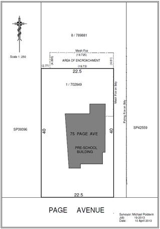
extending 5 metres beyond the rear boundary into Mahogany Creek Reserve (Figure
1).
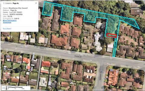
Figure 1: Highlighted lot forms part of Mahogany
Creek Reserve. The red box indicates the proposed licence area.
Mahogany Creek Reserve (NNN074)
is Council owned community land categorised as ‘Park’. Under
Section 47D of the Local Government Act 1993, exclusive occupation, or
exclusive use by any person of community land otherwise in accordance with a
lease, licence or estate is prohibited. Licenses can only be
granted where the licensed area is used either in accordance with the Plan of
Management or is a prescribed purpose such as kindergartens and the like.
In 2013, Council sought to formalise the encroachment with
the Parks Operations Manager wishing to enter into an agreement for the life of
the structures after which time they would need to be removed. At that
time, the Plan of Management for Mahogany Creek Reserve did not permit
licensing of longer than 12 months, so Council invited T & C Hoskin to
enter into an annual licensing arrangement. The area has been licensed
since that time. A key stipulation of the licence was, and is, that the
Licensee was not to make any improvements upon the Licensed Area or alterations
to any existing structures upon the Licensed Area.
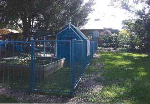
Figure 2: Rear fence of 75 Page Ave in 2013
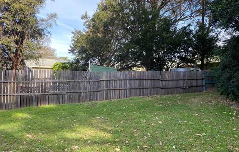
Figure 3: Rear fence of 75 Page Ave in 2022
Through changes to the Mahogany
Creek Plan of Management, Council is now able to offer a five-year licence to
formalise occupation of Mahogany Creek Reserve by T & C Hoskins, trading as
the North Nowra Preschool. From the images above, it is clear that there
have been improvements made to the encroachment, albeit minor in nature.
A benefit of offering a five-year licence is that Council is able to consider
the long-term occupation/encroachment of Mahogany Creek Reserve.
The North Nowra Preschool is a commercial enterprise that
has been in operation since the mid 1990’s. The owners of the
business have invested in developing a wonderful creative outdoor play space
for the children, although some of it is located on Council land.
Should Council decide that the encroachment needs to be rectified (removed),
this could be included in the five-year licence and would therefore provide the
operators of the North Nowra Preschool with a five-year window with which to
address this matter.
Terms
Schedule
|
Licensee
|
T & C Hoskin
|
|
Licensor
|
Shoalhaven City Council
Administration Building
42 Bridge Road, Nowra, NSW, 2541
Tel: 02 4429 3111
Email: Council@shoalhaven.nsw.gov.au
|
|
Premises
|
Part Lot 8 in DP 789881
|
|
Site area
|
As described as “Area of
Encroachment” in survey plan below
|
|
Term
|
Five (5) years
|
|
Rent
|
$543.00 plus GST per annum, payable yearly in advance
|
|
Rent Review
|
Annually to CPI
|
|
Percentage of Outgoings
|
0%
|
|
Permitted Use
|
Encroachment of Pre-School playground located at 75 Page
Ave North Nowra
|
|
Amount of Public Liability Insurance
|
A minimum of $20 million
|
Licence
Area
Community Engagement
In accordance with Section 47A
of the Local Government Act, a public notice of the proposed licence was
published in the South Coast Register on 27 July 2022. Adjoining property
owners were notified, and the notice was placed on Council’s website, in
Council offices and at Mahogany Creek Reserve for a period of 28 days.
One submission was received. This was in the form of a
phone call from an adjoining landowner who was seeking clarification that the
licence was for the existing area of encroachment only and that the preschool
would not be extending further into the Reserve.
Policy Implications
The licence is in accordance with Council’s Occupation
of Council Owned or Managed Land Policy.
Financial Implications
The Licensee will cover all
costs associated with the granting of this licence including advertising,
valuation, and legal fees in addition to the annual rent of $543 (plus
GST).
Income from rent will be allocated to general fund –
Reserve Access Licence Fee – Various and used for future maintenance
responsibilities.
Risk Implications
Continued occupation of part of
Mahogany Creek Reserve is unlawful without a licence or lease in place.
Either the encroachment is licenced, or it will need to be removed.
Should Council decide that the encroachment needs to be rectified, the North
Nowra Preschool, which is a long-established local business, would benefit from
a set date to vacate so that they can plan the transition accordingly.
|
|
Ordinary
Meeting – Monday 05 December 2022
Page
0
|
CL22.639 Quarterly
Review for Compliance Matters
HPERM Ref: D22/416444
Department: Certification
& Compliance
Approver: James
Ruprai, Director - City Development
Attachments: 1. Penalty
Notices & Warnings Issued & Patrols - Quarterly Review - City
Development - July to September 2022 ⇩
Reason for Report
At Council’s Ordinary meeting held on 13 November 2018
it was resolved to receive a detailed quarterly report on compliance activities
(MIN18.907).
At Council’s meeting of 23 May 2022, it was resolved for
all future reports to provide an analysis of trends, effectiveness and current
and arising areas of risk (MIN22.348).
This report provides information
on the period from 1 July to 30 September 2022 (first quarter 2022/2023).
|
Recommendation
That
Council receive the 1 July to 30 September 2022 quarterly report on compliance
matters for information.
|
Options
1. Council receives the report for
information.
Implications: Nil
2. Council receives the report and provides
additional direction for future reports.
Implications: Any changes or additional matters can
be added to future reports.
Report
Compliance activities are completed by the following Teams
within City Development:
(a) Compliance Team:
Development compliance matters including unauthorised development, development
not in accordance with development consent, land use issues and swimming pool
safety issues.
(b) Environmental Health:
Pollution incidents (noise, water and sediment control), environmental
incidents, food shops and the operation of on-site sewage waste management
facilities.
(c) Rangers: Parking,
animal management, unauthorised camping, littering, rubbish dumping and other
environmental offences.
(d) Fire Safety: Fire
Safety relating to commercial buildings.
This report provides Councillors with an update on the
penalties issued (number, type, and ticket value) and any Local or Land and
Environment Court matters determined or progressing.
This report relates to July - September
2022 (first quarter).
Penalties Issued During the
Period
A combined total of 1,464 penalty notices were issued by the
Teams during the period. These penalties have a face value of $378,184. Historically
Council stands to receive approximately 70% of this ticketed figure.
A total of 83 warnings were issued during the period.
Attachment 1 to this report provides a breakdown of the
penalties and warnings issued.
The following is a summary of the penalties issued for each
team:
Table 1:- Penalty
notices issued for the 1st quarter 2022/2023
|
Team
|
Number Issued
|
Total Amount
|
% of total
amount
|
Warnings issued
|
|
Compliance
|
17
|
$39,660
|
10.5%
|
43
|
|
Fire Safety
|
2
|
$1,200
|
0.3%
|
4
|
|
Compliance – Pools
|
13
|
$6,160
|
1.6%
|
12
|
|
Environmental Health
|
5
|
$7,640
|
2.0%
|
1
|
|
Rangers – Animal issues
|
168
|
$80,620
|
21.3%
|
17
|
|
Rangers – Environmental issues
|
22
|
$33,270
|
8.8%
|
1
|
|
Rangers – Parking
|
1,237
|
$209,634
|
55.5%
|
5
|
|
Sewer Management Facility
|
0
|
0
|
0
|
0
|
|
Total
|
1,464
|
$378,184
|
100%
|
83
|
Penalties Related to Compliance
issues
The following details are provided in relation to compliance penalty
notices issued during the period:
a) Sanctuary Point
($550):- One penalty notice was issued to the owner of a property for
having a swimming pool without a complying barrier.
A further three warning notices were also issued, and these
would have equated to $1830 if issued as penalty notices.
b) North Nowra ($550):-
One penalty notice was issued to the owner of a property for having a swimming
pool without a complying barrier.
A further three warning notices were also issued, and these
would have equated to $1830 if issued as penalty notices.
c) Ulladulla ($550):-
One penalty notice was issued to the owner of a property for having a swimming
pool without a complying barrier.
A further two warning notices were also issued, and these
would have equated to $660 if issued as penalty notices.
d) Fishermans Paradise
($12,000):- Six penalty notices were issued to the owners of a
premises for non-compliance with a development consent and for failing to
comply with a development control order (3 to each
owner).
Sixteen warning notices were also issued, and these would
have equated to a further $22,320 if issued as penalty notices.
e) Wattamolla ($9,460):-
Three penalty notices were issued to the owner of property for failing to
comply with a development control order and development without consent.
f) Budgong ($860):-
Three penalty notices were issued to three owners of a premises for operating
an on-site sewage management system without approval and failing to have a
working smoke alarm.
A further twenty-one (21) warning notices were also issued,
and these would have equated to a further $21,090 if issued as penalty notices.
g) Jaspers Brush ($660):-
Two penalty notices were issued to the owner of a
premises for failing to maintain a compliant pool barrier.
h) Callala Beach ($3000):-
One penalty notice was issued to a demolition contractor for demolishing a
dwelling containing asbestos without development consent.
i) South Nowra
($770):- Two penalty notices were issued to the owner of a premises
for not having a child proof barrier and for not registering a pool.
One warning was also issued for a separate breach and this
would have equated to $110 if issued as a penalty notice.
j) Ulladulla
($550):- One penalty notice was issued to the owner of a property for
failing to comply with a written direction to rectify a non-complaint swimming
pool barrier.
k) Culburra Beach
($3000):- One penalty notice was issued to the owner of a premises
for failing to comply with a development control Order requiring them to stop
use of the premises for residential accommodation as it was prohibited in the
zone.
l) Shoalhaven
Heads ($550):- One penalty notice was issued to owner of a property
for not providing a complaint swimming pool barrier.
One warning notice was also issued for another breach of
the Swimming Pools Act and this would have equated to $110 if issued as a
penalty notice.
m) Milton ($770):-
Two penalty notices were issued to the owner of a premises for breaches of the
Swimming Pools Act for failing to maintain a compliant barrier and for not
registering a swimming pool.
One warning notice was issued for a subsequent offence and
this would have equated to a further $550 if issued as a penalty notice.
n) Wandandian ($550):-
One penalty notice was issued to the owner of a premises for a breach of the
Swimming Pools Act for failing to surround a pool with a child resistant
barrier.
One warning notice was issued for failing to register the
pool and this would have equated to $220 if issued as penalty notice.
o) South Nowra ($12,000):-
Four penalty notices were issued to the owner of a commercial premises for
unauthorised development.
One warning notice was issued and
this would have equated to $3000 if issued as a penalty infringement notice.
Warnings Related to Compliance issues
A total of 55 warning notices were issued for compliance
matters in the period and these have no dollar value. Potentially the
Compliance Team could have issued a further $51,720 in penalties for the
period. The caution rate is approximately 52% of the total potential.
Figure 1 shows the penalties and warnings issue for the period
by suburb.
Figure 1:-
Penalties and warnings issued for the period by suburb
Court Elected Penalties:
There were no court elected penalties this quarter.
Compliance merits received this quarter
The Compliance Team received 87 Merits, and the following
tables highlights the trends.
|
Type of Merits Received
|
Number Received
|
Percentage of total
|
|
Asbestos issues
|
3
|
3.5
|
|
Building Works - Not in Accordance Consent
|
15
|
17.2
|
|
Building Works - Without Consent
|
28
|
32.2
|
|
Defective Building Works
|
2
|
2.3
|
|
Earthworks - Without Consent
|
2
|
2.3
|
|
Land Use - Without Consent
|
5
|
5.7
|
|
Stormwater Runoff
|
17
|
19.6
|
|
Swimming Pool Fencing Inspection
|
5
|
5.7
|
|
Manhole Adjustments (For Review)
|
10
|
11.5
|
|
TOTALS
|
87
|
100
|
The Compliance Team have been proactive in addressing areas of
risk by developing fact sheets, web-site updates and media campaigns for
swimming pools, moveable dwellings and camping grounds. The Team is
currently working on a media campaign and web-site update for shipping
containers as these are becoming more prevalent.
The following additional comments are made:
(a) Stormwater:-
Stormwater complaints reflect a high number of merits received representing
just under 20% of the total created. The number of complaints received was
substantially higher, however these matters can be difficult to establish cause
and in many cases were because of excess overland flow due to the recent
rainfall events and merits are not created for investigation in these
instances.
A significant number of stormwater complaints come from
areas in the LGA without street drainage infrastructure, where properties are
being inundated from excess overland surface water. Stormwater issues in
general can be difficult for Council staff to enforce compliance due to weak
legislative powers under the Local Government Act 1993.
(b) Development without
consent:- Development without consent also remains high representing
32.2% of the total number of merits.
Moveable dwellings installed on land for both residential
and tourist and visitor accommodation use remains a consistent issue. Council
has also seen an increase in unauthorised swimming pool being installed.
(c) Swimming Pool
Compliance:- Swimming pool merits represent just under 6% of the
total merits created and this reflects a drop in the number of referrals having
been received from private certifiers. This is likely due to an increase in
property managers and conveyancers opting to utilise Council for certification
works.
In total, Compliance undertook 89 individual swimming pool
inspections during the quarter resulting in forty (40) certificates of
compliance being issued and thirty (30) certificates on non-compliances being
issued.
Figure 2 shows the total number and type of compliance
merits received for the period.
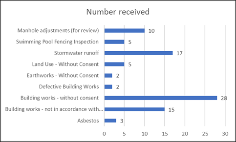
Figure 2:–
Compliance MERITS received for the period
Ranger Activities
Of the penalties issued by Ranger Services, there are trends
for animal management and environmental offences. Ranger Services are
working on a number of Media programs including responsible pet ownership, tree
vandalism and illegal dumping to address the main risks.
(a) Print and Post
commenced on 12 July 2022 which is a service provided by Revenue NSW.
Rather than putting the fine on the vehicle or posting it to the alleged
offender, Revenue NSW send the notice out on Council’s behalf.
(b) Ranger Services
collaborated with Environmental Services and National Parks to create a media
campaign and bus advertising for the 2022/2023 shorebird season. Three buses in
Nowra and Ulladulla will display the advert for 26 weeks.

(c) Rangers
attended 494 environmental complaints and 384 animal management complaints for
the quarter.
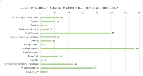
Figure 3:-
Customer requests for environmental issues
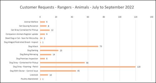
Figure 4:-
Customer requests for animal related issues
(d) Dog attacks:- Rangers
received and attended 52 reports of dogs attacking
during the period. Of these reports, 22 investigations have been completed with 27 penalty notices issued (i.e. 27 x $1,320 =
$35,640). A further 30 matters remain under investigation.
Although the penalty is high, dog attacks remain a major
risk. Whilst there is more awareness in the community, there may still be
unreported dog attacks.
The following figure provides information on the dog
related penalty notices issued by suburb for the period (Refer Figure 5).
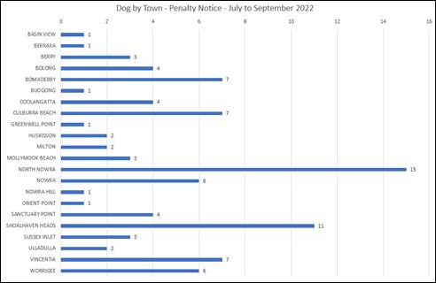
Figure 5:-
Dog related penalty notices by suburb for the period
(e) Animal
registrations:- A total of 71 penalty notices were issued for
non-compliance with the lifetime registered requirements by the Companion
Animals Act.
(f) Beach patrols:-
Rangers completed 419 beach patrols during this quarter. A number of dog owners
have been spoken to during this period. A total of 359 compliant dogs and 51
non-compliant dogs were observed. Enforcement action and education is
undertaken when offences are detected.
(g) Vegetation
vandalism:- Rangers received 46 reports of vegetation vandalism and 10 are
still under investigation. Rangers continue surveillance and on-going
monitoring of these vandalised areas in accordance with Council’s
Vegetation Vandalism Prevention Policy.
(h) Illegal Dumping:-
Shoalhaven City Council received 236 reports of illegal dumping and
Council’s Works and Services has removed 17.93 tonne with approximate
cost of $29,308.00 during the July - September quarter. A total of 82.19 tonne
of illegally dumped waste was also reported.
i. Penalty
Notices:- a total of 12 Penalty Notices (totalling $26,550) were
issued this quarter to offenders depositing household waste in bushland
areas. These offences occurred in Tianjara, Pyree, Culburra Beach and
West Nowra.
All offenders were ordered to clean up and dispose of
their waste at a lawful waste facility. A total of
six Clean Up Notices have also been issued and these have had
administration fees applied (i.e. 6 x $591 = $3,546).
ii. Proactive
Patrol – Illegal Dumping:- Shoalhaven City Council has implemented
proactive illegal dumping patrols for all Rangers.
A total of 52 proactive patrols occurred and breakdowns of
Land Custodian, officer and other options are now available to identify known
“Hot Spots”. In this quarter 19 proactive patrols were within NPWS
lands. This data will assist in determining effectiveness of proactive patrols
as well as improving targeting specific areas.
iii. Media Projects:–
Rangers have been successful in obtaining a grant to implement an education
program to promote use of RID online. This program utilises social media
together with face to face information sessions.
Council’s Media, IT and Waste Services staff have
participated in the three month program which focused on emotional response to
Wildlife, being included in the educational material. This includes
branding and display banners to promote EPA/RID Online.
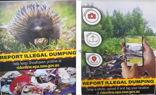
(i) Parking:-
A total of 1,237 penalty notices were issued for parking offences in the
period. Figure 6 highlights the penalties issued by suburb for the
period.
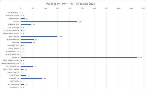
Figure 6:-
Parking by town.
(j) The
Responsible Dog Ownership project was launched in this quarter promoting three
key topics. These messages are being delivered via social media and media
releases. Posters are also displayed in Council’s foyer and at Council
events.
(k) Animal Shelter:
The Shelter currently has over 18,625 followers on Facebook. This
platform provides an effective means of advertising adoptions, lost dogs and
the promotion of responsible pet ownership.
i. Data
for incoming and outgoing animals: - A total of 223 animals entered the
Shelter (64 via Ranger, 37 surrenders, 12 offspring, 8 returns and 102 from the
public). A total of 277 animals left the Shelter (138 adoptions, 66 reclaims,
30 euthanised, 36 transfers to rescue organisations and 7 unassisted deaths (6
guinea pigs).
ii. Animal
desexing vouchers given to pensioners:- The Shelter collaborated with many
external units and was able to obtain continued support for the animal desexing
program. This resulted in 87 free animal desexing vouchers being provided
to pensioners.
iii. Contributions to
the shelter:- The Shelter received $1,893 in contributions from the
public and businesses in the last quarter.
The Shelter would like to acknowledge the
generosity of the public and these businesses. The Shelter will be using these
donations to create friendly and bright spaces in the exercise yards.
|

|
Ordinary
Meeting – Monday 05 December 2022
Page
0
|
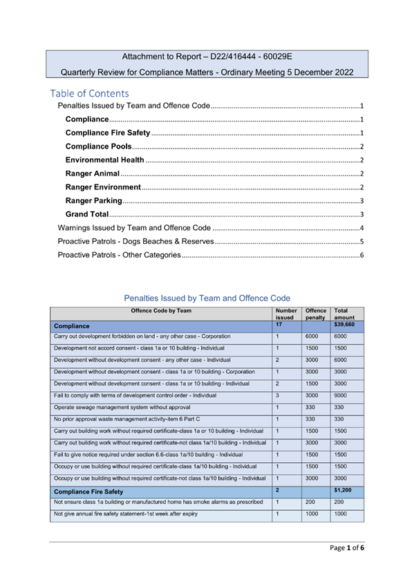
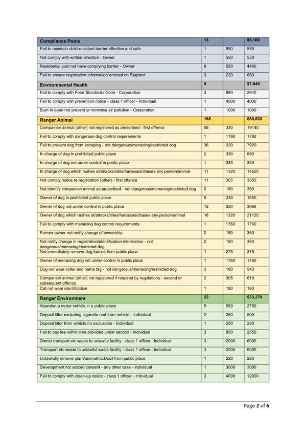
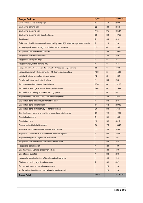
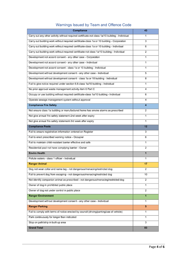
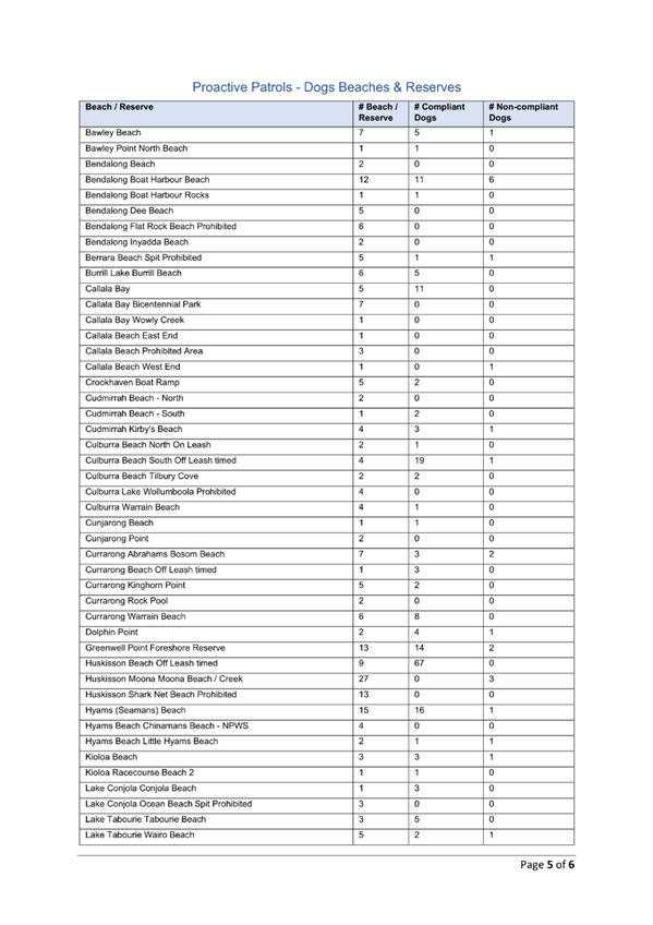
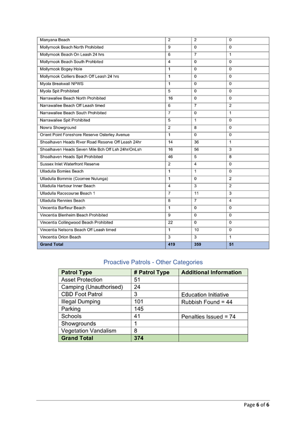
|

|
Ordinary
Meeting – Monday 05 December 2022
Page
0
|
CL22.640 RA22/1003
- McIntosh Street Shoalhaven Heads - Part Lot 7005 DP 1075719
DA. No: RA22/1003/4
HPERM Ref: D22/472888
Department: Development
Services
Approver: James
Ruprai, Director - City Development
Attachments: 1. Planning
Report S4.15 Assessment (under separate cover) ⇨
2. Draft
- Determination (under separate cover) ⇨
3. DPI Fisheries Referral
Response - General Terms of Approval ⇩
Description of Development: Coastal protection
works including modification of an existing rock revetment structure to
ameliorate the end effect erosion
Owner: Crown Lands
Applicant: Shoalhaven City Council
Notification Dates: 27/07/2022 – 10/08/2022
14/09/2022
– 14/10/2022
No. of Submissions: Two (2) submissions
Purpose
/ Reason for consideration by Council
To review the section 4.15 assessment report and
determination prepared by an independent consultant which is to be submitted to
the Southern Regional Planning Panel for consideration.
|
Recommendation
That:
1. Council receive and note the report
RA22/1003 - McIntosh Street, Shoalhaven Heads - Part Lot 7005 DP 1075719.
2. Council support RA22/1003 for
coastal protection works at McIntosh Street, Shoalhaven Heads on the basis
that it has been satisfactorily assessed pursuant to section 4.15 of the Environmental
Planning and Assessment Act 1979.
3. The resolution made by Council be
submitted to the Southern Regional Planning Panel prior to their
consideration and determination of RA22/1003.
|
Options
1. Support the
consultant’s recommendation to the Southern Regional Planning Panel
(SRPP) for approval of the application and advise the SRPP accordingly.
Implications:
The recommendation would be provided to the SRPP for their information as part
of their consideration of the regional application.
2. Make an
alternative resolution and make a separate submission to the SRPP.
Implications:
The alternative resolution would be provided to the SRPP for their
consideration. The SRPP will be the determining authority for the application.
Location Map
 Figure 1 – Site location / Aerial view
Background
Why this DA is being reported to the Regional Planning
Panel
· The works
constitute coastal protection works to be carried out by or on behalf of
a public authority.
· The Southern
Regional Planning Panel is the determining authority for the application in
accordance with section 8A of Schedule 6 of State Environmental Planning
Policy (Planning Systems) 2021, (SEPP).
8A Certain
coastal protection works
(1) The
following development on land within the coastal zone that is directly adjacent
to, or is under the waters of, the open ocean, the entrance to an estuary or
the entrance to a coastal lake that is open to the ocean—
(a) development
for the purpose of coastal protection works carried out by a person other than
a public authority, other than coastal protection works identified in the
relevant certified coastal management program,
(b)
development for the purpose of coastal protection works carried out by or on
behalf of a public authority (other than development that may be carried
out without development consent under clause 19(2)(a) of State Environmental
Planning Policy (Coastal Management) 2018).
The determination by a Panel adds a layer of transparency to
the assessment process. Furthermore, the application was also independently
assessed by a reputable Planning Consultancy – Mecone. These assessment
and management measures are intended to deal with any potential conflicts of
interest.
Proposed Development
Council is in receipt of a development application (DA)
which seeks approval for coastal protection works.
The Statement of Environmental Effects (SEE) outlines the
full scope of foreshore management activities to be undertaken by the
applicant, however, the applicant has specified that development consent is
sought only for the proposed rock revetment works which could not be
undertaken as exempt or complying development in accordance with 2.16 of State
Environmental Planning Policy (Resilience and Hazards) 2021.
The applicant has explained that ‘other’ works
specified in the SEE, including proposed sand/beach nourishment works do not
form part of the DA.
The DA assessment is limited only to the proposed rock
revetment works. The ‘other’ works are to be dealt with under Part
5 of the Environmental Planning and Assessment Act 1979.
A detailed description of rock revetment works for which
development consent is sought is provided below:
· Temporarily remove
rock armour (primary and secondary) and geotextile underlayer.
· Re-align and
re-profiling the lower section of earth bank to the design slope of 1V:1.5H
· Replace
geotextile, secondary armour, and a single layer of primary armour only, to a
maximum crest height of 4 metres AHD (adjacent to private boat ramp) and
reducing to level of natural ground at the eastern end
· Place
excess/excavated soil onto current erosion scarp at eastern end of rock
revetment, burying end of revetment within bank alignment if possible.
· Nourish the intertidal
area of foreshore to elevate it to a consistent longshore level (at least 1.1
metres AHD) against revetment toe, per current levels of areas further to the
west.
As mentioned previously, the development involves coastal
protection works to be carried out by or on behalf of a public authority
(Council), in accordance with section 8A of Schedule 6 of SEPP (Planning
Systems) 2021, the application constitutes a regional development application,
and the Southern Regional Planning Panel is the determining authority for the
application.
The proposed site plan is provided in Figure 2.

Figure 2 – Site Plan
Subject Land and Surrounds
The
subject site is located at McIntosh Street, Shoalhaven Heads, fronting
Shoalhaven River. It forms the north-western foreshore of the Shoalhaven River
immediately landward of Shoalhaven Heads and traverses approximately 500 metres
along the foreshore up to 20 metres wide to include the river foreshore,
waterway and vegetated embankment.
The land is legally identified as Lot 7005 DP 1075719 and
includes the Shoalhaven River waterway.
The site
predominantly comprises sandy beach with some locations with pebble deposits
over the sandflats. There are existing vegetation and stormwater pipes to the
south.
The site
is surrounded by residential
developments and by Shoalhaven River.
The land is zoned RE1 Public Recreation under the Shoalhaven
Local Environmental Plan 2014 (SLEP 2014), under which the proposal is prohibited,
however, permissible with consent in accordance with section 2.16(2)(b), State
Environmental Planning Policy (Resilience and Hazards) 2021.
Planning Assessment
The DA has been (independently)
assessed under s4.15 of the Environmental Planning and Assessment Act 1979.
Consultation and Community
Engagement:
The DA was first notified in accordance with the Environmental Planning & Assessment
Regulation 2021 (the EP&A Regs) and Council’s Community
Consultation Policy for Development Applications on 27 July 2022 to 10
August 2022. One (public) submission was received during the notification
period.
Following amended documentation being provided by the
applicant, the application was renotified between 14 September 2022 to 14
October 2022. A submission was received from the Crown Lands Office on 25
October 2022.
The (public) submission identified the following items:
· Lack of detail
regarding existing tree on the site to be retained and/or removed.
· Details of tree
location and protection details are required.
· Provide details
that two (2) mature tree (Banksia Trees) are not to be removed and are vitally
important to the river bank.
The applicant advised that no vegetation removal is
required for the development application. Protection zones for trees from
machinery and vehicles is to be maintained in accordance with AS 4970- 2009
– Protection of Trees on Development Sites.
The submission from the Crown Lands Office identified the
following potential impacts:
· “The
potential for the proposed works to move the end effect to the east (also
referred to in the WRL 2022 report) without undertaking mitigation activities.
· The sourcing of
sand from Seven Mile beach may increase the vulnerability of sand dunes
and vegetation along the beach.”
Crown Lands advised that:
“If RA22/1003 is
granted consent the following should be considered as part of the DA consent
the applicant must prepare a Coastal Protection Works Management Plan
(‘CPWMP’) for the area comprising the rock revetment structure and
sand nourishment.”
A condition of consent has accordingly been included as part
of draft conditions.
Financial Implications:
If the development is approved and
the development proceeds, the Council will be required to fund the project.
There are potential cost
implications for Council in the event of a refusal of the application.
Whilst Council is the applicant, it could (unusually) choose to appeal the
situation. However, more than likely if the application were to be
refused, Council would pursue a review of the decision. There would be
costs associated with investigations to resolve any issues and reasons for
refusal.
Legal Implications
Pursuant to section 8.2 of the Environmental
Planning and Assessment Act 1979, a decision of the Southern Regional
Planning Panel (SRPP) may be the subject of a review by the applicant in the
event of approval or refusal. If such a review is ultimately pursued, the
matter would be put to the SRPP for consideration. Additionally, a right
of appeal would be available.
Summary and Conclusion
This
application has been satisfactorily assessed having regard for section 4.15
(Evaluation) under the Environmental Planning and Assessment Act 1979.
Based upon the recommendations of the s4.15 Assessment Report (Attachment 1),
Development Application No. RA22/1003 is recommended to the SRPP for
conditional development consent.
The
draft conditions of development consent are contained in Attachment 2 to
this report. As the conditions reference the General Terms of Approval
(GTA) issued by the Department of Primary Industries (DPI) Fisheries, the
GTA is included in Attachment 3 to this report.
|

|
Ordinary
Meeting – Monday 05 December 2022
Page
0
|
|

|
Ordinary
Meeting – Monday 05 December 2022
Page
0
|
CL22.641 Development
Application - DA22/1614 - 5 Flora Street, Sanctuary Point
HPERM Ref: D22/458055
Department: Certification
& Compliance
Approver: James
Ruprai, Director - City Development
Attachments: 1. s4.15
Assessment Report (Class 1 & 10) (under separate cover) ⇨
2. DRAFT
Notice of Determination (under separate cover) ⇨
3. Architectural Plans (under
separate cover) ⇨
Description of Development: Demolition of Existing
Structures, Construction of a Dual Occupancy (attached) and associated Torrens
Title Subdivision of One (1) Lot into two (2) Lots
Owner: D J Azar, M M Azar, A T Azar, A Azar
Applicant: Nemco Design
Notification Dates: 29 August 2022 – 14
September 2022
No. of Submissions: Ten (10) were received
Purpose
/ Reason for consideration by Council
On 26 September 2022 Council resolved to call in
development application DA22/1614 for determination citing public interest
(MIN22.825).
|
Recommendation
That Development
Application DA22/1614 for demolition of existing structures, construction of
a dual occupancy (attached) and associated Torrens title subdivision of one
(1) lot into two (2) lots be approved subject to the recommended conditions
of consent provided at Attachment 2.
|
Options
1. Approve the
application in accordance with the recommendation.
Implications: This would
enable the development to proceed according to the recommended conditions of
consent.
2. Refuse the
application.
Implications: Council would need to determine the
grounds on which the application is refused, having regard to the section
4.15(1) considerations. The applicant would be entitled to seek a review
and / or pursue an appeal in the Land and Environment Court.
3. Alternative
recommendation.
Implications: Council will need to specify an
alternative recommendation and advise staff accordingly.
Location Map
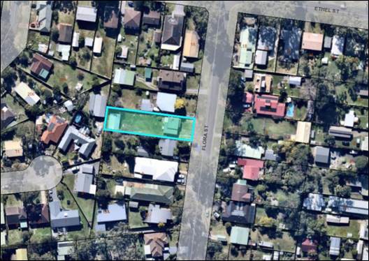
Figure 1: Location Map - Locality
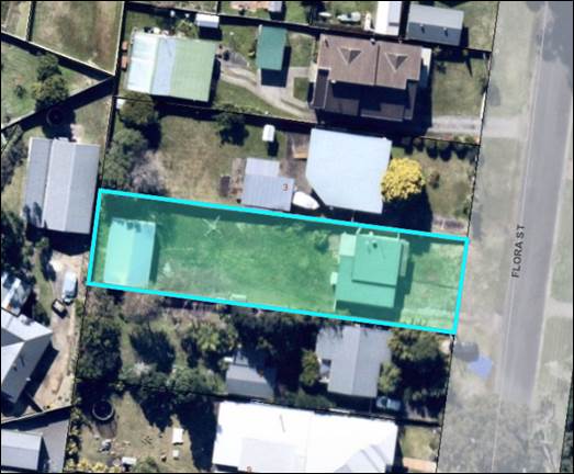
Figure 2: Location Map – Subject Site
Background
Proposed Development
The development application
includes:
· demolition of
existing structures
· construction of a
two-storey dual occupancy (attached) and
· associated Torrens
title subdivision of 1 lot into 2 lots.
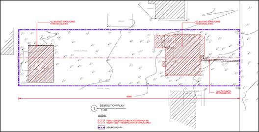
Figure 3: Demolition Plan
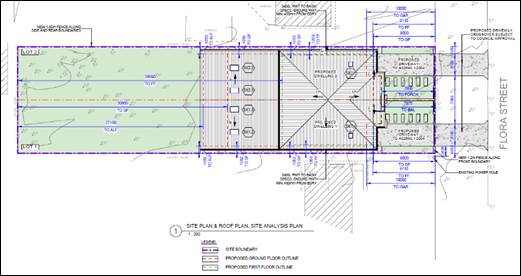
Figure 4: Site Plan
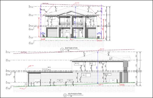
Figure 5: East and South Elevations
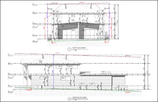
Figure 6: West and North Elevations
Figure 7: Subdivision Plan
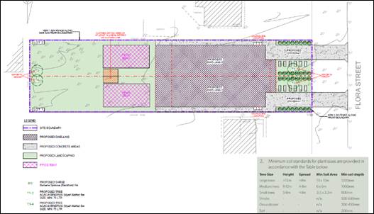
Figure 8: Landscape Plan
Subject Land
The development site is legally identified as Lot 277 DP
26390 and is described as 5 Flora Street, Sanctuary Point (refer to Figures 1
& 2).
Site & Context
The development site is located on the western side of Flora
Street. The site is a regular shaped allotment having an area of 942.16m2.
The existing development on the site includes a single storey
dwelling house and a detached shed (to be demolished). The site has
connections to town water and a reticulated sewer system. The site is
accessed directly from Flora Street.
Immediately adjoining the site are single storey dwelling
houses and associated ancillary development. Under the provisions of the
Shoalhaven Local Environment Plan 2014 (SLEP-2014) the subject land is zoned R2
– Low Density Residential (refer to Figure 9).
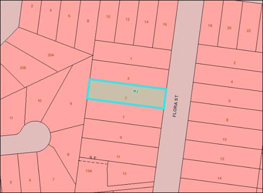
Figure 9: Zoning Map
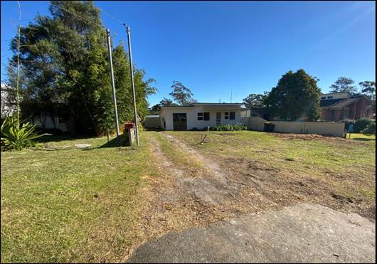
Figure 10: Photograph of existing development on site viewed from
Flora Street
History
The development application was lodged on 27 May 2022.
Additional information was requested on 20 June and 13 October 2022.
The applicant provided additional information on 27 July 2022
and as part of this, amended plans were provided removing the secondary
dwellings from the development. The application currently before Council is for
a dual occupancy (attached) and associated Torrens title subdivision only.
There are outstanding stormwater drainage issues but these
can be adequately resolved by a condition requiring the submission of amended
plans prior to the issue of a Construction Certificate. The amended plans
need to show the stormwater from the buildings being directed to Flora Street
and runoff from the driveways being directed to absorption trenches.
On 31 October 2022 Council resolved to call in development
application DA22/1614 for determination citing public interest
(MIN22.825).
Consultation and Community
Engagement
Ten (10) public submissions were received in relation to
Council’s notification of the development. All of the submissions
received were objections to the development. The notification was made in
accordance with Council’s Community Consultation Policy with letters
being sent within a twenty-five (25)m buffer of the site. The
notification was for a two (2) week period.
Key issues raised as a result of the notification are provided
below:
|
Summary
of Public Submissions
|
|
Objection
Raised
|
Comment
|
|
Development
is out of character with area
“This
planned development is totally out of keeping with the local area. It would
be visually detrimental to the quiet bushy neighbourhood - more suited to the
main street of a larger town. It will stand out like a sore thumb.”
“the
building proposed is not integrating with natural surrounds and will destroy
the 'feel' of Sanctuary Point.”
|
The
subject site has a site area of 942.16m²
which complies with the site area required for a dual occupancy (attached).
The
proposal complies with landscaping, site coverage, height and setback
controls. The building design is well articulated and is compatible with the
surrounding area.
|
|
Car
Parking
“The
plans include off street parking for one car for each of the two primary
dwellings. With two secondary dwellings proposed vehicles will inevitably
spill out onto Flora Street.”
“the
proposed building doesn't reflect a realistic amount of off street parking
for the amount of residents proposed.”
|
During
the course of the assessment the application was revised to remove the
secondary dwellings. The current application is for a dual occupancy
(attached) and associated Torrens title subdivision only.
The
development provides 2 car parking spaces for each dwelling (1 x internal in
a garage and 1 x stacked on the driveway) which complies with
Chapter G21 of Shoalhaven DCP-2014.
|
|
Privacy
“Our
use of our land will be seriously impaired if Shoalhaven Council allows the
development of the adjoining allotments with insufficient privacy taken into
consideration. The proposed development in a low density residential area is
going to have impacts on all surrounding properties for privacy and noise
concerns.”
“A
number of properties in this area are single level, the floorplan of this
property has windows looking over into neighbouring yards, this will just
tower over some of the existing properties and cause ongoing issues with
sunlight to gardens and grounds, and overlooking from the top level windows
into living areas of a number of neighbours.”
|
The proposed dual
occupancy (attached) is not considered to unreasonably impact on the privacy
of the adjoining development.
The majority of the
openings on the second storey of the northern and southern elevations is to
bedrooms, bathrooms and otherwise generally service low usage rooms.
The sill heights of the windows on the second storey have sill heights
ranging from 1.4m to 1.8m to help reduce any privacy impacts onto adjoining properties.
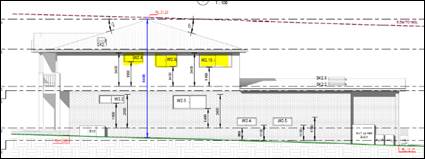
Figure 11: Northern Elevation
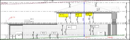
Figure 12: Southern Elevation
|
|
Noise
“This
is a very small space for 4 dwellings and noise will definitely be a big
problem for surrounding residences in such a quiet area.”
“it
seems this block has currently one little house on it. It is a low density
block, all blocks here in Sanctuary Point are low density. I do not agree
with crushing 20+ people on one block in our peaceful and quiet
neighbourhood. Imagine the chaos if the proposed apartments are rented for the
holidays.”
|
The
development is residential in nature and is appropriate for the
locality.
There
are only two dwellings proposed in this development.
|
|
Landscaping
“the
proposed building includes a lot of concrete and will not allow for enough plants
and trees to be planted again to make sure we preserve the current present
wildlife we enjoy here. I suggest two townhouses maximum be plenty and more
gardens.”
“The
design of this development does not fit in with the leafy
quite
character and environment that Sanctuary Point provides, this type of design
takes
away
from the feel of our area, the trees on this property have already been cut
down
which
is already showing the beginning of a barren landscape and stands out from
the
existing
properties. Can we confirm if an environmental impact review or arborist
report
was prepared prior to these being removed? If not this needs to be seriously
addressed
with the owners.”
|
The
development complies with Chapter G13 of Shoalhaven DCP with regard to
landscaping.
The
current development application does not involve any tree removal.
|
|
Stormwater
Issues
“it
is known that storm water runoff is an issue here in Sanctuary Point. This
proposal will certainly flood neighbouring properties.”
“We
currently have an inundation of stormwater from neighbouring developments
which have been completed adjoining our property recently, stormwater
measures taken with these developments have not been addressed. And we are
now suffering a severe financial loss due to these outstanding issues. We are
concerned with the proposed development and the adequate capturing of
stormwater. Strict measures should be being taken to ensure any hardstand
areas in the courtyards, paths and driveways will have a means of capturing
the stormwater and disposing of it to council mains rather then it running
straight into our property as it currently does.”
|
The
development application has been assessed by Council’s Development
Engineering team. Recommended conditions of consent have been provided
requiring stormwater from the buildings be directed to Flora Street and
runoff from driveway areas be directed to absorption trenches.
Council
is satisfied that stormwater from the development can be suitably managed.
Conditions of consent will ensure the stormwater system is designed,
installed and maintained so as not to increase surface water being
concentrated onto adjoining properties.
|
|
Subdivision
“The
Shoalhaven City Council S10.7 advised that Lot 277 DP 26390, 5 Flora Street
is zoned as R2 Low Density Residential, after reviewing the 310.7 and
Shoalhaven mapping, the minimum lot size for subdivision in a R2 Low Density
Residential lot is 500sqm. The proposed DA is under the minimum lot size and
should
not be allowed.”
|
The
proposal includes Torrens Title subdivision of the proposed dual occupancy
(attached) pursuant to clause 4.1A of Shoalhaven LEP 2014.
The
lot has a site area greater than 500m2 and therefore the proposal
meets the requirements of subclause (2).
Development
consent for the dual occupancy has been sought under clause 4.1A(2),
therefore the dual occupancy can be subdivided into lots of any size to
enable the resulting individual dwellings on those lots to have separate
titles pursuant to subclause 4.1A(4).
Council
is satisfied the subdivision and proposed lot size and layout is appropriate,
and that the proposal is consistent with the development controls and
performance criteria set out in Chapter G11 of Shoalhaven DCP-2014.
The
proposed Torrens Title subdivision is suitable with regard to the
considerations of Chapter G11.
|
Financial Implications
There are potential cost
implications if Council decide to refuse the application. Such costs would be
associated with defending an appeal in the Land and Environmental Court of NSW.
Legal Implications
A Section 8.2 review and/or appeal with the Land and
Environment Court are possible if the application is refused.
Summary and Conclusion
The proposed development is compliant with the provisions of
Shoalhaven LEP 2014 and is generally consistent with Shoalhaven DCP 2014.
The application is considered capable of support as there are
no substantial planning reasons to warrant refusal. Accordingly, it is
recommended it is approved subject to the conditions in the draft consent
(Refer Attachment 2).
|

|
Ordinary
Meeting – Monday 05 December 2022
Page
0
|
CL22.642 Development
Application - DA21/2438 - Currambene St & Hawke St Huskisson - Lot 1 DP
209436, Part Lot 7010 DP 1076858 & Lot 7012 DP 1021163
DA. No: DA21/2438/4
HPERM Ref: D22/470890
Department: Development
Services
Approver: James
Ruprai, Director - City Development
Attachments: 1. Section
4.15 Planning Assessment Report (under separate cover) ⇨
2. Architectural
Plans (under separate cover) ⇨
3. Ethos
Urban - Visual Impact Assessment (under separate cover) ⇨
4. Ethos
Urban - Visual Impact Evidence - Appendix A (under separate cover) ⇨
5. Draft Determination Notice -
Conditional Approval (under separate cover) ⇨
Description
of Development: Community Facility (Alterations and Additions to Existing
Volunteer Marine Rescue Building)
Owner: Crown Lands Department
Applicant: Marine Rescue NSW
Notification Dates: 15th December 2021
to 14th January 2022
No. of Submissions: Two (2)
Purpose
/ Reason for consideration by Council
In accordance with section 47E
(details are provided later in this report) of the Local Government Act 1993,
City Development does not have the delegation to determine the Development
Application and it instead must be determined by the elected Council
|
Recommendation
That Development Application No. DA21/2438 be determined by
means of approval, subject to the conditions of consent as attached at
Attachment 5.
|
Options
1. Approve the
application in accordance with the recommendation.
Implications: This would enable the
development to proceed according to the recommended conditions of consent.
Under some circumstances, third parties (i.e., objectors) can seek a judicial
review of Council’s decision in the NSW Land and Environment Court.
2. Refuse the
Development Application (DA).
Implications: The development is unable to proceed
as applied for. The applicant can, however, apply for a section 8.2A review of Council’s
decision and/or could lodge an appeal with the NSW Land and Environment Court
(LEC) against Council’s decision.
3. Alternative
recommendation.
Implications: Council will
need to specify an alternative recommendation and advise staff accordingly.
Location Map


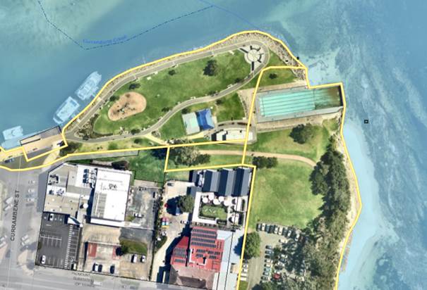
Background
Section 47E of the Local Government Act 1993
Section 47E is reproduced below:
47E Development of community land
(1) No
power of a council under an environmental planning instrument to consent to the
carrying out of development on community land may be delegated by the council,
if—
(a) the development
involves the erection, rebuilding or replacement of a building (other than a
building exempted by or under subsection (2) from the operation of this
paragraph), or
(b) the development
involves extensions to an existing building that would occupy more than 10 per
cent of its existing area, or
(c) the development
involves intensification, by more than 10 per cent, of the use of the land or
any building on the land, or
(d) the location of the
development has not been specified in the plan of management applying to the
land and the development is likely, in the opinion of the council, to be unduly
intrusive to nearby residents.
(2) The following buildings are exempt from the
operation of subsection (1)(a)—
(a) toilet facilities,
(b) small refreshment kiosks,
(c) shelters for persons from the sun and weather,
(d) picnic facilities,
(e) structures (other than accommodations for
spectators) required for the playing of games or sports,
(f) playground structures,
(g) work sheds or storage sheds,
(h) buildings of a kind prescribed by the
regulations.
(3) An existing area referred to
in subsection (1)(b) does not include the area of any awning, balcony, verandah
or other thing that extends beyond the main structural outline of the building.
(4) A delegation granted before
the commencement of this section, to the extent that the delegation could not
have been granted if this section had been in force at the time it was granted,
is void.
The increase in floor area is approximately 29%. The
intensification of the building equates to approximately 29%.
Accordingly, the matter must be reported to Council.
The land is also covered by a Plan of Management. The Plan of
Management (PoM) was endorsed by SCC on 22 July 2003 and adopted by NSW Crown
Lands on 20 November 2003 (File Ref No. 27590). There is a
current lease between Council as Crown Land Manager and Marine Rescue. It
is a 20-year lease, with a termination dated of 31 December 2037.
Proposed Development
In accordance with the submitted
Architectural Plans prepared by Ecosystem Architecture (Plan No’s
1910–04 Sheet No’s DA00 to DA11, dated 17th October
2020) located at Attachment 2 to this Report, the applicant proposes
alterations and additions to an existing Emergency Services Facility
(Alterations & Additions to the existing Volunteer Marine Rescue Jervis Bay
Base, Huskisson).
The nature of works proposed are
described as follows:
· New proposed
ramp and walkway providing accessible access to the first floor level of the
building from the adjacent public pathway.
· The
following alterations to the layout of the Ground Floor Level of the
development are proposed (Note: no extensions to the Ground Floor Level are
proposed):
o Existing private change
facility to be demolished and replaced with a new accessible change room
facility.
o Existing open plan
‘Council’ area in the northern part to be replaced by an enclosed lifesaving
room which incorporates lifesaving facilities including a first-aid bay and
pool communications.
o Enclosure of existing
kitchenette facility from the meeting / training room.
· The
following alterations and extensions to the layout of the First Floor Level of
the development are proposed:
o 78m² extension to the
floor area of the First Floor Level to match the floor area of the Ground Floor
Level.
o Alterations to existing layout
to incorporate an entry area (from the proposed ramp access), administration
room, radio room, accessible bathroom facility, training room, search and
rescue centre, and external viewing deck.
Subject Land
The site comprises three different allotments owned by Crown
Lands and is identified as Lot 1 DP 209436 Currambene St Huskisson, Part Lot
7010 DP 1076858 Currambene St Huskisson and Lot 7012 DP 1021163 Hawke St
Huskisson.
Site & Context
The site:
· Is zoned RE1
– Public Recreation in accordance with the Shoalhaven Local
Environmental Plan (SLEP) 2014.
· Is occupied
by the existing Volunteer Marine Rescue Jervis Bay building.
· Is partially
located over both White Sands Park and Voyager Memorial Park and is operated
under the Plan of Management (PoM) endorsed by SCC on 22nd July 2003
and adopted by NSW Crown Lands on 20th November 2003 (File Ref No.
27590).
· Is located
directly adjacent to other facilities associated with the Parks which are also
managed under the PoM including existing swimming pools, playground areas,
pathways, and public wharves.
· Is located
on the north-eastern edge of the Huskisson CBD area and possesses wide ranging
views of Jervis Bay to the north and east and provides an appropriate vantage
point having regard to the operational purpose as a volunteer marine rescue
organisation.
· Is located
within close vicinity to the existing Jervis Bay Hotel which is located at a
distance of approximately 15m to the south of the building.
· Is partly
identified as being flood prone land affected by the 1% AEP flood level and
Flood Planning Area.
· Is mapped
within a ‘Coastal Use Area’ and ‘Coastal Environment
Area’ pursuant to the SEPP (Resilience & Hazards) 2021.
· Is mapped
within a Class 5 acid sulfate soils area and within the Jervis Bay Region
pursuant to the SLEP 2014.
· Is partly
mapped (Lot 7012 DP 1021163 only) as being an item of local environmental
heritage significance (Item No. 201 – Tapalla Point geological rock
platform) and within immediate vicinity to a further item of local
environmental heritage significance (Item No. 207 – Jervis Bay Hotel).
History
A summary of actions taken as
part of the assessment of the Development Application is provided below:
|
Action
/ Event
|
Date
|
|
Development
Application fees paid and formal lodgement with Council.
|
26
November 2021
|
|
Referrals
sent out to various internal sections
|
6
December 2012
|
|
Commencement
of notification / advertisement
|
15
December 2021
|
|
Completion
of advertisement period (two submissions received)
|
14
January 2022
|
|
1st
Additional Information Request sent to the applicant relating to the
following:
· A response addressing the submissions received must be
provided.
· A further assessment against view impact must be provided
addressing the view sharing principles contained within: Tenacity Consulting v Warringah [2004] NSWLEC 140.
|
24 January
2022
|
|
Applicant
response to 1st Additional Information Request provided the
requested documentation.
|
21
February 2022
|
|
Response
to all internal referrals received by Council – no additional
information requested or required.
|
30
June 2022
|
|
Engagement
of Ethos Urban Pty Ltd to complete an independent View Impact Analysis (VIA)
of the proposed development, having regard for applicable legislation and Tenacity
Consulting v Warringah [2004] NSWLEC 140.
|
6
July 2022
|
|
Completion
of independent VIA by Ethos Urban Pty Ltd identifying that the proposal is
considered to have an acceptable impact.
|
9
November 2022
|
|
Completion
of assessment of application and recommendation to the Ordinary Council
Meeting of approval subject to conditions of consent.
|
11
November 2022
|
Issues
S4.15(1)(b) – Assessment of Potential Impacts Upon
the Built Environment
In accordance with section 4.15(1)(b) of the Environmental
Planning and Assessment (EP&A) Act 1979, Council is required to
consider impacts upon the surrounding built environment as part of the
assessment and determination of a Development Application.
One of the matters which is required to be considered as
part of the assessment of the potential for impacts upon the built environment,
is the potential for view loss associated with existing development surrounding
the site.
In this instance, the proposal for an extension to the
first-floor level of the Volunteer Marine Rescue building has resulted in two
(2) objections being received where concerns were raised regarding the topic of
view loss. A further discussion regarding the matters raised in the objections
received is provided in the Report below.
Decisions made within the NSW Land and Environment Court
have set the parameters and criterion for how view loss is to be assessed in
the assessment of Development Applications. This primarily relates to a
decision made by Roseth SC in the decision, Tenacity Consulting v Warringah
[2004] NSWLEC 140.
The following steps must be
considered:
26 The
first step is the assessment of views to be affected. Water views are valued
more highly than land views. Iconic views (e.g. of the Opera House, the Harbour
Bridge or North Head) are valued more highly than views without icons. Whole
views are valued more highly than partial views, e.g. a water view in which the
interface between land and water is visible is more valuable than one in which
it is obscured.
27 The second step is to consider from what part of the property the views
are obtained. For example the protection of views across side boundaries is
more difficult than the protection of views from front and rear boundaries. In
addition, whether the view is enjoyed from a standing or sitting position may
also be relevant. Sitting views are more difficult to protect than standing
views. The expectation to retain side views and sitting views is often
unrealistic.
28 The third step is to assess the extent of the impact. This should be
done for the whole of the property, not just for the view that is affected. The
impact on views from living areas is more significant than from bedrooms or
service areas (though views from kitchens are highly valued because people
spend so much time in them). The impact may be assessed quantitatively, but in
many cases this can be meaningless. For example, it is unhelpful to say that
the view loss is 20% if it includes one of the sails of the Opera House. It is
usually more useful to assess the view loss qualitatively as negligible, minor,
moderate, severe or devastating.
29 The fourth step is to
assess the reasonableness of the proposal that is causing the impact. A
development that complies with all planning controls would be considered more
reasonable than one that breaches them. Where an impact on views arises as a
result of non-compliance with one or more planning controls, even a moderate
impact may be considered unreasonable. With a complying proposal, the question
should be asked whether a more skilful design could provide the applicant with
the same development potential and amenity and reduce the impact on the views
of neighbours. If the answer to that question is no, then the view impact of a
complying development would probably be considered acceptable and the view
sharing reasonable.
Applicant’s Submission
The applicant has undertaken an
assessment against the Four-Part Test which can be found within Council’s
section 4.15 Assessment Report located at Attachment 1 to this Report. Their
assessment provides the following summary in relation to Step 4
–‘ Reasonableness of the Proposal that is Causing the
Impact’:
Given the
site’s Public Recreation RE1 zoning under Shoalhaven Local Environmental
Plan 2014, there are no numerical floor space ratio or building height controls
that apply to the subject site. Furthermore, the Shoalhaven DCP does not impose
any boundary setback controls in respect of the site. The proposal complies
with all relevant planning controls and is therefore inherently more reasonable
than one which breaches them.
Having
regard to the Land and Environment Court planning principle as to whether a
more skilful design could provide the applicant with the same development
potential and amenity and reduce the impact on the view of neighbours, the
answer to this question is no.
The
proposed extensions to the upper floor level of the Marine Rescue base facility
will provide an improved level of amenity and expanded capability to the Marine
Rescue Jervis Bay to meet the needs of this organisation. The current premises
were constructed in 2006 and are nearing 20 years old and are in need of
modernisation to meet current logistical
requirements. Given the facility is owned by and shared with Shoalhaven City
Council (amenities and pool maintenance equipment) the only available option is
to provide additional floor space on the upper floor level.
Furthermore,
the design of the proposal avoids the loss or alienation of parkland that a
ground floor extension would involve. The ground floor of the existing premises
provides toilet and change facilities for swimmers using the swimming pools and
the open space facilities more generally. In addition, the ground floor
comprises vital storage spaces that are used by both Shoalhaven City Council
and Marine Rescue. Given the current ground floor areas are in use and not
available for any other purpose, it is not possible for Marine Rescue to expand
into the ground floor of the building.
Having
regard to the importance of the Marine Rescue operations to the boating
community around Jervis Bay and nearby waterways, the proposed development is
considered to be reasonable under the circumstances.
Discussion
Noting the opposing views
between the applicant and objector and the nature of the submissions (one made
by a legal firm), it was considered both prudent and necessary for an
independent View Impact Analysis (VIA) to be carried out by an impartial and
suitably qualified practicing professional.
A thorough assessment was
undertaken by Ethos Urban Pty Ltd (as the impartial and suitably qualified
practicing professional) against all relevant planning legislation and controls
and in particular, the four-part test established in Tenacity Consulting v Warringah
[2004] NSWLEC 140.
The assessment also took into
account Rose Bay Marina Pty Limited v Woollahra Municipal Council and anor
[2003] NSWLEC. In this matter, a planning principle for consideration
of visual impact on the public domain was established. A discussion on
this principle can be found in Attachment 3, page 21. In summary a
quantitative and qualitative assessment was made taking into account the views
from the public domain.
The Visual Impact Assessment
(VIA) and Appendix A (supporting photographic evidence) are attached
(Attachments 3 and 4 (photographic evidence) to this Report).
The assessment provides the
following summary in relation to Step 4 –‘ Reasonableness of the
Proposal that is Causing the Impact’:
Public
interest
The provision of marine rescue facilities to service Jervis
Bay is in the public interest. It is understood that the proposal will enable
better operation of the facility.
Need and
nexus
In their
SEE, the applicant contends that there is a need for the proposal due to the
inadequacy of the current building for the growing needs of the Jervis Bay
Marine Rescue service.
There is a nexus between the current facility and rapid
access to the service’s moored rescue boat at the Currambene Creek wharf.
The facility also provides visibility over part of Jervis Bay, including the
entrance to Currambene Creek.
Compliance
with planning controls
As has
been already noted in this VIA, the site is not subject to planning controls
that typically influence view impact such as building height, FSR, site cover
or setbacks.
As
such, by default for the purposes of Tenacity the proposal is considered to be
a complying proposal.
Skilful
design
Under
Tenacity, ‘skilful design’ refers to alternative options that
achieve a better balance between the needs of the applicant and objector:
· ‘the question should be asked whether a more skilful
design could provide the applicant with the same development potential and
amenity and reduce the impact on the views of neighbours’.
This
entails a different design on the same site and does not consider alternative
sites.
As has
been shown in this VIA, the main cause of view loss for the Pavilion is the
proposed lateral expansion of the building’s ground storey and vertical
extension of the building’s second storey.
Alternative
to this, accommodating the same development potential could be achieved by
additions:
· maintaining the same building footprint and developing
underground
· maintaining the same building footprint and developing
above the building
· extending the building footprint forward.
Alterations
above the existing building are less desirable as they would block a greater
part of the sky, and may also start to intrude within views obtained from other
parts of the hotel. In addition, such an extension would make the building more
visible in the visual catchment more generally.
While
reducing view impact, it is likely that an underground extension would be
greatly increased costs due to excavation, may result in greater impact on
scenic character due to access arrangements and would impact amenity by
reducing visibility to the entrance to Currambene Creek.
While
better meeting the needs of the applicant and objector, a forward extension
would reduce the amount of Voyager Park for public recreation purposes, an
outcome that is inconsistent with the objectives of zone RE1 Public Recreation
and challenging public interest considerations under the EP&A Act.
On this basis, it is not considered that there are
reasonable alternatives that constitute more skilful design.
Bulk and
scale
The existing first floor is setback from the eastern and
western edges of the footprint delineated by the ground floor. This creates the
appearance of two blocks of mass, the uppermost of which is smaller in size.
The proposal involves the filling of this setback with new built form. This
creates a single mass, increasing the apparent bulk and scale of the building.
Should council consider the proposal suitable for approval, it is recommended
that measures be conditioned to reduce the appearance of bulk and scale, in
particular when seen from the Pavilion. It is further recommended these be
discussed and agreed with the applicant. Possible measures include the use of
different yet compatible colours and materiality.
Visual
clutter
Through signage and exposed air-conditioning units and
associated piping, the current building presents a level of visual clutter to
the Pavilion. Subject to discussion and agreement with the applicant and any
safety considerations, there is opportunity to mitigate broader overall visual
impact and improve visual amenity for the Pavilion by removing signage facing
south and better integrating the air-conditioning units and piping into the
building.
The Marine
Rescue Facility overall
In addition to the proposal,
the objector raises concern more broadly about the existence of the Marine
Rescue Facility in its current location and Voyager Park more generally.
As can be
seen in this VIA, the overwhelming cause of adverse visual impact on the hotel
is not the proposal but the existing building. Removal of the building, or even
reducing it to a single storey, would considerably reduce visual impact.
It is agreed with the objector
that any further extension to the facility beyond the current proposal would
likely cross a threshold of reasonableness under Tenacity, and as such should
be discouraged. As such, while not impacting the acceptability of the current
proposal, further extensions may trigger a conversation about the ultimate,
best location for the facility. Given this, council may wish to consider this
as opportunities for other local redevelopment arise that maintains similar
attributes to the site in terms of nexus with easy access to mooring facilities
and visibility of Jervis Bay.
In summary, Council accepts with
the conclusions reached by Ethos Urban Pty Ltd in their independent View Impact
Analysis in that there are no reasonable alternatives for the location of the
building when considering:
· A forward extension would reduce the amount of Voyager Park
for public recreation purposes, an outcome that is inconsistent with the
objectives of zone RE1 Public Recreation and challenging public interest
considerations under the EP&A Act.
· Alterations above the existing building are less desirable
as they would block a greater part of the sky, and may also start to intrude
within views obtained from other parts of the hotel. In addition, such an
extension would make the building more visible in the visual catchment more
generally.
· There is a nexus between the current facility and rapid
access to the service’s moored rescue boat at the Currambene Creek wharf.
The facility also provides visibility over part of Jervis Bay, including the
entrance to Currambene Creek.
· The provision of marine rescue facilities to service Jervis
Bay is in the public interest. It is understood that the proposal will enable
better operation of the facility.
· broader overall visual impact and amenity for the Pavilion
can be improved by removing signage facing south and better integrating the
air-conditioning units and piping into the building. In this regard, a
condition would be included within any consent which requires amended plans
which enables better integration of servicing equipment into the building and
removal of south-facing signage.
The proposal is considered to be
acceptable subject to implementation of conditions of consent (as recommended
by Ethos Urban Pty Ltd) which would incorporate the following design amendments
to be submitted to and approved by Council prior to the issue of any
Construction Certificate for the development:
a) All proposed signage on the southern-facing side of the
building must be deleted.
b) A schedule of colours and materials is required to be
submitted which is compatible with and sympathetic to the surrounding locality.
c) Any proposed building plant equipment or proposed air
conditioning units must be incorporated into the building design.
In correspondence with Council, the applicant has confirmed
agreement to the above requirements forming conditions of any development
consent, prior to the issue of a Construction Certificate.
Planning Assessment
The DA has been assessed under
s4.15 of the Environmental Planning and Assessment Act 1979. Refer
to Attachment 1.
Consultation and Community
Engagement:
Two (2) public submissions were received in relation to
Council’s notification and advertisement of the development. Two (2) were
objections to the development. Nil were in support of the development.
The notification and advertisement were made in accordance with Council’s
Community Consultation Policy The notification and advertisement was carried
out between 15 November 2021 and 14 December 2021.
Key issues raised as a result of the
notification/advertisement are provided below.
|
Summary
of Public Submissions
|
|
Objection
Raised
|
Comment
|
|
Non-Compliance with Zoning
Objectives
· An emergency services
facility for water activities does not meet this objective. The objectives
relate to land-based activities carried on in the RE1 zoned area. This is
clear from the second point of the objectives. The facility does not provide
a recreation setting or protect the natural land-based environment. It
protects humans whilst engaging with water activities. This is an entirely
different matter and outside the objectives of the zoning.
· By conflating the
purpose of water safety as being necessary for enhancing recreation on public
land the proponent is trying to indicate that the development meets the
zoning objectives. The fact is that the Marine Rescue structure relates to
water safety services and does not enhance the public participation in the
RE1 land. A Marine Rescue observation post may be erected in the foreshore
area and arguably this could be allowable under the State Emergency and
Rescue Management Act 1989 No 165. However, there are other locations that
provide much better safety observation and are less obtrusive; and the
legislative instruments governing land usage need to be appropriate of
purpose.
· The facility to provide
radio monitoring, storage, training and meeting rooms does not need to be in
Voyager Park or within site of the water.
· Certainly, public
safety on water is important. But this does not mean that a structure should
be located on RE1 land with devastating impacts on existing land owners and
businesses.
|
Non-Compliance with Zoning
Objectives
The assessment against the
zoning objectives has found that the proposed development achieves full
compliance with the objectives for Zone RE1 – Public Recreation.
This conclusion has been drawn
based upon the following considerations:
· The proposal
relates to an existing approved and constructed building and the works are
wholly contained within this footprint.
· No extensions
are proposed which would impact the remainder of the Park.
· An assessment by
the Asset Manager (Manager – Swim, Sport & Fitness) and by City
Lifestyles (Community Planning and Projects) found that the proposal is
entirely consistent with the Intent and Objectives of
- The
Plan of Management for Voyager Memorial Park and White Sands Park.
- Community
Infrastructure Strategic Plan.
· The proposal
would not impact upon the ability of the remainder of the Park to continue to
be used for its existing functions – being for recreational purposes.
· Appropriate
conditions of consent would be included to ensure that functioning of
existing recreational infrastructure within the Park such as the Pools and
supporting infrastructure such as the public amenities remain available and
accessible during construction works.
|
|
Shoalhaven DCP Chapter N18
Setbacks
· Page 13 of Chapter N18
of the Shoalhaven DCP 2014 provides setback requirements for buildings in the
Huskisson CBD. This is relevant as buildings along the Currambene shore line
and Voyager Park are required to be set back from the front boundaries by
variable setbacks.
· The point is that
development is limited along these public recreation areas. Chapter N18 does
not consider the public land between the CBD and Currambene Ck where the
existing and proposed development are located. However surely if private
development is not permitted close to the shoreline area then other types of
development outside the objectives of the RE1 zone should also be strictly
limited to those essential items (like toilets) that cannot be located
elsewhere.
· The existing structure
should not have been located in the Voyager Park area as a second storey to a
public building and certainly should not now be expanded.
|
Shoalhaven DCP Chapter N18
Setbacks
· The building is an
approved structure in its present location and has the right to be located in
the present location per the existing and issued approval.
· The works proposed as
part of this application involve alterations with the ground floor and on the
first floor of the development. There is no extension outwards which alter
any setbacks towards the water or otherwise which would permanently impact on
the remainder of the Parks.
|
|
Scenic Impacts / Loss of
View
· The
EIA that accompanied DA21/2438 has conflicting and materially incorrect
information relating to the site analysis, site lines and assessment of view
loss. This conflicting information has the effect of misleading people into
an incorrect understanding of the impact of the proposed development.
· The impact
of the existing Marine Rescue development is to lose circa 50% of the
relevant view from JBP. The additional loss from the proposed addition to the
Marine Rescue structure is nearly the entire view of the water and shoreline
from JBP.
· Arguments
that the loss of view from the hotel is mitigated by standing on different
parts of the hotel site are fanciful and have no regard to the facts. This
argument would run along the lines that the Marine Rescue structure and the
proposed addition has minimal impact on the overall view of the creek, bay
and the sky above the horizon from the hotel site. Such an argument is
misleading. The fact is JBP exists, and the correct perspective is from the
front of this building; not looking at angles from a location elsewhere on
the hotel site.
· Steps 2 and 3 on page
12 of the EIA are assessed incorrectly and in a self-serving manner. The EIA
advises that Huskisson Hotel enjoys uninterrupted views of voyager park and
Callala. Figure 6 is an image taken from the South West corner of the Hotel
dining room seeking to indicate minimal loss of view.
· Steps 2 and 3 on page
12 of the EIA do not even consider the impact on JBP. The analysis should
have been from JBP instead of pretending that JBP does not exist.
|
Scenic Impacts / Loss of
View
· A detailed assessment
in relation to the issue of view loss has been carried out and is detailed in
the Report above and within the s4.15 Assessment located at Attachment 1 to
this Report.
|
|
Economic & Social
Impacts
· JBP is
open for lunch and dinner 7 days/week for 8 months of the year and 4
days/week for 4 months of the year. As such the venue employs the following
staff:
- Front of House 14 FTE
- Kitchen 12 FTE
- Cleaners 2 FTE
- Maintenance 0.5 FTE
- Gardeners 0.5 FTE
This is 29 FTE staff. JBP generates
economic activity in the region of circa $12.6m pa (using a multiplier of 3.6
times).
The proposed extension of the Marine
Rescue structure will devastate the JBP meaning that it will effectively
become an overflow service only taking revenue during the 8 busiest weeks of
the year when the hotel is full.
The cost of the loss of economic activity
from the JBP significantly outweighs the one- time economic benefit of the
$0.56m construction cost of the proposed development.
· Marine Rescue will
claim that saving lives is more important than any economic benefit/cost.
This is a mischaracterisation of the issue and self-serving narrative. The
critical requirement for emergency search and rescue is observation of the
Bay area.
The existing and proposed structure provides
storage, meeting rooms and a training room. The radio and observation room are
23.3m2. These other activities do not need to be located on this site. They
would be better located with direct street and pedestrian access and adjacent
to a boat ramp.
|
Economic & Social
Impacts
A response has been provided to each of the items raised
below:
· As stated in the
Heritage Advisor referral response and as detailed in the independent View
Impact Analysis (VIA) prepared by Ethos Urban Pty Ltd, the circa 2019
additions to the Jervis Bay Pub has already provided an interruption to views
from the primary fabric of the original Pub structure.
The impact of the development has been revealed in
the VIA to be acceptable in nature subject to conditions of consent.
Based upon the fact that the view impact has been
found to be acceptable, it is considered that it would not be likely to have
an adverse economic impact on the surrounding locality.
· The building is
suitably located as it provides an important visual aide and lookout point
which is critical for boating and marine safety within the wider Bay area.
As part of the proposed embellishment works to the
building includes a designated Search And Rescue Centre (SARC) and
Observation Deck which requires specific views of the Creek and Bay to carry
out its functions.
These activities do in fact need to be located on
the Bay and in a location with close access to the water for search and
rescue purposes, which is available at the location, being directly adjacent
to the boat ramp and wharf.
|
|
White Sands & Voyager
Park Plan of Management (PoM)
The submissions raised the following matters:
· Clause 3.1.4 of the
White Sands Park and Voyager Park Plan of Management 2003 (the Management
Plan) specifies that the Huskisson Town Centre DCP shall guide future uses
having regard to the following principles including incorporates view lines
from the town centre to Currambene Ck. The original and proposed marine
rescue structure does not satisfy this principle. The Huskisson Hotel site is
the prime site in the town centre. The principles in the Management Plan do
not allow for minor loss of view.
· Clause 5 of the
Management Pan specifies the permissible uses of the park. Council is
required to consider several factors in deciding whether to grant approval
for a development in the Park. The first of these factors is the need for the
development on the land. Council has erred in its approval of the marine
rescue facility in this location
· The
fact that the management plan does not specifically address the Marine Rescue
structure is claimed to be a reason to permit the structure. Whereas the
proper interpretation should be that because the Management Plan does not
address a 2 x storey structure in the Park
|
White Sands & Voyager
Park Plan of Management (PoM)
The following responses have
been provided as it relates to each point raised regarding the PoM:
· The principles
referred to from Clause 3.1.4 are listed as follows:
- Set
aside areas for active and passive uses Reinforce tree planting along
foreshores subject to erosion.
- Rationalise
boundaries of existing car park and provide shade planting.
- Provide
for cycle path.
- Incorporate
view lines from town centre to Jervis Bay/Currambene Ck.
- To
improve public access, pedestrian linkages should be provided between such
reserves, retail centre and car park.
An assessment of the proposal by Council’s City
Lifestyles Section confirmed the following as it relates to compliance with
Intent and Objectives of the PoM:
“The proposed
alterations and additions to the existing building are not considered
inconsistent to its underlying objectives and intent”.
The principle only states that view lines from the town
centre to the Jervis Bay / Currambene Creek are to be incorporated, no
further parameters are given as to how this test is to be measured.
A proper test of how view loss is to be considered was in
the NSW LEC case: Tenacity Consulting v Warringah [2004] NSWLEC 140.
A detailed assessment in this
application has been carried out against this test which has found that the
proposal is able to achieve compliance with this requirement.
· The building is
an existing approved structure. This application is not considering whether
the building is appropriate on the land as this has already been considered
and approved as part of a separate determination. The application is only
considering the alterations and additions to the building, rather than the
‘need for the structure’ as a whole.
· The structure is
already approved as a two storey structure. As above, this application is not
considering the placement of the entire structure (which is approved) but
rather the additions to the structure.
Whilst not referenced with the Management Plan,
Council’s City Lifestyles Section relevantly advised:
Despite the absence of any
specific reference of the Marine Rescue Base facility in the adopted PoM for
Voyager Park, the proposed alterations and additions to the existing building
are not considered inconsistent to its underlying objectives and intent.
|
|
State Emergency &
Rescue Management Act 1989
· There is a claim that
the State Emergency and Rescue Management Act 1989 No 165 (the Act) permits
the construction of the building in its current location. This is not correct
and is a significant overreach.
· The Act defines the
powers that are available to emergency services organisations. This is to
prevent emergencies. Part 1 subdivision 4(1) defines an emergency as an
emergency due to an actual or imminent occurrence (such as fire,
flood, storm, earthquake, explosion, terrorist act, accident, epidemic or
warlike action) which— (a) endangers, or threatens to endanger, the
safety or health of persons or animals in the State, or (b) destroys or
damages, or threatens to destroy or damage, property in the State, or (c)
causes a failure of, or a significant disruption to, an essential service or
infrastructure, being an emergency, which requires a significant and
co-ordinated response.
· The Act does not give
Marine Rescue the right to construct a radio room, training room, storeroom
and admin room on the site. The power to enact the stages of emergency needs
to be considered in the context of what is reasonable in the circumstances.
|
State Emergency &
Rescue management Act 1989
· The proposal has
been assessed under the Environmental Planning and Assessment Act 1979.
· The applicant
has sought development consent and is permissible with consent under the Shoalhaven
Local Environmental Plan (SLEP) 2014.
· The Land Use
Table for the applicable zone (RE1) specifies that Community Facilities
are permissible with consent.
community
facility means
a building or place—
(a) owned
or controlled by a public authority or non-profit community organisation, and
(b) used
for the physical, social, cultural or intellectual development or welfare of
the community,
but does not include an educational establishment,
hospital, retail premises, place of public worship or residential
accommodation.
|
|
Aboriginal Heritage Impact
Assessment
· The proposed ramp is
located on land which has had landfill relocated to the site. This land fill
contained shell deposits that may have come from a midden.
· As a result of this
possibility the adjacent land (Lot 2 DP 209436) was registered on the AHIMS
on 14 September 2020 with a buffer of 200m. This buffer extends over the site
which is the subject of this DA application.
· Accordingly, an
Aboriginal Heritage Impact Permit is required. To obtain this permit an
Aboriginal Cultural Heritage Assessment Report is required. An ACHA should
have been lodged with the DA application. As the ACHA was not lodged the DA
material is incomplete and should not have been accepted.
|
Aboriginal Heritage Impact
Assessment
· It is noted that
the site is registered on the AHIMS Register. However the specific location
is undefined and there is no evidence that the works would directly impact
any shell deposits.
· The best of
course action is enforcing a condition of consent which, during construction
works, requires the following where any Aboriginal object is discovered
during the course of the work:
- All
excavation or disturbance of the area must stop immediately.
- Additional
assessment and approval pursuant to the National Parks and Wildlife Act
1974 may be required prior to works continuing the affected area(s) based
on the nature of the discovery.
- Work
may recommence in the affected area(s) if Heritage NSW advises that
additional assessment and/or approval is not required (or once any required
assessment has taken place or any required approval has been given).
- The
Heritage NSW must be advised of the discovery in accordance with section 89A
of the National
Parks and Wildlife Act 1974.
This condition has been placed
within the Draft Development Consent attached at Attachment 5.
|
|
Heritage Impact Assessment
· The site
of the hotel sustains the listing. The devastating impact on the view from
the front of the site is relevant in any assessment of the proposed DA and
the impact on the heritage listing of the Huskisson Hotel site.
· It is
strongly arguable that the devastating impact on the view from the property
compromises the venues role as a centre for recreation and entertainment.
· The EIA
concludes that a Heritage Impact Report is not required. This is an incorrect
conclusion and seems to have been made on the basis that the original hotel
structure is the listed item. As can be seen from the extract above the
"site and building achieve the requisite degree of significance"
The proposed development has a material impact on the site including the JBP.
· The fact
that the JBP is a recent building does not change the heritage considerations
as the significance attaches to the site. In prior periods the hotel outdoor
areas stretched to the north boundary of the site and hence the hotel over
time has traded from the entire site.
|
Heritage Impact Assessment
· A detailed assessment
of the development has been carried out by Council’s Heritage Advisor,
which has concluded that:
“the proposed works will have an
acceptable level of impact on this aspect of significance of the hotel
building”.
· In this
instance, it is found that the proposal has sufficiently demonstrated
compliance with clause 5.10 of the Shoalhaven Local Environmental Plan
(SLEP) 2014.
· Further details
regarding the assessment of the proposal against the heritage provisions at clause
5.10 are located within the s4.15 Assessment attached at Attachment 1 to this
Report.
|
|
Car Parking Controls
· The requirement for
car parking has just been assumed away with a statement that street parking
is available. Our experience is that such a statement is immediately rejected
by SCC staff and our DAs have been so rejected as incomplete for not properly
addressing issue of Car Parking.
· The same focus should
apply to all DA applications. A required rate of carparking is ignored
because there is no specific category in the DCP applicable to Community
Facility. This is a deliberate misreading of Chapter G21 part 5 of the DCP.
The chapter is clear that the categories are specifically provided to act as
a guide to typical minimum requirements.
· The lack of a category
does not absolve a proponent from have to provide car parking.
|
Car Parking Controls
· Community
Facilities do not have a specific car parking rate under Section 5.1 –
Car Parking Schedule of the SDCP 2014.
· Where there is
no specific car parking rate which applies, such developments are required to
be considered on a case by case basis.
· In this case,
the original Application noted that due to the nature of the activity, no
vehicular access was required to service the facility and that the
development did not warrant the provision of any additional car parking.
· Whilst the
current application proposes a minor increase in floor area, no additional
personnel are proposed to utilise the building, who would otherwise require
additional parking.
· This is because
the works are proposed to enhance the existing building and improve the
functionality of the building for existing staff – and is not designed
as a means to employ extra staff who would need further parking.
|
|
Coastal SEPP Clause (1)(a)
· This requirement has
been assumed away as not being impacted. This is again a sweeping and
ill-considered conclusion. The specific clauses that are impacted such that
the DA application should be rejected are: Clause (1) (a) (iii) - the visual
impact is outlined above and is catastrophic. Clause (1)(a)(iv) - As outlined
above an ACHA is required. Clause (1)(a) (v) - As outlined above the impact
on the built environment is catastrophic for the JBP.
|
Coastal SEPP Clause (1)(a)
· An assessment
has been carried out against SEPP (Resilience and Hazards) 2021 which has
revealed that the proposal complies with the objectives for the
‘Coastal Use Area’ and ‘Coastal Environment Area’.
· A detailed
assessment has been carried out (as described in the Report above) which has
revealed that the visual impact of the development has been found to be
acceptable, subject to the implementation of conditions within any
development consent.
|
Financial Implications:
There are potential cost implications for Council in the
event of a refusal of the application. Such costs would be associated with
defending an appeal in the Land and Environment Court of NSW.
Legal Implications
Pursuant to section 8.2 of the
EP&A Act, a decision of the Council may be subject of a review by the
applicant in the event of an approval or refusal. If such a review is
ultimately pursued the matter would be put to Council for consideration.
Alternatively, an applicant may also appeal to the Court
against the determination pursuant to section 8.7 of the EP&A Act.
Summary
and Conclusion
This application has been
assessed having regard for section 4.15 (Evaluation) under the Environmental
Planning and Assessment Act 1979. Having regard to the assessment and the
matters described in ‘Issues’ in this report, notably visual impact
of the development, the proposal is recommended for a determination by way of
approval.
A draft determination has been prepared and is located at
Attachment 5 to this report for consideration.
|
|
Ordinary
Meeting – Monday 05 December 2022
Page
0
|
CL22.643 Development
Application - DA22/1710 - 12 Milham Street, Lake Conjola - Lot 3 DP 515751
DA. No: DA22/1710/4
HPERM Ref: D22/474697
Department: Development
Services
Approver: James
Ruprai, Director - City Development
Attachments: 1. s4.15
Assessment Report (Class 1 & 10) (under separate cover) ⇨
2. Applicant's
Revised Clause 4.6 Report (under separate cover) ⇨
3. Draft Determination Notice
(Conditional Approval) (under separate cover) ⇨
Description
of Development: Demolition of Existing Dwelling and Garage and Construction
of New Dwelling
Owner: G A & A J Galway
Applicant: Grant Galway c/o Rygate & West
Notification Dates: 19 July 2022 to 3 August 2022
No. of Submissions: Five (5) in objection
Purpose
/ Reason for consideration by Council
The proposed dwelling exceeds
the height of building limitation under section 4.3, Shoalhaven Local
Environmental Plan 2014 (SLEP 2014) by a maximum extent of 1.083m (being
12.7%). The proposed dwelling is 9.583m high.
Council
can in this instance assume the concurrence of the Secretary; however, the
extent of the contravention requires referral to Council for consideration.
|
Recommendation
That Development Application DA22/1710
for demolition of an existing dwelling house and garage and construction of a
new dwelling house at Lot 3 DP 515751, 12 Milham Street, Lake Conjola be
approved subject to the recommended conditions of consent contained in
Attachment 3 of this report.
|
Options
1. Approve the
development application (DA) in accordance with the recommendation of this
report.
Implications: This would allow the applicant to
pursue construction of the development.
2. Refuse the
application.
Implications: Council would need to determine the
grounds on which the application is refused, having regard to section 4.15(1)
considerations.
3. Alternative
recommendation.
Implications: Council will
need to specify an alternative recommendation and advise staff accordingly.
Location Map
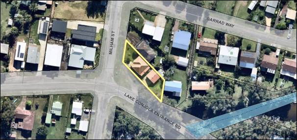
Figure 1 – Location Map
Background
Proposed Development
The DA seeks
approval for:
§ Demolition
of the existing dwelling and garage;
§ Construction of a new three (3)
storey dwelling house containing four (4) bedrooms with the following
arrangement of rooms and functions:
o Lower ground floor
– entry lobby, garage space for two (2) cars, laundry, ground floor
bathroom;
o Ground floor
– living room, kitchen/dining room, master bedroom, walk-in robe and
ensuite, pantry, powder room, front and rear decks;
o First
floor – three (3) bedrooms, main bathroom, study nook. This floor
is setback from the front and rear elevations.
It is noted
that the existing Lake Conjola Entrance Road access is no longer to be used.
Vehicular access is proposed from Milham Street.

 Figure 2 – Demolition Plan
Figure 3 – Site Plan


Figure 4 – Street
Elevations
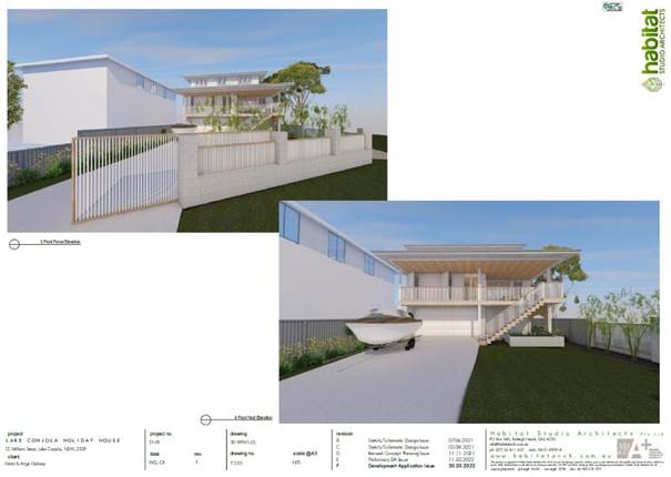
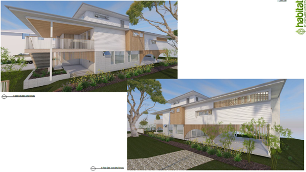
Figure 5 – 3D Views
Subject Land
The development site is Lot 3 DP 515751 (12 Milham Street,
Lake Conjola). Refer to Figure 1.
Site & Context
The development site:
§ Has frontage to Milham Street and Lake Conjola Entrance
Road and contains a single storey dwelling and detached garage. There are also
several large non-native shrubs on the site.
§ Is zoned RU5 Village. The surrounding area is residential
in character.
§ Is identified as bush fire, flood prone and potentially
contaminated land.
§ Is serviced by reticulated sewer and water and has existing
connection to electrical infrastructure.
§ 
 Adjoins land zoned RU5 Village.
Figure 6a and 6b –
Photographs of the existing buildings onsite
The zone objectives are provided
below as they are a consideration in assessing and considering a variation
request with regard to section 4.6, which is discussed later in this report.
The RU5 Village zone objective
is:
§ To provide for a range of land uses, services and
facilities that are associated with a rural village.
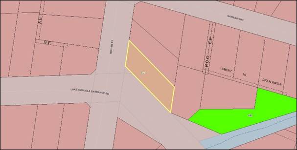
Figure 7 – Zoning
Extract
Subject Application
History
§ This current
application was lodged on 23 June 2022.
§ As a result of detailed assessment of the application, additional
information was requested from the applicant on three (3) occasions – 14
July 2022, 24 August 2022, 2 September 2022. These requests were generally in
relation to contamination, stormwater management and the colour schedule.
§ On 20 July 2022, 30 August 2022, 17 October 2022 and 10 November 2022,
the applicant submitted additional information, which was subsequently referred
to the relevant sections of Council for comment.
Issues
Section 4.3 (Height of
buildings) of SLEP 2014
Section 4.3 of SLEP 2014
contains controls for the maximum height of buildings and specifically outlines
that the maximum height of a building must not exceed the height shown on the
‘Height of Buildings Map’ that supports SLEP 2014.
The maximum building height for
the development site is 8.5m.
The proposed dwelling exceeds
the height by a maximum extent of 1.083m (being 12.7%) for a total building
height of 9.583m. See Figure 8 for extract from proposed elevations with 8.5
height limit shown.


Figure 8 – Extract from
elevations with 8.5m height limit shown
Section 4.6 (Exceptions to
development standards) of SLEP 2014
Development
consent may, subject to section 4.6, be granted for development even though the
development would contravene a development standard imposed by this or any
other environmental planning instrument.
The applicant has submitted a
written request to justify the contravention of the height of buildings
development standard pursuant to the requirements of section 4.6 of SLEP 2014.
Refer to Attachment 2 for the detailed request made by the applicant and
Council’s assessment. The following provides Council’s review
(summary) of the request for a height variation in relation to the requirements
of section 4.6. Refer to the attached assessment report (Attachment 1)
for additional detail.
Council is required to consider subsections (3), (4) and (5) of section
4.6. Section 4.6(3)-(5) are extracted from SLEP 2014 below:
(3) Development consent must not be
granted for development that contravenes a development standard unless the
consent authority has considered a written request from the applicant that
seeks to justify the contravention of the development standard by
demonstrating—
(a) that compliance with the
development standard is unreasonable or unnecessary in the circumstances of the
case, and
(b) that there are sufficient
environmental planning grounds to justify contravening the development
standard.
(4) Development consent must not be
granted for development that contravenes a development standard unless—
(a) the consent authority is
satisfied that—
(i) the applicant’s
written request has adequately addressed the matters required to be
demonstrated by subclause (3), and
(ii) the proposed development
will be in the public interest because it is consistent with the objectives of
the particular standard and the objectives for development within the zone in
which the development is proposed to be carried out, and
(b) the concurrence of the
Planning Secretary has been obtained.
(5) In deciding whether to grant
concurrence, the Planning Secretary must consider—
(a) whether contravention of the
development standard raises any matter of significance for State or regional
environmental planning, and
(b) the public benefit of
maintaining the development standard, and
(c) any other matters required
to be taken into consideration by the Planning Secretary before granting
concurrence.
Section
4.6(3)(a) – Compliance with the Development Standard is Unreasonable or
Unnecessary in the Circumstances of the Case
Flooding is the influencing factor in the design solution
for the development. The lower level has been designed so that it is not
habitable, containing vehicle parking, a bathroom and laundry. The other levels
contain the conventional living and sleeping areas.
The contravention to the building height limit is limited
to the upper roof, which is of minimal area, height and bulk.
Refer to Figure 8.
The building could comply if the roof was adjusted to a
flat roof, however the pitching of the roof balances the architectural design
of the building. The roof design also incorporates solar panels. Refer to
Figure 3.
The design of the dwelling will ensure that it is
compatible with the height, bulk and scale of the existing and desired future
residential character and therefore this objective is achieved despite
noncompliance with the standard.
The architectural design, whilst modern, is well
articulated containing variation in form and materials. The building has
a modern ‘Queenslander’ appearance. Refer to the
illustrations in Figure 5.
The top floor is setback from the front and rear and the
dwelling elevations. The site also benefits from a generous setback to Lake
Conjola Entrance Rd. These generous setbacks and location of the top
floor will assist in mitigating the impact of the height. If the pitched
roof were to be eliminated, the architectural form of the building would also
be compromised.
The
contravention is minor in terms of the overall design of the proposed
dwelling and still ensures that the dwelling is compatible with the height,
bulk and scale of the existing locality and objectives of section 4.3.
Section
4.6(3)(b) – Are there Sufficient Environmental Planning Grounds to
Justify Contravening the Development Standard?
As
identified above, the applicant’s written request has addressed the
matters required to be demonstrated in sub-section (3) in that there are
sufficient environmental planning grounds to justify contravening the standard.
A developer’s application must also demonstrate that
the contravention is justified on ‘sufficient environmental planning
grounds’. Such grounds include matters that ‘relate to (the)
subject matter, scope and purpose of the Act, including the objects in s 1.3.
This leaves developers with a wide range of grounds on which they can
rely to justify a 4.6 request, including, for example, that the variation will
promote good design and amenity, will allow for the orderly development of
land.
In
this instance, the increased building height permits the habitable floor level
of the dwelling to be consistent with both the 1 in 100 Year Flood Level and
Flood Planning Level.
The
variation to the building height would therefore permit the future occupants of
the dwelling to have long term safety in the event of a flood. This a
reasonable design outcome acknowledging the flood characteristics of the site
whilst allowing the order and pragmatic development of the site.
This will also result in the
proposal remaining consistent with the objectives of the land use zone and
results in a built form which is consistent with the existing and desired
future character of the street.
Section
4.6(4)(a)(ii) – Will the Proposed Development be in the Public Interest
Because it is Consistent with the Objectives of the Particular Standard and
Objectives for Development within the Zone in Which the Development is Proposed
to be Carried Out?
Section 4.6(4)(a)(ii) states that
development consent must not be granted for development that contravenes a
development standard unless the proposed development will be in the public
interest because it is consistent with the objectives of the particular
standard and the objectives for development within the zone in which the
development is proposed to be carried out.
The public interest test is not simply
whether the development is in the public interest in the broad sense. Rather,
the test is whether the development would be in the public interest
“because” it is consistent with the objectives of both the
development standard and the relevant zone. If the consent authority forms
the view that the proposed development is not consistent with the objectives of
the standard or the zone, or both, it will not meet the public interest test.
The term ‘consistency’ in this
context has been interpreted to be synonymous with the term
‘compatible’ and ‘capable of existing together in
harmony’. The requirement for development to be ‘consistent’
with the relevant objectives is a less onerous test than actually achieving the
particular objectives.
In determining whether it is satisfied that
a proposed development is in the public interest, the consent authority,
including the Court on appeal, is not limited to considering the cl.4.6
request. It is able can take into account the whole of the development
application and other relevant evidence before it. Source: BAL Publication.
The
proposed departure from the development standard is considered to be in the
public interest as the proposal is consistent with the zone and development
standard objective. In particular, the proposal would not impact the ability of
the rural village to continue to provide a range of land uses, services, and
facilities.
Section 4.6 (4)(b) – Concurrence of the Secretary has
been obtained
Council may assume concurrence. In
this instance, the extent of the contravention needs to be referred to
the elected Council for consideration.
Section
4.6(5)(a) – Would Non-Compliance Raise any Matter of Significance for
State or Regional Planning?
The
contravention does not raise any matters of significance having regard to State
or regional environmental planning. It does not have implications for any State
Environmental Planning Policies in the locality or impacts which are considered
of a State or regional scale.
Section
4.6(5)(b) – Is There a Public Benefit of Maintaining the Planning Control
Standard?
In the
judgement of Ex Gratia P/L v Dungog Council [2015] (NSWLEC 148),
Commissioner Brown of the NSW LEC outlined that the question that needs to be
answered in relation to the application of section 4.6(5)(b) is “whether
the public advantages of the proposed development outweigh the public
disadvantages of the proposed development”.
The
applicant is to demonstrate that there will be better planning outcomes
achieved through variation to the development standard as opposed to strict
compliance with the development standard or amending the application to reduce
the extent of the variation.
In this regard, it is considered
that strict compliance with the development standard and a reduction of
the building height to achieve compliance would not result in a better outcome.
Summary
and conclusion with regard to section 4.6
The written submission provided by
the applicant is considered to satisfy the requirements of section 4.6(3), (4)
and (5) and in this regard the proposed height variation is considered to
warrant approval.
Planning Assessment
The DA has been assessed under
s4.15(1) of the Environmental Planning and Assessment Act 1979. Please refer to
Attachment 1.
Council’s internal referrals have assessed the
application as being satisfactory with conditions of consent recommended to
address matters such as contamination, stormwater drainage and flooding.
Consultation and Community
Engagement:
Five (5) public submissions were
received in relation to Council’s notification of the development. The
notification was made in accordance with Council’s Community Consultation
Policy during the period 19 July 2022 to 3 August 2022.
Key issues raised as a result of the notification are
provided below.
Height of the proposed
dwelling
Comment
See comments made earlier in
this report.
A clause 4.6 variation has been
provided and found to be acceptable. It is important to note that the
height development standard is not a prohibition. All standard instrument
local environmental plans include the ability to vary development standards
under clause 4.6. This clause allows flexibility in the application of
standards where there will be a positive planning outcome.
Note: Variations to development standards are
reportable to the Department of Planning and Council. Council receives a
regular quarterly report, detailing the number of variations that have been
considered and consented to.
Flooding
Council’s Floodplain
Engineer reviewed the documentation submitted with this application and provided
the following comments:.
The subject site comprises
flood prone land and mapped within a high hazard storage hazard / hydraulic
category. The projected 2050 scenario Flood Planning Level (FPL) is
3.5m AHD.
It is noted that the ground
floor will consist of non-habitable space with an entry, double garage,
laundry, bathroom, storage, and alfresco area. The first and second floors will
consist of habitable rooms. The ground floor is proposed to be at 1.6m AHD, and
the lowest habitable floor level is proposed to be 4.4m AHD.
The entire development site sits within a high hazard flood storage hydraulic /
hazard category. There is no option in terms of being able to site the
building in a less ‘risky’ location.
Whilst the habitable floor level of the development (i.e. at
3.5m AHD) sits 900mm above the 2050 projected 1% AEP Flood Level (i.e. at 4.4m
AHD), it is noted that the Probable Maximum Flood Level (Projected 2100) sits
at 4.2m. As such, there is a minimal distance of 200mm between the habitable
floor level of the dwelling and the probable maximum flood event.
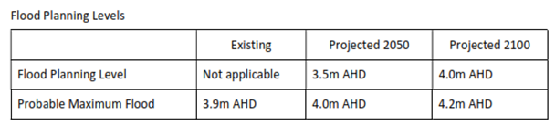
It is therefore considered that
the design has adequately balanced the interests between ensuring the
development is adequately flood proofed, whilst also minimising the extent of
the variation to the overall building height to the form of the development
which incorporates the roof pitch only.
The proposed development has been assessed as a Type A
(I) Single Residential/ Habitable Buildings land use category as per Schedule 1
of Chapter G9, SDCP 2014. This means that it is a category of development
that can be accommodated however the conditions in Schedule 2 (controls) should
ideally be satisfied.
Specific conditions are recommended to deal with the
flood risk as follows:
Prior to the issue of a
Construction Certificate, a professional engineer, (as defined in the National
Construction Code) must submit to the satisfaction of the Certifier,
certification that the following items have been detailed on the construction
drawings:
a) All habitable
floor levels must be constructed at or above the Flood Planning Level (FPL) (1%
Annual Exceedance Probability (AEP) flood level plus 500mm freeboard) as
documented on a Flood Certificate obtained from Council that is based on the
latest flooding information held.
b) Any proportion
of the structure below the FPL must be built from flood compatible materials.
c) All electrical
installations must be constructed above the FPL or be able to be isolated prior
to a flood event.
d) A flood
evacuation plan must be prepared to ensure permanent,
fail-safe, maintenance-free measures are incorporated in the development
to ensure that the timely, orderly and safe evacuation of people is possible
from the area and that it will not add significant cost and disruption to the
community or the SES. This plan is to consider for pre-flood event planning the
use of Flood Warning Products available from the Bureau of Meteorology.
Prior to the issue of a Construction Certificate, a
professional engineer, (as defined in the National Construction Code) must
submit to the satisfaction of the Certifier, certification that the building
and associated structure(s):
a) Can withstand
forces of floodwaters including debris and buoyancy forces up to a 1% Annual
Exceedance Probability (AEP) flood event.
b) Will not
become floating debris during a 1% AEP flood event.
Stormwater drainage
Comment
The latest stormwater plans have removed the surface runoff
stormwater pipelines. Surface flow direction is indicated on the plans in the
direction of the southern-most corner of the subject site. This is acceptable
as surface water is indicated to flow to the direction of the stormwater pit
adjacent to the southern-most corner of the site.
Contamination
Comment
The site was inspected on 9
November 2022, with there being no evidence of obvious contamination. However,
it is apparent that the site is identified as being potentially contaminated
land, being PCL427. Council's records indicate that this land may have
contained a service station.
Council’s Environmental
Health Officer reviewed the PCL file and the submitted geotechnical forensic
investigation with supporting letter from the applicant.
The letter proffers some
pertinent points regarding the contaminated land status of the site. Namely
investigations were undertaken by Terra Insight as part of the geotechnical
report which could not identify tanks onsite in aerial photos of the site. A
review of the geotechnical report photos dating from 1959 to current shows that
the older photos are not clear. The photo from 1987 does not appear to show any
tanks onsite or be operating, rather a dwelling house.
It is agreed that the potential
for tanks to be still onsite is low and that a Preliminary Site Investigation
(PSI) is not required. However, recommended conditions are to form part of any
consent granted, for unexpected finds and the requirement for a site
investigation in the case that an unexpected find is uncovered.
There were also concerns about asbestos. In this
regard, standard conditions have been recommended for the demolition component
for the application. These conditions require neighbour notification and
specify how the removal is to be undertaken. The relevant Australian Standard
is also referenced in the recommended conditions.
Financial Implications:
There are potential cost implications for Council in the
event of a refusal of the application. Such costs would be associated with
defending an appeal in the Land and Environment Court of NSW.
Legal Implications
A section 8.2 review or an appeal with the Land and
Environment Court are possible if the application is refused.
Summary and Conclusion
The applicant’s submission
has provided sufficient justification to demonstrate that given the specific
circumstances of this case that the 8.5m height limit is unreasonable, there is
sufficient environmental planning grounds to justify contravention of the
height requirement and that the proposal is in the public interest and should
be supported.
Further, there are no matters of concern or non-compliances
that would warrant the refusal of the application. Accordingly, it is
recommended that DA22/1710 is approved subject to the recommended conditions of
consent as per Attachment 3.
|

|
Ordinary
Meeting – Monday 05 December 2022
Page
0
|
CL22.644 Worrigee / South Nowra / East Nowra Community
Infrastructure Investigations
HPERM Ref: D22/474298
Department: Community
Planning & Projects
Approver: Michael
Paine, Manager - Community Connections
Attachments: 1. Report
- Strategy & Assets Committee 20 July 2021 ⇩
2. Public Private Partnership
(PPP) Guidelines (under separate cover) ⇨
Reason for Report
To update Council on the
progress of investigations in relation to an aquatic facility and community
facility for the Worrigee, South Nowra, and East Nowra areas.
|
Recommendation
That
Council:
1. Receive this report for information
as:
a. An update on investigations in
relation an aquatic facility for the
Worrigee, South Nowra, and East Nowra areas
b. An overview of discussions to date
with Schools Infrastructure NSW on partnership opportunities
2. Take no further action in respect of
the discussions with Worrigee Sports regarding an aquatic facility.
3. Consider the provision of community
infrastructure for Worrigee, South Nowra and East Nowra as part of the
upcoming review of the Community Infrastructure Strategic Plan (CISP).
|
Options
1. Adopt the above
recommendation.
Implications: This will result in an update to
Council on the progress of investigations to date for an aquatic facility and
community facility in the Worrigee, South Nowra, and East Nowra areas, and
include this as an option in the review of the CISP.
2. Adopt an
alternate recommendation.
Implications: This project will require a needs
analysis, community consultation and alignment with Council’s strategic
documents. An alternate recommendation might not allow for an integrated and
strategic approach to infrastructure and recreational facilities planning in
the Shoalhaven LGA and an inequitable distribution of community infrastructure.
Background
At
Council’s Strategy & Assets Committee meeting on 19 January 2021 a
Notice of Motion (NoM) was presented to Council on the basis that:
“The Worrigee, East Nowra and South Nowra areas
already have 4 schools established in the area, and the State Government is
planning the construction of a fifth in the area.
The area also has a large number of young families as
well as a public housing estate. The development of a modest aquatic facility
in the area would add greatly to the social capital of the area”.
In response, Council resolved
(MIN21.11) that:
1. The
CEO undertake site identification investigations with a view to finding the
most appropriate site to construct an aquatic facility (swimming pool) in the
Worrigee/South Nowra area, and report back to Council when the investigations
are complete.
2. Once
a site has been identified the CEO also report to Council on a source of
funding to enable project scoping and preliminary design of the proposed
facility.
3. Council give
consideration to the possibility of a private-public partnership in respect of
the development of the facility.
Subsequent to the above
resolution, a report was presented to Council at the Strategy & Assets
Committee meeting on 29 July 2021 (Attachment 1), outlining initial site
investigations and options for delivery/management of the facility. It was
resolved (MIN21.509):
That
Council:
1. Further
investigate the opportunities for a Public Private Partnership in discussion
with the Shoalhaven Ex-Servicemen’s Club (Worrigee Sports) and receive a
further report at the conclusion of these discussions;
2. Further investigate the need for a
community centre / facility for the Worrigee, South Nowra, and East Nowra areas
under the review of the Community Infrastructure Strategic Plan and continue
discussions with Schools Infrastructure NSW regarding access to Department of
Education premises;
3.
Include the creation of an integrated and connected recreational plan for the
Worrigee, South Nowra, and East Nowra areas under the review of the Community
Infrastructure Strategic Plan, currently being undertaken by Council.
This report provides an update to Council on MIN21. 509 Part
(1), the progress of investigations of opportunities to date, an overview of
discussions with Worrigee Sports and advice received from Schools
Infrastructure NSW (SINSW) regarding access to Department of Education
premises.
MIN21.509 Part (1)
– Further investigate the opportunities for a Public Private Partnership
in discussion with the Shoalhaven Ex-Servicemen’s Club (Worrigee Sports)
and receive a further report at the conclusion of these discussions.
Public Private Partnership
(PPP)
Council received the following
advice in relation to the parameters and definition of a Public Private
Partnership:
A Council may only enter into a PPP in accordance
with the provisions in Part 6 of Chapter 12 of the LG Act (s 400E of the LG
Act).
A PPP is defined in
section 400B(1) of the LG Act as:
‘…an arrangement:
(a) between a council and a private person to provide
public infrastructure or facilities (being infrastructure or
facilities in respect of which the council has an interest, liability or
responsibility under the arrangement), and in which the public infrastructure or facilities are provided
in part or in whole through private sector financing, ownership or control,
but does not include any such arrangement if it is of a class that has been
excluded from the operation of this Part by the regulations.’
An ‘arrangement’ includes a contract or
understanding (whether or not involving the formation of an entity). The range
of possible contractual arrangements which could potentially fall within this
definition is immense, as has been noted by the High Court (see R & R
Fazzolari Pty Ltd v Parramatta City Council; Mac's Pty Ltd v Parramatta City
Council (2009) 254 ALR 1at [76]).
‘Private person’ is defined in
s400B (2) to mean:
any person other than:
(a) the Government (including the State, the Crown and a
Minister of the Crown, or
(b) a public or local authority (including a council or
a State-owned corporation), or
(c) a public sector employee or other person or body
acting in an official capacity on behalf of the Government or a public or local
authority
Whilst ‘public infrastructure or facilities’
is not specifically defined in the LG Act, s440B(1)(a) provides that public
infrastructure or facilities are those in ‘in respect of which the
council has an interest, liability or responsibility under the arrangement [being
the arrangement which creates or constitutes the PPP]’.
The broad terms of the above
advice identifies the key requirement for a project to be eligible for a PPP.
As such, there is the potential for Council to pursue a PPP.
However, Council must not enter into a PPP or carry out
works under a PPP without notifying the Office of Local Government and
satisfying them that the project complies with the Public Private Partnership
Guidelines January 2022, and that legal advice has also been sought (see
Attachment 2, pg. 9).
Discussions with Worrigee Sports
Four online meetings were held
between September 2021 and November 2021. These meetings were attended by
Council staff from City Lifestyles, City Futures and Worrigee Sports Board
members. A summary of key discussion points is provided below:
· Potential location
for the proposed aquatic facility on the Worrigee Sports site
· Aquatic facility
requirements and potential site constraints
· Traffic management
and car parking requirements
· Proposed
partnership options, inclusive of conditions for a PPP
· Options for
operation and management
Worrigee Sports see a potential partnership with Council for
the proposed aquatic facility as a positive idea and beneficial to the
community of the Worrigee area and surrounding locality. This however would
require further investigations to assess feasibility of the proposed aquatic
facility, community consultation, detailed costings for design and delivery and
so forth.
MIN21.509 Part (2) - Further investigate the need for a community centre /
facility for the Worrigee, South Nowra, and East Nowra areas under the review
of the Community Infrastructure Strategic Plan and continue discussions with
Schools Infrastructure NSW regarding access to Department of
Education premises.
A full investigation regarding the need for a community
centre / facility will be undertaken during the review of the Community
Infrastructure Strategic Plan
Discussion
with Schools Infrastructure NSW
Council entered into a
Memorandum of Understanding (MoU) with SINSW in 2020, with the aim to form the
foundation for a cooperative relationship that works willingly to explore
partnership opportunities to benefit schools and the local community.
Bi-monthly
meetings are scheduled with SINSW, Asset Activations, and Council staff in
attendance. These meetings are ongoing and provide opportunity for SINSW
and Council to provide updates on relevant projects and discuss potential
opportunities, such as shared facilities and upcoming openings for grant
funding applications.
Advice from SINSW had previously
indicated that the site was too constrained to consider the construction of an
aquatic facility.
The timeframe for the
construction of the school is still to be determined. Hence, at this stage it
is not possible to advise on any opportunities to co-locate either an aquatic
facility or a community facility on Department of Education Land for shared
school and public use outside of school hours / use.
Council staff will continue to work with SINSW to determine
potential ways forward and possible sites on Department of Education land.
Policy Implications
Community Infrastructure
Strategic Plan (CISP)
The CISP identifies that the Shoalhaven LGA is well provided
for with aquatic facilities and community buildings, which meet demands now and
into the future 2036. The review of the CISP to be undertaken in 2022/23 may
identify changes in community needs, and gaps in provision of facilities.
Financial Implications
The investigations to date have been funded through the
Community Planning and Projects Department staff budget.
Risk Implications
There is significant risk in not ensuring that this project
aligns with the Community Infrastructure Strategic Plan. Council is working
towards ensuring a strategic and equitable distribution of Community
Infrastructure Assets across the LGA, that appropriately responds to population
growth or decline, demographics and supply and demand of current
infrastructure. As such it recommended that the final determination of whether
the investigation for an aquatics facility in this area will be with the CISP.
|

|
Ordinary
Meeting – Monday 05 December 2022
Page
0
|
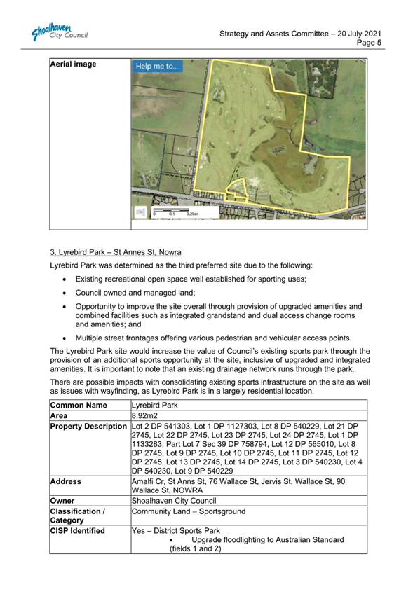
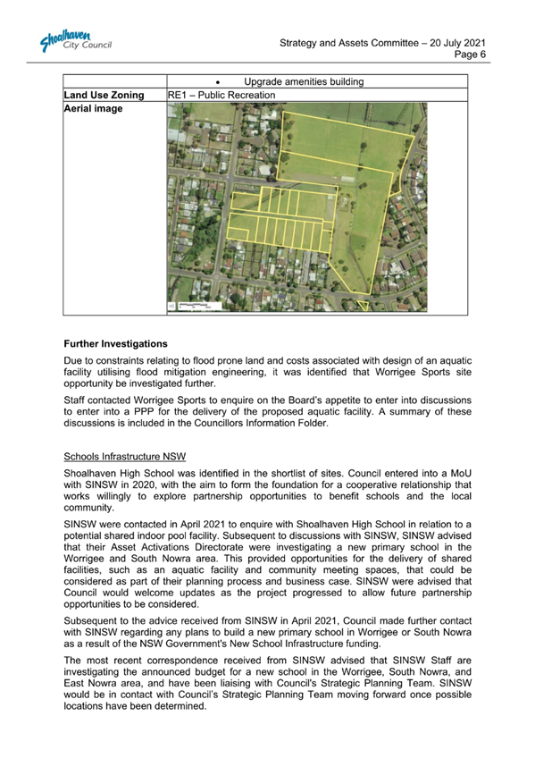
|

|
Ordinary
Meeting – Monday 05 December 2022
Page
0
|
CL22.645 Draft
Berry Showground Master Plan - Update to Council and Progress to Exhibition
HPERM Ref: D22/158265
Department: Community
Planning & Projects
Approver: Michael
Paine, Manager - Community Connections
Attachments: 1. Draft
Berry Showground Master Plan (under separate cover) ⇨
2. Community Engagement Report -
Berry Showground Master Plan (under separate cover) ⇨
Reason for Report
This report provides an update
on the Draft Berry Showground Master Plan and seeks Council’s endorsement
to publicly exhibit the document.
|
Recommendation
That Council;
1. Receive this report for information
in relation to engagement activities undertaken to date to inform the Draft
Berry Showground Master Plan.
2. Approve release of the Draft Berry Showground Master Plan for public exhibition for
a period of 28 days.
3. Receive a future report outlining
the outcome of community engagement activities associated with public
exhibition of the draft master plan, and recommendations relating to adoption
of a finalised Berry Showground Master Plan.
|
Options
1. Council adopt
the recommendation
Implications: This option will enable the Draft
Berry Showground Master Plan to be placed on public exhibition and will
give the general public an opportunity to comment on the proposed plans. This
will allow the project to progress, in line with community expectation.
2. Council adopt an
alternative recommendation and provide direction to staff
Implications: Depending on the significance of the
recommendation, this may affect the progression of the project, resulting in
delay in finalising plans.
Background
Berry Showground (or ‘Hazel Berry Park’)
occupies a strategically important location within the village of Berry;
between the village’s main street and its railway station. It has been
the venue for local agricultural shows since 1888 and is highly valued by the
local community, as a cultural and social asset that is enjoyed both by the
residents of Berry and visitors from beyond the village.
The Berry Showground is located
on Alexandra Street, Berry. The Showground is a mixture of Council owned
Community Land and Crown Land, for which Shoalhaven City Council is Trust
Manager.
David Berry Memorial Park adjoins the Showground’s
south-east. David Berry Memorial Park is a Council owned landscaped area
separate from the main Showground space and is used mainly for passive leisure
activities. Both areas are included in the Draft Master Plan.

Figure 1: Context Plan, showing extents of subject site in
relation to the township of Berry
The Showground is located
approximately 250m to 500m from the main business hub of Berry (Queen Street),
making it a popular destination for a range of community activities, including:
events; markets; sports; along with a highly successful camping ground /
caravan park.
The Showground is comprised of
the following distinct spaces (areas):
· Oval (or arena, or
show ring) and ring road, along with the grandstand and adjacent
toilets/changerooms;
· Pavilion
(‘Agricultural Pavilion’), Rural Youth Hall and nearby toilets in
the north-west corner;
· Berry Village
Pool, a separate area on Albany Street fenced from the remainder of the
Showground;
· Northern grass
(and road) open area;
· Playground area,
rotunda, and nearby toilets in the north-east corner;
· Former Council
Chambers building and Alexandra Street entrance;
· Campground area,
and horse stables, in the south;
· Woodchop arena and
surrounding facilities/buildings in the south-east;
· Livestock yards of
the site’s south-west corner; and
· Cattle lawn
(animal judging area) and nearby animal shelters/pavilions west of the
campground.
Draft Berry Showground Master Plan
The Draft Berry Showground
Master Plan outlines a general, coordinated approach to the planning,
development and implementation of infrastructure and landscaping improvements
at Berry Showground.
The Master Plan is informed by extensive internal
coordination between Council staff and external consultation with the Berry
community. This integrated approach considers the needs of all regular user
groups, as well as the wider community and tourists that visit the area. It is
anticipated that the needs of all user groups will be met and, subsequently,
well managed through implementation of the master plan.
Once finalised, the master plan will identify future
infrastructure and amenity upgrades to the Berry Showground that:
· Recognise and
enhance its landscape and built character and appeal to the broader community;
· Protect heritage
values and other significant assets;
· Accommodate a
range of uses on the site;
· Improve
site management and asset management outcomes;
The Draft Berry Showground Master Plan identifies a range of
discrete projects for future consideration by the elected Council, Council
staff, and the Berry Showground Management Committee. Discrete projects are
presented as ‘Design Notes’ throughout the Master Plan report, as
they relate to each of the following themes:
· Landscaping
· Heritage
· Circulation
· Proposed
Use
Design Notes are listed in the
relevant chapters and are also published on the corresponding plans (provided
as Appendix 1 within Attachment 1).
A Precinct Identification Plan
identifies the following precincts (ref. p. 16, Attachment 1):
· Precinct 1 (Agricultural
Market)
· Precinct 2
(Camping)
· Precinct 3
(Sporting / Market)
· Precinct
4 (Village Pool)
The Draft Berry Showground Master Plan can be viewed in Attachment 1.
Community Engagement
Engagement for this project was coordinated and led by
Gondwana Consulting, supported by Council staff and the Berry Showground
Management Committee. Engagement activities undertaken to date include:
|
FORMAT
|
DATE
|
DESCRIPTION
|
|
Workshop
|
11 March 2020
|
An initial Workshop was held between Council staff and the Berry
Showground Management Committee.
|
|
Survey
|
September 2020
|
A community survey was made available to Berry residents, and
promoted via Council’s online channels, as well as via networks of
relevant stakeholders.
The survey was made available via Council’s Get Involved page
and in hard copy. The survey received over 100 submissions.
|
|
Drop-in Sessions
|
17 and 21 September 2020
|
Two drop-in sessions were held to provide information to the
community and an additional forum for the general public to provide feedback.
|
|
FORMAT
|
DATE
|
DESCRIPTION
|
|
Stakeholder Focus Group Meetings
|
Tuesday 20 October 2020 (5.30pm to 7.00pm)
|
Berry Showground user groups and event coordinators gathered to
discuss the use of the site and potential direction in the future.
Representatives included:
· Rotary Club of Berry
· Showground Management Committee
· Historical Car Show
· Elite Energy
· Berry Sunday Markets, Management Committee
· Berry Spinners and Weavers
· Caravan Society
· Show Society, Management Committee
Main themes arising from this meeting included:
· Tree regeneration
· Parking and drainage
· Inclusion and accessibility within the Showground
|
|
Wednesday 21 October 2020 (5.30pm to 7.00pm)
|
Representatives included:
· Fairgrounds Festival
· Berry Silver Band
· Berry Shoalhaven Magpies Rugby Club
· Big Country Festival
· Southern Tablelands Holstein Dairy Cow Judging
· Showgrounds Caretaker
· Show Society, Management Committee
Main themes arising from this meeting included:
· Upgrades to plumbing and electrical infrastructure
· Field (main arena surface) upgrades
· Accessibility concerns
· Parking and drainage
· Protect heritage
|
A list of Focus Group
invitees and participants is provided in Table 1 below

Table 1. Stakeholder Focus Groups Participants
A Community Engagement Report is
provided as Attachment
2.
Next
Steps
Exhibition
Pending Council’s approval
to proceed, the DRAFT Berry Showground Master Plan will be placed on
public exhibition for a period of 28 days. It is anticipated this will occur in
the first quarter of 2023 (February / March). Risk associated with the delay
between receiving the elected Council’s endorsement to proceed to
exhibition and the proposed exhibition period is considered negligible for this
project.
Feedback received will be reviewed, collated, and considered
by the Project Team and Project Control Group and presented to the elected
Council for deliberation at a future Ordinary Council Meeting.
Final Plan
Once adopted, the Berry Showground Master Plan will
be utilised to inform future site management, capital works funding
allocations, and grant applications.
Financial Implications
The preparation of the Berry
Showground Master Plan (and associated Plan of Management) will continue to be
resourced from existing operational budgets (City Lifestyles
directorate).
An amount of $30,000 was
provided by the Berry Showground Management Committee towards the development
of the Berry Showground Plan of Management and the Berry Showground Draft
Master Plan.
Future funding applications will be forthcoming (through
Council’s 10 Year Capital Works Program) for the delivery of discrete
projects identified in the Berry Showground Master Plan. Grant funding
opportunities may be explored to allow for the delivery of some (or all) of
these works.
Policy Implications
The Draft Berry Showground Master Plan has been developed in
accordance with:
· Shoalhaven
City Council’s Community Infrastructure Strategic Plan 2017 –
2036
· The
Berry Forum’s Berry Community Strategic Plan (2016)
|

|
Ordinary
Meeting – Monday 05 December 2022
Page
0
|
CL22.646 Policy
- Private Functions on Public Reserves
HPERM Ref: D22/471730
Department: Community
Planning & Projects
Approver: Jane
Lewis, Director - City Lifestyles
Attachments: 1. Private
Functions on Public Reserves Policy (under separate cover) ⇨
Reason for Report
The Private
Functions on Public Reserves Policy is presented for adoption. Council
Policy requires that all Council public policies should be reviewed within 12 months
of an election of a new Council.
|
Recommendation
That
Council re-adopt the Private Functions on Public Reserve Policy.
|
Options
1. Adopt
the recommendation
Implications:
· Updated Policies
will be adopted within the 12-month timeframe of a newly elected Council
· This policy will
remain applicable in its current format.
2. Not
adopt the recommendation
Implications:
· Council
can request further details, seek further community input, or make other
changes
· This
may delay or impact Council’s ability to meet the requirement for review
of policies within twelve (12) months of the election of a new Council
· This
may result in loss of provision and controls for the relevant Policy.
Background
All Council policies should be
reviewed within twelve (12) months of the election of a new Council.
The Private Functions on Public
Reserves Policy objectives are to:
a) Facilitate and manage
private functions held on public reserves
b) Ensure private functions
are carried out without unduly impacting on normal use of public reserves and
the amenity of neighbours
c) Provide terms and
conditions appropriate to the location and size of the private function being
held on public reserves.
The Private Functions on
Public Reserves policy was first adopted on 22 July 2003.
Since adoption in 2003, the
Policy has been regularly updated and revised to ensure it remains current and
meets the needs of Council and the community.
This Policy has been working well and is being presented at
this stage with no changes recommended. It is intended to continue monitoring
requests for private events on public reserves, collaborate and consult with
staff members in different Departments of Council to identify if future changes
need to be made. Any future changes will be presented to Council as
required.
Community Engagement
There are minor changes to the format and no changes to the
content of the Policy, hence there is no requirement to place on public
exhibition.
Policy Implications
There is a requirement that all
Council policies should be reviewed within twelve (12) months of the election
of a new Council.
Reaffirmation of the above policy will ensure it remains
applicable as a Council policy.
Financial Implications
There are no additional financial implications resulting
from reaffirming the above policy.
|

|
Ordinary
Meeting – Monday 05 December 2022
Page
0
|
CL22.647 Acquisition
of Easement for Water Supply - Lot 28 DP 1282389 Taylors Lane Cambewarra
HPERM Ref: D22/443855
Department: Water
Asset Planning & Development
Approver: Robert
Horner, Executive Manager Shoalhaven Water
Attachments: 1. Easement
for Water Supply - Survey Plan ⇩
Reason for Report
This report provides Council
with an opportunity to consider the acquisition of an Easement for Water Supply
5 metres wide over Lot 28 DP 1282389 Taylors Lane Cambewarra from Cambewarra
Ventures Pty Ltd.
The easement is marked (W1) and
outlined blue on the attached survey plan.
|
Recommendation
That
Council:
1. Acquires an Easement for Water
Supply 5 metres wide over Lot 28 DP 1282389 Taylors Lane Cambewarra
identified as “W1” in the attached survey plan;
2. Pays compensation of $2,000 (plus
GST if applicable) and reasonable costs associated with the acquisition, in
accordance with the provisions of the Land Acquisition (Just Terms
Compensation) Act 1993;
3. Funds all costs associated with the
acquisition of the water easement from the Water Fund;
4. Delegates authority to the Chief
Executive Officer (Executive Manager, Shoalhaven Water) to make minor
adjustments to the purchase price, if necessary, in accordance with the
settlement figure determined by Council’s solicitor;
5. Authorises the Chief Executive
Officer (Executive Manager, Shoalhaven Water) to sign any documentation
required to give effect to this resolution and to affix the Common Seal of
the Council of the City of Shoalhaven to all documentation required to be
sealed.
|
Options
1. Resolve as
recommended.
Implications: The easement is required for infrastructure
servicing the Moss Vale Road Urban Release Area. It will provide Council with
legal rights to access, operation & maintenance of the infrastructure.
2. Not resolve as
recommended and provide further directions to staff.
Implications: Failure to acquire the easement will
lead to a delay in the delivery of the required infrastructure for the Moss
Vale Road Urban Release Area.
Background
The easement is required to
facilitate construction and future operation & maintenance of a water main
to service the residential subdivisions within the Moss Vale Road Urban Release
Areas.
A valuation report undertaken on
behalf of Council by Walsh & Monaghan assessed compensation for the water
easement on Lot 28 DP 1282389 at $2,000 (plus GST if applicable).
An offer of $2,000 (plus GST if applicable) was made to the
landowners’ representative and was agreed by both parties subject to
Council Resolution.
Community Engagement
Community engagement is not required for operational
purposes such as an easement acquisition.
Policy Implications
Nil.
Financial Implications
Compensation and all costs associated with the acquisition
are to be funded from Council’s Water Fund.
Risk Implications
Acquisition of the easement is
necessary to secure Shoalhaven Water’s legal rights for access, operation
and maintenance of essential public infrastructure. The proposed action is
administrative only and has no environmental impact.
Failure to acquire the easement
identified for water supply may lead to a delay in the delivery of required
infrastructure as part of the Moss Vale Road URA.
|

|
Ordinary
Meeting – Monday 05 December 2022
Page
0
|
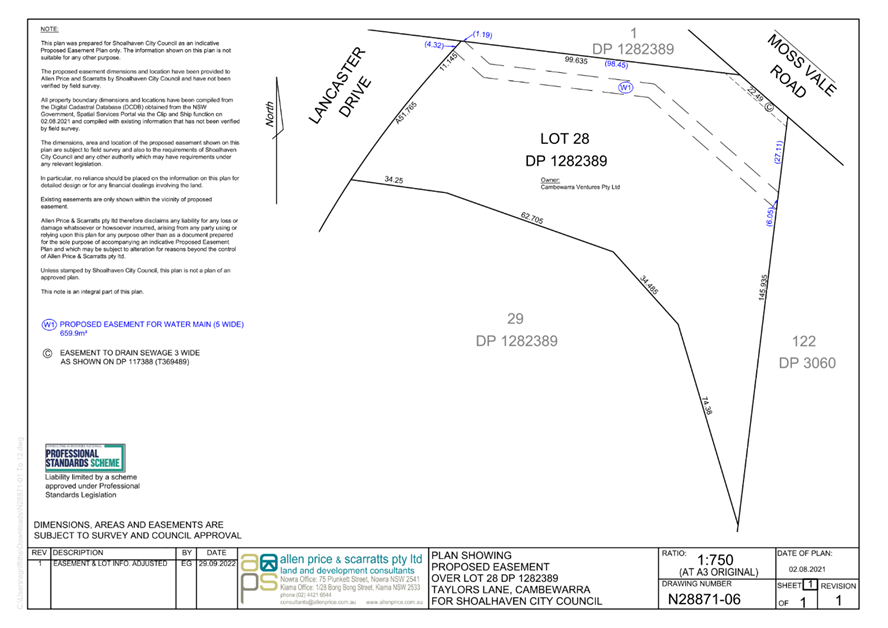
|

|
Ordinary
Meeting – Monday 05 December 2022
Page
0
|
CL22.648 Tenders
- Moss Vale Road Urban Release Area Water Infrastructure Illaroo Road Water
Pumping Station and Stage 2 Water Mains Construction Project
HPERM Ref: D22/492832
Department: Water
Asset Planning & Development
Approver: Robert
Horner, Executive Manager Shoalhaven Water
Reason for Report
To inform
Council of the tender process for the Moss Vale Road Urban Release Area Water
Infrastructure Illaroo Road Water Pumping Station and Stage 2 Water Mains
Construction project.
In accordance with Section 10A(2)(d)(i) of the Local
Government Act 1993, some information should remain confidential as it would,
if disclosed, prejudice the commercial position of the person who supplied it.
It is not in the public interest to disclose this information as it may reveal
commercial-in-confidence provisions of a contract, diminish the competitive
commercial value of any information to any person and/or prejudice any
person’s legitimate business, commercial, professional or financial
interests. This information will be considered under a separate confidential
report.
|
Recommendation
That Council consider a
separate confidential report in accordance with Section 10A(2)(d)(i) of the
Local Government Act 1993.
|
Options
1. Accept the
recommendation
Implications: Consider a separated confidential report on the matter.
2. Council make a
different resolution
Implications: This is not recommended as an extensive
evaluation process has been undertaken by the tender evaluation team in
accordance with the tender evaluation plan.
Details
Project Description
The
works are identified as part of the water servicing strategy for the Moss Vale
Road Urban Release Area Project; with proposed delivery to be executed as 4
distinct packages as detailed below and further within enclosed figure:
· Package
1: Stage 1 Water Main Lead-in Work (completed 2021).
· Package
2: Illaroo Road Water Pumping Station Upgrade (subject of this report as
Separable Portion A).
· Package
3: Stage 2 Water Mains Infrastructure (subject of this report as Separable
Portion B).
· Package
4: New Water Reservoir (awarded under separate contract August 2022).
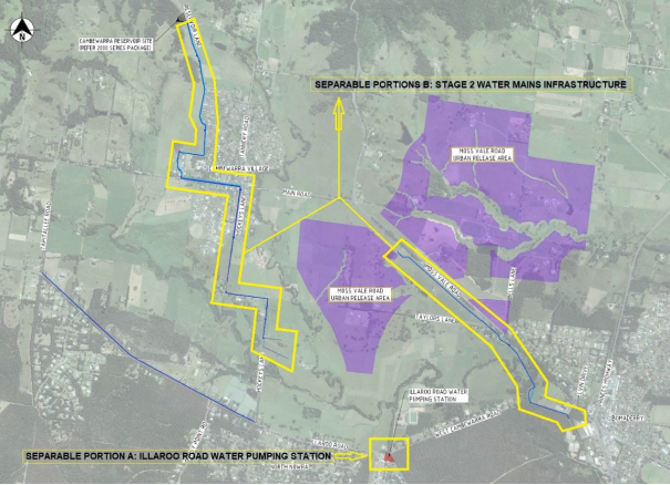
Package 2: Illaroo Road Water Pumping Station Upgrade
(Separable Portion A)
As part of the Moss Vale Road
URA development, a full upgrade of the existing Illaroo Road Water Pumping
Station has been identified as necessary to service the proposed development
area. The upgrade is proposed at the existing Illaroo Road Water Pumping
Station site and entails the construction of the upgraded facility as per the
previously procured detailed design.
Package 3: Stage 2 Water Mains Infrastructure
As part of the Moss Vale Road
URA development and the subsequent water infrastructure, the construction of a
new and upgrades water mains are required to service such expansion. The
proposed stage 2 water mains infrastructure works entails the construction of
the pipework as per the previously procured detailed design.
Tendering
Council called tenders for the Moss
Vale Road Urban Release Area Water Infrastructure Illaroo Road Water Pumping
Station and Stage 2 Water Mains Construction project on 20 September 2022 which
closed at 10:00 am on 11 November 2022. Six tenders were received at the
time of closing. Tenders were received from the following:
|
Tenderer
|
Location
|
|
Utilstra Pty Ltd
|
1 Geelong St, Fyshwick ACT 2604
|
|
Hisway Pty Ltd
|
13A Investigator Street, Nowra 2541
|
|
Killard Infrastructure Pty Ltd
|
Suite F.6./72 Berry Street, Nowra, NSW 2541
|
|
Quay Civil Pty Ltd
|
Suite 5.12, 32 Delhi Rd, North Ryde NSW 2113
|
|
Ledonne Construction Pty Ltd
|
43 Planthurst Rd, Carlton NSW 2218
|
|
RA Smith Contracting Pty Ltd
|
3 Cunningham Street MOOREBANK NSW 2170
|
Details relating the evaluation of the tenders are contained
in the confidential report.
Community Engagement:
Community and stakeholder engagement
prior to and during construction is proposed. A dedicated project webpage
has been established under Council’s ‘Major Projects &
Works’ Portal.
Policy Implications
Nil. The tender process has followed the requirements under
the provisions of the Local Government Act 1993.
Financial Implications:
Sufficient funds have been allocated in the Moss Vale Road
Water Infrastructure Project budget for 2022/23 and 2023/24 financial years.
Funding is available to cover the tender amount including other project costs.
|
|
Ordinary
Meeting – Monday 05 December 2022
Page
0
|
CL22.649 Tenders
- Danjera Dam Camping Ground and Recreational Area Construction
HPERM Ref: D22/429519
Department: Water
Asset Planning & Development
Approver: Robert
Horner, Executive Manager Shoalhaven Water
Reason for Report
To inform Council of the tender
process for the Danjera Dam Camping ground and
Recreational Area Construction project.
In accordance with Section
10A(2)(d)(i) of the Local Government Act 1993, some information should remain
confidential as it would, if disclosed, prejudice the commercial position of
the person who supplied it. It is not in the public interest to disclose this
information as it may reveal commercial-in-confidence provisions of a contract,
diminish the competitive commercial value of any information to any person
and/or prejudice any person’s legitimate business, commercial,
professional or financial interests. This information will be considered under
a separate confidential report.
|
Recommendation
That Council consider a separate
confidential report in accordance with Section 10A(2)(d)(i) of the Local
Government Act 1993.
|
Options
1. Accept the
recommendation
Implications: Consider a separate confidential report on the
matter.
2. Council does not
resolve to consider a separate Confidential Report.
Implications: The tender for the project will remain
unresolved and a reputational risk will ensue.
Details
Project Description
The project site at Yalwal, when viewed from a broader
geographic perspective, adjoins the
eastern side of Danjera Dam some
30km west of Nowra. Large areas of Crown Land adjoin the subject property
to the south and south-west, whilst the National Parks and Wildlife Service
(NPWS) adjoins to the north and west; private land adjoins to the east.
The proposed main development site has been used for
informal camping and a day use/picnic area since the dam was constructed by
Council in 1971. The locality is unique in that it offers tourism and
recreation activities, with multiple attractions to visitors including:
• Water-based
activities such as fishing and non-powered boating / kayaking;
• Bushwalking
and viewing other land based natural attractions (gorges etc.);
• Historical
relics including mines, cemetery and associated items; and
• Motor-cycle
and four-wheel drive touring.
The Danjera Dam Camping Ground and Day Visitors Area was
given Development Approval (DA19/2186) by Shoalhaven City Council (SCC) on 10
February 2021. This consent was subsequently modified via a s4.55 application
which was approved on 3 March 2022.
The main components of the project
include:
• Formalisation
of the existing campground to provide 41 designated camping spaces;
• Provision
of a one-way perimeter road approximately 4m wide;
• Construction
of a multipurpose building to contain the following key features:
o Refuge/recreational area to
house approximately 160 people in an emergency;
o Caretakers lodging which will
include an office, kitchen, amenities and sleeping quarters; and
o New amenities and showers
(noting that the existing primative amenities facility is to be demolished);
• Construction
of an onsite wastewater management system in accordance with the specifications
provided in the Onsite Sewage Management Plan (Whitehead & Associates
2019);
• Upgrades
to the garbage collection area, incorporating firewood storage;
• Establishment
of a centralised green area to be planted with fire resistant trees to provide
shade in the open campsite area; and
• Installation
of picnic shelters and walking paths.
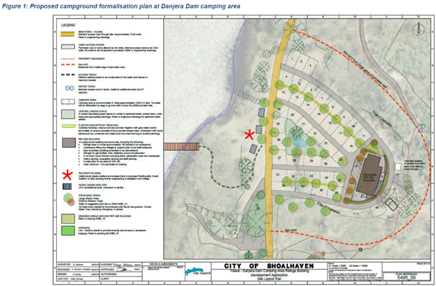
Tendering
Council called tenders for the Danjera Dam Camping Ground and
Recreational Area Construction project on 11
October 2022 which closed at 10:00am on 17 November 2022.
One (1) tender was received at the time of closing, as
detailed below:
|
Tenderer
|
Location
|
|
Jirgens Civil Pty Ltd
|
38 Trim Street, South Nowra NSW 2541
|
Details relating the evaluation of the tenders are contained
in the Confidential Report.
Community Engagement:
Community and stakeholder engagement prior to and during
construction is proposed. A dedicated project webpage will be established
under Council’s ‘Major Projects & Works’ Portal.
Policy Implications
Nil. The tender process has followed the requirements under
the provisions of the Local Government Act 1993.
Financial Implications:
Budget has been allocated in the 2022/23
and 2023/24 financial years. Financial implications are discussed in the
Confidential Report.
|

|
Ordinary
Meeting – Monday 05 December 2022
Page
0
|
CL22.650 Notice
of Motion - Hyams Beach Fire Shed
HPERM Ref: D22/498161
Submitted
by: Clr Patricia White
Attachments: 1. NSW
Land Grants to Hyams Beach Progress Association ⇩
Purpose / Summary
The following Notice of Motion,
of which due notice has been given, is submitted for Council’s
consideration.
|
Recommendation
That Council:
1. Hold a meeting with Hyams Beach CCB
(Caretaker Committee), HBVA working committee and available Councillors to
discuss status and options for the Community Hall/Fire Shed at Hyams Beach.
2. A further report be provided to
Council on status and options.
|
Background
Representations have been
received from residents in relation to the Fire Shed/Community Hall.
The community continues to be
disappointed and frustrated in its efforts to resolve the status of this hall
and to regain a community facility. A small working group of the HBVA has
been working on the issue over the last 12 months and has concluded after
discussion with Council and relevant State Government Ministers that there are
options available to progress this matter. Attached is information on the
original land grant. Further discussions are required on this matter.
I seek support from all
Councillors in resolving this matter.
|

|
Ordinary
Meeting – Monday 05 December 2022
Page
0
|
|
|
Ordinary
Meeting – Monday 05 December 2022
Page
0
|
CL22.651 Notice
of Motion - Sussex Inlet Road Completion of Footpath to Marine Rescue
HPERM Ref: D22/498189
Submitted
by: Clr Patricia White
Purpose / Summary
The following Notice of Motion,
of which due notice has been given, is submitted for Council’s
consideration.
|
Recommendation
That
Council complete the missing link of footpath on Sussex Inlet Road through
the Council reserve (from Inasmuch Villages to Marine Rescue building) in a
timely manner.
|
Background
Council recently completed a new
footpath and drainage at the end of Sussex Inlet Road near Inasmuch. However,
Council did not provide the footpath through the Council reserve to the shop
and café, some 30 metres.
Residents including elderly from
Inasmuch (in wheelchairs) still have to enter the road for the last 30 metres
to go to the local shop and café. This is a busy road with entry to two
tourist parks, the local boat ramp, carpark and marine rescue.
Representations have been
received from the Sussex Forum, local residents and Inasmuch, the local Aged
Care facility, to complete the footpath.
CEO Note:
Staff have prepared a proposal to provide a shared user path
approximately 76m through the “William Mulligan” reserve to the
Seacrest Café - No.30 Sussex Road as per the sketch below;
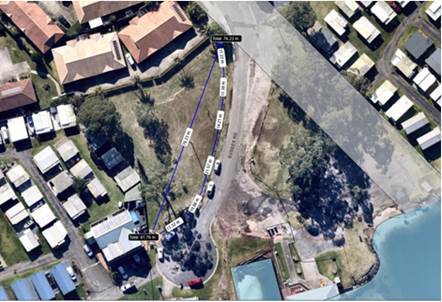
This has been estimated to cost $30,000 with the intention
of inclusion in Councils DRAFT 2023/24 capital works program for
Council’s consideration during the budget deliberations. Extending this
to the Marine Rescue would be considered a minor variation, and the proposal
will be amended in the DRAFT program to define the project as ending at the
Marine Rescue.
|
|
Ordinary
Meeting – Monday 05 December 2022
Page
0
|
Local Government act 1993
Chapter
3, Section 8A Guiding principles for councils
(1)
Exercise of functions
generally
The
following general principles apply to the exercise of functions by councils:
(a) Councils should provide strong
and effective representation, leadership, planning and decision-making.
(b) Councils should carry out
functions in a way that provides the best possible value for residents and
ratepayers.
(c) Councils should plan
strategically, using the integrated planning and reporting framework, for the
provision of effective and efficient services and regulation to meet the
diverse needs of the local community.
(d) Councils should apply the
integrated planning and reporting framework in carrying out their functions so
as to achieve desired outcomes and continuous improvements.
(e) Councils should work
co-operatively with other councils and the State government to achieve desired
outcomes for the local community.
(f) Councils should manage
lands and other assets so that current and future local community needs can be
met in an affordable way.
(g) Councils should work with
others to secure appropriate services for local community needs.
(h) Councils should act fairly,
ethically and without bias in the interests of the local community.
(i) Councils should be
responsible employers and provide a consultative and supportive working
environment for staff.
(2) Decision-making
The
following principles apply to decision-making by councils (subject to any other
applicable law):
(a) Councils should recognise
diverse local community needs and interests.
(b) Councils should consider social
justice principles.
(c) Councils should consider the
long term and cumulative effects of actions on future generations.
(d) Councils should consider the
principles of ecologically sustainable development.
(e) Council decision-making should
be transparent and decision-makers are to be accountable for decisions and
omissions.
(3) Community participation
Councils
should actively engage with their local communities, through the use of the
integrated planning and reporting framework and other measures.
Chapter
3, Section 8B Principles of sound financial management
The
following principles of sound financial management apply to councils:
(a) Council spending should be responsible and
sustainable, aligning general revenue and expenses.
(b) Councils should invest in responsible and
sustainable infrastructure for the benefit of the local community.
(c) Councils should have effective financial
and asset management, including sound policies and processes for the following:
(i) performance management
and reporting,
(ii) asset maintenance and
enhancement,
(iii) funding decisions,
(iv) risk management practices.
(d) Councils should have regard to achieving
intergenerational equity, including ensuring the following:
(i) policy decisions are made
after considering their financial effects on future generations,
(ii) the
current generation funds the cost of its services
Chapter
3, 8C Integrated planning and reporting principles that apply to councils
The
following principles for strategic planning apply to the development of the
integrated planning and reporting framework by councils:
(a) Councils should identify and prioritise key
local community needs and aspirations and consider regional priorities.
(b) Councils should identify strategic goals to
meet those needs and aspirations.
(c) Councils should develop activities, and
prioritise actions, to work towards the strategic goals.
(d) Councils should ensure that the strategic
goals and activities to work towards them may be achieved within council
resources.
(e) Councils should regularly review and
evaluate progress towards achieving strategic goals.
(f) Councils should maintain an
integrated approach to planning, delivering, monitoring and reporting on
strategic goals.
(g) Councils should collaborate with others to
maximise achievement of strategic goals.
(h) Councils should manage risks to the local
community or area or to the council effectively and proactively.
(i) Councils should make appropriate
evidence-based adaptations to meet changing needs and circumstances.