Ordinary Meeting
Meeting Date: Monday,
06 June, 2022
Location: Council
Chambers, City Administrative Building, Bridge Road, Nowra
Time: 5.30pm
Membership (Quorum - 7)
All Councillors
Please note: The proceedings of this meeting
(including presentations, deputations and debate) will be webcast and may be
recorded and broadcast under the provisions of the Code of Meeting
Practice. Your attendance at this meeting is taken as consent to the
possibility that your image and/or voice may be recorded and broadcast to the
public.
Statement
of Ethical Obligations
The Mayor and Councillors are
reminded that they remain bound by the Oath/Affirmation of Office made at the
start of the council term to undertake their civic duties in the best interests
of the people of Shoalhaven City and to faithfully and impartially carry out
the functions, powers, authorities and discretions vested in them under the
Local Government Act or any other Act, to the best of their skill and
judgement.
The Mayor and Councillors are also reminded of the
requirement for disclosure of conflicts of interest in relation to items listed
for consideration on the Agenda or which are considered at this meeting in
accordance with the Code of Conduct and Code of Meeting Practice.
Agenda
1. Acknowledgement of Country
2. Moment of Silence and Reflection
3. Australian National Anthem
4. Apologies / Leave of Absence
5. Confirmation of Minutes
· Ordinary
Meeting - 23 May 2022
· Extra
Ordinary Meeting - 26 May 2022
· Extra
Ordinary Meeting - 31 May 2022
6. Declarations
of Interest
7. Presentation
of Petitions
8. Mayoral
Minute
9. Deputations
and Presentations
10. Call Over of the Business Paper
11. A Committee of the Whole (if necessary)
12. Committee Reports
CL22.240..... Report of the Youth Advisory Committee - 18
May 2022.............................. 1
YA22.13...... Additional Item - Community Membership Nomination
Nathaniel Woodcock
CL22.241..... Report of the Shoalhaven Arts Board - 18 May
2022.................................... 2
AB22.20...... Council Policy Revisions - Shoalhaven Libraries -
Operations Policy
AB22.21...... Council Policy Revisions - Shoalhaven Libraries -
Children's Policy
AB22.22...... Council Policy Revisions - Internet Usage Policy
AB22.24...... Shoalhaven Arts Board - Expression of Interest -
Appointment of Community Members
AB22.29...... Cultural and Creative Industries Strategy &
Planning
AB22.31...... Additional Item - Cultural Development
13. Reports
CEO
CL22.242..... Port Kembla Submarine Base - Response from
Wollongong City Council. 27
City Performance
CL22.243..... Women in Public Sector Leadership Summit 2022..................................... 29
CL22.244..... DPOP 2021-22 - Quarterly Performance and Budget
Report (January - March) 31
City Futures
CL22.245..... Post Exhibition – Finalisation of Amendment
to Shoalhaven Contributions Plan 2019 – Huntingdale Park Reserve, Berry
(CP2019.4)............................................. 46
City Services
CL22.246..... Policy for Review - POL16/154 - Private Use of
Public Parking.................. 62
CL22.247..... Progress Update - Infrastructure Recovery Works -
Natural Disaster March 2022...................................................................................................................... 70
CL22.248..... Tenders - Management & Operation - Holiday
Haven Burrill Lake............. 75
CL22.249..... Tenders - Rehabilitation of Worrigee Road (CH860
– CH1620), Worrigee 77
CL22.250..... Land Acquisition Matters - Cambewarra Locality........................................ 79
City Development
CL22.251..... Variations to Development Standards - March
Quarter 2022...................... 80
CL22.252..... DA16/1465 – 173 Kinghorne St & 2 &
4 Albatross Rd - Nowra - Lot 1, 29 & 30 DP 25114............................................................................................................ 87
CL22.253..... Development Application - DA22/1281 - 13 The
Bastion Manyana - Lot 871 DP 263106........................................................................................................ 110
City Lifestyles
CL22.254..... Pump Track Investigations - Potential Sites and
Way Forward................ 120
Shoalhaven Water
CL22.255..... National Performance Reporting Score Card............................................ 153
14. Notices of Motion / Questions on Notice
Notices of Motion / Questions on Notice
CL22.256..... Notice of Motion - Community Safety in Nowra CBD................................ 159
CL22.257..... Notice of Motion - PP-2021-406 - Planning
Proposal - Callala Bay and Kinghorne Point Halloran Trust Lands Rezoning........................................................ 161
15. Confidential Reports
Reports
CCL22.17.... Tenders – Management & Operation -
Holiday Haven Burrill Lake
Local Government Act - Section 10A(2)(d)(i) - Commercial
information of a confidential nature that would, if disclosed prejudice the
commercial position of the person who supplied it.
There is a public interest
consideration against disclosure of information as disclosure of the
information could reasonably be expected to reveal commercial-in-confidence
provisions of a contract, diminish the competitive commercial value of any
information to any person and/or prejudice any person’s legitimate
business, commercial, professional or financial interests.
CCL22.18.... Tenders - Rehabilitation of Worrigee Road (CH 860
– CH1620), Worrigee
Local Government Act - Section 10A(2)(d)(i) - Commercial
information of a confidential nature that would, if disclosed prejudice the
commercial position of the person who supplied it.
There is a public interest
consideration against disclosure of information as disclosure of the
information could reasonably be expected to reveal commercial-in-confidence
provisions of a contract, diminish the competitive commercial value of any
information to any person and/or prejudice any person’s legitimate
business, commercial, professional or financial interests.
CCL22.19.... Land Acquisition Matters - Cambewarra Locality
Local Government Act - Section 10A(2)(c) - Information
that would, if disclosed, confer a commercial advantage on a person with whom
the Council is conducting (or proposes to conduct) business.
There is a public interest
consideration against disclosure of information as disclosure of the
information could reasonably be expected to reveal commercial-in-confidence
provisions of a contract, diminish the competitive commercial value of any
information to any person and/or prejudice any person’s legitimate
business, commercial, professional or financial interests.
|

|
Ordinary
Meeting – Monday 06 June 2022
Page
0
|
CL22.240 Report
of the Youth Advisory Committee - 18 May 2022
HPERM Ref:
D22/223902
|
YA22.13 Additional
Item - Community Membership Nomination Nathaniel Woodcock
|
|
REcommendation
That
Council appoint Mr Nathaniel Woodcock as a Community Member on the Youth
Advisory Committee.
|
|
|
Ordinary
Meeting – Monday 06 June 2022
Page
0
|
CL22.241 Report
of the Shoalhaven Arts Board - 18 May 2022
HPERM Ref:
D22/212724
Attachments: 1. Shoalhaven
Libraries - Operations Policy - Draft Changes ⇩
2. Shoalhaven
Libraries - Children's Policy - Draft Changes ⇩
3. Shoalhaven Libraries -
Internet Usage Policy - Draft Changes ⇩
|
AB22.20 Council Policy Revisions
- Shoalhaven Libraries - Operations Policy
|
HPERM Ref: D22/180270
|
|
RECOMMENDATION
That Council adopt the revisions
of the Shoalhaven Libraries Operations Policy.
|
|
AB22.21 Council Policy Revisions
- Shoalhaven Libraries - Children's Policy
|
HPERM Ref: D22/180349
|
|
RECOMMENDATION
That Council adopt the revisions
of the Shoalhaven Libraries Children’s Policy.
|
|
AB22.22 Council Policy Revisions
- Internet Usage Policy
|
HPERM Ref: D22/195566
|
|
RECOMMENDATION
That
Council adopt the revisions of the Shoalhaven Libraries Internet Usage
Policy.
|
|
AB22.24 Shoalhaven Arts Board -
Expression of Interest - Appointment of Community Members
|
HPERM Ref: D22/183472
|
|
RECOMMENDATION
That Council, as recommended by
the Shoalhaven Arts Board, endorse the appointment of the following community
members to a two (2) year term:
1. Kate Dezarnaulds – Community
Member
2. Bonnie Porter Greene –
Community Member
3. Drew Longbottom – Aboriginal
Community Member
|
|
AB22.29 Cultural and Creative
Industries Strategy & Planning
|
HPERM Ref: D22/163142
|
|
RECOMMENDATION
That the Shoalhaven Arts Board undertake a review of
the existing Strategic Plan and present a Revised Strategic Plan to Council
for consideration and adoption following the public exhibition process.
|
|
AB22.31 Additional
Item - Cultural Development
|
|
· Discussion took place following the
suggestion from Clr Gray for Council to create a new staff position -
Cultural Development Officer, whose role would be to work closely with local
schools and educators, small arts organisations and across all departments of
Council.
|
|
RECOMMENDATION
That Council:
1. Review
existing staffing models and undertake benchmarking for Cultural Development
Officers working in Local Government.
2. Report
its findings and potential ways forward at the next Shoalhaven Arts Board
meeting to be held on 18 August 2022.
Note by the CEO:
The Terms of Reference of the
Shoalhaven Arts Board (POL19/45) specifically limits the delegations of the
Board to Act within adopted budgets aligning with Council’s strategic
plans and document and make recommendations on the arts to Council. It is
outside the delegation of this Board to make recommendations to explore
additional operational staff positions.
Should the elected Council
wish to create additional services or functions in the area of Arts this
should be clearly outlined in Strategic Planning documents. Once established
as a strategic direction endorsed by the Council, then appropriate resourcing
could be considered.
Wording of an appropriate recommendation for this item is
provided below:
PROPOSED REPLACEMENT RECOMMENDATION
“That:
1. The
Shoalhaven Arts Board in their upcoming review of the Arts Board Strategic
Plan, give consideration to a function providing support in the Arts to
schools and educators, small arts organisations and to the Council.
2. Once
adopted by the Council, the Arts Board Strategic Plan initiatives be
incorporated for consideration and resourcing in the Council’s future
Delivery Programs and Budget.”
|
|

|
Ordinary
Meeting – Monday 06 June 2022
Page
0
|
|

|
Ordinary
Meeting – Monday 06 June 2022
Page
0
|

|

|
Ordinary
Meeting – Monday 06 June 2022
Page
0
|


|
|
Ordinary
Meeting – Monday 06 June 2022
Page
0
|
CL22.242 Port
Kembla Submarine Base - Response from Wollongong City Council
HPERM Ref: D22/212202
Approver: Stephen
Dunshea, Chief Executive Officer
Reason for Report
To provide the response received
from Wollongong City Council advising of their position in relation to the Port
Kembla Submarine Base.
|
Recommendation
That Council note the advice
received from received from Lord
Mayor, Clr Gordon Bradbury AM, that Wollongong City Council has not
established a formal position on basing the nuclear-powered submarines at
Port Kembla.
|
Options
1. Receive the report on the response
from Wollongong City Council advising of their position in relation to the Port
Kembla Submarine Base for information as recommended.
Implications:
No further action required.
2. Reconsider the original Notice of Motion
CL22.163.
Implications:
Council will need to provide a
new resolution.
3. Defer further consideration of the original
Notice of Motion until the new Federal Government states its position on the
matter.
Implications:
The response will depend on the
Federal Governments decision.
Background
Council considered the following Notice of Motion CL22.163
regarding Port Kembla Submarine Base at its Ordinary Meeting on 28 March 2022:
1. Supports
the construction of a new submarine base at Port Kembla to support Australia's
new nuclear-powered submarines. In adopting this position Council also condemns
as reckless and irresponsible commentary describing this proposal as 'putting a
target' on the Illawarra.
2. Notes
that a submarine base located at Port Kembla will create exciting opportunities
for our local defence industry to be involved in the ongoing development of
high-tech capability for Australia's defence capacity and capability.
3. Directs
the CEO to prepare a submission to the Nuclear-Powered Submarine Taskforce in
support of the Port Kembla base proposal in consultation with key stakeholders
including the Shoalhaven Defence Industry Group (SDIG) and other Councils in
our region.
4. Directs
the CEO to write to local Federal and State MPs asking for their support for
this initiative.
Council resolved that:
1. The
Notice of Motion be deferred.
2. The Mayor write to
Wollongong City Council, seeking their formal position on the Submarine Base at
Port Kembla, outlining the Notice of Motion raised at the Council meeting, and
report the outcome back to Council.
Mayor,
Clr Amanda Findley wrote to Wollongong City Council’s Lord Mayor, Clr
Gordon Bradbury AM, on 2 May 2022 and on 9 May 2022 received the following
response:
“Wollongong
City Council’s Economic Development Strategy references the defence
sector as a potential driver of employment growth. There are local
companies offering a wide-range of products and services to support the defence industries. I understand the armoured steel
for the Collins- class submarines, Adelaide-class frigates and the Hobart-class
Air Warfare Destroyers (AWD) projects was manufactured in Wollongong.
Council
previously worked with the RDA Illawarra on a submission to the Federal
Government to relocate naval activities from Garden Island to Port Kembla but
this was for conventional submarines only.
Wollongong
City Council has not established a formal position on basing the nuclear-
powered submarines at Port Kembla.”
|
|
Ordinary
Meeting – Monday 06 June 2022
Page
0
|
CL22.243 Women
in Public Sector Leadership Summit 2022
HPERM Ref: D22/215076
Department: Business
Assurance & Risk
Approver: Kevin
Voegt, Director - City Performance
Reason for Report
To consider Councillor
attendance at the Women in Public Sector Leadership Summit 2022 scheduled for 26-29
July 2022 in Canberra, ACT.
|
Recommendation
That
Council
1. Notes
the details of the Women in Public Sector Leadership Summit 2022 scheduled
for 26-29 July 2022 in Canberra, ACT.
2. Authorises
available Councillors to attend the conference and such attendance be deemed
Council Business.
3. Note
that all travel, registration fees, accommodation and all reasonable
out-of-pocket expenses will be met in accordance with its adopted policy.
4. Request
Councillors attending the conference to provide a written report within 30
days of returning from the conference.
|
Options
1. As per the
recommendation.
2. That Council
limit the number of Councillors attending the Conference and such attendance be
deemed Council Business.
3. That Council
does not approve Councillor attendance at the Conference as Council Business.
Background
The Women in Public Sector
Leadership Summit 2022 is considered relevant to local government, Information
in relation to the conference can be found via the following link:
https://www.theleadershipinstitute.com.au/public-sector-women-in-leadership/
Costs associated with the
conference are estimated as follows:
· Registration : Early bird (until 27 May
2022) $1,700 (conference only) to $2,999 (includes 2 workshops)
Standard: $1,999 (conference only) to $3,199 (includes
2 workshops)
· Travel,
accommodation and out of pocket expenses: not yet determined.
An option available to Council
is to define the number of Councillors attending the conference, and for
Council to determine the appropriate Councillors authorised to attend.
This option is presented having regard to the increase in Councillor expenses
in recent years, so that Council may pro-actively control this area of expenses
when appropriate.
The
Conference commences at 9.00am Tuesday, 26 July 2022 and concludes at 5.00pm
Friday 29 July 2022 and the following Council Business is scheduled which may
impact Councillor attendance to the conference:
· Ordinary
Meeting – Monday 25 July 2022.
Policy Implications
The Council Members –
Payment of Expenses and Provision of Facilities Policy limits attendance at
conferences to three per annum per councillor exclusive of any conference
arranged by either the State or National Local Government Associations.
Financial Implications:
Funds are available for
Councillors to attend this conference.
|
|
Ordinary
Meeting – Monday 06 June 2022
Page
0
|
CL22.244 DPOP
2021-22 - Quarterly Performance and Budget Report (January - March)
HPERM Ref: D22/227742
Department: Corporate
Performance & Reporting
Approver: Kevin
Voegt, Director - City Performance
Attachments: 1. Delivery
Program Operational Plan - Quarterly Performance Report 2021/22 - January to
March (under separate cover) ⇨
2. Quarterly
Budget Review Statement - March 2022 (under separate cover) ⇨
3. Capital
Project Status Update - April 2022 (under separate cover) ⇨
4. Completed
Notices of Motion / Mayoral Minutes report (councillors information folder) ⇨
5. Uncompleted Notices of Motion
/ Mayoral Minutes report (councillors information folder) ⇨
Reason for Report
This report outlines Quarter 3
performance (January to March 2022) against actions and targets set in
Council’s 2021-22 Delivery Program and Operational Plan (DPOP). Also, in
accordance with Regulation 203 (1) of the Local Government (General) Regulation
(2021), the responsible accounting officer must prepare and submit to Council,
a Budget Review Statement after the end of each quarter. This has been carried
out for the third quarter of the 2021/22 financial year.
The report also includes a response to the Mayoral Minute
22.5 tabled at the Council Meeting on 28 March 2022, outlining projects which
could be postponed diverting funding to urgent road repairs, the budget impact
of not applying the Special Rate Variation and administration of natural
disaster payments.
|
Recommendation
That
Council:
1. Receive
the March Quarterly Performance Report on the 2017-2022 Delivery Program and 2021-2022
Operational Plan and publish on Council’s website.
2. Receive
the March 2022 Quarterly Budget Review Report.
3. Adopt
the budget adjustments as outlined in the March 2022 Quarterly Budget Report
Document.
4. Discontinue
temporary amendment to the Local Preference Policy that was originally
adopted by Council on 11 February
2020.
5. Resolve
to allocate $2.778M of the General Fund towards the 2021/22 maintenance
budget in order for Council to continue repairs post weather event. The funds
to be allocated from the capital projects listed in this report with the
identified capital projects to be carried-forward in 2022/23 financial year.
This approach will warrant that Council’s unrestricted cash position
remains unchanged and Council continues to operate within a financially
sustainable balanced budget.
6. Notes
the impact of not applying the Special Rate
Variation on the roads maintenance budget.
7. Notes the Natural Disaster payments that Council
qualifies for.
8. Notes
that the Natural Disaster that was declared in the 6 March 2022 is still
unfolding into Q4, as rain continues to damage public infrastructure and the
repair bill estimate currently exceeds $50million.
9. Commends the dedication and
commitment of the outdoor workforce who have been working under extremely
challenging circumstances to repair roads and other infrastructure, and to
maintain service provision during this extended wet period.
|
Options
1. Adopt the
recommendation
Implications: Nil.
2. Adopt an
alternative recommendation
Implications: Staff will be required to rework the
quarterly performance and budget report in accordance with the alternative
resolution.
Background
Section 404 of the Local
Government Act 1993 requires the General Manager (Chief Executive Officer) to
provide progress reports to the Council with respect to the principal
activities detailed in the Delivery Program (Operational Plan) at least every 6
months. Furthermore, all councils must continue to consider a Quarterly
Budget Review report.
Clause 203 of the Local Government
(General) Regulation 2021 requires the Responsible Accounting Officer (Chief
Financial Officer) to prepare and submit to the Council, a Quarterly Budget
Review Statement that shows, by reference, the estimates of income and
expenditure set out in the Operational Plan and a revised estimate of the
income and expenditure for the full financial year.
The Responsible Accounting
Officer is also required to report as to whether they believe the financial
position of the Council is satisfactory, having regard to the original estimate
of income and expenditure.
The March 2022 Quarterly Budget
Review Statement (QBRS) includes an analysis of the year-to-date result and the
reasons for the major variances from the previously adopted Budget, by fund and
for each Directorate. Any proposed changes to the budget are included in
the attached March Quarterly Budget Review Statement.
Summary of DPOP Performance
The following performance has been measured on 31 March 2022
across each of the key themes outlined in the Community Strategic Plan -
Shoalhaven 2027.
|
Theme
|
Progress snapshot
|
|
Resilient, safe, and
inclusive communities
|
88% actions on track or
completed
|
|
Sustainable, liveable
environments
|
92% actions on track or
completed
|
|
Prosperous communities
|
80% actions on track or
completed
|
|
Responsible governance
|
91% actions on track or
completed
|
Key Highlights
Council has consistently
delivered a range of services, projects and activities which work towards
achieving the 10 priority goals outlined in Council’s Delivery Program
2017-22. Performance comments are provided in the report against each of the
157 actions and related targets in Council’s 2021-22 Operational Plan.
The complete DPOP Quarterly Performance Report (January -
March) is included as Attachment 1.
Significant achievements between
January and March 2022 include:
· Official
opening event at Boongaree Nature Play Park hosted in January 2022
· Council’s
Glass Recycling Plant awarded the Environmental Enhancement Project at the 2022
Institute of Public Works Engineering Australasia (IPWEA) Excellence Awards
· 90%
of the public swimming pool inspections have been completed resulting from a
tremendous effort by staff following the program being on-hold during COVID-19
restrictions
· Two
new Bushcare Group Action Plans have been drafted and distributed to
stakeholders for review
· Major
waterways improvement projects currently in design include Callala Bay Boat
Ramp, Myola Boat Ramp and regional boat ramp design options for Orient Point
· Ulladulla
Town Centre DCP Amendment (update) finalised
· Campaigns
such as the 100 Beach Challenge, Conscious Traveller, and Visitor Guide helped
disperse and educate visitors during summer, whilst the Art and Culture campaign
promoted Autumn visitation
· Round
two of Event Support Funding went live in January 2022 with twelve tourism
events being supported with an estimated return-on-investment equating to $24.8
million
· Shoalhaven's
drinking water judged as the best tasting in NSW / ACT at the Water Industry
Operators Association of Australia conference
· Shoalhaven
confirmed as the cheapest typical residential bill for water supply when
compared with all other large water utilities across Australia
· The dedication and
commitment of the outdoor workforce who have been working under extremely
challenging circumstances to repair roads and other infrastructure, and to
maintain service provision during this extended wet period
Behind Schedule or Needs Attention
The following twelve (12) Action items have been reported as
behind schedule as at 31 March 2022 and require attention. Full performance
comments are in the attached report and remedial actions have been reported to
senior management.
|
Ref.
|
Action
|
Quarter 3 Comment (summary)
Full comments in attached report
|
|
1.1.01.02
|
Inspect
Asset Protection Zones and Fire Trails for compliance against bushfire
mitigation guidelines
|
Council
staff have assessed 54 APZ’s this quarter to ensure maintenance obligations
are being met on Council land. Staff inspections were prioritised to weather
related activities, resulting in only 54% of inspections being achieved
against a target of 75%
|
|
1.1.06.01
|
Perform
the duties required to ensure the satisfactory operation of On-Site Sewage
Management Systems
|
The
program is behind due to only essential inspections being completed while
under COVID-19 stay at home orders. COVID-19 had direct impacts on
staff leave, grant-funded project demands and on-going wet weather saturating
the soil profile and making it difficult to complete an accurate assessment
of system performance
|
|
1.3.01.01
|
Undertake
scheduled park servicing as listed in the Maintenance Management System
|
Park
maintenance crews have performed extremely well in Q3, considering the
weather conditions. The weather has caused localised fast growth; however,
the East Coast Low has reduced the areas that can be maintained due to water
retention in the soil
|
|
2.1.04.01
|
Provide
a safe and efficient active transport network of pathways for cycling,
walking and various travel needs
|
The
broader review of the PAMP - Bike Plan strategies is in progress. Additional
budget will be required in 2022/23 to complete the review process, and a
grant application has been submitted to facilitate this. Once the
outcome of the grant application and resourcing needs is determined the
broader PAMP – Bike Plan review can be completed (planned for 2022/23)
|
|
2.2.02.01
|
Assess
and determine development applications within legislative timeframes and
community expectations
|
The
KPI for this quarter is below the target. Continue to improve processing
times through recruitment, continual review of the DA assessment process, and
working with the Department of Planning and Environment to ensure agency
referrals are received in a timely fashion
|
|
2.3.03.03
|
Implement
Council's Walking Track Asset Management Plan
|
Bushwalks
AMP 10-Year Action Plan reviewed in February 2022 as part of the Capital
Works Budget process. Focus for 2021-22 is now on Bens Walk track condition
due to level of risk, popularity of walk and La Nina weather effects over the
summer. This work will be costed and scheduled for completion prior to July
2022. Remaining planned bushwalk upgrades will recommence in 2022-23,
depending on budget outcomes, resources and weather.
|
|
3.1.02.01
|
Investigate,
facilitate and develop economic development and infrastructure projects that
meet the objectives of relevant federal and state government grants
|
Federal
announcement of $372M towards Princes Hwy Milton-Ulladulla Bypass announced.
Rains during the quarter have seriously affected east / west crossings of
Illawarra Escarpment through land slips. Routes through Kangaroo Valley and
Macquarie Pass are closed to heavy vehicles and will be for several months.
Lobbying is required to State & Federal government agencies to secure
funding to make the route based on MR92 suitable for heavy vehicles through
Queanbeyan Palerang Regional Council and Goulburn Mulwaree Council up to Higher
Mass Limits (HML) standard between Nerriga and Tarago
|
|
3.1.05.01
|
Maintain
Holiday Haven Revenue at record 2020-21 level
|
Due
to COVID-19 lockdowns and ongoing flooding, revenue figures are lower than
budget target
|
|
3.1.06.01
|
Strategic
Planning Works Program to activate and strengthen Shoalhaven's CBD's and town
centres
|
Range
of projects underway or progressing. Focus to remain on the Nowra Riverfront
Precinct and supporting the Nowra Riverfront Advisory Taskforce. Ulladulla
Town Centre DCP Amendment (update) finalised. Work on review of Nowra CBD
Building Heights needs renewed focus due to competing priorities
|
|
4.1.06.01
|
Construct
Sewer & Water infrastructure to support Moss Vale Road Urban Release
Areas
|
Wastewater
construction progress being hampered by weather conditions. Project due for
completion in July 2023. Water supply design work at 80% completion and
tenders being developed for reservoir and pumping station
|
|
4.2.08.01
|
Provide
Corporate Systems transformation through the implementation of
TechOne’s OneCouncil System
|
Customer
Request Management is in progress and user testing is scheduled to commence
in June 2022. For Development related processes due to be rolled out in
City Development, the system is very close to completion. To accommodate
Finance staff availability for testing during EOFY and the Financial
Statement Audit, the implementation has been rescheduled to October 2022.
Other system modules that were due to be implemented after DA’s (i.e.,
Licenses and Permits, Approvals, Enforcements and Certificates) will be
implemented in a phased manner from May through to December 2022.
|
|
4.2.10.02
|
Update
the Shoalhaven City Council Property Strategy
|
It
is intended to pursue a new Property Strategy, that takes a different
strategic approach and direction to the previous 2016/2017 Property Strategy.
Early works continuing ahead of internal dialogue and discussion with Council
|
On Hold
The following five (5) Action
items have been reported as on hold.
|
Ref.
|
Action
|
Quarter 3 Comment (summary)
Full comments in attached report
|
|
1.1.07.02
|
Review
and update State Emergency Service and Rural Fire Service Building Services
Agreements
|
The relationship with SES is
progressing well and key priorities understood. Recent RFS staff movements
have prompted re-establishment of the engagement process with RFS
representatives, who are encouraged to process all correspondence through one
key contact. This has been successful in the past when submitting work
requests and managing the budget
|
|
1.3.03.03
|
Review
and update the Community Infrastructure Strategic Plan (CISP)
|
A
report recommending the update of the CISP to incorporate legislative
changes, changing priorities, and incorporate consultation from various
community groups has been prepared for internal review. The format of how the
CISP, including the ownership of the document and the agility of the
document, will be determined through internal consultation. The timeline for
review and delivery of the CISP requires review and will incorporate the Play
Space Review
|
|
1.3.03.04
|
Review
and update the Play Space Strategy and Renewals Program
|
The
Play Space Strategy will be incorporated into the revised CISP, which is due
to be reviewed
|
|
4.2.03.02
|
Review
and implement Council’s Media and Social Media Policy
|
The
Executive Management Team endorsed adopting the Office of Local
Government’s draft social media model finalised policy. Council is
awaiting the OLG’s public consultation on the draft media policy. Once
available the Communications and Media team will prepare a report to the EMT
and Council for endorsement. This draft is currently on exhibition with OLG.
|
|
4.2.06.05
|
Commence
planning for consolidation of Council’s name and address register
|
Currently on hold pending the
identification of name and address data sources and implementation of TechOne
/ OneCouncil Request Management.
|
Additional Operational Plan Actions
arising from Notices of Motions (NoM’s)
Between 1
July 2021 and 31 March 2022, Council has endorsed 75 Notices of Motion
(NoM’s) which can be categorised as follows:
· 55
NoM’s relate to information, donations / community support, maintenance /
traffic requests, advocacy or Development Application call-ins and covered in
business-as-usual operations.
· 19
NoM’s relate to projects that required additional resources being added
to the Operational Plan 2021-22. These Actions can be further categorised into
the following areas:
o Infrastructure
Upgrades (4)
o Forward
Planning (12)
o Land-use
(3)
In addition, there are 14
NoM’s remaining from the 170 NoM’s endorsed in 2020-21 which are
currently categorised as ‘in progress’.
Funding was allocated to the
respective projects during the Quarterly Budget reviews. The full report of
Completed and Uncompleted Notices of Motion’s have been attached as Attachment
4 and Attachment 5, respectively.
The progress of capital works
was severely impacted by the recent
East Coast Low weather pattern, which has brought unprecedented rainfall across
all coastal areas in NSW. Due to continuous rainfalls and floods,
construction works had to be put on hold, once the weather has improved,
Council had to prioritise emergency works to ensure communities can be accessed
and resources delivered to those most in need.
To date, Shoalhaven City Council
teams have logged 2,600 sites of damage across more than 250 kilometres of
roads, making the civil infrastructure damage for this natural disaster larger
than that of the Currowan fire in 2019/2020.
March 2022 Quarterly Budget Results
Overview
Shoalhaven City Council was
severely impacted by the recent East
Coast Low weather pattern, which has brought unprecedented rainfall across all
coastal areas of NSW making the civil infrastructure damage for this
natural disaster exceeding $50M which is larger than that of the Currowan fire
in 2019/20.
Council has reprioritised works
to ensure communities can be accessed and resources delivered to those most in
need. Council is focusing on repairing critical community infrastructure that
was damaged as a result of the natural disaster and this change in priorities
has a direct impact on allocations of the Council budget.
It is important to note that
whilst the majority of costs to rebuild infrastructure will be recovered by
Council via NSW Disaster Assistance Arrangements, some of the maintenance
expenses, such as employee costs other than overtime, are not eligible for reimbursement
from the State and Council will need to fund them from its own budget.
As emergency repairs are taking
priority over the planned capital works program, a significant number of
capital projects have to be postponed until next financial year with some of
the funds to be redirected towards emergency maintenance works. Maintenance
budgets for roads, tree management, and open spaces require significant
increase so Council can continue with the urgent works. All major March
Quarterly Budget Review adjustments that are outlined further in this report
are focused on realigning current budget with these new organisational
priorities, whilst ensuring that Council remains financially sustainable.
As a result of emergency repairs
and historic maintenance budget shortfalls the General Fund operating expenses
are 2.4% above the year to date adopted budget ($197M actuals vs. $192M budget,
unfavourable) mainly due to an increase in roads maintenance costs ($900K),
tree management costs ($735K), parks maintenance costs ($1.6M), public amenity
cleaning ($561K) and legal costs and government levies ($533K). The shortfall
of $4.3M in operating expenses will be partly addressed by the proposed budget
adjustments in this quarter’s review using various funding sources, including,
redirecting savings from completed capital projects ($800K) and capital
projects that will be carried forward into the next financial year
($2.5M).
Additional information is
included later in this report in response to the Mayoral Minute (22.5)
on the projects that could be postponed in order to fund urgent road repairs
post the East Coast Low weather event.
The General Fund revenue is
currently 1.4% behind year to date adopted budget. As reported in the previous
Budget Quarterly Review report, community facilities and tourist parks were
closed due to lockdown and no revenue budget adjustments were proposed in the
December quarterly review as it was expected that Council will recoup some of
the lost income in the next quarter. Based on the March budget results, out of
the $4.2M revenue loss reported in December, Council will recoup $600K, and the
remaining shortfall of $3.6M will be partially ($2.8M) addressed in this budget
review through deferring capital projects ($2.4M) and operational expenditure
savings. The COVID subsidy for development applications has affected the budget
with a shortfall in income of $802K. As reported in the monthly investment
reports, the interest earned is below budget due to the slower than expected
recovery of the interest rates and the volatility of the long-term growth fund.
The long-term growth fund has more exposure to the international markets where
there is a number of escalating risks, all manifesting at once. The fund is
expected to return an average of 6.0% per annum over a seven-year cycle, the
current capital reduction is expected to be made up in the future.
Water and Sewer funds budget
results are close to the budget forecast with the revenue and operating
expenses slightly exceeding budget.
The March budget results
indicate that the Council is in a strong budget position and remains
financially sustainable with an acceptable level of working capital and a
sufficient level of unrestricted cash.
The working capital position of
the General Fund as at 31 March 2022, is 25% of the current liabilities
above the benchmark of 10%:
|
Description
|
($‘000)
|
|
Add
|
Current Asset
|
138,598
|
|
Less
|
Current Liabilities
|
53,592
|
|
Calc
|
Net Current Asset
|
85,006
|
|
Less
|
External restrictions
|
68,046
|
|
Less
|
Internal restrictions
|
24,983
|
|
Add
|
Provisions (Liabilities not expected to settle in 12 months)
|
21,663
|
|
Calc
|
Available working capital
|
13,640
|
|
Calc
|
Working Capital as a % of Current Liabilities
|
25%
|
Management continues to monitor the
working capital position of the Council and continues to report on the key
liquidity indicators to the Council on a monthly basis.
Financial Impact of COVID-19
To assist residents during the unprecedented times of the
COVID-19 pandemic and as well as supporting the recovery of the region, Council
has endorsed an extensive Financial Relief Package. The financial impact of
various financial assistance measures and impact of COVID-19 restrictions on
the year-to-date budget results is summarised below:
|
($‘000) Unfav/(Fav)
|
*YTD December
|
YTD March
|
|
DA fees waived
|
528
|
802
|
|
Rent reduction – full year impact
|
156
|
156
|
|
S7.11 subsidy
|
572
|
943
|
|
S64 subsidy
|
435
|
608
|
|
Total
impact of Council COVID-19 Assistance Policies
|
1,691
|
2,509
|
|
Holiday Haven
income reduction
|
3,188
|
2,200
|
|
Holiday
Haven expenditure reduction
|
(1,110)
|
0
|
|
Swim Sport
and Fitness income reduction
|
718
|
670
|
|
Swim Sport
and Fitness expenditure reduction
|
(231)
|
0
|
|
Entertainment
Centre income reduction
|
474
|
1,000
|
|
Entertainment
Centre expenditure reduction
|
(172)
|
(583)
|
|
Total
impact of COVID-19 Restrictions above
|
2,866
|
3,287
|
|
Grand Total (net loss)
|
4,557
|
5,623
|
*As reported to Council in
December Budget QR.
General Fund Budget and Quarterly
Review Movements
The net operating result before
capital grants and contributions of the General Fund as at 31 March 2022
Quarterly Budget Review, was a surplus of $15.6M, a $6.4M unfavourable variance
to the budgeted $22M. This unfavourable variance is largely driven by the loss
of tourist park revenue as a result of COVID-19 and additional emergency
maintenance works. It is important to note that the March Quarterly Budget
adjustments will address the majority of the unfavourable budget variations.
The unrestricted cash balance
movement was $2.3M less than the budgeted amount of $1.4M (unfavourable). The
primary reason for this unfavourable movement is lower than anticipated cash
inflow from Tourist Parks, Swim Sport & Fitness and the Entertainment
Centre in the first half of the financial year.
The following table presents a
high-level summary of the budget and movements for the General Fund for
2021/22:
|
Favourable / (unfavourable)
($'000)
|
Current Adopted Budget
|
March
QR Adjustments
|
March QR Revised Budget
|
YTD Adopted Budget
|
YTD Actuals
|
|
Net
Operating Result
|
79,880
|
942
|
80,822
|
40,836
|
39,433
|
|
Net
Operating Result before Capital Grants & Contributions
|
(8,648)
|
(5,056)
|
(13,704)
|
21,981
|
15,588
|
|
Net
Cash & Investments Movement
|
(35,897)
|
22,530
|
(13,367)
|
(56,980)
|
(26,907)
|
|
Unrestricted
Cash Movement
|
(213)
|
(0)
|
(213)
|
1,416
|
(929)
|
The main contributing factor for
the change to the operating result before capital grants and contributions is a
reduction in Tourist Parks revenue ($2.4M unfavourable), Entertainment Centre
revenue ($973K unfavourable) and Swim Sport & Fitness revenue ($670K
unfavourable) which was partially offset by $1.5M increase in Waste revenue.
In addition, proposed budget
adjustments increase operating expenses by $2.8M which includes increase in
internal expenses of $2.7M (unfavourable).
Capital grants and contributions
budget is proposed to be increased by $6M (favourable) to reflect $16M of
capital grants for the Far North Collector Road expected to be received in June
2022. This favourable adjustment was partially offset by removal of $3.2M grant
budget for Shoalhaven Community and Recreational Precinct (SCARP) which will be
now paid directly to Public Works Advisory and rephasing some other grants into
next financial year due to timing of grant payments.
It is important to note that
proposed budget adjustments have NIL on unrestricted cash movement which
demonstrates that Council continues to manage its budget effectively despite
having to address budget shortfalls caused by the unforeseen circumstances such
as COVID-19 lockdowns and natural disasters.
For a detailed list of budget
variations and proposed budget adjustments please refer to Attachment 2
– Quarterly Budget Review Statement – March 2022.
Capital Projects Progress
Overview
Attachment 3 provides a
detailed update as at 30 April 2022 on the progress of 106 major capital
projects with the annual budget allocation of over $400K for each project
(total budget of $154M) which represents 74% of the adjusted annual capital
budget of $207M.
As at 30 April 2022, 79 projects
remain on track, 10 completed, 9 are under close monitoring and 8 were flagged
as on hold due to pending approvals from other government bodies (e.g., Bolong
Road) and other external factors.
Water Fund Budget and
Quarterly Review Movements
The net operating result before
capital revenue of the Water Fund is a $738K deficit when compared to the year
to date forecasted deficit of $444K. The primary reason for this unfavourable
variance is largely due to reduced Water Usage revenue caused by the excessive
rain experienced over the last few months.
The net cash and investments
movement has improved compared to the adopted budget. All cash held by the
water fund is restricted.
|
($'000)
|
Current Adopted Budget
|
March
|
March QR Revised Budget
|
YTD Adopted Budget
|
YTD Actuals
|
|
QR Adjustments
|
|
Net Operating Result
|
3,891
|
(3,974)
|
(83)
|
2,188
|
1,525
|
|
Net Operating Result before Capital Grants & Contributions
|
(904)
|
(1,713)
|
(2,617)
|
444
|
(368)
|
|
Net Cash Movement
|
(12,234)
|
11,226
|
(1,008)
|
(8,637)
|
1,646
|
Sewer
Fund Budget and Quarterly Review Movements
The net operating result before
capital revenue of the Sewer Fund is a surplus of $8.1M when compared to the
year to date forecasted surplus of $6.4M. The primary reason for this
favourable variance is the reduced expenditure on materials and services due to
wet weather hampering maintenance works.
The net cash and investment movement has improved compared
to the adopted budget.
|
($'000)
|
Current Adopted Budget
|
March
|
March QR Revised Budget
|
YTD Adopted Budget
|
YTD Actuals
|
|
QR Adjustments
|
|
Net Operating Result
|
11,257
|
1,406
|
12,663
|
8,839
|
10,498
|
|
Net Operating Result before Capital Grants & Contributions
|
8,459
|
1,406
|
9,865
|
6,443
|
8,103
|
|
Net Cash Movement
|
(30,504)
|
16,856
|
(13,649)
|
(15,989)
|
(6,392)
|
Temporary Amendment to the Local
Preference Policy
The Local Preference Policy was adopted by Council on 25
August 2009 and reaffirmed on 26 July 2011 and 15 August 2017.
The purpose of the Local Preference Policy was to support
the Shoalhaven Local Government Area’s (LGA) economic development by
giving preference to local suppliers, whilst ensuring that Council achieves the
best overall value-for-money in its procurement of goods and services.
With this policy, Council assessed local supplier response
as if their total net cost bid was reduced by 5% with the discount capped to a
maximum of $15,000.
At the Strategy and Assets
Committee meeting on 11 February 2020, Council resolved to immediately
amend the Local Preference Policy providing up to 50% weighting
preferences to businesses located in the Shoalhaven, for a period of 12 months,
after which an evaluation would be undertaken. The purpose of this
temporary amendment was to provide economic stimulus to the businesses within the
Shoalhaven LGA in response to the 2019/2020 bushfires and the COVID-19
pandemic.
At the Ordinary Council meeting held on 23 March 2021 it was
resolved to extend the temporary policy to 30 June 2021. It was further
extended until 31 March 2022 at the Ordinary Council meeting held on 31 August
2021.
It is noted that over this
period there was a reduction in the number of suppliers submitting tenders and
an increase in the pricing. For example, some large tender packages received
only 2 to 3 submissions, whilst previously we would expect 6 to 8 submissions.
As our community and businesses continue recovering from
bushfires and COVID-19 and considering financial impact of the amendment on
Council’s budget, it is recommended for Council to discontinue the temporary
amendment to the Local Preference Policy.
Mayoral Minute (22.5) response -
Projects that could be diverted into urgent Road Repairs
The following information is included in response to the
following Mayoral Minute 22.5 tabled at the Council Meeting on 28 March 2022:
1. Any
projects that are not tied to grant funding that could be postponed in order to
divert further funding into urgent road repairs post weather event.
a. The
report should also include details of:
i. The
impact of not applying the Special Rate Variation, and how this will affect the
budget overall and specifically the roads budget
ii. The
compounding impact should Council continue to keep rates below what is required
to meet the demands in service
2. Any Natural
Disaster payments that Council qualifies for, what is included, and how will
they be administered following the State Government’s Natural Disaster
declaration of the Shoalhaven LGA.
Capital Projects in 2021/22 Budget
Shoalhaven City Council was severely impacted by the recent East Coast Low weather
pattern, which brought unprecedented rainfall across all coastal areas of NSW,
causing civil infrastructure damage to exceed $50M. As requested,
Council staff have reviewed the current capital works program to identify
capital projects funded from the General Fund that could be postponed, to
divert further funding into urgent road repairs post the recent weather event.
The list below includes
committed and uncommitted projects that will need to be deferred until the next
financial year. Council will not be able to deliver the following projects this
financial year due to weather conditions that caused significant delays in
construction schedules. A key priority for Council is repairing critical
community infrastructure, restoring access and allowing resources to be
delivered to those most in need.
It is proposed to allocate
$2.778M of the General Fund towards 2021/22 maintenance budget for Council to
continue repairs post the weather event. The funds to be allocated are from the
following capital projects that were completed or are to be carried-forward
into the 2022/23 financial year. This approach will warrant that
Council’s unrestricted cash position remains unchanged and Council
continues to operate within a financially sustainable balanced budget.
|
Program
|
Project
|
Budget ($’000)
|
|
Projects commenced and to
be carried-forward and funded from general roads allocation for 2022/23
|
|
Depot Improvements
|
Depot - Council Wash Bay Sewer
Connection Urban Upgrade / New
|
27,786
|
|
Depot Improvements
|
Erina Road, Woollamia - Office
Extension Woollamia
|
225,000
|
|
Coastal Programme
|
Coastal - Foreshore Disabled
Access Improvements Upgrade / New
|
43,000
|
|
Waterways Infrastructure
|
Bendalong & Kioloa –
Fishing Access Improvements
|
10,000
|
|
Waterways Infrastructure
|
Bangalee Wharf Stair Renewal
|
30,000
|
|
Waterways Infrastructure
|
Ulladulla Harbour Asset
Renewals
|
275,000
|
|
Waterways Infrastructure
|
Myola – Catherine Street
– Renewal – Boat Launching Ramp & Pontoon
|
98,750
|
|
Waterways Infrastructure
|
Callala Bay - Widen Boat Ramp
and new walkway - Lackersteen Street
|
90,250
|
|
Natural Areas Infrastructure
|
Natural Areas - Strategic
& Tactical Fire Trail Upgrade
|
54,000
|
|
Roads Strategy Projects
|
Nebraska Estate Road
Construction
|
12,853
|
|
Pathways
|
Pedestrian Facilities - CPTIGS
- Accessible PT
2019-21 Bus Infrastructure
|
80,000
|
|
Pathways
|
Nowra - Kalandar Street -
Shared User Path - Highway to Kinghorne Street
|
10,000
|
|
Pathways
|
Vincentia Safety Improvements
|
110,000
|
|
Roads to Recovery Program
|
Culburra - Culburra Road (R2R)
- CH 1.760 to 2.700km
|
266,600
|
|
Regional, Sub-Arterial and
Industrial
|
St Vincent Street - Roads
Strategy CP05ROAD4008 Urban New
|
43,792
|
|
Local Road Repair Program
|
Worrigee - Worrigee Road -
Fixing Local Roads Program
|
444,000
|
|
Projects NOT commenced and
to be carried-forward and funded from general allocation for 2022/23
|
|
Coastal Programme
|
Shoalhaven Heads Viewing
Platform
|
26,250
|
|
Waterways Infrastructure
|
Waterways - Fishing Cleaning
Facilities Renewal
|
10,000
|
|
Waterways Infrastructure
|
Shoalhaven Levee Restoration
Works
|
20,000
|
|
Drainage
|
Millards Creek / Ulladulla
Harbour - Drainage GPT Water Quality Urban Renewal
|
50,000
|
|
Drainage
|
Cornfields / Anglers Parade -
Drainage Urban Upgrade
|
18,000
|
|
Drainage
|
Nowra - Hyam Street -
marshland water quality assessment
|
10,182
|
|
Drainage
|
Prince Edward Avenue -
Drainage Skate Park Water Quality Urban Upgrade / New
|
8,000
|
|
Drainage
|
Croobyar Road - Drainage
CH0.96 Culvert Widen Urban Upgrade / New
|
10,000
|
|
Bridge Program
|
Hillcrest Avenue, South Nowra
– Bridge Repairs
|
12,807
|
|
Public Carpark Construction
|
Sussex Inlet - Sussex Road -
Boat ramp car park renewal
|
40,000
|
|
Kerb & Guttering Programme
|
Lockhart Avenue, Mollymook
Beach – Kerb & Gutter Replacement
|
6,400
|
|
Kerb & Guttering Programme
|
Seaview Street, Mollymook
– Kerb & Gutter Replacement
|
24,000
|
|
Pathways
|
Princes Highway South Street
Ulladulla Pedestrian
|
144,785
|
|
Urban Roads
|
Local Road Repair Program
(LRRP)
|
171,500
|
|
Urban Roads
|
Old Southern Road - LRRP
Browns Road/ Twin Waters Southern Urban Renewal
|
98,000
|
|
Urban Roads
|
Pengana Crescent – Kerb
& Gutter Urban Renewal
|
10,400
|
|
Urban Roads
|
Surfers Avenue – Kerb
& Gutter Urban Renewal
|
25,800
|
|
Completed
Projects with the Budget Savings
|
|
Drainage
|
Lake Conjola Entrance Road -
Culvert Upgrade
|
367
|
|
Drainage
|
Curtis Street / Village Drive
- Ulladulla - Drainage
|
909
|
|
Drainage
|
Bowen / Sydney Street Drainage
(S7.11)
|
22,021
|
|
Bridges
|
Tumblebar Creek Bridge
Replacement
|
247,471
|
|
R2R
|
Orient Point Road, Culburra
Beach - Road Rehabilitation (Design & Construction)
|
14
|
|
Drainage
|
Lake Conjola Entrance Road -
Culvert Upgrade
|
367
|
|
Total
|
2,778,304
|
It is important to note that the
projects listed above (apart from the completed projects that have budget
savings) will be carried-forward into 2022/23 and will be funded next year from
the general capital works allocation for roads and bridges listed below as
contained in the draft 2022/23 Budget currently on exhibition.
|
Project Description
|
Source
|
2022/23
$
|
|
Local Road Repair Program
|
SRV/GF
|
834,425
|
|
SRV Resurfacing
|
SRV
|
1,318,368
|
|
Bridge Program Various Bridge
Concrete Culverts
|
GF
|
80,000
|
|
Local Road Repair Program -
Resurface
|
GF
|
610,600
|
|
Steel arch refurbishment -
Various Locations Upgrade
|
GF
|
250,000
|
|
Total allocated in 2022/23 for the general
program of works
|
|
3,093,393
|
It is important to note that in
the absence of any further identified funding source, projects that were planned
to be delivered in 2022/23 from the above listing funding sources will be
further deferred and re-prioritised in future years capital works programs.
Impact
of not applying the Special Rate Variation and how this will affect the budget
overall and specifically the roads budget
Shoalhaven
City Council has an approved Special Rate Variation (SRV) that was not taken up
in the 2020/21 and 2021/22 financial years and can apply S511 of the Local
Government Act to catch up on the shortfall in the 2022/23 financial year. The
Special Rates Variation, if taken up in 2022/23, will generate an additional
$2.4M of revenue.
While
Council has an opportunity to catch up on the SRV in future years, the revenue
that could have been collected in previous years cannot be recouped along with
the compounding impact of the rate peg.
As
outlined in the Draft 2022/23 Budget, this additional revenue will be fully
utilised in the infrastructure maintenance areas.
Whilst
$2.4M will not suffice to address the infrastructure renewal / backlog funding
shortfall, this permanent increase in the roads and buildings budgets will
significantly reduce the funding gap. Along with building a strong
foundation for developing future budget strategies, focused on the continued improvement
of the condition of assets.
Conversely,
not taking up the SRV in the 2022/23 financial year will result in further
deterioration of roads and other assets, as no alternative source of revenue is
available to fund the renewal or maintenance budget. This will result in a
further increase of infrastructure backlog and deterioration of infrastructure
assets.
The
compounding impact of not taking up the SRV are:
· The budget is reduced by $2.4M of additional maintenance
budget
· Council had an option to take up the SRV in the 2020/21 and
2021/22 financial years, however, resolved to apply the rate peg only. As a
result, the Council’s maintenance budget, primarily for roads, was
reduced by $4.8M in total as at 30 June 2022
|
Financial Year
|
SRV Base ($’000)
|
Rate Peg
|
Revenue Lost (SRV base x Rate Peg) ($’000)
|
|
2020/21
|
2,384
|
|
2,384
|
|
2021/22
|
2,441
|
2.0%
|
2,432
|
|
Total Revenue Foregone as at 30 June 2022
|
4,816
|
· If Council does not take up the SRV in 2022/23, this amount
will increase to $7.3M in total
|
Financial Year
|
SRV Base ($’000)
|
Rate Peg
|
Revenue Lost (SRV base x Rate Peg)
($’000)
|
|
2020/21
|
2,384
|
|
2,384
|
|
2021/22
|
2,441
|
2.0%
|
2,432
|
|
2022/23
|
2,490
|
1.7%
|
2,473
|
|
Total Revenue Lost as at 30 June 2023
|
7,289
|
Available Natural Disaster Payments to Council
In
March 2022 Shoalhaven City Council received an upfront payment of $1M under the
Local Government Recovery Grants program.
The
grant was provided to Council as financial assistance towards supporting
restoration and recovery projects that best meet the needs of the community
following the March 2022 severe weather event and the ensuing “rain
bombs” that lasted for another three weeks. Of the $1M of grant funding,
$900,000 has been allocated to fund emergency and immediate reconstruction
works, and $100,000 targeted for a specific Kangaroo Valley Business Recovery
Plan. This grant program is administered by the Office of Local Government and
expenditure is required to be completed by 30 June 2024.
The other payments that Council
receives following the declaration of a natural disaster in the LGA are from
the Disaster Recovery Funding Arrangements (DRFA).
The main category that Council
claims under this program is Category B, which aids Local Governments for the
restoration of essential public assets. These payments are administered by the
Public Works Authority / Environmental Protection Authority and Transport for
New South Wales on behalf of the Federal Government.
Council is required to submit a
claim for each individual piece of infrastructure that is damaged, which is
then reviewed by the administrating authority and either approved or an agreed
modification. Council can then undertake the works up to the agreed approval
value. Council has up to two years to claim for these works.
Conclusion
This financial year has seen some
extraordinary events that have heavily impacted on Council’s budget. In
the December quarterly budget review, the impact of COVID and continued wet
weather on the closure and low occupancy of Council’s tourist parks and
facilities was reported to have an impact on income of $4.2M with some
potential expenditure offsets of $1.3M.
Following the December quarterly
review there has been unprecedented rainfall causing a strain on roads, parks
and tree maintenance of $3M. The March quarterly review has identified $4.9M in
deferred capital works, $800K in capital works savings and $300K in operational
savings to fund this additional cost or revenue shortfall.
As at this review, there remains
and estimated $2.2M in income shortfalls/cost overruns yet to be offset.
This shortfall is still under review and will be reported on further at the
June quarterly review.
Communication Strategy
Subject to Council’s
endorsement, the Quarterly Performance report will be made available on Council’s
website. A range of other communication methods may also be used to communicate
the outcomes of the report including performance highlights across
Council’s social media platforms.
|

|
Ordinary
Meeting – Monday 06 June 2022
Page
0
|
CL22.245 Post
Exhibition – Finalisation of Amendment to Shoalhaven Contributions Plan 2019
– Huntingdale Park Reserve, Berry (CP2019.4)
HPERM Ref: D22/168090
Department: Strategic
Planning
Approver: Carey
McIntyre, Director - City Futures
Attachments: 1. Concept
Plan Local Park Huntingdale Reserve Post Exhibition ⇩
2. Summary
of Submissions - Huntingdale Park Reserve ⇩
3. Supporting Information - CP
Amendment No.4 ⇩
Reason for Report
The
reason for this report is to seek the endorsement of the Council to finalise
Amendment No.4 to the Shoalhaven Contributions Plan 2019 that will
provide funding for embellishment of a Local Park at Huntingdale Park Reserve
in Berry Project (01OREC0009). The results of the public exhibition of the
draft amendment and concept plan are discussed in the report.
|
Recommendation
That
Council:
1. Endorse
and make Amendment No.4 to the Shoalhaven Contributions Plan 2019 as
exhibited, with the changes highlighted in blue at Attachment 3.
2. Continue
to work with local community stakeholders during the detailed design phase for
the local park and consider the suggestions of the Huntingdale Park Resident
Action Group, including exploring additional funding sources for any general
cost items that are unable to be funded via developer contributions.
3. Continue
to explore opportunities for bus routes and bus infrastructure to service
Huntingdale Park Estate as the area grows and investigate alternate funding
opportunities such as grants.
4. Notify
those who made a submission of this resolution and when the Amendment comes
into effect.
|
Options
1. Endorse and
make Amendment No.4 to the Shoalhaven Contributions Plan (CP) 2019 Project
01OREC0009.
Implications: This
option is recommended. The amendment will allow collected infrastructure
contributions levies to be spent on embellishment of local open space at
Huntingdale Park Reserve. It would also allow for the collection of additional
levies from new development in the area and the detailed design and delivery
phase to commence in a timely manner, in consultation with the local community.
2. Defer
endorsement of Amendment No.4 to the Shoalhaven CP 2019 – Project
01OREC0009.
Implications:
Deferring the amendment could provide opportunities for further refinement of
the local park concept plan; however, this does present an element of risk.
Delays in amending the CP could lead to infrastructure contributions funds
being unable to legally be spent on local park embellishments (passive open
space projects) due to impending state government reforms.
3. Do not
proceed with Amendment No.4 to the Shoalhaven Contributions Plan 2019
– Project 01OREC0009.
Implications: This
would result in no funding for embellishment of the Huntingdale Park Reserve
open space. Ultimately, as the land has already been dedicated for the
park purpose, if the amendment does not proceed, the project would need to be
deleted from the CP at some point in the future. Collected infrastructure
contributions funds would be distributed elsewhere within Planning Area 1,
which would not be considered a good outcome for the Berry community.
Background
The Shoalhaven
Contributions Plan (CP) 2019 helps fund local infrastructure to support a
growing population. Infrastructure contributions levies are payments made by
developers and landowners to help deliver development-contingent
infrastructure.
Amendment
No.4 to the CP seeks to amend Project 01OREC0009 (to become 01OREC5009) to use funds historically collected
for the acquisition of the Park, which has since been dedicated, for improvements
to the Huntingdale Park Reserve instead to provide local park facilities. The
amendment also seeks to extend and refine the benefit area of this project to
ensure new development in the area (including new residential zoned land south
of Hitchcocks Lane) contributes funds to the project.
Lots 5
and 7 DP 1115338 (64 and 44 Schofields Lane) have been removed from the
benefiting area as these properties are zoned for rural purposes, are not part
of the Berry Growth Area and will not directly benefit from the park
infrastructure. In this sense, there is no nexus.
The
park will be located on land owned by Council between Huntingdale Park Road and
Hitchcocks Lane, Berry. This land is currently known as Huntingdale Park
Reserve and is legally described as Part Lot 914 DP 1268409 and Lot 8 DP
1188080.
Council
resolved on 7 February 2022 (MIN22.93) to:
1. Endorse the Draft Concept Plan for the
passive open space area between Huntingdale Park Road and Hitchcocks Lane,
Berry and the associated Amendment to the Shoalhaven Contributions Plan
(CP) 2019.
2. Publicly exhibit the draft Concept
Plan and CP Amendment for a period of 28 days.
3. Advise key stakeholders, including
affected and adjoining landowners, the Berry Forum and Huntingdale Park Resident
Action Group, of this decision and the public exhibition arrangements.
4. Post-exhibition, receive a report
considering any submissions received, as well as a final Concept Plan and CP
Amendment for finalisation.
5. Consider an option to build a pull-in
bus bay in any future planning and project design.
6. Consider funding options for the
project design and construction costs including any grant funding
opportunities.
The CP
amendment is supported by a concept plan for the local park (Attachment 1).
This proposed amendment funds $1.5 million of improvements to the passive
recreation area on Huntingdale Park Road at Berry, to upgrade it to
‘Local Park’ service level. The draft Concept Plan was informed by
community feedback received during the public exhibition of the Hitchcocks Lane
Planning Proposal (rezoning of land) in October 2020 – January
2021.
Upon
amendment of the CP Plan, the project will move to the detailed design phase,
and then staged delivery. The attached Plan provides high-level concept only
and will be further refined through the detailed design phase.
Parts
5 and 6 of the 7 February 2022 (MIN22.93) resolution relate to investigations
for a bus pull-in bay and bus shelter near the park area, to improve public
transport functionality in the Huntingdale Park Estate, in response to
community requests. These investigations are continuing, and any potential
future design or works will consider integration with the local park.
No
changes to the proposed concept plan have been made at this time to incorporate
bus facilities as the contributions funds collected for the local park, as a
passive open space project, cannot be spent on unrelated infrastructure, for
example any external road redesign (catering for the wider Estate) or public transport
facilities. These general costs are required to be funded using other means,
and opportunities such as grant funding will continue to be explored.
Community Engagement
The CP
amendment and accompanying draft Concept Plan for the local park was publicly
exhibited for 28 days between 14 March to 11 April 2022.
All
landowners within the current and proposed Contributions (Benefit) Area were
notified of the proposed CP amendment via letter (i.e., all landowners within
Huntingdale Park Estate and residential area south of Hitchcocks Lane). A
public notice was also published on Council’s website and ‘Get
Involved’ platform, and the Berry Forum CCB, Huntingdale Park Resident
Action Group (HPRAG) and Nowra Local Aboriginal Land Council were notified via
email.
Three
submissions were received during the exhibition period. Two of the submissions
were from the HPRAG and one from a local household. The submissions broadly
supported the local park and included various requests for changes to the local
park concept plan. These requests are addressed in the submission summary at Attachment
2 and will be considered further during the detailed design phase of the
project.
One
submission objected to the location of the proposed bus bay. As previously
noted, bus infrastructure will not be funded via this project (and cannot be
paid for using this funding stream) and will therefore be subject to a separate
planning process/consideration.
Suggested
post exhibition changes resulting from submissions and minor administrative
changes are shown in blue at Attachment 3.
Policy Implications
As an existing passive recreation
project within the CP, funds collected for this project can only be spent on
recreational items where demand has been directly generated by new development.
Any contributions levied applied must also be reasonable. This means that any
additional embellishments relating to general costs or unrelated works need
alternate funding sources.
State-wide
principles for contributions plans require any general costs to be funded via
means other than contributions charges. General costs are defined as costs that
arise due to demographic changes, higher environmental standards, or community
preferences for higher service levels.
In
summary, this project seeks to charge
reasonable development contributions levies upon new development to fund a
local park to meet community needs. Service levels for local parks are defined
within the Shoalhaven Community Infrastructure Strategic Plan (CISP) 2018.
Any community preference for
higher service levels (beyond Local Park service levels) and any additions that
emerge during the detailed design phase will need to be funded via alternative
means as additional development contributions will not be able to be levied.
Changes to the concept plan remain possible during the detailed design phase
(e.g., reprioritisation of elements, budget savings through grants etc.), and
will be worked through in consultation with the community.
Financial Implications
The draft Concept Plan for the
park was costed at $1,521,332. Contributions already collected from Huntingdale
Park Estate development for this project amount to $1,240,750. The remaining
cost (balance) to deliver the project is estimated at $280,581.38 and this is
to be levied on future eligible development.
Future development is estimated at
157 ETs (equivalent tenements i.e., households) and a contribution rate of
$1,787.14 per ET is proposed for future development. These levies will be
indexed at the time of payment in accordance with CPI.
With limited amounts of funding
available, prioritisation of facilities is required. There are a limited range
of mechanisms available to Council to fund and deliver community
infrastructure. Therefore, any additional items that add to the overall cost of
the project will need to be funded through alternative means which may have
budget implications for Council. These additional costs will need to be
considered and weighed up during the detailed design phase of the project in
consultation with the community.
Risk Implications
The key risk facing this project
is that any delay in the amendment of the Contributions Plan could result in
development contributions funding for the project essentially being lost
(needing to be redistributed elsewhere), due to draft NSW Government’s
Infrastructure Contributions Reforms. Many of the proposed types of
embellishments are not included in the “Essential Works List’
prepared by the Independent Pricing and Regulatory Tribunal (IPART). In future,
it is expected that only base level (‘essential’) embellishment for
parks will be able to be provided using infrastructure contributions funds.
It is important to note this
project is existing within the Contributions Plan, and the majority of the
funds have already been collected, with the amendment necessary to enable
spending of these funds on park improvements to meet the needs of this growing
community.
There
is uncertainty at this stage as to when the Essential Works List Criteria will
be applied to contributions plans, post NSW Government Reforms (or if it will
be applied at all). It is expected that should the project amendment be
finalised in the current financial year (i.e., by July 2022), then the risk of
the project being affected by reforms is minimised. Any changes to the Concept
Plan (as requested by the community during the public exhibition) can be
further explored after the crucial step of amending the Contributions Plan to
secure the development contributions funding.
|
|
Ordinary
Meeting – Monday 06 June 2022
Page
0
|
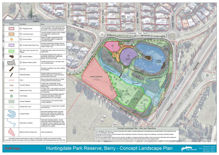
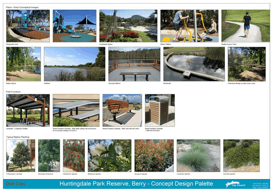
|
|
Ordinary
Meeting – Monday 06 June 2022
Page
0
|
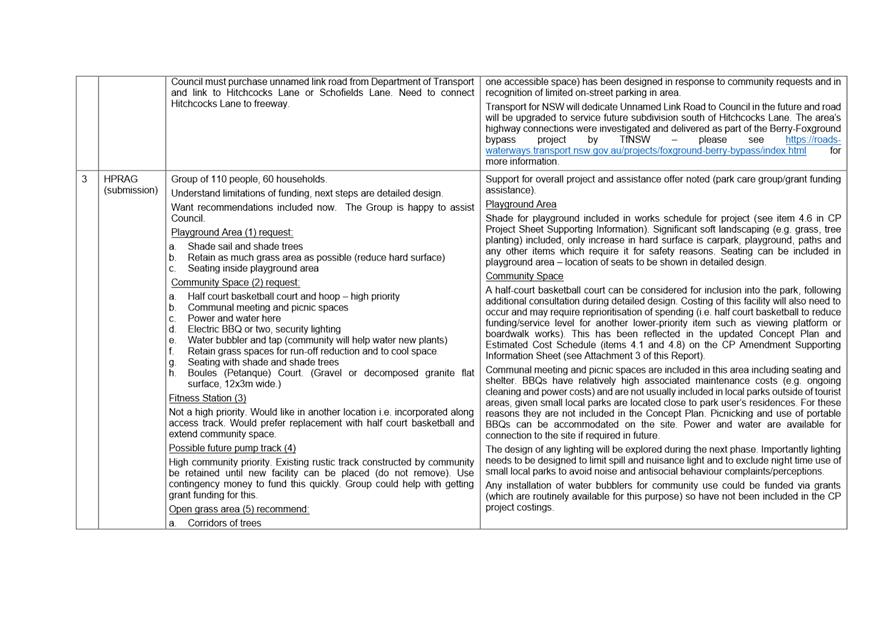
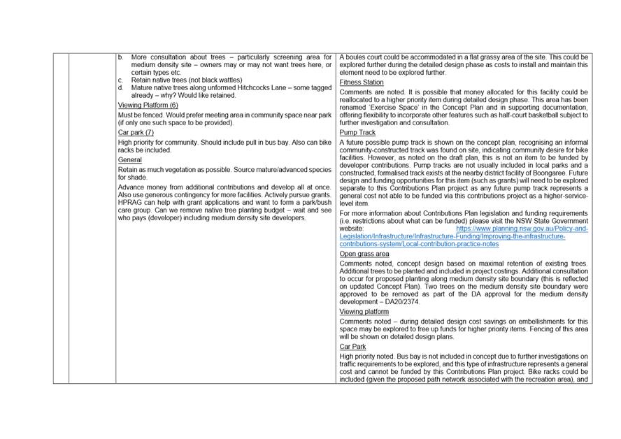
|
|
Ordinary
Meeting – Monday 06 June 2022
Page
0
|
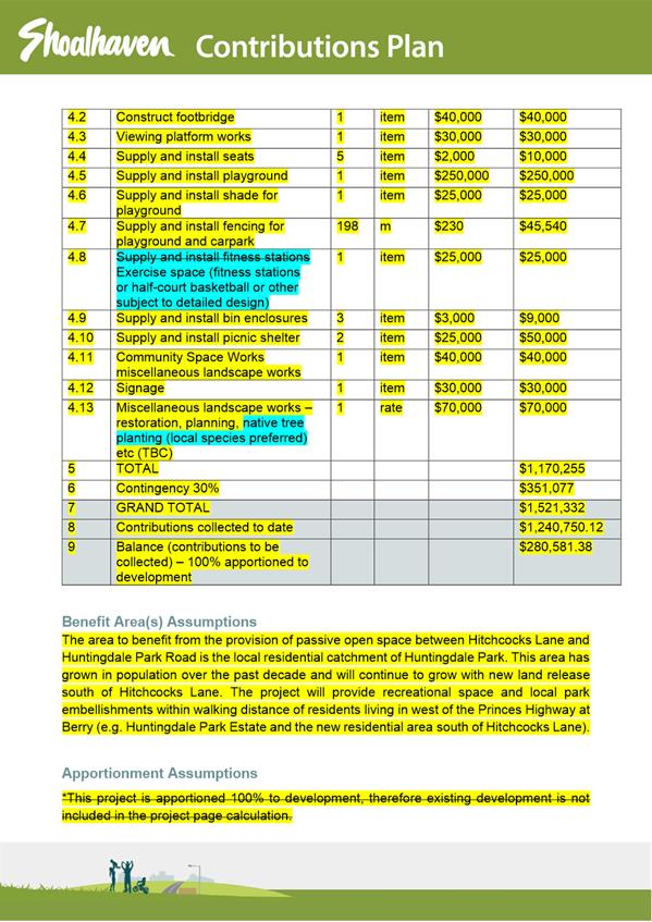
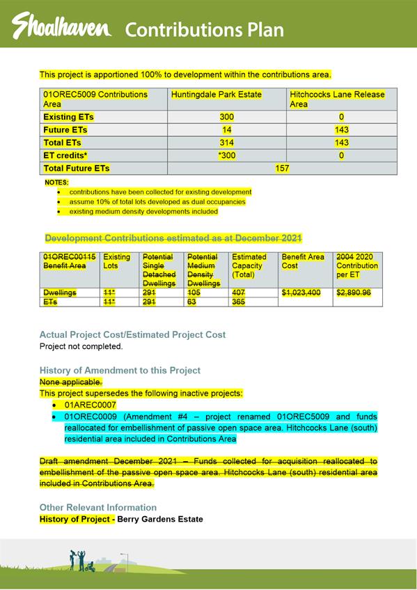
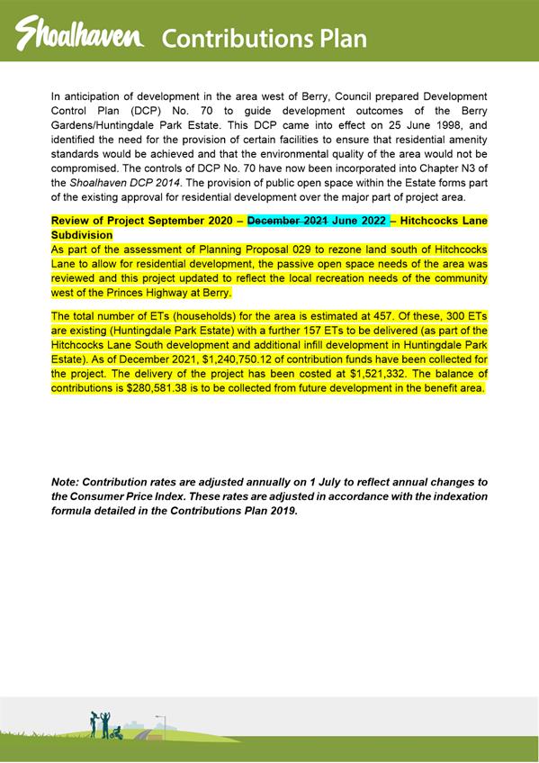
|
|
Ordinary
Meeting – Monday 06 June 2022
Page
0
|
CL22.246 Policy
for Review - POL16/154 - Private Use of Public Parking
HPERM Ref: D22/178971
Department: Technical
Services
Approver: Paul
Keech, Director - City Services
Attachments: 1. Draft
POL22/110 - Private Use of Public Parking ⇩
Reason for Report
This policy review is presented to Council
in accordance with the recommendations for all policies to be reviewed within
the first 12 months of the new Council.
|
Recommendation
That
Council adopts POL22/110 Private Use of Public Parking Policy as an amendment
to the existing POL16/154 Private Use of Public Parking Policy.
|
Options
1. Resolve as
recommended.
Implications: The adopted
policy will be updated to reflect current Directorate titling.
2. Resolve to not
adopt as recommended.
Implications: Adopted
policy POL16/154 will remain, and applications will be assessed in accordance
with the existing policy.
Background
POL16/154 was first implemented on 18 December 2007 in
accordance with MIN07.1801. The Policy was amended on 20 January 2009, 22
October 2013, and 21 February 2017.
Council provides a combination
of timed (restricted) and untimed (unrestricted) public parking spaces on
public roads and within car parks for use by the community. The Private
Use of Public Parking Policy sets guidelines for the exclusive private use of
public car parking spaces as well as the basis for setting fees and charges for
any private use.
The key changes are as follows:
1. Update
references to Departments and Directorates to reflect Council’s current
organisational structure.
Community Engagement
None required. The proposed changes are administrative,
housekeeping amendments to reflect current Directorate titling.
Policy Implications
The policy is due for review within one year of the election
of a new Council. No substantial policy changes will result from the
recommended changes to the policy.
Financial Implications
The fees outlined in Council’s fees and charges will
continue to be collected from applicants looking to use Council’s public
carparking for private use.
Risk Implications
The policy has been in place
since 2007/2008 and there have been no issues identified from the application.
|
|
Ordinary
Meeting – Monday 06 June 2022
Page
0
|
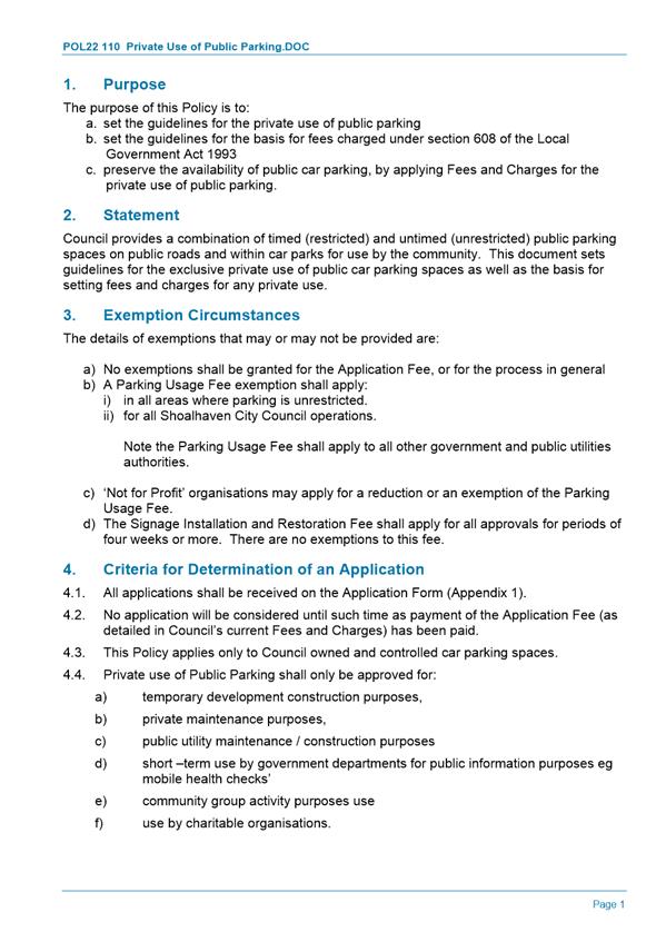
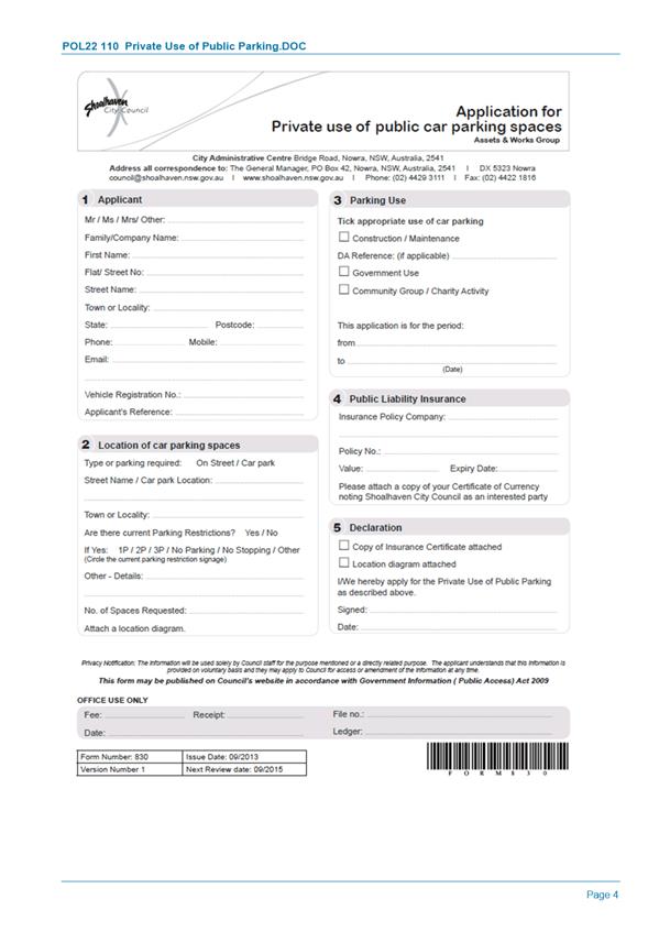
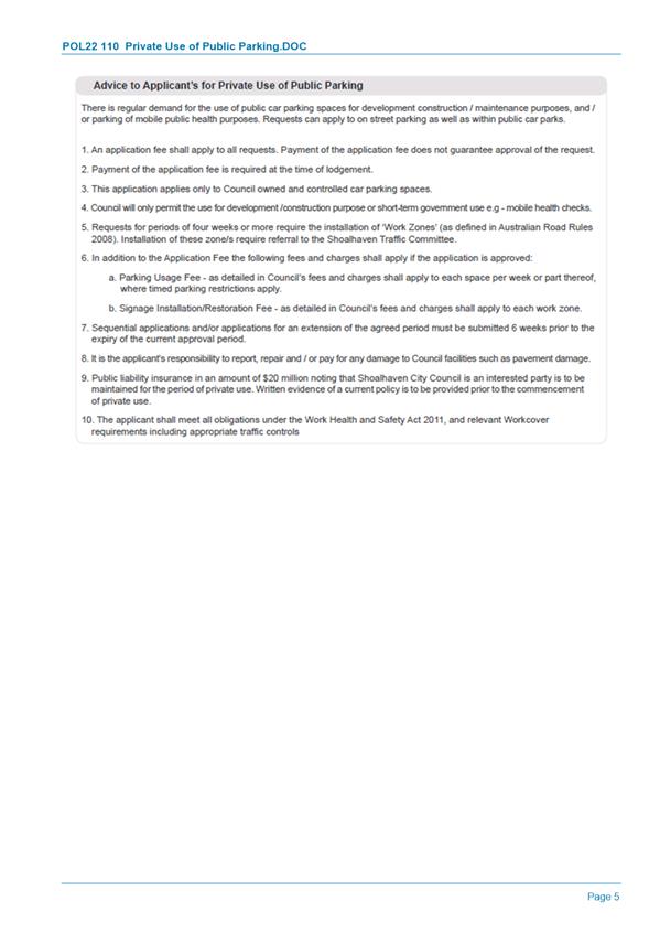
|
|
Ordinary
Meeting – Monday 06 June 2022
Page
0
|
CL22.247 Progress
Update - Infrastructure Recovery Works - Natural Disaster March 2022
HPERM Ref: D22/225969
Department: Works
& Services
Approver: Paul
Keech, Director - City Services
Reason for Report
To provide Council with an
update on the progress of infrastructure recovery works as a result of the severe
weather event across March and April 2022 in the Shoalhaven LGA.
|
Recommendation
That Council receive this update on the progress of
infrastructure recovery works which are required as a result of the March
2022 Natural Disaster Event.
|
Options
Nil
Background
Since the 2019/20 Bush Fire
crisis, the worst in NSW history, there has been eight significant natural
disaster events that have impacted the Shoalhaven. The latest of these being
the - March 2022 East Coast Low
which caused extensive damage by way of major landslips, pavement failures,
bridge and causeway damage. The following summarise the extent of the of this
damage to date:
· A
total of 962 records of damages received to date which is made up of:
§ 350
Emergency Works projects
§ 501
Immediate Reconstruction Works projects
§ 111
Essential Public Reconstruction Works projects
· 14
sites having specific funding approved to the total value of $875K
· 14
Geotechnical reports have been completed.
The definition of each work category above is as follows.
Emergency Works
Urgent activities necessary following an eligible disaster
to temporarily restore an essential public asset to enable it to operate at an
acceptable level of efficiency to support the immediate recovery of the
community.
Intermediate Reconstruction Works
Immediate reconstruction activities following an eligible
disaster to fully reconstruct a damaged essential public asset, and where no
Essential Public Asset Reconstruction Works are required.
Essential Public Asset Reconstruction Works
Reconstruction works of an essential public asset directly
damaged by an eligible disaster for which an estimated reconstruction cost has
been developed.
The timeframe of each work category is as follows:
A Natural
Disaster Project Team has been formed and is in the Nowra CBD in a vacant
Council property in Schofields Lane. A summary of the team formation is as
follows.
· Senior Project
Manager – recruited
· Business Support
Officer – recruited
· Administrative
Assistant – recruited
· 2 x Project
Managers – interviews completed and offers made – staff will be in
place by end of June 2022
· 2 x Surveillance
Officers – interviews completed & background checks in progress
– staff will be in place by end of June 2022
To date some projects have been completed. A more
comprehensive list will accompany future progress reports however it’s
worth noting that examples of our completed works to
date include -
· Monkey Mountain – landslip repairs
· Upper Kangaroo River Road – Stage 1 interim repair to
landslip
· Burrier Road – landslip repairs
· Kangaroo Valley Road – land slip clean-ups / repairs
to road pavement
· Foremans Rd – pavement works at landslip to provide
access for residents
· Mt Scanzi Road – clean-up of landslips
· Bunkers Hill Road – landslip repairs
· Martin Vale Lane – culvert replacement to provide access
to residents
· Budgong Road – make safe works including resheeting
of road
· Pestells Lane – road pavement works
· Devitts Lane - road pavement repairs
· Green Valley Road – make safe works
· Duffy’s Lane – road pavement repairs
· Corks Lane - heavy patching works
· Old Coach Rd – landslip repairs
· Lake Conjola – road pavement works
· Interim design solution for Wattamolla Road Major Landslip
· Tilbrook Av, St Georges Basin – Pavement Repair
· Greenwell Point Road– Pavement Repair
· Cabbage Tree Lane – Pavement Repair
· Callala Beach Road – Pavement Repair
· Evelyn Rd– Pavement Repair
· The Wool Rd– Pavement Repair
· Dowling St– Pavement Repair
· Roper St– Pavement Repair
· Murray St– Pavement Repair
· Woodstock Rd – Pavement Repair
· Lake Conjola Rd– Pavement Repair
· Sussex Inlet Rd – Pavement Repair
· Cammaray Dr Inlet Rd – Pavement Repair
· Albion St – Pavement Repair
· Woodhill Mountain Rd -Pavement Repair
The total damage bill is likely
to exceed $50 million. Expenditure and funding to date can be summarised as
follows.
Expenditure
|
District
|
|
Emergency Works
|
Immediate Restoration
|
Repair of Public Assets
|
|
Basin
|
|
$327,124
|
$8,111
|
Landslips $20,643
|
|
Central
|
|
$394,803
|
$19,651
|
|
North
|
|
$1,198,915
|
$660
|
|
South
|
|
$201,978
|
$18,993
|
|
TOTALS
|
|
$2,122,820
|
$47,415
|
$20,643
|
Funding
|
Funding Value
|
Month Paid
|
Distribution
|
|
$1,000,000
|
Mar-22
|
$100,000 –
Kangaroo Valley Business Recovery Plan
$900,000 –
Cover funding deficits for emergency and immediate reconstruction works
|
|
$5,000,000
|
Jun-22
|
Pre-funding of
first $5M of upcoming claims - to be lodged monthly
|
|
$6,000,000
|
|
|
With so many
people and places affected a prioritisation tool has been developed to help
rationally prioritise efforts. The prioritisation is determined via the heat
map scoring process whereby;
“Severity
+ Impact = Priority Score”
|
Severity
|
|
|
(5) Critical – road closed or single lane traffic / risk
of people not having access to emergency services (e.g. hospitals)
|
|
(4) High – road closes after short rain events / damages
add risk to damage to vehicles or people / risk of people having to make long
detours to have access to emergency services
|
|
(3) Moderate – damages require slowing of traffic /
damages add risk of traffic accidents due to slowing or swerving around
damages
|
|
(2) Low – damages unlikely cause harm or injury / damages
could deteriorate over time if not addressed
|
|
(1) Super Low – damages unlikely cause harm or injury /
damages unlikely to deteriorate
|
|
Impact
|
|
|
(5) Critical – one or more entire communities impacted
|
|
(4) High – one or more suburbs impacted
|
|
(3) Moderate – one or more roads impacted
|
|
(2) Low – one or more residents impacted
|
|
(1) Super Low – inconvenience only
|
This process is
still a work in progress, and it is planned to publish this “Heat
Map” as soon as possible. So far 57 sites have scored 5 or above and are
considered the highest priority for action. In most cases this means
“interim works” will be undertaken to reduce the severity whilst
permanent works are determined and planned.
Note: As the
Severity score comes down due to interim works this tool may require a
redefinition of Severity in six months’ time.
Three Week Forward Works Program
· Works
to commence on Wattamolla Road Major Landslide (interim solution to provide a
10 tonne load limited one lane access)
· Works
to commence on Woodhill Mountain Road Pavement repairs.
· Works
to commence on The Wool Road Pavement repair.
· Works
to commence on The Albion Street Pavement repair.
· Works
to commence on The Cammeray Drive Pavement repair.
· Investigation
and design work to progress on numerous damage items, (more details to follow
in future updates)
Three Month Forward Works Program
After three months it is anticipated that
1. All sites with a
Severity Score of 5 (as per above) will have been actioned to allow a revised
rating reduced to at least a 4.
2. All high priority
damage items (57 items) with investigation finalised and design work complete
or nearing completion.
Community Engagement
Extensive community engagement
has been undertaken and is ongoing as part of keeping the community up to date
with emergency work activities over the last eight weeks. This has included
attendance and two village gatherings in Kangaroo Valley (29 March & 26
April 2022) and one at the Berry Forum (12 May 2022). Specific project update
pages have been established on Council’s website which provides
information on current work. Interested persons/parties can subscribe to the
pages to receive updates.
Attending to all emails and
retuning all phone calls with detailed updates is proving to be a challenge. A
project page is being developed for each project with a “subscribe”
button available for members of the public to be kept up to date. Despite initial
teething problems, the uncertainty posed by the scale of the damage and ongoing
wet weather, these Project Pages appear to be being well received. Currently
new templates are being developed based on feedback so far and soon many more
project pages will appear on our webpage in the coming days.
Financial Implications
A Notice of Natural Disaster
Declaration was made on 6 March 2022 by Resilience New South Wales for the
Shoalhaven LGA. As a result, Council is eligible to receive funding under the
Australian Government Disaster Recovery Funding Arrangements (2018) to cover
the costs associated with restoration of roads to the pre-condition before the
event.
|
|
Ordinary
Meeting – Monday 06 June 2022
Page
0
|
CL22.248 Tenders
- Management & Operation - Holiday Haven Burrill Lake
HPERM Ref: D22/195708
Department: Commercial
Services
Approver: Paul
Keech, Director - City Services
Reason for Report
To inform Council of the tender
process for Management and Operation of Holiday Haven Burrill Lake.
In accordance with Section
10A(2)(d)(i) of the Local Government Act 1993, some information should remain
confidential as it would, if disclosed, prejudice the commercial position of
the person who supplied it. It is not in the public interest to disclose this
information as it may reveal commercial-in-confidence provisions of a contract,
diminish the competitive commercial value of any information to any person
and/or prejudice any person’s legitimate business, commercial,
professional or financial interests. This information will be considered under
a separate confidential report.
|
Recommendation
That Council consider a
separate confidential report in accordance with Section 10A(2)(d)(i) of the
Local Government Act 1993.
|
Options
1. Accept the
recommendation
Implications: Consider a separated confidential report on the
matter
2. Council make a different
resolution
Implications: This is not recommended as an extensive
evaluation process has been undertaken by the tender evaluation team in
accordance with the tender evaluation plan
Details
Council called tenders for Management and Operation of Holiday
Haven Burrill Lake on 7 April 2022 which closed
at 10:00 am on 3 May 2022. One tenders were received at the time of
closing. Tenders were received from the following:
|
Tenderer
|
Location
|
|
BLJ Burrill Lake Pty Ltd
|
Burrill Lake, NSW
|
Details relating the evaluation of the tenders are contained
in the confidential report.
Community Engagement:
The tender process for the appointment of a management
contractor to Shoalhaven City Council’s Holiday Haven Park at Burrill
Lake has been followed within the requirements of the provisions of the Local
Government Act.
Policy Implications
Nil. The tender process has followed the requirements under
the provisions of the Local Government Act 1993.
Financial Implications:
The financial provisions of the
current and new contract are the same.
Financial aspects of the management contracts for
Council’s commercially operated Holiday Haven Parks are a balance between
sufficient funds for the contract to provide a prudent level of staffing and
equipment to effectively operate these complex properties, and the need for
Council to obtain the best value for money. Holiday Haven considers the
cost of operating these properties carefully in order to maintain an adequate
business benefit to Council and a return to the Contractor that ensures the
properties are operated and maintained for Council to the required industry
standards.
Risk Implications
Details relating to the Risk
Implications are contained in the confidential report.
|

|
Ordinary
Meeting – Monday 06 June 2022
Page
0
|
CL22.249 Tenders
- Rehabilitation of Worrigee Road (CH860 – CH1620), Worrigee
HPERM Ref: D22/203906
Department: Works
& Services
Approver: Paul
Keech, Director - City Services
Reason for Report
To inform Council of the tender
process for Rehabilitation of Worrigee Road (CH 860 - CH1620), Worrigee.
In accordance with Section
10A(2)(d)(i) of the Local Government Act 1993, some information should remain
confidential as it would, if disclosed, prejudice the commercial position of
the person who supplied it. It is not in the public interest to disclose this
information as it may reveal commercial-in-confidence provisions of a contract,
diminish the competitive commercial value of any information to any person
and/or prejudice any person’s legitimate business, commercial,
professional or financial interests. This information will be considered under
a separate confidential report.
|
Recommendation
That Council consider a
separate confidential report in accordance with Section 10A(2)(d)(i) of the
Local Government Act 1993.
|
Options
1. Accept the
recommendation
Implications: Consider a separate confidential report on the
matter.
2. Council make a
different resolution
Implications: This is not recommended as an extensive
evaluation process has been undertaken by the tender evaluation team in
accordance with the tender evaluation plan.
Details
Project Description
Council intends to improve the drainage along Worrigee Road,
increase clearance to vegetation along this length of road and rehabilitate the
road pavement and driving surface between chainage 860 and 1620 (Isa Road to Regelia
Parade) of Worrigee Road.
Tendering
Council called tenders for Rehabilitation of Worrigee Road (CH
860 - CH1620), Worrigee on 1 March 2022 which
closed at 10:00 am on 29 March 2022. Three (3) tenders were received at
the time of closing. Tenders were received from the following:
|
Tenderer
|
Location
|
|
Cleary Bros (Bombo) Pty Ltd
|
Port Kembla, NSW 2505
|
|
Denrith Pty Ltd
|
Goulburn, NSW 2580
|
|
Fulton Hogan Industries Pty Ltd
|
Kembla Grange, NSW 2526
|
Details relating the evaluation of the tenders are contained
in the confidential report.
Policy Implications
Nil. The tender process has followed the requirements under
the provisions of the Local Government Act 1993.
Financial Implications:
Sufficient funds have been allocated in the Rehabilitation
of Worrigee Road (CH 860 - CH1620), Worrigee budget for 2022/2023 financial
year. Funding is available to cover the tender amount including other project
costs.
Risk Implications
Details relating to the Risk
Implications are contained in the confidential report.
|

|
Ordinary
Meeting – Monday 06 June 2022
Page
0
|
CL22.250 Land
Acquisition Matters - Cambewarra Locality
HPERM Ref: D22/189857
Department: Technical
Services
Approver: Paul
Keech, Director - City Services
Reason for Report
This report is to provide Council with an opportunity to
consider a confidential report for the acquisition of land in the Cambewarra
locality.
Further information is provided
in a separate confidential report in accordance with Section 10(2)(c) of the
Local Government Act 1993; if the information was disclosed, this would confer
a commercial advantage on a person with whom Council is conducting (or proposes
to conduct) business with.
|
Recommendation
That
Council, in accordance with Section 10(2)(c) of the Local Government Act
1993, considers a separate confidential report in relation to property
acquisition matters associated with Cambewarra locality.
|
Options
1. Adopt the recommendation
Implications: Consider a separate confidential
report for the proposed acquisition of land in the Cambewarra locality.
Background
Land is required for road
purposes to facilitate the delivery of the Far North Collector Road, including
construction, operation & maintenance of the future road.
The Far North Collector Road
(FNCR) was identified in the Nowra Bomaderry Structure Plan (NBSP) adopted by
the Council in 2007. The FNCR will provide transport connection from
Illaroo Rd West Cambewarra to Moss Vale Road Cambewarra at the Bells Lane
intersection, as well as provide relief routes required for both North &
South Moss Vale Road Urban Release Area’s. The southern Urban Release
Area is imminent urban development with current subdivision applications under
assessment.
The Property Unit commenced
negotiations in late 2018 to enable survey design for the road construction and
proposed area of acquisition. The last matter resolved was MIN20.204C.
Risk Implications
Failure to acquire the land for
the Far North Collector Road will impact on the delivery of the FNCR.
|
|
Ordinary
Meeting – Monday 06 June 2022
Page
0
|
CL22.251 Variations
to Development Standards - March Quarter 2022
HPERM Ref: D22/49250
Department: Development
Services
Approver: James
Ruprai, Director - City Development
Attachments: 1. Variation
Report - 1st Quarter - March 2022 ⇩
2. Planning Circular -
Variations to Development Standards ⇩
Reason for Report
This
report is submitted to the Ordinary Meeting due to therequirement
(Department of Planning and Environment) that the information contained in the
report is to be reported to the full elected Council and to the Department on a
quarterly basis. All reports to the Department must be submitted through
the NSW Planning Portal.
Council is required to consider
variations to development standards (contained in an environmental planning
instrument such as the Shoalhaven Local Environmental Plan) which exceed 10%,
with lesser variations able to be dealt with by staff, under delegation.
Council is also required to
publish the variations in addition to reporting the variations to the full
Council and the Department of Planning, Industry and Environment.
This is a regular information report.
|
Recommendation
That Council receive the
Variations to Development Standards – March Quarter Report 2022 for
information.
|
Options
1. Receive the
report for information.
Implications: Council will be complying with the
reporting provisions as detailed in Circular PS20-002 Variations to
development standards. (Attached.)
2. Resolve an
alternative and provide details to staff.
Implications: Depending on what is resolved, the
Council would need to ensure compliance observing that the Department
undertakes periodic audits.
Background
Procedural and reporting requirements
To ensure transparency and integrity in the planning
framework, the Department requires monitoring and reporting measures.
· A written application (by an applicant) must be made to
support a variation.
· An online register of all variations to be
maintained. (Council’s website.)
· A report must be submitted through the Portal.
· A report of all variations from a Council must be provided
to a meeting of the Council at least once a quarter. (This report.)
Audit
The Department will continue to
carry out random audits to ensure the above monitoring and reporting measures
are complied with.
This Council has been the
subject of an audit. The then Group Deputy Secretary of the Department of
Planning, Industry and Environment concluded that it was satisfied with the
Council’s processes and reporting regime, concluding in a letter dated 11
July 2019:
The audit involved the review of over 180 development
application approvals across 18 councils. Reporting on the
Council’s obligations outlines in clause 4.6 of the SILEP ….I would
like to congratulate Shoalhaven City Council for meeting the ongoing reporting
and administrative obligations under the development standard variation
regime…”
Summary of reportable
variations
The table below is based on the
spreadsheet but is simplified for easier reading. The spreadsheets are viewable
on Council’s webpage and are published quarterly as soon as possible
after the last day of the month.
There were two reportable
variations for the March Quarter.
1. Table
– Variations March Quarter 2022
|
DA
|
Lot
|
DP
|
Street Name
|
Suburb
|
Post Code
|
Description
|
Standard Varied
|
Extent of Variation
|
Decision
|
Date
|
|
DA21/1966
|
2
|
1260653
|
Mt Scanzi Rd
|
Kangaroo
Valley
|
2577
|
Dwelling
|
Height
|
9.38%
|
Approval
|
9/2/22
|
|
DA21/1612
|
1
|
531429
|
Bolong Rd
|
Bolong
|
2540
|
Industrial
(concrete batching plant)
|
Height
|
116%
|
Approval
|
14/3/22
|
DA21/1966 was for a dwelling at
Mt Scanzi Rd, Kangaroo Valley. The height penetration was for a small
portion of an architectural roof feature / embellishment. The height
control for the proposal was 8m. The departure - 0.75m. This
application was dealt with under delegation.
DA 21/1966 was for a concrete
batching plant at Bolong Rd, Bolong. It was reported to Council on 14 March
2022. Council resolved to determine the application by way of approval
and also:
Confirm it supports, pursuant
to cl 4.6 (Exceptions to development standards) of the SLEP 2014, the
applicant’s request to vary the height limit of 11m to 23.75m;
The height was associated with
the silos, which are required specifically for the industrial use the building,
plant and equipment.
Conclusion
· One
variation as detailed above, was under delegation (being under 10%) the other
reportable to Council as it exceeded the 10% threshold.
· The
variations and applications approved during the June quarter have been uploaded
to the Department of Planning and Environment Portal site and published on
Council’s website.
· This
report to Council, combined with the report (via the Portal) to the Department
and website publication satisfies the requirements for the Department’s
reporting regime for clause 4.6 matters.
|
|
Ordinary
Meeting – Monday 06 June 2022
Page
0
|
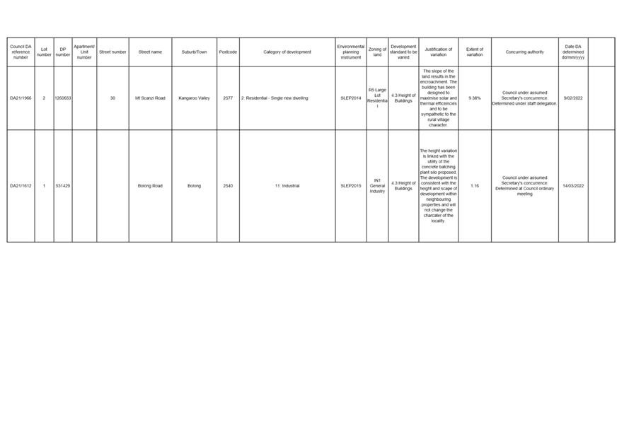
|
|
Ordinary
Meeting – Monday 06 June 2022
Page
0
|
|
|
Ordinary
Meeting – Monday 06 June 2022
Page
0
|
CL22.252 DA16/1465
– 173 Kinghorne St & 2 & 4 Albatross Rd - Nowra - Lot 1, 29 &
30 DP 25114
DA. No: DA16/1465/4
HPERM Ref: D22/183837
Department: Development
Services
Approver: James
Ruprai, Director - City Development
Attachments: 1. Section
4.15 Planning Report (under separate cover) ⇨
2. Notice
of Determination - Refusal ⇩
3. Architectural
Plans (as amended) (under separate cover) ⇨
4. CL21.230 - Report and Draft
Determination to 26 October 2021 Ordinary Meeting (under separate cover) ⇨
Description of Development: Demolition of existing
structures and construction of a mixed-use development consisting of 55
apartments including 16 x 3-bedroom, 31 x 2 bedroom and 8 x 1-bedroom
apartments, a basement car parking area and 3 commercial tenancies at ground
floor with frontage to both Kinghorne Street and Albatross Road
Owner: Bill Zervos and Jasmine Anne Simpson &
John Irwin Gould
Applicant: Lee Carmichael Town Planning (now trading
as PDC Lawyers and Town Planners)
Notification Dates: 14 June – 14 July 2017
No. of Submissions: Six (6) submissions in
objection and Nil (0) in support.
Purpose / Reason for consideration
by Council
The application has been
called in by Council (details are provided below) and has been reported on
several previous occasions. This is an outstanding application that requires
resolution having been with Council for over six (6) years. This site represents
a key opportunity for gateway development leading into the Nowra City Centre
and is characterised by possessing the only B4 zoning in the immediate
vicinity.
On 1 October 2019, it was
resolved by the Development and Environment Committee that Development
Application (DA) ‘DA16/1465 – Residential Units and
Commercial Space – 173 Kinghorne Street, Nowra be called in to Council
for determination due to significant public interest.’ (DE19.107)
On 6
October 2020, the Development & Environment Committee resolved
(MIN20.728):
“That consideration of Development Application
DA16/1465 – Mixed Use development consisting of 55 residential units and
commercial space on the land known as 173 Kinghorne Street and 2 & 4
Albatross Road, Nowra (Lot 1, 29 and 30 DP 25114) be deferred to the January
2021 Development and Environment Committee Meeting to allow Council to
undertake further traffic investigations in consultation with the
developer.”
On 11 May 2021, it was
resolved by the Development and Environment Committee: “That the Item
be deferred to the June Development and Environment Committee meeting for
further consideration.” (MIN21.256).
On 1 June 2021, it was
resolved by the Development and Environment Committee; “That Council
receive this report as an update on the progress of the assessment of DA16/1465
and in satisfaction of the 11 May 2021 resolution of the Development &
Environment Committee (DE21.50).” (MIN21.357).
On 26 October 2021, it
was resolved by the Ordinary Meeting ‘That in relation to Development
Application DA16/1465 – mixed use development consisting of 55
residential units and commercial space on the land known as 173 Kinghorne
Street and 2 & 4 Albatross Road, Nowra (Lot 1, 29 and 30 DP 25114) the
matter be deferred to early 2022.’ (MIN21.775).
This report is prepared to respond to the above resolutions.
|
Recommendation
That
Development Application DA16/1465 – mixed use development consisting of
55 residential units and commercial space on the land known as 173 Kinghorne
Street and 2 & 4 Albatross Road, Nowra (Lot 1, 29 and 30 DP 25114) be
determined by way of refusal for the reasons outlined in this report and
detailed in Attachment 2.
|
Options
1. Refuse the Development Application
(DA).
Implications: The proposal
would not proceed in its current form. The applicant can, however, apply for a
section 8.2 review of Council’s decision and/or could lodge an appeal
with the NSW Land and Environment Court against Council’s decision.
2. Approve the DA.
Implications: Council would have to provide reasons to support
the development, having regard to section 4.15 of the Environmental Planning
and Assessment Act 1979 (EP&A Act) considerations. Should
Council resolve to approve the DA a suite of conditions would be required to be
drafted for reconsideration by Council. Under some circumstances, third parties
(i.e., objectors) can seek a judicial review of Council’s decision in the
NSW Land and Environment Court.
3. Alternative recommendation.
Implications: Council will need to specify an alternative
recommendation and advise staff accordingly.
Location Map
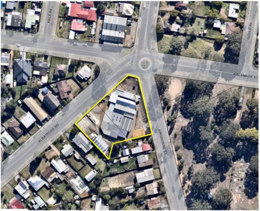
Figure 1 - Extract of the subject site in the local context.
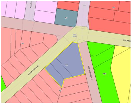
Figure 2 - Extract of the Shoalhaven Local Environmental Plan
2014 Land Use Zoning Map with the subject site with a yellow border
Background
Subject Land
The subject site comprises 3
lots (subject site) located on the south-western corner of the intersection of
Kinghorne Street, Albatross Road and Kalandar Street. The subject site is
described and legally identified as follows:
· Lot
29 DP 25114 – 4 Albatross Road, Nowra
· Lot
30 DP 25114 – 2 Albatross Road, Nowra
· Lot
1 DP 25114 – 173 Kinghorne Street, Nowra
The site is an irregular shaped
lot with a frontage of 74m to Albatross Road and 60m to Kinghorne Street with a
9.5m corner splay. The site falls gradually to the south-western corner of the
site at Albatross Road.
The combined land area of the
lots is approximately 3,497m2.
Proposed Development
The DA is seeking development
consent for the demolition of existing structures and construction of a
mixed-use development consisting of 55 apartments, including:
· 8 x 1 bedroom
apartments
· 31
x 2 bedroom apartments
· 16
x 3 bedroom apartments
· 3
commercial tenancies (total commercial floor area 259m2 (267m2
including bathroom i.e., GFA) at ground floor with frontage to both Kinghorne
Street and Albatross Road.
· A
basement car parking area accessed via Albatross Road with 93 car parking
spaces.
· Construction
of a left turn slip lane (removal of on-street parking) for access into the
basement car park off Albatross Road.
· Construction
of a central median and signage on Albatross Road to control the movement of
traffic in and out of the proposed development (left in and left out movements
only).
A site plan, ground floor,
elevations, landscape plan are provided attached at Attachment 3, with
photomontages shown at Figures 3 - 5.
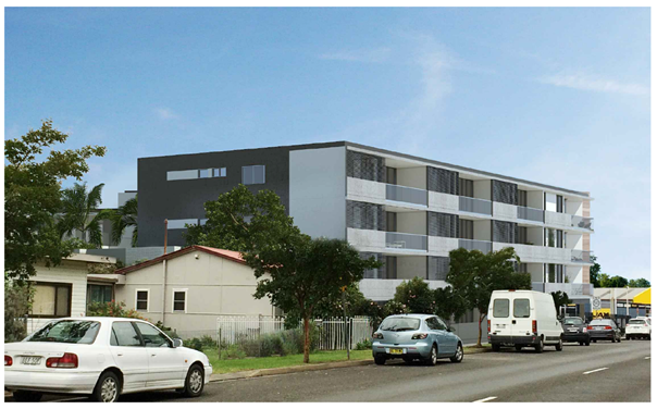
Figure 3 - Photomontage view from the
south-eastern (Kinghorne Street).
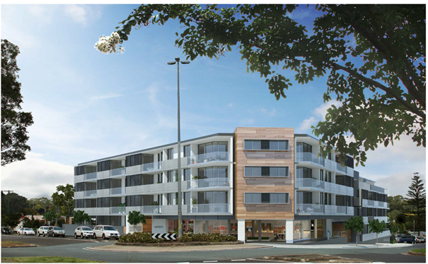
Figure 4 - Photomontage view from the
north-eastern corner of Kinghorne and Kalandar Street.
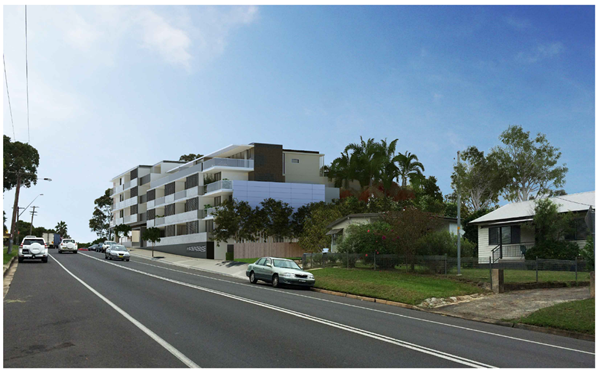
Figure 5 -Photomontage of the
south-western elevation of the development as viewed from Albatross Road.
Post-Lodgement
Key dates following the
lodgement are as follows:
· 8
April 2016, the DA was lodged with Council.
· 9
August 2016, Council requested additional information from the applicant in
relation to the design and access arrangements from Albatross Road.
· 16
December 2016, revised plans and additional information was submitted by
the applicant in response to Council’s letter dated 9 August 2016. The
amended plans included modifications to the southern portions of each wing of
the building and deletion of two apartments (reducing the unit yield from 57 to
55 apartments). The reduction in units on the southern portion of the
development was proposed to achieve a more appropriate transition to the
adjoining low-density development.
· 27
February 2017, Council requested additional information from the applicant,
with continued concerns raised in relation to design elements and major
concerns raised in relation to the proposed access/egress onto Albatross Road.
· 7
March 2017, Council met with the applicant to discuss the Planning Proposal
over the site (described below) and continued concerns with the design and
location of access/egress onto Albatross Road.
· 22
March 2017, a further additional
information letter was sent to the applicant to detail the outcomes of the 7
March 2017 meeting and to express continued concerns regarding the proposed
access/egress onto Albatross Road.
· 10 July 2018, Council
met again with the applicant to discuss design and traffic issues.
· 12
September 2018, the applicant lodged concept plans for access/egress to the
development from Kinghorne Street for Council’s consideration (refer to Figure
18).
· 12
October 2018, Council provided feedback to the applicant on the concept
plan, noting that the concept plan addressed the main concern that had been
raised by Council being the relocation of the access from Albatross Road to
Kinghorne Street frontage.
· 18
April 2019, the applicant confirmed that they would not be pursuing
any change to the design of the development which would relocate the access
from Albatross Road to Kinghorne Street frontage.
· 12
August 2019, the applicant submitted a further amended Traffic Report
prepared by Jones Nicholson (D19/280251) to justify the retention of access on
the Albatross Road frontage and to address concerns raised in relation to the
designs apparent inconsistency with State Environmental Planning Policy
(Infrastructure) 2007.
· 1
October 2019, the Development and Environment Committee that Development
Application (DA) ‘DA16/1465 – Residential Units
and Commercial Space – 173 Kinghorne Street, Nowra be called in to
Council for determination due to significant public interest.’ (DE19.107).
· 26
November 2019, the applicant submitted amended plans, acoustic report, and
clause 4.6 variation statement.
· 6
October 2020, the application was reported to the Development & Environment
Committee recommending the refusal of the application. The Committee resolved
(MIN20.728):
“That consideration of
Development Application DA16/1465 – Mixed Use development consisting of
55 residential units and commercial space on the land known as 173 Kinghorne
Street and 2 & 4 Albatross Road, Nowra (Lot 1, 29 and 30 DP 25114) be
deferred to the January 2021 Development and Environment Committee Meeting to
allow Council to undertake further traffic investigations in consultation with
the developer.”
Council
took the following actions in relation to the above matter, following the 6
October 2020 Council resolution:
· 18 November 2020,
relevant Council staff met to discuss critical aspects of the Development
Application in particular the Traffic Management Report prepared by
Jones Nicholson Consulting Engineers dated 27 February 2021 (Reference:
CRPT-16020003.01B). The outcomes of the meeting were provided to the applicant
on 26 November 2021 (D20/526133).
· 21 December 2020,
Council provided additional information to the applicant in the form of: Outputs from Council’s traffic modelling and
Council’s requirements for a future 4 lane cross section of Albatross
Road (D20/563561). Council also offered as part of the forwarding of this
additional information the opportunity to meet
further to ensure that all matters have been addressed relating to traffic and
planning issues.
· 15 January 2021,
Council notified the applicant via email (D21/16222) that the information requested in
Council’s 21 December 2020 was required to be submitted to Council in 7
days.
· 4 February 2021,
Council emailed the applicant (D21/43579) offering to meet to discuss the
additional information.
· 10 February 2021,
Council notified the applicant via email (D21/52704) that the information
requested in Council’s 21 December 2020 was required to be submitted to
Council in 7 days as the applicant had not responded to Council in relation to
the offer of a meeting and the information had not been submitted.
· 23 February 2021, the
applicant’s traffic consultant (Stephen Falkner) emailed Council, to
request the following:
§ traffic data on the existing road network from their records; and
§ projected traffic data for
10-year projections (2031).
· 12 March 2021, Council
emailed the applicant’s traffic consultant (Stephen Falkner) (D21/99332)
with the following:
§ Council’s most recent tube traffic count for the area; and
§ projected traffic data for
10-year projections (2031).
· 24 March 2021, Council
emailed the applicant (D21/117366) to inform them that the application would be
required to be reported to Council in the absence of a formal response to
Council’s email dated 21 December 2020.
· 31 March 2021, the
applicant was emailed (D21/127622) to inform them that the additional
information was required to be submitted to Council within 7 days.
· 11
May 2021, the application was reported to the Development and Environment
Committee recommending the refusal of the application. The Committee resolved:
“That
the Item be deferred to the June Development and Environment Committee meeting
for further consideration.” (MIN21.256).
Council
took the following actions in relation to the above matter, following the 11
May 2021 Council resolution:
· 18 May 2021, the
applicant was emailed (D21/203761) to again request the additional information.
· 27 May 2021, the
applicant submitted a revised SIDRA analysis (D21/227623) for the proposed
development.
· 1 June 2021, the application was reported to the
Development and Environment Committee where it was resolved:
“That Council receives
this report as an update on the progress of the assessment of DA16/1465 and in
satisfaction of the 11 May 2021 resolution of the Development & Environment
Committee (DE21.50).” (MIN21.357).
Council
took the following actions following 1 June 2021 Council resolution:
· 27 May 2021, the
applicant’s revised SIDRA analysis (D21/227623) was referred
Council’s Development Engineers and City Services for further
consideration.
· 7
October 2021, Council staff met with the applicant and their consultant to
discuss the outstanding access and traffic matters. The applicant outlined the
reasoning for the proposed access and traffic assessment associated with the
development as follows:
o The
applicant claims that their Albatross Road treatment is adaptable for future
integration into a growing network over the next 10 years. Their position is
formed in the view that the future beyond this time frame is so uncertain that
it is not reasonable to limit their proposal (future)
o The
Albatross Road access is a compliant treatment whereas the Kinghorne street
treatment is not compliant with the relevant Australian Standards. (Access)
o That
potential development to the west of their proposal would need to access from
Albatross Road (Driveway)
· 26
October 2021, the application
was reported to the Ordinary Meeting where it was resolved that:
“That in relation to
Development Application DA16/1465 – mixed use development consisting of
55 residential units and commercial space on the land known as 173 Kinghorne
Street and 2 & 4 Albatross Road, Nowra (Lot 1, 29 and 30 DP 25114) the
matter be deferred to early 2022.” (MIN21.775).
A copy of the Council report
(CL21.230) can be accessed at Attachment 4.
Council
has taken the following actions following 26 October 2021 Council resolution:
· 23 November
2021, a meeting was held with the applicant and Council City Development
staff where the applicant advised that their position on traffic matters
remained unchanged and it was recognised that the meeting would be reported
again in the new year.
·
16 March 2022, Council staff (City Development and City
Services) met with the applicant to discuss the development application and
specifically the traffic matters and classification of Albatross Road. The
applicant outlined that their position on the outstanding traffic matters have
still not changed since the meeting and subsequent Council report in October
2021.
At this meeting it was raised by Council staff that an amended
design relocating he access to the development to be from Kinghorne Street
would be accepted, despite the significant amount of time that has lapsed since
lodgement, in an attempt to resolve the application, and a commitment of a
further meeting was made. 7 April 2022, a further meeting was held with
the applicant and Council City Development staff where the applicant advised
that due to the subsequent impacts on development yield and cost of an
architectural redesign, that an amended design would not be submitted to
Council. Staff advised that the application would be accordingly reported to
Council in accordance with the October resolution.
Issues
The matters as assessed and outlined in the 26 October 2021
report to the Ordinary meeting (CL21.230) and attached Section 4.15 report have
not changed and the reasons for the recommendation of the refusal of the DA
remain as applicable and current as they were in October 2021 (refer Attachment
4). Broadly summarising these issues relate to:
i. Traffic,
vehicular access and impacts on the local road network
a) Proposed
vehicular access and road upgrades under the DA
The proposed development has frontages to both Albatross
Road (MR92), which is a classified regional road, and Kinghorne Street, which
is a local road. The proposed mixed-use development has its only vehicular
access from Albatross Road which requires road works and upgrades to this road
frontage. .
Throughout the assessment of the DA, access and traffic associated
with the proposed access arrangements have been a critical issue. Council staff
have met with the applicant and their consultant a number of time to discuss
the outstanding access and traffic matters. Council’s key concerns relate
to the following matters.
b) Suitability
of access via Albatross Road vs. Kinghorne Street and compliance with Austroads
Guide to Road Design and Council’s Development Control Plan (DCP).
The proposed design standards and implications are a point
of contention between Council’s engineers and the applicant. Further for
a compliant design, the development as proposed will require substantial
resumption of land on the opposite side of Albatross Road.
c) State Environmental
Planning Policy (Infrastructure) 2007 (now known as the SEPP (Transport and
Infrastructure) 2021)
The subject site has frontage to Albatross Road (MR92),
being a classified regional road. Accordingly, section 2.118 of SEPP (Transport
and Infrastructure) 2021 (formerly clause 101 of SEPP (Infrastructure) 2007)
applies and reads as follows:
2.118 Development with
frontage to classified road
(1)
The objectives of this section are—
(a) to
ensure that new development does not compromise the effective and ongoing
operation and function of classified roads, and
(b) to
prevent or reduce the potential impact of traffic noise and vehicle emission on
development adjacent to classified roads.
(2)
The consent authority must not grant consent to development on
land that has a frontage to a classified road unless it is satisfied
that—
(a) where
practicable and safe, vehicular access to the land is provided by a road other
than the classified road, and
(b) the
safety, efficiency and ongoing operation of the classified road will not be
adversely affected by the development as a result of—
(i) the
design of the vehicular access to the land, or
(ii) the
emission of smoke or dust from the development, or
(iii) the
nature, volume or frequency of vehicles using the classified road to gain
access to the land, and
(c) the
development is of a type that is not sensitive to traffic noise or vehicle
emissions, or is appropriately located and designed, or includes measures, to
ameliorate potential traffic noise or vehicle emissions within the site of the
development arising from the adjacent classified road. (emphasis added)
Under subsection 2.118(2) the consent authority must not
grant consent to development on land that has a frontage to a classified
road unless it is satisfied that all the subsequent considerations have
been met by the proposal.
The 3 preconditions in subsection 2.118(2) are collective.
Therefore, any one of the pre-conditions in subsection 2.118(2) about which
Council is not satisfied could prevent the issue of consent. As outlined in the
assessment at Attachment 1, Council is not satisfied that any of the
preconditions of subsection 2.118(2) can be met and accordingly Council cannot
approve the DA.
ii. Car
Parking
The development is required to
provide a total of 83.23 car spaces which, with 93 proposed, is compliant with
the applicable parking rates (refer 26 October 2021 Council report at Attachment 4
for full details). Nonetheless, it is noted that the proposal to provide
access to the basement car park via an intercom to provide security to the
basement car park area is unlikely to provide suitable public access to car
parking for those members of the public wishing to visit the commercial uses
and therefore there is likely to be a reliance on on-street car parking either
to the south of the site or along Kinghorne Street.
Furthermore, the location of the security gates and intercom
to provide access to the basement car park is likely to result in unsafe
manoeuvring of vehicles should they fail to gain access to the car park or
result in queuing on Albatross Road should there be technical issues with the
security gate (refer to Figure 6).
The development is located in a regional area.
Visitors to the residential flat building and customers of the commercial
component of the development are heavily reliant on private motor vehicles for
transport as opposed to good, accessible, and frequent public transport.
The proposed design and arrangement of the basement parking is not considered
suitable for a development of this scale and will result in unacceptable
impacts on Albatross Road.
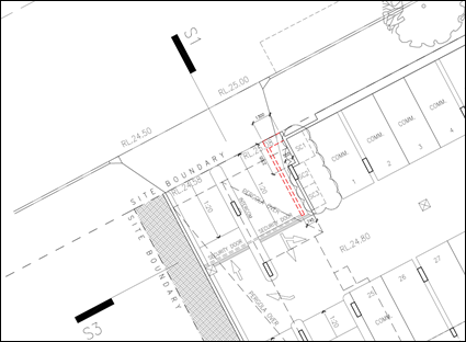
Figure 6 – Extract of the proposed
basement plan indicating the location security door and intercom to gain access
to the basement car park.
iii. Exceedance of
the LEP maximum height control - Clause 4.3 Height of Buildings
Clause 4.3 of SLEP 2014 sets an
8.5m (I2) height limit for part of the site and a 14m (N2) height limit for
rest of the site (refer Figure 7). The 8.5m height limit applies to a 9m
portion of the south eastern portion of the
site extending across all lots subject of the development application where the
lot adjoins the lower density R1 General Residential land to the south.
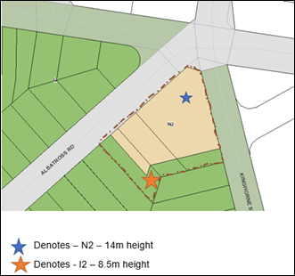
Figure 7 – Height controls applying to the site
under the Shoalhaven Local Environmental Plan 2014
Parts of the proposed building exceed
the 8.5m (I2) and 14m (N2) height are limited to a portion of the development.
The development proposed exceeds the maximum building
height as follows:
· 14m
height limit by 480mm or 3.4%;
· 8.5m
height limit 1.465m or 17.2%; and
· The percentage exceedance of the maximum building height
ranges from 1.4% to 17.2% with the average height limit exceedance being 4.83%.
The submitted height plane diagrams prepared by Kannfinch
Architects illustrate that the height limit breach and indicate the percentage
breach at each point (Refer to Figure 8 and 9).
In April 2016, a
Planning Proposal (PP) was lodged concurrently with this DA to rezone the
subject site from B5 Business Development to B4 Mixed Use zone and increase the maximum height of the building limit from 11m
to 15m (refer Attachment 1 for full details). The planning proposal was
approved and commenced on 6 October 2017 (Amendment No. 16 to SLEP 2014);
however, the height limit was increased only to 14m for the majority of the
site.
An 8.5m maximum building height associated with a 9m wide
portion, as measured from the southern boundaries of Lot 1 and Lot 30 DP 25114,
and south-eastern and south-western boundaries of Lot 29 DP 25114 was applied
to the subject site.
Despite the PP coming
into effect during the assessment of the subject DA, the design of the
development was not amended to comply with the approved heights under the site
specific PP.
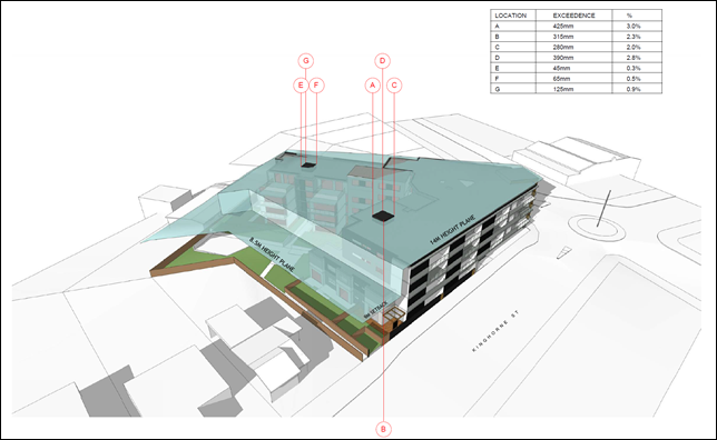
Figure 8 - Height plane instructions relating to the 14.0m
(N2) maximum building height -
south-eastern view from Kinghorne Street.

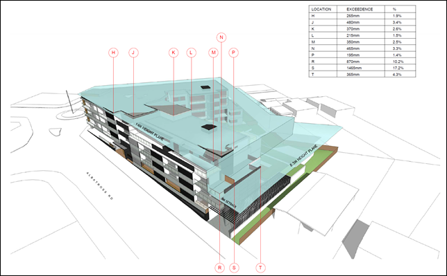
Figure 9 - Height Plane instructions relating to the 14.0m (N2) and
8.5m (I2) maximum building height - southwestern view from Albatross Street.
Development consent may, subject to clause 4.6, be granted
for development even though the development would contravene a development standard
imposed by this or any other environmental planning instrument. The application
seeks a variation to clause 4.3 Height of Building (i.e., the heights approved
under the site specific PP) in accordance with Clause 4.6 of SLEP 2014.
For the reasons detailed in the attached s4.15 Assessment
Report (Attachment 1), it is not considered that the clause 4.6
variation request has satisfied:
1. That
compliance with the development standard is unreasonable or unnecessary in the
circumstances of the case (cl 4.6(3)(a)); and
2. That
there are sufficient environmental planning grounds to justify contravening the
development standard (cl 4.6(3)(b)). The written request needs to demonstrate
both matters.
In particular a key reason for the variable height control
under the PP and transition from the
low-density zone to the south and the higher density proposed on the subject
site, was the mitigation of impacts to the character of the adjoining low
density area, loss of privacy and loss of solar access to the existing
neighbouring low density development. Cumulatively, the reduced side setback of
the building of 6m setback (opposed to the required 9m setback) and exceedance
of the height control in this location exacerbates the overshadowing of the
adjoining residences (No. 6 Albatross Road and No. 175 Kinghorne Street) for
the portion of the building along the Albatross road frontage.
The s4.15 Assessment Report provides a full assessment of
the clause 4.6 variation against the relevant planning ‘tests’, and
concludes that the applicant’s request to vary the development standard
as it relates to the maximum building height should not be supported for the
following reasons:
· The
variation request does not demonstrate that compliance with the development
standard would be unreasonable and unnecessary in the circumstances of this
development.
· The
variation request does not demonstrate there are sufficient environmental
planning grounds to justify the contravention, which results in a better
planning outcome than a strictly compliant development in the circumstances of
this particular case.
· Does
not demonstrate the development meets the objectives of the development
standard.
· The
proposed development is for the preceding reasons, not considered to be in the
public interest; and
· The
applicant has failed to demonstrate that there will be better planning outcomes
achieved through a variation to the height standard as it relates to the 8.5m
height of building standard associated with a 9m setback to the southern
boundary, as opposed to strict compliance with the development standard or
amending the application to reduce the extent of the variation.
iv. Non-compliance
with State Environmental Planning Policy No 65 – Design Quality of
Residential Flat Development (SEPP 65) and Apartment Design Guide (ADG)
State Environmental Planning Policy No 65 - Design
Quality of Residential Flat Development (SEPP 65) applies to the proposed development which consists of
a new building, of at least 3 storeys and containing at least 4 or more
dwellings.
In accordance with Clause 28(2) of the SEPP 65, In
determining a development application for consent to carry out development to
which this Policy applies, a consent authority is to take into consideration
(in addition to any other matters that are required to be, or may be, taken
into consideration):
(a) the advice (if any) obtained from the design
review panel, and
(b) the design quality of
the development when evaluated in accordance with the design quality principles,
and
(c) the Apartment Design Guide.
A SEPP 65 Design Statement has been prepared by a
Registered Architect (D20/6044) addressing the requirements of SEPP 65 and was
submitted with the application in accordance with Clauses 50(1A) & 50(1AB)
of the Environmental Planning and Assessment Regulation 2000 (EP&A
Regulation). The SEPP 65 Design Statement has address Schedule 1 of SEPP
65.
The development has been assessed against the ADG and a full
assessment is provided within the s.4.15 Assessment Report (Appendix 1
of this Report).
It is considered that the design quality of the development,
when evaluated against the nine design quality principles does not
satisfactorily exhibit exceptional design excellence when assessed against the
following principles:
· Principle 2: Built form and scale
· Principle 3: Density
· Principle 4: Sustainability
· Principle 5: Landscape
· Principle 6: Amenity
Additionally, Clause 30(2) of SEPP 65 requires residential
apartment development to be designed in accordance with the ADG. Parts 3
and 4 of the ADG provide objectives, design criteria and design guidance for
the siting, design, and amenity of apartment developments. In accordance with
ADGs, development needs to demonstrate how it meets the objective and design
criteria. The design criteria set a clear measurable benchmark for how the
objective can be practically achieved. If it is not possible to satisfy the
design criteria, applications must demonstrate what other design responses are
used to achieve the objective and the design guidance can be used to assist in
this.
The development is non-compliant with the following
Objectives and Design Criteria in Part 3 and 4 of the ADG, including:
· 3E-1
Deep Soil Zones
15% of the
site is to be provided as deep soil on sites greater than 1,500m2
with a minimum dimension of 6m. The development provides only 13% of the site
as deep soil area, or 9% when only areas of >6m dimension is calculated.
· 3F-1
Visual Privacy
The adjacent sites to the south of the development site are
zoned R2 Low Density Residential and currently contain single dwelling houses
per lot. Setback of the Kinghorne portion of the development to the adjoining
southern property boundary requires a minimum setback of 9m. A setback of. 6m
is proposed to the 3rd level in this location which does not comply.
· 3H-1
Vehicle Access
The
proposal to access the development from the Regionally Classified Road
(Albatross Road) is not supported and per SEPP (Transport and Infrastructure)
2021, access should be via the unclassified local road (Kinghorne Street).
· 3J-2
Bicycle and Car Parking
Each
resident has access to a secure storage cage which is large enough to
accommodate a bicycle. It is proposed to provide residential visitor and
customer bicycle spaces on the street in the form of post mounted bike rails
attached to existing street does or signposts, should Council require them. A
condition is recommended for the provision of on-street bicycle parking should
the application be approved.
· 4A-1
Solar and Daylight Access
37 of 55
apartments (67%) receive at least 3 hours direct sunlight between 9.00am and
3.00pm in mid-winter. The ADG requires a minimum of 70%.
13 of 55
apartments (24%) of apartments receive no sunlight between 9am and 3pm in
mid-winter. The ADG requires a maximum of 15%.
While
the numerical compliance is an assessment of the overall development, it is
noted that it is predominantly single aspect, and 1-bedroom apartments are
generally not naturally ventilated and will therefore rely on mechanical ventilation.
Of concern is that none of the proposed 1-bedroom apartments will be naturally
ventilated.
· 4D-3 Apartment Size and Layout
1-bedroom
apartment widths are 3.5m - this is marginally under minimum 3.6m required
under the ADG. The non-compliance is considered to be marginal and does not
impede the usable area of the living rooms and would not likely have a
significant detrimental impact on the amenity of the dwelling or resident use
of the units if this was a singular issue . However, it is noted that the
design of the single bedroom units is impacted by the proposed design and
overall amenity of these units reduced.
· 4E-1
Private Open Space and Balconies
A number of
the ground floor units do not provide at least 15sqm (G.04, G.08 and G.09) while
other apartments do not provide a minimum depth of 3m (G0.2, G.03,G.04, G.08,
G.10).
· 4F-1 Common Circulation and Spaces
The maximum
number of apartments off a circulation core on a single level is eight (8).
Lobby B services 11 apartments on levels 01, 02, and 10 apartments on Level 03.
The corridors have been designed with light slots to capture natural light and
ventilation to maintain a high level of amenity.
· 4K-2 Apartment Mix
The ADG
requires the apartment mix to be distributed to suitable locations within the
building. The mix of one-bedroom units is not considered to provide an
appropriate distribution to suitable locations within the building.
The single
bedroom units are limited to the southern elevation of the V-shaped building
design which has resulted in units with severely compromised solar access,
ventilation and private open space that will likely result in units with
diminished amenity. The irregular floor plans will also result in odd shaped
rooms and the potential loss of the use of usable space within these units.
It is
considered that the single bedroom units should be spread more evenly
throughout the development to enable these units a greater likelihood for
increased amenity
Appendix A to the Section 4.15 Assessment Report (Attachment
1) provides a full assessment of the proposed development against each of
the objectives of the ADG.
v. State
Environmental Planning Policy (Building Sustainability Index: BASIX) 2004 (SEPP
(BASIX))
The provisions of SEPP (BASIX) apply to the site. In
accordance with the requirements of SEPP BASIX, Certification for each dwelling
has been submitted with the development application.
Clause 55A of the EP&A Regulation 2000 allows for a
development application to be amended provided a new BASIX certificate is
submitted to account for those amendments. An amended BASIX Certificate, to
reflect amended plans was not submitted with the amended application.
Council cannot issue
development consent without the provision of a new BASIX Certificate that
reflects the amended application i.e., 55 residential units.
Planning Assessment
The DA has been assessed under
s4.15 of the Environmental Planning and Assessment Act 1979. Please refer
to Attachment 1.
It is noted that on
1 March 2022, the thematic State Environmental Planning Policies (SEPPs)
commenced with 11 new SEPPs introduced which re-organised and repealed 45
former SEPPs. Former SEPPs which applied at the time of the lodgement of this
DA, now exist as ‘Chapters’ within the new instruments.
There are no
savings and transitional provisions contained in the new instruments. Rather,
each instrument contains a ‘transferred provision’ clause which
states that section 30A of the Interpretation Act 1987 is taken to apply. This
means that the transfer of clauses to the new instruments will not affect their
operation, and the clauses should be construed as if they had not been
transferred.
Accordingly, the
assessment within the section 4.15 Planning Report at Attachment 1
assesses the proposal under the former SEPPs, however as the former SEPPs no
longer apply to existing development applications and consents, and the new
SEPPs apply instead the new references to SEPPs have been updated in the
recommended notice of determination. Planning
Circular PS21-007 issued by the Department of Planning and Environment
outlines the rollover of SEPPs and which of the former SEPPS have been
incorporated and repealed by the new SEPPs.
Additionally, in relation to the EP&A Regulations, the Environmental
Planning & Assessment Regulation 2021 was introduced on 1 March 2022.
Per the Schedule 6 Savings, transitional and other provisions, the 2000
Regulation continues to apply instead of the 2021 Regulation to a development
application made but not finally determined before 1 March 2022. Accordingly,
the SEPP65 and BASIX assessments reference a now repealed Regulation.
Policy Implications
A key policy consideration is
height.
Currently, there is an 8.5m and 14m height limit which applies to the site
under SLEP 2014.
The
development proposed exceeds the maximum building height as follows:
· 14m
height limit by 480mm or 3.4%;
· 8.5m
height limit 1.465m or 17.2%; and
· The
percentage exceedance of the maximum building height ranges from 1.4% to 17.2%
with the average height limit exceedance being 4.83%.
The variation has been addressed
by the applicant via a formal clause 4.6 variation statement. The matter is
discussed in the attached section 4.15 report in further detail (Attachment
1) and has been mentioned previously in this Report.
Consultation and Community Engagement:
Six (6) public submissions were
received in relation to Council’s notification of the development. Six
(6) were objections to the development. Nil (0) were in support of the
development. The notification was made in accordance with Council’s Community
Consultation Policy. The application was notified for a period of 30 days and
advertised in the local papers in accordance with Council’s Community
Consultation Policy.
Key issues raised as a result of
the notification are provided below:
· Traffic
impacts on the local road network.
· Impact
of additional cars parking on the on-street car parking.
· Amenity
impacts associated with overlooking and overshadowing.
· Insufficient
justification and planning purpose to support the PP.
· The
bulk and scale of the development is not consistent with the low scale
development to the south of the site and the site would be better developed for
multi-dwelling housing.
· The
proposed setbacks of the development to the southern boundary are not
appropriate.
· The
pedestrian access point to the development on the Kinghorne Street frontage
will result in safety and security issues.
The planning concerns raised by
the submitters are addressed in the attached section 4.15 report in further
detail (Attachment 1).
Financial Implications:
There are potential cost
implications for Council in the event of a refusal of the application. Such
costs would be associated with defending any appeal in the Land and Environment
Court (LEC), should the applicant utilise appeal rights afforded under the
EP&A Act.
Legal Implications
Pursuant to section 8.2 of the
EP&A Act, a decision of the Council may be subject of a review by the
applicant in the event of approval or refusal. If such a review is ultimately
pursued (if the recommendation is not adopted), the matter would be put to
Council for consideration.
Alternatively, an applicant may
also appeal to the Court against the determination pursuant to section 8.7 of
the EP&A Act.
Summary and Conclusion
This
application has been reported to Council several times with a recommendation of
refusal. Following the deferral of the application at Council’s Ordinary
Meeting on 26 October 2021 the applicant has been unwilling to amend the
proposal to meet Council’s concerns and the reasons and assessment
recommending the refusal of the DA (as outlined at Attachments 1 and 2)
remain the same.
Based
upon the s4.15 Assessment Report (Attachment 1) it is recommended that
Development Application No. DA16/1465 be refused for the following reasons.
1. The
development has failed to satisfy Council of preconditions Section 2.118(2)(a)
and (b) of the State Environmental Planning Policy (Transport and Infrastructure)
2021 (s4.15(1)(a)(i) of the EP&A Act).
In accordance with Section
2.118(2)(a) and (b) of the Transport and Infrastructure SEPP, Council
must not grant consent to development on land that has a frontage to a
classified road unless it is satisfied that:
(a)
where practicable and safe, vehicular access to the land is provided by a road
other than the classified road, and
(b) the
safety, efficiency and ongoing operation of the classified road will not be
adversely affected by the development as a result of:
(i) the
design of the vehicular access to the land, or
(ii) the
emission of smoke or dust from the development, or
(iii) the
nature, volume or frequency of vehicles using the classified road to gain
access to the land.
2. Non-compliance
with SEPP 65 in relation to the Apartment Design Guide (s4.15(1)(a)(i) of the EP&A
Act);
The development fails to satisfy
clause 30(2)(a) and (b) of SEPP 65, in that the development does not
demonstrate that adequate regard has been given to:
(a) the
design quality principles (Principle 2: Built form and scale; Principle
3: Density; Principle 4: Sustainability; Principle 5: Landscape; Principle 6:
Amenity), and
(b) the
objectives specified in the Apartment Design Guide for the relevant design
criteria (3E-1 Deep Soil Zones, 3F-1 Visual Privacy, 3H-1 Vehicle
Access, 3J-2 Bicycle and Car Parking, 4A-1 Solar and Daylight Access, 4D-3
Apartment Size and Layout, 4E-1 Private Open Space and Balconies, 4F-1 Common
Circulation and Spaces, 4K-2 Apartment Mix).
3. The
proposal exceeds the maximum building height development standard under clause
4.3 of SLEP 2014. The applicant’s written request to vary the maximum
building height development standard has not adequately addressed matters
required to be demonstrated by clause 4.6(3)(a) and (b) of SLEP 2014. The
applicant’s clause 4.6 Variation Request does not provide sufficient
environmental planning grounds to support the variation, nor that compliance is
unnecessary or unreasonable. (s4.15(1)(a)(i) of the EP&A
Act).
4. Clause
55A of the Environmental Planning and Assessment Regulation 2000 allows
for a development application to be amended provided a new BASIX certificate is
submitted to account for those amendments. An amended BASIX Certificate, to
reflect amended plans was not submitted with the amended application.
5. The
proposed development is inconsistent with the Objectives, Performance Criteria
and Acceptable Solutions as they relate to the following provisions of Chapter
G21: Car Parking and Traffic Shoalhaven Development Control Plan 2014 (SDCP
2014) (s4.15(1)(a)(iii) of the EP&A Act):
(a) 5.2
Traffic.
(b) 5.4
Access.
6. The
development is likely to have adverse impacts on the built environment
(s4.15(1)(b) of the EP&A Act).
7. The
site is not suitable for the development as proposed (s4.15(1)(c) of the EP&A
Act).
8. The
development is not in the public interest (s4.15(1)(e) of the EP&A
Act).
|
|
Ordinary
Meeting – Monday 06 June 2022
Page
0
|
|
|
Ordinary
Meeting – Monday 06 June 2022
Page
0
|
CL22.253 Development
Application - DA22/1281 - 13 The Bastion Manyana - Lot 871 DP 263106
DA. No: DA22/1281/4
HPERM Ref: D22/199718
Department: Development
Services
Approver: James
Ruprai, Director - City Development
Attachments: 1. Planning
Report S4.15 Assessment (under separate cover) ⇨
2. Draft
Determination (under separate cover) ⇨
3. Development Plans (under
separate cover) ⇨
Description of Development: Attached Dual
Occupancy
Owner: JFPG011 Pty Ltd
Applicant: Le Mottee Group Pty Ltd
Notification Dates: 18 March 2022 to 4 April 2022
No. of Submissions: 30 in objection and 1 in
support
Purpose / Reason for consideration
by Council
The
application was called in for determination by the Council “due to the
public interest and character of the area” by a Notice of Motion
dated 26 April 2022 MIN22.309
|
Recommendation
(Item to be determined under delegated
authority)
That Development Application DA22/1281 to construct a two-storey
attached dual occupancy at Lot 871 DP 263106, 13 The Bastion, Manyana be
approved subject to the conditions contained in Attachment 2 of this report.
|
Options
1. Approve the development application
(DA) in accordance with the recommendation of this report.
Implications: This would
allow the applicant to pursue construction of the development.
2. Refuse the application.
Implications: Council would need to determine planning grounds on which
the application is refused, having regard to section 4.15
“Evaluation”. A refusal enables the applicant to lodge a
section 8.2 Review and / or appeal with the Land and Environment Court.
3. Alternative recommendation.
Implications: Council will
need to specify an alternative recommendation and advise staff accordingly.
Location Map
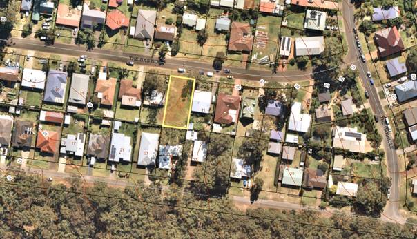
Background
Proposed Development
The proposal is for an attached two
storey dual occupancy development, each containing 3 bedrooms on the upper
level. Each dwelling has a single garage facing the street. A recessed
upper-level verandah is provided to the upper level facing the street.
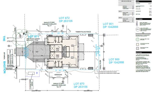
Figure 1: Site Plan
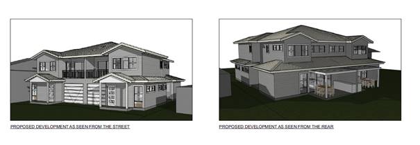
Figure 2: Front & Rear Perspectives
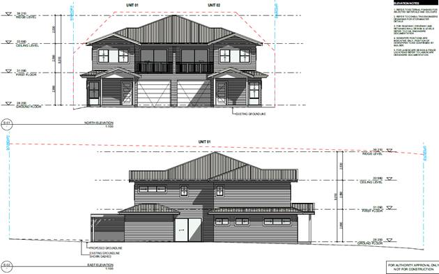
Figure 3: North & East Elevations
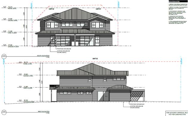
Figure 4: South & West Elevations
Subject Land
The development site is Lot 871
DP 263106, 13 The Bastion Manyana
Site & Context
The site is:
· Located on the
south side of The Bastion Manyana.
· It has an area of
665.9m2 with an 18m frontage to The Bastion with a depth of 37m,
· Zoned R2 Low
Density Residential under the Shoalhaven Local Environmental Plan 2014
(SLEP2014)
· Surrounded by low
density development which is a mix of one and two storey dwellings.
· Reasonably flat
with a slight slope from the west to east.
· Currently vacant.
· Approximately 860m
west of Manyana Beach and 2 km south from the junction of Innyada Drive and
Bendalong Road.
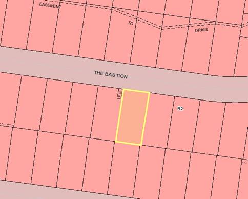
Figure 5 - Zoning Map – R2 Low Density
Residential Land
History
The following provides details on pre-lodgement
discussions, post-lodgement actions and general site history for context:
§ No informal enquiries or formal pre lodgement
discussions were held prior to lodgement.
§ The application was lodged on 9 March 2022.
§ The application was referred for technical comment on
21 March 2022.
§ No further information was requested from the
applicant.
Planning Assessment
The Development Application has
been assessed under s4.15 of the Environmental Planning and Assessment Act
1979. (Attachment 1.)
The proposed application has been assessed against the
relevant planning instruments and have been found to be satisfactory
Consultation and Community Engagement:
Thirty-one (31) public submissions were received in relation
to Council’s notification of the development. Thirty (30) were
objections to the development including two (2) submissions from the same
objectors and two (2) from Red Head Village Association. One (1) was in
support of the development. Notification was made in accordance with
Council’s Community Consultation Policy with letters being sent within a
twenty-five metre (25m) buffer of the site. The notification
was for a two (2) week period.
Key issues raised as a result of the notification are
provided below.
Issue
That the proposed development would be used for holiday
letting for a large number of people which impacts on the amenity of the
neighbourhood
Comment
The
potential for holiday letting is not a town planning consideration for a dual
occupancy application.
Holiday
letting is exempt development in dwellings, including dual occupancy dwellings,
under SEPP (Housing) 2021 – Short Term Accommodation which applies to the
entire State.
Issue
The proposal is of a bulk and scale that is inconsistent
with the surrounding coastal character of the area.
Comment
To
assist in controlling bulk and scale, Council has certain controls for development.
Council
has adopted a Floor Space Ratio (FSR) for this type of development. A FSR
is a control used to define or control the size of a building and intensity of
development on a parcel of land. The Council has adopted (in its
Development Control Plan (DCP) Chapter G13 - Medium Density and Other
Residential Development) 0.5:1 for sites less than 1,000m2 in
area. The development complies with the FSR control.
An
8.5m height limit (Shoalhaven Local Environmental Plan 2014) applies to
the site. The development complies with the height, being 8.1m.
With
regard to compatibility with existing development, some guidance can be taken
from Land and Environment Court principles. The relevant principle is “compatibility
with context” in Project Venture Developments V Pittwater Council
[2005] NSWLEC 191. In order to test whether a proposal is compatible with
its context, the following two questions can be asked:
i. Are the
proposal’s physical impacts on surrounding development acceptable? The
physical impacts include constraints on the development potential of
surrounding sites.
The physical impacts on surrounding
development have been assessed against the relevant provisions in Shoalhaven
Development Control Plan 2014 (DCP) and found to be compliant. The impacts on
surrounding amenity, solar access and streetscape character are considered
acceptable.
ii. Is the
proposal’s appearance in harmony with the buildings around it and the
character of the street?
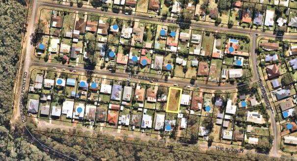
Figure 6 – Subject site (Yellow border) Two
storey construction (blue dots)
It is considered that the proposed two storey modern design
is in harmony with surrounding development and is consistent with the character
of the existing streetscape, which is a mix of one and two storey
dwellings, which also use similar pitched roofs. Although the street
predominantly has single storey dwellings, there are (10) two storey dwellings
in The Bastion.
The proposed dual occupancy complies with the DCP building envelope, setbacks and FSR requirements.
The design is sympathetic to the eclectic mix of one and two storey dwellings
in the street.
Issue
Increasing the density of the area considering the recent
bushfires by putting further responsibility on the neighbourhood and evacuation
during bushfires, especially if it is used for holiday makers.
Comment
Dual occupancy development is permissible in the R2 zone
under SLEP2014.
The lot is mapped as bushfire prone. A bushfire report from
a Bpad qualified bushfire consultant was provided with the application and an
assessment in accordance with Planning for Bushfire Protection 2019 (PBP2019)
made. The assessment is satisfactory. The construction of the
building must comply with a “Bushfire Attack Level (BAL) 12.5.
The application is for an attached dual occupancy. The
occupancy of the building whether owner occupier, long term or short-term
rental is not a planning consideration.
Issue
Allowing a dual occupancy development will set a
precedent for more dual occupancies in the area.
Comment
Dual occupancy development is a legally permissible use
under the current planning instrument and under 2(a1) zoning of the former Shoalhaven
Local Environmental Plan 1985. The development of more dual
occupancies will be contingent on land availability and the aspirations of
owners as well as any market considerations.
Issue
Dual occupancy development is not consistent with the
objectives of the R2 Low Density Residential zone which has as one of the
objectives ‘to provide an environment primarily for detached housing and
to ensure that other development is compatible with that environment’.
Comment
Detached and attached dual occupancies are a mandated land
use type in the R2 Low Density Residential zone. The objective of the R2 Zone
states:
• To provide for the housing needs of the
community within a low density residential environment.
• To enable other land uses that provide
facilities or services to meet the day to day needs of residents.
• To provide an environment primarily for
detached housing and to ensure that other development is compatible with that
environment.
The objective says primarily for detached housing and not
entirely. The attached dual occupancy is of a compatible bulk and scale to
other two storey development in the area and complies with DCP requirements for
bulk and scale, FSR, solar access and setbacks.
Issue
The adjoining neighbours have raised concerns regarding
solar access and privacy impacts to their properties.
Comment
The applicant has provided shadow diagrams that indicate
that the neighbouring properties will receive a minimum 3 hours sunlight
between 9am and 3pm on 21 June which complies with the DCP and the Planning
Principle of the Land and Environment Court for sunlight access. The main
living areas and private open space are on the ground floor and fencing between
properties will provide privacy to neighbours, which is compliant with the DCP.
There is a small sitting room which adjoins the front balcony and overlooks the
street frontage not any neighbouring dwellings.
Issue
Potential for dual occupancy development to increase the
demand on local infrastructure.
Comment
The existing infrastructure is considered adequate for the
proposed dual occupancy development which is a permissible use in the zone.
Issue
Noise from holiday makers
using the dwellings
Comment
Whether the proposed
dwellings are used for holiday letting, or the tenancy arrangements of the
development generally, is not a planning consideration.
Issue
Inadequate car parking and increased traffic will impact
on the surrounding amenity.
Comment
The application provides
for two car parking spaces on site for each dwelling which complies with the
DCP requirements. The traffic generated from two dwellings will not have a
significant impact on the surrounding road network.
Issue
No adaptable unit has been provided.
Comment
In accordance with the
DCP, adaptable units are not required in a dual occupancy
development. This provision applies where 3 or more dwellings are
proposed.
Issue
The proposal will impact on property values.
Comment
The potential for impacts
on property values is not a consideration for the development application under
section 4.15. Property values are determined by a number of factors such
as overall location, quality and age of buildings, proximity to services etc.
Issue
Trees have been cleared from the property.
Comment
The land is zoned R2, it
is possible that the trees were removed in accordance with Council’s DCP
Chapter 4 exemption policy which allows removal of trees where a tree is closer
than its own height from an approved building – these being the
neighbouring dwellings to the east and west.
Issue
The ability to subdivide duplexes is effectively
abandoning the minimum allotment control for the whole of Manyana.
Comment
The current application
before council does not seek any subdivision.
It is however logical to
permit development such as a dual occupancy or other housing types and allow
for them to be subdivided to create land title for people to buy those homes.
Issue
That the survey ground level heights on the neighbouring
dwelling are incorrect. As the RL is 29 and not 30.3 which is misleading.
Comment
The 30.3 reference is the
level of the gutter of the dwelling not the ground level.
Financial Implications:
There are potential cost
implications for Council in the event of a refusal of the application/s. Such
costs would be associated with defending an appeal/s in the Land and
Environment Court of NSW.
Legal Implications
A section 8.2 review and / or an
appeal with the Land and Environment Court are possible if the application is
refused.
Summary and Conclusion
The proposed development has satisfied
the provisions of SLEP 2014, and the overall objectives and provisions
contained within Shoalhaven Development Control Plan (SDCP) 2014.
This application has been
assessed and found to be satisfactory. There are no planning reasons
which warrant refusal of this development.
The application for the attached
dual occupancy development is compliant with the relevant planning instruments
and controls and is therefore recommended for determination by way of approval
subject to conditions outlined in Attachment 2 of the draft determination.
|

|
Ordinary Meeting
– 06 June 2022
Page
0
|
CL22.254 Pump
Track Investigations - Potential Sites and Way Forward
HPERM Ref: D22/191767
Department: Community
Planning & Projects
Approver: Kevin
Norwood, Manager - Shoalhaven Swim Sport Fitness
Attachments: 1. Photographs
- Existing BMX Circuits and Pump Tracks in the Shoalhaven (under separate
cover) ⇨
2. Sussex
Inlet Pump Track - Desktop Site Investigations and Analysis ⇩
3. Bomaderry
Pump Track - Desktop Site Investigations and Analysis ⇩
4. Sanctuary Point Pump Track -
Desktop Site Investigations and Analysis ⇩
Reason for Report
To update Council on outcomes of
preliminary investigations and to determine a way forward for proposed pump
tracks at:
· Sussex
Inlet (MIN21.536)
· Bomaderry
(MIN21.580)
· Sanctuary
Point (MIN21.805)
|
Recommendation
That
Council:
1. Receive this report as an update on:
a. Site criteria for provision of pump
tracks in Shoalhaven
b. Locations and condition of existing
BMX circuits and pump tracks in Shoalhaven
2. Recognise that proposed pump tracks
at Sussex Inlet, Bomaderry and Sanctuary Point are currently unfunded
projects.
3. Endorse the following Council owned
/ managed reserves as shortlisted sites for future investigation for the
proposed Sussex Inlet pump track:
a. Thomson Street Sporting Complex
b. Crown
Reserve R69668
4. Endorse Edwards Avenue Reserve,
Bomaderry for future investigation as a potential suitable site for the
proposed Bomaderry pump track
5. Endorse the following Community Land
as shortlisted sites for future investigation for the proposed pump track at
Sanctuary Point:
a. Sanctuary Point Public Reserve
b. Sanctuary Point Road Reserve
c. Yellow Bellied Glider Reserve
6. Further investigate potential for
the shortlisted sites through community consultation at such a time at which
the pump track projects can be allocated into the Community Planning and
Projects Work Plan to:
a. Determine community support
b. Determine desired location
c. Determine potential funding options
for the proposed pump tracks
7. Receive further reports on
consultation outcomes, preferred sites, budget required and potential funding
sources to plan and deliver the proposed pump tracks at Sussex Inlet,
Bomaderry and Sanctuary Point.
|
Options
1. Adopt the recommendation
as written.
Implications: This is in accordance with
Council’s resolutions (MIN.21.536, MIN21.580 and MIN21.805) as it
identifies a number of suitable locations for proposed pump tracks in Sussex
Inlet, Bomaderry and Sanctuary Point to present for community feedback. It
allows Council to receive a further progress report at conclusion of community
consultation and to identify required budget and potential sources of funding.
2. Adopt an
alternate recommendation.
Implications: Council to provide direction on
further actions and responsibilities in relation to the proposed pump tracks in
Sussex Inlet, Bomaderry and Sanctuary Point.
Background
Council’s Provision of Local Area BMX Circuits Policy
(POL16/109) provides criteria and guidelines to identify the need and provision
of Bicycle Motocross (BMX) circuits to ensure that unauthorised bike
initiatives, such as mounds or trails, do not cause conflict with users of
public reserves. The identified purpose of Council’s Provision of Local
Area BMX Circuits Policy is:
“To define Council’s requirements for
the provision of a Local Area BMX Circuit.”
In 2021, a number of Notices of Motion (NoMs) were presented
to Council in relation to investigations for pump tracks in Sussex Inlet,
Bomaderry and Sanctuary Point localities.
Sussex Inlet
At Council’s Strategy and Assets Committee Meeting in
July 2021, a Notice of Motion was reported to Council, where the following was
adopted (MIN21.536):
That Council:
1. In
consultation with the community, take action to identify a suitable location
for a pump track at Sussex Inlet.
2. Apply
for grant funding to fund the project.
3. Include
the project in a future Operational Plan.
Bomaderry
At Council’s Ordinary Meeting in August 2021 MIN21.580
was adopted:
That
Council:
1. Work
with Bomaderry Inc, Bomaderry CCB, Pride of Bomaderry, sporting clubs and other
interested parties to identify the most suitable location in the Bomaderry area
for the establishment of a pump track.
2. Add
the Bomaderry Pump Track to its list of unfunded projects and look for future
funding opportunities to progress the project.
Sanctuary Point
At Council’s Ordinary Meeting in November 2021 MIN21.805
was adopted:
That Council produce a scoping
study and estimate of costs to design and construct, in collaboration with the
community, a BMX Pump Track on Community Land at a location to be determined
through community consultation (such as Clifton Park Sanctuary Point adjacent
to the existing learn-to-ride bicycle track). On completion of this phase,
sources of funding would need to be identified.
Defining BMX Circuits and Pump
Tracks
BMX circuits and pump tracks have similar qualities and
provide a similar experience yet contain district features. Currently, the
provision of both of these types of infrastructure is under Council’s Provision
of Local Area BMX Circuits Policy with no distinction or acknowledgement
between the two track types.
BMX circuits, historically, have a
definitive start and finish, with the starting point generally on a high raised
mound which drops into the main track, then requires the rider to pedal to
reach the end point. Generally, various types of dirt jumps, rollers and large
‘bermed’ turns (corners) are provided for the rider to navigate
prior to finishing the track as illustrated in Figure 1.
Pump tracks, however, are
circuitous and made into a loop with riders of the track gaining and
maintaining momentum by “pumping” with whole body movements rather
than pedalling. The features of a pump track are more consistent with rollers
and ‘berms’ which can be ridden with minimal pedalling as
illustrated in Figure 2.
Provision of Local Area BMX
Circuits Policy has, historically, been successful in defining the role of
Council and community in providing BMX circuits on public land. The more recent
works, to upgrade Kangaroo Valley BMX Circuit to a sealed pump track and new
pump track at Shoalhaven Heads, were not subject to consideration of all
aspects of the Policy. With BMX circuits and pump tracks being similar
infrastructure, some criteria from the Policy can be applied to ensure
environmental aspects are considered and community expectations are met.
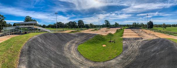
Figure 1 BMX Track (Source: Bike Tracks
Australia)
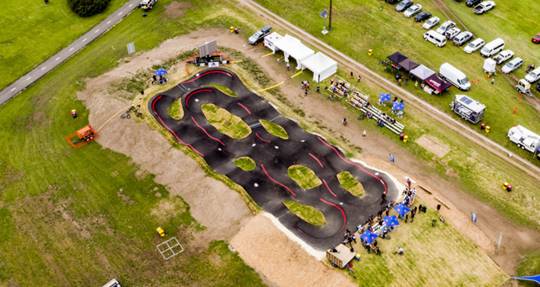
Figure 2 Pump Track (Source: Velosolutions)
Existing BMX Circuits and Pump Tracks
Council staff from Community
Planning and Projects undertook desktop investigations and site visits of
existing BMX circuits and pump tracks within Shoalhaven.
There are ten (10) known
existing BMX circuits and pump tracks within Shoalhaven, illustrated in Figure
3, which are located on land under multiple ownership and management,
including:
· Crown
Land
· Council–owned
land
· NSW
State Forest
A pump track is being delivered
as Stage 2 of Boongaree (previously Berry District Park), with construction to
commence on 6 June 2022, and the works anticipated to be completed by the end
of the year. Additionally, a pump track is included under the draft Ulladulla
Sports Park Masterplan endorsed by Council to progress to public exhibition in
May 2022.
While Council has been involved
in funding, partially or in full, and maintenance of some of the tracks within
Shoalhaven, other infrastructure has been constructed and may be maintained by
community members. At some sites, there is evidence that the infrastructure has
been upgraded and / or amended, i.e., shovels to indicate trail building, from
its initial approved form. Some of the infrastructure in Table 3 may be
considered informal due to Council not being involved in its planning or
operation.
Council staff from Community
Planning and Projects undertook site visits to provide a preliminary basic
visual condition assessment for existing BMX Circuits and Pump Tracks. A more
detailed analysis and condition assessment may be required by the Asset
Custodian or another suitably qualified staff for a comprehensive asset
assessment.
The existing BMX circuits and
pump track infrastructure have been assessed against Council’s Conditions
Rating Table – see Table 1 – with conditions assigned from a basic
visual assessment on track condition, ride-ability and maintenance required.
Photographs of these BMX
circuits and pump tracks are included in Attachment 1.
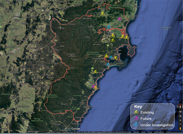
Figure 3
Locations of known BMX circuits and pump tracks in the Shoalhaven
Table 1 Conditions ratings for existing BMX tracks and pump
tracks
|
Scale
|
Condition of asset
|
|
Very
Poor Condition
|
· Structure has failed and is not operational
· Maintenance is not viable
· Unfit for purpose
· Environmental/contamination/pollution issues exist
|
|
Poor
Condition
|
· Structure is badly deteriorated
· Potential structural problems
· Inferior appearance
· Major defects
|
|
Fair
Condition
|
· Average condition
· Significant defects are evident
· Services are functional but maintenance is required
· Deferred maintenance work exists
|
|
Good
Condition
|
· Minor defects
· Superficial deterioration
· Major maintenance not required
|
|
Very
Good Condition
|
· No defects
· As new condition and appearance
|
Table 2 Overview of existing BMX circuits
and Pump Tracks on Council owned / managed land in the Shoalhaven
|
Location
|
Lot DP
|
Reserve Name
|
Approximate Reserve Area
|
Track Type
|
Approximate Track Dimensions
|
Approximate Track Size
|
Land Owner / Manager
|
Formal / Informal
|
Condition
|
|
Kangaroo Valley
|
Lot 16 DP 773481
|
Moss Vale Road Reserve
|
7,146m2
|
Sealed Pump Track
|
65m x 23m
|
1,727m2
|
Council
|
Formal
|
Very Good
|
|
Shoalhaven Heads
|
Lot 7009 DP 1002414
|
Jerry Bailey Oval
|
40,799m2
|
Sealed Pump Track
|
92m x 20m
|
1,971m2
|
Crown Lands / Council
|
Formal
|
Very Good
|
|
Worrigee
|
Lot 41 DP 807159, Lot 16 DP 806491
|
Andrew Crescent Reserve
|
7,663m2
|
Dirt BMX Circuit
|
62m x 40m
|
2,618m2
|
Council
|
Formal
|
Poor
|
|
South Nowra/ Comberton
|
N/A
|
Nowra State Forest
|
N/A
|
Dirt Pump Track
|
39m x 17m
|
480m2
|
State Forestry NSW
|
Informal
|
Good
|
|
Greenwell Point
|
Lot A DP 400413
|
Gordon Ravell Oval
|
20,300m2
|
Dirt BMX Circuit
|
48m x 22m
|
1,033m2
|
Council
|
Formal
|
Very Poor
|
|
Culburra Beach
|
Lot 1414 DP 12278
|
Curleys Bay Reserve
|
29,700m2
|
Dirt BMX Circuit
|
39m x 34m
|
1,042m2
|
Council
|
Formal
|
Poor
|
|
Erowal Bay
|
Lot 3 DP 874324
|
Pam Weiss Village Green
|
5,261m2
|
Dirt BMX Circuit
|
42m x 23m
|
1,004m2
|
Council
|
Informal
|
Fair
|
|
Fishermans Paradise
|
Lot 295 DP 26974
|
Hazel Rowbotham Reserve
|
29,900m2
|
Dirt BMX Circuit
|
47m x 27m
|
1,112m2
|
Council
|
Formal
|
Fair
|
|
Basin View
|
Lot 7020 DP 1056381
|
Malcolm Moore Reserve
|
22,403m2
|
Dirt BMX Circuit
|
73m x 60m
|
6,403m2
|
Crown Lands / Council
|
Formal
|
Good
|
|
Ulladulla
|
Lot 7020 DP 1056381
|
Parson St Reserve
|
5,258m2
|
Dirt BMX Circuit
|
62m x 42m
|
2,558m2
|
Council
|
Formal
|
Fair
|
|
|
Ordinary
Meeting – Monday 06 June 2022
Page
0
|
Proposed
Pump Track Investigations
Eligibility and Site Criteria for BMX Circuits and Pump
Tracks
Clauses 3.1 and 3.2 of the Provision
of Local Area BMX Circuits Policy (POL16/109) outline Eligibility and Site
Selection Criteria for development of a proposed local area circuit. With BMX
circuits and pump tracks being similar cycling infrastructure, some of the
below criteria from the Policy can be applied to ensure environmental aspects
are considered, and community expectations are met for the proposed pump
tracks. As such, where circuit and BMX are referenced, these should be assessed
in terms of a sealed pump track.
3.1 Eligibility
For a community to be eligible for a proposed local area
circuit, it must first meet the following criteria:
· Demonstration
of significant need by local BMX riders
· The
proposed circuit location meets the site selection criteria
· All
applications are to be considered and approved through the statutory
legislative process prior to construction
· Interested
community to create and evaluation criteria to weigh upon in successive years
· Interested
community to create a five-year activation strategy
3.2 Site Selection Criteria
Sites proposed for the development of BMX circuits must
first meet the following selection criteria:
· Council
owned / managed reserve
· Consistent
with the relevant Plan of Management for the reserve
· Relatively
flat terrain
· Circuit
size does not encroach on more than 1/3 of the reserve area
· Visual
prominence affording casual supervision
· Suitable
bike access to the reserve
· If
circuit to be located within 40.0m from a watercourse, the proposal is to be
discussed with the Department administering the Water Management Act
· Wherever
possible, to be located within the area of other recreation facilities and
amenities
· Close
to transport route and local shops
The Policy outlines that the
community is required to demonstrate eligibility prior to site selection, and
to undertake community consultation to determine support for the pump track,
along with identification of a suitable site which meets the Policy criteria.
Site Investigations
In response to the NoMs, Council
staff undertook a detailed desktop analysis of each of the Sussex Inlet,
Bomaderry and Sanctuary Point localities to identify potential sites suitable
to situate the proposed pump track, with the scope limited to Council owned or
managed Community Land.
The ability to situate a pump
track is based on estimated size and dimensions based on existing pump tracks.
The minimum dimensions required were calculated by averaging the dimensions of existing
pump tracks on Council owned or managed land as outlined in Table 2, having
dimensions of a minimum 59m x 32m and minimum area of 2,163m2.
Council-owned or managed land
was identified through Council’s GIS System and was considered against
the below criteria to identify possible sites:
1. Council owned / managed
reserve:
a. Classified as Community
Land
b. Zoned for Public
Recreation
2. Area of reserve is
minimum 6,489m2
3. Reserve contains area
of minimum 2,163m2 with:
a. Dimensions of approximately
59m x 32m
b. Relatively flat terrain
c. Generally cleared of
vegetation
Once the above criteria were
met, further assessment was undertaken in accordance with the below to result
in a shortlist of sites:
· Categorisation
of land
· Actions
identified in the Community Infrastructure Strategic Plan
· Criteria
under the Provision of Local Area BMX Circuits Policy
· Site
constraints
The identified shortlisted sites
were sent to the Asset Custodian for feedback on forward planning and
suitability for the proposed pump track for development on the sites. The
shortlisted sites are provided below for each of the Sussex Inlet, Bomaderry
and Sanctuary Point localities in order of suitability, if multiple sites were
identified.
Sussex Inlet
1. Thomson Street Sporting
Complex
2. Crown Reserve R69668
Detailed site analysis for the
proposed pump track at Sussex Inlet is included as Attachment 2.
Bomaderry
Detailed investigation –
included as Attachment 3 – provides assessment and analysis but
concludes suitability of one identified parcel of land in accordance with the
above criteria, being Edwards Avenue Reserve, Bomaderry as illustrated below in
Figure 4.
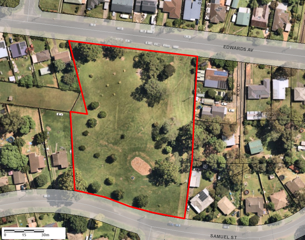
Figure 4 Edwards Avenue Reserve, Bomaderry
Sanctuary Point
1. Sanctuary Point Public
Reserve
2. Sanctuary Point Road
Reserve
3. Yellow Bellied Glider
Reserve
Detailed site analysis for the
proposed pump track at Sanctuary Point is included as Attachment 4.
Connectivity to Other Bicycle Infrastructure
Council has a Pedestrian Access & Mobility Plan (PAMP)
(D06/96520 - Stage 1 & D12/308835 – Stage 2). The Plan provides the
strategy, ranking methodology and mapping to support expansion of paths,
pedestrian crossings and bicycle infrastructure across the City. The
Plan’s purpose is to:
· Identify
priorities for pedestrians and cyclists
· Continuously
improve the network of footpaths, shared user paths and pedestrian crossings
across the City
· Assist
Council in prioritising works
· Demonstrate
an integrated approach to “active transport” planning across the
City
· Assist
Council and the community to obtain grant funding for priority improvements
Figure 5 to Figure 8 illustrate relevant excerpts from
Council’s Pedestrian Access & Mobility Plan (PAMP) showing existing
and proposed active transport networks for Sussex Inlet, Bomaderry, Sanctuary
Point and Bay & Basin localities.
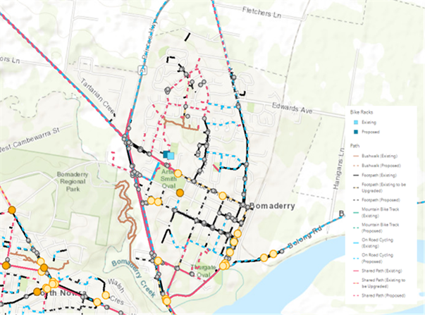
Figure 5 Bomaderry excerpt of
Council’s PAMP
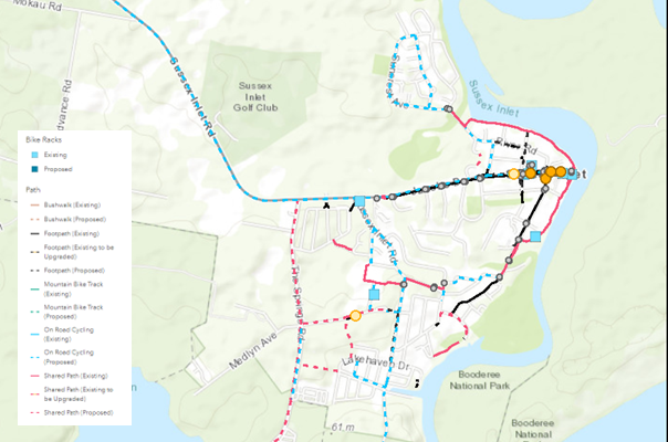
Figure 6
Sussex Inlet excerpt of Council’s PAMP
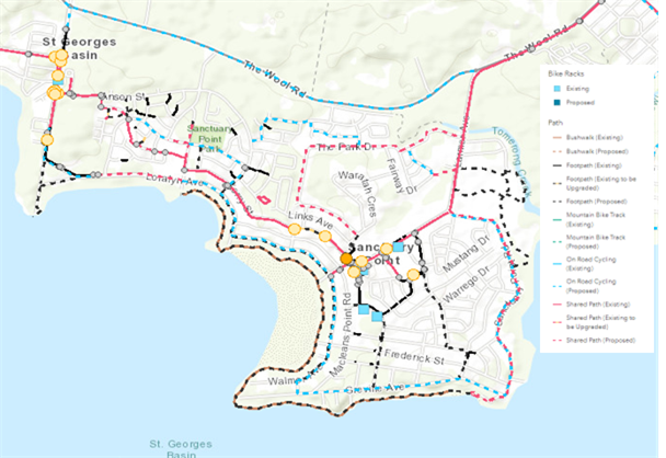
Figure 7
Sanctuary Point excerpt of Council’s PAMP
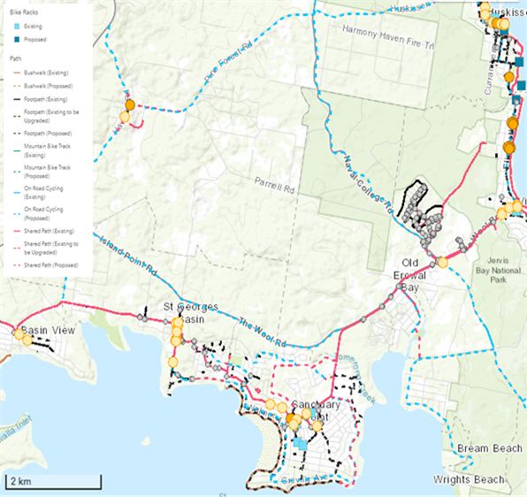
Figure 8 Bay and Basin Excerpt of Council’s
PAMP showing the Bay to Basin Shared Path / Cycleway
Council also has a Bike Plan (D16/102085), adopted in 2013,
which provides a similar purpose to the Pedestrian Access & Mobility Plan.
Mapping and projects are integrated across both documents. Although the PAMP
includes existing and proposed cycling infrastructure, it also includes all
other forms of active transport. Accordingly, the Bike Plan was prepared to
highlight the strategy for cyclists and cyclist safety specifically. It also
contains separate criteria to rank cycling initiatives.
Figure 9 to Figure 11 illustrate relevant excerpts from Council’s
Bike Plan showing existing and proposed active transport networks in the Sussex
Inlet, Bomaderry and Sanctuary Point localities.
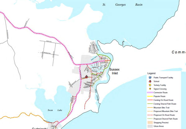
Figure 9 Excerpt of Map 016 from
Council’s Bike Plan
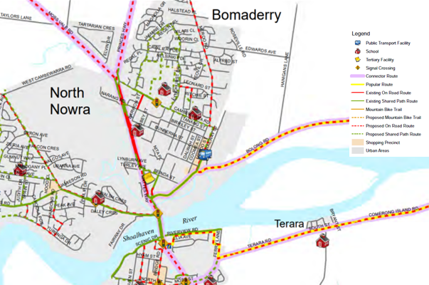
Figure 10 Excerpt of Map 007 from
Council’s Bike Plan
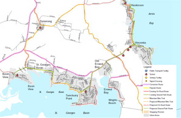
Figure 11 Excerpt of Map 014 from
Council’s Bike Plan
Community Engagement
Pending the outcome of
Council’s resolution, community engagement will be undertaken in
accordance with Council’s Community Engagement Policy.
Varying forms of engagement will
be undertaken with key internal / external stakeholders and the Sussex Inlet, Bomaderry
and Sanctuary Point communities in order to gather feedback which will inform
each proposed pump track.
Cycling Groups
Council is aware that a number
of community-led cycling clubs operate within the Shoalhaven, with a number of
self-maintained, off-road cycling trail networks. Thorough engagement with
these groups will occur to ensure any future proposed cycling infrastructure is
integrated with, and complements, existing networks. Key groups identified
include, but are not limited to:
· Milton
Ulladulla Mountain Bikers
· Nowra
Velo Club
· Shoalhaven
Bicycle User Group
· South
Coast United Mountain Bikers (SCUM)
Next Steps
Pending Council’s resolution, the next steps for these
proposed pump tracks will be to commence community engagement as covered above
to identify community support and the preferred sites. Figure 10 below provides
a flow chart for the proposed pump tracks’ overall process.
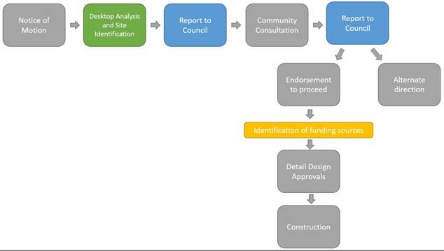
Figure 10 Flow chart of overall process
Policy Implications
Provision of Local Area BMX Circuits Policy (POL16/109)
The Policy was last reviewed in 2017, and is due for review
before end of 2022, in line with NSW Local Government Election requirements.
Subsequent to the Policy’s last review, a number of
strategic plans have been developed in response to an increase in cycling and
mountain biking. NSW Government and Regional Strategies have been developed in
response to the increased demand for cycling experiences and desire for more
authorised cycling experiences, particularly off-road biking. A strategic
approach should be adopted in the delivery of cycling infrastructure within
Shoalhaven, inclusive of robust community consultation to ensure connectivity
of existing and future cycling infrastructure.
Community Infrastructure Strategic Plan Review
Council’s CISP is the overarching strategic document
to guide Council’s social and infrastructure planning. Council staff will
shortly commence a thorough review of the CISP, involving the strategic review
of all community and social infrastructure, including all recreational and park
land within Shoalhaven.
Current community use and future needs for open space will be
further investigated during community consultation for the CISP Review, which
can be incorporated in the strategic development of a considered approach and
an integrated infrastructure program.
Provision and potential update of existing / new BMX circuits
and pump tracks, including their definition and classification, will be
considered under the CISP review.
Financial Implications
Investigations on the proposed pump tracks to date have been
‘desktop’ based and funded through the City Lifestyles staff
budget.
The pump track being delivered
as Stage 2 of Boongaree (previously Berry District Park) has been funded and is
due to commence construction in June 2022. The pump track included as part of
the draft Ulladulla Sports Park Masterplan has been endorsed by Council to
progress to public exhibition in May 2022, with no funding yet identified for
detail design and delivery of individual features.
Council does not currently have an identified budget to plan,
build or maintain the proposed pump tracks at Sussex Inlet, Bomaderry or
Sanctuary Point. In addition, each project is in the initial planning stage and
estimated costs of construction cannot yet be determined.
Should Council determine to undertake further and more
detailed investigations once the preferred sites have been determined, and the
scope clarified, funding will be required to progress this with development of
preliminary concept designs. Further funding would be required, should Council
determine to progress this project to a ‘shovel-ready’ /
construction-ready detailed design.
Approximate costings for detailed design for a pump track is
$9,000 to $25,000, inclusive of specialist documentation, with construction
between approximately $300,000 to $500,000 dependent on track size and features
and materials used. Costings for the pump track may be reduced if pump track
project is community-led, or a combination of the below funding streams are
utilised:
· Council
funding;
· Funding
or works in-kind, obtained or delivered by community groups; and/or
· Grant
funding.
Risk Implications
Council has a responsibility to
ensure that public space under its care, control and management continues to be
operational and developed in a sustainable manner to provide for current /
future community needs.
The identified sites would
require further technical investigations to determine site suitability for
location of the pump track. Increased outdoor recreation, greater numbers of
cyclists and mountain bikers has resulted in informal trail-building and
unauthorised jumps on Council land. Planning and delivery of formal cycling
infrastructure with community collaboration allows enhancement of outdoor
recreation in the Shoalhaven and mitigates additional unauthorised / unsafe
infrastructure.
Council policies and plans must
be in line with the relevant legislation, in particular, the Crown Lands
Management Act 2016 and the relevant Plan of Management for its category, which
governs care and management of Crown Land under Council control.
|
|
Ordinary
Meeting – Monday 06 June 2022
Page
0
|
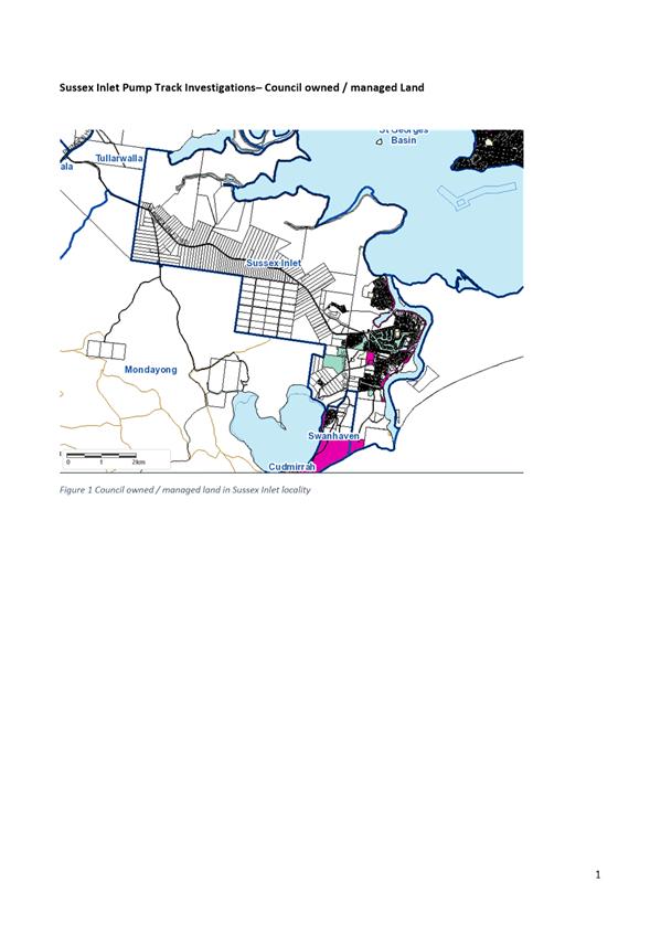
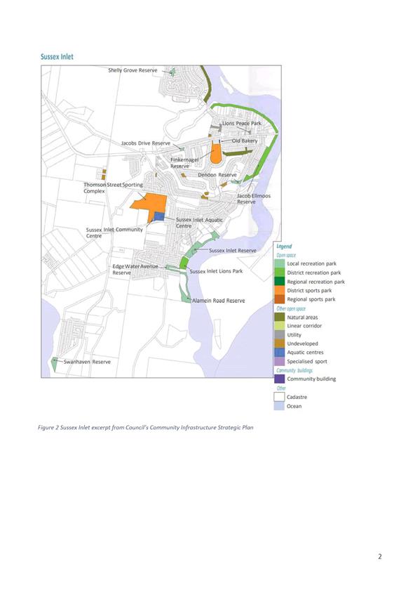
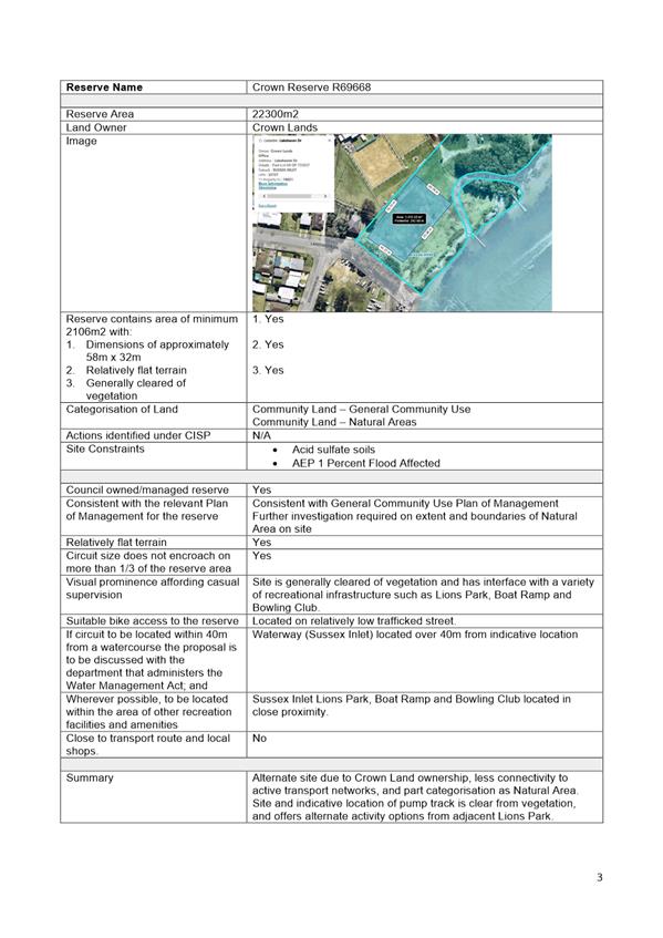
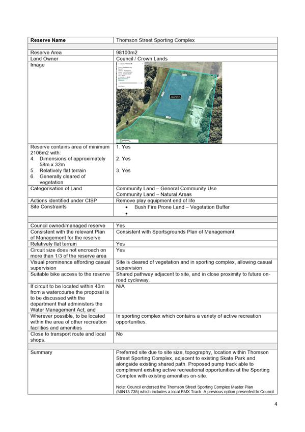

|

|
Ordinary
Meeting – Monday 06 June 2022
Page
0
|
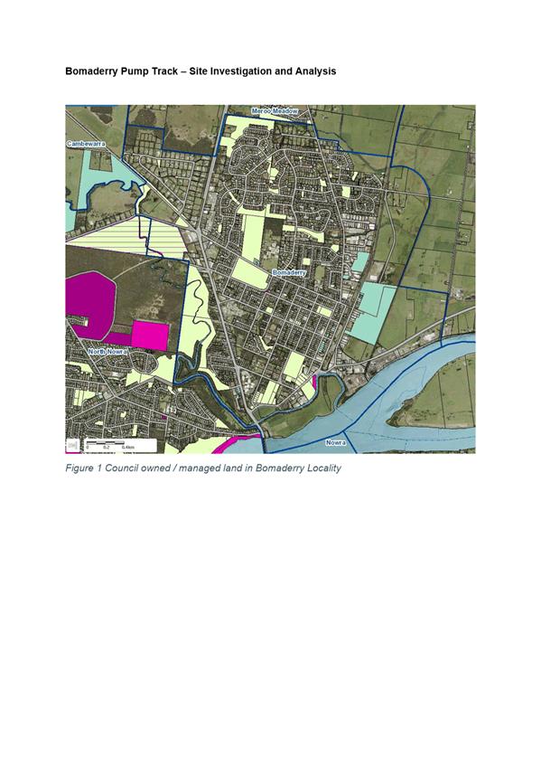
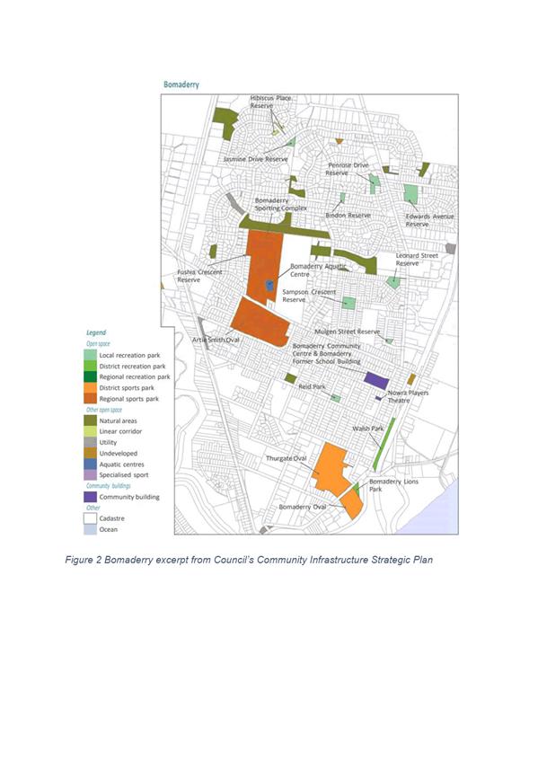
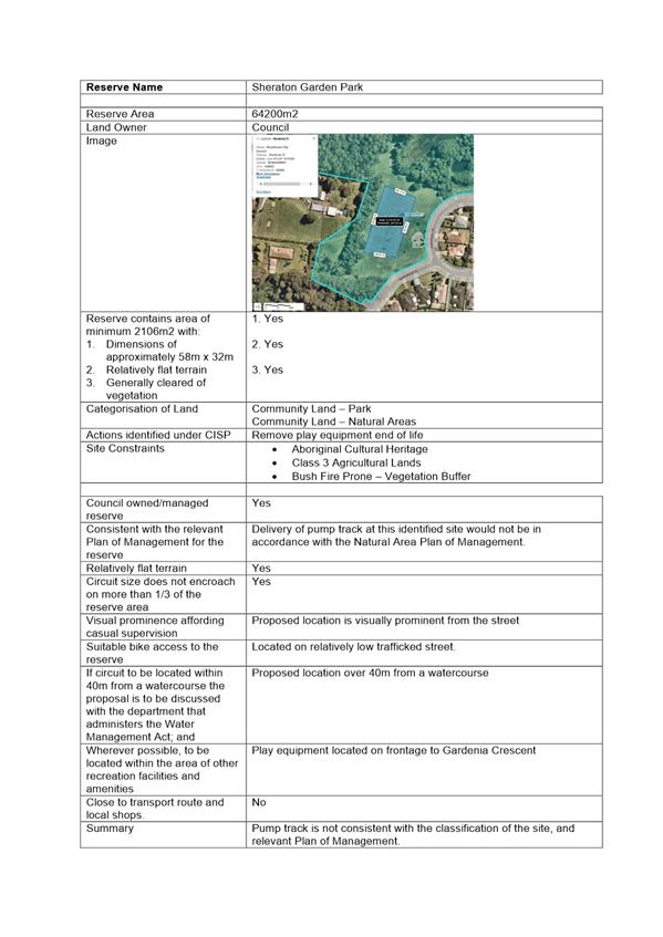
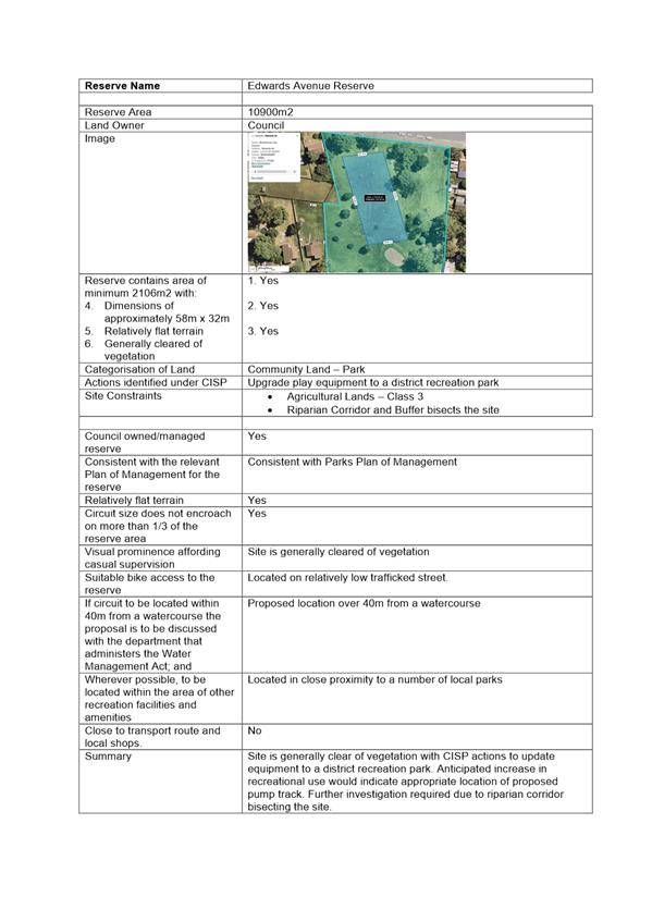
|
|
Ordinary
Meeting – Monday 06 June 2022
Page
0
|
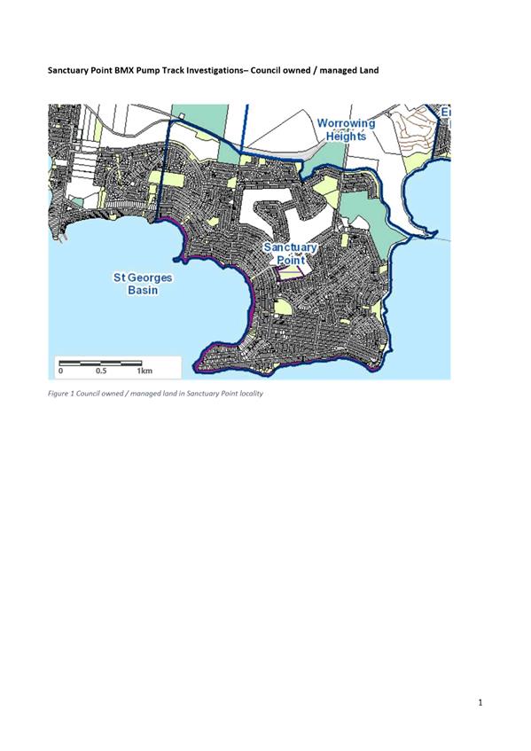
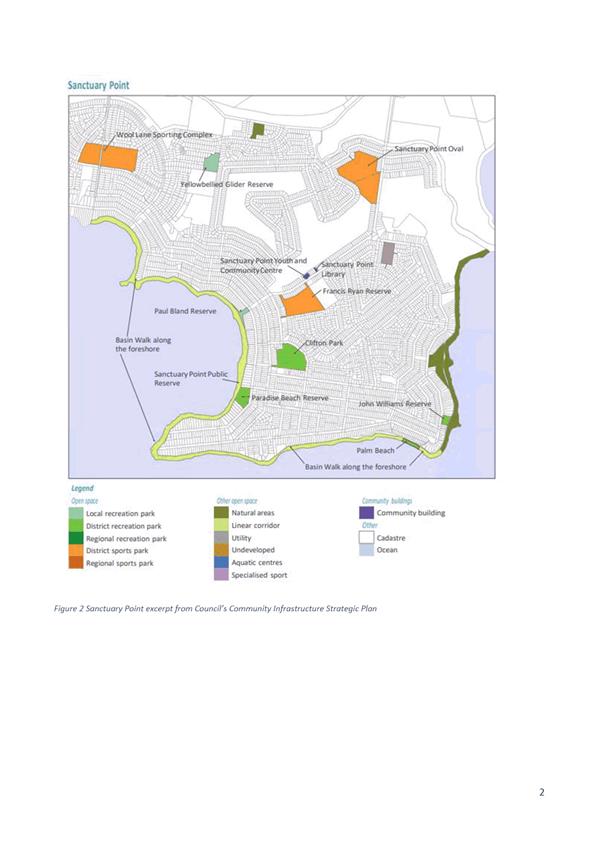
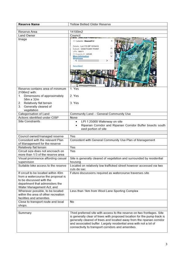

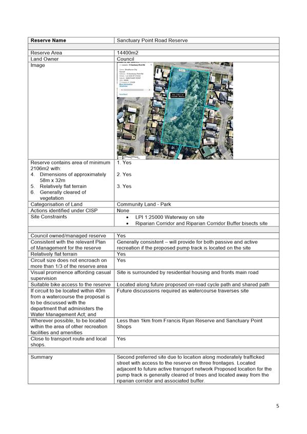
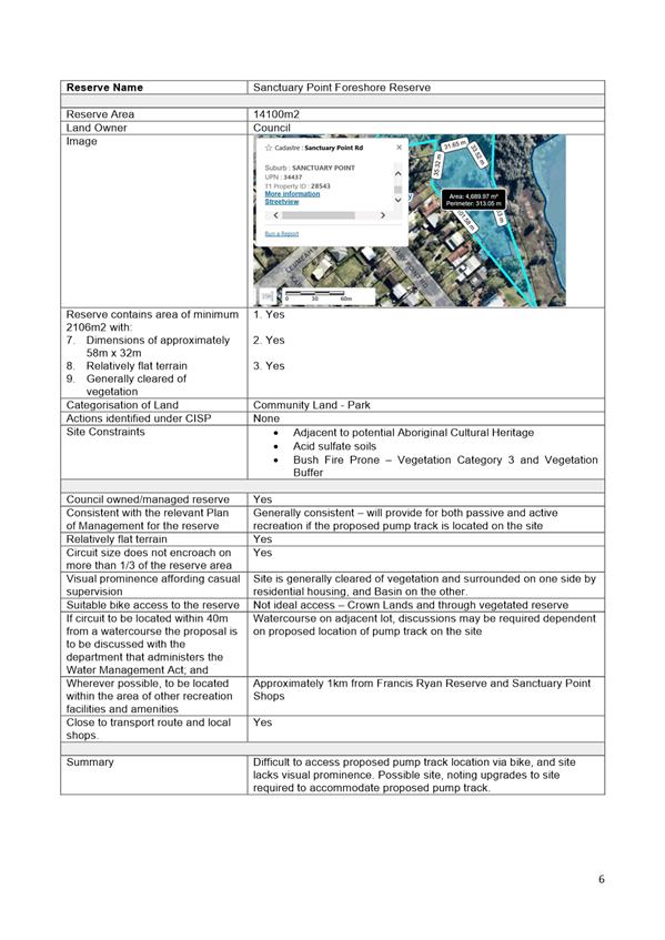
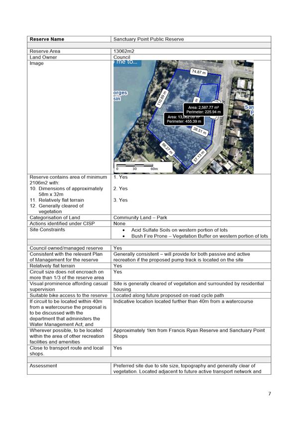

|
|
Ordinary
Meeting – Monday 06 June 2022
Page
0
|
CL22.255 National
Performance Reporting Score Card
HPERM Ref: D22/213478
Department: Water
Business Services
Approver: Andrew
McVey, Section Manager - Water Operations & Maintenance
Attachments: 1. National
Performance Reporting - Action Plan ⇩
Reason for Report
The purpose of this Report is to
inform Council of the performance outcomes for Shoalhaven Water following the
National Performance Report (NPR) 2020-21 for Urban Water Utilities. The NPR is
a comprehensive “report card” released in March 2022 covering the
reporting period of 1 July 2020 - 30 June 2021. The Report provides
benchmarking data against other Water Authorities/Utilities across Australia.
|
Recommendation
That Council
receive the Australian Government Bureau of Meteorology National Performance
Report 2020-21 for Urban Water Utilities for information.
|
Options
1. As Recommended
2. Council could seek additional
information on any of the indicator results.
Background
The NPR 2020-21 for Urban Water
Utilities produced by the Australian Bureau of Meteorology (BOM) benchmarks the
performance of 86 urban water service providers, comprising 81 Water Utilities
and five bulk water suppliers, against 166 indicators covering water resources,
pricing, environment, finance, assets, health, and customer service. These
indicators are calculated through the annual collection and submission of over
1,100 pieces of data.
Performance monitoring and
benchmarking of Council’s Water Supply and Sewerage businesses is
required under the terms of the National Water Initiative (NWI) and is
facilitated by the BOM. The BOM specifies the criteria by which Water Utilities
are monitored and the results are tabled publicly each year.
There are 166 indicators that
form the full set of performance indicators. This Report provides a summary of
key indicators. The full Report can be accessed through the BOM website http://www.bom.gov.au/water/npr/.
For the purpose of NPR, the
contributing utilities are grouped by the number of connected properties. The
utility groups used are:
|
Group
|
Number of Connected Properties
|
|
Major
|
100,000+
|
|
Large
|
50,000 to 100,000
|
|
Medium
|
20,000 to 50,000
|
|
Small
|
10,000 to 20,000
|
Shoalhaven Water under the
methodology set out in the NPR, has 50,200 connected properties. Shoalhaven
Water are therefore assessed in the Large Group. This is the first year
Shoalhaven Water has moved into the Large Group and is the only NSW based Water
Utility in this Group.
This Report is provided to
Council following analysis of the results and as a summary of key indicators of
interest for Shoalhaven Water performance against that of the 13 comparative
sized utilities in the Large Group. This report has also provided a comparison
with other neighbouring Local Water Utilities on the Typical Residential Bill.
Local Water Utilities
Included in the Large Group Category:
Shoalhaven City Council
Coliban Region Water Corporation
Central Gippsland Region Water
Corporation
North East Region Water
Corporation
Goulburn Valley Region Water
Corporation
Central Highlands Water
Toowoomba Regional Council
Redland City Council
Western Region Water Corporation
Water Corporation - Mandurah
Townsville City Council
Cairns Regional Council
Power and Water Corporation – Darwin
A selection of the 166 indicators have been detailed to show
Shoalhaven Water’s performance which have been collated into four key
sections. Each table includes Shoalhaven Water’s result, how the result
ranks within the Large Group and the average score of the Group.
Section 1- Size and Scale of Infrastructure
|
Indicator
|
Shoalhaven Water
|
Ranking in group
|
Group average
|
|
Number
of water treatment plants providing full treatment (plants)
|
4
|
4th
|
9.9
|
|
Number
of wastewater treatment plants (plants)
|
13
|
8th
|
11.6
|
|
Length
of Water Mains (km)
|
1,587
|
4th
|
1,929
|
|
Length
of sewer Mains
|
1,251
|
4th
|
1,363
|
|
Number
of properties served per km of water main (properties/km)
|
32
|
12th
|
36.4
|
|
Number
of properties served per km of sewer main (properties/km)
|
34
|
13th
|
45.48
|
These indicators demonstrate the
number of Council’s water and wastewater plants and the kilometres of
main required to service the community across the wide geographic area of the
Shoalhaven. The low number of properties that are serviced per kilometre for
both water and sewer mains, highlights the constraint faced when apportioning
the cost of maintaining and operating this infrastructure. Shoalhaven Water
ranked 12th and 13th respectively for properties served
per kilometre of water and wastewater main, the lowest and second lowest number
in the group.
Section 2 – Asset Performance
|
Indicator
|
Shoalhaven Water
|
Ranking in group
|
Group average
|
|
Number
of water main breaks, bursts, and leaks, per 100 km of water mains (mains
breaks/100 km)
|
6.5
|
3rd
|
13
|
|
Number
of sewer mains breaks and chokes per 100 km (breaks and chokes/100 km)
|
3
|
2nd
|
15.3
|
|
Number
of property connection sewer breaks and chokes per 1,000 properties (breaks
and chokes/1,000 properties)
|
2.2
|
6th
|
2.9
|
|
Number
of unplanned interruptions per 1,000 properties: water supply
(interruptions/1,000 properties)
|
38
|
4th
|
81.5
|
A targeted program of works to
replace high risk pipelines has been progressing over the past few years and it
is expected the results will further improve over time. The success of
Council’s ongoing investment, based on a risk management and risk
mitigation approach to maintain the water and wastewater network, underpins Shoalhaven
Water’s performance in all of the above indicators.
Importantly, it is recognised
that whilst Shoalhaven Water’s performance continues to be strong, the
continued reinvestment in assets is required to maintain this level of
performance and further improvement. A maturity assessment of Council’s
asset management was conducted at the end of 2021. Work has begun on the
implementation of the recommendations identified by this assessment, to further
strengthen the asset management and operations of Council’s infrastructure.
Section 3 – Customer Service
|
Indicator
|
Shoalhaven Water
|
Ranking in group
|
Group average
|
|
Number
of water service complaints per 1,000 properties (complaints/1,000
properties)
|
0.2
|
5th
|
4.6
|
|
Number
of sewerage service complaints per 1,000 properties (complaints/1,000
properties)
|
0.1
|
4th
|
0.5
|
|
Average
duration of an unplanned interruption: water supply (minutes)
|
74
|
4th
|
94.4
|
Shoalhaven Water has a strong
customer focus with systems well established to identify problems early within
the network, through a telemetry monitoring system. Shoalhaven Water have
built effective and efficient workflows to quickly respond when customers
identify interruptions in the water and sewer network.
Currently, Shoalhaven Water is
supporting the Council wide project to implement a Request Management System.
The project will provide a centralised system for customers to advise when they
find a problem, utilising a number of communication channels including the
Customer Experience team and self-service options through the Shoalhaven Water
website.
This project will continue to
capture and manage complaints to respond efficiently to further reduce
both the number and length of time of unplanned interruptions to
Council’s networks.
Section 4 – Customer
Cost of Service and Customer Usage of Services
|
Indicator
|
Shoalhaven Water
|
Ranking in group out of 13
|
Group average
|
|
Fixed
charge: water supply ($)
|
83.00
|
1st
|
299.60
|
|
Usage
charge: step 1 ($/kL)
|
1.75
|
4th
|
2.94
|
|
Annual
residential bill based on 200 kL per annum: water supply ($)
|
433.00
|
2nd
|
688.58
|
|
Annual
residential bill based on 200 kL per annum: wastewater ($)
|
876.00
|
12th
|
690.68
|
|
Total
typical residential bill: water supply and wastewater ($)
|
1,231
|
5th
|
1,370.92
|
|
Average
volume of residential water supplied per property (KL/property)
|
155
|
3rd
|
215
|
|
Average
volume of wastewater collected per property (KL/property)
|
277
|
11th
|
242
|
The Shoalhaven is fortunate to
have access to high quality raw water, coupled with the low volume of water
supplied on average to residential customers, the cost of water to customers is
comparably low. The complexity of managing wastewater across Council’s
geographically dispersed population, sensitive environments and the high volume
of average wastewater collected per property, all contribute to the higher
wastewater costs.
The investment in significant
wastewater treatment plants, particularly the Nowra Treatment Plant and
Reclaimed Water Management Scheme (REMS) has provided increased capacity in the
wastewater schemes to cater for current and future forecasted population growth
in the Shoalhaven.
Comparison with Neighbouring Local Water Utilities
|
Indicator
|
Total Typical residential Bill
|
|
Shoalhaven Water
|
$1,231
|
|
Sydney Water Corporation
|
$1,022
|
|
Goulburn Mulwaree Council
|
$1,362
|
|
Wingecarribee Shire Council
|
$1,376
|
|
Eurobodalla Shire Council
|
$1,770
|
|
Bega Shire Council
|
$1,952
|
A summary action plan is
attached to this report that identifies key actions planned for the next two
years to support the ongoing performance of Shoalhaven Water in the National
Performance Reporting.
The long-term financial planning
will continue to balance the cost to Shoalhaven customers and the revenue
required to fund the asset management planning and ongoing operational
costs. The fees and charges proposed for the 2022-23 financial year have
an increase in water usage charges but has maintained the fixed charge. This
pricing methodology is in line with the Best Practice Management of Water
Supply and Sewerage with most of the revenue collected through water usage.
This continues to encourage residents to be conservative with their water
consumption.
Dividend Paid
On the 26 April 2022 Council
adopted to approve the payment of a dividend from the 2020-21 financial year
from both the Water and Sewer funds. The NPR data reveals that Shoalhaven Water
was one of only four Local Water Utilities out of the thirteen in the large
group to pay a dividend for the 2020-21 year. A review of the neighbouring
Local Council areas, confirmed that only Eurobodalla Shire Council paid a
divided in this reporting period.
Review of Indicators
It should be noted that a review
of the performance indicators set out in the NPR has been underway since
October 2020. The outcome of the review is anticipated to establish a suite of
indicators and themes that are relevant to the current urban water sector and
adaptable to changes in the sector in the future. The publication of the new
NPR indicators and definitions handbook was anticipated to be released in March
2022, at the time of this Report, this has not been released. The indicators
will take effect for the reporting period starting 1 July 2022. Once released,
the collection of data required to meet the new NPR indicators will be reviewed
to ensure systems are updated for future reporting.
Community Engagement
A copy of the full BOM
performance report in a similar format is available from the BOM website. A full dataset of the
results from the 166 indicators are also available.
A summary along with links of
Shoalhaven’s performance have been promulgated for customers on the
Shoalhaven Water website and segments will be contained within the Customer
Service Plan for benchmarking against the targets specified in that strategic
document. An update of the Customer Service Plan can be found at the Shoalhaven
Water website.
Full analysis of the entire
suite of indicators is being undertaken to address any issues including future
considerations for inclusion into the Shoalhaven Water Strategic Business Plan.
Financial Implications
There are no financial
implications for Council resulting from this report that have not been
addressed separately.
|

|
Ordinary
Meeting – Monday 06 June 2022
Page
0
|
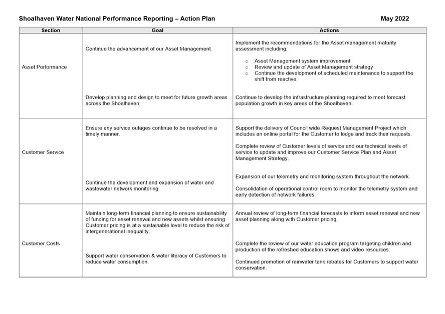
|

|
Ordinary Meeting
– Monday 06 June 2022
Page
0
|
CL22.256 Notice
of Motion - Community Safety in Nowra CBD
HPERM Ref: D22/225503
Submitted
by: Clr Paul Ell
Clr Serena
Copley
Purpose / Summary
The following Notice of Motion,
of which due notice has been given, is submitted for Council’s
consideration.
|
Recommendation
That
Council:
1. Directs the CEO to investigate and
audit the coverage of CCTV cameras and lighting in Council owned car parks in
and around the Nowra CBD and prepare a report for Councillors outlining the
findings of the audit.
2. Directs the CEO to include in his
report recommendations for any additional security infrastructure or other
measures needed to improve community safety particularly in the Council owned
car parks servicing the Nowra CBD.
3. Instructs the CEO to include
information about potential funding options open to Council from the state
and federal governments to achieve the objectives outlined in point 2.
4. Instructs the CEO to write to
Superintendent Greg Moore from the NSW Police as part of preparing the report
inviting him to share any suggestions or provide any other comments regarding
this matter.
|
Background
I have been made aware of a
spate of incidents of anti-social behaviour and vandalism in the Nowra CBD.
I personally work in Nowra on a
daily basis and I have witnessed this first hand. Just recently, my work
colleagues had to call the police over an incident occurring on the street
outside our office. This was preventing access for our clients and caused
enormous distress to elderly clients in the office at the time.
I am aware that a cafe owned by
a young brother and sister who had only opened their business together late
last year have recently decided to close due to anti-social behaviour and
vandalism impacting their business.
Further, a friend of mine
recently had her brand-new car (less than 5000 kms on the clock) keyed in a
vicious act of vandalism. She was parked in one of the all-day car parks owned
by Council at the time and was told by Council that there were no CCTV cameras
in place to help catch the culprits. She is a single mother and has had to fork
out close to a $1000 in insurance excess to deal with this issue.
The smash repairer she saw told
her that hers was one of nearly a dozen other cars that he has seen come into
his workshop just this month after having been vandalised in Council car parks.
After investigating the various
all-day car parks around the CBD, many do not have CCTV or adequate lighting
making them very unsafe environments for people walking back to their car after
work particularly in the non-daylight-saving months.
|
|
Ordinary
Meeting – Monday 06 June 2022
Page
0
|
CL22.257 Notice
of Motion - PP-2021-406 - Planning Proposal - Callala Bay and Kinghorne Point
Halloran Trust Lands Rezoning
HPERM Ref: D22/227908
Submitted
by: Clr Evan Christen
Clr Liza
Butler
Purpose / Summary
The following Notice of Motion,
of which due notice has been given, is submitted for Council’s
consideration.
|
Recommendation
That
Council
1. Acknowledges the community concern
about this Planning Proposal regarding the loss of threatened species, the
risks due to bushfires and that clearing forest does not help mitigate or
manage climate change
2. Recognise and take steps to help
protect the biodiversity value of the overall area covered by the exhibited
documents and the site adjacent to Callala Bay that is currently proposed for
rezoning to residential
3. Direct staff to make a submission on
the exhibited Planning Proposal and Biodiversity Certification Assessment
Report for Callala Bay the Department of Planning and Environment for the
following considerations
a. That DPE ensures that it can be
satisfied the proposal will achieve a ‘maintain or improve’
biodiversity outcome in relation to the Greater Glider, Yellow-bellied Glider
and Grey-headed Flying-fox, including a discussion of suitable habitat for
these species within the Lake Wollumboola Biobank Site.
b. That DPE should seek independent evidence
on the accuracy and currency of the BCAR (2016/17) in context of the Currowan
bushfire (2019/20) and recent credible sightings of endangered species on the
site, and the potential value of the proposed biodiversity certification area
as a suitable and credible refuge for the identified threatened species, as
any inaccuracies may be contentious for DPE.
c. Mitigation measures that could be
included as conditions of consent for the subdivision development
application(s) to minimise harm to biodiversity values within the
biodiversity certification area during the construction phase, including the
Greater Glider, Yellow-bellied Glider and Grey-headed Flying-fox, such as
i. Staging
clearing
ii. Timing
of clearing outside breeding seasons
iii. Retention
of hollow bearing trees within the public land and potential installation of
nesting boxes within surrounding bushland
iv. Best
practice methodology for felling trees to protect wildlife
d. Staff are involved in ongoing
discussions with the RFS, DPE & the proponent, and need to be satisfied
that the protection of lives and property can be realistically ensured
considering the proposed addition of 380 houses is to be surrounded on 3
sides by tall coastal forest in a small remote village
4. Receive an update report at the
appropriate point after the exhibition has concluded outlining how the above
matters will be considered and addressed moving forward.
|
Background
This Notice of Motion (NoM) is
brought to Council for consideration due to the concerns expressed by residents
of Callala Bay, and the Jervis Bay area. There have also been concerns raised
from various groups and organisations in the Shoalhaven.
The main concerns are regarding:
• The
clearing of approximately 32.7 hectares land with habitat for threatened
species such as Greater Gliders.
• Recent
independent examination of the land subject to clearing has found the presence
of threatened species: Greater Gliders, Yellow-bellied Gliders, Eastern Pygmy
Possums, Glossy Black Cockatoos, Gang Gang Cockatoos, and Grey-headed Flying
Foxes.
• Clear-felling
this land, whether staged or immediate, will either kill outright or displace
wildlife into adjoining areas. Displacement or relocation will generate
conflict from competition and/or death from exposure.
• About
80% of Shoalhaven land area was burned in 2019-2020 badly affecting wildlife,
therefore mature coastal forest such as this should be protected.
• That
an additional 380 homes surrounded on three sides by forest increases the risk
of death and property loss in Callala Bay.
This NoM is to support the
community in their concerns by requesting that the Department of Planning and
Environment re-evaluate these issues in considering the proposal. Further, it
is important to note that this local concern also reflects a broader concern
across the Shoalhaven regarding the environment and climate change. This is
evidenced in a number of ways:
The draft Community Strategic
Plan (CSP) has 4 key themes, one of which is “Sustainable, liveable
environments” (p23) which has three objectives:
• Manage
our infrastructure and assets for long term sustainability to meet community
need
• Manage
growth and development with respect for environment and community values
• Protect
the natural environment and enhance sustainability
The draft CSP indicates the
community is deeply concerned about the environment, page 19 quotes the
community as saying:
• "We
love –
o natural
landscapes and bush land,
o small
communities and villages".
• "We
want to see –
o balanced
sustainable development,
o protected
environment ".
• "We
are concerned about –
o over
development,
o loss
of our natural environment and
o impacts
of climate change".
The 2020 Community Satisfaction
survey by Council found that the community was not very satisfied with Council
performance in areas associated with the environment. Below are the percentages
of satisfied respondents:
• Sustainable
management of natural environment – 40%
• Environmental
protection and enforcement – 31%
• Strategic
land use and town planning for Shoalhaven – 21%
Outside of Council community
consultation, the concerns for the environment are also reflected in each of
the 5-community led strategic plans: Bay & Basin, Sussex Inlet, Berry,
Shoalhaven Heads, Conjola, with all of these Strategic Plans including a
priority with regard to the natural environment.
Clearly there is community
concern about protecting our natural environment and having ecologically
sustainable development. Council has heard these concerns and included
environmental protection goals in the CSP. Council is therefore committed to
protecting the environment and should represent the concerns of Callala Bay and
Shoalhaven residents.
|
|
Ordinary
Meeting – Monday 06 June 2022
Page
0
|
Local Government act 1993
Chapter
3, Section 8A Guiding principles for councils
(1)
Exercise of functions
generally
The
following general principles apply to the exercise of functions by councils:
(a) Councils should provide strong
and effective representation, leadership, planning and decision-making.
(b) Councils should carry out
functions in a way that provides the best possible value for residents and
ratepayers.
(c) Councils should plan
strategically, using the integrated planning and reporting framework, for the
provision of effective and efficient services and regulation to meet the
diverse needs of the local community.
(d) Councils should apply the
integrated planning and reporting framework in carrying out their functions so
as to achieve desired outcomes and continuous improvements.
(e) Councils should work
co-operatively with other councils and the State government to achieve desired
outcomes for the local community.
(f) Councils should manage
lands and other assets so that current and future local community needs can be
met in an affordable way.
(g) Councils should work with
others to secure appropriate services for local community needs.
(h) Councils should act fairly,
ethically and without bias in the interests of the local community.
(i) Councils should be
responsible employers and provide a consultative and supportive working
environment for staff.
(2) Decision-making
The
following principles apply to decision-making by councils (subject to any other
applicable law):
(a) Councils should recognise
diverse local community needs and interests.
(b) Councils should consider social
justice principles.
(c) Councils should consider the
long term and cumulative effects of actions on future generations.
(d) Councils should consider the
principles of ecologically sustainable development.
(e) Council decision-making should
be transparent and decision-makers are to be accountable for decisions and
omissions.
(3) Community participation
Councils
should actively engage with their local communities, through the use of the
integrated planning and reporting framework and other measures.
Chapter
3, Section 8B Principles of sound financial management
The
following principles of sound financial management apply to councils:
(a) Council spending should be responsible and
sustainable, aligning general revenue and expenses.
(b) Councils should invest in responsible and
sustainable infrastructure for the benefit of the local community.
(c) Councils should have effective financial
and asset management, including sound policies and processes for the following:
(i) performance management
and reporting,
(ii) asset maintenance and
enhancement,
(iii) funding decisions,
(iv) risk management practices.
(d) Councils should have regard to achieving
intergenerational equity, including ensuring the following:
(i) policy decisions are made
after considering their financial effects on future generations,
(ii) the
current generation funds the cost of its services
Chapter
3, 8C Integrated planning and reporting principles that apply to councils
The
following principles for strategic planning apply to the development of the
integrated planning and reporting framework by councils:
(a) Councils should identify and prioritise key
local community needs and aspirations and consider regional priorities.
(b) Councils should identify strategic goals to
meet those needs and aspirations.
(c) Councils should develop activities, and
prioritise actions, to work towards the strategic goals.
(d) Councils should ensure that the strategic
goals and activities to work towards them may be achieved within council
resources.
(e) Councils should regularly review and
evaluate progress towards achieving strategic goals.
(f) Councils should maintain an
integrated approach to planning, delivering, monitoring and reporting on
strategic goals.
(g) Councils should collaborate with others to
maximise achievement of strategic goals.
(h) Councils should manage risks to the local community
or area or to the council effectively and proactively.
(i) Councils should make appropriate
evidence-based adaptations to meet changing needs and circumstances.