Ordinary Meeting
Meeting Date: Tuesday,
26 October, 2021
Location: Council
Chambers, City Administrative Building, Bridge Road, Nowra
Time: 5.00pm
Membership (Quorum - 7)
All Councillors
Please note: The proceedings of this meeting
(including presentations, deputations and debate) will be webcast and may be
recorded and broadcast under the provisions of the Code of Meeting
Practice. Your attendance at this meeting is taken as consent to the
possibility that your image and/or voice may be recorded and broadcast to the
public.
Agenda
1. Acknowledgement of Traditional Custodians
2. Opening Prayer
3. Australian National Anthem
4. Apologies / Leave of Absence
5. Confirmation of Minutes
· Ordinary
Meeting - 28 September 2021
6. Declarations of Interest
7. Presentation of Petitions
8. Mayoral Minute
9. Deputations and Presentations
10. Notices of Motion / Questions on Notice
Notices of Motion / Questions on Notice
CL21.205..... Rescission Motion - DE21.114 - Planning
Proposal Request - Willinga Park Equestrian Centre, Bawley Point................................................................... 1
CL21.206..... Notice of Motion - DE21.114 - Planning
Proposal Request - Willinga Park Equestrian Centre, Bawley Point...................................................................................... 2
CL21.207..... Notice of Motion - Victor Ave, Narrawallee
– Access Steps.......................... 3
CL21.208..... Notice of Motion - Viking Festival - Sussex Inlet............................................ 5
CL21.209..... Notice of Motion - Management of Roads within the
Shoalhaven Area........ 7
CL21.210..... Notice of Motion - Ratepayer Tip Vouchers................................................... 9
CL21.211..... Question on Notice - Tomerong Quarry....................................................... 10
11. Committee Reports
CL21.212..... Report of the Development & Environment
Committee - 5 October 2021.. 15
DE21.105.... Notice of Motion - Ulladulla Milton Lions Club -
Local Farmers Producers Markets
DE21.106.... Notice of Motion - Village Green St. Georges Basin
DE21.110.... Proposed Agreement - Delivery of New Key Urban
Release Areas Roundabout, Moss Vale Road, Cambewarra
DE21.119.... Proposed Road Closure - Lot 4 DP 872852
(Vincentia) St Georges Basin Country Club and Response to Questions on Notice
CL21.213..... Report of the Strategy & Assets Committee
- 12 October 2021.................. 17
SA21.199.... Notice of Motion - Addition to Original Notice Of
Motion, Safety Upgrades - Culburra Beach Public School
SA21.204.... Progress Report - Council Resolution - Housing
Crisis
SA21.207.... Proposed Boundary Adjustment and Sale - Lot 2 DP
826924 Church Street Tomerong
SA21.208.... Proposed Road Closure - Cullen Crescent Kangaroo
Valley
SA21.212.... Grant of Electricity Easement in favour of
Endeavour Energy - Worrigee Street Carpark
SA21.220.... Management of Dingle Hughes Bequest Collection and
Proposal to Establish a Multi Art Storage Facility
SA21.223.... Classification of Council Land - Lot 1075 DP1247845
at Birkdale Circuit Sussex Inlet
SA21.225.... Acquisition of Easement - Sewer Purposes - Lot 502
DP 1221372- C130 Princes Highway Meroo Meadow
SA21.226.... Acquisition of Easement for Sewer Pipeline at
Terara - Burraga Island Pty Ltd - REMS Transfer Main
SA21.227.... Acquisition of Sewer Easement - 30 Hollywood
Avenue Ulladulla
CL21.214..... Report of the Inclusion & Access Advisory
Group - 11 October 2021........ 21
IA21.13........ Accessible viewing platform construction;
Surfers Avenue Narrawallee
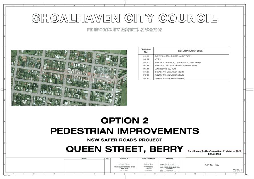
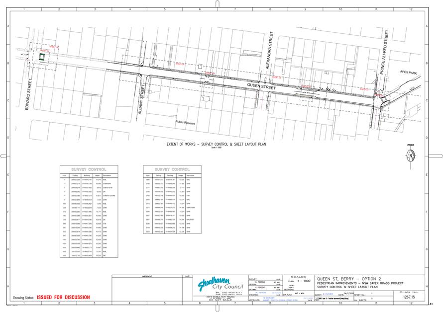
CL21.215..... Report of the Shoalhaven Traffic Committee -
12 October 2021................ 22
TC21.53...... Pedestrian Facility Improvements - Queen Street,
Berry (PN 3672)
12. Reports
City Performance
CL21.216..... Register - Disclosure of Pecuniary Interest
Returns - 2020/21................... 34
CL21.217..... Investment Report - September 2021.......................................................... 44
City Futures
CL21.218..... Update - NSW Government's Regional Housing
Taskforce........................ 54
CL21.219..... Grant Offer to Council - Building Better Regions
Fund Round 5 - Ulladulla Harbourside.................................................................................................. 66
CL21.220..... Jervis Bay Regional Boat Ramp Master Plan (option
H) - Construction - Boat Maintenance Facility - Woollamia - Operational
Procedures / Leasing Arrangements...................................................................................................................... 69
CL21.221..... Tenders - Placemaking at Vincentia Shopping
Village................................ 73
City Services
CL21.222..... Pathway - Callala Beach to Callala Bay –
Beach Rd & Emmett St - Options Investigation / Costs - Staged plan -
Community Consultation................... 75
CL21.223..... Additional Car Parking - Basin View Boat Ramp......................................... 79
CL21.224..... Natural Areas Volunteers - Parkcare Action Plans
- Barker Reserve / Burrill Lake Lions Park / Valley Drive Reserve................................................................ 82
CL21.225..... Expression of Interest - Lease - 100 St Vincent
St. Ulladulla.................... 100
CL21.226..... Tenders - Construction of Havilland Street Boat
Launching Ramp & Carpark, Conjola Park............................................................................................................. 102
CL21.227..... Tenders - Design, Install and Commission
Materials Recovery Facility... 104
CL21.228..... Tenders - Management & Operation Holiday
Haven Shoalhaven Heads. 106
City Development
CL21.229..... Variations to Development Standards - September
Quarter 2021............ 108
CL21.230..... DA16/1465 - 173 Kinghorne Street and 2
& 4 Albatross Road, NOWRA - Lot 1, 29 & 30 DP 25114............................................................................................... 110
CL21.231..... DA21/1673 - 116-118 St Vincent Street, Ulladulla
- Advice Addendum Report to be submitted.................................................................................................... 154
DE21.122.... Development Application - DA21/1392 – Old
Southern Rd South Nowra – Lot 2 DP 1065105 & Lot 28 DP 17310...................................................................... 155
CL21.232..... Lake Conjola - Crown Land Licence.......................................................... 181
City Lifestyles
CL21.233..... The Bob Proudfoot Pavilion - Public Exhibition
Summary and Way Forward 184
13. Confidential
Reports
Committee Reports
CCL21.15.... Report of the Strategy & Assets Committee -
12 October 2021
CSA21.45.... Expression of Interest - Occupation of 177-179
Illaroo Road. North Nowra
Local Government Act - Section
10A(2)(d)(i) - Commercial information of a confidential nature that would, if
disclosed prejudice the commercial position of the person who supplied it.
There is a public interest
consideration against disclosure of information as disclosure of the
information could reasonably be expected to reveal commercial-in-confidence
provisions of a contract, diminish the competitive commercial value of any
information to any person and/or prejudice any person’s legitimate business,
commercial, professional or financial interests.
CSA21.46.... Covid Rent Relief - 13 July 2021 - 13 January 2022
Local Government Act - Section
10A(2)(c) - Information that would, if disclosed, confer a commercial advantage
on a person with whom the Council is conducting (or proposes to conduct)
business.
There is a public interest
consideration against disclosure of information as disclosure of the
information could reasonably be expected to reveal commercial-in-confidence
provisions of a contract, diminish the competitive commercial value of any
information to any person and/or prejudice any person’s legitimate
business, commercial, professional or financial interests.
CSA21.47.... Tenders – Minor Works & Maintenance to
External Finishes – Reroofing & Repainting – Nowra Showground
Pavilion
Local Government Act - Section
10A(2)(d)(i) - Commercial information of a confidential nature that would, if
disclosed prejudice the commercial position of the person who supplied it.
There is a public interest consideration
against disclosure of information as disclosure of the information could
reasonably be expected to reveal commercial-in-confidence provisions of a
contract, diminish the competitive commercial value of any information to any
person and/or prejudice any person’s legitimate business, commercial,
professional or financial interests.
CSA21.48.... Land Acquisition Matter - Meroo Meadow
Local Government Act - Section
10A(2)(c) - Information that would, if disclosed, confer a commercial advantage
on a person with whom the Council is conducting (or proposes to conduct)
business.
There is a public interest
consideration against disclosure of information as disclosure of the
information could reasonably be expected to reveal commercial-in-confidence
provisions of a contract, diminish the competitive commercial value of any
information to any person and/or prejudice any person’s legitimate
business, commercial, professional or financial interests.
Reports
CCL21.16.... Tenders – Placemaking at Vincentia Shopping
Village
Local Government Act - Section 10A(2)(d)(i) - Commercial
information of a confidential nature that would, if disclosed prejudice the
commercial position of the person who supplied it.
There is a public interest
consideration against disclosure of information as disclosure of the
information could reasonably be expected to reveal commercial-in-confidence
provisions of a contract, diminish the competitive commercial value of any
information to any person and/or prejudice any person’s legitimate
business, commercial, professional or financial interests.
CCL21.17.... Expression of Interest - Lease - 100 St Vincent
St. Ulladulla
Local Government Act - Section 10A(2)(c) - Information
that would, if disclosed, confer a commercial advantage on a person with whom
the Council is conducting (or proposes to conduct) business.
There is a public interest
consideration against disclosure of information as disclosure of the
information could reasonably be expected to reveal commercial-in-confidence
provisions of a contract, diminish the competitive commercial value of any
information to any person and/or prejudice any person’s legitimate
business, commercial, professional or financial interests.
CCL21.18.... Tenders - Construction of Havilland Street Boat
Launching Ramp & Carpark, Conjola Park
Local Government Act - Section 10A(2)(d)(i) - Commercial
information of a confidential nature that would, if disclosed prejudice the
commercial position of the person who supplied it.
There is a public interest
consideration against disclosure of information as disclosure of the
information could reasonably be expected to reveal commercial-in-confidence
provisions of a contract, diminish the competitive commercial value of any
information to any person and/or prejudice any person’s legitimate
business, commercial, professional or financial interests.
CCL21.19.... Tenders – Design, Install and Commission
Materials Recovery Facility
Local Government Act - Section 10A(2)(d)(i) - Commercial
information of a confidential nature that would, if disclosed prejudice the
commercial position of the person who supplied it.
There is a public interest
consideration against disclosure of information as disclosure of the
information could reasonably be expected to reveal commercial-in-confidence
provisions of a contract, diminish the competitive commercial value of any
information to any person and/or prejudice any person’s legitimate
business, commercial, professional or financial interests.
CCL21.20.... Tenders – Management & Operation of
Holiday Haven Shoalhaven Heads
Local Government Act - Section 10A(2)(d)(i) - Commercial information
of a confidential nature that would, if disclosed prejudice the commercial
position of the person who supplied it.
There is a public interest
consideration against disclosure of information as disclosure of the
information could reasonably be expected to
|

|
Ordinary
Meeting – Tuesday 26 October 2021
Page
0
|
CL21.205 Rescission
Motion - DE21.114 - Planning Proposal Request - Willinga Park Equestrian
Centre, Bawley Point
HPERM Ref: D21/427438
Submitted
by: Clr Kaye Gartner
Clr Amanda
Findley
Clr John
Levett
Purpose / Summary
The following Rescission Motion,
of which due notice has been given, is submitted for Council’s
consideration.
|
Recommendation
That Council rescind the Motion
relating to Item DE21.114 of the Development & Environment Committee
meeting held Tuesday 5 October 2021.
|
Background
The following resolution
(MIN21.688) was adopted at the Development & Environment Committee held
Tuesday 5 October 2021.
That Council:
1. Support
progressing a Planning Proposal (PP) to amend Shoalhaven Local Environmental
Plan (SLEP) 2014 (SLEP 2014) to make ‘function centre’ an
additional permissible use (with consent) within the RU2 Rural Landscape Zone
on the subject land (Lot 21 DP 1217069 and Lot 33 DP 1259627, being 132
and 123 Forster Drive, Bawley Point) to allow a broader range of functions /
events (unrelated to equine activities) at Willinga Park.
2. Support
the proponent’s request to amend SLEP 2014 to make functions involving
less than 351 attendees (excluding staff) ‘development without
consent’.
3. Prepare
the PP and submit to the NSW Department of Planning, Infrastructure and
Environment (DPIE) for Gateway determination, in accordance with Part 1.
4. Subject
to receiving a favourable Gateway determination, undertake government agency
consultation and complete any supporting technical investigations (if required)
and publicly exhibit the PP.
5. Receive
a report on the outcome of the public exhibition of the PP.
6. Advise
the proponent and those who made a submission of this decision.
|
|
Ordinary
Meeting – Tuesday 26 October 2021
Page
0
|
CL21.206 Notice
of Motion - DE21.114 - Planning Proposal Request - Willinga Park
Equestrian Centre, Bawley Point
HPERM Ref: D21/427570
Submitted by: Clr
Kaye Gartner
Clr Amanda
Findley
Clr John
Levett
Purpose / Summary
The following Notice of Motion,
of which due notice has been given, is submitted for Council’s
consideration.
|
Recommendation
That Council
not support the Planning Proposal due to community concern about the impacts
on Bawley Point Village.
|
Note by the CEO
This Notice of Motion will be dealt with if the preceding
Rescission Motion is carried.
|
|
Ordinary
Meeting – Tuesday 26 October 2021
Page
0
|
CL21.207 Notice
of Motion - Victor Ave, Narrawallee – Access Steps
HPERM Ref: D21/423401
Submitted
by: Clr Patricia White
Clr Mitchell
Pakes
Clr Greg
Watson
Purpose / Summary
The following Notice of Motion,
of which due notice has been given, is submitted for Council’s
consideration.
|
Recommendation
That
Council:
1. Provide
access to Narrawallee Beach off leash area via Victor Avenue Steps.
2. Allow
access to the rock area below the Victor Ave Steps to the north.
|
Background
Council has addressed issues at
the off leash area at Narrawallee Beach for a number of years and it is also
included in the current review of the Council’s Dog Policy.
In February this year Council
resolved to prohibit access to the dog off leash area from Victor Avenue steps.
The report to Council noted “the approach to remove the access from
Victor Avenue has not been tested or consulted on in the community.”
Council has also been requested
to replace the stairs and in the interim to undertake some maintenance works at
the top and side of the stairs. Additionally, requests were made for maintenance
of vegetation from the pathway to the beach on Matron Porter Drive that allow
access for the dogs.
I have received representations
from many residents on the difficulties now when trying to access the off leash
area, even though Council has recently completed a shared pathway on Matron
Porter Drive in the area.
A recent visit to Narrawallee
Beach over the weekend highlighted the need for the reinstatement of the steps
as an access point with the volume of dog owners accessing the area.
The access via Narrawallee
Reserve is now infested with ticks and has had an impact on residents walking
though the reserve. Recently, a 96 year old gentlemen received a tick from
taking his dog to the beach via this area.
There are increased number of
dog owners in the Shoalhaven mainly due to COVID, wellbeing and companionship.
Additionally, once the COVID restrictions are lifted there will be increased
activity on the beach with visitors to the area with their dogs.
As the review of the Dog Policy
will not be finalised now until March/April 2022, some 6 months, with delays
due to COVID and Community Consultation.
We need to address the current
issues of access to the Off Leash area by large number of residents and
reinstate the Victor Ave steps.
I seek support from all
Councillors.
Note by the CEO
This Notice of Motion was
submitted to the Ordinary Meeting 28 September 2021 and was lost on the casting
vote of the Mayor. Councillors White, Pakes and Watson have resubmitted the
Notice of Motion for further discussion.
This Notice of Motion which is
proposed by three Councillors is included in the Business Paper in
accordance with cl 17.6 of the
Council’s Code of Meeting Practice:
“17.6 A notice of
motion to alter or rescind a resolution, and a notice of motion which has the
same effect as a motion which has been lost, must be signed by three (3)
councillors if less than three (3) months has elapsed since the resolution was
passed, or the motion was lost.”
Note:
Clause 17.6 reflects section 372(4) of the Act.
A previous Notice of Motion in February 2021 proposed to
close the Victor Avenue Stairs. This was supported by Council. Below is an
extract:
“Move the southern boundary
of the off-leash area to immediately south of the most southern Narrawallee Inlet
Reserve entrance and prohibit access to the dog off-leash area on the southern
part of Narrawallee Beach, including Victor Avenue stairs”.
If Council determines to support the new Notice of Motion to
reopen the Victor Avenue access for dog users, Council Officers will be
required to action a number of items. These include:
· A
site inspection to ensure the Victor Avenue Stairs are fit for purpose
· Change
the dog off leash way finding signage
· Amend
the online maps and guide
· Prepare
communication to the community on the Council approved changes
Councillors will be aware that
the Review of the Access Areas for Dogs has commenced; if this Notice of Motion
is supported this will take effect outside the formal review process; however,
this change will be incorporated into the work to date.
Ranger Services and the Media
and Communications team are being consulted on delivery time frames.
|

|
Ordinary
Meeting – Tuesday 26 October 2021
Page
0
|
CL21.208 Notice
of Motion - Viking Festival - Sussex Inlet
HPERM Ref: D21/447222
Submitted
by: Clr Patricia White
Purpose / Summary
The following Notice of Motion,
of which due notice has been given, is submitted for Council’s
consideration.
|
Recommendation
That
Council:
1. Allocate
funding of $10,000 for the 2022 Viking Festival to be held in Sussex Inlet.
2. Funding
source to be determined by the CEO or his nominee by either donation,
sponsorship, or allocation.
3. Funding to be recurrent for a period
of 3 years.
4. Shoalhaven
Tourism to provide in-house ongoing letters of support to the festival
organisers.
|
Background
Councillors and Staff will
remember the Sussex Inlet Viking Festival held on the June Long weekend in 2021
where over 3,500 people attended.
The Management Committee for the
Sussex Inlet Viking Festival has submitted an application to Shoalhaven Tourism
for grant funds of $10,000 to hold the festival in 2022 and ongoing. Whilst
staff advise this is an amazing and unique event, the application is not supported
due to the Event Guidelines, which focus on supporting events in the off
season. These guidelines aim to increase visitors when the region is not as
busy, and do not allow for funding to be provided to events that are held on
Long Weekends or during School Holidays.
Sussex Inlet Chamber of Commerce
who are the organising event management has a strong relationship with the team
at Shoalhaven Tourism and also with Destination NSW Sydney South and Surrounds
and plays a proactive role in supporting tourism initiatives across the
Shoalhaven.
The Sussex Inlet Chamber of
Commerce demonstrated in 2021 its ability to run a high-quality tourism event.
They have developed a number of high functioning working groups which include
the range of skills required to conduct a safe and innovative event. This event
is unique as it highlights the Danish history of Sussex Inlet and uses the
Viking theme to create a niche tourism opportunity while at the same time
celebrating the linkages to the local Wreck Bay Aboriginal community and the
Ellmoos family.
The funding requested will be
used for marketing the event to maximise festival ticket sales.
Projected figures have been
calculated from the analysis of the data from the 2021 Festival which was
constrained by covid restrictions on large events. The feedback received since
the 2021 festival has been extremely positive and the organisers are confident
that the experience and professional project planning skills of the Chamber of
Commerce and Viking Festival working group will enhance the Viking Festival
event for 2022 and the goal is to sell 4000 tickets to the event, which would
be a 15% increase.
The Chamber of Commerce has
developed an online ticketing system for the festival which will include
collection of data about location of visitors purchasing tickets and number of
visitors staying overnight.
The Chamber of Commerce has
built a funding model that relies less on external funding as the festival
matures over the next 3-5 years. As the Festival matures the Chamber will
reinvest the surplus funds each year with the goal for these funds to grow to
$35,000 by 2025 where the event should be self-funding.
The Viking festival has targeted
strategy to attract visitors to the festival - overnight visitors from southern
and southwestern Sydney, ACT, regional NSW, far south coast - day visitors from
Wollongong, Shellharbour, Shoalhaven, Eurobodalla.
The key target are families and
people interested in historical themed events such as Viking and Danish
history.
The Viking Festival is an annual
winter event designed to increase visitation during the winter months to
support our large number of accommodation operators and hospitality venues such
as clubs and cafes.
It is critical for the local
accommodation sector that the festival stays on the June long weekend to gain 3
nights of accommodation and the festival timing also provides 2 additional days
to enjoy the Sussex Inlet area as well as the surrounding areas of Milton,
Huskisson, and Jervis Bay. The Viking Festival has been planned as an annual
event on the June long weekend as historically winter accommodation visitation
is only about 45-50%. The Viking Festival increased this in 2021 to over 90% of
Sussex Inlet accommodation being filled.
As part of the 2022 festival the
Committee are planning additional cultural tourism opportunities in partnership
with the Indigenous Wreck Bay community both on the festival main day and also
promotion of tours to Booderee National Park.
I seek support from all
Councillors to support the Viking Festival Committee request for funding in the
initial 3 years to ensure growth and longevity of this wonderful historical
cultural event in the Shoalhaven
|

|
Ordinary
Meeting – Tuesday 26 October 2021
Page
0
|
CL21.209 Notice
of Motion - Management of Roads within the Shoalhaven Area
HPERM Ref: D21/447802
Submitted
by: Clr Nina Digiglio
Purpose / Summary
The following Notice of Motion,
of which due notice has been given, is submitted for Council’s
consideration.
|
Recommendation
That
Council
1. Receives a report outlining how staff
manage and monitor the upkeep of roads across the region by answering the
questions provided by the community below:
a. What
comprehensive data has the council already collected about the challenges on
the 1000km+ of (1366km of sealed roads in the Shoalhaven) Shoalhaven roads
that they can immediately make publicly available to Shoalhaven residents via
the SCC Website?
b. How does council specify the
strength, durability, water resistance of pavement material purchased for the
creation and repair of Shoalhaven roads, including grading and knowing the
likely rate of traffic density?
c. What testing takes place by SCC to
ensure the pavement material supplied by the supplier/quarry meets a
particular NSW State Standard to ensure the subsequent road stands up to the
heavy traffic and does not lose integrity and fail? Especially noting the
high rate of truck movements in certain areas within the Shoalhaven region.
d. Are there different qualities of
road base blends (based on; sandstone, shale or Wandrawandian
siltstone, blended with Slag or Fly Ash, crushed concrete/brick or Clay
to gain rigidity and water resistance) and where does Council source
it? Is it normal for road base to be a blend of materials or additives
to mined material to increase its quality and longevity? Do some road
base materials absorb more water than others and so become unstable and
deteriorate more quickly when the bitumen coating is compromised, or damaged
by heavy truck movements? If so where does that material come from and
what is that material being used?
e. Are roads graded per their
classification and as such vary in the quality of their composition?
(Freeway/Highway/Main Roads/Local Roads? Sealed/Unsealed etc). What is the
expected lifecycle of the different grades of road?
f. What is the Council’s
coordinated strategic vision and plan of action to deliver first class roads
and their upgrades, repair and general maintenance of aging infrastructure
over the next 5 years and beyond?
g. What percentage, if any of the road
construction work is done under contract by private companies? As a best
practice do Council engineers routinely oversee and check the quality of
materials and construction during any road process, whether private or SCC by
i.e., Audit and Certify the end product as being “fit for use and
purpose” and desired composition for longevity?
h. An updated and inclusive report in
relation to the direct and indirect impact pertaining to the historic
dealings of Comberton & Tomerong quarries. The report should address the
health, social, financial and environmental impacts on community and any
onflow effect on the state of our Shoalhaven roads.
2. Communicates this to the community
clearly and comprehensively as a matter of the public interest on this very
core function.
|
Background
One of the most common things
asked of Councillors is to explain the poor condition of Shoalhaven
roads. The reasons are likely to be both budgetary and historic. However,
a better understanding could be found by way of a report from the CEO answering
the questions listed above.
Note by the CEO
Given the detailed nature of the
questions, a report will be provided as soon as possible.
|
|
Ordinary
Meeting – Tuesday 26 October 2021
Page
0
|
CL21.210 Notice
of Motion - Ratepayer Tip Vouchers
HPERM Ref: D21/447969
Submitted by: Clr
Greg Watson
Purpose / Summary
The following Notice of Motion,
of which due notice has been given, is submitted for Council’s
consideration.
|
Recommendation
That Council
allow the use by holders of any
unused 2019/20 of 2020/2021 free tipping
vouchers in the financial year 2021/2022 year.
|
Background
Because of Covid-19 restriction, the closure of Transfer
Stations, and the inability of some property owners to access their properties
it would be reasonable to allow the use of old free tipping vouchers still held
by recipients – noting that Council will not be reissuing unused 2019/20
vouchers.
|
|
Ordinary
Meeting – Tuesday 26 October 2021
Page
0
|
CL21.211 Question
on Notice - Tomerong Quarry
HPERM Ref: D21/427325
Submitted
by: Clr John Levett
Clr Nina
Digiglio
Question
Response to Questions on Notice 11 May 2021
The
Director – City Services supplied written advice to Councillors Nina
Digiglio and John Levett dated 17 June 2021 (the response) in regard to our
previous questions on notice submitted on 11th May 2021 that were
deemed to be inadmissible by the CEO under the Code of Meeting Practice.
We have tendered some
revised and hopefully acceptable questions based on the response and the
DA90/1912 itself.
Question 1:
The response
stated “Council has confirmed the development approval DA90/1912
(DS02/1087, DS03/1325 & DS06/1039) “…has not and cannot expire.
It continues to exist and is capable of being modified into the future”.
(a) What
is the basis of the answer in the response that the approval of DA 90/1912;
“has not and cannot expire”, that is, what is the statutory
or legal basis of this continuation and is it based on a particular condition
or clause in the DA?
(b) Is
this continuation or non-expiry standard for DA’s approved by Council or
is it peculiar to this DA?
(c) Given
that the actual quarrying activities as part of the DA have expired, what
specific sections of the DA are not subject to expiry?
(d) Is
it the contention of the Council that the DA remains in effect in perpetuity?
(e) Under
what circumstances can the DA be revoked or terminated?
(f) If the DA remains in
effect in perpetuity, what is the timeframe Council is using to enforce the
rehabilitation requirements at the site?
The response
advised “As at 10/06/2021 Council officers are still in discussions
with In-Ja-Ghoondji Lands Inc regarding an application to modify the consent
and a further application is expected.”
Question 2:
(a) Council
in April 2018 stated they were undertaking surveys to ascertain the extent and
depth of the quarry in relation to the submitted approved plans. Has that
survey been completed, and can Council advise Councillors the siting/status of
the excavated area against the plans.?
(a) If the
quarry is shown to be extensively mined out and hence not “significantly
the same” as the approved area under the existing DA will a new
application be required to be a full new DA and not a s4.55 modification
The response advises in his response
regarding penalties for breaches that “In an email to all Councillors
dated 10/10/2017, Council advised that 19 penalty notices to the value of
$114,000 were sent to the Quarry Operators on 09/10/2017 (D17/332411). In
general terms, the penalties are as follows”:
i. Exceed monthly
tonnage (EP&A breach - 6 penalties @ $6K each = $36K)
ii. Import waste
(EP&A breach - 4 penalties @ $6K each = $24K)
iii. Early starts
(EP&A breach - 1 penalty @ $6K = $6K).
iv. Unlawful transport and
deposit of waste (PoEO breach – 4 penalties @ $4K each = $16K)
v. Use place as waste
facility (PoEO breach – 4 penalties @ $8K each = $32K)
Question 3:
With specific regards to items ii,iv,and v above in bold, can
Council advise:
(a) Did
Council ever deposit broken concrete, kerbing etc at Quarry?
(b) Did
Council ever deposit material suitable for overburden/rehabilitation at Quarry?
(c) Did
Council ever purchase/ remove overburden from Quarry?
In regard to the issue of material being imported into the
quarry as residents have reported numerous times to Council since 2011, the response
“The importation, blending and exporting of fly ash (Qenos ash) were
the subject of investigation and resulted in the issuing of penalty
notices.”
Question 4.
(a) Did Council ever use this particular
product or any other “blended” product in their roadworks?
(b) Did Council as part of their Tender
process request/invite, condone the use of blended products from Shoalhaven
Quarries (Tomerong Quarry) in their roadworks?
In
response to who is responsible for rehabilitation the response reported:
a) At this time the In-Ja-Ghoondji will be required to
rehabilitate the site. Council has issued orders under the EP&A Act
requiring In-Ja-Ghoondji Lands Inc to submit the details. While plans have been
submitted, they have not been of a standard Council could accept and In-Ja-Ghoondji
Lands Inc are required to prepare and resubmit plans.
b) In the event the
In-Ja-Goondji default on the order Council has a number of options available to
obtain compliance with the order. These include
i. Class
4 action in the Land and Environment Court seeking a Court order for the works
to be completed: or
ii. Enter
upon the land, complete the works and seek a Court order for payment.
As at 10/06/2021 Council officers are
still in discussions with In-Ja-Ghoondji Lands Inc regarding an application to
modify the consent and a further application is expected.
Question
5
How can Council issue orders to
prepare a rehabilitation plan whilst in discussions with the landowners to
modify the consent and submit a further application… these statements
appear to be conflicting; can Council please clarify?
Condition
6 (c) “Overburden to be used to revegetate the quarry walls”
As the DA is acted over the
land, the landowner is ultimately responsible for the outcome of the
rehabilitation and this overburden set aside for rehabilitation was, by its own
admission, sold by the Quarry Operator and advertised on its webpage. Such sale
is also evidenced by Google photographs of stockpiles diminishing. Letters from
Council advising the operator to desist from selling this material as well as
numerous letters of concern from Community groups and residents are on file
advising of potential risks to landowners and ratepayers. When asked if Council
had consulted with landowner over this the response stated, “The
landowners were not included in the discussion for over-burden because this
requirement rested with the person in charge of the consent (i.e., the Quarry
Operator).”
Question 6.
(a) Can Council please advise what action
it took with the Quarry Operator (before the DA was handed back to InjaGhoondji
Lands Inc) over this sale and removal, since 2010 or earlier of material set
aside as per consent conditions?
(b) Does this removal of overburden have
financial implications for the landowner or ratepayers?
(c) Why did Council in the $114,000 suite of
fines not include any fine for the sale of overburden from the site?
Bank
Guarantee ( refer to 1st Page Condition 13)
“to ensure that long- term site rehabilitation is
carried out, the applicant
shall enter into an irrevocable Bank Guarantee for the amount of $30,000
together with a landscape and rehabilitation completion and maintenance deed of
agreement. Such documents shall be completed and submitted with the building
application.”
Question 7.
Can Council please confirm the existence and registration
of the above-mentioned Irrevocable Bank Guarantee and Deed of Arrangement and
that it is held by Council.?
Model Litigant Penalties
The response
addressed this issue in various parts as listed.
· Manager- Certification & Compliance and Director
– City Development had initial
discussions concerning the likelihood of success in the Local Court given that
no prior regulatory action or formal warnings had been given to the
operators.”
· “Mayor Amanda Findley was
briefed, however was not part of any decision-making process.”
· No specific legal advice was obtained. The matter was considered
under delegation and was driven by the Manager- Certification & Compliance following discussions with the
Director – City Development. Both… have appropriate
knowledge, skills and experienced in these matters.
Comment: Community members were told
in Council, by a person involved in the investigation, that the maximum amount
of penalties incurred were in the vicinity of $2 - $3 Million dollars and were
issued under the above model litigant approach at $114,000. Council through the
Director – City Development stated that Council must always take this
Model Litigant approach.
Question 8
(a) Did Council take into
account the existence of the following documents before their investigation
concluded that no formal warnings had been issued to the operators of the
quarry;
i. Letter
from S. McDiarmid advising of legal prosecution for breach of daily haulage
ii. Matrix
of complaints to SCC legal dept from S. McDiarmid seeking advice on prosecution
iii. Advice
from SCC legal dept stating Matrix is very good and acceptable to institute Court
Orders
iv. Letter
from S. McDiarmid re illegal dam and potential removal of a state and federal
endangered species
v. Court
15 Orders issued for repeatedly breaching daily exportation rates (condition 14
(h)
vi. Court
15 Orders issued for failing to construct new creek crossing despite it being a
consent condition for 3 sec 96 modifications effectively giving the
quarry a 17 year operational extension.
(b) Does
Council consider the issues above formal warnings?
(c) Given the high profile of this issue,
why wasn’t the Investigation Report of the Manager- Certification &
Compliance brought to a confidential meeting of Councillors with a
recommendation for consideration?
(d) Legal
advice was recently sought regarding the expiration of the DA. Why was no
specific legal advice obtained in regard to the penalties/investigation?
(e) Can
Council please confirm that a similar model litigant approach was employed in
the Court Action between SCC & SCCCR and that appropriate formal warnings
were issued to SCCCR?
Asbestos
The Asbestos buried outside the
quarry extraction area is on part of the land leased by Shoalhaven Quarries. A
s9.22 report under the EPA Act of 1979 No 203 on the asbestos was presented to
Council in which it was reported that the Operations Manager of the parent
company of the Quarry operators was responsible for the commercial quantities
of asbestos being buried around the adjoining area outside the quarry
excavation. Asbestos was found in 5 of the 6 test holes.
The response states: “The asbestos dumping sites were not associated with the
quarrying activities and are being dealt with separately with the landowners.
Council has issued orders in relation to this issue, and it remains an on-going
compliance matter”.
Question 9.
(a) Can
Council confirm they investigated the 9.22 report fully and instigated 119J
duty to declare information on the alleged offender or company?
Under the Act Council has 18 months
to investigate and commence prosecution after a complaint is lodged.
(b) If
not, what action did Council take to fully investigate the matter and protect
the landowner from possible repatriation costs?
Background History.
DA 90/1912 was approved in 1990 by Shoalhaven City Council,
and the “consent or approved use” was for the quarrying and
processing of shale as illustrated on the plans submitted with development
application number 90/1912, referred to as the submitted plans.
There were nineteen conditions, including sub conditions
included in the approval and some are mentioned below as written.
Condition
6. (c) Overburden to be used to revegetate quarry walls;
Condition
6. (d) Revegetation and rehabilitation to keep pace with quarrying operations;
Condition
8. The applicant shall apply to the SPCC for a licence under the SPCC Act, with
regard to the Clean Air ACT 1961.
Condition
9. (b) All stockpiled soil and overburden shall be suitably shaped and
revegetated;
Condition
9. (c) The crushing plant shall be fitted with a water spray system which shall
be activated so as to prevent excessive dust build- up;
Bank
Guarantee
Condition
13.
To
ensure that the landscaping and initial rehabilitation is both carried out and
maintained for at least twelve (12) months following the endorsement date of the
consent, and to ensure that long- term site rehabilitation is carried out, the
applicant shall enter into an irrevocable Bank Guarantee for the amount of
$30,000 together with a landscape and rehabilitation completion and maintenance
deed of agreement.
Such
documents shall be completed and submitted with the building application.
Parking
and Standing Areas
Condition
15
The
applicant shall provide an all-weather, dust- free carparking area on the site,
capable of accommodating at least ten (10) vehicles.
Such
carparking facilities shall be constructed and drained to the satisfaction of
the City Engineer.
Condition
16
All
machinery standing/parking areas shall be constructed to a all-weather
dust-free standard and drained to the satisfaction of the City Engineer.
Advice
to Applicants
(b) A building application, which is a requirement under
Part X1 of the Local Government Act, 1919 as amended, together with plans and
specifications, in accordance with Ordinance 70 must be submitted to and
approved by Council prior to works proceeding.
Comments
and known facts from above.
1. Council
was and is the Consent Authority in charge of enforcing DA90/1912 consent
approved use conditions, some as listed above.
2. The
DA90/1912 consent did not allow for the importation of any material whatsoever.
3. The
DA90/1912 consent did not allow for exportation of material other than the
quarried shale.
4. The
DA90/1912 consent did not allow for the blending of materials in any form.
5. Previous and current executive
staff have rightly stated that the DA is acted over the land, hence the
landowner is the major stakeholder in this as it was when Peter Cowman
submitted the application on behalf of John M Herbert the owner of the property
at the time.
Response
A report will be provided with
responses to the questions.
|

|
Ordinary
Meeting – Tuesday 26 October 2021
Page
0
|
CL21.212 Report
of the Development & Environment Committee - 5 October 2021
HPERM Ref:
D21/433402
|
DE21.105 Notice of Motion - Ulladulla Milton Lions
Club - Local Farmers Producers Markets
|
HPERM Ref: D21/414855
|
|
Recommendation
That Council provide a donation
of $2,200 from the unallocated donations budget to the Ulladulla Milton Lions
Club for the Local Farmers Producers Markets to be held at Burrill Lake.
|
|
DE21.106 Notice of Motion - Village Green St. Georges
Basin
|
HPERM Ref: D21/415518
|
|
Recommendation
That Council:
1. Resolve
to reclassify 132 Island Point Road, St Georges Basin (Lot 10 DP1143842) from
operational to community land, following the registration of a sewer easement
to Shoalhaven Water on the northern boundary.
2. Undertake
house-keeping amendments to the DCP/LEP as required to remove the future
proposed car-parking and other services and adjust the zoning if necessary,
at an appropriate time determined by Council staff.
3. Notify
Basin Villages Forum of the changes.
|
|
DE21.119 Proposed Road Closure - Lot 4 DP 872852
(Vincentia) St Georges Basin Country Club and Response to Questions on Notice
|
HPERM Ref: D21/354817
|
|
Recommendation
That Council:
1. Resolve
to close the road reserves that adjoin Lot 4 DP 872852 Vincentia and sell to
the owner of Lot 4 being the St Georges Basin Country Club with compensation
for the sale of the land payable based on Independent Valuation advice.
2. Impose
the conditions on the proposed closed road requested by Council’s
Environmental Services Department as shown below:
a. The
88B Instrument must contain a provision that it cannot be varied, modified,
or released without the consent of the relevant parties as appropriate and
without the consent of the Shoalhaven City Council.
b. The
covenant must stipulate that:
- All
native vegetation must be retained unless subject to a formal development
application approval under the NSW EP&A Act 1995.
- All
retained native vegetation must be declared off limits to course users
pertaining to Development Application DA 01/1213 and the Environmental
Management Plan.
c. Upon
endorsement by Council the covenant must be registered with LRS or the
appropriate land registration body at the time of registration.
3. Require
the portion comprised in the road closure be consolidated into one lot with
the parent Lot being Lot 4
DP 872852.
4. Require
all costs associated with the road closure, registration of documents and
sale to be borne by St Georges Basin Country Club.
5. Authorise
the Chief Executive Officer to sign any documentation required to give effect
to this Resolution and to affix the Common Seal of the Council of the City of
Shoalhaven to all documentation required to be sealed.
|
|

|
Ordinary
Meeting – Tuesday 26 October 2021
Page
0
|
CL21.213 Report
of the Strategy & Assets Committee - 12 October 2021
HPERM Ref:
D21/444793
|
SA21.199 Notice of Motion - Addition to Original
Notice Of Motion, Safety Upgrades - Culburra Beach Public School
|
HPERM Ref: D21/426956
|
|
Recommendation
That in addition to the original Notice of Motion carried
by Council the following be added:
1. Council
cover the full cost of the kerb and guttering required to ensure pedestrian
access and safety, noting that as it is a Council initiative, the
circumstances warrant this to be dealt with as a variation by the Council to
the Kerb and Guttering - Charges Applicable policy POL16/148.
2. Due
to parking constraints and storm water runoff issues, continue the kerb and
guttering on the Southern side of Fairlands Street to the corner of Cross
Street and Fairlands Street.
3. Council
seek further clarification on the letter that was sent to the Minister
regarding reimbursement.
|
|
SA21.204 Progress Report - Council Resolution -
Housing Crisis
|
HPERM Ref: D21/405196
|
|
Recommendation
That Council:
1. Note
the updates on housing affordability and homelessness actions arising from
MIN21.302.
2. Subject
to finalisation of an Agreement with SALT Ministries (including detail on
siting locations), donate, under the provisions of section 356 of the Local
Government Act 1993, two cabins and remaining furniture and fittings
annually to SALT Ministries for emergency accommodation (valued at ~$10,000
this year), with a review conducted into the scheme after 5 years.
3. Continue
to investigate how Council can support people experiencing (or at risk of)
homelessness in Shoalhaven through the reconvened Homelessness Taskforce.
4. Continue
to take steps to implement actions from the Shoalhaven Affordable Housing
Strategy and advocate for Federal and State Government support to
positively influence housing affordability and availability locally.
|
|
SA21.207 Proposed Boundary Adjustment and Sale - Lot
2 DP 826924 Church Street Tomerong
|
HPERM Ref: D21/306920
|
|
Recommendation
That:
1. Council approve the boundary
adjustment and sale of approximately 76 square metres to the adjoining
landowners of Lot 1 DP 826924 Church Street, Tomerong.
2. Monies from the sale be placed in
the Property Reserve.
3. Council
authorise the affixing of the Common Seal of the Council of the City of
Shoalhaven to any documents requiring to be sealed and that the Chief
Executive Officer be authorised to sign any documents necessary to give
effect to this resolution.
|
|
SA21.208 Proposed Road Closure - Cullen Crescent
Kangaroo Valley
|
HPERM Ref: D21/393386
|
|
Recommendation
That
Council:
1. Close
approximately 924 square metres of the unformed road reserve at the northern
end of Cullen Crescent Kangaroo Valley (as shown in red in Figure 1 below) by
a notice published in the Government Gazette.
2. Authorise
the Chief Executive Officer to sign any documentation required to give effect
to this Resolution and to affix the Common Seal of the Council of the City of
Shoalhaven to all documentation required to be sealed.
|
|
SA21.212 Grant of Electricity Easement in favour of
Endeavour Energy - Worrigee Street Carpark
|
HPERM Ref: D21/412888
|
|
Recommendation
That Council:
1. Grant
an Electricity Easement in favour of Endeavour Energy for a Pad Mount
Substation 5.5 metres by 2.75 metres over Council land - Lots 4 and 5 DP
537780, Lot 3 DP 530250, Lots 12 and 13 DP 738683, Lot 1 DP 738686, Lot 1 DP
738675, and Lots 1 and 2 DP 738687 known as Worrigee Street Carpark.
2. Authorise
the Chief Executive Officer to sign all documentation required to give effect
to this resolution and to affix the Common Seal of the Council of the City of
Shoalhaven to all documentation required to be sealed.
|
|
SA21.220 Management of Dingle Hughes Bequest
Collection and Proposal to Establish a Multi Art Storage Facility
|
HPERM Ref: D21/407914
|
|
Recommendation
That:
1. The
Management of Dingle Hughes Bequest Collection report be received for information.
2. Funding
for the necessary curatorial work of $25,000 be allocated through a quarterly
budget review to allow a member of the Arts and Culture team to be taken
off-line and focus on documenting, digitising and knowledge building
associated with the Dingle Hughes Bequest collection and archive.
3. Funding
of $50,000 be re-purposed to enable investigations and a business case
proposal to be developed on the proposed multi-art storage facility.
4. Funding
of $7,500 be provided to enable a member of the Arts and Culture team to be
taken off-line to assess the Dingle Hughes Bequest collection and provide
advice to the Shoalhaven Arts Board Acquisitions Sub-Committee on potential
items to acquire should the application to the Alan Sisley Memorial Fellowship
be unsuccessful.
5. A
future Councillor Briefing and report to Council be received at the
conclusion of the investigations and upon receipt of the proposal.
|
|
SA21.223 Classification of Council Land - Lot 1075
DP1247845 at Birkdale Circuit Sussex Inlet
|
HPERM Ref: D21/404694
|
|
Recommendation
That Council classify the land
described as Lot 1075 DP1247845 at Birkdale Circuit, Sussex Inlet as
Operational Land under the Local Government Act 1993.
|
|
SA21.225 Acquisition of Easement - Sewer Purposes -
Lot 502 DP 1221372- C130 Princes Highway Meroo Meadow
|
HPERM Ref: D21/387946
|
|
Recommendation
That Council:
1. Acquire
an Easement for Sewerage Purposes 5 metres wide over part of Lot 502 DP
1221372, C130 Princes Highway, Meroo Meadow.
2. Pay
compensation of $11,500 plus GST (if applicable) and reasonable legal costs
associated with the acquisition to the Registered Proprietor of Lot 502 DP
1221372, in accordance with the provisions of the Land Acquisition (Just
Terms Compensation) Act 1993, from Shoalhaven Water’s Sewer Fund.
3. Authorise
the affixing of the Common Seal of the Council of the City of Shoalhaven to any
documents required to be sealed and that the Chief Executive Officer be
authorised to sign any documents necessary to give effect to this resolution.
|
|
SA21.226 Acquisition of Easement for Sewer Pipeline
at Terara - Burraga Island Pty Ltd - REMS Transfer Main
|
HPERM Ref: D21/412793
|
|
Recommendation
That Council:
1. Acquire
an Easement for Sewer Pipeline 4 metres wide and limited in height affecting
Lot 1 DP1184790 at Terara, as shown marked ‘S’ and highlighted
pink on DP1270293.
2. Pay
$nil compensation in accordance with the special provisions of Section 62 of
the Land Acquisition (Just Terms Compensation) Act 1991 for sub-surface
acquisitions.
3. Pay
reasonable legal costs associated with the acquisition from Council’s
Sewer Fund.
4. The
Common Seal of the Council of the City of Shoalhaven be affixed to any
documents required to be sealed.
|
|
SA21.227 Acquisition of Sewer Easement - 30 Hollywood
Avenue Ulladulla
|
HPERM Ref: D21/418256
|
|
Recommendation
That Council rescind MIN21.32
and:
1. Acquire
an Easement for Sewer Main 2.4 metres wide over part of Lot 52 DP 26132, 30
Hollywood Avenue, Ulladulla marked ‘S’ on the survey plan at Attachment
2.
2. Pay
compensation of $31,500, plus GST if applicable, and reasonable legal costs
associated with the acquisition in accordance with the provisions of the Land
Acquisition (Just Terms Compensation) Act 1991, from Council’s Sewer
Fund.
3. The
Common Seal of the Council of the City of Shoalhaven be affixed to any documents
required to be sealed.
|
|

|
Ordinary
Meeting – Tuesday 26 October 2021
Page
0
|
CL21.214 Report
of the Inclusion & Access Advisory Group - 11 October 2021
HPERM Ref:
D21/446472
|
IA21.13 Accessible viewing
platform construction; Surfers Avenue Narrawallee
|
HPERM Ref: D20/39138
|
|
Recommendation
That the Inclusion & Access
Advisory Group:
1. Receive the report on Notice of
Motion - construction of the viewing platform path and parking for
information.
2. Endorse the design specifications
of the viewing platform path and parking. Option A.
3. Request that Council proceed to
confirm construction costs and allow a budget bid to be submitted for
“2” above.
4. Request that Council investigate
alternatives for accessible parking in this area.
|
|
|
Ordinary
Meeting – Tuesday 26 October 2021
Page
0
|
CL21.215 Report
of the Shoalhaven Traffic Committee - 12 October 2021
HPERM Ref:
D21/449421
Attachments: 1. TC21.53
⇩
The Shoalhaven Traffic
Committee is a technical review committee not a committee of Council under the
Local Government Act, 1993.
The Roads and Maritime
Services has delegated certain powers to Council under the Transport
Administration Act 1988 (Section 50). A condition of this delegation is
that Council must take into account the Traffic Committee recommendations.
IMPORTANT NOTE:
Council cannot amend a Traffic Committee
recommendation. The Council can only:
1. Adopt the Traffic Committee
recommendation;
2. Not Adopt the Traffic Committee
recommendation; or
3. Request the Traffic Committee reconsider
the issue.
Other issues can be raised as Additional Business at the
Ordinary Meeting.
The full guide to the delegation to Councils for the
regulation of traffic can be viewed at: RMS Website
|
TC21.53 Pedestrian Facility Improvements
- Queen Street, Berry (PN 3672)
|
HPERM Ref: D21/420552
|
|
RECOMMENDATION
That the:
1. Chief
Executive Officer (Director City Services) be advised that the Shoalhaven
Traffic Committee has no objection to the proposed Pedestrian Facility
Improvements at Queen Street, Berry as per Plan No D21/420628 (Option 2);
subject to the following:
a. W8-2
signage be reduced from 25km/h to 20km/h;
b. Provide
W5-10 & W8-3(R) on the intersection with Prince Alfred Street heading
north bound;
c. Provide
W5-10 & W8-3(R) on the intersection with Edward Street heading north
bound and W5-10 & W8-3(L) heading south bound;
d. Rectify
line marking to the refuge island immediately east of the intersection of
Queen Street and Edward Street by the addition of chevron line marking to
assist with adequate delineation between LATM devices;
e. Council
does not proceed with the proposed second “at grade” crossing in
front of 81 Queen Street at this point in time and undertakes regular demand
analysis to assess the need for the second crossing for future installation;
f. W3-4
advanced warning signage be provided on the approach to the eastern threshold
heading west bound;
g. Speed
Zone Reduction variation to the original proposal being approved by Transport
for NSW – noting that TfNSW would like to see a firm commitment to
install both pedestrian crossings.
2. Traffic
Committee note that the funding required to implement this project is subject
to the proposed variations to the original agreement being approved by
Transport for NSW’s Funding Assessment Committee.
|
|
|
Ordinary
Meeting – Tuesday 26 October 2021
Page
0
|
|
|
Ordinary
Meeting – Tuesday 26 October 2021
Page
0
|
CL21.216 Register
- Disclosure of Pecuniary Interest Returns - 2020/21
HPERM Ref: D21/382615
Department: Business
Assurance & Risk
Approver: Sara
McMahon, Manager - Business Assurance & Risk
Attachments: 1. Complete
list of Designated Persons ⇩
Reason for Report
This report is being submitted
directly to the Ordinary Meeting due to the requirements under the Code of
Conduct and the Local Government Act 1993.To provide Council with the Register
of Pecuniary Interest Returns lodged with the Chief Executive Officer (CEO) for
the period of 1 July 2020 to 30 June 2021 as required under Section 4.21 of the
Code of Conduct.
|
Recommendation
That:
1. The report regarding the Register
– Disclosure of Pecuniary Interest Returns lodged for the period of 1
July 2020 to 30 June 2021 be received for information
2. The Chief Executive Officer consider
appropriate action in respect of any Designated Persons who have failed to provide
their return for the period of 1 July 2020 to 30 June 2021.
|
Options
1. Council may
withdraw delegated authority to the Committees whose members have not completed
the returns.
Implications: Withdrawing Delegated Authority from Committees
may impact on more resolutions being reported to Council.
2. The Chief
Executive Officer may suspend membership of Committees for any member in
contravention of the Model Code of Conduct.
Implications: Suspending membership until the form has
been returned may result in the Committees not reaching Quorum for meetings.
Background
The lodgement date for Pecuniary
Interest returns covering 1 July 2020 to 30 June 2021 was 30 September 2021.
Persons with an obligation to
lodge a pecuniary interest return by 30 September 2021 are listed in Attachment
1 of the register tabled at this meeting.
Notice was provided to:
· All Councillors on
25 August 2021
· Designated Staff
between 10 to 25 August 2021
· Committee members
on 30 August 2021
with a reminder sent via email
to various outstanding designated officers on 5 and 12 October 2021, reminding
them to complete the form in their Due Tray.
All Councillors have completed
and returned their declaration.
Despite the attempts and
reminder stated above seven (7) designated persons as noted in Attachment 1
have not completed a return at the time of preparing this report and have not
provided explanation for their failure to do so (i.e., not away, or unable to
complete due to illness or other reason)
Advice provided to Council by the Office of Local Government
in September 2015 was that ‘hard copies’ of returns are no longer
required to be tabled at the Council meeting. Therefore, the register of
returns for this period is attached and tabled and electronic versions of the
documents with personal information redacted may be viewed upon request.
Risk Implications
A failure of meeting the
obligations with respect to the Pecuniary Interest Returns by designated
officer leaves Council at risk of non-compliance with legislative requirements,
conflict of interests and limited transparency.
|
|
Ordinary
Meeting – Tuesday 26 October 2021
Page
0
|
|

|
Ordinary
Meeting – Tuesday 26 October 2021
Page
0
|
CL21.217 Investment
Report - September 2021
HPERM Ref: D21/446363
Department: Finance
Approver: Sara
McMahon, Manager - Business Assurance & Risk
Attachments: 1. Investment
Report - Shoalhaven City Council - September 2021 (under separate cover) ⇨
Reason for Report
In accordance with Section 625
of the Local Government Act 1993 and Clause 212 of the Local Government
(General) Regulation 2021, a written report is provided to Council setting out
the details of all money it has invested.
|
Recommendation
That
Council:
1. Receive the Record of Investments
for the Period to 30 September 2021 report of the Chief Executive Officer
(City Performance) for information.
2. Note that Council’s total
Investment Portfolio (excluding the
Long-Term Growth Fund) returned 0.90% per
annum for the month of September 2021, exceeding the benchmark AusBond Bank
Bill Index (0.01% pa) by 89 basis points (0.89%).
3. Note the performance of the Long-Term Growth Fund as presented in the report.
|
Options
1. The report on the
Record of Investments for the period to 30 September 2021 be received for
information.
Implications: Nil
2. Further
information regarding the Record of Investments for the period to 30 September
2021 be requested.
Implications: Nil
3. The report of
the Record of Investments for the period to 30 September 2021 to be received
for information, with any changes requested for the Record of Investments to be
reflected in the report for the period to 31 October 2021.
Implications: Nil
Background
Please refer to the attached
monthly report provided by Council’s Investment Advisor, CPG Research and
Advisory Pty Ltd.
All
investments are within the current Minister’s Order. Investments are
diversified across the eligible fixed interest universe and are well spread
across maturities. Available capacity exists in all terms, with medium term
particularly relevant to new issues.
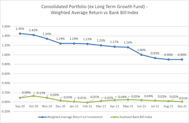
Portfolio Return
The Overall
portfolio returned a negative -1.13% p.a. for the month of September 2021, entirely
due to the negative movement of the growth fund. This will be a typical
pattern, where monthly results depend entirely on stock market direction.
The
investment returns excluding growth fund were a stable 0.90% p.a., exceeding
the benchmark AusBond Bank Bill Index (0.01% p.a.) by +89bp.
Council’s
investment in Long-Term Growth Fund returned -19.84% for the month of September
2021, which partially offset previous significant market gains, bringing year
to date return to +8.06% (0.76% above the benchmark).
The
Australian S&P/ASX200 fell -1.9% over the month, with ongoing lockdowns and
falling iron ore prices key drags on performance of the Long-Term Growth Fund.
Over the past 12 months, September was the only month to result in a fall in
the S&P/ASX 200 Index with the index still closing 30.6% higher than a year
prior. Australian economic data released during September confirmed the impact
of lockdowns in Greater Sydney and other Australian areas. It is expected for
the market to improve, as the lockdown being lifted. A weaker $A in the month
also supported absolute and relative performance of the Fund.
The
following graph shows the performance of Council’s Investment Portfolio
(excluding LTGF) against the benchmark on a rolling twelve (12) month basis. As
can be seen, performance has consistently exceeded the benchmark due to the mix
of Council’s Investment Portfolio.
The
following graph shows the performance of Council’s Long-Term Growth Fund
against the benchmark on a rolling twelve (12) months basis.
Interest
Earned – September 2021
The
following table shows the interest earned for the month of September 2021.
|
Fund
|
Monthly Budget
$
|
Actual Earned
$
|
Difference
$
|
|
General
|
98,436
|
89,394
|
(9,042)
|
|
Water
|
64,208
|
41,666
|
(22,542)
|
|
Sewer
|
30,519
|
23,546
|
(6,973)
|
|
Total excluding Long-Term Growth Fund
|
193,163
|
154,606
|
(38,557)
|
|
Long-Term Growth Fund
|
16,986
|
(375,102)
|
(392,088)
|
|
Total
|
210,149
|
(220,496)
|
(430,645)
|
The interest
earned for the month of September, excluding changes in the fair value of TCorp
Long-Term Growth Fund was $154,606 compared to the monthly budget of $193,163.
The fair
value of TCorp Long-Term Growth Fund decreased in September by $375,102. It is
important to note that it is expected that this value will fluctuate on a
monthly basis and the actual return on this fund should be assessed against our
budget forecast on an annual basis.
Interest Earned - Year to Date
The
following table demonstrates how the actual amount of interest earned year to
date has performed against the total budget.
|
Fund
|
Original Total
Annual Budget
$
|
Actual
YTD
$
|
%
Achieved
|
|
General
|
1,159,000
|
257,942
|
22.26%
|
|
Water
|
756,000
|
137,111
|
18.14%
|
|
Sewer
|
359,333
|
68,313
|
19.01%
|
|
Total excluding Long-Term Growth Fund
|
2,274,333
|
463,366
|
20.4%
|
|
Growth fund
|
200,000
|
382,800
|
191.4%
|
|
Total
|
2,474,333
|
846,166
|
34.2%
|
The interest
earned to the month of September excluding the change in fair value of TCorp
Long-Term Growth Fund was $463,366 which is 20.4% of the current full year
budget.
The graphs
below illustrate the cumulative interest earned for the year for each fund
against budget:
Cash
and Restricted Assets
|
RECORD OF INVESTMENTS
|
|
Cash and Investment Balances
|
|
$
|
$
|
|
September 2021
|
August 2021
|
|
Cash and Investments
Held
|
|
|
|
Cash at Bank -
Transactional Account
|
5,059,140
|
9,140,177
|
|
Cash on Hand
|
21,080
|
22,980
|
|
Other Cash and Investments
|
211,976,843
|
220,448,916
|
|
217,057,063
|
229,612,073
|
|
Fair Value Adjustment
|
270,067
|
319,029
|
|
Bank Reconciliation
|
1,467
|
608,137
|
|
271,534
|
927,166
|
|
Book Value of Cash
and Investments
|
217,328,597
|
230,539,239
|
|
Less Cash &
Investments Held in Relation to Restricted Assets
|
|
Employee Leave
Entitlements
|
7,050,000
|
7,050,000
|
|
Land Decontamination
|
252,196
|
300,672
|
|
Critical Asset
Compliance
|
839,157
|
881,384
|
|
Other Internal Reserves
|
3,007,150
|
2,270,848
|
|
Section 7.11 Matching
Funds
|
311,169
|
311,169
|
|
Industrial Land
Development Reserve
|
3,828,297
|
3,902,768
|
|
Plant Replacement
|
1,639,117
|
1,733,937
|
|
S7.11 Recoupment
|
22,602,739
|
22,720,951
|
|
Commitment To Capital
Works
|
3,438,992
|
3,436,117
|
|
Total Internally
Restricted
|
42,878,817
|
42,607,846
|
|
|
|
|
Loans - General Fund
|
36,149,697
|
39,931,078
|
|
Self-Insurance
Liability
|
2,880,000
|
2,880,000
|
|
Grant reserve
|
1,599,038
|
2,716,424
|
|
Section 7.11
|
16,295,837
|
15,588,942
|
|
Special Rate Variation
|
3,910,870
|
3,910,870
|
|
Storm Water Levy
|
1,227,541
|
1,279,871
|
|
Trust - Mayors Relief
Fund
|
161,374
|
161,374
|
|
Trust - General Trust
|
2,943,743
|
2,989,743
|
|
Waste Disposal
|
12,181,977
|
9,581,951
|
|
Sewer Fund
|
28,159,058
|
27,659,921
|
|
Sewer Plant Fund
|
4,247,063
|
4,253,708
|
|
Section 64 Water
|
21,989,656
|
21,825,849
|
|
Water Fund
|
24,579,646
|
25,612,707
|
|
Water Communication
Towers
|
4,127,513
|
3,568,121
|
|
Water Plant Fund
|
5,432,456
|
5,466,454
|
|
Total Externally
Restricted
|
165,885,466
|
167,427,013
|
|
|
|
|
Total Restricted
|
208,764,283
|
210,034,859
|
|
Unrestricted Cash
Balance - General Fund
|
8,564,314
|
20,504,380
|
Restricted Asset
Movements
The table below lists the major
movements in Restricted Assets:
|
Total Cash
|
-13,210,643
|
September was not a rate instalment month.
|
|
Other Internal Reserves
|
+736,302
|
Receipt of insurance claims and receipt for the lease of the
communication site at Cambewarra.
|
|
Loans - General Fund
|
-3,781,381
|
Loan funded projects are underway: Holiday Haven, Moss Vale, SEC
Upgrade.
|
|
Grant reserve
|
-1,117,387
|
Expenditure on grants received for various projects (Currarong Road,
Far North Collector Road, Moss Vale Road, etc.).
|
|
Section 7.11
|
+706,894
|
Receipt of developers’ contributions.
|
|
Waste Reserve
|
+2,600,026
|
Payments for domestic waste services received and allocated to the
reserve.
|
|
Sewer Fund
|
+499,137
|
Receipt of income for September quarter.
|
|
Water Fund
|
-1,033,062
|
Expenditure on infrastructure.
|
|
Unrestricted cash
|
-11,940,066
|
September was not rate instalment month and major capital projects are
well underway.
|
Liquidity Indicators
In accordance with the Liquidity
Contingency Plan as endorsed by Council, the following liquidity indicators
were included in the September 2021 Monthly Investment Report which will
continue to enhance the transparency of Council’s financial reporting.
All liquidity ratios remain
above the benchmark and Council remains in a sound financial position.
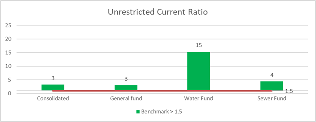
The Unrestricted Current
Ratio is an indicator used to assess the adequacy of working capital
and its ability to satisfy obligations in the short term for the unrestricted
activities of Council.
The ratio remains above the
benchmark as at the end of September 2021 for all funds.
Unrestricted Current Ratio =
(Current Assets less all
external restrictions) / (Current Liabilities less specific purpose
liabilities)
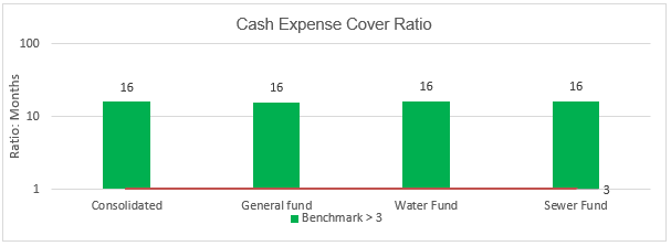
Cash Expense Cover Ratio indicates
the number of months a Council can continue paying for its immediate expenses
without additional cash inflow.
The ratio remains above the
benchmark of 3 months as at the end of September for all funds.
Cash expense cover ratio =
(Cash equivalents, TDs and FRNs
x 12) / (Payments from cash flow of operating and financing activities)
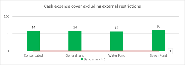
Cash Expense Cover Ratio
Excluding External Restrictions takes the OLG calculation for the
Cash Expense Cover Ratio and removes external restrictions to represent the
amount of months Council can continue paying for its immediate expenses without
resorting to external restrictions.
The ratio remains above the benchmark of 3 months as at the
end of September for all funds.
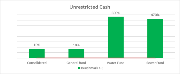
Unrestricted Cash is calculated as a total Cash and Investments, less external and Internal
restrictions.
The unrestricted cash balance remains above the benchmark as
at the end of September 2021 for all funds.
The benchmark is set up at 3% of budgeted
cash outflows (excluding investment purchases and expenditures funded by
reserves).
Financial Implications
COVID-19 has
applied some pressure to Council’s financial position; however, despite
this, Council’s financial position is operating in a sound manner based
on the current cash position and liquidity ratios. It is also noted that
revenue from interest earned forms a vital part of Council’s revenue
stream.
Statement by Responsible Accounting Officer
I hereby certify that the
investments listed in the attached report have been made in accordance with
Section 625 of the Local Government Act 1993, Clause 212 of the Local
Government (General) Regulations 2005 and Council’s Investments Policy
POL19/72.

Olena Tulubinska Date:
19 October 2021
|
|
Ordinary
Meeting – Tuesday 26 October 2021
Page
0
|
CL21.218 Update
- NSW Government's Regional Housing Taskforce
HPERM Ref: D21/426226
Department: Strategic
Planning
Approver: Gordon
Clark, Director - City Futures
Attachments: 1. Shoalhaven
City Council Submission - Regional Housing Taskforce ⇩
Reason for Report
Provide information on the NSW
Government’s Regional Housing Taskforce, including its recent
consultation activity and the publication of its preliminary Findings Report.
Note: This report is being submitted directly
to the Ordinary Meeting due to the information it covers only being released
recently and the limited number of meetings remaining this year/prior to the
Local Government elections.
|
Recommendation
That
Council receive the update report on the NSW Governments Regional Housing
Taskforce for information.
|
Options
1. As recommended.
Implications: Report
provides an update on the Taskforce’s review.
2. Make an
alternative resolution.
Implications: The implications of an alternative
resolution will need consideration and may require a subsequent report/s.
Background
In July 2021. the NSW Government
established a Regional Housing Taskforce in response to increasing pressure on
the supply and affordability of housing in regional NSW: Link
to Ministerial Media Release.
The Taskforce is:
· identifying
challenges and barriers to housing supply in the planning system, and
· making
recommendations to improve housing outcomes in regional NSW.
The Taskforce is chaired by Garry
Fielding and includes senior executives from the NSW Department of Planning,
Industry and Environment (DPIE) and the NSW Department of Regional NSW. Mr Fielding is a qualified town planner
with more than 40 years’ experience in State and local government and the
private sector. He has worked at senior executive levels at DPIE and as head
planner with Newcastle, Woollahra, and Maitland Councils.
The taskforce’s consultation
activities took place in July and August 2021 online and included eleven (11)
virtual meetings, various one-on-one sessions, and other events.
Council staff participated in two
meetings and made a formal submission to the taskforce in August 2021 (Attachment
1). Council’s submission identified the critical housing issues in
Shoalhaven as availability, suitability, and affordability. It also advised the
delivery of infrastructure, services, retailing, and employment opportunities
to meet the needs of current and future communities is a related and
significant challenge often exacerbated by rapid development/change.
Findings Report
In September 2021, the taskforce published an independent
Findings Report summarising the key findings of its consultation, engagement
and research - link
to document
The Findings Report contains feedback from 168 submissions
and more than 500 people, including Councils; representatives from community
groups; the housing, not-for-profit and development sectors; Local Aboriginal
Land Councils; business groups; and members of the public.
Key findings in the report include:
· More effort needed to prioritise, coordinate, fund, and
deliver infrastructure to support new homes.
· Need for collaboration between all levels of Government,
the housing development industry, and the community to develop the right type
of housing that people need where they want to live.
· Calls to speed up planning processes and reduce
duplication, particularly where opportunities to provide housing are time
critical.
· Faster rezoning and approvals will not solve the problem
alone and that industry, Councils and government need to work together to turn
approvals into completions.
· Demand for more affordable and diverse housing in line with
changing demographics, jobs growth, natural disasters, and migration trends.
· The impacts of COVID-19 on migration.
· Hardship due to the 2019-20 bushfires placing stress on
crisis accommodation.
Next Steps
The Findings Report is now being considered by the NSW
Minister for Planning and Public Spaces.
The Taskforce continues to consider all feedback and
submissions in the preparation of a second independent report. Publication of
this report is anticipated in October 2021. The second report will recommend
how the NSW planning system can be used to address housing needs and stimulate
supply in the regions.
Further
reports to Council will be provided on the Taskforce’s continued work,
its future findings, and the consideration of the findings by the NSW
Government.
|
|
Ordinary
Meeting – Tuesday 26 October 2021
Page
0
|
|
|
Ordinary
Meeting – Tuesday 26 October 2021
Page
0
|
CL21.219 Grant
Offer to Council - Building Better Regions Fund Round 5 - Ulladulla Harbourside
HPERM Ref: D21/439191
Department: Economic
Development
Approver: Gordon
Clark, Director - City Futures
Reason for Report
Council applied and has been
successful in receiving a grant to improve the Ulladulla Harbourside project
that will complement the Ulladulla Boardwalk project that has already been
funded from other grant income.
Note: This report is
submitted directly to the Ordinary Meeting to enable the grant offer to be
accepted prior to Council going into recess.
|
Recommendation
That
Council
1. Accept the grant of $1,575,686 from
the Australian Government’s ‘Building Better Regions’ Fund
Round 5 for the Ulladulla Harbourside upgrade project
2. Authorise the Chief Executive
Officer to sign the funding agreements with the Australian Government for
this project
3. Write to the Member for Gilmore
thanking the Australian Government for the grant from the Building Better
Regions Fund Round 5.
|
Options
1. Accept the
recommendation.
Implications: Funding will be secured and the
project will proceed.
2. Adopt an
alternate resolution
Implications: Would need to be determined based on
the nature of any resolution, but could still mean the project proceeds in an
amended form (not recommended).
Background
Council has previously committed
to the planning assessment reform agenda of the NSW Government and these
procedures are being implemented by Council including the improvement in
processing times for Development Applications and other development processes.
As a consequence of this, Council was offered $3 million to undertake a project
to enhance a public space under the NSW Government’s Public Spaces Legacy
Program.
Council applied to have this $3
million committed to the continuation and completion of the Ulladulla Boardwalk
project which was partially completed in 2012.
In working up this submission, a
parallel application was also developed and submitted to the Australian
Government under Round 5 of the Building Better Regions Program to include the
upgrade of the carparking area below the Boardwalk including new stairs from
Wason Street down to the carpark and a dedicated pedestrian walkway back
towards the Civic Centre precinct. This is shown as Stage 6 in the diagram
below - parts of Stage 5 are also shown in this image.
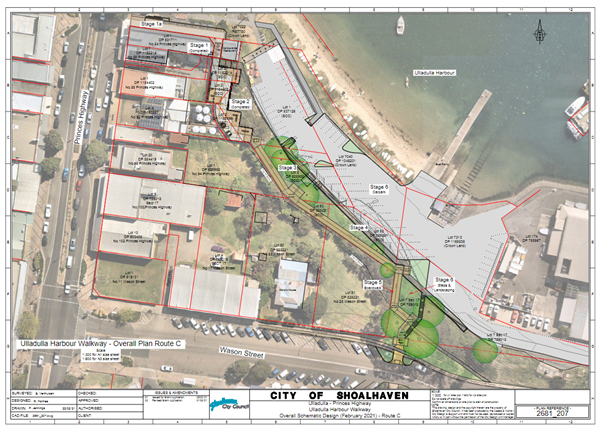
The overall Ulladulla Boardwalk
and Harbourside Improvement Project will create a new elevated public space
that establishes long desired visual connectivity between the commercial centre
and Ulladulla Harbour. This will assist in stimulating commercial activity by
encouraging locals and visitors to enjoy the Harbour outlook from the adjoining
cafes, restaurants and dedicated viewing points. In addition, the project will
provide connectivity between the Boardwalk, town centre and the adjoining
working waterfront, creating a vibrant, interesting and enjoyable destination
for visitors to the area.
The two projects will be
delivered together through a program of infrastructure works, with an emphasis
on linking and expanding on other key projects that are occurring in the area
within the town centre and working waterfront precincts. This will provide a
holistic outcome and experience for visitors, with easy access to iconic
natural areas being combined with the working waterfront areas and high-quality
dining / retail facilities all within the same locality.
As an integrated package of
works, two project areas will be delivered:
· Ulladulla Boardwalk
– Completion of the boardwalk project, which provides elevated views from
the ‘Ulladulla Harbour Triangle’ over the adjoining harbour and
working waterfront. This program of works will facilitate the completion of the
project which will connect the Princes Highway and Wason Street to create a
fully accessible ‘Ulladulla Harbour Triangle’. This Project has
been estimated at $3 million, with funding coming from the NSW
Government’s Public Spaces Legacy Program.
· Harbourside Improvements
– Improving the pedestrian connectivity between the Boardwalk above to
and along the foreshore. This requires careful planning to encourage public
interaction with the working waterfront whilst not impacting on commercial
water-based activities. At present there have been a number of improvements to
surrounding areas, however the car park and pedestrian connectivity through the
“working waterfront area” remains of concern. Plans have been
developed to facilitate infrastructure that allows safe movement in and around
the area without diminishing operational needs. This Project is being made
possible as a result of a grant from the Australian Government for $1,575,686
under the Building Better Regions Fund Round 5.
Both of the above applications were submitted to government
through Council’s City Futures Directorate and were prepared by the
Economic Development Office.
Community Engagement
The announcement about the
Boardwalk improvements has been available for some time and has attracted
positive comment from the wider business and general communities.
Several landholders are
involved, both private and public. The Crown agencies have been quite positive
and are working with Council. The private property owners are not opposed to
the development but have their own requirements which the project will
endeavour to meet and settle/agree to by ongoing negotiation.
The interests of the boating public have been addressed and
this will be a critical part of stakeholder engagement during project delivery.
Policy Implications
The Boardwalk project does form part of the overall planning
context for the Ulladulla town centre and the intent of the Development Control
Plan will be complied with.
Financial Implications
This most recent grant from the
Australian Government compliments the other NSW Government grant and will form
100% of the overall project cost.
The only financial contribution by Council will be staff
time and any cost overruns, but with good project management this should be
avoided.
Risk Implications
This project is a medium sized
construction project in a public space in Ulladulla. Any risks will be
identified and managed by Council and its contractors.
|
|
Ordinary
Meeting – Tuesday 26 October 2021
Page
0
|
CL21.220 Jervis
Bay Regional Boat Ramp Master Plan (option H) - Construction - Boat Maintenance
Facility - Woollamia - Operational Procedures / Leasing Arrangements
HPERM Ref: D21/442918
Department: Economic
Development
Approver: Gordon
Clark, Director - City Futures
Reason for Report
This report is submitted direct
to the Ordinary Meeting given the need to enter into an operational arrangement
to deliver a functional boat maintenance service before end of 2021.
Council considered a report in
July 2021 and received subsequent briefings about an operational Boat
Maintenance Facility at Woollamia. This report has been prepared to conclude
this matter following consultation with various stakeholders.
|
Recommendation
That
1. Council completes the construction
of the Boat Maintenance Facility at the Woollamia Boat Ramp as soon as
possible.
2. Council lease the use of the Boat
Maintenance Facility at Woollamia to local shipwright, Paul Kennedy, for
three (3) years with an option of a further 3 years.
3. The Chief Executive Officer (City
Futures) confirm a “fair” rental for the first 18 months to be
reviewed after 12 months of operations and reset for the final 18 months of
the initial lease term and thereafter reviewed at 12 monthly intervals,
should the option be taken up.
4. The lease be subject to adequate
commercial insurance coverage and trading terms to the satisfaction of the
Chief Executive Officer (City Futures).
|
Options
1. As recommended
Implications: The facility will be operational by
2022, with a commercial operator engaged with a lease.
2. Modify the
recommendation, for example, so as to not be finalised by the end of 2021
Implications: This could mean the project is not
finalised by the end of 2021 as intended. The boat repair users of the
facility, the operator and the wider boating community may have concerns in
this regard, given the delays that have occurred already in delivering the
project. Not recommended.
3. Reject the
resolution as printed
Implications: The facility may not be fully
operational and could be unusable. The Australian Government may then be
entitled to recall its grant and Council could suffer reputational damage for
not delivering a project that is almost complete.
Background
Council proposed, following
approaches from various vessel owners including the Jervis Bay Cruising Yacht
Club, to establish a facility to undertake vessel maintenance at the Jervis Bay
Regional Boat Ramp which included a compound with appropriate environmental
protection devices and a purpose-built trailer to lift vessels in and out of
Currambene Creek utilising the boat ramp.
Funds were sought from the
Australian Government to assist with this endeavour and a sum of $180,900 was
granted to Council.
This matter has been to Council
on several occasions, and in July 2021 it was resolved that:
“Council continue to
construct and commission the Boat Maintenance Facility, consistent with the
Jervis Bay Regional Boat Ramp Master Plan (Option H) with a view to the boat
maintenance being operational in November/December 2021”.
This part of the resolution
added that the following would be put in place:
· Perimeter fencing
· Storage for tools
and equipment for the contracted operator, including a small office space.
It was suggested that 2 x 20
foot containers may be required, but discussions with the proposed operator
concluded that only one would be required, thus maximising the area available
for vessel work. The alternate site for the container to the north of the
sediment tanks was not pursued for 2 reasons:
· It reduced the
number of available car & trailer parking by 2 spaces, and
· From a functional
& operational perspective access to an open container during working hours
is best located inside the maintenance compound.
The diagram above shows the indicative layout.

This concept was taken to the
Woollamia Maritime Precinct Management Committee on 13 October 2021 where the
above layout was discussed and, with the exception of the landscaping area, was
endorsed by the full Committee.
It was advised that the
landscaping area needed to be considered together with the area required for
boat washdown bays, to maximise the number of washdown bays to be created. If
no vegetation buffer is provided in this area, then an alternative for
consideration would be to place an appropriate mural on the side of the
container, although noting that this would be behind the fence. This matter is
not critical to the timing of the fencing etc so its implementation can be
deferred and resolved by staff.
With regard to the operational
fundamentals for the facilities, these were also tabled for discussion by the
Management Committee at the same meeting, as follows:
a) Storage shed and office as located in above diagram
b) Subject to adequate insurance coverage, have provisions
for vessel owners to perform works on their own vessels, under the supervision
of the contracted operator
c) Vessel lifting costs be set by the contracted operator,
including a charge to be set aside for asset replacement and maintenance of the
Council trailer
d) Subject to adequate insurance coverage, that other
vessel maintenance operators be allowed to work on vessels, under the
supervision of the contracted operator however the trailer will be operated by
the Contracted Operator (or their qualified staff).
e) The site fees be set by the contractor, and listed
within Council’s Fees & Charges, to be reviewed annually
The other operating condition
that was proposed in the previous Council resolution was discounted on the
grounds that the insurance provider for the contractor would not support this
condition:
f) Other boat lifting contractors be able to
lift boats for private work by owners in the maintenance area subject to the
site fees being paid to the primary contractor and subject to adequate
insurance cover being in place
This fact was based on an
understanding that in a boatyard the safety of persons and adjacent vessels is
dependent on the way in which the vessels are stored and braced. This practice
and signoff needs to be with the prime contractor and thus the insurance
company’s refusal to have other trailers and bracing systems installed by
other operators.
The outcome of discussion at the Management Committee was
clear in that there was unanimous support for the above operational
fundamentals a), b), c), d), and e) with the understanding that f) was to be
excluded. The provision to have either owners or contractors work on their
vessels in Part (d) was supported as it addressed the main opponent’s
concern that he was being excluded. Even though this point had been
incorporated in the original proposal, the concern seems to have dissipated
given a better understanding of the insurance issues.
Moving
Forward
Given the support for the above,
the way is now clear to complete the project - this is expected to be around
mid-December 2021.
Through an Expression of
Interest process to identify a shipwright to operate the facility, Council
staff have been working with Paul Kennedy, a local shipwright who currently
operates Council’s slipway at Greenwell Point. He has obtained insurance
advice and is working with Council staff towards entering into a lease
arrangement with Council based on the above fundamentals for a lease period of
3 years with a 3-year option.
The contractor will set the “lift” fee for
vessels and determine the site fees for boats being worked on within the
compound. The fee structure for this type of venture is untested. It is
proposed to set a lease fee for a period of 18 months which will be reviewed
and reassessed after the first 12 months based on actual turnover. With the
lease period commencing in the middle of the boating season, most craft will
have already been lifted for hull cleaning and polishing and so reduced
activity is bound to be encountered. A co-operative approach by Council is necessary
to establish this venture and set realistic charges that do not undermine other
operators in this market.
Community Engagement
This venture is approximately 18
months behind the anticipated and proposed commencement and commissioning date.
This has been mainly due to the high degree of community engagement that has
been needed to clarify things.
The most recent consultation
with the Management Committee has led to an endorsement of the development and
the operational regime.
Boat owners also welcome that they no longer have to
contemplate having their craft surveyed and maintained outside of Shoalhaven.
Policy Implications
This venture is based on establishing a service within the
City that was only partly being delivered by other contractors. This new
facility will vastly improve the environmental performance of cleaning and
servicing vessels at one of the busiest regional boat ramps in Shoalhaven.
Financial Implications
Council sought and obtained an
Australian Government grant to build the facility at Woollamia. Council funds
have come from the Council’s Reserves (economic development).
The fee structure will be able to fund the operational
maintenance of the asset, including the trailer, and will be based on life
cycle costing principles. The operational surpluses will be applied to other
maritime assets within Shoalhaven.
Risk Implications
This venture is aimed at
minimising, if not eliminating, the environmental risks that have prevailed
through past operations.
The venture can be regarded as
untried at present in the local area, but research into the demands and needs
of boatowners, especially with commercial craft and with larger vessels is that
they required a safe lift out system that can have their craft serviced and
returned to the water with minimal delay and risk. This operation will deliver
these outcomes.
|
|
Ordinary
Meeting – Tuesday 26 October 2021
Page
0
|
CL21.221 Tenders
- Placemaking at Vincentia Shopping Village
HPERM Ref: D21/423409
Department: Economic
Development
Approver: Gordon
Clark, Director - City Futures
Reason for Report
Inform Council of the tender process,
the evaluation and proposed awarding of contract for “Placemaking at
Vincentia Shopping Village”.
Note: This report is
being submitted directly to the Ordinary Meeting due to the need to award a
contract and engage contractors to comply with contracted obligations under a
funding agreement with the Australian Government.
In accordance with Section
10A(2)(d)(i) of the Local Government Act 1993, some information should remain
confidential as it would, if disclosed, prejudice the commercial position of
the person who supplied it. It is not in the public interest to disclose this
information as it may reveal commercial-in-confidence provisions of a contract,
diminish the competitive commercial value of any information to any person
and/or prejudice any person’s legitimate business, commercial,
professional, or financial interests. This information will be considered under
a separate confidential report.
|
Recommendation
That
Council consider a separate confidential report “Tenders –
Placemaking at Vincentia Shopping Village” in accordance with Section
10A(2)(d)(i) of the Local Government Act 1993.
|
Options
1. Consider the separate confidential
report.
Implications: Full details of the tendering process is
provided in the confidential report to enable Council to make an informed
decision in this regard.
2. Alternative recommendation.
Implications: No opportunity to assess and make an informed
decision on the tender process and results.
Background
Council recently called tenders
to undertake “Placemaking at Vincentia Shopping Village”. Tenders
were called on 31 August 2021 and closed at 10:00am on 28 September 2021.
A grant has been secured for
this work from the Australian Government’s ‘Building Better Regions’
Fund Round 3.
Details relating to the
evaluation of the tenders is contained in the associated confidential report.
Community Engagement
Extensive community engagement
has occurred on this project - full history of the project is available at: Placemaking
for Vincentia Shopping Village
Policy Implications
This project forms part of the
business development programs that extend across various areas of
Council’s operations. The rehabilitation of public space adjacent to
shopping centres has been undertaken in Nowra, Ulladulla, Huskisson, and Sussex
Inlet. These enhancements assist in the vitality of each centre in a different
way but are supportive of business trading and help with the vitality of
“local” shopping precincts’’.
Financial Implications
Council was successful in
obtaining a grant for $1.7m from the Australian Government under the
‘Building Better Regions’ Fund Round 3. The overall project
estimate was $3.44m with the Council contribution of $1,744,246 coming from
General Fund.
|
|
Ordinary
Meeting – Tuesday 26 October 2021
Page
0
|
CL21.222 Pathway
- Callala Beach to Callala Bay – Beach Rd & Emmett St - Options
Investigation / Costs - Staged plan - Community Consultation
HPERM Ref: D21/247835
Department: Works
& Services
Approver: Paul
Keech, Director - City Services
Attachments: 1. Plan
- Pathways Design Strategic Plan 2568_02 - Callala Beach to Callala Bay Links ⇩
Reason for Report
To allow Council to consider the
outcome of the consultation with the Callala Beach and Callala Bay CCB’s,
residents and community organisations to establish the alignment for improved
pedestrian connectivity between Callala Bay and Callala Beach along Emmett
Street and Callala Beach Road. This consultation process was the result of a
Council decision on the 23 February 2021.
Options
1. The
report on pathways linking Callala Beach and Callala Bay pathways be received
for information and a further report be provided to Council once detailed
design and further community consultation has been completed.
Implications: Nil.
2. Council
make an alternate recommendation on timing and funding.
Implications: Depending on
the alternate recommendation it may have implications for funding.
Background
Council considered a petition
submitted directly to the Ordinary Meeting on 25 January 2021 with over 1,785
signatures seeking to “provide a much needed link between the two
villages of Callala Beach and Callala Bay”. The petition as presented to
the Council Ordinary meeting read as follows:
“The Callala Beach Progress
Association and the Callala Bay Community Association wish to urge
Shoalhaven City Council to proceed to design and construct a shared pathway
or boardwalk which would provide a much needed link
between the two villages of Callala Beach and Callala Bay.
The proposed pathway would run
alongside Emmett Street and Callala Beach Road (from Stott Crescent to Club
Callala).
This pathway/boardwalk would
greatly benefit both residents and visitors, pedestrians and cyclists,
providing a safe connection between our two villages and safe access to the
services provided at each.
With the proposed O’Halloran
housing development, the new motel and surging tourist numbers, such a vital
link between our two villages is urgently needed, especially considering
increased traffic flow along a very narrow Callala Beach Road.”
Council has a Pedestrian Access and Mobility Plan (PAMP) which
was adopted in 2005. The preferred route put forward by the petitioner’s
was on a different alignment to the adopted route which has been developed as
part of the Round the Bay walk strategy.
A technical analysis was undertaken and presented to Council
with regard to the petitioner’s preferred route and Council’s
adopted PAMP route. The keys factors considered included safety, environmental
issues, design and cost.
In response to this petition and
technical analysis, at the Ordinary Meeting on 23 February 2021 the Council
resolved as follows: (MIN21.101)
“That in response to the
petition presented to the Ordinary Meeting on the 25 January 2021 (D21/31390)
seeking Council to ‘provide a much needed link between the two villages
of Callala Beach and Callala Bay”, Council:
1. Undertake
consultation with the Callala Beach and Callala Bay CCB’s, residents and
community organisations to establish the alignment for improved pedestrian
connectivity between Callala Bay and Callala Beach along Emmett Street and
Callala Beach Road.
2. As
part of the consultation develop a four year staging plan for detailed design
and construction, options for funding, and inclusion in the 10 year Capital
Plan.
3. Receive
a further report on alignment, funding and timing.”
Policy
Implications
Council has allocated funds in 2021/22 for an update of the
Pedestrian Access & Mobility Plan (PAMP). The process has commenced
initially with inspections by staff of the city’s path network to ensure
that PAMP mapping is as up to date as possible prior to engaging with the
community later in the financial year. Following recent investigations and
engagement with the community in the Callala Beach/Callala Bay area in May
2021, the paths labelled 1-7 (on the attached plan Callala Bay - Callala Beach
Rd and Emmett St Pathway Investigation Concept Plan 2568_02) have been captured
in the current review process and will be listed as proposed amendments when
the PAMP is initially provided to the public to invite feedback.
Community Engagement
A site meeting was held on 18
May 2021 to discuss the options and stages of actions to be taken with regard
to proposed locations for paths connecting Callala Beach and Callala Bay.
Present at the meeting were members of the Callala Beach Progress Association,
Callala Bay Community Association, Clr White, Clr Gash and Council staff.
A strategic plan was developed
for paths to connect Callala Beach and Callala Bay. The attendees decided that
detailed design and construction estimates of these paths would be beneficial
before undertaking wider community consultation.
Further public consultation is proposed to occur with this
information in late 2022 and as a part of the PAMP update.
Financial Implications
At the Council Ordinary Meeting
held on 29 June 2021, it was resolved to include in the 2021/22 Delivery
Program and Operational Plan and Budget: Callala Beach Road Boardwalk/Pathway
Detailed Design - $50,000. (MIN21.395)
This funding is being utilised
to undertake survey, investigations, detailed design, construction budget
estimates and a further round of community consultation in quarter four
of the 2021/22 financial year of the proposed paths (labelled 1 to 7) and
crossing, (labelled 8) on the attached plan Callala Bay - Callala Beach Rd and
Emmett St Pathway Investigation Concept Plan 2568_02.
|
|
Ordinary
Meeting – Tuesday 26 October 2021
Page
0
|
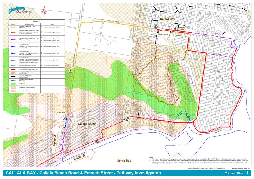
|
|
Ordinary
Meeting – Tuesday 26 October 2021
Page
0
|
CL21.223 Additional
Car Parking - Basin View Boat Ramp
HPERM Ref: D21/200835
Department: Works
& Services
Approver: Paul
Keech, Director - City Services
Reason for Report
The purpose of this report is to
advise council of the outcome of the investigations regarding the provision of
additional carparking at the Basin View Boat Ramp
This report is being submitted
directly to the Ordinary Meeting due to no more Strategy & Assets Committee
meetings being scheduled during the term of this Council.
|
Recommendation (Item to be determined under delegated authority)
That:
1. The CEO (Director City Services)
undertake works to create better delineation of the existing overflow trailer
parking at Basin View Boat Ramp prior to the peak tourism season in December
2021, with a view to providing approximately 10 additional parking bays, at a
cost of approximately $22,500 to be funded from budget adjustments at the
next quarterly budget review.
2. Council allocate $50,000 in the
draft 2022/2023 budget documentation for the investigation and subsequent
design of additional trailer parking bays at Basin View Boat Ramp, with the
aim of developing a staged upgrading plan for additional parking (if
required) and report to Council on costs and environmental impacts of any
parking expansion plans.
|
Options
1. Council adopts
the recommendation
Implications: With delineation and levelling work,
an additional 10 trailer parking bays could be provided at Basin View Boat Ramp
prior to next peak tourist period and would create very minimal environmental
impact and cost. This will allow further investigations, a future parking
demand strategy can be staged.
2. Council reject
the recommendation
Implications: The status quo remains and Council
risks a shortage of trailer parking at Basin View Boat Ramp during future peak
tourist periods. Local residents will continue to bear the brunt of parking and
traffic issues. Local and visiting boat owners will be dissatisfied with the
facilities provided at Basin View by Council.
Background
Over the last couple of years,
there has been a noticeable increase in the use of Council’s boating
facilities, especially in peak tourist periods and times when Covid-19
protections are in place at Booderee National Park (Murrays Beach Boat Ramp). Council
at its meeting on 19 January 2021 resolved that the CEO undertake urgent investigations
regarding the provision of additional carparking at the Basin View Boat Ramp
and report back to Council.
At the Strategy and Assets
Committee meeting on the 19 January 2021 the Committee resolved (under
delegation) as follows (MIN21.13);
That the CEO undertake urgent investigations regarding
the provision of additional carparking at the Basin View Boat Ramp and
report back to Council.
Investigation of Proposed Staged Additional Parking
The Basin View Boat Ramp currently provides ten car parking
bays and ten car & trailer (‘trailer’) parking bays as shown in
Figure 1 below.
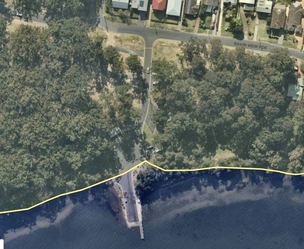
Figure
1 – Basin View Boat Ramp and carpark showing formal and informal
carparking
There is also an informal
overflow parking area serviced by a horseshoe shaped bitumen track, off the
boat ramp entrance road. However this area has no delineation and the ground is
uneven in some locations and so the area is not utilised to its full
theoretical capacity.
Stage 1 (recommended) -
Delineate of additional trailer parking areas (up to ten), in the existing
overflow parking area.
· In
conjunction with some levelling of grassed sections and optional removal of a
few trees, parking in the existing overflow area could be increased using
bollards and paint markings to delineate parking areas and parking bays. This
would be a relatively quick solution to provide additional trailer parking
solution with minimal financial outlay and low environmental and community
impact. As Council manages this parcel of Crown land, no special permissions
would be necessary.
· Due
to inefficiencies in space utilisation at present, the actual usable parking is
estimated at 20 trailer parking bays whereas the theoretical capacity is
approximately 30 trailer parking bays. An additional 10 trailer parking bays
for the upcoming peak tourism season could be provided with delineation and
levelling work.
Further Trailer Parking
development opportunities
Pending further investigation on
parking demands, there is additional potential for staged optimisation of the
existing overflow parking area that may be required during peak tourist
periods.
Stage 2 - Extend Existing horseshoe
loop road further into parkland.
· There
is semi-cleared parkland further south of the horseshoe track that could
provide additional parking but would require an extension of the existing track
or a new track directly off Basin View Parade. An extension of the overflow
parking access track would likely cause controversy with the community as it
would be impacting a scenic parkland area. Better use of the existing informal
parking area could be made before expanding into significant Community land.
Stage 3 - Construct Gravel
Pavement and Delineate Parking Bays, in existing overflow parking area
· To
allow delineation of parking bays to standard width and optimise parking bay
numbers, sections of the overflow parking area could have gravel pavement
constructed, which could be sealed at the time or in the future. Depending on
locations and extent of unsealed pavement construction, dust for nearby
residents may be an issue.
Stage 4 - Redesign existing
overflow parking area and construct road and parking bays with sealed pavements
and concrete kerb & gutter.
· A full and formal
design for trailer parking would have a high cost and long lead time for
survey, design, consultation, tender and construction.
Community Engagement
Consultation with the community
would need to be carried out for any significant changes to the existing
overflow parking area, i.e., anything more than the low impact proposed Stage 1
development.
Financial Implications
Stage 1 (recommended) - The cost
to undertake minor earthworks, tree removal and delineation of parking in the
existing overflow area is approximately $22,500, to be sourced from a budget
review at the next Quarterly review process.
The following ballparks coats
are provided as a guide to the likely scope of future works. No allocation in
the current budget of the long-term capital plan exists for the following.
Stage 2 – The cost to
extend the horseshoe loop road and carry out minor earthworks is $60,000
Stage 3 – Depending on the
extent of selective gravel pavement construction and sealing, the cost could be
$60,000 to $120,000
Stage 4 – The cost to
carry out full and formal design and construction is estimated at $275,000.
|

|
Ordinary
Meeting – Tuesday 26 October 2021
Page
0
|
CL21.224 Natural
Areas Volunteers - Parkcare Action Plans - Barker Reserve / Burrill Lake Lions
Park / Valley Drive Reserve
HPERM Ref: D21/374373
Department: Works
& Services
Approver: Paul
Keech, Director - City Services
Attachments: 1. Draft
- Barker Reserve - Burrill Lake - Parkcare Action Plan ⇩
2. Draft
- Burrill Lake Lions Park - Parkcare Action Plan ⇩
3. Draft - Valley Drive Reserve
- Conjola Park - Parkcare Action Plan ⇩
Reason for Report
To allow Council to consider two
updated and one new Parkcare Action Plans that have been prepared by Parkcare
Groups in conjunction with Council staff.
The plans are:
|
1.
|
Barker Reserve – Burrill
Lake – Parkcare Action Plan
|
Burrill Lake
|
New
|
|
2.
|
Burrill Lake Lions Park
– Parkcare Action Plan
|
Burrill Lake
|
Updated
|
|
3.
|
Valley Drive Reserve –
Conjola Park – Parkcare Action Plan
|
Conjola Park
|
New
|
|
Recommendation (Item to be determined under delegated authority)
That
Council:
1. Endorse the updated and new
“Parkcare” Plans for
a. Barker Reserve – Burrill Lake
(NEW)
b. Burrill Lake Lions Park (UPDATED)
c. Valley Drive Reserve – Conjola
Park (NEW )
2. Continue to allocate ongoing annual
operating funding of $400 (GST exclusive and CPI adjusted) for each Parkcare
Group, totalling $1,200 to cover safety PPE, miscellaneous materials, waste
disposal and purchase minor tools.
|
Options
1. Approve continued
endorsement of Burrill Lake Lions Park Parkcare Group and approve new
endorsements of Barker Reserve – Burrill Lake Parkcare Group and Valley
Drive Reserve – Conjola Park Parkcare Group and adopt the Draft Action
Plans.
Implications: One group is currently allocated a
total of $400 for continuing support and if this option is adopted two new
groups would be allocated $400 each, for ongoing support of Parkcare objectives
which would be offset by the free resource offered to Council. The total cost of
supporting the three Parkcare Groups would be an annual cost of $1,200 which
would be provided from the Works and Services Operational budget.
2. Not approve the
ongoing support of Burrill Lake Lions Park Parkcare Group and refuse any new
endorsement of Barker Reserve – Burrill Lake Parkcare Group and Valley
Drive Reserve – Conjola Park Parkcare Group, pending any changes to the
Action Plans.
Implications: This would be a lost opportunity for
Council. It is estimated from actual volunteer hours of existing Parkcare
groups, that the additional proposed Action Plans, and the volunteer effort
that supports it, allows the groups to supplement Council’s maintenance
schedule at a higher level of service thus adding approximately $16,500 per
annum (2 parks x average of 275 volunteer hours x $30 per hour for labour) to
present a high-quality park and reserve to the Conjola Park and Burrill Lake
Communities.
Background
Council engages volunteers such
as Parkcare groups to achieve higher levels of maintenance at minimal cost to
Council. Council currently has 50 Parkcare Groups with 441 volunteer members
under its Parkcare Programme.
The following draft Parkcare
Action Plan is up for readoption with no changes as part of the normal six-year
review process:
1. Burrill
Lake Lions Park Parkcare Action Plan
The following two draft Action Plans have been requested
from residents who are willing to supplement Council’s maintenance
schedules to enhance their local area:
1. Barker
Reserve – Burrill Lake Parkcare Action Plan
Barker Reserve was originally included in the Casuarina
& Honeysuckle Close Parkcare Action Plan, but the group has never worked in
the reserve and as both Barker Reserve and Casuarina & Honeysuckle Close
Parkcare Groups have their own goals, volunteer members and times and days they
work, a separate group was agreed upon by all volunteers involved.
2. Valley
Drive Reserve – Conjola Park Parkcare Action Plan
As part of a Council resolution MIN21.69, a memorial garden
in Hoylake Grove Park (official name, Valley Drive Reserve) was approved as
part of the Conjola Community Recovery Association’s Draft Conjola
Connected Communities Master Plan.
The Parkcare Group is being
formed by a local resident who, if the plan is adopted, will recruit other
local residents to become volunteers to complete the landscaping of the
memorial garden and supplement Council’s maintenance schedule of the
garden and the reserve.
Community Engagement
Participation and involvement in the Parkcare Groups is open
to all community members. All the attached Action Plans involved consultation,
as part of the Bushcare / Parkcare Procedures (PRD20/28), 7.2 Community
Consultation.
Financial
Implications
One group has been established
in the Shoalhaven for a number of years and has been allocated the $400 in
future Works & Services budgets.
Two groups to be allocated $400
each, which is offset by the free resource offered to Council and will continue
to receive a commitment totalling $800 for the group in future Works and
Services budgets.
The total yearly contribution of
$1,200 has been provided for in the 2021-2022 Operating budget for Works and
Services.
|
|
Ordinary
Meeting – Tuesday 26 October 2021
Page
0
|
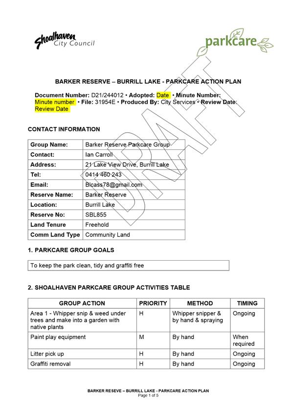
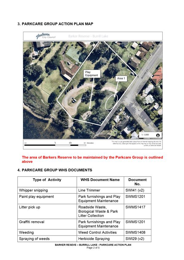
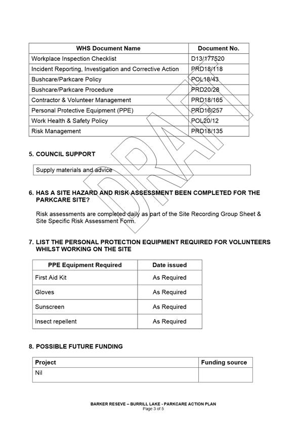

|
|
Ordinary
Meeting – Tuesday 26 October 2021
Page
0
|
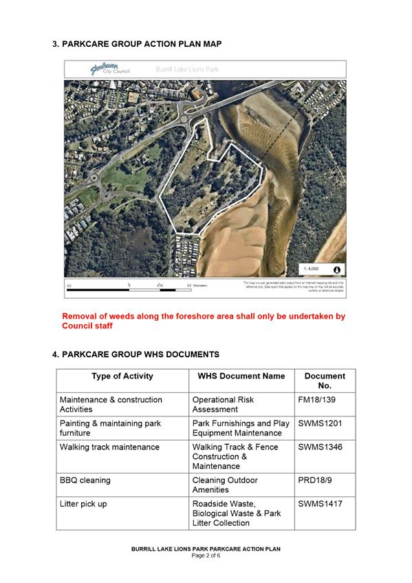
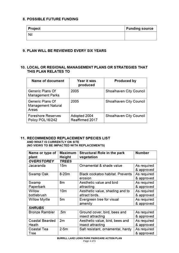
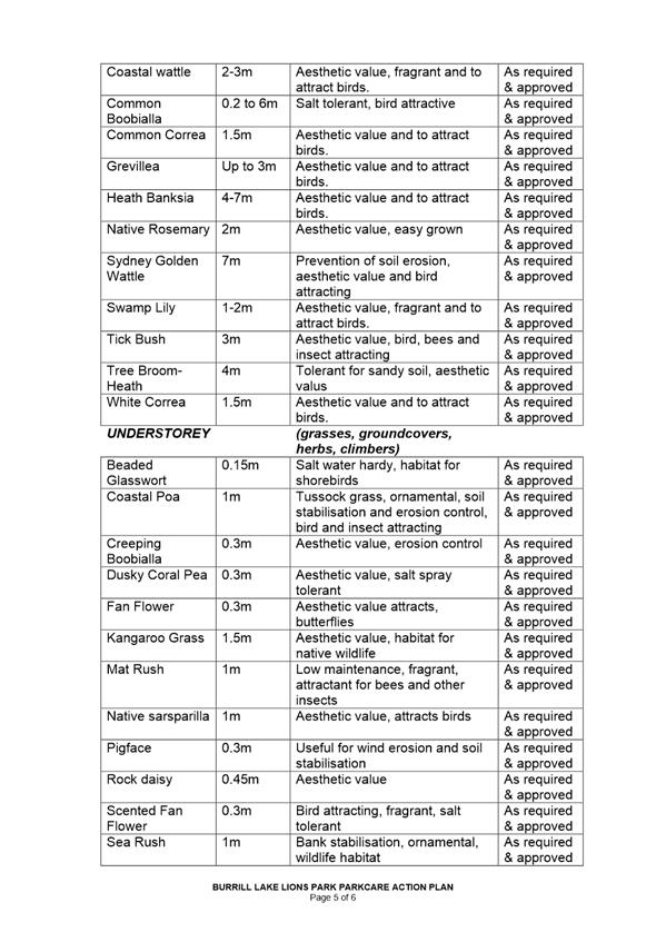
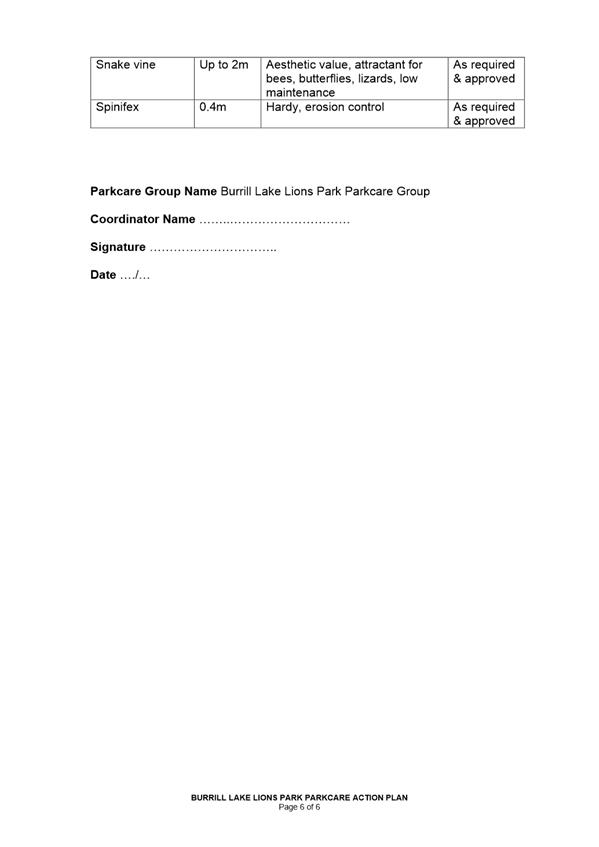
|

|
Ordinary
Meeting – Tuesday 26 October 2021
Page
0
|
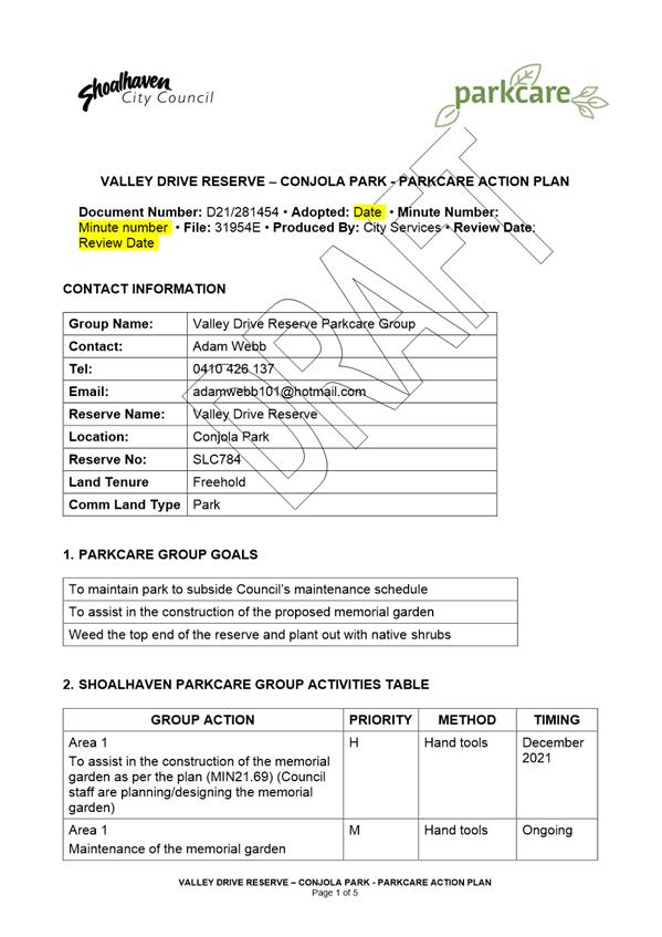
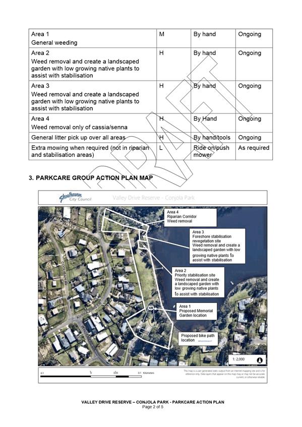
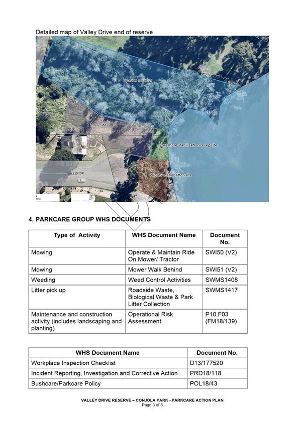
|
|
Ordinary
Meeting – Tuesday 26 October 2021
Page
0
|
CL21.225 Expression
of Interest - Lease - 100 St Vincent St. Ulladulla
HPERM Ref: D21/424596
Department: Building
Services
Approver: Paul
Keech, Director - City Services
Reason for Report
To inform Council of the tender
process for Expression of Interest - Lease - 100 St Vincent St. Ulladulla.
In accordance with Section
10A(2)(d)(i) of the Local Government Act 1993, some information should remain
confidential as it would, if disclosed, prejudice the commercial position of
the person who supplied it. It is not in the public interest to disclose this
information as it may reveal commercial-in-confidence provisions of a contract,
diminish the competitive commercial value of any information to any person
and/or prejudice any person’s legitimate business, commercial,
professional or financial interests. This information will be considered under
a separate confidential report.
This report is submitted
directly to the Ordinary Council Meeting pursuant to Clause 3 of
Council’s “Acceptance of Tenders – Reports to Council”
Policy.
|
Recommendation
That Council consider a
separate confidential report in accordance with Section 10A(2)(d)(i) of the
Local Government Act 1993.
|
Options
1. Accept the recommendation
Implications: Consider a separate confidential report on the
matter
2. Council make a different resolution
Implications: This is not recommended as an extensive
evaluation process has been undertaken by the tender evaluation team in
accordance with the tender evaluation plan
Details
Background - Property
Council purchased 100 St Vincent
Street, Ulladulla in April 2021. The site has an area of 1097 sqm with a gross
building area of 288.5 sqm. The land is classified as Community Land, and it is
categorised for General Community Use.
The building was originally
built as a Motel, but more recently owned by NSW Health and operated as a
Community Health Centre. The condition of sale between NSW Health and SCC
stipulated that the property be occupied for community and non-profit-making
purposes for a 15-year period.
The building is a two-storey
brick and terracotta tile construction, is approximately 50 years old and is in
average condition. Parking is located at the front and at the side of the
premises catering for approximately six cars. The original Motel configuration
lends itself to be used as overnight accommodation with up to four
self-contained spaces or the building could be split into multiple smaller
tenancies.
Aerial
View of 100 St Vincent Street, Ulladulla
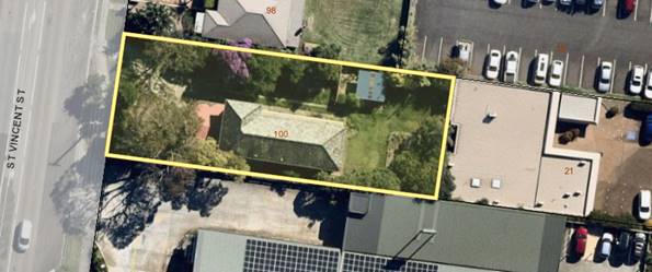
Street
view of the property- Rear view of the property
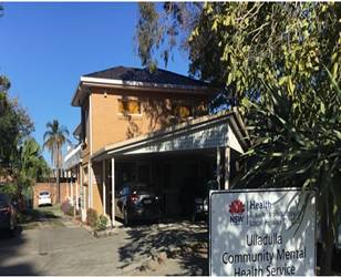
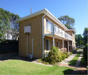
Community Engagement:
Further reporting will be required after lease negotiations
with the respondents has been finalised. The subject land is classified as
Community Land under the Local Government Act 1993 and accordingly, there is a requirement
for public notification stating Council proposes to lease the property. If any
submissions are received, they will be reported to Council.
Policy Implications
Nil.
Financial Implications:
Details relating to the Financial Implications are contained
in the confidential report.
Risk Implications
Details relating to the Risk
Implications are contained in the confidential report.
|
|
Ordinary
Meeting – Tuesday 26 October 2021
Page
0
|
CL21.226 Tenders
- Construction of Havilland Street Boat Launching Ramp & Carpark, Conjola
Park
HPERM Ref: D21/431404
Department: Works
& Services
Approver: Paul
Keech, Director - City Services
Reason for Report
To inform Council of the tender
process for Construction of Havilland Street Boat Launching Ramp & Carpark,
Conjola Park.
In accordance with Section
10A(2)(d)(i) of the Local Government Act 1993, some information should remain
confidential as it would, if disclosed, prejudice the commercial position of
the person who supplied it. It is not in the public interest to disclose this
information as it may reveal commercial-in-confidence provisions of a contract,
diminish the competitive commercial value of any information to any person
and/or prejudice any person’s legitimate business, commercial,
professional or financial interests. This information will be considered under
a separate confidential report.
This report is submitted
directly to the Ordinary Council Meeting pursuant to Clause 3 of
Council’s “Acceptance of Tenders – Reports to Council”
Policy.
|
Recommendation
That Council consider a
separate confidential report in accordance with Section 10A(2)(d)(i) of the
Local Government Act 1993.
|
Options
1. Accept the recommendation
Implications: Consider a separated confidential report on the
matter
2. Council make a different resolution
Implications: This is not recommended as an extensive tender
evaluation has been undertaken.
Details
Project Description
Council is seeking to engage a contractor to construct a new
two-lane boat launching ramp, with walkway pontoon, carparking and internal
road access at Havilland Street, Conjola Park.
Tendering
Council called tenders for the Construction of Havilland Street
Boat Launching Ramp and Carpark, Conjola Park on
23 August 2021 which closed at 10:00 am on 28 September 2021. Five (5) tenders
were received at the time of closing. Tenders were received from the following:
|
Tenderer
|
Location
|
|
Coastwide Civil Pty Ltd
|
Albion Park
|
|
GPM Marine Constructions Pty Ltd
|
Chatswood
|
|
Haines Bros Earthmoving Pty Ltd
|
Picton
|
|
Jirgens Civil Pty Ltd
|
South Nowra
|
|
Pascall Group Pty Ltd
|
Bomaderry
|
Details relating the evaluation of the tenders are contained
in the confidential report.
Community Engagement:
Community
consultation began in 2016 with a public meeting and a letter sent to all
Conjola, Conjola Park and Fisherman's Paradise ratepayers requesting comment on
the proposed facility. The facility received the support of the community
however the cost of the facility prevented delivery of the project immediately.
Further consultation was caried out in 2019 with a letter sent out to all
Conjola ratepayers requesting comment on a more afforadble option. The support
for the Havilland Street facility remained with many advocating for staging of
the project and commencment of the first stage.
Several meetings have been held
with the Conjola Community Association CCB who strongly support the Havilland
Street facility.
Other stakeholders involved in the consultation process
include Transport for NSW Maritime, Department of Primary Industries Fisheries,
NSW Department of Planning Industry and Environment Crown Lands and the NSW
National Parks and Wildlife Services.
Policy Implications
Nil
Financial Implications:
The work is fully funded in the 2021/22 Capital Works
Program and includes grant funding from the Boating Now Program Round 3 and the
Bushfire Local Econominc Recovery Fund Stage 2, as well as a Council
co-contribution. The funding provided is available to cover both the
tender amount and other project costs including the preliminary works, project
management costs and changed traffic conditions at the intersection of Lake
Conjola Entrance Road and Havilland Street.
|
|
Ordinary
Meeting – Tuesday 26 October 2021
Page
0
|
CL21.227 Tenders
- Design, Install and Commission Materials Recovery Facility
HPERM Ref: D21/415902
Department: Commercial
Services
Approver: Paul
Keech, Director - City Services
Reason for Report
To inform Council of the tender
process for Design, Install and Commission Materials Recovery Facility.
In accordance with Section
10A(2)(d)(i) of the Local Government Act 1993, some information should remain
confidential as it would, if disclosed, prejudice the commercial position of
the person who supplied it. It is not in the public interest to disclose this
information as it may reveal commercial-in-confidence provisions of a contract,
diminish the competitive commercial value of any information to any person
and/or prejudice any person’s legitimate business, commercial,
professional or financial interests. This information will be considered under
a separate confidential report.
This report is submitted
directly to the Ordinary Council Meeting pursuant to Clause 3 of
Council’s “Acceptance of Tenders – Reports to Council”
Policy.
|
Recommendation
That Council consider a separate
confidential report in accordance with Section 10A(2)(d)(i) of the Local
Government Act 1993.
|
Options
1. Accept the recommendation
Implications: Consider a separate confidential report on the
matter
2. Council make a different resolution
Implications: This is not recommended as an extensive
evaluation process has been undertaken by the tender evaluation team in
accordance with the tender evaluation plan
Details
Project Description
Council resolved on 11 August 2020 (MIN20.559)
to proceed with the development of a Materials Recovery Facility to be
located at West Nowra.
The Materials Recovery Facility (MRF) will source commingled
recyclables from across the Illawarra and Shoalhaven with a processing rate of
15 tonnes per hour. This best practice MRF owned, operated and maintained by
Council will provide greater flexibility to adapt to an ever-changing industry.
The MRF will incorporate best practice cutting-edge equipment to ensure
commodities are recovered to exceed market specifications (<1%
contamination). The MRF will provide valuable employment opportunities, reduce
the dependency on 3rd party services, reduce recycling costs, improve landfill
diversion, and assist in the transition towards a circular economy.
A previous tender has been awarded for the construction of the
MRF building.
This tender is to design, supply, install, test, certify and
commission the sorting equipment required for the MRF to operate in accordance
with the requirements described in the specification and in accordance with the
five principles of safe design.
Tendering
Council called tenders for the Design, Install and Commission
of a Shoalhaven Materials Recovery Facility on 6 August 2021. Tenders
closed at 10:00 am on 15 September 2021. Three tenders were received at
the time of closing. Tenders were received from the following:
|
Tenderer
|
Location
|
|
Australian Bale Press Company Pty Ltd
|
Tuggerah, NSW
|
|
RDT Engineering Pty Ltd
|
Eight Mile Plains, Queensland
|
|
Wastech Engineering Pty Ltd
|
Hallam, Victoria
|
Details relating the evaluation of the tenders are contained
in the confidential report.
Community Engagement:
Council resolved to seek public
comment on the proposal to establish a best practice Materials Recycling
Facility. In response a “Get Involved” post was created and
advertised on the Council Website, going live on 20 May 2020. On the same day,
all CCBs were advised by email.
The Get Involved post is ongoing and continuing. The
site had 101 visits in the first four weeks, with no questions, calls or
emails.
Policy Implications
Nil. The tender process has followed the requirements under
the provisions of the Local Government Act 1993.
Financial Implications:
Sufficient funds have been
allocated in the Materials Recovery Facility budget
for 2021/22 and 2022/23. Funding is available to cover the tender amount
including other project costs.
The cost impact on the community
through the annual domestic waste management charge is unlikely to be affected.
A lower gate fee was used for the business case than the current price Council
is currently paying a contractor to process the material. This provides
confidence to support that no additional charges will be applied to ratepayers.
The estimated capital cost is $23 Million for the total
project, which has been provided for over the 21/22 and 22/23 financial years
in Council’s 10-year Capital Plan.
Risk Implications
Details relating to the Risk
Implications are contained in the confidential report.
|
|
Ordinary
Meeting – Tuesday 26 October 2021
Page
0
|
CL21.228 Tenders
- Management & Operation Holiday Haven Shoalhaven Heads
HPERM Ref: D21/418469
Department: Commercial
Services
Approver: Paul
Keech, Director - City Services
Reason for Report
To inform Council of the tender
process for Management and Operation – Holiday Haven Shoalhaven Heads and
appoint the new management team.
In accordance with Section
10A(2)(d)(i) of the Local Government Act 1993, some information should remain
confidential as it would, if disclosed, prejudice the commercial position of the
person who supplied it. It is not in the public interest to disclose this
information as it may reveal commercial-in-confidence provisions of a contract,
diminish the competitive commercial value of any information to any person
and/or prejudice any person’s legitimate business, commercial,
professional or financial interests. This information will be considered under
a separate confidential report.
This report is submitted
directly to the Ordinary Council Meeting pursuant to Clause 3 of
Council’s “Acceptance of Tenders – Reports to Council”
Policy.
|
Recommendation (Item to be determined
under delegated authority)
That Council consider a
separate confidential report in accordance with Section 10A(2)(d)(i) of the
Local Government Act 1993.
|
Options
1. Accept the recommendation as
presented.
Implications: Consider a separated confidential report on the
matter.
2. Council make a different resolution.
Implications: This is not recommended as an extensive
evaluation process has been undertaken by the tender evaluation team in
accordance with the tender evaluation plan.
Details
Council called tenders for the management and operation of
Holiday Haven Shoalhaven Heads on 9 September
2021 which closed at 10:00 am on 1 October 2021. Four (4) tenders were
received at the time of closing, and were then assessed; the outcome of the
evaluation is contained in the confidential report.
Tenders were received from the following:
|
Tenderer
|
Location
|
|
TNJ Turf Renos Pty Ltd
|
Cudmirrah
|
|
JS & IS Management Pty Ltd
|
Kangaroo Valley
|
|
B. Buckley & D. Seaton
|
Lightning Ridge
|
|
Paul & Maria Harrod Family Trust
|
Warilla
|
Community Engagement:
The tender process for the appointment of a management
contractor to Council’s Holiday Haven Park at Shoalhaven Heads has been
followed within the requirements of the provisions of the Local Government Act.
Financial Implications:
The financial provisions of the
current and new contract are the same.
Financial aspects of the management contracts for
Council’s commercially operated Holiday Haven Parks are a balance between
sufficient funds for the contract to provide a prudent level of staffing and
equipment to effectively operate these complex properties, and the need for
Council to obtain the best value for money. Holiday Haven considers the cost of
operating these properties carefully in order to maintain an adequate business
benefit to Council and a return to the Contractor that ensures the properties
are operated and maintained for Council to the required industry standards.
|
|
Ordinary
Meeting – Tuesday 26 October 2021
Page
0
|
CL21.229 Variations
to Development Standards - September Quarter 2021
HPERM Ref: D21/416588
Department: Development
Services
Approver: Phil
Costello, Director - City Development
Reason for Report
This report is being submitted
directly to the Ordinary Meeting due to therequirement that the information
contained in the report is to be reported to the full elected Council and to
the Department of Planning, Industry and Environment.
Council is required to consider
variations to development standards (contained in an environmental planning
instrument such as the Shoalhaven Local Environmental Plan) which exceed 10%,
with lesser variations able to be dealt with by staff, under delegation.
Council is also required to publish the variations in
addition to reporting the variations to the full Council and the Department of
Planning, Industry and Environment.
|
Recommendation
That
Council receive the Variations to Development Standards – June Quarter
Report 2021 for information.
|
Options
1. Receive the
report for information.
Implications: Council will be complying with the
reporting provisions as detailed in Circular PS20-002 Variations to
development standards.
2. Resolve an
alternative and provide details to staff.
Implications: Depending on what is resolved, the
Council would need to ensure compliance observing that the Department
undertakes periodic audits.
Background
SEPP 1 and clause 4.6 have allowed flexibility in the
application of development standards by allowing the consideration of
development proposals that meet the objective of a development standard but not
its stated value.
On 5 May 2020, the Department of Planning, Industry and
Environment issued a new circular (PS20-002) which replaced PS18-003 and issued
assumed concurrence, governance, and reporting requirements for consent
authorities. It also advised that Council reports are to come through the
Planning Portal and the repeal of SEPP 1. The concurrence is conditional
containing limitations on lot sizes for dwellings in rural areas and for
contraventions over 10% (which must be reported to Council).
A link to the circular can be found here.
Procedural and reporting requirements
To ensure transparency and integrity in the planning
framework, the Department requires monitoring and reporting measures.
· A written application must be made to support a variation.
· An online register of all variations to be maintained.
· A report must be submitted through the Portal.
· A report of all variations from a Council must be provided
to a meeting of the Council at least once a quarter.
Audit
The Department will continue to
carry out random audits to ensure the above monitoring and reporting measures
are complied with. The Department and the NSW Independent Commission Against
Corruption will continue to review and refine the audit strategy.
It is noted that the application
has been the subject of ICAC investigations (amongst other things) referred to
as Operation Dasha. More information is available here. The Department is currently reviewing the
application of clause 4.6.
Should ongoing non-compliance
be identified with one or more consent authorities, the Secretary is able to consider
revoking the notice allowing concurrence to be assumed, either generally for a
consent authority or for a specific type of development.
Conclusion
The repeal of SEPP 1 came into
effect from 1 February 2020 as part of the SEPP Review Program to update and
simplify the NSW Planning system.
The variations are provided to
the Department in the form of a spreadsheet and are published as soon as
possible after the quarter has ended.
The table below is based on the
spreadsheet but is simplified for easier reading. The spreadsheets are viewable
on Council’s webpage and are published quarterly as soon as possible
after the last day of the month.
1. Table – Variations September
Quarter 2021
|
DA
|
Lot
|
DP
|
Street Name
|
Suburb
|
Post Code
|
Description
|
Standard Varied
|
Extent of Variation
|
Decision
|
Date
|
|
DA20/1413
|
1
|
831274
|
Church St
|
Ulladulla
|
2539
|
Residential Flat Building
– 22 units
|
Height
|
33%
|
Approval
|
3/8/2021
|
|
SF10873
|
5
|
803450
|
Yeovil Drive
|
Bomaderry
|
2541
|
Subdivision of existing dual
occupancy
|
Lot size
|
12.6%
|
Approval
|
14/7/2021
|
|
|
Ordinary
Meeting – Tuesday 26 October 2021
Page
0
|
CL21.230 DA16/1465
- 173 Kinghorne Street and 2 & 4 Albatross Road, NOWRA - Lot 1, 29 & 30
DP 25114
DA. No: DA16/1465
HPERM Ref: D21/256010
Department: Development
Services
Approver: Phil
Costello, Director - City Development
Attachments: 1. Section
4.15 Planning Report (under separate cover) ⇨
2. Determination Document -
Refusal ⇩
Description of Development: Demolition of existing
structures and construction of a mixed-use development consisting of 55
apartments including 16 x 3-bedroom, 31 x 2 bedroom and 8 x 1-bedroom
apartments, a basement car parking area and 3 commercial tenancies at ground
floor with frontage to both Kinghorne Street and Albatross Road
Owner: Bill Zervos and Jasmine Anne Simpson &
John Irwin Gould
Applicant: Lee Carmichael Town Planning (now trading
as) PDC Planners
Notification Dates: 14 June – 14 July 2017
No. of Submissions: Six (6) submissions in
objection and Nil (0) in support.
Purpose
/ Reason for consideration by Council:
The
application has been called in by Council (details are provided below) and has
been reported on previous occasions. This is an outstanding application that
requires resolution having been with Council for over four (4) years.
On 1 October 2019, it was
resolved by the Development and Environment Committee that Development
Application (DA) ‘DA16/1465 – Residential Units and
Commercial Space – 173 Kinghorne Street, Nowra be called in to Council
for determination due to significant public interest.’ (DE19.107)
On 6
October 2020, the Development & Environment Committee resolved (MIN20.728):
“That consideration of Development Application
DA16/1465 – Mixed Use development consisting of 55 residential units and
commercial space on the land known as 173 Kinghorne Street and 2 & 4
Albatross Road, Nowra (Lot 1, 29 and 30 DP 25114) be deferred to the January
2021 Development and Environment Committee Meeting to allow Council to
undertake further traffic investigations in consultation with the
developer.”
On 11 May 2021, it was resolved
by the Development and Environment Committee: “That the Item be deferred
to the June Development and Environment Committee meeting for further
consideration.” (MIN21.256).
On 1 June 2021, it was resolved
by the Development and Environment Committee; “That Council receive
this report as an update on the progress of the assessment of DA16/1465 and in
satisfaction of the 11 May 2021 resolution of the Development & Environment
Committee (DE21.50).” (MIN21.357).
Options
1. Refuse the
Development Application (DA) in accordance with the recommendation.
Implications: The proposal would not proceed in its current
form. The applicant can, however, apply for a section 8.2 review of
Council’s decision and/or could lodge an appeal with the NSW Land and
Environment Court against Council’s decision.
2. Approve the DA.
Implications: Council would have to provide reasons to support
the development, having regard to section 4.15 of the Environmental Planning
and Assessment Act 1979 (EP&A Act) considerations. Should
Council resolve to approve the DA a suite of conditions would be required to be
drafted for reconsideration by the Development & Environment Committee.
Under some circumstances, third parties (i.e., objectors) can seek a judicial
review of Council’s decision in the NSW Land and Environment Court.
3. Alternative
recommendation.
Implications: Council will need to specify an alternative
recommendation and advise staff accordingly.
Location Map
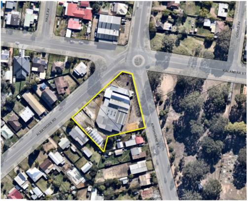
Figure 1 - Extract of the subject site in the local context.
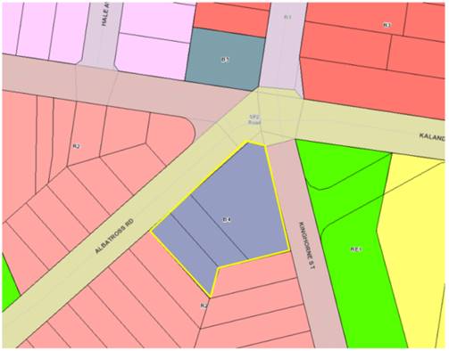
Figure 2 - Extract of the Shoalhaven Local Environmental Plan 2014
Land Use Zoning Map with the subject site
with a yellow border
Background
Post-Lodgement
Key dates are as follows:
· 8
April 2016, the DA was lodged with Council.
· 9
August 2016, Council requested additional information from the applicant in
relation to the design and access arrangements from Albatross Road.
· 16
December 2016, revised plans and additional information was submitted by
the applicant in response to Council’s letter dated 9 August 2016. The
amended plans included modifications to the southern portions of each wing of
the building and deletion of two apartments (reducing the unit yield from 57 to
55 apartments). The reduction in units on the southern portion of the
development was proposed to achieve a more appropriate transition to the
adjoining low-density development.
· 27
February 2017, Council requested additional information from the applicant,
with continued concerns raised in relation to design elements and major concerns
raised in relation to the proposed access/egress onto Albatross Road.
· 7
March 2017, Council met with the applicant to discuss the Planning Proposal
over the site (described below) and continued concerns with the design and
location of access/egress onto Albatross Road.
· 22
March 2017, a further additional
information letter was sent to the applicant to detail the outcomes of the 7
March 2017 meeting and to express continued concerns regarding the proposed
access/egress onto Albatross Road.
· 10 July 2018, Council
met again with the applicant to discuss design and traffic issues.
· 12
September 2018, the applicant lodged concept plans for access/egress to the
development from Kinghorne Street for Council’s consideration (refer to Figure
18).
· 12
October 2018, Council provided feedback to the applicant on the concept
plan, noting that the concept plan addressed the main concern that had been
raised by Council being the relocation of the access from Albatross Road to
Kinghorne Street frontage.
· 18
April 2019, the applicant confirmed that they would not be pursuing
any change to the design of the development which would relocate the access
from Albatross Road to Kinghorne Street frontage.
· 12
August 2019, the applicant submitted a further amended Traffic Report
prepared by Jones Nicholson (D19/280251) to justify the retention of access on
the Albatross Road frontage and to address concerns raised in relation to the
designs apparent inconsistency with State Environmental Planning Policy
(Infrastructure) 2007.
· 1
October 2019, the Development and Environment Committee that Development
Application (DA) ‘DA16/1465 – Residential Units and
Commercial Space – 173 Kinghorne Street, Nowra be called in to Council
for determination due to significant public interest.’ (DE19.107).
· 26
November 2019, the applicant submitted amended plans, acoustic report, and
clause 4.6 variation statement.
· 6
October 2020, the Development &
Environment Committee resolved (MIN20.728):
“That consideration of
Development Application DA16/1465 – Mixed Use development consisting of
55 residential units and commercial space on the land known as 173 Kinghorne
Street and 2 & 4 Albatross Road, Nowra (Lot 1, 29 and 30 DP 25114) be
deferred to the January 2021 Development and Environment Committee Meeting to
allow Council to undertake further traffic investigations in consultation with the
developer.”
Council has taken the following
action in relation to the above matter, following the 6 October 2020 Council
resolution:
1. 18
November 2020, relevant Council staff met to discuss critical aspects of
the Development Application in particular the Traffic Management Report
prepared by Jones Nicholson Consulting Engineers dated 27 February 2021
(Reference: CRPT-16020003.01B). The outcomes of the meeting were provided to
the applicant on 26 November 2021 (D20/526133).
2. 21 December 2020,
Council provided additional information to the applicant in the form of: Outputs from Council’s traffic modelling and
Council’s requirements for a future 4 lane cross section of Albatross
Road (D20/563561). Council also offered as part of the forwarding of this additional
information the opportunity to meet further to
ensure that all matters have been addressed relating to traffic and planning
issues.
3. 15
January 2021, Council notified the applicant via email (D21/16222) that the
information requested in Council’s 21 December 2020 was required to be
submitted to Council in 7 days.
4. 4
February 2021, Council emailed the applicant (D21/43579) offering to meet
to discuss the additional information.
5. 10
February 2021, Council notified the applicant via email (D21/52704) that
the information requested in Council’s 21 December 2020 was required to
be submitted to Council in 7 days as the applicant had not responded to Council
in relation to the offer of a meeting and the information had not been
submitted.
6. 23
February 2021, the applicant’s traffic consultant (Stephen Falkner)
emailed Council, to request the following:
§ traffic data on the existing road network from their records; and
§ projected traffic data for
10-year projections (2031).
7. 12
March 2021, Council emailed the applicant’s traffic consultant
(Stephen Falkner) (D21/99332) with the following:
§ Council’s most recent tube traffic count for the area; and
§ projected traffic data for
10-year projections (2031).
8. 24
March 2021, Council emailed the applicant ( D21/117366)
to inform them that the application would be required to be reported to Council
in the absence of a formal response to Council’s email dated 21 December 2020.
9. 31
March 2021, the applicant was emailed (D21/127622) to inform them that the
additional information was required to be submitted to Council within 7 days.
10. 11
May 2021, it was resolved by the Development and Environment Committee:
“That the Item be deferred to the
June Development and Environment Committee meeting for further consideration.”
(MIN21.256).
11. 18 May 2021, the applicant was emailed
(D21/203761) to again request the additional information.
12. 27
May 2021, the applicant submitted a revised SIDRA analysis (D21/227623) for
the proposed development.
13. 1 June 2021, it was resolved by the
Development and Environment Committee; “That Council receives this
report as an update on the progress of the assessment of DA16/1465 and in
satisfaction of the 11 May 2021 resolution of the Development & Environment
Committee (DE21.50).” (MIN21.357).
14. 27
May 2021, the applicant’s revised
SIDRA analysis (D21/227623) was referred Council’s Development Engineers
and City Services for further consideration.
15. 7 October 2021,
Council staff met with the applicant and their consultant to discuss the
outstanding access and traffic matters. The applicant outlined the reasoning
for the proposed access and traffic assessment associated with the development
as follows:
• The
applicant claims that their Albatross Road treatment is adaptable for future
integration into a growing network over the next 10 years. Their position is
formed in the view that the future beyond this time frame is so uncertain that
it is not reasonable to limit their proposal (future)
• The
Albatross Road access is a compliant treatment whereas the Kinghorne street
treatment is not compliant with the relevant Australian Standards. (Access)
• That
potential development to the west of their proposal would need to access from
Albatross Road (Driveway)
Site History and Previous
Approvals
In April 2016, a Planning
Proposal (PP) was lodged concurrently with this DA to rezone the subject site
to enable the development of the land as currently proposed.
The previous land zoning (B5
Business Development) only permitted residential development for the purpose of
‘shop top housing’ which would require the entire ground floor to
be developed for commercial use.
The PP sought to amend the
following Land Zoning and Height of Buildings maps in Shoalhaven Local
Environmental Plan 2014 (SLEP 2014):
· Land
Zoning – Sheet LZN_013E - amend zoning of subject land from B5 Business
Development to B4 Mixed Use.
· Height of
Buildings – Sheet HOB_013E - amend maximum height of building from 11m
default height (no mapped) maximum building height as per clause 4.3(2A) of
Shoalhaven Local Environmental Plan (LEP) 2014, to a height determined by the
outcome of the character assessment (maximum of 14m).
On 12 September 2017, the
Development Committee resolved (MIN17.776) to adopt the PP as exhibited with
the following addition:
“to avoid uncertainty, the width of the part of
the site with an 8.5m maximum building height is 9m, as measured from the
southern boundaries of Lot 1 and Lot 30 DP 25114, and south-eastern and
south-western boundaries of Lot 29 DP 25114.”
Under Council’s
delegation, the PP was forwarded to NSW Parliamentary Counsel to draft the
amendment to SLEP 2014 under Section 59(1) of the Environmental Planning and
Assessment Act 1979 (EP&A Act).
On 6 October 2017, Amendment No.
16 to SLEP 2014 was published on the NSW Legislation website and commenced,
bring into effect the zoning and building height changes outlined above.
The following
is a list of relevant approvals for the subject site:
· BA73/1794:
Showroom additions
· BA74/0275:
Storage Shed
· BA76/0601:
Car yard additions
· DA01/2756:
Car service centre – alterations and additions – approved – 9
October 2001.
· DA02/2244:
Commercial Workshop/Shed – approved – 30 August 2002.
The subject
site has operated in the capacity of vehicle servicing, repairs, and sales for
a significant period.
Proposed Development
The Development Application (DA)
is seeking development consent for the demolition of existing structures and
construction of a mixed-use development consisting of 55 apartments,
including:
· 8 x 1 bedroom
apartments
· 31
x 2 bedroom apartments
· 16
x 3 bedroom apartments
· 3
commercial tenancies (total commercial floor area 259m2 (267m2
including bathroom i.e., GFA) at ground floor with frontage to both Kinghorne
Street and Albatross Road.
· A
basement car parking area accessed via Albatross Road with 93 car parking spaces.
· Construction
of a left turn slip lane (removal of on-street parking) for access into the
basement car park off Albatross Road.
· Construction
of a central median and signage on Albatross Road to control the movement of
traffic in and out of the proposed development (left in and left out movements
only).
A site plan, ground floor,
elevations, landscape plan and photomontages are provided in Figures 3
– 14.
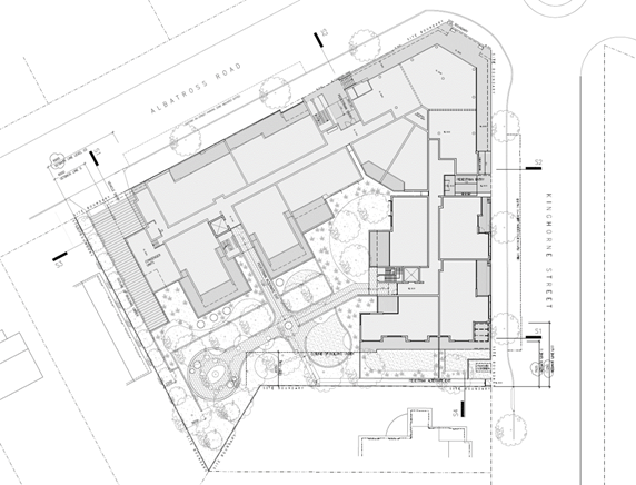
Figure 3 - Site Plan of the proposed development.
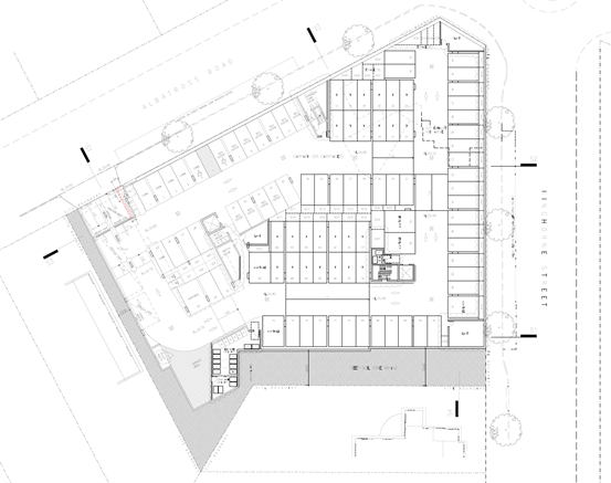
Figure 4 - Basement floor plan of the proposed development.
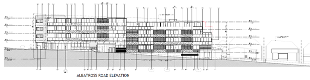
Figure 5 – Elevation of the proposed development (western
elevation – Albatross Road)
Figure 6 - Elevations of the proposed development (eastern
elevation – Kinghorne Street).
 Figure 7 - Elevation of the proposed development (southern
elevation).
Figure 7 - Elevation of the proposed development (southern
elevation).
Figure 8 - Section plans of the proposed development.
Figure 9 - Section plans of the proposed development.
Figure 10 - Landscape plans of the proposed development.
Figure 11 - Photomontage view from the south-eastern (Kinghorne
Street).
Figure 12 - Photomontage view from the north-eastern corner of
Kinghorne and Kalandar Street.
Figure 13 -Photomontage of the south-western elevation of the
development as viewed from Albatross Road.
Figure 14 - Extract of engineering design plan
indicating the slip-lane and entry design to the development. The design
includes a central median on Albatross Road to limit vehicle movements to a
left in and left out movement.
Subject Land
The subject site comprises 3
lots (subject site) located on the south-western corner of the intersection of
Kinghorne Street, Albatross Road and Kalandar Street. The subject site is
described and legally identified as follows:
· Lot
29 DP 25114 – 4 Albatross Road, Nowra
· Lot
30 DP 25114 – 2 Albatross Road, Nowra
· Lot
1 DP 25114 – 173 Kinghorne Street, Nowra
The site is an irregular shaped
lot with a frontage of 74m to Albatross Road and 60m to Kinghorne Street with a
9.5m corner splay. The site falls gradually to the south-western corner of the
site at Albatross Road.
The combined land area of the
lots is approximately 3,497m2.
Site & Context
An electrical wholesale supply
business (L&H Electrical) occupies the site. The site had previously
operated as a car servicing workshop that serviced and repaired motor vehicles.
The site adjoins established residential uses to the south and west, a tyre service
and residential uses to the north and public open space to the east.
The surrounding development can
be broadly characterised as low-density residential consisting of single and
two storey dwelling houses. Development immediately to the south consists of
free-standing single storey dwellings and associated outbuildings.
Beyond these dwellings and on
land bound by Albatross Road, Kinghorne Street and Albert Street is low density
residential development – mainly of single storey construction and
typically older housing stock.
To the west on the opposite side
of Albatross Road is a continuation of predominately freestanding low-density
dwellings with some multi dwelling housing developments.
To the east on the opposite side
of Kinghorne Street, is a Council park and cemetery.
On the northern side of the
intersection of Albatross Road and Kinghorne Street is an existing tyre shop.
On the eastern side of Kinghorne Street at the intersection with Kalandar
Street Council has recently approved 2 x 4 storey residential flat buildings,
consisting of 91 apartments and basement car park (DA19/1846).
As mentioned earlier, the land
was the subject of a planning proposal to rezone the subject land from B5
Business Development to B4 Mixed Use and amend maximum height of building to
part 14m and 8.5m (transition to low density development to the south. The
Planning Proposal was supported by a Character Assessment prepared by Urbanac
dated May 2017 (D17/257485) which informed the building heights for the site.
The character assessment
discussed the significance of providing transition in development scale and
that a suitable building height will:
“ensure a smooth
transition between new development and existing housing stock and maintain good
amenity for the dwellings immediately adjoining the site.” (P10, of
the Character Assessment by Urbanac.)
Issues
Traffic, Vehicular access and
impacts on the local road network.
Proposed vehicular access and
road upgrades under the DA
The proposed development has
frontages to both Albatross Road (MR92), which is a classified regional road,
and Kinghorne Street, which is a local road. The proposed mixed-use development
has its only vehicular access from Albatross Road.
To facilitate this vehicular
access, the following access and road upgrades along the Albatross Road
frontage are proposed:
· Construct
an 8.15m entry/exit driveway which can accommodate the manoeuvring of a medium
rigid vehicle (MRV) in and out of the proposed development. Swept path plans
demonstrate the ability of a garbage truck to manoeuvre in the basement car
park area for garbage collection.
· Construct
a basement car parking area accessed via Albatross Road with 93 car parking
spaces. Thirteen stacked car parking spaces have been provided in the basement
car park area. The stacked parking spaces will be allocated to the 3-bedroom
apartments, whereby the management of the car spaces is managed by the
apartment residents themselves.
· Access
to the basement car park is to be managed via security pass and intercom
arrangement.
· Construction
of a left turn slip lane for access into the basement car park off Albatross
Road and removal of the existing car parking on Albatross Road (six (6) spaces)
adjacent to the north western boundary.
· The
construction of a central median and signage be constructed along Albatross
Road to control the movement of traffic in and out of the proposed development.
The central median will force vehicles exiting from the proposed development
into a left turn only movement. Similarly, the construction of a central median
will force vehicles wishing to enter the proposed development into a left turn
in movement only. Vehicles travelling east along Albatross Road will need to
utilise the Kinghorne Street/Albatross Road roundabout to make a U-turn.
· With
regard to the servicing of the commercial units, the applicant proposes to
utilise the existing on-street parking on the eastern and western sides of
Kinghorne Street. A loading zone is to be provided on the western side of
Kinghorne Street to provide direct servicing access to the commercial units.
This would require the approval of the local traffic committee.
Throughout the assessment of the
DA, access and traffic associated with the proposed access arrangements have
been a critical issue. Council staff recently met with the applicant and their
consultant to discuss the outstanding access and traffic matters. The following
points summarise the applicant’s position in relation to the proposed
access and traffic issues:
a) The
applicant claims that their Albatross Road treatment is adaptable for future
integration into a growing network over the next 10 years. Their position is
formed in the view that the future beyond this time frame is so uncertain that
it is not reasonable to limit their proposal.
b) The
Albatross Road access is a compliant treatment whereas the Kinghorne Street
treatment is not compliant with the relevant Australian Standards.
c) That
potential development to the west of their proposal would need to access from
Albatross Road.
The following addresses each of
these issues.
a) Impacts
to the road network
As a result of the
development’s primary and singular access/egress from/to Albatross Road
it is considered by (both) Council’s Development Engineer and City
Services Engineers that the following roads proximate to the subject site
(refer Figure 15) will be impacted by the proposed development:
· Princes
Highway – State highway.
· Albatross
Road/Kalandar Street – Regional classified road
· Kinghorne
Street – local road
· Berry Street –
local road
Figure 15 – Aerial image of the site
indicating the roads in proximity to the site that will be impacted by the
proposal
The
most recent submitted revised SIDRA analysis (received 27 May 2021) was
reviewed by Council’s Development Engineers and City Services who
concluded that:
(a) The proposed
access on Albatross Road reduces:
- lane capacity (via
a reduction in width); and
- Council’s
ability to adequately service the surrounding road network.
(b) Given the
higher volume of traffic relative to Kinghorne Street, there is likely to be
increased conflicts on Albatross Road as a result of the applicant’s
current design utilising the Albatross Road access/egress arrangement.
(c) Implementation
of a right turn treatment (CHR(s)) into the development on Kinghorne Street is
likely to provide an opportunity to resolve the issue of increased conflicts
and reduced lane capacity on Albatross Road.
(d) The
application of the most current Austroads standards and turning treatments
indicates that a compliant right turn treatment (CHR(s)) into the development
on Kinghorne Street is achievable and will provide a compliant and suitable
treatment for entry to the development from a lower order road (not the
regionally classified road – Albatross Road).
(e) The approach
sight distances to turning vehicles are significantly improved with the
Kinghorne Street option when compared to the Albatross Road option.
(f) Access
from Kinghorne Street remains City Services preferred option in terms of
current and future efficient and safe operation of Albatross Road and providing
a development that is compliant with cl. 101(2)(a) of ISEPP (as assessed
further below), which requires vehicular access to be via a local road
(Kinghorne Street), being part of the unclassified road network and to which,
the site has an extensive street frontage.
Throughout the assessment of the
DA, Council staff have consistently advised that development in the West Nowra
region provides enough additional volume to warrant the increase of traffic
expected on Albatross Road.
This section of road forms an important link to the Princes
Highway and Flinders Estate, Albatross Air Base and Aviation Technology Park
and on to Canberra, and the Albatross and Kinghorne Intersection is a key
intersection in the Local, Regional and State Road network in the Shoalhaven.
b) Access
via Albatross Road vs. Kinghorne Street
The applicant has stated that
vehicular access to the site via Kinghorne Street is not practical as it is
unable to be designed to be technically compliant by 2017 or 2021 standards.
However, Council staff have advised the applicant that as per Austroads Guide
to Road Design, a channelised right turn treatment into the site on Kinghorne
Street would in fact be compliant with both 2017 and 2021 standards. The total
length available along the Kinghorne street frontage is approx. 61m, the total
length required for a compliant turning treatment (service vehicle) is
approximately 52m leaving 9m for driveway and landscaping, confirming
compliance with both Councils DCP and Austroads.
Conversely, the
applicant’s proposal for left-in left-out access onto Albatross Road is
non-compliant with regard to through lane and median width.
To provide a compliant design,
the proposal will require a median in Albatross Road to make the left-in and
left-out arrangement work. This median width together with the development not
being set back from the Albatross Road boundary means all widening will be
required to occur from the proposals kerb and gutter and not the centreline of
the road. Accordingly, the development as proposed will require substantial
resumption of land on the opposite side of Albatross Road. An indicative
arrangement has been prepared by Council’s City Services to demonstrate
this as shown at Figure 16.
Figure 16 – Aerial image with overlay
showing required works and acquisition that would be required to provide a
compliant treatment of Albatross Road associated with access to the site off
Albatross Road.
c) Potential
development to the west of their proposal
The applicant has raised that,
despite any future road upgrades of Albatross Road, sites to the west of their
proposal will always require access from Albatross Road (see Figure 17).
Accordingly, to deny access to the subject site is illogical as future development
will cause impact on the road network.
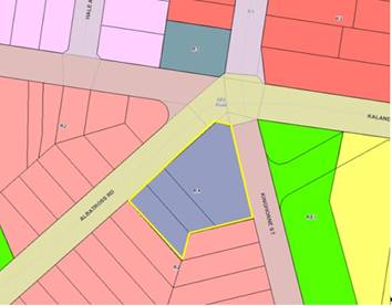
Figure 17 – Excerpt Lot Zoning Map
Shoalhaven LEP 2014
To this effect, Council’s
concerns are not with an additional 10-20 movements of traffic with a potential
single residential site which may be developed for any of the permitted uses
within the R2 Low Density Residential zone, but with a large development
close to a critical intersection with 93 parking spaces and thus significantly
higher turning traffic volumes.
It is further noted that the
controls of the State Environmental Planning Policy (Infrastructure) 2007 do
not relate to sites that have only a single frontage (as outlined below, and
the sites to the west do not have a secondary frontage to a lower order local
road.
State Environmental Planning
Policy (Infrastructure) 2007 (ISEPP)
The subject site has frontage to
Albatross Road (MR92), being a classified regional road. Accordingly, clause
101 of ISEPP applies and reads as follows:
101 Development with frontage to
classified road
(1) The objectives of
this clause are—
(a) to ensure that new
development does not compromise the effective and ongoing operation and
function of classified roads, and
(b) to prevent or
reduce the potential impact of traffic noise and vehicle emission on
development adjacent to classified roads.
(2) The consent
authority must not grant consent to development on land that has a frontage to
a classified road unless it is satisfied that—
(a)
where practicable and safe, vehicular access
to the land is provided by a road other than the classified road,
and
(b) the safety,
efficiency and ongoing operation of the classified road will not be adversely
affected by the development as a result of—
(i) the design of the
vehicular access to the land, or
(ii) the emission of
smoke or dust from the development, or
(iii) the nature, volume
or frequency of vehicles using the classified road to gain access to the land, and
(c) the development is of a type that is not
sensitive to traffic noise or vehicle emissions, or is appropriately located
and designed, or includes measures, to ameliorate potential traffic noise or
vehicle emissions within the site of the development arising from the adjacent
classified road.
Under subclause 101(2) the
consent authority must not grant consent to development on land that has
a frontage to a classified road unless it is satisfied that all the
subsequent considerations have been met by the proposal.
The 3 preconditions in subclause
101(2) are collective. Therefore, any one of the pre-conditions in subclause
101(2) about which Council is not satisfied could prevent the issue of consent:
· Subclause
101(2)(a) (‘where practicable and safe, vehicular access to the land
is provided by a road other than the classified road’), is relevant
because the site has frontage to Kinghorne Street (unclassified at this
location) and Albatross Road (regional classified road at this location).
Following a meeting with the applicant in September 2018,
the applicant submitted concept plans (D18/355817) (refer to Figures 18 and
19) to demonstrate that practicable and safe vehicular access to the land
can be provided by a road (Kinghorne Street) other than the classified road.
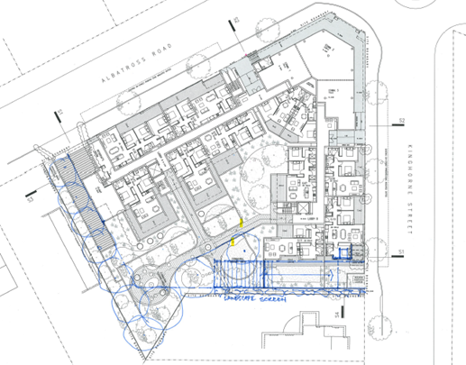
Figure 18 - Applicant's submitted concept plan,
demonstrating that access via Kinghorne Street is capable of being achieved.
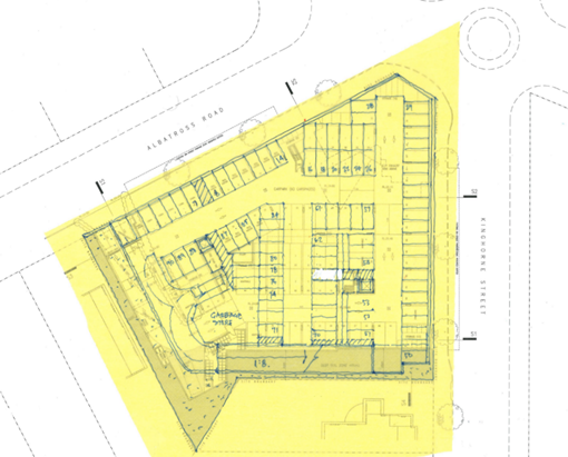
Figure 19 - Applicant's submitted concept plan,
demonstrating that access via Kinghorne Street is capable of being achieved.
In order to determine whether the access to the development
is “practicable”, the Court has established the test in the
case of Modern Motels Pty Ltd v Fairfield City Council [2013] NSWLEC
138, Preston CJ at paragraph [42]:
The phrase
“where practicable” regulates the desired outcome (“vehicular
access to the land is provided by a road other than a classified road”). The
consent authority is precluded from granting consent to a development on land that
has frontage to a classified road unless it is satisfied that the desired
outcome will be
achieved, where
that desired outcome is practicable. That is to say, the practicability
is as to the outcome of providing vehicular access to the land by a road other
than the classified road.
[emphasis added]
The desired outcome is for access to the land to be via the
unclassified local road – Kinghorne Street, which will ensure that the
development does not compromise the effective and ongoing operation and
function of the classified road (Albatross Road).
The applicant has indicated that access via Kinghorne
Street is capable of being provided by a road other than a classified road, and
in accordance with subclause 101(2)(a) the consent authority must not grant
consent to the development as practicable and safe, vehicular access to
the land is able to be provided by a road other than the classified road.
Subclause 101(2)(b) (“the
safety, efficiency and ongoing operation of the classified road will not be
adversely affected by the development as a result of—
(i) the design of the
vehicular access to the land, or
(ii) the emission of
smoke or dust from the development, or
(iii) the nature, volume or frequency of vehicles
using the classified road to gain access to the land, and
· The
applicant’s submitted traffic reports do not (in the view of
Council’s Traffic and Transport Unit) establish that the safety,
efficiency, and ongoing operation of the classified road would not be adversely
affected by the development as a result of the design of the vehicular access
to the land, and the nature, volume or frequency of vehicles using the
classified road to gain access to the land.
It is noted that on Page 15 of the Traffic Management
Report prepared by Jones Nicholson, dated 27 February 2018 (D18/89444)
concerning the Albatross Road access:
“The proposed Albatross Road access is considered
satisfactory in that it will not impact upon the safety, efficiency and ongoing
operation of Albatross Road. Furthermore, practicable access for all traffic
movements is not achievable from Kinghorne Street to the proposed development.
Therefore, the proposed access from Albatross Road can be approved in meeting
the requirements of SEPP Infrastructure clause 101.”
Council’s Traffic and Transport Unit has considered
all the applicant’s detailed traffic reports and is not satisfied that the access onto Albatross Road demonstrates
compliance with subclauses 101(2)(b)(i) and (iii) of the Infrastructure
SEPP. It follows therefore that the development has not been able to meet
preconditions 101(2)(a) and (b) and that Council therefore has questionable
ability under the ISEPP to approve the development application in its current form.
· Subclause
101(2)(c) (“the development is of a type that is not sensitive to
traffic noise or vehicle emissions, or is appropriately located and designed,
or includes measures, to ameliorate potential traffic noise or vehicle
emissions within the site of the development arising from the adjacent
classified road”) is relevant, the noise
criteria have been addressed in the submitted Acoustic Report prepared
by KA Acoustics dated 6 November 2019 (D19/423688).
The recommendations of the report
will ensure internal noise levels comply with those specified in Subclause
101(2)(c) are capable of being addressed by
appropriate development consent conditions, if approved.
It is
considered that:
1. Practicable
and safe, vehicular access to the land can be provided by a road (Kinghorne
Street) other than the classified road (Albatross Road MR92)
2. The safety, efficiency, and ongoing
operation of the classified road (Albatross Road MR92) will be adversely
affected by the development as a result of:
(i) the
proposed design of the vehicular access to the land, AND
(ii) the nature,
volume or frequency of vehicles proposing to use the classified road to gain
access to the land.
As such pursuant to the
Infrastructure SEPP (2007) the Council is unable to consent to the development.
Car Parking
Residential
Parking Rate
In
relation to the numerical requirements for car parking for residents and
visitors associated with the residential component of the development, this is
set by Part 3J (Objective 3J-1) of the Apartment Design Guide. Design Criteria
1 of Objective 3J-1 requires that; the minimum car parking requirement for residents and visitors is set out in
the Guide to Traffic Generating Developments, or the car parking requirement
prescribed by the relevant council, whichever is less.
With regard to Council’s Development
Control Plan (DCP) car parking requirements, it is noted that the subject DA
was lodged with Council on 18 April 2016. Version 3 of Chapter
G21: Car Parking and Traffic in Shoalhaven DCP 2014 (SDCP 2014) was
adopted on 23 June 2015 and commenced on 1 July 2015. In accordance with
Section 10 of SDCP 2014 Chapter 1, any application lodged before the
commencement of this Plan will be assessed in accordance with any previous
development control plan. Version 3 of Chapter G21: Car Parking and Traffic is
technically the relevant DCP that applies to the development, being the DCP
that applied at the time of lodgement of the development application.
It is noted that Chapter G21:
Car Parking and Traffic Version 4, which commenced on 23 October 2020 does not
apply to the development application, nor does Version 5 which has been adopted
by Council at its meeting on 7 September 2021. It is highlighted however
that Version 3 and Version 5 have the same parking requirements.
The tables over page, provide an assessment
of the development against the applicable parking controls. The car parking
rates under the car parking schedule in
Chapter G21 Versions 3, 4 and 5 are all higher than the rate set by the Guide
to Traffic Generating Developments, and accordingly the car parking
requirements of the Guide to Traffic Generating Developments apply which
requires a total of 66.1 residential and visitor car parking spaces.
Commercial
Parking Rate
The
car parking rate applying to the commercial component of the development is to
be calculated according to Chapter G21: Car Parking and Traffic in SDCP 2014.
The parking rate for commercial development has not been amended between the
abovementioned versions of the DCP.
Commercial
development within land zoned B3 Commercial Core at ground level or where
access to the development is from ground level above an underground level of
car parking is 1 space per 24m2 gross floor area.
The
commercial floor of 267m2 is located at ground level with frontage
to both Kinghorne Street and Albatross Road and is located above an underground
level of car parking. Therefore, 267m2 divided by 24m2 = 11.13
commercial car parking spaces.
Section
5.14 Loss of On-Street Car Parking – Major Developments/ Redevelopments
Section
5.14 of Chapter G21 of SDCP2014 notes that, where
“major
development/redevelopment is proposed that has frontage to two or more streets,
Council will take into account the loss of on-street car parking spaces arising
from the construction of access, bus embayment’s and car parking
restrictions, where these are directly related to the development proposal and
will require these to be replaced on site.”
The
design of the development including slip lane to provide left turn access to
the development from Albatross Road will result in the removal of all on-street
car parking spaces along the Albatross Road development frontage to facilitate
access. This will result in the removal of approximately six (6) on-street car
parking spaces, and thus require six (6) car parking spaces to be
provided within the development.
Parking
assessment
Table
1 provides an assessment of the parking requirements for the development under
the relevant planning controls.
The
proposal includes 93 car parking spaces which complies with the applicable
parking rates which requires a total of 83.23 car parking spaces.
|
Table 1. Parking Assessment
|
|
Guide to Traffic Generating Developments
|
|
Type
|
Volume
|
Units
|
Rate
|
Required spaces
|
|
Commercial
|
267
|
sqm
|
1/24sqm
|
11.13
|
|
Residential
|
8
|
1 bedroom
|
0.6
|
4.80
|
|
Residential
|
31
|
2 bedroom
|
0.9
|
27.90
|
|
Residential
|
16
|
3 bedroom
|
1.4
|
22.40
|
|
Visitor
|
55
|
Units
|
1 per 5 units
|
11.00
|
|
On street parking loss
|
6
|
spaces
|
1
|
6.00
|
|
|
|
|
TOTAL
|
83.23 spaces
|
|
Shoalhaven DCP Chapter G21 Version 3 and newly adopted
Version 5
|
|
Type
|
Volume
|
Units
|
Rate
|
Required spaces
|
|
Commercial
|
267
|
sqm
|
1/24sqm
|
11.13
|
|
Residential
|
8
|
1 bedroom
|
1
|
8
|
|
Residential
|
31
|
2 bedroom
|
1.5
|
46.5
|
|
Residential
|
16
|
3 bedroom
|
2
|
32
|
|
Visitor
|
55
|
Units
|
No requirement
|
0
|
|
On street parking loss
|
6
|
spaces
|
1
|
6.00
|
|
|
|
|
TOTAL
|
103.63 spaces
|
|
Shoalhaven DCP Chapter G21 Version 4
|
|
Type
|
Volume
|
Units
|
Rate
|
Required spaces
|
|
Commercial
|
267
|
sqm
|
1/24sqm
|
11.13
|
|
Residential
|
8
|
1 bedroom
|
1
|
8
|
|
Residential
|
31
|
2 bedroom
|
1
|
31
|
|
Residential
|
16
|
3 bedroom
|
2
|
32
|
|
Visitor
|
55
|
Units
|
0.5 spaces per unit
|
27.5
|
|
On street parking loss
|
6
|
spaces
|
1
|
6.00
|
|
|
|
|
TOTAL
|
115.63 spaces
|
· Suitability of proposed parking arrangements
The
development is required to provide a total of 83.23 car spaces which, with 93
proposed, is compliant with the applicable parking rates. Nonetheless, it is
noted that the proposal to provide access to the basement car park via
an intercom to provide security to the basement car park area is unlikely to
provide suitable public access to car parking for those members of the public
wishing to visit the commercial uses and therefore there is likely to be a
reliance on on-street car parking either to the south of the site or along
Kinghorne Street.
Furthermore, the location of the
security gates and intercom to provide access to the basement car park is
likely to result in unsafe manoeuvring of vehicles should they fail to gain
access to the car park or result in queuing on Albatross Road should there be
technical issues with the security gate (refer to Figure 20)
The development is located in a
regional area. Visitors to the residential flat building and customers of
the commercial component of the development are heavily reliant on private
motor vehicles for transport as opposed to good, accessible, and frequent
public transport. The proposed design and arrangement of the basement
parking is not considered suitable for a development of this scale and will
result in unacceptable impacts on Albatross Road.
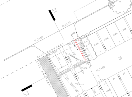
Figure 20 – Extract of the proposed basement plan indicating
the location security door and intercom to gain access to the basement car
park.
Variation to Clause 4.3 Height of Buildings
Development
consent may, subject to clause 4.6, be granted for development even though the
development would contravene a development standard imposed by this or any
other environmental planning instrument.
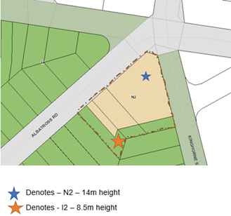
Figure 21 – Height controls applying
to the site under the Shoalhaven Local Environmental Plan 2014
The
application seeks a variation to clause 4.3 in accordance with Clause 4.6 of
SLEP 2014.
Clause 4.3 of SLEP 2014 stipulates the objective and development
standard for the height of buildings in Shoalhaven. Relevantly Clause 4.3(2)
& (2A) state as follows:
(2)
The height of a building on any land is not to exceed the maximum height shown
for the land on the Height of Buildings Map.
The
SLEP 2014, through Clause 4.3 sets an 8.5m (I2) height limit for part of the
site and a 14m (N2) height limit for rest of the site.
The
8.5m height limit applies to a 9m portion of the south eastern portion of the
site extending across all lots subject of the development application where the
lot adjoins the lower density R1 General Residential land to the south.
Parts
of the proposed building exceed the 8.5m (I2) and 14m (N2) height are limited
to a portion of the development.
The
development proposed exceeds the maximum building height as follows:
· 14m height limit by 480mm or 3.4%;
· 8.5m height limit 1.465m or 17.2%; and
· The percentage exceedance of the maximum building height
ranges from 1.4% to 17.2% with the average height limit exceedance being 4.83%.
The
submitted height plane diagrams prepared by Kannfinch Architects illustrate
that the height limit breach and indicate the percentage breach at each point
(Refer to Figure 22 and 23).
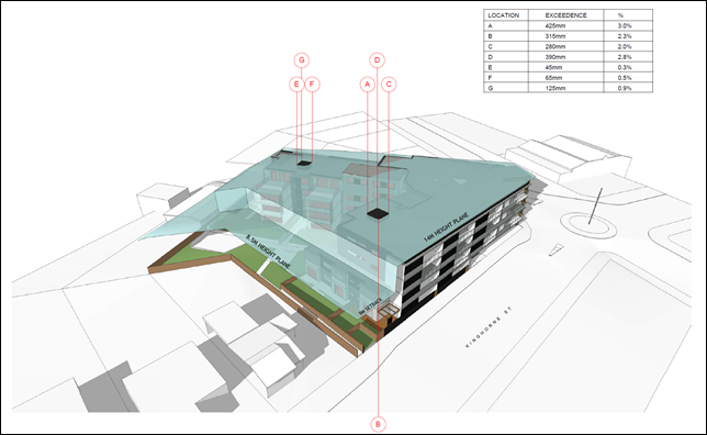
Figure 22 -
Height plane instructions relating to the 14.0m (N2) maximum building height -
south-eastern view from Kinghorne Street.

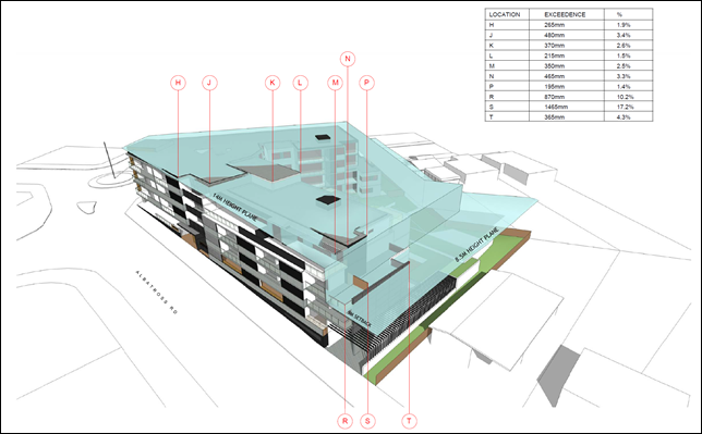
Figure 23 -
Height Plane instructions relating to the 14.0m (N2) and 8.5m (I2) maximum
building height - southwestern view from Albatross Street.
For the reasons detailed in the attached s4.15 Assessment
Report (Attachment 1), it is not considered that the clause 4.6
variation request has satisfied:
1. That
compliance with the development standard is unreasonable or unnecessary in the
circumstances of the case (cl 4.6(3)(a)); and
2. That
there are sufficient environmental planning grounds to justify contravening the
development standard (cl 4.6(3)(b)). The written request needs to demonstrate
both matters.
In conclusion it is considered that the applicant’s
request to vary the development standard as it relates to the maximum building
height should not be supported for the following reasons:
· The
variation request does not demonstrate that compliance with the development
standard would be unreasonable and unnecessary in the circumstances of this
development.
· The
variation request does not demonstrate there are sufficient environmental
planning grounds to justify the contravention, which results in a better
planning outcome than a strictly compliant development in the circumstances of
this particular case.
· Does
not demonstrate the development meets the objectives of the development
standard.
· The
proposed development is for the preceding reasons, not considered to be in the
public interest; and
· The
applicant has failed to demonstrate that there will be better planning outcomes
achieved through a variation to the height standard as it relates to the 8.5m
height of building standard associated with a 9m setback to the southern
boundary, as opposed to strict compliance with the development standard or amending
the application to reduce the extent of the variation.
It is acknowledged that the principal reason for not
supporting the variation request relates to the exceedance of the height
plane for the portion of the building fronting Albatross Road.
The exceedance of the maximum building height as it relates
to the 8.5m maximum building height is likely to result in a loss of privacy
and has been demonstrated to result in a loss of solar access to the existing
development (refer to the shadow diagrams prepared by Kannfinch Architects).
The overshadowing of the adjoining residences (No. 6 Albatross Road and No. 175
Kinghorne Street) is exacerbated by the adoption of a 6m setback (opposed to
the required 9m setback) for the portion of the building along the Albatross
Road frontage.
The adjoining lots can only be developed as single
dwellings or dual occupancies under the existing R2 Low Density Residential
zoning. The exceedance of the 8.5m maximum building height along the Albatross
Road frontage will exacerbate the blank wall along the southern elevation and
does not serve to create an appropriate transition as anticipated in the PP
associated with the site.
The PP and review of planning controls were undertaken
resulting in a specific conclusion i.e., height. The DA and design submitted
concurrently to the process has however not been adjusted to achieve the height
control. This is of concern as the change to the zone and strategic context has
only been relatively recently ‘made’ and it is already being
varied.
Non-compliance with State
Environmental Planning Policy No 65 – Design Quality of Residential Flat
Development (SEPP 65) and Apartment Design Guide (ADG)
State Environmental Planning
Policy No 65 - Design Quality of Residential Flat Development (SEPP 65) applies to the proposed development which
consists of a new building, of at least 3 storeys and containing at
least 4 or more dwellings.
Council does not have a Design
Review Panel constituted by the Minister of Planning.
In accordance with Clause 28(2)
of the SEPP 65, In determining a development application for consent to
carry out development to which this Policy applies, a consent authority is to
take into consideration (in addition to any other matters that are required to
be, or may be, taken into consideration):
(a) the advice (if any) obtained from the design
review panel, and
(b) the design quality of
the development when evaluated in accordance with the design quality principles,
and
(c) the Apartment Design Guide.
A SEPP 65 Design Statement
has been prepared by a Registered Architect (D20/6044) addressing the
requirements of SEPP 65 and was submitted with the application in accordance
with Clauses 50(1A) & 50(1AB) of the EP&A Regulation. The SEPP
65 Design Statement has address Schedule 1 of SEPP 65.
It is considered that the design
quality of the development, when evaluated against the nine design quality
principles does not satisfactorily exhibit exceptional design excellence when
assessed against the following principles:
· Principle 2: Built form and scale
· Principle 3: Density
· Principle 4: Sustainability
· Principle 5: Landscape
· Principle 6: Amenity
|
Schedule 1 Design
quality principles
|
|
Design quality principle
|
Comment
|
|
Principle 1: Context and neighbourhood character
Good design responds and contributes to its context.
Context is the key natural and built features of an area, their relationship,
and the character they create when combined. It also includes social,
economic, health and environmental conditions.
Responding to context involves identifying the desirable
elements of an area’s existing or future character. Well-designed
buildings respond to and enhance the qualities and identity of the area
including the adjacent sites, streetscape, and neighbourhood.
Consideration of local context is important for all
sites, including sites in established areas, those undergoing change or
identified for change.
|
The
surrounding development may be broadly characterised as low-density
residential housing, consisting of single and two-storey dwelling houses. The
development immediately to the south on Albatross Road and Kinghorne Street
consists of free-standing single storey dwellings and associated
outbuildings.
Beyond
these dwellings and on land bound by Albatross Road, Kinghorne Street and
Albert Street is low-density residential development – mainly of
single-storey construction.
To
the west and on the opposite side of Albatross Road is a continuation of
predominately freestanding low-density dwellings with examples of established
multi-dwelling housing developments.
To
the east, on the opposite side of Kinghorne Street, is a Council park and
cemetery.
On
the northern side of the intersection of Albatross Road and Kinghorne Street
on the western side of Kinghorne Street is an existing tyre shop. On the
eastern side of Kinghorne Street at the intersection with Kalandar Street,
Council has recently approved two - four storey residential flat buildings,
consisting of 91 apartments and basement car park (DA19/1846).
It
is noted that the subject site was the subject of a planning proposal to
zoning of subject land from B5 Business Development to B4 Mixed Use and amend
maximum height of building to part 14m and 8.5m (transition to low density
development to the south. The Planning Proposal was supported by a Character
Assessment prepared by Urbanac Dated May 2017 (D17/257485) which informed the
building heights for the site.
While
it is acknowledged that the desired future character of the locality will
include higher density residential development over a small footprint
commercial space at ground floor it is not considered that the current design
which includes an exceedance into the 8.5m maximum building height provides
an appropriate representation of that future character along the southern
elevation of the Albatross Road frontage.
Despite
Council’s concerns with the transition of the development to the low
scale development to the south, the development is considered to satisfy this
design principle.
|
|
Principle 2: Built form and scale
Good design achieves a scale, bulk, and height appropriate
to the existing or desired future character of the street and surrounding
buildings.
Good design also achieves an appropriate built form for a
site and the building’s purpose in terms of building alignments,
proportions, building type, articulation, and the manipulation of building
elements.
Appropriate built form defines the public domain,
contributes to the character of streetscapes and parks, including their views
and vistas, and provides internal amenity and outlook.
|
The
scale and bulk of the building is generally appropriate for the locality when
considering the development in the strategic context of the site and the
desire for a higher density of development to occur from the site.
However,
the proposed setback of the building to the adjoining lower density R2 Low
Density Residential zone does not provide an appropriate transition in built
form or resolve the associated amenity impacts that are associated with the
reduced setback.
The
southern portion of the building does not provide an appropriate transition to
the low-density development to the south. While the applicant has made an
attempt to reduce the bulk and scale of the development through the removal
of two (2) apartments on the southern elevation, this has not overcome the
need for a more suitable transition to the adjoining low-density environment.
The
aesthetics of the building are acceptable with appropriate colours and
finishes.
The
development is not considered to satisfy this design principle.
|
|
Principle 3: Density
Good design achieves a high level of amenity for residents
and each apartment, resulting in a density appropriate to the site and its
context.
Appropriate densities are consistent with the
area’s existing or projected population. Appropriate densities can be
sustained by existing or proposed infrastructure, public transport, access to
jobs, community facilities and the environment.
|
55 units on a site area of
3,509m², has a dwelling density of approximately 1 dwelling per
64m².
SLEP
2014 does not provide a floor space ratio under Clause 4.4 of the plan.
While
the density of development is consistent with that previously approved by
Council in relation to the site on the north-eastern corner of Kinghorne and
Kalandar Street (DA19/1846), it is not considered that the development achieves a high level of amenity for
residents and each apartment. The lack of solar access and ventilation to the single bedroom
apartments is of concern and will result in reduced amenity for occupants of
these units which is not consistent with this principle.
Furthermore, the design of the development does not
demonstrate comprehensive compliance with the ADG as it relates to standards
for:
· Solar access - 13
of 55 apartments (24%) of apartments receive no sunlight between 9am and 3pm
in mid-winter),
· Apartment size and layout – the single bedroom apartment
does not comply with the minimum widths (3.5m provided and 3.6m required)
· Private open space – Several ground floor units do
not provide at least 15sqm (G.04, G.08 and G.09) while other apartments do
not provide a minimum depth of 3m (G0.2, G.03, G.04, G.08, G.10).
· Landscaped deep soil zone for larger
blocks - The total area of deep soil landscaping is 461m2
(13% of the site area). The ADG recommends 15% deep soil zone for sites exceeding 1,500m2.
· Setbacks to the adjoining low-density
development – the
setback of the Albatross portion of the
development adjoining the southwestern boundary does not appear to comply
with the required 9m setback. 6m is proposed to the 3rd level, however as
this is measured to a balcony it is considered that the setback must be a
minimum of 9m.
· Common circulation and spaces – the maximum number of apartments off a circulation core on a single
level is eight. Lobby B services 11 apartments on levels 01, 02, and 10
apartments on Level 03. It is noted that the ADG accepts that where this
design criteria cannot be achieved the total units accessed off a circulation
core must not exceed 12.
· Apartment mix - The
mix of one-bedroom units is not considered to provide an appropriate
distribution to suitable locations within the building, with all single
bedroom units provided within the compromised southern side of the V-shaped
design – limiting solar access, ventilation, and unit design.
These non-compliances imply an overdevelopment of the
site.
The
development is not considered to satisfy this design principle
|
|
Principle 4: Sustainability
Good design combines positive environmental, social, and
economic outcomes.
Good sustainable design includes use of natural cross
ventilation and sunlight for the amenity and liveability of residents and
passive thermal design for ventilation, heating and cooling reducing reliance
on technology and operation costs. Other elements include recycling and reuse
of materials and waste, use of sustainable materials and deep soil zones for
groundwater recharge and vegetation.
|
37 of 55 apartments (67%)
receive at least 3 hours of direct sunlight between 9am and 3pm in mid-winter
13
of 55 apartments (24%) of apartments receive no sunlight between 9am and 3pm
in mid-winter. The ADG design criteria
specified that a maximum of 15% of apartments in a building receive no direct
sunlight between 9 am and 3 pm at mid-winter. The development does not comply
with the maximum number of units receiving no solar access.
The
majority of the proposed apartments have been designed to achieve
satisfactory natural cross ventilation. for the amenity and liveability of
residents and passive thermal design for ventilation, heating and cooling
reducing reliance on technology and operation costs. However, the design of
the single bedroom apartments results in poor solar access and natural
ventilation. There is likely to be a reliance on mechanical heating and
cooling for these apartments.
The
central courtyard and the principal area of communal open space will not
receive adequate solar access during winter. Due to the design of the
development and location of the communal open space areas on the southern
side of the building, the communal open space areas will have compromised
sunlight access, and this does not appear to be capable of resolution without
a significant redesign of the buildings and location of communal open space.
The
proposed development is supported by a BASIX Certificate as required under
the EP&A Regulation; however, this is not reflective of the current
layout.
Stormwater
is proposed to be reused for gardens in the communal area.
The
development is not considered to satisfy this design principle as it relates
to the design of single bedroom units.
The
development is not considered to satisfy this design principle
|
|
Principle 5: Landscape
Good design recognises that together landscape and
buildings operate as an integrated and sustainable system, resulting in
attractive developments with good amenity. A positive image and contextual
fit of well-designed developments is achieved by contributing to the
landscape character of the streetscape and neighbourhood.
Good landscape design enhances the development’s
environmental performance by retaining positive natural features which
contribute to the local context, co-ordinating water and soil management,
solar access, micro-climate, tree canopy, habitat values and preserving green
networks.
Good landscape design optimises useability, privacy and
opportunities for social interaction, equitable access, respect for
neighbours’ amenity and provides for practical establishment and
long-term management.
|
The proposed landscaping
meets the minimum deep soil requirements under the ADG. The total area of
deep soil area is 461m2 (13% of the site area). 328m2
(9% of the site area) has a minimum dimension of 6m or larger. These areas
have been designed to accommodate larger trees.
The site exceeds 1500m2
and as such it is appropriate to require 15% of the site as deep soil
landscaped area. Additional deep soil planting could be provided through the
reduction of units/building footprint and providing landscaping along the
Kinghorne and Albatross Road frontages.
Landscape plans have been
reviewed by Council’s landscape architect and are generally
satisfactory when considering the plantings and maintenance arrangements
(subject to recommended conditions if approved).
There are no existing
landscape features of note that would warrant retention.
The development is not
considered to satisfy this design principle.
|
|
Principle 6: Amenity
Good design positively influences internal and external
amenity for residents and neighbours. Achieving good amenity contributes to
positive living environments and resident wellbeing.
Good amenity combines appropriate room dimensions and
shapes, access to sunlight, natural ventilation, outlook, visual and acoustic
privacy, storage, indoor and outdoor space, efficient layouts and service
areas and ease of access for all age groups and degrees of mobility.
|
The proposed development
does not achieve compliance with the ADG as it relates to the minimum
standard for solar access, apartment size and layout, deep soil landscaping
for larger sites, private open space, common circulation and spaces,
apartment mix, as detailed in the ADG compliance table in the s4.15
Assessment Report – Appendix 1.
The development is not
considered to satisfy this design principle
|
|
Principle 7: Safety
Good design optimises safety and security within the
development and the public domain. It provides for quality public and private
spaces that are clearly defined and fit for the intended purpose.
Opportunities to maximise passive surveillance of public and communal areas
promote safety.
A positive relationship between public and private spaces
is achieved through clearly defined secure access points and well-lit and
visible areas that are easily maintained and appropriate to the location and
purpose.
|
The design is considered to
appropriately address Crime Prevention through Environmental Design (CPTED)
matters and reduces areas of potential concealment/entrapment. Passive
surveillance opportunities are available in the development.
There are defined secure access points and well-lit and visible
areas that are easily maintained and appropriate to the location and purpose.
Entry points are located adjacent to the activated retail zone and designed
to minimise opportunity for loitering.
The residential lobbies and
car park are proposed to operate on secured access. The car park access doors
will operate individually via remote control (or similar) for residents and
retail tenants, with an intercom system for visitors.
The development is considered
to satisfy this design principle.
|
|
Principle 8: Housing diversity and social interaction
Good design achieves a mix of apartment sizes, providing
housing choice for different demographics, living needs and household
budgets.
Well-designed apartment developments respond to social
context by providing housing and facilities to suit the existing and future
social mix.
Good design involves practical and flexible features,
including different types of communal spaces for a broad range of people and
providing opportunities for social interaction among residents.
|
The proposed development
provides additional dwellings, with a range of sizes, in an area where
additional housing is needed and is near a variety of services.
The development provides both
communal open space and a communal room. It is noted that the
resident’s room located on the south-west wing of the development has a
compromised and diminutive floor area (20m2) that is not likely to
be used by a broad range of people and is unlikely to provide opportunities
for social interaction among residents.
The development is
considered to satisfy this design principle.
|
|
Principle 9: Aesthetics
Good design achieves a built form that has good proportions
and a balanced composition of elements, reflecting the internal layout and
structure. Good design uses a variety of materials, colours, and textures.
The visual appearance of a well-designed apartment
development responds to the existing or future local context, particularly
desirable elements, and repetitions of the streetscape
|
The architectural treatment
is satisfactory.
The development is
considered to satisfy this design principle.
|
The development is considered to
satisfactorily address the remaining design quality principles.
Clause 30(2) of SEPP 65 requires residential apartment
development to be designed in accordance with the ADG.
The development has been assessed against the ADG and a full
assessment is provided within the s.4.15 Assessment Report (Appendix 1 of this
Report).
Parts 3 and 4 of the ADG provide objectives, design criteria
and design guidance for the siting, design, and amenity of apartment
developments. In accordance with ADGs, development needs to demonstrate how it
meets the objective and design criteria. The design criteria set a clear
measurable benchmark for how the objective can be practically achieved. If it
is not possible to satisfy the design criteria, applications must demonstrate
what other design responses are used to achieve the objective and the design
guidance can be used to assist in this.
The development is non-complaint with the following Objectives
and Design Criteria in Part 3 and 4 of the ADG, as outlined in the table below.
Appendix A to the Section 4.15 Assessment Report (Attachment 1) provides
a full assessment of the proposed development against each of the objectives of
the ADG.
|
Objective
|
Assessment
|
|
3E-1
Deep Soil Zones
Deep
soil zones provide areas on the site that allow for and support healthy plant
and tree growth. They improve residential amenity and promote management of
water and air quality.
On
some sites it may be possible to provide larger deep soil zones, depending on
the site area and context:
•
10% of the site as deep soil on sites with an area of 650m2 - 1,500m2
•
15% of the site as deep soil on sites greater than 1,500m2
|
The total area of deep soil
landscaping is 461m2 (13% of the site area). 328m2 (9%
of the site area) has a minimum dimension of 6m or larger. These areas have
been designed to accommodate larger trees.
The site exceeds 1500m2
and therefore it is appropriate to require 15% of the site as deep soil
landscaped area. Landscape plans have been reviewed by Council’s
landscape architect and are satisfactory, subject to consideration of the
requested changes.
|
|
3F-1
Visual Privacy
Adequate building separation
distances are shared equitably between neighbouring sites, to achieve
reasonable levels of external and internal visual privacy.
|
The adjacent sites to the south
of the development site are zoned R2 Low Density Residential and currently
contain single dwelling houses per lot.
The setback of the Kinghorne
portion of the development to the adjoining southern property boundary
requires a minimum setback of 9m. The setback of this portion of the building
varies for the ground and first floor of between 8m and 9m to windows and
balconies and therefore does not strictly comply with the required 9m
setback.
The setback of the Albatross
portion of the development adjoining the southwestern boundary does not
appear to comply with this requirement. 6m is proposed to the 3rd level,
however, as this is measured to a balcony it is considered that the setback
should be a minimum of 9m.
|
|
Separation between windows and
balconies is provided to ensure visual privacy is achieved. Minimum required
separation distances from buildings to the side and rear boundaries are as
follows (for building heights up to 12m):
Habitable rooms and balconies:
6m
Non-habitable rooms: 3m
Note: Apartment buildings
should have an increased separation distance of 3m (in addition to the
requirements set out in design criteria 1) when adjacent to a different zone
that permits lower density residential development to provide for a
transition in scale and increased landscaping (figure 3F.5)
|
|
3H-1
Vehicle Access
Vehicle access points are
designed and located to achieve safety, minimise conflicts between
pedestrians and vehicles and create high quality streetscapes.
|
Vehicle
access is provided at the southern end of the development along Albatross
Road. The vehicular access is generally incorporated into the
building’s façade. Security gates have been set back from the
frontage. While Council does not raise any concern with the design or
integration of the access into the building from a strictly aesthetic
standpoint it is noted that the car park entry and access should be located
on secondary streets.
The
basement car park and manoeuvring are to be designed to comply with the
Australian Standards and Chapter G21: Car Parking and Traffic.
The
proposal to access the development from the Regionally Classified Road
(Albatross Road) is not supported and the applicant has been encouraged to
provide access via the unclassified local road (Kinghorne Street).
Under
the ISEPP, a consent authority must not grant consent to development on land
that has a frontage to a classified road unless it is satisfied that, among
other things, ‘where practicable, vehicular access to the land is
provided by a road other than the classified road’.
|
|
3J-1
Bicycle and Car Parking
Car
parking is provided based on proximity to public transport in metropolitan
Sydney and centres in regional areas.
|
The
total number of car parking spaces required for residential units = 61.1
spaces required per the Guide to Traffic Generating Development.
The
car parking rate applying to the commercial component of the development is
to be calculated according to Chapter G21: Car Parking and Traffic in SDCP
2014
Commercial
development within land zoned B3 Commercial Core at ground level or where
access to the development is from ground level above an underground level of
car parking is 1 space per 24m2 gross floor area.
The
commercial floor of 267m2 is located at ground level with frontage
to both Kinghorne Street and Albatross Road and is located above an
underground level of car parking. Therefore, 267m2 divided by 24m2
= 11.13 spaces.
Total
of Car Spaces Required: 66.1 (residential) + 11.13 (commercial) = 77.23
Note:
In accordance with section 5.14 Loss of On-Street Car Parking – Major
Developments/ Redevelopments of Chapter G21 of SDCP2014, it is noted that:
“major
development/ redevelopment is proposed that has frontage to two or more
streets, Council will take into account the loss of on-street car parking
spaces arising from the construction of access, bus embayment’s and car
parking restrictions, where these are directly related to the development
proposal and will require these to be replaced on site.”
The
design of the development including slip lane to provide left turn access to
the development from Albatross road will result in the removal of all
on-street car parking spaces along the Albatross Road development frontage to
facilitate access. This will result in the removal of approx. six (6)
on-street car parking spaces.
Taking
into account the on-street car parking loss along the Albatross Road frontage
(six (6) on-street spaces) the development is required to provide a further
six (6) parking spaces.
Total
Car Spaces Required: 83.23 spaces
Total
of Car Spaces Proposed: 93 spaces
The
development is numerically compliant.
Excavation
of the site has been minimised in the placement of the car park access at the
lowest point in the site.
The
car parking area has been designed to suit the site which is triangular.
The
car park protrudes above ground level greater than 1m however this is solely
along the Albatross Road frontage and extends for less than 50% of the
frontage. To minimise the visual impact appropriate colours are to be
utilised and varied materials for balustrades located above the car parking
area.
Mixture
of natural ventilation and a mechanical exhaust are to be utilised.
|
|
3J-2
Bicycle and Car Parking
Parking and facilities are
provided for other modes of transport.
|
Each resident has access to a
secure storage cage that is large enough to accommodate a bicycle.
Residential visitor and customer bicycle spaces are proposed in the form of
post mounted bike rails within the road reserve, should Council require them.
|
|
4A-1
Solar and Daylight Access
To optimise the number of
apartments receiving sunlight to habitable rooms, primary windows, and
private open space.
|
37 of
55 apartments (67%) receive at least 3 hours of direct sunlight between 9am
and 3pm in mid-winter
13 of
55 apartments (24%) of apartments receive no sunlight between 9am and 3pm in
mid-winter.
While
the applicant has argued that the non-compliance with the Design Criteria is “due
to limitations imposed by the site configuration, southern slope and
orientation” it is noted that there are limited site constraints
and there is an opportunity to reduce the number of internal-facing
apartments and the design of dual aspect apartments overlooking the internal
communal open space area and either Albatross or Kinghorne Street.
Of
concern is that there are only two single bedroom apartments located on the
third level that achieve the minimum daylight access with no lower-level
single bedroom apartments receiving any solar access.
The
minor non-compliance with the requirement that no less than 70% of apartments
in a building receive a minimum of 3 hours of direct sunlight could be
readily accepted were the design to exceed the 15% of apartments in a
building receiving no direct sunlight between 9 am and 3 pm at mid-winter.
The
substantial non-compliance with the maximum number of apartments receiving no
direct sunlight between 9 am and 3 pm at mid-winter is a significant concern
and will significantly increase the reliance on artificial lighting and
heating, reduce energy efficiency and residential amenity.
The
design attempts to maximise the number of north facing apartments and limit
the number of single aspects south facing apartments, however, it is noted
that the internal facing single aspect apartments provided limited or no
solar access. It is considered further consideration of the design to further
limit single aspect southerly facing apartments would provide increased solar
access and amenity to future residents.
It
is noted that, where possible, the building design maximises the number of
living areas with a northerly aspect ensuring a high level of amenity is
achieved. Services areas are generally provided to the rear or in central
locations minimising their impact on the most desirable areas of the apartments.
|
|
1. Living
rooms and private open spaces of at least 70% of apartments in a building
receive a minimum of 2 hours direct sunlight between 9 am and 3 pm at
mid-winter in the Sydney Metropolitan Area and in the Newcastle and
Wollongong local government areas.
|
|
2. In
all other areas, living rooms and private open spaces of at least 70% of
apartments in a building receive a minimum of 3 hours direct sunlight
|
|
3. between
9 am and 3 pm at mid-winter. A maximum of 15% of apartments in a building
receive no direct sunlight between 9 am and 3 pm at mid-winter.
|
|
No.
|
|
4D-3 Apartment Size and Layout
Apartment layouts are designed
to accommodate a variety of household activities and needs.
|
The open plan designs allow for
a range of activities to happen in the kitchen and living spaces.
1-bedroom apartment widths are
3.5m - this is marginally under 3.6m. The non-compliance is marginal and does
not impede the usable area of the living rooms and would not likely have a
significant detrimental impact on the amenity of the dwelling or resident use
of the units impacted. However, it is noted that the design of the single
bedroom units is once again impacted by the proposed design.
|
|
1. Master bedrooms have a minimum area of
10m2 and other bedrooms 9m (excluding wardrobe space)
|
|
1. Bedrooms have a minimum dimension of 3m
(excluding wardrobe space)/.
|
|
2. Living rooms or combined living/dining
rooms have a minimum width of:
• 3.6m for studio and
1-bedroom apartments
• 4m for 2- and 3-bedroom
apartments
|
|
3. The width of cross-over or cross-through
apartments are at least 4m internally to avoid deep narrow apartment layouts
|
|
4E-1
Private Open Space and Balconies
Apartments provide appropriately
sized private open space and balconies to enhance residential amenity.
1. All apartments are required
to have primary balconies as follows:
Studio: 4m2
1 Bedroom: 8m2, 2m
minimum depth
2 Bedroom: 10m2, 2m
minimum depth
3 Bedroom: 12m2, 2.4m
minimum depth
The minimum balcony depth to be
counted as contributing to the balcony area is 1m.
2. For apartments at ground
level or on a podium or similar structure, a private open space is provided
instead of a balcony. It must have a minimum area.
of 15m2 and a minimum
depth of 3m.
|
All
balconies exceed the minimum area for the respective unit types. All
balconies have a minimum depth of 2m.
A
number of the ground floor units do not provide at least 15sqm (G.04,
G.08 and G.09) while other apartments do not provide a minimum depth
of 3m (G0.2, G.03, G.04, G.08, G.10).
|
|
4F-1 Common Circulation and
Spaces
Common circulation spaces
achieve good amenity and properly service the number of apartments.
1. The maximum number of
apartments off a circulation core on a single level is eight.
|
Common spaces are provided with
solar access, natural ventilation and allow for universal access.
Lobby
B services 11 apartments on levels 01, 02, and 10 apartments on Level 03. The
corridors have been designed with light slots to capture natural light and
ventilation to maintain amenity.
*
Note: Where design criteria 1 is not achieved, no more than 12 apartments
should be provided off a circulation core on a single level
|
|
2. For buildings of 10 storeys
and over, the maximum number of apartments sharing a single lift is 40
|
|
4K-2
Apartment Mix
The apartment mix is distributed
to suitable locations within the building.
|
The mix of one-bedroom units is
not considered to provide an appropriate distribution to suitable locations
within the building.
The single bedroom units are
limited to the southern elevation of the V-shaped building design which has
resulted in units with severely compromised solar access, ventilation and
private open space that will likely result in units with diminished amenity.
The irregular floor plans will also result in odd-shaped rooms and the
potential loss of the use of usable space within these units.
It is considered that the single
bedroom units should be spread more evenly throughout the development to
enable these units a greater likelihood for increased amenity
|
State Environmental
Planning Policy (Building Sustainability Index: BASIX) 2004 (SEPP
(BASIX))
The provisions of SEPP (BASIX)
apply to the site. In accordance with the requirements of SEPP BASIX,
Certification for each dwelling has been submitted with the development
application.
Clause 55A of the Environmental
Planning and Assessment Regulation 2000 (EP&A Regulation) allows for a
development application to be amended provided a new BASIX certificate is
submitted to account for those amendments. An amended BASIX Certificate, to
reflect amended plans was not submitted with the amended application.
Council cannot issue development consent without the
provision of a new BASIX Certificate that reflects the amended application
i.e., 55 residential units.
Planning
Assessment
The DA has been (or will be)
assessed under s4.15 of the Environmental Planning and Assessment Act
1979. Please refer to Attachment 1.
Policy
Implications
A key policy consideration is
height.
Currently, there is an 8.5m and 14m height limit which applies to the site
under SLEP 2014.
The
development proposed exceeds the maximum building height as follows:
· 14m
height limit by 480mm or 3.4%;
· 8.5m
height limit 1.465m or 17.2%; and
· The
percentage exceedance of the maximum building height ranges from 1.4% to 17.2%
with the average height limit exceedance being 4.83%.
The variation has been addressed
by the applicant via a formal clause 4.6 variation statement. The matter is
discussed in the attached section 4.15 report in further detail (Attachment
1) and has been considered previously in this Report.
Consultation
and Community Engagement:
Six (6) public submissions were
received in relation to Council’s notification of the development. Six
(6) were objections to the development. Nil (0) were in support of the
development. The notification was made in accordance with Council’s
Community Consultation Policy. The application was notified for a period of 30
days and advertised in the local papers in accordance with Council’s
Community Consultation Policy.
Key issues raised as a result of
the notification are provided below:
· Traffic
impacts on the local road network.
· Impact
of additional cars parking on the on-street car parking.
· Amenity
impacts associated with overlooking and overshadowing.
· Insufficient
justification and planning purpose to support the PP.
· The
bulk and scale of the development is not consistent with the low scale
development to the south of the site and the site would be better developed for
multi-dwelling housing.
· The
proposed setbacks of the development to the southern boundary are not
appropriate.
· The
pedestrian access point to the development on the Kinghorne Street frontage
will result in safety and security issues.
The planning concerns raised by
the submitters are addressed in the attached section 4.15 report in further detail
(Attachment 1).
Financial
Implications:
There are potential cost
implications for Council in the event of a refusal of the application. Such
costs would be associated with defending any appeal in the Land and Environment
Court, should the applicant utilise appeal rights afforded under the Environmental
Planning and Assessment Act 1979 (EP&A Act).
Legal
Implications
Pursuant to section 8.2 of the
EP&A Act, a decision of the Council may be subject of a review by the
applicant in the event of approval or refusal. If such a review is ultimately
pursued (if the recommendation is not adopted), the matter would be put to
Council for consideration.
Alternatively, an applicant may
also appeal to the Court against the determination pursuant to section 8.7 of
the EP&A Act.
Summary
and Conclusion
This
application has been assessed having regard for section 4.15 (Evaluation) under
the EP&A Act. Based upon the s4.15 Assessment Report (Attachment 1)
it is recommended that Development Application No. DA16/1465 be refused. for
the following reasons.
1. The
development has failed to satisfy Council of preconditions clause 101(2)(a) and
(b) of the ISEPP (s4.15(1)(a)(i) of the EPA Act).
In accordance with clause
101(2)(a) and (b) of the ISEPP, Council must not grant consent to development
on land that has a frontage to a classified road unless it is satisfied that:
(a)
where practicable and safe, vehicular access to the land is provided by a road
other than the classified road, and
(b) the
safety, efficiency and ongoing operation of the classified road will not be
adversely affected by the development as a result of:
(i) the
design of the vehicular access to the land, or
(ii) the
emission of smoke or dust from the development, or
(iii) the
nature, volume or frequency of vehicles using the classified road to gain
access to the land.
2. Non-compliance
with SEPP 65 in relation to the Apartment Design Guide (s4.15(1)(a)(i) of the
EPA Act);
The development fails to satisfy
clause 30(2)(a) and (b) of SEPP 65, in that the development does not
demonstrate that adequate regard has been given to:
(a) the
design quality principles (Principle 2: Built form and scale; Principle
3: Density; Principle 4: Sustainability; Principle 5: Landscape; Principle 6:
Amenity), and
(b) the
objectives specified in the Apartment Design Guide for the relevant design
criteria (3E-1 Deep Soil Zones, 3F-1 Visual Privacy, 3H-1 Vehicle Access,
3J-1 Bicycle and Car Parking, 3J-2 Bicycle and Car Parking, 4A-1 Solar and
Daylight Access, 4D-3 Apartment Size and Layout, 4E-1 Private Open Space and
Balconies, 4F-1 Common Circulation and Spaces, 4K-2 Apartment Mix).
3. The
proposal exceeds the maximum building height development standard under clause
4.3 of SLEP 2014. The applicant’s written request to vary the maximum
building height development standard has not adequately addressed matters
required to be demonstrated by clause 4.6(3)(a) and (b) of SLEP 2014. The
applicant’s clause 4.6 Variation Request does not provide sufficient
environmental planning grounds to support the variation, nor that compliance is
unnecessary or unreasonable. (s4.15(1)(a)(i) of the
EPA Act).
4. Clause
55A of the Environmental Planning and Assessment Regulation 2000 allows
for a development application to be amended provided a new BASIX certificate is
submitted to account for those amendments. An amended BASIX Certificate, to
reflect amended plans was not submitted with the amended application.
5. The
proposed development is inconsistent with the Objectives, Performance Criteria
and Acceptable Solutions as they relate to the following provisions of Chapter
G21: Car Parking and Traffic Shoalhaven Development Control Plan 2014 (SDCP
2014) (s4.15(1)(a)(iii) of the EPA Act):
(a) 5.2
Traffic.
(b) 5.4
Access.
6. The
development is likely to have adverse impacts on the built environment
(s4.15(1)(b) of the EPA Act).
7. The
site is not suitable for the development as proposed (s4.15(1)(c) of the EPA
Act).
8. The
development is not in the public interest (s4.15(1)(e) of the EPA Act).
|

|
Ordinary
Meeting – Tuesday 26 October 2021
Page
0
|
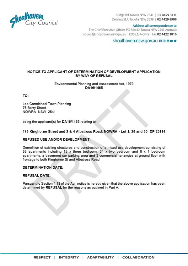
|
|
Ordinary
Meeting – Tuesday 26 October 2021
Page
0
|
CL21.231 DA21/1673
- 116-118 St Vincent Street, Ulladulla - Advice Addendum Report to be
submitted.
HPERM Ref: D21/450150
Approver: Phil
Costello, Director - City Development
Reason for Report
This
report is being submitted directly to Council’s Ordinary meeting. At
Council’s Development & Environment Committee meeting of 7 September
2021, Council resolved to “call-in” the DA for determination.
An Addendum Report is being prepared
to be submitted for this Development Application.
|
Recommendation
That
this report be received for information noting that an Addendum Report will
be submitted to Council’s Ordinary Meeting of 26 October 2021.
|
Options
1. Report be
received for information.
Background
The Development Application (DA)
was called in at the Development & Environment Committee meeting of 7
September 2021 for determination at either the Development Committee to be held
on 5 October 2021 or the Ordinary Council Meeting to be held on 26 October
2021. At that time the DA was yet to go on exhibition, with the
exhibition to be completed on 29 September.
For the application to be
reported for determination, the assessment, notification and report would have
required completion prior to 13 September to enable reporting to the meeting of
5 October.
Alternatively, to report to 26
October, the assessment, notification and report completed prior to 4
October. The timetable is to allow for the normal peer review and acceptance
processes for Council reports.
As it stands, the referrals were
still be finalised and discussed on 20 October, with the Urban Design Review by
Hill Thallis provided to Council on 15 October
2021. The independent Review was sought to provide an independent
assessment of the design having regard to not only the height (which is the
subject of a clause 4.6 variation given the 14 metre height exceedance) but
also concerns arising from a preliminary review of State Environmental
Planning Policy No. 65 – Design Quality of Residential Apartment
Development. Several matters have arisen warranting the applicant’s
attention. The matters go to and are not necessarily limited to design
considerations, waste collection and non-compliant floor to ceiling heights for
the commercial ground floor and the basement
At the time of finalising this Agenda, the Assement Report
was still being finalised for release as an Addendum Report for this Ordinary
Meeting.
|
|
Ordinary
Meeting – Tuesday 26 October 2021
Page
0
|
DE21.122 Development
Application - DA21/1392 – Old Southern Rd South Nowra – Lot 2 DP
1065105 & Lot 28 DP 17310
DA. No: DA21/1392/4
HPERM Ref: D21/383231
Department: Development
Services
Approver: Phil
Costello, Director - City Development
Attachments: 1. Determination
- Refusal ⇩
2. Assessment
Report (under separate cover) ⇨
3. Plans
- Architectural (under separate cover) ⇨
4. Plans - Landscaping ⇩
This item was deferred from the
Development and Environment Committee 5 October 2021 when it was advised by a
Councillor that a report from Dr Judith Stubbs was forthcoming in relatin to
the development.
Staff have been in contact with
the applicant who advised that the report from Dr Stubbs was forthcoming and it
was the intention to distribute to Councillors. It was requested this
report be forwarded to staff at the same time in order that staff had an opportunity
to review.
At the time of preparing this
report, no report from Dr Stubbs has been received by Council staff.
Description
of Development: Staged Residential Flat Building Development (containing 56
Units, and ancillary communal facilities, internal roads and services)
Owner: Care Living Nowra Pty Ltd
Applicant: PDC Lawyers & Town Planners
Notification Dates: 23 August 2021 to 8 September
2021
No. of Submissions: Nil
Purpose
/ Reason for consideration by Council
Council Resolved on 7 April 2020
(MIN20.240) with respect to COVID-19 Response, that:
“The delegation to the CEO be rescinded to determine a
development application by refusal until the end of COVID 19 crisis.
The refusal of a development
application must only be by Council/Committee resolution.”
This report recommends refusal of the above Development
Application and is therefore prepared for consideration by the Development
& Environment Committee in accordance with the 7 April 2020 Resolution of
Council.
|
Recommendation (Item to be determined under delegated authority)
That Development Application No.
DA21/1392 for a Staged Residential Flat
Building Development (containing 56 Units, and ancillary communal facilities,
internal roads and services) pursuant to the
Shoalhaven Local Environmental Plan 2014 at Lot 2 DP 1065105 & Lot 28 DP
17310, Old Southern Rd South Nowra be determined by way of refusal for the
reasons contained in Attachment 1 of this report.
|
Options
1. Refuse the
Development Application (DA) in accordance with the recommendation.
Implications: The development is unable to proceed
as applied for. The applicant can, however, apply for a section 8.2 review of
Council’s decision and/or could lodge an appeal with the NSW Land and Environment
Court (LEC) against Council’s decision.
2. Approve
the DA, subject to the resolution of any outstanding assessment matters.
Implications: Council would need to
resolve any outstanding referral matters and provide the grounds to support the
proposal, that is, provide reasons to support the development, having regard to
section 4.15 considerations. Under some circumstances, third parties (i.e.,
objectors) can seek a judicial review of Council’s decision in the NSW
Land and Environment Court.
3. Alternative
recommendation.
Implications: Council will
need to specify an alternative recommendation and advise staff accordingly.
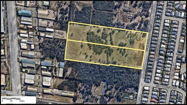
Figure 1 – Location Map
Background
Proposed Development
The application seeks consent for the construction of a staged
residential flat building (RFB) development consisting of 56 units across six
(6) two-storey buildings, internal roads and parking facilities, communal
facilities, and a fire trail in accordance with the architectural and landscape
plans provided at Attachments 3 and 4.
The construction of the development is proposed to be staged
in the following format:
· Stage 1:
Construction of Block A including:
o construction of two buildings
consisting of a total of 18 units across two levels (16 two bedroom and 2 one
bedroom units);
o internal ingress/egress road
to Old Southern Rd;
o gravel fire tail on the
northern rear side of the development;
o communal waste enclosure
servicing the development;
o communal facilities including
the ‘Hub’ (to be temporarily used as a sales office during Stage 1)
and village green; and
o associated resident/visitor
parking facilities including 21 private parking spaces, 13 visitor spaces, and
5 spaces dedicated to the communal facilities (i.e., Hub).
· Stage 2:
Construction of Block B including:
o construction of two buildings
consisting of a total of 20 units across two levels (16 two bedroom and 4 one
bedroom units);
o use of the Hub temporarily as
a sales office until the completion of the Stage 2 construction works.
o construction of associated
resident/visitor parking facilities including 17 private parking spaces and 2
visitor spaces.
· Stage 3:
Construction of Block C including:
o construction of two buildings
consisting of a total of 18 units across two levels (14 two bedroom and 4 one
bedroom units); and
o associated resident/visitor
parking facilities including 18 private parking spaces and 13 visitor spaces.
The proposed development requires the removal of 1.22ha of
vegetation to permit the construction of the proposed works. Vegetation to be
removed includes a mix of trees and grassland vegetation which have been
identified as falling under plant community types, Plant Type Community (PCT)
1080 – Red Bloodwood / Grey Gum Open Forest and PCT 1326 –
Illawarra Lowland Grassy Woodlands. Given the extent of vegetation being
removed from the property, the development was required to enter into the
Biodiversity Offsets Scheme and was thus accompanied by the lodgement of a
Biodiversity Development Assessment Report (BDAR).
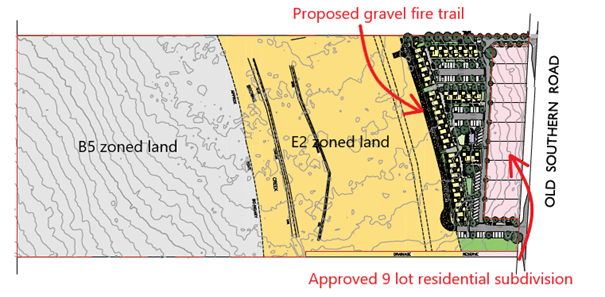
Figure 2 – Site Plan
Figure 3 below shows the development
as viewed from the internal driveway looking west. It is noted each block is
made up of two buildings, one sited in a north-south orientation and one
oriented east-west. The figure below depicts the east-west building for each
block on the right of each elevation plan with car park areas in front of
Blocks B and C.
Figure 3 – East Elevation Plan
Subject Land
The development site comprises Lot 2 DP 1065105 & Lot 28
DP 17310 (Old Southern Rd South Nowra). Refer to Figure 1.
Site & Context
The development site:
· Has
a total combined area across both lots making up the site of 8.16ha (Lot 2
– 4.17ha and Lot 28 – 3.99ha).
· Has
a mixed zoning (refer Figure 4) which includes the following:
o R1 General Residential in the
eastern front part of the site adjacent to Old Southern Rd – the vast
majority of the proposed development is located within this portion of the
site.
o E2 Environmental Conservation
in the central part of the site incorporating Browns Creek – the proposed
fire trail ancillary to the proposed development is located within this zone.
o B5
Business Development in the western rear part of the site beyond the Browns
Creek – no works are proposed within the part of the site zone B5.
· Has
approval under SF10679 for a ten (10) lot Torrens title subdivision development
including nine (9) residential lots directly front Old Southern Rd, and a
residue lot that wraps behind each of these lots and includes the rear of the
property, being the location of the subject site. The subdivision of the nine
(9) residential lot subdivision is currently under construction. Each of these
lots have a rear boundary abutting the development.
· Is
presently vacant and consists of a mix of cleared land in the eastern part to
support the residential subdivision development, and vegetated land for the
remainder of the site consisting of trees and grassland identified as plant
community types PCT 1080 – Red Bloodwood / Grey Gum Open Forest and PCT
1326 – Illawarra Lowland Grassy Woodlands.
· Is
traversed by Browns Creek which travels from north to south through the central
part of the site.
· Is
mapped as being partly flood prone land (i.e., subject to the 1% AEP flood
level and flood planning level). The part of the site where the residential
flat building development is proposed is not within the 1% AEP flood level but
partly within the flood planning level.
· Is
mapped as being bushfire prone land (Vegetation Category 2 and Buffer Area).
· Is
partly mapped as containing ‘Biodiversity – Significant
Vegetation’ and ‘Excluded Land’. The location of the proposed
works is outside of the mapped areas which are predominantly adjacent to the
Browns Creek.
· Is located
within a wider emerging South Nowra urban residential area which would consist
of the nine Torrens title lots being constructed adjacent to the development
site and further detached residential housing located on the opposite side of
Old Southern Rd.
Figure 4 – Zoning Map
History
The following provides a
description of correspondence which took place with the applicant prior to and
following the lodgement of the Development Application (DA) with Council:
|
Event / Action Taken
|
Date
|
|
Pre-lodgement Meeting held with the applicant and subsequent
notes provided with recommendations regarding alterations to the design to
enable the development to achieve compliance with applicable requirements
such as the Apartment Design Guide (ADG), which is a requirement of Councils
DCP.
|
07.10.2020
|
|
Formal lodgement of Development Application with
Shoalhaven City Council and payment of application fees.
|
21.04.2021
|
|
1st Request for information (RFI) sent to the
applicant – with the following matters being requested:
· amended plans addressing
the following:
o secured all-weather car
parking be provided to permit compliance with the ADG. This also reflects
advice provided to the applicant at pre-lodgement stage.
o Secured all-weather bicycle
parking be provided to permit compliance with the ADG.
o An improved landscape buffer
be provided separating the internal road servicing all residential flat
building units from the neighbouring approved nine (9) Torrens title lots.
· Request for the
fire trail to be amended to enable it to be wholly located within the R1
zoned section of the site – noting that, given it is ancillary and
incidental to the residential flat building development, such a proposal is
prohibited within its present location within the E2 zone.
· Request for all
communal facilities including the village green to be included as part of
Stage 1 of the development.
· Request for
review of the approved sewer design to ensure the proposed development is
capable of being serviced by this infrastructure.
|
06.05.2021
|
|
Applicant response to 1st RFI Request provided
with the following responses given to Council’s request:
· No amended plans
were provided with the following instead being noted:
o No alteration to the design
of the parking areas provided.
o Requested bicycle parking
spaces provided on amended Landscape Plans.
o Amended Landscape Plans
provided.
· No alteration to
the location of the fire trail provided. The applicant advised that the fire
trail should be a separately defined use – Emergency Management
Facility
· Agreement
provided that the village green should form part of Stage 1.
· Confirmation provided
as part of response that there is sufficient capacity within the sewer design
to cater for the proposed development.
|
07.06.2021
|
|
2nd RFI sent to the applicant following
consideration of the response – with the following matters being
requested (reiteration of matters raised as part of 1st Request
that were not adequately addressed):
· Request for
amended plans addressing the following:
o Reiteration of request for
secured all-weather car parking to be provided for the development to permit
compliance with the ADG.
o Request for secured
all-weather bicycle parking be provided for the development to permit
compliance with the ADG, noting that the plans provided did not demonstrate
that it would be all-weather.
o Request for an improved
landscape buffer and increased width to 1.5m to match that required for
medium density developments per Chapter G13 of the Shoalhaven Development
Control Plan 2014 (SDCP 2014).
· Advice provided
to the applicant that Council finds that the fire trail is effectively part
of the Residential Flat Building development given it is ancillary and
incidental to the overall development (noting that it would not be
required were a development not proposed and that it would be for the sole
purpose of the development).
|
13.07.2021
|
|
Applicant response to 2nd RFI Request
reiterating their response provided in the 1st Request:
· Request for
amended plans addressing the following:
o Applicant advice that the
Apartment Design Guide should not apply to the development and that they
consider that the proposed parking area complies with the Apartment Design
Guide, particularly as it relates to 3J-5.
o Advice provide that the
bicycle parking is located in an accessible location.
o Applicant reiteration that a
1m vegetation strip separating the internal road from the adjacent
residential lots is sufficient
Advice provided by applicant reiterating that the fire
trail should be a separately defined use and stating why such a trail should
be needed.
|
23.07.2021
|
|
Internal and external referrals requested.
|
23.08.2021
|
|
Completion of notification period.
The application was notified for a period of two weeks in
accordance with the Community Consultation Policy. No submissions were
received during the notification period. (Note: the adjoining
nine (9) residential lots have not been registered yet and are still on
Council record as being under the ownership of Care Living Nowra Pty Ltd.)
|
08.09.2021
|
|
Recommendation for refusal provided to the October
Development and Environment Committee Meeting.
|
Issues
Prohibited Use – Residential Flat Buildings within
Zone E2 – Environmental Conservation of the Shoalhaven Local
Environmental Plan 2014
In accordance with the submitted
architectural plans located at Attachment 3 to this Report, the proposed
development is primarily contained within the R1 General Residential Zone in
accordance with the Shoalhaven Local Environmental Plan (SLEP) 2014,
where such a development is permissible with consent – see land use table
below:
2 Permitted
without consent
Home occupations
3 Permitted
with consent
Attached dwellings; Boarding houses; Boat launching ramps;
Boat sheds; Building identification signs; Business identification signs;
Centre-based child care facilities; Community facilities; Dual occupancies;
Dwelling houses; Emergency services facilities; Environmental protection works;
Exhibition homes, Exhibition villages; Group homes; Home-based child care; Home
businesses; Home industries; Hostels; Jetties; Multi dwelling housing;
Neighbourhood shops; Office premises; Oyster aquaculture; Places of public
worship; Pond-based aquaculture; Recreation areas; Registered clubs; Residential
flat buildings; Respite day care centres; Roads; Semi-detached
dwellings; Seniors housing; Sewerage systems; Shop top housing; Tank-based
aquaculture; Tourist and visitor accommodation; Veterinary hospitals; Water
supply systems
4 Prohibited
Farm stay accommodation; Any other development not
specified in item 2 or 3
However, part of the residential
flat building development (being the ancillary gravel fire trail – see
Figure 2) is located within the adjoining E2 Environmental Conservation Zone
pursuant to the SLEP 2014 – where such a development is a prohibited use
– see Land Use Table below:
2 Permitted without consent
Nil
3 Permitted with consent
Bed and breakfast accommodation; Boat sheds; Dual
occupancies (attached); Dwelling houses; Eco-tourist facilities; Emergency
services facilities; Environmental facilities; Environmental protection works;
Home businesses; Oyster aquaculture; Recreation areas; Research stations;
Roads; Sewerage systems; Water recreation structures; Water supply systems
4 Prohibited
Business premises; Hotel or motel accommodation;
Industries; Multi dwelling housing; Pond-based aquaculture; Recreation
facilities (major); Residential flat buildings; Restricted
premises; Retail premises; Seniors housing; Service stations; Tank-based
aquaculture; Warehouse or distribution centres; Any other development not
specified in item 2 or 3
As such there is difficulty with the road as it is
fundamentally a prohibited use [being intrinsic to the development of a
residential flat building(s)] and cannot be approved in its present form.
Council’s position that
the fire trail is not a separately defined use but subservient to the overall
purpose of a Residential Flat Building development is further clarified in the
NSW Land and Environment Court decision Site
Plus Pty Limited v Wollongong City Council and anor [2011] NSWLEC 1371, where Brown ASC dismissed an appeal for use of part of a disused quarry for a resource recovery
facility. The decision has relevance to the subject application as it required
use of a road over adjoining property to which the overall proposed use was
prohibited on this particular land:
“26 The question of
permissibility arises from the proposed access to Lot 2. The proposal provides
for access from Five Islands Road over Lot 41 and 42 to Lot 2. While Lot 2 is
not landlocked and has a street frontage to Jarvie Road, access to this street
is not proposed. Access over Lot 41 is via an existing right of way, and access
over Lot 42 (owned by the council) forms part of the lease of Lot 2 that the
applicant proposes to enter into, if approval to the development application is
granted.
27 There was agreement that the
proposed development is permissible, and that there was also agreement that the
proposed development was a prohibited use on Lot 41 and 42 as it was not
included in Schedule 2. The only reference in Schedule 2 being to Lot 2.
31 Mr Clay SC, for the second
respondent, relies on the decision in Chamwell Pty Limited v Strathfield
Council (2007) 151 LGERA 400, where access was provided to a shopping
complex and ancillary facilities on commercially zoned land over land zoned
residential. In this case it was held that the access was part of the purpose
of a shopping complex, and as such, prohibited in the residential zone.
32 In considering the competing
submissions, I agree with the conclusions of Mr Clay. The general approach to
characterisation for planning purposes is best set out by Preston CJ
in Chamwell, where his Honour includes the relevant cases and relevantly
states, at 27 and 28:
27. In planning law, use must
be for a purpose: Shire of Perth v O'Keefe (1964) 110 CLR 529 at
534-535, and Minister Administering the Crown Lands Act v New South Wales
Aboriginal Land Council (1993) 80 LGRA 173 at 188. The purpose is the end
to which the land is seen to serve. It describes the character which is
imparted to that land at which the use is pursued: Shire of Perth v
O'Keefe (1964) 110 CLR 529 at 534.
28. In determining whether land
is used for a particular purpose, an enquiry into how that purpose can be
achieved is necessary: Council of the City of Newcastle v Royal Newcastle
Hospital (1957) 96 CLR 493 at 499-500. The use of land involves no more
than the 'physical acts by which the land is made to serve some purpose' at
508.
The decision by Brown ASC in Site Plus Pty Limited v Wollongong City Council and anor
[2011] NSWLEC 1371 and other cited cases, form the basis for the position that the fire trail
is appropriately categorised as part of the overall development for the
purpose of an RFB.
Having regard for the above, the
proposed use being ‘Residential Flat Building’ is permissible with
consent within Zone R1 – General Residential however is prohibited within
Zone E2 – Environmental Conservation.
Applicant’s Submission
The applicant has made the following
submissions regarding the location of the fire trail within the E2 zoned
portion of the land and has advised that it should be considered as a
completely separate and independent function to the residential flat building
development and should be a separately defined use known as an ‘Emergency
Services Facility’. This use is defined by the SLEP 2014 as follows:
“emergency
services facility means a building or place (including a helipad) used in
connection with the provision of emergency services by an emergency services
organisation”.
In particular, the applicant
made the following comments:
“The
fire trail is proposed as an emergency services facility, which is permissible
in the E2 zone. The Rural Fire Service is an emergency service facility.
While it is recognised that the proposed fire trail will
service the residential development proposed, it is not accurate to say that it
will solely benefit this development. The fire trail will provide maintenance
access, as well as firefighting access to the western part of the site to the
benefit of all residential development in the area.
The proposed fire trail
provides a fuel-reduced area directly adjacent to the building. It serves as
part of the firebreak as well as providing a physical platform from which fire
suppression and mitigation related activities may be undertaken by firefighting
agencies.
The trail also provides vehicular access to the E2 zoned
portion of the site that is subject ongoing monitoring and management under the
approved vegetation management plan”.
Discussion
The above position is not
supported for the following reasons:
· Council’s
consideration regarding the characterisation of the fire trail being part of
the primary purpose of a residential flat building is based upon an established
legal position formed as part of NSW Land and Environment Court decision Site Plus Pty Limited v Wollongong City Council and anor
[2011] NSWLEC 1371.
· The
fire trail would not be constructed were it not for the residential flat
building development being proposed, which demonstrates that it is entirely
‘subordinate’ and ‘reliant’ on the development. In
accordance with the SLEP 2014, it is therefore required to be considered as
ancillary to the development (residential flat buildings) and therefore cannot
be classified as a separate independent and primary land use.
· The
fire trail only extends to the boundaries of the development site and thus
services no other properties besides the subject site and the
residential flat building development. There is no overriding purpose or
community benefit for the fire trail other than to service the proposed
development on the subject site only.
· Residential
flat buildings are prohibited within the E2 Environmental Conservation Zone and
therefore the ancillary and incidental fire trail is not permitted to be
considered for approval.
· Given
the proposal is described as a prohibited use, it also results in
non-compliance with the objectives for the Environmental Conservation Zone as
follows:
|
Objective
|
Comment
|
|
To protect, manage and restore areas of high ecological,
scientific, cultural, or aesthetic values.
|
Inconsistent. The construction of
a gravel fire trail ancillary to a residential flat building does not assist
in the protection, management, and
restoration of areas of high ecological, scientific, cultural, or aesthetic
values.
|
|
To prevent development that could destroy, damage, or
otherwise have an adverse effect on those values.
|
Inconsistent. The construction of
a gravel fire trail ancillary to a residential flat building does not assist
in the prevention of damage to or destruction to those values.
|
|
To protect water quality and the ecological integrity of
water supply catchments and other catchments and natural waterways.
|
Inconsistent. The construction of
a gravel fire trail ancillary to a residential flat building does not assist
in the conservation or restoration of native vegetation.
|
|
To protect the scenic, ecological, educational, and
recreational values of wetlands, rainforests, escarpment areas and fauna
habitat linkages.
|
Inconsistent. The construction of
a gravel fire trail ancillary to a residential flat building does not assist
in the protection of scenic, ecological educational and recreational values of wetlands, rainforests,
escarpment areas and fauna habitat linkages.
|
|
To conserve and, where appropriate, restore natural
vegetation in order to protect the erosion and slippage of steep slopes.
|
Inconsistent. The construction of
a gravel fire trail ancillary to a residential flat building does not assist
in the conservation or restoration of native vegetation.
|
Non-Compliance with Chapter 2
– General Environmental Considerations of the Shoalhaven Development
Control Plan 2014 (SDCP 2014)
Council is required to take into
consideration the provisions of Chapter 2 General Environmental Considerations
of the SDCP 2014, in particular as it relates to ‘Crime Prevention
Through Environmental Design’ (CPTED) principles.
CPTED incorporates basic design
principles which contribute to the safety and security to users and the
community and seek to minimise crime risk. There are four broad principles of
CPTED: surveillance, access control, territorial re-enforcement, and space
management.
As part of Council’s
considerations as to whether the proposed development achieves compliance with
the CPTED principles, the development is required to demonstrate compliance
with the following objectives:
“i. enhance and improve
community safety;
ii. encourage a built
environment that encourages a sense of community safety;
iii. address community safety
and crime prevention;
iv. minimise crime risk in the
City of Shoalhaven; and
v. prevent the opportunity for
crime and antisocial behaviour.”
Council’s assessment of the
proposal has concluded that the proposal does not adequately demonstrate
compliance with the CPTED principles specifically with regard to the proposed
at grade carparking areas.
Applicant’s Submission
“The proposed development
achieves compliance with the design guidance for objective 3J-5 and it is
considered the proposed layout achieves an improved CPTED outcome by avoiding
enclosed entrapment spaces (basements) outside of high traffic and CBD areas.
Should Council require secured access to the parking areas the design could be
amended to include gates across the entry and exit points from Old Southern
Road.”
Discussion
The assessment concludes that
the proposed development does not satisfy the objectives for CPTED and
therefore represents a departure to Chapter 2 of the SDCP 2014 for the
following reasons:
· Providing
at grade car parking, located at the rear of the nine (9) residential lots
facing Old Southern Road, which is accessible for all, provides areas of
concealment and provides opportunity for crime and antisocial behaviour, is
directly contrary to the objectives for CPTED.
· Alternatively,
the provision of secured, all weather car parking (i.e., such as a basement car
park, garaging in association with dwellings) would provide for appropriate
levels of access control through security access doors / boom gates, individual
doors, etc. However, the applicant has not proposed any methods of access
control to separate the proposed on-grade parking area from the general public.
· The
construction of secured all weather car parking would also afford the opportunity
for better passive surveillance of the car parking area through the use of CCTV
cameras. Given the wide expanse of on-grade parking proposed, opportunities for
CCTV coverage of the entire car parking area are minimal.
· The
construction of secured, all weather car parking also affords the opportunity
for the level of lighting within the car parking to be managed and also for any
light spill to be avoided. The applicant has not submitted a car parking
lighting plan which explains how the wide expanse of on-grade parking would be
appropriately lighted for security purposes.
· The
assessment finds that any extensive on-grade lighting regime could potentially
cause considerable amenity impacts due to light spill affecting the
neighbouring nine (9) Torrens title lots which are adjacent to the car park and
internal driveway areas.
· The
assessment finds that there are improved options for space management
available. The relocation of on-grade parking to a secured, all weather
facility would provide increased opportunity for internal communal recreation
facilities – which would result in the improvement in function of the
space and increase the opportunities for passive surveillance within the
development
Non-Compliance with Acceptable
Solution 2.2 and Performance Criteria P2.2 of Chapter G3 – Landscaping
Design Guidelines of the Shoalhaven Development Control Plan 2014
The proposed development is required to be assessed against
the applicable provisions of Chapter G3: Landscaping Design Guidelines. In
general, Chapter G3 requires that any development other than a single dwelling
house is required to be accompanied by a Landscape Plan prepared by a qualified
designer. Such a Landscaping Plan has been submitted by the applicant (refer
Attachment 4 to this Report).
The Landscape Plan is also required to address specific
criteria within Chapter G3 which includes Acceptable Solution A2.2 and
Performance Criteria P2.1 and P2.2, which states the following:
“The
landscape plan must:
· Relate to the site plan for the proposed
development.
· Address P2.1 and P2.2.
· Include the landscape plan and
planting schedule requirements at Section 6.1 of this Chapter, as appropriate
to the scale of the development”.
The submitted landscape plan
relates to the site plan associated with the development and has been
accompanied by a planting schedule consistent with the requirements. However,
Council is required to also assess the landscaping against Performance Criteria
P2.1 and P2.2 of the Chapter G3 as follows:
“The landscape plan:
· Is
designed to meet user requirements taking into account maintenance, exercise
opportunities, shade provision and aesthetic quality.
· Enhances
the appearance of the streetscape through the provision of substantial
landscaping to the street frontage.
· Integrates
the development into the streetscape”.
“The landscape plan:
· Specifies
the location and species of trees, shrubs, and ground cover.
· Uses
vegetation types and landscaping styles that blend the development in with the
streetscape
· Complements
the functions of the street and reinforce desired traffic speed and behaviour.
· Is
an appropriate scale relative to both the street reserve width and the building
bulk.
· Considers
personal safety (safety by design) by ensuring good visibility and lighting at
dwelling entries, along paths and driveways and avoids shrubby landscaping near
thoroughfares.
· Contributes
to energy efficiency and amenity by providing substantial shade in summer
especially to west facing windows and open car park areas and admitting winter
sunlight to outdoor and indoor living areas.
· Improves
privacy and minimises overlooking between dwellings.
· Minimises
risk of damage to proposed buildings, overhead and underground power lines and
other services.
· Minimises
the risk of damage due to bushfire if the land is within a bushfire prone area
as mapped by Council.
· Retains
or plants mature shade trees to assist in reducing the urban heat effect.
· Reduces
the removal of native vegetation and dominant locally occurring native trees”.
Assessment has highlighted that the proposed 1m wide
landscape strip between the proposed development and the adjoining nine (9)
residential lots (excerpt shown at Figure 5) does not comply with the DCP
controls.
Figure 5 – Excerpt of proposed
Landscape Plan highlighting proposed 1m strip landscaping
Applicant’s
Submission
“We believe the densely
vegetated 1m landscape strip provided is acceptable given the low traffic
volumes and location of the site.”
Discussion
The development is non-compliant with Performance Criteria
P2.1 and P2.2 of Chapter G3 – Landscaping Design Guidelines for the
following reasons:
· The
proposed landscaping does not minimise overlooking of the proposed building
towards neighbouring properties (being the nine approved and under construction
Torrens title residential allotments).
· The
narrow nature of the landscaping strip, being only a depth of 1m, separating
the Torrens title lots from the adjoining internal road and nearby two storey
RFBs will provide inadequate screening, noting the Landscape Plan is shown to
consist of only hedge species and a single tree per every 20m of road length.
· The
landscaping strip separating the adjoining Torrens title lots and internal road
is not considered to be of an appropriate scale relative to both the street
reserve width and the building bulk. This is given the internal road is likely
to service a minimum of 504 vehicle trips per day (based upon a minimum of nine
vehicle trips per dwelling as specified by the RMS Guide to Traffic Generating
Developments) and the considerable impacts upon amenity that would be created
should an insufficient buffer, including landscaping be provided within this
location.
Non-Compliance with Acceptable
Solution 32.2 and Performance Criteria P32.2 of Chapter G13 – Medium
Density and Other Residential Development of the Shoalhaven Development Control
Plan 2014
In accordance with Chapter G13 –
Medium Density and Other Residential Development of the SDCP 2014, residential
flat building developments consisting of up to two storeys such as that
proposed on the site, are required to consider the provisions of the Apartment
Design Guide (ADG) per Acceptable Solution A32.2 as follows:
“A32.2 Where SEPP 65 does not apply (see clause 4
of SEPP 65), the development must be designed in accordance with the Apartment
Design Guide.”
A full
assessment of the proposed development against the Apartment Design Guide is
contained in the Assessment Report at Attachment 2 to this Report. However,
Council notes that non-compliances with three objectives of the Apartment
Design Guide which are summarised as follows:
Objective
3C-1 Opportunities for people to be concealed should be minimised.
The provision of on-grade
parking (which represents a non-compliance with Objective 3J-5) has resulted in
the following issues which represent a concern from a CPTED perspective and
could potentially lead to the concealment of people:
· As opposed to
basement parking which has more appropriate means of access control such as the
use of boom gates and/or fob only access for residents, on grade parking does
not have the same opportunity for access control where spaces can be accessed
by the general public or anyone walking past.
· Similarly, garages
and access thereto are controlled by occupants. Many modern garages have an
internal access point. (The design of the development however will
influence how a development is characterised (legally defined) and thus
assessed.)
· Use of CCTV
cameras within a development decreases the opportunity for concealment given
the level of surveillance it provides and also acts as a deterrent to criminal
behaviour where people may otherwise be looking for opportunities for
concealment. Given the wide expanse of on-grade parking proposed, opportunities
for CCTV coverage of the entire car parking area are minimal, which therefore
creates possibilities for concealment.
· The applicant has
not submitted a car parking lighting plan which explains how the wide expanse
of on-grade parking would be appropriately lit for security purposes. This
lighting has potential amenity impacts for adjoining residences and as such
should be assessed prior to determination.
· The distance of
the parking spaces to resident front doors exceeds 50m for some dwellings.
Given the extent of this separation, opportunities for concealment are created
given the lower level of surveillance afforded to residents of their parking
spaces.
· The relocation of
on-grade parking to a secured, all weather facility would provide increased
opportunity for internal communal recreation facilities – which would
result in the improvement in function of the space and increase the
opportunities for passive surveillance within the development.
Objective
3D-3 Communal open space should be well lit.
A detailed lighting design plan
is required to demonstrate compliance with CPTED principles and gauge potential
impact on adjoining properties.
In the absence of a plan,
Council cannot be satisfied that the communal open space areas, pathways
leading from car parks to buildings, and other internal areas would be
sufficiently lit.
Given the location of the nine
(9) Torrens title lots within close vicinity to facilities such as the internal
road, there is also concern that extensive lighting of all on-grade areas of
the development would potentially lead to light spill / nuisance for neighbours
and thus negative amenity impacts for future residents of those lots.
Objective
3J-5 – On-grade car parking should be avoided.
The applicant has provided wide
expanses of on-grade parking in a situation where the provision of such parking
is avoidable, representing a non-compliance with Objective 3J-5.
Council made the following
requests for the provision of secured, all-weather parking be provided by the
applicant:
· Pre-Lodgement
Meeting Notes issued to applicant dated 7th October 2020.
· 1st
RFI sent to applicant on 6th May 2021.
· 2nd RFI
sent to applicant on 13th July 2021.
Despite Council’s repeated
requests for the provision of a secure, all-weather parking facility,
application as lodged provides the same on-grade parking design as was presented
at pre-lodgement stage and has not altered the development to permit compliance
with the objective.
Council notes that the
non-compliance with the objective has resulted in the following issues being
present with regard to the design of the development as it relates to the
on-grade car parking:
· It
results in an impracticable design having regard for the significant length
residents are required to walk to get from their designated car space to the
front door – with no weather protection. The distance in some instances
is greater than 50m. This is of particular concern for elderly residents and
young families, particularly in instances of inclement weather.
· Remote
car parking, lack of cover i.e., weather protection and associated
inconvenience of such an arrangement are not commensurate with modern living
expectations and standards in newly designed and modern developments.
This goes to providing a reasonable and basic level of amenity for occupants,
regardless of socio-economic status. Further, garaging and the like can
also provide for storage of household items (assuming appropriate design and
dimensions).
· It
results in a less attractive design appearance, in that the car parking areas
represents one of the most visible design elements of the development as
highlighted in Figure 6 below.
· The
inclusion of on-grade parking has resulted in the total footprint of the
development being expanded, which has resulted in the need for the fire trail
to be located within the E2 Environmental Conservation zoned portion where such
a development is prohibited.
· The
areas presently taken up by on grade parking would be reclaimed for use as part
of the development – which would be an improved and more efficient design
outcome. Such areas could be utilised for further residential development or
the provision of an improved network of recreational and communal areas.
This would possibly enhance residential amenity of occupants.
· The design results
in concerns from a CPTED perspective, given the lack of access control, the
lack of lighting, and the lack of night-time surveillance opportunities.
Figure 6 – Site Plan highlighting
proposed parking areas (See also Attachment 4 (Landscaping) to this report)
Applicant’s
Submission
“It
should be noted that the proposed development is intended to provide affordable
housing to residents of the Shoalhaven. As mentioned in the SoEE the open,
at-grade parking spaces are considered appropriate for this style of
development for the following reasons:
· It reduces construction costs, allowing for the final
product to be delivered as a more affordable housing option;
· Reduces environmental impacts by limiting excavations and
minimises maintenance costs; and
· Provides greater opportunity for passive surveillance than
basement parking and with appropriate landscaping offers reduced opportunities
for concealment thereby resulting in a better outcome with reference to crime
prevention through environmental design principles.
· Parking spaces are sealed, line marked and located in areas
where passive surveillance is available”.
Discussion
Attachment 4 contains the
landscaping plans and site layout (particularly the car parking layout and
distribution across the site) in additional detail.
Noting that the proposed
development does not achieve compliance with Acceptable Solution A32.2 of
Chapter G13 – Medium Density and Other Residential development of the
SDCP 2014 and applicable provisions of the ADG, City Development also found
that the proposal did not achieve compliance with Performance Criteria P32.2 of
Chapter G13, which states the following:
“Development is liveable, protects surrounding
amenity and promotes resident amenity”.
The proposed development is found to be non-compliant with the
Performance Criteria P32.2 of Chapter G13 for the following reasons:
· The
proposed development is not considered to protect surrounding amenity as the
buffer between the development and the nine (9) adjacent Torrens title lots is
considered to be in adequate for amenity and liveability to be maintained.
· Resident
amenity is not promoted by the provision of on-grade parking which has a
significant impact upon the amenity of the site and reduces the amount of
communal recreation space which would otherwise be available.
· The
design creates opportunities for concealment, noting the lack of lighting,
access control, and night time surveillance proposed.
· The
car parking design reduces amenity for residents, noting that some residents
will have a path or travel distance of up to 50m from their designated parking
space to their front door. This is considered unacceptable noting that some
residents may be elderly, or have young children, and is inappropriate to
protect residents in times of inclement weather.
It is further noted that the
proposal is not for affordable housing. The EP&A Act defines affordable
housing as follows—
“affordable housing means housing for
very low-income households, low-income households or moderate-income
households, being such households as are prescribed by the regulations or as
are provided for in an environmental planning instrument.”
The justification that the
proposed parking layout is for the purposes of affordable housing is inaccurate
as the proposal has not been lodged utilising the provisions of State
Environmental Planning Policy (Affordable Rental Housing) 2009, there is no
proposal to restrict any portion of the development to be used for the purposes
of affordable housing, and it is not proposed to be managed by a registered
community housing provider.
Furthermore, there is no
mechanism in which Council can require the development to be used for the
purposes of affordable housing.
If the development truly is
intended for very low-income households, low-income households, or
moderate-income households, ‘affordable housing’ should not be
a reason for substandard design and poor amenity, but conversely should be an
imperative for adhering to CPTED principles, ensure the design creates a safe
environment for all, and deters crime.
Noncompliance with the SDCP Performance Criteria and
Acceptable Solutions, and the Apartment Design Guide, form reasons for the
recommended refusal of the application.
Planning Assessment
The DA has been assessed under s4.15(1) of the Environmental
Planning and Assessment Act 1979. Please refer to Attachment 2.
Consultation and Community
Engagement:
Nil public submissions were received in relation to
Council’s notification of the development.
The notification was made for a
period of two weeks between 23rd August 2021 and 8th
September 2021 in accordance with Council’s Community Consultation Policy
with letters being sent to surrounding property owners.
Financial Implications:
There are potential cost implications for Council in the
event of a refusal of the application. Such costs would be associated with
defending an appeal in the Land and Environment Court of NSW.
Legal Implications
Pursuant to section 8.2 of the
EP&A Act, a decision of the Council may be subject of a review by the
applicant in the event of an approval or refusal. If such a review is
ultimately pursued the matter would be put to Council for consideration.
Alternatively, an applicant may also appeal to the Court
against the determination pursuant to section 8.7 of the EP&A Act.
Summary and Conclusion
The assessment of the
application has identified that the proposal is partially prohibited
development with regard to the proposed gravel fire trail situated within the
E2 Environmental Conservation Zone, and there are several departures to SDCP
2014 and the ADG which result in poor design outcomes, unacceptable residential
amenity for future residents and impacts on the amenity of the adjoining
residential subdivision.
The applicant has provided a
response to the matters outlined which includes a planning basis to each item.
While design changes could be
made to resolve the issues, for instance in the form of a basement car park,
relocation of the fire trail within the R1 General Residential zoned land, and
improved landscaping; the applicant has not shown a willingness to make
significant amendments to the design, despite Council staff providing
opportunity for this to occur.
As the application as it stands
is not currently considered capable of support it is recommended the proposal
be refused for the reasons outlined in the attached draft determination notice
at Attachment 1.
|

|
Ordinary
Meeting – Tuesday 26 October 2021
Page
0
|

|
|
Ordinary
Meeting – Tuesday 26 October 2021
Page
0
|
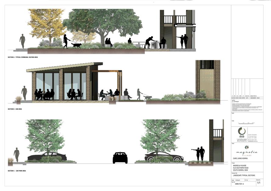
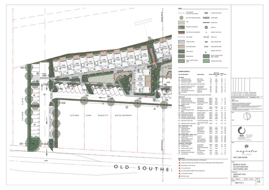
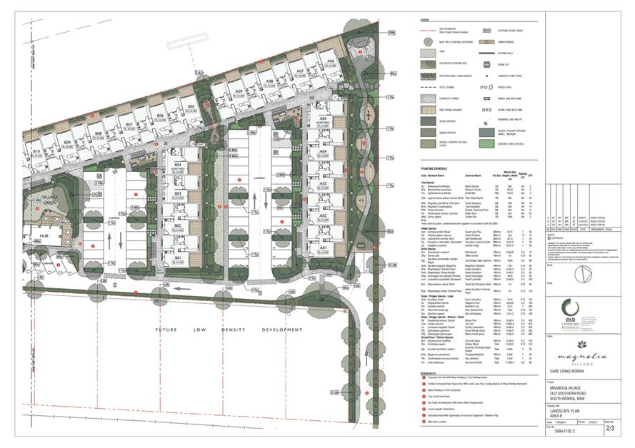
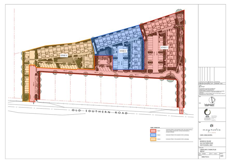
|
|
Ordinary
Meeting – Tuesday 26 October 2021
Page
0
|
CL21.232 Lake
Conjola - Crown Land Licence
HPERM Ref: D21/386412
Department: Environmental
Services
Approver: Phil
Costello, Director - City Development
Attachments: 1. DPIE
- Crown Land Licence - Lake Conjola Entrance Management (under separate cover) ⇨
Reason for Report
To provide Council with an
update on the licence application for Lake Conjola entrance intervention and
the associated revised triggers included in the licence from the Department of
Planning, Industry and Environment (DPIE) - Crown Land.
|
Recommendation
That
Council receive this report for information and note the revised triggers for
Lake Conjola artificial entrance intervention in accordance with the Department of Planning, Industry and Environment (DPIE) -
Crown Land licence dated 24 September 2021.
|
Options
1. That Council
receive this report for information and note the revised triggers and licence
area for Lake Conjola artificial entrance intervention in accordance with the
Crown Land Licence.
Implications: The Lake Conjola entrance will be
mechanically opened as required in accordance with the revised triggers.
2. Council could
choose to provide an alternative recommendation for consideration.
Implications: This would be dependent on
alternative recommendation.
Background
Following community
consultation, Council previously prepared a Review of Environmental Factors
(REF) environmental assessment and submitted a licence application to DPIE
– Crown Land for the modification of triggers to artificially open Lake
Conjola to the sea. This application was submitted in December 2020 and further
information requested by Crown lands was provided in May 2021.
This application has led to the
issue of the subject Licence (Attachment 1) in the terms outlined below. The
licence has been issued for a 5 year period.
Lake Conjola is currently open to the sea and has been since
February 2020. It is noted however that the entrance has been impacted by a
significant sand build up due to the recent East Coast Low weather event.
Intervention Trigger Levels
Below is a summary of the intervention triggers that are
included in the conditions of this licence and a comparison between the
requested and proposed triggers. In addition to the revised triggers below, the
actual area which the licence covers has been expanded - which gives Council
greater scope in regard to proposed opening events. (see schedule 3 of
attachment 1)
Prolonged low-level
inundation
This is a new trigger criteria
and has been included having regard to community consultation that occurred
after previous periods of the Lake entrance being closed for extended periods
-with Lake levels impacting on private and public assets and overall community
wellbeing.
|
Planning for an opening
|
The lake stabilises at or above
0.8m AHD for a period of three consecutive months
|
|
Open lake to sea
|
10-day-mean1 water
level is reached or exceeded and maintained at or above 0.8m AHD for more
than three consecutive months.
|
Notes:
1.
The 10-day-mean water level is the average water level recorded over the
previous 10 days. This approach of using the 10-day-mean would allow the water
level to drop slightly below 0.8m AHD for short periods of time provided the
average water level over the previous 10 days was at or above 0.8m AHD and
hence prevent the starting date for the three consecutive months being reset
every time the water level dropped slightly below 0.8m AHD.
Possible flooding
- High Lake water levels and heavy rain of more than 150mm in 24 hours or more
than 300mm over 3 days is forecast and likely to impact the Lake Conjola
catchment or which has been received in the catchment.
|
Action
|
Current
Draft Entrance Management Plan (EMP)
|
Licence
Application
|
Licence
Granted
|
|
Get Ready
|
0.8m
AHD
|
0.7m
AHD
|
0.7m
AHD
|
|
Prepare Pilot Channel
|
0.9m
AHD
|
0.8m
AHD
|
0.8m
AHD
|
|
Planned Opening
|
1.0m
AHD
|
0.9m
AHD
|
1.0m
AHD
|
The get ready and prepare a ‘pilot channel
standards’ have been reduced by 100mm with the planned opening mark
remaining in line with current EMP. The ability to open the lake with impending
significant rainfall events has been given a level of detail not existing in
the current EMP.
Evidence of water quality
risks and hazards
Whilst water quality is
referenced in the current EMP (ANZECC Guidelines) the below criteria offer a
greater level of clarification in regard to Lake opening.
|
Proposed Trigger in
REF
|
Trigger in Licence
|
|
Trigger
|
Action
|
Trigger
|
Action
|
|
Where the lake entrance
is closed, and water quality degradation becomes apparent
|
SCC will undertake a
risk assessment in accordance with Guidelines for Managing Risks in
Recreational Water (NHMRC 2008)
|
Red alert level1
as described in Guidelines for Managing Risks in Recreational Water (NHMRC
2008)
|
Liaison with DPI –
Fisheries and Crown Land
|
|
Risk assessment results
in a red alert1
|
SCC
will consult with the Department of Primary Industries – NSW Fisheries
and Crown Land to deem opening the lake is appropriate. Concurrence from both
agencies would be obtained prior to opening.
|
Red alert level1
(NHMRC 2008) and concurrence from DPI Fisheries and Crown Lands has been
received.
|
Open lake to sea
|
Notes:
1.
Red Alert Level indicates unacceptable risks to recreational users to an extent
requiring Council and health authorities to warn the public that the water body
is considered to be unsuitable for primary and secondary contact.
≥10 µg/L total microcystins or ≥50,000 cells/mL toxic M.
aeruginosa or biovolume equivalent of ≥4 mm3 L for the
combined total of all cyanobacteria where a known toxin producer is dominant in
the total biovolume. Or ≥10 mm3 /L for total biovolume of all
cyanobacterial material where known toxins are not present. or cyanobacterial
scums are consistently present
Community Engagement
Extensive community engagement has been conducted prior to
and during the preparation of the licence application and accompanying REF. The
final licence application was endorsed through this community consultative
process. It should also be noted that extensive community consultation has
occurred in relation to the Lake Conjola Coastal Management Plan which is
currently in the process of being formulated. The issue of Lake entrance
management is a consideration in the formulation of this plan.
Policy Implications
No known policy implications have currently been identified.
Artificial entrance intervention would continue to be undertaken for the Lake
Conjola entrance in accordance with the revised triggers.
Financial implications
Some of the opening triggers
included in this licence could result in significant and expensive artificial
entrance intervention such as the June 2019 works which cost approximately
$140,000 (Development & Environment Committee – Tuesday 06 August
2019 DE19.75). It is not possible to predict the likely number of separate
entrance interventions in any given year in the future, but it is possible that
multiple entrance interventions could be required in some years at significant
overall cost.
As there is no budget allocated
for entrance interventions, the financial implications associated with the
implementation of the licence conditions will need to be assessed during the
budget review process.
|
|
Ordinary
Meeting – Tuesday 26 October 2021
Page
0
|
CL21.233 The Bob Proudfoot Pavilion -
Public Exhibition Summary and Way Forward
HPERM Ref: D21/425355
Department: Community
Planning & Projects
Approver: Jane
Lewis, Director - City Lifestyles
Attachments: 1. The
Bob Proudfoot Pavilion - Endorsed Plans for Public Exhibition ⇩
2. Francis
Ryan Amenities Building - Quantity Survey (councillors information folder) ⇨
3. Financial Implications report
(councillors information folder) ⇨
Reason for Report
To advise on the outcomes of the public exhibition for the
design of the Bob Proudfoot Pavilion at Francis Ryan Reserve, Sanctuary Point
and to seek direction on the way forward.
This report is being submitted directly to the Ordinary
Meeting due to there being no further committee meetings prior to Council going
into caretaker mode.
|
Recommendation
That
Council;
1. Receive this report as a summary of
the public exhibition for the Bob Proudfoot Pavilion, Sanctuary Point.
2. Endorse the design of the Bob Proudfoot
Pavilion, in accordance with the publicly exhibited concept design (Design
Iteration 3).
3. Proceed to construction ready
detailed designs for the Bob Proudfoot Pavilion and subsequent request for
tender for the construction of the Bob Proudfoot Pavilion.
4. Re-prioritise capital projects
identified in the 2022/2023 DPOP and 10-Year Delivery Plan to address the
budget shortfall to construct the Bob Proudfoot Pavilion if the funding
application under the NSW State Stronger Country Communities Fund Round 4 is
unsuccessful.
5. A further report be brought to
Council at the conclusion of the public request for tender process for the
construction and delivery of the Bob Proudfoot Pavilion.
|
Options
1. Adopt the
recommendation
Implications: This will allow the design of the Bob
Proudfoot Pavilion to proceed to detailed design, with no further impact to the
scope or timeframe.
2. Adopt to
investigate alternative designs for the Bob Proudfoot Pavilion
Implications: This will increase the timeframe for
the delivery of the project, and result in additional planning, consultation,
and design. Increasing the scope of the project may require additional budget.
3. Adopt an
alternative recommendation and provide direction to staff
Implications: Depending on the significance of the
recommendation, this may affect the progression of the project, resulting in
delays and budget increases.
Background
As part of the Sanctuary Point
Library planning process, a new amenities block for Francis Ryan Reserve was
identified. The design of the amenities building has evolved with several
iterations, the current design being in line with a Notice of Motion from the
Ordinary Council Meeting on 27 April 2021, where it was resolved that (MIN21.250):
1. A
gymnasium space and CCTV security be included in the concept design for the new
amenities block at Francis Ryan Reserve, Sanctuary Point.
2. Council staff
assist with the best location for an electronic scoreboard at Francis Ryan
Reserve, Sanctuary Point.
As a result of the above Minute,
the amenities design includes a Fitness and Conditioning Space, as well as:
· Increased storage
space within the building
· Loss of the
‘breezeway/accessway’ to the carpark
· Inclusion of
details regarding design materials and colour scheme.
The current design (Design
Iteration 3) was reported to the Ordinary Council Meeting on 29 June 2021, to
seek Council’s endorsement to proceed to public exhibition. At this
meeting, it was resolved (MIN 21.426):
That Council:
1. Proceed
to public exhibition with Concept Design Iteration 3 of the Francis Ryan
Amenities Building; and
a. If
no significant feedback is received as part of the exhibition, the concept
design of the Francis Ryan Amenities Building be finalised and deemed adopted;
or
b. If
significant adverse feedback is received, update the concept design of the
Francis Ryan Amenities building and report the outcomes of the public
exhibition period to Council prior to adoption.
2. At
the completion of Part 1 (above) proceed to construction ready detailed designs
for the Francis Ryan Amenities Building, as per Design Iteration 3.
3. Advocate
for additional funding to deliver the Francis Ryan Amenities Building, as per
Design Iteration 3 through actively seeking funding through grant programs.
4. Receive
a further report on the appointment of the building contractor once the Request
for Tender process has been undertaken.
The design of the amenities was
subsequently placed on public exhibition. The exhibited design can be viewed in
Attachment 1.
The proposed amenities at Francis Ryan Reserve is to be
formally named “The Bob Proudfoot Pavilion” in line with part (1)
of MIN21.402:
That
Council:
1. Name
the amenities/change facilities at Francis Ryan reserve, when renovated and
extended, ‘The Bob Proudfoot Pavilion’.
Public Exhibition
Council has recently undertaken
public exhibition of the design for the Bob Proudfoot Pavilion at Francis Ryan
Reserve, Sanctuary Point. The design (Design Iteration 3) can be viewed at
Attachment 1.
The public exhibition took place
in the form of an online survey from 10 August to 9 September 2021. A total of
30 submissions were received via the online survey and one written submission.
66% of responses indicated
support for the design and that it met the needs of the community. Thirty-four
percent of responses indicated that the facility did not meet their needs,
providing the following reasons:
· Request
for environmentally friendly additions
· Request
for different finishes
· Issues
with the placement on the reserve
· The design needed
to include a community space or hall
Four of the survey responses and
the written submission outlined objection to the design, as there was no hall
or community space as an addition to the building. These community members have
previously raised this matter formally with Council officers about the Pavilion
needing to have a community hall space.
Council staff have consistently communicated with key
members of the group throughout the design and consultation process of the
pavilion, explaining that the primary purpose of the building is for sports and
recreation activities and that the impending construction of the Sanctuary
Point Library (200m from the Pavilion) will provide both additional indoor
community spaces for hire and an outdoor terrace space which will also be
available for hire.
Design considerations – The
Bob Proudfoot Pavilion
The request for the inclusion of
a hall or community space within the Bob Proudfoot Pavilion has been considered
by Council staff. This proposed addition to the facility is outside the scope
of the project and the budget allocated. The inclusion of a hall/community
space is not proposed to be supported for the following reasons:
· The current
proposed field alignment is constrained and limits the amount of infrastructure
on the site, including the proposed amenities.
· The current
proposed field alignment now provides for 2 senior sports fields to meet the
needs of the sport user groups and the growing number of female players in
codes previously dominated by male teams, this has been considered in the
flexible design of the amenities – the footprint provides for male and
female, home and away teams to allow games to be played concurrently.
· Including a
community hall would require the mound to the north of the amenities building
to be removed which would increase the civil cost of the building.
· Field lighting has
been delivered in the area to the south of the proposed building and this new
lighting would require relocation.
· The nearby
Sanctuary Point Library will provide community space within its design
· The primary use of
the amenities building is for sporting activities, while public amenities are
provided, it is not proposed that the amenities serve this dual purpose.
· The additions
would require an increase in budget.
On this basis it is not proposed to incorporate a community
space or hall into the current design that was placed on public exhibition and
requests Council to endorse the design of the Bob Proudfoot Pavilion (Design
Iteration 3), in accordance with the publicly exhibited concept design at
Attachment 1.
Financial Implications
The size and scope of the
project has increased as the sports stakeholder groups and Council MIN21.250
requirements were incorporated into the design. The project budget was
based on the initial base design. The final design has undergone an increase of
scope and Quantity Survey (QS) was obtained.
The QS and further details on
Financial Implications can be found in Attachment 2 and Attachment 3 in the
Councillors information Folder.
There is currently a budget
shortfall based on the QS to construct the building as presented in the final
design. It is proposed that the budget shortfall is
addressed by re-prioritising other capital projects in the 2022/2023 DPOP and
the 10-year delivery plan. As the project will be constructed across 2
financial years this is achievable.
It should be noted that a
funding application to the State Government Stronger Country Communities Fund
has been lodged by Council officer for the project. Grants closed on 25 June
2021 and the funding body has indicated that announcements of successful
applications would be made in September 2021. Council has not received notice
of the outcome to date. Staff are currently following up with the funding body.
Should this application be successful the project will be able to progress as
proposed.
If the grant application is not
successful and funding is not available, the scope could be reduced to meet the
budget which will affect the size and functionality of the building, the time
frame for the delivery of the project, the expectations of the key stakeholders
and the community and would not be consistent with Council
MIN21.250.
The final cost for construction and delivery will be
determined by the market when this project is put out for a public request for
tender process. At the conclusion of this process a further report will be
brought to Council on the outcome of the public tender.
Policy Implications
The Community Infrastructure Strategic Plan (CISP)
identifies Francis Ryan Reserve as a District Sports Park and recommends that
Council “Encourage passive recreation of the park to compliment active
users and to continue to Master plan the site as a youth precinct.”
The design of the Bob Proudfoot Pavilion is in line with the CISP.
Next Steps
With the public exhibition and community
consultation on the design of the Bob Proudfoot Pavilion now complete; and the
majority of survey participants supportive of the design, it is proposed in
accordance with part (1) and (2) of MIN21.426:
That Council:
1. Proceed
to public exhibition with Concept Design Iteration 3 of the Francis Ryan
Amenities Building; and
a. If
no significant feedback is received as part of the exhibition, the concept
design of the Francis Ryan Amenities Building be finalised and deemed adopted;
or
b. If
significant adverse feedback is received, update the concept design of the
Francis Ryan Amenities building and report the outcomes of the public
exhibition period to Council prior to adoption.
2. At
the completion of Part 1 (above) proceed to construction ready detailed designs
for the Francis Ryan Amenities Building, as per Design Iteration 3.
As per Part 2 of the above
Council Minute, it is proposed, pending Council resolution, that the current
design of the Bob Proudfoot Pavilion is adopted and that the project proceeds
to construction ready detailed design. Funding the construction of the Pavilion
is to be sought via the re-prioritisation of other projects in the 10-year
delivery plan.
|
|
Ordinary
Meeting – Tuesday 26 October 2021
Page
0
|
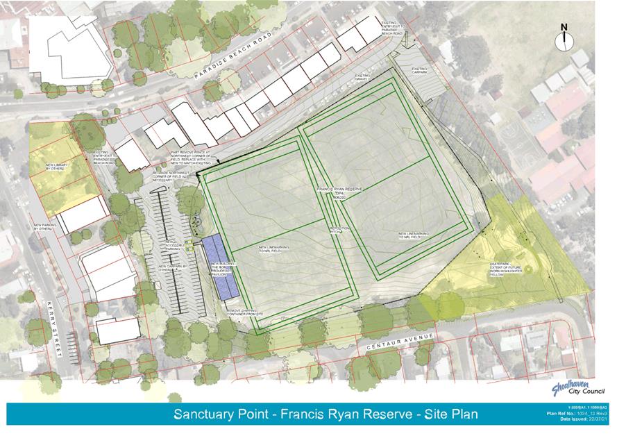
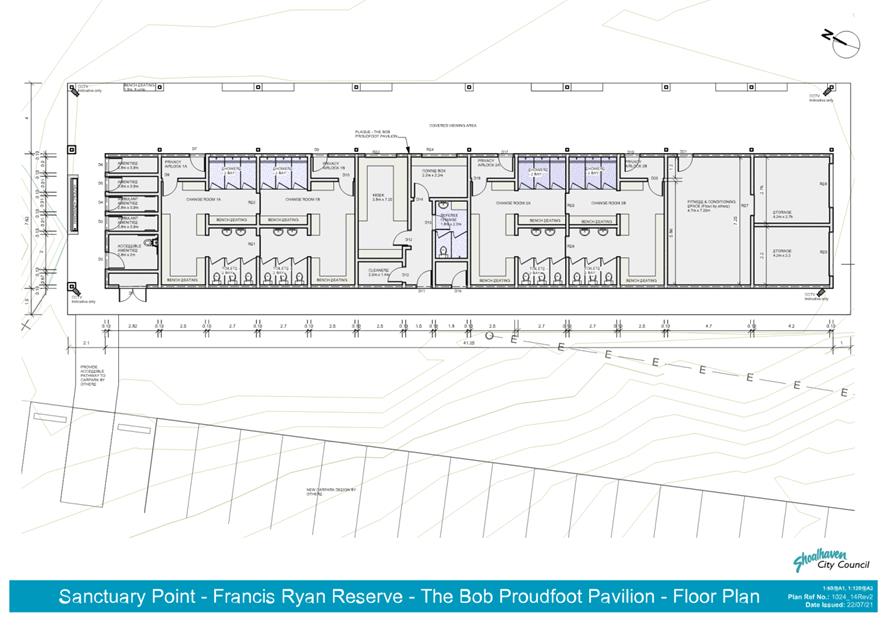
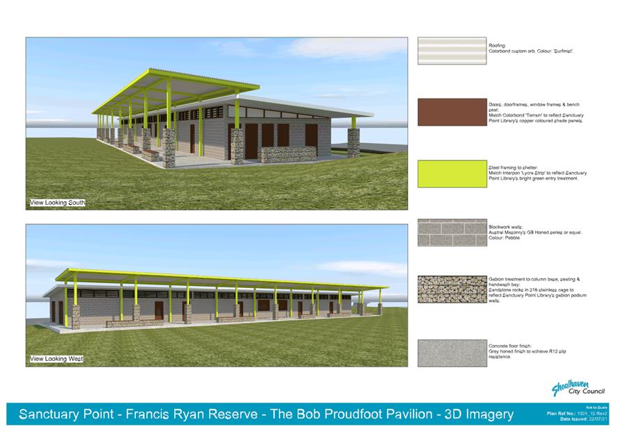
|
|
Ordinary
Meeting – Tuesday 26 October 2021
Page
0
|
Local Government Amendment (governance &
planning) act 2016
Chapter
3, Section 8A Guiding principles for councils
(1)
Exercise of functions
generally
The
following general principles apply to the exercise of functions by councils:
(a) Councils should provide strong
and effective representation, leadership, planning and decision-making.
(b) Councils should carry out
functions in a way that provides the best possible value for residents and
ratepayers.
(c) Councils should plan
strategically, using the integrated planning and reporting framework, for the
provision of effective and efficient services and regulation to meet the
diverse needs of the local community.
(d) Councils should apply the
integrated planning and reporting framework in carrying out their functions so
as to achieve desired outcomes and continuous improvements.
(e) Councils should work
co-operatively with other councils and the State government to achieve desired
outcomes for the local community.
(f) Councils should manage
lands and other assets so that current and future local community needs can be
met in an affordable way.
(g) Councils should work with
others to secure appropriate services for local community needs.
(h) Councils should act fairly,
ethically and without bias in the interests of the local community.
(i) Councils should be responsible
employers and provide a consultative and supportive working environment for
staff.
(2) Decision-making
The
following principles apply to decision-making by councils (subject to any other
applicable law):
(a) Councils should recognise
diverse local community needs and interests.
(b) Councils should consider social
justice principles.
(c) Councils should consider the
long term and cumulative effects of actions on future generations.
(d) Councils should consider the
principles of ecologically sustainable development.
(e) Council decision-making should
be transparent and decision-makers are to be accountable for decisions and
omissions.
(3) Community participation
Councils
should actively engage with their local communities, through the use of the
integrated planning and reporting framework and other measures.
Chapter
3, Section 8B Principles of sound financial management
The
following principles of sound financial management apply to councils:
(a) Council spending should be responsible and
sustainable, aligning general revenue and expenses.
(b) Councils should invest in responsible and
sustainable infrastructure for the benefit of the local community.
(c) Councils should have effective financial
and asset management, including sound policies and processes for the following:
(i) performance management
and reporting,
(ii) asset maintenance and
enhancement,
(iii) funding decisions,
(iv) risk management practices.
(d) Councils should have regard to achieving intergenerational
equity, including ensuring the following:
(i) policy decisions are made
after considering their financial effects on future generations,
(ii) the
current generation funds the cost of its services
Chapter
3, 8C Integrated planning and reporting principles that apply to councils
The
following principles for strategic planning apply to the development of the
integrated planning and reporting framework by councils:
(a) Councils should identify and prioritise key
local community needs and aspirations and consider regional priorities.
(b) Councils should identify strategic goals to
meet those needs and aspirations.
(c) Councils should develop activities, and
prioritise actions, to work towards the strategic goals.
(d) Councils should ensure that the strategic
goals and activities to work towards them may be achieved within council
resources.
(e) Councils should regularly review and
evaluate progress towards achieving strategic goals.
(f) Councils should maintain an integrated
approach to planning, delivering, monitoring and reporting on strategic goals.
(g) Councils should collaborate with others to
maximise achievement of strategic goals.
(h) Councils should manage risks to the local
community or area or to the council effectively and proactively.
(i) Councils should make appropriate
evidence-based adaptations to meet changing needs and circumstances.