Shoalhaven Traffic Committee
Meeting Date: Tuesday,
14 September, 2021
Location: Microsoft
Teams
Time: 9.30am
Please note: Council’s Code of Meeting Practice
permits the electronic recording and broadcast of the proceedings of meetings
of the Council which are open to the public. Your attendance at this meeting is
taken as consent to the possibility that your image and/or voice may be
recorded and broadcast to the public.
Agenda
1. Apologies
2. Confirmation of Minutes
· Shoalhaven
Traffic Committee - 10 August 2021........................................................ 1
3. Business Arising from Previous Minutes
4. Reports of the Convenor
TC21.47...... Signage and Linemarking Plans - Lot 502 DP
1221372 - Princes Highway, Meroo Meadow (PN 3367)......................................................................................... 5
TC21.48...... Signage and Linemarking Plans - Lots 38 & 39
DP 8082 - 193 Island Point Road, St Georges Basin (PN 3666).............................................................................. 9
TC21.49...... Parking Modifications - Vincentia Village -
Burton Street Mall - Burton Street - Vincentia (PN 3668)..................................................................................... 13
TC21.50...... Signage & Linemarking Plans - Proposed
Roundabout - Moss Vale Road - Cambewarra - (PN 3669)............................................................................. 18
TC21.51...... Proposed Accessible Parking Space - Princes
Highway - Ulladulla (PN 3670) 27
5. General Business
Note: The next meeting will be
held on Tuesday 12 October 2021.
|

|
Shoalhaven
Traffic Committee – Tuesday 14 September 2021
Page
|
Membership
Mr David Pieresko – Convenor
Ms Nicole Brodie
Sergeant Ian McManus
Ms Shelley Hancock MP (or representative)
Mr Stuart Coughlan
Clr Jo Gash
Clr Patricia White
The Shoalhaven Traffic Committee is a technical review
committee, not a committee of Council under the Local Government Act 1993. The
Roads and Maritime Services (RMS) has delegated certain powers to Council under
the Transport Administration Act 1988 (Section 50). A condition of this
delegation is that Council must take into account the Traffic Committee
recommendations.
There are four formal members of the Traffic Committee, each
of whom has a single vote only. The members are representatives from:
- NSW Police Force
- RMS
- Shoalhaven City Council
- Local State Member of Parliament (for the location of the
issue to be voted upon)
If the RMS or NSW Police Force disagrees with any Traffic
Committee recommendation, or Council’s resolution (on any Traffic
Committee recommendation), they may lodge an appeal with the Regional Traffic
Committee for determination. The appeal must be lodged in writing within
14 days of the date of notification in writing. Any action relative to
any issue under appeal must cease until the matter is determined. The
Regional Traffic Committee is chaired by an independent chairperson and
submissions and representations are welcomed from all interested parties.
Council cannot amend a Traffic Committee recommendation. The
Council can only: adopt the Traffic Committee recommendation; not adopt the
Traffic Committee recommendation, or request the Traffic Committee reconsider
the issue.
The full guide to the delegation to Council’s for
the regulation of traffic can be viewed at RMS
Website
Minutes of the Shoalhaven Traffic Committee
Meeting Date: Tuesday,
10 August 2021
Location: Email
Meeting
The following members
participated:
Convenor David Pieresko -
Senior Civil Engineer
Ms Emma Pietruska –
Transport for NSW
Mr Stuart Coughlan
S/C Kelly Thomas –
NSW Police
Ms Shelley Hancock - MP
Clr Patricia White
|
Apologies / Leave of Absence
|
Nil
|
Confirmation of the Minutes
|
|
RESOLVED (By consent)
That the Minutes of the
Shoalhaven Traffic Committee held on Thursday 15 July 2021 be confirmed.
CARRIED
|
|
Business Arising from Previous Minutes
|
Nil
Reports of the Convenor
|
TC21.44 North Nowra Public School -
School Safety Audit (PN 3662)
|
HPERM Ref: D21/323821
|
|
Transport
for NSW made the following recommendations for the Judith Dr entry to
Havenlee School (Sheet 3/3):
• Remove
S1 linemarking and install E1 linemarking
• Remove
through arrows in left hand lane
• Remove
“No Entry” and supplementary custom signage from signpost A
|
|
Recommendation
That:
1. The
Chief Executive Officer (Director City Services) be advised that the
Shoalhaven Traffic Committee has no objection to the proposed school safety
improvements at North Nowra Public School, as per Plan No D21/328696.
2. The
recommendation be approved by the Director City Services under delegated
authority from Shoalhaven City Council - refer MIN21.411.
|
|
RESOLVED (By consent)
That:
1. The
Chief Executive Officer (Director City Services) be advised that the
Shoalhaven Traffic Committee has no objection to the proposed school safety
improvements at North Nowra Public School, as per Plan No D21/328696, subject
to the following amendments at the Judith Dr entry to Havenlee School:
a. Replacement of ‘S1’
linemarking with ‘E1’ linemarking.
b. Removal of ‘Through’
arrows shown in left hand lane.
c. Removal of ‘No Entry’
& supplementary custom signage from Signpost A.
2. The
recommendation be approved by the Director City Services under delegated
authority from Shoalhaven City Council - refer MIN21.411.
CARRIED
|
|
TC21.45 Vincentia Public School - School
Safety Audit (PN 3663)
|
HPERM Ref: D21/323870
|
|
Recommendation
That:
1. The
Chief Executive Officer (Director City Services) be advised that the
Shoalhaven Traffic Committee has no objection to the proposed school safety
improvements at Vincentia Public School, as per Plan No D21/324608.
2. The
recommendation be approved by the Director City Services under delegated
authority from Shoalhaven City Council - refer MIN21.411.
|
|
RESOLVED (By consent)
That:
1. The
Chief Executive Officer (Director City Services) be advised that the
Shoalhaven Traffic Committee has no objection to the proposed school safety
improvements at Vincentia Public School, as per Plan No D21/324608.
2. The
recommendation be approved by the Director City Services under delegated
authority from Shoalhaven City Council - refer MIN21.411.
CARRIED
|
|
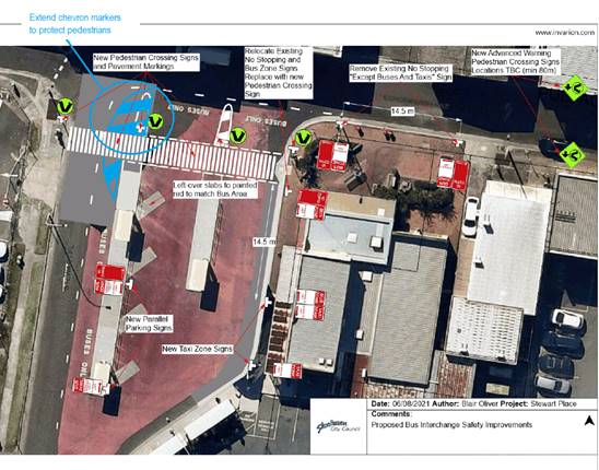
TC21.46 Stewart Place Bus Safety Improvements
- Nowra (PN 3665)
|
HPERM Ref: D21/324103
|
|
Transport
for NSW made the following recommendations:
• As
per Australian Standard (AS) 1742.10-2009, 6.3, for the installation of
pedestrian (Zebra) crossings, no more than one lane of moving traffic in any
one direction should be encountered by a pedestrian using a crossing.
• TfNSW’s
supplement to AS 1742.10-2009, also outlines that NSW practice does not
permit Zebra Crossings on roads with two or more marked travel lanes in same
direction.
• Remove
S1 line and increase chevron to reinforce turning paths and narrow lane width
at the zebra crossing on Stewart Place
• Reinstate
missing red pavement to clearly indicate bus area
• Consideration
should be given to relocating the loading zone on Schofields Lane to
facilitate bus turning movements without encroaching on the painted island or
zebra crossing
• While
concrete islands are generally preferred, TfNSW notes that, due to buses
turning, painted road markings would be more practical at this location.
|
|
Recommendation
That:
1. The
Chief Executive Officer (Director City Services) be advised that the
Shoalhaven Traffic Committee has no
objection to the proposed Bus Terminal Safety Improvements at Stuart Place,
Nowra as per Plan No D21/332170.
2. The
recommendation be approved by the Director City Services under delegated
authority from Shoalhaven City Council - refer MIN21.411.
|
|
RESOLVED
(By consent)
That:
1. The
Chief Executive Officer (Director City Services) be advised that the
Shoalhaven Traffic Committee has no
objection to the proposed Bus Terminal Safety Improvements at Stuart Place,
Nowra as per Plan No D21/332170, subject to the following amendments:
a. Removal
of ‘S1’ linemarking and augmentation of the existing chevron area
at the westernmost end of the zebra crossing in Stewart Place to reinforce
turning paths and narrow the lane width at this location.
b. Repainting
of any missing red pavement surfaces to clearly indicate bus area.
2. The
recommendation be approved by the Director City Services under delegated
authority from Shoalhaven City Council - refer MIN21.411.
CARRIED
|
There being no further
business, the meeting concluded.
Mr David Pieresko
CHAIRPERSON
|

|
Shoalhaven
Traffic Committee – Tuesday 14 September 2021
Page
0
|
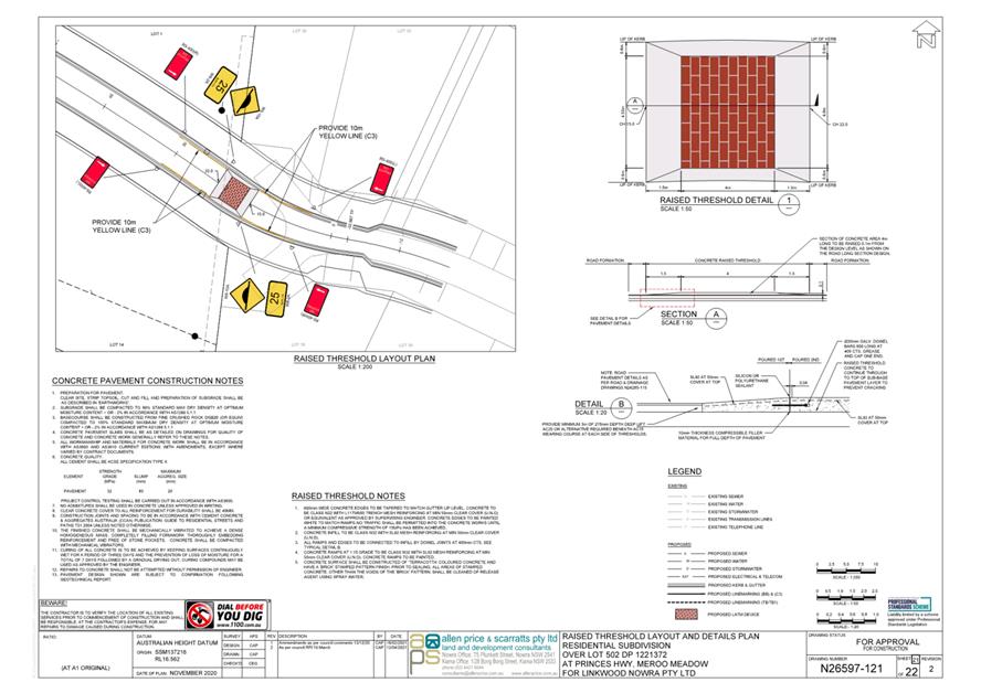
TC21.47 Signage
and Linemarking Plans - Lot 502 DP 1221372 - Princes Highway, Meroo Meadow (PN
3367)
HPERM Ref: D21/365646
Convenor: David
Pieresko
Attachments: 1. PN
3367 Plans ⇩
|
Recommendation
That
the Chief Executive Officer (Director City Services) be advised that the Shoalhaven
Traffic Committee has no objection to the proposed signage and line marking
associated with the development at C130 Princes Highway, Meroo Meadow (per
Development Consent Condition 26), as per Plan No. D21/365777, subject to the
following:
1. Additional W3-4 signage be located
30 to 50m from the proposed hump with additional W8-17-2 signage at the first
hump of the series when the additional (3) speed humps are installed.
2. W8-2A sign speed limit be reduced to
20km/h as per the guidance in AS1742.13.
3. The removal of no stopping
provisions (C3 Line Marking & R5-400 signs).
4. Provision of signage and line
marking to be applicable to all four LATM devices (when seeking approval in
the future).
5. The
Raised Threshold Typical Detail 1 - Sheet 1 (Plan Ref. N26597-SK15) to match
the Raised Threshold Typical Detail 1 on Sheet 2 (N26597-121) showing the
appropriate 0.6m transition back to the LIP of kerb.
6. The
recommendation be approved by the Director City Services under delegated
authority from Shoalhaven City Council - refer MIN21.411.
|
Applicant: Allen Price & Scarratts Pty Ltd
Owner: Linkwood Nowra Pty Ltd
C130 Princes Highway, Meroo Meadow – Lot 502 DP
1221372 - Fifteen (15) Lot Torrens Title Subdivision and Associated Site Works
As per Condition 26 of the
development consent, the following is required:
The road design must incorporate the provision of four
(4) Local Area Traffic Management (LATM) devices - raised threshold in
accordance with AS1742.13 and contain 4m platforms to meet Council
requirements. The first must be located in the vicinity of the existing turning
head-on Emerald Drive. An additional three (3) LATMs must be provided in
accordance with the recommendations of the Traffic Impact Assessment prepared
by Ason Group, Ref: P0673r01v03, dated 8/03/2019 and approved pursuant to
Condition 1.
A plan with details of the proposed LATM and any associated
line-markings and regulatory signs must be submitted to Council for a referral
to the Shoalhaven Traffic Committee and subsequent recommendation to Council.
The plans to be referred to Shoalhaven Traffic Committee must include details
of how the existing turnaround is proposed to be removed and replaced with the
extension of Emerald Drive forming a continuous access road into the
development including continuous kerb and gutter and suitable rehabilitation of
the existing turnaround areas in consultation with affected property owners.
The amended Traffic Assessment
prepared on behalf of the applicant by Ason Group report reference P0673r01v03
dated 8/03/2019 (Council’s Trim Ref D19/82306) states the following
below:
· It
is proposed to provide four raised thresholds (flat-top speed humps) in
accordance with AS1742.13 and Council requirements at appropriate locations
along Emerald Drive as a lower cost alternative to address the issue of the
existing narrow road width, provide safter environment for all road users and
offset the impact of the proposal
· The
provision of the first raised threshold device would be constructed as part of
the redesign of the existing turnaround treatment and design of the road
continuation, providing continuous kerb and guttering for the through road in
consultation with the adjacent property owners. The three additional remaining
devices, including one on Emerald Drive between Jade Place and Meroo Road would
be constructed later at the discretion of Council.
As such, the purpose of this referral is to seek acceptance
for LATM device Number 4 ONLY and that a further submission should be made to
the Traffic Committee for approval of the additional 3 LATM devices in the
future.
A signage and line marking plan has
been submitted to the Committee for consideration.
Consultation:
This Development Application was
placed on re-notification for a Public Exhibition between 14 December 2016 and
30 January 2017 with feedback requested from the community, directly affected
residents and the local community consultative body. During this period,
Council had received 17 submissions. Multiple submissions did not believe that
the incorporation of raised thresholds “being a lower cost alternative
to address the issue of the existing narrow road width to provide a safer
environment for all road users and to offset the impact of the proposal”
was the solution to existing site constraints. Two submissions in particular
raised concerns with “the constant brake and impact noise from cars
driving over thresholds” and the use of raised thresholds as “launching
ramps” were indicated as elements negatively impacting the quality of
life for current residents.
Council's Planning and Development Services Team approved
this development on the 6 August 2019.
Risk Implications:
There are no risk implications to Council regarding this
signage and line marking plan, as this is a private development.
Financial Implications:
There are no financial implications to Council regarding
this signage and line marking plan, as this is a private development. A bond
will be withheld from the developer to fund the extra (3) LATM devices if
required in the future and as such, the bond amount shall be review prior to
acceptance.
|

|
Shoalhaven
Traffic Committee – Tuesday 14 September 2021
Page
0
|
|

|
Shoalhaven
Traffic Committee – Tuesday 14 September 2021
Page
0
|
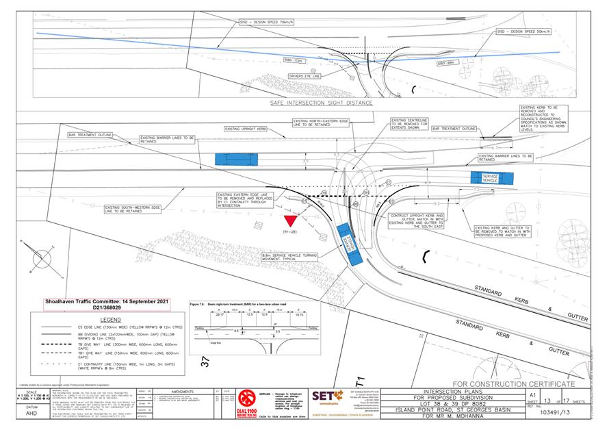
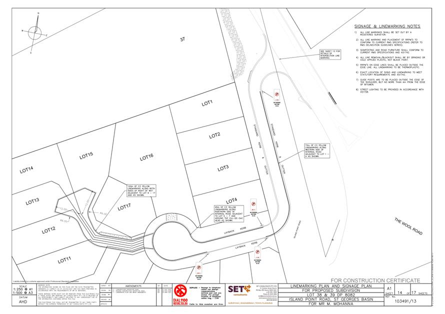
TC21.48 Signage
and Linemarking Plans - Lots 38 & 39 DP 8082 - 193 Island Point Road, St
Georges Basin (PN 3666)
HPERM Ref: D21/367775
Convenor: David
Pieresko
Attachments: 1. PN
3666 Plans ⇩
|
Recommendation
That the Chief Executive Officer (Director City Services)
be advised that the Shoalhaven Traffic Committee has no objection to the
proposed signage and line marking associated with the development at Lots 38
& 39 DP 8082 - 193 Island Point Road, St Georges Basin, (per development
consent condition 39), as per Plan No D21/368029; subject to the following:1. Change
location of R5-40 sign closest to Lot 4 from start of turning point to end of
turning point (South-East corner of Lot 4), moving the sign approx. 13m to
the north.
2. Provision of C3 line marking up to
new location of sign in front of Lot 4.
3. Change all R5-40 signs to R5-400
“No Stopping” signs.
4. The recommendation be approved by
the Director City Services under delegated authority from Shoalhaven City
Council - refer MIN21.411.
|
Applicant: SET Consultants Pty Ltd
Owner: Southhold Pty Ltd
Lot 39 DP 8082 (no.191) and Lot 38 DP 8082 (no.193) Island
Point Rd, St Georges Basin - 17 Residential Torrens Title Lot Subdivision
As per Condition 39 of the development consent, the following
is required:
Condition 39 -
Any speed control devices,
regulatory signage and line marking will require referral to the Shoalhaven
Traffic Committee for approval. Six (6) to eight (8) weeks should be allowed
for this.
A signage and line marking plan has
been submitted to the Committee for consideration.
Consultation:
This Development Application had
been on Public Exhibition between 24 January and 14 February
2018, and again on 6 to 21 September 2018, with feedback requested from the
community, directly affected residents and local community consultative body
(Basin Villages Forum). During this period, Council had received 14 responses,
objecting to the proposed development.
Council's Planning and Development Services Team approved
this development on 18 June 2020.
Risk Implications:
There are no risk implications to Council regarding this
signage and line marking plan, as this is a private development.
Financial Implications:
There are no financial implications to Council regarding
this signage and line marking plan, as this is a private development.
|

|
Shoalhaven
Traffic Committee – Tuesday 14 September 2021
Page
0
|
|
|
Shoalhaven
Traffic Committee – Tuesday 14 September 2021
Page
0
|
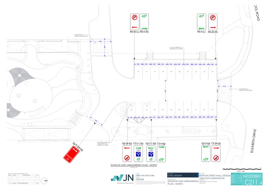
TC21.49 Parking
Modifications - Vincentia Village - Burton Street Mall - Burton Street -
Vincentia (PN 3668)
HPERM Ref: D21/368219
Convenor: David
Pieresko
Attachments: 1. PN
3668 Plans ⇩
|
Recommendation
That
the Chief Executive Officer (Director City Services) be advised that the
Shoalhaven Traffic Committee has no objection to the proposed signage, line
marking, parking modifications and reduction in parking capacity to the
northern and southern sections of the Burton Street Mall, Vincentia as per Plan
No D21/368474, subject to:
1. Supplementing existing “No
Stopping” areas with C3 Yellow line marking
2. On Sheet N0200881 – C210A,
remove the three R5-40 ‘No Parking’ signs at northern and
southern extents of parking bays and replace with C3 Yellow line marking
3. On Sheet N0200881 – C211A,
remove the four R5-40 ‘No Parking’ signs at northern and southern
extents of parking bays and replace with C3 Yellow line marking
4. On Sheet N0200881 – C210A,
remove the R5-445(R/L) ‘No Parking // Wedding or Funeral Vehicles
Excepted’ sign and replace with ‘No Parking // Authorised
Maintenance Vehicles Excepted’
5. The recommendation be approved by
the Director City Services under delegated authority from Shoalhaven City
Council - refer MIN21.411.
|
Background
Council has received funding as
part of the Building Better Regions Grant Fund for the revitalisation and
optimisation of public facilities at the Burton Street Mall, Vincentia (also
known as the Vincentia Village Shops).
Council has been actively
consulting with the community and affected shopkeepers, alongside
representatives from Placemaking NSW and consultants from “Place
Score”, to ensure that the proposed improvements would align with the
functional purposes of the Burton Street Mall and the recommendations brought
forward by the community.
Following this period of
consultation, a design consultant was commissioned by Council to interpret the
feedback received from the community (via Place Score metrics) and determine
the extent of improvements to the Burton Street Mall.
The design documentation
encompassed a review of existing traffic, parking, and pedestrian movement,
with particular focus on improving access for individuals with a
disability. The proposed design has created a more manageable central
space, improved parking facilities and meeting with Australian Standards for
access and disability compliance (AS1428).
In addition, a review of truck
manoeuvrability and swept paths, additional pathways for safe access either
side of the north and south carpark was undertaken by Jones Nicholson
Engineers.
A regulatory signage and line
marking plan has been submitted for the Committee's consideration.
Details of Submission:
The project proposes to modify
parking arrangements to the northern and southern parking areas of the Burton
Street Mall.
In summary, the comparison between pre and post development
parking are as follows:
|
|
Pre-Development
(Existing Parking Capacity)
|
Post Development
|
|
Car Parking Spaces
(Northern Section of Burton Street Mall)
|
29
|
18
|
|
Accessible Car
Parking Spaces (Northern Section of Burton Street Mall)
|
2
|
2
|
|
Car Parking Spaces
(Southern Section of Burton Street Mall)
|
30
|
20
|
|
Accessible Car
Parking Spaces (Southern Section of Burton Street Mall)
|
1
|
2
|
|
Maintenance Bay
|
1
|
1
|
|
Loading Zone
|
1
|
1
|
|
Total Vehicle
Spaces
|
64
|
44
|
Following this proposal, there
will be a net loss of 21 parking spaces (11 spaces in the Northern Section and
10 spaces in the Southern Section). However, an additional accessible parking
space will be created on the Southern Section of the Burton Street Mall,
thereby bringing the total net loss to 20 parking spaces.
This proposal also removes the
existing timed parking provisions in the Northern Section (1/2 hour and 2-hour
parking) and the Southern Section (2-hour parking respectively) of Burton
Street Mall. These timed parking restrictions will be replaced with 4-hour
timed parking spaces, proposed to provide ample time for visitors to shop and
access the new facilities.
The net loss of parking is
necessary to accommodate the central public open space being extended in a
northerly direction, as well as improving the internal pedestrian mobility and
complying with accessibility standards (AS1428). This recommendation is in line
with feedback received by the community, emphasising the need for a larger public
open space central to the design. The reduction of parking capacity at the
Southern Section of the Burton Street Mall will allow for additional outdoor
dining space, access for maintenance vehicles, additional provision for truck
movements and allocated car spaces for future Electric Vehicles.
The Traffic Impact Report
prepared by Jones Nicholson (on behalf of Council) had that whilst there would
be a net loss of parking along Burton Street Mall, there would be other
available opportunities for parking in the Eastern and Western car parks that
can be utilised by visitors.
The proposal also aims to
improve pedestrian connectivity through the installation of four new pedestrian
crossings. This includes:
· Across the
entrance to the Northern Section of the Burton Street Mall
· Across the
entrance to the Southern Section of the Burton Street Mall
· On the Eastern
side of the Southern Section of the Burton Street Mall
· On
the Western side of the Northern Section of the Burton Street Mall
These crossings have been proposed to improve pedestrian
flow and connectivity into the Burton Street Mall as well as existing pathways
along Elizabeth Drive and Excellent Street. These pedestrian crossings have
been designed in accordance with AS2890.6 – Parking Facilities:
Off-Street Parking for People with Disabilities.
Consultation:
Council has advertised the
proposal and the general arrangement on Economic Developments ‘Proudly
Shoalhaven’ web page since late 2019.
Prior to the development of this
proposal, community consultation was undertaken by consultants “Place
Score” between 2019 and 2020. This consultant’s final report with
recommendations based of feedback received by the community was made available
to access on Council’s Economic Developments ‘Proudly Shoalhaven -
“Placemaking Vincentia”’ web page since 21 May 2020.
Since this and to date, Council
has facilitated ongoing stakeholder engagement with adjoining private property
owners, business owners, Vincentia Chamber of Commerce, Vincentia Matters, and
the Vincentia Residents & Rate Payers Association. Council has also ensured
that information regarding this project is readily available to the wider
community on via Council’s website.
Risk Implications:
This proposal will assist with improving accessibility for
pedestrians and vehicles at both Northern and Southern sections of Burton
Street Mall as well as revitalising the facilities and appearance of the site.
The loss of 20 parking spaces will be accommodated by adjacent parking
opportunities and is considered negligible for the scope of this project.
Financial Implications:
This proposal is funded by:
Building Better Regions Grant Fund: $1,700,000
Shoalhaven City Council -
General Fund Allocation: $1,700,000
There are no further
financial implications to Council regarding this signage and line marking plan.
|
|
Shoalhaven
Traffic Committee – Tuesday 14 September 2021
Page
0
|
|
|
Shoalhaven
Traffic Committee – Tuesday 14 September 2021
Page
0
|
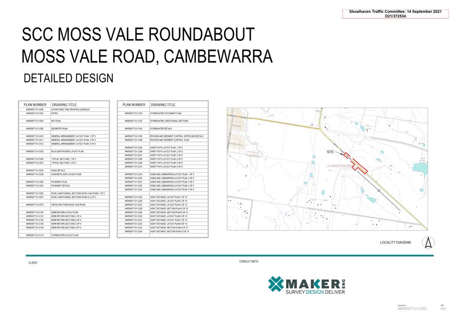
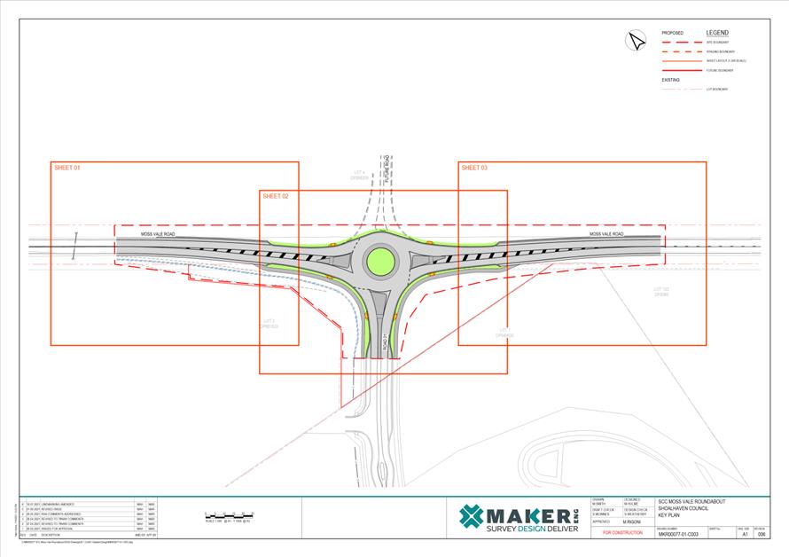
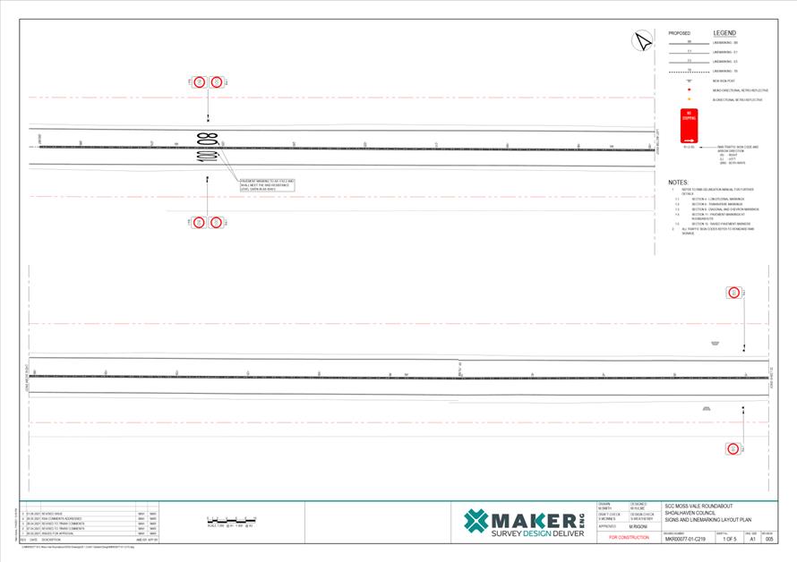
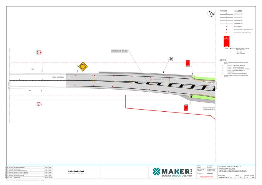
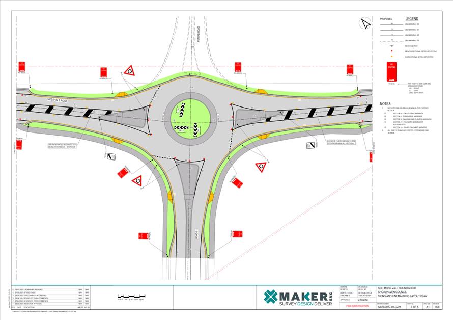
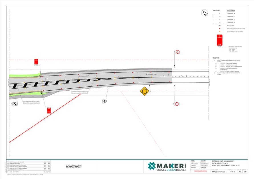
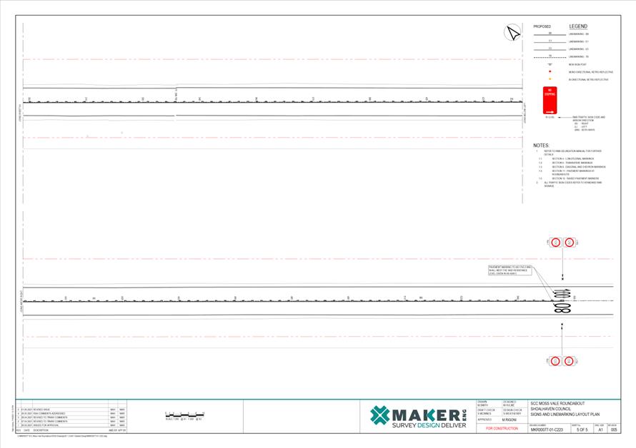
TC21.50 Signage
& Linemarking Plans - Proposed Roundabout - Moss Vale Road - Cambewarra -
(PN 3669)
HPERM Ref: D21/372386
Convenor: David
Pieresko
Attachments: 1. PN3669
- Plans ⇩
|
Recommendation
That
the Chief Executive Officer (Director City Services) be advised that the
Shoalhaven Traffic Committee has no objection to the proposed roundabout at
Moss Vale Road, Cambewarra as per Plan No D21/372534 subject to the
following:
1. Replace W2-7 Signage with G1-5
Advanced Direction Signage.
2. Provide additional G2-2 directional
signage.
3. The recommendation be approved by
the Director City Services under delegated authority from Shoalhaven City
Council - refer MIN21.411.
|
Background
Shoalhaven City Council has
received funding under the Housing Acceleration Fund (HAF) for the provision of
a new roundabout intersection on Moss Vale Road, Cambewarra. The Housing
Acceleration Fund aims to accelerate the delivery of critical infrastructure
needed to release land for new housing. The proposed new intersection will
provide vehicle, cyclist and pedestrian access to the Moss Vale Road North and
South Urban Release Areas (URAs) and is essential to enabling land release for
new housing in these URAs.
Details of Submission:
The extent of this proposal would involve a speed reduction
on Moss Vale Road (from 100 km/h to 80km/h), roundabout advisory signage, no
stopping controls and applicable linemarking. The proposed roundabout has
received design approval from Transport for NSW (being a state control road)
and the Work Authorisation Deed (WAD) has been approved
allowing the commencement of construction.
Consultation:
Council commenced consultation with affected residents,
stakeholders and the Cambewarra Residents and Ratepayers Association and Pride
of Bomaderry CCBs to discuss the proposal with the consultation period
concluded on Friday 27 August 2021. To date, Council has not received any
responses by affected residents regarding the proposed intersection.
Risk Implications:
The proposal will assist in providing safe access to both
North & South Urban Release Areas by the improvement of the local road
network by the addition of a traffic calming device. This will provide a
significant reduction for the potential for collisions and severity of impacts
by road users as Moss Vale Road is commonly known as the “Mad Mile”
by residents.
The proposed intersection will promote safer reaction times
and the reduction of speeds on Moss Vale Road is supported as traffic
generation increases with the development of the URAs. No further risks are
associated with this proposal.
Financial Implications: This proposal will be funded by the
Housing Acceleration Fund providing funding to Council which be passed on to
the developer via a funding agreement currently being finalised by
Council’s Strategic Planning Unit.
|
|
Shoalhaven
Traffic Committee – Tuesday 14 September 2021
Page
0
|
|

|
Shoalhaven
Traffic Committee – Tuesday 14 September 2021
Page
0
|
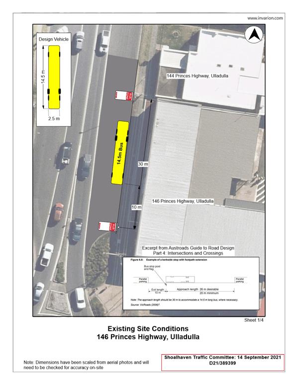
TC21.51 Proposed
Accessible Parking Space - Princes Highway - Ulladulla (PN 3670)
HPERM Ref: D21/389135
Convenor: David
Pieresko
Attachments: 1. PN
3670 Plans ⇩
|
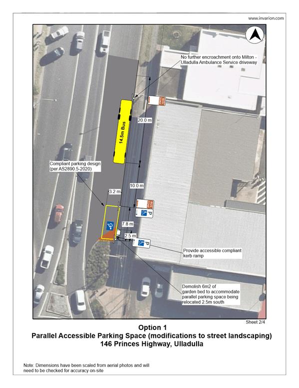
Recommendation (Item to be determined under delegated authority)
That the
Chief Executive Officer (Director City Services) be advised that the Shoalhaven
Traffic Committee has considered the
creation of an accessible car parking space and modification to the existing
Bus Zone adjacent to 146 Princes Highway, Ulladulla and has no technical
objection to the proposal prepared by Council, as per Plan No: D21/389399
(Option 1). Noting that Princes Highway is a State Road and Shoalhaven
City Council does not have the delegated authority to approve this proposal.
|
Background
Shoalhaven City Council has been
requested to investigate the provision of an accessible parking space fronting
146 Princes Highway, Ulladulla.
As raised by an item of urgency at the Development &
Environment Committee 7 September 2021 (MIN21.628):
“That Council call on the Shoalhaven Traffic
Committee to consider:
1. The creation of
an accessible car parking space on the Princes Hwy located at the southern end
of the existing bus zone located in front of the old Rivers building in
Ulladulla.
2. Also
consider how best the accessible space be developed”.
This proposal is to support
access requirements to the adjacent building, part of which is proposed to be
repurposed into a Country University Centre (CUC) (DA20/2370 Lot 3 DP25155).
This development has been supported by Federal and State grant funding and will
provide dedicated learning and study spaces for use by students from the
regional area. These spaces generally include the following (from the CUC
website):
· a
dedicated quiet study room with computers and space to bring personal devices
to work on
· tutorial
rooms, which can be used for seminars, tutorials, workshops, exams, and group
work, and
· space
for collaboration and break out, including kitchens and outdoor spaces
· Access
to the Ulladulla CUC is proposed to be 7.00am – Midnight, seven days a
week
· It
is expected that up to 10-15 students will utilise the CUC at any one time
Council’s Technical
Services team has subsequently investigated the request, undertaking a review
of current site conditions and existing signage at this section of the Princes
Highway. From these investigations, Council has prepared a concept design to
demonstrate how an accessible parking space could be provided by modifying the
existing parking restrictions and street landscaping.
As the Princes Highway is a State Road, any modifications to
parking arrangements or roadside environment are matters for Transport for NSW
(TfNSW) to determine and authorise. This report is intended to detail the
technical aspects of this proposal and seek input from key stakeholders to
assist the developer in discussions with TfNSW.
Details of Submission:
The extent of this proposal
would be the modification of the existing Bus Zone fronting 146 Princes
Highway, Ulladulla. This will involve reducing the zone by approximately 5.3m,
with the southern extent of the Bus Zone signage being relocated north by this
distance.
This would facilitate the
installation of a compliant, on-street parallel accessible parking space (in
accordance with AS2890.5 -2020: On-Street Parking). It will require the removal
of approximately 6m2 of the streetside garden bed to the south, to allow for
the parking space to be located approximately 2.5m south of the existing edge
of pavement.
This proposal will also require
the installation of a kerb ramp to be compliant with accessibility standards.
The proposal will be complemented by existing street lighting, will have an
adequate safety buffer from the adjacent travel lane and will not affect
vehicle deflection at the roundabout.
As noted on the attached plans,
these dimensions have been determined and scaled based on aerial photos and
will need to be checked for accuracy onsite.
The CUC applicant has indicated
the accessible space is required as a temporary measure until such time as
funding is available to upgrade the ramp in the rear off-street carpark to
current disability standards to provide appropriate access to the two existing
accessibility spaces located within the carpark.
However, given the civil work
required to reduce the size of the garden bed in the Highway, and given the
benefit of the space being located in close proximity to the front entrance to
the building, it is possible the proposed accessible space may become a
permanent fixture.
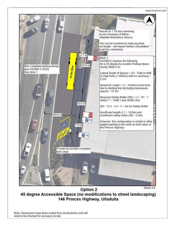
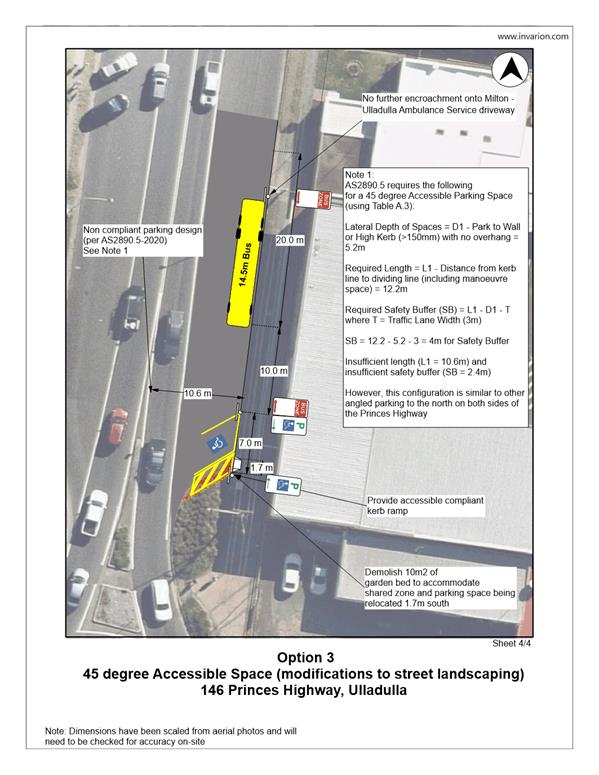
Other options were investigated
including a line marking only option within the existing kerbs shown on plan PN
3670 (Option 2). However, these options (Option 2 and Option 3) do not result
in complying accessible parking space or complying bus zone.
Consultation:
To date, Council staff have engaged in limited consultation
with key stakeholders. This has involved initial contact with Transport for NSW
and consultation with Ulladulla Buslines, the local bus company. Ulladulla
Buslines have confirmed with Council that they support Option 1. Council
has also been advised by Ulladulla Buslines that they are not aware of any
other service bus company using this bus zone.
Risk Implications:
The impact of this proposal
would result in providing an accessible parking space directly adjacent to the
future Country University Centre. The proposal has been designed to ensure the
Bus Zone length would continue to comply with appropriate standards, would not
impact access to the ambulance station to the north or impact on vehicle
deflection and sight distances at the roundabout. The proposal would make
manoeuvring into and out of the accessible space from the southbound lane of
the Princes Highway as straightforward as possible. The proposed location is
well suited to service the front entry to the property and will help in meeting
accessibility requirements for the site. The proposed location also demonstrates
sufficient separation from the Highway due to the wide shoulder and benefits
from being in proximity to an existing streetlight, an important consideration
given the facility is proposed to be accessible by students until midnight.
The approval process for this
proposal would sit with TfNSW as the Princes Highway is a State road. As such
the determination will be subject to its internal assessment process and
timeline.
Financial
Implications:
There are currently no financial
implications to Council regarding this proposal.
|
|
Shoalhaven
Traffic Committee – Tuesday 14 September 2021
Page
0
|