Ordinary Meeting
Meeting Date: Tuesday,
03 August, 2021
Location: Council
Chambers, City Administrative Building, Bridge Road, Nowra
Time: 5.00pm
Membership (Quorum - 7)
All Councillors
Please note: The proceedings of this meeting
(including presentations, deputations and debate) will be webcast and may be
recorded and broadcast under the provisions of the Code of Meeting
Practice. Your attendance at this meeting is taken as consent to the
possibility that your image and/or voice may be recorded and broadcast to the
public.
Agenda
1. Acknowledgement of Traditional Custodians
2. Opening Prayer
3. Australian National Anthem
4. Apologies / Leave of Absence
5. Confirmation of Minutes
· Ordinary
Meeting - 27 July 2021
6. Declarations of Interest
7. Presentation of Petitions
8. Mayoral Minute
Mayoral Minute
MM21.19..... Mayoral Minute - Solar Farm.......................................................................... 1
9. Deputations and Presentations
10. Notices of Motion / Questions on Notice
Notices of Motion / Questions on Notice
CL21.160..... Rescission Motion - SA21.164 - Worrigee / South
Nowra / East Nowra Investigations - Aquatic Centre & Integrated
Recreational Strategic Plan.............................. 2
CL21.161..... Notice of Motion - SA21.164 Worrigee / South
Nowra / East Nowra Investigations - Aquatic Centre & Integrated
Recreational Strategic Plan.............................. 3
CL21.162..... Notice of Motion - Replacement of Playground Soft
fall flooring, Orient Point Community Hall / Centre................................................................................ 5
11. Committee Reports
CL21.163..... Report of the Shoalhaven Tourism Advisory
Group - 19 July 2021.............. 6
TA21.26....... Appointment - New Members to the Shoalhaven
Tourism Advisory Group - 2021
12. Reports
City Performance
CL21.164..... 2020/2021 Council Borrowings - Loan Agreement -
General Fund.............. 7
City Services
CL21.165..... Reclassification of Land - Lot 1151 DP 1159783 -
Larmer Avenue Sanctuary Point........................................................................................................................ 9
CL21.166..... Traffic Impact Summary - NSW Aboriginal Rugby
League Knockout Carnival 2021...................................................................................................................... 12
CL21.167..... Traffic Impact Summary - L'Etape Major Cycling
Event 2021..................... 19
CL21.168..... Tenders - Construct Building - Materials Recovery
Facility......................... 27
CL21.169..... Far North Collector – Variation to the
original funding approved by the Australian Government.................................................................................................. 29
City Development
CL21.170..... Development Application DA20/1413 - Church St
Ulladulla – Lot 1 DP 831274 33
City Lifestyles
CL21.171..... Acceptance of Grant Funding - Berry Community
Activities Centre............ 55
CL21.172..... Create NSW Proposal for a Regional Arts
Development Organisation (RADO) for the South Coast.................................................................................................. 57
Shoalhaven Water
CL21.173..... Tenders - Sewage Pumping Station Upgrades
Project, St Anns Street (SPS3) & Lyrebird Park (SPS2).................................................................................... 77
13. Confidential
Reports
Reports
CCL21.12.... Tenders – Construct Building - Materials
Recovery Facility
Local Government Act - Section 10A(2)(d)(i) - Commercial
information of a confidential nature that would, if disclosed prejudice the
commercial position of the person who supplied it.
There is a public interest
consideration against disclosure of information as disclosure of the
information could reasonably be expected to reveal commercial-in-confidence
provisions of a contract, diminish the competitive commercial value of any
information to any person and/or prejudice any person’s legitimate
business, commercial, professional or financial interests.
CCL21.13.... Tenders - Sewage Pumping Station Upgrades Project,
St Anns Street (SPS3) & Lyrebird Park (SPS2)
Local Government Act - Section 10A(2)(d)(i) - Commercial
information of a confidential nature that would, if disclosed prejudice the
commercial position of the person who supplied it.
There is a public interest
consideration against disclosure of information as disclosure of the
information could reasonably be expected to reveal commercial-in-confidence
provisions of a contract, diminish the competitive commercial value of any information
to any person and/or prejudice any person’s legitimate business,
commercial, professional or financial interests.
|

|
Ordinary
Meeting – Tuesday 03 August 2021
Page
0
|
MM21.19 Mayoral
Minute - Solar Farm
HPERM
Ref: D21/312620
|
Recommendation
That
1. Moneys received via the upfront
payment of the commercial lease for the South Nowra Solar Farm be contributed
to Council’s Revolving Energy Fund (REFund) to make more funding
available for solar PV, energy efficiency and battery storage projects on
Council infrastructure.
2. That energy savings generated by the
installation of a 16kW solar array on the Animal Shelter be contributed to
the REFund to enable further funds for Council’s sustainable energy
projects as above.
|
Details
Repower Shoalhaven, our local
community energy powerhouse, has partnered with Flow Power and Council to
develop of a 3 MW solar farm at South Nowra, which is currently being built.
The Solar Farm generated $237,600 in upfront rental income which was paid to
Council on 6th July, 2021.
Council’s adjacent Animal
Shelter will receive a 16 kW solar PV system paid for by Flow Power as part of
the contractual arrangements. This solar array will significantly reduce the
Animal Shelter’s electricity costs.
Repower Shoalhaven has worked
with dedication for over 4 years to bring this project to fruition in line with
Council’s Sustainable Energy Policy and Strategy.
The Repower project team now ask
that the revenue and savings that the projects will generate for Council be
contributed into Council’s Revolving Energy Fund to replenish it for
future energy savings initiatives. The lease payment alone will nearly double
the amount available in the REFund and enable a significant increase in
Council’s solar PV roll out and associated GHG reductions. Projects
including the installation of energy-savings LED lights throughout the Nowra
Administration Centre could therefore be commenced sooner rather than later for
greater financial savings.
Council can acknowledge the
initiative and effort of Repower Shoalhaven by contributing this revenue and
savings to the REFund
Note by the CEO
Council received a prepayment of $216K (ex GST) for the
commercial lease for the South Nowra Solar Farm for the period 1 June 2021
– 30 April 2051. This payment was received in July 2021 and the majority
of it has been allocated to the Income Received in Advance account (liability
on the balance sheet) consistent with the relevant Accounting Standard as it
relates to unearned income. The lease revenue to be recognised in the budget is
$7.2K/annum over the term of the lease. As such, restricting $216K in the
reserve will not have immediate impact on the budget results and over 30 years
will have a cumulative unfavourable impact on unrestricted cash of $216K.
|

|
Ordinary
Meeting – Tuesday 03 August 2021
Page
0
|
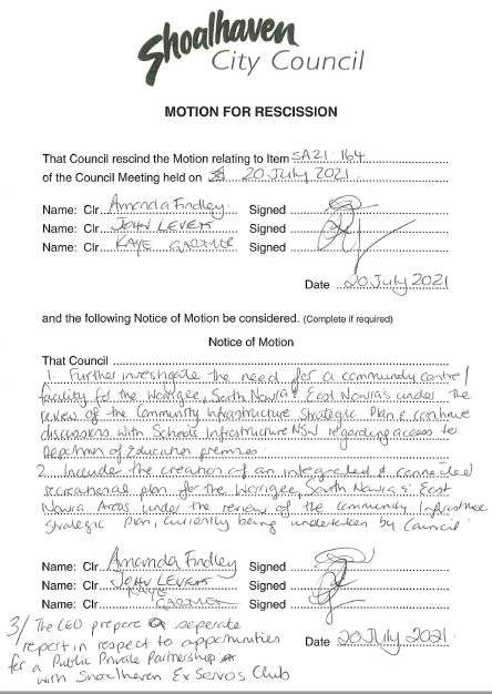
CL21.160 Rescission
Motion - SA21.164 - Worrigee / South Nowra / East Nowra Investigations -
Aquatic Centre & Integrated Recreational Strategic Plan
HPERM Ref: D21/313876
Submitted
by: Clr Amanda Findley
Clr John
Levett
Clr Kaye
Gartner
Purpose / Summary
The following Rescission Motion,
of which due notice has been given, is submitted for Council’s
consideration.
|
Recommendation
That
Council rescind the Motion relating to SA21.164 Worrigee / South Nowra / East
Nowra Investigations - Aquatic Centre & Integrated Recreational Strategic
Plan of the Strategy & Assets Committee 20 July 2021.
|
Background
The following resolution
(MIN21.509) was adopted at the Strategy and Assets Committee held Tuesday 20
July 2021.
That Council:
1. Further
investigate the opportunities for a Public Private Partnership in discussion
with the Shoalhaven Ex-Servicemen’s Club (Worrigee Sports) and receive a
further report at the conclusion of these discussions;
2. Further
investigate the need for a community centre / facility for the Worrigee, South
Nowra, and East Nowra areas under the review of the Community Infrastructure
Strategic Plan and continue discussions with Schools Infrastructure NSW
regarding access to Department of Education premises;
3. Include
the creation of an integrated and connected recreational plan for the Worrigee,
South Nowra, and East Nowra areas under the review of the Community
Infrastructure Strategic Plan, currently being undertaken by Council.
CEO Comment:
This report is a correction of
the report CL21-137 which was withdrawn from consideration at the Ordinary
Meeting held on 27 July 2021 due to the associated Notice of Motion containing
an administrative error whereby part of the proposed motion was not printed.
This rescission and the following replacement motion correctly reflect the
wording of Notice of Rescission submitted by Clrs Findley, Levett and Gartner
on 20 July 2021.
|

|
Ordinary
Meeting – Tuesday 03 August 2021
Page
0
|
CL21.161 Notice
of Motion - SA21.164 Worrigee / South Nowra / East Nowra Investigations -
Aquatic Centre & Integrated Recreational Strategic Plan
HPERM Ref: D21/313877
Submitted
by: Clr Amanda Findley
Clr John
Levett
Clr Kaye
Gartner
Purpose / Summary
The following Notice of Motion,
of which due notice has been given, is submitted for Council’s
consideration.
|
Recommendation
That
Council:
1. Further investigate the need for a
community centre / facility for the Worrigee, South Nowra & East Nowra
areas under the review of the Community Infrastructure Strategic Plan and
continue discussions with Schools Infrastructure NSW regarding access to
Department of Education premises.
2. Include the creation of an
integrated and connected recreational plan for the Worrigee / South Nowra and
East Nowra areas under the review of the Community Infrastructure Strategic
Plan, currently being undertaken by Council.
3. Receive a separate report prepared
by the CEO with respect to any Public Private Partnership with Shoalhaven
Ex-Services Club.
|
Note by the CEO
1. This
Notice of Motion will be dealt with if the preceding Rescission Motion is
carried.
2. This
Notice of Motion report is a correction of the report CL21-138 which was
withdrawn from consideration at the Ordinary Meeting held on 27 July 2021 due
to an administrative error whereby part of the proposed motion was not printed.
This motion correctly reflects the wording of Notice of Rescission submitted by
Clrs Findley, Levett and Gartner on 20 July 2021.
|
|
Ordinary
Meeting – Tuesday 03 August 2021
Page
0
|
CL21.162 Notice
of Motion - Replacement of Playground Soft fall flooring, Orient Point
Community Hall / Centre
HPERM Ref: D21/315011
Submitted
by: Clr Mitchell Pakes
Purpose / Summary
The following Notice of Motion,
of which due notice has been given, is submitted for Council’s
consideration.
|
Recommendation
That Council:
1. Commit to replace the soft fall
flooring under the play equipment at the Orient Point Community Hall/Centre
as a matter of urgency.
2. Fund the replacement of the soft
fall flooring for the next budget review.
|
Background
The play equipment at the Orient
Point Community Hall/Centre has been declared unusable due to the failing Soft
fall flooring. The Culburra & Districts Preschool who use the facility have
been working on funding options to upgrade the Soft fall flooring to ensure it
meets current standards. The cost would be around $15,000.
|
|
Ordinary
Meeting – Tuesday 03 August 2021
Page
0
|
CL21.163 Report
of the Shoalhaven Tourism Advisory Group - 19 July 2021
HPERM Ref:
D21/317236
|
TA21.26 Appointment - New Members to the
Shoalhaven Tourism Advisory Group - 2021
|
HPERM Ref: D21/247465
|
|
REcommendation
That the Shoalhaven Tourism
Advisory Group request that Council endorse the following community members
as casual memberships (until 31 October 2021) of the Shoalhaven Tourism
Advisory Group:
a. Michelle
Bishop
b. Sandra
Gray
|
|
|
Ordinary
Meeting – Tuesday 03 August 2021
Page
0
|
CL21.164 2020/2021
Council Borrowings - Loan Agreement - General Fund
HPERM Ref: D21/305606
Department: Finance
Approver: Kevin
Voegt, Director - City Performance
Attachments: 1. Letter
of Offer - General Fund Borrowings 20/21 - Corporate Business Systems
Implementation - $2,500,000 (under separate cover) ⇨
Reason for Report
This
report is being submitted directly to the Ordinary Meeting to seek Council
approval to enter into a loan agreement with Commonwealth Bank of Australia for
the borrowing requirements of the Corporate Business Systems Implementation
project.
|
Recommendation
That
Council enter into a loan agreement with the Commonwealth Bank of Australia
for the amount of $2,500,000 with a term of 10 years at an indicative rate of
1.89% to cover the borrowing requirements of the Corporate Business Systems
Implementation project that was approved in
principle by Council, as a part of the 2020/21 Delivery Program Operational
Plan & Budget adopted on 30 June 2020.
|
Options
1. Adopt the
recommendations in the report.
Implications: Council will be able to take up loans
and fund capital projects in accordance with the adopted 2020/21 Delivery
Program Operational Plan & Budget.
2. Not adopt the
recommendation and make an alternative resolution.
Implications: Council will need to seek borrowings
from other financial institutions and pay higher interest on loans or delay the
implementation of the Corporate Business Systems project.
Background
Council is continuing the
successful implementation of the new corporate business system, OneCouncil by
TechnologyOne, and to date Phases 1-3 including the Property & Rating, HR,
Payroll, Finance and the Asset and Works Management modules have been
implemented. Phase 4 began in mid-2020 and will continue right through to
2022 with the delivery of the Property & Rating Regulatory modules,
including DAs, Compliance and Certificates. Other Modules yet to commence
include the Customer Request Management, Strategic Asset Management and Project
Lifecycle Management. The delivery of these OneCouncil modules along with associated
Reporting, Dashboard and Analytics capabilities will be funded by the proposed
loan.
The proposed loan of $2,500,000
for the Corporate Business Systems Implementation project was approved in
principle by Council as a part of the 2020/21 Delivery Program Operational Plan
& Budget adopted on 30 June 2020 (MIN20.459).
Council requested quotes from
five financial institutions including: National Australia Bank, ANZ, Westpac,
Commonwealth Bank of Australia and Bendigo Bank. It is important to note that
TCorp does not provide loans for the implementation of Corporate Business
Systems projects, as TCorp does not classify these as community infrastructure.
The lowest quotation received
was from the Commonwealth Bank of Australia with an indicative rate of 1.89% fixed
rate principal deductions for 10 years.
Financial Implications
It is financially prudent for
Council to gain the best interest rates on loan funding and locking this
agreement in place will confirm a fixed term rate for the full 10 years of the
loan agreement.
|
|
Ordinary
Meeting – Tuesday 03 August 2021
Page
0
|
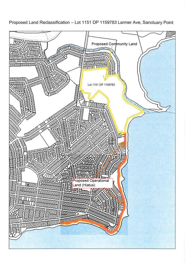
CL21.165 Reclassification
of Land - Lot 1151 DP 1159783 - Larmer Avenue Sanctuary Point
HPERM Ref: D21/305239
Department: Technical
Services
Approver: Craig
Exton, Manager - Technical Services
Attachments: 1. Plan
- Proposed reclassification - Lot 1151 DP 1159783 Larmer Ave Sanctuary Point ⇩
Reason for Report
This report is being submitted
directly to the Ordinary Meeting due to being deferred from the Strategy &
Assets Committee 8 December 2020. At that meeting only one option was presented
for consideration and the matter was deferred to a briefing. With no briefings
scheduled until after the 2021 Council elections a more comprehensive report
has been prepared with three options to give the Council to opportunity to
determine a position on the land classification.
Thus the purpose of the report
is to provide the Council with an opportunity to consider reclassifying the
land described as Lot 1151 DP 1159783 Larmer Avenue, Sanctuary Point from Operational
Land to Community Land.
Options
1. Option 1
(Preferred) – Council resolves to classify the area known as BHERWERRE
WETLAND as Community land and retain the hiatus land as Operational Land to
maintain flexibility for investigations into future options for boundary
adjustments or reclassification.
Implications: The wetlands
area of this lot can be classified as Community Land helping to limit
development and help protect flora and fauna including a number of
threatened species.
Council retains the hiatus land as Operational Land to
maintain connectivity to Crown Land and existing foreshore access, while
providing Council with flexibility for investigations into future options for
boundary adjustments or reclassification.
2. Option 2 (Do
nothing) – Council resolves to maintain the
current Operational Classification
Implications: The current operational
classification would remain, providing flexibility for future development,
sale, or future reclassification of the land.
A recommendation for this option would be:
Council Resolve to
Maintain the current Operational Classification of BHERWERRE
WETLAND (Lot 1151 DP 1159783)
3. Option 3 –
Council resolves to reclassify from Operational Land to Community Land
Implications: Reclassifying the land as Community
Land will prevent future sale, boundary adjustments or development of the land
thus protecting the site as there is significant flora and fauna biodiversity
in the reserve including a number of threatened species.
A recommendation for this option would be:
Council Resolve to
Reclassify the area known as BHERWERRE
WETLAND (Lot 1151 DP 1159783) from Operational Land to
Community Land.
Background
Council acquired Lot 1151 DP
1159783, known as BHERWERRE WETLAND on 13 November 2012 for the sum of
$900,000.00.
A Confidential Report went to
Council’s Property Steering Committee on 18 July 2012 proposing the
purchase of Lot 1151 DP 1159783 (MIN12.968).
A further report went to
Council’s Ordinary Meeting on 26 October 2012, when Council resolved to
classify Lot 1151 DP1159783 as operational land in accordance with Section 31
(2) of the Local Government Act 1993 (MIN12.1198). At that time, the area was
subject to investigation for the potential for playing fields on the land which
was dismissed for various reasons.
Recently, Council has been
successful in obtaining a grant of approximately $950,000 to improve the site
and protect the wetland from further development.
Section 33 (1) of the Local
Government Act 1993 (LGA93) provides that a Council may resolve that public
land classified as operational land be reclassified as community land.
Based on the above and after
receiving community input, it has been determined that there are benefits to
reclassify the wetland portion of land from Operational to Community. Reclassifying the wetland portion of the land as Community
Land will prevent future sale or development of the land thus protecting the
site as there is significant flora and fauna biodiversity in the reserve including a number of threatened species.
Community Engagement
As per Section 34 of Local
Government Act 1993, Council has advertised its intention to reclassify the
land from Operational to Community land in the form of Public Notices and an
advertisement in local newspapers. One submission was received from an
adjoining property owner seeking reclassification clarification and strategic
planning direction for use of the land.
Policy Implications
Section 33 (1) of the Local Government Act 1993 provides
that a Council may resolve that public land classified as operational land be
reclassified as community land.
|

|
Ordinary
Meeting – Tuesday 03 August 2021
Page
0
|
|
|
Ordinary
Meeting – Tuesday 03 August 2021
Page
0
|
CL21.166 Traffic
Impact Summary - NSW Aboriginal Rugby League Knockout Carnival 2021
HPERM Ref: D21/305876
Department: Technical
Services
Approver: Paul
Keech, Director - City Services
Reason for Report
This report is being submitted
directly to the Ordinary Meeting to discuss the traffic impacts surrounding the
NSW Aboriginal Rugby League Knockout Carnival 50th Anniversary
(“Koori Rugby League Knockout”), proposed to take place in early
October 2021.
|
Recommendation
With
regard to the South Coast Black Cockatoos hosting of the NSW Aboriginal Rugby
League Knockout Carnival 50th Anniversary, proposed to take place
on 30 September to 4 October 2021 at the Bomaderry Sporting Complex, Council:
1. Acknowledges that the key potential
traffic impacts associated with this “Class 1” event are as
follows:
a. Closure of a section of Cambewarra
Road at the Bomaderry Sporting Complex for up to 5 days (from 8am* 29
September to 8am* 5 October), excluding emergency vehicles. *Note: exact
times have not been stated in the application nor able to be confirmed at the
time of writing this report.
b. Provides for detour around the
Bomaderry Sporting Complex using local streets which will result in increased
traffic congestion and on street parking in those streets.
c. Proposes shuttle bus services to
various parking locations around the region.
2. Provides in-principle support for
the event after consideration of the proposed traffic impacts.
3. Will, through the CEO (Director City
Services), continue to work with the event organisers in planning to mitigate
the traffic impacts of the event on an in-kind basis.
4. Note that given Council’s
in-principle support of the proposed traffic impacts, the Shoalhaven Traffic
Committee will undertake a detailed technical assessment of the proposed
traffic management measures.
|
Options
1. As recommended.
Implications:
· Acknowledges the
extent of potential traffic impacts associated with the event are as follows:
o closure of a section of
Cambewarra Road at the Bomaderry Sporting Complex for up to 5 days (from 8am*
29 September to 8am* 5 October), excluding emergency vehicles. *Note: exact
times have not been stated in the application.
o Provides for detour around the
Bomaderry Sporting Complex using local streets which will result in increased
traffic congestion and on street parking.
o Proposes shuttle bus services
to various parking locations around the region.
· After
consideration of the proposed traffic impacts and the possible mitigation
measures, provides in-principle support for the event.
· Council will
continue to work with the event organisers to mitigate the traffic impacts of
the event on an in-kind basis.
2. Decline to provide
in-principle support of the traffic impacts as proposed and seek further
consultation with the event organisers.
Implications:
· May jeopardise the
viability of the South Coast Black Cockatoos to host the event in the
Shoalhaven.
· The
event is of significance to the region and a decision that is not fully
supportive of the event would have a potential reputational risk for Council,
both locally, regionally and nationally.
A possible resolution to affect
Option 2 would be as follows:
That the CEO (Director City Futures)
advise the event organisers that Council has concerns regarding the proposed
traffic impacts of the NSW Aboriginal Rugby League Knockout Carnival and
that the CEO (Director City Futures) work with the event
organisers to address those concerns.
Event Precinct Plan
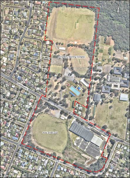
Event Background
A report was previously brought
before Council on 25 February 2020, which provided background to this event
being proposed (CL20.32 - Koori Rugby League Knockout - South Coast Black
Cockatoos - Event Support). The following recommendation was carried:
That Council:
1. Congratulate
the Black Cockatoos on their success in winning the right to host the NSW
Aboriginal Rugby League Knockout Carnival 50th Anniversary and thank
them for their commitment to running the 2020 event in Bomaderry.
2. Commit
to allocating $400,000 in the 3rd Quarter Review of the 2019/2020
Budget through an appropriate funding strategy to be determined, to ensure
works are completed in time for the event.
3. Note
that the costs associated with actually running the event will be met by those
other than Council.
4. Immediately
commence with necessary works to carry out all improvements at the Bomaderry
Sporting Complex and Artie Smith Oval site in accordance with Plan Ref
No.1007_40 (Rev1 Dated 11 Feb 2020), such that the event can be run by the
Black Cockatoos over the long weekend in October 2020.
5. Commend the
staff involved in the expeditious preparation of the site improvement plan
developed in close consultation with the organisers of the NSW Aboriginal Rugby
League Knockout Carnival 50th Anniversary to enable this event to
proceed in the Shoalhaven.
As a summary, the NSW Koori
Rugby League Knockout is one of the largest Indigenous gatherings in Australia. The event draws a large
number of participants, including more than 150 teams involved with the
proposed activities and an estimated 10,000 people per day over the 5-day
event.
The South Coast Black Cockatoos
had previously won the title in 2019, giving them the right to host the
subsequent event, which was also the 50th Anniversary in the
event’s history. This was originally proposed to take place
on the October long weekend in 2020. However, due to Public Health Order
restrictions at the time, the event was postponed to the following year.
The event is anticipated to be a
high exposure event, drawing national attention from sponsors and the NRL,
promoting the area as a key growth area for investment. However, this event
will also put significant pressure on local roads within Bomaderry as well as
potentially impacting major local transport networks such as Cambewarra Road
and the Princes Highway.
Classification of Event and Required
Timeline for Approvals
Under the NSW Government’s
‘Guide to Traffic and Transport Management for Special Events’
(‘The Guide’), this event would be classified as a Class 1 event.
According to s3.2 of ‘the Guide’, this is due to
the event:
1. ‘impact[ing]
major traffic and transport systems …’; and,
2. ‘…significantly
disrupts the non-event community over a wide area’.
As such, this event requires
significant traffic management and control measures to be implemented.
Additionally, due to this event
being classified as a Class 1 event, the following will be required:
· In-principle
support obtained from Council regarding the traffic impacts and summary of the
event factors that will affect the local, non-event community
· Following this,
the proposed traffic measures will need to be assessed by the Traffic Committee
and technical recommendation obtained
o Should not all voting members
accept the recommendation (not unanimous support), and Council wishes to
proceed with the proposal; Council MUST first advise the representatives for
Transport for NSW (TfNSW) and NSW Police of this decision. Following this, the
representatives for TfNSW and NSW Police may then lodge an appeal to the
Regional Traffic Committee (see s5.3.6 - Voting and s6 - Appeals of the
RTA’s “Guide to the Delegation to Councils for the Regulation of
Traffic (including the operation of Traffic Committees)”)
· Upon receipt of
the technical recommendation from the Shoalhaven Traffic Committee, the
proposed event can be endorsed by Council’s Roads Assets Team, referring
then to Council’s Events Team to grant the event approval.
Event Timeline
The event is proposed to take
place over the 30 September – 4 October 2021 period.
Council formally received the
draft traffic management plan (TMP) outlining key traffic impacts and the event
organiser’s proposed measures to mitigate these on the 12 July 2021,
approximately 10 weeks prior to the event’s proposed commencement.
The proposed Cambewarra Road
closure would start on Wednesday 29 September and re-open on Tuesday 5 October.
Access to Bomaderry High School
from Cambewarra Rd will be necessary from Tuesday 5 October, which is the
resumption of the school term.
Consideration
Temporary Local Road Closure and
Detour:
The event has proposed to
temporarily close a section of Cambewarra Road, between the intersections of
Barwon Street and North Tarawal Street. A detour has been proposed around this
closure, to utilise Barwon Street, Bunberra Street and Brinawarr Street.
This proposed closure and detour
will be implemented on Wednesday 29 September 2021 (two days prior to the event)
and will reopen on the 5 October 2021 (approximately one day after the
conclusion of the event). The proposed closure and detour will be active at all
times (24 hours) and will last over 7 days. Of this closure, there will be one
day comprising a public holiday (Monday 4 October 2021), with School Term Four
recommencing on Tuesday 5 October 2021.
Parking Impacts:
The event has proposed several areas of parking areas
designated for both private and public use. These are as follows:
1. TAFE
NSW Carpark, 60 Beinda Street, Bomaderry: To be used as a private event parking
area for players and their team vehicles/coasters (only if they are required to
play in early sessions)
2. Shoalhaven
Indoor Sports Centre Carpark, 90 Cambewarra Road, Bomaderry: To be used as a
private event parking area for designated VIPs for the event. This area will
also have 12 designated disabled parking spots. This area will also service as
an internal drop off point for taxis, mini-busses, and shuttle bus services.
The entry into this site will be controlled by a supervised boom-gate and
traffic controller presence.
3. Bomaderry
High School, 127 Cambewarra Road, Bomaderry: To be used as a private event
parking area for South Coast Black Cockatoos (SCBC) representatives, service
providers, vendors and supplier drops.
4. “Nowra
Saleyards”, 25 Moss Vale Road, Bomaderry: A privately owned property,
which the event organisers have proposed to use as public parking for this
event. The site is approximately 4.975 hectares. No further information has
been provided to Council regarding the proposed internal parking management or
estimated capacity for the site.
5. Bridge
Road Public Carpark, 81 Bridge Road: A Council owned, all day carpark, proposed
to be used as public parking for this event. Team vehicles / coasters not
approved for parking in the TAFE NSW carpark area will be directed to park at
this location. This site has approximately 191 all day spaces and 5 disabled
parking spaces.
6. Lot
1 DP 997520, Corner of Junction Street and Princes Hwy: A privately owned
property, which the event organisers have proposed to use as public parking for
this event. The site (when considering all related parcels of land) is
approximately 1.663 hectares. No further information has been provided to
Council regarding the proposed internal parking management or estimated
capacity for the site.
An additional site has been
identified as Narang Road Public Parking. However, the event organiser has not
provided further information in clarifying this point.
Pedestrian Access Closure:
The event organisers have proposed to close the section of
Cambewarra Road, between the intersections with Barwon Street and North Tarawal
Street, to pedestrian access by the general public. This will be in effect from
on Wednesday 29 September 2021 (two days prior to the event) and will reopen on
the 5 October 2021 (approximately one day after the conclusion of the event).
Public Transport Impact:
The event organisers have
proposed to arrange for additional public transport options, including shuttles
to and from parking areas to improve access to the event and remove excess
traffic around the event area.
The event organisers have also indicated that they have
liaised with City Rail to potentially provide additional train services from
Wollongong to Bomaderry.
Emergency
Access Impact:
The event organisers have
ensured that access for emergency vehicles into the event site will be
maintained at all times. Emergency vehicle access paths have been provided
within the site, maintaining a width of no less than 3.5m and being checked by
parking marshals throughout the event’s duration to ensure that no
obstruction occurs.
At the time of this report, the event organisers have
indicated that they are in the process of discussing further with
representatives from local Fire and Rescue and Ambulance services, establishing
a working group to discuss a management plan for emergency service access and
arrangements for the event site.
Community Awareness and Event
Notice Signage:
The event organisers have
proposed to advertise the traffic management
arrangements in local print media, the event website, and social media
platforms to raise awareness with the non-event community. However, it has not been stated in the event organiser’s
documentation how far in advance of the event that this notification will take
place and whether this will be in compliance with sections 14 and 15 of
Council’s Events Policy (POL17/75).
The event organisers have
proposed to inform directly affected residents and businesses within approx.
250m of the event site of the proposed traffic impacts and road closures. Similarly, it has not been stated in the event
organiser’s documentation how far in advance of the event that this
letterbox drop will take place and whether this will be in compliance with
sections 14 and 15 of Council’s Events Policy.
Variable
message sign (VMS) boards have been proposed as part of this event, installed
at strategic locations to advertise the upcoming event and proposed road
closures to local traffic and residents. These are proposed to be deployed
approx. 2 weeks prior to the event start date.
In addition to this, all
spectators will be given a copy of the Event Map which will highlight the
designated allocated parking areas, shuttle buses routes and times, No Parking
Zones and drop off zones. The event organisers have also proposed that traffic
marshals at the event site will be present to advise on the local detour around
the Cambewarra Road closure and to direct them to the most suitable public
parking areas.
Risk Implications
Closure of Cambewarra Road:
Cambewarra Road serves as a
major local transport route for the Bomaderry area. Traffic Counts conducted in
2019 show the following daily traffic volumes:
N205 - Cambewarra Rd E of
Princes Hwy - (3/12/2019 - 10/12/2019)
Average Daily = 9036 vehicles
per day
Average Weekday = 9649 vehicles
per day
Biggest Weekday = 10152
vehicles per day (Fri 6/12/19)
85th Percentile
Speeds = 48 km/h W, 48 km/h E
Percentage of Heavy Vehicles =
9.9% (Class 3 and above)
Split = 50% WB, 50% EB
Also noting that this data
should apply a 1.5% per annum growth rate, thereby potentially bringing the
Average Daily values to 9309 vpd for a 2021 calendar year. This does not
include the additional traffic which will use Cambewarra Road due to the long
weekend and the proposed event which could be around 20,000 additional
vehicles, assuming 2.5 people per vehicle.
By placing a full closure on
Cambewarra Road, the volumes listed above will be redirected onto many local
roads that will be unsuitable to accommodate this level of traffic. Residential
streets are typically designed for less than 2000 vpd (Chapter G11, DCP 2014).
The addition of over 9000 vehicle movements distributed within the residential
street network would give rise to the increase of various risk factors
discussed below.
In addition to this, the closure
will also have significant repercussions to access off the Princes Highway,
with queued traffic from this closure potentially backing up and encroaching
onto the Highway.
Furthermore, as the closure is in place at all times (active
24hours a day), impacts onto local roads via the proposed detour will also be
sustained throughout the extent of the event’s duration and outside of
its event hours.
Parking on Local Roads and
Potential Congestion:
The event is proposed to take
place over the October long weekend when there is traditionally a high volume
of both day trippers and overnight visitors in the region. There is a
‘higher than usual’ risk of conflict with local residents and visitors,
both to the event and tourism broadly. The event estimates 50,000+ people over
the 5 days, which will potentially generate conflict between residents and
visitors, competing for parking along these local roads.
Whilst the event organiser has
proposed temporary warning signs indicating ‘No Parking // Local
Residents Only’ around local roads in proximity to the event site, these
are non-enforceable and will give rise to confusion as to who has the right to
park in areas or not.
Many of the local roads within
proximity to the event site have road widths of <7m that when vehicles are
parked on both sides of the road, reduces the remaining trafficable lane to a
single direction. This scenario, with cars being unable to pass each other in
two directions, will lead to increased traffic queuing, increased risk of
traffic incidents, reduction of sight distances, reduction of stopping/braking
distances and contravenes the TfNSW safe system framework.
|

|
Ordinary
Meeting – Tuesday 03 August 2021
Page
0
|
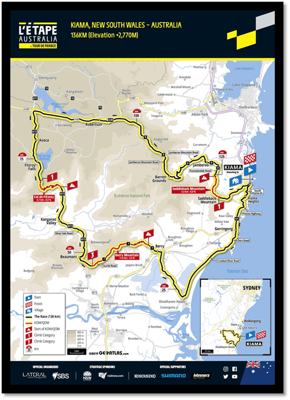
CL21.167 Traffic
Impact Summary - L'Etape Major Cycling Event 2021
HPERM Ref: D21/287145
Department: Technical
Services
Approver: Paul
Keech, Director - City Services
Reason for Report
This report is being submitted
directly to the Ordinary Meeting to discuss the traffic impacts surrounding the
L’Etape Major Cycling Event, proposed to take place on 28 November 2021.
|
Recommendation
(Item to be determined under delegated authority)
With regard
to the L’Etape Australia cycling event proposed to take place on
28 November 2021, Council:
1. Acknowledges that the key potential
traffic impacts associated with this “Class 1” event are as
follows:
a. Closure of various sections of road
at localities including Shoalhaven Heads, Far Meadow, Coolangatta, Berry,
Berry Mountain, Bellawongarah, Beaumont, Kangaroo Valley and Barrengarry at
various times between 4:30am and 10:45am, excluding emergency vehicles.
b. Access to the Shoalhaven via Moss
Vale Road will be detoured via the Hume Highway to Picton Road to use the
Princes Highway.
c. Closure
of Queen Street, Berry and all intersecting roads west of Albert Street,
Berry. A supervised crossing point at the intersection of Alexandra Street
and Queen Street will be maintained, allowing vehicle access when traffic
controllers permit it’s safe to do so. The total time of this temporary
road closure will be between 5am to 9:30am.
d. The
total time of temporary road closure within the main street of Kangaroo
Valley (Moss Vale Road) will be between 5:30am to 10:45am. However, this will
consist of approx. 3hrs 9mins of hard closure - between 7:24am to 10:33am.
2. Provides in-principle support for
the event after consideration of the proposed traffic impacts.
3. Notes that given Council’s
in-principle support of the proposed traffic impacts, the Shoalhaven Traffic
Committee will undertake a detailed technical assessment of the proposed
traffic management measures.
|
Options
1. As recommended.
Implications:
· Acknowledges
the extent of potential traffic impacts associated with the event are as
follows:
o Zone
2B – Beach Rd intersection with Gerroa Rd, overall closure of
4.5 hrs (4:30am to 9am).
o Zone
3A – Impacting Coolangatta Rd and associated side roads, leading into
Berry township and associated side roads, overall closure of 4.5 hrs (5am to
9:30am).
o Zone
3B – Impacting Kangaroo Valley Rd west of Berry township, associated side
roads and residences through to intersection with Tourist Rd, overall closure
of 5 hrs (5am to 10am).
o Zone
4A – Tourist Rd / Cambewarra Lookout Rd and associated side roads to the
intersection with Moss Vale Rd, overall closure of 5 hrs (5:30am to 10:30am).
o Zone
4B – Moss Vale Rd north of Cambewarra Lookout Rd, associated side roads,
Kangaroo Valley township through to the intersection of Bunkers Hill Rd,
overall closure of 5 hrs 15 mins (5:30am to 10:45am).
o Access
to the Shoalhaven via Moss Vale Road will be detoured via the Hume Highway to
Picton Road to use the Princes Highway, with the detour in place for 7 hrs
(5:30am to 12:30pm).
· After
consideration of the proposed traffic impacts and the possible mitigation
measures, provides in-principle support for the event.
2. Decline to provide
in-principle support of the traffic impacts as proposed and seek further
consultation with the event organisers.
Implications:
· May
jeopardise the viability of the event.
· The
event is of significance to the region and a decision that is not fully
supportive of the event would have a potential reputational risk for Council,
locally, regionally, and nationally.
A possible resolution to affect
Option 2 would be as follows:
That the CEO (Director
Futures) advise the event organisers that it has concerns regarding the
proposed traffic impacts of the L’Etape Australia cycling event and
that the CEO (Director Futures) work with the event organisers to
address those concerns.
Event Background
Shoalhaven City Council has been
assisting the NSW Government and Lateral Event Management for the preparation
of L'Etape Australia, a major cycling event to be held on 28 November
2021.
As part of this event, a 135.8km
length course has been proposed, impacting on parts of Kiama, Shoalhaven and
Wingecarribee LGAs. For the Shoalhaven area, the course is proposed to pass
through Berry township via Coolangatta Road and through Queen Street, passing
onto Kangaroo Valley Road to climb Berry Mountain before being detoured onto
Tourist Road. From the top of Berry Mountain, the course will continue north
into Kangaroo Valley township via Moss Vale Road and continue on this road into
Barrengarry and on to the Wingecarribee LGA.
Event Course Map
Classification of Event and Required
Timeline for Approvals
Under the NSW Government’s
‘Guide to Traffic and Transport Management for Special Events’
(‘The Guide’), this event would be classified as a Class 1 event.
According to s3.2 of ‘the Guide’, this is due to it being:
1. an ‘on road
vehicle race’.
2. ‘impacts major
traffic and transport systems …’; and,
3. ‘…significantly
disrupts the non-event community over a wide area’.
As such, this event requires
significant traffic management and control measures to be implemented along the
Shoalhaven lengths of the course.
Additionally, due to this event being classified as a Class
1 event, the following will be required:
· In-principle
support obtained from Council regarding the traffic impacts and summary of the
event factors that will affect the local, non-event community
· Following
this, the proposed traffic measures will need to be assessed by the Traffic
Committee and technical recommendation obtained
o Should not all voting members
accept the recommendation (not unanimous support), and Council wishes to
proceed with the proposal; Council MUST first advise the representatives for
Transport for NSW (TfNSW) and NSW Police of this decision. Following this, the
representatives for TfNSW and NSW Police may then lodge an appeal to the
Regional Traffic Committee (see s5.3.6 - Voting and s6 - Appeals of the
RTA’s “Guide to the Delegation to Councils for the Regulation of
Traffic (including the operation of Traffic Committees)”)
Event Timeline
Since the cancellation of the
March iteration of this event due to severe weather, Council’s Events
Team has been working closely with Lateral Events in the lead up to the
proposed 28 November 2021 race date.
In developing the latest version
of traffic management plan (TMP) for this new date, Lateral Events have engaged
with community through various face to face sessions with the intention of
understanding the communities' primary concerns around the event and road
closures.
On 10 June 2021, the Councillors
were briefed on the upcoming event.
Following this, the Event
Application and Traffic Management Plan (TMP) were formally submitted by
Lateral Events for review by Council.
To date, the Events Team have
received all the necessary information to grant an event approval once the
traffic impacts have been acknowledged and the traffic management documents
have been endorsed/approved from a technical perspective by the Shoalhaven Traffic
Committee.
On 20 July 2021, a summary of traffic impacts pertaining to
this event was presented to the Executive Management Team for their
consideration.
Consideration
Temporary Road Closures
The event course requires the
following temporary road closures, which have been broken into a total of 14
zones and sub-zones. Of these zones, four are applicable to the Shoalhaven
area. Whilst these zones have advertised total road closures for this event,
this will comprise of conditional access for locals within these affected areas
during both the set up and set down of the road closure, as well as the
necessary hard closure required for the event to flow through.
· Zone
2B: Beach Rd (Berry) intersection with Gerroa Rd and Crooked River Road.
o The
total time of temporary road closures within Zone 2B will be between 4:30am to
9am. However, this will consist of approx. 1hr 37mins of hard closure, between
6:23am to 8am.
· Zone
3A: Consisting of the following areas:
o Impacting
Gerroa Road and Bolong Road north of the intersection with Northview Close and
Shoalhaven Heads Road.
§ The
total time of this temporary road closure will be between 5am to 8:15am.
o Impacting
Coolangatta Rd and associated side roads, leading into Berry township via Wharf
Road and Prince Alfred Street. Closure of Queen Street and all intersecting
roads west of Albert Street. A supervised crossing point at the intersection of
Alexandra Street and Queen Street will be maintained, allowing vehicle access when
traffic controllers permit it’s safe to do so.
§ The
total time of this temporary road closure will be between 5am to 9:30am.
o Closure
of northbound and southbound ramps off the Princes Highway onto Queen Street.
Access to and from Huntingdale Park Road will be maintained by supervised
crossing point. A detour route for access into Berry via the eastern southbound
entry from the Princes Highway will be advertised by VMS Boards and Detour
signage.
§ The
total time of this temporary road closure will be between 5am to 8:45am.
o The
total time of temporary road closures within Zone 3A will be between 5am to
9:30am. However, this will consist of approx. 2hrs 8mins of hard closure,
between 6:33am to 8:41am.
· Zone
3B: Impacting Kangaroo Valley Road west of Queen Street. All associated side
roads and property access along the route will be impacted (including
controlled closure points at Bundewallah Rd and Irvines Rd). Intersection with
Tourist Road will also be closed, supervised by Police presence.
o The
total time of temporary road closures within Zone 3B will be between 5am to
10am. However, this will consist of approx. 2hrs 58mins of hard closure,
between 6:47am to 9:45am.
· Zone
4A: Impacting Tourist Road, leading into Cambewarra Lookout Road and associated
side roads and local access points south of Kangaroo Valley Road to the
intersection with Moss Vale Road.
o The
total time of temporary road closures within Zone 4A will be between 5:30am to
10:30am. However, this will consist of approx. 3hrs 18mins of hard closure,
between 6:47am to 10:05am.
· Zone
4B: Consisting of the following areas:
o Closure
of Moss Vale Road at the intersection of Barfield Road. VMS Boards will be
installed prior to this closure in order to provide additional awareness.
§ The
total time of this temporary road closure will be between 5:30am to 10:45am.
o Moss
Vale Road continuing north from the intersection with Cambewarra Lookout Road, impacting
associated side roads and local access points (including intersections with
Kangaroo Valley Road (in place to prevent any eastbound vehicles heading up
Berry Mountain and potentially interfering with the course further at the
Tourist Rd intersection), Nugents Creek Road, access to the Glenmack Park
facilities, within Kangaroo Valley township, Mount Scanzi Road and Jenanter
Drive south of the Hampden Bridge.
o Moss
Vale Road north of this point will also be impacted, with supervised closures
at Bendeela Road and Upper Kangaroo River Road. All associated side roads and
access points along Moss Vale Road will also be impacted.
o Moss
Vale Road at the intersection of Bunkers Hill Road will remain closed until
10:45am. After this time, all local access to Moss Vale Road south of this point
will be restored. Moss Vale Road north of this intersection will remain closed
to permit the course to proceed further on to Fitzroy Falls, until it will
reopen at 12:30pm.
o The
total time of temporary road closures within Zone 4B will be between 5:30am to
10:45am. However, this will consist of approx. 3hrs 9mins of hard closure,
between 7:24am to 10:33am.
Also note, that the provision of conditional access will be
at the discretion of the traffic controllers / Police Officers supervising the
closure, in order to assess the site conditions and permit access when it is
safe to do so.
Major Detours
The event has proposed two major
detours, advising motorists to utilise Princes Highway and Hume Highways as
best possible around the course itself. The following detour will impact access
to the Shoalhaven:
1. Kangaroo Valley
Detour:
· Scope of Closure: Moss Vale Road – Between Barfield Road
& Nowra Road & Nowra Road – Between Moss Vale Road and Sheepwash
Road.
· Duration: 5:30am – 12:30pm (7 hours).
· Impact of Closure: Vehicles required to use an alternate route to
travel between the Southern Highlands and Shellharbour.
· Detour Route:
o From Southern Highlands – Vehicles to use the Hume Highway to
Picton Road to use the Princes Highway.
o From Shellharbour – Vehicles to use the Princes Highway to Picton Road
to Access the Hume Highway.
· Local detour route -
Macquarie Pass and Tourist Road, however this will not be the advertised route
as Tourist Road has an existing 10t load limit.
Note: Access along Moss Vale Road
between Barfield Road and Carters Road will be reopened from 10:45am once the
back of the event has passed through Kangaroo Valley to reduce the overall
closure time for the town to 5.25 hours.
Traffic Controller and NSW Police
Presence
The extent of these measures
will be controlled by a combination of manned and unmanned traffic facilities
coordinated by both NSW Police and accredited Traffic Controllers.
The event has identified 14
positions where Police Officers will be stationed, to monitor key road closure
junctions and to ensure that traffic control measures for the event are
followed.
In addition to this, the format of the race itself will
involve Police Convoys at the commencement of the race, in between each wave of
cyclists and at the rear of the race. This is to ensure that the course itself
moves forward unimpeded by any potential issues that may be encountered along
the route.
Advanced Warning Signage and
Advisory Signage
Advanced warning signage will be
provided at high-risk locations to ensure that oncoming vehicles are made aware
of the changed traffic conditions.
This will be achieved in a
number of ways:
· Special
Event Warning Signage: installed at proposed road closures approx. 30 days
prior to the event date. These signs will show the proposed times of the
closure as well as website / contact details to seek further information.
· Access
Point Closure Signage: installed in areas along the route that are not
necessarily covered by road closure specific signage (e.g. minor local access
points, driveways, farm gates).
· Variable
Message Sign (VMS) Boards will be deployed at 10 locations within the
Shoalhaven. These will be deployed at least 2 weeks prior to the event day and
will depict information on the upcoming road closures, when the closures are in
place and when they have been lifted. The highest concentration of these signs
will be utilised along the Princes Highway to advise on the Tindalls Lane x
Schofield Lane detour to access Berry during the closure of the northbound and
southbound ramps at the Queen Street overpass. VMS boards will also be deployed
in Bomaderry to advise northbound travellers on the Princes Highway of the
temporary road closure of Moss Vale Road.
In addition to this, temporary parking restrictions have
been considered for the length of Queen Street, Berry. These signs will be
installed 7 days prior to the event date.
Emergency Access
Access for Local Residents suffering from emergency
situations, access to hospitals and passage for Emergency Vehicles has been
maintained at all times. This will be coordinated by the ECC, TMC and Police
Officers present on the day to ensure that the event cyclists will be managed
whilst permitting unobstructed access to an emergency vehicle. Local
representatives from NSW Fire and Rescue, NSW Rural Fire Service, SES and NSW
Ambulance have been notified of the event through the event organiser’s
All – Agency meetings and will be present on the day to assist. In
addition to this, the event organiser has engaged EMS Event Medical to provide
onsite medical support within the event.
Public Transport Impacts
Local public transport operators
have been notified of the event through communication from the Transport
Management Centre (TMC). Any impacts to scheduled routes within the Shoalhaven
area have been addressed and public transport services will coordinate around
this event course as best possible.
Whilst not specific to the Shoalhaven region, the event
organiser has also liaised with Sydney Trains regarding this event and has
arranged for additional services to support the transport needs for this event.
A dedicated representative from Sydney Trains will also be contactable on the
event day should any issues arise during the event
Local Access Impacts
To reduce the impact on the non-event community, the event
organisers have proposed areas within the specific traffic management and local
access arrangements to allow ‘conditional access’ within the course
(whilst the traffic management measures for the road closures are being set up
and removed). However, the ‘hard closure’ timeframe (when the first
Police scout vehicle arrives, giving way to the first wave of cyclists,
proceeded by the final wave and trailing police convoy vehicle) makes
restricted access necessary. This is to ensure full closure for the safety of
event and non-event participants. Please see ‘Temporary Road
Closures’ of this report for further information.
Notification to Local
Community Regarding Traffic Impacts
The Communication Strategy for
traffic management arrangements is the event organiser’s responsibility
(per s7.1 of ‘the Guide’ and s14 of Council’s Event’s
Policy).
The event organiser has prepared
a Communication Strategy document, that proposes to disseminate information and
raise awareness of the event and its traffic impacts via a number of means,
including local community meetings, online resources, mailing lists and
Facebook groups. These items will be executed in liaison with Council’s
Events Team.
Whilst the advertising of
traffic management measures remains to be the event organiser’s
responsibility, Council has agreed to also distribute information regarding the
proposed traffic impacts and to raise awareness prior to the proposed event
date.
Note that the event
organiser’s communication strategy complies with legislative requirements
for advertising traffic management arrangements (s5, Roads (General)
Regulation 2000 (NSW)) as well as requirements for notification as
stipulated under Council’s Events Policy (POL17/75).
Risk Implications
Closure of Local Roads
The event route has implemented
full closures of these local roads for the purposes of this cycling event. The
decision to implement full closures for this major cycling event is reinforced
by the NSW ‘Guidelines for Bicycle Road Races’ (s4.3 Traffic
Management Plan Requirements by Race Type):
“Road Races on
multiple lap open courses
Complete closure of the racecourse may not be required
by Police unless traffic levels and/or competitor numbers become sufficiently
large to warrant the closure of, part of or, the entire course. Part closures
are not recommended as this can lead to confusion among competitors or road
users as to whether they have free access to the road at any given point of the
race.”
The event organisers have
proposed measures to limit the overall impact to local residents impacted along
the course route, including the provision of ‘conditional access’
during set up and set down times and ensuring that the road closure times are
not needlessly extended.
As mentioned previously in this
report, access for emergency services will be maintained at all times and
impacts to public transport have been coordinated.
|

|
Ordinary
Meeting – Tuesday 03 August 2021
Page
0
|
CL21.168 Tenders
- Construct Building - Materials Recovery Facility
HPERM Ref: D21/306944
Department: Commercial
Services
Approver: Paul
Keech, Director - City Services
Reason for Report
To inform Council of the tender
process for the construction of the building for the Materials Recovery
Facility (MRF) to be located at West Nowra.
In accordance with Section
10A(2)(d)(i) of the Local Government Act 1993, some information should remain
confidential as it would, if disclosed, prejudice the commercial position of
the person who supplied it. It is not in the public interest to disclose this
information as it may reveal commercial-in-confidence provisions of a contract,
diminish the competitive commercial value of any information to any person
and/or prejudice any person’s legitimate business, commercial,
professional or financial interests. This information will be considered under
a separate confidential report.
This report is submitted
directly to the Ordinary Council Meeting pursuant to Clause 3 of
Council’s “Acceptance of Tenders – Reports to Council”
Policy.
|
Recommendation
That Council consider a
separate confidential report in accordance with Section 10A(2)(d)(i) of the
Local Government Act 1993.
|
Options
1. Accept the recommendation and consider
the matter in a confidential setting.
Implications: Consider a separate confidential report on the
matter.
2. Defer the decision on the matter
pending discussion at a Councillor briefing
Implications: This is not recommended as an extensive tender
evaluation has been undertaken and will result in a delay in the capital works
program.
Details
Council resolved on 11 August
2020 (MIN20.559) to proceed with the development of a Materials Recovery
Facility to be located at West Nowra.
The work is being completed in
three stages:
· access road and
earthworks;
· Construction of
the MRF building;
· Supply and
Installation of the recovery equipment and machinery
Council called for tenders to
construct the MRF building on 23 June 2021. Tenders closed on 20 July
2021 with 6 tenders received. The tenders were assessed and evaluated in
accordance with an evaluation and probity plan.
Tenders
Received
Tenders were received from the
following:
|
Tenderer
|
Location
|
|
BY Group Pty Ltd
|
Sanctuary Point
|
|
Civil Project Management Group
|
South Nowra
|
|
Lloyd Group
|
North Wollongong
|
|
Project Coordination (Australia) Pty Ltd
|
Unanderra
|
|
CRL Projects Pty Ltd
|
North Wollongong
|
|
Makki Constructions
|
Rockdale
|
Details relating the evaluation
of the tenders are contained in the confidential report.
Community Engagement:
Council resolved in 2020 to seek
public comment on the proposal to establish a best practice Materials Recycling
Facility (MRF). In response a “Get Involved” post was created and
advertised on the Council website, going live on 20 May 2020, and all CCBs were
advised by email.
Financial Implications:
The tendered price for the
preferred tenderer is below the budget price.
|
|
Ordinary
Meeting – Tuesday 03 August 2021
Page
0
|
CL21.169 Far
North Collector – Variation to the original funding approved by the
Australian Government
HPERM Ref: D21/307398
Department: Technical
Services
Approver: Paul
Keech, Director - City Services
Attachments: 1. Variation
Instrument NPT343827 - Investment Project - Far North Collector Road Network -
Federal Government ⇩
Reason for Report
This report is being submitted
directly to the Ordinary Meeting due to time constraints in accepting the
funding variation offer.
To inform Council and allow Council
to vote and authorise the variation to grant funding approval for the Far North
Collector Project.
|
Recommendation
That
Council accepts the $19 Million variation to the funding offer of $13.8
Million from the Australian Federal Government for the Far North Collector
Road project and authorises the expenditure on Project Finance Number 103432
in accordance with the approved funding profile (provided below in the
report).
|
Options
1. Adopt the recommendation
2. Not accept the recommendation
Implications: Not accepting the grant funding offer
will mean Council will have to identify another source of funding for the Far
North Collector Road project.
Background
On 18
May 2021, Prime Minister Scott Morrison announced in the Federal Budget that an
additional amount of $19 Million was approved for the construction of Far North
Collector Road totalling $32.8 Million. This was further confirmed by a letter
from Robyn Mills, Assistant Secretary NSW, ACT and Targeted Roads, a delegate
of the Minister. The letter is titled “Variation of Project Under Part 3
Section 15; Variation Instrument No NPT343827” (Attachment 1).
On 3 June 2021, Council received
a presentation on the Far North Collector Road project.
Given that the Federal Government has approved an additional
amount of $19 Million, totalling $32.8 Million for the Far North Collector Road
Project and as the allocation of funds are in accordance with the approved project proposal report, this report is provided for
Council to vote and authorise the approved funds, given the project has
commenced with early works and the detail design is 100% complete. The Request
for Tender is published in Tender link for the construction of Stage 3 Far
North Collector (the connection between Illaroo Road and Moss Vale Road) and is
due to close on 31 August 2021.
Financial Year Cash flow
A total of $5.945M has been paid
to date. The remaining is to be paid as follows:
|
Phase
|
Date
|
Amount
|
Description
|
|
Delivery
|
July 2021
|
$1,555,000
|
Contract Variation letter for Early
works for Far North Collect including fencing, clearing, site preparation,
soil management and utility & environment protection activities
|
|
Delivery
|
Nov 2021
|
$17,200,000
|
Open Tender Contract Award for the
connection from Illaroo Road to Moss Vale Road
|
|
Delivery
|
March 2022
|
$4,000,000
|
Contract Variation letter for the
construction of the Moss Vale Road Intersection with FNC and its commencement
|
|
Delivery
|
July 2022
|
$900,000
|
Contract Variation letter for the
Construction of Taylors Lane and its commencement
|
|
Delivery
|
Dec 2023
|
$1,600,000
|
Construction complete - Open to
traffic Event
|
|
Delivery
|
Dec 2024
|
$1,600,000
|
Submission and acceptance of
satisfactory Post Completion Report
|
Community Engagement
The Far North Collector Road
project was approved as part of the adopted Nowra Bomaderry Structure Plan
(NBSP) “preferred road network”, and the NBSP was subject to
extensive community consultation during its development.
Following the media release of the Federal Budget 2021-2022
(announcing funds for the Far North Collector Road) Council received several
enquiries from the public on the start date and in response an update on the
project is placed on the Council website and updated every month.
Policy Implications
N/A
Financial Implications
The Far North Collector Road project is 100% funded by the
Federal Government.
Risk Implications
N/A
|
|
Ordinary
Meeting – Tuesday 03 August 2021
Page
0
|
|
|
Ordinary
Meeting – Tuesday 03 August 2021
Page
0
|
CL21.170 Development
Application DA20/1413 - Church St Ulladulla – Lot 1 DP 831274
DA. No: DA20/1413/4
HPERM Ref: D21/239986
Department: Ulladulla
Service Centre
Approver: Phil
Costello, Director - City Development
Attachments: 1. DA
Plan Set (under separate cover) ⇨
2. Design
Verification Statement (under separate cover) ⇨
3. Clause
4.6 Variation Request (under separate cover) ⇨
4. Building
Height Analysis / Views (under separate cover) ⇨
5. Building
Height Analysis - Details (under separate cover) ⇨
6. Landscape
Plans (under separate cover) ⇨
7. S4.15
Planning Assessment Report (under separate cover) ⇨
8. Draft Determination (under
separate cover) ⇨
Description of Development: Residential Flat
Building comprising 22 units
Owner: Lobster Jack Developments Pty Ltd
Applicant: Joshua Wooden
Notification Dates: 4 July 2020 to 18 July.2020
including an advertisement in the local paper and letters to neighbours within
in a 100m buffer.
No. of Submissions: Six (6) in objection
Purpose
/ Reason for consideration by Council
This report is being put to
Ordinary Council in the absence of a Development & Environment Committee
meeting for August and to ensure the assessment and resolution of the
application is undertaken in a timely manner.
The purpose of this report is to seek Council direction with
respect to a request for a variation of a development standard under clause 4.6
of the Shoalhaven Local Environmental Plan 2014 (SLEP 2014) and determination
of the development application. The variation relates to building height and is
greater than 10%, thus requiring Council support. Staff do not have delegation
to consider variations exceeding 10%. The height limit established by
SLEP 2014 is 11 metres with the application requesting a 14.58m height.
|
Recommendation (Item to be determined under delegated authority)
That Council in relation to Development Application DA20/1413
for two (2) residential flat buildings containing 22 apartments and basement
parking at Lot 1 in DP 831274, Church St, Ulladulla:
1. Confirm that it supports the
proposed variation, under clause 4.6 of Shoalhaven Local Environment Plan
2014, to the 11m maximum building height to allow for the development of the
residential flat building to a maximum 14.58m in height.
2. Approve Development Application
(DA20/1413) in accordance with the recommended conditions of the consent
(Attachment 8).
|
Options
1. Resolve
to support the proposed variation to the development standard for height from
11m to 14.58m for the residential flat building and approve in accordance with
the recommended conditions of consent.
Implications:
This would enable the application to be finalised and conditions of consent
determined.
2. Resolve not to support the proposed variation to the
development standard and refer the application back to staff to negotiate with
the applicant to redesign the proposal to better match the 11m height standard.
Implications: This would mean that the
application could not be supported in its current form. This would require
modifications to be made to specifically adjust the height which could have
implications on the development and its commercial viability for the owners of
the site. This option could also potentially result in litigation by the
applicant.
3. Adopt an alternative
recommendation and provide direction to staff.
Location Map

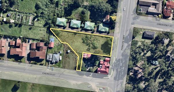
Figure 1 –
Location
Background
Proposed Development
A residential flat building
development comprising two buildings, Block 'A' and Block 'B', with 22
residential units and basement parking.
Block A
· Located on the
eastern side of the site, comprising basement level, three (3) floors of
residential units and a penthouse and roof terrace on the fourth floor (total
of 16 units).
· 3
x one-bedroom apartments
· 3
x two-bedroom apartments
· 6
x three-bedroom apartments
· 3
x four-bedroom apartments
· 1
x three-bedroom penthouse
Block B
· Three
floors of residential units (total 6).
· 3
x two-bedroom apartments
· 3
x three-bedroom apartments
The blocks are separated by
communal open space.
Vehicular access is off Church St with 42 basement car
parking spaces located in basement of Block A.
Subject Land
The site
is an irregular shaped lot with a primary frontage of 6m to Church Street to
the south, and a secondary frontage to the Princes Highway of 30m to the east.
The site is zoned R3 Medium Density Residential under the SLEP 2014 and has an
area of 2,754m2 and is vacant. There is scattered vegetation on the
eastern half of the site and along the frontage with the Princes Highway. The
site slopes down (away) from the Princes Highway, which is north east to south
west, with an overall fall of approximately 5m across the site.
There is a drainage easement and a right of carriageway that
is within and adjoins the site along the south western boundary.
Site and Context
The site is located north west
of Ulladulla Harbour and approximately 370m north of the Ulladulla Post Office
and CBD. The site adjoins an area to the north which is a mix of business uses
and residential developments which tend to decrease in density away from the
harbour.
Directly adjoining the site to the north is a medium density
development comprising 4 units. To the west of the site is a mix of low density
and medium density development, and to the south is a local heritage listed
property known as ‘Millards Cottage’. Opposite to the south is a
vacant lot that adjoins Millards Creek. Opposite to the east is Ulladulla
Rotary Park which has direct access to the Harbour foreshore and boat ramp.
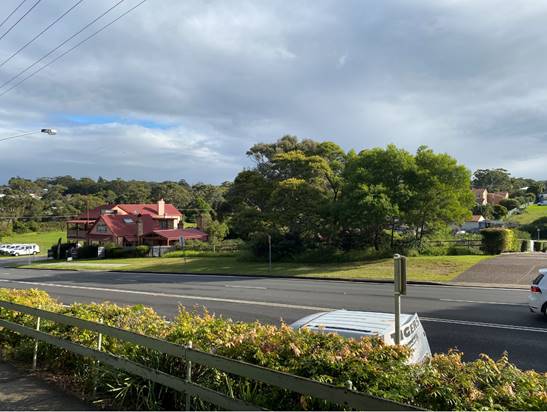
Photo 1: Princes
Highway Elevation
Photo 2: Church St
Elevation
Photo 3: Church St
looking west to adjoining development
Photo 4: Subject lot
looking east towards the Princes Highway


Photo 5: Looking
north over Church St towards the site from vacant lot opposite. Lot sits behind
horse paddock fence, Millards Cottage on the right, and house on the left,
approximately between the red markers.
Zoning
The site is zoned R3 Medium Density
Residential under the SLEP 2014. The proposed development is best described as
a Residential Flat Building which is permissible with consent. The objectives
of the zone are:
· To provide for the housing needs of the community within a
medium density residential environment.
· To provide a variety of housing types within a medium
density residential environment.
· To enable other land uses that provide facilities or
services to meet the day to day needs of residents.
· To provide opportunities for development for the purposes
of tourist and visitor accommodation where this does not conflict with the
residential environment.

Figure 2 –
Zone Extract (SLEP 2014)
History
The site has been subject to a previous development
application (DA) for a medium density development.
|
DA
number
|
Description
of Proposal
|
Decision
& Date of Decision
|
Officer
Comment
|
|
DA92/2615
|
5-unit town house development
|
Approved
January 1993
|
N/A
|
Issues
Clause 4.3 Height of Buildings
The objectives of this clause
are as follows:
a) to ensure that
buildings are compatible with the height, bulk, and scale of the existing and
desired future character of a locality,
b) to minimise visual
impact, disruption of views, loss of privacy and loss of solar access to
existing development,
c) to ensure that the
height of buildings on or in the vicinity of a heritage item or within a
heritage conservation area respect heritage significance.
The majority
of the site is mapped as having an 11m height restriction. The ‘Maximum
Height of Buildings’ map does not show a maximum height for a small
western portion of the site. clause 4.3(2A) states “If the Height of
Buildings Map does not show a maximum height for any land, the height of a
building on the land is not to exceed 11 metres”. As such an 11m
Maximum Height of Building control applies to the whole site.
This application proposes a
maximum building height of 14.58m. The applicant seeks to vary this building
height development standard via a clause 4.6 variation. A maximum variation of
33% (3.58m) is sought and pertains to the lift overruns and part of the
penthouse.
The maximum exceedance of Block
A is 3.58m which is the south western corner of the penthouse, and Block B is
1.73m being the lift overrun as depicted below. The perception of the
development when viewed from the surrounding area will be that the lift overrun
on Block A is the highest point.
The greatest point of height
exceedance is in fact the south western corner of the penthouse which is
attributable to the slope of the site which ‘dips’ down at this
point.
The penthouse has a gross floor
area (GFA) of 145m2 which represents 5% of the total GFA of the
development.
Figure 3: Building Height Analysis Views
The highest point is the lift
overrun of Block A which is 14.32m and has a RL of 21.4 AHD, however due to the
slope of the land the central portion of the site, whilst the overall RL of the
building is lower having an RL of 19.50m, at the greatest point the building
proposes a height of 14.58m being the top of point J (refer also to Figure 6
– 32.5%). As can be seen in the figure below, the height exceedance is
variable due to the slope / dip of the site.

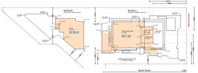
Figure 4: Roof Plan (refer to attachment for larger
image)
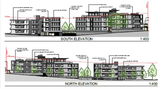
Figure 5: Elevation Height Exceedance Analysis
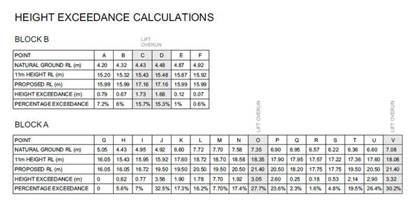
Figure 6: Height Exceedance Calculations
Applicant’s Submission
The applicant has submitted a
written request to justify the contravention of the development
standard.
Council is required to consider subclauses (3), (4) and (5) of clause 4.6.
Clause 4.6(3)-(5) are extracted from SLEP 2014 below:
(3) Development consent must not be granted for development that
contravenes a development standard unless the consent authority has considered
a written request from the applicant that seeks to justify the contravention of
the development standard by demonstrating:
(a) that compliance with the development standard is unreasonable or
unnecessary in the circumstances of the case, and
(b) that there are sufficient environmental planning grounds to
justify contravening the development standard.
(4) Development consent must not be granted for development that
contravenes a development standard unless:
(a) the consent authority is satisfied that:
(i) the applicant’s written request has adequately addressed the
matters required to be demonstrated by subclause (3), and
(ii) the proposed development will be in the public interest because
it is consistent with the objectives of the particular standard and the
objectives for development within the zone in which the development is proposed
to be carried out, and
(b) the concurrence of the Secretary has been obtained.
(5) In deciding whether to grant concurrence, the Secretary must consider:
(a) whether contravention of the development standard raises any
matter of significance for State or regional environmental planning, and
(b) the public benefit of maintaining the development standard, and
(c) any other
matters required to be taken into consideration by the Secretary before
granting concurrence.
Council must
be satisfied that clause 4.6(4)(a)(i) and (ii) have been addressed prior to the
grant of development consent. That is, a written request must be made, be
adequate and be in the public interest because it is consistent with the
objectives of the development standard and zone.
Further, the
applicant’s written request seeking to justify the contravention of the
development standard must adequately address the matters required to be
demonstrated by clause 4.6(3). Subclause (3) requires the following two matters
to be addressed:
1. That compliance with the development standard is unreasonable or
unnecessary in the circumstances of the case (cl 4.6(3)(a)); and
2. That there are sufficient environmental planning grounds to justify
contravening the
development
standard (cl 4.6(3)(b)). The written request needs to demonstrate both of these
matters.
Stepping through the subclauses
of cl. 4.6:
Clause 4.6(3)(a) –
Compliance with the Development Standard is Unreasonable or
Unnecessary
in the Circumstances of the Case.
To assess
whether compliance with a development standard is unreasonable or unnecessary
the Courts have provided guidance in the required assessment, with particular
reference to the accepted "5 Part Test" for the assessment
established by the NSW Land and Environment Court (L&EC) in Wehbe v
Pittwater Council [2007] NSWLEC 827 the principles outlined in Winten
Developments Pty Ltd v North Sydney Council [2001] NSWLEC 46 and further
clarified by Initial Action Pty Ltd v Woollahra Municipal Council [2018] NSWLEC
118. The “5-part Test” is outlined as follows:
1. The objectives
of the development standard are achieved notwithstanding non-compliance with
the standard.
2. The underlying
objective or purpose is not relevant to the development with the consequence
that compliance is unnecessary.
3. The underlying
objective or purpose would be defeated or thwarted if compliance was
required with the consequence that compliance is unreasonable.
4. The
development standard has been virtually abandoned or destroyed by the
Council’s own decisions in granting development consents that depart from
the standard and hence compliance with the standard is unnecessary and
unreasonable.
5. The zoning of
the particular land on which the development is proposed to be carried out was
unreasonable or inappropriate so that the development standard, which was
appropriate for that zoning, was also unreasonable or unnecessary as it applied
to that land and that compliance with the standard in the circumstances of the
case would also be unreasonable or unnecessary.
The
Applicant’s clause 4.6 report prepared for the proposal, does not rely on
parts 2-5 of the ‘5 Part Test’ as they are not considered applicable.
The argument put forward is focussed on part 1 - the objectives of the
development standard are achieved notwithstanding non-compliance with the
standard.
The
objectives of clause 4.3 (height) are:
(a) to ensure that buildings are compatible with the height, bulk, and
scale of the existing and desired future character of a locality;
(b) to minimise visual impact, disruption of views, loss of privacy
and loss of solar access to existing development; and
(c) to ensure that the height of buildings on or in the vicinity of a
heritage item or within a heritage conservation area respect heritage
significance.
Applicants
Request
The
following is an extract from the applicant’s request (inclusive of
Figures).
“The
proposal is consistent with the above objectives for the following reasons
summarised below:
4.3 (a)
to ensure that buildings are compatible with the height, bulk, and scale of the
existing
and
desired future character of a locality;
· The
development is consistent with the objectives of the zone and will provide high
quality housing close to the town centre.
· Ulladulla
town centre is undergoing transformation in built form, character, and land
use.
· The
proposed development is at forefront of development in the area, but it is anticipated
that nearby sites will be redeveloped in the coming years.
· The
land opposite zoned B4 with 14m height limit.
· The
future character of area is for increased density adjacent to the harbour.
· Shoalhaven
2040 strategic land – use planning statement prioritises medium density
apartments in the Ulladulla town centre.
· The
penthouse provides further diversity of housing types also supported by
Shoalhaven 2040.
· The
design retains the adjoining heritage item as the focal point providing good
separation and complementary colour variation.
· It
will contribute to the vibrancy of the area and support retail and night life.
4.3 (b)
to minimise visual impact, disruption of views, loss of privacy and loss of
solar access to existing development;
· Areas
of non-compliant height are central to the site and located way from side
boundaries.
· Areas
of height exceedance located towards the interface of Block A and Block B which
minimise the impact on existing development located on adjoining sites.
· Elements
of encroachment positioned on land with a natural ground level lower than
street elevation minimising visual intrusion into the skyline.
· Given
the topography of some of the properties to north west currently gain views to
Harbour which will be affected, however the height exceedance will not
significantly worsen this impact, as can be seen in the superimposed
photomontages below Fig 8-11.
· The
design is broken up into elements of varying heights thereby reducing visual
intrusion of the elements when viewed from a distance.
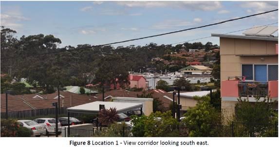
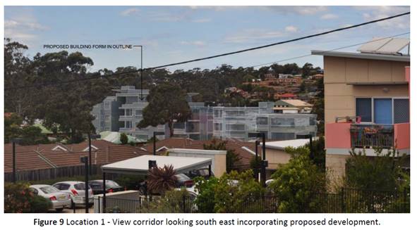
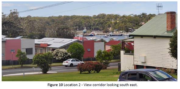
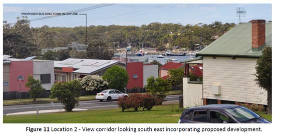
· While
the subject development may now impact on view loss when future development
occurs the building will be obscured by similar buildings located uphill from
the site.
· Height
exceedance is primarily associated with lift overruns and roofing, and the only
potential for loss of privacy is from penthouse which has been designed with
increased setbacks from boundaries (8.81m from south and 7.775m from the
north).
· Setbacks
comply with Apartment Design Guidelines for privacy.
· Solid
balustrading and planter boxes on penthouse will minimise loss of privacy.
· Proposed
setback of areas of height exceedance means solar access is absorbed into
shadows cast by compliant building components.
· Height
exceedances do not contribute significantly towards any additional
overshadowing of neighbouring properties as shown in shadow diagrams below.
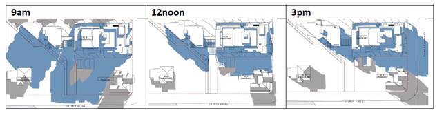
Figure 12 Shadow Diagrams
4.3 (c) to ensure that the height of buildings on or in the vicinity
of a heritage item or within a heritage conservation area respect heritage
significance.
· The
site adjoins Heritage listed Millards Cottage to the south. The Heritage
Assessment Report (Borst & Co. Architecture) finds that the generous
separation between the heritage item and proposed development, coupled with
other design elements which minimise bulk and scale result in limited impact to
the item. The proposed development is located to the north of the heritage item
and will not dominate the existing streetscape or Princes Highway frontage, nor
will it impede the existing sight lines to and from the heritage item. It is
also visually separated by the gum tree as can be seen in Figure 13.
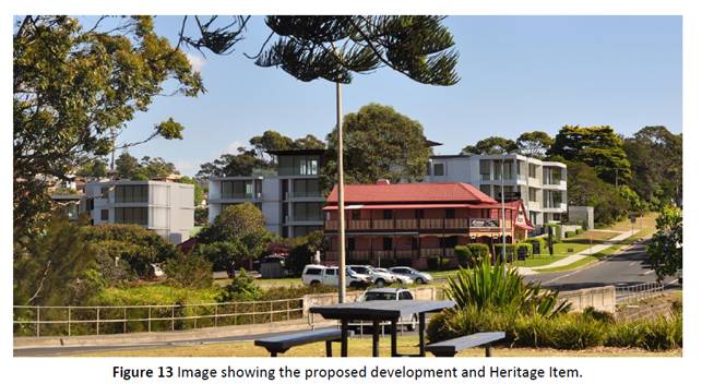
Clause 4.6(3)(a)
Evaluation of the written request relating to Clause 4.6(3)(a)- Compliance with
the development standard is unreasonable or unnecessary.
The consent authority must form the opinion of that the
applicant’s written request(s) have adequately addressed those matters
required to be demonstrated by clause 4.6(3)(a). The applicant has applied the
first test established in Wehbe v Pittwater Council to argue that the development standard
is unreasonable or unnecessary in the circumstances of the case because the
objectives of the development standard are achieved notwithstanding
non-compliance with the standard.
Discussion
It is
accepted that the proposed height exceedance will meet the objectives of the
development standard clause 4.3 Height of Building given that the areas of the
building that exceed the limit are the lift overruns and the roof of the
penthouse which are towards the middle of the buildings, and setback from the side
boundaries of 8.1m and 7.75m. The sloping (down) of the site from the Princes
Highway will also mean the areas of height exceedance will not be visually
prominent and excessive as viewed from the highway. Nor does it pose a
significant impact on privacy or overshadowing of neighbouring properties given
the location of the protrusions in the centre of the building site.
Although views to the northwest
of the site from existing development will be impacted, as the applicant
states, the areas of height exceedance do not have a significant impact on view
loss. The impacts on the view are substantially from the compliant components
of the building. Accordingly, if there were to be a height reduction of the
non-compliant components, there would not be a substantive improvement.
The site and surrounds have been
zoned R3 Medium Density and B4 Mixed Use with the expectation of higher
density living in close proximity to the town centre. Future buildings
will inevitably be multiple storey developments.
The design recognizes the
adjoining heritage item ‘Millards Cottage’. There is a separation,
building design elements and large gum tree adjacent to the boundary which will
soften the backdrop view of the development behind. There is no doubt that there
will be a contrast between the new and the old however it is not considered
appropriate to have a new development replicate or mimic the historic
architecture in this context. The cottage will retain its visual prominence in
that it is located on a corner site and the significant and historic qualities
will remain readily identifiable given the contrast between the new and the
old.
A view assessment in accordance
with the Planning Principle set out in the case Tenacity Consulting v
Warringah Council has been undertaken at Appendix 1 in the s4.15 Planning
Assessment Report. The view loss is considered to be minor and reasonable in
the circumstances.
Given the circumstances outlined
above, the proposed height exceedance is considered reasonable having regard to
the building design, its purpose and site characteristics.
The proposed development will
contribute to housing diversity in Ulladulla and is suitably located in a
highly desirable high amenity location within walking distance of the town
centre, harbour and opposite the Rotary Park.
Therefore, compliance with the development standard is
considered to be unreasonable and unnecessary in the circumstances of the case.
Clause
4.6(3)(b) Evaluation - There are sufficient environmental planning grounds to
justify contravening the development standard
The consent
authority must form the positive opinion that the applicant’s written
request has adequately addressed those matters required to be demonstrated by
clause 4.6(3)(b).
To
demonstrate that there are sufficient environmental planning grounds to justify
contravening the development standard, Preston CJ in Initial Action Pty Ltd
v Woollahra Municipal Council [2018] NSWLEC 118, held that the grounds
relied on by the applicant in the written request under cl 4.6 must be
“environmental planning grounds” by their nature: see Four2Five
Pty Ltd v Ashfield Council [2015] NSWLEC 90 at [26]. The adjectival phrase
“environmental planning” is not defined but would refer to grounds
that relate to the subject matter, scope, and purpose of the EPA Act, including
the objects in s 1.3 of the EPA Act.
In the
judgment, Preston CJ outlined the two methods for demonstrating that a Clause
4.6 is “sufficient at paragraph [24] of case as follows:
First, the environmental planning
grounds advanced in the written request must be sufficient “to justify
contravening the development standard”. The focus of cl 4.6(3)(b) is on
the aspect or element of the development that contravenes the development
standard, not on the development as a whole, and why that contravention is
justified on environmental planning grounds. The environmental planning grounds
advanced in the written request must justify the contravention of the
development standard, not simply promote the benefits of carrying out the development
as a whole: see Four2Five Pty Ltd v Ashfield Council [2015] NSWCA 248 at [15].
Second, the written request must
demonstrate that there are sufficient environmental planning grounds to justify
contravening the development standard so as to enable the consent authority to
be satisfied under cl 4.6(4)(a)(i) that the written request has adequately
addressed this matter see Four2Five Pty Ltd v Ashfield Council [2015]
NSWLEC 90 at [31].
Applicants
Request
The
applicant’s clause 4.6 request seeks to justify the height exceedance by
setting out environmental planning grounds in favour of the variation. Those
grounds are summarised as follows:
· The
proposal is consistent with the objectives of the R3 Medium Density zone as it
provides 22 apartments of a variety of configuration and sizes that will meet
the community needs by providing additional housing close to the town centre
and public foreshore.
· The
locality is undergoing a transition to taller buildings at higher density, and
it is appropriate in the high amenity location and north east gateway to
Ulladulla.
· The
proposal is consistent with the relevant objects at section 1.3 of the EP &
A Act which include:
“(c) to promote the orderly and economic use and
development of land…
(g) to promote good design and amenity of the built
environment…
(h) to
promote the proper construction and maintenance of buildings, including the
protection of the health and safety of their occupants…”
The design is
compliant with the Apartment Design Guide (ADG) and State Environmental
Planning Policy No 65 (SEPP 65) – Design Quality of Residential Apartment
Development, except for minor variations to the side setbacks which have been
addressed in the building design. As is the case with DCPs, the ADGs have
acceptable design solutions, however performance-based solutions (alternatives)
are available where it can be demonstrated that the purpose of the control is
not compromised (e.g., privacy, overshadowing).
The design and siting of the development has regard to the
site attributes and location.
In regard to Object (g), the lift
overruns do not detract from the architectural design merit or the amenity of
the surrounding buildings. The building materials and penthouse promote good
design and improve the amenity of the building for future residents.
In regard to Object (h) universal
access via the lift is a positive element for health and safety of future
occupants. The lift has been designed with a minimum dimensioned overrun
selected to minimise height and bulk and strict numeric compliance would not be
consistent.
· Of
relevance are the comments by Roseth SC in Veloshin v Randwick Council
[2007] NSWLEC 428:
“30 The debate about height and
bulk can be meaningful only against the background of local planning controls,
such as maximum height, floor space ratio, site coverage and setbacks.”
The proposal complies with the FSR and
landscaping controls.
The lift overrun, and penthouse do not contribute to the
perception of bulk (controlled by FSR). The scale and massing is not out
of character with the desired future building character in the locality.
· It
will be consistent with the emerging and desired future character for
development in the locality.
· Is
consistent with the Shoalhaven Character Statement 2020 as the building
provides a diversity of housing and makes a positive contribution to the
character of Ulladulla.
· The
height exceedance does not have a significant additional impact on view loss
which results from views obscured by the first two storeys of the building.
Discussion
The applicant’s written
request demonstrates sufficient environmental planning grounds to justify
contravening the height development standard for this particular proposal for
the following reasons:
· The
proposal is consistent with the key objectives of the R3 zone in that it
provides for the housing needs of the community, providing a variety of housing
types within a medium density residential environment.
· In
considering the objectives of the zone for the provision of medium density
residential uses the proposal is considered contextually appropriate.
· The
height of the development exceeds the height of existing surrounding
development in the vicinity however it is consistent with the desired future
character of the site and its immediate surrounds.
· The
site is burdened by both a drainage easement adjacent to the western boundary
and a Right of Carriage Way which in total are approximately 300m2 and
reduces the available land for development.
· The
site is affected by a localised flood path that flows along the western
boundary towards Millards Creek. This flood impact establishes a minimum built
floor level for the carpark to a height of 4m AHD and the entrance driveway to
the carpark to a minimum level of 4.4m AHD and therefore limits the available
building envelope of the site.
· Is
not inconsistent with the relevant Objectives of the EPA Act, SLEP 2014
including height clause and strategic vision for the locality.”
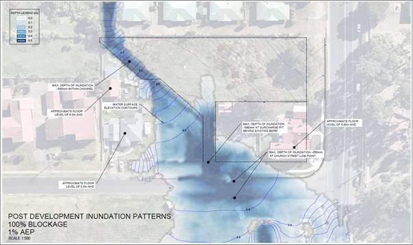
Figure 14 - 1% AEP Post Development Flood Model with
100% blockage.
· The
proposed two apartment blocks provide for a view corridor from the north,
improve the solar access to the apartments and communal open space and reduce
the overall bulk and scale of the development.
· The
proposed intrusion above the 11-metre height limit is essentially only for a
small section of both buildings being the middle sections, including the lift
overruns and part of the penthouse. Most of the buildings conform with the
height limit.
· The
proposal is consistent with the objectives of the height standard, to ensure
that the height of development is appropriate to the condition of the site and
its context.
· The
proposal is consistent with the desired future character of the area. The area
is identified in the Ulladulla Town Centre DCP as a Higher Density Residential
Precinct located on the fringe of the central business area which will become
increasingly important as an area for supporting higher density residential
living within walking distance of the CBD and Harbour foreshore.
· The
land across the road to the south is zoned B4 Mixed Use with a 14m height limit
and therefore a small section of height exceedance will not look out of
character in relation to future development anticipated in the vicinity.
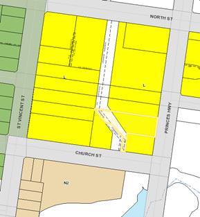
Figure 7: SLEP 2014 Height of Buildings Map
· The
proposed areas of height exceedance are only a small portion of the roof which
is towards the middle of the apartment blocks and will not be visually
prominent considering the topography of the site slopes down from the Princes
Highway.
· The
proposed lift overruns and penthouse have been designed to be sympathetic to
the proposed building and its surrounds and will not cause any additional
impacts on views across the site.
· The
building height variation does not generate overshadowing impacts on the
surrounding properties.
· The
design complies with the ADG and SEPP 65 with minor
variations to the side setbacks that have been justified by the applicant,
assessed in the planning report, and considered to be acceptable.
Consistency with the
underlying objectives of the standard:
The objective of the Height
Standard is listed at Clause 4.3 (1) of SLEP 2014.
a) to ensure that buildings are
compatible with the height, bulk, and scale of existing and desired future
character of the locality,
b) to minimise visual impact,
disruption of views, loss of privacy and loss of solar access to existing
development,
c) to ensure that the height of building on
or in the vicinity of a heritage item or within a heritage conservation area
respect heritage significance.
As discussed in the preceding
section of the report, the proposed height of the development is appropriate to
the context and is compatible with the 11-metre height limit. The extension of
the building beyond the 11m height control is predominant at the middle
sections of the building being the lift overruns and the penthouse.
The proposal positively responds
and satisfactorily addresses the characteristics of the site and its broader
context. The proposal is of a height and scale that is sympathetic to its
immediate context and the areas of height exceedance to not have any further
impacts on views from the north west, it is not visually intrusive, nor does it
create privacy or overshadowing issues.
The proposal is a contemporary residential apartment design
which is consistent with the desired future character of the immediate
surrounds and the objectives of the R3 zone and the Ulladulla town centre
precinct.
Clause
4.6(4)(a)(i) Have the matters set out in section 4.6(3) been adequately
addressed?
Clause 4.6(4)(a)(i) requires the
consent authority to be satisfied that the written request has adequately
addressed the matters required to be demonstrated by subclause 3. Rebel MH
Neutral Bay Pty Limited v North Sydney Council [2019] NSWCA 130 per Preston
CJ of LEC at [51] makes it clear that “the consent authority needs to
be satisfied that those matters have in fact been demonstrated”. The
applicant’s written request has adequately addressed the matters required
to be demonstrated by clause 4.6(3), because the analysis above has
demonstrated that it has.
Clause
4.6(4)(a)(ii) Evaluation – Public Interest
Clause
4.6(4)(a)(ii) states that development consent must not be granted for
development that contravenes a development standard unless the proposed
development will be in the public interest because it is consistent with the
objectives of the particular standard and the objectives for development within
the zone in which the development is proposed to be carried out.
The
applicant has provided sufficient justification as outlined above in the
summary of their written request that the top of the lift overrun, and height
encroachments are consistent with the objectives of Clause 4.3 relating to
height of buildings.
Pursuant to
the provisions of the SLEP 2014 the land is zoned R3 Medium Density
Residential, the objectives of which are:
· To
provide for the housing needs of the community within a medium density
residential environment.
· To
provide a variety of housing types within a medium density residential
environment.
· To
enable other land uses that provide facilities or services to meet the day to
day needs of residents.
· To
provide opportunities for development for the purposes of tourist and visitor
accommodation where this does not conflict with the residential environment.
The
proposal, being medium density residential development is clearly consistent
with the R3 Zone objectives.
The non-compliance with the
maximum height limit has minimal impact and is appropriate in this instance and
the proposal is considered to be in the public interest.
Clause
4.6 (b) – Concurrence of the Secretary
The Council assumes the
concurrence of the Secretary in this instance, when considering the
application.
Clause 4.6(5)(a)
- Matters of Significance for State or Regional Planning
The non-compliance with the
maximum building height development standard will not raise any matter of
significance for State or Regional Planning.
Clause
4.6(5)(b) - Public Benefit of Maintaining the Planning Control Standard
In the
judgement of Ex Gratia P/L v Dungog Council [2015] (NSWLEC 148),
Commissioner Brown of the NSW LEC outlined that the question that needs to be
answered in relation to the application of clause 4.6(5)(b) is “whether
the public advantages of the proposed development outweigh the public
disadvantages of the proposed development”.
It is considered that public
advantages of the development will outweigh public disadvantages for reasons
outlined in the discussion above.
Clause
4.6(5)(c) - Other matters
No other matters need to be
taken into consideration by the Secretary.
Summary
The clause
4.6 variation request adequately addresses the requirements of the clause as it
provides justification to support the height exceedance of the proposed
residential flat building because:
· The
applicant has demonstrated that the proposal is compatible with the bulk and
scale of the existing and future character of the locality.
· The
proposal will not be visually intrusive, will have minimal impact on privacy
and solar access to surrounding development.
· The
areas of height exceedance have minimal impact on views in what has been
assessed overall as an acceptable impact,
· The
design recognises the adjoining heritage item ‘Millards Cottage’.
· The
applicant has demonstrated there are sufficient environmental planning grounds
to justify contravening the development standard.
· The
proposal is consistent with the zone objectives and the objectives of the
development standards and is therefore in the public interest.
The clause 4.6 variation request
is therefore supported.
Planning Assessment
The DA has been assessed under
s4.15 of the Environmental Planning and Assessment Act 1979. Please refer
to Attachment 7.
Policy Implications
Not applicable
Consultation and Community
Engagement:
Six (6) public submissions were
received in relation to Council’s notification of the development.
Six (6) were objections to the development, two of which were from the same
objector. The notification was made in accordance with Council’s
Community Consultation Policy with letters being sent within a hundred (100)m
buffer of the site. The application was advertised in the local newspaper. The
notification was for a two-week period.
Key issues raised as a result of the notification are
provided below.
Issue
Height
exceedance
Comment
Height exceedance assessment has been undertaken in
accordance with clause 4.6 of the SLEP 2014 and found to be acceptable in the
circumstances.
Issue
Four storeys not needed near the Harbour.
Comment
The land is located in the higher residential density
precinct according to Council’s DCP Chapter S8 Ulladulla Town Centre with
an expectation of higher density development radiating out from the town centre
and the central harbour area. Land opposite the site and elsewhere in the CBD
area have a height limit of 14m which will facilitate four storey developments
in the vicinity.
Issue
Impact
on aesthetics of the adjoining heritage item.
Comment
In accordance with the principles of the Burra Charter the
proposed new work has considered the siting, bulk form, scale, colour, texture,
and material which respect the heritage significance of ‘Millards
Cottage’. As discussed in the Heritage Assessment Report by Borst &
Co Architecture, this has been achieved through the generous separation between
the heritage item and the development, the visual separation provided by the
large gum tree, the neutral toned colour and material palette, the proposed
landscaping, and the design of the buildings that will complement the character
of the heritage item and the surrounding area. The heritage item will retain
its prominence in the streetscape and the existing sight lines to and from the
heritage item will be preserved.
Issue
Impacts
on privacy to properties to the north.
Comment
The properties immediately adjoining to the north have their
private open space on the northern side of their dwellings and therefore there
will be minimal privacy impacts. The lot is zoned R3 medium density, and a
multiple storey development is appropriate to the zone which is for higher
density living. Landscaping on the northern boundary is proposed and will
assist in providing privacy to properties to the north.
Issue
Protection of Eucalypt on boundary
Comment
There is a large setback between the eucalypt and the
building. If the development is approved, conditions can be imposed to
ensure the protection of the tree during construction and post development.
Issue
The views of properties to the north west will be impacted.
Comment
As discussed above, there will be some view loss from
properties to the north west, however the view loss will be in the most part
attributable to the compliant area of the building, i.e., the first two
storeys. The bulk and scale of the building is consistent with what is to be
expected on a site zoned R3 Medium Density.
Issue
Proposed building height exceeds
maximum building height of town centre.
Comment
The proposed maximum height is 14.58m which is only a small
part of the building (lift overruns and portion of the penthouse), the majority
of the building is height compliant. The lot sits below the Princes Highway and
slopes away to the south west, the areas of height exceedance are in the centre
of the buildings. Having regard to the design of the development and where the
protrusions sit, site attributes, the context of the site and foreshadowed type
of development permitted by the zone, the height exceedance is not
unacceptable.
The height control is not a prohibition. Clause 4.6 enables
variation subject to a satisfactory assessment.
Financial Implications:
Nil, unless the matter is potentially litigated. See
below.
Legal Implications
If the application is refused,
or if the applicant is dissatisfied with Council’s determination, the
applicant is entitled to appeal to the Land and Environment Court.
Under some circumstances, third
parties may have a right to appeal Council’s decision to the Land and
Environment Court.
Summary and Conclusion
It is
recommended that the variation is reasonable and acceptable and, in this
instance, strict compliance with the height development standard is considered
to be unnecessary as the development is appropriate in the location and can
achieve relevant planning objectives. Furthermore, the proposal is
otherwise compliant with the floorspace and key planning controls with minor
variations to side setbacks whereby they have maintained visual privacy through
the incorporation of screening and other building design elements.
Given the satisfactory
assessment of the DA, there are no substantive planning reasons to warrant
refusal of the development and conditional approval is recommended.
|

|
Ordinary
Meeting – Tuesday 03 August 2021
Page
0
|
CL21.171 Acceptance
of Grant Funding - Berry Community Activities Centre
HPERM Ref: D21/307545
Department: Arts
& Culture
Approver: Jane
Lewis, Director - City Lifestyles
Reason for Report
To seek Council’s approval
to accept $3,000 (incl. GST) from Berry Community Activities Centre (BCAC) to
support a school bus subsidy program for travel to Shoalhaven Regional Gallery
for curriculum-based education learning activities.
|
Recommendation
That
Council:
1. Accept the grant funding of $3,000
(incl GST) from the Berry Community Activities Centre for the purposes of
subsiding school travel to Shoalhaven Regional Gallery.
2. Write to the Committee of the Berry
Community Activities Centre, to thank them for the grant.
|
Options
1. Council accepts
the grant of $3,000 (incl GST) provided to offset the costs of school buses for
travel to Shoalhaven Regional Gallery.
Implications: The Gallery can promote the subsidy
to School and support greater access to arts education across the
Shoalhaven.
2. Council do not
accept the funding and provide alternate direction to staff.
Implications: Schools wishing to attend activities
at Shoalhaven Regional Gallery would need to fund the cost of buses themselves,
reducing the opportunity for some schools to attend Gallery learning programs.
Background
In 2019, Shoalhaven Regional
Gallery received a grant from Museums and Galleries NSW (MGNSW) to undertake a
study into the barriers to accessing in-gallery learning programs for schools.
That study showed that the key issues were
1. Time
available to teachers and schools for excursion opportunities
2. Lack
of knowledge about gallery offerings
3. Difficulties
to access
Teachers noted the cost of bus
transport as a particular barrier to access. An example of this is the hire
costs for a bus from Bomaderry and return being over $200, which meant that bus
costs plus program costs at the gallery became unachievable for many
students.
Following the study, Shoalhaven
Regional Gallery has done a significant amount of work to address the issues
and barriers identified in the report. We have developed a new education
program, partnered with Sydney Living Museums to develop a full day excursion
activity for primary schools, and significantly improved and enhanced our
communication with schools on programs both for incursions and
excursions.
The cost of buses for schools
remained a problem that teachers commented on frequently as a reason for not
coming to the gallery for education programs. After a conversation with the
President of the BCAC, the Gallery was invited to submit a request for funding
support.
Funding was sought to offset the costs associated with bus
travel to the Gallery for Shoalhaven schools. The bus subsidy program will work
as a refund-based program, where schools invoice the Gallery for the cost of
travel following an excursion. The fund will remain open until all monies are
expended. BCAC and the Gallery will review the success of the program in
promoting schools engagement with the gallery and consider further funding in
the next financial year.
Community Engagement
The School Bus Subsidy program
funded by the grant will improve access to the Gallery for preschools, primary
schools, and high schools across the Shoalhaven. The funding will support a
significant increase in engagement with the Arts and the Gallery by school
students, supporting awareness and increased interest.
All gallery education is
developed to support the Visual Arts Curriculum and learning outcomes for the
education stage it is delivered to, it has been tested with students and
teachers and is delivered by qualified art education staff.
Research shows that children who access and visit cultural
institutions are far more likely to return and engage with the arts throughout
their life. Presenting opportunities to students through this program will
support and encourage greater engagement.
Financial Implications
The grant will be managed within
the Shoalhaven Regional Gallery budget as a separate activity line and monies
paid to schools from that budget. The school bus subsidy program will conclude
once all monies are expended.
|
|
Ordinary
Meeting – Tuesday 03 August 2021
Page
0
|
CL21.172 Create
NSW Proposal for a Regional Arts Development Organisation (RADO) for the South
Coast
HPERM Ref: D21/132696
Department: Arts
& Culture
Approver: Jane
Lewis, Director - City Lifestyles
Attachments: 1. Hon.
Don Harwin MLC - Proposal Development of New RADO Shoalhaven / Kiama Region -
Create NSW - Request for Feedback ⇩
2. Create NSW - Presentation to
Councillor Briefing - July 2021 - Development of RADO ⇩
Reason for Report
This report is being submitted
directly to the Ordinary Meeting due to the request from Councillors arising
from the Briefing by Create NSW on 15 July 2021 on the proposal to investigate
and potentially establish a Regional Arts Development Organisation for the
South Coast covering the Shoalhaven, Kiama and Shellharbour LGAs.
In March 2021 representations
were received from The Hon. Don Harwin MLC and Minister for the Arts seeking to
discuss the potential establishment of a Regional Arts Development Organisation
initially for the Shoalhaven / Kiama region.
|
Recommendation
That
Council:
1. Provide In Principle support for the
proposal by Create NSW to undertake a three (3) month investigation into the
establishment of a Regional Arts Development Organisation (RADO) for the
South Coast;
2. Receive an update from Create NSW at
the conclusion of the investigations;
3. Consider support for a RADO and the
likely financial implications as part of the 2022/23 Delivery Program and
Operations Plan and Budget;
4. Write to The Minister for the Arts,
The Hon. Don Harwin MLC to thank him for this opportunity and provide an
update on Council’s In Principle support for the proposal.
|
Options
1. Adopt the
recommendation as printed
Implications: Create NSW and the Minister will
continue work to progress the development of a RADO for the South Coast
(Shellharbour, Kiama and Shoalhaven) Region, including further consultation
with Council and the community.
2. Adopt an
alternate recommendation
Implications: Not known at this time.
Background
Following a meeting with The Hon. Don Harwin MLC, Shoalhaven
City Council has received a letter from the Minister and Create NSW with
regards to their desire to establish a Regional Arts Development Organisation
(RADO) for the Shoalhaven Kiama region. Subsequently a Councillor Briefing was
held on 15 July 2021 whereby staff from Create NSW made a presentation about
RADOs and the proposed process for its establishment.
Background to RADOs
A RADO is a non-profit
incorporated association and has a voluntary committee of management / board
made up of members who are elected / appointed to the position under rules
stated in the RADO constitution.
There are currently 14 RADOS
operating across NSW with the number of participating councils for each RADO
ranging from 3 to 12 in size.
RADOs’ aim is to provide
strategic direction for sustainable arts and cultural development in their
regions through broad development programs, projects and specific initiatives
to support sectors and communities within the region.
These can be managing grant
funding programs, supporting alliances and partnerships, encouraging
collaboration, and introducing arts organisations to commercial / business
partnerships. They employ staff members who coordinate and implement an arts
and cultural development program in partnership with the local government
entities in the region within which they operate. Local Government
representative(s) are typically on the board of directors.
The RADO staff are led by an
Executive Director. The core focus of this position changes based on the region
in which they work – for example the role may be more focussed on
planning and development projects at a local level to develop a strong arts
network across the region, or they may look to a more regional strategic and
planning level. The Executive Director engages across regional, state, and
federal levels to promote the region, activities and to seek support.
A 2020 review of the RADO
network and Regional Arts NSW identified gaps in delivery within some regions
and changed the funding model and relationship between the RADOs and Regional
Arts NSW (RANSW). This review highlighted the key role of the RADOs within the
region and resulted in an increase in direct funding from Create NSW to the
RADOs and a change in the Country Arts Support Program (CASP) grants, resulting
in these funds being directly managed by the RADOs, rather than through RANSW.
There was also a new position added to the Create NSW structure to service the
network of RADOs.
RADOs seek to provide independent, autonomous governance for
the specific purpose of providing Arts and Cultural services to generate more
opportunities and connections progressing art projects and careers of local
artists.
Funding
for RADOs
RADOs are reliant on funding
through partnership between state and local government and through sponsorships
/ community support.
At present this partnership is
set at $168,000pa from Create NSW and a contribution from member councils on a
per capita basis.
The funding covers staff
salaries, primarily an Executive Director, Administration / Communications
staff, and other program staff as suitable for the region, venue and office
hire, office and administration utilities and supplies.
Beyond the core funding, additional funding is sought to
provide further services and projects to the region. As a not-for-profit
organisation (some RADOs have Deductible Gift Recipient (DGR) status), the
range of funding options available is far broader than those which are currently
accessible by local government or individual artists.
Potential benefits /
opportunities provided by a RADO
· Strategic
and organisational support for artists and arts providers, both locally and
throughout the region.
· Draw
on the experience and project ideas from across the state to facilitate local
and regional arts-based solutions.
· Online
database of artist and arts organisations.
· Stronger
links to State and National arts funding.
· Professional
arts support and advice to artists and communities.
· Access
and support to the Country Arts Support Program (CASP) small grants program.
· Regional
promotion and marketing of the arts.
· Training
and support for community arts organisations and artists.
· Up
to date information regarding the arts and cultural sector such as research and
cultural data of the region.
· Facilitated
networks between arts organisations, arts businesses and artists within the
region and links to the state and national level.
· Development
of creative industries and cultural tourism opportunities in the region.
· Support and
capacity building for First Nations (or Aboriginal) arts and culture.
· Partnerships
between the arts and non-arts sectors
· Access
to funding from non-government sources
Approach from Create NSW
The absence of a RADO in the
South Coast region was particularly noticeable recently with the dispersal of
funding from the Rescue and Restart Funding package. This package provided
$130,000 to regions across NSW to support Arts organisations survive and
restart following COVID impacts. In most regions the money was disbursed
through the RADO. This was not possible in the Shoalhaven / Kiama region
and Create NSW ran a rapid response limited grant program for
organisations.
The correspondence from the
Minister and the presentation from Create NSW are attached. These provide
further information relating to the development of a RADO for the South Coast.
They seek in-principle support for the proposal and engagement with Councillors
in the research and development phase.
The Hon. Don Harwin MLC supports arts and culture in the
regions to be more equitable and accessible and views the establishment of a
RADO as a key step in providing resources and services for local artists and
arts and cultural organisations on the South Coast of NSW. Initially this
proposal included Kiama and Shoalhaven LGAs; this, at the request of Kiama
Council, has now be extended to include Shellharbour City Council LGA.
Options for progressing the
development of a RADO
Create NSW have advised of two
options for progressing the development of a RADO.
Option 1:
A new Not for Profit (NFP) organisation is established to
operate as the RADO. If this option is chosen, support could be requested from
South East Arts to auspice / manage the initial funding and provide the
financial and administrative support required for the establishment of the new
organisation.
|
Option
|
Timeframe
|
Notes
|
|
Option 1
Develop and support a new RADO
|
FY 2022/23
|
• Independent, autonomous, and not
tied to any historical issues or previous
organisational priorities.
• Established for specific and informed purpose.
• Will need additional financial
and administrative support
prior to establishment
to support
the foundation
of the organization.
• More complex for all parties to establish a new NFP organization, and to be involved in its governance and staffing.
• Will need a period of regional
consultation prior to establishment.
|
Option 2:
An existing organisation
operating in the Shoalhaven / Kiama / Shellharbour region would be supported
and upskilled to become the RADO for the region.
|
Option
|
Timeframe
|
Notes
|
|
Option 2
Support existing, local independent organization to
become a RADO
|
FY 2021/22
|
• Could be established faster than the establishment of a
new, independent organization.
• Could
be supported based on prior successful history of providing services and engaging
with community.
• Existing organization may not be the right fit for the
RADO network
• Local
stakeholder organizations may view the appointment unfavourably
• Will
need a period of regional consultation prior to establishment.
|
Create NSW are looking to progress Option 1 as the
preferred option, and will engage a consultant for 3 months to investigate this
proposal. This will involve undertaking research which will see
engagement with an establishing committee, RADOs in neighbouring regions and
individuals / arts organisations and communities across the three LGAs.
The establishment of the RADO will require confirmed
commitment from all three LGAs in the South Coast. Create NSW are undertaking
discussions with relevant parties in each LGA and are continuing to progress
the proposal to establish a South Coast RADO based on the feedback from those
discussions.
Community Engagement
Create NSW provided a Councillor
Briefing on Thursday 15 July. At the briefing Create NSW indicated that they
have funding in their 2021/22 program which will provide for the engagement of
a consultant over a three (3) month period to undertake further investigations,
research and community engagement to determine support for a RADO. Create NSW
committed to reporting back to Shoalhaven City Council at the outcome of these
investigations.
As part of a video conference on
22 March 2021 with arts and cultural organisations across the Shoalhaven /
Kiama region, staff from Create NSW encouraged feedback on the idea of a RADO
in the region. Specifically, they asked if artists / arts organisations would
be supportive of such a development and if there was an organisation already
operating in the region that could be supported to move towards the functions
of a RADO.
The general consensus gained
from the participants in the session was that a RADO would be well received,
that it would need to be supported to have an indigenous cultural liaison
officer from the start, have a clear purpose to grow and develop understanding,
awareness, and support for indigenous artists of the region.
If Council are supportive of the proposal to develop a RADO,
more detailed consultation with arts and cultural organisations, artists and
other stakeholders within the Shoalhaven / Kiama / Shellharbour region would
need to take place. Further community consultation would be required by Create
NSW as part of their commitment to the region and ensuring the RADO is established
in a way that is supported by the community.
Policy Implications
As an independent Not-for-Profit arts organisation, the
establishment of a RADO will not have any policy implication. However, a RADO
in the region may support the development of arts and cultural policies for the
Shoalhaven, as they will have an understanding of the sector needs and
opportunities.
Financial Implications
Contributing councils are asked
to provide an annual funding allocation to support the RADO. This amount
is per the RANSW Guide to Minimum Local Government Contributions to Regional
Arts Boards in NSW. The information from The Hon. Don Harwin MLC, (attachment
1) indicates the anticipated funding contribution required from Shoalhaven City
Council and provides a comparison to other LGAs in the region.
Funding
for a RADO
This information indicates
possible contributions of South Coast Council’s towards the establishment
of a RADO.
Shoalhaven/Kiama
RADO - Basic budget
|
Funding Source
|
$ p.a.
|
|
Shoalhaven LGA
(pop. 105,000)
|
36,000
|
|
Kiama
LGA
(pop. 23,500)
|
20,000
|
|
Shellharbour LGA (pop.
74,600)
|
36,000
|
|
Create NSW annual RADO funding
|
168,000
|
|
CASP funding (if 250,000
split evenly across 15 RADOS)
|
16,000
|
Comparative RADO - South East Arts 3 x contributing
councils,
91,967 people in coverage area
|
Funding Source
|
$ p.a.
|
|
Bega Valley Shire (pop.
33,253)
|
25,000
|
|
Eurobodalla Shire (pop. 37,919)
|
12,000
|
|
Snowy Monaro Regional Shire
(pop. 20,795)
|
16,000
|
|
Create NSW annual RADO funding
|
168,000
|
|
CASP funding
|
17,000
|
Total operating budget forecast
of South East Arts 20/21: $710,594.00, made up of Create NSW Operational
Funding, Local Government Operational Funding, Federal Government Project
Indigenous Arts Funding, Create NSW project funding and non-government project
funding.
It is suggested that following a
further update to Council by Create NSW at the conclusion of the community
engagement phase that the inclusion a funding contribution towards the
engagement of a RADO for the South Coast be considered as part of the 2022/23
Delivery Program and Operational Plan and Budget.
|
|
Ordinary
Meeting – Tuesday 03 August 2021
Page
0
|

|
|
Ordinary
Meeting – Tuesday 03 August 2021
Page
0
|


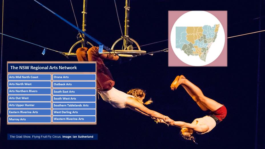
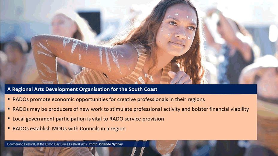
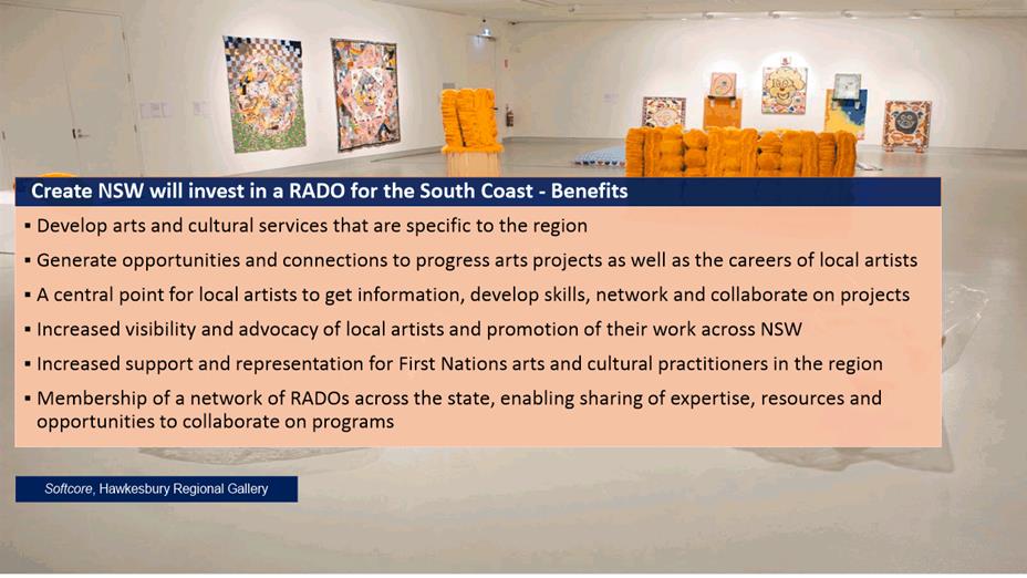
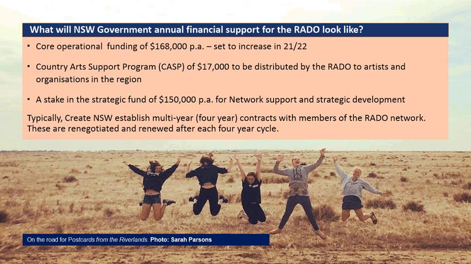
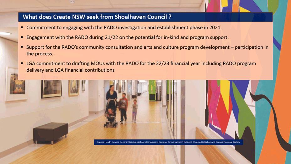
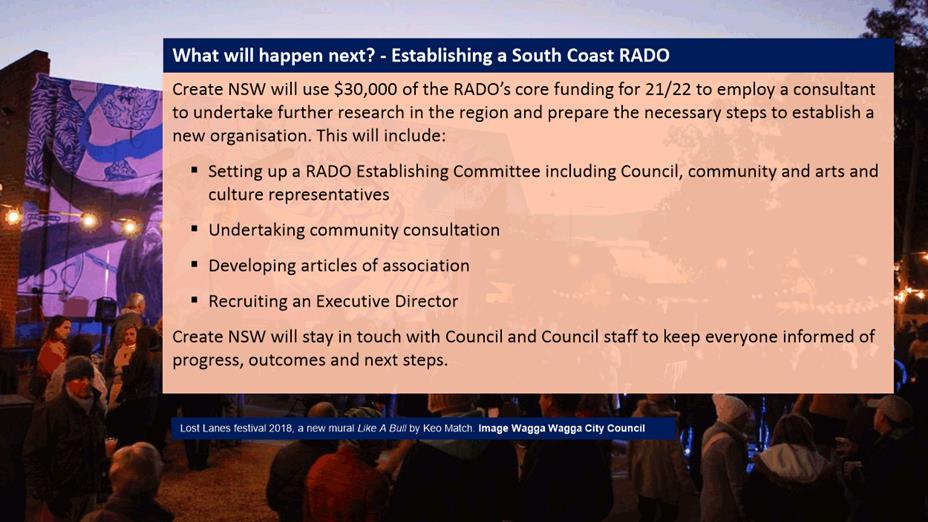

|
|
Ordinary
Meeting – Tuesday 03 August 2021
Page
0
|
CL21.173 Tenders
- Sewage Pumping Station Upgrades Project, St Anns Street (SPS3) & Lyrebird
Park (SPS2)
HPERM Ref: D21/218330
Department: Water
Asset Planning & Development
Approver: Robert
Horner, Executive Manager Shoalhaven Water
Reason for Report
To inform Council of the tender
process for the Sewage Pumping Station (SPS) Upgrades Project, comprising St
Anns Street, Nowra (SPS3) & Lyrebird Park (SPS 2) pumping stations.
In accordance with Section
10A(2)(d)(i) of the Local Government Act 1993, some information should remain
confidential as it would, if disclosed, prejudice the commercial position of
the person who supplied it. It is not in the public interest to disclose this
information as it may reveal commercial-in-confidence provisions of a contract,
diminish the competitive commercial value of any information to any person
and/or prejudice any person’s legitimate business, commercial,
professional or financial interests. This information will be considered under
a separate confidential report.
This report is submitted
directly to the Ordinary Council Meeting pursuant to Clause 3 of
Council’s “Acceptance of Tenders – Reports to Council”
Policy; as the project is considered a priority and the validity period of the
tenders would lapse should the project be required to await the next Strategy
and Assets Committee meeting.
|
Recommendation
That Council consider a
separate Confidential Report in accordance with Section 10A(2)(d)(i) of the
Local Government Act 1993.
|
Options
1. Accept the recommendation to consider
a separate report in Confidential Session.
Implications: This is recommended as the project is
considered a high priority and a detailed tender assessment has been
undertaken.
2. Council could choose not to accept the
recommendation and select a different approach, giving reasons.
Implications: This is not recommended
as an extensive tender evaluation process has been undertaken, comprising price
and non-price criteria in accordance with the Tender Evaluation Plan.
Details
Shoalhaven
Water owns and operates 224 sewage pumping stations (SPSs) throughout its 13
sewerage schemes. As part the asset renewal and upgrade program, it is proposed
to increase the capacity of two of the largest and most critical SPSs within
the Nowra Scheme, SPS 2 at Lyrebird Park and SPS 3 in St Anns Street. The
replacement and upgrade work is part of a larger program which includes the
replacement and upsizing of the rising mains that transport the sewage from
these SPSs to Nowra Wastewater Treatment Plant (WwTP).
The two SPSs are ageing, having been originally constructed in
the 1950s (SPS 2) and 1960s (SPS 3). Both assets are reaching the end of their
useful lives and require replacement to reduce the overall risk of failure (and
overflow) and to cater for future development west of Nowra, e.g. Mundamia.
SPS 2 is located between sporting fields in Lyrebird Park,
Nowra. The existing SPS consists of a wet well with an approximate internal
diameter of 6.9 metres, surrounding a dry well of approximately 2.7 metres
internal diameter. During periods of heavy rainfall, the volumes of transported
sewage in the catchment network can greatly increase, causing increased demand
on the Lyrebird Park SPS and increasing risk of failure (and overflow).
Shoalhaven Water proposes to upgrade the Lyrebird Park pumping station to
improve the performance and reliability of the infrastructure.
SPS 3 is a major sewerage pumping station which serves a large
existing catchment of approximately 1,650 residential dwellings. It is the main
collector station for several upstream pumping station catchments in the south
and south-western areas of Nowra. SPS 3 is a conventional wet well sewage
pumping station that pumps sewage to the Nowra STP via a 400mm diameter HDPE
rising main (recently upgraded from 300mm asbestos cement).
Similar to Lyrebird Park SPS, this pumping station also
experiences significant increases in sewage flows during heavy rain events and
can lead to overflows to the adjacent Nowra Creek.
A large emergency storage tank was constructed at SPS 3 in
2014, to reduce the frequency and volume of overflow events. Whilst the tank
has assisted in alleviating some operational pressures the risk of failure
remains high due to the assets within the pump station reaching the end of
their useful life, e.g. pump capacity.
Upgrade of the St Anns Street pumping station is also required
due to the growth and demand in the West Nowra area for development areas such
as Mundamia and Cabbage Tree Lane URAs.
Completion of this project will result in major improvements
to Shoalhaven Water’s sewerage system and will provide improved
environmental outcomes and reduced operation and maintenance costs within these
critical areas.
A Tender Evaluation Plan (TEP) consistent with the Conditions
of Tendering was prepared by the Tender Evaluation Committee (TEC) prior to
evaluation of tenders.
All TEC members were to disclose any current associations with
any of the tenderers or their companies, or any other circumstances that could
lead to a conflict of interest. No conflicts of interest were recorded.
Tenders were invited from the public (Open Tender) via
Tenderlink on 11 May 2021. Prospective tenderers were invited to attend a
non-mandatory pre-tender briefing and site visits on 18 May 2021.
Tenders closed at 10am on 8 June 2021 with a total of 2
tenders received by the deadline. No tenders were received after the deadline.
Council is requested to consider the tender evaluation in the
separate Confidential Report.
Tenders
Received
Tenders were received from the
following:
|
Tenderer
|
Location
|
|
Hisway Pty Ltd
|
13a Investigator Street, Nowra NSW 2541
|
|
Quay Civil Pty Ltd
|
Suite 3.12, 32 Delhi Road North Ryde, NSW 2113
|
Details relating the evaluation of the tenders are contained
in the Confidential Report.
Community Engagement
A Review
of Environmental Factors (REF) was originally prepared for the combined project
in 2015 by consultant GHD Pty Ltd, and shortly after the project was placed on
hold due to resourcing limitations and the need for the REMS 1B project to be
complete to enable additional flow to the Nowra STP.
With the completion of the REMS
1B, Shoalhaven Water is now able to progress this project and in 2020 engaged
EMAP Consulting Pty Ltd to prepare a revised REF (determined by Council 23 June
2020 under MIN20.451) to re-assess the environmental impacts on the proposed
activity, accounting for any legislative changes since the original project REF
was prepared in 2015.
Additional community and
stakeholder engagement prior to and during the construction is proposed, with a
dedicated project webpage to be established under Council’s ‘Major
Projects & Works’ portal.
Policy Implications
Procurement Policy – POL18/74
– The tender for this project has been undertaken in accordance with
Council’s Purchasing Policy. The recommendation for this report is
consistent with the provision of Council’s Purchasing Policy.
Financial Implications:
Adequate
funds have been allocated in the sewer budget to complete the construction of
the upgrade works in 2021/22.
|
|
Ordinary
Meeting – Tuesday 03 August 2021
Page
0
|
Local Government Amendment (governance &
planning) act 2016
Chapter
3, Section 8A Guiding principles for councils
(1)
Exercise of functions
generally
The
following general principles apply to the exercise of functions by councils:
(a) Councils should provide strong
and effective representation, leadership, planning and decision-making.
(b) Councils should carry out
functions in a way that provides the best possible value for residents and
ratepayers.
(c) Councils should plan
strategically, using the integrated planning and reporting framework, for the
provision of effective and efficient services and regulation to meet the
diverse needs of the local community.
(d) Councils should apply the
integrated planning and reporting framework in carrying out their functions so
as to achieve desired outcomes and continuous improvements.
(e) Councils should work
co-operatively with other councils and the State government to achieve desired
outcomes for the local community.
(f) Councils should manage
lands and other assets so that current and future local community needs can be
met in an affordable way.
(g) Councils should work with
others to secure appropriate services for local community needs.
(h) Councils should act fairly,
ethically and without bias in the interests of the local community.
(i) Councils should be
responsible employers and provide a consultative and supportive working
environment for staff.
(2) Decision-making
The
following principles apply to decision-making by councils (subject to any other
applicable law):
(a) Councils should recognise
diverse local community needs and interests.
(b) Councils should consider social
justice principles.
(c) Councils should consider the
long term and cumulative effects of actions on future generations.
(d) Councils should consider the
principles of ecologically sustainable development.
(e) Council decision-making should
be transparent and decision-makers are to be accountable for decisions and
omissions.
(3) Community participation
Councils
should actively engage with their local communities, through the use of the
integrated planning and reporting framework and other measures.
Chapter
3, Section 8B Principles of sound financial management
The
following principles of sound financial management apply to councils:
(a) Council spending should be responsible and
sustainable, aligning general revenue and expenses.
(b) Councils should invest in responsible and
sustainable infrastructure for the benefit of the local community.
(c) Councils should have effective financial
and asset management, including sound policies and processes for the following:
(i) performance management
and reporting,
(ii) asset maintenance and
enhancement,
(iii) funding decisions,
(iv) risk management practices.
(d) Councils should have regard to achieving
intergenerational equity, including ensuring the following:
(i) policy decisions are made
after considering their financial effects on future generations,
(ii) the
current generation funds the cost of its services
Chapter
3, 8C Integrated planning and reporting principles that apply to councils
The
following principles for strategic planning apply to the development of the
integrated planning and reporting framework by councils:
(a) Councils should identify and prioritise key
local community needs and aspirations and consider regional priorities.
(b) Councils should identify strategic goals to
meet those needs and aspirations.
(c) Councils should develop activities, and
prioritise actions, to work towards the strategic goals.
(d) Councils should ensure that the strategic
goals and activities to work towards them may be achieved within council
resources.
(e) Councils should regularly review and
evaluate progress towards achieving strategic goals.
(f) Councils should maintain an
integrated approach to planning, delivering, monitoring and reporting on
strategic goals.
(g) Councils should collaborate with others to
maximise achievement of strategic goals.
(h) Councils should manage risks to the local
community or area or to the council effectively and proactively.
(i) Councils should make appropriate
evidence-based adaptations to meet changing needs and circumstances.