Shoalhaven Traffic Committee
Meeting Date: Tuesday,
08 December, 2020
Location: Email
Meeting
Please note: Council’s Code of Meeting Practice
permits the electronic recording and broadcast of the proceedings of meetings
of the Council which are open to the public. Your attendance at this meeting is
taken as consent to the possibility that your image and/or voice may be
recorded and broadcast to the public.
Agenda
1. Apologies
2. Confirmation of Minutes
· Shoalhaven
Traffic Committee - 10 November 2020................................................... 1
3. Business Arising from Previous Minutes
4. Reports of the Convenor
TC20.51...... Recommendations from Previous Meeting.................................................... 5
TC20.52...... Proposed Roundabout - Bannister Head Road and
Tallwood Avenue - Mollymook Beach (PN 3620)............................................................................................ 6
TC20.53...... Proposed Parking Restrictions - Woollamia Boat
Ramp Carpark - Frank Lewis Way - Woollamia (PN 3625)..................................................................................... 9
TC20.54...... Proposed Carpark Upgrade - Ray Brooks Reserve -
Palm Beach - Sanctuary Point (PN 3623)..................................................................................................... 12
TC20.55...... Proposed Carpark Upgrade - Warrain Carpark -
Warrain Crescent - Currarong (PN 3624)............................................................................................................. 18
TC20.56...... Signage and Linemarking Plan - Lot 2 DP 1111478 -
13 Prince Alfred St - Berry (PN 3621)............................................................................................................. 21
TC20.57...... Signage and Linemarking Plan - Lot 2 DP 777260 -
315 Princes Highway - Bomaderry (PN 3622)................................................................................... 24
TC20.58...... Signage and Linemarking Plan - 81 The Wool Road -
Worrowing Heights - Proposed Tourist Facilities (PN 3614).......................................................................... 27
5. General Business
Note: The next meeting will be
held on Tuesday 2 February 2021.
|

|
Shoalhaven
Traffic Committee – Tuesday 08 December 2020
Page
|
Membership
Mr Micaiah Tipton – Convenor
Ms Kelly Cherry
Sergeant Nick Richardson
Ms Shelley Hancock MP (or representative)
Mr Stuart Coughlan
Clr Jo Gash
Clr Patricia White
The Shoalhaven Traffic Committee is a technical review
committee, not a committee of Council under the Local Government Act 1993. The
Roads and Maritime Services (RMS) has delegated certain powers to Council under
the Transport Administration Act 1988 (Section 50). A condition of this delegation
is that Council must take into account the Traffic Committee recommendations.
There are four formal members of the Traffic Committee, each
of whom has a single vote only. The members are representatives from:
- NSW Police Force
- RMS
- Shoalhaven City Council
- Local State Member of Parliament (for the location of the
issue to be voted upon)
If the RMS or NSW Police Force disagrees with any Traffic
Committee recommendation, or Council’s resolution (on any Traffic
Committee recommendation), they may lodge an appeal with the Regional Traffic
Committee for determination. The appeal must be lodged in writing within
14 days of the date of notification in writing. Any action relative to
any issue under appeal must cease until the matter is determined. The
Regional Traffic Committee is chaired by an independent chairperson and
submissions and representations are welcomed from all interested parties.
Council cannot amend a Traffic Committee recommendation. The
Council can only: adopt the Traffic Committee recommendation; not adopt the
Traffic Committee recommendation, or request the Traffic Committee reconsider
the issue.
The full guide to the delegation to Council’s for
the regulation of traffic can be viewed at RMS
Website
Minutes of the Shoalhaven Traffic Committee
Meeting Date: Tuesday,
10 November 2020
Location: E-Meeting
The
following members participated:
Micaiah Tipton - Convenor
Stuart Coughlan -
representing The Hon Gareth Ward MP
Kelly Cherry - Transport for NSW
Shelley Hancock - MP
Sgt Ian McManus - New South Wales Police Force
|
Apologies / Leave of Absence
|
Nil
|
Confirmation of the Minutes
|
|
RESOLVED (By consent)
That the Minutes of the
Shoalhaven Traffic Committee held on Tuesday 13 October 2020 be confirmed.
CARRIED
|
|
Business Arising from Previous Minutes
|
Nil
Reports of the Convenor
|
TC20.42 Recommendations from Previous
Meeting
|
HPERM Ref: D20/479104
|
|
Recommendation (Item to be determined under
delegated authority)
That the report regarding the
recommendations from the previous meeting be received for information.
|
|
RESOLVED (By consent)
That the report regarding the
recommendations from the previous meeting be received for information.
CARRIED
|
|
TC20.43 Major Event Road Closures -
L'Etape Australia - 20 March 2021 (PN 3597)
|
HPERM Ref: D20/473212
|
|
Mr Coughlan expressed support for
the traffic management measures, but not the proposed road closures.
Sgt McManus noted the the
expected time required for the ride to pass the intersection at Bomaderry and
recommended there be staggered crossing times controlled by accredited
traffic marshals.
|
|
Recommendation
That the Chief Executive Officer (Director City Services)
be advised that the Shoalhaven Traffic Committee has no objection to the
proposed road closures and traffic management measures proposed for the
L'Etape Australia major cycling event, proposed to be held on 20 March 2021
(or at a later date subject to COVID-19 related public health orders) (per
the attached plans).
|
|
RECOMMENDATION
(By consent)
That the Chief Executive
Officer (Director City Services) be advised that the Shoalhaven Traffic
Committee has no objection to the proposed road closures and traffic
management measures proposed for the L'Etape Australia major cycling event,
proposed to be held on 20 March 2021 (or at a later date subject to COVID-19
related public health orders) (per the attached plans).
CARRIED
|
|
TC20.44 Proposed Roundabout - Larmer
Avenue - The Park Drive (North) - Sanctuary Point (PN 3609)
|
HPERM Ref: D20/435990
|
|
Recommendation
That the Chief Executive Officer (Director City Services)
be advised that the Shoalhaven Traffic Committee has no objection to the
proposed roundabout and associated signage and linemarking on Larmer Avenue
and The Park Drive (North) Sanctuary Point, as per Plan No: D20/474004.
|
|
RECOMMENDATION
(By consent)
That the Chief Executive Officer (Director City Services)
be advised that the Shoalhaven Traffic Committee has no objection to the
proposed roundabout and associated signage and linemarking on Larmer Avenue
and The Park Drive (North) Sanctuary Point, as per Plan No: D20/474004.
CARRIED
|
|
TC20.45 Proposed Parking Restrictions -
O'Keefe Avenue - Nowra (PN 3615)
|
HPERM Ref: D20/473232
|
|
Recommendation
That the Chief Executive Officer (Director City Services)
be advised that the Shoalhaven Traffic Committee has no objection to the
proposed parking restrictions on O'Keefe Avenue, Nowra as per Plan No:
D20/473582.
|
|
RECOMMENDATION
(By consent)
That the Chief Executive Officer (Director City Services)
be advised that the Shoalhaven Traffic Committee has no objection to the
proposed parking restrictions on O'Keefe Avenue, Nowra as per Plan No:
D20/473582.
CARRIED
|
|
TC20.46 Proposed Parking Restrictions -
Silver Strand Circuit - Hyams Beach (PN 3619)
|
HPERM Ref: D20/473294
|
|
Recommendation
That the Chief Executive Officer (Director City Services)
be advised that the Shoalhaven Traffic Committee has no objection to the
proposed parking restrictions on Silver Strand Circuit and adjoining sections
of Cyrus Streets and Lister Circuit, as per Plan No: D20/473578.
|
|
RECOMMENDATION
(By consent)
That the Chief Executive Officer (Director City Services)
be advised that the Shoalhaven Traffic Committee has no objection to the
proposed parking restrictions on Silver Strand Circuit and adjoining sections
of Cyrus Streets and Lister Circuit, as per Plan No: D20/473578.
CARRIED
|
|
TC20.47 Signage and Linemarking Plan -
Boongaree Park Carpark - North Street Berry (PN 3552)
|
HPERM Ref: D20/473209
|
|
Mr Stuart Coughlan
raised concerns regarding this project.
|
|
Recommendation
That the Chief Executive Officer (Director City Services)
be advised that the Shoalhaven Traffic Committee has no objection to the
proposed signage and line marking associated with the Boongaree Park Carpark,
as per Plan No: D20/473599.
|
|
RECOMMENDATION
(By consent)
That the Chief Executive Officer (Director City Services)
be advised that the Shoalhaven Traffic Committee has majority support for the
proposed signage and line marking associated with the Boongaree Park Carpark,
as per Plan No: D20/473599.
CARRIED
|
|
TC20.48 Signage and Linemarking Plan -
Lot 22 DP 1113929 - 79 Albatross Road West Nowra (PN 3616)
|
HPERM Ref: D20/473236
|
|
Ms Cherry (Transport for NSW) indicated that a shared
zone is not enforceable on a private road. Furthermore, additional warning
pedestrian signage should be considered to slow speeds or consideration of
traffic calming devices.
|
|
Recommendation
That the Chief Executive Officer (Director City Services)
be advised that the Shoalhaven Traffic Committee has no objection to the
proposed signage and line marking associated with the development at 79
Albatross Road, West Nowra (per development consent condition 35), as per
Plan No: D20/473568.
|
|
RECOMMENDATION
(By consent)
That the Chief Executive Officer (Director City Services)
be advised that the Shoalhaven Traffic Committee has no objection to the
proposed signage and line marking associated with the development at 79
Albatross Road, West Nowra (per development consent condition 35), as per
Plan No: D20/473568, subject to the following:
1. Removal of the shared zone signage
from proposed plans as this is not enforceable within a private road
2. Installation of additonal
pedestrian warning signage to reinforce the pedestrian nature of this area
and promote slower speeds
3. Consideraiton be given to the
installation of traffic calming devices to promote slower speeds.
CARRIED
|
|
TC20.49 Signage and Linemarking Plan -
Lot 1 DP 949932 - Taylors Lane Cambewarra - Residential Subdivision (PN
3617)
|
HPERM Ref: D20/473251
|
|
Recommendation
That the Chief Executive Officer (Director City Services)
be advised that the Shoalhaven Traffic Committee has no objection to the
proposed signage, line marking and local area traffic management devices
associated with the development at Lot 1 DP 949932, Taylors Lane Cambewarra
(per development consent condition 35), as per Plan No: D20/473552.
|
|
RECOMMENDATION
(By consent)
That the Chief Executive Officer (Director City Services)
be advised that the Shoalhaven Traffic Committee has no objection to the
proposed signage, line marking and local area traffic management devices
associated with the development at Lot 1 DP 949932, Taylors Lane Cambewarra
(per development consent condition 35), as per Plan No: D20/473552.
CARRIED
|
|
TC20.50 Signage and Linemarking Plan -
Lot 35 DP 262647 - Corks Lane Milton - Residential Subdivision (PN 3618)
|
HPERM Ref: D20/473270
|
|
Recommendation
That the Chief Executive Officer (Director City Services)
be advised that the Shoalhaven Traffic Committee has no objection to the
proposed signage and line marking associated with the development at Lot 35
DP 262647 - Corks Lane Milton (per development consent condition 43), as per
Plan No: D20/473587.
|
|
RECOMMENDATION
(By consent)
That the Chief Executive Officer (Director City Services)
be advised that the Shoalhaven Traffic Committee has no objection to the
proposed signage and line marking associated with the development at Lot 35
DP 262647 - Corks Lane Milton (per development consent condition 43), as per
Plan No: D20/473587.
CARRIED
|
There being no further
business, the meeting concluded.
Micaiah Tipton
CHAIRPERSON
|

|
Shoalhaven
Traffic Committee – Tuesday 08 December 2020
Page
0
|
TC20.51 Recommendations
from Previous Meeting
HPERM Ref: D20/535698
Convenor: Micaiah
Tipton
|
Recommendation (Item to be determined under delegated authority)
That
the report regarding the recommendations from the previous meeting be
received for information.
|
Details
The minutes of the Shoalhaven
Traffic Committee meeting held on 10 November 2020 are included in the agenda.
The recommendations contained
therein were submitted to Council at its meeting held on 24 November 2020. All
recommendations were adopted.
|
|
Shoalhaven
Traffic Committee – Tuesday 08 December 2020
Page
0
|
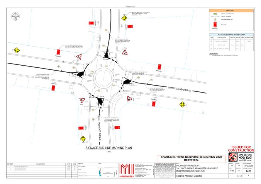
TC20.52 Proposed
Roundabout - Bannister Head Road and Tallwood Avenue - Mollymook Beach (PN
3620)
HPERM Ref: D20/525017
Convenor: Micaiah
Tipton
Attachments: 1. PN
3620 - Plan ⇩
|
Recommendation
That the Chief Executive Officer
(Director City Services) be advised that the Shoalhaven Traffic Committee has
no objection to the proposed roundabout and associated signage and
linemarking on Tallwood Avenue and Bannister Head Road, Mollymook Beach, as per
Plan No: D20/525024.
|
Background
Council has been approved for a
Safer Roads project to design and install a single lane roundabout at the
intersection of Tallwood Ave and Bannister Head Rd, Mollymook Beach. This
includes all traffic calming, line marking, lighting, and signage. The referral
to Traffic Committee is seeking approval for the proposed roundabout and
associated signage and linemarking.
Whilst this location has no
recorded crash history, the project was nominated as a proactive proposal
following the completion of a formal road safety audit that had identified
critical road safety issues at this intersection and supported the improvements
proposed.
Also of note, Stage 1 of the
Hazcorp subdivision at Narrawallee also had a requirement to pay a contribution
towards the proposed roundabout indicated here. Whilst fees had been paid to
Council in 2018, the overall renumeration was inadequate to complete the
project, and since this time, Council has been seeking grant funding opportunities
to fund the balance of the project and address the safety concerns at the
location.
From Council investigations and
the conducted Road Safety Audit, other traffic calming measures had been
considered. However, alternatives to a roundabout will not address the traffic
conflicts and sight distance constraints at the intersection. This is further
supported by AUSTROADS (best practice traffic management and road design
guidelines) that recognise roundabouts as the preferred method of traffic
calming.
Whilst the intersection is
located within a residential area, and Council has received concerns about
perceived adverse impacts associated with such a speed control device, this has
been taken into consideration in the overall development of this proposal.
Details of Submission:
The extent of this approval is to install a single lane
roundabout including all traffic calming, line marking, lighting, signage, and
pedestrian improvements, at the intersection of Bannister Head Road and
Tallwood Avenue, Mollymook, improving safety for motorists and pedestrians
alike.
Consultation
Council had commenced initial
consultation with the community and the Ulladulla Districts Community Forum
(UDCF) in November 2019.
During this initial
consultation, four objections were received by Council, as follows.
·
Objection from one of the property owners on the corner,
outlining that the roundabout was a disproportionate solution, as they had
claimed that since 1980, they have only seen 2 minor accidents with no injuries
at the intersection (one of which they were involved in).
·
An objection from two Mollymook residents, suggesting there were
other higher priorities in the area (for example a roundabout at the
Highway/Pitman Avenue intersection)
·
An objection from the UDCF (noted as being narrowly passed),
suggesting there were other higher priorities in the area, and instead wanting
other traffic calming options considered at the location
From this feedback it was noted
that if the funds were to be approved, it would be for the specific roundabout
at the intersection of Bannister Head Road and Tallwood Avenue, Mollymook, and
not transferrable to other project locations.
Following from the imminent
grant funding approval, Council sought support from the UDCF for this proposal
in August 2020. However, due to COVID-19 impacts, regular convenings of the
Forum had been temporarily suspended. It was encouraged that members of the
UDCF provide feedback on this proposal individually. From this period, Council
received 6 submissions, 2 in favour and 4 against the proposal. Upon
recommencement of regular UDCF meetings, this proposal was voted on again by
members. At this stage, the UDCF voted in favour of this project (3 in favour,
2 against).
Following this stage, Council
recommenced consultation on 26 October 2020 with a detailed design proposal.
Following this consultation period, Council received 15 submissions, 5 in
favour and 10 against the proposal. Most submissions opposed to this proposal
believed that:
·
the roundabout was unnecessary at this location;
·
there had been no recorded crashes; and
·
it could create potential traffic delays, resulting in an
increased travel time.
These comments were similar to those raised in the initial
consultation period and did not address the outlying safety concerns at this
intersection as raised by Council staff, road safety auditors and Transport for
NSW.
Risk Implications
This proposal will reduce risk to road users and assist in
improving road safety at this intersection. Council has considered the points
raised by the community regarding the perceived inconveniences presented by
this proposal. No further risks are associated with this proposal.
Financial Implications
This proposal will be funded by the Safer Roads Grant
Funding provided to Council by the NSW Government.
|
|
Shoalhaven
Traffic Committee – Tuesday 08 December 2020
Page
0
|
|

|
Shoalhaven
Traffic Committee – Tuesday 08 December 2020
Page
0
|
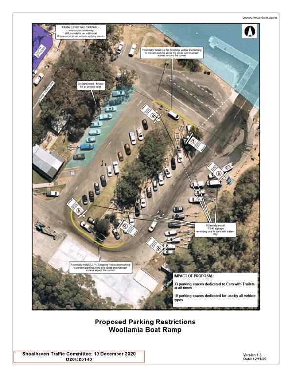
TC20.53 Proposed
Parking Restrictions - Woollamia Boat Ramp Carpark - Frank Lewis Way -
Woollamia (PN 3625)
HPERM Ref: D20/525161
Convenor: Micaiah
Tipton
Attachments: 1. PN
3625 - Plan ⇩
|
Recommendation
That the Chief Executive Officer
(Director City Services) be advised that the Shoalhaven Traffic Committee has
no objection to the parking restrictions at the Woollamia Boat Ramp Carpark,
per Plan No: D20/525167.
|
BackgroundShoalhaven City
Council has been requested to review the provision of parking restrictions to
the Woollamia Boat Ramp Carpark.
As the committee may recall, the
Woollamia Boat Ramp has been previously brought before the committee for the
assessment of the internal linemarking for the untying area in August 2020
(TC20.33). The masterplan for the Woollamia Boat Ramp was adopted in February
2020 (D20/69412).
The submission presented before the committee is for the
internal parking restrictions for the Woollamia Boat Ramp Carpark.
Details of Submission
The extent of this proposal
would be the installation of parking restrictions, on 33 of the 39 allocated
spaces. These controls include “No Parking” signage with the
condition of “Vehicles with Trailers Excepted”. The impact of this
will dedicate 33 spaces for the exclusive use by vehicles with boat trailers,
which will assist in reducing congestion and maximise efficiency for the boat
ramp’s use by vehicles with trailer combinations. The remaining 10
vehicles spaces on the western side of the carpark have been proposed to remain
unsignposted, in order to allow for mixed use to all types of vehicles and
combinations. This is viewed to be a low risk proposal due to the Frank Lewis
Way carpark providing for an additional 26 parking spaces for single vehicles, which
when viewed alongside the 10 unsignposted spaces within the carpark, provides
for an adequate provision of parking for vehicles without trailers.
Additionally, C3 “No Stopping” yellow
linemarking has been proposed around the corners of the central parking aisle
to restrict vehicles from parking within this length and thereby creating
congestion within the carpark.
Consultation
As previously raised with the
committee, initial consultation had been undertaken with the community through
the Woollamia Boat Launching Ramp Masterplan (SA20.17) and several meetings
held with relevant stakeholders on 4, 11 and 14 February 2020. This extensive
consultation resulted in 140 submissions received, wherein feedback had been
taken onboard in the adoption of the masterplan later that month.
For the current proposal,
Council has recently consulted with affected stakeholders and the Huskisson
Woollamia Community Voice. To date, Council has received 9 submissions, 8 in
favour of the proposal and 1 opposed. The submission that was opposed to the
proposal raised the following concerns:
· The
proposed signage catered towards a specific classification of vehicle
combination and did not allow for large vehicles not suited for the single
carparking spaces located at the boat ramp or in the Frank Lewis Way carpark;
· The
signage did not reflect the seasonal nature of the boat ramp, where many of the
spaces are not used to capacity at all hours of the day.
Of the submissions received, the Huskisson Woollamia
Community Voice has supported the proposal in principle. However, the
organisation has acknowledged, similar to the points raised above, that other
potential vehicle types and users have not been accounted for, with the current
proposal aiming to provide specifically for vehicles with boat trailers. It has
been requested that Council monitor the situation and investigate alternative
signage arrangements, should the need arise in the future.
Risk Implications
This proposal will assist in improving traffic flow and
reducing congestion within the carpark and boat ramp access. As raised above,
there will be adequate parking allocated for both single vehicles and vehicles
with trailers when viewed alongside the Frank Lewis Way carpark. As such, the
impact to parking is deemed to be minimal.
Financial Implications
The linemarking and signage for this proposal will be costed
out of Transport for NSW’s Block Grant Funding allocated to Council for
new signage and linemarking.
|

|
Shoalhaven
Traffic Committee – Tuesday 08 December 2020
Page
0
|
|
|
Shoalhaven
Traffic Committee – Tuesday 08 December 2020
Page
0
|
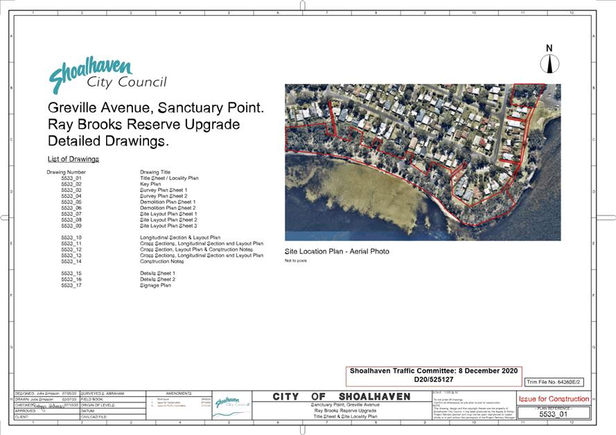
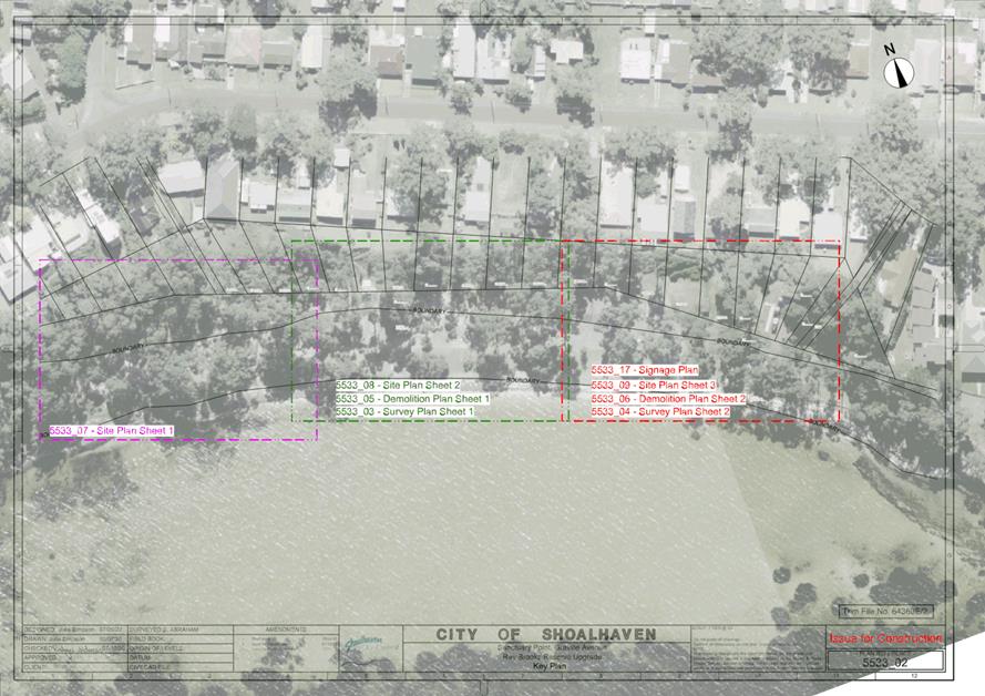
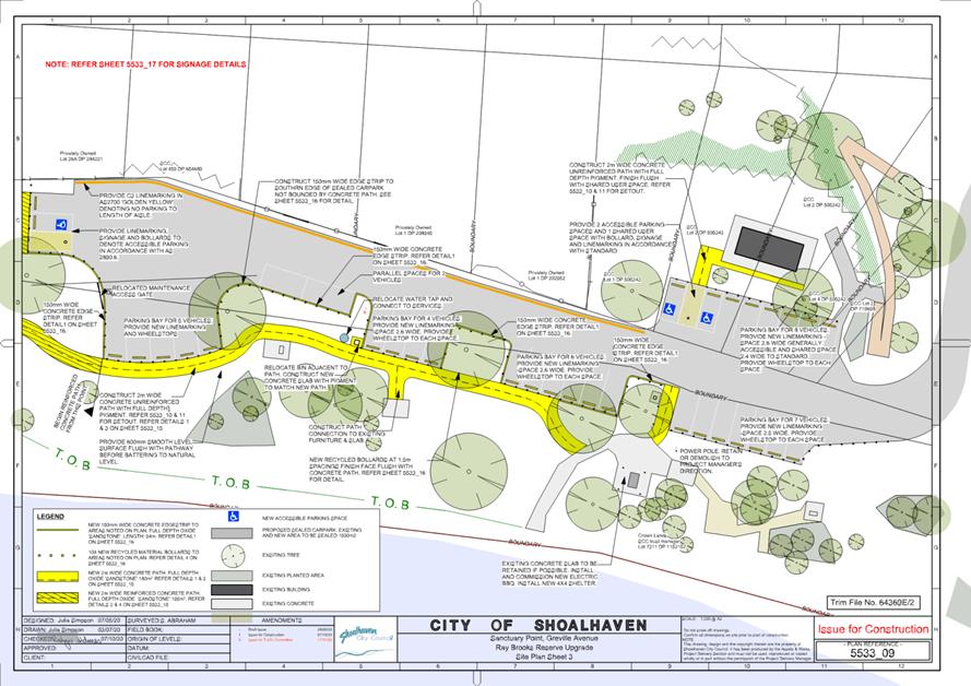
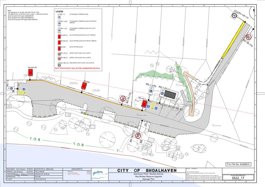
TC20.54 Proposed
Carpark Upgrade - Ray Brooks Reserve - Palm Beach - Sanctuary Point (PN 3623)
HPERM Ref: D20/525119
Convenor: Micaiah
Tipton
Attachments: 1. PN
3623 - Plan ⇩
|
Recommendation
That the Chief Executive Officer
(Director City Services) be advised that the Shoalhaven Traffic Committee has
no objection to the proposed signage and linemarking at the Ray Brooks
Reserve on Palm Beach, Sanctuary Point, as per Plan No: D20/525127.
|
Background
Council has been preparing a
proposed upgrade to the existing carpark at the Ray Brooks Reserve, Palm Beach.
This project has been supported as part of the Sustainable Tourism Projects,
funded via the Restart NSW Infrastructure Grant and Shoalhaven City Council.
The project has a strong focus on accessibility, with 2m wide paths and
accessible BBQs being installed as part of the project.
Path construction at Ray Brooks
Reserve commenced in October. The plan included the construction of concrete
accessible pathways, BBQs, picnic shelters and an asphalt overlay of the
existing carpark with minor changes to allow for the three additional
spaces. Construction work on the carpark commenced on 16 November;
however, line-marking and signage are subject to the Traffic Committee’s
approval.
A regulatory signage and line-marking plan has been
submitted for the Committee's consideration.
Details of Submission
The extent of this proposal is for the carpark's
reconfiguration, which includes 3 accessible spaces, C3 line marking and a
suggested speed limit of 10km/hour.
Consultation
Consultation for the Sustainable
Tourism Projects including the D3 Palm Beach project was undertaken via
Council’s Get Involved Page and a survey. Consultation was not sought
specifically on the carpark design or signage. However, feedback indicated that
residents felt the parking was inadequate. Concern was expressed from two
neighbouring residents about vehicles entering the driveway at high speed due
to a lack of speed limit signage. The objections received, and how the proposed
plan has incorporated this feedback are as follows:
· Insufficient
parking spaces. The proposed carpark design provides for an additional three
spaces. Whilst this is a minor increase, the scope was limited by not wanting
to encroach too heavily onto the green space. It is to be noted that there is
also street parking available along Greville Avenue.
· Two
neighbouring residents expressed concern about vehicles entering the access
driveway at high speed. The proposed carpark design therefore suggested that
speed limit signs be installed. This would help slow traffic as vehicles
approach the narrow bend at the entrance of the reserve.
· A
complaint was received from a resident whose property and backyard directly adjoins
the reserve, indicating that vehicles had previously reversed into their fence.
The suggested C3 line marking and the change to parallel parking indicated in
the proposed carpark has been designed to address this and to reduce traffic
congestion in this area.
Alongside the feedback received by Council, the Bay &
Basin Forum was consulted. The Project Manager presented an update on the
seven Sustainable Tourism Projects to the CCB on 19 October 2020. The last
meeting for the year of Bay & Basin CCB was conducted on 16 November 2020
and the Committee voted in favour of the proposed carpark design and the
installation of speed limit signage at Ray Brooks Reserve.
Risk Implications
This proposal will assist in improving traffic flow and
reducing congestion along this narrow entrance road. The entrance is narrow and
steep with quite a sharp rise when exiting making oncoming traffic difficult to
see. The proposed speed signs would assist with slowing traffic, allowing
drivers more time to navigate the entrance.
Financial Implications
The line-marking and signage for this proposal will be
funded from the Restart NSW Infrastructure Grant and Shoalhaven City
Council’s contribution to this project.
|
|
Shoalhaven
Traffic Committee – Tuesday 08 December 2020
Page
0
|
|

|
Shoalhaven
Traffic Committee – Tuesday 08 December 2020
Page
0
|
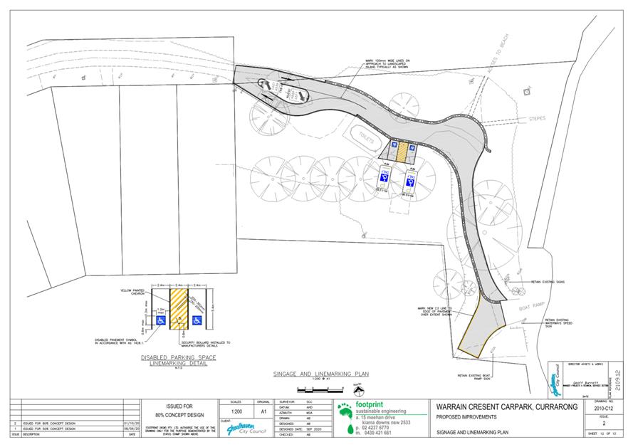
TC20.55 Proposed
Carpark Upgrade - Warrain Carpark - Warrain Crescent - Currarong (PN 3624)
HPERM Ref: D20/525140
Convenor: Micaiah
Tipton
Attachments: 1. PN
3624 - Plan ⇩
|
Recommendation
That the Chief Executive Officer
(Director City Services) be advised that the Shoalhaven Traffic Committee has
no objection to the proposed signage and linemarking at the Warrain Carpark
on Warrain Crescent, Currarong as per Plan No: D20/525143.
|
Details
Background
Council is proposing an upgrade
to the existing carpark along Warrain Crescent, Currarong.
A regulatory signage and linemarking plan has been submitted
for the Committee's consideration.
Details of Submission
The extent of this proposal is for the carpark to be
formalised and reconfigured to permit a separated entry and exit point, with
parking restrictions in the turning head of the boat ramp to ensure
manoeuvrability. In addition to this, two accessible parking spaces have been
proposed to be located adjacent to the amenities.
Consultation
Consultation was sought from the Currarong Community
Association Inc. in June 2020. Whilst the proposal was accepted in regard to
the carpark layout, there had been a request for modifications to the
accessible spaces. However, this would not be compliant with Australian
Standards and could not be accommodated.
Risk Implications
This proposal will assist in improving traffic flow and
reducing congestion within the carpark and boat ramp access. No further risks
are associated with this proposal.
Financial Implications
The linemarking and signage for this proposal will be costed
out of Council's Local Road Repair Program 2020/2021 budget.
|

|
Shoalhaven
Traffic Committee – Tuesday 08 December 2020
Page
0
|
|

|
Shoalhaven
Traffic Committee – Tuesday 08 December 2020
Page
0
|
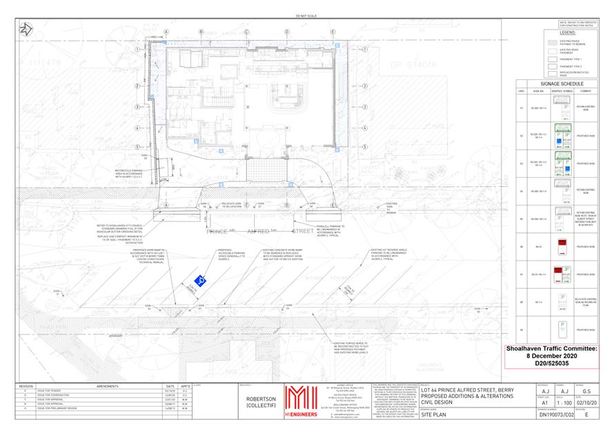
TC20.56 Signage
and Linemarking Plan - Lot 2 DP 1111478 - 13 Prince Alfred St - Berry (PN 3621)
HPERM Ref: D20/525033
Convenor: Micaiah
Tipton
Attachments: 1. PN
3621 - Plan ⇩
|
Recommendation
That the Chief Executive
Officer (Director City Services) be advised that the Shoalhaven Traffic
Committee has no objection to the proposed signage and line marking
associated with the development at 13 Prince Alfred St, Berry (per
development consent condition 19), as per Plan No: D20/525035; subject to the
following:
1. Provision
of plans that indicate linemarking of all Angled Parking along the eastern
side of Prince Alfred Street further north of the project site (per condition
19 (a))
|
Details
Applicant: MI Engineers
Owner: SET Consultants Pty Ltd
Lot 2 DP 1111478 - 13 Prince Alfred St - Berry - Alterations
and additions to an existing function centre, and use as a small bar,
restaurant, and function centre
As per Condition 19 of the development consent, the
following is required:
19. Details of works within Prince Alfred Street
Prior to the issue of a Construction Certificate by
the Principal Certifier or commencement of work within the road reserve, the
following details and plans are to be provided to Council for approval:
a) All angled parking on the
eastern side of Prince Alfred Street is to be line marked and signposted in
accordance with AS2890.5
b) A minimum of one (1)
accessible parking space is to be provided on the eastern side of Prince Alfred
Street as close as practicable to the facilities block in accordance with
AS2890.6
c) A Private use of Public
Parking application must be completed separate to the S138 application for the
use of on street parking spaces. Should the applicant require on-street parking
spaces for more than 4 weeks, traffic management plans should be submitted to
Council for referral to the Shoalhaven Traffic Committee. Shoalhaven Traffic
Committee Approval is to be obtained prior to approval of a construction
certificate. Any relevant fees and charges that apply must be paid in full
prior to submission to the Shoalhaven Traffic Committee or prior to Council
approval (less than 4 weeks of occupation), please see Council’s Private
Use of Public Parking Policy for further details.
d) Provide details to ensure
proposed access, onsite car parking, turning bays, disabled parking, traffic
movement’s and\or loading facilities are clearly marked with signs, lines
and arrows in accordance with AS2890.1. Details are to be provided to Council
for submission to the Shoalhaven Traffic Committee.
e) Details of any line
markings, regulatory signs (including any proposed loading zones along Prince
Alfred Street adjoining the development), traffic facilities or speed
controls/speed controlling devices (internal or external) shall be submitted to
Council for referral to the Shoalhaven Traffic Committee and subsequent
recommendation to Council. Six to eight weeks should be allowed for this
process, plus additional time if amendments to the plans are required.
Consultation
This Development Application had been on Public Exhibition
between 2 and 17 October 2019 with feedback requested from the community,
directly affected residents and the Berry Forum Community Consultative Body.
During this period, 9 submissions were received, all opposed to this
development. The majority of objections raised at this time related to parking
and noise concerns stemming from the operation of this function centre. This
feedback was considered by Council's Planning and Development Services Team as
part of their assessment and the development was approved on 27 April 2020,
subject to the development conditions (including condition 19, referenced
above).
Risk Implications
There are no risk implications to Council regarding this
signage and linemarking plan, as this is a private development.
Financial Implications
There are no financial implications to Council regarding
this signage and linemarking plan, as this is a private development.
|
|
Shoalhaven
Traffic Committee – Tuesday 08 December 2020
Page
0
|
|
|
Shoalhaven
Traffic Committee – Tuesday 08 December 2020
Page
0
|
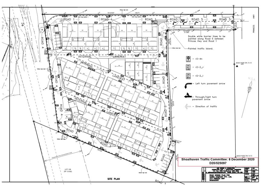
TC20.57 Signage
and Linemarking Plan - Lot 2 DP 777260 - 315 Princes Highway - Bomaderry (PN
3622)
HPERM Ref: D20/525062
Convenor: Micaiah
Tipton
Attachments: 1. PN
3622 - Plan ⇩
|
Recommendation
That the Chief Executive Officer
(Director City Services) be advised that the Shoalhaven Traffic Committee has
no objection to the proposed signage and line marking associated with the
development at 315 Princes Highway, Bomaderry (per development consent
condition 31), as per Plan No D20/520097; subject to the following:
1. Amending
positioning of One-Way and No Entry signage to face in the appropriate
direction.
|
Details
Applicant: Mohamed Sabra
Owner: Sabra Co Pty Ltd
Lot 2 DP 777260 - 315 Princes Highway - Bomaderry -
Demolition of Existing Structures and Staged Construction of Multi-Dwelling
Housing Development (40 Dwellings)
As per Condition 31 of the development consent, the
following is required:
31. Details of any line markings and regulatory signs
must be submitted to Council for review and subsequent approval by the
Shoalhaven Traffic Committee. Six to eight weeks should be allowed for this
process, plus additional time if amendments to the plans are required.
A signage and line marking plan has been submitted to the Committee
for consideration.
Consultation
This Development Application had been on Public Exhibition
between 12 and 27 March 2019 with feedback requested from the community,
directly affected residents and local Bomaderry CCB. During this period, 3
submissions were received, all opposed to this development. The majority of
objections raised related to constraints on nearby parking both during
construction and post completion. This feedback was considered by Council's
Planning and Development Services Team as part of their assessment and the
development was approved on the 28th May 2019, subject to the development
conditions (including condition 31, referenced above).
Risk Implications
There are no risk implications to Council regarding this
signage and linemarking plan, as this is a private development.
Financial Implications
There are no financial implications to Council regarding
this signage and linemarking plan, as this is a private development.
|
|
Shoalhaven
Traffic Committee – Tuesday 08 December 2020
Page
0
|
|
|
Shoalhaven
Traffic Committee – Tuesday 08 December 2020
Page
0
|
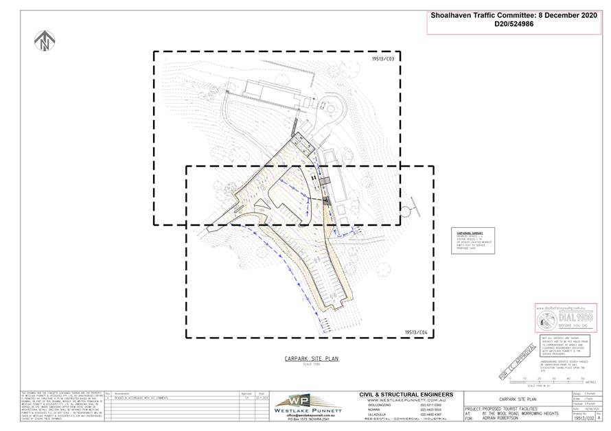
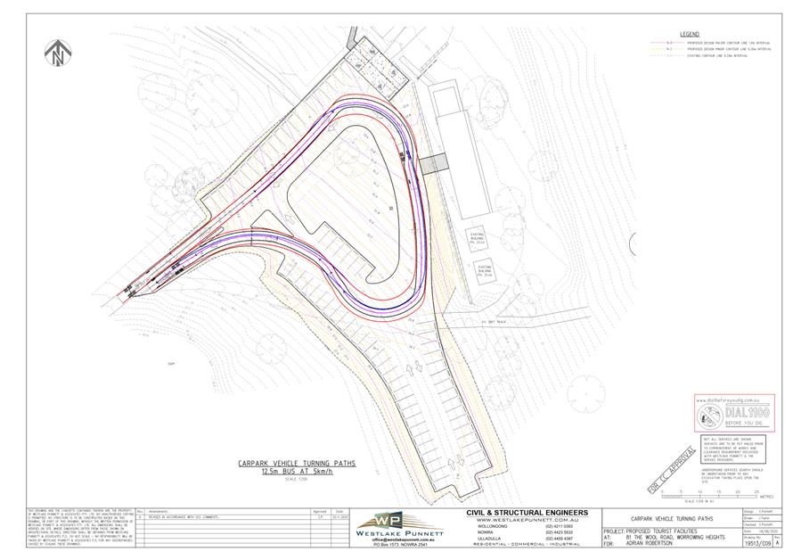
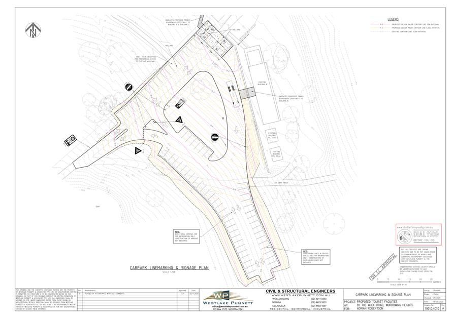
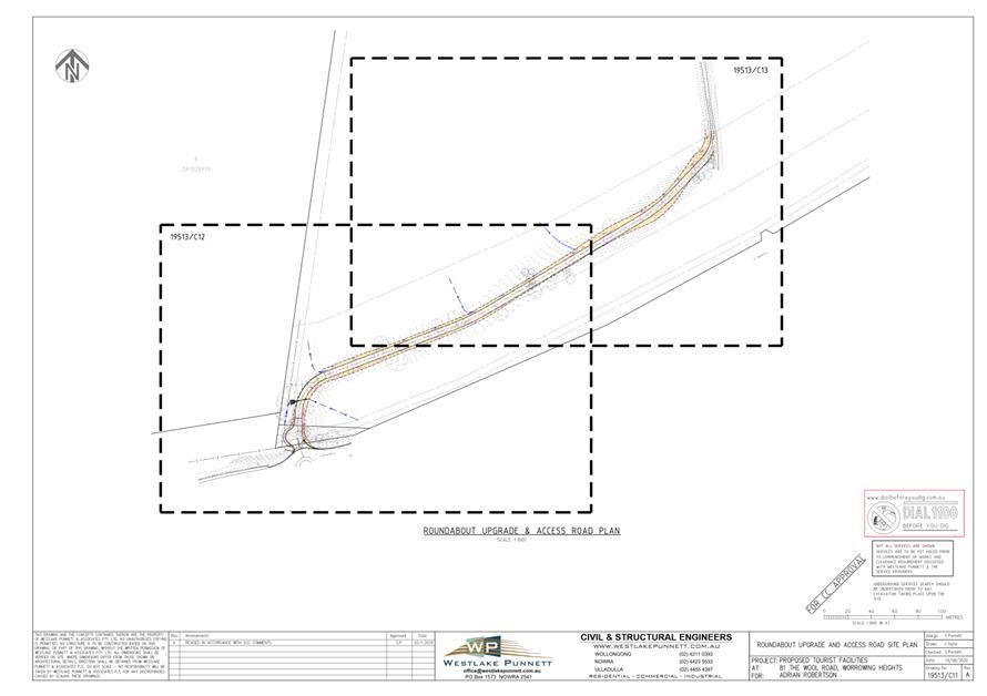
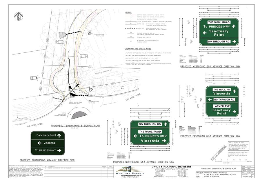
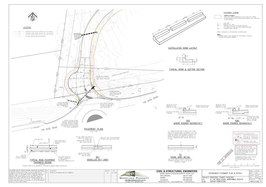
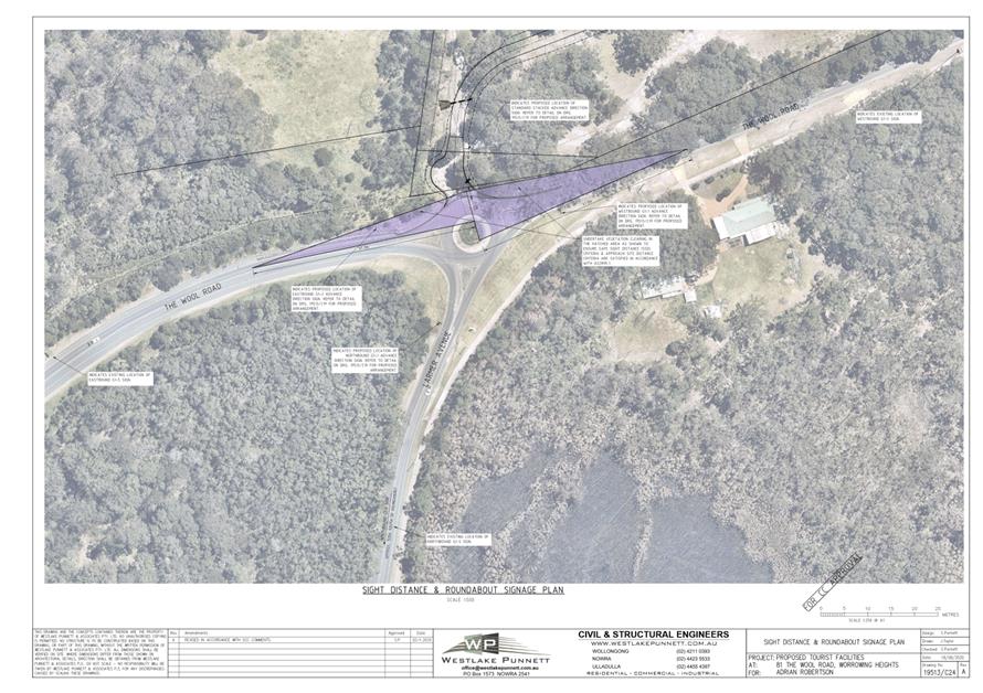
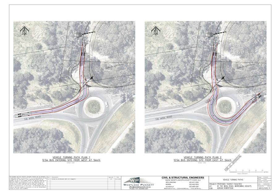
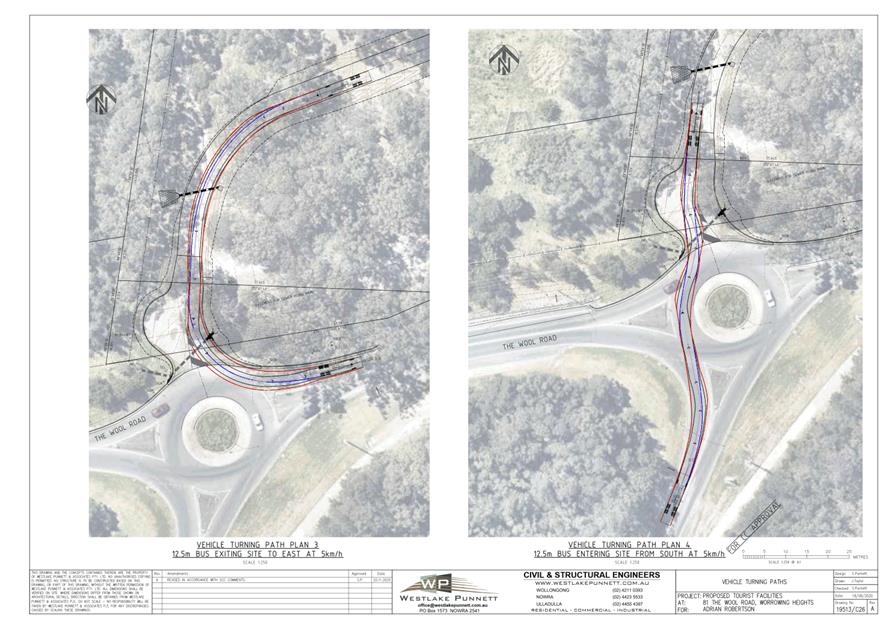
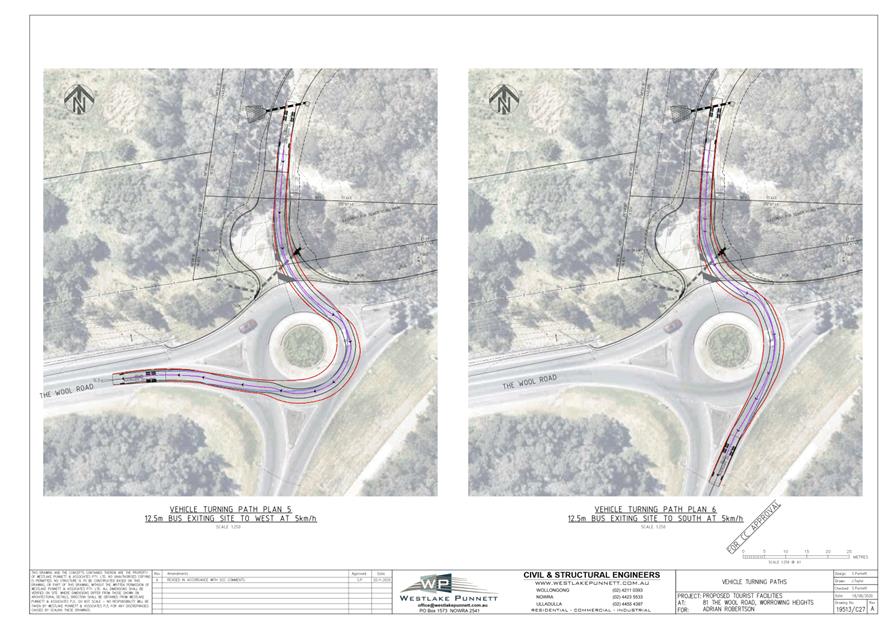
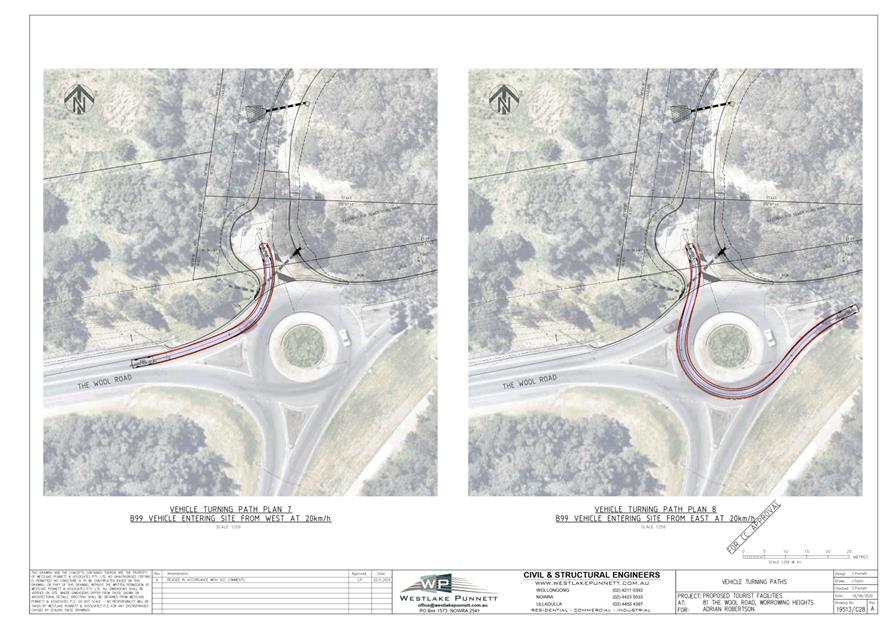
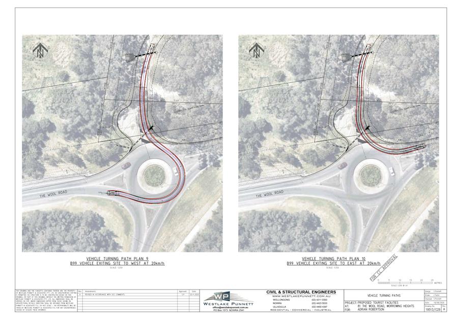
TC20.58 Signage
and Linemarking Plan - 81 The Wool Road - Worrowing Heights - Proposed Tourist
Facilities (PN 3614)
HPERM Ref: D20/524832
Convenor: Micaiah
Tipton
Attachments: 1. PN
3614 - Plan ⇩
|
Recommendation
That the Chief Executive Officer
(Director City Services) be advised that the Shoalhaven Traffic Committee has
no objection to the proposed signage and line marking associated with the
development at 81 The Wool Road, Worrowing Heights (per development consent
condition 28), as per Plan No D20/524986, subject to the following:
1. Removal of the shared zone signage
at the entry to the carpark from proposed plans.
|
Details
Applicant: Westlake and Punnett Pty Ltd
Owner: Adrian Robertson
81 The Wool Road - Worrowing Heights - Alterations and
Additions to and Use of Existing Buildings as Common Room (for Tourists and
Visitors for Educational Use), Café, Art Gallery/Workshop, Tourist
Cabin, Ancillary Office Premises and Amenities, Temporary Use of Land (Function
Centre); and Use of Existing Retaining Wall”
As per Condition 28 of the development consent, the
following is required:
28. Local Traffic Committee Approval
Prior to the issue of a Construction Certificate,
detailed construction plans are to be submitted to Council for referral to the
Shoalhaven Traffic Committee. These plans are to include:
a) Swept path plans showing
manoeuvring to and through the site for the largest proposed event vehicle and
a B99 vehicle. Unless approved by Council in writing, the maximum vehicle
length accessing the site is restricted to 12.5m.
b) Details of the accessible
parking onsite.
c) Details of an onsite pick
up/drop off area for the proposed largest vehicle are to be provided.
d) Details of signage
modifications associated with the roundabout showing the venue access from each
approach leg of the roundabout.
e) Details of the access for
the site from the proposed roundabout.
A signage and line marking plan has been submitted to the
Committee for consideration.
The Developer and applicant have advised that the 10km/h
Shared Zone that was to begin at the entry to the carpark (shown on Drawing
#19513/C10 Rev A) is no longer considered necessary and will not be installed.
Accordingly, the applicant is no longer seeking approval for this.
Consultation
This Development Application had been on Public Exhibition
between 28 November and 13 December 2019 with comments open to be received from
the community and affected residents. During this period, no submissions had
been received by Council. The application was approved on 4 June 2020.
Risk Implications
There are no risk implications to Council regarding this
signage and linemarking plan, as this is a private development.
Financial Implications
There are no financial implications to Council regarding
this signage and linemarking plan, as this is a private development.
|
|
Shoalhaven
Traffic Committee – Tuesday 08 December 2020
Page
0
|