Development & Environment Committee
Meeting Date: Tuesday,
01 December, 2020
Location: Council
Chambers, City Administrative Building, Bridge Road, Nowra
Time: 5.00pm
Membership (Quorum - 5)
Clr Mitchell Pakes - Chairperson
Clr Bob Proudfoot
All Councillors
Chief Executive Officer or nominee
Please note: The proceedings of this meeting
(including presentations, deputations and debate) will be webcast and may be
recorded and broadcast under the provisions of the Code of Meeting Practice. Your attendance at this meeting is taken
as consent to the possibility that your image and/or voice may be recorded and
broadcast to the public.
Agenda
1. Apologies / Leave of Absence
2. Confirmation of Minutes
· Development
& Environment Committee - 3 November 2020.................................... 1
3. Declarations of Interest
4. Mayoral Minute
5. Deputations and Presentations
6. Notices of Motion / Questions on Notice
Notices of Motion / Questions on Notice
DE20.127.... Question on Notice - Subdivision - Edendale
Street, Woollamia.................. 7
7. Reports
City Futures
DE20.128.... Nebraska & Jerberra Estates - Options for
Future Management of E2 Environmental Conservation Land....................................................................................... 18
DE20.129.... Exhibition Outcomes and Proposed Finalisation -
Planning Proposal and Draft DCP Amendment - Urban Release Areas Small Lots
Clause.............................. 29
DE20.130.... 'Legacy' Planning Proposals - Timing and
Progression - NSW Government Direction...................................................................................................................... 35
City Development
DE20.131.... DA20/1494 – 25 Sunnymede Lane, Berry –
Lot 3 DP 713138.................... 61
DE20.132.... DA20/1579 – 42 Naval Parade, Erowal Bay
– Lot 45 DP 1052512............ 92
DE20.133.... DA20/1751 – 42 Lyrebird Drive NOWRA –
Lot 72 & DP 1198691............ 107
DE20.134.... SF10686 – Red Gum Dr Ulladulla – Lot
600 DP 1249606 & Lot 2 DP 1076005 123
DE20.135.... SF10804 – 104 Taylors Lane, Cambewarra
– Lot 3 DP 851823.............. 141
DE20.136.... Quarterly Review for Compliance Matters................................................. 148
DE20.137.... Misuse of vegetation Policy Report............................................................ 162
DE20.138.... Collingwood Beach Dune Vegetation Two-Year Trial
Action Plan - Final Report 165
DE20.139.... Review of Tabourie Lake Entrance Management Policy........................... 183
8. Confidential
Reports
Nil
|

|
Development
& Environment Committee – Tuesday 01 December 2020
Page
i
|
Development & Environment
Committee
Delegation:
Pursuant to
s377(1) of the Local Government Act 1993 (LG Act) the Committee is
delegated the functions conferred on Council by the Environmental Planning
& Assessment Act 1979 (EPA Act), LG Act or any other Act or delegated
to Council, as are specified in the attached Schedule, subject to the following
limitations:
i. The
Committee cannot make a decision to make a local environmental plan to classify
or reclassify public land under Division 1 of Part 2 of Chapter 6 of the LG
Act;
ii.
The Committee cannot review a section 8.11 or
section 8.9 EPA Act determination made by the Council or by the Committee
itself;
iii.
The Committee cannot exercise any function delegated
to the Council which by the terms of that delegation cannot be sub-delegated;
iv.
The Committee cannot exercise any function which
s377(1) of the LG Act provides cannot be delegated by Council; and
v.
The Committee cannot exercise a function which
is expressly required by the LG Act or any other Act to be exercised by
resolution of the Council.
SCHEDULE
a. All
functions relating to the preparation, making, and review of local
environmental plans (LEPs) and development control plans (DCPs) under Part 3 of
the EPA Act.
b. All
functions relating to the preparation, making, and review of contributions
plans and the preparation, entry into, and review of voluntary planning
agreements under Part 7 of the EPA Act.
c. The
preparation, adoption, and review of policies and strategies of the Council in
respect of town planning and environmental matters and the variation of such
policies.
d. Determination
of variations to development standards related to development applications
under the EPA Act where the development application involves a development
which seeks to vary a development standard by more than 10% and the application
is accompanied by a request to vary the development standard under clause 4.6
of Shoalhaven Local Environmental Plan 2014 or an objection to the application
of the development standard under State Environmental Planning Policy No. 1
– Development Standards.
e. Determination
of variations from the acceptable solutions and/or other numerical standards
contained within the DCP or a Council Policy that the Chief Executive Officer
requires to be determined by the Committee
f. Determination
of development applications that Council requires to be determined by the
Committee on a case by case basis.
g. Review
of determinations of development applications under sections 8.11 and 8.9 of
the EP&A Act that the Chief Executive Officer requires to be determined by
the Committee.
h. Preparation,
review, and adoption of policies and guidelines in respect of the determination
of development applications by other delegates of the Council.
i. The
preparation, adoption and review of policies and strategies of the Council in
respect to sustainability matters related to climate change, biodiversity,
waste, water, energy, transport, and sustainable purchasing.
j. The
preparation, adoption and review of policies and strategies of the Council in
respect to management of natural resources / assets, floodplain, estuary and
coastal management.
Minutes of the Development & Environment Committee
Meeting Date: Tuesday,
3 November 2020
Location: Council
Chambers, City Administrative Building, Bridge Road, Nowra
Time: 5.00pm
The following members
were present:
Clr Mitchell Pakes -
Chairperson
Clr Amanda Findley
Clr Joanna Gash
Clr John Wells
Clr Patricia White
Clr Kaye Gartner –
(remotely)
Clr Nina Digiglio
Clr John Levett
Clr Andrew Guile –
(remotely) arrived 5.04pm
Clr Greg Watson
Clr Mark Kitchener
Clr Bob Proudfoot
Mr Stephen Dunshea -
Chief Executive Officer
Others present:
Phil Costello –
Director, City Development
Jane Lewis –
Interim Director, City Lifestyles
Kevin Voegt –
Interim Director, City Performance
Paul Keech – Director,
City Services
Gordon Clark –
Manager, Strategic Planning
Sara McMahon –
Manager, Business Assurance & Risk
|
Apologies / Leave of Absence
|
An apology was received
from Clr Alldrick.
|
Confirmation of the Minutes
|
|
RESOLVED (Clr White / Clr Wells) MIN20.811
That
the Minutes of the Development & Environment Committee held on Tuesday 06
October 2020 be confirmed.
CARRIED
|
Nil
Mayoral Minutes
Nil
Deputations and Presentations
The following
Deputations were made available on Council’s website:
DE20.124 - Exhibition
Outcomes/Finalisation - Draft Chapters N20 & S1 - Jerberra & Verons
Estates - Shoalhaven DCP 2014 (Amendment No.38)
Mary-Jean Lewis, Ardent Lawyers - Against
DE20.125 - DA20/1743 - 25 Lake
Conjola Entrance Rd Yatte Yattah– Lot 84 DP 817514
Marilyn Schoonderwoerd - Against
Notices of Motion / Questions
on Notice
|
DE20.122 Notice of Motion - Land Classification - 132
Island Point Road, St Georges Basin
|
HPERM Ref: D20/469546
|
|
Recommendation
That Council, subject to
community consultation, resolve to reclassify 132 Island Point Road, St
Georges Basin (Lot 10 DP 1143842) from operational to community land.
|
|
Motion (Clr Levett / Clr Findley)
That Council, subject to
community consultation, resolve to reclassify 132 Island Point Road, St
Georges Basin (Lot 10 DP 1143842) from operational to community land.
For: Clr
Findley, Clr Gartner, Clr Digiglio and Clr Levett
Against: Clr
Pakes, Clr Gash, Clr Wells, Clr White, Clr Guile, Clr Watson, Clr Kitchener,
Clr Proudfoot and Stephen Dunshea
LOST
|
|
RESOLVED (Clr White / Clr
Proudfoot) MIN20.812
That
Council, with respect to 132 Island Point Road, St Georges Basin (Lot 10 DP
1143842):
1. Retain the current operational
classification for the Village Green
2. Has no intent or plans to change
the current use of the Village Green area as green space
3. In
a future review of the broader St Georges Basin DCP, review the Village Green
DCP including the requirement for car parking and other controlled service
access and to further enhance the Village Green space.
For: Clr
Pakes, Clr Findley, Clr Gash, Clr Wells, Clr White, Clr Gartner, Clr
Digiglio, Clr Levett, Clr Guile, Clr Watson, Clr Kitchener, Clr Proudfoot and
Stephen Dunshea
Against: Nil
CARRIED
|
Reports
|
DE20.123 Post Exhibition and Finalisation -
Shoalhaven Local Environmental Plan (LEP) 2014 - 2019 Heritage Housekeeping
Amendment (PP036)
|
HPERM Ref: D20/425840
|
|
Recommendation (Item to be determined under
delegated authority)
That Council:
1. Adopt
Shoalhaven LEP2014 – 2019 Heritage Housekeeping Amendment Planning
Proposal (PP036) as exhibited, with the changes shown in Table 1 of the
report, and forward to the NSW Department of Planning, Industry and
Environment (DPIE) for finalisation, acknowledging that an objection from NSW
Crown Lands remains unresolved regarding the listing of items at
Chinaman’s Island which will ultimately be considered by DPIE during
finalisation.
2. Investigate
the heritage significance of the following properties as part of a future
housekeeping amendment Planning Proposal:
a. Lot 30 DP 1200000, Meroo Street,
Bomaderry - relating to Item No. 135: Bomaderry Railway Station and yard
group.
b. Lot
111 DP 997750 and Lot 1 DP 152845, 1 Berry Street, Nowra - relating to Item
No. 325: Pressed metal clad industrial building (former Barnes Garage).
c. Lot
7 DP 1037100, 466 Kangaroo Valley Road Berry Mountain - relating to Item No.
114: “Glenworth” – two storey residence and grounds.
3. Advise
key stakeholders, including relevant Community Consultative Bodies and those
who made a submission, of the resolution and when the LEP Amendment will be
made effective.
|
|
RESOLVED (Clr Watson / Clr Gash) MIN20.813
That Council:
1. Adopt
Shoalhaven LEP2014 – 2019 Heritage Housekeeping Amendment Planning
Proposal (PP036) as exhibited, with the changes shown in Table 1 of the
report, and forward to the NSW Department of Planning, Industry and
Environment (DPIE) for finalisation, acknowledging that an objection from NSW
Crown Lands remains unresolved regarding the listing of items at
Chinaman’s Island which will ultimately be considered by DPIE during
finalisation.
2. Investigate
the heritage significance of the following properties as part of a future
housekeeping amendment Planning Proposal:
a. Lot
30 DP 1200000, Meroo Street, Bomaderry - relating to Item No. 135: Bomaderry
Railway Station and yard group.
b. Lot
111 DP 997750 and Lot 1 DP 152845, 1 Berry Street, Nowra - relating to Item
No. 325: Pressed metal clad industrial building (former Barnes Garage).
c. Lot
7 DP 1037100, 466 Kangaroo Valley Road Berry Mountain - relating to Item No.
114: “Glenworth” – two storey residence and grounds.
3. Advise
key stakeholders, including relevant Community Consultative Bodies and those
who made a submission, of the resolution and when the LEP Amendment will be
made effective.
4. As
soon as the opportunity arises, undertake reconsideration of the proposal to
remove from the Heritage Register Lot 111 DP 997750 and Lot 1 DP 152845, 1
Berry Street, Nowra.
For: Clr
Pakes, Clr Gash, Clr Wells, Clr White, Clr Gartner, Clr Digiglio, Clr Guile,
Clr Watson, Clr Kitchener, Clr Proudfoot and Stephen Dunshea
Against: Clr
Findley and Clr Levett
CARRIED
|
|
DE20.124 Exhibition Outcomes/Finalisation - Draft
Chapters N20 & S1 - Jerberra & Verons Estates - Shoalhaven DCP 2014
(Amendment No.38)
|
HPERM Ref: D20/433881
|
|
Recommendation (Item to be determined under
delegated authority)
That Council:
1. Adopt
DCP Amendment 38 with the changes discussed in this report and shown in
Attachments 1 and 2.
2. Formally
request re-certification of the planning controls for each Estate as a
‘relevant planning arrangement’ under Clause 34A of the Biodiversity
Conservation (Savings and Transitional) Regulation 2017 from the
Department of Planning Industry and Environment (DPIE).
3. Notify
the adoption of the Amendment in accordance with the requirements of the NSW
Environmental Planning and Assessment Act 1979 and Regulations.
4. If
necessary, delay commencement of Amendment 38, pending recertification of the
planning controls for each Estate under Clause 34A, to avoid complications
that could arise if recertification is delayed.
|
|
RESOLVED (Clr Findley / Clr
Wells) MIN20.814
That Council:
1. Adopt
DCP Amendment 38 with the changes discussed in this report and shown in
Attachments 1 and 2.
2. Formally
request re-certification of the planning controls for each Estate as a
‘relevant planning arrangement’ under Clause 34A of the Biodiversity
Conservation (Savings and Transitional) Regulation 2017 from the
Department of Planning Industry and Environment (DPIE).
3. Notify
the adoption of the Amendment in accordance with the requirements of the NSW
Environmental Planning and Assessment Act 1979 and Regulations.
4. If
necessary, delay commencement of Amendment 38, pending recertification of the
planning controls for each Estate under Clause 34A, to avoid complications
that could arise if recertification is delayed.
For: Clr
Pakes, Clr Findley, Clr Gash, Clr Wells, Clr White, Clr Gartner, Clr
Digiglio, Clr Levett, Clr Guile, Clr Watson, Clr Kitchener, Clr Proudfoot and
Stephen Dunshea
Against:
Nil
CARRIED
|
|
DE20.125 DA20/1743 – 25 Lake Conjola Entrance
Rd Yatte Yattah– Lot 84 DP 817514
|
HPERM Ref: D20/426814
|
|
Recommendation
That Council refuse the
application for the completion of the subject 24m by14.5m by 7.93m high shed
and use of the building as a Home Industry at 25 Lake Conjola Entrance Road
and issue orders for the demolition of the structure for the following
reasons:
1. The
development is considered to exceed the maximum permitted 100m2
area for a home industry permitted under Clause 7.18 SLEP given that the
proposed design of the building incorporates no effective means to restrict
the home industry use to a maximum of 100m2 area and as such
should not be supported in the present form.
2. The
development does not comply with the objectives of Clause 4.3 SLEP Height of
Buildings as the unauthorised shed is not considered to be compatible
with the height, bulk and scale of the existing and desired future character
of a locality (adjoining rural dwelling) and presents a significant visual
impact to the adjoining dwelling and community when viewed from public
spaces..
3. The
building is 4.31m higher than the original shed height (3.62m)
or 119% above the original and is located on the ridge/skyline. The
unauthorized shed is prominent within the landscape and is visible both from
travellers along the Highway travelling south and Lake Conjola Entrance Road
in both directions.
4. The
shed has proportions more akin to an industrial building and as such is not
compatible with the objectives of the RU2 zone or adjoining dwelling and the
rural landscape character in which it sits. Industrial uses are not permitted
in the RU2 zone.
5. Retention
of the shed in such a prominent location would present a poor planning
outcome as it would create a precedent for other unauthorised development on
ridgelines to be formalised.
6. The
height of the building is not considered to comply with the streetscape and
character requirements of Chapter G19 of the SDCP2014.
Clr Findley raised a Point of
Order against Clr Watson for bringing Council into disrepute and impugning
character by implying Council’s message to the applicant would be
“we’re going to get even with you”, and asked that he
withdraw the comment and apologise. Clr Watson withdrew the comment.
|
|
RESOLVED (Clr Watson / Clr
Kitchener) MIN20.815
That:
1. Council approve DA20/1743 subject
to the conditions of consent contained in attached letter of notification to
the applicant.
2. It be noted that special
circumstances apply in respect of this approval in that the property owner
lost his home, farm machinery and previous work place during a major bushfire
event.
For: Clr
Pakes, Clr Gash, Clr Wells, Clr White, Clr Guile, Clr Watson, Clr Kitchener,
Clr Proudfoot and Stephen Dunshea
Against: Clr
Findley, Clr Gartner, Clr Digiglio and Clr Levett
CARRIED
|
|
Procedural
Motion - Matters of Urgency
|
|
Motion (Clr White / Clr Wells)
That an additional item - Call in DA20/2056 – 275 Bong
Bong Rd Broughton Vale - be introduced as a matter of urgency.
CARRIED
|
|
The Chairperson ruled
the matter as urgent as it was in the public interest.
|
|
DE20.126 Call In DA20/2056 - 275 Bong Bong Road
Broughton Vale
|
|
RESOLVED (Clr White / Clr Wells) MIN20.816
That Council call in for
determination DA20/2056 – 275 Bong Bong Rd Broughton Vale - Lot 102 DP
703530 - Parish BROUGHTON - Tourist & Visitor Accommodation (7
Cabins) and Dwelling Additions – 55283.
For: Clr
Pakes, Clr Findley, Clr Gash, Clr Wells, Clr White, Clr Gartner, Clr
Digiglio, Clr Levett, Clr Guile, Clr Watson, Clr Kitchener, Clr Proudfoot and
Stephen Dunshea
Against: Nil
CARRIED
|
There being no further
business, the meeting concluded, the time being 6.46pm.
Clr Pakes
CHAIRPERSON
|

|
Development
& Environment Committee – Tuesday 01 December 2020
Page
1
|
DE20.127 Question
on Notice - Subdivision - Edendale Street, Woollamia
HPERM Ref: D20/517130
Submitted
by: Clr John Levett
Attachments: 1. DLWC
letter ⇩
2. NPWS letter ⇩
These questions are in relation to an approved development
proposal/subdivision on the north side of Edendale St, Woollamia. The matter
was drawn to my attention by a group of concerned residents.
The subject block was originally known as Lot 71 DP 9289 and in June
1994 the applicants instructed Alan Price & Associates to apply for a
subdivision of Lot 70 and Lot 71 DP9289 on the corner of Woollamia Road and
Edendale Street, Woollamia.
On 19 April, 1995 application SF7945 was approved
for three Lots in Woollamia Road.
Question
1. In
January 1995 when the application was lodged how many nearby property owners
were notified or are likely to have been notified and does Council have
evidence of this notification?
On 25 January 1996 a 13 Lot
subdivision SF7946 was approved in Edendale St.
2. This
DA should have expired on 25 January, 2001…why is it still
active?…in what way was a substantial start made ?
3. What
planning law permits a DA approval to be acted upon 24 years after the original
assessment and does that law permit reassessment by Council to bring the
consent conditions up to contemporary standards ?
In August 1997 Council apparently
approved a “borrow pit” to excavate 6,500 cubic metres of soil to
use on SF7945 to build 2 metre high mounds so that future structures might be
out of flood reach. The clearing of bush and the excavation of the
“borrow pit” began in May 2000. Local residents estimate that
more than 100 trips were made per day for almost three weeks by 10 tonne dump
trucks travelling to and from along Edendale St and Woollamia Rd, creating a
dangerous situation for residents. Residents questioned the validity of
the development as they were not aware of any substantial start occurring and
they conveyed their concerns to Shoalhaven City Council, Department of Land
& Water Conservation, NPWS and the Departments of Planning and Health.
4. Was
the work on the “borrow pit” approved under SF7945 on 19 April 1995
and what community consultation took place in relation to the approval and the
truck movements that would be involved ?
If, as residents claim, work on the
“Pit” began in May 2000 wouldn’t such work be illegal due to
the expiration of SF 7945 a month before ?
5. Were
permits required from the Dept. of Land & Water Conservation before these
earthworks could take place and if so why were they not applied for ?
The attached letter from the
DL&WC and signed by Noel Kesby, Manager Resource Assessment & Planning,
states that; “The Department has no record of any previous referral from
Council in relation to seeking DL&WC comment on natural resource management
issues for the subject lands at the subdivision application stage…and how
Council addressed relevant State policies on natural resource management”
The DL&WC letter went on to
say that Council would be aware that the proposed development; “is likely
to be impacted on and impact flood behaviour…and should be considered in
accordance with the NSW Government’s Flood Prone Land Policy…to reduce
the impact of flooding and flood liability on individual owners and occupiers,
and to reduce the private and public losses resulting from flooding”
6. What
flood plain management plans existed when this development was approved and
what plan now exists to mitigate against the potential impacts of flooding in
the area as a result of the development proceeding ? Is there such a
thing as a Currambene Creek Floodplain Management Plan (the creation of which
was suggested by DL&WC back in 2000 before Council made any further development
decisions in the area) and if so does it address the issue of flood free access
and evacuation requirements, including hazards on access routes in the event of
a major flood?
7. Is
Council satisfied that it is protected under Section 733 of the Local
Government Act 1993 in the event that litigation arises as a result of flooding
at this site ?
8. When
this development was approved, did Council give appropriate consideration to
relevant State Natural Resource Policies, can Council give evidence of doing
so, and what conditions of consent were applied as a result of these
considerations ?
The issues that should have been
addressed are detailed in the October 2000 DL&WC letter under the broad
headings of; management of water quality, vegetation management, the
existence of acid sulphate soils, and effluent disposal.
9. The
riparian land on the site is defined in Council documentation as
“drainage reserve”. Is Council satisfied that this
description is accurate and in the words of DL&WC, “appropriately
reflects the total function as a riparian corridor and its connection to a
State significant wetland system.” What riparian protection
or enhancement, including buffer zones, has Council built into approvals at
this site by way of consent conditions ?
DL&WC offered the view at the
time of approval that the so called drainage reserve; “would in fact
contain inherent conservation values and provide a significant environmental
function that would warrant consideration of its definition (and zoning) that
affords greater protection”
The Statement of Environmental
Effects that accompanied the application offered the opinion that; “no
protected or endangered fauna would visit the area”. On 15th
June, 2000 after the excavation of the “borrow pit” began and in
response to representations from the public, two officers of the NSW National
Parks & Wildlife Service inspected the Edendale site and in a letter to
Development Manager, Tim Fletcher on 13th July, 2000, Michael Hood
(Manager, Conservation Planning, NPWS south) described the property
differently, as “a mature coastal forest” and added that;
“such a community provides habitat for a number of fauna species which at
the time were listed on the Endangered Fauna (Interim Protection) Act.”
10. Did
Council at any stage consider having the original Statement of Environmental
Effects peer reviewed?
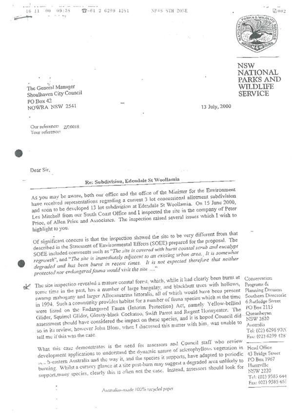
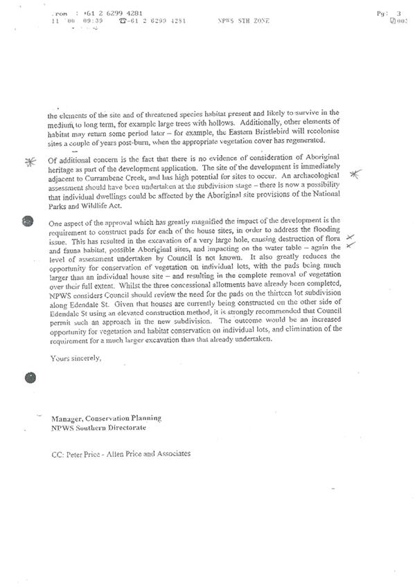
Of additional concern to Michael Hood
was that there was no evidence of consideration of Aboriginal Heritage as part
of the development application, notwithstanding the fact that the location of
the site, adjacent to Currambene Creek should have triggered an archaeological
assessment.
11. Has an
archaeological assessment of the site been requested by Council and has any
consultation with the Jerrinja Local Aboriginal Land Council taken place ?
The NPWS letter also drew attention
to the impact of the “pit” excavation and the building of pads to
elevate future dwellings, citing concerns about destruction of habitat and the
impact on possible aboriginal sites.
12. Will
Council allow more mining for fill at the “borrow pit” and permit
further house construction on “pads” given the warnings from NPWS
about the environmental sensitivity of the site.
13. Since the
sale of the site some 12 months ago, has Council received an application to
modify the DA in any way or a request for a “Certificate of
Construction” to clear bushland on the site ?
Response
A report responding to the Questions on Notice will be presented
to a future Development & Environment Committee meeting.
|

|
Development
& Environment Committee – Tuesday 01 December 2020
Page
1
|
|

|
Development
& Environment Committee – Tuesday 01 December 2020
Page
1
|
|

|
Development
& Environment Committee – Tuesday 01 December 2020
Page
1
|
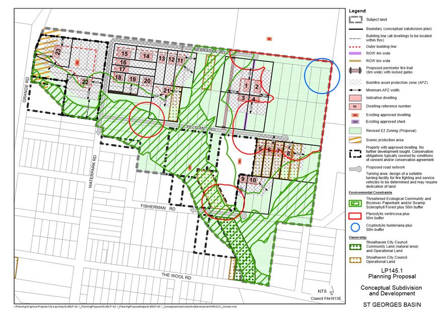
DE20.128 Nebraska
& Jerberra Estates - Options for Future Management of E2 Environmental
Conservation Land
HPERM Ref: D20/434779
Section: Strategic
Planning
Approver: Robert
Domm, Director - City Futures
Attachments: 1. Nebraska
Estate - Draft LP145.1 - Conceptual Subdivision and Development with SCC Owned
Land ⇩
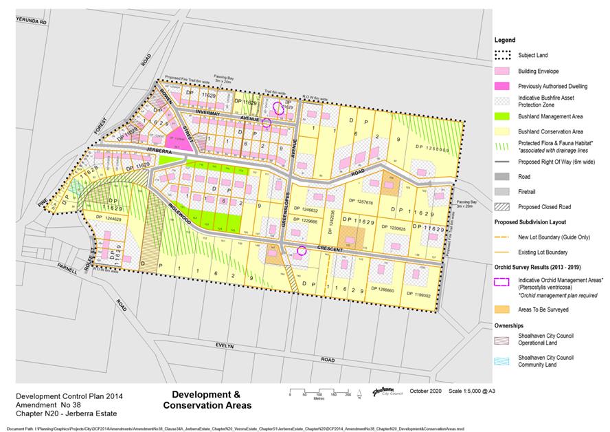
2. Jerberra Estate - DCP 2014
Amendment No 38 - Development & Conservation Areas with SCC Owned Land ⇩
Reason for Report
“In
principle” support is sought to prepare a policy which would enable the
voluntary acquisition and future management of residual/undevelopable E2
Environmental Conservation zoned land in Jerberra Estate and also ultimately
Nebraska Estate (if/when the land is rezoned) using the net profits from the
sale of developable Council land in the Estates.
A
biodiversity savings order (clause 34A certification) is also critical to the
feasibility of the Planning Proposal (PP) for Nebraska Estate. Indications are
that clause 34A certification for Nebraska will hinge on Council making a
commitment to proactively acquire and manage the “residual” E2
zoned properties that will not otherwise be resolved through development
consents.
Further, the
NSW Department of Planning, Industry & Environment (DPIE) wrote to Council
on 1 October 2020 about five “legacy” planning proposals. DPIE
advised that:
“A
review of current proposals identified a number that have been delayed or, are
yet to be finalised after more than four years. To address these, the
Department is commencing a focused program to work with councils to finalise
these proposals by 31 December 2020.
Nebraska
Estate is one of the “legacy” PPs identified by DPIE for
finalisation.
|
Recommendation (Item to be determined under delegated authority)
That
the Development & Environment Committee:
1. Receive
the update on the Nebraska Estate Planning Proposal (LP145.1) for
information.
2. Agree “in principle” to
the development of a new policy for the voluntary acquisition of “residual”
E2 Environmental Conservation land in the Nebraska & Jerberra Estates, to
be funded by any profits from the sale of developable Council land in each
Estate.
3. Agree to the preparation of a draft
policy for Council’s consideration based on the following:
a. the cost-neutral voluntary
acquisition of undevelopable E2 land in each Estate, to the extent possible,
funded by the net profit from the sale of Council-owned land with development
potential;
b. if offers to sell E2 land are
received before any developable Council-owned land has been sold, general
funds be used to purchase E2 properties in each Estate limited to the
anticipated net profits from the future sale of the Council-owned land;
c. land in Nebraska Estate is not
purchased until the Planning Proposal has been finalised and the land zoning
has been resolved;
d. the policy be limited to the
acquisition of E2 properties that are not able to form part of a development
parcel;
e. the cost of removing any
unauthorised structures from the land be deducted from the acquisition price;
f. any land acquired by Council
under the new policy be managed for conservation purposes consistent with
clause 34A of the NSW Biodiversity Conservation (Savings and Transitional)
Regulation using any available surplus funds and/or external funding programs
and subject to resourcing;
g. receiving further advice from the
NSW Government on the likelihood of receiving clause 34A certification for
Nebraska on the basis of parts 2 and 3 above; and
h. consultation with the landowners in
each Estate, in particular to gauge the interest of the E2 land in Jerberra
Estate and proposed E2 land in Nebraska Estate.
4. Agree an independent valuation
advice be obtained in order for management to provide detailed estimates of
the following for consideration before a draft policy is presented to
Council:
a. the potential net profit from the
sale of Council land in each Estate;
b. total unimproved land value of the
undevelopable E2 land (existing and proposed); and
c. the annual cost of maintaining land
to the Council.
|
Options
1. As recommended
Implications: DPIE’s Biodiversity &
Conservation Division (former Office of Environment and Heritage - OEH) will be
informed of Council’s “in principle” agreement to develop a
policy that seeks to acquire and manage the E2 land in both Nebraska and Jerberra
Estates. Ongoing discussions with them on possible clause 34A Certification for
the future Nebraska planning controls will depend heavily on being able to
secure long term environmental outcomes for the environmentally sensitive land.
Although this sensitive land will be zoned E2 Environmental Conservation, the
future tenure and management of most of the proposed E2 land will remain
unresolved.
While Council’s current policy allows land in
“paper subdivisions” to be acquired in lieu of unpaid rates if
requested by the owner, this does not provide sufficient certainty to qualify
for clause 34A certification. Furthermore, this current policy was developed
for a different purpose and not intended to be a proactive acquisition policy.
The fact that Council owns developable land in Jerberra Estate and potentially
developable land in Nebraska Estate, provides an opportunity to use the net
profits from the sale of this land to take a more proactive role in resolving
the future tenure and management of the undevelopable land.
The Nebraska PP and Draft DCP Amendment can also be
updated to reflect that the planning controls will be certified as
“relevant planning arrangements”.
Adopting the recommendation could also assist in the
up-coming discussions with DPIE regarding finalisation of the PP.
2. Resolve
to develop policy for the acquisition of E2 land in Nebraska but exclude the
Jerberra Estate.
Implications: The outcome for Nebraska Estate would
remain as per Option 1. However, adoption of a policy position to acquire E2
land in Nebraska Estate would create a precedent. Landowners of E2 land in
Jerberra Estate may expect similar consideration.
3. Not agree to
develop a policy to proactively acquire E2 properties in either Estate.
Implications: The NSW
Government has been reluctant to support clause 34A certification for Nebraska
Estate without a Council commitment for management of the E2 land into the
future. If Council is required to complete the PP without certification,
landowners will be required to undertake a Biodiversity Assessment Methodology
(BAM) Assessment and prepare a Biodiversity Development Assessment Report
(BDAR) to support development applications (DAs) for dwelling approval. This
would be an additional financial (and time) cost to be added to the expected
high costs for the provision of roads, water and sewer infrastructure. The
additional costs and delays could be blamed on Council, even though the
situation is a result of the NSW biodiversity law reforms.
Background
Current status – Nebraska
Estate PP
A report on the Nebraska Estate
PP and the outcomes of a landowner survey was last considered by the former
Development Committee on 5 April 2016. It was resolved (MIN16.230) that
Council:
a) Adopt
revised version 2 of Option 1 – Lower Density Residential Development
outlined in this report and provided in Attachment D, as the preferred option
to move forward with, and the Planning Proposal be amended accordingly.
b) Prepare
the required water cycle assessment.
c) On completion of a) and b) publicly exhibit the
Planning Proposal.
Water Cycle Assessment
An
Integrated Water Cycle Assessment was subsequently undertaken by
“Footprint Sustainable Engineering” (FSE) and completed in March
2017.
The
Assessment report demonstrates that the PP can achieve a “neutral or
beneficial” effect (NorBE) on water quality, water quantity and the
receiving environment subject to implementation of the recommended controls and
performance standards recommended in the report. These controls and performance
standards can be incorporated into the DCP intended to support the PP.
Strategic
Bushfire Assessment
In response
to changes to the NSW Rural Fire Service’s (RFS) “Planning for
Bushfire Protection” Guidelines (including a new section on strategic
planning), a strategic bushfire assessment was commissioned in late 2018. The
final report was received in October 2019. The report recommended several
bushfire mitigation measures, including establishment of a fire trail in the
Nebraska Road reserve between Grange Road and Waterpark Road. These measures
can be incorporated into the supporting DCP.
NSW Biodiversity Conservation Act 2016 (BC Act) –
Implications for Nebraska Estate
Exhibition of the PP was stalled
by the commencement of the BC Act and supporting Regulations on 25 August 2017.
The BC Act
introduced a new Biodiversity Assessment Methodology (BAM) and a new
Biodiversity Offsets Scheme (BOS). In recognition of the previous biodiversity
assessments completed as part of the rezoning processes, the resolved planning
controls for both Jerberra and Verons Estates were certified as “relevant
planning arrangements” by the NSW government in 2019. This means that
development applications (DA) in these Estates can be assessed under the
legislation that applied before the BC Act commenced; the BOS is not triggered
and a Biodiversity Development Assessment Report (BDAR) is not required to
support a DA.
A BAM must be prepared if:
1. the area of
clearing/disturbance exceeds the applicable area threshold (ranges from 0.25 ha
to 2 ha depending on the minimum lot size in the LEP), or
2. the site is mapped as
high biodiversity value on the Biodiversity Values map (prepared by OEH), or
3. a “test of
significance” assessment indicates that there will be a significant
impact. (If the above thresholds are not triggered, a test of significance
(5-part test) must be applied.)
An initial assessment of the PP
against the above criteria suggests that the BAM would need to be applied to all
23 individual proposed dwellings, each of which would require its own BDAR to
determine the offsetting requirement for each development, noting that the
legislation does not allow an overall BDAR to be completed. The cost of
offsetting the impacts (i.e. purchasing credits from the market or paying into
the fund) would also be borne by each applicant.
Council staff have been in
ongoing discussions with NSW Government officers since the BC Act commenced to
try to find a workable solution to this issue in respect of Nebraska Estate.
Clause 34A
Certification is considered the most likely solution. Clause 34A (4) sets out
the following eligibility criteria for “relevant planning
arrangements’:
(a) that
the proposed development the subject of a development application is part of a
relevant planning arrangement and the biodiversity impacts of the proposed
development were satisfactorily assessed before the commencement of the Act as
part of the relevant planning arrangement, and
(b) that
conservation measures have been secured into the future (by a planning
agreement, a land reservation or otherwise) to offset the residual impact of
the proposed development on biodiversity values after the measures required to
be taken to avoid or minimise those impacts.
In respect
of part (a) Council staff are of the opinion that the biodiversity
impacts were satisfactorily assessed prior to commencement of the BC Act. This
was confirmed in a joint NSW State Agency letter received in December 2011,
although it did raise some concerns about the proposed north east sector (which
is adjacent to large cluster of threatened orchids). The policy proposed in
this report may ultimately help to satisfy part (b) and provide the
certainty needed to refine and publicly exhibit the Nebraska Estate planning
controls (PP and supporting DCP chapter).
In principle
support for clause 34A certification was sought on 31 May 2018 from the then
NSW Office of Environmental Heritage (OEH) for the proposed planning controls
for Nebraska Estate. However, OEH was reluctant to commit to cl 34A
certification, partly due to uncertainty around the future of the residual E2
land that potentially makes up a significant proportion of the land. It was
also unclear at that time whether the planning controls for Jerberra and Verons
Estates would be certified under clause 34A because the legislation was new.
The planning controls for these Estates were ultimately certified in 2019 after
a lengthy delay.
The proposal in this report has
been prepared following further discussions with the Regional Office of the
Biodiversity & Conservation Division (BCD) of DPIE on potential use of
clause 34A for Nebraska Estate.
Jerberra
Estate – Current Position
Amendment No
38 to Shoalhaven DCP 2014 was adopted by Council on 3 November 2020 to reflect
the clause 34A certification for Jerberra & Verons Estates. Acquisition of
undevelopable residual E2 zoned land in the Jerberra & Verons Estates was
not necessary to secure clause 34A certification because a significant
proportion of the environmentally sensitive land will be secured in perpetuity
through legally binding development consents.
In Nebraska
Estate, however, most of the proposed E2 land will not be resolved through
development consents because there are three discrete areas of developable land
surrounded by relatively large areas of constrained land, which is in
fragmented ownership, including the main cluster of threatened orchids in the
north eastern corner of the Estate.
E2 Land
Management Options
The
following is a summary of the current status of available external funding
programs that could potentially be available to support management options for
the E2 land:
· Saving Our
Species (SOS) - the current program ends in June 2021 and all money is
currently allocated. There will be no more rounds of funding in the current
program model. Subject to the NSW State Budget in November, there may be a
second iteration of this program after June 2021.
· NSW
Biodiversity Conservation Trust (BCT) – there are no relevant grants.
· BCT
Stewardship/Conservation Agreements - generally only offered for properties
10 ha+ (maximum holding in Nebraska Estate is currently 1.65 ha).
· Other
– the BCD may have up to $10,000 available this financial year for
conservation work in Nebraska provided any proposed work is consistent with
adopted conservation strategies. Nebraska is listed as a priority
management site for the critically endangered orchid Pterostylis ventricosa.
Community Engagement
Landowners in Nebraska Estate
were alerted to the “sweeping changes” made to the NSW biodiversity
laws on 23 October 2017 and advised that Council would work closely with
officers of the former OEH to explore the implications and options for
finalising the PP.
Landowners in the Nebraska and
Jerberra Estates and relevant government agencies have been advised that this
report has been prepared for consideration on 3 November 2020. Should Council
adopt the recommendations, feedback will be sought from the landowners before
the matter is considered further by Council.
Further consultation with the
relevant stakeholders will be undertaken as the Nebraska Estate PP progresses.
Policy Implications
The implications of the proposed
policy direction are discussed throughout this report.
Existing policies
Council has two existing
policies relevant to the acquisition of land in lieu of unpaid rates:
Small
Lot Rural Subdivisions - Dealing with Unpaid Rates and Charges
This Policy applies to land in
small lot rural subdivisions categorised or formerly categorised as
“Residential, Non-Urban” for rating purposes and includes land in
the Jerberra and Verons Estates zoned for development and rated “Residential”.
It provides for Council to accept the transfer of land in full satisfaction of
unpaid rates. The Policy also establishes a framework for classification of
transferred land under the NSW Local Government Act. The full Policy is
accessible at the above link. Council has acquired land in both the Nebraska
Estate and Jerberra Estates under this Policy. The policy has a review date of
1 December 2020.
This Policy can continue to
stand alone and be supported by a separate (new) policy for the voluntary
acquisition of undevelopable environmental land using the net profits from the
sale of the developable land in the same Estate.
Sale
of Land to Recover Unpaid Rates and Charges (POL18/76)
This Policy applies to all land
in Shoalhaven. The Policy supports Section 713 of the NSW Local Government Act
which enables Council to sell land to recover unpaid rates and charges. The
Policy objective is to recover unpaid rates and charges outstanding for legislated
periods of time and any ancillary costs incurred in the sale of the land, but
not to profit from the sale. The process involves the land being put to
auction. If Council has an interest in acquiring the land a bid may be placed.
Bids are capped at cost-recovery. The policy also has a review date of 1
December 2020.
Council has not acquired land in
either Nebraska or Jerberra Estates under this Policy at this point. Land has,
however, been purchased for drainage and other purposes.
This Policy can also continue to
stand alone and be supported by the separate (new) policy for voluntary land
acquisition.
Proposed New Policy –
Acquisition of E2 land in Nebraska and Jerberra Estates
As detailed in the report it is
proposed that Council continue with the existing policies and not amend them.
The proposed new policy would
set out a process that allows undevelopable E2 land to be voluntarily purchased
(willing seller/willing buyer) in both Estates at the unimproved land value
(UV) to be independently assessed.
Currently, valuations for
Nebraska provided by the Valuer General (VG) for rating purposes are
approximately $5,000 per lot. This is consistent with the Voluntary Heritage
Estates Land Purchase project that was run externally. The undevelopable
properties in Jerberra Estate are generally larger than in both Nebraska and
Heritage Estates. This appears to be reflected in the VG’s valuations.
The UVs for both Estates would need to be independently assessed by a qualified
Valuer before a draft policy is prepared for Council’s
consideration.
In the medium-longer term it is
proposed that purchases would be funded from the profit on the sale of
Council’s developable land in each Estate. These profits (sale price less
development/infrastructure/legal costs) would be ringfenced for the voluntary
purchase of the E2 land in the relevant Estate. The aim is to create a circular
fund.
Once purchased, land would be
generally classified as community land (natural area) and opportunities for
parcel consolidation could be pursued as they arise. Further details are
provided below under “Financial Implications”.
Nebraska Estate
Council-owned land is
highlighted with stipple [brown (operational) and green (community)] on Attachment
1.
There are five (5) Council-owned
properties that are currently proposed to be rezoned for residential
development via the PP, one of which will require consolidation with other
privately owned properties.
Jerberra Estate
Council-owned land is
highlighted with stipple [brown (operational) and green (community)] on the map
at Attachment 2.
There are currently four (4)
Council-owned properties with direct development potential. Note: Council has
not disposed of any lots with a dwelling entitlement even though the land was
rezoned in 2014. Lot 140 was however recently sold to the owner of Lot 141 for
$165,000, who has since consolidated it.
It is suggested that funds could
be temporarily allocated to purchase E2 properties given that the timing of the
sale of Council’s remaining land is unknown.
The policy proposal has been
discussed internally with Property and Finance staff and is supported “in
principle”, subject to establishing the cost and implementation details,
and formal adoption by Council.
Advantages
Advantages of the proposed
policy for the acquisition of E2 land are:
· Redirection
of profits from sales to secure conservation objectives into the future would
help to satisfy the eligibility criteria for “relevant planning
arrangements” as required for clause 34A certification.
· Landowners
with development potential (post rezoning) in the Nebraska Estate would enjoy
the same benefits arising from clause
· 34A
certification as landowners in the Jerberra and Verons Estates.
· Council
will not be seen to be profiting from a rezoning process which will provide no
financial return or benefit to some landowners.
· Opportunities
for parcel consolidation should arise.
· This
may, in turn, generate grant funding opportunities for conservation projects on
larger parcels, thereby enhancing environmental values.
· Excess
funds, if any, generated by adoption and implementation of the policy could be
re-directed to conservation land management.
· Possibility
for collaboration with landowners with an existing Voluntary Conservation
Agreement.
· Implementation
and administration of the policy should not be onerous due to the relatively
small number of properties.
· There
is no precedent for Heritage Estates because no land was rezoned to enable
residential development.
· There is no
precedent for Verons Estate because there is no Council-owned land in the
Estate.
Disadvantages
· Ringfencing
profits would result in loss of income to the broader rates base. However, the
advantages generally outweigh this minor disadvantage.
· The
management responsibilities within the Estates will increase. However, Council
may be able to secure external funding to manage the residual E2 land and the
outcome is key to resolving the future of both Estates, especially Nebraska
Estate.
· An
acquisition policy would not be a “quick fix” and will take several
years to implement. It is however a solution to a problem that is not likely to
go away.
· The
policy is unlikely to result in 100% acquisition of the E2 properties. As an
example, in the case of the Heritage Estates, approximately 50% of properties
were acquired.
Financial Implication
The following information is
presented for Council’s initial consideration. Should Council
support considering the recommended approach, the overall financial
implications will be further investigated and presented to Council before the
proposed policy is finalised.
As discussed above, it is
proposed to engage a qualified Valuer to determine both realistic unimproved
values for E2 Conservation land and estimated sale price/return for
Council-owned land with development potential. Council would have to meet the
infrastructure costs associated with any acquired land.
If Council were approached to
purchase properties prior to the sale of any Council-owned developable land,
this would need to be financed from general funds in the interim.
It is understood that the land
would be sold debt-free as infrastructure costs would be met upfront.
Nebraska Estate
A preliminary rough estimate of
the infrastructure costs in 2014 was $175,000 per dwelling. Residential
land in St Georges Basin is currently listed for sale between $299,000 and
$470,000 depending on views and aspect.
There are thirty-three (33)
proposed E2 lots that would potentially be available for voluntary acquisition
if the PP is finalised.
Jerberra
There are fourteen (14) residual E2 lots (not part of a
proposed development parcel) potentially available for voluntary acquisition.
Currently, the UVs are between $20,000 and $32,000 and all lots attract special
rates for road construction which Council would need to meet, as required.
Vacant developable land in Jerberra is currently listed for between $389,000
and $410,000. Special Rates on properties with
“dwelling-entitlements” in the Estate are typically $3,000 to $4,000
per annum. The special rates will generally cease after the 2024/2025 financial
year.
Risk Implications
The general risks are:
· Landowners
may have unrealistic expectations about the value of their land.
· A
low level of landowner interest in selling may result in a difficult and
expensive maintenance burden arising from ownership of a scattering of
properties that must be managed for conservation.
· There
is no guarantee that Council would be able to secure sufficient funding to
cover the maintenance costs.
· The
total value of land that the landowners want to sell could be greater than the
net profit.
Specific risks for Nebraska are:
· uncertainty around
the cost of providing the infrastructure and net profit, and
· the risk that
clause 34A certification is ultimately not obtained (hence the recommendation
in this report to seek further advice from BCD).
|
|
Development
& Environment Committee – Tuesday 01 December 2020
Page
1
|
|
|
Development
& Environment Committee – Tuesday 01 December 2020
Page
1
|
|
|
Development
& Environment Committee – Tuesday 01 December 2020
Page
1
|
DE20.129 Exhibition
Outcomes and Proposed Finalisation - Planning Proposal and Draft DCP Amendment
- Urban Release Areas Small Lots Clause
HPERM Ref: D20/472861
Section: Strategic
Planning
Approver: Robert
Domm, Director - City Futures
Reason for Report
· Report
the outcomes of the public exhibition of Planning Proposal (PP055) to amend
Clause 4.1H of Shoalhaven Local Environmental Plan (LEP) 2014 and supporting
draft Amendment No. 47 to Shoalhaven Development Control Plan (DCP) 2014.
· Enable
the LEP and DCP amendments to proceed to finalisation.
Note: This LEP clause
currently enables small lots to be considered on certain land in the Moss Vale
Road South Urban Release Area (URA). It however requires adjustment to enable
it to operate as intended/expected.
|
Recommendation (Item to be determined under delegated authority)
That
Council
1. Adopt and finalise Planning Proposal
(PP055) as exhibited.
2. Forward PP055 to the NSW
Parliamentary Counsel’s Office to draft the amendment to Shoalhaven LEP
2014.
3. Make the resulting amendment to
Shoalhaven LEP 2014 using Council’s delegation.
4. Adopt and finalise the amendment to
Shoalhaven DCP 2014 Chapter NB3: Moss Vale Road South Urban Release Area as
exhibited and give the required public notice advising of its commencement
date.
5. Advise all affected and adjoining
landowners, the Cambewarra Residents and Ratepayers Association and
development industry representatives of this decision, and when the LEP and
DCP amendments will be made effective.
|
Options
1. As recommended.
Implications: This is the preferred option as it
will enable the amendments to Shoalhaven LEP 2014 and Shoalhaven DCP 2014 to be
finalised.
This will see the current LEP Clause 4.1H amended so that
it can be applied more flexibly to the Moss Vale Road South URA, in cases where
a development proposes minor, reasonable variations from Council’s
Indicative Layout Plan (ILP) for a proposed subdivision. The proposed
amendments will also enable Clause 4.1H to be applied more easily to other
URAs, where appropriate, and will remove resultant redundant provisions from
the LEP such as the Development Area Map. The consequential proposed amendment
to the DCP will reflect the amended LEP clause.
2. Adopt an
alternative recommendation.
Implications: This will depend on the extent of any
changes to the recommendation and as a result is not desirable. It may require
an alteration to the Gateway determination and re-exhibition of the PP and/or
draft DCP amendment. The recommended option will enable the finalisation of the
amendment which will provide an appropriate degree of flexibility where small
lots can be provided under Clause 4.1H while simplifying the LEP provisions.
3. Not adopt the
recommendation.
Implications: This is not a preferred option as the
existing Clause 4.1H provisions are not flexible and do not always enable small
lots to be provided in high amenity locations when a development seeks minor,
reasonable variations from the ILP in a proposed subdivision. It also means
Council would need to insert additional, duplicate clauses in the LEP if it
wished to enable small lots in other urban release areas, which is not
desirable.
Background
At its Development &
Environment Committee Meeting 20 July 2020 Council considered a report
(DE20.71) on a proposed Planning Proposal (PP) to amend Clause 4.1H of
Shoalhaven LEP 2014.
The existing clause was first
inserted into the LEP in 2018 to enable small lots below the mapped minimum
lots size (lots from 300m2 to 500m2 in size) to be
considered in certain locations in Moss Vale Road South (MVRS) Urban Release
Area (URA). The report highlighted several issues which had become apparent in
the consideration of subsequent development applications in URA which indicates
that the current clause was not operating as originally intended as a result of
its wording and the interpretation of it.
As such, Council resolved
(MIN20.473) to prepare a PP to amend Clause 4.1H to ensure it could be applied
flexibly as intended, so that small lots can be considered in cases where a
development proposes minor variations from the Indicative Layout Plan (ILP) for
the URA. The PP also proposes to make the wording of the Clause more
broadly applicable so that it can be applied to other URAs in the future, where
appropriate and as needed.
As part of the resolution,
Council also resolved to prepare an amendment to Shoalhaven DCP 2014 Chapter
NB3: Moss Vale Road South Urban Release Area, to reflect the revised clause.
The full resolution of Council
is provided below:
That Council:
1. Endorse
the preparation of a draft Planning Proposal to amend Clause 4.1H of Shoalhaven
LEP 2014 as detailed in this report.
2. Forward
the Planning Proposal to the NSW Department of Planning, Industry and
Environment for an initial Gateway determination.
3. Subject
to a favourable Gateway determination, proceed to publicly exhibit the Planning
Proposal for community comment in accordance with the determination.
4. Receive
a subsequent report on the outcome of the public exhibition and to enable the
Planning Proposal to be finalised.
5. Prepare
a draft amendment to Shoalhaven DCP 2014 Chapter NB3: Moss Vale Road South URA
to update the relevant sections in accordance with the amended Clause 4.1H
provisions and exhibit the draft amendment with the Planning Proposal.
6. Advise
all affected and adjoining landowners, the Cambewarra Residents and Ratepayers
Association and development industry representatives of this resolution.
The Planning Proposal
The PP proposes to amend
Shoalhaven LEP 2014 by:
1. Replacing the current Clause 4.1H with the
draft proposed version below. The ultimate clause wording may be subject to
change during the legal drafting process.
|
Current Clause
|
Draft Proposed Clause
|
|
4.1H Exceptions
to minimum subdivision lot sizes for dual occupancies and dwelling houses on
certain land in Moss Vale Road South urban release area
(1) This
clause applies to land identified as “Clause 4.1H” on the Lot Size Map.
(2) Despite
clause 4.1(3), development consent may be granted for the subdivision of land
to which this clause applies into 2 or more lots (the resulting lots) if each
resulting lot meets the following requirements—
(a) the
lot adjoins land identified as “Public open space” on the Development Area Map, or is separated from that
land only by a public road, or adjoins land identified as “Tree-lined
boulevard” on that Map,
(b) the
lot has a primary street frontage,
(c) if
the size of the lot is less than 400 square metres—the lot is accessed
by vehicle using a rear lane or shared driveway,
(d) if a
dual occupancy is proposed to be erected on the lot—the size of the lot
is at least 500 square metres,
(e) if a
dwelling house is proposed to be erected on the lot—the size of the lot
is at least 300 square metres.
|
4.1H Exceptions
to minimum subdivision lot sizes for dwelling houses on certain land in urban
release areas
(1) This
clause applies to land identified as “Clause 4.1H” on the Lot Size Map.
(2) Despite
clause 4.1(3), development consent may be granted for the subdivision of land
to which this clause applies into 2 or more lots (the resulting lots) if each
resulting lot meets the following requirements—
(a) the
lot comprises only land to which this clause applies,
(b) the
lot has a primary street frontage,
(c) if
the size of the lot is less than 400 square metres—the lot is accessed
by vehicle using a rear lane or shared driveway,
(d) the
size of the lot is at least 300 square metres.
|
2. Repealing
the Development Area Map from the LEP (extract shown in Figure 1 below)
as the revised Clause 4.1H will make the map redundant.
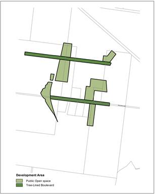
Figure 1: Development Area Map
3. Amending
the LEP Lot Size Map to adjust the land to which the clause applies in Moss
Vale Road South URA, as shown in Figure 2:
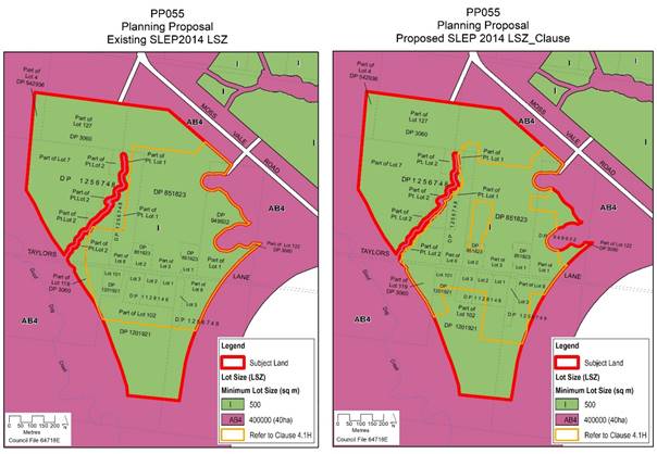
Figure 2: Current and Proposed Lot Size Maps
The proposed changes will enable
small lots to be considered and provided on land identified as ‘small lot
residential’ on the ILP and higher amenity land in close proximity to
intended public open spaces and tree lined boulevards, even if minor acceptable
or agreed variations are proposed in the locations of these spaces in a
proposed development.
Note: Council also
resolved during June 2020 to review the planning and proposed traffic
provisions in the Moss Vale Road South URA with the intent of retaining the
trees along Taylors Lane. This review is underway however at the time of
writing there were no outcomes or recommendations to consider. When the review
is completed, any resulting changes to the Clause 4.1H area and other planning
controls that are endorsed by Council may need to be undertaken via a separate
PP and/or DCP amendment.
DCP Amendment
A resulting DCP amendment is
also required to reflect the amended Clause proposed in the PP, consisting of
deletion of the following bullet point from Subsection 7.3.2 (6) in Section 7.3
Subdivision Design of Chapter NB3: Moss Vale Road South Urban Release Area:
“6) Subdivision of small lots in accordance with
Shoalhaven LEP 2014 must:
· Have
a primary street frontage;
· Adjoin land reserved for public open space (either directly
or separated by a road) or be located along a tree-lined boulevard; and
· Access is provided
via a rear laneway or shared driveway arrangement, except for lots equal to or
greater than 400m2.”
Gateway Determination and Public
Exhibition
The PP was submitted to the Department of Planning, Industry
and Environment (DPIE) on 31 July 2020, and a favourable Gateway determination
was received on 2 September 2020 which authorised the PP to proceed. Council
was given delegated authority to make the LEP amendment. The Gateway did not
require consultation with any public authorities.
Community Engagement
The PP and draft DCP amendment
were subsequently publicly exhibited from Wednesday 30 September to Friday 30
October 2020 inclusive (31 days) on Council’s website. The exhibition
included a copy of the PP, draft DCP amendment, explanatory statement, Gateway
determination and a public notice of the exhibition.
Letters advising of the public
exhibition were sent to all affected and adjoining landowners at Moss Vale Road
South URA, as well as development industry representatives and the Cambewarra
Residents and Ratepayers Association.
No submissions were received in response to the
exhibited PP and draft DCP amendment.
Policy Implications
Should the recommendation be
adopted, the PP will result in an amendment to Clause 4.1H of Shoalhaven LEP
2014 that will enable greater flexibility in the provision of ‘small
lots’ in URAs, particularly where a development application proposes a
minor variation to the relevant Indicative Layout Plan (ILP). The
proposed LEP amendment will enable the Clause to be more easily applied to
other URAs as desired, via a separate PP to identify the additional area/s on
the Lot Size Map. It will also remove redundant provisions from
Shoalhaven LEP 2014 such as the Development Area Map, simplifying the overall
provisions of the LEP.
The proposed amendment to Shoalhaven DCP 2014 Chapter NB3:
Moss Vale Road South URA will align the small lots criteria with the amended
Clause 4.1H provisions.
Financial Implications
There are no immediate financial
implications for Council. The amendment is being resourced by Council’s
existing Strategic Planning budget.
|
|
Development
& Environment Committee – Tuesday 01 December 2020
Page
1
|
DE20.130 'Legacy'
Planning Proposals - Timing and Progression - NSW Government Direction
HPERM Ref: D20/488125
Section: Strategic
Planning
Approver: Robert
Domm, Director - City Futures
Attachments: 1. DPIE
letter 1/10/20 - Legacy PPs ⇩
2. Council
letter 28/8/20 - Outcomes of Culburra groundwater monitoring study ⇩
3. DPIE
letter 6/11/20 - Culburra groundwater monitoring study ⇩
4. APS letter 16/11/20 -
response to DPIE letters 1/10/20 5/11/20 Halloran Culburra PP005 ⇩
Reason for Report
Confirm Council’s
direction on the timing/progression of the five (5) ‘legacy’
Planning Proposals (PP’s) detailed in the report to enable a response to
be provided to the NSW Department of Planning, Industry and Environment (DPIE)
following their letter to Council advising that the PP’s which are 4+
years old are to be ‘finalised’ by 31 December 2020.
|
Recommendation (Item to be determined under delegated authority)
That
Council
1. Receive the updates on each of the
‘legacy’ Planning Proposals (PP’s) for information.
2. In respect of each PP covered in the
report, take the following steps:
a. Warrah Road, Bangalee (PP005):
continue toward finalising this PP under a new Gateway determination.
b. Halloran Trust Land, Culburra
(PP006): withdraw the current PP and seek a new Gateway determination,
subject to further discussions with the proponent and the NSW Department of
Planning, Industry & Environment (DPIE) in an attempt to resolve a
development footprint.
c. Nebraska Estate, St Georges Basin
(LP145.1): withdraw the current PP and seek a new Gateway determination while
continuing efforts to secure certification for the new planning controls under
Clause 34A of the NSW Biodiversity Conservation (Savings and Transitional)
Regulation 2017.
d. Badgee Lagoon Deferred Areas, Sussex
Inlet (LP407): withdraw the current PP on the basis that it will be added to
and covered by a new PP and accompanying Biodiversity Certification
Assessment Report (BCAR) that is being prepared by the proponent.
e. Inyadda Drive, Manyana (PP007):
withdraw the current PP and seek a new Gateway determination once the outcome
of the proponent’s upcoming referral under the Commonwealth’s Environment
Protection and Biodiversity Conservation Act (EPBC Act) is known.
3. Prepare a future report on
revising/updating Council’s Planning Proposal Guidelines once DPIE has
updated it is relevant guidelines and the revised Planning Proposal process
is clearer.
|
Options
In respect of the PP’s in
question the ‘general’ options for each are briefly outlined below.
1. Withdraw the PP
and seek a new Gateway determination.
Implications: Of the options presented to Council
by DPIE, this is the only option for progressing the PP, albeit under a new
Gateway determination. DPIE will critically review any conditions before
issuing a new Gateway determination, to improve the prospects of completing the
PP within the allowable timeframe (generally one year, two years maximum).
However, in relation to the Badgee Lagoon Deferred Areas
(LP4097) PP, the proponent is preparing to lodge a new PP over the area around
golf course and they are also preparing a Biodiversity Certification Assessment
Report (BCAR) that will cover the new PP plus the ‘deferred’ areas.
It would be logical to incorporate the ‘deferred’ areas PP into the
new PP.
2. Withdraw the PP.
Implications: This option would only be appropriate
if, for some reason, Council no longer supports or wants to progress a PP and
this has not been indicated to date. Substantial work has been invested in all
the PP’s in question, and as such this option is not recommended.
3. Resolve to
‘do nothing’.
Implications: While the existing Gateway
determinations for three of the five PP’s do not lapse until 2021, DPIE
is able to terminate the PP at any time (by altering the Gateway). DPIE has
indicated that it will not allow the legacy PP’s to continue under
the current Gateway determinations beyond 31 December 2020. As such this
approach is not recommended.
Background
Council received a letter from
DPIE dated 1 October 2020 (see Attachment 1), regarding five (5) long
standing PP’s that ‘have been delayed or, are yet to be
finalised after more than four years’. In short, the letter states
that these ‘legacy’ PP’s are to be finalised by the end of
the year (2020).
The letter states that the focus
on these legacy PP’s is part of a broader set of ‘planning system
acceleration’ reforms which seek to ‘streamline and simplify the
planning system, will unlock productivity, keep people in jobs and support
sustained economic recovery from the Covid-19 pandemic’. The key
issues raised in the letter are summarised below.
• The
Minister is seeking to cut the time taken to finalise rezoning decisions by
33%. This will provide greater clarity to local government and the community,
and more certainty to proponents and investors
• …planning
proposals should generally take 1 year and no more than 2 years to complete.
This has been shown to be achievable in many cases where applications are
supported by enough evidence to justify strategic and site-specific merit, and
when proposals are aligned to a strong strategic planning framework
• To
ensure the new system achieves these outcomes we must first clear the backlog
of planning proposals that have remained under consideration for an extended
period
• Department
is commencing a focused program to work with councils to finalise proposals
that are 4+ years old by 31 December 2020
• DPIE
will then…start to address those that are between two four years old.
• Sarah
Lees, Director Southern Region, will contact you in the coming days to
establish a project plan and timeframe for finalising the above proposals.
The five (5) legacy PP’s in question are:
· LP407 - Badgee
‘Deferred’ Areas, Sussex Inlet (Proponent: Allen Price &
Scarratts for Lucas Property Group & Sheargold Group)
· PP006 - Halloran
Trust, Culburra Beach (Proponent: Allen Price & Scarratts for Halloran
Trust)
· LP145.1 - Nebraska
Estate, St Georges Basin (Proponent: Council on behalf of landowners)
· PP007 - Inyadda
Drive, Manyana (Proponent: JWD Projects)
· PP005 - Warrah
Road, Bangalee (Proponent: Peter Taranto, Warrah Property Developments P/L)
The status of these PP’s
is outlined later in this report. It is noted that all these PP’s
are specifically supported by an adopted/endorsed strategy, except for the
Inyadda Drive (PP007) which seeks to reduce the extent of an existing zoned
residential area and increase the area of environmental zoned land.
Meetings with DPIE and the PP
proponents
Following receipt of the letter
Council staff discussed each of the PP’s with DPIE and the proponents.
Meetings were held with DPIE and the proponents on 21 October in relation to
the Badgee ‘Deferred’ Areas and the Inyadda Drive PP’s; and
on 4 November in relation to Culburra Beach, Warrah Road and Nebraska Estate PP’s.
The proponent did not attend the Warrah Road meeting because public exhibition
of that PP is imminent.
At each of the meetings,
DPIE’s Executive Director – Rural & Regional Planning, Monica
Gibson, outlined the following general options:
· Accelerate
finalisation of the PP/LEP amendment. This option would only be considered if
the PP had been publicly exhibited. Not relevant to the PP’s in question.
· DPIE terminates
the PP by issuing an amended Gateway determination.
· Council withdraws
the PP.
· DPIE issues a
fresh Gateway determination for PP’s that have strategic and site
specific merit. There would need to be a high level of certainty that the PP
could be finalised within one year, or two years at the most. DPIE would
critically review the existing Gateway conditions, including consideration of
any issues that could be adequately addressed at a later stage.
Note: Except for Urban Release Areas
(URAs) how this would be achieved is uncertain as the current Standard
Instrument LEP format does not allow the use of local clauses to
‘defer’ specific matters to the development application stage.
Legacy PP’s: Status & Next Steps
Warrah Road, Bangalee (PP005)
· Strategic Basis - Part
of the Crams Road Urban Release Area identified in the Nowra Bomaderry
Structure Plan, with the zoning ‘deferred’ from LEP 2014.
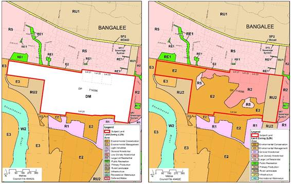
Above:
PP005, Warrah Road, Bangalee - current (left) and proposed (right) zoning
· Key issues: biodiversity,
unauthorised clearing / remediation order, traffic, bushfire
· PP supporting studies
complete.
· Currently finalising
pre-exhibition Government Agency consultation requirements. Aiming exhibit this
year, but will not be finalised by the end of the year.
· Current Gateway time
frame expired in July 2020. DPIE declined to issue any further extensions,
advising that Council should seek to finalise the PP as soon as possible.
Next Steps - Recommendation: Based on
advice from DPIE that the PP will not be allowed to continue beyond 31 December
2020 relying on the current Gateway determination. At the time of preparing
this report, a new Gateway request is being prepared for submission to DPIE to
enable this PP to proceed to exhibition as intended and then be finalised
during 2021
Halloran Trust Land, Culburra Beach (PP006)
· Strategic Basis –
Part of the Jervis Bay Settlement Strategy.
· Most of the land is
deferred from LEP 2014
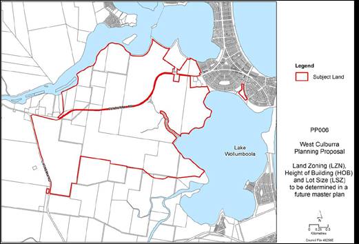
Above:
PP006 - subject land, Halloran Trust land, Culburra
· Key issues: impacts on
Lake Wollumboola & Crookhaven River, buffers, uncertainty about groundwater
behaviour, water quality management (neutral or beneficial effect - NorBE)
biodiversity, Aboriginal cultural heritage etc.
· ‘Part 3A’
major project / State Significant Development (SSD) for the West Culburra
subdivision application was refused. Proponent’s Land and Environment
Court (LEC) appeal is ongoing. The map below shows the relationship between the
PP area and the SSD area.
· Extensive suite of
studies required by Gateway determination, reflecting the range of issues and
constraints. These studies need to be undertaken in a logical sequence.
· The original PP was
split in two due to longer timeframe for Culburra Beach component. The Callala
/ Kinghorne Point component is now in a separate PP that is less than 4 years
old.
· Biodiversity
certification application submitted to NSW Government under the transitional
arrangements for the NSW Biodiversity Conservation Act.
· Project Control Group
(PCG) with DPIE and relevant NSW Government Agencies.
· The two-year groundwater
monitoring study was recently completed. This is discussed further below.
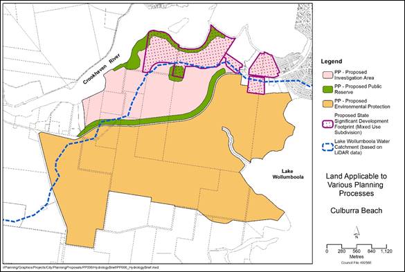
Above:
Map showing the PP investigation area in relation to the SSD subdivision area
West
Culburra Groundwater Assessment Report – Summary &
Implications
The West Culburra Groundwater
Assessment Study was undertaken by consulting firm, HGEO to address a key
initial condition of the Gateway determination. The key objective of the study
was to delineate the groundwater catchment for Lake Wollumboola and groundwater
flow directions within the area.
The study involved real-time
water level monitoring in a network of 28 bores (21 new and 7 existing) between
Lake Wollumboola and the Crookhaven River over a two-year period. The two-year
baseline monitoring period was dominated by drought conditions, with several
large rainfall events, including in early February 2020.
The key findings of the report are summarised below:
· The groundwater
catchment is considered to align with surface water catchment (refer to Figure
8 from the report which is reproduced below).
· Groundwater seepage is
unlikely to have a measurable influence on overall salinity levels within Lake
Wollumboola, but may influence near shore environments, particularly when the
lake is closed and its level is low.
· The siltstone bedrock
that underlies the study area has low permeability but is locally elevated due
to fracturing and faulting. These faulted and fractured zones within the
siltstone have high permeability (0.5 – 15 m/day).
· The degree of connection
between fractured zones cannot be determined from the existing bore network.
· There is potential for
migration of contaminants to the lake edge environment via fracture zones if
contamination reaches the water table.
· Land use planning should
avoid or mitigate potential for contamination of groundwater within the Lake
Wollumboola catchment.
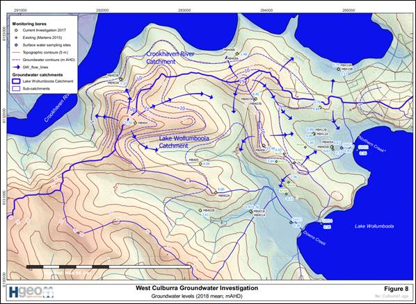
Above: Figure
8 from the West Culburra Groundwater Assessment Report (HGEO, 2020) showing the
catchment divide, bore locations and groundwater flow direction
The report was provided to the
proponent and the PCG and has also been made publicly available via this
link from Council’s Get
Involved page for the Halloran-Culburra PP.
Advice and direction were sought
in writing from DPIE on 28 August 2020 to enable the PP to be progressed in
light of the groundwater assessment report. Council’s letter to DPIE is
provided as Attachment 2. DPIE’s response, dated 6 November 2020,
is provided as Attachment 3 and an excerpt is provided below.
· The Department notes
the outcomes of the Culburra Groundwater Assessment Report, particularly
the findings and recommendations that:
· The divide between the
Lake Wollumboola and Crookhaven River groundwater catchments should be
considered coincident with the surface water catchment defined by topography.
· While the degree of
connection between fractured zones cannot be determined from the existing bore
network, there is potential for migration of contaminants to the lake edge
environment via fracture zones if contamination reaches the water table. Land
use planning should avoid or mitigate potential for contamination of
groundwater within the Lake Wollumboola catchment.
· Areas between the main
ridgeline north of Culburra Road and the mid-slope areas in both catchments are
dominated by rainfall recharge. It is recommended that land use within the
recharge-dominated areas of Lake Wollumboola Catchment (mid-slope to ridge-top)
includes significant open and unpaved areas in those important recharge areas.
Based on the Report’s
recommendations, as well as recommendations of the 2013 “Environmental
Sensitivity of Lake Wollumboola” report prepared by Peter Scanes, the
Department considers urban development in the area between Culburra Road and
the catchment divide would not be appropriate due to the risk of contamination
of the Lake. There may, however, be some potential for limited low-scale
development in this area such as appropriate private or public recreation,
ecotourism or environmental stewardship. Any development would need to be sited
and designed to direct surface stormwater (and any appropriately treated
wastewater) to the Crookhaven catchment or, if unavoidable and justified,
demonstrate a very high standard of environmental management to protect the
water quality of the Lake.
The Department considers that
the findings and recommendations of the Groundwater Assessment Report and Flora
and Fauna Offset Strategy should enable determination of an indicative
development footprint for the planning proposal and progression of the
remaining studies required under the Gateway determination.
DPIE’s response was
provided to the proponent on 10 November to enable their feedback to be
included in this report if needed. Allen Price & Scarratt’s (APS)
response that also covers the DPIE ‘legacy’ PP letter is provided
as Attachment 4. APS’s key points are quoted/summarised below.
Comments -
DPIE’s ‘legacy PP letter’
· The proponent supports
efforts to streamline the planning system but does not agree with issuing a new
Gateway unless there are significant efficiency gains.
· The PP site has a very
long history dating back to the 1980s.
· The landowner is very
concerned having “… progressed with as much haste has been possible
with the required studies, and it now appears there is potential for the
gateway determination to be either withdrawn prematurely or modified”
· “We note in our
meeting with DPIE representatives on 4 November 2020, it was indicated verbally
to us that DPIE would most likely terminate the West Culburra PP by 31 December
2020, and then issue a new gateway determination at some stage in the future.
We strongly object to DPIE ’s position on this matter and requests
Council resist this outcome in the strongest possible way in recognition of the
substantial progress made to date under the current Gateway
determination.”
· However,
“…there would be no objection if DPIE was to re-issue the same
gateway determination (with a new commencement date for administrative
purposes) or a revised Gateway determination with a reduced quantum of studies
required for the rezoning controls to be finalised.”
· “We note from our
4 November 2020 meeting with DPIE that we were supposed to have a follow up
meeting, but at the time of writing, this meeting had not been scheduled. We
request this matter be urgently pursued with DPIE representatives.” Council
Staff Comment: There was insufficient time to arrange a second
meeting with DPIE and the proponent prior to preparing this report.
Comments -
DPIE’s letter 6 November 2020 (re Groundwater Assessment)
· Believe DPIE’s
letter is at odds with HGEO’s Groundwater Assessment report.
· The only conclusions
that can and should be drawn from the HGEO report is that in order to minimise
the risk to Lake contamination, groundwater pollution should be avoided as part
of any land-use planning decisions. Treating stormwater generated by a
development to a level equivalent to or better than existing groundwater
quality, would ensure that any risk to the Lake water quality would be ‘mitigated’.
Stormwater management controls are thus both form of land-use controls and
mitigation measures.
· The Scanes Report (Note:
Earlier NSW Government scientist report on the issue) draws no conclusions
that prohibits urban development within the Lake Catchment.
· Contrary to the Scanes
Report, the HGEO report concludes that groundwater seepage is a minor
contributor to total inflows to the Lake.
· DPIE’s attitude
to development in the catchment of Lake Wollumboola is not based on sound
science and is overly conservative.
Next Steps -
Recommendation: There is still a need to resolve the zoning and
tenure future of the area. Given that, to date, a significant amount of money
and resources has been invested in the studies, Council staff and the proponent
are in strong agreement that Council should seek a new Gateway determination to
enable this matter to proceed to a resolution, subject to further discussions
with DPIE and the proponent on the outcomes of the groundwater assessment and a
development footprint.
Concluding this PP within the
likely one to two years under any new Gateway determination will however be
challenging unless the potential development footprint is more settled. The
proponent’s strongly disagree with DPIE’s position on the
fundamental groundwater aspect of the proposal. It is therefore recommended
that further discussions be held with DPIE and the proponent to try and reach
agreement on this before seeking a new Gateway determination.
If the hydrodynamic advection-dispersion modelling and/or
other modelling/assessments are required to resolve a footprint and address the
potential impacts on the downstream ecosystems, the probability of completing
the PP within two years will be substantially reduced.
Nebraska Estate, St Georges Basin (LP145.1)
· Strategic Basis –
Part of the Jervis Bay Settlement Strategy. Last unresolved ‘paper’
subdivision in the Jervis Bay area.
· Council effectively
acting as the proponent, with the rezoning investigations being funded by the
landowners through special rates.
· Large proportion is
highly constrained (biodiversity, bushfire, acid sulfate soils, flooding,
Aboriginal cultural heritage)
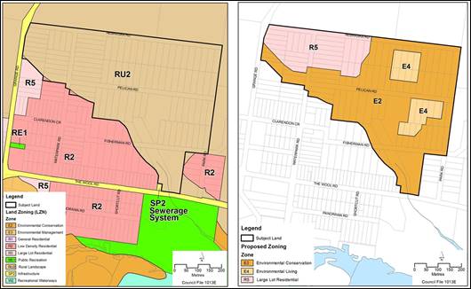
Above: LP145.1,
Nebraska Estate Planning Proposal - Current (left) and proposed (right) zoning
· Other issues: fragmented
land ownership, cost of providing/upgrading subdivision infrastructure.
· LEP Amendment will need
to be supported by site-specific DCP controls. A special rate and Special Rate
Variation (SRV) would be required to enable the required infrastructure
upgrades (consistent with Jerberra & Verons Estates).
· Progression of the PP
has been impacted by:
New biodiversity legislation -
The PP was almost ready for public exhibition before the new NSW Biodiversity
Conservation Act commenced. This led to ongoing discussions regarding the
potential use of Clause 34A of the NSW Biodiversity Conservation (Savings and
Transitional) Regulation (as for Jerberra and Verons Estates). If Clause 34A
cannot be used, most, if not, all future development applications in the Estate
would need to be supported by a Biodiversity Development Assessment Report
(BDAR) and the NSW Biodiversity Offset Scheme would apply.
Resourcing - an additional
part time staff resource has been added to assist in this regard.
New Planning for Bushfire
Protection Guidelines – bushfire assessment completed in 2019 to
address the new Guidelines.
· The required studies to
support the PP have been completed.
Next Steps –
Recommendation: To assist with the progression/resolution of
this matter, a separate report has been prepared for Council’s
consideration regarding future tenure and management for residual E2
Environmental Conservation zoned land in the Jerberra and Nebraska Estates. The
option presented in that report may help secure the use of Clause 34A for the
proposed Nebraska Estate planning controls. If Council resolves to progress
with that option, and Clause 34A certification is able to be achieved, the PP
and draft DCP would be updated and reported to Council for endorsement to
exhibit.
Given the long history of this matter and the amount of work
already invested in resolving the planning status of this ‘paper’
subdivision, it is recommended that a new Gateway determination be sought.
Badgee Deferred Areas,
Sussex Inlet (LP407)
· Strategic Basis
– Part of the Sussex Inlet Settlement Strategy.
· This PP covers the
two separate areas, shown on the following map, that are ‘deferred’
from LEP2014 adjacent to Badgee Lagoon, Sussex Inlet.
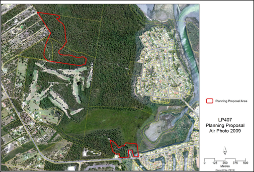
Above: LP407,
Badgee Lagoon Deferred Areas - subject land overlaid onto aerial photograph
· The progress of this PP
has been delayed by factors outside of Council’s control, including
delays in receiving funding from the proponent for the Biodiversity review, and
lack of definitive information from them on the final proposed layout of the
golf course.
· The proponent advised in
October 2018 that they intend to retain most of the northern
‘deferred’ area as conservation land and may include this in a
Biodiversity Stewardship site.
· Most of the required
assessments have been managed by the proponent whose main initial focus has
been on obtaining consent for, and implementing, the approved subdivision of
the Badgee Urban Release Area (URA). However, a joint venture was established
between the original landowner/developer, Lucas Property Group and the
Sheargold Group. The proponent has expressed a commitment to resolving the
zoning of both the northern and southern ‘deferred’ areas.
· The proponent is working
on a new PP to adjust and amend the zoning around the golf course and
residential area. They are also completing a draft Biodiversity Certification
Assessment Report (BCAR) for the new PP, which will also cover the
‘deferred’ land.
· Council Staff have had
discussions with the proponents and DPIE about incorporating the
‘deferred’ areas PP into the new PP. The proponent is generally
supportive provided additional studies are not required and the new Gateway
determination is not more onerous. Feedback from DPIE suggests this is
unlikely.
Next Steps – Recommendation - It is
recommended that Council withdraw this PP and incorporate the
‘deferred’ areas into a new overall PP that is being prepared by
the proponent, subject to assurance from DPIE that a new Gateway determination
will be issued, and that it will not be more onerous than the one for the
existing PP.
Inyadda Drive, Manyana
(PP007)
· This
PP was originally initiated by previous owner (Kylor P/L).
· Strategic Basis –
The subject land is already zoned a mix of R5 - Large Lot Residential, R1 -
General Residential, E3 – Environmental Management and RE1 – Public
Recreation as shown on the following map.
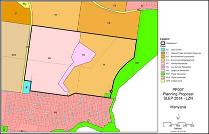
Above: PP007,
Inyadda Drive, Manyana - subject land and current zoning
· The PP seeks to reduce
the overall development footprint, but enable smaller lots (i.e. 600 m2)
than allowed in the current R5 area (which has a lot size of 2,000 m2)
· A key requirement of the
existing Gateway determination is the preparation of a biodiversity offset
strategy (among other studies).
· The proponent submitted
a Biodiversity Certification Assessment Report (BCAR) to Council for review on
6 November 2020. Council has 42 days to provide comments. The proponent will
then submit it to the NSW Government for approval to publicly exhibit.
· The proponent then
intends to submit a referral under the Commonwealth’s Environment
Protection and Biodiversity Conservation Act (EPBC Act) – a significant proportion
of the proposed development area is affected vegetation communities listed
under the Act: Illawarra Lowlands Grassy Woodland and Swamp Oak Floodplain
Forest (shown in the map below coloured yellow and brown/orange, respectively.
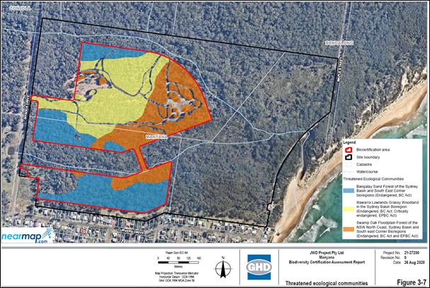
Above: Excerpt
from the BCAR prepared by GHD on behalf of the proponent
· Securing offset site(s)
for Illawarra Lowlands Grassy Woodland (shown above in yellow) may be
problematic, as the distribution of this community is very limited.
· It is understood that if
Illawarra Lowlands Grassy Woodland offset site(s) cannot be located/secured,
the development could not be approved under the EPBC Act based on the
Commonwealth’s ‘like for like’ offset trading rule.
· The proponent has
indicated that they will be proactively investigating the availability of
potential Illawarra Lowlands Grassy Woodland offset sites.
· An Aboriginal Cultural
Heritage Assessment (ACHA) needs to be prepared to address the relevant
Ministerial Direction under Section 9.1 of the NSW Environmental Planning and
Assessment Act.
· An ACHA consultant was
selected in January 2020, but the study has not commenced because the proponent
has not provided the required funding to Council. The proponent has indicated
that they will pay for the ACHA when the biodiversity offsetting / EPBC issue
has been resolved. This timeframe is outside of Council’s control.
The ACHA will take approximately 5 months to complete. There may also be a need
to obtain new consultancy quotations.
· The proponent has
prepared a range of other studies, some of which will need to be updated and/or
amended at the appropriate point to respond to Council feedback.
· A water cycle management
study will also need to be prepared after the above issues have been resolved.
· Supporting documents
will also be needed: Draft DCP; Contributions Plan amendment and/or Voluntary
Planning Agreement.
Next Steps – Recommendation – Whilst
there as some risk with this approach, it is recommended that Council
request a new Gateway determination once the biodiversity offsetting / EPBC
issue has been resolved.
Planning Proposals –
The Current ‘Gateway’ process
The current ‘gateway process’ was established to
allow PP’s to be considered based on preliminary information before
having to outlay costs on more expensive and time-consuming studies. This
approach is set out in the Department’s Planning
Proposal Guidelines which include the following statements about the level
of detail required in a planning proposal:
The preparation of a planning
proposal is the first step in preparing a LEP. Throughout the course of
preparing the proposed LEP, the planning proposal itself may evolve. This is
particularly the case for complex proposals.
The planning proposal may change
over time from when it is initially prepared to the point where a definite
proposal has been developed…
The planning proposal should contain enough information
to identify relevant environmental, social, economic and other site-specific
considerations. The scope for investigating any key issues should be identified
in the initial planning proposal that is submitted for a Gateway determination.
This would include listing what additional studies the PPA considers necessary
to justify the suitability of the proposed LEP amendment. The actual
information/investigation may be undertaken after a Gateway determination has
been issued…
Historically as a result, DPIE
has allowed PP’s to proceed based on a minimal level of information
relevant to the matter/site/issue, consistent with the above Guidelines setting
out any studies and consultation requirements that must be completed prior to
public exhibition in the Gateway determination.
If DPIE now intends to change the PP process as indicated in
their letter, the current PP guidelines need to be reviewed and revised as a
priority. This will also potentially mean that more comprehensive supporting
documentation may be required prior to Councils initial consideration of
whether to support a PP request proceeding further.
General comments - Time taken
to rezone land
PP’s depending on their
nature can vary greatly in scale and scope. Some are inherently complex and
require a longer more iterative process. Many factors can delay the process and
these are often outside of Council’s control. For more complex PP’s
it is often necessary to stage the studies. For example, environmental and land
capability assessments may need to be completed first to enable the overall
development footprint to be defined, before secondary assessments (e.g.
traffic, servicing and infrastructure assessment) can be undertaken.
Biodiversity assessments can often take 12 months or more to complete,
especially if a range of seasonal targeted surveys are required (and this is
not uncommon). Water quality assessments cannot be undertaken without a conceptual
subdivision. In the case of the Halloran Trust PP at Culburra Beach, a two-year
groundwater monitoring study was required among several other detailed studies.
In contrast to the current Gateway process as explained in
the current Guidelines, DPIE’s letter states that going forward ‘…
our intention is that planning proposals should generally take 1 year and no
more than 2 years to complete.’ The only way this can be achieved for
more complex proposals is to require far more detail and certainty upfront
(prior to the Gateway) or to defer studies/assessments to a later stage, such
as the development application (if this is the case the current Standard LEP
Instrument approach may need to be adjusted to enable or ensure this).
Community Engagement
There has been insufficient time to consult with the broader
community in respect of the options presented to Council by DPIE on these
‘legacy’ PP’s. It is reasonable to expect that the community
would have an expectation that the efforts to resolve the planning status of
these areas will be continue to a reasonable conclusion. Should the
recommendations of this report be adopted, and Council’s proposed
approach be supported by DPIE, the community will be engaged as part of the
subsequent formal exhibition process for each PP.
Policy Implications
DPIE’s insistence that PP’s will have to be
finalised within one to two years maximum, means that further information will
or may now need to be provided before Council seeks a Gateway determination.
Council’s current Planning Proposal Guidelines will need to be revised
once DPIE’s guidelines are updated.
Financial Implications
Four of the five PP’s are
proponent-initiated PP’s which are funded by the proponent in accordance
with Council’s Planning Proposal Guidelines and the applicable fees and
charges. The ‘Major PP’ fee which applies to these PP’s,
covers up to 80 hours of staff time. If new Gateways are requested, this fee
structure will be carried over.
Council took out a $200,000 loan in 2006 to fund the Nebraska
Estate rezoning investigations, was paid off by the landowners over 10 years
through a special rate. There is currently $65,240 in the Nebraska Estate
special rate budget. Any funds remaining at the conclusion of the PP/DCP
process would then be carried over to any infrastructure upgrade projects.
Risk Implications
As noted earlier, four of the
five PP’s are specifically identified in an adopted/endorsed strategy.
The other PP (Inyadda Drive, Manyana) site is already zoned for development,
and is justified by the fact that the PP is seeking to reduce the overall
development footprint, provide a better environmental outcome. Nevertheless,
should Council resolve to withdraw the PP’s in question and seek new
Gateway determinations, it is possible that DPIE will not issue new, comparable
Gateway determinations. This concern has been raised in discussions with DPIE
by Council staff and also the proponents. DPIE indicated that they cannot
completely guarantee the outcome. However, in the circumstance there appears to
be no other choice than to proceed as recommended.
|

|
Development
& Environment Committee – Tuesday 01 December 2020
Page
1
|
|
|
Development
& Environment Committee – Tuesday 01 December 2020
Page
1
|
|
|
Development
& Environment Committee – Tuesday 01 December 2020
Page
1
|
|
|
Development
& Environment Committee – Tuesday 01 December 2020
Page
1
|
|
|
Development
& Environment Committee – Tuesday 01 December 2020
Page
1
|
DE20.131 DA20/1494
– 25 Sunnymede Lane, Berry – Lot 3 DP 713138
DA. No: DA20/1494/4
HPERM Ref: D20/259112
Section: Development
Services
Approver: Phil
Costello, Director - City Development
Attachments: 1. 4.15
Assessment - 25 Sunnymede Lane, Berry - Lot 3 DP 713138 (under separate cover) ⇨
2. Booking.com
Listing - 25 Sunnymede Lane, Berry - Lot 3 DP 713138 ⇩
3. Stop
Use Order - 25 Sunnymede Lane, Berry - Lot 3 DP 713138 ⇩
4. Show
Cause Letter - 25 Sunnymede Lane, Berry - Lot 3 DP 713138 ⇩
5. Approved
Floor Plans (DA16/2488) - 25 Sunnymede Lane, Berry - Lot 3 DP 713138 ⇩
6. Plans
- Floor Plans - Lot 3 DP 713138 - 25 Sunnymede Lane Berry ⇩
7. Determination
- Approval - DA16/2488 - 25 Sunnymede Lane, Berry - Lot 3 DP 713138 (under
separate cover) ⇨
8. Applicants
Justification - DA16/2488 - 25 Sunnymede Lane, Berry - Lot 3 DP 713138 ⇩
9. Response
to Objections - 25 Sunnymede Lane, Berry - Lot 3 DP 713138 ⇩
10. Draft - Determination
- Approval - 25 Sunnymede Lane, Berry - Lot 3 DP 713138 (under separate cover) ⇨
Description
of Development: Change of use of existing ancillary structure (shed) to
detached habitable rooms.
Owner:
Philip Richard Scarr and Melissa Bevelyanna Scarr.
Applicant:
PDC Planners.
Notification
Dates: 10 June 2020 – 25 June 2020.
No.
of Submissions: 10 submissions received.
Purpose / Reason for consideration
by Council:
At its Ordinary Meeting on 23 June 2020, Council resolved to
call in DA20/1495 - 25 Sunnymede Lane, Berry, Lot 3 DP 713138 due to
public interest (MIN20.423). This application is for the change of use of an
existing ancillary structure (Shed) to detached habitable rooms.
|
Recommendation (Item to be determined under delegated authority)
That Council determine
Development Application DA20/1495 by way of approval subject to the
conditions at attachment 10.
|
Options
1. Approve the
Development Application as recommended
Implications: This would allow the applicant to proceed with the proposal
and complete the all-weather connection of the habitable rooms with the main
dwelling.
2. Refuse the
Development Application.
Implications: This would mean the current use could not be
regularised and the structure would need to revert back to a shed in accordance
with DA16/2488. A Notice of Determination for Refusal will need to be prepared.
The applicant can lodge an appeal with the NSW Land and Environment
Court against Council’s decision.
3. Alternative
recommendation.
Implications: Council will
need to specify an alternative recommendation and advise staff accordingly.
Subject Site & Surrounding Area:
The subject site is 25 Sunnymede Lane, Berry and it is legally
described as Lot 3 in Deposited Plan 713138.
The site has a depth of 95m and a length of 214m and is 2.01ha
in area. Sunnymede Lane directly connects to Beach Road which provides access
to the site.
The topography of the subject site exhibits a fall of
approximately 2.2 metres from the location of the proposed development towards
the northern boundary. The building site is located on a level portion of the
land.
The site currently contains an approved detached single
dwelling house, swimming pool, effluent treatment area, sports court, dispersed
vegetation and a detached shed. The applicant wishes to change the use of the
detached shed to detached habitable rooms.
Figure 1 – The
Subject Site with Existing Building Identified (Orange Circle).
The surrounding area primarily consists of detached single
dwellings on large individual parcels of land. These dwellings are situated
amongst an overall undulating topography that affords a typical rural residential
vista.
The proposed development
The applicants have applied for approval to change the use of
an existing ancillary structure (shed – Class 10a) to detached habitable
rooms (Class 1a).
The existing detached shed has an overall height of 6.302m and
a wall height of 5m. The gross floor area of the shed is 144m².
Externally, the building presents as a typical barn type structure on a
concrete slab. The walls and roof are clad with colorbond fitted to a steel
frame.
The building was approved in 2016 and it has approval for an
upper level bathroom and a sink/tub on the ground floor (DA16/2488).
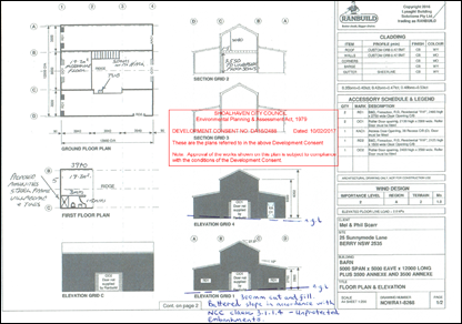
Figure 2 –
Approved Plans (DA16/2488)
The Development Application under assessment relates only to
the change of use. There are no structural changes or additional construction
works proposed. The proposed floor plan is indicated in figure 3 below.
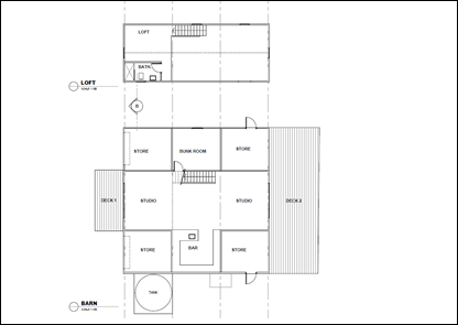
Figure 3 –
Proposed Floor Plan (DA20/1494)
Background and History:
On 10 February 2017 Council approved the construction and use
of a detached shed on the land at 25 Sunnymede Lane, Berry (DA16/2488).
Condition 3 of the development consent related to the use of the structure and
provides as follows:
iv.
The detached shed shall not be used for any industrial,
commercial, or habitable purposes.
The approved plans and development consent for DA16/2488 are
attached to this report (attachments 7 & 5). During the assessment of
DA16/2488, the applicants were asked to qualify and expand on the reasons for
the height and size of the shed. In response to this request, the following
justification was received by Council (Also see attachment 8).
“The shed is separated into 3
different sections as each section will be used for a different purpose. One of
the side sections will be used to store machinery, quad bikes, garden
equipment, bikes, surfboards and things that are used more regularly than the
other side section will be used for more long term storage such as boxes,
furniture and the like. The middle section will be used as an art
studio/workshop.
The mezzanine level will be used
for storage of art supplies and a toilet. As you need to be able to stand up on
the mezzanine level and also allowing for plenty of headroom if you are
standing under the mezzanine floor this affects the overall height of the shed.
In terms of floor area, we have a
lot of things to store and we will not have a garage attached to the main
house. Down the track, with renovations, the existing small garage will become
part of the house and a carport built instead. Hence the need for external
storage”.
Reviewing DA16/2488, it was put that the building was not
envisaged to be a habitable space except for the use of the middle section as
an arts studio. Council stipulated the building was not to be used for
habitable purposes based on the applicants’ statement (i.e. storage, and
an art studio/workshop).
After receiving approval from Council, the applicants carried
out the following works without approval:
(a) Fitting
the shed with internal cladding.
(b) Installing
kitchen cabinetry.
I Erection
of additional internal walls.
(d) Erection
of decks at the front and rear of the building.
I Modification
of roller doors to sliding doors.
(f) Installation
of seven new windows on the upper floor.
On 19 November 2018 Council received a complaint concerning
visitor noise as the premises was being rented out and advertised on Airbnb. An
investigation by Compliance Staff resulted in a show cause letter to the
landowners on 27 November 2018 (refer attachment 4).
The show cause letter required “all unauthorised use of
the detached shed to cease immediately”. An order was issued concurrently
on the basis that “the conversion of the detached shed into a habitable
space meets the definition of a dwelling under the SLEP 2014” (Attachment
3). The show cause letter contained the following photographs that were
obtained from the website for the Airbnb listing.
On 5 May 2020, the applicant submitted a Building Information
Certificate pursuant to section 149B of the Environmental Planning and
Assessment Act 1979 to regularise the works described in (a) to (f) above
(BC20/1034). The building information certificate application will be
determined separately following the determination of this development
application.
Issues
The key issue is whether the proposed development meets the
criteria of a detached habitable room and whether or not the proposed use is
appropriate for the land.
In establishing an appropriate determination for the
development application, it is paramount to consider whether the building meets
the criteria for a detached habitable room.
Detached Habitable Room:
The DCP dictionary defines a ‘detached habitable
room’ as:
For the proposed development to be considered a
‘detached habitable room’ in accordance with this description, the
building must satisfy the following matters:
(iv)
Be separated from the main dwelling:- There is no
definition of ‘separated’ or ‘detached’ in the Shoalhaven
Local Environmental Plan 2014, the Development Control Plan 2014, or the Environmental
Planning and Assessment Act 1979.
It is reasonable to conclude the building is
‘separated’ or ‘detached’ from the principal dwelling.
The building satisfies this requirement.
(b) Afford an
all-weather connection with the main dwelling:- Clause 6.2.3 of
SDCP-2014 includes a note that all-weather connection “must include a
continuously roofed/covered deck or hard stand pathway between the principal
dwelling and the detached habitable room/studio”.
The plans show an all-weather connection between the
dwelling and the detached habitable room.
I Be
used by members of the principal dwelling:- The building has been used
for holiday rental accommodation. The building is no longer listed on Airbnb
but it is listed on Booking.com.
Conditions of consent will require that the detached
habitable room only be used by members of the same household.
(d) Not contain the
prohibited facilities referenced in the DCP:- As noted on the submitted
floor plans, the building proposes to contain a bar area which includes a
countertop preparation area and a sink. Recommended conditions of consent will
require that the detached habitable room must rely on the main dwelling and the
buildings must function as a single dwelling/domicile. Conditions of consent
will require that the detached habitable room must not be fitted with any
cooking facilities or any clothes washing facilities. Accordingly, the building
not considered a separate dwelling and it satisfies the SDCP-2014 requirements
for detached habitable rooms.
6.3.2 Detached Habitable Rooms and Studios –
DCP 2014 – Chapter G12:
In addition to meeting the SDCP-2014 dictionary definition for
a detached habitable room, the proposed development must also comply with the
relevant provisions of Chapter G12 of SDCP-2014.
The listed objectives of 6.3.2 of the SDCP-2014 are to
(iv)
Ensure detached habitable rooms/studios provide an option for a
dwelling to have detached living spaces/bedrooms without being fully
self-contained”.
(ii) Ensure detached habitable rooms/studios
function operate as part of the principal dwelling and are linked by a
continuously roofed or all-weather hard-stand connection.
(iii) Ensure detached habitable rooms/studios fit with
the appearance of the principal dwelling.
(iv) Ensure there are no adverse impacts on the amenity,
privacy or solar access of adjoining/neighbouring properties.
Clause P27 of Chapter G12 of
SDCP-2014 requires that the detached habitable room must “rely on the
principal dwelling for either a laundry, bathroom, or kitchen”. An
inspection of the site has revealed that currently the building relies on the
principal dwelling for laundry facilities. Conditions of consent will require
that the detached habitable room must not be fitted with any cooking facilities
or any clothes washing facilities. It is considered that the requirements of
P27 are satisfied subject to recommended conditions of consent.
The plans indicate the two buildings will be linked by an
all-weather access and this will comply.
In terms of complementing the appearance of the existing
dwelling, this would have been considered under the original DA and no changes
are proposed. The building does not exacerbate any severe or devastating
effects on privacy or solar access of the neighbouring properties.
Compliance with Shoalhaven Development Control Plan 2014
The proposed development has been assessed against the
relevant chapters of the Shoalhaven Development Control Plan 2014 (SDCP-2014).
This is further outlined in the section 4.15 assessment report (attachment 1).
The following brief comments are made as a result of the assessment:
Chapter G1 – Site Analysis,
Site Design and Building Materials.
Comment: There are no changes proposed to
the approved development under DA16/2488. The applicants have submitted a site
analysis plan for this application.
Chapter G2 – Sustainable Stormwater Management and
Erosion/Sediment Control.
Comment: There are no changes proposed to
the approved stormwater management system as approved under DA16/2488.
Chapter G7 - Waste Minimisation and Management Controls.
Comment: The development application
pertains only to the ‘change of use’, additional building waste
will not be generated beyond that which was assessed under DA16/2488.
Chapter G12 – Dwelling Houses
and Other Low Density Residential Development.
Comment: The proposed development will
comply with this chapter.
Planning Assessment:
The application has been evaluated against the relevant
matters pursuant to section 4.15 of the Environmental Planning and
Assessment Act 1979 (See attachment 1).
Consultation and Community
Engagement
The proposed development was notified to affected neighbours
in accordance with Council’s Community Consultation Policy. Council has
received 10 submissions and the issues are summarised as follows:
|
Issue
|
Comment
|
|
(a) The
applicants have carried out unlawful works.
|
This is agreed and compliance action has been
instigated by Council.
The applicants have lodged a Building Information
Certificate application in respect of the unlawful works and these are being
held in abeyance pending determination of this development application.
|
|
(b) The
use of the building currently contravenes conditions of development consent
imposed by Council.
|
This is agreed and
compliance action has been instigated by Council.
The applicants have lodged a Development Application
seeking to legalise the use of the building as a detached habitable building.
Condition 3 of DA16/2488 stipulates the building cannot be used for habitable
purposes.
If Council is of the mind to approve this application,
recommended conditions of consent would have the effect of modifying
condition 3 of DA16/2488 and would require the person benefiting from the
consent to give notice of modification as required by clause 97 of the Environmental
Planning and Assessment Regulation 2000.
|
|
(c) The
capacity of the effluent treatment system.
|
This is agreed.
The applicant has provided additional information from
a geotechnical consultant indicating the existing system is capable of
supporting the expected load.
|
|
(d) The
applicants are required to comply with State Environmental Planning Policy
(Building Sustainability Index: BASIX) 2004.
|
The applicant has
submitted a BASIX certificate. Compliance with the BASIX certificate is
a condition on the consent.
|
|
(e) Use
of the proposed development negatively impacts on adjoining neighbours’
amenity through noise emissions.
|
Conditions of consent will require the detached
habitable room be used only by members of the same household. The use of the
building for habitable residential purposes is not considered to give rise to
unacceptable amenity impacts.
|
|
(f) The
proposed development is not permissible in the land use zone RU1.
|
It is agreed that a separate dual occupancy or
secondary dwelling is prohibited in this RU1 zone.
The application is for detached habitable rooms and
these are permissible.
|
The applicants have prepared a response to the received
submissions and these are summarised as follows (Refer attachment 9):
(a) The previous use of the
site was subject to a stop-use notice which has been complied with.
Comment:- The application is for
detached habitable rooms and these are permissible. The building cannot be used
as a separate dwelling.
(b) Any potential future
use is entirely speculative.
Comment:- This is agreed. The
use of the site contrary to an approval would be subject to compliance action
from Council.
(c) Detached habitable
rooms are permissible within the RU1 zone.
Comment:- This is agreed.
(d) The noise and traffic
impacts should be no greater than that associated with a single dwelling.
Comment:- As the detached habitable
rooms are in conjunction with the principal dwelling, this is agreed. Noise and
traffic impacts could be dealt with separately via Council’s Compliance
Team.
(e) Separation distances
between the proposed building and neighbouring properties would limit light
spill. The applicants could potentially provide landscaping to further limit
these impacts.
Comment:- The applicants have submitted an
amended landscape plan and this indicates additional screening. This matter has
been addressed.
(f) The building will be
required to comply with the BCA under the submitted Building Information
Certificate application and Council will not issue any consent approval for
either the DA or the BC until this matter has been satisfied.
Comment:- If the development application is
approved, then there will be a condition to comply with the requirements of the
National Construction Code. The BIC will also require the building to be
upgraded prior to use. This matter will be rectified separately to the
development approval.
(g) The shed was approved
with sinks and a bathroom connected to the existing effluent system. No change
to the existing connections is proposed.
Comment:- The applicant has supplied a report
from a geotechnical engineer supporting the existing effluent system. This
matter is satisfied.
(h) As the cost of works is
below $50,000, the development can be considered BASIX Optional Development.
Comment:- The applicant has supplied a BASIX
Certificate and this will be complied with as part of the development.
(i) The structure
meets the definition of a detached habitable room, is not fully self-contained
and does not have laundry facilities. The kitchen area is not fully functional.
An all-weather connection is provided between the principal dwelling and the
detached habitable rooms.
Comment:- The amended
plans indicate an all-weather connection will be provided between the
buildings. This will comply.
Financial Implications
If the application is appealed,
it will result in costs to Council in defending the appeal. This is not a
matter Council should consider in determining a development application.
Accordingly, it should not be given any weight in Council’s decision.
Legal Implications
If the application is refused, or if the applicant is
dissatisfied with Council’s determination, the applicant can appeal to
the Land and Environment Court.
Under some circumstances, third
parties may also have a right to appeal Council’s decision to the Land
and Environment Court.
Summary and Conclusion
Whilst the public interest was a major consideration for this
application, the concerns raised are not such that would support refusal of the
application.
It is recommended Council grant approval to the proposed
development being detached habitable rooms on the land at 25 Sunnymede Lane
Berry being Lot 3 DP 713138 subject to the draft conditions of consent (Refer
Attachment 10).
|

|
Development
& Environment Committee – Tuesday 01 December 2020
Page
1
|
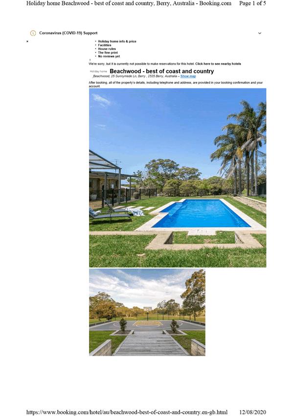
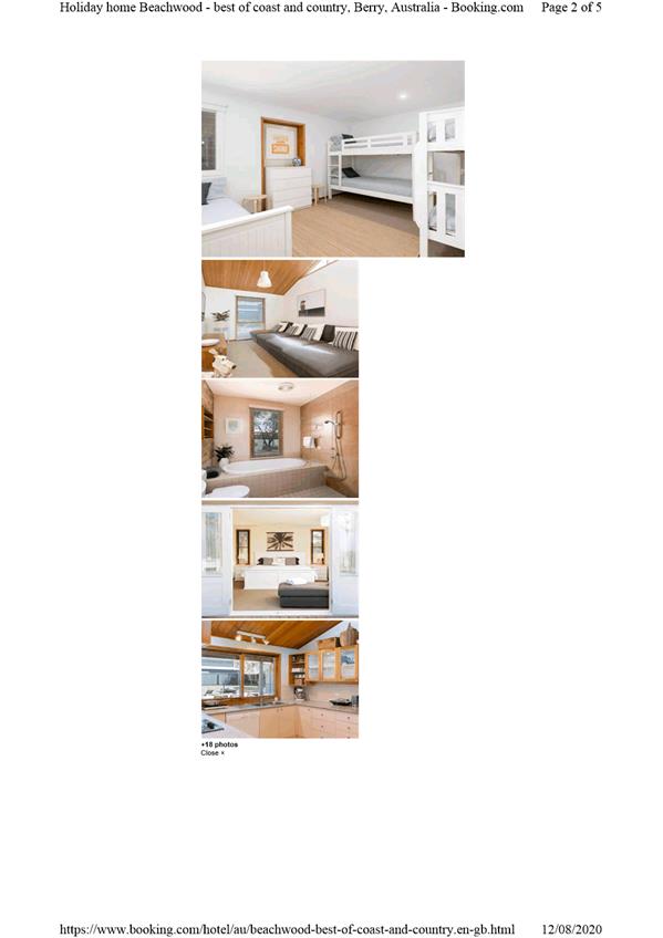
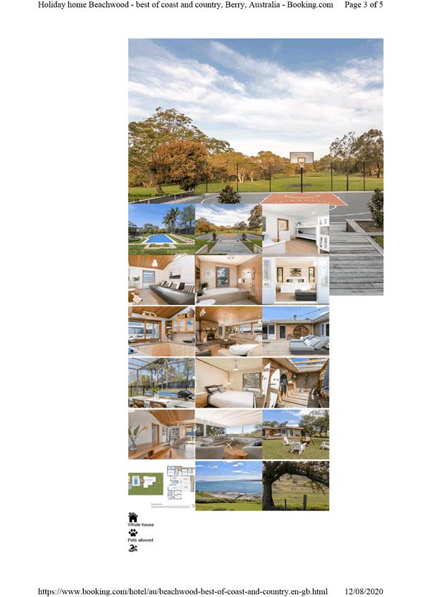
|
|
Development
& Environment Committee – Tuesday 01 December 2020
Page
1
|
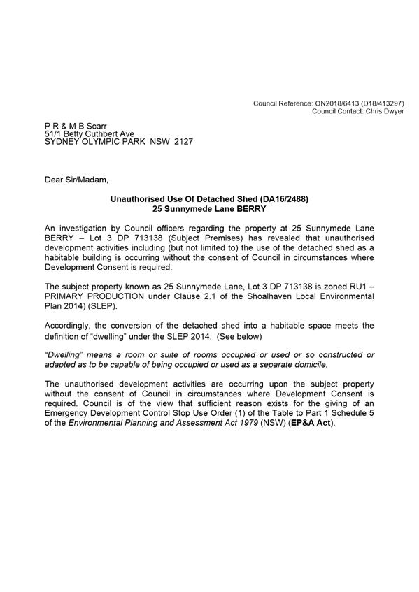

|

|
Development
& Environment Committee – Tuesday 01 December 2020
Page
1
|
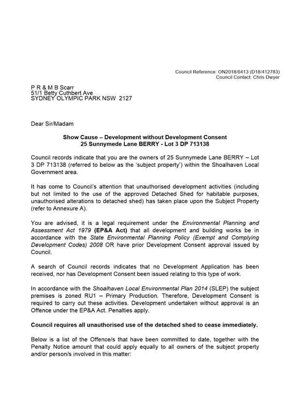
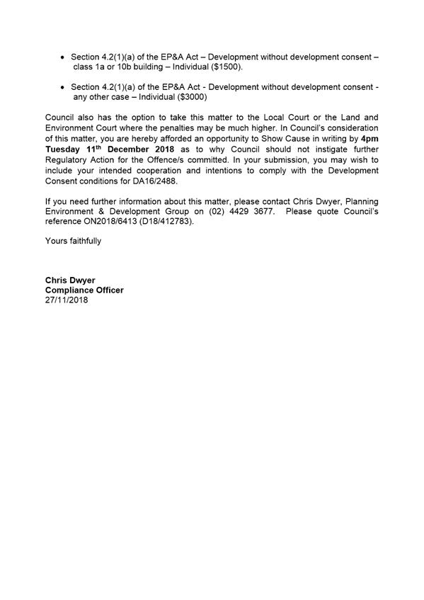
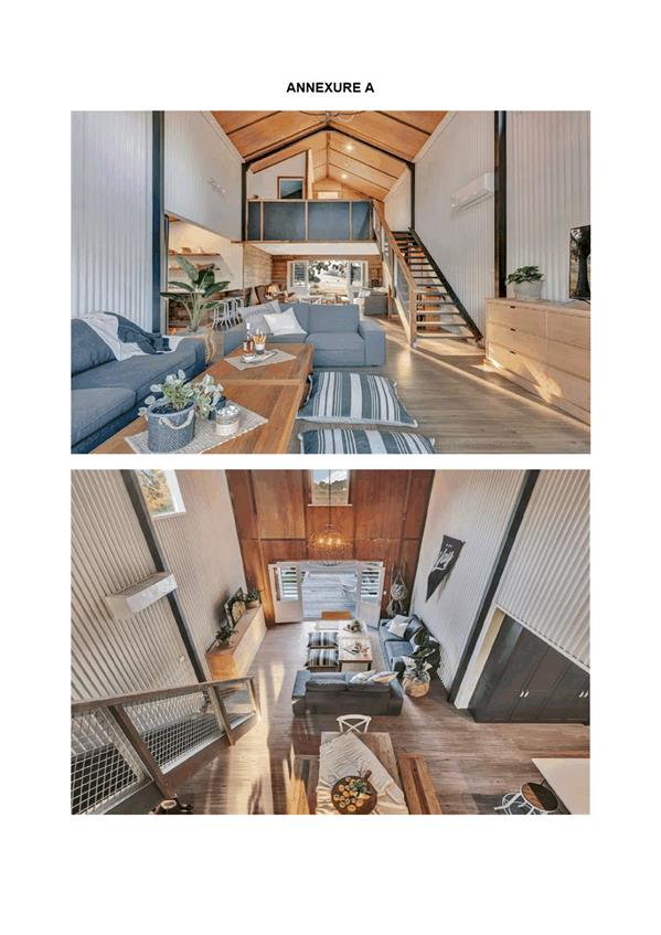
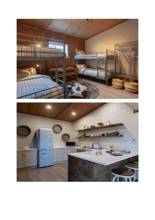
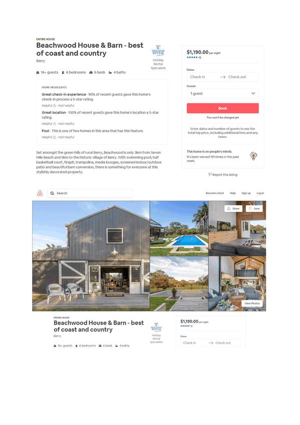
|
|
Development
& Environment Committee – Tuesday 01 December 2020
Page
1
|
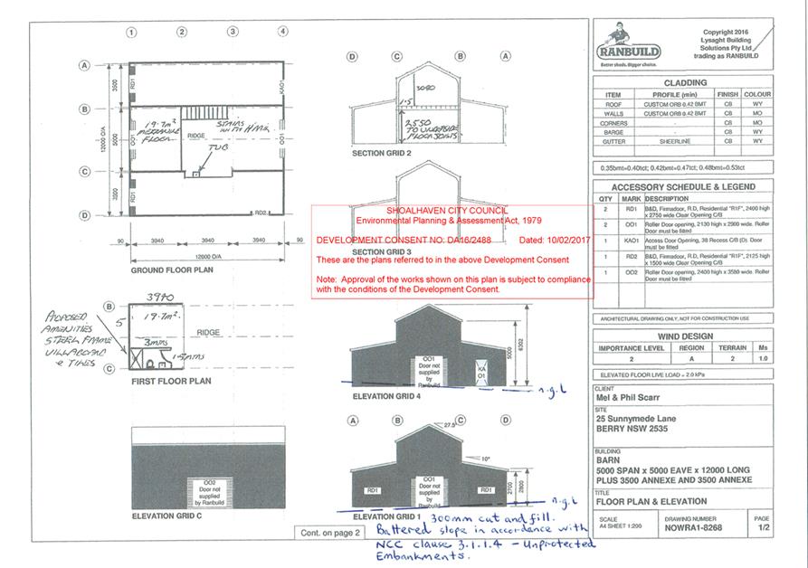
|
|
Development
& Environment Committee – Tuesday 01 December 2020
Page
1
|
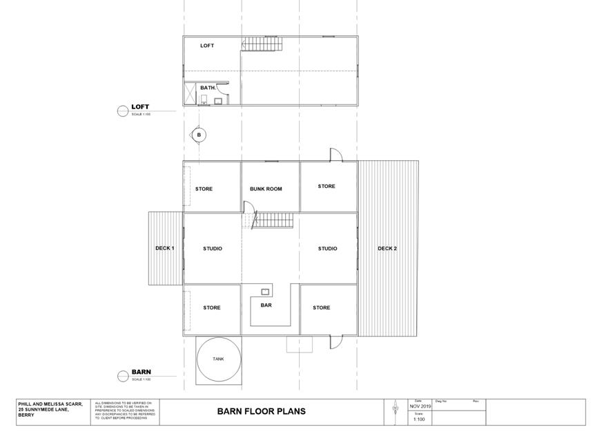
|
|
Development
& Environment Committee – Tuesday 01 December 2020
Page
1
|
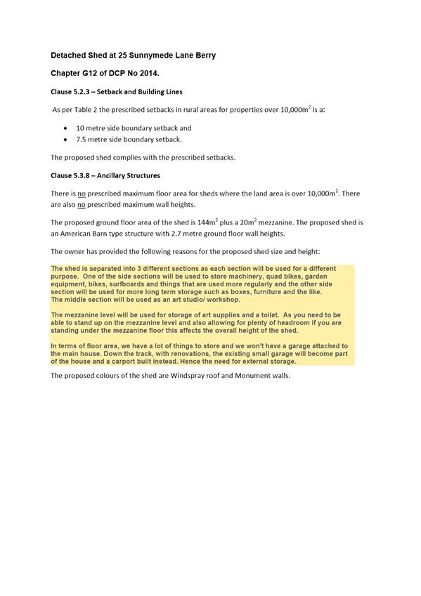
|
|
Development
& Environment Committee – Tuesday 01 December 2020
Page
1
|
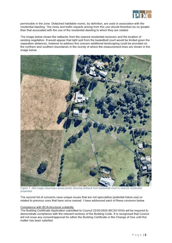
|
|
Development
& Environment Committee – Tuesday 01 December 2020
Page
1
|
DE20.132 DA20/1579
– 42 Naval Parade, Erowal Bay – Lot 45 DP 1052512
DA. No: DA20/1579/4
HPERM Ref: D20/478805
Section: Development
Services
Approver: Phil
Costello, Director - City Development
Attachments: 1. Planning
Report - 42 Naval Pde EROWAL BAY - Lot 45 DP 1052512 (under
separate cover) ⇨
2. Apartment
Design Guide Compliance - 42 Naval Pde EROWAL BAY - Lot 45 DP 1052512
(under separate cover) ⇨
3. Draft - Reasons - non support
- 42 Naval Pde EROWAL BAY - Lot 45 DP 1052512 ⇩
Description of Development: Demolition of Existing
Structures and Construction of Shop Top Housing Comprising Two (2) Commercial
Premises and 17 Dwellings
Owner: LG & MA Mascaro
Applicant: Michael Mascaro C/o Hotondo South Coast
Pty Ltd & SET Consultants
Notification Dates: 15-29 July 2020
No. of Submissions: 177 in objection
One
(1) in support
Purpose
/ Reason for consideration by Council
Council resolved on 7 April 2020
that staff are not to refuse applications, instead the refusal of a Development
Application (DA) must only be by Council / Committee resolution (MIN20.240).
In the case of this application
however, an appeal has been filed with the Land and Environment Court of
NSW.
Whilst this report does not
recommend support, the actual decision concerning the application will now be
made by the Court, in lieu of Council. Accordingly, this report is seeking
endorsement of the staff recommendation and not support the application for the
reasons outlined in Attachment 3.
Whilst this matter could be reported
‘confidentially’ on the basis that information could potentially
prejudice court proceedings, the issues are largely apparent and in the
interest of transparency noting the significant level of public interest in
this application, there is benefit in putting the matter within the public
domain and keeping the community informed.
|
Recommendation (Item to be determined under delegated authority)
That Development Application DA20/1579
to demolish existing structures and construct shop top housing at Lot 45 DP
1052512, 42 Naval Parade, Erowal Bay not be supported by Council having
regard to the reasons contained in Attachment 3 of this report.
|
Options
1. Not support the
development application (DA) in accordance with the recommendation of this
report.
Implications: The matter is
now before the Court for a decision. Council is obliged to respond to the
appeal. This will require the engagement of accredited environmental lawyers, potentially
counsel and experts. This will be at cost to Council.
The reasons for non support will
assist in informing the Statement of Facts and Contentions which are the
‘starting point’ for proceedings.
2. Resolve to
support the application.
Implications: Council would
need to determine the grounds on which the application is approved, having
regard to section 4.15(1) considerations. A position to support the application
would be made known to the applicant. The applicant could choose to file a
notice of discontinuance or continue through the Court process which may
include mediation and negotiations concerning conditions of consent.
3. Alternative
recommendation.
Implications: Council will
need to specify an alternative recommendation and advise staff accordingly.
Figure 1 – Location Map

Background
Proposed Development
The DA seeks approval for the
demolition of existing structures and construction of shop top housing,
comprising two (2) commercial premises (being a total of 403sqm in gross floor
area) and 17 dwellings:
§ 15 x 2-bedroom dwellings and 2 x 3-bedroom dwellings;
§ 40 car spaces and one (1) motorbike space provided onsite;
and
§ vehicular access from King George Street.
Figure 2 – Site Plan

Figure
3 – West & South Elevations

Figure
4 – East & North Elevations

 Figure
5 – Photomontages
Figure
5 – Photomontages
 Figure 6 – Landscape Plan (Ground Floor)
Subject Land
The development site comprises Lot 45 DP 1052512 (42 Naval
Parade, Erowal Bay). Refer to Figure 1.
Site & Context
The development site:
§ Currently contains a commercial building used as a general
store and fuel station along with other ancillary structures and planted
landscaping.
§ Is zoned B2 Local Centre and 1,925sqm in area.
§ Is identified as being potentially contaminated land, being
PCL197. Council records indicate that this is due to use of the site as a
service station.
§ Is located at the corner of Naval Parade and King George
Street with existing access available to both.
§ Adjoins land zoned B2 Local Centre (to the north) and R2
Low Density Residential.
 Figure 7 – Zoning Extract
History
The following provides details on pre-lodgement
discussions, post-lodgement actions and general site history for context:
§ The proposed development was discussed with the applicant
at a pre-lodgement meeting on 16 October 2019. Council responded to a number of
questions/points for discussion including the height variation, street
frontage, at grade car parking, residential interface and the retention of a
loading area and drop off/in parking spaces within the road reserve. It is
particularly noted that Council requested the development be designed in
accordance with State Environmental Planning Policy No 65—Design Quality
of Residential Apartment Development and the Apartment Design Guide
(ADG).
Note: This Policy (SEPP) and the ADGs requires an applicant
to consider design in detail including specific design principles including
context and neighbourhood character (contained in Part 1, of the ADG).
§ The DA was lodged on 15 June 2020.
§ As a result of detailed assessment of the DA, additional
information was requested from the applicant on three (3) occasions – 19
June 2020, 13 July 2020 and 12 August 2020. In relation to Council’s
request for additional information dated 12 August 2020, Council advised:
“Council
has assessed the design quality of the currently proposed development
particularly in relation to the design quality principles under Schedule 1,
State Environmental Planning Policy No 65—Design Quality of Residential
Apartment Development, and the Apartment Design Guide, and considers the
current design does not respond to and enhance the qualities and identity of
the area including the adjacent sites, streetscape and neighbourhood.
There
needs to be further consideration of the local context (and the overall
locality) given the subject site is in an established area, not currently
undergoing significant change or identified for change. Erowal Bay is a small
coastal village. The site is also located within a small business zone
surrounded by a low-density residential environment, comprising single to
two-storey detached dwellings.
The
proposed scale, bulk and height is not appropriate to the existing or desired
future character of the street and surrounding buildings. The density is not
appropriate to the site’s context and not consistent with the
area’s existing or projected population. The design does not positively
influence external amenity for neighbours.
It is requested that you consider the submissions received
from the exhibition period in a re-design of this development to ensure it is
compatible with the character of the local area.”
§ On 25 August 2020, the applicant
confirmed that the use of the commercial space will be subject to future
development applications for their use and fit outs.
§ On 8 October 2020 and 12 October
2020, the applicant advised that they would not be submitting any further
additional information or changes to the development in response to
Council’s request dated 12 August 2020, and requested the application be determined
based on the currently submitted information.
§ A
Resident Briefing Meeting was held via a webinar on 18 November 2020. The
issues raised included (but were not limited to) the proposed building design
and incompatibility with the character of the surrounding area, incorrect
characterisation, the lack of infrastructure and impact of increased traffic.
There were also a number of questions raised in relation to the Court process.
Residents are not party to the Court
proceedings. The matter is between the applicant and respondent (Council).
However, it was noted that the current Court rules allow for residents to
address the Court in a coordinated manner with up to six (6) objectors
addressing the Court, with submissions to be provided in writing and addressing
different issues.
Issues
State Environmental Planning Policy No 65—Design
Quality of Residential Apartment Development
Clause 4 of the SEPP outlines
the development types for which this Policy applies, which includes development
for the purposes of a residential flat building, shop top housing or mixed-use
development with a residential accommodation component.
The proposed development is
considered to be best defined as shop top housing as it consists of three (3)
storeys with retail premises located on the ground floor and contains four (4)
or more dwellings. In accordance with sub-clause 1(b) & (c) this Policy
applies to the proposed development.
Design Quality Principles
(Schedule 1) and the Apartment Design Guide
ADM Architects have designed the
development with regard to the criteria within the SEPP and Apartment Design
Guidelines (ADG). Council has however considered the design quality of the
development in accordance with clause 28(2)(b) and (c) and an assessment has
been completed (refer to Attachment 2).
In accordance with the
provisions of clause 30(2) and (3) of the SEPP, development consent cannot be granted
as the currently proposed development does not demonstrate that adequate regard
has been given to the design quality principles and the objectives specified in
the ADG, being 3A-1 in relation to site analysis and 4M-1 and 2 in relation to
the building facades.
Objective 3A-1 requests “site analysis illustrates
that design decisions have been based on opportunities and constraints of the
site conditions and their relationship to the surrounding context”.
The supporting design guidance, that provides advice on how
the objective can be achieved through appropriate design response, suggests
that each element in the Site Analysis Checklist (under Appendix 1 of the ADG)
should be addressed.
In this regard, the applicant
requested Council refer to the architectural submissions and supporting
Statement of Environmental Effects. However, it is considered that the
submitted documentation has only addressed this in part. The site analysis has
not adequately synthesised and interpreted the context and streetscape into
opportunities and constraints that generate design parameters, particularly the
relationship to and interface with adjacent properties. Accordingly, it does
not satisfy the relevant objective.
Objectives 4M-1 and 2 request “building
facades provide visual interest along the street while respecting the character
of the local area” and “building functions are expressed by
the façade”.
The applicant addressed the
relevant design guidance as follows:
“The façade includes a composition of varied
building elements forming a base, middle and top (roof) of the building. All
building services and rainwater pipes will be concealed within the
structure.”
It is considered that the
proposed building does not reference the coastal character of the local area.
Further, the design suggests a commercial ground floor use but the visual
interest is limited, with the west elevation being relatively homogenous. See
Figure 3. There is concern with the submitted design, therefore the objectives
again, are not satisfied.
As detailed earlier in this report, Council requested
additional information from the applicant to address this. However, the
applicant advised that they would not be submitting any further additional
information or changes to the development in response to Council’s
request and asked that the application be determined based on the currently
submitted information.
Clause 4.3 of Shoalhaven
Local Environmental Plan 2014 and clause 4.6 variation
The subject site is not mapped
as having a maximum building height, accordingly the building height is not to
exceed the default maximum permissible 11m height as per sub-clause (2A).
The proposed building exceeds
the height by a maximum extent of approximately 0.4m (being 3.6%) as a result
of architectural roof elements designed to allow solar access to the proposed
dwellings.
Other parts of the roof of the
building encroach to a lesser extent.
Figure
8 – Extract from SEE Attachment (2) by SET
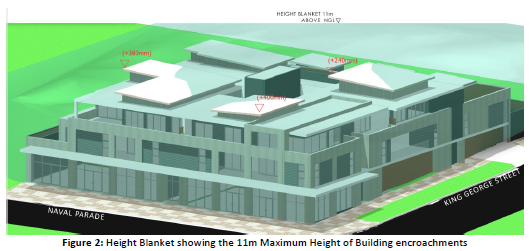
The applicant has requested the provisions of clause 4.6 be
applied. However, the applicant’s request has not adequately addressed
subclause 3 which requires consideration to be given to whether or not
compliance with the development standard is unreasonable or necessary and that
there are sufficient environmental planning grounds to justify the
contravention of the standard.
The applicant considers the
height suitable on the basis that the areas of height exceedance do not impact
on the surrounding streetscapes, there are no additional solar access or
privacy impacts, the height articulates the design, the variation is minor
amongst other things. Whilst these comments may be correct and there is an 11m
height maximum permitted, these design parameters must be taken into context
having regard to a site analysis and assessment of neighbourhood character as
foreshadowed in the SEPP and ADGs
Further, the proposal is
considered inconsistent with the objectives of the relevant (height) standard
in that the proposed development is not compatible with the height, bulk and
scale of the existing development and character of the locality which is a
modest high amenity coastal village.
Clause 4.3 (1) Height of
buildings in the SLEP states:
The objectives of this clause are as
follows—
(a) to
ensure that buildings are compatible with the height, bulk and scale of
the existing and desired future character of a locality,
(b) ……..
As detailed earlier in this report, Council requested
additional information from the applicant to address this, however, this has
not been provided. The applicant in addressing this provision of the LEP relies
on zoning permissibility, compliance with the FSR and that the non-compliant
heights are setback from the street frontages and side setbacks. Whilst this
may be the case, the bulk and scale of development having regard to the
contextual setting is considered disproportionate.
Planning Assessment
The DA has been assessed under s4.15(1) of the Environmental
Planning and Assessment Act 1979. Please refer to Attachment 1.
Consultation and Community
Engagement:
Notification was undertaken in
accordance with Council’s Community Consultation Policy with letters
being sent within a 200m buffer of the site, during the period 15 to 29 July
2020.
178 public submissions were
received in relation to Council’s notification of the development,
including a petition with 583 signatures.
177 were objections to the
development.
Key issues raised as a result of
the notification include but were not limited to matters listed below.
§ Permissibility and incorrect
characterisation;
§ Non-compliance with the
majority of Design Quality Principles under SEPP 65;
§ Incompatibility with the
character of the surrounding area – height, bulk and scale;
§ Impact of additional traffic
and lack of car parking availability;
§ Existing problems with
Intersection of King George Street and Naval Parade;
§ Lack of infrastructure to
accommodate this development;
§ Stormwater drainage impacts;
§ Overlooking;
§ Loss of views; and
§ Lack of neighbour
notification.
The assessment of the application considered the matters
raised in the submissions (as prescribed by s4.15(d) and concluded on balance
having regard to all the heads of consideration (s4.15 Evaluation), that the
application should be refused. A detailed analysis can be found in the attached
s4.15 assessment report.
Summary of Key Issues
Permissibility and
incorrect characterisation
The proposal is best
characterised as shop top housing under the Shoalhaven Local
Environmental Plan (SLEP) 2014. The proposal is permitted within the zone with
the consent of Council.
Having
regard to Hrsto v Canterbury City Council (No 2) [2014] NSWLEC 121, it is noted
that to qualify as shop top housing the relevant part of the
proposed building must be "above" the relevant retail or commercial
component. It is also worth noting the following in relation to the proposed
dwellings:
“…dwellings do not need to be directly or
immediately above ground floor retail premises or business premises in order to
be characterised as "shop top housing". If it was intended that
"shop top housing" be limited to dwellings that are directly or
immediately above ground floor retail premises or business premises it is
expected that those words would have been included in the definition of the
term 'shop top housing'.”
Further to this:
“…dwellings need only be at a floor level that
is higher than the top of the ground floor retail or business premises and do
not need to be contained in an envelope on the higher floor level that would be
intersected by a line drawn vertically from within the envelope of the ground
floor retail or business premises.”
Having regard to Arco Iris Trading
Pty Ltd v North Sydney Council [2015] NSWLEC 1113 in relation to the above, it
is noted that that there does not need to be a true directly vertical
correlation between the shop top housing component and the qualifying premises
at the lower level.
Non-compliance with the
majority of Design Quality Principles under SEPP 65
In accordance with the
provisions of clause 30(2) and (3), SEPP 65, development consent cannot be
granted as the currently proposed development does not demonstrate that
adequate regard has been given to the design quality principles.
As detailed earlier in this
report, Council requested additional information from the applicant to address
this, however, this has not been provided.
Incompatibility with the
character of the surrounding area – height, bulk and scale
The currently proposed
development is considered incompatible with the low-key coastal
character and ambience of the Erowal Bay locality.
It is noted that
“compatible” does not encourage “sameness” in built
form, but rather requires a development to fit comfortably within its urban
context. It is considered that the design of the development does not currently
achieve this having regard to the Land and Environment Court principle – “Surrounding
development” found in Project Venture Developments Pty Ltd v Pittwater
Council [2005] NSWLEC 191.
With regard to considering what is a suitable height and
bulk some guidance can be taken from the Land & Environment Court’s
principle, found in Veloshin v Randwick Council [2007] NSWLEC 428. In this
regard, having considered the question / test if the area has a predominant
existing character and does the proposal fit into that character, the
response is that the building is in response to the planning controls, largely
what is permissible in the zone, however as mentioned earlier, there is no
strategic analysis of the locality and site which should inform the design by
providing context. Having further regard to the question / test if the
proposal looks appropriate, the response is that it will ‘stand
out’ in contrast to the character of the area. The fact that the building
is also seeking a height variation pursuant to clause 4.6 of the SLEP 2014,
poses further doubt about the scale of the development and compatibility with
the locality.
Impact of additional
traffic and lack of car parking availability
The development is compliant
with the onsite car parking requirements of SDCP 2014.
40 car spaces and one (1) motorbike space are proposed
onsite.
The DCP requires a minimum 38 car spaces to be provided
onsite.
In terms of the residential
component as ‘shop top housing’, the DCP requires 28 onsite car
parking spaces (rounded up from 27.5), being one (1) space per dwelling
containing no more than 2 bedrooms (or rooms capable of use as a bedroom), two
(2) spaces per dwelling containing 3 or more bedrooms (or again rooms capable
of use as a bedroom), and for developments with three (3) or more dwellings,
0.5 car parking spaces per dwelling for visitors.
Regarding the proposed
commercial premises at the ground floor, the DCP requires 10 onsite car parking
spaces (rounded down from 10.075), being one (1) onsite car parking space per
40sqm of gross floor area as the land is not zoned B3 Commercial Core.
Council’s Development Engineer raised no objections to
this development in this regard, nor with the capacity of the existing road
network and location of the site at the intersection of King George Street and
Naval Parade, subject to recommended conditions of consent (if approved). On
review, Council is satisfied with the conclusion/outcomes of the submitted
traffic and parking impact assessment report. There is also no concern with the
retention of the existing loading bay and operations along the Naval Parade frontage,
although it is noted that whilst the report indicates that this is to be
maintained, the submitted plans do not reflect this.
Financial Implications:
There are cost implications for Council as it will be
required to respond to the appeal.
Legal Implications
A Class 1 application was filed
with the Land and Environment with Council receiving the following notice:
|
This is an automatically
generated email. Please do not reply.
|
|
|
|
Case number: 202000313821
|
|
Case title: Michael Mascaro v
Shoalhaven City Council
|
|
Sitting date: 07/12/2020,
10:15AM
|
|
|
|
Online Court has been
activated
|
At the time of writing this
report, no other documentation was received.
The appeal is for a deemed
refusal, which means that the application is considered to be refused as it was
not determined by Council within the statutory processing time.
A directions hearing will set a
timetable for the matter to be heard. This is usually by telephone between the
Court and Council’s legal representative (in the process of being engaged
at the time of writing this report).
Summary and Conclusion
The proposed development does
not satisfy the relevant provisions of SEPP 65 and SLEP 2014. Accordingly,
Council is not satisfied that the development will sit comfortably in the
coastal village setting.
The application is not
considered capable of support, based on the current design, which has been
assessed and found incompatible with the character of the surrounding area of
Erowal Bay. Accordingly, a negative conclusion has been reached and
recommendation made.
Attachment 3 contains the
reasons not to support the application, for the endorsement of Council.
|
|
Development
& Environment Committee – Tuesday 01 December 2020
Page
1
|
|
|
Development
& Environment Committee – Tuesday 01 December 2020
Page
1
|
DE20.133 DA20/1751–
42 Lyrebird Drive NOWRA – Lot 72 & DP 1198691
DA. No: DA20/1751/4
HPERM Ref: D20/478771
Section: Development
Services
Approver: Phil
Costello, Director - City Development
Attachments: 1. DRAFT
- Determination - Refusal - 42 Lyrebird Dr NOWRA - Lot 72 DP1198691 (under
separate cover) ⇨
2. Planning
Report - 42 Lyrebird Drive NOWRA - Lot 72 DP 1198691 (under separate cover) ⇨
3. Report
- Flood Impact Statement - Lot 72 DP1198691 - 42 Lyrebird Dr Nowra (under
separate cover) ⇨
4. Plans
(excluding habitable floor plan) - 42 Lyrebird Dr Nowra - Lot 72 DP1198691
(under separate cover) ⇨
5. A copy of DETERMINATION -
APPROVAL - DA18/2175 - 38 Lyreboird Dr Nowra - Lot 74 DP 1198691 (under
separate cover) ⇨
Description of Development: Construction of dual
occupancy (attached)
Owner: J J Reminis
Applicant: Hotondo South Coast
Notification Dates: 7 August 2020 to 22 August
2020
No. of Submissions: No submissions received
Purpose
/ Reason for consideration by Council
Council resolved on 7 April 2020
that staff are not to refuse applications, instead the refusal of a Development
Application (DA) must only be by Council / Committee resolution (MIN20.240).
The DA is recommended for refusal.
|
Recommendation (Item to be determined under delegated authority)
That Development Application No. DA20/1751 for the
construction of dual occupancy (attached) be determined by way of refusal for
the reasons set out in the draft Notice of Determination at Attachment 1.
|
Options
1. Refuse the
Development Application (DA) in accordance with the recommendation.
Implications: The proposal would not proceed. The applicant
can however apply for a section 8.2 review of Council’s decision and/or
could lodge an appeal with the NSW Land and Environment Court against
Council’s decision.
2. Approve the DA.
Implications: Council would have to provide the grounds to
support the proposal, that is, provide reasons to support the development,
having regard to section 4.15 considerations. This would require a further
report to Council attaching a suite of conditions.
3. Alternative
recommendation.
Implications: Council will need to specify an alternative
recommendation and advise staff accordingly.
Location Map
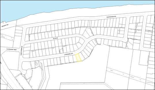
Figure 1: Map showing location of the site (outlined in yellow)
Background
Proposed Development
The proposal is for the construction of an attached dual
occupancy comprising 2 x 2 bedroom dwellings. The
habitable rooms are elevated above the Flood Planning Level and there is an
enclosed subfloor space which also houses a single garage for each dwelling.
Plans of the development can be found in Attachment 4 to this report.
A
separate Strata subdivision application No. SF10818 (lodged with Council on
6 August 2020) is pending the determination of this application.
On 6 August 2019, Council resolved to support a similar
attached dual occupancy on land at No. 38 Lyrebird Drive (to the east) (DA18/2175)
that:
1. Council
accept Development Application DA18/2175 for the erection of an attached dual
occupancy at Lot 74 DP 1108691, 38 Lyrebird Drive Nowra, a further report be
provided to Council with suitable conditions for consent.
2. The
next Housekeeping Amendment seek to consider inserting provisions in the
Shoalhaven LEP to rule out dual occupancy development in the vicinity of
Riverview Road and Lyrebird Drive, Nowra.
The conditions of consent for the approved DA18/2175 can be
found in Attachment 5. If Council were of a mind to approve DA20/1751,
conditions of consent similar to DA18/2175 would be applied. These conditions
however would need to be amended to be relevant to this application subject of
this Council report and should also be based on updated conditions of consent
to ensure currency and consistency with other dual occupancies.
Examples of changes that would
be required include (but not limited to) the table of approved documents which
would need to be adjusted to reflect the plans under consideration, the
contributions table would need to be specific and up to date for this proposal,
plus formatting would need to be consistent with current approvals.
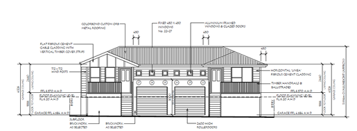
Figure 2: Street (North) Elevation of the
proposed development DA20/1751
Subject Land
The subject site:
· Is a vacant parcel
of land, devoid of trees and is zoned R2 Low Density Residential under the
Shoalhaven Local Environmental Plan 2014 (SLEP 2014).
· Is identified as
Lot 72 in DP 1198691 with a street address of 42 Lyrebird Drive, Nowra.
· Has an area of
830.20m² and is located within an established residential area. The site
is essentially rectangular and flat.
· Access to the site
will be provided from Lyrebird Drive.
· The adjoining and
surrounding land use is predominately low scale detached single dwelling houses
of a single and two-storey construction.
· Is mapped as a
flood prone land and is categorised as High Hazard Floodway in accordance with Shoalhaven Flood Mapping with the following flood
levels:
o 2050 Flood Planning Level of
6.2m AHD;
o 2050 1% AEP (Annual Exceedance
Probability) flood level of 5.7m AHD; and
o 2050 PMF (Probable Maximum
Flood) of 8.2m AHD.
· If the site is
considered to have an average height of 4.6m AHD, this means that the likely
depth of floodwaters would be:
o 1.6m in the 2050 1% AEP flood
event; and
o 3.6m in the 2050 Probable
Maximum Flood
o The
velocity for the 1% AEP flood event is 1.2m per second.
· Is mapped as
containing Class 4 acid sulfate soils (ASS) and is located approximately 69m
from Class 3 ASS.
· Is not identified
as a bush fire prone land or potentially contaminated land (PCL).
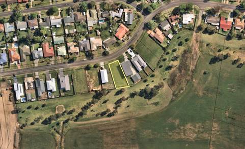
Figure 3: Aerial photograph of the site
and immediate surrounds
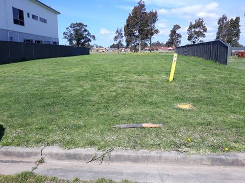
Figure 4: Street view of the subject site
Site & Context
The site is part of a low-density residential subdivision
approved in 1972 that includes Riverview Road, Ella Avenue and Lyrebird Drive. The site is within the Shoalhaven River floodplain
and it is located east of the Nowra Bridge.
The
Riverview Road Area Floodplain Management Plan (Plan) was adopted by Council in
2002 and applies to the site. The Riverview Road Area Floodplain Management Plan
(Outcomes Section at page 2) found that the area is currently protected to the
1% AEP flood level from direct inundation from the Shoalhaven River by the 2
metre high Riverview Road levee which was constructed in 1986/1987.
The Plan further found that in this
area (west of Ferry Lane) the flood hazard is low for events less than a 1% AEP
and high for larger events because of overtopping of the levee. The report
states that “it is likely that the community will not be prepared for
the sudden change in hazard which may occur with levee overtopping or
failure”.
History
The Plan states that approvals for the subdivisions in the
Riverview Road, Ella Avenue and Lyrebird Drive areas were made in 1972 under
SF3167. The subdivision plan for the stage containing the subject site was
registered on 14 October 2014.
Issues
1. Issue
- Flooding
Clause 7.3 – Flood Planning of the Shoalhaven
Local Environmental Plan 2014
The site is below the 2050 Flood
Planning Level of 6.2m AHD, therefore the application has been assessed against
the provisions of clause 7.3 – Flood Planning of the Shoalhaven Local
Environmental Plan 2014 (SLEP 2014) (see Clause 7.3 Assessment Table at Attachment
1). Council’s Natural Resources & Floodplain have reviewed the
application and have determined that the application does not comply with
several subclauses of clause 7.3. A condensed assessment of the application
against clause 7.3 is provided below.
This clause has been addressed
by the consultant in a submitted Flood Impact Statement prepared by
Rienco Consulting (Ref: 20096 Report 001 Rev 0) dated 23/6/2020 (see a copy at Attachment
3).
(1) The objectives of this clause are as
follows—
(a) to
minimise the flood risk to life and property associated with the use of land,
(b) to
allow development on land that is compatible with the land’s flood
hazard, taking into account projected changes as a result of climate change,
(c) to
avoid significant adverse impacts on flood behaviour and the environment.
Consultant’s comment:
On page 4 of the Flood Impact
Statement it is stated in relation to these objectives that:
In relation to objective 1(a):
“Future risk to property and life is minimised by:
· Developing
residentially zoned land in accordance with best practice DCP provisions.
· Ensuring
habitable floor levels set at a minimum of the 1% AEP flood level plus 500mm.
· Safe refuge available
in the Probable Maximum Flood.”
In relation to objective 1(b):
“It is our view that the development is compatible
with the lands flood hazard, as it will directly facilitate appropriate future
development in accordance with the residential zoning.
Sea level rise has been
directly taken into account in the supplied FPL from SCC, and we have adopted
this FPL for use in this study.”
In relation to objective 1(c):
“It is our view that the
impacts arising from the proposed development are not significant or adverse on
flood behaviour or the environment, as they are directly commensurate with the
lands zoning. Losses of flood storage in the Lower Shoalhaven River are
immaterial.”
Discussion:
The land is categorised as High
Hazard Floodway in accordance with Shoalhaven Flood
Mapping. Given current flood information, the land would not be
considered suitable for a dual occupancy or subdivision. Having regard to the
site’s zoning (R2 Low Density Residential) and Development Control Plan
requirements (discussed later in this report). The flood risk to life and
property could be minimised by limiting development on the site to a
single dwelling. While even single dwellings are not strictly compatible with
High Hazard Floodway category, allowing a single residential dwelling on lots
approved in the subdivision, is a reasonable concession having regard to
the historic context and flood risk that applies to the site and locality.
Increasing potential residential
densities by approving another dual occupancy development is not desirable nor
commensurate with the flood hazard.
In accordance with the Flood
Certificate contained within Flood Impact Statement, the 2050 PMF is
8.2m AHD. The proposed habitable floor levels are 6.57m AHD. The
2050 PMF would therefore result in inundation above the habitable floor levels
of 1.63m, which would result in the flood risk to life and property. Providing
a safe refuge on site is considered impossible. The increase in density would
result in additional people required to be evacuated from the site in the event
of a flood and affect the safe evacuation of the site.
The enclosed subfloor space of
approximately 116.38m² will impede flood flows. Based on the Flood
Impact Statement, the site falls from RL +4.61m AHD in the rear to RL
+4.41m AHD at the Lyrebird Drive frontage. The 2050 1% AEP flood will result in
inundation of between 1.59m and 1.79m across the site with a velocity of
1.2m/s. The PMF will result in floodwater depths across the site of
between 3.59m and 3.79m, with a similar velocity.
No calculations or evidence have
been provided in support of the assertion that there will be no significant
adverse effects on flood behaviour that may potentially affect nearby
properties.
It is not considered that the
applicant has satisfactorily demonstrated that the development will minimise
the flood risk to life, property associated with the use of land and the
environment. The proposed development does not satisfy the above objectives.
Subclause 3 of clause 7.3 states those matters that
must be satisfied prior to the grant of development consent. Clause 7.3((3)
states as follows:
(3) Development consent must not be granted to
development on land to which this clause applies unless the consent authority
is satisfied that the development—
(a) is compatible with the flood hazard of
the land, and
(b) will not significantly adversely affect
flood behaviour resulting in detrimental increases in the potential flood
affectation of other development or properties, and
(c) incorporates appropriate measures to
manage risk to life from flood, and
(d) will not significantly adversely affect
the environment or cause avoidable erosion, siltation, destruction of riparian
vegetation or a reduction in the stability of river banks or watercourses, and
(e) is not likely to result in unsustainable
social and economic costs to the community as a consequence of flooding, and
(f) will not affect the safe occupation or
evacuation of the land.
Consultant’s comment:
A Flood Impact Statement (see
copy at Attachment 3) addresses the requirements of these subclauses as
follows:
In relation to subclause (3)(a):
On page 4 of the Flood
Impact Statement it is stated in relation to this requirement that:
“It is our view that the
proposed development is compatible with the flood hazard of the land. In
particular, this is achieved by the ‘pier’ construction of the
development allowing the 1% AEP flood to pass safely underneath the
development.”
In relation to subclause (3)(b):
On page 4 of the Flood
Impact Statement it is stated in relation to this requirement that:
“It is our view that the
impacts arising from the proposed development are not significant or adverse on
the potential flood affectation of other development of properties.”
In relation to subclause (3)(c):
On pages 4 and 5 of the Flood Impact Statement it
is stated in relation to this requirement that:
“It is our view that the
proposed development meets this requirement. The proposed habitable FFL’s
are entirely above the Flood Planning Level, and the development meets the
controls of SCC’s DCP (Chapter G9).”
In relation to subclause (3)(e):
On page 5 of the Flood
Impact Statement it is stated in relation to this requirement that:
“It is our view that the
proposed development will not result in unsustainable social and economic costs
to the community as a consequence of flooding. This is demonstrated, and
managed, by:
· Improvement of
residentially zoned land.
· Ensuring habitable
floor levels set at a minimum of the 1% AEP flood level plus 500mm.
· Use of flood compatible
materials below the Flood Planning Level.
· Safe refuge in the
PMF.”
In relation to subclause (3)(f):
On page 5 of the Flood
Impact Statement it is stated in relation to this requirement that:
“It is our view that the
proposed development does not hinder evacuation, where it is ever
required.”
Discussion:
(a) is
compatible with the flood hazard of the land, and
The land is categorised as High
Hazard Floodway in accordance with Shoalhaven Flood
Mapping.
Given current flood information,
the land would not be considered suitable for a dual occupancy or subdivision.
Increasing potential residential densities by approving another dual occupancy
development is not compatible with the land’s high flood hazard in regard
to safe evacuation or providing a safe refuge on site during flood event.
The 1% AEP flood will not be
able to pass underneath the enclosed subfloor space (including the garages)
which has a total area of 116.38m².
The ‘pier’
construction referred to in the Flood Impact Statement does not apply to
the enclosed subfloor area. The enclosed subfloor area would impact on the
passing of any debris and will prevent the easy inundation and flows through
that area. Given the above, it is not considered that the proposal is
compatible with the flood hazard of the land.
(b) will
not significantly adversely affect flood behaviour resulting in detrimental
increases in the potential flood affectation of other development or
properties, and
The enclosed subfloor space
including the enclosed garages of approximately 116.38m² will impede the
movement of floodwater. The 2050 1% AEP flood will result in inundation of
between 1.59m and 1.79m across the site with a velocity of 1.2m/s. The PMF will
result in floodwater depths across the site of between 3.59m and 3.79m.
No evidence has been provided by
the applicant in support of this assertion that there will be no significant
adverse effects on other properties during a flood event.
(c) incorporates
appropriate measures to manage risk to life from flood, and
Shoalhaven Development Control
Plan 2019 Chapter G9: Development on Flood Prone Land provides information and
development controls needed to prepare and assess development applications on
flood prone land and includes appropriate measures to manage risk to life from
flood
Council’s Natural
Resources & Floodplain unit has reviewed the application and have
determined that the application does not demonstrate compliance with the
controls in SDCP 2014 Chapter G9.
The proposal provides no
practical safe refuge from the Probable Maximum Flood level, given that the
habitable floor levels would be inundated by 1.63m of floodwater in the PMF.
Additionally, there is no flood
free evacuation route available to the property, and the nearest land above the
1% AEP flood level is located approximately 310m to the west near the
intersection of Lyrebird Drive with Hawthorn Avenue).
In a flood event the development
will increase the need for evacuation by emergency services. Additional demand
for evacuations increases the cost to the community and the risk to emergency
services personnel.
It has not been demonstrated
that the proposal incorporates appropriate measures to manage risk to life from
flood.
(e) is
not likely to result in unsustainable social and economic costs to the
community as a consequence of flooding, and
The development cannot be
described as “Improvement of residentially zoned land that is flood free
in the 1% AEP event” as the land is clearly flooded by the 1% AEP flood.
The provision of safe refuge is
not achieved, as the habitable floors would be inundated by 1.63m of floodwater
in the 2050 PMF. As mentioned earlier, in a flood event the development will
increase the need for evacuation by emergency services. Additional demand for
evacuations increases the cost to the community and the risk to emergency
services personnel.
The risk of unsustainable social
and economic costs would be reduced by limiting development on the site.
(f) will
not affect the safe occupation or evacuation of the land.
As mentioned earlier, the
habitable floor levels would be inundated by 1.63m of floodwater in the PMF
during flood event. The proposal will affect the safe occupation and safe
refuge of the land in a flood event.
The development will increase
the need for evacuation over that which would be required if the land was
developed with a single dwelling. There is no flood free access to the land in the
event of a flood. The nearest land above the 1% AEP flood level is located
approximately 310m to the west.
In a flood event, the
development in its current form will increase the need for evacuation by
emergency services personnel which would increase the cost to the community and
the risk to emergency services personnel.
The applicant has not
demonstrated to the satisfaction of council that the development will not
affect the safe occupation or evacuation of the land.
In summary, it
has not been adequately demonstrated that the requirements of clause 7.3 have
been met as the proposal will:
· Increase
the flood risk to life and property associated with use of land and other
properties;
· Adversely
affect flood behaviour;
· Result
in social and economic costs to the community as a consequence of flooding; and
· Affect
the safe occupation or evacuation of the land.
Shoalhaven DCP Chapter G9: Development on Flood Prone
Land
The application does not comply with relevant clauses under
SDCP 2014 Chapter G9 in particular:
• the generic flood related development controls for the High
Hazard Floodway category under Clauses 5.1, 5.2 and 5.3 of Chapter G9; and
• the site specific flood related development controls for
the Riverview Road Area under Clause 5.4 of Chapter G9;
The Riverview Road Area controls
and the generic controls set out in Schedule 2 to Chapter G9 for the High
Hazard Floodway category are outlined below.
The important elements of these
controls are:
· Within the
Riverview Road/Ella Avenue/Lyrebird Drive subdivision area, no dual occupancies
or subdivisions will be permitted;
· Within the High
Hazard Floodway category, the ‘other residential/habitable’
category (which includes dual occupancy) is not suitable for this category of
flood hazard.
Council’s Natural
Resources & Floodplain unit has reviewed the application and recommended
that the proposal be refused due to significant non-compliance with this
Chapter and Clause 7.3 of the SLEP 2014 (Referral advice at Attachment 2).
This is primarily because the land is located within a High Hazard Floodway and
the development increases the risk to life and property by increasing occupancy
in this area.
Council is aware of other
existing/approved similar dual occupancy development at No. 38 Lyrebird Drive (DA18/2175).
However, approving this application may also result in cumulative impacts in
the future having regard to the number of these types of development in High
Hazard Floodway.
The objectives of this Chapter
are to:
i. Reduce
risk to life and property resulting from floods.
ii. Ensure
that the impacts of the full range of flood sizes up to and including the
probable maximum flood (PMF) are considered when assessing development on flood
prone land.
iii. Ensure
that the impact of climate change is considered when assessing development on
flood prone land.
iv. Ensure
the future use of flood prone land does not cause undue distress to individuals
or unduly increase potential flood liability to individuals or the community.
v. Incorporate
site specific floodplain management recommendations from local floodplain risk
management plans into Council’s overall planning framework.
Consultant’s submission
The applicant provides a
detailed response to the SDCP provisions in the Flood Impact Statement at Attachment
3.
The Flood Impact Statement
acknowledges the ‘prohibition’ on dual occupancies and subdivision
in the specific controls for the Riverview Road Area but argues this should be
flexibly interpreted and that density as measured by Floor Space Ratio (FSR)
ought to be the determining control in this regard. The applicant’s
argument regarding the appropriateness of FSR is expanded upon in the Flood
Impact Statement at Attachment 3.
Discussion:
The specific objectives that are
relevant to the DCP provisions in question are objectives (iv) and (v). The
applicant has not addressed the DCP objectives and has not satisfactorily
demonstrated that these provisions should be set aside, nor have they provided
an alternative that satisfactorily addresses the objectives.
Whilst it is acknowledged that
the provisions of a DCP can be flexibly applied having regard to s4.15(3A) (b)
and that the controls permitting development are embedded in the SLEP 2-14, the
prohibition in the DCP is well founded. The stated prohibition is grounded in
the process Council went through in consultation with the community, State
agencies and emergency services in developing and adopting the Riverview Road
Area Floodplain Management Plan. The position that lead to the current planning
controls for this area should not be lightly set aside for an individual
development. Added to this is the potential to establish a precedent for future
development, having regard to there being a number of vacant residential
allotments in this area. This was also mentioned in the previous report for
DA18/2175.
The 2050 Probable Maximum Flood
(PMF) would result in inundation above the habitable floor levels of 1.63m,
which would result in the flood risk to life and property associated with the
use of land during flood event as providing a safe refuge on site is considered
impossible. The increase in population would affect the safe evacuation or safe
refuge of the land. There is no flood free access to the land in the event of a
flood. The nearest land above the 1% AEP flood level is located approximately
310m to the west (near the intersection of Lyrebird Drive with Hawthorn
Avenue), refer to Figure 1 above.
In a flood event, the development in its current form will
increase the need for evacuation by emergency services personnel which would
increase the cost to the community and the risk to emergency services
personnel. Having regard to the site’s zoning (R2 Low Density
Residential), the flood risk to life and property could be minimised by
limiting development. In this regard the DCPs adopted limitation on dual
occupancy development is considered well founded.
DCP Requirements
5.1 General
A1.1 The development satisfies the requirements as shown
in the planning matrix at Schedule 2 including climate change considerations;
and
The table for the High Hazard Floodway category in Schedule 2
identifies the category as being “Not suitable for development” in
respect of Land Use Category “A(II) Other Residential / Habitable”
(this land use category includes dual occupancies).
Accordingly, the land, being categorised as High Hazard
Floodway, is not considered to be suitable for the proposed dual occupancy
development and is therefore noncompliant with A1.1.
Schedule 2 also states that land in the High Hazard Floodway
category is not suitable for single residential buildings, but contains the
following concession in a note to the table:
“This type of development is not suitable within
the risk category - however, if existing use rights (as defined in the
Environmental Planning and Assessment Act 1979) can be established and there is
no other option, the conditions as per Schedule 2 will apply.”
It is clear that the application currently before Council does
not meet all of the controls that would apply to the less intensive development
of a single residential dwelling. Additionally, no evidence of any calculations
or modelling has been submitted to ensure the building can withstand forces of
floodwaters including debris and buoyancy forces up to the PMF scenario.
Based on the site plan, the building footprint is
299.07m² which exceeds the 250m² threshold in this control. The Flood
Impact Statement states that a detailed and expensive hydraulic impact is
not required given the site is large and any minor impacts can be mitigated
prior to them being transferred to adjoining land. The Flood Impact
Statement also states that the proposed building is designed on ‘bearers
and joists’ and is thus open underneath to allow floodwaters to flow
beneath it.
The concession where no hydraulic impact report is required is
not satisfied, as the enclosed subfloor and garage space of approximately
116.38m² would obstruct flood flows.
There is no reliable access for either emergency vehicles or
pedestrians during a 1% AEP flood event. The nearest flood free land in a 1%
AEP flood event is 310m to the west, near the intersection of Lyrebird Drive
and Hawthorn Avenue. The public road between the site and the nearest flood
free land has a greater depth of inundation than the site itself. In the 1% AEP
flood event, the site would be inundated by floodwaters with a depth of between
1.09m (rear boundary and 1.29 m (street frontage) with a predicted velocity of
1.2m/s.
No flood evacuation plan has been prepared or submitted with
the application. Based on the consultant’s statement in the Flood Impact
statement, this acceptable solution has not been met and basically assigns
responsibility to the evacuation authorities during flood event which would add
significant cost and disruption to the community or the SES. Further, it is
noted that while the rate of rise in the Lower Shoalhaven may be relatively
slow, the risk of inundation to this property in the Riverview Road area would
arise from overtopping of the Riverview Road levee, which would result in much
more rapid inundation of the area than with a natural rate of rise.
A1.3 Buildings and structures are constructed in accordance
with the Building Code of Australia – ABCB Standard for Construction of
Buildings in Flood Hazard Areas. The controls in this Chapter are to be used in
instances where this Chapter specifies more stringent controls; and; Buildings
and structures are designed to withstand the forces of flood waters in
accordance with best practice engineering standards;
While the development may be capable of satisfying this
requirement, no evidence or engineering calculations have been submitted to
verify the building and structures are capable to withstand the forces of flood
waters in accordance with best practice engineering standards. This is
however a matter that is cable of being ‘conditioned’.
A1.5 Openings in structures such as fences or the like will
be provided below the flood planning level to allow free flow of water; and
where relevant;
The Flood Impact Statement states that the building is
supported on piers to allow floodwaters up to the FPL to flow under the
building, however, does not account for the enclosed subfloor spaces and
garages of about 116.38m².
Figure 5 provides an extract from the Sub Floor Plan which
shows the enclosed subfloor area and garages.
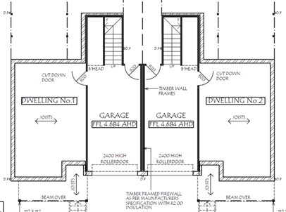
Figure 5 – Extract of the proposed
sub-floor of the dual occupancy
A1.6 Building foundations are designed by a suitably
qualified geotechnical engineer to be suitable for grounds with potentially
reduced bearing capacity under flooding conditions; and
No evidence was supplied to support the proposal’s
compliance with this acceptable solution. However, this is something that
could be ‘conditioned’.
A1.8 A report demonstrating that all performance criteria
have been met is supplied with the development application.
The submitted Flood Impact Statement addresses the
performance criteria underpinning the Acceptable Solutions under Clause 5.1.
The report states that the proposed development meets or exceeds the assessment
criteria.
Based on the response provided in the Flood Impact
Statement and review thereof, it is not considered however that all
performance criteria have been met.
5.2 Fill or Excavation on The Floodplain
A2.1 The development satisfies the requirements as shown in
the planning matrix at Schedule 2.
The table for the High Hazard
Floodway category in Schedule 2 identifies the category as being “Not
suitable for development” in respect of Land Use Category “E
Earthworks”.
Accordingly, the land, being
categorised as High Hazard Floodway, is not considered to be suitable for the
proposed earthworks associated with the development on site and is therefore
noncompliant with A2.1.
5.3 Subdivision in the
Floodplain
A3.1 The development
(subdivision and intended future use) satisfies the requirements as shown in
the planning matrix at Schedule 2;
A separate Strata subdivision
application SF10818, was lodged with Council on 6 August 2020 to subdivide the
proposed dual occupancy on the subject site. As shown in the planning matrix at
Schedule 2 and Table below under subclause 5.4.5 – Riverview Road Area,
no subdivision is permitted within Lyrebird Drive Subdivision as it located in
High Hazard Floodway, therefore non-compliant with A3.1.
5.4 Site Specific Flood
Related Development Controls
5.4.5 Riverview Road Area
states:
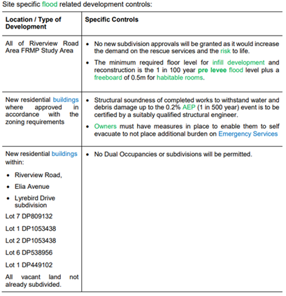
As shown in Table above, dual
occupancies or subdivisions are not permitted within Lyrebird Dr subdivision
area. This recommendation adopted from the Riverview Road Area Floodplain Risk
Management Plan in 2002. The main reason for the restriction of development of
dual occupancies in Lyrebird Drive subdivision is to limit the increase in
population requiring evacuation and risk to life/property. If Council
supports the development however, it follows that support would have to be
granted to the subdivision as the impacts of the development and flood issue
were assessed and deemed acceptable for the dual occupancy.
2. Issue
- Other DCP departures/ alternative solutions - Shoalhaven DCP Chapter G13:
Medium Density and other Residential Development Setbacks and Decking Area
The applicant has sought an alternative or performance-based
solution in regard to;
· Acceptable
Solutions A5.1 in relation to the proposed side setbacks of both dwellings;
· Acceptable
Solutions A5.3 in relation to the garage setback behind the front building
line; and
· Acceptable
Solutions A17.3 in relation to the proposed dimension/setback of the decking
area of both dwellings.
The acceptable solutions are:
· A5.1 Dual
occupancy development in the R1, R2, R3 and RU5 zones shall comply with the
setback provisions in Table 2 and Figure 3 (of the DCP).
· A5.3
Garages must be setback a further 1m behind the front building line.
· A17.3 Where the
private open space of a dwelling is provided at the ground level, it shall:
- Include
a defined hardstand area (e.g. concrete, paving, decking) of usable space
which:
- Is
setback at least 1.2m from an external boundary.
- Has a minimum dimension of 5m x 4m, of which 50% shall
be covered to provide protection from the elements.
- Have a minimum
dimension of 2m for all other areas.
- Have a gradient no
steeper than 1:20.
- Be adequately screened
to provide privacy to residents.
Discussion
The proposed alternative/
performance-based solution in regard to the above are considered reasonable for
the following reasons:
· It is considered
that the proposal is still consistent with the objectives of this chapter and
the relevant performance criteria underpinning the acceptable solutions.
· The proposal is
consistent with the character of the area. The dwellings have been designed
with suitable levels of articulation and windows on eastern and western
elevation have been positioned/setback to minimise overlooking to living area
and private open space of adjoining properties.
· Impacts upon the
existing streetscape would be minimal.
· There will be no
adverse impacts on the amenity of adjoining properties in terms of
overshadowing or loss of view.
· A boundary fence
will ensure that there are minimal privacy impacts upon adjoining properties.
· The proposal maintains
adequate provision for the on-site car parking including manoeuvring
area. Vehicles can safely enter and exit the proposed garage and
enter/exit the subject site.
· The areas of
functional and usable space would be of a suitable size to suit the projected
requirements of future residents, given also that the
remainder of the open space provided as grass and landscaping exceeds the
minimum 35sqm requirement.
· The reduced decking area is capable to be used as an
extension of the function of the dwelling for relaxation, dining,
entertainment, active recreation and children’s play.
· The departure from
the acceptable solutions is unlikely to set an undesirable precedent in the
area.
· No submissions
were received during the notification period actively objecting to the
proposal.
Planning Assessment
The DA has been assessed under
s. 4.15 of the Environmental Planning and Assessment Act 1979. Please refer to Attachment
2.
The applicant has sought an
alternative or performance-based solution under the SDCP Chapter G13 - Medium
Density and other Residential Development for setbacks and the decking area
which have been found satisfactory.
The key issue with respect to this application however is
flooding which forms the basis for refusal. This issue has been discussed
throughout this report.
Policy Implications
Riverview Road Area
Floodplain Management Plan and SDCP 2014 Chapter G9
This Floodplain Management Plan (The Plan) was prepared in
accordance with the NSW Flood Prone Land Policy and NSW Floodplain Development
Manual as part of the Shoalhaven Flood Program. It was adopted by Shoalhaven
City Council in 2002 following extensive consultation with the public, State
agencies and emergency services organisations.
As detailed in the report above, the controls in Chapter G9
are based on the findings and recommendations of The Plan. Also, assessment of
development proposals under Shoalhaven LEP2014 Clause 7.3 (Flood Planning) and
under Section 4.15 of the EPA Act are informed by the findings and
recommendations of The Plan.
Dual occupancies and subdivision are development types that
were not supported by Council when it adopted the Riverview Road Area
Floodplain Management Plan.
If
Council were of a mind to approve DA20/1751, this would be contrary to the
development standard in SDCP 2014 Chapter G9 that currently does not permit
dual occupancies. Further, more similar applications could then be expected, as
mentioned with the 2018 application, having regard to the number of vacant
allotments in this area and zone that applies to the land.
Council has approved two (2) dual occupancy developments in
the area; one in 1993 (DA93/1800) – 37 & 37A Lyrebird Dr and another
one in 2000 (DA00/1146) – 14 Riverview Road before the Riverview Road
Area Floodplain Management Plan was completed and Chapter G9 of SDCP 2014 was
adopted.
There
are currently 8 vacant allotments (including
No.42 Lyrebird Drive). The most recent and similar dual occupancy development
approved and constructed is at No. 38 Lyrebird Drive. Approving this
application may encourage similar applications.
Consultation and Community
Engagement:
The notification was made in
accordance with Council’s Community Consultation Policy. The notification
was for a two-week period 7 August 2020 to 22 August 2020
No submissions were received in relation to Council’s
notification of the development.
Financial Implications:
There are potential cost implications for Council in the
event of a refusal of the application. Such costs would be associated with
defending any appeal in the NSW Land and Environment Court, should the
applicant utilise appeal rights afforded under the EP&A Act.
Legal Implications
Pursuant to section 8.2 of the
EP&A Act, a decision of the Council may be subject of a review by the
applicant in the event of an approval or refusal. If such a review is
ultimately pursued (if the recommendation is adopted) the matter would be put
to Council for consideration. Alternatively, an applicant who is
dissatisfied with the determination of the application by the Council may also
appeal to the Court against the determination pursuant to section 8.7 of the
EP&A Act. Applicants can choose to do both, setting aside the Appeal
pending resolution of the review, noting there are time limitations with respect
to lodging applications for review and appeal.
Council is protected in its
decisions relating to floodplain management by Section 733 of the Local
Government Act 1993 (LG Act), provided it acts (or chooses not to act) in good
faith.
Council may not be seen to have
acted in good faith if it was to approve a development application that is
clearly inconsistent with an adopted Floodplain Management Plan. This could,
for instance, expose Council to actions in relation to losses encountered due
to flooding of the approved development or in increasing the risk to other
properties, people and emergency services personnel.
Approving
this application will reinforce a precedent set by the previous approval and
potentially result in cumulative impacts in the future having regard to the
number of these types of development in high hazard floodway.
Summary and Conclusion
This application for an attached dual occupancy at 42
Lyrebird Drive is not supported, based on assessment against the provisions of
Clause 7.3 of the Shoalhaven LEP 2014 and SDCP 2014 in particular Chapter G9
relating to development on flood prone land.
The land is within the High Hazard Floodway category in the
Riverview Road Area. The findings and recommendations of the Riverview Road
Area Floodplain Management Plan adopted by Council in 2002 state that no dual
occupancies or subdivisions should be approved in this area. It is accepted
that the levee may protect the area up to the 1% AEP flood; however, in the
event of a bigger flood, the levee will be overtopped, and the area will
rapidly change from Low Hazard conditions to High Hazard conditions.
The fundamental issue in this area is managing evacuation
in the event of a flood greater than the 1% AEP, and minimising the risk to
life, for both residents and for the emergency service personnel who will
inevitably become involved in the evacuation task.
Chapter G9 of SDCP 2014 seeks an
equitable outcome for existing landowners by allowing development of vacant
residential lots with single dwellings, despite the flood hazard, but excludes
dual occupancies or subdivisions which would increase the number of households
or occupancies in this area.
It is recommended that the
application be refused for the following reasons:
1. The development does
not satisfy the objectives and provisions of clause 7.3(3) of the SLEP 2014,
which Council must be satisfied of when granting development consent to an
application in flood prone land (Section 4.15(1)(a)(i) of EP&A Act).
2. The development does
not comply with the relevant provisions of Chapter G9 - Development on Flood
Prone Land of Shoalhaven Development Control Plan 2014 (Section 4.15 (1) (a)
(iii) of EP&A Act).
3. The site is not
considered suitable for the development due to its location within a High
Hazard Floodway (Section 4.15 (1) (c) of EP&A Act).
4. Approval of the
development would be contrary to the public interest (Section 4.15 (1) (e) of
EP&A Act) given that the site is flood affected and the development is
contrary to Council’s land use controls.
|
|
Development
& Environment Committee – Tuesday 01 December 2020
Page
1
|
DE20.134 SF10686
– Red Gum Dr Ulladulla – Lot 600 DP 1249606 & Lot 2 DP 1076005
DA. No: SF10686/4
HPERM Ref: D20/480834
Section: Development
Services
Approver: Phil
Costello, Director - City Development
Attachments: 1. Determination
- Refusal ⇩
2. Planning
Report – S4.15 Assessment (under separate cover) ⇨
3. Plans
- Amended Subdivision Layout ⇩
4. Reports
- Fauna & Flora Assessment (under separate cover) ⇨
5. TfNSW
Referral Response ⇩
6. Plans - Swale Drain and
Runoff Calculations ⇩
Description
of Development: Residential subdivision to create eight (8) Torrens Title
allotments, including seven (7) residential allotments, one (1) public reserve
lot, and associated site works within the subdivision approved by SF9275
Owner:
Hazcorp Pty Ltd and Transport for NSW
Applicant:
Rygate & West Ulladulla
Notification
Dates: 27 November 2018 to 12 December 2018
No. of
Submissions: Nil
Purpose
/ Reason for consideration by Council
Council resolved (7 April 2020)
that staff are not to refuse applications, instead the refusal of a Development
Application (DA) must only be by Council / Committee resolution (MIN20.240).
The DA was considered by the Committee on 4 August 2020 and deferred
for further assessment (MIN20.541). Following this further detailed assessment,
the DA is recommended for refusal.
Options
1. Refuse the
development application (DA) in accordance with the recommendation.
Implications: The
application would not proceed. The applicant is able to apply for a section 8.2
review of Council’s decision and/or could lodge an appeal with the NSW
Land and Environment Court against Council’s decision
2. Approve
the application.
Implications: Council would have to
determine the grounds on which the DA is to be approved, that is, provide
reasons to support the development, having regard to section 4.15
considerations. A suite of conditions would have to be prepared by staff in the
event that Council supports the proposal. Under some circumstances, third parties
(i.e. objectors) can seek a judicial review of Council’s decision in the
NSW Land and Environment Court.
3. Alternative
recommendation.
Implications: Council will
need to specify an alternative recommendation and advise staff accordingly.
Figure
1 – Location Map
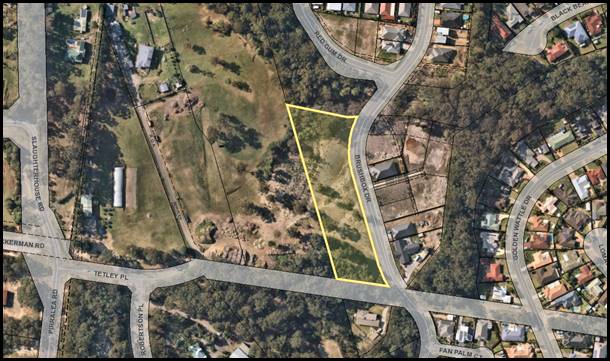
Background
Proposed Development –
Subdivision of Lot 600 DP 1249606
The subdivision plan prepared by
Rygate and West dated 21 March 2018 (Attachment 3) proposes to subdivide Lot
600 DP 1249606 into the following lots as part of Stage 10G of the residential
subdivision:
· Proposed
Lot 901 – Total area of 2,200.9m² (building envelope located
within south-eastern front corner and 25m asset protection zone to bushfire
prone vegetation on adjoining public reserve).
· Proposed
Lot 902 – Total area of 809m².
· Proposed
Lot 903 – Total area of 809m².
· Proposed
Lot 904 – Total area of 809m².
· Proposed
Lot 905 – Total area of 809m².
· Proposed
Lot 906 – Total area of 809m².
· Proposed
Lot 907 – Total area of 1,816.7m² (building envelope located
within north-eastern front corner and 22m asset protection zone to bushfire
prone vegetation on adjoining unformed road reserve).
· Proposed
Public Reserve – Total area of 1424.6m². Located immediately
north of Proposed Lot 901 and adjacent to an existing public reserve created as
part of Stage 10C. The Reserve would incorporate the existing Category 2 water
course and adjacent riparian vegetation.
Proposed Development
– Vegetation Clearing on Lot 600 DP 1249606
According to the submitted Fauna
and Flora Assessment (Attachment 4), the following vegetation is proposed to be
removed from Lot 600 DP 1249606 to facilitate the proposed subdivision:
· Removal of
regrowth vegetation totalling 1100m² within Proposed Lot 907.
· Removal of
scattered trees across the remainder of the property totalling 500m².
· Total area
of vegetation to be cleared from the property – 1600m².
Council notes that the proposed
development would not trigger entry into the Biodiversity Offsets Scheme
in accordance with the Biodiversity Conservation (BC) Act 2016 for the
following reasons:
· The extent
of clearing proposed does not exceed the specified clearing threshold for the
site, being 2500m² or 0.25 ha. The total clearing on the site equates to
1600m²
· No
vegetation proposed to be removed is mapped on the Biodiversity Values Map and
Threshold Tool.
· The Section
7.3 Test of Significance provided within the Fauna and Flora Assessment
indicates that the development is unlikely to have a significant impact upon
threatened species fauna or flora.
Proposed Development
– Maintenance of Asset Protection Zone on Lot 2 DP 1076005
A Bushfire Hazard Assessment
prepared by Bushfire Building Solutions (Ref. BAR 10050/18 dated 29 May 2019)
and General Statement of Compliance (Ref. HCPL290420 dated 4 August
2020) were both provided in support of the application. Both submitted
documents provide the following with regard to the maintenance of asset
protection zones (APZs) for the development:
1. Each
property shall be maintained in perpetuity as an inner protection area in
accordance with the requirements detailed in Section 3.3.
2. No
habitable building over Lot 901 shall be erected within 25 metres of the northern
boundary.
3. APZ
over adjacent land will be the responsibility of Hazcorp as the licence holder
of the land until such time that the NSW Department of Roads and Maritime
Services commences construction of the Milton-Ulladulla bypass.
Within their
referral response submitted to Council on 5 November 2020 (refer
Attachment 5), Transport for NSW (TfNSW) advised that they had undertaken a
review of the development occurring and their associated impacts upon the
bypass corridor land (Lot 2 DP 1076005). Subsequently, they advised as follows:
TfNSW
wishes to advise Council that:
1. Landowners
consent for any works or asset protection zone to be located on Lot 2 DP
1076005/TfNSW land is being withdrawn;
2. The existing
licence agreement between TfNSW and Hazcorp Pty Ltd that relates to Lot 2 DP
1076005/TfNSW land is in the process of being cancelled; and
3. A new
licence agreement will not be entered into with the owner of Lot 600 DP
1249606. As such, the developer will be unable to carry out vegetation
maintenance works/creation of an APZ on the TfNSW land to benefit this
development.
According to the above advice,
the licence agreement between TfNSW and the development permitting maintenance
of an APZ over the bypass corridor land (Lot 2 DP 1076005) is being cancelled
and will no longer be available.
In this regard, a redesign of the subdivision layout and an
amended Bushfire Hazard Assessment would be required to enable the APZ to be
wholly contained within the site and to enable compliance with the Planning for
Bushfire Protection (PBP) 2006 to be achieved. Further discussion in this
regard is contained within the Report below.
Proposed Development
– Reconstruction of Catch/Swale Drain on Lot 2 DP 1076005
An existing catch/swale drain,
presently in a state of disrepair, is partially located on the subdivision lot
and partially on the bypass corridor land.
To facilitate the diversion of
upstream runoff away from the proposed lots, it is required to be reconstructed
as part of the proposed works with Council’s Subdivision &
Development Engineer clarifying:
“The catch drain is currently in the wrong location
and is in a state of disrepair with scouring and erosion having occurred, and
therefore will require reconstruction within the subject lots as part of this
application.
Prior to the approval of the application it
is suggested that a revised subdivision plan is submitted showing the easement
for drainage, or an alternative treatment suggested by the applicant.”
The applicant subsequently
advised that the swale drain would be reconstructed entirely within the bypass
corridor land, and such works would form part of the proposal. A Swale Drain
and Runoff Calculations Plan (Attachment 6) was submitted to Council which
shows the positioning of the proposed swale drain and its location of discharge
towards the existing water course to the north.
Whilst correspondence was
previously received from Transport for NSW (TfNSW) providing their
owner’s consent for the reconstruction works within the bypass corridor
land (Lot 2 DP 1076005), as detailed above, this has now been withdrawn.
In this regard, a redesign of the swale drain would be
required to ensure that it is wholly contained within the site and to enable upstream
runoff to be successfully diverted.
Subject Land
The development site comprises Lot 600 DP 1249606 (proposed
subdivision site) and Lot 2 DP 1076005 (TfNSW Bypass corridor site) at Red Gum
Drive, Ulladulla. Refer to Figure 1.
Site & Context
The
development site:
· Includes land upon which the subdivision is proposed (Lot
600 DP 1249606 formerly known as Lot 500 DP 1235307) and the neighbouring
bypass corridor (Lot 2 DP 1076005).
· The subdivision site has an area of 9,497m² and is
presently vacant of development.
· Is residue land following the registration of Stage 10E of
the residential subdivision estate.
· Is accessed by a legal road frontage to Brushbox Drive to
the east of the property.
· Is zoned R1 General Residential and SP2 Infrastructure
(Road) in accordance with the Shoalhaven Local Environmental Plan 2014 (refer
zoning extract at Figure 2).
· Is mapped as being partially bush fire prone land (refer
Figure 3).
· Contains a mapped Category 2 watercourse which traverses
from east to west across the northern part of the site.
· Is vegetated in the northern part (riparian vegetation
surrounding water course) and in the southern part (regrowth vegetation).
The surrounding area is an emerging residential estate
characterised by low density development such as single dwelling houses on
urban sized blocks of land.
Figure
2 – Zoning Extract
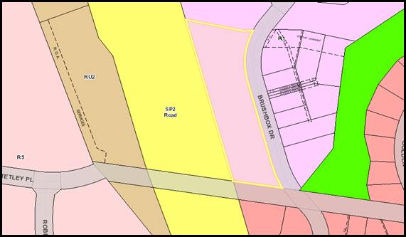
History
The following timeline of events
has taken place following the lodgement of the Development Application with
Council on 29 June 2018:
· 1st
request for information (RFI) was sent to applicant on 6 July 2018 relating to
several matters including amended Statement of Environmental Effects plans, and
documents.
· A
response to 1st RFI was provided by applicant in separate
submissions on 5 August, 22 August, 25 September, and 15 November 2018.
· The
DA was notified according to Community Consultation Policy for two (2) weeks
between 27 November and 12 December 2018. No submissions were received.
· Internal/external
referrals were made on 27 November 2018.
· 2nd
RFI Request sent to applicant on 19 March 2019 following response to
internal/external referrals. Information requested included:
o Vegetation
& Habitat Assessment addressing the Biodiversity Act 2016 (requested by
Council’s Environmental Assessment Officer); and
o Amended
Bushfire Hazard Assessment addressing the Planning for Bushfire Protection 2006
(requested by NSW Rural Fire Service being Integrated Development).
· A
response to the 2nd RFI Request on 11 September 2019 providing the
requested documentation.
· Re-referral
to Environmental Assessment Officer and NSW Rural Fire Service for
consideration of submitted documents on 25 September 2019.
· Re-referral
response by Environmental Assessment Officer on 21 October 2019 requesting an
amended Vegetation & Habitat Assessment given the submitted Report did not
comply with the Biodiversity Conservation Act 2016.
· 3rd
RFI Request sent to applicant on 2 December 2019 requesting the amended
Assessment.
· A
response was received from TfNSW on 2 February 2020 advising the reconstruction
of the swale drain within the bypass corridor is acceptable provided amended
plans and drainage calculations are provided, depicting the reconstruction.
· The
re-referral response provided by NSW Rural Fire Service on 28 February 2020
requested a further amended Bushfire Hazard Assessment given the submitted
Report still did not comply with the Planning for Bushfire Protection 2006.
· 4th
RFI Request sent to the applicant on 18 March 2020 requesting the amended
Assessment required by NSW Rural Fire Service and the plans/drainage
calculations required by TfNSW.
· Follow
up correspondence sent to applicant seeking updates regarding the progress of
the response to the 3rd and 4th RFI Requests on 18 March,
11 May, 14 May, and 3 June 2020 advising that the response is required within a
reasonable timeframe or the DA would be reported with a recommendation of
refusal.
· Response
to 4th RFI Requests provided by the applicant in separate
submissions on 4 and 11 August 2020 providing the requested documentation.
· Application
considered by the Development and Environment Committee on 4 August 2020 and deferred
for further assessment (MIN20.541).
· Internal/external
re-referrals were made on 19th August 2020.
· Re-referral
responses from NSW Rural Fire Service and Council’s Environmental
Assessment Officer provided by 10 October 2020 identifying further issues that
need to be addressed as it relates to the bushfire assessment and submitted
plans.
· Re-referral
response from Transport for NSW (TfNSW) provided on 5 November 2020 advising
that owner’s consent and licence agreements for works on the bypass corridor
land (Lot 2 DP 1076005) has been withdrawn / cancelled.
· Applicant
notified on 5 November 2020 of issues raised by NSW Rural Fire Service, TfNSW
and Council’s Environmental Assessment Officer.
Issues
Bushfire Protection
In
accordance with Figure 3 below, the site is mapped as being partially
bushfire prone.
Figure
3 – Bushfire Prone Land
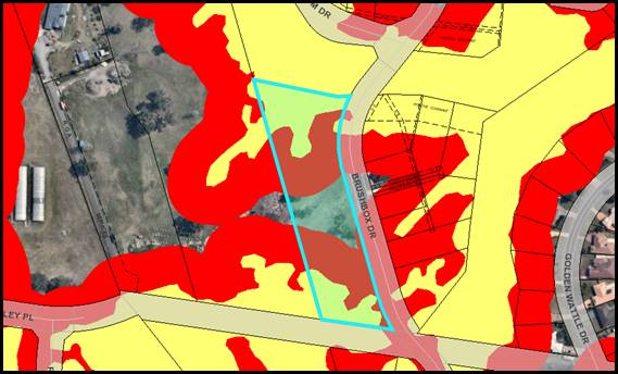
As the proposal is for
subdivision of bushfire prone land, the development is Integrated Development
under s4.46 of the Environmental Planning and Assessment (EP&A) Act 1979
and triggers referral to NSW Rural Fire Service (RFS).
The application was initially
referred to the RFS where a review of the submitted Bushfire Hazard Assessment
(prepared by Bushfire Building Solutions, dated 29 May 2019) was undertaken.
In their referral response dated
28 February 2020, RFS advised that the following amendments to the Bushfire
Hazard Assessment were required to permit compliance with the Planning for
Bushfire Protection (PBP) 2006:
· Amended
Subdivision Plan providing a 35m Asset Protection Zone to the bushfire prone
vegetation within the adjoining public reserve; and
· Amended
Bushfire Hazard Assessment further considering the bushfire prone vegetation
with Proposed Lots 906 to 908 given it does not meet the criteria for
‘low hazard vegetation’.
Following a Further Information Request, the applicant sought
to address these matters through the submission of a ‘General Statement
of Compliance’ (prepared by Bushfire Protection Planning & Assessment
Services Pty Ltd, dated 4 August 2020), which is an addendum to the Bushfire
Hazard Assessment previously submitted.
In their referral response dated 22 September 2020, RFS raised
several additional matters that are required to be addressed to permit
compliance with the Planning for Bushfire Protection (PBP) 2006. The matters
required to be addressed are as follows:
· Bush
Fire Modelling:
o The slope
transects do not adequately assess all the potential slopes influencing bush
fire behaviour that may impact the site, including slopes that would not be
considered level, as indicated in transects A and B in the bush fire modelling.
o The reduced fire
head width of 35 metres is not a conservative approach and the fire head width
should include the contiguous length of vegetation along that northern boundary
area.
o The proposed approach of
breaking the slope into such small transects (less than 10 metres intervals)
and modelling different APZs for each interval is unlikely to represent a true
fire, as a bush fire is not a single line/point of impact, rather a
‘front’ or ‘head’ with flanks.
· Proposed
Lot 907:
o The bush fire report indicates
that the vegetation within the ‘unformed road’ portion of land
adjacent to proposed lot 907 is to remain and is not part of the RMS licence
approval for vegetation management. Should this be the case the vegetation
would not meet the criteria for downgrading to remnant vegetation in that it
has a fire run of more than 50 metres and is connective to other vegetation
giving an area of greater than one hectare.
· Asset
Protection Zone (APZ): An amended Bushfire Hazard Assessment is required to be
provided which ensures the APZ is wholly contained within the property
boundary. This accords with the Transport for NSW advice where they advised that
owner’s consent and licence agreements for an APZ on the bypass corridor
land (Lot 2 DP 1076005) has been withdrawn / cancelled.
It appears that as a result of
the above (and TfNSW comments) that a redesign of the subdivision layout is
required to address the concerns.
Discussion
Given neither the Bushfire
Hazard Assessment nor the General Statement of Compliance addressed the
Planning for Bushfire Protection to NSW Rural Fire Services’
satisfaction, the proposal is found to be non-compliant with the following
items of legislation:
· Section 4.47(2)
of the Environmental Planning and Assessment (EP&A) Act 1979 states the
following:
“Before
granting development consent to an application for consent to carry out the
development, the consent authority must, in accordance with the regulations,
obtain from each relevant approval body the general terms of any approval
proposed to be granted by the approval body in relation to the development.
Nothing in this section requires the consent authority to obtain the general
terms of any such approval if the consent authority determines to refuse to
grant development consent.”
Subdivision of bush fire prone land is integrated
development under s100B of the Rural Fires Act 1997 and under Section 4.47(2)
of the EP&A Act 1979, general terms of approval and a Bush Fire Safety
Authority (BFSA) are required prior to determination of the development.
· A79.1/P80
of Chapter G11 – Subdivision of Land
Acceptable Solution A79.1 of Chapter G11 –
Subdivision of Land of the SDCP 2014 states the following:
“A development application is
supported by an appropriate level of analysis consistent with Council and other
legislative requirements.
The subdivision lot design
positively responds to:
· Slope and
desirability of minimising earthworks/retaining walls associated with dwelling
construction.
· Natural or cultural
features;
· Soil erosion and
bushfire risk;
· Special features such
as trees and views, including identification of mature stands of trees retained
& supplementary planting.”
Given the requirements of Planning
for Bushfire Protection 2006 have not been satisfactorily addressed, Council
finds that the subdivision lot design does not positively respond to bush fire
risk.
Performance Criteria P80 states the following:
“Lot areas and dimensions take
into account the site natural opportunities and constraints.”
The proposal remains non-compliant with Performance
Criteria P80 of Chapter G11 of the SDCP 2014 for the following reasons:
· Slope transects provided
did not adequately assess all slopes affecting bushfire behaviour on the site.
As such, the extent of natural opportunities and constraints on the site cannot
be properly quantified.
· Given TfNSW has
withdrawn their owner’s consent, any existing vegetation located on the
bypass corridor land would remain, which would create a fire run over 50m and
is connective to other vegetation giving an area of greater than one hectare.
· A further redesign would
be required, in particular of Proposed Lot 907, to enable the site to be
utilised for residential purposes – taking into account the site
opportunities and constraints.
Swale Drain and Works within the Princes Highway
Ulladulla Bypass Corridor
There is an existing swale drain
located partially on Lot 600 (subject subdivision site) and partially on Lot 2
(Bypass Corridor). Its purpose is to collect runoff generated upstream to avoid
the potential for overland flow across the subdivision site.
As mentioned previously,
Council’s Subdivision & Development Engineer commented:
“The catch drain is currently in the wrong location
and is in a state of disrepair (see D19/82250) with scouring and erosion having
occurred, and therefore will require reconstruction within the subject lots as
part of this application.
Prior to the approval of the application it
is suggested that a revised subdivision plan is submitted showing the easement
for drainage, or an alternative treatment suggested by the applicant”.
In correspondence with TfNSW,
the applicant advised their intention to reconstruct the swale drain entirely
within the bypass corridor (Lot 2 DP 1076005) with the point of discharge for
runoff being the existing water course to the north. TfNSW agreed to provide
owner’s consent for these works, subject to the submission of a plan
depicting the reconstruction of the swale drain and the associated drainage
calculations.
The applicant submitted a Swale
Drain and Runoff Calculations Plan (Attachment 6) which Council referred
through to TfNSW for their comments/conditions. In their response, TfNSW
advised as follows:
1. Landowners
consent for any works or asset protection zone to be located on Lot 2 DP
1076005/TfNSW land is being withdrawn;
2. The existing
licence agreement between TfNSW and Hazcorp Pty Ltd that relates to Lot 2 DP
1076005/TfNSW land is in the process of being cancelled; and
3. A new
licence agreement will not be entered into with the owner of Lot 600 DP
1249606. As such, the developer will be unable to carry out vegetation
maintenance works/creation of an APZ on the TfNSW land to benefit this
development.
Council notes that an extensive
redesign of the Swale Drain and Runoff Calculations Plan is required in order
to ensure no works are carried out on the bypass corridor land. This would
require an amended Plan which depicts its reconstruction within the boundaries
of the subdivision lot (Lot 600 DP 1249606) as well as an amended subdivision
plan which depicts easements burdening each of the proposed lots.
Discussion
TfNSW has withdrawn their
consent as owner of Lot 2 for any proposed works (Refer to Attachment
5). It is noted that in accordance with a consistent line of authority in the
Land and Environment Court, there is no opportunity for revocation or
withdrawal of landowner’s consent once made for a development
application. (Rose Bay Afloat Pty Ltd v Woollahra Council (2002) 126 LGERA 36).Thus
whilst in a technical sense consent may be able to be granted, the adjoining
landowner has denied legal ability to carry out the works required for the
subdivision.
Further to the above advice, TfNSW
has recommended that the developer either amend the current application to
provide the required APZ wholly within their own land (being Lot 600), or wait
until the Milton Ulladulla Bypass construction works have commenced on the
adjacent land, therefore, removing the need for an APZ.
In this regard, and as detailed earlier in this report, a
redesign of the subdivision layout and / or an amended Bushfire Hazard
Assessment would be required.
Planning Assessment
The DA has been assessed under s4.15(1) of the Environmental
Planning and Assessment Act 1979. Please refer to Attachment 2.
Consultation and Community
Engagement:
Notification was undertaken in accordance with
Council’s Community Consultation Policy with letters being sent within a
100m buffer of the site, during the period 27 November 2018 to 12 December
2018. No submissions were received in relation to Council’s notification
of the development.
Financial Implications:
There are potential cost implications for Council in the
event of a refusal of the application. Such costs would be associated with
defending an appeal in the Land and Environment Court of NSW.
Legal Implications
Pursuant to section 8.2 of the Environmental Planning and
Assessment Act 1979 (EP&A Act), a decision of the Council may be subject of
a review by the applicant in the event of an approval or refusal. If such a
review is ultimately pursued (if the recommendation is adopted) the matter
would be put to Council for consideration. Alternatively, an applicant who is
dissatisfied with the determination of the application by the Council may also
appeal to the Court against the determination pursuant to section 8.7 of the
EP&A Act. Applicants can choose to do both, setting aside the Appeal
pending resolution of the review, noting there are time limitations with
respect to lodging applications for review and appeal.
Summary and Conclusion
This application has been
assessed having regard for section 4.15 (Matters for consideration) under the
EP&A Act. Having regard to the assessment, the proposal is not
considered capable of support. Reasons for refusal are provided below and can
also be found at Attachment 1 to this report:
|
1.
|
Given
the significant redesign required to achieve compliance with the Planning for
Bushfire Protection (PBP) 2006, NSW Rural Fire Service was unable to issue
general terms of approval under Section 4.47(2) of the EP&A Act 1979.
(Section 4.47(2) of the Environmental Planning and Assessment Act, 1979)
|
|
2.
|
The
application has not satisfactorily demonstrated compliance with A79.1/P80 of
Chapter G11 – Subdivision of Land of the Shoalhaven Development Control
Plan 2014. (Section 4.15(1)(a)(iii) of Environmental Planning and Assessment
Act, 1979)
|
|
3.
|
Having
regard to the likely impacts of the development, the applicant has not
satisfactorily demonstrated that the proposal would not have an adverse
impact upon the natural environment. (Section 4.15(1)(b) of Environmental
Planning and Assessment Act, 1979)
|
|
4.
|
The
information submitted with the development application does not
satisfactorily demonstrate that the site is suitable for the proposed use.
(Section 4.15(1)(c) of Environmental Planning and Assessment Act, 1979)
|
|
5.
|
Having
regard to the above matters the granting of development consent is not in the
public interest. (Section 4.15(1)(e) of Environmental Planning and Assessment
Act, 1979).
|
|
|
Development
& Environment Committee – Tuesday 01 December 2020
Page
1
|
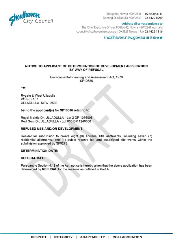
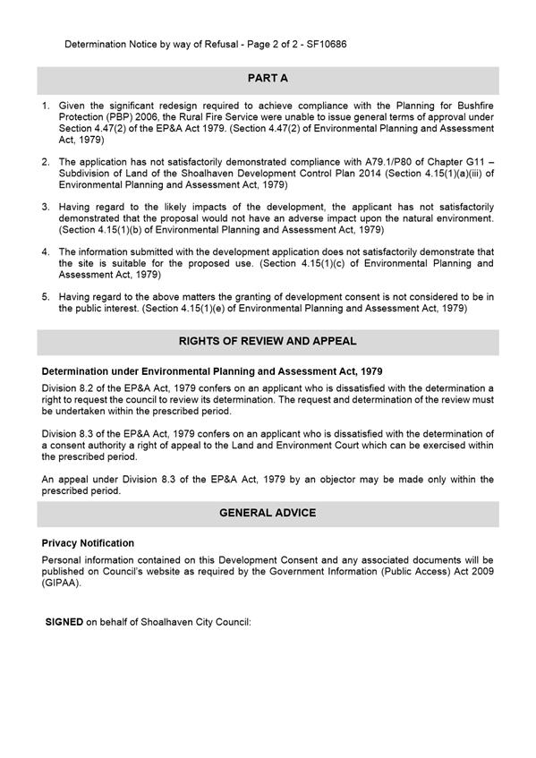
|

|
Development
& Environment Committee – Tuesday 01 December 2020
Page
1
|
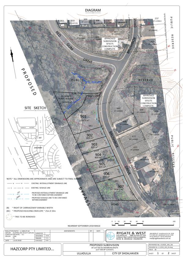
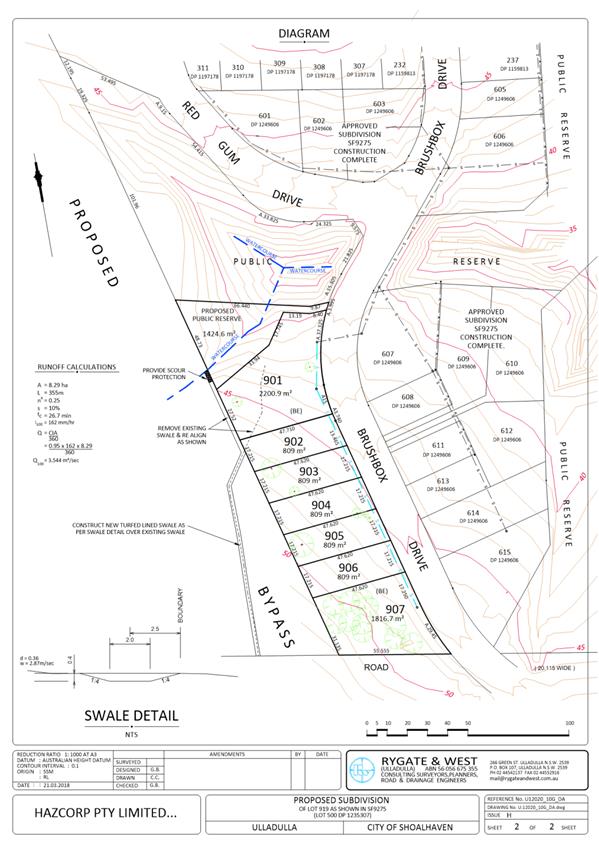
|
|
Development
& Environment Committee – Tuesday 01 December 2020
Page
1
|
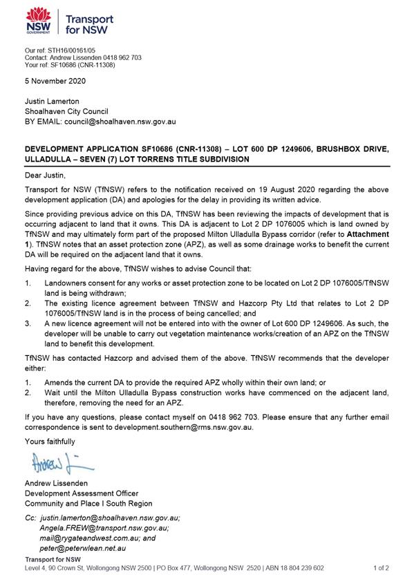
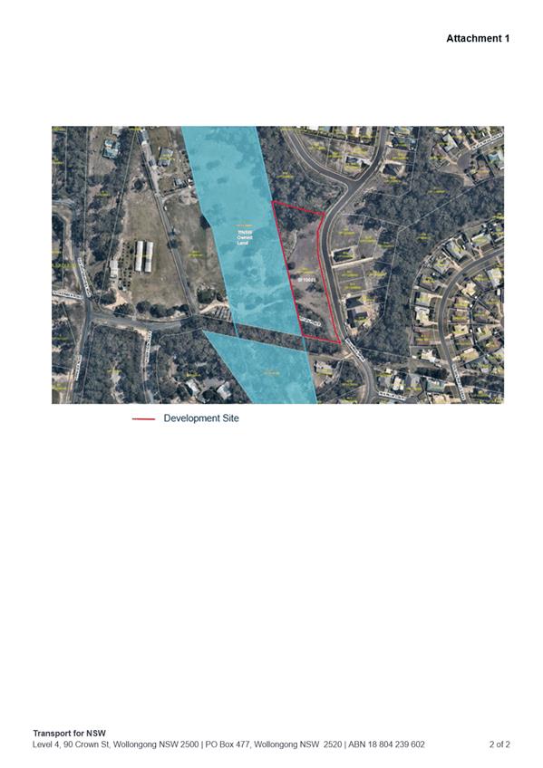
|
|
Development
& Environment Committee – Tuesday 01 December 2020
Page
1
|
|
|
Development
& Environment Committee – Tuesday 01 December 2020
Page
1
|
DE20.135 SF10804
– 104 Taylors Lane, Cambewarra – Lot 3 DP 851823
DA. No: SF10804/4
HPERM Ref: D20/509320
Section: Development
Services
Approver: Phil
Costello, Director - City Development
Attachments: 1. Plans
- Subdivision - Lot 3 DP 851823 - 104 Taylors Lane Cambewarra ⇩
Description
of Development: Staged residential subdivision to create 232 Torrens Title
allotments, including 228 residential and four (4) open space allotments, and demolition
of existing structures, earthworks, and provision of roads, drainage and
utility infrastructure along with associated landscaping works
Owner: KI & JG Tompson
Applicant: Watersplash Lane Pty Ltd
Notification Dates: 25 November 2020 – 9
December 2020
No. of Submissions: As above
Purpose
/ Reason for consideration by Council
Councillors requested a progress report on the Development
Application (DA) on 24 November 2020.
|
Recommendation (Item to be determined under delegated authority)
That the report on SF10804 – 104 Taylors Lane,
Cambewarra – Lot 3 DP 851823 be received for information.
|

Figure 1 – Location Map
Background
Proposed Development
The DA seeks approval for staged
residential subdivision to create 232 Torrens Title allotments, including 228
residential and four (4) open space allotments, and demolition of existing
structures, earthworks, and provision of roads, drainage and utility
infrastructure along with associated landscaping works.
This is one of the first subdivisions in the Moss Vale Road
South Urban Release Area (URA), which is one of the first URAs in
Nowra-Bomaderry to be released for development. As such Council has made a
considerable effort to get the planning documents in place (Indicative Layout
Plan, DCP Chapter and Contributions Plan amendment) to guide the development of
this new area and then work with developers, including the applicant for this
DA, throughout the planning of the URA to ‘do things differently’,
encourage compliance with planning controls and set a positive example for
future development in Moss Vale Road South URA and other URAs within the
broader Nowra-Bomaderry area.
Subject Land
The development site comprises Lot 3 DP 851823 (104 Taylors
Lane, Cambewarra). Refer to Figure 1.
Site & Context
The development site:
§ Is within the Moss Vale Road South Urban Release Area (URA)
and contains an existing dwelling and ancillary structures, six (6) earth dams
and scattered trees and vegetation. Historically, the site has been used for
rural residential and agricultural purposes, predominantly grazing.
§ Is zoned R1 General Residential, E2 Environmental
Conservation, E3 Environmental Management, and SP2 Infrastructure. Only the R1
zoned portion of the site is within the Urban Release Area.
§ Is 25.25ha in area.
§ Is identified as being partially flood prone and of
aboriginal cultural heritage significance.
§ Is identified as “Scenic Protection” in the
northern section, adjacent to Moss Vale Road.
§ Has frontage to Moss Vale Road and Taylors Lane.
§ Adjoins land zoned R1 General Residential, E2 Environmental
Conservation, E3 Environmental Management, SP2 Infrastructure and RU1 Primary
Production.
History
It is noted that Council staff engaged extensively with the
applicant before lodgement of the DA, including during the finalisation of the
Development Control Plan (DCP) and Contributions Plan (CP) projects for the
Moss Vale Road South URA. Comments were provided on the proposed planning
provisions for the subject land as part of the exhibition of the draft DCP and
draft CP projects. These comments were considered by Council as part of the
finalisation of the documents during 2018. It is however noted that some of the
issues/concerns with this DA are the same as or similar to, those considered
through the DCP/CP finalisation process.
The following provides details on post-lodgement actions
for context:
§ The application was lodged on 9 June 2020.
§ As a result of detailed assessment of the application, additional
information has been requested from the applicant on four (4) occasions –
11 June 2020, 10 July 2020, 2 September 2020 and 16 November 2020.
§ On 11 June 2020, Council requested additional information. It was
particularly noted that given the absence of a Special Infrastructure
Contribution (SIC), satisfactory arrangements for State public infrastructure
are required to satisfy clause 6.1 of Shoalhaven Local Environmental Plan 2014
(SLEP 2014). Satisfactory arrangements may be in the form of a Voluntary
Planning Agreement (VPA). Any VPA must be consistent with the Draft Practice
Note issued by the Department of Planning & Environment and Council’s
VPA Policy.
§ On 1 July 2020, the applicant submitted additional information, which
was subsequently referred to the relevant sections of Council and external
agencies for comment. The VPA was not and is still yet to be submitted.
§ On 8 July 2020, relevant Council staff met with the applicant and raised
concern with the currently proposed development. It was agreed that Council
would confirm what was discussed in this meeting and requirements in writing.
§ On 10 July 2020, Council requested the additional information as
discussed in the meeting. The applicant was requested to address inconsistency
with the Indicative Layout Plan (ILP), in accordance with A1.1, Control 7.1
Indicative Layout Plan, Chapter NB3, Shoalhaven Development Control Plan 2014
(SDCP 2014), particularly in relation to the location of the northern perimeter
road and through road connections/alignments and how it relates to that
approved as part of Development Consent SF10632 (subdivision within Stage 1 of
the Moss Vale Road South URA). Refer to Figure 2 and the attached current
subdivision plan. There were also other matters raised relating to design and
layout, inconsistency with the residential density targets, and non-compliance
with mandatory controls under Controls 7.3 Subdivision Design and 7.4 Street
Network and Hierarchy, Chapter NB3, SDCP 2014.
§ On 30 July 2020, the applicant submitted a letter with preliminary
response to Council’s request dated 10 July 2020.
§ On 2 September 2020, Council provided comments in response
to the applicant’s letter, along with a request for additional
information as requested by Transport for NSW and Nowra Local Aboriginal Land
Council. Whilst Council was agreeable to some aspects of the proposed design
response, there was still concern raised in relation to consistency with the
ILP, particularly in relation to the location of the northern perimeter road
and through road connections/alignments.
§ On 23 October 2020, the applicant submitted a letter with preliminary
response to Council’s request dated 2 September 2020. No specific
direction was provided as to how they particularly intended to proceed with
this application in ensuring the design layout was to better align with the
ILP.
§ On 13 November 2020, the applicant submitted a response with specific
direction in relation to the northern perimeter road alignment. They believe
that the location and landscaping of this road as proposed delivers a superior
urban design outcome for the URA.
§ On 16 November 2020, Council requested additional information as
requested by Heritage NSW. Council also confirmed a meeting date with relevant
staff to discuss the design further and work through outstanding matters.
§ On 24 November 2020, relevant Council staff met with the
applicant to discuss their preliminary response submitted to Council on 23
October 2020 along with additional drawings showing potential solutions to some
of Council’s requests. It was agreed that Council would provide formal response
in relation to its position on some of the matters raised to allow the
applicant to provide a revised suite of documentation as soon as possible. The
applicant indicated in this meeting that they intended to pursue the currently
proposed layout particularly the location of the northern perimeter road.
Planning Assessment
The DA has been (or will be)
assessed under s4.15(1) of the Environmental Planning and Assessment Act 1979.
Summary of Issues
The proposed development
currently includes a range of variations from relevant provisions of SLEP 2014
and SDCP 2014, including fundamental variations from the Indicative Layout Plan
(ILP) that Council encouraged the applicant to resolve numerous times, both pre
and post lodgement of the DA. Specifically:
a) The
proposal extends outside of the URA boundary along the northern perimeter by
placing a perimeter road (Road 10) in the E3 Environmental Management zone.
This is not consistent with the intended function of the E3 zone as an
environmental corridor/scenic protection area between the URA and Moss Vale
Road under Chapter NB3 of SDCP 2014. It is also not good planning practice when
an opportunity exists to place the road within the zoned development area. The
ILP shows no road along the western portion of the northern perimeter and
requires the road along the eastern portion of the perimeter to be within the
URA boundary. Council has consistently asked the applicant both pre and post
lodgement of the DA to comply with the DCP and locate Road 10 within the URA
boundary and also enable through road connections to the adjoining
conditionally approved subdivision (SF10632).
b) The
proposal does not provide large lots within the Large Lot Residential area
(northern edge of the URA) and instead proposes standard size residential lots.
This area is intended to provide an appropriate transition between the URA and
the rural land around it. This was consistent with the feedback received from
the community as part of the finalisation of SLEP 2014 when the residential
zone boundary was pulled back from Moss Vale Road in response to community
concerns. The DCP includes the provision for large lots and rural style edge
fencing in this location. However, the proposal exceeds the lot density target
and potentially presents a ‘hard edge’ to surrounding rural land
and when viewed from Moss Vale Road.
c) Safe
intersection sight distances need to be assessed for the Road 17/Road 11
intersection (northbound). The intersection angle is higher than shown in the
DCP layout. The roundabout location should be practical as an LATM device. The
proposed location will be too close to the western collector road and there is
a road missing based on the DCP layout making the laneways longer than
necessary. Additional LATM devices should be provided to ensure Road 20 does
not have a significant segment without slow points. Additional LATM measures
may be required for other roads that exceed the maximum leg length outlined in
Chapter G21, SDCP 2014.
d) The
intersections to the laneways are too close to the adjacent roads.
e) The
distance between intersections may be too small for laneways. Potential no
right turn movements should be provided into Road 18 and Road 21.
f) It
is crucial for the small lots to be fully compliant with the DCP regarding
vehicular access and parking requirements due to the nature of the access road.
On street parking overflow is not permitted and should be ”designed
out” at this stage.
g) A
“mini-roundabout” is proposed as part of the stage at the
intersection of Road 20 and Road 15, which is not acceptable. This roundabout
is not mentioned in the DCP. It is also noted
that this would need to be compliant for a 14.5m bus as it is located on the
interim bus route as shown in the DCP.
h) There is
a consistency issue with the residential density targets in relation to the
ILP, in accordance with A1.2, Control 7.1 Indicative Layout Plan, Chapter NB3,
SDCP 2014.
i) One
(1) block of small lots exceeds 100m in length by approximately 10%, as
indicated by the applicant. Street blocks are required to be designed to be
rectangular in shape to enable permeability. The length and width of street
blocks (excluding road verges) are a maximum of 100m x 70m in areas where small
lots are proposed, and rear lane access or shared driveways are located. 200m x
70m in all other areas.
j) Lots
101-104 are proposed with direct access to Road 20 (a tree-lined boulevard). No
direct vehicular access or waste collection is permitted on tree-lined
boulevards, except for the area to the far-west of the western Collector Road
(as illustrated by the dashed line in Figure 9 of Chapter NB3, SDCP 2014).
Figure 2 – Site in relation to Indicative Layout Plan (ILP)
Conclusion
Given the current design, the
proposal is inconsistent with the DCP and importantly fails to integrate with
the already approved subdivision on the adjoining land. Council has repeatedly
sought consistency with the adopted DCP layout and has conveyed this advice to
the applicant on several occasions. Having regard to the above, the application
would not receive a positive recommendation from staff in its current form.
The applicant has indicated they
will consider the discussion of 24 November 2020 and respond with a package of
information as soon as practicable. However, the applicant has indicated
that their preference is to pursue the design as put, particularly the location
of the perimeter road.
|
|
Development
& Environment Committee – Tuesday 01 December 2020
Page
1
|
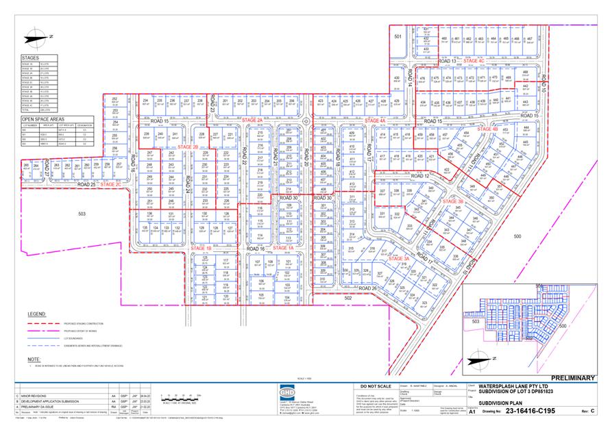
|
|
Development
& Environment Committee – Tuesday 01 December 2020
Page
1
|
DE20.136 Quarterly
Review for Compliance Matters
HPERM Ref: D20/422071
Section: Building
& Compliance Services
Approver: Phil
Costello, Director - City Development
Attachments: 1. Penalty
Notices Issued ⇩
Reason for Report
At Council’s Ordinary meeting held on 13 November 2018
it was resolved to receive a detailed quarterly report on compliance activities
(MIN18.907).
This report provides information
on the period from 1 July 2020 to 30 September 2020 (first quarter 2020/2021).
|
Recommendation (Item to be determined under delegated authority)
That
Council receive the quarterly report on compliance matters for information.
|
Options
1. Council receive
the report for information
Implications: Nil
2. Council receives
the report and provides additional direction for future reports.
Implications: Any changes or additional matters can
be added to future reports.
Report
Compliance activities are completed by the following Teams
within City Development:
(a) Compliance Team:
Development compliance matters including unauthorised development, development
not in accordance with development consent, land, and water pollution incidents
(including building sites), land use management issues, fire safety and
swimming pool safety issues.
(b) Environmental Health:
Pollution incidents (noise and water), environmental incidents, food shops and
the operation of on-site sewage waste management facilities.
(c) Parking: All parking
offences.
(d) Rangers:
Animal control, littering, unauthorised camping, rubbish dumping and other
environmental offences.
This report provides Councillors with an update on the
penalties issued (number, type, and ticket value), penalty reviews dealt with
by the Review Panel and any Local or Land and Environment Court matters
determined or progressing.
This report relates to July - September 2020 (first quarter).
Penalties issued during the period
A combined total of 1,609 penalty notices were issued by the
Teams during the period. These penalties have a face value of $334,225. Historically
Council stands to receive approximately 70% of this ticketed figure.
A total of 164 cautions were also issued during the period.
Attachment 1 to this report provides a breakdown of the
penalties and cautions issued.
The following is a summary of the penalties issued for each
team:
|
Team
|
Number Issued
|
Total Amount
|
% of total amount
|
Cautions issued
|
|
Compliance
|
1
|
$1,500
|
1%
|
23
|
|
Compliance – Fire Safety
|
0
|
$0
|
0
|
0
|
|
Compliance – Pools
|
0
|
$0
|
0
|
0
|
|
Environmental Health
|
0
|
$0
|
0
|
2
|
|
Rangers – Animal issues
|
291
|
$113,785
|
34%
|
21
|
|
Rangers – Environmental issues
|
80
|
$43,176
|
13%
|
11
|
|
Parking
|
1,237
|
$175,764
|
52%
|
107
|
|
Sewer Management Facility
|
0
|
$0
|
0
|
0
|
|
Total
|
1,609
|
$334,225
|
100%
|
164
|
Penalties related to Compliance issues
The following details are provided in relation to the single compliance
penalty notice issued:
a) Little Forest
($1500): One penalty notice issued to the owner of the premises. The
penalty notice relates to development without development consent (Class 1a or
10 building - $1500). A further seven (7) warning notices were issued.
The matter was brought to Councils attention following an
assessment by Council staff identifying the unauthorised use of the premises as
a primitive campground.
In addition, the investigation revealed a two-storey
structure had been constructed adjacent to an existing shed. The structure
contained accommodation used for short term tourist and visitor accommodation
on the upper floor which was advertised through ‘Air bnb’.
The value of the warning notices if issued as penalty
notices, would have been $6,300.
Warnings related to Compliance
issues
A total of 23 warning notices were issued for
compliance matters in the period and these equate to $49,430 in ticket face
value. Potentially the Compliance Team could have issued $50,930 in penalties
for the period. The caution rate is approximately 97%.
Penalty infringement panel reviews
During the period, the
review panel met on 3 September 2020. There were four (4) penalty infringement
notices considered during this period.
(a) Development
without development consent – any other case – individual’
with a penalty amount of $3000 and Fail to demolish or remove building contrary
to order – individual’ with a penalty amount of $3000 x2
The penalty notices subject to the review relate to the
unauthorised placement of two shipping containers and the failure to remove the
unauthorised shipping containers placed on the premises located within Jerberra
Estate.
A property was identified as one of a number of properties
in the Jerberra Estate where unauthorised structures had been erected. Council
wrote to the owners back in October 2017 to ascertain what their intentions
were to address the unauthorised structures located on the property. No
response was received.
A demolition order was issued directing the owner to remove
the shipping containers. Australia Post revealed the Order had been received. A
follow up inspection revealed both shipping containers still located at the
premises.
On review of a submission from the offender it was
determined that a consistent approach was required in this matter. Penalty
notice for development without development consent and 1x fail to demolish or
remove building contrary to order were withdrawn.
The other fail to demolish or remove building contrary to
order was determined by way of penalty to stand.
(b) Development
without development consent – Class 1a or 10 building – Individual
($1500)
The penalty notice subject to the review related to the
unauthorised rebuild of a treated pine deck located to the rear of the
premises. The premises were identified as Bush Fire Prone Land and the deck was
in flame zone. The construction of the deck did not satisfy the requirements
for exempt development and required approval from a consent authority.
This matter came to Councils attention as the result of a
complaint where concerns were raised about the demolition and reconstruction of
timber decks on bush fire prone land.
After reading the builders submission, a decision was made
to explain the legislation to him via a meeting. Each item of the submission
was addressed including the evolution of the legislation. During the meeting
the builder gained a new appreciation of the legislation and conceded that all
the works identified were unauthorised. He also explained that his speciality
of commercial style development had slowed down due to Covid-19 and he and is
business were experiencing considerable financial impact.
It was recommended the Penalty Notice subject to this
review be withdrawn and reissued as a formal warning. The panel concurred with
the recommendation.
Local Court matters
A second mention was held at Nowra Local Court relating to
Court Elected penalty Notice – Fail to Comply with development control
order (Demolish Works) – Jerberra Estate.
The defendant failed to appear and the matter has been listed
for hearing on 2 December 2020.
Land and Environment Court matters
NIL
Compliance Merits received this quarter
During the period the Compliance Team received a total of 177
Merits and these are detailed in the following table.
|
Type of Merits Received
|
Number
Received
|
Percentage
of total
|
|
Asbestos issues
|
4
|
2.26%
|
|
Building Works - Not in Accordance
Consent
|
32
|
18.08%
|
|
Building Works - Without Consent
|
62
|
35.03%
|
|
Defective Building Works
|
1
|
0.56%
|
|
Earthworks - Without Consent
|
10
|
5.65%
|
|
Erosion Control - Building Sites
|
1
|
0.56%
|
|
Erosion Control - Subdivision sites
|
3
|
1.69%
|
|
Land Use - Without Consent
|
12
|
6.78%
|
|
Sewerage Management Facility
|
1
|
0.56%
|
|
Stormwater Runoff - Building Site
|
40
|
22.60%
|
|
Swimming Pool Fencing Inspection
|
8
|
4.52%
|
|
Vegetation Clearing - Without Consent
|
3
|
1.69%
|
|
TOTALS
|
177
|
100%
|
Of these Merits, building works without consent make up 35.03%
of all complaints registered in the period. This is a clear indication that
development without consent is still high in the Shoalhaven.
Stormwater runoff – building sites (22.60%) is higher than
normal for the period. This increase is most likely attributed to the two east
coast low events that occurred during the quarter.
Development not in accordance with consent (18.08%) is also
high and this reflects the expectation of the community to keep developments
true to the approval.
Penalties related to Rangers issues
(a) Dog Attacks:
In the reporting period, Rangers have received and attended
61 reports of dogs attacking. Of these, 29 investigations have been completed
with 18 penalty notices issued (i.e. 18 X $1320 = $23,760). A further 32
matters remain under investigation.
5.0 Other activities
by Ranger Services
(a) Beach Patrols: Rangers
have completed 1262 beach patrols during this quarter. A total of 97 dog owners
have been spoken to with 235 dogs sighted. A total of 56 penalty notices have
been issued with 8 official warnings and 19 verbal cautions given.
(b) Shoalhaven
City Council project – Cigarette Butt Bin installation: Rangers have
coordinated a project with the community to reduce cigarette butt litter around
Shoalhaven District Memorial Hospital. In consultation with NSW Health and
members of the community from the local ‘Riverwatch’ group, four
(4) cigarette butt litter bins have been installed on SCC owned land on Scenic
Drive and Shoalhaven Street.
A community clean-up is scheduled for the area and Rangers
will continue to monitor butt bin usage to capture further data for future
projects. It is expected the result of this trial will be reported in media
outlets.
(c) Illegal Dumping:
Rangers have documented 212 new illegal dumping incidents within the
Shoalhaven. Shoalhaven City Council (Assets & Maintenance division, and
Parks & Ops division) have removed waste to the approximate cost of $19,420
during the reporting period. A total of 71 tonne of illegally dumped waste was
reported for the same quarter.
A large amount of mixed household and demolition waste was
located illegally dumped on a parcel of land off Naval College Road, Hyams
Beach. The land is owned by National Parks and Wildlife Services. The
investigation has now concluded, and two separate offenders were issued $2000
penalty notices for the offence of ‘Transport waste to unlawful facility
– class 1 officer – individual’ under the Protection of the
Environment Operations Act 1997. The land owner will complete clean up and will
consider issuing a cost compliance notice on the offenders to recoup associated
costs.
Approximately 200kg of mixed household waste was located
after being illegally dumped along an electricity easement in Yerriyong State
Forest, off Wandean Road Wandandian. The offender was issued a verbal clean up
notice to which he complied with and was subsequently issued a Penalty Notice
for the offence of ‘Transport waste to unlawful facility – class 1
officer – individual’ under the Protection of the Environment
Operations Act 1997 bearing a penalty amount of $2000.
A large amount of mixed household waste was illegally
dumped on the Council nature strip on Dudley Ave, Nowra. Neighbours provided
information leading Rangers to the offender who made admissions to taking the
waste across the road and dumping it on the Council verge. A verbal clean up
notice was delivered and was partially complied with however some waste was
required to be cleaned by Council. A $2000 Penalty Notice was issued the
offence of ‘Transport waste to unlawful facility – class 1 officer
– individual’ under the Protection of the Environment Operations
Act 1997.
Three lounge suites were illegally dumped at Callala Bay. A
member of the public has witnessed the incident and providing vehicle
registration details for Rangers. The offender was formally interviewed and
made admissions to dumping the lounges and was ordered to clean up the area.
The offender complied with this direction and provided tip receipts as proof of
lawful disposal. A $2000 Penalty Notice was issued the offence of
‘Transport waste to unlawful facility – class 1 officer –
individual’ under the Protection of the Environment Operations Act 1997.
Statistics show Shoalhaven Council is one of the leading
Councils in this region in the fight against illegal dumping. It is important
the community continue to be our eyes and ears and report incidents to Rangers
as soon as they notice it happening. A description of the vehicle together with
its registration is vital evidence and can lead to identifying the
perpetrator.
(d) Illegal Dumping media
spotlight for Shoalhaven: In August 2020, Rangers invited WIN News
Illawarra to “ride along” whilst undertaken proactive patrols to
identify illegally dumped waste. During the patrols a large illegal dumping was
located consisting of approximately 10 tonnes of mixed waste. WINTV covered the
story in their local news with newspaper “South Coast Register”
also running a piece.
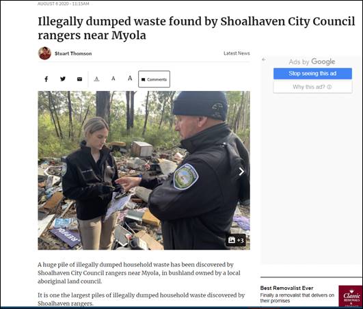
(e) Jerrinja and Nowra Local
Aboriginal Land Council collaboration
Rangers have located approximately 300 vehicle tyres dumped
at a known hotspot along Braidwood Road, Yerriyong. This parcel of land is
owned by Nowra Local Aboriginal Land Council and the dumping is under
investigation.
Rangers are also assisting Jerrinja Local Aboriginal Land
Council in making application for clean-up funds to remove waste from a number
of problem areas across the LGA. It is hoped this collaborative approach will
strengthen existing partnerships and encourage others to join the fight against
illegal dumping and littering.
(f) Animal Shelter:
Shoalhaven Animal Shelter’s Facebook page now has more than 11,643
followers. The page has a weekly “Did you know” post which shares
information about responsible pet ownership in the Shoalhaven with 21 posts
during the period. This has included pet registration requirements,
desexing assistance, researching breeds before buying and education about
health and welfare.
|
|
Development
& Environment Committee – Tuesday 01 December 2020
Page
1
|
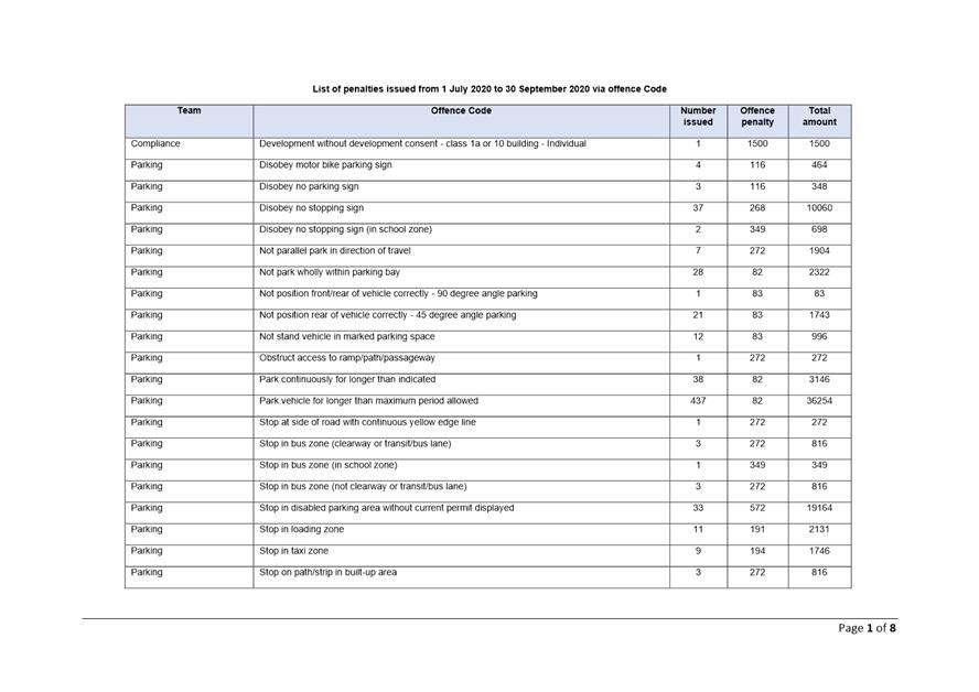
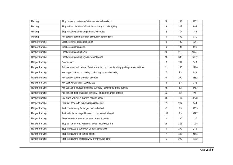
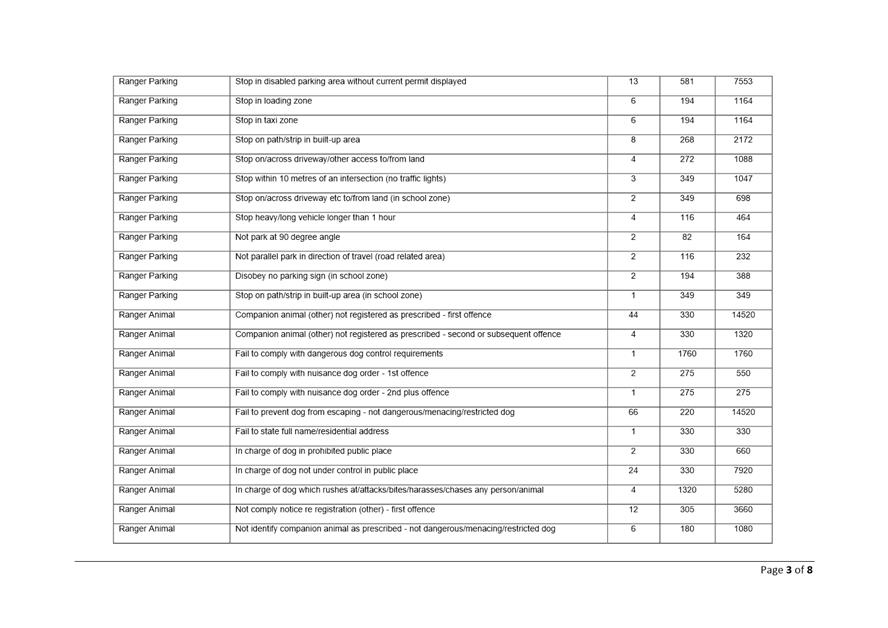
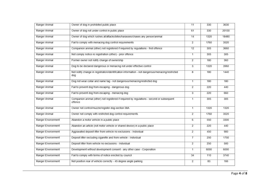
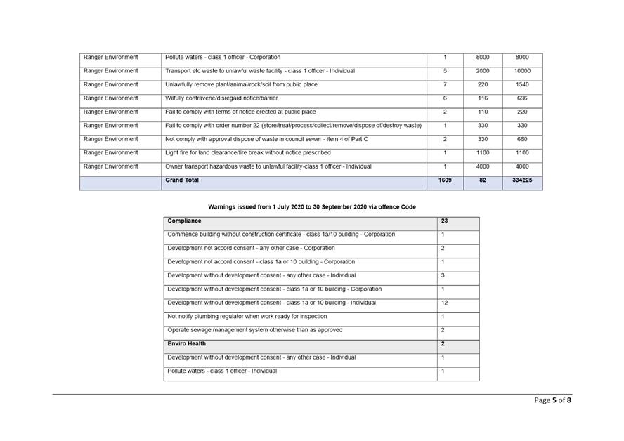
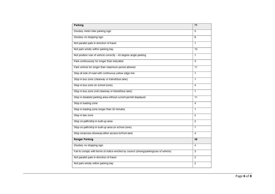
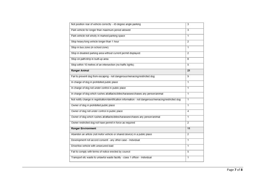
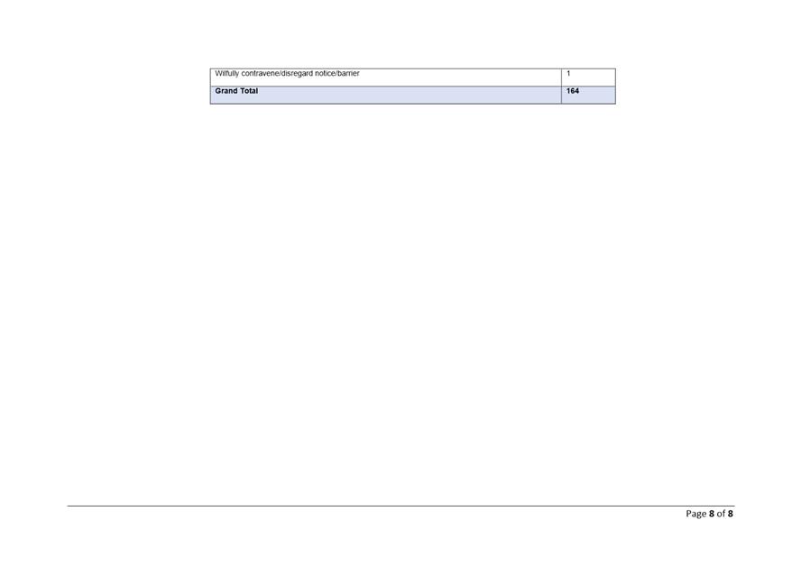
|

|
Development
& Environment Committee – Tuesday 01 December 2020
Page
1
|
DE20.137 Misuse
of vegetation Policy Report
HPERM Ref: D20/461817
Section: Environmental
Services
Approver: Phil
Costello, Director - City Development
Reason for Report
To provide a report in response
to the Notice of Motion MIN20.637
|
Recommendation (Item to be determined under delegated authority)
That
Council:
1. Receive this report for information;
and
2. Having regard to the fact that there is already a process
through the Land & Environment Court, supported by the Tree (Disputes
Between Neighbours) Act 2006, to deal with the type of issues outlined in
Council Minute MIN20.637, Council not proceed with developing a separate
policy relating to the misuse of vegetation at this time.
|
Options:
1. As recommended. Not
support developing a policy to prohibit the misuse of vegetation, noting there
is already a process through the land & Environment Court supported by the
trees (Disputes between neighbours) Act. Creating Council’s own policy
would create an unnecessary financial and resourcing burden on Council and
potentially expose Council to unnecessary risk in getting involved in
neighbourhood tree disputes.
2. Not adopt the
recommendation.
Background
At the Ordinary Meeting on 22
September 2020, Council considered a Notice of Motion from Councillor Proudfoot
and resolved (MIN 20.637) that a report is received from staff regarding the
potential development of a policy which could prohibit the misuse of vegetation
which has been planted in order to deliberately have a negative impact on the
amenity or aspect of a neighbour’s property, OR has the unintended
consequence of doing so. Some species worth consideration include bamboo,
conifers, Norfolk Island pines or even wild pittosporum.
Current situation
Under the Biosecurity Act, Council
already takes regulatory action to ensure weed species are managed across the
City. Council already provides education and advice to the community on weed
species when receiving enquiries to assist residents where possible and this
includes nuisance species such as bamboo.
In regard to Trees and other
vegetation such as hedges, there is currently a process in place through the
Land & Environment Court to deal with potential negative impacts of
planting of vegetation on neighbouring properties. The legislation is called
the Tree (Disputes Between Neighbours) Act 2006 (The Trees Act) and aims
to provide a simple, inexpensive and accessible process for resolving neighbour
disputes about trees.
Landholders can apply for the Court
to make an order to:
1. Remedy, restrain, or prevent
a neighbour's tree from causing damage to their property;
2. Prevent injury to people; or
3. Remedy, restrain, or prevent
a neighbour's high hedge (over 2.5m) from severely obstructing
sunlight to their window or a view from their house.
If the
Land and Environment Court intervenes a court order is issued on the owner of
the subject land to remedy the situation.
Further
information about the process can be found at
http://www.lec.justice.nsw.gov.au/Pages/types_of_disputes/class_2/Trees-hedge-disputes-process/Treedisputes-helpfulmaterials/treedisputes_helpfulmaterial.aspx
The Court also sets out tree dispute principles, from time
to time, when appropriate cases arise, to provide an understanding of how the
Court has approached a particular aspect of such disputes.
While tree dispute principles are stated in general terms,
they may be applied to cases to promote consistency. Tree dispute principles
are not legally binding but give guidance to all as to how the LEC may view
specific situations. For example, the following table lists some of these
principles.
|
PRINCIPLE
|
SPECIFIC ASPECT
|
CASE
REFERENCE AND LINK
|
|
Claims
for structural damage to property
|
Guidance where applications
made pursuant to Part 2 of the Trees Act 200 include claims for rectification
of, or compensation for, structural damage to property caused by roots of a
tree.
|
Fang
v Li & anor
[2017] NSWLEC 1503
|
|
The
tree was there first
|
Matters to be considered
when determining who should pay for any works or removal of a tree
|
Black
v Johnson (No 2)
[2007] NSWLEC 513
|
|
Urban
trees and ordinary maintenance issues
|
The dropping of leaves,
flowers, fruit, seeds, or small elements of deadwood by urban trees
ordinarily will not provide the basis for ordering removal of or intervention
with an urban tree.
|
Barker
v Kyriakides
[2007] NSWLEC 292
|
Policy and Risk Implications
The Court acts as an independent
arbitrator in these cases. If Council creates its own policy this may conflict
with the current legislative court processes and create an unnecessary onus or
legal obligation or risk burden on Council and an additional policy layer that
will protract an outcome for an individual.
It will also create an additional
administrative and cost burden to process applications or enforce a policy and
also create the situation where individuals may not agree with the Council
policy and in turn take Council to court to seek to have the situation
remedied, resulting in a further cost burden on the ratepayer.
Under the Biosecurity Act Council
already has power to take regulatory action to ensure weed species are managed
accordingly so as not to impact adjoining properties.
Council
already provides advice to customers and the community on this process when
receiving enquiries to assist residents as much as possible.
Financial Implications
Proceeding to develop policy
which could prohibit the misuse of vegetation would require additional
resources/ staffing to regulate this policy and potentially a burden of court
action or claims made against Council if the person seeking the remedy does not
agree with a decision of Council.
|
|
Development
& Environment Committee – Tuesday 01 December 2020
Page
1
|
DE20.138 Collingwood
Beach Dune Vegetation Two-Year Trial Action Plan - Final Report
HPERM Ref: D20/480826
Section: Environmental
Services
Approver: Phil
Costello, Director - City Development
Attachments: 1. Final
Report - Collingwood Beach Dune Vegetation Two-Year Trial Action Plan (under
separate cover) ⇨
2. Evaluation
Survey Report - Collingwood Beach Dune Vegetation Two-Year Trial Action Plan
(under separate cover) ⇨
3. DRAFT brochure summarising
outcomes and findings ⇩
Reason for Report
To provide the Final Report on the implementation of the
Collingwood Beach Dune Vegetation Two-Year Trial Action Plan and
recommendations from the Trial.
|
Recommendation
That
Council:
1. Support the preparation of the
Collingwood Beach Dunecare Action Plan to guide the work of the Collingwood
Beach Dunecare Group under Council’s Bushcare Program. This will be
supported by Council’s 2020 Collingwood Beach Coastal and Estuary
Grant, should it be successful;
2. Allocate
$37,700 in the 2021/22 budget for Council’s contribution for the 2020
Collingwood Beach Coastal and Estuary Grant;
3. Allocate a dedicated annual budget
of $15,000 from 2021/22 onwards to continue to implement Council’s
Vegetation Prevention Vandalism Policy across the Shoalhaven, noting the type
of replacement trees planted in the dune from Susan Street to Albion Street must
be on the approved revegetation species list;
4. Consider allocation of an additional
$125,000 for additional annual maintenance
funds from 2021/22 onwards, to prune overhanging vegetation, to allow for at
least three maintenance events each year of the Shoalhaven’s 170 km of
coastline with more than 250 beach access ways;
5. Undertake an audit of the stormwater
outlets, shared pathway and accessways along Collingwood Beach to inform the
Coastal Management Program to maintain the resilience of the dune and
identify any maintenance works that are required; and
6. Adopt the recommendations of the
Final Report - Collingwood Beach Dune Vegetation Action Two-Year Trial Plan.
|
Options
1. Adopt the
recommendation.
Implications: The community and the environment
will benefit from implementing the learnings from the Collingwood Beach Dune
Vegetation Two-Year Trial Action Plan with the budget required.
2. Choose an
alternative recommendation
Implications: This would depend on the alternative recommendation
and may delay implementing the learnings from the Trial that would benefit both
the community and the environment. Any implications of the alternative
recommendation relating to legislative responsibility, cost, policy and risk
would need to be considered.
Background
On 14 August 2018,
Council’s Development Committee resolved the following (MIN18.607):
That Council endorse the Draft Collingwood Beach
Dune Vegetation two-year trial Action Plan to enable implementation of the
actions contained within the Plan.
Section 6 – Communication
Strategy of the adopted Collingwood Beach Dune Vegetation Action Plan –
(the Plan) identifies that the final report is to be available in December 2020
after the 2-year trial period has expired.
The Plan provides a framework
for the restoration and future management of the Collingwood Beach dune
vegetation system using two trial study sites. The goal of the Plan is to
achieve a positive outcome in terms of protecting the health and resilience of
the dune system, as per the NSW Coastal Management Act 2016, whilst also
meeting the desires and expectations of the community and other key
stakeholders.
The
Collingwood Beach Dune Vegetation Action Plan – Two Year Trial Plan
(D18/59947) can be viewed on Council’s website at:
https://shoalhaven.nsw.gov.au/Environment/Collingwood-Beach
Purpose
of the Plan
The following is a summary of
key purposes/outcomes identified in the Plan:
1. To develop
recommendations leading to a long-term sustainable management plan for dune
vegetation for Collingwood Beach to deter vegetation vandalism;
2. Install a
viewing platform in accordance with Manly Hydraulic Laboratory (MHL) report;
and
3. Recognise the
recommendations and proposed management and communication methods compiled by
the former Collingwood Beach Dune Vegetation Reference Group (Chaired by Allan
Baptist in the former Council and referred to as the “Baptist Plan”
in this document. A full copy of the recommendations from the Baptist Plan is
contained within Appendix 1 of the Plan). The main recommendations from the
Baptist Plan are:
i. That
Council develop a plan for the management of the Collingwood Beach dune
vegetation on a 5-year trial basis;
ii. Improve
diversity of vegetation on the Dune through natural seedlings and planting of
local native species;
iii. Vegetation
on the dune to provide a wedge effect to retain sand on the beach and to
protect private and public assets;
iv. Manage
the dune vegetation to provide a range of experience, with filtered views (in
appropriate locations), thickets, healthy vegetation and tall occasional shade
trees;
v. The
dune vegetation needs to be managed and maintained in a sustainable way,
meaning it will need to be legally, financially, and environmentally,
acceptable for present and future generations; and
vi. Community
education and engagement to ensure the community understands the role of dune
vegetation management and the complexities of managing a natural active system
in an urban tourism setting, and supports the balanced approach required.
Actions
Completed
Table 1 summarises the implemented
actions from the Plan.
Table 1. Collingwood Beach
Action Plan – implemented actions
|
Action
|
Progress
|
Timeline for completion
|
|
Pruning works
undertaken at trial site and cut wood felled throughout foreshore reserve
|
100%
|
Completed
|
|
Pruning site fencing
works
|
100%
|
Completed
|
|
Install seating at both
trial sites
|
100%
|
Completed
|
|
Install viewing platform
at revegetation site with access ramp
|
100%
|
Completed
|
|
Community and school
planting days
Planting of trial site
|
100%
|
Completed
|
|
Drone footage of trial
sites
|
100%
|
Completed 21/02/2020,
17/5/2019, 26/2/2020 and 15/10/2020.
|
|
Vegetation Vandalism
Strategy presented to Council
|
100%
|
Completed 05/11/2019
|
|
CCTV research
undertaken and presented to Councillors
|
100%
|
Completed 05/03/2019
|
|
Collingwood Beach
‘Get Involved’ page (community engagement)
|
100%
|
Completed
|
|
Monitoring of
revegetation site
|
100%
|
Completed over the length of the trial.
|
|
Weed monitoring
|
100%
|
Completed over the length of the trial.
|
|
Photo monitoring of
both trial sites
|
100%
|
Completed Aug 2018; Nov 2018; Feb 2019; Oct 2019; Jan
2019; Jul 2020 and Oct 2020.
|
|
Poster/signage
program for community appreciation of native vegetation to be implemented
citywide
|
Ongoing
|
Signs installed. Review and installation of additional
signage ongoing.
|
|
Project management
|
100%
|
Completed
|
|
Internal costs and charges
(wages, stores, fleet inventory, miscellaneous)
|
100%
|
Completed
|
Key
Findings
The Collingwood Beach Dune
Vegetation Two-Year Trial Action Plan Final Report (Final Report) may be
viewed in full in Attachment 1. A draft brochure summarising the
outcomes and findings of the Trial is contained in Attachment 3.
The Final Report provides a
comprehensive review of all actions undertaken during the Collingwood Beach
Dune Vegetation Two-Year Trial (the Trial). The Final Report also details
results and conclusions from the Trial and provides recommendations moving
forward that incorporate learnings from the Trial. The following is a brief
summary of key findings from the Trial:
· The Collingwood
Beach Dune Trial location is unique to the Shoalhaven. It is a modified dune
system due to clearing in the 1960s to prepare for subdivision of the area and
a coastal erosion event in the early 1970s. Accordingly, the outcomes from the
Trial can only apply to this section of the beach (Susan Street to Albion
Street) and not to other areas within the Shoalhaven or even Vincentia.
· The Trial was a
mixed success. However, important learnings were gained across all areas of the
Trial and these learnings need to be implemented and funding allocated to
ensure benefits to both the community and the environment.
· The Trial was not
successful in deterring vandalism. During the Trial, an additional eleven
events were recorded across Trial Sites 1 and 2 and six in the control site.
· Vandalism of
Banksias leads to more epicormic growth and root shoots. This results in a
bushier tree with thicker foliage.
· Banksias pruned in
accordance with the Australian Standards not only survive and remain healthy,
but continue to grow upwards and not with thick foliage, thus maintaining
filtered views to the Bay.
· Selective planting
in consultation with residents was a positive outcome from the Trial. This is
evident by planted vegetation, including Bangalay trees, not being vandalised
during the Trial and the high survival rate of specimens.
· The diversity of
native species in the dune increased from 13 to 16 species. In addition, the
number of weed species declined from 11 to 5 species.
· There was insufficient
width on the dune to create a vegetation wedge effect.
· Since the initial
pruning event, over 80% of the Banksia trees have been subject to pruning and
many on more than one occasion. Most of these trees have had all branches
removed up to 2 m and therefore have little more to prune. The nature of the
area provides minimal light to the understory therefore slowing growth of
understory plants and retarding stem growth on Banksias. Accordingly, follow-up
pruning to retain the filtered views is estimated to be required once every two
years.
· There are
unobstructed views to the ocean resulting from vandalism of vegetation, from
63% of the shared pathway from Susan St to Albion St. An increase from 50%
identified in the original NGH Report, of area vandalised creating views.
· The potential for
additional filtered views could be considered in southern portion of Pruning
Trial Site 2, near the end of Susan Street. However, any assessment must
consider that as Banksia trees are thinned out or removed, the increase in
light initiates growth of remaining trees and understory plants, which would
potentially block views and would also require regular maintenance at an
ongoing cost.
Photographs in Plates 1 to 4
were taken at Pruning Trial Site 2 in August 2020, post pruning event. Plates
5, 6 and 7 were taken following completion of the viewing platform, bench
seating and fencing respectively. Plate 8 and Plate 9 were taken on Vincentia
Public School planting day and the community planting day, held on 24 August 2018
and 25 August 2018 respectively.
Plate 1: Filtered views –
Pruning Trial Site 2
Plate 2: Filtered views –
Pruning Trial Site 2
Plate 3: Filtered views –
Pruning Trial Site 2
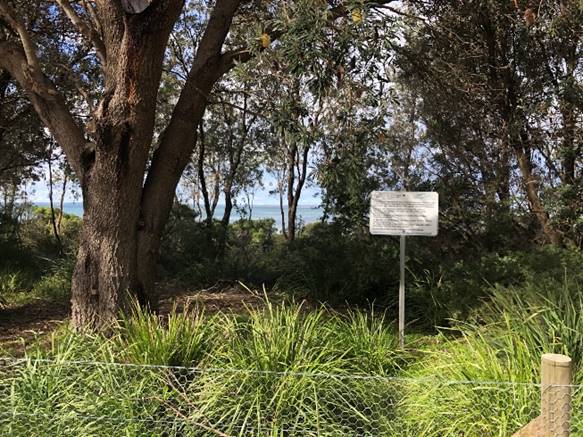
Plate 4: Filtered views –
Pruning Trial Site 2
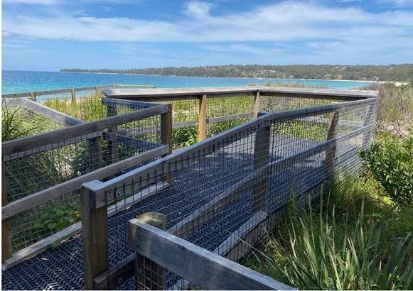
Plate 5: Completed inclusive-access viewing platform
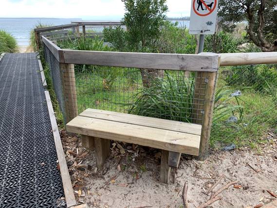
Plate 6: Completed bench seat
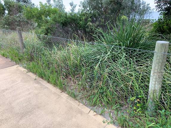
Plate 7: Fencing installed at the Trial site.
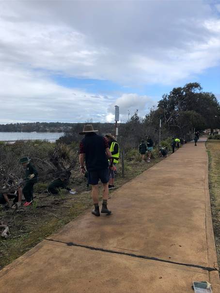
Plate 8: Vincentia Public School planting day
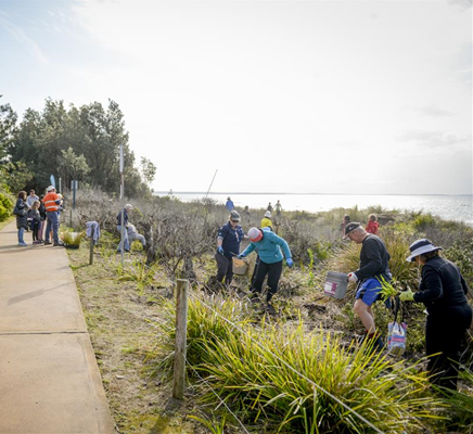
Plate 9: Community planting day
Evaluation of Trial success
Table 3 provides an evaluation of the
success of the implemented actions from the Plan.
Table 3:
Evaluation of Trial Success
|
Success
|
Measure
|
Status
|
|
Pruned
Banksias in good health
|
Assessment
by arborist at 6 monthly intervals and prior to pruning.
|

|
|
Surviving
plant specimens
|
Percentage
of survival of planted specimens.
|

|
|
Positive
social response
|
Number
and opinion of unsolicited posts, letters, etc.
|

|
|
Plant
diversity
|
Number
of weed vs native species.
|

|
|
Filtered
views
|
Cost
effectiveness of view window maintenance - time and money spent.
|
 
|
|
Decreased
vandalism on trial sites:
- A control site in Vincentia
will be chosen for comparison
|
Percentage
of known vandalism decreasing over time across trial sites.
|
 
|
|
Acceptance
by the community of the outcome of the trial
|
Community
survey to be undertaken (web-based).
|
|
1.The total cost of
creating filtered views was $25,796 with follow-up pruning recommended once
every two years. Therefore, whilst effective filtered views were created, they
were not considered to be cost-effective, especially considering the size of
the trial area compared to potentially effected coastline.
2.Vegetation
vandalism did not decrease over the Trial. However, importantly, none of the
vegetation planted at Regeneration Trial Site 1, including four Bangalay trees,
was vandalised. This indicates general support and acceptance by the community
of the approved revegetation species list. It was also noted that species other
than Banksias were vandalised during the Trial.
3.More than half of 90 survey participants
considered the actions undertaken as part of the Trial would not lead to an
acceptable balance between dune stability, amenity (views/accessibility) and
habitat at Collingwood Beach. Generally, either participants felt not enough
vegetation was removed from the dune or too much vegetation was removed and not
enough was planted.
Community Engagement
Table 2 details the implemented communication actions from
the Plan.
Table 2:
Communication Strategy
|
Action
|
Strategy
|
|
Develop
a strong engagement and communication strategy with identified stakeholders
including a program of public consultation and education throughout trial
period
|
Incorporate multi-media, information displays and
signage and/or presentations.
|
|
Implementation
|
Status
|
|
Meet with adjacent property owners
|
Completed
Community
planting day on 25 August 2020 and throughout the Trial.
Ranger
letterbox drops and vegetation vandalism investigations undertaken throughout
trial period.
Collingwood
Beach Dune Reference Group Meetings – April 2018, April 2019, May 2019
and October 2020.
|
|
Website and Facebook updates to Vincentia and
Huskisson communities
|
Completed
‘Get Involved’ page on
Council’s website updated throughout the Trial.
Five Facebook updates were posted throughout the
Trial and an additional post was made on 16 October 2020 requesting the
public to participate in the evaluation survey.
|
|
Information posters in local villages
|
Completed and ongoing
Bay & Basin Leisure Centre and Ulladulla Leisure Centre
Education Poster installed on 21 August 2020.
Stocklands in Nowra installed the Education Poster on
21 August 2020.
A review of the signage and additional installations
is ongoing and will be distributed to Libraries and CCBs
Specific requests have been made by Callala Bay
Community Association, Conjola Community Association and Huskisson Community
Centre.
|
|
Erect explanatory signs at trial sites
|
Completed
Installed August 2018.
|
|
Planting day
|
Completed
24
& 25 August 2018 (Vincentia Public School and Community planting days
respectively).
|
|
Progress Report to Council
|
Completed
November 2018, June
2019, February 2020, September 2020 and December 2020.
|
Community Survey
Ninety (90) community members participated in an online
community survey. A report on the results of the survey may be viewed in
Attachment 2. The survey was available for participation from 9 October 2020 to
2 November 2020. Signs were erected in the trial site informing the community
of the survey and providing the option to call Council to participate in the
survey if they were unable to do so online. Council also advertised the survey
on the online Get Involved Page and through social media.
Policy Implications
The Collingwood Beach Dune trial
location is unique to the Shoalhaven as it is a modified dune system due to
clearing in the 1960’s to prepare for subdivision of the area and a
coastal erosion event in the early 1970’s. Accordingly, the outcomes from
the Trial can only apply to this section of the beach (Susan Street to Albion
Street) and not to other areas within the Shoalhaven or even Vincentia.
The adopted outcomes and
learnings from the Trial will inform the Collingwood Beach Dunecare Action Plan
and guide the work of the Dunecare Group under Council’s Bushcare
Program.
Council’s adopted Shoalhaven Tree and Vegetation
Vandalism Prevention Policy is already in place and supports the outcomes and
learnings from the Trial.
Financial Implications
The Trial was a substantial
investment by Council. To capitalise on this investment, the following funding
is recommended for consideration in the 2021/22 budget to implement the
outcomes and learnings from the Trial:
· $37,700 for
Council’s contribution for the submitted 2020 Collingwood Beach Coastal
and Estuary Grant application;
· A dedicated annual
budget of $125,000 from 2021/22 for additional maintenance funds to prune
overhanging vegetation, to allow for at least three maintenance events each
year of the Shoalhaven’s 170 km of coastline with more than 250 beach
access ways; and
· a dedicated annual
budget of $15,000 from 2021/22 to continue to implement Council’s
Vegetation Prevention Vandalism Policy across the Shoalhaven.
Risk Implications
The two-year Trial has been a
substantial investment of Council’s and the community’s time, money
and resources. Should the recommendations from the Trial not be adopted or
funded, Council will risk not capitalising on this investment and that both the
community and the environment will not benefit from the Trial.
If Council deviates from the
recommendations from the Trial, the implications relating to legislative
responsibility, cost, policy and risk would need to be considered for any
alternative recommendation. This would include and alternative recommendations
regarding the removal of any additional vegetation. The long-term impacts of
such an action are unknown and an environmental assessment would be required.
|
|
Development
& Environment Committee – Tuesday 01 December 2020
Page
1
|
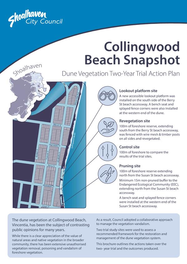
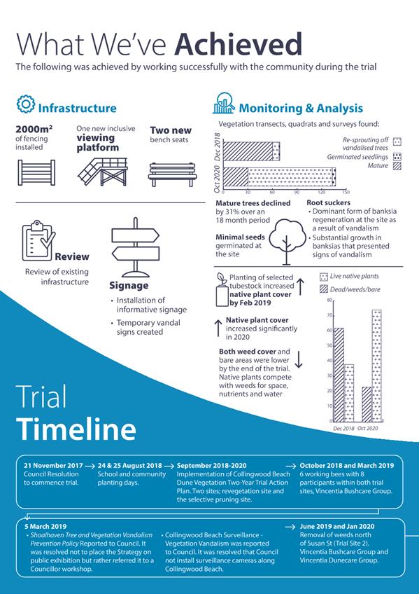
|
|
Development
& Environment Committee – Tuesday 01 December 2020
Page
1
|
DE20.139 Review
of Tabourie Lake Entrance Management Policy
HPERM Ref: D20/486502
Section: Environmental
Services
Approver: Phil
Costello, Director - City Development
Attachments: 1. Councillor
Briefing 6 August 2020 - Tabourie Lake Entrance Management ⇩
2. Tabourie Lake Entrance
Management Policy June 2019 (under separate cover) ⇨
Reason for Report
To inform Council regarding the
review of the Tabourie Lake Entrance Management Policy and present the policy
for adoption.
|
Recommendation (Item to be determined under delegated authority)
That
Council
1. Adopt the Tabourie Lake Entrance
Management Policy (June 2019), with the policy recommendation to increase the
trigger level, for mechanical opening, from 1.17m AHD to 1.3m AHD.
2. Continue to investigate stormwater
drainage issues affecting properties on Princes Highway, Tabourie Lake in
conjunction with Transport for New South Wales.
|
Options
1. As recommended
Implications: Would be in line with the
recommendation of the policy review and the equally highest ranked preferred
option based on community feedback.
2. Not adopt the Tabourie
Lake Entrance Management Policy (June 2019) and retain the Tabourie Lake
Entrance Management Policy (EMP, 2005).
Implications: Reviewing the Tabourie Lake Entrance
Management Policy was a key recommendation of the adopted Lake Tabourie Flood
Risk Management Plan 2016. Not adopting the reviewed Policy would place Council
in conflict with this recommendation. The current 2005 entrance management
policy was previously resolved to be updated and replaced following completion
of the Tabourie Lake Floodplain Risk Management Study and Plan (FRMS&P)
which were completed in 2016. Council would not be managing the lake based on
best available information and analysis.
3. Alternative
recommendation
Implications: Would depend on the recommendation.
Background
Council, together with the NSW
Government, manages five estuary entrances for flood mitigation purposes.
Historical land use planning and development of estuary catchments and
floodplains has resulted in low-lying properties being at risk from flooding
under certain rainfall and entrance conditions.
The review of the Tabourie Lake
Entrance Management Policy, dated June 2019 (EMP), was first reported to
Council on 5 November 2019 at the meeting of the Development & Environment
Committee. Council resolved to adopt the Tabourie EMP, with the policy
recommendation to retain the trigger level, for mechanical opening, of 1.17m
AHD (MIN19.809). Following a number of rescission motions and notice of
motions, Council officers briefed the Councillors on 6 August 2020. Please see Attachment
1 for the presentation given at the 6 August 2020 briefing and see Attachment
2 for the full copy of the revised EMP.
Council records indicate that localised flooding is
experienced from the Princes Hwy for properties south of the bridge. Council
has in the past liaised with the Tabourie Lake Community Consultative Body and
Transport for New South Wales (TfNSW) in an attempt to alleviate localised
flooding. Council will continue liaising with TfNSW in resolving this matter.
Response to the Notice of Motion (CL20.77)
At the Ordinary meeting of Council on 28 April 2020, Council
considered a Notice of Motion (CL20.77) in relation to the Tabourie Lake
Entrance Management Policy and resolved (MIN20.287):
That this matter be deferred pending a Clr Briefing and
be brought back to the next available meeting.
As noted above, a Councillor
briefing was held on 6 August 2020 following the July flood event. A copy of
the presentation is contained in Attachment 1. The 2005 policy states that if
the water level stabilises after rainfall at a level of between 1.0 m AHD and
1.17m AHD for a period of over two (2) months, the policy recommends that
Council opens the lake.
The proposal to reduce this two
(2) month period to one-week (7 days) will result in the increased frequency of
intervention. Statistically, average peak water level immediately prior to
entrance opening events is 1.19 m AHD (Cardno, 2019). This means that more
frequent intervention particularly during wet periods (e.g. El Niño)
will be required.
Increased intervention at the
lake entrance will have an economic impact to Council and the community, and an
unknown impact to the Lake ecology, environment and potential for increased
shoaling. Following inflow events, water levels gradually decrease due to
evaporation from the water surface and seepage through the berm, particularly
at higher lake water levels. Shallow estuaries such as Tabourie Lake tend to
experience accelerated reduction in water levels due to the above mechanisms.
Therefore, it is recommended that Council should not
consider the one-week protocol for the reasons mentioned above. No additional
assessment by Cardno is required as this has already been assessed.
Recorded
Debris Line – Flooding of 27 July 2020
The Lake was mechanically
breached by Council on 26 July 2020. Water levels reached 1.18m AHD and falling
to 1.0m AHD. Following significant rainfall and prevailing swell, a peak water
level of 1.31m AHD was recorded on 27 July 2020. Thus, even though the Lake was
open to the Ocean, flooding occurred due to catchment runoff and prevailing swell,
coinciding with the high tide.
Debris survey was undertaken by Council Surveyors following
the flood event. Please see Attachment 1 for further details which includes
photographic evidence of debris lines recorded at 1.31m AHD.
History of the Review of
Tabourie Lake Entrance Management Policy (EMP)
Cardno Pty Ltd was engaged by
Shoalhaven City Council to review the existing Entrance Management Policy (EMP)
for Tabourie Lake. Tabourie Lake is an Intermittently Closed and Open Lake or
Lagoon (ICOLL) and has periods during which the entrance is closed off from the
ocean by the formation of a berm. The study area for the EMP comprises the
tidal waterway of Tabourie Lake, its foreshores, and the adjacent lands.
The Tabourie Lake Floodplain
Risk Management Study/Plan (FRMS, 2016) proposed a review of Council’s
existing Tabourie Lake Entrance Management Policy (EMP, 2005) and the
accompanying Review of Environmental Factors (REF). The ocean storm event in
June 2016 further highlighted the importance of this review.
A Draft Entrance Management
Policy and REF was developed for Tabourie Lake by Peter Spurway &
Associates in 2005. The Draft EMP has been used since that time by Council to
guide the management of the entrance of Tabourie Lake for flood mitigation purposes.
Under the Draft EMP the entrance is mechanically opened by Council when:
· Lake water levels
are equal to, or in excess of, 1.17m AHD, this initiates an immediate entrance
opening; or
· Lake water levels
stabilise after rainfall at a level between 1.00m and 1.17m AHD and a period of
over two months has elapsed since attaining that level, resulting in below
floor level flooding of foreshore land.
Peter Spurway & Associates
(2005) recommend that the assumptions of the Draft EMP and the management framework
contained therein be reviewed following adoption of the Tabourie
Lake Floodplain Risk Management Study and Plan (FRMS&P). The FRMS&P
was completed in 2016, and one of the recommended actions in the FRMS&P was
to review the Draft EMP considering the improved understanding of flood
behaviour.
Given the significant amount of time that has passed since
the Draft EMP was prepared, and acknowledging the changes in the catchment and
improved understanding of flood behaviour, Council resolved to proceed with a
review of the Draft EMP and preparation of a final EMP.
EMP Considerations
The review of the EMP considered
the detailed flood modelling results presented in the 2016 FRMS&P, the
combined risks associated with catchment and ocean flooding, and the potential
impact of climate change on flooding and entrance behaviour.
There is a range of existing
information for Tabourie Lake, that is of relevance to understanding the need
and context for the EMP. ICOLL behaviour, entrance behaviour and flooding
processes are important determinants of the level of risk to low-lying
development from inundation, and aid in determining potential entrance
management options.
The statutory and policy context, and environmental and
social values of Tabourie Lake are important in assessing the appropriateness
and acceptability of entrance management options from both regulatory and
stakeholder perspectives.
EMP
Review – Management Options
Options were identified and
presented to the community. The following options were presented in the
following order:
· Option
1: A “Do Nothing” option. Under this scenario, there is no
active management of the lake entrance. For the “do nothing” option
the entrance berm would be overtopped when water levels rise during a rainfall
event and the entrance breaks out naturally without any intervention.
· Option
2: The continuation of the existing management approach, comprising
mechanical entrance opening, when lake water levels reach the trigger level of
1.17 m AHD.
· Option
3: Raising the trigger Level to 1.3m AHD. This would lead to fewer
mechanical openings of the entrance of Tabourie Lake, thereby reducing the
environmental impact on the Lake.
· Option
4: Berm height management. This involves managing the entrance berm height
(when closed) such that it does not exceed a pre-determined level; this is
known as maintaining a “dry notch”, which is a low or
“saddle” point in the entrance berm, which the water can
preferentially flow across. The purpose of the notch is to dispense with the
need to mechanically open the lake when a flood occurs.
· Option
5: Construction of a permanently open entrance, using rock armoured
training walls.
· Option 6:
Implementation of a pilot channel - a mechanical excavation of sand from the
entrance berm 1 – 3 days before a large storm is scheduled to arrive, by
digging a pilot channel starting from the ocean. The exercise is intended to
reduce the volume of sand required to be removed to instigate a lake breakout,
thereby inducing an earlier breakout and reducing flood levels within the lake.
Management Options -
Community Consultation
An online questionnaire was
distributed during the consultation period and over 90 responses were received
from the community. In the questionnaire, the community was asked to rank the
options presented (refer above) from a scale 1 to 5. It was found there was a
wide range of opinions within the community.
As demonstrated in Table 1, final scores for Options 2 to 5
were very similar, with Option 1 scoring the least. Therefore, the options
assessment based on community feedback concluded that options would come down
to cost and impacts to the community.
Table 1:
Summary of results from the community questionnaire
|
Option No.
|
Average Score
|
Rank
|
|
1
|
4.9
|
6
|
|
2
|
3.2
|
3
|
|
3
|
3.1
|
1
|
|
4
|
3.1
|
1
|
|
5
|
3.4
|
4
|
|
6
|
3.4
|
4
|
Table 1 above shows the options
ranking results, including an indication of how respondents ranked each option.
An average score is also provided, whereby each respondent ranked their most
preferred option “1” and their least preferred option
“6”. The survey results were inconclusive, with no clear preference
indicated by the community. The “most preferred” options were
Options 3 (Raise trigger level) and 4 (Dry notch) with an average score of 3.1
out of 6, followed closely by Option 2 (Existing approach) with a score of 3.2.
The least preferred option was Option 1 (Do nothing), which
would allow flooding to occur with no intervention. Option 6 (Construction of a
permanently open entrance) appeared to be a fairly polarising option, being
scored as the most preferred option by 38.8% of respondents, and least popular
by 30.6% of respondents.
Management Options Modelling
Computer-based numerical
modelling of various sub-sets of the entrance management options was undertaken
using the Delft3D hydrodynamic and morphological model of the Tabourie Lake Estuary,
which was established during the Tabourie Lake FRMS&P (Cardno, 2016). The
same model set-up and catchment inflow data was used as in the Cardno 2016
study.
Numerical modelling was
undertaken to assess the impact of three of the potential management options on
peak flood levels and durations for the more regularly occurring 20% Annual
Exceedance Probability (AEP) event. It is noted that the 1% AEP flood event
occurs so rapidly that entrance management is not feasible for purposes of
flood mitigation; hence it was not considered in the options assessment.
Option 1 was not modelled as it
was lowest ranking and was considered unacceptable to the community. Option 5
was not modelled as it was considered unacceptable due to its lower ranking,
high cost of implementation and risk of coastal inundation (refer to Section
4.5 of the EMP). Despite being ranked equal number one by the community, Option
4 was not modelled due to its higher cost and the fact that its technical
feasibility was questionable (refer to Section 4.4 of the EMP).
The remaining three options
modelled were:
· Option 2: Existing
approach with trigger level of 1.17 m AHD;
· Option 3: Raising
the trigger level to 1.30 m AHD; and
· Option 6:
Incorporation of a pilot channel (in conjunction with the existing trigger
level).
Each of the three options was
modelled under five discrete conditions, summing to a total of 15 model
simulations (as detailed below). These are different scenarios tested for each
option to indicate the peak water levels. Further detail on the modelling
methodology is provided in Section 5.3 of Attachment 2:
· Condition
A: High High Water Springs (HHWS) and initial berm height of 2.1 m;
· Condition B: HHWS
and initial berm height of 1.8 m;
· Condition C: 1%
AEP ocean level and initial berm height of 2.1m;
· Condition D: 1%
AEP ocean level and initial berm height of 1.8m;
· Condition E: HHWS
+ 0.4m sea level rise and initial berm height of 2.2 m.
Note: High High Water Springs (HHWS) refers to the highest
level that spring tides reach on average over a period of time. The 2.1m berm
height is deemed to be the maximum probable berm height.
Table 2: Peak
Water Levels for Each Option for Each of Model Run
|
Option
|
Condition A
|
Condition B
|
Condition C
|
Condition D
|
Condition E
|
|
2
|
1.86
|
1.86
|
2.52
|
2.53
|
1.86
|
|
3
|
1.93
|
1.93
|
2.52
|
2.53
|
1.93
|
|
6
|
1.76
|
1.76
|
2.52
|
2.52
|
1.77
|
Management
Options Modelling Results and Comparisons
Comparison of results for
Options 2 and 3 (Table 2) shows that raising the trigger level from 1.17 m AHD
to 1.30m AHD (an increase of 13cm) would result in an increase in the maximum
flood level. However, the increase in flood level is not one for one, and flood
levels only increase for Option 3 by around 7 cm (from 1.86 to 1.93 m AHD) for
conditions A and B.
The increase is non-linear due
to the fact that as flood level increases, so too does the available flood
storage. Additionally, the flood levels are likely heavily influenced by the
geometry of the entrance channel, which constricts the rate of lagoon outflow.
The results also show the same
level of storm tide inundation for Options 2 and 3. This would suggest that
Options 2 and 3 result in a comparable level of entrance scour, and therefore
allow ingress of the storm tide to the same degree.
Cardno Pty Ltd has recommended
that Council adopt Option 3 (raising trigger level to 1.3 m AHD) in the
Tabourie Lake EMP, as described in the attached Tabourie Lake Entrance
Management Policy. This recommendation is based on the technical assessment
presented in Section 5.4 of the EMP), which included a triple bottom line
cost-benefit assessment. The assessment resulted in highest score for Option 3
out of the six options considered.
If adopted, the EMP (Attachment
2) will henceforth supersede the previous Peter Spurway & Associates (2005)
EMP. The 2019 EMP sets out the procedure by which Council will decide to open
the entrance of Tabourie Lake for flood mitigation purposes, whether in
response to a flood event or to alleviate below floor level inundation of
foreshore land.
It is anticipated the
implementation of the measures outlined in the 2016 FRMS&P would, in the
future, likely remove the need to undertake entrance management and mechanical
lake opening as a means of mitigating below floor level flooding. These options
included structural options aimed at preventing, avoiding or reducing the
likelihood of flood risks – including the construction of levees behind
properties and raising roads in specific locations.
Therefore, it is intended that the EMP be adopted, until the
relevant measures outlined in the 2016 FRMS&P have been fully funded and
implemented. Please note that Appendices A to E are not included in the EMP
attached (Attachment 2), as they are the accompanying operational documents.
Community Engagement
The outcome of the options
assessment and the 2019 EMP were subject to public exhibition by Council
between 21 January 2019 and 22 March 2019. As part of this public exhibition,
the 2019 EMP was presented to the local community on 20 February 2019 at a
Community Workshop at the Tabourie Lake Rural Fire Service (RFS) Shed. More
than 30 community members attended this workshop.
In total 13 online submissions
were received, of which seven submissions were in support of the EMP, 1 was
neutral, and 4 were against. Of the submissions that were not in favour of the
EMP, one submission was made by ten residents. Please refer to Attachment 1 for
a summary of submissions received. Furthermore, a petition with 105 signatures
against raising the trigger and to continue with the current management was
presented by Councillor White at the Ordinary Meeting of Council, held on 30
April 2019. This petition was lodged post consultation period.
Council has received numerous
correspondences from the community in relation to raising the trigger to 1.3m
AHD, with the majority supporting the increase to 1.3mAHD. These
correspondences can be found in Trim Container 5118E.
Policy Implications
The current Tabourie Lake Entrance Management Policy (final
draft, 2005) remains current until such time as this review is completed and
formally adopted by Council.
Financial Implications
The review of the Tabourie Lake
Entrance Management Policy was completed within budget.
The project is for the provision
of consultancy works and does not have any direct or immediate implications on
Council’s assets. The project is managed by staff from the Natural
Resources and Floodplain Unit.
Once the EMP is adopted, Council is required to prepare a
Review of Environmental Factors, as per the requirements of Part 5 of the NSW
Environmental Planning and Assessment Act 1979. The cost of this is estimated
to be approximately $15,000. There are sufficient funds in the Flood Programme
budget for this work.
Risk Implications
Opening of the entrance of the
lake will not prevent flooding of property and dwellings in many circumstances.
For example, even if the entrance is fully open at the start of a large flood
event, if the flood is greater than a 10% Annual Exceedance Probability (AEP),
it is expected that there are existing dwellings that would be affected by
flooding
The Policy aims to reduce (where
possible) but not eliminate the impacts of catchment flooding. Further, there
may be circumstances (e.g. closed access roads, night, or dangerous sea
conditions) where, despite its best endeavours, Council cannot act to
mechanically open the entrance of the lake at the levels indicated in this
Policy.
Legal advice was sought on a
submission received from a resident, who is in favour of Option 2 (keep current
trigger level) and made the following comments:
· Believes that
adopting Option 3 could lead to legal action from residents who are potentially
negatively impacted by the entrance management (e.g. destruction of assets and
health and safety concerns).
· Makes a note
about the costs and lead time involved with potential legal action for Council,
as well as any potential media attention.
· Believes that
the outcomes of the Study (Option 3) are led by environmental arguments and
Council is not well-informed.
The legal response and
acknowledgement to this submission is contained within Attachment 1. In
summary, under the provisions of Section 733 of the Local Government Act, if
Council acts in good faith it is protected from legal action in instances such
as this. The “good faith” principle would be supported by the
scientific study completed in regard to the Tabourie Lake catchment.
|
|
Development
& Environment Committee – Tuesday 01 December 2020
Page
1
|
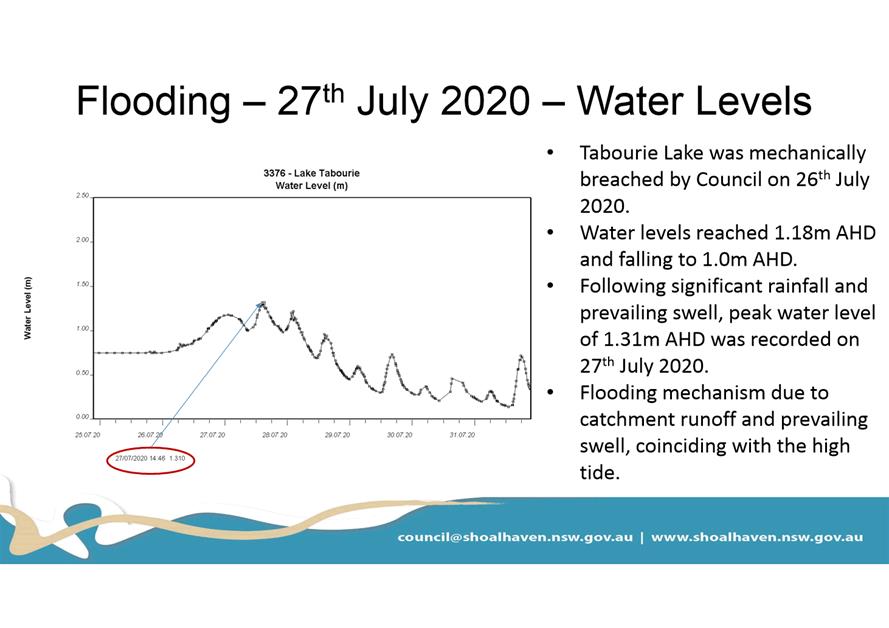
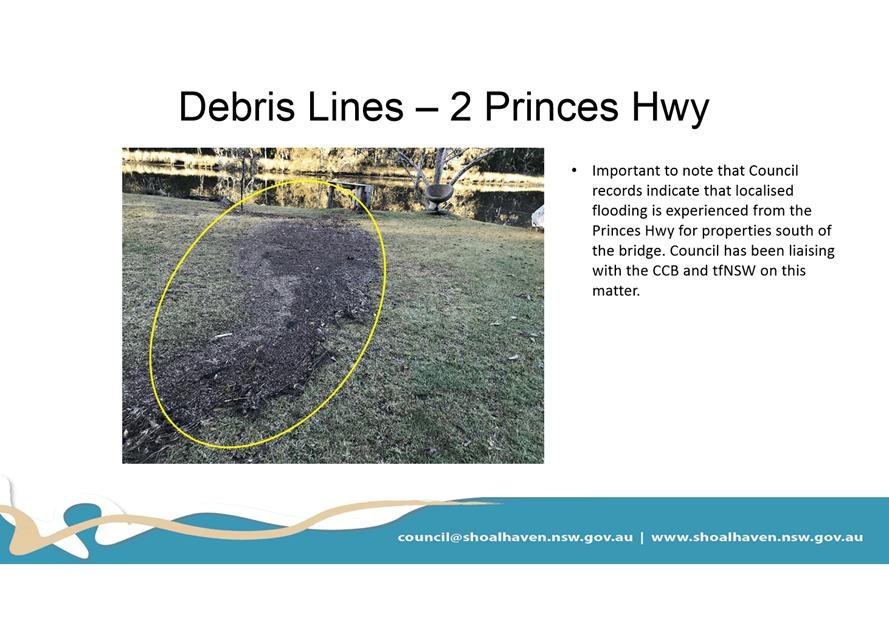
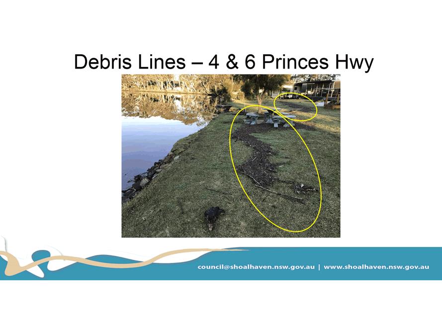
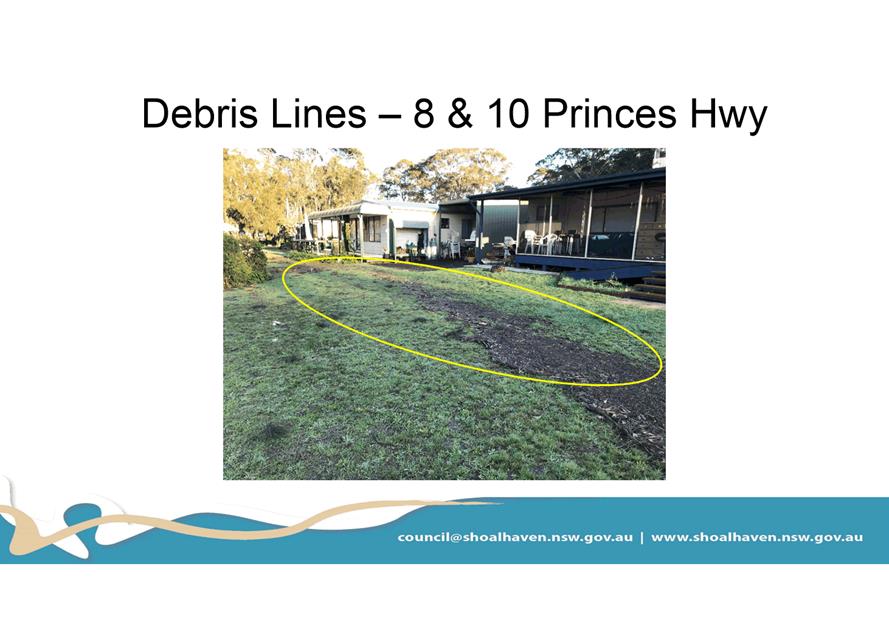
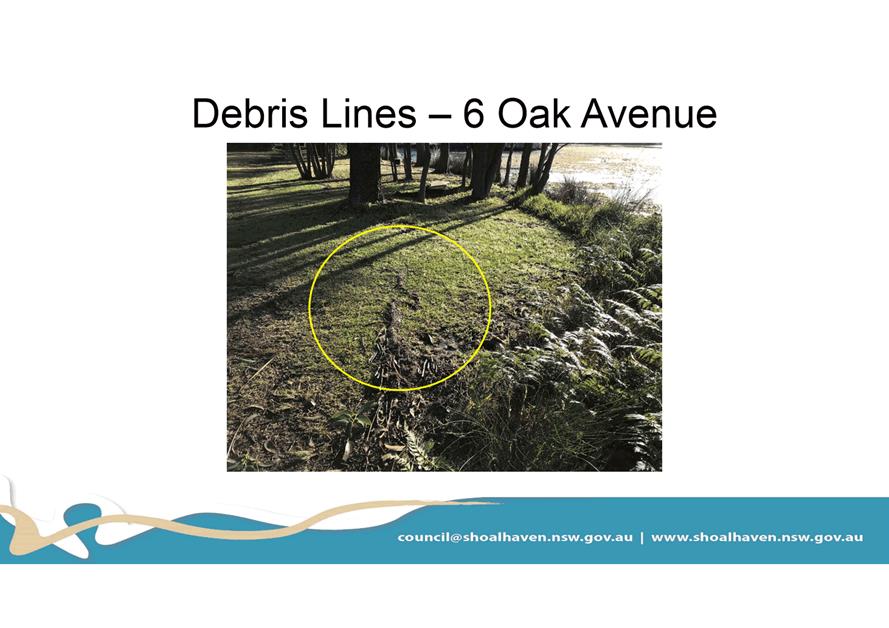
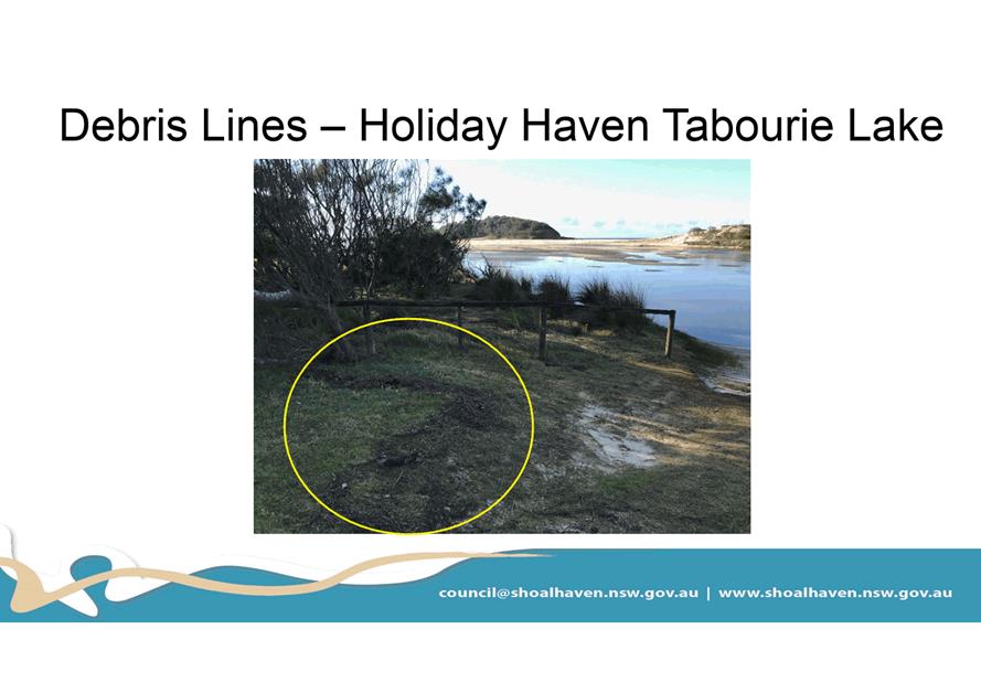
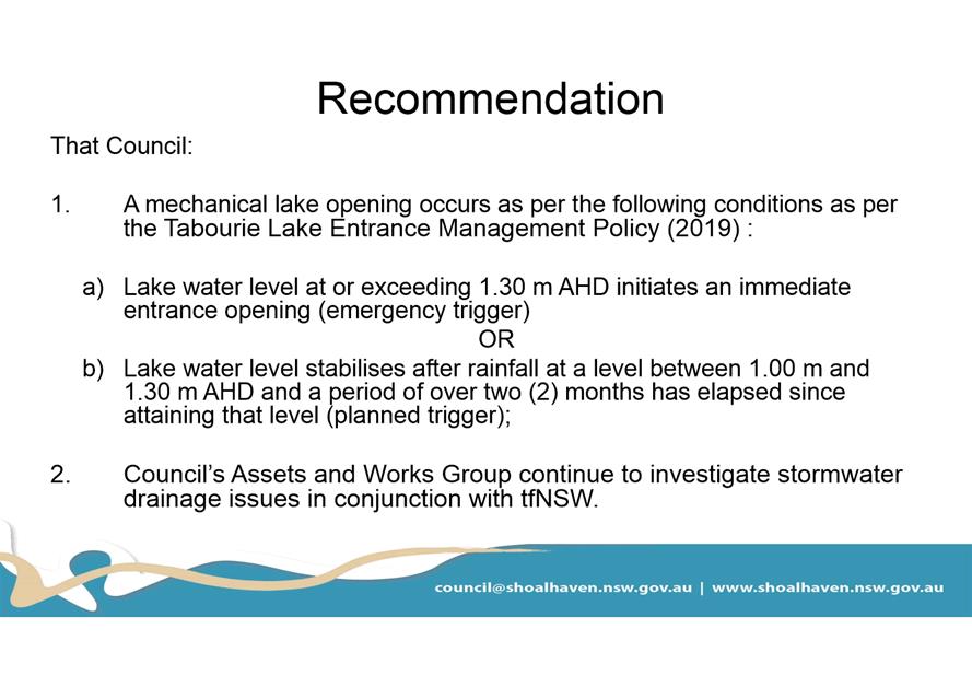
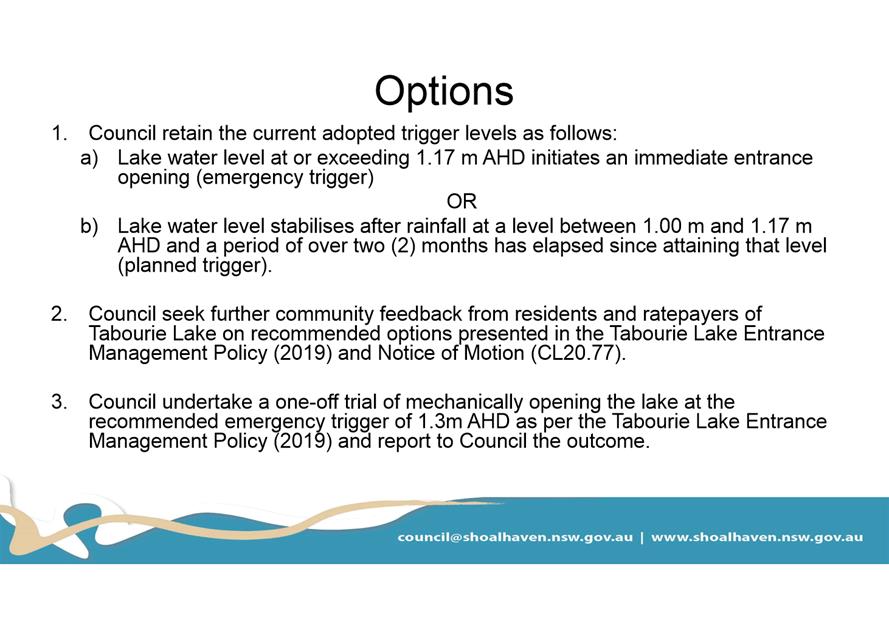
|
|
Development
& Environment Committee – Tuesday 01 December 2020
Page
1
|
Local Government Amendment (governance &
planning) act 2016
Chapter
3, Section 8A Guiding principles for councils
(1)
Exercise of functions
generally
The
following general principles apply to the exercise of functions by councils:
(a) Councils should provide strong
and effective representation, leadership, planning and decision-making.
(b) Councils should carry out
functions in a way that provides the best possible value for residents and
ratepayers.
(c) Councils should plan
strategically, using the integrated planning and reporting framework, for the
provision of effective and efficient services and regulation to meet the
diverse needs of the local community.
(d) Councils should apply the
integrated planning and reporting framework in carrying out their functions so
as to achieve desired outcomes and continuous improvements.
(e) Councils should work
co-operatively with other councils and the State government to achieve desired
outcomes for the local community.
(f) Councils should manage
lands and other assets so that current and future local community needs can be
met in an affordable way.
(g) Councils should work with
others to secure appropriate services for local community needs.
(h) Councils should act fairly,
ethically and without bias in the interests of the local community.
(i) Councils should be responsible
employers and provide a consultative and supportive working environment for
staff.
(2) Decision-making
The
following principles apply to decision-making by councils (subject to any other
applicable law):
(a) Councils should recognise
diverse local community needs and interests.
(b) Councils should consider social
justice principles.
(c) Councils should consider the
long term and cumulative effects of actions on future generations.
(d) Councils should consider the
principles of ecologically sustainable development.
(e) Council decision-making should
be transparent and decision-makers are to be accountable for decisions and
omissions.
(3) Community participation
Councils
should actively engage with their local communities, through the use of the
integrated planning and reporting framework and other measures.
Chapter
3, Section 8B Principles of sound financial management
The
following principles of sound financial management apply to councils:
(a) Council spending should be responsible and
sustainable, aligning general revenue and expenses.
(b) Councils should invest in responsible and
sustainable infrastructure for the benefit of the local community.
(c) Councils should have effective financial
and asset management, including sound policies and processes for the following:
(i) performance management
and reporting,
(ii) asset maintenance and
enhancement,
(iii) funding decisions,
(iv) risk management practices.
(d) Councils should have regard to achieving
intergenerational equity, including ensuring the following:
(i) policy decisions are made
after considering their financial effects on future generations,
(ii) the
current generation funds the cost of its services
Chapter
3, 8C Integrated planning and reporting principles that apply to councils
The
following principles for strategic planning apply to the development of the
integrated planning and reporting framework by councils:
(a) Councils should identify and prioritise key
local community needs and aspirations and consider regional priorities.
(b) Councils should identify strategic goals to
meet those needs and aspirations.
(c) Councils should develop activities, and
prioritise actions, to work towards the strategic goals.
(d) Councils should ensure that the strategic
goals and activities to work towards them may be achieved within council
resources.
(e) Councils should regularly review and
evaluate progress towards achieving strategic goals.
(f) Councils should maintain an
integrated approach to planning, delivering, monitoring and reporting on
strategic goals.
(g) Councils should collaborate with others to
maximise achievement of strategic goals.
(h) Councils should manage risks to the local
community or area or to the council effectively and proactively.
(i) Councils should make appropriate
evidence-based adaptations to meet changing needs and circumstances.