Development & Environment Committee
Meeting Date: Tuesday,
06 October, 2020
Location: Council
Chambers, City Administrative Building, Bridge Road, Nowra
Time: 5.00pm
Membership (Quorum - 5)
Clr Mitchell Pakes - Chairperson
Clr Bob Proudfoot
All Councillors
Chief Executive Officer or nominee
Please note: The proceedings of this meeting
(including presentations, deputations and debate) will be webcast and may be
recorded and broadcast under the provisions of the Code of Meeting Practice. Your attendance at this meeting is taken
as consent to the possibility that your image and/or voice may be recorded and
broadcast to the public.
Agenda
1. Apologies / Leave of Absence
2. Confirmation of Minutes
· Development
& Environment Committee - 1 September 2020................................... 1
3. Declarations of Interest
4. Mayoral Minute
5. Deputations and Presentations
6. Notices of Motion / Questions on Notice
Notices of Motion / Questions on Notice
DE20.99...... Notice of Motion - Community Concerns re logging
of South Brooman State Forest...................................................................................................................... 11
7. Reports
City Futures
DE20.100.... Proposed Policy - Solar Roof Panels - Efficiency........................................ 13
DE20.101.... Moss Vale Road North Urban Release Area -
Progressing Planning for Release...................................................................................................................... 19
DE20.102.... Proposed Housekeeping Amendment No.1 - Shoalhaven
Contributions Plan 2019 (CP2019.1)................................................................................................... 36
DE20.103.... Proposed Housekeeping Amendment - Shoalhaven Local
Environmental Plan 2014 - Mapping Changes (PP040).......................................................................... 41
DE20.104.... Coastal Hazard Review Planning Proposal (PP026) -
Update and Next Steps 44
DE20.105.... Post Exhibition Consideration/Finalisation - Draft
Chapter G21 Car Parking and Traffic - Shoalhaven DCP 2014 Amendment
(DCP2014.41)................................. 51
DE20.106.... Exhibition Outcomes and Proposed Finalisation -
Planning Proposal PP049 - Danjera Dam Additional Permitted Use (Camping Ground)...................................... 61
DE20.107.... Initial Consideration - Planning Proposal
(Rezoning) Application - 49 Queen Street & 20 Edward Street, Berry............................................................................... 71
City Development
DE20.87...... Development Application - DA19/2032 - 61
Summercloud Cr Vincentia - Lot 1125 DP 1210394........................................................................................................ 85
DE20.108.... Development Application - DA18/2094 - 2819A Moss
Vale Rd Barrengarry - Lot 2 DP 732659.......................................................................................................... 93
DE20.109.... Development Application - DA18/2276 - 179 Cedar
Springs Rd Kangaroo Valley - Lot 1 DP 791256............................................................................................... 121
DE20.110.... Development Application - DA20/1349 - 4 Sand Drift
Way Vincentia - Lot 1432 & DP 1231370...................................................................................................... 145
DE20.111.... Development Application - DA19/2192 - Bryces Rd
Far Meadow - Lot 25A DP 5996 & Lot 1 DP 1237878....................................................................................... 167
DE20.112.... Development Application - SF10754 - Albatross Rd
West Nowra - Lot 353 DP 755952.................................................................................................................... 182
DE20.113.... Development Application - DA16/1465 - 173
Kinghorne St and 2 & 4 Albatross Rd Nowra - Lot 1, 29 and 30 DP 25114........................................................... 201
DE20.114.... Development Application - DA20/1379 - 18 Jellicoe
St South Nowra - Lot 1 & DP 1198637...................................................................................................... 239
DE20.115.... Development Application - DA19/2165 - 15 Vallon Rd
Woollamia - Lot 3 DP 832984.................................................................................................................... 253
DE20.116.... Development Application - DA20/1676 - 23 Coorong
Rd North Nowra - Lot 2 DP 1056165...................................................................................................... 266
DE20.117.... Exemption of Bushfire Affected Properties from
Green Regulations........ 302
DE20.118.... Questions on Notice - Land Clearing - Intersection
Jervis Bay Road and the Princes Highway, Falls Creek.................................................................................. 309
DE20.119.... Update - Chinamans Island, Lake Conjola................................................ 311
DE20.120.... Adoption of Amendments to Terms of Reference for
Coast and Estuary Committee (North / Central / Southern) and Floodplain Risk
Management Committee (North / Central / Southern)..................................................................................... 315
DE20.121.... Committee Member Recommendations for the Coastal
and Floodplain Risk Management Committees.......................................................................... 344
8. Confidential
Reports
Nil
|

|
Development
& Environment Committee – Tuesday 06 October 2020
Page
|
Development & Environment
Committee
Delegation:
Pursuant to
s377(1) of the Local Government Act 1993 (LG Act) the Committee is
delegated the functions conferred on Council by the Environmental Planning
& Assessment Act 1979 (EPA Act), LG Act or any other Act or delegated
to Council, as are specified in the attached Schedule, subject to the following
limitations:
i. The
Committee cannot make a decision to make a local environmental plan to classify
or reclassify public land under Division 1 of Part 2 of Chapter 6 of the LG
Act;
ii.
The Committee cannot review a section 8.11 or
section 8.9 EPA Act determination made by the Council or by the Committee
itself;
iii.
The Committee cannot exercise any function delegated
to the Council which by the terms of that delegation cannot be sub-delegated;
iv.
The Committee cannot exercise any function which
s377(1) of the LG Act provides cannot be delegated by Council; and
v.
The Committee cannot exercise a function which
is expressly required by the LG Act or any other Act to be exercised by
resolution of the Council.
SCHEDULE
a. All
functions relating to the preparation, making, and review of local
environmental plans (LEPs) and development control plans (DCPs) under Part 3 of
the EPA Act.
b. All
functions relating to the preparation, making, and review of contributions
plans and the preparation, entry into, and review of voluntary planning
agreements under Part 7 of the EPA Act.
c. The
preparation, adoption, and review of policies and strategies of the Council in
respect of town planning and environmental matters and the variation of such
policies.
d. Determination
of variations to development standards related to development applications
under the EPA Act where the development application involves a development
which seeks to vary a development standard by more than 10% and the application
is accompanied by a request to vary the development standard under clause 4.6
of Shoalhaven Local Environmental Plan 2014 or an objection to the application
of the development standard under State Environmental Planning Policy No. 1
– Development Standards.
e. Determination
of variations from the acceptable solutions and/or other numerical standards
contained within the DCP or a Council Policy that the Chief Executive Officer
requires to be determined by the Committee
f. Determination
of development applications that Council requires to be determined by the
Committee on a case by case basis.
g. Review
of determinations of development applications under sections 8.11 and 8.9 of the EP&A Act that the Chief Executive Officer
requires to be determined by the Committee.
h. Preparation,
review, and adoption of policies and guidelines in respect of the determination
of development applications by other delegates of the Council.
i. The
preparation, adoption and review of policies and strategies of the Council in
respect to sustainability matters related to climate change, biodiversity,
waste, water, energy, transport, and sustainable purchasing.
j. The
preparation, adoption and review of policies and strategies of the Council in
respect to management of natural resources / assets, floodplain, estuary and
coastal management.
Minutes of the Development & Environment Committee
Meeting Date: Tuesday,
1 September 2020
Location: Council
Chambers, City Administrative Building, Bridge Road, Nowra
Time: 5.00pm
The following members
were present:
Clr Joanna Gash -
Chairperson
Clr Amanda Findley
Clr John Wells
Clr Patricia White
Clr Nina Digiglio –
(remotely)
Clr Annette Alldrick
– (remotely)
Clr John Levett –
(remotely)
Clr Andrew Guile –
(remotely) – left at 6.12pm
Clr Mitchell Pakes
Clr Greg Watson
Clr Mark Kitchener
Clr Bob Proudfoot
Mr Stephen Dunshea -
Chief Executive Officer
|
Apologies / Leave of Absence
|
A leave
of absence from Clr Gartner.
|
Confirmation of the Minutes
|
|
RESOLVED (Clr Wells / Clr White) MIN20.601
That
the Minutes of the Development & Environment Committee held on Tuesday 04
August 2020 be confirmed.
CARRIED
|
Nil
|
Call Over of the
Business Paper
|
|
RESOLVED (Clr Proudfoot / Clr
Pakes) MIN20.602
That
all items in the business paper be considered in the order they appear in the
agenda.
CARRIED
|
Mayoral Minutes
Nil
Deputations and Presentations
The following Deputations
were made available on Council’s website:
DE20.90
- DA19/1857 - 52 Parker Cr, Berry - Lot 710 DP 1247531
Foundation
Law Group, representing the Applicant
Paul Christie, representing
Huntingdale residents
DE20.93
- Planning Proposal (PP029) and Draft Development Control Plan - Hitchcocks
Lane, Berry - Next Steps
Stephen Richardson,
Cowman Stoddart, representing Peter & Pamela Brice
DE20.94
- Preliminary Consultation Outcomes - Berry Heritage Investigations
Jennifer
Clapham, Berry and District Historical Society
Notices of Motion / Questions
on Notice
|
DE20.86 Notice of Motion - Call In
DA20/1743 and DA20/1621
|
HPERM Ref: D20/380851
|
|
Recommendation (Item to be determined under
delegated authority)
That Council call in for
determination the following Development Applications due to public interest
and concern:
1. DA20/1743
- 25 Lake Conjola Entrance Rd Yatte Yattah - Lot 84 DP 817514; and
2. DA20/1621
- 260 Mount Hay Rd Broughton Vale - Lot 2 DP 4498.
|
|
RESOLVED (Clr White / Clr
Proudfoot) MIN20.603
That Council call in for
determination the following Development Application due to public interest
and concern:
1. DA20/1621
- 260 Mount Hay Rd Broughton Vale - Lot 2 DP 4498.
For: Clr
Gash, Clr Findley, Clr Wells, Clr White, Clr Digiglio, Clr Alldrick, Clr
Levett, Clr Guile, Clr Pakes, Clr Watson, Clr Kitchener, Clr Proudfoot and
Stephen Dunshea
AGAINST: Nil
CARRIED
|
Reports
|
DE20.87 DA19/2032 – 61 Summercloud
Crescent, Vincentia – Lot 1125 DP 1210394
|
HPERM Ref: D20/100727
|
|
Recommendation (Item to be determined under
delegated authority)
That the proposed development be
approved by Council subject to the conditions specified in the draft
development consent.
|
|
RESOLVED (Clr Levett / Clr
Proudfoot) MIN20.604
That Council receive the advice
of Council staff that those residents objecting were not given sufficient
notice that the item would be on this agenda, and that this item be deferred
to the 6 October 2020 Development & Environment Committee meeting.
For: Clr
Gash, Clr Findley, Clr Wells, Clr White, Clr Digiglio, Clr Alldrick, Clr
Levett, Clr Guile, Clr Pakes, Clr Watson, Clr Kitchener, Clr Proudfoot and
Stephen Dunshea
Against: Nil
CARRIED
|
|
DE20.88 s4.55 (2) Modification –
11 Tallimba Road Bangalee - Lot 115 DP 1205688
|
HPERM Ref: D20/343657
|
|
Recommendation (Item to be determined under
delegated authority)
That the application,
DS19/1421 – 11 Tallimba Rd Bangalee (Lot 115 DP 1205688) be refused.
The reasons for refusal are as follows:
1. The
proposed development does not meet the “substantially the same
development” test pursuant to clause 4.55(2) of the Environmental
Planning and Assessment Act 1979.
2. The
proposed development does not comply with the subdivision consent (SF9821) as
the proposed vegetation clearing is outside that which is permissible as per
the approved Environmental Management Plan under this consent.
3. The
proposed development does not comply with concurrence issued by the Office of
Environment and Heritage who have already issued a formal warning to Council
for non-compliance with this concurrence.
4. The
proposed development is contrary to previous approvals granted on the subject
site which specifically require the vegetation the subject of this proposal
to be retained.
5. Council
may be challenged on the validity of the determination if an approval were to
be issued.
|
|
RESOLVED (Clr Findley / Clr
Proudfoot) MIN20.605
That the application, DS19/1421 – 11 Tallimba Rd
Bangalee (Lot 115 DP 1205688) be refused.
The reasons for refusal are as follows:
1. The
proposed development does not meet the “substantially the same
development” test pursuant to clause 4.55(2) of the Environmental
Planning and Assessment Act 1979.
2. The
proposed development does not comply with the subdivision consent (SF9821) as
the proposed vegetation clearing is outside that which is permissible as per
the approved Environmental Management Plan under this consent.
3. The
proposed development does not comply with concurrence issued by the Office of
Environment and Heritage who have already issued a formal warning to Council
for non-compliance with this concurrence.
4. The
proposed development is contrary to previous approvals granted on the subject
site which specifically require the vegetation the subject of this proposal
to be retained.
5. Council
may be challenged on the validity of the determination if an approval were to
be issued.
For: Clr
Gash, Clr Findley, Clr Wells, Clr White, Clr Digiglio, Clr Alldrick, Clr Levett,
Clr Guile, Clr Pakes, Clr Kitchener, Clr Proudfoot and Stephen Dunshea
Against: Clr
Watson
CARRIED
|
|
DE20.89 Clause 4.6 Variation Request -
DA20/1031 - 5 The Concourse, Cambewarra Village
|
HPERM Ref: D20/351020
|
|
Recommendation (Item to be determined under
delegated authority)
That Council
1. Support
the variation of the height limit from 5.0 metres to 7.71 metres pursuant to
clause 4.6 (Exceptions to development standards) of SLEP 2014; and
2. Refer
the development application (DA20/1031) back to staff for determination.
|
|
RESOLVED (Clr Pakes / Clr Watson)
MIN20.606
That
Council resolve not to support the requested variation to the maximum height
of buildings requirement.
For: Clr
Findley, Clr White, Clr Digiglio, Clr Alldrick, Clr Levett, Clr Guile, Clr
Pakes and Clr Watson
Against: Clr
Gash, Clr Wells, Clr Kitchener, Clr Proudfoot and Stephen Dunshea
CARRIED
|
|
DE20.90 DA19/1857 – 52 Parker
Crescent, Berry – Lot 710 DP 1247531
|
HPERM Ref: D20/257461
|
|
Recommendation (Item to be determined under
delegated authority)
That Development Application DA19/1857
to construct multi dwelling housing (five (5) detached dwellings) and strata
title subdivision at Lot 710 DP 1247531, 52 Parker Crescent, Berry be refused
subject to the reasons contained in Attachment 3 of this report.
|
|
RESOLVED (Clr Wells / Clr Pakes) MIN20.607
That:
1. Development
Application DA19/1857 to construct multi dwelling housing (five (5) detached
dwellings) and strata title subdivision at Lot 710 DP 1247531, 52 Parker
Crescent, Berry be refused subject to the reasons contained in Attachment 3
of this report.
2. Attachment
3 of this report be amended by including, as a reason for refusal, the
application being invalid as it contravenes Clause 4.1f of the SLEP 2014, and
that Council’s application of this clause is not sufficiently clear for
Council to approve the Development Application.
For: Clr
Gash, Clr Wells, Clr White, Clr Findley, Clr Pakes, Clr Watson, Clr
Kitchener, Clr Proudfoot and Stephen Dunshea
Against: Clr
Digiglio, Clr Alldrick, Clr Levett and Clr Guile
CARRIED
|
|
DE20.91 Development Application –
37 Bawley Point Road Bawley Point - Lot 270 DP 1001660
|
HPERM Ref: D20/373066
|
|
Recommendation
That Council determine
Development Application by way of refusal for the following reasons:
1. The
Subject site including the proposed building and APZ is determined to be
within the NSW TSC Act listed EEC River Flat Eucalypt Forest on Coastal
Floodplains (RFEF). This is contrary to the findings of the Travers Bushfire
and Ecology (TBE) report.
2. The
environmental referral advice concludes the proposal will have a significant
impact on River Flat Eucalypt Forest and therefore a Species Impact Statement
is required subject to the assessment requirements of the OEH Director
General.
3. As
no SIS has been prepared, Council is unable to progress the application any
further.
|
|
RESOLVED (Clr White / Clr
Proudfoot) MIN20.608
That Council determine
Development Application by way of refusal for the following reasons:
1. The
Subject site including the proposed building and APZ is determined to be
within the NSW TSC Act listed EEC River Flat Eucalypt Forest on Coastal Floodplains
(RFEF). This is contrary to the findings of the Travers Bushfire and Ecology
(TBE) report.
2. The
environmental referral advice concludes the proposal will have a significant
impact on River Flat Eucalypt Forest and therefore a Species Impact Statement
is required subject to the assessment requirements of the OEH Director
General.
3. As
no SIS has been prepared, Council is unable to progress the application any
further.
For: Clr
Gash, Clr Findley, Clr Wells, Clr White, Clr Digiglio, Clr Alldrick, Clr
Levett, Clr Guile, Clr Pakes, Clr Proudfoot and Stephen Dunshea
Against: Clr
Watson and Clr Kitchener
CARRIED
|
|
DE20.92 Exhibition Outcomes and Proposed
Finalisation - Planning Proposal (PP047) - Princes Highway, Meroo Meadow
|
HPERM Ref: D20/249003
|
|
Recommendation (Item to be determined under
delegated authority)
That Council:
1. Adopt
Planning Proposal (PP047) as exhibited, and using Council’s delegation,
proceed to finalisation by forwarding the Planning Proposal to the NSW Parliamentary
Counsel’s Office with the instruction to draft the required amendment
to Shoalhaven LEP 2014.
2. Advise
the proponent and surrounding landowners of the resolution and notification
of the LEP Amendment.
|
|
RESOLVED
(Clr White / Clr Proudfoot) MIN20.609
That Council:
1. Adopt
Planning Proposal (PP047) as exhibited, and using Council’s delegation,
proceed to finalisation by forwarding the Planning Proposal to the NSW
Parliamentary Counsel’s Office with the instruction to draft the
required amendment to Shoalhaven LEP 2014.
2. Advise
the proponent and surrounding landowners of the resolution and notification
of the LEP Amendment.
For: Clr
Gash, Clr Findley, Clr Wells, Clr White, Clr Digiglio, Clr Alldrick, Clr
Levett, Clr Guile, Clr Pakes, Clr Watson, Clr Kitchener, Clr Proudfoot and
Stephen Dunshea
AGAINST: Nil
CARRIED
|
|
DE20.93 Planning Proposal (PP029) and
Draft Development Control Plan - Hitchcocks Lane, Berry - Next Steps
|
HPERM Ref: D20/337810
|
|
Recommendation (Item to be determined under
delegated authority)
That Council:
1. Publicly
exhibit the updated Planning Proposal (PP029), to rezone land south of
Hitchcocks Lane Berry (Part Lots 762 and 763 DP 1224932); and the supporting
draft Shoalhaven Development Control Plan (DCP) Chapter N3 Berry Residential
Subdivision, to facilitate subdivision and housing development on the land.
2. Seek
a minor amendment to the Gateway determination for PP029 to revise the
subject land boundary and PP maps to include the adjacent Hitchcocks Lane
Road Reserve (UPN 96829) to improve LEP mapping consistency.
3. Allow
for minor changes to the PP029 and draft DCP Chapter prior to exhibition to
update graphics and provisions in consultation (if required) with the
proponent and the NSW Department of Planning, Industry & Environment.
4. Exhibit
PP029 and the draft DCP Chapter N3 Berry Residential Subdivision for public
comment for 60 days in accordance with the requirements of the Gateway
Determination issued by the NSW Department of Planning, Industry and
Environment (DPIE).
5. Continue
to progress:
a. A
Voluntary Planning Agreement (VPA) to provide landscaping screening along the
southern boundary of the subject land to mitigate visual impacts of future
development, and
b. A
review of the Shoalhaven Contributions Plan (CP) 2019 Project 01OREC0009 (Land acquisition for passive open space - Princes
Highway, Berry) to recognise the demand the additional housing lots will
place on the passive open space network in the area.
6. Commit
to not finalising PP029 until a VPA is secured for landscape screening along
the southern boundary of the land and amendments to the CP Project 01OREC0009
to provide adequate open space are made.
|
|
RESOLVED (Clr Wells / Clr White) MIN20.610
That Council:
1. Publicly
exhibit the updated Planning Proposal (PP029), to rezone land south of
Hitchcocks Lane Berry (Part Lots 762 and 763 DP 1224932); and the supporting
draft Shoalhaven Development Control Plan (DCP) Chapter N3 Berry Residential
Subdivision, to facilitate subdivision and housing development on the land.
2. Seek
a minor amendment to the Gateway determination for PP029 to revise the
subject land boundary and PP maps to include the adjacent Hitchcocks Lane
Road Reserve (UPN 96829) to improve LEP mapping consistency.
3. Allow
for minor changes to the PP029 and draft DCP Chapter prior to exhibition to
update graphics and provisions in consultation (if required) with the
proponent and the NSW Department of Planning, Industry & Environment.
4. Exhibit
PP029 and the draft DCP Chapter N3 Berry Residential Subdivision for public
comment for 60 days in accordance with the requirements of the Gateway
Determination issued by the NSW Department of Planning, Industry and
Environment (DPIE).
5. Continue
to progress:
a. A
Voluntary Planning Agreement (VPA) to provide landscaping screening along the
southern boundary of the subject land to mitigate visual impacts of future
development, and
b. A
review of the Shoalhaven Contributions Plan (CP) 2019 Project 01OREC0009 (Land acquisition for passive open space - Princes
Highway, Berry) to recognise the demand the additional housing lots will
place on the passive open space network in the area.
For: Clr
Gash, Clr Findley, Clr Wells, Clr White, Clr Digiglio, Clr Alldrick, Clr
Levett, Clr Guile, Clr Pakes, Clr Watson, Clr Kitchener, Clr Proudfoot and
Stephen Dunshea
AGAINST: Nil
CARRIED
|
|
DE20.94 Preliminary Consultation
Outcomes - Berry Heritage Investigations
|
HPERM Ref: D20/346787
|
|
Recommendation (Item to be determined under
delegated authority)
That Council:
1. Support
an amendment to Schedule 5 of Shoalhaven Local Environmental Plan 2014 (LEP)
to list the:
a. Twelve
(12) dwellings identified in Figure 2 in the report as heritage items in Part
1 of the LEP.
b. Queen
Street and Showground areas (as shown in Figure 2 in the report) as Heritage
Conservation Areas in Part 2 of the LEP.
2. Prepare
and submit a Planning Proposal to the NSW Department of Planning, Industry
and Environment for Gateway determination and if favourable, proceed to
formal public consultation in accordance with the terms of the determination.
3. Advise
affected landowners and relevant community groups of this resolution, noting
the opportunity for formal consultation on the resulting Planning Proposal
later in the process.
|
|
RESOLVED
(Clr Findley / Clr Digiglio) MIN20.611
That Council:
1. Support
an amendment to Schedule 5 of Shoalhaven Local Environmental Plan 2014 (LEP)
to list the:
a. Twelve
(12) dwellings identified in Figure 2 in the report as heritage items in Part
1 of the LEP.
b. Queen
Street and Showground areas (as shown in Figure 2 in the report) as Heritage Conservation
Areas in Part 2 of the LEP.
2. Prepare
and submit a Planning Proposal to the NSW Department of Planning, Industry
and Environment for Gateway determination and if favourable, proceed to
formal public consultation in accordance with the terms of the determination.
3. Advise
affected landowners and relevant community groups of this resolution, noting
the opportunity for formal consultation on the resulting Planning Proposal
later in the process.
For: Clr
Gash, Clr Findley, Clr Wells, Clr White, Clr Digiglio, Clr Alldrick, Clr
Levett, Clr Guile, Clr Pakes, Clr Watson, Clr Kitchener, Clr Proudfoot and
Stephen Dunshea
AGAINST: Nil
CARRIED
|
|
DE20.95 Ground Penetrating Radar (GPR)
Survey Extent - Planning Proposal - 22 Currambene Street and 17 Hawke
Street, Huskisson
|
HPERM Ref: D20/360814
|
|
Recommendation (Item to be determined under
delegated authority)
That Council:
1. Note
the letter received from the Jerrinja Local Aboriginal Land Council, dated 7
August 2020, supporting the recommendation to fund the Ground Penetrating
Radar (GPR) Survey on Lot 9 Section C DP 758530 (26 Currambene Street)
Huskisson.
2. Allocate
$11,000 to enable the Ground Penetrating Radar (GPR) Survey that will be
undertaken for Huskisson Church Planning Proposal (Lots 7 and 8) to also
include the adjoining Lot 9, which is owned by the Jerrinja Local Aboriginal
Land Council, noting that the inclusion of Lot 9 in the GPR survey will
enable a more wholistic assessment of this aspect.
3. As
part of the next quarterly budget review, determine and confirm where the
$11,000 will be allocated from.
|
|
RESOLVED (Clr Findley / Clr
Proudfoot) MIN20.612
That Council:
1. Note
the letter received from the Jerrinja Local Aboriginal Land Council, dated 7
August 2020, supporting the recommendation to fund the Ground Penetrating
Radar (GPR) Survey on Lot 9 Section C DP 758530 (26 Currambene Street)
Huskisson.
2. Allocate
$11,000 to enable the Ground Penetrating Radar (GPR) Survey that will be
undertaken for Huskisson Church Planning Proposal (Lots 7 and 8) to also
include the adjoining Lot 9, which is owned by the Jerrinja Local Aboriginal
Land Council, noting that the inclusion of Lot 9 in the GPR survey will
enable a more wholistic assessment of this aspect.
3. As
part of the next quarterly budget review, determine and confirm where the
$11,000 will be allocated from.
For: Clr
Gash, Clr Findley, Clr Wells, Clr White, Clr Digiglio, Clr Alldrick, Clr
Levett, Clr Guile, Clr Pakes, Clr Watson, Clr Kitchener, Clr Proudfoot and Stephen
Dunshea
AGAINST: Nil
CARRIED
|
Note:
Clr Guile left the meeting at 6.12pm.
|
DE20.96 Draft COVID-19 Contributions
Discount Subsidy Policy - Post Exhibition Consideration and Finalisation
|
HPERM Ref: D20/361163
|
|
Recommendation (Item to be determined under
delegated authority)
That Council:
1. Adopt
the draft COVID-19 Contributions Discount Subsidy Policy as exhibited, with
the changes shown in Attachment 2 to the report.
2. Advise
those who made a submission and the Development Industry Representatives of
this resolution.
|
|
Motion
(Clr Watson / Clr Wells)
That:
1. Council adopt the draft COVID-19
Contributions Discount Subsidy Policy as exhibited, with the changes shown in
Attachment 2 to the report with the exception of the following part (a) and
(b):
a. Any development proposal which has achieved
an operational consent (an operation consent also means the approval of an
individual stage where a development is staged) within the development
incentive period, as determined by Council from time to time, has 2
years to reach compliance with the policy (25% completion) to qualify
for the reimbursement of a percentage of eligible paid contributions.
b. In respect of developments approved prior to
April 2020 where contributions have not been paid as at 7 April 2020, they
must achieve compliance with the policy by April 2022 to qualify for a
refund. The capacity to claim a refund in respect of these applications
applies to applications determined before the commencement date of this
policy where contributions have not been paid at the commencement date.
2. The CEO be authorised to make interpretive
adjustments to this policy.
3. Council advise those who made a submission
and the Development Industry Representatives of this resolution.
|
|
AMENDMENT
(Clr Findley / Clr Digiglio)
That Council
defer the decision on this matter until the September Ordinary meeting, and
some commentary be provided to Councillors in the intervening period to
understand the impact.
|
|
The AMENDMENT became the
MOTION and was PUT.
|
|
motion (RESOLVEd) (Clr Findley /
Clr Digiglio) MIN20.613
That Council
defer the decision on this matter until the September Ordinary meeting, and
some commentary be provided to Councillors in the intervening period to
understand the impact.
For: Clr
Gash, Clr Findley, Clr Digiglio, Clr Alldrick, Clr Levett and Stephen Dunshea
Against: Clr
Wells, Clr White, Clr Pakes, Clr Watson, Clr Kitchener and Clr Proudfoot
CARRIED on the CASTING
VOTE of the Chair.
|
|
DE20.97 Shoalhaven Animal Shelter Annual
Report
|
HPERM Ref: D20/259277
|
|
Recommendation (Item to be determined under
delegated authority)
That the Shoalhaven Animal
Shelter Annual Report be received for information.
|
|
RESOLVED (Clr Findley / Clr
Wells) MIN20.614
That the Shoalhaven Animal
Shelter Annual Report be received for information.
For: Clr
Gash, Clr Findley, Clr Wells, Clr White, Clr Digiglio, Clr Alldrick, Clr
Levett, Clr Pakes, Clr Watson, Clr Kitchener, Clr Proudfoot and Stephen
Dunshea
AGAINST: Nil
CARRIED
|
|
DE20.98 Review of the Narrawallee and
Upper Kangaroo Valley Bushcare Group Action Plans
|
HPERM Ref: D20/363087
|
|
Recommendation (Item to be determined under
delegated authority)
That Council adopt the:
1. Narrawallee
Bushcare Group Action Plan presented as Attachment 1; and
2. Upper
Kangaroo Valley Bushcare Group Action Plan presented as Attachment 2.
|
|
RESOLVED (Clr White / Clr
Proudfoot) MIN20.615
That Council adopt the:
1. Narrawallee
Bushcare Group Action Plan presented as Attachment 1; and
2. Upper
Kangaroo Valley Bushcare Group Action Plan presented as Attachment 2.
For: Clr
Gash, Clr Findley, Clr Wells, Clr White, Clr Digiglio, Clr Alldrick, Clr
Levett, Clr Pakes, Clr Watson, Clr Kitchener, Clr Proudfoot and Stephen
Dunshea
AGAINST: Nil
CARRIED
|
There being no further
business, the meeting concluded, the time being 6.36pm.
Clr Gash
CHAIRPERSON
|

|
Development
& Environment Committee – Tuesday 06 October 2020
Page
0
|
DE20.99 Notice
of Motion - Community Concerns re logging of South Brooman State Forest
HPERM Ref: D20/420316
Submitted
by: Clr Kaye Gartner
Purpose / Summary
The following Notice of Motion, of which due notice has been
given, is submitted for Council’s consideration.
|
Recommendation (Item to be determined under delegated authority)
That
Shoalhaven City Council write to the Hon Shelley Hancock, member for South
Coast and Minister for Local Government and the Hon Matt Kean, Minister for
Energy and Environment, voicing its concerns over the following impacts of
the logging operations of the Forestry Corporation in the South
Brooman:
1. The further destruction of the
natural environment and wildlife habitat already severely burnt in Black
Summer Fires
2. The closure of The Sheep Track Road
to local residents and businesses
|
Background
The Black Summer Fires hit the
South Brooman State Forest and burnt 90% of the bushland. The Forestry
Corporation is now extensively logging the area with no thought to the
increasing impact on the natural environment, wildlife habitat, local residents
or the local economy.
The NSW Forestry has commenced
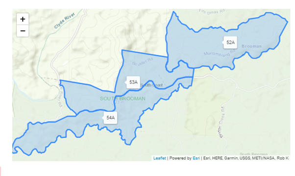
planning a harvest operation in compartments 52A, 53A and 54A to start at the
end of September 2020 which will continue for approximately 6-12 months (refer
to image below for map outlining logging areas). This proposed harvest will
further destroy the natural environment and available wildlife habitat in this
forest, much to the distress of local residents.
Further, this logging operation
will require closure of a heavily used road, The Sheep Track. Residents use
this road to access local towns (e.g. Ulladulla). As well as this, there are
small businesses located in the area including Shallow Crossing Camping Ground
and the Clyde River Berry Farm. With the Sheep Track closed, these businesses
will be heavily affected as alternate routes are much longer in distance and
travelling time. Alternate routes are not well known. The lack of familiarity
and longer travel times will be a deterrent for customers of these businesses.
|
|
Development
& Environment Committee – Tuesday 06 October 2020
Page
0
|
DE20.100 Proposed
Policy - Solar Roof Panels - Efficiency
HPERM Ref: D20/19802
Section: Strategic
Planning
Approver: Robert
Domm, Director - City Futures
Reason for Report
Within the last 12 months there
have been two (2) Notices of Motion relating to the efficiency of solar panels
and impacts of overshadowing. Both resulted in resolutions that a draft policy
be prepared relating to the performance/efficiency of solar panels.
Preliminary investigations have identified a number of
limitations on the development of the requested policies which are discussed in
this report.
|
Recommendation (Item to be determined under delegated authority)
That
Council:
1. Strengthen the following existing
Council policies and plans to encourage individual renewable investment and
protect solar roof panels on both private and public land:
a. Shoalhaven Development Control Plan
2014.
b. POL15/28 - Renewable Energy
Installations on Council Assets.
c. POL18/44 - Sustainable Energy
Policy.
d. POL16/10 - Tree Management Policy
– Public Land.
2. Receive a further report/s in a
timely fashion to address the detail of the proposed amendments to the
policies and plans identified at Part 1 and to progress this matter as
efficiently as possible.
|
Options
1. As recommended.
Implications: This is
the preferred option as it will allow additional provisions to be drafted in a
timely fashion, as part of ongoing amendments to Shoalhaven Development Control
Plan 2014 (DCP) and a number of existing Council policies. Such an amendment
could assist in ensuring that where development consent is required, greater
consideration is given to the protection of solar roof panels so they are able
to perform at their optimum level of efficiency, whilst also avoiding policy
duplication or conflict with over-arching state legislation. The changes to
existing Council policies would strengthen consideration and direction
regarding renewable investment and protect solar roof panels.
2. Draft a new
stand-alone policy as per Council resolution MIN19.874 and MIN20.350.
Implications: This
option is not favoured as the intent of Council’s resolutions could be
more effectively and efficiently achieved by amending the DCP and a number
of existing Council policies. Despite this, a standalone policy could be
prepared, however there would likely be duplication between the new Policy and
Council’s existing policies, and the conflict with the overarching state
legislation would remain.
3. Adopt an
alternative recommendation.
Implications: This will depend on the nature of
the recommendation; however, impacts will need to be investigated to ensure
that there are no additional policy implications – i.e. conflict with NSW
Government planning instruments.
Background
Council
resolved on 26 November 2019 (MIN19.874) that:
Council staff prepare a draft policy aimed at ensuring
that solar roof panels (both public and private)
perform at their optimum level of efficiency. Particular emphasis in
preparation of the policy would need to include innovative ways of dealing with
overshadowing, especially in the foreseeable future.
Additionally, it was also
resolved on 26 May 2020 (MIN20.350) that:
Council staff prepare a draft policy, which ensures that
any negative impact of overshadowing, cast from trees onto solar panels located
on the rooves of private residences, is as far as possible, eliminated. This
policy would need to address the ongoing maintenance of trees on both public
lands and private lands alike and would maximise the likelihood that individual
renewable investments are both encouraged and protected.
This report provides a follow up
report regarding these two related resolutions.
Review Process
Following the resolutions, a
number of existing policies and documents relating to solar efficiency were
reviewed, including the following:
· Existing
Council policies relating to solar roof panels.
· Relevant
chapters of Shoalhaven DCP2014.
· Other
NSW Council policies and DCPs.
· State
Environmental Planning Policy (Exempt and Complying Development Codes) 2008
· State
Environmental Planning Policy (Infrastructure) 2007 (ISEPP).
These are discussed in further
detail below.
Existing Shoalhaven Council
policies relating to solar roof panels
Council currently has three
existing policies that are relevant to solar and the protection of solar roof
panels. These policies are briefly summarised in Table 1 as well as
examples of how the policies could be strengthened in line with Council’s
resolution.
Table 1: Overview of existing policies and opportunities
|
Policy
|
Summary of Policy
|
Opportunities to Strengthen
|
|
POL15/28 - Renewable
Energy Installations on Council Assets
|
Outlines criteria
relating to solar suitability and is utilised when considering the
installation of solar roof panels on Council assets. One of the main criteria
considered when selecting suitable assets for rooftop or ground-mounted solar
systems is minimal shading of the panels.
|
POL15/28 could be
strengthened to further protect solar access by including criteria to identify/manage
the future risk of overshadowing when investigating the installation of
renewable energy solutions on Council assets and establishing considerations
to mitigate this risk. The
amendment could also emphasise the requirement to preserve solar access
rights across Shoalhaven,
|
|
POL18/44 - Sustainable
Energy Policy
|
Outlines
Council’s efforts to increase the uptake of renewable energy
solutions in relation to both Council operations and more broadly within
Shoalhaven.
The policy relates to
the Council’s vision to operate its energy consuming assets and fleet
transport in a sustainable manner with minimal effect on the natural
environment.
|
An amendment to
POL18/44 could emphasise the requirement to preserve solar access rights
across Shoalhaven, however the scope is limited based on the nature of the
Policy.
|
|
POL16/10 - Tree Management Policy – Public
Land
|
Identifies the impact
of overshadowing from trees on solar panels and identifies a criterion when
tree removal is considered appropriate on public land. This includes the
45-degree rule. These current provisions provide a criterion which permit the
removal of trees to protect pre-existing solar panels.
|
Table
1 of the policy could be amended to include consideration for pruning trees
on Council owned or managed land, where trees are existing prior to the
installation of solar panels on privately owned land. This amendment would need to consider a new
assessment criterion, as well as budget implications and staff resourcing
associated with additional tree pruning applications.
|
Other council DCPs and
relevant chapters of Shoalhaven Development Control Plan 2014
The following Shoalhaven DCP2014
chapters currently contain provisions relating to solar access and amenity, and
impacts on solar collectors:
· G1:
Site Analysis, Site Design and Building Materials.
· G4:
Tree and Vegetation Management.
· G11:
Subdivision of Land.
· G12:
Dwelling Houses and Other Low-Density Residential Development.
· G13:
Medium Density and Other Residential Development
Where development consent is
required, Council’s existing DCP controls help to ensure that
consideration is given to private open space, living areas, overshadowing,
solar amenity, and the impact on solar collectors.
Striking a balance in relation
to an appropriate level of controls is important, as introducing additional and
more stringent provisions designed to protect solar systems from adverse
overshadowing has the potential to impact on the design and form of future
development.
Whilst the existing Shoalhaven
development controls regarding solar access for low density residential
development (including 5 star solar design for residential subdivisions) is
considered appropriate, there may be scope to include additional provisions
within a future amendment to the DCP, with particular emphasis on medium
density and commercial and industrial premises.
As part of these investigations,
staff also reviewed DCPs across NSW and found that a number of councils have
DCP provisions in place to protect and minimise the impacts associated with the
installation of solar roof panels on residential and commercial
buildings. The following additional provisions could be adapted to
further support existing Shoalhaven DCP provisions:
· Implementation
of additional controls relating to the number of hours of direct sunlight
received on 21 June (winter solstice) for a range of development types.
· Outline
Council’s expectations for shadow diagrams so that owners provide good
quality solar diagrams but avoid providing unnecessary detail. This will
also assist in managing applicant costs in this regard.
· Implementation
of solar related controls relating to industrial and commercial development.
The following changes to
Shoalhaven DCP 2014 would be beneficial:
· G11:
Subdivision of Land:
- Detail
regulations for solar cell opportunities.
- Specify
design requirements for battle-axe lots to ensure suitable separation between
dwellings.
· G13:
Medium Density and Other Residential Development - Currently, there are no
shadow diagram requirements within this Chapter. Given medium density
development could have significant impacts on the residential setting, a
possible future amendment could include requirements for shadow diagrams with
the lodgement of certain development applications. Content of this nature has
not previously been included as medium density development has historically be
located in higher density areas where there is a level of expectation that
solar access will be impacted more so than in a low density residential area.
However, as infill medium density development continues to increase in low
density residential areas (e.g. dual occupancies), greater consideration of
solar preservation resulting from medium density development is required.
· G17:
Business, Commercial and Retail Activities - Protection of solar panels on
adjoining/adjacent development and number of hours of direct sunlight received
by solar panels on 21 June (winter solstice).
· G20:
Industrial Development - Protection of solar panels on adjoining/adjacent
development and number of hours of direct sunlight received by solar panels on
21 June (winter solstice).
In relation to trees and
overshadowing on private land, DCP Chapter G4: Tree and Vegetation Management,
in accordance with Part 3 of the Vegetation SEPP, provides a number of
exemptions which enable some trees to be removed without a permit. Where
development approval is required for tree removal, Council staff make an
assessment based on the assessment criteria for tree removal and pruning
outlined within the DCP, as well as the relevant provisions set out within the
Vegetation SEPP and NSW Biodiversity Conservations Act 2016. These
provisions are considered sufficient to assist in resolving issues with solar
panels. It is noted that there may be instances of tree disputes (e.g.
neighbour refuses to remove a tree that may be shadowing an adjoining
property/solar collector) and the Chapter should acknowledge that there is
generally nothing that Council can do in this regard.
Other NSW council
policies
Based on research undertaken, no councils in NSW currently
appear to have a dedicated policy similar to those proposed in MIN19.874 and
MIN20.350.
Overarching
legislation
Table 2 outlines the
overarching state legislation that requires consideration in relation to solar
panels and trees:
Table 2: Overview of relevant state legislation
|
Legislation/ matter
|
Overview
|
|
State Environmental Planning Policy (Exempt and
Complying Development Codes) 2008 (Codes SEPP)
|
It
is noted that ‘complying’ development is not required to consider
impacts on solar collectors. This means that where a dwelling can be approved
as ‘complying’ development, it does not need to consider the
impacts on the solar collectors of an adjoining dwelling or other
development.
As
such, a dedicated Council policy would not help to overcome the issues
associated with or created by ‘complying’ development. Council
may wish to raise the inequity between ‘complying development’
and the development application pathways in this regard as part of a future
submission to the NSW Government.
|
|
State Environmental Planning Policy (Infrastructure)
2007 (ISEPP)
|
Division
4 of this SEPP outlines the assessment pathways for the installation of solar
energy facilities, this includes both ‘exempt’ and
‘complying’ development, as well as development requiring
consent.
The
development standards within this SEPP enable a significant number of solar
collectors to be installed on both residential and commercial developments
under the ‘exempt’ or ‘complying’ development
approval pathway.
As
the installation of solar systems generally does not require development
consent, the ability to achieve the intended outcome of Council’s
resolutions is compromised.
|
|
Disputes between neighbours resulting from trees
overshadowing solar panels
|
Currently
there is no legislation within NSW to support Council when dealing with
disputes between neighbours that arise as a result of solar panels being
overshadowed by trees from an adjoining property.
Whereas
the Dividing Fences Act 1991 provides a
mechanism for Councils to deal with neighbour disputes, the Trees (Disputes
Between Neighbours) Act 2006 dictates that councils do not have the authority
to resolve disputes over trees. The Trees (Disputes Between Neighbours) Act
2006 pertains solely to trees at risk of causing damage or obstructing views
and sunlight to windows as opposed to impacts on solar panels.
|
Conclusion
Council’s current policies
do not address the impact of overshadowing of solar panels on privately owned
land, whether residential or non-residential in nature. However, there are a
number of existing provisions within relevant chapters of Shoalhaven’s
DCP which address solar panels and overshadowing. There is merit in
supplementing/strengthening a number of Council’s existing policies and
the DCP to meet the intent of the Council resolutions.
Introducing a dedicated policy designed to protect
solar systems from adverse overshadowing may be problematic as it would be
severely limited by both the Infrastructure SEPP and Codes SEPP. Not only do
these two SEPPs prevent the proposed policy intent from being fully and
consistently achieved, but any policy creation in this regard is likely to
conflict with existing over-arching NSW legislation. Further, there would be
duplication between the proposed new policy and existing policies of
Council.
In relation to Council
resolution MIN20.350 regarding overshadowing from trees, provisions within
Shoalhaven DCP2014 Chapter G4: Tree and Vegetation Management, are generally
considered sufficient to protect solar panels on both public and private land
(with a minor supplement); however, potential amendments to POL16/10
- Tree Management Policy – Public Land, will assist in ensuring solar
panels are protected into the future.
Community
Engagement
No community engagement has been
undertaken to date. Any future amendment to the DCP would be publicly exhibited
for a period of at least 28 days in accordance with legislative requirements.
Depending on the nature of the changes to existing Council policies, exhibition
may also be required in this regard.
Policy
Implications
The establishment of additional
policy regarding solar roof panels has the potential to impose onerous
restrictions on the design and form of future development. Additionally, given the
extent of provisions within the ISEPP, introducing an additional policy
increases the chance of conflict with NSW Government legislation.
Financial
Implications
Any potential policy development
or future amendments to the DCP will be resourced from the existing Strategic
Planning budget. A funding source for the existing Council policies will be
identified in future reports.
The proposed amendments to
POL16/10 Tree Management Policy may result in financial implications associated
with budget and resourcing.
|

|
Development
& Environment Committee – Tuesday 06 October 2020
Page
0
|
DE20.101 Moss Vale Road North Urban Release Area - Progressing
Planning for Release
HPERM Ref: D20/386419
Section: Strategic
Planning
Approver: Robert
Domm, Director - City Futures
Attachments: 1. Comparison
of current and Owners Group's proposed zones ⇩
2. Adjusted
Development Outcome ⇩
3. Comparison
of Owner Group Proposal and Adjusted Development Outcome ⇩
4. Alternative Centre Location ⇩
Reason for Report
1. Provide an update
on the planning of the Moss Vale Road North Urban Release (URA) Area,
including:
· testing
and refining of the Moss Vale North Owners Group’s 2019 proposal,
· collaboration
activity between Council officers, the Owners Group, and other significant landowners,
and
· ability
to pursue Biodiversity Certification for the release area.
2. Obtain
Council’s endorsement to prepare a Planning Proposal (PP), recommending
adjusting changes to the planning controls, to progress the release area and
submit it for initial Gateway determination. This will also enable work to
continue on the required Development Control Plan (DCP), development
contributions framework and other related matters to advance with some
certainty.
|
Recommendation (Item to be determined under delegated authority)
That
Council:
1. Endorse the preparation of a
Planning Proposal to amend the provisions and mapping in Shoalhaven Local
Environmental Plan 2014 relating to the Moss Vale Road North Urban
Release Area as outlined in Table 2 of this report.
2. Submit the Planning Proposal to the
NSW Department of Planning, Industry and Environment for a Gateway
determination.
3. Adopt the proposed Indicative Layout
Plan provided as Figure 1 as the basis for developing detailed Development
Control Plan Chapter and a development contributions framework for the
release area.
4. Not proceed with an application for
strategic Biodiversity Certification of the release area and continue to
consider opportunities for managed biodiversity outcomes.
5. Receive a further report on the
outcomes of the Gateway determination, draft Development Control Plan
Chapters, development contribution framework, and various other planning
matters relating to the delivery of the Moss Vale Road North Urban Release
Area.
|
Options
1. Support
the recommendation.
Implications: This is the preferred option and will
enable the submission of a PP to adjust and update the planning controls for
the URA to the NSW Department of Planning, Industry & Environment (DPIE)
for Gateway determination. It also allows work to continue on preparing the
detailed DCP and development contributions framework that will guide the future
delivery of the URA and its required infrastructure. Completing the release of
this area is a high priority project, confirmed by Council’s earlier
decisions and in the adopted Strategic Works Program. It will facilitate
subdivision activity and the release of residential lots, helping to meet
identified housing demand.
Investigations into the viability of a strategic
Biodiversity Certification application for the URA indicate a significant
chance of net financial loss for Council. As a result it is not recommended
that this application proceed. Alternative options for funding the restoration
of biodiversity resources within the release area will continue to be
investigated.
2. An
alternative resolution.
Implications: The implications will be subject to
the nature and content of the alternative resolution, but any decision
requiring further analysis, studies, or an alternative outcome for the URA,
will add time (and delay) to the work delivering the URA. The current timeframe
for submitting a PP for a Gateway determination before the end of 2020 would
likely not be met.
3. Not support a
recommendation.
Implications: This would
effectively cease the project and the planning controls currently applying to
the URA would be maintained, including the requirement to a DCP and make
suitable provision for infrastructure before the area can be developed, meaning
no subdivision development applications could be determined.
Background
The 266-hectare URA was
identified as a ‘New Living Area’ in the Nowra-Bomaderry
Structure Plan (2006) with the identified potential at that point to
provide about 1,300 dwellings. The URA was confirmed with land use zones, an
enlarged footprint providing for additional lots/dwellings and other related
provisions guiding its release in Shoalhaven Local Environmental Plan 2014.
Council considered the timing for the delivery of the URA in March and August
2017, resolving to accelerate its delivery.
In 2019,
the Moss Vale North Owners Group, comprising several major landowners
within the URA, submitted an alternative outcome for the area for
Council’s consideration. This sought to deliver about 2,500 dwellings (an
increase on the outcomes facilitated by the current planning controls),
adjusted the size and function of the retail centre, refine the E2
Environmental Conservation zones applied to the riparian corridors and
adjust other components of the URA. Attachment 1 provides a comparison
of the current LEP zones, being a mix of residential, public recreation,
business and environmental and those proposed under the Owners Group’s
proposal.
The Owners Group supported its proposal with an indicative
layout plan, draft development controls and a range of technical studies
relating to bushfire, infrastructure (including transport), scenic values,
contamination and biodiversity. The Owners Groups’
package of information can be viewed online at:
https://www.shoalhaven.nsw.gov.au/Council/Access-to-Information/Planning-Proposals-Pre-gateway
In August 2019, Council considered
the alternative outcome and supporting information and resolved to work
collaboratively with the Owners Group, giving ‘in principle’
support to the package being used as the basis for the documents guiding the
delivery of the URA (LEP amendment, new DCP chapter, and a development
contributions framework). Given the Owners Group subsequent split into two
major groups representing 47% and 34% respectively of development land in the
release area, Council officers have been engaging collaboratively but
separately with both. This is discussed in more detail later in the report.
Council also resolved to
investigate the possible biodiversity certification of the URA, development of
an affordable housing development contributions scheme and suburb naming
options.
Preparation of Planning
Documents
The selection of planning controls (for inclusion in a PP),
detailed development controls (to make up the DCP Chapter) and identification
of development contributions framework rely on an evidence base of technical
documents. Some of these documents were provided by the Owners Group and others
have been directly commissioned by Council. The review of the Owners
Group’s information identified some information gaps and the need for
additional studies to ensure that a robust, achievable and defendable PP could
be submitted for Gateway determination.
The following studies have now been completed:
1. Retail
analysis – to inform the amount and type of retail floorspace needed
by the future community. This analysis is required to justify proposed changes
to the size, type, and location of commercial zones. Note: analysis not
included in the Owners Group’s information.
2. Urban
design guidance – to assist with the consideration or an optimal
location and orientation of the proposed retail centre.
3. Gas
pipeline safety management study – to confirm the type and scale of
development possible adjacent to the Eastern Gas Pipeline located that runs
through the URA. This study is required to comply with the NSW
Government’s Planning Circular on controlling development near pipelines.
Note: study not included in the Owners Group’s information.
4. Visual
Analysis – a peer review of the visual analysis provided by the
Owners Group, with a focus on the scenic/visual corridor along Moss Vale Road.
This review is required to confirm the appropriate corridor and justify
proposed changes to the size of related land use zones.
5. Community
infrastructure needs analysis – to identify the community
infrastructure required by the future population. This analysis is required to
inform the amount and location of open space to be included on the indicative
layout plan and in the development contributions framework. Note: analysis
not included in the Owners Group’s information.
6. Traffic
study – to add value to the information provided by the Owners Group
and confirm the type and location of roads and connections to the existing
network, informing an indicative layout plan and the development contributions
framework.
7. Integrated
water management study – to identify options, including land
requirements and infrastructure, to sustainably manage stormwater run-off
(quantity and quality). This study was directly commissioned by Council for
efficiency as the consultants had just completed a similar study for the Moss
Vale Road South URA.
These studies can be viewed online
at:
https://www.shoalhaven.nsw.gov.au/Council/Access-to-Information/Planning-Proposals-Pre-gateway
The consideration of these studies suggests
some adjustment of the Owners Group’s proposal to ensure the delivery of
a responsible and sustainable development outcome that meets the needs of the
future community. Other adjustments are required to improve the commercial
viability of the development outcome, helping secure its timely delivery by
industry. The proposed refinements are summarised and explained later in this
report.
Other technical studies may still
be required as related detailed work progresses, such as the design and costing
of identified infrastructure for development contributions, or to inform
consultation with Government Agencies as the PP progresses through the Gateway
process. Potential examples include an additional bushfire assessment to
address recently published guidelines, and a riparian lands study to justify
proposed changes to existing watercourses.
Collaboration with Landowners
The ownership of the URA is currently split amongst 17 owners,
each with a varying share of the 165.5 hectares currently zoned for development
(with a residential or business zone). The Owners Group has 4 members who own
79.4 hectares or about 47% of the area currently zoned for development. The
majority of the URA is split amongst the other 13 owners, including one
significant land holding of 55.4 hectares (or about 34% of the area currently
zoned for development). Engagement with the owner of the significant 34% land
holding has included written updates, the sharing of completed studies and
several digital meetings. This owner has expressed verbal support for the
continued planning and the adjusted development outcome identified for the URA.
A professional working
relationship has been established with the remainder of the original Owners
Group and its project team (including planning and technical consultants). This
has been used to inform the preparation and refinement of technical studies,
consideration of related findings, and adjustment of development outcomes.
Collaboration activities have included regular dialogue with a single owner
representative and a planning consultant but also other members of the Owners
Group. Activities include:
· Monthly
written progress updates on the preparation of planning documents, findings of technical
studies, and refinements to potential development outcomes.
· Monthly
meetings (in person or online) with the Owners Group to discuss progress and
matters arising.
· A
workshop and exchange of information to refine the development control chapter.
· Representatives
of the Owners Group attended the workshop informing the Gas Pipeline Safety
Management Study.
· Provision
of copies of the completed studies, an opportunity to provide feedback on
findings, and the consideration of any feedback.
· Two
technical workshops to discuss the integrated water management study.
· Confirmation
of a shared intent to investigate options to contribute to the supply of affordable
housing in Shoalhaven.
Finally, a workshop to discuss
an adjusted development outcome responding to the findings of the technical
studies was held with the remaining members of the Owners Group on 31 July
2020. This examined key changes to the development outcome, including, the
location of the proposed retail centre, areas of medium density development,
open space provision, and water management infrastructure. The Owners Group was
invited to respond to the alternative outcome and provide feedback on the
studies about traffic, visual analysis, and community infrastructure.
Documentation from the workshop was
also contemporaneously provided to significant landowners no longer part of the
Owners Group.
On 10 September 2020, the Owners
Group responded to the workshop, providing a response on several matters,
including the proposed integrated water management solution, location of the
retail centre, and the findings of the traffic study. It also provided a
revised Indicative Layout Plan (amending the 2019 proposal). This information
has received further consideration in the development of the adjusted
development outcome which is outlined and discussed below.
Adjusted Development Outcome
Wherever possible, the Owners
Group’s proposed outcomes have been maintained, for example, the extent
of the proposed environmental zone applied to riparian corridors in the
original 2019 submission or the greater range of uses sought for the local
retail centre in the September 2020 update. This includes the Owners
Group’s desired dwelling yield outcome – about 2,500 dwellings.
The adjusted development outcome
maximises dwelling yield in a considered and responsible way to make efficient
use of already zoned land (in the URA), removing pressure for development in
more sensitive locations elsewhere. It also maximises the use of existing
infrastructure and planned infrastructure investment. Adopting comparable
development assumptions to those being delivered in the Moss Vale Road South
URA, a rate of dwellings per hectare has been identified for the various
residential areas. High and low scenarios have been used to identify an
indicative number of new homes. These scenarios or the range in the potential
dwelling yield accounts for:
· variation
and flexibility in the subdivision design required in response to physical
constraints, such as topography and retained vegetation,
· the
land required for easements, services, and infrastructure, such as electricity
substations, drainage, and open space, and
· the
residential densities and products, including dual occupancies and secondary
dwellings, the market might demand, or industry chooses to deliver.
Application of the high and low
scenarios to the adjusted development outcome indicates the potential for
between 2,380 and 3,360 new dwellings. The ultimate number of new dwellings
depends on the final lot layout given the above variables, which will only be
determined when a developer commences detailed subdivision planning. Further
opportunities to increase the potential dwelling yield are provided by the
retail centre, where the planning controls allow 1-2 storeys of units above
ground floor commercial premises. This would also increase the diversity of new
homes within the release area.
The Owners Group’s proposal has been adjusted in
response to the findings of the technical studies and subsequent planning considerations.
Adjustments include:
1. The
design of the water management infrastructure (type and location of devices) to
ensure an easy and cost-effective maintenance regime and avoid similar issues
and costs experienced, for example, with the drainage infrastructure at the
Bayswood Estate, Vincentia.
2. The
location of the retail centre to help ensure it is commercially viable (to
construct and operate) and secure its early delivery for the future community,
avoiding delays such as those observed at Worrigee (approximately 30 years
between initial subdivision and centre construction).
3. Securing
the land for increased infrastructure requirements to service the future
community, such as open space and wider roads to manage traffic, car parking,
pedestrian, and cyclists.
Other significant factors considered and addressed in the
adjusted development outcome are commercial viability and opportunities to
accelerate subdivision activity. The adjusted outcome optimises these by taking
advantage of and building on the planned roundabout on Moss Vale Road to
service both northern and southern release areas. NSW Government funding has
been secured for the design and construction of this roundabout, with
completion expected in the second half of 2021. The roundabout provides a
logical starting point for initial subdivision activity while the associated
North-South road into the release area will provide early access to the retail
centre and other residential zoned land, including an 18-hectare site owned by
an experienced development company.
Figure 1 (and Attachment 2)
identify the adjusted development outcome (including the indicative roundabout
location) and the following table (Table 1) provides more detailed rationale
for the key changes. Attachment 3 provides a comparison of the Owners
Group’s proposal and the adjusted outcome.
There are two key components of
the adjusted development outcome that the remaining members of the original
Owner’s Group have issues with. These are the:
· Design
of the integrated water management solution, with the Owners Group identifying
concerns with water quality outcomes, efficient management of flows, and
potential loss of developable area/dwelling yield due to the size of the
infrastructure.
· Location
of the retail centre, with the Owners Group identifying its preferred location
to increase exposure to passing traffic and concerns with perceived loss of
links with open space and landscape features (a farm dam and a stand of mature
trees).
The Owners Group also has issues
with some of the findings of the traffic study, relating to the recommended
road types and cross sections, and potential impacts on developable
area/dwelling yield. However, it must be noted that the PP will not confirm any
outcomes for road types and cross sections and these matters can continue to be
discussed and settled during the preparation of the more detailed development
controls.
Figure 1 – Adjusted
Development Outcome
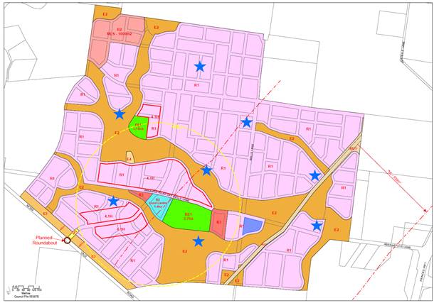
Table 1: Discussion of
adjusted layout
|
Component
|
Discussion
|
|
Water management Infrastructure
|
The
Owners Group proposed solution focusses on managing flows with treatment
provided by a complex system of many devices dispersed throughout the release
area with the majority located within identified riparian corridors. The
ability of the proposed system to maintain or improve water quality needs to
be tested.
This
solution has several potential implications, including high construction and
Council maintenance costs (for lots of devices), and the effectiveness of the
devices in areas at risk from flooding. Thorough consideration of these
implications is required to avoid similar and potentially larger, issues and
rectification works such as experienced with the Bayswood Estate, Vincentia.
The integrated
water management study identified an alternative, outcome with a smaller
number of larger devices, including basins and wetlands, to manage flows and
improve water quality. Other potential benefits include:
· Lower
construction cost as there are less devices,
· Easier
and cost-effective maintenance (for Council),
· Greater
function as infrastructure is above the area at risk from flooding,
· Increased
amenity through integration of drainage with landscaping and open space,
· Consistency
with development controls and standards, including systems delivered in other
release areas, and
· Reducing
the cost of subdivision activity by removing the need for temporary drainage
solutions.
A
greater area of land proposed to be zoned for residential purposes is
required for this outcome – 35,000m2.
To
address the Owners Group’s position, Council staff have incorporated
two design changes to better align the Owner’s Group proposal and the
recommendation of the study. These include the use of an existing dam,
subject to suitability testing, and replacing 2 large wetlands with 4-6
smaller devices. An indicative location for the proposed drainage
infrastructure is provided in Figure 1 – the blue stars and blue shaded area (to east/left of
Bells Lane).
The
adjusted development outcome will provide an environmentally responsible and
attractive scheme compliant with Council’s adopted controls and
standards. It also ensures a cost-effective and financially sustainable
management regime, avoiding significant burden on Council or the future community.
Importantly, the adjusted outcome requires a smaller amount of land,
requiring about 25,000m2, with possible further reductions to be
gained through the integration of basins within public open space.
|
|
Retail Centre
|
The retail
analysis recommends a neighbourhood-scale centre in a central location to
service the future community. It confirms 1,000-2,000m2 of retail
floorspace on about 1-1.5 hectares of land would be commercially viable and
would adequately meet identified need. It also predicts a larger centre would
be unfeasible, leading to no/late delivery or later failure, due to the size
of the future population and established and the new or planned retail
centres (the nearby Woolworths and Aldi supermarkets). The urban design
advice also recommended an optimal location.
The
Owners Group’s proposed B2 Local Centre zone is considered the most
appropriate zone for the Centre. It will provide a range of business and
retail uses greater than normally found in a neighbourhood centre, helping to
encourage early delivery, improve feasibility, and provide flexibility to
respond to changing retail practices. However, interim residential uses of
retail premises are not recommended due to the complexity of controls
required to manage this outcome, difficulties in reversing the temporary use,
length of tenancies, the quality of temporary dwellings, land use conflict,
and loss of amenity during transition from residential to retail.
The
adjusted outcome will potentially provide a more commercially achievable and superior
outcome to the Owners Group’s proposal as it provides a centre size,
location and zone that delivers:
· Optimal
exposure and ease of access at the intersection of two main roads, elements
critical to the feasibility of the centre,
· Early
delivery, as the adjacent main road will be delivered during the earliest
subdivision stages,
· A
walkable catchment (400m walking distance) to service the future community
containing about 40 hectares of residential zoned land,
· Equitable
and early access for the future community of Moss Vale Road South URA (950
households) from the roundabout and associated road, helping to support the
early delivery and feasibility of the centre, and
· Links
to public open space and other community uses.
The
Owners Group’s preferred location has less benefits. It is on the
intersection of two roads – Bells Lane and Abernethys Lane – and
has links to open space containing an existing dam and stand of vegetation.
However, the roads (existing) are due to be upgraded during later stages of
the subdivision, potentially delaying the delivery of the centre or
complicating its operation. It is also likely the existing landscape features
will change or could be lost through subdivision activity and associated earthworks
as experienced with the Taylors Lane redesign in the southern release area.
The existing farm dam is also likely to go through significant upgrades as it
is made suitable for integration into the drainage system.
The
proposed location does not provide the same level of access to the immediate
community or surrounding suburbs as the recommended centre location,
containing 33 hectares of residential land in its walkable catchment and
being further away from the southern release area (a 2km drive along Moss
Vale Road and Bells Lane – about the same distance to the current
Woolworths supermarket). These factors may decrease its long-term viability.
The
Owners Group rely on the future delivery of the Far North Collector Road
facilitating increased traffic flows past the centre. An interim intersection
of this new road with Moss Vale Road, but not servicing the release areas, is
planned for delivery by June 2022 (up to 12-months after the Moss Vale
Road/Release Area roundabout). No timeframe has been set for the upgrade of
Bells Lane and an improved intersection to service the release area. In
addition, the potential support for the centre from the delivery of this road
is uncertain, as it will improve access and shorten journey times from the
release area to higher-order retail centres (the established Woolworths
supermarket), i.e. retail expenditure could be lost from the release area.
Attachment
4 provides an indicative layout plan
with the Owners Group’s proposed centre location and corresponding
adjustments to areas of small lots and medium density residential areas.
The
detailed design of the centre will be considered during the continued
preparation of the DCP chapter.
|
|
Dwelling Diversity
|
Dwelling
diversity is achieved throughout the URA with:
· 5.9
hectares of R2 Low Density Residential zoned land at 10-14 dwellings per
hectare provides between 60 and 80 dwellings (rounded).
· 1.8
hectares of R3 Medium Density Residential at 21-35 dwellings per hectare
provides between 40 and 60 dwellings (rounded).
· 147 hectares
of R1 General Residential at 15-20 dwellings per hectare provides between
2,200 and 2,940 dwellings (rounded).
· The
proposed small lot controls provide opportunities for an extra 80 to 280
dwellings.
The
adjusted development outcome has the potential for upwards of 2,380 new
dwellings (with a potential upper limit of 3,360 dwellings). This is
considered to deliver a measured and responsible increase in dwelling yield
while providing the land required for necessary drainage infrastructure, open
space, and increased bushfire asset protection zones.
|
|
Open Space
|
The community
infrastructure needs analysis identified the need for 12 hectares of open
space to service the future community, with two thirds as formal parks and
sports fields and the remaining third as natural areas (extent and location
to be determined on biodiversity values and ability to support recreation).
For
the passive space, two large parks are zoned for public recreation –
one near the village centre and one adjacent to the riparian corridor in the
north of the release area. Four smaller parks (0.5 hectares) are proposed
within the residential areas (no open space zoning required), consolidating
the pocket parks proposed by the Owners Group and returning them to the
development area.
For
the active space, a 3-4-hectare sportsground is required. This can be
provided on-site in the central open space providing a hub of missed-use open
space (active and passive) or provided off-site (through development
contributions) to provide equity of access to surrounding communities.
The
level of embellishment and funding mechanisms will be addressed in the
proposed development contributions framework.
|
|
Scenic corridor
|
The peer
review of the visual analysis found the proposed buffer and bund to
provide a suitable scenic corridor. It also provided several other
recommendations to be considered during the preparation of DCP controls
(subject of a future report).
The
peer review did highlight the need for greater asset protection zones for
adjacent homes. The provision of suitable asset protection zones is being
examined in an additional bushfire assessment (an assessment also required to
consider updated NSW RFS guidance). In the interim, the adjusted development
outcome increases the width of the E3 Environmental Management zoned land
along Moss Vale Road (from 32m to 45m) to provide the required asset
protection zone. This can be reviewed upon receipt of the additional bushfire
assessment.
The
peer review also recommended improvements to the road layout and landscaping.
These will be considered during the preparation of development controls.
|
|
Gas Pipeline
|
The gas
pipeline safety management study confirmed the pipeline is constructed to
a standard suitable for the proposed development (non-rupture). To ensure the
ongoing integrity of the pipeline, the study identifies the need for
development controls:
· for road
and utility crossings,
· referring
subdivision and development applications within the identified measurement
length (identified as ML on the adjusted development outcome) to the pipeline
operator, and
· requiring
more detailed safety management studies for construction activity adjacent to
the pipeline.
The
pipeline is proposed to be zoned RU1 Primary Production, consistent with the
zoning of other regionally significant infrastructure, such as the
Nowra-Bomaderry Bypass, allowing dedication to be addressed at a future time.
|
|
Traffic
|
The traffic
study confirmed the existing, external road network will only need minor
upgrades to continue to operate efficiently when the release area is
delivered. The study also recommends an internal road network, road
typologies or cross sections, potential public transport routes, and a shared
user pathway network. It has been used to inform the adjusted development
outcome, but the details of the road and pathway infrastructure will be
settled during the preparation of development controls.
|
Proposed next steps
To ensure the timely advancement of
the planning framework for the release area, a PP needs to be prepared and
submitted for a Gateway determination. Table 2 lists the amendments required to
the current LEP planning controls to deliver the adjusted development outcome
identified in Figure 1 – the basis of the recommended PP.
Table 2: Proposed content of
the PP
|
Component of
Shoalhaven LEP 2014
|
Proposed Amendment
|
|
Land Zoning Map
|
Adjustment
to land use zones to match Figure 1.
|
|
Height of Building Map
|
· Apply
an 8.5m height to land zoned R2 Low Density Residential.
· No mapped height for
other zones – defaulting to 11m.
|
|
Minimum Lot Size Map
Clause 4.1H Exceptions
to minimum subdivision lot sizes for dual occupancies and dwelling houses (Enabling
clause for small lots)
|
Apply
the following lot sizes to corresponding zones:
· R1 General
Residential: 500m2
· R2 Low Density
Residential: 1,000m2
· E2 Environmental
Conservation: 40 hectares
· E3 Environmental
Management: 40 hectares
· E4 Environment Living:
2 hectares
· RU1 Primary
Production: 40 hectares
(No minimum lot size is set
for land zoned R3 Medium Density Residential, B2 Local Centre, or RE1 Public
Open Space)
Apply Clause 4.1H in
identified locations close to the retail centre, open space, and main roads
to permit subdivision into 300-499m2 lots.
|
|
Scenic Protection Area
Map
|
Remove
the application of this map from land zoned B7 Business Park.
|
|
Urban Release Area Map
|
Amend
the current map to apply to all residential and business zoned land in the
adjusted development outcome.
|
|
Clauses Map
|
Amend
the current map to apply to all residential and business zoned land in the
adjusted development outcome.
|
|
Riparian Lands and
Watercourses Map
|
Amend
the current map to apply to the watercourses proposed to be zoned E2
Environmental Conservation.
|
As the PP progresses through the
Gateway process, work will continue on the remaining planning documents –
the DCP Chapter and development contributions framework. The endorsement at
this point of the adjusted development outcome will allow finalisation of
draft:
· development
controls to guide future subdivision and development activity (including
village centre controls, road typologies, and development staging plans).
· development
contributions to fund and deliver the infrastructure and facilities to support
the future community.
Council staff will also continue to
progress investigations into biodiversity planning outcomes, affordable housing
opportunities and suburb name/boundary. It is intended that a further report
will be provided to Council in early 2021 to:
· Provide the results
and a summary of the PP Gateway determination.
· Seek endorsement
of a draft DCP chapter and development contribution framework for public
exhibition.
· Provide an update
on various other matters relating to the delivery of the release area (e.g.
affordable housing, and suburb naming).
· Seek endorsement
to publicly exhibit the planning package (PP, DCP chapter and development
contributions framework).
Biodiversity Certification
When considering the Owners Group’s 2019 submission,
Council resolved to investigate the strategic biodiversity certification of the
release area to help fast-track future subdivision applications. The technical
study provided by the Owners Group’s consultant, JB Enviro, stated
Biodiversity Stewardship may not be practical given the cost of the required
assessment, application fee, the few credits generated, and management costs.
Council staff engaged JB Enviro consultants to undertake
some further work to estimate the credit potential of the biodiversity resource
in the release area and the size of the fund deposit required to manage the
resulting stewardship site. This work found the limited size and quality of the
biodiversity resource would not generate sufficient credits. The current market
value of the 108 credits does not cover the costs to properly rehabilitate the
area through a Vegetation Management Plan (VMP), with a potential shortfall of
between $57,000 (under the moderate VMP scenario) and $687,000 (under the
intensive VMP scenario – most likely).
The timeframes observed for biodiversity certification
investigations for similar release areas in Wollongong indicate 5-6 years or
longer to implement. There are no other current examples under the current
process on which to provide an improved estimate of the time required to settle
biodiversity certification for the release area.
Biodiversity Certification is fully supported because of its
strategic conservation outcomes and quicker development approvals. However, as
it is financially unviable for Council, the absence of funding sources, as well
as uncertain and significant timeframes, it is recommended to not proceed with
current investigations and instead examine other options for funding
restoration of the biodiversity resources within the release area.
Community Engagement
Subject to the Gateway determination, the PP will be
publicly exhibited for at least 28 days. The draft development controls, and
contributions framework would be exhibited at the same time to present a
comprehensive array of documents for community and stakeholder feedback. The
proposed exhibition process will be outlined in the next Council report. As
outlined in this report, Council staff have worked collaboratively with all
major landowners to progress the planning of the release area.
Policy Implications
The adjusted development outcome outlined in this report
builds on the original Owner Group’s proposal to deliver a high quality
and much needed new living area in the Nowra-Bomaderry Area. The finalisation
of the planning documents to guide the delivery of the release area is a high
priority project, confirmed by Council’s earlier decisions and the
adopted Strategic Works Program. The documents, when finalised, will facilitate
subdivision activity and the release of lots, helping to meet identified
housing demand.
Financial Implications
In response to the high priority
placed on the project, a dedicated project team has been created within the
Strategic Planning Team. Significant funds have also been spent on necessary
technical studies to ensure the investigation and preparation of a well-founded
and responsible development outcome. There is likely to be a range of
longer-term financial and resourcing considerations for Council associated with
the delivery of the release area which will be addressed in future reports.
Delay to the delivery of the
planning documents also has implications for the current landowners who
continue to pay “holding costs” and other associated ownership
costs.
Risk Implications
This report and the work leading
to it ensures a Planning Proposal recommending contemporary planning controls
for the release area can be submitted for a Gateway determination in October
2020. Delays to the project ultimately delay the delivery of new homes in the
Nowra-Bomaderry URAs. They could also delay start of other strategic planning
projects whilst further work is undertaken for the release area. Other risks
include the emergence of higher priority projects and the subsequent allocation
of resources away from the release area.
|
|
Development
& Environment Committee – Tuesday 06 October 2020
Page
0
|
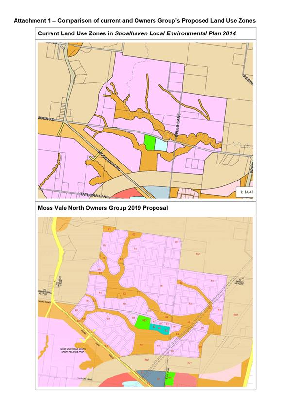
|
|
Development
& Environment Committee – Tuesday 06 October 2020
Page
0
|
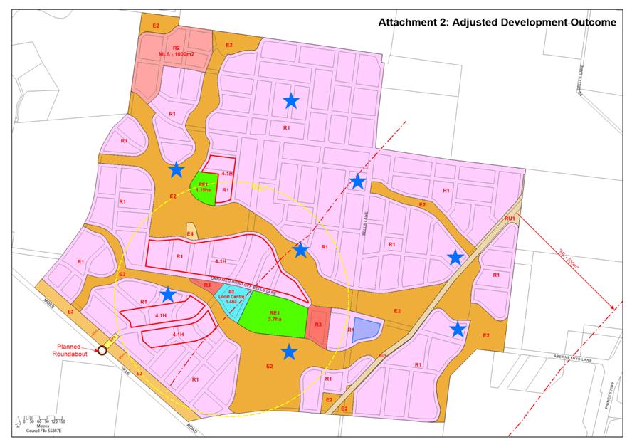
|
|
Development
& Environment Committee – Tuesday 06 October 2020
Page
0
|
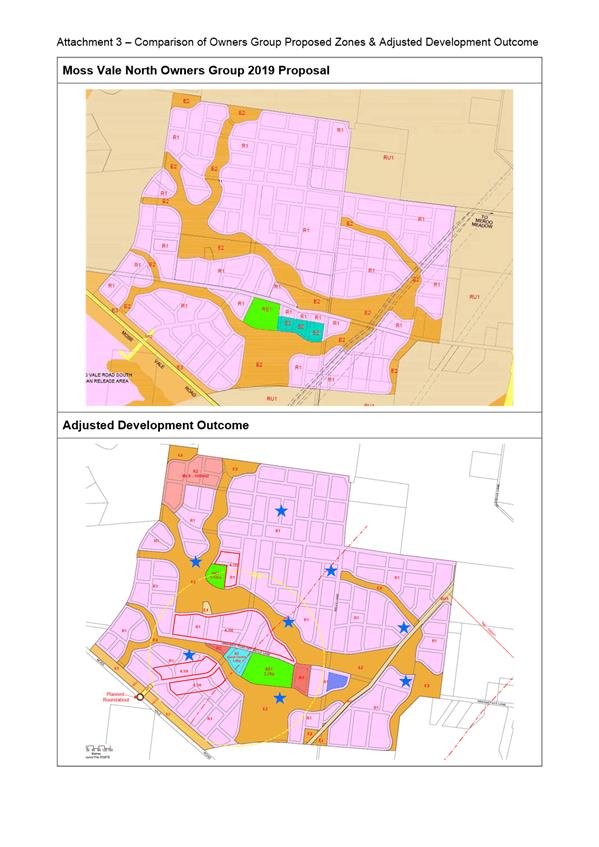
|
|
Development
& Environment Committee – Tuesday 06 October 2020
Page
0
|
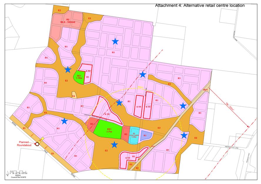
|

|
Development
& Environment Committee – Tuesday 06 October 2020
Page
0
|
DE20.102 Proposed
Housekeeping Amendment No.1 - Shoalhaven Contributions Plan 2019 (CP2019.1)
HPERM Ref: D20/149225
Section: Strategic
Planning
Approver: Robert
Domm, Director - City Futures
Attachments: 1. Proposed
Housekeeping Amendments (under separate cover) ⇨
Reason for Report
Obtain the required resolution
to formally exhibit Amendment No.1 (Housekeeping) to the Shoalhaven
Contributions Plan 2019 (the Plan).
|
Recommendation (Item to be determined under delegated authority)
That
Council:
1. Endorse the initial draft
Housekeeping Amendment (draft Amendment) to the Shoalhaven Contributions Plan
2019 at Attachment 1 and proceed to exhibit the draft Amendment for a period
of at least 28 days as per legislative requirements.
2. Receive a further report on the
draft Amendment following the conclusion of the public exhibition period to
consider feedback received, any necessary adjustments and the finalisation of
the amendment.
3. Notify key stakeholders (including
CCBs and Development Industry Representatives) of the exhibition arrangements
in due course.
4. Prepare a new contributions
framework, at the appropriate point, to ensure that suitable community
infrastructure is considered in relation to the outcomes of the Callala
Bay/Kinghorne Point and Culburra Beach (Halloran) deferred lands Planning
Proposals (PP006 and PP028).
|
Options
1. As recommended.
Implications: This is the preferred option as it
will enable operational issues and matters that require clarification to
improve the function of the Plan to be considered and resolved. This is
consistent with Council’s resolution (MIN19.212) of 2 April 2019 which
acknowledged that ongoing housekeeping would be required to the Plan.
2. Adopt an
alternative recommendation.
Implications: This will depend on the extent of any
changes and could delay the implementation of an updated and improved Plan.
Should Council require more detail on the scope of the proposed amendment a
briefing could be arranged before this matter comes back, after exhibition, for
final consideration.
3. Not adopt the
recommendation.
Implications: This could stop the Housekeeping
Amendment which is inconsistent with Council’s previous resolution
(MIN19.212). This may mean that improved, best practice/modern and better
structured projects and Plan content is not implemented.
Background
The Plan is a web-based plan
that allows Council to levy contributions on development consents and
‘complying’ development certificates issued for the development of
land within Shoalhaven. These contributions are collected to enable the
provision of community infrastructure projects (as detailed in the Plan) to
meet demand created by development.
The Plan is relatively
contemporary (commenced in May 2019) and as part of its finalisation Council
also endorsed (MIN19.212) the preparation of future amendments to:
· Update
project costings, apportionment, and timeframes,
· Clarify
calculation of credits, when contributions are charged for
industrial/commercial subdivision, dedication of land and works in kind, and
how merit assessment for miscellaneous development types is to be undertaken;
and
· Address
general housekeeping matters that may arise.
The main components of this
draft Housekeeping Amendment include the:
1. Review of certain
content in the Plan (i.e. website content).
2. Deletion of a number of
projects within the Plan.
3. Review and revision of
certain projects within the Plan.
Not all components of the May
2019 Council resolution have been considered in this amendment and future
housekeeping amendments will further refine the Plan and its projects.
The most notable components of
this draft Amendment are outlined in Table 1 below and in more detail in Attachment
1.
Table
1: Summary of key changes
|
Website Content
Review
|
|
The overall content of
the plan has been reviewed to improve readability, accuracy and address other
matters that have arisen since the Plan was made effective in May 2019. The
key proposed resulting amendments to the Plan include:
· New mapping (e.g. planning areas map) for a
consistent and modern look and feel.
· Update the population projections with the most
recent statistical data.
· Review of equivalent tenement (ET) rates for
residential development (excluding boarding houses and development under the
Affordable Rental Housing SEPP) with a change to 1ET per dwelling, regardless
of size.
· Review of the following sections/schedules to
provide more detailed, clearer and up to date information (as appropriate):
- Legal
basis of contributions.
- Land
dedication.
- Planning
agreements.
- Deferred
or periodic contributions payments.
- ET
rates applying to tourism accommodation development.
- Accredited
certifier obligations.
- Refunds.
- Schedule
2 (Old subdivision properties).
- Schedule
7 (Land acquisition).
· Inclusion of transitional arrangements provisions
that were unintentionally omitted from the new Contributions Plan 2019.
· Update of gross floor area definition in line with
the Standard Instrument Local Environmental Plan.
· Deletion of Schedule 1 (Infrastructure Projects) and
Schedule 3 (Contribution Project Rates) to reduce duplication and website
maintenance.
· Deletion of Schedule 6 (Projects Exempt from
Residential Cap) as there will be no projects exempt from the residential cap
following this amendment.
|
|
Project
Deletions
|
|
The current Plan
contains approximately 100 separate projects - 6 of which are proposed to be
deleted through this amendment. Reasons for the proposed deletion of these
projects include:
|
Reason
for deletion
|
Projects
proposed for deletion
|
|
The project has been
completed and paid off.
|
· 02CFAC0001: Callala Bay Community and Child Care
Centre (Emmett Street)
|
|
These projects relate
to land associated with the Halloran Planning Proposal at Culburra Beach
(PP006) and future community infrastructure should be considered as part of
that process.
|
· 02AREC0002: Culburra & District Sporting
Complex Site.
· 02CFAC0004: Culburra Community Centre (Proposed
Long Bow Point Subdivision).
· 02OREC0005: Land Acquisition for Passive Open
Space – Long Bow Point Subdivision.
|
|
These projects relate
to the sealing of rural roads at Falls Creek. The projects are low
value and the limited remaining funds are unlikely to be collected in a
reasonable timeframe.
|
· 03ROAD2014: Sinclair Road upgrade Parts 1 & 2
(Princes Highway to Hart Road).
· 03ROAD3011: Hart Road bitumen upgrade (Entire road
length), Falls Creek.
|
|
|
Project
Review and Revision/Amendment
|
|
A total of 15 projects
will revised as part of this Amendment. The general themes of the
project amendments include the following:
· Inclusion of new facilities in certain existing
recreation projects to assist with delivering community infrastructure in
line with Council’s adopted Community Infrastructure Strategic Plan
2017 (e.g. Pepper Reserve and Vic Zealand Oval, Shoalhaven Heads
(01AREC0009) and Crookhaven Park, Culburra Beach (02AREC0004)).
· As part of the 2019 Contribution Plan process, a new
rate of 2.31 people per ET was applied based
on population projection changes over time. These changes were applied to some
projects, but not all. Several projects have been updated to substitute
the now outdated 2.39 ET rate with the new 2.31 ET rate.
· The apportionment rates for some projects had not
been updated to reflect the population projections and current household
composition figures from the 2016 Census. These figures have recently been
refined by Council’s demographic consultant and affected projects have
been revised, resulting in amended contribution rates to reflect these
revised population statistics.
· The project codes for amended projects have been
changed so that each amendment can easily be identified. For example, the
first amendment to the project under the Plan is prefaced with a 5; e.g.
01ROAD5111, amendment two would be
prefaced with a 6; e.g. 01ROAD6111. As
projects are amended in the future, the relevant project codes will also be
updated.
· Update of assumptions to reflect 1ET for each
dwelling, regardless of size etc and also changes in the LEP (Huskisson
Laneways).
· A new project map layout and theme has been
introduced for all projects subject to the Amendment to better communicate
the intent of the maps. As projects are amended in the future, the maps
associated with those projects will also be updated.
A list of all the
projects proposed to be amended/updated is provided below:
· Planning Area 1:
- 01CFAC2012 - Nowra Integrated Youth Services Centre (Cnr
Kinghorne & Plunkett Streets)
- 01AREC0009 - Planning Area 1 recreational facilities upgrades
(various locations)
- 01AREC2006 - Northern Shoalhaven Sports Stadium (Cambewarra
Road)
- 01AREC3007 - Nowra Swimming Pool Expansion (Scenic Drive)
- 01OREC0015 - Moss Vale Road South URA Passive Recreation
· Planning Area 2:
- 02AREC0004 - Planning Area 2 - Recreation facilities upgrade
(various locations)
· Planning Area 3:
- 03ROAD2060 - Kent Lane Huskisson
- 03ROAD2061 - Winnima Lane, Huskisson
- 03ROAD2062 - Unnamed Lane (off Jervis Street, Huskisson)
· Planning Area 4:
- 04CFAC0003 - Planning Area 4 - Community facility upgrades
(various locations)
- 04AREC2003 - Sussex Inlet Aquatics Centre (Thomson Street)
· Citywide Projects:
- CWCFAC2006 - Shoalhaven City Library Extensions (Berry Street,
Nowra)
- CWCFAC0007 - Shoalhaven Regional Gallery
- CWAREC005 - Shoalhaven Community and Recreational
Precinct (SCaRP)
Cambewarra Road, Bomaderry
- CWCFAC2002
- Shoalhaven Entertainment Centre (Bridge Road, Nowra)
|
Conclusion
There is a need to continually update the existing Plan as
foreshadowed when it was adopted in May 2019. This will occur through regular
housekeeping amendment updates. The first of these is presented in this report
and if the draft amendments are accepted, they will proceed to public
exhibition before coming back to Council for consideration and final adoption.
Community Engagement
If endorsed by Council, the draft
Amendment will be publicly exhibited for at least 28 days in accordance with
legislative requirements on Council’s website. The exhibition material
will include the information at Attachment 1, as well as an explanatory
statement, contributions fact sheet and a copy of all relevant
project/supporting information sheets with proposed changes clearly marked.
Development Industry
Representatives and all CCBs will be directly notified of the exhibition
arrangements.
Policy Implications
The proposed Amendment seeks to increase
the efficiency and improve the operation of the Plan as a whole.
Financial Implications
The draft Amendment is being
resourced within the existing Strategic Planning budget.
|

|
Development
& Environment Committee – Tuesday 06 October 2020
Page
0
|
DE20.103 Proposed
Housekeeping Amendment - Shoalhaven Local Environmental Plan 2014 - Mapping
Changes (PP040)
HPERM Ref: D20/403066
Section: Strategic
Planning
Approver: Robert
Domm, Director - City Futures
Attachments: 1. Planning
Proposal - 2018 Housekeeping Amendment - Mapping - Pre-Gateway Version (under separate
cover) ⇨
Reason for Report
Obtain the necessary resolution
to progress the 2018 Mapping Housekeeping Amendment Planning Proposal (PP040)
which seeks to make a range of mapping amendments of a housekeeping nature to
Shoalhaven Local Environmental Plan (LEP) 2014.
|
Recommendation (Item to be determined under delegated authority)
That
Council:
1. Exclude Item No. 19 (2 Crookhaven
Parade, Currarong) from the Planning Proposal: Shoalhaven LEP 2014 –
2018 Housekeeping Amendment – Mapping (PP040).
2. Submit the adjusted PP040 to the NSW
Department of Planning, Industry and Environment for initial Gateway
determination and, if favourable, proceed to formal public exhibition in
accordance with the terms of the determination/legislative requirements and
receive a further report following the conclusion of the public exhibition to
enable its finalisation.
3. Based on its specific circumstances,
prepare a separate PP relating to Item 19 (2 Crookhaven Parade, Currarong),
submit it for initial Gateway determination and depending on the outcome
proceed to exhibit the PP and receive a further report on the after the
public exhibition period. If the Gateway determination does not require
formal public exhibition or any other requirements, proceed to finalise the
PP and subsequent LEP Amendment without receiving any further reports.
4. Advise key stakeholders, including
relevant Community Consultative Bodies and any directly affected landowners,
of the public exhibition arrangements.
|
Options
1. As recommended.
Implications: This is the preferred option. Since
the commencement of Shoalhaven LEP 2014, anomalies and minor issues continue to
be identified that need to be resolved. The matters in this PP relate to LEP
mapping issues that were generally identified in the 2018 calendar year. This
PP will enable the matters to be resolved to ensure the LEP remains accurate.
Note: there is now a need to resolve the zoning of
2 Crookhaven Parade, Currarong in a timelier manner than the overall Housekeeping
PP given its circumstances. As such it is recommended that this item (No.19 in
the PP – see Attachment 1) be advanced separately given the nature
of the zoning change (part E1 National Parks & Reserves to part R2
Low density Residential – lot contains an existing house) and the early
advice from the NSW National Parks & Wildlife Service that they have no
interest in acquiring the property, it is likely that this change on its own
will be deemed ‘minor’ and will not need to be exhibited.
2. Adopt an alternative
recommendation.
Implications: Depending on its nature, an
alternative recommendation could delay the resolution of the identified
housekeeping matters.
3. Not proceed with
the PP.
Implications: This is not the preferred option as
the identified housekeeping matters will not be resolved.
Background
Shoalhaven LEP 2014 commenced on
22 April 2014. As part of the completion of the Citywide LEP process, and since
the LEP has been in force, housekeeping amendments have been undertaken to
continue to improve the operation and accuracy of the Plan. These regular
amendments and associated reviews help maintain the currency of the Plan.
The housekeeping amendments are
generally grouped and managed by year (i.e. the year an issue or matter was
identified). Due to the extent of the mapping changes proposed as part of the
original 2017 Housekeeping Amendment, that amendment was split into two PPs.
The instrument amendments were finalised as part of the 2017 Housekeeping
Amendment – Instrument Changes (PP033). The required mapping changes are
now intended to be undertaken and advanced as part of this PP (PP040).
2018
Housekeeping Amendment – Mapping Changes
PP040 identifies thirty-eight
(38) items covering a variety of more minor mapping issues relating to minimum
lot size, zoning, height, terrestrial biodiversity, natural resource
sensitivity and land reservation acquisition.
It also proposes the removal of
the mapping associated with clause 5.9 Preservation of Trees or Vegetation as
the related clause was repealed from the NSW Standard Instrument LEP and
Shoalhaven LEP 2014 in 2017. As such the map layer is no longer
required/relevant.
The intended outcome of the PP
is to amend a number of maps to:
· correct
identified anomalies or inconsistencies in the LEP mapping.
· correct
administrative errors (e.g. items incorrectly or incompletely identified in
mapping)
· respond
to the registration of new land titles, landowner requests, development
assessment processes and as separately resolved by Council.
The proposed changes will help
to improve the overall operation of the plan. The proposed PP is included at Attachment
1 and contains the detail of the proposed amendments to Shoalhaven LEP
2014, which due to their nature, are difficult to summarise in this
report.
Following initial endorsement
from Council, the PP will be submitted to the NSW Department of Planning and
Environment for Gateway determination.
As detailed in the Project
Timeline in the PP (Attachment 1), it is anticipated that the LEP
amendment would be finalised by mid-2021.
Community Engagement
Should the PP receive a favourable Gateway determination,
it will be exhibited in accordance with the relevant legislative and any
Gateway requirements. The Gateway determination will specify the minimum
exhibition period and any government agencies who should be consulted.
Any directly affected landowners will be advised of the
exhibition arrangements in writing, as will all Community Consultative Bodies
and relevant stakeholders.
Financial Implications
There are no immediate financial implications for Council.
The amendment to Shoalhaven LEP 2014 will be resourced from the existing
Strategic Planning budget.
|
|
Development
& Environment Committee – Tuesday 06 October 2020
Page
0
|
DE20.104 Coastal
Hazard Review Planning Proposal (PP026) - Update and Next Steps
HPERM Ref: D20/359154
Section: Strategic
Planning
Approver: Robert
Domm, Director - City Futures
Attachments: 1. Advice
from the NSW Department of Planning, Environment and Industry - 30 June 2020 ⇩
Reason for Report
· Detail
the advice that has now been raised by the NSW Government which has stalled the
finalisation of the Coastal Hazard Review amendment to Shoalhaven Local
Environmental Plan (LEP) 2014.
· Obtain
direction regarding how to proceed with the Coastal Hazard Review Planning
Proposal (PP026).
|
Recommendation (Item to be determined under delegated authority)
That
Council:
1. Amend the Coastal Hazards Review
Planning Proposal (PP026) as per Option D in the body of this report.
2. Submit the revised PP026 to the NSW
Department of Planning, Industry and Environment for a revised Gateway
determination (if required) and, if favourable, proceed to formal public
exhibition in accordance with the terms of the determination and legislative
requirements.
3. Advise key stakeholders, including
relevant Community Consultative Bodies and any directly affected landowners,
of the resolution and public exhibition arrangements.
4. Receive a further report on PP026
following the conclusion of the public exhibition period.
|
Options
1. As recommended
(Option D later in this report).
Implications: This is the preferred option as it
enables the PP to continue, albeit with a different scope. The relevant State
Environmental Planning Policy (SEPP) maps can be removed as per the original
proposal, and although the LEP mapping would remain, it could be refined to
align with the Shoalhaven Development Control Plan 2014 and eventual Section
10.7 Planning Certificate terminology. Although the intent of the PP is
different, it allows a continuation and acknowledgement of the significant
effort and community consultation undertaken through the current process.
2. Adopt an
alternative recommendation.
Implications: This could include options A to C or
E identified later in the report, or another option. The implications of each
option are outlined in the report.
3. Not
provide a direction regarding the PP.
Implications: This option is not preferred as the
PP will remain in limbo and the Shoalhaven LEP 2014 and relevant SEPP will
remain as existing.
Background
Some public and private
properties along the coast are at risk from coastal hazards such as beach erosion,
shoreline recession, coastal entrance instability, sand drift, coastal
inundation, storm water erosion, and slope instability. Council’s
planning instruments assist to identify and manage this risk.
On 14 August 2018,
Council’s Development Committee resolved (MIN18.609) to endorse the
preparation of a Planning Proposal (PP) to amend the current coastal hazard
related controls in Shoalhaven LEP 2014 by:
· Removing
the Coastal Risk Planning Maps from the LEP (Note: the mapping would be
replaced with detailed coastal hazard mapping that is publicly available on Council’s
website);
· Amend
Clause 7.4 Coastal Risk Planning to apply to all land at risk of coastal
hazards identified within the Shoalhaven Coastal Zone Management Plan, coastal
management programs and/or supporting studies.
The PP also sought to amend
State Environmental Planning Policy (Exempt and Complying Development Codes)
2008 (SEPP) to remove eleven (11) maps sheets in Schedule 5 ‘Land
excluded from the Housing Code, Inland Code or Low Rise Housing Diversity
Code’, which are based on Council’s superseded coastal hazard data.
The PP with the above intent was
then submitted to the then NSW Department of Planning and Environment (DoPE)
and received a favourable Gateway determination to proceed on 24
October 2018 (PP Gateway version can be viewed here).
The PP was then publicly exhibited from 6 February to 8 March 2019 (inclusive) and
a Community Information Session was held on 26 August 2019.
The Development &
Environment Committee resolved on 5 November 2019 (MIN19.818) to adopt the PP
as exhibited and forward to the NSW Department of Planning, Industry and
Environment (DPIE) for finalisation.
On 30 June 2020, Council
received formal advice from DPIE (see Attachment 1) that the Council
endorsed amendment to the Shoalhaven LEP 2014 could not proceed. In
summary, DPIE now considers that the proposed removal of the maps from the
Shoalhaven LEP 2014 is inconsistent with their own policy position, despite
issuing a Gateway determination in October 2018 to proceed with the amendment.
This news is disappointing, not just due to the delay in this advice, but also
the significant effort and community consultation undertaken through the
process.
Based on the advice from DPIE, the PP cannot be finalised in
its current form. Despite this, the matter needs to move forward in some way
and five potential options are now presented below for Council’s
consideration. There may be adverse community reaction to whichever option is
pursued as all options propose an alternative approach to the existing (and
almost complete) process and intent. Option D is the preferred staff option, as
reflected in the report recommendation.
Option A – Abandon the
PP
This would mean the LEP coastal
maps, maps in Schedule 5 of the SEPP and LEP clause 7.4 would all remain as
existing. This option is not preferred for a number of reasons, including:
· LEP
maps are inaccurate and will still need to be updated at some point in the
future.
· SEPP maps remain
inaccurate (they cover the same area as the LEP maps) and this duplication is
not necessary. Coastal land based exclusions under the SEPP can be identified
in a LEP, DCP or Policy adopted by Council.
Option B - Abandon the PP and
resolve the LEP coastal map errors in the standard housekeeping process
This option would see the LEP
coastal maps, maps in Schedule 5 of the SEPP and LEP clause 7.4 all remain as
existing for the time being, with the SEPP and LEP maps amended as part of a
separate housekeeping process. Whilst the ability to update the coastal maps
annually as required is an advantage, this option is not preferred for a number
of reasons, including:
· SEPP
maps remain inaccurate for an undefined period of time. They cover the same
area as the LEP maps and this duplication is not necessary.
· Continual
need to update the LEP & SEPP as new or adjusted (properties removed) areas
are identified.
· Delays
in updating of LEP/SEPP maps due to housekeeping process timing.
· Issues associated
with coastal risk may delay housekeeping PPs.
Option C - Continue the PP
with an amended intent to address LEP map errors, remove SEPP mapping and
retain LEP Clause 7.4 as existing
This option would see the:
· SEPP
maps removed as initially intended.
· The
LEP coastal maps updated to reflect current data.
· LEP
clause 7.4 remain as existing.
There are some advantages associated with this option,
notably that the LEP maps would be accurate (until new studies completed) and
the duplication between the SEPP and LEP maps would be removed. Despite this,
however, this option is not preferred for a number of reasons, most notably the
continual need to update the LEP (probably housekeeping amendments) as new
areas are identified (or properties removed).
Option D – As per
Option C, however also specifically identify the different risks associated
with the land
This option would see the:
· SEPP
maps removed as initially intended.
· The
LEP coastal maps updated to reflect current data, including specifying the type
of coastal risk associated with the land.
· LEP
clause 7.4 remain as existing.
There are a number of advantages
associated with this option, notably that the:
· LEP
maps would be updated and be accurate (until new studies completed).
· Duplication
between the SEPP and LEP maps would be removed.
· Approach
is more consistent with the Section 10.7 (Planning Certificate) process Council
is working towards (specified by the NSW Government) which requires the type of
risk to be specifically identified. This creates consistency between the
LEP, DCP and Planning Certificates.
This option will most likely require a revised Gateway
determination and re-exhibition of the PP, and the LEP maps will need to be
continually updated in the future (probably housekeeping amendments) as new
areas are identified (or properties removed).
Option E - Continue with the
PP and map the entire coastal zone in the LEP, remove SEPP mapping and
potentially update LEP Clause 7.4
This option would see the:
· SEPP
maps removed as initially intended.
· The
current LEP coastal maps replaced with a map that identifies the entire coastal
zone.
· LEP
clause 7.4 remain as existing, possibly with minor amendments.
There are some advantages
associated with this option, notably that Council would not need to constantly
update the LEP as new areas are identified (or properties removed) and the SEPP
maps could be removed. However, this option is not preferred for a number of
reasons, including the fact that substantially more land would be
unnecessarily captured by the LEP clause. This would result in a more rigorous,
costly and unnecessary level of assessment requirements. This could also
introduce room for error in the assessment process, and extended assessment
timeframes.
Conclusion
Based on the recent advice from
DPIE, the PP cannot be finalised in its current form as the coastal maps cannot
be removed from the LEP. This report presents five options ranging from
abandoning the PP to amending and progressing it with a different intent.
Option D is the preferred option
as it enables the PP to continue, albeit with a different scope. The SEPP maps
can be removed as per the original proposal, and although the LEP mapping would
remain, it could be refined to align with the DCP and eventual Section 10.7
Planning Certificate terminology. Although the intent of the PP would be
different, it allows a continuation and acknowledgement of the significant
effort and community consultation undertaken through the current process.
Community Engagement
The PP process to date included
a formal public exhibition between 6 February to 8 March 2019 (inclusive) and a
Community Information Session held on 26 August 2019 (29 affected landowners
and some Councillors attended).
Should Council proceed with an
amended PP option, rather than abandon the current process, it is likely that a
revised PP will need to be prepared and submitted to the NSW Government for a
Gateway determination. If favourable, the revised PP would be exhibited for
comment in accordance with the relevant legislative requirements.
Directly affected landowners
will be advised of the resolution and exhibition arrangements in writing, as
well as all Community Consultative Bodies.
Policy and Risk Implications
Council’s original intent
for the PP was to remove the coastal mapping from the Shoalhaven LEP 2014.
Despite favourable advice and confirmation from DPIE throughout the process
that this was possible, on 30 June 2020 Council received formal advice from
DPIE (Attachment 1) that the Council endorsed amendment to the
Shoalhaven LEP 2014 could not proceed. It is noted that removing similar
mapping (flood) from the LEP had occurred via PP in recent years.
Option D in the report presents
an opportunity for Council to continue with the PP in an amended form. This
includes updating the LEP coastal maps to reflect current data, including
specifying the type of coastal risk associated with the land. This approach
creates consistency between the LEP, DCP and Section 10.7 Planning
Certificates. Whilst this is staff’s preferred option, it will require
ongoing future housekeeping updates to ensure the land mapped in the LEP aligns
with Council’s adopted coastal risk data.
Financial Implications
An amended PP would be resourced
within the existing Strategic Planning budget.
|
|
Development
& Environment Committee – Tuesday 06 October 2020
Page
0
|

|
|
Development
& Environment Committee – Tuesday 06 October 2020
Page
0
|
DE20.105 Post Exhibition Consideration/Finalisation - Draft Chapter
G21 Car Parking and Traffic - Shoalhaven DCP 2014 Amendment (DCP2014.41)
HPERM Ref: D20/386368
Section: Strategic
Planning
Approver: Robert
Domm, Director - City Futures
Attachments: 1. Public
Exhibition Submission Summary ⇩
2. Proposed Post Exhibition
Changes to Draft Chapter G21 (under separate cover) ⇨
Reason for Report
· Detail
the submissions received on the proposed draft amendment (the Amendment) of
Shoalhaven Development Control Plan (DCP) 2014: Chapter G21 - Car Parking and
Traffic (Chapter G21) and associated Dictionary housekeeping.
· Enable
finalisation of the DCP Amendment.
Note: this matter was
previously considered in July 2020, when it was ‘deferred’ to
enable a Council Briefing that occurred in August 2020.
|
Recommendation (Item to be determined under delegated authority)
That
Council:
1. Adopt the Housekeeping Amendment
(DCP2014.41) of Shoalhaven Development Control Plan 2014: Chapter G21: Car
Parking and Traffic and the associated Dictionary housekeeping as exhibited,
with the changes discussed in Attachment 1 and shown in Attachment 2 to the
report.
2. Notify the adoption of the Amendment
in accordance with the requirements of the NSW Environmental
Planning and Assessment Act 1979 and Regulations.
3. Rescind
the Council Policy: ‘Car Parking
Waiver – Change of Use Development in Traditional Retail Centres’
on the date the DCP Amendment is made
effective, as the content will be included in the new Chapter G21.
4. Consider opportunities to further
refine relevant duplicated standards in Chapter G21 as part of a future
amendment.
5. Advise key stakeholders of this
decision and when the Amendment will be made effective, including relevant
industry representatives and those who made a submission.
|
Options
1. As recommended.
Implications: This is the preferred option as it
will enable operational issues and matters that require clarification to be
considered and resolved which will improve the function of Chapter G21 and the
DCP as a whole.
2. Adopt
an alternative recommendation.
Implications: This will depend on the extent of any
changes and could delay the implementation of updated and improved DCP provisions
relating to car parking and traffic.
3. Not adopt the
recommendation.
Implications: This could stop the implementation of
improved, best practice and better structured provisions in the DCP.
Background
DCP Chapter G21 covers car
parking and traffic related matters and applies to all development in
Shoalhaven, as relevant.
On 20 January 2020,
Council’s Development & Environment Committee resolved under
delegation (MIN20.23) to:
1. Endorse the
initial draft Housekeeping Amendment (draft Amendment) to Chapter G21: Car
Parking and Traffic and the Dictionary of Shoalhaven Development Control Plan
2014 at Attachment 1 and support the exhibition of the draft Amendment for a
period of at least 28 days as per legislative requirements.
2. Receive a
further report on the draft Amendment following the conclusion of the public
exhibition period to consider feedback received, any necessary adjustments and
the finalisation of the amendment.
3. Reaffirm the
‘Car Parking Waiver – Change of Use Development in Traditional
Retail Centres’ Policy with the following changes as per Attachment 2:
a. Update
review date of the Policy to 31 December 2020.
b. Provide
clarification that the Policy does not apply to new floor area (including
extensions, additions, new buildings).
4. Notify key
stakeholders (including CCBs and Development Industry Representatives) of the
exhibition arrangements in due course.
The draft Amendment seeks to improve
the function and structure of the existing Chapter
G21, and address policy gaps and operational issues or matters requiring
clarification that have been identified since the DCP originally commenced in
2014. There are flow on impacts for the existing DCP
Dictionary that are also proposed to be
addressed/adjusted as part of the draft Amendment.
Councillor Briefing
On 20 July 2020, Council’s
Development & Environment Committee considered a post
exhibition/finalisation report on this matter and resolved (MIN20.468) to
‘defer’ it pending a Councillor Briefing. The Councillor Briefing
was held on 27 August 2020. No changes to the post exhibition
recommendations have been made or are suggested as a result of the Councillor
Briefing.
Public Exhibition
The draft Amendment package was
publicly exhibited for a period of 30 days from 26 February to 27 March 2020
(inclusive). Notices appeared in local newspapers on 26 February 2020. All Community Consultative Bodies
(CCBs) and development industry representatives (91) were also notified
directly in writing.
The
exhibition material included the following:
· Explanatory
Statement.
· Draft
DCP Chapter G2: Car Parking and Traffic and the draft DCP Dictionary.
· Newspaper
advertisement.
The exhibition material is still available on
Council’s internet site via the following link under ‘planning
documents on exhibition’:
https://shoalhaven.nsw.gov.au/My-Council/Public-exhibition/Documents-on-exhibition
As a result of the exhibition,
four (4) formal submissions were received:
· One
(1) from a community member;
· Two
(2) from development industry representatives (Allen Price & Scarratts Pty
Ltd and PDC Lawyers & Planners); and
· One
(1) internal Council staff submission from Strategic Planning.
Submission Summary and
Recommended Post Exhibition Changes
Attachment 1 is summary
of the submissions received and staff comments on them. Copies
of the actual submissions can be made available to Councillors prior to the
meeting if necessary, on request.
As a result of the submissions
received, the following changes are proposed to the exhibited draft Chapter
G21:
· Clarification
of vehicle manoeuvring for single and dual occupancy dwellings in light of the
content of the updated DCP Chapter G13: Medium Density and Other Residential
Development.
· Clarification
that in relation to the Nowra CBD Parking Discounts, the 30% and 25% car
parking discount applies to medium density residential development, excluding
dual occupancy development.
· Update
references from Roads & Maritime Services to Transport for NSW following
the State agency name change.
· Change
the name of car parking rate ‘Commercial premises (including
offices)’ to ‘Commercial premises (business premises, office
premises, retail premises)’ consistent with the Standard Instrument LEP
and Shoalhaven LEP 2014 terminology.
· Note
that additional car parking is no longer required in relation to outdoor
dining, where the use is associated with the approved adjacent business use.
· Include
additional clarification regarding gymnasiums (i.e. what is the lower of the
permissible rate range and potential impact of group classes on parking requirements).
These suggested changes are
highlighted in yellow in the attached version of the DCP Chapter (Attachment
2) for convenience.
The submissions did not comment
on the intended DCP Dictionary changes and therefore no changes are recommended
in this regard.
Conclusion
The draft Amendment package
resolves and updates a number of operational issues and matters that require
clarification. As such, there is merit in now adopting and finalising the
Amendment, noting that DCP controls can be varied, set aside etc. where appropriate
or justified through development applications.
It is also considered appropriate for the ‘Car
Parking Waiver – Change of Use Development in Traditional Retail
Centres’ Policy to now be repealed when the DCP amendment comes into
effect, as its content/intent will be included in the new Chapter G21.
Community Engagement
The draft Amendment was publicly
exhibited for 30 days at the Nowra Administrative Building in accordance with
legislative requirements. Four (4) submissions were received which are
summarised at Attachment 1 and discussed above.
Policy Implications
The Amendment seeks to continue
to introduce user-friendly DCP provisions in a logical structure that address
gaps in policy and respond to operational matters that have arisen following
the passing of time. Should the Amendment not proceed, these fundamental
concerns will not be addressed. The finalisation of this DCP Amendment also
involves the repeal of the ‘Car
Parking Waiver – Change of Use Development in Traditional Retail
Centres’ Policy as the content will now be included in Chapter G21.
Should further adjustments be considered/proposed
by the Committee in response to the submissions, these may need to be more
fully considered to ensure they worded appropriately and do not conflict with
other provisions in the DCP.
Financial Implications
The finalisation of the Amendment
will continue to be resourced within the existing Strategic Planning budget.
Risk Implications
Should the Amendment not proceed, gaps will remain in
Council’s provisions and guidance relating to car parking and traffic.
|
|
Development
& Environment Committee – Tuesday 06 October 2020
Page
0
|
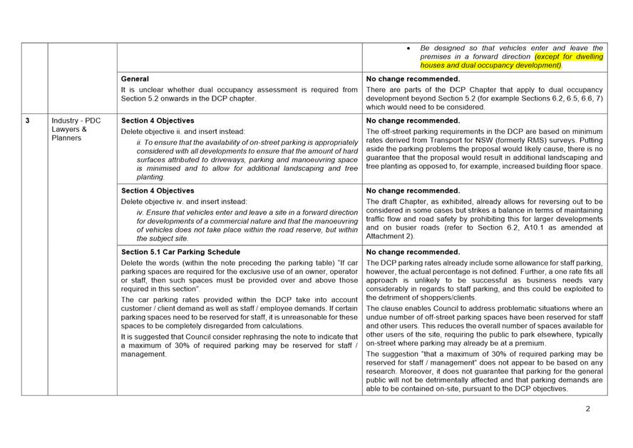
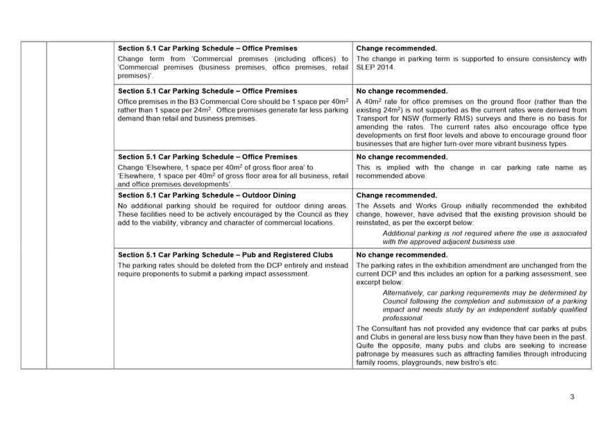
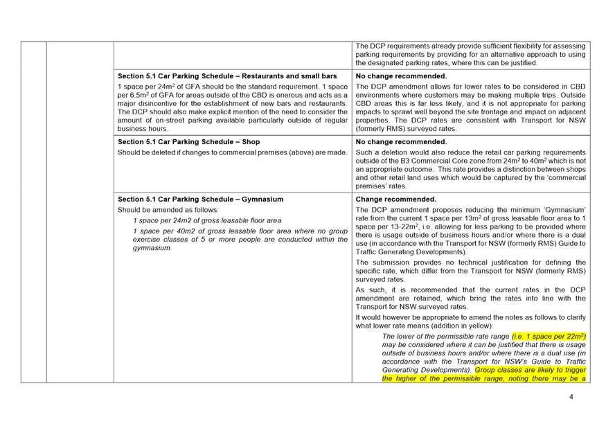
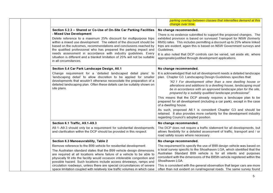
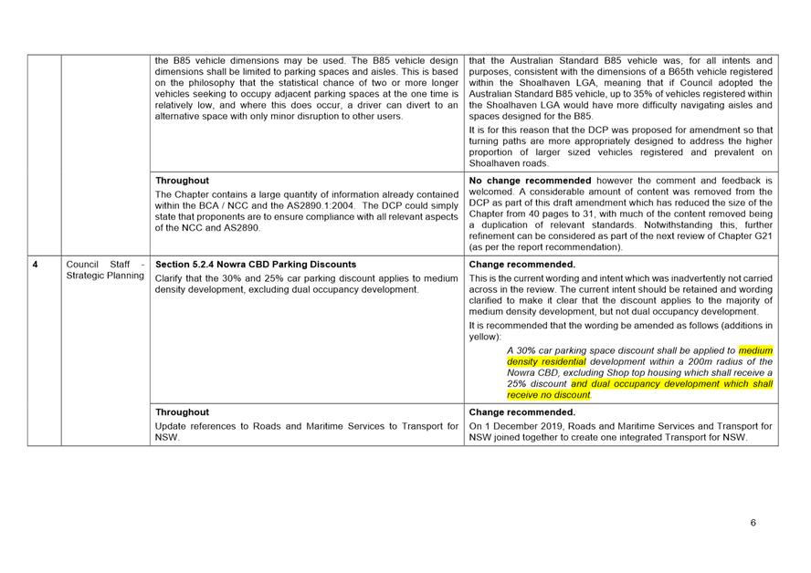
|
|
Development
& Environment Committee – Tuesday 06 October 2020
Page
0
|
DE20.106 Exhibition
Outcomes and Proposed Finalisation - Planning Proposal PP049 - Danjera Dam
Additional Permitted Use (Camping Ground)
HPERM Ref: D20/387526
Section: Strategic
Planning
Approver: Robert
Domm, Director - City Futures
Attachments: 1. Submission
summary - PP049 Danjera Dam Camping & Recreation Area ⇩
Reason for Report
· Present
the public exhibition outcomes for this Planning Proposal (PP) to amend
Schedule 1 of Shoalhaven Local Environmental Plan (LEP) 2014 to insert
“camping ground” as an additional permitted use at the Danjera Dam
Camping & Recreation Area, Yalwal, enabling the existing camping ground to
be formalised and planned improvements made to its facilities and management.
· Enable
the resultant LEP amendment to proceed to finalisation.
|
Recommendation (Item to be determined under delegated authority)
That
Council:
1. Adopt and finalise Planning Proposal
PP049 Danjera Dam Additional Permitted Use as exhibited.
2. Forward PP049 to the NSW
Parliamentary Counsel’s Office to draft the Amendment to Shoalhaven LEP
2014 and make the resulting amendment using
Council’s delegation.
3. Advise Shoalhaven Water (the
Proponent) and other stakeholders, including adjoining landowners,
development industry representatives and those who made a submission, of this
decision and when the LEP amendment is made.
|
Options
1. As recommended.
Implications: This is the preferred option and will
enable the LEP amendment to be finalised. This is consistent with previous
Council resolutions and the submissions received during the exhibition period
are generally supportive of the PP. The issues raised can be addressed as part
of the development application to formalise the camping ground, in the planned
improvements to facilities and also as part of the management of the site.
2. Not proceed
further with the PP.
Implications: This would be inconsistent with
Council’s previous resolutions and would limit the future management
options for the area. Use of the area would continue to be a concern to Council
and the community due to the ongoing potential for anti-social behaviour and
conflict between users. It would also make it difficult for Council to
satisfactorily manage bushfire risk and environmental impacts at the site.
3. Make
an alternate resolution.
Implications: Will depend on the nature of any
resolution.
Background
The subject land is owned by
Council and comprises Part Lots 1, 4 & 5 DP 252335; Lot 1 DP 874512; Lot 1
DP 217080; Part Lot 15 DP 1216343; Part Lot 11 DP 755931; and Part Lot 122 DP
1255641 (see Figure 1).
The land is classified as
“operational” under the Local Government Act 1993, is administered
by Shoalhaven Water and is currently zoned E2 Environmental Conservation under
Shoalhaven LEP 2014 (see Figure 2). This zoning does not permit
“camping grounds”.
The subject land has been used
for camping and day use since the Dam was constructed in 1971. There is a need
to formalise the existing camping ground use to enable Council to make planned
improvements to its facilities and management, consistent with the endorsed
redevelopment plan outlined in the Danjera Dam Future Directions Report that
was finalised by Council in 2018. The PP will assist with this and a
development application to formalise the camping ground has also now been
lodged by Shoalhaven Water pending the proposed LEP Amendment.
Shoalhaven Water originally
submitted the PP request (supported by detailed studies covering bushfire risk,
biodiversity impacts and onsite sewage management) in May 2019. Council
initially considered the PP request at the Development and Environment
Committee on 1 October 2019 and resolved (in part) to:
1. Support the Planning
Proposal request for the Danjera Dam Camping & Recreation Area submitted
for Shoalhaven Water.
2. Prepare and submit the
required Planning Proposal documentation to the NSW Department of Planning,
Industry and Environment for Gateway determination, and dependent on the
outcome proceed to exhibit the PP and report back to Council post-exhibition.
Council subsequently received a
favourable Gateway determination from the NSW Department of Planning, Industry
and Environment (DPIE) for the PP on 1 April 2020, which enabled it to proceed,
subject to early consultation with the following public authorities and public
exhibition (14 days):
· NSW
Rural Fire Service (RFS)
· DPIE
– Crown Lands
· DPIE
– Environment, Energy and Science (EES)
· National
Parks and Wildlife Service (NPWS).
The outcomes of the consultation
with public authorities and the public exhibition are summarised and discussed
below.
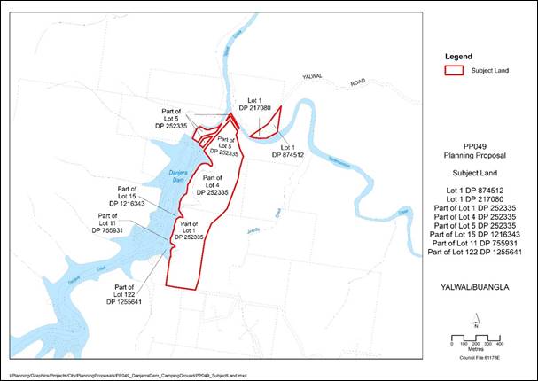
Figure 1: Subject Land
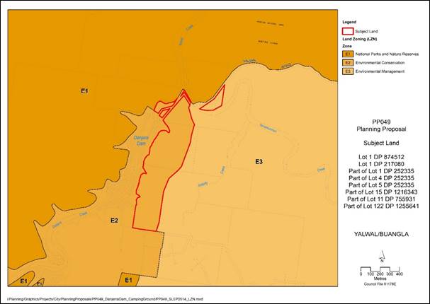
Figure 2: Current Land Use Zones
Consultation with Public
Authorities
Formal
submissions were received from the RFS and DPIE–EES who raised no
objections to the PP. Copies of the submissions are available on
Council’s exhibitions webpage here.
NPWS also advised that the
DPIE–EES submission included comments on its behalf and that it would not
be making a separate submission.
The RFS confirmed that future
camping ground development is to achieve an equivalent or higher level of bush
fire protection to the level proposed in the bushfire assessment report that
accompanied the PP and on which the conceptual site plan is based. This will be
assessed in detail and conditioned as part of the related development
application.
DPIE–EES commended Council
on the quality of the Biodiversity Development Assessment Report (BDAR)
prepared to support the PP and identified a number of technical issues that
should be addressed in the BDAR. This included the need to undertake an
additional survey of the site for an endangered species of orchid known to
inhabit the area. Council officers conducted the additional survey and updated
the BDAR ahead of the PP public exhibition period. No orchids were detected
during the survey. DPIE–EES confirmed that the remaining issues
identified in its submission could be addressed as part of the future
development application.
DPIE–Crown Lands advised
that it would not be making a submission on the PP. It is noted that
DPIE–Crown Lands previously made comments on the Future Directions Report
in late 2018 noting support for the proposed redevelopment of the camping
ground.
Community Engagement
The PP and supporting material
were exhibited as a package from 29 July to 14 August 2020 inclusive (17 days).
Written notification was sent to adjoining landowners and emailed to
development industry representatives. Hardcopies of the exhibition package were
not made available for viewing due to COVID-19 restrictions – however,
electronic copies were available at Council’s City Administration Centre
in Nowra and at the Ulladulla Service Centre during business hours.
The exhibition package was also available for viewing on Council’s
exhibitions webpage where it is still available.
The exhibition package included:
· Planning Proposal (PP049) document
· Explanatory Statement
· Gateway determination
· Report & Minutes – Development & Environment
Committee 1 October 2019
· Public Authority submissions (NSW Rural Fire
Service and DPIE – EES)
· Bushfire Assessment Report
· Biodiversity Development Assessment Report
· Onsite Sewage Management Options Report
· Public Exhibition Notification
Three (3) submissions were
received, including one public submission and two
(one original and one follow-up submission) from Council’s Building &
Compliance Section (Ranger Services Unit). All were supportive of the PP
and raised relatively detailed issues which will need to be appropriately
addressed as part of the development application and/or the management plan for
the site. A summary of the submissions and a Council staff response is included
as Attachment 1. Copies of the actual submissions can be provided to
Councillors if needed.
A summary of the key issues raised in submissions and
Council staff responses is provided below.
Comments - Building &
Compliance Section (Ranger Services Unit)
1. Number of vehicles that
campers can have at a single site will impact upon the space available within a
site.
Staff
Comment
Car parking
will need to be considered in detail as part of the subsequent development
application that needs to address/consider the requirements of the NSW Local
Government (Manufactured Home Estates, Caravan Parks, Camping Grounds and
Moveable Dwellings) Regulation 2005 in respect of car parking spaces for
campers and visitors. The concept site plan
submitted with the PP recognises the need to provide car parking spaces for
campers and visitors.
2. Number of camp sites should be
reduced from the 41 proposed sites to 20-25 sites, with a maximum of 5-6
persons per site. This will provide more space between sites and reduce the
likelihood of disputes/altercations between groups. Minimising the overall
number of campers would allow up to 40 ‘day-use’ campers to access
the emergency refuge in an emergency situation.
Staff
Comment
The site layout and number of camp sites will be considered
in detail as part of the related development application. The proponents
provided the following justification with the PP request:
· Proposal
includes the provision of an on-site manager (plus staff), as well as
rationalised and regulated camping and day visitation. An on-site management
presence will facilitate a much greater level of behaviour monitoring as well
as appropriate direct intervention when required. It will also facilitate much
quicker and better coordinated emergency response action.
· Unduly
limiting the number of camp sites to a level that becomes exclusive may
encourage camping elsewhere and again limit the ability of Council to regulate
behaviour in the locality.
The emergency refuge building
will be required to provide for the maximum capacity of the site (being the
total number of all accommodation guests, day visitors, staff, event attendees
etc) in accordance with the General Terms of Approval issued by the RFS for the
related development application.
3. Helicopter landing pad should
be established within the site to enable medical evacuation as this has been
necessary on multiple occasions in this location.
Staff Comment
Noted. The
proponent could consider providing a helicopter landing pad as part of the
redevelopment of the site. It is an element of detail that is outside the PP.
4. Vulnerable fauna species the
Glossy Black-Cockatoo and White-bellied Sea-Eagle have been sighted in the
vicinity of the proposal.
Staff Comment
The
Biodiversity Development Assessment Report (BDAR) prepared for the PP
considered the possible presence of the Glossy Black-Cockatoo and White-bellied
Sea-Eagle based on habitat features at the site. Targeted surveys were
conducted between November 2018 and October 2019 with neither species detected.
The BDAR concludes that neither species is at risk of ‘serious and
irreversible impact’ due to the proposed development.
5. The existing timber bridge on
the access road was submerged during the flood of 9 August 2020.
Staff Comment
The adequacy
of site access will be considered as part of the related development
application. Any necessary upgrades will be conditioned in any approval.
6. Encourage passive recreation
due to the impact of 4WD vehicles and motorbikes on the environs and other
users.
Staff Comment
Noted. The
proponent will consider what types of activities are permitted in the area as
part of the redevelopment and management of the site. Use of 4WD vehicles and
motorbikes in the vicinity of the Dam occurs mainly in the adjacent Morton
National Park and is governed by the National Parks and Wildlife Service. The
proposed redevelopment includes the provision of an on-site manager (plus
staff) as well as rationalised camping and day visitation areas which will
facilitate better management of activities within the area including the use of
4WD vehicles and motorbikes.
Comments - Public submission
1. Acknowledges the proposed
reduction in the number of camp sites, but recognises that ensuring safety of
campers is critical. Supports the implementation of a caretaker’s lodge,
camp kitchen and emergency refuge and recognises the potential for an onsite manager
to reduce instances of anti-social behaviour.
Staff Comment
Support noted.
Campers need to be able to have
their own campfire and access to firewood.
Staff Comment
Noted. This will be considered by
the proponent as part of the redevelopment and management of the site.
Access roads into the area
should be improved. Should establish a second access road into the area from
the south.
Staff Comment
The adequacy of site access will be further considered as
part of the development application. Any necessary upgrades can be conditioned
in any approval.
Conclusion
It is now appropriate to
finalise this PP and proceed to amend the LEP accordingly. This will enable the
related development application to be determined and Council (Shoalhaven Water)
to proceed to implement the endorsed redevelopment plan.
Policy Implications
The
Shoalhaven LEP 2014 does not currently permit the proposed ‘camping
ground’ use at the Danjera Dam Camping and Recreation Area. The PP seeks
to amend the LEP to insert ‘camping ground’ into Schedule 1 as an
Additional Permitted Use at the site. This will enable Council to formalise the
longstanding existing camping ground via the related development application
and make planned improvements to its facilities and management, consistent with
the endorsed redevelopment plan outlined in the Future Directions Report.
Financial Implications
Finalisation
of the amendment to Shoalhaven LEP 2014 resulting from this PP will be funded
by the Proponent (Shoalhaven Water) on a cost recovery basis in accordance with
Council’s Planning Proposal (Rezoning) Guidelines and adopted Fees and
Charges.
Risk Implications
If the
proposed amendment to Shoalhaven LEP 2014 does not proceed, Council will not be
able to formalise the camping ground and make planned improvements to the
facilities. It will also limit the options available to Council to improve the
management of the camping ground, address risks from natural hazards
(bushfire), manage impacts on the environment and address issues of antisocial
behaviour which have arisen from the existing arrangement.
|
|
Development
& Environment Committee – Tuesday 06 October 2020
Page
0
|
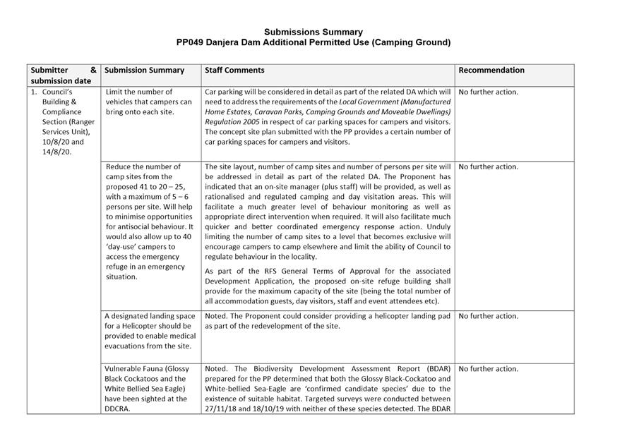
|
|
Development
& Environment Committee – Tuesday 06 October 2020
Page
0
|
DE20.107 Initial
Consideration - Planning Proposal (Rezoning) Application - 49 Queen Street
& 20 Edward Street, Berry
HPERM Ref: D20/335525
Section: Strategic
Planning
Approver: Robert
Domm, Director - City Futures
Reason for Report
Present a proponent-initiated
Planning Proposal (PP) which seeks to
rezone Lot C DP 379984 (49 Queen Street) and Lot 19 DP 803611 (20 Edward
Street), Berry for consideration and direction.
Landowner: Dunfrood Pty Ltd
Proponent: Martin Morris and
Jones P/L (MMJ Wollongong).
|
Recommendation
(Item to be determined under delegated authority)
That
Council not proceed with a Planning Proposal to rezone Lot C DP 379984 (49
Queen Street) and Lot 19 DP 803611 (20 Edward Street), Berry from R2
– Low Density Residential to R3 – Medium Density Residential,
and inform the proponent, submitters and The Berry Forum of this decision.
|
Options
1. Support the PP application and
progress a PP to rezone the site from R2 – Low Density Residential to R3
– Medium Density Residential.
Implications: Whilst not recommended, this would
enable more intensive forms of residential development than currently
permitted. It is understood that the proponent is seeking to allow more
intensive development, i.e. multi-dwelling housing, to improve the
feasibility/profitability of redeveloping the site. However, the potential
impacts on local amenity and character are significant given the prominent
location (main street of Berry), proximity to adjoining residential properties,
and the form and density of the development in the vicinity (predominantly
single storey detached dwellings). Supporting the proposal could also set a
precedent, noting that a broader review of infill development controls for the
older part of Berry has not been undertaken at this stage.
If Council supports the application, the PP will be
prepared and submitted to the NSW Department of Planning, Industry and
Environment (DPIE) for Gateway determination. Subject to a favourable
determination, any required studies will be completed, and the PP will then be publicly
exhibited. The outcomes of the exhibition will be reported to Council and if
the PP is finalised and the site is rezoned, the existing commercial
development will potentially be replaced by a multi-dwelling development
(subject to development approval).
2. Not support the PP application to
rezone the site to R3 and retain as R2.
Implications: The proponent could seek a
‘pre-gateway’ review. If successful, the PP would be progressed in
accordance with the outcome of the review.
3. Support
an alternative or modified proposal.
Implications: The current R2 zoning allows lower
density forms of residential development, including dwelling houses and dual
occupancies.
The Alternative options that exist include:
· Rezoning
the subject land to R1 – General Residential and retaining the 500 m2
min lot size, as applies to the land to the west. Multi dwelling housing is
permitted in the R1 zone but the extent to which the site could be developed
would be less than compared to R3. For example, the allowable floor space ratio
(FSR) under DCP Chapter G13 would be 0.5:1 compared to 0.7:1 for R3. Under the
Low Rise Housing Diversity Code, the allowable Gross Floor Area (GFA) is 60% of
the site for R1 compared to 80% of the site for R3. This option would still
potentially enable development that is out of character and impacts on local
amenity.
· Rezoning
the site to a business zone that allows both residential and commercial uses
(e.g. B4 mixed Use). This would be consistent with the ‘ground
rules’ established for the preparation of the Shoalhaven LEP2014 in
relation to ‘existing use’ locations. This saw a range of known
‘existing use’ sites zoned to reflect their use through the new
LEP.
No clear alternative options have been identified that
would increase the allowable density without impacting on local amenity and
character.
Background
Council is in receipt of a
Planning Proposal (rezoning) application from MMJ Wollongong seeking to rezone
Lot C DP 379984 (49 Queen Street) and Lot 19 DP 803611 (20 Edward Street) Berry
(the subject land), from R2 - Low Density Residential to R3 - Medium
Density Residential and to remove the minimum lot size layer (currently
mapped as 500m2) under Shoalhaven LEP2014.
The proponent’s
documentation can be viewed at Council’s ‘pre-gateway’
Planning Proposal webpage: https://doc.shoalhaven.nsw.gov.au/DisplayDoc.aspx?record=D20/272867
Subject land
The subject land is shown in Figures 1 and 2 below (blue
outline), comprises 20 Edward Street - area of 1,009m2; and 49 Queen
Street - of 607m2. Total area approximately 1,616m2.
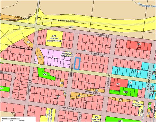
Figure 1 – Current zoning of subject land (blue outline)
and surrounds
Shoalhaven Local
Environmental Plan 2014 (LEP)
The subject land is currently
zoned R2 – Low Density Residential and the minimum lot size is mapped as
500 m2.
The R2 zone permits dwelling
houses, semi-detached dwellings and dual occupancies, but prohibits multi
dwelling housing and was ‘like for like’ transfer from the previous
Residential 2(a1) zoning under Shoalhaven LEP1985.
Other relevant existing LEP
provisions include:
· Height
of buildings = 8.5 m
· Heritage
– No. 50 Queen Street (opposite the subject land) is listed under
Schedule 5 as a Heritage Item and therefore LEP Clause 5.10 applies. Note:
Council has also resolved to support an LEP amendment to list a number of other
properties in Berry as heritage items, including 51, 53 and 54 Queen Street,
directly to the east of the subject land, and 54 Queen Street to south-east.
Land to the north, east and south is also zoned R2 –
Low Density Residential. Land to the west is zoned R1 – General
Residential. Lot 10 DP 771829 (24 Albert Street) to the north east, is
zoned SP2 – Educational Establishment (and is used as a childcare
centre). Except for 24 Albert Street (zoned SP2), the 500 m2
lot size also applies to the surrounding land.
Current uses
Although the site is currently
zoned R2, it has historically been used for light manufacturing, retail and
office premises, and most likely has ‘existing use’ rights as a
result. The commercial buildings on the site currently include a wool store,
and antique/furniture store and office premises. Refer to Figures 2 to 5 below.
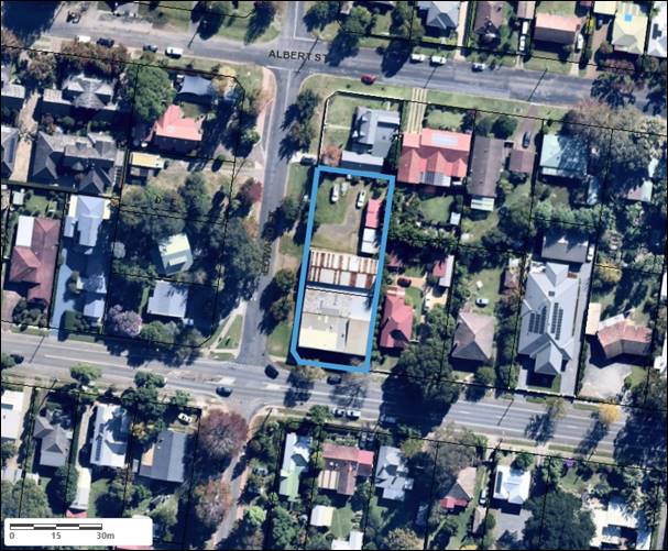
Figure 2 – Aerial photograph showing subject land (blue
outline) and immediate surrounds
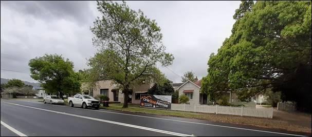
Figure 3 – Looking NW toward the subject land from the
southern side of Queen Street

Figure 4 – Looking SE toward the subject land from
Edward Street
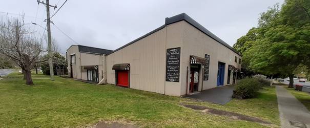
Figure 5 – Looking at NE at the subject land from the
corner of Queen Street and Edward Street
Most of the existing
surrounding buildings are single storey dwellings, apart from a two storey
dwelling at 26 Albert Street (to the north), a single storey pre-school at 24
Albert Street (to the north east) and a small single storey structure at the
rear of 7 Edward Street (to the west) which is owned by Telstra.
Local character
The subject land is located
within the older historic part of Berry, which is characterised by
predominantly single storey, heritage style buildings such as Federation-style
cottages with moderate setbacks; well established trees and gardens (RobertsDay
2020).
The properties in the vicinity
of the subject land are predominantly detached dwellings, or converted
residences, with space between the buildings. Recent improvements and additions
include detached dual occupancies and a secondary dwelling. Several existing
street trees contribute to the immediate streetscape. There are several medium
density / town house developments within the R1 zoned area further to the west,
the nearest of which is at 45 Queen Street and 18 Albert Street.
The existing commercial
buildings on the subject land consist of an industrial-style metal clad shed,
apart from the southern facade (facing Queen Street) which is partially brick
and has a rustic retail appearance. The northern third (approx.) of the subject
land has an informal car park and two small sheds (and currently a shipping
container) on the northern side (see Figures 3 and 4). The appearance of the
existing structures is softened by the adjacent street trees, particularly
along Queen Street (refer to Figure 3).
Berry housing market
Housing demand in Berry reflects
its lifestyle attractions, accessibility, and strong desirability from buyers
from Sydney. House sale and rental prices remain relatively high (with a median
house price above $1 million and a median rental of $580 per week[1]), down from the peak
in 2018 but remaining strong even with the initial economic impacts of the
Covid-19 pandemic.
The longer-term impacts of the
pandemic on the local housing market are currently emerging and dependent on
wider economic conditions and policies. Recent research indicates regional
housing markets have been more resilient than city markets during the pandemic,
due to a variety of factors, including liveability, relative affordability,
rise in remote work and international migration having less influence over
house prices compared to city markets[2].
Areas such as Berry which are accessible to key job markets (Wollongong, Nowra,
Sydney) will remain particularly desirable.
Proponent’s intended
outcome
The proponent’s PP includes conceptual architectural
schematics showing an 8 x 3 bedroom, terrace-style, multi dwelling housing
development. The schematics shown in the proponent’s PP report are copied
below.
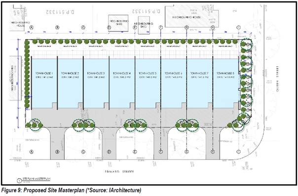
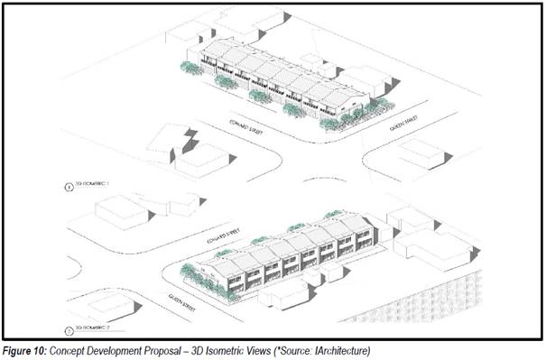
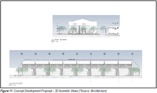
The
Planning Proposal (PP) / Gateway Process
Changes to local environmental
plans (LEPs) are typically made via the ‘planning proposal’ and/or
‘gateway’ process. The first step in the process is to
prepare a PP that explains the intended effect and justification for the
proposed changes to the LEP.
The purpose of this report is to
determine whether Council will support the application that has been received,
initiate the formal PP process and submit a PP to DPIE for initial Gateway
determination. The purpose of the Gateway determination, as stated in
DPIE’s ‘A
guide to preparing planning proposals’, is to:
“… ensure there is sufficient justification
early in the process to proceed with a planning proposal. It enables planning
proposals that lack strategic planning merit to be stopped early in the process
before time and resources are committed.”
Assessment Criteria
Council’s adopted Planning
Proposal (Rezoning) Guidelines set out the
following criteria for when PP will be supported:
1. The proposal has
strategic merit, i.e. it is consistent with, or give effect to an
adopted/endorsed Council or State Government strategy or plan such as the
Illawarra-Shoalhaven Regional Plan, or the Shoalhaven Growth Management
Strategy (GMS).
Note: DPIE’s PP guidelines also state
that a proposal may be considered to have strategic merit if it is responding
to a change in circumstances (such as provision of new infrastructure or
changing demographics)
2. The proposal will
resolve a clear anomaly in the LEP mapping.
3. The proposal is minor
and has sound justification.
The PP application is now
discussed below in relation to these criteria, with Council staff comment where
relevant.
1.
Consistency with adopted/endorsed strategy
Illawarra
Shoalhaven Regional Plan (ISRP) 2036
Was released by the NSW
Government in 2015 to provide “a vision and direction for strategic
and land use planning for future needs for housing, jobs, infrastructure, a
healthy environment and connected communities”.
The relevant directions in the
Plan are summarised below:
Direction 2.1 -
“Provide sufficient housing supply to suit the changing demands of the
region”.
Comment: This is a broad direction to
ensure there is an adequate supply and diversity of housing across the region.
Direction 2.2 is more specific and relevant to this proposal (see below).
Direction 2.2 - “support
housing opportunities close to existing services, jobs and infrastructure in
the region’s centres”. This Direction encourages the provision
of more housing in existing urban areas, and specifically identifies Berry (and
Huskisson) as having potential for provision of dual occupancies.
Comment:
The current R2 zoning permits dual occupancy development and the
proponent’s PP report states that the subject land can support 4 or 5
dual occupancies.
The Regional Plan does not specifically suggest or
encourage additional medium density infill residential development in Berry. It
does identify the opportunity for infill residential development in Berry in
the form of dual occupancies. Commentary on housing demand in Berry is
provided later in the report.
Direction 3.3 - “build
socially inclusive, safe and healthy communities”, including through
Neighbourhood Planning Principles (NPP). Relevant NPPs include:
· Provide a wide
range of housing for different needs and different incomes, including
traditional houses on individual blocks and smaller, lower-maintenance homes,
units and terraces for older people and young singles or couples.
· Facilitate
housing diversity by providing a range of purpose designed smaller lots and
dwellings.
· Ensure
new housing developments provide a proportion of adaptable housing to further
increase housing choice across the region to cater for the ever-changing needs
of residents.
Comment: The above housing objectives can
be delivered through a range of housing types across the region. As noted, the
Plan specifically identifies Berry as an opportunity for provision of dual
occupancy infill development. While there are some areas zoned and developed
for medium density development in Berry, the current Plan does not specifically
identify the need for additional medium density development in Berry. As
already noted, the current R2 zoning already allows a range of detached and
semi-detached housing types.
Shoalhaven Growth Management
Strategy (GMS) Version 1
This strategic land-use planning
document was prepared by Council and endorsed by the State Government in 2014.
The GMS provides strategic level guidance on the future growth of Shoalhaven.
The GMS is currently being reviewed.
The current adopted/endorsed
version of GMS includes the following guidance that is relevant to this
proposal in Berry.
Berry is characterised by
predominately low density residential development. There are also a number of
retirement / villages on the southern edge of the town. The town has a unique
character and contains a number of heritage buildings (both commercial and
residential).
Identifies Berry as one of
six settlements with some growth potential, stating that there are existing
opportunities for increasing densities within the existing urban framework
acknowledging flooding constraints, without undermining landscape, rural and
heritage values.
· Development
to focus and strengthen commercial centres
· Public
domain improvements to clearly identify commercial centres
· Increased
housing choice through diverse housing styles to reduce impact of aging
population structure
· Tourist
development potential exists in settlements through higher densities
· Outward
expansion to recognise sensitivity of environment and hazard issues
Council is currently progressing
two existing PP’s that will facilitate addition outward expansion
consistent with the GMS.
Comment: While
the existing commercial uses of the site contribute to the overall economic
activity in Berry, the site could potentially be redeveloped for housing under
the current R2 zoning, albeit in a less dense way than if it is rezoned to R3.
Although the subject land is currently used for commercial purposes, it is
separated from the commercial centre by residential development.
In terms of providing housing
choice and diversity for an ageing population, the subject land is well
located, being less than 500 m from the Berry commercial centre, approx. 300 m
from the Gerringong-Nowra bus service (Queen Street stop) and 1.2 km from Berry
Railway Station.
The number of bedrooms and
the dwelling floor space is an important factor in providing housing diversity.
The proposed development concept in the application is a two-storey, terrace
style multi-dwelling development consisting of 8 x 3 bedroom units. Some single
storey dwellings with 1-2 bedrooms would be more suited to the older
demographic and would be more consistent with Council’s adopted Shoalhaven
Affordable Housing Strategy.
Shoalhaven
2040 – Our Strategic Land-use Planning Statement (LSPS)
The draft Shoalhaven 2040
– Our Strategic Land-use Planning Statement (Shoalhaven 2040) was
publicly exhibited in July 2020 and was reported to Council’s Ordinary
meeting in September 2020 for finalisation. The LSPS will set out broad
planning priorities, strategic directions and actions, to guide decisions on
land use and achieve the community's broader goals over the next 20-years.
Proposed LSPS Planning
Priority 3 Protecting and enhancing neighbourhoods addresses the protection
or improvement of local or neighbourhood character, including how change and
development can be managed to ensure it respects and contributes to character.
It sets out future work to identify planning and development controls to
influence the quality and design of development in existing neighbourhoods and
manage the introduction of the NSW Government’s Low Rise Housing
Diversity Code.
The draft LSPS recognises
the importance of neighbourhood character and sets actions to update
development controls with built-form statements for many of Shoalhaven’s
settlements, including its coastal and historic villages. New development
proposals, even those proposed as complying development, will then need to
consider and address these statements – a process to help ensure
development contributes rather than detracts from a neighbourhood.
The draft LSPS also sets our
intended work with the NSW Government to identify opportunities for the
possible use of ‘special character planning controls’ to further
guide in-fill development in Berry, Kangaroo Valley and Milton.
Berry Community Strategic
Plan
This Plan was originally
prepared by The Berry Forum during 2016 and recognised by Council resolution
(among others) in 2017.
The Plan covers 7 themes. Themes
4 (town planning) and 7 (business and employment) are relevant to this
application and the relevant focus areas are provided below:
· Strategic focus
4.1
Preserve the town's heritage character and
“village feel” (very high priority).
· Strategic focus
4.3
Improve housing affordability (medium priority).
Description: Examine options for promoting improved housing affordability
within the town whilst retaining key attributes of the town in terms of
heritage retention.
· Strategic focus
4.4
Update planning controls (medium priority).
Description: To acknowledge changes brought by the bypass and to ensure that
the character both within and external to the town is retained and reinforced,
review and update relevant planning controls and strategic documents to reflect
the desired future of the town.
· Strategic focus
7.1
Provide for more employment opportunities (medium
priority).
· Strategic focus
7.4
Encouraging a more
diverse retail offering (medium priority).
Comment:
As discussed above, the draft
LSPS includes an action to prepare planning controls to guide infill
development in Berry (as well as Kangaroo Valley and Milton) which is
particularly relevant to 4.1 and 4.3 above.
In relation to 7.1 and 7.4, it is understood that the
proponent intends to redevelop the site in its entirety and replace the
existing commercial buildings with multi-dwelling housing. As such any existing
retail or employment uses would be lost. The site could potentially be
redeveloped for lower density residential housing under the current R2 zoning,
or possibly a mixed development using the R2 zoning and any ‘existing
use’ rights.
Proponent’s comments
- consistency with strategy
The proponent’s PP report
suggests that the proposal is consistent with strategy. The following is a
summary of their position in this regard along with Council staff comment:
· Regional
Plan Direction 2.1 – this broad direction seeks to ensure there is
adequate housing supply and choice across the region.
Comments: The concept proposal that is
shown in the application is a multi-dwelling development consists of 8 x 3
bedroom, terrace-style units. The subject land could potentially be redeveloped
under the current R2 Low Density Residential zone. Rezoning the subject land to
R3 – Medium Density Residential would make a negligible contribution to
housing supply, the benefit of which are potentially not fully justified given
the potential impacts on local amenity and character should the concept
proposal be pursued.
· The
draft Shoalhaven Character Assessment Report that was prepared by RobertsDay
identified the lack of housing choice and diversity in Shoalhaven.
Comments: The Shoalhaven Character
Assessment Report was finalised in February 2020. It was commissioned by the
then NSW Department of Planning and Environment to help inform the review of
Shoalhaven Growth Management Strategy (GMS), future amendments to the
Shoalhaven Development Control Plan (DCP) 2014 and preparation of the Local
Strategic Planning Strategy (LSPS).
In relation to Berry, the Report notes that the town is
characterised by one storey, heritage style buildings such as Federation-style
cottages, and concludes that new development should be sympathetic to heritage,
rural and fine-grain character, ensuring cohesiveness to the heritage
core’s-built form attributes.
· The
Shoalhaven Growth Management Strategy (GMS) identifies growth considerations
for several rural towns and villages, including Berry as:
§ Development
to focus and strengthen commercial centres
§ Increasing
housing choice through diverse housing styles to reduce impact of the ageing
population.
Comments: The number of bedrooms and the
floor space of a dwelling is an important factor in housing diversity. The
proposed development is a two-storey, terrace style multi-dwelling development
consisting of 8 x 3 bedroom units. Single storey dwellings with 1-2 bedrooms
would potentially be more suited to the older demographic and would be more
consistent with Council’s adopted Shoalhaven
Affordable Housing Strategy.
2. Will the
PP resolve an anomaly?
There is no justifiable anomaly in the LEP or its mapping in
regard to the subject land.
3. Is it a
minor matter that can be justified?
Potential issues that need to be considered in respect of
this criteria include:
· Heritage:
As noted, the subject land is not a heritage item in the Shoalhaven LEP 2014.
However, a property on the southern side of Queen Street (50 Queen Street) is
heritage listed in the LEP (Schedule 5).
Council resolved on 1 September 2020 to proceed with a PP
to list other properties in Berry as LEP heritage items, including three
properties directly to the east and south-east of the subject land. As
such this highlights the locality’s general heritage values, and as a
result the appropriateness of allowing medium density development on the
subject land ahead of completing a review of the controls for infill
development in Berry needs to be considered.
· Local
character: The bulk and scale of the potentially resulting development is
not in keeping with the character of the neighbourhood or Berry. Several
submissions have raised concerns about impacts on local character, as discussed
later in this report.
· Amenity
issues: The proposed development could potentially result in localised loss
of privacy, overshadowing, light and noise impacts, appearance, and traffic/car
parking issues. Submissions have been received from several adjoining property
owners raising concerns about amenity impacts. These are summarised later in
this report.
· Existing
/ approved uses, and likely future uses of the subject land/surrounds: The
subject land could potentially be redeveloped to the extent allowable under the
current R2 Low Density Residential zoning and/or any ‘exiting use’
rights that exist. The surrounding properties have detached dwellings
· Capacity
of existing services and infrastructure to accommodate the proposed
development: development of the sale envisaged under the application could have
servicing/infrastructure issues that will need to be investigated.
The requested rezoning cannot be considered to be
‘minor’ in terms of the area within which it sits and the potential
resulting outcome.
Proponent’s
justification
The proponent’s PP report
argues that the proposal is consistent with strategy based on:
· Direction
2.1 of the Illawarra Shoalhaven Regional Plan (ISRP), which as noted above is a
broad direction to ensure there is adequate housing supply and choice across
the region.
· The
draft Shoalhaven Character Assessment Report that was prepared by RobertsDay
identified the lack of housing choice and diversity in Shoalhaven.
· The
Shoalhaven Growth Management Strategy (GMS) identifies growth considerations
for several rural towns and villages, including Berry as:
o Development to focus and
strengthen commercial centres
o Increasing housing choice
through diverse housing styles to reduce impact of the ageing population.
Conclusion
The PP application has been reviewed against relevant
guidance. There appears to be limited strategic justification to the support a
rezoning of the subject land to R3 and there is the potential for resulting
development to have a negative impact on character and amenity. As such it is
recommended that the application as submitted not be supported. There are also
limited rezoning alternatives that could be consider that will not have similar
impacts. In this regard it is noted that the subject land could be redeveloped
for alternate uses now based on the current R2 zoning (and associated 8.5 metre
building height) and/or the ‘existing use’ rights that may exist.
The impact in this regard would need to be considered and assessed through the
development application process.
Community Engagement
The adjoining property owners
and the Berry Forum were notified upon receipt of the PP application (consistent
with Council’s Planning Proposal Guidelines). Five (5) written
submissions were received from properties in the vicinity of the subject land,
expressing a range of concerns including loss of privacy and impacts on local
amenity, traffic/car parking, and incompatibility of the proposed development
with the character of Berry. A summary of the submissions is provided below.
|
Name & Doc ref.
|
Property Address
|
Summary of issues raised
|
|
D20/310352
|
Property in
Edward Street
|
· Object to the
proposal due to impacts on neighbours.
· Traffic and car
parking concerns. Suggests there will be insufficient off-street parking.
· Concern about
impact on property values.
· Suggests R3
zoning is incompatible with current character.
· Proposed
development has insufficient space for privacy and landscaping, and it would
be overdevelopment of the site.
· Redevelopment
would be viable under the current R2 zoning.
|
|
D20/310352
|
Property in
Queen Street
|
· Rezoning from R2
to R3 will have a serious impact on our standard of living.
· Loss of privacy
/ overlooking, overshadowing, traffic and parking/access.
· R3 zone would be
incompatible with the area.
· Existing R2
zoning allows sufficient redevelopment opportunities and housing types.
|
|
D20/345206
|
Property in
Queen Street
|
· Do not oppose
the application but question if the dwellings will be in keeping with the
appearance and character of Berry.
· No. 51 will
possibly be heritage listed.
· Concerned that
upstairs windows and balconies will overlook backyard, loungeroom and kitchen
windows.
|
|
D20/350709
|
Property in
Edward Street
|
· Values the jobs
created by the existing development, and its uniqueness and contribution to
tourism.
· Adamantly oppose
the proposed 8x3 bedroom dwellings.
· Traffic/parking
safety concerns for elderly and children using community preschool; vehicles
using Edward Street to bypass the town centre; exhaust pollution.
· Noise pollution
concerns.
|
|
D20/335503
|
Property in
Albert Street
|
· Proposed
development is out of character and at odds with Berry’s small-town
charm. Rezoning to R3 would damage the rustic charm of our rural town.
· Loss of
on-street parking on Edward Street, which is often used by visitors,
childcare customers, and tourists.
· Loss of privacy
- proposed plans would look into two of my bedrooms. The plan incorrectly
labels one of our bedrooms as a ‘garage’.
· Loss of amenity
to my property and neighbouring properties.
· Precedent
concerns.
|
Note: Copies of the actual submissions received can
be made available to Councillors if needed on request.
Policy Implications
Council’s decision on this
PP application could potentially have significant policy implications for
future infill development within the historic part of the Berry township.
Supporting it may indicate a general willingness to consider other PP’s
for medium density development.
Financial Implications
If Council resolves to support
the PP application, the proponent will be required to pay the applicable fees,
which are based on cost recovery.
|

|
Development
& Environment Committee – Tuesday 06 October 2020
Page
0
|
DE20.87 Development
Application - DA19/2032 - 61 Summercloud Cr Vincentia - Lot 1125 DP 1210394
DA. No: DA19/2032/4
HPERM Ref: D20/100727
Section: Building
& Compliance Services
Approver: Phil
Costello, Director - City Development
Attachments: 1. Draft
- 4.15 Report - 61 Summercloud Cr, Vincentia - Lot 1125 DP 1210394 (under
separate cover) ⇨
2. Assessment of Submissions - 61
Summercloud Cr, Vincentia - Lot 1125 DP 1210394 (councillors information
folder)
3. Draft Development Consent - 61 Summercloud Cr,
VINCENTIA - Lot 1125 DP 1210394 (under separate cover) ⇨
This item was
deferred from the Development and Environment Committee 1 September 2020.
Description of Development: Dual
Occupancy and Strata Subdivision
Owner: Ibrohim Makhmudov
Applicant: Hotondo Homes South
Coast Pty Ltd
Notification Dates: 24 October
2019 – 8 November 2019
No. of Submissions: 10 Submissions
received
Reason for consideration by Council:
At the Development & Environment Committee meeting held on
4 February 2020, Council resolved to call in the development application for a
dual occupancy at 61 Summercloud Crescent, Vincentia. This application
was called in due to community concern.
This report recommends the application is
approved subject to conditions.
|
Recommendation (Item to be determined under delegated authority)
That
the proposed development be approved by
Council subject to the conditions specified in the draft development consent.
|
Options
1. Approve the
Development Application in accordance with the recommendation.
Implications: This
would allow the applicant to proceed with the proposal and seek a construction
certificate for the development.
2. Refuse the Development
Application.
Implications: The
application would not proceed. A Notice of Determination for Refusal will need
to be prepared with reasons for refusal stated. The applicant can apply for a
section 8.2 review of Council’s decision and/or could lodge an appeal
with the NSW Land and Environment Court against Council’s decision.
3. Alternative
recommendation.
Implications: Council will
need to specify an alternative recommendation and advise staff accordingly.
Location
Map
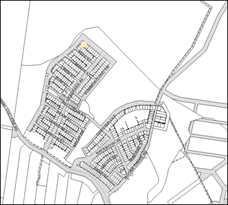
Figure 1: Aerial Map of the subject site in the
broader context of the Bayswood Estate Subdivision (SF9786)
Background
At its Development & Environment Committee meeting held on
4 February 2020, Council resolved to call in the development application for a
dual occupancy and strata subdivision at 61 Summercloud Crescent,
Vincentia. The application was called in due to community concern citing the
proposed subdivision of the dual occupancy is not compatible with the amenity
of the existing low-density environment where there are only single dwellings
on each lot.
Proposed Development
The application is for a dual occupancy and strata subdivision
on the land identified as No.61, Lot 1125 DP1210394, Summercloud Crescent,
Vincentia. The land is zoned R2 – Low Density Residential and it has an
area of 614.3 m2. Both dual occupancy and strata subdivision are
permissible on this land with consent.
The development consists of two attached 3-bedroom dwellings.
The proposed development complies with requirements of Shoalhaven DCP 2014
(SDCP-2014) and a detailed assessment of the application is contained in
attachment 1.
The site plan, floor plans and elevations illustrate the
proposed development (Refer Figures 2, 3, and 45).
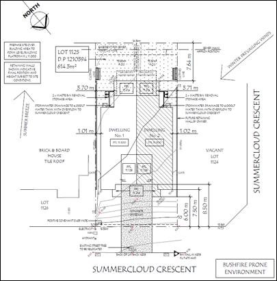
Figure
2: Site Plan
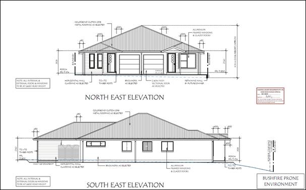
Figure
3: North east and south East elevations
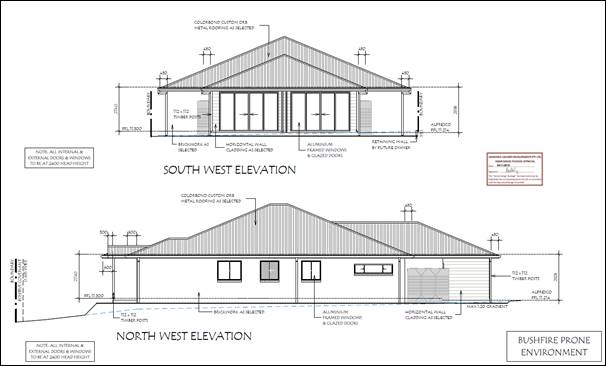
Figure
4: South West and North West elevations
The development is a single storey dual occupancy. The
building has a mixture of brick veneer walls and selected horizontal wall
cladding. The roof is metal on a timber frame. The building is located
centrally on the site with 1.01m and 1.02m to the east and west boundaries,
respectively. The front building line is 6.0m to the outer edge of the entrance
porch.
Subject site, surrounds and context
The subdivision is located in an area characterised by
residential dwellings and associated infrastructure. The subdivision adjoins
dry sclerophyll forest.
The subject site is identified as bush fire prone land and
there is a drainage easement at the rear of the allotment. There are no other
significant encumbrances on the site.
The site falls from the south-east (rear) to the north
(front). The fall across the land is approximately 1.0m.
Existing development of a similar nature in the immediate
surrounds
The subject site is zoned R2 – Low Density Residential
and there are currently eight (8) approved secondary dwellings and nine (9)
approved dual occupancies in the near vicinity of this site.
(a) Secondary
dwellings (8 approvals): Two of these secondary dwellings were approved via
development applications and the other six (6) were approved via Complying
Development Certificates.
(b) Dual occupancies
(9 approvals): All nine dual occupancies were approved under development
applications. Seven (7) of the applications also have strata title subdivision
approval and the other two (2) have Torrens title subdivision approval.
The location of these developments in the broader context of
the Bayswood Estate Subdivision (SF9786) is shown in Figure 6 below.
Figure
6: Nearmaps Aerial Image indicating the location of similar development
types within the overall subdivision.
Planning Assessment
In deciding whether to grant approval to the proposed
development, Council must consider the relevant matters contained in clause
4.15 of the Environmental Planning and Assessment Act 1979. A detailed
assessment is contained at attachment 1.
The following matters are relevant to this discussion:
Environmental Planning Instruments
The proposed development complies with the relevant
environmental planning instruments being:
(a) The Shoalhaven Local
Environmental Plan 2014
(b) State Environmental
Planning Policy (Building Sustainability Index: BASIX) 2004
(c) State Environmental
Planning Policy (Vegetation in Non-Rural Areas) 2017
Development Control Plans
The proposed development meets the objectives and provisions
of the following relevant chapters of the Shoalhaven Development Control Plan
2014:
(a) G1: Site Analysis, Site
Design and Building Materials
(b) G2: Sustainable
Stormwater Management and Erosion/Sediment Control
(c) G3: Landscaping Design
Guidelines
(d) G7: Waste Minimisation
and Management Controls
(e) G11: Subdivision of
Land
(f) G13: Medium Density and
Other Residential Development
(g) G21: Car Parking and
Traffic
(h) N15:
Vincentia Coastal Village and District Centre
The likely impacts of that development, including impacts
on the natural and built environments, and social and economic impacts on the
locality
(a) The land is bush fire
prone and this is the only significant environmental encumbrance.
The Rural Fire Service (RFS) have issued a Bush Fire Safety
Authority and have provided conditions of development addressing the likely
impacts. The building is required to comply with the requirements of BAL-19.
(b) The proposed
development is considered to have a minimal impact on the built environment.
The building is located amongst similar single storey brick veneer dwellings.
(c) The proposed
development is not considered to have any adverse social or economic impact on
the locality.
The suitability of the site for the development
(a) The proposed
development is permissible within the R2 – Low Density Residential
Zoning.
(b) The design, bulk and
scale of the proposed development is consistent with that of the existing and
desired future streetscape. The building is single storey and does not
overpower the streetscape.
(c) The architectural plans
of the proposed development have been endorsed by the developer as per the
terms of restriction on the use of the land numbered 7 in the S88B Instrument.
(d) Construction is
considered to be site responsive.
Any submissions made
Council has received 10 submissions and this includes a
petition signed by 62 people objecting to the proposal (See Attachment 2). The
details of the petition are contained in “B Information Pertaining to
the Petition” in Attachment 2.
These objections have been fully considered in regard to this
application and each of the major issues are summarised and discussed in the
table below.
|
Issue
|
Comment
|
|
(a) Development
is not compatible with the objectives of the R2 zoning
|
Dual occupancies are
‘permitted with consent’ in the R2 – Low Density
Residential Zone.
The proposed development is
considered to be consistent with the objectives of the R2 zone, as it
provides for the housing needs of the community in the context of a growing
population and the primary development type of single dwellings within the
surrounding area will be retained.
|
|
(b) Strata
subdivision is below the minimum lot size of 500m2.
|
Clause 4.1 (Minimum subdivision
lot size) of the Shoalhaven Local Environmental Plan 2014 does not
apply to the subdivision of any land by the registration of a strata plan of
subdivision under the Strata Schemes Development Act 2015.
There is no minimum lot size
for the strata subdivision as proposed and the development complies.
|
|
(c) Dual
occupancy will impact on the existing road system and utilities
|
The proposed development is not
considered to unreasonably impact upon the existing road system.
The proposed development
achieves compliance with the relevant planning controls.
Council’s Development
Engineer has reviewed the proposed development and has raised no objections
to the proposal.
|
|
(d) The development does not comply with the
design essentials for Bayswood
|
The design, bulk and scale of
the proposed development is considered compatible with the surrounding area.
Compliance has been achieved
with DCP Chapter N15 which is the prevailing site-specific chapter and
details the design essentials for Bayswood Estate.
The architectural plans have
been endorsed by the developer as required by the restrictions as to user on
the S88B Instrument.
|
|
(e) On-site
carparking
|
Provisions for car parking,
site access and traffic safety have been assessed against the performance
criteria of DCP Chapter G21: Car Parking and Traffic.
The development complies.
|
|
(f) Impact on bush fire emergency response
|
The subject site is identified
as bush fire prone land. As the application comprises a subdivision,
the proposed development required authorisation under Section 100B of the Rural
Fires Act 1997 in respect of bush fire safety.
The NSW Rural Fire Service have
issued a Bush Fire Safety Authority and General Terms of Approval.
The RFS conditions address the
likely impacts of bush fire and these will be included in the development
consent.
The development will satisfy
the bush fire requirements.
|
|
(g) Bulk
and scale
|
The proposed development is fully
compliant with the setback requirements contained in SDCP Chapter N15.
The building is entirely within
the building envelope described in SDCP Chapter G12 and the maximum
permissible building height pursuant to clause 4.3 of SLEP.
The floor space ratio of the
building will not exceed 0.5:1 as required by SDCP Chapter G12.
Impacts upon overshadowing,
privacy and views are not considered to be severe or devastating when
assessed against the relevant NSWLEC Planning Principles.
It is therefore reasonable to
conclude that the bulk and scale of the development is appropriate for the
site.
|
This assessment has also considered case law similarities and
this is illustrated in Ougra & Ors v The Hills Shire Council [2012]
NSWLEC 1178. In this case, The Hills Shire Council refused a dual
occupancy application on land at 26 Moseley Street, Carlingford (Lot 29 DP
251044) with contentions of “whether the proposed dual occupancy would
complement and/or integrate with the existing and future low density character
of the area”. This is essentially the main thrust of the submissions made
against DA19/2032.
In comparing the 2 sites, both have a common zoning of R2
– Low Density Residential. The objectives of the zones across both local
government areas are similar and dual occupancy is permissible in each
instance.
Summarily, most of the issues were resolved by way of Section
34AA conference. This meant that largely, “the only contention for
determination by the Court concerns the public interest considerations arising
from the [community] objections”. Similarities arise here between this
case and the present application before Council as both developments complied
with planning controls except for the “public interest” considerations.
The appeal was upheld and the application was approved.
In his closing remarks, Commissioner Hussey assents that
“… it is obvious from the evidence that
this form of development is envisaged by the current controls. There are no
restrictions that only allow single detached dwellings”.
The same is true of the current application. If the
application is refused and a comparison is drawn between both cases, it is
likely that the Court would rule in the same way.
Financial Implications:
If the
application is appealed, it will result in costs to Council in defending the
appeal. This is not a matter Council should consider in determining a
development application. Accordingly, it should not be given any weight in
Council’s decision.
Legal
Implications
If the application is
refused, or if the applicant is dissatisfied with Council’s
determination, the applicant can appeal to the Land and Environment Court.
Under some circumstances,
third parties may also have a right to appeal Council’s decision to the
Land and Environment Court.
Summary and Conclusion
Whilst the public interest was a major consideration for this
application, the concerns raised are not justified in this instance.
It is recommended Council grant consent to the proposed
development being a dual occupancy and strata subdivision on the land at 61
Summercloud Crescent, Vincentia – Lot 1125 DP 1210394 subject to the
draft conditions of consent (Refer Attachment 3).
|
|
Development
& Environment Committee – Tuesday 06 October 2020
Page
0
|
DE20.108 Development
Application - DA18/2094 - 2819A Moss Vale Rd Barrengarry - Lot 2 DP 732659
DA. No: DA18/2094/4
HPERM Ref: D20/240931
Section: Development
Services
Approver: Phil
Costello, Director - City Development
Attachments: 1. Draft
- Determination - Refusal - 2819A Moss Vale Rd Barrengarry - Lot 2 DP 732659 ⇩
2. Planning
Report – S4.15 Assessment 2819A Moss Vale Rd, Barrengarry - Lot 2
DP 732659 (under separate cover) ⇨
3. Report
- Amended Operational Plan - 2819A Moss Vale Road Barrengarry - Lot 2 DP732659 ⇩
4. Plans - Amended Site Plan -
2819A Moss Vale Rd Barrengarry - Lot 2 DP 732659 ⇩
Description
of Development: Temporary Use of land as a function centre pursuant to
clause 2.8 of the Shoalhaven Local Environmental Plan (SLEP) 2014
Owner: Blue Sox Investments Pty Ltd
Applicant: SET Consultants Pty Ltd
Notification Dates: 5-20 October 2018
No. of Submissions: 24 in objection
Purpose
/ Reason for consideration by Council
On 30 April 2019, it was resolved by Council that
Development Application DA18/2094 be called in to Council for determination due
to the significant public interest (MIN19.244).
|
Recommendation (Item to be determined under delegated authority)
That Development Application DA18/2094
for the temporary use of land as a function centre pursuant to Clause 2.8 of
Shoalhaven Local Environmental Plan (SLEP) 2014 at Lot 2 DP 732659, 2819A
Moss Vale Rd, Barrengarry be determined by way of refusal for the reasons
contained in Attachment 1 of this report.
|
Options
1. Refuse the
Development Application (DA) in accordance with the recommendation.
Implications: The development is unable to proceed
as applied for. The applicant can, however, apply for a S8.2A review of
Council’s decision and/or could lodge an appeal with the NSW Land and
Environment Court (LEC) against Council’s decision.
2. Approve
the application.
Implications: Council would have to
provide the grounds to support the proposal, that is, provide reasons to
support the development, having regard to section 4.15 considerations.
Should Council resolve to approve the DA a suite of conditions would be
required to be drafted for reconsideration by the Development & Environment
Committee. Under some circumstances, third parties (i.e. objectors) can seek a
judicial review of Council’s decision in the NSW Land and Environment
Court.
3. Alternative
recommendation.
Implications: Council will
need to specify an alternative recommendation and advise staff accordingly.
Figure
1 – Location Map
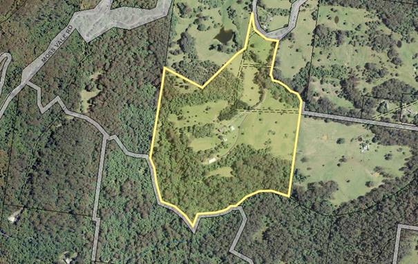
Background
Proposed Development
The proposal includes:
· Temporary use of land
under clause 2.8 of the SLEP 2014 for use of the site as a ‘Function
Centre’.
o Functions would cater for up
to 150 people.
o Maximum of 52 functions per calendar
year.
o Functions including weddings,
receptions, conferences, meetings, and other private events.
o Operation in accordance with
the Operational Management Plan (Attachment 3).
· Installation
of Temporary Marquees
o Larger
functions such as wedding receptions would require the installation of a
temporary marquee (for functions of up to 150 people).
o The
location of the temporary marquee is depicted on the Site Plan prepared by SET
Consultants (Attachment 4).
o Whilst
the size of the marquee would differ for each event, the applicant advises the
maximum sized marquee would be approximately 300m² (20m long x 15m wide).
· Use
of existing buildings including Studio Building and Small Farm Shed
o Small
scale events including weddings, meetings, etc would be held within the
existing studio building.
o Events
held within the studio building would contribute to the 52 events per calendar
year.
o The
small farm shed would be utilised by catering staff for storage and preparation
of food for service.
· Use
of Existing Dwelling
o The
existing primary dwelling would not be utilised for functions.
o The
dwelling would be used by a bride and groom only (on their wedding night) as
short-term rental accommodation (STRA).
o Use
of the dwelling as STRA would be subject to compliance with Clause 7.13 of the
SLEP 2014 and Draft SEPP (Short-Term Rental Accommodation).
· Site
Amenities and Transport
o Installation
of port-a-loos at designated locations as marked on the Site Plan.
o Transport
of all larger function guests via mini-buses from their place of residence
and/or hotel/motel accommodation.
o Parking
for the smaller functions/conferences for up to 25 vehicles is to be provided
on-site.
o Separate
vehicle parking for contractors (e.g. caterers)
Subject Land
The development site comprises Lot 2 DP 732659 (2819A Moss
Vale Road, Barrengarry). Refer to Figure 1.
Site & Context
The development site:
· Has a number of existing buildings within the central
northern part which is inclusive of a primary dwelling with an ancillary and
detached studio and two (2) detached farm buildings.
· Has a land area of 39.42 ha.
· Is accessed via a primary frontage to Moss Vale Road to the
north of the site. Moss Vale Road within the vicinity of the site is winding
with the driveway entrance being located on a tight bend.
· Is predominantly zoned RU2 Rural Landscape and partially
zoned E2 Environmental Conservation.
· Is identified as being wholly bush fire prone land.
· Contains a mapped ‘Category 2’ watercourse
traversing from east to west across the northern part of the site.
The surrounding area is rural in character and is
characterised by single dwellings on large blocks of land. Steep slopes and
high levels of vegetation cover are evident across the immediate surrounding
locality.
Figure 2 – Zoning Extract
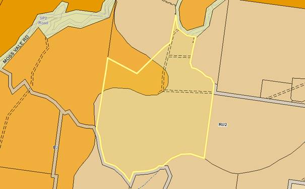
History
The following provides context
regarding the information requested by Council and that provided by the
applicant following lodgement of the Development Application with Council on 26
September 2018 (Note: request for information is ‘RFI’):
· 1st
RFI Request sent to the applicant on 5 October 2018 requesting:
o Confirmation the existing
structures are approved and lawfully constructed.
o Floor Plans for the studio building
and small farm shed.
· 2nd RFI
Request sent to the applicant on 18 December 2018 requesting:
o Confirmation regarding the
maximum size marquee required for functions.
o Traffic Impact Assessment
(TIA).
o An amended Site Plan
depicting: Turning paths for mini-buses and car parking according to Chapter
G21 of the SDCP 2014.
o Amended Operational Plan
advising: pick up/drop off location for mini-buses and how onsite manager would
prevent people from driving their own vehicle.
· Response provided
to the 1st and 2nd RFI Requests in separate submissions
on 28 March 2019, 24 May 2019, and 27 June 2019.
· 3rd RFI
Request sent to the applicant on 5 June 2019 requesting:
o Amended Operational Plan
advising pick up/drop off location for mini-buses.
· Response provided
to the 3rd RFI Letter on 18 June 2019.
· 4th RFI
Request sent to the applicant on 25 June 2019 requesting:
o Commentary addressing how the
proposal complies with Clause 2.8(3) of the SLEP 2014 with revised information
demonstrating that the proposed temporary use will have no adverse impact
on any adjoining land or the amenity of the neighbourhood including. (This
issue arose during the assessment of the application as Council became aware of
recent litigation concerning the use of clause 2.8.
o Amended Environmental Noise
Impact Assessment; and
o Amended Traffic Impact
Assessment addressing Transport for New South Wales (TfNSW) comments.
Note:
the issue of adverse impacts arose during assessment as staff became aware of
relatively recent litigation around the use of clause 2.8.
· Partial response
to 4th RFI Letter on 29 October 2019 providing the Amended
Environmental Noise Impact Assessment.
· 5th RFI
Request sent to applicant on 5 March 2020 requesting:
o Bushfire Emergency Management
& Evacuation Plan requested by RFS.
o Reaffirm request for amended
Traffic Impact Assessment requested by TfNSW.
· Response to 5th
RFI Request provided in separate submissions on 26 June and 1 July 2020
providing a Bushfire Emergency Management and Evacuation Plan for review by RFS
and a further traffic submission for review by TfNSW.
· Upon review of the
further traffic submission, TfNSW advised in their response dated 15 July 2020
that the submitted documentation does not
provide enough information to assess the development. Council’s Traffic
Unit concurred with this advice by recommending refusal in their response dated
24 July 2020.
· As the requirements in relation to traffic were not
able to be adequately addressed and having regard for the comments made in the
‘Issues’ section of this Report below, a recommendation for refusal
is provided.
· The applicant was advised in verbal discussion and
via email correspondence on 17th September 2020 that the application
would be determined based upon the information submitted to date.
Issues
|
Clause 101(2)(b) – Development with Frontage
to Classified Roads of State Environmental Planning Policy (Infrastructure)
2007
|
The subject site has frontage to Moss Vale Road, being a
classified regional road. Accordingly, clause 101 of ISEPP applies and reads as
follows:
101
Development with frontage to classified road
(1) The objectives of
this clause are—
(a) to ensure that new
development does not compromise the effective and ongoing operation and
function of classified roads, and
(b) to prevent or
reduce the potential impact of traffic noise and vehicle emission on
development adjacent to classified roads.
(2) The consent
authority must not grant consent to development on land that has a frontage to
a classified road unless it is satisfied that—
(a)
where practicable and safe, vehicular access
to the land is provided by a road other than the classified road,
and
(b) the safety,
efficiency and ongoing operation of the classified road will not be adversely
affected by the development as a result of—
(i) the design of the
vehicular access to the land, or
(ii) the emission of
smoke or dust from the development, or
(iii) the nature, volume
or frequency of vehicles using the classified road to gain access to the land,
and
(c) the development is of a type that is not
sensitive to traffic noise or vehicle emissions, or is appropriately located
and designed, or includes measures, to ameliorate potential traffic noise or
vehicle emissions within the site of the development arising from the adjacent
classified road.
Under subclause 101(2) the
consent authority must not grant consent to development on land that has a
frontage to a classified road unless it is satisfied that the subsequent
considerations have been met by the proposal.
This clause applies as the site
has direct frontage to a classified road (being Moss Vale Rd to the north of
the site). Moss Vale Road forms the site’s only legal road access and
would be utilised as part of the proposed temporary use by vehicles including
mini-buses ferrying people to and from the functions prior to and following the
completion of the events. The access would also be utilised by people
associated with providing the marquees to the site, caterers, and security
during setup, operation and pull down of each event.
Applicant’s Submission
“Another
concern raised in the community submissions was the increase in vehicle traffic
accessing the site. The site is accessed from Moss Vale Road via an access
driveway that provides access to all proposed events areas throughout the site.
The access to the site off Moss Vale Road is of particular concern due to the
bend of the road in the location of access. A Traffic Impact Assessment
prepared by ASON Group has being prepared and concludes that the site is
acceptable for the proposed use”.
Discussion
The Development Application was
externally referred to Transport for New South Wales (TfNSW) for concurrence
due to the site’s frontage to a classified road (Moss Vale Rd) and
for review of the submitted Traffic Impact Assessment (TIA) prepared by Ason
Group.
TfNSW advised in their referral
response on 4 July 2019 that the development would
generate additional traffic which needs to be considered and adequately
mitigated. TfNSW advised the submitted TIA
does not provide enough information to assess the development – noting
the following non-compliances with AUSTROADS Guidelines and Australian
Standards:
· Evidence of design according to Figure A10 AUSTROADS Guide to Road Design – Part 4:
Intersections and Crossings.
· Evidence that sight distance complies with Austroads Guide to Road Design Part 4A or Australian
Standard AS2890.1:2004.
· Evidence that the gradeline
for the access road complies with F2.3 of Austroads Guide to Road Design Part
4A.
Council subsequently requested
an amended Traffic Impact Assessment (TIA) requiring that the above matters be
addressed. An amended traffic submission prepared by Ason Group was received on
1 July 2020 which sought to address the above requirements (the submission was
provided following advice from the applicant that Ason Group had been working
extensively with TfNSW to ensure the relevant requirements are addressed).
The amended traffic submission
was reviewed by TfNSW and a referral response was received on 15 July 2020.
TfNSW advised that the submission still does not provide enough information to
assess the development and advised of a number of matters which are still
outstanding which are listed as follows:
1. The proposed BAR design does not provide all dimensions. A fully
dimensioned BAR design is required according to Austroads Guide to Road Design
Part 4, Fig. A28.
a) The edge line
for the BAR design must remain along the edge of the travel lane (refer Fig.
A28).
2. The proposed
BAL treatment provided does not appear to be drawn correctly. A BAL design is required
according to Austroads Guide to Road Design Part 4A, Fig. 8.2.
3. A
longitudinal section for the access has not been provided but the report
provided dated 30/06/2020 states Fig. 2.3 Austroads Guide to Road Design Part
4A can be achieved. The crossfall/superelevation of Moss Vale Rd must be
adopted as the grade line at least beyond the edge of the widened shoulder for
the BAL treatment. The existing driveway slopes down from Moss Vale Rd so it is
not possible to make an assessment without the grade line. This needs to be
addressed.
4. The sight
distance required for the access should be based on a design speed of 70kph
(10kph above the posted speed). The sight distance diagram provided does not
appear to be drawn correctly and does not show the vertical plane. Sight lines
should be taken from points shown in Fig. 3.2 & 3.3 of Austroads Guide to
Road Design Part 4A. A correction for grade must be applied based on Table 3.4
of Austroads Guide to Road Design Part 4A. The report states some vegetation needs
to be removed to obtain the sight distance however desktop views of the site
indicate a batter may also need to be cut back.
The TfNSW response was further
corroborated by Council’s Traffic and Transport Unit who advised as
follows in their referral response dated 24 July 2020:
1. Adequate
dimensions not provided in the submitted concept plan.
2. Vertical
geometry is not adequately considered. Moss Vale Rd has significant geometrical
constraints and further assessment such as provision of long sections or
vertical geometry will alleviate concerns raised by TfNSW.
3. Based
on the concept provided, significant tree clearing would be required to
achieve the minimum compliant sight distance.
4. Based
on site usage, it is anticipated that there will be no direct increase in
public transport utilisation, however increased heavy vehicle use is
anticipated.
5. It
is noted in the TIA that the majority of guests will arrive by minibus, how is
this managed? No details provided regarding operation of the minibus and therefore
its use to minimise traffic impacts on Moss Vale Rd is not accepted.
For the following reasons, the
TfNSW referral response is taken to be a recommendation for refusal and Council
finds that the applicant has not satisfactorily demonstrated compliance with
Clause 101(2)(b) of SEPP (Infrastructure) 2007.
· Council’s
Traffic Unit’s referral response corroborating with TfNSW and further
advising that they do not support the proposal.
· The
protracted nature of the assessment already and the likelihood that a further
protracted period of time would be required to address the further requirements
listed by TfNSW.
· The
likelihood that clearing and earthworks within the TfNSW road reserve would be
required to achieve compliant sightlines and specifically:
- TfNSW consent for
such works has not been provided to date.
- A Fauna and Flora
Assessment addressing the Biodiversity Conservation Act 2016 would be required
as a result. Any threatened species studies required to be undertaken would
likely further protract the assessment process.
· The
applicant was advised that the amended traffic submission was not accepted by
TfNSW or Council’s Traffic and Transport Unit and that the application
would be sent to the Development & Environment Committee based upon the
information submitted to date. This was confirmed via written correspondence
sent to the applicant on 17 September 2020 that the application would be sent
to the October Development & Environment Committee for determination based
upon the information submitted to date.
TfNSW and Council’s Traffic and Transport Unit have
considered all the applicant’s detailed traffic reports and are not satisfied that the access onto Moss Vale Road demonstrates
compliance with subclause 101(2)(b) of the Infrastructure SEPP. It follows that
Council does not have the ability under the ISEPP to approve the development
application in its current form.
|
Clause 2.8 – Temporary
Use of Land of the Shoalhaven Local Environmental Plan (SLEP) 2014
|
Clause 2.8(3) of the Shoalhaven Local Environmental Plan
(SLEP) 2014 provides development consent must not be granted to a proposal
unless the consent authority is satisfied that:
(a) the temporary use
will not prejudice the subsequent carrying out of development on the land in
accordance with this Plan and any other applicable environmental planning
instrument.
(b) the temporary use
will not adversely impact on any adjoining land or the amenity of the
neighbourhood.
(c) the temporary use
and location of any structures related to the use will not adversely impact
on environmental attributes or features of the land, or increase the risk of
natural hazards that may affect the land.
(d) at the end of the
temporary use period the land will, as far as is practicable, be restored to
the condition in which it was before the commencement of the use.
This clause applies as the applicant is seeking consent for a
temporary use of the land for the purpose of a Function Centre for up to 52
events per calendar year. Functions are proposed to be held for weddings,
receptions, conferences, meetings, and other private functions for up to 150
people at any given event.
Clause 2.8(3)(a) – the temporary use will
not prejudice the subsequent carrying out of development on the land in accordance
with this Plan and any other applicable environmental planning instrument.
Applicant’s Submission
“The
use of the site for events and functions up to 52 times a year will not
preclude the land for being continual used for rural purposes and will not
impact on the environmental zoned portions of land”.
Discussion
The proposal is temporary in
nature and all additional structures are temporary and capable of being removed
following the completion of each function. Temporary facilities including the
marquee and portable toilets would be removed by contractors and solid waste
produced during the event including by caterers and function guests would be
transported off site following the events. The proposed temporary use of the
land will not result in significant unacceptably irreversible changes to the
continued use of the site.
Considering the above, the site
is capable of being restored to its prior condition following completion of
each event, which would not prejudice the future and ongoing use of the land
for rural and primary production purposes in accordance with Clause 2.8(3)(a).
Clause 2.8(3)(b)
– the temporary use will not adversely impact on any adjoining land or
the amenity of the neighbourhood.
Applicant’s Submission
“The
application is accompanied by an acoustic report prepared by Harwood Acoustics
which demonstrates that the use of the land for functions will not adversely
impact on the amenity of the adjoining property or the neighbourhood. An
extract from the report’s recommendations can be seen below, and
concludes the following:
“Recommended Noise Controls
· Amplified music should not exceed an energy-average sound
pressure level (Leq, 15 minute) of 85 dBA when measured over a 15 minute
period at 3 metres from the speakers within the marquee. This
level equates to a sound power level of 103 dBA which is based on, for example,
a medium sized band, duo or medium level of pre-recorded amplified music (iPod,
DJ, etc).
· Speakers
should be orientated toward the south west or west.
· The
predicted noise levels and noise control recommendations in this assessment are
based 150 guests with amplified music in an open-air marquee and this
represents an acoustically worst-case scenario.
· Other
possible scenarios such as the use of building structures and stage area for
seminars or training sessions will produce lower levels of noise emission and
be well within the acceptable noise limits at all receptor locations. This is
providing the maximum allowable amplified music levels do not exceed those
outlined in s7.1
· All
amplified music should be controlled through an in-house sound system with
levels pre-set to ensure compliance with the relevant criterion where
practicable.
· All
amplified music played exclusively through an amplifier owned and operated by
the owners of the property. The amplifier can be calibrated and a maximum
volume level pre-set so that the maximum allowable sound pressure levels are
not exceeded.
· The
amplifier must be contained in a locked cabinet so that it is not accessible to
function guests or entertainers. Any portable media devices may be plugged
externally into the amplifier via a lead outside the lockable cabinet.
· The
calibration of the amplifier will allow for the fact that portable media
devices have their own volume controls.
· A sound
level meter may be purchased from an electronics store so that the owner or
property manager may ‘spot check’ for noise compliance during or
prior to functions. Whilst the sound level meter will not be a Class 1 or Type
2 instrument, the meter can be calibrated by a suitably qualified acoustic
consultant to determine the level the meter displays that is equivalent to
levels recommended in s7.1 at 3m from speakers.
· In the
event that any complaints are received a noise compliance assessment of noise
levels should be undertaken by a suitably qualified acoustical consultant to
ensure the recommended noise level is not exceeded.
· There
should be no function activity at the site after midnight on any day.
· The level
of noise emission from any mechanical plant servicing the development should
not exceed an ‘A’ frequency weighted, energy average, sound
pressure level (Leq) of 25 dBA, when measured over 15 minutes at the closest
receptor. This is to ensure the overall level of noise emission from the Site
does not exceed the acceptable noise limit of 35 dBA.
· To
achieve this, the total sound power level (Lw) of any mechanical plant combined
should not exceed 83 dBA. This assumes direct line of sight and no additional
attenuation from building structures, shielding, etc. Depending on the location
of mechanical plant the allowable sound power level may be higher in practice.
· In
any event compliance with the noise goals for mechanical plant noise should be
easily achievable and a final assessment may be required prior to
installation.”
Discussion
In order to properly consider
this matter, case law has been referred to.
The operation of clause 2.8 as
it relates to Standard Instrument Local Environmental Plan (of which the SLEP 2014
is a Standard Instrument LEP) has been considered by the Land and Environment
Court of NSW in the leading judgement of: Marshall Rural Pty Limited v
Hawkesbury City Council and Ors [2015] NSWLEC 197.
Marshall Rural Pty Limited
v Hawkesbury City Council [2015] NSWLEC 197
The Marshall case involved a
challenge by a neighbour to a development consent for the temporary use of barn
buildings as a function centre issued by Hawkesbury City Council on a rural
holding which was otherwise used for the holding of polo tournaments.
The development consent
authorised the function centre use for up to 28 days in any 12 months period
and the consent was granted for a period of 2 years.
Acting Justice Moore (Moore AJ)
described the nature of the test for development applications made pursuant to
clause 2.8 at [113] – [116] as follows:
113 The nature of the activities that are capable of
being permitted by an application invoking cl 2.8 are, I remind myself,
activities that are otherwise prohibited in a zone.
114 That any application that is sought to be approved
for such a prohibited use seeks a significant indulgence for such a substantial
departure from the planning controls applicable to a zone is reflected in two
aspects of the clause.
115 The first arises with respect to the temporal
limitation mandated by the clause if such an otherwise prohibited use is to be
permitted. This aspect of the clause was the subject of Marshall Rural’s
first complaint, a complaint dealt with and dismissed in my rejection of Ground
1.
116 The second element engaged by these proceedings is
the requirement that the proposal will “not adversely impact”
in the fashion specified in cl 2.8(3)(b). This test, cast in absolute terms
reflecting the seriousness with which an application of this nature is required
to be assessed, puts a very high hurdle in the path of any such application.
The placing of such a hurdle requires that the Council must approach the
consideration and determination of any such application with a marked degree of
precision and caution.
A matter for Council to consider
carefully is what Moore AJ describes at [116] as a “very high hurdle”
in the path of any application for approval under clause 2.8. That is, the
requirement in clause 2.8(3)(b) that the temporary use of land “will
not adversely impact on any adjoining land or the amenity of the
neighbourhood”. As his Honour pointed out in Marshall Rural this
provision is cast in absolute terms: any adverse impact is sufficient to
require the refusal of such an application.
Moore AJ stipulated that the
clause 2.8 test is “absolute” and that the temporary use must have
not have an adverse impact on any adjoining land or the amenity of the
neighbourhood. This case strongly demonstrates that when a use is prohibited
in the zone, but the LEP provides for temporary use of the land in a manner
that is otherwise prohibited, that use is still fundamentally prohibited in
nature within that zone.
As the current application has
been made pursuant to clause 2.8, Council must be satisfied that the proposed
development “will not adversely impact on any adjoining land or the
amenity of the neighbourhood”.
Potential adverse impacts upon
the adjoining land or the amenity of the neighbourhood include the
following:
Noise:
In response to Marshall Rural
Pty Limited v Hawkesbury City Council [2015] NSWLEC 197, Council requested as
further information that the Environmental Noise Impact Assessment (ENIA) be
revised to address the ‘adverse impact’ of the proposal rather than
the ‘acceptable impact’ which had been addressed in the initial
submission. A revised ENIA was submitted by Hardwood Acoustics addressing
Clause 2.8(3)(b) ‘Adverse Impact’ which concluded that:
“This could therefore be described as not having
an adverse impact acoustically on any adjoining land and certainly not on the
amenity of the neighbourhood. In my opinion, this particular site provides for
significant separation between the noise sources and receptors and is located
on a busy sub arterial road. With respect acoustics, the potential impacts here
are negligible if the site is managed in accordance with the recommendations
made and the noise impacts could not reasonably be considered adverse”.
The revised ENIA was reviewed by
Council’s Environmental Health Officer who agreed with the
recommendations and provided recommended conditions which are summarised as
follows:
· Compliance
with the recommendations of the revised ENIA.
· Onsite
manager for monitoring of noise level.
· Contact
name and number for onsite manager to be made available to neighbouring
properties.
· Log
book and complaints register: kept by the onsite property manager detailing the
date and time of all functions, number of patrons attending, responsible staff
member, and any noted amenity issues for each event. The log book and
complaints register is to be available to council staff to review on request.
· Curfew
regarding noise emissions.
· Noise
limit for mechanical and plant equipment of 83dBA.
In consideration of the above
comments, it is assessed that the proposal would not have an ‘adverse
impact upon the amenity of the neighbourhood’ in relation to noise,
subject to implementation of the recommended conditions of consent.
Traffic:
In response to Marshall Rural
Pty Limited v Hawkesbury City Council [2015] NSWLEC 197, Council requested that
the Traffic Impact Assessment (TIA) be revised to address comments provided by
TfNSW, in particular non-compliances with AUSTROADS and Australian Standards
for intersections/crossings, sight distances, and gradelines.
An amended traffic submission
was received which sought to address the above non-compliances. However as part
of their review of the amended submission, TfNSW found that several matters had
still not been satisfactorily addressed and remain outstanding (these matters
are listed in the Report above).
Comments received from
neighbouring and surrounding residents during the notification process
reflected TfNSW’ comments. Concerns raised related to additional traffic
entering and exiting the site (including large vehicles such as mini-buses and
trades vehicles) being likely to cause traffic accidents noting that Moss Vale
Rd within the vicinity of the site is already very dangerous given the winding
nature of the road and tight bends with several accidents being cited.
In consideration of comments
received from TfNSW, Council’s Traffic Unit, and neighbouring and
surrounding residents during the notification process, Council cannot be
satisfied that the proposal would not have an ‘adverse impact upon the
adjoining land’ – particularly as it relates to local residents
travelling to and from their properties.
Clause 2.8(3)(c)
– the temporary use and location of any structures related to the use
will not adversely impact on environmental attributes or features of the land,
or increase the risk of natural hazards that may affect the land.
Applicant’s Submission
“Whilst
the proposed use will take advantage of existing shed structures and open
spaces for the events, the functions will also require the installation of a
temporary marquees for the guests and the location of portable bathroom
facilities. Depending on the size of the function, the size of marquee vary
however the number of guests will not exceed 150. These temporary installations
will not increase the risk of natural hazards. The temporary structures are
located in areas close to existing buildings, and are not likely to cause any
visual impacts to surrounding residents. This reduces the potential visual
impact on the surrounding areas.
The access
to the site is restricted in that guests can only attend via mini bus therefore
reducing and limiting conflicts with vehicle traffic and noise.
In regard to the existing onsite effluent system, guests
will not have access to the dwelling and will not overload the system. Portable
bathroom facilities are provided on site and removed following the completion
of the function. The catering company is not undertaking cooking of the food on
site nor will the cleaning of the dishes occur on-site and as such the onsite
effluent system will not be affected.”
Discussion
The site is entirely mapped as being bushfire prone
(Vegetation Category 1) according to Council’s bushfire prone land
mapping. As depicted in Figure 1 (above), the site and surrounding locality has
a high level of vegetation cover and is located adjacent to a National Park.
An initial referral was made to the Rural Fire Service
(RFS) for assessment of the Development Application in accordance with Section
4.14 of the Environmental Planning and Assessment (EP&A) Act 1979, the
purpose for the referral being for consideration of the submitted Bushfire
Assessment Report and the recommendations for bushfire mitigation.
In their response, RFS requested a Bushfire Emergency
Management and Evacuation Plan be provided, specifying how function attendees
would be evacuated from the site in the event of a bushfire. The requested Plan
was submitted by the applicant and subsequently re-referred to the RFS seeking
comments and/or conditions.
In their re-referral response dated 14 August 2020, RFS
advised that the Plan would enable safe and efficient evacuation from the site,
subject to conditions of consent such as the requirement for a refuge building
and/or an open air assembly area.
On the basis of information submitted by the applicant in
support of the proposal and the subsequent review by RFS, it is found that the
proposal would be unlikely to adversely impact
on environmental attributes or features of the land, or increase the risk of
natural hazards that may affect the land.
Clause 2.8(3)(d)
– at the end of the temporary use period the land will, as far as is
practicable, be restored to the condition in which it was before the
commencement of the use.
Applicant’s Submission
“At the end of each temporary use function the
land will be restored to the condition it was in prior to the commencement of
each function”.
Discussion
As per the submitted SEE, the
applicant advises that all temporary structures would be removed in the day/s
following the event and be returned to its natural state.

Section 4.15(1)(b) of the Environmental Planning and
Assessment (EP&A) Act 1979 provides the following:
(1) Matters
for consideration—general In
determining a development application, a consent authority is to take into
consideration such of the following matters as are of relevance to the
development the subject of the development application—
(b) the
likely impacts of that development, including environmental impacts on both the
natural and built environments, and social and economic impacts in the
locality,
The southern, central, and
western parts of the site are covered with native vegetation which are mapped
as being areas of terrestrial biodiversity in accordance with the SLEP 2014.
This vegetation is also depicted on the NSW Department of Environment, Energy
and Science’ BOSET Mapping Tool as containing vegetation of high
biodiversity value.
There is further vegetation
located along the northern frontage to Moss Vale Rd. The vegetation is located
within the road reserve and lines both the northern and southern sides of the
road within the vicinity of the site.
Applicant’s Submission
“The proposed temporary use will not result in the
loss of any critical habitat, or significant impacts on any Endangered or
threatened flora or fauna.”
Discussion
The applicant’s above
response has not considered the vegetation which would likely be required to be
removed within the Moss Vale Rd road reserve to facilitate sufficient sight
lines to be provided according to the requirements set by Transport for New
South Wales (TfNSW) in their referral response.
This vegetation removal would require the lodgement of a
Fauna and Flora Assessment to clarify whether or not the proposal would trigger
entry into the Biodiversity Offsets Scheme (BOS) in accordance with the
provisions of the Biodiversity Conservation Act 2016. Given no such Report has
been provided, Council cannot quantify the extent of the impact upon vegetation
in this location or the applicability of the BOS. Council therefore cannot be
satisfied that the development would not have an adverse impact upon the
natural environment.
Planning Assessment
The DA has been assessed under s4.15(1) of the Environmental
Planning and Assessment Act 1979. Please refer to Attachment 2.
Consultation and Community
Engagement:
Notification was undertaken in
accordance with Council’s Community Consultation Policy with letters
being sent within a 200m buffer of the site, during the period 5 to 20 October
2018.
24 submissions objecting to the
proposal were received in relation to Council’s notification of the
development.
Key issues raised as a result of the notification process
are summarised in the following Table (Council’s response to the
objections raised is provided in the Planning Report at Attachment 2).
|
Clause
2.8 of SLEP 2014
Application of clause 2.8 of
the SLEP 2014. Specifically, that the proposal would result in an adverse
impact to adjoining properties and the wider area.
|
|
Road
Safety
Comments
that Moss Vale Rd within the vicinity of the site is
dangerous due to the driveway location on a tight bend and being a single
lane road with no designated turning bays. Also
concerns regarding vehicles entering/exiting the site given the extra volume
of traffic, which may present a hazard – in particular, minibuses and
trades vehicles.
|
|
Bushfire
Risk
Concern regarding how 150 people would be evacuated in
the event of a bushfire and potential habitat destruction from a spread of
fire caused by the proposal.
|
|
Fauna
/ Flora Habitat
Potential
to interfere with the habitat and amenity of fauna and risk of snake bites to
function attendees.
|
|
Noise
Noise
disturbance from 52 events per year and associated construction works.
|
|
Time
of Disruption
Disruption
time when taking into account set up and dismantling of marquees and other
temporary structures.
|
|
Inadequate
Parking
Requesting
a guarantee that minibuses would be used and not personal vehicles.
|
|
Waste Management
Concerns that the Waste
Management Plan is inadequate.
|
|
Business Saturation
Identification of a number of similar
businesses in the locality and potential to dilute revenue.
|
|
Responsible Service of Alcohol
Concerns
that RSA would be inadequate given alcohol would be ‘BYO’.
|
|
Facilities
Representations that studio
building may be used for accommodation despite applicant advice that no
guests staying at the site.
|
|
Water Quality
Site’s location within
the Sydney Drinking Water Catchment and potential waterway contamination.
|
Financial
Implications:
There are potential cost implications for Council in the event
of a refusal of the application. Such costs would be associated with defending
an appeal in the Land and Environment Court of NSW.
Legal Implications
Pursuant to section 8.2 of the
EP&A Act, a decision of the Council may be subject of a review by the
applicant in the event of an approval or refusal. If such a review is
ultimately pursued the matter would be put to Council for consideration.
Alternatively, an applicant may also appeal to the Court
against the determination pursuant to section 8.7 of the EP&A Act.
Summary and Conclusion
This application has been assessed having regard for section
4.15 (Matters for consideration) under the EP&A Act. Having regard
to the assessment, the proposal is not considered capable of support. Reasons
for refusal are provided below and can also be found at Attachment 1 to this
report:
|
1.
|
The development application has
not satisfactorily demonstrated compliance with Clause 2.8(3)(b) of the
Shoalhaven Local Environmental 2014. (Section 4.15(1)(a)(i) of Environmental
Planning and Assessment Act, 1979)
|
|
2.
|
The development application has
not satisfactorily demonstrated compliance with Clause 101(2)(b) of the State
Environmental Planning Policy (Infrastructure) 2007. (Section 4.15(1)(a)(i)
of Environmental Planning and Assessment Act, 1979)
|
|
3.
|
The
likely impacts of the development, including environmental impacts upon the
natural environment, has not been satisfactorily addressed. (Section
4.15(1)(b) of Environmental Planning and Assessment Act, 1979)
|
|
4.
|
The
information submitted with the development application does not
satisfactorily demonstrate that the site is suitable for the proposed use.
(Section 4.15(1)(c) of Environmental Planning and Assessment Act, 1979)
|
|
5.
|
Having
regard to the above matters to address the relevant provisions of
Environmental Planning and Assessment Act, 1979, the granting of development
consent is not considered to be in the public interest. (Section 4.15(1)(e)
of Environmental Planning and Assessment Act, 1979)
|
|
|
Development
& Environment Committee – Tuesday 06 October 2020
Page
0
|
|
|
Development
& Environment Committee – Tuesday 06 October 2020
Page
0
|

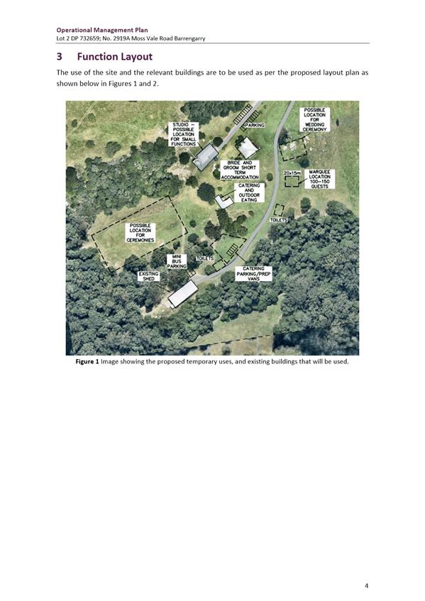
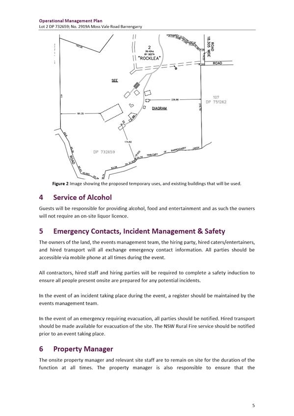

|
|
Development
& Environment Committee – Tuesday 06 October 2020
Page
0
|
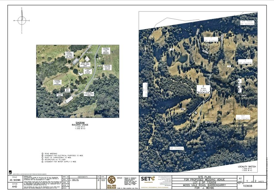
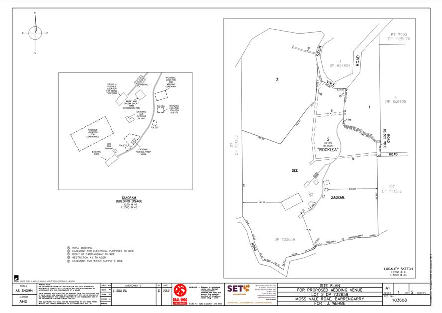
|
|
Development
& Environment Committee – Tuesday 06 October 2020
Page
0
|
DE20.109 Development
Application - DA18/2276 - 179 Cedar Springs Rd Kangaroo Valley - Lot 1 DP
791256
DA. No: DA18/2276/4
HPERM Ref: D20/240982
Section: Development
Services
Approver: Phil
Costello, Director - City Development
Attachments: 1. Determination
- 179 Cedar Springs Rd, Kangaroo Valley - Lot 1 DP 791256 (under separate
cover) ⇨
2. Planning
Report - 179 Cedar Springs Rd Kangaroo Valley - Lot 1 DP 791256 (under separate
cover) ⇨
3. Amended
Operational Management Plan - 179 Cedar Springs Rd Kangaroo Valley - Lot 1 DP
791256 ⇩
4. Site
Plan - 179 Cedar Springs Rd Kangaroo Valley - Lot 1 DP 791256 ⇩
5. Site
Plan - Inset - 179 Cedar Springs Rd Kangaroo Valley - Lot 1 DP 791256 ⇩
6. Amended Environmental Noise
Impact Assessment - 179 Cedar Springs Rd Kangaroo Valley - Lot 1 DP 791256
(under separate cover) ⇨
Description of Development: Temporary Use of Land
as a Function Centre
Owner: Addison Puch Properties Pty Ltd
Applicant: SET Consultants Pty Ltd
Notification Dates: 25 February 2019 to 12 March
2019
No. of Submissions: 21 in objection
Purpose
/ Reason for consideration by Council
On 30 April 2019, Council resolved that Development
Application DA18/2094 be called in to Council for determination due to the
significant public interest (MIN19.244).
|
Recommendation (Item to be determined under delegated authority)
That Development Application DA18/2276
for ‘Temporary Use of Land as a Function Centre at Lot 1 DP 791256, 179
Cedar Springs Rd, Kangaroo Valley be approved subject to the recommended
conditions of consent contained in Attachment 1 of this report.
|
Options
1. Approve the
development application (DA) in accordance with the recommendation of this
report.
Implications: This would allow the
development to proceed. A suite of conditions has been prepared by staff and
can be found at Attachment 1 to this Report. Under some circumstances, third
parties (i.e. objectors) could seek a judicial review of Council’s decision
in the NSW Land and Environment Court.
2. Refuse the
application.
Implications: The
development is unable to proceed as applied for. The applicant can, however,
apply for a S8.2A review of Council’s decision and/or could lodge an
appeal with the NSW Land and Environment Court against Council’s
decision.
3. Alternative
recommendation.
Implications: Council will
need to specify an alternative recommendation and advise staff accordingly.
Figure
1 – Location Map
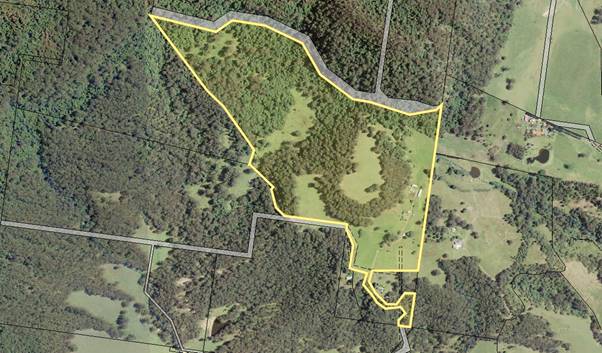
Background
Proposed Development
The proposal includes:
· Temporary use of land
under Clause 2.8 of the SLEP 2014 for use of the site as a ‘Function
Centre’.
o Functions for up to 150 people
for weddings, receptions, conferences, meetings, and other private events.
o A maximum of 52 functions per
calendar year.
o A maximum of 22 of the 52
functions being weddings held on a weekend with an absolute finishing time of
12am.
o The remaining 30 of the
permitted 52 functions being small midweek team building / corporate conferences.
o Functions to be held within
one of the three (3) existing farm buildings located on the site.
o Transport to and from the site
via mini-buses – which would pick up and drop off attendees to and from
their accommodation to prevent the need for individuals to drive to the site.
o No temporary camping is
proposed.
o Operations to accord with the
Operational Management Plan (Attachment 3).
· Reconstruction
and extension of farm building/s and upgrades to all buildings to be used for
functions to achieve the recommendations of the Environmental Noise Impact
Assessment (ENIA) (Attachment 6).
o Proposed
works to complete the reconstruction of the ‘Grain Shed’.
o Alterations
and additions to all buildings to be used for functions to achieve the
recommendations of the ENIA.
· Proposed site amenities
as depicted on the Site Plan (Attachments 4 and 5):
o Construction of car and
mini-bus parking area adjacent to the entrance and internal driveway consisting
of:
§ Twenty-four (24) standard parking
spaces – the purpose of which is to provide space for parking by staff
members including caterers, waiters, bartender/s trained in RSA (to manage
alcohol brought to the site), security guard/s, hair and makeup staff,
deliveries, and limited spaces to cater for unexpected late arrivals.
§ Two (2) dedicated mini-bus parking
spaces.
o Construction of a shed
adjacent to the entrance and internal driveway to be used as a bushfire refuge.
The shed would:
§ Have a total area of 252m²
(21m long x 12m wide).
§ Have a height of 2.94m to the eaves
and 6.21m to the apex.
§ Be an ‘American Barn’
style shed consisting of a total of three bays.
o Installation of a temporary
marquee for use as a ‘Food Preparation Tent’ by caterers during
preparation of food to be served during functions.
o Installation of portable
toilets for use by function guests.
Subject Land
The development site comprises Lot 1 DP 791256 (179 Cedar
Springs Road, Kangaroo Valley). Refer to Figure 1.
Site & Context
The development site:
· Has a number of existing buildings within the south-eastern
front corner of the site which includes an existing homestead and detached
habitable rooms, rural worker’s dwelling, and three (3) existing farm
buildings.
· Has a land area of 58.07ha.
· Is accessed via a private internal access road to Cedar
Springs Road to the south of the site.
· Is partially zoned RU1 Primary Production (the part the
subject of the temporary use proposal) and partially zoned E2 Environmental
Conservation.
· Is identified as being partially bush fire prone land.
Figure 2 – Zoning Extract
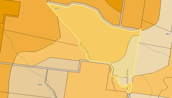
History
The following provides context
regarding the information requested by Council and that provided by the
applicant following lodgement of the Development Application with Council on 20
November 2018 (note: request for information is ‘RFI’):
· 1st
RFI Request sent to the applicant on 26 November 2018 requesting:
o An amended Site Plan:
§ Addressing Schedule 1 of the
Environmental Planning and Assessment (EP&A) Act 1979; and
§ Depicting car and mini-bus parking
according to Chapter G21 – Car Parking and Traffic of the Shoalhaven
Development Control Plan 2014 (SDCP).
o Plans for those buildings
forming part of the application.
o Verification of cost of works.
· Applicant response
to the 1st RFI Request on 30 January 2019 providing a response to
the requested information.
· 2nd RFI
Request sent to the applicant on 26 June 2019 following a response to all
internal / external referrals and the notification process requesting:
o Commentary addressing how the
proposal complies with clause 2.8(3) of the SLEP 2014 with revised information
demonstrating that the proposed temporary use will have no adverse impact
on any adjoining land or the amenity of the neighbourhood including: (This
issue arose during the assessment of the application as Council became aware of
recent litigation concerning the use of clause 2.8).
o An amended Environmental Noise
Impact Assessment.
o A Traffic Management Plan and
plans showing manoeuvring paths for vehicles attending the site.
o Architectural plans for each
of the structures and identifying the existing v proposed components.
o Updated Structural Engineering
Report.
o Further information clarifying
how power and water would be supplied to the food preparation tent.
· Response to 2nd
RFI Request provided in separate submissions on 26 June 2020 and 6 July 2020
providing the requested information.
· The
submitted documentation was referred for review by internal and external
referral agencies with responses providing comments/conditions.
Issues
|
Clause 2.8 – Temporary Use of Land of the
Shoalhaven Local Environmental Plan (SLEP) 2014
|
Clause 2.8(3) of the Shoalhaven Local Environmental Plan
(SLEP) 2014 provides development consent must not be granted to a proposal
unless the consent authority is satisfied that:
(a) the
temporary use will not prejudice the subsequent carrying out of development on
the land in accordance with this Plan and any other applicable environmental
planning instrument.
(b) the
temporary use will not adversely impact on any adjoining land or the
amenity of the neighbourhood.
(c) the
temporary use and location of any structures related to the use will not adversely
impact on environmental attributes or features of the land, or increase the
risk of natural hazards that may affect the land.
(d) at the
end of the temporary use period the land will, as far as is practicable, be
restored to the condition in which it was before the commencement of the use.
Clause 2.8 applies as the applicant is seeking consent for a
temporary use of the land for the purpose of a Function Centre for up to 52
events per calendar year. Functions are proposed to be held for weddings,
receptions, conferences, meetings, and other private functions for up to 150
people at any given event. Compliance with Clause 2.8 would be required as a
condition of any consent.
A discussion is provided below regarding how the proposal
achieves compliance with the provisions of Clause 2.8(3).
Clause 2.8(3)(a) – the temporary use will
not prejudice the subsequent carrying out of development on the land in
accordance with this Plan and any other applicable environmental planning
instrument.
Applicant’s Submission
“The use of the site for functions up to 52 times
a year will not preclude the land for being continual used for rural purposes
and will not impact on the environmental zoned portions of land”.
Discussion
The proposal is temporary in
nature and the farm buildings are capable of being reverted back to their
original intended use following the completion of the functions. Temporary
facilities including the food preparation tent and portable toilets would be removed
by contractors immediately following the functions with solid waste transported
off site.
Whilst the temporary use would
require the construction of permanent facilities including a car park and
refuge building, it would not prejudice the subsequent carrying out of
development as they would be located immediately adjacent to the internal
driveway whereby minimising fragmentation to available farm land.
Considering the above, the
temporary use would not prejudice the future and ongoing use of the land for
rural and primary production purposes in accordance with Clause 2.8(3)(a).
Clause 2.8(3)(b) – the temporary use will
not adversely impact on any adjoining land or the amenity of the neighbourhood
Applicant’s Submission
“The rural nature
of the property, existing setbacks, frequency of use, topography and vegetation
both onsite and in the surrounding area all contribute to the proposal being
achievable to temporarily use the site without having an adverse impact on the
amenity of the area, or attributes of the site.
The two
areas of particular importance being traffic and acoustic impacts. An Environmental
Noise Impact Assessment RFI Response prepared by Harwood Acoustics has been
submitted to Council. This report outlined how the temporary use development
can operate to achieve the ‘no adverse impact’ requirement to
satisfy Clause 2.8(3) of the SLEP 2014. It is anticipated that a consent be
conditioned to require compliance with the Environmental Noise Impact
Assessment. This will ensure that the temporary use development will have no
adverse impacts on the amenity of the surrounding area”.
Discussion
In order to properly consider
this matter, case law has been referred to.
The operation of clause 2.8 as
it relates to Standard Instrument Local Environmental Plan (of which the SLEP
2014 is a Standard Instrument LEP) has been considered by the Land and
Environment Court of NSW in the leading judgement of: Marshall Rural Pty
Limited v Hawkesbury City Council and Ors [2015] NSWLEC 197.
Marshall Rural Pty Limited
v Hawkesbury City Council [2015] NSWLEC 197
The Marshall case involved a
challenge by a neighbour to a development consent for the temporary use of barn
buildings as a function centre issued by Hawkesbury City Council on a rural
holding which was otherwise used for the holding of polo tournaments.
The development consent
authorised the function centre use for up to 28 days in any 12 months period
and the consent was granted for a period of 2 years.
Acting Justice Moore (Moore AJ)
described the nature of the test for development applications made pursuant to
clause 2.8 at [113] – [116] as follows:
113 The nature of the activities that are capable of
being permitted by an application invoking cl 2.8 are, I remind myself,
activities that are otherwise prohibited in a zone.
114 That any application that is sought to be approved
for such a prohibited use seeks a significant indulgence for such a substantial
departure from the planning controls applicable to a zone is reflected in two
aspects of the clause.
115 The first arises with respect to the temporal limitation
mandated by the clause if such an otherwise prohibited use is to be permitted.
This aspect of the clause was the subject of Marshall Rural’s first
complaint, a complaint dealt with and dismissed in my rejection of Ground 1.
116 The second element engaged by these proceedings is
the requirement that the proposal will “not adversely impact”
in the fashion specified in cl 2.8(3)(b). This test, cast in absolute terms
reflecting the seriousness with which an application of this nature is required
to be assessed, puts a very high hurdle in the path of any such application.
The placing of such a hurdle requires that the Council must approach the
consideration and determination of any such application with a marked degree of
precision and caution.
A matter for Council to consider
carefully is what Moore AJ describes at [116] as a “very high hurdle”
in the path of any application for approval under clause 2.8. That is, the
requirement in clause 2.8(3)(b) that the temporary use of land “will
not adversely impact on any adjoining land or the amenity of the
neighbourhood”. As his Honour pointed out in Marshall Rural this
provision is cast in absolute terms: any adverse impact is sufficient to
require the refusal of such an application.
Moore AJ stipulated that the
clause 2.8 test is “absolute” and that the temporary use must have
not have an adverse impact on any adjoining land or the amenity of the
neighbourhood. This case strongly demonstrates that when a use is
prohibited in the zone, but the LEP provides for temporary use of the land in a
manner that is otherwise prohibited, that use is still fundamentally prohibited
in nature within that zone.
As the current application has
been made pursuant to clause 2.8, Council must be satisfied that the proposed
development “will not adversely impact on any adjoining land or the
amenity of the neighbourhood”.
Potential adverse impacts upon
the adjoining land or the amenity of the neighbourhood include the
following:
Noise:
In response to Marshall Rural
Pty Limited v Hawkesbury City Council [2015] NSWLEC 197, Council requested as
further information that the Environmental Noise Impact Assessment (ENIA) be
revised to address the ‘adverse impact’ of the proposal rather than
the ‘acceptable impact’ which had been addressed in the initial
submission. A revised ENIA was submitted by Hardwood Acoustics addressing
Clause 2.8(3)(b) ‘Adverse Impact’ which concluded that:
“This could therefore be described as not having
an adverse impact acoustically on any adjoining land and certainly not on the
amenity of the neighbourhood. In my opinion, this particular site provides for
significant separation between the noise sources and receptors and is located
on a busy sub arterial road. With respect acoustics, the potential impacts here
are negligible if the site is managed in accordance with the recommendations
made and the noise impacts could not reasonably be considered adverse”.
The revised ENIA was reviewed by
Council’s Environmental Health Officer who agreed with the
recommendations and advised that these must be implemented as conditions of
consent. Further recommended conditions of consent are also recommended and are
summarised as follows:
· Compliance
with the recommendations of the revised ENIA.
· Onsite
manager for monitoring of noise level.
· Contact
name and number for onsite manager to be made available to neighbouring
properties.
· Log
book and complaints register: kept by the onsite property manager detailing the
date and time of all functions, number of patrons attending, responsible staff
member, and any noted amenity issues for each event. The log book and
complaints register is to be available to council staff to review on request.
In consideration of the above
comments, it is assessed that the proposal would not have an ‘adverse
impact upon the amenity of the neighbourhood’ in relation to noise,
subject to implementation of the recommended conditions of consent.
Traffic:
In response to Marshall Rural
Pty Limited v Hawkesbury City Council [2015] NSWLEC 197 and in response to
requests from the NSW Police and Council’s Development Engineer, further
information was requested from the applicant in the form of a Traffic
Management Plan. Details that were requested to be addressed as part of the
response included matters such as:
· How traffic
including buses, late arrivals, and equipment providers (e.g. food preparation
tent, temporary WCs, caterers) would be managed during the setup, operational
phase, and pack up stages of each proposed event.
· Demonstrating
the location of turning bays for buses and trucks accessing the site and that
such movements are able to take place on the parts of the site constructed with
a surface of an all-weather nature.
· Indicating
designated times for bus movements to and from the site.
The following Table demonstrates
the typical traffic movements associated with an event involving the maximum
permitted function attendance of 150 guests (the below numbers may change
depending upon the number of guests attending). The Table is based upon
information provided within a Traffic Management Plan submitted by the
applicant in response to Council’s above request:
|
|
Estimated No.
|
Est. Capacity per Trip
|
Trips
|
|
Late arrivals
|
20 people
|
4 per car
|
5 incoming
5 outgoing
|
|
Guests arriving by bus
|
130 people
|
25 – per bus
2 buses to be used
|
6 incoming
6 outgoing
|
|
Catering/staff
|
6 vehicles
|
-
|
6 incoming
6 outgoing
|
|
Total
34
|
The following measures were provided
within the Traffic Management Plan and / or Environmental Noise Impact
Assessment and would assist in ensuring that the above traffic movements do not
result in any ‘adverse’ impacts as it relates to traffic:
· The site
manager will ensure all departures conclude before midnight.
· The
events manager will ensure the vehicles exiting are staggered between 10pm and
midnight to comply with the acoustic requirements.
· Minibuses
must drop off guests at the reception centre and not in the car parking area.
· Guest
vehicle parking must be restricted to the northern most end of the car park
area as far from noise receptor R2 as is reasonably practicable,
· After
10pm, guests must be driven to the car park from the reception building using a
courtesy vehicle or minibus.
· A
site manager or onsite staff member must be present in the car park after 10pm
to ensure guests access their vehicles in a timely manner and exit the property
quietly.
· No
gathering permitted in the car park.
In consideration of the above
comments, it is assessed that the proposal would not have an ‘adverse
impact upon the amenity of the neighbourhood’ in relation to traffic,
subject to implementation of the recommended conditions of consent.
Clause 2.8(3)(c) –
the temporary use and location of any
structures related to the use will not adversely impact on environmental
attributes or features of the land, or increase the risk of natural hazards
that may affect the land.
Applicant’s Submission
“Whilst the proposed
use will take great advantage of the two impressive barn/stable structures, the
functions will also require the installation of a temporary tent for the food
preparation area and the location of mobile bathroom facilities. These temporary
installations will not increase the risk of natural hazards. The installations
are screened by the existing structures and cannot be seen external to the site
due to the isolated location.
The access to the site is restricted in that guests can
only attend via mini bus therefore reducing and limiting conflicts with vehicle
traffic and noise.
In regard to the existing
onsite effluent system, guest will not have access to the dwelling and will not
overload the system. Portable bathroom facilities are provided on site and
removed following the completion of the function. The catering company is not
undertaking cooking of the food on site so the cleaning of the dishes and such
the onsite effluent system will not be affected.
Discussion
Neither the reconstruction of the proposed farm sheds nor
the construction of the refuge building would impact upon any environmental
attributes or increase the risk of natural hazards occurring on the site.
In particular, the structures are within existing cleared
parts of the site and away from the parts mapped as a ‘biodiversity
habitat corridor’.
Clause 2.8(3)(d) – at the end of the temporary use period the land will, as far
as is practicable, be restored to the condition in which it was before the
commencement of the use.
Applicant’s Submission
“At the end of each temporary use function the
land will be restored to the condition it was in prior to the commencement t of
each function”.
Discussion
The use
of the structures would be required to be reverted back to farm buildings
following the completion of the functions.
Planning Assessment
The DA has been assessed under
s4.15(1) of the Environmental Planning and Assessment Act 1979.
Please refer to Attachment 2.
Consultation and Community
Engagement:
Notification was undertaken in
accordance with Council’s Community Consultation Policy with letters
being sent within a 200m buffer of the site, during the period 25 February 2019
to 12 March 2019.
Twenty-one (21) public
objections were received in relation to Council’s notification of the
development.
Key issues and an assessment of
Council’s response to each issue raised during the notification process
are summarised in the following Table (a detailed response from Council to the
objections raised is provided in the Planning Report at Attachment 2).
|
Clause
2.8 of SLEP 2014
· Application of clause 2.8(3)(b) of the Shoalhaven Local
Environmental Plan (SLEP) 2014 and the potential for the proposal to have an ‘adverse
impact’ on the wider locality.
· Concerns regarding the lack of an end date for the
temporary use proposal.
· Concerns that the set-up and pack-up prior to and after
events have not been considered in the temporary use period.
|
Clause
2.8 of SLEP 2014
· An assessment against Clause 2.8(3)(b) of the SLEP 2014
found the proposal to comply with Clause 2.8 with any associated impacts
unlikely to be adverse given:
o Recommendations of Environmental Noise Impact Assessment
(ENIA) would be implemented in full.
o NSW Police conditions would manage behaviour on the site.
o Traffic would be minimised through the use of mini-buses
with only separate contractors to use private vehicles.
o Rural Fire Service were satisfied with procedures for
evacuation.
· Compliance with Clause 2.8 of the SLEP 2014 would also be
required as a condition of consent (see Condition 4 of Attachment 1).
· Marshall Rural Pty Ltd v Hawkesbury City Council and Ors
[2015] NSWLEC 197 found that consent for a
temporary use is not required to be subject to an end date. Notwithstanding,
Council proposes a condition limiting any consent to one (1) year only in the
first instance.
· EMRR Pty Ltd v Murray Shire Council [2016] NSWLEC 144
found that the 52 days per year permitted
for a temporary use is not required to consider the set-up and pack-up prior
to and following each event.
|
|
Bushfire
Risk
· Concerns regarding the bushfire risk given the slope and
vegetative cover of the site and locality.
· Concerns regarding the proposed refuge building and
regarding the lack of a secondary access road off the site.
· Concerns regarding evacuation and access by emergency
services given the winding nature of the road.
· Concerns regarding the evacuation timeframe given the
guests to staff ratio.
· The danger of spread of fire resulting from the temporary
use.
|
Bushfire
Risk
· The Rural Fire Service found the proposal to be
acceptable subject to conditions of consent including:
o Emergency Evacuation Plan prior to any functions being
held.
o Maintenance of asset protection zones
o Static supply of water for firefighting.
o The refuge building to have a bushfire attack level of
BAL29.
o Upgrade of the access road to meet the Planning for
Bushfire Protection 2006.
|
|
Traffic Management / Road Maintenance
· Concerns regarding where people would park to be
collected by the mini-bus and the resultant potential for private vehicle
parking on Bendeela Rd.
· The purported limits on vehicular movements after 6pm may
not be achievable.
· Concerns that trucks and buses or cars may not be able to
pass one another on the private access road.
· Concerns
that the condition of the private access road may deteriorate due to over use
by heavy vehicles including trucks and buses given it is a shared road
providing a ROW to several other properties.
· The restriction requiring majority agreement of all
benefitting lots prior to any maintenance or upgrade works taking place.
|
Traffic
Management / Road Maintenance
· No vehicular parking on Bendeela Rd is proposed or is
permitted.
· Council’s Development Engineer found the proposal
to be suitable, subject to conditions of consent.
· Traffic movements to and from the site during night time
hours are further clarified in the Traffic Management Plan.
· The amended Operational Management clarifies that guests
will be picked up from their accommodation and will therefore not need to
park their cars at any separate location.
|
|
Noise
· Impacts upon amenity due to increased noise resulting
from music played at functions.
· Likelihood for sleep disturbance due to excessive noise.
· Potential noise emission during the set up and pack up
phases such as increased traffic noise.
· The formulaic guidelines applied within the Environmental
Noise Impact Assessment may not account for the geographic location of the
site within a natural amphitheatre.
· The recommendations of the Environmental Noise Impact
Assessment may be unrealistic for live music being played at a function
centre.
· The increased noise may increase the burden on emergency
services.
|
Noise
· An amended ENIA was submitted which addresses whether the
proposal would have an ‘adverse impact’ as opposed to an
‘acceptable impact’.
· The amended ENIA concluded there would be no
‘adverse impact’ subject to strict conditions of consent.
· Recommendations of the ENIA include an electronic noise
limiting device which would enable realistic measuring of noise emissions.
· The concurrence of the NSW Police Force has been
obtained.
|
|
Unauthorised
Structures
· Concerns that the structural certification provided by
Westlake Punnett may be outdated and further unauthorised works may have
taken place since this date.
· Concerns
were raised that, given the structures are presently unauthorised, they may
be deficient.
· Concerns that the structures may not meet fire safety
standards.
· Concerns
that architectural plans for the proposed structures have not been provided.
|
Unauthorised
Structures
· Updated structural certification provided by Westlake
Punnett covers all unauthorised works to date.
· A condition regarding structural adequacy would also be
placed within any consent.
|
|
Responsible Service of Alcohol (RSA)
· Concerns
that, given alcohol would be BYO, the RSA would be inadequate.
· The resultant potential for anti-social behaviour.
· Trespass & security concerns for neighbours due to
intoxicated function attendees.
|
Responsible Service of Alcohol
· A referral response from the NSW Police concurred with
the proposed arrangements subject to conditions including:
o Licencing Officer at South Coast PD to be informed of any
events with a notice of at least 28 days.
o Alcohol brought to the site is to be kept under the
control of and served only be persons within RSA authorisation.
|
|
Business Saturation
· The
large number of existing businesses within the locality which provide a
similar service.
|
Business Saturation
· Concerns
regarding business saturation are acknowledged – however the applicant
is permitted to apply for the proposed development.
|
|
Potential Impacts to Natural Environment
· Potential impacts
associated with the development upon the natural environment given its
location within the vicinity of a National Park.
· Potential
adverse impacts to various local species of fauna and flora which inhabit the
site and immediate surrounding locality.
|
Potential Impacts to Natural Environment
· Concerns are
acknowledged, however given no vegetation removal is proposed there would be
no adverse impact to threatened species of fauna and flora.
|
|
Future Development Plans
· Concerns regarding future development plans which may be
undertaken on the property.
|
Comments regarding Future Development Plans
· Comments regarding future development plans which do not
form part of the present application cannot be taken into consideration.
|
|
Water Quality
· The site’s
location within the Sydney Drinking Water Catchment was noted.
· The
potential for impacts upon Tanners Creek and Target Creek.
|
Water Quality
· A
response received from WaterNSW found the proposal to be acceptable with
regard to impacts upon the Sydney Drinking Water Catchment, subject to
conditions of consent.
|
|
Inadequate Onsite Sewage Management System (OSSM)
· Concerns raised that
the present OSSM may be insufficient to cater for function attendees in
addition to the existing number of people it is designed to service.
· Concerns
that a very big new system may be required which may not be suitable.
|
Inadequate Onsite Sewage Management System (OSSM)
· Use of the existing
OSSM is not proposed. The applicant has proposed that portable toilets will
be brought onto the site for each event.
· A condition would be
included requiring the provision of portable toilets.
|
Financial Implications:
There are potential cost implications for Council in the
event of a refusal of the application. Such costs would be associated with
defending an appeal in the Land and Environment Court of NSW.
Legal Implications
Pursuant to section 8.2 of the EP&A Act, a decision of
the Council may be subject of a review by the applicant in the event of an
approval or refusal. If such a review is ultimately pursued the matter would be
put to Council for consideration.
Alternatively, an applicant may also appeal to the Court
against the determination pursuant to section 8.7 of the EP&A Act.
Summary and Conclusion
The proposed development was
subjected to a detailed assessment as required under section 4.15 – Evaluation
of the Environmental Planning and Assessment (EP&A) Act 1979.
Following the detailed assessment and analysis of the main issues identified in
this report, the application is considered to be capable of support as there
are no substantive planning reasons to warrant refusal.
· Subject to
conditions of consent. the development has satisfactorily addressed the
requirements for temporary use proposals under clause 2.8(3) of the SLEP 2014.
· The
application has satisfactorily addressed the objectives for Zone RU1 –
Primary Production and other relevant clauses of the SLEP.
· Compliance
with the acceptable solutions of relevant chapters of SDCP has been
demonstrated.
· The proposal
was found not to have an adverse impact upon either the natural or the built
environments.
· The proposal
was found not to have an adverse social or economic impact upon the surrounding
locality.
Accordingly, it is recommended for approval subject to the
conditions of consent as per Attachment 1 and that the approval be limited to
an initial period of 1 year.
|
|
Development
& Environment Committee – Tuesday 06 October 2020
Page
0
|
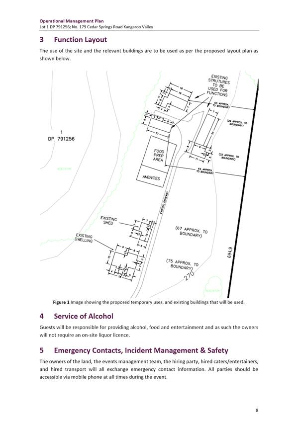
|
|
Development
& Environment Committee – Tuesday 06 October 2020
Page
0
|
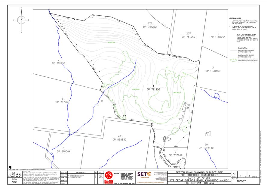
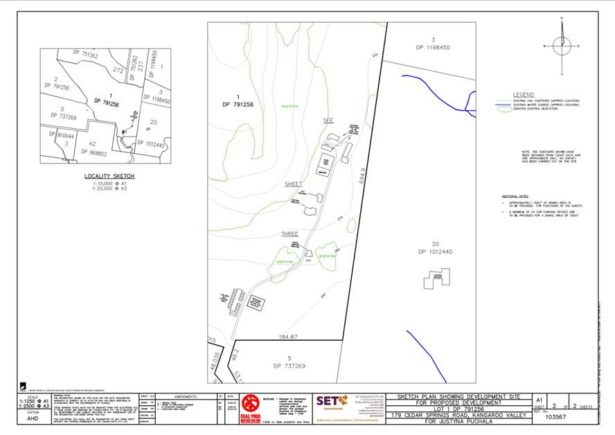
|
|
Development
& Environment Committee – Tuesday 06 October 2020
Page
0
|
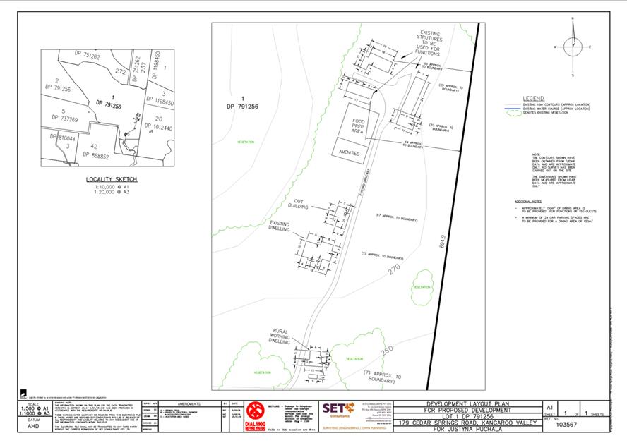
|
|
Development
& Environment Committee – Tuesday 06 October 2020
Page
0
|
DE20.110 Development
Application - DA20/1349 - 4 Sand Drift Way Vincentia - Lot 1432 & DP
1231370
DA. No: DA20/1349/4
HPERM Ref: D20/309409
Section: Development
Services
Approver: Phil
Costello, Director - City Development
Attachments: 1. Planning
Report - 4 Sand Drift Way Vincentia - Lot 1432 DP 1231370 (under separate
cover) ⇨
2. Draft
Determination - Approval - 4 Sand Drift Way Vincentia - Lot 1432 DP 1231370 ⇩
3. Management Plan - Lot 1432 DP
1231370 - 4 Sand Drift Way Vincentia (under separate cover) ⇨
Description of Development: Change of Use from
Dwelling to Boarding House
Owner: New Living Shoalhaven Pty Ltd
Applicant: PDC Planners
Notification Dates: 04 May 2020 to 19 May 2020
No. of Submissions: 156 (154 objecting, 2
supporting)
Purpose / Reason for consideration
by Council
On 23 June 2020, the Development & Environment Committee
resolved that DA20/11349 be ‘called in’ to Council for
determination due to the significant public interest (MIN20.422).
|
Recommendation
(Item to be determined under delegated authority)
That
Development Application DA20/1349 be determined by way of approval subject to
the imposition of conditions of consent as contained in Attachment 2.
|
Options
1. Approve the
Development Application (DA) in accordance with the recommendation.
Implications: Approving the DA will enable the provision of
affordable housing in an appropriate location. There are third party appeal
rights through the NSW Land and Environment Court (L&EC) in particular
circumstances.
2. Refuse the
Development Application (DA)
Implications: Council would have to provide reasons for
refusal to form part of the determination. The applicant would have the ability
to request a review of any refusal by Council and / or pursue an appeal through
the NSW Land and Environment Court (L&EC).
3. Alternative
recommendation.
Implications: Council will need to specify an alternative
recommendation and advise staff accordingly.
Location Map
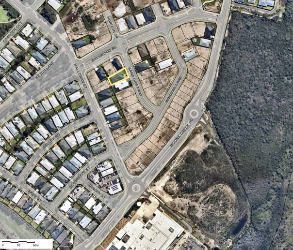
Figure 1 – Location Map with Aerial Overlay
Background
Proposed Development
The conversion of an existing dwelling and secondary dwelling
to a boarding house.
The existing dwelling will comprise of four (4) boarding
rooms, one accessible; communal living area with kitchenette and laundry facilities;
outdoor alfresco area with private open space; and double garage.
The existing secondary dwelling will comprise of Two (2)
boarding rooms; outdoor private open space; and communal entry.
All boarding rooms will comprise separate bathroom facilities
and kitchenettes. Each boarding room has been designed for single occupation
with a total maximum of six (6) occupants at any one time.
Primary dwelling
· Communal
area = 24.45m2
· Room
1 (accessible) = 21.05m2
· Room
2 = 20.9m2
· Room
3 = 19.26m2
· Room
4 = 17.81m2
Secondary dwelling
· Room
1 = 23.03m2
· Room
2 = 19.02m2
Services provided to the site include two (2) enclosed parking
spaces; one (1) accessible open space; waste management/bin storage; letterbox
facilities; two (2) motorcycle spaces; and two (2) bicycle racks.
The proposed boarding house is intended to provide
accommodation for individuals who are on low incomes. The boarding house
complies with development standards set by State Environmental Planning
Policy (Affordable Rental Housing) 2009 and provides all occupants an
appropriate standard of internal and external facilities.
The boarding house will provide a social benefit as it will
provide an affordable, high quality housing option for those who may otherwise
be unable to afford to rent a dwelling or unit in the private market.
The boarding house is to be run by New
Living Shoalhaven Pty Ltd and will be aimed at low income workers, students and
aged pensioners. The Plan of Management submitted with the application
(Attachment 3) identifies that an off-site manager will be appointed to the
boarding house and will undertake regular monitoring of the premises. The Plan
of Management also addresses house rules which will be displayed at the
entrance of the premises, in every private room and in outdoor communal areas.
A zero tolerance policy for alcohol and drugs will be implemented along with no
parties, no live music and outdoor communal area use restricted to between the
times of 8am and 10pm seven (7) days a week and no visitors will be permitted
past 10pm. Any lodger or visitor failing to observe the rules will be dealt
with in accordance with the Plan of Management. Any serious offences and
anti-social behaviour are reportable to the police as is the case regardless of
location.
Figure 2 – Site Plan
Figure 3 – Perspectives
Subject Land
The subject site is situated at 4 Sand Drift Way, Vincentia
legally described as Lot 1432 DP 1231370.
The site has an 18.84m frontage to Sand Drift Way with a total
site area of 600.0m2.
The site currently contains an attached Dwelling and Secondary
Dwelling approved under Complying Development Certificate No. 19/1116 and
modified by 19/1350.
The existing dwelling and secondary dwelling are currently
leased out as two (2) individual dwellings under normal tenancy conditions.
Site & Context
The site is located within the Bayswood Estate.
The surrounding character is comprised of existing residential
development. The site is approximately 250m from the Vincentia Marketplace
which includes supermarkets, specialty stores, dental centre, and medical
services.
The site is within close proximity of existing public
transport which services the wider region and links to train services at
Bomaderry.
History of Current Application
20 April 2020 - The application lodged with Council.
21 April 2020 - Additional information was requested
from the applicant at vetting stage.
04 May 2020 - Additional information received, and
vetting completed.
04 May – 19 May 2020 – official
notification period of 2 weeks.
23 June 2020 - Notice of Motion put forward that
DA20/1349 be called in for determination by Council because of public interest.
01 July 2020 - Request for information sent to
applicant.
03 July 2020 - Site Inspection undertaken.
13 July 2020 - Additional information received from
applicant.
Issues
Shoalhaven Affordable Housing Strategy
The Shoalhaven Affordable Housing Strategy (the Strategy) was
adopted by Council on 11 December 2017. The Strategy “provides a range
of effective policy solutions to facilitate additional affordable housing
across the Shoalhaven local government area”. The Strategy outlines
the issues of affordability in the Shoalhaven and the associated risks:
“Increasing pressure from the Sydney housing market
is having a significant impact on local people, who are forced to compete in an
increasingly competitive local housing market. In particular, local rents are
increasing compared with local incomes in real terms, and the relative scarcity
of rental accommodation at the more affordable end of the market means that
real estate agents can be increasingly selective about who is housed. This is
also contributing to homelessness and increasing the risk of homelessness among
groups who would once have been in more secure accommodation.
Importantly, housing for purchase and rental that is
affordable to very low and low-income households is generally not being created
through the market. Again, this is due to the increasing cost of housing and
the income required to rent or purchase affordably.” (pg.5)
The Strategy contains ‘Locational Criteria for
Affordable Housing’ which preferences affordable housing within
well-located areas that are close to transport and services. Ideally, housing
that meets the needs of very low, low and moderate-income households should be
located close to larger service centres. This has been defined by the Strategy
as precincts within 400-600m of the urban areas of Nowra-Bomaderry, Vincentia
and Milton-Ulladulla. In this instance the boarding house is located in
Bayswood/Vincentia 0.5km from the Vincentia Market Place and 2.8km from the
commercial core of Vincentia.
Public transport services are provided by Nowra Coaches,
departing from the Vincentia Market Place at 9:35am, 11:05am, 1:24pm, 2:24pm,
3:51pm and 6:20pm to Nowra and Bomaderry Railway Station from Monday to Friday;
there are buses returning to Vincentia departing from Stewart Place in Nowra at
7:51am, 9:21am, 10:43am, 12:56pm, 2:54pm, 3:42pm and 5:22pm. On Saturday and
Sunday this is limited to a service at 9:56am and 2:00pm and returning at
8:26am and 12:56pm.
The proposed development is
considered to be essentially consistent with the Strategy in the provision of
high quality ‘new generation’ boarding houses that have been
designed to satisfy the requirements of the State Environmental Planning
Policy (Affordable Rental Housing) 2009. Whilst not being within a
‘well-located’ area as defined under the Strategy the site is
located close to Vincentia Marketplace and there are sufficient public
transport links to the larger commercial areas, along with the day to day
services provided within Vincentia, that will provide for the needs of future
residents.
Social Impacts
Submissions have been received
prior to, during, and after the notification period that have raised concerns
with the impacts on the existing residential area that may result from the
proposed boarding houses.
On the issue of concerns or
fears raised by the community when considering a development application, in New
Century Developments Pty Limited v Baulkham Hills Shire Council [2003]
NSWLEC 154, his Honour Lloyd J stated:
“That the subjective fears and concerns must have a
rational basis and be amenable to objective assessment in order for any
significant weight to be attached to them.”
In this instance the concerns
raised in the public submissions regarding the potential impact of the future
residents on the existing residential community are not able to be verified by
way of ‘objective assessment’.
A Boarding House Management Plan
and Boarding House Rules have been submitted with the application which outline
the process for applying for accommodation and the management arrangement. This
includes a dispute resolution mechanism should there be issues with or between
tenants of the premises.
Council is satisfied that the proposed development will not
result in significant adverse social impacts through the provision of
alternative housing in Vincentia. Conditions of consent that address the
appropriate management of the boarding house in accordance with the submitted
documentation, are considered to be sufficient to mitigate potential impacts.
Planning Assessment
The DA has been assessed under s4.15 of the Environmental
Planning and Assessment Act 1979. Please refer to
Attachment 1
Policy Implications
There are no Policy implications as a result of the
development as proposed.
Consultation and Community Engagement
One hundred and fifty-six (156) public submissions were
received in relation to Council’s notification of the development. 154
were objections to the development from 102 households. Two (2) were in support
of the development.
The notification was made in accordance with Council’s
Community Consultation Policy with letters being sent within a 60m buffer of
the site. Community Consultation Groups were also notified of the proposed
development. The notification was for a standard two (2) week period.
One hundred and sixteen (116) submissions were received during
the formal notification period, 28 submissions were received prior to formal
notification taking place, and another 12 received after the formal
notification period closed.
The initial notification period was delayed due to additional
information being required from the applicant prior to notification.
Key issues raised as a result of
the notification are provided below.
Issue: Lack
of community consultation
Submissions raised the following concerns:
· Reclassification
of the purpose-built dwelling, it was specifically designed as a boarding
house.
· No
notification at construction stage.
· Prevent
this misuse/abuse of its recent Affordable Housing Policy.
Comment
The proposed development was notified in accordance with Shoalhaven
City Council Community Consultation Policy for Development Applications
(Including Subdivision) and the Formulation of Development Guidelines
and Policies (POL 16/230).
The application was notified for 2 weeks between Monday 04 May
2020 till close of business Tuesday 19 May 2020. All documents (except floor
plans) are publicly available on the DA tracking website.
Developers are not required to engage with neighbours or the
community when preparing a development application.
The original application was approved under a Complying
Development Certificate (CDC) in accordance with the provisions of the NSW
State government State Environmental Planning Policy (Exempt and Complying
Development Codes) 2008 (Codes SEPP). The controls in the Codes SEPP have been developed to provide building
envelopes that take into account amenity and privacy.
CDCs do not require neighbour notification as is the case with
many forms of Local Development.
Issue: Illegal development
Submissions raised the following concerns:
· Reclassification
of the purpose-built dwelling, it was designed as a boarding house.
· Not
constructed in accordance with the ‘Bayswood Design Essentials’.
· prevent
this misuse/abuse of its recent Affordable Housing Policy.
Comment
The application before Council is for a Change of Use, from a
dwelling to a Boarding House. The proposed use is permissible within the Zone.
The existing structure was approved as a Dwelling and attached
Secondary Dwelling (Granny Flat) via a Complying Development Certificate (CDC).
The two-step approach to the development, undertaken by the developer, is a
legitimate pathway within the NSW Planning System. The existing structure is a
permissible use within the Zone.
The issues raised by way of the proposed development not
complying with the Masterplan of the Estate are based on marketing strategies
and promotional material, not land use planning legislation. The proposed development is permissible within the Zone and
is compliant with all relevant legislation.
The original Complying Development adhered to the requirements
within the 88b instrument, Restrictions as to User which state that:
Issue: Inappropriate Development
within the zone
Submissions raised the following concerns:
· Boarding houses in
residential areas are inappropriate
· Bayswood is a
place for growing families and elderly residents
Comment
The Proposed Development Is Located Within the R2 – Low
Density Residential Zone. A boarding house is permissible within the Zone with
consent. An extract from the Shoalhaven Local Environmental Plan 2014 is
below:
Permitted with consent
Bed and breakfast accommodation; Boarding houses;
Boat launching ramps; Boat sheds; Building identification signs; Business
identification signs; Centre-based child care facilities; Community facilities;
Dual occupancies; Dwelling houses; Environmental protection works; Exhibition
homes; Flood mitigation works; Group homes; Health consulting rooms; Home-based
child care; Home businesses; Home industries; Jetties; Neighbourhood shops;
Oyster aquaculture; Places of public worship; Pond-based aquaculture; Recreation
areas; Respite day care centres; Roads; Semi-detached dwellings; Sewerage
systems; Tank-based aquaculture; Water supply systems
The objectives of the R2 zone are:
1. To provide for the
housing needs of the community within a low-density residential environment.
2. To enable other land
uses that provide facilities or services to meet the day to day needs of
residents.
3. To provide an
environment primarily for detached housing and to ensure that other development
is compatible with that environment.
1. The low-density residential zone is characterised by
predominantly single storey residential development. The existing area has a
variety of residential accommodation types already approved including dwelling
houses, secondary dwellings, and attached dual occupancies. The proposed
development presents as a dwelling to the street and provides diverse housing
stock within the community.
2. Other land uses permitted within the zone to support the
needs of residents include medical centres, neighbourhood shops, places of
worship – churches, and childcare facilities to name a few. The subject
site is less than 200m from the adjoining B2 – Local Centre which
provides a range of retail,
business, entertainment and community uses.
Boarding house developments provide
medium to long-term rental housing for a diverse group of people within the
community including but not limited to low-income/young professional,
divorcees, retired people, contract workers, students, and others looking to
live within a community.
Issue: Parking and traffic safety
Submissions raised the following concerns:
· Sand
Drift Way is a narrow street and does not facilitate large vehicle movements
· Limited
on-site parking. Six rooms/people and only parking for three vehicles
· Car
parking is already an issue within the Estate
· Design
Essentials for Bayswood Estate state that parking is to be in a garage or
behind a fence.
· Do
not want people parking on pathways/sidewalk
· Visitor
parking provisions
· Safety
of pedestrians
Comment
Under the State Environmental Planning Policy (Affordable
Rental Housing) 2009, the proposed development triggers the need for 0.5
parking spaces per room. A total of six (6) rooms requires three (3) spaces.
The proposed development provides two (2) internal parking spaces with an
additional external accessible space located in the front setback. Accordingly,
Council cannot refuse consent to the boarding houses based on the provision of
car parking alone.
Section I.VI of the Management Plan outlines the requirements
for parking as follows:
· Off
street parking is provided for the use of residents.
· Cars,
bicycles and motorcycles are to be parked in the allocated areas.
· No
car or motorcycle is to remain in a parking space, without being moved, for a
period of longer than 72 hours.
· Repairs
to motor vehicles are not to be carried out on site.
The additional accessible parking space within the front
setback is to be screened from public view through the use of landscaping and is
to be maintained in perpetuity.
The provision for Bayswood Estate within the Bayswood
Design Essentials, that states that parking is to be in a garage or behind
a fence, is not something that can be legally regulated and has no legal basis.
This requirement is not being complied with by existing residents who use
driveways to park their vehicles.
Visitor parking can be accommodated onsite or on the road
verge, similar to other properties within the estate. There is no requirement
for visitor parking to be provided either within the ARH SEPP or Chapter G21
– Car Parking and Traffic, of the Shoalhaven Development Control Plan
2014.
The driveway is existing and was
approved under s138 of the Roads Act 1993 and access and manoeuvrability
into and within the site is in accordance with Chapter G21 of the Shoalhaven
DCP 2014. The road infrastructure has been designed to comply with the
Austroads road design requirements.
Issue:
Operations of boarding house and safety
Submissions raised the following concerns:
· No on-site manager
to supervise
· Too many people
residing in the residence
· Negative
effect on children and the elderly who will be ‘too frightened to step
outside their houses’
· Increased
crime in the area and anti-social problems – abuse, vehicle accidents,
‘questionable’ comings and goings, theft, break-ins and vandalism
Comment
Clause 30(1e) of the State Environmental Planning Policy
(Affordable Rental Housing) 2009 states that an on-site manager is only
required if the boarding house has the capacity to accommodate 20 or more
lodgers. The proposed boarding house has the capacity to accommodate 6 lodgers
and does not trigger the requirement for on-site management.
The Boarding Houses Act 2012 introduced regulations and
protections for residents of boarding houses. The Act states that an Occupancy
Agreement is required to be produced in accordance with Schedule 1 of the Act
and provided to all tenants.
A Management Plan has been provided which outlines the ongoing
management of the proposed boarding house as follows:
· The
premises are to operate as a registrable boarding house for the purposes of the
NSW Boarding Houses Act 2012 and the operation of the boarding house is
to be in compliance with the Act.
· The
capacity of each boarding room shall not exceed 1 resident.
· Any
person who is to occupy a room in the boarding house is to sign an Occupancy
Agreement.
· Prior
to entering into an Occupancy Agreement, prospective residents are to be
advised that they may potentially be evicted if they breach the resident
obligations.
· Alcohol
is not permitted to be consumed in the indoor or outdoor communal areas.
· Examples
of serious misconduct include but are not limited to drug or alcohol abuse,
sexual, racial or religious harassment, theft, or violence. Lodgers are
instructed to call the police if the lodger is performing illegal acts on the
property.
· Any
lodgers inviting visitors to the premises must accept full responsibility for
them and their behaviour. In the event of any serious misconduct by the visitor
of a lodger, the lodger may also be asked to vacate the premises and be asked
to pay for damages, where required.
· No
pets are allowed within the boarding house accommodation at ANY time.
· Security
cameras are permitted to be installed in the common areas.
· A
Complaint Monitoring System will be established, and all complaints will be
recorded and acted upon in a timely manner.
The Management Plan has been written in accordance with the
requirements set out in Schedule 1 of the Act.
The Local Government (General) Regulation 2005 sets
standards for places of shared accommodation, and this includes all boarding
houses. Schedule 2 Standards enforceable by orders, Part 1 Standards for places
of shared accommodation
General boarding houses are subject
to an initial inspection by the local council, and separately are subject to
the local council’s ongoing monitoring of development controls and fire
and building safety regulations under the Environmental Planning and
Assessment Act 1979 and the Local Government Act 1993.
Issue: Affordability
Submissions raised the concern that the proposed development
was too expensive to be classed as ‘Affordable Housing’
Comment
It is proposed to rent the rooms out at around $225-250 per
week. This includes the room, basic furniture and utilities. Current rents
within the Shoalhaven area for a studio apartment or 1-bedroom unit range from
$210 upwards with an average cost of $250/week (NSW Department of Communities
and Justice, March Quarter 2020 Rent Tables). These prices do not include
furniture or utilities.
The difference between boarding houses and standard
residential tenancies which makes boarding houses more affordable is outlined
below:
|
Boarding house
|
Residential tenancy
|
Difference
|
|
0-2 weeks bond
|
4-6 weeks bond
|
Lower initial outlay
|
|
Furnished
|
Usually not furnished
|
No outlay for furniture
|
|
Utilities provided in
lease agreement
|
Utilities the
responsibility of tenant
|
Fixed costs allow for
budgeting
|
|
Flexibility of tenure
|
Fixed/minimum term
tenure
|
Suitable for contract
workers and others requiring flexibility in accommodation
|
Issue: Sourcing of tenants
Submissions raised the following concerns:
· ‘Marketing
for tenants through social media, local hospitals, police stations and any suitable
reference for key workers.’
· Clients who are
low-socioeconomic, parolees/offenders, people with mental illness, drug addicts
Comment
Under the Anti-discrimination
Act 1977 and the Boarding Houses Act 2012, it is unlawful for
providers of services and accommodation to discriminate against people.
Discrimination against people due to age, race, disability, gender,
gender-identity, sexual orientation, marital status or carer’s
responsibilities, or discrimination against a person because they are related
to, or associate with, a person with these characteristics, is unlawful under
the Acts.
Issue: Lack of local infrastructure
and support
Submissions raised the concerns of limited public transport,
limited medical facilities, no Government services within the vicinity.
Comment
The State Environmental Planning Policy (Affordable Rental
Housing) 2009 has no provisions for boarding houses to be located nearby
public transport, Government facilities or other services. The ARH SEPP clause
27(3) has provisions for boarding houses within regional areas whereby they
need to be located within 400m proximity to a B2 – Local Centre Zone.
The proposed boarding house will be located less than 300m
from the B2 – Local Centre Zone and Vincentia Marketplace. Vincentia
marketplace includes Woolworths, Aldi, Vincentia Bay Medical Centre, Vincentia
Dental Care, Choice Pharmacy, Australia Post, Westpac, Anytime Fitness, Caltex
Petrol, and a variety of specialty stores and food outlets. The boarding house
will also be in close proximity to Vincentia High School, Vincentia Public
School, Vincentia Medical Centre, Bay and Basin Leisure Centre, Vincentia
Shopping Village, a variety of Churches, HMAS Creswell Royal
Australian Navy base, and HMAS Albatross Royal Australian Navy base.
Access to public transport is
available to the site with a bus stop located Vincentia Marketplace which
services the local area to Basin View, Sanctuary point, Hyams Beach, Huskisson,
Nowra and connects to the train line at Bomaderry.
Issue:
Noise
Submissions raised concerns relating to noisy behaviour by
residents.
Comment
The property is to be managed by way of a Management Plan. The
Management Plan outlines the house rules which place restrictions on noise as
follows:
· Live
music will not be permissible on the premises at ANY time.
· No
amplified music is permitted at ANY time within the outdoor communal areas.
Recorded and/or amplified music is permissible indoors during daylight hours
between 8:00am and 10:00pm, seven days a week.
· No
Parties are permitted on the premises.
· All
visitors of residents are to leave the premises by 10pm nightly.
· The
use of the outdoor communal areas shall be restricted to between the hours of
8:00am and 10.00pm every day.
The premises are to be used in the same fashion as surrounding
residential premises, however with a higher level of restrictions, particularly
around the matter of noise producing activities.
Noise control is enforced under the
Protection of the Environment Operations Act 1997 (POEO Act) and the Protection
of the Environment Operations (Noise Control) Regulation 2008 (Noise
Control Regulation). Section 6 of the POEO Act makes Council the regulatory
authority for noise control within the LGA. The noise restrictions outlined
within the Management Plan are consistent with the POEO Act, and Noise Control
Regulation.
Issue:
House and land prices
Submissions raised concerns with the proposed development
devaluing of existing properties within the Estate.
Comment
House and land prices do not form part of the development
assessment process and are not a mechanism for assessment consideration under
the Environmental Planning and Assessment Act 1979. This position is
consistent with the Land and Environment Court’s long taken stance that
land values are not a relevant planning consideration (Alphatex Australia v
The Hills Shire Council (No 2) [2009] NSWLEC 1126). In this matter, at
paragraph 105 the (then) Senior Commissioner Moore stated:
“…I pay no
regard to the fears about loss of property values as, consistent with the
position long taken in the Court, this is not a relevant planning
consideration.”
Issue:
Currently occupied and multiple bins at the location
Submissions raised the following concerns:
· People are
currently living on the premises
· There are two (2)
sets of bins at the location
Comment
The existing approval is for a four (4) bedroom dwelling and
two (2) bedroom secondary dwelling. The issue of the structure already being
used has been reviewed by Council’s Compliance Team, who found that the
existing premises was currently being rented as two (2) separate dwellings in
accordance with the current approved use.
‘Yellow’ and ‘red’ bins have been
provided to each separate occupancy in accordance with Council’s Waste
Minimisation and Management Guidelines, whereby all dwellings are to be
provided with suitable waste services.
Financial Implications
There are potential cost implications for Council in the event
of a refusal of the application. Such costs would be associated with defending
any appeal in the Land and Environment Court, should the applicant utilise
appeal rights afforded under provisions of the EP&A Act.
Legal Implications
Pursuant to section 8.2 of the EP&A Act, a decision of the
Council may be subject of a review by the applicant in the event of an approval
or refusal. In the event that such a review is ultimately pursued (if the
recommendation is not adopted) the matter would be put to Council for
consideration.
Alternatively, an applicant may also appeal to the Court
against the determination pursuant to section 8.7 of the EP&A Act.
Summary and Conclusion
• The
development is permitted within the zone and is consistent with the objectives
of the zone.
• The
development will result in alternative accommodation in a suitable location.
• The
development will not result in significant social impacts subject to
appropriate management and therefore the imposition of appropriate conditions
of consent.
• The
development is compliant, with no significant reason or issue being identified
warranting a negative recommendation.
Having regard to the above, it is recommended that Development
Application No. DA20/1349 be approved subject to appropriate conditions of
consent. (Attachment 2.)
|

|
Development
& Environment Committee – Tuesday 06 October 2020
Page
0
|
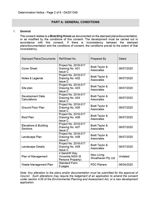
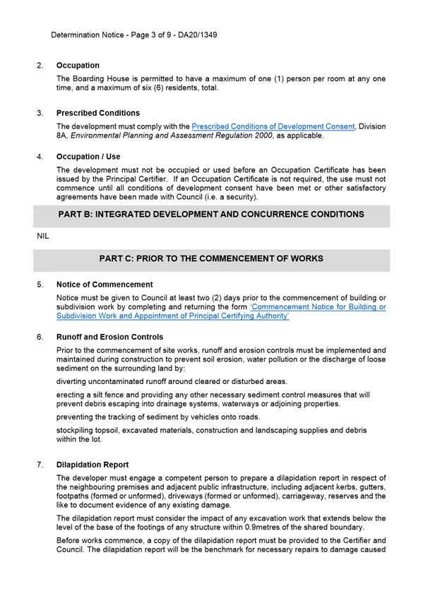


|
|
Development
& Environment Committee – Tuesday 06 October 2020
Page
0
|
DE20.111 Development
Application - DA19/2192 - Bryces Rd Far Meadow - Lot 25A DP 5996 & Lot 1 DP
1237878
DA. No: DA19/2192/4
HPERM Ref: D20/327520
Section: Development
Services
Approver: Phil
Costello, Director - City Development
Attachments: 1. Draft
Determination - Bryces Rd Far Meadow - Lot 25A DP 5996 & Lot 1 DP 1237878
(under separate cover) ⇨
2. Planning
Report - Bryces Rd FAR MEADOW - Lot 25A DP 5996 & Lot 1 DP 1237878
(under separate cover) ⇨
3. Site
Plan - Bryces Rd Far Meadow - Lot 25A DP 5996 & Lot 1 DP 1237878 ⇩
4. Site
Plan - Right of Way - Bryces Rd Far Meadow - Lot 25A DP 5996 & Lot 1 DP
1237878 ⇩
5. Concept Floor Plan - Bryces
Rd Far Meadow - Lot 25A DP 5996 & Lot 1 DP 1237878 ⇩
Description
of Development: In Principle Dwelling Envelope
Owner: Shoalhaven City Council (Lot 25A) & M J
Boyde & J A Lawson (Lot 1)
Applicant: Shoalhaven City Council – Property
Unit
Notification Dates: 9-30 January 2020
No. of Submissions: Three (3)
Purpose
/ Reason for consideration by Council
Section 3.3.2 of Council Policy No. POL16/235 –
Dealing with Development Applications Lodged by Council Staff or Councillors
applies. As detailed above, the owner is Shoalhaven City Council and is being
assessed by same. To ensure the process is transparent, the matter is
being put to Council’s Development & Environment Committee for
consideration.
|
Recommendation (Item to be determined under delegated authority)
That Development Application DA19/2192
for ‘In Principle Dwelling
Envelope’ at Lot 25A DP 5996 and Lot 1
DP 1237878, Bryces Rd, Far Meadow be approved subject to the recommended
conditions of consent contained in Attachment 1 of this report.
|
Options
1. Approve the
development application (DA) in accordance with the recommendation of this
report.
Implications: This would allow the
development to proceed.
2. Refuse
the application.
Implications: Council would need to determine the
grounds on which the application is refused, having regard to section 4.15(1)
considerations.
3. Alternative
recommendation.
Implications: Council will
need to specify an alternative recommendation and advise staff accordingly.
Figure
1 – Location Map
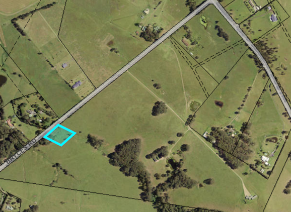
Background
Proposed Development
The proposal is an application
for the nomination of a building envelope which involves:
· Establishment of a
building envelope on Lot 25A DP 5996 at Bryces Rd Far Meadow (which forms the
‘development site’) as depicted in Attachment 3. The building
envelope would have a total area of 252.5m².
o The envelope would have
maximum dimensions of 21.75m long x 14.4m wide.
o The envelope would be located
a distance of 10.0m from the south-eastern rear corner of the development site
and directly adjoins the southern side boundary.
o A Concept Floor Plan
(Attachment 5) proves that the building envelope would be of a sufficient size
and dimensions to support the construction of an adequately sized dwelling
whilst also achieving compliance with applicable provisions of the Shoalhaven
Development Control Plan (SDCP) 2014.
· Establishment of an
effluent disposal area on Lot 25A DP 5996 at Bryces Rd Far Meadow (which forms
the ‘development site’) as depicted in Attachment 3.
o The effluent disposal area
would be located in the south-eastern rear corner of the development site and
directly adjacent to the building envelope.
o An Onsite Wastewater
Assessment prepared by Harris Environmental Consulting, dated 5 March 2019
proves that the following system is capable of being installed within the
dimensions of the effluent disposal area as part of a future development:
§ Aerated Wastewater Treatment System
(AWTS) with a 13.8m² raised soil absorption bed as one 6m long x 2.3m wide
bed.
§ Reservation of 13.8m² reserve
for a raised soil absorption bed.
§ 700mm masonry retaining wall OR 1:3
grassed slope batter around the sides and upslope diversion bank.
· The establishment of a
right of way access easement over Lot 1 DP 1237878 at No. 47 Bryces Rd Far
Meadow to permit access to Bryces Road as Lot 25A DP 5996 does not have direct
frontage to Bryces Road.
Subject Land - Background
The development site comprises
Lot 25A DP 5996 and Lot 1 DP 1237878 (Bryces Road, Far Meadow). Refer to Figure
1.
The lot was originally created
in DP 5996 dated 5 September 1910. The lot was created without road access
(notation on the DP detailed further below) so that it would have to be
consolidated with adjoining land if sold. Subsequent to this, DP 234234
was registered on 8 September 1965. This did not impact on Lot 25A.
This later DP created a ‘road’.
Lot 25A was transferred to
Council for ‘reservoir purposes’ in 1920. The land was never used
for the intended purpose and is no longer required resulting in it being
surplus to Council’s operational requirements. The land also has an
easement for a water pipeline. The historic dealing A665982 references lot 25A
for “reservoir purposes”.
The note (numbered
‘1’) on the DP that applies to Lot 25A, is as follows:
(1) An
easement is retained by the vendors over the land 2 feet in width on each side
of lines referred to as Water Easement on plan.
Blocks Nos 25A,
26A, 44B, 51A (?) to which no road of access has been left will only be sold to
owners of adjoining land.
Lot 25A is identified in
Council’s records as a ‘dam’. It is not being used for
this purpose and is subject to a Category 3 water course as detailed further
below. As mentioned, the dam never eventuated. The land is separated from
Bryces Rd by a thin strip forming part of Lot 1.
The land has an ‘entitlement’ to a dwelling
(certificate dated 22 October 2015). This DA will confirm or otherwise,
depending on the final decision, that the site has capacity to
‘fit’ a modern dwelling having regard to site characteristics and
constrains and resolve access issues.
Application Context
Having regard to the above, whilst there is a legal
entitlement, the land was not created for rural or rural residential purposes.
This application therefore ‘teases’ out site suitability and
capacity for a dwelling in a rural context.
It is also noted that Council considered a confidential report
concerning this land in 2017. In summary, the intention being to investigate
‘options’ to ensure any sale was based on an appropriate market
value. The confidentiality was on the basis that there could be certain
commercial advantages to certain parties.
This current development application is described in the
amended Statement of Environmental Effects prepared by Locale, dated December
2019, in the “Executive Summary” as a:
“…development application to ensure that a
rural dwelling can be constructed on the site, prior to lodging a
separate boundary adjustment application. This will enable Council to create a
more useable parcel of land that can be disposed of by Council. The land
disposal process will be consistent with Council’s Development and / or
Disposal of Council Lands Policy (POL16/256).”
The same report comments that there are no significant
environmental constraints to the proposal. This may be correct in terms of
flora and fauna and other impacts; however, there are physical attributes to
the land that make the design and siting of a dwelling house particularly
challenging. The report goes on to conclude that there is a “small”
building footprint on the land. This footprint relies on the acceptance or
otherwise of allowing performance-based solutions to a side set back as
discussed later in this report.
The issue of boundary setbacks was specifically mentioned as
something for exploration in the pre-lodgement meeting held on 28 March 2018.
This application also follows an exercise to investigate a
boundary adjustment however the boundary adjustment as put at the time, posed a
number of issues. It was considered that a boundary adjustment could
theoretically be undertaken; however, upon obtaining legal advice the extent
of the adjustment that was being considered at the time was deemed to be more
that a minor change amongst other things.
Site & Context
The development site (Lot 25A DP
5996):
· Has a total area of 5,969m² and is presently vacant.
· Has a large
proportion, being the northern, central, and western parts, being made up of an
existing Category 3 water course and surrounding riparian areas.
· Is also vegetated across the south-western front corner
nearest to Bryces Road.
· Has a small area of cleared land external to the water
course and vegetated areas where the building envelope is proposed.
· Does not have direct road frontage to Bryces Road (see
figure 3) and a driveway and right of way access over the neighbouring property
(Lot 1 DP 1237878) is required for legal and practical access.
· Is zoned RU1 Primary Production under the Shoalhaven Local
Environmental Plan 2014 (SLEP 2014).
The driveway / right of way
access easement site (Lot 1 DP 1237878):
· Has a total area of 46.13 hectares.
· Is a large rural property predominantly occupied for
primary production purposes including grazing.
· Contains an existing dwelling in the eastern rear part at a
distance of 800m from the ‘development site’ and location of the
proposed driveway and right of way easement.
· Has direct road frontage to Bryces Rd in the western part.
· Is zoned RU1 Primary Production under the SLEP 2014.
Figure
2 – Zoning Extract
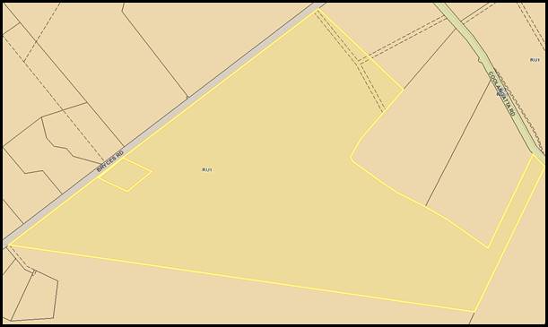
Figure 3 –
Location of Boundaries
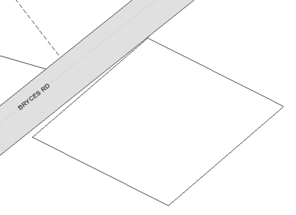
History of the Development Application
The following provides a history
of correspondence with the applicant and further information requested in
relation to the Development Application following its lodgement on 3 December
2019 (note: request for information is ‘RFI’):
· 1st
RFI Request sent to the applicant on 11 December 2019 requesting:
o A revised application form to
include Lot 1 DP 1237878 (known as 47 Bryces Road) as part of this application
due to the proposed works affecting this land.
o Addendum to the Statement of Environmental
Effects (SoEE) Report to demonstrate that any future development can comply
with Chapter G12 of the SDCP 2014, particularly considering boundary setbacks.
o Provision of a Waste
Management Plan.
· Applicant response
to the 1st RFI Request on 19 December 2019 providing a response to
the requested information.
· 2nd RFI
Request sent to the applicant on 24 April 2020 following a response to all
internal / external referrals and the notification process requesting that
matters raised by the Development Engineer and Environmental Assessment Officer
be addressed, including:
o Right of Way (ROW) Plan - Plan
depicting the full length of the ROW access & connection to Bryces Road,
sight distances, vegetation to be removed, and method for runoff disposal.
o Longitudinal Section Plan
– Longitudinal sections of the driveway.
o Amended Fauna and Flora
Assessment providing –
§ A full Fauna and Flora Assessment
with all sections provided.
§ Map with vegetation communities
overlain with the future development footprint (inclusive of the entire length
of the right of way access).
· Applicant response
to the 2nd RFI Request in separate submissions on 4 and 18 June
2020, providing the requested documentation.
· Response provided
to all internal referrals by 21 August 2020 recommending approval subject to
conditions of consent.
Issues
Figure
3 – Building Envelope Plan
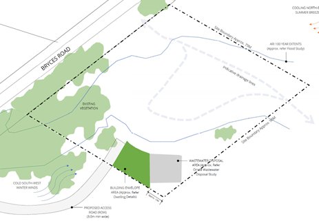
Performance–Based Solution to Side Setback for a
future Dwelling
The ‘Concept Floor
Plan’ at Attachment 5 demonstrates a suitably sized modest dwelling is
capable of being constructed within the building envelope. However, a suitably
sized dwelling such as that demonstrated is likely to lead to a future departure
to the side setback requirement for a dwelling (under A18.1 of Chapter G12
– Dwelling Houses and Other Low Density Residential Development of the
SDCP 2014).
Details regarding the future
departure to Acceptable Solution A18.1 are provided below:
Acceptable Solution A18.1 states
the following:
“Setbacks
comply with Table 1, where the site is located in the following zones:
· RU1 Primary Production (between 4,000m² and 10,000m²).
- Front Setback – 20m;
- Side Setback –
7.5m; and
- Rear
Setback – 7.5m”.
The concept floor plan shows
that the following setbacks are capable of being achieved for a future dwelling
such as that demonstrated:
· Front
Setback (western towards Bryces Rd) – 60.0m approx. (complies);
· Side Setback
(northern) – 112.0m approx. (complies);
· Side Setback (southern) – 4.2m setback provided
(40% future departure likely); and
· Rear Setback
(eastern) – 10.0m (complies).
In summary, there is an alternatively solution proposed for
the side setback.
Applicant’s Submission
“A
variation is sought as justified below:
· The proposed side and rear setbacks do not create
overshadowing, privacy, amenity, loss of views, infrastructure or safety
impacts as the nearest dwelling is some 150m away.
· The proposed building footprint responds to the site
constraints in relation to flora & fauna, flooding and effluent disposal
and in doing so reduces the environmental impact of the proposed dwelling.
· The location of a central watercourse and the shape and
size of the allotment (relatively small in relation to other surrounding rural
holdings and other RU1 zoned land) limit the opportunities to meet the setbacks
in Table 2, whilst still responding to the environmental attributes of the
site.
· The proposed setbacks ensure the building footprint is
sympathetic to the physical constraints of the site and encourage an
ecologically sustainable outcome, on a site with an existing dwelling
entitlement”.
Discussion
Clause 11
– Variations (that is, acceptable solutions) to provisions in the SDCP
2014 allows flexibility in the application of such development controls to
promote innovation and design excellence.
Council may
consider alternative solutions to the requirements of the Development Control
Plan in certain circumstances where flexibility can produce improved and
innovative solutions for particular sites, taking into account the fact that
there can be unique site attributes and design outcomes required to achieve
development.
The
acceptable solutions are provided as examples of what is considered acceptable
for the respective performance criteria and objectives. Council can consider
alternative solutions in certain circumstances provided the objectives and
performance criteria are met.
Performance Criteria P18.1
– P18.6 which apply in this instance, state the following:
“P18.1 The front setback is
generally consistent with adjoining development and does not undermine the
integrity of the prevailing building lines.
P18.2 The location and siting of the
building complements the existing setbacks in proximity to the site, foreshore
(if applicable) and the streetscape.
P18.3 The proposed development is
setback and of a scale that is relative to the street reserve width, in such a
way to ensure pedestrians do not feel buildings are overbearing.
P18.4 Setbacks avoid loss of view,
undue overshadowing and provide/maintain privacy (visual and acoustic), traffic
safety and maintain adequate daylight and sunlight access.
P18.5 Adequate levels of light and
ventilation to adjoining buildings, landscaping, services and infrastructure are
protected.
P18.6 The proposal maintains adequate
provision for on-site car parking”.
Council concurs with the
variation statement provided by the applicant and agrees that the concept floor
plan for a future dwelling would be capable of providing a justifiable
performance-based solution for the following reasons:
· Given
the rural location of the development site, the nearest dwelling is located
approximately 150m away. On this basis, a minor encroachment to the side
setback requirement would not be likely to lead to a visible impact in relation
to privacy, solar access or loss of views.
· Adequate
levels of light and ventilation to nearby buildings, landscaping, services and
infrastructure are likely to be maintained.
· The
proposed dwelling is a concept layout only and does not represent the final
design. The floor plan is indicative only to show that a suitably sized
dwelling can be accommodated within the building envelope. An alternative
design may be provided at dwelling construction stage which may provide a
different layout which reduces the extent of the departure.
· The
site is significantly constrained due to various matters including water
courses and adjacent riparian areas traversing across the northern, western,
and central parts of the site, flood prone land unavailable for construction,
and vegetation cover. These matters combined are likely to prevent a dwelling
from being constructed in a different location.
· Compliance
is capable of being achieved with all other setbacks on the site.
· Adequate
space would be available within the building envelope and driveway for the
onsite parking requirement of two spaces to be achieved.
Another consideration is if this design solution (building
envelope) having regard to the agricultural use of the adjoining land would
pose an issue. Lot 25A is located adjacent to lot 1 in DP 1237878 – which
is 46.13ha in area. The current use is described as grazing. However,
there are approvals in place for tourist and visitor accommodation – that
is, tourist cabins. The cabins and a significant dwelling have been constructed
on the land with the Occupation Certificate issued in 2010.
Having regard to the use of the land, location of the cabins,
existing (rural residential) development, the location of Lot 25A (see Figures
1 and 2), site characteristics, and proposed driveway arrangement, it appears
unlikely that a significant land use conflict would result. In this regard the
side setback is considered reasonable in this situation. Achieving the
acceptable solution, i.e. 7.5m as opposed to the 4.2 as put forward in this
proposal, is unlikely to achieve an improved or visibly better outcome or
improved amenity.
With regard to any precedent, it is important to note that
each application must be considered on merit with regard to the circumstances,
unique attributes of the site and development at hand. Consequently, it is not
considered that this proposal will result in an undesirable precedent.
In the event that this application is approved, a further
development application will be required for a dwelling. However, this current
application would have resolved the key issue of site suitability and capacity
to ensure that a dwelling, albeit modest one, can be reasonable placed on the
site which is clearly constrained.
Planning Assessment
The DA has been assessed under
s4.15(1) of the Environmental Planning and Assessment Act 1979. Please refer to
Attachment 2.
Policy Implications
Assessment of Council’s Own Development
Applications – POL16/226
Council’s Policy No. POL16/226 – ‘Assessment
of Council’s Own Development Applications’ applies given the
Development Application was lodged by Council’s Property Section.
The purpose of POL16/226 is:
“To
ensure that where a Development Application (DA) is lodged and Council is both
the applicant and landowner, the assessment, the consideration of submissions
and the recommendations put forward for Council’s consideration of that
DA,
· are
free from any conflicts of interest, and
· are
undertaken independently and in an unbiased manner.
· are in
line with the Independent Commission Against Corruption (ICAC)’s Position
Paper on “Corruption Risks in NSW Development Approval Processes”
dated September 2007”.
This policy is formulated
following Council’s consideration of the ICAC Position Paper
recommending: “That individual local councils take steps to manage their
conflicting roles in
matters
where they are the regulator of land and have a financial interest in the
outcome of the matter.”
The Table
to ‘Part 3 – Provisions’ of Policy No. 16/226 below provides
a summary of which applications may be determined under Delegated Authority,
which applications may be determined as part of a Report to Council, and which
applications require determination by an external independent town planning
consultant:
|
Category of DA where
Council is both Applicant and Landowner, or where Council has an interest on
the land
|
Provision
|
|
Minor DA
|
· Assessment
by Council staff not involved in the application.
· Determination
under delegated authority.
|
|
Routine larger subdivision DA
(not minor) or other form of DA that takes place within Council’s
industrial estates or on Council reserves and complies with zoning, land use
provisions and Council policies.
|
· Assessment
by Council staff not involved in the application and peer reviewed by senior
member of staff.
· Determination
under delegated authority by senior member of staff.
· Report to
council would be an option if substantial submissions received.
|
|
Major DA
|
· Engage
external independent town planning consultant (in accordance with
Council’s Purchasing Policy), to:
o assess
DA in accordance with requirements of section 79C (now s4.15) of the Environmental
Planning & Assessment Act 1979;
o consider
any submissions received following DA notification in accordance with
Council’s Community Consultation Policy for Development Applications
(Including Subdivisions) and the Formulation of Development Guidelines and
Policies; which may include addressing a resident briefing meeting; and
o prepare
and submit to Council a report on the section 79C (now s4.15) assessment and
consideration of submissions, including recommendations for the consideration
of full Council.
|
The
Development Application is considered to fall under category 2 which requires
assessment by Council staff not involved in the application and peer reviewed
by a senior member of staff. The assessment was carried out by a member of
Council’s City Development staff not involved in the application and was
reviewed by senior members of staff.
However,
since three (3) submissions were received objecting to the proposal it was
decided that the application should be reported to Council for determination
which will ensure that the process is completely transparent.
Consultation and Community
Engagement:
Notification was undertaken in
accordance with Council’s Community Consultation Policy with letters
being sent within a 100m buffer of the site, during the period 9 January 2020
to 30 January 2020.
Three (3) public objections were
received in relation to Council’s notification of the development.
Key issues raised as a result of
the notification process and Council’s response to each issue raised are
summarised in the following Table:
|
Potential for effluent flow
into the water course
· There is a
direct water course linking this property with several other properties, and
concerns were raised that wastewater runoff has the potential to flow onto
other properties and into their dams.
· The septic
system must be placed far away from the water course and the gully which
feeds into several properties.
|
Potential effluent flow
into the water course
· A recommendation
of the ‘Soil and Site Assessment for Onsite Wastewater Disposal’
requires that an upslope diversion bank be installed to prevent effluent flow
to the water course.
· Council’s
Environmental Health Officer reviewed the Report and supported the proposal
on the proviso that the recommendations be implemented.
· A section 88B
restriction would be included within any consent requiring that the
recommendations of the Report be implemented as part of any future dwelling
construction.
|
|
Flooding
· A natural water
course has created a huge gully over the entire development site.
· Comments were
made that the development site floods substantially from surrounding
mountains which then passes through several properties.
|
Flooding
· The natural water
course, whilst encompassing the majority of the development site, does not
traverse the part of the development site where the building envelope is
located and is completely fenced off from the area which would become the
future development site.
· The site and
proposal was reviewed in detail by Council’s Floodplain Engineer and it
was found that the south-eastern rear corner of the site where the building
envelope is proposed is located outside of the 1% AEP flood level extent.
|
|
Survey Details are Incorrect
· A comment was
made that the survey details supplied with the application may be incorrect.
· A comment was
made that it may not mention all the easements as per the Certificate of
Title for the land, with easements missing being appurtenant to Lot 25A
DP5996.
|
Survey details are
incorrect
· The survey being
referred to is a Plan which is provided within the ‘Site Assessment for
Onsite Wastewater Disposal’ Report.
· It has been
prepared for the purpose of documenting the location of the creek and the
associated flood risks.
· The plan is not
designed to be a new survey of the land nor is it designed to be lodged with
Land Registry Services.
· The plan
referred to in no way impacts upon easements burdening the land or those
which burden neighbouring properties.
|
Financial Implications:
There are potential cost implications for Council in the
event of a refusal of the application.
Legal Implications
Pursuant to section 8.2 of the EP&A Act, a decision of
the Council may be subject of a review by the applicant in the event of an
approval or refusal. If such a review is ultimately pursued the matter would be
put to Council for consideration.
Summary and Conclusion
This application has been
assessed having regard for section 4.15 (Matters for consideration) of the Environmental
Planning and Assessment Act 1979. The assessment revealed that the
proposed development is compliant with the provisions of the SLEP 2014 and is
broadly consistent with the acceptable solutions and/or performance criteria of
the SDCP 2014.
The application has been
subjected to a detailed analysis of the main issues identified in this report,
being the performance-based solution to the side setback which would likely be
required for any future dwelling. It is noted that the application is for a
building envelope and right of way and not for a dwelling which would be the
subject of a future application.
The application is considered capable
of support as there are no substantive planning reasons to warrant refusal.
Accordingly, it is recommended it is approved subject to the recommended
conditions of consent as per Attachment 1.
|
|
Development
& Environment Committee – Tuesday 06 October 2020
Page
0
|
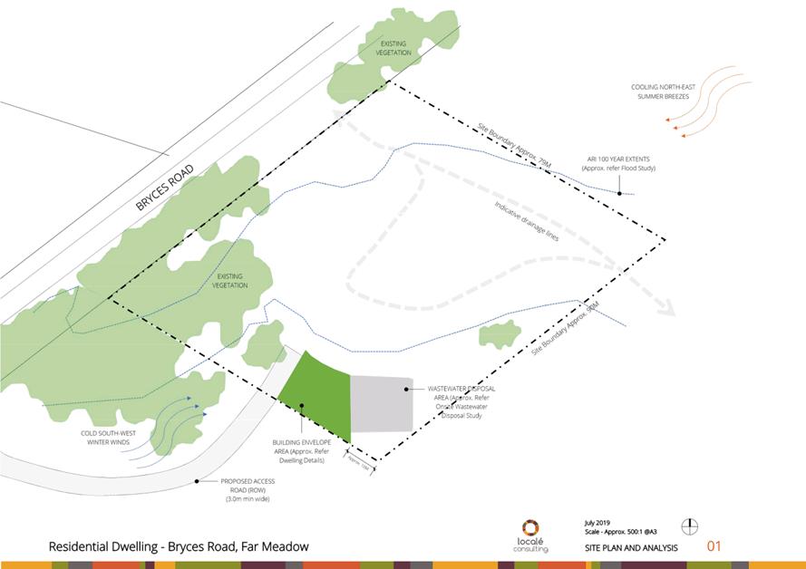
|
|
Development
& Environment Committee – Tuesday 06 October 2020
Page
0
|
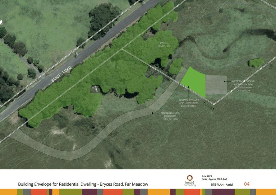
|
|
Development
& Environment Committee – Tuesday 06 October 2020
Page
0
|
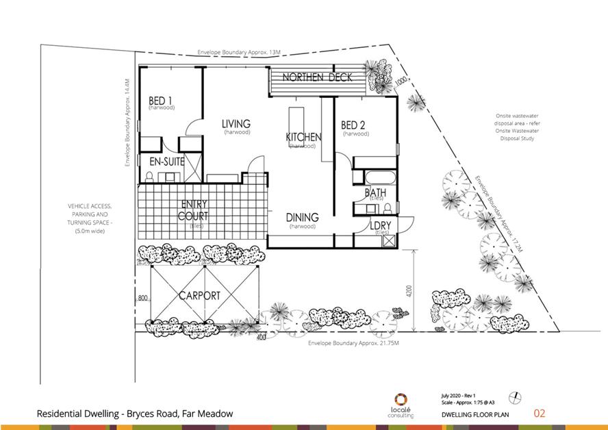
|
|
Development
& Environment Committee – Tuesday 06 October 2020
Page
0
|
DE20.112 Development
Application - SF10754 - Albatross Rd West Nowra - Lot 353 DP 755952
DA. No: SF10754/4
HPERM Ref: D20/327601
Section: Development
Services
Approver: Phil
Costello, Director - City Development
Attachments: 1. Draft
Determination - Refusal - Albatross Rd West Nowra - Lot 353 DP 755952 ⇩
2. Planning
Report - Albatross Rd West Nowra - Lot 353 DP 755952 (under separate cover) ⇨
3. Subdivision
Plan - Albatross Rd West Nowra - Lot 353 DP 755952 ⇩
4. Road
& Stormwater Drainage Layout Plan - Albatross Rd West Nowra - Lot 353 DP
755952 ⇩
5. Sewer & Water Layout Plan
- Albatross Rd West Nowra - Lot 353 DP 755952 ⇩
Description of Development: Five (5) Lot Torrens
Title Subdivision and Site Works
Owner: J J & S G Reminis
Applicant: PDC Planners
Notification Dates: 9 October to 8 November 2019
No. of Submissions: One (1) in objection
Purpose
/ Reason for consideration by Council
Council Resolved on 7 April 2020
(MIN20.240) with respect to COVID- 19 Response, that:
“The delegation to the CEO be rescinded to determine a
development application by refusal until the end of COVID 19 crisis.
The
refusal of a development application must only be by Council/Committee
resolution.”
This Report recommends refusal of the above Development
Application and is therefore prepared for consideration by the Development
& Environment Committee in accordance with the 7 April 2020 Resolution of Council.
|
Recommendation (Item to be determined under delegated authority)
That Development Application SF10754
for a five (5) lot Torrens Title subdivision and site works at Lot 353 DP
755952, Albatross Rd West Nowra be determined by way of refusal for the
reasons set out in the Notice of Determination Attachment 1 of this
report.
|
Options
1. Refuse
the development application (DA) in accordance with the recommendation.
Implications: The
development is unable to proceed as applied for. The applicant can however
apply for a section 8.2 review of Council’s decision and/or lodge an
appeal with the NSW Land and Environment Court against Council’s decision
2. Approve
the application.
Implications: Council would have to
provide the grounds on which the DA is to be approved, that is, provide reasons
to support the development, having regard to section 4.15 considerations. This would require a further report to Council attaching a
suite of conditions. Under some circumstances, third parties (i.e. objectors)
can seek a judicial review of Council’s decision in the NSW Land and
Environment Court.
3. Alternative
recommendation.
Implications: Council will
need to specify an alternative recommendation and advise staff accordingly.
Figure
1 – Location Map
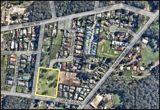
Background
Proposed Development
In accordance with plans
submitted by the applicant (refer to Attachments 3, 4, and 5), the proposal
involves the creation of five (5) allotments, the construction of a new public
road to provide a connection between two existing streets (i.e. Lightwood Drive
and Coral Sea Drive), and the construction of infrastructure to service the
proposed lots.
The following provides a
description of the lots proposed to be created:
· Proposed Lot
1 – Area of 2,391.9m². Split parcel with one portion located in the
southern part of the property (including the building envelope) and the other
portion located in the northern part (opposite side of the unformed road
reserve and including the riparian vegetation to the water course).
· Proposed Lot
2 – Area of 1,304.7m². Vacant parcel in the northern part of the
property.
· Proposed Lot
3 – Area of 1,314.7m². Vacant parcel in the central part of the
property.
· Proposed Lot
4 – Area of 1,738.2m². Vacant parcel in the central part of the
property.
· Proposed Lot
5 – Area of 1,684.8m². Vacant parcel in the southern part of the
property.
The following provides a
description of the infrastructure proposed for construction:
· Proposed
public road – To provide a through connection between Lightwood Drive
(which terminates at the site’s northern border) and Coral Sea Drive
(which terminates immediately to the south-east of the site.
· Stormwater
infrastructure – A series of surface inlet pits constructed within the
subdivision layout to direct runoff from lots along the proposed road, and to
the proposed detention basin (maximum capacity of 30.1m³) in the
north–western corner of the site.
· Sewer and
water infrastructure – Extensions to the existing sewer and water mains
to enable the proposed lots to be suitably serviced.
The following provides a
description of the site works proposed to be undertaken:
· Vegetation
Clearing – A total of nine (9) trees are proposed to be removed (seven
(7) of which are located within the unformed road reserve and two (2) are
located within the site). Their removal would not trigger entry into the
Biodiversity Offsets Scheme (BOS) in accordance with the Biodiversity
Conservation Act 2016 for the following reasons:
o Vegetation proposed for removal
is not mapped on the Biodiversity Values Map and Threshold Tool.
o The area of vegetation
proposed to be removed does not trigger the area threshold (being 0.25
hectares).
o Given their isolated nature
and separation from other vegetation forming a continuous biodiversity habitat
corridor, a section 7.3 Test of Significance is not considered to be necessary
in this instance.
· Earthworks
– Cut and fill is proposed within the unformed road reserve and within
the building envelope for Proposed Lot 1. As per the submitted Cross Sections,
the cut and fill earthworks would have the following extent:
o Extent of cut proposed –
130mm.
o Extent of fill proposed
– 620mm.
Subject Land
The site comprises Lot 353 DP 7565952 (Albatross Road, West
Nowra). Refer to Figure 1.
Site & Context
The development site:
· Is vacant of development apart from a small farm shelter
located in the central part.
· Contains some vegetation, including an area of riparian
vegetation adjoining the existing Category 2 water course in the north-western
corner. The remainder is scattered with individual isolated trees which do not
form part of a continuous biodiversity corridor.
· Has an area of 1.09 ha.
· Is zoned R1 General Residential.
· Is
identified as being bush fire and flood prone land.
· Is mostly flat
with a minor slope downwards from a high point of 34m AHD in the south-eastern
corner towards a low point of 31m in the northern part.
· Is
burdened by transmission lines which traverse from the northern border through
to the south-western corner.
The surrounding locality is a developing area consisting of
established urban residential estates, predominantly being single dwellings and
dual occupancies.
Figure 2 –
Zoning Extract
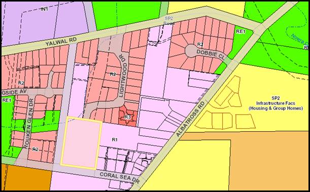
History
The following timeline of events
has taken place following the lodgement of the Development Application with
Council on 22 July 2019 (note: RFI means Request for Further Information):
· 1st RFI
Request sent to the applicant on 31 July 2019 requesting information including
payment of the nominated integrated development fees, owner’s consent,
and a detailed cost estimate.
· Response to the 1st
RFI Request provided in separate submissions on 20 August and 30 September
2019. It is noted that the provision of the requested cost of works estimate
was not received and remains outstanding.
· Referral to
internal and external agencies for comments/conditions on 2 October 2019 with a
response to all referrals being received by 3 June 2020. Further information
was requested by the Natural Resources/Floodplain Unit, Subdivision Engineer,
and Environmental Assessment Officer.
· The application
was advertised in accordance with the Community Consultation Policy to
surrounding property owners and also advertised within the local newspaper for
a period of one (1) month between 9 October 2019 and 8 November 2019 (given it
is nominated integrated development). One (1) submission was received during
this period (assessment of the issues raised is provided in the Report below).
· 2nd RFI
Request sent to the applicant on 9 January 2020 relating to items requested as
part on the referral process (a request for a progress update on the status of
the response was sent to the applicant on 19 February 2020).
· Response to the 2nd
RFI Request provided by the applicant in their submission on 25 March 2020. The
response was partial and did not incorporate the redesign of the subdivision
and road layout at Item 1 requested by the Subdivision Engineer in their
referral response. In this regard, the applicant made representations that the
requested change would lead to a poor design outcome.
· Correspondence was
sent to the applicant on 14 May 2020 reaffirming the requirement for Item 1 of
the 2nd RFI Request to be addressed. This was made following further
clarification with Council’s Development Engineering Coordinator.
· Correspondence was
sent to the applicant on 22 June 2020 following up on the progress of the
response to Item 1 of the Request. The applicant was also advised of
Council’s resolution regarding Development Applications which have been
under assessment for more than 90 days. Specifically the following comments
were made: “please confirm your intentions within seven (7) days by
emailing council@shoalhaven.nsw.gov.au.
Should a response not be received, it is likely the DA will be reported to the
Development and Environment Committee based upon information already
submitted.”
· A
response was not received in the period of time following Council’s
correspondence and the present time advising of any status update or whether
they plan to address Council’s request. Accordingly, Council has provided
a recommendation based upon the information already submitted being a
recommendation for refusal.
The DA is now recommended for refusal for the reasons listed
in the report.
Issues
Electricity Infrastructure
Endeavour
Energy (EE) provided a referral response to Council on 23 October 2019. Their
concurrence was required given the site is burdened by an easement benefitting
EE for 132,000 volt / 132 kilovolt (kV) high voltage overhead power lines and
overhead earth cables, which traverses from the northern part to the
south–western part of the site. The location of the infrastructure is
depicted in the below image:
Figure 3 –
Overhead Power Lines and Easement
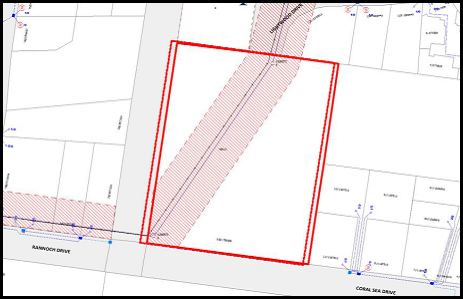
EE advised in their referral
response to Council of the minimum easement requirements for a termination
pole/structure or an aerial/ground stay according to the ‘Mains Design
Instruction MDI 0044 – Easements and Property Tenure Rights Section 5.3.2
Minimum easement required for network assets’. The requirement is for the
easement for such infrastructure to extend at least half the easement width
beyond the last network pole or stay.
In accordance with the
subdivision layout shown in Attachment 3, the ground stays are presently mapped
outside the easement and the proposed layout does not presently account for the
abovementioned requirement for it ‘to extend at least half the easement
width beyond the last network pole or stay’.
The easement width would need to
extend a distance of approximately 20m further to the east of its current
location. EE made representations that this would likely have a substantial
impact upon the subdivision layout and associated building envelopes.
A request was made as part of Council’s correspondence
on 14 May 2020 that the applicant provide a redesign of the subdivision to
properly consider the easement required as it relates to the existing
infrastructure, however a response to this request was not received.
Applicant’s Submission
“The
road alignment generally follows the alignment of the electricity easement.
Lots 1-4 will be affected only in a minor fashion by the easement, as shown on
the submitted concept subdivision plan”.
Discussion
Given the subdivision layout has not been altered to
consider the easements required for the ground stays, the following concerns
are noted:
Clause 45: Determination
of Development Applications – Other Development of the State Environmental
Planning Policy (Infrastructure) 2007
Clause 45 of the policy applies
to development that is:
(i) within
or immediately adjacent to an easement for electricity purposes (whether or not
the electricity infrastructure exists), or
(ii) immediately
adjacent to an electricity substation, or
(iii) within
5m of an exposed overhead electricity power line
Council notes that the site and
location of the proposed development is within and immediately adjacent to an
easement for electricity purposes and is also within 5m of an exposed overhead
electricity power line. Before determining an
application to which this clause applies, the consent authority must—
(a) give
written notice to the electricity supply authority for the area in which the
development is to be carried out, inviting comments about potential safety
risks, and
(b) take
into consideration any response to the notice that is received within 21 days
after the notice is given.
In accordance with clause 45,
written notice was given to the electricity supply authority for the area
(being EE) and notice was provided within the prescribed period of 21 days.
EE advised in their referral
response that there are two (2) attachment points for ground stays that are
located outside the easement. While this infrastructure is located outside of
the easement the Electricity Supply Act 1995 identifies them as protected
assets and as such the owner or occupier of the land cannot take any action to
relocate or remove the infrastructure. EE have advised that the retention of
suitable access to the stays and poles is critical and they “would
insist on the creation of an easement for the stays” .This would
result in an extension of approximately 20m to the east to accommodate
the anchor lines and stays which EE advises would substantially impact the
proposed subdivision and building envelopes.
EE also raised concern over the
layout of the subdivision which would result in the electricity easement being
located over a number of individual privately owned lots which is problematic
for EE and the landowners.
Dissecting the easement along
its route results in restriction of access (e.g. every lot being potentially
fenced) and multiple gates would be required to ensure contiguous ready access
for EE. This is particularly important where there are poles or structures and
changes in direction to a line route. In the event of fallen conductors or
faults, access to the poles is essential for restoring electricity supply.
Due to the above issues EE objects
to the development application due to the significant impact on the
easement/electricity infrastructure on the site and these matters need to be
resolved prior to the current proposal being approved.
Council has considered the response from EE and agrees that
as the matters raised have not been resolved the application should not be
approved.
Clause 7.11: Essential
Services of the Shoalhaven Local Environmental Plan (SLEP) 2014
Clause 7.11 of the SLEP 2014
states the following:
(1) Development consent must not be granted for
development unless the consent authority is satisfied that any of the following
services that are essential for the development are available or that adequate
arrangements have been made to make them available when required—
(a) the supply of water,
(b) the supply of electricity,
(c) the
disposal and management of sewage.
EE advised that although the
existing distribution substations may have some spare capacity, as the site
currently has no existing low voltage electricity infrastructure an extension
of the existing network would be required to supply the proposed development.
The extent of works required cannot be determined until a detailed assessment
is undertaken.
Given the comments made by EE, Council is unable to confirm
that a suitable supply of electricity to the development would be available.
Subdivision Layout / Road Design
Council
advised the applicant that the construction of a link between Lightwood Drive
and Coral Sea Drive is not supported given it has the potential to create a
shortcut or ‘rat run’ between the two major collector roads of
Yalwal Road and Albatross Road. The location of these collector roads in
relation to the site is depicted in Figure 1.
The following comments were made to the applicant as part of
correspondence on 14 May 2020 which clarified and reaffirmed Council’s
position that a link and through connection between these two roads is not
considered to be appropriate:
“Agreed it is not ideal to terminate such a length
of road with a cul-de-sac, but it is a much more preferred outcome than
connecting the two major collector roads (Yalwal Road and Albatross Road).
Council’s strategic traffic modelling indicates a huge increase in
traffic due to future residential development which would occur in the Mundamia
and Nowra Hill areas and the likely future upgrades which would be required to
be undertaken to Yalwal Road and the intersection of Yalwal / Albatross Roads.
Once traffic increase occurs on Yalwal Road, motorists would likely look for
faster route options to avoid the intersection. Council must be mindful of this
future implication with any applications being assessed and cannot support the
application in its current form.
Lightwood Drive and Coral Sea Drive are an acceptable
width to be used as a local street but will not support a higher classification
road. There are other options available to the developer to pursue in this
regard.
Rannoch
Drive could be connected to
Lightwood Drive to provide a secondary access for the development and this
should be utilised if there are difficulties in addressing provisions under the
Planning for Bushfire Protection 2006.” (see Figure 4)
Figure
4 – Potential Road Access Arrangement

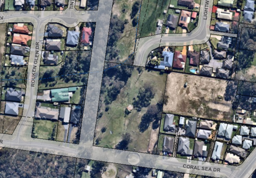
Applicant’s Submission
“Creating a cul-de-sac as suggested would result
in a poor urban design outcome. Short cul-de-sacs are acceptable in some
instances, however, cul-de-sacs longer than 200m should be avoided. Creating a
cul-de-sac as suggested by Council would in this instance be approximately 430m
in length which is unacceptable.
Planning for bushfire protection indicates that for new
subdivisions, all roads should be through roads, and cul-de-sacs over 200m in
length should be avoided.
The NSW Government Architect has released draft urban
design guidelines for regional NSW. It states that streets should be designed
in a way that will improve connectivity and legibility – aim to connect
through to other places rather than terminate as a cul-de-sac.
The subject land are (sic)
zoned R1 and the lots proposed are large enough to accommodate multi-dwelling
housing developments. Terminating the road in the manner suggested would create
significant issues with the likely end use of the lots in terms of traffic
generation, bin collection and on street parking within a cul-de-sac
head.”
Discussion
Given the subdivision layout has not been altered to remove
the road link / through connection between Lightwood Drive and Coral Sea Drive,
the following issues are highlighted:
Section
4.15(1)(b): Matters for Consideration of the Environmental Planning and
Assessment (EP&A) Act 1979
Section 4.15(1)(b) of the
EP&A Act 1979 states the following:
(1) Matters for Consideration – General: In determining
a development application, a consent authority is to take into consideration
such of the following matters as are of relevance to the development the
subject of the development application—
(b) the
likely impacts of that development, including environmental impacts on both the
natural and built environments, and social and economic impacts in the
locality.
A large increase in traffic
volume utilising a shortcut along Lightwood Drive between the two major
collector roads would be likely to have an adverse social impact in the
locality. Specifically, the following adverse social impacts are considered
likely:
· An
increase in traffic noise being experienced by residents of Lightwood Drive and
Coral Sea Drive.
· Potential
issues relating to traffic and pedestrian safety given the road is neither wide
enough nor designed for use as a higher order road.
· General
loss of amenity as a result of the above issues.
Given the above matters which have the potential to impact
upon the surrounding locality, Council cannot be satisfied that the proposal
would not have an adverse social impact.
Flooding
The site is not mapped within
the Shoalhaven Development Control Plan (SDCP) 2014 as being subject to the 1%
AEP flood level as it was not encaptured within the scope of the previous flood
study covering West Nowra. However, a Flood Report prepared by Reinco
Consulting and submitted as part of the application demonstrated that the site,
in particular the western and northern parts including the location of the proposed
road, is subject to the 1% AEP flood level.
The
submitted Flood Report was reviewed by Council’s Floodplain Engineer who
requested an amended Flood Report and modelling, noting the following concerns:
· Post-development
modelling identifies the subdivision and access road will increase flood levels
with an afflux of 200mm for the 1% AEP event. The increased 1% AEP flood level
will reduce the freeboard to dwellings at 84, 86, 88 Rannoch Drive and 4 Rouken
Glen Drive.
· Section 3.6 of
the Report identifies the access road may be inundated by 100mm in a 1% AEP
event, with localised depths up to 300mm.
· The
Report identifies the pre and post-development hazard category is low. The 1%
AEP event velocity appears to be above 2m/s which is a high hazard and could
result in a velocity-depth product greater than 0.3m2/s.
A response was provided by Reinco Consulting dated 17 February
2020, which Council’s Floodplain Engineer found to address the
requirements including that there would be no afflux to adjoining properties.
However, a review of the modelling provided found that it was based upon the initial
subdivision layout showing a through connection between Lightwood Drive and
Coral Sea Drive and did not have regard for the amendments to the design
requested by Council’s Development Engineering Coordinator.
Given the amended subdivision layout was not provided and an
amended Flood Report and modelling for the amended scenario was not provided,
Council’s Floodplain Engineer advised they could not quantify the impacts
associated with such a development.
Discussion
Given no Flood Report or modelling has been received which
quantifies flooding impacts for the amended subdivision layout requested by
Council, the following is noted:
Clause 7.3: Flood Planning
of the Shoalhaven Local Environmental Plan (SLEP) 2014
Clause 7.3 of the SLEP 2014
states that consent is not permitted to be granted unless the consent authority
is satisfied that the proposal:
(a) is compatible
with the flood hazard of the land, and
(b) will not
significantly adversely affect flood behaviour resulting in detrimental
increases in the potential flood affectation of other development or
properties, and
(c) incorporates
appropriate measures to manage risk to life from flood, and
(d) will not
significantly adversely affect the environment or cause avoidable erosion,
siltation, destruction of riparian vegetation or a reduction in the stability
of river banks or watercourses, and
(e) is not likely to
result in unsustainable social and economic costs to the community as a
consequence of flooding, and
(f) will
not affect the safe occupation or evacuation of the land.
Given the amended design has not
been received, Council is unable to quantify whether the following would be
able to be achieved:
· That the
proposed access road and/or building envelopes would be compatible with the
flood hazard of the land as the location has not been finalised.
· Given the
location of access routes from each property has not been finalised, safe
occupation or evacuation from the lots is unable to be confirmed.
· Zero afflux
for neighbouring properties for an amended layout is unable to be confirmed.
Section 5.3 –
Subdivision in the Floodplain of Chapter G9 – Development on Flood Prone
Land of the Shoalhaven Development Control Plan (SDCP) 2014
Acceptable
Solutions A3.1 and A3.2 of Chapter G9 – Development on Flood Prone Land
of the SDCP 2014 states the following:
“A3.1 The
development (subdivision and future use) satisfies the requirements as shown in
the planning matrix at Schedule 2.
A3.2 Flood
conditions for year 2100, which includes sea level rise projection, are
used.”
Given Council is not satisfied
that the proposed access road and/or building envelopes would be compatible
with the flood hazard of the land (as the subdivision layout was not been
finalised), Council cannot confirm that the development satisfies the
requirements shown in the planning matrix at Schedule 2.
Performance Criteria P3.1 to
P3.3 state the following:
“P3.1 The
development (subdivision and intended future use) is a suitable land use, and
is adequately designed, for the defined hazard/hydraulic category.
P3.2 The proposed
subdivision will not create new lots that are affected by a high hazard area,
or floodway in today’s flood conditions or in climate change conditions
up to the year 2100.
P3.3 The proposed
subdivision will not increase the potential population density in any areas
(flood prone or flood free) with restricted evacuation access.”
Council provides the following
assessment against the performance criteria, which demonstrates that a
performance–based solution is not capable of being achieved in this
instance:
· A response
to Council’s request for a redesign of the subdivision layout considering
Council’s comments regarding road design and the vicinity to the
transmission lines was not received (as discussed above). As such Council
cannot determine the relevant hydraulic category for the resultant lots,
location of future dwellings, or access roads.
· Given the
hydraulic category for an amended subdivision layout cannot be determined,
Council cannot be satisfied that the proposal is adequately designed for the
relevant hydraulic category.
· Given the
amended location for lots has not be clarified through an amended subdivision
design, Council cannot satisfactorily determine that such lots would not have a
hazard category of ‘high hazard floodway’ assigned.
· Given the
location for vehicle entry and exit to the proposed lots has not been clarified
through an amended subdivision design, Council cannot satisfactorily determine
that the access and appropriate evacuation would be available during a 1% AEP
flood event.
Section 4.15(1)(b):
Matters for Consideration of the Environmental Planning and Assessment
(EP&A) Act 1979
Section 4.15(1)(b) of the
EP&A Act 1979 states the following:
(1) Matters for Consideration – General: In
determining a development application, a consent authority is to take into
consideration such of the following matters as are of relevance to the
development the subject of the development application—
(b) the
likely impacts of that development, including environmental impacts on both the
natural and built environments, and social and economic impacts in the
locality.
Taking into consideration the
Floodplain Engineer’s advice as described in the report above, without a
Flood Report and modelling of an amended subdivision layout, Council cannot
quantify that the following built environments impacts would not occur:
· Inundation
of dwellings on proposed lots in a 1% AEP flood event.
· Flood free
vehicular access along a proposed road.
· Afflux
to adjoining properties.
In consideration of the above matters relating to the
proposal, Council cannot be satisfied that the proposal would not have an
adverse impact upon the built environment.
Planning Assessment
The DA has been assessed under
s4.15(1) of the Environmental Planning and Assessment Act 1979.
(Attachment 2.)
Consultation and Community
Engagement:
Advertisement and notification
were undertaken in accordance with Council’s Community Consultation
Policy for a period of period of one month between 9 October to 8 November
2019, as follows:
· letters
being sent to all landholders within a 60m buffer of the site;
· letters
to local community consultation bodies; and
· advertisement
within the South Coast Register newspaper on 9 October 2019.
One (1) public objection was
received in relation to Council’s advertisement / notification of the
development.
Key issues raised as a result of
the consultation and community engagement process and Council’s response
to the key issues raised are summarised in the following Table:
|
Flooding
· Concerns raised
that inadequate pipes and upstream subdivisions may lead to increased
flooding within the allotment.
· Particular
concern raised regarding the potential for afflux to neighbouring properties
within Lightwood Dr.
|
Flooding
· A Flood Report
was submitted by the applicant which considers the impacts associated with
flooding from upstream developments.
· Information
provided by the applicant in relation to flooding demonstrates that there
would be no afflux to neighbouring properties.
· The Flood Report
and flood modelling was, however, prepared having regard to the present
subdivision layout which is not supported by Council.
· Given the Flood
Report and associated modelling does not address the amended layout required,
Council cannot quantify the extent of flooding impacts for the amended
layout.
· Accordingly
Council finds that the issue of flooding has not been satisfactorily
addressed.
|
|
A road connection could
lead to a ‘rat run’ out of the estate
· Lightwood Dr
could become a ‘rat run’ given there is presently only one road
in and one road out.
· The road design
may bring an increased traffic volume through Lightwood Dr which may impact
upon residents.
|
A road connection could
lead to a ‘rat run’ out of the estate
· Council agrees
with the submitter’s representation that the development has the
potential to become a ‘rat run’ (i.e. shortcut between the two
major collector roads being Yalwal Rd and Albatross Rd).
· Extensive future
residential developments within Mundamia and Nowra Hill are likely to result
in an increase in vehicular traffic at the intersection of these two
collector roads, which presents a risk that the proposed layout could result
in a ‘rat run’ as motorists look for a quicker route.
· Neither Lightwood
Dr nor Coral Sea Dr were designed to hold a greater level of traffic and were
designed to hold local traffic only.
· Council finds
that the design has not satisfactorily addressed the traffic impacts
associated with the development.
|
Financial Implications:
There are potential cost implications for Council in the
event of a refusal of the application. Such costs would be associated with
defending any appeal in the Land and Environment Court, should the applicant
utilise appeal rights afforded under the Environmental Planning and
Assessment Act 1979 (EP&A Act).
Legal Implications
Pursuant to section 8.2 of the EP&A Act, a decision of
the Council may be subject of a review by the applicant in the event of an
approval or refusal. If such a review is ultimately pursued (if the
recommendation is adopted) the matter would be put to Council for
consideration. Alternatively, an applicant who is dissatisfied with the
determination of the application by the Council may also appeal to the Court against
the determination pursuant to section 8.7 of the EP&A Act. Applicants can
choose to do both, setting aside the Appeal pending resolution of the review,
noting there are time limitations with respect to lodging applications for
review and appeal.
Summary and Conclusion
This application has been
assessed having regard for section 4.15 (Matters for consideration) under the
EP&A Act. Having regard to the assessment, the proposal is not
considered capable of support. Reasons for refusal are provided below and can
also be found at Attachment 1 to this report:
|
1.
|
The
development application has not satisfactorily demonstrated compliance with
Clause 7.3 and 7.11 of the Shoalhaven Local Environmental Plan 2014. (Section
4.15(1)(a)(i) of Environmental Planning and Assessment Act, 1979).
|
|
2.
|
The
development application has not satisfactorily demonstrated compliance with
Section 5.3 of Chapter G9 – Development on Flood Prone Land of the
Shoalhaven Development Control Plan 2014. (Section 4.15(1)(a)(iii) of
Environmental Planning and Assessment Act, 1979).
|
|
3.
|
The
applicant has not satisfactorily demonstrated that the proposal would not
have an adverse impact upon the built environment or that the proposal would
not have an adverse social impact upon the surrounding locality. (Section
4.15(1)(b) of Environmental Planning and Assessment Act, 1979)
|
|
4.
|
The
information submitted with the development application does not
satisfactorily demonstrate that the site is suitable for the proposed use. (Section
4.15(1)(c) of Environmental Planning and Assessment Act, 1979)
|
|
5.
|
Having
regard to the inconsistency with the abovementioned legislation, the granting
of development consent is not considered to be in the public interest.
(Section 4.15(1)(e) of Environmental Planning and Assessment Act, 1979).
|
|
|
Development
& Environment Committee – Tuesday 06 October 2020
Page
0
|

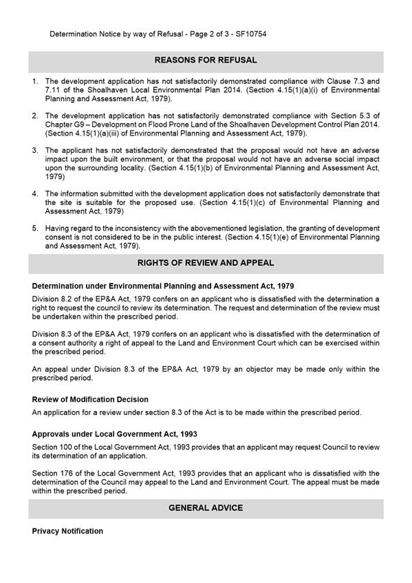

|
|
Development
& Environment Committee – Tuesday 06 October 2020
Page
0
|
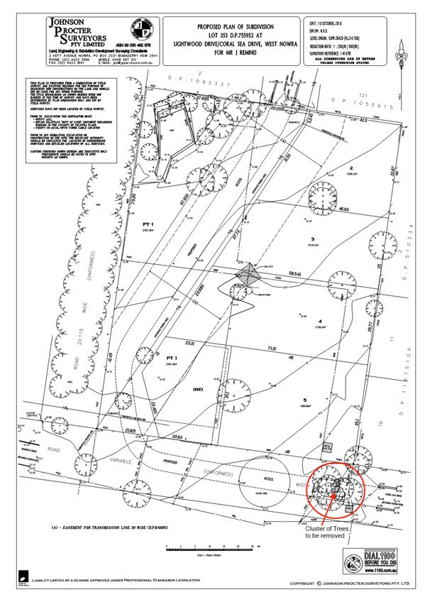
|
|
Development
& Environment Committee – Tuesday 06 October 2020
Page
0
|
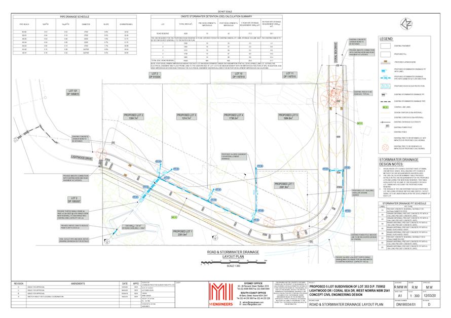
|
|
Development
& Environment Committee – Tuesday 06 October 2020
Page
0
|
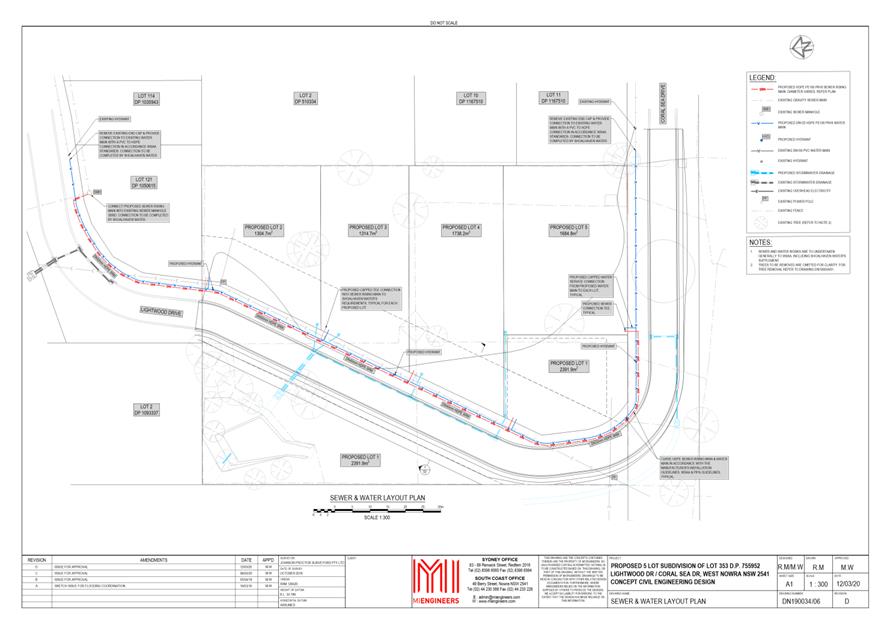
|
|
Development
& Environment Committee – Tuesday 06 October 2020
Page
0
|
DE20.113 Development
Application - DA16/1465 - 173 Kinghorne St and 2 & 4 Albatross Rd Nowra -
Lot 1, 29 and 30 DP 25114
DA. No: DA16/1465/4
HPERM Ref: D20/348899
Section: Development
Services
Approver: Phil
Costello, Director - City Development
Attachments: 1. Section
4.15 Assessment Report (under separate cover) ⇨
2. Notice of Determination
(Refusal) ⇩
Description
of Development: Demolition of existing structures and construction of a
mixed use development consisting of 55 apartments including 16 x 3 bedroom,
31 x 2 bedroom and 8 x 1 bedroom apartments, a basement car parking area and 3
commercial tenancies at ground floor with frontage to both Kinghorne St and
Albatross Road
Owner: Bill Zervos and Jasmine Anne Simpson &
John Irwin Gould
Applicant: Lee Carmichael Town Planning NTA PDC
Planners
Notification Dates: 14 June – 14 July 2017
No. of Submissions: Six (6) submissions in
objection and Nil (0) in support.
Purpose
/ Reason for consideration by Council
On 1
October 2019, it was resolved by the Development and Environment Committee
that Development Application (DA) ‘DA16/1465 –
Residential Units and Commercial Space – 173 Kinghorne Street, Nowra be
called in to Council for determination due to significant public
interest.’ (DE19.107)
The DA is reported to the
Development and Environment Committee for determination.
Options
1. Refuse the
Development Application (DA) in accordance with the recommendation.
Implications: The proposal would not proceed in its current
form. The applicant can, however, apply for a section 8.2 review of
Council’s decision and/or could lodge an appeal with the NSW Land and
Environment Court against Council’s decision.
2. Approve
the DA.
Implications: Council would have to provide the grounds to
support the proposal, that is, provide reasons to support the development,
having regard to section 4.15 considerations. Should Council resolve to
approve the DA a suite of conditions would be required to be drafted for
reconsideration by the Development & Environment Committee. Under
some circumstances, third parties (i.e. objectors) can seek a judicial review
of Council’s decision in the NSW Land and Environment Court.
3. Alternative
recommendation.
Implications: Council will need to specify an alternative
recommendation and advise staff accordingly.
Location Map
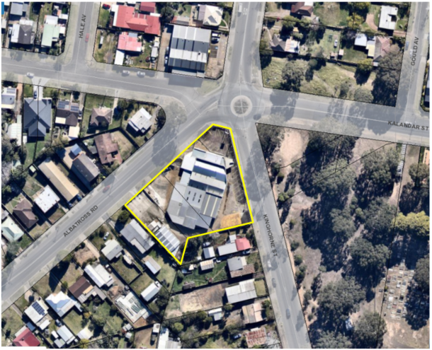
Figure 1 - Extract of the subject site in the
local context.
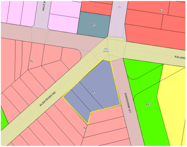
Figure 2 - Extract of the Shoalhaven Local
Environmental Plan 2014 Land Use Zoning Map with the subject site with a
yellow border
Background
Post-Lodgement
Key dates are as follows:
· 8
April 2016, the DA was lodged with Council.
· 9
August 2016, Council requested additional information from the applicant in
relation to the design and access arrangements from Albatross Road.
· 16
December 2016, revised plans and additional information was submitted by
the applicant in response to Council’s letter dated 9 August 2016. The
amended plans included modifications to the southern portions of each wing of
the building and deletion of two apartments (reducing the unit yield from 57 to
55 apartments). The reduction in units on the southern portion of the development
was proposed to achieve a more appropriate transition to the adjoining
low-density development.
· 27
February 2017, Council requested additional information from the applicant,
with continued concerns raised in relation to design elements and major
concerns raised in relation to the proposed access/egress onto Albatross Road.
· 7
March 2017, Council met with the applicant to discuss the Planning Proposal
over the site (described below) and continued concerns with the design and
location of access/egress onto Albatross Road.
· 22
March 2017, a further additional
information letter was sent to the applicant to detail the outcomes of the 7
March 2017 meeting and to express continued concerns regarding the proposed
access/egress onto Albatross Road.
· 10 July 2018, Council
met again with the applicant to discuss design and traffic issues.
· 12
September 2018, the applicant lodged concept plans for access/egress to the
development from Kinghorne Street for Council’s consideration (refer to Figure
15).
· 12
October 2018, Council provided feedback to the applicant on the concept
plan, noting that the concept plan addressed the main concern that had been
raised by Council being the relocation of the access from Albatross Road to
Kinghorne Street frontage.
· 18
April 2019, the applicant confirmed that they would not be pursuing
any change to the design of the development which would relocate the access
from Albatross Road to Kinghorne Street frontage.
· 12
August 2019, the applicant submitted a further amended Traffic Report
prepared by Jones Nicholson (D19/280251) to justify the retention of access on
the Albatross Road frontage and to address concerns raised in relation to the
designs apparent inconsistency with State Environmental Planning Policy
(Infrastructure) 2007.
· 1
October 2019, the Development and Environment Committee that Development
Application (DA) ‘DA16/1465 – Residential Units and
Commercial Space – 173 Kinghorne Street, Nowra be called in to Council
for determination due to significant public interest.’ (DE19.107).
· 26
November 2019, the applicant submitted amended plans, acoustic report, and
clause 4.6 variation statement.
Site History and Previous
Approvals
In April 2016, a Planning
Proposal (PP) was lodged concurrently with this DA to rezone the subject site
to enable development of the land as currently proposed.
The previous land zoning (B5 Business
Development) only permitted residential development for the purpose of
‘shop top housing’ which would require the entire ground floor to
be developed for commercial use.
The PP sought to amend the
following Land Zoning and Height of Buildings maps in Shoalhaven Local
Environmental Plan 2014 (SLEP 2014):
· Land
Zoning – Sheet LZN_013E - amend zoning of subject land from B5 Business
Development to B4 Mixed Use.
· Height of
Buildings – Sheet HOB_013E - amend maximum height of building from 11m
default height (no mapped) maximum building height as per clause 4.3(2A) of
Shoalhaven Local Environmental Plan (LEP) 2014, to a height determined by the
outcome of the character assessment (maximum of 15m).
On 12 September 2017, the Development Committee resolved
(MIN 17.776) to adopt the PP as exhibited with the following addition: “to
avoid uncertainty, the width of the part of the site with an 8.5m maximum
building height is 9m, as measured from the southern boundaries of Lot 1 and
Lot 30 DP 25114, and south-eastern and south-western boundaries of Lot 29 DP
25114.”
Under Council’s
delegation, the PP was forwarded to NSW Parliamentary Counsel to draft the
amendment to SLEP 2014 under Section 59(1) of the Environmental Planning and
Assessment Act 1979 (EP&A Act).
On 6 October 2017, Amendment No.
16 to SLEP 2014 was published on the NSW Legislation website and commenced,
bring into effect the zoning and building height changes outlined above.
The following
is a list of relevant approvals for the subject site:
· BA73/1794:
Showroom additions
· BA74/0275: Storage
Shed
· BA76/0601: Car
yard additions
· DA01/2756: Car
service centre – alterations and additions – approved – 9
October 2001
· DA02/2244:
Commercial Workshop/Shed – approved – 30 August 2002
The subject
site has operated in the capacity of vehicle servicing, repairs, and sales for
a significant period of time.
Proposed Development
The Development Application (DA)
is seeking development consent for the demolition of existing structures and
construction of a mixed-use development consisting of 55 apartments,
including:
· 8
x 1-bedroom apartments
· 31
x 2 bedroom
· 16
x 3 bedroom
· 3
commercial tenancies (total commercial floor area 259m2 (267m2
including bathroom i.e. GFA) at ground floor with frontage to both Kinghorne
Street and Albatross Road.
· A
basement car parking area accessed via Albatross Road with 93 car parking
spaces.
· Construction
of a left turn slip lane (removal of on-street parking) for access into the
basement car park off Albatross Road.
· Construction
of a central median and signage on Albatross Road to control the movement of
traffic in and out of the proposed development (left in and left out movements
only).
A site plan, ground floor,
elevations, landscape plan and photomontages are provided in Figures 3
– 14.
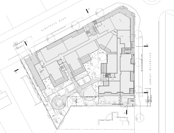
Figure 3 - Site Plan of the proposed development.
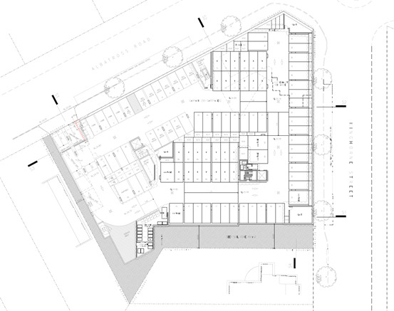
Figure 4 - Basement floor plan of the proposed
development.
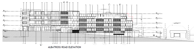
Figure 5 – Elevation of the proposed
development (western elevation – Albatross Road)
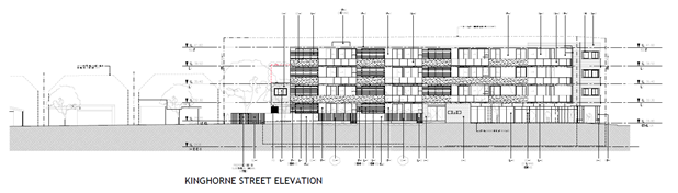
Figure 6 - Elevations of the proposed development
(eastern elevation – Kinghorne Street).
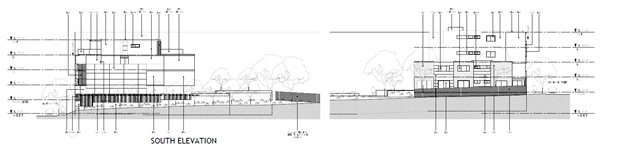 Figure 7 - Elevation of the proposed development (southern
elevation).
Figure 7 - Elevation of the proposed development (southern
elevation).
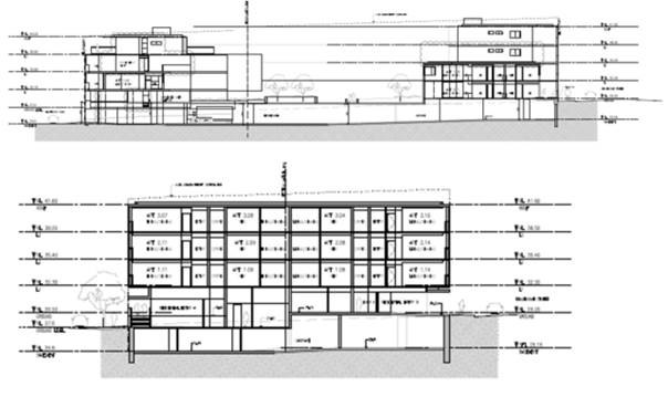
Figure 8 - Section plans of the proposed
development.
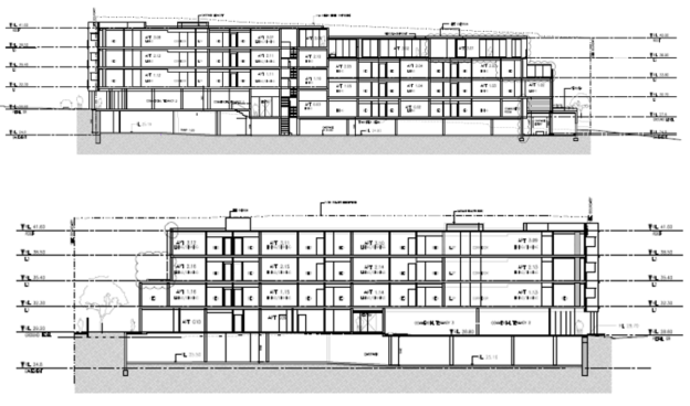
Figure 9 - Section plans of the proposed
development.
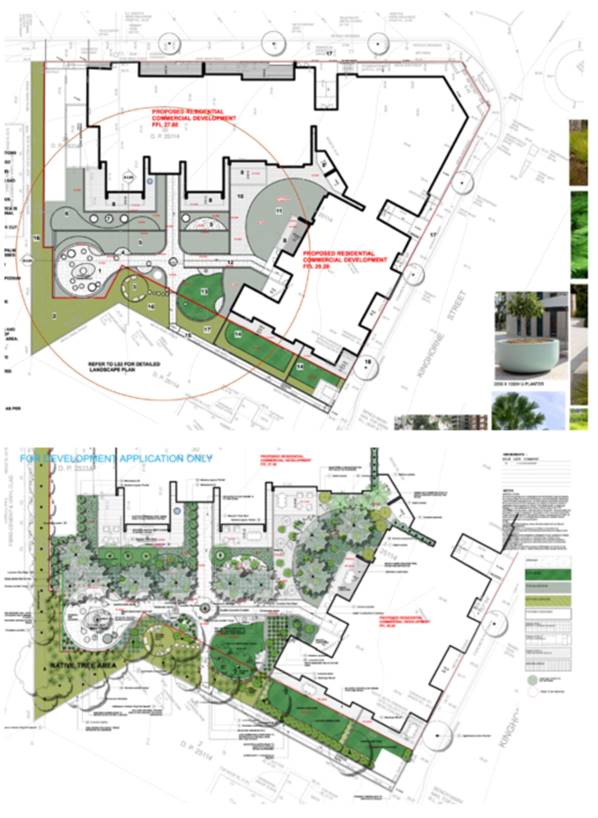
Figure 10 - Landscape plans of the proposed
development.
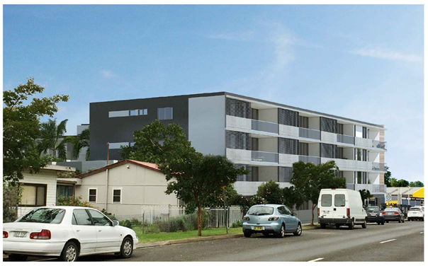
Figure 11 - Photomontage view from the
south-eastern (Kinghorne Street).
Figure 12 - Photomontage view from the
north-eastern corner of Kinghorne and Kalandar Street.
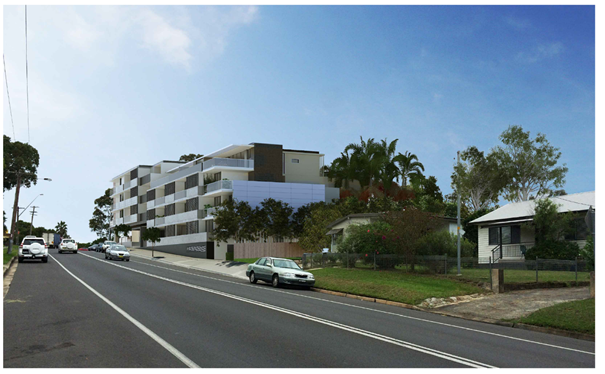
Figure 13 -Photomontage of the south-western
elevation of the development as viewed from Albatross Road.
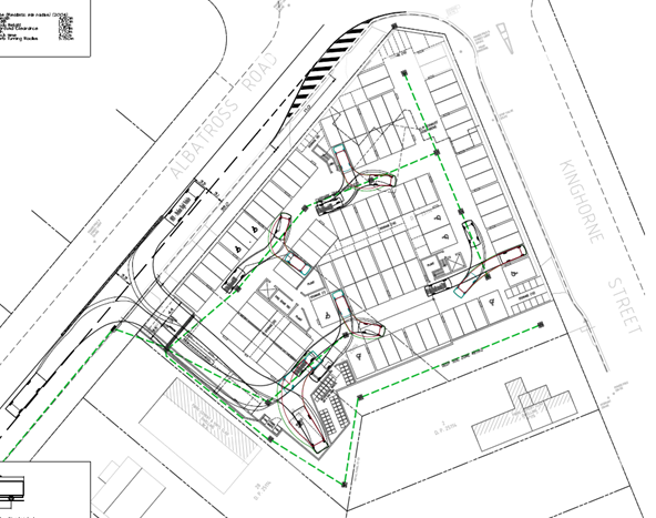
Figure 14 - Extract of engineering design plan
indicating the slip-lane and entry design to the development. The design
includes a central median on Albatross road to limit vehicle movements to a
left in and left out movement.
Subject Land
The subject site comprises 3
lots (subject site) located on the south-western corner of the intersection of
Kinghorne Street, Albatross Road and Kalandar Street. The subject site is
described and legally identified as follows:
· Lot
29 DP 25114 – 4 Albatross Road, Nowra
· Lot
30 DP 25114 – 2 Albatross Road, Nowra
· Lot
1 DP 25114 – 173 Kinghorne Street, Nowra
The site is an irregular shaped
lot with a frontage of 74m to Albatross Road and 60m to Kinghorne Street with a
9.5m corner splay. The site falls gradually to the south-western corner
of the site at Albatross Road.
The combined land area of the
lots is approximately 3,497m2.
Site & Context
An electrical wholesale supply
business (L&H Electrical) occupies the site. The site had previously
operated as a car servicing workshop that serviced and repaired motor vehicles.
The site adjoins established residential uses to the south and west, a tyre
service and residential uses to the north and public open space to the east.
The surrounding development can
be broadly characterised as low-density residential consisting of single and
two storey dwelling houses. Development immediately to the south consists of
free-standing single storey dwellings and associated outbuildings.
Beyond these dwellings and on
land bound by Albatross Road, Kinghorne Street and Albert Street is low density
residential development – mainly of single storey construction and
typically older housing stock.
To the west on the opposite side
of Albatross Road is a continuation of predominately freestanding low-density
dwellings with some multi dwelling housing developments.
To the east on the opposite side
of Kinghorne Street, is a Council park and cemetery.
On the northern side of the
intersection of Albatross Road and Kinghorne Street is an existing tyre shop.
On the eastern side of Kinghorne Street at the intersection with Kalandar
Street Council has recently approved 2 x 4 storey residential flat buildings,
consisting of 91 apartments and basement car park (DA19/1846).
As mentioned earlier, the land
was the subject of a planning proposal to zoning of subject land from B5
Business Development to B4 Mixed Use and amend maximum height of building to
part 14m and 8.5m (transition to low density development to the south. The
Planning Proposal was supported by a Character Assessment prepared by Urbanac
dated May 2017 (D17/257485) which informed the building heights for the site.
The character assessment
discussed the significance of providing transition in development scale and
that a suitable building height will “ensure a smooth transition
between new development and existing housing stock and maintain good amenity
for the dwellings immediately adjoining the site.” (P10, of the
Character Assessment by Urbanac.)
Issues
Traffic, Vehicular access and
impacts on the local road network
The following roads are
proximate to the subject site and will be impacted by the proposed development:
· Princes
Highway – State highway.
· Albatross
Road/Kalandar Street – Regional classified road
· Kinghorne
Street – local road
· Berry
Street – local road
The applicant proposes the
following access and upgrades along the Albatross Road frontage:
· Construct
an 8.15m entry/exit driveway which can accommodate the manoeuvring of a medium
rigid vehicle (MRV) in and out of the proposed development.
· Construct
a basement car parking area accessed via Albatross Road with 93 car parking
spaces. Thirteen stacked car parking spaces have been provided in the basement
car park area. The stacked parking spaces will be allocated to the 3-bedroom
apartments, whereby the management of the car spaces is managed by the
apartment residents themselves.
· Access
to the basement car park is to be managed via security pass and intercom
arrangement.
· Construction
of a left turn slip lane for access into the basement car park off Albatross
Road and removal of the existing car parking on Albatross Road adjacent to the
north western boundary.
· The
construction of a central median and signage be constructed along Albatross
Road to control the movement of traffic in and out of the proposed development.
the central median will force vehicles exiting from the proposed development
into a left turn only movement. Similarly, the construction of a central median
will force vehicles wishing to enter the proposed development into a left turn
in movement only. Vehicles travelling east along Albatross Road will need to
utilise the Kinghorne Street/Albatross Road roundabout to make a U-turn.
The site is capable of being
serviced by an MRV. Swept path plans that have been provided to demonstrate the
ability of a garbage truck to manoeuvre in the basement car park area for
garbage collection.
With regard to the servicing of
the commercial units, the applicant proposes to utilise the existing on-street
parking on the eastern and western sides of Kinghorne Street. A loading
zone can be provided on the western side of Kinghorne Street to provide direct
servicing access to the commercial units. This would require the approval of
the local traffic committee.
State Environmental Planning
Policy (Infrastructure) 2007 (ISEPP)
The subject site has frontage to Albatross Road (MR92),
being a classified regional road. Accordingly, clause 101 of ISEPP applies and
reads as follows:
101
Development with frontage to classified road
(1) The objectives of
this clause are—
(a) to ensure that new
development does not compromise the effective and ongoing operation and
function of classified roads, and
(b) to prevent or
reduce the potential impact of traffic noise and vehicle emission on
development adjacent to classified roads.
(2) The consent
authority must not grant consent to development on land that has a frontage to
a classified road unless it is satisfied that—
(a) where practicable
and safe, vehicular access to the land is provided by a road other than the
classified road, and
(b) the safety,
efficiency and ongoing operation of the classified road will not be adversely
affected by the development as a result of—
(i) the design of the
vehicular access to the land, or
(ii) the emission of
smoke or dust from the development, or
(iii) the nature, volume
or frequency of vehicles using the classified road to gain access to the land,
and
(c) the development is of a type that is not
sensitive to traffic noise or vehicle emissions, or is appropriately located
and designed, or includes measures, to ameliorate potential traffic noise or
vehicle emissions within the site of the development arising from the adjacent
classified road.
Under subclause 101(2) the
consent authority must not grant consent to development on land that has a
frontage to a classified road unless it is satisfied that the subsequent considerations
have been met by the proposal.
The 3 preconditions in subclause
101(2) are collective. Therefore, any one of the pre-conditions in subclause
101(2) about which Council is not satisfied prevents the issue of consent:
· Subclause
101(2)(a) (‘where practicable and safe, vehicular access to the land
is provided by a road other than the classified road’), is
relevant because the site has frontage to Kinghorne Street (unclassified at
this location) and Albatross Road (regional classified road at this location).
The applicant has submitted concept plans (D18/355817)
(refer to Figure 15) to demonstrate that practicable and safe, vehicular
access to the land can be provided by a road (Kinghorne Street) other than the
classified road.
In order to determine whether the access to the development
is “practicable”, the Court has established the test in the
case of Modern Motels Pty Ltd v Fairfield City Council [2013] NSWLEC
138, Preston CJ at paragraph [42]:
The phrase
“where practicable” regulates the desired outcome (“vehicular
access to the land is provided by a road other than a classified road”). The
consent authority is precluded from granting consent to a development on land that
has frontage to a classified road unless it is satisfied that the desired
outcome will be
achieved, where
that desired outcome is practicable. That is to say, the practicability
is as to the outcome of providing vehicular access to the land by a road other
than the classified road.
[emphasis added]
The desired outcome is for access to the land to be via the
unclassified local road – Kinghorne Street, which will ensure that the
development does not compromise the effective and ongoing operation and
function of the classified road (Albatross Road).
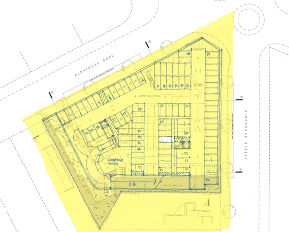
Figure 15 - applicant's submitted concept plan,
demonstrating that access via Kinghorne Street is capable of being achieved.
· Subclause
101(2)(b) (“to prevent or reduce the potential impact of traffic noise
and vehicle emission on development adjacent to classified roads”) is
relevant in that the applicant’s submitted traffic reports do not (in the
view of Council’s Traffic and Transport Unit) establish that the safety,
efficiency and ongoing operation of the classified road would not be adversely
affected by the development as a result of the design of the vehicular access
to the land, and the nature, volume or frequency of vehicles using the
classified road to gain access to the land.
It is noted that on Page 15 of the Traffic Management
Report prepared by Jones Nicholson, dated 27 February 2018 (D18/89444)
concerning the Albatross Road access:
“The proposed Albatross Road access is considered
satisfactory in that it will not impact upon the safety, efficiency and ongoing
operation of Albatross Road. Furthermore, practicable access for all traffic
movements is not achievable from Kinghorne Street to the proposed development.
Therefore, the proposed access from Albatross Road can be approved in meeting
the requirements of SEPP Infrastructure clause 101.”
Council’s Traffic and Transport Unit has considered
all the applicant’s detailed traffic reports and is not satisfied that
the access onto Albatross Road demonstrates compliance with subclauses
101(2)(b)(i) and (iii) of the Infrastructure SEPP. It follows therefore
that the development has not been able to meet preconditions 101(2)(a) and (b)
and that Council therefore does not have the ability under the ISEPP to approve
the development application in its current form.
· Subclause
101(2)(c) (“the development is of a type that is not sensitive to
traffic noise or vehicle emissions, or is appropriately located and designed,
or includes measures, to ameliorate potential traffic noise or vehicle
emissions within the site of the development arising from the adjacent
classified road”) is relevant, the noise
criteria have been addressed in the submitted Acoustic Report prepared
by KA Acoustics dated 6 November 2019 (D19/423688).
The recommendations of the report
will ensure internal noise levels comply with those specified in Subclause
101(2)(c) are capable of being addressed by
appropriate development consent conditions, if approved.
Car Parking
Car parking for the development
is required to be provided in accordance with the car parking schedule in
Chapter G21: Car Parking and Traffic in SDCP 2014
Parking rate (Residential):
· 1
space per small dwelling (under 55m2)
· 1.5
spaces per medium dwelling (56-85m2)
· 2
spaces per dwelling of 86m2 or greater
Residential parking rate
according to unit mix (55 units)
· 8
apartments <55m2 / 1 space per dwelling = 8 spaces required
· 31
apartments 55-85m2 / 1.5 space per dwelling = 46.5 spaces required
· 16
apartments >85m2 / 2 spaces per dwelling = 32 spaces required
Total number of car parking
spaces required for residential units = 86.5 spaces required
Parking Rate (Commercial):
Commercial premises (including
offices) within land zoned B3 Commercial Core at ground level or where access
to the development is from ground level above an underground level of car
parking is 1 space per 24m2 gross floor area.
The commercial floor of 267m2
is located at ground level with frontage to both Kinghorne Street and Albatross
Road and is located above an underground level of car parking. Therefore, 267m2
divided by 24m2 = 11.13 spaces.
Total of Car Spaces Required:
86.5 (residential) + 11.13 (commercial) = 97.63 spaces or 98 spaces
Total of Car Spaces Proposed:
93 spaces
The development is deficient
five (5) spaces or 5.1%.
The numerical deficiency in car
parking is not supported by a request to vary the required car parking required
to service the development.
Furthermore, the proposed slip
lane to provide left turn access to the development from Albatross Road will
result in the removal of all on-street car parking spaces along the development
frontage to facilitate access. This will result in the removal of
approximately six (6) on-street car parking spaces on Albatross Road.
Note: In accordance with section
5.14 Loss of On-Street Car Parking – Major Developments/ Redevelopments
of Chapter G21 of SDCP2014, it is noted that, where
“major development/ redevelopment is proposed that
has frontage to two or more streets, Council will take into account the loss of
on-street car parking spaces arising from the construction of access, bus
embayments and car parking restrictions, where these are directly related to
the development proposal and will require these to be replaced on site.”
The development makes no
provisions for the replacement of these car parking spaces on-site. Taking this
into consideration the development is arguably deficient eleven (11) spaces.
The
deficiency in car parking is not supported for the following reasons:
· The
performance solution to Chapter G21: Car Parking and Traffic is not supported
by a formal request to ‘vary’ the development control, i.e.
acceptable solution, prepared in accordance with Chapter 1 of SDCP 2014;
· There
are no valid reasons for reducing the number of the car parking spaces required
to service the development.
· The
proposal to provide access to the basement car park via an intercom to provide
security to the basement car park area is unlikely to provide suitable public
access to car parking for those members of the public wishing to visit the
commercial uses and therefore there is likely to be a reliance on on-street car
parking either to the south of the site or along Kinghorne Street. Furthermore,
the location of the security gates and intercom to provide access to the
basement car park is likely to result in unsafe manoeuvring of vehicles should
they fail to gain access to the car park or result in queuing on Albatross Road
should there be technical issues with the security gate (refer to Figure 16)
· The
subject site is located 950m from the Nowra CBD and there is a likelihood that
any customers visiting the site will drive to visit any of the proposed
commercial tenancies or visit a resident of the building. The likely reliance
on vehicles to access the development mean that providing sufficient car
parking is a critical element of the development.
· There
are no public parking facilities in the vicinity of the proposed development
that may reduce the need for sufficient car parking to be provided in
accordance with the car parking schedule.
· The
availability of kerb-side parking opportunities in the vicinity of the proposed
development will be reduced as a result of the proposed access arrangements on
Albatross Road that will remove approximately six (6) on street car parking
spaces.
· The
existing and likely future traffic volumes on the surrounding road network,
traffic circulation and safety are not likely to be improved through a
reduction in on-site car parking.
· The
anticipated impacts of not providing for adequate on-site car parking are
likely to be significant and will impact on the broader locality.
· Strict
compliance with the numerical standard is considered appropriate in the
circumstances where the design and density of the development should respond to
the constraints of the site. The car parking supply proposed to service the
site points to an overdevelopment of the site, potentially an issue with
density of apartments and commercial floor area that is not consistent with the
characteristics of the site.
· The
proposal is likely to set an undesirable precedent granted the nature of the
variation.
· The site is outside of the
contribution area for parking and therefore developer contributions cannot be levied for the shortfall in on-site spaces.
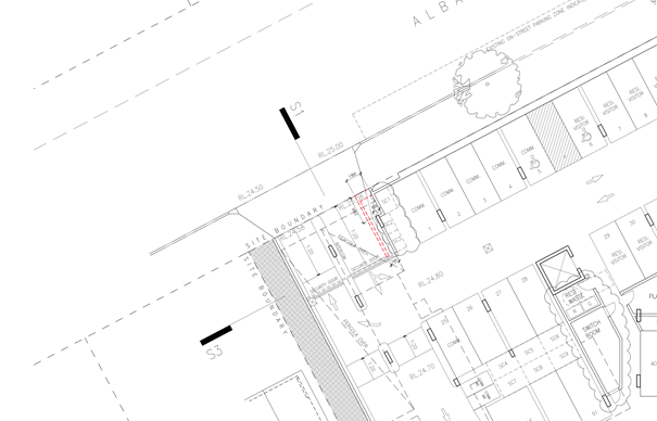
Figure 16 – Extract of the proposed basement
plan indicating the location security door and intercom to gain access to the
basement car park.
Variation to Clause 4.3 Height of Buildings
Development
consent may, subject to clause 4.6, be granted for development even though the
development would contravene a development standard imposed by this or any
other environmental planning instrument.
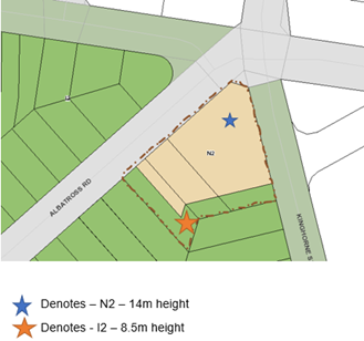
Figure 17 – Height controls applying to the site under the
Shoalhaven Local Environmental Plan 2014
The application
seeks a variation to Clause 4.3 in accordance with Clause 4.6 of SLEP 2014.
Clause 4.3 of SLEP 2014 stipulates the objective and development
standard for the height of buildings in Shoalhaven. Relevantly Clause 4.3(2)
& (2A) state as follows:
(2)
The height of a building on any land is not to exceed the maximum height shown
for the land on the Height of Buildings Map.
The SLEP
2014, through Clause 4.3 sets an 8.5m (I2) height limit for part of the site
and a 14m (N2) height limit for rest of the site.
The 8.5m
height limit applies to a 9m portion of the south eastern portion of the site
extending across all lots subject of the development application where the lot
adjoins the lower density R1 General Residential land to the south.
Parts of the proposed building
exceed the 8.5m (I2) and 14m (N2) height are limited to a portion of the
development.
The development proposed exceeds
the maximum building height as follows:
· 14m height limit by 480mm or 3.4%;
· 8.5m height limit 1.465m or 17.2%; and
· The percentage exceedance of the maximum building height
ranges from 1.4% to 17.2% with the average height limit exceedance being 4.83%.
The submitted height plane
diagrams prepared by Kannfinch Architects illustrate that the height limit
breach and indicate the percentage breach at each point (Refer to Figure 18
and 19).
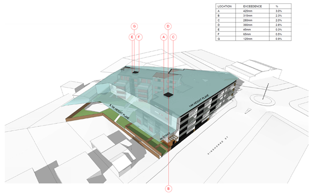
Figure 18 - Height plane instructions relating to the 14.0m (N2)
maximum building height - south-eastern view from Kinghorne Street.

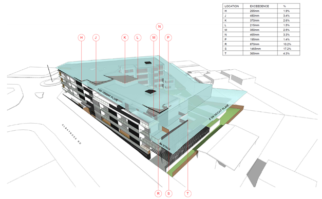
Figure 19 - Height Plane instructions relating to the 14.0m (N2)
and 8.5m (I2) maximum building height - southwestern view from Albatross
Street.
For the reasons detailed in the attached s4.15 Assessment
Report (Attachment 1), it is not considered that the clause 4.6
variation request has satisfied:
1. That
compliance with the development standard is unreasonable or unnecessary in the
circumstances of the case (cl 4.6(3)(a)); and
2. That
there are sufficient environmental planning grounds to justify contravening the
development standard (cl 4.6(3)(b)). The written request needs to demonstrate
both matters.
In conclusion it is considered that the applicant’s
request to vary the development standard as it relates to the maximum building
height should not be supported for the following reasons:
· The
variation request does not demonstrate that compliance with the development
standard would be unreasonable and unnecessary in the circumstances of this
development;
· The
variation request does not demonstrate there are sufficient environmental
planning grounds to justify the contravention, which results in a better
planning outcome than a strictly compliant development in the circumstances of
this particular case;
· Does
not demonstrate the development meets the objectives of the development
standard;
· The
proposed development is for the preceding reasons, not considered to be in the
public interest; and
· The
applicant has failed to demonstrate that there will be better planning outcomes
achieved through variation to the height standard as it relates to the 8.5m
height of building standard associated with a 9m setback to the southern
boundary, as opposed to strict compliance with the development standard or
amending the application to reduce the extent of the variation.
It is noted that the principal reason for not supporting
the variation request relates to the exceedance of the height plane for the
portion of the building fronting Albatross Road.
The exceedance of the maximum building height as it relates
to the 8.5m maximum building height is likely to result in a loss of privacy
and has been demonstrated to result in a loss of solar access to the existing
development (refer to the shadow diagrams prepared by Kannfinch
Architects). The overshadowing of the adjoining residences (No. 6
Albatross Road and No. 175 Kinghorne Street) is exacerbated by the adoption of
a 6m setback (opposed to the required 9m setback) for the portion of the building
along the Albatross road frontage.
The adjoining lots can only be developed as single
dwellings or dual occupancies under the existing R2 Low Density Residential
zoning. The exceedance of the 8.5m maximum building height along the
Albatross Road frontage will exacerbate the blank wall along the southern
elevation and does not serve to create an appropriate transition as anticipated
in the PP associated with the site.
The PP and review of planning controls were undertaken
resulting in a specific conclusion i.e. height. The DA and design
submitted concurrently to the process has however not been adjusted to achieve
the height control. This is of concern as the change to the zone and
strategic context has only been relatively recently ‘made’ and it
is already being varied.
Non-compliance with State
Environmental Planning Policy No 65 – Design Quality of Residential Flat
Development (SEPP 65) and Apartment Design Guide (ADG)
State Environmental Planning
Policy No 65 - Design Quality of Residential Flat Development (SEPP 65) applies to the proposed development which
consists of a new building, of at least 3 storeys and containing at
least 4 or more dwellings.
Council does not have a Design
Review Panel constituted by the Minister of Planning.
In accordance with Clause 28(2)
of the SEPP 65, In determining a development application for consent to
carry out development to which this Policy applies, a consent authority is to
take into consideration (in addition to any other matters that are required to
be, or may be, taken into consideration):
(a) the advice (if any) obtained from the design
review panel, and
(b) the design quality of
the development when evaluated in accordance with the design quality principles,
and
(c) the Apartment Design Guide.
A SEPP 65 Design Statement
has been prepared by a Registered Architect (D20/6044) addressing the
requirements of SEPP 65 and was submitted with the application accordance with
Clauses 50(1A) & 50(1AB) of the EP&A Regulation. The SEPP 65
Design Statement has address Schedule 1 of SEPP 65.
It is considered that the design
quality of the development, when evaluated against the nine design quality
principles does not satisfactorily exhibit exceptional design excellence when
assessed against the following principles:
· Principle 2: Built form and scale
· Principle 3: Density
· Principle 4: Sustainability
· Principle 5: Landscape
· Principle 6: Amenity
|
Schedule 1 Design quality principles
|
|
Design quality principle
|
Comment
|
|
Principle 1: Context and neighbourhood character
Good design responds and contributes to its context.
Context is the key natural and built features of an area, their relationship
and the character they create when combined. It also includes social,
economic, health and environmental conditions.
Responding to context involves identifying the desirable
elements of an area’s existing or future character. Well designed
buildings respond to and enhance the qualities and identity of the area
including the adjacent sites, streetscape and neighbourhood.
Consideration of local context is important for all
sites, including sites in established areas, those undergoing change or
identified for change.
|
The
surrounding development may be broadly characterised as low-density
residential housing, consisting of single and two-storey dwelling houses. The
development immediately to the south on Albatross Road and Kinghorne Street
consists of free-standing single storey dwellings and associated
outbuildings.
Beyond
these dwellings and on land bound by Albatross Road, Kinghorne Street and
Albert Street is low-density residential development – mainly of
single-storey construction.
To
the west and on the opposite side of Albatross Road is a continuation of
predominately freestanding low-density dwellings with examples of established
multi-dwelling housing developments.
To
the east, on the opposite side of Kinghorne Street, is a Council park and
cemetery.
On
the northern side of the intersection of Albatross Road and Kinghorne Street
on the western side of Kinghorne Street is an existing tyre shop. On the
eastern side of Kinghorne Street at the intersection with Kalandar Street,
Council has recently approved two - four storey residential flat buildings,
consisting of 91 apartments and basement car park (DA19/1846).
It
is noted that the subject site was the subject of a planning proposal to
zoning of subject land from B5 Business Development to B4 Mixed Use and amend
maximum height of building to part 14m and 8.5m (transition to low density
development to the south. The Planning Proposal was supported by a Character
Assessment prepared by Urbanac Dated May 2017 (D17/257485) which informed the
building heights for the site.
While
it is acknowledged that the desired future character of the locality will
include higher density residential development over a small foot print
commercial space at ground floor it is not considered that the current design
which includes an exceedance into the 8.5m maximum building height provides
an appropriate representation of that future character along the southern
elevation of the Albatross Road frontage.
Despite
Council’s concerns with the transition of the development to the low
scale development to the south, the development is considered to satisfy this
design principle.
|
|
Principle 2: Built form and scale
Good design achieves a scale, bulk and height appropriate
to the existing or desired future character of the street and surrounding
buildings.
Good design also achieves an appropriate built form for a
site and the building’s purpose in terms of building alignments,
proportions, building type, articulation and the manipulation of building
elements.
Appropriate built form defines the public domain,
contributes to the character of streetscapes and parks, including their views
and vistas, and provides internal amenity and outlook.
|
The
scale and bulk of the building is generally appropriate for the locality when
considering the development in the strategic context of the site and the
desire for a higher density of development to occur from the site.
However,
the proposed setback of the building to the adjoining lower density R2 Low
Density Residential zone does not provide an appropriate transition in built
form or resolve the associated amenity impacts that are associated with the
reduced setback.
The
southern portion of the building does not provide an appropriate transition
to the low-density development to the south. While the applicant has made an
attempt to reduce the bulk and scale of the development through the removal
of two (2) apartments on the southern elevation, this has not overcome the
need for a more suitable transition to the adjoining low density environment.
The
aesthetics of the building are acceptable with appropriate colours and
finishes.
The
development is not considered to satisfy this design principle.
|
|
Principle 3: Density
Good design achieves a high level of amenity for residents
and each apartment, resulting in a density appropriate to the site and its
context.
Appropriate densities are consistent with the
area’s existing or projected population. Appropriate densities can be
sustained by existing or proposed infrastructure, public transport, access to
jobs, community facilities and the environment.
|
55 units on a site area of
3,509m², has a dwelling density of approximately 1 dwelling per
64m².
SLEP
2014 does not provide a floor space ratio under Clause 4.4 of the plan.
While
the density of development is consistent with that previously approved by
Council in relation to the site on the north-eastern corner of Kinghorne and
Kalandar Street (DA19/1846), it is not considered that the development achieves a high level of amenity for
residents and each apartment. The lack of solar access and ventilation to the single bedroom
apartments is of concern and is will result in reduced amenity for occupants
of these units which is not consistent with this principle.
Furthermore, the design of the development does not
demonstrate comprehensive compliance with the ADG as it relates to standards
for:
· Solar access - 13
of 55 apartments (24%) of apartments receive no sunlight between 9am and 3pm
in mid-winter),
· Apartment size and layout – the single bedroom apartment
does not comply with the minimum widths (3.5m provided and 3.6m required)
· Private open space – Several ground floor units do
not provide at least 15sqm (G.04, G.08 and G.09) while other apartments do
not provide a minimum depth of 3m (G0.2, G.03,G.04, G.08, G.10).
· Landscaped deep soil zone for larger
blocks - The total area of deep soil landscaping is 461m2
(13% of the site area). The ADG recommends 15% deep soil zone for sites exceeding 1,500m2.
· Setbacks to the adjoining low density
development – the
setback of the Albatross portion of the
development adjoining the south western boundary does not appear to comply
with the required 9m setback. 6m is proposed to the 3rd level, however as
this is measured to a balcony it is considered that the setback must be a
minimum of 9m.
· Common circulation and spaces – the maximum number of apartments off a circulation core on a single
level is eight. Lobby B services 11 apartments on levels 01, 02, and 10
apartments on Level 03. It is noted that the ADG accepts that where this
design criteria cannot be achieved the total units accessed off a circulation
core must not exceed 12.
· Apartment mix - The
mix of one-bedroom units is not considered to provide an appropriate
distribution to suitable locations within the building, with all single
bedroom units provided within the compromised southern side of the V-shaped
design – limiting solar access, ventilation and unit design.
· Car parking - Total
of car spaces required: 97.63 spaces or 98 spaces. Total of car spaces
proposed: 93 spaces
These non-compliances imply an overdevelopment of the
site.
It
is likely however that the proposed density can be sustained having regard to
existing or proposed infrastructure, public transport, access to jobs,
community facilities and the environment.
The
development is not considered to satisfy this design principle
|
|
Principle 4: Sustainability
Good design combines positive environmental, social and economic
outcomes.
Good sustainable design includes use of natural cross
ventilation and sunlight for the amenity and liveability of residents and
passive thermal design for ventilation, heating and cooling reducing reliance
on technology and operation costs. Other elements include recycling and reuse
of materials and waste, use of sustainable materials and deep soil zones for
groundwater recharge and vegetation.
|
37 of 55 apartments (67%)
receive at least 3 hours direct sunlight between 9.00am and 3.00pm in
mid-winter
13
of 55 apartments (24%) of apartments receive no sunlight between 9am and 3pm
in mid-winter. The ADG design criteria
specified that a maximum of 15% of apartments in a building receive no direct
sunlight between 9 am and 3 pm at mid-winter. The development does not comply
with the maximum number of units receiving no solar access.
The
majority of the proposed apartments have been designed to achieve
satisfactory natural cross ventilation. for the amenity and liveability of
residents and passive thermal design for ventilation, heating and cooling
reducing reliance on technology and operation costs. However, the design of
the single bedroom apartments results in poor solar access and natural
ventilation. There is likely to be a reliance on mechanical heating and
cooling for these apartments.
The
central courtyard and the principal area of communal open space will not
receive adequate solar access during winter. Due to the design of the
development and location of the communal open space areas on the southern
side of the building, the communal open space areas will have compromised
sunlight access and this does not appear to be capable of resolution without
a significant redesign of the buildings and location of communal open space.
The
proposed development is supported by a BASIX Certificate as required under
the EP&A Regulation, however this is not reflective of current layout.
Stormwater
is proposed to be reused for gardens in the communal area.
The
development is not considered to satisfy this design principle as it relates
to the design of single bedroom units.
The
development is not considered to satisfy this design principle
|
|
Principle 5: Landscape
Good design recognises that together landscape and
buildings operate as an integrated and sustainable system, resulting in
attractive developments with good amenity. A positive image and contextual
fit of well-designed developments is achieved by contributing to the
landscape character of the streetscape and neighbourhood.
Good landscape design enhances the development’s
environmental performance by retaining positive natural features which
contribute to the local context, co-ordinating water and soil management,
solar access, micro-climate, tree canopy, habitat values and preserving green
networks.
Good landscape design optimises useability, privacy and
opportunities for social interaction, equitable access, respect for
neighbours’ amenity and provides for practical establishment and long
term management.
|
The proposed landscaping
meets the minimum deep soil requirements under the ADG. The total area of
deep soil area is 461m2 (13% of the site area). 328m2
(9% of the site area) has a minimum dimension of 6m or larger. These areas
have been designed to accommodate larger trees.
The site exceeds 1500m2
and as such it is appropriate to require 15% of the site as deep soil
landscaped area. Additional deep soil planting could be provided through the
reduction of units / building footprint and providing landscaping along the
Kinghorne and Albatross Road frontages.
Landscape plans have been
reviewed by Council’s landscape architect and are generally
satisfactory when considering the plantings and maintenance arrangements
(subject to recommended conditions if approved).
There are no existing
landscape features of note that would warrant retention
The development is not
considered to satisfy this design principle.
|
|
Principle 6: Amenity
Good design positively influences internal and external
amenity for residents and neighbours. Achieving good amenity contributes to
positive living environments and resident wellbeing.
Good amenity combines appropriate room dimensions and
shapes, access to sunlight, natural ventilation, outlook, visual and acoustic
privacy, storage, indoor and outdoor space, efficient layouts and service
areas and ease of access for all age groups and degrees of mobility.
|
The proposed development
does not achieve compliance with the ADG as it relates to the minimum
standard for solar access, apartment size and layout, deep soil landscaping
for larger sites, private open space, common circulation and spaces,
apartment mix, car parking as detailed in the ADG compliance table in
the s4.15 Assessment Report – Appendix 1.
The development is not
considered to satisfy this design principle
|
|
Principle 7: Safety
Good design optimises safety and security within the
development and the public domain. It provides for quality public and private
spaces that are clearly defined and fit for the intended purpose.
Opportunities to maximise passive surveillance of public and communal areas
promote safety.
A positive relationship between public and private spaces
is achieved through clearly defined secure access points and well lit and
visible areas that are easily maintained and appropriate to the location and
purpose.
|
The design is considered to appropriately
address Crime Prevention through Environmental Design (CPTED) matters and
reduces areas of potential concealment/entrapment. Passive surveillance
opportunities are available in the development.
There are defined secure access points and well-lit and visible
areas that are easily maintained and appropriate to the location and purpose.
Entry points are located adjacent to the activated retail zone and designed
to minimise opportunity for loitering.
The residential lobbies and
car park are proposed to operate on secured access. The car park access doors
will operate individually via remote control (or similar) for residents and
retail tenants, with an intercom system for visitors.
The development is
considered to satisfy this design principle.
|
|
Principle 8: Housing diversity and social interaction
Good design achieves a mix of apartment sizes, providing
housing choice for different demographics, living needs and household
budgets.
Well designed apartment developments respond to social
context by providing housing and facilities to suit the existing and future
social mix.
Good design involves practical and flexible features,
including different types of communal spaces for a broad range of people and
providing opportunities for social interaction among residents.
|
The proposed development
provides additional dwellings, with a range of sizes, in an area where
additional housing is needed and is near a variety of services.
The development provides
both communal open space and a communal room. It is noted that the
resident’s room located on the south-west wing of the development has a
compromised and diminutive floor area (20m2) that is not likely to
be used by a broad range of people and is unlikely to provide opportunities
for social interaction among residents.
The development is
considered to satisfy this design principle.
|
|
Principle 9: Aesthetics
Good design achieves a built form that has good proportions
and a balanced composition of elements, reflecting the internal layout and
structure. Good design uses a variety of materials, colours and textures.
The visual appearance of a well-designed apartment
development responds to the existing or future local context, particularly
desirable elements and repetitions of the streetscape
|
The architectural treatment
is satisfactory.
The development is
considered to satisfy this design principle.
|
The development is considered to satisfactorily address the
remaining design quality principles.
Clause 30(2) of SEPP 65 requires residential apartment
development to be designed in accordance with the ADG.
The development has been assessed against the ADG and a full
assessment is provided within the s.4.15 Assessment Report (Appendix 1 of this
Report).
Parts 3 and 4 of the ADG provide objectives, design criteria
and design guidance for the siting, design and amenity of apartment
developments. In accordance with ADGs, development needs to demonstrate how it
meets the objective and design criteria. The design criteria set a clear
measurable benchmark for how the objective can be practically achieved. If it
is not possible to satisfy the design criteria, applications must demonstrate
what other design responses are used to achieve the objective and the design
guidance can be used to assist in this.
The development is non-complaint with the following Objectives
and Design Criteria in Part 3 and 4 of the ADG, as outlined in the table below.
Appendix A to the Section 4.15 Assessment Report (Attachment 1) provides
a full assessment of the proposed development against each of the objectives of
the ADG.
|
Objective
|
Assessment
|
|
3E-1
Deep Soil Zones
Deep
soil zones provide areas on the site that allow for and support healthy plant
and tree growth. They improve residential amenity and promote management of
water and air quality.
On
some sites it may be possible to provide larger deep soil zones, depending on
the site area and context:
•
10% of the site as deep soil on sites with an area of 650m2 - 1,500m2
•
15% of the site as deep soil on sites greater than 1,500m2
|
The total area of deep soil
landscaping is 461m2 (13% of the site area). 328m2 (9%
of the site area) has a minimum dimension of 6m or larger. These areas have
been designed to accommodate larger trees.
The site exceeds 1500m2
and therefore it is appropriate to require 15% of the site as deep soil landscaped
area. Landscape plans have been reviewed by Council’s landscape
architect and are satisfactory, subject to consideration of the requested
changes.
|
|
3F-1
Visual Privacy
Adequate building separation
distances are shared equitably between neighbouring sites, to achieve
reasonable levels of external and internal visual privacy.
|
The adjacent sites to the south
of the development site are zoned R2 Low Density Residential and currently
contain single dwelling houses per lot.
The setback of the Kinghorne
portion of the development to the adjoining southern property boundary
requires a minimum setback of 9m. The setback of this portion of the building
varies for the ground and first floor of between 8m and 9m to windows and
balconies and therefore does not strictly comply with the required 9m
setback.
The setback of the Albatross
portion of the development adjoining the south western boundary does not
appear to comply with this requirement. 6m is proposed to the 3rd level,
however as this is measured to a balcony it is considered that the setback
must be a minimum of 9m.
|
|
Separation between windows and
balconies is provided to ensure visual privacy is achieved. Minimum required
separation distances from buildings to the side and rear boundaries are as
follows (for building heights up to 12m):
Habitable rooms and balconies:
6m
Non-habitable rooms: 3m
Note: Apartment
buildings should have an increased separation distance of 3m (in addition to
the requirements set out in design criteria 1) when adjacent to a different
zone that permits lower density residential development to provide for a
transition in scale and increased landscaping (figure 3F.5)
|
|
3H-1
Vehicle Access
Vehicle access points are
designed and located to achieve safety, minimise conflicts between
pedestrians and vehicles and create high quality streetscapes.
|
Vehicle
access is provided at the southern end of the development along Albatross
Road. The vehicular access is generally incorporated into the
building’s façade. Security gates have been setback from the
frontage. While Council does not raise any concern with the design or
integration of the access into the building from a strictly aesthetic stand
point it is noted that the car park entry and access should be located on
secondary streets or lanes where available.
The
basement car park and manoeuvring are to be designed to comply with the
Australian Standards and Chapter G21: Car Parking and Traffic.
The
proposal to access the development from the Regionally Classified Road
(Albatross Road) is not supported and the applicant has been encouraged to
provide access via the unclassified local road (Kinghorne Street).
Under
the ISEPP, a consent authority must not grant consent to development on land
that has a frontage to a classified road unless it is satisfied that, among
other things, ‘where practicable, vehicular access to the land is
provided by a road other than the classified road’.
It is considered that
consent must not be granted for access off Albatross Road if practicable
vehicular access is available to the site from a road other than the
Albatross Road (that being Kinghorne Street). The applicant has submitted
concept plans (D18/355817) indicating that there was practicable vehicular
access from Kinghorne Street. This approach is reflected in the Land and
Environment Court judgements.
|
|
3J-1
Bicycle and Car Parking
Car
parking is provided based on proximity to public transport in metropolitan
Sydney and centres in regional areas.
|
Given the location of the
development, it does not qualify for the car parking calculation listed
within the ‘Guide to Traffic Generating Developments’.
Accordingly, car parking is to be provided in accordance with Council’s
requirements. Chapter G21 of the SDCP 2014 sets the numerical parking
requirements for various developments and is calculated as follows:
· 1 space per
small dwelling (under 55m2);
· 1.5 spaces per
medium dwelling (56 – 85m2)
· 2 spaces per
dwelling of 86m2 or greater
· Commercial
premises (including offices) Within land zoned B3 Commercial Core at ground
level or where access to the development is from ground level above an
underground level of car parking 1 space per 24m2 gross floor
area.
Parking Rate (Residential) According to Unit Mix (55
Units)
8 apartments <55m2 / 1 space per dwelling =
8 spaces required
31 apartments 55-85m2 / 1.5 space per dwelling
= 46.5 spaces required
16 apartments >85m2 / 2 spaces per dwelling
= 32 spaces required
Total residential car parking required = 86.5 spaces
required
Parking Rate (Commercial)
Commercial floor area 267m2 provided at ground level
above an underground level of car parking of car parking/24m2
Total commercial car parking required = 11.13 spaces
required
Note: Car parking calculated as per car
parking schedule under Section 5.1 of Chapter G21 - Within land zoned B3
Commercial Core at ground level or where access to the development is from
ground level above an underground level of car parking 1 space per 24m2 gross
floor area. At 1st floor and above 1 space per 40m2 gross floor
area.
Total of Car Spaces Required: 97.63 spaces or 98 spaces
Total of Car Spaces Proposed: 93 spaces
Excavation of the site has been
minimised in the placement of the car park access at the lowest point in the
site.
The car parking area has been
designed to suit the site which is triangular. However, a logical layout is
generally achieved.
The car park protrudes above
ground level greater than 1m however this is solely along the Albatross Road
frontage and extends for less than 50% of the frontage. To minimise the
visual impact appropriate colours are to be utilised and varied materials for
balustrades located above the car parking area.
Mixture of natural ventilation
and a mechanical exhaust are to be utilised.
|
|
3J-2
Bicycle and Car Parking
Parking and facilities are
provided for other modes of transport.
|
Each resident has access to a
secure storage cage which is large enough to accommodate a bicycle.
Residential visitor and customer bicycle spaces are proposed in the form of
post mounted bike rails within the road reserve, should Council require them.
|
|
4A-1
Solar and Daylight Access
To optimise the number of
apartments receiving sunlight to habitable rooms, primary windows and private
open space.
|
37 of
55 apartments (67%) receive at least 3 hours direct sunlight between 9.00am
and 3.00pm in mid-winter
13 of
55 apartments (24%) of apartments receive no sunlight between 9am and 3pm in
mid-winter.
While
the applicant has argued that the non-compliance with the Design Criteria is “due
to limitations imposed by the site configuration, southern slope and
orientation” it is noted that there are limited site constraints
and there is opportunity to reduce the number of internal facing apartments
and the design of dual aspect apartments overlooking the internal communal
open space area and either Albatross or Kinghorne Street.
Of
concern is that there are only two single bedroom apartments located on the
third level that achieve the minimum daylight access with no lower level
single bedroom apartments receiving any solar access.
The
minor non-compliance with the requirement that no less than 70% of apartments
in a building receive a minimum of 3 hours direct sunlight could be readily
accepted were the design to exceed the 15% of apartments in a building
receiving no direct sunlight between 9 am and 3 pm at mid-winter.
The
substantial non-compliance with the maximum number of apartments receiving no
direct sunlight between 9 am and 3 pm at mid-winter is a significant concern
and will significantly increase the reliance on artificial lighting and
heating, reduce energy efficiency and residential amenity.
The
design attempts to maximise the number of north facing apartments and limit
the number of single aspects south facing apartments, however, it is noted
that the internal facing single aspect apartments provided limited or no
solar access. It is considered further consideration of the design to further
limit single aspect southerly facing apartments would provide increased solar
access and amenity to future residents.
It
is noted that, where possible, the building design maximises the number of
living areas with a northerly aspect ensuring a high level of amenity is
achieved. Services areas are generally provided to the rear or in central
locations minimising their impact on the most desirable areas of the
apartments.
|
|
1. Living
rooms and private open spaces of at least 70% of apartments in a building
receive a minimum of 2 hours direct sunlight between 9 am and 3 pm at
mid-winter in the Sydney Metropolitan Area and in the Newcastle and
Wollongong local government areas.
|
|
2. In
all other areas, living rooms and private open spaces of at least 70% of
apartments in a building receive a minimum of 3 hours direct sunlight
|
|
3. between
9 am and 3 pm at mid-winter. A maximum of 15% of apartments in a building
receive no direct sunlight between 9 am and 3 pm at mid-winter.
|
|
No.
|
|
4D-3 Apartment Size and
Layout
Apartment layouts are designed
to accommodate a variety of household activities and needs.
|
The open plan designs allow for
a range of activities to happen in the kitchen and living spaces.
1-bedroom apartment widths are
3.5m - this is marginally under 3.6m. The non-compliance is marginal and does
not impede the usable area of the living rooms and would not likely have a
significant detrimental impact on the amenity of the dwelling or resident use
of the units impacted. However, it is noted that the design of the single
bedroom units is once again impacted by the proposed design.
|
|
1. Master bedrooms have a minimum area of
10m2 and other bedrooms 9m (excluding wardrobe space)
|
|
1. Bedrooms have a minimum dimension of 3m
(excluding wardrobe space)/.
|
|
2. Living rooms or combined living/dining
rooms have a minimum width of:
• 3.6m for studio and
1-bedroom apartments
• 4m for 2- and 3-bedroom
apartments
|
|
3. The width of cross-over or cross-through
apartments are at least 4m internally to avoid deep narrow apartment layouts
|
|
4E-1
Private Open Space and Balconies
Apartments provide appropriately
sized private open space and balconies to enhance residential amenity.
1. All apartments are required
to have primary balconies as follows:
Studio: 4m2
1 Bedroom: 8m2, 2m
minimum depth
2 Bedroom: 10m2, 2m
minimum depth
3 Bedroom: 12m2, 2.4m
minimum depth
The minimum balcony depth to be
counted as contributing to the balcony area is 1m
2. For apartments at ground
level or on a podium or similar structure, a private open space is provided
instead of a balcony. It must have a minimum area
of 15m2 and a minimum
depth of 3m.
|
All
balconies exceed the minimum area for the respective unit types. All
balconies have a minimum depth of 2m.
A
number of the ground floor units do not provide at least 15sqm (G.04,
G.08 and G.09) while other apartments do not provide a minimum depth
of 3m (G0.2, G.03,G.04, G.08, G.10).
|
|
4F-1 Common Circulation and
Spaces
Common circulation spaces
achieve good amenity and properly service the number of apartments.
1. The maximum number of
apartments off a circulation core on a single level is eight
|
Common spaces are provided with
solar access, natural ventilation and allow for universal access.
Lobby
B services 11 apartments on levels 01, 02, and 10 apartments on Level 03. The
corridors have been designed with light slots to capture natural light and
ventilation to maintain amenity.
*
Note: Where design criteria 1 is not achieved, no more than 12 apartments
should be provided off a circulation core on a single level
|
|
2. For buildings of 10 storeys
and over, the maximum number of apartments sharing a single lift is 40
|
|
4K-2
Apartment Mix
The apartment mix is distributed
to suitable locations within the building.
|
The mix of one-bedroom units is
not considered to provide an appropriate distribution to suitable locations
within the building.
The single bedroom units are
limited to the southern elevation of the V-shaped building design which has
resulted in units with severely compromised solar access, ventilation and
private open space that will likely result in units with diminished amenity.
The irregular floor plans will also result in odd-shaped rooms and the
potential loss of the use of usable space within these units.
It is considered that the single
bedroom units should be spread more evenly throughout the development to
enable these units a greater likelihood for increased amenity
|
State Environmental
Planning Policy (Building Sustainability Index: BASIX) 2004 (SEPP
(BASIX))
The provisions of SEPP (BASIX)
apply to the site. In accordance with the requirements of SEPP BASIX,
Certification for each dwelling has been submitted with the development
application.
Clause 55A of the Environmental
Planning and Assessment Regulation 2000 (EP&A Regulation) allows for a
development application to be amended provided a new BASIX certificate is
submitted to account for those amendments. An amended BASIX Certificate, to
reflect amended plans was not submitted with the amended application.
Council cannot issue
development consent without the provision of a new BASIX Certificate that
reflects the amended application i.e. 55 residential units.
Planning
Assessment
The DA has been (or will be)
assessed under s4.15 of the Environmental Planning and Assessment Act
1979. Please refer to Attachment 1.
Policy
Implications
A key policy consideration is
height.
Currently, there is an 8.5m and 14m height limit which applies to the site
under SLEP 2014.
The
development proposed exceeds the maximum building height as follows:
· 14m
height limit by 480mm or 3.4%;
· 8.5m
height limit 1.465m or 17.2%; and
· The
percentage exceedance of the maximum building height ranges from 1.4% to 17.2%
with the average height limit exceedance being 4.83%.
The variation has been addressed
by the applicant via a formal clause 4.6 variation statement. The matter is
discussed in the attached section 4.15 report in further detail (Attachment
1) and has been considered previously in this Report.
Consultation
and Community Engagement:
Six (6) public submissions were
received in relation to Council’s notification of the development.
Six (6) were objections to the development. Nil (0) were in support of
the development. The notification was made in accordance with
Council’s Community Consultation Policy with letters being sent within a
m buffer of the site. The application was notified for a period of 30 days and
advertised in the local papers in accordance with Council’s Community
Consultation Policy
Key issues raised as a result of
the notification are provided below:
· Traffic
impacts on local road network
· Impact
of additional cars parking on the on-street car parking
· Amenity
impacts associated with overlooking and overshadowing
· Insufficient
justification and planning purpose to support the PP.
· The
bulk and scale of the development is not consistent with the low scale
development to the south of the site and the site would be better developed for
multi-dwelling housing.
· The
proposed setbacks of the development to the southern boundary are not
appropriate
· The
pedestrian access point to the development on the Kinghorne Street frontage
will result in safety and security issues
The planning concerns raised by
the submitters are addressed in the attached section 4.15 report in further
detail (Attachment 1).
Financial
Implications:
There are potential cost
implications for Council in the event of a refusal of the application. Such
costs would be associated with defending any appeal in the Land and Environment
Court, should the applicant utilise appeal rights afforded under the Environmental
Planning and Assessment Act 1979 (EP&A Act).
Legal
Implications
Pursuant to section 8.2 of the
EP&A Act, a decision of the Council may be subject of a review by the
applicant in the event of approval or refusal. If such a review is ultimately
pursued (if the recommendation is not adopted), the matter would be put to
Council for consideration.
Alternatively, an applicant may
also appeal to the Court against the determination pursuant to section 8.7 of
the EP&A Act.
Summary
and Conclusion
This
application has been assessed having regard for section 4.15 (Evaluation) under
the EP&A Act. Based upon the s4.15 Assessment Report (Attachment 1)
it is recommended that Development Application No. DA16/1465 be refused for the
following reasons.
1. Non-compliance
with SEPP 65 in relation to the Apartment Design Guide (s4.15(1)(a)(i) of the
EPA Act);
The development fails to satisfy
clause 30(2)(a) and (b) of SEPP 65, in that the development does not
demonstrate that adequate regard has been given to:
(a) the
design quality principles (Principle 2: Built form and scale; Principle
3: Density; Principle 4: Sustainability; Principle 5: Landscape; Principle 6:
Amenity), and
(b) the
objectives specified in the Apartment Design Guide for the relevant design
criteria (3E-1 Deep Soil Zones, 3F-1 Visual Privacy, 3H-1 Vehicle
Access, 3J-1 Bicycle and Car Parking, 3J-2 Bicycle and Car Parking, 4A-1 Solar
and Daylight Access, 4D-3 Apartment Size and Layout, 4E-1 Private Open Space
and Balconies, 4F-1 Common Circulation and Spaces, 4K-2 Apartment Mix).
2. The
proposal exceeds the maximum building height development standard under clause
4.3 of SLEP 2014. The applicant’s written request to vary the maximum
building height development standard has not adequately addressed matters
required to be demonstrated by clause 4.6(3)(a) and (b) of SLEP 2014. The
clause 4.6 Variation Request does not provide sufficient environmental planning
grounds to support the variation, nor that compliance is unnecessary or
unreasonable. (s4.15(1)(a)(i) of the EPA Act).
3. The
development has failed to satisfy Council of preconditions clause 101(2)(a) and
(b) of the ISEPP (s4.15(1)(a)(i) of the EPA Act).
In accordance with clause
101(2)(a) and (b) of the ISEPP, Council must not grant consent to development
on land that has a frontage to a classified road unless it is satisfied that:
(a) where
practicable and safe, vehicular access to the land is provided by a road other
than the classified road, and
(b) the
safety, efficiency and ongoing operation of the classified road will not be
adversely affected by the development as a result of:
(i) the
design of the vehicular access to the land, or
(ii) the
emission of smoke or dust from the development, or
(iii) the
nature, volume or frequency of vehicles using the classified road to gain
access to the land
4. Clause
55A of the Environmental Planning and Assessment Regulation 2000 allows
for a development application to be amended provided a new BASIX certificate is
submitted to account for those amendments. An amended BASIX Certificate, to
reflect amended plans was not submitted with the amended application.
5. The
proposed development is inconsistent with the Objectives, Performance Criteria
and Acceptable Solutions as they relate to the following provisions of Chapter
G21: Car Parking and Traffic Shoalhaven Development Control Plan 2014 (SDCP
2014) (s4.15(1)(a)(iii) of the EPA Act):
(a) 5.1
Car Parking Schedule.
(b) 5.2
Traffic.
(c) 5.4
Access.
(d) 5.14
Loss of On-Street Car Parking – Major Developments/ Redevelopments.
6. The
development is likely to have adverse impacts on the built environment
(s4.15(1)(b) of the EPA Act).
7. The
site is not suitable for the development as proposed (s4.15(1)(c) of the EPA
Act).
8. The
development is not in the public interest (s4.15(1)(e) of the EPA Act).
|
|
Development
& Environment Committee – Tuesday 06 October 2020
Page
0
|
|
|
Development
& Environment Committee – Tuesday 06 October 2020
Page
0
|
DE20.114 Development
Application - DA20/1379 - 18 Jellicoe St South Nowra - Lot 1 & DP 1198637
DA. No: DA20/1379/4
HPERM Ref: D20/365510
Section: Development
Services
Approver: Phil
Costello, Director - City Development
Description of Development: Modification to
existing approved crushing and screening operations associated with existing
approved bulk materials storage depot and construction of an industrial shed.
Owner: J A Norman & M Norman
Applicant: Cowman Stoddart Pty Ltd
Notification Dates: 3 June 2020 to 3 July 2020
No. of Submissions: Nil
Purpose
/ Reason for consideration by Council
Council is in receipt of an
application to construct a new industrial building which exceeds the 11 metre
height limit set by clause 4.3 of Shoalhaven Local Environmental Plan 2014
(SLEP-2014). The single storey structure has a maximum height of 14.5
metres (31.8%).
Where a variation to the
development standard is greater than 10%, the variation must be determined by
the elected Council.
Council is able to assume the concurrence of the Secretary
of the Department of Planning and Environment for clause 4.6 to vary a
development standard.
|
Recommendation (Item to be determined under delegated authority)
That the Council:
1. Confirm that it supports, pursuant
to clause 4.6 (exceptions to development standards) of the SLEP 2014, the
request to vary clause 4.3 building height limit of 11m to a maximum of
14.5m.
2. Refer the application DA20/1379 back
to staff for determination.
|
Options
1. Resolve to support
the requested building height variation.
Implications: The development can proceed as proposed, subject
to meeting other considerations under section 4.15 of the Environmental
Planning and Assessment Act 1979 and subject to such conditions as may be
imposed arising from those considerations.
2. Resolve
not to support the building height variation.
Implications: This would result in the applicant needing to
reconsider the design of the proposal. Should the applicant not reconsider the
design to demonstrate compliance with clause 4.3, the application would likely
be determined by way of refusal. The applicant would be entitled to appeal
against Council’s refusal in the Land and Environment Court.
3. Alternative
recommendation.
Implications: Council will need to specify an alternative
recommendation and advise staff accordingly.
Location Map
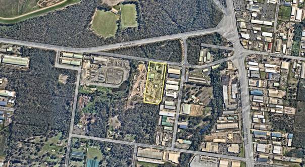
Figure 1: Location map
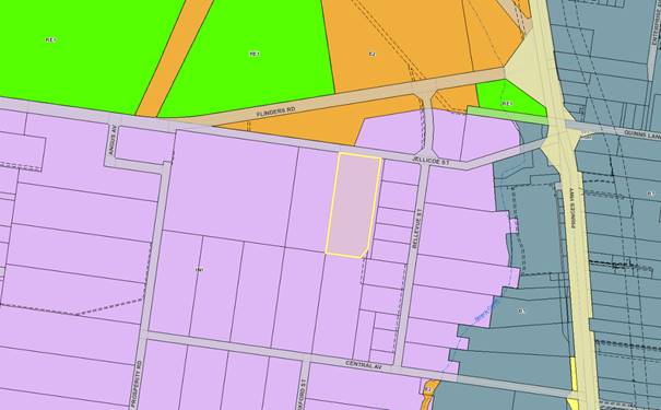
Figure 2: Zoning map
Background
Proposed Development
The proposal is for alterations
and additions to the existing crushing and screening operations. These
operations were approved under DA08/1538 on 16 June 2008 and are associated
with existing approved bulk materials storage depot approved under DA01/1548 on
6 June 2001.
The development consent
DA01/1548 enabled the stockpiling of a maximum of 30,000m³ of materials on
site per annum.
The proposal involves the
following:
· Increasing the
amount of material that can be crushed and screened at the site from the
present 10,000 tonnes to a maximum of 30,000 tonnes.
· To remove the need
for crushing operations to be limited to 4 campaigns per year, to enable
crushing / screening operations to occur throughout the year.
· Construction of an
industrial shed at the rear (southern) boundary of the site, within which
crushing operations will take place, and where processed and unprocessed
materials will be stockpiled. The shed will be used to store plant, equipment
and machinery associated with the crushing and screening operations. The
industrial shed will have a maximum height of 14.5m.
The proposal does not seek to
increase the overall amount of material that can be transported to or
stockpiled on the site per annum; nor do they seek to modify the type of
material that is able to be processed by the crushing and screening operations.
A maximum of 30,000m³ of material will be stockpiled on the site per
annum. Crushing and screening operations are limited to concrete and brick
demolition materials. The development application also does not seek to
increase or change the number of vehicles travelling to the site to deliver or
received material to and from the site and no changes to the type of plant and
equipment used on the site.
As mentioned above, the proposed
industrial shed will have a maximum height of 14.5m which exceeds the 11m
height limit set by clause 4.3 of SLEP 2014. A clause 4.6 variation statement
has been submitted with the application (D20/151372).
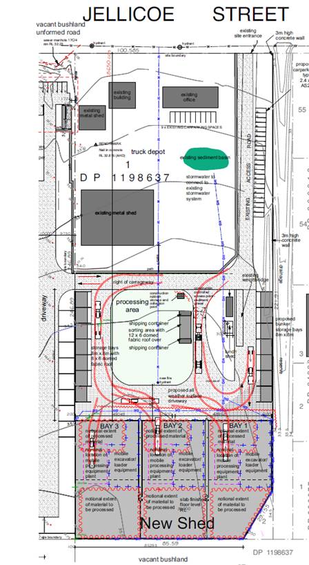
Figure 3: Site plan showing the existing industrial buildings on
site that are proposed to be retained, processing area and the proposed shed
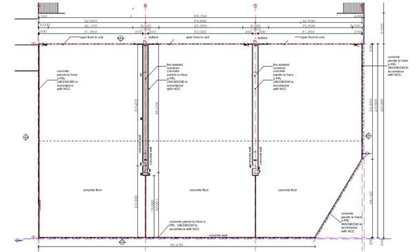
Figure 4: Floor plan of the proposed industrial shed
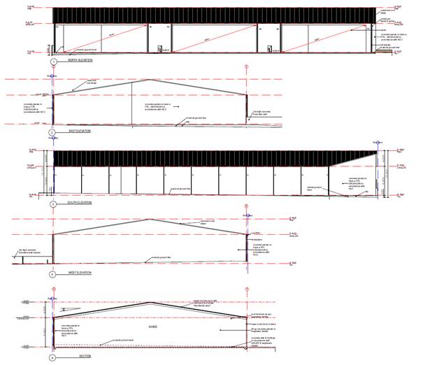
Figure 5: Elevations and section of the proposed shed which
exceeds 11m height limit
Subject Land
The site:
· Is zoned IN1
– General Industrial under the SLEP 2014 and has an area of 2.46ha.
· Is located within
an established industrial area in South Nowra.
· Is accessed from
Jellicoe Street which connects to Bellevue Street, Flinders Street and Princes
Highway.
· Adjoins an
unformed portion of Jellicoe Street to the north, undeveloped land to the north
and a mix of developed and undeveloped industrial lands to the east, west and
south.
· Contains existing
industrial buildings, office, weighbridge, and existing undertaking (bulk
materials storage depot) approved under DA01/1548. The site is currently
surfaced with an all-weather aggregate material. Land to the west, at No. 14
Jellicoe Street which is part of the subject site (under the same ownership)
was approved for a landscape material supplies business under DA18/2329.
· Is identified as
containing class 5 acid sulfate soils.
· Is identified as
partially bushfire prone land by mapping prepared by
Shoalhaven Council and endorsed by the NSW Rural Fire Service and is also
flood prone land.
· Is not as
Potentially Contaminated Land (PCL).
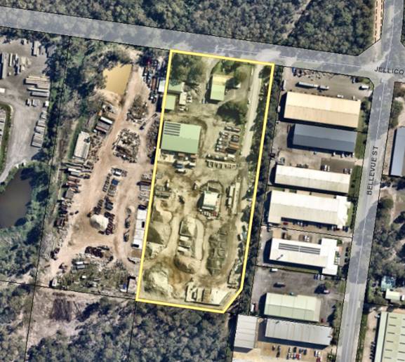
Figure 6: Expanded aerial view of the subject site and surrounding
developments
Site & Context
The site is situated within an industrial zoned area, with
industrial developments located within the immediate vicinity of the site. A
drainage canal and industrial development are located to the east. Undeveloped
industrial zoned lands are located to the south. An approved Landscape Supplies
Yard is located on the adjoining property to the west (No. 14 Jellicoe St)
which is part of the subject site (under the same ownership).
The subject site has been used as a bulk material storage yard
since 2001. The site is devoid of native vegetation and contains an office,
weighbridge, and water quality pond. The site is covered with road base and
contains stockpiles of various grades of rock aggregate and similar types of
materials consistent with the approvals issued in 2001 and 2008
History
The lot was created by
subdivision in 1941. The land was further subdivided by a subdivision
application SF8792 approved on 8 March 2000 and further amendment was approved
and registered with the NSW Land Registry Services in 2014. There are no
restrictions or easements relating to the subject lot which would preclude the
proposed development.
As mentioned previously:
· On
6 June 2001, Council granted Development Consent No. DA01/1548 for the
establishment of bulk materials depot on site. This consent enabled the
stockpiling of bulk materials. In accordance with condition No. 2, a maximum of
30,000m³ of material is permitted to be stockpiled on the site per annum.
· On
2 May 2007, Council granted development consent No. DA07/1053 for the
installation of a weighbridge and an office on site associated with the
existing bulk material depot.
· On
16 June 2008, Council granted development consent No. DA08/1538 for the operation
of crushing and screening plant up to 4 times per year for a maximum duration
of 5 days each time, with a maximum of 10,000 tonnes of material to be crushed
/ screened in any one year.
Issues
Variation to the maximum building height development
standard under clause 4.3 of SLEP 214 in accordance with clause 4.6 of SLEP
2014.
Development Standard to be
Varied
Clause 4.3 stipulates the
objective and development standard for the height of buildings. Clause 4.3(2)
& (2A) state as follows:
(2) The height of a building
on any land is not to exceed the maximum height shown for the land on the Height of Buildings Map.
(2A) If the Height of Buildings Map does
not show a maximum height for any land, the height of a building on the land is
not to exceed 11 metres.
The Height of Building Map does
not show a maximum height for the land and therefore the maximum building
height defaults to 11 metres in accordance with subclause (2A) of the SLEP
2014.
Extent
of the Variation
The maximum height of the
industrial shed is 14.5m, which is a variation of 3.5m or 31.8% from the 11m
height limit. The building is approximately 99.7m long x 60m wide. Refer to Figures
4 & 5.
The applicant has submitted a
variation report to justify the contravention of the development standard
pursuant to the requirements of clause 4.6 of SLEP 2014.
Discussion
Council is required to consider
subclauses (3), (4) and (5) of clause 4.6.
Clauses 4.6(3) - (5) are
reproduced below:
(3) Development consent must
not be granted for development that contravenes a development standard unless
the consent authority has considered a written request from the applicant that
seeks to justify the contravention of the development standard by
demonstrating:
(a) that compliance with the development standard is
unreasonable or unnecessary in the circumstances of the case, and
(b) that there are
sufficient environmental planning grounds to justify contravening the
development standard.
(4) Development consent must
not be granted for development that contravenes a development standard unless:
(a) the consent authority
is satisfied that:
(i) the
applicant’s written request has adequately addressed the matters required
to be demonstrated by subclause (3), and
(ii) the proposed
development will be in the public interest because it is consistent with the
objectives of the particular standard and the objectives for development within
the zone in which the development is proposed to be carried out, and
(b) the concurrence of
the Secretary has been obtained.
(5) In deciding whether to
grant concurrence, the Secretary must consider:
(a) whether contravention
of the development standard raises any matter of significance for State or
regional environmental planning, and
(b) the public benefit of
maintaining the development standard, and
(c) any
other matters required to be taken into consideration by the Secretary before
granting concurrence.
Council must be satisfied that clause
4.6(4)(a)(i) and (ii) have been satisfied prior to the grant of development
consent.
The first step in satisfying
clause 4.6(4)(a)(i) is to consider whether the applicant’s written
request seeking to justify the contravention of the development standard has
adequately addressed the matters required to be demonstrated by clause 4.6(3).
Subclause (3) requires the following two matters to be addressed:
1. That compliance with
the development standard is unreasonable or unnecessary in the circumstances of
the case (clause 4.6(3)(a)); and
2. That there are
sufficient environmental planning grounds to justify contravening the
development standard (clause 4.6(3)(b)). The written request needs to
demonstrate both matters.
Clause 4.6(3)(a) –
Compliance with the Development Standard is Unreasonable or Unnecessary in the Circumstances
of the Case
To assess whether compliance
with a development standard is unreasonable or unnecessary the Courts have
provided guidance in the required assessment, with particular reference to the
accepted "5-Part Test" for the assessment established by the NSW Land
and Environment Court (NSWLEC) in Wehbe V Pittwater Council (2007) NSWLEC
827. The “5-Part Test” is outlined as follows:
1. The
objectives of the development standard are achieved notwithstanding noncompliance
with the standard.
2. The
underlying objective or purpose of the standard is not relevant to the
development and therefore compliance is unnecessary.
3. The
underlying objective or purpose would be defeated or thwarted if compliance was
required and therefore compliance is unreasonable.
4. The
development standard has been virtually abandoned or destroyed by the
Council’s own actions in granting development consents departing from the
standard and hence compliance with the standard is unnecessary and
unreasonable.
5. The zoning of
the particular land is unreasonable or inappropriate so that a development
standard appropriate for that zoning is also unreasonable and unnecessary as it
applied to the land and compliance with the standard would be unreasonable or
unnecessary.
The 5-part test above has been considered by the applicant
and is considered satisfied by Council staff. Further discussion is
below.
Consideration of the written
request relating to Clause 4.6(3)(a)
Council must form the positive
opinion of satisfaction that the applicant’s written request has
adequately addressed those matters required to be demonstrated by clause
4.6(3)(a).
The applicant has provided an
assessment of the proposed development and has relied upon test 1 of the
“5-part test”, principally, that the development standard is
unreasonable or unnecessary in the circumstances of the case.
The justification that the
application meets the objectives of the development standard has been provided
on pages 21 and 22 of the variation statement (D20/151372) and includes the
following justifications:
· “The
proposed works will not be dissimilar to existing and approved structures
within the surrounding industrial area. The building forms, heights, shapes and
characteristics are also similar to those that presently exist or that are
approved in the locality, and will conform to the visual character of the site,
ie. it is industrial development within an industrial setting. In this regard
the recently approved Bunnings Warehouse redevelopment (DA18/1598) will
comprise a height above ground level of 13.889m, and will have a footprint
substantially larger than the proposed shed structure. The
design is also a less invasive response to the sloping topography of the site,
avoiding the need for excessive cut and fill. The restriction in earthworks
result in a well-defined gully and doesn’t diminish the overall landscape
character, noting the cut would be used to form road grades and level car
parking areas on site.
· The subject
site is zoned IN1 General Industrial and the proposed development meets the
current and desired future character of the locality in which it is sited.
· The proposed
development will have a limited visual impact. The bulk and scale of the
structure associated with this application will not be dissimilar to that of
other industrial type development within the broader locality. The works will
be sited in the midst of other factory developments and will be set back 86.5
metres from the Jellicoe Street road frontage, behind existing structures and
buildings. As such the proposed building will not be visually prominent within
the broader landscape will not diminish the views of existing development.
· Given the
siting of the proposed shed to the rear of the site, the proposed building will
also not disrupt views from within the locality.
· The development
will not lead to excessive overshadowing or loss of privacy to existing
development. The site is situated within the middle of an existing industrial
area and no residential properties are located on adjoining sites.
· The proposed
development site is not subject to a heritage listing under the provisions of
SLEP 2014 nor is it sited within the in the vicinity of a heritage item or
within a heritage conservation area.
It is our view that the proposed
building associated with this proposal will not be inconsistent with the
prevailing character of this locality; or the envisaged character of the area
given the planning provisions applying to the land.
Importantly the height of the
proposed shed will enable plant, equipment and machinery associated with the
crushing and screening operations to be housed and operated from within the
shed. This will ensure that the environmental impacts associated with the
crushing and screening impacts on the surrounding locality in terms of air
quality and noise are minimised.”
The proposed shed will enable plant, equipment and
machinery associated with the crushing and screening operations to be housed
and operated from within the shed. The industrial shed is considered compatible
with the bulk and scale of the character of the locality and has an acceptable
visual impact having regard to the location and surrounding industrial area and
character of locality, therefore satisfying the relevant aims of the clause in
the context of the site location.
The height exceedance creates no impacts on any buildings
on surrounding properties such as view loss, considering its setting in an
industrial context. The building will not be prominent from any other external
location impacting on significant views or landscapes. The shed will be setback
86.5m from the Jellicoe St frontage, located behind existing structures and
buildings on site. The height exceedance has no impact on solar access to
existing development or raises any amenity concerns.
Through the flexibility afforded
by clause 4.6 of SLEP 2014, compliance with the 11 metre height limit is
unnecessary given the proposed use of the structure, location, suitable design
approach, and that it will also minimise environmental impacts associated with
the crushing and screening operations in terms of air quality and noise within
the industrial setting.
The objectives of Clause 4.3 –
Height of Buildings of the SLEP 2014 are:
(a) to ensure
that buildings are compatible with the height, bulk and scale of the existing
and desired future character of a locality,
(b) to
minimise visual impact, disruption of views, loss of privacy and loss of solar
access to existing development,
(c) to ensure
that the height of buildings on or in the vicinity of a heritage item or within
a heritage conservation area respect heritage significance.
It is considered that the
applicant has satisfactorily demonstrated that compliance with clause 4.3 is
unreasonable or unnecessary in the circumstances of the case for the following
reasons:
The objectives of clause 4.3 are
achieved notwithstanding non-compliance with the standard as follows:
· The
proposal is considered compatible with the surrounding development and desired
future character of a locality. The proposed development is of an overall
height, scale, bulk, design and external appearance that is in keeping with the
existing development on the site, as well as nearby industrial land uses in the
same industrial estate. The proposal will encourage additional employment
opportunities, facilitates the continued utilisation of industrial land for
industrial purposes and has the potential to provide for an industrial activity
that does not significantly conflict with the operation of existing or proposed
development.
· The
additional height above the 11m maximum building height will not result in
unreasonable overshadowing, overlooking or amenity impacts in excess of that
pre-existing at the site. The proposed shed will enable plant, equipment and
machinery associated with the crushing and screening operations to be housed
and operated from within the shed. This will have a twofold benefit of reducing
noise and dust emissions from the crushing operation by virtue of the operation
being located within the shed.
· The subject site
is no listed as a heritage item, nor is it located within the close vicinity of
a heritage item or within a heritage conservation area.
Clause 4.6(3)(b) –
Are there Sufficient Environmental Planning Grounds to Justify Contravening
the Development Standard?
Council must form the positive
opinion that the applicant’s written request has adequately addressed
those matters required to be demonstrated by Clause 4.6(3)(b).
The environmental planning
grounds relied on in the written request under Clause 4.6 must be
“sufficient” (Initial Action Pty Ltd v Woollahra Municipal
Council [2018] NSWLEC 118. In the judgment, Preston CJ outlined the
two methods for demonstrating that a Clause 4.6 is “sufficient” as
follows:
First, the environmental planning grounds advanced in
the written request must be sufficient “to justify contravening the
development standard”. The focus of cl 4.6(3)(b) is on the aspect or
element of the development that contravenes the development standard, not on
the development as a whole, and why that contravention is justified on
environmental planning grounds. The environmental planning grounds advanced in
the written request must justify the contravention of the development standard,
not simply promote the benefits of carrying out the development as a whole.
Second, the written request must demonstrate that there are sufficient
environmental planning grounds to justify contravening the development standard
so as to enable the consent authority to be satisfied under cl 4.6(4)(a)(i)
that the written request has adequately addressed this matter: see Four2Five
Pty Ltd v Ashfield Council [2015] NSWLEC 90 at [31].
The applicant has provided an
additional statement in the variation report to justify that there are
sufficient environmental planning grounds to justify contravening the
development standard.
Section 1.3 of the EP&A Act
contains the following objects relevant to the aspect of the proposed
development that contravenes clause 4.6:
“(c) to promote the
orderly and economic use and development of land,
(e) to protect the
environment, including the conservation of threatened and other species of
native animals and plants, ecological communities and their habitats,
(f) to promote the
sustainable management of built and cultural heritage (including Aboriginal
cultural heritage),
(g) to promote good design
and amenity of the built environment,”
The aspect of the development
that contravenes clause 4.6 of SLEP 2014 relates to height (clause 4.3 in SLEP
2014 sets an 11m maximum height). In this case the contravention is acceptable
because:
· No
issues of loss of amenity, views, solar access, or adverse impact on heritage
significance in the locality have been raised in assessment.
· The
proposed height of the proposed building will enable plant and equipment
associated with the existing approved crushing and screening operations to be
located within the building. The proposed shed will be constructed of masonry
walls and a corrugated sheet steel roof with the northern façade open.
Therefore, air quality and noise impacts on the surrounding locality will be
minimised.
· Strict
compliance with the 11m height requirement is not expected to result in a
satisfactory or improved design outcome for the intended use of the building.
· The
proposal is consistent with the existing development on site.
There are sufficient
environmental planning grounds to justify contravening the development standard
because:
· The
application has demonstrated that the proposal and the height contravention
remain consistent with the objectives (where relevant) of the subject IN1 zone,
specifically the height contravention does not create conflict between land
uses within this zone and land uses within adjoining zones, despite the
numerical non-compliance.
· The
proposed height contravention does not compromise the local land use planning
framework that applies to the site.
· The
height contravention does not result in any unreasonable visual impacts, in the
industrial setting.
· The
height contravention does not result in any unreasonable overshadowing impacts,
largely due to its context in the industrial setting.
· The height
contravention assists with achieving an appropriately functional building for
the intended use. Critically, the proposed height of the proposed shed will
enable plant, equipment and machinery associated with the crushing and
screening operations to be housed and operated from within the shed. The
proposed development will allow greater operational flexibility because some
activities can be transferred indoors thus be protected from inclement weather.
Consideration
of the written request relating to Clause 4.6(3)(b)
The applicant’s written
request adequately addresses those matters required to be demonstrated by
clause 4.6(3)(b). The applicant’s written request demonstrates that there
are sufficient environmental planning grounds to justify contravening the
development standard for the following reasons:
Council can be satisfied that
the written request has adequately addressed those matters required to be
demonstrated by clause 4.6(3)(b). The requirement to demonstrate that
there are sufficient environmental planning grounds to justify contravention
has been met.
Clause 4.6(4)(a)(ii) –
Will the Proposed Development be in the Public Interest Because it is
Consistent with the Objectives of the Particular Standard and Objectives for
Development within the Zone in Which the Development is Proposed to be Carried
Out?
Clause 4.6(4)(a)(ii) states that
development consent must not be granted for development that contravenes a
development standard unless the proposed development will be in the public
interest because it is consistent with the objectives of the particular
standard and the objectives for development within the zone in which the
development is proposed to be carried out.
Pursuant to the provisions of
the SLEP 2014, the land where the industrial shed is located is IN1 zoned land.
The objectives of this zone are as follows:
• To
provide a wide range of industrial and warehouse land uses.
• To
encourage employment opportunities.
• To
minimise any adverse effect of industry on other land uses.
• To
support and protect industrial land for industrial uses.
• To
allow a diversity of activities that do not significantly conflict with the
operation of existing or proposed development.
• To
enable other land uses that provide facilities or services to meet the day to
day needs of workers in the area.
The proposed shed / development
will not result in an inconsistency with the zone objectives.
Consideration of the written
request relating to clause 4.6(4)(a)
The applicant’s written
submission is supported for the following reasons:
· Is
consistent with the objectives of the development standard and the objectives
of the zone.
· Provides
for a wide range of industrial land uses and encourage employment
opportunities.
· Provides
opportunities for the use of the building for other uses in the future should
the current use no longer continue at the site.
· Not
unreasonable considering the industrial context and setting, and respectful
positioning of the building in the context of the existing built.
Clause 4.6 (4)(b) –
Concurrence of the Secretary has been obtained
Council may assume concurrence in
this instance.
Clause
4.6(5)(a) – Would Non-Compliance Raise any Matter of Significance for State or Regional
Planning?
The non-compliance with the
maximum building height development standard will not raise any matter of
significance for State or regional environmental planning.
Clause 4.6(5)(b) – Is
There a Public Benefit of Maintaining the Planning Control Standard?
In the judgement of Ex Gratia
P/L v Dungog Council [2015] (NSWLEC 148), Commissioner Brown of the NSW LEC
outlined that the question that needs to be answered in relation to the application
of Clause 4.6(5)(b) is “whether the public advantages of the proposed
development outweigh the public disadvantages of the proposed
development”.
The applicant has demonstrated
that a better planning outcome and public advantage will be achieved through
the variation to the height standard as opposed to strict compliance. The
proposed works will not be dissimilar to existing structures within the
surrounding industrial area. The building forms, heights, shapes and
characteristics are also similar to those that presently occur in the locality
and will conform to the visual character of the site. Importantly, the building
has been designed to enable plant and equipment associated with the crushing
and screening operations to be located within the building. This will assist in
minimising air quality and noise impacts on the surrounding locality associated
with the proposal.
Clause
4.6(5)(c) – Are there any other matters required to be taken into
consideration by the Secretary before granting concurrence?
There no other matters required
to be taken into consideration by the Secretary before granting concurrence.
Planning Assessment
The DA will be finalised /
assessed having regard to s4.15 of the Environmental Planning and Assessment
Act 1979 also having regard to the Council’s decision concerning the
height issue.
Policy Implications
There are no specific policy implications
that arise from this matter. Each variation to the SLEP is considered on merit
having regard to the particular request, proposal and circumstances of the
case.
Consultation and Community
Engagement:
The notification was made in
accordance with Council’s Community Consultation Policy. The notification
was for a four-week period.
No submissions were received in
relation to Council’s notification of the development.
Financial Implications:
There are potential cost
implications for Council in the event of a refusal of the application. Such
costs would be associated with defending any appeal in the NSW Land and
Environment Court, should the applicant utilise appeal rights afforded under
the EP&A Act.
Legal Implications
If the requested variation is
not supported and the application subsequently assessed and refused, or if the
applicant is dissatisfied with Council’s determination, the applicant has
the right of a review and / or appeal to the Land and Environment Court.
Summary and Conclusion
The applicant’s submission
has provided sufficient justification to demonstrate that due to specific
circumstances of the case, the 11m height limit is unreasonable, there are
sufficient environmental planning grounds to justify contravention of the height
requirement and that the proposal is in the public interest and should be
supported.
For the reasons outlined in this
report it is recommended that the Council support the proposed variation to
clause 4.3 Building Height Development of SLEP 2014 in accordance with clause
4.6 of SLEP 2014.
|
|
Development
& Environment Committee – Tuesday 06 October 2020
Page
0
|
DE20.115 Development
Application - DA19/2165 - 15 Vallon Rd Woollamia - Lot 3 DP 832984
DA. No: DA19/2165/4
HPERM Ref: D20/373483
Section: Development
Services
Approver: Phil
Costello, Director - City Development
Attachments: 1. Determination
- Approval - 15 Vallon Rd Woollamia - Lot 3 DP 832984 - Parish Currambene
- New Commercial - Construction of 6 "Glamping" Tents (under separate
cover) ⇨
2. Planning Report - 15 Vallon Rd
Woollamia - Lot 3 DP 832984 (under separate cover) ⇨
Description
of Development: Construction of six (6) primitive camping sites
“glamping” and associated site amenities buildings, car parking and
landscaping
Owner: 15 Vallon Road Wollamia Pty Ltd
Applicant: I Architecture
Notification Dates: On 24 January 2020, the
application was notified in accordance with the Council’s Community
Consultation Policy.
No. of
Submissions: Six (6) submissions objecting to the application. A
total of four (4) submissions were received following notification. An
additional two (2) submissions were received prior to finalisation of the
assessment.
Purpose / Reason for consideration
by Council
On 11 August 2020, the Strategy
& Assets Committee resolved in relation to Item No. SA20.136 “[t]hat
the following Development Applications be called in for determination by
Council on the basis of public interest:
1. DA19/2165 - 15 Vallon Road
Woollamia - Lot 3 DP 832984
(MIN20.548)
This Report is prepared in response to the above resolution.
|
Recommendation
(Item to be determined under delegated authority)
That Development Application DA19/2165 for the
construction of six (6) primitive camping sites "glamping" and
associated site amenities buildings, car parking and landscaping at 15 Vallon
Road, Woollamia - Lot 3 DP 832984 be approved subject to the recommended
conditions of consent contained in Attachment 2 of this report.
|
Options
1. Approve the development application
(DA) in accordance with the recommendation of this report.
Implications: This would
allow the applicant to act upon the Development Consent (Attachment 2) and
commence works on the subject site.
2. Refuse the application.
Implications: Council
would need to determine the grounds on which the application is refused, having
regard to section 4.15 considerations.
3. Alternative recommendation.
Implications: Council
will need to specify an alternative recommendation and advise staff
accordingly.
Location Map
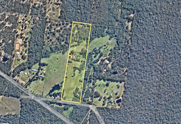
Figure 1 –
Aerial image of the subject site in the local context.
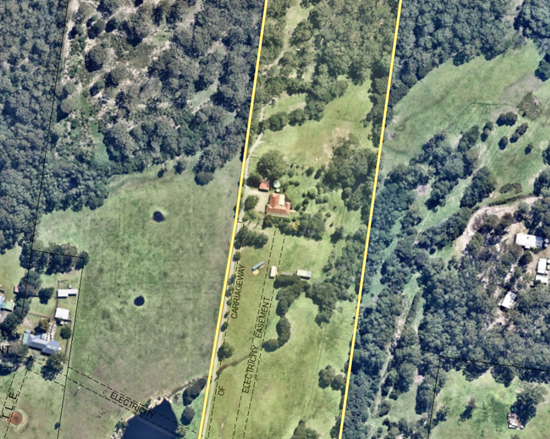
Figure 2 - aerial
image detailing part of the site subject of the application and adjoining
residences.
Background
Proposed Development
Construction of six (6) primitive camping sites
“glamping” and associated site amenities buildings, car parking and
landscaping.
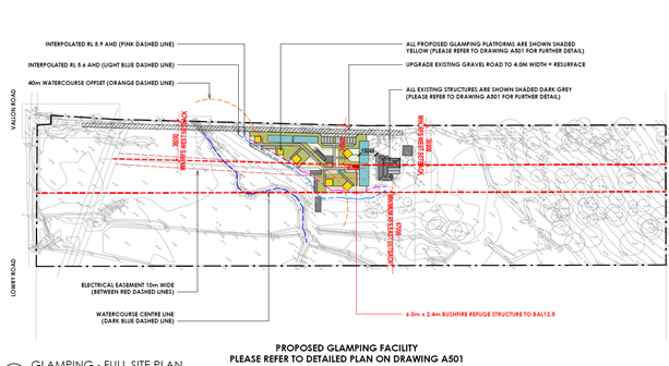
Figure 3- Extract of
the proposed site plan.
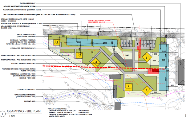
Figure 4 - Extract
of part site plan showing the location of the proposed primitive camping
development.
Subject Land
The site is located on the
northern side of Vallon Road, 130m east of the intersection with Jervis Bay
Road in the predominately rural/residential area of Woollamia. The land is
known as 15 Vallon Road, Woollamia and is legally identified as Lot 3 DP 832984.
The site is a regular shaped allotment of approximately 7.3ha in area (560m
long by approximately 130m wide).
The site has been partially
cleared with scattered vegetation to the Vallon Road frontage and existing
native vegetation to the rear of the property. The site is mapped as containing
biodiversity – habitat corridor under the provisions of Shoalhaven
Local Environmental Plan 2014. Several unnamed drainage depressions
traverse the site which eventually drains into Currambene Creek further to the
north.
The site is mapped with bushfire prone land and within a
flood planning area subject to flooding.
Site & Context
The land surrounding the site is
primarily characterised by small rural use lots (land zoned RU2 – Rural
Landscape) with R5 Large Lot Residential zoned land to the rear of the site.
The surrounding land is used primarily for residential purposes with limited
use for hobby farming and low intensity and scale agriculture.
The site has been developed for
residential purposes, with a single storey brick and tile roof dwelling being
centrally located on the site. Works have been completed within the existing
dwelling house without prior planning approval. The works are associated with
the fit-out and use of the dwelling for additional bedrooms. These works are
the subject of a building information certificate (BC19/1091). The building
certificate remains undetermined at the time of the preparation of this Report.
History
The site has historically been used for rural/residential land
use since the approval of a rural dwelling at the site on 30 April 1986
(DA86/1705). Council has subsequently approved a number of applications for
dwelling additions and modifications to this dwelling as follows:
· DA01/2803
– Dwelling Extensions Patio – approved 4 January 2002
· DA01/3145
– Detached garage and awning to dwelling – approved 21 September
2001
· DA01/2803
– Dwelling Extensions Patio – approved 16 August 2001
On 10 June 2016, Development Application No. DA16/1702 was lodged
with Council for the temporary use of the land as a wedding reception venue.
The application was lodged in accordance with Clause 2.8 Temporary Use of Land
of SLEP 2014.
During the assessment, concerns were raised by Council in
relation to the Jervis Bay Road/Vallon Road intersection and the impacts of the
development on the operation, safety, and efficiency of the intersection. Other
issues were also raised (bushfire, flooding, environmental impact on nearby
watercourses and SEPP 14 wetlands, etc). On 5 September 2016, the
application was withdrawn on the recommendation of Council.
On 1 October 2019, Complying Development Certificate (CDC)
18.447/01 (Council’s reference CD19/1474) was issued by a private
certifier for building works described on the Certificate as a “Cabana”
(BBQ area and deck)”. This structure is now proposed to be used on
the site to provide primitive camping ground amenities (i.e. toilets, showers,
hand basins, storage, BBQ area, etc).
On 21 November 2019, the applicant lodged Modification
Application (DS19/1494) and a Building Information Certificate (BIC)
application (BC19/1091) in relation to internal building works (including
plumbing and drainage) completed on the dwelling house. The works included the
conversion of a living area to a bedroom and part change of use of the garage
for an ensuite.
The modification was subsequently withdrawn at the request of
Council and the building information certificate remains at the time of
preparing this report, undetermined. The BIC is not contingent upon the
determination of the current application which does not seek the use of the
alterations to the dwelling.
The unauthorised works are a separate matter to this
application. In this regard, there are separate provisions in the Environmental
Planning and Assessment Act 1979 to deal with unlawful works.
Issues
The proposed development has
been called up for determination based upon “public interest”
grounds. It is considered that submissions explored later in this Report
provide an assessment of the key issues raised during the community
consultation process.
Planning Assessment
The DA has been assessed under s4.15 of the Environmental
Planning and Assessment Act 1979 (EP&A Act). Please refer to
Attachment 1.
The land is zoned RU2 Rural Landscape under the Shoalhaven
Local Environmental Plan 2014 (SLEP 2014).
The proposal is best characterised as a camping ground
under the SLEP 2014. The proposal is permitted within the zone with the consent
of Council and is not inconsistent with the objectives of the RU2 Rural
Landscape zone which include in simple terms, the encouragement of sustainable
primary production, retention of the rural landscape character and allowing a
range of compatible land uses.
The proposed development is consistent with the relevant
clauses of SLEP 2014 as it relates to the development and the site.
An assessment of the development against the Local
Government (Manufactured Home Estates, Caravan Parks, Camping Grounds and
Moveable Dwellings) Regulation 2005 (Caravan and Camping Grounds Reg) is
provided in Attachment 1 which demonstrates that the development meets the
relevant provisions of the Regulation.
The development has been assessed and deemed compliant with
the following relevant environmental planning instruments:
· State
Environmental Planning Policy (Infrastructure) 2007;
· State
Environmental Planning Policy No 44 - Koala Habitat Protection; and
· State
Environmental Planning Policy No 55 - Remediation of Land
The application has been assessed and is compliant with the
following relevant chapters of Shoalhaven Development Control Plan 2014 (SDCP
2014):
· G1:
Site Analysis, Sustainable Design and Building Materials in Rural and Coastal
Areas;
· G2:
Sustainable Stormwater Management and Erosion/Sediment Control;
· G7:
Waste Minimisation and Management Controls;
· G8:
Onsite Sewage Management;
· G9:
Development on Flood Prone Land; and
· G21:
Car Parking and Traffic
The proposed development is considered to increase the demand
for community facilities in accordance with the Shoalhaven Contributions Plan
2019 (the Plan). The development is most appropriately characterised as a
Caravan Park/Tourist Accommodation development for the purpose of calculating
contributions under the Plan.
The Shoalhaven Contribution Plan 2019 specifies that
contributions are calculated at a rate of 0.4ET per campsite. A total of six
(6) campsites are proposed (2.4ET – Estimate Total: $6,564.68)
The development, based on the information provided, is not
expected to have any significant adverse impact on the environment, the amenity
of the locality or public health/safety.
Policy Implications
There are no policy implications as a result of the
development as proposed.
Consultation and Community Engagement:
Six (6) public submissions were
received from three (3) separate submitters in relation to Council’s
notification of the development. Six (6) were objections to the development.
Nil (0) were in support of the development. The notification was made in
accordance with Council’s Community Consultation Policy with letters
being sent within a 200m buffer of the site. The notification was for 2 weeks.
Key issues raised as a result of
the notification are provided below.
· Flooding
· Effluent
disposal
· Bushfire
Impacts
· Traffic
impacts
· Noise
Impacts
· Management
of the camping operations
· Amenity
impacts – noise, traffic movements and anti-social behaviour
· Unregulated
and illegal use of the site for functions and weddings
· The
site is not suitable for the development
Comment
Flooding Impacts on the
Proposed Use
Concerns have been raised that
the flood affectation and location of the development relative to the mapped
flood hazard render the development incompatible and unsuitable for the site.
Furthermore, concerns were raised in relation to the accuracy and soundness of
the assessment of flood impact.
Part of the property is
categorised as high hazard floodway. Part of the property is categorised as low
hazard floodway and part of the property is flood-free. Whilst the proposed
development is not compatible within the flood-affected parts of the land, the
proposed development is compatible within the flood-free portion of the land.
The application is supported by
a Flood Impact Assessment prepared by Allen Price and Scarratts Pty Ltd
dated September 2019 (D19/419351). The Flood Impact Assessment has been
reviewed and is found satisfactory by Council’s Flood Engineers. It is
noted that the proposed development is on a flood-free portion of the site;
however, access to the site is restricted in an event of a flood.
A flood evacuation plan will be
required to be prepared and lodged with Council before the commencement of the
use in accordance with the Flood Impact Assessment.
An alternate access road/access
to and from the site was not deemed to be necessary or appropriate.
Furthermore, such an access road would require legal access to be created over
an adjoining lot, which does not form part of the application and no owners
consent has been provided.
Despite the application being
lodged on land impacted by flooding, it is considered that the location of the
development on a flood-free portion of the site and implementation of a flood
evacuation plan to be implemented by the site manager (24 hours) in the event of
a flood enable the potential impacts of flooding on the site to be effectively
managed.
Effluent disposal
Concerns have been raised with
the proposed method, location (relative to boundaries and watercourses) and
suitability of wastewater disposal for the development.
The application is supported by
a Soil and Site Assessment for Onsite Wastewater Disposal (Wastewater
Report) prepared by Harris Environmental Consulting dated 10 October 2019
(D19/419360). The Wastewater Report recommends the
use of a domestic Aerated Wastewater Treatment System to treat wastewater and 2
x 20 x 1.8m wide soil absorption beds in the location identified on the
supporting site plan. A reserve area equal to 100% of the primary wastewater
disposal load is required and has been designated as land to be set aside for
future effluent disposal onsite.
Council’s Environmental Health Officers have
considered the Wastewater Report and deem that the report has satisfactorily
addressed the requirements under Chapter G8 Onsite Sewage Management of SDCP
2014, taking into consideration the specifics of the site and the method of
disposal proposed.
Bushfire Impacts
Concerns have been raised in relation to the
accuracy and adequacy of the submitted bushfire assessment for the proposed development
and the ability of the site to be evacuated in the event of a bushfire.
The site is identified as being bushfire prone
land. The site contains Category 1 vegetation and land identified as
“Vegetation Buffer”.
Under the Rural Fires Act 1997, section
100B, a Bush Fire Safety Authority from the NSW RFS is required for a special
fire protection purpose (SFPP) development. The proposed camping ground is a
form of SFPP under the Rural Fires Act 1997. As such, an Integrated
Development approval is required under Section 4.46 of the EP&A Act.
The application is supported by Bushfire
Assessment Report prepared by Bushfire Building Solutions dated 15 July
2020 (Reference BAR 10115/18) (D20/329893). The Bushfire Assessment Report makes
recommendations for:
· The establishment of asset protection zones to be
maintained for a distance of 67m to the north and east, and 36m to the south and west.
· The Camp Kitchen must comply with
construction requirements of AS3959-2009 BAL 12.5 and Section 7.5 of Planning
for Bushfire Protection 2019.
· Provision of 20,000-litre static water
supply.
· A Bushfire Emergency Management and Evacuation Plan be
prepared in accordance with the NSW Rural Fire Service document ‘A
guide to developing a Bushfire Emergency Management and Evacuation Plan’.
The application was referred to the NSW RFS in
accordance with section 4.46 of the EP&A Act.
On
19 August 2020, the NSW RFS issued their General Terms of Approval to the
application (D20/374608).
Noise Impacts
Concerns have been raised that
the development will result in adverse impacts associated with noise
production.
The application is supported by
a Noise Impact Assessment prepared by Harwood Acoustic dated 25 October
2019 Reference: 1905014E-R1 (D19/419340). The Noise Impact Assessment has
considered the potential noise impacts associated with voice noise, motor
vehicle and mechanical plant. The Noise Impact Assessment has been
considered by the Council’s Environmental Assessment Officer to be
suitable and conditions are recommended to ensure there will be no loud
amplified music played at the campsites.
The location of the camping
grounds relative to adjoining premises varies from160m to 360m (Refer to Figure
5 below). While it is anticipated that there may be an impact on residents
at No. 9 Vallon Road associated with vehicle movements and additional traffic
noise. This has been considered to be within acceptable levels and is unlikely
to result in disturbance. The other adjoining properties are unlikely to be
significantly impacted and this is confirmed by the Noise Impact Assessment.
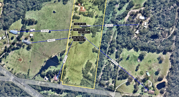
Figure 5 - Aerial image of the subject site in the local
context with the relative distance of the dwelling from the approximate
location of the camping area.
Appropriate conditions are
recommended to ensure no adverse impact associated with noise will occur and
patron behaviours are proposed to be managed by a site manager to be on-site
24 hours a day during the use of the camping ground.
Traffic Impacts
The submissions have raised
concerns with the potential traffic impacts associated with the use and safety
of the Vallon Road and Jervis Bay Road intersection despite the reduction in
the speed limit to 90kph.
The application is supported by
a Traffic Impact Statement prepared by Allen Price and Scarratts Pty Ltd
(N27544-SK01) Revision P1 (D19/419337) and additional Sight Distances Layout
Plan prepared by Allen Price and Scarratts and supporting email (D20/316164).
SDCP 2014 does not provide
estimated daily movement rates for camping grounds, however, the RMS Guide
to Traffic Generating Developments provides traffic generation averages for
motels (most appropriate comparative use) as:
· Evening
peak hour vehicle trips = 0.4 per unit total for 6 camp sites = 2.4 vph
· Daily
vehicle trips = 3 per unit; total for 6 camp sites = 18 vpd
The anticipated traffic
movements are considered to be satisfactory and will not result in an
unreasonable impact on either Vallon Road or Jervis Bay Road.
The operation of the
intersection of Vallon and Jervis Bay Road has been considered for efficiency
and safe intersection sight distance (SISD). Waiting times to turn right onto
Jervis Bay Road is unlikely to exceed 1 minute and a SISD is achieved for the
right turn in and right turn out at the intersection of Vallon Road/Jervis Bay
Road.
Council’s Traffic
Engineers have reviewed the submitted information and deem that the traffic
impacts are satisfactory and no additional upgrade works are required at the
Vallon Road and Jervis Bay Road intersection.
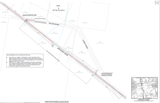
Figure 6- Sight
Distances Layout Plan prepared by Allen Price and Scarratts
Management of the camping
operations
Concerns have been raised in
relation to the management procedures proposed, being untruthful, incorrect,
and questionable in their likely ability to be implemented and tents removed
within 24 hours of their use.
The application is supported by
a Site Management Plan prepared by Allen Price and Scarratts Pty Ltd
dated 20 April 2020 (D20/153150), which outlines that an operations manager
will be onsite at all times and will be accommodated in the existing dwelling
for 24-hour operation, with no camping in the absence of management. The
applicant proposes the following specific management arrangements:
· Camper
registration and maintenance of camper and vehicle details and numbers.
· Complaints
register to be available for Council inspection on request. Any complaint will
be recorded in the onsite complaints register and followed up and investigated
by the onsite manager/landowners. These complaints will be kept on the register
for a minimum period of two years.
· Dismantling
of tents within 24 hours of use in accordance with the Caravan and Camping
Grounds Reg.
· Limiting
the use of the camping ground to a total of 12 persons.
· Maintenance
of bushfire requirements i.e. vegetation management and static water supply.
· Implementation
of the Flood Emergency Management Plan in the event of a flood.
· Limitation
of the use of the existing dwelling for use of the manager.
· Noise
and camper behaviour.
· Waste
management
· Security.
Guests will be required on arrival to register their details with the onsite
manager and no additional visitors will be permitted to camp on the site. No
vehicles in addition to the guest registered vehicles will be permitted on the
site except for any service vehicles that have been authorised by the
landowners / onsite manager.
It is considered that Council
has an opportunity through this application to place stringent operational
management controls on the site to limit the use of the site as described in
the application and as proposed to be managed in the Site Management Plan. Council
cannot allow the prior use of the site to foreshadow the proposed and future
use of the site for permissible use.
With appropriately rigorous and
overarching conditions of consent as outlined in the draft determination (refer
to Attachment 2), it is considered that the management and operation of
the site can be effectively achieved.
Unregulated and illegal use
of the site for functions and weddings
It is noted that submissions
have raised doubts about the statements relating to the use of the existing
dwelling and potential use of the site for functions and weddings.
One submitter has identified
booking websites for the site indicate that the manager's cottage is currently
being promoted for exclusive use by guests (10 persons in 4 bedrooms) and that
the managers are not residing at No. 9 Vallon Road as suggested in the
applicant’s submission.
The applicant has identified
that the existing dwelling is currently advertised for short term accommodation
and has been a consistent use over many years and that the short term use of
the existing dwelling is consistent with current local and state planning
legislation that does not require prior approval for the use of an approved
dwelling for short term accommodation to paying guests
The applicant has also indicated
in their letter in response to the submitted objections dated April 2020
(D20/153143), that:
“[T]here has been extensive stays by guests at the
existing dwelling, there has been only one major unauthorized event with large
numbers staying and a noise nuisance caused to neighbours. This exposed the
then inadequate means of managing the property, which has since been recognized
and has been dealt with. The new measures now in place by the owners have
provided a far better system of management which limits numbers and the type of
activities that can occur on-site.”
Council records indicate that
there have been two (2) substantiated complaints concerning the use of the
site, which related to camping on the site. These complaints have been
investigated by Council’s Compliance officers and where required
appropriate regulatory action has been taken. There have been no substantiated
complaints received and investigated by Council relating to the use of the site
for functions or weddings.
It is important to note that the
application currently under assessment does not propose to use the site for
functions or weddings (as previously proposed by the withdrawn Development
Application DA16/1702 for the temporary use of the land as a function centre).
The application only relates to the camping ground with the use of the existing
dwelling proposed to be used as a manager’s residence.
Council can only consider the
application as put to it. It cannot take any allegations of what may happen or
has happened into account in the prescribed planning assessment (specified in
section 4.15 of the EPA Act 1979). As mentioned previously there are separate
provisiosn available to deal with unauthorised works (and also activities)
should such a circumstance eventuate.
With appropriate conditions
which limit the use of the site as proposed and the operation and use of the
site per the Site Management Plan and the recommended condition of
development contained in the draft determination (Refer to Attachment 2),
it is considered that the use can be effectively managed.
The
site is not suitable for the development
Concerns have been raised that
the site is inappropriate as a proposed glamping site. The lack of onsite and
full-time management compounds the risks for those who stay and is problematic
for the neighbours.
The site has several constraints
that limit the scale and use of the site, they include bushfire, flooding, wastewater
management, mapped watercourses and threatened species/terrestrial
biodiversity, access, and the local road network capacity.
The applicant has provided a
considered application that does not propose the maximum density of potential
camping sites capable under the Local Government Regulation 2005, which
stipulates that the site could notionally achieve 2 camping sites for each
hectare of the camping ground i.e. 14 primitive camping sites based upon the
site having an area of just over 7 hectares. The application for a total of six
(6) sites reflects the limitations of the site.
The camping sites are located
following consideration of the site constraints and detailed reports have been
prepared to support the application which has been reviewed by Council, the NSW
RFS and Endeavour Energy to be satisfactory, subject to recommended conditions.
The site is considered to be
suitable for the proposed development subject to the recommended conditions
contained in the draft determination contained in Attachment 2.
Financial Implications:
There are potential cost
implications for Council in the event of a refusal of the application. Such
costs would be associated with defending any appeal in the Land and Environment
Court, should the applicant utilise appeal rights afforded under the Environmental
Planning and Assessment Act 1979 (EP&A Act).
Legal Implications
According to section 8.2 of the
EP&A Act, a decision of the Council may be subject of a review by the
applicant in the event of approval or refusal. If such a review is ultimately
pursued (if the recommendation is not adopted), the matter would be put to
Council for consideration.
Alternatively, an applicant may
also appeal to the Court against the determination according to section 8.7 of
the EP&A Act.
Summary and Conclusion
· The
development is permitted within the zone and is consistent with the objectives
of the zone.
· The
development will provide an additional form of tourist and visitor
accommodation in an accessible location, close to local service centres of
Huskisson and Vincentia, and near to local scenic attractions within the Jervis
Bay area.
· The
development is generally compliant with the relevant provisions of SDCP 2014.
· The
development provides sufficient car parking on the site through the provision
of ten (10) car parking spaces.
· The
site is to be managed by an on-site and on-call manager who will be available
to administer the operation of the primitive camping ground.
· The
proposed development is unlikely to result in unreasonable amenity impacts on
the adjoining residents with conditions recommended to ensure no adverse noise
impacts. Furthermore, the limitation of the primitive camping ground to twelve
(12) campers across all six (6) sites is unlikely to result in amenity impacts
on adjoining rural/residential land-uses.
· The
NSW Rural Fire Service has issued their General Terms of Approval to the
application and suitable conditions are recommended to ensure construction
standards for buildings, installation of fire refuge and implementation of a
bushfire management plan in the event of bushfires.
· Traffic
movements to and from the site are acceptable and will not necessitate any
upgrade works to the Vallon Road and Jervis Bay Road intersection.
· The
site is suitable for the proposed development taking into account the existing
and future development in the locality which is likely to continue to be used
for rural/residential land uses.
· The
assessment of the public interest has considered the competing and conflicting
public interests associated. Ultimately the development is unlikely to
represent the interests of all sectors of the public who have an interest in
the development, however, the recommendation to support approval of the
development application is considered to beon balance in the broader public
interest.
· Having
regard to the above, conditional approval is recommended as attached to this
report.
|
|
Development
& Environment Committee – Tuesday 06 October 2020
Page
0
|
DE20.116 Development
Application - DA20/1676 - 23 Coorong Rd North Nowra - Lot 2 DP 1056165
DA. No: DA20/1676/4
HPERM Ref: D20/398450
Section: Development
Services
Approver: Phil
Costello, Director - City Development
Attachments: 1. DRAFT
- Determination - Refusal - DA20/1676 - 23 Coorong Rd North Nowra - Lot 2 DP
1056165 ⇩
2. Planning Report - 23
Coorong Rd North Nowra - Lot 2 DP 1056165 (under separate cover) ⇨
Description of Development: Construction of an
access driveway for maintenance purposes and associated earthworks, vegetation
removal and drainage works.
Owner: A & S Sturt
Applicant: Adam Sturt C/O SET Consultants
Notification Dates: 29 July 2020 – 26 August
2020
No. of Submissions: 5 in objection
Purpose
/ Reason for consideration by Council
Council resolved on 7 April 2020
(MIN20.240), with respect to COVID-19 Response, that:
“The delegation to the CEO be rescinded to determine a
development application by refusal until the end of COVID-19 crisis
The refusal of a development
application must only be by Council/Committee resolution.”
This Report recommends refusal of the above Development
Application and is therefore prepared for consideration by the Development
& Environment Committee in accordance with the 7 April 2020 Resolution of
Council.
|
Recommendation (Item to be determined under delegated authority)
That Development Application DA20/1676
for the construction of an access driveway for maintenance purposes and
associated earthworks, vegetation removal and drainage works at Lot 2
DP 1056165, 23 Coorong Road, North Nowra be determined by way of refusal for
the reasons set out in the Notice of Determination (Attachment 1) to this
report.
|
Options
1. Refuse the
development application (DA) in accordance with the recommendation.
Implications: The
application would not proceed. The applicant can apply for a section 8.2 review
of Council’s decision and/or could lodge an appeal with the NSW Land and
Environment Court against Council’s decision
2. Approve the
application.
Implications: Council would
have to determine the grounds on which the DA is to be approved, that is,
provide reasons to support the development, having regard to section 4.15
considerations. A suite of conditions can be prepared by staff in the event
that Council supports the proposal. Under some circumstances, third parties
(i.e. objectors) can seek a judicial review of Council’s decision in the
NSW Land and Environment Court.
3. Alternative
recommendation.
Implications: Council will
need to specify an alternative recommendation and advise staff accordingly.
Location Map
Figure 1 - Location Map
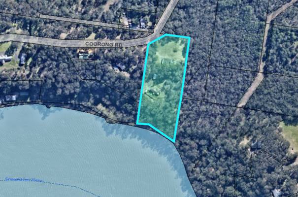
Background
Proposed Development
The proposal includes:
· Construction of an
access driveway for maintenance purposes
o Associated earthworks
o Associated drainage works
o Associated vegetation removal
o Temporary access over Council
reserve at bottom of cliff escarpment to bring machinery and materials required
for construction to the site. Construction materials and machinery will be
barged up the Shoalhaven River.
Note (see Figure 3) That the road terminates at the property
boundary and there is a small reserve between the site and the Shoalhaven
River.
Figure 2 – Site Plan
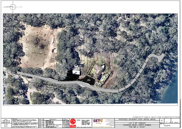
Figure 3 – Works Impact Plan
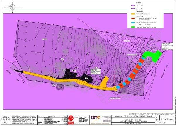
Figure 4 – Typical Elevation Details
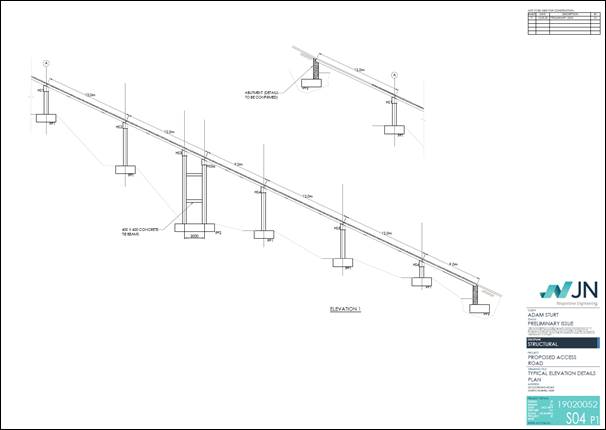
Figure
5 – Driveway Long Section Plan
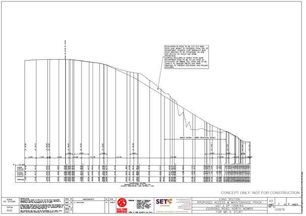
Subject Land
The development site comprises Lot 2 DP 1056165 (23 Coorong
Road, North Nowra). Refer to Figure 1.
Site & Context
The development site:
· Is accessed from the southern side of Coorong Road.
· Adjoins the Shoalhaven River and includes a large cliff
escarpment at the rear of the site.
· Forms part of the unique river landscape along the
Shoalhaven River.
· Is mostly zoned E3 Environmental Management, with a small
portion zoned RU2 Rural Landscape under the Shoalhaven Local Environmental
Plan 2014 (SLEP 2014) and has a land area of 2.62ha.
· Contains an existing dwelling and associated structures.
· Includes some cleared areas nearby the existing dwelling
and also has areas of dense bushland vegetation on the southern and eastern
parts of the site. The cliff escarpment area is heavily vegetated.
· Is mapped as bush fire prone land.
· Is partially mapped as flood prone land.
· Is mapped as a ‘coastal use area’ and
‘coastal environment area’ under State Environmental Planning
Policy (Coastal Management) 2018.
· Is partially mapped as containing land in the vicinity of
the Western Bypass Corridor under clause 7.21 of SLEP 2014
The surrounding area is rural in character and the site is
adjoined by rural residential and other bushland areas. The site adjoins the
Shoalhaven River to the south and it is noted that there is a small Council
reserve separating the subject property from the mapped Shoalhaven River
watercourse.
Figure 6 – Zoning Extract
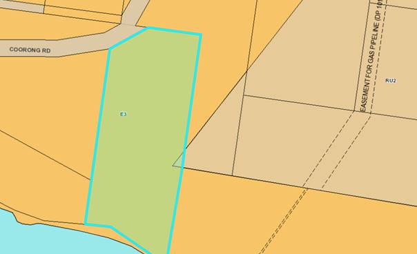
History
The following provides details on pre-lodgement
discussions, post-lodgement actions and general site history for context:
· A previous application (DA19/1079) for a similar access
track to be constructed to permit access to the lower portion of the property
for maintenance of the land and also public foreshore reserve was determined by
way of refusal on 3 September 2019. The application was refused primarily due
to concerns about the adverse impacts on the environment from the construction
of the track and there being no agreement with Council to undertake foreshore
maintenance.
· The current application was lodged on 7 July 2020.
· As a result of detailed assessment of the application,
additional information was requested from the applicant on two (2) occasions
– 15 July 2020 and 23 July 2020. Additional concerns relating to the
development based on referral comments were communicated to the Applicant on 10
August 2020.
· The Applicant was advised on 23 July 2020, based on a
preliminary assessment of the proposed development, that the purpose and need
(i.e. planning purpose) for the access driveway is unconvincing and that the
proposed development may not be suitable or an appropriate development for the
locality considering environmental qualities and topography of the site.
Furthermore, the Applicant was advised on 28 August 2020 that based on a
detailed assessment of the proposed development, it is considered that the
proposed access driveway would have a significant adverse impact on the unique
riparian and escarpment environment and negatively impact on the river
landscape, and that if the application is to be pursued, it will proceed with a
report to Council at the next Development and Environment Committee meeting.
· To
date, there has been no response to the additional information requests.
Issues
State Environmental Planning Policy (Coastal Management)
2018
The subject land is mapped as
“coastal environment area” and “coastal use area” under
State Environmental Planning Policy (Coastal Management) 2018.
SEPP (Coastal Management) 2018 specifies that
development consent must not be granted for development within the
“coastal environment area” or “coastal use area” unless
the consent authority has considered whether the proposed development is likely
to cause an adverse impact on the matters set out in clause 13 (for
“coastal environment area”) and clause 14 (for “coastal use
area”) and is satisfied that the development has been designed to avoid
or minimise or will be managed to mitigate adverse impacts. Consideration of
clause 13 and 14 are discussed below.
Applicant’s Submission
“The proposed access track will have minimal adverse
impacts on the existing foreshore area. This is due to the driveways design and
location. The methods of construction and proposed sediment and erosion controls
proposed also minimise the impact on the adjacent foreshore to the south.
The areas of impact and clearing of native vegetation will
be offset through the planting and rehabilitation plan of the area surrounding
the driveway and foreshore area. This will have a positive impact on the
foreshore area, with the ongoing maintenance capability provided by the
driveway. The Ecological & Riparian Issues & Assessment Report prepared
by Gunninah outlines the potential impacts of the development on the natural
environmental and Biodiversity present on the site. In summary, the report
provided the following conclusion and recommendations:
‘On the basis that the works are undertaken in a
manner which avoids or minimises sediment discharge and erosion, the proposed
access road on the subject land in North Nowra will impose only limited impacts
on the natural environment in general – given the small footprint of the
proposal and the limited removal of vegetation necessary (because of the
escarpment).
In particular, it is not “likely” that a
“significant effect” would be imposed upon any threatened biota
listed in the BCon Act as a consequence of the proposal (as detailed in Chapter
8.4 and Attachment G).
Similar considerations apply to threatened and/or
migratory biota listed in the EPBC Act - it is not “likely” that a
“significant impact” would be imposed on any relevant MNES pursuant
to that Act.
A number of recommendations are provided for the
proposal.
· Precise
details of the road alignment are to be reviewed on site by the engineers and a
Project Ecologist – in order to minimise the extent of disturbance and
the number of trees to be removed; and to identify particular engineering or
design solutions to retain trees and vegetation wherever possible.
· An
arborist will be required to identify specific tree protection measures for
trees along or near to the alignment of the road.
· A
detailed Vegetation Management Plan (VMP) is to be prepared on receipt of
development consent and prior to the issue of a Construction Certificate
– to detail the rehabilitation and replanting regime for the areas to be
disturbed.’
The proposed access track has been designed to provide safe
access to the southern portion of the site. The southern portion of the site is
currently difficult to access due to the rocky escarpment in this area of the
site. This will make it easier for the area to be maintained and rehabilitated.
The proposed access track will not impact on the existing waterway and has been
provided with the necessary stormwater and erosion controls to prevent
potential issues.
The use of concrete footings and headstocks have reduced
the area of impact particularly along the escarpment. The proposed access track
has considered the surrounding context and site constraints to provide suitable
access to this portion of the site. The track will not have any impact on other
existing accesses to the foreshore, river or public reserve adjacent to the
southern boundary. There is no proposed development in this application with the
potential to overshadow, funnel wind, or restrict existing views of the
surrounding properties and public spaces of the foreshore.
The visual amenity and existing scenic qualities of the
site will not be significantly impacted by the proposed access track. The
current view of the site from the south is of the existing vegetation with the
site sloping up towards dwelling. The existing structures onsite are not
visible from the Shoalhaven River. The proposed access track requires the
removal of selected native vegetation. The access track will retain a vegetated
buffer between driveway and the Shoalhaven River which with the exception of
the area of the turning head, will be approximately 20m wide effectively
screening it from view. The proposed earthworks and tree removal will have no
significant visual impacts on the surrounding foreshore. A Vegetation
Management Plan will be prepared prior to the Construction Certificate stage
and will propose the replanting of the foreshore which will further improve the
visual and scenic qualities of the site.
Figure 7 shows the approximate location of the subject
property and lateral position of the turning head as viewed from the river. As
can be observed from the density of the existing vegetation, which is to be
retained, the access will be largely screened from view.
Figure 7: Foreshore view showing
property and proposed access location
[extracted from Applicant’s Statement of Environmental Effects]
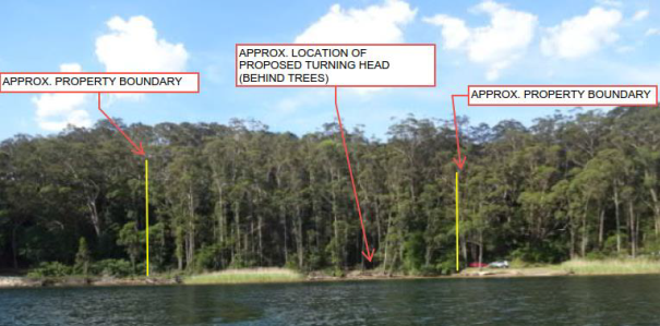
It is noted that adjoining properties to the east and west,
as well as others along the river contain similar access driveways to what is
proposed in this application, including thinning of vegetation and management
of the southern portion of the site. The proposed access track will allow
maintenance of the southern portion of the development site, which will provide
a significant improvement to the health of the environmental on site. Figures 8
and 9 show the existing use and current development of adjoining properties
adjacent to the foreshore.
Figure 8: Foreshore view of the
property immediately east of subject site
[extracted from Applicant’s Statement of Environmental Effects]
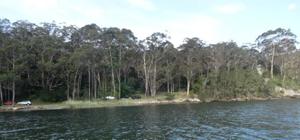
Figure 9 shows an image of the site
in regards to the wider context along the foreshore. The image has been taken
from the Shoalhaven River, facing north-west towards the site.
Figure 9: Site Context foreshore view
[extracted from Applicant’s Statement of Environmental Effects]
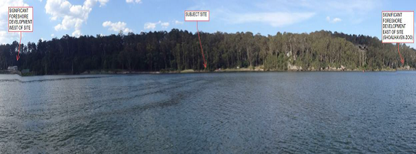
It is considered that the
proposed access driveway has been designed and positioned to minimise the
potential impacts of the surrounding coastal environment, and that the
development will assist in the ongoing maintenance and protection.”
Discussion
Clause 13 Development
on land within the coastal environment area
Development consent must not be granted to development on
land that is within the coastal environment area unless the consent authority
has considered whether the proposed development is likely to cause an adverse
impact on the following:
|
Matter for Consideration
|
Assessment Staff Comment
|
|
the integrity and
resilience of the biophysical, hydrological (surface and groundwater) and
ecological environment
|
The application has not
adequately addressed the impacts of the development on the natural
environment. The construction of the driveway access is likely to have an
adverse impact on the environmental values of the site.
The purported use of the
access driveway for maintenance purposes is queried. It was noted
during the site inspection that the area at the bottom of the cliff
escarpment was generally in good ‘health’. Because of existing
vegetation and the limited presence of weeds or exotic plant species at the
bottom of the cliff escarpment, it is considered that any weed removal or
foreshore management should be carried out by hand, the use of heavy
machinery would not be appropriate and would have a negative impact on the
natural environment.
Council is of the view that the proposed development is
likely to have an adverse impact in relation to the integrity and resilience
of the biophysical, hydrological (surface and groundwater) and ecological
environment.
|
|
coastal
environmental values and natural coastal processes,
|
The application has not
adequately addressed the impacts of the development on coastal environmental
values and natural coastal processes.
As observed during the site
inspection, vegetation above the cliff line is predominately mature spotted
gums above the cliff and vegetation below the cliff line represents a unique
ecotone caused by the shade of the cliff and enclosed tree canopy and
waterfalls/seepage coming down the escarpment keeping the area moist. This
type of environment is unique and characteristic of this area of the
Shoalhaven River.
The proposed access driveway
is likely to be visible from the Shoalhaven River and negatively impact on
the environmental and scenic values of this unique environment.
It is also noted that the
Shoalhaven River is prone to flooding and during the site inspection it was
observed that large amounts of silt were deposited on the lower areas of the
area at the bottom of the cliff.
The application has not
adequately addressed flooding impacts of the development on natural river
processes.
Council is of the view that the proposed development is
likely to have an adverse impact on coastal environmental values and natural
coastal processes.
|
|
the water quality of
the marine estate (within the meaning of the Marine Estate Management Act
2014), in particular, the cumulative impacts of the proposed development on
any of the sensitive coastal lakes identified in Schedule 1,
|
It is not considered that the proposed development would
have a significant impact on the water quality of a marine estate.
|
|
marine vegetation,
native vegetation and fauna and their habitats, undeveloped headlands and
rock platforms,
|
The application has not
adequately addressed the impacts of the development on native vegetation and
fauna and their habitats.
The purported use of the
access driveway for maintenance purposes is not substantiated, as it was
observed during the site inspection that the vegetation at the bottom of the
cliff escarpment was in good health and did not require extensive weed
clearing or maintenance. The environmental benefits of providing access for
heavy machinery do not outweigh the likely environmental impacts of the
development.
Because of the unique cliff
environment and existing vegetation, weed removal and foreshore maintenance
would more appropriately be carried out by hand, the necessity of larger
machinery for maintenance purposes would be infrequent (if any) and could
more appropriately be achieve through accessing the bottom of the cliff via
barge.
It is considered that the proposed development would have
an adverse impact on native vegetation and fauna and any environmental
benefits of providing access to the bottom of the cliff for maintenance
purposes would not outweigh the likely environmental impact of the
development.
|
|
existing public open
space and safe access to and along the foreshore, beach, headland or rock
platform for members of the public, including persons with a disability,
|
The proposal will not restrict public access to and along
the foreshore.
|
|
Aboriginal cultural
heritage, practices and places,
|
The
application was referred to Nowra Local Aboriginal Land Council (LALC). Some
correspondence was received from Nowra LALC (see D20/354286), but no specific
comments or response was raised from Nowra LALC within 28 days of notice
being sent to the LALC.
Attachment 3 in the submitted Statement of Environmental
Effects (SEE) provides an Aboriginal Heritage Information Management System
(AHIMS) which has not identified any recorded aboriginal sites or declared
aboriginal places within a 200m radius of the development site.
|
|
the use of the surf zone.
|
The proposal will not compromise the use of the surf zone.
|
The application has not demonstrated
and Council is not satisfied that the proposal has been designed to avoid or
minimise or will be managed to mitigate adverse impacts on the matters for
consideration set out in clause 13 of SEPP (Coastal Management) 2018,
in particular the developments impact on ecological, environmental and natural
coastal processes.
14 Development
on land within the coastal use area
Development consent must not be granted to development on
land that is within the coastal use area unless the consent authority has
considered whether the proposed development is likely to cause an adverse
impact on the following:
|
Matter for Consideration
|
Assessment
Staff Comment
|
|
existing, safe
access to and along the foreshore, beach, headland or rock platform for
members of the public, including persons with a disability,
|
The proposal will not restrict public access.
|
|
overshadowing, wind
funnelling and the loss of views from public places to foreshores,
|
The subject site forms part of the cliff escarpment that
runs along the northern side of Shoalhaven River. The upper parts of the
proposed access driveway are likely to be visible from the Shoalhaven River
and would detrimentally impact on the scenic qualities of the river and
riparian environment.
|
|
the visual amenity
and scenic qualities of the coast, including coastal headlands,
|
The upper parts of the proposed access driveway are likely
to be visible from the Shoalhaven River and would detrimentally impact on the
visual amenity and scenic qualities of the river and riparian environment.
|
|
Aboriginal cultural
heritage, practices and places,
|
The application was referred
to Nowra Local Aboriginal Land Council (LALC). Some correspondence was
received from Nowra LALC (see D20/354286), but no specific comments or
response was raised from Nowra LALC within 28 days of notice being sent to
the LALC.
Attachment 3 in the submitted Statement of Environmental
Effects (SEE) provides an Aboriginal Heritage Information Management System
(AHIMS) which has not identified any recorded aboriginal sites or declared
aboriginal places within a 200m radius of the development site.
|
|
cultural and built
environment heritage, and
|
The proposal is considered appropriate with regard to
cultural and built environmental heritage.
|
The application has not demonstrated and Council is not
satisfied that the proposal has been designed to avoid or minimise or will be
managed to mitigate adverse impacts on the matters for consideration set out in
clause 14 of SEPP (Coastal Management) 2018, in particular the
developments impact on views and scenic qualities.
Clause 2.3 - Zoning objectives and land use table
– Shoalhaven Local Environmental Plan 2014
The land is mostly zoned E3
Environmental Management, with a small portion zoned RU2 Rural Landscape under
the SLEP 2014. The proposed access driveway is wholly located on the E3 zoned
land.
The objectives of the E3
Environmental Management zone are:
· To protect, manage and
restore areas with special ecological, scientific, cultural or aesthetic
values.
· To provide for a limited range of development that does not
have an adverse effect on those values.
· To protect the natural and cultural features of the
landscape, including coastal and foreshore areas, that contribute to scenic
value and visual amenity.
· To maintain the stability of coastal land forms and protect
the water quality and ecological values of estuaries and coastal streams.
The proposal is best characterised as driveway access ancillary
to the residential use of the land. The proposal is permitted within the zone
with the consent of Council.
Applicant’s Submission
“The proposal for the construction of an access
driveway over the existing driveway, and extending into the southern portion of
the site would be considered a driveway or private access road. The road is
also considered ancillary to the existing dwelling onsite and as such is a
permitted land use on the subject site under both the E3 and RU2 zones.
The proposed development satisfies the objectives of the
zones by providing access to the southern portion of the site to allow for
vegetation rehabilitation and management. The proposed access driveway is
considered compatible within the surrounding landscape, and has been designed
to minimise the visual and environmental impact of the development. The
proposed construction methodology, use of the bridge and footings, and sediment
and erosion controls ensures the existing natural and cultural features of the
site, including the foreshore area will be retained and protected.”
Discussion
Zone objectives
|
E3 Zone Objective
|
Assessment
Staff Comment
|
|
To protect, manage and restore areas with special ecological,
scientific, cultural or aesthetic values.
|
The application has not
adequately addressed the development’s impact on the environmental,
ecological, or aesthetic values of the site.
The use of the access driveway for “vegetation
rehabilitation and management” purposes is questionable. The proposed
development would have an adverse impact on the environmental and ecological
values of the site and would detrimentally impact on the scenic and aesthetic
qualities of the river environment. It is considered that the proposed
development is inconsistent with this zone objective.
|
|
To provide for a limited range of development that does not have an
adverse effect on those values.
|
The application has not
adequately addressed the likely impacts of the development.
The proposed development would have an adverse impact on
the natural environment and would detrimentally impact on the scenic and
aesthetic qualities of the site and river environment. It is considered that
the proposed development is inconsistent with this zone objective.
|
|
To protect the natural and cultural features of the landscape,
including coastal and foreshore areas, that contribute to scenic value and
visual amenity.
|
Upper parts of the proposed access driveway would likely
be visible from the Shoalhaven River and the development would compromise the
unique natural river environment. It is considered that the proposed
development is inconsistent with this zone objective in that it does not
protect the natural features of the landscape that contribute to scenic
values and visual amenity.
|
|
To maintain the stability of coastal land forms and protect the water
quality and ecological values of estuaries and coastal streams.
|
The application has not
adequately addressed the likely environmental and ecological impacts of the
development.
The proposed development may have a negative impact on the
unique riparian environment and the environmental values of the site. It is
considered that the proposed development is inconsistent with this zone
objective.
|
The development application has
not satisfactorily demonstrated compliance with the objectives of the E3
– Environmental Management zone in accordance with clause 2.3 of Shoalhaven
LEP 2014.
Clause 7.2 - Earthworks – Shoalhaven Local
Environmental Plan 2014
Clause 7.2 of Shoalhaven LEP
2014 requires development consent for earthworks and requires the consent
authority to consider the following matters before granting consent for
earthworks (or for development involving ancillary earthworks):
a) the likely disruption
of, or any detrimental effect on, drainage patterns and soil stability in the
locality of the development,
b) the effect of the
development on the likely future use or redevelopment of the land,
c) the quality of the fill
or the soil to be excavated, or both,
d) the effect of the development
on the existing and likely amenity of adjoining properties,
e) the source of any fill
material and the destination of any excavated material,
f) the likelihood of
disturbing relics,
g) the proximity to, and
potential for adverse impacts on, any waterway, drinking water catchment or
environmentally sensitive area,
h) any appropriate measures
proposed to avoid, minimise or mitigate the impacts of the development.
Applicant’s Submission
“The site slopes to the rear of the lot with a rocky escarpment
currently limiting access to the foreshore area. There is no formal stormwater
drainage for this part of site, with overland runoff currently discharging
overland to the south. The proposed access driveway will be cut into the ground
level sloping towards the escarpment. This connects to a section of bridges,
headstocks and footings which will be positioned adjacent to the escarpment.
The bridges are to be located atop of concrete pillars. The driveway returns to
natural ground level towards the end of the driveway. The material excavated
will be rock and will be reused onsite as fill, to assist in stabilising the
proposed driveway.
The construction of the access driveway includes
stormwater, erosion and sediment controls to manage the overland stormwater
runoff. The set of Civil Plans prepared by SET Consultants Pty Ltd outlines the
proposed drainage and erosion infrastructure to ensure overland stormwater
runoff can continue safely.
The proposed earthworks are highly unlikely to expose to
increase the potential for harmful materials to enter the receiving waterways
to the south of site. Appropriate sediment and erosion controls will be
implemented during the construction of the track.”
Discussion
The application proposes some
associated earthworks to construct the access driveway, notably the upper area
of the driveway will be cut into the cliff escarpment up to a maximum depth
of 3.8m. This is substantial work.
Figure 90: Driveway Section Plan showing
extent of cutting at top of cliff escarpment.
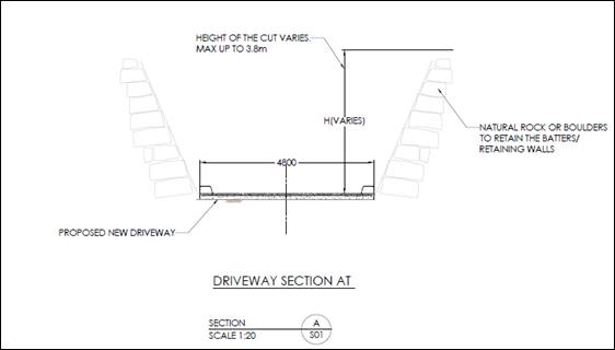
The middle area of the driveway will be constructed on
pylons that will be cemented on footings that will be laid on top of existing
rocks and boulders.
The lower area of the driveway
will level out and there may be some associated earthworks to create a level
driveway area.
The proposed cutting and other
earthworks are located in close proximity to the Shoalhaven River and within a
unique riparian river environment which is characteristic of this part of the
Shoalhaven River. It is considered that the proposed development and associated
earthworks would have adverse impacts on the environmental values of the site
and compromise the integrity of the cliff escarpment and the natural and scenic
qualities of the river waterway.
The proposed development is considered
unsuitable with regard to the considerations of clause 7.2 of Shoalhaven LEP
2014.
Clause 7.3 – Flood planning – Shoalhaven
Local Environmental Plan 2014
Clause 7.3 of Shoalhaven LEP
2014 specifies that development consent must not be granted to land at or
below the flood planning level unless the consent authority is satisfied that
the development -
a) is
compatible with the flood hazard of the land, and
b) will
not significantly adversely affect flood behaviour resulting in detrimental
increases in the potential flood affectation of other development or
properties, and
c) incorporates
appropriate measures to manage risk to life from flood, and
d) will
not significantly adversely affect the environment or cause avoidable erosion,
siltation, destruction of riparian vegetation or a reduction in the stability
of riverbanks or watercourses, and
e) is
not likely to result in unsustainable social and economic costs to the
community as a consequence of flooding, and
f) will not affect the safe occupation or evacuation of the
land.
Applicant’s Submission
“The proposed access driveway is considered
compatible within the flood effected area. The track will not significantly
affect the behaviour of flood waters as fill material to be placed is below the
approximated 1% Annual Exceedance Probability (AEP) Flood level with less than
1m depth. This meets the requirements of Acceptable Solution A2.2 for fill and
Excavation under Section 5.2 of SCC DCP 2014 Chapter G9 – Development on
Flood Prone Land.
The proposed access track will not introduce any potential
impacts on the existing development on site or in the surrounding area due to
the limited footprint in relation to the floodplain and significant distance
from any other foreshore development. The proposed access driveway will be
concrete sealed protecting against flood impacts with batters stabilised by
rockwork and/or revegetation. Appropriate measures are proposed to avoid
erosion and siltation, with the foreshore environment to be rehabilitated as
part of the completion of works.”
Discussion
The proposed development comes
under Development Type ‘E’ (Earthworks) in Chapter G9 of the
Shoalhaven DCP 2014 and the subject land at the bottom of the escarpment is
identified as high hazard floodway. As per Chapter G9 of the Shoalhaven DCP
2014 Development Type ‘E’ is unsuitable within the high hazard
floodway. The application has not been supported by a merit-based flood
compliance report demonstrating that the proposed development is suitable in
the location with regard to the flood hazard.
The application has been
reviewed by Council’s Natural Resource & Floodplain Section who are
not satisfied that the development is compatible with the flood hazard of the
land and that the development would not significantly adversely affect flood
behaviour. Further, staff are not satisfied that the development would not
significantly affect the environment or cause avoidable erosion, siltation,
destruction of riparian vegetation or a reduction in the stability of
riverbanks or the watercourse.
The proposed development does not comply with the
requirements of Chapter G9 of Shoalhaven DCP 2014 and is considered
unsuitable with regard to the considerations of clause 7.3 of Shoalhaven LEP
2014.
Clause 7.6 – Riparian land and watercourses
– Shoalhaven Local Environmental Plan 2014
The proposed access driveway is located within 50m of the
bank of a “Watercourse Category 1” (Shoalhaven River).
Clause 7.6 of Shoalhaven LEP 2014 specifies that before
determining a development application, the consent authority must consider -
a) whether
or not the development is likely to have any adverse impact on the
following—
i) the water quality and flows within the watercourse,
ii) aquatic and riparian species, habitats and ecosystems of the
watercourse,
iii) the stability of the bed and banks of the watercourse,
iv) the
free passage of fish and other aquatic organisms within or along the watercourse,
v) any
future rehabilitation of the watercourse and its riparian areas, and
b) whether
or not the development is likely to increase water extraction from the
watercourse, and
c) any
appropriate measures proposed to avoid, minimise, or mitigate the impacts of
the development.
Applicant’s Submission
“The proposed driveway access will not have a
significant impact on the Shoalhaven River. The development is located to take
advantage of the existing cleared areas to reduce the required vegetation removal.
Sediment and erosion controls, and the use of the cut material (rock) will be
used to stabilise the areas surrounding the driveway. The Vegetation Management
Plan will also assist in stabilising the area through the planting and
rehabilitation of the surrounding area.”
Discussion
The application has not
adequately addressed the likely impacts of the development on the natural
environment and environmental values of the river environment.
The proposed development and
associated earthworks and vegetation clearing would have an adverse impact on
riparian species and their habitats and the river ecosystem. The purported use
of the access driveway for maintenance purposes is questioned, and it is
considered that any weed management or foreshore maintenance activities of the
land at the bottom of the cliff escarpment should be more appropriately be
carried out by hand. The use of heavy machinery within this sensitive river
environment would have a significant adverse impact on the riparian environment
and river ecosystem.
Council is not satisfied that
the development is designed, sited and will be managed to avoid any significant
adverse environmental impact and is therefore inappropriate for its purported
purpose and is inappropriate given the areas sensitive and unique environment
and the residential use of the property.
The proposed development is
considered unsuitable with regard to the considerations of clause 7.6 of Shoalhaven
LEP 2014.
Clause 7.7 – Landslide risk
and other land degradation – Shoalhaven Local Environmental Plan 2014
The access driveway is proposed to be cut into the upper
part and then descends alongside the cliff escarpment. It is noted that the
access driveway is to be cut into the upper part of the cliff escarpment and
will pass underneath and with close proximity to a number of cliff overhangs.
Figure
11: Photo of cliff face/escarpment. Proposed driveway will hug cliff face.
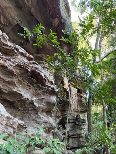
Figure 102: Photo of cliff overhangs.
Proposed driveway will be located underneath some cliff overhangs.
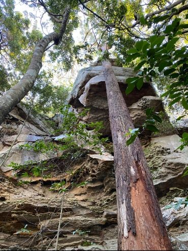
Figure 113: Photo of cliff overhangs.
Proposed driveway will be located underneath some cliff overhangs.
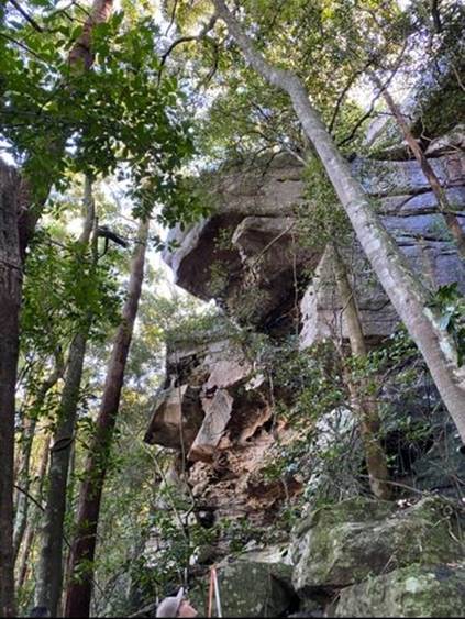
Clause 7.6 of Shoalhaven LEP 2014 specifies that before
determining a development application, the consent authority must consider any
potential adverse impact either from, or as a result of, the development in
relation to -
a) the
geotechnical stability of the site, and
b) the
probability of increased erosion or other land degradation processes.
Applicant’s Submission
Nil.
Discussion
Concern is raised with regard to
the geotechnical stability and overall safety of the development with regard to
land degradation and landslide risk.
The proposed cutting and
earthworks associated with driveway construction may result in increased
erosion and increased degradation of the upper parts of the cliff escarpment.
Staff are not satisfied that the
development is designed, sited and will be managed to avoid any significant
adverse environmental impact and is therefore inappropriate for its purported
purpose and is inappropriate given the areas sensitive and unique environment
and the residential use of the property.
The proposed development is
considered unsuitable with regard to the considerations of clause 7.7 of Shoalhaven
LEP 2014.
Clause 7.8 - Scenic protection – Shoalhaven Local
Environmental Plan 2014
The site of the proposed access driveway is mapped as
“scenic protection” on the Scenic Protection Area Map in Shoalhaven
LEP 2014.
Clause 7.8 of Shoalhaven LEP 2014 specifies that in
deciding whether to grant development consent, the consent authority must -
a) consider
the visual impact of the development when viewed from a public place and be
satisfied that the development will involve the taking of measures that will
minimise any detrimental visual impact, and
b) consider
the number, type and location of existing trees and shrubs that are to be
retained and the extent of landscaping to be carried out on the site, and
c) consider
the siting of the proposed buildings.
Applicant’s Submission
“Section 4.2.2 of this Statement of Environmental
Effects addresses the Coastal Management SEPP. The SEPP similarly to Clause 7.8
of the SLEP 2014 considered the visual impact of a development on existing
amenity of the area. Section 4.2.2 of this report provides a detailed analysis
of how the development will not have a significant impact on the existing
scenic qualities of the foreshore area.
The visual amenity and existing scenic qualities of the
site will not be significantly impacted by the proposed access driveway. The
current view of the site from the south is of the existing vegetation with the
site sloping up towards dwelling. The existing structures onsite are not
visible from the Shoalhaven River. The proposed access track requires the
removal of selected native vegetation. The access track will retain a vegetated
buffer between driveway and the Shoalhaven River which with the exception of
the area of the turning head, will be approximately 20m wide effectively screening
it from view. The proposed earthworks and tree removal will have no significant
visual impacts on the surrounding foreshore. A Vegetation Management Plan will
be prepared prior to the Construction Certificate stage and will propose the
replanting of the foreshore which will further improve the visual and scenic
qualities of the site.”
Discussion
The upper area of the proposed
access driveway will be cut into the upper part of the cliff escarpment and
would likely be visible from the Shoalhaven River. The area is a unique natural
riparian environment and is characteristic of this part of Shoalhaven River.
It is considered that the
proposed development will have an adverse impact on the aesthetic values of the
site and the scenic qualities of the river. The proposal would have a
detrimental visual impact on the area and detract from the unique river
landscape. Earthworks and vegetation clearing associated with the proposed
access driveway will further exacerbate adverse visual impact and detract from
the scenic qualities of the landscape.
The location and siting of the
proposed access driveway is inappropriate.
The proposed development is
considered unsuitable with regard to the considerations of clause 7.8 of Shoalhaven
LEP 2014.
Shoalhaven Development Control
Plan (DCP) 2014
The development application has not satisfactorily
demonstrated compliance with the relevant provisions of Chapters G1 (Site
Analysis, Site Design and Building Materials), G5 (Biodiversity Impact
Assessment), and G9 (Development on Flood Prone Lane) of Shoalhaven
Development Control Plan (DCP) 2014.
Site analysis controls - Chapter G1 (Acceptable Solution
A1.3 and Performance Criteria P1.1, P1.2 and P1.3)
Acceptable solution A1.3 specifies that:
|
A1.3
|
The proposed site layout responds to and implements the
findings of the site analysis plan prepared in accordance with A1.1 and A1.2
|
Performance Criteria P1.1, P1.2 and P1.3 require that:
|
P1.1
|
The
characteristics of the site and its surrounds have been adequately considered
through preparation of a thorough site analysis plan.
|
|
P1.2
|
The site analysis informs the site design and layout.
|
|
P1.3
|
The site layout integrates
with the surrounding environment through:
· Adequate
pedestrian, cycle and vehicle links to street and open space networks
· Buildings
that face and address streets and the public domain
· Buildings,
streetscape and landscape design that relates to the site topography and to
the surrounding neighbourhood character
|
Applicant’s Submission
“The purpose of this Chapter is to outline controls
for the management of the natural and built environment. This SoEE contains a
site analysis (section 2) and images that show the extent of vegetation,
location of existing development on and surrounding the site. The site analysis
and other supporting documents were undertaken to identify the site constraints
and inform the best location for the proposed development.
A set of Site Plans, and Civil Plans prepared by SET
Consultants Pty Ltd has been submitted with this development application. The
proposal is consistent with the acceptable solutions of this chapter.”
Discussion
The proposed access driveway does not appropriately respond
to site constraints as required by P1.1, P1.2 and P1.3, in particular,
topography of the site and land degradation risks, ecological and environmental
qualities of the site, terrestrial biodiversity and riparian land
considerations, scenic and aesthetic qualities of the river environment, and
also the flood hazard of the land. It is considered that the proposed
development is not suitable for the site given the constraints.
Site analysis, building materials and site design
controls - Chapter G1 (Acceptable Solution A1.3 & A2.1 and Performance
Criteria P1.1, P1.2, P1.3 & P2)
Acceptable solution A1.3 and 2.1 specify that:
|
A1.3
|
The proposed site layout responds to and implements the
findings of the site analysis plan prepared in accordance with A1.1 and A1.2
|
|
A2.1
|
The building design satisfies the following to ensure
the development does not detract from the scenic-value of the landscape:
· Siting
– buildings shall be suitably sited (i.e. below ridgelines and/or
knolls) in a location which does not unreasonably impact on the outlook of
any other dwelling or a vista from a public road, public place or place
frequented by the public.
· Screening
– existing trees and vegetation shall be utilised to provide a backdrop
and/or for screening of buildings. Additional landscaping may also be used to
implement screening.
· Design
– roof pitch and orientation shall be designed to minimise or mitigate
glare.
· Access
roads and services shall be designed and located to minimise soil and
tree/vegetation disturbance and visual impact.
· Materials
and colours shall be appropriate to the local landscape and or background to
ensure that the building does not significantly detract from the scenic value
of that landscape. Structures should not strongly contrast with the
background whether by location, colour or choice of materials.
|
Performance Criteria P1.1, P1.2, P1.3 and P2 require that:
|
P1.1
|
The
characteristics of the site and its surrounds have been adequately considered
through preparation of a thorough site analysis plan.
|
|
P1.2
|
The site analysis informs the site design and layout.
|
|
P1.3
|
The site layout integrates
with the surrounding environment through:
· Adequate
pedestrian, cycle and vehicle links to street and open space networks
· Buildings
that face and address streets and the public domain
· Buildings,
streetscape and landscape design that relates to the site topography and to
the surrounding neighbourhood character
|
|
P2
|
Buildings are designed,
constructed and sited to compliment the landscape and minimise impacts on
visual amenity when viewed from public places and private property.
|
Applicant’s Submission
“The purpose of this Chapter is to outline controls
for the management of the natural and built environment. This SoEE contains a
site analysis (section 2) and images that show the extent of vegetation,
location of existing development on and surrounding the site. The site analysis
and other supporting documents were undertaken to identify the site constraints
and inform the best location for the proposed development.
A set of Site Plans, and Civil Plans prepared by SET
Consultants Pty Ltd has been submitted with this development application. The
proposal is consistent with the acceptable solutions of this chapter.”
Discussion
The proposed access driveway
does not appropriately respond to site constraints, in particular, the proposal
does not suitably respond to the topography of the site and land degradation
risks, ecological and environmental qualities of the site, terrestrial
biodiversity and riparian land considerations, scenic and aesthetic values of
the Shoalhaven River, and also the flood hazard of the land.
Additionally, the location of
the proposed access driveway is within the mapped ‘scenic
protection’ area (clause 7.8 of Shoalhaven LEP 2014). It is likely
that upper parts of the proposed access driveway will be visible from
Shoalhaven River and the proposed development and associated earthworks and
vegetation removal will detract from the scenic value of the unique river
landscape.
It is considered that the proposed development does not
comply with the acceptable solutions in Chapter G1 and does not comply with
Performance Criteria P1.1, P1.2, P1.3 and P2.
Biodiversity Controls - Chapter G5 (Acceptable Solution
A1.1 & A2.1 and Performance Criteria P1 & P2)
Acceptable solution A1.1 and A2.1 specify that:
|
A1.1
|
Native vegetation and threatened species habitats are
retained in perpetuity on sites identified with high ecological value.
|
|
A2.1
|
Where possible avoid either
directly or indirectly impacting threatened species, populations and
threatened ecological communities (TECs).
|
Performance Criteria P1 and P2 require that:
|
P1
|
Developments are responsive
to the principles of ecologically sustainable development in relation to
native vegetation and threatened species habitats.
|
|
P1
|
A development application is supported by an
appropriate level of analysis consistent with Council policy and other
legislative requirements.
|
Applicant’s Submission
“The purpose of this Chapter is to provide
information on threatened species and their habitats to ensure the protection
of these species are managed when assessing new developments.
This development application requires the removal of
existing native vegetation for the construction of the access driveway. The
Ecological & Riparian Issues & Assessment Report prepared by Gunninah
outlines potential impacts of the required clearing on the existing flora and
fauna onsite.
The Ecological & Riparian Issues & Assessment
Report prepared by Gunninah concludes that if the appropriate measures are
taken during the construction of the access track, there will be minimal impact
on the flora and fauna onsite.
The removal of the selected native vegetation will have no
significant impacts on the biodiversity present onsite, and surrounding the
site.”
Discussion
Council’s Environmental
Assessment Officer has noted that the submitted Ecological & Riparian
Issues & Assessment Report is lacking detail. As per referral comments from
Council’s Environment Assessment Officer (below) further information
would be required to adequately assess the proposed development’s impact
on biodiversity:
Further information is required in order for this
proposal to be adequately assessed.
The Gunninah (2020) report does not adequately quantify
the impact of the proposal in order for this to be assessed.
The upper portion of the proposed driveway is lined on
either side with trees classified as Spotted Gum/Grey Gum Woodland. Gunninah
(2020) states there will be no vegetation removal for this upper portion of the
proposal however there is significant excavation including cut of up to 3.8
metres requiring retaining either side of the proposed accessway adjacent to
these trees. Further assessment is required by a qualified arborist in order to
assess whether excavation for the upper portion of the driveway or drilling for
piers through mid-section will impact adjacent trees and if so recommend
measures to minimise impact to these or state whether impacted trees will
require removal.
A plan showing trees required to be removed must be
included within the assessment. Any trees potentially impacted should be
included within the area clearing calculations. Allocasuarina littoralis
within the study area must be shown mapped as Glossy Black Cockatoo feed trees
and retained and protected wherever possible.
The area of clearing is not clearly defined. The area of
clearing should include all the area where the footprint of the proposed
driveway intersects with mapped native vegetation as well as a suitable
buffer. Any potential impacts such as root disturbance by excavation and
disturbance required for site access and shading of vegetation below the
suspended sections of driveway must be included. The Ecological &
Riparian Issues & Assessment Report by Gunninah (2020) suggest that areas
with a clear or rock understorey are not native vegetation and therefore should
not be included within area of vegetation removal is incorrect and is not
accepted. The Biodiversity Offset Scheme Entry Tool User Guide provides
guidance on assessing the area of native vegetation clearance. https://www.environment.nsw.gov.au/-/media/OEH/Corporate-Site/Documents/Animals-and-plants/Biodiversity/biodiversity-offset-scheme-entry-threshold-user-guide-170503.pdf
The Lesryk (2017) report shows 2 hollow bearing trees
within the proposed driveway footprint. If hollow bearing trees will be either
be removed or impacted by the proposal further survey is required to assess
whether these hollows are occupied, and the Tests of Significance need to
consider this impact of habitat loss for threatened fauna species.
Tests of Significance must be conducted according to the
Threatened Species Test of Significance Guidelines. https://www.environment.nsw.gov.au/-/media/OEH/Corporate-Site/Documents/Animals-and-plants/Threatened-species/threatened-species-test-significance-guidelines-170634.pdf.
The Tests of Significance must be based on accurately quantified impacts such
as area, or number of hollow bearing, or other trees impacted and refer to
specific threatened species. All threatened species potentially impacted
by the proposal must be considered.
The EP&A Act, the BC Act and Council’s LEP
require proposals to avoid and minimise significant impacts wherever
possible. The cliff and associated overhangs and caves as well as the
mesic vegetation community and habitat provided below as well as the Shoalhaven
River foreshore are particularly sensitive environments. The proposed driveway
down this steep slope and cliff will have a significant impact on these
features. The reasoning given for this proposal, providing access for
maintenance, is dubious. Further reasoning is required to justify the proposal
and how this aims to avoid and minimise impacts.
A site inspection was carried
out by assessment staff and Council’s Environmental Assessment Officer on
13/8/2020 and the following observations were made with regard to biodiversity
and the ecological and environmental qualities of the site:
Site observations
from Assessing Officer
· The area is
heavily vegetated and has natural and environmental values.
· It is likely
that upper parts of the driveway will be visible from the Shoalhaven River.
· The proposed
driveway will involve substantial works including approximately 2m of cut at
the top of the cliff.
· The cliff face
is steep and is an interesting geological landform.
· There are large
rocks and boulders in the location of the proposed driveway.
· Parts of the
proposed driveway will be located below cliff overhangs.
· There are a
number of streams and waterfalls running down the cliff face.
· Evidence of native
fauna (e.g. scat, hollows, hollow bearing trees) was observed on site and in
the location of the proposed driveway.
· The bottom part
of the cliff appeared to be in a healthy state and largely devoid of weeds and
other exotic and intrusive plant species.
· It was observed
that due to topography at the bottom of the site as well as existing
vegetation, maintenance of the land would best be achieved by hand. Large
machinery would not be necessary.
· The area at the
bottom of the cliff to the west of the subject site has been under scrubbed
which has compromised the natural habitat of that site. Under scrubbing or
disruption of the land at the bottom of the cliff on the subject property
through use of machinery for “maintenance purposes” (e.g. lawn
mower, earth moving machinery) would have a negative environmental impact. Any
maintenance of the land (e.g. weed removal) should be carried out by hand to
preserve the environmental values of the site.
· It was observed
that recent floodwaters had deposited large amounts of sediment and mud on the
lower part of the land at the bottom of the cliff. The river alignment may also
have been modified during the floods.
Site observations
from Council’s Environmental Assessment Officer
· Mature spotted
Gums with hollows grow above the cliff. Vegetation below the cliff line
represents a unique ecotone caused by the shade of the cliff and enclosed tree
canopy and waterfalls/ seepage coming down the escarpment keeping the area
moist. This is characterised by a mature fig tree, tall canopy of emergent
Eucalypts, a subcanopy of Coachwood and understorey of ferns and mesic
(rainforest type) understorey. Native orchids (Dendrobium speciosum) grow below
the cliff top. Overhangs and caves provide fauna habitat for a range of
species likely to include cave roosting microbats.
· While the
majority of large very mature Eucalypts and will be avoided, the construction
of the raised driveway would require the removal of mature coachwood trees, one
mature Syzygium paniculatum (threatened species) and rainforest type
understorey species.
· The vegetation
within the subject lot is in good condition with no weed maintenance required.
The crown land along the river foreshore had woody weeds including wild tobacco.
Removal with hand tools would be the appropriate method for weed control and
would be easily achievable given the minimal extent of the weeds present. Heavy
machinery should not be used in this sensitive area.
· The landowner
was very interested in ‘restoring’ the riverbank with rock
armouring to overcome the erosion of the bank reported to be up to 2m per year,
with significant erosion in the recent flood waters. During the inspection the
landowner offered more than once to pay for this himself. While there appears
no good reason for this proposed driveway access to the foreshore, re
stabilising the bank to create a useable area along the foreshore may be the
motivation for the proposal.
· The
landowner pointed out rock armouring put in place upstream in front of the
adjacent property in recent years. This may be the cause of increased recession
of the riverbank downstream in front of the subject property.
Additional information was requested on 15/7/2020 and
23/7/2020 requesting further information on vegetation clearing and a revised
biodiversity assessment and responding to the issues raised in Council’s
Environmental Assessment Officer’s referral comments. Additional
information has not been received.
Based on Council’s
assessment of the proposed development and likely environmental impacts, it is
considered that the proposed development will have a significant adverse impact
on biodiversity and environmental values of the site and river area.
It is considered that the proposed development does not
comply with the acceptable solutions in Chapter G5 and does not comply with
Performance Criteria P1 and P2.
Flood planning controls - Chapter G9 (Acceptable
Solution A1.1, A1.2, A1.3, A1.6 & A1.8 and Performance Criteria P1)
Acceptable solution A1.1, A1.2, A1.3, A1.6 and A1.8 specify
that:
|
A1.1
|
The development satisfies the requirements as shown in
the planning matrix at Schedule 2 including climate change considerations.
|
|
A1.2
|
Buildings and structures are constructed in accordance
with the flood proofing guidelines (see Supporting Document 1: Chapter G9
– Guidelines for Development on Flood Prone Land).
|
|
A1.3
|
Buildings
and structures are constructed in accordance with the Building Code of
Australia – Construction of Buildings in Flood Hazard Areas –
Standard 2012. The controls in this Chapter are to be used in instances where
this Chapter specifies more stringent controls; and
Buildings and structures are
designed to withstand the forces of flood waters in accordance with best
practice engineering standards.
|
|
A1.6
|
Building foundations are designed by a suitably
qualified geotechnical engineer to be suitable for grounds with potentially
reduced bearing capacity under flooding conditions
|
|
A1.8
|
A report demonstrating that all performance criteria
have been met is supplied with the development application.
|
Performance Criteria P1 requires that:
|
P1
|
Development
or work on flood prone land will meet the following:
· The
development will not increase the risk to life or safety of persons during a
flood event on the development site and adjoining land.
· The
development or work will not unduly restrict the flow behaviour of
floodwaters.
· The
development or work will not unduly increase the level or flow of floodwaters
or stormwater runoff on land in the vicinity.
· The
development or work will not exacerbate the adverse consequences of
floodwaters flowing on the land with regard to erosion, siltation and
destruction of vegetation.
· The
structural characteristics of any building or work that are the subject of
the application are capable of withstanding flooding in accordance with the
requirements of the Council.
· The
development will not become unsafe during floods or result in moving debris
that potentially threatens the safety of people or the integrity of
structures.
· Potential
damage due to inundation of proposed buildings and structures is minimised.
· The
development will not obstruct escape routes for both people and stock in the
event of a flood.
· The
development will not unduly increase dependency on emergency services.
· Interaction
of flooding from all possible sources has been taken into account in
assessing the proposed development against risks to life and property
resulting from any adverse hydraulic impacts.
· The
development will not adversely affect the integrity of floodplains and
floodways, including riparian vegetation, fluvial geomorphologic
environmental processes and water quality.
|
Applicant’s Submission
“There is a section of the proposed access track that
is estimated to be below the 1% AEP Flood Level as shown on the Maintenance
Track Layout Plan prepared by SET Consultants Pty Ltd.
The proposed access driveway is considered compatible
within the flood hazard area as less than 50m3 of fill will be placed below the
approximated 1% Annual Exceedance Probability (AEP) Flood level with less than
1m depth. This meets the requirements of Acceptable Solution A2.2 for fill and
Excavation under Section 5.2 of SCC DCP 2014 Chapter G9 – Development on
Flood Prone Land. The track will not significantly affect the behaviour of
flood waters, and will not introduce any potential impacts on the existing
development on site and in the surrounding area. The proposed access track will
be concrete sealed. Appropriate measures are proposed to avoid erosion and
siltation, with the foreshore environment to be rehabilitated as part of the
completion of works.”
Discussion
The proposed development comes
under Development Type ‘E’ (Earthworks) in Chapter G9 of the Shoalhaven
DCP 2014 and the subject land is identified as high hazard floodway. The
application has been reviewed by Councils Natural Resource & Floodplain
Section who have noted that as per Chapter G9 of the Shoalhaven DCP 2014
Development Type ‘E’ is unsuitable within the high hazard floodway.
The application has not been supported by a merit-based flood compliance report
demonstrating that the proposed development is suitable in the location with
regard to the flood hazard.
Council is not satisfied that
the development is compatible with the flood hazard of the land and that the
development would not significantly adversely affect flood behaviour.
The proposed development does not comply with the applicable
acceptable solutions in Chapter G9 and does not comply with Performance
Criteria P1.
Likely impacts of development - Section 4.15(1)(b) of the Environmental Planning and
Assessment Act 1979
Section
4.15(1)(b) of the Environmental Planning and Assessment Act 1979
requires that the consent authority must give consideration to the likely
impacts of the development, including environmental impacts on both the natural
and built environments, and social and economic impacts in the locality.
Applicant’s Submission
“5.1 Context and
Setting
The
surrounding land primarily consist of rural dwellings, ancillary structures and
native vegetation. The subject site is surrounded by development of a similar
size and scale. Vegetation that surround the site screen surrounding
properties, and reduce the visibility of the existing developments from the
Shoalhaven River to the south. The proposal for an access driveway to be
extended to provide access to the southern portion of the site is considered
consistent with the surrounding area.
The
proposed access driveway will provide access to the southern portion of site,
and will allow for this area to be revegetated and rehabilitate. This will be
beneficial to the surrounding area as the foreshore are is currently unmanaged
and contains noxious weeds.
A Vegetation Management Plan
will be submitted at Construction Certificate Stage which will
outline the proposed
vegetation rehabilitation of the foreshore area. The proposal is not likely to
have a negative impact on native vegetation, amenity, privacy and solar access
on surrounding properties.
5.2
Public Domain
The proposed access driveway
to the southern portion of the subject site will not reduce the public
recreational opportunities in the locality. The proposal is consistent with the
existing rural environment surrounding the site and has no impact on public
recreational spaces. As the access driveway will provide access to the southern
portion of the site allowing vegetation management, the view from the
Shoalhaven River will be enhanced. Nothing in this proposal could be
interpreted as being contrary to the public interest.
5.3
Access and Traffic
Construction
equipment require to access the lower and mid areas of the construction site
will be transported to site via a barge on the Shoalhaven River. It is proposed
that equipment required to be floated into the lower portion of the site could
be loaded at the Fairway Drive boat ramp following obtaining the necessary
statutory approvals and the barge travel up the Shoalhaven River with equipment
unloaded at site.
The
proposed access driveway will be sealed and graded appropriately to ensure safe
and effective access is achieved.
5.5
Natural Hazards
5.5.2
Flooding
The
subject site is identified as being flood prone land, with part of the proposed
driveway being below the 1% AEP Flood Level, as shown on the Maintenance Track
Layout Plan prepared by SET Consultants Pty Ltd.
The proposed access driveway
is considered compatible within the flood hazard area as less than 50m3 of fill
will be placed below the approximated 1% Annual Exceedance Probability (AEP)
Flood level with less than 1m depth. The track will not significantly affect
the behaviour of flood waters, and will not introduce any potential impacts on
the existing development on site and in the surrounding area. Appropriate
measures are proposed to avoid erosion and siltation, with the foreshore
environment to be rehabilitated as part of the completion of works.
5.7
Flora and Fauna
The
proposed access track requires the removal of native vegetation for its
construction. The level of clearing required does not trigger the BOSET
threshold for native vegetation clearing, and does not require further
biodiversity assessment.
The
proposed access driveway will not result in the loss of any critical habitat,
or significant impact on any endangered or threatened flora or fauna. An
Ecological & Riparian Issues & Assessment Report prepared by Gunninah
has been submitted with this application. This report outlines the potential
impacts on the flora and fauna, and includes recommendations to ensure that the
potential impacts are minimised, and that the ongoing vegetation management of
the site is achieved.
Further
assessment against the provisions of the Biodiversity Conservation Act 2016 is
not required in this case.
5.13 Cumulative Impacts
Cumulative
impacts of this proposal are expected to be negligible, as the project has been
designed to account for the natural constraints of the site. The vegetation
removal, cut and fill has been reduced as much as possible due to the proposed
location, use of concrete footing and pillars and construction methodology. The
cleared vegetation and cut material will be reused on site.
A positive impact the access
driveway will have is that the current unmanaged area will become accessible
and be able to be managed and benefit from being re-vegetated. The revegetation
and rehabilitation of the southern portion of the site will be managed as per
the recommendations outlined in the Vegetation Management Plan to be submitted
at Construction Certificate Stage. Appropriate stormwater, sediment and erosion
design has also been incorporated into the design of the access driveway to
ensure the proposal will not cause any adverse impacts”
Discussion
It is considered that the
proposed development would have a significant adverse impact on the natural and
built environment. In particular:
Impact on natural
environment – Biodiversity
The proposed development and
associated earthworks and vegetation removal will have an adverse impact on the
sensitive riparian environment.
The purported use of the access
driveway for maintenance purposes is dubious and it is noted that existing
vegetation at the bottom of the cliff escarpment is in good health and largely
devoid of weeds and invasive plant species. Due to the sensitive riparian
environment and existing vegetation, weed removal and foreshore management
should be undertaken by hand, regular use of heavy machinery in the area would
be inappropriate and would result in further environmental impacts.
Furthermore, the construction of the access driveway along
the cliff face may disturb native fauna (bats, birds and other small animals)
that utilise the cliff and surrounding hollow-bearing trees as habitat.
Impact on natural
environment - Scenic qualities and river landscape
The area of the Shoalhaven River in which the subject site
is located is unique and characterised by scenic cliff escarpments along the
river. The proposed access driveway and associated earthworks and vegetation
removal will likely be visible from the Shoalhaven River and will detract from
the aesthetic values and scenic qualities of the river.
Impact on natural
environment - Construction impacts
As noted in the submitted SEE, to enable the construction of
the middle and lower areas of the access driveway, machinery and materials will
be required to be barged up the Shoalhaven River to access the area at the
bottom of the escarpment. This will involve access and transporting machinery
and materials over the Council reserve area between the Shoalhaven River and
the subject property. The construction of the access driveway may also have
significant impacts on the sensitive riparian ecosystem and native flora and
fauna by generating construction noise and vibration, erosion and sedimentation
impacts and although through disturbance to the surrounding environment in the
process of transporting materials and machinery and other construction
processes.
It is considered that the development may have a significant
adverse impact on the natural environment and should not be supported.
Impact on built
environment – Western Bypass Corridor
Part of the access driveway is
proposed to be constructed on land mapped as in the vicinity of the Western
Bypass Corridor (clause 7.21). Although the proposal is not necessarily
unsuitable with the clause 7.21 considerations, it is noted that the location
of the proposed access driveway may be in conflict with any future road
alignment constructed within the Western Bypass Corridor.
The proposed development may
compromise future road alignment and the future use of the land mapped as in
the vicinity of the Western Bypass Corridor.
It is considered that the development may have a negative
impact on the built environment and future land uses and should not be
supported.
Planning Assessment
The DA has been assessed under
s4.15(1) of the Environmental Planning and Assessment Act 1979. Please refer to
Attachment 2.
Consultation and Community
Engagement:
Notification was undertaken in
accordance with Council’s Community Consultation Policy with letters
being sent within a 100m buffer of the site and the development application
being publicly advertised in local press, during the period of 29 July 2020
– 26 August 2020.
5 public objections were
received in relation to Council’s notification of the development.
Key issues raised as a result of
the notification include but were not limited to matters listed below.
· Vegetation removal
and ecological, environmental and biodiversity impacts of development,
including impact on rocky outcrops
· Loss of amenity,
aesthetic impacts and detrimental impact on scenic qualities of escarpment and
river landscape
· Concerns relating
to intended use of access driveway
· Inappropriate
maintenance of foreshore reserve
· Site suitability
· Flooding impacts
· Aboriginal
heritage
· Compliance with
objectives of E3 – Environmental Management zone
· Compliance with
requirements of Shoalhaven DCP 2014
· Geotechnical
stability and safety of proposed development
· Impacts from
construction works
· Impact on Western
Bypass Corridor
· Development
Application should have been rejected as “it is for integrated
development and all property had not given consent to lodge the
application”
· Inaccurate
estimated value of works for proposed development
The assessment of the
application considered the matters raised in the submissions and concluded that
the application should be determined by way of refusal.
A detailed analysis can be found in the attached section
4.15 assessment report.
Financial Implications:
There are potential cost
implications for Council in the event of a refusal of the application. Such
costs would be associated with defending an appeal in the Land and Environment
Court of NSW.
Legal Implications
Pursuant to section 8.2 of the
EP&A Act, a decision of the Council may be subject of a review by the
applicant in the event of an approval or refusal. If such a review is
ultimately pursued the matter would be put to Council for consideration.
Alternatively, an applicant who is dissatisfied with the determination of the
application by the Council may also appeal to the Court against the
determination pursuant to section 8.7 of the EP&A Act. Applicants can choose
to do both, setting aside the Appeal pending resolution of the review, noting
there are time limitations with respect to lodging applications for review and
appeal.
Summary and Conclusion
This application has been assessed having regard for section
4.15 (Matters for consideration) under the EP&A Act. Having regard
to the assessment, the proposal is not considered capable of support. Reasons
for refusal are provided below and can also be found at Attachment 1 to this
report.
|
1.
|
The proposal
is inconsistent with the objectives and requirements of State Environmental
Planning Policy (Coastal Management) 2018, in that the proposal is considered
to be unsuitable having regard to the considerations for development within
the “coastal environment area” and “coastal use area”
(section 4.15(1)(a)(i) of Environmental Planning and Assessment Act, 1979).
|
|
2.
|
The
development application has not satisfactorily demonstrated compliance with
the objectives of the E3 – Environmental Management zone in accordance
with clause 2.3, Shoalhaven Local Environmental Plan 2014. (Section
4.15(1)(a)(i) of Environmental Planning and Assessment Act, 1979)
|
|
3.
|
The
proposal is considered unsuitable with regard to the considerations of clause
7.2, and 7.8 Shoalhaven Local Environmental Plan 2014. (Section 4.15(1)(a)(i)
of the Environmental Planning and Assessment Act, 1979)
|
|
4.
|
The
development application has not satisfactorily demonstrated compliance with
the relevant provisions of clause 7.3, 7.6 and 7.7 Shoalhaven Local
Environmental Plan 2014. (Section 4.15(1)(a)(i) of the Environmental Planning
and Assessment Act, 1979)
|
|
5.
|
The
development application has not satisfactorily demonstrated compliance with
the relevant provisions of Chapters G1, G5, and G9 Shoalhaven Development
Control Plan 2014. (Section 4.15(1)(a)(iii) of Environmental Planning and
Assessment Act, 1979)
|
|
6.
|
The
development application has not adequately demonstrated that the proposal
will not have adverse amenity impacts on the natural and built environment in
the locality. (Section 4.15(1)(b) of Environmental Planning and Assessment
Act, 1979)
|
|
7.
|
The
information submitted with the development application does not
satisfactorily demonstrate that the site is suitable for the proposed use.
(Section 4.15(1)(c) of Environmental Planning and Assessment Act, 1979)
|
|
8.
|
Having
regard to the above matters to address the relevant provisions of
Environmental Planning and Assessment Act, 1979, the granting of development
consent is not considered to be in the public interest. (Section 4.15(1)(e)
of Environmental Planning and Assessment Act, 1979)
|
|

|
Development
& Environment Committee – Tuesday 06 October 2020
Page
0
|
|
|
Development
& Environment Committee – Tuesday 06 October 2020
Page
0
|
DE20.117 Exemption
of Bushfire Affected Properties from Green Regulations
HPERM Ref: D20/381845
Section: Building
& Compliance Services
Approver: Phil
Costello, Director - City Development
Attachments: 1. Support
letter to the Mayor of Eurobodalla Council Liz Innes - 25/08/2020 ⇩
2. Bush fire rebuild
applications - January to August 2020 ⇩
Reason for Report
At Council’s Strategy & Assets meeting held on 11
August 2020 Council requested a report on all fire affected properties that are
awaiting ecological reports, studies for Koalas, or any other report that is
deemed to still be outstanding (MIN20.564).
This report provides Councillors with an update on the number
of applications submitted, determine and outstanding since the December 2019
and January 2020 bush fires.
|
Recommendation
That Council
receive the report on Exemption of Bushfire Affected Properties from Green
Regulations for information.
|
Options
1. Council receive
the report for information.
Implications:
Nil
2. Council resolve
a different recommendation.
Implications: Council Officers
will act on that resolution.
Background
The Currowan bush fire began on 26 November 2019 and it burnt
for 74 days. It was declared extinguished on 8 February 2020. Statistics on
this bush fire indicate 312 homes were destroyed and a further 173 homes were
damaged in the Shoalhaven.
In the wake of the bush fires, Councillors have been
supportive of the community by providing them with fee relief as they attempt
to rebuild their lives. There is little doubt the financial, social and
psychological impacts of this event will be carried by residents for many years
to come.
Assessment Staff in both the Nowra and Ulladulla Offices have
come together to assist with the rebuild project in an effort to prioritise
these applications. Whilst a funding proposal to both the Federal and State
Governments has been submitted to appoint 2 additional assessment officers in
Ulladulla and one additional assessment officer in Nowra for a 12 month
period, this grant has not yet come to fruition.
At Council’s Strategy & Assets meeting held on 11
August 2020 Council resolved the following (MIN20.564).
That Council
1. Send a letter of support to the mayor of
Eurobodalla Liz Inness with her call to the government of all bushfire
properties to be exempt from the green regulations that are slowing developments
applications for many of those without homes, and wanting to rebuild; and
2. Provides
a report on those properties still affected in our city due to ecological
reports, studies for Koalas, or any other report that is deemed to still be
outstanding.
The letter of support was sent to the Mayor of Eurobodalla,
Liz Inness, on 25 August 2020 (Refer attachment 1).
This report addresses item 2 of the resolution and provides
Councillors with an update on the number of applications submitted, determined
and outstanding since the Currowan Fires up to and including 31 August
2020.
Report
Generally, the pathway for approvals has taken one of two
directions. The most common has been a development application followed by a
construction certificate. The other pathway relates to properties with a
current development application or building approval and the applicant only
sought to rebuild what was previously approved. In this instance, only a
construction certificate has been issued.
Attached to this report is a table listing all applications
that have been submitted, determined and outstanding since the Currowan fires
(Refer attachment 2).
Council has received a total of 75 applications for
rebuilding. Of these rebuilds, 61 applications followed the new
development application and construction certificate pathway and 14 were for
the construction certificate only pathway.
A total of 60 applications have been approved, 4 have been
withdrawn and 11 remain outstanding. Of the 11 outstanding, 5 are at the early
stage of assessment and 6 are seeking additional information.
Of the six applications seeking additional information, none
are awaiting information on ecological reports or studies for Koalas.
Applications are awaiting additional information from applicants including
amended site plans and building plans, consultant bush fire reports, details on
wastewater systems and solid fuel heater information. These requirements are
all highlighted in the Table at attachment 2.
|
|
Development
& Environment Committee – Tuesday 06 October 2020
Page
0
|
|
|
Development
& Environment Committee – Tuesday 06 October 2020
Page
0
|
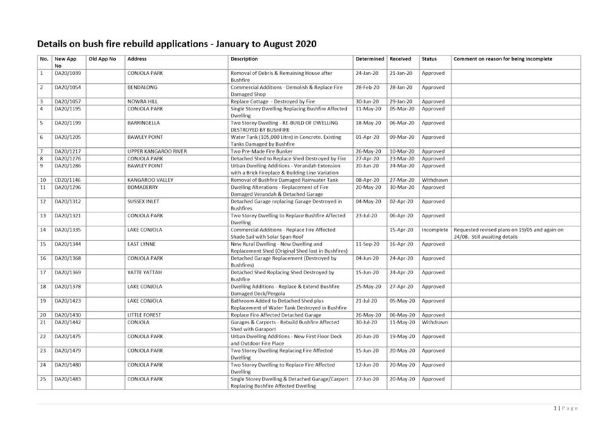
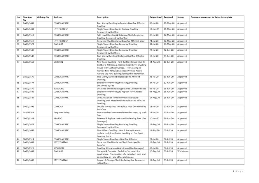
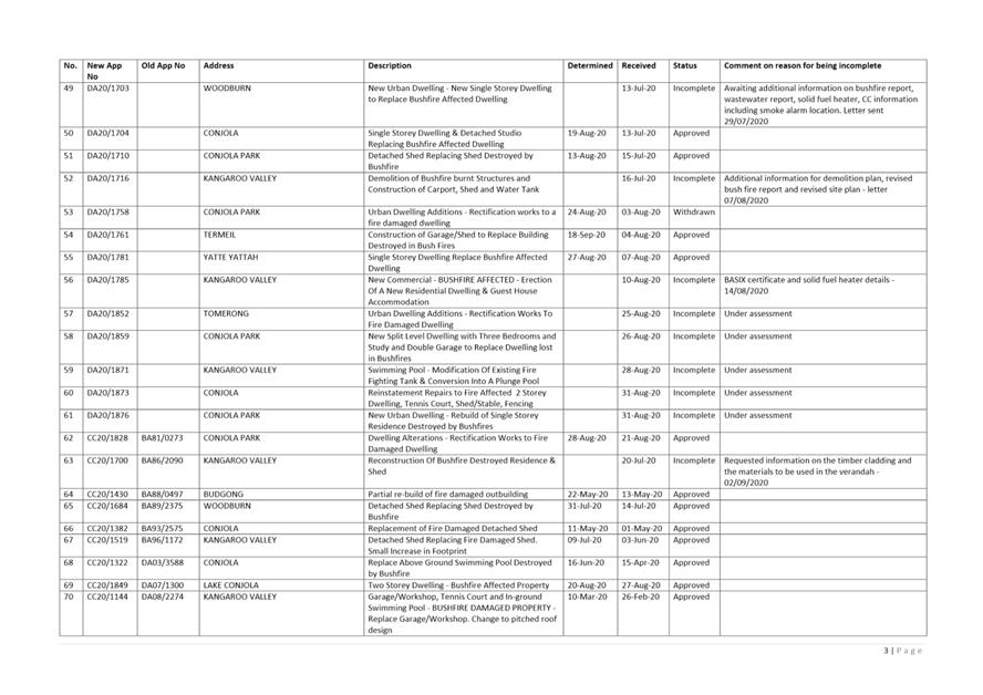
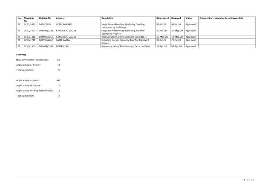
|
|
Development
& Environment Committee – Tuesday 06 October 2020
Page
0
|
DE20.118 Questions
on Notice - Land Clearing - Intersection Jervis Bay Road and the Princes
Highway, Falls Creek
HPERM Ref: D20/415069
Section: Environmental
Services
Approver: Phil
Costello, Director - City Development
Reason for Report
To address the Questions on
Notice from CL20.172.
|
Recommendation
(Item to be determined under delegated authority)
That
Council receive the report on Land Clearing - Intersection Jervis Bay Road
and the Princes Highway, Falls Creek for information.
|
Options
1. As recommended. Information be
received as advised.
Implications: Council’s position and powers
are understood regarding the Questions on Notice.
2. Not adopt the report as recommended
and adopt an alternative recommendation.
Implications: Unknown.
Background
The report has been prepared in
address the Questions on Notice from
CL20.172. The questions on notice have been included in the response below.
Response
1. What
restrictions apply to clearing on this land under existing zonings?
Ans: The land at Lot 2 DP 244495 and Lot
3 DP 244495 Princes Highway, Falls Creek are zoned RU2 (Rural) and
Department of Planning, Industry and Environment (DPIE) regulate clearing on
rural lands.
Council Environmental Health Officers investigated
the matter and established that DPIE were the appropriate regulatory authority
to conduct the investigation.
Council staff have been advised that DPIE has
reviewed the clearing on regulated land where the Local Land Services Act
2013 (LLS Act) applies.
2. Are
there conflicting jurisdictions over the land between the three tiers of
government and if so, have these conflicts made action problematic in dealing
with possible breaches in relation to land clearing at the site?
Ans: .The LLS Act operates
independently of the NSW Biodiversity Conservation Act 2016 (BC Act), Environmental
Planning & Assessment Act 1979 (EP&A Act) and the Shoalhaven
Local Environment Plan (LEP) clauses in relation to biodiversity protection. The
actual jurisdiction of each of these Acts is clear. The federal Environmental Protection
Biodiversity Conservation Act (EPBC) was not considered to apply in the subject
circumstances.
3. Is
the land a “wildlife corridor” under the Shoalhaven Local
Environment Plan and if so, was permission required from Shoalhaven Council to
clear the land and was such permission granted?
Ans: Under the Shoalhaven LEP,
the subject lots are identified as Terrestrial Biodiversity –
Biodiversity habitat corridor.
Permission was not required from
Shoalhaven City Council – please see point 2 above.
4. Is
Council aware of any protections over the land under the Federal Environment
Protection & Biodiversity Conservation Act (1999) and if so, is an
Environmental Impact Statement required before clearing can commence and is DA
consent required for such clearing?
Ans: Please see
point 2 and 3 above.
5. Does
the NSW Local Land Services Act limit the removal of native vegetation for the
purpose of fencing and road clearing on the land. What approvals are required
and what would be the likely conditions in such approvals to protect against
such things as; damage to soil structure, soil erosion, and polluted water
runoff?
Ans: Under the LLS Act there are
provisions for removal of vegetation for fencing as an allowable activity and
there are restrictions on the area of vegetation that can be cleared. More
information can be found on Local Land Services website https://www.lls.nsw.gov.au/help-and-advice/land-management-in-nsw.
As an
allowable activity requires no approval, no
specific conditions are applicable.
Council are the
appropriate regulatory authority for ensuring that sediment runoff and erosion
are not caused by any works conducted. Council’s Environmental
Health Officer attended the site and subsequently issued a Clean-up Notice
under the Protection of the Environment Operations Act.
6. Has
clearing at the site impacted on the Jervis Bay Road corridor outside the
boundary of the property and if so, will action be taken by Council?
Ans: DPIE advised that the Roads
Act 1993 applies to the road easement and Crown Lands are the appropriate
regulatory authority for that corridor.
|

|
Development
& Environment Committee – Tuesday 06 October 2020
Page
0
|
DE20.119 Update
- Chinamans Island, Lake Conjola
HPERM Ref: D20/389848
Section: Environmental
Services
Approver: Phil
Costello, Director - City Development
Reason for Report
To provide
Council with an update on continued liaison with Crown land - NSW Department of
Planning, Industry & Environment (DPIE) following the impact of the
Currowan Bushfire on Chinamans Island in accordance with Council resolution
MIN20.159.
|
Recommendation
(Item to be determined under delegated authority)
That Council:
1. Receive the report providing an
update on continued liaison with Crown land – NSW Department of
Planning, Industry & Environment (DPIE), following the impact of the
Currowan Bushfire on Chinamans Island in accordance with Part 2 MIN20.159,
for information.
2. Endorse Council staff to continue to
liaise with Crown land – NSW DPIE and provide updates to Councillors.
|
Options
1. As recommended
Implications: This will allow Council and other
stakeholders to make informed decisions and for Council to continue to work
collaboratively with the community.
2. Other direction
as determined by Council.
Implications: Any implications relating to
legislative responsibility, cost, policy and risk will need to be considered.
Background
At
Council’s Development & Environment Committee meeting of 3 March 2020
(MIN20.159) it was resolved:
That Council:
1. Receive
the report providing an update on investigations by Department of Crown Lands
and the three permissive occupants on Chinamans Island in accordance with Part
1 MIN19.872 for information.
2. Endorse Council
staff to continue to liaise with Crown Lands following the impact of the
Currowan fire and report progress back to Council.
The report presented to the Development & Environment
Committee on 3 March 2020 identified that:
· two of the three tenured dwellings on Chinamans Island (the
Island) were destroyed in the 2019/20 Currowan Bushfire. The one remaining
tenured dwelling was untouched;
· RFS mapping shows of the four untenured dwellings; one had
major damage, two had minor damage and one remained untouched from the fire;
· reports received from Crown land – NSW DPIE
identified post-fire hazards on the Island, such as broken fibro sheeting
containing asbestos and that all dwellings and most associated structures
(sheds and jetties) were structurally inadequate; and
· wastewater investigations had only been received from Crown
land – NSW DPIE for the four untenured properties, which reported that no
septic tanks or absorption trenches were located and existing drainage pipework
was damaged and defective.
Crown land have
advised that the clean-up of Chinamans Island by NSW Public Works
Advisory’s contractor, Laing O’Rourke (LO’R), is outside the scope of
works of the contract to complete clean-up works resulting from the Currowan
Bushfire. The purpose of this contract is to facilitate re-building and at the
Island, there is no indication of:
i. the owners wanting to
re-build; and/or
ii. being permitted to re-build damaged
structures.
Crown
land are consequently seeking to separately
engage a contractor to complete the clean-up at the Island for works resulting
from the Currowan Bushfire.
Community Engagement
Crown
land – NSW DPIE
Council is
continually engaging with Crown land – NSW DPIE via on-going monthly
meetings, e-mail and telephone communications to address the legislative,
environmental and public health/safety risks on the Island. This includes the
impact, implications and risks posed on site following the Currowan Bushfire.
Permissive
Occupants – two destroyed dwellings
Council
Officers consulted and communicated with the three permissive occupants prior
to the 2019/2020 Currowan Bushfire. Council currently has no reason to engage
with the permissive occupants of the two destroyed dwellings. Crown land
– NSW DPIE have agreed to conduct any required communications with these
two permissive occupants.
Permissive
Occupant – remaining dwelling
A wastewater
audit and options report are still required for the one remaining tenured
dwelling on the Island. However, the clean-up of the Island, especially of asbestos
material, is required before any such investigations can safely take place. All
of the asbestos-containing materials were sprayed and sealed as part of the
clean up works after the Currowan Bushfire. However, there is concern that the
heavy rainfalls experienced earlier this year may have washed off some of the
binding material. As an interim measure, an understanding has been reached
between Crown land – NSW DPIE and the permissive occupant of the
remaining dwelling that the latter will not occupy the site until it is safe to
do so. In addition, signs were erected in May 2020 on the Island, identifying
asbestos present on the Island and alerting the general public to the potential
dangers and not allowing admittance to the Island.
In addition,
Crown land – NSW DPIE have advised that the permissive occupant is
currently not in a position where they can comfortably discuss the future of
their tenure. Accordingly, Council has ceased communications with this
permissive occupant until further notice by Crown land – NSW DPIE.
Policy Implications
The
implications from the impact of the Currowan Bushfire are being addressed as
first priority. Council staff will then respectfully follow up on any
outstanding requirements, such as wastewater management issues, to ensure that
Council Policy and legislative requirements are being met.
Financial Implications
Nil
Risk Implications
There is a high public health
and environmental risk associated with the potential for public to access the
Island and from debris being blown or washed from the site. Accordingly, the
fire-damaged buildings and associated debris are required to be cleaned up as
soon as possible.
As heritage or draft heritage
items are not exempt under the State Environmental Planning Policy (Exempt and
Complying Development Codes) 2008, Council is issuing an Emergency Demolish
Order under the Environment Planning and Assessment Act to enable the timely
clean-up of asbestos and other debris from the two destroyed dwellings (see
Photos 1 and 2) and destroyed ancillary buildings. The Order will:
i. not be issued
until written confirmation is received from Heritage NSW confirming there is no
submission lodged with them in respect of dwellings on the Island;
ii. require DPI
– Crown Lands to submit a montage of the two dwellings to Council; and
iii. be specific to the two
destroyed sites and does not allow scope for demolition outside of this.
Continuing
to operate on-site sewage systems without proper assessment and current
Approval to Operate may lead to pollution of waters. This risk is minimised at
this stage as the permissive occupant of the remaining dwelling has given an
undertaking not to visit the Island until such matters are resolved.
Council has
a responsibility to ensure the proper construction and maintenance of
buildings, including the protection of the health and safety of their occupants
(Clause 1.3 EPA Act, 1979). The risks identified with structures will be
properly considered and addressed in time. However, the identified risks
resulting from the Currowan Bushfire must first be addressed.
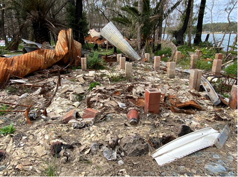
Photo 1
– the first of the two destroyed dwellings on Chinamans Island, Lake
Conjola.
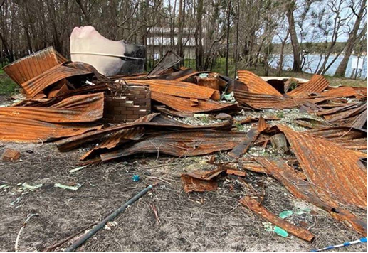
Photo 2
– the second of the two destroyed dwellings on Chinamans Island, Lake
Conjola.
|

|
Development
& Environment Committee – Tuesday 06 October 2020
Page
0
|
DE20.120 Adoption
of Amendments to Terms of Reference for Coast and Estuary Committee (North /
Central / Southern) and Floodplain Risk Management Committee (North / Central /
Southern)
HPERM Ref: D20/411142
Section: Environmental
Services
Approver: Phil
Costello, Director - City Development
Attachments: 1. Amended
Terms of Reference - North Central Southern Floodplain Risk Management
Committees ⇩
2. Amended Terms of Reference -
North Central Southern Coastal Management Advisory Committees ⇩
Reason for Report
To
provide Council the necessary information to formally adopt the amended Terms
of Reference (ToR) for the proposed North, Central, and Southern Coast and
Estuary Management Committees, and the proposed North, Central, and Southern
Floodplain Risk Management Committees.
|
Recommendation (Item to be determined under delegated authority)
That
Council adopt:
1. The amended Terms of Reference for
the North / Central / Southern Coastal Management Advisory Committees; and
2. The Amended Terms of Reference for
the North / Central / Southern Floodplain Risk Management Committees.
|
Options
1. As per
recommendation
Implications: This will
allow inclusion of dedicated Aboriginal and Youth members on the committee and
include a representative from the New South
Wales State Emergency Services (NSW SES) and Local Aboriginal Land Councils to
be included. These positions were intended to be included in the original Terms
of Reference (ToR) as per Council’s adopted citywide Coastal Management
Program Scoping Study. Internal consultation revealed that the existing
Terms of Reference did not directly account for these representatives in the ToR adopted by Council on 20 July 2020 (MIN20.479). The proposed changes also include changing the name of the
northern, central, and southern Coast and Estuary Committees to ‘Coastal
Management Committee’.
2. Propose an
alternative recommendation
Implications: Dependent
on the alternative recommendation. This will delay Council finalising the
committees and risk meeting deadlines under the Coastal Management Program and
Floodplain Management Program
Background
This report is seeking Council to
adopt the proposed amendments to the existing Terms of Reference (ToR) for the
proposed North, Central, and Southern Coast and Estuary Management Committees,
and the proposed North, Central, and Southern Floodplain Risk Management
Committees contained in attachment 1 and 2.
The existing Terms of Reference
for both the Coast and Floodplain Committees were adopted on 20 July 2020 (MIN20.479). Nominations for community
members were invited from 23 July 2020 to 21 August 2020. Due to an
insufficient number of applications received to form the committees, an
extension was granted until 2 September. A separate report in this business
paper contains the recommendations for community membership.
Prior to the extension, it was
acknowledged that the existing Terms of Reference was missing appropriate
representation of our Youth and Aboriginal community, as well as the New South Wales State
Emergency Services (NSW SES). These positions were intended to be included in
the original Terms of Reference (ToR) as per Council’s adopted Scoping
Study, however, were not specifically referenced in the ToR adopted by Council
on 20 July 2020 (MIN20.479).
The
community and stakeholder consultation process, and subsequentially the Scoping
Study Report, identified Youth and the Aboriginal community being
underrepresented in community engagement. An
outcome from this consultation process was that the Stakeholder and Community
Engagement Strategy should have youth and aboriginal participation (Adopted
Final Draft Scoping Study – Appendix F). The proposed changes also
include changing the name of the northern, central, and southern Coast and
Estuary Committees to ‘Coastal Management Committee’ in-line with
the Scoping Study.
Therefore,
the proposed amendments to the existing Terms of Reference are to include
representatives in the Membership section for the following:
· New South Wales State Emergency Services (NSW SES) representative (Missing in Coastal Committees only)
· Local
Aboriginal Land Council
And in
the community section, in addition to four (4) community representatives agreed
upon, an additional two (2) spots be allocated for:
· One
(1) Aboriginal, and
· One
(1) Youth Representative (12 - 25)
By not
including this in the Terms of Reference, Council risk losing out on both
groups’ valuable input and not following the recommendations that have
previously been adopted.
Councillor
Workshop:
A
workshop was held on 14 September 2020 with the Environmental Services Section
and the Committee Chairs - Councillor Patricia White, Councillor John Wells and
Councillor Bob Proudfoot to discuss Committee recommendations and the
amendments to the Terms of Reference. In this workshop, the amendments to the
Terms or Reference were agreed upon.
Committee
Recommendations
In a
separate report to Council in this business paper, the recommendations for the
committee memberships, which were shortlisted at the Councillor workshop on 14
September with the Environmental Services team and Committee Chairs -
Councillor White, Councillor Wells and Councillor Proudfoot.
It was
noted in the meeting that Youth representatives could include up to the age of
28 years old.
Community Engagement
Internal consultation revealed
that the existing Terms of Reference did not directly account for
representation of local Aboriginal communities as well as representation for
our Youth (defined as aged 12 – 25 according to the Scoping Study).
By adding these specific
Stakeholders to the committee, it is ensuring the participation of these
underrepresented groups, in the management of our natural
resources.
Council’s Aboriginal
Community Development Officer advertised information regarding the committees
to Local Aboriginal Land Councils (3),
Individual Aboriginal workers, Aboriginal community organisations (6),
Shoalhaven Aboriginal Interagency network,
and the SCC Aboriginal Advisory Committee.
Council’s Community Development Team advertised
information regarding the committees to the Youth Interagency Network list,
comprising of 412 people.
|
|
Development
& Environment Committee – Tuesday 06 October 2020
Page
0
|


|
|
Development
& Environment Committee – Tuesday 06 October 2020
Page
0
|

|
|
Development
& Environment Committee – Tuesday 06 October 2020
Page
0
|
DE20.121 Committee
Member Recommendations for the Coastal and Floodplain Risk Management
Committees
HPERM Ref: D20/413790
Section: Environmental
Services
Approver: Phil
Costello, Director - City Development
Reason for Report
To report on nominations received for the Coastal Management
Advisory Committees and the Floodplain Risk Management Committees in the North,
Central, and Southern areas of Shoalhaven, and to present the recommended
committee members for adoption.
|
Recommendation (Item to be determined under delegated authority)
That
Council:
1. Adopt the recommended committee
members presented for the Coastal Management Advisory Committees in the
Northern, Central and Southern areas of Shoalhaven;
2. Adopt the recommended committee
members presented for the Floodplain Risk
Management Committees in the Northern,
Central and Southern areas of Shoalhaven;
3. Write to the successful applicants
notifying them of their selection; and
4. Write to the unsuccessful applicants
thanking them for their interest and encouraging them to get involved in
future community engagement initiatives for both programs.
|
Options
1. As recommended
Implications: Allow Council to proceed with the
establishment of the Committees.
2. Council could
choose to not accept the recommendation
Implications: This is not recommended as it will delay Council finalising the committees and risk not
meeting deadlines under the Coastal Management Program and Floodplain
Management Program.
Background
The purpose of this report is to
seek adoption of the recommended committee members for both the Coastal
Management Advisory Committees and Floodplain Risk Management Committees, for
which applications closed on 2 September 2020.
The following
background is provided to assist the Council as follows:
Floodplain
Risk Management Committee:
Council resolved as follows, on 30 April 2019 (MIN19.254),
following a report from the Shoalhaven Coast Estuary & Floodplain Management Liaison Group on 27 March 2019.
“That
Council
1. Note the following recommendations for
information.
a. Note that the Floodplain Development
Manual requires a committee; however, the Coastal Management Act does not
require a formal committee that requires community engagement for the
development of coastal management programs.
b. Adopt an alternative model for
floodplain risk management, comprising three (3) Advisory Committees –
North, Central and South – that would report to Council.
c. Establish an interim Shoalhaven Coast
and Estuary Committee initially comprising Councillors, staff, and government
agency representatives until the Coastal Management scoping study is completed.
d. Conduct focus group workshops to
obtain community input during the preparation of the citywide Coastal
Management Plan Scoping Study and review the model for the group after the CMP
Scoping Study is complete.
e. Ensure the Shoalhaven Heads Estuary
Taskforce will continue independently on the same basis as at present and be
encouraged to participate in delivery of the new model.
f. Initiate a strong communication
program to explain how Council is now working in accordance with the Floodplain
Development Manual and the new Coastal Management Act.
2. Staff
provide a report to the Ordinary Meeting outlining the legislative requirements
and the reasons for a proposed alternative model for coastal and estuary
issues.
3. Invite OEH and other relevant
government agencies to a Councillor Briefing to explain the planning processes
for flood risk management and the Coastal Management Framework.”
Part 1b. of the above is addressed in this report and an
advisory committee is proposed as per the above resolution. Under the
Floodplain Development Manual (2005), Council is required to establish a
management committee that acts as both a focus and forum for discussion on
technical, social, economic, environmental and cultural issues for floodplain
risk management.
Coastal Management Committee:
On 9 June 2020 the Strategy and Assets Committee adopted the
Final Shoalhaven Coastal Management Program Scoping Study (referred as The
Scoping Study), with amendments following public exhibition taking into
considerations community submissions, as detailed in the report and proceed
with the following:
1. Formation
of the proposed North, Central, and Southern Coast and Estuary Management
Committees and coastal management program working groups; and
2.
Seek additional grant funding where required to undertake assessments as
detailed in the Scoping Study to inform the Shoalhaven Coastline/Jervis Bay,
Lake Conjola, and the St Georges Basin/Sussex Inlet as priority 1 for the
Shoalhaven Coastal Management Program; and
3. Council
consider allocating the additional $397,500 matching funds over 2 years,
$238,750 in 2020/21 and $158,750 in 2021/22 budgets, to provide 50%
contribution to the above grants; and
4.
Commence preparation of Tender documentation for the preparation of the
Shoalhaven Coastline and Jervis Bay, Lake Conjola, and St Georges Basin/Sussex
Inlet Coastal Management Programs.
Part 1 of the above is addressed in
this report and an advisory committee is proposed as per the above resolution.
Terms of Reference for Coastal and Floodplain Risk
Management Committee:
The
existing Terms of Reference for both the Coast and Floodplain Committees were adopted
on 20 July 2020 (MIN20.479).
Reference is made to a Council Report in this business paper
recommending amendments to the existing Terms of Reference, where
representation for Youth and the Aboriginal Community are included.
Committee Submissions Received:
In
September 2019, the Floodplain Risk Management Committee opened nominations as
an outcome of resolution from the 30 April 2019 (MIN19.254). Eleven (11)
applications were received.
Due to the insufficient number
of applications and lack of representation across the City, the Floodplain Risk
Management Committee was not formed at that time. Council
took the opportunity to update and align the Flood Committee Expressions of
Interest (EOI) with the Coastal Committee EOI following Councillor feedback.
In
July 2020, both Coastal and Flood Committees opened nominations as an outcome
of the 9 June 2020 Strategy and Assets Committee adopting the Final
Shoalhaven Coastal Management Program Scoping Study (referred as The Scoping
Study), with amendments, and the adoption of the Terms of References on 20 July 2020 (MIN20.479).
Nominations
from the community were invited from 23 July 2020 to 21 August 2020. Due to an
insufficient number of nominations received to form the committees, an
extension was granted until 2 September 2020.
Seventy
(70) nominations in total were submitted by close of business on 2 September.
At the open of nominations in
July, all previous applicants for the Floodplain Risk Management Committee from
2019 were advised they did not have to reapply. Two (2) applicants chose to
re-apply, eight (8) confirmed interest in still being considered for their
position, and one (1) applicant declined their continued interest as a nominee.
Councillor
workshop
A
workshop was held on 14 September with the Environmental Services team and
Committee Chairs - Councillor White, Councillor Wells and Councillor Proudfoot
to review nominations. In this workshop, the amendments to the Terms of
Reference were agreed upon, as well as the preferred committee members.
Therefore, the tables below
include the agreed-upon short-list of community representatives, plus an
additional community Aboriginal and Youth representatives. It was agreed that
28 years old could be classified as Youth. Noting that representatives from
Local Aboriginal Land Councils will also be invited to each meeting along with
government agencies.
Table 1 – Proposed Coast
Advisory Committees:
|
COASTAL
|
NORTH -
|
CENTRAL
|
SOUTH
|
|
Aboriginal Rep
|
Plaxy Rowe
(Nowra)
|
Graham John Connolly
(Nowra)
|
Adam Crossley
(Bomaderry)
|
|
Youth Rep
|
X
|
Samuel Dunnett (27)
(Berrara)
|
Jackson Green (24)
(Narrawallee)
|
|
Community Rep
|
Leonie Sinclair
(Culburra Beach)
|
Evan Christen
(Huskisson)
|
Monica Mudge
(Mollymook)
|
|
Community Rep
|
John Gould
(Cambewarra)
|
Christopher Grounds
(Erowal Bay)
|
Michael Brungs
(Lake Conjola)
|
|
Community Rep
|
Claude Domio
(Shoalhaven Heads)
|
Bob Pullinger
(Collingwood
Beach/Vincentia)
|
Dirk Treloar
(Lake Conjola)
|
|
Community Rep
|
Denise Belling
(Shoalhaven Heads)
|
Julie Court
(Sussex Inlet/Berrara)
|
Allan Carle
(Lake Conjola)
|
Table 2 – Proposed
Floodplain Advisory Committees:
|
FLOOD
|
NORTH
|
CENTRAL
|
SOUTH
|
|
Aboriginal Rep
|
Plaxy Rowe
(Nowra)
|
Ronald Carberry
(Orient Pt)
|
Adam Crossley
(Bomaderry)
|
|
Youth Rep
|
Leonard White
(North Nowra)
|
Zachariah Cleary (24)
(Berrara)
|
Holly Gunton (28)
(Mollymook)
|
|
Community Rep
|
John Gould
(Cambewarra)
|
Richard Carpenter
(Sussex Inlet)
|
Michael Brungs
(Lake Conjola)
|
|
Community Rep
|
David Brawn
(Berry)
|
David Tarbert
(Cudmirrah)
|
Paul Mitchell
(Narrawallee)
|
|
Community Rep
|
Mark Kielly
(Nowra/Worrigee)
|
Peter Foggitt
(Sanctuary Point)
|
VACANT
|
|
Community Rep
|
Phil Guy
(Shoalhaven Heads)
|
Janis Natt
(Sussex Inlet)
|
VACANT
|
This report has been prepared for
Council to summarise submission received to join the Coastal Management
Advisory Committees and the Floodplain Risk Management Committee.
The adoption of the Coastal Committee
Advisory Committee will enable the Council to move forward with Stage 2 and
Stage 3 of implementing a Coastal Management Plan.
Community Engagement
Advertising
for the Coastal Management and Floodplain Risk Management Advisory Committees
was coordinated through:
· Council’s
Community Engagement platform, Get Involved Shoalhaven Coastal Management
Program - https://getinvolved.shoalhaven.nsw.gov.au/CMP . Coastal Management
Committees website page total visits: 442.
· Council’s
Community Engagement platform, Get Involved Shoalhaven Floodplain Risk
Management
https://getinvolved.shoalhaven.nsw.gov.au/floodplain-risk-management-committees
. Floodplain Risk Management Committees website page total visits: 132
· Council’s
website - https://www.shoalhaven.nsw.gov.au/Projects-Engagement/Major-Projects-Works/Coastal-Management-Programs
· Council
Media release.
· Emails
sent out to all CCBs.
· Email
notifications to Bushcare network.
· Emails
were sent to eight (8) Secondary schools in Shoalhaven.
· Emails
sent through Council’s Community Development team to Youth and Aboriginal
networks (Local Aboriginal Land Councils, Individual Aboriginal workers, 6
Aboriginal community organisations, Shoalhaven Aboriginal Interagency network,
SCC Aboriginal Advisory Committee and Youth Interagency Network list
(consisting of 412 contacts)
· Emails
sent to previous CMP Scoping Study workshop attendees 150 recipients
· Emails
sent through Council’s Frontline & Gumboots mailing lists (Frontline
– 142 recipients, Gumboots 106 recipients)
· Paid
and non-paid advertising through the Council’s social media channels
(1) First post 7/8/20: 6,624
people reached, non-paid
(2) Second Post 14/08/20: 5800
people reached, non-paid
(3) Third post 27/08/20: Paid
advertising & 21,187 people reached
Policy Implications
The
proposed North, Central, and Southern Coast and Estuary Management Committees
and coastal management program working groups are an integral part to
transition from its current Coastal Zone Management Plan (CZMP) and Estuary
Management Plans to the development, adoption and certification of CMPs under
the NSW Coastal Management Act and Manual.
The NSW Floodplain Development
Manual 2005 (NSW FDM) also outlines that a floodplain risk management committee
does not have formally delegated powers, rather it acts as an advisory
committee only. The principal objective of the committees is to assist Council
in the development and implementation of flood risk management plans for areas
under their jurisdiction, as outlined by the NSW FDM.
Financial Implications
From 2021 onwards, adopted, and
certified CMPs with identified management actions will be required to gain
access to state and federal government funds for coastal management works.
These actions will also need to be tied into Council’s Integrated
Planning and Reporting (IP&R) framework, with reporting and auditing of CMP
actions.
Risk Implications
Community consultation and
collaboration is a key requirement for the development of Coastal Management
Plans (CMP) and Floodplain Risk Management Studies and Plan. CMPs must meet the
minimum standards of the Coastal Manual to gain certification by the NSW
Government.
|
|
Development
& Environment Committee – Tuesday 06 October 2020
Page
0
|
Local Government Amendment (governance &
planning) act 2016
Chapter
3, Section 8A Guiding principles for councils
(1)
Exercise of functions
generally
The
following general principles apply to the exercise of functions by councils:
(a) Councils should provide strong
and effective representation, leadership, planning and decision-making.
(b) Councils should carry out
functions in a way that provides the best possible value for residents and
ratepayers.
(c) Councils should plan
strategically, using the integrated planning and reporting framework, for the
provision of effective and efficient services and regulation to meet the
diverse needs of the local community.
(d) Councils should apply the
integrated planning and reporting framework in carrying out their functions so
as to achieve desired outcomes and continuous improvements.
(e) Councils should work
co-operatively with other councils and the State government to achieve desired
outcomes for the local community.
(f) Councils should manage
lands and other assets so that current and future local community needs can be
met in an affordable way.
(g) Councils should work with
others to secure appropriate services for local community needs.
(h) Councils should act fairly,
ethically and without bias in the interests of the local community.
(i) Councils should be
responsible employers and provide a consultative and supportive working
environment for staff.
(2) Decision-making
The
following principles apply to decision-making by councils (subject to any other
applicable law):
(a) Councils should recognise
diverse local community needs and interests.
(b) Councils should consider social
justice principles.
(c) Councils should consider the
long term and cumulative effects of actions on future generations.
(d) Councils should consider the
principles of ecologically sustainable development.
(e) Council decision-making should
be transparent and decision-makers are to be accountable for decisions and
omissions.
(3) Community participation
Councils
should actively engage with their local communities, through the use of the integrated
planning and reporting framework and other measures.
Chapter
3, Section 8B Principles of sound financial management
The
following principles of sound financial management apply to councils:
(a) Council spending should be responsible and
sustainable, aligning general revenue and expenses.
(b) Councils should invest in responsible and
sustainable infrastructure for the benefit of the local community.
(c) Councils should have effective financial
and asset management, including sound policies and processes for the following:
(i) performance management
and reporting,
(ii) asset maintenance and
enhancement,
(iii) funding decisions,
(iv) risk management practices.
(d) Councils should have regard to achieving
intergenerational equity, including ensuring the following:
(i) policy decisions are made
after considering their financial effects on future generations,
(ii) the
current generation funds the cost of its services
Chapter
3, 8C Integrated planning and reporting principles that apply to councils
The
following principles for strategic planning apply to the development of the
integrated planning and reporting framework by councils:
(a) Councils should identify and prioritise key
local community needs and aspirations and consider regional priorities.
(b) Councils should identify strategic goals to
meet those needs and aspirations.
(c) Councils should develop activities, and
prioritise actions, to work towards the strategic goals.
(d) Councils should ensure that the strategic
goals and activities to work towards them may be achieved within council
resources.
(e) Councils should regularly review and
evaluate progress towards achieving strategic goals.
(f) Councils should maintain an
integrated approach to planning, delivering, monitoring and reporting on
strategic goals.
(g) Councils should collaborate with others to
maximise achievement of strategic goals.
(h) Councils should manage risks to the local
community or area or to the council effectively and proactively.
(i) Councils should make appropriate
evidence-based adaptations to meet changing needs and circumstances.