Development & Environment Committee
Meeting Date: Tuesday,
04 August, 2020
Location: Council
Chambers, City Administrative Building, Bridge Road, Nowra
Time: 5.00pm
Membership (Quorum - 5)
Clr Joanna Gash - Chairperson
Clr Greg Watson
All Councillors
Chief Executive Officer or nominee
Please note: The proceedings of this meeting
(including presentations, deputations and debate) will be webcast and may be
recorded and broadcast under the provisions of the Code of Meeting Practice. Your attendance at this meeting is taken
as consent to the possibility that your image and/or voice may be recorded and
broadcast to the public.
Agenda
1. Apologies / Leave of Absence
2. Confirmation of Minutes
· Development
& Environment Committee - 20 July 2020............................................. 1
3. Declarations of Interest
4. Call Over of the Business Paper
5. Mayoral Minute
6. Deputations and Presentations
7. Notices of Motion / Questions on Notice
Nil
8. Reports
Planning Environment & Development
DE20.79...... Environmental Services 2019-2020 Regulatory
Activities Report............... 13
DE20.80...... Shoalhaven District Memorial Hospital - Continued
Medical Precinct Development - Support Confirmation.................................................................................... 16
DE20.81...... Response to Question on Notice - DA20/1453,
Proposed Mixed Use Development at 3 Moona St (Lot 104, DP 755928), Huskisson............................................ 23
DE20.82...... Development Application No. SF10686 – Red
Gum Dr Ulladulla – Lot 600 DP 1249606 & Lot 2 DP 1076005...................................................................... 31
DE20.83...... Report - DA20/1203 - 151 Wattamolla Road,
Woodhill - Lot 1 DP 740771 46
DE20.84...... Report - Quarterly Review for Compliance Matters..................................... 69
9. Confidential
Reports
Nil
|

|
Development
& Environment Committee – Tuesday 04 August 2020
Page
|
Development & Environment
Committee
Delegation:
Pursuant to
s377(1) of the Local Government Act 1993 (LG Act) the Committee is
delegated the functions conferred on Council by the Environmental Planning
& Assessment Act 1979 (EPA Act), LG Act or any other Act or delegated
to Council, as are specified in the attached Schedule, subject to the following
limitations:
i. The
Committee cannot make a decision to make a local environmental plan to classify
or reclassify public land under Division 1 of Part 2 of Chapter 6 of the LG
Act;
ii.
The Committee cannot review a section 8.11 or
section 8.9 EPA Act determination made by the Council or by the Committee
itself;
iii.
The Committee cannot exercise any function delegated
to the Council which by the terms of that delegation cannot be sub-delegated;
iv.
The Committee cannot exercise any function which
s377(1) of the LG Act provides cannot be delegated by Council; and
v.
The Committee cannot exercise a function which
is expressly required by the LG Act or any other Act to be exercised by
resolution of the Council.
Schedule
a. All
functions relating to the preparation, making, and review of local
environmental plans (LEPs) and development control plans (DCPs) under Part 3 of
the EPA Act.
b. All
functions relating to the preparation, making, and review of contributions
plans and the preparation, entry into, and review of voluntary planning
agreements under Part 7 of the EPA Act.
c. The
preparation, adoption, and review of policies and strategies of the Council in
respect of town planning and environmental matters and the variation of such
policies.
d. Determination
of variations to development standards related to development applications
under the EPA Act where the development application involves a development
which seeks to vary a development standard by more than 10% and the application
is accompanied by a request to vary the development standard under clause 4.6
of Shoalhaven Local Environmental Plan 2014 or an objection to the application
of the development standard under State Environmental Planning Policy No. 1
– Development Standards.
e. Determination
of variations from the acceptable solutions and/or other numerical standards
contained within the DCP or a Council Policy that the Chief Executive Officer
requires to be determined by the Committee
f. Determination
of development applications that Council requires to be determined by the
Committee on a case by case basis.
g. Review
of determinations of development applications under sections 8.11 and 8.9 of
the EP&A Act that the Chief Executive Officer requires to be determined by
the Committee.
h. Preparation,
review, and adoption of policies and guidelines in respect of the determination
of development applications by other delegates of the Council.
i. The
preparation, adoption and review of policies and strategies of the Council in
respect to sustainability matters related to climate change, biodiversity,
waste, water, energy, transport, and sustainable purchasing.
j. The
preparation, adoption and review of policies and strategies of the Council in
respect to management of natural resources / assets, floodplain, estuary and
coastal management.
Minutes of the Development & Environment Committee
Meeting Date: Monday,
20 July 2020
Location: Council
Chambers, City Administrative Building, Bridge Road, Nowra
Time: 5.00pm
The following members
were present:
Clr Joanna Gash -
Chairperson
Clr Amanda Findley
Clr John Wells
Clr Patricia White
Clr Nina Digiglio
Clr Annette Alldrick
Clr John Levett
Clr Andrew Guile –
(Remotely)
Clr Mitchell Pakes
Clr Greg Watson –
(Remotely)
Clr Mark Kitchener
Clr Bob Proudfoot
Mr Stephen Dunshea -
Chief Executive Officer
|
Apologies / Leave of Absence
|
Nil
|
Confirmation of the Minutes
|
|
RESOLVED (Clr Pakes / Clr
Digiglio) MIN20.460
That
the Minutes of the Development & Environment Committee held on Tuesday 02
June 2020 be confirmed.
CARRIED
|
Nil
|
Call Over of the Business Paper
|
|
The
following items were called up for debate:
DR20.59,
DE20.60, DE20.61, DE20.62, DE20.63, DE20.64, DE20.65, DE20.66, DE20.67,
DE20.68, DE20.72, DE20.73, DE20.74, DE20.75, DE20.78
The
remaining items were resolved en bloc (Clr Wells / Clr White) at this time.
They are marked with an asterisk(*) in these Minutes.
|
Mayoral Minutes
Nil
Deputations
and Presentations
The
following Deputations were made available on Council’s Website:
DE20.62
Preliminary Consultation Outcomes - Berry Heritage Investigations
Tegan
and Luke Elliot – Against the Recommendation
DE20.66
Post Exhibition Consideration/Finalisation - Draft Chapter G21 Car Parking and
Traffic - Shoalhaven DCP 2014 Amendment (DCP2014.41)
Lee
Carmichael – PDC Lawyers and Town Planners – Against the
Recommendation
Notices of Motion / Questions
on Notice
|
DE20.59 Notice of Motion - Call in
DA20/1358 - Wilfords Lane MILTON - Lot 1 DP 1082590
|
HPERM Ref: D20/215191
|
|
Recommendation (Item to be determined under
delegated authority)
That
Council call in for determination Development Application DA20/1358 -
Wilfords Lane Milton - Lot 1 DP 1082590 due to community concern.
|
|
Note: This item was withdrawn.
|
|
Procedural
Motion - Bring Item Forward
|
|
RESOLVED (Clr Proudfoot / Clr
Levett) MIN20.461
That the matter of item DE20.78 Notice of Motion - Call
in DA20/1453 - 3 Moona Street, Huskisson - Lot 104 DP 755928 be brought
forward for consideration.
CARRIED
|
|
Procedural Motion -
Introduction of Items as Matters of Urgency
|
|
MOTION (Clr Proudfoot / Clr Levett)
That
the following addendum report be introduced as a matter of urgency:
1. DE20.78 Notice of
Motion - Call in DA20/1453 - 3 Moona Street, Huskisson - Lot 104 DP 755928
|
|
The
Matter was submitted with sufficient notice to be considered at this meeting,
but was not included in the initial business paper which had been published
earlier.
CARRIED
|
|
DE20.78 Notice of Motion - Call in
DA20/1453 - 3 Moona Street, Huskisson - Lot 104 DP 755928
|
HPERM Ref: D20/316064
|
|
Recommendation (Item to be determined under
delegated authority)
That Council call in the
Development Application DA20/1453 - 3 Moona Street, Huskisson (Lot 104 DP
755928) due to public interest.
|
|
RESOLVED (Clr Levett / Clr
Proudfoot) MIN20.462
That Council call in the
Development Application DA20/1453 - 3 Moona Street, Huskisson (Lot 104 DP
755928) due to public interest.
For: Clr
Gash, Clr Findley, Clr Wells, Clr White, Clr Digiglio, Clr Alldrick, Clr
Levett, Clr Guile, Clr Pakes, Clr Watson, Clr Kitchener, Clr Proudfoot and
Stephen Dunshea
Against:
Nil
CARRIED
|
Reports
|
DE20.60 Tomra Recycling Centre -
Greenwell Point
|
HPERM Ref: D20/222076
|
|
Recommendation (Item to be determined under
delegated authority)
Council note that in relation to
the decision by TOMRA Group to remove the Reverse Vending Machine (RVM) at
Greenwell Point:
1. Council
staff have been advised by the TOMRA Group that the Greenwell Point Bowling
Club have now embraced the opportunity to continue as an over the counter
collection point and have been operating as such since 8 June 2020.
2. The
ability for Greenwell Point residents to embrace recycling has therefore been
maintained.
|
|
RESOLVED (Clr Pakes / Clr
Findley) MIN20.463
Council note that in relation to
the decision by TOMRA Group to remove the Reverse Vending Machine (RVM) at
Greenwell Point:
1. Council
staff have been advised by the TOMRA Group that the Greenwell Point Bowling
Club have now embraced the opportunity to continue as an over the counter
collection point and have been operating as such since 8 June 2020.
2. The
ability for Greenwell Point residents to embrace recycling has therefore been
maintained.
For: Clr
Gash, Clr Findley, Clr Wells, Clr White, Clr Digiglio, Clr Alldrick, Clr
Levett, Clr Guile, Clr Pakes, Clr Watson, Clr Kitchener, Clr Proudfoot and
Stephen Dunshea
Against:
Nil
CARRIED
|
|
DE20.61 Road Closure - Unformed Road UPN102284
Separating Lot 28 & 14 DP 755927 - Conjola
|
HPERM Ref: D20/48445
|
|
Recommendation
That Council
1. Rescind
MIN17.241 given the advice from the NSW Land Registry Services.
2. Require
John McCloghry to create a private Right of Access over Lot 28 DP
755927, shown as blue hatching on Attachment “1” Plan No
(D19/441014) Draft Plan No U16850 in favour of Lot 14 DP 755927 for continued
legal access.
3. After
the Right of Way is created, close the unformed road UPN102284, known as
Wollybutt Road, which separates Lots 14 & 28 DP 755927, Conjola, shown in
yellow shading on Attachment “1” (D19/441014) Draft Plan No
U16850 and sell to the owner of the surrounding properties, John McCloghry
for $7,000 plus GST.
4. Give
authority to the Chief Executive Officer to affix the Common Seal of the
Council of the City of Shoalhaven to any documents required to be sealed and
that the Chief Executive Officer be authorised to sign any documents
necessary to give effect to the resolution.
5. Note
all costs associated with this matter are to be met by John McCloghry.
6. Request
National Parks & Wildlife Service to reserve for nil consideration the
unformed road UPN115721, that continues through Conjola National Park, shown
in red, on Attachment “2”, (D20/192150) for addition to Conjola
National Park pursuant to S30C(a) of the National Parks and Wildlife Act
1974.
|
|
RECOMMENDATION
(Clr White / Clr Findley)
That Council
1. Rescind
MIN17.241 given the advice from the NSW Land Registry Services.
2. Require
John McCloghry to create a private Right of Access over Lot 28 DP
755927, shown as blue hatching on Attachment “1” Plan No
(D19/441014) Draft Plan No U16850 in favour of Lot 14 DP 755927 for continued
legal access.
3. After
the Right of Way is created, close the unformed road UPN102284, known as
Wollybutt Road, which separates Lots 14 & 28 DP 755927, Conjola, shown in
yellow shading on Attachment “1” (D19/441014) Draft Plan No
U16850 and sell to the owner of the surrounding properties, John McCloghry
for $7,000 plus GST.
4. Give
authority to the Chief Executive Officer to affix the Common Seal of the
Council of the City of Shoalhaven to any documents required to be sealed and
that the Chief Executive Officer be authorised to sign any documents
necessary to give effect to the resolution.
5. Note
all costs associated with this matter are to be met by John McCloghry.
6. Request
National Parks & Wildlife Service to reserve for nil consideration the
unformed road UPN115721, that continues through Conjola National Park, shown
in red, on Attachment “2”, (D20/192150) for addition to Conjola
National Park pursuant to S30C(a) of the National Parks and Wildlife Act
1974.
For: Clr
Gash, Clr Findley, Clr Wells, Clr White, Clr Digiglio, Clr Alldrick, Clr
Levett, Clr Guile, Clr Pakes, Clr Watson, Clr Kitchener, Clr Proudfoot and
Stephen Dunshea
Against: Nil
carried
|
|
DE20.62 Preliminary Consultation
Outcomes - Berry Heritage Investigations
|
HPERM Ref: D20/2615
|
|
Recommendation
(Item to be determined under delegated authority)
That Council:
1. Support
an amendment to Schedule 5 of Shoalhaven Local Environmental Plan (LEP) 2014
to list the:
a. Sixteen
(16) dwellings identified in Figure 2 in the report as heritage items in Part
1 of the LEP.
b. Queen
Street and Showground areas (as shown in Figure 2 in the report) as Heritage
Conservation Areas in Part 2 of the LEP.
2. Prepare
and submit a Planning Proposal to the NSW Department of Planning, Industry
and Environment for Gateway determination and if favourable, proceed to
formal public consultation in accordance with the terms of the determination.
3. Advise
affected landowners and relevant community groups of this resolution, noting
the opportunity for formal consultation on the resulting Planning Proposal
later in the process.
|
|
MOTION (RESOLVED) (Clr Findley /
Clr Digiglio) MIN20.464
That Council defer this item to a
Councillor Briefing before the next Development & Environment Committee
meeting.
For: Clr
Gash, Clr Findley, Clr Wells, Clr White, Clr Digiglio, Clr Alldrick, Clr
Levett, Clr Guile, Clr Pakes, Clr Watson, Clr Kitchener, Clr Proudfoot and
Stephen Dunshea
Against: Nil
CARRIED
|
|
DE20.63 Question on Notice - Lake
Conjola - Council Position and Grant Funding Eligibility
|
HPERM Ref: D20/74986
|
|
Recommendation (Item to be determined under
delegated authority)
That the report regarding the
Question on Notice – Lake Conjola – Council Position and Grant
Funding Eligibility be received for information.
|
|
MOTION (Clr Findley / Clr
Digiglio)
That:
1. The
report regarding the Question on Notice – Lake Conjola – Council
Position and Grant Funding Eligibility be received for information.
2. It
be noted that the Mayor does not have executive powers to open the lake or
other ICOLLs.
Clr Pakes raised a Point of Order
against Clr Findley with reference to comments appearing on Facebook. The
Chairperson ruled that Facebook content is not the basis for a Point of
Order.
Clr Watson raised a Point of
Order against Clr Findley, asking her to apologise for her comments made
about Councillors which brought Councillors into disrepute. The Chairperson
did not rule as a Point of Order.
Clr Guile moved dissent against
the Chairperson’s ruling.
|
|
MOTION
OF DISSENT (Clr Guile / Clr Pakes)
On the ruling of the Chairperson
with respect the Point of Order against Clr Findley on the basis that it is
the wrong ruling and will not receive the support of Council.
For: Clr
Wells, Clr White, Clr Guile, Clr Pakes, Clr Watson, Clr Kitchener and Clr
Proudfoot
Against: Clr
Gash, Clr Findley, Clr Digiglio, Clr Alldrick, Clr Levett and Stephen Dunshea
CARRIED
The ruling of the
Chairperson on the Point of Order was overturned.
|
|
MOTION (Clr Findley / Clr Digiglio)
That:
1. The
report regarding the Question on Notice – Lake Conjola – Council
Position and Grant Funding Eligibility be received for information.
2. It
be noted that the Mayor does not have executive powers to open the lake or
other ICOLLs.
For: Clr
Gash, Clr Findley, Clr Digiglio, Clr Alldrick, Clr Levett and Stephen Dunshea
Against: Clr
Wells, Clr White, Clr Guile, Clr Pakes, Clr Watson, Clr Kitchener and Clr
Proudfoot
LOST
|
|
FORESHADOWED MOTION (RESOLVED)
(Clr Guile / Clr Pakes) MIN20.465
That the report regarding the
Question on Notice – Lake Conjola – Council Position and Grant
Funding Eligibility be received for information.
For: Clr
Gash, Clr Findley, Clr Wells, Clr White, Clr Digiglio, Clr Levett, Clr Guile,
Clr Pakes, Clr Watson, Clr Kitchener, Clr Proudfoot and Stephen Dunshea
Against: Clr
Alldrick
CARRIED
|
|
DE20.64 Council Accelerated Assessment
Program
|
HPERM Ref: D20/303149
|
|
Recommendation (Item to be determined under
delegated authority)
That Council receive this report
for information and note that Shoalhaven City Council is one of the councils
which has already agreed to participate in the Planning System Accelerated
Assessment Program (PSAP).
|
|
RESOLVED (Clr Proudfoot / Clr
Wells) MIN20.466
That Council receive this report
for information and note that Shoalhaven City Council is one of the councils
which has already agreed to participate in the Planning System Accelerated
Assessment Program (PSAP).
For: Clr
Gash, Clr Findley, Clr Wells, Clr White, Clr Digiglio, Clr Alldrick, Clr
Levett, Clr Guile, Clr Pakes, Clr Watson, Clr Kitchener, Clr Proudfoot and
Stephen Dunshea
Against:
Nil
CARRIED
|
|
DE20.65 Proposed Exhibition Package - Draft
Voluntary Planning Agreement Policy and Draft Works in Kind Agreement Policy
|
HPERM Ref: D20/206383
|
|
Recommendation (Item to be determined under
delegated authority)
That
Council:
1. Endorse the public exhibition of the
draft Voluntary Planning Agreement (VPA) and Works in Kind Agreement (WIKA)
Policy Package at Attachment 1.
2. Endorse the review of the existing
fee structure relating to VPAs and WIKAs and prepare a new fee structure as
required.
3. Receive a further report regarding the
outcomes of the public exhibition, proposed delegation arrangements for
certain VPAs/WIKAs, proposed fee structure and proposed finalisation of the
draft Policy Package.
4. Advise
relevant stakeholders, including CCBs and industry representatives of this
resolution and exhibition arrangements.
|
|
RESOLVED (Clr Proudfoot / Clr
White) MIN20.467
That
Council:
1. Endorse the public exhibition of the
draft Voluntary Planning Agreement (VPA) and Works in Kind Agreement (WIKA)
Policy Package at Attachment 1.
2. Endorse the review of the existing
fee structure relating to VPAs and WIKAs and prepare a new fee structure as
required.
3. Receive a further report regarding
the outcomes of the public exhibition, proposed delegation arrangements for
certain VPAs/WIKAs, proposed fee structure and proposed finalisation of the
draft Policy Package.
4. Advise
relevant stakeholders, including CCBs and industry representatives of this
resolution and exhibition arrangements.
For: Clr
Gash, Clr Findley, Clr Wells, Clr White, Clr Digiglio, Clr Alldrick, Clr
Levett, Clr Guile, Clr Pakes, Clr Watson, Clr Kitchener, Clr Proudfoot and
Stephen Dunshea
Against: Nil
CARRIED
|
|
DE20.66 Post Exhibition
Consideration/Finalisation - Draft Chapter G21 Car Parking and Traffic -
Shoalhaven DCP 2014 Amendment (DCP2014.41)
|
HPERM Ref: D20/119929
|
|
Recommendation (Item to be determined under
delegated authority)
That Council:
1. Adopt
the Housekeeping Amendment (DCP2014.41) of Shoalhaven Development Control
Plan 2014: Chapter G21: Car Parking and Traffic and the associated Dictionary
housekeeping as exhibited, with the changes discussed in Attachment 1 and
shown in Attachment 2 to the report.
2. Notify
the adoption of the Amendment in accordance with the requirements of the NSW
Environmental Planning and Assessment Act 1979 and Regulations.
3. Rescind
the Council Policy: ‘Car Parking Waiver – Change of Use
Development in Traditional Retail Centres’ on the date the DCP
Amendment is made effective, as the content will be included in the new
Chapter G21.
4. Consider
opportunities to further refine relevant duplicated standards in Chapter G21
as part of a future amendment.
5. Advise
key stakeholders of this decision and when the Amendment will be made
effective, including relevant industry representatives and those who made a
submission.
|
|
RESOLVED (Clr Pakes / Clr Wells) MIN20.468
That
this item be deferred pending a further Councillor Briefing.
For: Clr
Gash, Clr Findley, Clr Wells, Clr White, Clr Digiglio, Clr Alldrick, Clr
Levett, Clr Guile, Clr Pakes, Clr Watson, Clr Kitchener, Clr Proudfoot and
Stephen Dunshea
Against: Nil
CARRIED
|
|
DE20.67 Boarding House Amendment
(CP2019.5) - Shoalhaven Contributions Plan 2019 - Post Exhibition
Consideration and Proposed Finalisation
|
HPERM Ref: D20/248265
|
|
Recommendation (Item to be determined under
delegated authority)
That Council:
1. Adopt
the Boarding House Amendment (CP2019.5) to Shoalhaven Contributions Plan 2019
as exhibited and proceed to finalisation.
2. Advise
those who made a submission and relevant industry representatives of this
decision and when the amendment to Shoalhaven Contributions Plan 2019 will be
made effective.
|
|
RESOLVED (Clr Proudfoot / Clr
Pakes) MIN20.469
That Council:
1. Adopt
the Boarding House Amendment (CP2019.5) to Shoalhaven Contributions Plan 2019
as exhibited and proceed to finalisation.
2. Advise
those who made a submission and relevant industry representatives of this
decision and when the amendment to Shoalhaven Contributions Plan 2019 will be
made effective.
3. Require a review of the Amendment
at 12 months.
For: Clr
Gash, Clr Findley, Clr Wells, Clr White, Clr Digiglio, Clr Alldrick, Clr
Levett, Clr Guile, Clr Pakes, Clr Watson, Clr Kitchener, Clr Proudfoot and
Stephen Dunshea
Against: Nil
CARRIED
|
Note:
Clr Digiglio left the meeting at 6.45pm
|
DE20.68 Tomerong Quarry and
Rehabilitation Plan Update - Lot 4 DP 775296 - 146 Parnell Road Tomerong
|
HPERM Ref: D20/177995
|
|
Recommendation (Item to be determined under
delegated authority)
That Council receive this
compliance update report on Tomerong Quarry for information, with a further
report to be provided to Council following the expiry of the development
consent on 6 November 2020.
|
|
RESOLVED (Clr Gash / Clr White) MIN20.470
That Council receive this
compliance update report on Tomerong Quarry for information, with a further
report to be provided to Council following the expiry of the development
consent on 6 November 2020.
For: Clr
Gash, Clr Findley, Clr Wells, Clr White, Clr Alldrick, Clr Levett, Clr Guile,
Clr Pakes, Clr Watson, Clr Kitchener, Clr Proudfoot and Stephen Dunshea
Against: Nil
CARRIED
|
The following items marked
with an * were resolved ‘en bloc’.
|
DE20.69 SF10649 – 196 Braidwood
Road, Nowra Hill – Lot 1 DP 1143632
|
HPERM Ref: D20/219665
|
|
RESOLVED* (Clr Wells / Clr White)
MIN20.471
That Development Application SF10649
subdivision of existing 3 lots to create 2 Torrens Title lots at Lot 1 DP
1143632, and 145 & 146 DP 755952, 196 Braidwood Road, Nowra Hill be
determined by way of refusal for the reasons set out in the Notice of
Determination (Attachment 1) to this report.
CARRIED
|
|
DE20.70 RD20/1001 – Westbrook
Road, Nowra – Lot 340 DP 755952
|
HPERM Ref: D20/233591
|
|
RESOLVED* (Clr Wells / Clr White)
MIN20.472
That Council endorse the
determination by approval and associated conditions, in regard to DA18/2387
for the construction of a shed for use as a depot at Lot 340 DP 755952,
Westbrook Road, Nowra, as contained in attachment 3 to this report.
CARRIED
|
|
DE20.71 Proposed Planning Proposal -
Clause 4.1H Amendment - Shoalhaven Local Environmental Plan 2014
|
HPERM Ref: D20/234480
|
|
RESOLVED* (Clr Wells / Clr White)
MIN20.473
That Council:
1. Endorse
the preparation of a draft Planning Proposal to amend Clause 4.1H of
Shoalhaven LEP 2014 as detailed in this report.
2. Forward
the Planning Proposal to the NSW Department of Planning, Industry and
Environment for an initial Gateway determination.
3. Subject
to a favourable Gateway determination, proceed to publicly exhibit the
Planning Proposal for community comment in accordance with the determination.
4. Receive
a subsequent report on the outcome of the public exhibition and to enable the
Planning Proposal to be finalised.
5. Prepare
a draft amendment to Shoalhaven DCP 2014 Chapter NB3: Moss Vale Road South
URA to update the relevant sections in accordance with the amended Clause
4.1H provisions and exhibit the draft amendment with the Planning Proposal.
6. Advise
all affected and adjoining landowners, the Cambewarra Residents and
Ratepayers Association and development industry representatives of this
resolution.
CARRIED
|
Note: Clr Digiglio
returned to the meeting at 6.47pm
|
DE20.72 Development Application No.
SF10744 – 271 Lemon Tree Creek Rd Termeil – Lot 22 DP 1238872
|
HPERM Ref: D20/248847
|
|
Recommendation (Item to be determined under
delegated authority)
That Development Application No. SF10744
for a Two (2) Lot Subdivision over Lot 22 DP 1238872, 271 Lemon Tree Creek Rd
Termeil, be determined by way of refusal for the reasons set out in the
Notice of Determination (Attachment 1) to this report.
|
|
RESOLVED (Clr Proudfoot / Clr
White) MIN20.474
That Development Application No. SF10744
for a Two (2) Lot Subdivision over Lot 22 DP 1238872, 271 Lemon Tree Creek Rd
Termeil, be determined by way of refusal for the reasons set out in the
Notice of Determination (Attachment 1) to this report.
For: Clr
Gash, Clr Findley, Clr Wells, Clr White, Clr Digiglio, Clr Alldrick, Clr
Levett, Clr Guile, Clr Pakes, Clr Watson, Clr Kitchener, Clr Proudfoot and Stephen
Dunshea
Against: Nil
CARRIED
|
|
DE20.73 Development Application –
300 Kings Point Drive Ulladulla – Lot 18 DP 805460
|
HPERM Ref: D20/269747
|
|
Recommendation (Item to be determined under
delegated authority)
That Council determine
Development Application by way of refusal for the following reasons:
1. The
proposed development is on a classified road and the TfNSW (Transport for
NSW) (former Roads & Maritime Services - RMS) has objected to the
proposal due to non-compliance with the Transport Corridor Outdoor
Advertising and Safety Guidelines 2017 and concerns in regard to the
reduction of safety for motorists using both the Princes Highway and Kings
Point Drive.
2. Council
cannot be satisfied that the proposed signage facing the highway will not
pose an unacceptable risk to the safety of motorists using the Princes
Highway and Kings Point Drive.
3. The
signs are not in the public interest.
|
|
RESOLVED (Clr Findley / Clr
Wells) MIN20.475
That Council determine
Development Application by way of refusal for the following reasons:
1. The
proposed development is on a classified road and the TfNSW (Transport for
NSW) (former Roads & Maritime Services - RMS) has objected to the
proposal due to non-compliance with the Transport Corridor Outdoor
Advertising and Safety Guidelines 2017 and concerns in regard to the
reduction of safety for motorists using both the Princes Highway and Kings
Point Drive.
2. Council
cannot be satisfied that the proposed signage facing the highway will not
pose an unacceptable risk to the safety of motorists using the Princes
Highway and Kings Point Drive.
3. The
signs are not in the public interest.
For: Clr
Gash, Clr Findley, Clr Wells, Clr White, Clr Digiglio, Clr Alldrick, Clr
Levett, Clr Guile, Clr Pakes, Clr Watson, Clr Kitchener, Clr Proudfoot and
Stephen Dunshea
Against: Nil
CARRIED
|
|
DE20.74 Development Application –
127 Princes Hwy Ulladulla - Lot 6 DP 535004
|
HPERM Ref: D20/270030
|
|
Recommendation (Item to be determined under
delegated authority)
That Council determine Development Application by way of
refusal for an incomplete application as the applicant failed to provide
additional information requested in accordance with Clause 54(6) of EPA
Regulations 2000.
|
|
RESOLVED (Clr Findley / Clr
Digiglio) MIN20.476
That Council determine Development Application by way of
refusal for an incomplete application as the applicant failed to provide
additional information requested in accordance with Clause 54(6) of EPA
Regulations 2000.
For: Clr
Gash, Clr Findley, Clr Wells, Clr White, Clr Digiglio, Clr Alldrick, Clr
Levett, Clr Guile, Clr Pakes, Clr Watson, Clr Kitchener, Clr Proudfoot and
Stephen Dunshea
Against: Nil
CARRIED
|
|
DE20.75 Zero Litter to Ocean - Policy
Paper
|
HPERM Ref: D20/205890
|
|
Recommendation (Item to be determined under
delegated authority)
That Council provide “in
principle” support to the Zero Litter to Ocean (ZL2O) target and the
proposed funding request to Federal and State governments.
|
|
RESOLVED (Clr Findley / Clr
Wells) MIN20.477
That Council provide “in
principle” support to the Zero Litter to Ocean (ZL2O) target and the
proposed funding request to Federal and State governments.
For: Clr
Gash, Clr Findley, Clr Wells, Clr White, Clr Digiglio, Clr Alldrick, Clr
Levett, Clr Guile, Clr Pakes, Clr Watson, Clr Kitchener, Clr Proudfoot and
Stephen Dunshea
Against: Nil
CARRIED
|
|
DE20.76 Nowra Veteran Golfers Bushcare
Group Action Plan
|
HPERM Ref: D20/169201
|
|
RESOLVED* (Clr Wells / Clr White)
MIN20.478
That Council adopt the Nowra
Veteran Golfers Bushcare Group Action Plan.
CARRIED
|
|
DE20.77 Adoption of Terms of Reference
for Coast and Estuary Committee (North / Central / Southern) and Floodplain
Risk Management Committee (North / Central / Southern)
|
HPERM Ref: D20/257494
|
|
RESOLVED* (Clr Wells / Clr White)
MIN20.479
That
Council adopt:
1. Terms of Reference for the North /
Central / Southern Coastal Management Advisory Committees (Attachment 1); and
2. Terms
of Reference for the North / Central / Southern Floodplain Risk Management
Committees (attached).
CARRIED
|
Addendum Reports
|
DE20.78 Notice of Motion - Call In DA20/1453 - 3 Moona Street, Huskisson - Lot 104 DP 755928
|
HPERM Ref: D20/316064
|
|
Item
dealt with earlier in the meeting see MIN20.462
|
There being no further
business, the meeting concluded, the time being 6.59pm.
Clr Gash
CHAIRPERSON
|

|
Development
& Environment Committee – Tuesday 04 August 2020
Page
0
|
DE20.79 Environmental
Services 2019-2020 Regulatory Activities Report
HPERM Ref: D20/322278
Section: Environmental
Services
Approver: Phil
Costello, Director Planning Environment & Development Group
Attachments: 1. 2019-2020
Environmental Services Regulatory Activities - Report to Development &
Environment Committee - August 2020 (under separate cover) ⇨
Reason for Report
To provide a snapshot of the
regulatory action undertaken by the Environmental Services Section of Council
over 2019/20.
|
Recommendation (Item to be determined under delegated authority)
That
Council receive the Environmental Services 2019 – 2020 Regulatory
Activities Report for information.
|
Options
1. As recommended.
Implications: None.
2. Alternative recommendation.
Implications: Unknown.
Background
There is no doubt that this year has seen unprecedented times
for all Council activities. The experience of a massive bushfire followed by
February flooding rains, then Covid-19 and now further flooding has impacted
all of Council’s services in one way or another.
This has meant staff have had to operate outside normal roles
and address new sets of challenges. Some of these activities are highlighted
below and are an indication of the types of activities the Environmental
Services team have been engaged in.
The attached report details the regulatory activities of the
past year.
Covid-19
– The Environmental Health Role
From the outset of the Covid-19
pandemic Council’s Environmental Services have been at the forefront
actively liaising with local businesses such as food premises, beauticians,
tattooists, body piercers, caravan parks, aquatic centres, swim schools and
retail businesses.
Upon each occasion the NSW
Government eased restrictions and issued new Health Orders, staff immediately
communicated these to all affected local businesses. This provided direct, up
to date advice on what the new changes meant for the business operator and how
they could ensure their business remained COVID safe.
Since the beginning of the
pandemic Council Environmental Health Officers have been assisting retail food
businesses and other businesses to assist the industry with compliance of
Public Health Orders and maintenance Food Safety Standards completing more than
250 inspections and responding to many more enquiries between March and June.
From June 2020, Council has undertaken to inspect all “dine-in”
food establishments in the Shoalhaven within a one-month period. This
inspection program canvasses more than 300 food premises with each business
being assessed in respect to their Covid-19 Safety Plan. The aim of a Food
Business Safety Plans is for the proprietor to create and maintain a safe
environment for their staff and customers and focuses on the following 5 key
points.
1. Physical
distancing allowing 4 square metres of space for each customer,
2. Excluding
unwell staff and customers from the premises,
3. Good hygiene
and cleaning/sanitising practices,
4. Keeping records
of all dine-in customers for a period of 4 weeks,
5. Producing a
Covid-19 Safety Plan document which addresses all the above.
Currowan Bush Fire and
Environmental Services
Embracing the core function of
collaboration, the first ever “hybrid team” made up of Council
Environmental Services officers, RFS, Police, Fire and Rescue were deployed to
conduct Building Impact Assessments. These teams entered the fire grounds
directly after bushfires had passed through to assess people’s wellbeing
and any structural damage incurred. The use of hybrid teams saw unprecedented
speed and value adding to Building Impact Assessments across the northern
Eurobodalla and Shoalhaven. Public health concerns involving hazardous
materials, Asbestos identification and inspecting fire damaged effluent
management systems were vital parts of the assessment program.
This model, being a first in the
State, was subsequently rolled out across other fire impacted Local Government
Areas (LGA) thereafter.
In the aftermath of the
bushfire, Environmental Services also conducted extensive water sampling across
the southern Shoalhaven, which experienced power failure over the weeks
following the fires. This provided essential advice regarding effluent
overflows and associated bacteria levels in our waterways and the safety of
recreational swimming areas.
The Currowan Bush fire had a
significant impact upon on-site effluent disposal systems with many
polypropylene tanks melted and destroyed. Many Aerated Waste-water Treatment
Systems had their pumps and associated power supply cut off together with
irrigation lines destroyed. Officers issued numerous Clean-up Directions under
the Protection of the Environment Operations Act 1993 to rectify these issues,
waiving any associated administrative costs.
Our Engineers, with assistance
provided by staff from Woollahra Council, were in the field soon after the
bushfires installing sediment and erosion controls around some of the worst
impacted towns. Hundreds of metres of core logs and sandbags were installed
prior to the February floods in an effort to hold back some of the soil and ash
from entering our waterways. Staff were also responsible for $1.4m in
successful grant funding to continue this work across the whole LGA for the
next 3 years, and to project manage the same across Eurobodalla and Bega LGAs.
Environmental Assessment and
Biosecurity teams began making and installing wildlife watering stations across
our reserves. This was supported by the installation of cameras to monitor
wildlife using these stations and providing valuable data on what animals were
resilient enough to survive such a devastating fire.
The activities we have been
involved in could go on and this really is a snapshot of the works that have
been undertaken by Environmental Services alone. Not to mention the work done
by the whole organisation. It truly has been a mammoth undertaking on top of
those activities that are provided by Council day to day.
The attached report expands on
the regulatory activities Environmental Services has been engaged in over the
2019-2020 financial year.
Bushfire mitigation
Council’s Bushfire/Natural
Area Officers have been auditing asset protection zones (APZs) on Council
managed lands adjacent to residential areas, in liaison with Rural Fire
Service, in preparation for the bushfire season with maintenance works being
scheduled accordingly. Officers have also been responding to requests from the
community. Approximately 260 assessments and inspections were completed during
April to June. Staff have also been working together across Groups to
transition the management of APZs to Assets & Works Group under
Council’s new Asset Custodian Model.
|

|
Development
& Environment Committee – Tuesday 04 August 2020
Page
0
|
DE20.80 Shoalhaven
District Memorial Hospital - Continued Medical Precinct Development - Support
Confirmation
HPERM Ref: D20/322037
Section: Strategic
Planning
Approver: Phil
Costello, Director Planning Environment & Development Group
Attachments: 1. Letter
- NSW Health Infrastructure - Shoalhaven Hospital Redevelopment ⇩
Reason for Report
Detail a request (Attachment
1) for support received from NSW Health Infrastructure regarding the
ongoing development of a medical precinct on the current Shoalhaven District
Memorial Hospital site and adjacent lands (Nowra Park).
|
Recommendation (Item to be determined under delegated authority)
That
Council reaffirm its previous in-principle support for the establishment and
staged development of a master planned medical precinct centred on the
current Shoalhaven District Memorial Hospital site and adjacent land,
including, where required, the further acquisition and development of Nowra
Park.
|
Options
1. Support the
request
Implications: This would be consistent with
previous Council decisions in this regard. It would maintain Council’s
support for the ongoing future development of a medical precinct on the current
hospital site and adjacent land (Nowra Park)
2. Defer a decision
to enable community comment to be sought
Implications: This would delay a decision, but
would enable community (adjoining residents etc.) feedback to be sought on the
request before it is considered by Council.
3. Not support the
request
Implications: This could take a number of forms,
including requesting the NSW Government to formally consider a greenfield
location for a new hospital. It is however noted that Council support is not
necessarily required, but would be preferred by NSW Health Infrastructure
before they move forward.
Background
The following information provides background and commentary
regarding the request (Attachment 1) that has been received from NSW
Health Infrastructure.
NSW Government Planning
Council is not responsible for
health planning - but assists and collaborates with the NSW Government (the
responsible level of government) as required in this regard.
The following NSW Government
plans/decisions are relevant to this matter:
Illawarra-Shoalhaven Local
Health District’s Health Care Services Plan 2012-2022 – sets
out how local health care (medical) services will be delivered in the region.
The plan outlines a ‘hub and spoke’ service delivery model that
will be delivered based around main population centres, including Nowra. It is
noted that the Shoalhaven District Memorial Hospital will continue its role as
the acute hub in Shoalhaven.
It is understood that the
Illawarra-Shoalhaven Local Health District (LHD) is currently developing a new
Health Care Services Plan, which will maintain this strategic direction for the
role of the current hospital, and further describe its planned redevelopment.
The existing Health Care Services Plan is available on the internet at the
following link:
http://www.islhd.health.nsw.gov.au/Plans/ISLHDHCSPFinalVersionOctober2012.pdf
Illawarra-Shoalhaven Regional
Plan (2015) - identifies the ‘Nowra Centre’ as a ‘major
regional centre’. The Plan acknowledges that Nowra is the business,
retail and services hub of the Shoalhaven. Action 1.3.1 in the Plan is as
follows:
Renew and revitalise Nowra Centre by coordinating State
agency input into precinct planning and reviewing capacity for expanded health
related uses.
The Plan also notes that the NSW Government will: Identify
Shoalhaven District Memorial Hospital’s capacity for growth and consider
opportunities to accommodate future expansion.
The following is an extract from the Regional Plan mapping
related to the ‘Nowra Centre’.
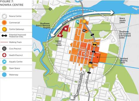
Regional Plan Extract – Figure 7: Nowra Centre
(2015)
The
current Illawarra-Shoalhaven Regional Plan is available on the internet at:
https://www.planning.nsw.gov.au/Plans-for-your-area/Regional-Plans/Illawarra-Shoalhaven
The
Regional Plan is currently under review and it is understood that the new draft
plan will be released for comment in late 2020/early 2021.
Hospital Masterplan and
Budget Commitments
During 2018 the NSW Government
released an initial masterplan for the hospital and in November 2018 made a
commitment of $434 million to the redevelopment of the hospital. Funding was
also announced on the 2018-19 budget to commence the more detailed planning for
several health projects including Shoalhaven hospital.
The masterplan drawing that was
released during 2018 is provided below:
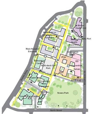
Shoalhaven District Memorial Hospital – Long Term
Zonal Masterplan (2018)
The released masterplan for the
hospital builds on the significant investment made to date in health
infrastructure on the current site and its surrounds, including the Shoalhaven
Cancer Centre, the GP Super Clinic and the multi-deck car park.
It is understood that NSW Health are now advancing the
planning for the staged development of a medical precinct centred on the
current hospital and involving adjacent land. As such they have written to
Council (Attachment 1) specifically seeking early
‘in-principle’ support for the acquisition and development of Nowra
Park where required for future healthcare facilities.
Nowra Park
The area that is under
consideration as part of this request is Lot 104 DP1165533, which is the
residue of Nowra Park. Lot 104 is shown on the following aerial photograph:
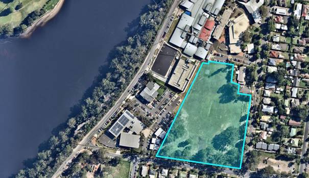
Lot 104 DP 1165533 – Nowra Park
Areas of the original Nowra Park
were previously acquired/transferred in 2002, 2003 and also 2012 and are now
occupied by the hospital car park, pre-school, cancer centre and GP
superclinic.
The creation of the cancer
centre/GP super clinic in 2012 involved an internal NSW Government acquisition
transaction. The lot was also rezoned in 2011 by the NSW Government to Special
Uses 5(a)(Health Services Facility) under the previous Shoalhaven LEP1985 (now
SP2 Infrastructure – Health Services Facility under Shoalhaven LEP2014).
The remaining Lot 104 has an
area of 2.6 hectares and is a Crown ‘public recreation’ reserve
(Nowra Park) for which Council is the trustee. The lot is currently zoned RE1
Public Recreation under Shoalhaven LEP2014.
It is envisaged that NSW Health
Infrastructure will follow a similar process in regard to the transfer and
rezoning of Lot 104.
Previous Council Resolutions
The Council has previously
passed resolutions regarding the hospital, its expansion and the possible
establishment of a medical precinct in the location of the current hospital and
the adjacent Nowra Park.
These previous relevant
resolutions include:
July 2012 Resolution:
Council supports in principle
its proposal to develop an at grade car park of up to 100 spaces for an interim
period on portion of the Nowra Park, as a low-impact solution to the current
and forecast increase in short-term car parking demand in the Hospital
precinct.
Note: this followed a letter
from the LHD dated 20 June 2010 regarding a possible ‘at grade’ car
park for 100 car spaces on the adjoining land. The letter mentioned that the
LHD Board had agreed to support the establishment of a Shoalhaven Health
Precinct on land surrounding the hospital and that negotiations to acquire the
land for the future use were continuing.
November 2011 Resolution:
a) Council
reaffirms its support for the establishment and staged development of a master
planned medical precinct centred on the current Shoalhaven hospital site and
adjacent lands,
b) Council
supports the Illawarra Shoalhaven Area Health Board, Illawarra Shoalhaven
Medicare Local, University of Wollongong and local Members of Parliament in the
announcement of a master plan approach and vision and appropriate community
engagement steps,
c) Council
takes a participative role in the further definition and staged implementation
of a master plan to create a “Centre of Health Delivery and Education
Excellence” for the Shoalhaven,
d) Parts
a), b) and c) remain confidential in accordance with Section 10(A)(2)(d)(i) of
the Local Government Act 1993, until the public announcement of the siting of a
proposed Super Clinic in Nowra by State Government representatives.
December 2010 Resolution:
a) Council
take all steps necessary to pursue the Nowra Park (Hospital site) location as
the preferred option for the co-location of any super clinic and associated
health facilities and negotiate with the NSW Government Land and Property
Management Authority accordingly;
b)
Council treat other sites as secondary for the purpose of further reporting;
c) General
Manager report on the establishment of a medical precinct centred on the
current hospital site and adjacent lands and other opportunities for
co-location of services that would enhance the economic development of the
Shoalhaven.
These resolutions all
effectively indicated a level of support from the Council for the retention and
expansion of the hospital/medical uses on the current site and also in the
longer term a future possible utilisation of the adjacent Nowra Park or at least
parts of it.
Community Suggestions
– New Green Field Hospital
Recent community representations
have suggested that a new green field location is required for the hospital to
enable it to better serve the City as a whole into the future, considering growth
and other factors (travel times etc). It has been suggested that a green field
location in the centre of the City would be more appropriate.
Nowra-Bomaderry is recognised as
the City’s major urban centre; as such higher-level services will
continue to be focussed there, including health services. Council will continue
to assist the NSW Government deliver relevant outcomes in the Regional Plan. It
is also acknowledged that given the level of investment that currently exists
on site at the current hospital it is unlikely that a new greenfield hospital
campus would be developed.
As highlighted above, existing
NSW Health and regional planning is committed to the continued development of
the hospital at its current site in Nowra. This is recognised and it is envisaged
that Council will assist the NSW Government as required in this regard.
The hospital redevelopment is in
the early stages of planning and it is also understood that a business case
will examine in detail the options for the proposed redevelopment as part of
this early planning.
Through continued dialogue with
the NSW Government on the project, Council can help ensure that community
impacts are recognised, considered and accommodated.
Conclusion
This report provides an
opportunity for the Council to confirm (or otherwise) its support for the
ongoing future development of a medical precinct on the current hospital site
and adjacent land (Nowra Park).
Community Engagement
No community engagement has been
undertaken in regard to this report. One of the options available to Council,
prior to deciding in this regard, is to seek initial community feedback.
There will also be a significant
community consultation and engagement process throughout the planning of the
hospital redevelopment. This will be undertaken by the NSW Government.
Policy Implications
Relevant policy implications are
discussed within the body of the report.
Financial Implications
No current financial
implications for Council. However, these could emerge as this matter progresses
and if needed these can be separately reported to Council.
|

|
Development
& Environment Committee – Tuesday 04 August 2020
Page
0
|
|
|
Development
& Environment Committee – Tuesday 04 August 2020
Page
0
|
DE20.81 Response
to Question on Notice - DA20/1453, Proposed Mixed Use Development at 3 Moona St
(Lot 104, DP 755928), Huskisson
HPERM Ref: D20/330978
Section: Development
Services
Approver: Phil
Costello, Director Planning Environment & Development Group
Reason for Report
This report is in response to
Questions on Notice in the Ordinary Meeting Business Paper dated 28 July 2020.
|
Recommendation
(Item to be determined under delegated authority)
That the Response to Question on
Notice - DA20/1453, Proposed Mixed Use Development at 3 Moona St (Lot 104, DP
755928), Huskisson report be received for information.
|
Options
1. Receive the report for information.
Implications: Nil.
2. Adopt an alternative recommendation.
Implications: This
will depend on the recommendation.
Background
Council is in receipt of a development
application, lodged on 14 May 2020, for a mixed-use development at 3 Moona St,
Huskisson.
· The applicant for
the development is PDC Planners.
· The owner is
Kingfisher Projects Pty Ltd.
· The assessment of
the application is incomplete.
The Proposal
The proposal, as it currently
stands, is for a 40-room motel, food and drink premises, commercial space (day
spa), Guest gym, pool and apartment building containing 39 residential units.
The motel consists of 34 standard rooms and 6 suites; two of the standard rooms
will be accessible. The proposal includes on-site parking and the construction
of an access within the Moona Street road reserve with some parking also in the
road reserve.
Council has written to the
applicant requesting additional information. A formal response is yet to be
submitted.
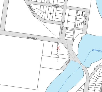
Figure 1
– Location
Community Engagement
The proposal has been uploaded
onto Council’s tracking website for public viewing and was formally
notified between 3 June 2020 and 3 July 2020. Numerous submissions have been
made and continue to be submitted. Council will continue to accept
submissions whilst the application is under assessment.
The application has been
referred to a number of technical officers within Council and externally to:
· Department of Primary
Industries – Jervis Bay Marine Park
· Department of
Planning, Industry and Environment – Crown Lands
· NSW Rural Fire
Service
· Water NSW
· Office of
Environment & Heritage (now Energy, Environment and Science)
· Jerrinja Local
Aboriginal Land Council
Response to Questions on Notice
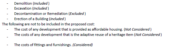
Question 1
Among the
documents on DA tracking is a report by QPC & C Quantity Surveyors giving
costings on the building of the complex proposed for the site. These figures
are complicated but appear to take the proposed development very close to the
threshold of State Significant Development. Does Council accept these figures
on face value or are they peer reviewed…. and what is the consequence if
costs blow out and take the project over the threshold?
Response
The Department’s
Circular PS13-002 explains that clause 246B of the Environmental Planning and
Assessment Regulation 2000 sets out how DA fees are calculated. The consent
authority must determine the fee having regard to the genuine estimate of the
cost provided by the applicant on the DA form.
· It
is recommended that for development up to $100,000 the cost is estimated by the
applicant or a suitable qualified person with an explanation of the
methodology.
· For
development between $100,000 and $3 million, a suitable qualified person should
prepare the cost estimate with an explanation of the methodology.
· For
development more than $3 million a detailed cost report prepared by a
registered quantity surveyor verifying the cost of the development should be
submitted.
Having regard to
the PS Circular document referred to above, the consent authority must accept
the estimate of the cost submitted unless it is satisfied that the estimate is
not genuine or accurate. It is an offence if a person makes any statement that
is false or misleading.
If the threshold is
reached to trigger the development being classified as regional development, it
is notified and assessed by Council. The Regional Planning Panel determines
these applications. Regional development is defined in Schedule 7 of the State
Environmental Planning Policy (SEPP) (State and Regional Development) 2011 and
includes development with a capital investment value (CIV) over $30 million.
Capital
investment value of a development or project includes all costs necessary to
establish and operate the project, including the design and construction of
buildings, structures, associated infrastructure and fixed or mobile plant and
equipment, other than the following costs—
(a)
amounts payable, or the cost of land dedicated or any other benefit provided,
under a condition imposed under Division 7.1 or 7.2 of the Act or a planning
agreement under that Division,
(b)
costs relating to any part of the development or project that is the subject of
a separate development consent or project approval,
(c) land
costs (including any costs of marketing and selling land),
(d) GST
(within the meaning of A New Tax System (Goods and Services Tax) Act 1999 of
the Commonwealth).
It is noted that
the cost of the development has been estimated to be $32,038,629 however the
GST is $2,912,603 which is subtracted from the overall cost figure noting the
definition (See (d) above).
Note: the fee
for a DA is calculated differently to the CIV value of a DA.
The QS report
advises that in accordance with clause 255 of the Environmental Planning and
Assessment Regulation 2000 the development cost includes goods and service tax,
builders margin and all associated preliminaries and labour but excludes any
project contingency. (4.1 of the report).
255 How is a fee
based on estimated cost determined?(cf clause 102 of EP&A Regulation 1994)
(1) In determining the
fee for development involving the erection of a building, the consent
authority must make its determination by reference to a genuine estimate
of—
(a)
the costs associated with the construction of the building, and
(b)
the costs associated with the preparation of the building for the purpose for
which it is to be used (such as the costs of installing plant, fittings,
fixtures and equipment).
(1A) In determining the
fee for development involving the carrying out of a work, the consent authority
must make its determination by reference to a genuine estimate of the
construction costs of the work.
(1B) In determining the
fee for development involving the demolition of a building or work, the consent
authority must make its determination by reference to a genuine estimate of the
costs of demolition.
(2)
The estimate must, unless the consent authority is satisfied that the estimated
cost indicated in the development application is neither genuine nor accurate,
be the estimate so indicated.
In accordance with
clause 25J of the Environmental Planning and Assessment Regulation 2000 https://www.legislation.nsw.gov.au/#/view/regulation/2000/557/part4/div1b/sec25j,
the proposed cost of carrying out the development is to be determined by
addition up all the costs and expenses that have been or are to be included by
the applicant tin carrying out the development. (This clause of the
Regulation relates to the imposition of consent conditions for fixed
development consent levies.)
Figure 2 – Extract from Applicant’s Report,
Page 3 under 4.2
QPC&C Quantity Surveyors and Project
Managers https://www.capital-qpc.com.au/
prepared a Registered Quantity Surveyors Cost Report. Given their
accreditation, Council accepts their estimate which is based on the plans
submitted with the application.
In the event that
the development is assessed and ultimately approved (if favourably assessed)
and if the value post approval or during construction is found to exceed the
estimate, there is no recourse. This would not render an approval invalid. An
approval can only be rendered invalid by the Land and Environment Court.
Question 2
Is a development
elevated to State Significance if the site is in an environmentally sensitive
location and who makes that decision? The letter from DPI Fisheries in the
submissions says that; “the DA, including the Statement of Environmental
Effects and various associated reports, fails to note that the site is within
100 metres of Jervis Bay Marine Park, a “nearby sensitive
environment” and that stormwater from the site flows into an area of the
Marine Park that is zoned “habitat protection”.
Response
The proposal does
not meet the criteria for State significant based on the information currently
provided.
The State
Environmental Planning Policy (State and Regional Development) 2011 (SEPP) defines
environmental sensitive area of State significant as:
Environmentally sensitive
area of State significance means—
(a) coastal waters of the
State, or
(b) land identified as
“coastal wetlands” or “littoral rainforest” on the
Coastal Wetlands and Littoral Rainforests Area Map (within the meaning of State
Environmental Planning Policy (Coastal Management) 2018), or
(c) land reserved as an
aquatic reserve under the Fisheries Management Act 1994 or as a marine park
under the Marine Parks Act 1997, or
(d) a declared Ramsar
wetland within the meaning of the Environment Protection and Biodiversity
Conservation Act 1999 of the Commonwealth, or
(e) a declared World
Heritage property within the meaning of the Environment Protection and
Biodiversity Conservation Act 1999 of the Commonwealth, or
(f) land identified in an
environmental planning instrument as being of high Aboriginal cultural
significance or high biodiversity significance, or
(g) land reserved as a
state conservation area under the National Parks and Wildlife Act 1974, or
(h) land, places, buildings
or structures listed on the State Heritage Register under the Heritage Act
1977, or
(i) land reserved or
dedicated under the Crown Land Management Act 2016 for the preservation of
flora, fauna, geological formations or for other environmental protection
purposes, or
(j) land identified as being
critical habitat under the Threatened Species Conservation Act 1995 or Part 7A
of the Fisheries Management Act 1994.
If a development is
listed in schedule 1 of the SEPP (this schedule lists the types of development)
which can also be in ‘environmentally sensitive areas’, a
development may be potentially classed as State significance.
Development for
tourism related purposes but not including any commercial premises, residential
accommodation and services apartments whether separate of ancillary with a
capital investment value of more than $100 million or $10 million in an
environmentally sensitive area of State significance or a sensitive coastal location
would potentially be State development. Having regard to the list above,
the site does not fall within the criteria.
The decision or
assessment path is usually determined prior to lodging an application having
regard to the type of development, information available and planning
framework. Sometimes this is done in consultation with the consent
authority, given that various specialist reports can be required etc.
Having regard to the above criteria the proposal currently fits within local
integrated development category. It is possible however that an assessment
of a development can identify issues which may trigger an additional assessment
or alternative assessment path.
The Minister can
also declare a development to be State significant. However, the Minister
must seek advice from the Independent Planning Commission.
From the
Department’s website:
Under the Environmental Planning &
Assessment Act 1979, development can become State significant
development (SSD) in two ways.
First, a State
Environmental Planning Policy may declare any development, or class or
description of development, to be SSD.
Most State
significant development is identified in the State & Regional Development
SEPP, and includes:
· development from certain industries
(mines, factories, power stations, schools, hospitals), generally due their
size, economic value or potential impacts; and
· development on sites with
strategic planning significance (Barangaroo, Darling Harbour, Sydney Opera
House, Sydney Olympic Park).
Other SEPPs
(such as the Three Ports SEPP)
also identify SSD.
Second, the
Minister for Planning may declare specified development on specified land to be
SSD by order published in the Government Gazette. However, prior to making such
an order the Minister must first obtain advice from the Independent Planning Commission about
the State or regional planning significance of the development and make this
advice publicly available.
There is a policy and guideline for
making these Ministerial orders.
Source:
https://www.planningportal.nsw.gov.au/major-projects/assessment/state-significant-development/ssd-projects
https://www.planningportal.nsw.gov.au/major-projects/assessment/state-significant-development
Question 3
Fisheries have
indicated thirteen conditions of development to protect the Marine Park. Who
will monitor compliance with these conditions and will the cost of doing so be
carried by the Shoalhaven ratepayers?
Response
During
construction, concerns are appropriately directed to the Principal Certifier
(PC) in the first instance.
The Council has a
Compliance Team which is charged with the responsibility of investigating
alleged non-compliance with consent conditions, amongst a range of other
matters. If any alleged non-compliance occurs, investigation would be
carried out by the appropriate regulatory authority, which may be Council or a
State agency depending on the legislation involved.
Question 4
In recent years,
the volume of sand in Moona Moona Creek, downstream of the road and footbridge,
has increased significantly and reduced the connectivity between the Creek and
Jervis Bay. Will Council in its assessment of the DA be considering the impact
of this change in hydrology on potential flood levels at the site and the
manner in which the developer proposes to manage water quality and prevent
polluted stormwater discharging into a system that no longer flushes as it used
to?
Response
Council will assess
the environmental impacts of the development having regard to a range of
issues. The basic criteria is that post development conditions do not increase
impact over pre development conditions.
Question 5
One submission
questioned the proponents plan to manage the acid sulphate soils on the site
which require “very high level” and “complex”
treatment. Can the effectiveness of the plan be assessed when the construction
methodology of the building is yet unknown?
Response
Clause 7.1(3) of the Shoalhaven
Local Environmental Plan 2014 (SLEP 2014) requires that an acid sulphate soils
management plan be prepared for the proposed works in accordance with the Acid
Sulphate Soils Manual.
The submitted ASS Report (D20/15273) would appear to satisfy
this subclause. However, Water NSW will be considering the dewatering component
of the development. Council’s Environment Team will also review the
report to ensure its adequacy.
Question 6
If a particular
number of unique public objections are received against a development will its
assessment be taken out of the hands of Council to a higher authority such as
the Independent Planning Commission?
Response
No. It is not
uncommon for development applications to attract significant public interest.
The Independent
Planning Commission (IPC) is the consent authority for State significant
developments (SSD), where there are particular circumstances, such as the
number of objections, a reportable political donation disclosure and/or the
Council has made an objection to the SSD application and not rescinded the
objection following exhibition.
This development is
not SSD.
https://www.ipcn.nsw.gov.au/about-us
Question 7
Are bonds required from
developers as surety against failure to comply with consent conditions and
lastly, is the CEO aware of any reportable political
donations by parties associated with this development?
Response
Bonds or financial securities are
not sought for potential non-compliances. In principle, the only
circumstance in which a Council may impose a bond are those identified s4.17(6)
of the Environmental Planning and Assessment Act 1979 (EPA Act 1979).
Conditions and other arrangements concerning security
A development consent may be granted subject to a
condition, or a consent authority may enter into an agreement with an
applicant, that the applicant must provide security for the payment of the cost
of any one or more of the following—
(a) making good any damage caused to any property
of the consent authority (or any property of the Planning Ministerial
Corporation) as a consequence of the doing of anything to which the consent
relates,
(b) completing any public work (such as road work,
kerbing and guttering, footway construction, stormwater drainage and
environmental controls) required in connection with the consent,
(c) remedying any defects in any such public work
that arise within 6 months after the work is completed,
(d) in relation to coastal protection works (within
the meaning of the Coastal Management Act 2016), either or both of the
following—
(i) the maintenance of the works,
(ii) the restoration of a beach, or land adjacent
to the beach, if any increased erosion of the beach or adjacent land is caused
by the presence of the works.
Where there are potential
breaches, there are separate provisions in the EPA Act 1979 and other legislation
(eg the Protection of the Environment and Operations Act 1979) to deal with
such circumstances. These could include fines or legal proceedings.
With regard to any reportable
donations, there have been no declarations. The Development Application
form, section 18 requires a declaration to be made. The applicants and
owners have advised there have been no donations or gifts. The DA form is
viewable online.
The NSW Political Donations
register is here: https://www.elections.nsw.gov.au/Funding-and-disclosure/Disclosures/View-disclosures
.
|
|
Development
& Environment Committee – Tuesday 04 August 2020
Page
0
|
DE20.82 Development
Application No. SF10686 – Red Gum Dr Ulladulla – Lot 600 DP 1249606
& Lot 2 DP 1076005
DA. No: SF10686/4
HPERM Ref: D20/248826
Section: Development
Services
Approver: Phil
Costello, Director Planning Environment & Development Group
Attachments: 1. Determination
- Refusal - Red Gum Dr Ulladulla - Lot 600 DP 1249606 and Lot 2 DP 1076005 ⇩
2. Planning
Report – S4.15 Assessment Red Gum Dr, ULLADULLA - Lot 500 DP
1235307 (under separate cover) ⇨
3. Plan - Amended Plan of
Subdivision - Red Gum Drive Ulladulla - Lot 500 DP 1235307 ⇩
Description
of Development: Eight (8) Lot Residential Subdivision, Public Reserve and
Vegetation Clearing
Owner: Hazcorp Pty Ltd
Applicant: Rygate & West Ulladulla
Notification Dates: 27 November 2018 to 12
December 2018
No. of Submissions: Nil
Purpose
/ Reason for consideration by Council
Council resolved (7 April 2020)
that staff are not to refuse applications, instead the refusal of a development
application must only be by Council / Committee resolution (MIN20.240).
The Development Application (SF10686) is recommended for
refusal.
|
Recommendation (Item to be determined under delegated authority)
That Development Application No. SF10686 for an Eight (8) Lot Residential Subdivision plus
Public Reserve and Vegetation Clearing over Lot 600 DP 1249606 & Lot 2 DP
1076005, Red Gum Dr Ulladulla, be determined by way of refusal for the
reasons set out in the Notice of Determination (Attachment 1) to this report.
|
Options
1. Refuse the
development application (DA) in accordance with the recommendation.
Implications: The
application would not proceed. The applicant can apply for a section 8.2 review
of Council’s decision and/or could lodge an appeal with the NSW Land and
Environment Court against Council’s decision
2. Approve
the application.
Implications: Council would have to
determine the grounds on which the DA is to be approved, that is, provide
reasons to support the development, having regard to section 4.15
considerations. A suite of conditions would have to be prepared by staff in the
event that Council supports the proposal. Under some circumstances, third
parties (i.e. objectors) can seek a judicial review of Council’s decision
in the NSW Land and Environment Court.
3. Alternative
recommendation.
Implications: Council will
need to specify an alternative recommendation and advise staff accordingly.
Location Map
Figure
1 – Location Map
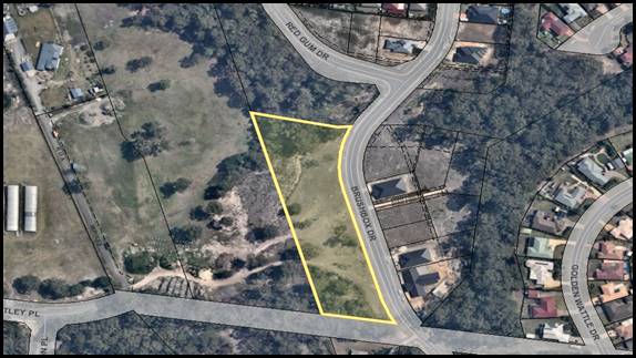
Background
Subdivision of Lot 600 DP 1249606
The subdivision plan prepared by
Rygate and West dated 15 November 2018 (Attachment 3) proposes to subdivide Lot
600 DP 1249606 into the following lots as part of Stage 10G of the residential
subdivision:
· Proposed
Lot 901 – Total area of 1,742m² (building envelope marked in
south-eastern front corner and 20m asset protection zone to bushfire prone
vegetation).
· Proposed
Lot 902 – Total area of 809m².
· Proposed
Lot 903 – Total area of 809m².
· Proposed
Lot 904 – Total area of 809m².
· Proposed
Lot 905 – Total area of 809m².
· Proposed
Lot 906 – Total area of 809m².
· Proposed
Lot 907 – Total area of 809m².
· Proposed
Lot 908 – Total area of 1,005m².
· Proposed
Public Reserve – Located immediately north of Proposed Lot 901 and
adjacent to an existing public reserve created as part of Stage 10C. The
Reserve would incorporate the existing Category 2 water course and adjacent
riparian vegetation.
Vegetation Clearing on Lot
600 DP 1249606
The following vegetation would
be removed from Lot 600 DP 1249606 to facilitate the proposed subdivision:
· Removal of
vegetation totalling 255m² within Proposed Lot 901 to facilitate an asset
protection zone.
· Removal of
regrowth vegetation totalling 1445m² within Proposed Lots 907 and 908.
Maintenance of Asset
Protection Zone on Lot 2 DP 1076005
The Bushfire Hazard Assessment
prepared by Bushfire Building Solutions (Ref. BAR 10050/18 dated 29 May 2019)
in support of the application provides the following recommendations regarding
the maintenance of asset protection zones for the development:
1. Each property shall be maintained in perpetuity as an
inner protection area in accordance with the requirements detailed in Section
3.3.
2. No habitable building over Lot 901 shall be erected within
25 metres of the northern boundary.
3. APZ
over adjacent land will be the responsibility of Hazcorp as the licence holder
of the land until such time that the NSW Department of Roads and Maritime
Services commences construction of the Milton-Ulladulla bypass.
The owner (Hazcorp Pty Ltd) presently has a licence with
Transport for NSW (TfNSW) permitting maintenance of a strip of existing cleared
land on the Bypass Corridor land (Lot 2 DP 1076005) prior to the formal
construction of the Bypass.
Reconstruction of
Catch/Swale Drain on Lot 2 DP 1076005
An existing catch/swale drain,
presently in a state of disrepair, is partially located on the subdivision lot
and partially on the bypass corridor land.
To facilitate the diversion of
upstream runoff away from the proposed lots, it is required to be reconstructed
as part of the proposed works with Council’s Subdivision Engineer
clarifying:
“The catch drain is currently in the wrong location
and is in a state of disrepair with scouring and erosion having occurred, and
therefore will require reconstruction within the subject lots as part of this
application.
Prior to the approval of the application it
is suggested that a revised subdivision plan is submitted showing the easement
for drainage, or an alternative treatment suggested by the applicant.”
The applicant subsequently
advised that the drain would be reconstructed entirely within the bypass
corridor land, and such works would form part of the proposal. TfNSW has agreed
to the works on its land on the basis modified plans depicting the
reconstructed swale drain and drainage calculations were provided to Council.
Further discussion on this matter is provided within the Report below.
Subject Land
The development site comprises Lot 600 DP 1249606 (proposed
subdivision site) & Lot 2 DP 1076005 (TfNSW Bypass corridor site) at Red
Gum Dr Ulladulla. Refer to Figure 1.
Site & Context
The
development site:
· Partly includes land upon which the subdivision is proposed
(Lot 600) and partially includes the neighbouring bypass corridor (Lot 2).
· The subdivision site has an area of 9,497m² and is
presently vacant of development.
· Is residue land following the registration of Stage 10E of
the residential subdivision estate.
· Is accessed by a legal road frontage to Brushbox Drive to
the east of the property.
· Is zoned R1 General Residential in accordance with the
Shoalhaven Local Environmental Plan 2014 (refer zoning extract at Figure 2).
· Is mapped as being bush fire prone land (Vegetation Category
2)
· Contains a mapped Category 2 water course which traverses
from east to west across the northern part of the site.
· Is vegetated in the northern part (riparian vegetation
surrounding water course) and in the southern part (regrowth vegetation).
The surrounding area is an emerging residential estate
characterised by low density development such as single dwelling houses on
urban sized blocks of land.
Figure 2 –
Zoning Extract
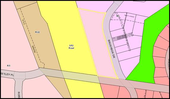
History
The following timeline of events
has taken place following the lodgement of the Development Application with
Council on 29 June 2018:
· 1st
request for information (RFI) was sent to applicant on 6 July 2018 relating to
several matters including amended Statement of Environmental Effects plans, and
documents.
· A response
to 1st RFI was provided by applicant in separate submissions on 5
August, 22 August, 25 September, and 15 November 2018.
· The DA was
notified according to Community Consultation Policy for two (2) weeks between
27 November and 12 December 2018. No submissions were received.
· Internal/external
referrals were made on 27 November 2018.
· 2nd
RFI Request sent to applicant on 19 March 2019 following response to
internal/external referrals. Information requested included:
o Vegetation & Habitat Assessment
addressing the Biodiversity Act 2016 (requested by Council’s
Environmental Assessment Officer); and
o Amended Bushfire Hazard Assessment
addressing the Planning for Bushfire Protection 2006 (requested by the Rural
Fire Service being Integrated Development).
· A response
to the 2nd RFI Request on 11 September 2019 providing the requested
documentation.
· Re-referral
to Environmental Assessment Officer and Rural Fire Service for consideration of
submitted documents on 25 September 2019.
· Re-referral
response by Environmental Assessment Officer on 21 October 2019 requesting an
amended Vegetation & Habitat Assessment given the submitted Report did not
comply with the Biodiversity Conservation Act 2016.
· 3rd
RFI Request sent to applicant on 2 December 2019 requesting the amended
Assessment.
· A response
was received from TfNSW on 2 February 2020 advising the reconstruction of the
swale drain within the bypass corridor is acceptable provided amended plans and
drainage calculations are provided, depicting the reconstruction.
· The
re-referral response provided by Rural Fire Service on 28 February 2020
requested a further amended Bushfire Hazard Assessment given the submitted
Report still did not comply with the Planning for Bushfire Protection 2006.
· 4th
RFI Request sent to the applicant on 18 March 2020 requesting the amended
Assessment required by the Rural Fire Service and the plans/drainage
calculations required by TfNSW.
· Follow up
correspondence sent to applicant seeking updates regarding the progress of the
response to the 3rd and 4th RFI Requests on 18 March, 11
May, 14 May, and 3 June 2020 advising that the response is required within a
reasonable timeframe or the DA would be reported with a recommendation of refusal.
· No response
to the RFI Requests were received from the applicant by the nominated date of
17 June 2020.
Issues
Bushfire Protection
In accordance with Figure 3
below, the site is mapped as being bushfire prone (containing Vegetation
Category 2).
Figure
3 – Bushfire Prone Land
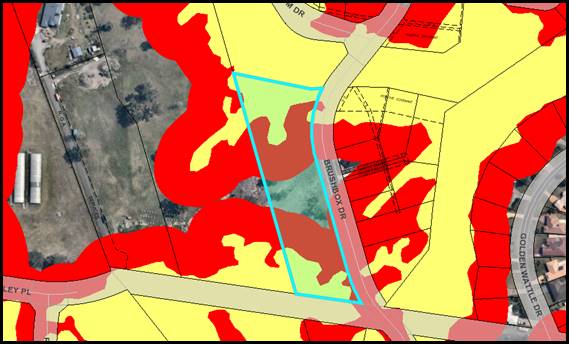
As the proposal is for
subdivision of bushfire prone land, the development is Integrated Development
under s4.46 of the Environmental Planning and Assessment (EP&A) Act 1979
and triggers referral to the Rural Fire Service (RFS).
Accordingly, the application was
referred to the RFS where a review of the submitted Bushfire Hazard Assessment
(prepared by Bushfire Building Solutions, dated 29 May 2019) was undertaken.
The RFS advised that the
following amendments to the Bushfire Hazard Assessment are required to permit
compliance with the Planning for Bushfire Protection 2006:
· Amended
Subdivision Plan providing a 35m Asset Protection Zone to the bushfire prone
vegetation within the adjoining public reserve; and
· Amended
Bushfire Hazard Assessment further considering the bushfire prone vegetation
with Proposed Lots 906-909 given they do not meet the criteria for ‘low
hazard vegetation’ recommended in the previously submitted Report.
A Further Information Request was sent to the applicant on 18
March 2020 requesting the above matters be addressed. Despite repeated follow
ups, the requested amended documents were not provided by the applicant.
Discussion
An amended Bushfire Hazard
Assessment was not received. As such, the proposal is found to be non-compliant
with the following items of legislation:
· Section
4.47(2) of the Environmental Planning and Assessment (EP&A) Act 1979 states
the following:
“Before
granting development consent to an application for consent to carry out the
development, the consent authority must, in accordance with the regulations,
obtain from each relevant approval body the general terms of any approval
proposed to be granted by the approval body in relation to the development.
Nothing in this section requires the consent authority to obtain the general
terms of any such approval if the consent authority determines to refuse to
grant development consent.”
Subdivision of bush fire prone land is integrated
development under s100B of the Rural Fires Act 1997 and under Section 4.47(2)
of the EP&A Act 1979, general terms of approval and a Bush Fire Safety
Authority (BFSA) are required prior to determination of the development.
· A79.1/P80
of Chapter G11 – Subdivision of Land
Acceptable Solution A79.1 of Chapter G11 –
Subdivision of Land of the SDCP 2014 states the following:
“A development application is
supported by an appropriate level of analysis consistent with Council and other
legislative requirements.
The subdivision lot design
positively responds to:
· Slope
and desirability of minimising earthworks/retaining walls associated with
dwelling construction.
· natural
or cultural features;
· soil
erosion and bushfire risk;
· Special
features such as trees and views, including identification of mature stands of
trees retained & supplementary planting.”
Given the requirements of Planning for Bushfire Protection
2006 have not been achieved, in particular requirements for a suitable asset
protection zone (Proposed Lot 901) and for a suitable assessment of bushfire
prone vegetation, the subdivision lot design does not positively respond to
bush fire risk.
Performance Criteria P80 states the following:
“Lot areas and dimensions take
into account the site natural opportunities and constraints.”
The proposal is non-compliant with Performance Criteria
P80 of Chapter G11 of the SDCP 2014 for the following reasons:
· The
lot area and dimensions for Proposed Lot 901 do not adequately account for the
required asset protection zone (APZ) of 35m. Only a 20m APZ is depicted on the
subdivision plans.
· Given
the width of Proposed Lot 901 is only 35m, the required 35m APZ would provide
no space for a building envelope.
· A
redesign would be required to enable Proposed Lot 901 to be able to be utilised
for residential purposes – taking into account the site opportunities and
constraints
· Vegetation mapped within
proximity to Proposed Lots 906 to 908 has not been suitably considered in the
applicant’s bush fire assessment.
Impacts upon Threatened Species
As part of the DA, the applicant
proposes the removal of the following stands of vegetation from the site
(totalling 1700m²):
· Removal of vegetation
totalling 255m² within Proposed Lot 901 to facilitate an asset protection
zone; and
· Removal
of regrowth vegetation totalling 1445m² within Proposed Lots 907 and 908.
The DA was referred to
Council’s Environmental Assessment Officer who requested additional
information be provided to determine whether it would trigger entry into the
Biodiversity Offsets Scheme under the Biodiversity Conservation (BC) Act 2016.
Under the BC Act 2016, entry
into the Biodiversity Offsets Scheme is triggered by any of the following
methods:
· Clearing above the
threshold listed at Clause 7.2 of the BC Regulation 2000;
· Clearing of native
vegetation mapped on the Biodiversity Values Map; and
· Section
7.3 Test of Significance identifying a potential adverse impact upon threatened
species known to occur within the locality.
A Vegetation & Habitat
Assessment was submitted by the applicant which stated that the proposal would
not trigger entry into the Biodiversity Offsets Scheme given:
· The total amount of
clearing, being 1700m², does not exceed the threshold listed at Clause 7.2
of the BC Regulation 2000 – being 2500m²;
· Vegetation on the site
is not mapped on the Biodiversity Values Map; and
· A
Section 7.3 Test of Significance was undertaken which found no significant
impacts.
The Vegetation & Habitat
Assessment was reviewed by Council’s Environmental Assessment Officer who
found that the S7.3 Test of Significance at Section 8 of the Report does not
refer to any locally occurring threatened species and instead refers to species
not known to occur in the locality. Specifically, the referral advice states:
“S6.1.1 of the Test of Significance report
identifies a number of threatened species previously detected within 1.5km of
the subject site. The section 7.3 BC Act Test of Significance provided in
Section 8 of the report however does not refer to these species, or any locally
occurring threatened ecological communities.
Those species and ecological communities that have been
assessed, being Pine Donkey Orchid Diuris tricolor and plant community types
(PCT 45, 76, 80 and 267) are not known to occur within the locality.”
Based upon the above, and to
further clarify whether the development would trigger entry into the
Biodiversity Offsets Scheme, a revised Vegetation and Habitat Assessment and
S7.3 Test of Significance was requested with the following being required:
· Revised Test of
Significance referencing species likely to occur in locality
· Provide
a table of likely species with reference to supporting literature.
· Further
inspection of site given Council’s inspection revealed evidence of glider
activity.
· Provision
of a list of recommendations of how to mitigate residual impacts upon
biodiversity.
A Further Information Request
was sent to the applicant on 2 December 2019 requesting the additional
information be provided to determine whether the proposal would trigger entry
into the Biodiversity Offsets Scheme. Separate correspondence was sent to the
applicant requesting a status update regarding the progress of the revised
documentation on 18 March, 11 May, 14 May, and 3 June 2020. Given no response
to the status update requests on these dates was provided, Council provided the
applicant with a nominated date of 17 June 2020 upon which the application
would be determined based upon the information submitted to date. The requested
information was not received by the nominated date and thus has not satisfied
the requirements of the Biodiversity Offsets Scheme.
Discussion
Given the amended Vegetation
& Habitat Assessment and S7.3 Test of Significance was not received, the
proposal is found to be non-compliant with the following items of legislation:
· Acceptable
Solution A1.1 of Chapter G5 – Threatened Species Impact Assessment of the
SDCP 2014 states the following:
“A development application is supported by an
appropriate level of analysis consistent with Council and other legislative
requirements.”
As per Council’s Environmental Assessment Officer
referral comments several amendments to the Vegetation & Habitat Assessment
and S7.3 Test of Significance are required to determine whether entry into the
Biodiversity Offsets Scheme would be triggered.
Given the requested information was not received, Council
cannot be satisfied that the proposal provides an appropriate level of analysis
consistent with Council and other legislative requirements.
Performance Criteria P1 states the following:
“To ensure that threatened
species, populations and EECs are protected from the impacts generated by
development.”
Given that a s7.3 Test of Significance against threatened
species likely to occur within the locality has not been received,
Council cannot be satisfied that the proposal and the related vegetation
clearing would not have an adverse impact upon threatened species, populations
and EECs within the area. The proposal is therefore non-compliant with
Performance Criteria P1 of Chapter G5 of the SDCP 2014.
· Section
4.15(1)(b) of the EP&A Act 1979 – Likely impacts of that development,
including environmental impacts upon the natural environment
Given a S7.3 Test of Significance has not been provided
against threatened species likely to occur within the locality, Council cannot
be satisfied that the proposed vegetation clearing would not have an adverse
impact upon the natural environment specifically relating to habitat and
population numbers of such species.
Proposed Works within the Princes Highway Ulladulla
Bypass Corridor
There is an existing swale drain
located partially on Lot 600 (subject subdivision site) and partially on Lot 2
(Bypass Corridor). Its purpose is to collect runoff generated upstream to avoid
the potential for overland flow across the subdivision site.
Council’s Subdivision
Engineer recommended that stormwater issues be resolved prior to the issue of
any consent:
“The catch drain is currently in the wrong location
and is in a state of disrepair (see D19/82250) with scouring and erosion having
occurred, and therefore will require reconstruction within the subject lots as
part of this application.
Prior to the approval of the application it
is suggested that a revised subdivision plan is submitted showing the easement
for drainage, or an alternative treatment suggested by the applicant”.
In correspondence with TfNSW,
the applicant advised of their intention to reconstruct the swale drain
entirely within the Bypass Corridor with the point of discharge being the
existing water course. TfNSW agreed to give owner’s consent to these
works provided the following is provided for their review prior to any
determination:
“The plans provided for the proposed drainage works
on TfNSW land (Plans with Ref: U12020_10G_DA, Sheet 1 and 2, Issue: E, dated
2.12.2019) will need to be updated, inclusive of the calculations, so the
proposed swale can achieve containment in a 1:100 weather event when the swale
has long grass.”
A Further Information Request
was sent to the applicant on 18 March 2020 requesting the amended plan and drainage
calculations be provided. Separate correspondence was sent to the applicant
requesting a status update regarding the progress of the revised documentation
on 11 May, 14 May, and 3 June 2020. Given no response to the status update
requests on these dates was provided, Council provided the applicant with a
nominated date of 17 June 2020 upon which the application would be determined
based upon the information submitted to date. The requested information was not
received by the nominated date and therefore was not able to be referred to
TfNSW for their review.
Discussion
Given the amended plan/s and
associated drainage calculations depicting the location and proposed discharge
point of the reconstructed swale drain were not provided as requested, the proposal
is found to be non-compliant with the following items of legislation:
· Clause
100 – Development on proposed classified road of the State Environmental
Planning Policy (Infrastructure) 2007.
Clause 100 of the State
Environmental Planning Policy (Infrastructure) 2007 applies as the site is
located immediately adjacent to and involves work within land reserved for the
construction of a future classified road. The future classified road which
applies in this instance is the Princes Highway Bypass Corridor.
Development consent is not permitted to be granted to
development being a subdivision creating lots with dwelling entitlements, until
the concurrence of the chief executive officer of TfNSW (formerly RMS) has been
received.
TfNSW advised that their consent to these works is subject
to the provision of an amended plan depicting the reconstructed swale drain and
associated drainage calculations. Whilst this detail was requested as part of
an RFI request (as detailed in the Report above), the information was not
provided by the applicant.
In light of the above comments,
Council cannot be satisfied that the development has been provided with the
necessary concurrence of TfNSW. It is considered that the development has not
satisfied the requirements of Clause 100 of SEPP (Infrastructure) 2007.
Planning Assessment
The DA has been assessed under
s4.15(1) of the Environmental Planning and Assessment Act 1979. Please
refer to Attachment 2.
Consultation and Community
Engagement:
Notification was undertaken in
accordance with Council’s Community Consultation Policy with letters
being sent within a 100m buffer of the site, during the period 27 November 2018
to 12 December 2018. No submissions were received in relation to
Council’s notification of the development.
Financial Implications:
There are potential cost implications for Council in the
event of a refusal of the application. Such costs would be associated with
defending an appeal in the Land and Environment Court of NSW.
Legal Implications
Pursuant to section 8.2 of the Environmental Planning and
Assessment Act 1979 (EP&A Act), a decision of the Council may be subject of
a review by the applicant in the event of an approval or refusal. If such a
review is ultimately pursued (if the recommendation is adopted) the matter
would be put to Council for consideration. Alternatively, an applicant who is
dissatisfied with the determination of the application by the Council may also
appeal to the Court against the determination pursuant to section 8.7 of the
EP&A Act. Applicants can choose to do both, setting aside the Appeal
pending resolution of the review, noting there are time limitations with
respect to lodging applications for review and appeal.
Summary and Conclusion
This application has been
assessed having regard for section 4.15 (Matters for consideration) under the
EP&A Act. Having regard to the assessment, the proposal is not
considered capable of support. Reasons for refusal are provided below and can
also be found at Attachment 1 to this report:
|
1.
|
Given a
response to the further information request by the Rural Fire Service issued
under Clause 67 of the Environmental Planning and Assessment (EP&A)
Regulation 2000 was not received, general terms of approval under Section 4.47(2)
of the EP&A Act 1979 were unable to be provided. (Section 4.47(2) of the
Environmental Planning and Assessment Act, 1979)
|
|
2.
|
Having
regard to the works within the proposed classified road, the application has
not satisfactorily demonstrated that the concurrence of the chief executive
officer of RMS has been provided in accordance with Clause 100 of the State
Environmental Planning Policy (Infrastructure) 2007. (Section 4.15(1)(a)(i)
of Environmental Planning and Assessment Act, 1979)
|
|
3.
|
The
application has not satisfactorily demonstrated compliance with the
Acceptable Solutions and/or Performance Criteria of the Shoalhaven Development
Control Plan 2014 – particularly as it relates to A1.1/P1 of Chapter G5
– Threatened Species Impact Assessment and A79.1/P80 of Chapter G11
– Subdivision of Land. (Section 4.15(1)(a)(iii) of Environmental
Planning and Assessment Act, 1979)
|
|
4.
|
Having
regard to the likely impacts of the development, the applicant has not
satisfactorily demonstrated that the proposal would not have an adverse
impact upon the natural environment. (Section 4.15(1)(b) of Environmental
Planning and Assessment Act, 1979)
|
|
5.
|
The
information submitted with the development application does not
satisfactorily demonstrate that the site is suitable for the proposed use.
(Section 4.15(1)(c) of Environmental Planning and Assessment Act, 1979)
|
|
6.
|
Having
regard to the above matters the granting of development consent is not in the
public interest. (Section 4.15(1)(e) of Environmental Planning and Assessment
Act, 1979).
|
|

|
Development
& Environment Committee – Tuesday 04 August 2020
Page
0
|
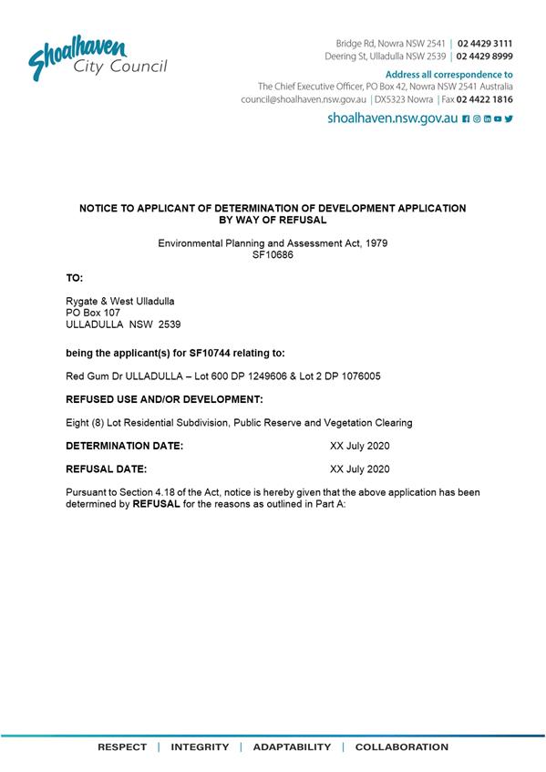
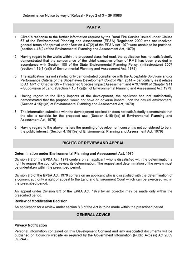

|
|
Development
& Environment Committee – Tuesday 04 August 2020
Page
0
|
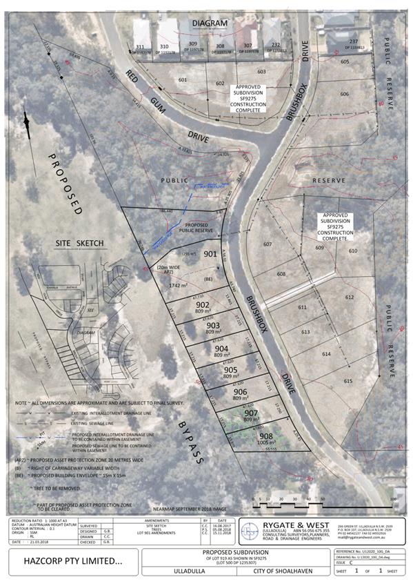
|
|
Development
& Environment Committee – Tuesday 04 August 2020
Page
0
|
DE20.83 Report
- DA20/1203 - 151 Wattamolla Road, Woodhill - Lot 1 DP 740771
DA. No: DA20/1203/4
HPERM Ref: D20/309870
Section: Development
Services
Approver: Phil
Costello, Director Planning Environment & Development Group
Attachments: 1. Planning
Report - 151 Wattamolla Rd WOODHILL - Lot 1 DP 740771 (under separate
cover) ⇨
2. DRAFT - Determination - 151
Wattamolla Road WOODHILL - Lot 1 DP 740771 (under separate cover) ⇨
Description of Development: Construction of a
dwelling house and pool, conversion of existing dwelling to tourist cabin and
alterations and additions to existing garage and conversion to tourist cabin
Owner: G & J O’Brien
Applicant: G O’Brien C/O SET Consultants Pty
Ltd
Notification Dates: 12 March 2020 – 27 March
2020
No. of Submissions: 35 in objection
13 in support
Purpose
/ Reason for consideration by Council
Councillors called in DA20/1203
due to the significant public interest on 23 June 2020 (MIN20.423).
|
Recommendation (Item to be determined under delegated authority)
That Development Application DA20/1203 construction of a
dwelling house and pool, conversion of existing dwelling to tourist cabin and
alterations and additions to existing garage and conversion to tourist cabin at Lot 1 DP 740771, 151 Wattamolla Road, Woodhill be
approved subject to the recommended conditions of consent contained in
Attachment 2 of this report.
|
Options
1. Approve the
development application (DA) in accordance with the recommendation of this
report.
Implications: This would
allow the applicant to pursue construction of the development.
2. Refuse the
application.
Implications: Council would
need to determine the grounds on which the application is refused, having
regard to section 4.15(1) considerations.
3. Alternative
recommendation.
Implications: Council will
need to specify an alternative recommendation and advise staff accordingly.
Location Map
Figure 1 – Location Map
Background
Proposed Development
The proposal includes:
· Construction of
new dwelling house:
o 2 storey (second storey is
attic/store space).
o 2 x bedrooms.
o Other living and habitable
areas.
o Attached garage.
o Attached plunge pool.
o Installation of underground
water tank.
· Conversion of
existing 3 x bedroom dwelling to tourist accommodation consisting of:
o 3 x bedrooms.
o Other living and habitable
areas.
o Loft/storage area.
· Conversion of
existing garage to tourist cabin consisting of:
o 2 x bedrooms.
o Other living and habitable
areas.
· Construction of
parking and vehicle manoeuvring area.
· Installation of
new effluent management system to service new dwelling and tourist.
accommodation (garage conversion). The existing dwelling (proposed tourist
accommodation) will be serviced by the existing effluent management system.
· Installation of
underground water tank to service new dwelling.
Figure 2 – Site Plan
Figure 3 – North and West Elevations of
Proposed New Dwelling
Figure 4 – South and East Elevations of
Proposed New Dwelling
Figure 5 – Elevation Plans of Existing
Dwelling to be Converted to Tourist Accommodation
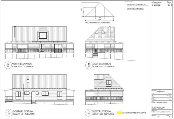
Figure 6 – Elevation Plans Showing
Proposed Alterations and Additions to Existing Garage to be Converted to
Tourist Accommodation
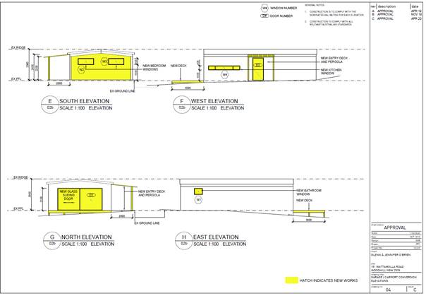
Subject Land
The development site comprises Lot 1 DP 740771 (151
Wattamolla Road, Woodhill) Refer to Figure 1.
Site & Context
The development site:
· Is zoned RU1 Primary Production under the Shoalhaven
Local Environmental Plan 2014 (SLEP 2014).
· Is accessed from Wattamolla Road.
· Contains an existing dwelling house, detached garage, and
other detached ancillary structures.
· Is mapped as bush fire prone land.
· Contains mapped category 2 watercourses
· Contains areas mapped as “biodiversity - significant
habitat” under SLEP 2014.
The surrounding area is rural-residential in character and
the site is adjoined by rural-residential development to the north and west,
and bushland areas to the south and east. The land backs onto the escarpment.
Figure 7 – Zoning Extract
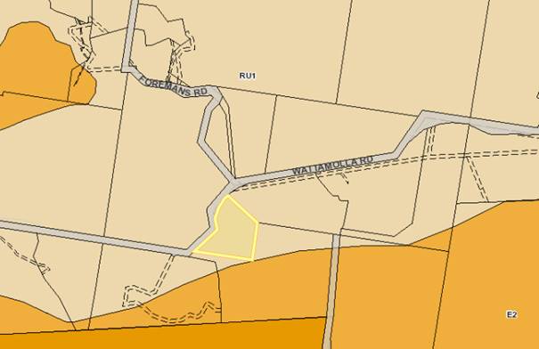
History
The following provides details on pre-lodgement
discussions, post-lodgement actions and general site history for context:
· The application was lodged on 9 March 2020.
· As a result of detailed assessment of the application,
additional information was requested from the applicant on two (2) occasions
– 12 March 2020 and 11 June 2020.
· On 27 May 2020 and 18 June 2020, the applicant submitted
additional information, which was subsequently referred to the relevant
sections of Council for comment.
Issues
Council’s Development Control Plan (DCP) Controls:
The application proposes some
performance-based solutions with regard to the Shoalhaven Development Control
Plan 2014 (SDCP 2014).
The application proposes
performance-based solutions in place of the following acceptable solutions set
out in Chapter G12 (A18.1) and Chapter G15 (A1.1, A1.2, A2.1, A12.1, A24.1
& A25.1). The performance-based solutions are discussed below.
Performance Based Solution
to Setback Distances for Dwellings Located in the RU1 Zone – Chapter G12
(Acceptable Solution A18.1)
Acceptable solution A18.1
specifies that dwellings are to have a front setback of 30m to the primary road
frontage.
The proposal
includes the construction of a dwelling house 22.99m from the Wattamolla Road
frontage (primary road frontage). This represents a
7.01m (23.4%) departure to the setback distances set by A18.1
Applicant’s Submission
The applicant provided the following
justification for the proposed performance-based solution:
The
DCP variation that this application seeks is to Acceptable Solutions A18.1 of
the Shoalhaven Development Control Plan 2014 – Chapter G12 Dwelling
Houses and Other Low-Density Residential Development. This acceptable solution
requires dwellings be setback from the front boundary by 30m. The proposed
dwelling is setback by 22.99m from the front boundary. The existing garage to
be converted to a tourist cabin is currently setback 26.971m from the front
boundary. The front boundary is to the west of the proposed dwelling and is
adjacent to Wattamolla Road.
The
Acceptable Solution seeking the variation is as follows, with an extract of
Table 1 provided:
A18.1
Setbacks shall comply with the provisions in Table 1, where the site is located
in the following zones:
· RU1 Primary Production.
· RU2 Rural Landscape.
· RU4 Primary Production Small Lots.
· E2 Environmental Conservation.
· E3 Environmental Management.
· E4 Environmental Living.
· R2 Low Density Residential, where the site area is equal to
or greater than 2000m2.
· R5 Large Lot Residential.
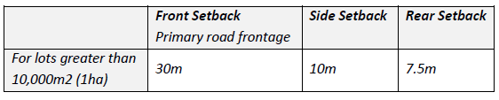
The proposed dwelling requires a
7.01m variation to the 30m setback requirement. This equates to a 23.4%
variation to the Acceptable Solution. There is no proposed change to the
existing setback of the garage. The tourist cabin will retain its 26.971m
setback to the front boundary. Similarly, the existing rural properties in the
surrounding area that also front Wattamolla Road have lesser setbacks to their
associated front boundaries. Figure 15 below shows an annotated image of some
of the nearby properties with setbacks lesser than 30m. These two examples are
within 300m of the subject site and are only two examples of many occurrences
of lesser front setbacks being provide to Wattamolla Road.
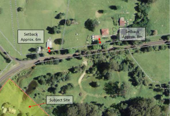
Annotated Image showing existing
properties along Wattamolla Road (SixMaps).
The DCP is structured so that the
Acceptable Solution listed in the DCP is a manner in which the associated
Performance Criteria can be achieved. It should be noted that the proposal is
consistent with the Performance Criteria that the Acceptable Solution relating
to Front Setbacks is under. The Performance Criteria associated with this
variation is as follows, with comment being provided to justifying how the
proposed dwelling is consistent with the criteria.
P18.1 The front
setback is generally consistent with adjoining development and does not
undermine the integrity of the prevailing building lines.
P18.2 The location and
siting of the building complements the existing setbacks in proximity to the
site, foreshore (if applicable) and the streetscape.
P18.3 The proposed
development is setback and of a scale that is relative to the street reserve
width, in such a way to ensure pedestrians do not feel buildings are
overbearing.
As shown in Figure 15 above, the
lesser setback is a frequent occurrence along Wattamolla Road.
The provided setback of 22.99m is
greater than the setbacks of many existing properties in the surrounding area.
The setback provided is therefore generally consistent with the established
setbacks in the area.
The trees along the front boundary on
both the subject site and within the road reserve are to be retained, and as a
result not significantly change the streetscape.
P18.4 Setbacks avoid
loss of view, undue overshadowing and provide/maintain privacy (visual and
acoustic), traffic safety and maintain adequate daylight and sunlight access.
P18.5 Adequate levels
of light and ventilation to adjoining buildings, landscaping, services and
infrastructure are protected.
The positioning of the new dwelling
will not impact on the views experienced by the surrounding properties. The
dwelling will also not introduce any issues with overshadowing or privacy. The
nearest existing neighbouring property is located approximately 225m
north-north-east of the new dwellings position.
The existing driveway will be
retained and continue to provide access to the site. The lesser setback will
have no foreseeable impact on traffic safety onsite, or on Wattamolla Road.
The dwelling has been designed and
orientated to have its living areas located on the northern side of the
building which will provide solar access. The dwelling has access to essential
services, with water and effluent disposal to be managed onsite. The proposed
development will not adversely impact on the services and infrastructure
located around the site. The dwelling will also not overshadow the surrounding
properties.
P18.6 The proposal maintains
adequate provision for on-site car parking.
There are two car parking spaces
provided within the attached garage. The cabins also have sufficient space for
vehicles to park onsite. The proposed setback does not adversely impact the
carparking of vehicle movement on and near the site.
Similarly, to the Performance
Criteria, the Objectives of Section 6.1.2 of this DCP chapter are also achieved
by the proposed development. The objective are listed below, with comment
provided with how the objectives are achieved.
i) Minimise
the visual impacts of elements of the development that exaggerate the built
form and impacts negatively on desired future streetscapes.
The proposed dwelling does not
provide an excessive built form, and is generally consistent in size to other
dwellings throughout the surrounding area. The dwelling has been designed to
have its main living rooms furthest from the front setback, with the garage and
main entry to the dwelling facing towards the street.
ii) Encourage
design that creates desirable living conditions and ensures that the amenity of
surrounding properties is properly considered and not adversely impacted.
The dwelling has been designed to
provide the owner with a desirable and useable space within the rural
landscape. The dwelling will not have a foreseeable impact on the amenity of
the area due to the separation distance between the dwellings location and the
existing properties. The existing vegetation to be retained provides a level of
screening of the development site from the road, and neighbouring properties.
iii) Allow
adequate separation between buildings to promote natural light, solar access,
ventilation, landscaping and privacy.
The dwelling is provided with large
separation distances to ensure the development receives adequate solar access,
ventilation and privacy. The development will have no foreseeable impact on
neighbouring properties in terms of solar access, ventilation, landscaping and
privacy.
iv) Retain
the amenity of the public domain.
The amenity of the public domain will
also not be significantly impacted. The development is considered compatible
and comparable to the established rural properties throughout the surrounding
area. The dwelling will have no foreseeable significant adverse impacts on the
public domain.
It is anticipated that the proposed
front setback variation is considered and supported by Council. Support should
be given due to the existing precedent set in the surrounding area, and that
the setback provided will not have a significant environmental impact as
demonstrated in this Variation Statement.
Discussion
The
proposed development will result in a 7.01m
(23.4%) departure from the acceptable solution setback distances set by A18.1.
The
relevant performance criteria are:
|
P18.1 – The front setback is generally
consistent with adjoining development and does not undermine the integrity of
the prevailing building lines.
|
|
P18.2 – The location and siting of the
building complements the existing setbacks in proximity to the site, foreshore
(if applicable) and the streetscape.
|
|
P18.3 - The proposed development is
setback and of a scale that is relative to the street reserve width, in such
a way to ensure pedestrians do not feel buildings are overbearing.
|
|
P18.4 - Setbacks avoid loss of view, undue
overshadowing and provide/maintain privacy (visual and acoustic), traffic
safety and maintain adequate daylight and sunlight access.
|
|
P18.5 - Adequate levels of light and
ventilation to adjoining buildings, landscaping, services and infrastructure
are protected.
|
|
P18.6 - The proposal maintains adequate
provision for on-site car parking.
|
The proposal includes the
construction of a new dwelling house. As noted in the applicant’s
justification for the performance-based solution, the proposed location of this
building is not inconsistent with the character of the area.
The subject land is not mapped as “scenic
protection” on the Scenic Protection Area Map in the Shoalhaven LEP
2014. The proposed dwelling will not be visible from residences on
adjoining properties and will largely be screened from view from Wattamolla
Road by existing vegetation. It is considered that the location of the proposed
dwelling will not have a significant or detrimental visual impact and the
siting of the proposed buildings is appropriate.
Figure 8 - View of proposed development site
when viewed from access driveway
near residence to the north-east of subject site[1].
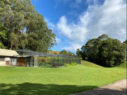
Figure 9 - Photo of dwelling site and
existing vegetation when viewed
from Wattamolla Road.
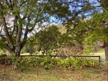
It is
recommended that the performance-based solution relating to setback distances
for dwellings in the RU1 zone be supported for the following reasons:
· The
proposed development will not have a significant impact on the environmental
attributes or scenic qualities area.
· The
proposed dwelling is located >200m from the adjoining residences and it is
not anticipated that the construction of the proposed dwelling house would
result in a significant or adverse impact on local amenity.
· The
proposal is consistent with Performance Criteria P18.1 – P18.6 Chapter
G12 Shoalhaven DCP 2014.
Performance Based Solution
to Floor Area for Tourist Cabins - Chapter G15 (Acceptable Solution A1.1)
Acceptable
solution A1.1 specifies the floor area of a single tourist cabin does not
exceed 120m².
The proposal includes the
conversion and use of an existing dwelling and detached garage to create
2 tourist cabins. The proposed tourist cabin (existing garage conversion) has a
floor area including verandahs of 86m² and therefore complies with this
requirement. The proposed tourist cabin (existing dwelling conversion) comprises
of an internal ground floor of 79.8m², internal elevated loft area of
51m² and external verandah area of 50m² (total floor area =
180.8m²).
As noted in the
Dictionary section of Shoalhaven DCP 2014:
Floor area of a guestroom or tourist cabin when
used in reference to Chapter G15: Tourist and Visitor Accommodation means the
area of a guestroom or tourist cabin, measured within the finished surfaces of
the walls, and includes the area occupied by any cupboard or other built-in
furniture, fixture or fitting and all decks and verandahs.
As such, the proposed tourist
cabin (existing dwelling conversion) exceeds the floor area requirements set by
A1.1 by 60.8m² (50.6%).
Applicant’s Submission
The applicant provided the
following justification for the proposed performance-based solution:
The DCP
Acceptable Solutions A1.1 and A1.2 of the Shoalhaven Development Control Plan
2014 – Chapter G15: Tourist and Visitor Accommodation states:
A1.1 The floor area of a single tourist cabin does not exceed
120m².
A1.2 The building does not exceed one storey in height.
The
proposed cabin (existing dwelling) has a ground floor component of 79.8m²,
the loft has an area of 51m², and the total verandah area equates to
50m². The total combined area would therefore equate to 180.8m². The
cabin is provided with a loft storage area which is considered an additional
storey to the cabin.
The DCP
definition is defined as follows:
Floor area
of a guestroom or tourist cabin when used in reference to Chapter G15: Tourist
and Visitor Accommodation means the area of a guestroom or tourist cabin,
measured within the finished surfaces of the walls, and includes the area
occupied by any cupboard or other built-in furniture, fixture or fitting and
all decks and verandahs.
The
proposed cabin under this definition exceeds the floor area by 60m2. However,
it is noted that the loft and verandahs equate to over 100m2 of the total floor
area, and provided dimensions restricting their use as a habitable room, and do
not significantly increase the scale of the cabin. The verandahs are variable
in width, with the east and west elevations having widths of 1.785m, and 2m to
the verandah to the north.
Where
strict numerical compliance with the Acceptable Solutions cannot be
demonstrated, the associated Performance Criteria must be achieved. The
proposal is consistent with the Performance Criteria that the Acceptable
Solutions requesting the variation is under. The associated Performance Criteria
are as follows:
P1.1 Visual impact on scenic, natural landscape and adjoining
properties is minimised.
P1.2 Visual impact is not excessively impacted by the scale or
built form of the development.
P1.3 Materials and built form are sympathetic to the character
of the area.
The
proposed change of use of the existing dwelling to a cabin will have no
significant visual impact on scenic, natural landscape and adjoining
properties. The cabin, although exceeding the numerical floor area control and
single storey requirement is an appropriate size and scale, not dissimilar to
existing developments throughout Woodhill. The floor area, scale and bulk of
the cabin is unchanged as a result of this application. The additional dormer
window originally proposed to the loft area has been removed from this
application. This further ensures that the visual impact of the cabin does not
change, and reduces the two storey appearance of the cabin.
The
existing trees, vegetation, topography, and separation distances to the
surrounding properties assist in retaining the amenity and rural character of
the area.
Similarly
to the Performance Criteria, the Objectives of the DCP chapter are achieved by
the proposed development. The objectives are listed below, with comment
provided with how each Objective is achieved:
i) Provide development guidelines for bed and breakfast
accommodation and tourist development in rural areas.
ii) Conserve the rural character and environmental quality of
the local area enjoyed by residents of, and visitors to Shoalhaven.
iii) Address issues of cumulative impact and ecologically
sustainable development.
iv) Encourage innovative, well-designed, quality development
which will support and enhance tourism.
v) Encourage sustainable design and eco-tourism.
vi) Encourage tourist facilities with a range of support
infrastructure.
vii) Protect
the amenity and privacy of adjoining residents.
viii) Provide
opportunities for a range of tourist accommodation in rural areas.
ix) Ensure that the density of development in a particular
locality is appropriate to the constraints of the land and is sustainable in
the long term.
x) Discourage permanent occupation of development approved for
tourism purposes.
xi) Provide management guidelines for tourist accommodation.
xii) Provide
guidelines for community title subdivision.
xiii) Maintain
the agricultural potential and prevent fragmentation of rural land.
xiv) Recognise
the risk of natural hazard in some areas and ensure that development is designed
and located to minimise this risk.
xv) Ensure
vehicular access is safe and adequate for the scale of the proposed
development.
xvi) Conserve and
complement any natural or heritage characteristics of buildings and places.
The
proposed development has demonstrated compliance with the relevant DCP
Controls, and where strict compliance with the Acceptable Solutions is not
achieved, the development has demonstrated that the associated Performance
Criteria and Objectives have been met.
The
proposed development will retain the rural character of the area, and has been
designed to accommodate the environmental constraints of the site. The proposed
variation to DCP Chapter G15 will not significantly impact on the existing
properties throughout Shoalhaven and will provide additional tourist capacity
to the South Coast.
The
cumulative impacts and ecological sustainability of the development is
considered positive within the surrounding context. This application seeks to
retain the existing structures onsite as tourist cabins, to provide the client
with the opportunity to operate a small-scale tourist accommodation. This is
not dissimilar to other tourist accommodations located in the surrounding area.
The
development provides tourist accommodation within the existing rural landscape,
while not significantly impacting of the existing amenity of the area. The
existing access to the site will be retained to access both the dwelling and
proposed tourist cabins. The proposed dwelling will ensure the tourist cabins
will be managed appropriately by the owners.
It is considered unreasonable to require the cabin to
reduce its floor area to comply with the DCP Acceptable Solution when the
proposed development is able to satisfy both the Performance Criteria and the Objectives
of the Tourist and Visitor Chapter.
Discussion
The proposed tourist cabin
(existing dwelling conversion) proposes a performance based solution with the
development and exceeds the floor area requirements set by A1.1 by 60.8m²
(50.6%).
The
relevant performance criteria are:
|
P1.1 – Visual impact on scenic,
natural landscape and adjoining properties is minimised.
|
|
P1.2 – Visual impact is not
excessively impacted by the scale or built form of the development.
|
|
P1.3 - Materials and built form are sympathetic to the
character of the area.
|
The applicant’s justification for the
performance-based solution is largely agreed with.
It is also noted that the proposed tourist cabin would
almost comply with the DCP tourist cabin floor area controls if it were not for
the internal raised loft area. The internal raised loft area although useable
would not be considered a habitable space because of the reduced ceiling
height.
Figure
10 – Photo of loft/storage space in existing dwelling
Figure 10 - Section through loft/storage area
in proposed tourist cabin
(existing dwelling conversion).
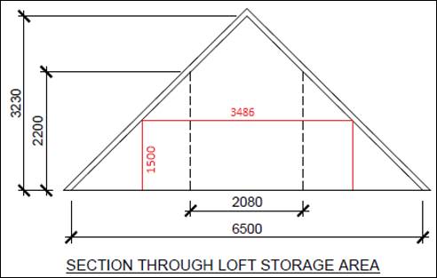
Part 3.8.2 – Room Heights
of Volume 2 of the NCC 2019 Building Code of Australia specifies that in order
to be considered a habitable room, an attic must have a ceiling height not less
than 2.2m for at least two-thirds of the floor area of the room or space. It is
noted, in calculating floor area for the purposes of Part 3.2.2 of the
NCC 2019 BCA, any part of the ceiling less than 1.5m is not included.
The above section is largely
representative of the full length of the upper loft storage area. In order to
be considered a “habitable room” the width of the loft area with a
ceiling height >2.2m must be more than a 2.3m (two-thirds) of the floor
area width of the loft area (loft floor area excludes any floor area
with a ceiling height <1.5m).
As shown in Figure 11 only 2.08m
width of the loft floor area has a ceiling height >2.2m and therefore
the loft area cannot be considered a habitable room under NCC 2019 Building
Code of Australia.
As noted in the
applicant’s justification for the performance-based solution the raised
loft area will be used for storage. Recommended conditions of consent will
require that the loft area be used only for storage purposes and must not be
used as a habitable space.
The existing dwelling has a
building footprint of approximately 130.8m² which is not inconsistent with
other tourist cabins and the bulk and scale of the building is compatible with
the rural character of the area.
The applicant’s
justification for the performance-based solution also notes that A1.2 specifies
that tourist cabins must not exceed 1 storey in height. Despite having a raised
loft area, it is considered that the building still predominantly presents as a
single storey building.
Figure 11
Photo of existing
dwelling (proposed tourist accommodation) viewed from south-west.
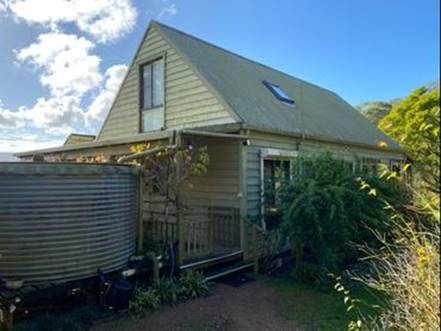
Figure 12 - Photo of existing dwelling
(proposed tourist accommodation)
viewed from north-east.
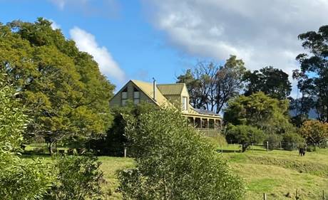
It is
recommended that the performance-based solution be supported for the following
reasons:
· The existing dwelling has a building footprint of
130.8m², 51m² of which is open verandah area. The internal raised
loft area adds to the floor area; however, this loft area should not be
considered as habitable space and recommended conditions of consent will
require it to be used for storage purposes only.
· The proposed tourist cabin (existing dwelling conversion)
presents as a single storey building (the loft is contained within the roof
space).
· The proposed tourist cabin (existing dwelling conversion)
is located >150m away from the residences on adjoining properties and is
largely screened from view.
· The proposal does not increase the floor area or building
footprint of the existing dwelling.
· The design and proposed building materials for the
buildings is appropriate and sympathetic to the rural character of the area.
· Modifying the development that is by way of example,
removing verandahs and roof space to achieve numeric compliance would not
result in any substantial improved environmental planning outcomes or a better
development.
· The proposal is consistent with Performance Criteria P1.1,
P1.2 & P1.3 of Chapter G15 Shoalhaven DCP 2014.
Performance Based Solution
to Setback Distances for Tourist Cabins - Chapter G15 (Acceptable Solution A2.1
and A12.1)
Acceptable solutions A2.1 and
A12.1 specify that tourist cabins are to be setback 30m from adjoining property
boundaries.
The proposal includes the
conversion and use of an existing dwelling and detached garage to tourist
accommodation. The proposed tourist cabin (existing garage conversion) is setback
26.971m from the Wattamolla Road frontage and >30m from all other property
boundaries. The proposed tourist cabin (existing garage conversion) represents
a 3.029m (10%) departure to the 30m setback distance set by A2.1 and A12.1.
Applicant’s Submission
The applicant provided the
following justification for the proposed performance-based solution:
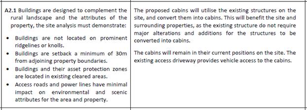
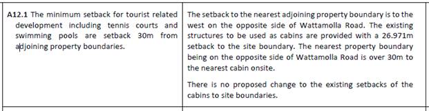
Discussion
The proposed development will result in a 3.029m (10%) departure to the setback distances set by A2.1 and
A12.1
The
relevant performance criteria are:
|
P2 – Areas with identified
environmental attributes and/or scenic protection are conserved and
protected.
|
|
P12 – To conserve the rural character
of a locality and the amenity enjoyed by local residents and neighbouring
properties is preserved.
|
The location of this building is
not inconsistent with the character of the area and is an already approved
residence.
The proposed tourist cabin
(existing garage conversion) is not visible from any adjoining residences and
is largely screened from view from Wattamolla Road by existing vegetation. It
is considered that the proposed conversion of the existing dwelling and existing
detached garage will not have a significant or detrimental visual impact and
the siting of the proposed buildings is appropriate.
It is
recommended that the performance-based solution be supported for the following
reasons:
· The
building exists, and thus the physical impacts of the development are known.
· The
proposed development will not have a significant impact on the environmental
attributes or scenic qualities area.
· It
is considered that acoustic and visual privacy between adjoining residences
would be maintained.
· The
proposed tourist cabins (existing dwelling and garage conversions) are located
>150m to residences on adjoining properties and are screened from view.
· It
is not anticipated that the conversion of the building to tourist and visitor
accommodation would result in a significant or adverse impact on local amenity.
· The
proposal is consistent with Performance Criteria P2 and P12 of Chapter G15
Shoalhaven DCP 2014.
Performance Based Solution
to Minimum Land Area Required for Tourist Cabins - Chapter G15 (Acceptable
Solution A24.1 and A25.1)
Acceptable solutions A24.1 and
A25.1 specify that a land area of 2ha is recommended for the construction of
1-2 tourist cabins.
The proposal includes the
conversion and use of an existing dwelling and detached garage to create 2
tourist cabins. The subject site has a land area of 1.95ha which represents a
shortfall of 0.05ha (2.5%) to the land area specified A24.1 and A25.1.
Applicant’s Submission
The applicant provided the following
justification for the proposed performance-based solution:
The subject
site is approximately 1.95ha in area. This equates to a 2.5% variation to the
DCP controls, which is considered to be a minor variation. The Acceptable
Solutions seeking the variation is as follows:
A24.1 A minimum area of two (2) hectares is required for all
forms of tourist development in rural areas;
A25.1 The
number of cabins permitted is outlined in the table below:
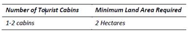
The proposal is for two cabins to be
used as short-term holiday accommodation. As identified in this Statement of
Environmental Effects, there are similar sized tourist development in the
surrounding area. Of particular note, the tourist development located to the
north-north-east of the site is approximately 1.35ha in area, which is also
below the 2ha control.
There would be no foreseeable benefit
in having an additional 0.05ha to the site. There is sufficient area for the
site to support the two cabins, with the proposed use not likely to significantly
impact on the surrounding properties and amenity of the area.
The proposed development is deemed to
satisfy the Performance Criteria that the Acceptable Solutions requesting the
variation are under. The Performance Criteria associated with this variation is
as follows, with comment being provided to justifying how the proposed dwelling
is consistent with the performance-based criteria.
P24 Sufficient area
is available for the development so as to not impact on surrounding land use or
amenity of the locality.
P25 Density of
tourist cabins and guesthouses should be of a rural nature and be consistent
with the surrounding areas.
As demonstrated throughout the
Statement of Environmental Effects and DCP Compliance Table, the proposed
development is considered capable of supporting the two tourist cabins and new
dwelling. There is sufficient area for the cabins in their current positions to
retain the privacy and not significantly impact on residence in the surrounding
area.
The density and scale of the tourist
cabins is considered small, and fitting to the size of the site. The two
tourist structures and new dwelling are in keeping with the existing
developments throughout the surrounding area.
The use of the existing structures,
and changing their use to tourist cabins is advantageous. This reduces the
potential impacts of the development, by retaining the structures in their
existing positions. The cabins are clustered together, with the proposed
dwelling located to the south.
The dwelling will provide surveillance
opportunities of the cabins for management purposes. Similarly to the
Performance Criteria, the Objectives of Section 5.3 of this DCP chapter are
also considered to be achieved by the proposed development. The objectives are
listed below, again with comment provided with how the objectives are achieved.
i) Ensure
the density of development is sustainable and has minimal impact on the
environment.
ii) Provide
tourist development forms that is compatible the rural character of the area.
iii) Ensure
the impact of development on the amenity of rural areas is maintained and the
impact on neighbouring areas is minimised.
iv) Ensure
that native vegetation and water quality is protected.
v) Ensure
that multiple forms of tourist development on one property are consistent with
the acceptable density standards.
The
development consists of two tourist cabins which is deemed suitable to the
subject site. The development will have minimal impact on the surrounding
properties. Changing the use of the existing structures for use as tourist
cabins benefits the environment and existing character. The structures are
comparable to similar structures within the rural setting. There is only one
proposed type of tourist accommodation on the site. The scale of the tourist
accommodation is considered low, with minimal impact on the site and
surrounding areas during operation.
The
proposed tourist cabins and dwelling will have no significant impact on the
existing vegetation and watercourses onsite and in the surrounding area. The
existing trees onsite will be retained. The existing trees and vegetation
currently provide screening of structures. The proposal is considered to
achieve both the relevant Performance Criteria and Objectives outlined above.
It is anticipated that this variation provided be considered and supported by
Council.
Discussion
The proposed development would result in a shortfall
of 0.05ha (2.5%) to the land area specified by A24.1 and A25.1.
The
relevant performance criteria are:
|
P24 – Sufficient area is available for the
development so as to not impact on surrounding land use or amenity of the
locality.
|
|
P25 – Density of tourist cabins and guesthouses
should be of a rural nature and be consistent with the surrounding areas.
|
The proposed shortfall in the
recommended land area for 1-2 tourist cabins is minor and would be
imperceptible.
The proposed tourist cabins are
located >150m away from any adjoining residence and are screened from view.
It is considered that the proposed development and minor shortfall to land area
requirements would not have significant or adverse impact on local amenity.
The
surrounding area is characterised by smaller rural-residential lots and it is
considered that the building design and tourist cabin density is not
inconsistent with the rural character of the area.
It is
recommended that the performance-based solution be supported for the following
reasons:
· It
is considered that acoustic and visual privacy between adjoining residences
would be maintained.
· The
proposed tourist cabins (existing dwelling and garage conversions) are located
>150m to residences on adjoining properties and are screened from view.
· It
is not anticipated that the conversion of the building to tourist and visitor
accommodation would result in a significant or adverse impact on local amenity.
· The
proposed building design and tourist cabin density is not inconsistent with the
rural character of the area.
· The
proposal is consistent with Performance Criteria P24 and P25 of Chapter G15
Shoalhaven DCP 2014.
Planning Assessment
The DA has been assessed under
s4.15(1) of the Environmental Planning and Assessment Act 1979. Please refer to
Attachment 1.
Consultation and Community
Engagement:
Notification was undertaken in
accordance with Council’s Community Consultation Policy with letters
being sent within a 200m buffer of the site, during the period 12 to 27 March
2020.
37 objections and 13 submissions
of support were received in relation to the development.
Key issues raised in objections
are as follows and are discussed below.
|
Objection Raised
|
Assessing Officer Comments
|
|
Concerns with effluent
management and water quality
|
The application has been
supported by an effluent management report which demonstrates that there is
adequate area on site to adequately manage increased load from the proposed
new dwelling house and proposed tourist cabin (garage conversion).
The proposed tourist cabin
(existing dwelling conversion) will be managed via the existing on-site
effluent management system. As per comments from Water NSW it is considered
that effluent from the tourist accommodation can be suitably managed on site
either via the existing septic system or proposed new aerated wastewater
treatment system.
The application and effluent
management report have been reviewed by Council’s Environmental Health
department and also Water NSW with no objection being raised. Concurrence has
been granted by Water NSW under clause 11 of SEPP (Sydney Drinking Water
Catchment) 2011.
It is considered that the
proposed development will not have a significant or adverse impact on water
quality.
|
|
Privacy to adjoining residences
|
The proposed new dwelling
house is located >200m from residences on adjoining land and is largely
screened from view from adjoining properties and also from Wattamolla Road by
existing vegetation.
The proposed tourist cabins
(existing dwelling and garage conversion) are located >150m from
residences on adjoining land and are largely screened from view from
adjoining properties and also from Wattamolla Road by existing vegetation.
It is considered that the
proposed development will not have a significant adverse impact on the
amenity of adjoining properties.
|
|
Impact of tourist
cabins on local amenity (noise, anti-social behaviour etc.)
|
Proposed tourist cabins are
located >150m from residences on adjoining land.
As per the submitted Statement
of Environmental Effects, tourist cabins will be operated and managed by the
residents living in the proposed new dwelling house.
It is not considered that the
proposed tourist cabins can be appropriately managed and would have a
significant adverse impact on the amenity of adjoining properties.
|
|
Visual impact
|
The proposed development is
largely screened from view from residences on adjoining properties and also
from Wattamolla Road by existing vegetation.
The proposed buildings are appropriately designed and
located and compatible with the rural character of the area.
|
|
“Variations”
to DCP acceptable solutions (floor area for tourist cabins, single storey
development, setback distances, minimum site area for tourist cabins etc.)
|
The application proposes some performance-based solutions
with regard to Chapter G12 and G15 of the Shoalhaven DCP 2014 which have been
assessed in light of performance criteria and chapter objectives. The
performance solutions have been considered in this Development &
Environment Committee Report and in the 4.15 assessment report and are
appropriate. Council assessment staff are satisfied that the proposed
development is consistent with the applicable objectives and performance
criteria set out in the Shoalhaven DCP 2014.
|
The assessment of the
application considered the matters raised in the submissions concluded that the
application should be supported.
Financial Implications:
There are potential cost
implications for Council in the event of a refusal of the application. Such
costs would be associated with defending an appeal in the Land and Environment
Court of NSW.
Legal Implications
A section 8.2 review and / or an
appeal with the Land and Environment Court are possible if the application is refused.
Summary and Conclusion
The proposed development is
compliant with the provisions of SLEP 2014 and it is considered that the
proposed performance-based solutions to SDCP 2014 are supportable and that the
proposed development is consistent with the performance criteria specified in
SDCP 2014.
This application has been
assessed having regard for section 4.15 (Matters for consideration) under the
EP&A Act and has been subjected to detailed analysis of the main issues
identified in this report, being departures from SDCP 2014 acceptable
solutions. These issues have also been investigated and addressed by the
applicant.
Having regard to the assessment, the proposal is considered
capable of support as there are no substantive planning reasons to warrant refusal.
Accordingly, it is recommended it is approved subject to the recommended
conditions of consent as per Attachment 2.
|
|
Development
& Environment Committee – Tuesday 04 August 2020
Page
0
|
DE20.84 Report
- Quarterly Review for Compliance Matters
HPERM Ref: D20/309001
Section: Building
& Compliance Services
Approver: Phil
Costello, Director Planning Environment & Development Group
Attachments: 1. List
of penalties issued from 1 April 2020 to 30 June 2020 via offence Code ⇩
Reason for Report
At Council’s Ordinary meeting held on 13 November 2018
it was resolved to receive a detailed quarterly report on compliance activities
(MIN18.907).
This report provides
information on the period from 1 April 2020 to 30 June 2020 (final quarter
2019/2020).
|
Recommendation
(Item to be determined under delegated authority)
That
the quarterly review for compliance matters report be received for
information.
|
Options
1. Council receive the
report for information.
Implications: Nil
2. Council receives the report and provides
additional direction for future reports.
Implications: Any changes or additional matters can
be added to future reports.
Report
Compliance activities are completed by the following Teams
within the Planning, Environment and Development Group:
(a) Compliance Team:
Development compliance matters including unauthorised development, development
not in accordance with development consent, land, and water pollution incidents
(including building sites), land use management issues, fire safety and
swimming pool safety issues.
(b) Environmental
Health: Pollution incidents (noise and water), environmental incidents,
food shops and the operation of on-site sewage waste management facilities.
(c) Parking: All
parking offences.
(d) Rangers:
Animal control, littering, unauthorised camping, rubbish dumping and other
environmental offences.
This report provides Councillors with an update on the penalties
issued (number, type, and ticket value), penalty reviews dealt with by the
Review Panel and any Local or Land and Environment Court matters determined or
progressing.
This report relates to compliance actions from 1 April 2020 to
30 June 2020 (final quarter).
Penalties issued during the period
A combined total of 1,041 penalty notices were issued by the
Teams during the period. These penalties have a face value of $307,151.
Historically Council stands to receive approximately 70% of this ticketed
figure.
A total of 212 cautions were also issued during the period.
Attachment 1 to this report provides a breakdown of the
penalties and cautions issued during the period. The following is a
summary of the penalties issued for each team:
|
April – June 2020
|
Number Issued
|
Total Amount
|
% of total amount
|
Cautions issued
|
|
Compliance
|
7
|
$11,600
|
3.78%
|
26
|
|
Compliance - Fire Safety
|
1
|
$200
|
0.06%
|
0
|
|
Compliance – Pools
|
3
|
$1,650
|
0.53%
|
0
|
|
Environmental Health
|
2
|
$9,000
|
2.93%
|
0
|
|
Rangers – Animal issues
|
513
|
$171,640
|
55.88%
|
73
|
|
Rangers – Environmental issues
|
147
|
$46,744
|
15.22%
|
11
|
|
Parking
|
368
|
$66,317
|
21.60%
|
102
|
|
Sewer Management Facility
|
0
|
0
|
0
|
0
|
|
Total
|
1,041
|
$307,151
|
100%
|
212
|
Penalties related to Compliance issues
The following details are provided in relation to the 7
compliance penalty notices issued in this quarter:
(a) Tomerong ($1,500): One penalty notice was
issued to the owner for development without development consent (Individual -
$1,500). The owner rebuilt a shade structure that had previously been
demolished through Council’s order process. The owner was aware that both
development consent and construction certificate were needed for this work.
(b) Bomaderry ($1,500):
One penalty notice was issued to the builder for development without consent.
Approval was required for the demolition and reconstruction of a timber framed
awning and decking on the bush fire prone allotment. The development was being
constructed in BAL-Flame Zone.
Council demonstrated leniency in this matter by issuing 2 warning
notices and the value of these would have resulted in a further financial
penalty of $3000.
(c) Bomaderry ($1,500):
One penalty notice was issued to the owner for development without development
consent relating to the construction of a swimming pool.
The matter came to Council’s attention following
receipt of an application for a Compliance Certificate for the swimming pool.
During the desktop assessment, the Officer confirmed no approval had been
sought or granted for this development.
The Compliance Officer worked with the owner for many
months assisting them through the Building Information Certificate (BIC)
process as well as bringing the swimming pool barrier into compliance.
(d) Culburra Beach ($1,100):
Two penalty notices were issued for breaches against the Plumbing and Drainage
Act. The plumber failed to seek approval for plumbing and drainage work in
accordance with Section 68 of the Local Government Act 1993.
Five breaches were identified. Two penalty notices (2 x
$550) and 3 warning notices were issued. The plumber failed to provide notice
of work to the plumbing regulator and failed to provide a certificate of
compliance within required timeframe.
The value of the warning notices if issued as Penalty
Notices, would have incurred a financial penalty of $2,750.
(e) Sussex Inlet
($3,000): One penalty notice issued for failure to comply with the terms of
a development control order. In this case the penalty notice was issued to an
individual.
Council’s Compliance Officer issued a Stop Use Order
and a Demolish Works Order which related to an unauthorised shed located at the
premises.
The allotment has a dwelling entitlement, however a dwelling
has not yet been constructed. The shed can only exist as ancillary to an
existing dwelling.
The owner is a repeat offender who has a considerable prior
history of non-compliance.
(f) Sanctuary
Point ($3,200): Two penalty notices were issued to the owner of the
premises (a corporation). The penalty notices relate to development without
development consent (Class 1a or 10 building - $3000) and for not ensuring
there are smoke alarms installed (Compliance - Fire Safety - $200). A further
three (3) warning notices were issued.
The matter came to Council’s attention following a
call from the tenant stating the garage had been converted into two flats.
Compliance Officers inspected the garage and confirmed a dual occupancy had
been constructed without consent in addition to other unauthorised internal
works within the main dwelling.
The value of the warning notices if issued as penalty notices,
would have been $9,000.
Warnings related to Compliance issues
A total of 26 warning notices were issued for compliance related
matters in the period. These warnings equate to $31,196 in penalty notice face
value. The caution rate for Compliance actions in this period is 72.9%.
Penalty infringement panel reviews
During the period, the review panel met only once on 4 June
2020. A total of two (2) penalty infringement appeals were considered at this meeting.
(a) Fail to comply with terms
of development control order - Corporation – (1 x $6000): The penalty
notice subject to this review related to the failure to comply with the terms
of a development control order (Corporation).
The initial investigation centred around the use of
the property located in Woollamia for short-term tourist and visitor
accommodation. This included habitable use of the garage and use of the
property for primitive camping without consent. Council had previously issued a
formal caution for the same offence in November 2019.
The property was again identified as being used for
primitive camping despite the issue of an emergency stop use order. Concern for
onsite effluent disposal was a key issue in the original complaint to Council.
Whilst the property owners have lodged a Development
Application for future use of the property for glamping, Council needed to send
a clear message that this application must be determined favourably prior to
the proposed use commencing.
The panel decided the penalty should stand.
(b) Fail to comply with terms of
development control order – Individual - (1 x $3000): The penalty
notice subject to review related to the failure to comply with terms of
development control order (individual).
A property was identified as one of a number of properties
in the Jerberra Estate where unauthorised structures had been erected. Council
wrote to the owners back in December 2017 to ascertain what their intentions
were to address the unauthorised structures located on the property. No
response was received.
A demolition order was issued directing the owner to remove
the steel-clad shed. No response or representations had been received from the
owner concerning either the notice or the order.
During this time the property was sold to the current owner.
The orders automatically transfer to successors of title in accordance with
Schedule 5, Part 11 Clause 26 of the Environmental Planning and Assessment Act .
The current owner was made aware of Council’s actions
in this matter in March 2019 and were afforded ample time to comply. An
inspection in late November 2019 revealed the shed had not been removed.
The panel decided the penalty should stand.
Land and Environment Court matters
(a) Tomerong – The
property is located within the Jerberra Estate and was identified in Council
audits as being land upon which unauthorised dwellings had been constructed and
permanently occupied. On 27 September 2012 Orders were made in the Land and
Environment Court (L&EC) regarding the property. Amongst other things, the
order contained the following terms:
1. The
respondents, their servants and agents, be restrained from using, or permitting
to be used, the Land or any buildings or structures on the Land that were
erected without obtaining development consent under Part 4 of the Act.
2. Order
that the respondents, their servants and agents, take all reasonable steps to
prevent the use by any person of Land or any buildings or structures on the
Land (including notifying any successors in title) until the respondents, or
their successors in title, obtain development consent for the use of the Land
in accordance with the Act.
Despite being aware of the Court Orders, the
respondents did not comply with the terms of the orders as the premises
continued to be occupied to the present day.
A conciliation conference was conducted on 4 May
2020. This resulted in the Land and Environment Court determining dates for all
the works to be completed. This matter is now required to be finalised by 15
July 2021.
Compliance Merits received this quarter
Previous quarterly reports have not indicated the number or
type of complaints received by the Compliance Team received through
Council’s customer request management system (Merit). It is considered
important to view these statistics and they will be included in this and all
subsequent quarterly reports.
During the period the Compliance Team received a total of 191
Merits and these are detailed in the following table.
|
Type of Merits Received
|
Number Received
|
Percentage of total
|
|
Asbestos issues
|
2
|
1.05%
|
|
Building Works - Not in Accordance Consent
|
49
|
25.7%
|
|
Building Works - Without Consent
|
94
|
49.2%
|
|
Defective Building Works
|
2
|
1.05%
|
|
Earthworks - Without Consent
|
7
|
3.7%
|
|
Erosion Control - Building Sites
|
2
|
1.05%
|
|
Erosion Control - Subdivision sites
|
1
|
0.5%
|
|
Land Use - Without Consent
|
17
|
8.9%
|
|
Sewerage Management Facility
|
1
|
0.5%
|
|
Stormwater Runoff - Building Site
|
10
|
5.2%
|
|
Swimming Pool Fencing Inspection
|
2
|
1.05%
|
|
Vegetation Clearing - Without Consent
|
4
|
2.1%
|
|
TOTALS
|
191
|
100%
|
Of these Merits, building works
without consent make up 49.2% of all complaints registered in the period. This
is a clear indication that development without consent is still high in the
Shoalhaven.
Other notable statistics are
development not in accordance with consent (25.7%) and land use without consent
(8.9%).
Activities by Ranger Services
(a) Zero Tolerance
– Dog Attacks – Unregistered Dogs: On 21 April 2020, Council
adopted a zero tolerance for all detected unregistered dogs and substantiated
dog attacks. This resolution was to apply to all incidents with penalties to be
imposed. The Ranger Services Unit have amended their procedures to
reflect this position.
Since this resolution and up to 30 June 2020, a total of 76
penalty notices have been issued for unregistered dogs identified in the City
(i.e. 76 X $330 = $25,080). A search of the New South Wales Companion Animals
Register (CAR) has been conducted with a further 256 penalty notices issued to
pet owners for failing to lifetime register their animals (i.e. 256 x $305 =
$78,080).
(b) Beach Patrols: Rangers
have completed 1,222 beach patrols during this quarter. A total of 212 dog
owners have been spoken to with 295 dogs sighted. A total of 98 penalty notices
have been issued with 12 official warnings and 25 verbal cautions given.
(c) COVID-19: Rangers
have continued to assist with the COVID-19 pandemic by patrolling and
monitoring all Council closed assets and public spaces in order to maintained
barriers, closed signage and tape.
Education is provided to the Community on social distancing
and public order requirements while conducting CBD parking and beach patrols.
The Ranger Services Unit assisted with the redeployment of
4 staff members from Council’s Leisure Centre and Library areas.
These Staff members assisted Rangers in their daily duties ensuring COVID-19
controls were maintained across the City.
(d) Illegal Dumping: Rangers
have documented 235 new illegal dumping incidents within the Shoalhaven. Each
incident has been investigated with a total of 54 tonne of illegal waste
recorded. Of this waste, 40% has been identified as household waste with
26 matters remaining under investigation.
One penalty notice for $4,000 was issued for the
offence of “Transport excess waste to unlawful facility – class 1
officer – individual” under the Protection of the Environment
Operations Act 1997. The offender was also issued with a cost compliance
notice of $915 for the associated clean-up costs.
(e) Community Response: Ranger
Services Unit has responded to 1367 complaints in order to meet the needs of
the Community. Of those complaints 761 related to alleged breaches of animal
management. Other concerns raised by the Community related to illegal camping,
parking obstructions, pollution incidents, signs and reserve issues.
(f) Animal Shelter: The
Animal Shelter has changed their procedures to meet with the COVID-19 pandemic.
These changes now see customers required to book an appointment with the
Shelter in order to reclaim or adopt an animal. Potential adoptees are provided
information on the animal at time of the “meet and greet” including
the animal’s needs and requirements to promote responsible pet
ownership.
|
|
Development
& Environment Committee – Tuesday 04 August 2020
Page
0
|
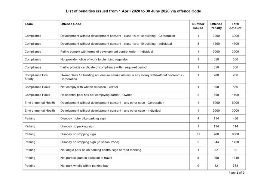
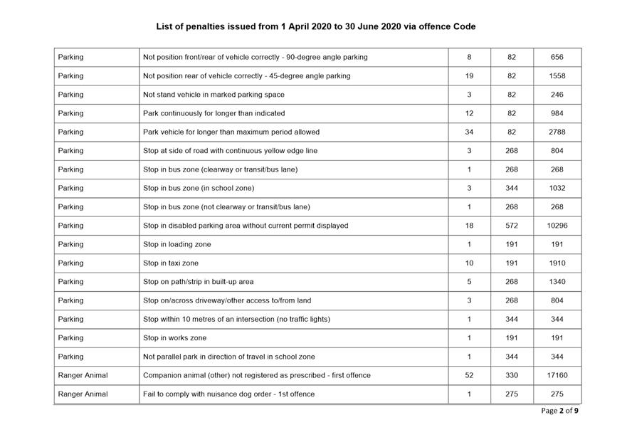
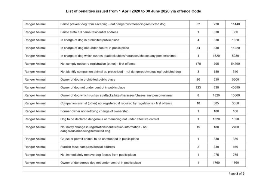
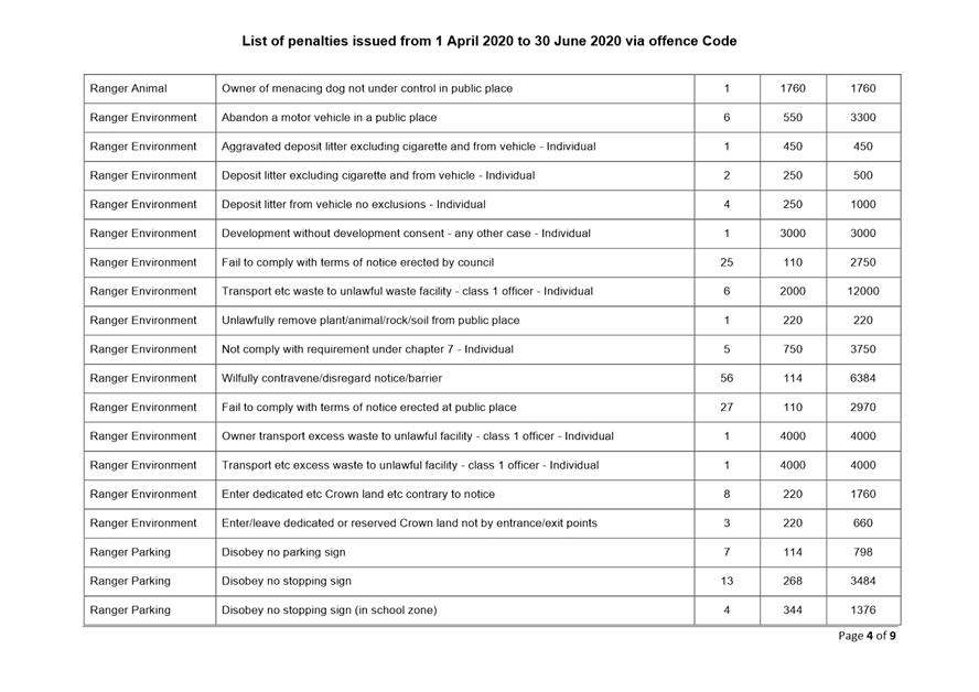
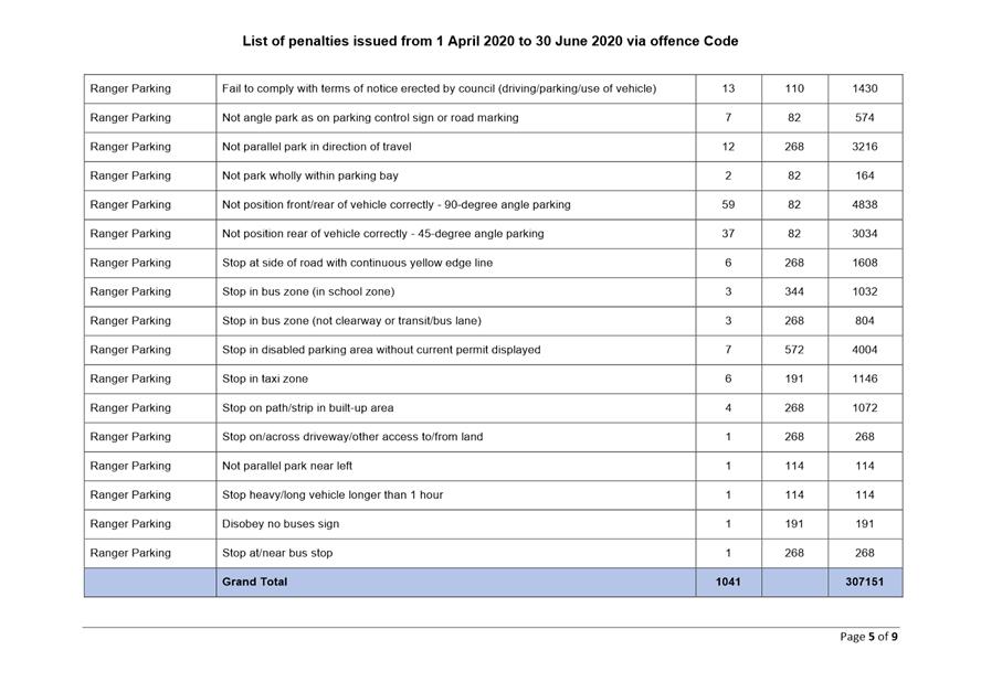
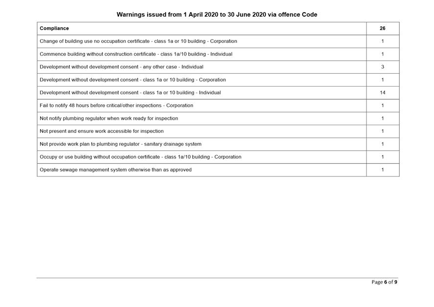
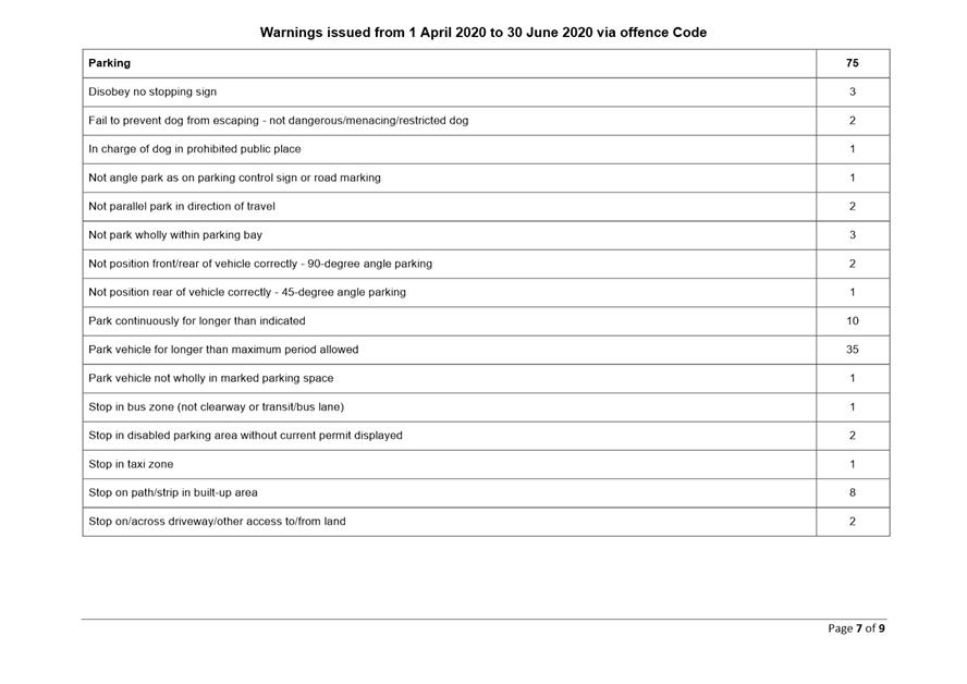
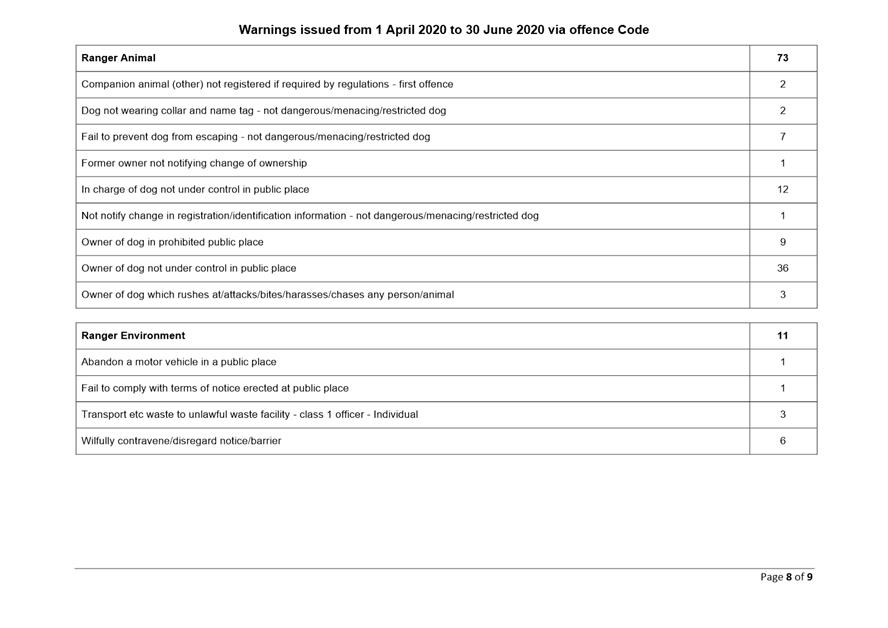
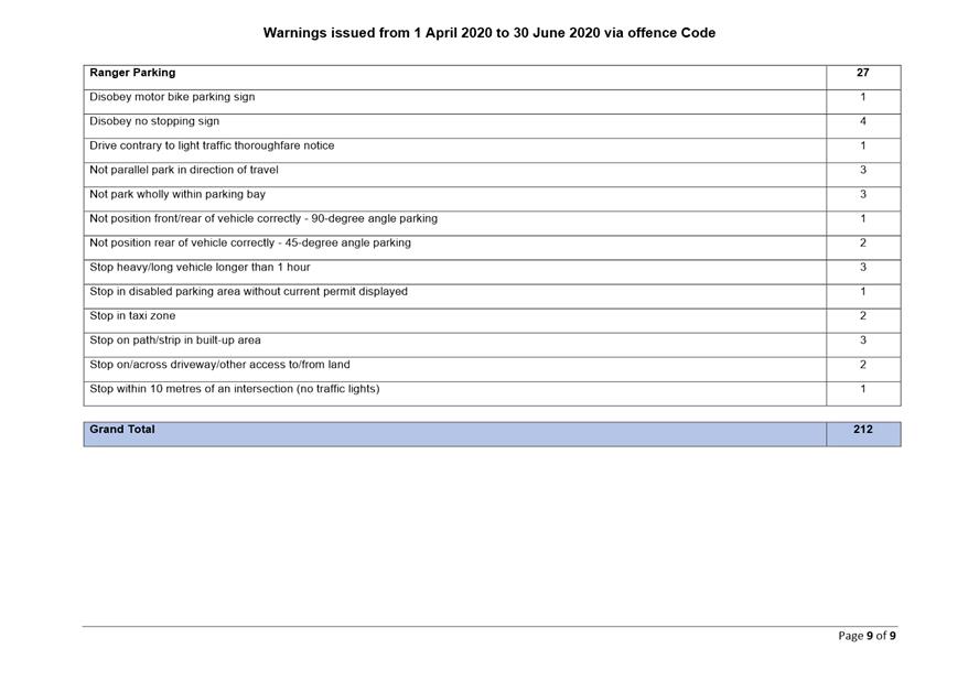
|

|
Development
& Environment Committee – Tuesday 04 August 2020
Page
0
|
Local Government Amendment (governance &
planning) act 2016
Chapter
3, Section 8A Guiding principles for councils
(1)
Exercise of functions
generally
The
following general principles apply to the exercise of functions by councils:
(a) Councils should provide strong
and effective representation, leadership, planning and decision-making.
(b) Councils should carry out
functions in a way that provides the best possible value for residents and
ratepayers.
(c) Councils should plan
strategically, using the integrated planning and reporting framework, for the
provision of effective and efficient services and regulation to meet the
diverse needs of the local community.
(d) Councils should apply the
integrated planning and reporting framework in carrying out their functions so
as to achieve desired outcomes and continuous improvements.
(e) Councils should work
co-operatively with other councils and the State government to achieve desired
outcomes for the local community.
(f) Councils should manage
lands and other assets so that current and future local community needs can be
met in an affordable way.
(g) Councils should work with
others to secure appropriate services for local community needs.
(h) Councils should act fairly, ethically
and without bias in the interests of the local community.
(i) Councils should be
responsible employers and provide a consultative and supportive working
environment for staff.
(2) Decision-making
The
following principles apply to decision-making by councils (subject to any other
applicable law):
(a) Councils should recognise
diverse local community needs and interests.
(b) Councils should consider social
justice principles.
(c) Councils should consider the
long term and cumulative effects of actions on future generations.
(d) Councils should consider the
principles of ecologically sustainable development.
(e) Council decision-making should
be transparent and decision-makers are to be accountable for decisions and
omissions.
(3) Community participation
Councils
should actively engage with their local communities, through the use of the
integrated planning and reporting framework and other measures.
Chapter
3, Section 8B Principles of sound financial management
The
following principles of sound financial management apply to councils:
(a) Council spending should be responsible and
sustainable, aligning general revenue and expenses.
(b) Councils should invest in responsible and
sustainable infrastructure for the benefit of the local community.
(c) Councils should have effective financial
and asset management, including sound policies and processes for the following:
(i) performance management
and reporting,
(ii) asset maintenance and
enhancement,
(iii) funding decisions,
(iv) risk management practices.
(d) Councils should have regard to achieving
intergenerational equity, including ensuring the following:
(i) policy decisions are made
after considering their financial effects on future generations,
(ii) the
current generation funds the cost of its services
Chapter
3, 8C Integrated planning and reporting principles that apply to councils
The
following principles for strategic planning apply to the development of the
integrated planning and reporting framework by councils:
(a) Councils should identify and prioritise key
local community needs and aspirations and consider regional priorities.
(b) Councils should identify strategic goals to
meet those needs and aspirations.
(c) Councils should develop activities, and
prioritise actions, to work towards the strategic goals.
(d) Councils should ensure that the strategic
goals and activities to work towards them may be achieved within council
resources.
(e) Councils should regularly review and
evaluate progress towards achieving strategic goals.
(f) Councils should maintain an
integrated approach to planning, delivering, monitoring and reporting on
strategic goals.
(g) Councils should collaborate with others to
maximise achievement of strategic goals.
(h) Councils should manage risks to the local
community or area or to the council effectively and proactively.
(i) Councils should make appropriate
evidence-based adaptations to meet changing needs and circumstances.