Development & Environment Committee
Meeting Date: Tuesday,
07 April, 2020
Location: Council
Chambers, City Administrative Building, Bridge Road, Nowra
Time: 5.00pm
Membership (Quorum - 5)
Clr Joanna Gash - Chairperson
Clr Greg Watson
All Councillors
Chief Executive Officer or nominee
Please note: The proceedings of this meeting
(including presentations, deputations and debate) will be webcast and may be
recorded and broadcast under the provisions of the Code of Meeting Practice. Your attendance at this meeting is taken
as consent to the possibility that your image and/or voice may be recorded and
broadcast to the public.
Agenda
1. Apologies / Leave of Absence
2. Confirmation of Minutes
· Development
& Environment Committee - 3 March 2020........................................... 1
3. Declarations of Interest
4. Call Over of the Business Paper
5. Mayoral Minute
6. Deputations and Presentations
7. Notices of Motion / Questions on Notice
Nil
8. Reports
Planning Environment & Development
DE20.22...... Development Application – 83 Quay Road,
Callala Beach – Lot 17 Sec N DP 8188........................................................................................................................ 8
DE20.23...... Development Application - DA19/1852 – 43
Tahnee Street, Sanctuary Point – Lot 47 DP 1243551.................................................................................................. 23
DE20.24...... Development Application - 204 Kinghorne St
NOWRA - Lot 1 DP 130928 31
DE20.25...... Development Application – Lake View Drive
BURRILL LAKE– Lot A DP21307 34
DE20.26...... Development Application – 1 Princess Avenue
South Burrill Lake –Lot 47 DP1051945...................................................................................................................... 44
DE20.27...... Landscape Screening and Bushfire Protection
Measures - Planning Proposal (PP029) - Hitchcocks Lane, Berry.............................................................................. 63
DE20.28...... Review - Clause 2.8 Temporary Use of Land,
Shoalhaven LEP 2014....... 77
DE20.29...... Review - Tourist & Visitor Accommodation -
Planning Provisions.............. 83
DE20.30...... Planning Proposal (PP035 ) - Lot 3 DP 846470,
Jervis Bay Road, Falls Creek - Public Exhibition Detail Confirmation......................................................... 101
DE20.31...... Planning for Bush Fire Protection 2019 Adoption...................................... 113
DE20.32...... Bomaderry Creek Bushcare Group Action Plan........................................ 117
DE20.33...... Grant Offer: Moeyan Hill Environmental Works
funded through Catchment Action NSW............................................................................................................ 119
9. Confidential
Reports
Nil
|

|
Development
& Environment Committee – Tuesday 07 April 2020
Page
i
|
Development & Environment
Committee
Delegation:
Pursuant to
s377(1) of the Local Government Act 1993 (LG Act) the Committee is
delegated the functions conferred on Council by the Environmental Planning
& Assessment Act 1979 (EPA Act), LG Act or any other Act or delegated
to Council, as are specified in the attached Schedule, subject to the following
limitations:
i. The
Committee cannot make a decision to make a local environmental plan to classify
or reclassify public land under Division 1 of Part 2 of Chapter 6 of the LG
Act;
ii.
The Committee cannot review a section 8.11 or
section 8.9 EPA Act determination made by the Council or by the Committee
itself;
iii.
The Committee cannot exercise any function delegated
to the Council which by the terms of that delegation cannot be sub-delegated;
iv.
The Committee cannot exercise any function which
s377(1) of the LG Act provides cannot be delegated by Council; and
v.
The Committee cannot exercise a function which
is expressly required by the LG Act or any other Act to be exercised by
resolution of the Council.
Schedule
a. All
functions relating to the preparation, making, and review of local
environmental plans (LEPs) and development control plans (DCPs) under Part 3 of
the EPA Act.
b. All
functions relating to the preparation, making, and review of contributions
plans and the preparation, entry into, and review of voluntary planning
agreements under Part 7 of the EPA Act.
c. The
preparation, adoption, and review of policies and strategies of the Council in
respect of town planning and environmental matters and the variation of such
policies.
d. Determination
of variations to development standards related to development applications
under the EPA Act where the development application involves a development
which seeks to vary a development standard by more than 10% and the application
is accompanied by a request to vary the development standard under clause 4.6
of Shoalhaven Local Environmental Plan 2014 or an objection to the application
of the development standard under State Environmental Planning Policy No. 1
– Development Standards.
e. Determination
of variations from the acceptable solutions and/or other numerical standards
contained within the DCP or a Council Policy that the Chief Executive Officer
requires to be determined by the Committee
f. Determination
of development applications that Council requires to be determined by the
Committee on a case by case basis.
g. Review
of determinations of development applications under sections 8.11 and 8.9 of
the EP&A Act that the Chief Executive Officer requires to be determined by
the Committee.
h. Preparation,
review, and adoption of policies and guidelines in respect of the determination
of development applications by other delegates of the Council.
i. The
preparation, adoption and review of policies and strategies of the Council in
respect to sustainability matters related to climate change, biodiversity,
waste, water, energy, transport, and sustainable purchasing.
j. The
preparation, adoption and review of policies and strategies of the Council in
respect to management of natural resources / assets, floodplain, estuary and
coastal management.
Minutes of the Development & Environment Committee
Meeting Date: Tuesday,
3 March 2020
Location: Council
Chambers, City Administrative Building, Bridge Road, Nowra
Time: 5.00pm
The following members
were present:
Clr Joanna Gash -
Chairperson
Clr John Wells
Clr Patricia White
Clr Kaye Gartner
Clr Nina Digiglio
Clr Annette Alldrick
Clr John Levett
Clr Greg Watson
Clr Mark Kitchener
Clr Bob Proudfoot
Mr Stephen Dunshea -
Chief Executive Officer
|
Apologies / Leave of Absence
|
Apologies were received for Clr Amanda Findley, Clr Kaye
Gartner, Clr Andrew Guile and Clr Mitchell Pakes.
|
Confirmation of the Minutes
|
|
RESOLVED (Clr Digiglio / Clr
Levett) MIN20.155
That the Minutes of the
Development & Environment Committee held on Tuesday 04 February 2020 be
confirmed.
CARRIED
|
Nil
|
Call Over of the
Business Paper
|
|
RESOLVED (Clr Proudfoot / Clr
Levett) MIN20.156
That
the items on the agenda be dealt with as they appear in the paper.
CARRIED
|
|
Procedural
Motion - Matters of Urgency
|
|
RESOLVED (Clr Watson / Clr Gash) MIN20.157
That an additional item
“COVID-19 Preparation” be introduced as a matter of urgency.
CARRIED
|
|
The
Chairperson ruled the matter as urgent as it is a matter of public safety.
|
|
DE20.19 Additional Item - COVID-19 Preparation
|
|
Motion (Clr Watson / Clr Gash)
That the CEO immediately start
the preparation of a response to a possible coronavirus pandemic affecting
Australia and as consequence the Shoalhaven Area.
The plan should be informed by
the following:
1. The
protection of our residents by reducing the risk of exposure through a local
education program and possible closure of Public air-conditioned buildings,
if determined to be necessary, to reduce the potential of virus transmission.
2. Protection
of our employees where practical, by allowing as many as possible to work
from home using computer links as air-conditioning and the close work
environment may aid in the spread of the disease.
3. Monitoring
of the health of employees as they arrive at work.
4. Immediate
representation be made to the Minister for Local Government to allow Council
Meetings to be conducted remotely using computers should local infections by
the coronavirus occur to facilitate the continuation of Council business.
|
|
Motion (Clr Wells / Clr White)
That the motion be PUT.
|
|
RESOLVED (Clr Watson / Clr Gash) MIN20.158
The CEO immediately start the
preparation of a response to a possible coronavirus pandemic affecting
Australia and as consequence the Shoalhaven Area.
The plan should be informed by the following:
1. The
protection of our residents by reducing the risk of exposure through a local
education program and possible closure of Public air-conditioned buildings,
if determined to be necessary, to reduce the potential of virus transmission.
2. Protection
of our employees where practical, by allowing as many as possible to work
from home using computer links as air-conditioning and the close work
environment may aid in the spread of the disease.
3. Monitoring
of the health of employees as they arrive at work.
4. Immediate
representation be made to the Minister for Local Government to allow Council
Meetings if required to be conducted remotely using computers should local
infections by the coronavirus occur to facilitate the continuation of Council
business.
For: Clr
Gash, Clr Wells, Clr White, Clr Watson, Clr Kitchener, Clr Proudfoot and
Stephen Dunshea
Against: Clr
Digiglio, Clr Alldrick and Clr Levett
CARRIED
|
|
Clr Annette Alldrick raised a Point of Order against Clr
Greg Watson for bringing the Councillors into disrepute. The Chairperson
ruled on the Point of Order and Clr Watson retracted part of his words about
“Political ploys”.
|
Reports
|
DE20.14 Chinamans Island - Lake Conjola
|
HPERM Ref: D19/434563
|
|
Recommendation (Item to be determined under
delegated authority)
That Council:
1. Receive
the report providing an update on investigations by Department of Crown Lands
and the three permissive occupants on Chinamans Island in accordance with
Part 1 MIN19.872 for information.
2. Endorse
Council staff to continue to liaise with Crown Lands following the impact of
the Currowan fire and report progress back to Council.
|
|
RESOLVED (Clr White / Clr Levett)
MIN20.159
That Council:
1. Receive
the report providing an update on investigations by Department of Crown Lands
and the three permissive occupants on Chinamans Island in accordance with
Part 1 MIN19.872 for information.
2. Endorse
Council staff to continue to liaise with Crown Lands following the impact of
the Currowan fire and report progress back to Council.
For: Clr
Gash, Clr Wells, Clr White, Clr Digiglio, Clr Alldrick, Clr Levett, Clr
Watson, Clr Kitchener, Clr Proudfoot and Stephen Dunshea
Against: Nil
CARRIED
|
|
DE20.15 Grant Application: Five (5)
Projects funded through the Community Environment Program 2019/20
|
HPERM Ref: D20/14275
|
|
Recommendation (Item to be determined under
delegated authority)
That Council
1. Note
the successful grant of $66,400 (ex GST) from Australian Government through
the Department of Industry, Innovation and Science Communities Environment
Program Grants for five (5) Shoalhaven projects to be completed by the end of
the 2020 calendar year.
2. Provide
matching funding (including in-kind contributions) from the existing
operational budgets (job numbers 15915, 75714 and 15900 over 2020/21 and
2021/22).
3. Write
a letter of thanks to the Member for Gilmore, the Hon. Fiona Phillips MP, for
the grant.
|
|
RESOLVED (Clr White / Clr
Digiglio) MIN20.160
That Council
1. Note
the successful grant of $66,400 (ex GST) from Australian Government through
the Department of Industry, Innovation and Science Communities Environment
Program Grants for five (5) Shoalhaven projects to be completed by the end of
the 2020 calendar year.
2. Provide
matching funding (including in-kind contributions) from the existing
operational budgets (job numbers 15915, 75714 and 15900 over 2020/21 and
2021/22).
3. Write
a letter of thanks to the Member for Gilmore, the Hon. Fiona Phillips MP, for
the grant.
For: Clr
Gash, Clr Wells, Clr White, Clr Digiglio, Clr Alldrick, Clr Levett, Clr
Watson, Clr Kitchener, Clr Proudfoot and Stephen Dunshea
Against: Nil
CARRIED
|
|
DE20.16 Proponent Initiated Planning
Proposal - 10 Victoria Street, Berry
|
HPERM Ref: D20/8104
|
|
Recommendation (Item to be determined under
delegated authority)
That:
1. Council
support ‘in principle’ the proposed rezoning of the north eastern
area of Lot 6 DP 1204186 (No. 10 Victoria Street) from RU1 – Primary
Production to R2 – Low Density Residential.
2. Prepare
and submit a Planning Proposal to the NSW Department of Planning, Industry
and Environment (DPIE) for Gateway determination.
3. If
Gateway is granted, prior to formal public exhibition of the Planning
Proposal, complete an Aboriginal Cultural Heritage Assessment (ACHA) in
accordance with advice from DPIE.
4. Advise
the proponent and the Berry Forum of this decision.
|
|
RESOLVED (Clr Wells / Clr White) MIN20.161
That:
1. Council
support ‘in principle’ the proposed rezoning of the north eastern
area of Lot 6 DP 1204186 (No. 10 Victoria Street) from RU1 – Primary
Production to R2 – Low Density Residential.
2. Prepare
and submit a Planning Proposal to the NSW Department of Planning, Industry
and Environment (DPIE) for Gateway determination.
3. If
Gateway is granted, prior to formal public exhibition of the Planning
Proposal, complete an Aboriginal Cultural Heritage Assessment (ACHA) in
accordance with advice from DPIE.
4. Advise
the proponent and the Berry Forum of this decision.
For: Clr
Gash, Clr Wells, Clr White, Clr Digiglio, Clr Alldrick, Clr Levett, Clr
Watson, Clr Kitchener, Clr Proudfoot and Stephen Dunshea
Against: Nil
CARRIED
|
|
DE20.17 Exhibition Outcomes - Proposed
Finalisation - Planning Proposal (PP043) - South Nowra Industrial Expansion
Area: Additional Permitted Use
|
HPERM Ref: D20/8369
|
|
Recommendation (Item to be determined under
delegated authority)
That Council:
1. Adopt
and finalise the Planning Proposal (PP043) as exhibited.
2. Forward
PP043 to the NSW Parliamentary Counsel’s Office to draft the required
amendment to Shoalhaven LEP 2014.
3. Make
the resulting amendment to Shoalhaven LEP 2014 using Council’s
delegation.
4. Advise
key stakeholders, including owners of the subject land, adjoining landowners,
relevant industry representatives and those who made a submission, of this
decision, and when the LEP amendment is made effective.
|
|
RESOLVED (Clr Proudfoot / Clr
White) MIN20.162
That Council:
1. Adopt
and finalise the Planning Proposal (PP043) as exhibited.
2. Forward
PP043 to the NSW Parliamentary Counsel’s Office to draft the required
amendment to Shoalhaven LEP 2014.
3. Make
the resulting amendment to Shoalhaven LEP 2014
using Council’s delegation.
4. Advise
key stakeholders, including owners of the subject land, adjoining landowners,
relevant industry representatives and those who made a submission, of this
decision, and when the LEP amendment is made effective.
For: Clr
Gash, Clr Wells, Clr White, Clr Digiglio, Clr Alldrick, Clr Levett, Clr
Watson, Clr Kitchener, Clr Proudfoot and Stephen Dunshea
Against: Nil
CARRIED
|
|
DE20.18 Rezoning Options - Tomerong
Quarry - Lot 4 DP775296, Parnell Road, Tomerong
|
HPERM Ref: D20/35125
|
|
Recommendation (Item to be determined under
delegated authority)
That Council
1. Seek
formal feedback (planning and mineral resources) from the NSW Department of
Planning, Infrastructure & Environment on the current significance of the
mineral resource at Lot 4 DP775296, Parnell Road, Tomerong and their views on
a possible rezoning of the subject land to E3 Environmental Management under
Shoalhaven Local Environmental Plan 2014.
2. Receive
a subsequent report in this regard once the feedback has been received to
enable a decision to be made on whether to pursue a rezoning.
|
|
Motion
(Clr Wells / Clr Watson)
That
the report be received for information.
For: Clr
Wells, Clr White, Clr Watson, Clr Kitchener and Stephen Dunshea
Against: Clr
Gash, Clr Digiglio, Clr Alldrick, Clr Levett and Clr Proudfoot
LOST
ON THE CASTING VOTE OF THE CHAIR
|
|
foreshadowed motion (RESOLved)
(Clr Levett / Clr Digiglio) MIN20.163
That
Council
1. Seek
formal feedback (planning and mineral resources) from the NSW Department of
Planning, Infrastructure & Environment on the current significance of the
mineral resource at Lot 4 DP775296, Parnell Road, Tomerong and their views on
a possible rezoning of the subject land to E3 Environmental Management under
Shoalhaven Local Environmental Plan 2014.
2. Receive
a subsequent report in this regard once the feedback has been received to
enable a decision to be made on whether to pursue a rezoning.
For: Clr
Gash, Clr White, Clr Digiglio, Clr Alldrick, Clr Levett, Clr Proudfoot and
Stephen Dunshea
Against: Clr
Wells, Clr Watson and Clr Kitchener
CARRIED
|
|
Procedural
Motion - Matters of Urgency
|
|
RESOLVED (Clr Watson / Clr Gash) MIN20.164
That DS19/5512 - 123 Forster
Drive BAWLEY POINT - Willinga Park be called in as a matter of urgency due to
public interest.
CARRIED
|
|
The
Chairperson ruled the matter as urgent due to public interest.
|
|
DE20.20 Additional Item - DS19/1522 - 123 Forster
Drive BAWLEY POINT - Willinga Park
|
|
RESOLVED (Clr Watson / Clr Wells)
MIN20.165
That DS19/1522 - 123 Forster
Drive BAWLEY POINT - Willinga Park – be called in for determination.
For: Clr
Gash, Clr Wells, Clr White, Clr Digiglio, Clr Alldrick, Clr Levett, Clr
Watson, Clr Kitchener, Clr Proudfoot and Stephen Dunshea
Against: Nil
CARRIED
|
|
Procedural
Motion - Matters of Urgency
|
|
RESOLVED (Clr Watson / Clr Gash) MIN20.166
That DA/1846 - 204 Kinghorne
Street NOWRA be introduced as a matter of urgency due to public interest.
CARRIED
|
|
The
Chairperson ruled the matter as urgent due to public interest.
|
|
DE20.21 Additional Item - DA19/1846 - 204 Kinghorne
Street NOWRA
|
|
RESOLVED (Clr Wells / Clr
Proudfoot) MIN20.167
That an update be provided on the
previous call-in in relation to DA19/1846 – 204 Kinghorne Street Nowra.
For: Clr
Gash, Clr Wells, Clr White, Clr Digiglio, Clr Alldrick, Clr Levett, Clr
Watson, Clr Kitchener, Clr Proudfoot and Stephen Dunshea
Against: Nil
CARRIED
|
There being no further
business, the meeting concluded, the time being 6:02 PM.
Clr Gash
CHAIRPERSON
|

|
Development
& Environment Committee – Tuesday 07 April 2020
Page
1
|
DE20.22 Development
Application – 83 Quay Road, Callala Beach – Lot 17 Sec N DP 8188
DA. No: DA19/1847/4
HPERM Ref: D19/378379
Section: Building
& Compliance Services
Approver: Phil
Costello, Director Planning Environment & Development Group
Attachments: 1. Draft
- Determination - Approval - DA19/1847 - 83 Quay Rd Callala Beach - Lot 17 Sec
N DP 8188 - Two Storey Dwelling (under separate cover) ⇨
2. Compiled
Plans (under separate cover) ⇨
3. Report
- Visual Analysis (under separate cover) ⇨
4. Report
- Coastal Engineering (under separate cover) ⇨
5. Planning Report - 4.15
Assessment (under separate cover) ⇨
Description of Development: Two-storey urban
dwelling.
Owner: Gail Melinda McCook & Peter Malcolm
McCook
Applicant: Craig White Building Design
Notification Dates: 10 September 2019 – 25
September 2019 and
25
September 2019 – 10 October 2019
No. of Submissions: Eleven (11) submissions
were received in objection to the application from seven (7) individuals or
groups (three (3) objectors made multiple submissions). One (1) submission was
received from the Callala Beach Progress Association, a Community Consultative
Body.
Purpose
/ Reason for Consideration by Council
At the Ordinary Meeting of 29
October 2019, Council resolved the following:
That DA19/1847 be called in for determination by Council,
because of Public Interest. (MIN19.772)
|
Recommendation (Item to be determined under delegated authority)
That Council approve
Development Application DA19/1847 for construction of a two-storey dwelling
at 83 Quay Road, Callala Beach – Lot 17 Sec N DP 8188, subject to the
recommended conditions of consent contained in Attachment 1 of this report.
|
Options
1. Approve the
Development Application in accordance with the recommendation.
Implications: This would allow the
applicant to proceed with the proposal and seek a construction certificate for
development on the subject site.
2. Refuse the
Development Application.
Implications: The application would
not proceed. A Notice of Determination for Refusal will need to be prepared.
The applicant can apply for a section 8.2 review of Council’s decision
and/or could lodge an appeal with the NSW Land and Environment Court against
Council’s decision.
3. Alternative
recommendation.
Implications: Council will need to specify an alternative
recommendation and advise staff accordingly.
Location
The subject site is situated at
83 Quay Road, Callala Beach – Lot 17 Sec N DP 8188. The site has a 15.29
metre frontage to Quay Road and a depth of 59 metres with a total site area of
897.90m2. The subject site is zoned R2 – Low Density
Residential, and the surrounding character is comprised of low density
dwellings in a coastal setting.
Callala Beach is an area that is
known to be at risk of beach erosion and/or oceanic inundation. Coastal hazard
studies have informed the Shoalhaven Coastal Hazard Interactive Mapping, which
sets the basis for Shoalhaven Development Control Plan (SDCP) Chapter G6
controls within areas of coastal hazard risk.
The controls are based
upon the projected sea level rises that were adopted by Council on 10 February
2015. These are:
· 100mm
for 2030;
· 230mm
for 2050;
· 360mm
for 2100.
The map below shows the Coastal Hazards Lines (CHLs) that
overlay the subject property. The coloured lines correspond with the SDCP G6
Precincts as follows:
· Precinct
1: Area seaward of blue 2030 CHL.
· Precinct
2: Area seaward of orange 2050 CHL.
· Precinct
3: Area seaward of magenta 2100 CHL.
· Precinct
4: Area seaward of green Wave Runup line.
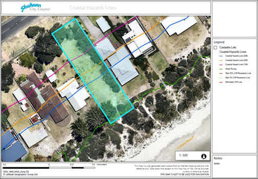
Figure 1 Aerial image of subject site with Coastal Hazard Lines
overlay. The area of the site landward of the blue line is within SDCP Chapter
G6 Precinct 1.
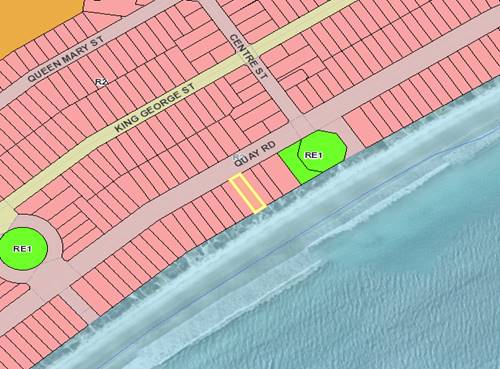
Figure 2 Zoning of subject site - R2 Low Density
Residential.
Background
The development application (DA19/1847)
seeks a variation to the SDCP Chapter G6: Coastal Management Areas Acceptable
Solution of:
A1.1 “No new development is permitted” within
Precinct 1 High Risk – Seaward of the 2030 Zone of Reduced Foundation
Capacity (ZRFC).
The DA proposes an alternative
‘performance-based’ solution to the acceptable solution of A1.1.
This involves the use of deep piled foundations to support the proposed
building within the 2100 stable foundation zone.
Council resolution is required
to determine if this alternative performance-based solution should be supported
for new development within Precinct 1.
Proposed Development
The
application seeks approval for a two-storey dwelling and detached habitable
room on vacant land. The dwelling proposed is comprised of the following, as
shown on the plans below:
Ground Floor
· Detached habitable
room with ensuite and living room (connected via the front porch);
· Combined foyer,
kitchen, living room, dining room and courtyard;
· Master Bedroom
with ensuite and walk in robe;
· Laundry, drying
courtyard, rainwater collection tank and air conditioning units;
· Double Garage with
additional internal space for boat storage; and
· Covered alfresco.
First Floor
· Stairwell and
void;
· Study nook;
· Four (4) bedrooms;
· One (1) common
bathroom;
· Upper living room;
and
· Cantilevered
balcony.
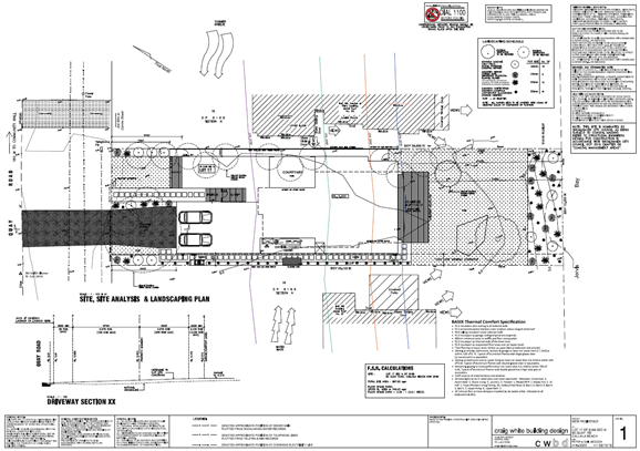
Figure 3 Site, site analysis and landscaping plan. Coastal Hazard
Lines are shown on the plans.
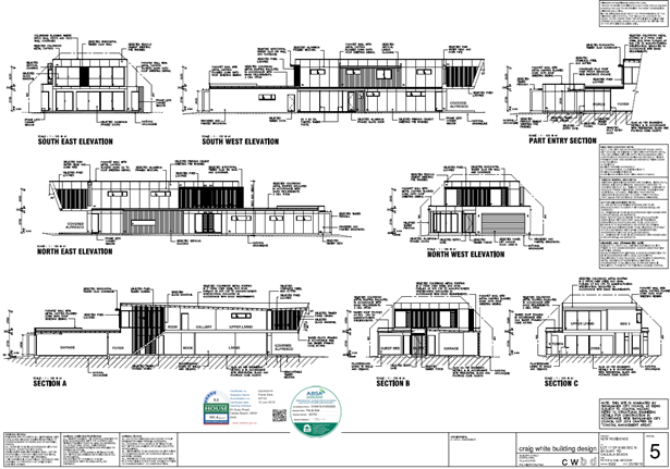
Figure 4 Elevations and sections plans.
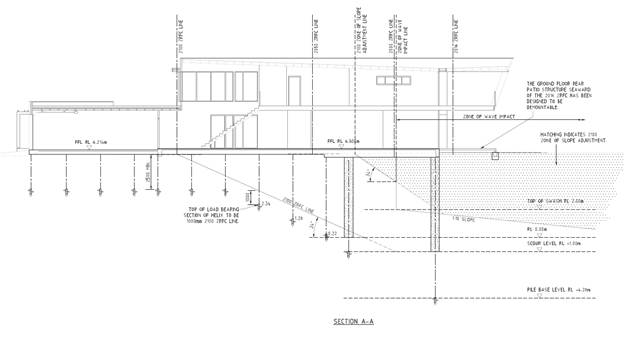
Figure 5 Proposed concrete encased screw piles to
support the building within the 2100 Stable Foundation Zone.
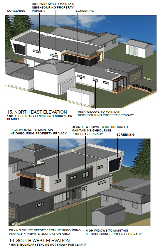
Figure 6 3D representation of proposed dwelling
in relation to existing adjoining dwellings and outbuildings (see Attachment
3).
Planning
Assessment
The Development Application has
been assessed under section 4.15 of the Environmental Planning and
Assessment Act 1979 (please refer to Attachment 5) and a recommendation for
determination by way of approval with conditions is made (Attachment 1).
The
recommendation is based upon:
(1) A
full assessment of the applicable planning instruments, including but not
limited to:
(a) State
Environmental Planning Policy (SEPP) Coastal Management 2018;
(b) Shoalhaven
Local Environmental Plan 2014 (SLEP 2014) clause 2.3 Zone objectives and
Land Use Table;
(c) the
provisions within Chapter 1: Introduction of the SDCP;
(d) SDCP
Chapter G6: Coastal Management Area and Clause 7.4 Coastal Risk Planning of Shoalhaven
Local Environmental Plan 2014;
(e) SDCP
Chapter G12: Dwelling Houses and Other Low Density Residential Development.
(2) Legal
advice that Council has received for residential development applications
within Precinct 1 of SDCP Chapter G6: Coastal Management Area.
SEPP
Coastal Management 2018
The proposed development is
consistent with the objectives and planning controls of the Coastal
Management 2018 State Environmental Planning Policy (see Attachment 5
“Planning Report” for a full assessment).
Shoalhaven Local
Environmental Plan 2014 (SLEP 2014)
The proposed development is
consistent with the objectives of the R2 – Low Density Residential Zone
– “to provide for the housing needs of the community within a low
density residential environment” and is a form of development that is
permitted with consent within the zone.
Shoalhaven Development
Control Plan
Chapter 1: Introduction of SDCP
2014 sets out a guideline for how the controls and Chapters of the Plan should
be interpreted.
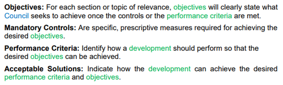
As stated within section 7 of
Chapter 1, the SDCP consists of a combination of objectives, mandatory
controls, performance criteria and acceptable solutions (see snip below):
The proposed development was
assessed against all relevant Chapters of SDCP 2014. There are no mandatory
controls within SDCP 2014 that were applicable to the development. The
development complies with all relevant acceptable solutions with the notable
exception of Chapter G6, section 5.1.1, A1.1.
SDCP 2014 Chapter G6: Coastal
Management Areas, section 5.1.1 Areas of beach erosion and/or oceanic
inundation
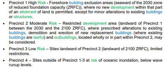
Chapter G6 sets out four (4)
Precincts for areas of land that are identified as being affected by beach
erosion and/or oceanic inundation.
As stated, the proposal does not
meet the Acceptable Solution of SDCP Chapter G6: Coastal Management Areas,
section 5.1.1 Areas of beach erosion - (A1.1): “No new development”
(within Precinct 1) as a portion of the proposal (approximately 3.5m linear
metres) is within this Precinct (as shown below).
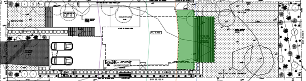
Figure 7 Site plan of proposed development showing portion (in
green) that is within Precinct 1 at the ground surface.
Precinct 1 of SDCP Chapter G6 is
delineated by the area of land that is seaward of the 2030 Zone of Reduced
Foundation Capacity (ZRFC). The zones of reduced foundation capacity can also
be delineated three dimensionally i.e. below the ground surface (as shown in
the cross-section for the waffle pod slab layout plan (Figure 8 below) as they
are based upon the substrates ability to support the load of a structure
accounting for projected sea level rise in future years.
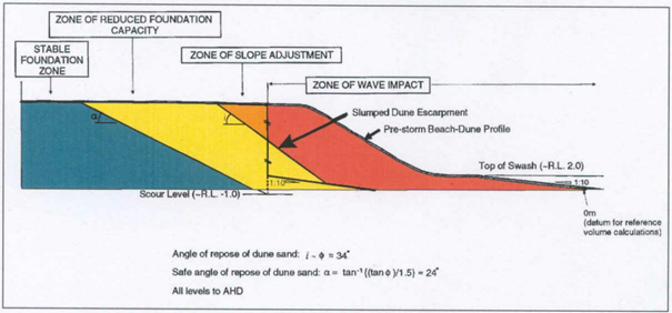
Figure 8 Schematic representation of coastline
hazard zones (after Nielsen et al. 1992). Source: SCC Shoalhaven Coastal Zone
Management Plan, Appendix 2 - Risk Assessment 2018 prepared by Advisian.
Section 11 of SDCP Chapter 1
states that “the acceptable solutions are provided as examples of what is
considered acceptable for the respective performance criteria and objectives.
Council can consider alternative solutions in certain circumstances provided
the objectives and performance criteria are met. Justification in the form of a
variation statement demonstrating how the objectives will be achieved must be
provided with the application.”
Accordingly, the applicant has
provided a Coastal Engineering Report, prepared by Advisian (Attachment 4),
that addresses the variation to the acceptable solution of SDCP Chapter G6 A1.1
and demonstrates how the objectives of the Chapter are achieved.
The variation to A1.1 (and
associated performance solution) proposed is for the building to have concrete
encased screw piles extending beyond the 2030 ZRFC and into the 2100 Stable
Foundation Zone (this corresponds with Precinct 3 Low Risk (landward of 2100
ZRFC)).
The report states that
“the proposed development would meet the performance criteria outlined in
SDCP, provided that:
· The
proposed building is founded on deep-piled foundations into the 2100 Stable
Foundation Zone and designed in accordance with the requirements outlined
in Nielsen et al. (1992). The foundations will need to be founded at the
required embedment depth below the scour level to resist the shear forces
applied to the pile at scour level and develop the required axial and lateral
Capacity within the 2100 Stable Foundation Zone.
· The
foundation design will need to consider wave loads that could occur on the
seaward portion of the foundations after 2050, as the seaward edge of these on
the ground floor lie approximately 4 m seaward of the 2100 Zone of Wave
Impact.
· Certification
by the Structural Engineer that the foundations of the building have been
designed in accordance with the requirements of Nielsen et al. (1992)
would need to be provided prior to Council issuing a construction certificate
for the development.
· The
proposed building allows for at least 0.5 m freeboard above the 100-year
average return interval (ARI) wave runup level as the finished floor level of
the house is 6.3 m Australian Height Datum (AHD) which would be adequate to
protect the living areas against the effects of wave inundation. Future
inundation risk can be reduced by setting electrical fittings in the lower
floor living areas to at least 0.3 m above the finished floor level. “
The applicant has provided a
cross-section plan of the slab design of the building that shows
concrete-encased screw piles extending into the 2100 Stable Foundation Zone
with a design that has been undertaken in accordance with Neilsen et al (1992)
and the Advisian Coastal Engineering Report submitted with the application (see
Attachment 2).
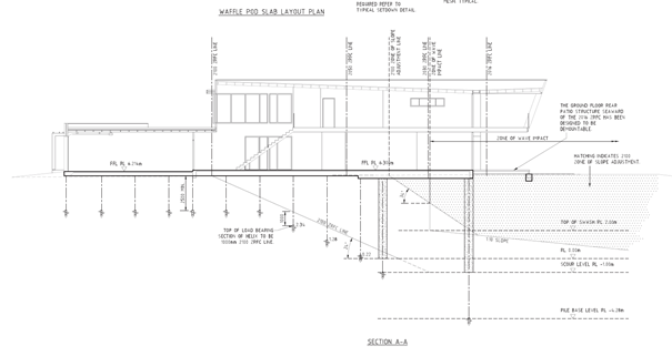
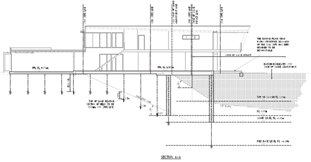
Figure 9 Cross-section of slab design showing
that the proposed development is founded on deep piled foundations within the
2100 Stable Foundation Zone.
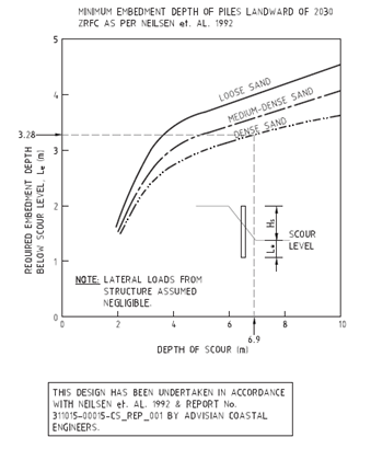
Figure 10 Annotation of slab cross-section plan
stating that the design has been undertaken in accordance with Neilsen et al
1992 and Advisian Coastal Engineering Report.
If determined by way of
approval, conditions of consent will be imposed so that:
1. Prior to the issue of a
Construction Certificate, a Structural Engineer is to provide certification
that the foundations of the proposed building are designed:
a) in
accordance with the foundation design criteria of Nielsen A.F., Lord D.B and
Poulos H.G. 1992 Dune Stability – Considerations for Building
Foundations Vol. CE34 No. 2, June 1992; and
b) in accordance with
the recommendations of the Coastal Engineering Report No.
311015-000150CS_REP_001, prepared by Advisian, dated August 2019; and
c) to extend into the
2100 Stable Foundation Zone; and
2. A
structural engineering report is to be provided to Council prior to the issue
of an Occupation Certificate.
The
report is to contain the following information:
a) Details
of the depth that each pile has been installed to;
b) The
composition of the subsurface material at each metre below ground level in
which the piles were installed;
c) The
specifications of the constructed pile materials, including dimensions;
d) The
construction methods that were used;
e) A
slab plan and section of the foundation slab and piles as constructed;
f) Certification
from a licenced structural engineer that the development is:
i. Designed
and constructed in accordance with the foundation design criteria of Nielsen
A.F., Lord D.B and Poulos H.G. 1992 Dune Stability – Considerations
for Building Foundations Vol. CE34 No. 2, June 1992 and;
ii. Supported on deep piled foundations into the 2100
Stable Foundation Zone.
It is therefore considered that
the proposal will comply with the objectives and performance criteria of
section 5.1.1 and the variation to A.1.1 can be supported.
The following should also be
noted:
· The
proposed building’s footprint is landward of the two adjoining residences
and complies with the acceptable solutions for overshadowing and view loss of
Council’s DCP.
· If
the proposed building’s footprint was to be modified so that it was
entirely behind the 2030 Coastal Hazard Line and within the SDCP setback
controls (for front and side boundaries plus a viewing corridor of 10%), there
would be a remaining land area of approximately 27m x 13m (338m2) to
build upon.
Legal Advice
Council has received prior legal
advice relating to the application of alternative or
‘performance-based’ solutions for development within Precinct 1.
The advice states that:
“Provided a variation statement is provided in accordance with the
requirements of Section 11 of Chapter 1 of the SDCP, there is nothing to
prevent the Council from considering an performance solution to Acceptable
Solution A1.1: “No new development is permitted” provided the
relevant objectives and performance criteria are met.”
Consultation
and Community Engagement:
Eleven (11) public submissions
were received by seven (7) individuals in relation to Council’s
notification of the development. The notification was made in accordance
with Council’s Community Consultation Policy with letters being sent
within a 25m buffer of the site.
Key issues raised as a result of
the notification are summarised below.
|
Basis of submission
|
Response
|
|
Building forward of Precinct 1
|
The applicant has provided a
coastal engineering report prepared by Advisian to support a performance
solution to build within Precinct 1. The report recommends concrete encased
piers anchored into the 2100 Stable Foundation Zone.
Development applications
situated at 117 & 135 Quay Road have adopted the same performance
solution that was approved under delegated authority.
In addition, legal advice was
sought regarding the DCP wording, which prohibits development within Precinct
1. In summary the legal advice states that the DCP cannot prohibit
development and a performance solution must be applied and assessed on its
merits. In this instance, the application has satisfied the performance
criteria.
|
|
|
|
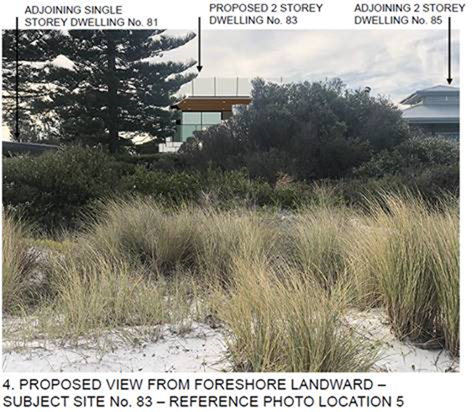
Visual impact from the beach
|
The applicant has submitted a
visual analysis report in support of the application (see Attachment 3). As
depicted below, the existing vegetation along the foreshore screens the
proposed development from Callala Beach. In addition, the proposed building height
is 6.8m which complies with the maximum allowable height of 7.5m and
maintains the same alignment as the adjoining properties. As a result, the
proposed development does not unduly impact upon the existing views from
Callala Beach or the adjoining properties.
|
|
|
|
The bulk and scale of the proposed development is not
appropriate for the site.
|
The proposed development complies with the front/side
setback controls and does not exceed the maximum allowable building height of
7.5m. Moreover, the proposed development complies with the 45-degree building
envelope control and is architecturally designed to provide adequate visual
interest through façade which includes articulation and different use
of materials. It is therefore considered that the proposed development is
compatible with the surrounding character and is not excessive in bulk and
scale.
|
|
|
|
Overshadowing of 81 and 85
Quay Road
|
The proposed development has a
maximum height of 6.8m and complies with the maximum allowable height of 7.5m.
Shadow diagrams were submitted in support of the application and these plans
indicate that both 81 and 85 Quay Road will maintain at least 3 hours of
direct sunlight between 9am and 3pm during the winter solstice.
|
|
Privacy issues associated with
81 Quay Road
|
The first-floor elevations of
the proposed development include adequate fixed screening and high sill
windows to preserve privacy and ensure any potential overlooking issues are
addressed. In addition, a 1.8m side boundary fence and screen planting will
further alleviate any overlooking issues into the adjoining properties.
|
|
View loss 81 and 85 Quay Road
|
The proposed development
maintains the same foreshore setback alignment as 81 and 85 Quay Road. The
applicant submitted a visual analysis report in support of the application,
which clearly demonstrates that existing views from 81 and 85 Quay Road will
be maintained.
|
Financial
Implications:
There
are potential cost implications for Council in the event of a refusal of the
application. Such costs would be associated with defending any appeal in the
NSW Land and Environment Court, should the applicant utilise appeal rights
afforded under the EP&A Act.
Legal
Implications
Council
is protected in its decisions relating to coastal management by section 733 of
the Local Government Act 1993 (LG Act), provided it acts in good faith.
That is, Councils have due regard to the policy framework, controls applicable
and the circumstances of the particular case.
Council
may not be seen to have acted in good faith if it were to approve a
development application that is clearly inconsistent with the performance
criteria set out in an adopted development control plan, and in the absence of
sound planning reasons to support a development. Council in such a scenario
could be exposed to challenge in relation to losses encountered due to coastal
impacts of the approved development or in increasing the risk to other properties,
people and emergency services personnel.
Summary and Conclusion
The proposed development is for
a two-storey dwelling on a vacant R2 – Low Density Residential zoned lot
on the seaward side of Quay Road, Callala Beach.
The site is mapped with Coastal
Hazard Lines and is within a Coastal Risk Planning Area. It is therefore
subject to coastal risk planning legislation including the State
Environmental Planning Policy Coastal Management 2018, clause 7.4 of Shoalhaven
Local Environmental Plan 2014 and Shoalhaven Development Control Plan 2014
Chapter G6: Coastal Management Areas.
Whilst the proposal does involve
a variation to the acceptable solution of “No new development”,
Chapter 1 of Shoalhaven Development Control Plan states that “acceptable
solutions are provided as examples of what is considered acceptable for the
respective performance criteria and objectives. Council can consider
performance solutions in certain circumstances provided the objectives and
performance criteria are met” (SDCP Chapter 1: Introduction, p 7).
The applicant submitted a
Coastal Engineering Report to support the variation. The report stated that
“if the recommendations regarding the foundations for the proposed
development are implemented, then the proposed development can be considered to
meet the planning criteria listed in the NSW Coastal Planning Guideline and the
performance criteria outlined in Council’s DCP” (p 39, Attachment
4).
The applicant has provided a
cross-section of the proposed slab design showing that the recommendations of
the Coastal Engineering Report will be implemented. Furthermore, conditions of
consent can be imposed so that a structural engineer certifies that the design
has been carried out in accordance with the recommendations.
It is therefore recommended that
Council approve the development in its current form. Other options available to
Council are to either refuse the development application, or to propose an
alternative recommendation.
|

|
Development
& Environment Committee – Tuesday 07 April 2020
Page
1
|
DE20.23 Development
Application - DA19/1852 – 43 Tahnee Street, Sanctuary Point – Lot 47
DP 1243551
DA. No: DA19/1852/4
HPERM Ref: D20/86809
Section: Development
Services
Approver: Phil
Costello, Director Planning Environment & Development Group
Attachments: 1. Planning
Assessment (s4.15) Report (under separate cover) ⇨
2. Draft Conditions of
Development Consent (under separate cover) ⇨
Description of Development: Construction of Multi
Dwelling Housing – Seven (7) Dwellings
Owner: Lawler & Son Pty Ltd
Applicant: Nadine Street Pty Ltd
Notification Dates: 10-25 September 2019
No. of Submissions: 13 in objection
Nil
in support
Purpose
/ Reason for consideration by Council
Councillors called in the Development Application (DA) due
to the significant public interest on 8 October 2019.
|
Recommendation (Item to be determined under delegated authority)
That Development Application DA19/1852
to construct multi dwelling housing (seven (7) dwellings) at Lot 47 DP
1243551, 43 Tahnee Street, Sanctuary Point be approved subject to the
recommended conditions of consent contained in Attachment 2 of this report.
|
Options
1. Approve the
development application (DA) in accordance with the recommendation of this
report.
Implications: This would
allow the applicant to pursue construction of the development.
2. Refuse the
application.
Implications: Council would
need to determine the grounds on which the application is refused, having
regard to section 4.15(1) considerations.
3. Alternative
recommendation.
Implications: Council will
need to specify an alternative recommendation and advise staff accordingly.
 Figure
1 – Location Map
Figure
1 – Location Map
Background
Proposed Development
The DA seeks approval for the
construction of multi dwelling housing, comprising seven (7) two (2) storey
dwellings:
§ One (1) x 4-bedroom and six (6) x 3-bedroom dwellings; and
§ 14 car spaces provided onsite.
Vehicular access is proposed from Tahnee Street.
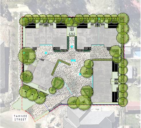
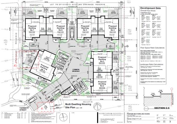 Figure
2 – Site Plan
Figure
2 – Site Plan
Figure
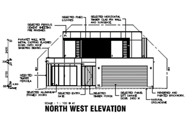
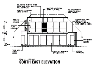
3 – South and East Elevations
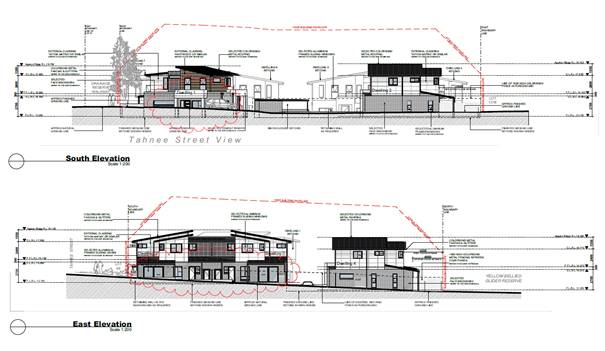
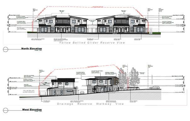
Figure
3 – North and West Elevations
Figure
4 – Landscape Plan
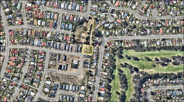
Subject Land
The development site comprises Lot 47 DP 1243551 (43 Tahnee Street,
Sanctuary Point). Refer to Figure 1.
Site & Context
The development site:
§ Is located in a newly created subdivision and suburban area
of Sanctuary Point. It is vacant with a gradual slope falling from the street
towards the rear (northern) boundary which is adjacent to Yellow Bellied Glider
Reserve.
§ Is zoned R1 General Residential under the Shoalhaven Local
Environmental Plan 2014 (SLEP 2014) and is 1,950sqm in area.
§ Is identified as being wholly bush fire prone land.
§ The site is on the north-eastern corner (low) side of
Tahnee Street and has a public pathway sited immediately along the western
boundary which connects Tahnee Street to the Yellow Belly Glider Reserve
located to the north.
§ Adjoins land zoned R1 General Residential (to the west and
south), R2 Low Density Residential (to the east) and RE1 Public Recreation (to
the north, being the Yellow Belly Glider Reserve), under SLEP 2014 as
illustrated in Figure 5. Adjoining allotments to the west and south contain
recently constructed dwellings, being Lot 10 (No.39 Tahnee Street) and Lot 46
(No.45 Tahnee Street) in the registered subdivision. To the east of the subject
site is an existing developed residential area with detached dwellings of
varied design and construction, ranging from one (1) to two (2) storey in
height, with associated ancillary outbuildings.
Figure
5 – Zoning Extract
History
The following provides details on pre-lodgement
discussions, post-lodgement actions and general site history for context:
§ The application was lodged on 29 August 2019.
§ As a result of detailed assessment of the application,
additional information was requested from the applicant on three (3) occasions
– 29 October 2019, 5 February 2020 and 16 March 2020.
§ On 12 December 2019 and 12 February 2020, the applicant
submitted additional information, which was subsequently referred to the
relevant sections of Council for comment.
Issues
Council’s
Development Control Plan (DCP) Controls:
The development generally
complies with the provisions of Shoalhaven Development Control Plan 2014 (SDCP
2014) except for the following relatively substantive numeric departure for the
acceptable solution.
A17.3 of Control 5.3.3
Private Open Space, Chapter G13 Medium Density and other Residential
Development, SDCP 2014
There is a non-compliance with
A17.3 of Control 5.3.3 Private Open Space and the defined
hardstand area of usable space required to be provided for each dwelling.
This area is to be set back at
least 1.2m from an external boundary and to have a minimum dimension of 5m
x 4m, of which 50% is to be covered to provide protection from the
elements.
The defined hardstand area of
usable space (decking) proposed with Dwelling No. 1 is only set back 681mm
from the western property boundary. The decking proposed with dwellings No. 2
and 3 has a dimension of 5m x 2.8m.
Applicant’s Submission
The applicant provided the
following justification for the proposed variation:
“The extent of the proposed variation and the unique
circumstances as to why the variation is being sought;
The extent of variation is a
reduced depth from 4m to 2.8m for the hardstand private open space areas
serving dwellings 2 & 3. The area dimensions require 5m x 4m pursuant to
the control. The reduced depth results in an area of 14m2 in place of 20m2, a
30% reduction. The POS areas remain both functional and a component of the
larger general area available for the dwellings to utilise for POS activities.
Dwelling 2 is provided with a private courtyard space of 60m2 and Dwelling 3 is
provided with a private courtyard space of 55m2. The deck areas will be able to
accommodate outdoor furniture (table and chairs) and remain functional within
the overall POS areas serving the respective dwellings.
Demonstrate how the relevant
objectives and performance criteria (as appropriate) are being met with the
proposed variations; and,
P17 Performance Criteria
details that POS is to be functional and useable all year round and the design
and reduced 2.8m depth dimension is able to be accommodate a standard six seat
outdoor table setting (table dimension 1500 L x 900 W x 740 H mm) or a smaller
‘café’ style setting. The hardstand area is a component of
the overall POS and both dwelling 2 & 3 well exceed the minimum area of POS
(35m2) detailed in Table 5 of Control 5.3.3. The 5m x 2.8m deck areas have more
than 50% of their respective areas covered with a shade structure. Notably a
dwelling comparable in size, but provided at a first floor level would only
require a POS area with minimum dimensions of 2m x 3m and the POS hardstand
areas, whilst provided at ground floor level, well exceed an acceptable
criteria for POS had the dwellings been on the 1st floor of the development.
The POS areas are to be well screened through the implementation of the
landscape plan and will afford appropriate privacy and amenity to the dwelling
occupants.
Refer to Drawing No. P5421-A14
– Issue D, Section E-E, prepared by Algorry Zappia & Associates,
wherein the decking POS area and peripheral landscape area above the retaining
wall is identified.
Demonstrate that the
development will not have any additional adverse impacts as a result of the
variation.
The numeric dimensional
shortfall does not automatically render the POS areas as lacking having regard
to the satisfactory address of the performance criteria. The minimum POS
overall areas are exceeded with the development providing a responsive
landscape plan and fencing which will assist in the success of the design as it
is detailed currently. There are no identifiable adverse impacts associated with
the requested variation and the development design represents an appropriate
response where infrastructure elements (sewer line depth and position)
sometimes provide difficult constraints. The POS areas are an immediate
extension of internal living areas and are generous in overall area afforded to
the dwelling occupants.”
Discussion
It is considered that the
numeric variation proposed results in an area that is still consistent with the
objectives of this chapter and the relevant performance criteria. The areas of
usable space would be of a suitable size to suit the requirements of future
residents.
It is noted that the proposed
decking areas for Dwellings No. 2 and 3 would reduce impact to the existing
gravity sewer main along the eastern boundary of the site.
The reduced setback from the
decking associated with Dwelling No. 1 is satisfactory and is supported
considering the boundary adjoins the public pathway (Lot 48 DP 1243551), which
serves to connect the Tahnee Street roadway with the public walkway which
extends along the north side boundary of the subdivision.
Further, the areas remain useable and accessible.
Additionally, the areas are part of a larger open space component.
Comment on DCP variations
Chapter 1 of the Shoalhaven DCP
explains that the DCP aims to allow flexibility in the application of
development controls and that Council may consider variations to requirements
of the DCP. Acceptable solutions are provided as examples of what is
considered acceptable for the respective performance criteria and
objects. Council can consider alternative solutions in circumstances
provided the objectives and criteria are met.
Planning
Assessment
The DA has been assessed under
s4.15(1) of the Environmental Planning and Assessment Act 1979. Please refer to
Attachment 1.
Consultation
and Community Engagement:
Notification was undertaken in
accordance with Council’s Community Consultation Policy with letters
being sent within a 60m buffer of the site, during the period 10 to 25
September 2019.
13 public submissions were
received in relation to Council’s notification of the development. They
were all objections to the development.
Key issues raised as a result of
the notification include but were not limited to matters listed below.
§ Scale of the development,
including dwelling design and density;
§ Visual privacy;
§ Traffic impacts;
§ Onsite car parking; and
§ Waste disposal.
The assessment of the application
considered the matters raised in the submissions and concluded that the
application should be supported.
A detailed analysis can be found in the attached section
4.15 assessment report.
Financial Implications:
There are potential cost implications
for Council in the event of a refusal of the application. Such costs would be
associated with defending an appeal in the Land and Environment Court of NSW.
Legal
Implications
A section 8.2 review or an
appeal with the Land and Environment Court are possible if the application is
refused.
Summary
and Conclusion
The proposed development is
compliant with the provisions of SLEP 2014 and is broadly consistent with the
SDCP 2014 (albeit for the alternative solution to the numeric acceptable standard
for hardstand areas of usable space under A17.3 of Control 5.3.3 Private
Open Space of Chapter G13, and a minor variation to landscaping
under A10.1 of Control 5.7 Landscape Design of Chapter G21).
This application has been
subjected to detailed analysis of the main issues identified in this report,
being the scale of the development, including dwelling design and density,
visual privacy, traffic impacts, onsite car parking and waste disposal. These
issues have also been investigated and addressed by the applicant.
The application is considered capable of support as there
are no substantive planning reasons to warrant refusal. Accordingly, it
is recommended it is approved subject to the recommended conditions of consent
as per Attachment 2.
|
|
Development
& Environment Committee – Tuesday 07 April 2020
Page
1
|
DE20.24 Development
Application - 204 Kinghorne St NOWRA - Lot 1 DP 130928
DA. No: DA19/1846/4
HPERM Ref: D20/93764
Section: Development
Services
Approver: Phil
Costello, Director Planning Environment & Development Group
Description of Development: Construction of a
residential apartment complex consisting of 91 apartments
Owner: Tonandua Pty Ltd
Applicant: PDC Planners
Notification Dates: 18 September to 3 October 2019
No. of Submissions: Nil
Purpose / Reason for consideration
by Council
On 3 March 2020, the Development
and Environment Committee resolved:
‘that an update be provided on the previous call-in
in relation to DA19/1846 – 204 Kinghorne Street Nowra’
(DE20.21).
This report provides an update.
|
Recommendation
(Item to be determined under delegated authority)
That Council
1. Receive this
report as an update on the progress of the assessment of DA19/1846.
2. Receive a further
report following the finalisation of the assessment of DA19/1846.
|
Options
1. Receive the report for information.
Implications: The application will be finalised and reported
to Council upon completion.
2. Resolve alternatively.
Implications: The implications would be contingent on the
Council decision.
Location Map
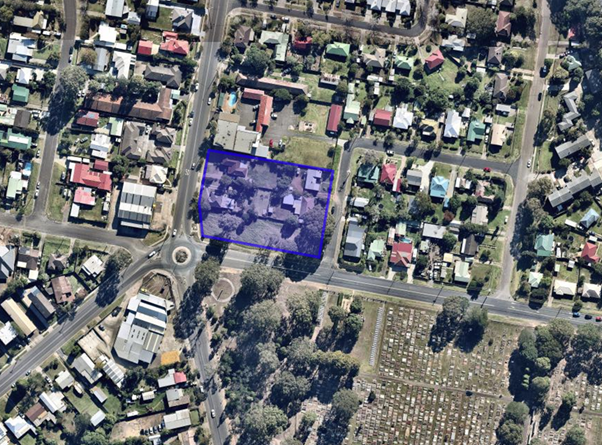
Background
Regional Development Application
RA17/1002 was assessed by Council staff and was to be reported to the Southern
Regional Planning Panel for determination (the relevant planning authority at
that time).
The application was however
withdrawn by the applicant following consideration by Council’s Regional
Development Committee.
Whilst the current application
is the same, it does not require consideration and determination by the
Regional Planning Panel, as the threshold (Capital Investment Value) of
development has changed.
Council is the consent authority
for the current application.
Current Application
· On
28 August 2019, the applicant lodged the current DA19/1846 with Council.
§ Shortly after lodgement,
Council engaged the services of an independent planning consultant to complete
the assessment of the Development Application.
§ An independent assessment was
sought to provide transparency to the assessment of the project given that this
application is virtually an identical development application to the regional
application previously submitted for the site in November 2017
(RA17/1002). The previous report also made a negative
recommendation. A fresh independent assessor was considered appropriate
so that the applicant was afforded an impartial balanced assessment.
· On
20 January 2020, the Development & Environment Committee resolved to call
in the Development Application (DA) for determination by Council (DE20.8,
MIN20.20).
· On
3 March 2020, the Development & Environment Committee resolved:
‘that an update be provided
on the previous call-in in relation to DA19/1846 – 204 Kinghorne Street
Nowra’ (DE20.21, MIN20.167).
· On
16 March 2020, the applicant submitted additional plans (traffic and civil
design drawings) to satisfy a request for additional information from
Council’s Traffic and Transport Unit and Development Engineer. The
additional information has been referred to the relevant sections of Council
for review.
Once the review of the
additional information by the Traffic and Transport Unit and Development
Engineer has been completed, this will be provided to the independent planning
consultant who will finalise the s4.15 Assessment Report and provide their
recommendations to Council. At this time it is expected this report will be
presented to the May Development and Environment Committee.
Whilst the application is
identical to the previous application, the assessment process cannot be
negated. The assessment process is legally prescribed.
At this time it is expected this report will be presented to
the May Development and Environment Committee.
Planning Assessment
The DA is currently being assessed under s4.15 of the Environmental
Planning and Assessment Act 1979 and is approaching finalisation.
Policy Implications
There are no policy implications in relation to this report.
Consultation and Community Engagement:
Details of the consultation and community engagement will be
outlined in the future Council report to consider the DA.
Financial Implications:
There is no financial implication in relation to this
report.
Legal Implications
There are no legal
implications in relation to this report.
Summary and Conclusion
DA will be reported to Council
when the assessment is concluded.
|

|
Development
& Environment Committee – Tuesday 07 April 2020
Page
1
|
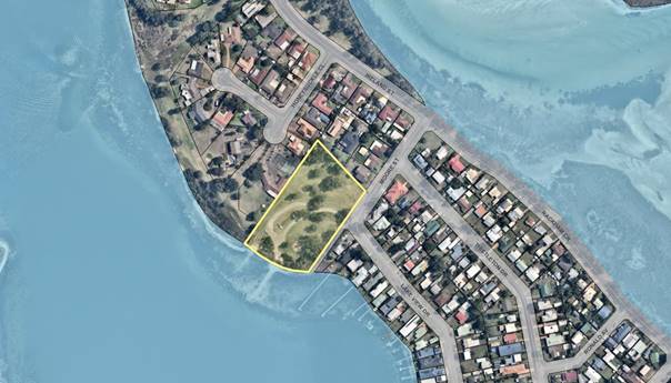
DE20.25 Development
Application – Lake View Drive BURRILL LAKE– Lot A DP21307
DA. No: DA19/1897/4
HPERM Ref: D20/64858
Section: Ulladulla
Service Centre
Approver: Phil
Costello, Director Planning Environment & Development Group
Attachments: 1. Draft
4.15 Assessment Report (under separate cover) ⇨
2. Draft
consent (under separate cover) ⇨
3. Plans
- Site Plan (under separate cover) ⇨
4. Plans
- Floor Plan (under separate cover) ⇨
5. Plans
- Elevations (under separate cover) ⇨
6. Plans
- Sections (under separate cover) ⇨
7. Plans
- Roof Plan (under separate cover) ⇨
8. Plans
- South East Perspective (under separate cover) ⇨
9. Plans - South West
Perspective (under separate cover) ⇨
Description of Development: Relocation of the
Childrens Playground within the reserve, construction of boat shed for the
storage of paddle powered boats
Owner: Shoalhaven City Council
Applicant: PDC Planners
Notification Dates: 20 November 2019 – 20
December 2019
No. of Submissions: 118 submissions have been
received:
54
in objection
64
in support
A
198 signature petition in objection was also received
Purpose
/ Reason for consideration by Council
At the Development &
Environment Committee meeting of Council held on 20 January 2020 Council
resolved to “call-in” the DA for determination.
|
Recommendation (Item to be determined under delegated authority)
That the Development Application
for relocation
of the Childrens Playground within the reserve and the construction of a boat
shed for the storage of paddle powered boats on the land at Lake View Drive Burrill Lake - Lots A DP
21307 be approved subject to the recommended conditions of consent contained
in Attachment 2 of this report.
|
Options
1. Approve the
development application (DA) in accordance with the recommendation of this
report.
Implications: This would
allow the applicant to proceed with the proposal and seek a construction
certificate for development on the subject site.
2. Refuse the
application.
Implications: Council would
need to determine the grounds on which the application is refused, having
regard to section 4.15 considerations.
3. Alternative
recommendation.
Implications: Council will
need to specify an alternative recommendation and advise staff accordingly.
Location Map
Background
Proposed Development
The application proposes the
relocation of the childrens playground within the reserve and construction of a
boat shed for the storage of paddle powered boats. More specifically:
· Construction
of a boatshed for the storage of the club’s outrigger canoes and
kayaks.
· The
proposed boatshed slab occupies an area (18m x 15.92m) comprising a total floor
area of 286m².
· The
boat shed proposes to integrate two shipping containers into the design.
o The
shipping containers will be in an L-shaped configuration on the northern and
eastern elevations and will be clad in timber.
o A
versiclad metal roof will cover the area inside the L-shaped shipping
containers.
o 2-metre
high powder coated steel picket fences will be located on the perimeter of the
slab where there are no solid walls;
o Despite
the shipping containers and the roof, the building will essentially be open in
design and will not be enclosed by solid walls except for shipping containers
on part of the northern and eastern elevations.
o The
shipping containers will be utilised for the storage of the kayaks whilst the
larger open area under the roof is for storage of the 6-person outrigger
canoes.
o An
identification sign is proposed to the northern elevation.
· The
proposed boatshed has an overall maximum building height of 4.27 metres to the
top of the pitched roof but with a predominant wall height of 2.87 metres being
the maximum height of the shipping containers.
· The
existing playground is required to be removed to accommodate the boat house and
the proponents are relocating the playground further north of its current
location and installing a new playground in consultation with Council’s
Recreation Section.
· No
vegetation removal is required.
Fig 1 Floor Plan

Fig 2 North &
East Elevations
Fig 3 South & West Elevations
Fig 4 South-West Perspective
Fig 5 South-East Perspective
Subject Land
The subject site is known is
Barker Reserve and is Council Managed Land. The site is located north-west of
the intersection between Lake view Drive and Moore Street, in Burrill
Lake. The site is rectangular in shape and has a total area of 1.21
hectares and has extensive grassed areas, trees & vegetation throughout, a
playground, boat launching area and car parking area.
Kayaks and outrigger canoes
associated with the paddling clubs are stored near the lake foreshore. Other
boats not associated with the club are also stored in the vicinity of the
foreshore.
Topographically, the land is
relatively flat. The site is not affected by any easements or restrictive
covenants
Immediate surrounding area
The site is in a predominantly
residential area. Three dwellings with frontages to Honeysuckle Close, abut the
western boundary and three dwellings abut the northern boundary.
A single dwelling is located on
the south-eastern boundary and Burrill Lake foreshore is located along the
southern boundary.
Beyond the immediate surrounds
are predominantly residential dwellings and the Princes Highway is located
approximatelyt 700 metres south-east of the site.
History
Pre-lodgement
The applicant met with Planning,
Shoalwater & Council’s Development Engineer on the 7th
September 2017 prior to lodging the application to discuss the merits of the
development on land at the Lions Park in Burrill Lake.
However there were issues with
the NSW Natural Resource Access Regulator and the potential impact on reeds in
the vicinity of where the boats were to be launched so an alternative location
was sought which is the subject of the current development application.
Issues
Suitability of the site for the proposed development
The application has received 118
submissions for and against the proposal. A prominent issue being raised in the
submissions is the appropriateness and permissibility of a boatshed on Council
land
Planning Context
In addressing the matter, it is appropriate to establish what the Shoalhaven Local
Environment Plan 2014 seeks under the various provisions and policies applying
to this proposal.
The land is zoned RE1 Public
Recreation under Shoalhaven LEP 2014. A boatshed is permitted under the
zone with consent. The objectives of the zone are:
• To enable
land to be used for public open space or recreational purposes.
• To provide
a range of recreational settings and activities and compatible land uses.
• To protect
and enhance the natural environment for recreational purposes.
It is
considered that the proposal is consistent with the objectives of the zone by
providing a building for recreational use which is compatible with the site and
maintains the natural environment for recreational purposes.
Local Government Act 1993
Land is
classified under the Local Government Act 1993 (the Act) as either:
§ Community Land, or
§ Operational Land
Community Land is defined by the Act as “land which is
set aside for community use, such as parks, sportsgrounds, beaches, community
centres and walking tracks”. Development and use of this land is
subject to the requirements of the Act and these are described in Appendix
One.
Any land identified as Community Land must be governed by a
Plan of Management.
The Local Government Act details the
core objectives and permitted uses of Community Land such as Parks,
sportsgrounds, and natural areas.
The Local Government
Act provides Council with guidelines to ensure all Community Land is
appropriately categorised as one or more of the following – Sportsground,
Park, Natural Area, General Community Use and Area of Cultural
Significance. Natural Areas must be further categorised as foreshore,
bushland, wetland, escarpment or watercourse.
Community Land
The land is identified on
Council’s mapping as Community Land and categorised as a Park pursuant to
the LG Act 1993.
Core
objectives for management of community land categorised as a park
Under the LG Act, the core objectives for management of
community land categorised as a park are—
(a) to encourage, promote
and facilitate recreational, cultural, social and educational pastimes and
activities, and
(b) to provide for passive
recreational activities or pastimes and for the casual playing of games, and
(c) to improve the land in
such a way as to promote and facilitate its use to achieve the other core
objectives for its management.
The Plan of Management relevant
to the proposal is Council’s Generic Plan of Management: Parks (2009)
The proposal is consistent with
the core objectives for community land categorised as a park by providing a
facility to store boats which encourages and promotes recreational activities
and social interaction. Therefore, facilitates and encourages the use of the
land through a recreational activity.
The proposal is consistent with the Plan of Management for
the park and should a consent be issued the proponents will be required to
enter into a lease agreement with Council as per the provisions of the LG Act
& the Plan of Management.
Planning Assessment
The DA has been assessed under s4.15 of the Environmental
Planning and Assessment Act 1979. Please refer to Attachment 1.
Policy Implications
There are no specific policy implications that arise from
this matter.
Consultation and Community
Engagement:
One hundred and eighteen (118)
public submissions were received in relation to Council’s notification of
the development. Fifty-four (54) were objections to the
development. Sixty-four (64) were in support of the development. A
198-signature petition in objection was also received. The notification was
made in accordance with Council’s Community Consultation Policy with
letters being sent within a twenty-five (25) metre buffer of the site. The
proposal was also advertised in local papers. The notification was for a 4-week
period.
Key issues raised as a result of the notification are
provided below.
Issue
Suitability of the site for the
proposed development
Comment
This has been discussed in the
preceding sections of the report
Issue
Building will obstruct views
to the lake / Occupies large part of the reserve
Comment
The proposal is low scale and
comprises a design where the structure is open on two sides and where the only
walls are derived from the placement of the shipping containers on two
elevations. It should be noted that the shipping containers are 12.1 metres in
length so they will not run for the entire length of those elevations. For the
two ‘walls’ the predominant wall height is 2.87 metres. The
building has a maximum height of 4.27 metres at the peak of the roof however it
is predominantly a low scale building. Further the low incline of the roof and
the low scale open design of the structure keeps the design modest in its
context. The building is located where there are existing trees and vegetation
hence there are no views through this part of the park through to the lake and
the proposed building will not be higher than the existing vegetation.
The park is 1.21 hectares and
the building has a total area of building only occupies 286m². Hence the
proposal would occupy 2.3% of the total area of the park.
Concerns were also raised that
if the boatshed was approved that boats would continue to be left out in the
open thereby increasing the areas which the club would occupy. Conditions of
consent will be in place to ensure that all boats associated with the club are
stored in the boatshed.
Issue
Visual bulk & scale is out of proportion
Comment
The proposed building is considered appropriate in this
context. The proposal has been designed to be sympathetic to the surrounding
area. It is compatible with the surrounding built form and incorporates design
elements such as a predominantly open structure akin to a carport with the only
form of wall being the two shipping containers. The open structure provides
transparency and reduces the massing and bulk of the building.
Issue
Increase use of park / increase in traffic / lack of
parking / sets precedent for other development on public land / increase
intensity of use with potential additions of clubrooms, bar etc / create
opportunities for unlawful behaviours
Comment
The club currently stores boats
in the open near the Barkers Reserve foreshore and have done so for many years.
This proposal is essentially to formalise the storage of boats associated with
the paddler’s clubs. It is not anticipated that it will increase parking
or traffic as the paddlers will continue to utilise the park for training in
the early morning as is their current practice. Additional parking is also
being provided as part of the proposal. The application is purely for storage
of the boats rather than a clubhouse and conditions of consent will also ensure
that the use of the boatshed does not morph into a clubhouse and that amenity
of the surrounding area is maintained.
Regardless the use is permitted
with consent and Council can only consider any future applications on its own
merits rather than what has been approved previously.
Whilst it is always difficult to
prevent unlawful behaviours the open design of the structure supports the
casual surveillance of the structure. Further, the proximity to the proposed
playground and to the foreshore where activity will be the most frequent in
this portion of the park is likely to be a natural deterrent for unlawful
behaviour. The applicant is also able to utilise other security measures such
as CCTV if required.
Issue
Not consistent with LEP definition / Land was gifted to
Council so proposal not in the spirit of the park use as proposal is for
private use
Comment
A boat shed is defined under the
Shoalhaven LEP 2014 as follows:
boat shed means a building or other structure used for the
storage and routine maintenance of a boat or boats and that is associated with
a private dwelling or non-profit organisation, and includes any skid used in
connection with the building or other structure.
The proposal is a structure for
the storage of boats and the clubs are considered non-profit organisation and
therefore consistent with the definition. Although the land has been gifted to
Council the gifting of the land does not preclude it from the potential
development opportunities through it categorisation as community land and its
existing Public Recreation zoning.
Issue
Council not empowered to approve the Development
Application due to leasing provisions of the Local Government Act 1993
Comment
The development application is
subject to the requirements of the Environment & Planning Act 1979. Hence
the leasing aspect of the land is not generally considered in the assessment of
the application. Regardless Council’s Property section have provided in-principle
support for a ground licence being entered into. Should a consent be
issued, the matters raised in the submission regarding the legalities of a
lease arrangement with Council will be required to be addressed separate from
the DA. Further a condition of consent will require that the proponent
enter into a leasing agreement with Council prior to the issue of a
Construction certificate.
Issue
There are alternative sites such as Kings Point, Mollymook
Oval
Comment
The proponents have advised that
the clubs members range in age from young children to retirees and the current
location in Barkers Reserve provides shallow and generally sheltered area for
launching the boats but also an ideal area for instructing new paddlers. The
alternative locations proposed do not allow for this and/or are some distance
from the water.
Issue
Loss of playground/residents
should not pay for replacement playground
Comment
The club will be required to replace the playground. The
clubs are applying for grants for the replacement playground and a condition of
consent will require that the applicant demonstrate that funding is confirmed
for the playground prior to the issue of a construction certificate.
Financial Implications:
As addressed previously in report.
Legal Implications
Pursuant to Section 8.2 of the
EP&A Act a decision of the Council may be subject of an application for
review by the applicant in the event of an approval or refusal. Alternatively,
an applicant for development consent
who is dissatisfied with the determination of the application by the Council
may appeal to the Court against the determination pursuant to Section 8.7 of
the EP&A Act.
Summary and Conclusion
The proposed development has
been assessed in accordance with Section 4.15 of the EP&A Act and is
recommended for approval.
· The
proposed use and development of part of the site for a boatshed is a use
contemplated in a RE1 Recreation Zone
· Amenity
issues derived from the proposed use can be addressed by conditions on the
consent and in most cases given the extensive setback from the nearest
residential dwellings, the perceived amenity impacts are lessened.
· Whilst
the expectations of objectors is that this park must be protected from
development this needs to be tempered having regard to the context of the site
and the proposed location of the boatshed in proximity to the nearest
residence, consideration of the objectives of the zone and of community land
and consistency with the current plan of management.
· The
proposal is consistent with the relevant environmental planning instruments and
the Shoalhaven Development Control Plan 2014;
· The
height, bulk and scale of the proposed building is satisfactory and consistent
with the low scale residential development in the locality;
|

|
Development
& Environment Committee – Tuesday 07 April 2020
Page
1
|
DE20.26 Development
Application – 1 Princess Avenue South Burrill Lake –Lot 47
DP1051945
DA. No: DA19/2160/4
HPERM Ref: D20/76497
Section: Ulladulla
Service Centre
Approver: Phil
Costello, Director Planning Environment & Development Group
Attachments: 1. Location
Plan (under separate cover) ⇨
2. Site
Plan (under separate cover) ⇨
3. Roof
Plan (under separate cover) ⇨
4. Elevations
(East & South) (under separate cover) ⇨
5. Elevations
(West & North) (under separate cover) ⇨
6. View
Analysis (under separate cover) ⇨
7. Height
Limit (under separate cover) ⇨
8. Render
1 (under separate cover) ⇨
9. Render
2 (under separate cover) ⇨
10. Render
3 (under separate cover) ⇨
11. Render 4 (under
separate cover) ⇨
Description of Development: Demolition of existing
motel and construction of three storey tourist and visitor accommodation
building comprising ground floor parking, food and drink premises, 25
accommodation suites & roof top terrace.
Owner: Luke Ocean Pty Ltd
Applicant: Christopher Beasley
Notification Dates: Letters to affected
owners 7 January 2020 -30 January 2020
Notification
in the newspapers 10 January -14 February 2020
No. of Submissions: 59 in objection
34
in support
Purpose
/ Reason for consideration by Council
The purpose of this report is to
seek Council direction with respect to a request for a variation of a
development standard under Clause 4.6 of the Shoalhaven Local Environmental
Plan 2014 (SLEP 2014). The variation relates to building height and is greater
than 10%, thus requiring Council approval. The height limit established by SLEP
is 11 metres with the application requesting a 12.8m height.
|
Recommendation (Item to be determined under delegated authority)
That Council:
1. Confirm that it supports the
proposed variation, under clause 4.6 of Shoalhaven Local Environment Plan
2014, to the 11m maximum building height to allow for the development of the
motel to a maximum 12.8m in height.
2. Refer the application back to staff
for determination
|
Options
1. Resolve to
support the propose variation to the development standard for height from 11m
to 12.8m for the redevelopment of the Edgewater Motel and refer the application
back to staff to determine under delegated authority.
Implications: This would enable the application to be
finalised and conditions of consent determined.
2. Resolve not to
support the proposed variation to the development standard and refer the
application back to staff to negotiate with the applicant to redesign the
proposal to comply with the 11m height standard.
Implications: This would give guidance to the
applicant in regard to the height issue and allow negotiation with staff or
other available action to the applicant.
3. Adopt an
alternative recommendation and provide direction to staff.
Location Map

Background
Proposed Development
General
a) Demolition of the existing motel
b) New building generally 3 storeys in height with ground
level parking, first floor restaurant, bar and outdoor terrace area, 25
accommodation rooms on the second floor and centrally sited roof terrace
c) Maximum predominant height of the building between
10.18m-10.35m. The roof terrace portion provides a maximum height to 12.8m in
height
Ground
Floor Level
d) Comprises car parking (42
car spaces inclusive of one (1) disabled space), lift & stair cores, bin
storage.
e) An additional 10 car
spaces are proposed within the front setback to Princess Avenue South road
reserve.
f) 12 bicycle spaces
are also provided external of the building.
g) Vehicle access to car park
is from princess Avenue South.
First
floor
h) Comprises open plan
reception area, restaurant and function room, lift and stair cores, open
kitchen, back of house food preparation area, amenities and administrative
areas.
i) A deck is proposed
to wrap around the southern and eastern elevation
j) A 1.2m wide public
footpath is proposed along the frontage of the site.
k) First floor level
comprises a total area of approximately 1204m2.
Second Floor
l) The second
floor contains 25 accommodation rooms sited around the perimeter of the
building with a central communal lounge area containing library and fireplace.
m) Accommodation rooms
comprise 19 standard rooms with floor area between 27-37m2 and 6
suites with a floor area between 40-44m2. These suites are provided
with balconies.
n) The rooms are
accessed by lift and stair cores.
o) The second floor
comprises a total area of 1289m2.
Roof Terrace
p) The roof terrace
comprises a pergola covered area of approximately 254m2.
q) No other facilities
such as toilet or bar area are to be provided in this area
r) Access is via
lifts and stairs.
s) A separate balustrade
is to be provided around this area to restrict access to the perimeter of the
building.
Materials
t) The building
comprises a predominately glazed façade integrated with silvertop ash
timber cladding, concrete panels and bronze powder coated aluminium frame.
Landscaping
u) Integrated landscape
plan including landscaping along Princess Avenue South and along a portion of
the northern and western boundary.
Subject Land
The subject site is located on
the north-western side of Princess Ave South, at the end of the cul-de-sac. The
site is irregular in shape with a frontage to Princess Ave South and main
frontage to Burrill Lake.
Topographically, the land is
relatively flat and at its lowest point has a height of approximately RL 1.5m
AHD which is located at the mean high-water mark distinguished by the drop from
motel ground level defined by the log retaining wall down onto Burrill Lake
edge.
The sites south-western boundary
extends to the mean high-water mark
The site has a frontage of 43m
to Princess Ave South and a frontage to Burrill Lake of 52 metres with an
overall site area of 2411m2.
There are no restrictive
covenants or agreements registered on the titles.
The site is currently developed
with the Edgewater Motel which is predominantly single storey building
comprising ten (10) motel rooms and associated car space. An attached two-level
building containing office under and a three-bedroom residence over as the
managers residence.
The site is largely devoid of landscaping with the exception
of some shrubs and plants located in a garden bed and there are a group of
Casuarina trees and two (2) Norfolk Pines in the frontage to Burrill Lake and a
group of Bangalow Palms on the north-western boundary.
Site & Context
· To
the south-west, the waters of Burrill Lake where an informal pedestrian
accessway has been created adjacent the subject site as this provides the most
direct pedestrian route to the beach from the Highway and other areas to the
north-west.
· To
the north-east are single storey detached dwellings.
· To
the south-east, opposite Princess Avenue South is a caravan park.
· To
the south-west is the Princes Highway, with the constructed carriageway
separated by pedestrian infrastructure supporting the recent bridge replacement
in the form of pedestrian pathways/underpass and landscaping. Beyond this is
the old alignment of the Princes Highway which contains single storey detached
buildings used for a mix of purposes including commercial and residential.
· The
immediate surrounds are essentially a precinct zoned for tourist and commercial
development.
Photo 1: Existing Motel
Photo 2: Existing
Motel with double storey managers residence and office component in background
Photo 3: Existing Motel with motel rooms in the
background
Photo 4: View
looking north-east along Princess Avenue South with Existing Motel and
north-western boundary of caravan park in background
Photo 5: View
looking north-west from Princess Avenue South to nearest immediate residence to
the immediate north-east of the site
Photo 6: View
looking south-east from Princess Avenue South to caravan park
Photo 7: View
looking west from subject site across Burrill Lake to Dolphin Point

Photo 5: View
looking north-west along south-western boundary of site with log retaining wall
& indicative mean high-water mark
Zoning
The site is zoned SP3 Tourist under the Shoalhaven
LEP 2014. The proposed development is best described as Tourist & Visitor
Accommodation which is permissible with consent. The objectives of the zone
are:
• To provide for a variety of
tourist-oriented development and related uses.
• To enable compatible residential and
recreational uses.

History
The following applications, listed as considered relevant to
the current proposal, have previously been considered for the subject site
and/or adjoining sites:
|
DA number
|
Description
of Proposal
|
Decision
& Date of Decision
|
Officer
Comment
|
|
BA78/0055
|
Motel
extension
|
Approved,
January 1978
|
N/A
|
|
BA74/0223
|
Eight
Unit Motel with integrated Managers Residence
|
Approved,
January 1974
|
N/A
|
Issues
Clause 4.3 Height of Buildings
The objectives of this clause are as follows;
a) to ensure that buildings
are compatible with the height, bulk and scale of the existing and desired
future character of a locality,
b) to minimise visual
impact, disruption of views, loss of privacy and loss of solar access to
existing development,
c) to ensure that the
height of buildings on or in the vicinity of a heritage item or within a
heritage conservation area respect heritage significance.
The property is situated within
an area where there is no maximum building height specified hence Clause 4.3
(2A) is applicable where there is no maximum height for any land, the height of
a building on the land is not to exceed 11 metres.
This application proposes a
maximum building height of 12.8m. The applicant seeks to vary this building
height development standard via a Clause 4.6 variation.
A variation of 16% (1.8m) is
sought essentially through the middle of the building where the roof top
terrace is to be located.
Clause 4.6 Exceptions to Development Standards
Clause 4.6 provides flexibility to vary the development standards
specified within the LEP where it can be demonstrated that the development
standard is unreasonable or unnecessary in the circumstances of the case and
where there are sufficient environmental grounds to justify the departure.
Clause 4.6 states the following:
“(2) Consent may, subject to this clause, be granted
for development even though the development would contravene a development
standard imposed by this or any other environmental planning instrument.
(3) Consent must not be granted for development that
contravenes a development standard unless the consent authority has considered
a written request from the applicant that seeks to justify the contravention of
the development standard by demonstrating:
(a) That compliance with the development standard is
unreasonable or unnecessary in the circumstances of the case, and
(b) That there are sufficient environmental planning
grounds to justify contravening the development standard.”
Further, the consent
authority must be satisfied that:
i. the applicant’s written
request has adequately addressed the matters required to be demonstrated by
subclause (3), and
ii. the proposed
development will be in the public interest because it is consistent with the
objectives of the particular standard and the objective for development within
the zone in which the development is proposed to be carried out.
Applicant’s Submission
The applicant provided Council with a justification to
variation of the development standards as follows:
This written request seeks to justify
the departure to the provisions of Clause 4.3 (2A) of the SLEP 2014 which
imposes a maximum building height of eleven (11) metres on the subject land. It
is proposed to construct a building containing a food and drink premises,
function room and tourist and visitor accommodation with ancillary parking. The
vast majority of the proposed building complies with the 11 m height limit
(being approximately 10 m in height) however a small section involving the
pergola over a portion of the roof top terrace, along with stairs and lifts to
access this area, has a height of 12.8 m.
This height is above that allowed
under Clause 4.3 (2A) of the SLEP 2014.
This written request demonstrates
that compliance with Clause 4.3 (2A) of SLEP 2014 is unreasonable and
unnecessary given the specific circumstances of this case; that there are
sufficient environmental planning grounds to justify contravention of the
maximum height limit restriction; and that the proposal is in the public
interest.
COMPLIANCE WITH STANDARD UNREASONABLE
OR UNNECESSARY
It is our view that requiring
compliance with the maximum height requirement of Clause 4.3 (2A) of the SLEP
2014 under the specific circumstances of this case would be unreasonable and
unnecessary.
Preston CJ in Wehbe v Pittwater
Council [2007] NSWLEC827 (21 December 2007) provides commentary with respect to
establishing whether compliance with a development standard is unreasonable or
unnecessary under the specific circumstances of a particular matter. Whilst
this case related to the use of SEPP 1, given the similarities between the
objects of SEPP No. 1 and Clause 4.6 the findings of Preston CJ does provide
guidance with respect to the implementation of this clause.
According to Preston CJ one of the
most commonly invoked ways to establish that compliance with the development
standard is unreasonable or unnecessary is because the objectives of the
development standard are achieved notwithstanding non-compliance with the
standard.
The rationale is that development
standards are not ends in themselves but means of achieving ends. The ends are
environmental or planning objectives. Compliance with a development standard is
fixed as the usual means by which the relevant environmental or planning
objective is able to be achieved. However, if the proposed development proffers
an alternative means of achieving the objective, strict compliance with the
standard would be unnecessary (it is achieved anyway) and unreasonable (no
purpose would be served).
As outlined in Section 6.0 above, the
objectives underpinning the development standard – in this instance the
maximum building height of eleven metres is a relevant consideration in
determining whether strict compliance with that standard under the specific
circumstances of the case would be unreasonable or unnecessary.
The purpose or objective of the
height of buildings standard is expressly stated in Clause 4.3 as follows:
a) to ensure that
buildings are compatible with the height, bulk and scale of the existing and
desired future character of a locality,
b) to minimise
visual impact, disruption of views, loss of privacy and loss of solar access to
existing development,
c) to ensure that
the height of buildings on or in the vicinity of a heritage item or within a
heritage conservation area respect heritage significance.
The above objectives in my view
provide a clear appreciation of the purposes underpinning the height of
buildings development standard outlined in Clause 4.3 (2A) and which applies to
the subject site.
This written submission will
demonstrate that this proposal will not prevent the above objectives from being
achieved notwithstanding non-compliance with the eleven-metre height
restriction development standard in the specific circumstances of this case.
Having regard to the above
objectives, it is my view that the proposal is not inconsistent with these for
the following reasons:
· The proposal
seeks consent to erect a building containing a food and drink premises,
function room and tourist and visitor accommodation with ancillary parking. The
subject site is zoned SP3 Tourist and in accordance with the above zoning
provisions, the subject land has been identified as being suitable for the
provision of tourist infrastructure. Established development in the immediate
locality contains an existing one, part two storey motel (the subject site);
single detached dwellings (along the north-western side of Princess Avenue
South); and a caravan park (opposite Princess Avenue South). It is reasonable
to assume that the locality is one that is in transition to the SP3 Tourist
land uses, and this application is forming part of this process.
Consequently, it is necessary to
also consider this proposal in light of the desired future character. Whilst
development on adjoining sites is currently single storey in height, in order
to optimise development opportunities, it is expected that, in time, development
up to the height limit allowed under the Shoalhaven LEP 2014 will be undertaken
to maximise viability of a development. As outlined above, the proposal is
largely compliant with the height requirements, with the encroachment
restricted to a pergola over a portion of the roof top terrace, and stairs and
lifts. The proposal is therefore not incompatible with the bulk and height
expected of the desired future character
· The proposal
incorporates a high architectural quality in design that will contribute to the
character of the development and its context within the public domain. The
design adopts a composition of building elements, materials, textures, colours
which will have a positive effect in terms of the scale and appearance of the
development in context of this local area. In particular and is evident by a
review of the elevation and perspective drawings that are included in Annexure
1 of SEE. The façades of the development have been composed in a manner
with appropriate scale, rhythm and proportion which responds to the
building’s proposed use and locational context.
Furthermore, the colour palette
has been carefully selected to ensure the development is not out of context
with the surrounding locality. Colours for the buildings have been informed by
the building’s coastal location.
· The design of the
development has been undertaken in compliance with the statutory requirements
of both the SLEP 2014 and SDCP 2014. The minor breach to the maximum building
height limit notwithstanding the proposed development complies with the
relevant statutory requirements which relate to the anticipated bulk scale and
size of development envisaged for this site. Detailed plans of the proposed
development are attached as included in Annexure 1 of the SEE.
· The floor level
of the proposed building is constrained by the flood liable nature of the site
which has resulted in the need to elevate the habitable space.
· The
extent to which the proposal exceeds the maximum building height limit is only
minor and in consideration of the overall development, would not be readily
observable. The proposal will have a compliant height limit for the majority of
the development, only a modest section of the overall development exceeds the
height limit.
· The proposed
encroachment above the 11 m height limit does not result in significant
additional visual impacts, disruption of views, loss of privacy or loss of
solar access to existing development. In this regard, the proposal:
o Locates
the portion of the building that exceeds the height limit in the middle of the
building where it is not visible from properties closest to the site,
o Features
a design where the encroachment appears mostly as a thin element being the
pergola structure, and therefore will not be prominent in the landscape,
o Does
not result in any additional view loss,
o Does
not result in any additional loss of privacy due to the design of the
development which prevents access to the edge of the building where visitors
and patrons may be able to view down into adjoining properties, and
o Does
not result in any additional overshadowing to adjoining properties, with the
shadows being cast on the building itself due to the siting of the space within
the centre of the building,
· The subject site,
adjoining properties and nearby areas are not identified as containing
identified heritage items, or as being within a heritage conservation area.
Given the
factors outlined above, it is our view that the proposal has been designed in a
manner that is consistent with the scale of development envisaged for this area
having regard to the planning provisions that apply to the land; and
incorporates design measures that will reduce the overall visual bulk and scale
of the development. As a consequence, it is considered that strict compliance
with the standard is unreasonable under the circumstances.
ENVIRONMENTAL PLANNING GROUNDS THAT
JUSTIFY CONTRAVENING DEVELOPMENT STANDARD
The written request is also required
to demonstrate that there are sufficient environmental planning grounds to
justify contravening the eleven-metre height restriction.
· The
proposal is not inconsistent with state and regional planning provisions
applying to this land.
· The
subject site is flood liable, requiring habitable floors to be elevated, thus
necessitating an increase to the overall height of development.
· The
proposal is consistent with the objectives and is permissible within the SP3
Tourist
zone that applies to the land.
· Despite
a very minor non-compliance with eleven metre height restriction, the proposal
is consistent with the stated objectives of Clause 4.3 as they relate to the
building height requirements as outlined above in Section 8.1 of this written
request.
· The
proposed development is representative of the envisaged character of the
locality.
· The
subject site is eminently suitable for the proposal development.
PUBLIC INTEREST
The written request is also required
to demonstrate that the proposed development will be in the public interest
because it is consistent with the objectives of the particular standard and the
objectives for development within the zone in which the development is proposed
to be carried out.
Section 8.1 of this submission
demonstrates that the proposal will be able to satisfy the objectives of the
development standard as enunciated within Clause 4.3 notwithstanding
contravention of the eleven-metre height restriction.
The subject
site is zoned SP3 Tourist under the provisions of the Shoalhaven Local
Environmental Plan 2014.
Objectives of the SP3 zone
The
objectives of the SP3 zone are:
· To
provide for a variety of tourist-oriented development and related uses.
· To
enable compatible residential and recreational uses.
The
proposal is clearly consistent with the above zone objectives as it seeks
approval for tourist-oriented development in the form of high-quality tourist
accommodation, and a food and drink premises. It is noted that the zone
objectives seek to ensure that tourist-oriented development is the dominant
land use, by enabling only residential and recreational uses which are
compatible with the other allowable uses.
Amenity
Visual Impact
As described in Section 2.0 of this
request, the locality within which the proposed development is situated
comprises single detached dwellings and a caravan park, whilst further afield a
range of land uses are undertaken including commercial on the former alignment
of the Princes Highway. As a result, there is no single distinctive
architectural character within the locality.
The design
of the development has been undertaken in consideration of the statutory
requirements
of the Shoalhaven LEP 2014, however it is noted that the development does
exceed the overall height of 11 m due to the extension of the roof top terrace.
In this regard, the element is considered satisfactory as it:
· Is
located in the middle of the building where no additional overshadowing impacts
arise.
· It
does not add to the overall bulk of the building, presenting predominantly as a
very thin element that is not prominent in the overall landscape.
Having
regard to the overall visual impacts of the development, these are considered
to be reasonable given the following:
· The
building is well designed featuring an interesting design, use of variable building
materials, and a design that is articulated to break up the apparent bulk of
the building.
· The
building presents well to Burrill Lake with a coastal aesthetic, dominated by
the deck which has a wharf like appearance accentuating the coastal location of
the property.
· The
site is set down below the level of the Princes Highway to reduce the overall
perceived height of the building when viewed from this main thoroughfare,
· The
building is well setback from the adjoining privately owned property being 3.0m
from the property to the north-east.
· The
locality is an area in transition with the single dwellings not reflecting the
SP3 Tourist zone and resultant development that is anticipated in these areas.
Consequently, it is expected that in time, further development of these
properties will result, inevitably resulting in development having a bulk and
scale more compatible with the anticipated character.
Tourist zone and resultant
development that is anticipated in these areas. Consequently, it is expected
that in time, further development of these properties will result, inevitably
resulting in development having a bulk and scale more compatible with the
anticipated character.
Given these
circumstances it is our view that the proposal has been designed in a manner
that is consistent with the scale of development envisaged for this area having
regard to the planning provisions that apply to the land; and incorporates
design measures that will reduce the overall visual bulk and scale of the
development.
Solar Access
Overshadowing
of neighbouring privately owned properties is not expected due to the siting of
the subject property, which is to the south of those sites. Consequently,
overshadowing occurs predominantly to land within the Princess Avenue South
road reserve, or the footpath and landscaping adjacent the Princess Highway.
Conclusion
Given these circumstances, it is our
view that the proposed building will not be inconsistent with the envisaged
character of this locality given the planning provisions applying to the land.
The
proposal is consistent with the objectives of Clause 4.3 which imposes the
eleven-metre height restriction. Furthermore, it is not inconsistent with the
SP3 Tourist zone objectives that apply to the land, as such it is our view that
the proposal will be in the public interest having regard to clause 4.6(4)ii)
of SLEP 2014.
Clause 4.6(5) Matters for
Consideration by Director-General
As outlined above the proposal does
not require the concurrence of the Director-General, and therefore those
matters outlined under Clause 4.6(5) have no specific relevance to this
proposal. Notwithstanding this, it is our view that the proposal the
application is not inconsistent with any State or Regional planning policy.
The
applicant has also submitted plans which illustrate the extent of the intrusion
of the building above the 11m height plane.
Discussion
In accordance with 4.(a)(i) of
Clause 4.6 of the SLEP 2014, the applicant’s written request is
considered to have adequately addressed the matters required to be demonstrated
by subclause (3) that is,
a) Compliance with the development
standard is unreasonable or unnecessary in the circumstances of the case and
b) There
are sufficient environmental grounds to justify contravening the development
standard.
The applicant’s written
request demonstrates sufficient environmental planning grounds to justify
contravening the height development standard for this particular proposal for
the following reasons:
· The
proposal is consistent with the key objectives of the SP3 zone in that it
provides a land use that subject to condition is compatible with surrounding
tourist land uses and that it provides development in an accessible location to
encourage walking and cycling.
· In
considering the objectives of the zone for the provision of tourist-oriented
development and related uses the proposal is considered contextually
appropriate.
· The
height of the development exceeds the height of surrounding development in the
vicinity however it is consistent with the desired future character of the site
and its immediate surrounds.
· The
proposed intrusion above the 11-metre height limit is essentially only for a
small section of the building being the middle section where the roof terrace
is proposed. Most of the building conforms with the height limit.
· The
proposal is consistent with the objectives of the height standard, to ensure
that the height of development is appropriate to the condition of the site and
its context:
o The
proposed roof terrace occupies only a small portion of the roof and is a
light-weight open structure which minimises the appearance of the roof
structure and eliminates the ‘heaviness’ of a solid roof structure
and walls. Landscaping will also soften the appearance of the roof terrace
structure.
o The
proposed roof terrace has been designed to be sympathetic to the proposed
building and its surrounds and will not impact on any views across the site.
· The
site is in an area which is identified as flood prone hence the finished floor
levels have been raised to ensure that living areas of the building are able to
withstand any potential flooding and therefore minimise risk to occupiers of
the motel.
· The
building height variation does not generate overshadowing impacts on the
surrounding properties.
Consistency with the
underlying objectives of the standard:
The objective of the Height
Standard is listed at Clause 4.3 (1) of SLEP 2014.
a) to ensure that buildings are
compatible with the height, bulk and scale of existing and desired future
character of the locality,
b) to minimise visual impact,
disruption of views, loss of privacy and loss of solar access to existing
development,
c) to
ensure that the height of building on or in the vicinity of a heritage item or
within a heritage conservation area respect heritage significance.
As discussed in the preceding
section of the report, the proposed height of the development is appropriate to
the context and is compatible with the 11-metre height limit. The
extension of the building beyond the 11m height control is predominant at the
middle of the building and is essentially only 1.8 metre above the height
limit.
The proposal positively responds
and satisfactorily addresses the characteristics of the site and its broader
context. The proposal is of a height and scale that is sympathetic to its
immediate context and does not impede views, it is not visually intrusive, nor
does it create privacy or overshadowing issues.
It is also however highlighted
that the site is at the interface of the SP3 Tourist Zone and the only four (4)
residential dwellings located within this zone. This must therefore temper
amenity expectations accordingly. Owners of residential properties within a
tourist zone cannot realistically expect the same level of residential amenity
as someone residing in the middle of a purely residential area.
The proposal is a contemporary commercial design which is
consistent with the desired future character of the immediate surrounds and the
objectives of the SP3 zone.
Planning Assessment
The application will be fully
assessed under s4.15 of the Environmental Planning and Assessment Act 1979
following determination of the application for variation to development
standards.
Policy Implications
Not applicable
Consultation and Community Engagement:
Ninety-three (93) public
submissions were received in relation to Council’s notification of the
development. Fifty-nine (59) were objections to the development. Thirty-four
(34) were in support of the development. A petition was also submitted by one
of the objectors with 74 signatures however the signatures were blacked out by
the objector for privacy reasons.
The notification was made in accordance with Council’s
Community Consultation Policy with letters being sent to the whole of Burrill
Lake and Dolphin Point. The application was notified for a 4-week period to
account for the Christmas/New Year’s holidays. The application was also
notified via the press for a 4-week period.Key issues raised as a result of the
notification in regard to height issues are provided below:
Issue
The proposal is out of
character/three storey development is inappropriate/ Sets precedent for
similar development
Comment
The proposed building is considered appropriate in its
context.
The proposal is located in the an SP3 Tourist zone which
essentially forms a tourist zoned triangular precinct bounded by Princess
Avenue South and the Princes Highway. A small commercial precinct (B2 Local
Centre Zone) is also located in proximity of the site which abuts McDonald
Parade and Burrill Lake.


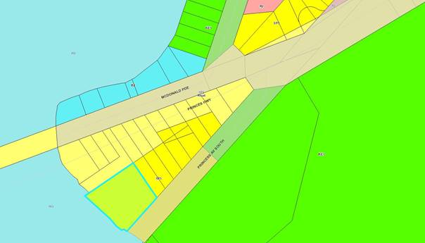
These precincts are situated
within an area where there is no maximum building height specified hence the
default height under the Shoalhaven LEP2014 is 11 metres.
Given the objectives of the
zones it is expected that tourist and commercial development of a similar
nature and potentially similar height can be considered under current planning
controls. Further these precincts provide appropriate buffers to nearby residential
areas.
When assessing a planning
application, each is considered on its merits and not on the precedent of
previous applications.
The proposal has been designed to be sympathetic to the
surrounding area and it is compatible with the desired future character and the
objectives of the tourist zone.
Issue
The height is excessive
Comment:
It is considered that this issue has been addressed in the
preceding assessment. Regardless the height of the building is generally
consistent with the 11m height standard except for the middle section of the
roof. The maximum deviation is 1.8m. The height is considered to be consistent
with the design objectives and built form outcomes of the SP3 Zone.
Issue
Visual bulk &
inappropriate scale & massing
Comment:
The design of the building
utilises different materials and textures and includes vertical articulation in
the way of balconies and windows to reduce the massing and bulk of the
building. The proposed building is articulated and incorporates a variety of building
materials and integrates variations to the façade walls to create
interest and articulation.
The proposed extent of
visibility is an acceptable and anticipated outcome for future built form
within the SP3 Zone, with the zoning of the area envisaging that more robust
developments will occur.
Having regard to the above it is considered that the massing
and bulk of the proposal is considered appropriate.
Issue
Overshadowing of adjoining
properties
Comment:
The location of the lot and siting of the proposal to the
south-west of the existing residential properties ensures that no impacts from
overshadowing will occur to the existing properties located north-east of the
site.
Issue
Overlooking of caravan park
and residences
Comment:
With regards to overlooking, the
closest residential sites are located to the north and the caravan park is
located to the east.
The tourist accommodation unit
level, the units are designed to prevent direct views to the north. In this
regard, a series of articulations and an angled wall provide openings that are
directed away from the neighbouring property.
There are potential overlooking
opportunities from the roof terrace. Whilst the Medium Density DCP (G13) does
not apply to this application, it provides a guideline for distances that are
considered acceptable in limiting unreasonable overlooking for developments
above 3 storey (12m). Using this policy as a parameter, the proposed roof
terrace is located beyond the 12-metre requirement and in conjunction with the
proposed vegetation screening will ameliorate any privacy concerns.
There are no direct line of
sight issues into habitable room windows or private open space area. It is
considered that this degree of separation and the landscaping will limit
overlooking to the residential properties to the north-east and the caravan
park to the south-east.
Having regard to the above, the proposal will not result in
any undue loss of privacy to the immediate surrounds.
Issue
Noise
Comment:
The applicant provided Council
with an Acoustic Report (prepared by Hardwood Acoustics Consultants) which
recommended implementing a number of measures to prevent unreasonable noise or
vibration from impacting nearby residents.
These measures included use of noise limiters, building
treatments and operational management measures. Additional conditions of
consent to support the acoustic report will also be added to the development
consent to minimise any adverse noise impacts.
Financial Implications:
Not applicable
Legal Implications
Not applicable
Summary and Conclusion
It is recommended that the
variation is reasonable and acceptable and, in this instance, strict compliance
with the height development standard is considered to be unnecessary as the
development is appropriate in the location and can achieve relevant planning
objectives.
It is considered that there are sufficient planning grounds
to justify the departure from the height development standard prescribed in the
Shoalhaven LEP 2014. Therefore, the proposed variation to the building height
development standard is well founded in this instance
|
|
Development
& Environment Committee – Tuesday 07 April 2020
Page
1
|
DE20.27 Landscape Screening and Bushfire Protection Measures -
Planning Proposal (PP029) - Hitchcocks Lane, Berry
HPERM Ref: D19/374064
Section: Strategic
Planning
Approver: Phil
Costello, Director Planning Environment & Development Group
Attachments: 1. Proponents'
Concept Masterplan 27/2/20 - Hitchcocks Lane PP029 ⇩
2. Screening Landscape Plan -
Hitchcocks Lane PP029 ⇩
Reason for Report
· Provide
a general update on the status of this Planning Proposal (PP029); and
· Seek
Council’s specific input into one of the key aspects of this PP - proposed
vegetation screening along the southern side of the subject land as recommended
in the Visual Impact Assessment, incorporating the recommendations of a
Bushfire Assessment report.
|
Recommendation (Item to be determined under delegated authority)
That
Council:
1. Note the update on the status of
Planning Proposal PP029.
2. Give ‘in principle’ endorsement
to locating a proposed landscaped screen adjacent to the southern boundary of
the subject land as follows:
a. Minimum 12 m wide landscaped buffer
incorporating an 8 m wide planting area and 2 m wide buffer on either side.
b. The landscaped buffer is to be
maintained by the landholder in accordance with a positive covenant on the
adjoining land.
3. Secure the Proponent’s
commitment to implement the above measures via a Voluntary Planning Agreement
to be exhibited concurrently with the PP.
4. Prepare a draft amendment to Chapter
N3 (Berry Residential Subdivision) of Shoalhaven Development Control Plan
(DCP) 2014 to incorporate the above provisions and any other key
recommendations of the supporting studies.
5. Commence the preparation of an
amendment to Shoalhaven Contributions Plan 2019 project 01OREC0009 (Land
acquisition for passive open space - Princes Highway, Berry) to recognise the
demand the additional lots will place on the passive open space network in
the Huntingdale subdivision area.
6. Prepare a report on the PP package
prior to public exhibition, including the updated PP, draft Planning
Agreement, and proposed amendments to the CP and DCP.
|
Options
1. As recommended.
Implications: this is the preferred approach,
endorsing the proposed landscaping and bushfire protection measures will enable
the concept masterplan and further details of the PP and supporting documents
to be prepared/updated and progressed toward public exhibition.
Provision of effective visual
screening along the land’s southern side, while at the same time,
managing bushfire risk are key outcomes that affect other aspects of the PP
(zoning, lot sizes, road layout etc.). The proposed landscaping and bushfire
protection measures have been negotiated between Council staff and the
proponents and satisfactorily address these issues.
2. Adopt an
alternate recommendation.
Implications: will depend on the nature of changes
made, but may delay the finalisation of the concept masterplan and overall
progression of the PP. Any alternate measures may not satisfactorily address
bushfire hazard and visual screening along the southern side of the subject
land and may not be agreed to by the proponents.
3. Do not proceed
with the recommendation.
Implications: this will
delay the finalisation of the concept masterplan and overall progression of the
PP. Key visual impacts and bushfire hazards will not be addressed in the PP.
Background
This PP covers the land outlined
red in Figure 1 below, being part of Lots 762 and 763 DP 1224932, Hitchcocks
Lane, Berry (the subject land).
The subject land is located on
the southern edge of the Berry urban area and is adjoined to the southeast by
the Princes Highway, to the north by the Huntingdale Park residential estate
and to the southwest by rural land.
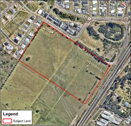
Figure 1:
Subject land
The PP was initiated as the
result of a proponent-initiated PP application that was received on 8 September
2017 from Cowman Stoddart Pty Ltd on behalf of the landowners. At the time,
both lots were owned by P&P Bice. One of the two lots (Lot 763) was
subsequently purchased by 2535 No 2 Pty Ltd.
Council resolved to support the PP at the 14 November 2017
Development Committee meeting as follows:
1. Prepare
a Planning Proposal to rezone part (as detailed in the plans within this
report) of Lots 762 and 763 DP 1224932, Hitchcocks Lane, Berry, to an R2 - Low
Density Residential Zone with:
a. A 500 m2
minimum lot size; and
b. An 8.5 m
maximum height of buildings.
2. Forward
this Planning Proposal to the NSW Department of Planning and Environment for a
Gateway determination with a request that the determination be subject to a
condition allowing up to 25% of the site to be provided with a lot size as
small as 350 m2 subject to specialist studies and community
consultation.
3. Advise
the NSW Department of Planning & Environment that the following studies are
considered appropriate as part of the post Gateway stage of the Planning
Proposal (prior to public exhibition):
a. Stormwater
assessment including conceptual design details for the proposed drainage
reserve
b. Stage
1 preliminary contaminated site assessment
c. Aboriginal
cultural heritage assessment
d. Flood
risk assessment
e. Traffic
study
f. Visual
impact assessment
g. Infrastructure
study and delivery plan (including “soft” infrastructure)
h. Master
plan including detailed urban design and built form guidelines
6. Consider
a report on the Planning Proposal prior to public exhibition.
The PP subsequently received a
Gateway determination from the then NSW Department of Planning and Environment
on 3 April 2018 authorising the PP to proceed, subject to consultation with
public authorities, completion of several technical studies and public exhibition.
The PP seeks to rezone the
subject land from RU1 Primary Production to R2 Low Density Residential to
permit the subdivision of the land for residential development. A condition of
the Gateway determination permits the provision of lot sizes down to 350 m2
across up to 25% of the subject land.
This report primarily concerns
the key aspect of the Visual Impact Assessment, noting that depending on the
outcome of this detailed matter that a further report will be presented to
Council prior to public exhibition of the overall PP. A brief update on the
other studies associated with the PP is provided later in this report.
1. Visual Impact Assessment
& Urban Design Guidelines (VIA/UDG)
Given the importance of this
aspect, Council commissioned Peter Andrews and Associates P/L to prepare a
Visual Impact Assessment and Urban Design Guidelines (VIA/UDG) for the PP
independently of the Proponent, but with funding provided by the proponent
consistent with Council’s Planning Proposal Guidelines.
The resulting VIA/UDG report
recommends a range of planning and urban design measures to achieve positive
visual outcomes on this key edge to the town of Berry and manage the visual
impact of the proposed development. The recommended measures cover development
density, lot sizes, lot layout, dwelling/lot design and landscaping.
Of these measures, potentially
most contentious is a proposed tree and vegetation screen to manage the visual
impact of the site as viewed from the Princes Highway when travelling
north. The detail of how this is implemented is a key policy issue that
requires closer consideration by the Council, and it will inform preparation of
the PP maps, particularly the minimum lot size map.
The existing view of the subject
land when travelling north along the Princes Highway is shown in Figure 2.
Figure 2:
Existing view north toward the subject land from the Princes Highway
(Peter Andrews & Associates, May 2019)
The VIA identifies this view as
sensitive due to the outstanding views of the surrounding ridgelines,
escarpment, natural areas and cleared rural lands available when travelling
north on the Highway towards Berry.
Figure 3 is a photo
montage of the proposed development from the same viewpoint based on
Council’s generic DCP controls for subdivision.
Figure 3:
Indicative photo montage of proposed development without screening from
the same viewpoint based on Council’s generic subdivision DCP controls
(Peter Andrews & Associates, May 2019)
The VIA concludes that without
appropriate screening, the proposed development would have a moderate impact on
these views due to the extent of the proposed development, the abruptness of
the change in view and the resulting increased urbanity of the view.
As a result, the VIA recommends
that substantial tree planting be undertaken along the southern boundary of the
subject land and within the drainage corridor that traverses through the site
to screen views of the proposed development from the Princes Highway. The VIA
suggests that the tree planting on the southern boundary could be within the
subject land or on the adjoining land near the development and should
incorporate any acoustic berms (if required) to mitigate highway noise.
Figure 4 is an indicative
photo montage of the view of the proposed development with potential tree
planting along the southern boundary and the drainage corridor.

Figure 4:
Indicative photo montage of proposed development incorporating recommended tree
planting along southern boundary and drainage corridor
(Peter Andrews & Associates, May 2019)
The VIA also includes a concept development plan showing how
the recommended screening measures could be incorporated into the future subdivision
and development of the subject land (Figure 5).
Figure 5:
VIA concept development plan (Peter Andrews & Associates, May 2019)
The main vegetation screen shown
in Figure 5 is located to the south of the subject land (i.e. within the area
that will remain RU1) and also along the drainage corridor that dissects the
subject land.
The VIA does not specify a
minimum width for the southern boundary tree planting however the indicative
width on the concept development plan is 20 m. It should be noted that this
plan was prepared to illustrate one possible development scenario incorporating
the VIA’s recommendations. It does not necessarily reflect the
Proponent’s concept masterplan for the subject land.
The recommended establishment of
effective tree and vegetation screening, particularly along the southern and
south eastern side of the development and the drainage corridor that dissects the
subject land is strongly supported given the highly visible nature of this edge
on the entry into Berry. Without an appropriate treatment the development of
the subject land could have a negative or less than desirable visual impact on
this key entry. Council staff have had detailed discussions and
negotiations with the proponents in relation to the position (within or outside
of the subject land), width, tenure and ongoing management responsibility of
the vegetation screen/s.
Several different options and
implementation mechanisms have been considered for establishing effective
vegetation screens including the following:
· Positive covenant
on the title of future residential lots within the subject land, maintained by
each landholder.
· Land dedicated to
Council as open space or part of a widened road reserve.
· Easement on
adjoining private land maintained by Council.
· Positive
covenant on adjoining private land maintained by landholder.
· Landscaping
width ranging from 6 m to 20 m wide.
It is
considered important that the selected vegetation screening option:
· Is established at
subdivision stage i.e. ahead of development. Note: this has been a consistent
theme in early planning work done by Council for this future residential area.
· Is sufficiently
wide enough and under appropriate tenure to facilitate effective screening of
the development from the south, as depicted in the VIA report.
· Addresses the
long-term management arrangements for the landscape screen. It should also be
cost-neutral to Council over the life of the asset.
· Complies with the
requirements of Planning for Bushfire Protection 2019 - the subject land
is not currently identified as bushfire prone, but the NSW Rural Fire Service
advised in late 2019 that it is likely to identified in the new grassland
hazard category when the bushfire prone land mapping is revised. A bushfire
assessment was subsequently commissioned by the proponent, to ensure that any
proposed vegetation screening and landscaping is consistent with bushfire
planning requirements.
In discussions with Council
staff, the proponents have agreed on a proposed landscaping treatment for the
southern boundary comprising:
· 12 m wide
landscaped screen encompassing 8 m of planting and 2 m wide buffers on either
side to provide access for maintenance. Council’s landscape architect has
advised that this is suitable to achieve the screening effect depicted in the
VIA.
· Mix of low, medium
and tall plantings to achieve an effective screen. The canopy width of the
buffer will be in the order of 12 m.
· Fire resistant
species (buffer will adjoin the southern side of the 14 m wide asset protection
zone required for the future development).
· Buffer is proposed
to be located on the adjoining land and maintained by the landholder (currently
the same owners as the subject land) via a positive covenant.
The proponents also propose to establish
the plantings on either side of the drainage corridor consistent with another
recommendation of the VIA.
The agreed measures are
illustrated in Attachments 1 and 2 (Proponent’s concept masterplan
and landscaping plan). Detailed considerations that will need to be addressed
in the design of the landscaped buffer (fencing, edging, drainage, maintenance
regime etc.) will also be included in the draft DCP Chapter for the subject
land and are proposed to be secured via a Voluntary Planning Agreement (VPA) to
be prepared and exhibited concurrently with the PP, DCP etc.
Council’s endorsement of
this approach is now sought so that the PP and supporting draft DCP amendment
can be prepared/updated as the size and location of the landscaped screen will
affect the layout of the concept masterplan to be exhibited with the PP.
The overall PP package
(including proposed DCP and CP amendments) will be reported to Council for
review prior to the formal community consultation public exhibition and then
again after the public exhibition period.
Council staff and the proponents are having ongoing
discussions on the other recommendations of the VIA/UDG and are confident of
reaching agreement on a set of preferred development controls to form the basis
of a draft DCP chapter for the site. Details of these will be provided in the
pre-exhibition Council report.
2. Bushfire Planning Considerations
As noted, the subject land is
not currently identified on the bushfire prone land map and the Gateway
determination does not require the PP to be referred to the NSW Rural Fire
Service (RFS). However, the RFS is currently reviewing and updating bushfire
prone land maps across the State. As part of this update,
‘grasslands’ will be added to the map as a new category of bushfire
prone land. The new Planning for Bushfire Protection (PFBP) 2019 which recently
came into effect includes new requirements for development in areas identified
as grasslands.
Shoalhaven’s bushfire
prone land map is still being reviewed by the RFS, however, preliminary advice
received from the RFS in relation to this PP is that areas of pasture
(grassland) on and adjacent to the subject land are likely to be mapped as
bushfire prone on the revised map. This will require future development to
provide, at a minimum, a perimeter access road along the southern boundary and
an appropriate asset protection zone (APZ) for the dwellings fronting this
boundary.
The RFS also suggested that the
PP should be referred for comment even though there is currently no requirement
to do so.
This emerging detail was
discussed and agreed to with the proponents. A bushfire assessment was prepared
by Bushfire & Evacuation Solutions on behalf of the proponents. The
findings and recommendations of which have been incorporated into the design
and location of the landscaped buffer and the proponent’s concept master
plan for the site. The report considers existing vegetation on adjacent land
and the proposed tree planting along the southern boundary. The report
confirmed that:
· An
APZ of a minimum width of 14 m will be required along the southern perimeter of
the site to separate future planned residential buildings from the grassland
hazard; and
· A perimeter road will
need to be provided along the southern perimeter of the site.
These requirements have been incorporated into the
proponent’s concept master plan for the subject land, which includes a
perimeter road along the southern boundary between the landscaped buffer and
future residential lots. The perimeter road is wide enough to function as the
APZ, being a minimum 16 m wide.
3. Update on Other Supporting Studies
The following is a general
summary of the supporting studies that have been completed to date to support
this PP.
Flooding and Stormwater
Management
A Flooding and Stormwater
Management Report was prepared for the proponents by Southeast Engineering
& Environment. The recommendations are summarised below.
· New
stormwater network (minor system) for proposed residential areas (lots and
roads) to be designed to cater for a 5 year Average Recurrence Interval (ARI)
event with direct discharge to either proposed bioretention or central drainage
depression;
· New
roads to provide overland flow path towards the central drainage depression for
large storm events (major system);
· A
new culvert crossing (sized for 100 year ARI) over drainage depression as part
of road proposed road network;
· On
lot controls to include rainwater tanks for roof water harvesting and reuse in
accordance with BASIX + additional Onsite Stormwater Detention (OSD) volume;
· End
of line gross pollutant traps to capture gross pollutants and a portion of
suspended solids;
· End
of line bioretention systems to remove gross pollutants, a portion of suspended
solids and some nutrients + provide a portion of OSD function for the
development.
· The
drainage depression will be modified and landscaped to cater for the 1% AEP (1
in 100 year event) peak flow, and allow for filling to achieve the necessary
flood planning levels for the adjacent residential land and road reserves, and
to accommodate stormwater infrastructure.
Council Staff Comments:
Stormwater management details will be addressed in further detail as part of
the subdivision application process in accordance with Chapter G2 of the DCP.
Council’s Community and Recreation Services Unit also provided the
following advice in relation to the proposed drainage reserve:
Council’s adopted Community Infrastructure
Strategic Plan (CISP) specifies that drainage reserves will not be accepted
unless it is useable, accessible and a minimum size and width.
Acknowledging Council’s existing ownership of a reserve on Parker
Crescent (Lot 339 DP 1226462) that would connect with the proposed drainage
reserve on the land subject to the PP, and the proposed 350 m2 lot
size in this location, it is considered appropriate that the drainage reserve
is embellished with passive recreation embellishments. These
embellishments should include shared paths (min. 2 m), seating, lighting
and appropriate landscaping. This level of detail will need to be
considered at the Development Application stage.
Preliminary Land
Contamination
A Stage 1 - Environmental Site
Assessment (Land Contamination) report was prepared for the proponents by ENRS
P/L. The report concluded that it is unlikely that the site may pose a
significant risk to the environment and to the health of future users of the
Site and may be considered suitable for the proposed residential land-use.
Aboriginal Cultural
Heritage Assessment
An Aboriginal Cultural Heritage
Assessment is currently being finalised for Council by AMBS and is expected to
be completed by early June 2020.
Traffic Assessment
A traffic assessment was
completed for the proponents by Bitzios Consulting. The overall conclusion was:
The site has been suitably designed to ensure that it
can comply with Council's relevant codes and standards under the proposed
re-zoning. Furthermore, the impact assessment identified no issues of
significance that would preclude its approval.
Council’s Traffic Unit has
provided technical on a range of specific technical matters that will be
addressed as the subsequent master planning/subdivision design process
progresses.
Infrastructure Assessment
An Infrastructure Assessment was
prepared for the proponents by Allen Price & Scarretts. The
Assessment outlines a range of proposed infrastructure upgrades and extensions
to facilitate the proposed development. In summary:
· Water
and sewer capacity are not constraints to proceeding.
· Electricity
capacity is not a constraint to proceeding.
· The
site and its future residential development will create demand for community
facilities and public open space and hence this demand needs to be met
appropriately and resourcefully.
· Contributions
project 010REC0009 (Land acquisition for passive open space - Princes Highway,
Berry) should be reviewed
· The
Community Infrastructure Strategic Plan indicates that there is an oversupply
of open space area in Berry.
Council staff Comments:
Council’s Community and Recreation Section have confirmed/advised that
the area for project 01OREC0009 in the Shoalhaven Contributions Plan (CP) 2019
should be amended. As a result, this report includes a recommendation to
initiate an amendment to the CP in conjunction with this PP.
The Shoalhaven CP 2019 currently
includes project 01OREC0009 (Land acquisition for passive open space - Princes
Highway, Berry) which provides for the acquisition of land for the purpose of
passive open space in the Huntingdale Estate area. The current
contribution area for project 01OREC0009 is identified in Figure 6 below.
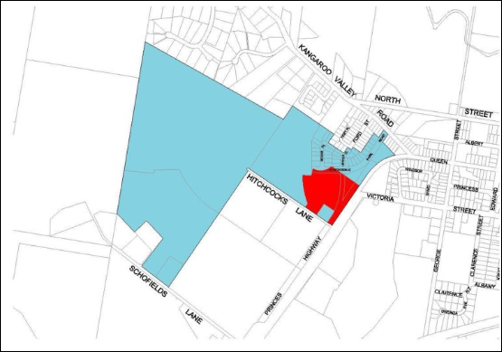
Figure
6: Contributions Project 01OREC0009 Contribution Area (blue)
Passive
Open Space Area – identified in red
The future residential
subdivision of the subject land will place additional demand on this
infrastructure, and as such, should contribute to the acquisition of the land.
It is recommended that project 01OREC0009 be amended to:
· Expand
the contribution area to incorporate the subject land.
· Adjust
the apportionment to development to reflect the development that has occurred
in the contribution area since the project commenced (now known as existing
tenements).
· Adjust
the contribution rate accordingly.
· Consider
the potential embellishment of the passive open space.
· Consider
the extent of the passive open space area, taking into consideration recent
approvals in the vicinity and the acquisition of several lots by Transport for
NSW (TfNSW) as part of the Berry Bypass.
· Consider
any other matters that arise during the project review.
Conclusion
This report essentially seeks
Council’s endorsement for one of the key decisions associated with this
PP – how to deal with its southern edge given its highly visible location
on this edge of Berry. Assuming the recommended approach to this is accepted,
work will continue to get the PP ready for exhibition.
Further information on the other
supporting studies will be provided when the overall PP is reported to Council
as required prior to public exhibition.
Community Engagement
Once all the required studies
and other conditions of the Gateway determination have been satisfied, a
further report on the PP package (including proposed DCP and CP amendments) will
be prepared for Council’s endorsement for public exhibition.
Adjoining landholders, development industry representatives
and the Berry Forum (CCB) will be notified when the package if publicly
exhibited.
Policy Implications
The key policy issues that is
dealt with in this report concerns the proposed tree/vegetation screen to
mitigate visual impact of the proposed development when travelling north along
the Princes Highway toward Berry.
Also, the proponent’s conceptual masterplan proposes a
mix of lot sizes ranging from 350 m2, 500 m2 and 700
m2, and a building height limit of 8.5 m, noting that Council has
previous resolved to allow a 350 m2 minimum lot size on up to 25% of
the site. The appropriate zoning of any such land will need to be reviewed and
resolved prior to public exhibition as the R2 zone is unlikely to be
appropriate.
Financial Implications
There are no financial costs to
Council associated with the implementation or maintenance of the proposed
landscape buffer treatment. Under the proposed arrangement, the buffer would be
implemented via a positive covenant on the land and the landholder would be
responsible for ongoing management and maintenance.
Several of the other options
would possibly result in a financial cost to Council for ongoing maintenance,
for example, if the landscaped buffer was dedicated to Council as public open
space. Any alternate option should be cost neutral to Council over the life of
the asset. This could be achieved by having the Proponent enter into a
Voluntary Planning Agreement to make a monetary contribution for
maintenance. All costs associated with preparing a Voluntary Planning
Agreement as part of the PP would be borne by the Proponent in accordance with
Council’s fees and charges.
|
|
Development
& Environment Committee – Tuesday 07 April 2020
Page
1
|
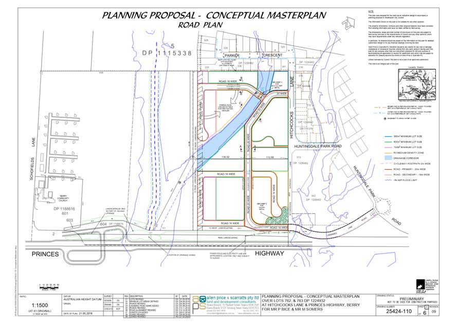
|
|
Development
& Environment Committee – Tuesday 07 April 2020
Page
1
|
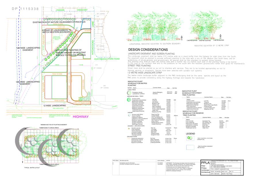
|
|
Development
& Environment Committee – Tuesday 07 April 2020
Page
1
|
DE20.28 Review
- Clause 2.8 Temporary Use of Land, Shoalhaven LEP 2014
HPERM Ref: D20/71160
Section: Strategic
Planning
Approver: Phil
Costello, Director Planning Environment & Development Group
Reason for Report
· Present the outcomes of
the initial community consultation in relation to the Clause 2.8 (Temporary use
of land) review.
· Resolve the way forward
in this regard and if accepted, obtain endorsement for potential amendments to
the Shoalhaven Development Control Plan (DCP) 2014.
|
Recommendation (Item to be determined under delegated authority)
That
Council:
1. Not proceed to amend Clause 2.8
(Temporary use of land) in the Shoalhaven Local Environmental Plan 2014 at
this point.
2. Monitor the outcome of both the Destination Sydney Surrounds South work in this regard and the relevant NSW Council
Planning Proposals regarding function centres in rural areas and staff report
back to Council at the appropriate point regarding opportunities that arise
for Shoalhaven.
3. Prepare an amendment to Shoalhaven
Development Control Plan 2014 to provide guidance regarding temporary use
developments as outlined in this report and receive a further report on the
proposed detail of the draft DCP amendment prior to it proceeding to public
exhibition.
4. Advise relevant stakeholders of this
resolution; including CCBs, Shoalhaven Tourism Advisory Group, the
Development/Tourism Industry, those who made a submission/submitted a
questionnaire and attendees of the information session.
5. Update the Strategic Planning Works
Program to reflect the outcomes of this resolution.
|
Options
1. As recommended
Implications: This is the preferred option as it
responds to the outcomes of the community consultation which largely indicated
that ‘no change’ to Clause 2.8 Temporary use of land in Shoalhaven
Local Environmental Plan (SLEP) 2014 was favoured at this point.
Further opportunities may arise in relation to function
centres in Shoalhaven’s rural/environmental areas from current work being
done by Destination Sydney Surrounds South (DSSS) and other NSW councils.
This option also advances an amendment to the DCP to
provide better quality and responsive provisions/guidance regarding temporary
use applications that is much needed.
2. Adopt an
alternative recommendation.
Implications: The implications will depend on the
extent of any changes. Depending on its nature, an alternative
recommendation could delay any proposed amendments to the DCP.
3. Not adopt the
recommendation.
Implications: This option is not preferred as
Council will need to continue to assess development applications made under
Clause 2.8 on a case-by-case basis without appropriate guidance in the DCP.
This will lead to a lack of clarity regarding Council’s standards or
expectations for temporary use developments.
Background
Clause 2.8 of Shoalhaven LEP
2014 is an ‘optional’ clause in the NSW Standard Instrument LEP
which allows development consent to be granted for any development in any
zone for a maximum period of 52 days in any 12 month period, regardless
of land use permissibility and any other land use restrictions within the
LEP.
The original intent of this
clause was to accommodate or provide for ‘one off’ or temporary
events, such as a school fete or community event.
The review of Clause 2.8 was
originally prompted as a result of community concerns raised in submissions
regarding several development applications made under the clause for function
centres (e.g. weddings) in rural and environmental zones and the concerns
primarily related to the following:
· Inappropriate
location,
· Undesirable
behaviour,
· Amenity
impacts (noise, dust, light spill),
· Flora
and fauna impacts,
· Actual
“Temporary” nature of the use/development,
· Lack
of services, and
· Waste
collection.
Following consideration
of an initial report, Council resolved on 7 May 2019 (MIN19.285) to:
1. Proceed to review the
operation and effect of the current Clause 2.8 (Temporary use of land) in
Shoalhaven Local Environmental Plan 2014.
2. Advise relevant
stakeholders (all CCBs, Development/Tourism Industry, Shoalhaven Tourism
Advisory Group) of this decision and engage them during the Review.
3. Receive a further report
outlining the findings of the Review and options to revise the clause as
appropriate.
Stakeholder Consultation
To help inform the review, two
well attended information sessions were held as follows:
· 11
November 2019 – generally targeted at the Development and Tourism
Industry – 118 registered attendees.
· 13 November 2019 -
generally targeted at the community – 111 registered attendees.
The purpose of the sessions was
to provide both community and industry representatives with a clear and
consistent overview of the current issues, concerns etc relating to Clause 2.8
and its use/operation.
A number of Councillors also
attended one or both of the information sessions.
The information sessions also
included a segment on the separate, but related, Tourist and Visitor
Accommodation Planning Review.
Invitations to the information
sessions were sent to the Shoalhaven Tourism Advisory Group, Development
Industry representatives and Tourism Industry representatives, informing them
of the details of the information sessions. An invitation was also sent
to all Community Consultative Bodies (CCB’s) with a request that the
invitation be circulated to their members.
A questionnaire relating to the
Clause 2.8 Temporary Use of Land Review was provided at both sessions seeking
targeted feedback. To enable time to fully consider the questionnaire, a
period of four weeks after the information sessions to 13 December 2019 was
provided for the questionnaire to be returned, or a written submission made.
A ‘Get
Involved’ page has been set up for the Review (including the Tourist
and Visitor Accommodation Review) and remains in place, which contains:
· Fact
sheet.
· Answers
to frequently asked questions (these were updated as questions arose).
· Information
session presentation; and
· Online
questionnaire (has concluded).
Outcomes of Consultation
At the conclusion of the online
questionnaire, 161 responses had been received in relation to the Clause 2.8 Temporary
Use of Land Review and 5 written submission had also been received.
Copies of the questionnaire responses and submissions can be provided to
Councillors if needed.
The key themes identified during the consultation are
outlined in Table 1 below, as are the percentage of the questionnaire
responses/surveys that mentioned the theme. The themes identified in the
written submissions are also presented.
Table 1: Key themes identified in questionnaire responses/
surveys
|
Submission Point
|
Percentage
of questionnaire responses
|
Number
of submissions
|
|
LEP
Clause and Approval Process
|
|
LEP Clause 2.8 should
remain unchanged and amendments would likely make the current situation worse
|
46.6%
|
1
|
|
Approvals under Clause
2.8 are not ‘temporary’, and they undermine the intent of the
whole LEP
|
12.4%
|
3
|
|
Amenity impacts:
|
Clause 2.8 is resulting
in adverse amenity impacts (e.g. noise, traffic)
|
11.2%
|
3
|
|
There must be an
absence of any adverse amenity impacts
|
6.8%
|
1
|
|
Maximum number of days
should decrease
|
4.3%
|
2
|
|
More certainty is
required for operators/businesses (i.e. regarding approval and number of
years they can operate for
|
3.7%
|
-
|
|
Shoalhaven
Development Control Plan 2014
|
|
Introduction of
suitable controls/guidance in DCP
|
13%
|
-
|
|
Specific
Economic and Environmental Considerations
|
|
Wedding/events industry
is critical to the tourism industry, economy and jobs
|
7.5%
|
1
|
|
Need to balance amenity
and environmental impacts with economic/tourism pursuits and opportunities
|
3.7%
|
2
|
|
Operational
Issues/ Breaches
|
|
Issues relate to
unlawful operators, not those with development consent (i.e. unapproved
locations)
|
5.6%
|
-
|
|
Need to better manage
breaches of development consent
|
4.3%
|
-
|
|
Miscellaneous
|
|
Council should consider
the preparation of a Code of Practice or guidelines with stakeholder
representatives from the South Coast Wedding Industry, Chambers of Commerce
and events industry
|
3.7%
|
-
|
Key themes throughout the
questionnaire responses and submissions related to: Clause 2.8 should not be
changed, concern regarding the ‘temporary’ nature of uses and the
adverse impacts of the uses.
When specifically asked whether the current wording of Clause
2.8 adequately manages temporary use developments, of the 161 questionnaire
responses:
· 70%
thought the clause adequately manages temporary use developments.
· 18%
thought the clause did not adequately manage temporary use developments.
· 12%
thought the clause partially manages temporary use developments adequately.
If a change was to be made to Clause 2.8, the results of the
questionnaire indicated the following preferences as most preferred:
· 17.4%
- Decrease the 52-day maximum timeframe.
· 6.5%
- Introduce new controls within the DCP to manage temporary uses.
Commentary
– LEP Provisions
The majority of those who
provided feedback indicated that no change should be made to Clause 2.8 at this
point in time. This also maintains a pathway for the ‘one
off’ and infrequent uses/events that the clause was originally envisaged
to facilitate.
The second preference arising
from the feedback, although not preferred, would be to retain the existing
Clause 2.8 with a decrease in the 52-day maximum timeframe. In this
regard it is noted that Shoalhaven’s Clause 2.8 is identical to 61% of
other Council LEP’s across NSW. An additional 34% have a variation in the
number of days - 30.6% with increased days and 69.4% with decreased days.
Council can if it wishes alter
subclause 2 to reduce the number of days permissible within a 12 month period,
where justified, however without more detailed analysis (to possibly select an
appropriate and soundly based number) this may have unintended adverse impacts
on Shoalhaven’s tourism industry where temporary events and related
industries are a large contributor.
Destination Sydney Surrounds
South (DSSS) are also currently continuing with a review and advocacy in the
‘temporary use’ space, which seeks to provide a clear direction for
the development and growth of ‘destination weddings’ and business
conferencing in rural locations within their Council areas: Wollongong,
Shellharbour, Kiama, Shoalhaven, Wingecarribee and Wollondilly.
This is particularly relevant to
Shoalhaven as the majority of development applications being received utilising
Clause 2.8 relate to temporary function centres. Whilst the outcomes of
the DSSS’s review/advocacy has not yet been made public, it is understood
that discussions have commenced regarding a possible new LEP definition for a
rural function centre type use which would cater for destination weddings and
small scale business conferencing without having to permit the general
“function centres” definition in rural and/or environmental zones.
It is also noted that Byron,
Clarence Valley, Oberon, Gundagai and Greater Hume Councils are currently in
the process of amending their LEP’s to facilitate rural event/function
sites on rural land in the same general manner, with the Byron and Clarence
Valley PP’s including an additional ‘local clause’ to
consider impact and amenity. It would be worth continuing to review the
outcome of these PP’s and consider the potential for Shoalhaven to follow
a similar approach at the appropriate point when these are settled/known.
Commentary – DCP
Provisions
The review has identified the
following matters for consideration in relation to temporary uses which would
benefit from further explanation, guidance and controls in the DCP:
· Commentary regarding
‘adverse impacts’, as per the Marshall Rural Pty Limited v
Hawkesbury City Council case [2015], and what supporting information Council
will require to satisfy this test.
· Clarification regarding
setting up and tacking down of the temporary uses and associated structures and
the relationship to the 52 day limit in LEP Clause 2.8.
· Clarification that temporary
uses may be carried out in permanent structures (e.g. farm buildings or sheds).
· Clarification regarding
the ongoing approval of temporary uses.
· Possible commentary
regarding operational breaches (e.g. failure to comply with conditions of
consent).
Other related matters will be considered and included as they
arise or are identified during the preparation of the DCP amendment.
Conclusion
Tourism and its associated
economic activity are extremely important to the overall Shoalhaven economy.
Functions and events industry are an important and growing part of this.
Tourism overall in Shoalhaven is experiencing challenging times at present and
whilst it is appreciated that that there are ongoing community concerns around
the impact of functions/events in rural areas, it is important that at this
time Council proceeds carefully with any review so as not to create further
consequences, impacts or concerns.
Based on the outcomes of the
initial community consultation and the review undertaken to date, it is
considered appropriate at this point to:
· Retain
the existing LEP Clause 2.8 as is.
· Continue
to monitor the outcome of the DSSS review/advocacy and the five identified NSW
Council PP’s regarding function centres in rural areas; and advise
Council of future opportunities to improve the operation of the Shoalhaven LEP
as a result.
· Amend
the DCP to provide commentary and controls on the relevant themes identified in
this report to provide greater clarity in relation to development applications
for temporary use.
Community Engagement
The initial community engagement
that was undertaken in late 2019 is detailed in this report.
At the appropriate point, any
draft amendments to the LEP and/or DCP will be publicly exhibited in accordance
with Council’s Community Participation Plan and legislative
requirements.
Community
Consultative Bodies (CCB’s), the Shoalhaven Tourism Advisory Group,
development Industry and tourism Industry are being kept advised of the
progress of this review and will be directly advised of any future public
exhibition to ensure that the proposed amendments consider the views of all
stakeholders.
Policy Implications
Any policy decision needs to
consider the broader community and the impact on the overall City as any
changes to the LEP and/or DCP will apply to the entire Shoalhaven.
Financial Implications
Based on the recommended
approach, there are no immediate financial implications for Council and the
matter is being resourced within the existing Strategic Planning budget.
Risk Implications
There is currently a lack of
certainty regarding development applications for temporary uses assessed under
Clause 2.8, and whether these will be approved by Council. Providing additional
guidance in this regard will provide clarification to applicants and Council
staff regarding Clause 2.8 and relevant matters for consideration.
|

|
Development
& Environment Committee – Tuesday 07 April 2020
Page
1
|
DE20.29 Review
- Tourist & Visitor Accommodation - Planning Provisions
HPERM Ref: D20/20045
Section: Strategic
Planning
Approver: Phil
Costello, Director Planning Environment & Development Group
Attachments: 1. Key
Consultation Themes and Summary - Tourist and Visitor Accommodation Review ⇩
2. Model Clause - Rural and
Nature-based Tourist Facilities ⇩
Reason for Report
· Report the outcomes of
the initial community consultation in relation to the review of the Tourist and
Visitor Accommodation planning provisions.
· If
accepted, obtain endorsement to proceed with potential amendments to the
Shoalhaven Local Environmental Plan (LEP) 2014 and Shoalhaven Development
Control Plan (DCP) 2014.
|
Recommendation (Item to be determined under delegated authority)
That
Council:
1. Provide ‘in principle’
support for a Planning Proposal (PP) to amend the Shoalhaven Local
Environmental Plan (LEP) 2014 to introduce a
new Part 7 ‘Additional local provisions’ clause based on the
model clause ‘Rural and nature-based tourist facilities’ provided
at Attachment 2,
2. Receive a further report in due
course that considers the implications of any guidance material/revised model
clause released by the NSW Department of Planning, Industry and Environment
(DPIE) and that presents a PP for consideration to obtain the required
resolution to proceed to Gateway, as appropriate.
3. Continue the preparation of a draft
amendment to Shoalhaven Development Control Plan 2014 Chapter G15: Tourist
and Visitor Accommodation, in accordance with:
a. Council’s previous resolution
of 5 March 2019 (MIN19.113), and
b. The further investigation areas
outlined in Attachment 1.
4. Receive a further report on the
proposed detail of the draft DCP amendment prior to it proceeding to public
exhibition.
5. Advise
relevant stakeholders of this resolution; including Community Consultative
Bodies, the Development/Tourism Industry and those who made a
submission/submitted a questionnaire.
6. Update
the Strategic Planning Works Program to reflect the outcomes of this
resolution.
|
Options
1. As recommended.
Implications: This is the preferred option as it
will enable the LEP and DCP to be amended to provide updated, better quality
and responsive provisions relating to tourist and visitor accommodation
development in Shoalhaven. This option balances the feedback from the
community which broadly seeks to protect the amenity and aesthetics of
Shoalhaven’s rural and environmental areas whilst also continuing to
encourage tourism opportunities.
The progression of a Planning Proposal (PP) to amend the
LEP would not be progressed until such time as the NSW Department of Planning,
Industry and Environment’s (DPIE) guidance/model clause relating to
‘tourist and visitor accommodation’ is released. Indications are
this could occur shortly.
2. Prepare and
progress amendments to the LEP and DCP ahead of the content of DPIE’s
guidance material/model clause being known.
Implications: Whilst this option would see the
proposed amendment to DCP Chapter G15 progress without delay, this option is
not preferred as it would also see an amendment to LEP commence prior to the
release of DPIE’s guidance material/model clause. There may be
subsequent LEP implications for Shoalhaven resulting from this release which
would need to be explored when its detail is known.
3. Adopt an
alternative resolution or not proceed with any amendments to the LEP or DCP.
Implications: This will largely depend on the
nature of any alternative resolution. Not proceeding with any LEP or DCP
amendments would stop the implementation of improved or clarified planning
provisions.
4. Defer this
matter to enable a Councillor Briefing Workshop to be held.
Implications: This could provide an opportunity for
Councillors to provide more detailed input into the review and also further discuss
its possible direction given the sensitivity of this issue to the community,
tourism industry etc.
Background
Council have
received a range of representations from the community regarding the current
tourist and visitor accommodation planning controls in both the LEP and DCP. In
response, Council resolved on 5 March 2019 (MIN19.113) to:
1. Report the scope and
content of a Planning Proposal to amend the relevant provisions of the
Shoalhaven Local Environmental Plan (LEP) 2014 related to ‘tourist and
visitor accommodation’ back to Council and as part of this carry out
initial consultation with relevant stakeholders.
2. Prepare an amendment
to Chapter G15: Tourist and Visitor Accommodation of the Shoalhaven Development
Control Plan (DCP) 2014 and receive a further report on the proposed amendment
prior to it proceeding to public exhibition.
3. Advise relevant stakeholders,
including CCBs and the Development/Tourism Industry, of this decision and
engage them during the preparation of the Planning Proposal and DCP amendment.
4. Staff, in further reports, consider
the submission from the Berry Forum presented in the deputation to this
meeting.
5. Convene a Councillor
Briefing at an appropriate time.
Initial
Stakeholder Consultation
In accordance with Council’s resolution regarding
initial consultation, two well attended information sessions were held as
follows:
· 11
November 2019 – generally targeted at the Development and Tourism
Industry – 118 registered attendees.
· 13 November 2019 -
generally targeted at the broader community – 111 registered attendees.
The purpose of the sessions was
to provide both community and industry representatives with a clear and
consistent overview of the current planning controls relating to tourist and
visitor accommodation, as well as highlight some issues identified regarding
the operation of some of these existing provisions.
A number of Councillors also
attended one or both of the information sessions
The information sessions also
included a segment on the separate, but related, LEP Clause 2.8 (temporary use
of land) Review.
Invitations to the information
sessions were sent to the Shoalhaven Tourism Advisory Group, Development
Industry representatives and Tourism Industry representatives, informing them
of the details of the information sessions. An invitation was also sent
to all Community Consultative Bodies (CCB’s) with a request that the
invitation be circulated to their members.
A questionnaire relating to the
Tourist and Visitor Accommodation Review was provided at both sessions seeking
targeted feedback. To enable time to fully consider the questionnaire, a
period of four weeks after the information sessions to 13 December 2019 was
provided for the questionnaire to be returned, or a written submission
provided.
A ‘Get
Involved’ page was set up for the Review (including the Clause 2.8
Review) and remains in place, which contains:
· Fact
sheet.
· Answers
to frequently asked questions (these were updated as questions arose).
· Information
session presentation; and
· Online
questionnaire (has concluded).
Consultation Outcomes
At the close
of the online questionnaire, 190 responses had been received in relation to the
Tourist and Visitor Accommodation Review. Copies of the questionnaire
responses are available to Councillors.
Of the 190
responses, 72% were received from the Berry area and 28% from other areas
within Shoalhaven. Whilst the views of the Berry community are important, it is
noted that the Berry area forms a relatively small part of the overall
Shoalhaven and as such it does not necessarily reflect the views of the broader
community. This is important as any changes to the LEP would apply across the
Shoalhaven.
Based on the nature of the tourist and visitor accommodation
space and the responses to the questionnaire, several common key themes have
emerged for consideration in any review, including:
· Theme
1 - Expansion of Part 7: Additional Local Provisions in the LEP to include
specific consideration of tourist and visitor accommodation.
· Theme
2 – Expansion/modification or removal of the current ‘tourist and
visitor accommodation’ group term in the LEP as it relates to rural and
environmental zones.
· Theme
3 - Expansion of the existing LEP Clause 5.4 ‘Controls relating to
miscellaneous permissible uses’ to include Tourist cabins and Eco-tourist
facilities.
· Theme
4 - Remove Clause 4.2A ‘Subdivision of land’ from the LEP, which
applies to the community title subdivision of ‘tourist and visitor
accommodation’ in the RU1, RU2 and E3 zones.
· Theme
5 – Relevant controls need to be in LEP not the DCP.
· Theme
6 – Amenity and environmental considerations relating to tourist
development.
· Theme
7 - Ensuring adequate infrastructure for tourist development.
· Theme
8 - Consideration and preservation of the character of an area.
· Theme
9 - Tourism and the economy in Shoalhaven generally and secondary income for
farming.
· Theme
10 - Introduction of new LEP definitions, e.g. Tourist cabins and Guest houses.
· Theme
11 – Views of the whole City should be considered, not just certain
localities or planning areas.
The key
themes largely focused on existing and possible LEP and DCP controls, however,
there was also concern raised regarding the economic impacts/consequences associated
with possible changes to the planning controls related to tourist and visitor
accommodation.
More detail on each of the above
key themes, including a summary of proposed/possible changes and related
Council staff comments is provided in Attachment 1. Also arising from
this are a range of recommendations that are discussed below:
Possible Changes to LEP
Based on the
consultation outcomes and the review undertaken by Council staff, it is
recommended that a new local clause be introduced in Part 7 Additional local
provisions of the LEP, based on the NSW Standard LEP Instrument model clause
‘Rural and nature-based tourist facilities’. A copy of this
model clause is provided as Attachment 2.
The proposed
new local clause would enable the rural and environmental land use tables in
the LEP to remain unchanged, which offers continued opportunity/flexibility to
consider a range of tourism accommodation uses, but provides an
additional layer of consideration (on future developments) that is not currently
there in relation to agricultural, scenic and environmental values which is a
key theme identified by the broader community.
Further guidance would be
required from DPIE regarding additional flexibility to adjust or amend the
clause to include local variations, considerations etc. It is also noted
that the DPIE Tourist and Visitor Accommodation Review (outlined in detail
below) may include a revised or a new model clause relating to tourist and
visitor accommodation.
Possible DCP
Investigation/Amendment Areas
Council
previously resolved to amend Chapter
G15: Tourist and Visitor Accommodation of the DCP to include the following:
· Provision
of a set of generic objectives and controls that apply to all tourist related
development, ensuring that these controls address key issues raised in the
relevant court cases (e.g. amenity, access, servicing).
· Expansion
of the application of the Chapter to include guidelines for more types of
tourist development (e.g. terms defined in LEP and other tourist uses). Provide
specific objectives, controls and guidance as relevant.
· Provision
of additional definitions and guidance on all known tourist uses such as
tourist cabins, glamping, glass tents etc. to assist applicants in
characterising their development.
· Inclusion of relevant guidelines for tourist development in
urban areas where appropriate.
It is considered appropriate to also
consider/investigate the following matters for inclusion in the review of
Chapter G15:
· Ongoing representations
from the Berry Forum made following the 5 March 2019 Development &
Environment Committee meeting.
· Assessment
criteria for visual impact; including definitions for ridgeline, knoll and
escarpment to assist assessment of visual character and amenity.
· Provisions
outlining the definition of ‘short term’ accommodation as it
relates to tourist and visitor accommodation.
· Supplementary controls to support inclusion of the
‘Rural and nature-based tourist facilities’ model clause in the LEP
(Note: only if the related amendment to the LEP is supported).
· Consideration of provisions for Tourist cabins in relation
to size/floor area and number of bedrooms.
· Density standards for Eco-tourist facilities.
· Controls
relating to colour and materials.
Berry Forum’s
Deputation
Consistent
with the Part 4 of the Council resolution of the 5 March 2019, the deputation
from the Berry Forum presented at that meeting has been considered. An overview
of the Forum’s issues and possible solutions was part of the
presentations that was given to the Information Session’s in November
2019.
The themes
within the Berry Forum’s deputation align with several of the general
consultation feedback themes (either partially or wholly) and this has been
specifically noted in Attachment 1.
The main issue/request
from the Berry Forum is that the suggested current LEP ‘loophole’
(their term) that is being used to enable any and all types of tourist and
visitor accommodation in potentially inappropriate locations be revisited and
closed. This essentially relates to the ‘open’ nature of the
‘tourist and visitor accommodation’ land use group term and it
being currently permissible in RU1, RU2 and E3 zones. The Berry Forum has
requested that the current group term be removed from the list of permissible
uses and that the specific uses of ‘farm stay’ and ‘bed and
breakfast accommodation’ be added as permissible uses. It has also been
suggested that Schedule 1 (additional permitted uses) be used to permit
‘other’ types of appropriate tourist and visitor accommodation in
specific areas.
When
constructing the land use tables for the RU1, RU2 and E3 zones in the new LEP
prior to 2014, the then Council was aware of the ‘open’ nature of
the ‘tourist and visitor accommodation’ land use term. This was
accepted as one of the focusses of the Council at that time was on a
‘like for like’ transfer from the previous LEP 1985. Under this LEP
1985 a range of tourist accommodation land uses were permissible in the rural
and some environmental protection zones, including for example tourist cabins.
As such given the role that tourism plays in Shoalhaven, this flexibility was
maintained in LEP 2014.
Removing the
group term as requested by the Berry Forum would now prohibit, for example,
backpackers accommodation, tourist cabins and any other emerging innominate
land uses (even if a new use was considered beneficial or appropriate in a
location) in the RU1, RU2 and E3 zones. The use of Schedule 1 (additional
permitted uses) to circumvent any prohibition in the land use tables may be possible
but is not necessarily good planning practice consistent with the intent of the
NSW Standard LEP Instrument and as such may not be ultimately accepted by DPIE.
The Berry Forum deputation also
raise one suggested change that did not come out as a key theme during the
recent consultation, being the inclusion of a new local clause in Part 7 of the
LEP which prescribes development standards (density, size/area) relating to
Eco-tourist facilities. Numerical standards of this nature are not currently
part of the Standard LEP Instrument framework and if required are generally
located in a DCP, an approach generally supported by DPIE.
NSW Planning Review
DPIE have commenced a review of
tourist and visitor accommodation in relation to the NSW Standard Instrument
LEP and are currently in the process of finalising this process. As part
of the review, DPIE released an industry stakeholder survey relating to the Standard
Instrument LEP tourist and visitor accommodation provisions in late 2018. The
survey asked specific questions regarding characterisation of tourist uses,
whether a definition of ‘tourist cabins’ would be beneficial, use
of model clauses and effectiveness of eco-tourist facility provisions.
It is understood that an outcome
of the review is the preparation of a guideline or additional guidance to
assist councils in planning for and determining applications for tourist and
visitor related land uses and a model clause for tourist and visitor land uses
in rural and environmental areas.
At this point in time, the content or implications of the
guidance documentation is unknown, including the relationship of the
‘possible’ model clause to the current model clause that is
provided as Attachment 2. As such, it would be prudent to wait until the
guidance and model clause has been released so it can be considered in the
context of Shoalhaven. It is understood that the outcomes of the Review
and guidance may be released shortly.
Conclusion
Tourism and its associated
economic activity are extremely important to the overall Shoalhaven economy.
Tourism is currently experiencing challenging times due to a range of local
natural events, global issues etc. Whilst it is appreciated that there are also
ongoing community concerns around tourism impacts, it is also important that
Council proceeds carefully with this review so as not to create further
unintended consequences, impacts or concerns.
Based on the outcomes of the community consultation and the
review work undertaken to date, it is considered appropriate to:
· Amend
the LEP to include a new ‘local clause’ based on the NSW Standard
LEP Instrument model clause ‘Rural and nature-based tourist
facilities’ (see Attachment 2). However, it is considered
premature to progress a PP of this nature until the DPIE review
outcomes/guidance material is released in mid-2020.
· Continue
with the review of Chapter G15 of DCP, considering the existing and additional
themes identified as part of the community consultation outlined in Attachment
1.
Community Engagement
The initial community engagement
that was undertaken in late 2019 is detailed in this report.
At the appropriate point, any
draft amendments to the LEP and/or DCP will also be publicly exhibited in
accordance with Council’s Community Participation Plan and legislative
requirements.
Community Consultative Bodies
(CCB’s), the Shoalhaven Tourism Advisory Group, Development Industry and
Tourism Industry are being kept advised of the progress of this review and will
be directly advised of any future public exhibition to ensure that the proposed
amendments consider the views of all stakeholders.
Policy Implications
Any policy decision needs to
consider the broader community and the impact on the overall City as any
changes to the LEP and/or DCP will apply to the entire Shoalhaven.
Financial Implications
Based on the recommended
approach, there are no immediate financial implications for Council as this
matter is being resourced within the existing Strategic Planning budget.
Risk Implications
It is important that the review
considers the needs and submissions of both the community and the tourism
industry, which are somewhat divergent. Shoalhaven is the most visited
LGA outside of the Sydney and the tourism industry is a significant contributor
to the local economy. The needs of both stakeholder groups need to be
carefully balanced.
The progression of the LEP and
DCP amendment will provide specific direction regarding tourist and visitor
accommodation generally as well as innovative, emerging or innominate tourist
land uses. This will help reduce the risk of highly subjective
development applications that may be incompatible with community expectations
and existing development in those locations.
|

|
Development
& Environment Committee – Tuesday 07 April 2020
Page
1
|
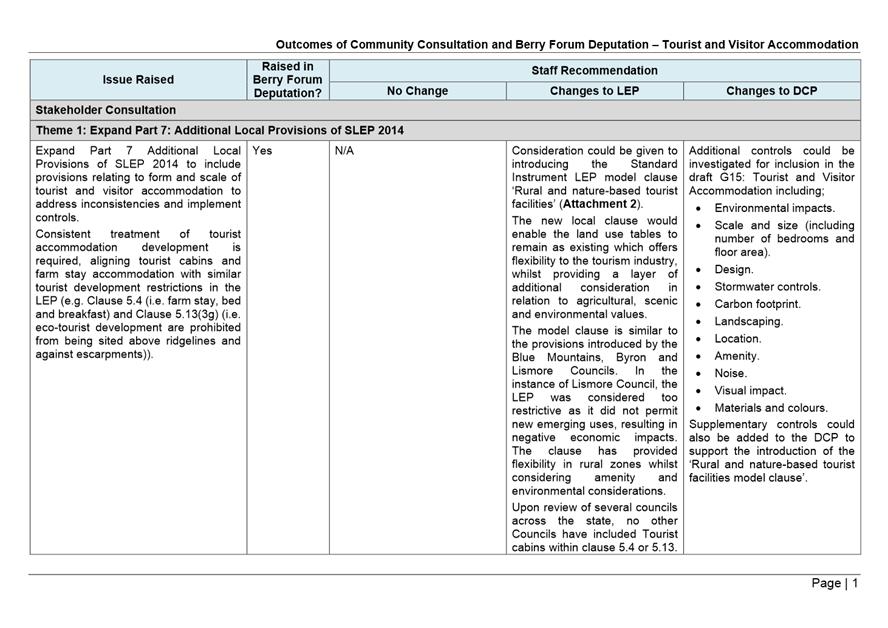
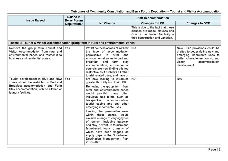
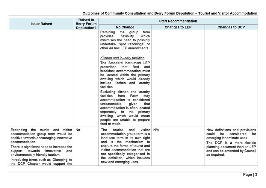
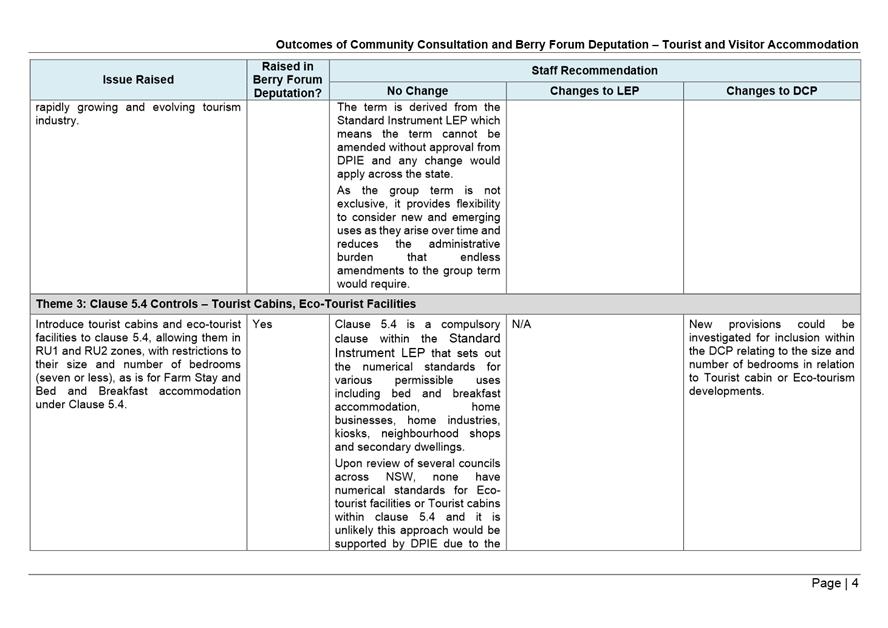


|
|
Development
& Environment Committee – Tuesday 07 April 2020
Page
1
|

|
|
Development
& Environment Committee – Tuesday 07 April 2020
Page
1
|
DE20.30 Planning
Proposal (PP035 ) - Lot 3 DP 846470, Jervis Bay Road, Falls Creek -
Public Exhibition Detail Confirmation
HPERM Ref: D20/52111
Section: Strategic
Planning
Approver: Phil
Costello, Director Planning Environment & Development Group
Attachments: 1. Proponent's
revised conceptual subdivision plan ⇩
Reason for Report
· Present
the findings of the supporting studies which have now been completed in regard
to this proponent initiated Planning Proposal (PP); and
· Obtain
Council’s direction in relation to the number and size of the proposed
lots prior to public exhibition, consistent with the Council resolution of 13
March 2018 (MIN18.162).
|
Recommendation (Item to be determined under delegated authority)
That
Council:
1. Update the Planning Proposal for Lot
3 DP 846470, Jervis Bay Road, Falls Creek (PP035) to reflect the completed
studies, and include the following changes prior to public exhibition:
a. Update zoning, minimum lot size, and
terrestrial biodiversity maps to reflect the revised development footprint.
b. The intended outcome be revised to
allow up to 13 residential lots, no smaller than 4,000 m2.
c. Replace the reference to amending
Clause 4.2B of the LEP with a statement that the legal mechanism to achieve
the intended outcome of the Planning Proposal will be determined in
consultation with NSW Parliamentary Counsel.
2. Place the Planning Proposal and the
supporting information on public exhibition for a minimum of 28 days.
3. Adopt a policy position that should
the Planning Proposal ultimately be finalised on the basis of a minimum lot
size of 4,000 m2 , that town water will not be supplied to the
subject land (regardless of whether the land/subdivision complies with
Council’s Rural Water Supply Policy).
|
Options
1. Proceed as
recommended to publicly exhibit the PP on the basis of the proponents’
proposed changes to the size and number of lots and also the findings of the
various supporting studies. Also replace the reference in the PP to amending
Clause 4.2B (subdivision in certain rural and environment protection zoned) of
the LEP with a statement that the legal mechanism to achieve the intended
outcome of the PP will be determined in consultation with Parliamentary
Counsel.
Implications:
This is the preferred approach as the proponent’s
proposed subdivision layout has now been revised based on the findings of a
range of studies.
One of the key studies is an onsite effluent/wastewater
report which assumes that town water will not be available. Advice from
Shoalhaven Water, however, is that town water could potentially be supplied,
subject to compliance with Council’s Rural Water Supply Policy. Larger
onsite effluent management areas would be required if town water is available,
in which case, a larger/more conservative minimum lot size should be applied.
As a result, this report recommends that if the PP is ultimately finalised on
the basis of 13 residential lots and a 4,000 m2 lot size, that
Council adopt a prudent policy position not to provide town water to the
subject land.
The best legal mechanism for achieving the intended
outcome of this PP remains to be determined. In this regard, a new local clause
is potentially more appropriate than amending the current LEP Clause 4.2B. The
primary purpose of the PP is to describe the intended outcome in plain English
and legal mechanism for achieving the outcome does not necessarily need to be
described in the document.
2. Amend the
recommended approach.
Implications:
Would largely depend on the nature of any changes or
additions to the recommendation.
3. Not proceed
further with the PP
Implications:
This would not be recommended given the level of work that
has gone into this PP consistent with a previous resolution of Council.
Background
In March 2018, Council
considered an initial report on a proponent-initiated Planning Proposal (PP)
application for Lot 3 DP 846470, Jervis Bay Road, Falls Creek.
The PP application was submitted
by Cowman Stoddart Pty Ltd (on behalf of the owner T Pasialis) in November 2017
and sought to amend the Shoalhaven Local Environmental Plan (LEP) 2014 to
permit a 13-lot community title subdivision comprising 12 residential lots
(within a largely cleared area) and a neighbourhood property (bushland which is
to be managed for conservation). The proposed residential lots had a
minimum area of 5,635 m2. The existing minimum lot size under
the LEP is part 40 ha and part 2 ha.
Council resolved on 13 March
2019 (MIN18.162) to:
1. Prepare a Planning Proposal
to:
a. Permit a community title
subdivision of Lot 3 DP 846470 Jervis Bay Road Falls Creek into rural
residential lots and a neighbourhood environmental conservation lot; and
b. Rezone the land to part R5
– Large Lot Residential and part E2 - Environmental Conservation.
2. Submit
this Planning Proposal to the NSW Department of Planning and Environment for a
Gateway determination.
3. Advise
the NSW Department of Planning & Environment that the following studies are
considered appropriate as part of the post Gateway stage of the Planning
Proposal to determine the actual subdivision potential (prior to public
exhibition):
a. Flora
and fauna assessment
b. Onsite
wastewater management plan
c. Water
quality and stormwater management
d. Bushfire
hazard assessment
e. Traffic
study
f. Visual
impact assessment
4. Receive
a report once all the above studies have been completed to determine the number
and size of lots prior to public exhibition of the Planning Proposal.
The resultant PP document
(PP035) was prepared and submitted for Gateway determination in July 2018. The
then NSW Department of Planning and Environment issued a Gateway determination
in September 2018, which included the following conditions:
1. Technical studies on flora
and fauna assessment; onsite wastewater management plan; water quality and
stormwater management; and bushfire hazard assessment are to be prepared and
included in the planning proposal prior to public exhibition.
2. The explanation of the
provisions and maps are to be updated, following the completion of the
technical studies, into a revised planning proposal prior to public exhibition.
Consistent with Part 4 of the
above Council resolution, this report now presents the findings of the required
studies and seeks Council’s direction/confirmation in relation to the
number and size of the lots so that the PP can be updated and publicly
exhibited.
Subject land
The site location and the
subject land are shown in Figures 1 and 2 below.
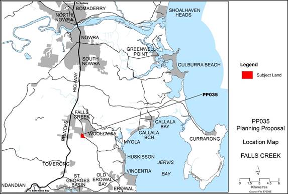
Figure 1 – Site Location
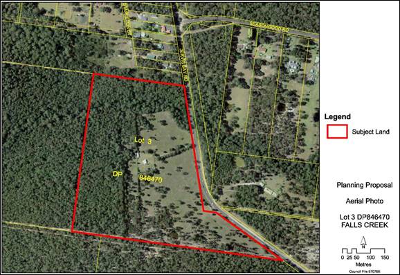
Figure 2
– Subject land overlaid onto aerial photograph
The PP sought to rezone the
subject land from part R5 - Large Lot Residential and part RU2 – Rural
Landscape to part R5 and part E2 - Environmental Conservation – see
Figure 3 below.
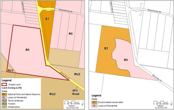
Figure 3 – Existing and proposed land use
zoning
(Source: PP035,
Gateway request version)
Accompanying subdivision
application (SF10637) and proposed layout
The proponent’s original
PP application included a conceptual subdivision plan dated 6 November
2019, for which a subdivision application was also submitted at the same time
(SF10637).
Subdivision Application Notes:
1. Was
submitted during the transitional period for the NSW Biodiversity Act, meaning
that the biodiversity impacts may be assessed under the previous legislation
(i.e. a ‘7-part test’ rather than applying the new Biodiversity
Assessment Methodology and biodiversity offsetting scheme).
2. Has
been in abeyance as requested by the proponent on 22 December 2017,
pending progression of the PP.
The proponent has subsequently
submitted two amendments to their proposed subdivision layout in light of
studies undertaken as part of the PP process. The proposed subdivision
changes are outlined in Table 1 and shown in Figures 4 to 6 below. The
latest layout version is also provided in Attachment 1.
Table 1 – Outline
of changes to proponent’s proposed subdivision application/layout
|
Version /date
|
#
proposed lots
|
Residential
lot size range
|
Comments
|
|
Version 1 6/11/2017
|
12
residential lots, + 1 conservation/ community lot
|
5,635
m2 to 1.541 ha
|
Proponent’s
original proposed subdivision plan. Corresponds to SF10637 which has been
held in abeyance since December 2017.
|
|
Version 2 23/5/2019
|
14
residential lots, + 1 conservation/ community lot
|
4,047
m2 to 8,755 m2
|
Development
footprint reduced to avoid Green and Golden Bell Frog habitat. Plan shows
indicative effluent management areas (including reserve areas)
|
|
Version 3 13/12/2019
|
13
residential lots + 1 conservation/ community lot
|
4,048
m2 to 8,755 m2
|
Largely
same footprint as Version 2. Layout amended to accommodate
recommendations of the Visual Impact Assessment including a slightly wider
setback to Jervis Bay Road to enable more effective vegetation screening.
|
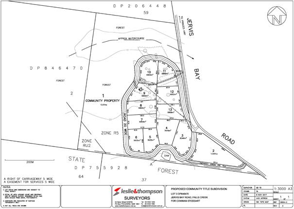
Figure
4 – Proponent’s original proposed subdivision plan dated
6/11/2017 (Version 1) – showing 12 residential lots. Corresponds to
SF10637 which is currently held in abeyance.

Figure
5 – Proponent’s proposed subdivision plan dated 23/5/2019
(Version 2) showing 14 residential lots and indicative effluent management
areas.
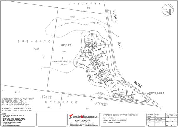
Figure
6 – Proponent’s proposed subdivision plan dated 13/12/2019
(Version 3) – also provided in Attachment 1
Supporting Studies - Summary
of Findings
The key findings of the studies that
have now been prepared to support this PP are summarised below. Apart from the
Visual Impact Assessment, the studies were commissioned and managed by the
proponent, consistent with Council’s Planning Proposal Guidelines.
Flora and Fauna Assessment (Eco
Logical Australia, August 2019)
· The
proposal has been limited to previously cleared areas to retain intact
vegetation, riparian areas and threatened species habitats.
· A
7-part test concluded that the proposed development is unlikely to have
a significant impact on those assessed threatened species provided the
recommended mitigation measures are implemented.
· Referral
under the EPBC Act is not required.
· Management
Plan should be prepared for the proposed Lot 1 Community Property to guide
appropriate management activities and maintain its natural values.
· Green
and Golden Bell Frog management measures include frog exclusion fencing,
access, enhancement of frog habitat and connectivity to adjoining forest,
pre-clearing surveys, hygiene protocols, monitoring and reporting.
The following map (Figure 7)
from the Flora and Fauna Assessment report shows the threatened species
habitat.
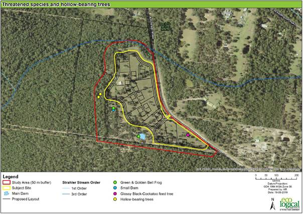 Figure 7 –
Threatened species habitat within the proposed development
footprint (Source: Ecological Australia
2019)
Figure 7 –
Threatened species habitat within the proposed development
footprint (Source: Ecological Australia
2019)
Bushfire Assessment (Eco
Logical Australia, August 2019)
· Access
- a perimeter road is proposed around most of the proposed lots, except for the
southern edge of the proposed residential subdivision adjacent to Lot 37 DP
755928, where a fire trail is proposed.
· Construction
standard - the minimum required bushfire asset protection zones (APZs) to
achieve a maximum Bushfire Attack Level (BAL) of BAL-29 range from 24 m to
50 m – see Figure 8 below.
· Water
supply - based on the assumption that the subdivision will not be serviced by
town water, each lot will require a static water supply of 10,000 L for
firefighting purposes.
· Electricity
- where practicable, electrical transmission lines within the subdivision
should be underground.
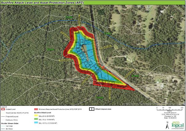
Figure
8 – Minimum APZ and Bushfire Attack Level
(Source: Ecological Australia 2019)
Onsite Wastewater Management
(Cowman Stoddart, November 2017)
· Assumes
that town water will not be extended to the subject land and therefore
hydraulic loading of 600 L (i.e. 150 L/bedroom/day) has been assumed for the
purpose of calculating the minimum required effluent management area.
· Minimum
area for onsite wastewater management = 480 m2
· Minimum
reserve area = 470 m2
· Gypsum
should be applied to the land application area at a rate of 2 kg per 10 m2
and should be mixed in with the topsoil.
· Agricultural
lime should be incorporated into the land application area at a rate of 2 kg
per 10 m2.
Supplementary letter - Onsite Wastewater Management
(Cowman Stoddart, dated 19 August 2019)
The supplementary letter
clarified that the updated subdivision plan shows the minimum Effluent
Management Area and reserve area for a future 4-bedroom house for each
lot. The minimum required setbacks to property boundaries and
intermittent watercourses have been incorporated in the updated subdivision
plan.
Staff Comment:
although town water is not currently provided to the subject land, the
adjoining property to the north is serviced by town water. Advice from
Shoalhaven Water is that town water supply may also be made available to the
subject land if the development complies with Council’s Rural Water
Supply Policy. However, should town water be extended to the subject land,
the calculated minimum effluent management areas will be undersized because
households with town water use more water (approx. 20%) than those that rely on
rainwater tanks. Thus, it is recommended that Council adopt a policy
position that if the PP is ultimately finalised on the basis of a minimum lot
size of 4,000 m2, that town water not be supplied to the subject
land (regardless of whether the land/subdivision complies with
Council’s Rural Water Supply Policy). Council has adopted a similar
prudent approach in relation to Jerberra Estate at Tomerong to minimise risks
associated with onsite effluent management.
Stormwater Assessment (SEEC
August 2019)
· A
loop road would encompass most of the development and would drain via
grassed-line swales to a single bioretention basin. Proposed Lots 2, 3 and 4 in
the far south of the site would drain offsite with no treatment.
· The
large size of each lot (>4,000 m2) means the effective
imperviousness area on each is estimated at 5%. The new road would be 30%
effective impervious.
· Modelling
shows a neutral or beneficial effect (NorBE) can be met.
· The
water quality measures (swales and bioretention basin) would be maintained by
the body corporate that would enter into a contract with an appropriately
qualified contractor. The bioretention basin would have a defined life and
would require replacement (or at least re-generation) every 15-20 years or so.
Such work would also be the responsibility of the body corporate.
Visual Impact Assessment
(Envisage , August 2019)
· Recommended
a minimum 15 m setback between Jervis Bay Road and the internal road to enable
a more effective landscape screen to be established between Jervis Bay Road and
the dwellings and also to increase the setback between the dwellings and
associated structures and Jervis Bay Road.
· The
subdivision layout should be revised to enable more of the existing trees
within the overall development footprint to be retained.
· Reduce
the number of lots – set a minimum lot size of 5,000 m2 so
that the density of dwellings is lower.
Staff Comments:
The proponent’s original subdivision plan incorporated a narrower setback
between Jervis Bay Road and the internal road. The revised subdivision plan
(Figure 6 and Attachment 1) has incorporated a wider setback (approx. 15
m). The lot layout was also revised from ‘version 2’ (Figure 5)
reducing the proposed number of lots by one, to enable more of the existing
trees to be retained.
The proponents’ revised
subdivision plan is now generally consistent with the key findings of the
Visual Impact Assessment, except that six (6) of the lots are smaller than
5,000 m2. However, importantly, all but one of the lots
adjacent to Jervis Bay Road are 5,000 m2 or greater. This is
considered acceptable provided the other key recommendations outlined above are
also implemented.
Intersection (Turning
Warrants) Assessment (Allen Price & Scarratts, February 2020)
· Recommends
that a CHR(s)/BAL intersection (right turn and left turn treatments) be
provided at the intersection with Jervis Bay Road to adequately address the Turning
Warrants in accordance with Austroads Guide to Traffic Management (Part 6)
2019.
Community Engagement
Assuming that Council resolves
to proceed, community feedback will now be formally sought when the PP is
publicly exhibited.
Policy Implications
As outlined above, it is
recommended that if the PP is finalised to allow lots down to 4,000 m2
in size, that Council adopt a policy position that town water not be supplied
to the subject land to prudently ensure there is sufficient land on each lot to
manage household wastewater/effluent.
Financial Implications
Work on this PP is being funded by
the Proponent in accordance with Council’s Planning Proposal Guidelines
and adopted fees/charges.
Conclusion
The range of supporting studies
have now been prepared and finalised to inform the detail of this PP and enable
it to proceed to public exhibition. As such it is appropriate that following
Council’s consideration and confirmation of the detail in this report
that it proceed to exhibition, noting that it is via this
exhibition/consultation process any further issues can be identified and
addressed.
|
|
Development
& Environment Committee – Tuesday 07 April 2020
Page
1
|
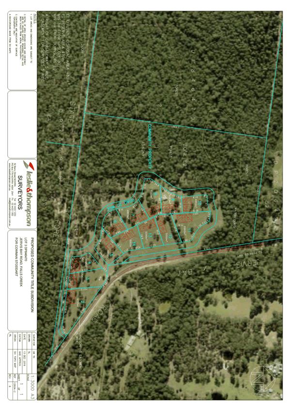
|
|
Development
& Environment Committee – Tuesday 07 April 2020
Page
1
|
DE20.31 Planning for Bush Fire Protection 2019 Adoption
HPERM Ref: D20/75763
Section: Building
& Compliance Services
Approver: Phil
Costello, Director Planning Environment & Development Group
Attachments: 1. Planning for Bushfire Protection 2019 -
Key-Changes-fact-sheet-May-2018-V2.4 ⇩
Reason for Report
This report provides information on the key changes to
Planning for Bush Fire Protection (PBF) with the adoption of PBF 2019.
|
Recommendation (Item to be determined under delegated authority)
That Council receive this
report for information.
|
Options
1. Council receive
the report for information.
Implications: Nil
2. Council receives
the report and provides additional direction for future reports.
Implications: Any changes or additional matters can
be added to future reports.
Background
After the 2001
Christmas fires in NSW, which destroyed 109 homes and burnt more than 750,000
hectares, a Joint Parliamentary Inquiry was established. The resulting report
endorsed the release of a document which contained specifications for building
on land identified as Bush Fire Prone Land (BFPL). This document is titled Planning for Bush Fire
Protection (PBP) which was first published in 2001. This document
was superseded by PBP 2006 which was superseded on the 1 March 2020 by the
adoption of the PBP 2019. PBP is considered industry best practice in the
provision of bush fire protection standards.
PBP is intended for
use by councils, town planners, NSW fire authorities, developers, planning and
bush fire consultants, building surveyors, building practitioners, and the
public.
PBP provides
guidelines and requirements for developing in bush fire prone areas in NSW.
Planning law requires all new development on BFPL to comply with PBP. The aim
of PBP is to provide for the protection of human life and to minimise the
impacts on property from the threat of bush fire.
PBP sets the
direction at a strategic planning level through to subdivision design
requirement and site-specific assessment for new development and
re-development. It provides specific provisions for the most at-risk
developments, like schools and aged care facilities. PBP is applicable to all
development applications and complying development on BFPL in NSW.
As the Australian
natural environmental conditions are evolving and having an impact on bushfire
behaviour our scientific approach to bushfire impact is providing a better
understanding of the heightened impact of bushfire, especially wildfire, on the
natural and built environments. Since PBP 2006 was written, there have been
improvements in the understanding of bush fires and changes to building
construction standards. In addition, following the findings from the Victorian
2009 Bush Fires Royal Commission, changes in bush fire protection requirements
have been considered and made. Research into bushfire behaviour has resulted in
changes to fuel load calculations which has impacted on the requirements for
Asset Protection Zones (APZ’s) and Bushfire Attack Levels (BAL). Additionally,
fact sheets, policy notes, and interpretations have all been incorporated into
PBP 2019.
Impacts on Development Applications
Under section 4.14 of the Environmental Planning &
Assessment Act 1979 (EP&A Act), development consent can only be granted on
BFPL where the consent authority is satisfied that, or has been provided with a
certificate from a recognised bushfire consultant stating that, the development
conforms with PBP 2019.
Referral to the NSW
Rural Fire Service (RFS) is required where a development application proposes
development on BFPL that:
i)
involves a performance solution to achieve compliance with PBP 2019; or
ii)
is within Bushfire Attack Level 40 (BAL-40) or Flame Zone (BAL-FZ).
The attachment to
this report highlights some of the key changes that were adopted when the
original document was released for public consultation in 2018. Therefore, the
attachment refers to PBP 2018 not PBP 2019. Only minor changes have been made
to the document since the 2018 release.
Key Impacts on
Development Applications for Single Dwellings
The key changes for
development applications for single dwellings lodged on BFPL is the level
supporting information.
1. Infill development
proposals on BFPL must be accompanied by bush fire assessments and reports
demonstrating compliance with PBP. In particular, the following must be
addressed:
a. a statement that the
site is BFPL;
b. the location, extent and
vegetation formation of any bushland on or within 140 metres of the site; the
slope and aspect of the site and of any BFPL within 100 metres of the site;
c. any features on or
adjoining the site that may mitigate the impact of a bush fire on the proposed
development; a statement assessing the likely environmental impact of any
proposed Bushfire Protection Measures (BPMs);
d. a site plan showing
access, water supplies, Asset Protection Zones (APZs), BAL requirements and
building footprint in relation to the bush fire hazards; and
e. calculated BAL
construction levels.
2. For smaller proposals,
this can be done relatively simply by using the NSW RFS Single Dwelling
Application Kit which can be found on the NSW RFS website www.rfs.nsw.gov.au and is to be
accompanied by a diagram identifying the requirements detailed within item 1
above.
3. A development application will need to include the
development of a Bush Fire Management Plan (BFMP)
A BFMP should detail all bush fire safety aspects of the
proposed development including:
a. APZ locations and
management details;
b. Landscaping requirements
including indicative design layout and vegetation density thresholds;
c. Access provisions such
as locations, passing bays and alternate emergency access; Water supplies and
bush fire suppression systems (including drenching systems, static water
supply, natural water sources etc.);
d. Schedule of the BALs
requirements and building footprints as well as any specific construction
details (i.e. bush fire shutter operating instructions);
e. Details regarding the
Bush Fire Emergency Management and Evacuation Plan; and
f. Any other
essential bush fire safety requirements.
For more complex applications or performance-based solutions,
a recognised bushfire consultant will be required to be engaged to prepare a
bush fire assessment report and a BFMP. These consultants are known as a
Bushfire Planning and Design (BPAD) Accredited Practitioner or a Level 2 or 3
BPAD Accredited Practitioner. The highest BPAD Accredited Practitioner is Level
3.
Community Engagement
PBP 2019 has been
through an extensive consultation period and has received Ministerial approval
for publication. It was adopted in legislation on 1 March 2020.
The NSW RFS has
providing at least two months advance notice to industry and the public before
PBP 2019 was adopted into legislation.
|
|
Development
& Environment Committee – Tuesday 07 April 2020
Page
1
|
|
|
Development
& Environment Committee – Tuesday 07 April 2020
Page
1
|
DE20.32 Bomaderry
Creek Bushcare Group Action Plan
HPERM Ref: D20/77395
Section: Environmental
Services
Approver: Phil
Costello, Director Planning Environment & Development Group
Attachments: 1. Draft
Bomaderry Creek Bushcare Group Action Plan (under separate cover) ⇨
Reason for Report
The purpose of the report is to
present the Bomaderry Creek Bushcare Group Action Plans for adoption.
|
Recommendation
(Item to be determined under delegated authority)
That
Council adopt the Bomaderry Creek Bushcare Group Action Plan presented as
Attachment 1.
|
Options
1. As recommended
Implications: The Bomaderry Creek Bushcare Group
will implement weed control and rehabilitation activities to increase the
condition and resilience of important bushland around Bomaderry Creek.
2. Modify the recommendation
Implications: The positive and negative
implications of choosing this option would depend on what the proposed changes
are.
3. Not adopt the recommendation
Implications: This decision would significantly
affect volunteer morale and may result in a loss of volunteer participation in
Council’s Natural Area Volunteer program.
Background
The Bomaderry Creek and
surrounds has been described as a ‘beautiful bushland oasis’. It
contains very popular walking tracks and a variety of landform and vegetation.
It includes a wide variety of wildflowers and a number of threatened plant
species.
The Bomaderry Creek Bushcare
Group has been operating for many years and has made significant in-roads to
control weeds on Council reserves. The group has also helped remediate a
previous tip site through weed control and revegetation.
The proposed revised plan will
update the current plan adopted in 2010.
The revised Bomaderry Creek
Bushcare Group Action Plan was drafted in consultation with the Bushcare Group.
The group meets monthly and focuses on weed control and rehabilitation of an
old tip site, accessed off Narang Road. However, there are a number of Council
Reserves and an area of National Parks and Wildlife Service (NPWS) land that
the group also cares for.
Community Engagement
The community consultation for
this Group Action plan falls under minor consultation as per the current
Bushcare/Parkcare Procedures. The revegetation being undertaken does not impact
on views or amenity, being well away from residences. There is no installation
of infrastructure and no change to current usage or status. Therefore, the
draft was required only to be provided to the Department of Planning,
Industries and Environment - Crown Land, in accordance with the procedures.
However, it was also provided to the relevant Council Consultative Body, Pride
of Bomaderry and the Nowra Local Aboriginal Land Council. The draft was also
provided to NPWS. All agencies/groups were provided with a draft on 30 January
2020. No feedback has been received at the time of writing.
Policy Implications
There are no policy
implications.
Financial Implications
Over the six years of the
Bomaderry Creek Bushcare Actions Plan, the cost of implementation will be a
total of $21,700. These costs include an allocation of existing staff resources
which support the Natural Areas Volunteers Program, which will be funded from
the existing annual operation budget (job number 15915). A materials and
equipment contribution of $400 per annum per group is also included in these costs.
The in-kind volunteer
contribution over the six years of the plans is estimated at $39,600. This is a
significant contribution from our volunteers in meeting the objectives of
Council’s Community Strategic Plan.
Risk Implications
There are no risk implications.
|
|
Development
& Environment Committee – Tuesday 07 April 2020
Page
1
|
DE20.33 Grant
Offer: Moeyan Hill Environmental Works funded through Catchment Action NSW
HPERM Ref: D20/78148
Section: Environmental
Services
Approver: Phil
Costello, Director Planning Environment & Development Group
Reason for Report
To seek approval to accept a
grant offer to undertake environmental improvement works on Council’s
Natural Area reserve at Moeyan Hill.
|
Recommendation (Item to be determined under delegated authority)
That
Council
1. Accept the grant offer of $10,500
made by Local Land Services under the Mountains to Sea Biodiversity Corridors
project funded through Catchment Action NSW; and
2. Note co-contributions by Council of
$9,465 funded under existing operational budgets (job numbers 15910 and
15915).
3. Write to Local Land Services
thanking them for the grant.
|
Options
1. As recommended
Implications: Council will be able to expedite the
rehabilitation of the natural area of Moeyan Hill, an important ecological and
cultural reserve, thereby supporting the Moeyan Hill Bushcare Group and
building upon previous investments in the area.
2. Council does not
accept the grant
Implications: The rehabilitation of this important
reserve will take much longer and the effect of previous investments will not
be maximised.
Background
Moeyan Hill supports a range of
flora and fauna. Conserving the biodiversity of Moeyan Hill has been stressed
in a number of ecological reports. Moeyan Hill provides known habitat for
threatened animal species and regionally significant species.
Towards the end of 2019, Local
Land Services (LLS) called for expressions of interest for proposals under the
Mountains to Sea Biodiversity Corridors project funded through Catchment Action
NSW. LLS were seeking projects that would help extend and improve important
ecological communities. Projects were sought from private and public land
managers.
Projects were sought for
high-priority riparian environments, those containing Endangered Ecological
Communities (EEC), that improve the connectivity of vegetation and that
integrate well with other programs/projects.
Funding has previously been
obtained through Local Land Services to improve the condition of Moeyan Hill
that was successfully delivered by Council. A further proposal was developed to
build upon this work, as well as that done by Moeyan Hill Bushcare Group, by
Council’s Aboriginal Bushcare Regenerators and recent work by Corrective
Services works crews.
Under the grant offered, environmental weeds will be
controlled within a 3.4 ha area on the southern side of Moeyan Hill
reserve (Figure 1). This work will connect to previous weed control work
done on the reserve and will improve the habitat corridor along the tributary
of Broughton Creek. The completion date for the project is August 2021.
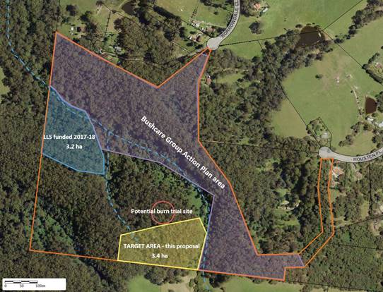
Figure 1 Project area
The feasibility of doing a low
intensity burn will be investigated for areas of sclerophyll forest and, if
feasible and approvals received, carried out with involvement of LLS,
Council’s Bushfire mitigation staff and Council’s Aboriginal Bush
Regenerators. Consideration will be given as to whether such a burn is
appropriate given the bushfires that occurred since the proposal was submitted.
The proposed works will connect
to previous habitat improvement work and is situated along mapped riparian
corridors that connect with areas of the EEC Illawarra Subtropical Rainforest
located within the land parcel. The area has a Bushcare group that regularly
works on site and there is a high level of cultural significance associated
with the site. The land is zoned as E2 – Environmental Conservation.
Community Engagement
Communications were held with the volunteer coordinator of
the Moeyan Hill Bushcare Group and with Local Land Services including the lead
within LLS with regard to cultural burning. LLS staff toured the site with
Council’s Bushcare Coordinator and Aboriginal Bushcare Regenerators prior
to the proposal being submitted.
Policy Implications
A part of the project involves investigating the feasibility
and requirements to undertake a cultural burn. This may result in some
learnings that will assist with the development of policy and/or procedures. In
all other regards, there are no policy implications.
Financial Implications
Council will use existing operational budgets to provide the
$9,465 representing Council’s co-contribution, which will consist largely
of work by Aboriginal Bush Regenerator staff and administration.
Risk Implications
Standard Risk Assessment
procedures will be employed in undertaking the work and will form part of the
feasibility assessment regarding a potential cultural burn. The potential
benefits in managing bushfire risk will also be considered.
|

|
Development
& Environment Committee – Tuesday 07 April 2020
Page
1
|
Local Government Amendment (governance &
planning) act 2016
Chapter
3, Section 8A Guiding principles for councils
(1)
Exercise of functions
generally
The
following general principles apply to the exercise of functions by councils:
(a) Councils should provide strong
and effective representation, leadership, planning and decision-making.
(b) Councils should carry out
functions in a way that provides the best possible value for residents and
ratepayers.
(c) Councils should plan
strategically, using the integrated planning and reporting framework, for the
provision of effective and efficient services and regulation to meet the
diverse needs of the local community.
(d) Councils should apply the
integrated planning and reporting framework in carrying out their functions so
as to achieve desired outcomes and continuous improvements.
(e) Councils should work
co-operatively with other councils and the State government to achieve desired
outcomes for the local community.
(f) Councils should manage
lands and other assets so that current and future local community needs can be
met in an affordable way.
(g) Councils should work with
others to secure appropriate services for local community needs.
(h) Councils should act fairly,
ethically and without bias in the interests of the local community.
(i) Councils should be
responsible employers and provide a consultative and supportive working
environment for staff.
(2) Decision-making
The
following principles apply to decision-making by councils (subject to any other
applicable law):
(a) Councils should recognise
diverse local community needs and interests.
(b) Councils should consider social
justice principles.
(c) Councils should consider the
long term and cumulative effects of actions on future generations.
(d) Councils should consider the
principles of ecologically sustainable development.
(e) Council decision-making should
be transparent and decision-makers are to be accountable for decisions and
omissions.
(3) Community participation
Councils
should actively engage with their local communities, through the use of the
integrated planning and reporting framework and other measures.
Chapter
3, Section 8B Principles of sound financial management
The
following principles of sound financial management apply to councils:
(a) Council spending should be responsible and
sustainable, aligning general revenue and expenses.
(b) Councils should invest in responsible and
sustainable infrastructure for the benefit of the local community.
(c) Councils should have effective financial
and asset management, including sound policies and processes for the following:
(i) performance management
and reporting,
(ii) asset maintenance and
enhancement,
(iii) funding decisions,
(iv) risk management practices.
(d) Councils should have regard to achieving
intergenerational equity, including ensuring the following:
(i) policy decisions are made
after considering their financial effects on future generations,
(ii) the
current generation funds the cost of its services
Chapter
3, 8C Integrated planning and reporting principles that apply to councils
The
following principles for strategic planning apply to the development of the
integrated planning and reporting framework by councils:
(a) Councils should identify and prioritise key
local community needs and aspirations and consider regional priorities.
(b) Councils should identify strategic goals to
meet those needs and aspirations.
(c) Councils should develop activities, and
prioritise actions, to work towards the strategic goals.
(d) Councils should ensure that the strategic
goals and activities to work towards them may be achieved within council
resources.
(e) Councils should regularly review and
evaluate progress towards achieving strategic goals.
(f) Councils should maintain an
integrated approach to planning, delivering, monitoring and reporting on
strategic goals.
(g) Councils should collaborate with others to
maximise achievement of strategic goals.
(h) Councils should manage risks to the local
community or area or to the council effectively and proactively.
(i) Councils should make appropriate
evidence-based adaptations to meet changing needs and circumstances.