|
|
Addendum Agenda - Ordinary Meeting – Tuesday 25 February 2020 Page 1 |
CL20.40 Woollamia Boat Launching Ramp Updated Masterplan
HPERM Ref: D20/48459
Section: Project Delivery & Contracts
Approver: Paul Keech, Director Assets & Works
Attachments: 1. Woollamia BLR Master Plan rev C adopted 2016 ⇩
2. Woollamia BLR Master Plan rev J 2020 ⇩
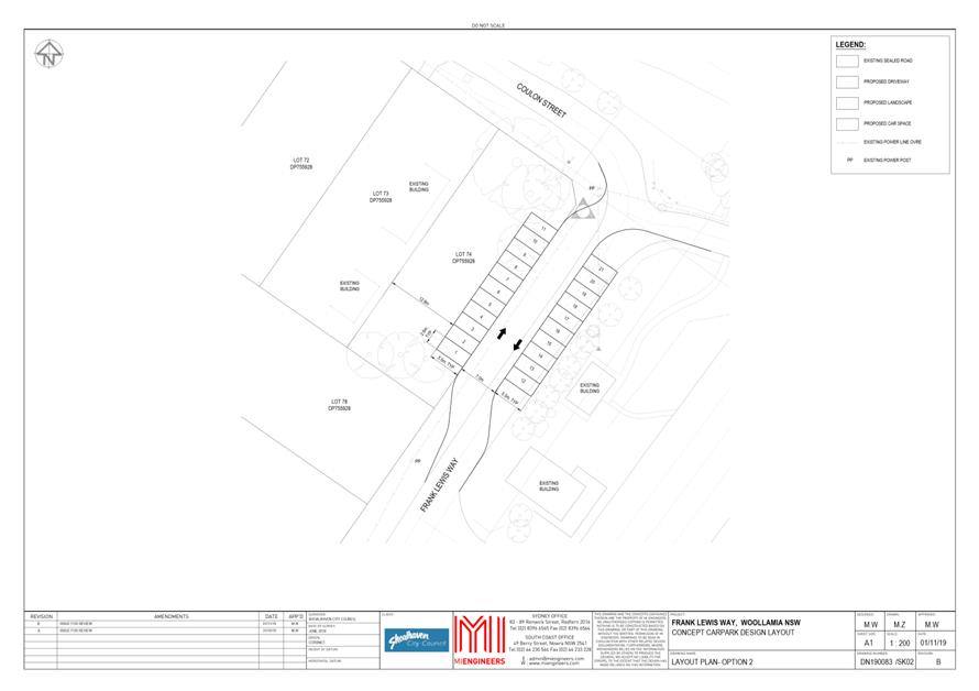
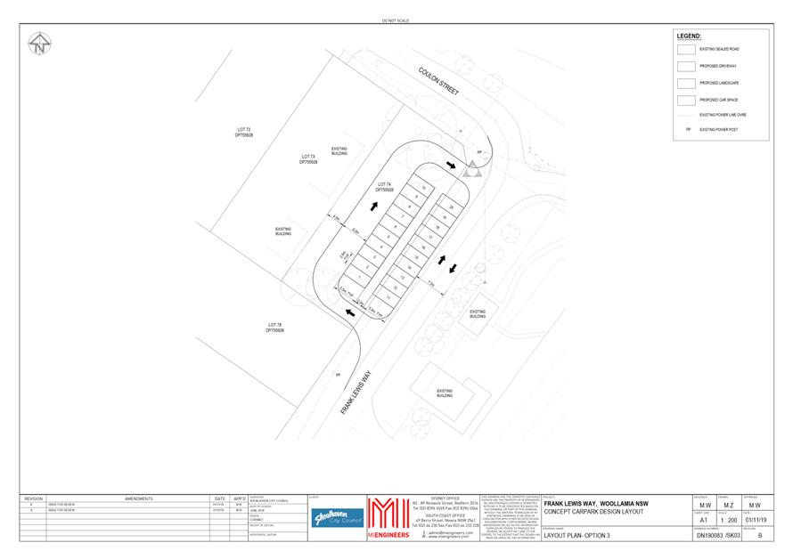
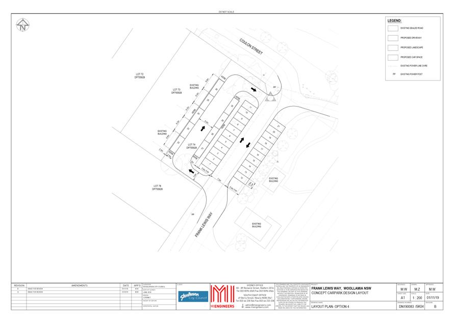
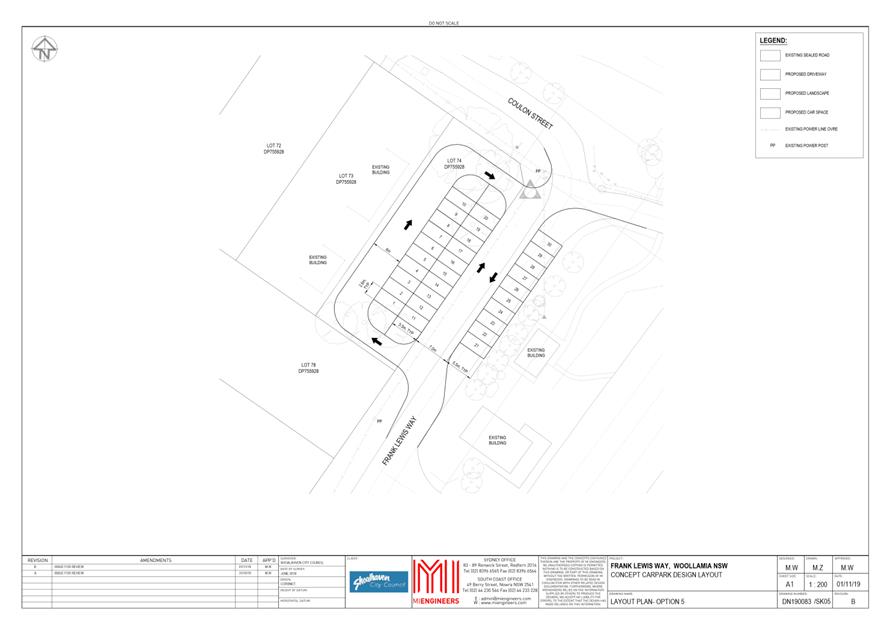
3. Frank Lewis Way - Car Park Options ⇩
4. Woollamia BLR Master Plan rev H 2020 ⇩
5. Petition Wording ⇩
6. Woollamia BLR Master Plan - letter to Stuart Dixon ⇩
7. Council Responses to Residents Concerns ⇩
8. Letter Stuart Dixon - Woollamia BLR Master Plan 5.2.20 ⇩
9. Woollamia BLR Master Plan rev I 2020 ⇩
10. Attachment - Post meeting Correspondence Ordinary Meeting ⇩
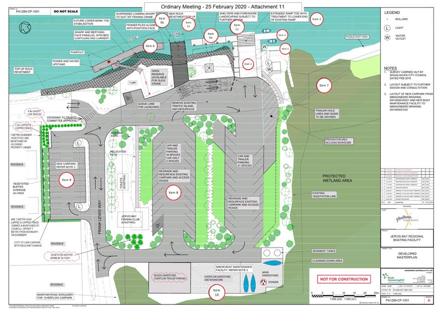
11. Woollamia BLR Master Plan rev K 2020 ⇩
12. Letter - Acoustic Impact Woollamia Boat launching Ramp - The Acoustic Group ⇩
Reason for Report
To allow Councillors to consider the updated masterplan for the Woollamia Boat Launching Ramp precinct, enabling currently funded works to proceed and a platform from which to seek funding for further works.
|
That Council:
1. Adopt the updated Master Plan for Woollamia Boat Launching Ramp (PA1289-CP-1001 Rev K) and commence works that are currently funded and in accordance with this Master Plan. 2. Seek funding for works identified in the Master Plan for Woollamia Boat Launching Ramp (PA1289-CP-1001 Rev K) which are not currently funded. 3. Note that the operation of the Boat Maintenance Facility will need to be governed by Conditions of Operation and public consultation will be required before such conditions are imposed. 4. Install appropriate signs to prohibit the launching of paddle boards and similar nonmotorised craft from the boat lunching ramps, and thus allow the facility to operate as designed.
|
Options
1. Adopt the Master Plan Revision J - 23 space single car park off Frank Lewis Way. A suitable resolution for this option could be:
1. Adopt the updated Master Plan for Woollamia Boat Launching Ramp (PA1289-CP-1001 Rev J) and commence works that are currently funded and in accordance with this Master Plan.
2. Seek funding for works identified in the Master Plan for Woollamia Boat Launching Ramp (PA1289-CP-1001 Rev J) which are not currently funded.
3. Note that the operation of the Boat Maintenance Facility will need to be governed by Conditions of Operation and public consultation will be required before such conditions are imposed.
4. Install appropriate signs to prohibit the launching of paddle boards and similar nonmotorised craft from the boat lunching ramps, and thus allow the facility to operate as designed.
Implications: Currently funded works and grant applications for future aspects can be undertaken with a high level of certainty. This option mitigates some of the concerns raised by local residents.
2. Adopt the Master Plan Revision K - 26 space single car park off Frank Lewis Way. As recommended:
Implications: Currently funded works and grant applications for future aspects can be undertaken with a high level of certainty. Currently funded aspects are proposed to be built to designs supported by the community majority. This option mitigates less of the concerns raised by local residents than Revision J.
3. Council adopt an alternative master plan.
Implications: An alternative master plan would require substantial redefinition and community consultation. Currently funded aspects are proposed to be built to designs supported by the community majority. A suitable resolution for this option could be:
That Council note the need to update the Master Plan for Woollamia Boat Launching Ramp (PA1289-CP-1001 Rev C) adopted in 2016, and that the CEO (Director Assets and Works) conduct a Councilllor Workshop to consider amendments to the Master Plan.
4. Council do not adopt the proposed master plan. Not a feasible Option given the consultation and works that have occurred to date.
Implications: The previously adopted 2016 Master Plan Revision C would remain as the planning document and this is contrary to the expectations of the community. Currently funded aspects proposed to be built in accordance with updated designs could be challenged as not being in accordance with the previously adopted 2016 master plan.
Background
Woollamia Boat Launching Ramp is one of the busiest boat-launching ramps in the Shoalhaven as it provides sheltered launching and retrieval for vessels using Jervis Bay.
Council adopted a master plan in August 2016, however the demand for facilities and detailed design has developed to the extent that an updated master plan is warranted.
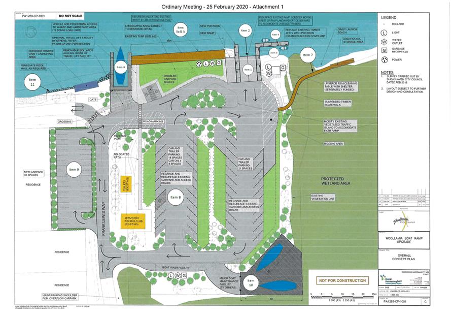
MIN16.641 of August 2016 adopted the master plan as shown in Attachment 1.
The major components of the 2016 master plan are as follows:
1. Two-lane ramp increased to three lanes,
2. Existing ramp slope and length adjusted,
3. Existing jetty demolished,
4. New downstream pontoons,
5. Existing wharf refurbished and extended.
6. New upstream travel lift out,
7. Timber board walk to downstream sandy beach,
8. Regrade and resurface existing car park and internal access roads,
9. New single vehicle car park in Frank Lewis way,
10. Minor boat maintenance facility.
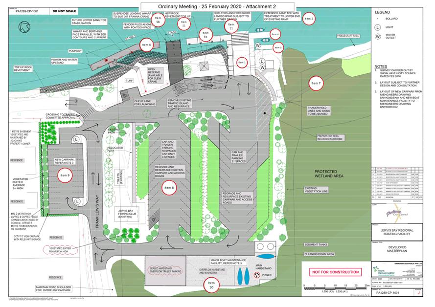
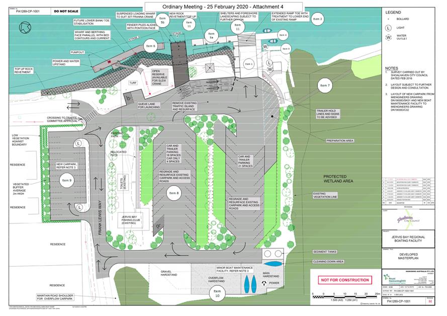
The proposed master plan ‘Woollamia BLR Master Plan rev K 2020’ (Attachment 11) alters the above aspects as follows:
1) Two lane ramp - proposed to be increased to three lanes.
The majority of users have advised that a third ramp lane will increase rather than alleviate queueing at the ramp and that the risks associated with reversing vehicles would also be increased. The preference is for more on water waiting space and for better access to the head of the ramp to allow “out of sequence” vehicles to get to the ramp to retrieve their vessel. The third ramp lane is no longer proposed, and the vegetated island is proposed to be removed to allow better vehicle access to the head of the ramp.
2) Existing ramp slope and length adjusted
The existing ramp consists of an upper half of in situ concrete and a lower half of precast planks that finish about 1.5 metre short of the berthing face of the pontoons. The slope is slightly steeper than some ramps in the Shoalhaven; however, to alter the grade would require substantial rebuilding of the ramp to either extend the ramp further into the car park at the top end or further into the creek at the toe. This is an expensive option and it is impracticable to extend into the car park and it would create a navigation hazard if extended beyond the berthing line of the pontoons. The existing precast planks are in a varying state of repair and would be best replaced with in situ concrete extending to align with the berthing face of the pontoons.
3) Existing jetty demolished.
The existing L-shaped fixed jetty is in relatively shallow depth water and was used by smaller vessels to tie alongside, and also by people watching the activities in and around the ramp including observing the large stingrays that feed at the discharge pipe from the fish cleaning table. The access leg of the fixed jetty was demolished to make space for the access leg of the downstream pontoons, and the berthing leg of the fixed jetty was retained to continue its use for smaller vessels such as dinghies and its ongoing use as a viewing platform. The fixed jetty was provided with a fixed access ramp as the fixed jetty is preferred as an observation point for those who do not wish to use the pontoons which move with the tides and waves. This work was completed in 2017.
4) New downstream pontoons.
The downstream pontoons, stage 1 pontoons, are an L shape with the access leg adjacent to the ramp and the berthing face outside of the existing fixed jetty. Stage 1 pontoons were constructed in 2017 using grant funding provided under the NSW Government Better Boating Now program.
5) Existing wharf refurbished and extended
The existing wharf was found to be in a poor condition such that refurbishment was an expensive option. The existing wharf was a fixed height wharf and people in the majority of vessels had to climb access ladders to get to the wharf deck. The new downstream pontoons provide a berthing face 600mm above the water and the accessibility of the new pontoons at all tide ranges led to the user groups calling for more pontoons and no wharf. The wharf does however provide for the loading and unloading of goods or equipment to vessels where some form of cranage is required. Cranes cannot use the pontoons as the loads are too great and the pontoons rely on floatation not a fixed footing. The wharf has accordingly been reduced in berthing face width and has been supplemented by more pontoon berthing face, stage 2 pontoons. The pontoons were completed in 2019. The Wharf works are still to be undertaken.
6) New upstream travel lift out
Travel lift equipment utilises a large mobile lifting frame with slings that are positioned under a vessel for lifting and lowering. The travel lift requires a fixed wharf either side to allow the travel lift to position the vessel out into deep water. Travel lifts are one option for retrieving vessels and are inherently costly to operate and require specialised operators. The volume and type of vessels predominant in the Currumbene Creek, Jervis Bay area are more suited to being managed with a hydraulic lift trailer than a travel lift and a hydraulic lift trailer is more manoeuvrable between the creek and the maintenance area. The travel lift and associated wharf fingers have been replaced with a hydraulic lift trailer that will use the boat ramp and more pontoon berthing face, stage 3 pontoons. The stage 3 pontoons are proposed to include water and power facilities to allow for provisioning of vessels. The stage 1 and stage 2 pontoons are proposed to have limited berthing times managed by the Ramp User Group while the stage 3 pontoons are proposed to cater for vessels wishing to berth for longer periods.
7) Timber board walk to downstream sandy beach.
The board walk provides access to the downstream sandy beach for paddle craft which makes launching and retrieval easier and safer, as it is located away from the ramp area with motorised vessels. Originally shown as a curved board walk the design was straightened out for easier use and to minimise damage to existing wet land mangroves. The structure was changed to fibre-reinforced materials for better durability in the marine environment and to avoid the use of treated timbers in the wetland mangrove area. The board walk was completed in 2018.
8) Regrade and resurface existing car park and internal access roads.
This aspect remains unchanged as the existing areas are ageing and have potholing and ponding issues. These works are subject to securing future funding.
9) New single vehicle car park in Frank Lewis way.
There are limited single vehicle spaces within the existing formed areas and the number of single vehicles is increasing with paddle craft users and general visitors. The user groups have raised the issue of the single vehicles parking in spaces suitable for vehicles with trailers.
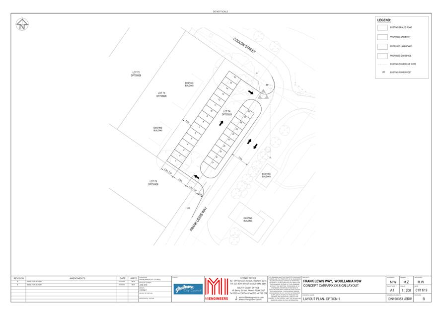
Lot 74 DP755928 is a vacant lot at the end of Frank Lewis Way on the western side held by the State of New South Wales gazetted for Parking in 2006 and for Public Recreation, Community Purposes, Environmental Protection, Tourist Facilities & Services in 2008. The 2016 master plan showed the development of a “new car park 32 spaces”; however, the detail design undertaken to date allows for 26 spaces for single vehicles. Refer Attachment 3 Option 1.
10) Minor boat maintenance facility.
The minor boat maintenance facility remains in the same area as proposed in the 2016 master plan; however, the footprint has changed due to definition of the property boundary and definition of the vegetated areas and the SEPP Wetland area. The proposal includes concrete hardstands falling to pump facilities to retain wash down water in settlement tanks and prevent run off anti-fouling sediments into the adjacent SEPP Wetlands.
11) New item revetment and shore-based facilities
The 2016 master plan identifies that the existing revetment along Currambene Creek is in need of repair; however, the Jervis Bay Marine Park Authority have submitted that the revetment should be rebuilt to a design that provides more fish and crustacean habitat.
The pontoons and adjacent creek edges are increasingly popular with non-boaters and there is an increasing demand for landscaping, seating, shade and BBQ facilities.
The number of vessels using facilities in the Shoalhaven is continually increasing. A pump out facility is allowed for in the masterplan to provide a future service (when/if required) to cater for vessel’s needs, rather than have them visit two facilities for different purposes.
These new items are currently unfunded.
Updated Master Plan
The recommended updated masterplan (Attachment 11, Woollamia BLR Master Plan Rev K) seeks to provide more formalised, efficient and practically placed areas for competing uses whilst also reducing the effect on local residents and the environment. It endeavours to :
· Maximise berthing space for small recreational vessels (short and long stay).
· Maximise, optimise parking and manoeuvring space.
o Vehicles and trailers by boat ramp.
o Single vehicle parking off Frank Lewis Way, out of circulation as early as possible.
o Overflow trailer parking by maintenance area.
· Reduce traffic congestion.
· Accommodate minor boat maintenance.
· Provide environmental protection – foreshore and wetlands.
· Enable loading/unloading, removal of large vessels – fixed wharf for crane use.
· Separate paddle craft from motorised craft.
· Accommodate passive recreation.
· Allow for future pumpout facility.
· Improve amenity of local residents
· Accommodate future improvements.
Community Engagement
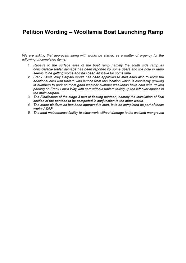
The enhanced development of the Woollamia Boat Launching Ramp retains a high level of support within the general community, and a petition containing 140 signatures was received seeking “approvals along with works be started as a matter of urgency for the following uncompleted items”;
1 Repairs to the existing ramp
2 Frank Lewis Way car park
3 Stage 3 pontoons
4 Crane platform wharf
5 Boat maintenance facility
The wording of the petition is contained in Attachment 5.
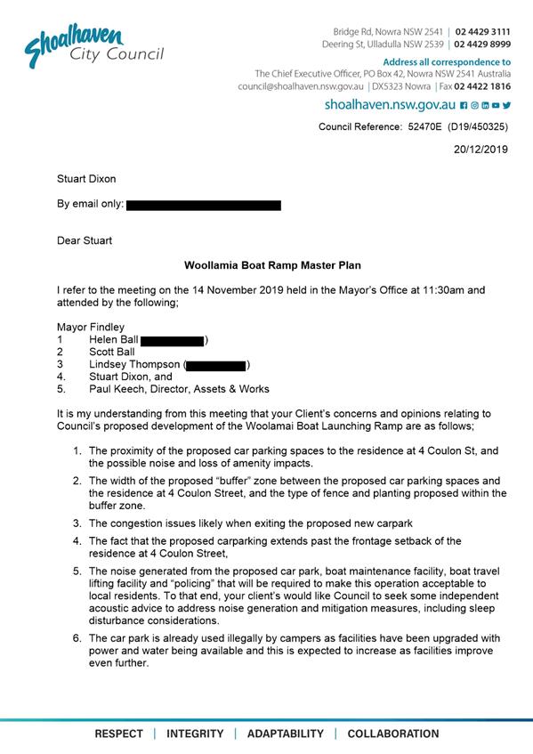
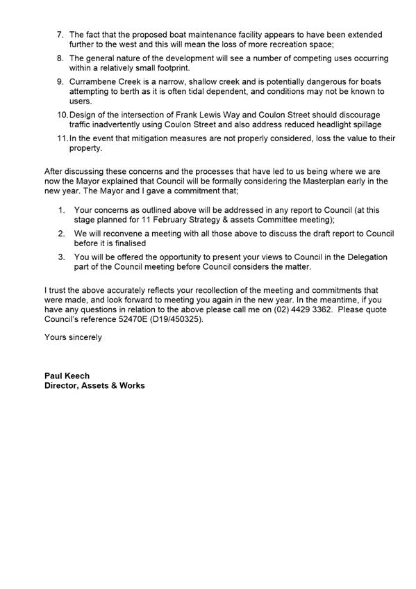
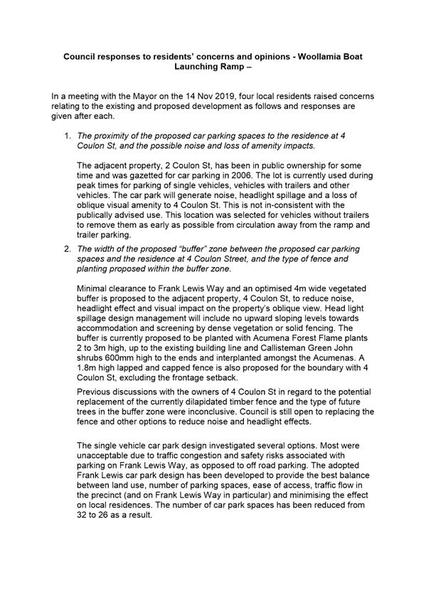
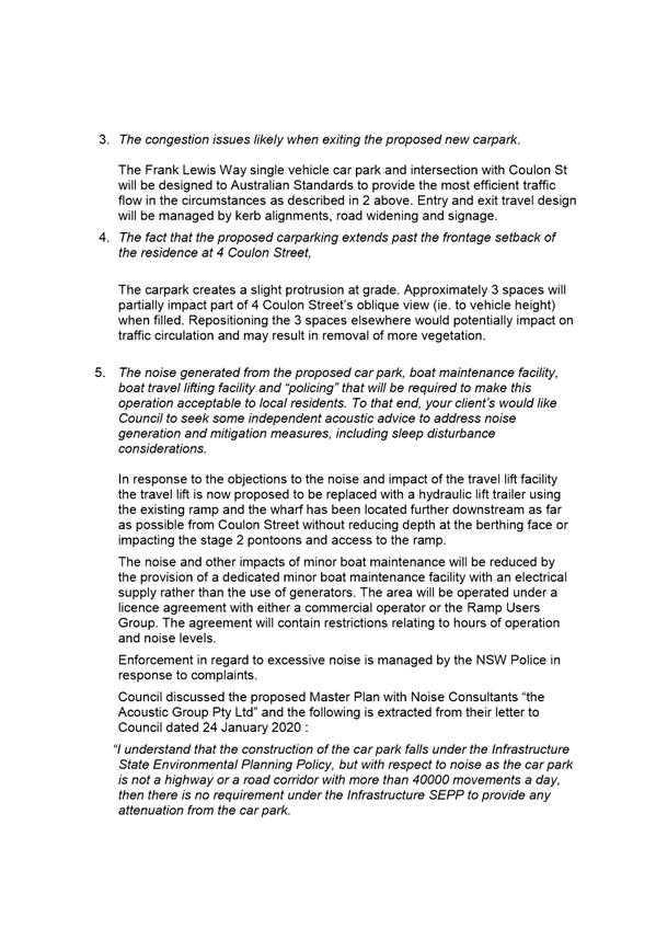
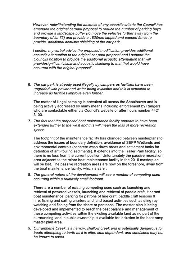
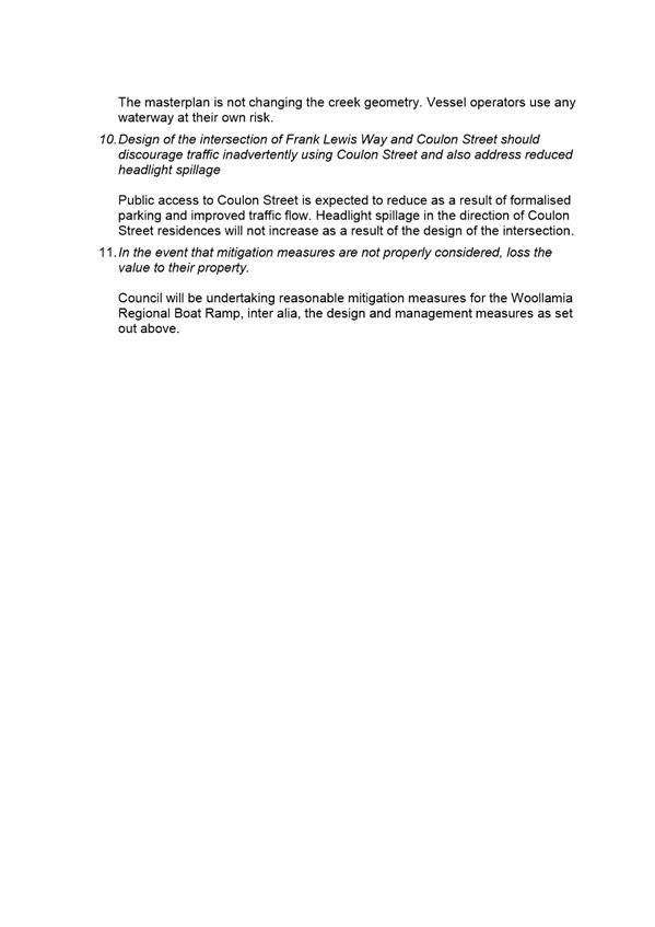
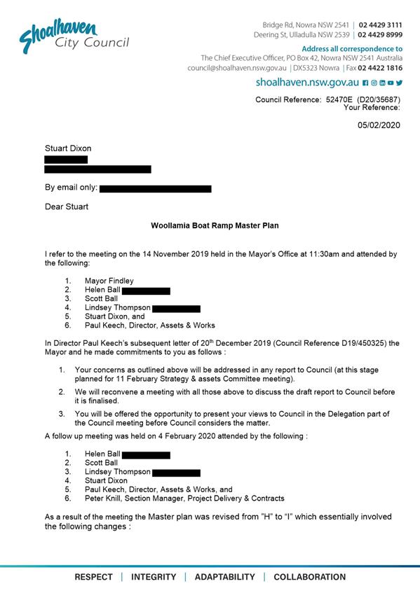
Objections to aspects of the travel lift facility, the minor boat maintenance facility, the single vehicle car park, competing uses within a small footprint, illegal camping, public access to Coulon St and navigation safety were received from some Coulon Street landowners in a meeting with the Mayor and Director Assets and Works on 14 November 2019, see a 6. Council’s responses to the concerns raised are contained in Attachment 7.
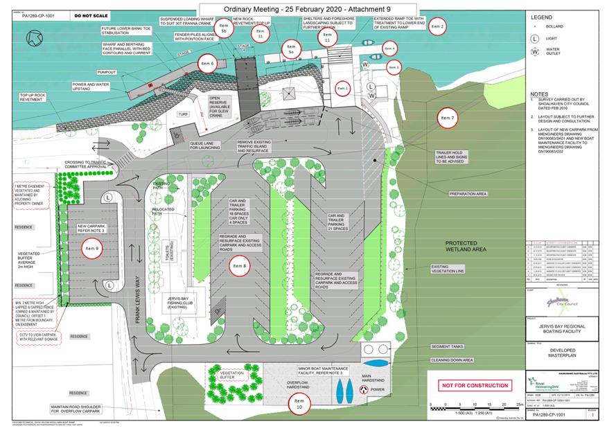
On 4 February 2020 the Director Assets and Works held a follow up meeting with the aforementioned local landowners (refer Attachment 8) and revision I of the Master plan (Attachment 9) was presented to the Strategy & Assets meeting of 11 February 2020. The changes were:
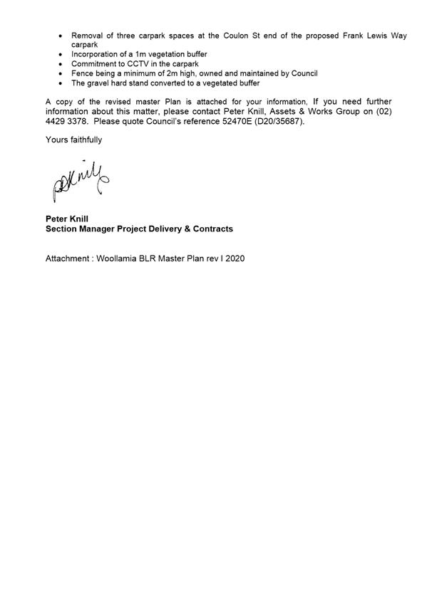
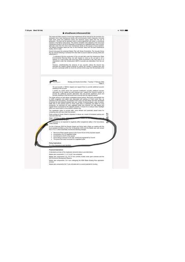
· Removal of three carpark spaces at the Coulon St end of the proposed carpark off Frank Lewis way adjacent to No 4 Coulon St
· Incorporation of a 4m vegetated buffer
· Commitment to CCTV in the carpark
· A minimum 2m high capped and lapped fence, owned and maintained by Council
· Replacement of the gravel hardstand area adjacent to the Minor Boat Maintenance Facility with a vegetated buffer zone.
The Strategy & Assets Committee of 11 February 2020 resolved as follows (MIN20.99):
That the:
1. Matter be deferred to the Ordinary Meeting to allow for further consultation with user groups and briefing of Councillors.
2. CEO consider the possible usage of the pumpout facility of the main wharf rather than replicate it.
Further consultation with stakeholders occurred on Friday 14 February 2020 to discuss the changes made to the masterplan. Attendees included those who presented deputations to the Strategy & Assets Committee meeting, user group members, some local residents and a consultant representing the Coulon Street residents who raised the objections described earlier.
Two further master plan revisions based on the meeting and ensuing dialogue (Attachment 10) are presented with this report :
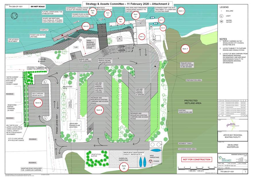
· Revision J – without the 3 car spaces (Attachment 2).
· Revision K – with the 3 short (4.8m) rear to kerb car spaces reinstated and a 1.2m high capped and lapped fence, proposed by user group members (Attachment 11).
In response to the objections to the noise and impact of the travel lift facility the travel lift is now proposed to be replaced with a hydraulic lift trailer using the existing ramp, and the wharf has been located further downstream as far as possible from Coulon Street without reducing depth at the berthing face or impacting the stage 2 pontoons and access to the ramp.
The noise and other impacts of minor boat maintenance will be reduced by the provision of a dedicated minor boat maintenance facility with environmental control measures (concrete wash down areas and settlement tanks) and electrical supply rather than the use of generators. The area will be operated under a licence agreement with either a commercial operator or the Ramp Users Group. The passive recreation area adjacent to the minor boat maintenance facility in the 2016 masterplan is proposed as a sealed hardstand for overflow trailer parking. A vegetated buffer zone is included south of the Jervis Bay Fishing Club building to further attenuate any noise from the minor boat maintenance facility. The passive recreation areas are now on the foreshore, away from the boat maintenance facility.
Council discussed the proposed Master Plan with Noise Consultants, The Acoustic Group Pty Ltd, and the following is extracted from their letter to Council dated 24 January 2020 (see Attachment 12)
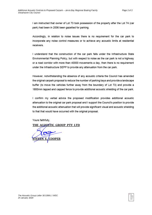
“I understand that the construction of the car park falls under the Infrastructure State Environmental Planning Policy, but with respect to noise as the car park is not a highway or a road corridor with more than 40000 movements a day, then there is no requirement under the Infrastructure SEPP to provide any attenuation from the car park.
However, notwithstanding the absence of any acoustic criteria the Council has amended the original carpark proposal to reduce the number of parking bays and provide a landscape buffer (to move the vehicles further away from the boundary of lot 73) and provide a 1800mm lapped and capped fence to provide additional acoustic shielding of the car park.
I confirm my verbal advice the proposed modification provides additional acoustic attenuation to the original car park proposal and I support the Council’s position to provide the additional acoustic attenuation that will provide significant visual and acoustic shielding to that that would have occurred with the original proposal”.
The single vehicle car park design investigated several options. Most were unacceptable due to traffic congestion and safety risks associated with parking on Frank Lewis Way, as opposed to off road parking. The adopted Frank Lewis car park design has been developed to provide the best balance between land use, number of parking spaces, ease of access, traffic flow in the precinct (and on Frank Lewis Way in particular) and effect on local residences. An optimised 4m wide vegetated buffer and minimum 2m high lapped and capped fence is proposed to the adjacent property, 4 Coulon St, to reduce noise, headlight effect and visual impact on the property’s oblique view.
Public access to Coulon Street is expected to reduce as a result of formalised parking and improved traffic flow.
Illegal camping is being addressed by means outside of the masterplan, such as enforcement by Council Rangers.
The masterplan is not expected to negatively affect navigational safety in the Currumbene Creek channel.
Policy Implications
No policy implications were identified.
Financial Implications
A tabulated summary of the masterplan elements status is provided below.
Master plan components 1, 3, 4, 5 a) & 7 are completed.
Master plan components 5 b), 9 & 10 are currently funded under grant schemes and the SCC Economic Development Reserve.
Master plan components 2 & 6 are undergoing the NSW Better Boating Now application process.
Master plan components 8 & 11 are unfunded with no current potential for funding.
|
Item |
Adopted 2016 master plan |
Proposed 2020 master plan |
Financial status |
|
1 |
Two lane ramp increased to three lanes |
Retain as two lanes. Completed. |
ü |
|
2 |
Existing ramp slope and length adjusted |
Repair existing ramp |
Better Boat Now application Estimate $115,000 (BBN $86,250, SCC $28,750) |
|
3 |
Existing fixed jetty demolished |
Part retained. Completed |
ü |
|
4 |
New downstream pontoons |
Stage 1 built Completed |
ü |
|
5 |
Existing wharf refurbished and extended |
a) Changed to stage 2 pontoons. Completed. And b) Reduced to shorter berthing face wharf. |
ü
NSW Growing Local Economies Grant Estimate $1,107,000. T1 75947 (GLE $851,000, SCCEDR $256,000) |
|
6 |
New upstream travel lift out |
Changed to stage 3 pontoons |
Better Boat Now application Estimate $465,000 (BBN $348,750, SCC $116,250) |
|
7 |
Timber board walk to downstream sandy beach |
Material changed and built. Completed |
ü |
|
8 |
Regrade and resurface existing car park and internal access roads |
Regrade and resurface existing car park and internal access roads, |
Unfunded Estimate $1,425,000 |
|
9 |
New single vehicle car park in Frank Lewis way |
Proposed as 26 spaces |
NSW Growing Local Economies Grant Estimate $260,000. T1 75947 (GLE $174,000, SCCEDR $86,000) |
|
10 |
Minor boat maintenance facility |
Proposed with changed footprint & hydraulic lift trailer |
Australian Government South Coast Region Jobs Grant. T1 75926 Estimate $380,900 (SCRJ $180,900, SCCEDR $200,000) |
|
11 |
Not identified |
Revetment and non-boating aspects, pump out facility |
Unfunded Not designed yet Estimate unknown as yet |
Risk Implications
Failure to adopt a developed master plan design has the potential to slow the implementation of works that have been funded by external grant funds from the Australian and New South Wales Governments. It also has the potential to damage Council’s reputation within the community.