Development & Environment Committee
Meeting Date: Tuesday,
05 November, 2019
Location: Council
Chambers, City Administrative Building, Bridge Road, Nowra
Time: 5.00pm
Membership (Quorum - 5)
Clr Joanna Gash - Chairperson
Clr Greg Watson
All Councillors
Chief Executive Officer or nominee
Please note: The proceedings of this meeting
(including presentations, deputations and debate) will be webcast and may be
recorded and broadcast under the provisions of the Code of Meeting Practice. Your attendance at this meeting is taken
as consent to the possibility that your image and/or voice may be recorded and
broadcast to the public.
Agenda
1. Apologies / Leave of Absence
2. Confirmation of Minutes
· Development
& Environment Committee - 1 October 2019........................................ 1
3. Declarations of Interest
4. Call Over of the Business Paper
5. Mayoral Minute
6. Deputations and Presentations
7. Notices of Motion / Questions on Notice
Nil
8. Reports
Assets & Works
DE19.108.... Updated - Parkcare Action Plans - Shoalhaven Heads
Native Botanic Gardens / Kings Point / Nashos Rotary Park / Plantation Point............................................. 11
Planning Environment & Development
DE19.109.... Draft Low Density Residential Amendment - Shoalhaven
DCP 2014 (DCP2014.25) - Post Exhibition Consideration and Finalisation............................................ 35
DE19.110.... Development Application – 52 Cyrus Street
Hyams Beach – Lot 58 & DP 577627...................................................................................................................... 47
DE19.111.... Development Application - SF10689 – Greens
Road GREENWELL POINT – Lot 1 DP 625828.......................................................................................................... 78
DE19.112.... Development Application SF10741 – 636
Murramarang Road KIOLOA – Lot 9 DP 245582........................................................................................................ 101
DE19.113.... Exhibition Outcomes & Finalisation - Planning
Proposal PP018, Draft DCP Chapter N18 and Draft Planning Agreement - 510 Beach
Road, Berry.................. 107
DE19.114.... Quarterly review for compliance matters................................................... 144
DE19.115.... Shoalhaven City Council - Mobile Food Vans in the
LGA - Private and Public Lands - SEPP Exempt & Complying Development -
Business Impacts................. 155
DE19.116.... Draft Shoalhaven Tree and Vegetation Vandalism
Prevention Policy - Post Exhibition Consideration and Finalisation................................................................... 159
DE19.117.... Berry Grey-headed Flying-fox Camp Emergency Grant
2019.................. 178
DE19.118.... Proposed 2019 Heritage Housekeeping Amendment -
Shoalhaven Local Environmental Plan 2014 (PP036)............................................................. 183
DE19.119.... Public Exhibition Outcomes - Proposed Finalisation
- Coastal Hazard Review Planning Proposal and Coastal Management Areas DCP
Amendment... 190
DE19.120.... NOM - Narrawallee Beach Victor Way - Beach Access
Stairs.................. 197
DE19.121.... NOM - St Georges Basin & River Entrance Sussex
Inlet - Safe Navigation - Seek Grant Funding - Contact State Minister -
Review Classification as ICOLL 201
DE19.122.... Review of Tabourie Lake Entrance Management Policy........................... 204
DE19.123.... Lake Conjola Entrance Update and other matters
relating to Mayoral Minute MIN19.143.................................................................................................. 214
DE19.124.... Potential Impact of Invasive Aquatic Weeds on Sydney
Drinking Water Catchment and Shoalwater Infrastructure.................................................................... 220
Shoalhaven Water
DE19.125.... Drought Management - Implementation of Water Restrictions................. 226
9. Confidential
Reports
Nil
|

|
Development
& Environment Committee – Tuesday 05 November 2019
Page
i
|
Development & Environment
Committee
Delegation:
Pursuant to
s377(1) of the Local Government Act 1993 (LG Act) the Committee is
delegated the functions conferred on Council by the Environmental Planning
& Assessment Act 1979 (EPA Act), LG Act or any other Act or delegated
to Council, as are specified in the attached Schedule, subject to the following
limitations:
i. The
Committee cannot make a decision to make a local environmental plan to classify
or reclassify public land under Division 1 of Part 2 of Chapter 6 of the LG
Act;
ii.
The Committee cannot review a section 8.11 or
section 8.9 EPA Act determination made by the Council or by the Committee
itself;
iii.
The Committee cannot exercise any function delegated
to the Council which by the terms of that delegation cannot be sub-delegated;
iv.
The Committee cannot exercise any function which
s377(1) of the LG Act provides cannot be delegated by Council; and
v.
The Committee cannot exercise a function which
is expressly required by the LG Act or any other Act to be exercised by
resolution of the Council.
Schedule
a. All
functions relating to the preparation, making, and review of local
environmental plans (LEPs) and development control plans (DCPs) under Part 3 of
the EPA Act.
b. All
functions relating to the preparation, making, and review of contributions
plans and the preparation, entry into, and review of voluntary planning
agreements under Part 7 of the EPA Act.
c. The
preparation, adoption, and review of policies and strategies of the Council in
respect of town planning and environmental matters and the variation of such
policies.
d. Determination
of variations to development standards related to development applications
under the EPA Act where the development application involves a development
which seeks to vary a development standard by more than 10% and the application
is accompanied by a request to vary the development standard under clause 4.6
of Shoalhaven Local Environmental Plan 2014 or an objection to the application
of the development standard under State Environmental Planning Policy No. 1
– Development Standards.
e. Determination
of variations from the acceptable solutions and/or other numerical standards
contained within the DCP or a Council Policy that the Chief Executive Officer
requires to be determined by the Committee
f. Determination
of development applications that Council requires to be determined by the
Committee on a case by case basis.
g. Review
of determinations of development applications under sections 8.11 and 8.9 of
the EP&A Act that the Chief Executive Officer requires to be determined by
the Committee.
h. Preparation,
review, and adoption of policies and guidelines in respect of the determination
of development applications by other delegates of the Council.
i. The
preparation, adoption and review of policies and strategies of the Council in
respect to sustainability matters related to climate change, biodiversity,
waste, water, energy, transport, and sustainable purchasing.
j. The
preparation, adoption and review of policies and strategies of the Council in
respect to management of natural resources / assets, floodplain, estuary and
coastal management.
Minutes of the Development & Environment Committee
Meeting Date: Tuesday,
1 October 2019
Location: Council
Chambers, City Administrative Building, Bridge Road, Nowra
Time: 5.00pm
The following members
were present:
Clr Joanna Gash -
Chairperson
Clr Patricia White
Clr John Wells
Clr John Levett
Clr Nina Digiglio
Clr Annette Alldrick
Clr Kaye Gartner
Clr Mitchell Pakes
Clr Greg Watson
Clr Mark Kitchener
Clr Bob Proudfoot
Mr Stephen Dunshea -
Chief Executive Officer
|
Apologies / Leave of Absence
|
Apologies
were received from Clr Findley and Clr Guile.
|
Confirmation of the Minutes
|
|
RESOLVED (Clr Pakes / Clr White) MIN19.712
That the Minutes of the Development & Environment
Committee held on Tuesday 03 September 2019 be confirmed.
CARRIED
|
Clr Gartner – DE19.105
– Submission – Proposed New Regulatory Framework – Short Term
Rental Accommodation - pecuniary interest declaration – owns a short term
rental property with spouse – will leave the room and will not take part
in discussion or vote.
|
Call Over of the
Business Paper
|
|
The following items were called
up for debate:
DE19.94, DE19.95, DE19.96,
DE19.97, DE19.98, DE19.99, DE19.100, DE19.102, DE19.103, DE19.104, DE19.105,
DE19.106.
The remaining item (DE19.101) was
resolved en-block (Clr Proudfoot / Clr Wells) at this time. It is marked with
an asterisk (*) in these Minutes.
|
Deputations and Presentations
DE19.94 Notice of
Motion - Call In DA19/1841 - 44 Duncan Street, Huskisson (Page 11)
Ms Susan Smith, representing the
Huskisson Woollamia Community Voice CCB, spoke for the recommendation.
DE19.95 Development
Application 18/2115 – 171B Strongs Rd, Jaspers Brush – Lot 2 &
DP 778594 (Page 18)
Mr Stuart Coughlan, representing
the Berry Forum, spoke for the recommendation.
DE19.104
Tomerong Quarry - Lot 4 DP 775296 Parnell Rd DA90/1912 (Page
115)
Mr Peter Allison, representing
the Tomerong Community Forum, spoke to the recommendation.
|
Procedural
Motion - Bring Item Forward
|
|
RESOLVED (Clr Wells / Clr White) MIN19.713
That the following matters be
brought forward for consideration:
· DE19.94 - Notice
of Motion - Call In DA19/1841 - 44 Duncan Street, Huskisson
· DE19.95 -
Development Application 18/2115 – 171B Strongs Rd JASPERS BRUSH –
Lot 2 & DP 778594
· DE19.104 -
Tomerong Quarry - Lot 4 DP 775296 Parnell Rd DA90/1912
CARRIED
|
Notices of Motion / Questions
on Notice
|
DE19.94 Notice of Motion - Call In
DA19/1841 - 44 Duncan Street, Huskisson
|
HPERM Ref: D19/316168
|
|
Recommendation (Item to be determined under
delegated authority)
That Council call in the
Development Application DA19/1841 - 44 Duncan Street, Huskisson due to public
interest.
|
|
RESOLVED (Clr Levett / Clr Pakes) MIN19.714
That Council call in the Development Application
DA19/1841 - 44 Duncan Street, Huskisson due to public interest.
For: Clr
Gash, Clr White, Clr Wells, Clr Levett, Clr Digiglio, Clr Alldrick, Clr
Gartner, Clr Pakes, Clr Watson, Clr Kitchener, Clr Proudfoot and Stephen
Dunshea
Against: Nil
CARRIED
|
Reports
|
DE19.95 Development Application 18/2115
– 171B Strongs Rd JASPERS BRUSH – Lot 2 DP 778594
|
HPERM Ref: D19/240144
|
|
Recommendation (Item to be determined under
delegated authority)
That Development Application No.
18/2115 for the ‘temporary use of land for events/functions including
weddings’ be determined by way of refusal for the reasons set out in
the Notice of Determination Attachment 1 to this report.
|
|
RESOLVED (Clr Proudfoot / Clr
Wells) MIN19.715
That Development Application No. 18/2115 for the
‘temporary use of land for events/functions including weddings’
be determined by way of refusal for the reasons set
out in the Notice of Determination Attachment 1 to this report.
For: Clr
Gash, Clr White, Clr Wells, Clr Levett, Clr Digiglio, Clr Alldrick, Clr
Gartner, Clr Guile, Clr Pakes, Clr Watson, Clr Kitchener, Clr Proudfoot and
Stephen Dunshea
Against: Nil
CARRIED
|
|
DE19.104 Tomerong Quarry - Lot 4 DP 775296 Parnell Rd
DA90/1912
|
HPERM Ref: D19/315873
|
|
Recommendation (Item to be determined under
delegated authority)
That Council receive this report
on Tomerong Quarry for information.
|
|
RESOLVED (Clr Levett / Clr
Digiglio) MIN19.716
That Council receive this report on Tomerong Quarry
for information.
For: Clr
Gash, Clr White, Clr Wells, Clr Levett, Clr Digiglio, Clr Alldrick, Clr
Gartner, Clr Pakes, Clr Watson, Clr Kitchener, Clr Proudfoot and Stephen
Dunshea
Against: Nil
CARRIED
|
|
DE19.96 Development Application –
No. 20, Lot 3 in DP 539866, The Wool Road Vincentia
|
HPERM Ref: D19/213103
|
|
Recommendation (Item to be determined under
delegated authority)
That Council refuse Development
Application DA18/1736 for change of use to dual occupancy and strata
subdivision at lot 3 DP539866, 20 The Wool Road Vincentia, for the reasons
set out in Attachment 1.
|
|
RESOLVED (Clr Proudfoot / Clr Wells) MIN19.717
That the matter of Development Application – No.
20, Lot 3 in DP 539866, The Wool Road Vincentia be deferred at the request of
the Applicant.
For: Clr
Gash, Clr White, Clr Wells, Clr Levett, Clr Digiglio, Clr Alldrick, Clr
Gartner, Clr Pakes, Clr Watson, Clr Kitchener, Clr Proudfoot and Stephen
Dunshea
Against: Nil
CARRIED
|
|
DE19.97 Proposed Public Exhibition -
Planning Proposal (PP043) - Additional Permitted Use - South Nowra
Industrial Expansion Zone
|
HPERM Ref: D19/284727
|
|
Recommendation (Item to be determined under
delegated authority)
That Council:
1. Endorse
Planning Proposal (PP043) – Additional Permitted Use – South
Nowra Industrial Expansion Zone, updated to include the responses of Public
Agency Consultation, for Public Exhibition for a minimum period of 28 days.
2. Receive
a further report that provides the results of the Public Exhibition period
and recommends the next steps to finalise the Planning Proposal.
|
|
RESOLVED (Clr Watson / Clr
Digiglio) MIN19.718
That Council:
1. Endorse
Planning Proposal (PP043) – Additional Permitted Use – South
Nowra Industrial Expansion Zone, updated to include the responses of Public
Agency Consultation, for Public Exhibition for a minimum period of 28 days.
2. Receive
a further report that provides the results of the Public Exhibition period
and recommends the next steps to finalise the Planning Proposal.
For: Clr
Gash, Clr White, Clr Wells, Clr Levett, Clr Digiglio, Clr Alldrick, Clr
Gartner, Clr Pakes, Clr Watson, Clr Kitchener, Clr Proudfoot and Stephen
Dunshea
Against: Nil
CARRIED
|
|
DE19.98 Urban Greening Strategy and
Voluntary Compensatory Tree Planting Policy
|
HPERM Ref: D19/266523
|
|
Recommendation (Item to be determined under
delegated authority)
That Council
1. Commence
development of an overarching urban greening strategy in-line with other
Australian and regional Councils to meet objectives within the Community
Strategic Plan 2027, Integrated Strategic Plan 2018, Delivery Program and
Operational Plan 2019-2020 and Illawarra Shoalhaven Regional Plan, that
includes a compensatory tree replacement policy (except where a development
application has triggered entry into the NSW Biodiversity Offset Scheme).
2. Hold
a Councillor workshop so that Councillors can provide input into the
development of the draft Strategy and Policy.
3. Following
the Councillor workshop report back to Council the draft Strategy and Policy
for endorsement for public exhibition.
4. Endorse
the NSW LGA Increasing Resilience to Climate Change grant applied for
in September 2019 to enable Council to undertake a tree canopy audit within
urban areas to determine tree canopy and land use distributions, vegetation
change and priority areas for potential planting and urban greening to assist
in implementation of Council resolution (MIN18.955).
|
|
RESOLVED (Clr Proudfoot / Clr Pakes) MIN19.719
That the matter of Urban Greening Strategy and
Voluntary Compensatory Tree Planting Policy be withdrawn pending a Councillor
briefing and report back to Council.
For: Clr
Gash, Clr White, Clr Wells, Clr Levett, Clr Digiglio, Clr Alldrick, Clr
Gartner, Clr Pakes, Clr Watson, Clr Kitchener, Clr Proudfoot and Stephen
Dunshea
Against: Nil
CARRIED
|
|
DE19.99 NSW Heritage Grants 2019-2020:
Shoalhaven Local Heritage Assistance Fund
|
HPERM Ref: D19/289172
|
|
Recommendation (Item to be determined under
delegated authority)
That
Council endorse the allocation of the Shoalhaven Local Heritage Assistance
Funds for the 2019-2020 program as listed in Table 1 within
the report; and reallocate any declined offers amongst the remaining
successful and eligible applicants if required.
|
|
RESOLVED (Clr White / Clr Proudfoot) MIN19.720
That
Council endorse the allocation of the Shoalhaven Local Heritage Assistance
Funds for the 2019-2020 program as listed in Table 1 within
the report; and reallocate any declined offers amongst the remaining
successful and eligible applicants if required.
For: Clr
Gash, Clr White, Clr Wells, Clr Levett, Clr Digiglio, Clr Alldrick, Clr
Gartner, Clr Pakes, Clr Watson, Clr Kitchener, Clr Proudfoot and Stephen
Dunshea
Against: Nil
CARRIED
|
|
DE19.100 Nowra-Bomaderry Retail Review - Exhibition Outcomes
and Proposed Implementation
|
HPERM Ref: D19/293966
|
|
Recommendation (Item to be determined under
delegated authority)
That Council:
1. Commission
a detailed, city-wide retail supply and demand analysis modelled on forecast
future population growth to inform its strategic land use planning
activities.
2. Prepare
a Planning Proposal to enable consideration of amendments to Shoalhaven
Local Environmental Plan 2014 to:
a. Introduce
a new local provision to support retail activity in Nowra CBD.
b. Change
the zone objectives for B3 Commercial Core and B4 Mixed Use zones to support
retail activity in Nowra CBD, and
c. Exclude
general and speciality shops from the South Nowra bulky goods retail area.
3. Commence
a detailed project to examine the location, size and function of the planned
retail centres intended to service the Moss Vale Road Urban Release Areas and
the land use zones associated with the southern centre.
4. Identify
Planning Priorities in its Local Strategic Planning Statement to:
a. Develop
a city-wide retail strategy to identify the amount and type of retail floor
space required across all retail zones and centres, and
b. Develop
place-based strategies to guide the future growth and development of Nowra
CBD and Bomaderry.
|
|
RESOLVED (Clr Proudfoot / Clr
Pakes) MIN19.721
That Council not proceed with the implementation of
selected recommendations from the Nowra-Bomaderry Centres – Retail
& Centres Planning Assessment.
For: Clr
Gash, Clr White, Clr Wells, Clr Pakes, Clr Watson, Clr Kitchener and Clr
Proudfoot
Against: Clr Levett, Clr
Digiglio, Clr Alldrick, Clr Gartner and Stephen Dunshea
CARRIED
|
Items marked with an *
were resolved ‘en block’.
|
DE19.101 St Andrews Way/Berry's Bay & Woollamia
Sewerage Schemes - Waiving of Fees for Approval to Operate On-site Sewage
Systems
|
HPERM Ref: D19/305033
|
|
RESOLVED* (Clr Proudfoot / Clr
Wells) MIN19.722
1. That
Council endorse the waiving of “Approval to Operate Systems of Sewage
Management” and associated inspection fees for property owners within
the St Andrews Way/Berry’s Bay and Woollamia Sewerage Schemes, during
the construction phase of the schemes.
2. Any
annual risk inspections required through the construction of the schemes be
funded from Council’s sewer fund.
CARRIED
|
|
DE19.102 Formation of Collingwood Beach Dunecare
Group - Progress Report
|
HPERM Ref: D19/308998
|
|
Recommendation (Item to be determined under
delegated authority)
That Council receive the progress
report, regarding the formation of the Collingwood Beach Dunecare Group, as
per Council resolution (MIN19.318).
|
|
RESOLVED (Clr Proudfoot / Clr
White) MIN19.723
That:
1. As part
of the Natural Area Volunteers Group, a Dunecare Group be formed at
Collingwood Beach prior to the Ordinary Meeting of council on 29 October
2019.
2. A draft
Collingwood Beach Dunecare Management Plan be presented to the Ordinary
Meeting of Council on 29 October 2019. This plan be formulated taking into
consideration the submission by Coordinator, Dawn Thompson’s group, the
Collingwood Beach Reserve Bushcare Action Plan (2008) and the Collingwood
Beach Dune Vegetation Action Two-year Trial Plan.
For: Clr
Gash, Clr White, Clr Wells, Clr Digiglio, Clr Gartner, Clr Pakes, Clr Watson,
Clr Kitchener, Clr Proudfoot and Stephen Dunshea
Against: Clr Levett and
Clr Alldrick
CARRIED
|
|
DE19.103 Initial Consideration - Proponent Initiated
Planning Proposal - Danjera Dam Camping & Recreation Area
|
HPERM Ref: D19/309365
|
|
Recommendation (Item to be determined under
delegated authority)
That Council:
1. Support
the Planning Proposal request for the Danjera Dam Camping & Recreation
Area submitted for Shoalhaven Water.
2. Prepare
and submit the required Planning Proposal documentation to the NSW Department
of Planning, Industry and Environment for Gateway determination, and
dependent on the outcome proceed to exhibit the PP and report back to Council
post-exhibition.
3. Advise
the proponent of this resolution.
|
|
RESOLVED (Clr Watson / Clr Kitchener) MIN19.724
That Council:
1. Support
the Planning Proposal request for the Danjera Dam Camping & Recreation
Area submitted for Shoalhaven Water.
2. Prepare
and submit the required Planning Proposal documentation to the NSW Department
of Planning, Industry and Environment for Gateway determination, and
dependent on the outcome proceed to exhibit the PP and report back to Council
post-exhibition.
3. Advise
the proponent of this resolution.
For: Clr
Gash, Clr White, Clr Wells, Clr Levett, Clr Digiglio, Clr Alldrick, Clr
Gartner, Clr Pakes, Clr Watson, Clr Kitchener, Clr Proudfoot and Stephen
Dunshea
Against: Nil
CARRIED
|
|
DE19.104 Tomerong Quarry - Lot 4
DP 775296 Parnell Rd DA90/1912
|
HPERM Ref: D19/315873
|
|
Item
dealt with earlier in the meeting see MIN19.716.
|
|
DE19.105 Submission - Proposed New Regulatory
Framework - Short Term Rental Accommodation
|
HPERM Ref: D19/316058
|
|
Recommendation (Item to be determined under
delegated authority)
That Council
1. Endorse
the draft submission that was made on the proposed Short Term Rental
Accommodation reform package (provided as Attachment 1 to this report)
and advise the NSW Government accordingly.
2. Continue
to play an active role, as required, in this important matter and received
future reports as needed.
|
|
Clr Gartner - pecuniary interest declaration - owns a
short term rental property with spouse – left the room and did not take
part in discussion or vote.
Note: Clr Gartner left the meeting at 6.17pm.
|
|
RESOLVED (Clr Proudfoot / Clr
White) MIN19.725
That Council:
1. Endorse
the draft submission that was made on the proposed Short Term Rental
Accommodation reform package (provided as Attachment 1 to this report)
and advise the NSW Government accordingly.
2. Continue
to play an active role, as required, in this important matter and received
future reports as needed.
For: Clr
Gash, Clr White, Clr Wells, Clr Levett, Clr Digiglio, Clr Alldrick, Clr
Pakes, Clr Watson, Clr Kitchener, Clr Proudfoot and Stephen Dunshea
Against: Nil
CARRIED
|
Note: Clr Gartner
returned to the meeting at 6.34pm.
|
DE19.106 Ministerial Representations - Chapter G4
Tree & Vegetation Management - Shoalhaven DCP2014
|
HPERM Ref: D19/316102
|
|
Recommendation (Item to be determined under
delegated authority)
That Council
1. Determine
relevant action having regard to options provided below or other appropriate
actions,
2. Advise
the NSW Minister for Planning & Public Spaces of this decision and keep
him advised of the progress of the review/possible amendment to the DCP.
|
|
Clr Gartner raised a Point of
Order against Clr Pakes for suggesting that some Councillors made accusations
about illegal and wrong doing work taking place at the Huskisson Anglican
Church site and those accusations haven’t been made by her.
The Chair did not rule as a Point
of Order as accusations were made by signs being put up at Huskisson, that
Clr Gash, Clr Watson and Clr Pakes had “ruined Huskisson” because
of the trees.
Clr Gartner raised a Point of Order against Clr Pakes
for saying that the Hon Justin Field, MLC was unfamiliar with the area and
stated that he lives in the Shoalhaven. The Chair did not rule as a Point of
Order.
|
|
RESOLVED (Clr Proudfoot / Clr
White) MIN19.726
That Council:
1. Note
the request received from the Minister that essentially requests that Council
reconsider the current provisions in this regard and advise the Minister of
Council’s decision to retain the current provisions for the overriding
reason of public safety, noting that Council is also considering policy
options to address tree loss within the City more generally.
2. Write
to all tree lopping and tree removal contractors on an annual basis to
explain their obligations before a tree is removed, under the “45
degree rule”. In addition, that the maximum penalties for any breaches
be clearly outlined in the correspondence.
3. Advise
the NSW Minister for Planning & Public Spaces of this decision.
For: Clr
Gash, Clr White, Clr Wells, Clr Pakes, Clr Watson, Clr Kitchener, Clr
Proudfoot and Stephen Dunshea
Against: Clr Levett, Clr
Digiglio, Clr Alldrick and Clr Gartner
CARRIED
Note: A
Rescission Motion was received on this Item.
|
|
Procedural
Motion - Matters of Urgency
|
|
Motion (Clr White / Clr Pakes)
That an additional item in relation to DA16/1465,
corner of Albatross Road and Kinghorne Street, Nowra be introduced as a
matter of urgency.
|
|
The Chairperson ruled
the matter as urgent as it is in the public interest.
|
|
DE19.107 Additional Item - Development Application -
Residential Units and Commercial Space - 173 Kinghorne Street, Nowra
|
|
RESOLVED (Clr Watson / Clr Pakes) MIN19.727
That DA16/1465 –
Residential Units and Commercial Space – 173 Kinghorne Street, Nowra be
called in to Council for determination due to significant public interest.
For: Clr
Gash, Clr White, Clr Wells, Clr Levett, Clr Digiglio, Clr Alldrick, Clr
Gartner, Clr Pakes, Clr Watson, Clr Kitchener, Clr Proudfoot and Stephen
Dunshea
Against: Nil
CARRIED
|
Note: A Rescission Motion was
received in relation to DE19.106 – Ministerial Representations –
Chapter G4 Tree & Vegetation Management – Shoalhaven DCP2014 signed
by Clr Gartner, Clr Digiglio and Clr Levett. It will be considered at the
Ordinary Meeting on Tuesday 29 October 2019 at 5pm in the Council Chambers.
There being no further
business, the meeting concluded, the time being 7.42pm.
Clr Gash
CHAIRPERSON
|

|
Development
& Environment Committee – Tuesday 05 November 2019
Page
1
|
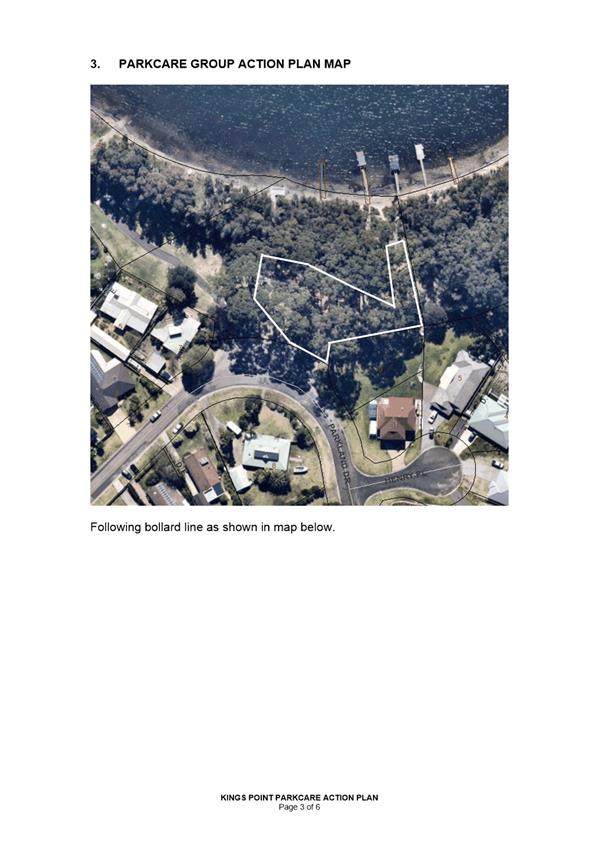
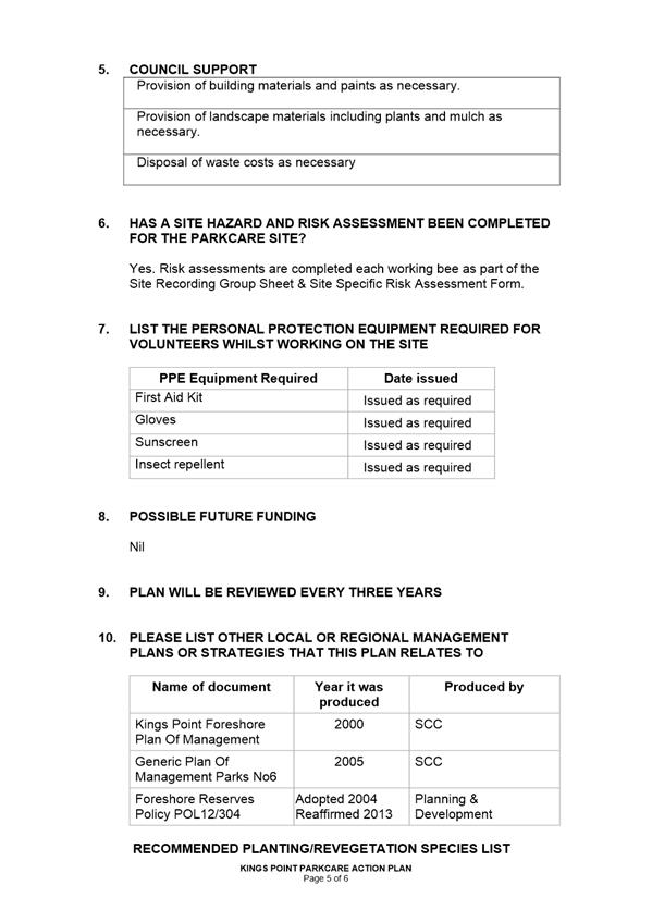
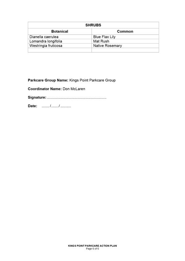
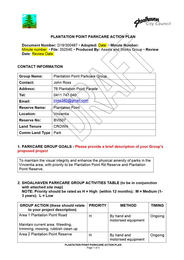
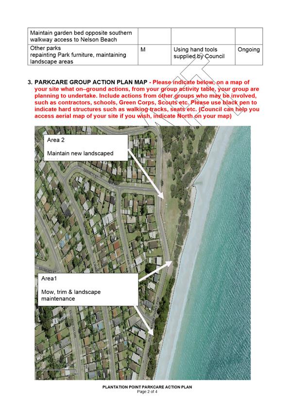
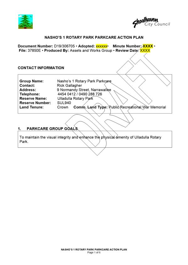
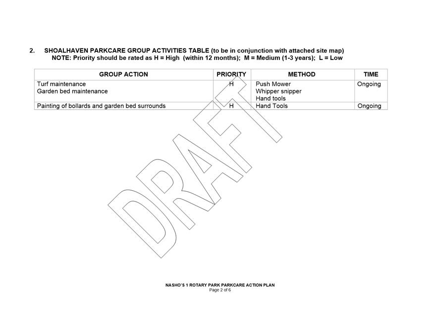
DE19.108 Updated
- Parkcare Action Plans - Shoalhaven Heads Native Botanic Gardens / Kings Point
/ Nashos Rotary Park / Plantation Point
HPERM Ref: D19/293353
Group: Assets
& Works Group
Section: Works
& Services
Attachments: 1. Kings
Point Parkcare Action Plan ⇩
2. Shoalhaven
Heads Native Botanic Gardens Parkcare Action Plan ⇩
3. Plantation
Point Parkcare Action Plan ⇩
4. Nasho's 1 Rotary Park
Parkcare Action Plan ⇩
Purpose / Summary
To present for consideration
four updated draft Parkcare Action Plans that have been prepared by Parkcare
Groups and Council staff. The plans are:
1. Shoalhaven
Heads Native Botanic Gardens Parkcare Group (previously known as Curtis Park
Arboretum Parkcare Group)
2. Kings
Point Parkcare Group
3. Nashos
Rotary Park Parkcare Group and
4. Plantation
Point Parkcare Group
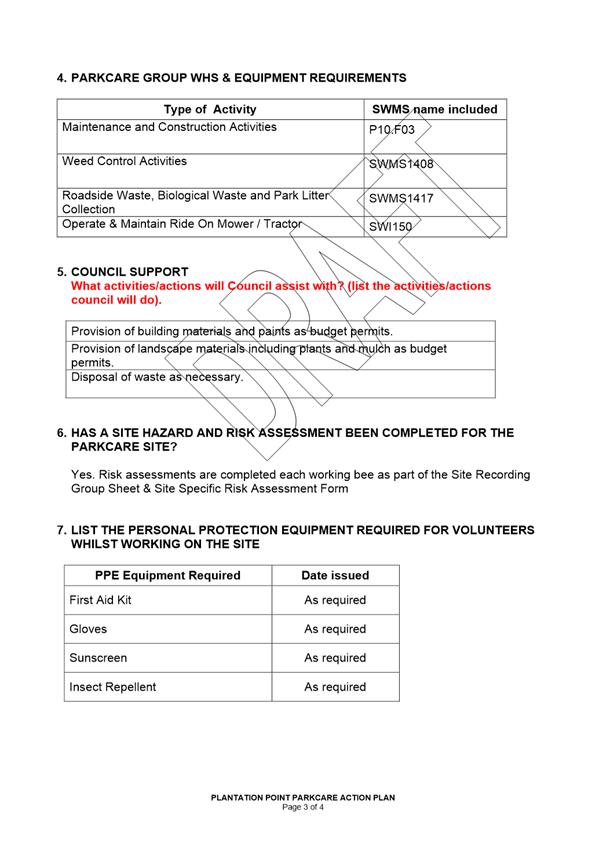
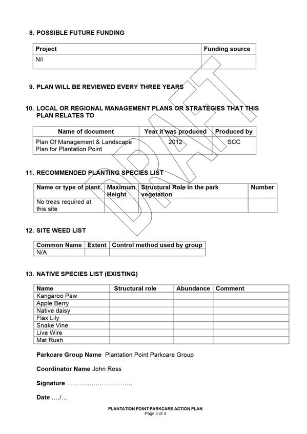
|
Recommendation (Item to be determined under delegated authority)
That
Council:
1. Endorse the updated
‘Parkcare’ plans for Shoalhaven Heads Native Botanic Gardens (previously known as Curtis Park Arboretum Parkcare
Group), Kings Point, Nashos Rotary Park and
Plantation Point.
2. Continue to allocate ongoing annual
funding of $400 (CPI adjusted and exc GST) per each group to cover safety PPE, miscellaneous materials, waste disposal and
purchase of minor tools.
|
Options
1. Approve
continued endorsement of Shoalhaven Heads Native Botanic Gardens Parkcare Group
(previously known as Curtis Park Arboretum Parkcare Group), Kings Point
Parkcare Group, Nashos Rotary Park Parkcare Group and Plantation Point Parkcare
Group and adopt the draft Action Plans.
Implications: Annual cost of $1,600 per year for
these 4 groups currently allocated for continuing support of Parkcare
objectives offset by the free resource offered to Council.
2. Reject the
ongoing support of Shoalhaven Heads Native Botanic Gardens Parkcare Group (previously
known as Curtis Park Arboretum Parkcare Group), Kings Point Parkcare Group,
Nashos Rotary Park Parkcare Group and Plantation Point Parkcare Group pending
changes to the Action Plans.
Implications: Lost opportunity for continued
volunteer groups at Shoalhaven Heads Native Botanic Gardens Parkcare Group,
Kings Point Parkcare Group, Nashos Rotary Park Parkcare Group and Plantation
Point Parkcare Group pending changes to the Action Plan.
Background
Council currently has 50
Parkcare Groups with 448 volunteer members under its Parkcare Programme.
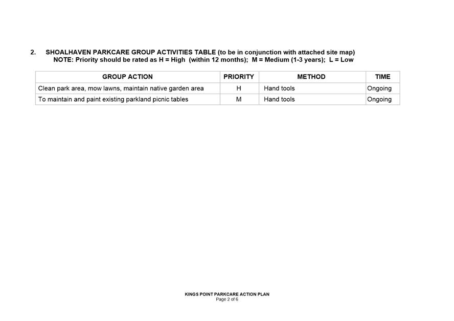
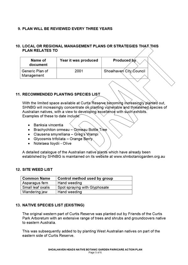
1. Shoalhaven Heads Native
Botanic Gardens Parkcare Group (previously known as Curtis Park Arboretum
Parkcare Group)
2. Kings Point Parkcare
Group
3. Nashos Rotary Park
Parkcare Group and
4. Plantation Point
Parkcare Group are four of the Parkcare Action Plans that are due for
readoption.
The Shoalhaven Heads Native
Botanic Gardens Parkcare Group was previously known as the Curtis Parks
Arboretum Parkcare Group. In 2017 the Park was admitted to Botanic Gardens
Australia New Zealand BGANZ network of botanic gardens. This is the first and
only recognised Botanic Garden in the Shoalhaven LGA and has attracted
increased interest and tourism to Shoalhaven Heads.
There are no significant changes
to the following plans:
· Kings
Point Parkcare
· Nashos
Rotary Park Parkcare
· Plantation
Point Parkcare
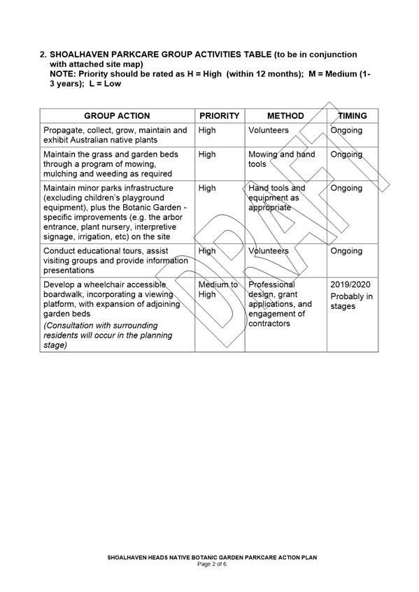
The Shoalhaven Native Botanic
Garden plan encompasses future projects, as the group’s activities are
expanding. These future projects will not fundamentally change the intent of
the existing action plan (see
Part 8. Possible Future Funding of the Action Plan).
An allocation of $400 per annum
per group is budgeted by Council to fund Parkcare. Some Parkcare groups are
very active in applying for and obtaining grant funding in addition to the
Council funding.
Community Engagement
Participation and involvement in
the groups are open to all community members.
The Shoalhaven Heads Native Botanic Garden Parkcare Action
Plan will require community consultation before the Wheelchair accessible
boardwalk and the upgrade of the nursery which will be completed before any
commence of works.
Financial Implications
No further cost to Council as
all four groups have been established in the Shoalhaven for a number of years
and have been allocated finance in future budgets.
|
|
Development
& Environment Committee – Tuesday 05 November 2019
Page
1
|
|

|
Development
& Environment Committee – Tuesday 05 November 2019
Page
1
|
|
|
Development
& Environment Committee – Tuesday 05 November 2019
Page
1
|
|
|
Development
& Environment Committee – Tuesday 05 November 2019
Page
1
|
|
|
Development
& Environment Committee – Tuesday 05 November 2019
Page
1
|
DE19.109 Draft
Low Density Residential Amendment - Shoalhaven DCP 2014 (DCP2014.25) - Post
Exhibition Consideration and Finalisation
HPERM Ref: D19/332187
Group: Planning
Environment & Development Group
Section: Strategic
Planning
Attachments: 1. Exhibition
Submission Summary ⇩
2. Chapter G12 - Post Exhibition
Version (under separate cover) ⇨
Purpose / Summary
To consider the:
· Submissions
received as a result of the public exhibition of the draft Low Density
Residential Amendment (the Amendment) to Shoalhaven Development Control Plan
(DCP) 2014.
· Amendments
proposed at the 3 September 2019 Development & Environment Committee
meeting.
· Finalisation
of the Amendment.
|
Recommendation (Item to be determined under delegated authority)
That Council:
1. Adopt the draft Low Density
Residential Amendment (the Amendment) as exhibited, with the inclusion of the
changes to draft Chapter G12 as shown in Attachment 2, based on:
a. The summary of submissions at
Attachment 1.
b. The amendments in Table 1 in this
Report that were proposed at the 3 September 2019 Development &
Environment Committee meeting; as modified by the Staff recommendations in
Column 2 of Table 1.
2. Notify the adoption of the Amendment
in local newspapers in accordance with the requirements of the Environmental
Planning and Assessment Act 1979 and Regulations.
3. Rescind existing Chapter G12:
Dwelling Houses, Rural Worker's Dwellings, Additions and Ancillary Structures
of Shoalhaven Development Control 2014 when the Amendment is made effective.
4. Advise key stakeholders, including
relevant industry representatives, of this decision and when the Amendment
will be made effective.
|
Options
1. As recommended.
Implications: This is the preferred option as it
will enable the resolution of operational issues and matters that require
clarification to improve the function of the low density residential
development provisions in Shoalhaven.
The Amendment will also result in provisions that
holistically consider local character and context, good quality design,
amenity, universal design (optional) and more broadly the public interest. It
also gives due consideration to the submissions received and also the matters
raised at the 3 September 2019 Development & Environment Committee meeting.
2. Adopt an
alternative recommendation.
Implications: This will depend on the extent of any
changes and could further postpone the finalisation of the Amendment. Depending
on the extent of any changes that may be made to the exhibition version of the
Amendment, re-exhibition may be appropriate.
One such alternative recommendation could be to adopt the
changes proposed at the 3 September 2019 Development & Environment
Committee meeting:
· Verbatim
(i.e. column 1 of Table 1) and not as recommended in Column 2 in Table 1.
· With
staff recommendations and further augmentation.
3. Not adopt the
recommendation.
Implications: This could stop or defer the
implementation of more appropriate and better structured low density
residential development provisions.
Background
On 7 May 2019, Council’s
Development & Environment Committee resolved (MIN19.291) to:
1. Support the
exhibition of the draft Low Density Residential Amendment to Shoalhaven
Development Control Plan 2014 for a period of 28 days as per legislative
requirements.
2. Receive a
further report on the draft Low Density Residential Amendment following the
conclusion of the public exhibition period.
3. Continue to
investigate the possibility of an off-site mature tree replacement scheme for
Shoalhaven in line with MIN18.955(4) and receive a future report on this
matter.
4. Advise key
stakeholders, including relevant industry representatives, of this decision.
The Amendment seeks to improve the
function of low density residential development controls within the DCP and
also address policy gaps/operational issues or matters that need clarification
that have been identified in regard to this
development form since the Shoalhaven DCP 2014 originally became effective on
22 October 2014.
The Amendment includes:
· The
repeal of existing Chapter
G12: Dwelling Houses, Rural Worker's Dwellings, Additions and Ancillary
Structures.
· Proposed
new Chapter G12: Dwelling Houses and Other Low Density Residential Development.
· Proposed
related amendments to the DCP Dictionary.
Draft Chapter G12 applies to dwelling
houses and rural workers’ dwellings (including additions and
alterations), relocation of second-hand dwellings, detached habitable rooms,
secondary dwellings, ancillary structures and non-habitable structures on
vacant land.
Public Exhibition
In accordance with the
resolution, the Amendment package was publicly exhibited for a period of 30
days from Wednesday 29 May to Friday 28 June 2019
(inclusive).
Notices appeared in local
newspapers on 29 May 2019. All Community Consultative Bodies, relevant development
industry representatives (91) and one interested community member were notified
directly in writing.
The
exhibition material included the:
· Explanatory
Statement.
· Draft
Chapter G12: Dwelling Houses and Other Low Density Residential Development and
the draft Dictionary. To view a copy of these Chapters, refer to the
attachments to item DE19.27 considered at the 7 May 2019 Development &
Environment Committee Meeting (MIN19.291).
· Newspaper
advertisement.
As a result of the exhibition,
two (2) formal submissions were received from development industry
representatives.
A detailed summary of the
submissions, with a Council staff response is provided in Attachment 1.
Copies of the actual submissions
will also be available for review in the Councillors’ Room prior
to the meeting.
Post-Exhibition Amendments
Attachment 1 covers the
content of the two submissions received, comments on them and highlights
adjustments where required, justified etc.
Resulting from the submissions received,
various amendments are proposed to the exhibited draft Chapter G12 as shown at Attachment
2. For convenience, the proposed changes are highlighted within the
Chapter.
The recommended post exhibition
amendments to draft Chapter G12 are summarised briefly below:
· Consolidation of content, as
appropriate, to reduce length of the chapter and reduce duplication.
· Clarify content
relating to ‘restriction as to user’ and ‘certain’
areas in relation to building materials, textures and colours.
· Clarify that
setbacks may need to be reduced to respond to the prevailing setbacks in the
streetscape. Also clarify that only the setbacks in the general vicinity of the
subject land need to be considered when determining the prevailing setback in a
street.
· Restructure and
refine Table 2 (setbacks in urban areas), including the deletion of setbacks
for development on battle axe lots and reduction of rear setbacks to 3m
(average) as per Chapter
G13 (Medium Density Residential Development) of the Shoalhaven DCP 2014 as
recently amended by Council.
· Refine and delete
provisions relating to storage for consistency with Chapter
G13 as recently amended by Council.
· Removal of the
restriction requiring car parking spaces to be provided behind the building
line.
No changes are recommended in
relation to the DCP Dictionary.
Consideration of subsequent proposed
amendments
On 3 September 2019, the
Development & Environment Committee initially considered the
post-exhibition finalisation report for this Amendment. It was resolved
(MIN19.616):
That this Item be deferred to a
Councillor briefing to allow consideration and discussion of Clr
Pakes’ proposed amendments prior to the next Council meeting.
The further amendments proposed by
Clr Pakes to the exhibited Chapter G12 are outlined in column 1 of Table 1
below.
A Councillor briefing was held on
19 September 2019 to enable the consideration and discussion of the additional
proposed amendment content. The Council staff response/feedback to the proposed
amendments is outlined in column 2 of Table 1.
It is recommended that the proposed
amendments in Table 1 also be made, as modified by the Council staff
recommendations in column 2 of Table 1.
|
Column 1
Councillor Pakes’
Proposed Amendments
|
Column2
Staff
Response/Recommendations
|
|
a. Objective
ii in section 6.3.2 is amended to read:
ii. Ensure detached
habitable rooms / studios function /operate as part of the principal dwelling
and are linked by a continuously roofed, or, all
weather hard stand connection.
|
No issue with proposed addition. Change supported.
|
|
b. P27,
dot point 4 is amended to read:
Rely or the principal
dwelling for either a laundry, bathroom, or kitchen
|
It is recommended that P27 (dot point 4) be amended
as follows: “Rely on the principal dwelling for laundry and bathroom
kitchen facilities”.
This is consistent with the proposed Dictionary
term ‘detached habitable room’ and ‘detached studio’,
the latter being a defined term in State Environmental Planning Policy
(Exempt and Complying Development Codes) 2008.
This enables the detached habitable room to function
as part of the principal dwelling, not as a separate dwelling, which is the
clear intent.
|
|
c. A27.2
is deleted
|
This will remove the suggested 10m separation
distance requirement between the detached habitable room and the principal
dwelling.
This is not preferred as it becomes difficult for
the detached habitable room to function as part of the principal dwelling,
which is clearly the required intention. Note that this is an acceptable
solution and may be varied having regard to the performance criteria.
Recommend retention as exhibited
|
|
d. A27.3
is amended to read:
A27.3 An all-weather
connection shall be provided between the detached habitable room / studio and
the principal dwelling so they are
physically connected.
|
No issue with proposed addition. Change supported.
|
|
e. A32.1
dot point 4 is amended to read:
Division 2 of State
Environmental Planning Policy (Affordable Rental Housing) 2009. Additionally,
Schedule 1 – Development Standards for Secondary Dwellings is to be
used as a guide. Where a proposal does not meet Schedule 1 development
standards, Council will require proponents to demonstrate consistency with
relevant performance criteria within Parts 5 & 6 of this Chapter.
Note: Should be dot
point 2, not dot point 4. Dot point 4 relates to compliance with the
Building Code of Australia requirements.
|
Recommended that the exhibited A32.1 dot point 2
and associated note box be adapted as follows. This has the same intent but
matches DCP drafting for consistency.
· AHSEPP
- Schedule 1 Development standards for secondary
dwellings, as a guide.
|
Note: Where the proposal does not comply
with a provision in Schedule 1 of the
AHSEPP, a variation
statement must form part of the development application in
accordance with Chapter 1: Introduction of this Development
Control Plan the proposal must demonstrate consistency with the
relevant performance criteria within Sections 5 and 6 of this
Chapter.
|
|
|
f. Delete
A33.2 and Table 4
|
This issue was identified by the Building &
Compliance Section and is a significant issue in residential areas
(‘monster sheds’).
The provision is existing, except for Figure 10
which provides guidance. The provision now also includes SP3 land.
It is recommended that the provision be retained,
however if it is deleted then Figure 10 should also be deleted as it is
referred to in Table 4.
|
Conclusion
The draft Amendment, with
recommended post exhibition changes and certain components of changes proposed at
the September 2019 Development & Environment Committee, holistically
considers the planning/design of low density residential development in
Shoalhaven into the future. As such, there is merit in now adopting and
finalising the Amendment, noting that DCP controls can always be varied, set
aside etc. where appropriate/justified.
Community Engagement
The draft Amendment was publicly
exhibited for 30 days at the Nowra Administrative Building in accordance with
legislative requirements. Two (2) submissions were received which are
summarised at Attachment 1.
Policy Implications
The Amendment seeks to introduce
user-friendly DCP provisions in a logical structure that address gaps in policy
and respond to operational matters that have arisen following the passing of
time. Should the Amendment not proceed, these fundamental concerns will not be
addressed.
It is intended that the new Chapter
G12: Dwelling Houses and Other Low Density Residential Development will
ultimately replace existing Chapter G12: Dwelling Houses, Rural Workers’
Dwellings, Additions and Ancillary Structures.
Financial Implications
The finalisation of the Amendment
will continue to be resourced within the existing Strategic Planning budget.
Risk Implications
Should the Amendment not proceed, there is a risk that
Council will not be able to respond to low density residential development in a
way that holistically considers matters such as local character and context,
good quality design and amenity and more broadly the public interest. This
could result in poor built form and liveability outcomes for both residents and
the broader community. There are also matters that need to be revised to ensure
the planning controls continue to operate as expected/intended and resolve
inconsistencies.
|

|
Development
& Environment Committee – Tuesday 05 November 2019
Page
1
|
|
|
Development
& Environment Committee – Tuesday 05 November 2019
Page
1
|
DE19.110 Development
Application – 52 Cyrus Street Hyams Beach – Lot 58 & DP
577627
DA. No: DA16/1341/4
HPERM Ref: D19/294076
Group: Planning
Environment & Development Group
Section: Building
& Compliance Services
Attachments: 1. Independent
Planner Report - Kerry Gordon - Peter Stutchbury Architecture - Newport (under
separate cover) ⇨
2. Conditions
- Independent Planner - Kerry Gordon - Peter Stutchbury Architecture (under
separate cover) ⇨
3. NSW Land & Environment
Court Determination - Platford v Van Veenendaal and Shoalhaven City Council ⇩
Description of Development: Demolition of the
existing dwelling and construction of two storey dwelling and boat house.
Owner: T
G Van Veenendaal
Applicant: Peter
Stutchbury Architecture
Notification Dates: 6 to 21
April 2016, renotified 10 to 25 October 2016, renotified 17 February to 6 March
2017, renotified 4 – 16 August 2018 and renotified 4 – 19 December
2018.
No. of Submissions: 41 submissions (17 of
these were made on behalf of the owner at 54 Cyrus Street)
Purpose
/ Reason for consideration by Council
The Land and Environment Court
determined that development consent granted for DA16/1341 is invalid and of no
effect. The development application therefore remains undetermined.
This report provides an
independent assessment of the application and recommends approval.
|
Recommendation (Item to be determined under delegated authority)
That Council approve Development Application DA16/1341 for
demolition of the existing dwelling and construction of a two-storey dwelling
and boat house situated at 52 Cyrus Street, Hyams Beach legally described as
Lot 58 in DP577627, subject to the recommended conditions of consent
contained in Attachment 2 of this report.
|
Options
1. Approve the
development application (DA) in accordance with the recommendation of this
report.
Implications: This would allow the applicant to proceed with
the proposal and seek a construction certificate for development on the subject
site.
2. Alternative
recommendation
Implications: Council will need to specify an
alternative recommendation and advise staff accordingly.
Background
Proposed Development
The proposed development seeks approval for demolition of the
existing dwelling and construction of a two-storey dwelling and boat house.
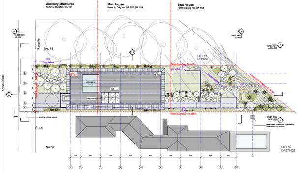
Figure 1 – Proposed
site plan
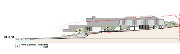
Figure 2
– Elevation
Subject Land
The subject site is located on the eastern side of Cyrus
Street and is known as 52 Cyrus Street, Hyams Beach. The site is legally
described as Lot 58 in DP 577627.
The site is an irregular shape allotment with an angled rear
boundary to the foreshore and total site area of 941.7m2. The site
has a frontage of 13.715m to Cyrus Street and a rear boundary dimension of
21.925m. The southern side boundary dimension of 77.22m and northern side
boundary dimension of 60.115m.
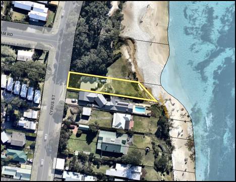
Figure 3 – Subject Site
History
The subject application was lodged with Council on 22 March
2016. The application has undergone several amendments and in particular the
design of the boat shed. A number of geotechnical and coastal hazard
assessments have been provided in response to requests for information from
Council.
The application, in its various forms, has been notified five
(5) times and received a total of 41 submissions. Of these submissions,
17 were received by or on behalf of the owner of the adjoining property at 54
Cyrus Street.
It was resolved by Council at its Ordinary Meeting of 28
February 2017 to call in the application for determination due to the
significant public interest. The application was considered at Council’s
meeting of 17 July 2017 where it was approved. Development Consent DA16/1341
was issued on 25 July 2017.
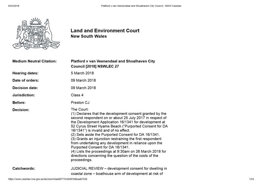
Subsequent to the issue of Development Consent DA16/1341, the
owner of 54 Cyrus Street challenged the legal validity of the consent in the
Land and Environment Court. The proceedings were heard by Preston CJ and a
decision was handed down on 9 March 2018 with Orders as follows:
The Court:
(1) Declares
that the development consent granted by the second respondent on or about 25
July 2017 in respect of the Development Application 16/1341 for development at
52 Cyrus Street Hyams Beach (“Purported Consent for
DA 16/1341”) is invalid and of no effect.
(2) Sets
aside the Purported Consent for DA 16/1341.
(3) Grants
an injunction restraining the first respondent from undertaking any development
in reliance upon the Purported Consent for DA 16/1341.
(4) Lists
the proceedings at 9:30am on 26 March 2018 for directions concerning the
question of the costs of the proceedings.
The effect of the Court’s decision is that DA16/1341
remains undetermined as consent granted by the Council on 17 July 2017 has been
set aside. A copy of this determination is included at attachment 3.
Subsequent to the judgement, amended plans were submitted by
the applicant, with changes confined to the design of the boat shed and boat
shed arm to address wave run up.
Given the history of the development application, Council
engaged an independent Town Planning Consultant to undertake a section 4.15
assessment.
Planning Assessment
The development application has been assessed against the
provisions of section 4.15 of the Environmental Planning and Assessment Act
1979. The independent Town Planning Consultant’s assessment is attached
and forms the basis of the recommendation contained in this report (Refer
attachment 1).
The recommendation is based upon full and complete assessment,
including the provisions within Chapter G6 Coastal Management Area of the
Shoalhaven Development Control Plan 2014, including the contrary view
articulated in the objector’s legal advice. The primary concern raised
was the potential impact from wave runup in a 1 in 100 storm event.
The applicant has submitted revised plans to address this
issue. The revised design includes suspended decking supported by concrete
encased piers. This will ensure that any wave runup will be dispersed as
opposed to hitting a solid wall which could potentially redirect the storm
surge and impact upon the adjoining property.
In addition to the above, the proposed boat shed is in close
proximity to the Banksia integrifolia which are identified to be
retained and the works required for the footings of the boat shed have the
potential to impact on these trees as depicted below in figure 3.
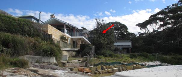
Figure 4 – Banksia
Integrifolia to be retained
The trees will provide screening and softening of the visual
impact of the boat shed as viewed from the beach to the east and their
retention is considered appropriate for this reason.
In order to ensure the retention of the trees, the independent
town planning consultant has recommended a condition to be placed upon the
consent requiring the boat shed to be relocated 1.5m to the west, with the
subsequent shortening of either the vegetable garden or outdoor wash area to
accommodate the relocation. Condition eight (8) of the consent reads as
follows:
Amended
plans
1. Prior to
the issue of the construction certificate, the applicant must submit
to the PCA amended building plans that address the following:
a. The
boat shed arm and boatshed must be reduced in length landwards such that its
eastern extent is relocated 1.5m westward;
b. The
WC within the boat shed arm shall be elevated such that the base of the slab
shall be above RL 4.4 AHD;
c. The
subfloor beam of the boat shed and boat shed arm shall be raised such that the
base of the beam is at or above RL 4.4 AHD. This shall be achieved without
increasing the height of the structure above RL 7.76 AHD;
d. The
boat shed and entire boat shed arm shall be constructed on piled footings in
accordance with the recommendations of the Report on Geotechnical Investigation
by Douglas Partners Pty Ltd ref no Project 89244.00 R.001. Rev2 dated 15
February 2017;
e. All
electrical, wiring, fuel lines or any other service pipes and connections to
the boathouse arm must be located at least 500mm above the wave runup level;
and
f. No
filling shall be placed and no retaining walls shall be constructed in the wave
runup area.
In summary, the independent Town
Planning Consultant recommended that the development application should be
supported subject to the attached conditions of consent.
Should Council determine that
the provisions of Chapter G6 of SDCP prohibit the boat shed and boat shed arm
seaward of the ZRFC 2025, contrary to the attached independent planners
assessment, then it is recommended that Council grant partial consent to the
development application without the boat shed and boat shed arm, with the
following changes to the conditions:
1. Condition 3 be deleted
and replacement with the following:
The boat shed and boat shed arm are not approved under this
consent and are to be deleted from the Construction Certificate plans prior to
issue of the Construction Certificate.
a. The boatshed arm and
boat shed shall be deleted.
2. Condition 26 be amended
by deletion of c, d and e.
3. Deletion
of Conditions 8, 10 and 45.
Figure
2 – Proposed Section Plan of the Boat Arm.
Consultation and Community
Engagement:
The application, in its various forms, has been notified five
(5) times;
· Initial
notification 6 to 21 April 2016 (extended to 2 May 2016 in response to
neighbour’s request). A total of 13 submissions were received from or on
behalf of 6 respondents.
· Renotified
10 to 25 October 2016 (extended to 31 October 2016 in response to
neighbour’s request) – amended plans, boat shed arm design
statement, initial and supplementary Coastal Hazards Risk Assessment Reports. A
total of 10 submissions were received from or on behalf of 6 respondents.
· Renotified
17 February to 6 March 2017 – additional information on geotechnical and
coastal hazard assessment issues. A total of 16 submissions were received from
or on behalf of 15 respondents.
Since the Court’s decision to set aside the consent
granted by the Council, the application has been amended and renotified a
further two times.
· The
fourth notification occurred from 4–16 August 2018. In response to this
notification 13 submissions were received.
· The
fifth notification period occurred from 4–19 December 2018. In response
to this notification 2 submissions were received.
All notifications were undertaken in accordance with
Council’s Community Consultation Policy, with the letters for the first
notification sent to the owners of four (4) properties lying within a 25m
buffer of the site. Subsequent notifications were sent to the owners notified
in the first round of notification and to those people who made submissions during
the first and second rounds.
A summary of each submission and response has been provided in
the attached Section 4.15 Assessment Report prepared by an independent
Town Planning Consultant.
Financial Implications:
The development application was subject to a Class 1 appeal in
the Land and Environment Court. The amended development application has
addressed the issues raised as part of the Class 1 appeal which relate to wave
run up. As a result, no further financial implications are likely to occur due to
the previous proceedings.
Legal Implications
Pursuant to Section 8.2 of the
EP&A Act, a decision of the Council may be subject of a review by the
applicant in the event of an approval, partial approval or refusal.
Alternatively, an applicant for development
consent who is dissatisfied with the determination of the application by the
Council may appeal to the Court against the determination pursuant to Section
8.7 of the EP&A Act.
Summary and Conclusion
Based upon the finding within the attached independent section
4.15 assessment report. It is recommended that Council approve DA16/1341,
subject to the conditions at Attachment 2.
|
|
Development
& Environment Committee – Tuesday 05 November 2019
Page
1
|

|
|
Development
& Environment Committee – Tuesday 05 November 2019
Page
1
|
DE19.111 Development
Application - SF10689 – Greens Road GREENWELL POINT – Lot 1 DP
625828
DA. No: SF10689/4
HPERM Ref: D19/306348
Group: Planning
Environment & Development Group
Section: Development
Services
Attachments: 1. Draft
- Determination - Refusal - Greens Road, GREENWELL POINT - Lot 1 DP 625828 ⇩
2. Draft
- Determination - Approval - Greens Road, GREENWELL POINT - Lot 1 DP 625828
(under separate cover) ⇨
3. Plans
of Proposed Development (complied documents) for Council Report - SF10689 - Lot
1 DP 625828 - Greens Road, GREENWELL POINT ⇩
4. Planning Report – S4.15
Assessment Greens Rd GREENWELL POINT - Lot 1 DP 625828 (under separate
cover) ⇨
Description of Development: Four (4) lot Torrens
Title subdivision and placement of fill to create building platforms
Owner: J Farnham and V Farnham
Applicant: PDC Planners
Notification Dates: 29 April 2019 – 14 May
2019
No. of Submissions: 1 submission (objection)
Purpose
/ Reason for consideration by Council
At the Ordinary Meeting of 25
June 2019, Council resolved the following:
That Council call in the Development Application SF10689
- proposed 4 lot subdivision, Lot 1 DP 625828 Greens Road, Greenwell
Point due to public interest. (MIN19.451)
This report has been prepared on the basis that the
‘call in’ is to determine the application.
|
Recommendation (Item to be determined under delegated authority)
That Development Application SF10689 for a ‘four (4) lot
Torrens Title subdivision and placement of fill to create building
platforms’ be determined by way of refusal for the reasons set out in
the Notice of Determination (Attachment 1) to this report.
|
Options
1. Refuse the
Development Application (DA) in accordance with the recommendation. (See Attachment
1.)
Implications: The application would not proceed. The applicant
can apply for a section 8.2 review of Council’s decision and/or could
lodge an appeal with the NSW Land and Environment Court against Council’s
decision.
2. Approve the DA.
Implications: Council would have to determine the grounds on
which the DA is to be approved, that is, provide reasons to support the
development, having regard to section 4.15 considerations. A suite of
conditions is attached in the event that Council supports the proposal (Attachment
2). Under some circumstances, third parties (i.e. objectors) can seek a
judicial review of Council’s decision in the NSW Land and Environment
Court.
3. Alternative
recommendation
Implications: Council will need to specify an alternative
recommendation and advise staff accordingly.
Location Map
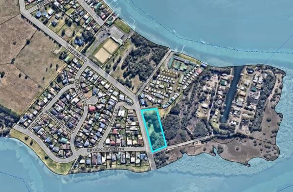
Figure 1: Location Map
Background
Proposed Development
On 6 June 2018, Development Application
(DA) No. SF 10689 was submitted, seeking development consent for a four (4) lot
Torrens Title subdivision and placement of fill to create building platforms at
Greens Road (Lot 1 DP 625828) as described in the Statement of Environmental
Effects (SEE) prepared by PDC Planners (Ref: S18-019) dated June 2018 and
amended 26 July 2018.
The subdivision is proposed
pursuant to Clause 4.1 of Shoalhaven Local Environmental Plan 2014 (SLEP
2014).
Plans of the proposed development are shown in Attachment 3
Subject Land
The subject site is located at
Greens Road, Greenwell Point and is legally described as Lot 1 in DP 625828.
Site & Context
The development site:
· is
currently vacant and contains some established native vegetation with part of
the land being mapped as ‘coastal wetlands’ under State
Environmental Planning Policy (Coastal Management) 2018. Other areas of the
site are mapped as ‘proximity area for coastal wetland’. The land
mapped as ‘coastal wetlands’ is also identified as ‘excluded
land’ on the Terrestrial Biodiversity Map in the SLEP 2014;
· has
a steep drop in slope away from Greens Road on the western portion of the site,
with the eastern portion of the site largely flat;
· is
zoned R2 Low Density Residential and the property has a site area of 6,750m²;
· is
identified as flood prone land with the majority of the site categorised as
high hazard floodway;
· is
mapped as Acid Sulfate Soils Class 5 and Class 2 in lower lying areas of the
site; and
· is
mapped as bush fire prone land.
The surrounding area is residential in character with the
development site being adjoined by low density residential development to the
west, an existing caravan/tourist park to the north and environmental
conservation land to the south and east.
The Crookhaven oyster farming area is located approximately
200m to the east of the site.
History
The subject property was excised
from the E2 Environmental Conservation zoned land to the east by way of
subdivision which was registered 7 May 1982.
The subject site is vacant and
has not been previously developed.
Post Lodgement
The following correspondence and
actions have taken place with the applicant following the lodgement of SF10689:
|
6
June 2018
|
Application lodged with
Council.
|
|
4
July 2018
|
Additional information requested
by Council for applicant to clarify the proposed development, provide details
of proposed filling and provide a variation statement to DCP controls with
regard to subdivision and placement of fill on flood prone land
|
|
13
July 2018
|
Applicant submitted additional
information in response to Council requests.
|
|
1
August 2018
|
Additional information
requested by Council for applicant to clarify if proposal is considered to be
‘Designated Development’ under the Environmental Planning and
Assessment Act 1979.
|
|
11
September 2018
|
Applicant provided legal
opinion indicating that the application should not be considered as
‘Designated Development’.
|
|
23
April 2019
|
Legal advice received from
Council’s Legal Department concurring that the application should not
be considered as ‘Designated Development’
|
|
24
April 2019
|
Additional information
requested by Council for the applicant to consider the proposed
development’s impact on Acid Sulfate Soils, existing infrastructure,
nearby oyster farms and associated infrastructure and provide additional
information in regard to proposed filling.
|
|
12
June 2019
|
Applicant submitted additional
information in response to Council requests.
|
|
13
May and 13 June 2019
|
Additional information
requested by Council for applicant to consider the appropriateness of the
development given site is mapped as flood prone land – high hazard
floodway.
|
|
17
June 2019
|
Additional information
requested by Council for applicant to provide geotechnical report and
additional stormwater drainage infrastructure.
|
|
25
June 2019
|
At an Ordinary Meeting of
Council, it was resolved that Council call-in SF10689 due to the public
interest (MIN19.451).
|
|
30
June 2019 and 12 August 2019
|
Applicant submitted additional
information in response to Council requests. This additional information
indicated:
a) A ‘variation
statement’ will not be provided as the submitted Flood Impact Statement
has already considered the performance criteria set out in Chapter G9 of SDCP
2014.
b) Additional stormwater
information has been provided, however, if further information is necessary,
applicant is happy to liaise further with Council. This would occur if the
elected Council decide to support the proposal on the grounds of flooding.
|
Issues
Issue – Clause 7.3 (Flood Planning) of Shoalhaven
LEP 2014
Clause 7.3 of the SLEP 2014
specifies that development consent must not be granted to development on land
at or below the flood planning level unless the consent authority is satisfied
that the development:
a) is compatible with the
flood hazard of the land, and
b) will not significantly
adversely affect flood behaviour resulting in
detrimental increases in the potential flood affectation of other development
or properties, and
c) incorporates appropriate measures to manage risk to life from flood, and
d) will not significantly adversely affect the environment or cause
avoidable erosion, siltation, destruction of riparian vegetation or a reduction
in the stability of riverbanks or watercourses, and
e) is not likely to result in unsustainable social and economic costs to
the community as a consequence of flooding, and
f) will not affect the safe occupation or evacuation of the
land.
Applicant’s Submission
The applicant submitted a
‘Flood Impact Statement’ and ‘Supplementary Letter’ in
support of the application. The applicant contends that the proposal is
satisfactory in regard to the considerations of Clause 7.3 of the SLEP 2014, by
making the following comments:
|
LEP Requirement
|
How the Proposal Addresses the Requirement
|
|
To minimise the flood risk to life and property
associated with the use of land,
|
Future risk to property and life is minimised by:
· Improvement
of residentially zoned land that is flood free in the 1% AEP event, including
allowances for climate change.
· Ensuring
habitable floor levels (of future residential development) set at a minimum
of the 1% AEP flood level plus 500mm.
· All
lots having reliable access available to Greens Road.
· Safe
refuge (of future residential development) available in the Probable Maximum
Flood.
|
|
To allow development on land that is compatible with the
land’s flood hazard, taking into account projected changes as a result
of climate change
|
It is our view that the development is compatible with
the lands flood hazard, as it will directly facilitate appropriate future
development in accordance with the residential zoning.
Sea level rise has been
directly taken into account in the supplied FPL from SCC, and we have adopted
this FPL for use in this study.
|
|
To avoid significant adverse impacts on flood behaviour
and the environment.
|
It is our view that the impacts arising from the proposed
development are not significant or adverse on flood behaviour or the
environment, as they are directly commensurate with the lands zoning. Losses
of flood storage in the Lower Shoalhaven River are immaterial.
|
|
The development is compatible with the flood hazard of
the land.
|
It is our view that the proposed development is
compatible with the flood hazard of the land. In effect, the development
seeks to change the flood hazard on part of the land to enable future
residential development to occur.
|
|
The development will not significantly adversely affect
flood behaviour resulting in detrimental increases in the potential flood
affectation of other development of properties.
|
It is our view that the impacts arising from the proposed
development are not significant or adverse on the potential flood affectation
of other development of properties.
|
|
The development incorporates appropriate measures to
manage risk to life from flood
|
It is our view that the proposed development meets this
requirement. The proposed building areas are entirely above the 1% AEP flood
planning level, and future residential development can readily meet the
controls of SCC’s DCP (Chapter G9).
|
|
The development will not significantly adversely affect
the environment or cause avoidable erosion, siltation, destruction of
riparian vegetation or a reduction in the stability of riverbanks or
watercourse
|
It is our view that the proposed development would cause
no such environmental effects.
|
|
The development is not likely to result in unsustainable
social and economic costs to the community as a consequence of flooding
|
It is our view that the proposed development will not
result in unsustainable social and economic costs to the community as a
consequence of flooding. This is demonstrated, and managed, by:
· Improvement
of residentially zoned land that is flood free in the 1% AEP event, including
allowances for climate change.
· Ensuring
habitable floor levels (of future residential development) set at a minimum
of the 1% AEP flood level plus 500mm.
· Safe
refuge (of future residential development) in the PMF.
|
|
The development will not affect the safe occupation or
evacuation of the land.
|
It is our view that the proposed development does not
hinder evacuation, where it is ever required.
|
Discussion
The land is mapped as flood
prone land and is categorised as high hazard floodway. The proposed subdivision
will create four lots with dwelling entitlements with the implied right to
construct a dwelling.
To facilitate the subdivision,
the development also includes the placement of significant fill - up to 2.3m
above natural ground level to create building platforms above the 1% AEP flood
planning level. The proposal will place ‘obstructions’ in the high
hazard floodway and will result in an increased dwelling density within a high
hazard flood area as a result of the creation of additional allotments of land.
Council’s Natural
Resources and Floodplain Unit (NRFU) provided referral comments on 8 August
2018 and 10 May 2019 noting numerous non-compliances with the SDCP 2014 and
other flood controls and raising objection to the proposal.
Referral comments indicated that
the application should not be supported as the proposed subdivision increased
potential dwelling density in high hazard floodway land which presents a
significant risk to life and property. The NRFU concluded that the development
is not compatible with the land’s flood hazard and should not be
supported.
The NRFU referral comments also
note that rather than demonstrating any quantitative analysis, the Flood Impact
Study only provides that in the view of the flood consultant the proposed
development will not have any significant adverse impact and the proposal is
suitable in the opinion of that flood consultant. The Flood Impact Study also
does not assess any hydraulic impact towards the neighbouring property due to
the filling.
The NRFU also noted that
although this section of Greens Road is above the 1% AEP flood level, only a
small area of land in this part of Greenwell Point is above the present day 1%
AEP flood level and is isolated from the main Greenwell Point township and the
rest of the local government area during the 1% AEP flood event (see Figure 2).
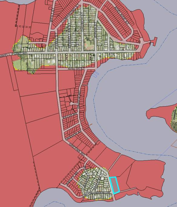
Figure 2: Map showing extent of flooding during the 1% AEP flood
event.
Subject property is highlighted in
blue. Greenwell Point is shown to the north
The proposed development is not
suitable with regard to the considerations of clause 7.3 (3) of SLEP 2014,
specifically:
a) The proposed
subdivision and placement of fill is not compatible with the flood hazard (high
hazard floodway) of the land as it will likely negatively alter floodwater
behaviour and present an increased risk to life and property. The applicant has
not demonstrated to the contrary.
b) The placement of
substantial amounts of fill within the high hazard floodway would likely alter
floodwater behaviour and potentially displace floodwater onto adjoining
properties. The application has not adequately demonstrated that the
development, particularly the placement of fill, will not significantly
adversely affect flood behaviour resulting in detrimental increase in the
potential flood affectation of adjoining properties.
c) The placement of fill
within a high hazard floodway may potentially exacerbate erosion and siltation
processes during flood events and lead to additional sediment entering the
adjoining coastal wetland. This could have an adverse impact on riparian
vegetation within nearby sensitive wetland environments. The application has
not adequately demonstrated that the development will not significantly
adversely affect the environment or not exacerbate erosion or siltation
processes or lead to the destruction of riparian vegetation by altering
floodwater behaviour. The applicant provided some additional information;
however, it is considered that the information provided has not adequately
addressed how erosion and siltation processes will be managed and adverse
impacts minimised.
d) The proposed
subdivision is of land within a high hazard floodway where safe evacuation out
of the immediate area may not be achievable, thereby increasing the dependence
on emergency services. It is considered that the proposal is likely to result
in additional social and economic costs to the community as a consequence of
flooding by increasing dwelling density in a flood area with restricted
evacuation, presenting an increased risk to life and property and increasing
burden on emergency services for the community.
e) Safe occupation or
evacuation from the immediate area may not be achievable in a flood event and
access will also be cut off from the Greenwell Point township during the 1% AEP
flood. Greenwell Point is also itself cut off. Refer to Figure 2.
Issue – State Environmental Planning
Policy (Coastal Management) 2018
The subject land is mapped as
“coastal environment area”, “coastal use area”, “proximity
area for coastal wetlands” and “coastal wetlands” under SEPP
(Coastal Management) 2018.
Part 2 of the SEPP identifies
the matters for consideration for development on land identified within coastal
wetlands, on land in proximity to coastal wetlands and land within the coastal
use area and coastal environment area. The matters for consideration are
discussed in detail in the section 4.15 Planning Report for SF10689 (Attachment
4).
As discussed in the section 4.15 Planning Report for
SF10689, the application has not demonstrated that the proposal is suitable in
relation to the considerations set out in SEPP (Coastal Management 2018),
specifically potential adverse impact of proposed developments on nearby mapped
“coastal wetlands”. For example, the proposed placement of fill
within the high hazard flooding area may alter floodwater behaviour and
potentially exacerbate erosion and siltation processes which may lead to
additional sediment being displaced and deposited onto the coastal wetland
area. This may have adverse impacts on sensitive vegetation and the integrity
of the coastal wetland. The applicant provided additional information; however,
it is considered that the information provided has not adequately addressed the
potential environmental impacts on coastal wetlands or any measures proposed to
protect the biophysical, hydrological and ecological
integrity of the coastal wetland. The application is not supported on this
basis.
Issue – Shoalhaven DCP Chapter G9
(Development on Flood Prone Land)
Objectives of Chapter G9: Development on Flood Prone Land,
SDCP 2014
The objectives of the Chapter are to:
i. Reduce risk to
life and property resulting from floods.
ii. Ensure that the
impacts of the full range of flood sizes up to and including the probable
maximum flood (PMF) are considered when assessing development on flood prone
land.
iii. Ensure that the
impact of climate change is considered when assessing development on flood
prone land.
iv. Ensure the future use of
flood prone land does not cause undue distress to individuals or unduly
increase potential flood liability to individuals or the community
v. Incorporate site
specific floodplain management recommendations from local floodplain risk
management plans into Council’s overall planning framework.
The proposed development involves the placement of fill and
subdivision of land within a high hazard floodway. The application has not
demonstrated that the development is compatible with the current or predicted
future flood hazard of the land and, rather, presents an increased risk to life
and property. The proposed subdivision would increase dwelling density in an
area with restricted flood evacuation from the immediate area and so increasing
reliance on emergency services and community resources. The proposal is
inconsistent with the overall objectives of Chapter G9.
Objectives and Performance Criteria P2 of Control 5.2 Fill
or Excavation on the Floodplain, Chapter G9: Development on Flood Prone Land,
SDCP 2014
Objectives
The objectives of Control 5.2
are to:
i. Ensure that
filling or excavation within the floodplain does not have a significant impact
on flood behaviour, conveyance and storage capacity, as well as surrounding
properties or structures and the environment in the specific area where the
development is proposed.
The application has not provided
any quantitative analysis of flood behaviour. The submitted Flood Impact Report
only provides, that in the view of the flood consultant, the proposed
development will not have any significant adverse impact. The Flood Impact
Study also does not assess any hydraulic impact towards the neighbouring
property due to the filling. Assessment staff are not satisfied that the
application and submitted Flood Impact Study has demonstrated that the proposed
development and proposed filling within the high hazard flood area will not
significantly adversely affect flood behaviour and have a detrimental impact on
adjoining properties, structures and sensitive environments though displacement
of floodwaters. The proposal is inconsistent with the objectives of Control
5.2.
Performance Criteria
P2 states that:
“Filling or excavation on flood prone land
will meet the following:
· High
hazard floodway areas are kept free of fill and/or obstructions.
· The
proposed fill or excavation will not unduly restrict the flow behaviour of
floodwaters.
· The
proposed fill or excavation will not unduly increase the level or flow of
floodwaters or stormwater runoff on land in the vicinity, including adjoining
land.
· The
proposed fill or excavation will not exacerbate erosion, siltation and
destruction of vegetation caused by floodwaters flowing on the land.
· The
proposed fill or excavation will not be carried out on flood prone land if
sufficient flood free area is available for development within the subject
property.
· The
proposed excavation does not create new habitable rooms, non-habitable storage
areas or carparks with floor levels below the existing ground level.”.
The proposed development involves the placement of fill
within a high hazard floodway area to facilitate the subdivision. Furthermore,
the application has not adequately or quantitively demonstrated that the
placement of fill within the floodway will not adversely affect flood behaviour
by displacing floodwater and will not have a detrimental impact on adjoining
properties. Insufficient information has been provided to demonstrate that the
development and proposed filling will not exacerbate erosion and siltation
processes which may lead to additional sediment being deposited on nearby
sensitive coastal environments. The proposed development is inconsistent with
P2.1.
Performance Criteria P3.1, P3.2 and P3.3 of Control 5.3
Subdivision in the Floodplain, Chapter G9: Development on Flood Prone Land,
SDCP 2014
Objectives
The objectives of Control 5.3 are to:
i. Ensure
that the creation of new lots does not increase potential flood risks to landowners
or the community.
ii. Ensure
that new lots that are created on the floodplain are suitable for, and capable
of, being developed for their intended future use.
The proposal involves subdivision of land within a high hazard
floodway with restricted evacuation access from the immediate area. Subdivision
of high hazard flood areas is not supported in the DCP as it presents and
increased risk to life and property. The application has not adequately or
quantitatively demonstrated that the proposed placement of fill within the
floodway will not have a detrimental impact on adjoining properties and nearby
sensitive environments. Further, the restricted evacuation access from the
immediate area increases the community’s reliance on emergency services
during a flood event.
The proposal necessitates the placement of substantial amounts
of fill, up to 2.1m above natural ground level, within the floodway in order to
create building envelopes above the 1% AEP flood level. The proposal is
inconsistent with the objectives of Control 5.3.
Performance Criteria
P3.1 states that “The
development (subdivision and intended future use) is a suitable land use, and
is adequately designed, for the defined hazard/hydraulic category.”
P3.2 states that “the
proposed subdivision will not create new lots that are affected by a high
hazard area, or floodway in today’s flood conditions or in climate change
conditions up to the year 2100.”
P3.3 states that “the
proposed subdivision will not increase the potential population density in any
areas (flood prone or flood free) with restricted evacuation access.”
The proposed development
involves subdivision of high hazard floodway and the creation of four
additional dwelling sites with restricted evacuation access from the flood
affected area. The proposal is therefore inconsistent with P3.1 and P3.3 and in
direct contrast to P3.2.
Applicant’s Submission
The Flood Impact Statement
contends that the proposal is satisfactory in regard to the performance
criteria set out in Section 5.2 Fill or Excavation on the Floodplain in
Chapter G9 of the SDCP 2014, by making the following comments:
|
DCP Performance Criteria
|
How the Proposal Addresses the Performance Criteria
|
|
High
hazard floodway areas are kept free of fill and/or obstructions.
|
Minor
amounts for fill are proposed in the high hazard floodway areas, specifically
to generate modest building envelopes to support development on the land
commensurate with its zoning. The impacts of this filling are unquantifiable
because they are so minor. Given that the minor amount of filling is
specifically for the purposes of supporting residential development on
residentially zoned land, there is no engineering-based reason why such
filling is not reasonable.
|
|
The
proposed fill or excavation will not unduly restrict the flow behaviour of
floodwaters.
|
The
proposed fill does not unduly restrict the flow behaviour of floodwaters, as
the fill simply extends an embankment adjacent to Greens Road.
|
|
The
proposed fill or excavation will not unduly increase the level or flow of
floodwaters or stormwater runoff on land in the vicinity, including adjoining
land.
|
The
proposed fill does not unduly increase the level or flow of floodwaters or
stormwater runoff on land in the vicinity, including adjoining land, as the
fill simply extends an embankment adjacent to Greens Road.
|
|
The
proposed fill or excavation will not exacerbate erosion, siltation and
destruction of vegetation caused by floodwaters flowing on the land.
|
We
do not consider the proposed earthworks will exacerbate erosion, siltation
and destruction of vegetation caused by floodwaters flowing on the land.
|
|
The
proposed fill or excavation will not be carried out on flood prone land if
sufficient flood free area is available for development within the subject
property.
|
The
proposed residential development would be very difficult to achieve without
the accompanying fill. The entire site is zoned for R2 residential purposes.
|
|
The
proposed excavation does not create new habitable rooms, non-habitable
storage areas or carparks with floor levels below the existing ground level.
|
No
excavation is proposed.
|
The Flood Impact Statement does not provide any commentary
specifically addressing the performance criteria set out in Section 5.3
Subdivision in the Floodplain in Chapter G9 of the SDCP 2014.
Discussion
Referral comments from
Council’s NRFU note that the proposal is inconsistent with the
development controls and the performance criteria set out in Chapter G9 of SDCP
2014. Referral comments conclude that the proposal should not be supported due
to the non-compliances with the relevant performance criteria and implications
and impacts of allowing placement of substantial amounts of fill to facilitate
a subdivision on land categorised as high hazard floodway.
The proposed development is not
suitable having regard to the SDCP 2014, specifically due to the non-compliance
with the performance criteria (P2.1, P3.1, P3.2 and P3.3) set out in Chapter
G9. The application is not supported because:
a) The proposal involves
the placement of a substantial amount of fill (up to 2.1m above natural ground
level) within a high hazard floodway land to create building platforms above
the 1% AEP land. P2.1 requires that “high hazard floodway areas
are kept free of fill and/or obstructions” and the proposal is in
direct contrast to this requirement. The proposal is inconsistent with
performance criteria P2.1.
b) P2.1 requires that “The
proposed fill or excavation will not unduly restrict the flow behaviour of
floodwaters” and “The proposed fill or excavation will not
unduly increase the level or flow of floodwaters or stormwater runoff on land
in the vicinity, including adjoining land”. The application has not
adequately considered the impact of this filling on adjoining property and the
environment. It is considered that the proposed filling would likely affect the
flow and behaviour of floodwaters and would have an adverse impact on adjoining
property by redirecting flows onto adjoining land. The proposal is inconsistent
with performance criteria P2.1.
c) P2.1 specifies that
“The proposed fill or excavation will not exacerbate erosion,
siltation and destruction of vegetation caused by floodwaters flowing on the
land”. The application has not adequately demonstrated that the proposal
would not exacerbate erosion or siltation processes.
Further, adequate information has not been provided for
Council to be satisfied that the proposed development would not have a
significant impact on native vegetation or nearby environmentally sensitive
ecosystems, such land mapped as ‘coastal wetland’ as a result of
the alteration to floodwater behaviour. The proposal is inconsistent with
performance criteria P2.1.
d) P3.1 requires that
“the development (subdivision and intended future use) is a suitable
land use, and is adequately designed, for the defined hazard/hydraulic
category”. The proposed subdivision of residential land necessitates
the placement of substantial amounts of fill on high hazard floodway land and
is therefore not considered to be a suitable land use given the flood hazard of
the land. The proposal is inconsistent with performance criteria P3.1.
e) P3.2 states that “the
proposed subdivision will not create new lots that are affected by a high
hazard area, or floodway in today’s flood conditions or in climate change
conditions up to the year 2100”. The proposed development involves
creation of additional lots that are affected by a high hazard area and is
therefore in direct contrast to this requirement. The proposal is inconsistent
with performance criteria P3.2.
f) P3.3
requires that “the proposed subdivision will not increase the
potential population density in any areas (flood prone or flood free) with
restricted evacuation access”. Although the property has access to a
section of Greens Road which is above the 1% AEP flood level, flood free access
from the immediate area is unachievable and the site would be isolated from the
Greenwell Point township which is also isolated during the 1% AEP flood event.
As such, it is considered that the development is inconsistent with performance
criteria P3.3.
Issue – Stormwater Drainage
The application proposes to
direct stormwater from any future dwellings to absorption trenches and level
spreaders 3m from the eastern boundary of each proposed lot.
Applicant’s Submission
Stormwater information and a
Report on Geotechnical Investigation was submitted in support of the
application. The applicant has also provided the following comments in relation
to stormwater issues raised by Council:
Whilst the stormwater plan submitted proposes
absorption trenches, it also specifies a level spreader for each lot. The
stormwater plan basically assumes zero absorption, and it therefore assumes all
runoff that isn’t stored in the absorption trenches will percolate thru
the ground surface and then discharge across the rear boundary as shallow sheet
flow – much like it does now.
With respect to the size, shape and location of
absorption trenches, it is our position that the provision of this information
is premature and it is more appropriate that these requirements be calculated
at DA stage for future dwellings.
We are happy to liaise
further with the Council in relation to stormwater if required and should the
elected Council make a decision to support the proposal on flooding grounds,
however we do not think this is necessary. Sufficient information has
been provided to Council to date in order for it to make a planning decision
for the application in relation to stormwater and the submitted concept plan is
sound.
Discussion
Council’s Asset and Works
– Drainage Engineer provided referral comments on 31 May 2018 and 15
August 2019 firstly requiring a geotechnical report and additional stormwater
information be submitted and also noting potential issues with the site’s
suitability for on-site stormwater disposal. Upon reviewing the additional
information provided by the applicant, the following referral comments were
made:
I have reviewed the additional information provided
including the Geotech report:-
1) I can conclude
from the geo report that absorption trench, as proposed, is an unsuitable
method of stormwater dispersal at this site.
2) Given point (1)
above, applicant needs to demonstrate how the site will manage its stormwater
discharge. How and where a suitable site stormwater discharge will be achieved.
3) Location and
method of stormwater discharge will impact adjoining properties, in particular,
if overland discharge is proposed. I note that a caravan park adjoins this
site. I have concerns related to the impact of the proposed stormwater
discharge onto this caravan park and request further information on measures
proposed to mitigate overland flow impacts.
4) Overland runoff
will exacerbate waterlogging in an area already prone to water issues.
In this regard, the follow
concerns arise:
a) Based on a review of
the hydraulic conductivity of the site, it does not appear that the proposal
could effectively utilise absorption trenches to manage stormwater discharge
from future development of the lots.
b) On-site stormwater
disposal may have an adverse impact on adjoining property. If absorption
trenches do not have capacity to manage stormwater from future residential
development on the lots, overflow would flow onto adjoining land.
c) The filling and proposed
stormwater drainage methods could have an adverse impact on adjoining land and
nearby environmentally sensitive ecosystems (e.g. ’coastal
wetland’) by exacerbating waterlogging in an area already prone to water
issue.
Noting that alternatives can potentially be explored and
designed by the applicant, stormwater management is not considered an
overwhelming or fatal issue. However, any solution will need to have regard to
Council’s stormwater requirements and could result in unforeseen time and
expense to the applicant.
Planning Assessment
The DA has been assessed under
section 4.15 of the Environmental Planning and Assessment Act 1979.
Please refer to Attachment 4.
The issues relating to the flood hazard of the land and stormwater
disposal are the reasons for recommending refusal.
Policy Implications
SDCP 2014 Chapter G9
The proposed development conflicts with the Performance
Criteria P3.1, P3.3 and is in direct contrast to P2.1 and P3.2 of Chapter G9 of
SDCP 2014.
The NSW Floodplain Development Manual provides the following
guidance for circumstances such as are brought into focus by the current
application:
“Case-by-case decision making
cannot account for the cumulative impacts on flood behaviour and risks, caused
by individual developments of works. This form
of assessment contravenes the principles of the manual.” (NSW
Floodplain Development Manual, p.5).
“A
fundamental principle of floodplain risk management is to assess development
applications within the strategic framework of a floodplain risk management
plan and not in isolation or
individually.” (NSW Floodplain Development Manual, p.12).
If Council were of a mind to approve SF10689, this would be
inconsistent and in direct contrast to the performance criteria set out in
Chapter G9 of the SDCP 2014, specifically those that prohibit the placement of
fill or other obstructions in high hazard floodway and also those that prohibit
the creation of additional lots in high hazard flooding areas or any floodway.
Approval of the current application
would potentially compromise flood related performance criteria set out in
Chapter G9.
Consultation and Community Engagement:
One (1) public submission was
received objecting to the development in relation to Council’s
notification of the development.
The notification was made in
accordance with Council’s Community Consultation Policy with letters
being sent within a 25m buffer of the site. The notification was for a two week
period.
Key issues raised in the objection are as follows:
Issue – Subdivision
and filling of high hazard floodway
Concern raised about the
proposed subdivision and impact of proposed filling in a high hazard floodway.
The submission identified that filling of the land would have an adverse impact
on adjoining land, leading to altered flood behaviour and detrimental increases in the potential flood affectation of
nearby and adjoining land and properties.
Comment
The application has not
adequately demonstrated that the proposed development will not adversely impact
on adjoining properties.
Similar concerns in relation to
subdivision and filling high hazard floodway land have been raised by
Council’s NRFU and by assessment staff. It is considered that the
proposed development may adversely impact on adjoining land by altering flows
and floodwater behaviour. The proposed subdivision and filling of land presents
an increased flood risk to life and property.
Issue – Stormwater
management and water quality
Concern raised about the
proposed stormwater design and the impact of the development on water quality
and how this will impact on nearby oyster leases.
Comment
The application has not
adequately demonstrated that the proposed stormwater drainage design with
disposal by way of absorption trenches and level spreaders is appropriate.
Similar concerns in relation to
stormwater disposal have been raised by Council’s Assets – Drainage
Engineer and by assessment staff. Based on a review of the provided stormwater
information and the hydraulic conductivity of the site, it does not appear that
the proposal could effectively utilise absorption trenches to dispose of
stormwater from future development.
With regard to nearby oyster
leases, referral comments from NSW Department of Primary Industries recommend
that appropriate sediment and erosion controls must be in place to ensure that
development does not impact on the health and lifecycle of aquatic organisms.
Erosion and sediment controls could be applied to minimise impact on nearby
oyster leases.
Issue – Integrated development – proximity
to watercourse
Is the development integrated
development? Therefore, it would require a controlled activity approval
under the Water Management Act.
Comment
The proposed development does
not involve work within 40m of ‘waterfront land’ or a
‘river’ as defined under the Water Management Act 2000. The
current application is not nominated integrated development under the Water
Management Act 2000.
Issue – Acid Sulfate Soil (ASS)
Concerns were raised in relation
to the impact of the proposed development, specifically the proposed absorption
trenches on acid sulfate soils.
Comment
The application has been
supported by a Geotechnical Investigation Report. This Report identified that
the land is likely to contain ASSs and recommended that appropriate measures be
implemented on site where ASS is disturbed. It is considered that subject to
compliance with the recommendations of the Report on Geotechnical
Investigation, the development will not have an unacceptable impact on ASSs.
Financial Implications:
There are potential cost implications for Council in the
event of a refusal of the application. Such costs would be associated with
defending any appeal in the NSW Land and Environment Court, should the
applicant utilise appeal rights afforded under the EP&A Act.
Legal Implications
Council is
protected in its decisions relating to floodplain management by section 733 of
the Local Government Act 1993 (LG Act), provided it acts in good faith. That
is, Councils have due regard to the policy framework, controls applicable and
the circumstances of the particular case.
Council may not be seen to have acted in good faith
if it were to approve a development application that is clearly inconsistent
with the performance criteria set out in an adopted development control plan,
and in the absence of sound planning reasons to support a development. Council
in such a scenario could be exposed to challenge in relation to losses
encountered due to flooding of the approved development or in increasing the
risk to other properties, people and emergency services personnel.
Summary and Conclusion
This application for a four (4)
lot Torrens Title subdivision and placement of fill at Greens Road (Lot 1 DP
625828) is inconsistent with the provisions of Clause 7.3 of SLEP 2014, SEPP
(Coastal Management) 2018 and also performance criteria (P2.1, P3.1, P3.2,
P3.3) of Chapter G9 of SDCP 2014 as outlined in this report.
Given the issues that have
arisen with regard to flooding, a negative recommendation has been made. As a
secondary issue, the application has not adequately demonstrated that
stormwater can be appropriately managed from future development on the lots.
However, subject to suitable design this secondary issue could potentially be
resolved and / or addressed via conditions of development consent.
|

|
Development
& Environment Committee – Tuesday 05 November 2019
Page
1
|
|
|
Development
& Environment Committee – Tuesday 05 November 2019
Page
1
|
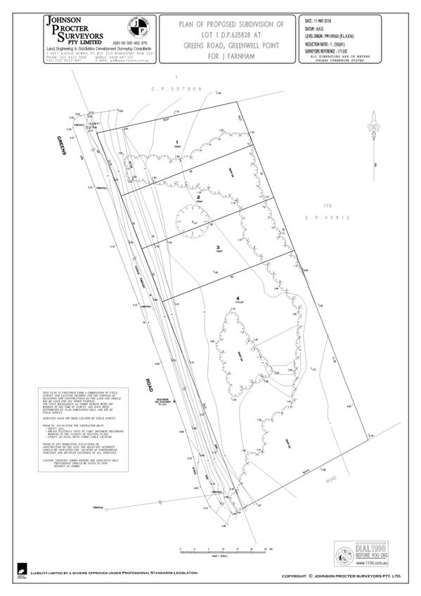
|
|
Development
& Environment Committee – Tuesday 05 November 2019
Page
1
|
DE19.112 Development
Application SF10741 – 636 Murramarang Road KIOLOA – Lot 9 DP 245582
DA. No: SF10741/4
HPERM Ref: D19/344549
Group: Planning
Environment & Development Group
Section: Development
Services
Description of Development: Two (2) lot Torrens
Title subdivision
Owner: E Beard & S Clelland
Applicant: E Beard & S Clelland
Notification Dates: 30 May 2019 – 14 June
2019
No. of Submissions: Nil
Purpose
/ Reason for consideration by Council
Variation
to Chapter G8 – Onsite Sewage Management of Shoalhaven Development
Control Plan (SDCP) 2014
· The
development application (DA) proposes a variation to Chapter G8 – Onsite
Sewage Management of Shoalhaven Development Control Plan (SDCP) 2014, to
permit the provision of effluent pump out services to proposed lots to be
created via the subdivision of land as proposed in SF10741.
· Provision
of pump out services to new lots requires Council approval.
· Section
5.3 of Chapter G8 of SDCP 2014 specifies “new pumpout services
are not to be provided to new subdivisions or new rezonings”. As
such, the matter is reported to Council for confirmation that the variation to SDCP
2014 is supported.
|
Recommendation (Item to be determined under delegated authority)
That
Council:
1. Support the request to permit the
provision of new additional effluent pumpout services to proposed Lot 1
(Development Application SF10741 - 636 Murramarang Road, Kioloa)
2. Refer the application back to staff
for determination.
|
Options
1. Support the
variation to SDCP 2014 with respect to the provision of new pumpout
services to proposed Lot 1:
Implications: This will enable the
completion of the s4.15 assessment and determination of the application.
2. Not support the variations
to SDCP 2014.
Implications: The DA as currently
submitted will not be able to be supported and would therefore be determined by
way of refusal under delegated authority.
3. Adopt an
alternative recommendation and provide direction to staff.
Location Map
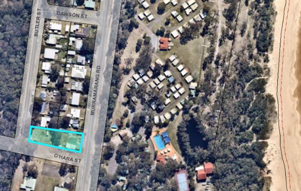
Figure 1: Location map
Background
Proposed Development
On the 20 May 2019, Development
Application (DA) No. SF10741 was lodged with Council. The DA is for a two (2)
lot Torrens Title subdivision at 636 Murramarang Road, Kioloa (Lot 9 DP 245582)
as described in the Statement of Environmental Effects (SEE) prepared by
Planscapes Town Planning Consultancy and dated 19 April 2019. The subdivision
is proposed pursuant to Clause 4.1 of Shoalhaven Local Environmental Plan
2014 (SLEP 2014).
Plans of the proposed
development are shown in Attachment 1.
Subject Land
The subject site is located at
636 Murramarang Road, Kioloa and is legally defined as Lot 9 DP 245582.
Site & Context
The development site:
· currently
contains a commercial/retail building (food and drink premises) on the eastern
portion of the site. This building is currently undergoing renovations and
refurbishment as approved by DA18/1320 (as modified). DA18/1320 (as modified)
also approves the use of the land immediately to the west of the existing
commercial building for a car park for the food premises. All these existing
structures and associated infrastructure are contained within proposed Lot 2.
The western portion (proposed Lot 1) of the site is vacant.
· has
a gentle slope to the east, towards Murramarang Road.
· is
zoned RU5 Village and the property has a site area of 1,719.91m².
· is
mostly mapped as containing acid sulfate soils class 5, with a small portion of
the eastern part of the site mapped as class 3.
· is
mapped as bush fire prone land.
The surrounding area is residential in character with the
development site adjoined by low density residential development to the north,
a caravan park/tourist park to the east, community facilities (rural fire
station and community hall) to the south and bushland to the west.
History
The subject property forms part of the Kioloa township. The
lot was created in 1954 at the same time as the other residential lots to the
north.
The subject site contains an existing commercial/retail
building (food and drink premises) which is currently undergoing renovations
and refurbishment as approved by DA18/1320 (as modified).
Post Lodgement
The following correspondence and
actions have taken place with the applicant following the lodgement of SF10689:
|
20 May 2019
|
Application lodged with
Council.
|
|
28 May 2019
|
Additional information
requested by Council for applicant correct errors within submitted SEE
|
|
29 May 2019
|
Applicant submitted additional
information in response to Council requests.
|
|
31 July 2019
|
Email sent to applicant
advising that integrated referral payment through the ePlanning Portal was
outstanding. Advised to organise payment to NSW Rural Fire Service.
|
|
2 August 2019
|
Integrated development fee
paid to NSW Rural Fire Service
|
|
23 August 2019
|
General Terms of Approval
issued by NSW Rural Fire Service
|
Issues
Issue – Shoalhaven DCP 2014 – Chapter G8
Onsite Sewage Management
Section 5.3 – Effluent
Management
Section 5.3 of Chapter G8 of SDCP 2014 states that:
|
The following is
required to ensure that the installation of pumpout systems is
environmentally and economically efficient:
· New pumpout
services must be generally allowed on existing lots within unsewered
residential or commercially zoned land within Shoalhaven that was existing
before the adoption of Council’s former Effluent Pumpout Policy on 28
August 2007.
· New pumpout
services are not to be provided to new subdivisions or new rezonings.
· Pumpout
services are not to be provided to multi-unit housing in villages not
designated for future reticulation services. Future reticulation services are
identified in Council’s adopted 20 year financial and capital works
forward plan.
|
The proposed development relies on the provision of pumpout
services to both lots. Proposed Lot 2 already contains an existing
commercial/retail building and associated pumpout services/infrastructure. The
current proposal will create an additional lot (Lot 1) that would be reliant on
effluent pumpout services.
Applicant’s Submission
The applicant has provided the
following commentary in in support to the proposed variation to Chapter G8 of
SDCP 2014:
|
The subject land as it is
today, is a parcel that existed prior to the adoption of Council’s
former Effluent Pumpout Policy in 2007. If a house were built on the land
prior to the subdivision taking place, it would be able to have an effluent
pumpout system.
This is not a new
subdivision in the sense of the abovementioned requirements, it is an infill
subdivision of an existing parcel in an area which benefits from pumpout. The
‘new subdivisions’ mentioned above relates to urban expansion
areas and the subdivision of larger parcels into numerous lots, its intention
wasn’t to apply to subdivision of this nature.
Council has approved
numerous subdivisions since 1995 where the lots benefit from pumpout
services. In this instance, the subdivision is primarily to cut off the
café so that it can be separately owned and rated as a business.
The landowners are fully
cognisant of the requirement for a restriction on the title for full cost to
be borne by the developer / owner of lot 1 for the provision of pumpout
services. We request therefore that this application be reported to Council
in this regard.
|
Discussion
· The
western portion of the site is vacant and has the potential for a dwelling to
be constructed on it.
· The
proposed subdivision is consistent with the historic subdivision pattern of the
residential area immediately to the north of the site.
· Based
on the available land area and dimensions of the site, other methods of on-site
effluent management are unfeasible.
· Shoalhaven
Water has reviewed the application. Shoalhaven Water does not object to
the proposal.
· There
are no plans to connect the Kioloa township to the reticulated sewer or water
network and it is unlikely that this would occur in the foreseeable future.
· As
per Chapter G8 of SDCP 2014, new pumpout services must be generally
allowed on existing lots within unsewered residential or commercially zoned
land within Shoalhaven that was existing before the adoption of Council’s
former Effluent Pumpout Policy on 28/8/2007.
· The
subject lot was existing prior to 2007 and has the potential for further
development (e.g. construction of a residential dwelling on the western portion
of the site). Effluent management for proposed Lot 1 through provision of additional
effluent pumpout services is considered satisfactory having regard to the
circumstances of the case.
Planning Assessment
The DA will be assessed under
s4.15 of the Environmental Planning and Assessment Act 1979.
Policy Implications
Shoalhaven Development Control Plan 2014 (SDCP 2014)
Chapter G8 of SDCP 2014 does not support the provision
of new pump out services unless the environmental impacts are minor or the
alternative carries a greater environmental risk. In this instance, the
proposal is a reasonable solution noting that other options are not practical
or achievable.
Consultation and Community
Engagement:
· No
public submissions were received during the notification period.
· The
notification was made in accordance with Council’s Community Consultation
Policy with letters being sent within a 25m buffer of the site.
· The
notification was for a two (2) week period.
Financial Implications:
In the event that Council
decides to adopt the recommendation, the application will still need to have a
favourable final s4.15 assessment to enable consent to be issued however the
‘policy’ issue concerning effluent disposal would be resolved.
It is also important to note Council resolved on 19 December
1995 that:
|
If Council resolves to allow a
new effluent pump out service for a particular circumstance which is not in
accordance with policy then the pump out service be at the full cost of
providing the pump out service and this will be noted on the Section 149
Certificate and Title Deeds (p.13, Chapter G8 of SDCP 2014)
|
If the provision of effluent pumpout services is not
supported (resulting in an unfavourable assessment), the applicant could
potentially seek a review and / or appeal the decision in the Land and
Environment Court. Legal action would have cost implications for Council.
Legal Implications
Should the provision of effluent pumpout services not be
supported and the application ultimately refused. The applicant could however,
as mentioned above, choose to seek a review and / or may appeal to the Land and
Environment Court.
Summary and Conclusion
· The
RU5 Village zoning of proposed Lot 1 creates an expectation that the land can
be used and developed for residential or other permissible purposes.
· Whilst
there are environmental risks associated with the provision of additional pump
out service to proposed Lot 1, it is acknowledged that this arrangement is not
out of place with the Kioloa township and is the only feasible option
for development of the land.
· The
original lot was created prior to the adoption of the Effluent Pumpout Policy
in 2007.
· The
proposal for pump out services is considered a suitable option in the
circumstances of the case. The proposed variation to Chapter G8 of SDCP 2014
is considered capable of support.
|
|
Development
& Environment Committee – Tuesday 05 November 2019
Page
1
|
DE19.113 Exhibition
Outcomes & Finalisation - Planning Proposal PP018, Draft DCP Chapter N18
and Draft Planning Agreement - 510 Beach Road, Berry
HPERM Ref: D19/319484
Group: Planning
Environment & Development Group
Section: Strategic
Planning
Attachments: 1. Exhibited
Explanatory Statement ⇩
2. Post-Lightning
Assessment of Scarred Tree ⇩
3. Post Exhibition Version DCP
Chapter N28 ⇩
Purpose / Summary
· Report
the outcomes of the combined public exhibition of Planning Proposal PP018 for
Lot 4 DP 834254 (510 Beach Road) Berry and associated Development Control Plan
2014 Chapter N28 (Draft Amendment No 36) and Draft Planning Agreement No 14.
· Enable
the amendments to Shoalhaven Local Environmental Plan (LEP) 2014 and Shoalhaven
DCP 2014 to proceed to finalisation.
|
Recommendation (Item to be determined under delegated authority)
That
Council:
1. Adopt and finalise the Planning
Proposal (PP018) as exhibited with the changes outlined in this report.
2. Adopt and finalise Chapter N28 of
Shoalhaven Development Control Plan (DCP) 2014 (Amendment 36) as exhibited
with the changes outlined in this report.
3. Based on advice from the
Environment, Energy and Science (EES) group of the NSW Department of
Planning, Industry and Environment (DPIE) that Council is not required to be
a party to the Planning Agreement, liaise with the proponent and EES to have
Council removed from the final Planning Agreement.
4. To ensure that the legal mechanism
for the transfer of the E1 land to NPWS is secured, only forward the Planning
Proposal to DPIE for finalisation after the Planning Agreement has been
signed by both parties.
|
Options
1. Adopt PP018 and
DCP Chapter N28 as exhibited with the changes recommended in this report. Not proceed to be part of the Planning Agreement as there
is no requirement for Council to be part of it.
Implications: The proposed changes to the LEP and
DCP controls resolve the relevant issues raised during the public exhibition
phase. The proposed LEP and DCP controls are consistent with the environmental
and land capability assessments and will deliver planning outcomes that are
consistent with the adjoining land.
2. Adopt the PP018
and DCP as exhibited with no changes. Procced (or not proceed) to be part of
the Planning Agreement that was also part of the exhibition package.
Implications: Not
recommended as several issues raised in the public exhibition warrant changes
to the exhibited LEP and DCP controls.
3. Adopt an
alternative recommendation.
Implications: Depending on its nature, this could
delay finalisation of this planning proposal.
Background
Subject Land
The subject land is Lot 4 DP
834254, at 510 Beach Road, Berry and is located east of the township of Berry
as shown in Figure 1 below.
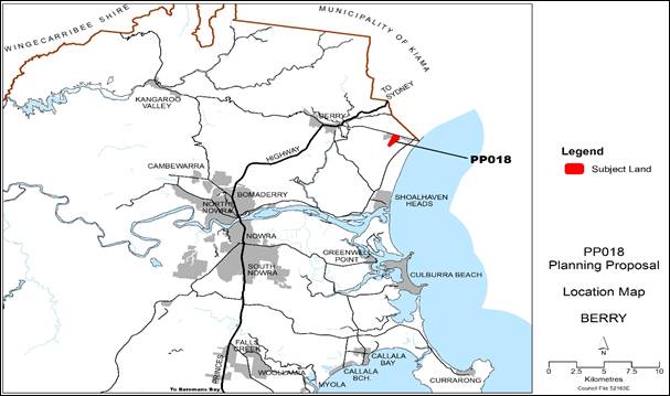
Figure
1 –
Location of subject land
Planning Proposal Overview
Council initially received a
proponent-initiated PP request for the subject land on 3 October 2015. The
request sought to rezone the land from a mix of RU1 - Primary Production, and
E2 - Environmental Conservation to:
· R5
- Large Lot Residential,
· E1
- National Parks and Nature Reserves,
· E2
– Environmental Conservation, and
· E3
- Environmental Management.
The PP also proposed to transfer
that part of the land within the Coomonderry Swamp to the NSW Government for
incorporation into the Seven Mile Beach National Park. (It has since been
confirmed that this transfer is to be facilitated through a planning
agreement.)
On 18 January 2016, Council
resolved to support the PP ‘in principle’ subject to:
· Revising
the proponent’s proposed minimum lot size to ensure the size of future
lots is consistent with adjacent subdivisions and can adequately accommodate on
site effluent disposal.
· Revising
the proponent’s proposed zoning to ensure appropriate environmental
zoning for the swamp and buffer area and other ecologically significant areas
on the subject land including, but not limited to, protection of Coomonderry
Swamp/SEPP 14 wetland and ecologically significant areas such as the patch of
forest known as ‘Jim’s Forest’ and Berry Wildlife Corridor.
· Resolving
the proposed transfer of land to National Parks and Wildlife Service, and the
possible need for a Voluntary Planning Agreement.
The proponent then pursued a
pre-Gateway review of Council’s decision. This review was undertaken by
the then Southern Joint Regional Planning Panel (JRPP). The JRPP’s advice
was provided to the NSW Minister for Planning in November 2016 and it did not
contradict the Council resolution.
The Gateway determination was
then subsequently received in June 2017, requiring information to be updated or
prepared prior to public exhibition of the PP.
A report on the updated PP and a
draft DCP was considered by Council’s Development and Environment
Committee on 2 April 2019. Council resolved to:
1. Amend the Planning
Proposal (PP) for Lot 4 DP83425, Beach Road, Berry to:
a. Reflect the revised
maps provided with the report; and
b. List the Aboriginal
Scarred Tree identified on the site as an item of Aboriginal Heritage
2. Submit the revised
PP to the NSW Department of Planning and Environment for consideration as
required by the Gateway determination.
3. Undertake the
necessary Government Agency consultation prior to public exhibition as required
by the Gateway determination.
4. Prepare a draft
site-specific Development Control Plan (DCP) chapter to support the PP.
5. Publicly
exhibit the PP and supporting draft DCP chapter, subject to completion of the
above matters.
Public Exhibition
The PP (PP018) and supporting documents, including a draft DCP
Chapter and a draft Planning Agreement, were publicly exhibited at
Council’s Nowra Administration Building from 17 July to 16 August 2019.
They were also made available on Council’s website, including via Documents
on Exhibition and Get
Involved.
A notice was placed in the South Coast Register on 17 July
2019. Adjoining landowners, the Berry Forum and people who had previously made
submissions were advised of the arrangements in writing.
The exhibited documents included:
· Explanatory
statement (Attachment 1 to this report)
· PP018: seeks to amend Shoalhaven Local
Environment Plan (LEP) 2014, to rezone the land to a mix of large lot
residential and environmental protection zones. The proposed LEP changes are
consistent with adjoining zones and the land’s environmental and cultural
heritage values.
· New chapter (Chapter N28) in Shoalhaven
Development Control Plan (DCP) 2014: proposed to provide additional site-specific
objectives and controls to ensure that buildings are located north of the
ridgeline and that development is sympathetic to the land’s environmental
and cultural heritage values.
· Draft Planning Agreement: seeks to
facilitate the transfer of the southern part of the subject land that forms
part of Coomonderry Swamp to the NSW Government for inclusion in Seven Mile
Beach National Park.
It is noted that the draft Planning
Agreement was prepared by the proponent to detail how the subject land transfer
that is associated with this PP will occur. It also covers the potential
transfer of two other land parcels owned by the proponent to the NSW Government
that are outside the PP process.
Public Exhibition - Submissions
Submissions were received from:
· The
landowner/proponent
· Three
adjoining landowners (two to the east and one to the west of the subject land)
· Berry
Landcare Group
· Internal
Council submissions
Government agency responses were received from:
· NSW
Rural Fire Service (RFS)
· Environment,
Energy & Science group of the NSW Department of Planning, Industry &
Environment
· Endeavour
Energy
These are summarised below, and copies of submissions are
provided in the Councillors’ room for review prior to the meeting.
1. Landowner: Aboriginal
Cultural Heritage (D19/290624)
The landowner/proponent raised concerns as follows about the
proposed LEP and DCP controls that were based on the outcomes of the Aboriginal Cultural Heritage Assessment (ACHA).
1.1 Area of Potential Archaeological Deposit (PAD)
– Stone Artefacts
Inconsistency between the ACHA and the PP: Areas with
moderate to high likelihood of subsurface Aboriginal artefacts. The possibility
of any significant Aboriginal Artefacts being found during the construction of
the subdivision is unlikely.
1.2 Aboriginal Scarred Tree
The Aboriginal Scarred tree has
been significantly damaged by fire and is now in a state which should exclude
the tree from being heritage listed. The Scar Tree has been dead for an
extended period of time, it has been damaged by fire and the climate and is now
in a dangerous structural condition. Removing the Scar Tree from the site
appears to be the safest and best option.
Council Staff
Comments:
Refer to discussion later in
report in ‘response to submissions’ under Aboriginal Cultural
Heritage and proposed changes to the PP and DCP chapter.
2.
Adjoining Landowner: Internet Speeds (D19/287017 & D19/281263)
“… it is
incumbent on Council to require the developers of the proposed 510 Beach Road
subdivision to pay the costs involved to upgrade or augment Telstra's copper
wire network along Beach Road so that there is no subsequent reduction or
deterioration in the level of the internet service currently available…”
Council Staff
Comments:
This is not a matter that Council
can control or resolve through the current planning processes. Any concerns
about declining internet speeds need to be directed to the service provider in
the first instance. The ACCC advises that if the service provider does not resolve
the issue, a complaint should be lodged with the Telecommunications Industry Ombudsman.
Developers are required to
contribute to the cost of providing phone and internet infrastructure to their
chosen carrier (e.g. NBN) in accordance with the Australian Government’s
Telecommunications Infrastructure in New Developments (TIND) policy. This will
be further considered when the development of the subject land reaches the
subdivision stage.
3. Adjoining
Landowner: Stormwater Runoff and Hydrology Adjoining Campbells Run (D19/281299)
· Already have significant problems with the water coming off
the ridge. Concerned about increased runoff from at least 1 or 2 houses.
· We have a small spring on our property behind the house and
we have had to replace a section of the hedge twice in front of the house
because of the water running under the residence.
Council Staff Comments:
Refer to discussion later in the
report in ‘response to submissions’ under stormwater and
groundwater and proposed change to the DCP chapter.
4. Adjoining Landowner: Alignment of
zoning / ridgeline and exclusion of buildings from Coomonderry Swamp
(D19/280701)
· Inconsistency between stated intent of the PP to exclude
buildings from the Coomonderry Swamp catchment and the PP and DCP mapping
Council Staff Comments:
The alignment of the ridgeline has
been validated and corrected using the spatial analysis tool in GIS and
detailed contour mapping (1 m contour intervals). Changes to the maps in the PP
and DCP are discussed later in this report.
5. Berry Landcare: Ecology / Wildlife Corridors
(D19/281040)
· Tree canopy along Beach Road is an important corridor for
the local glider population including the locally endangered Greater Glider.
Internal Council Submissions
Environmental Services Section -
Ecology (D19/248125)
· Key ecological values within the site are identified in the
report by Biosis.
· Development must be excluded from all areas within
Coomonderry Swamp. ‘Jim’s Forest’ is south of the ridgeline
and should be E2 not E3 as proposed.
· All remnant vegetation should be protected from
development.
· The proposal provides an opportunity to revegetate areas
such as around springs and along ephemeral drainage lines (proposed to be E3)
to protect water quality, increase vegetation in the locality and across the
city to combat the impacts of climate change, and improve the amenity of future
residents. Controls to ensure revegetation should be written into the LEP / DCP
for the locality.
Council Staff Comments:
Refer to discussion later in the
report in ‘response to submissions’ under Stormwater and
Groundwater; and Ecology and Proposed Changes to the DCP Chapter.
Environmental Services Section
– Land Contamination (D19/248167)
· The land is not currently flagged as potentially
contaminated.
o Comment: In accordance with the Phase 1 Contaminated site
assessment, the land has been added to Council’s Potentially Contaminated
Land (PCL) register noting that any contamination downslope of the homestead
(underground diesel tank) can be remediated to be suitable for its intended use
subject to further assessment at the subdivision development application stage.
· Area affected by ASS are in the area where no development
is proposed (edge of Coomonderry Swamp).
· ‘Jim’s Forest’ should be zoned E2 not E3
as proposed.
Council Staff Comments:
A Phase 1 Contaminated Site
Assessment completed over the land concluded that:
1. Most
of the site has been used for agricultural purposes including a dairy operation
and more recently grazing for beef cattle.
2. Some
lands near the homestead and immediately downslope may have been contaminated
by past practices, including an underground diesel tank.
3. The
land can be remediated to be suitable for its intended use subject to further
assessment at the subdivision development application stage.
The site has been added to
Council’s Potential Contaminated Lands Register to ensure this is further
assessed and conditioned if appropriate at the subdivision development
application stage.
Environmental Services Section
– Onsite Effluent Management (D19/248092)
· The spring/well in the NW corner of the subject land is a
bore and will need a 100 m buffer.
· The spring in the NE corner of the subject land has a pipe
coming out of it and is a bore and will need a 100 m buffer.
· The Windmill in the Southern part of the property is a bore
and will need a 100 m buffer, which will extend the buffer from
Coomonderry Swamp.
· Figure 2 in Draft DCP Chapter N28 identifies what appears
to be a 100 m buffer from the Windmill. However, the remaining two springs
identified above that are considered to be a bore only appear to have a 40 m
buffer. Two potential options to rectify this include:
a. decommissioning
the NW and NW bores prior to re-zoning; or
b. increase the
buffer around these bores to 100 m in Figure 2.
· A soil bore completed in the NW of the property confirmed
that soils in this location are subject to periodic saturation and are
unsuitable for effluent land management.
· The Shoalhaven Soil Landscape is potentially present in the
NNE part of the property. The soils here were not examined to confirm the
extent of the Shoalhaven Soil Landscape.
· Soil investigation should be completed in this location to
confirm whether soils subject to periodic saturation are also present in this
location and accordingly, whether the exclusion area in Figure 2 in Draft DCP
Chapter N28 needs to be extended.
Council Staff Comments:
As noted above, the landowner may
choose to either comply with the 100 m setback requirement in DCP Chapter
G8 or decommission the bores. An acceptable solution has been added to the
revised DCP Chapter N28 to ensure this is addressed at subdivision stage.
Community and Recreation
Section (D19/343601)
· Draft DCP Chapter N28 does not include specific social objectives of connecting people and places. This
is considered an omission and should be addressed - if not now, then possibly
when the Rural Residential Strategy is being prepared and may precipitate a
review of the DCP Chapter.
Council Staff Comments:
This submission raises an issue that
is essentially outside the scope of this draft DCP Chapter, noting that it
deals with a piece of infill rural residential development. The thrust of the
submission (connecting people and place) will however be considered as part of
the preparation of the new Local Strategic Planning Statement (LSPS). The LSPS
along with the Community
Strategic Plan (CSP) will consider embedding the
principle or objective of connecting people and places, and will outline a
broad vision for, amongst other things:
· well managed development protecting the special character
of Shoalhaven’s towns, villages and neighbourhoods, and
· infrastructure, parks and facilities supporting active,
healthy and connected communities
This work will ultimately inform
future potential amendments to the Shoalhaven DCP2014.
Shoalhaven Water (D19/344522)
· Town water and sewerage are not available in the area.
· The land is rural in nature and it will not be serviced
with water supply and/or sewerage in the foreseeable future.
· The future land parcels must be large enough to ensure that
on-site sewage treatment systems can operate efficiently
Council Staff Comments:
The individual future lots will be
self-sufficient in terms of water and wastewater (onsite effluent) management.
Government Agency Submissions
NSW Rural Fire Service
(D19/213323)
· No objection to the proposal provided the future
subdivision complies with Planning for Bushfire Protection requirements
including in respect of:
o asset
protection zones (APZ)
o access
o services
Council Staff Comments
Noted and
will need to be considered at the subdivision development application stage.
Environment, Energy & Science
Group, NSW Department of Planning, Industry & Environment (D19/284645)
· Support the proposed location of development on the
northern side of the ridgeline supported by building and wastewater exclusion
areas to protect the Swamp's catchment.
· Support the retention of ‘Jim's Forest’ in
single ownership subject to management measures specified at DA stage.
· E2 zoning should apply to ‘Jim's Forest’ in the
area currently identified as E3 and within the Swamp's catchment
· The exact location of the ridgeline and catchment boundary,
and any associated refinements to zone boundaries, should be confirmed prior to
rezoning.
· A native vegetation buffer in the E2 zone, which acts as a
natural buffer between future NPWS land and the developable lots, should also
be provided and secured at DA stage. A functional native vegetation buffer is
also critical to ensuring connectivity of the broader environmental corridor
linking the escarpment to Berry and Seven Mile Beach National Park. We
recommend considering a provision in the DCP requiring native vegetation
planting in non-developable areas of future lots within the E2 zone
· Any asset protection zones for new dwellings should be located
wholly outside of the E2 zone and avoided in the E3 zone wherever possible to
allow opportunities for revegetation.
· The draft VPA is still being refined between the applicant
and NPWS and will be finalised following exhibition of the PP.
· In areas that have been mapped as having archaeological
potential, we recommend archaeological test excavation occur as soon as
possible to provide certainty to all parties about the extent and nature of the
Aboriginal heritage sites and any management requirements. We note that the
applicant should ensure appropriate time and funding resources are provided to
prepare Aboriginal Cultural Heritage Assessments and any necessary permit
applications.
· An Aboriginal Heritage Management Plan is recommended to
manage the interface between the proposed heritage listed tree and the proposed
residential subdivision. Finally, we request the opportunity to review the
detailed Cultural Heritage Study once it is completed.
Council Staff Comments
Refer to discussion later in the report
in ‘response to submissions’.
Endeavour Energy (D19/351621)
Generally, no objection to the PP
- previously provided a Technical Review Advice dated 24 August 2017, which
generally remains valid.
The existing nearby pole mounted
substations are unlikely to be able to service the proposed development. A new
padmount substation will be required within the development. However, the
proposed method of supply and the extent of the works required to the local
network will not be determined until the final load assessment is completed.
Endeavour Energy’s preference is to alert proponents / applicants (and
Council) of the potential matters that may arise as rezoning and development of
non-urban areas continues to occur.
In due course the applicant for
the future proposed development of the site will need to submit an application
for connection of load via Endeavour Energy’s Network Connections Branch
to carry out the final load assessment and the method of supply will be
determined.
Council Staff Comments
Noted and will need to be considered
at the subdivision development application stage.
Substantive Submissions -
Response
Aboriginal Cultural Heritage Assessment (ACHA) – Area
of Stone Artefact Potential Archaeological Deposit
(PAD)
The ACHA report identified an area of Potential Archaeological Deposit (PAD) in
which 11 stone artefacts were excavated during the assessment. The ACHA report
states that the PAD area is likely to retain additional subsurface
archaeological deposits and recommends that:
· Future development in the study area should seek to avoid
or limit impacts to the stone artefact and PAD site.
· future proponents wishing to impact the stone artefact and
PAD site within the study area should apply to OEH for an AHIP
· Approval for reburial of excavated artefacts [excavated during AMBS’s assessment] should be
sought as a condition of future AHIP applications in the study area.
· The PAD has …low overall significance for
Aboriginal heritage, and further archaeological investigation of the site is
unlikely to increase the current scientific understanding of the region and
that … establishment of a conservation area encompassing the site is
not recommended. Conservation area refers to a ‘heritage conservation
area’.
In conclusion, despite the low
overall significance of the stone artefacts and PAD, an Aboriginal
Heritage Impact Permit (AHIP) is legally required if
excavation or ground disturbance is proposed. If no ground disturbance is
proposed, an AHIP is not required.
The proposed changes to the DCP
Chapter N28 include the addition of more detail to clarify the legal
requirements concerning the PAD. Refer to Table 2 below.
Aboriginal Cultural Heritage – Scarred Tree
An Aboriginal Scarred Tree was identified within the part of
the subject land identified for development. The ACHA report prepared by AMBS
recommended that this tree be listed in the LEP as a ‘heritage
item’ because of its heritage significance.
The tree was however subsequently struck by lightning after
the ACHA report was prepared and while this PP was under assessment. As a
result, the tree was significantly damaged. When this matter was previously
considered by Council, a further report was pending to help determine whether
the remains of the tree still warrant heritage listing.
AMBS completed a post-lightning
condition assessment of the scarred tree remains in September 2019. A copy of
their report is provided in Attachment 2. AMBS concluded that:
· While
the culturally scarred tree site has experienced significant impacts and loss
of heritage value, it remains an Aboriginal Object protected under the National
Parks and Wildlife Act 1974 (NPW Act). Under Section 90 of the NPW Act, it is
an offence to destroy, deface, damage or desecrate an Aboriginal Object or
Aboriginal Place, unless an Aboriginal Heritage Impact Permit (AHIP) has been
issued.
· AMBS
does not recommend inclusion of the culturally scarred tree site as a
‘heritage item’ in the Local Environmental Plan, as had been
previously recommended.
· Consultation
with the Jerrinja Local Aboriginal Land Council (LALC) has indicated that the
tree retains moderate cultural significance to the local Aboriginal community,
despite the significant physical damage and loss of some aspects of its
scientific, historic and aesthetic heritage values. The Jerrinja LALC are aware
that it is unlikely that the tree will survive indefinitely in its current location
and identified that they were likely to support two management outcomes.
· The
Jerrinja LALC have identified that their preferred options are either:
o make
the tree safe and retain it in place, and allowed to degrade naturally over
time, or
o that
the tree be carefully trimmed and felled and removed to a keeping place
nominated by the community for conservation and ongoing preservation.
· The
Jerrinja LALC indicated that they would discuss the options internally and
identify their preference for inclusion within the AMBS report, however, to
date feedback has not yet been received.
· A
copy of this report should be provided to the Jerrinja LALC for their review,
input and feedback, and any additional information received should be appended
to this report where appropriate.
· In
the absence of advice from the Jerrinja LALC and their nomination of a suitable
keeping place, AMBS recommends that the culturally scarred tree be trimmed to a
height that will render it safe, and the remaining tree trunk be retained in
place and allowed to decay naturally. The extent of the trimming of the tree
should be limited to that necessary to prevent the risk of limb fall or
collapse of the trunk and should be guided by advice from a suitably qualified
arborist, however the portion of the trunk containing the cultural scars should
remain.
· Future
residential development in the study area has potential to impact the
Aboriginal heritage site. To avoid the risk of accidental impacts during future
development a buffer area around the site should be established during
construction in the vicinity of the site. The buffer area should be as wide
around as the trimmed tree remains high and should be clearly demarcated during
future development activities to prevent accidental impacts arising from the
works, possibly through the use of temporary fencing.
· Any
impact to the Aboriginal heritage site, including trimming of branches or
felling or removal of the tree, will require an approved AHIP granted by Office
of Environment and Heritage (OEH). An application for an AHIP is required to be
accompanied by an ACHA report specifically assessing the proposed impacts,
prepared in consultation with the local Aboriginal community.
Based on the AMBS condition
assessment report, it is now proposed to not list the tree remains in the LEP
as a ‘heritage item’. Changes are proposed to the draft DCP Chapter
to remove ambiguity around when an Aboriginal Heritage Impact Permit (AHIP)
will be required - refer to Table 2 below for more detail.
Ecology – Wildlife Corridors
Submissions from Berry Landcare,
Council’s Environmental Services Section and DPIE (EES) suggest that
there is an opportunity to improve wildlife linkages between Coomonderry Swamp,
‘Jim’s Forest’ and vegetation along Beach Road. The Council
staff submission also identified the opportunity to establish native vegetation
along the drainage line.
The PP exhibition package included a
Flora
and Fauna Assessment (FFA) prepared by Biosis Pty
Ltd on behalf of the proponent. The FFA concluded that the proposal will not
significantly impact upon threatened communities or biota. This conclusion is
based on limiting removal of native vegetation and habitat to 0.29 ha of
Bangalay Sand Forest EEC.
The FFA also indicates that a
Biodiversity Development Assessment Report (BDAR) will not be required at the
subdivision stage. Notwithstanding the conclusions of the FFA, there is
an opportunity to achieve a range of positive outcomes (including in respect of
ecology, local amenity, water quality and visual impact) by establishing native
trees/shrubs along:
· the
north-eastern boundary linking Beach Road and ‘Jim’s Forest’
· the
eastern boundary linking ‘Jim’s Forest’ and Coomonderry Swamp
· the
drainage line that flows north to Beach Road
· Beach
Road (i.e. private land adjacent to the road reserve)
· the
southern edge of the proposed E2 land, adjoining the proposed E1 land
· 30 m
wide ‘regeneration’ buffer
An additional proposed control has been
added to the draft DCP requiring a positive covenant to be established at
subdivision stage. Refer to Table 2.
Stormwater and Groundwater
The PP exhibition package included a
Groundwater
Impact Assessment prepared by Larry Cook
Consulting Pty Ltd (2018). The Assessment identified two relatively small
shallow groundwater discharge zones (springs) on the northern side of the
ridgeline. The submission (D19/281299) concerns the western-most of these
springs.
The Assessment recommended the
following setbacks from the springs be adopted for onsite effluent management:
· 15 m
side slope
· 30 m
upslope
· 50 m
downslope
These recommendations were
incorporated into the exhibited DCP Chapter.
The PP exhibition package included a
Water
Cycle Assessment (WCA) completed by SEEC on
behalf of the proponent. The WCA does not identify the need for any
specific stormwater-related controls for the subject land. The WCA
proposes that a Stormwater Plan be prepared at subdivision stage to comply with
the generic stormwater controls in DCP Chapter G2. It is noted however
that the WCA does not discuss or address the springs.
The WCA provides basic stormwater
management information which is generally satisfactory given that detailed
stormwater design will be required at subdivision stage. Information will also
be required to demonstrate how the water quality will be managed and fully
address the controls in DCP Chapter G2.
To address concerns about the
springs, controls have been added to the attached draft DCP Chapter N28 based
on feedback from Council’s Senior Flood Engineer. Refer to Table 2 below.
Proposed Changes - Planning
Proposal
The proposed changes resulting from
the public exhibition are summarised in Table 1 below.
Table 1
- Proposed
Changes to the Planning Proposal
|
Change
|
Comments
|
|
Zoning map: revise the E2 zone boundary to align it
with the ridgeline separating the Coomonderry Swamp and Foys Swamp
catchments. See Figure 2 below.
|
As alluded to in several submissions, the exhibited
map unintentionally proposed some E3 and R5 land within the Coomonderry Swamp
including ‘Jim’s Forest’.
The alignment of the ridgeline
was validated using the spatial analysis tool in GIS and detailed contour
mapping (1 m contour intervals).
This was contrary to Council’s resolution on
18/1/16 and the ‘Explanation of Provisions’ in section 3 of the
PP which specifically states that land within the Coomonderry Swamp catchment
will be zoned E1 and E2.
|
|
Minimum Lot Size map: revise the boundary between the
1ha and 2ha minimum lot size areas to match the ridgeline alignment. See Figure
3 below.
|
This change is needed to ensure consistency between
the minimum lot size and zoning maps.
|
|
Not list the Aboriginal scarred tree as a Heritage
Item in the LEP.
|
As discussed above, the tree was badly damaged by lightning/fire
– refer to the findings of the post-lightning condition
assessment. The tree is however still protected under the NPW Act.
|
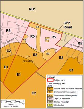
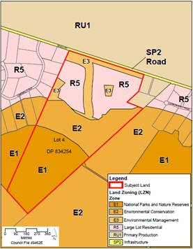
Figure 2 - Proposed zoning maps: exhibited
(left) and final proposed (right)
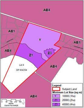
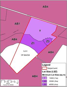
Figure 3 - Proposed minimum lot size maps:
exhibited (left) and proposed (right)
Proposed changes -
DCP Chapter N28
The proposed changes to
draft DCP Chapter N28 resulting from the public exhibition are summarised in Table
2 below and shown in track-changes in Attachment 3.
Table 2 - Proposed changes to DCP Chapter
N28
|
Change
|
Comments
|
|
Figure 2 - Wastewater exclusion map: align the
wastewater exclusion area with the ridgeline
|
Ensure wastewater is not applied on land that drains
to Coomonderry Swamp. Refer to discussion on the ridgeline under zoning map
changes.
|
|
Figure 3 - Building exclusion map: align the
building exclusion area with the ridgeline
|
Refer to zoning map changes. Will ensure
consistency.
|
|
Aboriginal Cultural Heritage:
· Provide
options to remove/retain the scarred tree
· Add
detail on when an AHIP will be required in the area of Potential
Archaeological Deposit (PAD)
|
As discussed above, changes are required to:
· Reflect
the recommendations of the post-lightning assessment of the scarred tree.
· Improve
clarity around the statutory requirements.
|
|
Add provision requiring landscape planting of native
shrubs and trees to facilitate wildlife movement between Beach Road,
‘Jim’s Forest’ and Coomonderry Swamp and along the drainage
line.
|
In summary the proposed provisions are required based
on:
· Corridor
width generally 10 m but can be averaged to ensure dwelling yield is not
reduced and bushfire construction standard is BAL-29 or less.
· Corridor
along Coomonderry Swamp is 30 m wide (based on information provided by the
proponent).
· Tree/shrub
planting corridors to be shown in a landscaping plan to be provided with the
subdivision application.
· Positive
covenants to be established at subdivision stage.
· Planting
required at individual development application stage.
These provisions will also provide a range of other
benefits including visual, landscape amenity, water quality, hydrology, and
privacy.
|
|
Add provision to require the groundwater discharge
zones to be appropriately drained at subdivision stage.
|
To minimise the risks associated with the groundwater
discharge zones including potential adverse impacts on adjoining properties.
|
Conclusion
This matter is now at a point where Council needs to consider
the outcome of the public exhibition period and determine how it wishes to
proceed to finalise things. It is recommended that the PP and DCP Chapter be
finalised consistent with the table of changes and associated material provided
within the report, responding to the submissions received.
Financial Implications
This Planning Proposal has been
funded by the proponent in accordance with Council’s Planning
Proposal Guidelines and fees and charges. Any outstanding fees will
be payable prior to submitting the PP to DPIE/Parliamentary Counsel for
finalisation.
|
|
Development
& Environment Committee – Tuesday 05 November 2019
Page
1
|
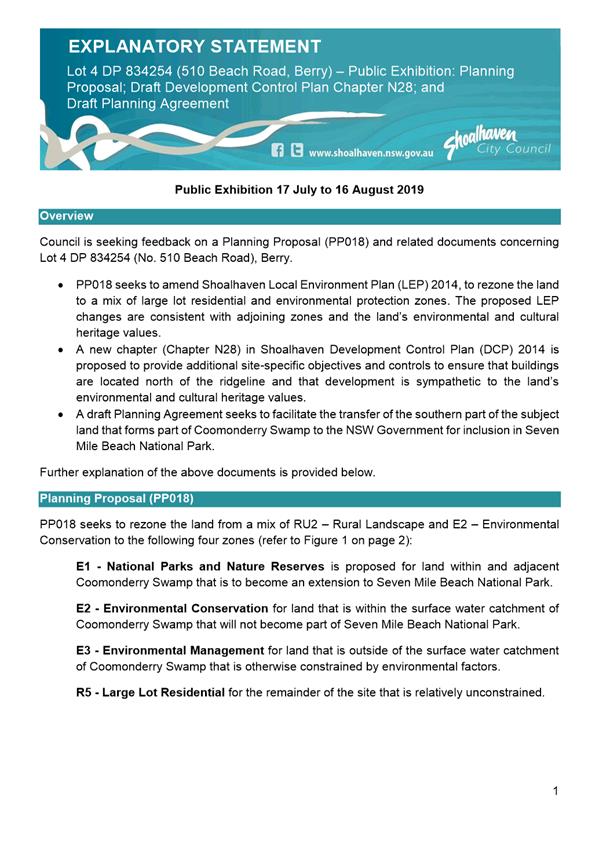
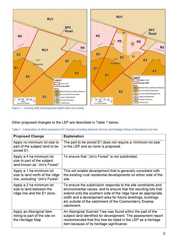
|
|
Development
& Environment Committee – Tuesday 05 November 2019
Page
1
|
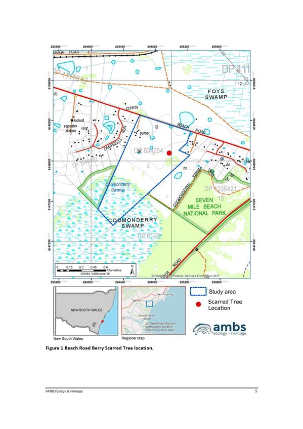
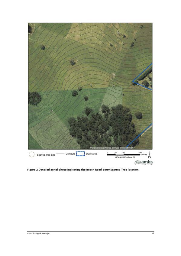
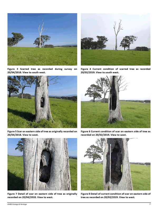
|

|
Development
& Environment Committee – Tuesday 05 November 2019
Page
1
|
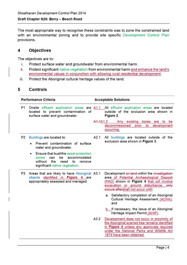
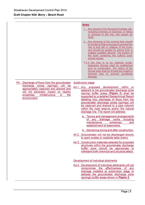
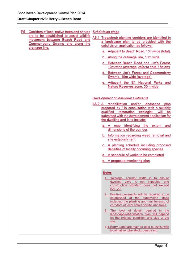
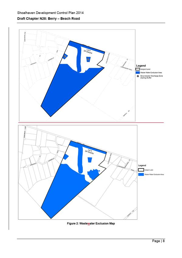
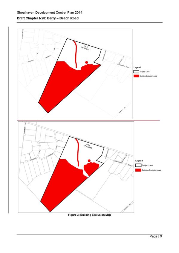
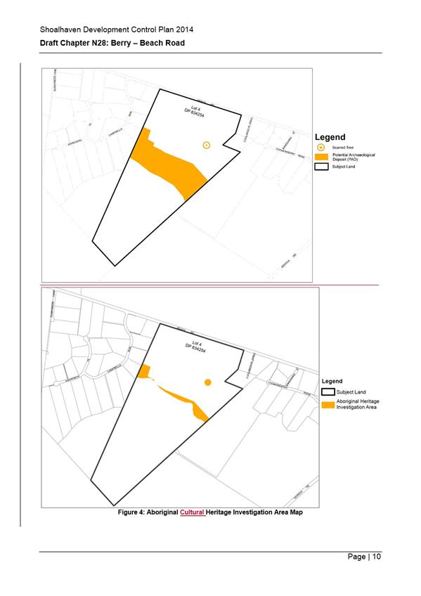
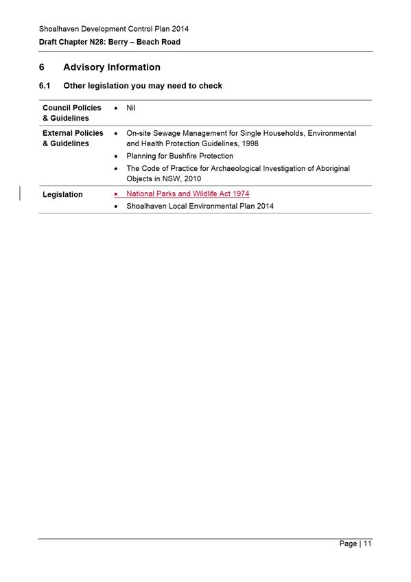
|
|
Development
& Environment Committee – Tuesday 05 November 2019
Page
1
|
DE19.114 Quarterly
review for compliance matters
HPERM Ref: D19/317494
Group: Planning
Environment & Development Group
Section: Building
& Compliance Services
Attachments: 1. List
of penalties and cautions issued July to September 2019 (under separate cover) ⇨
Purpose / Summary
At Council’s Ordinary meeting held on 13 November 2018
it was resolved to receive a detailed quarterly report on compliance activities
(MIN18.907).
This report provides information on the period July to
September 2019 (first quarter 2019/2020).
|
Recommendation (Item to be determined under delegated authority)
That Council receive the
quarterly report on compliance matters for information.
|
Options
1. Council receive
the report for information
Implications: Nil
2. Council receives
the report and provides additional direction for future reports.
Implications: Any changes or additional matters can
be added to future reports.
Report
Compliance activities are completed by the following Teams
within the Planning, Environment and Development Group:
(a) Compliance Team:
Development compliance matters including unauthorised development, development
not in accordance with development consent, land and water pollution incidents
(including building sites), land use management issues, fire safety and
swimming pool safety issues.
(b) Environmental Health:
Pollution incidents (noise and water), environmental incidents, food shops and
the operation of on-site sewage waste management facilities.
(c) Parking: All parking
offences.
(d) Rangers:
Animal control, littering, unauthorised camping, rubbish dumping and other
environmental offences.
This report provides Councillors with an update on the
penalties issued (number, type and ticket value), penalty reviews dealt with by
the Review Panel and any Local or Land and Environment Court matters determined
or progressing.
This report relates to July - September 2019 (first quarter).
1.0 Penalties issued
during the period
A combined total of 1043 penalty notices were issued by the
Teams during the period. These penalties have a face value of $351,466. Historically
Council stands to receive approximately 70% of this ticketed figure. A total of
283 cautions were also issued during the period. Attachment 1 to this report
provides a breakdown of the penalties and cautions issued.
The following is a summary of the penalties issued for each
team:
|
Team
|
Number Issued
|
Total Amount
|
% of total amount
|
Cautions issued
|
|
Compliance
|
51
|
$136,920
|
38.5%
|
95
|
|
Compliance – Fire Safety
|
0
|
0
|
0%
|
1
|
|
Compliance – Pools
|
1
|
$550
|
1%
|
10
|
|
Environmental Health
|
9
|
$10,710
|
3%
|
3
|
|
Rangers – Animal issues
|
124
|
$51,205
|
14.5%
|
17
|
|
Rangers – Environmental issues
|
16
|
$9,070
|
2.5%
|
4
|
|
Parking
|
838
|
$127,011
|
36%
|
150
|
|
Sewer Management Facility
|
4
|
$16,000
|
4.5%
|
3
|
|
Total
|
1043
|
$351,466
|
100%
|
283
|
Penalties related to Compliance issues
The following details are provided in relation to the 51 compliance
penalty notices issued:
a) Bawley Point: The property owners
constructed a two storey addition and first floor timber deck additions without
obtaining a construction certificate or appointing a principal certifier. One
penalty notice issued to two owners for development not in accordance with consent
–
class 1a or 10 building – Individual ($1500) (Total $3000).
b) Brooman: One penalty notice issued to one owner for permitting a
music stage/platform to be constructed upon the property without consent – Carry out
specified development prohibited on land – any other case –
Corporation ($6000).
c) Vincentia:
One penalty notice issued to one owner for unauthorised construction of a deck,
pergola, balcony and the relocation of a kitchen – Development without
development consent – class 1a or 10 building – Individual ($1500).
d) Cambewarra:
Seven penalty notices issued to one owner for construction
of a farm shed, tennis cabana, storage shed, carport, outdoor gym pergola and
two attached verandas to the house –
Development without development consent – class 1a or 10 building –
individual ($1500) (Total $10,500)
Four penalty
notices issued to one owner for construction of a
filled ramp and earthworks, driveway and hardstand area, earthworks within a
riparian area and earthworks under buildings ancillary to the tennis court – Development without development consent – any other
case – individual ($3000) (Total $12000).
Two penalty notices issued to the Builder
for the construction of a Tennis Cabana and Storage Shed – Development
without development consent – class 1a or 10 building – Corporation
– ($3000) (Total $6000).
One penalty notice issued to the Builder
for construction of a driveway and hardstand area - Development without
development consent – any other case – Corporation – ($6000)
One penalty notice issued to Plumber for
unauthorised works in association with the Tennis Cabana - Development without
development consent – class 1a or 10 building – individual –
($1500).
One penalty notice issued to the Plumber
relating to plumbing work done to a driveway and hard stand area - Development
without development consent – any other case – individual –
($3000)
Two penalty notice issued to the Plumber
for not providing notice of work to plumbing regulator – individual -
($550) (Total $1100).
e) Wattamolla: Two
penalty notices issued to one owner for land clearing - Development without
development consent – any other case – individual ($3000) (Total
$6000).
Seven penalty
notices issued to one owner for pollute water offences relating to works
undertaken within or near a creek/causeway – pollute waters –
individual – ($4000) (Total $28000).
Two penalty
notices issued to one owner for Earthworks (road building) and works within a
causeway – development without
development consent – any other case individual – ($3000) (Total
$6000).
f) Tomerong:
Five penalty notices issued to the owner for the installation of a shipping
container to be used as a shed, building works associated with an ablution
block extension, construction of a wedding shed, hayshed and pool cabana -
development without development consent – Class 1a or 10 Building –
corporation – ($3000) (Total $15000).
One penalty notice issued to the owner for
the operation of a campground – development without development consent
– any other case - corporation – ($6000).
Three penalty notices issued to the owner
for operating a sewage management system without approval – ($330) (Total
($990).
Two penalty notices issued to one owner
for allowing wedding event and associated camping to proceed – fail to
comply with the terms of a development control order – Corporation
– ($6000) (Total $12000).
g) Falls
Creek: One penalty notice to one owner for the construction of an in-ground
swimming pool – development without development consent – class 1a
or 10 building – individual – ($1500).
h) Hyams
Beach: One penalty notice issued to one owner for unauthorised alterations
to existing building and associated timber deck – development without
development consent – class 1a or 10 building – individual –
($1500).
i) Termeil:
One penalty notice issued to one owner for failing to install a temporary
swimming pool barrier – not comply with written direction – owner
– ($550).
j) Callala
Beach: Two penalty notices issued to one owner for construction of 2 site
sheds for habitable purposes – development without development consent
Class 1a or 10 Building – individual – ($1500) (Total $3000).
k) Woodstock:
One penalty notice issued to the owner for operating a sewage management system
without approval – ($330).
One penalty notice issued to the Builder
in relation to building works – development without development consent
– Class 1a or 10 Building – corporation – ($3000).
l) Basin
View: One penalty notice issued to the Builder – non- compliance with
development consent - development not in accordance with development consent
– class 1a or 10 Building – ($3000).
Warnings related to Compliance
issues
A total of 95 warning notices were issued for
compliance matters in the period and these equate to $230,000 in ticket face
value. Potentially the Compliance Team could have issued $366,920 in penalties
for the period. The caution rate is approximately 65%.
Penalties related to Rangers issues
a) Illegal Dumping:
One penalty notice was issued for dumping household waste on Moss Vale Road,
Barrengarry Mountain. Offence – Transport waste to unlawful waste
facility – ($2,000). The perpetrator was ordered to clean up the waste
and disposed of it to the Nowra Waste Facility.
b) Fail to prevent dog
escaping: Rangers issued 34 penalty notices for failing to prevent dogs
escaping. On each occasion the dog owner is first educated on responsible pet
ownership and potential measures to assist in securing their dog. Upon the
animal escaping for a subsequent time, a penalty notice is issued. Each penalty
has a face value of $220 and this equates to $7480 in total.
c) Dog attacks: The
number of dog attacks during the period was 63 with 18 still under
investigation. This resulted in the issue of 4 fines totalling $5,280. The dogs
involved in these attacks have been given a “dangerous dog
listing”.
d) Stock on Road: On
going issues with stock and horses being located unsecured on public roads has
resulted in Rangers issuing 7 penalty notices to owners for cause or permit
animal to be unattended. Each penalty has a face value of $330 and this equates
to $2,310 in total.
e) Opt in parking
offences: A total of 506 parking penalties were issued under the reduced
opt in amount of $82 and this totalled $41,492. Under the previous $114 penalty
amount this would have resulted in a total of $57,684. This represents a
$16,192 difference in income.
f) Warnings
related to parking issues:- A total of 136 warnings were issued
during the period and this equates to $37,366 penalty notice face value.
2.0 Penalty
infringement panel reviews
During the period, the review panel
met on 4 July, 1 August 2019 and 9 September 2019. There were nineteen (19)
penalty infringement appeals considered during this period.
(a) Development without development
consent – Class 1a or 10 building – Individual ($1500) and
Development not in accordance with the Development Consent – any other
case ($3000)
This matter related to two penalties issued; one for the
construction of the access bridge and the other for the occupation of the shed
structures occurred without development consent.
Considerable works had been undertaken without the required
construction certificate being issued for the access bridge. The unauthorised
sheds are located within designated bushfire prone land without any
consideration or protection provided.
Council staff had shown leniency by issuing a single
penalty notice for all the offences in relation to development without
development consent and by issuing a single penalty notice for all the offences
in relation to development not in accordance with the development consent.
The panel considered the matter on
4 July 2019 and agreed each of the penalty notices should stand. Further,
Councils Compliance Officers will monitor the progress of the current
Development and Building Information Certificate applications to ensure further
unauthorised works are not undertaken.
(b) Development without
development consent – any other case –Individual ($3000)
The penalty notices relate to the unauthorised occupation
of an industrial unit located at Ulladulla. Both
the owner and the tenant admitted to using the industrial unit for residential accommodation since February 2018 and
each received a penalty.
· An industrial
building was being used for residential accommodation (Land zoned IN1 –
General Industrial).
· The owner was
fully aware that the tenants were leasing the industrial building for
residential accommodation since February 2018 and made no effort to stop this
unlawful use.
· No development
consent had been issued to use the industrial building for residential
accommodation.
· The industrial
building did not contain a smoke alarm or other fire safety measures
required for residential use and this triggered immediate health and fire
safety concerns (imminent threat to life).
· Residential
accommodation is a prohibited activity pursuant to the SLEP 2014 in land zoned
IN1 – General Industrial.
Council worked with and showed
leniency to the owner and the tenants in the following manner:
· An Emergency Stop
Use Order was not issued by Council because the occupants offered to install
temporary smoke alarms and subsequently remove the sleeping facilities from the
subject premises.
· A formal caution
had been issued to one of the tenants.
· Further penalties
were not issued to the owner for the lack of essential fire safety measures in
the industrial building.
The tenant is now renting a
residential premise in the Shoalhaven area and is no longer offending. It was
considered that a caution to the tenant was the correct decision in this
instance.
The panel considered the matter on
4 July 2019 and determined that penalty notices should stand for the owner and
the penalty notice to the tenant be withdrawn and a formal caution be issued.
(c) Fail to comply with
terms of development control order – individual ($3000).
The owners had carried out
unauthorised works and they had received penalties for that activity. They were
then given a formal direction not to carry out any further works on the works.
The owners did not comply with this direction and each was issued with further
penalties for failing to comply with the direction.
The panel were advised:
· Both owners were
served the formal stop work order,
· Both owners were
fully aware of Councils requirements and chose not to abide by the terms of the
order,
· Both owners were
equally involved in the decision to carry out the work,
· This is the second
time the owners had breached the terms of a formal order.
· The works were
completed on a Heritage Item without prior approval and without consideration
or oversite from an Archaeologist or Heritage Consultant. Relics may have been
discovered, exposed, moved, damaged or destroyed.
· Both owners made a
business decision to ignore the formal stop work order to meet their own
personal deadlines. Substantial excavation works had been undertaken without
prior approval from Council.
The panel considered the matter on
4 July 2019 and agreed that both owners were aware of the requirements to stop
and they indicated they would continue. This was a deliberate act and the panel
resolved that the penalties should stand.
(d) Development without
development consent – class 1a or 10 building – Individual ($1500).
Council’s Compliance Officers
became aware of the unauthorised structures on Council reserve following a
phone call from a member of the public concerned with the amount of unapproved
merchandise stands creating trip hazards in Huskisson.
On two occasions Council contacted
the owner of the business advising that the merchandise, sign and cart would
need to be removed from Councils land until such time as Development Consent
approval was given.
A further site inspection
identified the structures still on Council’s road reserve. One penalty
notice was issued to the business owner. Council staff had shown leniency for
not issuing $1,500 penalty notices for each day the merchandise was identified
on Council reserve. This non-compliance went on for several months.
The panel considered the matter on
4 July 2019 and agreed that in this instance an official caution was warranted.
The penalty notice was withdrawn and a formal caution has been issued.
(e) Fail to comply with
terms of development control order – individual (x2) ($6000).
Council has received numerous
complaints since early 2016 relating to the fire damaged and partly demolished
dwelling located at Mollymook Beach.
Council issued orders to both
owners to demolish the damaged and dilapidated building.
Council has previously received
legal advice enabling multiple penalty notices being issued for the same
offence relating to a breach of a development control order. This advice
enabled Council to issue one development control order and multiple penalty
notices under that order for the same offence, without the requirement of
issuing a new development control order after each penalty notice.
Council has received subsequent
legal advice contradicting the original advice. As such Staff recommended both
penalty notices be withdrawn due to the updated legal advice.
The Review Panel considered the
matter on 1 August 2019. The Panel was satisfied with the Staff recommendation
and the penalty notices were withdrawn.
(f) Development
without development consent – class 1a or 10 building – Corporation
($3000).
During a mandatory on-site sewer
management facility inspection, it was identified that the dwelling was
under-going demolition and construction works. A review of Council records
revealed no formal approvals were in place for these works and the matter was
referred to the Compliance Team for investigation.
This matter relates to the
unauthorised demolition and reconstruction of a 90m2 detached shed (Class 10a
building). The main dwelling was partially demolished and substantially
rebuilt without development consent, a construction certificate or the
appointment of an Accredited Certifier.
It was determined the property
owner allowed considerable unauthorised works to be undertaken on the
property.
Council staff had shown leniency by
issuing the owner with two formal cautions rather than additional penalty
notices.
The Panel considered the matter on
1 August 2019 and agreed the single penalty should stand.
(g) Development without
development consent – class 1a or 10 building – Corporation (x2)
($6000).
This matter relates to the Builder who undertook the
unauthorised development in the review listed in (f) above. The Builder had
been issued with two penalty notices.
Council staff recommended both penalty notices should stand
for the following reasons:
· The
builder has completed considerable unauthorised works. A firm but fair message
should be sent to both the property owner and the builder.
· The
builder has enabled the owner to undertake the works and should be held
accountable. This is the builder’s core area of business and he
should have taken the time to educate himself on the legislative framework that
he works under. Particularly the requirements of the SEPP (Exempt &
Complying Codes), which he could have used to demonstrate to the property owner
that consent was required prior to commencing works.
· The
builder has profited from the works undertaken to date and has admitted to
making a business decision to continue demolition and reconstruction works once
he formed the view Council approval was required.
The Panel considered the matter on 1 August 2019. The panel
acknowledged the representations made and the hardship being experienced by the
Builder and opted to withdraw one of the penalty notices. The other
penalty notice was to stand.
(h) Pollute Waters
– class 1 officer – Corporation (x2) (16,000) and fail to comply
with Prevention Notice - class 1 officer – Corporation ($8000)
A heavy rain event in November 2018 triggered the overflow of
a detention basin on the property located in Bomaderry. Sediment laden water
discharged from the property through inadequate sediment and erosion controls
onto Cambewarra Road and the Princes Highway. Formal cautions were issued to
the organisation in relation to this breach of the Protection of the
Environment & Operations Act (POEO Act).
Investigation into the breach revealed that the sediment and
erosion controls were not executed onsite in accordance with the Environmental
Site Management Plan approved by Council.
To address these deficiencies, Council issued a prevention
notice to the organisation requiring additional sediment controls and
maintenance of existing controls to be implemented immediately. No action
was undertaken on site by the organisation as a result of the prevention
notice.
The following weekend, after these works were completed, there
was another rain event and strong winds. The sediment and erosion control
measures that had been implemented failed, and the strong winds damaged the
banners secured to the boundary fence creating a further water pollution event.
This resulted in the issuing of three (3) penalty notices which were the
subject to the review.
Council staff recommended:
· Penalties to be
withdrawn as they were issued contrary to law due to the incorrect payment
timeframes printed on the notice. This position is based on legal
representation.
· The penalties be
reissued with the correct time frames.
The Panel considered the matter on 9 September 2019 and agreed
with Council staff recommending that all penalty notices be withdrawn. It
was further recommended that two new penalty notices be issued and one formal
caution be issued. The new penalty notices reflected the 28 day
requirement.
(i) Development
without development consent – class 1a or 10 building – Individual
($1500).
The owner of a property located in Bangalee advised Council
that his tenant has installed an above ground pool without approval from
himself or a consent authority.
Council’s Compliance Officers investigated the property
and found the above ground pool, associated timber deck and swimming pool
barrier have been installed without prior approval from a consent authority.
A review of Council’s records found that the tenant was
issued with a formal caution in September 2015 for the installation of the same
swimming pool on the same property. This pool was dismantled in 2015 as a
result of that investigation.
Council staff have shown leniency by issuing a formal caution
in 2015 for installing a swimming pool without consent from a consent
authority. At that time Council advised the tenant of the need to obtain
approval prior to erecting the pool.
The Panel considered the matter on 9 September 2019. The Panel
recommended that the penalty should stand. This matter has since been Court
elected and it is set for mention on 1 November 2019 in Nowra Local Court.
(j) Development
without development consent – any other case – Individual (x2)
($6000) and Pollute Waters – class 1 officer – Individual ($4000)
This investigation was initially brought to Council’s attention
in May 2019 by a neighbour of a property located in Wattamolla. A photograph
was produced depicting significant earthwork cuttings which the neighbour
stated was part of larger works being conducted by the owner of the
neighbouring property.
A review of the Council records revealed no development
consent existed for these works. Investigations identified the following:
· Six
(6) creeks had been filled with earth using an excavator. Some of the creeks
had a 350 mm pipe in them in an attempt to build a culvert. These works were
unauthorised and caused significant land and water pollution.
· Approximately
one (1) hectare of land had been cleared at the northern end of the property.
This activity was completed with the stated purpose of building a dwelling at a
future time. A significant number of trees had been felled on the property.
These works were unauthorised and caused significant land pollution.
· During
a subsequent inspection in May 2019; another smaller cleared area was located.
Adjacent to this clearing, a creek flowing out of Budderoo National Park was
dammed with earth and rubble. These works were unauthorised and caused a
significant water pollution event.
· During
a further inspection in June 2019, Council officers located a series of
unauthorised earthworks in a right-of-carriageway. The works consisted of six
(6) separate earthworks done on switchback turns with the stated intention of
widening the right-of-carriageway to enable passage of a larger vehicle. These
works were unauthorised and had potential to cause significant water pollution.
· A
further unauthorised development had also been done by filling a creek crossing
at the bottom of the right of carriageway and covering it with shale-like
stone. These works were unauthorised and caused significant water
pollution.
As a result of this incident a total of 11 penalty notices had
been issued with a face value of $30,000. Council had also issued 28 cautions
with a face value of $100,000.
The submission made on behalf of the owner’s Solicitor
identified hardship and this was having an impact on him completing the
required rehabilitation works. Council staff recommended the three penalty
notices the subject to this review be withdrawn on those grounds.
The Panel considered the matter on 9 September 2019. The panel
agreed Council is focussed on the rehabilitation of the site and it is
considered that the costs associated with the penalties would be best spent on
those works. The Panel determined to withdraw the three penalties and formal
cautions were issued.
(k) Development not
accordance with consent – class 1a or 10 building – Individual
– ($1500)
The penalty related to the
construction alterations and additions without a construction
certificate.
Council received a development
application for a proposed dwelling extension and deck area in August 2018.
Council’s Building Surveyor assessing the development application
identified unauthorised works when comparing the proposed development against
the historic approved Building Application.
· An
attached unauthorised first floor deck and associated stairway access had been
constructed upon the premises without approval.
· A
3.8m X 7.5m concrete slab attached to the dwelling constructed for the garage
extension.
Council had issued six formal warning
notices and two penalty notices for these offences. One of the owners
requested that a penalty be withdrawn.
Council has shown considerable
leniency by not issuing separate penalty notices for all breaches. Council
staff recommended the penalty stand.
The Panel considered the matter on 9
September 2019 and concluded that the penalty should stand.
3.0 Other activities
by Ranger Services
a) Illegal dumping
education: Rangers in collaboration with Illawarra Shoalhaven Joint
Organisation (ISJO) commenced an education campaign aimed at providing the
public with information on our ‘Community Recycling Centres’ across
the LGA. The campaign identifies and promotes where assorted items can be
disposed of free of charge. The campaign is also focussed on encouraging our
community to report illegal dumping and providing information on how to report
alleged offences.
The campaign has seen Rangers visit hardware stores around
the LGA providing advice and information to the building industry.
b) Mollymook
Beach patrols: Rangers conducted 67 patrols of Mollymook Beach in the
period. This included three on leash areas and 64 prohibited areas.
During these patrols eight dogs were sighted and six people were spoken with
about their dogs. As a result, one verbal caution, one official warning
and five penalty notices to the total value of $1650 were issued.
This beach features highly on the complaints register.
Patrols will continue in an effort to educate pet owners about responsible pet
ownership and the regulations.
c) Other beach
patrols: Rangers have completed 145 patrols of other beaches in the area
during the period. The beaches patrolled have included Shoalhaven Heads,
Culburra Beach, Abrahams Bosom Beach, Collingwood Beach, Shark Net Beach,
Nelsons Beach, Moona Moona Beach, Moona Moona Creek, Blenheim Beach,
Narrawallee Beach, Berrara Beach, Conjola Lake Ocean Beach and Spit,
Tabourie Point Beach, Bawley Point Beach and Burrill Beach.
Beach patrols will pick up in the next 2 quarters as
historically these will see an increase in usage during the warmer months.
d) Shorebirds:
A meeting with stakeholders was held on 11 September 2019 to discuss strategies
for the shorebird recovery programme including patrols for dogs on beaches.
Council will collaborate with National Parks and Wildlife Services on this
programme.
Representatives from Wollongong, Shellharbour and Kiama
Councils attended the meeting. Both Eurobodalla and Bega Councils were also
involved in an effort to share the responsibility of helping to protect the
shorebirds.
Council stakeholders include Ranger Services, Executive
Strategy, Tourism, Tourist Parks, Sustainability, Community
& Recreation and Parks Operations.
Strategies to develop for annual programme include:
· Creating
networks and processes to share information and create solutions.
· Media campaign targeting
both tourists and local residents including television and radio, social media
and information on Council’s website in line with National Parks’
Communication Plan.
· Address
ongoing complaints from the public about problems with dogs not under control
in public places, including shorebird nesting areas, which escalates during
holiday season. This would include additional ranger patrols after hours.
· Beach visits by Rangers
and shorebird volunteers to provide education, information and enforcement
where necessary.
· Providing information to
holiday accommodation and surf clubs about shorebirds and threats to their
breeding success.
· Ensuring signage and
fencing is in place.
Community expectation continues to increase and Council
will provide resources in conjunction with National Parks to protect breeding
sites.
e) Additional
casual Assistant Rangers: Three casual Assistant Rangers have been
recruited to address the increased workload during the busy holiday period from
November to January inclusive.
4.0 Land and
Environment Court matters
Jerberra Estate –
Hearing – Contempt Proceedings – Garry Knight.
Unauthorised works were undertaken by
the owner Garry Knight and he had failed to comply with Council’s
direction to remedy the situation. This matter was taken to the Land and
Environment Court in 2014 where the Court issued orders for the works to be
completed.
The owner then failed to comply with
the Court orders and this resulted in contempt of Court proceedings against
him.
The matter was heard on 27 May 2019.
The landowner attended Court on this occasion and entered a guilty plea to the
contempt of court. Council indicated its intention to enter the land and
execute the orders. The owner was allowed a further 4 weeks to remove any
personal items.
On 28 June 2019 Council entered the
land to conduct a safety assessment prior to executing the terms of the Court
Order.
The matter was heard on 1 July 2019
where it was adjourned to 19 September 2019 to allow Council to execute the
terms of the Court Order.
The landowner was ordered to reimburse
the Council $17,270.25 towards the costs incurred in carrying out the clean-up
of the site.
The landowner pleaded guilty to the
contempt and incurred a fine of $12,750 which was significantly reduced to
$1000 based on the owner’s immediate financial circumstances and realistic
prospect of his ability to pay such penalty (Note:- the fine issued by the
Court is paid to Consolidated Revenue and not Council).
Council sought legal costs in this
matter. The landowner was ordered to pay Councils legal costs in a gross sum of
$158,387.38.
5.0 Local Court matter
There was only one Local Court matter in the period and this
related to the prosecution of the Australian Hotel for unclean food premises.
On 18 September 2019, the Nowra Local Court issued the Hotel
with a fine of $6000. The Hotel was also required to pay $4000 towards
Council’s costs.
|
|
Development
& Environment Committee – Tuesday 05 November 2019
Page
1
|
DE19.115 Shoalhaven
City Council - Mobile Food Vans in the LGA - Private and Public Lands - SEPP
Exempt & Complying Development - Business Impacts
HPERM Ref: D19/342833
Group: Planning
Environment & Development Group
Section: Building
& Compliance Services
Attachments: 1. Letter
to NSW State Government, Mobile Food Vans - Private & Public Lands ⇩
2. Response from NSW Government
/ Planning Industry & Environment, Mobile Food Vans - Private & Public
Lands ⇩
Purpose / Summary
This report advises on the
response received from NSW Department of Planning Industry and Environment
concerning mobile food vans on private and public lands.
|
Recommendation
(Item to be determined under delegated authority)
Council receive and note the
response from the NSW Department of Planning Industry and Environment
concerning the mobile food vans on private and public lands.
|
Background
At its Ordinary meeting held on 2 July 2019 Council resolved
to do the following (MIN19.466):
1. The report Mobile
Food Vans in the LGA - Private and Public Lands be received for information.
2. Council write to the
NSW State Government to express concerns about the impact of the Mobile Food
Van provisions within the State Environmental Planning Policy (SEPP) (Exempt
& Complying Development Codes) on businesses in regional towns and villages
and consider further consultation and amendments to the SEPP if necessary.
Council wrote to The Honourable Robert Stokes MP, Minister for
Planning, Industry and Environment on 18 July 2019 in accordance with the
resolution (refer attachment 1). The NSW Department of Planning Industry &
Environment responded to Council on 16 September 2019 (refer attachment
2). Essentially, the Department have advised as follows:
(a) The State Environmental
Planning Policy (Exempt and Complying Development Codes) 2008 (Codes SEPP)
allows mobile food and drink outlets to be carried out on private or public
land without planning approval, as exempt development, provided they meet the
relevant development standards.
(b) The general requirements of
the development standards that are detailed in the Codes SEPP for mobile food
and drink outlets.
(c) The provisions were
introduced to support daytime and evening activities and experiences in the
community and to cater for people looking for inexpensive and convenient food
and drink options.
(d) Mobile food and drink
outlets play an important role in activating public spaces.
(e) While the planning system
has regard to the economic impacts of a development, it does not usually impose
development standards that address restraint of trade, to prevent or reduce
competition between businesses.
This advice is presented to Council for their information.
|
|
Development
& Environment Committee – Tuesday 05 November 2019
Page
1
|
|
|
Development
& Environment Committee – Tuesday 05 November 2019
Page
1
|
|
|
Development
& Environment Committee – Tuesday 05 November 2019
Page
1
|
DE19.116 Draft Shoalhaven Tree and Vegetation Vandalism Prevention
Policy - Post Exhibition Consideration and Finalisation
HPERM Ref: D19/318186
Group: Planning
Environment & Development Group
Section: Environmental
Services
Attachments: 1. Summary
of Submissions for Shoalhaven Tree and Vegetation Vandalism Prevention Policy ⇩
2. Draft Shoalhaven Tree and
Vegetation Vandalism Prevention Policy (under separate cover) ⇨
Purpose / Summary
To consider the submissions received as a result of the
public exhibition of the draft Shoalhaven Tree and Vegetation Vandalism
Prevention Policy and to consider the finalisation of the Policy, in accordance
with Council resolution MIN19.490.
|
Recommendation (Item to be determined under delegated authority)
That
Council:
1. Adopt the draft Shoalhaven Tree and
Vegetation Vandalism Prevention Policy as exhibited, with amendments
following consideration of Summary of Submissions for Shoalhaven Tree and Vegetation Vandalism Prevention
Policy received during public exhibition as
highlighted in Attachment 1;
2. Notify the adoption of the Policy to
all who made a submission and CCBs;
3. Notify the adoption of the Policy
via media release and provide a link on Council’s website to the new
Policy;
4. Advise key stakeholders, including
relevant industry representatives, of this decision, and when the Policy will
be made effective; and
5. Amend Council’s Foreshore
Reserves Policy and Compliance Policy to reference the Shoalhaven Tree and
Vegetation Vandalism Prevention Policy.
|
Options1. As
recommended.
Implications: This is the preferred option as it
will address the growing concern of vegetation vandalism in the Shoalhaven. The
Policy focuses on four key strategies of education; monitoring, recording and
prevention; regulation and enforcement; and rehabilitation with the aim of
engaging and involving the community.
2. Adopt an
alternative recommendation.
Implications: If the alternative recommendation
involves amendments other than those proposed in this report, depending on the
extent of any changes that may be made to the exhibited version of the Draft
Policy, re-exhibition may be appropriate. This may postpose the finalisation of
the Draft Policy.
3. Not adopt the
recommendation.
Implications: This option is not preferred as
Council would continue to have no policy in place to direct and manage tree and
vegetation incidents across the Shoalhaven. This means that incidents of
vandalism would be considered on a case-by-case basis without a guiding
framework or consistent approach.
Background
On 23 July 2019, Council
resolved (MIN19.490):
That
Council:
1. Place
the Draft Shoalhaven Tree and Vegetation Vandalism Prevention Policy on public
exhibition for a period of 28 days; and
2. Receive
a report following the exhibition period outlining submissions received and any
recommended amendments to the Draft Policy prior to adoption by Council.
Community Engagement
The Policy was publicly
exhibited for a period of 30 days from Tuesday 30 July to Wednesday 28 August
2019 (inclusive).
The draft policy was exhibited
via the following:
· Council’s
Community Engagement platform, Get Involved Shoalhaven - https://getinvolved.shoalhaven.nsw.gov.au/tree-and-vegetation-vandalism-prevention
· Council’s
website - On Exhibition page https://www.shoalhaven.nsw.gov.au/My-Council/Public-exhibition/Documents-on-exhibition;
· Notice sent to all
CCBs;
· Council’s
Facebook page;
· Poster advertising
the exhibition in the foyer of Nowra Administration Building;
· Council’s
newsletter; and
· Hardcopies of the
document were placed in Council’s Administration Buildings in Nowra and
Ulladulla.
As a
result of the exhibition, fifty-seven (57) formal submissions were received. Graph
1 is a representation of the types of submissions received.
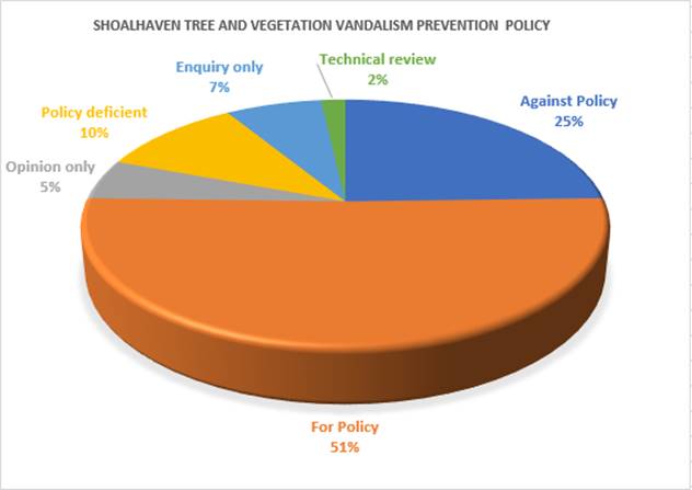
Graph 1: Types of submissions received during the exhibition phase
· For
Policy: submissions that considered the Policy satisfactory and were
supportive of the Policy.
· Against
Policy: submissions that did not support the Policy.
· Policy
Deficient: submissions that considered the Policy to be deficient and
potentially not robust enough to act as a deterrence.
· Opinion
only: submissions that did not directly address the Policy, however general
opinion regarding vegetation vandalism was provided.
· Enquiry
only: submissions that were an enquiry only and did not directly relate to
the Policy.
· Technical
Review: submission that provided a technical review by Council’s
internal Strategic Planning team.
A representation of the most
common themes raised in the submissions received by Council is shown in Graph
2.
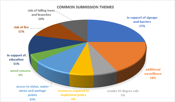
Graph
2: Common Submission Themes
In support of signage and
barriers: 25% of submissions considered the use of signage and barriers
(including signs, banners, and physical barriers) as an effective way of
deterring ongoing vandalism.
Additional Surveillance:
18% of submissions considered the installation of surveillance such as CCTV
cameras and compliance officers as an effective way of deterring ongoing
vandalism.
In support of Education: 11%
of submissions considered ongoing education including education in schools and
through the distribution of pamphlets as an effective way of deterring ongoing
vandalism.
Risk of Fire: 11% of
submissions were concerned that the Policy did not consider the risk of fire.
Access to vistas, water
views, vantage points and mobility of impaired people: 10% of submissions
emphasized the importance of views and accessibility to them.
Risk of falling trees and
branches: 10% of submissions identified falling trees and branches as a
significant cause of power failures, bushfires, property damage, injury and
death.
Resources required to
implement policy: 6% of submissions were concerned about the ongoing
provision of resources by Council to ensure the effective implementation of the
Policy.
Revoke 45-degree rule: 5%
of submissions considered exemption 5.2.3(d) in the Shoalhaven DCP Plan 2014
– Chapter G4, Tree & Vegetation Management should be revoked.
Weed concern: 4% of
submissions were concerned about weeds in the Shoalhaven and their potential to
block views and reduce biodiversity.
A detailed summary of the
submissions, including a Council staff response for each is provided in Attachment
1.
Copies
of the actual submissions will also be available for review in the Councillor’s
Room prior to the meeting.
Post-Exhibition Amendments
Following consideration of the
key themes and issues raised in the 57 submissions, amendments to the draft policy
are recommended. These amendments are shown by the track changes in Attachment
2.
The recommended post exhibition
amendments to the draft Policy are summarised briefly below:
|
Section
in Policy
|
Recommended Change and Reason
|
|
2.Objective
|
Opening statement moved from
‘Objective’ to ‘Introduction’ as this was considered
a general statement rather than an objective.
|
|
3.Policy Statement
|
Removed the opening paragraph
as it was considered superfluous information.
|
|
Remove reference to
‘public and private land’ to emphasize that the policy applies to
all land except for state forests, defence land, land reserved or
acquired under the National Parks and Wildlife Act, Marine Parks and National
Parks.
|
|
3.1 Scope
|
Emphasize that the Policy prevails
over all other policies rather than supersedes.
|
|
3.2 Background
|
Include ‘public and
private land’ in opening paragraph to emphasise that the Policy is
applicable to all land.
|
|
Include sentence in fourth
paragraph with the potential to create polarisation and conflict within
the community to highlight additional problems created by acts of
vandalism.
|
|
4.Provisions
|
Reference to ‘public
land’ deleted to de-emphasize focus on a particular type of land.
|
|
4.2 Definitions
|
Removed superfluous
information under the definition of ‘Tree’.
|
|
Reference to removal
(dead or alive) included under 4.2 Definitions: Tree and
Vegetation Vandalism
The Local Government Act 1993
s 629 specifies that it is an offence to wilfully or negligently injure,
damage or unnecessarily disturb any plant, animal, rock or soil in a public
place. Additionally, a person, without lawful excuse who removes a plant,
animal, rock or soil from a public place is guilty of an offence.
|
|
6.1
Community Education
|
Update reference to mowing
within Council reserves to provide clarity.
|
|
6.2
Monitoring, Recording and Prevention
|
Remove Point 5
‘Record the number of incidents and requests reported by members of the
community’. Record keeping is already captured in Point 1.
|
|
New Point 5: Retain poisoned
vegetation on site unless assessed as a safety hazard rather than remove
after 12 months. Retention recognises the importance of dead wood and stags
as important habitat for wildlife.
|
|
Appendix
2
|
Tree and Vegetation
Vandalism
Include Background
Information in the title to clarify that the information
provided in this appendix is additional information to the main body of the
Policy.
Removal of superfluous
information: Recognition of the broad tree and vegetation vandalism issues
being experiences in the Shoalhaven as a result of Council passing a
resolution to develop a robust tree and vegetation vandalism policy.
Policy responses
Remove reference to “ANZ
Standard (Draft) or similar”. The type of calculation used will depend
on the type of vegetation loss i.e. one tree or an area of
vegetation.
|
|
Appendix
3
|
Update legislative framework
table to reflect reference to Environmental Planning and Assessment Act 1979
rather than the Shoalhaven Development Control Plan.
Update table identifying other
areas not managed by Council.
|
|
Appendix
6
|
Include reference to private
land in opening paragraph.
Under Low and Medium Impact
Events: Include wording until rehabilitated tree or vegetation has been
assessed to be adequately re-established. The retention of signage
until vegetation has been adequately re-established may discourage further
vandalism from occurring.
Under High Impact Events:
change number of trees and vegetation in rehabilitation works from three to
five to provide consistency with section 6.2 Monitoring, Recording and
Prevention.
|
|
Appendix
7
|
Include loss of birdlife
and other native species in the example template letter to further
educate impact of vandalism on the environment.
Change number of trees and
vegetation in rehabilitation works from three to five which provides
consistency with section 6.2 Monitoring, Recording and Prevention.
|
|
Appendix
9
|
Update tree education sign to
show tree growing on land rather than water.
|
Policy Implications
The Policy seeks to prevent
vegetation and tree vandalism in a logical structure that provides a guiding
framework to Council staff and the public. Should the Policy not proceed, these
fundamental growing concerns of the community will not be addressed.
If the Shoalhaven Tree and
Vegetation Vandalism Prevention Policy is adopted, the Shoalhaven Foreshore
Reserve Policy and Compliance Policy will need to be updated and show the links
between Council’s policies that relate to the management of trees and
vegetation as well as Council’s Compliance Policy.
Financial Implications
The finalisation of the draft
Policy will continue to be resourced within the existing Environmental Planning
and Development budget.
Risk Implications
There are
risks in not taking action to implement a citywide Policy in the Shoalhaven.
Vegetation vandalism occurring in the Shoalhaven is extensive and ongoing. A
lack of action from Council may also be seen by the community as ‘doing
nothing’ in terms of implementing Council’s previous resolutions to
adopt a robust Policy and addressing the community submissions Council has
received in recent years requesting that vegetation vandalism occurring at
Collingwood Beach and other hotspots across the Shoalhaven be addressed.
|

|
Development
& Environment Committee – Tuesday 05 November 2019
Page
1
|
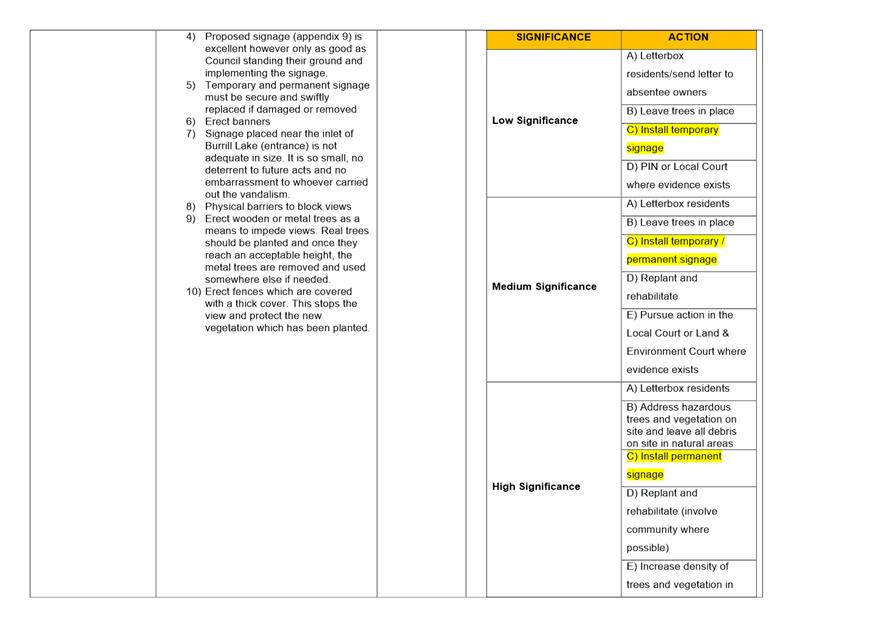
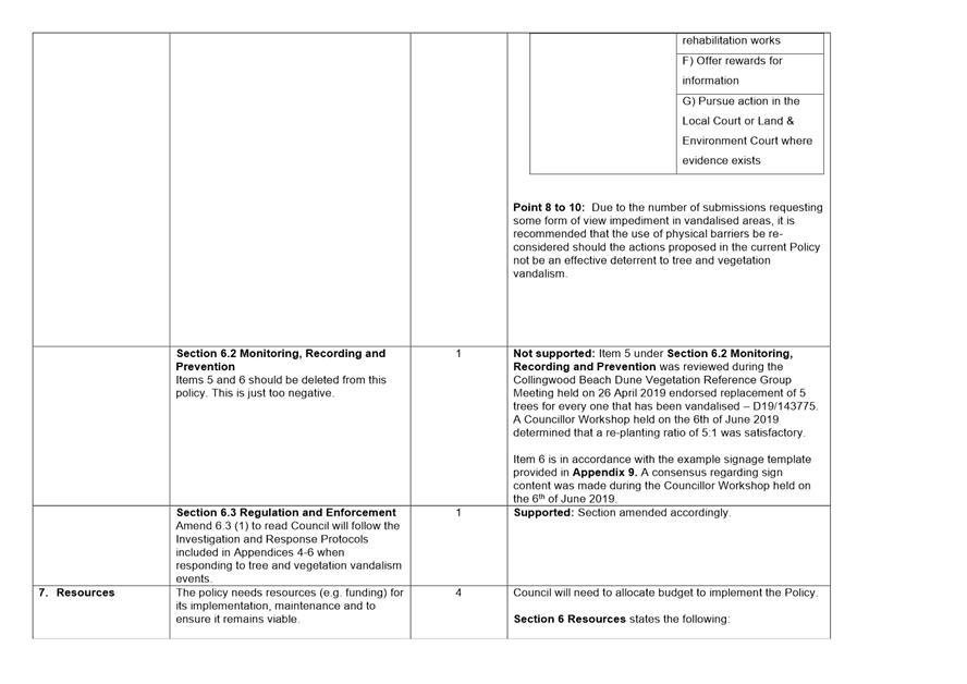
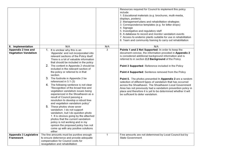
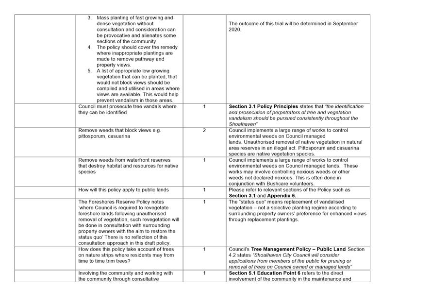
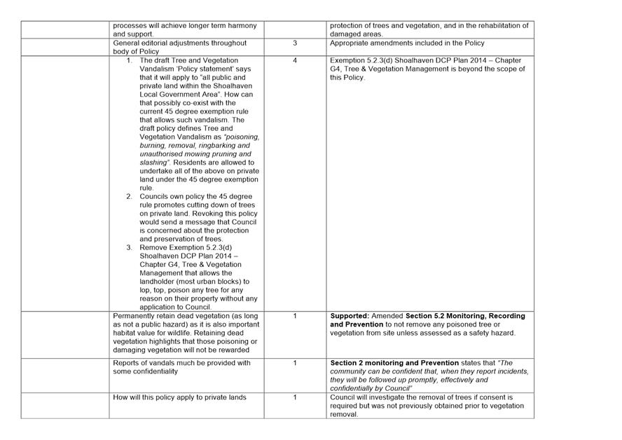
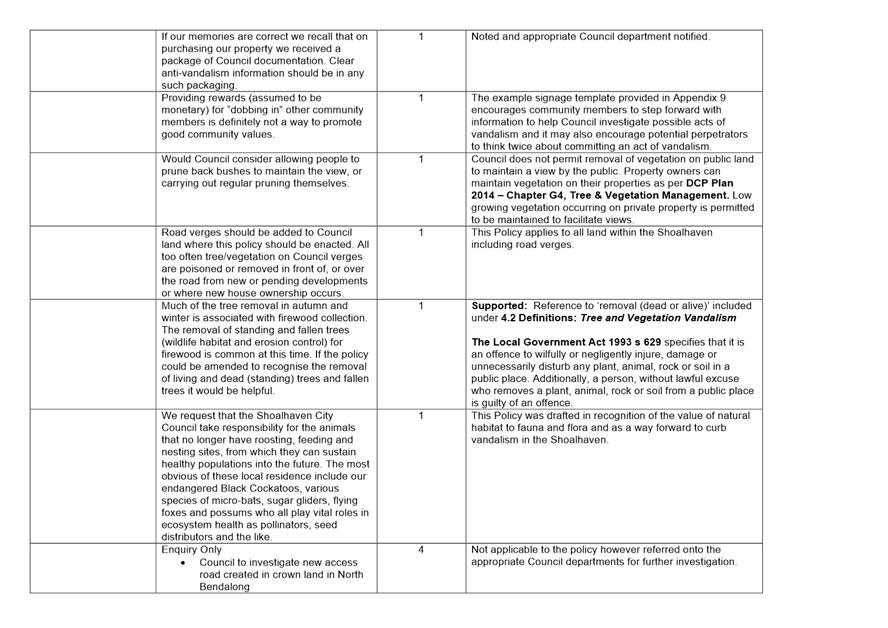
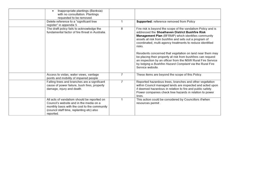
|

|
Development
& Environment Committee – Tuesday 05 November 2019
Page
1
|
DE19.117 Berry
Grey-headed Flying-fox Camp Emergency Grant 2019
HPERM Ref: D19/350495
Group: Planning
Environment & Development Group
Section: Environmental
Services
Purpose / Summary
To inform Council that Local Government NSW have reduced the
maximum grant funding available for managing a Grey-headed Flying-fox (GHFF)
colony at Berry to $17,500 and to re-confirm Council’s in-kind commitment
of $50,000, as per MIN19.645.
|
Recommendation (Item to be
determined under delegated authority)
That
Council:
1. Accept the grant funding of $17,469
from Local Government NSW;
2. Council support the grant with a
$50,000 in-kind commitment from existing operational budget to manage the ongoing
flying fox issues currently experienced in the Shoalhaven LGA; and
3. Write
to the Minister of Local Government NSW and the State Member for Kiama thanking
them for the grant funding and also outlining concerns regarding the
reduction in grant funding and seeking restoration of the full funding of
$50,000 for this round and into the future.
|
Options
1. As recommended
above
Implications:
The existing in-kind commitment of $50,000 (as per
MIN19.645) is from existing budget for staff salaries and equipment. It is
vital in assisting with the management, continued education and allocation of
mitigation measures at the Berry Flying Fox Camp. The funds will also assist
with the management of other flying fox camps in the Shoalhaven such as those
located in Bomaderry and Kangaroo Valley, as well as new camps that may form in
the future and require community liaison and education.
A community expectation has evolved that Council manage
the impacts of flying foxes within the Shoalhaven. With the grant funding from
Local Government NSW being reduced, Council staff will need to work closely
with the community to determine which mitigation items are fully funded by the
grant and which ones will require a monetary contribution.
2. Only approve a
like for like contribution
Implications: Should Council approve a like
for like contribution i.e. $17,500 to match the Local Government NSW
contribution of $17,500, the total funds of $35,000 will be insufficient to
implement mitigation measures as well as fund staff time to manage the impacts
of the flying foxes in Berry as well as other areas of the Shoalhaven to the
degree originally contemplated.
3. Not accept the
grant funding for $17,469 and write to the Minister for Local Government and
State Member for Kiama outlining concerns regarding the reduction in grant funding
and seek restoration of the full funding of $50,000 for this round and the need
for future rounds.
Implications: A community expectation has evolved
that Council provide some sort of assistance or solutions if local residents
are impacted by living in close proximity to a GHFF colony. Should Council not
accept the $17,469 grant funding, there will be no budget to purchase items to
assist residents. There will likely be community angst and the number of
complaints received is likely to escalate.
4. Council provide
an alternative resolution.
Implications: This would depend on the resolution.
Background
Flying Foxes in the
ShoalhavenGrey-headed Flying-fox (GHFF) is a
threatened species listed as vulnerable to extinction under both the NSW
Biodiversity Conservation Act 2016 (BC Act) and Commonwealth Environment
Protection & Biodiversity Conservation Act 1999 (EPBC Act). Actions
related to the species, such as removal of roosting trees, requires a licence from the Department of Planning,
Industry and Environment (DPIE) and potentially approval from the Federal
Environment Minister.
A relatively small number of
GHFF were known to be present at Berry from time to time as advised by
residents. In the past, Council did not receive any complaints about GHFF in
this area as the animals were most likely contained within the lower parts of
the backyards along the naturally occurring gully. However, the number of GHFF
dramatically increased in June and July 2019.
During an initial inspection
undertaken by Council officers and DPIE in mid-June 2019, the GHFF camp was
found to be mainly restricted to the backyard of one property at Kentia
Crescent, Berry. The property has been vacant for some time. An estimated count
of the GHFF population at the time was approximately 500 individuals. During a
subsequent site visit on 16 July with DPIE staff, a survey of GHFF numbers
found that the population had greatly increased to approximately 2025
individuals and were occupying another backyard in Kentia Close within close
proximity to a house and sleeping rooms (see Figure 1).
It is unknown whether the GHFF
camp at the subject site is made up of a local population from an existing camp
formerly located next to the Princes Highway in Berry or from the Bomaderry
Camp located approximately 12 km south-west of Berry.
Some residents expressed
concern, either via visits to Council’s administration centre or through
official telephone complaints to Council officers, that residents were waking
them in the early hours of the morning because of air horns and banging of pots
in an effort to dissuade the GHFF from roosting in certain trees/backyards in
Kentia Close. It should also be noted that a number of residents that DPIE and
Council officers have spoken to during community consultation were in favour of
the GHFF and appreciative of the natural phenomenon.
At the
time of writing, a total of 84 hours of Council staff time has been dedicated
to door knocking, addressing complaints and completing the application for
emergency grant funding.
Documented
attempts to disperse GHFF camps at various locations in Queensland, Northern
Territory and New South Wales between the years 1990 and 2013 show that in most
cases the flying-foxes did not leave the local area and the local population
size was not reduced. The cost of dispersal, the amount of resources required,
and the obtrusive nature of the dispersal methods does not make this a viable
option.
A
licence from DPIE would also be required and is unlikely to be granted.
Therefore, dispersal is considered a last resort response.
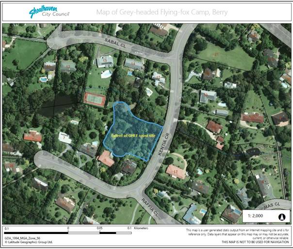
Figure 1 – Location of the Grey-headed Flying-fox
Camp, Berry
Grant
Funding
LGNSW has available
“emergency grant funding” which can include funding of:
· possible
removal of native and non-native trees to create a buffer between the camp and
the residents’ houses; and
· items
such as air conditioners, double glazed windows, high pressure cleaning
systems, clothesline covers, and car covers etc for protection from GHFF
faeces.
Staff applied for a grant from
Local Government NSW in relation to managing a Grey-headed Flying-fox colony located on private property between Sabal Close and Kentia
Crescent, Berry. The maximum amount, $50,000, was applied for, with an
in-kind Council contribution of $50,000. This action was resolved on 20
September 2019 (MIN19.645). However, due to the number of flying fox issues
occurring in other NSW local government areas, Council was notified by Local
Government NSW that the maximum amount available has been reduced to $17,500.
Council resubmitted the grant application to reflect the reduced grant amount
available as per the request of Local Government NSW which was granted on 24
October 2019.
The grant is subject to Council
providing a matching or greater in-kind contribution for managing and
implementing the grant. The full amount for managing the GHFF colony and
community expectations at Berry was previously estimated at a maximum total of
$100,000 (including grant money).
In order to reduce costings of
goods to a maximum of $17,500 a number of milestones have been excluded from
the grant. Negotiations will have to be made with local residents regarding the
types of goods that will offer the greatest mitigation to the effects of the
flying fox colony as well as their level of monetary contribution (up to 50%).
The grant funds are limited to the purchase of mitigation measures such as
double-glazed windows, air conditioning units, pool covers, tree removal/
lopping, high pressure cleaning equipment etc.
Local Government NSW has advised
that grant funding to manage flying foxes in local government areas will no
longer be available in the foreseeable future.
It is therefore recommended that Council approach the local
Member and the Minister for Local Government to seek restoration of full
funding of $50,000 for this round and into the future.
Community Engagement
Since June 2019, Council’s
Environmental Services officers have responded to 13 complaints in relation to
GHFF roosting (camped) in trees in close proximity to homes and have been in
regular contact with the most affected residents (four households). Council
reported the colony and the complaints from residents to DPIE.
Council’s
Environmental Services officers and DPIE visited the area and door knocked
residences surrounding the colony on five separate occasions
to date. Information about GHFF and the
perceived disease risk was left with residents or in letter boxes along with
contact details for an Environmental Services Staff member. Council has advised
residents a grant application for an emergency funding grant has been prepared
in order to provide alleviation measures and direct measures such as habitat
modification (subject to the DPIE licence) was also provided.
It should be noted that a DPIE
licence comes with strict conditions in relation to the timing of actions
around habitat modifications with no actions permitted if the GHFF will be
unduly disturbed.
Council officers continue to
contact and listen to affected residents as well as residents in support of the
GHFF colony. Council continues to liaise with DPIE about possible management
actions. DPIE do not support attempting to relocate the GHFF colony as this is
not considered a viable option as it was unlikely to work, very expensive and
that the number of persons affected was relatively small.
Proposed future actions will include the contacting of
residents to inform them of the reduced funding amount and the requirement to
provide monetary contributions for certain mitigation measures.
Policy Implications
Lessons learned from the Berry camp in relation to the
impacts of the GHFF on residents and the benefits of GHFF are useful for future
management plans. Council is currently working with DPIE to review the GHFF
management plan to include camps located in Berry and Kangaroo Valley area and
any other new camp formations in the LGA.
Financial Implications
Council Staff time since June 2019 has come from existing
operations budgets, approximately 84 hours to date. This includes time
allocated to the following:
· Various door
knocks to document complaints, educate owners of flying-fox ecology and
disease, mitigation options and suggest coping strategies;
· Receiving
complaints over the phone and in person at the front counter;
· Camp counts to
determine level of impact;
· Preparation of
relevant information to affected and neighbouring properties;
· Dissemination of
relevant information to affected and neighbouring properties;
· Liaising with
stakeholders including DPIE and Local Government NSW;
· Administrative
time to document issues; and
· Completion
of the grant, including amending the grant to reflect reduced funds as per
Local Government NSW request.
The grant offered is limited to
the procurement of mitigation measures. Any additional staff time in managing
the Berry camp, community expectations and other future issues associated with
flying fox camps in the Shoalhaven will have to be met by Council.
Regardless of the reduction in grant funding,
Council’s commitment of a $50,000 in-kind contribution is still required
as the work associated with the management of flying foxes in the Shoalhaven is
essential and is likely to be a recurring issue.
Risk Implications
Shoalhaven City Council may be viewed as ignoring the
concerns of its residents directly affected by the GHFF colony at Berry, should
Council be unable to effectively manage the impacts of the flying fox colony.
|
|
Development
& Environment Committee – Tuesday 05 November 2019
Page
1
|
DE19.118 Proposed
2019 Heritage Housekeeping Amendment - Shoalhaven Local Environmental Plan 2014
(PP036)
HPERM Ref: D19/250223
Group: Planning
Environment & Development Group
Section: Strategic
Planning
Purpose
/ Summary
Obtain the necessary resolution
to progress the 2019
Heritage Housekeeping Amendment Planning Proposal (PP) which seeks to make
a range of required housekeeping amendments to the heritage components of
Shoalhaven Local Environmental Plan (LEP) 2014.
The PP also seeks to list the
cottages and former timber railway on Chinaman’s Island, Lake Conjola as
local heritage items as resolved by Council.
|
Recommendation (Item to be determined under delegated authority)
That
Council:
1. Submit the 2019 Heritage
Housekeeping Amendment Planning Proposal (PP036) to the NSW Department of
Planning, Industry and Environment for initial Gateway determination and, if
favourable, proceed to formal public exhibition in accordance with the terms
of the determination and legislative requirements.
2. Advise key stakeholders, including
relevant Community Consultative Bodies and any directly affected landowners,
of the public exhibition arrangements.
3. Receive a further report on PP036
following the conclusion of the public exhibition period.
|
Options
1. As recommended.
Implications: This is the preferred option as it
will enable Council to address the identified inaccuracies in the LEP, make
necessary adjustments and ensure it remains accurate and correctly identifies
the location of local heritage items within the Shoalhaven. This will also
ensure that steps are taken to recognise the heritage significance of the
cottages and former timber railway on Chinaman’s Island in the Shoalhaven
LEP 2014.
2. Adopt an
alternative recommendation. This could include endorsing the PP with the
exception of the map changes relating to 14 items which seek to include private
properties not currently identified in the map layer of the LEP within the heritage
listing of existing items. Two alternatives could potentially be considered
regarding these specific items:
· Consider as part
of a separate standalone subsequent PP that can be given specific
consideration; or
· Not proceed with
them and discontinue the relevant proposed changes.
Note: an alternative
recommendation can be presented at the meeting if one of these alternatives is
considered.
Implications: This will depend on the extent of any
changes. Depending on its nature, an alternative recommendation could delay the
resolution of the identified housekeeping matters and heritage listing of the
cottages and former timber railway on Chinaman’s Island. Amendments to
the instrument may still be required to address property description and other
minor housekeeping matters relating to some of these items.
3. Not proceed with
the PP.
Implications: This is not favoured as the
identified housekeeping matters will not be resolved and the cottages and
former timber railway on Chinaman’s Island will not proceed to heritage
listing.
Background
Since its commencement in 2014
Council has continued to update and revise the Shoalhaven LEP 2014 via on-going
housekeeping amendments.
As part of the housekeeping
review process, a number of issues and anomalies have been identified in
relation to the heritage items listed in LEP Schedule 5 and the associated
heritage map.
In addition; on 8 May 2018, Council’s
Development Committee resolved (MIN18.333) to list the cottages and the former
timber railway at Chinaman’s Island, Lake Conjola as local heritage items
in LEP Schedule 5.
2019 Heritage Housekeeping Amendments
The 2019
Heritage Housekeeping Amendment Planning Proposal (PP) seeks to amend LEP Schedule 5 and the associated heritage map in
Shoalhaven LEP 2014. The amendments to the LEP are predominantly administrative
in nature, responding to anomalies or issues that have been identified through
the operation of the Plan since 2014, including:
· Errors during the making of Shoalhaven LEP 2014 (e.g.
items incorrectly or incompletely identified in the instrument or map);
· Locational inaccuracy, including property description,
street address and map, due to a variety of factors (e.g. road network
reconfiguration, subdivisions, cadastre shifts/updates);
· Changes to the heritage significance of items (No.241
Hampden Bridge has been included in the NSW State Heritage Register and No.A5
Greenwell Point wharf and surrounds has been nominated for inclusion in the NSW
State Heritage Register); and
· Physical changes to items due to development or other
factors (e.g. tree removal, subdivision or natural disaster).
In addition to these largely
administrative changes the PP also seeks to:
· Include new components for two (2) existing items
– No.202 Lady Denman heritage complex and No.215 Bundanon;
· Include one (1) existing item additionally as an
archaeological site – No.407 Nowra Wharf; and
· Include two (2) new items (the cottages and former
timber railway at Chinaman’s Island, Lake Conjola) within LEP Schedule 5.
The range of proposed amendments
are summarised in Table 1 below, along with a brief explanation of why
the change/adjustment is required.
Table 1: Summary of the
proposed amendments
|
Summary of proposed
amendment
|
Rationale
|
|
64 items within LEP Schedule 5 require
administrative amendments only to the Instrument. These amendments include:
updating the item names, addresses and property descriptions.
|
The proposed changes respond to issues that have
been identified in the accuracy of the current schedule. These changes are
administrative only and amend the item name, address and/or property
description due to identified inaccuracies or respond to the lack of adequate
detail within the heritage listing.
|
|
Eight (8) LEP Schedule 5 items are located within a
road reserve and have been incorrectly mapped, with the heritage layer
covering the entire road reserve, rather than the specific location.
It is proposed to remove the heritage map layer from
the road reserve and only map the location of the item and its immediate
curtilage. Associated amendments to the item address and property description
are also required to reflect the proposed changes to the heritage map.
Note: three (3) of the
proposed changes will also affect private properties that are not currently
identified on the heritage layer in the LEP (refer to Items No.33, 41 and 45
in the PP).
|
The entire road reserve does not need to be
identified as a heritage item. The proposed change will ensure the heritage
layer is placed solely over the actual item and its immediate curtilage. This
will allow for better identification of the item’s specific location
and remove heritage controls from land that does not contain a heritage item.
The three (3) properties that are not currently
identified on the heritage layer in the LEP are however identified within the
Heritage Inventory Sheets for the heritage items as containing a portion of
the item in question. Amending the listing and associated heritage map to
cover the curtilage of the heritage items (including the three (3) private
properties) will better align LEP Schedule 5 with the data in the supporting
Heritage Inventory Sheets.
|
|
25 items within LEP Schedule 5 include a heritage
significant tree(s) where the dripline of the tree(s) extends beyond the
current heritage map layer. It is proposed to extend the heritage layer for
these items to include the entire curtilage of the tree(s).
Associated amendments to the item address and
property description are required to reflect the proposed changes to the
heritage map.
Note: these changes only affect private land
that is currently identified on the heritage layer in the LEP or that is
owned or managed by Council (including a road reserve). None of the proposed
changes will affect private property that is not currently identified on the
heritage layer in the LEP - the tree drip line has been interrupted to avoid
these additional private properties. See map example below:

|
Extending the heritage layer to
include the dripline of the heritage listed tree(s) will enable better
identification of the location of the heritage item in question or that
component of a heritage item. This only applies to properties on the existing
heritage layer in the LEP or land that is owned or managed by Council
(including the road reserve).
This change will allow for:
· Better
identification of the specific location of the heritage items.
· Better
management and maintenance of items on public land.
· The correct
identification of land affected by heritage controls on Planning Certificates
provided under section 10.7 of the Environmental Planning and Assessment Act
1979.
|
|
52 items within LEP Schedule 5 require amendments to
the heritage map with some items also requiring associated amendments to the
Instrument.
Some of these amendments include adding and/or
removing lots from the heritage listing.
One of the proposed amendments is to Item No.241
Hampden Bridge to reflect its inclusion on the NSW State Heritage Register.
In September 2018, Council supported (MIN18.800) the inclusion of the bridge
on the NSW State Heritage Register. The State listing was Gazetted on 2
August 2019.
Note: 14 of these amendments will or could
affect additional private properties that are not currently identified on the
heritage layer in the LEP (refer to Item No’s 6, 36, 114, 124, 135,
226, 325, 344, 405, 432, 444, 489, 509 and 532 in the PP).
|
The proposed changes respond to inaccuracies within
LEP Schedule 5 and the associated heritage map. The amendments are only
proposed where the instrument or heritage map are either incorrect or
incomplete due to errors in the preparation of the original Shoalhaven
LEP 2014.
Lots are only proposed to be removed from the heritage
map when the item has been incorrectly identified as being located on these
lots. This will ensure heritage controls only apply to land that actually
contains a heritage item.
Lots are only proposed to be included on an
item’s heritage map when the Heritage Inventory Sheet lists the item as
being located on that lot.
Note: Should Council wish to exclude the 14
proposed amendments that seek to specifically map private property not
currently identified on the heritage map in the LEP, these items should
possibly still be considered as part of a separate process. Council could
also discontinue completely the amendments associated with these items.
However, amendments to the instrument may still be
required to address property description and other minor housekeeping
matters.
|
|
Six (6) items currently identified within LEP Schedule
5 require amendments to the associated heritage map layer as a result from a
shift in Council’s cadastre. Some of these map changes also require
complementary instrument changes.
|
Shoalhaven is constantly being surveyed with more
accurate locational information becoming available in the process. At times
this results in a physical shift in the Council’s official cadastre, on
which all GIS and map data is based. The proposed amendments to the heritage
map layer will ensure the map identifies the entire lot a heritage item is
located on.
|
|
Eight
(8) items within LEP Schedule 5 require amendments due to physical changes to
the heritage item (e.g. subdivisions, lawful developments and natural
disasters) that have altered the heritage item.
|
Eight (8) heritage items have been physically altered
since the LEP was originally compiled in 2014. The proposed amendments reflect
the physical alterations to the heritage items and ensure that lots that no
longer possess heritage significance are not identified within LEP Schedule 5
or the associated heritage map.
It is noted that none of the proposed amendments will remove
an item from LEP Schedule 5.
|
|
Item No.378 (St Michael’s Roman Catholic Church
including two storey Victorian presbytery and grounds) and Item No.380 (St
Michael’s Roman Catholic Cemetery) are proposed to be combined into a
single heritage listing.
|
These two items are located within the same lot and
share a combined history and use.
The cemetery that makes up Item No.380 was donated to
the church (Item No.378) to be used as a burial ground for the congregation.
The Heritage Inventory for the two items additionally refers to the shared
group value of the two items.
Recognising the shared heritage significance of the
two items under a single listing reflects the combined history of the site
and strengthens their related nature in the LEP.
|
|
The Jervis Bay Maritime Museum (Lady Denman Heritage
Complex) custodians have requested that Council amend the name of Item No.202
to recognise the heritage significance of four (4) vessels located at the
site.
|
Four (4) vessels located at the Lady Denman Heritage Complex
(Item No. 202) have been identified as having heritage significance. It is
proposed to amend the name of Item No.202 to include the names of these four
vessels (Crest, Kingfisher, Porthole, Seabee Runabout) to recognise their
heritage significance.
This will allow the Museum to apply for
conservation-based grant funding to help preserve the vessels.
|
|
Amend the item name, property description and heritage
map for Item No.215 (“Bundanon”-homestead including outbuildings
and natural landscape) to align the local listing with the Commonwealth
Heritage List Inventory Sheet.
|
Item No.215 is additionally listed within the
Commonwealth Heritage List. It is proposed to amend the item name to
reference the four (4) properties that make up Item No.215. It is also
proposed to amend the property description and associated heritage map to
include Lot 1, DP 1232368. This will ensure the local listing is consistent
with the Commonwealth listing.
|
|
Amend the heritage map of the Pulman Street Heritage
Conservation Area (HCA) to include an additional lot (Lot 1, DP 558065).
|
Lot 1, DP 558065 is recognised in the Heritage
Inventory Sheet of the Pulman Street HCA as a component of the HCA. The
heritage map should be amended to include all lots associated with the HCA.
|
|
Amend the heritage map of the Hampden Bridge HCA to be
visible over the heritage item map layer.
|
The hatched HCA map layer for the Hampden Bridge HCA
is not visible through the solid polygon heritage item map layer. Amending
the HCA map layer to be visible over the heritage item layer will help better
identify the location of both the HCA and the heritage item.
|
|
On 19 April 2016, Council resolved (MIN16.275(c)) to
request the NSW Office of Environment and Heritage to place the old
Berry’s Wharf site (Item No.A5) at Greenwell Point on the NSW State
Heritage Register. This was supported by a maritime archaeological survey of
the site.
To reflect this, it is proposed to amend the
significance of Item No. A5 (Greenwell Point Wharf and Surrounds) in the LEP
to reflect the item’s State significance nomination.
It is also proposed to amend the item name to replace
‘Greenwell Point Wharf’ with ‘Berry’s Wharf’
and include the ‘breaking chain’ within the item name.
The heritage map is also proposed to be amended to
include Lot 7302, DP 1165443.
|
Existing Item No.A5 has been nominated for inclusion
on the State Heritage Register. While the outcome is unknown at this point in
time, Practice Note PN11-001 requires that the items significance be listed
as ‘nominated item of State significance’ until a decision is
made by the Heritage Council of NSW.
Updating the name to also reference the breaking chain
will better identify the item and all its components and amending the item
name to replace ‘Greenwell Point Wharf’ with the more common name
‘Berry’s Wharf’ will strengthen the identification of the
heritage item.
LEP Schedule 5 lists the heritage item as partially
located on Lot 7302, DP 1165443. Updating the heritage map to also include
Lot 7302, DP 1165443 will align the heritage map with the LEP Schedule 5
heritage listing.
|
|
Add the Chinaman’s Island (Lake Conjola) cottage
group as a heritage item and the Chinaman’s Island former timber
railway as an archaeological site to LEP Schedule 5.
|
On 8 May 2018, Council resolved (MIN18.333) to list
the cottages and the former timber railway as local heritage items in LEP
Schedule 5.
|
|
Include the Nowra Wharf (which forms part of heritage
item No.407) as an archaeological item in LEP Schedule 5.
|
The Nowra Sailing Club Heritage Assessment identified
that the wharf possesses archaeological potential. While the wharf has been
removed as it posed a public safety risk, the early footing is to be retained
in-situ. These remains are proposed to be listed in LEP Schedule 5 as an
archaeological site as supported by a Statement of Heritage Impact for the
Nowra Wharf.
|
Following initial endorsement by
Council, the PP will be submitted to the NSW Department of Planning, Industry
and Environment for a Gateway determination. Depending on the response it will
then proceed to formal public exhibition.
Community Engagement
Should the PP receive a
favourable Gateway determination, it will be exhibited for comment in
accordance with Council’s Community Engagement Policy at Level 1 to
‘inform’ and ‘consult’, and in accordance with the
relevant legislative requirements.
The Gateway determination will
specify the minimum exhibition period and any government agencies who should be
consulted.
Any directly affected landowners
will be advised of the exhibition arrangements in writing, as well as all
Community Consultative Bodies.
Financial Implications
There are no immediate financial implications for Council.
This PP is being resourced within the Strategic Planning budget.
Risk Implications
Ensuring the heritage listings
within LEP Schedule 5 and the associated heritage map are accurate will help
protect these heritage items from unsympathetic development or other impacts.
|
|
Development
& Environment Committee – Tuesday 05 November 2019
Page
1
|
DE19.119 Public
Exhibition Outcomes - Proposed Finalisation - Coastal Hazard Review Planning
Proposal and Coastal Management Areas DCP Amendment
HPERM Ref: D19/335874
Group: Planning
Environment & Development Group
Section: Strategic
Planning
Attachments: 1. Public
Exhibition Submission Summary (under separate cover) ⇨
2. Proposed Post Exhibition
Changes to Chapter G6 (under separate cover)
Purpose
/ Summary
· Detail
the outcomes of the combined public exhibition of Planning Proposal PP026
– Coastal Hazards Review (PP) and Development Control Plan (DCP)
Amendment No. 20 Chapter G6: Coastal Management Areas.
· Provide
details on the community information session that was held on 26 August 2019
following the initial August 2019 consideration of this matter by the
Committee.
· Enable
the amendments to Shoalhaven Local Environmental Plan (LEP) 2014 and Shoalhaven
DCP 2014 to proceed to finalisation.
|
Recommendation (Item to be determined under delegated authority)
That
Council:
1. Adopt the Planning Proposal (PP026)
as exhibited and forward to the NSW Department of Planning, Industry and
Environment (DPIE) for finalisation.
2. Adopt and finalise the Shoalhaven
Development Control Plan 2014 Chapter G6: Coastal Management Areas Amendment
as exhibited, with the inclusion of the changes highlighted in Attachment 2.
3. Advise key stakeholders, including
all CCBs, relevant industry representatives, submitters and/or people who
attended the community information session, of this decision, and when the
LEP and DCP amendments will be made effective.
|
Options
1. As recommended.
Implications: This is the preferred option as it
will ensure the amendments proceed to finalisation. This will increase the
dependability of Council’s coastal risk information in the planning
process and also address several housekeeping matters within Chapter G6:
Coastal Management Areas.
2. Adopt an
alternative recommendation.
Implications: Depending on its nature, this could
delay the progress of the amendments to the LEP and DCP.
3. Not
adopt the recommendation.
Implications: This option is not preferred as the
coastal risk planning maps will remain in the LEP, resulting in potentially
lengthy delays to update these maps on an ongoing basis as needed. The DCP
housekeeping matters will also remain outstanding, which will potentially
negatively impact on the overall application and use of the Chapter.
Background
Some public and private properties
along the coast are at risk from coastal hazards such as beach erosion,
shoreline recession, coastal entrance instability, sand drift, coastal
inundation, storm water erosion, and slope instability. Council’s
planning instruments assist to identify and manage this risk.
On 14 August 2018,
Council’s Development Committee resolved (MIN18.609) to:
1. Endorse the
Coastal Hazards Review Planning Proposal (PP026) (Attachment 1) and submit it
to the NSW Department of Planning and Environment for Gateway determination
2. Following
receipt of the Gateway determination, concurrently exhibit PP026 and draft
Chapter G6: Coastal Management Areas of Shoalhaven Development Control Plan
2014 (Attachment 2), for a period of 28 days as per legislative requirements.
3. Support the
preparation of the online coastal hazard mapping based on current coastal risk
data.
4. Receive a
further report on PP026 and draft Chapter G6: Coastal Management Areas
following the conclusion of the public exhibition period.
5. Advise key
stakeholders, including relevant Community Consultative Bodies, of this
decision.
The following is an overview of the PP and DCP amendment.
Planning Proposal
Seeks to amend the current
coastal hazard related controls in the LEP by:
· Removing
the Coastal Risk Planning Maps from the LEP (Note: detailed coastal hazard
mapping is now publicly available on Council’s
website and will be used if this removal occurs);
· Amend
Clause 7.4 Coastal Risk Planning to apply to all land at risk of coastal
hazards identified within the Shoalhaven Coastal Zone Management Plan, coastal
management programs and/or supporting studies.
The PP was submitted to the then NSW Department of Planning
and Environment (DP&E) following the August 2018 resolution and received a
favourable Gateway determination on 24 October 2018. Council was not given
delegated authority to finalise the LEP amendment which means the PP will
ultimately need to be submitted to the NSW Department of Planning,
Infrastructure & Environment (DPIE) for finalisation.
DCP Amendment
The proposed amendments to DCP
Chapter G6: Coastal Management Areas respond to operational issues and matters
that require clarification. The key changes are summarised below:
· Insert
references to the Shoalhaven Coastal Hazard Interactive Mapping.
· Replace
references to 2025 Zone of Reduced Foundation Capacity (ZRFC) with 2030 ZRFC
throughout.
· Clarify
that sites landward of Precinct 2 (i.e. 2100 ZRFC) have limited restrictions,
not no restrictions.
· Include
additional commentary and provisions relating to wave runup.
· Include
Bendalong Boat Harbour Beach as a known area of beach erosion and/or oceanic
inundation, and Narrawallee as a known area of cliff/slope instability.
· Insert
references to recently adopted studies (e.g. Royal Haskoning DHV Report –
Shoalhaven Coastal Cliffs and Slopes Risk Management Program – 2018).
· Clarify
that the side setback requirements also apply to lots on the landward side of
an unformed road that adjoins a waterfront reserve.
· Include
several provisions adopted from Council Policy POL12/217 Coastal Areas –
Planning and Development relating to mitigating loss of public amenity and
managing aesthetic and environmental impacts on the foreshore and other public
areas.
· Expand
foreshore development controls in Section 5.2 to also apply to non-residential
development.
· Include
new provisions relating to public infrastructure on public land.
· Include
provisions to reflect the revised content of the Generic Community Lands Plan
of Management – Natural Areas and Foreshore Reserves Policy (e.g.
Stormwater from adjoining residences should be managed via inter-allotment
drainage and discharged directly into a stormwater facility of Council).
· Update all images
to enhance the readability of the Chapter and consistency across the DCP.
Government Agency Feedback
Prior to public exhibition, the
PP was referred to the NSW Office of Environment and Heritage (OEH) as required
by the Gateway determination. The comments from OEH and the Council staff
response is summarised in Table 1 below.
Table 1: OEH Comments on the Planning Proposal
|
OEH Comments
|
Council Staff Response
|
|
Cleary demonstrate that removing the coastal hazard
mapping will not affect or remove existing development controls for
development on land subject to coastal hazards.
|
The PP was updated prior to exhibition
to include the following additional commentary in Section 3.2 Map Change:
“It (the online coastal mapping) will be updated as and when Council
adopts new or updated coastal risk data (for example, Coastal Zone Management
Plan). The removal of the CRP Map from SLEP 2014 will not affect or remove
existing development controls on land subject to coastal hazards.”
|
|
Cleary demonstrate that there is a legal planning
mechanism in place to trigger and apply appropriate coastal hazard related
development controls for land subject to coastal hazards.
|
The PP was updated prior to
exhibition to include the following additional commentary in Section 2 Part 1
Intended Outcome: “The SLEP 2014 will then be used in conjunction
with the Shoalhaven Coastal Management Plan (CZMP) 2018 and the Shoalhaven
Development Control Plan 2014 (SDCP) to apply appropriate development
controls to areas at risk of coastal hazards as identified in the online
coastal risk mapping.”
|
|
Clarify how the proposed mapping will be linked to the
development controls within Shoalhaven LEP 2014 and Shoalhaven DCP 2014.
|
|
Update the proposed amendment to Clause 7.4(2) as
follows: “This clause applies to the land identified as being at risk
of coastal hazards in Council's Coastal Zone Management Plan, Coastal
management programs and/or supporting studies.”
|
The PP was updated prior to exhibition to reflect this
request.
|
|
Outline how the intent of the PP is consistent with
the Shoalhaven Coastal Management Plan.
|
The following additional commentary was included in
Section 4.2.2 of the PP prior to exhibition: “It is more appropriate
to remove the CRP Mapping from SLEP 2014 and move the mapped coastal risk
data to Council’s online mapping system. This will allow for more
timely updates of new risk data in perpetuity.
“The PP is considered consistent with this
Action, as although the mapping is not included in SLEP 2014 or SDCP 2014,
both draft documents refer to all risk areas, including the revised Advisian
Risk Assessment Maps, via the content and relationship to the proposed online
coastal risk mapping.”
|
Public Exhibition
In accordance with the Council
resolution (MIN18.609) and Gateway determination, the PP and proposed DCP
amendment were publicly exhibited for a period of 30 days, from 6 February to 8
March 2019 (inclusive).
Notices appeared in local
newspapers on 6 February 2019. All CCBs, Development Industry Representatives
and affected landowners were notified directly in writing.
The exhibition material
consisted of the following:
· Planning
Proposal (PP026) – Coastal Hazards Review.
· Draft
DCP 2014 Amendment No. 20 Chapter G6: Coastal Management Areas.
· Explanatory
Statement.
· Gateway
determination dated 24 October 2018.
· Agency
consultation responses.
· Newspaper
advertisement.
As a result of the exhibition,
twelve (12) formal submissions were received including:
· One
(1) submission from a consultancy firm.
· Nine
(9) submissions from the community.
· Two
(2) internal Council submissions: Environmental Services and Strategic Planning
Sections.
A detailed summary of the
submissions with a Council staff response to all comments raised is provided in
Attachment 1.
Copies of the actual submissions will also be available for
review in the Councillors’ Room prior to the meeting.
Post-Exhibition Amendments
As a result of the submissions
received, various minor amendments are proposed to the Draft Chapter G6 as
shown at Attachment 2. For convenience, the proposed changes are
highlighted in yellow, with strikethroughs to note deletions. The recommended
post exhibition amendments to Draft Chapter G6 are briefly summarised below:
· Include
a link to the Shoalhaven Coastal Hazard Interactive Mapping in Section 1.
· Amend
the purpose to apply to development in areas of coastal risk instead of
development in areas of coastal management.
· Amend
the context to correct the number of beaches, bays and headlands and include a
link to the Shoalhaven Coastal Zone Management Plan 2018.
· Remove
the word physical from objective ii) in section 4 Key Objectives.
· Remove
reference to planned retreat in acceptable solution A1.9.
· Include
the Narrawallee – Surfers Avenue/Bannister Head Road/Tallwood Avenue,
Geotechnical Scoping Study and Stability Assessment, Douglas Partner 2012
within acceptable solution A2.1.
· Include
additional wording to section 5.2 to correct a grammatical error.
· Remove
reference to the Advisian hazard mapping and Shoalhaven Coastal Zone Management
Plan as examples of properties identified but not studied.
· Include
the 2016 Shoalhaven Coastal Mapping Review within Section 6.2.
No changes are recommended or
required to the Coastal Hazard Review Planning Proposal following public
exhibition.
Community Information Session
Following the initial
consideration of the public exhibition outcomes, Council’s Development
& Environment Committee resolved on 2 July 2019 (MIN19.456(1)) that;
1.
Consideration of the Planning Proposal (PP026) be deferred to allow for:
a. a
briefing be held for Councillors to address the concerns raised at the 2 July
2019 Development and Environment Committee Meeting
b. The
provision of an avenue for affected community members to address any of the
concerns raised at the 2 July 2019 Development and Environment Committee
meeting
2. Following
the briefing and community consultation, that a further report on the proposal
be brought to the July 2019 Ordinary Council meeting for adoption, if possible.
3. No
changes be made with respect to Coastal Mapping unless a report has been
provided to the Council and prior community consultation undertaken with
affected residents.
Consistent with this resolution, a Community Information
Session was held at the Council Chambers on 26 August 2019. All landowners
affected by the coastal hazard mapping were advised of this session in writing,
with approximately 29 affected landowners and some Councillors attending.
Generally, no issues were raised
by the landowners at this session regarding the proposed amendments to DCP
Chapter G6: Coastal Management Areas. There were however concerns raised
surrounding the Planning Proposal and the approach being taken, which are
generally summarised in Table 2 below, along with a Council staff
response/comment.
Table 2: Community Comments on the Planning Proposal
|
Community Comments
|
Council Staff
Response/comment
|
|
Is it legal for Council to remove the coastal hazard
mapping from the LEP?
|
There is no legislative
requirement for a Council to have a coastal hazard map within its LEP (this
has been confirmed by the DPIE).
Additionally, out of the 20
coastal councils in NSW (excluding Shoalhaven) 14 do not have a coastal
hazard related map within their LEP.
|
|
How was the new online coastal hazard map determined?
|
The online coastal hazard
map is based on information obtained from the 2016 Coastal Hazards Mapping
Review, and Coastal Cliffs and Slopes Risk mapping 2008, 2011 and 2012.
This mapping was previously
exhibited along with the 2018 Coastal Zone Management Plan for the Shoalhaven
Coastline.
|
|
Can Council change the online map without notifying
residents?
|
It is noted that on 2 July 2019 (MIN19.456(3)),
Council’s Development & Environment Committee resolved that no
changes be made with respect to Coastal Mapping unless a report has been
provided to the Council and prior community consultation is undertaken with
affected residents.
As such, the online mapping will not be changed
without notifying owners and providing an opportunity to comment and
reporting any change through Council.
|
Conclusion
The primary concern raised at
the Community Information Session was that the online mapping would be changed
without Council notifying affected landowners. However, the resolution by
Council’s Development & Environment Committee on 2 July 2019 (MIN19.456(3))
ensures that no future changes will be made to the online mapping unless prior
community consultation is undertaken with affected owners etc.
It is still considered prudent to finalise the PP as
exhibited and to ensure that the most relevant information is available and
being used. Thus, as a result of the Community Information Session, no changes
are recommended to the exhibited PP.
Policy and Risk Implications
Council will no longer rely upon
the Coastal Risk Planning maps within Shoalhaven LEP 2014 to identify land
subject to coastal risk. Instead, land subject to coastal risk will be
identified by the Shoalhaven Coastal Zone Management Plan, coastal management
programs and/or supporting studies.
This approach is more responsive
and better manages coastal hazard risk in Shoalhaven. As new information is
obtained or information is updated the online mapping can be revised in a
timelier manner, acknowledging that the 2 July 2019 direction from Council will
also be complied with.
Financial Implications
Finalisation of the PP and draft
DCP amendment will continue to be undertaken within the existing Strategic
Planning budget.
|
|
Development
& Environment Committee – Tuesday 05 November 2019
Page
1
|
DE19.120 NOM
- Narrawallee Beach Victor Way - Beach Access Stairs
HPERM Ref: D19/325806
Group: Planning
Environment & Development Group
Section: Environmental
Services
Purpose / Summary
To provide Council with
information on the upgrade to Victor Avenue beach access at Narrawallee, which
includes the increase to width and re-grade of concrete stairs, in accordance
with the Notice of Motion and resolution MIN19.502, dated 30 July 2019, and to
seek endorsement to proceed with geotechnical assessment.
|
Recommendation (Item to be determined under delegated authority)
That
Council:
1. Receive the report on the update of
Notice of Motion to upgrade the Victor Avenue beach access stairs at
Narrawallee Beach for information;
2. Endorse staff to seek further
geotechnical advice on the slope stability, to inform the design to widen the
concrete step section, along the existing alignment;
3. Endorse for inclusion in the design,
a crossing point on the steps for periods of heavy use; and
4. Staff report the results of the
geotechnical advice back to Council, including design options and detailed
costings of design and construction.
|
Options
1. As per the
recommendation
Implications: Reduce the
risk of failure of any new infrastructure built at the site and would ensure
that it would be designed fit for purpose.
2. Not adopt the
recommendation
Implications: The site severely limits the capacity
to redirect the access alignment or adjust the grade due to the narrow beach
width and coastal processes acting on the site. Without geotechnical advice,
the risk of failure of any alterations to the existing beach access stairs
would increase.
3. Council provide an
alternative approach
Implications: Would depend on the
resolution.
Background
On the 30 July 2019, Council
resolved the following via a Notice of Motion (MIN19.502):
That the Victor Avenue access stairs to Narrawallee Beach
be replaced with a much wider set of stairs to allow more comfortable
“passing” of beach users as they go to and from the beach. The
design would ideally incorporate a landing and a slightly decreased grade for
ease of access. Funding for the construction could be sourced from savings in a
quarterly budget review or a future budget.
The Victor Avenue beach access
site is set on the natural rock headland, although the exact depth of the rock
platform is unknown. The beach access follows the existing gradient from the
road to the beach level (rock platform) (Figure 1). The underlying rock and
rock beach platform do not allow for the regrading of the access slope without
works into the rock shelf and extension of access footprint.
Regrading the slope would
involve either a reclamation onto the rock platform that includes complex
engineering design and approval by State Government agencies or excavation into
the headland which may cause slope failure. The alternate option would be to
have one or more passing bays, with the gradient remaining within the existing
footprint. Further clarification in this regard is recommended and should be
based on Geotech assessment.
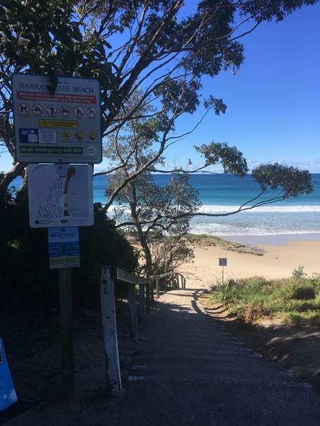
Figure 1: Victor Avenue Beach
Access, looking east, showing rock platform exposed on beach
A road stormwater outlet empties
onto the southern side of the existing access stairs. The stormwater channel
runs directly beside the southern side of the access path, which restricts any
ability to change the horizontal alignment of the track (Figure 2).

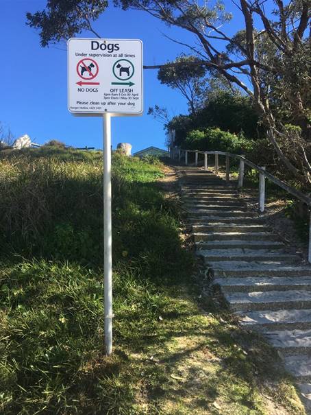
Figure 2: Looking west from
beach on Victor Avenue Beach Access Stairs & Stormwater Outlet
Horizontal realignment on the
northern side of the beach access way is also restricted, due to proximity of
the boundary of the adjoining private land. Path width increases may be
achieved within these constraints to achieve a path width of 2.5m. However,
this would also be subject to geotechnical assessment.
Adjacent cliffs and slopes to
the south are known for geotechnical instability, being of similar geology and
aspect. They have been mapped on the Shoalhaven Coastal Cliffs and Slopes Risk
Management Recommendations report 2018, as being subject to coastal risk from
geotechnical instability. Thus it can be safely assumed that this section of
slope would also be unstable, based on previous studies undertaken on the
adjoining coastal cliffs and slopes.
The site has previously been
subject to storm wave attack, and the beach immediately to the north has been
mapped as being subject to coastal erosion in the 2016 Shoalhaven Coastal
Hazard Study. The location of the slope, where the beach access way is located,
has not been impacted by slope instability, however areas immediately adjacent
to the site (100m south) are known to have slope instability, which is
documented.
Thus, Council under its duty of
care would be strongly advised to seek geotechnical advice, to better inform
the design of any new hard structures at this location.
Having regard to the above,
Council may wish to consider the option of retaining the existing stair access
and investigate the option of providing passing bay(s) along the length of the
stair to accommodate the intent of the resolution. Whilst such a measure would
require geotechnical assessment, the scope of such assessment would be reduced.
Financial Implications
The geotechnical advice, land
survey, aboriginal heritage and environmental assessment is estimated to be
$15,000. The cost of design and construction is unknown at this stage and will
need to be informed by the recommendations of the geotechnical assessment.
Risk Implications
The site review takes into
consideration the geotechnical instability and coastal hazards impacting the
site. The Advisian 2018 site-specific Emergency Action Narrawallee Subplan
identifies storm erosion to 6 metres AHD as a potential risk, along with the
road stormwater scour as another major potential risk to be managed.
As previously mentioned, there
is a storm water outlet impacting on the southern side of the beach access way.
If the stairs are widened, then there is a risk that this stormwater will
impact on the safety of the stairs, thus will be increasing the public risk
from wet stairs. If the risk was to be removed, the storm water would need to
be redirected further south, however this would increase the cost.
Many of these coastal locations
contain Aboriginal cultural heritage items, such as shell middens and
stone/flint artefacts, due to their proximity to food sources. This would also
pose an additional risk to the cost if they were found on the site, requiring
further specialist investigations under the NSW Due Diligence Code.
|
|
Development
& Environment Committee – Tuesday 05 November 2019
Page
1
|
DE19.121 NOM
- St Georges Basin & River Entrance Sussex Inlet - Safe Navigation -
Seek Grant Funding - Contact State Minister - Review Classification as ICOLL
HPERM Ref: D19/320589
Group: Planning
Environment & Development Group
Section: Environmental
Services
Purpose / Summary
To advise Council of an
administrative error, detected by the community in the Coastal Zone Management
Plan, classifying Sussex Inlet entrance as an ICOLL.
|
Recommendation (Item to be determined under delegated authority)
That
Council:
1. Note the amendment to map Figure 1.1
– Shoalhaven Coastal Zone in the 2018 Coastal Zone Management Plan for
the Shoalhaven Coastline removing the notation of Sussex Inlet as a Council
managed entrance as this was an error in the document;
2. Approach the relevant NSW Department
to assist Council undertaking a hydrographic survey of Sussex Inlet and a
seismic survey in key locations identified as potentially having rock ballast
and apply for funding assistance through the Marine Infrastructure Delivery
Office or other relevant grant programs; and
3. List for consideration in future
quarterly budgets reviews the allocation of up to $30,000 to contribute to
the surveys and preparation of a navigation study to inform the preparation
of the coastal management program (CMP) for St Georges Basin and Sussex
Inlet.
|
Options
1. As recommended.
Implications: This would
progress investigation of the issues raised in the Council’s resolution
and inform a coastal management program.
2. Adopt 1 and 2
only and further assess depending the result of approaches to State agencies
and/or grant applications
Implications: Council
would be better informed in regard to State Government assistance prior to
making a budgetary commitment.
3. Not adopt the
recommendation.
Implications: Progress of
the issues raised in Council’s resolution would not be undertaken.
4. Alternative
recommendation.
Implications: Unknown.
Background
At
Council’s Strategy & Assets Committee Meeting of 23 July 2019 it was
resolved that:
1. The
Chief Executive Officer report to Council regarding the possibility of having a
preliminary design done aimed at achieving a reasonably safe navigable entrance
for the River at Sussex Inlet.
2. Consideration
also be given to the possibility of obtaining a grant to meet part of the cost
of the study/design.
3. Council
express concern to the relevant State Government Minister regarding St Georges
Basin and River being classified as an ICOLL in a Government map, as the River
has never closed in recorded memory.
4.
Council make the necessary correction to its Coastal Zone Management Plan so
that the St Georges Basin and River (Sussex Inlet entrance) is not classified
as an ICOLL.
Items 1 and 2 – survey,
design and study for safe navigable entrance and funding
The Safe Navigation Action Group
(SNAG) – Sussex Inlet, identified the presence of ballast rock within
Sussex Inlet river entrance as a significant issue in regard to sand
accumulation in the area and overall navigation. SNAG recently submitted a
document titled “Sussex Inlet Waterways Recovery, restoration and
Rehabilitation 2019, in which they identify the removal of ballast and associated
accumulated sand, as a significant aim of the group.
To achieve the above, it would
be necessary to undertake a seismic survey to locate potential ballast rock
within the problem areas identified by SNAG, including the sand shoal in front
of the ARU camp and The Haven around the entrance to St Georges Basin. The
estimated cost of ballast removal cannot be estimated until such survey is
completed. The cost of survey is estimated to be in the order of $10,000. This
will identify the location, depth of any rock ballast and provide some
understanding of the impact of the rock ballast.
A hydrographic survey for the
whole of the Inlet, including the canals and around Chris Creek, from the Bar
to St Georges Basin (known as the goal posts or the sticks) should also be
carried out to inform a navigation assessment and study. It is likely that
professional surveyor costs would be $20,000 to $30,000.
It is possible for Council to
seek assistance from NSW Department of Industry, Planning & Environment
(DPIE) technical survey team to undertake the surveys. NSW DPIE have undertaken
similar surveys in other local government areas.
These surveys would inform a
navigation study which would in turn inform the coastal management program for
St Georges Basin and Sussex Inlet. This study should consider the type of use,
type and size of boats, navigation constraints and operational safety. The
study should also consider the impact of vessel navigation on the waterway
including erosion. It is estimated that the cost of this study is approximately
$20,000 to $30,000 dependent upon the brief and results of the surveys.
A potential funding stream
includes the Rescuing Our Waterways Program through the Marine Infrastructure
Delivery Office (MIDO). The latest round of the Rescuing Our Waterways program
is now open for applications. NSW coastal councils are invited to apply for a
share of $1.5 million being offered by the NSW Government for dredging projects
(and pre-dredge studies/activities) to keep local waterways accessible and safe
for boating.
Applications close on Tuesday 12
November 2019.
Items 3 and 4 –
correction required on Coastal Zone Management Plan
The area map defining the Shoalhaven Coastal Zone, Figure
1.1 in the 2018 Coastal Zone Management Plan (CZMP) for the Shoalhaven
Coastline, was in error as it referenced Sussex Inlet as a Council managed
entrance. Council does not manage the entrance of Sussex Inlet and has never
had a management plan to do so. This error has been corrected on the map and
Council’s website updated and in the CZMP. See
http://doc.shoalhaven.nsw.gov.au/DisplayDoc.aspx?record=D18/379377
Letters notifying the Minister for Energy and Environment,
Minister for Local Government, NSW DPIE and NSW Coastal Council were sent,
noting the error and providing the updated map. There was no other reference in
the CZMP that referred to this item and removing it has not changed or altered
the intent of the CZMP or any actions in it. As this map was only a locality
map for the document and does not include actions for estuaries including St
Georges Basin and Sussex Inlet.
Community Engagement
Community engagement is underway
as part of Council’s coastal management program and will inform the
citywide Scoping Study. Community engagement sessions were held at Sussex
Inlet.
Policy Implications
Any findings from the survey and
study should inform the Coastal Management Program for St Georges Basin and
Sussex Inlet.
Financial Implications
The cost of the survey and study
is estimated to be up to $50,000. With assistance from NSW DPIE this could be
reduced to $20,000 to $30,000.
Risk Implications
The Sussex Safe Navigation Group
(SNAG) has requested Council investigate these issues to address safe
navigation within Sussex Inlet.
|
|
Development
& Environment Committee – Tuesday 05 November 2019
Page
1
|
DE19.122 Review
of Tabourie Lake Entrance Management Policy
HPERM Ref: D19/345193
Group: Planning
Environment & Development Group
Section: Environmental
Services
Attachments: 1. Tabourie
Lake - EMP - Summary of Community Consultation Submissions ⇩
2. Draft Lake Tabourie Entrance
Management Policy (under separate cover) ⇨
Purpose / Summary
To inform Council regarding the
review of the Tabourie Lake Entrance Management Policy and present the policy
for adoption.
|
Recommendation
(Item to be determined under delegated authority)
That
Council adopt the Tabourie Lake Entrance Management Policy (June 2019), with
the policy recommendation to increase the trigger level, for mechanical
opening, from 1.17m AHD to 1.3m AHD.
|
Options
1. As recommended
Implications:
Would be in-line with the recommendation of the policy review and the equally
highest ranked preferred option based on community feedback.
2. As recommended with a
trial time frame
Implications; This
would allow assessment of impact during periods when Tabourie Lake are at or
above trigger levels
3. Not adopt the Tabourie
Lake Entrance Management Policy (June 2019)
Implications:
Reviewing the Tabourie Lake Entrance Management Policy was a key recommendation
of the adopted Lake Tabourie Flood Risk Management Plan 2016. Not adopting the
reviewed Policy would place Council in conflict with this recommendation.
4. Alternative
recommendation
Implications:
Would depend on the recommendation.
Background
Council, together with the NSW
Government, manages five estuary entrances for flood mitigation purposes.
Historical land use planning and development of estuary catchments and
floodplains has resulted in low-lying properties being at risk from flooding
under certain rainfall and entrance conditions.
History of the Review of
Tabourie Lake Entrance Management Policy (EMP)
Cardno Pty Ltd was engaged by
Shoalhaven City Council to review the existing Entrance Management Policy (EMP)
for Tabourie Lake. Tabourie Lake is an Intermittently Closed and Open Lake or
Lagoon (ICOLL) and has periods during which the entrance is closed off from the
ocean by the formation of a berm. The study area for the EMP comprises the
tidal waterway of Tabourie Lake, its foreshores, and the adjacent lands.
The Tabourie Lake Floodplain
Risk Management Study/Plan (FRMS, 2016), proposed a review of Council’s
existing Tabourie Lake Entrance Management Policy (EMP, 2005) and the
accompanying Review of Environmental Factors (REF). The ocean storm event in
June 2016 further highlighted the importance of this review.
A Draft Entrance Management
Policy and REF was developed for Tabourie Lake by Peter Spurway &
Associates in 2005. The Draft EMP has been used since that time by Council to
guide the management of the entrance of Tabourie Lake for flood mitigation
purposes. Under the Draft EMP the entrance is mechanically opened by Council
when:
· Lake
water levels are equal to, or in excess of, 1.17m AHD, this initiates an
immediate entrance opening; or
· Lake
water levels stabilise after rainfall at a level between 1.00m and 1.17m AHD
and a period of over two months has elapsed since attaining that level,
resulting in below floor level flooding of foreshore land.
Peter Spurway & Associates
(2005) recommends that the assumptions of the Draft EMP and the management
framework contained therein be reviewed following adoption of the Tabourie Lake
Floodplain Risk Management Study and Plan (FRMS&P). The FRMS&P was
completed in 2016, and one of the recommended actions in the FRMS&P was to
review the Draft EMP considering the improved understanding of flood behaviour.
Given the significant amount of
time that has passed since the Draft EMP was prepared, and acknowledging the
changes in the catchment and improved understanding of flood behaviour, Council
resolved to proceed with a review of the Draft EMP and preparation of a final
EMP.
EMP Considerations
The review of the EMP considered
the detailed flood modelling results presented in the 2016 FRMS&P, the
combined risks associated with catchment and ocean flooding, and the potential
impact of climate change on flooding and entrance behaviour.
There is a range of existing
information for Tabourie Lake, that is of relevance to understanding the need
and context for the EMP. ICOLL behaviour, entrance behaviour and flooding
processes are important determinants of the level of risk to low-lying
development from inundation, and aid in determining potential entrance
management options.
The statutory and policy
context, and environmental and social values of Tabourie Lake are important in
assessing the appropriateness and acceptability of entrance management options
from both regulatory and stakeholder perspectives.
EMP Review –
Management Options
Options were identified and
presented to the community. The following options were presented in the
following order:
· Option
1: A “Do Nothing” option. Under this scenario, there is no
active management of the lake entrance. For the ‘do nothing’ option
the entrance berm would be overtopped when water levels rise during a rainfall
event and the entrance breaks out naturally without any intervention.
· Option
2: The continuation of the existing management approach, comprising
mechanical entrance opening, when lake water levels reach the trigger level of
1.17 m AHD.
· Option
3: Raising the trigger Level to 1.3m AHD. This would lead to fewer
mechanical openings of the entrance of Tabourie Lake, thereby reducing the
environmental impact on the Lake.
· Option
4: Berm height management. This involves managing the entrance berm height
(when closed) such that it does not exceed a pre-determined level; this is
known as maintaining a ‘dry notch’, which is a low or
‘saddle’ point in the entrance berm, which the water can
preferentially flow across. The purpose of the notch is to dispense with the
need to mechanically open the lake when a flood occurs.
· Option
5: Construction of a permanently open entrance, using rock armoured
training walls.
· Option
6: Implementation of a pilot channel - a mechanical excavation of sand from
the entrance berm 1 – 3 days before a large storm is scheduled to arrive,
by digging a pilot channel starting from the ocean. The exercise is intended to
reduce the volume of sand required to be removed to instigate a lake breakout,
thereby inducing an earlier breakout and reducing flood levels within the lake.
Management Options - Community Consultation
An online questionnaire was
distributed during the consultation period and over 90 responses were received
from the community. In the questionnaire, the community was asked to rank the
options presented (refer above) from a scale 1 to 5. It was found there was a
wide range of opinions within the community.
As demonstrated in Table 1,
final scores for Options 2 to 5 were very similar, with Option 1 scoring the
least. Therefore, the options assessment based on community feedback concluded
that options will come down to cost and impacts to the community.
Table 1:
Summary of results from the community questionnaire
|
Option No.
|
Average Score
|
Rank
|
|
1
|
4.9
|
6
|
|
2
|
3.2
|
3
|
|
3
|
3.1
|
1
|
|
4
|
3.1
|
1
|
|
5
|
3.4
|
4
|
|
6
|
3.4
|
4
|
Table 1 above shows the options
ranking results, including an indication of how respondents ranked each option.
An average score is also provided, whereby each respondent ranked their most
preferred option ‘1’ and their least preferred option
‘6’. The survey results were inconclusive, with no clear preference
indicated by the community. The ‘most preferred’ options were
Options 3 (Raise trigger level) and 4 (Dry notch) with an average score of 3.1
out of 6, followed closely by Option 2 (Existing approach) with a score of 3.2.
The least preferred option was
Option 1 (Do nothing), which would allow flooding to occur with no intervention.
Option 6 (Construction of a permanently open entrance) appeared to be a fairly
polarising option, being scored as the most preferred option by 38.8% of
respondents, and least popular by 30.6% of respondents.
Management Options
Modelling
Computer-based numerical
modelling of various sub-sets of the entrance management options was undertaken
using the Delft3D hydrodynamic and morphological model of the Tabourie Lake
Estuary, which was established during the Tabourie Lake FRMS&P (Cardno,
2016). The same model set-up and catchment inflow data was used, as in the
Cardno 2016 study.
Numerical modelling was
undertaken to assess the impact of three of the potential management options on
peak flood levels and durations for the more regularly occurring 20% Annual
Exceedance Probability (AEP) event. It is noted that the 1% AEP flood event
occurs so rapidly that entrance management is not feasible for purposes of
flood mitigation; hence it was not considered in the options assessment.
Option 1 was not modelled as it
was lowest ranking and was considered unacceptable to the community. Option 5
was not modelled as it was considered unacceptable due to its lower ranking,
high cost of implementation and risk of coastal inundation (refer to Section
4.5 of the 2019 Draft Policy). Despite being ranked equal number one by the
community, Option 4 was not modelled due to its higher cost and the fact that
its technical feasibility was questionable (refer to Section 4.4 of the 2019
Draft Policy).
The remaining three options modelled
were:
· Option
2: Existing approach with trigger level of 1.17 m AHD;
· Option
3: Raising the trigger level to 1.30 m AHD; and
· Option
6: Incorporation of a pilot channel (in conjunction with the existing trigger
level).
Each of the three options was
modelled under five discrete conditions, summing to a total of 15 model
simulations (as detailed below). These are different scenarios tested for each
option to indicate the peak water levels. Further detail on the modelling
methodology is provided in Section 5.3 of Attachment 2:
· Condition
A: High High Water Springs (HHWS) and initial berm height of 2.1 m;
· Condition
B: HHWS and initial berm height of 1.8 m;
· Condition
C: 1% AEP ocean level and initial berm height of 2.1m;
· Condition
D: 1% AEP ocean level and initial berm height of 1.8m;
· Condition
E: HHWS + 0.4m sea level rise and initial berm height of 2.2 m.
Note: High High Water Springs
(HHWS) refers to the highest level that spring tides reach on average over a
period of time. The 2.1m berm height is deemed to be the maximum probable berm
height.
Table 2: Peak
Water Levels for Each Option for Each of Model Run
|
Option
|
Condition A
|
Condition B
|
Condition C
|
Condition D
|
Condition E
|
|
2
|
1.86
|
1.86
|
2.52
|
2.53
|
1.86
|
|
3
|
1.93
|
1.93
|
2.52
|
2.53
|
1.93
|
|
6
|
1.76
|
1.76
|
2.52
|
2.52
|
1.77
|
Management Options
Modelling Results and Comparisons
Comparison of results for
Options 2 and 3 (Table 2) shows that raising the trigger level from 1.17 m AHD
to 1.30m AHD (an increase of 13cm) would result in an increase in the maximum
flood level. However, the increase in flood level is not one for one, and flood
levels only increase for Option 3 by around 7 cm (from 1.86 to 1.93 m AHD) for
conditions A and B. The increase is non-linear due to the fact that as flood
level increases, so too does the available flood storage. Additionally, the
flood levels are likely heavily influenced by the geometry of the entrance
channel, which constricts the rate of lagoon outflow.
The results also show the same
level of storm tide inundation for Options 2 and 3. This would suggest that
Options 2 and 3 result in a comparable level of entrance scour, and therefore
allow ingress of the storm tide to the same degree.
Cardno Pty Ltd has recommended
that Council adopt Option 3 (raising trigger level to 1.3 m AHD) in the
Tabourie Lake EMP, as described in the attached Tabourie Lake Entrance
Management Policy. This recommendation is based on the technical assessment
presented in Section 5.4 of the 2019 Draft Policy), which included a triple
bottom line cost-benefit assessment. The assessment resulted in highest score
for Option 3 out of the six options considered.
If adopted, the Entrance
Management Plan for Tabourie Lake presented in the 2019 Draft Policy
(Attachment Two) will henceforth supersede the previous Peter Spurway &
Associates (2005) EMP. The 2019 Draft EMP sets out the procedure by which
Council will decide to open the entrance of Tabourie Lake for flood mitigation
purposes, whether in response to a flood event or to alleviate below floor
level inundation of foreshore land.
It is anticipated the
implementation of the measures outlined in the 2016 FRMS&P would, in the
future, likely remove the need to undertake entrance management and mechanical
lake opening as a means of mitigating below floor level flooding. These options
included structural options aimed at preventing, avoiding or reducing the
likelihood of flood risks – including the construction of levees behind
properties and raising roads in specific locations.
Therefore, it is intended that
the EMP be adopted, until the relevant measures outlined in the 2016 FRMS&P
have been fully funded and implemented.
Please note that Appendices A to
E are not included in the Draft Tabourie Lake Entrance Management Policy
(Attachment Two), as they are the accompanying operational documents.
Community Engagement
The outcome of the options
assessment and the 2019 Draft EMP were subject to public exhibition by Council
between 21 January 2019 and 22 March 2019. As part of this public exhibition,
the 2019 Draft EMP was presented to the local community on 20 February 2019 at
a Community Workshop at the Tabourie Lake Rural Fire Service (RFS) Shed. More
than 30 community members attended this workshop.
In total 13 online submissions
were received, of which seven submissions were in support of the draft EMP, 1
was neutral, and 4 were against. Of the submissions that were not in favour of
the Draft EMP, one submission was made by ten residents. Please refer to
Attachment One for a summary of submissions received.
Furthermore, a petition with 105
signatures against raising the trigger and to continue with the current
management was presented by Councillor White at the Ordinary Meeting of
Council, held on 30 April 2019. This petition was lodged post consultation
period.
Policy Implications
The current Tabourie Lake
Entrance Management Policy (final draft, 2005) remains current until such time
as this review is completed and formally adopted by Council.
Financial Implications
The review of the Tabourie Lake
Entrance Management Policy was completed within budget.
The project is for the provision
of consultancy works and does not have any direct or immediate implications on
Council’s assets. The project is managed by staff from the Natural
Resources and Floodplain Unit.
Once the Draft Tabourie Lake EMP
is adopted, Council is required to prepare a Review of Environmental Factors,
as per the requirements of Part 5 of the NSW Environmental Planning and
Assessment Act 1979. The cost of this is estimated to be approximately $15,000.
There are sufficient funds in the Flood Programme budget for this work.
Risk Implications
Opening of the entrance of the
lake will not prevent flooding of property and dwellings in many circumstances.
For example, even if the entrance is fully open at the start of a large flood
event, if the flood is greater than a 10% Annual Exceedance Probability (AEP),
it is expected that there are existing dwellings that would be affected by
flooding
The Policy aims to reduce (where
possible) but not eliminate the impacts of catchment flooding. Further, there
may be circumstances (e.g. closed access roads, night, or dangerous sea
conditions) where, despite its best endeavours, Council cannot act to
mechanically open the entrance of the lake at the levels indicated in this
Policy.
Legal advice was sought on a
submission received from a resident, who is in favour of Option 2 (keep current
trigger level) and made the following comments:
· Believes
that adopting Option 3 could lead to legal action from residents who are
potentially negatively impacted by the entrance management (e.g. destruction of
assets and health and safety concerns).
· Makes
a note about the costs and lead time involved with potential legal action for
Council, as well as any potential media attention.
· Believes
that the outcomes of the Study (Option 3) is led by environmental arguments and
Council is not well-informed.
The legal response and
acknowledgement to this submission is contained within Attachment One. In
summary, under the provisions of Section 733 of the Local Government Act, if
Council acts in good faith it is protected from legal action in instances such
as this. The “good faith” principle would be supported by the
scientific study completed in regard to the Tabourie Lake catchment.
|
|
Development
& Environment Committee – Tuesday 05 November 2019
Page
1
|
|
|
Development
& Environment Committee – Tuesday 05 November 2019
Page
1
|
DE19.123 Lake
Conjola Entrance Update and other matters relating to Mayoral Minute MIN19.143
HPERM Ref: D19/349266
Group: Planning
Environment & Development Group
Section: Environmental
Services
Attachments: 1. Email
correspondence from Red Head Villages Association and Conjola Community
Association ⇩
Purpose / Summary
To provide Council with an
update on progress in accordance with the Mayoral Minute, (MIN19.143) dated 26
March 2019.
|
Recommendation (Item to be determined under delegated authority)
That
Council:
1. Receive the report providing an
update on Parts 3, 8 and 10 of the Mayoral Minute (MIN19.143) regarding Lake
Conjola for information; and
2. No longer seek approval from the NSW
Government Ministers of Crown Lands, Office Environment and Heritage and
Department of Primary Industries (Fisheries) to immediately prepare and
maintain a “dry notch” at the entrance to Lake Conjola to allow
“break out” of the lake should flooding occur.
|
Options
1. As recommended
Implications: Council will be better informed and
updated on Lake Conjola.
2. Propose an
alternative recommendation.
Implications: Would depend on the recommendation
Background
On 26 March 2019 Council passed
Mayoral Minute (MIN19.143), relating to the management of Lake Conjola entrance
(MIN19.143). The following is a summary of the progress to date relating to the
following parts of MIN19.143:
· Part
3: Seek approval from the NSW Government Ministers of Crown Lands, Office
Environment and Heritage and Department of Primary Industries (Fisheries) to
immediately prepare and maintain a “dry notch” at the entrance to
Lake Conjola to allow “break out” of the lake should flooding
occur. This is to be maintained until a new Coastal Management Plan is
approved by the Minister.
· Part
8: Report timeframe and priority status for preparation of Coastal Management
Plan for Lake Conjola to Council.
· Part
10: Provide monthly update reports to Councillors on all issues concerning Lake
Conjola.
Proposed Dry Notch
Council staff have completed a
draft Lake Conjola “Flood Dry Notch” proposal report based on the
current available scientific data, contained within existing current studies.
The difficulty with such a report is it is not able to guarantee accuracy or
completeness to the full extent of the subject matter, given there is an
information gap.
Any proposal, without being
informed by relevant data and a specific study, looking into social,
environmental and economic implications, can be prone to inaccuracy, as coastal
processes are a complex science.
Council staff presented the
“Lake Conjola Flood Dry Notch” proposal to Councillors on 26
September 2019. The outcome of the presentation was for Council staff to
consult directly with the Red Head Villagers and Conjola Community Association,
including offering to give the presentation to the association.
The offer to present the
proposal for the Lake Conjola ‘Flood Dry Notch” was not taken up by
ether CCB, as they have decided not to undertake any further investigations
into a proposed flood dry notch (see
Attachment 1).
In light of the
community’s decision, it is recommended that Council no longer seek
approval from the NSW Government Ministers of Crown Lands, Office Environment
and Heritage and Department of Primary Industries (Fisheries) to immediately
prepare and maintain a “dry notch” at the entrance to Lake Conjola
to allow “break out” of the lake should flooding occur.
Lake Conjola Costal
Management Program
In April 2019, Council applied
for a grant from the NSW Government – Coast and Estuary Program to
prepare a Coastal Management Program (CMP) for Lake Conjola. In June 2019,
Council was awarded and signed a grant agreement with the NSW Office of Environment
and Heritage (OEH). The grant timeframe is from 01/09/2019 to 01/09/2021.
Further to advice received from
the NSW Coastal Council, Council pursued the development of the Scoping Study
(as per the first phase of the Coastal Management Program (CMP)) for the whole
of the city. The Scoping Study was to include the open coast and all estuaries.
Further detail regarding subsequent grant variations has been emailed to
Councillors.
Council engaged Advisian -
WorleyParsons to prepare the citywide scoping study and engaged the RPS Group
to undertake the community engagement. This means that all current and future
CMPs will not have to undertake a scoping study as part of their CMP
preparation, including Lake Conjola.
The community engagement phase
of the citywide scoping study was rolled out across the city, with six (6)
Focus Workshops and Community Information Drop-In Sessions held at the
following locations:
1. Ulladulla;
2. St Georges Basin;
3. Nowra;
4. Lake Conjola;
5. Sussex Inlet; and
6. Shoalhaven Heads.
The milestones, outputs and
timeframe for the Lake Conjola CMP are as follows:
|
Milestone
|
Outputs
|
Timeframe
|
|
Citywide Scoping Study
|
Scoping
Study Community Engagement report
Scoping
Study questionnaire evaluation
Final
Scoping Study report
|
31/12/2019
|
|
Additional studies
|
Working
group established
Consultant engaged
Additional studies commenced
|
30/04/2020
|
|
Draft CMP
|
Draft CMP complete and on
public exhibition
|
17/12/2020
|
|
Final CMP
|
Final
CMP adopted by Council
Grant acquitted.
|
31/08/2021
|
Table 1: Lake Conjola CMP grant
Milestones, Outputs and Timeframe
Condition of the entrance
Further to part ten of the
Mayoral Minute (MIN19.143), the following is an update of the condition of the
Lake Conjola entrance, including the current lake levels. Any further updates
will be provided to Councillors via an email.
On 13 June 2019, Council opened
the lake to the ocean and have been closely monitoring the condition of the
entrance. The entrance closed on 12 August 2019.
Since closure of the lake
entrance, Council have been monitoring the water level and rainfall. Between 16
and 17 August 2019, Lake Conjola received 60mm of rainfall over 24 hours
resulting in water level increase from 0.64m to 0.74m. No other significant
rainfall has been experienced to date. Lake levels at 12:00 hours on 25/10/2019
were 0.699m AHD.
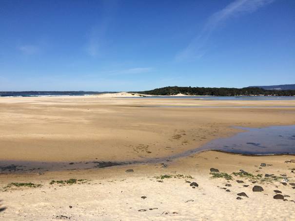
Figure 1: Lake Conjola Entrance – Looking South
27/9/2019
Community Engagement
Council have collaborated
closely with both the Red Head Villages Association and Lake Conjola Community
Association throughout the planning and implementation process of the recent
lake opening. Council have setup a ‘Get Involved Page’ providing
information about Lake Conjola entrance management.
As part of the preparation of
the citywide scoping study, six focus workshops and community information
drop-in session were held across the Shoalhaven from 24/919 to 3/10/19, at six
locations across the City.
13 residents from Conjola and
surrounding areas attended the focus group workshops across various locations,
with five representatives from the Conjola Community Association attending.
The scoping study community
engagement report and the draft scoping study report are scheduled to be
presented to Council in December 2019 for approval to publicly exhibit.
As part of the preparation of the Lake Conjola CMP, a
Working Group, will be formed. This working group will have community
representatives from Lake Conjola, including Council staff and State Government
Agencies staff.
Policy Implications
The community consultation and associated works will
contribute to the production of updated coastal policy.
Financial Implications
Grant variations were required to facilitate the completion of
a city-wide scoping study process.
|
|
Development
& Environment Committee – Tuesday 05 November 2019
Page
1
|
|
|
Development
& Environment Committee – Tuesday 05 November 2019
Page
1
|
DE19.124 Potential
Impact of Invasive Aquatic Weeds on Sydney Drinking Water Catchment and
Shoalwater Infrastructure
HPERM Ref: D19/342970
Group: Planning
Environment & Development Group
Section: Environmental
Services
Attachments: 1. Greater
Sydney's Water Supply System ⇩
Purpose / Summary
To inform Council of the concerns raised by WaterNSW
regarding the potential impact of Water hyacinth (Eichhornia crassipes),
Long-leaf willow primrose (Ludwigia longifolia) and other invasive
aquatic weeds on critical drinking water infrastructure managed by WaterNSW and
Shoalhaven Water and to seek endorsement to act appropriately on these
concerns.
|
Recommendation (Item to be determined under delegated authority)
That Council:
1. Write to the Minister for
Agriculture and Western New South Wales, urging the Department to introduce a
Special Biosecurity Zone for management of aquatic weeds in the WaterNSW
Sydney Drinking Water Catchment and Shoalhaven River Catchment;
2. Write to the Illawarra Shoalhaven
Joint Organisation (ISJO) seeking their support for establishment of the
Special Biosecurity Zone;
3. Write to other councils that have
land management roles in the broader Sydney Drinking Water Catchment seeking
their support for establishment of the Special Biosecurity Zone. These
councils are:
a. Wollondilly Shire Council;
b. Wingecarribee Shire Council;
c. Blue Mountains City Council;
d. Lithgow City Council;
e. Goulburn Mulwaree Council;
f. Queanbeyan Palerang Regional
Council;
g. Oberon Council; and
h. Upper Lachlan Shire Council.
4. Write to
the Local Land Services regional weed committees that are established in the
catchment area seeking their support for establishment of the Special
Biosecurity Zone. These weeds committees are:
a. South
East Regional Weed Committee;
b. Greater
Sydney Regional Weed Committee; and
c. Central
Tableland Regional Weed Committee.
|
Options
1. Adopt
the recommendation:
Implications: Supporting the establishment of the
Special Biosecurity Zone - Aquatic Weeds in the Declared Sydney Drinking Water
Catchment and Shoalhaven River Catchment will provide protection for critical
State infrastructure and water supply not only for Sydney, but also the
Shoalhaven area, as serviced by Shoalhaven Water. Attachment 1 provides an
overview of the infrastructure in Greater Sydney’s Water Supply System.
2. Not adopt the
recommendation:
Implications: Not supporting the
establishment of the Special Biosecurity Zone - Aquatic Weeds in the Declared
Sydney Drinking Water Catchment and Shoalhaven River Catchment will potentially
expose critical State and Council water infrastructure to risk of degradation
by establishment of invasive aquatic species.
Background
In early December 2007 extremely
intense rainfall in the Kangaroo Valley area washed Water hyacinth from an
ornamental lake in Kangaroo Valley into an adjoining farm dam and then into the
Kangaroo River.
This infestation was not known
to Council’s Noxious Weeds staff at the time of the incident and was
reported by a local resident.
The infestation was carried into
the Kangaroo River and into Lake Yarrunga behind Tallowa Dam.
Control Action
Council staff took immediate
action to contain existing plants in the farm dam and treat this infestation
with herbicide and mechanically remove plants from the farm dam. Council also
immediately alerted the former Sydney Catchment Authority [Water NSW] of the
incident.
Sydney Catchment Authority weed
control staff commenced mechanically removing Water hyacinth from Tallowa
Dam/Lake Yarrunga. This involved control activity on excess of 30 km of
foreshore and when completed the labour component of the project exceeded 60
days of labour.
It was recorded that the extreme
rainfall event that led to the carriage of the Water hyacinth into Lake
Yarrunga, scoured the creek line and Kangaroo River watercourse, carrying the
Water hyacinth into the lake.
Council staff continue to
monitor dams, ponds, creeks and rivers in this area on a seasonal basis.
South East Regional Weed
Committee
At a recent meeting of the South
East Regional Weed Committee, the representative of WaterNSW tabled a document
seeking support from Shoalhaven City Council and other members of the committee
to include the Sydney Drinking Water Catchment as part of the State Water
hyacinth Biosecurity Zone.
Currently, the “Water
hyacinth Biosecurity Zone” applies
to all land within the State, except for the following regions: Greater
Sydney and South East (but only in the local government areas of Eurobodalla,
Kiama, City of Shellharbour, City of Shoalhaven or City of Wollongong).
Considering that part of the
Sydney Water Catchment and the Shoalhaven Catchment are critical
infrastructure, these areas are worthy of special consideration to ensure
protection of the drinking water supply to Sydney and the Shoalhaven.
Water NSW has requested support
from local councils, including Shoalhaven City Council and Local Land Services
boards in lobbying the Minister for Agriculture and Western New South Wales,
The Hon. Adam Marshall MP, for establishment of a Special Biosecurity Zone -
Aquatic Weeds in the Declared Sydney Drinking Water Catchment and Shoalhaven
River Catchment.
Legislative provisions
Biosecurity Act 2015 &
Biosecurity Regulation 2017
Currently, under the Biosecurity
Regulation 2017, Water hyacinth and Alligator weed (Alternanthera
philoxeroides) are identified as priority weeds. A biosecurity zone is
established for Water hyacinth and Alligator weed.
Under Division 2, Clauses 68 and
69 of the Biosecurity Regulation 2017, the Alligator weed biosecurity zone is
described in the following terms:
68 Establishment
of biosecurity zone
1. A biosecurity zone, to be known as
the alligator weed biosecurity zone, is established for all
land within the State except land in the following regions:
a. Greater
Sydney
2. The alligator weed biosecurity zone is
established to manage the biosecurity risk of the weed Alternanthera philoxeroides (Alligator
weed).
69 Regulatory
measures
An owner or occupier of land in the alligator weed
biosecurity zone on which there is the weed Alternanthera philoxeroides (Alligator
weed) must:
a. if the weed is part of a new
infestation of the weed on the land, notify the local control authority for the
land as soon as practicable in accordance with Part 6, and
b. eradicate
the weed or, if that is not practicable, destroy as much of the weed as is
practicable and suppress the spread of any remaining weed.
Under Division 4, Clauses 72 and
73 of the Biosecurity Regulation 2017, the Water hyacinth biosecurity zone
is described in the following terms:
72 Establishment of
biosecurity zone
1. A biosecurity
zone, to be known as the Water hyacinth biosecurity zone, is established for
all land within the State except land in the following regions:
a. Greater Sydney
b. South East (but
only land in that region that is in the local government area of Eurobodalla,
Kiama, City of Shellharbour, City of Shoalhaven or City of Wollongong).
2. The Water
hyacinth biosecurity zone is established to manage the biosecurity risk of the
weed Eichhornia crassipes (Water hyacinth).
73 Regulatory measures
An owner or occupier of land in
the Water hyacinth biosecurity zone on which there is the weed Eichhornia
crassipes (Water hyacinth) must:
a. if the weed is part of
a new infestation of the weed on the land, notify the local control authority
for the land as soon as practicable in accordance with Part 6, and
b. eradicate
the weed, or if that is not practicable, destroy as much of the weed as is
practicable and suppress the spread of any remaining weed
Other Aquatic Plants
Under s. 24 of the Biosecurity Act 2015 other
invasive aquatic species (refer to table below) are captured as
“prohibited plants” or under “mandatory measures” which
specify what land managers must do in respect of the identified biosecurity
matter [weed].
Prohibited matter
|
Common name
|
Botanic name
|
Mandatory measure
|
|
Anchored water hyacinth
|
Eichhornia azurea
|
Prohibited matter
|
|
Frogbit
|
Limnobium laevigatum – Inc. all species of
Limnobium
|
Prohibited matter
|
|
Lagarosiphon
|
Lagarosiphon major
|
Prohibited matter
|
|
Pond apple
|
Annona glabra
|
Prohibited matter
|
|
Spongeplant
|
Limnobium spongia
|
Prohibited matter
|
|
Water caltrop
|
Trapa spp
|
Prohibited matter
|
|
Water soldier
|
Stratiotes aloides
|
Prohibited matter
|
|
Prohibited matter
A person who deals with prohibited matter or a carrier of
prohibited matter is guilty of an offence. A person who becomes aware of or
suspects the presence of prohibited matter must notify the Department of
Primary Industries.
|
Mandatory measures
|
Common name
|
Botanic name
|
Mandatory measure
|
|
Alligator weed
|
Alternanthera philoxeroides
|
Alligator weed biosecurity zone
(excludes Shoalhaven City Council)
Recommended Regional Measure 1.
|
|
Water hyacinth
|
Eichhornia crassipes
|
Water hyacinth biosecurity zone
(excludes Shoalhaven City Council)
Recommended Regional Measure 1.
|
|
Hygrophila
|
Hygrophila costata
|
Recommended Regional Measure 2.
|
|
Kidney-leaf mud
plantain
|
Heteranthera reniformis
|
Recommended Regional Measure 2.
|
|
Long-leafed willow
primrose
|
Ludwigia longifolia
|
Recommended Regional Measure 2.
|
|
Ludwigia
|
Ludwigia peruviana
|
Recommended Regional Measure 2.
|
|
Salvinia
|
Salvinia molesta
|
Recommended Regional Measure 2.
|
|
Senegal tea
|
Gymnocoronis spilanthoides
|
Recommended Regional Measure 2.
|
|
Water lettuce
|
Pista stratiotes
|
Recommended Regional Measure 2.
|
Sagittaria
|
Sagittaria platyphylla
|
Recommended Regional Measure 3.
|
|
Recommended regional measure 1
Within the Biosecurity Zone this weed must be
eradicated where practicable, or as much of the weed destroyed as practicable,
and any remaining weed suppressed. The local control authority must be
notified of any new infestations of this weed within the Biosecurity Zone.
|
|
Recommended regional measure 2
Land managers should mitigate the risk of new weeds
being introduced to their land. The plant should be eradicated from the land
and the land kept free of the plant. The plant should not be bought, sold,
grown, carried or released into the environment. Notify local control
authority if found.
|
|
Recommended regional measure 3
Plant should not be allowed to be spread to priority
sites of high environmental, economic or social value.
|
Policy Implications
Policy implications will be
limited as the application of the relevant legislation is already addressed by
Council’s weed biosecurity management program. The creation of the
special biosecurity zone will enhance Council’s ability to effectively
manage aquatic weeds by enforcement of the Biosecurity Act 2015 and Biosecurity
Regulation 2017.
Financial Implications
Limited in the current
situation. However, if aquatic weeds are allowed to establish in the Shoalhaven
drinking water supply and the Sydney Drinking Water Catchment, then the costs
of management of aquatic weeds in these areas will increase exponentially.
Risk Implications
The risk posed to the Shoalhaven
drinking water supply and the Sydney Drinking Water Catchment by aquatic weeds
cannot be understated. Recent infestation and eradication of Water hyacinth and
current control activity on Long-leafed willow primrose, demonstrate the
vulnerability of these critical state infrastructure assets to potential threat
from invasive aquatic weeds.
Establishment of a special Biosecurity Zone for management
of aquatic weeds in the WaterNSW Sydney Drinking Water Catchment and Shoalhaven
River Catchment will substantially mitigate the risk posed by serious aquatic
weeds.
|
|
Development
& Environment Committee – Tuesday 05 November 2019
Page
1
|
|
|
Development
& Environment Committee – Tuesday 05 November 2019
Page
1
|
DE19.125 Drought
Management - Implementation of Water Restrictions
HPERM Ref: D19/364372
Approver: Stephen
Dunshea, Chief Executive Officer
Attachments: 1. Communicating
Water Restrictions - Survey Results (under separate cover) ⇨
2. Communicating Water
Restrictions - Additional Analysis ⇩
Reason for Report
This report seeks
Council’s concurrence to implement Level 1 water restrictions from 2
December 2019 whether or not the trigger levels in the Drought Management Plan
are met. It also seeks Council’s support to review its Drought
Management Plan following a recent community survey.
|
Recommendation (Item to be determined under delegated authority)
That
Council
1. Note the current water supply
situation.
2. Implement Level 1 Water Restrictions
from 2 December 2019 irrespective of trigger levels in Council’s
Drought Management Plan being met.
3. Undertake a full review of the
Drought Management Plan, incorporating “Permanent Water Conservation
Measures”, following the recent community survey.
4. Receive a further report at the
completion of a revised Draft Drought Management Plan, prior to public
exhibition.
5. Review and implement marketing
strategies to support the key findings and recommendations from the “Communicating
Water Restrictions in the Shoalhaven LGA” Report, August 2019.
|
Options
1. Adopt the
recommendation with regard to implementation of Level 1 water restrictions.
Implications: Level 1 water restrictions will be
implemented on 2 December 2019, with water saving messages being aired in the
lead-up to the implementation date.
2. Council could
resolve to implement water restrictions in accordance with the trigger levels
in the Drought Management Plan.
Implications: Staff consider that, if water
restrictions are not implemented over the peak holiday period, this could
convey a negative message to the local community with regard to water
conservation.
3. Adopt the
recommendation with regard to reviewing the Drought Management Plan.
Implications: The Drought Management Plan was last
updated in 2014 and is outdated. The review would be undertaken
incorporating “Permanent Water Conservation Measures” and a full
review of other restriction Levels
4. Council could
resolve to leave the Drought Management Plan in the status quo.
Implications: The Drought Management Plan was last
updated in 2014 and is outdated. The recent community survey suggests
that the community (particularly the younger generation) are in favour of permanent
water conservation measures.
Background
Current Water Supply
Situation
At mid October, 98.4% of NSW was
in drought, with the worst affected areas being in the north-west (Namoi/Peel,
Macquarie and Border Rivers) and the far west (Barwon-Darling and Lower Darling
Valleys). Towns such as Bourke, Orange, Tamworth, Dubbo, Bathurst, Glenn Innes,
Cobar, Coonabarabran, Nyngan, Walgett, Walcha and Murrumundi are rated as high
risk of running out of potable water supply. A number of smaller villages in these
areas are already receiving potable water by water carting.
Sydney’s water storages
were at 48% of capacity, and falling at 22 October 2019. Sydney Water customers
have been on Level 1 water restrictions since 1 June 2019.
Eurobadalla Shire Council introduced
Level 1 water restriction from 14 October 2019.
At 22 October 2019,
Shoalhaven’s dams were at a total 87% of capacity; individually the dams
capacities were:
· Bamarang
Dam – 98%
· Danjera
Dam – 84.2%
· Porters
Creek Dam – 73.2%
The WaterNSW-owned Tallowa Dam
was at 1.5 metres below spill level and the flow into Tallowa Dam was 87
megalitres per day (ML/day) and dropping. Shoalhaven Water ceased pumping from
the Shoalhaven River to Bamarang Dam on 22 October 2019 when the flow into Tallowa
Dam dropped below 90 ML/day, per the Water Sharing Plan and Council’s
Drought Management Plan.
WaterNSW has received
Ministerial approval to pump water from Tallowa Dam to Fitzroy Dam (Sydney
system) until Tallowa Dam drops to 3 metres below spill level, from 27 August
2019. The Hon. Melinda Pavey utilised Powers under Sec.49A of the Water
Management Act 2000 to suspend part of the operation of the Water
Sharing Plan for the Greater Metropolitan Unregulated River Water Sources 2011 to
enable additional pumping. This action has approval to continue until June
2020, or until notified otherwise.
In the past 12 months Shoalhaven
has only received its long term average rainfall in 5 of those months and as
such has been close to trigger levels for Level 1 water restrictions.
Level 1 restrictions are triggered by Bamarang Dam dropping to 60% of capacity
and the first release of water from Danjera Dam. Bamarang Dam is drawn down
when Shoalhaven ceases pumping from the Shoalhaven River due to the flow into
Tallowa Dam dropping to less than 90 ML/day.
The Bureau of
Meteorology’s outlook for rain in the Shoalhaven up to the end of
November is poor with the current likelihood of receiving average rainfall
through this period around 30-40%.
Shoalhaven last implemented
water restrictions on 3 September 2018 and removed restrictions from 10
December 2018 (98 days in Level 1 restrictions). Previous to that, restrictions
were implemented in 2009/10 for a period of 128 days.
It is estimated that it will
take approximately 6 weeks to draw Bamarang Dam down to 60% from the time
pumping ceases from the River (from 22 October 2019).
Shoalhaven Water’s Drought
Management Team are recommending that Council impose Level 1 water restrictions
from 2 December 2019, whether or not the trigger levels are met, based on
the following:
· 2
December 2019 is the current projected time for triggering Level 1 restrictions
based on no significant rainfall.
· We
are heading into the high demand holiday period where water demand
traditionally increases by around 40%.
· Many
holiday makers are from the Sydney area, who are now accustomed to water
restrictions.
· Porters
Creek Dam and Milton WTP will be required for use over the peak period.
These have not been utilised due to the current level of Porters Creek Dam.
Community Engagement
Council resolved at its Ordinary
Meeting in March 2019 as follows:
That Council
1.
Engage with the community and seek views on water restrictions, permanent water
conservation measures and other possible programs that would be used to develop
a new Drought Management Plan and Water Demand Strategy.
2.
Consider a further Report after community input has been received.
Following this resolution
Shoalhaven Water engaged Iris Research and The Marketing Clan to undertake a
community survey and develop marketing strategies. The aims of this research
were to:
· Gauge
the community’s awareness of the Shoalhaven’s water sources.
· Gauge
the community’s awarenes of the various levels of water restrictions and
their triggers.
· Investigate
the community’s appetite for change to Council’s Drought Management
Plan, primarily in terms of whether the status quo should remain or introduce
permanent water conservation measures (similar to Sydney Water and Eurobadalla
Shire).
· Identify
the effectiveness of various communications channels on the community’s
behavioural responses to assist Council with it’s marketing strategies.
The full survey results can be
viewed in Attachments 1 and 2.
A summary of the key findings
from the survey follow.
· Nearly
all residents surveyed (96%) are convinced Council’s water restriction
messages indicate there are current water shortages.
· More
than one third of residents surveyed do not understand the meaning of Level 1,
2, 3, 4 water restrictions.
· When
seeking response on whether Shoalhaven should have more severe intermittent
water restrictions the total sample was almost split between agreeing and
disagreeing (55%:45%), it is interesting to note that the 18-39 year old age
group strongly supported (74%) more severe, intermittent water restrictions
while the 60-74 year old age group were less supportive (48%) and the 75+ age
group were only 38% supportive.
· When
seeking response on whether Shoalhaven should introduce permanent water conservation
measures, again the total sample was almost split between agreeing and
disagreeing (49%:51%), however it was again the 18-39 age group showing the
greatest support for permanent water conservation measures (63%).
· Only
half of the respondents claimed to be aware of the origins of their water
supply. When prompted to name the origins only about half of those
claiming to know responded with Shoalhaven River.
The key recommendations from the
engagement are as follows
· Increase
residents’ understanding of Levels of water restrictions through
education.
· Develop
water conservation messages and programs raising awareness of water
conservation.
· Increase
community awareness of of its water sources to engender stronger water
conservation attitudes and behaviours.
· Council
should have a multimedia approach to messaging.
· Monitoring should
be undertaken to assess the success of any water conservation messages and
programs undertaken.
Policy Implications
Council has an adopted Drought
Management Plan (2014). It is proposed, through a thorough review process, to
ultimately adopt a revised Drought Management Plan which takes into
consideration feedback from the community and recommendations from the
consultation process.
An aim of the review will also
to develop a Drought Management Plan to be better aligned with surrounding
Water Authorities/Utilities, i.e. Sydney Water and Eurobadalla Shire.
|
|
Development
& Environment Committee – Tuesday 05 November 2019
Page
1
|
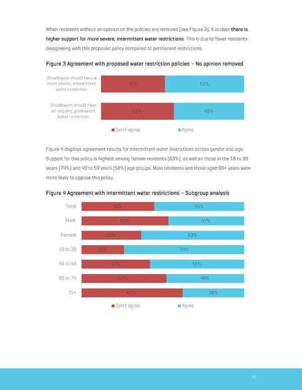
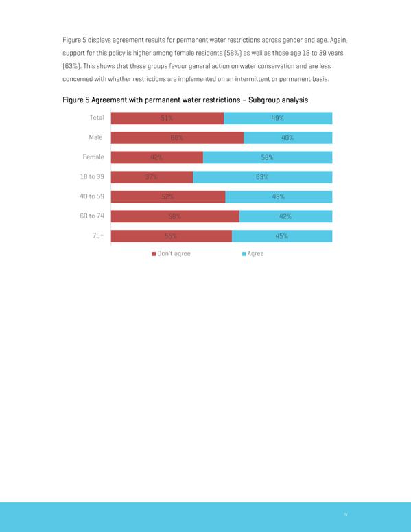
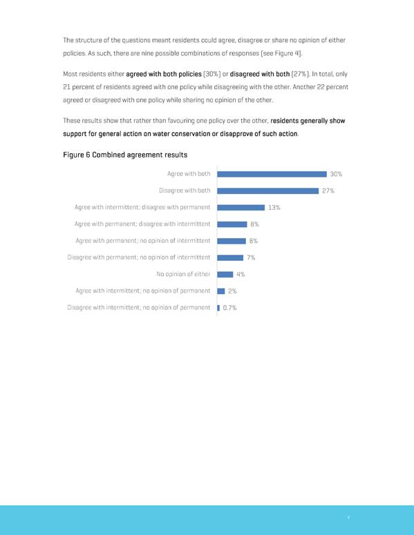
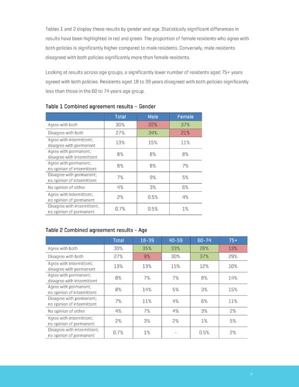
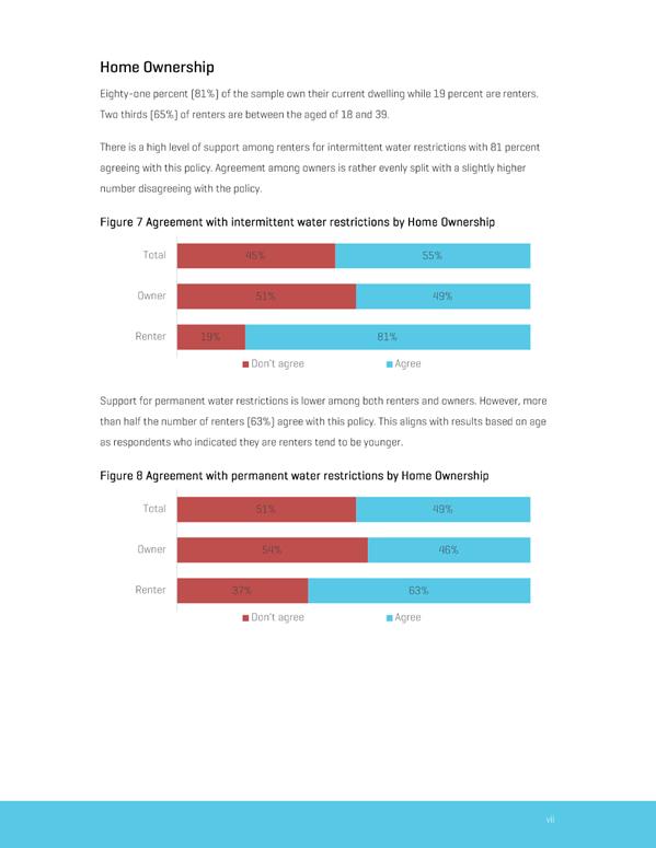
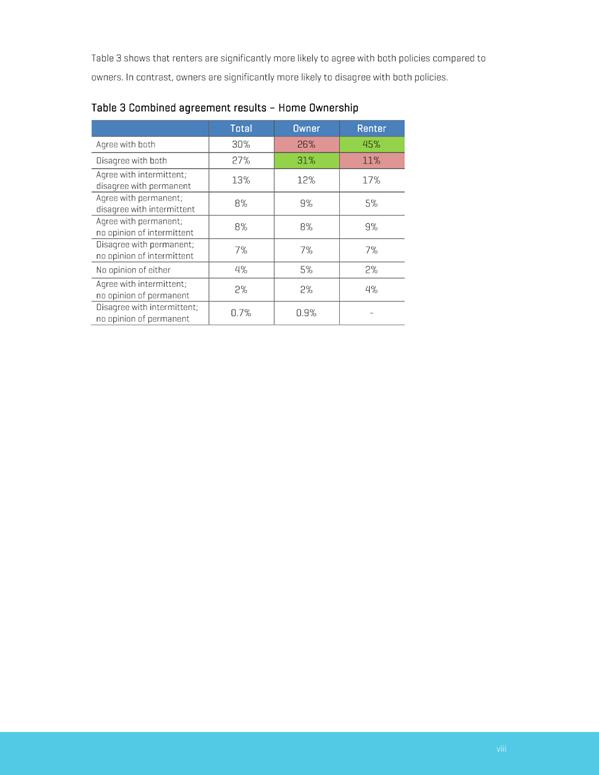
|
|
Development
& Environment Committee – Tuesday 05 November 2019
Page
1
|
Local Government Amendment (governance &
planning) act 2016
Chapter
3, Section 8A Guiding principles for councils
(1)
Exercise of functions
generally
The
following general principles apply to the exercise of functions by councils:
(a) Councils should provide strong
and effective representation, leadership, planning and decision-making.
(b) Councils should carry out functions
in a way that provides the best possible value for residents and ratepayers.
(c) Councils should plan
strategically, using the integrated planning and reporting framework, for the
provision of effective and efficient services and regulation to meet the
diverse needs of the local community.
(d) Councils should apply the
integrated planning and reporting framework in carrying out their functions so
as to achieve desired outcomes and continuous improvements.
(e) Councils should work
co-operatively with other councils and the State government to achieve desired
outcomes for the local community.
(f) Councils should manage
lands and other assets so that current and future local community needs can be
met in an affordable way.
(g) Councils should work with
others to secure appropriate services for local community needs.
(h) Councils should act fairly,
ethically and without bias in the interests of the local community.
(i) Councils should be
responsible employers and provide a consultative and supportive working
environment for staff.
(2) Decision-making
The
following principles apply to decision-making by councils (subject to any other
applicable law):
(a) Councils should recognise
diverse local community needs and interests.
(b) Councils should consider social
justice principles.
(c) Councils should consider the
long term and cumulative effects of actions on future generations.
(d) Councils should consider the
principles of ecologically sustainable development.
(e) Council decision-making should
be transparent and decision-makers are to be accountable for decisions and
omissions.
(3) Community participation
Councils
should actively engage with their local communities, through the use of the
integrated planning and reporting framework and other measures.
Chapter
3, Section 8B Principles of sound financial management
The
following principles of sound financial management apply to councils:
(a) Council spending should be responsible and
sustainable, aligning general revenue and expenses.
(b) Councils should invest in responsible and
sustainable infrastructure for the benefit of the local community.
(c) Councils should have effective financial
and asset management, including sound policies and processes for the following:
(i) performance management
and reporting,
(ii) asset maintenance and
enhancement,
(iii) funding decisions,
(iv) risk management practices.
(d) Councils should have regard to achieving
intergenerational equity, including ensuring the following:
(i) policy decisions are made
after considering their financial effects on future generations,
(ii) the
current generation funds the cost of its services
Chapter
3, 8C Integrated planning and reporting principles that apply to councils
The
following principles for strategic planning apply to the development of the
integrated planning and reporting framework by councils:
(a) Councils should identify and prioritise key
local community needs and aspirations and consider regional priorities.
(b) Councils should identify strategic goals to
meet those needs and aspirations.
(c) Councils should develop activities, and
prioritise actions, to work towards the strategic goals.
(d) Councils should ensure that the strategic
goals and activities to work towards them may be achieved within council
resources.
(e) Councils should regularly review and
evaluate progress towards achieving strategic goals.
(f) Councils should maintain an
integrated approach to planning, delivering, monitoring and reporting on
strategic goals.
(g) Councils should collaborate with others to
maximise achievement of strategic goals.
(h) Councils should manage risks to the local
community or area or to the council effectively and proactively.
(i) Councils should make appropriate
evidence-based adaptations to meet changing needs and circumstances.