Shoalhaven Traffic Committee
Meeting Date: Tuesday,
08 October, 2019
Location: Jervis
Bay Rooms, City Administrative Centre, Bridge Road, Nowra
Time: 9.30am
Please note: Council’s Code of Meeting Practice
permits the electronic recording and broadcast of the proceedings of meetings
of the Council which are open to the public. Your attendance at this meeting is
taken as consent to the possibility that your image and/or voice may be
recorded and broadcast to the public.
Agenda
1. Apologies
2. Confirmation of Minutes
· Shoalhaven
Traffic Committee - 10 September 2019.................................................. 1
3. Business Arising from Previous Minutes
4. Reports of the Convenor
TC19.47...... Recommendations from Previous Meeting.................................................... 3
TC19.45...... Traffic Calming - River Road, Shoalhaven Heads......................................... 4
TC19.48...... Traffic Calming - LATM - Leo Drive Subdivision -
Narrawallee (PN 3499)... 9
TC19.49...... Load Limit Signage - Tahnee Street Sanctuary
Point (PN 3558)................ 11
TC19.50...... Tahnee St Sanctuary Point - Lots 38-40 DP1243551
- Proposed Childcare Centre (PN 3560)..................................................................................................... 13
TC19.51...... One Way Controls - Gumley Lane Milton (PN 3559)................................... 17
TC19.52...... Corks Lane, Milton - Lot 35 - DP 262647 -
Residential Subdivision (PN 3562) 19
TC19.53...... Private Use of Public Parking - 82 South Street
Ulladulla (PN 3561)......... 23
TC19.54...... 74 Island Point Rd, St Georges Basin - Lot 6 / 15
DP 25550 - 52 Lot Residential Subdivision (PN 3563).................................................................................. 25
TC19.55...... Cunjurong Point Rd, MANYANA - Lot 172 - DP
755923 - Residential Subdivision (PN 3564)............................................................................................................. 28
5. General Business
Note: The next meeting will be
held on Tuesday 12 November 2019.
|

|
Shoalhaven
Traffic Committee – Tuesday 08 October 2019
Page
|
Membership
Mr Tom Dimec
Ms Kelly Cherry
Sergeant Nick Richardson
Mr Alan Trass
Mr Stuart Coughlan
Clr Jo Gash
Clr Patricia White
Clr Mitchell Pakes
The Shoalhaven Traffic Committee is a technical review
committee, not a committee of Council under the Local Government Act 1993. The
Roads and Maritime Services (RMS) has delegated certain powers to Council under
the Transport Administration Act 1988 (Section 50). A condition of this
delegation is that Council must take into account the Traffic Committee
recommendations.
There are four formal members of the Traffic Committee, each
of whom has a single vote only. The members are representatives from:
- NSW Police Force
- RMS
- Shoalhaven City Council
- Local State Member of Parliament (for the location of the
issue to be voted upon)
If the RMS or NSW Police Force disagrees with any Traffic
Committee recommendation, or Council’s resolution (on any Traffic
Committee recommendation), they may lodge an appeal with the Regional Traffic
Committee for determination. The appeal must be lodged in writing within
14 days of the date of notification in writing. Any action relative to
any issue under appeal must cease until the matter is determined. The
Regional Traffic Committee is chaired by an independent chairperson and
submissions and representations are welcomed from all interested parties.
Council cannot amend a Traffic Committee recommendation. The
Council can only: adopt the Traffic Committee recommendation; not adopt the
Traffic Committee recommendation, or request the Traffic Committee reconsider
the issue.
The full guide to the delegation to Council’s for
the regulation of traffic can be viewed at RMS
Website
Minutes of the Shoalhaven Traffic Committee
Meeting Date: Tuesday,
10 September 2019
Location: Jervis
Bay Rooms, City Administrative Centre, Bridge Road, Nowra
Time: E-meeting
The following members
participated:
Mr Tom Dimec - Convenor
Sgt Ian McManus –
representing NSW Police
Mr Alan Trass –
representing Shelley Hancock MP
Mr Stuart Coughlan
– representing Gareth Ward MP
Ms Kelly Cherry –
representing NSW Roads & Maritime Service
|
Apologies / Leave of Absence
|
Nil
|
Confirmation of the Minutes
|
|
RESOLVED (By consent)
That
the Minutes of the Shoalhaven Traffic Committee held on Tuesday 13 August
2019 be confirmed.
CARRIED
|
|
Business Arising from Previous
Minutes
|
Nil
Reports of the Convenor
|
TC19.44 Recommendations from Previous
Meeting
|
HPERM Ref: D19/305782
|
|
Recommendation (Item to be determined under
delegated authority)
That the report regarding the recommendations from the
previous meeting be received for information.
|
|
RESOLVED (By consent)
That the report regarding the recommendations from the
previous meeting be received for information.
CARRIED
|
|
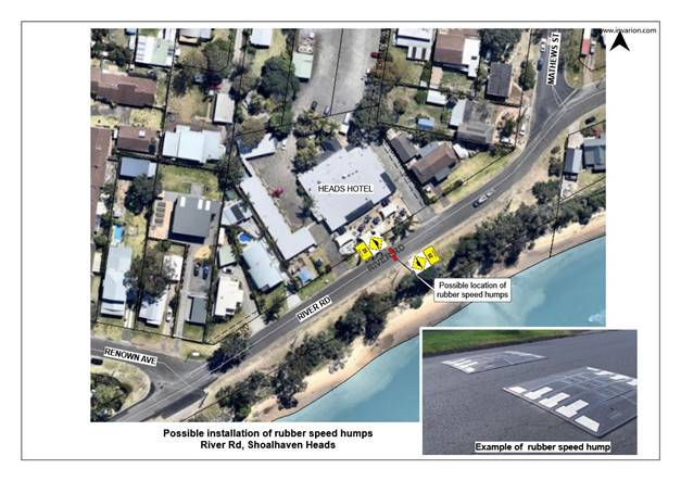
TC19.45 Traffic Calming - River Road,
Shoalhaven Heads
|
HPERM Ref: D19/140883
|
|
Recommendation
That the Chief Executive Officer (Director Assets and
Works) be advised that the Shoalhaven Traffic Committee support the
installation of a low-cost rubber speed hump in River Road, Shoalhaven Heads,
between Mathews St and Renown Ave as an interim solution.
|
|
RESOLVED (By consent)
That this Item be deferred to the October 2019 meeting
for consideration.
CARRIED
|
|
TC19.46 Disabled Access Parking Space
– Ulladulla Leisure Centre Carpark – Warden Street Ulladulla (PN
3557)
|
HPERM Ref: D19/305567
|
|
Recommendation
That the Chief Executive
Officer (Director Assets and Works) be advised that the Shoalhaven Traffic
Committee has no objection to the proposed installation of a disabled access
parking space in the Ulladulla Leisure Centre carpark located adjacent to
Warden Street, Ulladulla as detailed in the attached plan.
|
|
RECOMMENDATION (By consent)
That the Chief Executive
Officer (Director Assets and Works) be advised that the Shoalhaven Traffic
Committee has no objection to the proposed installation of a disabled access
parking space in the Ulladulla Leisure Centre carpark located adjacent to
Warden Street, Ulladulla as detailed in the attached plan.
CARRIED
|
There being no further
business, the meeting concluded.
Mr Tom Dimec
CHAIRPERSON
|

|
Shoalhaven
Traffic Committee – Tuesday 08 October 2019
Page
0
|
TC19.47 Recommendations
from Previous Meeting
HPERM Ref: D19/345264
Convenor: Tom
Dimec
|
Recommendation (Item to be determined under delegated authority)
That
the report regarding the recommendations from the previous meeting be
received for information.
|
Details
The minutes of the Shoalhaven
Traffic Committee meeting held on 10 September 2019 are included in the agenda.
The recommendations contained
therein were submitted to Council at its meeting held on 20 September 2019. All
recommendations were adopted.
|
|
Shoalhaven
Traffic Committee – Tuesday 08 October 2019
Page
0
|
TC19.45 Traffic
Calming - River Road, Shoalhaven Heads
HPERM Ref: D19/140883
Convenor: Tom
Dimec
Attachments: 1. River
Road Shoalhaven Heads Rubber Speed Humps Concept Plan ⇩
|
Recommendation
(Item to be determined under delegated authority)
That
the Chief Executive Officer (Director Assets and Works) be advised that the
Shoalhaven Traffic Committee support the installation of a low-cost rubber
speed hump in River Road, Shoalhaven Heads, between Mathews St and Renown Ave
as an interim solution.
|
Note: This item was deferred from the 10 September 2019
E-Meeting of the Committee.
Details
River Road, Shoalhaven Heads is
a local road within Shoalhaven Heads with residential properties and the Heads
Hotel on the northern side, and the Shoalhaven River on the southern side.
The area in question is adjacent
to the Heads Hotel located between Mathews Street and Renown Avenue. See
Attachment 1.
Council has received ongoing
community requests from the Heads Hotel for pedestrian and traffic calming
facilities, and more recently the Shoalhaven Heads Community Forum (CCB) is now
also requesting urgent consideration of traffic calming facilities in River
Road, adjacent to the Heads Hotel.
Council has also received
preliminary concerns from the RMS regarding this proposal. To address these
concerns, it has been recommended that a higher level of pre warning for the
road user on approach to the speed cushions should be provided. This can be
achieved by installing advanced warning signs in conjunction with kerbside
blisters.
The CCB has advised that the
section of River Road adjacent to the Hotel is an area where people congregate
and walk across the road to view the River. The CCB has also advised that there
is a high volume of traffic which tends to slow to view the closed entrance,
which causes conflict with other road users. They have advised that traffic
calming is needed and that the speed limit in this area should be slowed to
lower than 40kph.
Traffic tube counters were
installed in River Road, 50m west of Renown Avenue (in the vicinity of the
areas of concern to the community), in 2011 and 2017. The results of the tube
counts are:
2 December 2011 – 8
December 2011
Average Daily Traffic 576 vehicles/day
Busiest Day 820
vehicles/day (Sat 3/12)
V85th speed 47.9
km/h
8 May 2017 – 15 May
2017
Average Daily Traffic 511 vehicles/day
Busiest Day 621
vehicles/day (Sat 15/5)
V85th speed 50.8
km/h
The above tube count results are
typical for local 50kph roads, and the results alone do not suggest a traffic
or speeding problem in River Road that needs to be addressed with engineering
measures at this point in time.
In addition to the traffic and speed data collected in River
Road, Council had also arranged a pedestrian and traffic count along River Road
from Mathews Street to Renown Avenue on Sunday 18 December 2016 (the day and
time was suggested by the Heads Hotel to capture a typical busy period) to
gauge the current traffic and pedestrian crossing demand in the location.
|
VEHICLES
|
|
|
|
|
|
|
|
E/T
|
|
|
W/T
|
|
|
|
|
TIME
|
L
|
H
|
B
|
L
|
H
|
B
|
TOTAL
|
|
1030 - 1045
|
16
|
0
|
0
|
9
|
0
|
0
|
25
|
|
1045 - 1100
|
8
|
0
|
0
|
8
|
0
|
0
|
16
|
|
1100 - 1115
|
15
|
0
|
0
|
11
|
0
|
0
|
26
|
|
1115 - 1130
|
8
|
1
|
0
|
8
|
0
|
0
|
17
|
|
1130 - 1145
|
6
|
0
|
0
|
3
|
0
|
0
|
9
|
|
1145 - 1200
|
10
|
0
|
0
|
11
|
0
|
0
|
21
|
|
1200 - 1215
|
16
|
0
|
0
|
8
|
0
|
0
|
24
|
|
1215 - 1230
|
12
|
0
|
0
|
11
|
0
|
0
|
23
|
|
1230 - 1245
|
13
|
1
|
0
|
11
|
0
|
0
|
25
|
|
1245 - 1300
|
9
|
2
|
0
|
11
|
0
|
0
|
22
|
|
1300 - 1315
|
14
|
0
|
0
|
11
|
0
|
0
|
25
|
|
1315 - 1330
|
7
|
0
|
0
|
7
|
0
|
0
|
14
|
|
1330 - 1345
|
5
|
0
|
0
|
12
|
1
|
0
|
18
|
|
1345 - 1400
|
7
|
0
|
0
|
4
|
0
|
0
|
11
|
|
1400 - 1415
|
12
|
0
|
0
|
9
|
0
|
0
|
21
|
|
1415 - 1430
|
7
|
0
|
0
|
9
|
0
|
0
|
16
|
|
1430 - 1445
|
6
|
0
|
0
|
7
|
0
|
0
|
13
|
|
1445 - 1500
|
13
|
0
|
0
|
11
|
0
|
0
|
24
|
|
1500 - 1515
|
5
|
0
|
0
|
7
|
0
|
0
|
12
|
|
1515 - 1530
|
6
|
0
|
0
|
7
|
0
|
0
|
13
|
|
TOTAL
|
195
|
4
|
0
|
175
|
1
|
0
|
375
|
|
PEDESTRIANS
|
|
|
|
|
|
|
|
|
|
|
|
|
ZONE 1 (east)
|
|
|
ZONE 2 (hotel)
|
|
|
ZONE 3 (west)
|
|
|
|
TIME
|
A
|
C
|
E
|
TOTAL
|
A
|
C
|
E
|
TOTAL
|
A
|
C
|
E
|
TOTAL
|
|
1030 - 1045
|
0
|
0
|
0
|
0
|
2
|
0
|
0
|
2
|
0
|
0
|
0
|
0
|
|
1045 - 1100
|
0
|
0
|
0
|
0
|
1
|
0
|
0
|
1
|
1
|
0
|
0
|
1
|
|
1100 - 1115
|
0
|
0
|
0
|
0
|
1
|
0
|
0
|
1
|
1
|
0
|
0
|
1
|
|
1115 - 1130
|
1
|
0
|
0
|
1
|
0
|
0
|
0
|
0
|
1
|
0
|
0
|
1
|
|
1130 - 1145
|
0
|
0
|
0
|
0
|
3
|
0
|
0
|
3
|
1
|
0
|
0
|
1
|
|
1145 - 1200
|
1
|
0
|
0
|
1
|
5
|
6
|
0
|
11
|
1
|
0
|
0
|
1
|
|
1200 - 1215
|
2
|
1
|
0
|
3
|
9
|
0
|
0
|
9
|
0
|
0
|
0
|
0
|
|
1215 - 1230
|
0
|
0
|
0
|
0
|
0
|
0
|
0
|
0
|
0
|
0
|
0
|
0
|
|
1230 - 1245
|
0
|
0
|
0
|
0
|
0
|
0
|
0
|
0
|
0
|
0
|
0
|
0
|
|
1245 - 1300
|
0
|
0
|
0
|
0
|
2
|
0
|
0
|
2
|
0
|
0
|
0
|
0
|
|
1300 - 1315
|
0
|
0
|
0
|
0
|
7
|
2
|
0
|
9
|
0
|
0
|
0
|
0
|
|
1315 - 1330
|
0
|
0
|
0
|
0
|
2
|
0
|
0
|
2
|
0
|
0
|
0
|
0
|
|
1330 - 1345
|
0
|
0
|
0
|
0
|
1
|
0
|
0
|
1
|
3
|
0
|
0
|
3
|
|
1345 - 1400
|
6
|
0
|
0
|
6
|
0
|
0
|
0
|
0
|
6
|
0
|
0
|
6
|
|
1400 - 1415
|
0
|
0
|
0
|
0
|
6
|
2
|
0
|
8
|
0
|
0
|
0
|
0
|
|
1415 - 1430
|
0
|
0
|
0
|
0
|
3
|
0
|
0
|
3
|
0
|
0
|
0
|
0
|
|
1430 - 1445
|
0
|
0
|
0
|
0
|
0
|
0
|
0
|
0
|
0
|
0
|
0
|
0
|
|
1445 - 1500
|
1
|
0
|
0
|
1
|
4
|
0
|
0
|
4
|
0
|
0
|
0
|
0
|
|
1500 - 1515
|
2
|
2
|
0
|
4
|
4
|
0
|
0
|
4
|
0
|
0
|
0
|
0
|
|
1515 - 1530
|
0
|
0
|
0
|
0
|
4
|
0
|
0
|
4
|
0
|
0
|
0
|
0
|
|
TOTAL
|
13
|
3
|
0
|
16
|
54
|
10
|
0
|
64
|
14
|
0
|
0
|
14
|
Legend:
L = Light Vehicles
H = Heavy Vehicles
B = Buses
A = Adult Pedestrians
C = Children Pedestrians
E = Elderly & Mobility Impaired Pedestrians
Warrants for pedestrian
facilities (i.e. pedestrian crossing or pedestrian threshold) are included
within the AUSTROADS guidelines, specifically:
· Traffic
volumes (V) need to be greater than 500 vehicles per hour
· Pedestrian
volumes (P) need to be greater than 30 per hour
· The
“Normal warrant” (P x V) needs to be greater than 60,000
· The
“Special warrant” (a lower warrant for consideration of vulnerable
users) P x V needs to be greater than 45,000
· These
conditions need to be prevalent for 4 separate hours of any one day.
From the recorded data on River
Road Shoalhaven Heads, and taken from the busiest pedestrian location (outside
the Heads Hotel), the following can be summarised:
· The
busiest pedestrian hour was 23 (76% of the required warrant) but other hours
were much less
· The
corresponding traffic hour was 71 vehicles (only 14% of the required warrant)
· The
value of PV is 1633 (only 2.7% of the normal warrant, or only 3.6% of the
special warrant) i.e. significantly lower than the recommended warrant.
These calculations indicate the low
priority of the location, and it is noted that there are numerous other
locations city wide that have much greater values of PV, including around town
centres, schools, and retirement/aged care facilities.
Council at its meeting of 18
December 2018 resolved (MIN18.1002):
That Council consults with the local residents in regard
to the possibility of constructing a ‘low cost’ rubber speed hump
in River Road (between Mathews St and Renown Ave adjacent to the Heads Hotel).
Shoalhaven Heads, in response to the request from the Shoalhaven Heads
Community Consultative Body.
Following this Council
resolution (MIN 18.1002) Council staff wrote to the 5 property owners between
Renown Ave and Mathews St, and the Shoalhaven Heads Community Forum, on 7
January 2019, requesting feedback on a possible low-cost rubber speed hump to
be installed on River Rd, adjacent to the Heads Hotel, pursuant to
Council’s resolution.
Council received the following 3
submissions in response to the proposal (summarised):
Response 1 – Notes
concerns with potential noise generated from vehicles traversing the raised
speed hump, in particular with larger delivery vehicles, and cars with boat
trailers. This response offered an alternative solution of a road narrowing
with a 40km/h speed zone and a marked pedestrian crossing.
Response 2 – Agreed
that River Rd is dangerous for pedestrians, but do not support a rubber speed
hump due to associated noise impacts by car and boat trailers and trucks. This
response also offered an alternative solution of a road narrowing with a 40km/h
speed zone and marked pedestrian crossing.
Response 3 –
Suggests Council have a wholistic plan for speed control and pedestrian access.
This response suggests speed humps be placed at the intersections of Mathews St
and Renown Ave with a 20km/h speed zone in between, with a pedestrian crossing
in front of the Hotel. This response suggests that Council consider the
commercial and safety aspects of the suggested interim measure.
The Shoalhaven Heads Community
Forum did not respond to the consultation letter; however, they proposed the
short-term solution.
The request for a pedestrian
crossing is acknowledged. Surveys identify that guideline warrants are
currently not met for the installation of a pedestrian crossing. Constructing a
pedestrian crossing without the warrant being met can undermine the importance
of and expectations at pedestrian crossings.
Incorporating a pedestrian
crossing into a raised threshold device has been included into the broader
foreshore masterplan (not detailed design or funded). A raised threshold
incorporating a pedestrian crossing:
- reduces noise
impacts to within acceptable limits
- achieves the
desired speed reduction where required (out the front of the Hotel) and
- enhances the
chances of a successful grant funding outcome and approval through the
Shoalhaven Traffic Committee.
On 11 August 2019, Council
received a submission from the Shoalhaven Heads Forum requesting an
investigation into lowering the speed limit along River Road to 40km/h. Council
staff passed on these concerns to Roads and Maritime Services (RMS) for their
assessment. On 2 September 2019, RMS had passed its findings on to Council and
the Shoalhaven Heads Forum, advising that the existing 50km/h speed zone was
found to be in accordance with NSW Speed Zoning Guidelines and would not be
reduced. In light of this assessment, Council considers the installation of
rubber speed humps to be a viable option to address the concerns of the
community.
The RMS have conveyed that,
street lighting and advance warning signs be required to be installed at this
location. These recommendations will be presented to the Shoalhaven Traffic
Committee for consideration.
|

|
Shoalhaven
Traffic Committee – Tuesday 08 October 2019
Page
0
|
|
|
Shoalhaven
Traffic Committee – Tuesday 08 October 2019
Page
0
|
TC19.48 Traffic
Calming - LATM - Leo Drive Subdivision - Narrawallee (PN 3499)
HPERM Ref: D19/147355
Convenor: Tom
Dimec
Attachments: 1. PN
3499 Plan ⇩
|
Recommendation
That
the Chief Executive Officer and (Director Assets & Works) be advised that
the Shoalhaven Traffic Committee has no objection to the proposed speed
table, and associated regulatory signage and line marking on Leo Drive,
Narrawallee as detailed in the attached plan, subject to the following:
1. Provide a specific value about
proposed ramp grade, whether the design parameters will be 1:12, 1:15 or a
value in between
2. Provide a specific value about the
positioning of warning signage in relation to the raised thresholds, whether
they will be set out at 30m, 50m or a value in between, taking note to not
adversely impact on residential driveways
3. Provide the following
specifications for the raised threshold surfacing: “The concrete
surface shall be constructed of ‘Dark Terracotta’ coloured concrete
and have a ‘Brick’ stamped pattern finish, using a
‘Bluestone’ coloured release agent. Prior to sealing, all areas
of stamped concrete, other than the voids of the ‘Brick’ pattern,
shall be cleaned of release agent using sprayed water.”
|
Details
Applicant: PW Rygate & West (Ulladulla)
Owner: HAZCORP Pty Ltd
Lot 1 DP 1087105
Part 3A application- 168 lot residential subdivision & 3
Public Reserve allotments
The committee may recall prior discussions regarding the
ongoing subdivision of Leo Drive, Narrawallee.
Condition B10.1 of the 3A consent requires the construction of
two speed humps on Leo Drive between the intersections of Sagittarius Way and
Aries Place during stage 2 as part of the subdivisions local area traffic
management. As there is an existing speed table on Leo Drive at this location
the applicant has submitted plans for an additional speed table.
Consultation was undertaken with the community, with feedback
received mostly being negative. This feedback is duly noted. However, as this
initiative has been conditioned by the State Government, the installation of
this raised threshold must continue.
A plan of the threshold and
associated signage has been submitted for the Committee's consideration.
|

|
Shoalhaven
Traffic Committee – Tuesday 08 October 2019
Page
0
|
|
|
Shoalhaven
Traffic Committee – Tuesday 08 October 2019
Page
0
|
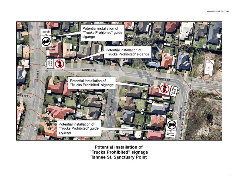
TC19.49 Load
Limit Signage - Tahnee Street Sanctuary Point (PN 3558)
HPERM Ref: D19/341796
Convenor: Tom
Dimec
Attachments: 1. PN
3558 Plan ⇩
|
Recommendation
That the Chief Excetive Officer (Director Assets and Works) be
requested to arrange for the installation of the load limit signage and
related advanced warning signage on Tahnee Street Sanctuary Point, as
detailed in the attached plan.
|
Details
Council staff have been requested to review Tahnee Street,
Sanctuary Point.
Residents have expressed concerns regarding the inadequate
width of the road which has led to heavy vehicle traffic mounting the verge and
causing damage to the road environment.
To address these concerns, Council's Engineering Design Unit
are considering the installation of load limiting controls along Tahnee Street,
preventing thoroughfare of trucks above 4.5 tonnage. This will be complemented
by advanced warning signage on Nadine Street and Anson Street approaches,
ensuring that the load limit controls are effectively communicated.
The impact of these proposed controls aims to assist in
reducing the number of heavy vehicles using Tahnee Street.
Consultation was undertaken with affected residents regarding
this proposition. Council received 12 submissions in favour of the proposed
load limit and two against.
A signage plan has been
submitted for the Committee's consideration.
|
|
Shoalhaven
Traffic Committee – Tuesday 08 October 2019
Page
0
|
|
|
Shoalhaven
Traffic Committee – Tuesday 08 October 2019
Page
0
|
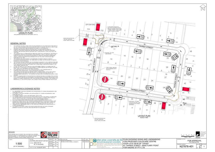
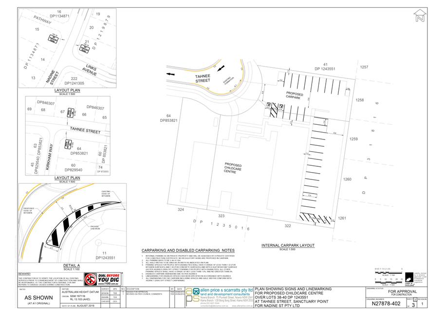
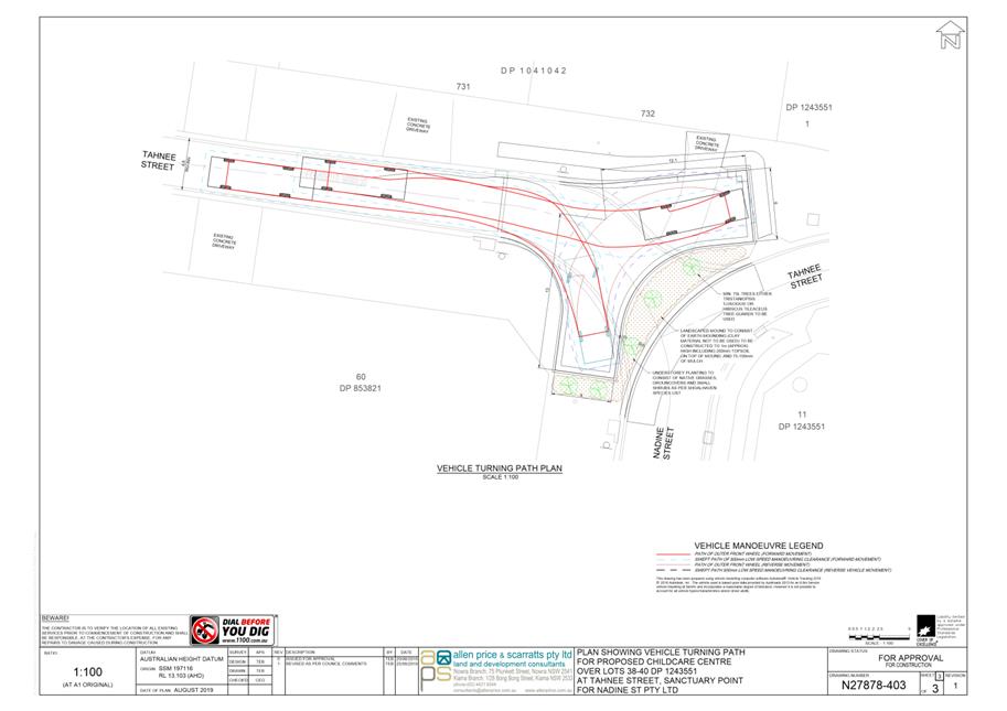
TC19.50 Tahnee
St Sanctuary Point - Lots 38-40 DP1243551 - Proposed Childcare Centre (PN 3560)
HPERM Ref: D19/341803
Convenor: Tom
Dimec
Attachments: 1. PN
3560 Plans ⇩
|
Recommendation
That
the Chief Executive Officer (Director Assets and Works) be advised that the
Shoalhaven Traffic Committee has no objection to the proposed works on Tahnee
Street and Nadine Street as part of the proposed Childcare Centre (per
condition 17 of DA18/1700), as detailed in the attached plan, subject to:
1. Extending the BB centreline marking
on Nadine Street for an additional 13m, thereby making a total 20m of BB line
marking.
|
Details
Applicant: Allen Price and Scarratts Pty Ltd
Owner: Nadine Street Pty Ltd
Tahnee Street, Sanctuary Point - Lots 38-40 DP1243551
Council has received a development application for a proposed
Childcare Centre and related changes to the road environment on Tahnee Street
and Nadine Street, Sanctuary Point.
Condition 17 of the development consent requires:
Prior to the issue of a Construction Certificate for the
development, the person benefitting from this consent must submit plans
detailing lane widths, proposed signage locations and line marking (including
dimensions), swept paths with clearance offsets to proposed landscaping measures,
cul-de-sac head design within Tahnee Street, Nadine Street and the site’s
internal parking (including grade compliance with the disabled parking space)
to Council’s Traffic Unit for Shoalhaven Traffic Committee consideration.
These plans are to include:
a) No stopping zones along the frontage of the
proposed childcare site and as appropriate in the proposed cul-de-sac head;
b) Directional pavement markings in compliance with
Australian standards;
c) Appropriate longitudinal line marking on both
Nadine Street and Tahnee Street, in accordance with relevant standards;
d) Pedestrian linkage between the internal path and
external path within Nadine Street (inside and outside of the loop) in
accordance with the current engineering plans for Nadine Street.
A signage, linemarking and swept
path plans for the proposed works on Tahnee Street and Nadine Street have been
submitted for the Committee's consideration.
|
|
Shoalhaven
Traffic Committee – Tuesday 08 October 2019
Page
0
|
|
|
Shoalhaven
Traffic Committee – Tuesday 08 October 2019
Page
0
|
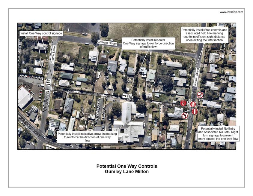
TC19.51 One Way Controls - Gumley Lane Milton (PN 3559)
HPERM Ref: D19/341800
Convenor: Tom
Dimec
Attachments: 1. PN
3559 Plan ⇩
|
Recommendation
That the Chief Executive Officer (Director Assets and Works)
be advised that the Shoalhaven Traffic Committee has no objection to the
proposed installation of one-way controls along Gumley Lane, Milton from a
western to eastern direction, accompanied by relevant signage and
line-marking, as detailed in the attached plan.
|
Details
Council has been requested to review Gumley Lane, Milton.
Residents have expressed concerns over the road's minimal
width, presenting an issue for two way flow.
Council's Engineering Design Unit inspected the location and
noted the road's inadequate width for two-way flow in accordance with
Australian Standards.
To address this request, Council is considering the
installation of One-Way controls, controlling flow from a west to easterly
direction. Signage to indicate this one-way flow has been proposed at both
intersections with Church Street and Gordon Street. Additional signs and
pavement arrows have been proposed to reinforce this one-way flow.
The impact of this proposal will result in an organised
traffic flow that will prevent potential conflicts with cars travelling in dual
directions.
Consultation was undertaken with affected properties. Council
received four submissions in favour of the proposal and three against. Of the
comments received from the community, two similar trends were observed from
across the different submissions.
Firstly, that the speed limit along Gumley Lane should be
reduced from the existing 50km/h controls. This would tie into the One-way
controls effectively.
Secondly, that the intersection of Church Street and the
Princes Highway is an ongoing traffic issue and that a study should be
conducted as to whether a roundabout or signalised treatment should be
implemented.
Both of these notions should be investigated in further detail
and would synergise with the one-way controls effectively.
A signage and line-marking plan
has been submitted to the Committee for consideration.
|

|
Shoalhaven
Traffic Committee – Tuesday 08 October 2019
Page
0
|
|
|
Shoalhaven
Traffic Committee – Tuesday 08 October 2019
Page
0
|
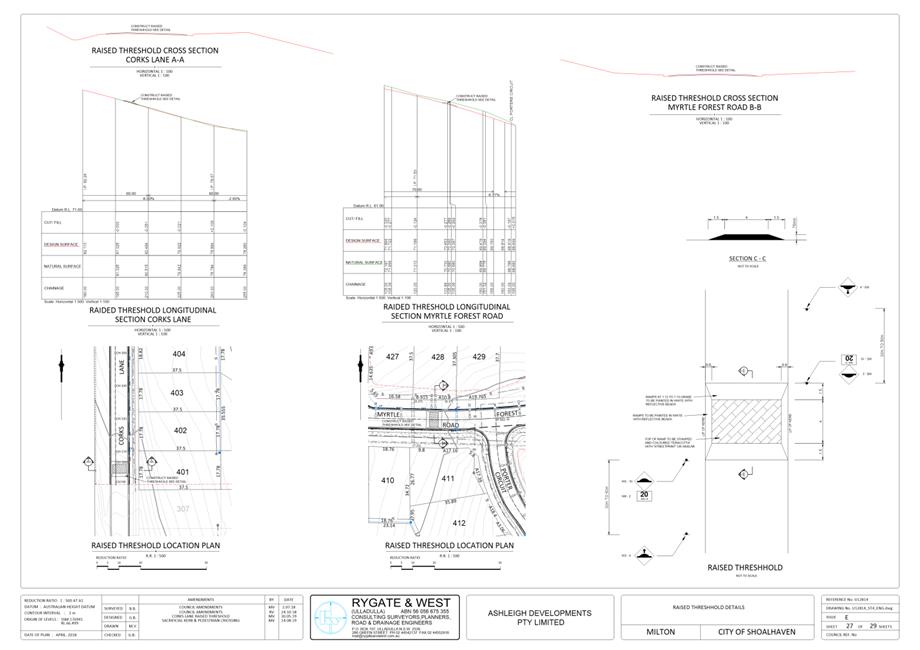
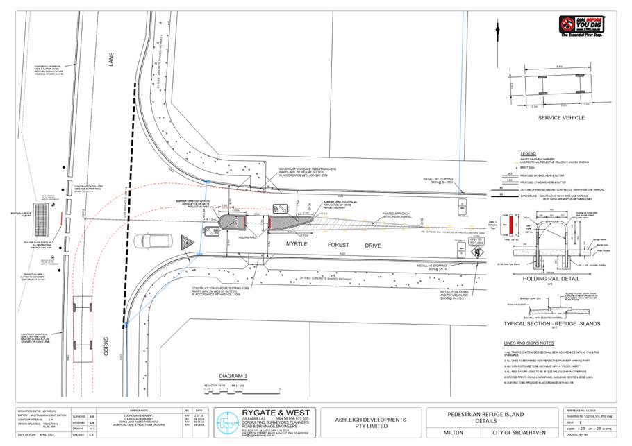
TC19.52 Corks
Lane, Milton - Lot 35 - DP 262647 - Residential Subdivision (PN 3562)
HPERM Ref: D19/341809
Convenor: Tom
Dimec
Attachments: 1. PN
3562 Plans ⇩
|
Recommendation
That
that the Chief Executive Officer (Director Assets and Works) be advised that
the Shoalhaven Traffic Committee has no objection to the proposed works on
Corks Lane (proposal as per conditions 41 and 53), as detailed in the
attached plan, subject to:
1. On Sheet 27:
a. Demonstrate the dimensions from
affected properties adjacent to the proposed raised thresholds on Corks Lane
and Myrtle Forest Road and justify how these properties’ access will
not be adversely impacted by the positioning of the threshold
b. Design the raised threshold in
accordance with AS 1742, providing a compliant ramp grade, indicating whether
the design parameters will be 1:12, 1:15 or a value in between
c. Provide an exact distance for the
positioning of warning signage in relation to the raised thresholds, whether
they will be set out at 30m, 50m or a value in between
d. Provide the following specifications
for the raised threshold surfacing: “The concrete surface shall be
constructed of ‘Dark Terracotta’ coloured concrete and have a
‘Brick’ stamped pattern finish, using a ‘Bluestone’
coloured release agent. Prior to sealing, all areas of stamped concrete,
other than the voids of the ‘Brick’ pattern, shall be cleaned of
release agent using sprayed water”
2. On Sheet 29:
a. Change Give Way Hold Line Marking TB
to TB / TB1
b. Indicate the sign code for the Give
Way signage
c. Provide C3 yellow line marking
instead of No Stopping Signage at locations indicated along Myrtle Forest
Drive, or that both signage and line marking be used in conjunction with each
other
d. Provide a revised design of the kerb
ramp, as it currently shows it extending into the lip of the gutter, when it
should finish at the face of the kerb
|
Details
Applicant: Rygate and West Pty Ltd
Owner: Ashleigh Developments Pty Ltd
Corks Lane, MILTON - Lot 35 - DP 262647 - Residential
Subdivision
Council has received a development application for a proposed
residential subdivision at Corks Lane, Milton.
Condition 41 of the development consent requires:
The construction of speed reduction devices or mountable roundabouts,
in accordance with Austroads and Australian standards, to reduce the speed of
through traffic at the intersections of Road 3 with Corks Lane and Roads 4
& 5. The nature strip adjacent to these devices shall be a minimum of 3
metres. The speed control devices or roundabouts will require referral to the
Shoalhaven Traffic Committee at the concept design stage and again for the
approval of line marking and regulatory signposting. Preliminary designs
should be forwarded to Council prior to finalisation of engineering road design
plans for the relevant Stages.
Additionally, Condition 53 of the development consent
requires:
Details of any line markings and regulatory signs shall
be submitted to Council for referral to the Shoalhaven Traffic Committee and
subsequent recommendation to Council. Six to eight weeks should be allowed for
this process, plus additional time if amendments to the plans are
required.
Please note, Road 3, Road 4 and Road 5 are Myrtle Forest Road,
Link Road to the Princes Highway (extension of Myrtle Forest Road) and Hilder
Close respectively.
A plan detailing the raised
thresholds, signage and line marking details has been submitted for the
Committees consideration.
|

|
Shoalhaven
Traffic Committee – Tuesday 08 October 2019
Page
0
|
|
|
Shoalhaven
Traffic Committee – Tuesday 08 October 2019
Page
0
|
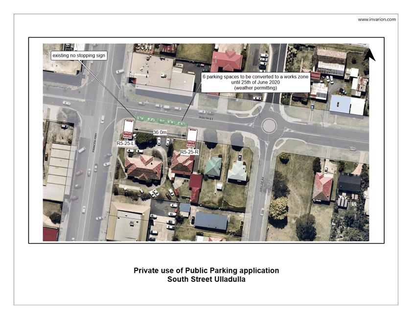
TC19.53 Private
Use of Public Parking - 82 South Street Ulladulla (PN 3561)
HPERM Ref: D19/341806
Convenor: Tom
Dimec
Attachments: 1. PN
3561 Plan ⇩
|
Recommendation
That the Chief Executive Officer
(Director Assets and Works) be advised that the Shoalhaven Traffic Committee
has no objections to the temporary use of 6 parking spaces for a period of
approximately 9 months during the works of 82 South St, Ulladulla, as
detailed in the attached plan, subject to payment of associated fees in
accordance with Council’s Private Use of Public Parking Policy 16/154.
|
Details
Applicant: Zauner Construction
Works Description: To conduct works at
82 South Street, Ulladulla (per RA18/1001) until 25 June 2020, weather
permitting.
Lot 6 DP 22193
Council has received an application from Zauner Constructions
who are undertaking the redevelopment works at 82 South Street, Ulladulla in
regards to the new Health One facility (per RA18/1001). They have requested to
utilise 6 parallel car spaces on South Street, Ulladulla for an approximate
period of 9 months.
South Street is directly adjacent to the work site and would
be the most safe and efficient location to park in this proposed zone. The
spaces to be occupied do not significantly impact on neighbouring residences or
businesses.
This application is consistent
with Council’s Private Use of Public Parking Policy 16/154.
|
|
Shoalhaven
Traffic Committee – Tuesday 08 October 2019
Page
0
|
|
|
Shoalhaven
Traffic Committee – Tuesday 08 October 2019
Page
0
|
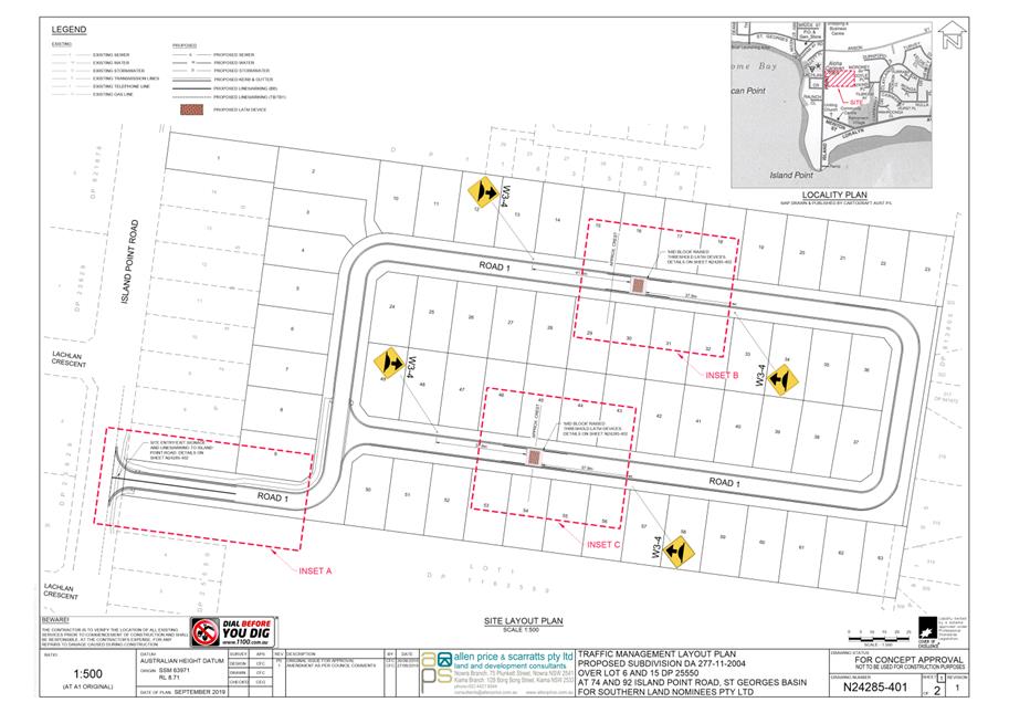
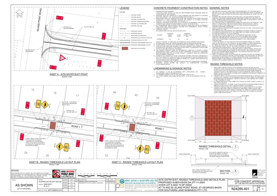
TC19.54 74
Island Point Rd, St Georges Basin - Lot 6 / 15 DP 25550 - 52 Lot Residential
Subdivision (PN 3563)
HPERM Ref: D19/341811
Convenor: Tom
Dimec
Attachments: 1. PN
3563 Plans ⇩
|
Recommendation
That
the Chief Executive Officer (Director Assets and Works) be advised that the
Shoalhaven Traffic Committee has no objection to the proposed works on Island
Point Road (per condition C9(3)) as indicated in the attached plans; subject
to:
1. Providing the dimensions of the
shared footpath indicated in the plans.
|
Details
Applicant: Allen Price and Scarratts Pty Ltd
Owner: Southern Land Nominees Pty Ltd
74 Island Point Rd, ST GEORGES BASIN - Lot 6 / 15 DP 25550
Council has received a development application for a 52-lot
residential subdivision on Island Point Road, St Georges Basin.
Condition C9(3) 'Engineering Plans and Design Standards' of
the development consent requires:
The design of speed control devices, warning signage or
other acceptable traffic control devices (may include LATM or other devices)
shall reduce the 85% speed to 40kph. The speed control devices, warning signage
etc will require referral to the Shoalhaven Traffic Committee for approval.
A plan detailing raised
thresholds and associated signage and line marking has been submitted for the
Committee's consideration.
|
|
Shoalhaven
Traffic Committee – Tuesday 08 October 2019
Page
0
|
|
|
Shoalhaven
Traffic Committee – Tuesday 08 October 2019
Page
0
|
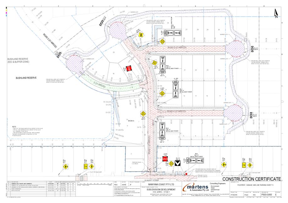
TC19.55 Cunjurong
Point Rd, MANYANA - Lot 172 - DP 755923 - Residential Subdivision (PN
3564)
HPERM Ref: D19/341813
Convenor: Tom
Dimec
Attachments: 1. PN
3564 Plans ⇩
|
Recommendation
That
the Chief Executive Officer (Director Assets and Works) be advised that the
Shoalhaven Traffic Committee has no objection to the works at Cunjurong Point
Rd, Manyana (per condition B12 of the development consent), as detailed in
the attached plan, subject to:
1. Providing ‘Give Way’
Size A (R1-2-A) signage at all locations where 'Road Ahead' (W6-8-A) signage
has been used on the shared path
|
Details
Applicant: Martens and Associates Pty Ltd
Owner: Manyana Coast Pty Ltd
Cunjurong Point Rd, MANYANA - Lot 172 - DP 755923
Council has received a development
application for a proposed residential subdivision at Cunjurong Point Road,
Manyana.
Condition B12 of the development
consent requires the following:
a) Kerb and gutter, stormwater drainage, full road width pavement
including traffic facilities and paved footpaths shall be constructed along the
full length of the new roads in all stages of the development, with the
exception of roads adjoining reserves where grass swales are to be used. All
roads shall be designed in accordance with the relevant requirements of the
Shoalhaven City Council's DCP 100 (Subdivision Code). Final road design plans
shall be prepared by a practising engineer and submitted to the Council prior
to the issue of a Construction Certificate for Stage 1;
b) The street designs are to incorporate traffic calming
principles in accordance with DCP 100 and to the satisfaction of Council - Stages
1-6;
c) Appropriate physical barriers shall be installed around the
roadside perimeter of the EEC and passive open space with restricted access for
maintenance vehicles and separate access for pedestrians at appropriate
locations determined by the VMP (refer to Condition B9)- Stages 1, 4, 5 and
6;
d) A "Stop" signage and hold-line shall be provided on
Road No. 1 at its intersection with Sunset Strip, and at The Barbette at its
intersection with Sunset Strip - Stage 1;
e) Two signposted bus zones (R5-20 signs) located on both sides of
Berringer Road shall be constructed to the immediate east of Berringer
Road/Road No. 2 intersection, with the final location to be determined in
consultation with Council. Road carriageway width shall be 9.5m wide (allowing
a 3m wide kerbside lane for parking and bus stops, 2 x 3m unobstructed through
lanes and 0.5m for pavement protection) and 3m wide indented bus bays shall be
provided in accordance with Austroads Part 11 - Stage 5;
f) Two symbolic "Caution Children" r,N6-3A) warning
signs shall be installed, one on the south side of Berringer Road, mid-way
between Road No. 4 and The Companionway and the second on the west side of
Cunjurong Point Road at the southern boundary of the site, midway between Road
6 and the Sunset Strip - Stage 3 and Stage 6 respectively;
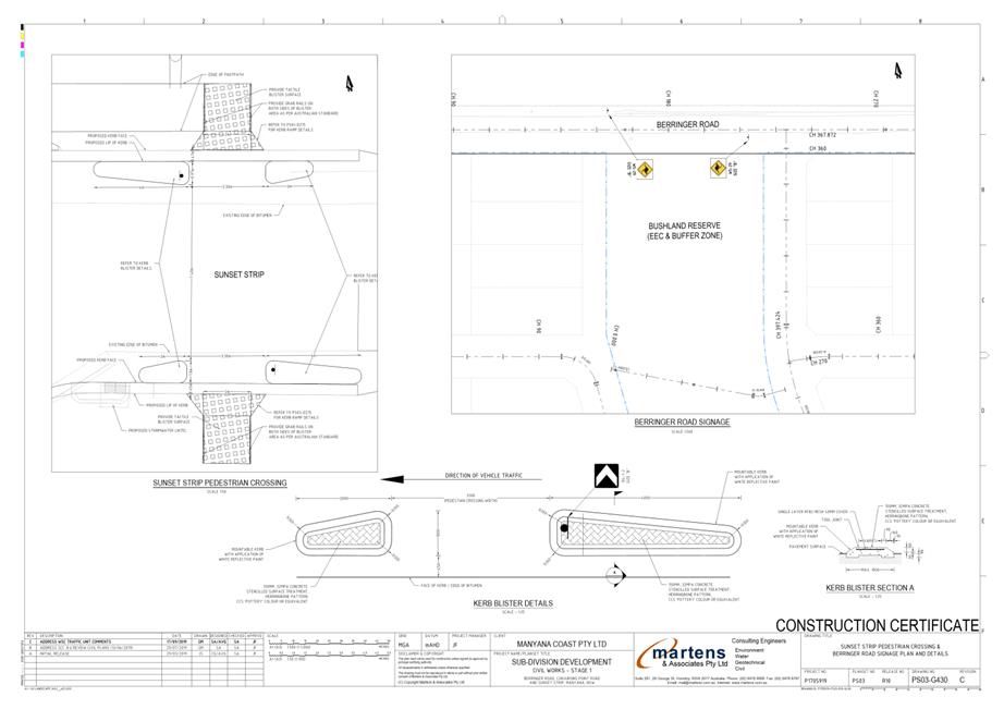
g) Two "Wildlife Crossing" signs are to be provided on
Berringer Road in the proximity of where the bushland reserve meets Berringer
Road - Stage 1;
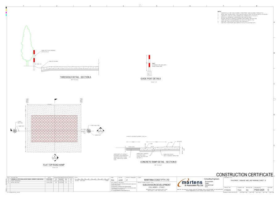
h) Two speed control facilities in the form of ramped-thresholds
shall be provided on Sunset Strip on the approaches to its staggered
intersections with Road No. 1 and The Barbette, one approximately 100m west and
the other approximately 1 00m to the east of The Barbette - Stage 1;
i) Construct a cycle/pedestrian crossing on Sunset Strip, to the
immediate east of Sunset Strip/The Barbette intersection, involving
kerb-extension blisters, kerb ramps and shared-path connections to both sides,
grab-rails to accommodate cyclists and a 2m wide shared-path linking to the
facility to Road No. 1 and integrated with the proposed internal pathways of
the development - Stage 1;
j) A 1.2m wide footpaths shall be installed on the development's
entire frontage along Berringer Road and Cunjurong Point Road - Stage 3/4
and Stage 5/6 respectively;
k) Shared cyclist/pedestrian pathway shall be constructed of
concrete and shall be 2m wide and signposted, linemarked and provided with safe
crossing points in accordance with Austroads Part 14 and in the locations shown
on the approved plan of subdivision (Drawing No.24256-09 Layout H Rev.02) - all
Stages;
l) The cyclist/pedestrian pathway forming the extension of Road 3
where it crosses the bushland reserve shall be raised above natural ground
level and be of timber/metal construction and be no closer than 400mm to the
ground at any point - Stage 5;
m) Pedestrian pathways shall be constructed of concrete and shall
be 1.2m wide - all Stages;
n) All internal roads, Berringer Road and Cunjurong Point Road
shall be provided to Council DCP 100 Standards- all Stages;
To satisfy conditions B12(b,d,g,h,I,k,m,r) for Stage 1,
a plan detailing signage and linemarking for the internal roads and shared
cycleway path and associated raised thresholds has been submitted for the
Committee's Consideration.
|
|
Shoalhaven
Traffic Committee – Tuesday 08 October 2019
Page
0
|