Strategy and Assets Committee
Meeting Date: Tuesday,
16 October, 2018
Location: Council
Chambers, City Administrative Centre, Bridge Road, Nowra
Time: 5.00pm
Membership (Quorum - 5)
Clr John Wells - Chairperson
Clr Bob Proudfoot
All Councillors
General Manager or nominee
Please note: The proceedings of this meeting
(including presentations, deputations and debate) will be webcast and may be
recorded and broadcast under the provisions of the Code of Meeting Practice. Your attendance at this meeting is taken
as consent to the possibility that your image and/or voice may be recorded and
broadcast to the public.
Agenda
1. Apologies / Leave of Absence
2. Confirmation of Minutes
· Strategy
and Assets Committee - 18 September 2018............................................... 1
3. Declarations of Interest
4. Mayoral Minute
5. Deputations and Presentations
6. Notices of Motion / Questions on Notice
Nil
7. Reports
Finance Corporate & Community Services
SA18.233.... 2018/2019 Conferences............................................................................... 18
SA18.234.... Access Areas for Dogs Policy and Off-leash Dog
Areas - Sussex Inlet District and Greenwell Point............................................................................................ 21
SA18.235.... Installation of Bollards - Marine Vegetation
Protection - Jacob Ellmoos Reserve, Sussex Inlet.................................................................................................. 34
SA18.236.... Establishment of Alcohol Prohibited Area -
Huskisson Carnival................. 49
SA18.237.... Proposed Pump Track at Jerry Bailey Oval,
Shoalhaven Heads - Community Consultation Outcomes and Next Steps...................................................... 53
SA18.238.... Ulladulla Skate Park - Audit Report and
Recommendations for Facility Update 84
SA18.239.... Milton Ulladulla Croquet Club Construction - Stage
1 - Revised Timeframes for Completion.................................................................................................... 89
SA18.240.... Shoalhaven Tennis - Decommission 2 Courts and
Waive Outstanding Loan 92
SA18.241.... Nowra Showground Buildings Budget......................................................... 97
Assets & Works
SA18.242.... Shoalhaven Affordable Housing Strategy - Property
Acquisition Matters. 104
SA18.243.... Sale - Council Land - Lot 1 DP579906 at 27c
Broadview Ave Culburra Beach 109
SA18.244.... Pilot Project- Council Land Review
Sanctuary Point & St Georges Basin......................................................... 120
SA18.245.... Proposed Sale of Lot 4 DP 550354 Island Point
Road, St Georges Basin 137
SA18.246.... Grant of Electricity Easement for Pad Mount
Substation and Restriction on the Use of Land to Endeavour Energy - Lot 1
DP860791 - 92 Albatross Road, South Nowra.................................................................................................................... 141
SA18.247.... Grant of Easement for Underground Cables to
Endeavour Energy - Lot 49 DP243033 - North Nowra............................................................................................. 144
SA18.248.... Positive Covenant - Asset Protection Zone - Over
Part Crown land - Reserve R89771 - adjoining 2 Greville Ave, Sanctuary Point................................................ 147
SA18.249.... Proposed Ground Licence to Sussex Inlet Men's Shed
Inc. - Thomson Street Sporting Complex - 29 Thomson Street Sussex Inlet.............................................. 151
SA18.250.... Response - MIN18.290 regarding various issues in
the Huskisson Area. 156
SA18.251.... Proposed Road Closure & Subdivision - Part
North Crescent, Culburra Beach 166
SA18.252.... NSW Government Saving Lives on Country Roads
Program 2018-19 and 2019-20.................................................................................................................... 171
SA18.253.... Funding Request - Volunteer Adopt A Road Programme......................... 174
Planning Environment & Development
SA18.254.... Shoalhaven Coastal Zone Management Plan -
certification and gazettal. 176
SA18.255.... Shoalhaven Coastal Management Projects Updates................................ 178
SA18.256.... Investigation - Repair Beach Access Ocean St
Culburra.......................... 193
SA18.257.... Flood Program Progress Update............................................................... 202
SA18.258.... Bushcare Program Update......................................................................... 205
SA18.259.... Council's Bushfire Mitigation Program....................................................... 209
Shoalhaven Water
SA18.260.... Acquisition of land and easements at Mundamia for
University of Wollongong Shoalhaven Campus.................................................................................. 216
8. Confidential
Reports
Reports
CSA18.18.... Shoalhaven Affordable Housing Strategy - Property
Acquisition Matters
Local Government Act - Section 10A(2)(c) - Information
that would, if disclosed, confer a commercial advantage on a person with whom
the Council is conducting (or proposes to conduct) business.
There is a public interest
consideration against disclosure of information as disclosure of the
information could reasonably be expected to reveal commercial-in-confidence
provisions of a contract, diminish the competitive commercial value of any
information to any person and/or prejudice any person’s legitimate
business, commercial, professional or financial interests.
|

|
Strategy and
Assets Committee – Tuesday 16 October 2018
Page
I
|
Strategy and Assets
Committee
Delegation:
pursuant to s377 (1) of the Local
Government Act 1993 the Committee is delegated
the functions conferred on Council by the Local
Government Act 1993 (LG Act) or any other Act or delegated
to Council, as are
specified in the Schedule, subject to the following limitations:
i. The
Committee cannot exercise any function delegated to the Council which by the
terms of that delegation cannot be sub-delegated;
ii. The
Committee cannot exercise any function which s377(1) of the LG Act provides
cannot be delegated by Council;
iii. The
Committee cannot exercise a function which is expressly required by the LG Act
or any other Act to be exercised by resolution of the Council; and
iv. The
Committee cannot exercise any function which is a function of the General
Manager under s335 of the LG Act.
SCHEDULE
a. Make recommendations to
Council and consider, formulate, review and adopt policies in relation to
Councils corporate & community planning under Part 2 of Chapter 13 of the
LG Act, asset management and in connection with the other functions listed in
this Schedule and in particular to make recommendations to Council in respect
of the content of Councils community strategic plan, delivery program,
resourcing strategy and operational plan within the meaning of Part 2 of Chapter
13 of the LG Act;
b. Make recommendations to
Council and consider, formulate, review and adopt Council policies, plans and
strategies other than those in respect of town planning and environmental
matters, and any other matter referred to the Committee by the General Manager.
c. Make recommendations in
respect of the introduction of new fees or charges or the alteration of
existing fees and charges for inclusion in the Councils next operational plan
within the meaning of s405 of the LG Act;
d. Monitor, review and
consider matters relating to the operations and strategic direction of Councils
Holiday Haven Tourist Parks Group;
e. All functions in respect
of the management of, and facilities provided on Crown Land in respect of which
Council is the ‘Crown Land Manager’ under Division 3.4 of the Crown
Lands Management Act, 2016 and the making of recommendations to Council
regarding such matters where the function is not dealt with under the
delegations to the General Manager or cannot be delegated by Council;
f. Provision of
corporate direction to the Shoalhaven Water Group in respect of powers
delegated to it by Council regarding the construction, alteration or
maintenance of water and sewerage works, effluent works and pump out
removal;
g. Authorise the
expenditure of funds raised under s64 of the LG Act within the limits outlined
in, and in accordance with Councils adopted Development Servicing Plan and
other relevant adopted Council policies;
h. Make recommendations to
Council in respect of fees and charges for water and wastewater services
provided by Council;
i. Develop,
implement, review and adopt strategic policies for water, sewerage and effluent
operations of Council;
j. Undertake
preliminary investigations (feasibility, cost benefit, risk analysis, etc.)
into development opportunities for Councils strategic land holdings and make
recommendations to Council.
k. Review and make
recommendations to Council in relation to:
l. The sale prices of
land in connection with residential and industrial Council subdivisions;
m. The sale of Council property
or the purchase or resumption of land;
n. The compensation to be
offered in respect of land resumed by Council; and
o. Properties leased or
rented by Council, other than those delegated to the General Manager for
approval and execution in accordance with MIN14.912 and MIN15.237 of the
Council.
p. To determine and accept
all tenders with a value of $1 Million or more, except those tenders required
by law to be determined by full Council (MIN17.334).
Minutes of the Strategy and Assets Committee
Meeting Date: Tuesday,
18 September 2018
Location: Council
Chambers, City Administrative Centre, Bridge Road, Nowra
Time: 5.04pm
The following members
were present:
Clr John Wells -
Chairperson
Clr Joanna Gash
Clr Amanda Findley
Clr Patricia White
Clr Kaye Gartner
Clr Nina Cheyne
Clr John Levett
Clr Mitchell Pakes
Clr Greg Watson
Clr Mark Kitchener
Clr Bob Proudfoot
Russ Pigg - General
Manager (arrived 5.09pm)
|
Apologies / Leave of Absence
|
Apologies were received
from Clr Alldrick and Clr Guile.
|
Confirmation of the Minutes
|
|
RESOLVED (Clr Gash / Clr White) MIN18.700
That the Minutes of the Strategy
and Assets Committee held on Tuesday 21 August 2018 be confirmed.
CARRIED
|
Clr Findley – SA18.218 – Options for Rate Relief
for Drought-Affected Farmers – Less than significant pecuniary interest
declaration – will leave the room and will not take part in discussion or
vote – She is the director/secretary of Brooman Farm Co which may or may
not benefit from Drought Relief assistance.
Mayoral Minutes
Nil
Deputations and Presentations
SA18.210 – Notice of
Motion - Toilet Block - Culburra Beach Skate Park
Alan Pendleton, President of the Culburra Beach Progress
Association, spoke in favour of the recommendation.
SA18.211
– Notice of Motion – Dogs on Leash –
Adelaide Street Reserve, Greenwell Point
Warwick Wright spoke
against the recommendation.
|
Procedural
Motion - Bring Item Forward
|
|
RESOLVED (Clr Pakes / Clr
Gartner) MIN18.701
That the matters of the following
items be brought forward for consideration:
· SA18.210 –
Notice of Motion - Toilet Block - Culburra Beach Skate Park
· SA18.211 –
Notice of Motion - Dogs on Leash Adelaide Street Reserve Greenwell Point
· SA18.223 –
New Shoalhaven Bridge – Nowra
· SA18.218 –
Options for Rate Relief for Drought-Affected Farmers
· SA18.230 –
Water rebate drought affected Farmers
CARRIED
|
Notices of Motion / Questions
on Notice
|
SA18.210 Notice
of Motion - Toilet Block - Culburra Beach Skate Park
|
HPERM Ref:
D18/310378
|
|
Recommendation (Item to be determined under
delegated authority)
That the General Manager take all
reasonable actions to ensure construction on the Toilet Block adjacent to the
Skate Park at Culburra Beach is commenced without further delay.
|
|
RESOLVED (Clr Watson / Clr Pakes)
MIN18.702
That the General Manager take all
reasonable actions to ensure construction on the Toilet Block adjacent to the
Skate Park at Culburra Beach is commenced without further delay.
CARRIED
|
|
SA18.211 Notice
of Motion - Dogs on Leash Adelaide Street Reserve Greenwell Point
|
HPERM Ref:
D18/314490
|
|
Recommendation (Item to be determined under
delegated authority)
That Council
1. Reaffirms
its dog on leash policy for the identified
areas
a. Anzac
Reserve (Greenwell Point)
b. Foreshore
Reserve (Greenwell Point)
c. Adelaide
Street Boat ramp (Greenwell Point)
d. Adelaide
Street Reserve (Greenwell Point)
2. Undertake
a trial of new signage printed on pathways
3. Consider
a fenced dog off leash area for the community of Greenwell Point, possible
location being the Council owned overflow carpark, West Street.
|
|
RESOLVED (Clr Pakes / Clr Watson)
MIN18.703
That Council
1. Reaffirms
its dog on leash policy. Council does not support the establishment of dog
off leash areas in the following locations:
a. Anzac
Reserve (Greenwell Point)
b. Foreshore
Reserve (Greenwell Point)
c. Adelaide
Street Boat ramp (Greenwell Point)
d. Adelaide
Street Reserve (Greenwell Point)
2. Undertake
a trial of new signage printed on pathways
3. Defer
the consideration of a fenced dog off leash area for the community of
Greenwell Point to the October Strategy & Assets Committee meeting to
allow time to consult with the Community Consultative Body and its
Sub-committee.
CARRIED
|
|
SA18.223 New
Shoalhaven Bridge - Nowra
|
HPERM Ref:
D18/305160
|
|
Recommendation (Item to be determined under
delegated authority)
The Council authorise the General Manager to:
1. Make
a submission to the Roads and Maritime Services on behalf of Council in
relation to the RMS proposal to construct an additional bridge crossing of
the Shoalhaven River immediately west of the crossing that currently connects
Bomaderry to Nowra. The submission is to cover the matters contained within
this report and specifically highlight the following:
a. Council
is adamant that its preferred option is for grade separated intersections and
does not support at grade treatments;
b. There
is likely to be significant upstream and downstream impacts following
construction of the Nowra bridge project. The bridge project, in
conjunction with the Berry to Bomaderry upgrade, will bring forward the need
to extend 3 lanes of traffic in each direction continuous through Bomaderry
and South Nowra;
c. With
regards to urban design, Council requests that the RMS urban design team
agrees to a plan and process that involves Council staff in the urban design
to ensure integration between the Nowra Bridge project and the
Council’s river foreshore masterplan;
d. Opportunities
exist for RMS residual assets that may have the potential to enhance some of
Council’s long term projects, and Council requests that the RMS work
closely with Council staff to achieve the best value for money from residual
assets.
2. Make
further submissions as the design process commences, briefing Councillors
regularly and reporting back to Council as required.
3. Request
RMS agreement to further discuss its requirements for the occupation of
Council owned land and to negotiate agreements subject to formal Council
approval, for the acquisition of various properties.
|
|
RESOLVED (Clr Watson / Clr White)
MIN18.704
That
Council
1. Make
a submission to the Roads and Maritime Services on behalf of Council in
relation to the RMS proposal to construct an additional bridge crossing of
the Shoalhaven River immediately west of the crossing that currently connects
Bomaderry to Nowra. The submission is to cover the matters contained within
this report and specifically highlight the following:
a. Council
is adamant that its preferred option is for grade separated intersections and
does not support at grade treatments;
b. There
is likely to be significant upstream and downstream impacts following
construction of the Nowra bridge project. The bridge project, in
conjunction with the Berry to Bomaderry upgrade, will bring forward the need
to extend 3 lanes of traffic in each direction continuous through Bomaderry
and South Nowra;
c. With
regards to urban design, Council requests that the RMS urban design team
agrees to a plan and process that involves Council staff in the urban design
to ensure integration between the Nowra Bridge project and the
Council’s river foreshore masterplan;
d. Opportunities
exist for RMS residual assets that may have the potential to enhance some of
Council’s long term projects, and Council requests that the RMS work
closely with Council staff to achieve the best value for money from residual
assets.
2. Make
further submissions as the design process commences, briefing Councillors
regularly and reporting back to Council as required.
3. Request
RMS agreement to further discuss its requirements for the occupation of
Council owned land and to negotiate agreements subject to formal Council
approval, for the acquisition of various properties.
4. Make
urgent representations to RMS (copied to Shelley Hancock MP and Gareth Ward
MP) with respect to
a. the removal of the traffic lights
at the intersection with the Riverview Road precinct;
b. the need to continue planning for
the Western Bypass of Nowra.
CARRIED
|
|
SA18.218 Options
for Rate Relief for Drought-Affected Farmers
|
HPERM Ref:
D18/303835
|
|
Clr Findley – Declaration of Conflict of
Interest – Less than significant pecuniary interest declaration –
left the room and will not take part in discussion or vote – She is the
director/secretary of Brooman Farm Co which may or may not benefit from
Drought Relief assistance.
Note: Clr Findley left
the meeting at 6.44pm
|
|
Recommendation (Item to be determined under
delegated authority)
That Council:
1. Note
the actions taken to date in promoting the NSW Government’s Drought
Assistance.
2. Amend
its Hardship Policy to allow all Farmland rated property owners experiencing
financial hardship due to the drought to make an application to have their
rates deferred to the 2019/20 financial year.
3. Endorse
the issue of two Drought Relief Waste Disposal vouchers for each Shoalhaven
property with a ‘Farmland’ or ‘Farmland – Dairy
Farmers’ rating.
4. Place
the financial assistance measures it proposes for drought-affected farmland
on public notice, in accordance with Section 356 of the Local Government Act,
and receive a further report following the notification period and review any
written submissions received.
5. Note
that Council staff, as an interim measure, will process any payment plan for
the 2018/19 financial year submitted by eligible farmers experiencing
financial hardship.
6. Promote
the measures outlined in this report that provide practical support to
drought affected farmers across the Shoalhaven.
|
|
RESOLVED (Clr Pakes / Clr White) MIN18.705
That Council:
1. Note
the actions taken to date in promoting the NSW Government’s Drought
Assistance.
2. Amend
its Hardship Policy to allow all Farmland rated property owners experiencing
financial hardship due to the drought to make an application to have their
rates deferred to the 2019/20 financial year.
3. Endorse
the issue of two Drought Relief Waste Disposal vouchers for each Shoalhaven
property with a ‘Farmland’ or ‘Farmland – Dairy
Farmers’ rating.
4. Place
the financial assistance measures it proposes for drought-affected farmland
on public notice, in accordance with Section 356 of the Local Government Act,
and receive a further report following the notification period and review any
written submissions received.
5. Note
that Council staff, as an interim measure, will process any payment plan for
the 2018/19 financial year submitted by eligible farmers experiencing
financial hardship.
6. Promote
the measures outlined in this report that provide practical support to
drought affected farmers across the Shoalhaven.
CARRIED
|
Note: Clr Findley
returned to the meeting at 6.50pm
|
SA18.230 Water
rebate drought affected Farmers
|
HPERM Ref:
D18/281564
|
|
Recommendation
That Council
1. Provide
upon application a water rebate to customers classified for the purposes of
water consumption as rural/agricultural to take effect from 1 October 2018
and for the duration of the drought.
2. The
rebate be calculated as a 50% reduction of the water usage charge for the
difference between the calculated daily average consumption on a billed
account and the daily average consumption of the previous corresponding three
periods.
3. This
proposal be publicly notified in accordance with Section 356 of the Local
Government Act, and a further report be provided following the notification
period and review of any written submissions received.
|
|
RECOMMENDATION
(Clr Pakes / Clr White)
That Council
1. Provide
upon application a water rebate to customers classified for the purposes of
water consumption as rural/agricultural to take effect from 1 October 2018
and for the duration of the drought.
2. The
rebate be calculated as a 50% reduction of the water usage charge for the
difference between the calculated daily average consumption on a billed
account and the daily average consumption of the previous corresponding three
periods.
3. This
proposal be publicly notified in accordance with Section 356 of the Local
Government Act, and a further report be provided following the notification
period and review of any written submissions received.
CARRIED
|
Report of the Business &
Employment Development Committee - 22 August 2018
|
BE18.22 Membership
- new members
|
HPERM Ref:
D18/237405
|
|
Recommendation (item to be
determined under delegated authority)
That:
1. The
report outlining the new representatives for Shoalhaven Secondary Schools and
TAFE NSW be received for information.
2. Mary-Jean
Ardent and Steve Prothero be appointed as community member representatives.
|
|
RESOLVED (Clr Pakes / Clr White) MIN18.706
That:
1. The
report outlining the new representatives for Shoalhaven Secondary Schools and
TAFE NSW be received for information.
2. Mary-Jean
Ardent and Steve Prothero be appointed as community member representatives.
CARRIED
|
Report of the Inclusion &
Access Advisory Group - 3 September 2018
|
IA18.13 Beach
Wheelchair Access
|
HPERM Ref:
D18/276058
|
|
Recommendation (item to be determined
under delegated authority)
That:
1. The report regarding Beach
Wheelchair Access be received for information;
2. Council
install signage at each of the Beach Wheelchair Access locations advising
that wheelchairs are available and with contact details for hire.
|
|
RESOLVED (Clr Pakes / Clr White) MIN18.707
That:
1. The report regarding Beach
Wheelchair Access be received for information;
2. Council
install signage at each of the Beach Wheelchair Access locations advising
that wheelchairs are available and with contact details for hire.
CARRIED
|
|
IA18.15 Application
for Membership - Grace Kennedy
|
HPERM Ref: D18/286049
|
|
Recommendation (item to
be determined under delegated authority)
That Grace Kennedy be appointed
as a member of the Inclusion and Access Committee.
|
|
RESOLVED (Clr Gash / Clr White) MIN18.708
That Grace Kennedy be appointed
as a member of the Inclusion and Access Committee.
CARRIED
|
Reports
|
SA18.214 Gateway
Park - Nowra
|
HPERM Ref:
D18/213658
|
|
Recommendation (Item
to be determined under delegated authority)
That Council determine to put the
Gateway Park project on hold until RMS finalise their plans regarding the new
bridge crossing.
|
|
RESOLVED (Clr Gash / Clr White) MIN18.709
That Council determine to put the
Gateway Park project on hold until RMS finalise their plans regarding the new
bridge crossing.
CARRIED
|
|
SA18.215 Redesign
of Bay and Basin Hub and proceed to detail design
|
HPERM Ref:
D18/288050
|
|
Recommendation (Item to be determined under
delegated authority)
That Council agree to progress on
the Bay and Basin Hub by:
1. Endorsing
the revised concept plans; and
2. Proceed
to detail design for the Bay and Basin Hub featuring the inclusions of a
learn to Swim/Therapy pool and exclusion of library facilities.
|
|
RESOLVED (Clr Pakes / Clr
Gartner) MIN18.710
That Council agree to progress on
the Bay and Basin Hub by:
1. Endorsing
the revised concept plans; and
2. Proceed
to detail design for the Bay and Basin Hub featuring the inclusions of a
learn to Swim/Therapy pool and exclusion of library facilities.
CARRIED
|
|
SA18.216 Floodlighting
Charges Review
|
HPERM Ref:
D18/295712
|
|
Recommendation
That:
1. The
Floodlighting fee for sportsgrounds be amended to $0.47/kwhr for the 2018/19
financial year.
2. The
Floodlighting fee is to be Consumer Price Indexed (CPI) annually thereafter,
in line with Council’s other Fees & Charges, and adjusted to
accommodate any future increases to electricity charges beyond CPI.
3. All
fees for sportsground floodlighting for local clubs, be waived and no charges
to apply, for the period 1 July 2017 to 30 March 2019. This includes both
Council and Management Committee public facilities.
4. Local
clubs be reimbursed for any invoices already paid for sportsground
floodlighting for the period 1 July 2017 to 30 March 2019. Local clubs at
Management Committee facilities to be refunded from the Sportsgrounds
operational budget.
5. 2018/19
Floodlight fees for local clubs be charged quarterly from 1 April 2019.
6. Council
staff to administer all invoicing, and payments for floodlighting to be made
directly from clubs to Management Committees where applicable.
7. Staff to ensure that all electricity accounts are held in
the name of Shoalhaven City Council or Management Committee. Local clubs at
all public facilities are to be invoiced according to this Resolution.
8. Staff
install floodlight controllers on all Council sportsgrounds by 1 April 2019,
subject to funding availability.
9. Council
allocate the balance of $42,500 to the Floodlight Controllers budget,
required to facilitate the installation of illuminators at currently unfunded
sportsgrounds, thus enabling all controllers to be in place and operational
by 1 April 2019.
10. Amendments
to the Floodlighting fee (Fees and Charges Policy) be placed on Public
Exhibition for a period of 28 days, in accordance with Section 705 of the
Local Government Act. If no adverse comments are received, the amended Policy
be deemed adopted.
11. Staff
amend the Sportsground Management Policy to reflect this Resolution, and the
Policy be placed on Public Exhibition for a period of 28 days. If no adverse
comments are received, they amended Policy be deemed adopted.
|
|
RECOMMENDATION
(Clr Gartner / Clr Cheyne)
That:
1. The Floodlighting fee for
sportsgrounds be amended to $0.47/kwhr for the 2018/19 financial year.
2. The
Floodlighting fee is to be Consumer Price Indexed (CPI) annually thereafter, in
line with Council’s other Fees & Charges, and adjusted to
accommodate any future increases to electricity charges beyond CPI.
3. All fees for sportsground
floodlighting for local clubs, be waived and no charges to apply, for the
period 1 July 2017 to 30 March 2019. This includes both Council and
Management Committee public facilities.
4. Local
clubs be reimbursed for any invoices already paid for sportsground
floodlighting for the period 1 July 2017 to 30 March 2019. Local clubs at
Management Committee facilities to be refunded from the Sportsgrounds
operational budget.
5. 2018/19
Floodlight fees for local clubs be charged quarterly from 1 April 2019.
6. Council
staff to administer all invoicing, and payments for floodlighting to be made
directly from clubs to Management Committees where applicable.
7. Staff to ensure that all electricity accounts are held in
the name of Shoalhaven City Council or Management Committee. Local clubs at
all public facilities are to be invoiced according to this Resolution.
8. Staff
install floodlight controllers on all Council sportsgrounds by 1 April 2019,
subject to funding availability.
9. Council
allocate the balance of $42,500 to the Floodlight Controllers budget,
required to facilitate the installation of illuminators at currently unfunded
sportsgrounds, thus enabling all controllers to be in place and operational
by 1 April 2019.
10. Amendments
to the Floodlighting fee (Fees and Charges Policy) be placed on Public
Exhibition for a period of 28 days, in accordance with Section 705 of the
Local Government Act. If no adverse comments are received, the amended Policy
be deemed adopted.
11. Staff
amend the Sportsground Management Policy to reflect this Resolution, and the
Policy be placed on Public Exhibition for a period of 28 days. If no adverse
comments are received, they amended Policy be deemed adopted.
carried
For: Clr
Wells, Clr Gash, Clr Findley, Clr White, Clr Gartner, Clr Cheyne, Clr Levett,
Clr Pakes, Clr Watson, Clr Kitchener and Russ Pigg
Against: Clr Proudfoot
|
|
SA18.217 Proposed
Submission to Everyone Can Play - Draft Guideline on Creating Inclusive
Playspaces
|
HPERM Ref:
D18/280615
|
|
Recommendation (Item to be determined under
delegated authority)
That Council endorse the draft
submission at Attachment 1 on the Everyone Can Play Draft Guideline and
submit to the NSW Department of Planning and Environment, Office of Open
Space and Parklands.
|
|
RESOLVED (Clr Gartner / Clr
Cheyne) MIN18.711
That Council endorse the draft
submission at Attachment 1 on the Everyone Can Play Draft Guideline and
submit to the NSW Department of Planning and Environment, Office of Open
Space and Parklands.
CARRIED
|
|
SA18.218 Options For Rate Relief For Drought-Affected Farmers
|
HPERM Ref: D18/303835
|
|
Item dealt with earlier in the
meeting see MIN18.705
|
|
SA18.219 Receive
Money from South Coast Regional Tourism Organisation (SCRTO)
|
HPERM Ref:
D18/304069
|
|
Recommendation (Item to be determined under
delegated authority)
That Shoalhaven City Council
1. Receive
the report for information and accept the payment of $2,312.48.
2. Council
write to the partners of SCRTO and thank them for their long-term partnership
and collaboration.
|
|
RESOLVED (Clr Proudfoot / Clr
White) MIN18.712
That Shoalhaven City Council
1. Receive
the report for information and accept the payment of $2,312.48.
2. Council
write to the partners of SCRTO and thank them for their long-term partnership
and collaboration.
CARRIED
|
|
SA18.220 Continuation
of Road Safety Officer Program (to 30 June 2021)
|
HPERM Ref:
D18/288483
|
|
Recommendation (Item to be determined under
delegated authority)
That Council write to Bernard
Carlon, Executive Director (Centres for Road Safety and Maritime Safety)
advising that Council accepts the invitation to participate in the revised
Local Government Road Safety Program (LGRSP) until 30 June 2021, in
particular the 50/50 funding agreement for the Road Safety Officer (RSO)
position.
|
|
RESOLVED (Clr Findley / Clr
Gartner) MIN18.713
That Council write to Bernard
Carlon, Executive Director (Centres for Road Safety and Maritime Safety)
advising that Council accepts the invitation to participate in the revised
Local Government Road Safety Program (LGRSP) until 30 June 2021, in
particular the 50/50 funding agreement for the Road Safety Officer (RSO)
position.
CARRIED
|
|
SA18.221 Local
Government Road Safety Program 2018/19 (Approved Projects)
|
HPERM Ref:
D18/288506
|
|
Recommendation
That Council writes to NSW Roads and
Maritime Services (RMS) thanking it for its funding assistance towards the
2018/19 Road Safety Program and accept and vote the grant funding offer of
$11,400 from RMS as follows:
1. $900
for Shoalhaven Look out before you step out pedestrian safety
2. $600
for Shoalhaven Youth Graduated Licensing Scheme (GLS)
3. $4200
for Shoalhaven Free Cuppa for the Driver Fatigue program
4. $200
for Motorcycle Safety- Motorcycle Awareness Week
5. $500
for the Safety around Schools Forum
6. $5000
for Bike Week
7. Slow
Down / Hold my Hand / There’s Kids Around Pedestrian safety - Little
Blue Dinosaur campaign (no funds required)
8. Speed
Monitoring on Local Roads (paid directly by RMS).
9. Breath
Testing at Local Events (paid directly by RMS).
10. 65
+ Older Drivers Presentations (paid directly by RMS).
11. U
turn the Wheel youth program (paid directly by Rotary).
|
|
RECOMMENDATION
(Clr Proudfoot / Clr White)
That Council writes to NSW Roads
and Maritime Services (RMS) thanking it for its funding assistance towards
the 2018/19 Road Safety Program and accept and vote the grant funding offer
of $11,400 from RMS as follows:
1. $900
for Shoalhaven Look out before you step out pedestrian safety
2. $600
for Shoalhaven Youth Graduated Licensing Scheme (GLS)
3. $4200
for Shoalhaven Free Cuppa for the Driver Fatigue program
4. $200
for Motorcycle Safety- Motorcycle Awareness Week
5. $500
for the Safety around Schools Forum
6. $5000
for Bike Week
7. Slow
Down / Hold my Hand / There’s Kids Around Pedestrian safety - Little
Blue Dinosaur campaign (no funds required)
8. Speed
Monitoring on Local Roads (paid directly by RMS).
9. Breath
Testing at Local Events (paid directly by RMS).
10. 65
+ Older Drivers Presentations (paid directly by RMS).
11. U
turn the Wheel youth program (paid directly by Rotary).
CARRIED
|
|
SA18.222 Bolong
Road / Back Forest Road - Unsuitable Material
|
HPERM Ref:
D18/302406
|
|
Recommendation (Item to be determined under
delegated authority)
That Council notes in respect to
the works on Bolong Road:
1. That
the removal of unsuitable material is required at the Bolong Road shoulder
widening/safety improvement works 400m east of Broughton Creek;
2. The
value of this work is estimated to be $359,678.40 (GST exclusive);
3. It
will be managed as a variation under the terms of the contract with Select
Civil Pty Ltd;
4. Funding
for this additional work is being sought from external sources.
|
|
RESOLVED (Clr Findley / Clr
White) MIN18.714
That Council notes in respect to
the works on Bolong Road:
1. That
the removal of unsuitable material is required at the Bolong Road shoulder
widening/safety improvement works 400m east of Broughton Creek;
2. The
value of this work is estimated to be $359,678.40 (GST exclusive);
3. It
will be managed as a variation under the terms of the contract with Select
Civil Pty Ltd;
4. Funding
for this additional work is being sought from external sources.
CARRIED
|
|
SA18.223 New Shoalhaven Bridge - Nowra
|
HPERM Ref: D18/305160
|
|
Item
dealt with earlier in the meeting see MIN18.704.
|
|
SA18.224 Crown
Land Management Act 2016
|
HPERM Ref:
D18/305448
|
|
Recommendation (Item
to be determined under delegated authority)
That the General Manager be
authorised to make submissions to the Minister responsible for administration
of the Crown Lands Management Act 2016 in relation to (a) the classification
of specific Crown reserves as operational land, (b) the categorisation of
specific Crown reserves which have been classified as community land, and (c)
proposed changes of reserve purpose(s).
|
|
RESOLVED (Clr Pakes / Clr White) MIN18.715
That the General Manager be
authorised to make submissions to the Minister responsible for administration
of the Crown Lands Management Act 2016 in relation to (a) the classification
of specific Crown reserves as operational land, (b) the categorisation of
specific Crown reserves which have been classified as community land, and (c)
proposed changes of reserve purpose(s).
CARRIED
|
|
SA18.225 Classification
of Land - Lot 137 DP 1236274 - Vendetta St Nowra
|
HPERM Ref: D18/298418
|
|
Recommendation
That Council resolve to classify
the land described as Lot 137 DP 1236274 Vendetta Street Nowra, as
Operational Land.
|
|
RECOMMENDATION
(Clr Gash / Clr Wells)
That Council resolve to classify
the land described as Lot 137 DP 1236274 Vendetta Street Nowra, as
Operational Land.
CARRIED
|
|
SA18.226 Proposed
Licence to Berry Riding Club Inc
|
HPERM Ref:
D18/260965
|
|
Recommendation
That
Council resolves to:
1. Enter
into a 5 year licence agreement over Lot 6 DP 1188080 at Schofields Lane
Berry with a 5 year option period with Berry Riding Club Incorporated
commencing at an annual rent of $10,702.84 + GST with annual CPI increases.
2. Approve the allocation of rent
received under the licence agreement into the Property Reserve Restricted
Asset Account.
3. Approve
that the Common Seal of the Council of the City of Shoalhaven be affixed to
any documents required to be sealed otherwise the General Manager be authorised
to sign any documentation necessary to give effect to this resolution.
|
|
RECOMMENDATION
(Clr Wells / Clr Pakes)
That
Council resolves to:
1. Enter into a 5 year licence
agreement over Lot 6 DP 1188080 at Schofields Lane Berry with a 5 year option
period with Berry Riding Club Incorporated commencing at an annual rent of
$3,000.00 + GST with annual CPI increases as offered by Berry Riding Club.
2. Approve the allocation of rent
received under the licence agreement into the Property Reserve Restricted
Asset Account.
3. Approve
that the Common Seal of the Council of the City of Shoalhaven be affixed to
any documents required to be sealed otherwise the General Manager be
authorised to sign any documentation necessary to give effect to this
resolution.
CARRIED
|
|
SA18.227 Rent
Waivers for Leases and/or Licences - Council Owned or Managed
Buildings/Property
|
HPERM Ref:
D18/305852
|
|
Recommendation (Item to be determined under
delegated authority)
That
Council:
1. Notes
that no rental fees have been waived since September 2015;
2. Resolves
to rescind MIN15.597C which required submission of a quarterly report on rent
waivers; and
3. Undertakes
to report annually as Council has not waived any rental fees since the
recommendation of MIN15.597C in September 2015.
|
|
RESOLVED (Clr Gartner / Clr
White) MIN18.716
That
Council:
1. Notes
that no rental fees have been waived since September 2015;
2. Resolves
to rescind MIN15.597C which required submission of a quarterly report on rent
waivers; and
3. Undertakes
to report annually as Council has not waived any rental fees since the
recommendation of MIN15.597C in September 2015.
CARRIED
|
|
SA18.228 Holiday
Haven Tourist Parks - End of Year Report
|
HPERM Ref:
D18/190107
|
|
Recommendation (Item
to be determined under delegated authority)
The
Holiday Haven Tourist Parks – End of Year Report be received for
information with Council noting the following highlights;
1. Tourist park income is up 4.5% on
last year and exceeded total budgeted income by 1%
2. Overall expenses were up on the
previous year by 6.4% and up on budget by 2.1%.
3. Holiday Haven consolidated park
occupancy increased 2.2% on 16/17.
4. Holiday
Haven net operating result for FY 17/18 was 2.4% below budget and 1.5% above
16/17 results.
|
|
RESOLVED (Clr Proudfoot / Clr
White) MIN18.717
That
1. The Holiday Haven Tourist Parks
– End of Year Report be received for information with Council noting
the following highlights;
a. Tourist
park income is up 4.5% on last year and exceeded total budgeted income by 1%
b. Overall
expenses were up on the previous year by 6.4% and up on budget by 2.1%.
c. Holiday
Haven consolidated park occupancy increased 2.2% on 16/17.
d. Holiday
Haven net operating result for FY 17/18 was 2.4% below budget and 1.5% above
16/17 results.
2. The
‘Shoalhaven’ name and/or logo be displayed on all Holiday Haven
marketing and promotional materials.
CARRIED
|
|
SA18.229 Proposed
Residential Subdivision - Mundamia Urban Release Area - George Evans and
Jonsson Roads Mundamia (SSD7169)
|
HPERM Ref:
D18/202447
|
|
Recommendation (Item to be determined under
delegated authority)
That Council:
1. Provide
‘in-principle’ support to enter into a Voluntary Planning
Agreement as per the draft consent issued by the NSW Department of Planning
and Environment;
2. Upon determination of the
application, by the NSW Department of Planning and Environment, process the
draft Voluntary Planning Agreement as per legislative requirements (the draft
VPA needs to be reported to Council and exhibited); and
3. Supports
‘in principle’ the request for financial contribution to the
construction of traffic calming devices associated with this proposed
subdivision including allocation of the necessary funds for contribution to
the necessary traffic calming devices to that extent Council confirms its
share (calculated to be $135,979.26) will be payable upon completion of the
works as requested by the applicant.
|
|
RESOLVED (Clr Gartner / Clr
White) MIN18.718
That Council:
1. Provide
‘in-principle’ support to enter into a Voluntary Planning
Agreement as per the draft consent issued by the NSW Department of Planning
and Environment;
2. Upon determination of the
application, by the NSW Department of Planning and Environment, process the
draft Voluntary Planning Agreement as per legislative requirements (the draft
VPA needs to be reported to Council and exhibited); and
3. Supports
‘in principle’ the request for financial contribution to the
construction of traffic calming devices associated with this proposed
subdivision including allocation of the necessary funds for contribution to
the necessary traffic calming devices to that extent Council confirms its
share (calculated to be $135,979.26) will be payable upon completion of the
works as requested by the applicant.
CARRIED
|
|
SA18.230 Water Rebate Drought Affected Farmers
|
HPERM Ref: D18/281564
|
|
Item
dealt with earlier in the meeting.
|
|
Introduction of Items as
Matters of Urgency
|
|
RESOLVED (Clr Pakes / Clr White) MIN18.719
That
the following addendum reports be introduced as matters of urgency:
1. SA18.231 Waste
Expo Australia
CARRIED
|
|
The Chairperson ruled
the matters as ones of urgency as they relate to urgent business of Council
and allowed their introduction.
|
Addendum Reports
|
SA18.231 Waste
Expo Australia
|
HPERM Ref:
D18/317870
|
|
Recommendation (Item to be determined under
delegated authority)
That Council
1. Notes
the details of the Waste Expo Australia scheduled for 3 and 4 October 2018 in
Melbourne, Victoria.
2. Authorises
available Councillors to attend the conference and such attendance be deemed
Council Business.
3. Travel,
registration fees, accommodation and all reasonable out-of-pocket expenses be
met in accordance with its adopted policy.
4. Request
Councillors attending the conference to provide a written report within 30
days of returning from the conference.
|
|
RESOLVED (Clr Pakes / Clr White) MIN18.720
That Council
1. Notes
the details of the Waste Expo Australia scheduled for 3 and 4 October 2018 in
Melbourne, Victoria.
2. Authorises
available Councillors to attend the conference and such attendance be deemed
Council Business.
3. Travel,
registration fees, accommodation and all reasonable out-of-pocket expenses be
met in accordance with its adopted policy.
4. Request
Councillors attending the conference to provide a written report within 30
days of returning from the conference.
CARRIED
|
|
Procedural
Motion - Matters of Urgency
|
|
RESOLVED (Clr Watson / Clr Pakes)
MIN18.721
That an additional item regarding
DS18/1343 - 8 Admiralty Crescent,
Huskisson be introduced as a matter of urgency.
CARRIED
|
|
The chairperson ruled the matter
as urgent as it is intended for the agenda of a forthcoming Development
Committee meeting.
|
|
SA18.232 DS18/1343
- 8 Admiralty Crescent Huskisson
|
|
RESOLVED (Clr Watson / Clr Pakes)
MIN18.722
That the matter of DS18/1343 - 8 Admiralty Crescent,
Huskisson – be brought for consideration at a future Development
Committee meeting due to the significant public interest in the
development.
CARRIED
|
There being no further
business, the meeting concluded, the time being 7.11.
Clr Wells
CHAIRPERSON
|

|
Strategy and
Assets Committee – Tuesday 16 October 2018
Page
1
|
SA18.233 2018/2019
Conferences
HPERM Ref: D18/315189
Group: Finance
Corporate & Community Services Group
Section: Human
Resources, Governance & Customer Service
Purpose / Summary
To consider Councillor
attendance at various conferences from November 2018 to October 2019.
|
Recommendation (Item to be
determined under delegated authority)
That Council
1. Authorises
available Councillors to attend the following conferences and such attendance
be deemed Council Business.
a. 27th
NSW Coastal Conference
b. 18th
International Cities and Town Centres Conference
c. 2018
Global Eco Asia-Pacific Tourism Conference
d. 2019
Climate Leadership Conference
e. 2019
Australian Coastal Councils Conference
f. 2019
Australian Local Government Women’s Association NSW State Conference
g. Waste
2019 Conference
h. 2019
OzWater Conference
i. 2019
National General Assembly of Local Government
j. 2019
LGNSW Water Management Conference
k. 2019
NSW Local Government Aboriginal Network Conference
l. 2019
LGNSW Annual Conference
2. Require
that travel, registration fees, accommodation and all reasonable
out-of-pocket expenses be met in accordance with Council Members –
Payment of Expenses and Provision of Facilities Policy.
3. Request
Councillors attending the conference to provide a written report within 30
days of returning from the conference.
4. The
Ordinary Meeting in November 2018 be rescheduled from the 27 November to 20
November 2018, if there are several councillors wishing to attend the 2018
Global Eco Asia-Pacific Tourism Conference.
|
Options
1. As per the
recommendation. Additional information on conferences which is not available at
the time of publication of the report will be provided to the Councillors.
2. That Council
receive an individual report for each conference.
3. That Council not
approve Councillor attendance at one or more of the listed Conferences as
Council Business.
Background
In order for Councillors’
registration and associated expenses for attendance at Conferences outside the
local government area to be covered by the Council
Members – Payment of Expenses and Provision of Facilities Policy, a
resolution of the Council is required to determine the attendance as
‘Council Business’.
In previous years a separate
report has been written for Councillor attendance at each of the conferences
listed in the recommendation. To reduce administration and inform Councillors
of conferences available for attendance in advance it is proposed that Council
authorise attendance at all of the following conferences in this one
report. Additional reports will be provided to the Council when there is
a need to appoint voting delegates and endorse motions from the Council for
inclusion in the business paper of a conference.
The details of the Conferences available to the
Council currently are as follows:
a. 27th NSW Coastal Conference
Dates: 7-9
November 2018
Location: Merimbula,
NSW
Costs of Registration: up
to $885
b. 18th International
Cities and Town Centres Conference
Dates: 14-16
November 2018
Location: Fremantle,
WA
Costs of Registration: up
to $1300
c. 2018 Global Eco Asia-Pacific Tourism
Conference
Dates: 26-28
November 2018
Location: Townsville,
QLD
Costs of Registration: up
to $1295
A number of Councillors have expressed a desire to attend
this conference and it is recommended that the November Council meeting be
bought forward to the 20 November 2018 to ensure a quorum is reached for the
meeting.
d. 2019 Climate Leadership Conference
Dates: Not
known – last event was 15-16 March 2018
Location: Not
yet available
Costs of Registration: Not
yet available
e. 2019 Australian Coastal Councils
Conference
Dates: 6-8
March 2019
Location: Kiama,
NSW
Costs of Registration: Not
yet available
f. 2019
Australian Local Government Women’s Association NSW State Conference
Dates: 4-6
April 2019
Location: Liverpool,
NSW
Costs of Registration: Not
yet available
g. Waste 2019 Conference
Dates: 14-16
May 2019
Location: Coffs
Harbour, NSW
Costs of Registration: Not
yet available
h. 2019 OzWater Conference
Dates: 7-9
May 2019
Location: Melbourne,
VIC
Costs of Registration: Not
yet available
i. 2019 National General
Assembly of Local Government
Dates: Not
available– last event was 17-20 June 2018
Location: Canberra
ACT
Costs of Registration: Not
yet available
j. 2019
LGNSW Water Management Conference
Dates: Not
Confirmed – August or early September 2019.
Location: Not
yet available
Costs of Registration: Not
yet available
k. 2019 NSW Local
Government Aboriginal Network Conference
Dates: Not
available– last event was 12-14 September 2018
Location: Not
yet available
Costs of Registration: Not
yet available
l. 2019
LGNSW Annual Conference
Dates: Not
available – 2018 Conference is 21-23 October.
Location: Not
yet available
Costs of Registration: Not
yet available
For those conferences where
details of the Conferences were not available at the time of this report,
Councillors will be advised by email of the specific details. Councillors will
also be advised further in relation to the above conference as conference dates
get closer.
It is acknowledged that the above
list may not include all conferences which may be available in the upcoming
year. Conferences additional to those listed above which warrant consideration
of attendance by Councillors will be reported individually to the Council once
their details are advertised.
Policy Implications
The Council Members –
Payment of Expenses and Provision of Facilities Policy limits attendance at
conferences to three per annum per councillor exclusive of any conference
arranged by either the State or National Local Government Associations.
Financial Implications:
Funds are available for
Councillors to attend these conferences.
The expenses relating to
Councillors’ attendance at conferences and other expenses are published
annually on the Council’s Website.
|
|
Strategy and
Assets Committee – Tuesday 16 October 2018
Page
1
|
SA18.234 Access
Areas for Dogs Policy and Off-leash Dog Areas - Sussex Inlet District and
Greenwell Point
HPERM Ref: D18/309379
Group: Finance
Corporate & Community Services Group
Section: Recreation
Community & Culture
Attachments: 1. Response
from Greenwell Point Community Association ⇩
Purpose / Summary
To report on the outcomes of
the Sussex Inlet District investigation for a dog off-leash area as per
MIN18.567 and seek further direction from Council; and provide further
information in relation to dog off-leash areas in Greenwell Point as per
MIN18.703.
|
Recommendation
(Item to be determined under delegated authority)
That
Council resolves to:
1. Bring
forward the timing of the comprehensive review of the Access Areas for Dog
Policy from 2020 to the first half of 2019.
2. Have
the policy review undertaken in consultation with Ranger Services as the
enforcement body, and the broader community, and consider the process for new
off-leash dog areas including site criteria and fencing arrangements.
3. Seek
quotations for the engagement of a suitably qualified and experienced
consultant to facilitate the review, and a further report be presented to
Council recommending a preferred consultant and an identified funding source.
4. Defer
a decision in relation to an off-leash dog area in the Sussex Inlet District
and at Greenwell Point, and signage, until the comprehensive review of the
Access Areas for Dog Policy has been completed.
|
Options
1. Adopt the
recommendation.
Implications: Council have indicated that a
comprehensive review of the Policy is required to address the various issues
with the Policy. Given the limited resources currently available and the timing
of the next review being 2020, engaging an external consultant will allow for
the comprehensive review to be undertaken. Proceeding with the recommendation
will require deferral of any decisions of the Sussex Inlet District and
Greenwell Point, and new signage off-leash dog area until the comprehensive
review is undertaken. Community consultation will be integrated as part of the
policy review; this could provide an opportunity to consult with the relevant
communities in relation to Sussex Inlet District and Greenwell Point.
2. Adopt an
alternative recommendation.
Implications: Depending on the nature of the
alternative recommendation, additional resources or budgets may be required to
address any additional work.
3. Do not proceed
with a review of the Access Areas for Dog Policy. Alternatively, undertake community
consultation of potential sites for dog off-leash areas in Sussex Inlet
District as per MIN18.567 and establish a trial fenced off-leash dog area in
Greenwell Point.
Implications: If Council resolve to proceed with
community consultation for Sussex Inlet District and Greenwell Point off-leash
dog areas, Council will need to provide direction of a short list for Sussex
Inlet District and confirm the location for the trial at Greenwell Point that
acknowledges feedback received from the Community Consultative Body. Proceeding
with community consultation for off-leash dog areas in Sussex Inlet District
and Greenwell Point should not precede a comprehensive review of the Policy.
The addition of off-leash dog areas in these localities could be considered as
part of the Policy review and community consultation to be undertaken as part
of the Policy review.
Background – Sussex Inlet
District
At the Ordinary Council meeting
of 26 June 2018, a Notice of Motion was received in relation to the use of part
of Cudmirrah Beach as an off-leash dog area. The resolution (MIN18.458) was as
follows:
1. Allocate appropriate
human resources to implement a 12 month trial for designated dog areas on Cudmirrah
beach only as follows:-
1. Koolyn Drive Reserve
to the north to “S4” sign on the beach as “24 hour off leash
dogs area”
2. Sussex Inlet Surf
Club to the south to “S4” on the beach as ‘dogs on
lead”.
2. Provide an
appropriate on leash area for access to the trial area from the southern side
in Koolyn Drive Reserve and the northern side adjacent to the Sussex Surf Club.
3. Provide a new
“S4” sign on Cudmirrah beach, to replace the old sign.
Additional dog signage also be provided at this location on the beach.
4. Provide the standard
large dog information signs at Cudmirrah and Sussex Inlet Surf Club identifying
the new dog area.
5. Receive a further
report on the outcomes and community feedback following the trial.
6. Once the trial has
been implemented, Ranger services undertake additional patrols in and around
the Berrara Creek and Berrara beach area for dogs off leash.
At the next Ordinary Council
meeting on 31 July 2018, a rescission motion was received in relation to the
previous Council resolution. The rescission motion was carried (MIN18.566) and
a new Notice of Motion was received which put forward:
1. Council undertake
extensive community consultation including NPWS, Birdlife Shoalhaven, Shorebird
volunteers, Office of Environment and Heritage and local dog owners in the
Sussex Inlet, Swan Lake and Berrara communities to establish a fenced dog
exercise park that allows for dogs to exercise off leash.
2. Sites to be
considered include Thompson Street Recreational Area as it is within a residential
area and therefore within walking distance for many residents.
3. The community
consultation also consider the future of Swan Lake Beach as a dog off leash
area.
It was resolved (MIN18.567)
that:
1. A Councillor briefing
be held on possible sites in the Sussex Inlet area, which may be suitable for
an authorised “dog off leash” location to be established.
2. Following the
briefing extensive community consultation be undertaken on the short listed
sites and a report be provided to Council with a view to making a decision in
November 2018.
In accordance with Part 1 of the
above minute, Council staff briefed the Councillors on 30 August 2018 in
relation to potential sites in the Sussex Inlet District for an off-leash dog
area. At the Councillor Briefing, a number of issues were raised in relation to
dog off-leash area, Council’s Policy generally and the implementation of
off-leash dog areas.
Site Investigation –
Sussex Inlet District
A review of the Council owned
and managed lands was undertaken in Sussex Inlet, Cudmirrah, Swanhaven and
Berrara to identify potential dog off-leash areas. This process identified a
total of 101 lots that are Council owned or managed, and six (6) coastal /
beach areas including Sussex Inlet Canal, Cudmirrah Beach, Swan Lake / Ski
Beach, Bherwerre Beach, Kirby’s Beach and Berrara Creek / Beach. It was
noted that within the Sussex Inlet District, Ski Beach on Swan Lake is an
existing timed off-leash dog area.
As part of the investigation,
sites were considered in terms of accessibility / site limitations, existing
assets, safety and environmental constraints. The site investigation resulted
in the identification of five (5) potential sites. However, it was noted that
there would be issues in terms of establishing a dog off-leash area at each of
the sites. The site options are:
1. Part of Finkernagel
Reserve,
2. Part of Thomson Street
Reserve,
3. Lakehaven Drive
(Bowling Club) Reserve,
4. Third Avenue Reserve,
5. Part of Jacob Elmoos
Reserve (off Thora Street).
During the Councillor Briefing
on 30 August 2018, Councillors noted that each of the sites were complex and
had the potential to be controversial, particularly Finkernagel Oval, Thomson
Street Reserve and Third Avenue Reserve, including but not limited to their
existing use and adjacent sensitive residential land uses. Acknowledging the
issues with the various sites, Lakehaven Drive (Bowling Club) Reserve was
considered to be the most suitable for a potential off-leash dog area.
Background - Greenwell Point
Since the Councillor Briefing on
the Sussex Inlet District Investigation, a Notice of Motion was considered by
Council’s Strategy and Assets Committee on 18 September 2018 in relation
to dogs on-leash and off-leash in Greenwell Point. The resolution (MIN18.703)
of the Committee was that Council:
1. Reaffirms its dog on
leash policy. Council does not support the establishment of dog off leash areas
in the following locations:
a. Anzac Reserve (Greenwell Point)
b. Foreshore Reserve (Greenwell
Point)
c. Adelaide Street Boat ramp
(Greenwell Point)
d. Adelaide Street Reserve (Greenwell
Point)
2. Undertake a trial of new signage printed
on pathways.
3. Defer the
consideration of a fenced dog off leash area for the community of Greenwell
Point to the October Strategy & Assets Committee meeting to allow time to
consult with the Community Consultative Body and its Sub-committee.
In implementing a trial of new signage printed on pathways
Council must identify a suitable location. The General Manager’s note to
the Notice of Motion had indicated that provision of printed signage on
pathways requires further exploration in terms of location for establishment
and durability of such signage. Where paved pathways (either asphalt/bitumen or
concrete) exist in dog on-leash areas, provision of printed signs is possible,
however this on-ground signage cannot be established on gravel, grass or other
terrain.
In addition,
durability of printed pathway signage in some locations may be limited due to
environmental constraints or high traffic. Further consideration is required
with respect to the area where such printed signage is to be implemented, i.e.
in transition zones between on-leash and off-leash dog areas. It is recommended
that any decision in relation to new signage on pathways or otherwise be
deferred until a comprehensive review is completed.
In relation to the above minute,
Council staff wrote to the Greenwell Point Community Consultative Body (CCB),
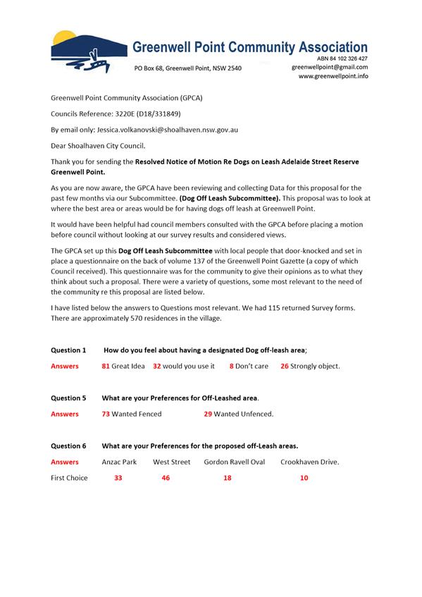
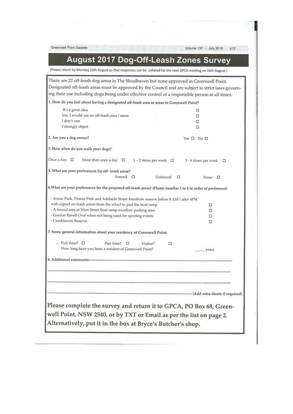
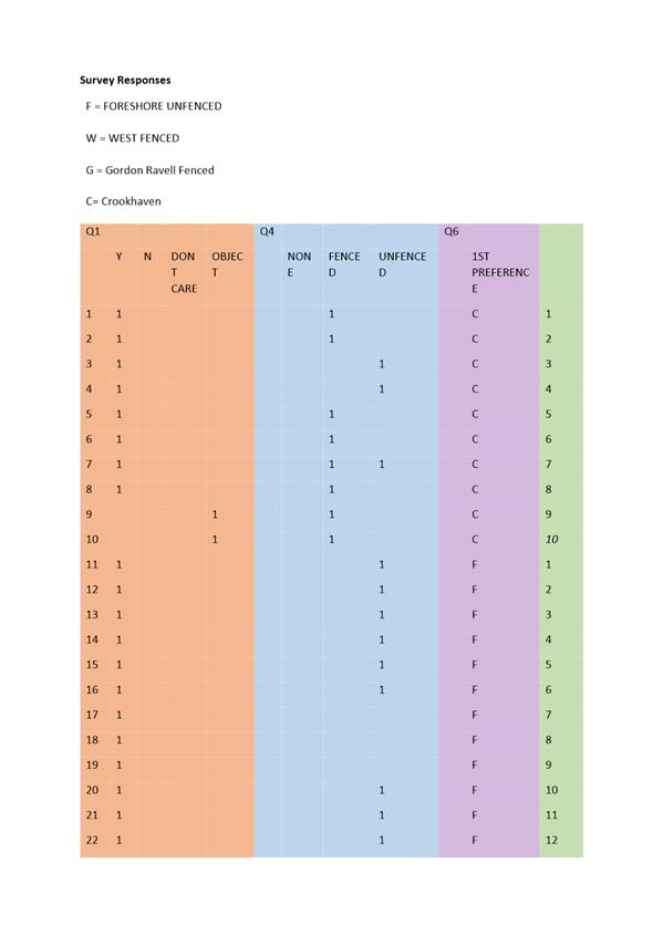
Greenwell Point Community Association (GPCA). A response was received from GPCA
on 9 October and is provided at Attachment 1. The response from GPCA
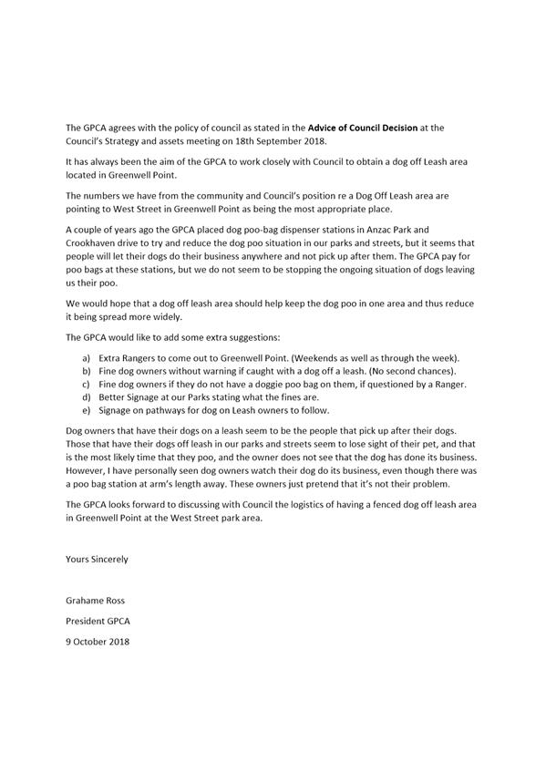
indicates the following:
2. Following the
community survey, West Street is seen as the most appropriate location for an
off-leash dog area.
3. GPCA have
provided doggy-bag dispenser stations in Anzac Park and Crookhaven Drive to
reduce undisposed animal excrement, however these do not seem to stop the
ongoing situation of dog owners not picking up after their dogs.
4. Offer the
following suggestions:
a. Additional
ranger patrols in Greenwell Point, during the week and weekends.
b. Dog
owners be fined without warning if caught with a dog off a leash (no second
chances).
c. Dog
owners be fined if they do not have a doggy-bag on them, if questioned by a
Ranger.
d. Improved
signage at our Parks stating what the fines are.
e. Signage
on pathways for dog on Leash owners to follow.
5. GPCA looks
forward to discussing the logistics of a fenced off-leash dog area at the West
Street park area with Council.
Community Engagement
Sussex Inlet District
Investigation
Part 2 of the resolution of
Council from 28 July 2018 (MIN18.567) requires extensive community consultation
be undertaken on a shortlist of sites for potential off-leash dog areas in
Sussex Inlet District. This report is seeking direction on the shortlist of
potential sites so that Council staff are able to proceed with actioning this
part of the minute.
Greenwell Point Investigation
Part 3 of the resolution of
Council from 18 September 2018 (MIN18.703) required consultation with the GPCA
and its sub-Committee prior to making any decision of a fenced dog off-leash
area for Greenwell Point.
Since the Strategy and Assets
meeting, Council staff wrote to the GPCA and sub-committee requesting their
feedback on the matter for Council’s consideration. The feedback provided
is detailed in this report. It should be noted that the feedback received from
the GPCA, does not necessarily reflect the views of the whole community.
Subject to Council’s decision in respect to the recommendation of this report,
the response received from GPCA should be considered as part of the
comprehensive review of the Policy.
Policy Implications
Council’s Policy, Access
Areas for Dogs, was last reviewed in 2017 with the next review due in 2020. The
investigation of potential sites for off-leash dog areas in Sussex Inlet
District was undertaken outside of the review process of the Policy.
At the Councillor Briefing on 30
August 2018, Councillors indicated that the timing for the next review of the
Policy was not suitable. It was suggested that due to resourcing issues, an
external consultant could undertake a review of the Policy. Acknowledging the
inclination to review the policy immediately, it is recommended that the review
period be brought forward to early 2019.
In moving forward, Council could
consider doing bi-annual reviews to the Policy to address issues which arise
mid-operational period.
Financial Implications
Policy review
At the Councillor Briefing, two
directions were suggested, including:
1. Undertaking a
full review of the Access Areas for Dogs Policy subject to a detailed workshop
with the Councillors; and
2. In the interim
of any Policy review, establishing a position to fence all new dog off-leash
areas.
Depending on the direction of
Council, the options available will require the allocation of a budget
provision to facilitate a Policy review at this time. There is also no budget
allocation for the installation of fencing. A previous report to Council’s
Strategy and Assets Committee in July 2016 indicates that a full policy review
would cost in the order of up to $120,000.
It is also noted that the
extensive community consultation required by MIN18.567 has not been separately
resourced or budgeted for at this stage.
Signage Trial and Fenced
Off-leash Dog Areas
At the Strategy and Assets
Committee meeting on 18 September 2018, Council considered a Notice of Motion
in relation to a fenced off-leash dog area at Greenwell Point and undertaking a
trial of new signage printed on pathways. Provision of signage on pathways will
require a budget of approximately $5,000 for graphic design, sign printing
(stencil) and delivery for at least two printed signs. Fencing is expected to
cost up to $20,000, depending on the ultimate size of the area. As per the
recommendation, it is suggested that these matters should be considered
subsequent to a comprehensive policy review.
|

|
Strategy and
Assets Committee – Tuesday 16 October 2018
Page
1
|


|

|
Strategy and
Assets Committee – Tuesday 16 October 2018
Page
1
|
SA18.235 Installation
of Bollards - Marine Vegetation Protection - Jacob Ellmoos Reserve, Sussex
Inlet
HPERM Ref: D18/326935
Group: Finance
Corporate & Community Services Group
Section: Recreation,
Community & Culture
Attachments: 1. Saltmarsh
Brochure - DPI Fisheries ⇩
2. Permit to Harm - Jacob
Ellmoos Reserve - Sussex Inlet - DPI Fisheries ⇩
Purpose / Summary
To report to Council prior to
the installation of bollards and signage to demarcate and protect coastal
Saltmarsh in Jacob Ellmoos Reserve, Sussex Inlet - in accordance with
MIN18.475.
Options
1. Install bollard
barriers to protect identified Saltmarsh areas at Jacob Ellmoos Reserve to
comply with NSW DPI Fisheries (Fisheries) issued Permit: PN18/22 in order to
protect identified coastal Saltmarsh protected areas – this is the
Fisheries recommended course of action. Notify neighbouring residents of
Council’s Resolution prior to installation and provide Fisheries’
brochure for their information.
Implications: Bollard barriers will be installed at
the foreshore reserve. Effective protection of Saltmarsh communities in
compliance with Fisheries Permit. Clear demarcation of protected areas for
Council mowing staff will reduce potential for penalties. Potential opposition
from residents.
2. Install
Fisheries signage at key entry points to the area.
Implications: Education of local community
regarding legislation and penalties associated with protected areas of
Saltmarsh.
3. Install
continuous fencing around protected Saltmarsh areas. Install Fisheries signage
at close intervals along fencing.
Implications: Additional infrastructure at coastal
reserves. May incur additional cost – no quotes sought by staff at this
time. Unsightly infrastructure, and likely strong community opposition. Clear
demarcation of protected areas for Council mowing staff will reduce potential
for penalties.
4. Do not install
barriers around protected Saltmarsh areas. Install Fisheries supplied signage
at entry points to reserve.
Implications: Saltmarsh areas remain vulnerable to
continued harm. Thorough training and awareness required for all relevant
Council staff to not mow in protected areas. Failure to protect Saltmarsh areas
leaves Council liable to penalties from Fisheries if protected areas are
damaged. Members of the public may be more likely to incur penalties due to
being unaware of protected areas.
Background
This Report is to advise Council
of the proposed installation of bollards at Jacob Ellmoos Reserve, Sussex
Inlet, in accordance with the Resolution from Council’s Ordinary Meeting
of 26 June 2018, MIN18.475:
That:
3. Prior to bollards being installed
in foreshore reserves, a report be provided to Council on their location.
Installation is proposed due to
the requirement under the Fisheries Management Act 1994 No 38 Part 7, that
Council ensures the protection of marine vegetation on foreshore
reserves. The applicable Section of the Act is as follows:
Fisheries
Management Act 1994 No 38
Part 7 Protection of aquatic habitats
Division 4 Protection
of mangroves and certain other marine vegetation
204 Application
and interpretation
(2)
In this Division:
Foreshore means any land adjacent to public water land, or adjacent
to an area that is the subject of an aquaculture lease, that is below the
highest astronomical tide level of the waters by which the land or area is
submerged.
Harm has the same meaning it has in Part 7A.
marine
vegetation means marine vegetation,
whether living or dead.
protected
area means any public water land, or
any area that is the subject of an aquaculture lease, and includes:
(a) that
part of the foreshore of any public water land or area that is the subject of
an aquaculture lease that is below the mean high water mark of the waters by
which the land or area is submerged, and
(b) any
other part of the foreshore of any public water land or area that is the
subject of an aquaculture lease that is declared by the Minister, by order
published in the Gazette, to be a protected area.
205 Marine
vegetation—regulation of harm
(1)
This section applies to:
(a) mangroves,
or
(b) seagrasses,
or
(c) any
other marine vegetation declared by the regulations to be marine vegetation to
which this section applies,
but does not
apply to protected marine vegetation under section 204A.
(2)
A person must not harm any such marine
vegetation in a protected area, except under the authority of a permit issued
by the Minister under this Part.
Maximum penalty: In the case of a corporation, 2,000
penalty units or, in any other case, 1,000 penalty units.
The current rate of “penalty
units” is $110 per unit, resulting in penalties of up to $220,000 for
corporations and $110,000 in any other case.
Saltmarsh Flora and Fauna
The foreshores of Sussex Inlet are a
major asset to the community and visitors to the area. Coastal Saltmarsh
is a low growing intertidal community of plants providing habitat and food for
marine and land animals. Saltmarsh communities can be found growing in patches
inundated by the highest astronomical tides (spring tides) along the foreshore
reserve.
Saltmarsh performs a pivotal role in
the conservation of fish stocks. It provides habitat, shelter and food and is a
key component in the life cycle of species such as Yellowfin Bream, Mullet,
Garfish, Sand Whiting, and Prawns. Saltmarsh protects the fragile ecological
zone between the marine environment and the land and ensures the Sussex Inlet
waterways stay healthy and productive.
Due to historical loss and
continuing threats to Saltmarsh areas, along with the recognition of its
importance in maintaining healthy estuaries and fish stocks, Saltmarsh has been
classified as an ‘Endangered Ecological Community’. It is protected
under:
· the NSW Fisheries
Management Act 1994,
· the NSW Threatened
Species Conservation Act, and
· the Federal
Environment Protection and Biodiversity Conservation Act.
This means that Council is obliged
to protect areas of Saltmarsh within public reserves to assist in regeneration
of the communities. The Department of Primary Industries, Fisheries regulates
compliance with this legislation.
Mowing
Historical practice at the
reserve has included the mowing of large areas of Saltmarsh by both Council
staff and local residents who have at times undertaken mowing without Council
permission.
Upon advice from Fisheries in
2017, Council staff ceased mowing activities at the reserve. Staff
received complaints from members of the public that the mowing had not been
maintained.
In response to community
requests, Council contacted the Fisheries to request permission to continue to
mow the reserve. Staff have been liaising with Fisheries staff to assess the
condition of the Saltmarsh in the reserve and identify areas suitable for
regeneration, along with areas where Council can continue to mow.
Council has now been issued with
Permit PN18/22 from Fisheries (attached). The Permit gives permission to mow
certain areas of the reserve and specifies other areas within which Council is
now required to cease mowing to ensure the protection of the Saltmarsh plant
communities.
Due to the historical practice of
mowing the reserve, it is anticipated that there may be some continued
opposition to the initiative by members of the public, and it is likely that
some local residents may undertake mowing in the protected areas.
In order to meet Council’s
obligation to protect the vegetation, it is proposed that protected areas are
clearly designated and signposted for the information of the public. This will
ensure that:
· members of the
public are alerted to the legislative requirements and penalties that apply,
· Council has done
everything it can to protect the public from incurring penalties due to people
being unaware of the legislation and the manner in which it applies to the
reserve,
· clear demarcation
of protected areas for Council mowing staff will reduce potential for
penalties,
· Saltmarsh areas
are protected.
It is proposed that protected areas within the reserve be
identified with spaced bollards and 3 Fisheries-supplied signs be located at
key points to the area. This signage warns of the penalties applicable to
individual members of the public.
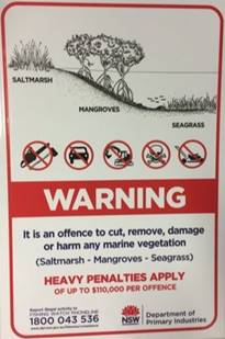
Council will
cease mowing the protected areas. Sixty six (66) individual bollards with
chamfered top edge (1,200mm x 150mm x 100mm treated pine), will be concreted
600mm in the ground. The above-ground height will be 600mm and the bollards
will be spaced at four (4) metre intervals surrounding the designated coastal
Saltmarsh protected areas.
Views and Environment
Council recognises the importance of
community access and views to Sussex Inlet, and has considered these in liaison
with Fisheries, when identifying Saltmarsh areas to be protected. Saltmarsh is
a predominantly low growing community, the largest rushes reaching less than 1m
in height.
A brochure will be provided to
neighbouring residents that provides detailed information regarding the Saltmarsh
(attached). This brochure illustrates that mature, protected Saltmarsh is an
attractive foliage, providing numerous benefits for seaside environments.
Council has committed to the regular
removal of any Casuarina (She-Oak) saplings that may sprout within the area
protected by the bollards, along with the maintenance of existing access tracks
to the Inlet. This will ensure that the height of the regenerating foliage
stays low.
Mowing and
maintenance of the reserve and Saltmarsh areas can only be undertaken by
Council. It is proposed that Council display signage to inform residents that
it is an offence under the Fisheries Management Act 1994 to cause harm to
Saltmarsh or any other marine vegetation without a permit.
Community Engagement
Due to the extended time since
initial advice to residents was issued, staff propose to send further
notification to residents on when the installation is scheduled. The attached
brochure will be included.
The advice will also be sent to the Community Consultative
Body, Sussex Inlet and District Community Forum, and signage as above will be
erected in the reserve.
Policy Implications
Council will meet legislative
requirements.
Financial Implications
Council has obtained a quote to
install 66 individual bollards, at $5,227.20 (GST Incl), and signage to be
installed by staff, quoted at $270. The works can be funded from
Council’s Minor Improvements Budget.
Breach of Permit:
Maximum penalty for breach of
Permit by Council staff is 1,000 penalty units. The current rate of
“penalty units” is $110 per unit, resulting in penalties of up to
$110,000.
Risk Implications
Failure to implement PN18/22 may
result in loss of habitat for native flora and fauna.
Financial implications may be
applied to Council if Fisheries deem that a breach of Permit has occurred.
|
|
Strategy and
Assets Committee – Tuesday 16 October 2018
Page
1
|
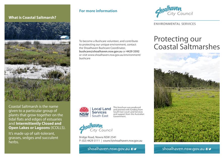
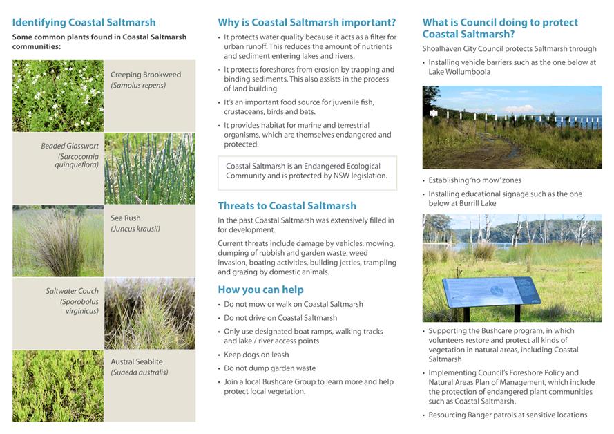
|
|
Strategy and
Assets Committee – Tuesday 16 October 2018
Page
1
|
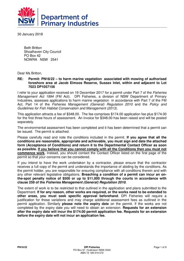

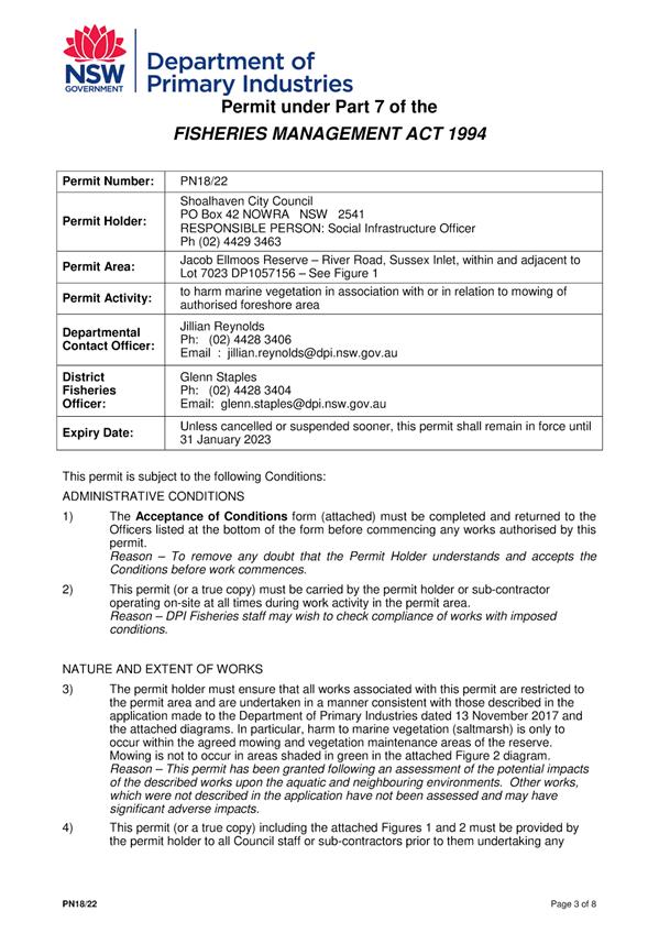
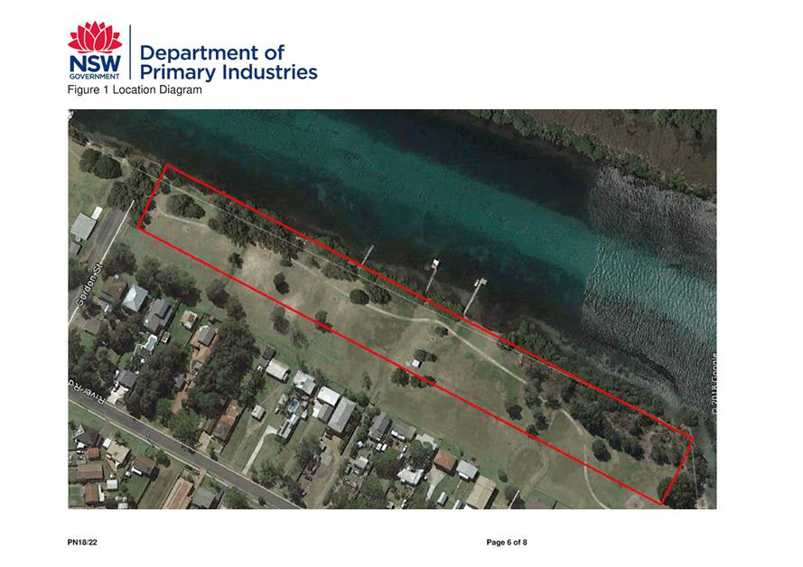
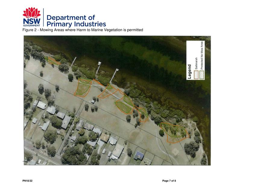
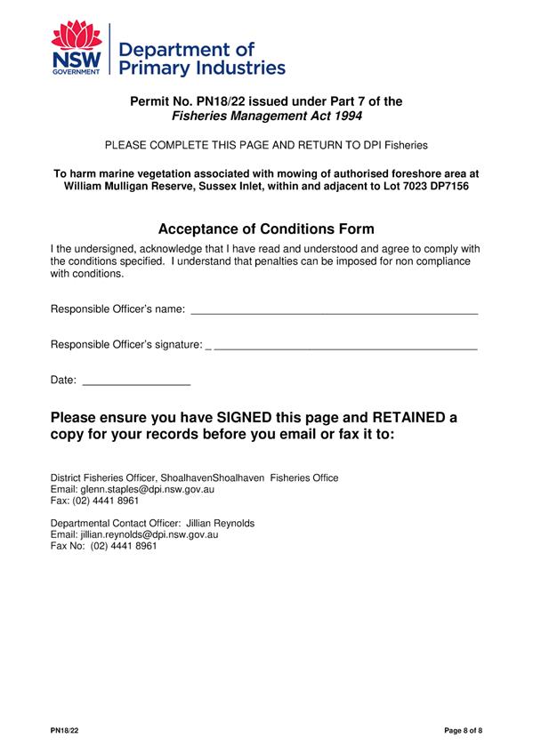
|
|
Strategy and
Assets Committee – Tuesday 16 October 2018
Page
1
|
SA18.236 Establishment
of Alcohol Prohibited Area - Huskisson Carnival
HPERM Ref: D18/330739
Group: Finance
Corporate & Community Services Group
Section: Recreation
Community & Culture
Attachments: 1. Audit
Report - Huskisson Carnival (Confidential - under separate cover)
Purpose / Summary
To
consider a proposal to establish an Alcohol Prohibited Area for the duration of
the Huskisson Carnival annually during December and January.
|
Recommendation
(Item to be determined under delegated authority)
That Council establish an Alcohol
Prohibited Area for the duration of Huskisson Carnival at Huskisson Oval
annually during December and January.
|
Options
1. As recommended.
Implications: Reduction of risk of harm to
patrons and general public at and in the environs of the annual Huskisson
Carnival.
2. That Council not
proceed with the establishment of the Alcohol Prohibited Area for the Huskisson
Carnival.
Implications: May result in the increase of
anti-social behaviour, injury and property damage resulting from irresponsible
drinking. This would not give the necessary powers to Police to restrict
anti-social behaviour.
Background
Following a disturbance on
Australia Day outside the perimeter of the Huskisson Carnival 2018, it was
requested that a Risk Assessment Audit Report be conducted for the purpose of
review by Shoalhaven City Council and NSW Police with the need to evaluate the
recommended strategies to reduce or control risk of public disturbance. The
Risk Assessment Audit Report from Joylands Amusements Pty Ltd for the Huskisson
Carnival is attached (confidential).
The Report identifies specific
Risks and Hazards, as well as Potential Risks of Harm. Hazards identified
included:
· Public
bringing alcohol onto carnival site,
· Intoxication
– alcohol and drugs,
· Underage
Intoxication.
Potential Risks of Harm
included:
· Business
damage, infringements,
· Intoxication
risks,
· Patron
dissatisfaction (disharmony based on behaviour of intoxicated patrons),
· Patron
injury (resultant from intoxication, violence, slips, trips and falls),
· Patron
illness (dehydration, headaches),
· Patron
overdose and potential fatality,
· Asset
loss (future claims and PR/damage),
· Patron
dissatisfaction – behavioural change, patron and crowd degeneration,
· Patron
Injury (aggression and affray).
At a meeting on the 6 July 2018,
Council staff and NSW Police representatives met to discuss the Risk Management
Audit Report. The following issues were discussed and identified for action:
· An
Alcohol Prohibited Area be established during the December/January holiday
period on the oval where the Carnival is located, including the toilets,
· Temporary
lighting poles will be installed to illuminate the toilet area to discourage
this area being used as a gathering point for the consumption of alcohol and
anti-social behaviour,
· Temporary
fencing will be investigated to be installed around the toilet area,
· One
entrance into the Carnival and one entrance out will be established as a
security check point.
The Alcohol Prohibited Area will
be established in alignment with Section 632A of the Local Government Act 1993
on the Huskisson Oval as the map indicates below.
Lot 1 DP 1169683
Park St, HUSKISSON 2540
The Local Area Commander
requested and endorsed this decision. NSW Police have advised (9 February
2018), that the zone will enable Police enforcement.
Community Engagement
This matter was raised with
Council by the NSW Police Local Area Command arising from an incident on
Australia Day and relates only to the Huskisson Carnival. The proposed
actions are in response to concerns for public safety and are based on a risk
audit. The signage will be erected at Huskisson Oval for the duration of
the Carnival during December and January, annually. The proposed actions have
the support of the NSW Police Local Area Commander and will give them the
necessary powers to restrict anti-social behaviour. The local Community
Consultative Bodies have been contacted to advise them of this report going to
Council.
Policy Implications
Recommendation aligns with
Council’s Event Management Policy.
Financial Implications
The direct costs associated with
the establishment of the Alcohol Prohibited Area includes general
administration costs and the erection or placement of a sticker on signs, which
can be funded within the current year’s budget.
Risk Implications
Recommendation will promote risk
minimisation at annual Huskisson Carnival event.
|
|
Strategy and
Assets Committee – Tuesday 16 October 2018
Page
1
|
SA18.237 Proposed
Pump Track at Jerry Bailey Oval, Shoalhaven Heads - Community Consultation
Outcomes and Next Steps
HPERM Ref: D18/290897
Group: Finance
Corporate & Community Services Group
Section: Recreation
Community & Culture
Attachments: 1. Request
for BMX Pump Track - Shoalhaven Heads Community Forum ⇩
2. Proposed
Plans for BMX Pump Track - Shoalhaven Heads Community Forum ⇩
3. Proposed
Activation Strategy for BMX Pump Track - Shoalhaven Heads Community Forum ⇩
4. Summary
of Submissions ⇩
5. Summary
of Survey Responses ⇩
6. Behaviour Mapping Outcomes ⇩
Purpose / Summary
The purpose of this report is to inform Council of the
Shoalhaven Heads Community Forum’s proposal to construct a BMX Pump Track
on Jerry Bailey Oval, Shoalhaven Heads and to provide a summary of the
community consultation outcomes and to recommend a way forward.
|
Recommendation
(Item to be determined under delegated authority)
That Council supports the
proposal by Shoalhaven Heads Community Forum to construct a BMX Pump Track on
Jerry Bailey Oval, Shoalhaven Heads, subject to Shoalhaven Heads Community
Forum supplying Council with:
1. Revised
Activation Strategy to include a five-year plan for activating the BMX Pump
Track;
2. Evaluation
Criteria as per Council’s Policy; and
3. Confirmation
that they have secured donations and in-kind contributions to fund and
deliver the project.
|
Options
1. Council supports
the proposal for the Shoalhaven Heads Community Forum to implement a local BMX
Pump Track at Jerry Bailey Oval, Shoalhaven Heads, per the proposal and revised
plans, which can be viewed in Attachment 1 and Attachment 2.
Implications:
This is the preferred option as the proposal is generally consistent with
Council’s Policy, and community consultation undertaken by Council staff
has indicated that majority of the community are in support of the proposal.
2. Adopt an
alternative solution to support the proposal and provide a monetary
contribution of $7,000.
Implications: Council does not have any funds
available in the BMX budget in order to provide a monetary contribution of
$7,000. Council would need to identify an alternative budget source if they are
to adopt this option.
3. Adopt an
alternative solution to not support the proposal.
Implications: Whilst there have been objections in
relation to the proposal from the Save Jerry Bailey Oval Inc and other
submitters, the community consultation outcomes have indicated majority support
for the proposal.
Background
On 8 December 2016, the
Shoalhaven Heads Community Forum sent a proposal to Shoalhaven City Council for
the construction of an asphalt pump track to be constructed on Jerry Bailey
Oval, Shoalhaven Heads. The proposal was assessed against Council’s
Provision of Local Area BMX Circuits Policy, where it was determined that the
proposal was inconsistent with the Policy, predominantly due to the use of
asphalt material.
On 7 June 2017 the Shoalhaven
Heads Community Forum presented the proposal to the Shoalhaven Sports Board,
where it was resolved (SB17.9, D17/88428) to:
“Support in principle the proposed Heads pump track
and look forward to seeing this project go ahead.”
On 8 March 2018 the Shoalhaven Heads Community Forum
submitted a request for a revised BMX Pump Track proposal, taking into
consideration Council’s previous comments relating to the asphalt
material. The revised proposal was for an unsealed pump track to be constructed
on Jerry Bailey Oval, Shoalhaven Heads. A copy is provided at Attachment 1.
The plans for this proposal were forwarded to Council on 2 June 2018. A copy of
the plans for the unsealed pump track is provided at Attachment 2. As
per Council’s Policy, the Shoalhaven Heads Community Forum also provided
an Activation Strategy on 17 September 2018 for the proposed BMX Pump Track
which outlines how they plan to fund the development of the proposal, as well
as how to ensure that it remains well used. The Activation Strategy is provided
at Attachment 3.
Policy Considerations
Council’s Policy Provision
of Local Area BMX Circuits specifies the requirements in considering a BMX Pump
Track in terms of eligibility, site selection criteria and construction
guidelines.
The proposed BMX Pump Track is
generally consistent with the site selection criteria and construction
guidelines. It is noted that the information submitted by the Shoalhaven Heads
Community Forum does not include evaluation criteria, and the activation
strategy submitted is not a 5-year strategy. If Council resolve to support the
proposed BMX Pump Track, this information will need to be provided as a
condition of support.
The proposal is deemed to comply
with the eligibility, site selection criteria, and construction guidelines
outlined in the policy.
Other Considerations
Native Title
Jerry Bailey Oval is Crown Land
in which Council is the Crown Land Manager. Any works undertaken on Crown Land
must be assessed against Native Title, which Council’s Native Title
Manager completes. This proposal was referred to the Native Title Manager to
assess the potential impacts of the proposal on Native Title. The assessment
deemed:
· Construction
and operation of the BMX Pump Track is consistent with the Reserve purpose,
being public recreation;
· The
proposed BMX track does not fall within the definition of “public
works”, as it is not a fixture or major earth work and could be removed
if required; and
· Under
Subdivision J of the Native Title Act 1993, the non-extinguishment
principal will apply and no notification to native title parties is required.
Aboriginal Land Claim
Jerry Bailey Oval is subject to
an existing Aboriginal Land Claim (ALC), being the 2017 blanket claim. The reserve
was lawfully utilised for recreation prior to the land claim and on the date
the claim was lodged. The proposal does not modify the use of the site for
public recreation, in accordance with the Reserve purpose.
Review of Environmental
Factors
A Review of Environmental
Factors (REF) has been completed for the proposed BMX Pump Track by
Council’s Environmental Officer. The REF determined:
· The
impact is considered acceptable considering the nature and purpose of the
impact and benefits it would provide;
· The
impact would only affect a small number of people in opposition to the
facility, whilst the facility would benefit the whole of the community;
· The
impact is unlikely to result in a threat to the health and safety of
individuals or the community;
· An
assessment of the statutory matters of consideration reveals no potential
medium or high adverse impacts;
· All
identified potential negligible or low adverse impacts are considered
acceptable considering the need for the activity; and
· The proposed
activity is unlikely to have a significant effect on threatened species or
endangered ecological communities.
Community Engagement
In considering the proposal from
the Shoalhaven Heads Community Forum, Council undertook community consultation
on the proposed BMX Pump Track between 22 August and 7 September 2018
(inclusive). During this time, a Get Involved page was established which
allowed community members to view the submitted documents, make a submission on
the proposal and complete a survey. The community consultation period was
advertised in the local newspaper (Heads News), with supplementary letters sent
to the Community Consultative Body and other community groups, door knocks to
adjacent properties, and social media posts on Council’s Facebook page.
During the community
consultation period, a total of 15 submissions were received from 14
individuals. Each submission received has been summarised and responded to in Attachment
4. Copies of the submissions will be available in the Councillors’
Room prior to the Strategy and Assets Committee Meeting. From these
submissions, 9 were in opposition to the proposal and 6 were in support. The
themes of the submissions in opposition to the proposal were as follows:
· No
evidence to suggest the need for the track, the demographic of the locality
does not warrant it, and existing facilities at Jerry Bailey Oval are
under-utilised.
· Destruction
of open space that is used for activities and the nearby vegetation.
· Proximity
to residential land use and impact to residents including acoustic, dust,
amenity and other impact.
· There
is a current lack of parking options and there will be increased parking and
traffic issues as a result of the facility.
· The
pump track will provide a space for adolescents to gather of evenings.
During the community
consultation period, the survey was completed by 263 people, 161 of whom reside
in Shoalhaven Heads. The survey results revealed a converse outcome to the
written submissions received. A total of 81% of the survey participants
currently use or visit Jerry Bailey Oval, with 91% believing the Shoalhaven
Heads community would use and benefit from a pump track. A total of 82% of
participants would either use the pump track themselves or have someone in
their household who would use it. Of the survey participants who are not
residents of Shoalhaven Heads, 89% would travel there to use the pump track. A
full summary of the survey results is included in Attachment 5.
In addition, the South Coast
Register published an article on the proposal on 1 September 2018 which
contained a poll, asking “Do you think in general the local community
will benefit from a BMX Pump Track at Jerry Bailey Oval?”. As of 17
September 2018, 86.23% voted “Yes” and 13.77% voted
“No”.
Council staff conducted a door
knock of the houses directly affected by the proposal on Wagin Street and
Woolstencraft Street, Shoalhaven Heads during the community consultation period
(5 September 2018). This door knock was aimed at raising awareness of the
proposal and ensuring that nearby residents had the opportunity to be involved
in the community consultation. It was noted that all of the residents spoken to
had knowledge of the proposal, and many had either completed the survey or sent
a submission to Council.
Behaviour mapping was conducted
by Council staff over four site visits at Jerry Bailey Oval to determine how
the space is currently used, and the levels of passive surveillance provided by
these users. It was noted that the site of the proposed pump track was only
observed to be used occasionally by people passing through the oval or walking
their dogs. The amount of people using the oval in general would provide
adequate passive surveillance to the facility. It is noted that the findings of
the behaviour mapping are limited due to the mid-week timing. A summary of the
behaviour mapping is provided at Attachment 6.
Community Groups
A number of community groups and
organisations separately organised their own petitions in relation to the
proposed BMX Pump Track. The outcomes of these are outlined below. It should be
noted that whilst these have been identified in this report, the petitions were
not considered as formal submissions, with the exception of the Shoalhaven
Heads Public School which was identified as a single submission.
Shoalhaven Heads Community
Forum
The Shoalhaven Heads Community
Forum organised a petition in support of the proposed BMX Pump Track, which had
972 signatures. This petition was undertaken prior to Council conducting the
community consultation period.
The Shoalhaven Heads Community
Forum have also held several community meetings and drop-in sessions to
determine community support and volunteers for fundraising, planning and
construction of the track. Flyers and newsletters with information on the
proposal were distributed by the Shoalhaven Heads Community Forum around the
community.
The “Shoalhaven Heads” Facebook page created an
online poll, seeking feedback on “Are you in favour of the construction
of the BMX Pump Track on Jerry Bailey Oval?”. This poll received a 90%
vote of “Yes” and a 10% vote of “No” as of 7 September
2018.
Save Jerry Bailey Oval Inc.
Save Jerry Bailey Oval Inc.
organised a petition in opposition to the proposed BMX Pump Track, which had
118 signatures. This petition was undertaken prior to Council conducting the
community consultation period.
As part of this campaign, the group distributed flyers
around the community with information on why the proposal should not go ahead,
as well as providing numerous submissions to Council providing reasons why they
oppose the construction of the track.
Shoalhaven Heads Public
School
The Shoalhaven Heads Public
School have a petition in support of the proposed BMX Pump Track, which has 175
signatures from staff and students. In 2017, the school had approximately 195
students enrolled from years K-6.
Policy Implications
As described above, the proposal has been assessed against
Council’s Provision of Local Area BMX Circuits Policy and is
considered to be generally in accordance with the Policy.
Financial Implications
Council’s Policy specifies
that a maximum Council contribution of up to $7,000 can be provided however it
is noted that the BMX Budget was not replenished this Financial Year, therefore
there are no available funds for this project. Alternatively, Council
could provide in-kind contributions through the provision of soil for the
proposal, if suitable excess soil is available.
The proposed pump track at Jerry
Bailey Oval is a community lead project, being pursued by the Shoalhaven Heads
Community Forum. The Shoalhaven Heads Community Forum have received a $10,000
grant to assist with the initial design and survey. It is proposed to complete
the project by sourcing further grant funding, donations and in-kind assistance.
Below is a breakdown and
estimate of costs, provided by the Shoalhaven Heads Community Forum, which is
described in more detail in Attachment 3.
|
Item
|
Estimated cost
|
Funding source
|
|
Site
Survey
|
Not
specified
|
Completed
by LBG at no cost
|
|
Initial
design and construction supervision
|
$10,000
|
Funded
by $10,000 grant received from Gareth Ward
|
|
Soil/clay/gravel
|
$20,000
|
Proposed
to be sourced as in-kind donations from Environmental and Natural Resource
Solutions
|
|
Civil
construction and equipment
|
$30,000
- $40,000
|
Proposed
to be provided as in-kind donations from local contractors
|
|
Labour
|
$10,000
- $15,000
|
Proposed
to be provided as in-kind works by local volunteers
|
|
Landscaping
|
Not
specified
|
-Pending
$7,000 Council contribution as per the Policy.
-Donations
and in-kind support from businesses and volunteer groups
|
Conclusion
The proposed BMX Pump Track
generally is in accordance with the Provision of Local Area BMX Circuits
Policy. Community consultation undertaken by Council staff has indicated that
the majority of the community are in support of the track, with a high
percentage of residents and visitors indicating that they will frequently use
the track. It is recommended that Council support the proposal by Shoalhaven
Heads Community Forum.
It is noted that many of the
proposed in-kind works and donations identified by the Shoalhaven Heads
Community Forum do not appear to have been confirmed. Council must ensure that
the Shoalhaven Heads Community Forum has the capacity to fully deliver the project
prior to formal approval.
|
|
Strategy and
Assets Committee – Tuesday 16 October 2018
Page
1
|
|
|
Strategy and
Assets Committee – Tuesday 16 October 2018
Page
1
|
|
|
Strategy and
Assets Committee – Tuesday 16 October 2018
Page
1
|
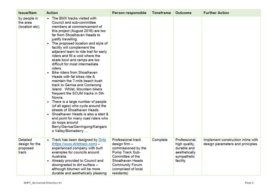
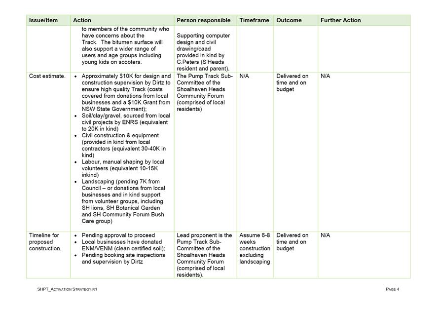
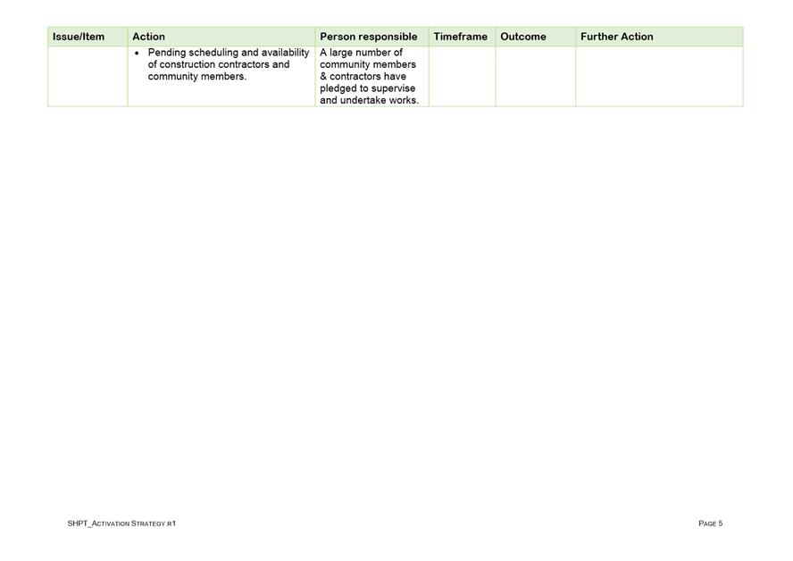
|
|
Strategy and
Assets Committee – Tuesday 16 October 2018
Page
1
|
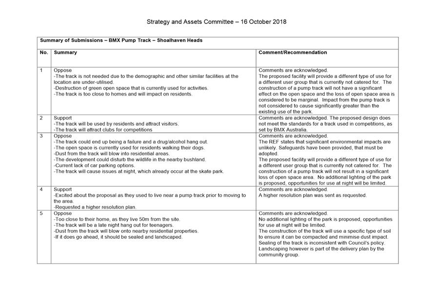
|
|
Strategy and Assets
Committee – Tuesday 16 October 2018
Page
1
|
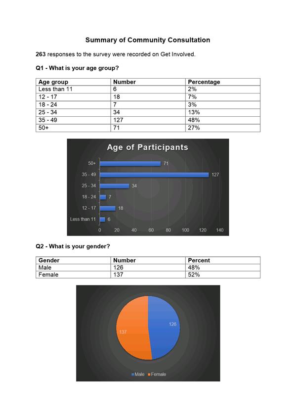
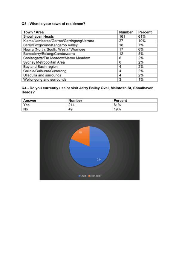
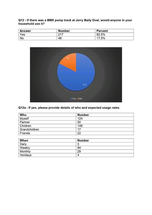
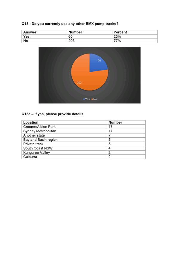
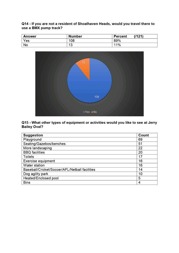
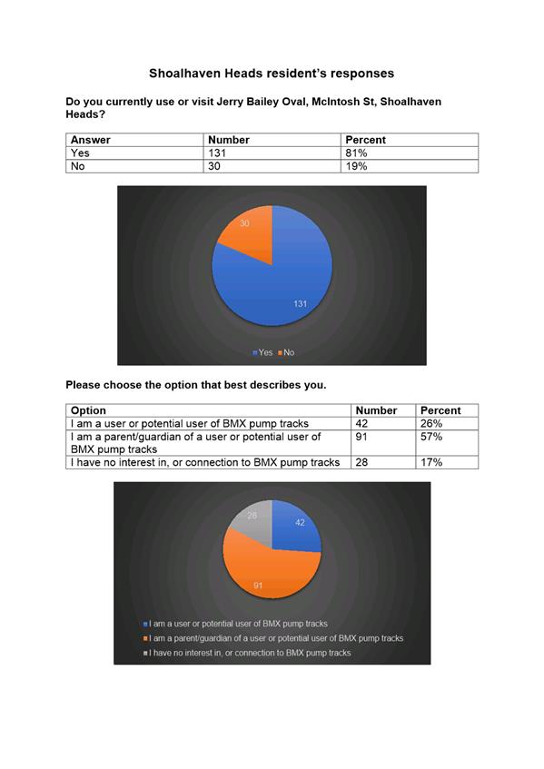
|

|
Strategy and
Assets Committee – Tuesday 16 October 2018
Page
1
|
|

|
Strategy and
Assets Committee – Tuesday 16 October 2018
Page
1
|
SA18.238 Ulladulla
Skate Park - Audit Report and Recommendations for Facility Update
HPERM Ref: D18/322224
Group: Finance
Corporate & Community Services Group
Section: Recreation
Community & Culture
Attachments: 1. Audit
Report - Ulladulla Skate Park (under separate cover) ⇨
Purpose / Summary
To determine a solution to
return the skatepark infrastructure at Ulladulla Sports Park to a high standard
and to seek direction for expansion.
|
Recommendation
(Item to be determined under delegated authority)
That Council:
1. Receive
the Ulladulla Skate Park Audit Report for information and note that the
report identifies the estimated end of the useful life of the facility will
be reached at the end of 2023.
2. Limit
repairs to the existing facility at this time to repairs that the General
Manager (Director Finance, Corporate & Community Services) deems
appropriate to address high risk defects.
3. Utilise
the current budget allocation of $200,000 to engage a consultant to prepare a
concept and detail design for the construction of a replacement facility of
the Ulladulla Skate Park that considers the recommendations of the Ulladulla
Skate Park Audit Report and in consultation with community. Prior to
proceeding to detail design, Council receive a report with the concept design
for endorsement.
4. Develop
a funding plan for the replacement of the Ulladulla Skate Park facility that
identifies funding sources, including grant funding opportunities, over a
number of budget cycles commencing 2019/20 for inclusion in Council’s
long-term financial plan.
5. Commence
the preparation of the master plan for the Ulladulla Sports Park using any
savings from the current budget allocation of $200,000 for the Ulladulla
Skate Park.
|
Options
1. Adopt the
recommendation.
Implications: This option
is generally in accordance with Council’s previous minute from February
2018 seeking to upgrade the skate park facility, however the recommendation
seeks to establish the level of upgrade in consultation with community. This
recommendation seeks to avoid any repairs at such time as the options to
construct a new district or regional level facility will result in the
demolition of the existing facility.
2. Adopt an
alternative recommendation seeking to repair the existing facility as per
Option 1 of the Audit Report.
Implications: This option addresses rectification
of condition items only. The refurbishment can be carried out at different
levels depending on the desired lifespan that is required of the facility. This
option is a short-term solution to fix high priority safety hazards. These
works are deemed as the minimum required works to ensure the facility can
fulfil its remaining life. This option is not considered to be in line with
community expectations.
Background
The Ulladulla Skate Park
facility at the Ulladulla Sports Park was built in approximately 1997/1998. The
Ulladulla Skate Park was once considered to be in the top 10 of skate
facilities, but over the last decade it has become somewhat run down and in
dire need of repair to reduce the risk of injury to individuals who use the
facility. The community who use the facility anticipated that the cause of the
condition of the skate park was due to concrete cancer.
In February 2017, a Mayoral
Minute was considered by the Ordinary Council in relation to the Ulladulla Skate
Park. The Ordinary Council resolved (MIN18.109) that:
1. The
West Ulladulla Skate Park funding opportunities and plans for the
extension be subject to a Councillor Briefing.
2. Council
support a budget allocation of $400,000 over a two-year budget cycle commencing
in 2018/2019 to upgrade the West Ulladulla Skate park to become the regional
facility that has been promised since the first stage over 20 years ago.
3. This
project be partially funded from the Skate Park Funds and an additional capital
works for the 2019/2020 budget and that Council work towards obtaining grant
funding and the physical work be undertaken in one stage.
4. Council also
undertake urgent repairs on the Ulladulla Skate Park to ensure that the users
are not at undue risk due to surface damage. This could be funded from the
balance of the funds in the skate funds.
Following the Council
resolution, Convic (project consultant) was engaged to undertake an Audit
Report of the facility. The report provides a condition and function assessment
of the existing facility and makes recommendations regarding rectification and
redevelopment work. Undertaking this report prior to making any decisions to
repair and extend the facility was considered important to ensure that any
works would be the more efficient and effective way of moving forward. A copy
of the Audit Report is provided at Attachment 1.
Audit Report – Findings
The Audit Report made the
following findings in relation to the condition of the facility, and
specifically its features, obstacles and landscape:
· There is evidence
of ground water seeping through the bowl which is displacing the transition
slabs.
· The concrete
surface is worn in most areas of the facility, with substantial cracking,
chipping and differential settlement.
· Concrete to coping
deterioration is apparent throughout the entire skate park.
· Coping in the bowl
is rusted through, while the coping tolerance across the facility is not to
standard practices.
· Expansion joints
have widened to a width that is not acceptable for skate surfaces.
· Concrete cancer
was not deemed to be present at the facility.
· There is erosion
present around the perimeter of the facility.
· The south eastern
section of the facility appears to be graded incorrectly, and as such does not drain
storm water sufficiently.
The Audit Report made the
following findings in relation to the function of the facility and specifically
its skate function, overall design and layout, and landscape and amenity.
· Most of the
facility functions adequately, however there are some areas particularly within
the street area that are outdated.
· There is little to
no allowance for beginners.
· There are limited
flow lines around the facility, directly affecting the potential user capacity.
Users tend to travel along two main flow lines, disregarding the majority of
the park.
· There are limited
refuge areas for users.
· The facility has
on site car parking.
· The facility is
fenced in, with a back of house feel.
· There is no DDA
access to the facility.
· There is no toilet
facility.
· The facility has
two bins, a drinking fountain and a small shelter.
· The facility has
limited seating.
· There is no safety
signage upon entry to the facility.
Based on the key condition and
function findings, the facility was given a ‘poor’ rating for
condition which suggests that the asset is in poor condition with severe
serviceability problems and needing rehabilitation immediately. There is a risk
to the community if the facility is to remain unrepaired and in service (25% of
life remaining – approximately 5 years). The facility was also
given a ‘poor’ rating for function, which suggest that there are
extensive design and layout flaws with major improvements necessary, and
minimal on-site amenities. Overall, the facility has been given a
‘poor’ rating.
Audit Report –
Recommendation
The Audit Report has identified three options with respect
to the repair and redevelopment of the skate park facility. Each of the options
seek to improve the safety, condition and function of the facility to varying
levels. In considering each of the options, the project consultant has
suggested that further community engagement should be incorporated in the
process to gauge the community response.
Option 1: Repairs of Condition
Findings Only
This option
will rectify the condition items as identified in the Audit Report, however
will not address the functional issues. This option is considered to be a
short-term solution to address the high priority safety hazards and groundwater
issues. If undertaken with regular maintenance, these works are the minimum
required works to ensure the facility can fulfil its remaining life with the
potential to extend the life span of the facility by a further 2 to 4 years.
The cost of this option is
$300,000 - $400,000.
Option 2: Construction of a New
District Level Facility
This option
involves the demolition of the existing facility, addressing any existing
groundwater issues, and the construction of a modern, district level youth
precinct. The new facility would be comparable to the existing facility in
capacity and function with the addition of catering to various user skill
levels.
Additional
landscape conditions such as lighting, seating, shade, improved access and
repositioning of the facilities would be considered as part of this option. The
scope of this facility should be determined once a budget is allocated, and
community engagement is undertaken.
This option
is recommended by the project consultant as it is considered to be the most
cost effective whilst addressing all of the condition and function issues outlined
in the Audit Report and extending the life span of the facility by a further 15
to 20 years.
The cost of
this option is $655,000 - $930,000.
Option 3: Construction
of a New Regional Level Facility
This option
involves the demolition of the existing facility, addressing any existing
groundwater issues, and the construction of a larger, regional level youth
precinct. The new facility would introduce modern style skate features to the
skate park, while also catering to various user skill levels. Additional youth
activation and recreation such as parkour, half-court basketball, ping pong
tables, and BBQ and picnic areas could also be considered.
Additional
landscape conditions such as lighting, seating, shade, improved access and
repositioning of the facilities would be considered as part of this option. The
scope of this facility should be determined once a budget is allocated, and
community engagement is undertaken. This option will extend the life span of
the facility by a further 15-20 years.
This option is approximately
$990,000 - $1,480,000.
Next Steps
In proceeding with any redesign or
redevelopment of the skate park facility it is considered necessary to
investigate the broader master plan for the Ulladulla Sports Park.
Council’s adopted Community Infrastructure Strategic Plan identifies the
park as having the potential to increase usage capacity of the park through the
provision of additional sporting facilities thereby making it a multi user
facility. It is recommended as part of the next steps that Council commence the
process of preparing a masterplan for the Ulladulla sports park which will
incorporate the new skate park facility, croquet courts, netball courts,
internal paths and more.
It should also be noted that Council
are currently working with Illawarra-Shoalhaven Joint Organisation, Office of
Sport, Venues NSW and Illawarra-Shoalhaven Councils to prepare a Sports
Facility Plan for the Illawarra-Shoalhaven Region. The plan will identify the
priority facilities for various sports which currently host or have the
potential to host regional, state and national level competition and events.
Through this process, skate parks will be considered for inclusion in the Plan
given the recent inclusion of skateboarding as an Olympic sport. Including the
Ulladulla Skate Park in this process would ensure that the project has
strategic merit, Local and State Government endorsement and bolster
Council’s position in making any grant funding applications for the
facility.
Community Engagement
Council staff have provided
regular updates to community members with regards to the progress of the audit
report.
The community is committed to
improving the skate park and has created a “Ulladulla Skate Park
Expansion 2018” Facebook page to document Council’s progress in
finding a solution to this problem with the infrastructure.
The community also mentions
continually the onset of skateboarding in the 2020 Olympics and how this could
be an opportunity for the youth in the southern Shoalhaven should the facility
improve through embellishments and expansion.
In planning for a new district
or regional facility, further community engagement is required in order to
coordinate the new layout and design with the users of the facility.
In preparing a master plan for
the Ulladulla Sports Park Council would need to undertake community
consultation with user groups and the broader community.
Financial Implications
The Audit Report identifies
three options in proceeding forward, which each have an approximate budget. The
anticipated costs (exclusive of GST) as specified by the project consultant are
as follows:
· Option
1 Repairs of Condition Findings Only: $300,000 - $400,000
· Option
2 Construction of a New District Level Facility: $655,000 - $930,000
· Option
3 Construction of a New Regional Level Facility: $990,000 - $1,480,000
The previous Council resolution
allocated a total of $400,000 budget over a two-year budget cycle between
2018/19 and 2019/20. This budget allocation will only cover Option 1 Repairs of
Condition Findings Only which would be inconsistent with the Council resolution
that seeks to establish a regional facility at Ulladulla Sports Park.
Funding to upgrade the skate
park to a district or regional level facility will require an additional
capital works budget. It is recommended that a funding plan is prepared which
considers funding sources for a replacement skate park facility. The funding
plan should consider identifying funding sources over a number of budget cycles
commencing 2019/20 for inclusion in Council’s long-term financial plan
and also include grant funding opportunities.
Further reports to Council once
a concept plan has been developed for a replacement facility will ensure
Council is able to allocate an appropriate budget for the construction of the
facility. The recommendation will see the project become shovel ready which
will ensure eligibility for future grant funding initiatives.
Risk Implications
Due to the condition of the
existing facility, there is risk of injury to users.
|
|
Strategy and
Assets Committee – Tuesday 16 October 2018
Page
1
|
SA18.239 Milton
Ulladulla Croquet Club Construction - Stage 1 - Revised Timeframes for
Completion
HPERM Ref: D18/323950
Group: Finance
Corporate & Community Services Group
Section: Recreation
Community & Culture
Purpose / Summary
To provide Council with an
update on the timeframes for the construction of Stage 1 of the Milton
Ulladulla Croquet Courts.
|
Recommendation
(Item to be determined under delegated authority)
That Council revise the timeframe
for the construction of the croquet courts as detailed in Part 4 of MIN17.323
to :
1. Commence
construction in fourth quarter of 2018/19 and
2. Complete
construction by of the courts in second quarter of 2019/20.
|
Options
1. Adopt the
recommendation.
Implications: This is the
preferred option as it allows Council staff to proceed with the current project
as planned.
2. Adopt an
alternative recommendation.
Implications:
Depending on the nature of the alternative recommendation, this may result in
further delays or potentially overspending the existing budget.
Background
In October 2016, Council’s
Strategy and Assets Committee received a report in relation to croquet court
expansion options at the Milton Showground. Following an assessment of the
impact of the expansion on the Showground, feedback received from adjacent
property owners and review of alternative options, Council staff reported the
investigation to Council’s Ordinary Meeting on 26 April 2017. At this
meeting Council resolved (MIN17.323) to:
1. Decline
the opportunity to construct a second croquet court at Milton Showground.
2. Actively
work with Milton Croquet Club to relocate the croquet facilities to suitable
venue within 18 months. The new location is to contain sufficient land
for construction of two courts and four courts in the future, a suitably sized
club house, fencing of an area for four courts; car parking spaces, landscaping
and other comparable facilities to those that the Club already has at the
Milton Showground.
3. Establish
a working group of available Councillors, Executive of Milton Croquet Club and
Council staff to facilitate the relocation.
4. Allocate
funding for project planning in 2017/2018; and construction of two croquet
courts to commence in the first quarter of 2018/2019, with the courts and
facilities completed by the end of the third quarter of 2018/2019.
5. Continue
to work with the Showground Management Committee and owners adjacent to Milton
Showground to formalise offsite parking options via a licence agreement to
increase capacity for future large events at the Showground.
6. Review
the Milton Showground Management Plan within 12 months, in consultation with
the Showground Management Committee.
7. Advise
both the Milton Ulladulla Croquet Club & Milton Showground Management
Committee of the above Council resolution.
8. Receive
a further report on the financing options for the new facility.
Following the Council
resolution, an investigation was undertaken by Council staff which led to the
identification of Ulladulla Sports Park. However the site came with conditions
in that there was an existing stockpile which required relocation to enable use
and construction of croquet courts. The site was considered to be the best
location and was ultimately supported by Milton Ulladulla Croquet Club (MUCC) committee
members.
A subsequent report was
considered by Council’s Strategy and Assets Committee on 19 August 2017
where it resolved (MIN17.788) to endorse the relocation of the MUCC from Milton
Showground to Ulladulla Sports Park, and allocated a budget of $350,000 to
relocate the existing stockpile on the site, $15,000 for the detail design of
the two croquet courts, and $750,000 for the construction of the courts. Allocated
monies towards the removal of the stockpile were significantly less than the
required amount by approximately $150,000 and the provision of funds for the
court construction exclude any clubhouse facilities.
Current Status of Croquet
Court Construction
Stockpile Relocation
Council commenced the relocation of the stockpile in August
2018. This commencement was delayed as a result of additional funding needing
to be identified for the stockpile removal. It is expected that the stockpile
relocation will be complete by November 2018. The relocation of the stockpile
was not anticipated as part of the original timeframe which informed the
Council resolution from April 2017, therefore this resulted in a delay of the
entire croquet project commencing.
Detail Design
The detail design of the croquet courts was completed in
June 2018.
Croquet Court Construction
The construction of the croquet
courts will be subject to a tender process. It is expected that this process
will commence in December 2018 following the completion of the stockpile
removal. This is expected to be a prolonged process as it will coincide with
the Christmas / New Year shut down period. It is expected that the construction
of the croquet courts will commence in April 2019 with completion in November
2019.
The proposed timeframes require a
revision to Part 4 of MIN17.323 to ensure that it reflects a timeframe that is
achievable.
Community Engagement
Throughout the detail design and
works process, Council staff have continually engaged with MUCC, including
providing updates at extraordinary Committee Meetings. Through this engagement,
MUCC have noted their disappointment in the delayed timeframes.
Financial Implications
A budget for the Milton Ulladulla
Croquet Club Construction Stage 1 has already been allocated which will include
the relocation of the stockpile, detail design and the construction of two
croquet courts. As noted previously, the budget allocation for the construction
of the croquet courts will not enable the provision of amenities / clubhouse. As
a separate exercise, Council staff have made an application to the Community
Sport Infrastructure Program through Sport Australia in September, seeking
grant funding for the provision of an accessible clubhouse facility at
Ulladulla Sports Park.
|
|
Strategy and
Assets Committee – Tuesday 16 October 2018
Page
1
|
SA18.240 Shoalhaven
Tennis - Decommission 2 Courts and Waive Outstanding Loan
HPERM Ref: D18/326924
Group: Finance
Corporate & Community Services Group
Section: Recreation
Community & Culture
Attachments: 1. Heads
News Article - A Double Fault - Volume 14, Issue 8, September 2018 ⇩
Purpose / Summary
To seek direction regarding
outstanding loan to Shoalhaven Heads Tennis Courts Management Committee.
To advise and seek support to
the decommissioning of Courts 3 & 4 at the Shoalhaven Heads Tennis Courts.
|
Recommendation
That Council
1. Waive
the outstanding loan amount of $7,500 to Shoalhaven Heads Tennis Courts
Management Committee,
2. Proceed
to decommission Courts 3 & 4 at Shoalhaven Heads Tennis Courts.
|
Options
1. Adopt the
recommendation.
Implications:
Shoalhaven Heads Tennis Courts Management Committee will be enabled to conduct
sound financial management of the two Tennis Courts in current usage.
2. Do not waive the
outstanding loan and continue to pursue recovery, assisting the Management
Committee with financial management of the debt.
Implications: The
Management Committee will be unable to meet future financial costs of
maintaining the facility and future resurfacing of Courts 1 and 2.
3. Do not
decommission Courts 3 and 4.
Implications: Increased financial burden for
Council. Maintenance of community infrastructure that is not justified by
historical records of usage and future projections. There would be significant
costs to resurface 4 courts which cannot be funded by the Management Committee
with current usage.
Background
In 1975 Courts 1 & 2 were
constructed with a concrete base.
In 1995 Courts 3 & 4 were
constructed with fibre crete base. The Management Committee obtained a loan
from Council for $45,000 to install.
In 2009 all four courts were
resurfaced.
Council has been successful in a
Stronger Country Communities Fund grant application for resurfacing of Courts 1
and 2. A contribution from the Management Committee will be requested towards
the works.
Closure of Courts 3 and 4 in 2016
All four courts were resurfaced
in 2009. The surface of the courts was estimated to have a life of 10 years,
however cracks in the base prevented use on Courts 3 and 4 by 2016.
The fibre crete base originally
installed on Courts 3 and 4 has failed. This is a concrete product that was not
reinforced with mesh and had small fibres in the concrete. With a reactive
ground underneath the slab, it has cracked and does not have steel reinforcement
to hold it together. Courts 1 and 2 have the steel reinforcement.
In 2016 the Management Committee
advised that the courts had become unplayable, with trip hazards identified. An
inspection of the facility by Council staff identified the courts were in poor
condition. Staff directed the Management Committee to discontinue use of Courts
3 and 4 due to the WHS hazard which presented a risk to users, and the courts
were locked against further use at that time.
Consultation with the
Shoalhaven Heads Tennis Courts Management Committee:
Discussions with the Management
Committee and Tennis Club in 2016 determined that usage rates at the facility
were low and further works on Courts 3 and 4 were unjustified based on current
usage rates.
The Management Committee have
been and are supportive of the decision to decommission the courts, most
recently expressed in a meeting with the Secretary and Treasurer in early
August 2018. At this meeting it was agreed that staff would pursue options to
decommission Courts 3 and 4, and that comment would be welcome from the
community regarding any future use of the decommissioned courts. Staff are
aware of some discussion within the community regarding possible use of the
courts as a community garden space; however to date no community members have
approached Council or the Community Consultative Body, offering to project
manage this initiative.
The Management Committee
currently have an outstanding loan of $7,500 from Council, being the balance of
the loan used to resurface the courts. As usage has decreased, income at the
facility has dropped and the Committee has found it increasingly difficult to
service the loan. When Courts 3 and 4 became unplayable, the Committee
requested that the excess loan amount be waived, as the repayments were no
longer supported by income from the courts, and income from Courts 1 and 2 is
required to be held against future resurfacing of these courts.
The Management Committee have
advised Council that they would enjoy the use of four courts again if that were
an option, but they advise that usage rates are unlikely to provide sufficient
income to fund ongoing maintenance costs of four courts. Management
Committees are responsible for all operational maintenance, including resurfacing
of tennis courts.
The Management Committee’s
2017/2018 Financial reports show a significant increase in the balances held
due to reduced maintenance costs. They started the financial year with $258.35
in the bank and finished with $2,018.44, with income generated from Courts 1
and 2.
During 2017/2018, across Courts
1 and 2, Casual Hire generated $1,688.50 (yearly average of 5 hours/week), and
Competition Hire generated $1,470 (yearly average of 2 hours/ week).
Community Engagement
Since the closure of Courts 3
& 4 in 2016 until August 2018, Council has received no requests from the
community to re-open the courts, and no complaints.
After the meeting with the
Management Committee in August 2018, staff received a phone call from a member
of the public, who identified himself as a resident of Shoalhaven Heads.
The gentleman expressed support of the idea that a multi-purpose court rather
than a community garden be installed at the site. Staff invited him to submit a
request/comment in writing to Council, which has not been received to date. To
make Courts 3 and 4 into multi-purpose courts would require the resurfacing.
The ‘Heads News’
newsletter published an article (Volume 14, Issue 8, September 2018) with the
heading “Decommissioning two of the tennis courts is a double
fault” (attached). The article was submitted by the Shoalhaven Heads
Chamber of Commerce and forwarded to staff by the Management Committee. No
other comments on the decommissioning have been received by Council from the community
to date.
The idea presented in this
article regarding multi line-marked courts could be undertaken on Courts 1 and
2. Courts 3 and 4 are unfit for use and would need resurfacing works prior to
multi-line marking, which has been identified as cost prohibitive by the
Management Committee. When the courts are resurfaced with the current grant
funding, Council could undertake community consultation regarding making these
multi-sports courts with line marking.
Staff have submitted a response
to the ‘Heads News’, which was approved by the Management
Committee. It provides facts to counter various misinformation included in the
original article regarding projected costs and utilisation at the facility. The
Shoalhaven Heads Tennis Club also drafted a statement to the ‘Heads
News’ recognising that the Club’s numbers have declined and stating
they would accept funding to renew the courts, pending Council approval.
Formal decommissioning of Courts
3 and 4 involves display of signage at the facility for a period of 3 months,
prior to the Asset being removed from Council’s Asset Register. The signs
have not yet been installed, pending the outcome of this Report to Council.
Policy Implications
Decommissioning of Courts 3 and
4 aligns with the Community Infrastructure Strategic Plan 2017-36.
Financial Implications
Waiver of Outstanding Loan
$7,500 Waiver
of the outstanding loan amount can be funded from Council’s operational
sportsgrounds budget 2018/19.
Recommissioning of Courts 3
and 4
Recommissioning is estimated to
cost $203,400 for initial reinstatement, identified as:
2 x $11,700 Court
surface replacement - Average of $18.12pm2 x average size of 650m2
2 x $65,000 Court
Base installation - Average of $100pm2 x 650m2
2 x $25,000 Removal
and replacement of fencing - $187 per lineal meter
Total $203,400
Further ongoing maintenance costs will apply if the courts
are returned to use.
Risk Implications
Financial costs to Council if
the courts are recommissioned.
WHS and hazard risk to users if
the courts are reactivated without further works.
Financial cost burden to the
Management Committee that they would be unable to service if the loan is not
waived.
Financial cost burden for
maintenance and future asset replacement by the Management Committee that they
would be unable to meet based on current and projected usage if courts 3 &
4 are recommissioned.
|
|
Strategy and
Assets Committee – Tuesday 16 October 2018
Page
1
|
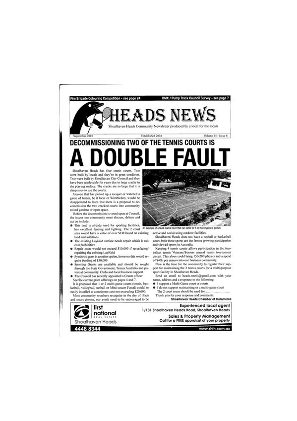
|
|
Strategy and
Assets Committee – Tuesday 16 October 2018
Page
1
|
SA18.241 Nowra
Showground Buildings Budget
HPERM Ref: D18/330889
Group: Finance
Corporate & Community Services Group
Section: Recreation
Community & Culture
Attachments: 1. Proposed
Budget - Hydraulic Fire Service Upgrade - Nowra Showground ⇩
2. Proposed Site Plan -
Hydraulic Fire Service Upgrade - Nowra Showground ⇩
Purpose / Summary
To seek a resolution regarding
expenditure of Council’s 2018/19 Special Rate Variation Nowra Showground
Buildings Budget of $600,000.
Options
1. As recommended.
Implications: Ensure
compliance with fire-fighting legislation and provide some visual enhancements
to the Nowra Showground. Upgrade of camping amenities will not be met by this
budget.
2. Allocate funding
of up to $400,000 for Fire Services Upgrade from alternate source to ensure
compliance with fire-fighting legislation. Full $600,000 Special Rate Variation
Nowra Showground Buildings budget be expended on building enhancements and
upgrades.
Implications: Council’s 2018/19 expenditure
may be increased by allocation of additional funds of $400,000 for Fire
Services Upgrade - no source of funds identified. Upgrades to showground
buildings, including provision of camping amenities will be implemented.
Background
Recent inspection of the Nowra
Showground fire hydrants system found that the infrastructure does not comply
with current legislative requirements (Building Code of Australia (BCA) and
Local Government Camping Ground Regulation 2005) for the following
reasons:
· The
hydrants are required to be mounted on an above-ground standpipe,
· The
system failed the ‘flow test’. It is likely that the underground
pipe has been crushed or broken and is consequently not able to perform to
required flow rates,
· Hydrants
and hose reels are not placed as required.
BCA Requirements
E1.3 Fire hydrants
(a) A
fire hydrant system must be provided to serve a building—
(i) having
a total floor area greater than 500 m2; and
(ii) where
a fire brigade is available to attend a building fire.
Local Government
(Manufactured Home Estates, Caravan Parks, Camping Grounds and Moveable
Dwellings) Regulation 2005
128 Fire hydrants
(1) No part of a
dwelling site, camp site or community building within a caravan park or camping
ground may be situated more than 90 metres from a fire hydrant.
(2) Any
fire hydrant located within a caravan park or camping ground must:
(a) be
a double-headed pillar-type fire hydrant, and
(b) be maintained to
the standard specified in the approval for the caravan park or camping ground.
129 Fire hose
reels
(1) Fire hose reels
must be installed so that each dwelling site or camp site in the caravan park
or camping ground can be reached by a fire hose.
(2) The fire hose
reels must be constructed in accordance with AS/NZS 1221:1997, Fire hose reels
and installed in accordance with AS 2441—1988, Installation of fire hose
reels, as in force on 1 September 2005.
(3) The holder of the
approval for the caravan park or camping ground must cause the council to be
given a certificate (a fire hose reel certificate) in relation to the fire hose
reels once every calendar year. If a fire hose reel is newly installed, the
certificate must be provided within 7 days of the completion of its
installation.
(4) A fire hose reel
certificate is to state, in relation to each fire hose reel installed in the
caravan park or camping ground:
(a) that the fire hose
reel has been inspected and tested by a person (chosen by the holder of the
approval) who is properly qualified to carry out such an inspection and test,
and
(b) that, as at the
date on which the fire hose reel was inspected and tested, the fire hose reel
was found to perform to a standard not less than that required by this
Regulation.
Staff have engaged a consultant
to provide compliance designs for a comprehensive fire services upgrade for the
Nowra Showground. Design and cost estimates are attached. The new
system will ensure legislative compliance with modern, effective firefighting
infrastructure for asset protection for the Nowra Showground.
The cost estimate provided is
$378,480. This expenditure is not currently funded.
Nowra Showground Buildings
Budget
The Nowra Showground Buildings
budget for 2018/19 is $600,000. This budget was provided as part of the funding
from the approved Special Rate Variation and is available for the renewal of
the Nowra showground buildings and public amenities. It is considered that this
essential hydraulic fire service upgrade compliance work is replacement of an
existing building system that is at the end of its useful life and therefore
represents appropriate use of the SRV allocation.
However, the options open to
Council are:
Option 1
· Council
expend up to $400,000 (based on the $378,480 estimate) of the 2018/19 Nowra
Showground Buildings Budget on Fire Services Upgrade for the Nowra Showground.
· Council
expend all remaining funds on grandstand leak repair, painting external
buildings, roof cleaning and internal painting of Pavilion, Committee Room and
Warriors buildings, to the extent that funding permits.
Staff estimate that if this
budget is used for the essential upgrade of the fire hydrant system, the
remaining $200,000 will be sufficient to fund:
· repair
of a leak from the grandstand into the Pavilion building,
· external
painting and roof-cleaning of these buildings at the Nowra Showground:
o Pavilion,
o Committee
Room,
o Warriors
Building.
The cost of these works is
estimated to be high due to the need for the hire of equipment to work at
heights. The painting work required is intricate, with a lot of work cutting
in, and it will not be possible to use a spray gun for the works.
It is proposed that if funds are
remaining, these funds be spent on internal painting of the Pavilion and
Committee Room.
Option 2
· Allocate
additional funding for Fire Services Upgrade from alternate source. Full
$600,000 Nowra Showground Buildings budget be expended on building enhancements
and upgrades.
This will require Council
sourcing and allocating funds to deliver the essential Fire Services Upgrade to
ensure compliance with legislation – no source of funds identified.
Staff estimate that the full
$600,000 budget will be sufficient to fund:
· $220,000 Repair
of a leak from the grandstand into the Pavilion building, external painting and
roof-cleaning of these buildings at the Nowra Showground:
o Pavilion,
o Committee
Room,
o Warriors
Building,
· $
70,000 Internal Painting of Pavilion and
Committee Room,
· $310,000 Upgrade
amenities building for camping (including 6 shower and 10 toilets).
Upgrades to the amenities at
Nowra Showground must comply with “Access to Premises” Building
Standards 2010 which requires higher standards than the BCA and refers to
Australian Standards 1428 “Design for Access and Mobility”.
Pending Tourism and
Environment grant application
Council has applied to the Tourism
and Environment Grant program, seeking funding for an upgrade of facilities at
the showground’s cattle yards, including:
· $100,000 Judging
room improvements
· $175,000 Kitchen
upgrade
· $100,000 Amenities
block upgrade
· $164,000 New
amenities block
· $
47,000 Fencing
- cattle judging yard & perimeter
· $105,300 Seating
- general & inclusive
· $150,000 Drainage
- cattle wash down
· $
80,000 Cattle
stall guttering, drainage & connection to stormwater
· $
20,000 Cattle
ramp improvements
Should this funding application
be successful, further community consultation and a masterplan for the entire
Nowra Showground site will be undertaken prior to the upgrade of
infrastructure.
Community Engagement
Nowra Showground Ideas Day, held
in 2017, resulted in positive feedback regarding the Nowra Showground and
requests for added enhancements and an improvement to the visual amenity of the
facility.
In the event of successful
funding from the Tourism and Environment grant application, community consultation
will be undertaken towards development of a masterplan for Nowra Showground,
prior to upgrade facilities and amenities.
Policy Implications
Upgrade to the Fire Services
infrastructure will ensure compliance with legislated firefighting requirements.
Financial Implications
Option 1 Expenditure
of current budgets, $600,000 funded from the approved Special Rate
Variation specifically for the Nowra Showground.
Option 2 Requires
allocation of additional funding of up to $400,000 for Fire Services Upgrade,
enabling the SRV funding of $600,00 to be spent on the Pavilion, Committee
Rooms and amenities for camping.
In the absence of an identified alternate funding source for
the essential hydraulic fire service upgrade compliance work, it is recommended
that Council proceed with Option 1 in order to comply with Building Code of
Australia and Local Government Camping Grounds Regulation 2005 requirements.
Risk Implications
Non-compliance with legislated
firefighting requirements.
Non-compliance with legislated
camping requirements.
|
|
Strategy and
Assets Committee – Tuesday 16 October 2018
Page
1
|

|
|
Strategy and
Assets Committee – Tuesday 16 October 2018
Page
1
|
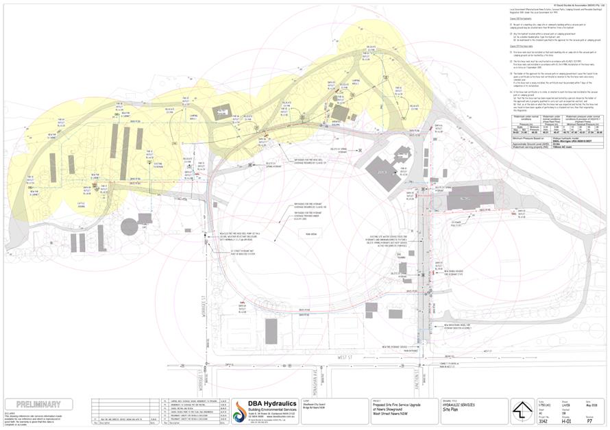
|
|
Strategy and
Assets Committee – Tuesday 16 October 2018
Page
1
|
SA18.242 Shoalhaven
Affordable Housing Strategy - Property Acquisition Matters
HPERM Ref: D18/338075
Group: Assets
& Works Group
Section: Business
& Property Unit
Attachments: 1. GIS
Aerial View - 49 Meroo Street, Bomaderry ⇩
Purpose / Summary
To provide Council with the
opportunity to consider acquiring additional properties in Bomaderry for
consolidation with Council’s existing land holdings in Coomea Street to
facilitate the propposed Shoalhaven Affordable Housing Strategy.
The recommendation for
consideration is provided in a separate confidential report, this is in
accordance with section 10A(2)(C) of the Local Governement Act 1993, if the
information was disclosed, this would confer a commercial advantage on a person
with whom council is conducting (or proposes to to conduct) business.
|
Recommendation
That Council in accordance with
Section 10A(2)(C) of The Local Government Act 1993, consider a separate
confidential report on the acquisition of additional properties in Bomaderry
to facilitate the proposed Shoalhaven Affordable Housing Strategy.
|
Options
1. Council Accept
the recommendation as presented
Implications: Council will consider a separate
confidential report outlining the proposal
2. Not adopt the
recommendation
Implications: Provide further direction to staff
and propose an alternative.
Background
Council resolved at its Ordinary
meeting dated 28 March 2017 to (MIN17.215):
“That should opportunities arise
for Council to further consolidate its land holdings in Coomea Street Bomaderry
then the opportunities be reported to Council for consideration and that
funding for such a project be from the Strategic Lands Reserve”
The presentation to Council
of a confidential report seeking resolution of the matter by the Council.
Background Pride of Bomaderry
– 49 Meroo Street, Bomaderry
The Pride of Bomaderry was endorsed by Council as a Community
Consultative Body (CCB) by MIN14.645 on 16 September 2014. Since its inception,
one of its major projects has been to improve the appearance of the main street
of Bomaderry.
In the Pride of Bomaderry’s first correspondence to
Council, the group outlined an intention to enter into an agreement with the
owners of 49 Meroo Street, Bomaderry to use that privately owned vacant land
for public open space. The group provided an artist’s view of the planned
improvements to the land and also enclosed the following consent on behalf of
the owners:
“I agree to the Pride of Bomaderry Committee
approaching Council to use my property 49 Meroo Street, Bomaderry as public
open space subject to the waiving of rates and Council maintaining the facility
for the benefit of the public until the property is sold.”
The CCB acting Chairman had stated that the owner(s):
“..is not anxious to sell the property at the moment
unless an offer well above market value is made.”In February 2016,
Gareth Ward MP, Member for Kiama, made representations to Council on behalf of
a constituent for Council to purchase 49 Meroo St, Bomaderry.
Council’s response in part by letter dated 24 February
2016 was:
“Council does not have any current nor future plans
to acquire the property.”
In November 2016 the Pride of Bomaderry wrote to Council with
a request that Council purchase 49 Meroo St, Bomaderry. The response was:
“Given the property is privately owned and zoned
for Mixed Use development, it has not been identified on any future planning
documents as a potential park in this location. There is Open Space
identified nearby, being Walsh Park (Memorial Park) approximately 200m to the
south east along with numerous other community spaces throughout Bomaderry.
Council recently received an unsolicited approach from
Raine & Horne on behalf of the owner offering the property to Council at a
value of $450,000. This offer was respectfully declined.
There are no current or future plans to acquire this
property or additional open space in the Bomaderry locale.”
In April 2017 the Pride of Bomaderry sent Council an email
raising concerns that the owners may consider revoking the informal agreement
to provide their private land for public use due to an increase in Public
Liability insurance premiums.
The increase was attributed to the insurer being made aware
that the use of the land had changed from private vacant land to publicly
accessible land.
At this point the purchase option was again considered and
again rejected in recognition of the flexibility which could be gained through
a licence agreement and the payment of a licence fee equivalent to the
owners’ increase in insurance premium.
Based on the above, Council resolved in part at its Ordinary Council
meeting dated 23 May 2017 (MIN17.409) to:
“2. Request
the Pride of Bomaderry form a parkcare group for the ongoing maintenance of
Waratah Park;
3. Enter into a
licence with the owners of Waratah Park at 49 Meroo St, Bomaderry for the
ongoing public use of the land and delegate authority to the General Manager or
his nominee to finalise the details of any agreement.”
A licence was entered into and
subsequently in May of 2018 Council (MIN18.379) endorsed the parkcare plan for
Waratah Park.
Council’s current position is to not support acquisition
of the property at 49 Meroo St, Bomaderry for a park and this is supported by
recommendations in the:
1. “Community
Infrastructure Strategic Plan 2017” which identifies and recommends the
rationalisation (sale) of the following parks in Bomaderry:
i. Reid Park
– located on the corner of Bunberra and Tallayang Streets comprised of
809 sqm of “Community land”;
ii. Mulgen
Street Reserve – located in Mulgen Street, 295sqm of “Community
land”;
iii. Leonard Street
Reserve – located in Leonard St, 1,195 sqm of “Community
land”;
2. Consultancy
firm “Acclimate’s” Master Plan for the Shoalhaven Community
& Sports Precinct (SCaRP) which identified nine (9) Council properties
ideally suitable for rationalisation.
50 Coomea Street, Bomaderry
The potential affordable housing development on Council land
in Coomea Street (42 to 46) is a short term priority in the Shoalhaven
Affordable Housing Strategy that included pursuing, in partnership with others
(e.g. Southern Cross Housing), the acquisition of additional land.
Within the Shoalhaven Affordable Housing Strategy adopted in
December 2017 Council believes that:
“An effective way of delivering affordable housing
is through the development of affordable housing on Council land in partnership
with a community housing provider such as Southern Cross Community Housing and
possibly also the private sector.
The under used Council land at 42-46 Coomea Street,
Bomaderry could be redeveloped to increase the supply of affordable housing in
Shoalhaven.
The project area could be expanded via the acquisition of
adjacent privately-owned land, specifically 48-52 Coomea Street and/or 49 Meroo
Street.
Given the location, the land is suitable for a
financially viable affordable housing project and has the potential to initiate
and assist with revitalising the Bomaderry Town Centre, which has been
requested by and has the support of the local community group.
State Government funding would assist Council and
possible partner organisations to implement a much-needed affordable housing
project.”
Based on the above, Council at its Ordinary meeting dated 28
March 2017 resolved (MIN17.215):
“That should opportunities arise for Council to
further consolidate its land holdings in Coomea St Bomaderry then the
opportunities be reported to Council for consideration and that funding for
such a project be from the Strategic Lands Reserve.”
An outcome of this resolution was correspondence being sent to
each of the property owners in Coomea Street advising of Council’s
interest in purchasing their properties in the event they considered selling.
In August 2018 the owner of 50 Coomea Street responded to
Council’s approach. This response was an offer to sell the property to
Council, subject to agreement on price and terms.
Councillor Briefing
A Councillor briefing was held on 13 September 2018 to discuss
the request by the Pride of Bomaderry to purchase Waratah Park for public
recreation space and provide an update on the approach by the owner of 50
Coomea Street.
The outcome of the briefing confirmed the opinion of Council
staff that no further open space was required in Bomaderry; however two
alternate options were considered:
1. Acquire
Meroo Street (Waratah Park) and other lots as a strategic land development
initiative with retention of existing zonings and seek
“operational” classification that reserved Council’s right to
develop the lands as part of the Shoalhaven Affordable Housing Strategy. This
included the possibility of an arcade and a pedestrian link to the council car
park in Coomea Street; or
2. Not
acquire Meroo Street but continue with the acquisition of other lots in Coomea
Street as a strategic land development initiative.
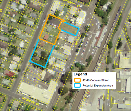
Community Engagement
There has been no community engagement undertaken in relation
to this matter.
Financial Implications
Council’s Strategic Property Reserve has a balance of
$523,000 as at 31 August 2018. The Reserve has been depleted of late with
numerous strategic acquisitions occurring over the past two years.
Notwithstanding there may be insufficient funds to cover the
purchase of both properties, Council can expect an injection of funds of
$735,000 into the Property Reserve from the upcoming disposals of land at
Broadview Ave, Culburra Beach and Bridge Road, Nowra.
|
|
Strategy and
Assets Committee – Tuesday 16 October 2018
Page
1
|
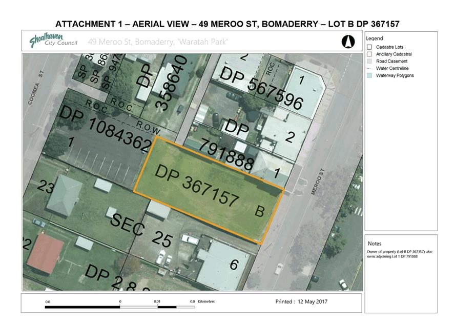
|
|
Strategy and
Assets Committee – Tuesday 16 October 2018
Page
1
|
SA18.243 Sale
- Council Land - Lot 1 DP579906 at 27c Broadview Ave Culburra Beach
HPERM Ref: D18/295498
Group: Assets
& Works Group
Section: Business
& Property Unit
Attachments: 1. Aerial
view - access highlighted ⇩
2. Sketch
showing location of Lo1 DP579906 ⇩
3. Copy
of DP 579906 ⇩
4. Copy of Dealing P448482
relating to DP579906 ⇩
Purpose / Summary
This report provides Council
with the opportunity to consider approving the sale of Lot 1 DP 579906, 27c
Broadview Ave, Culburra Beach, formerly known as 10 Jopejija Crescent, to Janet
& Paul Francis for $235,000.
|
Recommendation
That Council resolves to:
1. Authorise
the sale of the land comprised in Lot 1 DP 579906 at 27c Broadview Ave
(formerly known as 10 Jopejija Crescent), Culburra Beach to Janet & Paul
Francis for $235,000 (inclusive of GST if applicable); and
2. Authorise
the General Manager to sign all documents required to give effect to this
resolution and to affix the Common Seal of the Council of the City of
Shoalhaven to all documentation required to be sealed; and
3. Rescind
MIN17.1020 (1) & (2).
|
Options
1. Adopt
the recommendation.
Implications: This property is
surplus to operational needs and disposal will generate additional income for
Council and reduce Council’s ongoing maintenance burden.
2. Not
adopt the recommendation and defer a decision on the matter pending discussion
at a Councillor Briefing.
Implications: Not adopting this
recommendation will result in the matter reverting to the standing Council
resolution MIN17.1020 which requires that the property be sold via public
auction. Council may continue negotiations with the owners of 27a Broadview
Ave, Culburra Beach, Paul and Janet Francis, for the acquisition of a 300sqm
easement over their property for the purposes of access and services to the
adjoining Lot 1 DP 579906, the subject land.
Background
Council adopted the following
recommendations at the Ordinary meeting of Council on 28 November 2017
(MIN17.1020):
“1. Resolve
to dispose of 10 Jopejija Crescent, Culburra Beach (Lot 1 DP579906) by way of
public auction in accordance with Policy 16/256 (Development and/or Disposal of
Council Lands);
2. Authorise
the General Manager to set the auction reserve (based on valuation advice) and
to finalise the terms of a sale within 10% of the reserve or list price in the
case of a private treaty sale if the property fails to sell at auction;
3. Fund
all costs associated with the sale of 10 Jopejija Crescent, Culburra Beach from
Job Number 88823 and the net income from the sale be placed in the Strategic
Property Reserve;
4. Resolve
to extinguish the easement for water supply 2 wide and 4 wide over Lot 10
DP261880 at Culburra Beach;
5. Fund
all costs associated with pipe removal and easement extinguishment of Lot 10
DP261880 from Job Number 18850; and
6. Authorise
the General Manager to sign all documents required to give effect to this
resolution and to affix the Common Seal of the Council of the City of
Shoalhaven to all documentation required to be sealed.”
NOTE: Actions under (4) & (5) above were
concluded upon registration of dealing AN128082, a transfer releasing easement,
in March 2018.
The address 10 Jopejija
Crescent, Culburra Beach was changed to 27c Broadview Ave, Culburra Beach to
assist identification of the property, to match the point of legal access from
Broadview Ave and to remove any confusion about the street name and access
point.
The subject property comprises a
single parcel of vacant land described as Lot 1 DP579906 and is 929 sqm in
area. The land is classified Operational with a zoning of R2 Low Density
Residential under Shoalhaven LEP 2014.
This property was acquired in
1976 for a water reservoir, with underground connections installed, but no
reservoir was ever built. Shoalwater has confirmed that the property is surplus
to current and future operational needs. Shoalwater has endorsed the sale as
the ongoing maintenance and encroachment issues have become a burden on its
operational team.
Due diligence investigations in
preparing the property for disposal by public auction revealed that an easement
for access and water supply, granted under Dealing P448482 (refer to
attachments 3 & 4) and burdening the adjoining property comprised in Lot 10
DP 261880 is of benefit to Council only. Further, legal advice confirms that
the benefit granted to Council pursuant to the easement does not transfer as a
right to any subsequent owner(s). This would result in:
1. An
as yet unquantified reduction in the value of Council’s property because
the property becomes land-locked if it is transferred to another party as a
result of a sale; and
2. The
need for a purchaser to enter into negotiations with the adjoining owner
(Francis) for a new easement (with the purchaser being in a very poor position
from which to negotiate) for access and services.
Considering the above and given
the closeness of the access to the Francis’ residence (refer to photo 2
below) consideration was given to disposal of the property to Mr and Mrs
Francis and negotiations commenced with them subject to Council approval.
Basis of Sale
Market appraisals were provided by Ray
White, First National and Elders Real Estate offices.
· Ray
White - $300,000 - $350,000
· First
National - $350,000 - $375,000
· Elders
- $320,000
- $360,000
Midpoint values of the three market appraisals ranged from
$325,000 - $362,500. These values assumed full and unimpeded access and land
which is unencumbered.
Based on valuation and legal advice, the final cost to a new
owner of the Council property of acquiring an easement for access and services
could be within the vicinity of $150,000.
Paul and Janet Francis approached Council with an offer to
purchase 27c Broadview Ave with an initial offer of $180,000. Further
discussions resulted in two more offers of $215,000 in July and a final offer
of $235,000 in August.
In the circumstances of this case, a sale to the adjoining
owners is the most logical means of achieving an outcome which disposes of a
property regarded as surplus to requirement. This action accords with Council’s
POL16/256 – Development and/or Disposal of Council Lands under point 3(o)
– “direct negotiations under exceptional
circumstance….” and the ICAC guidelines for managing risk in
direct negotiations (May 2006).
The proposed sale price is supported by the following
calculations:
The midpoint of values of 27c Broadview Ave $325,000
to $362,500
less 27a Broadview Ave easement acquisition $150,000
Property Price Range $175,000
to $212,500
The sale price of $235,000 represents a better return than the
high end of this range which is $212,500.
By resolving to deal with the owners of 27a Broadview Ave and
accepting the offer to purchase, Council does not have to acquire an easement
for access and services in order to sell the land nor is it required to meet
costs associated with marketing the property for sale.
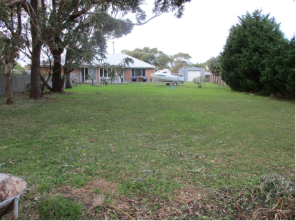
Photo 1: View
from Council’s property looking towards Janet & Paul Francis’
house
Photo 2: Shared
driveway from Broadview Ave for access and services to Janet & Paul
Francis’ house on the left and Council’s property on right at the
end of the paling fence
Photo 3:
Council’s property on right through gate
Community
Engagement
The Proposed Sale of the subject land is a local area low
impact issue as outlined in Council’s Community Engagement Policy. There
has been an appropriate level of community engagement as per resolution
There are six adjoining Property owners, all of whom have been
individually contacted and notified of Council’s intention to dispose of
this lot.
Financial
Implications
The proposed sale of this land will
generate extra income for Council to set aside for future land development and
disposal projects. This represents potential for an improved return on assets
which is in the best interests of the wider community.
|
|
Strategy and
Assets Committee – Tuesday 16 October 2018
Page
1
|
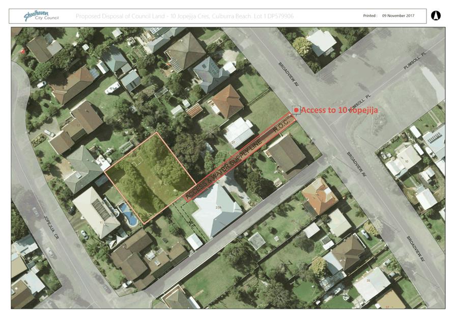
|
|
Strategy and
Assets Committee – Tuesday 16 October 2018
Page
1
|
|
|
Strategy and
Assets Committee – Tuesday 16 October 2018
Page
1
|
|
|
Strategy and
Assets Committee – Tuesday 16 October 2018
Page
1
|
|
|
Strategy and
Assets Committee – Tuesday 16 October 2018
Page
1
|
SA18.244 Pilot
Project- Council Land Review
Sanctuary Point & St Georges Basin
HPERM Ref: D18/339002
Group: Assets
& Works Group
Section: Business
& Property Unit
Attachments: 1. Pilot
Project - Council Land Review Report SA18.154 ⇩
2. Sanctuary
Point & St Georges Basin Pilot Area Properties ⇩
3. Council owned Community Land
Pilot Maps - Sanctuary Point - St Georges Basin ⇩
Purpose / Summary
This report provides Council with the opportunity to consider
clarifications and additional information requested when Council deferred
consideration of the report presented to the Strategy and Assets Committee on
12 June 2018 (refer to Attachment 1 - SA18.154) on this matter.
|
Recommendation (Item to be
determined under delegated authority)
That:
1. Council
endorse Sanctuary Point and St Georges Basin as the location of the Land
Review Pilot Project;
2. Staff
engage with the community and residents of Sanctuary Point and St Georges
Basin to understand:
a. community
expectations with regard to parks and reserves generally;
b. the
appetite of the community to consider disposal of under performing community
land assets to fund improvements to under utilised and/or under developed
parks and reserves;
3. Staff
undertake detailed investigation of community land within the Pilot Area
including those reserves identified in the Community Infrastructure
Strategic Plan 2017-2036 to identify which land may be suitable for full
or partial disposal; and
4. Council
receive a further report detailing outcomes of the community consultation and
the detailed investigation of community land within the pilot area.
|
Options
1. Resolve as
recommended.
Implications: Key outcomes
recommended in the Shoalhaven City Council Property Strategy will be delivered.
Council will be provided with an opportunity to engage with the communities of
Sanctuary Point and St Georges Basin and make recommendations regarding parks
and reserves which are not meeting residents’ expectations.
2. Not resolve as
recommended and resolve along the following lines:
“That the General Manager (Director Works and
Assets) prepares a report which identifies an alternative pilot area to
Sanctuary Point and St Georges Basin as the preferred location of the Land
Review Pilot Project.”
Implications: Council will be provided with an
opportunity to engage with the community of another locality and to make
recommendations regarding the parks and reserves which are not meeting
residents’ expectations.
Background
A report was submitted to
Council’s Strategy and Assets Committee on 12 June 2018 seeking
endorsement of Sanctuary Point as the Pilot area for the Council Land Review
Pilot Project.
At the meeting Council resolved
(MIN18.449) to defer consideration of this project pending:
“1. More
details of scope and population needs;
2. Review
of the boundaries; and
3. Familiarisation
tour.”
Discussion at the meeting revolved around requesting
additional information on population growth in the region, a boundary review
and a physical site inspection of the proposed pilot project area.
Based on the above request, local demographics, the boundaries
of the project and the integrity of the population figures provided in the
initial report to Strategy and Assets were reviewed.
Additionally, extensive mapping information was also provided
to Councillors who requested same to enable individual familiarisation tours.
Population Needs
The Population Figures provided in this report are the
research and demography statistics collated and used by the NSW Department of
Planning and Environment. The population growth figures are derived from their
2016 NSW Population projections using modelling that ranges from Low to High
growth rates over a twenty-five-year period from 2011 to 2036 within the
Shoalhaven Region.
These growth rates and population projections assist in
determining the open space required in this region as shown in the table below.
The decision to choose St Georges Basin and Sanctuary Point
for the Pilot Program was based on a manageable geographic test area and the
conglomeration of community land suitable for such a land review pilot within
these boundaries.
Location – Pilot Area
The Pilot Area is defined as all land within the suburbs of
Sanctuary Point and St Georges Basin.
It should be noted that as the pilot implementation progresses
it may become necessary to consult or consider properties on the edges of the
Pilot Area such as Basin View and Erowal Bay. Hence the boundaries might be
considered as flexible to allow for assessment of other community land adjacent
to or within close proximity of the pilot project area.
Updated Open
Space Requirements for Sanctuary Point & St Georges Basin
The Sanctuary Point and St
Georges Basin suburbs have a current population of 11,033* and a forecast
population of 11,885* by 2036* according to figures and projections obtained
from NSW Department of Planning and Environment NSW Population Statistics &
Projections (2016).
The Community Infrastructure Community Plan (CISP) identified
an overall surplus of open space (both sports and recreation) within Planning
Area Three[1].
According to best practice, the following are the standards for the provision
of open space within the Sanctuary Point and St Georges Basin areas:
|
Open Space Type
|
Hierarchy
|
Provision Standard
|
Area Required
(based on 2036 forecast population)
|
|
Recreation Parks
|
Local
|
0.5ha per 1,000 people
|
5.94ha
|
|
|
District
|
0.6ha per 1,000 people
|
7.13ha
|
|
|
Regional
|
0.2ha per 1,000 people
|
2.37ha
|
|
Sports Parks
|
District
|
1.3ha per 1,000 people
|
15.45ha
|
|
|
Regional
|
0.6ha per 1,000 people
|
7.13ha
|
|
TOTAL OPEN SPACE
REQUIRED – SANCT POINT /ST G BASIN
|
38.02ha
|
|
TOTAL AREA- ALL
COMMUNITY LAND- SANCT POINT / ST G BASIN
|
64.76ha
|
The above is a high-level
assessment of open space within Sanctuary Point and St Georges Basin and lends
weight to this area being an ideal location to use for the Pilot Project. A
detailed list of the properties comprising the total area of 64.76Ha for
Sanctuary Point and St Georges Basin is found at Attachment 2. Plans showing
Community land at Sanctuary Point and St Georges Basin is found at Attachment
3.
Specifically, the detailed
review of Council land in the Pilot Area is seeking to identify land which
offers limited recreational use by the community and may present opportunities
for divestment and/or conversion to another use/purpose.
|
|
Strategy and
Assets Committee – Tuesday 16 October 2018
Page
1
|
|
|
Strategy and
Assets Committee – Tuesday 16 October 2018
Page
1
|
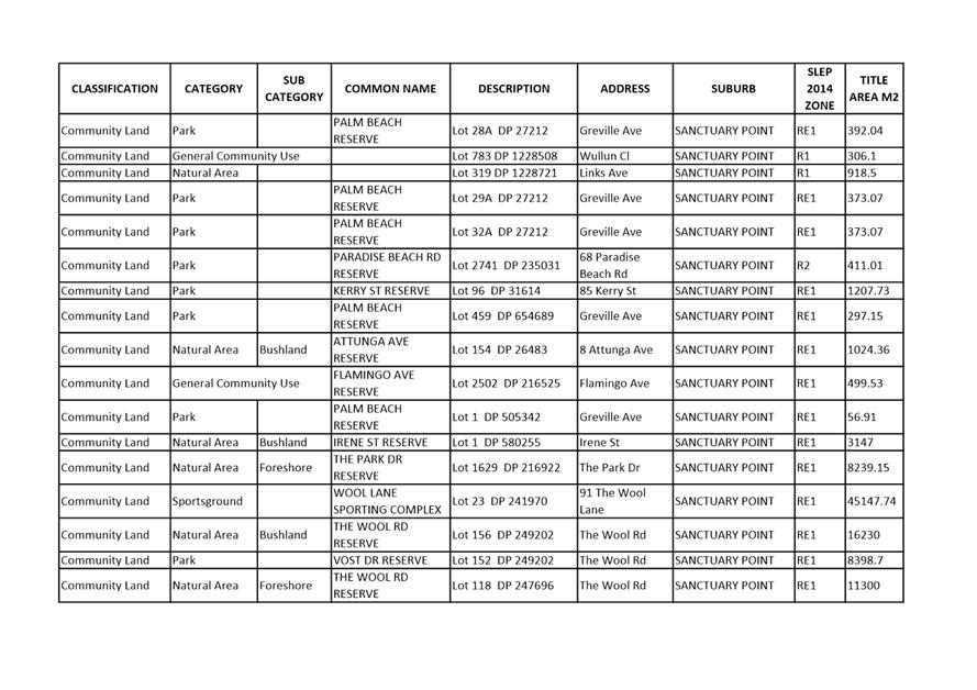
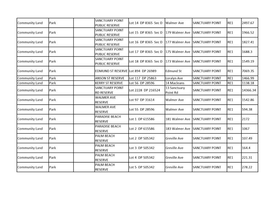
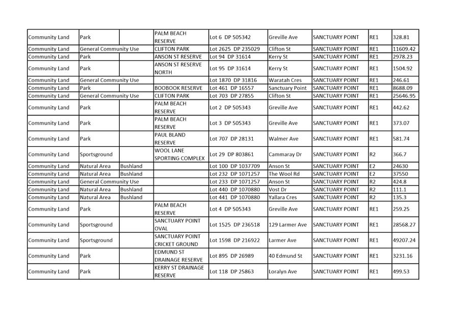
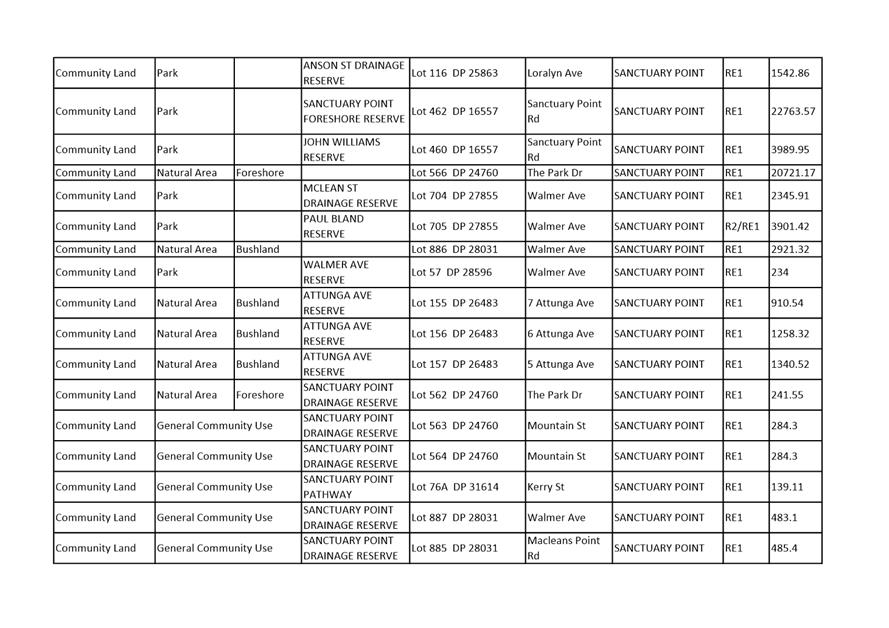
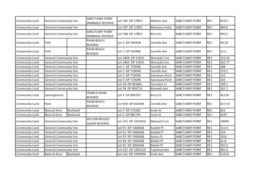
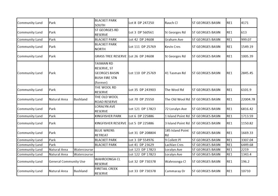
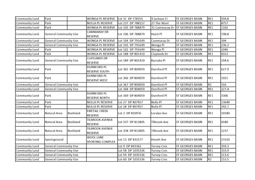
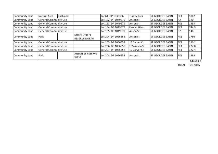
|
|
Strategy and
Assets Committee – Tuesday 16 October 2018
Page
1
|
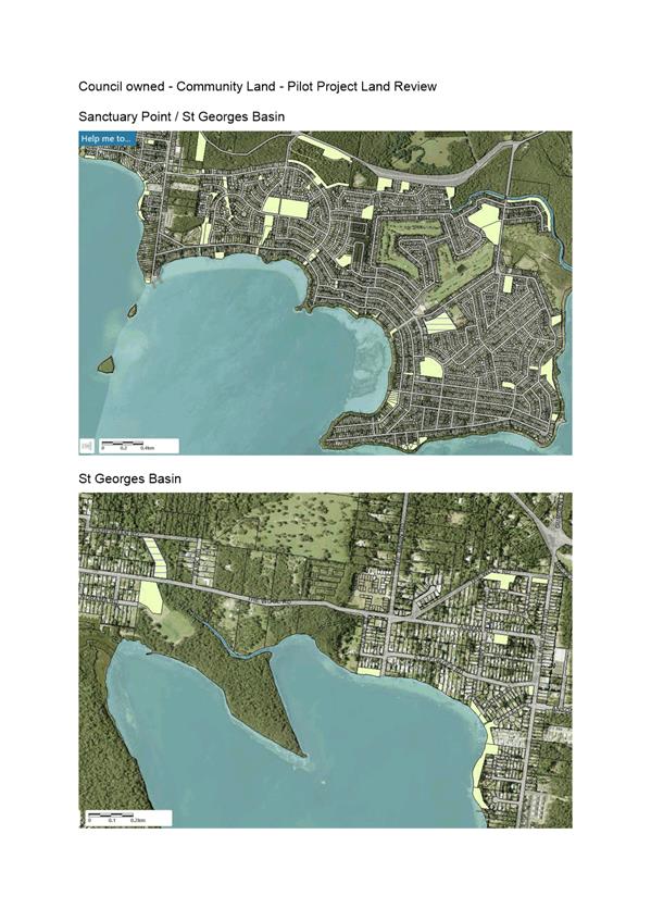
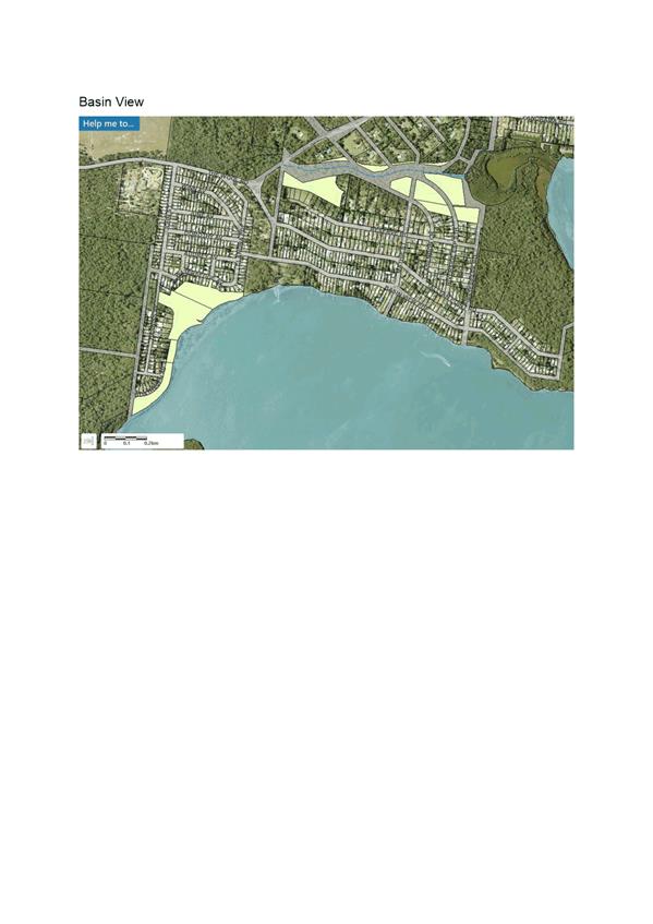
|
|
Strategy and
Assets Committee – Tuesday 16 October 2018
Page
1
|
SA18.245 Proposed
Sale of Lot 4 DP 550354 Island Point Road, St Georges Basin
HPERM Ref: D18/309787
Group: Assets
& Works Group
Section: Business
& Property
Attachments: 1. Proposed
Sale - Lot 4 DP 550354 Island Point Rd, St Georges Basin ⇩
2. Proposed Subdivision - Lot 4
DP 550354 Island Point Rd, St Georges Basin ⇩
Purpose / Summary
To provide Council with an
opportunity to consider a proposal to subdivide Lot 4 DP550354 Island Point
Road, St Georges Basin into three (3) for the purpose of selling each lot to
the adjoining owner.
|
Recommendation
That Council:
1. Approve,
in principle, the sale of Council land comprised in a three (3) lot
subdivision of Lot 4 DP 550354 Island Point Road, St Georges Basin;
2. Receive
a further report in due course regarding the subdivision and final terms and
conditions of the proposed sales to adjoining owner(s).
|
Options
1. Resolve as
recommended.
Implications: The proceeds of the sale of the land
will increase Council ‘s revenue base.
2. Not resolve as
recommended.
Implications: Council will retain ownership of the
surplus land and continue to be liable for all costs associated with it into
the future. Council will also forego the opportunity to maximise income
generated through the sale of the land.
Background
The subject land is currently
vacant, has an area of 354.1 sq metres and is zoned Business B4 Mixed Use. It
is land locked with no legal vehicle or pedestrian access from Island Point
Road but does however have water access from St Georges Basin.
As part of the 2017 Planning
Proposal to amend Shoalhaven Local Environmental Plan 2014 (PP010 –
Council Land Reclassification – Housekeeping), the land was reclassified
from community land to operational land. The public notice for the
reclassification provided the following information:
|
Council’s interests in land – when and how
it was acquired
|
This lot was dedicated to Council as public reserve in
1971 under subdivision No. 3071.
|
|
Any agreements over the land
|
No.
|
|
Anticipated development
|
Unknown; No change to zone proposed.
|
|
Asset management objectives
|
Disposal of surplus land through investigation of sale
of land to adjoining land owner.
|
|
Financial implications
|
Small financial gain if sold to adjoining land
owner(s).
|
As a result of the public
notice, three adjoining property owners (16, 16A & 18 Island Point Road)
indicated to Council their interest in purchasing part of the land following
subdivision of same.
Given the above, the best result
for Council is to undertake a three (3) lot subdivision (the B4 zoning has no
minimum lot size with the lot sizes ranging from 82 sq metres to 108 sq metres)
and negotiate the sale of the 3 allotments directly with the adjoining owners
(16, 16A & 18 Island Point Road). This will result in these three
properties becoming absolute water front.
A plan of a proposed subdivision
is shown on Attachment 2. It is intended to negotiate the sale of each of the
newly created lots directly with the adjoining owner(s) on the provision the
newly created lots are consolidated with their current holding in each case.
Community Engagement
The proposed sale of this land
is considered to be a local area low impact issue as outlined in
Council’s Community Engagement Policy and Handbook, therefore before
placing the property on the market there will be an appropriate level of
community engagement including newspaper advertising, notification on
Council’s website and informing the local Community Consultative Bodies.
Financial Implications
The proposed sale of this land
will generate additional income for Council and this will be placed in the
Property Reserve for future property projects.
|
|
Strategy and
Assets Committee – Tuesday 16 October 2018
Page
1
|
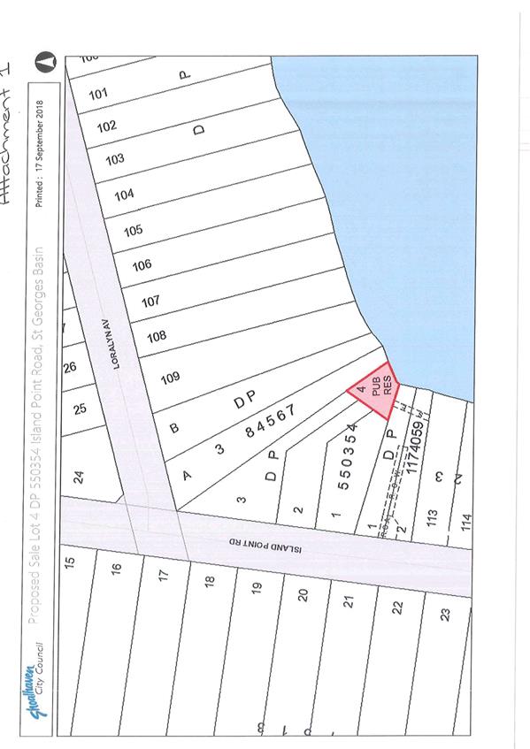
|
|
Strategy and
Assets Committee – Tuesday 16 October 2018
Page
1
|
|

|
Strategy and
Assets Committee – Tuesday 16 October 2018
Page
1
|
SA18.246 Grant
of Electricity Easement for Pad Mount Substation and Restriction on the Use of
Land to Endeavour Energy - Lot 1 DP860791 - 92 Albatross Road, South
Nowra
HPERM Ref: D18/321907
Group: Assets
& Works Group
Section: Business
& Property
Attachments: 1. Proposed
Pad Mount Substation Easement and Restriction on Use of Land - Lot 1 DP 860791
South Nowra ⇩
Purpose / Summary
This report provides Council
with an opportunity to consider granting an Easement for a Pad Mount Substation
and Restriction on the Use of Land in favour of Endeavour Energy over Council
owned Operational land comprised in Lot 1 DP860791 at 92 Albatross Road, South
Nowra as shown and marked (A) and (B) on Attachment 1.
|
Recommendation
That:
1. Council
grant an Easement in favour of Endeavour Energy for a Pad Mount Substation
and Restriction on the Use of Land over Council owned land at Lot 1 DP860791,
92 Albatross Road, South Nowra; and
2. Authority
be granted to affix the Common Seal of the Council of the City of Shoalhaven
to any documents required to be sealed and the General Manager be authorised
to sign any documentation necessary to give effect to this resolution.
|
Options
1. Resolve as
recommended.
Implications: The easements
are required to provide Endeavour Energy with legal access for the operation
and maintenance of its essential public infrastructure.
2. Not resolve as
recommended.
Implications: Endeavour Energy will not have
guaranteed access to maintain the public infrastructure which may have a
negative impact on the operation of the Integrated Emergency Management Centre.
Background
A tender for the Integrated Emergency Management Centre Pad
Mount Substation was considered by Council on 27 June 2017 when it was resolved
as follows (MIN17.602C):
“1. Council
accept the Tender from Great Southern Electrical Pty Ltd for the IEMC Pad Mount
Sub Station a total cost of $361,028.00 (excluding GST).
2. The contract
documents and any other associated documents be executed on behalf of the
Council in accordance with cl165 of the Local Government Regulation.
3. Council
vote additional funds of $80,000 from the S94 Recoupment Reserve with these
funds being recouped from future contributions being received on project
CWFIRE2002.”
Pursuant to Council resolution, an easement is now required
over Council owned operational land for the pad mount substation and a
restriction on the use of the surrounding land to ensure Endeavour Energy has
legal access for the operation and maintenance of its essential public
infrastructure.
The easement is required as a condition of supply (upgrade) of
electricity by Endeavour Energy in connection with the development of the
emergency management centre and is to be created at no cost to Endeavour
Energy.
Community Engagement
This matter is considered to be a local area low impact issue
as outlined in Council’s Community Engagement Policy and Handbook and
therefore no community engagement has taken place.
|
|
Strategy and
Assets Committee – Tuesday 16 October 2018
Page
1
|
|
|
Strategy and
Assets Committee – Tuesday 16 October 2018
Page
1
|
SA18.247 Grant
of Easement for Underground Cables to Endeavour Energy - Lot 49 DP243033 -
North Nowra
HPERM Ref: D18/277754
Group: Assets
& Works Group
Section: Business
& Property
Attachments: 1. Proposed
Easement - Endeavour Energy - Lot 49 DP243033 - North Nowra ⇩
Purpose / Summary
This report provides Council
with an opportunity to consider the granting of an easement over a Council
public reserve at North Nowra in favour of Endeavour Energy.
|
Recommendation
That:
1. Council
grant an Easement in favour of Endeavour Energy for underground cables 2
metres wide and overhead cables 9 metres wide (per Endeavour Energy plan Ref:
511156 dated June 2018) over Lot 49 DP243033 (Council public reserve located
between Philip Dr and Walsh Cres, North Nowra) and accept compensation of
$7,000 plus GST, provided that all costs associated with the granting of the
easement, including valuation, survey and legal costs are met by Endeavour
Energy; and
2. Authority
be granted to affix the Common Seal of the Council of the City of Shoalhaven
to any documents required to be sealed and the General Manager be authorised
to sign any documentation necessary to give effect to this resolution.
|
Options
1. Resolve as recommended.
Implications: This
easement is required to provide Endeavour Energy with legal access for the
operation and maintenance of its essential public infrastructure.
2. Not resolve as
recommended and that Council defer a determination / decision on the matter
pending discussion at a Councillor briefing.
Implications: Endeavour
Energy will not have guaranteed access to maintain the public infrastructure.
Background
Endeavour Energy is undertaking
a project to improve the reliability and security of the electricity network to
the residential area around Philip Drive and Walsh Crescent, North Nowra.
The project involves the
construction of a high voltage cross feeder tie to link 2 existing substations.
One substation is located in Philip Drive and the other is located in Walsh
Crescent at Illaroo Road Public School. Both these substations are located at
the end of a spur line in the high voltage electricity network.
The preferred route will pass
through a Council public reserve located between Philip Drive and Walsh
Crescent. The affected Council land is comprised in Lot 49 DP243033. The route
through the reserve will follow the edge of the concrete footpath from the
Philip Drive boundary to a location just beyond the playground before heading
to the existing power pole adjacent to that playground. From this pole,
overhead conductors will run to the east side of Walsh Crescent.
Compensation for the granting of
the easement has been assessed at $7,000 plus GST by Walsh & Monaghan
Valuers Pty Ltd. Endeavour Energy has given approval to the payment of that
amount in compensation and accepts responsibility for all costs associated with
the creation of the easement. Endeavour Energy has agreed to repair / replace
any infrastructure damaged in the construction.
The underground conduits and
subsequent easements will run through and be over Council land categorised as
“Community Land”. The granting of a lease, licence or estate in
respect of community land is permissible under Clause 46 (1) (a) of the Local
Government Act 1993 which states:
“A lease, licence or other estate in respect of
community land may be granted for the provision of public utilities and works
associated with or ancillary to public utilities.”
In this case, the granting of
the easement for underground cables falls under the definition of other estate.
Community Engagement
This matter is considered to be
a local area low impact issue as outlined in Council’s Community
Engagement Policy and Handbook and therefore no community engagement has taken
place.
Financial Implications
All costs associated with the
granting of the easement are to be met by Endeavour Energy.
|
|
Strategy and
Assets Committee – Tuesday 16 October 2018
Page
1
|
|
|
Strategy and
Assets Committee – Tuesday 16 October 2018
Page
1
|
SA18.248 Positive
Covenant - Asset Protection Zone - Over Part Crown land - Reserve R89771 -
adjoining 2 Greville Ave, Sanctuary Point
HPERM Ref: D18/285234
Group: Assets
& Works Group
Section: Business
& Property
Attachments: 1. Proposed
APZ - Crown land Reserve adjoining 2 Greville Ave, Sanctuary Point ⇩
Purpose / Summary
This report provides Council
with an opportunity to consider approving the creation of a Positive Covenant
in accordance with Section 88E, Conveyancing Act 1919 for an Asset Protection
Zone (APZ) over part of Council managed Crown land Reserve R89771 to benefit
the adjoining land comprised in Lot 1 Sec A DP8366 at 2 Greville Ave Sanctuary
Point.
|
Recommendation
That Council:
1. Resolve
to approve the creation of a variable width Asset Protection Zone over part
of Crown Reserve R89771 adjoining the western boundary of Lot 1 Sec A DP8366
by way of a positive covenant in accordance with the provisions of Section
88E, Conveyancing Act 1919;
2. Require
the owners of the benefitting land comprised in Lot 1 Sec A DP8366, David and
Linda Fletcher, to pay compensation to Council in the amount of $500.00 plus
GST (if applicable) and to meet all costs associated with the creation of the
positive covenant;
3. Require
that the owners of Lot 1 Sec A DP8366 indemnify Council against any loss,
injury or damages incurred whilst on Council managed land and undertaking the
activities defined in the APZ Management Plan; and
4. Grant
authority to affix the Common Seal of the Council of the City of Shoalhaven
to any documents required to be sealed and the General Manager be authorised
to sign any documentation necessary to give effect to this resolution.
|
Options
1. Resolve as
recommended.
Implications: Creation of
the positive covenant will reduce the determined construction standard required
from BAL-Flame Zone to BAL-40.
2. Not resolve as
recommended and consider adoption of the following alternative resolution:
“That Council:
Refuse the application for the creation of a variable
width Asset Protection Zone over part of Council managed Crown Land Reserve
R89771adjoining the common western boundary of Lot 1 Sec A DP8366.”
Implications: Refusing
the APZ application will not stop the development from proceeding but rather
retain the construction standard at BAL-Flame Zone. This will require David and
Linda Fletcher to meet the additional costs of construction to a standard
required to protect their development.
3. That
Council/Committee defer a determination/decision on the matter pending
discussion at a Councillor briefing.
Background
At the Ordinary Council meeting
of 26 June 2018, it was resolved that Council (MIN18.474):
1. “Supports
the establishment of a “positive covenant” on the land title at 2
Greville Avenue, Sanctuary Point, to enable the current owners and future
owners to manage bushfire hazard reduction in the adjacent reserve, to ensure
that the bushfire classification of the site is no longer that of “Flame
Zone”.”
Council has received an
application for consent (DA18/1072) to demolish an existing dwelling and erect
a new dwelling on 2 Greville Ave, Sanctuary Point (Lot 1 DP8366 Sec A). The
assessment of the DA has determined the bushfire construction level as
“Flame Zone” which requires the use of building materials that are
highly flame resistant and which carry a higher building cost compared to
materials permissible if the bushfire construction level was lower.
The Bushfire construction level
Flame Zone is mainly attributed to the Council managed Crown land Reserve
adjoining the site to the west.
Area
of positive covenant along western boundary looking south from Greville Ave
To reduce the Bushfire
construction level, the owners of 2 Greville Ave, Sanctuary Point have made an
application to Council for the creation of an Asset Protection Zone over the
adjoining Council managed Crown land Reserve. Development Staff have advised
the maintenance of a variable width strip over the Crown land will reduce the
bushfire construction level to BAL-40, therefore changing the types of
materials used to construct the dwelling and providing significant savings on
construction costs.
The owners of 2 Greville Avenue
will be required to create the positive covenant over their property, Lot 1 Sec
A DP8366, which is to provide for maintenance of the adjoining Crown land for
as long as the covenant exists. The positive covenant can only be released,
varied or modified by Council. All costs and maintenance associated with the
APZ will be the responsibility of the owner of 2 Greville Ave, Sanctuary Point.
A valuation undertaken on behalf
of Council by Walsh & Monaghan Pty Ltd has assessed compensation for the
positive covenant at $500.00 (excluding GST) for an area of approximately
700m2.
It should be noted that a
refusal to grant the APZ will not stop the development from occurring provided
David and Linda Fletcher pay the construction costs that affords their
development protection to BAL-Flame Zone.
Community Engagement
This matter is considered to be
a local area low impact issue as outlined in Council’s Community
Engagement Policy and Handbook and therefore no community engagement has taken
place.
|
|
Strategy and
Assets Committee – Tuesday 16 October 2018
Page
1
|
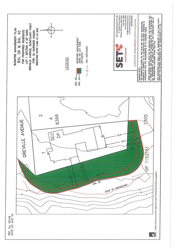
|
|
Strategy and
Assets Committee – Tuesday 16 October 2018
Page
1
|
SA18.249 Proposed
Ground Licence to Sussex Inlet Men's Shed Inc. - Thomson Street Sporting
Complex - 29 Thomson Street Sussex Inlet
HPERM Ref: D18/331087
Group: Assets
& Works Group
Section: Business
& Property
Attachments: 1. Proposed
Licence Plan ⇩
Purpose / Summary
This report provides Council
with an opportunity to consider an approval to grant a ground licence over
Part Lot 2 DP 1062625 – Thomson Street Sporting Complex, 29
Thomson Street Sussex Inlet (refer to attachment 1) to the Sussex Inlet Men’s
Shed for a one year short term licence, at an annual rent of $493 plus GST,
with annual CPI increases.
|
Recommendation
That Council:
1. Enter
into a one year short term ground licence over Part Lot 2 DP 1062625 Thomson
Street Sporting Complex with Sussex Inlet Men’s Shed for an annual rent
of $493 plus GST, with annual CPI increases, for the purpose of operating a
men’s shed.
2. Authorise
the General Manager to sign all documentation required to give effect to this
resolution and to affix the Common Seal of the Council of the City of
Shoalhaven to all documentation required to be sealed.
|
Options
1. Adopt the
recommendation.
Implications: The ground
licence will allow the Licensee to continue to occupy the premises and provide
a place for men to gather, converse, share skills and provide a safe and secure
facility for storage of tools, equipment including a bus trailer.
2. Not adopt the
recommendation.
Implications: The Licensee will be required to find
alternate premises for single use occupation to enable use and provide safe and
secure storage of tools, equipment and bus trailer.
Background
Sussex Inlet Men’s Shed provides a place for local men
to meet and enjoy the company of other men with similar interests, encourage an
environment to discuss men’s health, both mental and physical, and the
sharing of skills learnt over a working lifetime within the wider community.
The Sussex Inlet Men’s Shed provides a support network to the male
residents of Sussex Inlet, Cudmirrah, Berrara, Wandandian, Basin View and Fisherman’s
Paradise
The Sussex Inlet Men’s Shed was formed circa 2007, and
initially occupied the premises identified as the shed adjoining the eastern
side of the tennis club house. In 2012, the Men’s Shed was the driving
force for obtaining development consent for and construction of a purpose built
3 bay garage for storage of a bus trailer and equipment, and additionally, it
gave an opportunity to provide extra bays for sporting and/or community groups.
Due to the nature of the existing occupancy, that being use of
tools and machinery for the purpose of operating a “Men’s
Shed”, the facility occupied by the Sussex Inlet Men’s Shed is not
available for public hire and therefore does not fall under a public facility
definition. Therefore a formal licence agreement is required to cover the
ongoing occupation of the facility
Council’s Property Unit and
the Sussex Inlet Men’s Shed have worked together to negotiate a ground
licence for the area currently occupied at the Thomson Street Sporting
Complex. The schedule of agreed terms is provided below:
Terms Schedule
|
Licensor:
|
The Council of the City
of Shoalhaven as Crown Land Manager – R180065 – Thomson Street
Sporting Complex.
Administration
Building
42 Bridge Road, Nowra, NSW, 2541
Tel: 02 4429 3111
Fax: 02 4422 1816
Email Council@shoalhaven.nsw.gov.au
|
|
Licensee:
|
Sussex Inlet
Men’s Shed
ABN: 30 832 610 991
Thomson St Sporting
Complex Sussex Inlet
Telephone: 02 4441 0090
(Shed – 8am to 12 noon Mon, Wed, Fri)
Mobile: 0457 996 775
Email:
kevftho84@gmail.com
|
|
Premises:
|
Part Lot 2
DP 1062625
|
|
Licence Term:
|
1 year
|
|
Commencing date:
|
TBA
|
|
Terminating date:
|
TBA
|
|
Licence preparation
fee:
|
$350.00
|
|
Rent:
|
Statutory Minimum
$493.00 plus GST per
annum
|
|
Rent Assessment:
|
Not applicable
|
|
Fee
review
|
Annually in accordance
with CPI
|
|
Outgoings:
|
100%
|
|
Permitted use:
|
Community not for profit
organisation - Men’s Shed meetings and all activities incidental
thereto.
|
|
Limit of liability
under insurance:
|
$20 Million
|
Initial licence negotiation with Sussex Inlet Men’s Shed
was prior to the commencement of the Crown Land Management Act 2016 (CLM Act)
on 1 July 2018. The CLM Act authorises councils that are appointed to manage
dedicated or reserved Crown land as if it were community land under the Local
Government Act and a plan of management must be adopted for that community
land. A transition period of 3 years applies, and a plan of management must be
in place within that time.
Prior to the adoption of a plan of management, Council under
the Act can only issue a new short-term licence for a maximum period of one
year if the licence is for a prescribed purpose under the CLM Act. Therefore
the initial term of 5 years as requested by the Sussex Inlet Men’s Shed
will now be revised to a one year short-term licence that will need to be
renewed each year until a plan of management is approved by the Minister; a
longer term agreement can then be entered into.
Community Engagement
In accordance with Section 47A of the Local Government Act, a
public notice of the proposed licence was physically attached to both the 3 bay
garage and existing shed that adjoins the eastern side of the tennis clubhouse,
as well as public notification by way of newspaper advertising in the South
Coast Register and Milton Ulladulla Times on Wednesday 1 August 2018
for a period of 28 days. Adjoining property owners, Sussex Inlet and District
Community Forum and the Thomson Street Sporting Complex Management Committee
have also been notified.
Three submissions were received and raised the following
concerns:
|
Issue
|
The complex is a community facility and should remain
under the control of the Council delegated committee i.e. Sussex Inlet
Thomson Street Facilities Management Committee.
|
|
Council response
|
The facility occupied by the Sussex Inlet Men’s
Shed is not available for public hire and therefore does not fall under the
term “public facility”. A formal Licence agreement is required.
|
|
Issue
|
The Management
Committee needs to be part of the process for
leasing of the complex so other community groups are not disadvantaged or a
precedent is set.
|
|
Council response
|
Although the Management
Committee represents Council, it is not a separate entity and has no
authority to execute leases/licences. The input of the Management Committee
has been requested through informal request for comment and formal public
notification.
|
|
Issue
|
Dissatisfaction with
the state of the complex; number of extra buildings being erected; lack of consistency
in building materials and construction; appearing to look more and more
industrial in nature; considerable deterioration of standard of buildings at
the complex.
|
|
Council response
|
The proposed ground
licence is to formalise an existing occupation. No new building is
proposed.
|
|
Issue
|
Public notice implied
the proposed ground licence was for the whole of the Sussex Inlet Thomson
Street Sporting Complex. However, if the ground licence is only for the
existing facilities used by the Sussex Inlet Men’s Shed, then no
comment.
|
|
Council response
|
It is confirmed that the proposed licence is for the
existing occupation of facilities.
|
|
Issue
|
Initial concerns raised over control of the 3 bays in
the garage.
|
|
Council response
|
The licence is a ground licence only. A special
condition is to be included in the licence to address concerns about usage of
the 3 bay garage by sporting and/or community groups.
Special Condition:
The
hebel, concrete and steel garage identified as the western licenced area is
to be occupied as follows:
Sussex
Inlet Men’s Shed
……………………… approximately
50%
Rotary
Club
…………………………………………
approximately 25%
Community
groups………………………………
approximately 25%
As per the
existing configuration.
The Rotary Club
and Community Groups will have unhindered access to their allocated storage
areas for the term of any ground licence granted by Council.
|
An acknowledgment letter has been sent to those who provided a
submission during the public notification period and detailed response letter
will be forwarded following resolution.
|
|
Strategy and
Assets Committee – Tuesday 16 October 2018
Page
1
|
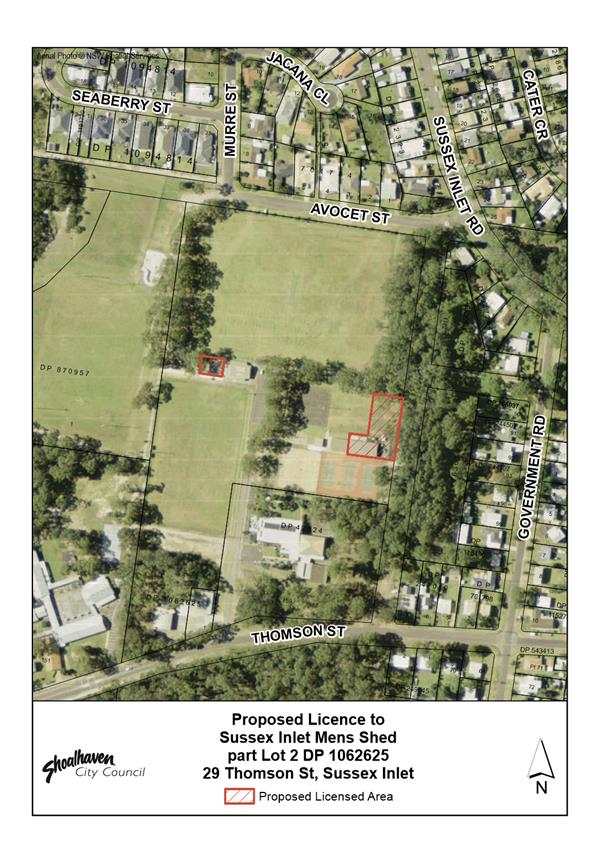
|
|
Strategy and
Assets Committee – Tuesday 16 October 2018
Page
1
|
SA18.250 Response
- MIN18.290 regarding various issues in the Huskisson Area
HPERM Ref: D18/206735
Group: Assets
& Works Group
Attachments: 1. JBMM
Banner Bracket Policy 2017 ⇩
Purpose / Summary
The following is a response to the
24 April 2018 Resolution (Min18.290) regarding various issues in the Huskisson
area.
|
Recommendation (Item to be determined
under delegated authority)
That Council note the responses
to the 24 April 2018 Resolution (MIN18.290) regarding various issues in the
Huskisson area.
|
Background
At the Ordinary Meeting on 24
April 2018, Council resolved as follows (MIN18.290):
That:
1. Council
recognises and gives priority consideration in the budget process to the
following (noting the importance of item 1a as a priority)
a. Prepare
a comprehensive current traffic/parking control plan and fund and construct a
roundabout at the intersection of Owen/Sydney/Tomerong streets (Picture Theatre
corner).
b. Remove
the existing work/dump area at the entrance to Husky Road north side (opposite
the new sign) and replant with trees to compliment the other side.
c. Sports fields public amenities
upgrade
2. The following items be costed and
reported to Council
a. Outdoor gym equipment in Voyager
Park.
b. Car Parking solutions (a
significant on-going issue)
c. Add trees to village entrance on
south side near the Bowling Club to create an avenue.
d. Install banners in Owen street on
power poles for holidays/ white sands carnival.
Responses
are provided by various officers as follows;
1. Council recognises and gives
priority consideration in the budget process to the following
(noting the importance of item 1a as a priority)
a. Prepare a comprehensive current traffic/parking control
plan and fund and construct a roundabout at the intersection of
Owen/Sydney/Tomerong streets (Picture Theatre corner).
Response: Director Assets and Works
The construction of a roundabout at
the intersection of Owen / Sydney / Tomerong Streets Huskisson has been noted
as a priority for consideration / inclusion in future budget with an allocation
of $800,000. See item 2b for car parking study / control plan.
Economic Development will be seeking
funding opportunities by submitting applications through Building Better
Regions Program and Stronger Country Communities Fund when opportunities arise.
The June Quarterly Budget Review also
has provided funding of $25,000 for design and costing so that the construction
of a roundabout can be “shovel ready”.
b. Remove the existing work/dump area at the entrance to
Husky Road north side (opposite the new sign) and replant with trees to
compliment the other side.
Response: Director Assets and Works
There is a designated stockpile site
at the intersection of Pine Forest Road and Naval College Road.
The verge on the north side of
Huskisson Rd is generally not used for stockpiling of material, although has
been used for a temporary works compound at various times during construction
projects.
Staff are currently finalising a list
of citywide streetscape improvement projects for the FY18/19 streetscape budget
and this project will be nominated for consideration by Council.
c. Sports
fields public amenities upgrade
Response: Director Finance Corporate & Community
It is understood that this item
specifically relates to the Huskisson Sporting Fields. The community representatives
have suggested that: “the current facility has a feel of the
1960’s. There is now 400 registered soccer players, plus market attendees
and carnival attendees using the facilities. There are only 2 female cubicles
in these facilities. People now use the Bowlo’s facilities as public
facilities seem inadequate”.
The amenities were updated in 2008
and are not programmed for any further works this financial year. The current
arrangement meets the requirements of 180 persons. The facilities are only opened
to patrons of the Huskisson sports fields when it is in use. They are not
considered Public Amenities as they specifically service the sporting fields.
Council’s Community
Infrastructure Strategic Plan 2017-2036 notes no further works or recommendations
for upgrades for the Huskisson Sports Ground. The 2017 Seasonal Allocation Form
identifies 368 registered players and two fields.
The appropriate manner to deal with
this issue would be to directly engage with the users groups when
Council’s Community Infrastructure Strategic Plan is reviewed. This
is expected to occur in 2021 following the next local government elections.
2. The following items be costed and
reported to Council
a. Outdoor
gym equipment in Voyager Park.
Response: Director Finance Corporate & Community
Council staff are currently
finalising the detail design for Voyager Park, and have commenced the
construction works to complete the HMAS Voyager memorial, park entrance and
path in line with funding received from the Commonwealth Government under the
Community Development Grants Program. In addition, the concept plan for Voyager
Park also includes an extension to the existing playground and water play
facility. Considering any addition infrastructure in this location is not
recommended as it may result in overcrowding of facilities and detract from the
ambience of Voyager Park. Delivering the masterplan is consistent with
Council’s adopted Community Infrastructure Strategic Plan.
Other areas in Huskisson should be
considered for such facilities, including White Sands Park or Moona Moona Creek
Reserve. Installation of outdoor gym equipment should be considered along
established shared paths rather than as a single station with multiple
equipment types. This provides users the opportunity to travel along the paths,
stop for a specified exercise and continue on. This option also limits the
amount of space required for the facility, which is a necessary consideration
for these open space areas in Huskisson which are highly utilised for events,
and reduces the impact from a noise and congestion perspective on the
surrounding sensitive land uses such as residential dwellings. An indicative
cost for the supply and install of facility which includes approximately eight
to ten outdoor gym equipment pieces is approximately $75,000.
Council’s Community
Infrastructure Strategic Plan 2017-2036 does not identify this facility as a
requirement in Huskisson. Existing outdoor exercise equipment is provided in
the Bay & Basin area at Plantation Point, Vincentia, and Paradise Beach,
Sanctuary Point.
The
appropriate manner to deal with this issue would be to directly engage with the
users groups when Council’s Community Infrastructure Strategic Plan is
reviewed. This is expected to occur in 2021.
b. Car Parking
solutions (a significant on-going issue)
Response: Director Assets and Works
The
Huskisson Traffic and Parking study was completed in December 2016. Council
resolved 20 December 2016 (MIN16.1048)
That
1. The Huskisson Traffic and Parking Study
be made publicly available
2. Commence survey
design and consultation for all short-term pedestrian and traffic management
options in accordance with the recommended strategy
3. Consider
reviewing the Development Control Plan and Contributions Plan projects related
to car parking and traffic facilities
4. As part of the
next major review of the Shoalhaven Local Environmental Plan, based on the
study findings consider planning for the long-term provision of a Huskisson
Bypass (alternative road access around the town centre for through traffic)
The study identified (based on Council’s current
policy/CAR parking rates) that there is currently adequate parking in
Huskisson. It is the demand “over and above” those minimum rates,
particularly on weekends and holidays that creates the current angst in
Huskisson.
However, city-wide the Development Control Plan (DCP) and
Contributions Plan (CP) do not provide for those higher levels of demand.
Generally, if Council wanted to satisfy those higher level demands this would
have to be funded separately (in addition to car parking projects identified in
the DCP/CP), and subject to considering city wide priorities (the higher levels
of parking demand experienced in Huskisson is common in many of
Shoalhaven’s towns and villages).
Because a key outcome of the analysis was that parking
supply in Huskisson was currently sufficient (in accordance with Council
policy), there was no resolution in December 2016 to address parking in the
short term (item 3 of the resolution intended to address strategic planning for
future car parking provision).
At the time the Huskisson Traffic and Parking study was
completed, it was unknown what the future direction was in regards to
· #59
Owen Street (the study considers both with/without),
· it
was assumed the Church and Crown land (Currumbene Street) would both be
required as part as part of the future car parking strategy (now uncertain
whether this can be achieved), and
· it
was reported that an additional 40 spaces (approximately) could be created on
the same land as the existing Owen Street car park by reconfiguring the
existing car park to create a fourth aisle of parking to minimum Australian
Standards (the car park immediately adjacent to the bottle shop). The Owen
Street car park option (although available as a short term option) was never
pursued by Council as it considered the future development potential of that
land.
The study was comprehensive and provided all the
supply/demand numbers for Council to consider, however the Strategy
remains unresolved.
Because of uncertainties over key parcels of land
historically considered to be options for a Huskisson car parking strategy, the
DCP and CP has been unable to be progressed because the DCP and CP reviews are
effectively later steps when Council resolves its actual carparking strategy
for Huskisson. Before the reviews can be undertaken, actual sites and intended
works, with indicative costings, need to be known.
The following provides further
commentary in relation to the above “unresolved” sites:
The Church and Crown Lands (Currumbene Street)
The study envisaged being able to provide 80 spaces on each
parcel, 160 in total if both developed to full potential, as car parking.
However, the land referred to as Crown Land in the study is
now in the ownership of the Jerrinja Local Aboriginal Land Council (LALC).
Additionally, it is understood that the Church are in the process of selling
their land to a developer who may ultimately pursue its development. As such
the use and availability of both parcels is unknown at this point.
Regarding the LALC lot, initial discussions have been held
regarding Council’s desire to use this parcel as a car park in the longer
term. Following the recent completion of the Memorandum of Understanding (MoU)
with the LALC, Council’s staff will continue to liaise with them re the
use of this site. It may be that they could ultimately be interested in leasing
the land to Council for this purpose to create an income stream rather than a
one-off purchase. It should be noted that before the LALC can deal in this land
that it needs to be surveyed and other procedural steps taken. Council staff
will report back separately on this in due course. However, the potential number
of spaces on this LALC land is unknown at this point as there are, for example,
several unmarked graves on the land, and environmental issues to be considered
(there are a significant number of, and some very large trees on the land, which
may not be suitable to coexist in a car park).
The Existing Owen Street Car Park (next to bottle shop)
At this point the land is commercially zoned and Council
needs to clarify whether it wishes to pursue development of this nature, which
could possibly include car parking. Council has always required any development
of public car parks to provide both replacement public car parking and any
parking required by the actual development. It is likely that if Council were
to pursue a redevelopment of this site that it would take many years to
realise.
Currently the adopted contributions plan for Huskisson car
parking (03CARP2002) only includes one project (to provide a minimum of 87
spaces over the three parcels of land immediately adjacent to the bottle shop);
this only includes the land subject of the existing car park immediately
adjacent the bottle shop, and does not include the two parcels of land later
purchased between the existing car park and Sydney Street (currently used as
temporary overflow car parking). There is currently $656,144.96 available to
the 03CARP2002 project. A design has been prepared identifying 42 spaces that can
be created over the existing car park land, at an estimated cost of $170,000
(adjusted from an earlier estimate in 2015, and contingency added).
As such in the interim the provision of an additional 40+
spaces is still an option for Council to consider.
59 Owen Street
Council was briefed on the status of 59 Owen Street
recently. At this briefing staff advised that before the site is redeveloped
for a community use (i.e. park or similar) that the car parking strategy for
Huskisson needs to be clarified and replacement parking identified and
constructed before the existing parking on 59 Owen Street is removed.
Councillors were provided with a range of information on the site at 59 Owen
Street and its history. The consensus at the briefing was the Councillors
wanted a half day workshop (4-7pm) to discuss and ventilate the range of issues
associated with the site and the adjacent areas, including carparking. The
workshop is still to be scheduled.
Huskisson Streets
The Huskisson Traffic and Parking study identified that a
significant amount of on street car parking could be provided in the streets
around the Huskisson town centre, but strongly recommended that Council should
not include their provision in its DCP/CP (which is meant to provide for the
minimum levels of demand in off street car parking locations). The on street
car parking locations will be an important future stock of car parking supply
to address demands higher than Council’s minimum rates but will need to
be funded separate to the DCP/CP to avoid a significant encroachment of car
parking in the future on the surrounding residential area.
Following the Huskisson Traffic and Parking study a design
was prepared for 90 degree car parking at the northern end of Currumbene Street
(between Owen and Morton Streets). The Western side was constructed immediately
following, and the eastern side remains outstanding (but design is construction
ready). The design kerb line is set back to a new alignment along Currumbene
Street that will facilitate 90 degree car parking along its whole length
(ultimately to Bowen Street) on both sides. $100,000 is required to be
allocated by Council if they want to proceed with the works (just the eastern
side between Morton and Owen Street).
Options
A report outlining short term car parking options will be
compiled for Council’s consideration in October and November and thus
provide early consideration for the 2019 - 2020 budget.
c. Add trees to village entrance on south side near the
Bowling Club to create an avenue.
Response: Director Assets and Works
It is proposed to remove the existing
Liquid Amber trees on the southern side of Huskisson Road from the entry into
the Huskisson Bowling Club to Kioloa Street. These trees are many decades old,
have been heavily lopped and disfigured, due to Endeavour Energy pruning
beneath overhead power lines.
In addition, it is intended to
replace the trees on the northern side of the road (directly opposite) which
are failing to thrive. This will afford the opportunity of creating an avenue
of more suitable trees leading into Huskisson.
A concept diagram of proposed works
and planting species will be prepared and presented to Huskisson Chamber of
Commerce and the CCB.
Following consultation, landscape
works will proceed when conditions are suitable to planting between March and
April, using funding held in the Streetscape Renewal budget of $512K.
d. Install banners in Owen street on power poles for
holidays/ white sands carnival.
Response:
Director Finance Corporate & Community
Banners are already installed on Owen
Street, and can be booked for advertising, managed by the Jervis Bay Maritime
Museum (JBMM). The attached document provides details on the JBMM Policy and
associated costs.
|

|
Strategy and Assets
Committee – Tuesday 16 October 2018
Page
1
|
|

|
Strategy and
Assets Committee – Tuesday 16 October 2018
Page
1
|
SA18.251 Proposed
Road Closure & Subdivision - Part North Crescent, Culburra Beach
HPERM Ref: D18/127393
Group: Assets
& Works Group
Section: Business
& Property
Attachments: 1. Aerial
View of North Crescent Culburra ⇩
2. Plan - Proposed 5 Lot
Subdivision ⇩
Purpose / Summary
This report provides Council
with the opportunity to approve the closure of the surplus road reserve at
North Crescent, Culburra Beach shown as per Attachment 1, with the intention to
create a 5 lot subdivision for Council to sell to reinvest in future roads
projects.
|
Recommendation
That Council:
1. Resolve,
as Roads Authority, to close the surplus road reserve at North Crescent
Culburra Beach, adjacent to Lot 738 DP 12278, Lot 1 DP 286157, Lots 7621 and
7622 DP 1205582 and Lots 1 and 2 DP 526508 by a notice published in the
Government Gazette.
2. Authorise
the Common Seal of the Council of the City of Shoalhaven be affixed to any
documentation requiring to be sealed and delegate to the General Manager
authority to sign any documentation necessary to give effect to this
resolution.
|
Options
1. Resolve as
recommended.
Implications: The closure of
North Crescent and subsequent subdivision and sale of 5 residential lots
(subject to separate Council approval) will provide Council an opportunity to
generate income to reinvest into future road projects.
2. Not adopt the
recommendation and maintain the status quo.
Implications: Council will miss a commercial
opportunity to generate income to invest in future road projects.
Background
The subject road reserve is zoned R2 Low Density Residential under
the Shoalhaven LEP 2014. The proposal is to close the road reserve, create 5
new residential allotments ranging from approximately 620m2 to 800m2
in area and provide a new road alignment and reserve. The subdivision of the
land would be subject to a Development Application and subsequent separate
Council approval for the sale of the five allotments.
The proposal to close this section of road has been considered
by the various departments of Council and no objection to the closure has been
raised.
There is no objection to the closure from any of the
notifiable authorities.
Community Engagement
The road closure process required public notification and
advertising calling for submissions by any interested parties on the merits of
the proposal. This consultation has been undertaken and the submission period
closed on 15 March 2016. Several submissions were received from interested
parties; results of which are detailed in the table below:
Submissions
|
Issue - 37 Allerton Avenue –
Privacy
The property owner of 37 Allerton Avenue, Culburra
Beach expressed privacy concerns due to their home being east facing, which
will result in their balcony overlooking the backyard of the newly created
lots.
Resolution
Council staff have agreed with the property owner to
provide a 1.5metre boundary adjustment as per attachment 2 and highlighted in
green, in favour of the property owner, to allow for the planting of trees
for the purpose of privacy screening.
Any proposed sale to the adjoining owner would be at
agreed value, subject to separate Council approval and all costs associated
with the sale transaction (legal, valuation, subdivision plans) are to be
borne by the property owner.
|
|
Issue - 112 Penguin Head Road – Garage Access
and Privacy
The property owner at 112 Penguin Head Road (Lot 738
DP 12278) expressed concerns over their driveway access. The property owner
asserts that the creation of the new lots will shorten their driveway to the
south boundary making it difficult for them to exit their garage.
Resolution
Council staff have agreed to provide the property
owner a 3 metre boundary adjustment as per attachment 2 and highlighted in
blue, in favour of the property owner, to allow for a generous turning circle
and unobstructed access to their garage, along with the ability to plant
trees for privacy screening.
Any proposed sale to the adjoining owner would be at
agreed value and subject to separate Council approval and all costs
associated with the sale transaction (legal, valuation, subdivision plans)
are to be borne by the property owner.
|
|
Issue - 188 Marina Lane – Loss of Amenity and
View
The property owner at 188 Marina Lane Culburra Beach
(Lot 7621 DP 1205582) expressed concerns over the loss of amenity and view
given the attraction of the block of land was because of its corner aspect,
with ocean views.
Council staff consulted with the property owner over
many months and presented several options to the property owner for
consideration, being:
Option 1
That access be provided to the property via a rear
access “handle”.
Option 2
Council consider selling a wedge of land to the
property owner, as per attachment 2 and highlighted in yellow, of
approximately 300m2 which would preserve the accustomed
ocean views.
Option 3
Council consider a boundary adjustment in favour of
the property owner of approximately 108m2 which would result in a
3 metre extension of the eastern boundary.
Resolution
Council staff have agreed to Option 2, to
ensure the protection of the property owner’s amenity and view and
provide unobstructed access to garage.
Any proposed sale to the adjoining owner would be at
agreed value and subject to separate Council approval and all costs
associated with the sale transaction (legal, valuation, subdivision plans)
are to be borne by the property owner.
|
|
General Issues raised during the submission period
During the submission period several residents
expressed concerns over the current drainage and existing kerb &
guttering.
Resolution
Property owners and concerned residents were all
advised that kerb and gutter will be provided to both sides of North Crescent
as part of the proposed subdivision and drainage is to be incorporated into
the subdivision design.
|
Financial Implications
If the road is closed and a subdivision created, Council will
receive proceeds for the sale of 5 residential parcels of land. The sale
proceeds will be transferred to an appropriate reserve for use on future road
projects in accordance with Section 43 of the Roads Act 1993.
|
|
Strategy and
Assets Committee – Tuesday 16 October 2018
Page
1
|
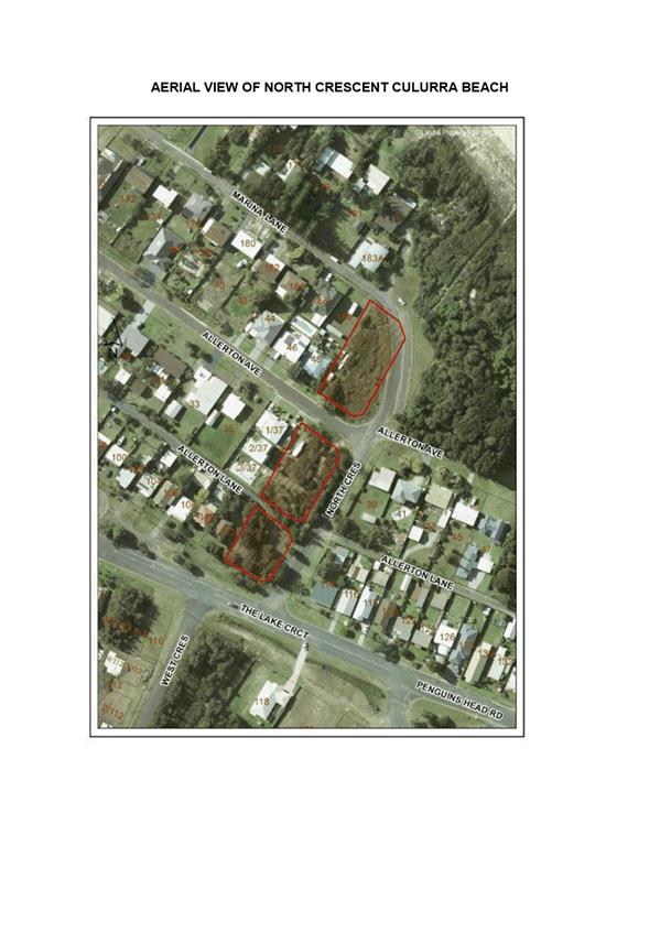
|
|
Strategy and
Assets Committee – Tuesday 16 October 2018
Page
1
|
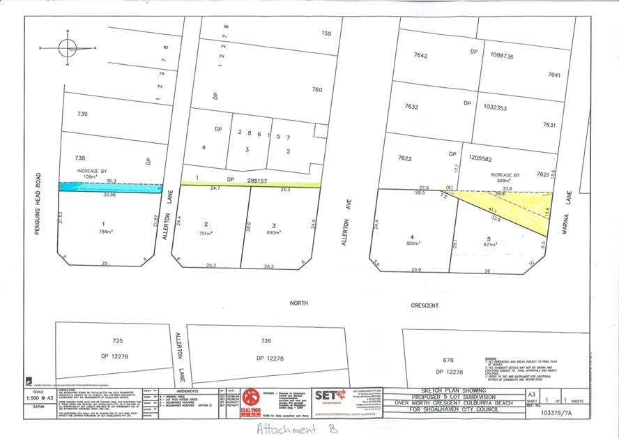
|
|
Strategy and
Assets Committee – Tuesday 16 October 2018
Page
1
|
SA18.252 NSW
Government Saving Lives on Country Roads Program 2018-19 and 2019-20
HPERM Ref: D18/329298
Group: Assets
& Works Group
Section: Asset
Management
Purpose / Summary
To approve the 2018/19 and
2019/20 Assets & Works (NSW Government Saving Lives on Country Roads)
program.
|
Recommendation
That:
1. Council
accepts the offers of funding from the NSW Government under the new Saving
Lives on Country Roads Program, as follows:
a. $770,000
to upgrade Sussex Inlet Road in the vicinity of Old Berrara
Road (safety barriers, delineation, sealed shoulders, and intersection
improvements), and authorises the expenditure ($80,000 in 2018-19 and
$690,000 in 2019-20).
b. $740,000
for the shoulder widening and sealing on Greenwell Point Road
to the east of Jindy Andy Lane, and including vehicle activated signage on Greenwell
Point Road (on the approaches to the Jindy Andy Lane intersection),
and authorises the expenditure ($200,000 in 2018-19 and $540,000 in 2019-20).
c. $555,000
for the removal of the hazardous crest on Forest Road (to
improve safety in one of the few overtaking zones on Forest Road), and
authorises the expenditure ($80,000 in 2018-19 and $475,000 in 2019-20).
d. $260,000
to extend the existing guardrail and install profile edge and
centre lines over the 2.2km length of Naval College Road (to the south of The
Wool Road), and authorises the expenditure (completion in 2018-19).
e. $800,000
for the shoulder widening and sealing on Coonemia Road (the
first 2km to the south of Culburra Road), and authorises the
expenditure ($100,000 in 2018-19 and $700,000 in 2019-20).
2. The
General Manager (Director Assets & Works) writes to the NSW Roads &
Maritime Services, and both local State Members of Parliament, thanking them
for their ongoing support of the Shoalhaven Community through the new NSW
Government Saving Lives on Country Roads Program, and for the support of RMS
staff in reviewing and supporting Council’s nominations for these
important local road safety improvements.
|
Options
1. Adopt the
recommendation
2. Not accept the
recommendation
Implications: This will mean these important safety
improvements cannot be delivered and is likely to lead to continuing crashes at
these locations.
Background
A
report was presented to the Council’s Strategy & Assets Committee
meeting on 24 July 2018 after a media announcement in June about the NSW
Government’s new “Saving Lives on Country Roads” program, and
after the RMS advised Council a letter of offer would follow within a few
weeks.
It was subsequently resolved:
“That:
1. Once
Council receives the final letter of offer from RMS under the NSW Government
Saving Lives on Country Roads Program, that Council accepts the grant funding
offers, as follows:
a. Either
$470,000 or $770,000 (exc GST) will be approved, to upgrade Sussex Inlet Road in the vicinity of Old Berrara Road (the difference
being whether a high friction seal component is approved to improve safety on
the curve to the west of Old Berrara Road).
b. $590,000
(exc GST) for the shoulder widening and sealing on
Greenwell Point Road to the east of Jindy Andy Lane.
c. $555,000
(exc GST) for the removal of the hazardous crest on Forest
Road (to improve safety in one of the few overtaking zones on Forest Road).
d. $260,000
(exc GST) to extend the existing guardrail and install
profile edge and centre lines over the 2.2km length of Naval College Road (to
the south of The Wool Road).
e. $800,000
(exc GST) for the shoulder widening and sealing on
Coonemia Road (the first 2km to the south of Culburra Road).
2. Once Council
receives the final letter of offer from RMS, the General Manager (Director
Assets & Works) writes to the NSW Roads & Maritime Services, and both
local State Members of Parliament, thanking them for their ongoing support of
the Shoalhaven Community through the new NSW Government Saving Lives on Country
Roads Program, and for the support of RMS staff in reviewing and supporting
Council’s nominations for these important local road safety
improvements.”
Council
received a letter of offer from RMS at the start of September. Although late to
arrive the letter still outlined an expectation that all projects could
commence construction in the 2018/19 financial year period.
Staff
subsequently met with RMS to discuss a more achievable delivery of the approved
projects, and a revised letter of offer from RMS was sent to Council on 18
September 2019, detailing a split of funds over two financial years.
A
total of five projects are approved under the NSW Government’s new
“Saving Lives on Country Roads” program, as detailed in the
proposed recommendation, totalling $3,125,000 of additional grant funds for new
road safety improvements.
These
are the same projects reported to Council in July, although a revised funding
profile has been approved (allowing the projects to be delivered more
realistically over two years).
Community Engagement
Initial community engagement has
been undertaken for all of the projects to date; directly affected
properties and community consultative bodies were notified after the projects
were identified, and further consultations will be undertaken where required as
a part of the delivery of the projects.
Financial Implications
NSW Saving Lives on Country Roads Projects are 100% funded
by the NSW State Government.
|
|
Strategy and
Assets Committee – Tuesday 16 October 2018
Page
1
|
SA18.253 Funding
Request - Volunteer Adopt A Road Programme
HPERM Ref: D17/416011
Group: Assets
& Works Group
Section: Works
& Services
Purpose / Summary
To request Council to consider
in principle support and funding in the 2019/2020 budget and future budgets for
a volunteer Adopt A Road Programme on receipt of participation from Community
Consultative Bodies.
|
Recommendation
(Item to be determined under delegated authority)
That Council give in principle
support to the creation of an Adopt a Road Program and that the General
Manager (Assets and Works) develop a manual to cover the activities of
community groups and consult with the CCBs to develop a budget consideration
for the 2019/2020 financial year.
|
Options
1. As recommended.
Implications: Undertake volunteer works which will
reduce litter and rubbish alongside Council’s roads which will greatly
improve the aesthetics of roads and entrances to Shoalhaven towns and villages
for an extended period of time. Allocation of $6,000 annually to fund the
programme
2. Council not
support expanding the Adopt A Road Programme.
Implications: The level of litter and rubbish will
remain similar or increase as tourism increases. Council may have to fund ad
hoc staff clean ups to address community concens.
Background
Council is responsible for the
maintenance of sealed and unsealed roads within the local government area. This
does not include the Princes Highway, which is under Roads & Maritime
Service delegation.
Throughout the year Council receives
numerous complaints regarding the roadside litter along the entrance roads into
villages, and Council does not have a routine programme (and budget) to clean
up this litter on a regualr basis.
Some time ago, Council had a
Parkcare Group in the Basin area that did do a little bit of roadside litter
collection as part of its voluntary work, but this group has not operated for
some years. The Adopt A Road programme is a programme that has evolved to allow
community groups to play an active role in the appearance of particular roads
and has existed in other Councils throughout Australia but has not operated in
the Shoalhaven.
The Adopt A Road programme is a
great opportunity to empower community groups to collect litter and thus
improve the appearance of entrance roads into villages in the Shoalhaven and
enhance the natural beauty of the area for the enjoyment of residents and
visitors.
Benefits would include:
· The
cost effective reduction of litter “hot spots”.
· Increased
awareness of effects of littering.
· Improved
attractiveness of the Shoalhaven’s local roads.
· A
sense of local pride and accomplishment for the community.
The Adopt A Road programme
requires the development of a manual to cover group aims, best practices, WHS
and responsibilities across the whole programme. This manual would need to
include required training and traffic conderations etc.
Council would provide basic
funding to cover the resources required by the community groups such as PPE,
bags, minor tools, signage, training and any associated costs with the
collected litter being delivered to a waste facility (if that was required).
The take up of such a programme
is hard to esimate; however, an allocation of $6,000 a year is likely.
Community Engagement
Community Consultative Bodies
(CCBs) will be encouraged to form an Adopt A Road Group for their area. The
groups can be made up of members of the CCB and local residents.
Each group will be required to
register along with individual members. Registration will be a simple form requesting
a group to be established and the areas in which they would deem a litter
hotspot to carry out their task. Each member registering will be required to
complete a membership form that will include contact details. These details
will be kept on a Council database along with a record of hours accomplished
and a total of waste picked up.
All volunteers will also be
required to complete the WHS Online Volunteer Induction and acknowledge they
have read the Volunteer Handbook.
Financial Implications
There will be ongoing yearly
costs associated with participating groups with an estimate of $6,000 per year
depending on the amount of time volunteers spend on clean ups. This includes
personal protective equipment, tools and waste tipping fees.
Risk Implications
The Adopt A Road manual would
include Safe Work Practices and standard traffic control plans which would be
available for use by volunteers to mitigate risk of working within road
reserves. Council staff would also be made available to assist with traffic
control on major clean up days or events if required and there is a proven cost
benefit to Council to do so.
|
|
Strategy and
Assets Committee – Tuesday 16 October 2018
Page
1
|
SA18.254 Shoalhaven
Coastal Zone Management Plan - certification and gazettal
HPERM Ref: D18/334265
Group: Planning
Environment & Development Group
Section: Environmental
Services
Purpose / Summary
Provide Council with an update
on the certification and gazettal of the Shoalhaven Coastal Zone Management
Plan.
|
Recommendation
(Item to be determined under delegated authority)
That Council receive the report
on the certification and gazettal of the Shoalhaven Coastal Zone Management
Plan for information.
|
Options
1. Council accept
the report for information
Implications: Nil
2. Council could
choose to provide an alternative recommendation for future consideration by
Council.
Implications: Would depend on the recommendation
Background
After consideration of public
submissions, Shoalhaven City Council adopted the Coastal Zone Management Plan
2018 (CZMP) on 26 June 2018.
On 29 June 2018 the CZMP, with
appendices and agency letters of support, were submitted to the Minister for
Environment, Heritage and Local Government, The Hon. Gabrielle Upton, for
certification. On Friday 21 September 2018 the CZMP was published in the NSW
Government Gazette.
Community Engagement
The CZMP 2018, with appendices, was
on public exhibition for 21 days from 23 May 2018 to 12 June 2018.
· The
CZMP was posted on Council’s website (Get Involved) during this time
· Hard
copies were available at Council Administrative Offices in Nowra and Ulladulla
and at Nowra, Sancturay Point, Ulladulla and Milton libraries
· Three
community drop in sessions were held:
Nowra – 29 May 2018
Ulladulla - 31 May 2018
Vincentia – 7 June 2018
A submissions table (summarising
2016 and 2018 submissons) was included as Appendix 3 of the CZMP.
Policy Implications
Staff are now able to seek
resourcing to implement works under the Coastal Program, with clearly
identified actions contained within the CZMP.
Staff have commenced
implementing priority actions from the CZMP, including:
· preparing
information for landholders living adjacent to geotechnical hazards (Action
C6.4)
· incorporating
a monitoring program for public land and infrastructure, including viewing
platforms, stormwater drainage, sewer and water infrastructure in identified
coastal cliffs and slopes risk areas, into Council’s maintenance programs
(Action 6.4)
· rehabilitating
areas of public land at Inyadda Point and Mitchell Parade, Mollymook consistent
with the Landslide Risk Assessment undertaken for this area as required
(Actions LA4.5 & LA5.16).
Council has already approved the
full-time position of Coastal Program Coordinator, which is currently being
recruited. This position’s key role will be the implementation of the
CZMP and oversee the transition to a coastal management program as per the new
Coastal Management Act 2016.
Financial Implications
Now that the CZMP 2018 is
certified and gazetted, Council is eligible to apply to the Coast &
Estuaruies Grant program.
Staff will prepare and submit
grant applications for relevant projects. This includes projects that have been
on hold, such as the preparation of a Coastal Management Program for the Lower
Shoalhaven River Estuary.
The guidelines of the Coastal
and Estuary Grant Program require Council to provide 50% of grant funds.
|
|
Strategy and
Assets Committee – Tuesday 16 October 2018
Page
1
|
SA18.255 Shoalhaven
Coastal Management Projects Updates
HPERM Ref: D18/337229
Group: Planning
Environment & Development Group
Section: Environmental
Services
Attachments: 1. South
Mollymook Coastal Hazard Distribution Modelling - Study Method Approach Memo -
RHDHV (under separate cover) ⇨
2. Currarong Erosion Remediation
Project - Q & A ⇩
Purpose / Summary
Provide
Council with a progress update on five (5) key coastal management projects,
currently being delivered under the Council’s Coast and Estuary Program,
summarised as follows.
1. South
Mollymook Cost Benefit and Distribution Analysis
2. Shoalhaven
Heads – River Road Foreshore Precinct Restoration
3. Shoalhaven
Coastal Management Program
4. Currarong
Erosion Remediation Project
5. Shoalhaven
Riverbank Restoration
|
Recommendation
(Item to be determined under delegated authority)
That Council receive the updates on the Shoalhaven Coastal
Management Projects for information.
|
Options
1. As
per the recommendation
Implications – the
five-key coastal management project would continue to progress.
2. Council consider
alternative recommendations
Implications – This would depend on the
recommendation
Background
For the
purposes of this report, each of the five-coastal projects have been broken
into the following sub-headings.
i. Overview
ii. Status
iii. Future
Progress
South Mollymook Cost Benefit
and Distribution Analysis
i. Overview
On the
southern end of Mollymook Beach, coastal protection is in place in the form of
a gabion and sandstone seawall (in front of the golf club and Beach Rd) and a
concrete seawall (in front of the Mollymook Surf Life Saving Club (SLSC)).
Large parts of these seawalls have deteriorated to a point that a decision is
required on the repair, removal or replacement of the coastal protection
structures.
In 2016,
Council engaged Royal Haskoning DHV (RHDHV) to prepare a report on the
condition and replacement of these coastal protection structures. The report
recommended replacement of two of the structures and repair of the third. The
estimated full cost of doing this was $4,752,810 for all three structures, with
a 40% contingency for construction costs.
As per the
NSW Coastal Management Manual – Part C, all coastal projects seeking
grant funding over the value of $1 million must undertake a Cost Benefit
Analysis (CBA), using NSW OEH’s Cost-Benefit Analysis to Assess Coastal
Management Options: Guidance for Councils’ and the NSW Treasury Guide to
Cost-Benefit Analysis.
The CBA is
to be undertaken to determine the cost of the coastal management option,
weighted against the economic benefits the coastal protection options would
provide. Council was awarded a $50,000 grant from NSW OEH towards the cost of
undertaking a CBA at South Mollymook, with $50,000 contributed from Council
coastal budget.
In October
2017, Origin Capital Group was engaged by Council to carry out a formal Cost
Benefit Analysis (CBA) for several long-term options identified to manage
coastal hazards at South Mollymook Beach. RHDHV was retained by Origin Capital
Group to carry out a risk-based coastal hazard assessment, which includes
coastal hazard mapping, for South Mollymook Beach to inform the CBA.
As a
variation to the original project, the risk-based coastal hazard assessment
mapping for South Mollymook Beach was expanded to include the whole of
Mollymook Beach.
The mapping
uses a different methodology, called “probabilistic’ modelling, as
opposed to “deterministic” modelling, previously used in the
citywide coastal hazard review 2016 (undertaken by Advisian). For a full
detailed description of the coastal mapping methodology and how it informs the
CBA, please refer to the attached memo from RHDHV on the study approach used
for the coastal hazard assessment.
In simple terms, probabilistic assessment is based on a
group of techniques that incorporate variability and uncertainty into the risk
assessment process. It provides estimates of the range and likelihood of a hazard,
exposure or risk, rather than a single point estimate which is
associated with deterministic assessment.
ii. Status
The
complexities experienced with the new coastal hazard modelling methodology have
delayed the coastal hazard mapping project, and subsequently the South
Mollymook CBA. The project has been delayed by six (6) months, with Council
receiving approval from NSW OEH grants section to delay the finalisation of the
grant project from 30/06/2018 until 22/12/2018. The draft coastal hazard mapping
report is currently being reviewed by staff from both Council and NSW OEH,
before being approved for use to inform the CBA.
iii. Future Status
The draft
CBA report is due to be completed by Origin Securities by October 2018. Once
received, Council staff will review the report and then forward it to NSW OEH
for final approval. The CBA draft report will be reported to Council for
adoption. Final acquittal of the grant project is to be completed in December
2018.
Shoalhaven Heads –
River Road Foreshore Precinct Restoration
i. Overview
The 2016 East Coast Low impacted
on the banks of the Shoalhaven River at River Road, Shoalhaven Heads. This was
due to a combination of factors including the opening of the Shoalhaven River
mouth, the impact of swell within the River and large rainfall events impacting
on the stability of the riverbank from three (3) storm water outlets. The
result was moderate bank erosion, loss of vegetation along the riverbank, and
direct threats to public assets, including public road, powerline utilities and
storm water infrastructure.
Following community concern,
Council commissioned the UNSW Water Research Laboratory (WRL) to assess the
coastal management options for the River Road foreshore precinct; to address
the erosion on the riverbank and assess the coastal protection options
available to Council. The River Road Foreshore – Assessment of Coastal
Management Options report was produced and reported to Council via the
Shoalhaven Heads Estuary Taskforce in December 2017.
The report prioritised a 250 metre stretch (Zone 2b & 3a
- see Figure 1) for construction of a rock protection structure, sand
nourishment and storm water management, and the installation of recreational
assets, such as viewing decks and beach access ways. This was based on a
geotechnical risk assessment undertaken of the foreshore precinct by JK
Geotechnics.
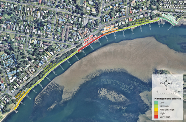
Figure 1: Prioritisation of
management options for the River Road foreshore precinct, Source WRL, River
Road Foreshore Assessment of Coastal Management Options.
The report costing for the
coastal protection, sand nourishment, storm water and recreation facilities was
approximately $1.7 million. Upon request from the Shoalhaven Heads Estuary
Taskforce (SHET), the WRL report was peer reviewed by Manly Hydraulics
Laboratory (MHL). It was recommended that the following technical information
be incorporated into the detailed design of erosion remediation control
structures at River Rd:
a. Coastal erosion
remediation structure be designed for a more conservative large river entrance
opening to reduce the risk of failure; and
b. A minimum design life of
25 years for coastal erosion remediation structure be adopted.
Following this, Council
successfully applied for grant funding from Infrastructure NSW under its
Restart NSW Tourism grants for the design and construction of the coastal
protection, stormwater management and recreational infrastructure to the value
of $1.72 million dollars. Council contributed $550,000 from the Coastal Reserve
Budget and the Storm Water Reserve Fund. Planet Footprint have undertaken the
hydraulic stormwater assessment and design.
Council put out a tender for the
detailed design of:
· the
coastal protection structure;
· stormwater
management;
· sand
nourishment;
· beach
accessways and viewing platform; and
· Site
rehabilitation.
The design is to also include a
shared pedestrian access pathway, kerb and guttering and traffic calming
devices on River Rd, however these additional features are currently unfunded.
ii. Status
Council’s Project Delivery
Unit are managing and delivering the project and the Natural Resources and
Floodplain Unit are undertaking the community consultation.
Council has awarded the tender
for the detailed design to Magryn Engineering Consultants, see https://www.magryn.com.au/projects.
An initial community consultation meeting was held on 28 September 2018, with
Council staff and members of the Shoalhaven Heads Community Forum to refine the
parameters of the detailed design.
iii. Future
Status
Currently the detailed design is
due for 95% completion by the end of November 2018. Another community
consultation meeting is scheduled for late October, at the 75% completion stage
of the design. Table 1 below is a summary of the projects timeline.
|
Event
|
Start
|
Complete
|
|
Procurement of detailed design
|
August 2018
|
September 2018
|
|
Detail Design
|
September 2018
|
November 2018
|
|
Community Consultation on detailed design
|
October 2018
|
November 2018
|
|
REF, interagency approvals and procurement of construction
works
|
November 2018
|
February 2019
|
|
Procurement of construction works
|
February 2019
|
March 2019
|
|
Site preparation and contractor preliminaries
|
April 2019
|
May 2019
|
|
Stormwater and road preparation
|
June 2019
|
July 2019
|
|
Construction of Rock protection works
|
July 2019
|
November 2019
|
|
Construction of boardwalk, access stairs, viewing platform
|
October 2019
|
November 2019
|
|
Beach scrapping works
|
November 2019
|
November 2019
|
|
Rehabilitation
|
March 2020
|
April 2020
|
Table 1: Timeline - Shoalhaven
Heads – River Road Foreshore Precinct Rehabilitation Restart NSW Grant
Project
Shoalhaven Coastal Management
Program
i. Overview
The NSW Coastal Management Act
2016 requires all coastal Councils to transition from a Coastal Zone Management
Plan (CZMP) (as per the requirements of the now repealed Coastal Protection Act
1979) to a Coastal Management Program (CMP).
On 11 September 2018, the
Shoalhaven Coastal Zone Management Plan was certified by the NSW Minister for
the Environment and was gazetted on 23 September 2018. The CZMP will act as an
interim coastal management plan until 2021, whilst Council transitions to
Coastal Management Program, as per the requirements of the Coastal Management
Manual.
In 2017 Council was awarded a
$100,000 grant from NSW OEH under the Coast and Estuary Grant stream to prepare
a Coastal Management Program for the Shoalhaven LGA, with Council contributing
$100,000. The Coastal Management Manual requires that a scoping study is
prepared prior to a Coastal Management Program being prepared. The key
components of a coastal management program scoping study, as identified in the
Coastal Manual, are outlined in Figure 2.
The three key components of a
scoping study that require the largest investment of time and resources, are a
first pass risk assessment to identify knowledge gaps; the preparation of
stakeholder and community engagement strategy and a preliminary business case
to access the economic, social and environmental cost.
Figure 2: Key components of the coastal management scoping
study
Council staff prepared a
preliminary draft scoping study in 2017. A working group was formed, consisting
of Council staff and members of the former Natural Resources and Floodplain
Management Committee, to determine the geographical extent of the scoping
study.
It was agreed by the working
party that the geographical extent of the Coastal Management Program would be
the open coast (not including estuary entrances), Lake Conjola and St Georges
Basin estuaries.
Following a revision of Part B:
stage 1 of the NSW Coastal Management Manual requirements for a first pass risk
assessment, preparation of a stakeholders and community engagement strategy and
a business plan, it was decided to outsource the preparation of the Scoping
Study to an external consultant.
ii. Status
This project has had significant
delays due to Council resources being allocated to the preparation of the CZMP
for certification and to ongoing changes and updates to the NSW Coastal
Management Manual.
Initially, the preparation of
the scoping study and CMP were going to be tendered out as one project, with a
holding period between the scoping study and CMP. However, NSW OEH advised
against this, as there was concern that there may be too many variations
required based on the unknown outcomes of the Scoping Study.
Accordingly, Council has split
the Scoping Study and the preparation of the CMP into two separate
tender/quotation processes, with the request for quotation for the preparation
of the Scoping Study currently out and due to close on 23 October 2018.
iii. Future
Status
The deadline for the preparation
of the Scoping Study report is early April 2019. The preparation of the CMP
will then be tendered out and the deadline for the completion of the CMP is
November 2019. This original timeframe will need to be reviewed and initial
discussions have been held with OEH in this regard.
Currarong Erosion Remediation
Project
i. Overview
In 2009, the final three
preferred options following the preparation of the Currarong Coastal Erosion
Options Report (SMEC) and the outcomes of a workshop held with the Shoalhaven
Estuary Management Committee were:
1. Trial Groyne - A
groyne located along at the eastern end of Warrain Beach, to allow natural
build-up of sediment seaward of the area that is undergoing recession in
addition to beach nourishment to minimise the impact on the beach down drift of
the groyne;
2. Sand Nourishment
- Beach nourishment at the central reef where the dwellings behind the dune are
the closest to the beach; and
3. Dune Management-
Maintain and improve the health of the dune vegetation.
This project was expedited in
2016 as a result of the damage from erosion caused by the 2016 East Coast Low
(ECL). Following the ECL, a community meeting was held in October 2016 at the
Currarong Community Hall, in which 120 residents attended. Community consensus
at the meeting was that Council should pursue the project to design stage.
Council also undertook a
community consultation via Council “Get Involved” platform, the
results of the consultation were that 50% of the community were in favour of
pursuing the Currarong Erosion Remediation Project (for details of the
background and results of the project please see the attached Q & A
Information sheet).
The certified Coastal Zone
Management Plan (CZMP) identifies actions (LA3.2) in relation to the Warrain
Beach and Beecroft Parade coastal protection options. These actions were
changed from design and construct, by request from the NSW DoI – Land and
Water following ongoing consultation during the development of the CZMP. This
was following written advice from DoI – Land and Water’s Coastal
Specialist, and their Coastal Engineer Specialist. The Department were of the
view that the coastal risk was not as high as Council had initially thought and
were of the view that Council still needed to continue to investigate coastal
management options. The actions in the CZMP are as follows:
“Undertake a detailed,
technical investigation of coastal hazard management options for Currarong
Beach and for the shoreline in front of Beecroft Parade. That are feasible for
this location, cognisant of coastal processes and risks (over defined
timeframes), as well as the social, environmental and economic impacts of the
options, including its benefits and costs. Develop and implement a management
strategy in consultation with key stakeholders including DoI Crown
Lands.”
ii. Status
On 16 August 2018, NSW DoI
– Land and Water, as the land owner, met with Council and the two Coastal
Engineering consultancies, Royal Haskoning DHV and Advisian, to discuss and
consider the preferred options. The Department indicated that Council’s
response may have been reactionary to the 2016 ECL storm and that a hard
engineering solution may not be appropriate at this time. Following this
general commentary, Council is now waiting on a formal letter of direction from
DoI on how best to proceed.
Office of Environment &
Heritage (OEH) advised that a reasonable interim response is to split the
project into three (3) stages with separate Review of Environmental Factors
(REFs) and Aboriginal Heritage Impact Permit (AHIP) applications:
Stage 1 Warrain
Beach: sand nourishment and construction of the remaining two (2) beach access
ways
Stage 2 Beecroft
Parade: risk assessment and remediation options review and cost benefit
analysis
Stage 3 Warrain
Beach: options review and cost benefit analysis
Royal Haskoning DHV have
provided cost estimates for Stage 1, estimated at $10,000, to deliver the community
priority of additional beach access points. However, Council are considering
the possibility of undertaking the Review of Environmental Factors in-house.
Council is currently reviewing
the geotechnical information in relation to the installation of the Currarong
Sewage Scheme to assess the location/depth of the rock platform at Beecroft
Parade foreshore and Warrain beach.
The reason for this is to see if
Council can reassess the coastal hazard mapping, undertaken by Advisian given
this new data and to access if further geotechnical assessments are required.
iii. Future
Status
Currently Council is awaiting a
formal written advice from the NSW DoI – Land and Water regarding the
Department’s position on the project, given they are the land owners on
which the coastal protection structures are proposed to be built.
Environmental Services is also
in negotiations with Shoalhaven Water and Asset and Works Groups, to undertake
a first pass basic Cost Benefit Analysis of relocating the public assets such
as water lines, sewage lines and roads at Warrain Beach and Beecroft Parade, as
a retreat option.
Shoalhaven Riverbank
Restoration
i. Overview
In September 2017 Council
received a $300,000 grant from the Commonwealth Department of Industry,
Innovation and Science under the Improving Your Local Parks and Environment
grant program. The funding provided is to repair and restore a section of the
Shoalhaven River bank adjacent to Bolong Road, just south of Broughton Creek.
The project will undertake
riverbank restoration of 950 metres of the Shoalhaven River Estuary by
combining new technologies of river bank revetment and the planting of marine
and terrestrial plants to reduce the effects of erosion following minor to
moderate floods as well as improve riparian biodiversity within the River.
The project will be undertaken
by Council in partnership with South East Local Land Services and Shoalhaven
Riverwatch. Key activities of the project are:
· 950
metres of riverbank revetment erosion structure which incorporates erosion
control and improvements to riverbank biodiversity;
· 950
metres of stock fencing; and
· Sand-filled
geofabric bags to protect the 10,000 plants (mangroves, macrophytes & Swamp
Oak) that will be planted by Riverwatch volunteers.
The work aligns with action 8.13
of the Shoalhaven River Estuary Management Plan Implementation Strategy,
previously adopted by council. The total project cost is $300,000, supplied in
full by the Australian Government.
ii. Current
Status
Currently the project is running
three (3) months behind schedule. In March 2018 Council tendered out the
project management, erosion assessment, concept and detailed design,
environmental assessment, construction and rehabilitation/revegetation of the
Shoalhaven Riverbank Restoration Project. The tender was evaluated and under
delegated authority the General Manager awarded the tender to Riparian
Engineering Pty Ltd, a South Coast based engineering company, specialising in
riparian and estuarine projects. See http://riparianengineering.com
for further details.
Since being awarded the tender,
Riparian Engineering have completed a riverbank erosion and geomorphological
assessment to assess what natural forces are affecting the riverbank erosion at
this reach of the river. This information has been used to inform a concept
plan for the project, which has been approved by the project working group, consisting
of representatives from Shoalhaven Riverwatch, SE Local Land Services and the
property owner Mr Jim Knapp.
The project has now progressed,
and a detailed design, preparation of the Review of Environmental Factors (REF)
and Construction and Environmental Management Plan (CEMP) have all been
completed. These documents have been sent to NSW DoI – Land and Water as
supporting documents for an application of permanent lease for the construction
erosion control structure and to NSW DPI Fisheries for a permit to harm marine
vegetation under the NSW Fisheries Marine Management Act 1997.These
applications are still pending.
Investigations into PASS
(Potential Acid Sulphate Soils) have revealed that the site is affected by ASS
(Acid Sulphate Soils) within a band of white clay soils that were used to
construct a small levee from spoil from the construction of flood drainage
channels. However, these will be able to be treated on-site and will not
negatively impact on the river water quality.
iii. Future
Status
Once the approvals from NSW DoI
– Land and Water and DPI Fisheries are received, it is envisaged that
construction of the erosion control will commence in November 2018.
Community Engagement
One of the principal methods of engaging with communities
and State Agencies in regard to the type of projects outlined above, has been
via the Natural Resource and Floodplain Management Committee. As this committee
has now been disbanded, the options regarding community consultation are
engagement with individual property owners and/or Community Consultative
Bodies. Such engagement however does not guarantee the involvement of State
Agencies nor foster direct dialogue between the community and Agencies.
|
|
Strategy and
Assets Committee – Tuesday 16 October 2018
Page
1
|
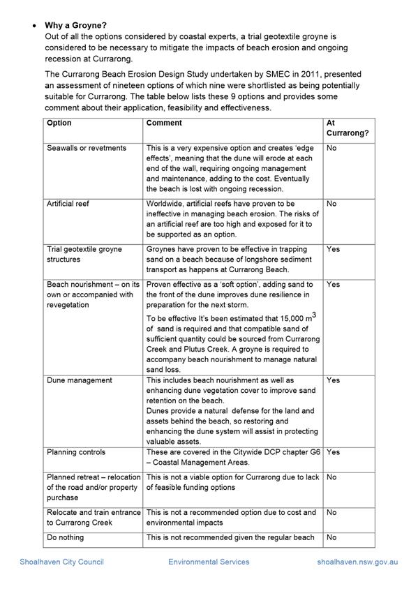
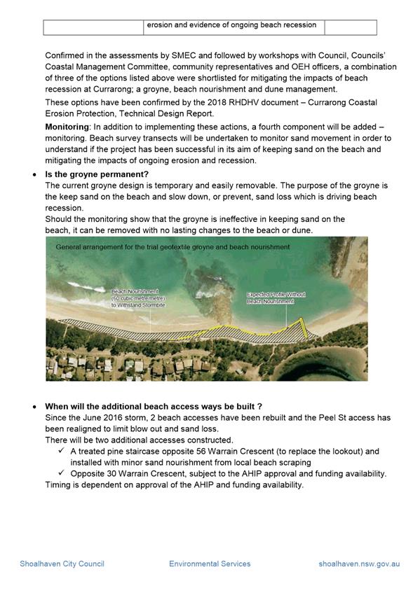
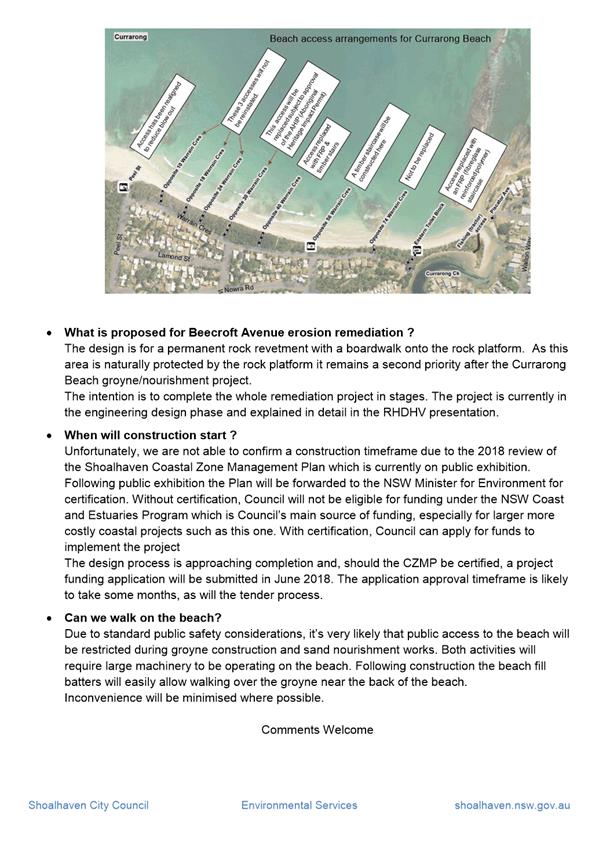
|
|
Strategy and
Assets Committee – Tuesday 16 October 2018
Page
1
|
SA18.256 Investigation
- Repair Beach Access Ocean St Culburra
HPERM Ref: D18/199224
Group: Planning
Environment & Development Group
Section: Environmental
Services
Attachments: 1. Ocean
St Culburra concept ⇩
2. Email - Culburra Beach
Progress Association - Request for meeting to discuss inclusive access at
Culburra Beach ⇩
Purpose / Summary
To report on the investigations into the upgrade of beach
access only at Ocean Street, Culburra Beach (MIN16.959).
|
Recommendation (Item to be
determined under delegated authority)
That Council continue with cyclic
maintenance reshaping of the beach access at Ocean Street, Culburra to
maintain an even sand ramp to the beach.
|
Options
1. As recommended.
Implications: Due to
beach aspect and shape, ongoing cyclic maintenance will need to be undertaken
annually, as a minimum, as part of Council’s ongoing coastal maintenance
works.
2. Council make an
alternative recommendation
Implications: Unknown and would depend on the
recommendation.
Background
At the Strategy & Assets
Committee on 13 December 2016, Council resolved that (MIN16.959):
1. Council Staff to investigate and provide costs back
to Council to repair the car park and access track to Ocean Street Beach so it
can be utilised by disabled users, family access and emergency responders and
general beach users.
2. The
community and the CCB be included in any design ideas to create a user friendly
area.
During the past three (3) years, Nature
Assisted Beach Enhancement (NABE), beach scraping, has been undertaken
following major storms along Culburra Beach once a year. NABE has been
identified in the Coastal Zone Management Plan, Emergency Action Sub-Plan for
Culburra as an ongoing emergency response to coastal erosion.
The Ocean St
beach access is currently 40 metres long, at a steep grade (1:4) from the
reserve level, adjacent to the car park (see figure 1). Facing directly
northeast, during summer large volumes of sand are windblown from the northeast
and deposited up onto the car park, and grassed foreshore reserve.
Figure 1:
Photo of beach access from the beach showing the steep access
Dune
vegetation is an important stabilising feature that is maintained by Council to
reduce the effects of windblown sand on the grassed areas and car-park; it also
helps stabilise the access track
As the beach
access track at Ocean St is utilised seasonally for surf life-saving patrols, a
wider track width is required for access of surf life-saving equipment. The
need to increase the width of the access track has resulted in a reduction in
dune vegetation cover. This can affect dune stability, because it results in an
increase in wind-blown sand filling the car park and grassed areas on the
foreshore reserve (see figure 2).
Figure 2:
Increase in width of beach access track to allow access for surf life-saving
equipment results in a reduction in stabilising dune vegetation cover.
The release
of stormwater from the car park and road, impacts the beach access track and is
another challenge to beach management. Erosion during heavy rain continues to
compromise the lower track condition at the beach level and steepens the whole
beach profile.
The ongoing
impacts from windblown sand, coastal erosion from storms and the road
stormwater make any plans for inclusive access difficult if not impossible to
achieve. On this basis, to design a compliant 1:14 grade inclusive access at
the Ocean Street car park location would require an engineered structure like
Lake Conjola boardwalk. The design would need to resolve these complex issues
and include extensive dune vegetation clearing, Aboriginal Heritage assessment
and consideration of a toilet block upgrade to disabled standard. The works are
not currently resourced and due to the coastal hazards are not recommended at
this site, due to high coastal hazard risks.
Environmental Services staff
have been working with the Community, Culture and Recreation Unit and the
Shoalhaven Access Advisory Committee to identify suitable locations for
inclusive access.
At Warrain Beach, the Nowra Culburra Surf Lifesaving Club
(SLSC) has been identified as the preferred location because there is currently
a beach ramp, which is used by the SLSC to access the beach with their rescue
craft. Beach wheelchairs are also available at this location during the
patrolled season. The grade/slope of the beach at this location is more suited
to the 1V:14H grade required for inclusive/disabled access (see figure 3).
Figure
3: Beach access ramp at Nowra – Culburra Beach SLSC.
The other location considered by
staff was Tilbury Cove reserve at the southern end of Culburra Beach.
Unfortunately, the current reserve access road and concrete ramp onto the beach
do not meet the 1V:14H grade standards for inclusive access and would require
additional funding to bring them up to an acceptable standard.
This location does already have
a toilet block with disabled access parking and improved picnic facilities.
Swimming safety is variable and medium risk being on the open ocean with the
natural rock bed making this option less attractive for assisted disabled
swimming (see figures 4 – 6).
Figure 4: Tilbury Cove Reserve – Showing concrete
access ramp
Figure 5: Tilbury Cove Reserve – Showing access
road down to the water which doesn’t meet the standard
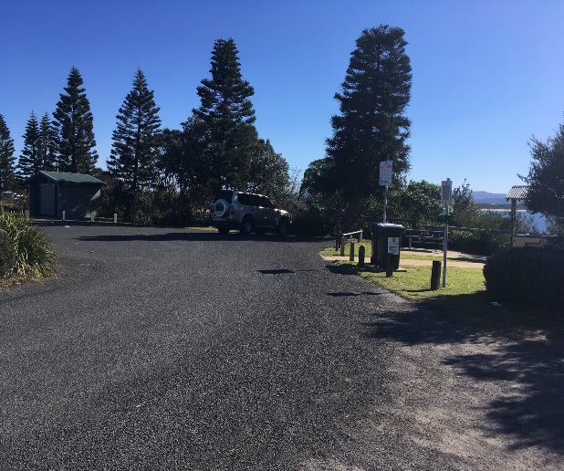 Figure 6: Tilbury
Cove Reserve – car park and disabled toilet block
Figure 6: Tilbury
Cove Reserve – car park and disabled toilet block
Policy Implications
NABE (beach scraping) is an
adaptive strategy deployed across the 40 Council managed beaches, to respond to
remediation of beach access availability compromised by storm action.
The 2018 Coastal Zone Management
Plan for the Open Coast, under the Local Area Plans for Culburra (LA2.4),
includes an action to investigate suitable sites for disabled access to Warrain
Beach at the Nowra-Culburra Surf Life Saving Club. This is supported by action
A2.4.7 of Council’s Disability Inclusion Action Plan 2017, which states
the following.
“Investigate options for beach access for people
using wheelchairs and/or for access to calm water non-beach swim sites”.
Financial Implications
The general estimated cost of
upgrading the Ocean St beach access/car park and installation of disabled
toilets is $250,000, not including the costs of survey, design, environmental
and Aboriginal Heritage assessment and licences and approvals that would be
required. The potential for major damage to the engineered ramp is a high risk
and ongoing future cost to Council. Therefore it is not recommended that
Council proceed with works at this location.
These implications should be
compared to the annual cyclic maintenance of the existing Ocean St sand ramp
beach access way that is in the order of $5,000 annual cost and considered an
adaptable management option.
Community Consultation
Council staff e-mailed the
Culburra Beach Progress Association on 12 September 2018 (see attached
correspondence to Culburra Beach Progress Association) to request an on-site
meeting to discuss the options for inclusive access at Culburra Beach. Council
has received no response to date.
Council staff have and are in
direct consultation with the Shoalhaven Access Advisory Group regarding the
preferred locations for inclusive access at Culburra Beach.
|
|
Strategy and
Assets Committee – Tuesday 16 October 2018
Page
1
|
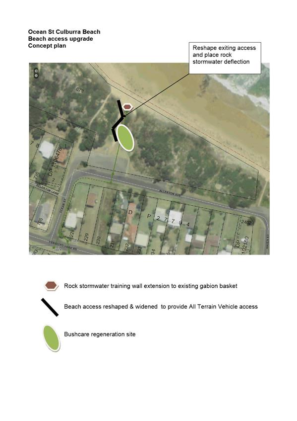
|
|
Strategy and
Assets Committee – Tuesday 16 October 2018
Page
1
|
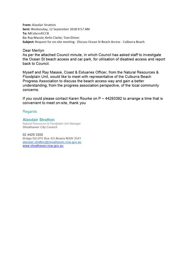
|
|
Strategy and
Assets Committee – Tuesday 16 October 2018
Page
1
|
SA18.257 Flood
Program Progress Update
HPERM Ref: D18/337316
Group: Planning
Environment & Development Group
Section: Environmental
Services
Purpose / Summary
The purpose of this report is to
inform the Committee about the updates on Shoalhaven Flood Program as follows:
· Lower
Shoalhaven River Floodplain Risk Management Study and Plan Review;
· St
Georges Basin Floodplain Risk Management Study and Plan Review;
· Millards
Creek Flood Study; and
· Currarong
Creek Flood Study.
|
Recommendation
(Item to be determined under delegated authority)
That Council receive the report for information and
consider the mechanism whereby communities and State agencies might come
together, with Council, to consider and progress Flood and Estuary Management
programs.
|
Options
1. Council
accept the report for information.
Implications: Nil.
2. Council accept
the report for information and recommend the formation of a sub committee to
deal with Flood and Estuary Management issues
Implications: A terms of
reference and membership criteria would need to be drafted and adopted to
facilitate the formation of such sub committee
3. Council could
choose to provide an alternative recommendation for future consideration by
Council.
Implications: Unknown.
Background
Shoalhaven City Council has
received financial support from the NSW State Floodplain Management program
managed by the Office of Environment and Heritage (OEH) to undertake a flood
investigation of the Shoalhaven River, St Georges Basin, Millards Creek –
Ulladulla and Currarong Creek.
The primary objective of the NSW
Government’s Flood Prone Land Policy is to reduce the impact of flooding
and flood liability on individual owners and occupiers of flood prone property,
and to reduce private and public losses resulting from floods, utilising
ecologically positive methods wherever possible.
Lower Shoalhaven River
Floodplain Risk Management Study and Plan Review
Floodplain risk management in
the lower Shoalhaven River floodplains has to date been based on a flood study
finished in 1990 and a floodplain risk management study and plan completed in
2008.
Since that time there has been
ongoing infill development in various areas and the occurrence of several
recent significant flood events. This has led Council and the local community
to form the view that it is an appropriate time to undertake a review of the
adopted study and plan.
St Georges Basin
Floodplain Risk Management Study and Plan Review
Floodplain risk management in
the St Georges Basin floodplains has to date been based on a flood study
finished in 2001 and a floodplain risk management study and plan completed in
2006. This was based on a quasi-two-dimensional RUBICON model that was
undertaken in the mid 1990’s. There has been significant advancement in
the two-dimensional model platforms and the RUBICON model was not configured to
define velocity around the Basin over bank areas.
Since that time there has been
ongoing infill development in various areas and the occurrence of several
recent significant flood events which have led Council and the local community
to form the view that it is an appropriate time to undertake a review of the
adopted study and plan.
Proposed Millards Creek Flood Study - Ulladulla
Council’s only prior flood
study for this area was in 1995. That study used hydrological and 1D
hydrodynamic models that only provided peak flood flow, velocities and flood
levels at a few key locations. Since that time there has been ongoing infill
development in various areas. Therefore, to gain a contemporary understanding
of the flood behaviour of Millards Creek and its tributaries, a detailed flood
study is required. This will be the first stage of the Floodplain Management
process.
Proposed Currarong Creek
Flood Study
Council has not previously
undertaken any flood studies for this area. To gain a contemporary
understanding of the flood behaviour of Currarong Creek and its tributaries, a
detailed flood study is required. This will be the first stage of the Floodplain Management process.
The proposed flood study is to
analyse the flood behaviour of Currarong Creek and its tributaries.
Furthermore, the study will define overland flows generated across
sub-catchments and identify the catchment response in various flood scenarios
including storm surge in tidal reaches. The flood behaviour information
available about this catchment is minimal and thus the flood study will provide
Council with better intelligence.
Table 1 provides an outline of the progress to date of the
subject studies.
|
Study
|
Progress
|
Estimate
Completion
|
Comments
|
|
Lower Shoalhaven River Floodplain Risk Management Study
and Plan
|
15%
|
June 2020
|
The project is behind schedule due to the performance of
the consultant. Council has taken contractual action and is currently
reviewing performance over a three (3) month period ending December 2018. If
performance is not satisfactory, Council may take further contractual action.
|
|
St Georges Basin Floodplain Risk Management Study and Plan
|
15%
|
June 2020
|
The project is behind schedule due to the performance of
the consultant. Council has taken contractual action and is currently
reviewing performance over a three (3) month period ending December 2018. If
performance is not satisfactory, Council may take further contractual action.
|
|
Millards Creek Flood Study
|
0%
|
December 2019
|
Not yet started. Council is currently assessing tender
submissions.
|
|
Currarong Creek Flood Study
|
0%
|
December 2019
|
Not yet started. Council is currently assessing tender
submissions.
|
Table
1 – outline of progress to date of the subject studies
Community Engagement
Advancing Council’s
long-term floodplain management program ensures that economic, social and
environmental factors relating to the management of floodplains within the
Shoalhaven are considered, documented and implemented in Council’s
planning programs and policies.
The community will be engaged
throughout the duration of the project. Typically, a flood project includes an
initial mail-out and notifications via electronic media to inform residents and
ratepayers within the flood study area. Community meetings and drop in sessions
would typically be conducted throughout the project.
NSW Office of Environment and
Heritage have been playing an integral collaborative role in the development
and implementation of flood studies, as have other State agencies on an
“as needs” basis.
In the past, much of the
community engagement has been focused via community membership of the Natural
Resource and Floodplain Management Committee. As this committee has now been
disbanded, it is worth considering the mechanism whereby communities and State
agencies might come together, with Council, to consider and progress Flood and
Estuary Management programs. It is a recommendation of the Floodplain
Development Manual that a specific forum (sub-committee) be established for
this purpose.
Financial Implications
$132,999
funding for the projects has been provided for under the NSW State Government
‘Floodplain Management Program’ on a 2:1 basis. Council’s
matching contribution of $115,000 comes from the existing general Floodplain
Management Program budget.
Risk Implications
Council has a statutory
responsibility for land use planning and management under the Environmental
Planning and Assessment Act. If Council did not undertake these studies, the
risk may be poor land use planning and emergency management for these areas. In
addition, obligations under the Floodplain Development Manual (2005) will not
be met.
|
|
Strategy and
Assets Committee – Tuesday 16 October 2018
Page
1
|
SA18.258 Bushcare
Program Update
HPERM Ref: D18/339148
Group: Planning
Environment & Development Group
Section: Environmental
Services
Purpose / Summary
To provide Council with an
update on the Shoalhaven Bushcare Program.
|
Recommendation
(Item to be determined under delegated authority)
That the Bushcare Program Update
be received for information
|
Options
1. Council accept
the report for information.
Implications: Nil.
2. Council could
choose to provide an alternative recommendation for future consideration by
Council.
Implications: Unknown.
Update
Bushcare Groups
There continues to be over 60
groups and 700 volunteers that are registered with Shoalhaven City
Council’s Bushcare Program. Over 50 of these groups are regularly active.
These volunteers continue to do an amazing job to maintain and improve
Council’s reserves that are managed as Natural Areas.
Each group works at their own
pace. Some groups work infrequently, when there is a particular need or event.
Most meet regularly, with monthly through to weekly working bees.
So far, 3100 hours of volunteer
effort have been recorded since the start of 2018. However, this is an
underestimate of the contribution, as many Bushcare Group record sheets are yet
to be submitted for the period. Even so, this volunteer labour contribution has
been valued at $93,000.
Three Bushcare Field Officers
(Wendy Roberts – north; Rebecca Rudd – central; Cate Brooks –
south) continue to work with the groups that are regularly active and require
support. In total, 34 groups are supported by the Field Officers.
Bushcare/Parkcare Policy
and Procedures
The revised Bushcare / Parkcare
Policy was adopted by Council, following significant input by the Bushcare
Reference Group. The policy is available at http://doc.shoalhaven.nsw.gov.au/displaydoc.aspx?record=POL18/43.
The new policy includes a vision statement, re-worked aims, objectives, roles
and responsibilities.
The procedures have been
separated from the new policy but remain unchanged. It is intended to review
these in the current financial year.
Bushcare Group Action Plans
Four revised Bushcare plans were
adopted by Council in March. These were Broughton Vale, Callala Boat Ramp
Reserve, Mia Way (Culburra) and Tallyann Point. These are all available on
Council’s website.
Four Bushcare Group Action Plans
are currently being reviewed. These are the Warden Head, Bomaderry Creek,
Bangalee Reserve and The Grotto action plans, which will be reported to Council
for adoption over the next three months.
2018 Events and Highlights
· Opening
of the Callala Wetland Boardwalk – February 2018
· Links
to Learning program Vincentia High School, rehabilitation planting within
Heritage Estate, Vincentia – May 2018
· National
Tree Day plantings were completed at Shoalhaven Heads over two days involving
two schools (Kiama High and Shoalhaven Heads Public). National Tree Day
plantings were also completed by Wrights Beach Bushcare Group and at Milton
Rainforest – August 2018
· Other
plantings completed at Bushcare sites this year include: Hyams Beach, Mia Way
Culburra, Bangalee Reserve, Basin Walking Track, Wirricoo Walk (near Jervis Bay
Maritime Museum), Huskisson Bushcare Group, Narrawallee Foreshore, Bomaderry
Creek, Camp Quality (Bundewallah Ck, Berry), Twyford St Vincentia around new
shared pathway, Millards Creek (Ulladulla) and Lower Mulgen Creek, Bomaderry
· Dyball
Reserve Bushcare Group Open Day– September 2018
Projects
The following projects have been
completed to date in 2018:
· Completion
of the weed control contract at Moeyan Hill by Proust Bushland Services.
· Involvement
of volunteers in the release of Korean strain of the calicivirus for rabbit
control.
· Monitoring
of Bomaderry Zieria with Terry Barrett, following the recent fire.
· Planting
along Coolangatta Road following roadworks and at Duck Creek following bridge
works, by Indigenous Bush Regenerators crew.
Communications
· The
winter edition of Bushcare Links newsletter was produced. The spring edition is
to be distributed soon.
· Maintained
membership and attendance at meetings of Shoalhaven Landcare Association
Support and communications around NatureMapr – Atlas of Budawang
Coast.Attendance at Berry Small Farm Field Day.
New Issues
A large area of the Bomaderry
Creek Regional Park was affected by the bushfire in August. This included burnt
areas of revegetation and naturally occuring Bomaderry Zieria. A meeting will
be held with Bomaderry Bushcare Group and NPWS to determine the next steps to
be undertaken to address the damage caused by the fire.
Photos
|
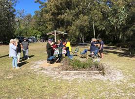
Dyball Reserve Open Day
|
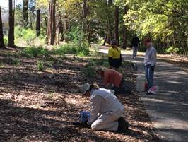
Enhancement planting at
Millards Creek
|
|
National Tree planting day
– Shoalhaven Heads
|

Bushcare Group plantings
burnt at Bomaderry Creek
|
|
Bomaderry Zieria post-fire
assessment
|
Vincentia Bushcare Group
planting along the pathway
|
|
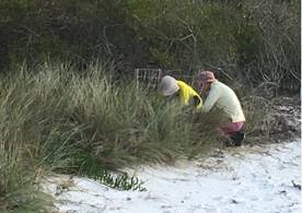
Hyams Bushcare group busily
planting
|
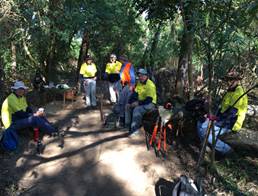
The Grotto Bushcare group
having a break
|
|
|
Strategy and
Assets Committee – Tuesday 16 October 2018
Page
1
|
SA18.259 Council's
Bushfire Mitigation Program
HPERM Ref: D18/300995
Group: Planning
Environment & Development Group
Section: Environmental
Services
Attachments: 1. SCC
Firetrails 2018-19 ⇩
2. RFS Determinations
01/07/2017-11/09/2018 ⇩
Purpose / Summary
This report provides a summary
of activities carried out to manage bushfire risks on Council owned and/or
managed properties.
|
Recommendation
(Item to be determined under delegated authority)
That Council’s Bushfire
Mitigation Program be received for information.
|
Background
The NSW Rural Fires Act 1997 (RF
Act) imposes a duty on public authorities and owners and occupiers of land to
prevent bush fires (section 63, RF Act). This duty is refined through the
assessments done when preparing Bushfire Risk Management Plans (BRMPs) for each
fire district in NSW.
District BRMPs identify assets
of value to the community and set strategies and priorities to mitigate risk as
well as identifying who is responsible for carrying out the treatments
described. Council’s Annual Bushfire Mitigation Program is guided by
these strategies, treatments and priorities as partial fulfilment of its duty
under s63 of the Act. The Shoalhaven district BRMP (the Plan) was developed in
2010 and a revised plan is due to go on public exhibition shortly.
Each land management agency runs
and funds its own program of works, except for Crown Land whose annual works
program is funded through the Bushfire Risk Mitigation & Resilience Grants
Programme. Council’s program consists of:
1. Ongoing vegetation
management at 140 sites adjacent urban development i.e. Asset Protection Zones
(APZs), fire-breaks, fence-line vegetation management – see attachment 1
for site lists or see Council’s website for maps
of sites included in the program;
2. Assessment, planning and
coordination of prescribed burning within Strategic Fire Advantage Zones
identified in the BRMP;
3. Scheduled
fuel/hazard/risk inspections of Council’s specified fire trails,
strategic communication infrastructure sites and Council owned-managed lands
and assets;
4. Certification of hazard
reduction activities, administration of customer requests, provision of advice
to internal and external customers;
5. Reporting of bushfire
hazard reduction activities in accordance with section 74 of the RF Act.
6. Pre-fire site
preparation and post-fire rehabilitation.
Council’s Bushfire
Mitigation program seeks to apply a strategic approach to the assessment and
amelioration of bushfire risk at the bushland interface. It aims to:
· Achieve the
economic, strategic and sustainable management of interface areas through the active
management of bushfire fuel
· predict and
provide annual work programs and link with other bushland management programs
· provide
transparency in fire management strategies
· fulfil
Council’s obligations in respect to the Shoalhaven Bushfire Risk Management
Plan
· link
Council’s Bushfire Mitigation Strategy with RFS Community Education
Programs
Bushfire mitigation
activities on Council managed land - 2017-18 financial year
Prescribed Burning
Two prescribed burns were
undertaken in April 2018:
· 7000m²
of land adjacent to the northern boundary of Havenlee School; and
· 1.5ha
on the southern side of Mahogany Creek behind houses in Federation Place and
Jamieson Rd.
Fire & Rescue NSW undertook
the burns for Council. Both sites are being monitored and regenerating weeds
will be treated as required.
Fire Trails
The list of fire trails that
Council is responsible for maintaining is attached. Other Council unsealed
roads are maintained through the Unsealed Roads Maintenance Program. These
trails are inspected prior to the bushfire danger period.
Trails where works were
completed during the 2017-18 financial year include the track on Council land
that leads to the Huskisson and Bowling Club fire trails at Huskisson, the
Murray St fire trail at Vincentia, and Pritchard Rd fire trail at Woollamia.
Council was successful in
gaining $268,980 from the Bushfire Risk Mitigation & Resilience Grants
Program 2017-18 to upgrade the creek crossing on the Wattle Fire Trail at
Yerriyong. Assets & Works will complete the upgrade during the
2018-19 financial year.
Annual ongoing maintenance
program
The 2017-18 program saw 138
sites receive mowing/slashing during October to November 2017 and during
February to March 2018.
Each site is assessed to ensure
compliance with the Rural Fire Services (RFS) standards for asset protection
zones and, if required, additional works are done. This includes tree trimming,
crown raising and separating, tree removal, weed control and the investigation
and removal of dumping and encroachments.
The increasing value of work
done under this program triggered the need to run a formal tender process which
was done during November 2017 through to January 2018. Current contracts will
expire in 2020.
Bushfire mitigation
activities on Council managed land - current financial year
A proposed prescribed burn at
North Nowra is now not required due to the August wildfire at West Cambewarra
Road. Planning and assessment is underway for burn proposals at St Georges
Basin, Bawley Point, Narrawallee and Coonemia.
Round 1 of the annual
maintenance program was completed in August-September 2018, with round 2
scheduled to begin in mid-November prior to the holiday season in
December/January 2018-19. Round 3 is generally done once plant growth rates
decline around April.
Council continue to prioritise
APZ and fire trail enhancements/improvements at those locations with the
highest risk rankings.
Bushfire Hazard Complaints
Section 74C of the RF Act
requires that all bushfire hazard complaints be referred to the Commissioner
within 14 days of receipt. Each complaint is investigated by an RFS Fire
Mitigation Officer and a determination made. The outcome is relayed to both the
customer and the land manager.
A list showing Determinations
received during the 2017-18 financial year and the current financial year to
date is contained in attachment 2. Works required are implemented to comply
with the order and, if required, the site is added to the annual maintenance
program.
Data compiled from the
complaints records suggest that approximately 80% of the sites identified
through the complaint process, and subsequently treated, are ranked as low risk
in the BFMC.
A complaints-based approach can
provide opportunities for engagement and education, albeit for those that are at
relatively low risk from bushfire; however, allowing complaints to drive the
mitigation program can:
· direct
valuable resources away from strategic fuel management as guided by the Risk
Management Plan;
· lead
to ad-hoc works that waste time and money and cause negative environmental
outcomes that require ongoing resources to manage.
Financial Implications
The treatment of assets with a
risk-ranking of high or above i.e. high, very high or extreme risk, are
prioritised by the current and draft revised BRMP. This acknowledges the need
to balance risk against resources and capacity to undertake the work as well as
noting that areas of medium or low risk are likely to be managed by routine
procedures and therefore do not require a specific application of resources.
However, the revised BRMP
proposes to add a City-wide treatment that would require the ongoing monitoring
of APZs that are adjacent low, moderate or high-risk assets and the
application of resources to maintain them according the RFS Standard for APZs.
It is noted that ‘these APZs are generally not located on land that is
the responsibility of the asset protected’ i.e. Council land or other
tenures.
This new requirement, if
adopted, will require an increase to the hazard reduction operational budget of
at least 25%. The annual operational hazard reduction budget for 2018-19 is
$146,596 so a budget bid will be submitted in the new year.
Risk Implications
This program ensures that
Council’s responsibilities in relation to the management of bushfire
hazards on its land are met.
Failure to adequately address
the bushfire risk on Council-managed properties may result in loss of life or
property and damage to the environment.
|
|
Strategy and
Assets Committee – Tuesday 16 October 2018
Page
1
|
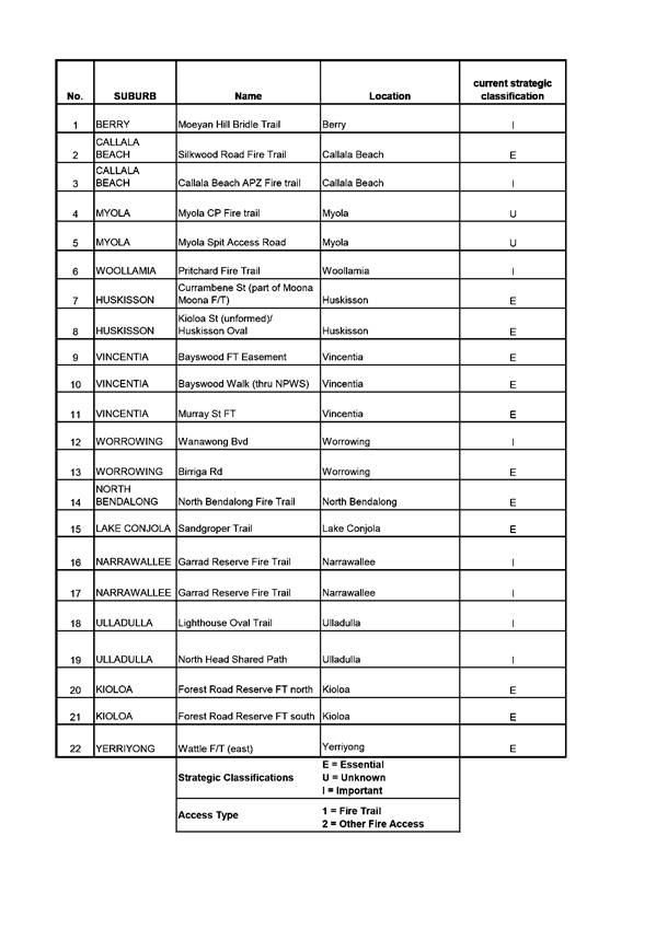
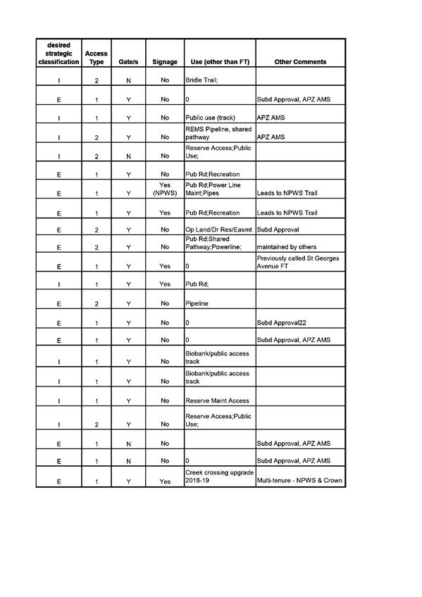
|
|
Strategy and
Assets Committee – Tuesday 16 October 2018
Page
1
|
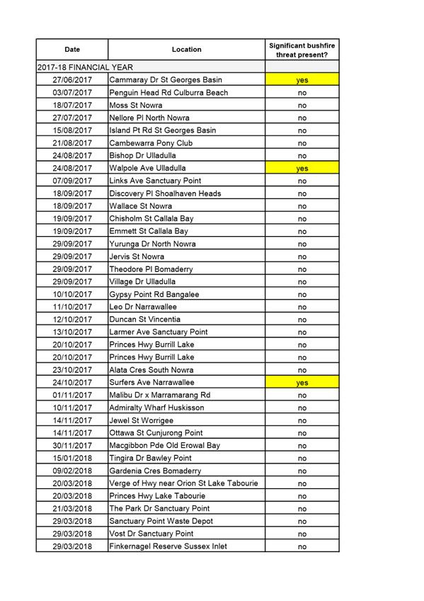
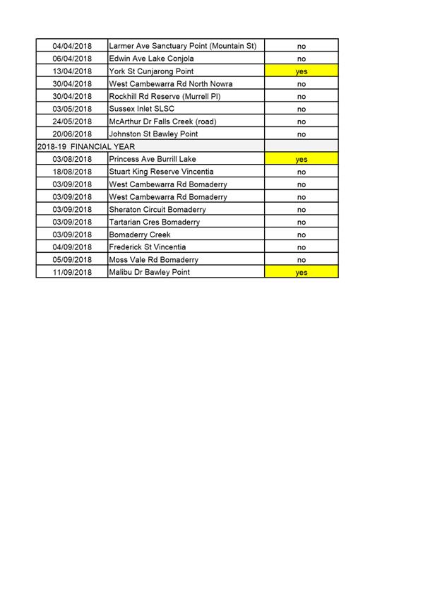
|
|
Strategy and
Assets Committee – Tuesday 16 October 2018
Page
1
|
SA18.260 Acquisition
of land and easements at Mundamia for University of Wollongong Shoalhaven
Campus
HPERM Ref: D18/300657
Group: Shoalhaven
Water Group
Section: Water
Asset Planning & Development
Attachments: 1. Draft
Acquisition Plan ⇩
2. Crown Lands Plan ⇩
Purpose / Summary
This report is submitted to seek
Council approval to the compulsory acquisition of:
1. Part of Lot 6 DP1156684
(for existing sewer pump station site) and easements for sewerage purposes,
water supply, access, underground cables and right of way over Lot 6 DP1156684
at George Evans Drive Mundamia from the Minister for Education and Training, at
the University of Wollongong (UOW) Shoalhaven Campus.
2. Easements for access and
water supply over Crown land Lot 7319 DP1165060 at Yalwal Road Mundamia.
|
Recommendation
That Council resolve:
1. To
compulsorily acquire the following land and easements for Council
infrastructure servicing the University of Wollongong Shoalhaven Campus on
Lot 6 DP1156684, at nominal compensation of $1:
a. Part
of Lot 6 DP1156684, shown as proposed Lot 2 and coloured pink on the attached
‘Draft Acquisition Plan’.
b. Easements
for Sewerage Purposes & Access 6 wide, Sewerage Purposes 6 wide, Sewerage
Purposes 3 wide, Access 15 wide & variable, and Underground Cables 1
wide, all shown coloured pink on the attached ‘Draft Acquisition
Plan’.
2. To
compulsorily acquire the following easements for Council infrastructure over
Lot 6 DP1156684, but not servicing the University of Wollongong Shoalhaven
Campus, at compensation to be determined by the Valuer General:
a. A
Right of Way variable width and Easements for Water Supply 2 wide, 3 wide and
8 wide, all shown coloured yellow on the attached ‘Draft Acquisition
Plan’.
b. An
Easement for Sewerage Purposes 3 wide and an Easement for Water Supply 6
wide, shown coloured green and blue respectively on the attached ‘Draft
Acquisition Plan’.
3. To
compulsorily acquire the following easements for Council infrastructure over
Crown land Lot 7319 DP1165060, subject to resolving Aboriginal Land Claim and
Native Title interests, at compensation determined by the Valuer General:
a. An
Easement for Access 7m and 15m wide and an Easement for Water Supply 8m wide,
shown edged red and blue respectively on the attached ‘Crown Lands
Plan’.
4. To
pay compensation and costs associated with the acquisitions from Shoalhaven
Water’s Sewer and Water Funds. Compensation determined by the Valuer
General to be in accordance with the provisions of the Land Acquisition (Just
Terms Compensation) Act 1991.
5. That
the necessary applications be made to the Minister for Local Government and
the Governor. The acquisitions are to be carried out under the Local
Government Act 1993.
6. That
the acquired land be classified Operational land in accordance with Section
31(2) of the Local Government Act.
7. That
the Common Seal of the Council of the City of Shoalhaven be affixed to any
documents required to be sealed.
|
Options
1. Resolve as
recommended. Acquisition of the land and easements are substantially required
to formalise existing Shoalhaven Water infrastructure. Two easements are
required for future infrastructure.
2. Not
resolve as recommended and provide further directions to staff.
Background
University campus land
Approval was given to the
University campus development at Mundamia in 1998 subject to Shoalhaven Water
requirements that:
· Land
be ceded to Council for a sewer pump station and associated facilities, and
· Easements
be created over a sewer rising main and proposed gravity sewer system.
Council resolved by MIN02.1036
dated 27 August 2002 to acquire the pump station site (proposed Lot 2) and
various easements from the Minister for Education and Training for $nil
consideration. The accompanying Council report states that Council provided infrastructure
support for the establishment of the Education Complex and that the Department
of Education and Training (DET) had given in-principle consent to the
acquisition of the pump station site and easements at $nil compensations,
subject to all costs being borne by Council.
The acquisitions have not
occurred, mainly due to:
· DET
requested that it grant a long term lease of the pump station site and
easements in lieu of acquisition by Council at $nil consideration.
· Concerns
raised that some of the easements approved in the 2002 Council Resolution were
for existing infrastructure over the campus site but did not service the campus
facilities.
· DET
was split into two separate Departments – Education and TAFE, with
associated reallocation of real estate assets.
The Mundamia campus site is
occupied mainly by the UOW and by TAFE with a minor interest (lease of a child
care centre only). On these grounds TAFE declined to accept ownership of the
land and title to Lot 6 DP1156684 remains in the name of the Minster for
Education and Training.
Following extensive negotiations
an alternative proposal was submitted to DET to resolve the impasse. The
proposal is in accordance with the above Recommendation and is to:
· Acquire
the land and easements servicing the campus at $nil consideration as originally
agreed.
· Acquire
the additional easements at compensation determined by the Valuer General, in
accordance with normal practice.
As the affected land was acquired
by DET under the University of Wollongong Act and the TAFE Commission Act it
has been agreed that Council’s acquisitions should be undertaken by the
compulsory process of the Land Acquisition (Just terms Compensation) Act. UOW
and TAFE have advised there is no objection to the acquisition proposal and DET
has provided advice that it also has no objection and Council should proceed
with the proposed compulsory acquisition.
The proposed easements for sewer
and water coloured green and blue on the draft Acquisition Plan were not part
of the original development approval. They are for future pipelines to service
the Mundamia residential release area north of the campus site.
Crown Land
The original approval included a
proposed Easement for Access 15 metres wide from George Evans Road westerly to
the sewer pump station. However, the campus development has since been expanded
and vehicular access is no longer possible along the route of that access
easement due to construction of a covered pedestrian walkway.
Access to the pump station is
currently being obtained between the campus buildings and representations were
made by the UOW for Shoalhaven Water to arrange an alternative route. Investigations
determined the favoured option to be westerly from the pump station along an
existing gravel track to Yalwal Road through adjoining Crown land, Lot 7319
DP1165060.
Crown Lands has provided consent
to the acquisition of an Easement for Access 7m and 15m wide, edged red on the
attached ‘Crown Lands Plan’. It also provided consent for an
Easement for Water Supply 8m wide, edged blue on that plan, to formalise an
existing trunk water main. The consent was subject to Council resolving any
Aboriginal Land Claims and Native Title issues over the land.
With respect to Native Title,
NTSCorp representing the South Coast People have been notified of
Council’s actions and will be provided the same procedural rights as a
freehold title owner under the Land Acquisition (Just Terms Compensation) Act.
If Council cannot resolve issues
with the Crown land an alternative route is proposed along the sewer main
extending southerly from the pump station to Yalwal Road. An Easement for Sewerage
Purposes and Access 6 metres wide is to be acquired for that pipeline which
could allow for the construction of an access track if required.
Financial Implications
Compensation and all costs associated with the acquisition
are to be funded from Shoalhaven Water’s Sewer and Water funds. The
compensation is at agreed nominal amount of $1 or as determined by the Valuer
General, as detailed in the above recommendation.
|
|
Strategy and
Assets Committee – Tuesday 16 October 2018
Page
1
|
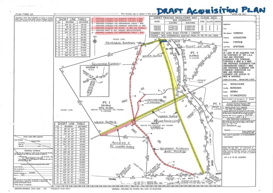
|
|
Strategy and
Assets Committee – Tuesday 16 October 2018
Page
1
|
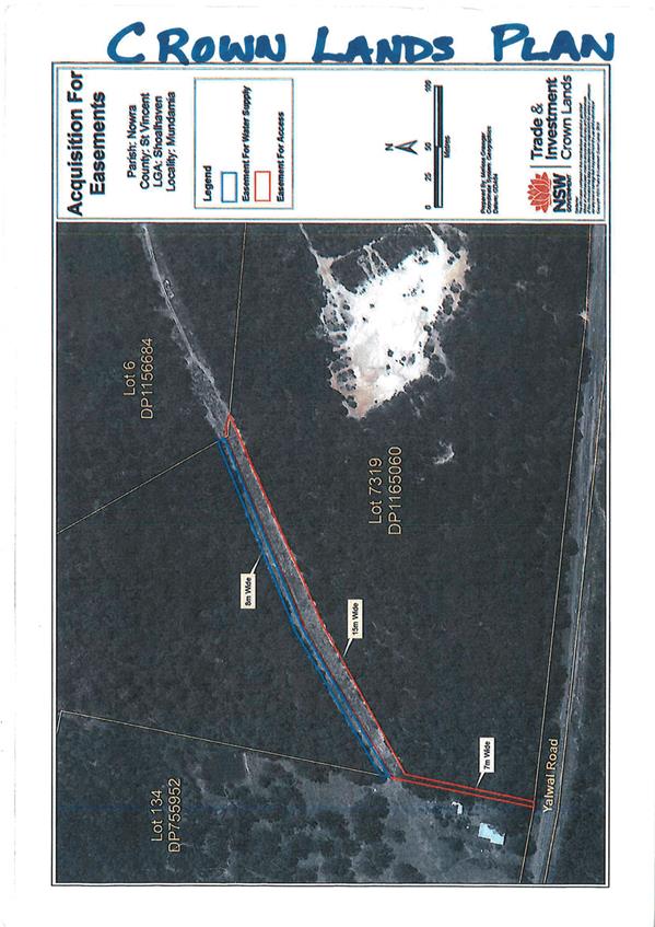
|
|
Strategy and
Assets Committee – Tuesday 16 October 2018
Page
1
|
Local Government Amendment (governance &
planning) act 2016
Chapter
3, Section 8A Guiding principles for councils
(1)
Exercise of functions
generally
The
following general principles apply to the exercise of functions by councils:
(a) Councils should provide strong
and effective representation, leadership, planning and decision-making.
(b) Councils should carry out
functions in a way that provides the best possible value for residents and
ratepayers.
(c) Councils should plan
strategically, using the integrated planning and reporting framework, for the
provision of effective and efficient services and regulation to meet the
diverse needs of the local community.
(d) Councils should apply the
integrated planning and reporting framework in carrying out their functions so
as to achieve desired outcomes and continuous improvements.
(e) Councils should work
co-operatively with other councils and the State government to achieve desired
outcomes for the local community.
(f) Councils should manage
lands and other assets so that current and future local community needs can be
met in an affordable way.
(g) Councils should work with
others to secure appropriate services for local community needs.
(h) Councils should act fairly,
ethically and without bias in the interests of the local community.
(i) Councils should be
responsible employers and provide a consultative and supportive working
environment for staff.
(2) Decision-making
The
following principles apply to decision-making by councils (subject to any other
applicable law):
(a) Councils should recognise
diverse local community needs and interests.
(b) Councils should consider social
justice principles.
(c) Councils should consider the
long term and cumulative effects of actions on future generations.
(d) Councils should consider the
principles of ecologically sustainable development.
(e) Council decision-making should
be transparent and decision-makers are to be accountable for decisions and
omissions.
(3) Community participation
Councils
should actively engage with their local communities, through the use of the
integrated planning and reporting framework and other measures.
Chapter
3, Section 8B Principles of sound financial management
The
following principles of sound financial management apply to councils:
(a) Council spending should be responsible and sustainable,
aligning general revenue and expenses.
(b) Councils should invest in responsible and
sustainable infrastructure for the benefit of the local community.
(c) Councils should have effective financial
and asset management, including sound policies and processes for the following:
(i) performance management
and reporting,
(ii) asset maintenance and
enhancement,
(iii) funding decisions,
(iv) risk management practices.
(d) Councils should have regard to achieving
intergenerational equity, including ensuring the following:
(i) policy decisions are made
after considering their financial effects on future generations,
(ii) the
current generation funds the cost of its services
Chapter
3, 8C Integrated planning and reporting principles that apply to councils
The
following principles for strategic planning apply to the development of the
integrated planning and reporting framework by councils:
(a) Councils should identify and prioritise key
local community needs and aspirations and consider regional priorities.
(b) Councils should identify strategic goals to
meet those needs and aspirations.
(c) Councils should develop activities, and
prioritise actions, to work towards the strategic goals.
(d) Councils should ensure that the strategic
goals and activities to work towards them may be achieved within council
resources.
(e) Councils should regularly review and
evaluate progress towards achieving strategic goals.
(f) Councils should maintain an
integrated approach to planning, delivering, monitoring and reporting on
strategic goals.
(g) Councils should collaborate with others to
maximise achievement of strategic goals.
(h) Councils should manage risks to the local
community or area or to the council effectively and proactively.
(i) Councils should make appropriate
evidence-based adaptations to meet changing needs and circumstances.