Development Committee
Meeting Date: Tuesday,
08 August, 2017
Location: Council
Chambers, City Administrative Building, Bridge Road, Nowra
Time:
5.00pm
Membership (Quorum - 5)
Clr Patricia White - Chairperson
All Councillors
General Manager or nominee
Please note: Council’s Code of Meeting Practice
permits the electronic recording and broadcast of the proceedings of meetings
of the Council which are open to the public. Your attendance at this meeting is
taken as consent to the possibility that your image and/or voice may be
recorded and broadcast to the public.
Agenda
1. Apologies / Leave of Absence
2. Confirmation of Minutes
· Development
Committee - 17 July 2017...................................................................... 1
3. Declarations of Interest
4. Mayoral Minute
5. Deputations and Presentations
6. Notices of Motion / Questions on Notice
Nil
7. Reports
DE17.53...... Draft Planning Agreement - Enterprise Avenue,
South Nowra - Public Exhibition Outcomes and Finalisation/Execution............................................................ 9
DE17.54...... Nowra CBD Urban Design Planning Controls -
Planning Proposal and Development Control Plan Chapter - Adoption and Finalisation........................................ 13
DE17.55...... Planning Proposal (Rezoning) - Warrah Road
Bangalee - Finalisation of Development Footprint........................................................................................................ 36
DE17.56...... Moss Vale Road North Urban Release Area -
Resourcing and Funding ... 48
DE17.57...... Clause 4.6 Variation Report - 71 Meroo St,
Bomaderry - Lot 1 DP 732712 57
DE17.58...... Development Application – 123 Forster Drive
Bawley Point – Lot 3 DP 527264 77
DE17.59...... Exhibition outcomes - Planning Proposal LP406 and
DCP Chapter N16 - Falls Creek / Woollamia Deferred Areas .......................................................................... 83
DE17.60...... Development Application – 23 Seasongood
Road, Woollamia – Lot 113A DP 15266...................................................................................................................... 99
8. Confidential
Reports
Nil
|

|
Development
Committee – Tuesday 08 August 2017
Page
iii
|
Development Committee
Delegation:
Pursuant to s377 (1) of the
Local Government Act 1993 the Committee is delegated the functions conferred on
Council by the Environmental Planning & Assessment Act 1979 (EPA Act),
Local Government Act 1993 (LG Act) or any other Act or delegated to Council, as
are specified in the attached Schedule, subject to the following limitations:
i. The
Committee cannot make a decision to make a local environmental plan to classify
or reclassify public land under Division 1 of Part 2 of Chapter 6 of the LG
Act;
ii. The
Committee cannot review a s82A or s96AB EPA Act determination made by the
Council or by the Committee itself;
iii. The
Committee cannot exercise any function delegated to the Council which by the
terms of that delegation cannot be sub-delegated;
iv. The Committee
cannot exercise any function which s377(1) of the LG Act provides cannot be
delegated by Council; and
v. The
Committee cannot exercise a function which is expressly required by the LG Act
or any other Act to be exercised by resolution of the Council.
Schedule:
1. All
functions relating to the preparation, making, and review of local
environmental plans (LEPs) and development control plans (DCPs) under Part 3 of
the EPA Act.
2. All
functions relating to the preparation, making, and review of contributions
plans and the preparation, entry into, and review of voluntary planning
agreements under Part 4 of the EPA Act.
3. The
preparation, adoption, and review of policies and strategies of the Council in
respect of town planning and environmental matters and the variation of such
policies.
4. Determination
of variations to development standards related to development applications
under the EPA Act where the development application involves a development
which breaches a development standard by more than 10% and the application is
accompanied by a request to vary the development standard under clause 4.6 of
Shoalhaven Local Environmental Plan 2014 or an objection to the application of the
development standard under State Environmental Planning Policy No. 1 –
Development Standards.
5. Determination
of variations from the acceptable solutions and/or other numerical standards
contained within the DCP or a Council Policy that the General Manager requires
to be determined by the Committee
6. Determination
of development applications that Council requires to be determined by the
Committee on a case by case basis.
7. Review
of all determinations of development applications under sections 82A and 96AB
of the EP&A Act.
8. Preparation,
review, and adoption of policies and guidelines in respect of the determination
of development applications by other delegates of the Council.
Minutes of the Development Committee
Meeting Date: Monday,
17 July 2017
Location: Council
Chambers, City Administrative Building, Bridge Road, Nowra
Time: 5.03pm
The following members
were present:
Clr Patricia White -
Chairperson
Clr John Wells
Clr John Levett
Clr Nina Cheyne
Clr Annette Alldrick
Clr Mitchell Pakes
Clr Greg Watson
Clr Mark Kitchener
Clr Bob Proudfoot
Mr Russ Pigg - General
Manager
|
Apologies / Leave of Absence
|
Apologies were received
from Clr Gash, Clr Gartner, Clr Guile and Clr Findley.
|
Confirmation of the Minutes
|
|
RESOLVED (Clr Proudfoot / Clr
Wells) MIN17.604
That the Minutes of the
Development Committee held on Monday 05 June 2017 be confirmed.
CARRIED
|
Nil
Deputations and Presentations
Mr Peter Stutchbury,
Peter Stutchbury Architecture, addressed the
Committee in relation to DE17.45 Development Application – 52 Cyrus St
Hyams Beach – Lot 58 DP 577627
Ms Colleen Platford, of 54 Cyrus Street, Hyams Beach addressed
the Committee in relation to DE17.45 Development Application – 52 Cyrus
St Hyams Beach – Lot 58 DP 577627
Mr
Mark Jones addressed the Committee in relation to DE17.50 Endorsement for
Exhibition - Draft Shoalhaven Affordable Housing Strategy
Mr
Josh Sanders addressed the Committee in relation to DE17.51 Exhibition &
Finalisation - Planning Proposal - Additional Permitted Use - 5C Creston Grove,
Bomaderry (PP021)
Reports
|
Procedural
Motion - Bring Item Forward
|
|
RESOLVED (Clr Wells / Clr
Proudfoot) MIN17.605
That the matters of the following
items be brought forward for consideration
- DE17.45
Development Application – 52 Cyrus St Hyams Beach – Lot 58
DP 577627
- DE17.50
Endorsement for Exhibition - Draft Shoalhaven Affordable Housing
Strategy
- DE17.51 Exhibition & Finalisation - Planning
Proposal - Additional Permitted Use - 5C Creston Grove, Bomaderry
(PP021)
CARRIED
|
|
DE17.45 Development
Application – 52 Cyrus St Hyams Beach – Lot 58 DP 577627
|
HPERM Ref:
D17/152965
|
|
Recommendation (Item to be determined under
delegated authority)
That Development Application
16/1341 to demolish the existing dwelling and erect a two storey dwelling and
ancillary boathouse arm on Lot 58 DP 577627, 52 Cyrus Street Hyams Beach be
approved subject to:
1. The
boathouse floor being constructed to a height of 4.75m AHD (without any
increase in maximum building height) and in accordance with the requirements
of the Advisian report dated 6 June 2017 (report No.301015-03779-001) vis:
a. the
floor of the boathouse is to be constructed of timber slats to reduce wave
uplift pressures;
b. access
to the boathouse is to be from the landward side or via a timber ramp
oriented south-north so that it does not interfere with wave runup flows;
c. The
boathouse is to be landscaped to suitably screen the sub-floor area.
2. The
additional conditions contained in Attachment 7 of this report.
|
|
RESOLVED (Clr Pakes / Clr
Proudfoot) MIN17.606
That Development Application
16/1341 to demolish the existing dwelling and erect a two storey dwelling and
ancillary boathouse arm on Lot 58 DP 577627, 52 Cyrus Street Hyams Beach be
approved subject to:
1. The
boathouse floor being constructed to a height of 4.75m AHD (without any
increase in maximum building height) and in accordance with the requirements
of the Advisian report dated 6 June 2017 (report No.301015-03779-001) vis:
a. the
floor of the boathouse is to be constructed of timber slats to reduce wave
uplift pressures;
b. access
to the boathouse is to be from the landward side or via a timber ramp
oriented south-north so that it does not interfere with wave runup flows;
c. The
boathouse is to be landscaped to suitably screen the sub-floor area and the
area between the boathouse arm and the dividing fence be landscaped with
appropriate vegetation.
2. The
additional conditions contained in Attachment 7 of this report.
For: Clr
Levett, Clr Alldrick, Clr Pakes, Clr Watson, Clr Kitchener, Clr Proudfoot and
Russ Pigg
Against: Clr White, Clr
Wells and Clr Cheyne
CARRIED
|
|
DE17.50 Endorsement
for Exhibition - Draft Shoalhaven Affordable Housing Strategy
|
HPERM Ref:
D17/146959
|
|
Recommendation (Item to be determined under
delegated authority)
That Council:
1. Endorse
the draft Shoalhaven Affordable Housing Strategy (Strategy) at Attachment 1
with the following changes:
a. Identify
the Council owned site at 42-46 Coomea Street, Bomaderry as the preferred
site for the short term strategy and investigate potential opportunities for
expansion to include additional land in the precinct;
b. Remove
the following sites as potential affordable housing project sites:
i. 11 Lamonds
Lane, Nowra.
ii. Corner
Greenwell Point Road and Clipper Road, Nowra.
iii. 10 Pleasant
Way, Nowra.
c. Outline
that Council will undertake investigations into the suitability of other
sites for affordable housing projects that may also include sites not owned
by Council.
d. Include
a set of desired affordable housing location characteristics and a definition
of key centres in line with the Background Report and Discussion Paper.
e. Include
commentary on the broader approach to affordable housing maintenance.
f. Consider
the relevant outcomes of the Shoalhaven Economic Development Strategy 2017.
2. Support
the public exhibition of the draft Strategy with the Background Report,
Discussion Paper and Strategic Framework.
3. Arrange
for Dr Judy Stubbs to brief Council on the strategies/actions in the draft
Strategy either prior to or during the public exhibition period.
4. Continue
to pursue the possibility of an initial demonstration affordable housing
development at Coomea Street, Bomaderry with the NSW Government, Community
Housing Providers, property industry representatives (e.g. Property Council
of Australia) and relevant community consultative bodies.
5. Receive
a future report, following the public exhibition period of the draft
Strategy, to enable any submissions to be fully considered and any changes
made prior to Council adoption.
|
|
RESOLVED (Clr Wells / Clr
Proudfoot) MIN17.607
That
Council:
1. Endorse
the draft Shoalhaven Affordable Housing Strategy (Strategy) at Attachment 1
with the following changes:
a. Identify
the Council owned site at 42-46 Coomea Street, Bomaderry as the preferred
site for the short term strategy and investigate potential opportunities for
expansion to include additional land in the precinct;
b. Remove
the following sites as potential affordable housing project sites:
i. 11 Lamonds
Lane, Nowra.
ii. Corner
Greenwell Point Road and Clipper Road, Nowra.
iii. 10 Pleasant
Way, Nowra.
c. Outline
that Council will undertake investigations into the suitability of other
sites for affordable housing projects that may also include sites not owned
by Council.
d. Include
a set of desired affordable housing location characteristics and a definition
of key centres in line with the Background Report and Discussion Paper.
e. Include
commentary on the broader approach to affordable housing maintenance.
f. Consider
the relevant outcomes of the Shoalhaven Economic Development Strategy 2017.
2. Support
the public exhibition of the draft Strategy with the Background Report,
Discussion Paper and Strategic Framework.
3. Arrange
for Dr Judith Stubbs to brief Council on the strategies/actions in the draft
Strategy either prior to or during the public exhibition period.
4. Continue
to pursue the possibility of an initial demonstration affordable housing
development at Coomea Street, Bomaderry with the NSW Government, Community
Housing Providers, property industry representatives (e.g. Property Council
of Australia) and relevant community consultative bodies.
5. Receive
a future report, following the public exhibition period of the draft
Strategy, to enable any submissions to be fully considered and any changes
made prior to Council adoption.
For: Clr
White, Clr Wells, Clr Levett, Clr Cheyne, Clr Alldrick, Clr Pakes, Clr
Watson, Clr Kitchener, Clr Proudfoot and Russ Pigg
Against: Nil
CARRIED
|
|
DE17.51 Exhibition
& Finalisation - Planning Proposal - Additional Permitted Use - 5C
Creston Grove, Bomaderry (PP021)
|
HPERM Ref:
D17/163745
|
|
Recommendation (Item to be determined under
delegated authority)
That Council:
1. Adopt
the Planning Proposal as exhibited.
2. Under
Council’s delegation for this Planning Proposal, forward the Planning
Proposal to the NSW Parliamentary Counsel instructing them to draft an
amendment to the SLEP 2014 under Section 59(1) of the Environmental Planning
and Assessment Act 1979.
3. Advise
the proponent and surrounding landowners of this resolution and again when
the LEP Amendment is notified.
|
|
RESOLVED (Clr Wells / Clr Proudfoot) MIN17.608
That Council:
1. Adopt
the Planning Proposal as exhibited.
2. Under
Council’s delegation for this Planning Proposal, forward the Planning
Proposal to the NSW Parliamentary Counsel instructing them to draft an
amendment to the SLEP 2014 under Section 59(1) of the Environmental Planning
and Assessment Act 1979 in accordance with the Gateway Determination from the
Department of Planning and Environment dated 27 October 2016
3. Advise
the proponent and surrounding landowners of this resolution and again when
the LEP Amendment is notified.
For: Clr
White, Clr Wells, Clr Levett, Clr Cheyne, Clr Alldrick, Clr Pakes, Clr
Watson, Clr Kitchener, Clr Proudfoot and Russ Pigg
Against: Nil
CARRIED
|
|
DE17.46 Development
Application – 59 Princes Highway Ulladulla – Lot A DP
346694
|
HPERM Ref:
D17/209331
|
|
Recommendation (Item to be determined under
delegated authority)
That Council:
1. Supports
the variation to Shoalhaven Development Control Plan 2014 – Chapter G21
– Car Parking and Traffic to allow part of the car parking for the
development to be provided on the adjoining road reserve.
2. Refer
the application back to staff for determination
|
|
RESOLVED (Clr White / Clr
Proudfoot) MIN17.609
That Council:
1. Supports
the variation to Shoalhaven Development Control Plan 2014 – Chapter G21
– Car Parking and Traffic to allow part of the car parking for the
development to be provided on the adjoining road reserve.
2. Refer
the application back to staff for determination
For: Clr
White, Clr Wells, Clr Levett, Clr Cheyne, Clr Alldrick, Clr Pakes, Clr
Watson, Clr Kitchener, Clr Proudfoot and Russ Pigg
Against: Nil
CARRIED
|
|
DE17.47 Waiving
of DA Fees - Nowra CBD Access Improvement Financial Assistance Program
|
HPERM Ref: D17/192826
|
|
Recommendation (Item to be determined under
delegated authority)
That Council endorse the waiver
of development application fees to a value of $300 and the entire
construction certificate fee and Principal Certifying Authority fees for
successful applications under the Nowra CBD Access Improvement Financial
Assistance Program.
|
|
RESOLVED (Clr Pakes / Clr
Proudfoot) MIN17.610
That Council
endorse the waiver of development application fees to a value of $300 and the
entire construction certificate fee and Principal Certifying Authority fees
for successful applications under the Nowra CBD Access Improvement Financial
Assistance Program.
For: Clr
White, Clr Wells, Clr Levett, Clr Cheyne, Clr Alldrick, Clr Pakes, Clr
Watson, Clr Proudfoot and Russ Pigg
Against: Clr
Kitchener
CARRIED
|
|
DE17.48 Shoalhaven
LEP 2014 - Review of Subdivision Controls
|
HPERM Ref:
D17/144236
|
|
Recommendation (Item to be determined under
delegated authority)
That Development Committee:
1. Prepare
a planning proposal to amend Shoalhaven Local Environmental Plan 2014 to:
a. Investigate
inclusion of an exception to clause 4.1 to remove Torrens subdivision
restrictions following lawful dual occupancy and multi dwelling housing
development.
b. Revise
Clause 4.1A – Dual occupancy and multi dwelling housing to:
i. Remove
provisions relating to a minimum lot size for the subdivision of resulting
lots and replace with a minimum lot size for the parent lot prior to the
erection of a dual occupancy or multi dwelling housing development.
ii. Consider
expansion of areas to which this provision would apply.
c. Investigate
the application of a minimum lot size to the parent lot for the erection of a
dual occupancy on a battle-axe lot in certain areas and include the term
‘battle-axe’ in the Shoalhaven LEP 2014 Dictionary.
d. Revise
Clause 4.1C - Dwellings, attached dwellings and semi-detached dwellings to:
i. Reduce
the minimum lot size for resulting lots to 300m2 or less.
ii. Expand
application to the R3 and RU5 zones.
iii. Investigate
additional provisions for urban release areas.
2. Consider
a briefing and a further report to consider the detail of the planning
proposal for submission to the NSW Department and Planning of Environment for
Gateway determination.
|
|
RESOLVED (Clr Wells / Clr Cheyne) MIN17.611
That Development Committee:
1. Prepare
a planning proposal to amend Shoalhaven Local Environmental Plan 2014 to:
a. Investigate
inclusion of an exception to clause 4.1 to remove Torrens subdivision
restrictions following lawful dual occupancy and multi dwelling housing
development.
b. Revise
Clause 4.1A – Dual occupancy and multi dwelling housing to:
i. Remove
provisions relating to a minimum lot size for the subdivision of resulting
lots and replace with a minimum lot size for the parent lot prior to the
erection of a dual occupancy or multi dwelling housing development.
ii. Consider
expansion of areas to which this provision would apply.
c. Investigate
the application of a minimum lot size to the parent lot for the erection of a
dual occupancy on a battle-axe lot in certain areas and include the term
‘battle-axe’ in the Shoalhaven LEP 2014 Dictionary.
d. Revise
Clause 4.1C - Dwellings, attached dwellings and semi-detached dwellings to:
i. Reduce
the minimum lot size for resulting lots to 300m2 or less.
ii. Expand
application to the R3 and RU5 zones.
iii. Investigate
additional provisions for urban release areas.
2. Consider
a briefing and a further report to consider the detail of the planning
proposal for submission to the NSW Department and Planning of Environment for
Gateway determination.
For: Clr
White, Clr Wells, Clr Levett, Clr Cheyne, Clr Alldrick, Clr Pakes, Clr
Watson, Clr Kitchener, Clr Proudfoot and Russ Pigg
Against: Nil
CARRIED
|
|
DE17.49 Strategic
Planning Works Program - Adoption and Finalisation
|
HPERM Ref:
D17/142532
|
|
Recommendation (Item to be determined under
delegated authority)
That Council:
1. Adopt
and finalise Attachment 1 as Council’s Strategic Planning Works
Program.
2. Request
that the Strategic Planning Works Program be reported back to the Development
Committee annually in June to coincide with each new financial year.
3. Make
future changes to the Strategic Planning Works Program only after considering
the current program, project priority, staff workload and resources.
4. Receive
a briefing on how to use the interactive Strategic Planning Works Program
when operational.
|
|
RESOLVED (Clr Wells / Clr Cheyne) MIN17.612
That Council:
1. Adopt
and finalise Attachment 1 as Council’s Strategic Planning Works
Program.
2. Request
that the Strategic Planning Works Program be reported back to the Development
Committee annually in June to coincide with each new financial year.
3. Make
future changes to the Strategic Planning Works Program only after considering
the current program, project priority, staff workload and resources.
4. Receive
a briefing on how to use the interactive Strategic Planning Works Program
when operational.
For: Clr
White, Clr Wells, Clr Levett, Clr Cheyne, Clr Alldrick, Clr Pakes, Clr
Watson, Clr Kitchener, Clr Proudfoot and Russ Pigg
Against: Nil
CARRIED
|
|
DE17.50 Endorsement
for Exhibition - Draft Shoalhaven Affordable Housing Strategy
|
HPERM Ref: D17/146959
|
|
Item dealt with
earlier/later in the meeting see MIN.607.
|
|
DE17.51 Exhibition
& Finalisation - Planning Proposal - Additional Permitted Use - 5C
Creston Grove, Bomaderry (PP021)
|
HPERM Ref: D17/163745
|
|
Item dealt with
earlier/later in the meeting see MIN17.608.
|
|
DE17.52 Options
Report - Berry Heritage Investigations
|
HPERM Ref:
D17/194330
|
|
Recommendation (Item to be determined under
delegated authority)
That Council:
1. Resolve
to pursue Option 1 as detailed in this report as the appropriate approach to
progress heritage investigations in the Berry urban area.
2. Apply
for grant funding to support Option 1 via the NSW Government’s Heritage
Near Me – Local Heritage Strategic Projects grants program.
3. Notify
the Berry Forum of this outcome.
|
|
RESOLVED (Clr Wells / Clr Cheyne) MIN17.613
That Council:
1. Resolve
to pursue Option 1 – Consideration of additional heritage listings for
properties outlined in the report as the appropriate approach to progress
heritage investigations in the Berry urban area.
2. Apply
for grant funding to support Option 1 via the NSW Government’s Heritage
Near Me – Local Heritage Strategic Projects grants program.
3. Notify
the Berry Forum of this outcome.
For: Clr
White, Clr Wells, Clr Levett, Clr Cheyne, Clr Alldrick, Clr Pakes, Clr
Watson, Clr Kitchener, Clr Proudfoot and Russ Pigg
Against: Nil
CARRIED
|
There being no further
business, the meeting concluded, the time being 6.37pm.
Clr White
CHAIRPERSON
|

|
Development
Committee – Tuesday 08 August 2017
Page
9
|
DE17.53 Draft
Planning Agreement - Enterprise Avenue, South Nowra - Public Exhibition
Outcomes and Finalisation/Execution
HPERM Ref: D17/199418
Group: Planning
Environment & Development Group
Section: Strategic
Planning
Purpose / Summary
To report on the public
exhibition outcomes and finalise/execute the Draft Planning Agreement that
relates to the road project at Enterprise Avenue, South Nowra.
|
Recommendation
(Item to be determined under delegated authority)
That Council:
1. Finalise and execute the Planning
Agreement with the following changes:
a. Inclusion of contact details for
Council and Palmira Holdings Pty Ltd;
b. Amend to Clause 36.3.1 of the Draft
Planning Agreement to reference an additional development consent that the
applicant as obtained;
c. Include the cost of drafting the
Planning Agreement, including revisions; and
d. Include the Council processes to fund
a portion of the project as agreed.
2. Prepare a draft amendment to the
Shoalhaven Contributions Plan 2010 to reflect the revised costings and design
for 01ROAD2149 (Enterprise Avenue) and receive a further report prior to
public exhibition.
3. Continue and complete the process to
acquire part of Lot 2 DP 1170503 to enable the construction works to be
undertaken.
|
Options
1. Adopt the recommendation.
Implications: This will enable the Planning
Agreement to be finalised/executed and the required land acquisition and
construction for the half-width portion of Enterprise Avenue, South Nowra to be
undertaken.
2. Adopt an alternative recommendation.
Implications: If changes to the Draft Planning
Agreement are proposed, this could potentially increase the costs to Council
and delay the progression of the Agreement. There is also a risk that Palmira
Holdings Pty Ltd may not agree to the terms of the agreement being revised.
Background
In May 2015 the Development Committee considered an initial
acquisition request from the owner of Lot 26 DP 734975 (Mitsubishi dealership
– Palmira Holdings Pty Ltd) to acquire land at Enterprise Avenue, South
Nowra to enable the expedited delivery of Contributions Project - 01ROAD2149
(Enterprise Avenue). The Committee resolved to seek formal confirmation
of involvement/interest from relevant landowners prior to proceeding further.
At that time, it was advised that the landowner was no longer interested in
pursuing the original offer, particularly due to the one-way alignment that was
proposed by Council at that point.
In May 2016, Palmira Holdings Pty Ltd returned with the
landowner of the adjacent Lot 3 DP 589103 (Smith’s Plant Hire – P.A
& D.E & W.C & P.S Smith) to seek Council support for the desired
full-width construction of the remainder of Enterprise Avenue.
Since that time, Smith’s Plant Hire withdrew from the
agreement, and as a result, the proposal was modified to initially deliver
Enterprise Avenue at half-width construction in a northerly direction as
illustrated in the land dedication map in Figure 1 below.
Figure 1 –
Land Dedication Map
Palmira Holdings Pty Ltd also requested that Council fund
part of the design of the road and construction. This was supported in
principle at the Development Committee on 9 May 2017 and it was resolved to
publicly exhibit the Draft Planning Agreement in this regard.
Public Exhibition
The Draft
Planning Agreement (Note: link will take you to the exhibited version) was
exhibited in accordance with the relevant legislative requirements from
17 May to 16 June 2017 (inclusive).
No submissions were received during the public exhibition
period. Given that Palmira Holdings Pty Ltd did not make a submission, it is
assumed that they support the Draft Planning Agreement as exhibited.
However, the following minor amendments need to be made to
the exhibited document relating to the completion of missing fields or to
address some previous requests from Palmira Holdings Pty Ltd:
· Inclusion of the
contact details for Council and Palmira Holdings Pty Ltd;
· Change to Clause
36.3.1 to reference an additional development consent that the applicant as
obtained;
· Inclusion of the
cost of drafting the Planning Agreement, including revisions; and
· Inclusion of
Council processes for funding the portion of the road on land currently owned
by Council (via funds in deleted Contributions Projects).
A copy of the amended Planning Agreement will be available
in the Councillor’s Room for review prior to the meeting. The amended
Planning Agreement includes private Company details and thus has not been
included as an attachment to this report for privacy reasons.
Purchase of part of Lot 2 DP 1170503
Council has commenced the process to seek written consent
from the owner of Lot 2 DP 1170503 to allow Palmira Holdings Pty Ltd to
complete road construction work over the required portion of their property
(identified in green in Figure 1).
Clause 37 of the Planning Agreement requires Council to use
its reasonable endeavours to enter into an agreement with the owner of Lot 2 DP
1170503 within three months of the execution of the agreement to acquire the
necessary land within Lot 2. If no such agreement is reached, Council may
acquire the subject area of land by compulsory process under the Land
Acquisition (Just Terms Compensation) Act 1991 (Just Terms).
Refund of Development Contributions and Development
Application Fees
As part of the negotiations associated with the Planning
Agreement and previous consideration by the Development Committee, Palmira
Holdings Pty Ltd requested that Development Contributions and Development
Application (DA) fees be waived. The resolution of 9 May 2017 resolved to
support this.
At the execution of the Planning Agreement, a refund will be
provided of the Development Contributions and Development Application (DA) Fees
paid for DA16/1588 and DA16/2187. In addition, the Planning Agreement allows DA
fees to be waived for the first DA made by the Palmira Holdings Pty Ltd or an
Associated Entity.
The cost of these concessions is outweighed by the public
benefit that will ultimately be obtained by opening up the services lane.
Community
Engagement
Landowners within the catchment of the Contributions Project
were sent letters advising them of the public exhibition of the Draft Planning
Agreement.
The Draft Planning Agreement was exhibited in accordance
with legislative requirements from 17 May to 16 June 2017 (inclusive). No submissions
were received.
Financial
Implications
In the previous report to Council, the financial
implications associated with the acquisition of part of Lot 2 DP 1170503 and
the refund of Development Contributions for DA16/2187 and DA16/1588 were outlined.
The additional cost of undertaking the required acquisition was estimated to be
$38,000 in accordance with Just Terms principles.
The previous resolution also required that Council
considered the waiving of DA fees associated with DA16/2187 and DA16/1588, and
deemed this appropriate in the circumstances.
Council will also pay a portion of the design and
construction works to represent the works to be undertaken on land already
owned by Council (Lot 7 DP 731949). The cost of this is yet to be finalised by
Palmira Holdings Pty Ltd, however it is estimated that it will be approximately
$50,000 and will be accommodated through funds available from deleted
‘road’ Contributions Projects.
|

|
Development
Committee – Tuesday 08 August 2017
Page
13
|
DE17.54 Nowra
CBD Urban Design Planning Controls - Planning Proposal and Development Control
Plan Chapter - Adoption and Finalisation
HPERM Ref: D17/96445
Group: Planning
Environment & Development Group
Section: Strategic
Planning
Attachments:
1. Gateway Determination ⇩
2.
Exhibition Outcomes Report (under separate cover) ⇨
3.
Additional Controls for Active Frontages ⇩
Purpose / Summary
Detail the outcomes of the public exhibition of the package
of planning documents for the Nowra CBD that relate to desired urban design
outcomes and obtain Council endorsement to finalise the Planning Proposal (PP)
and Development Control Plan (DCP) Chapter.
|
Recommendation
(Item to be determined under delegated authority)
That the Committee:-
1. Adopt
the Nowra CBD Height of Buildings Planning Proposal as exhibited, with the
following change:
a. Amend
the Planning Proposal Report in respect to the number of storeys possible
with a 15 metre building height limit to 4 storeys.
2. Submit
the amended Planning Proposal for the Nowra CBD Height of Buildings to the
NSW Parliamentary Counsel Office with instructions to prepare an amendment to
Shoalhaven Local Environmental Plan 2014 under Section 59(1) of the
Environmental Planning and Assessment Act 1979.
3. Adopt
the draft Shoalhaven Development Control Plan 2014 – Nowra CBD Urban
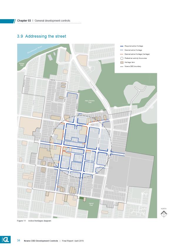
Design Development Controls Chapter as exhibited with the following changes:
a. Remove
the ‘Council owned land’ key from the Area Specific Controls
Maps;
b. Reduce
the area shown as “indicative consolidated deep soil zone” for
the Council owned site on the corner of Worrigee Street and Berry Street in
Figure 11;
c. Remove
the proposed ‘desired future connection’ shown over privately
owned land in Figure 13;
d. Include
clarification that site coverage is calculated across a development site and
on a lot by lot basis in relation to Area E1;
e. Amend
the maximum building depth in Area E1 to 180m;
f. Revise
the character area description of Area E1 to reflect the land uses
permissible in the zone;
g. Revise
the map ‘key’ in Figure 14 to clarify that the desired link is
over privately owned land; and
h. Include
the additional controls outlined in Attachment 3 to address active frontages
and amend numbering of controls accordingly.
4. Notify
the adoption of Shoalhaven Development Control Plan 2014 – Nowra CBD
Urban Design Development Controls Chapter in the local newspaper in
accordance with the requirement of the Environmental Planning and Assessment
Act 1979 and its Regulations, noting that it will commence when the related
LEP Amendment is notified.
5. Repeal
Chapters N8 – Nowra CBD Urban Fringe and N9 – Bulky Goods
Precinct East Street Nowra in the Shoalhaven Development Control Plan 2014 in
association with the commencement of the new Chapter in the DCP.
6. Advise
the NSW Department of Planning and Environment (DP&E) and the people/agencies
who made submissions on the Planning Proposal of Council’s
resolution.
7. Separately
consider the establishment of a Design Review Panel to assist in the
assessment of Development Applications for certain land uses and scales
within Shoalhaven through a separate report to Council.
8. Council
receive a further report to consider a wider Heritage Conservation Area to
the west of the Nowra CBD Commercial Core Area as part of the project that is
underway in this regard.
|
Options
1. Adopt the DCP
Chapter and finalise the LEP Amendment with the suggested changes to enable
positive future development outcomes in the Nowra CBD area.
Implications: This is the preferred option as it
allows Council to finalise the building heights and supporting urban design
development controls for the Nowra CBD to provide certainty for the community,
landowners and the development industry and to recognise Nowra’s role as
a Major Regional Centre consistent with the Illawarra-Shoalhaven Regional Plan
and Nowra CBD Urban Design Masterplan.
2. Make additional
changes to the exhibited documents.
Implications: Depending
on the nature of these changes, it may require the PP and/or DCP to be
re-exhibited.
3. Not adopt the PP
or DCP Chapter.
Implications: This option
is not favoured as the finalisation of the Nowra CBD planning documents are an
important step forward in providing certainty to the community, landowners and
the development industry, and reinforcing Nowra as a Major Regional Centre
consistent with the Illawarra-Shoalhaven Regional Plan and Nowra CBD Urban
Design Masterplan.
Background
The Nowra CBD is identified as a ‘major regional
centre’ in the NSW Government’s Illawarra-Shoalhaven Regional Plan,
and Shoalhaven’s primary business, retail and service hub.
Following on from the adopted Nowra CBD Urban Design Masterplan (2014), Council
prepared and adopted the Nowra CBD Urban Design Development Controls Report in
April 2016. Studio GL Pty Ltd prepared this report and it recommended a new set
of maximum building heights and supporting urban design controls for the CBD,
which recognised and reflected Nowra’s current and future role as a major
regional centre.
Council also resolved (April 2016) to prepare a Planning
Proposal (PP) to add the maximum building heights into Shoalhaven Local
Environmental Plan (LEP) 2014 and to insert the adopted supporting Urban Design
Development Controls, as a Chapter, into the Shoalhaven Development Control
Plan (DCP) 2014.
Planning Proposal - Building Heights in Nowra CBD
Under the current provisions of LEP 2014, the maximum height
of buildings in the Nowra CBD that Council can consider is typically up to 11
metres through a generic city-wide provision, although some limited sites are
specifically mapped to enable greater building heights to be considered.
During the preparation of LEP 2014 it was agreed with the
NSW Department of Planning & Environment (DP&E) that Council would do
the necessary work to enable detailed height of building controls to ultimately
be added to the LEP via a standalone process given that Nowra CBD is recognised
as a ‘major regional centre’
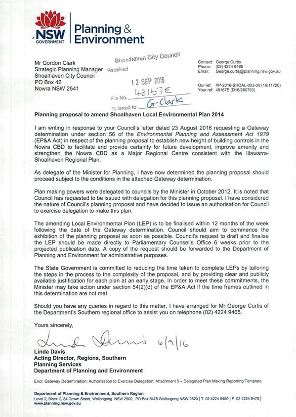
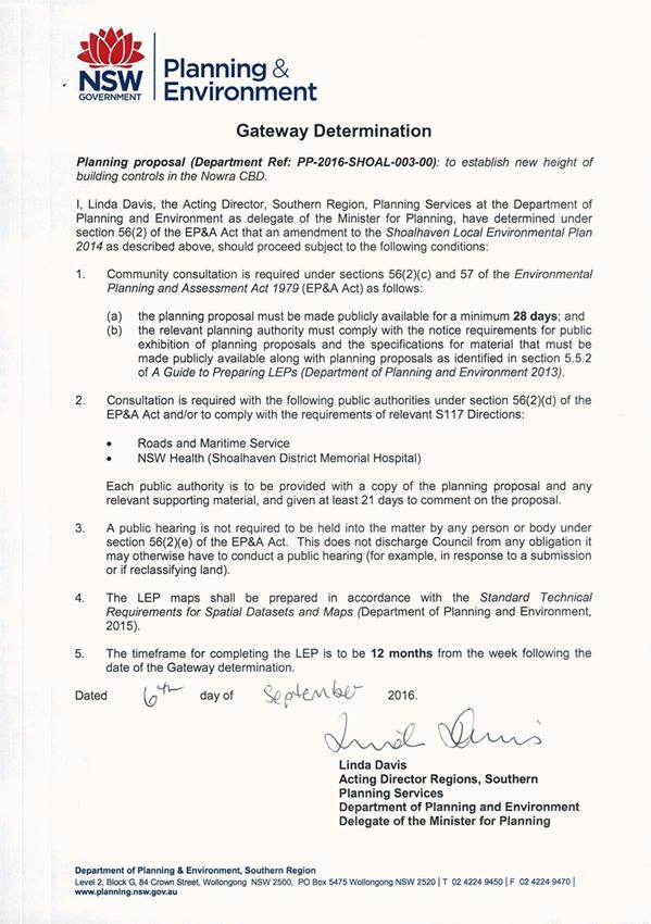
Council received a Gateway determination to for the PP to
establish the new height of building controls in Nowra CBD from the NSW
Department of Planning & Environment (DP&E) on 6 September 2016 with a
12 month timeframe to finalise the LEP Amendment. The Gateway determination is
provided as Attachment 1 to this report.
The PP seeks to introduce a new set of mapped maximum
building heights into LEP 2014 for the Nowra CBD. The proposed heights
respond to key strengths of Nowra such as the location of heritage buildings,
topography, and existing views and vistas to the natural and pastoral
surrounds.
The PP proposes a range of building heights for the Nowra
CBD, including:
· 20
metres immediately surrounding the core;
· 15
metres throughout the core and to the east of the Princes Highway; and
· 12
metres on Junction Street in consideration of heritage buildings, and within
the mixed use zoned areas surrounding the CBD.
The proposed heights are shown in Figure 1 below.
Figure 1
- Exhibited Building Heights
When thinking about building height in this context it is
important to consider that the number of levels (or storeys) achieved within
any given height limit can vary, and often depends on the proposed end use.
Commercial and retail uses require a greater floor to ceiling height than
residential apartments. For example, within a 20 metre height limit it is
possible to build a five storey commercial building or a six storey building
with retail on the ground floor and residential apartments on the upper levels
as shown indicatively in Figure 2 below.
It is noted that there was an error in the exhibited PP
report, where it was stated that the 15 metre building height limit would allow
for 4-5 storeys instead of 4 storeys. This indicative advice will be
clarified in the final PP document.
Figure 2
- Building Height in Storeys
Draft Development Control
Plan (DCP) Chapter
The draft DCP Chapter provides a new set of detailed urban
design controls to support the proposed new building height and help guide the
overall future built form in the Nowra CBD. The draft DCP Chapter
contains a range of controls for building and floor heights, building setbacks,
building bulk and scale, articulation, heritage conservation and solar access.
The draft DCP Chapter also identifies opportunities to build
on the existing character of the different precincts within the Nowra CBD,
create active street frontages, improve vehicle and pedestrian linkages, and
the protect views and vistas. The draft Chapter will also, when adopted,
replace and rescind the following two (2) existing Chapters in Shoalhaven DCP
2014:
· Chapter N8 –
Nowra CBD Urban Fringe; and
· Chapter N9 –
Bulky Goods Precinct – East Street Nowra.
The draft DCP Chapter will be inserted to the Area Specific
Chapters of the Shoalhaven DCP 2014 as Chapter N8 – Nowra CBD Urban
Design Development Controls.
Public Exhibition
The draft PP and DCP Chapter were exhibited as a package,
along with supporting material, for approximately six weeks between 2 November
and 16 December 2016 (inclusive) at the Council Administration Centre in Nowra.
The exhibition package was also available for viewing on Council’s
website.
To support the public exhibition, two (2) community drop-in
sessions were held where staff were available to answer any questions and
explain the provisions in the PP and draft DCP Chapter. All owners within
the PP area were advised in writing of the exhibition arrangements and the
community drop in sessions. The two drop in sessions were held at
Shoalhaven Arts Centre on Wednesday 23 November 2016 at 12pm to 2pm, and 4pm to
6pm respectively. A total of six (6) people attended the drop-in sessions.
A total of thirteen (13) submissions were received,
including submissions from Stockland and the Urban Development Institute of
Australia (UDIA). A submission was also received by Council’s
Assets and Works Group in relation to the development of the multi-storey car
park on Worrigee Street.
The NSW Roads & Maritime Services (RMS) also commented
on the PP consistent with the requirements of the Gateway determination.
In addition, a letter was also received by a consultant on
behalf of a large CBD landholder that was requested to be dealt with as
‘commercial in confidence’. Due to this request to keep the
submission commercial in confidence, a copy of the letter has not been provided
in the Councillors Room with the other submissions. This was received in July
2017, seven months after the public exhibition had ended.
The submissions were provided to Council’s consultants
Studio GL Pty Ltd, with the exception of the late submission, to review and
comment on the issues raised in the submissions. A copy of the Studio GL
Exhibition Outcomes Report is provided as Attachment 2 to this
report.
A summary of the key issues raised in the submissions, with
comments where relevant is provided below. A copy of all submissions will be
available in the Councillors rooms prior to the Development Committee Meeting.
1. UDIA
NSW
Commended Council on establishing a planning framework for
the Nowra CBD that reflects Nowra’s role as the key commercial centre for
Shoalhaven.
The draft DCP Chapter and the proposed modifications to the
building heights in the LEP are viewed as a crucial step in strengthening Nowra
CBD’s position as a major regional centre.
2. Stockland
Generally support the overarching objectives and the vision
to revitalise Nowra CBD and improve the quality and attractiveness of the
public domain as a catalyst to encourage development. The notion of excluding
Floor Space Ratio controls from the LEP is also supported.
Raised a number of concerns with the draft planning
framework, which are detailed below:
· The proposed
building heights of 15m and 12m over the Stockland sites are unnecessarily
restrictive and do not reflect the considerable opportunity afforded by the
large consolidated landholdings, nor do the heights accommodate the nature of
the proposed development that Stockland is planning. Based on the proposed
heights, Stockland would be unable to develop its vision for a high quality
interface with the Highway with two retail levels and multi storey parking in
place of the existing at-grade car park. Stockland request the building
heights be increased to 20 metres in this location.
· The desired future
character for the Eastern Retail Precinct for a large scale retail uses of
between 3 and 4 storeys cannot be satisfied within a 15m height limit or a 12m
height limit.
· The aims and
objectives of the Eastern Retail Precinct do not recognise and reflect the LEP
zone objectives and permissible land uses.
· The draft DCP
contains highly prescriptive, somewhat arbitrary and one-size-fits-all controls
that do not cater for a range of building typologies and scales, and are
inconsistent with existing development consents.
· The maximum site
coverage control in the draft DCP needs to be clarified as it is unclear in
circumstances of large landholdings covering multiple allotments.
· The maximum
building depth of 100m and maximum floorplate of 30,000m2 is
inconsistent with the current approval and Stockland future development vision.
· The identification
of a new north-south link road connecting North Street to Morton Parade is not
identified for future acquisition, this should be identified through the
preparation and adoption of a Section 94 Plan.
Comments
The proposed heights reflect Council’s vision for a
strengthened commercial core with the highest buildings close to the centre,
with building heights stepping down to the edges of the CBD area. The
proposed building height of 15m (shown in coloured purple in Figure 3
below) at 10-18 East Street and 32 East Street will allow various
configurations for a retail development of the site.
The submission states that the floor to floor ceiling
heights would limit the development of the land for their vision, however it is
argued that the proposed heights would still enable a two storey retail
development with associated multi-level carpark up to five storeys. The
desire for a taller gateway feature of greater than 20m next to the highway
does not adequately justify the request for increased heights across all three
Stockland sites, a specific gateway feature could be considered on its merits
and under existing LEP provisions (i.e. Clause 5.6 Architectural Roof
Features).
The residual lot to the east of the current centre has a 12m
height limit as it is located on the edge of the CBD and surrounded by flood
liable land. Development on this site to the requested 20m height could
create a significant visual impact on the eastern edge of Nowra that would
potentially be a poor urban design outcome.
It is recommended that the proposed building heights for the
Stockland sites remain unchanged.
Figure 3 –
Area Specific Controls Diagram Eastern Retail Precinct
To address the issue of the LEP zone objectives and
permissible land uses not being reflected in the Eastern Retail Precinct future
desired character statement, it is recommended that it be amended to read
“New development in this area is likely to include a mix of retail,
business, entertainment, community, residential and community
uses”.
The remaining issues raised in the submission on specific
DCP controls are proposed to be addressed with the following amendments:
· Clarification
will be provided in the DCP on the appropriate method to calculate site
coverage, being across the entire proposed development sites and not on a lot
by lot basis.
· Increase
the maximum building depth from 100m to 180m.
· Revise
the map ‘key’ in Figure 11 so that the desired links over privately
owned land is clearer. Remove the ‘Council Owned Land’ key on all
Area Specific Controls Maps – this will help remove any confusion in
interpreting the maps whilst also removing the need for a DCP Amendment should Council’s
property portfolio change in the future.
4. Council - Assets
& Works Group
Raise concern with respect to the controls over the proposed
multi storey car park site bounded by Berry Street, Worrigee Street and
Lawrence Avenue. Issues raised with respect to the building setback off
Worrigee Street and Lawrence Avenue, upper storey setbacks, retention of mature
trees, and deep soil zones. These concerns primarily relate to the design
of the proposed multi-storey car park and its non-compliance with the draft controls.
Specific modifications requested to Acceptable Solution
A25.1 and Acceptable Solution A45.1 to stipulate that the retention of trees is
only undertaken where possible, and that the building setback from Worrigee
Street is staggered between 3m and 6m.
Comments
The Exhibition Outcomes Report (Attachment 2) considers
and addresses the various issues raised in the submission. In
general, the issues raised were not considered to have enough merit to justify
amending the controls to suit the specific design of the multi-storey car park
development.
The draft DCP Chapter, and specifically the controls
relating to Character Area C3 - CBD South attempt to encourage high quality
design outcomes that will accommodate a wide diversity of land uses (not solely
a multi-storey car park) that are currently permissible in the zone of the site
being B4 Mixed Use.
In respect to the specific requests to modify Acceptable
Solutions relating to building setbacks and retention of significant trees, it
is recommended that a variation request to the development controls in the DCP
be considered through the development application process rather than a change
to proposed controls at this point. This is considered a more appropriate
approach, than amending the controls to accommodate only one type of
development and a specific use design. Amending the controls could result
in a poor outcome if the proposed development (in this case a multi-storey car
park) does not ultimately eventuate. Broadly, there is a potential risk
that this could occur on all sites across the CBD.
The Exhibition Outcomes Report (Attachment 2) has
recommended that the “indicative consolidated deep soil zone”
illustrated in Figure 11 be reduced in size on the subject site as the street
setbacks contribute to provision of deep soil zones.
5. Consultant
on behalf of large CBD landholder
This late submission recognises that the draft DCP is
positive and achievable over 80 percent of sites within the CBD, however it
raises concerns that there is no incentive provided to develop large
amalgamated sites. As such, it is suggested that development will occur
on a site-by-site basis and potentially result in poor outcomes.
An ambit height of 42 metres is suggested via a diagrammatic
representation in the submission for a possible development opportunity along
the Princes Highway as a more suitable building height. This is also
represented with a zero setback from Princes Highway and a 20 metre street wall
height.
It has been requested that Council consider the inclusion of
bonus provisions in the DCP for development of larger development sites to
enable individual proposals to be assessed on their merits.
Comments
Given the lateness of this submission it is not considered
in the Exhibition Outcomes Report (Attachment 2)
Whilst the holistic redevelopment of large amalgamated sites
is generally supported as it can achieve better development and design
outcomes, the assertion that large amalgamated site development would not occur
unless the height of buildings was more than double is potentially unfounded
and without basis.
The risk of increasing the height of buildings to the
suggested 42 metres, with a limited basis, is that it could actually stifle
development or ultimately create an undesirable outcome, as seen by other
recent decisions to accommodate ambit landowner height requests (e.g. Anson
Street, St Georges Basin).
The draft DCP proposes a maximum street wall height of 12m
in the CBD core area, with reduced maximum street wall heights of 8.5m away
from the core. Irrespective of the location of the development adjacent
to a six-lane highway, increasing the street wall height to 20m would be
inconsistent with the CBD area and does not ensure streets and lanes retain a
pedestrian scale.
In addition, the landscape setbacks, maximum street wall
heights and upper level setbacks proposed in the DCP will help to improve the
overall amenity of this area. The application of the DCP is necessary to ensure
that developments are able to achieve a high quality design along the highway
and in the CBD area more broadly.
Provisions are available for the future development of the
site to vary the LEP height standards using clause 4.6 of LEP 2014, or to vary
a DCP control as part of a development application. Alternatively, a soundly
based PP can be submitted to consider a site specific change to the height of
buildings controls on its merits for submission to DP&E. Due to the
limited timeframe remaining to finalise this LEP Amendment, this is considered
the most suitable approach for this specific site/location.
It is also noted in regard to this submission that the PP
and draft DCP are essentially the final steps in a broader strategic process
that has been undertaken with ongoing community and landowner engagement. Thus,
it would possibly be inappropriate to consider such a significant change at
this point in the process and particularly one that is essentially seeking
flexibility for a large site, when one of the aims of the process is establish
clear controls for the future that assist with certainty.
6. Community
Submissions
Issue - Building Heights
Ten (10) of the submissions made
reference to the proposed building heights.
Two (2) submissions supported the increased heights and
associated development controls and seven (7) submissions opposed increasing
the building heights above the current 11 metre maximum height of
building. The reasons for opposing the increase in heights are summarised
below:
· Lack of demand /
population growth to support the increased building heights;
· Impact on
Nowra’s character (a number of submissions support a 3 storey maximum in
this regard);
· Impact on views;
and
· Impact on
heritage.
The reasons for supporting the increase in heights include:
· The
proposed building heights are a crucial step in strengthening Nowra CBD’s
position as a major regional centre; and
· Act
as a catalyst to encourage development in Nowra CBD.
Comments
It is important to note that prior to 2014, there were
technically no maximum building heights for the Nowra CBD. Council did
not have the time to establish detailed building height controls during the
Shoalhaven LEP 2014 process, and therefore, the CBD was not given a
‘mapped’ height of building in the new LEP. This resulted in
the building heights reverting to the city wide default height of 11 metres as
prescribed in Clause 4.3 in Shoalhaven LEP 2014. The 11 metre height limit
current applies to all land not mapped in the LEP 2014 height of buildings map
overlay.
The 11 metres standard came from an earlier planning
provision that enabled Council to deal with any development up to that height,
then anything above that could still be considered, but with the concurrence or
approval of the NSW Government
As noted earlier, at the time of preparing the Standard
Instrument LEP, the DP&E supported Council’s approach to building
heights in the Nowra CBD, as a detailed analysis had not been undertaken to
establish specific height controls. However, DP&E advised that
following the adoption of LEP 2014, Council needed to investigate and implement
new building heights that reflected Nowra’s role as a major regional
centre.
It is anticipated that the Nowra-Bomaderry area will
experience significant population growth over the next 20 years, and, the
increased building heights will assist to encourage employment generating and
residential developments in the Nowra CBD. The CBD is the business hub
for Shoalhaven, and increasing building heights provides an opportunity for
existing sites to provide essential employment generating developments to
support Shoalhaven’s growing population, as well as complementary and
supporting residential development.
The proposed building heights were established through
detailed analysis to minimise adverse impacts on views, heritage items and
character. The proposed building heights are also supported by a set of
detailed urban design controls that aim to ensure that development positively
contributes to the future character of the Nowra CBD.
Studio GL Pty Ltd have recommended that Council also
consider establishing a Design Review Panel to ensure developments meet a
minimum standard of design. Additionally, it has been suggested that
Council consider creating a large conservation area to the west of the CBD to
ensure that development considers and responds to the local character of
Nowra. These suggestions may have merit and are recommended for further
consideration and will be separately reported to Council in due course.
Issue - Lack of Public Domain Controls
One (1) submission highlighted the importance of the public
domain in town centres and raised concerns about the lack of public domain
controls / planning in the draft DCP Chapter.
Comments
It is acknowledged and agreed that an appropriately planned
and managed public domain is essential to the future look/feel and success of
the Nowra CBD. However, it is important to note that the role of the DCP
Chapter is to guide private development, not to plan the public domain.
Council is however currently working on a draft DCP Chapter
for the Streetscape Design of Town and Village Centres. This DCP Chapter
will consider appropriate treatment of streets in association with proposed
developments.
In addition, the Nowra CBD Masterplan has a detailed plan
for the public domain in the Nowra CBD and Council continues to improve the
public domain through the implementation of the Nowra CBD Revitalisation
Strategy in consultation with the Nowra CBD Revisitation Strategy Committee.
Issue - Lack of Supporting
Infrastructure Strategy
One (1) submission raised concerns about the lack of
infrastructure planning in the draft DCP. The submission stated that
there is no plan for traffic, car parking, public domain, sewer, water and
lighting.
Comments
As outlined earlier in the report, the draft DCP Chapter is
a guide for private development, and is not itself an infrastructure
strategy. However, in this regard, Council has previously adopted the
Nowra CBD Transport Strategy, Nowra CBD Car Parking Strategy, Nowra CBD
Masterplan (public domain) and Shoalhaven Development Servicing Plan (water and
sewer) which adequately plan for infrastructure to support future development
in the Nowra CBD. These various strategies and plans can be adjusted in the
future if needed to respond to demands on infrastructure.
NSW Roads and Maritime Services (RMS) were consulted on the
PP and DCP and in their response advised that they are working on a
Nowra-Bomaderry Network Strategy, which will investigate and recommend infrastructure
upgrades to the local and classified road network.
Once the Network Strategy is finalised, an amendment to the
Shoalhaven Contributions Plan 2010 (CP) should be considered. In the
interim, mechanisms such as Conditions of Consent, Planning Agreements in
association with Development Applications and Council’s Capital Works
Budget can be utilised to enable the delivery of infrastructure to support the
demand created by new development. This aspect will be monitored as new
development occurs and if necessary, appropriate changes and adjustments can be
considered in this regard.
Issue - Proposed Laneway
One (1) submission raised concerns about a proposed laneway
shown in the draft DCP Chapter. The proposed laneway is shown as a future
link over what was previously Council owned land, however, the subject land is
no longer in Council’s ownership.
The proposed laneway is shown in Figure 4 below, and
the submission requests that the laneway (and Council owned land hatching) be
removed or relocated in the draft DCP.
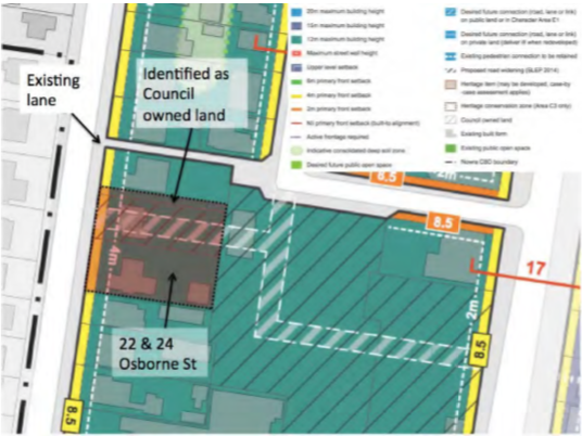
Figure 4 - Extract
from submission, proposed laneway
Comments
While the proposed ‘desired future connection’
would create a more logical link, it was never intended for it to be shown over
private land. It is recommended that the draft DCP be amended to remove
the proposed laneway from the subject land, and also the ‘Council owned
land’ key from all Area Specific Controls Maps. It is also noted
that an existing lane is located just to the north.
7. State Government
Agencies
The Gateway determination for the PP required consultation
with state government agencies including RMS and NSW Health (Shoalhaven
District Memorial Hospital), a response was only received from RMS.
RMS
Originally raised concerns about the lack of a traffic
strategy to support the increase in building heights in the Nowra CBD.
However, it was subsequently clarified that the Nowra CBD Traffic Strategy,
which was adopted by Council and endorsed by the RMS, provides a strategy for
traffic and transport in the Nowra CBD out to 2036. Following the
exhibition, the RMS were provided with a copy of the Nowra CBD Traffic
Strategy.
The RMS reviewed their initial advice taking into account
the additional information provided. Subsequent advice provided indicated that
they no longer require a traffic impact study and advised that they wish to
work collaboratively with Council in planning for appropriate future road work
upgrades. It was also recommended that Council consider the appropriate
mechanisms to collect contributions from new development within the area
affected by the PP as part of the consideration of this matter.
Comments
In considering the RMS advice, there are currently
appropriate mechanisms in place to enable new developments to fund or undertake
required infrastructure upgrades. These include conditions of consent, Planning
Agreements associated with Development Applications and Council’s Capital
Works budget.
In the most recent advice, RMS indicated that they are
currently working on a Network Strategy for the Nowra-Bomaderry area which will
investigate and recommend infrastructure upgrades to the local and classified
road network. Once the study is finalised, a supporting amendment to the
CP should be considered.
Additional Controls – Active Frontages
As part of the Nowra-Bomaderry Retail Hierarchy Study that
is currently being finalised, the consultants undertook a review of the draft
DCP Chapter. Recommendations were made with respect to the draft DCP,
specifically, that there was a need to address treatment of active frontages.
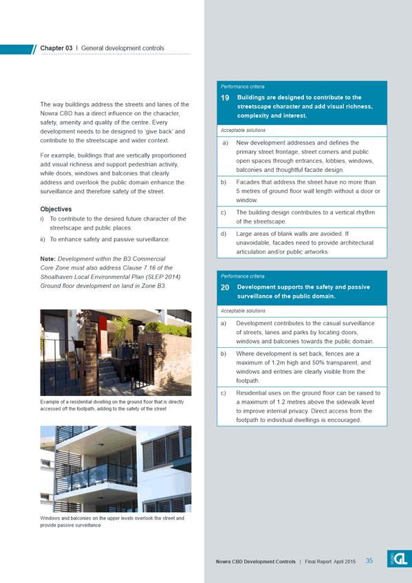
Thus, a new section, ‘5.10 Active Frontages’ is
recommended for inclusion in the DCP Chapter following ‘5.9 Addressing
the Street’. Numbering of subsequent DCP controls will also need to
be amended.
The new section provides development controls to ensure that
streets identified as required or desired active frontages are designed with
appropriate building treatments. In particular, they have regard to
pedestrian scale, encourage ease of access, allow interaction and foster
pedestrian activity.
The additional controls for inclusion are provided at Attachment
3.
Community Engagement
The draft Urban Design Development Controls were initially
prepared with the assistance of a Project Liaison Group made up of local
property and business owners, architects, planning consultants and community
representatives. The project consultants facilitated three workshops with
the group during the development and testing of the controls.
The PP and draft DCP Chapter were exhibited as a package
between 2 November and 16 December 2016 (inclusive) at the Council
Administration Centre in Nowra. The package was also available for viewing on
Council’s website. Direct letters were sent to 144 of the affected
landowners advising of the public exhibition period.
To support the public exhibition, Council staff held two (2)
community drop-in sessions in the CBD, where staff were available to answer any
questions and explain the provisions in the draft DCP Chapter and PP. A
total of 6 people attended the drop-in sessions.
Policy Implications
The adoption of the draft DCP with amendments will also
replace and rescind two existing DCP Chapters being N8 Nowra CBD Urban Fringe
and N9 Bulky Goods Precinct – East Street Nowra.
The adoption of the Planning Proposal to increase the Height
of Buildings will result in an Amendment to the Shoalhaven LEP 2014 to reflect
the new heights within the subject area.
Financial Implications
The preparation of the draft DCP and PP have been managed
within the existing Strategic Planning Budget.
As discussed earlier in
this report, finalisation of the draft DCP and PP may necessitate the need for
a supporting amendment to the CP.
|

|
Development
Committee – Tuesday 08 August 2017
Page
27
|
|

|
Development
Committee – Tuesday 08 August 2017
Page
31
|
|
|
Development
Committee – Tuesday 08 August 2017
Page
35
|
DE17.55 Planning
Proposal (Rezoning) - Warrah Road Bangalee - Finalisation of Development
Footprint
HPERM Ref: D17/213879
Group: Planning
Environment & Development Group
Section: Strategic
Planning
Attachments:
1. Gateway
Determination - Warrah Road Planning Proposal ⇩
2. Final
Peer Review - Ecological Assessment - Warrah Road Planning Proposal (under
separate cover) ⇨
3.
Proponents Submission 10/7/2017 - Warrah Road PP (under separate cover) ⇨
4. Proposed
Land Zoning Map ⇩
5. Proposed
Lot Size Map ⇩
6. Proposed
Offset Map ⇩
Purpose / Summary
Advise Council of the results of
the latest biodiversity peer review and consider a possible development
footprint for the site and resultant draft zoning and lot size maps to enable
progression of this Planning Proposal (PP) at Warrah Road, Bangalee.
|
Recommendation
(Item to be determined under delegated authority)
That Council
1. Adopt
the attached Land Use Zone (Attachment 5) and Lot Size (Attachment 6) maps as
the basis for preparing the specialist studies required to enable public
exhibition of the Planning Proposal.
2. Forward
these maps to the NSW Department of Planning and Environment with a request
to revise the Gateway determination that:
a. Reflects
the proposed new development footprint;
b. Removes
condition 1, which is covered by the new footprint;
c. Removes
items (c) and (d) from condition 2 in the current determination; and
d. Adds
a condition allowing the minimum lot size of 1500 m2 to be revised
if appropriately supported by the traffic and bushfire assessments undertaken
for the planning proposal.
3. That
the proposal be reported back to Council prior to exhibition.
|
Options
1. Adopt the
revised zone and lot size maps as the basis for progressing this PP.
Implications: This option reflects the constraints
and opportunities arising from the most recent ecological investigations
related to the site. It also reflects Council’s earlier resolutions and
allows much of the land that is not identified as having high conservation
value to be developed. As such, it is the recommended approach
2. Do not utilise
the results of the most recent and final biodiversity peer review and progress
the PP based on the previous reduced development footprint and adopt
appropriate zones and minimum lot size to proceed with.
Implications: This option avoids the need to seek
an amended gateway determination from the NSW Department of Planning &
Environment (DP&E) in the short term. It would, however mean that the PP
does not reflect the more detailed biodiversity information and final
biodiversity peer review that now exists, making progression of the PP
potentially problematic. This approach is likely to result in further delays,
and/or a lower lot yield and/or significant environmental impacts. This option
is not recommended.
3. Discontinue the
PP.
Implications: This would mean that the future of
the site remains unresolved and the current ‘deferred’ zoning under
Shoalhaven Local Environmental Plan (LEP) 2014 would be retained. Thus, this
option is not recommended. Under this option, the proponent would also have the
option to seek the intervention of the DP&E and Joint Regional Planning
Panel (JRPP), which could result in the proposal being taken out of
Council’s control.
Overview
On 6 December 2016, Council resolved to consider an
additional biodiversity assessment submitted by the proponents (Huntingdale
Developments Pty Ltd and Southbank Land Pty Ltd) in relation to the PP at
Warrah Road, Bangalee.
This report outlines the results of the independent peer
review of the proponent’s additional biodiversity assessment. The
resulting revised development footprint, supported by draft zoning and lot size
maps are presented for consideration so that the other necessary studies related
to the PP can be prepared.
Background
The overall Crams Road Urban Release Area (URA) was
originally identified in the Nowra-Bomaderry Structure Plan (NBSP). The
subject land was part of the original URA.
The NBSP stated that a range of investigations, including
biodiversity, would need to be completed to determine the potential extent of
residential development.
Due to conflicting biodiversity studies the Crams Road URA
was ultimately ‘deferred’ from the Shoalhaven LEP 2014 to enable
further investigations to be undertaken to determine an appropriate development
footprint for the site.
In 2014 the proponents submitted a PP to commence the
process to resolve the zoning of the site. In an attempt to reconcile the
conflicting biodiversity studies over the subject land, in early 2015 Council
engaged NGH Environmental Pty Ltd to undertake an independent peer review of
the biodiversity studies that existed over the site and make recommendations on
biodiversity significance to inform a PP.
In December 2015, Council ultimately resolved to prepare and
advance a PP based on the findings of the peer review. The Warrah Road
PP (PP005) was subsequently submitted to DP&E and a Gateway determination
issued on 12 July 2016. The Gateway determination allowed the PP to proceed
subject to a number of terms and conditions including the following:
Condition 1: applying an environmental zone to
Sub-remediation Area B.
Comment: this concerns unauthorised clearing on the
site which is discussed later in this report.
Condition 2: completion of additional studies:
a) Bushfire
Hazard Study
b) Aboriginal
Archaeological Assessment
c) Biodiversity
Review of Lots 21-23
d) Provision
of infrastructure – water, sewerage and electricity to confirm demand and
supply issues
Comments:
This report includes a recommendation that Council seek an
amendment to the gateway determination to delete conditions c) and d).
In relation to condition c) the suitability of Lots 21-23
for residential development has already been established and confirmed by the
latest independent peer review that is discussed later in this report.
In relation to condition d) Part 6 of the LEP already
requires that adequate utility infrastructure is provided prior to the actual
released of land within the URAs. Furthermore, the original Crams Road
URA (of which the site is part) is identified as a long-term release area in
the NBSP. As such the area once zoned, will not be developed in the
short/medium term.
A copy of the Gateway determination is provided as Attachment
1.
Independent Peer Review of
Conservation Significance Assessment Report
Following receipt of the Gateway determination, the matter
was reported to Council and it was noted that the proponent had prepared a
further biodiversity study that should be considered. Thus, in accordance with
MIN16.944 (December 2016) Council engaged NGH Environmental Pty Ltd to prepare
an independent and objective peer review of the latest OMVI 2016 study
commissioned by the proponent and to:
· Reassess areas of
High Conservation Value (HCV) land; and
· Determine if
further field studies are still required to accurately define HCV areas.
This peer review was completed in June 2017. It
concluded that adequate survey has been undertaken to determine HCV lands at
the subject site. A full copy of the report prepared by NGH Environmental
Pty Ltd, including the revised HCV land map is provided as Attachment 2 (see
separate folder).
However, it should also be noted that NGH concluded that
“…given that populations of the Leafless Tongue Orchid may not
flower every year, and only one comprehensive survey for this species has been
undertaken, it is recommended that another additional targeted survey be
conducted for this species in areas that may be developed in the future, to
clarify the conclusions of the study that the species is absent.”
Proponent’s Response to
the Biodiversity Peer Review
A copy of the completed peer review was provided to the
proponent and they responded on 10 July 2017 - see Attachment 3 (separate
folder).
As a result of the latest information, the proponent’s
submission proposes that:
1. The
future western bypass corridor be zoned RU2 Rural Landscape
2. The
HCV land be zoned E2 Environmental Conservation
3. For
the remaining land:
o the area to the west of Warrah
Road be zoned R2 Low Density Residential
o the area to the east of Warrah
Road be zoned R1 General Residential
The proponent has proposed the following lot sizes:
· 2000 m2
for the land adjoining existing residential development
· 500 m2
for the remaining land within the development footprint
· 40 ha for the proposed
E2 and RU2 areas
Council staff have reviewed the proponent’s proposed
zoning and lot size maps. The overall development footprint is generally
supported but some changes to the proposed density of development are
considered necessary in response to the known site constraints.
Recommended Zoning and Lot
Size Maps
The recommended land use zoning map is shown in Attachment
4 and the recommended lot size map is shown in Attachment 5.
The proposed 2000 square metres lot size across
the northern part of the developable footprint is consistent with the existing
pattern of development to the north, and will help maintain a consistent
landscape character and amenity for the existing dwellings. It will
enable a more appropriate development transition.
However, a 500 square metres lot size is
considered too small for the southern fringe of the proposed R2 zone. The
irregular configuration and long length of the residential/environmental
boundary on the eastern side of the residential area has implications for
infrastructure requirements and bushfire risk. It will also pose challenges in
terms of managing weeds, pests and illegal dumping within the E2 area.
Thus, a 1500 square metres minimum lot size
is recommended for the land adjoining the proposed E2 zone. This lot size
reflects the need for a bushfire asset protection zone (APZ) between the
dwellings and the adjoining bushland, as well as potential road/traffic issues.
It is proposed to request a notation in the Gateway that this may be revised in
the final PP subject to traffic and bushfire investigations.
An area within the centre of the site is proposed to have a
minimum lot size of 500 square metres to enable some flexibility in this part
of the site to enable smaller lots.
Remediation Areas
The current Gateway determination requires land affected by
a remediation order under the Native Vegetation Act to be zoned for
environmental protection. This reflects the uncertainty in determining
ecological values after land has been cleared and the principal that there
should be no benefit from unlawful activities.
The residential zone suggested by the proponents will encroach
into the remediation area by approximately 1.5 hectares. To offset this impact,
it is proposed to conserve in an E2 zone 3.8 hectares of land that would
otherwise potentially be suitable for residential zoning. This represents an
offset ratio of 1:2.5, and is shown in Attachment 6.
It is considered that this offsetting is appropriate as it
will facilitate a negotiated outcome and allows better planning outcomes to be
achieved. This outcome cannot be pursued, however, unless DP&E agree to
delete or modify condition 1 from the Gateway determination, hence
recommendation 2b in this report.
Community Engagement
The purpose of this report is to
establish a potential development footprint and enable the PP to advance on
that basis so that the other investigations required by DP&E can be
undertaken.
The community will then be able
to provide input through the formal PP exhibition process when this point is
reached and prior to the PP being finally adopted by Council.
A site-specific chapter in
Shoalhaven Development Control Plan (DCP) 2014 will also need to be prepared
before the land is ultimately released in the future. Thus may also need to be
accompanied by a supporting Contributions Plan (CP). This step will also
involve a separate community engagement process at that stage.
Council could consider seeking community feedback on the
proposed footprint, zoning and lot size maps prior to the formal PP exhibition
period. However, the proposal is not yet in a form that would enable a
community member to reach an informed opinion on the proposal. It may also
contribute to ‘consultation fatigue’ which could impact on formal
community engagement processes for the PP and DCP Chapter.
If the land is able to be
subdivided in the future once the PP and DCP/CP processes are completed, the
proponents will need to submit development applications to subdivide the land,
at which point the community will have further opportunity to comment on the
proposed subdivision(s).
Financial Implications
The proponent has paid the PP
lodgement and preparation fee in accordance with Council’s fees and
charges and met the costs of the reports prepared to date. Any additional
studies required by the PP are required to be wholly funded by the proponent,
as would any further peer reviews that may need to be undertaken.
Conclusion
The ecological investigations
for the Warrah Road PP have been completed and a position reached between the
ecologists working for the proponent and the ecologists working for Council. A
potential new footprint for the rezoning has been designed that reflects the
latest and most complete ecological assessment of the site. Adopting this will
require an amendment to the Gateway determination and it is recommended that
Council request this amendment.
Once
the Gateway determination is amended and further studies undertaken into
bushfire risk, traffic impacts and Aboriginal cultural heritage, the PP will be
in a form suitable to allow a community member to reach an informed opinion on
the proposal. The proposal can then be formally exhibited and then reported
back to Council.
|

|
Development
Committee – Tuesday 08 August 2017
Page
40
|
|
|
Development
Committee – Tuesday 08 August 2017
Page
44
|
|
|
Development
Committee – Tuesday 08 August 2017
Page
45
|
|
|
Development
Committee – Tuesday 08 August 2017
Page
46
|
|

|
Development
Committee – Tuesday 08 August 2017
Page
47
|
DE17.56 Moss
Vale Road North Urban Release Area - Resourcing and Funding
HPERM Ref: D17/216422
Group: Planning
Environment & Development Group
Section: Strategic
Planning
Purpose / Summary
Report on the resourcing and
funding requirements to enable the detailed planning tasks associated with the
Moss Vale Road North (MVRN) Urban Release Area (URA) to be prioritised.
|
Recommendation
That Council:
1. Formally commence the process
required under Part 6 of Shoalhaven Local Environmental Plan 2017 for Moss
Vale Road North (MVRN) Urban Release Area (URA).
2. Revise the indicative development
phasing plan (contained in the Nowra-Bomaderry Structure Plan) for the Nowra
Bomaderry URAs as follows:
a. Phase 1 – Mundamia and Worrigee
b. Phase 2 – Moss Vale Road South
and Moss Vale Road North
c. Phase 3 – Cabbage Tree Lane
d. Phase 4 – Crams Road
3. Consult with the landowners of MVRN
URA regularly to ensure they are provided with opportunities to be involved
in the planning process and offer feedback
4. Support the establishment of a
Project Control Group to facilitate the progression of the planning for the
URA and its role at the development stage to ensure satisfactory provision of
public infrastructure.
5. Commit the required staff resources
and set a budget of $165,000 in 2017/18 (as per Table 1 in the report) to
undertake the detailed planning requirements and delivery of infrastructure
and identify a funding source in the September Quarterly Review.
6. Continue to seek opportunities for
grant funding to reduce the cost of technical investigations and
infrastructure, which would ordinarily be imposed on landowners/developers
through Section 94 Contributions.
7. Advise all landowners within the
Nowra-Bomaderry URAs of this resolution.
|
Options
1. Adopt the recommendation.
Implications: This will enable Council staff to
work with the landowner’s consultants to achieve an outcome that both
parties are supportive of and in a timeframe that is in line with their
expectations. Should the recommendation be adopted it is necessary that
all landowners within the MVRN URA are provided opportunities, as suggested in
the report to be regularly consulted through this process.
2. Adopt an alternative resolution that
requires that Council undertake the required investigations to prepare a
Development Control Plan and Contributions Plan.
Implications: Given the amount of technical
investigations involved with the MVRN URA, it is unlikely that Council staff
will be able to enable the release of the MVRN URA in line with the Moss Vale
Road South (MVRS) URA and the landowner and community expectation.
Background
On 28 March 2017, Council considered a Notice of Motion
relating to the prioritisation of work on the MVRN URA and requested a report
on the resourcing and funding requirements to do so.
The Council resolution (MIN17.222) in this regard is as
follows:
That:
1. Council
revise and elevate the strategic planning priority of the Moss Vale Road North
urban release area due to the economic stimulus, provision of alternative
development concepts and other benefits including affordable housing that this
will provide.
2. The
General Manager report to Council resourcing requirements for consideration to
support the immediate commencement of the detailed development control plan and
other processes required under Part 6 of Shoalhaven LEP 2014 and any other
steps necessary to facilitate the short term release of this land to market.
3. The
General Manager report to Council any alternate sources of funding including
any contributions that may be negotiated with the proponents to manage the
processes required to enable the release of this land.
4. The
General Manager report to Council any acceleration that may be required for the
provision of infrastructure to account for the change of priority.
5. That
Council inform other holders of land within the Nowra-Bomaderry Urban Release
Areas of Council’s decision and related justification.
This report responds as required to this resolution.
Prioritisation of MVRN URA
The Council resolution of 28 March 2017 specifically sought
to re-prioritise MVRN from Phase 5 to Phase 2 in the Nowra-Bomaderry Structure
Plan (NBSP) phasing, concurrent with the Moss Vale Road South (MVRS) URA that
is actively being worked on by Council’s Strategic Planning Section.
The different phasing of the two URAs in the original NBSP
was primarily due to economic feasibility and ensuring the market was not
flooded with new land release in such close proximity. In addition, it
was acknowledged that MVRN potentially had more constraints than MVRS.
A significant constraint relevant to MVRN is the significant
amount of riparian areas that traverse the site. The additional considerations
for MVRN, as opposed to MVRS, include but are not limited to Aboriginal
Cultural Heritage, threatened species, bushfire and the riparian corridor
network. The site is also much larger in area, which comes with greater
land ownership fragmentation. While it is accepted that both release areas are
in the same general location, their characteristics differ and it is expected
that this difference will be evident in the eventual development of the URAs.
Bringing both MVRS and MSRN URAs online in the next phase of
release creates an impact on Council resourcing and funding, as existing
budgets and works programs did not account for the additional resourcing
required to enable the release of the land at MVRN ahead of schedule.
The work required to bring a release area online is set by
Part 6 of Shoalhaven Local Environmental Plan (SLEP) 2014. Part 6
stipulates that development of land mapped, as an URA must provide satisfactory
arrangements for state public infrastructure, public utility infrastructure,
and be subject to a Development Control Plan (DCP) prior to development consent
being granted.
This means that funding budgets need to be reconsidered,
opportunities for State Government infrastructure grants investigated and that
the landowners will need to undertake a large portion of the scope of works
required to inform the Development Control Plan and Contribution Plan for the
URA.
Resourcing and Funding Requirements
Additional resourcing and funding will be required for a
number of Sections of Council to support the immediate commencement of the
detailed DCP and other processes required under Part 6 of SLEP 2014.
Strategic Planning
Council’s Strategic Planning Section will be
responsible for the overall project management of the MVRN URA to ensure that
the Part 6 requirements of SLEP 2014 are satisfied. This includes but is
not limited to the preparation of a DCP, Contributions Plan (CP), and
consulting with relevant State Government agencies, Shoalhaven Water and other
infrastructure providers to coordinate the delivery of State and Local Public
Utility Infrastructure for the new living area.
To encourage a variety of housing products at different
price ranges, a Planning Proposal (PP) to encourage smaller lot sizes is likely
to be considered for MVRN, similar to MVRS. The preparation and
submission of a PP for Gateway determination will be coordinated by Strategic
Planning. The PP may also need to address other matters related to the
refinement of zones in this area, such as the existing B1 Neighbourhood Centre
zone, dependent on the outcomes of the Nowra-Bomaderry Retail Hierarchy Study.
Strategic Planning will also be responsible for managing the
required public exhibition of any PP, DCP and CP for MVRN as required by the Environmental
Planning & Assessment Act (EP&A Act) 1979 and Environmental
Planning & Assessment Regulations (Regulations) 2000.
As Council’s Development Committee endorsed the
Strategic Planning Works Program on 17 July 2017, management of the MVRN URA
will be resourced by Council’s Strategic Planning Section and funded
within the existing Strategic Planning Budget. Should additional funding be required
in this regard or related to specific tasks, this will be covered in subsequent
reports to Council through the process.
Water and Sewerage
Shoalhaven Water can provide sewerage servicing and water
supply over an eight-year period to address the additional demand because of
MVRN URA. Shoalhaven Water has advised that the upgrades required to
sewer and water infrastructure also take into account the additional demand
from MVRS URA. These works will be included in the new Water Supply and
Sewerage Services, Development Servicing Plans.
Sewerage servicing requires the construction of major
infrastructure to support both MVRN and MVRS URAs. The development of the
URAs will require substantial works to be brought forward from the current
Wastewater Capital Works program. This includes a number of gravity sewer
mains, sewage pumping stations and emergency storage tanks that are estimated
to cost in excess of $6.852 million (these figures are based on 2013 Sewer
Strategy Report indexed to 2017/18 using NSW Water Supply & Sewerage
Construction Cost Indices) between 2017/18 and 2024/25.
Water supply infrastructure can be provided to support both
MVRN and MVRS URAs, however due to the elevation and ground levels of the
existing Cambewarra Reservoir, the URAs will need to be split into two
catchments for water supply servicing. Initial provision of water supply would
be to the western section of MVRN URA and the north-eastern section of MVRS
URA. Further water supply can be provided to the eastern part of MVRN via
an extension from the Bomaderry Water Supply System. The development of
the URAs will require new pipelines, reservoir and a water pumping station that
are estimated to cost in excess of $2.55 million (these figures are based on
the 2013 Water Servicing Strategy Report indexed to 2017/18 using NSW Water
Supply & Sewerage Construction Indices) between 2017/18 through to 2022/23.
The costs provided by Shoalhaven Water are exclusive of land
acquisition, servicing of other areas and upgrade to existing power
supply. In addition, the required works and timing may change subject to
the development staging identified for the URAs. An external contractor will
undertake the construction works, which is standard practice for Shoalhaven
Water capital works. However, Shoalhaven Water may carry out the designs
where workloads permit.
Based on the above, the provision of water supply and
sewerage infrastructure will require significant funding. However it is
noted that the initial costs and timing provided for sewerage and water
infrastructure have been provided on the basis of the Indicative Layout Plans
for the URAs and are not based on any detailed subdivision plans (as they are
not available at this stage), therefore these figures are subject to further
analysis and refinement as the projects advance.
Road Infrastructure
To inform the Contributions Plan (CP) on the required road
infrastructure, further investigations with respect to traffic and transport,
infrastructure design and delivery, and project management will be required.
Traffic and Transport investigation that includes traffic
modelling and investigations will be required to establish possible CP
projects, and model traffic flows on Moss Vale Road and the Princes Highway to
determine the timing of road and intersection upgrades. This resource is
not currently available within Council’s Assets and Works Group and will
need to be managed by an external consultant – estimated cost $30,000.
Infrastructure design and delivery are typically undertaken
externally with potential input from Council’s Development Services
Subdivision Unit. It is unknown what the cost or timing of this
investigation work will be.
Project management will also be required, Council’s
Assets and Works Group have advised that there is no capacity for existing
resources to be taken offline to assist with project management. Thus,
this will require an additional position internally.
In addition, NSW Roads and Maritime Services (RMS) will need
to be involved in any discussions relating to road infrastructure that may
affect the State Road Network (i.e. Moss Vale Road and the Princes
Highway). There may be spare capacity within RMS to undertake the design
and costings of the infrastructure projects required (needs to be clarified),
which could then be input into a Contributions Plan.
Outside the URA, the State Budget had identified a number of
key projects within the vicinity of MVRN, which include the Berry to Bomaderry
Princes Highway Upgrade, and the Nowra Bridge project. The progression of
the Berry to Bomaderry Princes Highway Upgrade, in particular, will consider
access to MVRN from Princes Highway. The RMS’s preliminary plans
indicate that Pestells Lane should be used as the primary access point of the
Highway as it is proposed to be a grade-separated intersection (similar to
Berry) combined with Meroo Road.
The Federal Budget has also committed funding to the Far
North Collector Road (FNCR). Council will consider a report in the future
on the design and costings of the FNCR, including potential funds within this
project that could be used to upgrade Taylors Lane and the intersection with
Moss Vale Road.
Environmental Considerations
As indicated earlier, the MVRN URA has a number of potential
environmental constraints including but not limited to Aboriginal Cultural
Heritage, threatened species, bushfire risk, flood risk, stormwater management
and management of the riparian corridor and open space system.
Council’s Natural Resources Section have indicated
that consultants will need to be engaged to undertake the required
investigations for MVRN; this would also require an additional position
internally to manage various consultants, and a natural areas manager for the
ongoing management of riparian corridor land. The review of these studies
is unlikely to be able to be handled within existing internal staff resources
of the section is likely to require a part time project officer costing
approximately $60,000 annually, and would potentially be required over an 18-24
month period.
Open Space and Recreation
The riparian corridor network and RE1 Public Recreation
zoned land within the MVRN URA will potentially result in the creation of a
significant public asset for Council to manage.
Provision of suitable community infrastructure such as open
space network, shared cycle ways or similar will require staff resourcing with
respect to designing the embellishments of public open space. Council’s
Social and Infrastructure Planning Section has advised that staff resourcing is
available internally should the required consultant reports be undertaken
externally.
Establishment of a Project Control Group (PCG)
To ensure the overall coordination of the development of the
URA and that the planning requirements under Part 6 of SLEP 2014 are addressed,
it is recommended that a PCG made up of relevant Council staff from Strategic
Planning, Development Services, Natural Resources, Social Infrastructure
Planning, Assets and Works, and Shoalhaven Water be established. The
primary role of the PCG will be to meet regularly with the proponents to
consult and progress with the overall planning of the MVRN URA. The
Strategic Planning Section will be responsible for the management of the PCG.
An opportunity also exists for the PCG to continue to be
involved after the requirements of Part 6 of SLEP 2014 are satisfied.
This relates to the PCG reviewing and providing in-principle support of plans
for public infrastructure prior to lodgement of a Development
Application. This process has been adopted by some of the Councils that
make up the Sydney Region Growth Centres as a mechanism to ensure that the
standard of public infrastructure that is to be dedicated to Council is
satisfactory and to simplify the pre-lodgement process.
Landowner Proposal
Since the March 2017 Council resolution, Council staff have
met with two of the landowners in the MVRN URA who own a large proportion of
the URA with their consultants Allen Price & Scarratts (APS) to discuss the
way forward with the planning for the MVRN URA.
In these discussions, Council staff provided detailed advice
on the studies required to develop a DCP and CP for the URA, including but not
limited to the following:
· Development of an
Indicative Layout Plan to inform street hierarchy and network, staging and
development footprint;
· Flora and fauna
study;
· Aboriginal
Cultural Heritage;
· Traffic (this is
to also consider the latest design of the Berry to Bomaderry highway upgrades
and entrances via Pestells Lane and Abernathys Lane);
· Bushfire Risk;
· Flood
Investigation of Abernathy’s Creek;
· Integrated Water
Cycle Assessment, including baseline water quality conditions;
· Open Space and
Landscape Strategy;
· Electricity
Capacity Assessment;
· The potential need
to review the existing B1 Neighbourhood Centre zone in relation to its size and
location; and,
· Consideration of
the future ongoing management of the riparian corridor and open space system.
APS have advised that the landowners have agreed to
generally respond to the issues raised through their own scope of works to
fulfil the requirements under Part 6 of SLEP 2014. The scope of works
provided by APS involves:
· Detailed
masterplanning including staging, urban design controls for significant
development sites, encouraging increased densities, public facilities and
commercial areas
· Transport Movement
Hierarchy
· Landscape Concept
Plan including vegetation and riparian corridor management and active and
passive recreation areas
· Stormwater and
Water Quality
· Natural and
Environmental Hazards including bushfire, flooding and contamination
· Aboriginal
Cultural Heritage
· Flora and Fauna
· Infrastructure
Delivery
· Visual Impact
· Economic Feasibility
The list of studies identified appeared to generally address
the issues raised in discussions. Council staff have also discussed the
need to be involved in the process through establishing the scope of works for
each study and reviewing the draft reports. This is to ensure quality
control and that the final product (studies, DCP and CP) is of a high standard,
provides the necessary information for the development of the DCP and CP and is
capable of being supported by Council. It is considered that this role
can be provided by the PCG. APS and their client generally support this
approach.
Community
Engagement
Regular meetings with the landowners in MVRN URA will be
required should Council resolve to proceed to work with the proponents
collaboratively to commence the requirements under Part 6 of SLEP 2014.
It is necessary that Council run this process to ensure that all landowners are
provided with sufficient opportunities to be involved, consulted and provide
feedback.
In addition, once the PP, DCP and CP have been prepared to
Council’s satisfaction, the documents will be publicly exhibited as a
package in accordance with the requirements of the EP&A Act and Regulations.
Policy Implications
As MVRN is mapped as a URA under SLEP 2014, the requirements
under Part 6 determine that arrangements are made for State public
infrastructure, public utility infrastructure and a DCP is prepared to MVRN URA
prior to development occurring.
Financial
Implications
Significant funding is required to enable the immediate
commencement of the detailed planning work and delivery of the required
infrastructure for MVRN URA.
If Council resolve to undertake the detailed planning for
MVRN URA as a combined effort with the landowners, the full extent of
resourcing and funding for Council, as detailed in this report, may not be
needed. Based on a collaborative approach, the financial figures is
provided in Table 1 below, the table also identifies how payment could
be allocated.
|
Resource / Infrastructure /
Study
|
Costs
|
Cost Allocation
|
|
Strategic Planning – at least one internal officer
|
Unknown
|
Carried out initially within Strategic Planning
Operational Budget
|
|
Sewer Infrastructure
|
$6.852M
|
Levied to developer as per Section 64 Headworks Charges
|
|
Water Supply
|
$2.55M
|
Levied to developer as per Section 64 Headworks Charges
|
|
Traffic and Transport Investigation
|
$30,000
|
Developer
|
|
Infrastructure Design and Delivery
|
Minimum $40,000
|
Council - Budget to be allocated.
Portion of costs potentially be recouped via Section 94 Contributions
and levied to developer
|
|
Infrastructure Project Manager
|
Minimum $40,000 per year
|
Council
|
|
Flora and Fauna Study
|
Minimum $10,000
As suggested by proponent
|
Developer
|
|
Aboriginal Cultural Heritage Investigation
|
Minimum $15,000
As suggested by proponent
|
Developer
|
|
Bushfire Risk
|
Minimum $5,000
As suggested by proponent
|
Developer
|
|
Flood Investigation
|
Minimum $20,000
As suggested by proponent
|
Developer
|
|
Integrated Water Cycle Assessment, including baseline
water quality
|
Minimum $25,000
As suggested by proponent
|
Council – Budget to be allocated
Portion of costs potentially recouped via Section 94
Contributions and levied to developer
|
|
Open Space & Landscape Strategy
|
Minimum $25,000
As suggested by proponent
|
Developer
|
|
Environmental/Natural Resources Project Manager
|
$60,000 per year
|
Council - Budget to be allocated
|
|
Social Infrastructure Planning – at least one
internal officer
|
Unknown
|
Carried out within Social Infrastructure Planning
Operational Budget
|
|
Project Control Group Resources – at least eight (8)
internal officers from Planning, Environmental & Development Services;
Corporate & Community; and Assets & Works Groups.
|
Unknown
|
Carried out within Group Operational Budgets
|
|
Total –
Council staff resourcing – minimum ten (10) staff members
in varying capacities
|
Total –
Minimum cost of $165,000
|
Council - Budget to be allocated
|
Table 1 –
Approximate Indicative Resourcing Costs
Should the landowners choose to run the process ahead of
Council’s schedule it is recommended that landowners fund the required
technical investigations. Where possible, technical investigations that
apply to both MVRN and MVRS URA will be undertaken concurrently and the costs
shared.
State Infrastructure Contributions (SIC) Levy
Having arrangements in place for designated State public
infrastructure is a requirement under Part 6 of SLEP 2014. These
arrangements are typically provided through a SIC Levy which is administered by
the NSW Department of Planning & Environment (Department). At this
stage, a SIC Levy does not exist and it is not known whether the Department
will proceed with a SIC Levy for MVRN URA. Confirmation will continue to be
sought from the Department in this regard.
Shoalhaven Contributions Plan 2010 (CP) – specific
projects
The delivery of infrastructure such as roads, drainage, open
space, shared cycleways etc. will be levied via specific projects in the CP for
the MVRN URA and in accordance with the EP&A Act. In some
instances, where an infrastructure project is required for the development of
both MVRS and MRVN URAs, the recoupment costs will be shared between the two
URAs.
Where Council has funded the technical studies and design of
infrastructure, there may be opportunities for the costs to be recouped through
the CP process if deemed necessary and appropriate.
Water and Sewerage Headworks Charges (Section 64
Contributions)
The costs for water supply and sewer infrastructure as
listed in the Development Servicing Plans for the development of MVRN URA will
be recouped via Section 64 Charges.
Grant Funding
There may be opportunities to apply for future grant funding
for technical investigations and help offset the cost of infrastructure
delivery. The current grant funding available requires that projects are
further advanced and are ‘shovel ready’.
Grant funding has the potential to reduce costs on Council
and developers of MVRN URA by providing funding to undertake technical
investigations and the delivery of infrastructure. These costs are
typically incurred by a developer through Section 94 Contributions. This
will hopefully also assist with making housing in this location more affordable
should the opportunity arise.
Although the MVRN infrastructure projects may not be
eligible for grant funding now, opportunities for future grant funding will be
sought to reduce the cost of technical investigations and actual infrastructure
delivery.
Risk Implications
The wider Moss Vale Road area has the potential to provide
up to 2400 dwellings based on initial calculations. The release of that
many lots within a short time period has the potential to flood the market that
may decrease the viability of land in this area, especially given the
approximate cost of infrastructure required to enable the land release.
The DCP will need to consider appropriate staging of the MVRN URA in
association with the delivery and staging of the MVRS URA.
|
|
Development
Committee – Tuesday 08 August 2017
Page
56
|
DE17.57 Clause
4.6 Variation Report - 71 Meroo St, Bomaderry - Lot 1 DP 732712
DA. No: DA16/2440/4
HPERM Ref: D17/234650
Group: Planning
Environment & Development Group
Section: Development
Services
Attachments:
1. DA Plans -
Clause 4.3 Variation - Bomaderry Hotel - 71 Meroo St Bomaderry - Lot 1 DP
732712 ⇩
Description of Development: Alterations
and additions to Bomaderry hotel to create additional guestrooms (19 new rooms
for total of 24 rooms)
Owner: Schustrom Pty Ltd
Applicant: Lee Carmichael Town
Planning
Notification Dates: 5 January to
19 January 2017
No. of Submissions: One (1)
in objection
Zero (0) in support
Purpose / Reason for consideration by Council
To seek
direction from Council on a policy variation relating to the 11m maximum height
of buildings limit under Clause 4.3 (Height of buildings) of the Shoalhaven
Local Environmental Plan 2014 (SLEP 2014). Under the assumed concurrence
conditions from the Secretary, Department of Planning, variations greater than
10% are required to be considered by the Council and not by delegation.
|
Recommendation
(Item to be determined under delegated authority)
That the Committee:
1. Confirms
that pursuant to Clause 4.6 (Variation to development standards) of SLEP
2014, it supports the applicant’s request to vary the maximum height of
buildings limit of 11m to 12.8m; and
2. Refer
the development application (DA16/2440) back to staff for determination.
|
Options
1. Resolve
to support the requested variation to the maximum height of buildings limit.
Implications: This would enable Council to
issue a development consent for the proposal, subject to resolving outstanding
issues relating to car parking. Negotiations on this issue are still ongoing
but would unlikely affect the overall design of the proposed development and
the maximum height of the building.
2. Resolve
not to support the proposed variation to the maximum height of buildings limit.
Implications: This would require the
applicant to reconsider the design of the proposal. If the applicant does not
pursure this option or the current development application (DA) is not
withdrawn, Council would have to refuse consent for the DA which may ultimately
result in the applicant appealing Council’s decision in the NSW Land and
Environment Court.
3. Resolve
to modify the recommendations contained in this report.
Implications: This would require the
Committee to provide direction to staff.
Location Map
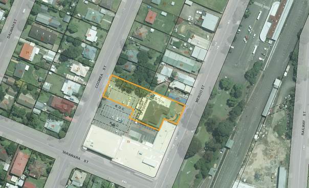
Figure 1 –
Location of site
Zoning Map
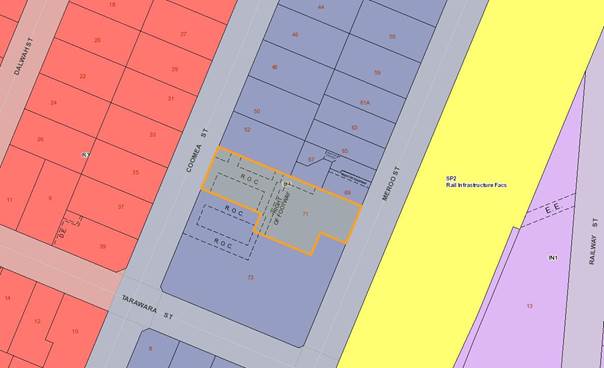
Figure
2 – zoning extract, Shoalhaven Local Environmental Plan 2014
Background
Proposed Development
A DA has been
lodged with Council seeking development consent for alterations and additions
to the Bomaderry hotel, located at 71 Meroo St, Bomaderry. The DA proposes:
· The creation of an additional 19 guest rooms (in addition to five
(5) existing rooms and manager’s residence) through the construction of a
third storey on top of the existing two-storey hotel and reconfiguration of the
layout of the existing ground and first floors.
· The proposal would therefore result in a total of 24 hotel/motel
type guestrooms plus a manager’s residence across the two upper floors of
the building, with the existing pub and bottle shop remaining on the ground
floor.
The proposal
would be defined as both a pub and hotel or motel
accommodation in the SLEP 2014 dictionary. Both these forms of
development are permitted with consent within the site’s B4 Mixed Use
zoning. See Attachment 1 for a copy of the submitted DA plans.
Subject Land
The subject
land:
· Is located at 71 Meroo St, Bomaderry (legally described as Lot 1 DP
732712) and has an area of 2,183sqm; and
· Contains the existing two-storey Bomaderry hotel with associated car
parking to the rear. This car park is shared with the Bomaderry Plaza shopping
centre to the south. The hotel contains bars, gaming and dining areas, bottle
shop and cool room on the ground floor with five (5) existing short-term
accommodation rooms plus a manager’s residence and associated amenities on
the upper floor.
Site & Context
The subject site:
· Is located within the established commercial/town centre of
Bomaderry close to Bomaderry railway station;
· Is zoned B4 Mixed Use as is adjoining land. Land to the west across
Coomea St is zoned R3 Medium Density Residential but currently contains mostly
detached single dwellings;
· Is surrounded by single-storey commercial buildings to the north
along Meroo St, detached single dwellings along the western side of Coomea St
and the one and two-storey Bomaderry Plaza to the south;
· Has pedestrian access to Meroo St and pedestrian and vehicular
access via the car park to the rear of the site accessed off Coomea St;
· Is neither bushfire nor flood prone land;
· Although a long-established building, it is not listed as a heritage
item in SLEP 2014; and
· Contains a Right of Carriageway (ROC) and Right of Footway (ROF) as
shown on the above Location and Zoning Maps. The ROC allows access to/from the
adjacent Bomaderry Plaza lot to the south while the ROF allows access to/from a
Council-owned lot to the north and further east towards Meroo St.
History
The DA was
lodged with Council on 6 December 2016.
The DA has been
under assessment for some time given complex issues relating to car
parking. In summary, the car park is shared by patrons of both the
hotel and the Bomaderry Plaza. This arrangement has been in place since the
construction of the Plaza in 1985. At that time, the two developments were
located on the same lot however after a subdivision was registered in 1986, the
two sites were split and the car park is now effectively shared over both lots.
There are existing Rights of Carriageway over both lots to ensure reciprocal
rights of access for users of both sites.
Issues
Clause 4.3 (Height of buildings) of the
Shoalhaven Local Environmental Plan 2014 (SLEP 2014)
Clause 4.3 of
SLEP 2014 contains controls for the maximum height of buildings. Clause 4.3(2)
states that: “The height of a building on any land is not to exceed
the maximum height shown for the land on the Height of Buildings Map.”
Clause 4.3(2A)
states that: “If the Height of Buildings Map does not show a maximum
height for any land, the height of a building on the land is not to exceed 11
metres.”
The proposed
development would result in a structure that at its highest point would be 12.8m
above natural ground level. This represents a 1.8m exceedance of the 11m
maximum height limit. Expressed as a percentage (i.e. 1.8m / 11m) this
represents a variation of 16.36%. Therefore a request to vary this
development standard has been provided by the applicant pursuant to Clause 4.6
(Exceptions to development standards) of SLEP 2014.
The variation
is demonstrated in the following 3D views with the 11m height plane shown:
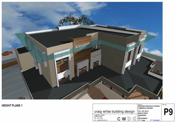
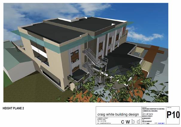
Figure3
– 11m Height Plane 3D Views from Front and Rear
Applicant’s Submission
The applicant
has requested a variation to the maximum building height development standard
and has provided an adequate assessment as required by Clause 4.6.
In the
variation statement submitted, the applicant has stated that strict compliance
with the 11m maximum height limit is unreasonable and unnecessary having regard
for the specific circumstances of this site and would be consistent with the
objectives of Clause 4.3 as:
a) The building proposed has
considerable architectural merit. It is located in commercially zoned area and
it is considered that the development will be entirely compatible with the
surrounding built environment. Whilst the physical form of the building does
differ from some older existing development in the locality in terms of height
and architectural style, it is expected to make a positive contribution to the
streetscape both current and future desired;
b) The newly constructed
additions whilst exceeding the 11m height limit are of a lesser height than
existing development. The ridge height of the existing roof is 13.26m above
natural ground level. The parapet (highest part) of the new additions is
approx. 12.8m above natural ground level;
c) The building, if approved,
will have minimal visual impacts. In fact, it is expected that the finished
development will enhance and modernise
the appearance of the current property;
d) Being situated within a
commercial area, the issues of privacy and solar access to existing development
are not critical issues. Despite this, the issues of privacy and solar access
will not be greatly impacted upon for adjoining development; and
e) There are no heritage items within the vicinity of the site that
would be adversely impacted upon by the development.
Discussion
With reference
to the objectives of Clause 4.3 and the applicant’s above submission:
· It is considered that the proposed development would be compatible
with the height, bulk and scale of the existing and future desired character of
the locality. It is also acknowledged that most of the existing
commercial development along Meroo St is single-storey and the proposal will
differ from this development. The only building above one storey in the
vicinity is the two-storey Bomaderry Plaza. However, given that Meroo St
falls to the south, the Plaza also presents mostly as a single-storey building when
viewed from Meroo St in front of the hotel, as well as when viewed from the
rear car park at the Coomea St frontage. The change in height would not
make a discernable difference to the locality. The change to the
façade and architecture however will have more of an impact, modernizing
a building that has undergone various alterations and additions over time.
It should be noted
that the block bounded by Meroo, Tarawara, Coomea and Bunberra Streets is zoned
B4 Mixed Use and that the 11m height limit also applies to all other lots.
Chapter N5 (Bomaderry Town Centre) of Shoalhaven Development Control Plan 2014
(SDCP 2014) applies to this area. The supporting map to this Chapter provides
an indication of the desired future development of this area. It is noted that
the proposed development would not increase the footprint of the existing hotel
and preserve the car parking area to the rear of the site, consistent with the
Supporting Map.
The Bomaderry Plaza
and other commercial properties on Meroo St are generally underutilised with a
number of vacant premises. It is clear that if the proposed development were
built, it would be a modern and revitalised building at the heart of Bomaderry
town centre and may encourage further redevelopment in this area in line with
the desired future character as per Chapter N5.
· It is considered that the proposed development will not result in
disruption of views, loss of privacy and loss of solar access to existing
development. While it is acknowledged that the proposal would result in a
building which will ‘stand out’ among the mostly single-storey
buildings in this area, this is already the case for the current building.
While the highest
point of the proposed redeveloped building will be slightly lower than the
ridgeline of the existing roof, it can be seen from the design that a larger
volume of the proposed building would exist above the 11m height plane compared
to the current building. Despite this, the front (eastern) and rear (western)
facades have been articulated with a variety of parapet heights, colours and
building materials, which overall presents a modern design. This
articulation combined with the building’s generous setbacks to both Meroo
and Coomea Streets would therefore minimise its visual impact.
The site is
bordered by commercial premises to both the north and south, which as noted by
the applicant are not particularly sensitive to issues of disruption of views,
loss of privacy or solar access. Rooms on the upper (second) floor would
mostly face east and west, overlooking Meroo St and the rear car park
respectively. Rooms on the southern elevation would overlook the car park and
Bomaderry Plaza, while rooms to the north would overlook the adjacent
Council-owned land and adjacent commercial development. As such, it can be
concluded that any impacts regarding loss of privacy or solar access would be
minimal.
· The applicant has stated that there are “no heritage items
within the vicinity of the site that would be adversely impacted upon by the
development”. While there are heritage items located within the
vicinity (including the Bomaderry Railway Station and yard group – an
item of State heritage significance), the DA was referred to Council’s
Heritage Advisor who had no issues with the proposal. An extract of the
referral response:
“There is no heritage impact
associated with the proposed development. The proposed extra storey proposed
will increase the visual bulk of the hotel building but does not increase its
height beyond its current roof line. Although the hotel is located directly
across the road from the heritage curtilage of railway group, the main built
elements of the railway group are located more than 50 metres north of the
hotel, with the Station Master’s residence positioned further to the
north of the platform buildings. Since the hotel building itself is positioned
on a generous setback from the street, there is little visual connection
between the two places.”
In summary, assessment staff are satisfied
that the proposed development would respect the heritage significance of
surrounding heritage items, including the State significant Bomaderry Railway
Station and yard group.
Clause
4.6 (Exceptions to development standards) of the Shoalhaven Local Environmental
Plan 2014
Clause 4.6
contains the specific requirements relating to the variation of a development
standard where it can be shown that strict compliance is unreasonable or
unnecessary in the circumstances of the case and where there are sufficient
environmental planning grounds to justify contravening the development
standard. Before applying the requirements of Clause 4.6, the consent authority
must be satisfied that the standard for which the departure is sought is a
development standard and not a matter which would prohibit the proposal.
Applicant’s Submission
As per the
requirements of Clauses 4.6(3) and 4.6(4), the applicant has submitted a
written request for a contravention to the stipulated development standard,
namely the 11m maximum building height limit that applies to the subject site
as per Clause 4.3(2A). The applicant’s written request has provided the
following justification for departure from this development standard and why
this development standard is unreasonable or unnecessary in this particular
circumstance as follows:
Strict compliance with the 11m height
limit is unreasonable in the circumstances of the case because:
a) Careful revision of the submitted plans and diagrams
attached to this submission will reveal that the extent of the encroachment is
reasonable. The part of the building which makes the encroachments to the 11m
height limit replaces a part of the building that already exceeds it.
b) Appropriate building to boundary setbacks have been
proposed to minimise the perception of building bulk. The new work is proposed
towards the centre of the site well setback from the front and rear boundaries.
This ensures that the work proposed will not dominate the streetscape and the
new work shouldn’t result in the finished building being overbearing for
pedestrians.
c) The physical form of the building is well articulated
and a variety of building materials are proposed to be used in construction.
The proposal will enhance the streetscape qualities of the area despite the
encroachment made to the 11m height limit.
d) The structure will not be visually prominent from any
important public places. The height of the structure will be compatible with
the existing built environment. It must be remembered that the existing
structure exceeds 11m in height. The new structure will be of a reduced height
compared to existing development.
e) The extent to which to the building is expected to
overshadow adjoining properties as a result of the encroachment is minimal.
f) The proposal if approved, will not result in
any inconsistencies with other environmental planning instruments or the
objectives of the B4 zone as outlined within the SLEP 2014.
g) The proposal remains consistent with the objectives
of Clause 4.3 as outlined above;
h) The proposal if approved will not set an undesirable
precedence for reasons outlined above.
Discussion
The assessment
concludes that the 11m height limit prescribed by Clause 4.3(2A) is a
development standard which can be varied using Clause 4.6 of SLEP 2014 (i.e.
regard has been had for the definition of ‘development standard’ in
the Environmental Planning and Assessment Act 1979 (EPA Act). The written
submission provided by the applicant is considered to satisfy the requirements
of Clause 4.6(3) and Clause 4.6(4) and as previously noted, compliance with the
objectives of Clause 4.3 are still achieved. As such, compliance with the
11m maximum building height development standard is unnecessary, and there are
sufficient environmental grounds to justify contravention of this development
standard. The proposal is considered in the public interest for the following
reasons:
· The development would be consistent with the objectives of Clause
4.3 as previously discussed;
· The development would comply with the objectives of the B4 Mixed Use
zone, in that it would be an example of a compatible land use in the zone and
being located in close proximity to Bomaderry railway station, would be a
development that would maximise public transport patronage and encourage
walking and cycling;
· The development is consistent with the provisions of any other
applicable state or regional planning provisions that apply to the land;
· The works would have minimal environmental impacts as the site is
fully developed, there would be minimal ground disturbance, the majority of
works would be aboveground and the site is unaffected by flooding, bushfire or
land contamination constraints;
· The proposed development would contribute to the desired future
character of the locality as per Chapter N5 and Supporting Map of SDCP 2014,
i.e. it is a form of mixed use development within the B4 Mixed Use zoning in
the Bomaderry town centre and may promote further redevelopment in the area;
· The proposal has sufficient visual articulation, architectural merit
and generous setbacks to both street frontages that reduces its visual impact,
bulk and scale;
· As demonstrated on the height plane plans, given the change in
natural ground level over the site, the 1.8m exceedance would only relate to
the front elevation of the building with reduced exceedances on other
elevations;
· The proposal would have minimal impact with regard to disruption of
views and loss of privacy or solar access as previously discussed, given it is
surrounded by mostly commercial development not particularly sensitive to such
issues;
· The subject site has been used as a pub and for short-term visitor
accommodation for some time and the proposed development would increase and
improve the standard of such accommodation provided on the site;
· No concerns have been raised from Council’s Heritage Advisor
or external stakeholders including NSW Police and Sydney Trains.
Concurrence
from the Director-General is not required and can be assumed for this DA as per
the guidelines prepared by the Department of Planning and Environment (Planning
Circular PS 08-003 issued on 9 May 2008).
As the
applicant’s submission and assessment above demonstrates, strict
adherance to the development standard can be regarded is unreasonable or
unnecessary in the circumstances of this case. There are sufficient environmental
planning grounds to justify a contravention of this development standard.
Pending the resolution of the car parking issue, the proposed development would
ultimately be consistent with the objectives of the state, regional and local
planning provisions for this site, the development would be in the public
interest and consistent with the objectives of both Clause 4.3 and the B4 Mixed
Use zone.
Planning Assessment
The overall proposal is still under
assessment as per Section 79C of the Environmental Planning and Assessment Act
1979. If agreement can be reached and a solution found to the outstanding
car parking issue, the DA assessment will be finalised and can be determined
under delegated authority by the Section Manager – Development, Planning,
Environment & Development Group.
Consultation and
Community Engagement
In accordance with Council’s
‘Community Consultation Policy for Development Applications’ the DA
was notified to surrounding residents, Endeavour Energy, NSW Police and Sydney
Trains. The DA has been made available to view on Council’s website via
DA Tracking.
No response was received from
Endeavour Energy. Responses were received from NSW Police and Sydney Trains
with no major concerns raised. Only one (1) public submission was
received from a resident of Coomea St, raising concerns with the development in
relation to heritage impacts. In this regard, the DA was referred to
Council’s Heritage Advisor and these comments are detailed earlier in
this report.
Legal Implications
If the requested
variation is not supported and the applicant is dissatisfied with
Council’s determination the applicant has the right of appeal to the NSW
Land and Environment Court.
Summary and
Conclusion
The
applicant’s submission has provided sufficient justification to
demonstrate that given the specific circumstances of this case, strict
compliance with the 11m maximum height limit is unreasonable or unnecessary.
There are sufficient environmental planning grounds to justify a contravention
of this standard. Accordingly, support for the variation is recommended.
|
|
Development
Committee – Tuesday 08 August 2017
Page
66
|
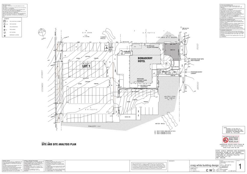
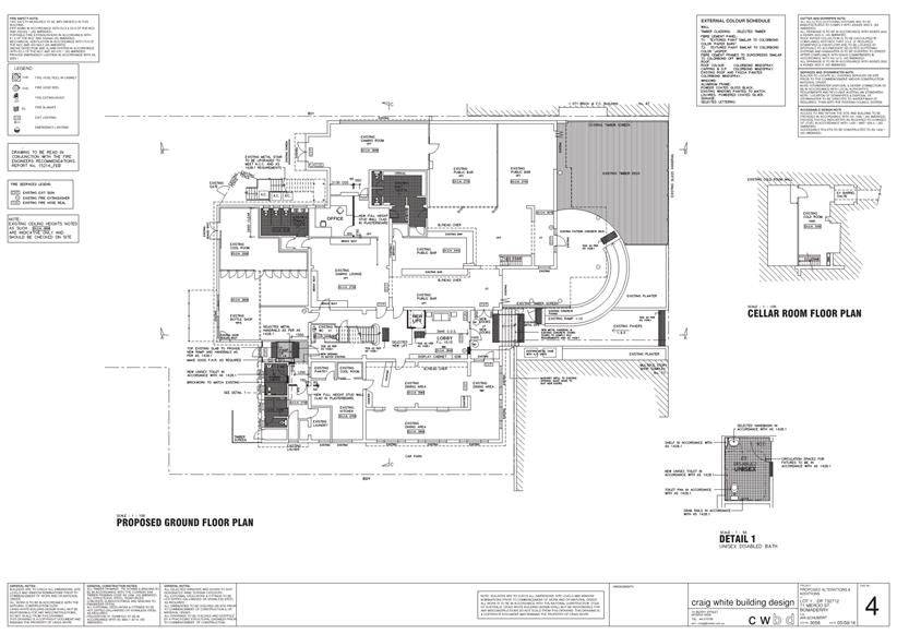
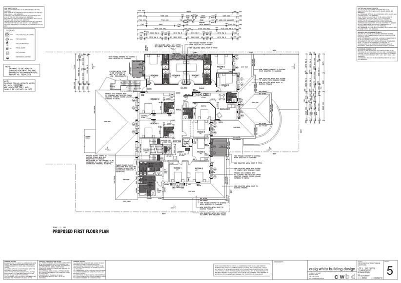
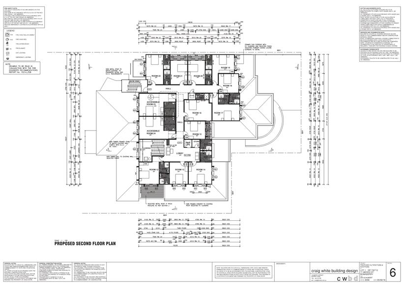
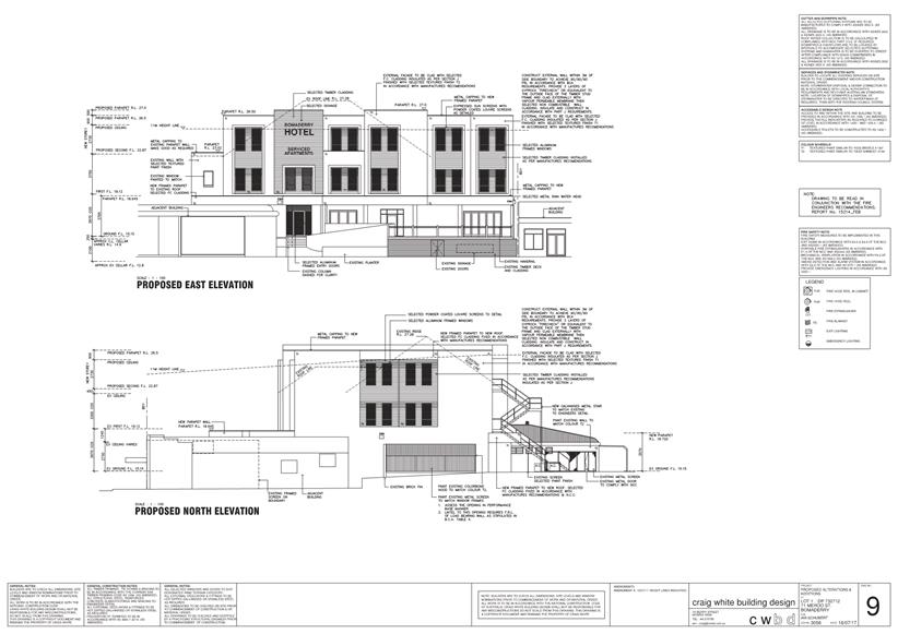
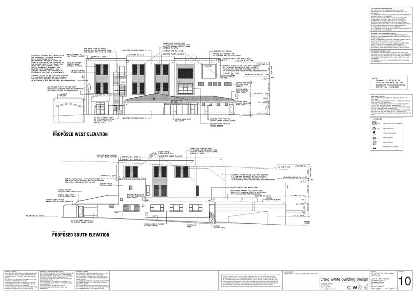

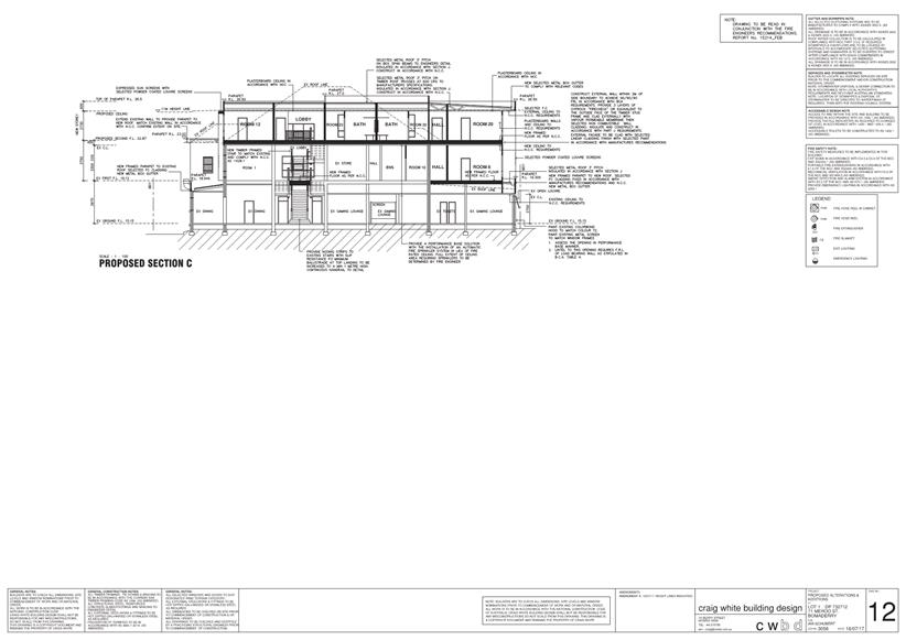
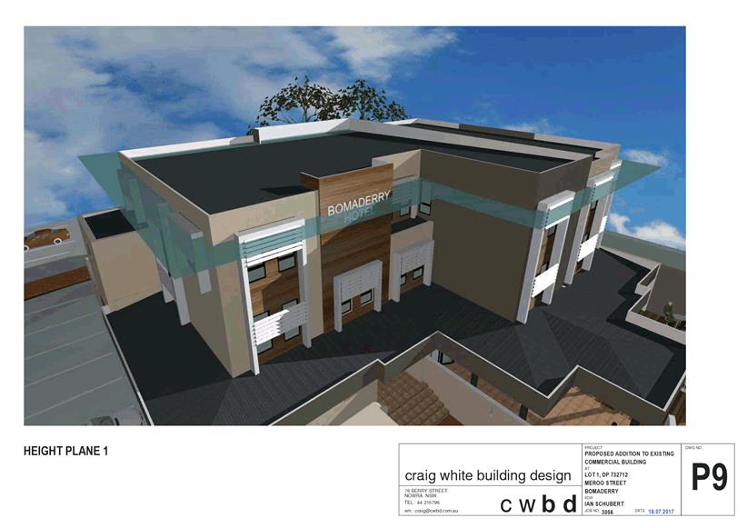
|
|
Development
Committee – Tuesday 08 August 2017
Page
76
|
DE17.58 Development
Application – 123 Forster Drive Bawley Point – Lot 3 DP 527264
DA. No: DA17/1761/4
HPERM Ref: D17/240746
Group: Planning
Environment & Development Group
Section: Ulladulla
Service Centre
Description of Development: Stock Management
Building, Amenities and Associated Infrastructure
Owner: Capital Property Corporation
Applicant: Shaun Lawer on behalf of GHD
Notification Dates: 17 July to 1 August
No. of Submissions: One submission in support
has been received, still in notification at time of preparing this
report. Any additional submissions received by the expiry of the notification
period (1 August) will be provided at the meeting.
Purpose
/ Reason for consideration by Council
The purpose of this report is to seek Council direction with
respect to a request for a variation of a development standard (building
height) applicable to the site under Clause 4.6 of the Shoalhaven Local
Environmental Plan 2014 (SLEP 2014) for a small portion of an entry wall and a
metal tree sculpture that exceed 11.0m
|
Recommendation
(Item to be determined under delegated authority)
That Council:
1. Confirm
that it supports the proposed variation, under clause 4.6 of Shoalhaven Local
Environment Plan 2014, to the 11m maximum building height to allow for the
metal sculpture 13m in height and for the stockyards/camping area entry 11.7m
in height;
2. Refer
the application back to staff for determination by delegation;
|
Options
1. Resolve to
support the propose variation to the development standard for height from 11m
to 13m for a metal tree sculpture and 11.7m for a small portion of the entry
feature gate to the stockyards/camping area and refer the application back to
staff to determine the application under delegated authority.
Implications: This would enable the application to be
finalised and conditions prepared to enable consent to be finalised.
2. Resolve not to
support the proposed variation to the development standard and refer the
application back to staff to negotiate with the applicant to redesign the
proposal to meet the 11m height standard.
Implications: This would mean that the application could not
be supported in its current form. This would require modifications to be
made to specifically adjust the height. This option could also
potentially result in litigation by the applicant.
3. Adopt an
alternative recommendation and provide direction to staff.
Location Map
Figure 1 Location Map
Background
Proposed Development
The application proposes
construction of Stock Management Building, Amenities and Associated
Infrastructure as an addition to the existing Willinga Park Equine Centre. This
component of the site provides for stock management and the primitive camp
ground for events competitors and their animals approved under previous consent
DA15/1659. Two components of this proposal exceed the 11.0m maximum building
height:
a) A
reinforced concrete drive through entry gate 45.6m wide that is generally under
8.0m high with a small sliver at the north east corner increasing in height to
11.7m due to site topography.
b) A
wind activated kinetic tree sculpture that will vary in height from 10.0m to
13.0m depending on the position of the branches.
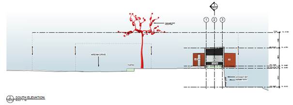
Subject Land
The site is part of a large land
holding known as Willinga Park and is being established as an Equine Centre of
Excellence, comprising facilities for the breeding and training of Australian
stock horses, including a stable complex, covered arena for dressage events,
polocrosse and camp drafting arenas, stockyards, horse paddocks and car parking
areas.
The development site for the
current application is located on a ridge at the western end of Forster Drive,
Bawley Point on lot 3 DP 527264. The land is elevated, ranging from 30 to 48m
AHD and heavily screened from view to properties outside the site due to
vegetation, distance and topography. The development site currently contains
stockyards, roads and a farm shed under construction under complying development
approvals with associated vegetation clearing. There are also and roads and
water tanks in the location being carried out under exempt development
provisions.
Site & Context
The development site is
immediately surrounded by RU2 zoned rural land with E2 zoned land around the
headwaters of Lake Willinga to the north. Surrounding land uses are
predominantly agriculture and rural residential. Willinga Park contains a
number of larger buildings and monolithic feature walls, landscaping and
sculptures that form gateways into the different areas of the development that
are appropriate to the scale of the site and have provide a high quality built
environment.
Issues
Clause 4.3 Height of Buildings
The site is within an area where
the Height Building Maps under cl.4.3 of SLEP 2014 does not map a specific
maximum building height, therefore, the default height of 11.0m applies.
This application seeks to vary this development standard.
A variation of 5.9% (11.65m) is
sought for a small portion of the entry gate while a variation of 18% (13m) is
sought for the wind activated kinetic tree sculpture for those periods when the
tree limbs swing above the 11.0m height plane.
Clause 4.6 Exceptions to Development Standards
The NSW planning system provides flexibility in planning
controls by providing the ability for Council to vary development standards in
certain circumstances. In this regard, the concurrence of the Secretary
of the Department of Planning and Environment (DP&E) can be assumed as
provided in DP&E publication – Varying development standards: A
Guide – August 2011 (the Guide). Clause 4.6 enables a development
standard to be varied, provided the applicant has submitted a written request
that adequately justifies the exception from the development standard by
demonstrating that:
a) that compliance with the
development standard is unreasonable or unnecessary in the circumstances of the
case; and
b) that there are
sufficient environmental planning grounds to justify contravening a development
standard.
Further, the consent
authority must be satisfied that:
i. the
applicant’s written request has adequately addressed the matters required
to be demonstrated by subclause (3), and the proposed development will be in
the public interest because it is consistent with the objectives of the
particular standard and the objective for development within the zone in which
the development is proposed to be carried out.
Applicant’s Submission
The applicant provided Council with a justification for the
variation of the development standards:
The development standard is
considered to be unreasonable and unnecessary in the circumstance of this case.
The variation is integral to the architectural merit of the stock management
building and associated stockyards.
An 11m height limit is
considered to be unreasonable and unnecessary in this instance as the site is
visually remote from any adjoining properties and the proposed entry feature
gate and sculpture would not be seen from any vantage points external to the
site and would be set within the backdrop of the existing native vegetation
surrounding the site. Furthermore, the proposed entry feature gate and
sculpture along with the stock management building will not result in any undue
visual impact, disruption of views, loss of privacy or loss of solar access for
any existing development within or external to the site.
It is considered there is sufficient planning grounds to
justify contravening the development standard to support the proposed height
variation. Furthermore the height of the entry feature gate above the building
height limit is minimal with the vast majority of the structure having a height
of 7.2m. Furthermore, the sculpture is a moveable structure that will fluctuate
between 10 and 13m subject to wind conditions. The proposed development remains
consistent with the objectives of the zone, despite it being non-compliant in
relation to building height.
The scale and form of the development is in line with the
site’s existing development and adds to the architectural merit of the
proposed stock management building and associated infrastructure. Despite the
non-compliance with the standard this is considered not to adversely affect any
environmental, social or economic factors at the site.
Public interest
The proposed entry feature gate and sculpture are considered
to be in the public interest as they are consistent with the objectives of the
standard and the zone in which the development is proposed to be carried out.
As explained above a strict application of the height control is not considered
necessary due to the site’s isolation and the complementary nature of the
proposed entry feature gate and sculpture with the other architecture proposed
for the stock management building and existing development at the site. The
proposed built form at the site offers a striking and memorable feature to an
otherwise rural landscape.
Discussion
In accordance with 4.(a)(i) of
Clause 4.6 of the SLEP 2014, the applicant’s written request is
considered to have adequately addressed the required matters. After
reviewing the applicant’s submission it is considered that the variation
is reasonable and acceptable for the following reasons:
· The entry gate height varies with the
slope of the block and is contextually appropriate.
· The building height variation does
not generate overshadowing impacts on the surrounding properties.
· The proposal is
consistent with the desired future character of Willinga Park.
· The proposal is
considered to be consistent with the objectives of the height standard, to
ensure that the height of development is appropriate to the condition of the
site and its context.
When dealing with a variation to
a development standard under cl 4.6, the council must also consider the
following five part test (as outlined in the Guide) to determine if the
variation is acceptable:
a) The
objectives of the standard are achieved notwithstanding noncompliance with the
standard;
The
objective of the Height of Buildings clause are:
a) to ensure that
buildings are compatible with the height, bulk and scale of existing and
desired future character of the locality,
b) to minimise visual
impact, disruption of views, loss of privacy and loss of solar access to
existing development,
c) to ensure that the
height of building on or in the vicinity of a heritage item or within a
heritage conservation area respect heritage significance.
The proposal is consistent with bulk and scale of the existing
development and the desired future character of the locality. The proposed
height of the development is appropriate to the context and is compatible with
the prevailing pattern of buildings, feature gates and landscaping in the
locality.
The proposal positively responds
and satisfactorily addresses the particular characteristics of the site and its
broader context. The proposal is of a height and scale that is sympathetic to
its immediate context.
a) The
underlying objective or purpose of the standard is not relevant to the
development and therefore compliance is unnecessary - The underlying objectives
of the standard are not relevant to the proposed height variations as the entry
gate and tree will not be visible to any other premises outside the site and
the structures are remote from any other property.
b) The
underlying object or purpose would be defeated or thwarted if compliance was
required and therefore compliance is unreasonable - Not relevant to the
proposal.
c) The
development standard has been virtually abandoned or destroyed by
Council’s own actions in granting consents departing from the standard
and hence compliance with the standard is unnecessary and unreasonable - Not
relevant to the proposal.
d) The
compliance with the development standard is unreasonable or inappropriate due
to existing use of land and current environmental character of the particular
parcel of land. That is, the particular parcel of land should not have been
included in the zone. – Not relevant to the proposal.
Planning Assessment
The application will be fully assessed under s79C of the
Environmental Planning and Assessment Act 1979 following determination of the
variation to development standards.
Consultation and Community
Engagement:
The application was still in notification at time of
preparing this report. The proposed works are located more than 400m away from
nearest neighbouring property and more than 900m away from the nearest
neighbouring dwelling not affiliated with the applicant. One submission has
been received in support of the proposal and any additional submissions
received by the expiry of the notification period (1 August) will be provided
at the meeting and discused.
|

|
Development
Committee – Tuesday 08 August 2017
Page
82
|
DE17.59 Exhibition
outcomes - Planning Proposal LP406 and DCP Chapter N16 - Falls Creek /
Woollamia Deferred Areas
HPERM Ref: D17/187131
Group: Planning
Environment & Development Group
Section: Strategic
Planning
Attachments:
1. DCP Chapter N16
- post exhibition version (track changes) (under separate cover) ⇨
2.
Supporting Map 1 (post exhibition) Woollamia Road DCP Chapter N16 ⇩
3. Traffic
Unit Assessment ⇩
4. Post
exhibition lot size map - Woollamia Road - LP406 ⇩
5. Post
exhibition lot size map - Seasongood Road - LP406 ⇩
6.
Supporting Map 2 (post exhibition) Seasongood Road DCP Chapter N16 ⇩
Purpose / Summary
To detail and consider feedback
received as a result of the exhibition of the Falls Creek / Woollamia Deferred
Areas Planning Proposal (PP) LP406 and supporting draft Development Control
Plan (DCP) Chapter N16.
|
Recommendation
That:
1. Council
adopt the Falls Creek / Woollamia Deferred Areas Planning Proposal (LP406) as
exhibited, with the minor changes outlined in this report and issue the
second (and final) invoice to landowners, subject to confirmation that:
a. The
owner of No. 111 Woollamia Road has surrendered the consent for three tourist
cabins (DA00/2847) in accordance with MIN16.945 (part 1.b).
b. If
the consent for DA00/2847 is not surrendered by 5 September, amend LP406 and
DCP Chapter N16 to reduce the number of lots that can be subdivided from
three to two in line with the other properties within the subject land.
c. The
two invoices issued to landowners to recoup costs incurred by Council in
preparing the planning proposal have been paid in full.
2. If
part 1c is not fully resolved within 60 days of issuing the second invoice,
remove the relevant properties from the LEP amendment and the draft Chapter
N16 - Shoalhaven Development Control Plan (DCP) 2014 and refund any monies
paid by the owner(s).
3. Subject
to the outcome of parts 1 and 2:
a. Liaise
with the NSW Department of Planning and Environment regarding the
finalisation of the required amendment to the Shoalhaven Local Environmental
Plan 2014.
b. Adopt
the attached version of Chapter N16 of the Shoalhaven Development Control
Plan 2014 and give public notice in the appropriate local newspaper/s to
enable it to become effective upon commencement of the LEP amendment.
4. Ensure
that funding improvements at the Jervis Bay Road / Seasongood Road
intersection are considered in the FY18/19 budget.
|
Options
1. Adopt the
recommendation.
Implications: This will enable the PP to be
finalised with minimal delay while ensuring that issues relating to cost
recovery and uncertainty around the consent for tourist cabins at No. 111
Woollamia Road are resolved.
2. Make changes to
the PP and/or DCP Chapter N16 as directed by Council.
Implications: Further changes to PP and DCP Chapter
N16 are not recommended but if considered, they should be consistent with the
intended outcomes described in the exhibition documents.
3. Adopt an
alternative approach to resolving issues around the payment of Council’s
costs for preparing the PP and/or the consent for the tourist cabins at No. 111
Woollamia Road.
Implications: It is important that these issues are
resolved prior to the finalisation of the PP.
Background
The Falls Creek / Woollamia
Deferred Areas Planning Proposal (PP) - LP406 was first initiated in 2011 to
address an action in the Jervis Bay Settlement Strategy 2003 (JBSS) to
investigate the potential for increased rural residential densities.
Finalisation of the PP will
conclude this longstanding strategic planning project. Background reports
and Council resolutions relating to LP406 can be viewed on a dedicated webpage
for this project via:
https://shoalhaven.nsw.gov.au/Planning-amp-Building/Strategic-planning/Paper-subdivisions
Most recently on 9 May 2017, it
was resolved that:
1. Council endorse the
updated Falls Creek / Woollamia Deferred Areas Planning Proposal and draft Development
Control Plan Chapter N16 for public exhibition and proceed to exhibit for a
minimum period of 28 days.
2. Council staff be
authorised to make any necessary minor changes to improve readability/usability
of the draft Development Control Plan Chapter prior to exhibition.
3. Report the outcomes
of the exhibition period back to the Development Committee for final
consideration.
No. 111 Woollamia Road -
Consent for tourist cabins (DA00/2847)
The Council resolution of 6
December 2016 (MIN16.945) included the following requirement related to this
property that is part of the PP:
In respect of 111 Woollamia Road, to potentially enable a
three lot subdivision based on establishment of a reciprocal right of way
between Woollamia Road and Falls Road as outlined in the report prepared by SET
Consultants, subject to the owner surrendering the consent for three tourist
cabins (DA00/2847) which have not yet been constructed.
As outlined in the report to
Council on 6 December 2016:
The cumulative impacts (and conflicts) of the tourist
cabins and a three lot subdivision on local amenity could be significant, e.g.
noise, dust and visual impacts on adjoining properties. Hence, it is
recommended that in relation to 111 Woollamia Road, the PP seek to allow a
three lot subdivision on the basis that the approval for the cabins be
‘surrendered’ and that this be done prior to finally amending
Shoalhaven LEP 2014. This could be done without delaying the LEP amendment for
the other lots within the PP.
A submission has been received
on behalf of the owner of the property who wishes to proceed with the three-lot
subdivision. However, the landowner has not surrendered DA00/2847 at this
point in time. This issue is discussed later in the report.
Public Exhibition Details
The PP and draft DCP Chapter N16
(Amendment No. 17 - Shoalhaven DCP 2014) were publicly exhibited for 31 days
from 24 May to 23 June 2017. The exhibition display was located at
Council’s Nowra administrative building and the documents were available
for viewing online via the ‘Documents on Exhibition’ portal.
The exhibition package included
the following documents. (Note: the hyperlinks will remain active for 3 months
after exhibition close.)
The public exhibition was
advertised widely, including advice to landowners within the PP area and those
adjacent to it. Relevant Government Departments/Agencies were also informed of
the exhibition arrangements.
Submissions
As a result of the exhibition, three (3) landowner /
community submissions were received:
· One
(1) submission on behalf of a landowner within the PP;
· One
(1) submission from an adjoining landowner with specific concerns in relation
to the neighbouring property within the PP; and
· One
(1) submission from a member of the community with more general concerns.
The issues raised in each submission are summarised below.
Copies of the actual submissions will be available in the Councillors’
room prior to the meeting.
Table
1: Summary of landowner / community submissions
|
Author:
Concerned
Community Member
|
Doc
Ref: D17/193889
|
|
Issue
|
Staff
Comment
|
|
Proposal
will change traffic flows along Woollamia Road due to the proposed plan to
open Falls Road to the public. Traffic will exit/enter Falls Road at the
Princes Highway and continuing along Falls Road onto the Woollamia Road.
|
No
change is proposed to Falls Road, a section of which is unformed. Traffic
cannot drive directly from the Highway to Woollamia village via Falls Road.
Note: comments from Council’s Traffic Unit have been incorporated into
the PP.
|
|
Proposal
will increase traffic flows along Woollamia Road and through Woollamia
village.
|
The
proposal would result in up to five additional dwellings along Woollamia
Road. The resulting increase in vehicle movements would not be significant in
the context of the overall locality.
|
|
Proposal
will set a precedent for further subdivision of the remaining Rural
Residential Deferred Areas.
|
Finalisation
of the PP will complete the action in the JBSS to investigate the potential
of these areas to accommodate further subdivision. This process started with
a much larger area under consideration and has resulted, through detailed
investigations, in a much reduced area being identified for additional
subdivision.
|
|
Other
landowners will seek to have their land rezoned.
Precedent
will ultimately create a ribbon development that will have adverse impacts on
natural and cultural heritage values.
|
These
concerns relate to hypothetical PP’s and subdivision(s). Given the
process that has been followed, any additional land would need to be
considered through separate and subsequent PP’s. Landowners
would need to prepare their own PP and submit to Council with the appropriate
fee. Any such PP would need to be supported by a number of studies, be funded
by the landowner(s) and have a strategic basis.
|
|
The
proposal will not meet the aim of the Jervis Bay Regional Environmental Plan
1996 (JBREP) to protect the natural and cultural heritage values of Jervis
Bay.
|
Notwithstanding
that JBREP was repealed on 5/8/2016, The PP was informed by a strategic
environmental assessment. Areas with important biodiversity habitat are
proposed to be added to the terrestrial biodiversity map. The PP and
supporting DCP Chapter N16 are designed to protect riparian corridors and
land with important natural and cultural heritage values.
|
|
Proposal
will further fragment the forest and understory habitat as well as increase
nutrient and turbidity into the riparian areas within the catchment of
wetlands and Jervis Bay Marine Park.
|
DCP
Chapter N16 requires a 30 metre riparian buffer to be provided along the
watercourses, and each subdivision application will need to be supported by a
Neutral or Beneficial Effect (NorBE) Assessment to ensure receiving waterways
are protected. Minor changes made to Acceptable Solutions A7.1 and A7.4
enhance protection of riparian areas (see Attachment 1).
Note:
the Jervis Bay Marine Parks Authority provided comments and these are
discussed below
|
|
Proposal
will result in localised extinction of threatened flora and fauna species
|
In
addition to the comments provided above, potential impacts on threatened
biodiversity will need to be further assessed as part of each development
application. Targeted surveys for relevant threatened species will need to be
undertaken as part of each application.
|
|
Habitat
at the corner of Seasongood and Jervis Bay Roads will be fragmented.
|
Development
of No. 1 Seasongood Road would be confined to cleared land within 200 metres
of the road. The triangular lot at the corner of Seasongood and Jervis Bay
Roads (Lot 8763 DP 1189732) and adjoining lots to the North, West and South
are not part of the PP.
|
|
Proposal
will fragment the wildlife corridor that connects Currambene Creek to
Woollamia Nature Reserve to Parma Creek Nature reserve into the Great Eastern
Escarpment and the Budawang Wilderness.
|
The
proposal seeks to minimise disturbance of biodiversity habitat and requires
riparian areas to be protected. Will have negligible impact on habitat
connectivity in the broader landscape.
|
|
Creek
lines provide habitat for threatened species and the Swamp Sclerophyll
Forest Endangered Ecological Community
|
See
comments above.
|
|
Proposed
new bridges, roads, drainage and land clearing will change the natural
hydrology and water quality that in turn will impact on microclimates and
frog habitats.
|
A
Strategic Water Cycle Assessment recommended measures to ensure that the
natural hydrology and water quality regimes are maintained. These
recommendations have been incorporated into DCP Chapter N16. This includes
that requirement that each subdivision application is supported by a NorBE
Assessment.
|
|
Rural
land must be protected for its environmental and health benefits to society
as a whole as well as the food that is produced within the catchment and out
into the Jervis Bay Fisheries that provides Seafood as a Primary Industry
|
The
proposal will have a negligible environmental impact and no impact on food
production (terrestrial or aquatic).
|
|
Author:
Adjacent
Landowner
|
Doc
Ref: D17/197305
|
|
Issue
|
Staff
Comment
|
|
Adjoining
owner concerns relating to No. 111 Woollamia Road: as previously stated have
no objection to the proposed 3-lot subdivision, but have grave concerns
concerning the through road.
|
The
concerns previously raised were circulated to Councillors prior to the
Development Committee meeting in December 2016.
|
|
Proposed
road / right of way is 36 metres from front door, 20 metres from garage and
35 metres from pool area.
|
Note:
These dimensions are based on the exhibited alignment, i.e. a 4-metre buffer
between the road shoulder and boundary (to accommodate a vegetation screen).
Further
detailed comments in this regard are provided below.
|
|
Would
prefer if the access road runs along the western boundary and crosses to the
eastern boundary behind the second dam. This would eliminate the need to
enter into the low lying sensitive wetlands area and the construction of a
raised bridge.
|
The
watercourse crossing may still need to be below the 1 in 100 year flood
extent. Furthermore, the length of road suggested would be significantly
longer than the proposed alignment along the eastern boundary, which is
largely cleared. No change is recommended.
|
|
If
the above option is not considered, request that the access road be moved
further into the centre of paddock to reduce noise, light and dust pollution
|
The
exhibited DCP Chapter N16 included a suite of measures in an attempt to limit
future noise, light and dust pollution, including requirements for the road
to be sealed within 50 metres of the dwelling, and for a 3-4 metre high
vegetation screen to be established between the road and the boundary. Minor
adjustments are proposed to strengthen these provisions (see Attachment 1).
The
level of use of this section of road is likely to be very limited: vehicles
are more likely to access the property directly from Woollamia Road rather
than travel a much longer route via Falls Road.
Given
the measures that have been included in the DCP, It is not considered
necessary to increase the setback of the road from the boundary given the
other proposed provisions.
The
issues in this regard can be given further detailed consideration in any
future development application for subdivision.
|
|
Road
should be sealed from Falls Road to 50 metres past our dwelling
|
DCP
Chapter N16 has been revised to require the access road to be sealed 50 m
either side of the adjacent dwelling (see Attachment 2)
|
|
Plant
spacing for screening hedge should be 1 metre (centres) to ensure density is
adequate and 2.5 – 3 metres from the boundary fence to allow
maintenance of the fence etc.
|
Advice
from Council’s Landscape Architect is that 1 metre may be insufficient
for some species. The wording in the DCP has been changed to read “1-2
metres spacing between plants depending on species, 2 metres from
boundary” (see Attachment 2).
|
|
Author:
SET
Consultants (on behalf of the owner of No. 111 Woollamia Road)
|
Doc
Ref: D17/205929
|
|
Issue
|
Staff
response
|
|
The
site currently has development approval for the construction of three (3)
tourist cabins (DA00/2847) in two stages:
· Stage one was for the construction of
‘Cottage 1, one car parking space and landscaping’ and
· Stage two - ‘Cottage 2 & 3, two additional
car parking spaces, access, bushfire mitigation works and landscaping’.
Stage 2 was deferred, subject to additional information being provided.
The
owner proposes that he retain Stage 1 and surrender only Stage 2 of the
existing approval, prior to the registration of any subdivision of the land.
|
This
request is not supported.
Council
previously resolved that progression of the PP is based on the owner
surrendering the consent and this was stated in the exhibited PP and
supporting material.
The
cumulative impact of two additional dwellings (3 dwellings total) and
Cabin 1 has not been considered by the community or assessed through the PP
process. Cottage 1 would be positioned on a 1 ha lot and be within close
proximity of the access road and new dwellings. This will create
potential impacts on local amenity within the subject the lot (e.g. impacts
on the dwellings and access road on the privacy of the cabin) as well as on
adjoining land.
Note:
If DA00/2847 is not to be surrendered, it is recommended that the PP be
modified to allow a two-lot subdivision (2 dwellings total). This
requires clear direction prior to finalising the PP.
|
|
Council
has acknowledged that “suitable commencement” has occurred for
stage 1. As such, believe it is unreasonable to request that the owner
forfeit this part of the consent. Cottage 1 is located within close
proximity to the existing dwelling and would remain with the dwelling in any
future subdivision. The cottage will not be located on its own lot and will
continue to be utilised as a tourist cabin in accordance with the Consent.
|
Notwithstanding
the advice Council has provided, the cabins themselves have not yet been
constructed.
If
Cabin 1 had been constructed, a maximum of two lots (one additional dwelling)
would be supported.
It
is recommended that if the consent is not surrendered by a specified date,
the PP be amended to reduce the number of new dwellings from two to one, in
accordance with the exhibited PP.
|
|
Request
that Council amend the minimum lot size map to align with their proposed
revised minimum lot size map based on:
· 2 ha at the front of the site;
· 1 ha in the middle of the site; and
· 3 ha at the rear of the site.
|
Overall
requested change is not supported: 3 ha is too small for the rear lot as it
would result in development overlapping into the riparian buffer.
The
exhibited lot size map has however been amended slightly to ensure that the
boundary between the middle and rear lot is well to the north of the dam. The
revised lot size map is attached (Attachment 4)
|
|
Has
invested a significant amount of money in developing the site in a specific
manner to ensure all sections of the site retain their own infrastructure and
water supply.
|
The
decision to proceed with a subdivision rests with the owner. For example,
they could stage or delay the subdivision to suit their personal
circumstances.
|
|
The
‘kink’ in the Lot Size Map between the 2ha and 1ha areas is to
ensure that the large dam located on the site is retained within the front
lot. This dam forms part of the critical infrastructure relating to the
operation of the miniature horse stud.
|
See
above comments.
|
|
The
proposed building areas are within the Council investigation area.
|
The
curtilage of the dwellings (APZ) would overlap substantially into the
riparian buffer and the building envelope (15 metres x 15 metres) would
be too small in this context.
|
Three (3) Government agencies provided submissions –
NSW Rural Fire Service (RFS), NSW Roads & Maritime Services (RMS) and the
Department of Primary Industries – Jervis Bay Marine Park (DPI-
JBMP). These are summarised below. Copies of the actual submissions will
be available in the Councillors’ room prior to the meeting.
Table
2: Summary of Government agency submissions
|
Agency
/ Doc Ref
|
Issue
|
Staff
response
|
|
RFS
D17/197015
|
Suggested
rewording of DCP Chapter acceptable solution A3.5 to ensure that the new
dwellings at No’s 21 and 23 Seasongood Road are constructed to BAL 29.
|
This
is consistent with previous verbal advice from the RFS and is considered
appropriate given the proximity of the dwellings to the public road.
Suggestion
has been incorporated into the revised DCP Chapter N16.
|
|
|
Has
no objection to the progression of the PP subject to incorporation of the
above suggestion.
|
Noted.
|
|
RMS
D17/198677
|
Recognise
that the lot/dwelling yield has been reduced from 37 to 16.
|
Noted.
|
|
|
The PP
is unlikely to generate significant traffic, however it will intensify the
use of intersections at the Princes Highway and Jervis Bay Road.
|
Noted.
|
|
|
Council
needs to determine if any upgrades are required to these intersections as an
outcome of the PP - however consider that the PP is unlikely to greatly impact
on the Princes Highway.
|
Council’s
Traffic Unit has advised that the intersection of Jervis Bay Road and
Seasongood Road is at or near capacity (refer to Attachment 3).
The
traffic assessment shows that the additional dwellings that are proposed to
have access to Seasongood Road would result in a 29% increase in turning
movements at the intersection with Jervis Bay Road (albeit from a relatively
low base). This increase in traffic volumes would trigger the need for an
upgrade to the intersection of Seasongood Road and Jervis Bay Road. An
upgrade to this intersection would enhance both safety and capacity, by
providing a higher level of protection both for traffic turning to and from
Seasongood Road, and for through traffic in Jervis Bay Road.
The
assessment also shows the intersection, based on current conditions, requires
some improvements. Accordingly, this report includes a recommendation for
these works to be considered in the 2018/2019 FY.
|
|
DPI
- JBMP
D17/199003
|
Affects
lands within the Currambene Creek catchment which is classed as Type 1 Key
fish habitat and is within sanctuary, habitat protection and special purpose
zones of Jervis Bay Marine Park.
|
Noted.
|
|
|
Not
supportive of new development without provision of adequate sewerage
infrastructure because of the likelihood of detrimental impacts on water
quality and receiving waters of the marine park. Water sampling suggests that
excessive faecal coliforms are entering Jervis Bay via Currambene Creek
during heavy rain events.
|
A
strategic onsite wastewater assessment was completed as part of the strategic water cycle
assessment
commissioned by Council. The assessment concluded that the risk of nutrients
and pathogens being exported can be managed by:
· requiring treatment to
secondary standard
· appropriate design,
construction and management of subsurface irrigation
· preventing stormwater ingress
· establishing/managing
vegetation cover
These
requirements have been incorporated into DCP Chapter N16.
|
|
|
Highlight
that: “The NorBE test is only applied to sediment, phosphorous and
nitrogen loads and concentrations. It is accepted that overall flows will
increase with an increase in effective imperviousness.” (SEEC,
Strategic Water Cycle Assessment, p.34) Increase in overall flows will likely
increase pollution from existing effluent disposal systems.
|
Practical
measures to minimise pollution arising from the new onsite systems are
proposed in DCP Chapter N16, including:
· Requiring treatment to secondary standard before
land application.
· Applying the treated effluent to a pressurised or
dose-loaded subsurface application area
· Requiring a diversion swale/trench to prevent
stormwater and groundwater ingress.
· Adhering to Council’s required buffer
requirements
|
|
|
Thus
it is recommended that the draft DCP 2015 Chapter N16 be amended as follows:
· Amend A 10.1 to read – Existing systems will
be upgraded at the subdivision stage
|
This
cannot be required unless the existing onsite system is failing. Onsite
effluent systems are already currently regulated under section 68 of the
Local Government Act and are typically inspected by Council every three
years.
DCP
Chapter N16 will require an assessment of the existing system to be
undertaken as part of the subdivision application, and that it be upgraded if
there is evidence of failure.
|
|
|
· APZ's must not be permitted to overlap onto
riparian buffers or any other environmental buffers relating to protection of
water quality. It is essential that good quality vegetation cover is maintained
to provide effective buffers that are being relied on to provide
environmental protection benefits as part of the overall stormwater and
effluent management system/s. If an adequate buffer cannot be maintained
whilst accommodating the APZ, the lot is not appropriate for subdivision.
|
The PP
will significantly increase protection of watercourses by requiring a 30
metre riparian buffer (comprising a 20 metre core riparian zone and a 10
metre vegetated buffer) to be provided on both sides of the watercourse.
The
riparian buffer will need to be fenced off and maintained as native bushland
(including regeneration of cleared areas). Overlap of the APZ is only
proposed to be allowed to the extent shown on the Supporting Maps,
effectively limiting it to No. 49 Woollamia Road, within the outer 10 metre
vegetated buffer. Furthermore, this will need to be offset by increasing the
buffer provided elsewhere on the lot.
|
Summary of Changes
To respond to the relevant items identified in the
submissions and discussed above adjustments and changes are proposed to the PP
and the DCP Chapter.
Planning Proposal
The following minor adjustments are proposed to the lot size
maps within the PP:
· No.
111 Woollamia Road – decrease the area shown as 4 ha minimum lot size
area to be consistent with the revised suggested subdivision boundary shown on
the revised Supporting Map 1 for DCP Chapter N16. This change responds to
the submission from SET Consultants (Table 1).
· No’s
18 and 20 Seasongood Road - change the alignment of the boundary between the 2
ha and 1 ha minimum lot sizes to be consistent with the suggested subdivision
boundary shown on the revised Supporting Map 2 for DCP Chapter N16. This
change addresses an anomaly identified by staff during the exhibition.
The revised lot size maps for Woollamia Road and Seasongood
Road are provided in Attachments 4 and 5 respectively.
DCP Chapter N16
Other than minor formatting and editorial changes, the
changes proposed to DCP Chapter are:
· Change
to Acceptable Solution A3.2 incorporating the suggestion from the RFS to ensure
dwellings at No’s 21 and 23 Seasongood Road are constructed to BAL 29.
· Minor
changes to Supporting Maps 1 and 2 and Acceptable Solutions A7.1 and A7.4 to
limit disturbance of riparian buffers in response to concerns about impacts on
riparian corridors and downstream environments in the Jervis Bay Marine Park.
· Minor
change to Acceptable Solution A10.1 to clarify the nexus between assessment of
existing onsite effluent systems and subdivision proposals, responding to
feedback from Council’s Subdivisions section.
· Addition of a
requirement for any stormwater treatment devices required as part of the
subdivision process to be identified on the property title so that subsequent
owners are aware of their management obligations, responding to feedback from
Council’s Subdivisions section.
· Addition
of a note under Acceptable Solution A16.3 to ensure that any clearing of
vegetation to improve sight distances (in relation to new driveways) is
included and assessed as part of the subdivision application, responding to
feedback from Council’s Subdivisions section.
These changes are highlighted in the
‘track-changes’ version of Chapter N16 provided as Attachment 1
(see separate folder).
The following changes have been made to Supporting Map 1
concerning No. 111 Woollamia Road:
· Additional
detail in the inset map to clarify the extent of sealing required for the
property access road to minimise impacts on local amenity, responding to
submission from the adjoining landowner.
· Additional
detail in the inset map concerning the vegetation screen requirements to
minimise impacts on local amenity and privacy, responding to submission from
the adjoining landowner.
· Adjustments
to the building line for the rear-most dwelling. The submission from SET
Consultants prompted a review of the slope mapping and APZ calculation between
the dwelling and the watercourse. As a result, the APZ is reduced from 39
metres to 32 metres.
· The
suggested subdivision boundary between the middle and rear lot was moved
further north of the dam (consistent with the change to the minimum lot size
map) in response to the submission from SET Consultants.
The revised Supporting Maps are provided as Attachments 2
and 6 for Woollamia Road and Seasongood Road respectively.
Community Engagement
The Falls Creek / Woollamia
Deferred Areas PP and draft DCP Chapter N16 are rated as “local area
– high impact” using Council’s community engagement matrix.
The engagement methods employed as part of the public exhibition process are
consistent with this rating. As detailed in this report, minor changes are
proposed in response to submissions received.
Financial Implications
Consistent with part 4 of
Council’s resolution on 6 December 2016, an invoice for 50% of
Council’s costs ($1,423.50 including GST) was issued to each
landowner on 16 May 2017. Payment was due on 15 June 2017. As at 11 July
2017, six landowners owe a total of $8,301.75. This highlights the need
to require full payment of the PP invoices before the PP is finalised.
If the recommendations of this
report are adopted, invoices for $1,423.50 (per property) will be sent to each
landowner after Council has resolved to adopt the PP. It is proposed to require
payment within 60 days rather than the standard 30 days, in recognition of the
financial circumstances of some owners.
It is important that Council set
a firm date by which all fees must be paid. Hence, any properties with
outstanding fees after 60 days of issuing the second invoice would be removed
from PP and DCP Chapter N16.
Correspondence will be sent to
the landowners to ensure they are aware of this deadline and the implications
of not paying their invoices. Any monies paid by these owners will be
refunded.
Conclusion
Adopting the recommendations of
this report will enable this legacy planning project to be resolved.
Submissions on the PP and DCP Chapter N16 have been carefully considered and
changes recommended where appropriate to address the issues raised.
The
recommendations seek to enable the PP to be finalised in a timely manner whilst
recovering Councils costs.
|
|
Development
Committee – Tuesday 08 August 2017
Page
92
|
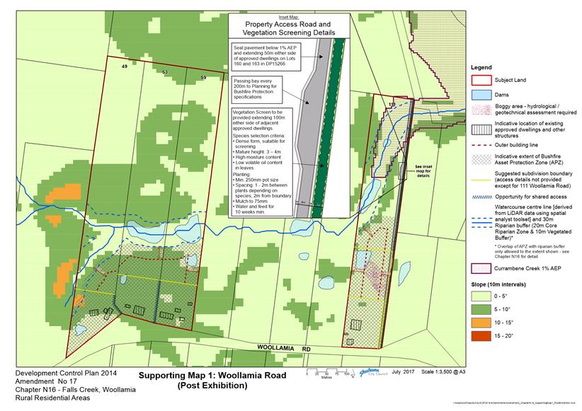
|
|
Development
Committee – Tuesday 08 August 2017
Page
93
|
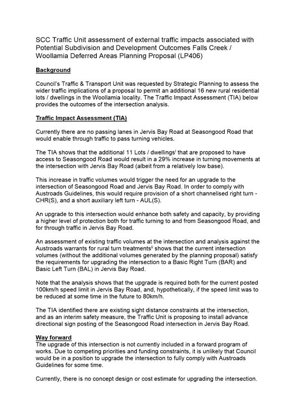
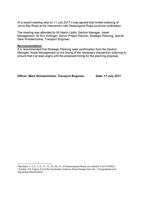
|
|
Development
Committee – Tuesday 08 August 2017
Page
95
|
|
|
Development
Committee – Tuesday 08 August 2017
Page
96
|
|
|
Development
Committee – Tuesday 08 August 2017
Page
97
|
|
|
Development
Committee – Tuesday 08 August 2017
Page
98
|
DE17.60 Development
Application – 23 Seasongood Road, Woollamia – Lot 113A DP 15266
DA. No: DA16/1433/4
HPERM Ref: D17/230792
Group: Planning
Environment & Development Group
Section: Development
Services
Attachments:
1. Revised Site
Plan - Proposed Building Envelope - 23 Seasongood Road, Woollamia ⇩
2. s79C
assessment report (under separate cover) ⇨
3. Statement
of Environmental Effects ⇩
4. Original
Bushfire Risk Assessment (under separate cover) ⇨
5. Bushfire
Building Solutions response to RFS September 2016 ⇩
6. RFS 79BA
Response 20 June 2017 ⇩
Description
of Development: Demolition of an existing dwelling house and the
construction of a replacement dwelling house in two stages. Stage 1 of the
proposal, the subject of the development application, involves the demolition
of the existing dwelling house, detached garage and swimming pool and the
nomination of a ‘building envelope’ for the construction of a
future dwelling house (stage 2 of the proposal).
Owner: Gregory & Robyn Watson
Applicant: Lee Carmichael Town Planning
Notification Dates: 21st April to 6th
May 2016
No. of Submissions: Nil in objection
Nil in
support
Purpose
/ Reason for consideration by Council
In accordance with
Council’s adopted policy for Dealing with Development Applications
Lodged by Council Staff or Councillors (POL16/235), where the applicant or
land owner in respect of a development application is a Council staff member or
Councillor and where the development application seeks a substantive variation
to any performance-based Development Control Plan (DCP) or Council Policy, the
development application (DA) is to be reported to Council for determination.
|
Recommendation
(Item to be determined under delegated authority)
That Council resolve to refuse
Development Application DA16/1433 for the Staged Construction of a
Replacement Dwelling House – Stage 1 Nomination of Building Envelope
and Demolition of Existing Dwelling House at Lot 113A DP 15266 No.23
Seasongood Road, Woollamia for reasons relating to:
1. The
proposed building envelope is not consistent with the provisions of Planning
for Bushfire Protection 2006;
2. The
NSW Rural Fire Service does not support the building envelope in its proposed
location;
3. Based
on the proposal’s inconsistency with Planning for Bushfire
Protection 2006 and the NSW Rural Fire Service’s opposition to the
development proposal, the development application is unsatisfactory with
regard to Section 79BA of the Environmental Planning and Assessment Act,
1979; and
4. The
development proposal is inconsistent with the draft Shoalhaven Local
Environmental Plan (Planning Proposal LP406) and provisions of supporting
draft Shoalhaven Development Control Plan 2014 – Amendment No.17
– draft Chapter N16 Falls Creek / Woollamia Rural Residential Areas.
|
Options
1. Decline to
support the proposal as currently presented in the development application and
refuse the development application for the reasons stated in the
Recommendation.
Implications: This would be consistent with Council
resolutions in relation to draft Planning Proposal LP406 and provisions of
supporting draft Shoalhaven Development Control Plan 2014 – Amendment
No.17 – draft Chapter N16 Falls Creek / Woollamia Rural Residential Areas
The applicant would be entitled to appeal against Council’s refusal in
the Land and Environment Court.
2. Resolve to
support the proposal as currently presented in the development application and
set out the reason(s) to justify this determination, and call for a further
report from staff with draft conditions of consent for consideration.
Implications:The development as currently proposed is not
consistent with draft Planning Proposal (see separate item in the Development
Committee Business Paper) and supporting draft Shoalhaven Development Control
Plan 2014 – Amendment No.17 – Draft Chapter N16 Falls Creek /
Woollamia Rural Residential Areas and has
received opposition from the Rural Fire Service on the basis that it is
inconsistent with the provisions of Planning for Bushfire Protection 2006.
Council would need to provide reasons to justify this determination and a
further report would be required with draft conditions of consent for
consideration by Council. Councillor’s protection from liability under
Section 733 of Local Government Act may be compromised where a decision is not
considered to be ‘in good faith’ if is not consistent with Planning
for Bushfire Protection 2006 as set out in Sections 733 (4)&(5).
3. Decline to
support the proposal as currently presented in the development application, but
issue a deferred commencement consent pursuant to sub-section 80(3) of the
Environmental Planning and Assessment Act, 1979 requiring the applicant to
amend the development proposal to be consistent with the provisions of the
draft Planning and Proposal and supporting draft Shoalhaven Development Control
Plan 2014 – Amendment No.17 – Draft Chapter N16 Falls Creek /
Woollamia Rural Residential Areas.
Implications: The applicant would need to redesign the development
proposal and submit the revised plan to Council for review before an operative
development consent could be issued. If dissatisfied with the decision, the
applicant would be entitled to appeal to the Land and Environment Court.
4. Adopt an alternative
recommendation and provide direction to staff.
Location Map
Figure 1 –
Location Map – No. 23 Seasongood Rd, Woollamia
Background
Proposed Development
Development consent is being
sought under the provisions of s80(4) of the Environmental Planning and
Assessment Act 1979 (EP&A Act), for the carrying out of a development
involving the demolition of an existing dwelling house and the construction of
a replacement dwelling house in two stages.
Stage 1 of the proposal, the
subject of the development application, involves the demolition of the existing
dwelling house, detached garage and swimming pool and the nomination of a
‘building envelope’ for the construction of a future dwelling house
(Stage 2 of the proposal).
The proposed building envelope
measures 40m x 20m (800m2) and is located 43m from the southern
property boundary, 43m from the eastern boundary and 43m from the western
boundary. The building envelope sits within an existing clearing, on very
gently sloping land, and is located some 165m from the nearest neighbouring
dwelling house at No.21 Seasongood Road as shown in Attachment 1.
Access to the proposed building
envelope will be maintained from the existing access point off Seasongood Road,
with the internal site access driveway to follow the route of an existing
track. This track will need to be upgraded to provide access to the
future dwelling house, with such works including upgrading to a minimum width
of 4m and the provision of passing bays at 200m intervals along the route.
Full details of the proposal are
provided in the Statement of Environmental Effects (Attachment 3).
Subject Land
The subject site is identified
as Lot 113A in DP 15266. The subject site consists of a roughly
rectangular-shaped allotment of land, situated on the southern side of
Seasongood Road (see Figure 1). The site is an elongated property, some 607m to
622m deep and 105m wide, with an area of 6.51 hectares. The site currently
contains a single storey rendered masonry dwelling house and detached garage
together with a metal shed at its northern end, adjacent to Seasongood Road.
An intermittent watercourse and
associated riparian vegetation passes through the property to the south of the
existing buildings and links with established areas of vegetation located on
the neighbouring properties to the west and east. The watercourse is subject to
flooding. The southern portion of the site consists of approximately 3.7
hectares of cleared land with scattered, individual trees.
Figure
2 – Site Context
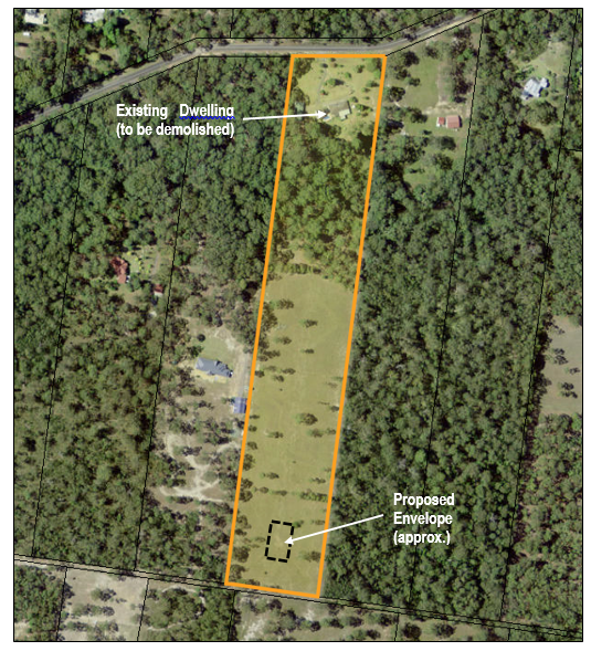
Site & Context
The subject site is located within a rural-residential
area currently zoned R5 Large Lot Residential under the provisions of
Shoalhaven Local Environmental Plan 2014. Surrounding allotments on the
southern side of Seasongood Road are similar in configuration to the subject
site (narrow and elongated), whilst allotments on the northern side of
Seasongood Road are of similar width but shorter.
The land in the locality is
largely vegetated, with some properties supporting larger cleared areas than
others. Dwelling houses in the locality are located within cleared areas
and tend to be positioned closer to Seasongood Road.
Strategic Context
Council has prepared and publicly exhibited a draft
amendment to Shoalhaven Local Environmental Plan 2014 (SLEP 2014) and a draft
amendment to Shoalhaven Development Control Plan 2014 (SDCP 2014).
The draft amendment to Shoalhaven Local Environmental
Plan 2014 (LP406) applies to certain lands at Falls Creek and Woollamia
(including the subject site) and seeks to enable the further subdivision of the
lands to create up to an additional 16 allotments. In respect of the
subject site, the draft amendment seeks to amend the Lot Size Map to create a
minimum allotment size of 1 hectare over the northern part of the subject site
(taking in the existing dwelling house and outbuildings) and a minimum lot size
of 5 hectares over the balance of the site.
The effect of the amendment to SLEP 2014 would be to
enable the subject site to be subdivided into two (2) allotments, effectively
enabling a new dwelling to potentially be approved on the rear lot, while
retaining the existing dwelling on the front lot. The draft amendment
will also amend the Terrestrial Biodiversity Map to include the riparian zone
vegetation passing through the subject site and a small patch of vegetation in
the south-western corner of the site as Biodiversity – significant
vegetation.
The draft amendment to SDCP 2014 will insert a new
chapter – Chapter N16 – into the DCP. The purpose of draft Chapter
N16 is to incorporate more detailed planning controls to ensure that the
objectives of the draft amendment to SLEP 2014 are achieved in relation to
bushfire risk management, biodiversity, stormwater management and on-site
effluent management for rural residential subdivision and development. Having
regard to these objectives, a subdivision and development outcomes plan has
been prepared and is illustrated in Figure 3 below. Further detail can be
obtained in the related report concerning the Planning Proposal (LP406).
Figure
3 – Subdivision & Development Outcomes Woollamia
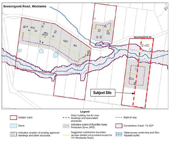
Issues
There are two issues which Council is being asked to
consider with respect to this application.
Firstly, the development proposal is inconsistent with
the provisions of the Draft SDCP 2014 – Amendment No.17 in that the
proposed location of the building envelope is outside of the nominated building
area shown on the map in Figure 3.
Secondly, the NSW Rural Fire Service (RFS) is opposed to
the proposed building envelope location, due to its inconsistency with Planning
for Bushfire Protection 2006, and has recommended that the building
envelope be relocated to a position within the nominated building area shown in
Figure 3. Figure 2 shows the location of the proposed building envelope
which is at the rear of the property.
In considering this development proposal, Council will need to
make a decision as to whether the advice of the RFS is to be accepted (Attachment
6), which would have the effect of implementing the provisions of Draft SDCP
2014 – Amendment No.17; or, allowing the variation to the provisions of
Draft SDCP 2014 – Amendment No.17, which would be contrary to the advice
of the RFS.
Planning Assessment
The Development Application has
been assessed under s79C of the EP&A Act. A copy of the Section 79C
assessment report is attached. As a result of that assessment, two issues
remain unresolved – the development proposal’s inconsistency with
Draft SDCP 2014 – Amendment No.17 and the RFS’ objection to the
proposed building envelope location.
Policy Implications
Draft Shoalhaven DCP 2014 – Amendment No.17
The major policy implication
arising as a result of this matter is the development proposal’s inconsistency
with the provisions of Draft SDCP 2014 – Amendment No.17, which has been
based upon strategic investigations undertaken to inform the enabling draft
amendment to SLEP 2014.
Applicant’s Submission
As the provisions of the
exhibited draft amendments to SLEP 2014 and SDCP 2014 are a matter for
consideration in the assessment of the development application, a submission
has been made in support of the development application seeking a variation to
the provisions of draft SDCP 2014 – Amendment No.17, for the following
reasons:
In the letter the RFS say,
“to ensure building are sighted and designed to minimise the risk of
bushfire attack, and to ensure firefighters and evacuating residents are not
required to travel long distances through forested areas, the following
conditions shall apply”.
If this is the basis of their
recommended conditions the whole premise of the conditions is flawed because
the property at both the RFS preferred location and our preferred site is
totally cleared and is managed pasture, our preferred location is just over 100
meters past the line on the map referred to in the letter and provides for a
minimum APZ 43m on three sides and 350m on the fourth, this complies with the
verbal advice given to me by Ms Amanda Moylan last year.
Just to demonstrate how over
the top some of the conditions are under General 2 for example:
“The development for the
purpose of the proposed new dwelling should not commence until the
demolition/decommissioning of the existing dwelling is complete”. So in
other words we have to pitch a tent or arrange for other accommodation at
significant cost while the building is being constructed….
….When the application
was lodged the provisions of the draft DCP were unknown and in my opinion it is
a strange coincidence the RFS did not make their recommendations until the
draft DCP to be placed on exhibition then referencing the map in the draft DCP
in their advice.
It is my understanding the
draft DCP is a performance based document and the dotted line referred to in
the map can be varied on a submission, it is our opinion the submission by our
consultants ticks all the boxes and exceeds normal RFS requirements…..
Another major issue with the
RFS’s preferred location coincides with a very large spring which remains
continually wet for months after heavy rain and has an area of about 5000sqm
and when the wet area is combined with a cut of about 1m ….our preferred
site is flat and has no seepage issues.
The final is one of privacy and
amenity we do not see why should be force to live in our next door residents
pockets….”
Comments
Several points in the
applicant’s submission require comment and/or clarification:-
· The development
application proposes the demolition of the existing dwelling house and
identification of a building envelope for a future dwelling house. This is
evident from the description of the development proposal in the statement of
environmental effects:
Consent is sought from Council
for the establishment of a building envelope on the property (otherwise known
as ‘in-principle dwelling approval’). Further to this, consent is
also sought for the demolition of the existing residential development located
on the land.
It would be expected that a
separate development application would be submitted for the construction of a
specific dwelling house within the approved building envelope. Given that
sub-clause 4.2D(5) only allows the construction of a new dwelling house on the
subject site “if there is a lawfully erected dwelling house on the
land and the dwelling house to be erected is intended only to replace the
existing dwelling house”, there will need to be a mechanism
incorporated into any consent issued which will ensure that the existing
dwelling house is demolished.
This could include a condition to
the effect that an Occupation Certificate for the new dwelling house is not
issued until the existing dwelling house has been demolished. This would
enable the existing house to be occupied during construction and demolition at
the completion of the development.
· Whilst the provisions of
SDCP 2014 are performance-based, with regard to development of bushfire prone
land, Council cannot grant consent to development unless that development is
consistent with the provisions of Planning for Bushfire Protection 2006,
or the RFS has been consulted and has agreed to an ‘alternate
solution’ to the provisions of Planning for Bushfire Protection 2006.
In this case, the RFS has not agreed to the applicant’s proposed
‘alternate solution’ but has agreed to the ‘alternate
solution’ proposed by draft Chapter N16.
Having regard to the expertise of
the RFS, it is considered imprudent to make a decision, which is contrary to
their advice albeit there is scope to consent to development (see later in this
report) pursuant to section 79BA.
· As outlined in the s79C assessment
report (Attachment 2) the development proposal was considered to be
satisfactory with regard to a range of planning and environmental matters
including the ability for the site to be adequately accessed and serviced; the
suitability of the site for on-site wastewater management; the absence of any
detrimental impacts on native vegetation; and, the favourable aspect of the
site (which promotes excellent solar access). The only issues of concern
with the proposed envelope are the related matters of the proposal’s
inconsistency with Planning for Bushfire Protection 2006, its inconsistency
with draft Chapter N16, and the RFS’ unresolved objection to the proposed
building envelope. It may be that if an alternate building envelope (compliant
with draft Chapter N16 and the recommendations of the RFS) were proposed, the
assessment of planning issues would result in the same overall acceptability of
the site with the added benefit of RFS support.
Environmental Planning and
Assessment Act, 1979
Section 79BA Consultation and
development consent – certain bush fire prone land states:
(1) Development consent cannot be granted for
the carrying out of development for any purpose (other than a subdivision of
land that could lawfully be used for residential or rural residential purposes
or development for a special fire protection purpose) on bush fire prone land
unless the consent authority:
(a) is satisfied that the development
conforms to the specifications and requirements of the version (as prescribed
by the regulations) of the document entitled Planning for Bush Fire Protection
prepared by the NSW Rural Fire Service in co-operation with the Department (or,
if another document is prescribed by the regulations for the purposes of this
paragraph, that document) that are relevant to the development (the relevant
specifications and requirements), or
(b) has been provided with a
certificate by a person who is recognised by the NSW Rural Fire Service as a
qualified consultant in bush fire risk assessment stating that the development
conforms to the relevant specifications and requirements.
(1A) If the consent authority is
satisfied that the development does not conform to the relevant specifications
and requirements, the consent authority may, despite subsection (1), grant
consent to the carrying out of the development but only if it has consulted
with the Commissioner of the NSW Rural Fire Service concerning measures to be
taken with respect to the development to protect persons, property and the
environment from danger that may arise from a bush fire.
In relation to the development
application, the proposed building envelope is located in a position which does
not meet the relevant property access specifications of 4.1.3(2) of Planning
for Bushfire Protection 2006, as it is located more than 200m from
Seasongood Road and has not been provided with an alternate access route.
Accordingly, as the proposal does not conform to the specifications and
requirements of Planning for Bushfire Protection 2006, s79BA
requires Council to consult with the RFS in relation to the development
proposal. The applicant’s original bushfire report and response to the
initial RFS comments are included as Attachments 4 and 5 respectively.
As detailed below (under “Consultation
and Community Engagement”), the RFS does not support the proposed
building envelope location and would prefer the building envelope be relocated
to a position within the building area identified in draft Chapter N16 of SDCP
2014.
Although this building area is also
located more than 200m from Seasongood Road, it has been identified in
consultation with the RFS as an appropriate ‘alternate solution’
having regard to the need “to protect persons, property and the
environment from danger that may arise from a bush fire” [sub-section
79BA(1A)]. In the Falls Creek / Woollamia Rural Residential Deferred
Areas Planning Proposal (LP406) report this ‘concession’ was
made however:
“In respect of 21 and 23
Seasongood Road, the new dwelling sites be positioned no further from the road
than the existing dwelling at 21 Seasongood Road”
Having regard to the provisions of s79BA of the EP&A
Act, the proposed development’s inconsistency with the relevant
provisions of Planning for Bushfire Protection 2006, and the RFS’
objection to the proposed building envelope, it is considered that Council
should not grant consent to the development application – unless the
building envelope is relocated to a position consistent with draft Chapter N16
of SDCP 2014 as recommended by the RFS.
Additionally the protections provided for
Councillor’s liability for decision making in relation to bushfire issues
under Section 733 of Local Government requires the decision on a development
application being made substantially in accordance with the principles
contained in the relevant manual, which in the case of bushfire is
Planning for Bushfire Protection 2006 as provided by Sections 733(4)&(5).
To make a decision that is not substantially in accordance with the manual and
contrary to RFS advice may at some future time be deemed not to have been made
‘in good faith’.
Consultation and Community
Engagement:
Rural
Fire Service
As the subject site is mapped as
bushfire prone land, in accordance with the provisions of s79BA of the EP&A
Act, the development application was referred to the RFS.
The initial referral to the RFS
was sent on 22nd April 2016. The RFS responded by letter dated 16th
September 2016, advising that as:
“the proposed building
envelope will result in a greater risk to both fire fighters and occupants
entering and leaving the site without alternative access being available, and
that there are other options for the siting of the dwelling, it is recommended that
the applicant either relocate the future dwelling site to within 200 metres of
Seasongood Road or provide alternative access, in a different direction to the
primary access, to ensure consistency with the provisions of Planning for
Bushfire Protection 2006.”
The applicant was advised of the
RFS’ comments and responded with a submission prepared by the
applicant’s bushfire consultant, Bushfire Building Solutions (Attachment
5). This submission was (re)referred to the RFS on 6th October
2016. The referral response from the RFS (dated 30th November
2016) reiterated its previous advice of 16th September 2016.
The applicant was again afforded
an opportunity to respond to the RFS’ concerns. Additional
information was provided by the applicant, and consisted of an amended site
plan (which increased the setbacks to the side and rear boundaries and reduced
the area of the building envelope) and a submission from the applicant’s
bushfire consultant. This information was again referred to the RFS on 1st
March 2017.
In a reply dated 20th
June 2017 (Attachment 6), the RFS recommended the issuing of a deferred
commencement consent (pursuant to sub-section 80(3) of the EP&A Act) which
requires the proposed building envelope to be relocated to a position within the
building area identified in Draft SDCP 2014 – Amendment No.17 as a
pre-requisite to the issuing of an operative consent.
Effectively, the RFS has
indicated that the development application can be approved – but only
if the building envelope is repositioned consistent with draft Chapter N16
of SDCP 2014. The applicant is aware of this, but does not wish to
relocate the building envelope and is seeking to have the development
application determined in its current form.
Neighbour
Notification
Notification
was carried out in accordance with Council’s Community Consultation
Policy with letters sent to the owners of the adjoining and adjacent
properties. The notification was for a 14 day period.
No submissions were received
during the notification period.
Financial Implications:
There may be financial
implications for Council if the matter is challenged via an appeal in the Land
and Environment Court of NSW.
Legal Implications
If the application is refused, or if the applicant is
dissatisfied with Council’s determination, the applicant is entitled to
appeal to the Land and Environment Court.
Under limited circumstances, third parties may have a
right to appeal Council’s decision to the Land and Environment Court.
Summary and Conclusion
The development application seeks Council’s
consent for the staged construction of a replacement dwelling house, with Stage
1 involving the nomination of a building envelope and demolition of the
existing dwelling house. The proposed building envelope measures 40m x 20m and
is positioned towards the southern end of the subject site, 43m from each of
the side and rear property boundaries.
Separate to this development application Council has
prepared and publicly exhibited a draft amendment to SLEP 2014 and associated
supporting draft Chapter N16 to be inserted into SDCP 2014. The effect of
these amendments is to enable the subdivision of the subject site into two (2)
allotments – one (1) with a minimum area of 1 hectare and taking in the
northern portion of the site surrounding the existing dwelling house, and the
other with a minimum area of 5 hectares taking in the balance of the subject
site.
An acceptable designated building area has been
identified in in draft Chapter N16 of SDCP 2014 in an area adjacent to the
existing dwelling house on the neighbouring property at No.21 Seasongood
Road. The location of this building area was in part due to the
consultation with RFS in relation to the planning proposal.
The proposed building envelope is located further south
of the identified designated building area and does not satisfy the provisions
of Planning for Bushfire Protection 2006. In response to
Council’s consultation (undertaken in accordance with s79BA of the
EP&A Act) the RFS has objected to the position of the proposed building
envelope and recommended that it be relocated to a position consistent with the
requirements of draft Chapter N16.
In its current format, bearing in mind the inconsistency
with Planning for Bushfire Protection 2006, the RFS objection, and the
provisions of s79BA of the EP&A Act, DA16/1433 is not supported.
|
|
Development
Committee – Tuesday 08 August 2017
Page
109
|
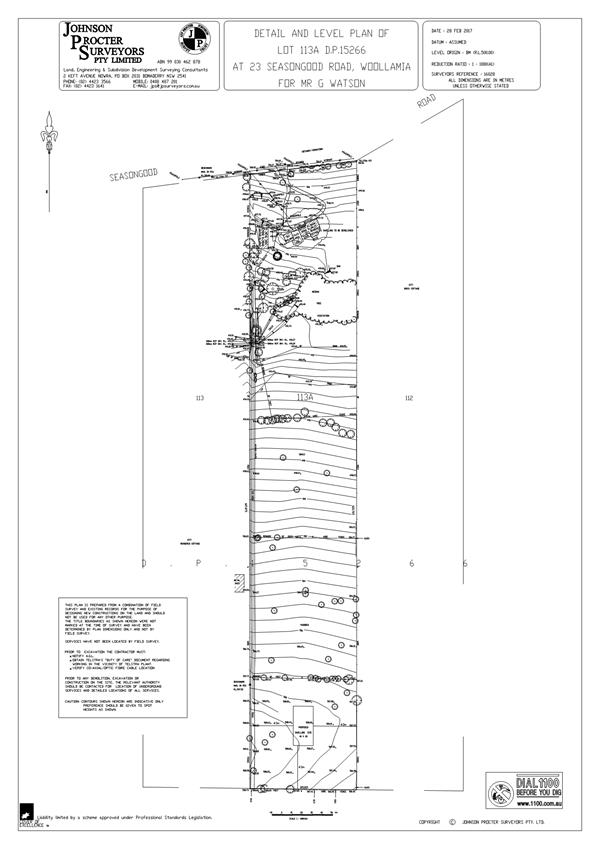
|
|
Development
Committee – Tuesday 08 August 2017
Page
110
|
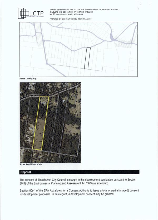
|
|
Development
Committee – Tuesday 08 August 2017
Page
119
|
|

|
Development
Committee – Tuesday 08 August 2017
Page
121
|
|
|
Development
Committee – Tuesday 08 August 2017
Page
124
|
Local Government Amendment (governance &
planning) act 2016
Chapter
3, Section 8A Guiding principles for councils
(1)
Exercise of functions
generally
The
following general principles apply to the exercise of functions by councils:
(a) Councils should provide strong
and effective representation, leadership, planning and decision-making.
(b) Councils should carry out
functions in a way that provides the best possible value for residents and
ratepayers.
(c) Councils should plan
strategically, using the integrated planning and reporting framework, for the
provision of effective and efficient services and regulation to meet the
diverse needs of the local community.
(d) Councils should apply the
integrated planning and reporting framework in carrying out their functions so
as to achieve desired outcomes and continuous improvements.
(e) Councils should work
co-operatively with other councils and the State government to achieve desired
outcomes for the local community.
(f) Councils should manage
lands and other assets so that current and future local community needs can be
met in an affordable way.
(g) Councils should work with
others to secure appropriate services for local community needs.
(h) Councils should act fairly,
ethically and without bias in the interests of the local community.
(i) Councils should be
responsible employers and provide a consultative and supportive working
environment for staff.
(2) Decision-making
The
following principles apply to decision-making by councils (subject to any other
applicable law):
(a) Councils should recognise
diverse local community needs and interests.
(b) Councils should consider social
justice principles.
(c) Councils should consider the
long term and cumulative effects of actions on future generations.
(d) Councils should consider the
principles of ecologically sustainable development.
(e) Council decision-making should
be transparent and decision-makers are to be accountable for decisions and
omissions.
(3) Community participation
Councils
should actively engage with their local communities, through the use of the
integrated planning and reporting framework and other measures.
Chapter
3, Section 8B Principles of sound financial management
The
following principles of sound financial management apply to councils:
(a) Council spending should be responsible and
sustainable, aligning general revenue and expenses.
(b) Councils should invest in responsible and
sustainable infrastructure for the benefit of the local community.
(c) Councils should have effective financial
and asset management, including sound policies and processes for the following:
(i) performance management
and reporting,
(ii) asset maintenance and
enhancement,
(iii) funding decisions,
(iv) risk management practices.
(d) Councils should have regard to achieving
intergenerational equity, including ensuring the following:
(i) policy decisions are made
after considering their financial effects on future generations,
(ii) the
current generation funds the cost of its services
Chapter
3, 8C Integrated planning and reporting principles that apply to councils
The
following principles for strategic planning apply to the development of the
integrated planning and reporting framework by councils:
(a) Councils should identify and prioritise key
local community needs and aspirations and consider regional priorities.
(b) Councils should identify strategic goals to
meet those needs and aspirations.
(c) Councils should develop activities, and
prioritise actions, to work towards the strategic goals.
(d) Councils should ensure that the strategic
goals and activities to work towards them may be achieved within council
resources.
(e) Councils should regularly review and
evaluate progress towards achieving strategic goals.
(f) Councils should maintain an
integrated approach to planning, delivering, monitoring and reporting on
strategic goals.
(g) Councils should collaborate with others to
maximise achievement of strategic goals.
(h) Councils should manage risks to the local
community or area or to the council effectively and proactively.
(i) Councils should make appropriate
evidence-based adaptations to meet changing needs and circumstances.