Development & Environment Committee
Meeting Date: Tuesday,
06 August, 2019
Location: Council
Chambers, City Administrative Building, Bridge Road, Nowra
Time: 5.00pm
Membership (Quorum - 5)
Clr Joanna Gash - Chairperson
Clr Greg Watson
All Councillors
Chief Executive Officer or nominee
Please note: The proceedings of this meeting
(including presentations, deputations and debate) will be webcast and may be
recorded and broadcast under the provisions of the Code of Meeting Practice. Your attendance at this meeting is taken
as consent to the possibility that your image and/or voice may be recorded and
broadcast to the public.
Agenda
1. Apologies / Leave of Absence
2. Confirmation of Minutes
· Development
& Environment Committee - 2 July 2019............................................... 1
3. Declarations of Interest
4. Call Over of the Business Paper
5. Mayoral Minute
6. Deputations and Presentations
7. Notices of Motion / Questions on Notice
Nil
8. Reports
Planning Environment & Development
DE19.64...... SF10541 - C130 Princes Hwy MEROO MEADOW -
Lot 502 DP 1221372 12
DE19.65...... Development Application – 38 Lyrebird Drive
Nowra - Lot 74 DP 1198691 DA18/2175...................................................................................................................... 41
DE19.66...... Moss Vale Road North Urban Release Area -
Detailed Supporting Plans.. 49
DE19.67...... Update - Planning Proposal - Inyadda Drive,
Manyana.............................. 65
DE19.68...... Update - Halloran Trust Lands Planning Proposal -
Biodiversity Certification 76
DE19.69...... Public Hearing Outcome and Proposed Finalisation
- Planning Proposal (PP023) - Anson Street, St. Georges Basin................................................................. 82
DE19.70...... Audit by NSW Planning Industry & Environment
- use clause 4.6 of Shoalhaven Local Environmental Plan 2014............................................................................. 96
DE19.71...... Home modifications to permit elderly and injured
residents to return to their dwellings.................................................................................................................... 100
DE19.72...... Quarterly review for compliance matters................................................... 105
DE19.73...... Bomaderry Grey-headed Flying Fox Community Education
Grant from Local Government NSW...................................................................................... 117
DE19.74...... Grant Application: Coastal & Estuary Grants
Program 2018-19............... 125
DE19.75...... Lake Conjola Entrance Opening and other Matters
Relating to Mayoral Minute MIN19.143.................................................................................................. 132
DE19.76...... Orient Point Wetland Bushwalk.................................................................. 153
Shoalhaven Water
DE19.77...... Review of Environmental Factors - Woollamia and
St Andrews Way - Berrys Bay- Pressure Sewer Scheme............................................................................ 169
9. Confidential
Reports
Nil
|

|
Development
& Environment Committee – Tuesday 06 August 2019
Page
|
Development & Environment Committee
Delegation:
Pursuant to
s377 (1) of the Local Government Act 1993 the Committee is delegated the
functions conferred on Council by the Environmental Planning & Assessment
Act 1979 (EPA Act), Local Government Act 1993 (LG Act) or any other Act or
delegated to Council, as are specified in the attached Schedule, subject to the
following limitations:
i. The
Committee cannot make a decision to make a local environmental plan to classify
or reclassify public land under Division 1 of Part 2 of Chapter 6 of the LG
Act;
ii.
The Committee cannot review a section 8.11 or
section 8.9 EPA Act determination made by the Council or by the Committee
itself;
iii.
The Committee cannot exercise any function delegated
to the Council which by the terms of that delegation cannot be sub-delegated;
iv.
The Committee cannot exercise any function which
s377(1) of the LG Act provides cannot be delegated by Council; and
v.
The Committee cannot exercise a function which
is expressly required by the LG Act or any other Act to be exercised by
resolution of the Council.
Schedule
a. All
functions relating to the preparation, making, and review of local
environmental plans (LEPs) and development control plans (DCPs) under Part 3 of
the EPA Act.
b. All
functions relating to the preparation, making, and review of contributions
plans and the preparation, entry into, and review of voluntary planning
agreements under Part 7 of the EPA Act.
c. The
preparation, adoption, and review of policies and strategies of the Council in
respect of town planning and environmental matters and the variation of such
policies.
d. Determination
of variations to development standards related to development applications
under the EPA Act where the development application involves a development
which seeks to vary a development standard by more than 10% and the application
is accompanied by a request to vary the development standard under clause 4.6
of Shoalhaven Local Environmental Plan 2014 or an objection to the application
of the development standard under State Environmental Planning Policy No. 1
– Development Standards.
e. Determination
of variations from the acceptable solutions and/or other numerical standards
contained within the DCP or a Council Policy that the General Manager requires
to be determined by the Committee
f. Determination
of development applications that Council requires to be determined by the
Committee on a case by case basis.
g. Review
of determinations of development applications under sections 8.11 and 8.9 of
the EP&A Act that the General Manager requires to be determined by the
Committee.
h. Preparation,
review, and adoption of policies and guidelines in respect of the determination
of development applications by other delegates of the Council.
i. The
preparation, adoption, and review of policies and strategies of the Council in
respect to sustainability matters related to climate change, biodiversity,
waste, water, energy, transport, and sustainable purchasing.
j. The
preparation, adoption and review of policies and strategies of the Council in
respect to management of natural resources / assets, floodplain, estuary and
coastal management.
Minutes of the Development & Environment Committee
Meeting Date: Tuesday,
2 July 2019
Location: Council
Chambers, City Administrative Building, Bridge Road, Nowra
Time: 5.00pm
The following members
were present:
Clr Joanna Gash -
Chairperson
Clr Patricia White
Clr John Wells
Clr John Levett
Clr Nina Digiglio
Clr Annette Alldrick
Clr Kaye Gartner
Clr Mitchell Pakes
Clr Greg Watson
Clr Mark Kitchener
Clr Bob Proudfoot
Mr Stephen Dunshea -
Chief Executive Officer
|
Apologies / Leave of Absence
|
Apologies
were received from Clrs Findley and Guile.
|
Confirmation of the Minutes
|
|
RESOLVED (Clr White / Clr
Alldrick) MIN19.454
That
the Minutes of the Development & Environment Committee held on Tuesday 04
June 2019 be confirmed.
CARRIED
|
Clr Gash – DE19.58 - Shoalhaven Development Control Plan
2014 - Proposed Amendment to Chapter N12: Culburra Beach - The Marina Area
– pecuniary interest declaration – will leave the room and will not
take part in discussion or vote – She is the co-owner of 97 The Marina,
Culburra Beach and the amendment may or may not have a positive or negative
effect on her property.
|
Call Over of the
Business Paper
|
|
The following items were called up for debate DE19.46,
DE19.53, DE19.54, DE19.57, DE19.58, DE19.59, DE19.60, DE19.61 and DE19.62.
The remaining items (DE19.52 and
DE19.55) were resolved en-bloc (Clr Gartner/ Clr White) at this time. They
are marked with an asterisk (*) in these Minutes.
|
Mayoral Minutes
Nil
Deputations and Presentations
DE19.46
- Public Exhibition Outcomes - Coastal Hazard Review Planning Proposal and
Coastal Management Areas DCP Amendment (Page 12)
Ms
Leonie Sinclair addressed the meeting to speak against the recommendation.
Mr
David Greenslade addressed the meeting to speak against the recommendation.
DE19.57
- Exhibition Outcomes and Proposed Finalisation - Citywide SP3 Tourist Zones
Review - Planning Proposal and Proposed Amendment to Chapter V3 Shoalhaven
Development Control Plan 2014
Mr
John Willmott addressed the meeting to speak against the recommendation.
DE19.59
- Development Application – No. 64, Lot 1138 in DP 1210394, Seagrass
Avenue Vincentia (Page 65)
Mr
Glyn Leyshon (of behalf of Bayswood residents) addressed the meeting to speak
for the recommendation.
Mr
Andrew Stecyk (owner) addressed the meeting to speak against the
recommendation.
DE19.60
- Development Application – 38 Lyrebird Drive Nowra – Lot 74 DP
1198691 DA18/2175 (page 98)
Mr
Alex Kelly and Mr Anthony Barthelmess (representing the owners of the land) addressed
the meeting to speak against the recommendation.
|
Procedural
Motion - Bring Item Forward
|
|
RESOLVED (Clr Gartner / Clr
White) MIN19.455
That the following matters be
brought forward for consideration:
· DE19.46 - Public
Exhibition Outcomes - Coastal Hazard Review Planning Proposal and Coastal
Management Areas DCP Amendment
· DE19.57 -
Exhibition Outcomes and Proposed Finalisation - Citywide SP3 Tourist Zones
Review - Planning Proposal and Proposed Amendment to Chapter V3 Shoalhaven
Development Control Plan 2014
· DE19.59 -
Development Application – No. 64, Lot 1138 in DP 1210394, Seagrass
Avenue Vincentia
· DE19.60 -
Development Application – 38 Lyrebird Drive Nowra – Lot 74 DP
1198691 DA18/2175
CARRIED
|
|
DE19.46 Public Exhibition Outcomes -
Coastal Hazard Review Planning Proposal and Coastal Management Areas DCP
Amendment
|
HPERM Ref: D19/113261
|
|
Recommendation (Item to be determined under
delegated authority)
That Council:
1. Adopt
the Planning Proposal (PP026) as exhibited and forward to the NSW Department
of Planning and Environment for finalisation.
2. Adopt
and finalise Shoalhaven Development Control Plan 2014 Chapter G6: Coastal
Management Areas Amendment as exhibited, with the inclusion of the changes
highlighted in Attachment 2.
3. Advise
key stakeholders, including all CCBs, relevant industry representatives and
those who made a submission, of this decision, and when the LEP and DCP
amendments will be made effective.
|
|
RESOLVED (Clr Pakes / Clr Watson)
MIN19.456
That:
1. Consideration
of the Planning Proposal (PP026) be deferred to allow for:
a. a
briefing be held for Councillors to address the concerns raised at the 2 July
2019 Development and Environment Committee Meeting
b. The
provision of an avenue for affected community members to address any of the
concerns raised at the 2 July 2019 Development and Environment Committee
meeting
2. Following
the briefing and community consultation, that a further report on the
proposal be brought to the July 2019 Ordinary Council meeting for adoption,
if possible.
3. No
changes be made with respect to Coastal Mapping unless a report has been
provided to the Council and prior community consultation undertaken with
affected residents.
For: Clr
Gash, Clr White, Clr Wells, Clr Digiglio, Clr Alldrick, Clr Gartner, Clr
Pakes, Clr Watson, Clr Kitchener, Clr Proudfoot and Stephen Dunshea
Against: Clr
Levett
CARRIED
|
|
DE19.57 Exhibition
Outcomes and Proposed Finalisation - Citywide SP3 Tourist Zones Review -
Planning Proposal and Proposed Amendment to Chapter V3 Shoalhaven Development
Control Plan 2014
|
HPERM Ref: D19/171980
|
|
Recommendation (Item to be determined under
delegated authority)
That Council:
1. Adopt
and finalise the exhibited Planning Proposal (PP013)
2. Forward
PP013 to NSW Parliamentary Counsel’s Office to draft the amendment to
Shoalhaven Local Environmental Plan 2014.
3. Make
the resulting amendment to the Shoalhaven Local Environmental Plan 2014 using
Council’s delegation.
4. Adopt
and finalise the amendment to Shoalhaven Development Control Plan 2014
Chapter V3: Miscellaneous Site-Specific Issues as exhibited, with the
inclusion of the change to Performance Criteria P5.1 as noted in Attachment
2.
5. Advise
key stakeholders, including owners of the subject land, adjoining land
owners, all Community Consultative Bodies, relevant industry representatives
and those who made a submission, of this decision, and when the LEP and DCP
amendments will be made effective.
|
|
RESOLVED (Clr Gartner / Clr
Digiglio) MIN19.457
That Council:
1. Adopt
and finalise the exhibited Planning Proposal (PP013).
2. Forward
PP013 to NSW Parliamentary Counsel’s Office to draft the amendment to
Shoalhaven Local Environmental Plan 2014.
3. Make
the resulting amendment to the Shoalhaven Local Environmental Plan 2014 using
Council’s delegation.
4. Adopt
and finalise the amendment to Shoalhaven Development Control Plan 2014
Chapter V3: Miscellaneous Site-Specific Issues as exhibited, with the
inclusion of the change to Performance Criteria P5.1 as noted in Attachment 2
and with an amendment to Acceptable Solution A5.4 specifying that screening
is an alternative solution.
5. Advise
key stakeholders, including owners of the subject land, adjoining land owners,
all Community Consultative Bodies, relevant industry representatives and
those who made a submission, of this decision, and when the LEP and DCP
amendments will be made effective.
For: Clr
Gash, Clr White, Clr Wells, Clr Levett, Clr Digiglio, Clr Alldrick, Clr
Gartner, Clr Proudfoot and Stephen Dunshea
Against: Clr
Pakes, Clr Watson and Clr Kitchener
CARRIED
|
|
DE19.59 Development Application –
No.64, Lot 1138 in DP 1210394, Seagrass Avenue Vincentia
|
HPERM Ref: D18/383673
|
|
Recommendation (Item to be determined under
delegated authority)
That Development Application
DA18/1998 be refused for the reasons set out in Attachment 1 to this report.
|
|
RESOLVED (Clr Gartner / Clr
Alldrick) MIN19.458
That Development Application
DA18/1998 be refused for the reasons set out in Attachment 1 to this report.
For: Clr
Gash, Clr White, Clr Wells, Clr Levett, Clr Digiglio, Clr Alldrick, Clr
Gartner, Clr Pakes, Clr Watson, Clr Kitchener, Clr Proudfoot and Stephen Dunshea
Against: Nil
CARRIED
|
|
DE19.60 Development Application –
38 Lyrebird Drive Nowra – Lot 74 DP 1198691 DA18/2175
|
HPERM Ref: D19/189185
|
|
Recommendation (Item to be determined under
delegated authority)
That the Committee refuse
Development Application DA18/2175 for the erection of an attached dual
occupancy at Lot 74 DP 1108691, 38 Lyrebird Drive Nowra, for the reasons as
shown in the draft Notice of Determination at Attachment 1.
|
|
RESOLVED (Clr Wells / Clr
Proudfoot) MIN19.459
That:
1. Council
accept Development Application DA18/2175 for the erection of an attached dual
occupancy at Lot 74 DP 1108691, 38 Lyrebird Drive Nowra, a further report be
provided to Council with suitable conditions for consent.
2. The
next Housekeeping Amendment seek to consider inserting provisions in the
Shoalhaven LEP to rule out dual occupancy development in the vicinity of
Riverview Road and Lyrebird Drive, Nowra.
For: Clr
Gash, Clr White, Clr Wells, Clr Pakes, Clr Watson, Clr Kitchener and Clr
Proudfoot
Against: Clr
Levett, Clr Digiglio, Clr Alldrick, Clr Gartner and Stephen Dunshea
CARRIED
|
Reports
|
DE19.46 Public Exhibition Outcomes - Coastal Hazard Review
Planning Proposal and Coastal
Management Areas DCP Amendment
|
HPERM Ref: D19/113261
|
|
Item
dealt with earlier/later in the meeting see MIN19.456
|
Items marked with an *
were resolved ‘en bloc’.
|
DE19.52 Progress Update - Berry Heritage
Investigations
|
HPERM Ref: D19/181822
|
|
RESOLVED* (Clr Gartner / Clr
White) MIN19.460
That Council:
1. Provide
in principal support to the proposed heritage listing of the 25 properties
and 2 Heritage Conservation Areas in Shoalhaven Local Environmental Plan
2014, as identified in Table 1 in this report, for preliminary community
consultation only.
2. Investigate
the heritage significance of No. 30 and No. 40 Alexandra Street, Berry as
recommended by the Heritage Consultant.
3. Following
part 2 of this recommendation, commence preliminary community consultation
with the affected landowners, the Berry Forum, Berry Showground Management
Committee, Berry Chamber of Commerce and Berry & District Historical
Society regarding the Berry Heritage Investigations work to date.
4. Advise
relevant stakeholders (affected landowners, the Berry Forum, Berry Showground
Management Committee, Berry Chamber of Commerce and Berry & District
Historical Society) of this decision.
5. Receive
a further report outlining the findings of the supplementary heritage
investigations and preliminary community consultation.
CARRIED
|
|
DE19.53 Exhibition Outcomes and
Finalisation - Planning Proposal: 2017 Housekeeping Amendment (Instrument
Changes) - Shoalhaven LEP 2014
|
HPERM Ref: D19/121834
|
|
Recommendation (Item to be determined under
delegated authority)
That
Council:
1. Adopt
and finalise Planning Proposal (PP033) as exhibited, with the changes
outlined in Attachment 2.
2. Forward
PP033 to NSW Parliamentary Counsel’s Office to draft the amendment to
Shoalhaven Local Environmental Plan 2014.
3. Make
the resulting amendment to the Shoalhaven Local
Environmental Plan 2014 using Council’s delegation.
4. Undertake
a separate future review of Clause 4.2B of Shoalhaven Local Environmental
Plan 2014 with the following scope:
a. Further
consideration of Item 6 (proposed for deletion from PP033) including the
appropriateness of the current zoning of certain land in Clause 4.2B.
b. Provide
clarification as to what ‘land’ means (i.e. identifying holdings).
c. Other
matters that are identified during the review or were raised in submissions.
5. Prepare
a future report to Council in relation to the outcome of the review at Part 4
of this recommendation, including the scope of a future Planning Proposal as
appropriate and its priority in the Strategic Planning Works Program.
6. Advise
key stakeholders, including all CCBs, relevant industry representatives and
those who made a submission, of this decision, and when the Amendment will be
made effective.
|
|
RESOLVED (Clr Proudfoot / Clr
Pakes) MIN19.461
That the Planning Proposal
(PP033) be deferred for consideration at the July 2019 Ordinary Council
meeting.
For: Clr
Gash, Clr White, Clr Wells, Clr Levett, Clr Digiglio, Clr Alldrick, Clr
Gartner, Clr Pakes, Clr Watson, Clr Kitchener, Clr Proudfoot and Stephen
Dunshea
Against: Nil
CARRIED
|
|
DE19.54 Nowra CBD Fringe Planning
Proposal - Progress and Possible Next Steps
|
HPERM Ref: D19/122291
|
|
Recommendation (Item to be determined under
delegated authority)
That Council:
1. Adopt the following recommendations
of the Heritage Study and provide an amended Planning Proposal to the
Department of Planning and Environment:
a. Reduce
the boundaries of the proposed Heritage Conservation Area to exclude areas
where there are large areas of ‘non-contributory’ buildings.
b. Update
the Statement of Significance for the proposed Heritage Conservation Area.
2. Not
adopt the following recommendation of the Heritage Study and defer for
consideration as part of any broader future Shoalhaven heritage review:
a. Expand
the proposed Heritage Conservation Area boundary to include Oliver Parade
which is in the study area but not in the proposed Heritage Conservation
Area.
3. Not
include ‘post-war fibro cottages’ on Leaney Avenue and Oliver
Parade as ‘contributory’ items on the contributory items map.
4. Endorse
the revised contributory items map for public exhibition with the supporting
DCP Chapter.
5. Not
endorse the DCP controls recommended in the Heritage Study to ensure the
overall focus of the DCP Chapter remains on character rather than heritage
aspects of individual ‘contributory’ items.
|
|
RESOLVED (Clr Wells / Clr
Gartner) MIN19.462
That Council:
1. Adopt
the following recommendations of the Heritage Study and provide an amended
Planning Proposal to the Department of Planning and Environment:
a. Reduce
the boundaries of the proposed Heritage Conservation Area to exclude areas
where there are large areas of ‘non-contributory’ buildings.
b. Update
the Statement of Significance for the proposed Heritage Conservation Area.
2. Not
adopt the following recommendation of the Heritage Study and defer for
consideration as part of any broader future Shoalhaven heritage review:
a. Expand
the proposed Heritage Conservation Area boundary to include Oliver Parade
which is in the study area but not in the proposed Heritage Conservation
Area.
3. Not
include ‘post-war fibro cottages’ on Leaney Avenue and Oliver
Parade as ‘contributory’ items on the contributory items map.
4. Endorse
the revised contributory items map for public exhibition with the supporting
DCP Chapter.
5. Not
endorse the DCP controls recommended in the Heritage Study to ensure the
overall focus of the DCP Chapter remains on character rather than heritage
aspects of individual ‘contributory’ items.
For: Clr
Gash, Clr White, Clr Wells, Clr Levett, Clr Digiglio, Clr Alldrick, Clr
Gartner, Clr Pakes, Clr Watson, Clr Kitchener, Clr Proudfoot and Stephen
Dunshea
Against: Nil
CARRIED
|
|
DE19.55 Funding Offer - NSW Heritage
Grants - 2019-20 and 2020-21
|
HPERM Ref: D19/185099
|
|
RESOLVED* (Clr Gartner / Clr
White) MIN19.463
That Council:
1. Accept
the following NSW Heritage Grants funding offers as detailed in the report:
a. 2019-20
to 2020-21 financial years for the Local Heritage Places and Local Government
Heritage Advisor streams; and
b. 2019-2021
Local Government Heritage Studies stream (Berry Heritage Investigations
project).
2. Note
that recurrent funding is provided in the annual Budget to meet
Council’s matching commitment.
CARRIED
|
|
DE19.56 Proposed Housekeeping Amendment
- Shoalhaven Development Control Plan 2014 - General and Generic Chapters
|
HPERM Ref: D19/185859
|
|
Recommendation (Item to be determined under
delegated authority)
That Council:
1. Endorse
the initial draft General and Generic Chapter Housekeeping Amendment (draft
Amendment) to Shoalhaven Development Control Plan 2014 at Attachment 1
(including the Draft Waste Minimisation and Management Guidelines and
rescission of Chapter 3: Exempt Development) and support the exhibition of
the draft Amendment for a period of at least 28 days as per legislative
requirements.
2. Receive
a further report on the draft Amendment following the conclusion of the
public exhibition period to consider feedback received, any necessary
adjustments and the finalisation of the amendment.
3. Advise
key stakeholders, including relevant industry representatives, of this
decision and the exhibition arrangements in due course.
|
|
RESOLVED (Clr Gartner / Clr
Digiglio) MIN19.464
That Council:
1. Endorse
the initial draft General and Generic Chapter Housekeeping Amendment (draft
Amendment) to Shoalhaven Development Control Plan 2014 at Attachment 1
(including the Draft Waste Minimisation and Management Guidelines and
rescission of Chapter 3: Exempt Development) and support the exhibition of
the draft Amendment for a period of at least 28 days as per legislative
requirements.
2. Receive
a further report on the draft Amendment following the conclusion of the
public exhibition period to consider feedback received, any necessary
adjustments and the finalisation of the amendment.
3. Advise
key stakeholders, including relevant industry representatives, of this
decision and the exhibition arrangements in due course.
For: Clr
Gash, Clr White, Clr Wells, Clr Levett, Clr Digiglio, Clr Alldrick, Clr
Gartner, Clr Pakes, Clr Watson, Clr Kitchener, Clr Proudfoot and Stephen
Dunshea
Against: Nil
CARRIED
|
|
DE19.57 Exhibition Outcomes and Proposed Finalisation - Citywide SP3 Tourist Zones Review - Planning
Proposal and Proposed Amendment To Chapter V3
Shoalhaven Development Control Plan 2014
|
HPERM Ref: D19/171980
|
|
Item
dealt with earlier/later in the meeting see MIN19.457.
|
Note: Clr Gash left the meeting at 7:10pm – Clr Watson
assumed the chair in the absence of Councillor Gash.
|
DE19.58 Shoalhaven Development Control
Plan 2014 - Proposed Amendment to Chapter N12: Culburra Beach - The Marina
Area
|
HPERM Ref: D19/191446
|
|
Clr Gash– DE19.58 Shoalhaven
Development Control Plan 2014 - Proposed Amendment to Chapter N12: Culburra
Beach - The Marina Area – pecuniary interest declaration – left
the room and did not take part in discussion or vote – She is the co-owner of 97 The Marina, Culburra Beach
and the amendment may or may not have a positive or negative affect on her
property.
|
|
Recommendation (Item to be determined under
delegated authority)
That Council:
1. Endorse
the preparation of an amendment to Chapter N12: Culburra Beach – The
Marina of Shoalhaven Development Control Plan 2014.
2. Receive
a further report on the draft Amendment prior to public exhibition.
3. Adopt
the ‘Interim’ Policy Position that the Maps at Attachment 1
represent Council’s ongoing strategic intent in terms of building
lines, erosion setback lines and 20m vegetation buffer lines for The Marina
area and apply the Interim Policy Position until the lines have been
reviewed, considered and finalised as part of the amendment to DCP Chapter
N12.
4. Advise
key stakeholders, including relevant industry representatives and landowners,
of this decision.
|
|
Note:
Clr Proudfoot left the meeting at 7.17pm
|
|
RESOLVED (Clr Gartner / Clr
Digiglio) MIN19.465
That Council:
1. Endorse
the preparation of an amendment to Chapter N12: Culburra Beach – The
Marina of Shoalhaven Development Control Plan 2014.
2. Receive
a further report on the draft Amendment prior to public exhibition.
3. Adopt
the ‘Interim’ Policy Position that the Maps at Attachment 1
represent Council’s ongoing strategic intent in terms of building
lines, erosion setback lines and 20m vegetation buffer lines for The Marina
area and apply the Interim Policy Position until the lines have been
reviewed, considered and finalised as part of the amendment to DCP Chapter
N12.
4. Advise
key stakeholders, including relevant industry representatives and landowners,
of this decision.
For: Clr
White, Clr Wells, Clr Levett, Clr Digiglio, Clr Alldrick, Clr Gartner, Clr
Pakes, Clr Watson, Clr Kitchener and Stephen Dunshea
Against: Nil
CARRIED
|
|
Note:
Clr Gash returned to the meeting at 7:18pm and reassumed the Chair.
Note:
Clr Proudfoot returned to the meeting at 7:18pm
|
|
DE19.59 Development Application – No.64, Lot 1138 in DP
1210394, Seagrass Avenue Vincentia
|
HPERM Ref: D18/383673
|
|
Item
dealt with earlier/later in the meeting see MIN19.458
|
|
DE19.60 Development Application – 38 Lyrebird Drive Nowra
– Lot 74 DP 1198691 DA18/2175
|
HPERM Ref: D19/189185
|
|
Item dealt
with earlier/later in the meeting see MIN19.459
|
|
DE19.61 Shoalhaven City Council - Mobile
Food Vans in the LGA - Private and Public Lands
|
HPERM Ref: D19/187221
|
|
Recommendation (Item to be determined under
delegated authority)
That the report Mobile Food Vans
in the LGA - Private and Public Lands be received for information.
|
|
RESOLVED (Clr White / Clr Wells) MIN19.466
That:
1. The
report Mobile Food Vans in the LGA - Private and Public Lands be received for
information.
2. Council
write to the NSW State Government to express concerns about the impact of the
Mobile Food Van provisions within the State Environmental Planning Policy
(SEPP) (Exempt & Complying Development Codes) on businesses in regional
towns and villages and consider further consultation and amendments to the
SEPP if necessary.
For: Clr
Gash, Clr White, Clr Wells, Clr Levett, Clr Digiglio, Clr Alldrick, Clr
Gartner, Clr Pakes, Clr Watson, Clr Kitchener, Clr Proudfoot and Stephen
Dunshea
AGAINST: Nil
CARRIED
|
|
DE19.62 Shoalhaven Heads - River Road
Foreshore Precinct Rehabilitation Project - Progress Update
|
HPERM Ref: D19/115308
|
|
Recommendation (Item to be determined under
delegated authority)
That Council:
1. Proceed
to call Tenders for the Shoalhaven Heads River Road Foreshore Precinct
Rehabilitation Project in accordance with the separable portions strategy
outlined in the report.
2. Receive
a further confidential report regarding the Tender process in accordance with
the provisions of the Local Government Act.
|
|
RESOLVED (Clr Wells / Clr White) MIN19.467
That Council:
1. Proceed
to call Tenders for the Shoalhaven Heads River Road Foreshore Precinct
Rehabilitation Project in accordance with the separable portions strategy
outlined in the report.
2. Receive
a further confidential report regarding the Tender process in accordance with
the provisions of the Local Government Act.
For: Clr
Gash, Clr White, Clr Wells, Clr Levett, Clr Digiglio, Clr Alldrick, Clr
Gartner, Clr Pakes, Clr Watson, Clr Kitchener, Clr Proudfoot and Stephen
Dunshea
Against: Nil
CARRIED
|
|
Procedural
Motion - Matters of Urgency
|
|
RESOLVED (Clr White / Clr Pakes) MIN19.468
That an additional item with
respect to home modifications for elderly and injured persons be introduced
as a matter of urgency.
CARRIED
The
Chairperson ruled the matter as urgent as it is a current issue affecting
residents.
|
|
DE19.63 Additional Item – Home Modifications
– Elderly and Injured Residents – Medical Requirements
|
|
RESOLVED (Clr White / Clr Pakes) MIN19.469
That:
1. Council
approve an Interim Policy to give approval for residence modifications in
response to Occupational Therapists and Doctors instructions to allow elderly
people and those who are injured to return to their homes.
2. A
further report be provided back to Council on a policy provision to address
this issue.
CARRIED
|
There being no
further business, the meeting concluded, the time being 7.33pm.
Clr Gash
CHAIRPERSON
|

|
Development
& Environment Committee – Tuesday 06 August 2019
Page
0
|
DE19.64 SF10541
- C130 Princes Hwy MEROO MEADOW - Lot 502 DP 1221372
DA. No: SF10541/4
HPERM Ref: D19/187428
Group: Planning
Environment & Development Group
Section: Development
Services
Attachments: 1. s4.15
Assessment Report (under separate cover) ⇨
2. Draft
Determination (under separate cover) ⇨
3. Subdivision Plan ⇩
Description of Development: Fifteen (15) lot Torrens
title subdivision and associated site works
Owner: Linkwood Nowra Pty Ltd.
Applicant: Allen Price & Scarratts (APS)
Notification
Dates: The application was notified on
four (4) separate occasions on 12 December 2016, 17 January 2018, 8 November
2018 and 19 March 2019
No. of
Submissions: 86 submissions were received to the notifications. All
submissions were in objection to the application. Multiple objections were
received in some cases by a single submitter(s).
Purpose
/ Reason for consideration by Council
On 23 January 2017 Council resolved at the Development
Committee meeting, that:
1. All
delegations for SF10541 be withdrawn and this matter be reported to council for
consideration.
2. A
residents briefing meeting be held on the abovementioned application.
3. The
time for submissions be extended until the residents briefing meeting can be
held.
This Report is prepared in response
to item 1 of the Council’s resolution. A resident briefing meeting was
held on 2 March 2017 in response to item 2.
|
Recommendation (Item to be determined under delegated authority)
That Council:
1. Approve Development Application
SF10541 for a fifteen (15) lot Torrens title subdivision and associated site
works at C130 Princes Highway, Meroo Meadow - Lot 502 DP 1221372 by way of Deferred
Commencement consent, subject to the recommended conditions of consent
contained in Attachment 2 to this report.
2. Support the preparation of a
planning proposal over C130 Princes Highway, Meroo Meadow - Lot 502 DP
1221372 to amend Shoalhaven Local Environmental Plan 2014 (SLEP
2014) to rezone the current R1 General Residential component of the land to
R5 Large Lot Residential and also apply a 1,500m2 minimum lot size
and 8.5m height limit to that part of the land.
3. Submit the Planning Proposal to the
NSW Department of Planning, Industry and Environment (PIE) to request a
‘Gateway determination’. If a favourable determination is
received, proceed to public exhibition and report back to Council with the
outcomes of the exhibition period.
|
Options
1. Support
and approve the development application (DA) as a deferred commencement in
accordance with the recommendation and prepare a planning proposal (PP).
Implications: This would allow the applicant to seek
a Subdivision Construction Certificate (CC) for development on the subject site
upon resolution of the deferred matter. The deferred matter would be
finalisation of the Planning Proposal.
The proposed amendment to SLEP 2014 would support the
appropriate long-term management of the land.
2. Refuse
the application and not prepare a planning proposal.
Implications: Council would need to determine the
grounds on which the application is refused, having regard to section 4.15
considerations.
The applicant would have the ability to request a review of
any refusal by Council and/or pursue an appeal through the NSW Land and
Environment Court (L&EC). Council may still wish to give further
consideration to the zoning and other particulars of the land via a separate
process.
3. Alternative
recommendation.
Implications: Council will need to specify an
alternative recommendation and advise staff accordingly.
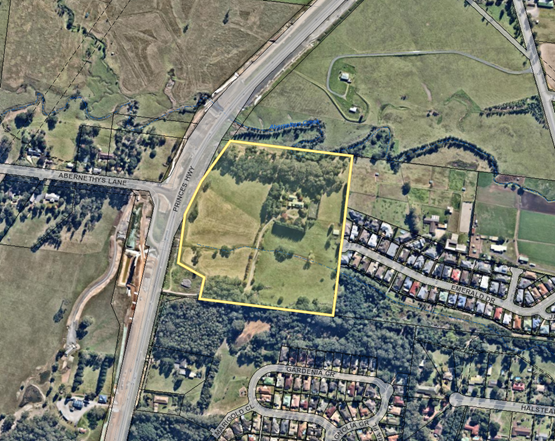
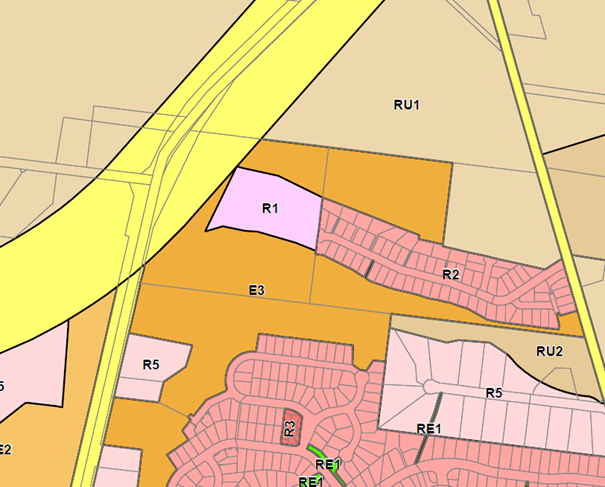
Location Map
Figure
1 – Location Map
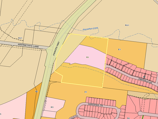
Figure
2 – Zoning Map
Background
On 11 December 2014, a pre-lodgement meeting was held in
relation to the subject site for a development described in the pre-lodgement
meeting notes as a 37 lot subdivision.
On 19 October 2016, the applicant lodged SF10541 for
development described on the development application form as
“37
Torrens Title Residential subdivision, vegetation clearing within
the development footprint, demolition of the existing dwelling, swimming pool
and tennis court; and associated site works”.
On 27 October 2016, Council requested additional
information from the applicant. Council requested additional information from
the applicant on numerous occasions throughout the assessment process.
On 12 December 2016, the development application was
notified for a period of 47 days (extended notification for the Christmas and
New Year period). A total of 26 submissions were received during the
notification period or shortly thereafter. All submissions were in objection to
the application.
On 23 January 2017 Council resolved at the Development Committee meeting
that:
1. All delegations for SF10541 be withdrawn and this
matter be reported to council for consideration.
2. A residents briefing meeting be held on the
abovementioned application.
3. The time for submissions be extended until the
residents briefing meeting can be held.
On 6 February 2017, the applicant lodged amended plans and
written responses to the referral process to date.
On 2 March 2017, a resident’s briefing meeting (RBM)
was conducted to outline the planning process and the development application
and the outstanding issues to be resolved prior to determination of the
application.
On 12 December 2017, the applicant lodged amended plans
which included upgrades to Emerald Drive required to satisfy the
Acceptable Solutions of Chapter G11: Subdivision of Land of Shoalhaven
Development Control Plan 2014 (SDCP 2014).
The drawings provided details of proposed road widening
along a portion of the southern side of the existing pavement along Emerald
Drive. The road widening intending to create a functional width of 6-7m.
On 17 January 2018, the applicant’s amended plans
were re-notified for a period of 30 days. A total of 25 submissions were
received following the re-notification of the development application. All
submissions were in objection to the application.
On 6 September 2018, the applicant lodged amended concept
plans which included a proposal to reduce the lot yield to 15 lots and
removal of the required widening of the southern side of Emerald Drive, the
retention of the existing dwelling on proposed lot 4 and construction of a
single raised threshold traffic calming device (an additional three (3) devices
to be provided in locations to be determined by Council.
On 8 November 2018, the application was re-notified for a
period of 15 days. A total of 20 submissions were received following the
re-notification of the development application. All submissions received were
in objection to the application.
On 11 March 2019, the applicant lodged final amended plans
and supporting reports for the amended 15 lot subdivision
On 19 March 2019, the application was re-notified for a period
of 15 days. A total of 15 submissions were received following the
re-notification of the development application. All submissions were in
objection to the application.
As is with all applications,
documentation was made and remains accessible on the DA tracking website.
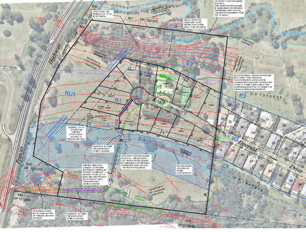
Proposed Development
The development, as amended, seeks development consent for
a 15 lot Torrens title subdivision and associated site works including the
construction of an extension to Emerald Drive and associated drainage. Lot
sizes range from 1,500m2 to 7.16ha.
The proposal is to create 14 residential allotments and one
residue lot comprising the remainder of the property with a building area
within the R1 General Residential zone (15 lots in total).
The existing dwelling house is to be retained on a
resulting lot. The tennis court will be removed. An extract of the subdivision
plan is provided in Figure 3.
The development is proposed to be accessed via two access
points. All 15 lots will gain access via a proposed
extension of Emerald Drive. Additionally, proposed Lot 15 will retain the
existing site access from the Princes Highway where the Roads and Maritime
Service (RMS) is currently in the process of constructing a turning bay as part
of the highway upgrade (Refer to Figure 3). The purpose of this access is to
provide the Rural Fire Service (RFS) with secondary access to the development
area. This would be secured by a locked gate on Lot 15 (adjacent to the
southwestern corner of proposed Lot 10) to ensure traffic from the proposed
development does not take advantage of this access to the highway.
Figure 3
- Extract of the proposed subdivision plan for the proposed development.
Subject Land
The subject site is located
north of Bomaderry situated between the Princes Hwy and the western end of
Emerald Drive in the suburb of Meroo Meadow. The land is legally identified as
Lot 502 DP 1221372 (formerly Lot 1 DP 130825) and is described as C130 Princes
Highway, Meroo Meadow.
Site & Context
The subject site is a regular shaped allotment with a total
land area of 9.707 hectares.
The site enjoys dual frontage to the Princes Highway in the
west and connects with Emerald Drive in the east. Meroo Road is located 600m to
the east of the site. The site is presently accessed via a driveway off Princes
Highway located on the south-eastern boundary of the site.
The land is gently undulating, with the property rising to a
central ridge running parallel to the northern boundary. Water naturally drains
to Abernethy Creek in the north-eastern corner of the site and an unnamed creek
toward the southern boundary of the site which feeds into Abernethy Creek on
the eastern side of Meroo Road.
Significant vegetation has historically been removed from the
site as part of the rural/residential land use of the site. There are stands of
remnant eucalyptus located along the southern boundary and riparian vegetation
along the extent of Abernethy Creek on the northern boundary. The site has also
been extensively landscaped to the extent of the curtilage of the existing
dwelling house and access driveway.
The site is currently a ‘semi-rural’ property
containing a single dwelling, pool and tennis court located in the
north-eastern portion of the site and shed on the eastern boundary.
The site is mapped as bush fire prone land in accordance with
bush fire prone land maps prepared by Council and certified by the Commissioner
of the NSW RFS.
The supporting reports associated
with the RMS Berry to Nowra Princes Highway upgrade indicate that there were
Aboriginal archaeological artefacts recorded on the AHIMS database within the
vicinity of the subject land. The applicant’s Aboriginal due diligence
reports have identified Aboriginal objects that are the subject of an
Aboriginal Heritage Impact permit pursuant to Section 91 of the National
Parks and Wildlife Act 1974.
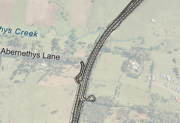
The site is bound to the west by the Princes Highway which is
currently undergoing an extensive upgrade associated with the State
Government’s Berry to Bomaderry works program. It is noted that a U-turn
bay is proposed to be located on the south-eastern corner of the site (Refer to
Figure 4 below). On the western side of the Princes Highway and along
the extent of Abernethys Lane the predominant land use is a mix of rural and
residential.
To the south, the site is adjoined by Council (environmental)
managed land. Further to the south again, the land has predominately been
developed for low-density residential development consisting of detached single
and two-storey dwelling houses. It is noted that there are limited examples of
multi-dwelling housing.
To the north, the land has been historically used for
agriculture (and associated dwellings).
To the east, the site is adjoined by the western extent of
Emerald Drive and Maddor Park Estate. The estate having been developed for
residential accommodation with the predominant built form being single storey
detached dwelling houses.
Figure 4
– extract from the concept designs for the Berry to Bomaderry upgrades
for the section of the Princes Highway to the extent of the subject site.
Extracted from the RMS website.
Existing Road Network
The Princes Highway at the boundary of the site is a two-way
undivided highway. The Princes Highway is being upgraded to include four lanes
of divided highway to improve road safety and traffic efficiency.
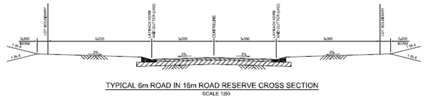
Emerald Drive is considered an access street under SDCP 2014
Chapter G11: Subdivision of Land and is 16m wide (road reserve). Emerald Drive
services 73 residential dwellings and has a nominal local road speed limit of
50km/h. Emerald Drive provides a trafficable width of approximately 5.0m,
constituting a formal central two-way carriageway of approximately 4.2m gutter
invert to gutter invert, and layback gutter dish drains on both sides of
approximately 0.7m each.
Meroo Road to the east of the site is a major collector road
between the Princes Highway and Bomaderry. Meroo Road carries one lane of
traffic in each direction and has unrestricted parking along most of its
length.
The proposed access and traffic impacts associated with the
development are detailed further in this Report and in consideration of
submissions.
History
On 18 July 2000, Council granted Development Consent SF8781
for a 76 lot subdivision of land now known as Maddor Park Estate (accessed via
Emerald Drive).
The approved road design for the subdivision stipulated
construction of a 5m carriageway width within a 16m and 18m road reserve (which
included traffic calming pavement).
The first request from the landowner
for rezoning of the subject site was received in August 2002.
Under Shoalhaven Local Environmental
Plan 1985 (SLEP 85) the subject site was zoned 1(b) Rural (Arterial and Main
Road Protection) Zone.
On 18 January 2005, a report to Council’s Development
Committee considered the proponent’s rezoning request that part of the
site be rezoned from its current zoning of Rural 1(b) (Arterial and Main Road
Protection) to a residential zoning.
The proposed residential area was to be accessed from Emerald
Drive on the eastern boundary of the site and comprised an extension of the
existing residential area to the east (Maddor Park Estate). The report
recommended limiting the extent of the potential rezoning having regard to the
site constraints to that generally consistent with the R1 General Residential
zone under Draft SLEP 2009.
It was recommended that a planning report be prepared to
support the proposed rezoning and to address the following issues:
· Flooding
and water quality;
· Visual
impacts including views to and from the site (specifically in relation to the
urban/ rural interface);
· Traffic
impact assessment;
· Impact
on agricultural values of the site; and
· Preliminary
concept plan for the future development of the site.
On Tuesday 25 January 2005 Council resolved to:
a) Support
preparation of a draft LEP (at the owners cost);
b) The
General Manager (Planning Group) be requested to consider a reduction in the
buffer zone area adjacent to the Princes Highway.
This resolution resulted from a request from the then
landowner to rezone the subject land to enable residential subdivision.
Specific provisions were recommended to be incorporated into the draft plan so
that the primary vehicular access to the subject land would be via Emerald Drive and not the Princes Highway.
On 12 February 2008, a report to the Policy and Planning
Committee considered the rezoning application and sought Council’s
direction in regard to aspects of the proposed draft plan prior to proceeding
to request a certificate to publicly exhibit the Draft Local Environmental Plan
(LEP) No. LEP 379 (Draft LEP 379).
On 6 June 2008, the NSW State planning agency at the time, now
known as PIE, wrote to Council of PIE’s refusal to issue their section 65
Certificate under the Environmental Planning and Assessment Act 1979
(the EP&A Act) in regard to Draft LEP 379 for the subject site.
On 9 January 2009, PIE wrote to Council to reiterate that they
would not support the rezoning of the subject site which would allow for
residential development to within 50m of the Princes Highway.
However, PIE went on to state that it was “willing to
support a rezoning that allows residential development to within 100m of the
Princess Highway.”
PIE advised that should Council and the landowner accept that
no development was to occur within 100m of the Princes Highway the matter
should be dealt with as part of the Draft Shoalhaven LEP 2009 rather than a
stand-alone LEP amendment.
On 18 July 2011, Shoalhaven City Council’s draft
Shoalhaven LEP 2009 was placed on public exhibition for 13 weeks. A copy of an
extract of the Land Zoning Map – LZN-024 Nowra Bomaderry indicating the
proposed zoning boundaries relative to the subject site is provided in Figure
5 below.
Figure 5
- Extract of the Land Zoning Map – LZN-024 Nowra Bomaderry indicating the
proposed zoning boundaries relative to the subject site
On 8 April 2014, Shoalhaven LEP 2014 was gazetted.
Issues
Traffic Impacts
The proposed development has the potential to impact on local
traffic conditions, with the local street network (Emerald Drive and
Intersection with Meroo Road) being identified as a potential impediment to the
proposed development due in part to the width of the Emerald Drive road
pavement, no traffic calming devices and concerns with sightlines at the Meroo
Meadow intersection.
A number of traffic reports have been prepared for the
application since lodgement of the DA. However, it is important to consider the
development in light of the most recent amendment to the lot yield and
therefore consideration of the principal traffic report titled Traffic
Impact Assessment (Traffic Report) prepared by Ason Group dated 8
March 2019 (D19/83206).
The Traffic Report assess the revised proposal (15 lot
subdivision) in relation to the:
· current
planning context,
· existing
conditions;
· public
transport, cycling and pedestrian network;
· existing
traffic conditions;
· operational
impacts; and
· design.
Road Network
Emerald
Drive currently services 73 residential dwellings and has a nominal local road
speed limit of 50km/h.
Emerald
Drive provides a trafficable width of approximately 5.0m, constituting a formal
central two-way carriageway of approximately 4.2m gutter invert to gutter
invert, and layback gutter dish drains on both sides of approximately 0.7m
each. This profile extends to the full extent of Emerald Drive.
The current
construction of Emerald Drive is consistent with the upper carriageway width of
a laneway (carriageway width 3.5–5.0m with less than 15 Annual average
daily traffic (AADT)) as per SDCP 2014 Chapter G11: Subdivision of Land.
Emerald
Drive – Current Conditions
Under the
current circumstances with no further development, the AADT flows do not exceed
500vpd (vehicles per day) in Emerald Drive. This is based upon data collected
by the applicant from an automatic traffic counter (ATC) installed in Emerald
Drive in February 2016 (Appendix B to Traffic Report).
Applying the
surveyed daily trip rate to the 73 dwellings within the existing subdivision
provides an AADT estimate of just under 500vpd. Figure 6 below,
indicates that AADT would not exceed 500vpd for Emerald Drive and at the
intersection with Meroo Meadow.
Figure
6 - Existing Emerald Drive sectional
daily traffic flows. Extracted from the Traffic Report prepared by Ason Group
(D19/82306).
Emerald
Drive – Projected Conditions (15 Lot subdivision)
Based upon
the applicant’s amended application for 15 lots (one dwelling per lot)
with access along Emerald Drive the Traffic Report provides predicted daily
traffic flows which indicate that AADT would exceed 500vpd at a point west of
Ruby Lane, generally adjacent to 24 Emerald Drive (refer to Figure 7).
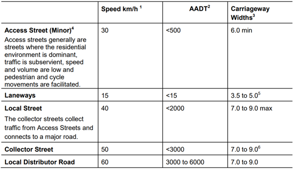
Reference to SDCP 2014 Chapter G11: Subdivision of Land suggests that west of
this location a 6.0m carriageway would be required, while east of this location
a 7.0m carriageway would be required. Refer to Table 1 below.
The amended
application does not propose road widening works along Emerald Drive.
The
applicant’s plans for retention of Emerald Drive’s current
construction standard has been considered by Council’s Traffic and
Transport Unit to be satisfactory under the current circumstances and road
widening is neither feasible nor supported. It is noted that residents also
expressed concern about the potential widening.
It is
important to note that approval of the current application without the need for
road widening would constitute a variation to SDCP 2014 Chapter G11 Subdivision
of Land – Acceptable Solution A19.1 (refer to Table 1 below).
Figure 7
- Future Emerald Drive sectional daily traffic flows. Extracted from the
Traffic Report prepared by Ason Group (D19/82306).
Table 1 - classification
of streets (extracted from SDCP 2014 Chapter G11:
Subdivision of
Land).
Emerald Drive and Meroo Road Intersection
The
intersection of Meroo Road with Emerald Drive provides a T intersection under
priority (unsigned Give Way) control. The intersection provides a short
auxiliary left turn lane to Emerald Drive, and a widened southbound carriageway
(paved kerbside lane) over a short distance to notionally allow for a
southbound vehicle to pass a vehicle turning right to turn into Emerald Drive
(refer to Figure 8).
The Emerald
Drive approach provides a paved carriageway of approximately 5.5m for
approximately 12m, after which the carriageway returns to 5m. Meroo Road has a
posted speed limit of 60km/h.
Figure 8
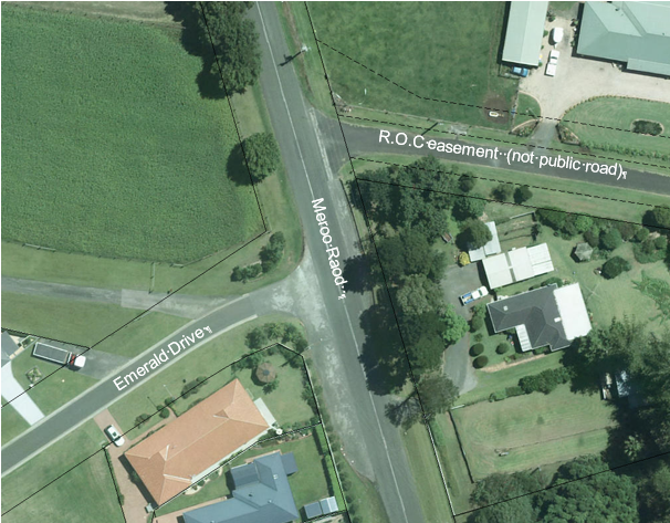
– Aerial image of Emerald Drive and Meroo Road intersection.
In relation
to the operation of the Emerald Drive and Meroo Road intersection under the
current conditions, the Traffic Report indicates on page [11] that:
“[T]he intersection operates
at a high Level of Service in both peak periods, with average delays of less
than 6 seconds to vehicles departing Emerald Drive and an overall average delay
of less than 1 second. The intersection provides significant spare capacity.
Ason Group has also provided sensitivity testing of alternative distribution
(north/south) scenarios and determined similar results.
It is important to note that, at
present, the narrow width of the Emerald Drive approach has the potential to
reduce capacity at the intersection and reduce the efficiency of inbound
movements given the narrow carriageway width remaining when vehicles are queued
to depart Emerald Drive. While a more detailed review of the SIDRA results
indicates an 85th percentile queue in Emerald Drive of less than 1m –
indicating that 85% of the time no more than a single vehicle would be queued
to depart – it is likely that on occasions 2-3 vehicles might be queued,
which would reduce the length of the arrival lane as it tapers back to the
broader design profile. The Proposal is unlikely to fundamentally change these
operations or increase average queue lengths on the approach to Meroo Road.
In the event that the subdivision is approved and developed
with a single dwelling house on each lot, the Traffic Report indicates on page
[16] that:
“SIDRA testing of the future traffic flows at the
intersection Meroo Road with Emerald Drive indicates that the intersection will
continue to operate at a high Level of Service in both peak periods, with
average delays retained at less than 6 seconds to vehicles departing Emerald
Drive and an overall average delay of less than 1.3 seconds and 1.2 seconds in
the AM and PM peaks respectively. The intersection would also continue to
provide significant spare capacity.
The impact of the proposed
development on the critical intersection of Emerald Drive with Meroo Road has
been assessed as a net increase over and above the baseline future conditions
and the results of this analysis are summarised in… [Table 2
below].”
Table 2
- Future and Development Intersection Performance
(Figures extracted from Page 16 of the Traffic Report).
The Traffic Report concludes that
the intersection operates satisfactorily having regard to future traffic
volumes. Council’s Traffic and Transport Unit has considered the Traffic
Report and is satisfied that the operation of the Emerald Drive and Meroo Road
intersection is operating satisfactorily and efficiently and is not required to
be upgraded to facilitate the proposed development.
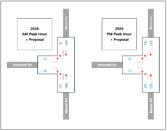
A summary of estimated 2026 peak period traffic flows at the
intersection is provided in Figures 9 and 10 below:
Figure 9 - Estimated 2026
Peak Period Traffic Flows
(No Proposal) (extracted from Page 13 of the Traffic
Report).
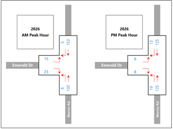
Figure 10 - Estimated 2026
Peak Period Traffic Flows
(with Proposal) (extracted from Page 14 of the Traffic
Report).
Proposed Emerald Drive Road Upgrade Works
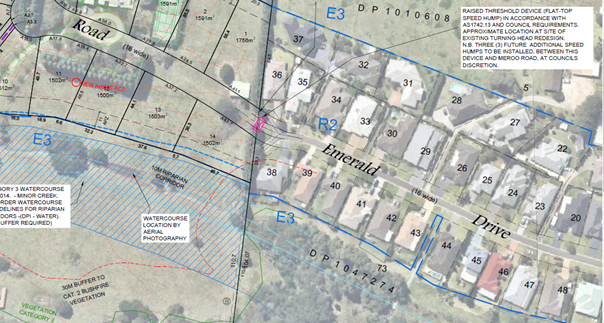
In lieu of Emerald Drive road widening, the applicant proposes
to construct four (4) raised threshold devices (flat-top speed humps) at
appropriate locations along Emerald Drive. The approximate location of the
first device is provided in Figure 11 below. The location of the three
(3) remaining devices will be identified in consultation with Council prior to
the issue of a Construction Certificate.
Figure 11
- Extract from plan titled Plan Showing Proposed Subdivision and Site Analysis
prepared by Allen Price and Scarratts indicating the approximate location of
the first raised threshold device.
A turning head catering for service vehicles is currently
located at the western end of Emerald Drive, immediately adjacent to the site.
The applicant proposes to extend Emerald Drive to enable road access to all
lots in the development. A typical cross-section of the proposed extension of
Emerald Drive is provided in Figure 12 below.
A typical cul-de-sac treatment at the western extent of the
Emerald Drive extension is proposed. The design of these cul-de-sac treatments
would provide a 19m turn radius and 24m verge to accommodate Council waste
vehicles and emergency vehicles.
Figure 12
- Typical cross-section of the proposed extension of Emerald Drive.
Provision of alternate access
to the site for all lots
As previously stated, all 15 lots are proposed to gain access
via an extension of Emerald Drive with Lot 15 also retaining access to the
Princess Highway, the access will afford the NSW RFS secondary access to the
development area.
The
applicant, Council and RMS (roads authority in relation to the Princes Highway)
have explored the potential for alternative access arrangements for access to
the subdivision during the period following the initial pre-lodgement meeting
on 11 December 2014 and subsequent to lodgement of the application on 19
October 2016.
The
alternate access options are provided below.
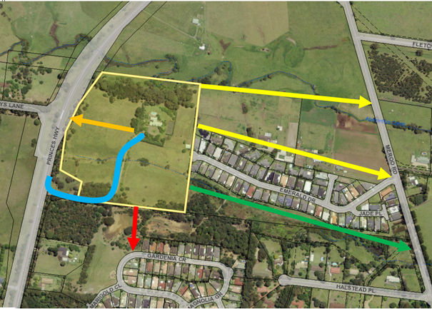
Option 1: Construction of a new connection road to the
north to be located along southern boundaries of adjacent rural properties to
the east of the development linking to Meroo Road in the east (Option 1
indicated in yellow in Figure 13
below). The main concerns or impediments to this proposal may be broadly
summarised as follows:
· private
ownership of land containing dwellings and rural outbuildings and
infrastructure;
· the
impact on the amenity of residents on the northern side of Emerald Drive would
be significant with most lots having public roads to their front and rear
boundary;
· the
land is largely flood prone making the construction of flood free access
difficult and costly;
· rural
holdings would be further fractured and the viability of the rural holdings
potentially compromised.
Option 2: Construction of
a new connection road along the southern boundary of existing lots on the
southern side Emerald Drive through the public reserve to link to Meroo Road
(Option 2 indicated in green in Figure
13 below). The main concerns or impediments to this proposal may be broadly
summarised as follows:
· the
road would be on land dedicated as a public reserve;
· the
land is wholly flood-prone;
· the
road would impact on private land owned in Halstead Place including pond
filling and an engineered watercourse crossing;
· the
impact on the amenity of residents on the southern side of Emerald Drive would
be significant with these lots having public roads to their front and rear
boundary
Option 3: Construction of
direct access to Princes Highway with no access to Emerald Drive (Option 3
indicated in orange in Figure 13 below). The main concerns or
impediments to this proposal may be broadly summarised as follows:
· safety
issues with sight lines for southbound highway traffic;
· fracture
of RU1 land on residue lot which would further limit the potential use of the
residue land for an agricultural use;
· this
arrangement has been rejected by the RMS as part of the original application
for 37 lots and again as part of the amended application for 15 lots. The RMS
has accepted access for proposed lot 15 on the basis that there is existing
access and access to the highway is required and desirable to enable emergency
services access (in particular the RFS).
· Without
the support of the RMS to access the Princes Highway this option cannot be
pursued any further.
Option 4: Construction of
direct access to Princes Highway utilising the existing access driveway which
would include a revised proposed layout with no access to Emerald Drive (Option
4 indicated in blue in Figure 13
below). The main concerns or impediments to this proposal may be broadly
summarised as follows:
· RMS
has agreed to only a single lot use of the existing access driveway by way of
existing rights of access to the subject site (emergency access exempted);
· RMS
has consistently indicated that they wish to limit direct access onto the
Princes Highway and to limit traffic volumes;
· RMS
has agreed to use of Highway as secondary access for emergency services over
easement via a locked gate on proposed Lot 15;
· An
access road in this location would result in further fracturing of the E3 zoned
land on residue lot;
Option 5: Construction of
a road through Council’s public reserve to the south of the development
site, linking the new development to Jasmine Drive via Gardenia Crescent,
Magnolia Grove and Sheraton Circuit (Option 5 indicated in red in Figure
13 below). The main concerns or impediments to this proposal may be broadly
summarised as follows:
· The
public access road would be located on land dedicated as a public reserve;
· The
land is largely flood-prone;
· Road
pavement widths along Gardenia Crescent and Magnolia Grove present similar
traffic and road network issues as is present within Emerald Drive;
· Additional
ecological impacts are likely and may require entry in the Biodiversity Offset
Scheme to offset flora and fauna impacts.
It is important to note that the
Council as the assessing authority can only assess the application as proposed
by the applicant and cannot direct the design. Council can encourage
consideration of alternate designs but cannot redesign the application for the
applicant.
Figure 13
- Potential alternate access arrangements for providing access to the
subdivision which does not include the use of Emerald Drive. Each coloured line
indicates the five (5) potential options that have been explored as part of the
application.
Significant public submissions in relation to the
application
The DA was notified in accordance with Council’s
Community Consultation Policy for Development Applications on four (4) separate
occasions following the submission of additional information.
Table 3 – Summary of notification /submissions
|
|
Date
|
Details
|
Submissions
|
|
1
|
12 December 2016
|
Notified for a period
of 47 days (extended notification for the Christmas and New Year period).
|
26 Objections
|
|
2
|
17 January 2018
|
Re-notified for a
period of 30 days
|
25 Objections
|
|
3
|
8 November 2018
|
15 days
|
20 Objections
|
|
4
|
19 March 2019
|
15 days
|
15 Objections
|
|
|
|
TOTAL
|
86
|
In accordance with section
4.15(d) of the EP&A Act and clause 3.4.10 of Council’s Community
Consultation Policy for Development Applications (Including Subdivision) and
the Formulation of Development Guidelines and Policies, Council is required
take into consideration any
submissions made in accordance with the EP&A Act or the Environmental
Planning and Assessment Regulation 2000.
Some submissions received by Council raised a single issue
relating to a specific part of the development. Other submissions raised
several issues and relate to several perceived deficiencies with the development.
Such submissions have been broken into the relevant heads of objection and
addressed in the section 4.15 Assessment Report that accompanies this Council
Report (Attachment 1).
The key issues identified in objection to the
development through the notification process may be generally summarised as
follows:
Traffic and road infrastructure
· The
current road network is insufficient to support further development of the
subject site. The revised Traffic Report acknowledges Emerald Drive's existing
width does not comply with Chapter G11: Subdivision of Land under SDCP 2014,
which requires a minimum 6.0m pavement to accommodate an AADT figure of up to
500 vpd.
· The
current design of Emerald Drive would not provide compliance with AUS-SPEC or
Landcom residential road design guidelines.
· The
increased traffic flows through the construction phase of the development will
severely impact on traffic flows and the safety of residents
· The
Emerald Drive and Meroo Meadow intersection is unsafe and the increased traffic
flows from the development will exacerbate the situation.
· Proposed
traffic calming devices are unsatisfactory and will not result in a
satisfactory outcome for Emerald Drive in terms of safety and operation.
· The
increased heavy vehicle movements will result in continued damage to Emerald
Drive and the surrounding road network.
· The
Traffic Report does not consider the increase in traffic due to commercial
vehicles or make reference to this traffic at peak times. No consideration of
the impacts of construction traffic has been made within the report.
· Council
should engage an independent traffic consultant to review the Traffic Report to
provide a transparent assessment.
Comment:
The traffic impacts and existing and
essential road infrastructure upgrades have been considered by the applicant as
part of the numerous traffic reports that have been submitted to Council and
assessed by Council’s Traffic and Transport Unit.
The applicant’s final Traffic
Report has considered the existing and future traffic impacts associated with
the site based upon one dwelling house per lot. It is noted that the current
planning regime would permit development and subdivision of the lots based on
500m² minimum lot sizes, which would likely result in additional traffic
impacts on Emerald Drive and the functioning of the Emerald Drive and Meroo Meadow
subdivision.
It has been suggested that it may be
appropriate to seek to impose appropriate restrictions on the title of the lots
in accordance with s88B of the Conveyancing Act 1919 to restrict
development on the lots and prevent traffic impacts. However, title
restrictions cannot be used to prevent a planning purpose / outcome that would
be otherwise permissible by an environmental planning instrument. There is
scope to impose a requirement for a building envelope to be placed on the
subdivision plan for each lot which would be consistent with the nominal
building envelope stipulated under Chapter G11: Subdivision of Land of SDCP
2014.
Council may also choose to explore
the appropriate amendments to SLEP 2014 through a planning proposal and
‘Gateway Determination’ to rezone and amend appropriate development
standards which would curtail more intense land uses. This approach has been
recommended and is explored later in this Report.
The additional traffic impacts
associated with subdivision, construction and eventual dwelling construction on
the lots have not been considered by the submitted Traffic Report. Traffic
impacts associated with construction works are difficult to effectively
estimate and survey and it is unclear whether the applicant may seek to obtain
a staged CC for works at the site. Conventional traffic reports will
generally not consider these details.
However, the applicant will be
required to prepare and lodge a construction traffic management plan as a
condition of the development consent (if approval is granted). Council
can require such a plan to be prepared by a suitably qualified person and list
the matters for inclusion.
The construction traffic management
plan must assess traffic impacts on the local road network created by the
construction of the development. An appropriate condition is also recommended
to ensure all subdivision construction traffic be directed via the existing
driveway access from the Princess Highway and that no section 138 approval to
access to Emerald Drive shall be issued by Council to open Emerald Drive until
all required civil, demolition and drainage works have been completed to the
extent to the eastern boundary with Emerald Drive.
Additionally, a dilapidation report
would also be required to deal with any damage to public infrastructure as a
result of construction traffic.
It is considered that the
requirement for four (4) raised threshold devices along Emerald Drive to aid in
traffic calming along with the reduction in the lot yield from 37 lots to 15
lots has significantly reduced the potential traffic impacts associated with
the development and has removed the need for widening. It is also noted that
the road widening of Emerald Drive was opposed by residents during the
notification of the ‘road widening’ plans by Council on 8 November
2018.
The operation of the Meroo Road and
Emerald Drive intersection has been assessed and considered by the applicant
via a Traffic Report which has also been reviewed by Council’s Traffic
and Transport unit as part of the assessment of the application. The safety,
functionality and efficiency of the intersection have been reviewed and
determined to be satisfactory under the existing and future conditions. It has
been determined that there is presently no requirement for upgrade works at the
intersection.
Council has suitably qualified
professionals working in the Traffic and Transport Unit who have reviewed all
plans and information submitted by the applicant. The assessment has been
detailed and independent of external influences. It was not considered
warranted to refer the matter for external review by an independent traffic
consultant. There is nothing unusual about this. This is standard practice for
most NSW Councils where there is in-house expertise to assess technical aspects
of a development.
Safety concerns associated with
road users and pedestrians along Emerald Drive
· The
width of Emerald Drive, coupled with the absence of a pedestrian or shared
pathway connecting Maddor Park Estate and the new development to Meroo Meadow
Road and the parking of residents cars on the verge requires that pedestrians
and cyclists share Emerald Drive with vehicles. The proposed development is
likely to result in an increase in the potential for conflict between
pedestrians and cyclists with vehicles using the road.
Comment:
The safety, functionality and
efficiency of Emerald Drive have been determined to be satisfactory under the
existing and future conditions, should the subdivision be approved.
It is considered that the
requirement for four (4) raised threshold devices along Emerald Drive to aid in
traffic calming along with the reduction in the lot yield from 37 lots to 15
lots has significantly reduced the potential traffic impacts associated with
the development.
The management of traffic impacts
associated with the subdivision construction works will be further managed
through a construction traffic management plan in the event of an approval.
Further development impacts on
Emerald Drive
· The
current planning controls relating to the site and resulting lots do not prevent
further development or subdivision of the lots which have not been modelled in
the Traffic Report and are likely to result in unacceptable traffic impact.
Comment:
The current planning regime would
not prevent further development (i.e. multi-dwelling housing, dual occupancy,
child care centres or residential flat buildings) and further subdivision of
the lots which would have a significant and detrimental impact on the safety
and functioning of Emerald Drive and the Meroo Road intersection with Emerald
Drive.
Accordingly, it is recommended that
a Planning Proposal (PP) and/or site-specific development control plan for the
site to ensure that future development of the lots does not result in
unsatisfactory traffic impacts on Emerald Drive and the Meroo Road
intersection.
The potential options open to
Council to limit further development are discussed later in this report.
Alternate access to the
site should be explored with no access from Emerald Drive
· The
proposed extension of Emerald Drive to the west to accommodate the development
is not an acceptable option that will result in unsatisfactory traffic impacts
on a road which is already under prescribed in terms of the effective road
pavement width when considered against the provision of SDCP 2014 Chapter G11:
Subdivision of Land. The applicant should explore alternative access
arrangements to the north, south or via the Princes Highway.
Comment:
As has been identified earlier in
this Report, the potential for alternate access to the site has been explored
by the applicant, Council and the RMS throughout the assessment process. The
potential for access to the Princes Highway for all lots has been considered
and rejected by the RMS under the original proposal for 37 lots and again under
the amended application for 15 lots. The RMS has agreed to enable access for
Lot 15 and emergency vehicles to Emerald Drive via the right of carriageway
accessed via the turning head to be constructed on Lot 505 DP 1221372.
It is important to note that Council
previously approved the construction of Emerald Drive with the existing road
pavement width under SF8781 and rezoning of the subject site was prepared and
gazetted largely on the basis that access to the subject site would in all
likelihood be via Emerald Drive.
It is considered that there is no
realistic alternative to access the subject site beyond that proposed by the
applicant for the extension of Emerald Drive.
Negative impacts on the amenity
of Emerald Drive residents
· The
additional dwellings on the resulting lots and extension Emerald Drive will
have a negative impact on the amenity of existing residents and the Emerald
Drive streetscape.
Comment:
The additional lots will likely
result in an additional dwelling house on each lot with subsequent traffic
movements to and from the dwellings consistent with typical residential usage.
It is not considered that the impacts associated with an additional 15 lots
will have a significant and discernible impact on the amenity of the residents
of Maddor Park Estate or the broader locality.
The proposed lots range from 1,500m2
to 7.16ha. The larger lot sizes are considered to be more reflective of the
surrounding rural/residential setting.
Street planting will contribute to
the streetscape. It is envisaged that similar housing to existing will be
constructed continuing the low density streetscape and character.
Noise impacts
· The
noise associated with the additional traffic movements and driver behaviour
associated with the traffic calming devices (heavy braking and accelerating)
will have a negative impact on all residents and particularly for those
residents directly adjoining traffic calming devices.
Comment:
It is likely that the installation
of four (4) raised thresholds (traffic calming devices) along Emerald Drive
will result in driver behaviour that may result in associated noise
impacts i.e. braking before the devices and accelerating after going over the
device. Emerald Drive has a speed limit of 50km/h. The Traffic Report and
associated surveys demonstrate that average speeds are below 40km/h and the
addition of 15 lots to the subdivision is unlikely to increase vehicle speeds.
The raised thresholds should be designed to reduce associated noise impacts
where possible.
Property Values
· The
proposed subdivision and extension of Emerald Drive will have such a
detrimental effect on the character of the neighbourhood, that property values
will be negatively affected.
Comment:
Whilst this is a typical and
worrying concern when people are faced with new development, it is not a
planning consideration that Council can consider in the assessment of the
application. The planning assessment of an application is prescribed by section
4.15 of the EP&A Act 1979.
Stormwater Impacts
· The
extension of the Emerald Drive road and dwellings on the 15 lot proposal will
create a significant additional stormwater impact. The revised subdivision
proposal does not seem to provide updated details of stormwater management or
an assessment of peak stormwater events to the North into Abernethy's Creek or
South into the watercourse flowing east behind the existing houses along the
southern side of Emerald drive into the pond near Meroo Road.
Comment:
Lots will include inter-allotment
drainage and street drainage installed to manage stormwater runoff.
All future dwellings are to include
5kL on-site detention (OSD) rainwater tanks (beyond any requirements for
BASIX), to limit peak runoff flow rates to pre-developed levels and to improve
downstream water quality and on-site retention for rainwater re-use.
A drainage easement through proposed
Lot 14 will cater for major overland flows in the 100-year storm event and an
appropriate restriction is to be placed on the lot in accordance with s88B of
the Conveyancing Act 1919.
A soil and water management plan
will be prepared prior to work commencing on the site to manage site
disturbance and control sediment runoff from the construction site.
The development has been considered
by Council’s subdivision and drainage engineers to be satisfactory and is
consistent with the applicable objectives relating to sustainable stormwater
management and sediment control.
The redesign of the application does not prevent further
subdivision or intensification of land uses that would have an unreasonable
impact on Emerald Drive.
Comment:
The subject site has split zoning under SLEP 2014, consisting
of land zoned part: R1 General Residential, E3 Environmental Management and RU1
Primary Production. Refer to the extract from the Land Use Zoning Map of SLEP
2014 in Figure 14 below.
Development permitted with consent and prohibited in the R1
General Residential zone is identified under Item 3 and 4 of Land Use Table to
the zone as follows:
3 Permitted with consent
Attached dwellings; Boarding houses; Boat
launching ramps; Boat sheds; Building identification signs; Business
identification signs; Centre-based child care facilities; Community
facilities; Dual occupancies; Dwelling houses; Emergency services
facilities; Environmental protection works; Exhibition homes, Exhibition
villages; Group homes; Home-based child care; Home businesses; Home industries;
Hostels; Jetties; Multi dwelling housing; Neighbourhood shops; Office
premises; Oyster aquaculture; Places of public worship; Pond-based
aquaculture; Recreation areas; Registered clubs; Residential flat buildings;
Respite day care centres; Roads; Semi-detached dwellings; Seniors housing;
Sewerage systems; Shop top housing; Tank-based aquaculture; Tourist
and visitor accommodation; Veterinary hospitals; Water supply systems
4 Prohibited
Farm stay accommodation; Any other development not
specified in item 2 or 3
Under the current provisions of SLEP 2014 and in the event
that the current proposal is determined by way of approval a development
application could be lodged for a land uses (bolded) which would all
result in a significant increase in traffic volumes on Emerald Drive. The
intensification of land uses and the associated impacts are of considerable
concern to residents.
The increase in traffic would likely exceed that presently
modelled under the Traffic Report which has adopted an average of 6.4 vehicles
movements per day (vpd) per dwelling. The highlighted land uses would be
expected to generate a significantly higher vpd for each of the lots and AADT.
Figure 14
- Extract from SLEP 2014 Land Use Zoning Map. The subject site highlighted in
blue.
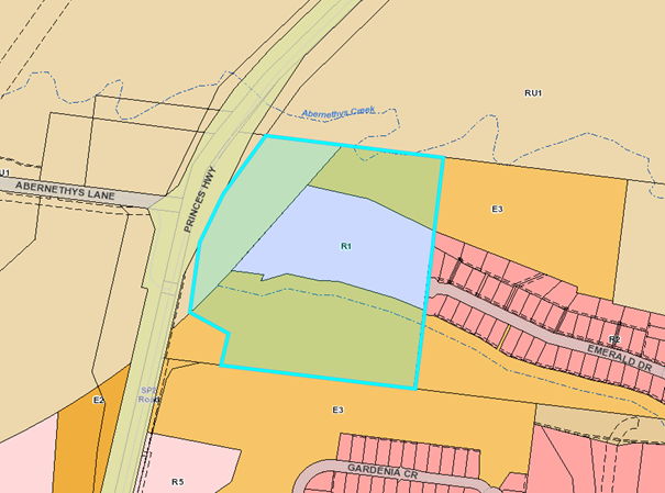
The Lot Size Map
relating to the subject site indicates that there are two minimum lot sizes
relating to the subject site – “AB4” 40ha and “I”
500m². The 500m²
minimum lot size mapping is consistent with the land zoned R1 General
Residential under SLEP 2014. Refer to Figure 15 extract from SLEP 2014 Lot
Size Map.
Under the current provisions of SLEP 2014 and in the event
that the current proposal is determined by way of approval a development
application could be lodged for a re-subdivision of any of the lots in
accordance with clause 4.1 of SLEP 2014. Based on the current subdivision
design an application could be lodged to re-subdivide each lot to generate an
additional 15 lots (30 lots in total) or a subdivision pattern similar to that
previously proposed by the applicant as part of the original application lodged
in October 2016.
Furthermore, there
are additional provisions under Part 4 Principal Development standards of SLEP
2014 which allow for subdivision of the land which would result in a lot less
than the minimum lot size indicted on the Lot Size Map; they include the
following provisions:
· Clause 4.1C Exceptions to minimum subdivision lot sizes for
certain residential development; and
· Clause 4.1F Minimum subdivision lot size for community scheme
and strata plan lots.
Any subsequent re-subdivision of the resulting 15 lot
subdivision would result in an increase in traffic volumes on Emerald Drive
which would exceed that presently modelled under the Traffic Report which
indicates that AADT would exceed 500vpd at a point west of Ruby Lane, generally
adjacent to 24 Emerald Drive (refer to Figure 7 in this Report).
Figure 15 - Extract from SLEP
2014 Lot Size Map. The subject site highlighted in blue.
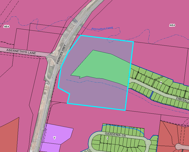
There are a number of approaches that Council could explore to
ensure that further subdivision and subsequent dwelling houses and more intense
land uses are not capable of being situated on the resulting lots, this may
include matters along the following lines however the imposition of any
restrictions via an 88B Instrument would have to be worded in a manner that
they do not prevent the achievement of a planning purpose /outcome permitted in
an Instrument.
· Placement
of appropriate covenant on the lots as a restriction on the use of land by deed
of agreement between the parties pursuant to s88 Conveyancing Act 1919. Such
restrictive covenants could include:
o No
part of a dwelling or other habitable building may be constructed or allowed to
remain on any lot hereby burdened unless it is contained wholly within the
approved building envelope delineated on the plan in relation to the burdened
lot; and
o No
driveway access shall be permitted to be constructed or retained on any lots
unless such driveway access is the only driveway access on the lot.
However, such restrictions would serve to highlight to
future owners that the intention is for the land to accommodate conventional
low density residential development. In the event that an approval is granted
for the development and the PP is pursued, it would be likely that an application
would be made to remove any such requirement noting that the building envelope
is relatively modest having regard to the land size.
Given the recommendation is for a Deferred Commencement,
restrictions are not deemed necessary.
· Preparation
and lodgement of a planning proposal (PP) in relation to:
o Zoning
(relating to R1 General Residential land only). A zoning of R5 Large Lot
Residential is considered more appropriate for the land as it is consistent
with the development application’s large lot nature and would enable land
owners to pursue land uses consistent with the nature of the land;
o Minimum
lot size (relating to land identified as “I” under the Lot Size Map
which relates to the 500m² minimum lot size). A minimum lot size of 1,500m2
would maintain the large lot residential nature proposed as part of the
development application. This will assist in managing future development of the
land to avoid congestion and adverse impacts on the immediate road network; and
o Building
height. The Height of Buildings Map
does not show a maximum height for the land and therefore the height of a
building on the land shall not exceed 11 metres. A maximum height of 8.5m over
the land (R1 part only) is considered appropriate as it reflects the height
limit of surrounding residential land and the citywide approach to heights in
this context.
· Preparation
of an area specific development control plan to guide future development of the
lots and stipulate performance criteria and acceptable solutions to ensure that
the rural/residential character of the lots is maintained, the resulting
development does not result in a significant increase in traffic generation
beyond that anticipated under the Traffic Report. This is considered not to be
a suitable approach for this site. Furthermore, having regard to the
hierarchy of planning controls and the intention of a development control plan,
it should be noted that they are designed to guide development and provide a
degree of flexibility. In simple terms, it is easier to vary provisions in
these plans as opposed to controls included in a local environmental plan
(LEP).
The applicant has also advised Council the landowner is
prepared to enter into a legal agreement. Such an agreement would prevent or
seek to defer registration of the lots or lodgement of a subdivision
certificate until the PP was resolved. Whilst the intention may be clear, some
concern remains about the veracity of such an agreement.
Another option which has been suggested
is a deferred commencement style consent. However, a deferred matter
should generally not be something that relies on another independent
process or approval. A deferred consent however would ensure resolution of the
PP prior to the subdivision occurring. This greatly reduces the risk of land
being sold /purchased and potentially developed for uses with a higher traffic
generation.
Planning Assessment
The application has been assessed under section 4.15 of the
EP&A Act, with all necessary heads of consideration reviewed.
(Attachment 1)
Community Engagement
The notification of the application was undertaken in
accordance with Council’s Community Consultation Policy including
advertising and notification of local residents within the vicinity of the
development, with letters being sent within a 100m radius of the site and to
Community Consultative Bodies.
A total of 86 submissions were received to the application.
All submissions were in objection to the application.
Should a planning proposal proceed through Gateway to
exhibition it would be exhibited for a period of at least 28 days in accordance
with legislative requirements.
Policy Implications
If an approval is to be issued, the
policy implications, if the recommendation is adopted, will be that the
strategic planning framework will need to be explored to limit further
development in the locality having regard to the unique circumstances of the
estate, being a long narrow road, servicing the number of lots.
Financial Implications
There are potential cost implications for Council in the event
of a refusal of the application. Such costs would be
associated with defending any appeal in the Land and Environment Court of NSW.
Should Council support the preparation of a planning proposal,
this process would be managed through the Strategic Planning budget and may
impact on the work programme.
Legal Implications
Pursuant to section 8.2 of the EP&A Act a decision of the
Council may be subject of a review by the applicant in the event of approval or
refusal. Alternatively, an applicant
for development consent who is dissatisfied with the determination of the
application by the Council may, as mentioned above, appeal to the Court against
the determination pursuant to section 8.7 of the EP&A Act.
Summary and Conclusions
· The
proposal is acceptable having regard to the relevant environmental planning
instruments and the SDCP 2014.
· The
extent of variations to SDCP 2014 are limited to nominated road widths
indicated in Chapter G11: Subdivision of Land. The variations are identified in
the attached section 4.15 Assessment Report;
· The proposed development is unlikely to result in significant
adverse unreasonable environmental impacts on both the natural and built
environments, and social and economic impacts in the locality having regard to
the urban zone and context of the land;
· Subject
to appropriate conditions, the site is considered suitable for the proposed
development noting that it has been zoned for urban development (although the
capacity of the land has been questioned and the proposal modified in
response);
· The
submissions received by Council raise concerns with the development and
associated impacts. The submissions have been considered and addressed as part
of the Council Report and section 4.15 Assessment Report;
· The
development is considered to be in the public interest in that it will provide
additional land for housing development; and
· The
development is compatible with the surrounding development and will not have a
significant adverse impact on the landscape character of the area.
Regarding the above, the proposal is not considered
unacceptable, objectionable or warranting refusal. Accordingly, a positive
recommendation is made.
|

|
Development
& Environment Committee – Tuesday 06 August 2019
Page
0
|
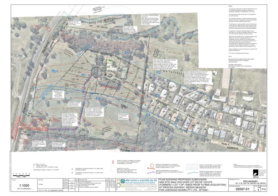
|

|
Development
& Environment Committee – Tuesday 06 August 2019
Page
0
|
DE19.65 Development
Application – 38 Lyrebird Drive Nowra - Lot 74 DP 1198691 DA18/2175
DA. No: DA18/2175
HPERM Ref: D19/228785
Group: Planning
Environment & Development Group
Section: Building
& Compliance Services
Attachments: 1. SDCP
2014 Chapter G9: Generic controls - High Hazard Floodway ⇩
2. SDCP
204 Chapter G9: Legend for the flood development controls matrix ⇩
3. SDCP
2014 Chapter G9: Riverview Road Area controls ⇩
4. Draft
conditions of approval (under separate cover) ⇨
5. Council
Resolution - MIN9.459 ⇩
6. Development & Environment
Report 2/7/19 - DA18/2175 - 38 Lyebird Drive Nowra (under separate cover) ⇨
Description of Development: Attached dual
occupancy
Owner: AM
Showell
Applicant: Hotondo
South Coast
Notification Dates: 30 October to 14
November 2018
No. of Submissions: No submissions received
Purpose / Reason for consideration
by Council
This report provides recommended
conditions of consent for this application which was considered at the Development
and Environment Committee meeting held on 2 July 2019.
At that meeting the Committee
resolved to approve Development Application DA18/2175 for the erection of an
attached dual occupancy at Lot 74 DP 1108691, 38 Lyrebird Drive Nowra, and
requested a further report be provided to Council with suitable conditions for
consent (MIN19.459). Attachment 5.
|
Recommendation
(Item to be determined under delegated authority)
That Council consider the conditions of consent as shown in
Attachment 4.
|
Options
1. Council can
resolve to grant consent to the application in accordance with the conditions
set out in Attachment 4.
Implications: The application can proceed
in accordance with those conditions of consent.
2. Council could
resolve to grant consent subject to alternative conditions of consent.
Implications: Council would need to determine the alternative
conditions and the development could then proceed in accordance with those
alternative conditions.
Location Map
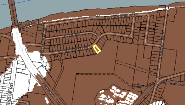
Figure 1 –
Location map with subject site shown outlined in yellow
Background
The report to the 2 July 2019 meeting of the Development and
Environment Committee provided an assessment of the development application for
the proposed attached dual occupancy. That report recommended that the
application be refused due to the flood hazard on the land.
The application was called in by Councillor White at the
meeting of the Development and Environment Committee held on 4 June 2019.
At the Committee’s meeting held on 2 July 2019, it resolved
that (MIN19.459 – Attachment 5):
1. Council
accept Development Application DA18/2175 for the erection of an attached dual
occupancy at Lot 74 DP 1108691, 38 Lyrebird Drive Nowra, a further report be
provided to Council with suitable conditions for consent.
2. The
next Housekeeping Amendment seek to consider inserting provisions in the
Shoalhaven LEP to rule out dual occupancy development in the vicinity of
Riverview Road and Lyrebird Drive, Nowra.
The conditions in the draft notice of determination at Attachment
4 consist mainly of standard conditions that will apply to dual occupancies
generally. There are a number ofspecial conditions which arise from the
consideration in relation to SDCP 2014 Chapter G9 (Development on Flood Prone
Land) and in particular:
· the
flood related development controls applying to land in the High Hazard Floodway
(see copy of matrix at Attachment 1 and legend for matrix at
Attachment 2); and
· the
specific development controls applying to land in the Riverview Road Area (see
copy at Attachment 3).
These conditions are condition numbers 5 (Engineer’s
reports – flood hazard), 26 (Flooding – minimum floor level), 27
(Flood compatible building components), 46 (Engineer’s Certification), 47
(Self evacuation measures) and 49 (Use of sub floor area).
Policy Implications
Policy implications associated with a decision to approve the
application were detailed in the report to the Committee’s meeting held on
2 July 2019.
There are no policy implications associated with the
determination of conditions for this application.
Consultation and Community Engagement:
Community consultation was detailed in the report (Attachment
6) presented to the Committee on 2 July 2019. The application was notified
in accordance with Council’s Community Consultation Policy and no
submissions were received.
Financial Implications:
Financial implications were detailed in the report to the
Committee’s meeting held on 2 July 2019.
Legal Implications
Legal implications were detailed in the report to the
Committee’s meeting held on 2 July 2019.
Summary and Conclusion
If Council determines to grant consent to this application the
conditions in Attachment 4 are recommended.
|
|
Development
& Environment Committee – Tuesday 06 August 2019
Page
0
|
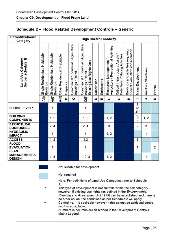
|
|
Development
& Environment Committee – Tuesday 06 August 2019
Page
0
|
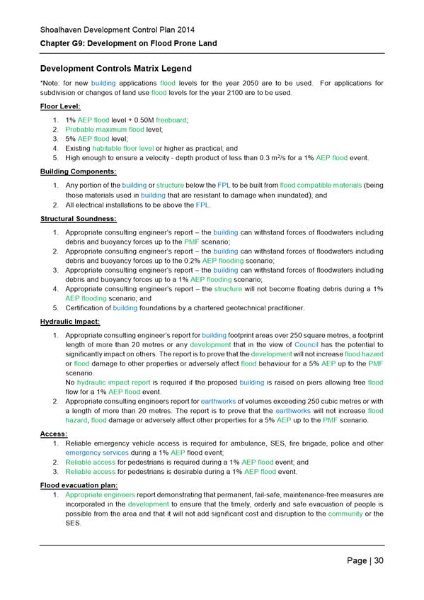
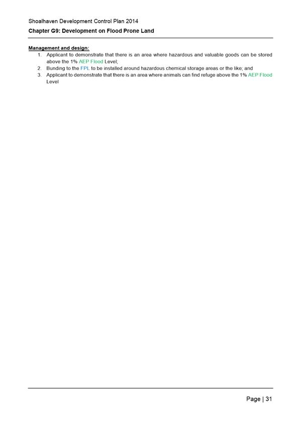
|
|
Development
& Environment Committee – Tuesday 06 August 2019
Page
0
|
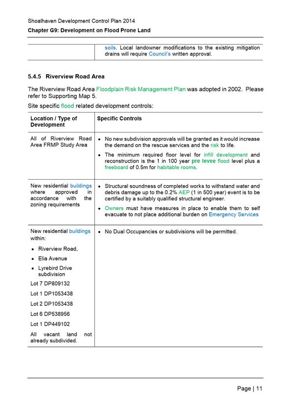
|
|
Development
& Environment Committee – Tuesday 06 August 2019
Page
0
|
|
|
Development &
Environment Committee – 06 August 2019
Page
0
|
DE19.66 Moss
Vale Road North Urban Release Area - Detailed Supporting Plans
HPERM Ref: D19/214378
Group: Planning
Environment & Development Group
Section: Strategic
Planning
Purpose / Summary
Present the Moss Vale Road North
(MVRN) package of information submitted by the MVRN Owners Group (the proponent
group) to Council for consideration and to obtain direction in this
regard.
Council also needs to formally
resolve to prepare an adjusting Planning Proposal (PP) and draft Development
Control Plan (DCP) Chapter and Contributions Plan (CP) Amendment for the URA
consistent with Part 6 of Shoalhaven Local Environmental Plan (LEP) 2014.
|
Recommendation (Item to be determined under delegated authority)
That
Council
1. Acknowledge the work undertaken by
the proponent group and give ‘in-principle’ support to the
current package of information for the Moss Vale Road North Urban Release
Area being used as the basis for the detailed supporting plans, including the
Planning Proposal Background Report being used as the basis for preparing a
Planning Proposal to amend Shoalhaven Local Environmental Plan 2014.
2. Prepare and submit the Planning
Proposal to the NSW Department of Planning, Industry and Environment for
Gateway determination and if necessary, receive a further report following
receipt of the Gateway determination.
3. Formally commence the preparation of
a Development Control Plan Chapter and Contributions Plan for the Moss Vale
Road North Urban Release Area as required by Part 6 of Shoalhaven Local
Environmental Plan 2014.
4. Continue to work with the Moss Vale
Road North Owners Group to discuss opportunities highlighted in the report
and resolve the issues identified in this report and through initial staff
referrals as the Planning Proposal, Development Control Plan Chapter and
Contributions Plan are advanced and prepared.
5. Investigate biodiversity
certification for the Urban Release Area with a further report to be provided
to Council in due course.
6. Investigate the preparation of an
affordable housing contribution scheme under the SEPP 70 Affordable Housing
(Revised Schemes) for the Urban Release Area and opportunities more generally
to ensure affordable housing outcomes in the area.
7. Investigate and report back on
potential suburb naming options for the Moss Vale Road North and Moss Vale
Road South Urban Release Areas.
|
Options
1. Support the
recommendation.
Implications: This is preferred as it will enable
Council staff to continue working with the proponent group to efficiently
progress the planning work required to enable the ‘release’ and
development of this URA.
The associated technical studies, indicative layout plan,
proposed PP justification and draft DCP Chapter are a crucial package in
guiding the future development of this new URA, achieving the desired outcome
in this location and potentially an exemplar residential development.
2. Not support the
recommendation.
Implications: This option is not preferred given
the work that has already been done to date and the commitment that has been
established with the proponent group and landowners in the area.
The draft package of plans will ultimately encourage a mix
of lot sizes, housing types and densities in the URA, facilitate the desired
development outcome and enable Council to levy local contributions to assist in
the provision of community facilities or infrastructure to meet the demand
created by this new development.
Background
The MVRN URA was originally
identified as a ‘New Living Area’ in the Nowra-Bomaderry Structure
Plan which was adopted by Council in 2006 and endorsed by the NSW Government in
2008.
The site was rezoned under
Shoalhaven LEP 2014 to predominantly R1 General Residential with parts rezoned
RE1 Public Recreation, B1 Neighbourhood Centre, E2 Environmental Protection and
E3 Environmental Management. The current URA covers 266.1ha of land and is
subject to provisions of Part 6 of Shoalhaven LEP 2014. This requires a DCP and
infrastructure plans to be in place before development can be considered.
The detailed planning for the
MVRN area was brought forward from originally Phase 5 to Phase 2 following a
Notice of Motion on 28 March 2017. Council subsequently resolved to formally
commence the process required under Part 6 of Shoalhaven LEP 2014 for the MVRN
URA on 22 August 2017 (MIN17.738).
A Project Control Group (PCG)
was established to facilitate the progression of the planning for the URA, and
Council have been working with the proponent group as the relevant technical
studies and draft supporting documentation have been prepared. An initial
landowner meeting for all landowners in the URA was held on 25 September 2017
and progress updates have been provided where possible through the dedicated
‘Get Involved’ Page.
A package of planning
information including detailed technical investigations, a possible draft DCP
and justification for a proposed adjusting PP has now been provided to Council
from the proponent group.
Councillors were given an
initial overview briefing on the submitted planning package by representatives
of the MVRN Owner’s Group on 30 May 2019. Council staff also outlined the
proposed next steps in this regard. The detailed planning work for this URA is
now at a point where formal Council consideration is required and direction on
how to take it forward.
This report provides Council
with the first formal opportunity to consider the package of submitted
information and resolve to commence the preparation of a PP, DCP Chapter, and a
CP Amendment for the area.
MVRN Planning Package
The MVRN Owners Group (note: do
not represent all landowners within the URA) have submitted the following
documents as part of the planning package, except for the Integrated Water
Cycle Assessment (IWCA) which was managed by Council.
· Draft Indicative
Layout Plan (see Figure 1)
· Draft Zoning
Boundary Adjustment (see Figure 2)
· Draft Proposed
Zones Map (see Figure 3)
· Draft
Development Control Plan (see note below)
· Bushfire
constraints advice for Masterplan and DCP
· Infrastructure
Report
· Visual Impact
Assessment
· Flora & Fauna
Assessment
· Fauna Survey
· Stage 1 Contamination
Assessment
· Dam Stability
Assessment
· Landscape Study
· Flood Study &
Riparian Lands Concept Design and Assessment
· Aboriginal
Archaeological Study
· Traffic &
Transport Report
· Planning
Report & Masterplan (see note below)
· Integrated Water
Cycle Assessment
Note: To minimise
printing, the two key overview documents, the Planning Report & Masterplan
and Draft Development Control Pan, are not provided as attachments, but are
available via direct embedded links above or via the general link below.
The complete package of information is extensive and is
currently available on Council’s internet site at:
https://shoalhaven.nsw.gov.au/Planning-amp-Building/Strategic-planning/Planning-Proposals/Pre-Gateway/Moss-Vale-Rd-North-URA
Staff from relevant sections of
Council have reviewed the submitted information and provided initial comments
on the relevant technical studies which will be forwarded to the proponent
group for consideration and further refinement where necessary. Commentary on
any significant issues identified are discussed later in this report.
Based on the proponent’s
submitted draft Indicative Layout Plan (ILP) shown in Figure 1, the site
has the capacity to accommodate some 2,500–3,000 dwellings. The ILP
provides a higher-level overview of the proponent group’s aspirations for
the URA.
|
Figure 1
– Draft Indicative Layout Plan
|
Proposed Planning Proposal
Following the completion of the
above technical studies, the proponent has also prepared and submitted a
‘Planning Proposal Background Report to Support Rezoning’ which
could be used as the basis for a future PP should Council resolve to also
initiate this process.
The main objective of the PP
would be to resolve several inconsistencies in land zoning mapping which have
been identified through the detailed technical investigations, including a
number of locations where zone boundaries do not currently correlate with the
current physical state of the land. A copy of the draft Zoning Boundary
Adjustment and draft Proposed Zones Map is provided in Figure 2 and Figure
3 respectively. The below table related to Figure 2 gives an overview of
potential changes and initial Council staff comment on them.
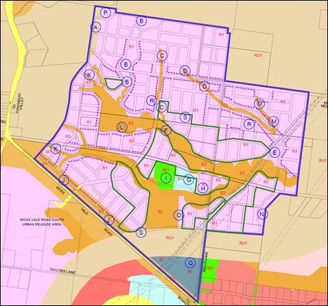
Figure 2 –
Draft Zoning Boundary Adjustment Map
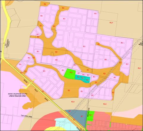
Figure 3
– Draft Proposed Zones Map
|
|
Development
& Environment Committee – Tuesday 06 August 2019
Page
0
|
|
Figure 2 Key
|
Proposed LEP
Amendment
|
Staff Comment
|
|
(A)
|
Rezone approximately
2ha of land from RU1 Primary Production to R1 General Residential.
|
Support in principle
– further discussion below.
|
|
(B) (E) (N) (O) (P)
|
Rezone areas of R1
General Residential to E2 Environmental Conservation.
|
Support. The PP request
will result in an overall increase of E2 land from 39.93 ha to 47.93 ha.
|
|
(C) (D) (K) (M)
|
Rezone areas of E2
Environmental Conservation to R1 General Residential.
|
Support in principle
– further discussion below.
|
|
(F)
|
Adjust E2 and R1 zone
to suit landform.
|
Supported.
|
|
(G)
|
Reduce the size of the
business zoned area from approximately 2.31ha to approximately 2.24ha and
rezone it from B1 Neighbourhood Centre to B2 Local Centre or B4 Mixed Use.
|
Support in principle
– further discussion below.
|
|
(H)
|
Rezone R1 General
Residential to the adjoining Business zone.
|
Support in principle
– further discussion below.
|
|
(I)
|
Adjust the RE1 boundary
to fit with the proposed Indicative Layout Plan.
|
Support. The
adjustment results in a slight increase in RE1 land from 2.58 ha to 2.6 ha.
|
|
(J)
|
Reduce the size of the
E3 Environmental Management buffer along Moss Vale Road from 75m to 30m and
rezone the additional 45m to R1 General Residential.
|
Reservations –
further discussion below.
|
|
(L)
|
Introduce provisions to
enable the subdivision of the existing dwelling with a 2,000m2
minimum area around it.
|
Support – this is
currently being resolved through a separate PP to generally amend LEP Clause
6.5.
|
|
(Q)
|
Remove the Scenic
Protection Area from B7 Business Park land.
|
Support in principle
– further discussion below.
|
|
(R)
|
Introduce provisions to
enable the provision of small lots (300-450m2) in close proximity
to open space and or on main traffic ‘spine’ roads.
|
Support in principle
– further discussion below.
|
|
(S)
|
Introduce provisions to
encourage medium density development in close proximity to open space and
business zoned land.
|
Reservations –
further discussion below.
|
Discussion on Proposed LEP
Amendments
(A). Rezone approximately
2 ha of land from RU1 Primary Production to R1 General Residential.
Extending the URA to line up
with cadastral / property boundaries in this location is logical and supported.
In addition to an R1 zoning, the minimum lot size map should also possibly be
used to reflect the intended future use which is shown as ‘Large Lot
>1,000m2’ development on the submitted Indicative Layout
Plan – this would see a 1,000m2 minimum lot size applied to
the land.
(C) (D) (K) (M). Rezone areas of E2
Environmental Conservation to R1 General Residential.
Internal referral comments
received have requested that the proposed change from E2 to R1 for some of the
ephemeral watercourses be reviewed carefully given the potential for erosion of
the soil types existing on the site.
This will be further discussed with
the proponent and relevant Government Departments as part of the PP process.
(G). Reduce the size of the
business zoned area and rezone it from B1 Neighbourhood Centre to either B2
Local Centre or B4 Mixed Use and (H) Rezone R1 General Residential to
the adjoining Business zone.
The proponent group are seeking
to rezone the current B1 Neighbourhood Centre zone to B2 Local Centre or B4
Mixed Use. Based on the recent Nowra-Bomaderry Retail Centres Hierarchy Review,
B2 is preferred/supported over a B4 zone which is referenced in the draft DCP.
The recent Retail Centres
Hierarchy Review also recommended that the two B1 Neighbourhood Centre areas
currently zoned to service MVRN and MVRS should be subject to a strategic
analysis and “be combined in a single centre that is relevant and
accessible for the two growth areas north and south of Moss Vale Road.”
The Review recommended that the resultant business centre should be a maximum
size of 1.2–1.5 ha providing for a centre of a maximum of 5,000 m2
Gross Lettable Area (GLA).
The Retail Centres Hierarchy
Review was exhibited for comment and will shortly be reported back to Council
to consider how to take it or relevant components forward. It is also noted
that a separate strategic analysis of the existing R3 Medium Density/B1
Neighbourhood Centre/SP2 Educational Establishment zonings adjacent to the MVRS
area probably also needs to be undertaken given what is now known about likely
development in this location.
Dependent on the decisions made
regarding the overall Retail Centres Hierarchy Review and any work on the area
adjacent to MVRS, the need to consider reducing the size of the MVRN business
zone to 1.5ha and including an additional clause in the LEP to ensure the
centre does not exceed 5,000m2 can be considered as part of the PP
process.
The proponent’s Proposed
PP Justification Report also seeks the insertion of an Additional Local
Provision to permit the “temporary residential use of ground floor
shop top housing areas (i.e. use of shop area) until surrounding development
and viability is achieved to support the shop top use. This outcome will avoid
the Business centre having vacant land / shops in its initial development
period.” Again, the actual need for this will be considered as part
of the PP process.
(J). Reduce
the size of the E3 Environmental Management buffer from 75m to 30m and rezone
the additional 45m buffer area to R1 General Residential.
The Scenic Protection Area
buffer was first identified along Moss Vale Road in the Nowra-Bomaderry
Structure Plan 2008. Its width was however reduced through the Citywide LEP
process based on submissions. Given the topography of the land, the original
intent of this buffer in the Structure Plan was to lessen the visual impact of
the future development looking north when travelling along Moss Vale Road. The
original proposed buffer provided the opportunity to site dwellings below the
level of the road, assisted with road noise management and also acknowledged
the size of the existing trees that are located on that side of the road.
The proponent group’s
justification for further reducing the E3 buffer from its current 75m to 30m is
that the current width is excessive for the purposes of providing a dense
landscape screen planting and visual buffer from Moss Vale Road. They propose
that suitable screening can be provided within a 25m/30m width (Note:
conflicting widths in multiple documents) including an added landscaped earth
mound for noise attenuation and a further 5m wide ‘share way’ abutting
the perimeter road.
The proponents draw a comparison
between the 20m buffer further east along Moss Vale Road that separates lots in
Bomaderry along Tartarian Crescent, however an important distinction is that
these lots average 4,000m2 and are significantly larger than what
the draft Indicative Layout Plan proposes for MVRN (Small Lots 300–450 m2).
Based on traffic forecasts for Moss Vale Road to 2041, there is concern that a
2-4m vegetated earth mound will do little to attenuate against existing and
future traffic noise especially if dwellings in this location are built to the
maximum permissible height of 11m (3 storeys).
Some of the staff comment raised
concerns that this requested change may have a significant visual/scenic
impact.
This requested change is not
necessarily supported completely as submitted, but requires more detailed and
careful consideration in discussion with the proponents and others (e.g. NSW
Department of Planning, Industry & Environment) as the PP advances.
Specific things that need to be considered and/or further investigated include:
· Appropriate
noise attenuation
· Whether
small lots of 300–450 m2 should be encouraged in this location
· Whether
building heights needs to be controlled given that it is an elevated ridge
· Should
the Scenic Protection Layer be retained to ensure that adverse visual impacts
from Moss Vale Road can be considered.
(Q). Remove
the Scenic Protection Area from B7 Business Park land.
This Scenic Protection Area was
carried over into Shoalhaven LEP 2014 from the Nowra-Bomaderry Structure Plan
2008, when this area was originally identified as a ‘Possible Future
Living Area’ (long term). As such in the original versions of the then
draft LEP this area was shown as a ‘rural’ zone with the
‘scenic protection area’ hatching. The area was however ultimately
zoned B7 Business Park through the Citywide LEP process based on submissions.
Given the objectives of the B7
Business Park zone to provide a range of office and light industrial uses, the
original scenic protection purpose is highly compromised and should be removed
as it is now inconsistent with the zoning of the land that envisages
development of a more intensive nature.
The land directly east of the B7
zone is currently shown incorrectly in the proponent group’s proposed
zoning plan as being zoned RE1 Public Recreation when it is actually zoned E2
Environmental Conservation. This will be rectified in the PP.
(R). Introduce provisions
to enable the subdivision of small lots (300-450m2) in close
proximity to open space and main traffic ‘spine’ roads.
The introduction of the
potential for small lots will hopefully help facilitate a mix of housing types
and lot sizes to support a wide/diverse range of residents at various
life stages. Small lots are also more likely to be priced more affordably than
larger lots and may contribute to increased future housing affordability in the
area.
Small lots should only be
considered and permissible in higher amenity locations close to main traffic
roads and future public transport routes and with direct street frontage to
open space, not necessarily just “in close proximity to open
space”. This will ensure that future small lots enjoy a superior amenity
to justify any trade-offs as a result of reduced land area. Some areas
identified on the draft Indicative Layout Plan as being “Small Lot
300–450 m2” should possibly be removed moving forward
where they do not front onto open space areas as these may not ultimately be
considered suitable high amenity locations.
The facilitation of Small Lots
(300-450 m2) will be achieved via a similar provision to Clause 4.1H
that was inserted into the LEP to enable the subdivision of small lots in the
MVRS URA below the set minimum lot size in higher amenity locations.
(S). Introduce provisions
to encourage medium density development in close proximity to open space and
business zoned land.
The current R1 zoning already
permits a range of medium density housing types including multi dwelling
housing (3 or more dwellings on one lot) and residential flat buildings within
the URA.
The proponent has clarified they
are actually seeking for areas marked as “Medium Density / Integrated
Apartments <300m2” on their draft Indicative Layout Plan to
be rezoned from R1 General Residential to R3 Medium Density Residential. This
is however not currently reflected in Figure 3 – Draft Proposed Zones
Map. The justification for this is to provide the opportunity to increase the
range of housing and facilitate opportunities for increased affordable housing
supply. This justification is not clear as the outcome (and possibly a better
one) can already be achieved through the existing R1 zone.
The main differences between the R1 and R3 zone are shown in
the table below:
|
|
R1 General Residential
|
R3 Medium Density Residential
|
|
Dwelling houses
|
ü
|
û
|
|
Dual occupancies
|
ü
|
ü
|
|
Semi-detached dwellings
|
ü
|
û
|
|
Multi dwelling housing
|
ü
|
ü
|
|
Residential flat buildings
|
ü
|
ü
|
There is also some concern over
the scale of the proposed rezoning of all the “Medium Density /
Integrated Apartments <300m2” areas shown on the draft
Indicative Layout Plan to R3. It is specifically noted that the R3 zone is not
as flexible as R1 zone and for example prohibits standalone dwelling houses and
semi-detached dwellings.
Thus, to enable future
development to respond flexibly to market demand, it is recommended that any
areas to be rezoned to R3 Medium Density Residential must be within 400m walking
distance of the proposed business centre and also have direct frontage onto
connected open space areas. Areas which do not meet these criteria should be
left as R1 to enable medium density development to be flexibly applied should
there be market demand for this, not mandated.
Other Possible LEP Amendments
The proponent group’s
draft DCP also refers to possible maximum building heights of up to 16m (4
storeys) in the business centre and R3 Medium Density areas. This is in excess
of the current maximum permissible height of 11m under Clause 4.3(2A) of the
LEP and no explanation or justification has been provided in the PP
justification report.
This issue needs further
clarification before being included in any PP for the area. Subject to further
discussion, increasing the maximum height from 11m to 16m is generally not
favoured as it could result in an overdevelopment of the URA that is not
compatible with the location and its high scenic and pastoral landscape
setting.
The draft DCP also states that
height in other residential zones will be a maximum of 10m (2 storeys), however
it is unclear whether this is being sought as a mapped LEP adjustment below the
current maximum height of 11m as it has also been excluded from the PP
Justification Report. Further clarification is required in this regard.
Also, as a minor housekeeping
amendment, the PP should also amend the current URA mapping to exclude Lot 10
DP 1105201, which has approximately 2.67m2 currently mapped within
the URA. This is not a viable area; however, the current mapping would still
trigger Part 6 of the LEP before any development consent can be granted on that
land. To avoid this issue in the future, the Draft Proposed Zones Map should
follow the boundaries of the ILP to avoid small ‘left over’ pieces
of land.
Other Considerations
Biodiversity Certification
Council Environmental Services
staff have flagged the potential opportunity for the URA to be also be
biodiversity certified under the NSW Biodiversity Conservation Act 2016.
This is given that a significant
amount of work has already been done by the applicant’s environmental
consultant (JB Enviro) which could be used in the Biodiversity Certification
(BC) assessment process. BC would avoid the requirement for individual
Biodiversity Development Assessment Reports (BDAR) to be required at the future
development application stage and would result in a streamlined biodiversity
assessment process for future developments. This would then result in greater
certainty for developers and the community on the development and conservation
outcomes for the URA.
BC can be either
‘Standard’ (available to landholders and planning authorities) or
‘Strategic’ (available only to planning authorities to support
significant regional development and planning processes). The Biodiversity
Conservation Trust may also provide loans and financial assistance to planning
authorities undertaking BC.
At this stage, it is recommended
that Council endorse the principle to biodiversity certify the URA and that
this be discussed in further detail with the proponent and landowners with a further
report to be provided to Council. The ability for expenses associated with the
BC process to be recouped through the Contributions Plan system or similar will
also be investigated.
Affordable Housing
One of the reasons that Council
brought forward the phasing of this URA at the request of the proponent group
was the potential to help with affordable housing opportunities in the
Nowra-Bomaderry area given the issues being experienced. This has also been
discussed with and raised by the proponent group.
The adopted Shoalhaven
Affordable Housing Strategy contains various ‘strategies’ that are
particularly relevant regarding the URA that is currently under consideration
given its significant size. The relevant strategies include:
· Short
Term: Strategy 4 - Council will investigate the potential for
development of small lot housing on a privately-owned Greenfield site, and
appropriate mechanisms, funding and legal agreements to implement an
appropriate model or demonstration project including opportunities for shared
equity approaches.
· Short
Term: Strategy 6 - Advocate for the NSW Government to revise SEPP 70
Affordable Housing (Revised Schemes) to include Shoalhaven to effectively
mandate provision of contributions for affordable housing where appropriate/required.
· Medium
Term: Strategy 9 - Council will ensure that there is sufficient
developable land zoned R1 in future greenfield release areas to provide market
opportunities for development of residential flat buildings and multi dwelling
housing.
· Long
Term: Strategy 24 - Council will develop a Masterplan DCP approach to
Greenfield developments in accordance with Part 6 of Shoalhaven Local
Environmental Plan 2014, potentially including the following types of
requirements:
˗ A
proportion of lots to be allocated to multi dwelling housing (for example, 10%
of lots), with mandatory provisions for smaller 2-bedroom stock (i.e.
2-bedroom, 1-bathroom dwellings with a maximum floor area of 70 or 75 m2);
˗ A
proportion of lots be allocated as smaller lots (for example, 10% of lots or 5%
of the masterplan area as 350 m2 lots);
˗ A
proportion of separate houses of a specified size (for example, 2 and 3 bedroom
dwellings with 1 bathroom and a maximum floor area of 110 m2).
· Long
Term: Strategy 25 - Council will develop a performance criteria-based
approach in an early stage of new release areas, with criteria related to
housing type and affordability benchmarks.
It is acknowledged that the
proponent group’s current package of plans does seek to provide a range
of lot size and housing opportunities – this approach is consistent with
the intent of some of the above strategies and will hopefully assist with
affordability. Given the above strategies and Council’s commitment to
taking positive planning steps to assist with the provision of affordable
housing opportunities, the possibilities in this regard should be further
explored in consultation with the proponent group, and if possible/practical,
implemented through the detailed plans that will be prepared for this URA.
In regard to Strategy 6 it is
relevant to note that SEPP 70 Affordable Housing (Revised Schemes) was amended
in early 2019 to enable its provisions to be used in all regional areas,
including Shoalhaven. These provisions enable an affordable housing
contribution scheme to be established in appropriate areas and enable
contributions to be collected by councils for affordable housing. Given that
the planning package effectively involves a new LEP for this URA, the
opportunity now exists to consider and test the possible establishment of an
affordable housing contribution scheme in this location. This involves
following a set process to determine whether such a scheme is viable in this
URA.
Thus, it is recommended that
Council, in supporting taking the overall proposal forward, investigate the
preparation of an affordable housing contribution scheme under the SEPP 70 for
this URA.
Bushfire / Asset Protection
Zones
The URA is partially mapped as
bushfire prone. The Bushfire Assessment Report dated March 2018 references the
outdated NSW Planning for Bushfire Protection (PBP) 2006 document. Revised
asset protection zones (APZs) are needed with PBP 2018 dimensions. The
bushfire assessment area also falls short of Moss Vale Road and does not include
the land proposed to be extended in the north west section (as does the
Biodiversity Report). Future development will also be assessed under PBP
2018.
The report maps the (possibly
outdated) indicative APZs which will be required. It is recommended that APZs
are contained within the residential zoned land and do not include E2 zoned
land via a mechanism such as the DCP. For example, areas identified for
‘Small Lots 300–450 m2 next to 35m APZs may need to be
reconsidered. Where APZs widths cannot be achieved, the level of construction
of the dwelling will have to be increased as a result. This issue will be
discussed in further detail with the proponent as part of the further
development of the supporting plans (e.g. the DCP Chapter). This discussion
will also cover comments raised by staff in the Development Services Section
regarding the need to ensure that APZs, bushfire etc. are properly resolved
with access arrangements.
Contamination
The site has previously been
used for agricultural purposes and there is the potential for isolated
contamination. The Preliminary Site Investigation submitted is satisfactory and
further individual geotechnical assessment at the development application stage
should be undertaken. This can be covered in the DCP Chapter.
Flooding
The initial staff review of the
Flood Study and Riparian Lands Assessment has shown it to be comprehensive in
assessing the flood scenario at the pre-development condition. Initial comments
from Council’s flooding technical staff have provided some addition
information to be considered at the development application stage. This will be
forwarded to the proponent group for future reference and may also be
considered in the development of the DCP Chapter.
Riparian Zones
It is not entirely clear from
the documents provided whether or not the proposed zoning boundaries include
the required riparian buffers which were previously discussed with the
proponent group on site. Guidance on riparian corridor widths is provided
by the NSW Office of Water using the Strahler System of ordering watercourses.
Riparian zone widths will be further discussed and clarified with the proponent
prior to proceeding with the PP preparation.
Some concern was also raised in
the initial Council staff consultation over the width of the riparian corridor
in the northern E2 portion along Abernethy’s Creek. Further clarification
will be sought from the proponent group as well as requesting that the width be
increased in this section to ensure it is a practical corridor for wildlife
movements in the future.
Infrastructure –
Traffic & Transport
An assessment of the
functionality of the proposed internal road network has been difficult at this
stage as the package of plans do not include traffic volume forecasts. Similar
forecasts were used to determine the adequacy of the indicative MVRS layout and
should also be provided for the MVRN area to confirm that the proposed road
types (local or collector roads) and road cross sections (including road widths
and number of lanes) are appropriate.
Inconsistencies with the
Nowra-Bomaderry Structure Plan Preferred Road Network should also be
considered/addressed, as well as considering external strategic road links for
future longer-term development to the north (Meroo Meadow Future Long Term
Living Area). It is noted that external traffic modelling requested by RMS is
still outstanding.
Greater consistency will also be
required in terms of road widths between the MVRS and MVRN DCP Chapters. In
addition to these high-level comments, Council’s Traffic and Transport
staff have raised a number of detailed issues which will be further discussed
and worked through with the proponent group and their traffic consultant.
Infrastructure – Water
and Sewerage
Sewerage infrastructure for MVRS
is expected to be delivered in 2019/2020 (not 2018/2019 as indicated in the
Infrastructure Report) and MVRN is expected to be delivered in 2021/2022 (not
2019/2020 as indicated in the Infrastructure Report).
Water infrastructure for MVRN is
expected to be delivered between 2019/2020 and 2022/2023 (not between 2018/2019
and 2021/2022 as indicated in the Infrastructure Report).
Development contributions
payable will be in accordance with the Development Servicing Plans current at
time of payment.
Shoalhaven Water are currently
advancing their planning to potentially service both MVRS and MVRN.
Natural Resources
At this stage the package of
plans does not clearly distinguish which areas will be landscaped for open
space areas and which areas will be protected/conserved and rehabilitated. It
is expected that the proponent group will work towards full restoration and
function of the riparian system, particularly Abernethy’s Creek which is
severely degraded in its present form. This has been achieved in other areas
within the City such as Dolphin Point and will be further discussed with the
proponent group moving forward.
Open Space
The draft ILP meets the open
space requirements for passive recreation of 12 m2 per person (1.2
ha/1000 people) set out in Council’s adopted Community Infrastructure
Strategic Plan (CISP). However, some areas of ‘Open Space’ shown on
the draft ILP are not shown on the Draft Proposed Zones Map and are instead
shown as R1. This will be clarified with the proponent group.
Council also does not generally
support the development of any new ‘pocket parks’, of which there
are six (6) proposed on the draft ILP. This directly contradicts the adopted
CISP and Council’s current approach of rationalising all pocket parks in
the City with the focus on developing district and regional hubs for active
recreation. It is recommended these be removed from the draft ILP or
alternatively connected to the wider open space network.
Further emphasis on ensuring
open spaces are accessible should also be made in the draft DCP.
Council’s Social
Infrastructure Planning Unit also made a range of more detailed comments which
will be forwarded to the proponent for consideration.
Stormwater
Management and Water Quality
Prior to construction,
background water quality sampling will be required to establish the water
quality of Abernethy’s Creek. This should capture upstream locations
(from the escarpment) through to locations where detention basins are proposed
in order to establish background data that can then be used to determine future
water quality parameters as well as any development impacts on water quality.
Water treatment devices will
need to be of a proven design to protect the receiving E2 zoned areas/riparian
areas and be contained within residential zoned land. This will be
specified in the DCP Chapter.
Draft Development Control
Plan Chapter and Draft Contributions Plan Amendment
Under Part 6 of Shoalhaven LEP
2014, development consent cannot be granted for subdivision etc. in a URA
unless a DCP has been prepared for the site and arrangements made for public
utility infrastructure (generally via a CP and other mechanisms).
To assist in the preparation of
the DCP Chapter, the proponent group have prepared a set of potential draft
controls.
A preliminary review of this
draft DCP document has identified some areas which need to be worked through
with the proponent group to potentially achieve consistency with the PP and
resolve issues with the suggested staging plan, desired future character
chapter and other detailed comments received from Council staff during the
initial internal consultation period.
Preliminary preparatory work has
also commenced on the CP. At time of writing the State Infrastructure Contribution
(SIC) approach has however not yet been resolved or clarified by the NSW
Government.
This report seeks the required
formal resolution to commence the preparation of the required plans. It is
intended that the draft DCP Chapter and CP will be placed on exhibition with
the PP at the appropriate point and a further report will be provided prior to
exhibition, so that the detail of these draft plans can be reviewed and
considered by Council.
Suburb Naming
The MVRN URA is currently split by the boundary of two
suburbs – Meroo Meadow and Cambewarra, as shown in Figure 4.
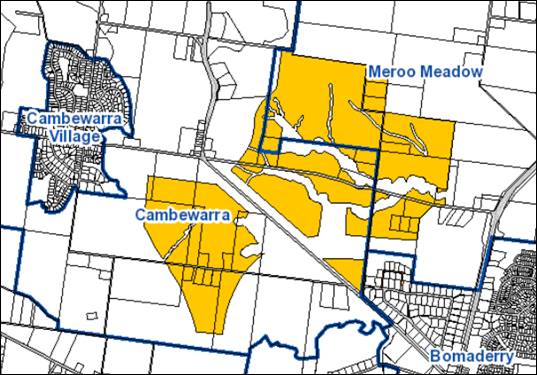
Figure 4
– Current Suburb Boundaries of Cambewarra and Meroo Meadow
As development of the URA
progresses, it is expected this delineation could cause a number of issues and confusion
in terms of street addressing, way finding for emergency and postal services,
and community cohesion within the URA.
Council staff have been
researched potential naming options for both the Moss Vale Road URAs (North and
South) using historic lands title maps and knowledge of the Aboriginal and
European history of the area; however, these investigations have not uncovered
any clearly suitable naming options that would conform with the naming
principles of the Geographical Names Board of NSW (GNB).
In order to avoid confusion as
the URAs develops, it is recommended that Council formally commence the process
to investigate and resolve potential naming options for the URAs.
The naming process is not
managed by Council and all options will ultimately require an application to
the GNB. Council could undertake community consultation prior to submitting the
final naming request to the GNB.
Options which could be considered, including the number of
affected properties, are outlined in the table below:
|
Suburb Naming Option
|
No. of Affected Properties
|
|
1. Adjust
the current Cambewarra / Meroo Meadow suburb boundary to run along Moss Vale
Road instead of through the middle of the MVRN URA (as shown in Figure 5).
|
6
|
|
2. Assign
new suburb names individually to both the MVRN and South URAs.
|
33+
|
|
3. Assign
a single new suburb name for the two URAs combined.
|
33+
|
Option 1, as shown in Figure
5 below, will have the least impact on landowners, would result in less
contention among owners in choosing a new name, and is more likely to be
supported by the GNB.
However, depending on feedback
received from Council, landowners, community groups, etc, Options 2 and 3
should also possibly be considered. These options also have the benefit of
establishing a new identity for these substantial new residential area/s.
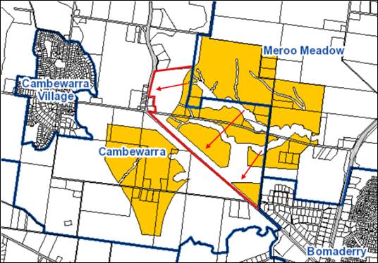
Figure 5
– Option 1 Suburb Name Boundary Adjustment (preferred option)
Conclusion
A significant body of work has
now been prepared for the MVRN URA, including the proposed justification for a
future adjusting PP and draft DCP Chapter. The considerable work undertaken by
the proponent group in this regard is duly acknowledged.
Council’s endorsement of
the work to date and formal resolution to prepare the necessary PP, DCP Chapter
and CP Amendment as outlined in this report will enable the planning of MVRN
URA to enable its ‘release’ to continue to progress. Further
reports will be presented to Council as these plans advance and at key future
points.
Community Engagement
In acknowledgement that not all
landowners within the MVRN URA are part of the proponent group, an initial
landowner meeting was held on 25 September 2017 following Council’s
decision to revise the staging plan for the URA. Further updates have
subsequently been provided to all owners through an online ‘Get
Involved’ page for the Nowra-Bomaderry URAs.
Letters were also sent to all
landowners in the URA advising of receipt of the package of plans from the
proponent group and how to view them. No early comments have been received at
this stage from landowners or the public
Another meeting with all
landowners will be arranged once Council has formally considered the plans that
are subject to this report to discuss the next steps etc.
The proposed PP, DCP Chapter and
CP Amendment will ultimately be publicly exhibited as a package following the
Gateway determination for a minimum period of 28 days.
Policy Implications
This is a ‘high
priority’ project on the 2019-2020 Strategic Planning Works Program that
was adopted by Council in June 2019.
Preparation of a PP, a DCP
Chapter, and a CP Amendment will set the policy direction for future
development and ‘release’ of the URA.
Financial Implications
Work being undertaken by Council
staff to progress the MVRN URA release planning is currently being managed
within the existing Strategic Planning budget.
The majority of the technical
studies for the URA have so far been funded by the proponent group, with the
exception of the Integrated Water Cycle Assessment (IWCA) which was prepared
for Council and will be considered for recoupment via Section 7.11
contributions levied from future development within the URA.
There are likely to be a range of more detailed financial
and longer-term resourcing implications for Council associated with the
ultimate development of this URA and these will be discussed in more detail at
the appropriate points in the release process. This includes possibly funding
mechanisms or management regimes for the extensive open space and riparian
areas and other required infrastructure (e.g. Stormwater controls). In the
discussions with the proponent group their desire to consider different or
innovative approaches in this regard have been highlighted, with the aim of
providing a higher standard of maintenance/presentation, employment
opportunities and the like.
|

|
Development
& Environment Committee – Tuesday 06 August 2019
Page
0
|
DE19.67 Update
- Planning Proposal - Inyadda Drive, Manyana
HPERM Ref: D19/234274
Group: Planning
Environment & Development Group
Section: Strategic
Planning
Attachments: 1. Gateway
determination 22/6/2015 Inyadda Drive, Manyana ⇩
2. Inyadda Drive Proponents'
Revised Footprint June 2019 ⇩
Purpose / Summary
Update Council and the
community on progress of the Planning Proposal (PP) for land formerly owned by
Kylor Pty Ltd that is located off Inyadda Drive, Manyana given ongoing community
interest.
|
Recommendation (Item to be determined under delegated authority)
That
Council receive the report on the Planning Proposal – Inyadda Drive,
Manyana, for information.
|
Options
1. Receive the
report for information.
Implications: Work will continue to address the
requirements of the Gateway determination and refining the PP.
2. Adopt an
alternative approach.
Implications: Advice can be provided should an
alternative approach be considered. However, any alternative approach that
delays potential resolution of this longstanding matter is not recommended.
Background
There has been strong community
interest in the PP for land located to the east of Inyadda Drive at Manyana,
particularly since the land changed ownership in 2018. The subject land is
located on Inyadda Drive, Manyana, and consists of Lot 106 DP 755923 (Por 106),
Lot 2 DP 1161638 and Lot 2 DP 1121854 (see Figure 1 below).
Figure
1 – Subject Land and Current Zoning
A brief history of this PP is
provided below, followed by an update on the status of the investigations that
need to be undertaken before the PP can proceed to be publicly exhibited.
Brief history
The subject land has a long and
complex planning history dating back to the 1980s. Various development outcomes
have been considered over a long period and the local community has maintained
a keen interest in the site and its potential development.
Under Shoalhaven Local
Environmental Plan (LEP) 2014, the land is currently zoned a mix of:
· R5
- Large Lot Residential
· R1
- General Residential
· E3
- Environmental Management
· RE1
- Public Recreation
The current minimum lot size
requirements in the LEP are 2,000 m2 (R5) and 500 m2
(R1).
On 20 February 2013, Council
received a proponent-initiated PP on behalf of the then owner (Kylor) to rezone
the land to enable a denser residential development and provide environmental
protection for the remaining land. The zoning proposed by Kylor in 2013 is
shown in Figure 2 below.
Figure
2 – Kylor’s proposed zoning submitted to Council in February 2013
After considering detailed
reports and community feedback, Council resolved in January 2014 to adopt an
amended version of Kylor’s proposed zoning as the basis for taking a PP
forward – refer to Figure 3 below.
Figure 3: Proposed
zoning adopted by Council as basis for Planning Proposal
The Council resolution made on
20 January 2014 was to:
a) Support
the Planning Proposal for North Manyana with the following changes:
i) The
residential development area be primarily zoned R2 Low Density Residential with
an area of R1 General Residential zoned land surrounding the proposed Manyana
neighbourhood centre.
ii) An
increase in minimum lot size to 600m2 for the R2 Low Density
iii) The
residential zoned land be identified as an ‘Urban Release Area’ and
be subject to Part 6 of the Shoalhaven Local Environmental Plan 2013.
b) Submit
the Planning Proposal to the Department of Planning and Infrastructure
requesting ‘Gateway’ determination.
c) Request
the Department of Planning and Infrastructure to include the following studies
as a requirement of the ‘Gateway’ determination:
i) A
detailed assessment of the Bendalong Waste Water Treatment Plant to
ascertain/confirm hydraulic loading limits.
ii) An
assessment using an accredited methodology (e.g. biobanking) to come up with a
consistent and valid biodiversity offset.
In March 2014, the landowner
(Kylor) submitted a pre-gateway review request to the NSW Government,
essentially seeking to review Council’s decision to remove the proposed
residential zone in the south-eastern corner, only to withdraw their request in
July 2014.
The PP (PP007) was subsequently
prepared by staff and submitted to the NSW Government for Gateway
determination.
Gateway determination was issued by
the NSW Department of Planning and Environment on 22 June 2015, a copy of
which is provided in Attachment 1. The Gateway determination details a
range or assessments that need to be completed before the PP can be publicly
exhibited, including a biodiversity assessment and offset strategy.
The land subsequently changed
ownership in 2018 and the new owners commenced new biodiversity investigations.
They subsequently indicated a desire to re-visit the footprint adopted by
Council (Figure 3). They submitted documentation including a proposed revised
footprint and zoning plan (refer to Figure 4) which represented a substantial
variation to Council’s adopted footprint.
Figure
4 – Excerpt from proponents’ submission, December 2018
To enable Council to consider
community feedback on this proposed footprint variation, feedback was sought
via Council’s ‘Get Involved’ page. More than 400 responses
were received.
A redacted copy of the responses
(i.e. personal details redacted) was provided to the proponents in May 2019.
The proponents considered this feedback and submitted a new footprint in June
2019. A copy of the revised footprint is provided in Attachment 2.
The most controversial element; a
possible new development precinct in the north east of the site, has been
removed. The revised proposal is now very similar to the original investigation
footprint adopted by Council in January 2014 (Figure 3) and is considered to be
within the scope of the Gateway determination. The proponent has advised that
this revised footprint responds to the findings of their biodiversity
assessment (nearing completion) as well as community concerns about the
possible extent of development.
Council Staff are continuing to
liaise with the proponents to ensure the assessments required to satisfy the
Gateway determination are completed to the required standards to enable the PP
to move forward. In this regard, the Aboriginal Cultural Heritage Assessment
will be directly managed by Council in accordance with Council’s Planning
Proposal Guidelines.
Council is yet to receive the
proponents’ biodiversity offset strategy and a number of other
assessments have not commenced. The proposal will be refined (and footprint
possibly reduced) as the investigations are completed and further information
becomes known.
The land will also be identified as
an Urban Release Area (URA) under Part 6 of the Shoalhaven LEP 2014 to ensure
that arrangements are in place to provide appropriate public utility
infrastructure before the land can be subdivided. At this stage, it is intended
that a draft Development Control Plan (DCP) Chapter will be prepared for
exhibition at the same time as the PP, along with a Contributions Plan and/or
Planning Agreement.
In summary, a substantial body of
work now needs to be completed/undertaken before this PP will be ready for
public exhibition. Council staff are liaising with the proponents in this
regard.
Timeframe
The finalisation date stipulated in
the original Gateway determination 22 December 2016, but this has been extended
and is now due to expire on 22 December 2019. A further extension will most
likely be required to enable completion of the necessary assessments.
Community Engagement
The PP and supporting documents
will be formally exhibited once the requirements of the Gateway determination
have been satisfied. Council’s ‘Get Involved’ page has been
utilised to keep the community informed on the progress on this project, and
this will continue.
The proponents and their
consultants have also had a number of meetings with representatives of the Red
Head Villages Association (CCB) and have expressed a desire to work with the
community as the process continues and the proposal is refined.
Financial Implications
This is a proponent-initiated
PP, the cost of which is fully funded by the proponent in accordance with
Council’s planning proposal guidelines and fees and charges.
|
|
Development
& Environment Committee – Tuesday 06 August 2019
Page
0
|
|

|
Development
& Environment Committee – Tuesday 06 August 2019
Page
0
|
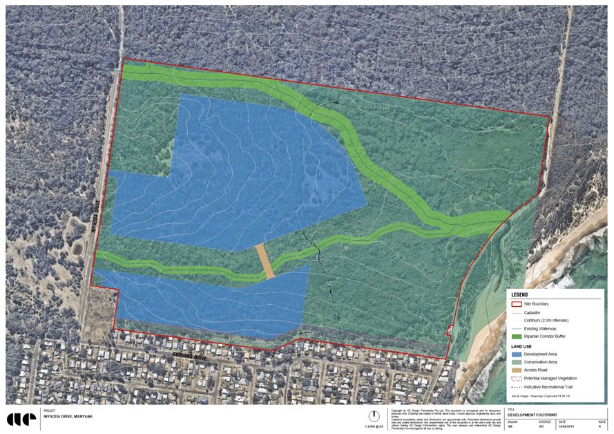
|
|
Development
& Environment Committee – Tuesday 06 August 2019
Page
0
|
DE19.68 Update
- Halloran Trust Lands Planning Proposal - Biodiversity Certification
HPERM Ref: D19/208445
Group: Planning
Environment & Development Group
Section: Strategic
Planning
Attachments: 1. Planning
Proposal PP006 - Halloran Trust Lands - Potential Biodiversity
Certification Application - Development Committee - 11 April 2017 ⇩
2. OEH
letter to proponent - deadline for saved biocertification proposals ⇩
3. Excerpt
of Culburra Beach - Proponents BCA Report (under separate cover) ⇨
4. Excerpt of Callala Bay -
Proponent BCA Report (under separate cover) ⇨
Purpose / Summary
Provide an update on the
progress of the biodiversity certification for the land covered by the Halloran
Trust Lands Planning Proposals (PP).
|
Recommendation
(Item to be determined under delegated authority)
That
Council receive this report on the progress of bio-certifying the Halloran Trust Lands Planning Proposals for information, noting that the biodiversity
certification reports will be submitted to the NSW Office of Environment and
Heritage by 25 August 2019.
|
Options
1. Receive this report for information
Implications: Council resolved to proceed to
bio-certify the Halloran Trust Lands PP in August 2017. This report is provided
for information and no action is required from Council for the matter to
proceed as outlined in this report.
2. Other action
Implications: Further advice can be provided if
another approach is considered or resolved.
Background
Council is currently progressing
two PPs to resolve the zoning of land owned by the Halloran Trust which is
‘deferred’ from the Shoalhaven Local Environmental Plan (LEP) 2014.
This matter has been reported to Council on several occasions since the PP
process commenced in 2014.
The Halloran Trust PP was spilt
into two separate PPs in 2017. Prior to that, all the ‘deferred’
Halloran Trust land was covered by one PP. The larger PP covers land at
Culburra Beach and the smaller one covers land at Callala Bay and Kinghorne
Point.
In April 2017, the Development
Committee considered a report (Attachment 1) recommending that the
Halloran Trust PP be biodiversity certified. This is a process where the
impacts of the proposal on terrestrial ecology are considered and offsets
secured at the PP or zoning stage.
The Committee resolved under
delegation to support in principle the preparation of a Biodiversity
Certification Application for the Planning Proposal for the Halloran Trust
Lands at Culburra Beach, Callala Bay and Kinghorne (MIN17.288).
The proponent’s assessment
for the biodiversity certification was initiated prior to commencement of the
NSW Biodiversity Conservation Act on 25 August 2017. The subject land, however,
is subject of an Order issued by the NSW Office of Environment & Heritage
(OEH) under Clause 37 (2) of the NSW Biodiversity Conservation (Savings and
Transitional) Regulation 2017, extending the transitional period to 25 August
2019 (two years). The ‘reminder’ letter from OEH to the proponent
in this regard, dated 7 September 2018, is provided as Attachment 2.
The required work has
progressed, and Council has now received two biodiversity certification reports,
one for each of the PPs. Due to the length of these reports (approx. 400 pages
total) only excerpts are provided as Attachments 3 and 4 (under
separate cover). The full reports will be available in the Councillor’s
Room prior to the meeting. Due to the timeframe from the NSW Government,
the biodiversity certification application must now be lodged with OEH by 25
August 2019. The implication of not meeting this deadline is that the
biodiversity certification assessment work would need to be redone in accordance
with the NSW Biodiversity Conservation Act, i.e. the Biodiversity
Assessment Methodology (BAM).
It should be noted that the
biodiversity certification process does not address water quality or aquatic
ecology. These matters are being investigated separately as part of progressing
the PPs. The investigation of water quality and aquatic ecology will not be
complete for Culburra Beach when the biodiversity certification application is
lodged. It is possible that the water quality investigations will require the
development footprint for Culburra Beach to be reduced further. If this occurs
the biodiversity certification will need to be amended to reflect the reduced
footprint. Issuing (approval) biodiversity certification will not enable
development that is otherwise unsatisfactory from a water quality or aquatic
ecology perspective. In other words, lodging the biodiversity certification
application now will not create any issues that cannot be easily addressed
should the development footprint need to be reduced in response to the water
quality and other investigations that are ongoing.
Community Engagement
The biodiversity certification
applications will be exhibited for review and comment along with the PPs at the
appropriate time in the process.
Financial Implications
In accordance with
Council’s adopted guidelines and fees and charges, these PPs are being
funded on a 100% cost recovery basis by the proponent.
|
|
Development
& Environment Committee – Tuesday 06 August 2019
Page
0
|

|
|
Development
& Environment Committee – Tuesday 06 August 2019
Page
0
|
|
|
Development
& Environment Committee – Tuesday 06 August 2019
Page
0
|
l
DE19.69 Public
Hearing Outcome and Proposed Finalisation - Planning Proposal (PP023) -
Anson Street, St. Georges Basin
HPERM Ref: D19/219918
Group: Planning
Environment & Development Group
Section: Strategic
Planning
Attachments: 1. Public
Hearing Report - Planning Proposal PP023 (under separate cover) ⇨
2. Public
Exhibition - Submissions Summary - Planning Proposal PP023 (under separate
cover) ⇨
3. Previous
Council Report - May 2019 - PP023 Exhibition Outcomes (under separate cover) ⇨
4. Submission - On behalf of Mr
De Battista - Dated 14 March 2019 ⇩
Purpose / Summary
Detail the outcome of the
Public Hearing held regarding this Planning Proposal (PP) and consider the next
steps to possibly finalise this PP.
|
Recommendation (Item to be determined under delegated authority)
That
Council
1. Receive the Independent
Chairperson’s Report on the Public Hearing held on 1 July 2019
regarding Planning Proposal PP023 for information.
2. Adopt and finalise Planning Proposal
PP023 as exhibited.
3. Forward PP023 to the NSW
Parliamentary Counsel’s Office to draft the amendment to Shoalhaven
Local Environmental Plan 2014.
4. Give effect to the decision by
making the resulting amendment to the Shoalhaven Local Environmental Plan
2014 using Council’s delegation, through arranging for the instrument
to be notified on the NSW Legislation Website.
5. Write to the affected landowner,
relevant community groups/individuals and advise them of this decision.
6. Proceed to separately review the
building height controls for the adjacent B4 and R1 zoned land to the north
and south of the subject land to consider establishing a consistent outcome
(8.5 metre maximum mapped height) and advise the affected landowners in this
regard.
|
Options
1. Adopt
the PP as exhibited, exercise the Council’s delegation to make a Local
Environment Plan consistent with the PP, and arrangements be made for the
drafting of the plan and notification of the plan on the NSW Legislation
Website, and separately review and set a consistent mapped height of buildings
(8.5m) for the adjacent B4 and R1 zones.
Implications: This option is open to Council and
will enable the PP to be finalised by Council as exhibited.
Council should also decide whether, as either a standalone
PP or as part of the regular Housekeeping PPs, to consider establishing a
consistent mapped height of buildings (8.5m) for the other B4 and R1 zoned land
to the north and south of the subject land. This is flagged in the letter from
the NSW Department of Planning, Industry and Environment (DPIE) that
accompanied the Gateway determination and was also raised in the
landowner’s submission to the PP. It is also likely to have broader
community support given the concerns that have arisen with the potential development
of the subject land. This additional step is also recommended to ensure a
consistent outcome.
2. Adopt the PP as
exhibited, but not exercise the Council’s delegation to make a
plan consistent with the PP, write to the NSW Department of Planning, Industry
& Environment advising them of this decision and request that the Minister
makes a Local Environmental Plan consistent with the PP and notifies the
resulting plan on NSW Legislation Website to give effect to the PP, and
separately review and set a consistent mapped height of buildings (8.5m) for
the adjacent B4 and R1 zones.
Implications: This option is also open to Council
and would also enable the PP to be finalised by the Minister. Given the
contentious nature of this PP, the Council could opt not to use its delegations
to make the Plan and write to DPIE and advise them of this decision. This would
essentially mean that Council finally adopts the PP and then requests DPIE to
consider and make the resulting Plan.
Again, the additional step of reviewing the zoning of the
adjacent B4 and R1 zone is also recommended to ensure a consistent outcome.
3. Either
Option 1 or 2, without the separate building heights review of the adjacent B4
and R1 zones.
Implications: This option involves adopting the PP
as exhibited and proceeding to either make the local environmental plan under
delegation or ask the Minster to make the plan, but not resolving to undertake
a separate review of the B4 and R1 zones. This option is not recommended given
the need to also clarify/set the desired height outcome on the adjacent
similarly zoned land given community concerns associated with the subject land
and the need for a consistent outcome in this location as suggested by DPIE in
the Gateway determination.
4. Proceed with an
amended PP.
Implications: Depending on the nature of any
amendments, for example changing the proposed height from 8.5m to another
height, the PP may require an amended Gateway determination and need to be
re-exhibited to enable the community and landowner to comment.
5. Discontinue the
PP process.
Implications: This would see the existing height
limit of 13m remain in place contrary to the Council’s original intent
when it proposed the PP and contrary to community opposition.
Background
The outcomes of the recent public
exhibition (February to March 2019) of this PP were considered by Council in
May 2019, see Attachment 1. As a result, Council resolved on 7 May 2019
to:
1. Proceed
to organise a Public Hearing for Planning Proposal No. PP023 that applies to
part of Lot 1 and Lot 6 DP 1082382, Anson Street, St Georges Basin.
2. Consider
a further report on this matter and its possible finalisation following the
Public Hearing.
The report to the Development
& Environment Committee dated 7 May 2019 (Attachment 1) details the
submissions received during the exhibition of the PP and presents options for
Council to consider regarding the finalisation of the PP.
This report presents that
outcome of the Public Hearing that was held on 1 July 2019 regarding the PP in
accordance with the Council resolution.
The report also presents the
options that are available to Council to consider in finalising this PP.
Public Hearing –
Overview
The Public Hearing was held on 1
July 2019 in the Council Chambers, City Administrative Centre, Nowra commencing
at 5.30pm. It was chaired by an independent Chairperson and attended by 30-40
people. Eight (8) people gave oral submissions at the hearing in support of the
exhibited PP.
The directly affected landowner
who requested the hearing elected not to give an oral submission, but at his
request a copy of his submission to the PP was provided to the Chairperson. A
copy of this submission is provided at Attachment 4. The Chairperson
also provided a verbal summary of the submission at the commencement of the
hearing.
The report on the Public Hearing
provided by the Independent Chairperson is provided as Attachment 2.
This report was made publicly available once received via Council’s
website.
The report concludes that
“The public hearing did not reveal any reasons why the planning proposal
should not proceed. To the contrary, there is clear community support for the
planning proposal.”
Public Exhibition Outcome
– Recap
The PP was publicly exhibited
from 27 February until 29 March 2019 and the exhibition material is still
available on Council’s internet site at the following link under the
heading “Planning documents on exhibition”:
http://www.shoalhaven.nsw.gov.au/My-Council/Public-exhibition/Documents-on-exhibition
The report that was considered
by the Development & Environment Committee on 7 May 2019 provides a
detailed overview of the outcomes of the public exhibition – see Attachment
1.
The summary of the submissions
which were received is also provided as Attachment 3. The
following is an overview of the submissions:
Total of 217
submissions received:
· Support: 167
(includes 3 community petitions containing 483 signatures)
· Comment: 49
· Oppose:
1
Those
supporting or commenting on the PP covered the following main themes:
· 8.5m is better
overall outcome
· Basis of previous
decision
· Character
· Amenity
· Visual Impact
· Environment
· Infrastructure/services
· Viability/land
values
· Social
Impact
The local Community Consultative
Body, the Basin Villages Forum, also provided a submission in support of the PP
that covered many of the above items.
The one (1) submission that was
received in opposition to the exhibited PP, on behalf of the directly affected
landowner Mr D DeBattista, raised the following reasons for objection:
· PP is ad-hoc
· Inconsistency with
Section 117 Directions
· Inconsistency with
broader strategic planning framework
· Desired character
of development
· Feasibility
analysis
· Insufficient
strategic planning merit to justify the change. Should not proceed and be
supported by Council. If Council decides to proceed, public hearing requested,
with the results to be considered before Council decides whether to make the
plan.
Each point raised in opposition
to the PP is commented on in detail in the report dated 7 May 2019.
Conclusions
As outlined in the earlier
report, there is community interest in the subject land and the PP that has
been exhibited as shown by the number of submissions that supported or
commented on the proposal.
Given that the requested Public
Hearing has now been held Council needs to consider the next steps that it
wishes to take regarding the PP and its possible finalisation.
The basic options outlined in
the earlier report are still valid in this regard, noting that a Public Hearing
has now been held, namely:
· Adopt
the PP as exhibited and exercise delegation to make the resultant Plan.
· Adopt
the PP as exhibited, but not exercise the delegation to make the Plan.
· Proceed
with an amended PP
· Discontinue
the PP process
Also, as discussed elsewhere in
the report, should Council ultimately decide to adopt the PP, it would also be
appropriate to consider applying a consistent mapped height of buildings (e.g.
8.5m) to the other adjacent B4 and R1 zones in this location – further
commentary on this aspect is provided below.
Community Engagement
The PP was formally public
exhibited in accordance with the Gateway determination from 27 February until
29 March 2019 (31 days) inclusive. The report to Council dated 7 May 2019
detailed the submissions received as a result of the public exhibition.
The requested Public Hearing was
held on 1 July 2019, the details and outcomes of which are covered in this
report.
Policy Implications
Given that similar zones exist
to the north and south of the subject land, Council needs to decide whether to
also adjust the height of buildings provision for this similarly zoned land to
reflect the outcome of this PP when determined.
This will ensure that a
consistent height control also applies to the adjacent B4 and R1 zones, that
are currently unmapped and rely on the general 11m height provision. This could
be done as a standalone PP or as part of a future Housekeeping PP. The priority
of this additional project needs to be considered in the context of the overall
Strategic Planning Works Program.
It is noted that most of the
remaining B4 zoned land is vegetated and undeveloped. The R1 zone is however
already partially developed as 1 to 2 storey developments, with the remainder
undeveloped and vegetated. There is the potential that applying a lesser height
control (e.g. 8.5m) may be resisted by the affected landowners but may also be
supported by the broader community given the issues that have arisen with the
proposed development of the subject land.
Financial Implications
This PP is currently being
managed within the existing Strategic Planning budget.
Risk Implications
The December 2018 Land &
Environment Court Judgement regarding this PP is the subject of an appeal to
the NSW Court of Appeal, the outcome of which is unknown at this point.
|
|
Development
& Environment Committee – Tuesday 06 August 2019
Page
0
|
|
|
Development
& Environment Committee – Tuesday 06 August 2019
Page
0
|
DE19.70 Audit
by NSW Planning Industry & Environment - use clause 4.6 of Shoalhaven Local
Environmental Plan 2014
HPERM Ref: D19/242003
Group: Planning
Environment & Development Group
Section: Development
Services
Attachments: 1. Planning
Industry & Environment - Audit Report - Use of Clause 4.6 (under separate
cover) ⇨
Purpose / Summary
This report attaches the
Department of Planning Industry and Environment’s (PIE) audit report in
full for Council’s information.
In summary, the audit involved
the review of over 180 development application approvals across 18 councils.
Shoalhaven City Council was included in the audit.
The audit was of
Council’s administrative and reporting procedures and policies related to
the use of the Secretary’s assumed concurrence and under clause 4.6 of
the Standard Instrument (Local Environmental Plans) Order 2006 (SILEP).
|
Recommendation
(Item to be determined under delegated authority)
That the
report on the Department of Planning Industry and Environment’s Audit be
received for information.
|
Options
1. Adopt the recommendation.
Implications: Nil.
2. Resolve alternatively.
Implications: this would be contingent on what the
Committee of Council resolved.
Background
Variations to Development
Standards
Council is required to consider
variations to development standards (contained in an environmental planning
instrument such as the Shoalhaven Local Environmental Plan) which exceed 10%,
with lesser variations able to be dealt with by staff, under delegation.
Council is also required to
report the variations to the full council and thereafter PIE.
SEPP 1 and clause 4.6 allow flexibility in the
application of development standards by allowing the consideration of
development proposals that meet the objective of a development standard but not
its stated value.
SEPP 1 and clause 4.6 permit an applicant to object to
development standards claiming they are unreasonable, unnecessary or would
result in poor planning outcomes.
When the consent authority is satisfied the objection
under SEPP 1 or clause 4.6 is well founded it may, with the concurrence of the
Secretary of PIE, grant consent to that development application (DA)
notwithstanding the subject development standard.
The Secretary has delegated to councils assumed
concurrence to use SEPP 1 or clause 4.6 in respect of most types of
development.
Monitoring of council use of SEPP 1 and clause 4.6
Councils are required to monitor their use of the
Secretary’s assumed concurrence under SEPP 1 and clause 4.6 and report to
PIE on that usage on a quarterly basis. PIE has been systematically monitoring
council quarterly SEPP 1 and clause 4.6 returns since June 2008.
Monitoring and auditing councils’ use of SEPP 1
and clause 4.6 enables PIE to check whether councils are keeping accurate
records of the use of SEPP 1 and clause 4.6, to assess whether any development
standards are being regularly varied by a council and may require review, and
to detect anomalies (e.g. exceeding of delegations) if they are occurring.
Planning Circular PS18-003
Variations to development standards, dated 21 February 2018
The Circular
states:
· “Applications for variations to development standards
cannot be considered without a written application objecting to the applicable
development standard and addressing the matters required to be addressed in the
relevant instrument.
· A publicly available online register is to be established,
and its currency maintained, of all variations to development standards
approved by council or its delegates. This register must include the
development application number and description, the property address, the
standard to be varied and the extent of the variation.
· A report of all variations approved, either by council or
its delegates, must be submitted to developmentstandards@planning.nsw.gov.au
within 4 weeks of the end of each quarter (i.e. March, June, September and
December). Such report must be on the form provided by the Department.
· A report of all variations approved under delegation by
staff must be provided to a full council meeting at least once each
quarter.”
The Circular concludes:
“The Department will continue to carry out random
audits to ensure the above monitoring and reporting measures are complied with.
The Department and the NSW Independent Commission Against Corruption will
continue to review and refine the audit strategy.
Should ongoing non-compliance be identified with one or
more consent authorities, the Secretary will consider revoking the notice
allowing concurrence to be assumed, either generally for a consent authority of
for a specific type of development.”
The Audit
Result
PIE wrote to Council on 11
July 2019 commenting that:
“I
would like to congratulate Shoalhaven City Council for meeting the ongoing
reporting and administrative obligations under the development standard
variation regime.”
The audit outcome was that:
“Shoalhaven
City Council has complied with all requirements of clause 4.6, the relevant
circular and the assumed concurrence.”
Further:
“Shoalhaven
City Council be advised that no issues were identified in the
Department’s audit of the above development applications involving
variation of a development standard.” (Refer to table in the attached report, page 28.)
Comparison with other Councils – Summary
Table 7 of the report is
reproduced below. Shoalhaven and Newcastle City Councils do not require any
further audit.
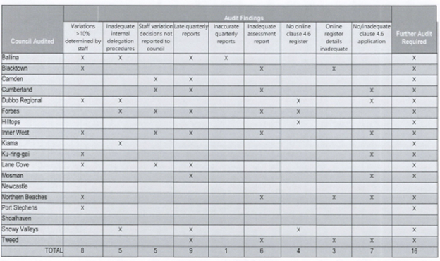
Table 7 extracted from Audit Report
Risk Implications
If Council continues to adhere
to the requirements specified by PIE, there should be no issue with compliance
or warranting further immediate audit.
Conclusion
Apart from the reporting regime,
it is mandatory to ensure that all applications which are subject of a
variation are accompanied by a written request addressing the specifics of that
clause.
Staff have been ensuring that
this occurs for the affected applications. It is noted however that clause 4.6
has been hotly contested in the Land and Environment Court which has set the
bar high, to ensure that the integrity of the relevant planning controls and system
are maintained.
|
|
Development
& Environment Committee – Tuesday 06 August 2019
Page
0
|
DE19.71 Home
modifications to permit elderly and injured residents to return to their
dwellings
HPERM Ref: D19/240753
Group: Planning
Environment & Development Group
Section: Building
& Compliance Services
Attachments: 1. DRAFT
Policy - Home modifications to allow elderly and injured residents to return to
their dwellings ⇩
Purpose / Summary
At Council’s Development
& Environment Committee meeting held on 2 July 2019, Council
resolved’
“That:
1. Council approve an
Interim Policy to give approval for residence modifications in response to
Occupational Therapists and Doctors instructions to allow elderly people and
those who are injured to return to their homes.
2. A further report be
provided back to Council on a policy provision to address this issue.”
This report provides an interim
policy for Council’s consideration and approval.
|
Recommendation
(Item to be determined under delegated authority)
That
Council adopt the draft policy as presented as Attachment 1 to this report.
|
Options
1. Council adopt the policy as printed
Implications: Staff will apply the policy so that
elderly or injured occupants of dwellings can have them modified to permit
their continued occupancy.
2. Council adopt an alternative
recommendation
Implications: Council may wish to provide guidance
on amendments to the draft policy or reject the policy.
Background
Dwellings that are constructed over two or more levels pose
manoeuvring difficulties for the elderly or injured residents. This can result
in owners seeking alternative accommodation or prematurely transferring to a
full-time care facility.
Wherever possible, it is an advantage to keep people within
their existing homes. There are obvious social rewards as well as economic
benefits by reducing the tension on already stretched nursing care
resources.
Simple changes to the configuration may include the provision
of access ramps, grab rails, minor internal alterations and additions of
bathrooms, laundries and kitchens. It may also result in the provision of
additional facilities on the lower level of multi-storey buildings.
Having two kitchens or laundries in a dwelling for instance is
not a prohibited arrangement under the National Construction Code provided the
building is still used as a single dwelling. It can present problems with
a change of classification if they are separately tenanted and this is not the
purpose of this policy.
Many alterations and additions can be completed under the
State Environment Planning Policy (Exempt and Complying Development Codes)
2008. Some of these are listed in the draft policy and examples include the
provision of ramps, grab rails, changes to the internal configuration of
bathrooms and kitchens.
Where these standards cannot be satisfied, a development
application will need to be submitted to Council for consideration.
If additional plumbing and drainage
services are required, then Council will need to be involved in the inspection
of these extended services. This would trigger a separate section 68
approval under the Local Government Act.
Community Engagement
Nil
Policy Implications
This would provide guidance to the public and Council staff.
Financial Implications
Nil
Risk Implications
Nil
|
|
Development
& Environment Committee – Tuesday 06 August 2019
Page
0
|
|
|
Development
& Environment Committee – Tuesday 06 August 2019
Page
0
|
DE19.72 Quarterly
review for compliance matters
HPERM Ref: D19/219965
Group: Planning
Environment & Development Group
Section: Building
& Compliance Services
Attachments: 1. List
of penalties issued 1 April to 30 June 2019 ⇩
Purpose / Summary
At Council’s Ordinary meeting held on 13 November 2018
it was resolved to receive a detailed quarterly report on compliance activities
(MIN18.907).
This report provides information on
the period April – June 2019 (fourth quarter).
|
Recommendation (Item to be determined under delegated authority)
That
Council receive the quarterly report on compliance matters for information.
|
Options
1. Council receive the report for information
Implications: Nil
2. Council receives the report and provides
additional direction for future reports.
Implications: Any changes or additional matters can
be added to future reports.
Report
Compliance activities are completed by the following Teams
within the Planning, Environment and Development Group:
(a) Compliance Team:
Development compliance matters including unauthorised development, development
not in accordance with development consent, land and water pollution incidents
(including building sites), land use management issues, fire safety and
swimming pool safety issues.
(b) Environmental Health:
Pollution incidents (noise and water), environmental incidents, food shops and
the operation of on-site sewage waste management facilities.
(c) Parking: All parking
offences.
(d) Rangers:
Animal control, littering, unauthorised camping, rubbish dumping and other
environmental offences.
This report provides Councillors with an update on the
penalties issued (number, type and ticket value), penalty reviews dealt with by
the panel and any Local or Land and Environment Court matters determined or
progressing.
This report relates to April – June 2019 (fourth
quarter).
Penalties issued during the period
A combined total of 1840 penalty notices were issued by the
Teams during the period. These penalties have a face value of $542,533.
Historically Council stands to receive approximately 70% of this ticketed
figure. A total of 344 cautions were also issued during the period. Attachment
1 to this report provides a breakdown of the penalties and cautions issued.
The following is a summary of the penalties issued for each
team:
|
Team
|
Number Issued
|
Total Amount
|
% of total amount
|
Cautions issued
|
|
Compliance
|
29
|
$93,910
|
17.3%
|
37
|
|
Compliance – Fire Safety
|
0
|
0
|
|
0
|
|
Compliance – Pools
|
0
|
0
|
|
0
|
|
Environmental Health
|
0
|
0
|
|
0
|
|
Rangers – Animal issues
|
659
|
$213,285
|
39.3%
|
19
|
|
Rangers – Environmental issues
|
40
|
$21,720
|
4%
|
12
|
|
Parking
|
1111
|
$213,288
|
39.3%
|
276
|
|
Sewer Management Facility
|
1
|
$330
|
0.1%
|
0
|
|
Total
|
1840
|
$542,533
|
100%
|
344
|
There has been a considerable
increase in animal related penalty notices for this quarter. This is due to
Council’s annual pet registration drive which resulted in 598 penalties
issued for failing to comply with Council’s notice to register. There has
been a procedural change and this will be now be completed monthly
rather than yearly.
Penalties related to Compliance issues
The following details are provided in relation to the 29
compliance penalty notices issued:
(a) Two
penalty notices issued to one owner for unauthorised construction of an
alfresco outdoor area and a detached habitable room – Development without
development consent – class 1a or 10 building – Individual $1500
($3000 total) – Meroo Meadow
(b) Two
penalty notices issued to one owner for unauthorised construction of a large
concrete bridge – Development without development consent – class
1a or 10 building – Individual $1500, and converting a Class 10a
structure into a habitable dwelling - Development not in accordance with
consent - any other case – Individual – $3000 (Total $4500) –
Parma.
(c) Two
penalty notices issued to one owner for failing on two occasions to comply with
a development control order relating to a dilapidated asbestos dwelling –
Fail to comply with terms of development control order – Individual $3000
(Total $6000) – Mollymook.
(d) One
penalty notice each issued to two owners for converting a shed in an industrial
zone to a habitable dwelling – Development without development consent
– any other case – Individual $3000 (Total $6000) –
Ulladulla.
(e) Three
penalty notices issued to one owner for unauthorised demolition of a dwelling
and the subsequent construction of a new dwelling and shed. – Development
without development consent – class 1a or 10 building – Individual
$1500 ($4500 total).
Two penalty notices issued to the builder
on this site for constructing the new dwelling and shed – Development
without development consent – class 1a or 10 building – Individual
$1500 ($3000 total). – Conjola.
(f) Two
penalty notices issued to one owner for failing on two occasions to comply with
a development control order relating to works done on a heritage property
– Fail to comply with terms of development control order –
Individual $3000 (Total $6000) – Berry.
(g) One
penalty notice each issued to one owner for the unauthorised construction of a
pergola – Development without development consent – class 1a or 10 building – Individual $1500 (Total
$1500) – Sanctuary Point.
(h) One
penalty notice issued to a building company for failed sediment control
measures at a new shopping centre under construction resulting in water
pollution – Pollute waters – class 1 – Corporation $8000
(Total $8000) – Worrigee.
(i) One
penalty notice issued to a corporation for failing to comply with a development
control order – Fail to comply with prevention notice – class 1
– Corporation $8000.
Three penalty notices were issued to the
same corporation for failed sediment control measures at a new shopping centre
under construction resulting in water pollution – Pollute waters –
class 1 – Corporation $8000 (Total $32000) – Bomaderry.
(j) One
penalty notice issued to one owner for the unauthorised installation of an
effluent system – Development without development consent – any
other case – Individual $3000 (Total $3000) – Tomerong.
(k) One
penalty notice issued to one owner for the unauthorised renovation of a
heritage home – Development without development consent – class 1a
or 10 building – Individual $1500 (Total $1500) – Berry.
(l) One
penalty notice issued to one owner for the unauthorised construction of a
pergola – Development without development consent – class 1a or 10
building – Individual $1500 (Total $1500) – Parma.
(m) One penalty notice
issued to one owner for the unauthorised construction of earthworks –
Development without development consent – any other case –
Individual $3000 (Total $3000) – Ulladulla.
(n) One
penalty notice issued to one owner for failing to comply with a development
control order relating to a clean-up notice – Fail to comply with terms
of development control order – Individual $3000 (Total $3000) –
Tomerong.
(o) One
penalty notice issued to one owner for failing to dispose of asbestos waste in
an appropriate manner – Failure to ensure waste
is stored in an environmentally safe manner – Individual $750 (Total
$750) – Culburra Beach.
(p) Two
penalty notices issued to a builder for failing on two separate occasions to
prevent waste from building site moving onto road – Expose article in/on/over road/let article be exposed at
road without approval – Individual $330 (Total $660) –
Sussex Inlet.
Penalties related to Rangers issues
(a) Illegal dumping of
asbestos and other materials at Woollamia
Following an eyewitness report, Rangers were able to track
down an offender after their vehicle had been spotted in heavily vegetated
vacant bushland. Rangers inspected the area and found a recent dumping of
materials including asbestos cement sheeting. After an extensive investigation
Rangers interviewed a suspect where admissions were made concerning the
offence.
The offender was issued with a “clean up
notice’ directing them to engage a qualified and licensed person to
remove and correctly dispose of the asbestos and other material to a recognised
waste disposal facility. At the completion of the work a validation certificate
was submitted confirming that the site is free of any contaminants.
The total clean-up of this offence cost the offender
$5,940. Potential penalties relating to this offence totalled $16,000; however,
only one $4000 penalty notice was issued for “transport asbestos waste to
unlawful facility”. All other offences were dealt with by way of caution
considering the cost to the offender for cleaning up the dump site.
(b) Eight dog attacks
(each receive a $1320 penalty)
Eight people have all received penalty notices for
incidents relating to dog attacks. Each dog has also been declared dangerous to
ensure owners provided adequate controls and housing to prevent such incidents
recurring.
Council Rangers are stepping up patrols of public areas and
discussing the importance of responsible dog ownership. This includes keeping
dogs on leash and under effective control at all times.
Penalty infringement
panel reviews
During the period, the review panel met on 4 April, 24 April,
9 May and 6 June 2019. The following eight penalty infringement appeals
were considered during this period:
(a) Failure
to comply with terms of development control order – Individual ($3000).
Council had issued orders for the owner of the premises to
cease occupation on the property and to demolish the dwelling and manufactured
home. The site did not have a dwelling entitlement.
Council officers had also extended the time period to over
one year for compliance to enable the owners to find alternative accommodation.
The owners failed to comply with the order. The following additional
information was provided:
· The structures were
located on bushfire prone land and structures should be designed and
constructed to Bushfire Attack Level Flame Zone (BAL FZ). The structures had no
bushfire protection.
· The owners had not
provided Council with confirmation that working smoke alarms were installed
within either the dwelling or the manufactured home.
· A non-compliant onsite
effluent disposal system. Effluent was flowing directly into an onsite trench.
There was no formal section 68 approval nor an operational approval for the
onsite effluent system.
· The owners were actively
burning all the household waste as there is no weekly rubbish removal for the
property.
The panel considered the matter on
4 April 2019 and agreed the penalty should stand. Council officers are
seeking to have the structures removed and the land remediated.
(b) Development without
development consent – Class 1a or 10 building – individual (four
submissions each for $1500).
There are four (4) owners of a property and each admitted
to installing and altering four shipping containers to make them habitable and
authorising the construction of timber decks to each shipping container. Each
of the four owners has appealed against the penalties issued.
The panel considered that each owner could have been
subject to nine (9) offences totalling $19,800. Only one penalty notice of
$1500 was issued to each of the four owners.
The panel considered the matter on
24 April 2019 and agreed that each of the four penalty notices should stand.
Further, it was considered that Council’s Compliance Team should pursue
demolition orders for the unauthorised works.
(c) Fail to comply with
terms of development control order – individual ($3000).
Compliance Officers became aware of
the unauthorised works at a heritage significant property in Berry. The
investigation identified the owners were aware of the need to obtain
development approval and they indicated their needs to continue to complete the
works. Penalty notices were issued for the initial unauthorised works and
Council issued a development control order directing each owner to cease work.
The owners proceeded to complete the works and further
penalty notices were issued. One of the two owners appealed against this
subsequent penalty notice.
The panel considered the matter on
24 April 2019 and agreed that both owners were aware of the requirements to
stop and they indicated they would continue. This was a deliberate act and the
panel resolved that the penalty should stand.
(d) Development not in
accordance with consent – Class 1a or 10 building – Corporation
($3000).
This matter
related to building waste, sediment controls and boundary encroachment of
materials and site fencing onto Councils’ reserve. A direction
to take clean up action was issued under the Protection of the Environment
Operations Act (PoEO) in relation to the waste. The waste included glass,
metal framing brackets and masonry rubble. A show cause was sent to the
building company identifying the multiple breaches of the development consent.
A $3000 penalty was subsequently issued to the company.
Council staff showed leniency for
not issuing an $8,000 penalty notice for sediment leaving the building site
creating a pollution event and also not issue additional $3,000 penalties for
each of four other breaches of the development consent. This could have been a
total of $23,000.
The panel considered the matter on
9 May 2019 and agreed the penalty should stand.
(e) Development without development consent –
any other case – individual ($3000).
This matter
related to extensive excavation and clearing of native vegetation on land
adjoining the site owned by the perpetrator. The works were completed to
construct bike tracks for his children. The owner of the adjoining land was
unaware of this clearing event and they did not give permission for this to
occur.
A significant
number of trees were removed as part of these unauthorised works. Council
officers issued only one penalty for the offences committed and have issued
orders on the owner of the land to have it regenerated. The owner does not want
the perpetrator back on their site. These works will take a number of years to
complete.
The panel considered the matter on
6 June 2019 and agreed the penalty should stand.
Local or Land and Environment Court matters
(a) Jerberra Estate – Failure to comply with demolition.
An order was issued by Council to the owner of a premises
directing them to demolish a building. The owner failed to complete the works
and a $1500 penalty notice was issued.
The owner elected to have the matter dealt with by the
Local Court. The matter was heard in the Local Court on 15 April 2019. The
owner was found guilty of the offence and fined $1000 and ordered to pay
Council’s professional costs of $750.
(b) Jerberra Estate – unauthorised works.
Unauthorised works were undertaken, and the owner had
failed to comply. This matter was taken to the Land and Environment Court in
2014 where the Court issued orders for the works to be completed. This is
contempt of Court proceedings against the owner who has failed to comply with
the Courts order to clean up the premises.
The matter was heard on 27 May 2019. The landowner attended
Court on this occasion and entered a guilty plea to the contempt. Council
indicated its intention to enter the land and execute the orders. The owner was
allowed a further 4 weeks to remove any personal items.
On 28 June 2019 Council entered the land to conduct a
safety assessment prior to executing the terms of the Court Order.
The matter was heard on 1 July 2019 where it was adjourned
to 19 September 2019 to allow Council to execute the terms of the Court Order.
Quotations are being sought for the works to be undertaken.
Other matters
(a) Shoalhaven Animal
Shelter celebrates its first birthday
The Shoalhaven Animal Shelter celebrated its first birthday
as a Council managed facility. The shelter has found new forever homes for 598
animals including dogs, cats, roosters, sheep, a goat, a horse and a bird.
The Shelter operations continue to be a good news
story since Council took over its management.
|
|
Development
& Environment Committee – Tuesday 06 August 2019
Page
0
|
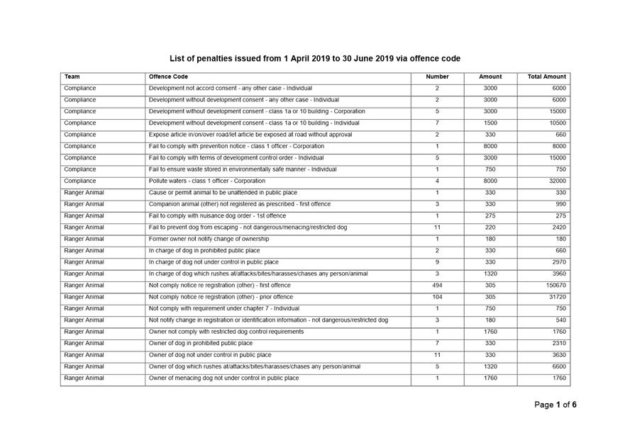
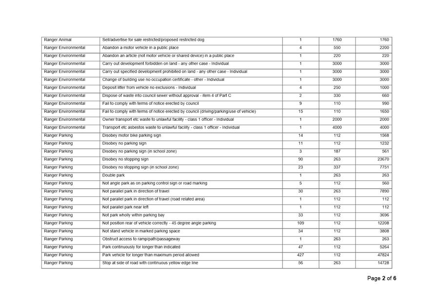
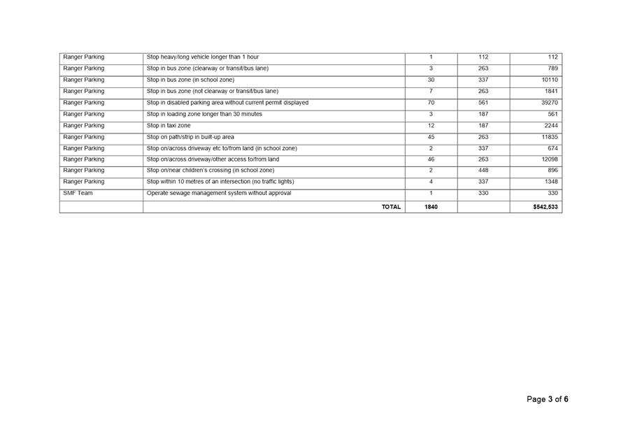
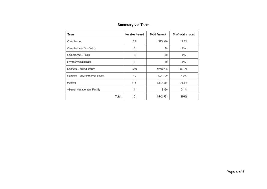
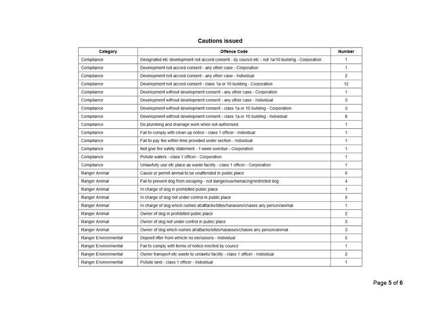
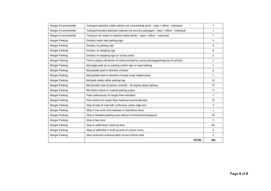
|
|
Development
& Environment Committee – Tuesday 06 August 2019
Page
0
|
DE19.73 Bomaderry
Grey-headed Flying Fox Community Education Grant from Local Government NSW
HPERM Ref: D19/214637
Group: Planning
Environment & Development Group
Section: Environmental
Services
Attachments: 1. Legal
Document Grant ⇩
Purpose / Summary
To advise Council that the NSW Office of Environment and
Heritage (OEH) and Local Government NSW, have provided Shoalhaven City Council
with a $10,000 grant to be used for a community education project based around
inappropriate netting and its use in gardens and commercial activities and its
risk to the Grey-headed Flying-fox:
|
Recommendation (Item to be determined under delegated authority)
That
Council
1. Receive the report for information
regarding the $10,000 grant (excl. GST) received from
NSW Office of Environment and Heritage and Local Government NSW for the Bomaderry Grey-headed Flying-fox Community Education
project; and
2. Write to the NSW Office of
Environment and Heritage and Local Government NSW thanking them for the grant
and their support of the project.
|
Options
1. As recommended.
Implications: The grant
from the NSW Office of Environment (OEH) and Heritage and Local Government NSW
(LGNSW ) will allow Council’s Environmental Services officers to contact
and educate retail suppliers/residents of inappropriate netting types and about
safer alternatives and therefore reduce the number of Grey-headed Flying-foxes
(GHFF) maimed or killed following entanglement in inappropriate netting, as
well as reduce the incidents of stress and injury to residents and commercial
operators who discover GHFF tangled in inappropriate ‘garden’
netting. The education project should also reduce the need for local wildlife
carers to rescue entangled GHFF and help protect the numbers of these vital forest
pollinators.
2. Council returns
the grant of $10,000.
Implications: Without the grant Council staff will
not to be able to develop an education portfolio to engage with local business
owners and local residents that informs them about Grey-headed Flying-fox friendly
tree netting. The use of inappropriate netting will continue to adversely
impact this threatened species, putting GHFF, residents, wildlife rescuers and
commercial growers at risk.
Council has previously received
a grant to the value of $55,000 (with council contributing matching funds) to
fund emergency actions to alleviate the impacts to residents living within
close proximity to flying foxes at Bomaderry.
3. Adopt an
alternative recommendation.
Implications: Unknown.
Background
Grey-headed Flying-foxes (GHFF)
are a threatened species listed as vulnerable to extinction under both the NSW
Biodiversity Conservation Act 2016 (BC Act) and Commonwealth Environment
Protection & Biodiversity Conservation Act 1999 (EPBC Act). Actions
related to the species, such as removal of roosting trees, requires a licence
from the NSW Office of Environment & Heritage (OEH) and potentially
approval from the Federal Environment Minister.
GHFF are increasingly becoming
displaced from their natural habitat because of land clearing and extreme
weather events and are having to resort to commercial orchards and flowering
and fruiting trees in residential backyards as a food source. Tree netting is a
popular way to protect fruit from the Grey-headed Flying-fox and other native
animals. Certain types of netting easily entangle these native animals in mesh
sizes greater than 1cm square, where many perish or require long term care
prior to release.
The South Coast Wildlife Rescue
GHFF volunteers have identified GHFF entanglement in garden netting as a
significant problem in the Shoalhaven that can be avoided through education and
the use of appropriate netting types and installation.
It is a condition of the grant
that Council acknowledge the NSW Government and LG NSW assistance in all
publications, reports, signage and promotional material relating to the
project.
Community Engagement
South Coast Wildlife Rescue
volunteers and the NSW Office of Environment & Heritage have been working
with and assisting Environmental Services officers to work with the community
to manage GHFF issues. The grant will allow a Council Environmental Services
Officer to;
· Identify
and contact local businesses who currently sell tree/fruit netting;
· Create
and deliver information/education material to local businesses about
Grey-headed Flying-fox friendly tree/fruit netting, with a poster to be
displayed on product shelves etc;
· Identify
hot spot areas of the Shoalhaven where large aperture fruit netting is
currently or potentially in use; and
· Create
and distribute flyers to raise awareness regarding flying fox friendly tree
netting to be letter dropped in residential hot spot areas and for distribution
by Grey-headed Flying-fox rescuers.
Financial Implications
The grant will cover the financial cost of Council staff
time to achieve the grant outcomes.
Risk Implications
OEH recommend the use of wildlife-friendly netting that is
well secured and has a gap size of less than five millimetres. In 2017, there
were 1,076 flying fox rescues over a two-month period from backyards across
NSW, with most rescues associated with netting incidents. The greatest concern
to Shoalhaven residents is the potential health risks associated with flying
foxes such as Lyssavirus. Only trained and inoculated wildlife carers should
come in contact with animals that are caught in netting. Without the grant,
Council will not be able to develop a community education program about these
risks and it is likely that there will be further losses of GHFF.
|
|
Development
& Environment Committee – Tuesday 06 August 2019
Page
0
|
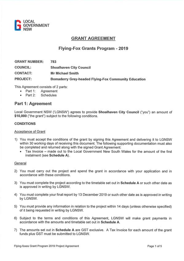
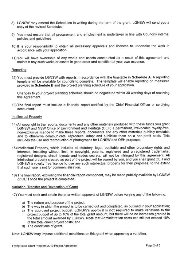
|
|
Development
& Environment Committee – Tuesday 06 August 2019
Page
0
|
DE19.74 Grant
Application: Coastal & Estuary Grants Program 2018-19
HPERM Ref: D19/230517
Group: Planning
Environment & Development Group
Section: Environmental
Services
Attachments: 1. Maps
& Spreadsheet of sites included in the OEH Coast & Estuary Grant for
Shoalhaven Wetlands & EECs 2019-2022 ⇩
Purpose / Summary
To report the successful grant offer of $105,000 from the
NSW Department of Planning, Industry and Environment (DPIE) Coastal &
Estuary Grants Program for Protecting and Enhancing Shoalhaven’s Coastal
Wetlands and Bushland Reserves project.
|
Recommendation (Item to be determined under delegated authority)
That
Council
1. Accept the grant offer of $105,000
(ex GST) from NSW Department of Planning, Industry and Environment (DPIE) for
Protecting and Enhancing the Shoalhaven’s
Coastal Wetlands and Bushland Reserves project, over 3 years.
2. Provide matching funding, from the existing
operational budget (job #15817).
3. Write a letter of thanks to the
Member for the South Coast and NSW Minister for Local Government, the Hon.
Shelley Hancock, for the grant.
|
Options
1. As recommended.
Implications: Council will be able to value add to
its current resources for the restoration and management of key coastal
wetlands that are listed under the Coastal Management SEPP 2018, and be able to
value add to the work of 11 of Council’s volunteer Bushcare Groups
2. Council not
accept the grant offer from NSW DPIE.
Implications: Council will be unable, based on
current resources, to restore key SEPP wetlands across the Shoalhaven and
effectively provide a boost to the 11 volunteer Bushcare Groups
Background
Council applied for funds under the Coastal & Estuary
Grants Program in December 2018 to implement the following priority actions
from the Shoalhaven Coastal Zone Management Plan.
|
Action No.
|
CZMP Actions
|
|
C4.3
|
Maintain and enhance
ecological communities in coastal reserves (including dunes), considering
appropriate ecological strategies for urban (foreshore recreation reserve)
and non-urban areas
|
|
C4.5
|
Support bush regeneration
programs in coastal reserves
|
The Protecting and Enhancing
Shoalhaven’s Coastal Wetlands and Bushland Reserves project will enable
Council to achieve these actions over the next three years, whilst the Council
transitions to a Coastal Management Program. Key outcomes of the project are:
a. Improvement in the
condition and resilience of 175 hectares of coastal vegetation classified as
Endangered Ecological Communities and Coastal
b. To support and improve
the capacity of 11 Bushcare Groups to protect, restore and rehabilitate coastal
Endangered Ecological Communities
c. To raise community
awareness of the importance of coastal vegetation in protecting foreshore and
estuarine landscapes.
Financial Implications
Under the grant agreement, Council has undertaken to provide
matching funds of $105,000 over three years using portions of existing operating
budgets. In-kind, non-funded costs are estimated at $38,500 over the 3-year
period.
Risk Implications
The above actions C4.3 and C4.5
in the Council’s adopted and certified CZMP cannot be achieved without
additional financial resources. Without the assistance from the DPIE grant,
Council does not have the resources and capacity to achieve these actions.
|
|
Development
& Environment Committee – Tuesday 06 August 2019
Page
0
|
|
|
Development
& Environment Committee – Tuesday 06 August 2019
Page
0
|
DE19.75 Lake
Conjola Entrance Opening and other Matters Relating to Mayoral Minute MIN19.143
HPERM Ref: D19/246757
Group: Planning
Environment & Development Group
Section: Environmental
Services
Attachments: 1. Executed
Short Term Licence - Opening of Lake Conjola ⇩
2. Response
- Minister Lake Conjola ICOLL classification ⇩
3. Response from Minister - Lake
Conjola Fish Kills/Seagrass and Lead Contamination ⇩
Purpose / Summary
To provide Council with an update
on progress in response to the Mayoral Minute of 26 March 2019 (MIN19.143)
|
Recommendation (Item to be determined under delegated authority)
That
Council:
1. Write to The Honourable Melinda
Pavey MP, Minister for Water, Property and Housing, to thank her for her
assistance in the granting of a licence to carry out “Access and
Environmental Protection Work” (Conjola Lake entrance opening works).
2. Write to The Honourable Shelley
Hancock MP, Minister for Local Government, to thank her for her assistance
and support in making representations for the Licence application for Lake
Conjola entrance opening works.
3. Receive a briefing regarding the
formulation of a “dry notch” management policy for Lake Conjola.
|
Options
1. As per
recommendation
Implications: Nil
2. Alternative
recommendation
Implications: This would depend on the
recommendation
Background
On 26 March 2019 Council passed
the following Mayoral Minute relating to the management of Lake Conjola entrance
(MIN19.143):
That
Council:
1. Make
further representations to the relevant agencies for approval to open the
entrance of Lake Conjola on the following grounds: -
a. To minimise risk to
public safety associated with excessive inundation of foreshores and
infrastructure as a result of low-level flooding that
has been affecting residents and foreshore areas for more than 3 months.
b. In accordance with the recommendation
from residents and community members at the Lake Conjola Community CCB Meeting
21 January 2019.
c. In-line with the Interim Entrance
Management Plan: -
i. On the
planned openings prior to Christmas and Easter holiday trigger levels.
ii. Social,
mental and physical impact and wellbeing of residents and tourists including
events that occurred over last 3 months.
d. The
continued threat of weather i.e. heavy rain from storms and capacity of
contractor’s timeframes and safety to open the entrance in an emergency.
2. Continue
to make ongoing representations to the relevant agencies for approval to open
the entrance at Lake Conjola in accordance with Item 1 above until such opening
has occurred.
3. Seek
approval from the NSW Government Ministers of Crown Lands, Office Environment
and Heritage and Department of Primary Industries (Fisheries) to immediately
prepare and maintain a “dry notch” at the entrance to Lake Conjola
to allow “break out” of the lake should flooding occur. This
is to be maintained until a new Coastal Management Plan is approved by the
Minister.
4. Write
to the Minister for Crown Lands & Office of Environment & Heritage
requesting that an investigation be undertaken immediately to establish how and
why Lake Conjola was listed as an “ICOLL” and not a Wave Dominated
Barrier Estuary (WDBE).
5. Write
to Department of Fisheries and request Fisheries to investigate:
a. All
current, ongoing and future fish and marine life deaths/kills and sea grass
kills in Lake Conjola.
b. The
amount of Lead in the Lake from lost lead from over a century of recreational
fishing by testing water, fish and marine life species in Lake Conjola and the
sands beds of the Lake with the lake closed and not being subject to two tidal
interchanges per 24 hours, is this lead building up in the water column and the
food chain.
6. Report
back to Council with a proposed plan and costings to undertake investigations
for contamination at the old Waste Depot at Lake Conjola. Such
investigations to include: -
a. Water
samples in Pattimores lagoon, land run off water, Ground water. Take soil core
samples. Take into consideration that many residents use bore water to water
their gardens, vegetable gardens and fruit trees.
b. Contaminations
including asbestos, industrial liquids, insecticides.
c. Seek
information from Local residents on knowledge of what was dumped at the site
from the original opening.
7. Request
the General Manager (or his delegate) to continue to audit the safety of
Council assets at Lake Conjola and undertaken any works or signage that maybe
necessary. This report to include an investigation of the condition of
“Steps” over Lake Revetment walls created by Council on the Council
reserve in front of the Lake Conjola Liquor Store and to the east towards Deep
Water Resort to be repaired, cleaned and maintained by council.
8. Report
timeframe and priority status for preparation of Coastal Management Plan for
Lake Conjola to Council.
9. Report
back to Council at the Strategy & Assets meeting in April on reasons for:
a. Not
providing the CCB Executive with copies of documentation in relation to Lake
Conjola requested over the last 9 months.
b. How
Council can facilitate the requests from the CCB Executive for copies of
documentation.
10. Provide
monthly update reports to Councillors on all issues concerning Lake Conjola.
11. Formally resolve as
policy to continue to support and advocate for residents and community members
at Lake Conjola on all issues pertaining to opening the entrance, flooding and
erosion at Lake Conjola.
The following is a summary of the progress to date relating
to the nominated items from the above resolution.
1. Lake Conjola Entrance
– Opening/Pilot Channel
Part 2 of the Mayoral Minute stated the following.
“Make further
representations to the relevant agencies for approval to open the entrance of
Lake Conjola”.
Council prepared and submitted a
further Short-Term Licence application to NSW Department of Industry (DoI)
– Crown Lands for the excavation of a pilot channel on 11 April 2019. A
Review of Environmental Factors (REF) was prepared as an addendum to the
Interim Lake Conjola Entrance Management Policy REF 2013, to accompany the
Crown Land Licence.
On 6 June 2019 Council prepared
a Ministerial brief for the NSW Minister for Water, Melinda Pavey MP, providing
further information to support the short-term licence application.
On 7 June 2019 the NSW DoI
– Crown Lands wrote to Council offering a licence to occupy the land, to
excavate a pilot channel, with a set of conditions that Council must adhere to
(Attachment 1). Council accepted the offer along with the licence conditions on
11 June 2019.
Council officers, Councillors
and representatives from the Lake Conjola Community Association met to
determine the location of the pilot channel and procedure that would be
followed for the opening. It was agreed at this meeting that the pilot channel
would be located on the central-southern side of the main entrance spit, as
shown on the operating procedure of the Interim Lake Entrance Management Policy
(see figure 1).
Works on the channel commenced
on 16 June 2019 and concluded on 12 July 2019. Over 1500 truck loads
(22,600cu.m) of sand were excavated and placed at an approved location to the
north of the lake. The initial channel prior to plug removal was excavated to
10m wide and over 1m deep (0m AHD). The plugs were removed opening the lake to
sea on 19 June 2019. Works were completed using Caterpillar 320CL excavator and
two Volvo A25 dump trucks. The total cost of works was approx. $140,000.
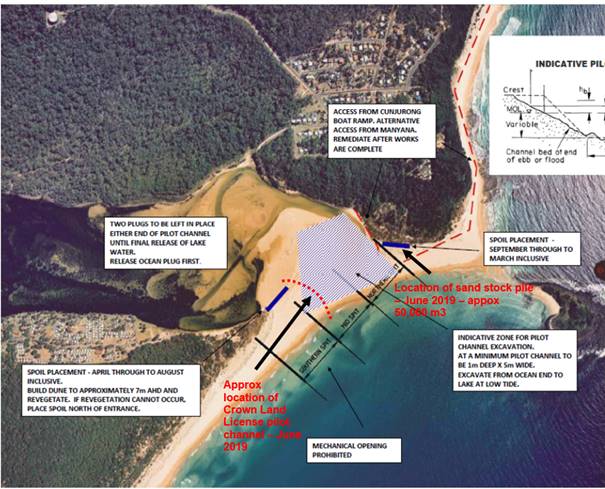
Figure 1: Operational map
showing location of pilot channel and sand spoil – REF Crown Lands
Licence, June 2019.
The excavated pilot channel will
continue to be monitored on a weekly basis by staff, to assess changes in
channel composition and dynamics until such a time as it ceases to function as
a channel, or a rain event occurs that naturally facilitates a further lake
opening.
The sand that was dredged from
the entrance and lake was stockpiled on the northern side of the lake entrance,
up against the base of Cunjurong Point, as per the operational procedures of
the Interim Lake Entrance Management Policy.
Following completion of works,
Council received an email request from Crown Lands, 15 July 2019, stating:
The department is concerned that the current
dredging operation at Lake Conjola has expanded beyond the parameters of the
existing Crown Lands licence conditions.
A number of additional questions
were also contained in the email which brought the following response from
Council’s Director Planning, Environment and Development:
There is nothing to suggest to me that Council’s
initial Review of Environmental Factors and subsequent addendum, prepared in
June, did not address and cover all issues associated with the works recently
completed by Council.
Whilst I have attended the site on one occasion during
works, I have been informed by relevant staff as to the progress of the
project, and am aware that required monitoring has taken place during the term
of the works.. I am also aware that necessary advices were provided to State Agencies
who were welcome to attend the site at any stage during the course of the
project.
The works associated with the opening of the Lake were
completed on 12 July when it was considered that the objectives and community
outcomes, clearly outlined in Council’s addendum REF, were achieved. All
required monitoring was carried out during the project and it is gratifying to
note that there has been no adverse environmental effects and there have been
very significant and positive outcomes in regard to the objectives of the Lake
Conjola community relating to public safety and health and overarching
community values. It is also positively noted that there is still, as of today,
a healthy tidal interchange within the lake.
As you can appreciate, working within lines on a map,
particularly in a waterway is not a straightforward proposition. Whilst Council
has taken measures to define the “red line” within the issued
licence, we have also been cognisant of meeting the overarching objectives of
the project at hand. Thus, whilst Council did carry out initial survey work to
establish various reference points and parameters, no final survey has been
carried out to determine the actual extent of completed operations. If you feel
that such survey is now necessary, please let me know. Also, if you require any
further information in regard to the project, I am happy to meet at any time.
If further information is required, I would suggest that the requesting
agencies be involved in the meeting in order that we can address all issues.
2. Lake Conjola Flood
Dry Notch
Part 3 of the Mayoral Minute
states the following:
“Seek approval from the
NSW Government Ministers of Crown Lands, Office Environment and Heritage and
Department of Primary Industries (Fisheries) to immediately prepare and
maintain a ‘dry notch’ at the entrance to Lake Conjola to allow
‘break out’ of the lake should flooding occur. This is to be
maintained until a new Coastal Management Plan is approved by the Minister.”
Council staff have significantly
advanced a draft Lake Conjola “Flood Dry Notch” proposal report
based on the current available scientific data and current studies. The
difficulty with such a report is it is not able to guarantee accuracy or
completeness to the full extent of the subject matter, given the information
gap. Any proposal, without being informed by relevant documentation and
extensive study, can be prone to failure as coastal processes are a complex
science.
Having regard to the above it is
suggested that a briefing be provided to Councillors prior to tabling of the
draft document.
3. Lake Conjola ICOLL
Listing
Part 4 of the Mayoral Minute
stated the following:
“Write to the Minister
for Crown Lands & Office of Environment & Heritage requesting that an
investigation be undertaken immediately to establish how and why Lake Conjola
was listed as an ‘ICOLL’ and not a Wave Dominated Barrier Estuary
(WDBE).”
Following this Council wrote to
the Minister of Energy and Environment, the Hon. Matt Kean, on 23 April 2019,
asking why Lake Conjola was listed as an Intermittently Closed and Open Lake or
Lagoon (ICOLL) and not a Wave Dominated Barrier Estuary (WDBE).
A reply from Michael Saxon,
Director of South East Branch on behalf of the Minister, was received on 20
June 2019 (Attachment 2). The letter stated that Lake Conjola has a long
history of closing for periods of time, dating back to 1909.
The ICOLL classification was
used for estuaries across NSW based on a paper by Roy et al., where the
terminology of wave dominated barrier estuary is introduced as one of five
classes of coastal water bodies for eastern Australia.
The response stated that Lake
Conjola has a dual classification of ICOLL and WDBE.
4. Lake Conjola Fish
Kills/Seagrass and Lead Contamination
Part 5 of the Mayoral Minute stated the following:
“Write
to Department of Fisheries and request Fisheries to investigate:
a. All
current, ongoing and future fish and marine life deaths/kills and sea grass
kills in Lake Conjola
b. The
amount of Lead in the Lake from lost lead from over a century of recreational
fishing by testing water, fish and marine life species in Lake Conjola and the
sands beds of the Lake with the lake closed and not being subject to two tidal
interchanges per 24 hours, is this lead building up in the water column and the
food chain.”
Following the resolution, Council
wrote to the Minister for Agriculture and Western NSW, the Hon. Adam Marshall
MP, regarding marine life, seagrasses and lead contamination in Lake Conjola.
On 20 June 2019, Sarah Fairful, Deputy Director General for
DPI Fisheries, responded stating the following in relation to the inquiry
(Attachment 3):
1. Since 2014,
according to the NSW DPI Fish Kill database, there had been three recorded
incidents of marine life kills. All of which has been caused by natural events.
2. According to aerial
imagery, between 2012 and 2013, there had been reduction in seagrass coverage
at Lake Conjola, this was consistent with other estuaries across SE NSW. Since
2013 to 2018 there had been an increase in seagrass coverage across Lake
Conjola. They suggested that a more detailed analysis of aerial imagery was
needed, and this could be an action of the Lake Conjola Coastal Management
Program.
3. DPI
Fisheries is not aware of any health concerns relating to lead contamination.
5. Lake Conjola Coastal
Management Plan (CMP)
On 26 April 2019 Council applied
to the NSW Coast and Estuary Grants – Planning Stream for the preparation
of a CMP for Lake Conjola, following the decision by the community in February
to prepare a standalone CMP.
On 7 June 2019 Council received
a letter of offer for $140,000 to fund 50% of the preparation of CMP for Lake
Conjola. A report was provided to the Council Ordinary meeting on 30 July 2019
which recommended that the grant offer be accepted.
It is important to note that,
based on advice from NSW Department of Planning, Industry and Environment and
the NSW Coastal Council, Council has decided to undertake the first phase of
the CMP process, the preparation of the Scoping Study, across the whole of the
City. This means that the Scoping Study will be prepared for the
Shoalhaven’s open coast and all estuaries.
This will give Council a
prioritisation system for the future development of CMPs across the City and
will allow Council to engage with all affected communities to gain an
understanding on the priority issue for coast and estuary management across the
City.
The preparation of the Lake
Conjola CMP will begin once the citywide scoping study has been finalised, and
all the coastal management issues identified in the community consultation
phase of the scoping study for Lake Conjola have been identified.
The timeline for the preparation
of the Lake Conjola CMP is summarised in the table below.
|
Grant Milestone
|
Activities
|
Outputs
|
Timeframe
|
|
Completion
of Citywide Scoping Study for open coast and estuaries (including Lake
Conjola)
|
Commence
the preparation of tender and procurement for Lake Conjola CMP
|
Successful
consultant selected for the preparation of the Lake Conjola CMP
|
Dec
2019
|
|
Additional
Studies
|
Commence
additional studies including:
- Update
of Estuary Health Report Card
- Review
of Interim Entrance Management Policy
- Update
of Lake & entrance process study
- Final
list of studies will emerge from the Scoping Study
|
- Working
group
established
- Consultant
engaged
- Additional
studies commenced
|
April
2020
|
|
Draft
CMP prepared
|
- Implement
community consultation
- Additional
studies completed
- Preparation
of draft CMP to meet mandatory requirements
|
- Draft
CMP complete and on public exhibition
|
Dec
2020
|
|
Final
CMP report
|
- Prepare
final draft of CMP
- Submissions
in reply report and revised CMP
- OEH
review
- Councillor
and NRFMC briefings
- CMP
finalised for adoption
- Send
to State Government for certification
|
- Final
CMP adopted by Council
- Grant
acquitted
|
August
2021
|
Community Engagement
Council have collaborated
closely with both the Red Head Villages Association and Lake Conjola Community Associations,
throughout the planning and implementation process of the recent lake opening.
The preparation of the citywide
scoping study will hold focus workshops with communities in the south, which
both Community Consultative Bodies (CCB) will be invited to, to gain a clear
understanding of the coast and estuary management issues at Lake Conjola.
The development of the Lake
Conjola CMP will be done in direct collaboration with both the CCB’s and
will also undertake targeted surveys of residents and visitors.
Policy Implications
The community consultation and
associated works will contribute to the production of updated coastal policy.
Financial Implications
The total cost to Council for
entrance management intervention and management of the lake from August 2018 to
July 2019 is approx. $330,000, this includes:
· Entrance
management works;
· Water quality
monitoring;
· Staff attendance
at community meetings;
· Site inspections;
· Entrance
monitoring;
· Surveys; and
· Administration.
|
|
Development
& Environment Committee – Tuesday 06 August 2019
Page
0
|
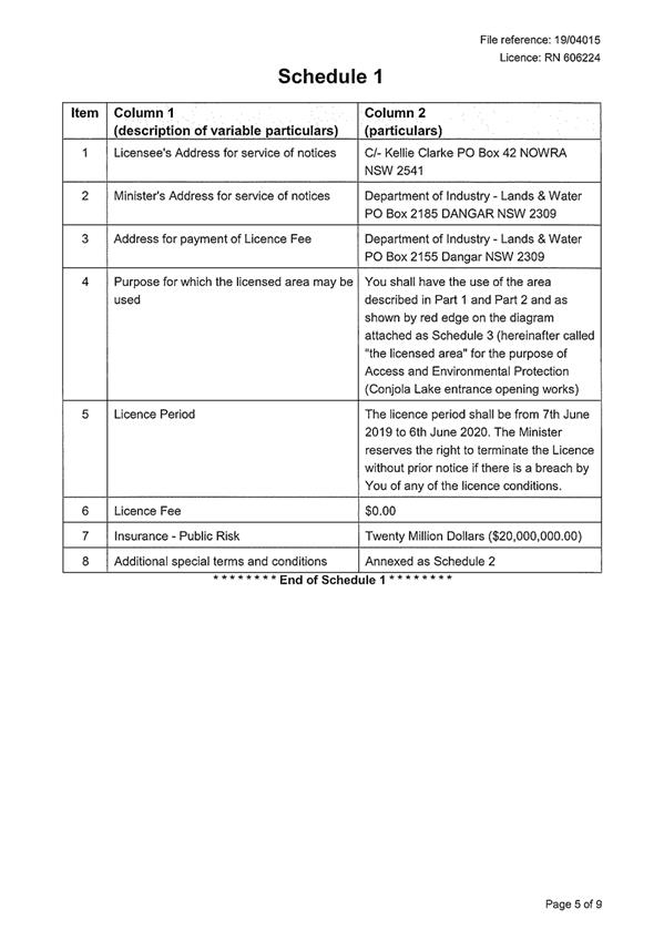
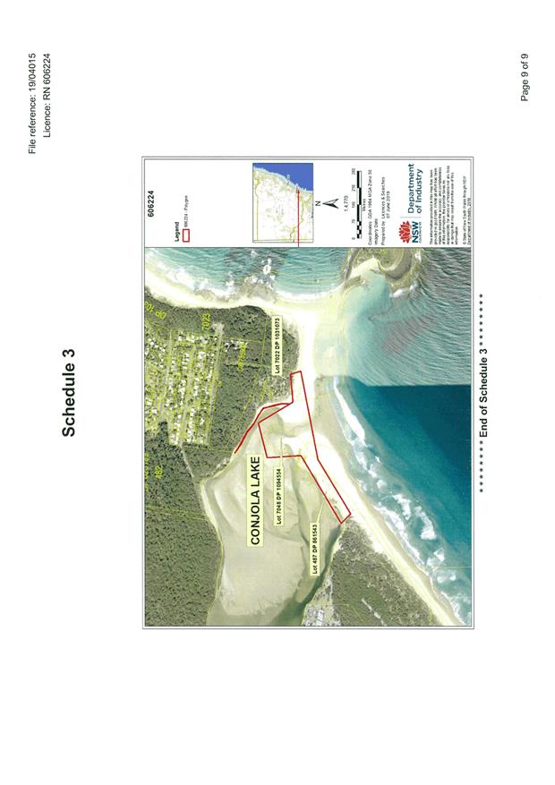
|
|
Development
& Environment Committee – Tuesday 06 August 2019
Page
0
|
|
|
Development
& Environment Committee – Tuesday 06 August 2019
Page
0
|
|
|
Development
& Environment Committee – Tuesday 06 August 2019
Page
0
|
DE19.76 Orient
Point Wetland Bushwalk
HPERM Ref: D19/191949
Group: Planning
Environment & Development Group
Section: Environmental
Services
Attachments: 1. Photographs:
Duckboards ⇩
2. Orient
Point Wetland Reserve - Bushwalk - Duckboarding Submissions of Support and CCB
Notification ⇩
3. Orient
Point Wetland Reserve - Duckboarding Risk Assessment ⇩
4. Jenny
Callanan - Email Support for Orient Point Wetland Walk ⇩
5. Submission - Orient Point
Wetland - Merrliyn Helliwell ⇩
Purpose / Summary
To provide Council with information about the upgraded
bushwalk at the Orient Point Wetland as requested in MIN19.384, including
costings, consultations and Australian Standards.
|
Recommendation (Item to be determined under delegated authority)
That
Council continue to maintain the newly constructed Orient Point Wetland duck
board bushwalk, provided the following works are undertaken, prior to
re-opening the bushwalk:
1. Track head area to be landscaped
(Orama Crescent entrance);
2. Move the star picket, inserted on
the outward side of the bearers (as per photo) to secure the structure, to
the inside where they pose less risk to the user;
3. Installation of track head signage,
stating that the bushwalk is rated as a Grade 3 (as per Australian
Standards), with a narrow (380mm) width.
|
Options
1. As recommended
Implications: The Orient Point Wetland bushwalk and
the recently upgraded duck boarding would remain open for the community to
utilise,
2. Removal of the
Orient Point wetland duck board infrastructure
Implications: This would remove the facility for
use by the community and would be an additional cost to Council.
Background
In response to a Procedural
Motion – Matters of Urgency raised at the Development & Environment
Committee meeting of 4 June 2019, Council resolved,
That
with respect to the recently constructed pathway structure at Orient Point,
Council:
1. Take immediate steps
to isolate or barricade the structure for concerns of public safety;
2. Provide an urgent
report on the new pathway and the report include:
a.
The total cost of the project
b.
Who in the Community was consulted
c.
If the pathway meets current standards
This report is in response to
point two (2) above, with item one (1) being attended to on 11 June 2019.
The upgrade of the bushwalk at
the Orient Point Wetland was identified as an action in the Orient Point
Bushcare Action Plan, which was adopted by Council in July 2010. The goals of
the Bushcare Group are:
1. To protect and
regenerate the degraded section of the Orient Point wetland, with attention to
the salt marsh vegetation, to improve the reserve’s habitat, biodiversity
and aesthetic values.
2. Raise the local
community’s awareness of the natural values of the wetland through
education programs with school, local residents and visitors.
3. Improve the
informal walking trail through the wetland to provide a well-formed loop walk
and educational signage.
4. Prevent illegal
vehicle access onto the salt marsh wetland areas to prevent on-going damage.
As a coastal wetland identified
in the Coastal Management Act 2016 and Coastal SEPP 2018, specific management
objectives guide its protection, promotion, improvement and use. Filling,
dumping and weed encroachment, along with uncontrolled vehicle access, had seen
parts of the saltmarsh degraded. Sustained work by the Council and the Orient
Point Bushcare Group has seen a steady improvement in the overall condition.
Duckboarding is used primarily
in locations where site disturbance must be avoided due to the sensitivity of
the environment and/or access for construction is difficult, due to the site
conditions, topography or distance.
The classification of the track aligns with the width of the
duckboards. Similar Council bushwalks are located at the Callala Creek Wetland
and the Burrill Lake Aboriginal Cave. They are used locally by the
National Parks and Wildlife Service at the Mt Bushwalker walk, on the
Murramarang Coastal Walk and in Jervis Bay National Park. Duckboards are used
extensively overseas as well.
|
Figure 1:
Duckboard traversing damaged saltmarsh
|
Figure 2:
This section created a loop walk
|
This bushwalk is classified as Challenging, which is
equivalent to the Australian Standard (AS) Classification three (3). Class 3
tracks provide an opportunity for visitors to walk in slightly modified natural
environments, with moderate level of fitness required. The Elements for
Classification for Class 3 Tracks are described in Table 1.
Table 1 – Australian
Standards for Class 3 Tracks
|
Elements for
Classification
|
Description
|
|
Overview
|
Opportunity for visitors to
walk in a slightly modified natural environment requiring moderate level of
fitness and where the provision of interpretation and facilities is not
common
|
|
Track conditions
|
Generally, a modified surface,
sections may be hardened. Width: variable and generally less than 1200mm.
Kept mostly clear of intrusions and obstacles
|
|
Gradient
|
May exceed 1:10 for short
sections but generally no steeper than 1:10. Steps may be common
|
|
Signage
|
Signs and track markers may
be used for direction. Limited signage for management and interpretation
purposes.
|
|
Infrastructure
|
Facilities generally not
provided except for specific safety and environmental considerations.
|
|
Terrain
|
Users need no bushwalking
experience and a minimum level of specialised skills. Users may
encounter natural hazards such as steep slopes, unstable surfaces and minor
water crossings. They are responsible for their own safety.
|
|
Weather
|
Storms may affect
navigation and safety.
|
Council has undertaken hazard and risk assessment of the
reserve structure (see attachment 3), which has found that the structure
conforms to the standards. As previously explained, due to the class 3
classification of the walking track, the track width of 380mm is adequate, even
though it is less than the 1200mm.
Community Engagement
Council’s Community
Engagement team advised the Culburra Beach Progress Association of the project
on 22 January 2019 (see attached) and suggested they could experience a similar
boardwalk at the Callala Bay wetlands. The matter was taken to their February
meeting.
A question about the total
length of the proposed boardwalk was asked; however, there was no further
discussion and there was no further contact with Council regarding the
proposal.
Since the completion of the duckboarding at Orient Point
Wetland Reserve, Council has received seven individual written correspondence
items, six supporting the construction of the duckboarding and objecting to the
Culburra Beach–Orient Point Progress Association request to have the
bushwalk closed. There is also one submission objecting to the duckboarding
installation (see attached).
Financial Implications
The total cost of the project
was $25,424, which was funded from Council Walking Track Improvements, capital
works budget. The works were deemed a priority, due to it being included in the
Orient Point Wetland Bushcare Group Action Plan 2010. The Bushcare Group is
contributing to the project, via on-going maintenance of the bushwalk and
planting.
Subject to Council’s
decision in respect of this report, works will be ongoing and include:
· Completion
of the stile (addition of the handrail)
· Development
and installation of the track head signs
· Sympathetic
landscaping of the new entrance on Orama Crescent
These costs will be <$5K.
Risk Implications
Bushwalks managed by Council
adhere to the Australian Standard AS2156.1-2001 Walking Tracks Part 1:
Classification & Signage and AS2156.2-2001 Walking Tracks – Part 2:
Infrastructure Design.
|

|
Development
& Environment Committee – Tuesday 06 August 2019
Page
0
|
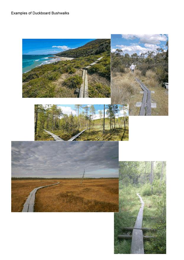
|
|
Development
& Environment Committee – Tuesday 06 August 2019
Page
0
|
|
|
Development
& Environment Committee – Tuesday 06 August 2019
Page
0
|
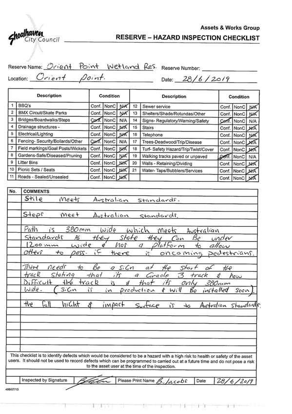
|
|
Development
& Environment Committee – Tuesday 06 August 2019
Page
0
|

|

|
Development
& Environment Committee – Tuesday 06 August 2019
Page
0
|
|
|
Development
& Environment Committee – Tuesday 06 August 2019
Page
0
|
DE19.77 Review
of Environmental Factors - Woollamia and St Andrews Way - Berrys Bay- Pressure
Sewer Scheme
HPERM Ref: D19/202563
Group: Shoalhaven
Water Group
Attachments: 1. Woollamia
Pressure Sewer System REF - Public Works (under separate cover) ⇨
2. St Andrews Way Berrys Bay
Pressure Sewer System REF - Public Works (under separate cover)
Purpose / Summary
The purpose
of this report is to inform Council of the Review of Environmental Factors
(REF) for the Woollamia and Coolangatta Pressure Sewer Schemes dated June 2019.
|
Recommendation
(Item to be determined under delegated authority)
That
1. After
consideration of the REF for Woollamia Pressure Sewerage System, June 2019,
a. Council
determine that it is unlikely that there will be any significant
environmental impact as a result of the proposed work and an Environmental
Impact Statement is therefore not required for the proposed activity.
b. The
proposed mitigation measures and controls outlined in the REF be adopted and
implemented.
2. After
consideration of the REF for St Andrews Way, Berrys Bay Pressure Sewerage
System, June 2019,
a. Council
determine that it is unlikely that there will be any significant
environmental impact as a result of the proposed work and an Environmental
Impact Statement is therefore not required for the proposed activity.
b. The
proposed mitigation measures and controls outlined in the REF be adopted and
implemented.
|
Options
1. Adopt the recommendations.
Implications: This is recommended as the community
has been consulted following Council’s resolutions to provide pressure
sewer systems to the subject areas of Woollamia and St Andrews Way/Berrys Bay.
2. Council could determine not to proceed
with provision of pressure sewer provision to the subject areas of Woollamia
and St Andrews Way/Berrys Bay.
Implications: The community has been consulted extensively
following the resolutions of Council to connect these areas to Council’s
pressure sewer systems. Council has made funds available for the completion of
the project.
3. Council could determine that the
environmental impacts warrant the preparation of an EIS.
Implications:
This is not recommended as the REF has found that the identified potential
impacts are addressed by the proposed management and mitigation measures and
assessment of statutory matters reveals the proposed management and mitigation
measures will meet legislative requirements.
Background
Council, at its Ordinary Meeting
on 31 January 2017, resolved to:
Amend the Delivery Program and Operational Plan to
include the new capital projects for sewer extensions to Woollamia Village and
the residential subdivision at St Andrews Way.
Council, at its Ordinary on 26
June 2018, resolved to:
Connect 1260 – 1280 Bolong Road, Coolangatta
(Berry’s Bay) to reticulated sewer and amend the Delivery Program and
Operational Plan to include these properties in the capital project to sewer
the residential subdivision at St Andrews Way (construction to be completed in
2019/20).
In response to the
recommendations above staff have progressed through the planning phase and
design is complete.
The preparation of separate
Reviews of Environmental Factors (REFs) for the two components of the project,
Woollamia and St Andrews Way/Berrys Bay has been proceeding concurrently with
the design and preparation of specifications. It is intended to deliver the two
components under a single supply and construct contract.
REF for St
Andrews Way and Berrys Bay
The owners
of various parcels of land within Coolangatta Estate approached Council to
express interest in connecting to the new system when implemented. While the
design and environmental assessment for the scheme has taken into consideration
the connection of parts of Coolangatta Estate, the connection would be subject
to a formal application and considered under a separate process (in accordance
with Council’s Rural Wastewater Connection Policy). A further report
would be provided to Council for its consideration should this application be
received.
Following
environmental assessment, the REF states that the proposal would potentially
cause short term impacts such as increased noise and traffic, as well as a
reduction in community amenity for the users of construction areas and
adjoining land during the construction phase. However, the works are temporary
and can be managed to minimise impacts.
Given that
the works predominantly comprise underground pipelines, adverse environmental
impacts potentially associated with the operation phase of the proposal are
considered to be minimal. The operational impacts would be positive due to the
provision of sewage reticulation infrastructure in the village.
The REF for St Andrews Way,
Berrys Bay and Coolangatta Estate Pressure Sewerage System concludes as
follows:
Based on the information in
this REF, it is concluded that:
i. the proposed
activity is not likely to have a significant impact on the environment and
therefore an Environmental Impact Statement is not required.
ii. the
proposed activity is not likely to significantly affect threatened species,
populations, ecological communities, or critical habitat. Therefore, a Species
Impact Statement (SIS) is not required.
iii. the
proposed activity is not likely to affect any Commonwealth land, is not being
carried out on Commonwealth land, or significantly affect any Matters of
National Environmental Significance.
The
proposed activity is recommended to proceed subject to the implementation of
the measures to avoid, minimise or manage environmental impacts listed in this
REF.
REF for Woollamia Village
The REF for
Woollamia Village states that a pressure sewer system would provide a
much-needed sewerage reticulation system for the developed and future lots at
the village zoned areas on Edendale Street and Woollamia Road, a fishing club
toilet block on Frank Lewis Way; and rural residential lots on Coulon Street in
Woollamia. The proposal would potentially cause short term impacts such as
increased noise and traffic, as well as a reduction in community amenity for
the users of construction areas and adjoining land during the construction
phase. However, the works are temporary and can be managed to minimise impacts.
The REF recommends
further due diligence works in relation to Aboriginal Heritage. This process
has commenced and is expected to be completed in time for a tender to be
released.
Given that the
works predominantly comprise underground pipelines, adverse environmental
impacts potentially associated with the operation phase of the proposal are
considered to be minimal. The operational impacts would be positive due to the
provision of sewage reticulation infrastructure in the village.
The REF for Woollamia Pressure
Sewerage System concludes as follows:
Notwithstanding further assessment, which is
recommended in relation to Aboriginal heritage impacts, on the basis of the
information presented in this REF it is concluded that:
i. the proposed activity is not
likely to have a significant impact on the environment and therefore an
Environmental Impact Statement is not required.
ii. the proposed activity is not
likely to significantly affect threatened species, populations, ecological
communities, or critical habitat. Therefore, a Species Impact Statement (SIS)
is not required
iii. the proposed activity is not likely
to affect any Commonwealth land, is not being carried out on Commonwealth land,
or significantly affect any Matters of National Environmental Significance.
The proposed activity is
recommended to proceed subject to the implementation of the measures to avoid,
minimise or manage environmental impacts listed in this REF.
Community Engagement
Community engagement has been
extensive through the planning and design phases of the schemes. It was
recognised that numerous property owners, particularly in Woollamia, would not
be aware that the scheme in their area was proceeding. It was also recognised
that few would have knowledge of pressure sewer systems. Some consultation had
been undertaken with property owners in St Andrews Way and Berrys Bay by
Environmental Services so have some familiarity with the proposed system.
The consultation process thus
far has included newsletters, information brochures, website updates, social
media and a community drop-in session. The community drop-in session was held
at the Lady Denman from 9:30am to 11:30am on Saturday 9 February 2019. It was
very well attended with approximately 60 people in attendance (most from
Woollamia but some from St Andrews Way). The vast majority of attendees were in
support of the scheme but there were some concerned with the potential and
ongoing costs of being connected to the scheme; others were concerned with the
cost of decommissioning recently installed (expensive) on-site systems.
There were several requests to
hold another similar session at the completion of the design process (and prior
to construction commencing). This will be added into the program.
A “Get Involved”
page has been set up on Council’s website to continue the consultation
process and provide a history of correspondence for those who haven’t
responded to the consultative process thus far.
The REFs for these projects were
placed on public exhibition between from 3 July 2019 to 20 July 2019 during
which time submissions were invited. Two responses were received in relation to
the Woollamia scheme.
The first respondent was
supportive of the scheme and requested an extension of the current scheme
boundary. It is not considered a matter to be dealt with under this REF as the
assessment only considered the impacts within the adopted scheme boundary.
The second respondent objected to the scheme generally,
raising matters such as ongoing costs to the landowners through sewer
availability charges and electricity costs. These matters have been previously
dealt with by correspondence and discussed at the Community drop in session. It
is considered that the matters raised can be resolved with the respondent
during the construction and management of the project or have been addressed by
the REF.
Policy Implications
Council’s Policy POL16/94 - Pressure Sewer System
Policy - Backlog Sewerage Schemes has been provided to all property owners
and the main points were highlighted at the Community drop-in session.
The primary interest of the property owners has been the potential and ongoing
costs.
Financial Implications
Adequate funds have been allocated in the sewer budget to
support Council’s resolutions to complete design for the schemes in
2018/19 and construction in 2019/20.
Risk Implications
A project risk assessment for
the project has been established. Environmental risks have been identified and
addressed in the project REFs by recommending mitigation measures. These
mitigation measures will be required to be implemented by the construction
contractor through their Construction Environmental Management Plan.
|
|
Development
& Environment Committee – Tuesday 06 August 2019
Page
0
|
Local Government Amendment (governance &
planning) act 2016
Chapter
3, Section 8A Guiding principles for councils
(1)
Exercise of functions
generally
The
following general principles apply to the exercise of functions by councils:
(a) Councils should provide strong
and effective representation, leadership, planning and decision-making.
(b) Councils should carry out
functions in a way that provides the best possible value for residents and
ratepayers.
(c) Councils should plan
strategically, using the integrated planning and reporting framework, for the
provision of effective and efficient services and regulation to meet the
diverse needs of the local community.
(d) Councils should apply the
integrated planning and reporting framework in carrying out their functions so
as to achieve desired outcomes and continuous improvements.
(e) Councils should work
co-operatively with other councils and the State government to achieve desired
outcomes for the local community.
(f) Councils should manage
lands and other assets so that current and future local community needs can be
met in an affordable way.
(g) Councils should work with
others to secure appropriate services for local community needs.
(h) Councils should act fairly,
ethically and without bias in the interests of the local community.
(i) Councils should be
responsible employers and provide a consultative and supportive working
environment for staff.
(2) Decision-making
The
following principles apply to decision-making by councils (subject to any other
applicable law):
(a) Councils should recognise
diverse local community needs and interests.
(b) Councils should consider social
justice principles.
(c) Councils should consider the
long term and cumulative effects of actions on future generations.
(d) Councils should consider the
principles of ecologically sustainable development.
(e) Council decision-making should
be transparent and decision-makers are to be accountable for decisions and
omissions.
(3) Community participation
Councils
should actively engage with their local communities, through the use of the
integrated planning and reporting framework and other measures.
Chapter
3, Section 8B Principles of sound financial management
The
following principles of sound financial management apply to councils:
(a) Council spending should be responsible and sustainable,
aligning general revenue and expenses.
(b) Councils should invest in responsible and
sustainable infrastructure for the benefit of the local community.
(c) Councils should have effective financial
and asset management, including sound policies and processes for the following:
(i) performance management
and reporting,
(ii) asset maintenance and
enhancement,
(iii) funding decisions,
(iv) risk management practices.
(d) Councils should have regard to achieving
intergenerational equity, including ensuring the following:
(i) policy decisions are made
after considering their financial effects on future generations,
(ii) the
current generation funds the cost of its services
Chapter
3, 8C Integrated planning and reporting principles that apply to councils
The
following principles for strategic planning apply to the development of the
integrated planning and reporting framework by councils:
(a) Councils should identify and prioritise key
local community needs and aspirations and consider regional priorities.
(b) Councils should identify strategic goals to
meet those needs and aspirations.
(c) Councils should develop activities, and
prioritise actions, to work towards the strategic goals.
(d) Councils should ensure that the strategic
goals and activities to work towards them may be achieved within council
resources.
(e) Councils should regularly review and
evaluate progress towards achieving strategic goals.
(f) Councils should maintain an
integrated approach to planning, delivering, monitoring and reporting on
strategic goals.
(g) Councils should collaborate with others to
maximise achievement of strategic goals.
(h) Councils should manage risks to the local
community or area or to the council effectively and proactively.
(i) Councils should make appropriate
evidence-based adaptations to meet changing needs and circumstances.