Development & Environment Committee
Meeting Date: Tuesday,
02 July, 2019
Location: Council
Chambers, City Administrative Building, Bridge Road, Nowra
Time: 5.00pm
Membership (Quorum - 5)
Clr Joanna Gash - Chairperson
Clr Greg Watson
All Councillors
General Manager or nominee
Please note: The proceedings of this meeting
(including presentations, deputations and debate) will be webcast and may be
recorded and broadcast under the provisions of the Code of Meeting Practice. Your attendance at this meeting is taken
as consent to the possibility that your image and/or voice may be recorded and
broadcast to the public.
Agenda
1. Apologies / Leave of Absence
2. Confirmation of Minutes
· Development
& Environment Committee - 4 June 2019............................................. 1
3. Declarations of Interest
4. Call Over of the Business Paper
5. Mayoral Minute
6. Deputations and Presentations
7. Notices of Motion / Questions on Notice
Nil
8. Reports
Planning Environment & Development
DE19.46...... Public Exhibition Outcomes - Coastal Hazard
Review Planning Proposal and Coastal Management Areas DCP Amendment......................................................... 12
DE19.52...... Progress Update - Berry Heritage Investigations........................................ 17
DE19.53...... Exhibition Outcomes and Finalisation - Planning
Proposal: 2017 Housekeeping Amendment (Instrument Changes) - Shoalhaven LEP
2014...................... 21
DE19.54...... Nowra CBD Fringe Planning Proposal - Progress and
Possible Next Steps 31
DE19.55...... Funding Offer - NSW Heritage Grants - 2019-20 and
2020-21................... 42
DE19.56...... Proposed Housekeeping Amendment - Shoalhaven Development
Control Plan 2014 - General and Generic Chapters.................................................................... 45
DE19.57...... Exhibition Outcomes and Proposed Finalisation -
Citywide SP3 Tourist Zones Review - Planning Proposal and Proposed Amendment to
Chapter V3 Shoalhaven Development Control Plan 2014.................................................................. 51
DE19.58...... Shoalhaven Development Control Plan 2014 -
Proposed Amendment to Chapter N12: Culburra Beach - The Marina Area.............................................................. 56
DE19.59...... Development Application – No.64, Lot 1138
in DP 1210394, Seagrass Avenue Vincentia....................................................................................................... 65
DE19.60...... Development Application – 38 Lyrebird Drive
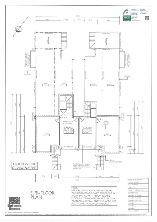
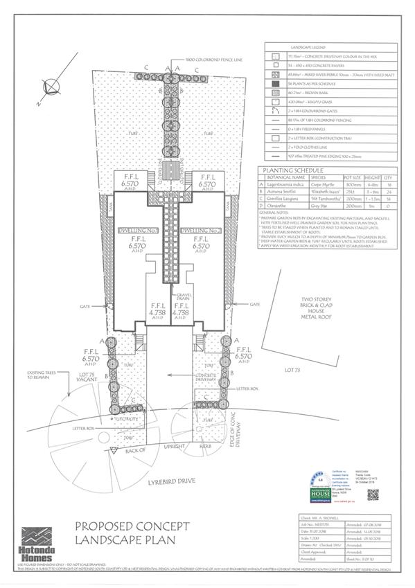
Nowra – Lot 74 DP 1198691 DA18/2175...................................................................................................................... 98
DE19.61...... Shoalhaven City Council - Mobile Food Vans in the
LGA - Private and Public Lands.................................................................................................................... 121
DE19.62...... Shoalhaven Heads - River Road Foreshore Precinct
Rehabilitation Project - Progress Update........................................................................................................ 129
9. Confidential
Reports
Nil
|

|
Development
& Environment Committee – Tuesday 02 July 2019
Page
|
Development & Environment Committee
Delegation:
Pursuant to
s377 (1) of the Local Government Act 1993 the Committee is delegated the
functions conferred on Council by the Environmental Planning & Assessment
Act 1979 (EPA Act), Local Government Act 1993 (LG Act) or any other Act or
delegated to Council, as are specified in the attached Schedule, subject to the
following limitations:
i. The
Committee cannot make a decision to make a local environmental plan to classify
or reclassify public land under Division 1 of Part 2 of Chapter 6 of the LG
Act;
ii.
The Committee cannot review a section 8.11 or
section 8.9 EPA Act determination made by the Council or by the Committee
itself;
iii.
The Committee cannot exercise any function delegated
to the Council which by the terms of that delegation cannot be sub-delegated;
iv.
The Committee cannot exercise any function which
s377(1) of the LG Act provides cannot be delegated by Council; and
v.
The Committee cannot exercise a function which
is expressly required by the LG Act or any other Act to be exercised by
resolution of the Council.
Schedule
a. All
functions relating to the preparation, making, and review of local
environmental plans (LEPs) and development control plans (DCPs) under Part 3 of
the EPA Act.
b. All
functions relating to the preparation, making, and review of contributions
plans and the preparation, entry into, and review of voluntary planning
agreements under Part 7 of the EPA Act.
c. The
preparation, adoption, and review of policies and strategies of the Council in
respect of town planning and environmental matters and the variation of such
policies.
d. Determination
of variations to development standards related to development applications
under the EPA Act where the development application involves a development
which seeks to vary a development standard by more than 10% and the application
is accompanied by a request to vary the development standard under clause 4.6
of Shoalhaven Local Environmental Plan 2014 or an objection to the application
of the development standard under State Environmental Planning Policy No. 1
– Development Standards.
e. Determination
of variations from the acceptable solutions and/or other numerical standards
contained within the DCP or a Council Policy that the General Manager requires
to be determined by the Committee
f. Determination
of development applications that Council requires to be determined by the
Committee on a case by case basis.
g. Review
of determinations of development applications under sections 8.11 and 8.9 of
the EP&A Act that the General Manager requires to be determined by the
Committee.
h. Preparation,
review, and adoption of policies and guidelines in respect of the determination
of development applications by other delegates of the Council.
i. The
preparation, adoption, and review of policies and strategies of the Council in
respect to sustainability matters related to climate change, biodiversity,
waste, water, energy, transport, and sustainable purchasing.
j. The
preparation, adoption and review of policies and strategies of the Council in
respect to management of natural resources / assets, floodplain, estuary and
coastal management.
Minutes of the Development & Environment Committee
Meeting Date: Tuesday,
4 June 2019
Location: Council
Chambers, City Administrative Building, Bridge Road, Nowra
Time: 5.00pm
The following members
were present:
Clr Amanda Findley
Clr Joanna Gash -
Chairperson
Clr Patricia White
– arrived 5.01pm
Clr John Wells
Clr John Levett
Clr Annette Alldrick
Clr Kaye Gartner
Clr Andrew Guile –
arrived 5.07pm
Clr Mitchell Pakes
Clr Greg Watson
Clr Mark Kitchener
Clr Bob Proudfoot
Mr Stephen Dunshea -
Acting General Manager
|
Apologies / Leave of Absence
|
An apology was received
from Clr Digiglio.
|
Confirmation of the Minutes
|
|
Note:
Clr White arrived at 5.01pm
|
|
RESOLVED (Clr Findley / Clr
Pakes) MIN19.366
That the Minutes of the
Development & Environment Committee held on Tuesday 07 May 2019 be
confirmed.
CARRIED
|
Nil
|
Call Over of the
Business Paper
|
|
RESOLVED (Clr Gartner / Clr
Alldrick) MIN19.367
That
no call over of the agenda be carried out and all items be dealt with
individually.
CARRIED
|
Mayoral Minutes
Nil
Deputations and Presentations
DE19.40 - Development
Application – 17 Hawke Street & 22 Currambene Street, Huskisson - Lot
7 & 8 DP 758530 Sec 3E - Relocation of the former church on the
subject site and demolition of the existing associated hall and shed (page 15)
Mr George Brown, representing
the Save Husky Church group, addressed the meeting and spoke against the
recommendation.
Note: Clr Guile arrived at
5.07pm
Mr Stephen Bartlett addressed the meeting and spoke for the
recommendation
DE19.48 - Jerberra and Verons
Estates - Biodiversity Assessment - Clause 34A Certification (page 110)
Ms Mary-Jean Lewis, representing
Jerberra Committee land owners, addressed the meeting and spoke for the
recommendation.
|
Procedural
Motion - Bring Item Forward
|
|
RESOLVED (Clr Wells) MIN19.368
That Item DE19.48 - Jerberra and
Verons Estates - Biodiversity Assessment - Clause 34A Certification be
brought forward for consideration.
CARRIED
|
|
DE19.48 Jerberra
and Verons Estates - Biodiversity Assessment - Clause 34A Certification
|
HPERM Ref:
D19/140355
|
|
Recommendation (Item to be determined under
delegated authority)
1. Receive
the update on the Clause 34A certification provided for Jerberra and Verons
Estates for information.
2. As
a way of removing uncertainty, adopt a policy position for Jerberra Estate
that requires appropriate covenants to be registered on property titles as
part of the development approval process to ensure the areas listed below are
managed for conservation into the future:
a. Bushland
Management Area (BMA)
b. Bushland
Conservation Area (BCA)
c. Orchid
Management Area (OMA)
3. Commence
to amend the Shoalhaven Development Control Plan (DCP) 2014 to update Chapter
N20 (Jerberra Estate) and S1 (Verons Estate) because of the Clause 34A
certification for each Estate, including the following:
a. the
addition of a specific provision in Chapter N20 to establish covenants
outlined in part 1. to ensure the clause 34A certification remains legally
valid in Jerberra Estate
b. update
references to legislation
c. make
other changes as required to improve the effectiveness and readability of
both chapters.
|
|
RESOLVED (Clr Guile / Clr Wells) MIN19.369
1. Receive
the update on the Clause 34A certification provided for Jerberra and Verons
Estates for information.
2. As
a way of removing uncertainty, adopt a policy position for Jerberra Estate
that requires appropriate covenants to be registered on property titles as
part of the development approval process to ensure the areas listed below are
managed for conservation into the future:
a. Bushland
Management Area (BMA)
b. Bushland
Conservation Area (BCA)
c. Orchid
Management Area (OMA)
3. Commence
to amend the Shoalhaven Development Control Plan (DCP) 2014 to update Chapter
N20 (Jerberra Estate) and S1 (Verons Estate) because of the Clause 34A
certification for each Estate, including the following:
a. the
addition of a specific provision in Chapter N20 to establish covenants
outlined in part 1. to ensure the clause 34A certification remains legally
valid in Jerberra Estate
b. update
references to legislation
c. make
other changes as required to improve the effectiveness and readability of
both chapters.
For: Clr
Findley, Clr Gash, Clr White, Clr Wells, Clr Levett, Clr Alldrick, Clr
Gartner, Clr Guile, Clr Pakes, Clr Watson, Clr Kitchener, Clr Proudfoot and
Stephen Dunshea
Against: Nil
CARRIED
|
Reports
|
DE19.40 Development
Application – 17 Hawke Street & 22 Currambene Street, Huskisson -
Lot 7 & 8 DP 758530 Sec 3E - Relocation of the former church on the
subject site and demolition of the existing associated hall and shed
|
HPERM Ref:
D19/145092
|
|
|
Recommendation (Item to be determined under
delegated authority)
That Council approve Development Application DA18/2102 for
the relocation of the former church and demolition of the existing associated
hall and shed on the land at 17 Hawke Street and 22 Currambene Street,
Huskisson - Lots 7 and 8 DP 758530 Sec 3E subject to the recommended
conditions of consent contained in Attachment 1 to this report.
|
|
RESOLVED (Clr Guile / Clr Watson)
MIN19.370
That:
1. Council
approve Development Application DA18/2102 for the relocation of the former
church and demolition of the existing associated hall and shed on the land at
17 Hawke Street and 22 Currambene Street, Huskisson - Lots 7 and 8 DP 758530
Sec 3E subject to the recommended conditions of consent contained in
Attachment 1 to this report.
2. The consent be structured to
enable demolition to occur independent to the Church relocation.
For: Clr
Gash, Clr White, Clr Wells, Clr Guile, Clr Pakes, Clr Watson, Clr Kitchener
and Stephen Dunshea
Against: Clr
Findley, Clr Levett, Clr Alldrick, Clr Gartner and Clr Proudfoot
CARRIED
|
|
DE19.41 Development
Application – 43 Willowford Road WOOLLAMIA – Lot 80 & DP 9289
|
HPERM Ref:
D19/6384
|
|
Recommendation (Item to be determined under
delegated authority)
That Council:
1. Approve
Development Application DA18/2020 subject to the conditions provided at
Attachment 1; and
2. Officers
give notice of its intention to serve a “Demolish Works Order”
under Section 9.34 of the Environmental Planning and Assessment Act 1979 in
respect of the Blacksmith’s Shed and the pergola. The order that
follows any representations received will be suitably aligned with the
recommended conditions of approval.
|
|
RESOLVED (Clr Findley / Clr
Alldrick) MIN19.371
That Council:
1. Approve
Development Application DA18/2020 subject to the conditions provided at
Attachment 1; and
2. Officers
give notice of its intention to serve a “Demolish Works Order”
under Section 9.34 of the Environmental Planning and Assessment Act 1979 in
respect of the Blacksmith’s Shed and the pergola. The order that
follows any representations received will be suitably aligned with the
recommended conditions of approval.
For: Clr
Findley, Clr Gash, Clr White, Clr Wells, Clr Levett, Clr Alldrick, Clr
Gartner, Clr Guile, Clr Pakes, Clr Watson, Clr Kitchener, Clr Proudfoot and
Stephen Dunshea
Against: Nil
CARRIED
Note:
This item was re-introduced later in the meeting for final resolution see MIN19.375
|
|
DE19.42 Collingwood
Beach - Action Plan Progress Report
|
HPERM Ref: D19/77369
|
|
Note: Clr Proudfoot left
the meeting at 6.16pm
|
|
Recommendation (Item to be determined under
delegated authority)
That Council
1. Receive
the report on the progress of the Collingwood Beach Dune Vegetation Two-Year
Trial Action Plan for information; and
2. Revote
any of the remaining funds in job number 15857
to the 2019/20 budget to allow implementation of the Collingwood Beach Dune
Vegetation Two-Year Trial Action Plan until the end of the two-year trial
period.
|
|
RESOLVED (Clr Levett / Clr
Gartner) MIN19.372
That Council:
1. Receive
the report on the progress of the Collingwood Beach Dune Vegetation Two-Year
Trial Action Plan for information; and
2. Revote
any of the remaining funds in job number 15857
to the 2019/20 budget to allow implementation of the Collingwood Beach Dune
Vegetation Two-Year Trial Action Plan until the end of the two-year trial
period.
For: Clr
Findley, Clr Gash, Clr White, Clr Wells, Clr Levett, Clr Alldrick, Clr
Gartner, Clr Guile, Clr Pakes, Clr Watson, Clr Kitchener and Stephen Dunshea
AGAINST:
Nil
CARRIED
|
|
DE19.43 Two
(2) Bushcare Group Action Plans - Review
|
HPERM Ref:
D19/124016
|
|
Recommendation (Item to be determined under
delegated authority)
That Council adopt the following
two (2) reviewed Bushcare Group Action Plans:
1. The
Grotto; and
2. Camp
Quality.
|
|
RESOLVED (Clr Findley / Clr
Wells) MIN19.373
That Council adopt the following
two (2) reviewed Bushcare Group Action Plans:
1. The
Grotto; and
2. Camp
Quality.
CARRIED
|
|
DE19.44 Strategic
Planning Works Program - Proposed 2019-2020 Version
|
HPERM Ref: D19/94513
|
|
Recommendation (Item to be determined under
delegated authority)
That Council:
1. Adopt
and finalise Attachment 2 as Council’s 2019-2020 Strategic Planning
Works Program.
2. Receive
a report on the 2020-2021 Strategic Planning Works Program in June 2020 to
coincide with the new financial year.
3. Make
future changes or additions to the Strategic Planning Works Program only
after considering the current program, project priority, staff workload and
resources.
|
|
RESOLVED (Clr Watson / Clr
Gartner) MIN19.374
That Council:
1. Adopt
and finalise Attachment 2 as Council’s 2019-2020 Strategic Planning
Works Program.
2. Receive
a report on the 2020-2021 Strategic Planning Works Program in June 2020 to
coincide with the new financial year.
3. Make
future changes or additions to the Strategic Planning Works Program only
after considering the current program, project priority, staff workload and
resources.
CARRIED
|
|
DE19.45 Draft
Medium Density Amendment (Chapter G13) - Shoalhaven DCP 2014 - Post
Exhibition Consideration and Finalisation
|
HPERM Ref:
D19/132724
|
|
Recommendation (Item to be determined under
delegated authority)
That
Council:
1. Adopt
the amendment to Chapter G13: Medium Density and Other Residential
Development of Shoalhaven Development Control Plan 2014 (the Amendment) as
exhibited, with the changes outlined in Attachment 2.
2. Notify
the adoption of the Amendment in local newspapers in accordance with the
requirements of the Environmental Planning and Assessment Act 1979 and
Regulations.
3. Advise
key stakeholders, including all Community Consultative Bodies, relevant
industry representatives and those who made a submission, of this decision,
and when the Amendment will be made effective.
|
|
Motion (Clr Guile / Clr Gash)
That Council:
1. Defer this matter until the June
2019 Ordinary Meeting.
2. Advise the key stakeholders
(including landowners, submitters and relevant CCBs) of this decision and of
the upcoming Council meeting arrangements.
Note:
Debate on this item was not completed at this time – refer MIN19.376
for resolution.
|
|
Procedural
Motion - Reintroduction of Item
|
|
PROCEDURAL Motion (Clr Watson /
Clr Guile)
That DE19.41 - Development
Application – 43 Willowford Road WOOLLAMIA – Lot 80 & DP 9289
be reintroduced for clarification of the recommendation.
PROCEDURAL MOTION CARRIED
|
Note: Clr Proudfoot
returned to the meeting at 6.20pm
|
DE19.41 Development
Application – 43 Willowford Road WOOLLAMIA – Lot 80 & DP 9289
|
HPERM Ref:
D19/6384
|
|
This item was
re-introduced for clarification of the recommendation.
|
|
Recommendation (Item to be determined under
delegated authority)
That Council:
1. Approve
Development Application DA18/2020 subject to the conditions provided at
Attachment 1; and
2. Officers
give notice of its intention to serve a “Demolish Works Order”
under Section 9.34 of the Environmental Planning and Assessment Act 1979 in
respect of the Blacksmith’s Shed and the pergola. The order that
follows any representations received will be suitably aligned with the
recommended conditions of approval.
|
|
RESOLVED (Clr Findley / Clr
Wells) MIN19.375
That Council:
1. Approve
Development Application DA18/2020 subject to the conditions provided at
Attachment 1; and
2. Officers
give notice of its intention to serve a “Demolish Works Order”
under Section 9.34 of the Environmental Planning and Assessment Act 1979 in
respect of the Blacksmith’s Shed and the pergola. The order that
follows any representations received will be suitably aligned with the
recommended conditions of approval.
For: Clr
Findley, Clr Gash, Clr White, Clr Wells, Clr Levett, Clr Alldrick, Clr
Gartner, Clr Guile, Clr Pakes, Clr Watson, Clr Kitchener, Clr Proudfoot and
Stephen Dunshea
Against: Nil
CARRIED
|
|
DE19.45 Draft
Medium Density Amendment (Chapter G13) - Shoalhaven DCP 2014 - Post Exhibition
Consideration and Finalisation
|
HPERM Ref:
D19/132724
|
|
The previous motion was
not put and carried.
|
|
Recommendation (Item to be determined under
delegated authority)
That
Council:
1. Adopt
the amendment to Chapter G13: Medium Density and Other Residential
Development of Shoalhaven Development Control Plan 2014 (the Amendment) as
exhibited, with the changes outlined in Attachment 2.
2. Notify
the adoption of the Amendment in local newspapers in accordance with the
requirements of the Environmental Planning and Assessment Act 1979 and
Regulations.
3. Advise
key stakeholders, including all Community Consultative Bodies, relevant
industry representatives and those who made a submission, of this decision,
and when the Amendment will be made effective.
|
|
RESOLVED (Clr Guile / Clr Gash) MIN19.376
That Council:
1. Defer this matter until the June
2019 Ordinary Meeting.
2. Advise the key stakeholders
(including landowners, submitters and relevant CCBs) of this decision and of
the upcoming Council meeting arrangements.
For: Clr
Findley, Clr Gash, Clr White, Clr Wells, Clr Levett, Clr Alldrick, Clr
Gartner, Clr Guile, Clr Pakes, Clr Watson, Clr Kitchener, Clr Proudfoot and
Stephen Dunshea
Against: Nil
CARRIED
|
|
DE19.46 Public
Exhibition Outcomes - Coastal Hazard Review Planning Proposal and Coastal
Management Areas DCP Amendment
|
HPERM Ref:
D19/113261
|
|
Recommendation (Item to be determined under
delegated authority)
That Council:
1. Adopt
the Planning Proposal (PP026) as exhibited and forward to the NSW Department
of Planning and Environment for finalisation.
2. Adopt
and finalise Shoalhaven Development Control Plan 2014 Chapter G6: Coastal
Management Areas Amendment as exhibited, with the inclusion of the changes
highlighted in Attachment 2.
3. Advise
key stakeholders, including all CCBs, relevant industry representatives and
those who made a submission, of this decision, and when the LEP and DCP
amendments will be made effective.
|
|
RESOLVED (Clr Proudfoot / Clr
Pakes) MIN19.377
That
Council:
1. Defer this matter until the July
2019 Development & Environment Committee meeting.
2. Advise
the key stakeholders (including submitters and relevant CCBs) of this
decision and of the upcoming Council meeting arrangements.
CARRIED
Note: At Page 99 in the report in
the background, “some” should be inserted with reference to Public and
private properties.
|
|
DE19.47 New
Proponent Initiated Planning Proposal - Appleberry Close, Meroo Meadow
|
HPERM Ref:
D19/130924
|
|
Recommendation (Item to be determined under
delegated authority)
That Council:
1. Support
the Planning Proposal to permit a boundary adjustment between Lots 21 and 22
in DP 1113675 and Lot 202 in DP 1180659 provided no additional lots or
dwelling entitlements will be created, and the mechanism to achieve this
outcome be determined in consultation with the NSW Department of Planning and
Environment.
2. Prepare
and submit the PP documentation to the NSW Department of Planning and
Environment for Gateway determination, and dependent on the outcome proceed
to exhibit the PP and report back to Council post-exhibition.
3. Advance
as a ‘minor’ proponent-initiated Planning Proposal and fees be
charged in accordance with Council’s adopted Fees and Charges.
4. Advise
the proponent of this resolution.
|
|
RESOLVED (Clr Wells / Clr
Gartner) MIN19.378
That Council:
1. Support
the Planning Proposal to permit a boundary adjustment between Lots 21 and 22
in DP 1113675 and Lot 202 in DP 1180659 provided no additional lots or
dwelling entitlements will be created, and the mechanism to achieve this
outcome be determined in consultation with the NSW Department of Planning and
Environment.
2. Prepare
and submit the Planning Proposal documentation to the NSW Department of
Planning and Environment for Gateway determination, and dependent on the
outcome proceed to exhibit the PP and report back to Council post-exhibition.
3. Advance
as a ‘minor’ proponent-initiated Planning Proposal and fees be
charged in accordance with Council’s adopted Fees and Charges.
4. Advise
the proponent of this resolution.
For: Clr
Findley, Clr Gash, Clr White, Clr Wells, Clr Levett, Clr Alldrick, Clr
Gartner, Clr Guile, Clr Pakes, Clr Watson, Clr Kitchener, Clr Proudfoot and
Stephen Dunshea
Against: Nil
CARRIED
|
|
DE19.48 Jerberra and Verons Estates - Biodiversity
Assessment - Clause 34A Certification
|
HPERM Ref: D19/140355
|
|
Item
dealt with earlier in the meeting see MIN19.369
|
GENERAL BUSINESS
|
Procedural
Motion - Matters of Urgency
|
|
RESOLVED (Clr White) MIN19.379
That an additional item regarding
urgent matters regarding Lake Conjola be introduced as a matter of urgency
due to the current weather conditions.
CARRIED
|
|
The Chairperson ruled
the matter as urgent as it relates to public interest.
|
|
DE19.49 Additional
Item - Lake Conjola - Rising Water Levels - Water Gauges
|
|
Clr White raised concerns
regarding the water levels at Lake Conjola in the current weather and the
residents are concerned for their safety.
|
|
RESOLVED (Clr White / Clr
Proudfoot) MIN19.380
That Council:
1. Immediately
install manual water gauges/devices in 2 locations, one at the top end of the
lake and one near the Manly Hydraulic device as a matter of urgency.
2. Provide
the community with an emergency plan that contains emergency phone numbers of
who to contact in emergency situations related to the lake.
3. A
briefing be provided to Councillors on Council’s protocols for
emergencies related to the lake.
4. Request
the Mayor to make representations to the Member for South Coast – The
Hon Shelley Hancock regarding the Council’s safety concerns relating to
the Lake.
CARRIED
|
|
Procedural
Motion - Matters of Urgency
|
|
RESOLVED (Clr White) MIN19.381
That an additional item DA18/2175 – 38 Lyrebird Drive,
Nowra be introduced as a matter of urgency.
CARRIED
|
|
The chairperson ruled
the matter as urgent as it
relates to public interest.
|
|
DE19.50 Additional
Item - Call in Development Application
|
|
RESOLVED (Clr White / Clr
Proudfoot) MIN19.382
That the
matter of DA18/2175 – 38 Lyrebird Drive, Nowra be called in due to the
public interest and Policy.
For: Clr
Findley, Clr Gash, Clr White, Clr Wells, Clr Levett, Clr Alldrick, Clr
Gartner, Clr Guile, Clr Pakes, Clr Watson, Clr Kitchener, Clr Proudfoot and
Stephen Dunshea
Against: Nil
CARRIED
|
|
Procedural
Motion - Matters of Urgency
|
|
RESOLVED (Clr Pakes) MIN19.383
That an additional item regarding
the pathway structure at Orient Point be introduced as a matter of urgency.
CARRIED
|
|
The Chairperson ruled
the matter as urgent as it relates to public interest.
|
|
DE19.51 Additional
Item - Pathway Infrastructure - Orient Point
|
|
Clr
Pakes raised concerns regarding the newly constructed pathway infrastructure
at Orient Point.
|
|
RESOLVED (Clr Pakes / Clr Gash) MIN19.384
That
with respect to the recently constructed pathway structure at Orient Point,
Council:
1. Take immediate steps to isolate or
barricade the structure for concerns of public safety;
2. Provide an urgent report on the
new pathway and the report include:
a. The total cost of the project
b. Who in the Community was consulted
c. If the pathway meets current
standards
CARRIED
|
There being no further
business, the meeting concluded, the time being 7.00pm.
Clr Gash
CHAIRPERSON
|

|
Development
& Environment Committee – Tuesday 02 July 2019
Page
0
|
DE19.46 Public
Exhibition Outcomes - Coastal Hazard Review Planning Proposal and Coastal
Management Areas DCP Amendment
HPERM Ref: D19/113261
Group: Planning
Environment & Development Group
Section: Strategic
Planning
Attachments: 1. External
Consultation Submission Summary (under separate cover) ⇨
2. Proposed Post Exhibition
Changes to Chapter G6 (under separate cover) ⇨
This item
was deferred from the Development & Environment Committee meeting of 4 June
2019.
Purpose / Summary
· Report
the outcomes of the combined public exhibition of Planning Proposal PP026
– Coastal Hazards Review (PP) and Development Control Plan (DCP)
Amendment No. 20 Chapter G6: Coastal Management Areas.
· Enable
the amendments to Shoalhaven Local Environmental Plan (LEP) 2014 and Shoalhaven
DCP 2014 to proceed to finalisation.
|
Recommendation (Item to be
determined under delegated authority)
That Council:
1. Adopt
the Planning Proposal (PP026) as exhibited and forward to the NSW Department
of Planning and Environment for finalisation.
2. Adopt
and finalise Shoalhaven Development Control Plan 2014 Chapter G6: Coastal
Management Areas Amendment as exhibited, with the inclusion of the changes
highlighted in Attachment 2.
3. Advise
key stakeholders, including all CCBs, relevant industry representatives and
those who made a submission, of this decision, and when the LEP and DCP
amendments will be made effective.
|
Options
1. As recommended.
Implications: This is the preferred option as it
will ensure the amendments to Shoalhaven LEP 2014 and Shoalhaven DCP 2014
proceed to finalisation. This will increase the dependability of
Council’s coastal risk information and address several housekeeping
matters within Chapter G6: Coastal Management Areas.
2. Adopt an
alternative recommendation.
Implications: Depending on its nature, this could
delay the progress of the amendments to Shoalhaven LEP 2014 and Shoalhaven DCP
2014.
3. Not
adopt the recommendation.
Implications: This option is not preferred as the
coastal risk planning maps will remain in Shoalhaven LEP 2014 resulting in
lengthy delays to update these maps. The housekeeping matters for consideration
in Chapter G6: Coastal Management Areas of Shoalhaven DCP 2014 will remain
outstanding, which will negatively impact upon the overall application and use
of the Chapter.
Background
Some public and private properties
along the coast are at risk from coastal hazards such as beach erosion,
shoreline recession, costal entrance instability, sand drift, coastal
inundation, storm water erosion, and slope instability. Council’s
planning instruments assist to manage this risk.
On 14 August 2018,
Council’s Development Committee resolved (MIN18.609) to:
1. Endorse the
Coastal Hazards Review Planning Proposal (PP026) (Attachment 1) and submit it
to the NSW Department of Planning and Environment for Gateway determination
2. Following
receipt of the Gateway determination, concurrently exhibit PP026 and draft
Chapter G6: Coastal Management Areas of Shoalhaven Development Control Plan
2014 (Attachment 2), for a period of 28 days as per legislative requirements.
3. Support the preparation
of the online coastal hazard mapping based on current coastal risk data.
4. Receive a
further report on PP026 and draft Chapter G6: Coastal Management Areas
following the conclusion of the public exhibition period.
5. Advise key stakeholders,
including relevant Community Consultative Bodies, of this decision.
The following is an overview of the PP and DCP amendment.
Planning Proposal
Seeks to amend the current
coastal hazard related controls in the LEP by:
· Removing
the Coastal Risk Planning Maps from the LEP (Note: detailed coastal hazard
mapping is now publicly available on Council’s
website);
· Amend
Clause 7.4 Coastal Risk Planning to apply to all land at risk of coastal
hazards identified within the Shoalhaven Coastal Zone Management Plan, coastal
management programs and/or supporting studies.
The PP was submitted to the NSW Department of Planning and
Environment (DP&E) following the August 2018 resolution and was granted a
favourable Gateway determination on 24 October 2018. Council was not granted
delegated authority to finalise the LEP amendment which means the PP will
ultimately need to be submitted to DP&E for finalisation.
DCP Amendment
The proposed amendments to DCP
Chapter G6: Coastal Management Areas respond to operational issues and matters
the require clarification. The key changes are summarised below:
· Insert
references to the Shoalhaven Coastal Hazard Interactive Mapping.
· Replace
references to 2025 Zone of Reduced Foundation Capacity (ZRFC) with 2030 ZRFC
throughout.
· Clarify
that sites landward of Precinct 2 (i.e. 2100 ZRFC) have limited restrictions,
not no restrictions.
· Include
additional commentary and provisions relating to wave runup.
· Include
Bendalong Boat Harbour Beach as a known area of beach erosion and/or oceanic
inundation, and Narrawallee as a known area of cliff/slope instability.
· Insert
references to recently adopted studies (e.g. Royal Haskoning DHV Report –
Shoalhaven Coastal Cliffs and Slopes Risk Management Program – 2018).
· Clarify
that the side setback requirements also apply to lots on the landward side of
an unformed road that adjoins a waterfront reserve.
· Include
several provisions adopted from Council Policy POL12/217 Coastal Areas –
Planning and Development relating to mitigating loss of public amenity and
managing aesthetic and environmental impacts on the foreshore and other public
areas.
· Expand
foreshore development controls in Section 5.2 to also apply to non-residential
development.
· Include
new provisions relating to public infrastructure on public land.
· Include
provisions to reflect the revised content of the Generic Community Lands Plan
of Management – Natural Areas and Foreshore Reserves Policy (e.g.
Stormwater from adjoining residences should be managed via inter-allotment
drainage and discharged directly into a stormwater facility of Council).
· Update all images
to enhance the readability of the Chapter and consistency across the DCP.
Government Agency Feedback
Prior to public exhibition, the
PP was referred to the NSW Office of Environment and Heritage (OEH) as required
by the Gateway determination. The comments from OEH and the Council staff response
is summarised in Table 1 below.
Table 1: OEH Comments on the Planning Proposal
|
OEH Comments
|
Council Staff Response
|
|
Cleary demonstrate that removing the coastal hazard
mapping will not affect or remove existing development controls for development
on land subject to coastal hazards.
|
The PP was updated prior to
exhibition to include the following additional commentary in Section 3.2 Map
Change: “It (the online coastal mapping) will be updated as and when
Council adopts new or updated coastal risk data (for example, Coastal Zone
Management Plan). The removal of the CRP Map from SLEP 2014 will not affect
or remove existing development controls on land subject to coastal
hazards.”
|
|
Cleary demonstrate that there is a legal planning
mechanism in place to trigger and apply appropriate coastal hazard related
development controls for land subject to coastal hazards.
|
The PP was updated prior to
exhibition to include the following additional commentary in Section 2 Part 1
Intended Outcome: “The SLEP 2014 will then be used in conjunction
with the Shoalhaven Coastal Management Plan (CZMP) 2018 and the Shoalhaven
Development Control Plan 2014 (SDCP) to apply appropriate development
controls to areas at risk of coastal hazards as identified in the online
coastal risk mapping.”
|
|
Clarify how the proposed mapping will be linked to the
development controls within Shoalhaven LEP 2014 and Shoalhaven DCP 2014.
|
|
Update the proposed amendment to Clause 7.4(2) as
follows: “This clause applies to the land identified as being at risk
of coastal hazards in Council's Coastal Zone Management Plan, Coastal
management programs and/or supporting studies.”
|
The PP was updated prior to exhibition to reflect this
request.
|
|
Outline how the intent of the PP is consistent with
the Shoalhaven Coastal Management Plan.
|
The following additional commentary was included in
Section 4.2.2 of the PP prior to exhibition: “It is more appropriate
to remove the CRP Mapping from SLEP 2014 and move the mapped coastal risk
data to Council’s online mapping system. This will allow for more
timely updates of new risk data in perpetuity.
“The PP is considered consistent with this Action,
as although the mapping is not included in SLEP 2014 or SDCP 2014, both draft
documents refer to all risk areas, including the revised Advisian Risk
Assessment Maps, via the content and relationship to the proposed online
coastal risk mapping.”
|
Public Exhibition
In accordance with the Council
resolution (MIN18.609) and Gateway determination, the PP and proposed DCP
amendment were publicly exhibited for a period of 30 days, from 6 February to 8
March 2019 (inclusive).
Notices appeared in local newspapers
on 6 February. All CCBs, Development Industry Representatives and affected
landowners were notified directly in writing.
The combined PP and DCP
amendment were exhibited at Council’s Administrative Office, Bridge Road,
Nowra during business hours, and could also be viewed at the Ulladulla
Administrative Office and on Council’s website. The exhibition material
consisted of the following:
· Planning
Proposal (PP026) – Coastal Hazards Review.
· Draft
DCP 2014 Amendment No. 20 Chapter G6: Coastal Management Areas.
· Explanatory
Statement.
· Gateway
determination, dated 24 October 2018.
· Agency
consultation responses.
· Newspaper
advertisement.
As a result of the exhibition,
twelve (12) formal submissions were received including:
· One
(1) submission from a consultancy firm.
· Nine
(9) submissions from the community.
· Two (2) internal
Council submissions: Environmental Services and Strategic Planning Sections.
A detailed summary of the
submissions with a Council staff response to all comments raised is provided in
Attachment 1.
Copies of the actual submissions will also be available for
review in the Councillor’s Room prior to the meeting.
Post-Exhibition Amendments
Resulting from the submissions
received, various minor amendments are proposed to the Draft Chapter G6 as
shown at Attachment 2. For convenience, the proposed changes are
highlighted in yellow, with strikethroughs to note deletions.
The recommended post exhibition
amendments to Draft Chapter G6 are summarised briefly below:
· Include
a link to the Shoalhaven Coastal Hazard Interactive Mapping in Section 1.
· Amend
the purpose to apply to development in areas of coastal risk instead of
development in areas of coastal management.
· Amend
the context to correct the number of beaches, bays and headlands and include a
link to the Shoalhaven Coastal Zone Management Plan 2018.
· Remove
the word physical from objective ii in section 4 Key Objectives.
· Remove
reference to planned retreat in acceptable solution A1.9.
· Include
the Narrawallee – Surfers Avenue/Bannister Head Road/Tallwood Avenue,
Geotechnical Scoping Study and Stability Assessment, Douglas Partner 2012
within acceptable solution A2.1.
· Include
additional wording to section 5.2 to correct a grammatical error.
· Remove
reference to the Advisian hazard mapping and Shoalhaven Coastal Zone Management
Plan as examples of properties identified but not studied.
· Include
the 2016 Shoalhaven Coastal Mapping Review within Section 6.2.
No changes are required to the
Coastal Hazard Review Planning Proposal following exhibition.
Policy and Risk Implications
Council will no longer rely upon
the Coastal Risk Planning maps within Shoalhaven LEP 2014 to identify land
subject to coastal risk. Instead, land subject to coastal risk will be
identified by the Shoalhaven Coastal Zone Management Plan, coastal management
programs and/or supporting studies.
This approach better manages
coastal hazard risk for Shoalhaven. As information is obtained or updated the
online mapping can be updated in a timely manner.
Financial Implications
Finalisation of the PP and draft
DCP amendment will continue to be undertaken within the existing Strategic
Planning budget.
|

|
Development
& Environment Committee – Tuesday 02 July 2019
Page
0
|
DE19.52 Progress
Update - Berry Heritage Investigations
HPERM Ref: D19/181822
Group: Planning
Environment & Development Group
Section: Strategic
Planning
Purpose / Summary
Provide an update on the Berry Heritage
Investigations and obtain the required resolution to undertake preliminary
community consultation regarding the potential heritage listing of several
additional individual heritage items and heritage conservation areas within
Berry.
|
Recommendation
(Item to be determined under delegated authority)
That Council:
1. Provide
in principal support to the proposed heritage listing of the 25 properties
and 2 Heritage Conservation Areas in Shoalhaven Local Environmental Plan
2014, as identified in Table 1 in this report, for preliminary community
consultation only.
2. Investigate
the heritage significance of No. 30 and No. 40 Alexandra Street, Berry as
recommended by the Heritage Consultant.
3. Following
part 2 of this recommendation, commence preliminary community consultation
with the affected landowners, the Berry Forum, Berry Showground Management
Committee, Berry Chamber of Commerce and Berry & District Historical
Society regarding the Berry Heritage Investigations work to date.
4. Advise
relevant stakeholders (affected landowners, the Berry Forum, Berry Showground
Management Committee, Berry Chamber of Commerce and Berry & District
Historical Society) of this decision.
5. Receive
a further report outlining the findings of the supplementary heritage
investigations and preliminary community consultation.
|
Options
1. Adopt the
recommendation.
Implications: This is the preferred option, as it
will enable Council staff to proceed with investigating potential heritage
listings within the township which will assist in the preservation of the
character of the old residential area of Berry. This option will also enable
Council staff to undertake important preliminary community consultation with the
affected landowners and others prior to a further report being presented to
Council.
2. Adopt an
alternative recommendation.
Implications: This will depend on the extent of any
changes. Depending on its nature, an alternative recommendation could delay any
investigation into the potential heritage listings.
3. Not adopt the
recommendation.
Implications: This option is not preferred as no
further heritage listings would be investigated/considered within Berry at this
point in time. There is potential for the erosion of the heritage character of
the township by way of unsympathetic development if appropriate heritage
protection is not considered.
Background
Prior to the commencement of the
Shoalhaven Local Environmental Plan (LEP) 2014, there were several heritage
items and Heritage Conservation Areas suggested for inclusion within Schedule 5
– Environmental Heritage, that were ultimately not included the LEP.
There was also a request at the time of preparing the LEP to consider
identifying the whole township as a conservation area.
Following consideration of an
options report, Council’s Development Committee resolved on 12 July 2017
to investigate 29 items (dwellings) and 2 Heritage Conservation Areas
identified in the Shoalhaven Heritage Study and Inventory for potential
additional heritage listing within Schedule 5 of the LEP (MIN17.613(1)):
Pursue Option 1 – Consideration of additional
heritage listings for properties outlined in the report as the appropriate
approach to progress heritage investigations in the Berry urban area.
Council then reaffirmed its
commitment to investigating these additional heritage listings within Berry by
resolving at its Development Committee Meeting on 11 September 2018
(MIN18.695(1)) to:
Proceed with the Berry Heritage Investigations project;
to investigate and consider the 29 properties and 2 smaller Heritage
Conservation Areas identified as possible additional heritage listings for
Berry.
Consistent with this resolution,
Council’s Heritage Consultant (Louise Thom) has subsequently researched
and prepared inventory sheets for the 29 properties and 2 Heritage Conservation
Areas. A summary of the findings is provided below:
· 4
of the properties (50, 66 and 70 Albert Street and 31 Albany Street) do not
meet the threshold required for local heritage listing.
· The
remaining 25 properties and 2 Heritage Conservation Areas outlined in Table 1
are recommended for potential heritage listing in the LEP.
Note: Since the affected land owners have not yet had an
opportunity to consider the content of the preliminary inventory sheets, a copy
is provided in the Councillors’ Room for review if necessary.
· 2
additional properties (30 and 40 Alexandra Street) potentially possess heritage
significance and should be further investigated to determine whether heritage
listing would be appropriate.
Table 1: Summary of Heritage Consultant's Findings
|
Address
|
Description
|
Recommended for listing in Shoalhaven LEP 2014
|
Additional recommendations
|
|
Group 1 – High priority Heritage Conservation
Areas (HCA)
|
|
Berry Town Centre Heritage Conservation Area
|
Queen Street between Alexandra Street and Prince Alfred Street
|
Yes
|
Include in a Development Control Plan and prepare an interpretation
plan.
|
|
Berry Showground Heritage Conservation Area
|
Berry Showground and adjacent residential area
|
Yes
|
Include in a Development Control Plan and prepare an interpretation
plan.
|
|
Group 2 – High Priority items
|
|
17 Albany Street
|
Victorian style brick residence
|
Yes
|
Include in the Berry Showground HCA
|
|
27 Albany Street
|
Inter war federation style weatherboard cottage
|
Yes
|
Include in the Berry Showground HCA
|
|
29 Albany Street
|
Inter war weatherboard & fibro cottage
|
Yes
|
Include in the Berry Showground HCA
|
|
31 Albany Street
|
Post war fibro & tile residence & garden
|
No
|
Include as a contributory item in the Berry Showground HCA
|
|
3 Albert Street
|
Inter war weatherboard cottage
|
Yes
|
-
|
|
46 Albert Street
|
Federation weatherboard cottage
|
Yes
|
-
|
|
50 Albert Street
|
Victorian Georgian Style weatherboard cottage
|
No
|
-
|
|
66 Albert Street
|
Federation style Weatherboard cottage
|
No
|
-
|
|
70 Albert Street
|
Inter war cottage
|
No
|
Archivally record the building prior to any alteration or demolition
|
|
39 George Street
|
Federation weatherboard cottage
|
Yes
|
Produce a conservation management plan and document/ prepare an
archival record.
|
|
19 Prince Alfred Street
|
Inter war weatherboard Californian bungalow
|
Yes
|
-
|
|
33 Prince Alfred Street
|
Federation weatherboard cottage
|
Yes
|
-
|
|
36 Prince Alfred Street
|
Federation weatherboard cottage
|
Yes
|
-
|
|
45 Prince Alfred Street
|
Inter-war weatherboard bungalow
|
Yes
|
-
|
|
44 Princess Street
|
Inter-war bungalow
|
Yes
|
-
|
|
64 Princess Street
|
Federation weatherboard cottage
|
Yes
|
-
|
|
71 Princess Street
|
Federation weatherboard cottage
|
Yes
|
-
|
|
51 Queen Street
|
Federation weatherboard cottage
|
Yes
|
-
|
|
53 Queen Street
|
Inter-war weatherboard cottage
|
Yes
|
-
|
|
54 Queen Street
|
Federation weatherboard cottage
|
Yes
|
-
|
|
59 Queen Street
|
Federation weatherboard cottage
|
Yes
|
-
|
|
68 Queen Street
|
Federation weatherboard cottage
|
Yes
|
-
|
|
70 Queen Street
|
Inter-war weatherboard bungalow
|
Yes
|
-
|
|
44 Victoria Street
|
Federation weatherboard cottage
|
Yes
|
-
|
|
50 Victoria Street
|
Federation weatherboard cottage
|
Yes
|
-
|
|
63 Victoria Street
|
Inter-war weatherboard cottage
|
Yes
|
-
|
|
69 Victoria Street
|
Federation weatherboard cottage
|
Yes
|
-
|
|
73 Victoria Street
|
Federation weatherboard cottage
|
Yes
|
-
|
|
75/77 Victoria Street
|
Inter-war Californian bungalow
|
Yes
|
-
|
Conclusion
It is recommended that the 25
properties and 2 Heritage Conservation Areas recommended for possible inclusion
in Schedule 5 of the LEP by the Heritage Consultant, as well as the 2
properties that require further heritage assessments (30 and 40 Alexandra Street),
form the basis of preliminary community consultation with key stakeholders
(affected landowners, Berry Forum, Berry Showground Management Committee, Berry
Chamber of Commerce and Berry & District Historical Society).
This will enable Council to consider
the views of these stakeholders in a further report to Council prior to
possibly proceeding further with an LEP amendment in this regard.
Community Engagement
The proposed preliminary
community consultation will provide an opportunity to gain initial early
feedback from affected landowners and key stakeholders at the early stage of
the project.
Any future Planning Proposal
resulting from this process would ultimately be formally exhibited for comment
in accordance with Council’s Community Engagement Policy to
‘inform’ and ‘consult’ and relevant legislative
requirements.
Policy Implications
The outcomes of the Berry
Heritage Investigations may recommend future amendments to Shoalhaven LEP 2014,
which would be reported to Council in due course.
Financial Implications
Based on the recommended
approach, there are no immediate financial implications for Council. The
preliminary community consultation arrangements and any future amendments to
Shoalhaven LEP 2014 would be resourced from the Strategic Planning budget.
Risk Implications
Investigating potential heritage
items/areas within Berry offers an opportunity to protect these items/areas
from unsympathetic development which may over time erode the heritage
significance and character of Berry.
|
|
Development
& Environment Committee – Tuesday 02 July 2019
Page
0
|
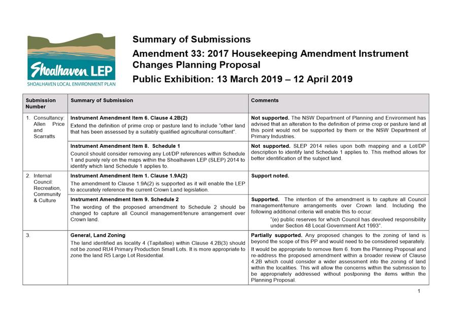
DE19.53 Exhibition
Outcomes and Finalisation - Planning Proposal: 2017 Housekeeping Amendment
(Instrument Changes) - Shoalhaven LEP 2014
HPERM Ref: D19/121834
Group: Planning
Environment & Development Group
Section: Strategic
Planning
Attachments: 1. Exhibition
Submission Summary ⇩
2. Planning Proposal -
Post-Exhibition Version (under separate cover) ⇨
Purpose / Summary
Detail
the outcomes of the public exhibition of Planning Proposal (PP033) – 2017
Housekeeping Amendment (Instrument Changes) and enable the resultant amendments
to Shoalhaven Local Environmental Plan (LEP) 2014 to proceed to finalisation.
|
Recommendation
(Item to be determined under delegated authority)
That
Council:
1. Adopt
and finalise Planning Proposal (PP033) as exhibited, with the changes
outlined in Attachment 2.
2. Forward
PP033 to NSW Parliamentary Counsel’s Office to draft the amendment to
Shoalhaven Local Environmental Plan 2014.
3. Make
the resulting amendment to the Shoalhaven Local
Environmental Plan 2014 using Council’s delegation.
4. Undertake
a separate future review of Clause 4.2B of Shoalhaven Local Environmental
Plan 2014 with the following scope:
a. Further
consideration of Item 6 (proposed for deletion from PP033) including the appropriateness
of the current zoning of certain land in Clause 4.2B.
b. Provide
clarification as to what ‘land’ means (i.e. identifying
holdings).
c. Other
matters that are identified during the review or were raised in submissions.
5. Prepare
a future report to Council in relation to the outcome of the review at Part 4
of this recommendation, including the scope of a future Planning Proposal as
appropriate and its priority in the Strategic Planning Works Program.
6. Advise
key stakeholders, including all CCBs, relevant industry representatives and
those who made a submission, of this decision, and when the Amendment will be
made effective.
|
Options
1. Adopt
the recommendation.
Implications: This is the preferred option as it
will ensure that the relevant housekeeping matters in Shoalhaven LEP 2014 are
addressed and progressed in a timely manner so that the LEP operates
efficiently.
2. Adopt
an alternative recommendation.
Implications: Depending on its nature, this could
delay the progress of the Planning Proposal (PP) and the resulting amendments
to Shoalhaven LEP 2014
3. Not adopt the
recommendation.
Implications: This is not the preferred option as
the identified housekeeping matters will not be resolved.
Background
The
Shoalhaven LEP 2014 is continuously reviewed/updated to ensure it aligns with
strategic documents, is improved where necessary, relevant matters are resolved
and delivers positive outcomes for the community. As a result, Council has an
ongoing process of housekeeping amendments to improve the operation and
maintain the accuracy of the LEP.
In this regard on 11 September
2018, Council (MIN18.699) resolved to:
1. Submit the
2017 Housekeeping Amendment – Instrument Changes Planning Proposal (PP033
– Attachment 1) to the NSW Department of Planning and Environment for a
Gateway determination and if favourable, proceed to formal public consultation
in accordance with the terms of the determination.
2. Advise any
relevant community groups of this decision, noting the opportunity for formal
consultation later in the process.
This PP addresses several
non-urgent matters (Table 1) that were identified during the 2017 calendar year
to improve the accuracy and operation of the plan.
Table 1: Summary of LEP instrument amendments
|
Item
|
Summary of proposed amendment
|
|
1
|
Amend references to the Crown Lands Act 1989 in
clause 1.9A (2) to reflect the repeal of the Act in June 2018.
|
|
2
|
Insert ‘artisan food and drink industry’ as
a land use permitted with consent in the RU1 Primary Production and RU2 Rural
Landscape zones.
|
|
3
|
Insert ‘dual occupancies (attached)’ as a
land use permitted with consent in the E2 Environmental Conservation zone.
|
|
4
|
Amend clause 4.1(4) Minimum Subdivision Lot Size, to
allow the creation of a lot from a closed road that is smaller than the
minimum lot size shown on the Lot Size Map.
|
|
5
|
Insert a new subclause to clause 4.1F Minimum
Subdivision Lot Size for Community Scheme and Strata Plan Lots, to make it
clear that clause 4.1F is not subservient to clause 4.1 (Minimum subdivision
lot size).
|
|
6
|
Amend clause 4.2B(2) Subdivision of Certain Land in
Zone RU1, Zone RU2, Zone RU4, Zone R5 and Zone E4, to only apply to land in a
RU1, RU2 or RU4 zone in relation to prime crop and pasture land given they
are the ‘rural’ zones where agriculture would be expected, noting
that R5 and E4 are essentially residential in nature.
|
|
7
|
Amend clause 4.2G (4) Boundary Adjustments of Land in
Certain Rural and Environmental Protections Zones, to delete reference to
permissibility of a dwelling following subdivision.
|
|
Item
|
Summary of proposed amendment
|
|
8
|
In relation to Schedule
1 Additional permitted uses (6) ‘Use of certain land at
Manyana’, update the description of the land
to which Schedule 1 (6) applies.
|
|
9
|
In relation to Schedule
2 Exempt Development ‘Temporary events on public land and public
roads and associated temporary structures’, insert
additional criteria in subclause 2 in relation to Crown land that is vested
in Council, or of which Council is the Crown lands manager.
|
|
10
|
In relation to Schedule
2 Exempt Development, insert new exempt development
criteria relating to:
· A-frame
sign boards and structures.
· Merchandise displays.
|
The PP was submitted to the NSW
Department of Planning and Environment (DP&E) and was granted a favourable
Gateway determination on 5 November 2018. The Gateway determination granted
delegated authority to Council for this PP which means that Council can liaise
directly with the NSW Parliamentary Counsel’s Office to prepare and
finalise the LEP amendment.
Government Agency Feedback
Prior to the required public
exhibition, the PP was referred to the NSW Office of Environment and Heritage
(OEH), NSW Rural Fire Service (RFS), Natural Resource Access Regulator and the
NSW Department of Primary Industries – Agriculture (NSW DPI) as required
by the Gateway determination. The comments from each agency on the PP are
summarised in Table 2 below.
Table
2: Agency Consultation
|
Agency
|
Feedback
|
|
NSW Office of
Environment and Heritage
|
Requested a map be included within the PP illustrating
the spatial location of the E2 Environmental Conservation land that meets the
minimum lot size requirement (40ha) for a dual occupancy in relation to
proposed Instrument Amendment Item 3.
Note: The maps were included as an attachment to
the exhibited PP.
|
|
NSW Rural Fire Service
|
No objection to the PP under the condition that
development applications comply with Planning for Bush Fire Protection 2006
and the pre-release Planning for Bush fire Protection 2018.
Note: This will be undertaken as required at the DA
stage.
|
|
Natural Resource Access
Regulator
|
No objection to the PP.
|
|
Department of Primary Industries
– Agriculture
|
No objections to the PP under the condition that
development applications for land in rural zones are assessed in order to
avoid conflict with nearby agricultural activities.
Note: This will be undertaken as required at the DA
stage.
|
Public Exhibition
In accordance with the Gateway determination and Council
resolution (MIN18.699) the PP was publicly exhibited for a period of 31 days
from 13 March to 12 April 2019 (inclusive).
Notices appeared in local
newspapers on 13 March 2019. All Community Consultative Bodies (CCBs),
Development Industry Representatives and relevant affected landowners were
notified directly in writing.
The PP was exhibited at
Council’s Administrative Office, Bridge Road, Nowra during business
hours, and could also be viewed at the Ulladulla Administrative Office and on
Council’s website. The exhibition material included the;
· Planning
Proposal (PP033) – 2017 Housekeeping Amendment Instrument Changes.
· Explanatory
Statement.
· Gateway
determination, dated 5 November 2018.
· Agency
consultation responses.
· Newspaper
advertisement.
As a result of the exhibition
ten (10) formal submissions were received including:
· Two
(2) industry/consultancy submissions.
· One
(1) internal Council submission: Recreation, Community & Culture Section.
· Seven
(7) submissions from the community.
Copies of the actual submissions
received will be available for review in the Councillors’ Room
prior to the meeting.
A detailed summary of the
submissions with a response to all comments raised is provided in Attachment
1. A summary of key issues raised, and brief staff comment is
outlined in Table 3 below:
Table
3: Summary of key issues raised in submissions and brief staff comment
|
Item
|
Summary of issues raised
|
Staff comment
|
|
2
|
Support inclusion of ‘artisan food and drink
industry’ as a land use permitted with consent in the RU1 and RU2
zones.
|
Noted.
|
|
Request to include the land use as permissible with
consent in the B2 Local Centre zone.
|
Permitting artisan food and drink
with consent in the B2 Local Centre zone across the city at this stage is a
substantial change and beyond the scope of this PP and would trigger
re-exhibition.
More appropriate for the current
PP to proceed and investigate this matter and its merit as part of a future
housekeeping amendment to the LEP.
|
|
3
|
Support inclusion of ‘dual occupancies
(attached)’ as a land use permitted with consent in the E2 zone.
|
Noted.
|
|
6
|
Request the definition of prime crop or pasture land
be amended to allow a qualified agricultural consultant to identify prime
crop or pasture land.
|
DP&E has advised that an alteration to the
definition of prime crop or pasture land at this point would not be supported
by them or the NSW DPI.
|
|
Locality 1: Bundewallah – Question zoning of
area and request review.
|
It is recommended that Item 6 be removed from the PP
at this point. Given the nature of the feedback/submissions received, closer
consideration of this issue and related matters is considered to be
warranted.
This will require a more thorough review of the zoning
of land within the localities in question. The priority of this work will be
considered in the context of the overall Strategic Planning Works Program.
The review once completed will inform any future alterations needed to the
proposed/exhibited amendment, which will be addressed within a future
PP.
This separate handling of Item 6 will enable Council
to address the concerns raised surrounding the Clause 4.2B amendment and
associated matters, without delaying the other proposed LEP amendments within
the PP.
|
|
Locality 4: Tapitallee – Question zoning of area
and request review. The clause does not recognise the environmental
constraints which restricts agricultural pursuits.
|
|
Concerns related to impact on amenity and land values.
|
The impact of the proposed amendment on amenity of the
surrounding area will be further investigated as part of the identified
review into the zoning of land within the localities (see above), if this
approach is accepted.
|
|
Locality 4: Tapitallee – Requested a reduction
in minimum lot size for the area.
|
It is not recommended to reduce the minimum lot size
provisions within Clause 4.2B. This would conflict with the purpose of Clause
4.2B (2) and significantly limit the ability to undertake agricultural pursuits
within the localities.
The Growth Management Strategy review that is underway
will consider the need for additional rural residential zones/development.
This would also be a significant change to the
exhibited PP, if pursued, and as such would trigger re-exhibition.
|
|
Locality 6: Termeil – Requested a reduced
minimum lot size to enable greater subdivision potential.
|
|
8
|
Request that the Lot/DP references in Schedule 1 be
removed and Council purely rely upon the mapping within Shoalhaven LEP 2014
to identify land that Schedule 1 applies to.
|
The LEP relies on both mapping and a Lot/DP
description to identify the land Schedule 1 applies to. This method is the
accepted practice and allows for better identification of the subject land.
|
|
9
|
Support for the additional criteria with a request to
include additional wording to allow the clause to apply to all Crown land
managed by Council.
|
The proposed additional wording will enable the clause
to capture all Council management/tenure arrangements over Crown land.
|
Because of the submissions received, 2 amendments are
proposed to the exhibited PP as shown at Attachment 2. For convenience,
the proposed changes are highlighted in yellow, with strikethroughs to note
deletions. The recommended post-exhibition amendments to the PP are summarised
briefly below.
· Remove Instrument
Amendment Item 6 (Clause 4.2B Subdivision of certain land in Zone RU1, Zone
RU2, Zone RU4, Zone R5 and Zone E4) from the PP. It would be appropriate to
include the scope of Item 6 within a broader future review of Clause 4.2B which
would consider the zoning of land within the localities identified within
Clause 4.2B and also provide clarification as to what ‘land’ means
(i.e. identifying holdings).
· Include the
following criteria within Instrument Amendment Item 9 (Exempt Development -
‘Temporary events on public land) to capture all management/tenure
arrangements over Crown land: “(e) public reserves for which Council
has devolved responsibility under Section 48 Local Government Act 1993”.
Policy Implications
Finalising these amendments will
ensure Shoalhaven LEP 2014 is both accurate and is operating as intended.
Removing Item 6 from PP033 will ensure due consideration of matters raised
during public exhibition.
Financial Implications
The finalisation of the Amendment
will continue to be resourced within the existing Strategic Planning budget.
|
|
Development
& Environment Committee – Tuesday 02 July 2019
Page
0
|
|
|
Development
& Environment Committee – Tuesday 02 July 2019
Page
0
|
DE19.54 Nowra
CBD Fringe Planning Proposal - Progress and Possible Next Steps
HPERM Ref: D19/122291
Group: Planning
Environment & Development Group
Section: Strategic
Planning
Attachments: 1. Nowra
CBD Fringe - Heritage Study - Final - 29-3-2019 (under separate cover) ⇨
Purpose / Summary
· Provide
an update on the Nowra CBD Fringe Planning Proposal (PP), including the results
of consultation with the NSW Office of Environment & Heritage (OEH) and
outcomes of the resultant Heritage Study.
· Obtain
direction on the next steps for this PP.
|
Recommendation
(Item to be determined under delegated authority)
That Council:
1. Adopt the following recommendations
of the Heritage Study and provide an amended Planning Proposal to the
Department of Planning and Environment:
a. Reduce
the boundaries of the proposed Heritage Conservation Area to exclude areas
where there are large areas of ‘non-contributory’ buildings.
b. Update
the Statement of Significance for the proposed Heritage Conservation Area.
2. Not
adopt the following recommendation of the Heritage Study and defer for
consideration as part of any broader future Shoalhaven heritage review:
a. Expand
the proposed Heritage Conservation Area boundary to include Oliver Parade
which is in the study area but not in the proposed Heritage Conservation
Area.
3. Not
include ‘post-war fibro cottages’ on Leaney Avenue and Oliver
Parade as ‘contributory’ items on the contributory items map.
4. Endorse
the revised contributory items map for public exhibition with the supporting
DCP Chapter.
5. Not
endorse the DCP controls recommended in the Heritage Study to ensure the
overall focus of the DCP Chapter remains on character rather than heritage
aspects of individual ‘contributory’ items.
|
Options
1. Adopt
the recommendation.
Implications: This is the preferred option as it
enables this important community project and its outcomes, including the PP, to
progress and establishes a clear policy direction for the area, providing
certainty to landowners/developers.
This option will enable two of the Heritage Study
recommendations to be pursued, whilst deferring the recommendation of including
a further area of post-war fibro cottages (initially developed by the NSW
Housing Commission) in the Heritage Conservation Area (HCA) for consideration in
any broader scale heritage review for Shoalhaven that may take place on the
future. Examples of the post-war fibro cottages are prolific across the LGA so
more detailed consideration needs to be given to what examples have the most
heritage merit.
It will also ensure that the DCP Chapter does not become
overly prescriptive with heritage related controls, and instead retain its
focus on ensure the overall character of the area can be retained, as was the
original intent behind the Nowra CBD Medium Density Study.
2. Adopt the
recommendations of the Heritage Study.
Implications: This option is not favoured as one of
the recommendations of the Heritage Study is to expand the proposed HCA
boundary to include Oliver Parade, which is in the study area but not in the
proposed HCA.
Oliver Parade is a highly intact example of post-war fibro
cottages initially developed by the NSW Housing Commission, which played a
significant part in Nowra’s history. However, this style is already
represented in other parts of the proposed HCA, and given it is common across
Shoalhaven, it should be given more detailed consideration through a wider
Heritage Review, should this be included on Council’s Strategic Planning
Works Program in the future and with detailed engagement with affected owners.
The Heritage Study also recommends including some DCP controls
which are highly prescriptive and, if adopted, would make demolition of
contributory items prohibited. This was not the intent of the Nowra
Medium Density Study, which was primarily about retaining the character of the
area, not specific buildings which may be contributory from a heritage
perspective.
3. Place the Nowra
CBD Fringe project on hold pending the outcome of the Local Character Overlay
Discussion Paper which was recently exhibited.
Implications: This option is not favoured given that
the project is identified as a priority on Council’s adopted Strategic
Planning Works Program. A significant body of work has already been done on the
project, having now reached Gateway determination stage. Detailed heritage
referrals and advice has found the area has heritage significance and grounds
for creating a HCA and initial community consultation showed support for the PP
and DCP.
There are still uncertainties around the proposed Local
Character Overlay, including the legal weight it would have in the planning
process and how it would affect complying development. If it does
eventually become an option, it would still require a PP for the overlay to be
included in Council’s Local Environmental Plan and so there is a risk
that this delay will lead to further losses to substantially intact
streetscapes.
4. Adopt
an alternative recommendation.
Implications: This option is not favoured. By
not adopting the recommendation there is potential for the PP to be delayed
which could lead to uncertainty for landowners/developers in the area.
Background
Council adopted the Nowra
CBD Fringe Medium Density Study (prepared by Studio GL) on 3 July 2018.
Council also resolved to prepare a PP and Development Control Plan (DCP)
Chapter based on the recommendations of the Study.
The initial PP was prepared and
submitted to the NSW Department of Planning and Environment (DP&E) on 8
August 2018 and a favourable Gateway determination was issued on 11 September
2018.
As part of the conditions of the
Gateway determination, consultation was required with the NSW Rural Fire
Service (RFS) and OEH. RFS raised no objections. OEH indicated support
for the creation of the HCA but recommended a Heritage Study be undertaken by a
suitably qualified and experienced heritage consultant to review and make
recommendations on:
· Proposed
HCA boundaries;
· Land
use zonings;
· Building
heights;
· DCP
controls; and
· Effect
on two (2) State Heritage Register (SHR) items (Meroogal and Graham Lodge).
Louise Thom Heritage was
engaged to undertake the required Heritage Study, which is provided in Attachment
1.
The Heritage Study makes the
following recommendations which may require alterations to the PP and/or
Gateway determination:
1) Reduce
the boundary of the proposed HCA to exclude areas where there are large areas
of ‘non-contributory buildings’.
2) Expand
the proposed HCA boundary to include Oliver Parade which is in the study area
but not in the proposed HCA.
3) Revise
the statement of significance for the proposed HCA.
4) Consider
making the zoning within the HCA low density residential.
Further discussion on these recommendations, options and
potential impacts is discussed below.
1) Reduce the
boundary of the proposed HCA to exclude areas where there are large areas of
non-contributory buildings.
For the purposes of addressing
OEH’s submission to review and confirm the most appropriate boundaries of
the HCA, a map of ‘contributory’ and ‘non-contributory’
items was prepared with assistance from Louise Thom Heritage (Figure 1).
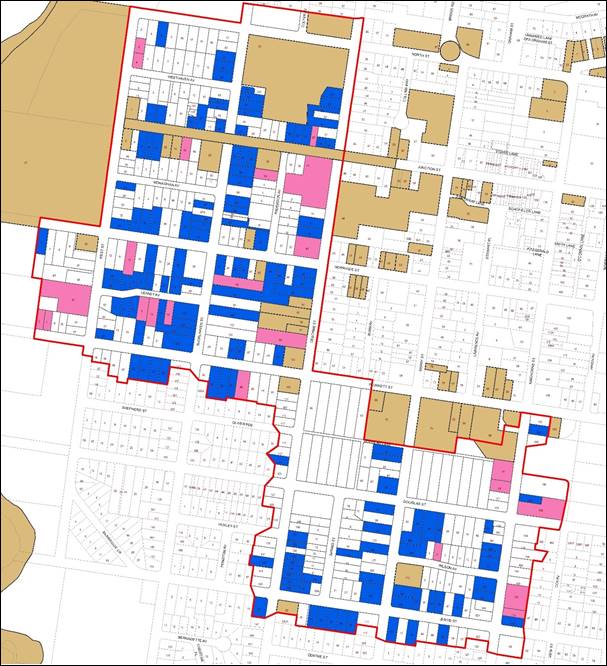
Figure 1.
Contributory items map
‘Contributory’ items
are buildings not listed as ‘heritage items’ but are located within
a HCA (identified in the LEP) that make an important and significant
contribution to the character and significance of the HCA.
‘Contributory’ items are buildings that are representative of the
Victorian, Federation, Inter-war or Post-war period. The Heritage Study
recommends a number of supporting DCP controls that generally specify that
‘contributory’ items are not to be demolished and any additions to
them must retain their character and be located at the rear of the existing
building.
‘Neutral’ items are
‘non-contributory’, however their design and scale does not detract
from the overall character of the HCA.
‘Detracting’ items
are buildings that are intrusive, uncharacteristic and detract from the overall
significance of the area.
Examples of identified ‘contributory’ items
identified by the consultant within the current proposed HCA are shown in
Figures 2-6 below:
|
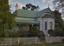 
Figure 2. Examples of Contributory Items from the
Victorian Period (1850-1890)
|
|
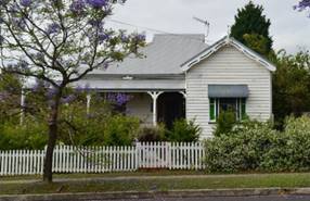 
Figure 3. Examples of Contributory Items from the
Federation Period (1890-1915)
|
|
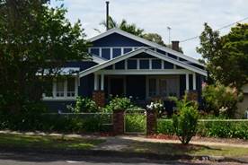 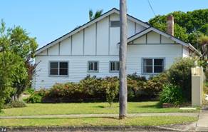
Figure 4. Examples of Contributory Items from the
Inter-war Period (1915-1940)
|
|
Figure 5. Examples of Contributory Items from the
Post-war Period (1940-late 1950s)
|
|
Figure 6. Examples of Contributory Items from the
Post-war Period – Leaney Avenue (1940-late 1950s fibro cottages,
initially developed by the NSW Housing Commission)
|
Further discussion on the
identification of Post-war fibro cottages as ‘contributory’ items
is provided later in this report.
As seen in the Figure 1 Contributory Items Map, there are a
number of areas in the proposed HCA with relatively few ‘contributory
items’, i.e. buildings that represent one of the four key historic
periods (Victorian, Federation, Inter-war and Post-war). The Heritage Study
indicates that the proposed HCA is larger than it needs to be and has recommended
two (2) areas that should be removed from the proposed HCA - see Figures 7 and
8 below.
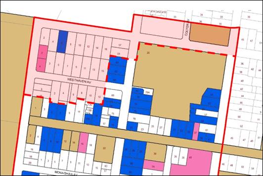
Figure 7. Northern
part of the HCA recommended to be removed (shaded area)
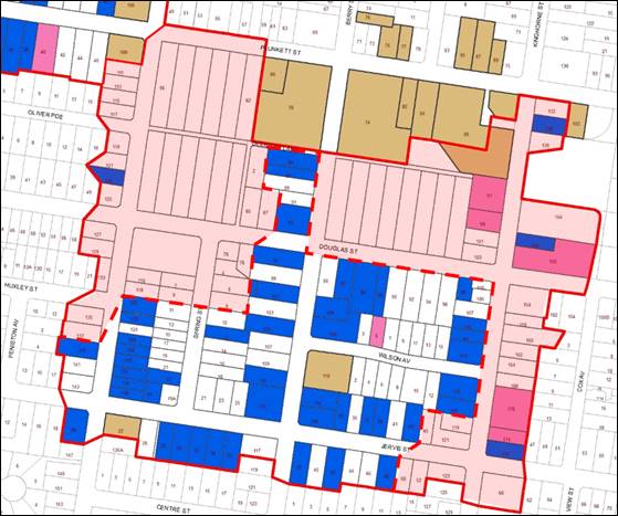
Figure 8. Southern
part of the HCA recommended to be removed (shaded area)
It is recommended, if this
project proceeds, that the boundaries of the proposed HCA be consolidated to
exclude the areas shaded in Figure 7 and Figure 8 given their lack of heritage
value or significance, and that a revised PP be submitted to DP&E prior to
public exhibition.
It should be noted that there
are zones (R1, R3 and B4) in these two locations that allow more intensive
forms of development. The community may still have ‘character’
concerns regarding redevelopment that could occur in these areas in the future
if they are removed from the HCA.
2) Revise
the statement of significance for the proposed HCA in the Planning Proposal.
The Heritage Study provides an
assessment of the draft statement of significance to support the PP and
provides a suggested rewording as follows:
“Nowra Town Centre West Heritage Conservation Area
(HCA) has historical and aesthetic value for its ability to demonstrate
Governor Darling’s set of rules for laying out of towns through the
underlying grid structure laid out in 1852 by surveyor Thomas Mann. The HCA
provides physical evidence of the 19th century and early 20th century
residential development surrounding the administrative and commercial centre of
Nowra which was established after floods devastated the centres of Numbaa and
Terara in 1862 and 1870. The HCA is rare as one of the oldest residential areas
of Nowra and for the considerable evidence it retains of Nowra’s
settlement and early expansion.
The terrain and elevated natural setting add to the
aesthetic value of the HCA by providing long distance views to the scenic rural
landscape, Shoalhaven River or the Cambewarra escarpment, framed by landscaped
streetscapes and garden settings. The residential buildings within the HCA
provide evidence of the local emergence of architectural styles representative
of different periods including late Victorian, Federation, Inter-War, Post-war
and public housing. Within the HCA houses demonstrate a consistency in
character that is defined by similar setbacks and heights and architectural
styles from the four key periods of development which as a group form
attractive streetscapes. In particular the prevalence of houses from the
Inter-war period provide a continuity of house style that has high aesthetic
value and contributes to the overall visually appealing character of the HCA.
Houses within the HCA demonstrate the predominant building materials available
at different times and the aesthetic value of houses is enhanced by their
garden settings and the streetscape plantings.
The HCA is an excellent representative example of a
residential area in a town centre containing substantially intact built form
evidence from the end of the 19th century through to the Post-war period. The
HCA is also historically and aesthetically significant as it provides
substantially intact examples of the early work of the NSW Housing Commission
to provide affordable housing by acquiring parcels of land, creating mid-block
subdivisions and building new cottages in the Post-war period.”
If this project proceeds, it is
recommended that the statement of significance for the proposed HCA be updated
and that a revised PP be submitted to DP&E prior to public exhibition.
3) Expand
the HCA boundary to include Oliver Parade which is in the study area but not in
the proposed HCA.
The Heritage Study recommends including a section
surrounding Oliver Parade in the proposed HCA, as shown in Figure 9.
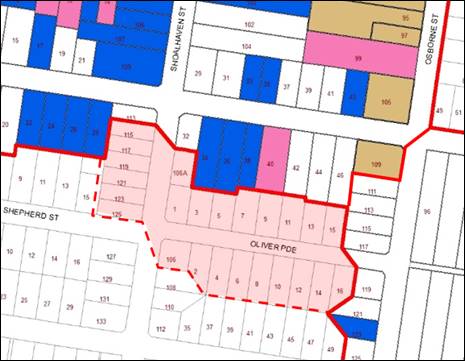
Figure 9.
Additional area recommended to be included in the HCA (shaded area)
The Heritage Study states that
“Oliver Parade is an excellent example of early post-war Housing
Commission development and should be considered for inclusion within the
HCA”.
Oliver Parade is a highly intact example of post-war
cottages developed by the NSW Housing Commission in the years following
WWII. Examples of houses in Oliver Parade are shown in Figure 10, and
similar housing styles can already be found inside the proposed HCA boundaries,
including along Leaney Avenue (see Figure 6).
Figure 10.
Post-war Fibro Cottages in Oliver Parade (1949)
There are a number of concerns
with this recommendation given the age of these buildings and the presence of
fibro sheeting containing asbestos. The Shoalhaven LEP 2014 also identifies
these two streets as being suitable for medium density development, with Leaney
Avenue being zoned R1 General Residential and Oliver Parade zoned R3 Medium
Density Residential. This building style is also common across other parts of
Shoalhaven and would need to be given more detailed consideration before
identifying any parts as contributory to a HCA. The identification of this type
of development was also generally considered as part of the earlier Shoalhaven
Heritage Study (and LEP) process.
It is recommended that this particular
recommendation of the Heritage Study not be pursued at this stage and that it
be considered as part of a broader Heritage Review, should this be included on
Council’s Strategic Planning Works Program in the future.
4) Consider
making the zoning within the HCA low density residential.
As
discussed in previous reports, the zoning of the proposed HCA is not proposed
to be changed. The aim of the PP is to achieve a balance in protecting the
existing character of this area of Nowra whilst also facilitating an
appropriate mix of densities and high-quality housing, and
‘back-zoning’ is unlikely to be supported by DP&E given
Nowra’s status as a Major Regional Centre in the Illawarra-Shoalhaven
Regional Plan.
DCP Chapter
Following current best practice
for Heritage Conservation Area DCPs, the heritage advice from Louise Thom
Heritage has suggested the inclusion of a ‘contributory’ items
map to assist future decision making in the HCA (see Figure 1).
‘Contributory’ items are buildings not listed as
‘heritage items’ but are located within a HCA and make an important
and significant contribution to the contribution to the character and
significance of the HCA. Contributory items are buildings that represent one of
the following four key historic periods:
|
Period
|
Dates
|
Description
|
|
Victorian
|
1850-1890
|
Slow development as the shift is slowly made from Numbaa
and Terara after the devastating floods
|
|
Federation
|
1890-1915
|
Increase in growth with opening of the bridge and the
railway
|
|
Inter-war
|
1915-1940
|
Substantial period of growth in housing in West Nowra CBD
|
|
Post-war
|
1940-late 1950s
|
Period of infill growth
primarily led by the NSW Housing Commission
|
‘Neutral’ items are
non-contributory; however, their design and scale does not detract from the
overall character of the HCA while ‘detracting’ items are buildings
that are intrusive, uncharacteristic and detract from the overall significance
of the area.
The Heritage Study also suggests
the following DCP controls to apply to the HCA:
1. Contributory items are
not to be demolished.
2. Additions to
contributory items must retain their character and be located at the rear.
3. Additions to heritage
items and contributory items are not permitted in front of the existing
building.
4. New development must
maintain the predominant setbacks, heights and front streetscape zone of
contributory items in the vicinity.
5. Garages and carports
must be located at the rear or the side – set back behind the front of
the building.
As discussed earlier in this
report, there are concerns with including post-war fibro cottages as
‘contributory’ items in the DCP. It is recommended that the
contributory items map exclude this style along Leaney Avenue (sample shown in
Figure 6) as ‘contributory’ items.
There is also some concern that
by adopting the above DCP controls, the overall intent and focus of this
project will change from being primarily about character, to one that is more
heavily focused on heritage. While heritage is an important aspect that contributes
to the overall character of the area, it is only one among other aspects such
as setbacks, landscaping, and streetscape interface. The recommended controls
are highly prescriptive and prohibitive and focused more on the heritage
aspects of individual ‘contributory’ items. It is therefore
recommended that Council not endorse the DCP controls recommended in the
Heritage Study to ensure the overall focus of the DCP Chapter remains on
character rather than heritage. It is also noted that a DCP cannot override an
ability in the LEP, for example regarding demolition.
It is also recommended that
Council endorse the inclusion of a revised contributory items map (excluding post-war
fibro cottages as ‘contributory’ items) in the draft DCP Chapter for
the purposes of consulting with the community.
Alternate Option –
Local Character Overlay
The DP&E recently released a
Discussion Paper on the proposal to introduce a ‘local character
overlay’ in the form of a map and supporting local clause into the Standard
Instrument Local Environmental Plan (LEP). The proposed clause could
require applicants to:
· meet
development controls within the LEP clause; and/or
· meet
development controls within a DCP; and/or
· submit
a ‘statement of consistency’ with the desired future character for
the area, as set out in a desired future character statement adopted by
Council.
This proposal could ultimately
provide an additional more appropriate way of managing consideration of
character impact through the LEP, however at this stage the exact detail and
timings for the implementation of the local character overlay are unknown.
Community Engagement
The PP and DCP Chapter have not
yet been publicly exhibited, however the Nowra CBD Fringe Medium Density Study
which is the basis for the PP and DCP was on public exhibition from 18 April to
18 May 2018.
Following formal exhibition of
any PP and/or DCP Chapter, a further report will be provided to Council for
consideration.
Policy Implications
This is a ‘high
priority’ project on the 2018-2019 Strategic Planning Works Program that
was adopted by Council in June 2018.
Council adopted the Nowra CBD
Fringe Medium Density Study (Background Report and Recommendations Report) on 3
July 2018. The PP seeks to implement the recommendations of that report into
Shoalhaven Local Environmental Plan 2014.
Financial Implications
The Nowra CBD Fringe Medium
Density Study and associated PP and DCP Chapter work has been managed with the
existing Strategic Planning Budget.
Risk Implications
If the PP does not proceed,
there is a risk that the character of the Nowra CBD fringe area will not be
considered in the development process, and substantially intact streetscapes
and evidence of key historic periods may be permanently lost or damaged.
|

|
Development
& Environment Committee – Tuesday 02 July 2019
Page
0
|
DE19.55 Funding
Offer - NSW Heritage Grants - 2019-20 and 2020-21
HPERM Ref: D19/185099
Group: Planning
Environment & Development Group
Section: Strategic
Planning
Purpose / Summary
Detail the NSW Heritage Grants funding offers received for
the 2019-20 to 2020-21 financial years from the NSW Government and obtain
endorsement to accept the offers.
|
Recommendation
(Item to be determined under delegated authority)
That Council:
1. Accept
the following NSW Heritage Grants funding offers as detailed in the report:
a. 2019-20
to 2020-21 financial years for the Local Heritage Places and Local Government
Heritage Advisor streams; and
b. 2019-2021
Local Government Heritage Studies stream (Berry Heritage Investigations
project).
2. Note
that recurrent funding is provided in the annual Budget to meet
Council’s matching commitment.
|
Options
1. Adopt the
recommendation.
Implications: This will enable the grant funding
offers to be accepted which will help ensure the continuation of both the
Heritage Advisor Service and Shoalhaven Local Heritage Assistance Fund Program
for 2019-20 to 2020-21. The resolved Berry Heritage Investigations project can
also be progressed.
2. Adopt an
alternative recommendation.
Implications: This would not be inconsistent with
the established process that has been followed for this grant funding that
Council has been successfully promoting and administering.
Background
Council has continued its
commitment to local heritage projects by supporting the NSW Heritage Grants.
This grant funding provided by the NSW Office of Environment and Heritage (OEH)
assists Council to provide a Heritage Advisor and run an annual Local Heritage
Assistance Fund to provide grants of up to $5,000 for a wide range of small
heritage projects including general maintenance, adaptive reuse, or sympathetic
alterations/additions for heritage items.
The conservation of Shoalhaven’s
cultural heritage by its owners is clearly beneficial to the broader community
and visitors to the area. These grants, although small, show that Council and
the NSW Government are committed to helping owners to conserve and enhance
their properties for future generations. These heritage projects demonstrate
Council’s commitment to heritage conservation management and promoting
cultural sustainability, heritage tourism and the Community Strategic Plan.
NSW Heritage Grants Program
2019-20 and 2020-21
OEH have again required councils
to apply for two (2) financial years in the one application, to provide greater
efficiency in grant administration, management processes and to provide
financial certainly for councils.
NSW Heritage Grant funding was
sought under the following streams:
· Local
Heritage Places (Shoalhaven Local Heritage Assistance Fund).
The application was successful, and Council has been
offered a grant of up to $5,500 per annum (ex GST) for 2019-20 and 2020-21.
Acceptance is required by 31 July 2019.
· Local
Government Heritage Advisors.
The application was successful, and Council has been
offered a grant of up to $6,000 per annum (ex GST) for both 2019-20 and 2020-21
for providing a Heritage Advisor Service for Shoalhaven. Acceptance is required
by 31 July 2019.
· Local Government
Heritage Studies (Berry Heritage Investigations project).
The application was
successful, and Council has been offered a grant of up to $12,000 (ex GST) for
the 2019-2021 funding period. Acceptance is required by 31 July 2019.
Community Engagement
No specific community engagement
is required in relation to this report. The Shoalhaven Local Heritage
Assistance Fund will continue to be run and advertised in accordance with the
usual process when the funding round opens, following acceptance of the funding
offers. Direct advice will also be provided to people who have previously
expressed an interest in the program.
Community and landowner
engagement will be undertaken as part of the Berry Heritage Investigations
project and this will be separately reported to Council.
Policy Implications
As part of the funding agreement
for the Local Government Heritage Advisors Grant and to claim re-imbursement,
Council is required to submit a Heritage Strategy covering the relevant
financial years. Any required changes to the Shoalhaven Heritage Strategy will
be reported to Council for endorsement at the appropriate stage in the grant
process.
Financial Implications
Shoalhaven Local Heritage
Assistance Fund (Local Heritage Places Grant)
The funding offer from the NSW Government for the 2019-20
and 2020-21 financial years is up to $5,500 (ex GST) per annum, with a funding
formula of $1: $1 (NSW Government: Council). Recurrent funding to match the
Grant continues to be provided in Council’s annual budget.
Local Government Heritage
Advisors Grant
The funding offer from OEH for the 2019-20 and 2020-21
financial years is up to $6,000 (ex GST) per annum, with a funding formula for
both years of $1: $1 (NSW Government: Council). Recurrent funding to
match the Grant continues to be provided in Council’s annual budget.
Local Government Heritage
Studies (Berry Heritage Investigations Project)
The funding offer from OEH for
the 2019-2021 funding period is up to $12,000 (ex GST), with a funding formula
of $1: $1 (NSW Government: Council). Therefore, a matching contribution
of up to $12,000 is required which will be sourced from the existing Strategic
Planning budget.
|
|
Development
& Environment Committee – Tuesday 02 July 2019
Page
0
|
DE19.56 Proposed
Housekeeping Amendment - Shoalhaven Development Control Plan 2014 - General and
Generic Chapters
HPERM Ref: D19/185859
Group: Planning
Environment & Development Group
Section: Strategic
Planning
Attachments: 1. Proposed
Housekeeping Amendment - Draft Chapters (under separate cover) ⇨
Purpose / Summary
Obtain the required Council
resolution to formally exhibit the draft General and Generic Chapters
Housekeeping Amendment (the Amendment) to Shoalhaven Development Control Plan
(DCP) 2014.
|
Recommendation
(Item to be determined under delegated authority)
That Council:
1. Endorse
the initial draft General and Generic Chapter Housekeeping Amendment (draft
Amendment) to Shoalhaven Development Control Plan 2014 at Attachment 1
(including the Draft Waste Minimisation and Management Guidelines and
rescission of Chapter 3: Exempt Development) and support the exhibition of
the draft Amendment for a period of at least 28 days as per legislative
requirements.
2. Receive
a further report on the draft Amendment following the conclusion of the
public exhibition period to consider feedback received, any necessary
adjustments and the finalisation of the amendment.
3. Advise
key stakeholders, including relevant industry representatives, of this
decision and the exhibition arrangements in due course.
|
Options
1. As recommended.
Implications: This is the preferred option as it
will enable operational issues and matters that require clarification to
improve the function of the relevant chapters and DCP as a whole to be
considered and resolved.
2. Adopt an
alternative recommendation.
Implications: This will depend on the extent of any
changes and could delay the implementation of updated and improved DCP provisions.
3. Not adopt the
recommendation.
Implications: This could stop the implementation of
improved, best practice/modern and better structured provisions in the DCP.
Background
Council’s resolved on 2
June 2015 to commence a large-scale systematic review/amendment of Shoalhaven
DCP 2014. This program was based on a 5-stage approach and included several of
the General and Generic Chapters in the DCP.
The scope of the draft Amendment
has been expanded since 2015 and now includes the review of the following DCP
Chapters:
· General
Chapters and Dictionary:
- Chapter
1: Introduction
- Chapter
3: Exempt Development
- Dictionary
· Generic
Chapters:
- Chapter
G1: Site Analysis, Sustainable Design and Building Materials in Rural, Coastal
and Environmental Areas
- Chapter
G3: Landscaping Design Guidelines
- Chapter
G5: Threatened Species Impact Assessment
- Chapter
G7: Waste Minimisation and Management Controls
- Chapter
G8: Onsite Sewage Management
- Chapter
G17: Business, Commercial and Retail Activities
- Chapter
G19: Home Based Business Activities
- Chapter
G28: Design Guidelines for Permanent Occupation of Caravan Parks
Essentially, the draft DCP
Amendment proposes to improve the function of the relevant chapters, address
gaps in policy and address operational issues or matters that need
clarification that have been identified since the Shoalhaven DCP 2014
originally commenced on 22 October 2014.
The most notable components of
the draft Amendment are outlined in Table 1. All the proposed changes to the
respective chapters are detailed in the table of changes at the beginning of
each chapter at Attachment 1.
Table 1: Summary of key changes in the draft Amendment
|
Chapter
|
Summary of key changes
|
|
Throughout Amendment
|
|
Throughout
|
· Highlight all terms in the DCP Dictionary green and terms in LEP
Dictionary blue.
· Minor
changes to punctuation, spelling, grammar, structure, formatting and
acronyms.
· Change
references of ‘you’ to less personal reference.
· Replace
section references of the EP&A Act to reflect amendments to the Act.
· Numbering
changes.
· Transfer
content of certain acceptable solutions to note boxes.
· New
and redrafted images.
· Update
legislation, policy and guideline references.
· Complete
plain English review.
· Expand
references of vegetation to include trees.
· Remove
definitions already in the DCP Dictionary.
· Remove
checklists as relevant – now on Council’s Hub on internet.
|
|
General Chapters and
Dictionary
|
|
Chapter 1: Introduction
|
· DCP
Matrix removed from the chapter - will be available instead on the DCP
website.
· Remove
references to Chapter 3 (exempt development).
· Include
reference to the Jerberra LEP in reference to exempt development.
· Expand
area specific chapters to identify the 4 categories of development (Northern,
Southern, Various and Nowra-Bomaderry Urban Release Areas).
· Introduction
of commentary regarding:
- Inconsistencies
between area specific and generic provisions.
- Transitional
arrangements.
- Variations
to mandatory controls.
|
|
Chapter 3: Exempt
Development
|
· Chapter
to be rescinded. There is now no place for exempt development provisions in a
DCP given legislative changes/reforms.
|
|
Dictionary
|
· Add
new definitions: Arterial road, Collector road, Continuous Accessible Path of
Travel (CAPT), Local distributor road, Local road, Mandatory control,
Potentially hazardous food, Sub-arterial road, Tourist accommodation sites.
· Delete
definitions: Council, Dilapidation/defects report, Flood planning level,
Height of building, Named river, Native vegetation, Structurally independent,
Waterbody.
· Amend
definitions: Acceptable solutions, Access street, Building height plane,
Development, Economic activity zones, Environmental planning instrument,
Flood compatible building components, Flood compatible materials, Ground
level (natural), Laneway, Performance criteria, Variation statement, Waste
minimisation and management plan (now waste management plan).
· Amend
term: ‘Outdoor eating area’ is now ‘outdoor dining
area’ – definition remains the same.
|
|
Generic Chapter
|
|
Chapter G1: Site
Analysis, Sustainable Design and Building Materials in Rural, Coastal and
Environmental Areas
|
· Change
in Chapter Heading – proposed to be “Chapter G1: Site Analysis,
Site Design and Building Materials.”
· Application
– Simply state that the Chapter applies to all development in
Shoalhaven.
· Inclusion
of additional requirements for site analysis plans.
· Delete
existing Section 5.2 ‘Energy Efficiency & Solar Access’
(content already in Chapter G12/13) and related content throughout.
|
|
Chapter G3: Landscaping
Design Guidelines
|
· New
objectives relating to winter sun and summer shade.
· New
content relating to the retention/removal of mature shade trees - aim is to
reduce the reduction of native vegetation and dominant locally occurring
native trees to restore and retain the urban canopy where appropriate.
This is consistent with an existing resolution of Council (MIN16.946)
that requires any future DCP reviews to consider the value of mature trees in
providing shade and reducing the heat island effect. The proposed
amendments emphasise retention where appropriate.
· New
acceptable solution regarding amenity when considering plant palate.
· Landscape
plan now required for a dual occupancy development.
· Currently
a landscape plan can only be prepared by a ‘qualified landscape
architect or designer’ – propose to change to ‘suitably
qualified landscape professional’.
· Rationalised
landscape plan requirements.
· Paving
to be fit for purpose.
· Clarification
that plants can be selected outside of the species list.
· Figure
1 replaced with an updated landscape plan.
|
|
Chapter G5: Threatened
Species Impact Assessment
|
· Change
in Chapter Heading – proposed “Chapter G5: Biodiversity Impact
Assessment” to reflect general legislative changes.
· All
changes to supporting information and general commentary respond to the
recent Biodiversity Reforms.
· Performance
criteria and acceptable solutions have been reshaped to reflect the new
legislation (e.g. preserve high value ecological areas).
|
|
Chapter G7: Waste
Minimisation and Management Controls
|
· Replace references to POL12/273
‘Waste Minimisation and Management Guidelines’ with new draft Waste Minimisation
and Management Guidelines. Supporting Document 1 (copy of
POL12/273) to be deleted.
- Guidelines
to be exhibited with the proposed DCP Amendment but will be a
‘guideline’ of Council, not located within the DCP.
· Remove
duplicate definitions already in the DCP Dictionary.
|
|
Chapter G8: Onsite
Sewage Management
|
· Remove
content that duplicates existing legislation.
· Remove
links to the Sydney Drinking Water Catchment Area Map - directly refer to
legislation.
· Changes
to reflect content of Shoalhaven Local Approvals Policy (LAP) 2017.
· Restructure
chapter to better separate controls and supporting information. Some content
moved from supporting information to controls.
· New
table to simplify and update information required to install, construct or
alter a sewage management system.
· Deletion
of outdated information (i.e. concurrence powers of Sydney Catchment
Authority).
· Replace
‘suitably qualified practising person or persons’ with reference
to a ‘professional engineer or environmental/soil scientist with
appropriate indemnity insurance’.
· Reintroduced
content from previous DCP No.78 Effluent Disposal that was as an oversight
not transferred as part of the citywide DCP process (overall impact of the
proposal both in the long and short term).
· Update
role of designers and installers in in the onsite sewage management process.
|
|
Chapter G17: Business,
Commercial and Retail Activities
|
· Remove
reference to roadside stalls throughout – there are no controls for
roadside stalls in the chapter.
· New
provisions relating to streetscape design, pavement, planting and street
trees/landscaped areas.
· Inclusion
of provisions relating to mature trees.
· Update
provisions relating to markets to reflect the changing nature of this
activity.
· Insert/update
provisions relating CAPT to incorporate best practice principles:
- Travel
diagram.
- Human
Rights Commission Good Practice Principles.
- Locate
commercial use of the footpath along the kerbside rather than along the
building line/shopfront and maintain established CAPTs.
- Clearly
and concisely identify CAPT widths.
· Insert
site line diagram.
· Delete
section relating to parking of caravans for commercial or community
activities – most developments considered under the Codes SEPP or
assessed on merit in conjunction with the LAP.
|
|
Chapter G19: Home Based
Business Activities
|
· Update
terminology – “Commercial Home Catering” is now “Home
Based Food Businesses”.
· Hours of
operation have been extended to 9am-6pm and references made consistent across
the Chapter.
· Clarification
that a home-based activity should not be undertaken outside of the designated
home-based activity area, rather than the whole property.
· Reword, clarify
and expand provisions relating to home-based food businesses, including
potentially hazardous food, to ensure provisions are contemporary and meet
relevant food standards.
· Clarify that the
term ‘vehicle repair station’ is not a home-based business
activity.
|
|
Chapter G28: Design
Guidelines for Permanent Occupation of Caravan Parks
|
· Insert
requirement that only 50% of sites in a caravan park in an SP3 zone may be
long term sites.
· Delete
provisions relating to demand for affordable housing as other provisions in
the chapter allow 50% of sites to be considered for this housing stock.
· Remove
superfluous content regarding environmental hazards which are addressed
throughout the development application process.
· Insert
references to the Shoalhaven LAP 2017 regarding criteria for approvals.
· Clarify that
long terms sites should not reduce public road access for tourist
accommodation.
|
Community Engagement
The draft Amendment will be
publicly exhibited for at least 28 days in accordance with legislative
requirements at the Nowra Administrative Building. Documentation will also be
available for viewing on Council’s website and at the Ulladulla
Administrative Building. Development Industry representatives will be directly
notified of the exhibition arrangements.
Policy Implications
The draft Amendment seeks to
address issues relating to the General and Generic chapters of DCP 2014 arising
from:
· Resolutions
of Council;
· Operational
issues, gaps in policy or matters that need clarification that have been
identified since the Shoalhaven DCP 2014 became effective on 22 October 2014.
These changes will increase
efficiency and improve the operation of the Shoalhaven DCP 2014.
Financial Implications
The draft Amendment will
continue to be resourced within the existing Strategic Planning budget.
|
|
Development
& Environment Committee – Tuesday 02 July 2019
Page
0
|
DE19.57 Exhibition
Outcomes and Proposed Finalisation - Citywide SP3 Tourist Zones Review -
Planning Proposal and Proposed Amendment to Chapter V3 Shoalhaven Development
Control Plan 2014
HPERM Ref: D19/171980
Group: Planning
Environment & Development Group
Section: Strategic
Planning
Attachments: 1. Exhibition
Package (under separate cover) ⇨
2. Summary of Submissions -
Proposed PP and DCP Amendments (under separate cover)
Purpose / Summary
· Report
the outcomes of the public exhibition of the Citywide SP3 Tourist Zones Review
Planning Proposal (PP) and the related proposed draft Amendment to Chapter V3
Shoalhaven Development Control Plan (DCP) 2014 for Site 6 in the PP -
Ulladulla-Mollymook Gateway Precinct;
· Enable
the amendments to Shoalhaven Local Environmental Plan (LEP) 2014 and Shoalhaven
DCP 2014 to proceed to finalisation.
|
Recommendation
(Item to be determined under delegated authority)
That Council:
1. Adopt
and finalise the exhibited Planning Proposal (PP013).
2. Forward
PP013 to NSW Parliamentary Counsel’s Office to draft the amendment to
Shoalhaven Local Environmental Plan 2014.
3. Make
the resulting amendment to the Shoalhaven Local Environmental Plan 2014 using
Council’s delegation.
4. Adopt
and finalise the amendment to Shoalhaven Development Control Plan 2014
Chapter V3: Miscellaneous Site-Specific Issues as exhibited, with the
inclusion of the change to Performance Criteria P5.1 as noted in Attachment
2.
5. Advise
key stakeholders, including owners of the subject land, adjoining land
owners, all Community Consultative Bodies, relevant industry representatives
and those who made a submission, of this decision, and when the LEP and DCP
amendments will be made effective.
|
Options
1. As recommended.
Implications: This is the preferred option as it
will enable the amendments to Shoalhaven LEP 2014 and Shoalhaven DCP 2014 to be
finalised.
This will see the seven (7) predominantly residential sites
rezoned from SP3 Tourist to a more appropriate residential zone. The new local
LEP Clause and removal of the third SP3 Tourist zone objective will also
clarify the consideration of development applications for dwelling houses in
the SP3 Tourist zone. The site-specific development controls for Site 6
‘Ulladulla/Mollymook Gateway Precinct’ will also help guide future
development in this prominent precinct and minimise potential impacts (e.g.
Privacy and solar access) on the amenity of adjoining properties.
2. Adopt an
alternative recommendation.
Implications: An alternative recommendation could
delay the completion of this PP and the implementation of related Shoalhaven
DCP 2014 provisions for Site 6.
This could result in the retention of a zone that does not
reflect existing or likely future land use. The absence of a local LEP Clause
and retention of the third SP3 Tourist zone objective will result in ongoing
uncertainty as to the permissibility of dwelling houses
in the SP3 Tourist zone. Without site specific development controls to
accompany a rezoning of Site 6, future development would be subject to the
generic provisions of the DCP which may lead to undesirable outcomes from new
development in this high-profile site and possible negative impacts on the amenity
of adjoining properties. Whilst not ideal, the PP could also proceed without
the proposed DCP amendment.
3. Not adopt the
recommendation.
Implications: This is not the preferred option as
the existing zoning provisions in Shoalhaven LEP 2014 will remain unchanged.
The seven (7) sites will remain zoned SP3 Tourist in the Shoalhaven LEP 2014
which does not reflect the existing and likely future use of the land and may
limit good or logical development outcomes. Without a local LEP Clause and
removal of the third SP3 Tourist zone objective there will be ongoing
uncertainty as to the permissibility of dwelling houses in the SP3 zone.
The absence of site specific DCP controls for Site 6
‘Ulladulla/Mollymook Gateway Precinct’ may also lead to undesirable
outcomes from development at this location and negative impacts on the amenity
of adjoining properties.
Background
The Citywide SP3 Tourist Zones
Review PP seeks to rezone SP3 Tourist zoned land in seven predominantly
residential sites at various locations in the City to a residential zone to
better reflect the current and likely future use of the land. The PP also seeks
to remove the third SP3 Tourist zone objective from the LEP and introduce a
local Clause to clarify when development applications for dwelling houses in
the SP3 Tourist zone can be considered and approved.
The PP was initially endorsed by
Council on 5 June 2018 (MIN18.420) and received a Gateway determination from
the NSW Department of Planning and Environment (DP&E) on 24 September 2018
authorising the PP to proceed, subject to public exhibition and consultation
with public authorities.
In its resolution of 5 June
2018, Council also resolved to prepare supporting development controls to guide
future development in Site 6 in the PP (the ‘Ulladulla/Mollymook Gateway
Precinct’). A draft amendment to the Shoalhaven DCP 2014, Chapter V3
Miscellaneous Site-Specific Issues (the DCP Amendment) was subsequently
endorsed by Council on 4 December 2018 (MIN18.946) and exhibited alongside the
PP to enable detailed landowner and community review/comment.
Government Agency Feedback
Prior to the required formal
public exhibition, the PP was referred to the NSW Office of Environment and
Heritage (OEH), NSW Rural Fire Service (RFS) and the NSW Roads and Maritime
Service as required by the Gateway determination. The comments from each
agency are summarised in Table 1 below.
Table
1: Agency Consultation
|
Agency
|
Summary
|
Staff Comment
|
|
NSW Office of Environment and Heritage
|
Sites 1, 2, 3, 4, &
5: the presence of flood prone land requires Council to address the relevant
flood related Ministerial Direction 4.3 Flood Prone Land. Council
should do so in a manner consistent with the NSW Government’s Flood
Prone Land Policy and the principles in the Floodplain Development Manual
2005. This could consider the information available in the adopted Floodplain
Risk Management Plans and draft Floodplain Risk Management Studies and Plans
being prepared for the Lower Shoalhaven and St Georges Basin floodplains.
This would ensure that the intended use of the land is compatible with the
flood hazard, using best available flood information as part of the rezoning
process.
|
Ministerial Direction
4.3 Flood Prone Land has been addressed in section 4.2.4 of the PP in a
manner consistent with the NSW Government’s Flood Prone Land Policy and
the principles in the Floodplain Development Manual 2005. As part of this
Council considered the information in the adopted Floodplain Risk Management
Plans for the Lower Shoalhaven and St Georges Basin floodplains.
A review of these plans
and studies is currently underway however no new flood mapping or modelling
was available at the time of preparation of the PP. Hence, there is no change
in Council’s understanding of flood affectation of Sites 1, 2, 3, 4,
& 5 from the review. The PP is considered to be consistent with
Ministerial Direction 4.3 Flood Prone Land and consistent with the advice
from OEH.
It is however noted
that proposed change of zone will enable a similar or lesser scale of
development to be considered.
|
|
NSW Rural Fire Service
|
Raises no objections to
the PP subject to a requirement that any future subdivision of the land
complies with Planning for Bushfire Protection 2006 (or equivalent),
including provision of asset protection zones, access and services.
|
Any future subdivision
of sites that are bushfire prone will be required to comply with the
provisions of Planning for Bushfire Protection 2006 (or equivalent) at
development application stage.
|
|
Roads and Maritime Service
|
Given that the PP aims
to update the Shoalhaven LEP 2014 to better reflect the existing land use
across the identified sites, RMS does not consider that the proposal would
significantly alter the traffic generation of the sites.
Noting the above, RMS
does not believe the proposed changes will have a significant impact on the
state road network and on this basis, does not object to the PP.
No objection to the PP.
|
Noted.
|
Community Engagement/Public
Exhibition
The PP and proposed DCP
Amendment were formally exhibited concurrently from 30 January to 1 March 2019
inclusive (31 days), in accordance with the Gateway determination. The
exhibition included:
· Advertisements
in local newspapers;
· Exhibition
of the proposed PP, DCP Amendment and related documentation at the Nowra and
Ulladulla Administrative Buildings and on Council’s website. A copy of
the exhibition material is provided at Attachment 1;
· Notification
to affected and adjoining landholders at each site;
· Notification
to Development Industry Representatives and Community Consultative Bodies
(CCBs);
· A
public information / Q&A drop in session at the Ulladulla Civic Centre on
20 February 2019 for affected landholders and other interested parties in Site
6 (Princes Highway, Mollymook/Ulladulla);
· An
information / Q&A session between Council’s Strategic Planning staff,
Councillors (2) and owners/representatives of the four existing motels in Site
6.
Council also consulted with
three public agencies on the PP prior to the exhibition period as required by
the Gateway determination.
As a result of the public
exhibition, seven (7) submissions were received on the PP and three (3)
submissions were received on the proposed DCP Amendment. Three (3) of the
submissions commented on both the PP and DCP Amendment, thus the total number
of submissions was seven (7).
Submissions on the PP and
proposed DCP Amendment are broken down below.
· Submissions
on PP:
- Site 3 (150 to 164 Larmer
Avenue, Sanctuary Point) – Two (2) submissions: One (1) from a
landowner and one (1) from a consultant on behalf of landowner. Both support
the PP;
- Site
6 (Princes Highway, Mollymook/Ulladulla) – Four (4) submissions; One (1)
from a landowner (support), one (1) from an individual (not support) and two
(2) from a consultant on behalf of landowners in Site 6 (general support); and
- One
(1) submission from Council’s Recreation Community & Culture Section
(general support for the PP).
· Submissions
on proposed DCP Amendment for Site 6:
- One
(1) from a landowner and two (2) from a consultant on behalf of landowners
– 2 object to aspects of the DCP Amendment and 1 raises no objections.
Council staff also responded to
numerous enquiries during the exhibition from landholders across the seven (7)
sites who were generally supportive of the proposed rezoning and keen to see it
finalised promptly.
The submissions received on the
PP and proposed DCP Amendment are summarised and commented on at Attachment
2. Copies of the actual submissions received will also be available for
review in the Councillors’ Room prior to the meeting.
As a result of submissions received, no changes are recommended
to the exhibited PP and one change is recommended to the proposed DCP Amendment
(Performance Criteria P5.1) as follows:
Amend the wording of Performance
Criteria P5.1 from:
The front setback is generally consistent with adjoining
development and does not undermine the integrity of the prevailing building
lines
to
The front setback does not undermine the integrity of the
prevailing building lines.
In simple terms, the above change makes it clear that
developments in Site 6 do not need to match the front setbacks of adjoining
developments – they are permitted to build further forward, provided they
are generally consistent with the prevailing setback pattern on the same side
of the street.
Policy Implications
The amendments proposed via the
PP to Shoalhaven LEP 2014 will see the seven predominantly residential sites
rezoned from SP3 Tourist to a more appropriate residential zone which reflects
the existing and likely future use of the land. The introduction of a new local
LEP Clause and removal of the third SP3 Tourist zone objective will clarify
when development applications for dwelling houses in the SP3 Tourist zone can
be considered and approved.
The implementation of site
specific development controls for Site 6 ‘Ulladulla/Mollymook Gateway
Precinct’ will help guide future development in this prominent precinct
and minimise potential impacts on the amenity of adjoining properties, such as
privacy and solar access. The need for site specific development controls in
Site 6 was identified during the preparation of the associated PP.
Financial Implications
Finalisation of the amendments
to the Shoalhaven LEP 2014 and Shoalhaven DCP 2014 will continue to be
resourced within the existing Strategic Planning budget.
|
|
Development
& Environment Committee – Tuesday 02 July 2019
Page
0
|
DE19.58 Shoalhaven
Development Control Plan 2014 - Proposed Amendment to Chapter N12: Culburra
Beach - The Marina Area
HPERM Ref: D19/191446
Group: Planning
Environment & Development Group
Section: Strategic
Planning
Attachments: 1. Former
DCP 48 Maps ⇩
Purpose / Summary
· Obtain
the required Council resolution to commence the preparation of an amendment to
Chapter N12: Culburra Beach – The Marina (Chapter N12) of Shoalhaven
Development Control Plan (DCP) 2014.
· Adopt
an ‘Interim’ Policy Position in relation to building lines, erosion
setback lines and 20m vegetation buffer lines along The Marina.
|
Recommendation
(Item to be determined under delegated authority)
That Council:
1. Endorse
the preparation of an amendment to Chapter N12: Culburra Beach – The
Marina of Shoalhaven Development Control Plan 2014.
2. Receive
a further report on the draft Amendment prior to public exhibition.
3. Adopt
the ‘Interim’ Policy Position that the Maps at Attachment 1
represent Council’s ongoing strategic intent in terms of building
lines, erosion setback lines and 20m vegetation buffer lines for The Marina
area and apply the Interim Policy Position until the lines have been
reviewed, considered and finalised as part of the amendment to DCP Chapter
N12.
4. Advise
key stakeholders, including relevant industry representatives and landowners,
of this decision.
|
Options
1. As recommended.
Implications: This is the preferred option as it
will enable the resolution of operational issues and matters that require
clarification to improve the function of DCP Chapter N12. This is also an
opportunity to update and streamline the Chapter which will assist in the
preparation and assessment of development applications in the subject
area.
The proposed ‘Interim’ Policy Position will
also enable the specified building lines, erosion setback lines and 20m
vegetation buffer lines (see Attachment 1) to be clearly applied until
they can be reviewed, considered and finalised as part of the amendment to
Chapter N12.
2. Adopt an
alternative recommendation.
Implications: This will depend on the extent of any
changes and could delay the implementation of updated and more appropriate provisions.
3. Not adopt the
recommendation.
Implications: This option is not preferred as it
could stop the implementation of more appropriate, best practice and better
structured provisions in Chapter N12. An “Interim’ Policy Position
would also not be in place in the meantime to clarify Council’s intent
regarding the specified building lines, erosion setback lines and 20m
vegetation buffer lines referred to within Chapter N12.
Background
Chapter
N12 of Shoalhaven DCP 2014 is an area specific chapter that provides
provisions for residential development along The Marina, an unformed road
reserve that runs parallel to Culburra Beach - Figure 1 below shows the area
covered by this Chapter.
Figure 1: Subject Land - Chapter N12
The content in Chapter N12 was transferred
from former DCP
48 - Culburra Beach as part of the 2014 citywide DCP process. There have
been no amendments to the Chapter since Shoalhaven DCP 2014 became effective on
22 October 2014. The original DCP 48 was first adopted in the early 1990s.
Over time it has become apparent that there are several operational
issues and other matters that are complicating the preparation and assessment
of development applications in the subject area, including (not exclusively):
· Dated and
confusing figures/images.
· Punctuation,
spelling, grammar, structure, formatting and acronyms issues.
· Lengthy, overly
complex, duplicated and confusing provisions.
· Need for a
landscape plan due to dune stability concerns.
· Need for building
lines, erosion setback lines and 20m vegetation buffer lines to be located in
the chapter.
An amendment to Chapter N12 will enable Council to modernise
and improve the Chapter to ensure it is an effective planning tool now and into
the future.
Interim Policy Position
The matter of building lines,
erosion setback lines and 20m vegetation buffer lines (hereon referred to as
relevant lines) in relation to Chapter N12 has proven to be confusing.
Former DCP 48 (Amendment 1)
included several maps as supporting documentation that detailed the relevant
lines in relation to The Marina (Attachment 1). The relevant lines
identified in former DCP 48 Amendment 1 were based on an interpretation of the
technical information contained in engineering reports prepared by NSW Public
Works in 1980 and 1995 and consideration of visual impact.
These maps were not carried
across to DCP 48 Amendment 2; rather the DCP outlined that accurate details of
the relevant lines were available from Council. As a result, during the
transfer of content from DCP 48 to the Citywide DCP in 2014, the maps were not
included in Chapter N12.
Chapter N12 currently includes a
‘note’ box below Acceptable Solution A2.2 that also outlines that
accurate details of the relevant lines are available from Council. The relevant
lines in DCP 48 Amendment 1 remain Council’s strategic intent for the
subject land and have been rigorously applied throughout the area to
date.
Whilst DCP 48 has been rescinded, the associated map sheets
of Amendment 1 remain the easiest way to view the relevant lines. As such, it
would be appropriate to adopt an ‘Interim’ Policy Position which
clarifies that the relevant lines at Attachment 1 are Council’s
long term strategic intent for the subject land. It would be appropriate for
the ‘Interim’ Policy Position to be in place until the relevant
lines have been reviewed, considered and finalised as part of an amendment to
Chapter N12.
Community Engagement
Any future amendment to the DCP
would be publicly exhibited for at least 28 days in accordance with legislative
requirements at the Nowra Administrative Building. Documentation would also be
available on Council’s website and at the Ulladulla Administrative
Buildings.
Policy Implications
The draft Amendment seeks to
address operational issues, gaps in policy or matters that need clarification
that have been identified since Chapter N12 became effective on 22 October
2014.
Importantly, the Amendment will look to crystallise
Council’s building lines, erosion setback lines and 20m vegetation buffer
line requirements. The proposed Interim Policy Position would be in place until
the relevant lines have been reviewed, considered and finalised as part of an
amendment to Chapter N12.
Financial Implications
The draft Amendment will be
resourced within the existing Strategic Planning budget.
|
|
Development
& Environment Committee – Tuesday 02 July 2019
Page
0
|
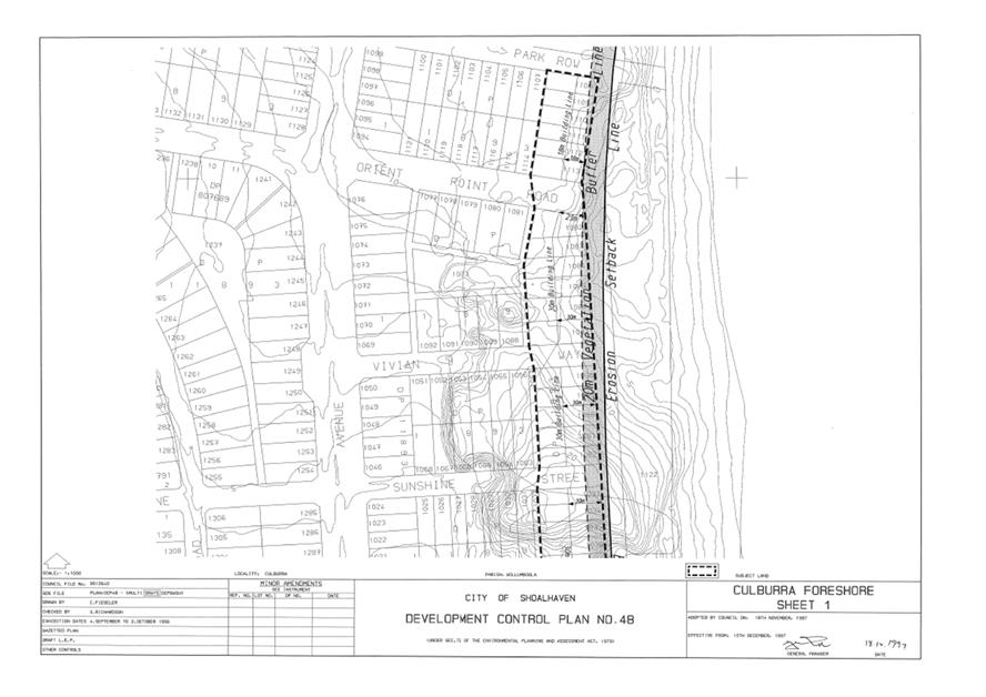
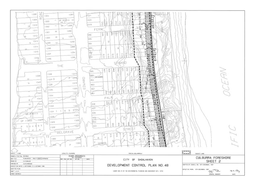
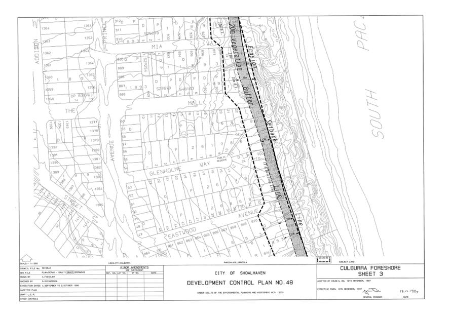
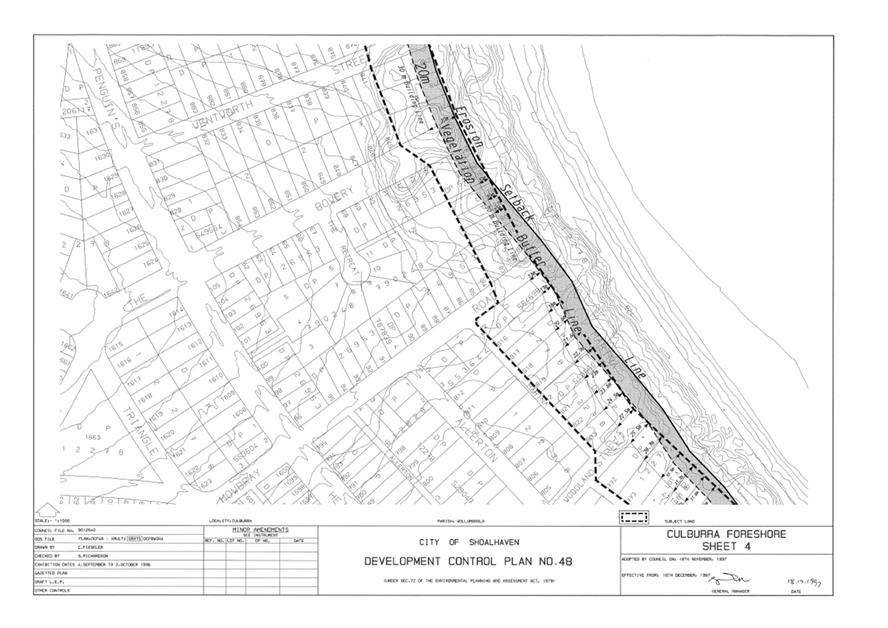
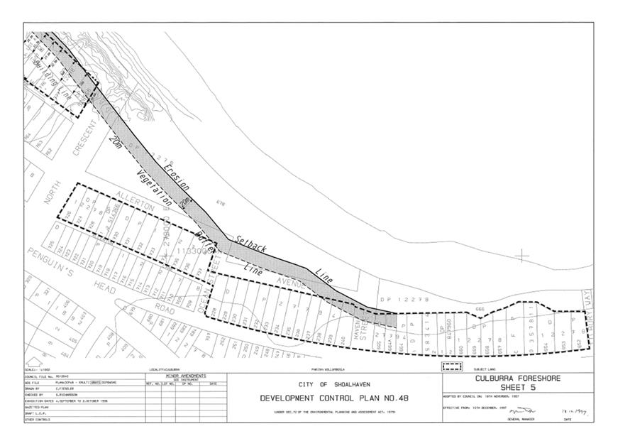
|
|
Development
& Environment Committee – Tuesday 02 July 2019
Page
0
|
DE19.59 Development
Application – No.64, Lot 1138 in DP 1210394, Seagrass Avenue Vincentia
DA. No: DA18/1998/4
HPERM Ref: D18/383673
Group: Planning
Environment & Development Group
Section: Building
& Compliance Services
Attachments: 1. Draft
Notice of Determination ⇩
2. Plans
of the proposal (under separate cover) ⇨
3. Email
from applicant - detailed shadow analysis ⇩
4. Independent
Shadow Analysis - (Revised) (under separate cover) ⇨
5. Section
4.15 Assessment Report (under separate cover) ⇨
6. Applicant's
request for variation to driveway location ⇩
7. Applicant's
response to submissions (under separate cover) ⇨
8. Proceedings
of the Residents Briefing Meeting held on 4 March 2019 (under separate cover) ⇨
9. Report
- Assessment of Submissions (councillors information folder) ⇨
10. Submission
by Sherrie Smith dated 20 March 2019 (under separate cover) ⇨
11. Submission
by Peter O'Sullivan dated 21 March 2019 (under separate cover) ⇨
12. Checklist
for SDCP Chapter G11 - Dual Occupancy Subdivision ⇩
13. Checklist for SDCP
Chapter G13 - revised version post 30 Oct 2018 (under separate cover) ⇨
Description of Development: Attached Dual
Occupancy (2 x Two Storey Dwellings) and Strata Subdivision
Owner: KARINA MAY WAITE & ANDREW JOHN STECYK
Applicant: Eagle Homes
Notification Dates: 10 October 2018 to 25 October
2018 and 6 to 21 March 2019
No. of Submissions:
First round of
notification: 48 submissions in objection (from 38 submitters), one petition of
objection with 30 signatures, 1 in support (from owner of subject land).
Second round of
notification: 46 in objection (from 40 submitters), one petition of objection
with 193 signatures, none in support.
Purpose / Reason for consideration
by Council
This application was called in
for determination by Council’s Development Committee at its meeting held
on 6 November 2018 (MIN18.892), citing the large number of objections made and
the considerable public concern caused by the application.
The Committee further resolved
at that meeting that a Residents Briefing Meeting be organised.
|
Recommendation (Item to be determined
under delegated authority)
That Development Application
DA18/1998 be refused for the reasons set out in Attachment 1 to this
report.
|
Options
1. Refuse the application as recommended.
Implications: The application would not proceed. The applicant
can apply for a Section 8.2 review of Council’s decision and/or
could lodge an appeal with the Land and Environment Court against
Council’s decision.
2. Approve the application as submitted
Implications: The application could
proceed subject to compliance with any conditions of consent, issue of
Construction Certificate and Subdivision Certificate. Under some circumstances
third parties (i.e. objectors) can seek a judicial review of Council’s
decision in the Land and Environment Court.
Location Map
Figure 1 - Site location plan
Background
The applicant proposes an attached dual occupancy of two
storeys containing two, four-bedroom dwellings. The application includes Strata
subdivision of the completed development. There have been no prior
approvals for Dual Occupancy within the Bayswood Estate.
The Bayswood Estate was approved by the State government under
the Major Projects SEPP. It is a highly planned residential estate. When
Shoalhaven LEP2014 came into effect, the development came under the control of
Council as consent authority, and many of the former development controls in
the Major Project approval were embraced in a new Chapter N15 of the Shoalhaven
DCP (Vincentia Coastal Village and District Centre).
Ownership of the remaining undeveloped and unsold land in the
Bayswood site transferred to the current developer, Wakefield Ashworth
Developments P/L.
Proposed Development
The applicant proposes an attached dual occupancy of two
storeys containing two, four-bedroom dwellings. The application includes Strata
subdivision of the completed development. The plans of the proposal are shown
in Attachment 2.
Subject Land
The subject land is lot 1138,
DP1210394, No.64 Seagrass Avenue, Vincentia. The land is situated towards the
northern end of Seagrass Avenue in Bayswood Estate, between Reef Road and
Summercloud Crescent. The site is shown highlighted yellow on the aerial
photograph in Figure 2 below.

Figure 2 – Aerial view of the site and
surrounding development
Site & Context
The site is 500 m2 in
area with a width of 15.625 metres and depth of 32 metres. The site is cleared
of vegetation.
The land is zoned R2 Low Density
Residential under Shoalhaven LEP 2014. Dual occupancies are permissible in the
zone with consent.
The site is relatively level
over most of its surface but slopes down by approximately 0.6 metres to
the footpath and road surface in Seagrass Avenue in the section of the lot
forward of the general front building alignment.
Immediately surrounding the site
are single storey dwellings of recent construction. There are several two
storey dwellings more distant from the site. In accordance with the practice
adopted by the initial developers, most of these two storey dwellings are
located on corner lots with the intent of minimising overshadowing.
A street view of the site and
surrounding residential development is shown at Figure 3 below.
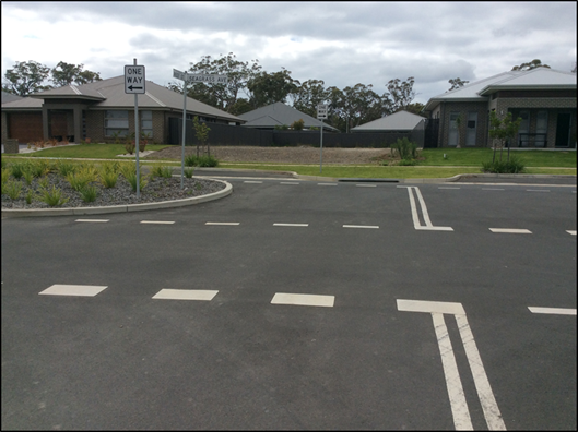
Figure 3 – Street view of the site
The east-west orientation of the
site and those in its vicinity, and their relatively small size and narrow
width, means that the blocks are highly vulnerable to overshadowing from two
storey developments.
The NSW Land and Environment
Court has established a planning principle for development on small or narrow
sites in CSA Architects v Randwick City Council [2004] NSWLEC 179.
This planning principle has relevance to this issue of solar access. Its
application is discussed under the ‘Issues’ section below.
Seagrass Avenue is constructed
with divided carriageways with a central landscaping strip. Each of the
one-way road carriageways are narrow and are supplemented by parking bays
outside of the carriageways themselves. These parking bays are not continuous
and provide for significantly less on-street parking than would be found in a
more traditional subdivision.
On the eastern side of the
section of Seagrass Avenue containing the subject site, there is a parking bay
between Summercloud Crescent and Reef Street providing approximately five (5)
on-street car spaces and another parking bay between Reef Street and Compass
Street providing approximately another five on-street car spaces. On the
western side of Seagrass Avenue there is a parking bay containing three on-street
car spaces, adjoining the property on the corner of Seagrass Avenue and
Summercloud Crescent (approximately 40 metres from the subject property). There
are no on-street car parking spaces on the western side of Seagrass between
Reef Street and Compass Street.
There are approximately thirteen
on-street car parking spaces to serve the sixteen residential properties on
Seagrass Avenue between Summercloud Crescent and Compass Street.
One of these on-street car
parking spaces is located immediately in front of the subject site and will be
lost due to the width and location of the proposed driveway. The parking bay is
terminated by a kerb extension or ‘blister’ that is designed to
reduce traffic conflict at the intersection with Reef Street.
Due to the narrow one-way roads,
the intersection with Reef Street also functions as a ’U’ turn bay
for traffic travelling up and down Seagrass Avenue.
The expanded aerial view of the
site and surrounds at Figure 4 below shows the configuration of Seagrass
Avenue, its intersection with Reef Street immediately opposite the site, and
the configuration of the on-street parking bay and kerb ‘blister’
in front of the site.
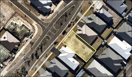
Figure 4 – Expanded aerial view of the site and
surrounding development
History
The subject land was subdivided in accordance with Subdivision
Approval SF9786. There are no previous development applications applying to
this site.
Issues
Overshadowing of adjacent dwellings (SDCP Chapter G1)
The proposal causes shading to two adjacent properties; 62
Seagrass Avenue and 33 Summercloud Crescent. The impact on each of these
properties is addressed individually below.
Applicant’s Submission
The shadow diagrams submitted by the applicant are included in
the plans at Attachment 2 and the applicant’s assessment of shadow
impact is at Attachment 3.
The applicant contends that the level of shadowing is largely
compliant with the DCP standard and is therefore acceptable.
Discussion
33 Summercloud Crescent
The shadow diagrams provided by
the applicant and the independent shadow review commissioned by Council, both
indicate that this property does not encounter additional shading from the
proposal until after 2pm.
This meets the solar access
requirements set out in Acceptable Solutions A3.1 and A4.1 of SDCP Chapter G1.
The property retains at least 3 hours solar access to north facing living rooms
and principal open space areas between 9 am and 3 pm on the shortest day of the
year.
62
Seagrass Avenue
The assessment of solar impact
affecting this property is complex and has been aided by Council’s
commissioning of independent shadow diagrams. The decision to obtain an
independent shadow review was made because the shadow diagrams submitted with
the application did not include shadow elevations of sufficient accuracy and
because those shadow diagrams indicated that the result was borderline.
The independent shadow analysis
commissioned by Council is at Attachment 4
A detailed assessment of the
shadow impact of the proposal on 62 Seagrass Avenue is contained in the SDCP
Chapter G1 Checklist contained in the Section 4.15 Assessment Report at Attachment
5.
In summary, that detailed
assessment finds as follows:
· The
proposal does not meet the solar access standard in Acceptable Solution A4.1 in
SDCP2014 Chapter G1, which states that “50% of the area of the windows
or glazed doors of north facing living areas and principal open space of
adjoining dwellings do not have their sunlight reduced to less than three hours
of sun between the hours of 9am and 3pm on the 21st June(winter
solstice)”;
· There
is significant self-shading of the north facing living areas and private open
space of the dwelling at 62 Seagrass Avenue caused by the roof and eaves of the
building and by the existing boundary fence;
· Because
of the development, the principal private open space area (which comprises the
al fresco area and the private open space area adjacent to the living rooms)
loses virtually all the sunlight that it currently receives;
· Due
to the extent of self-shading and the proposal’s non-achievement of the
3hours / 50% standard, a more qualitative assessment was conducted in
accordance with the NSW LEC Planning Principal on solar access (established in The
Benevolent Society v Waverley Council [2010] NSWLEC 1082 at 144 –
updated from Parsonage v Ku-Ring-Gai);
· This
assessment finds that the loss of solar access to 62 Seagrass Avenue is
unreasonable;
· The
proposal does not satisfy Performance Criteria P4 in SDCP2014 Chapter G1, which
is “To ensure that dwellings are sited to minimise the overshadowing
of neighbouring dwellings, such that the impact on adjoining residences is not
unreasonable”.
The NSW Land and Environment
Court Planning Principle on development on small or narrow sites (established
in CSA Architects v Randwick City Council [2004] NSWLEC 179) states that
the “main criterion for assessing the proposal on its own site is whether
it meets other planning controls” and identifies the most critical
control for small and narrow sites is that for setbacks, and asked the question
whether the development’s impact is “worse because the
development is on a small or narrow site”.
The Planning Principle deals
with the issue of solar access and identifies that where setbacks meet the
Council’s standards (as they do in this case) building height is the
other critical element where narrow sites are concerned. The assessment
undertaken for this development is consistent with the elements of this
Planning Principle.
SDCP2014
standards for solar access in relation to 62 Seagrass Avenue
SDCP2014 contains the following
standards for solar access to neighbouring dwellings:
· Performance
Criteria P4: “To ensure that dwellings are sited to minimise the
overshadowing of neighbouring dwellings, such that the impact on adjoining
residences is not unreasonable”.
· Acceptable
Solution A3.1: “Your dwelling design should be based on the NSW Land
& Environment Court Planning Principle ‘Impact on Solar Access of
Neighbours’ from Parsonage v Ku-ring-gai [2004] NSWLEC 347”.
· Acceptable
Solution A4.1: “50 % of the area of the windows or glazed doors of north
facing living areas and principal open space of adjoining dwellings do not have
their sunlight reduced to less than three hours of sun between the hours of 9am
and 3pm on the 21st June (winter solstice)”.
The requirements of Acceptable
Solution A4.1 are generally conclusive in determining the acceptability of loss
of sunlight to neighbouring dwellings. That is to say, if the development
retains at least 3 hours of sun over 50% of the area of north facing living
area windows and principal open space area, then the degree of impact is
considered to be reasonable.
In the case of this development
and its impact on the adjoining dwelling at 62 Seagrass Avenue, the 3 hours /
50% standard is not met for either north facing living area windows or for the
principal private open space (PPOS) area. For the period between 9 am and 3 pm,
solar access to north facing windows ranges between 27% and 49.5% and never
reaches the 50% level. For the principal private open space (PPOS) area,
the most sunlight that is retained is about 10%, so the standard is not met for
the PPOS area either.
A second analysis was undertaken
because the affected property receives substantial self-shading of the north
facing windows and PPOS from its roof eaves and from the existing boundary
fence. In this analysis the extent of self-shading was excluded and the
loss of solar access to the residual area receiving sunlight was estimated.
This approach provides the most favourable assessment of the shading impact of
the development. It is not strictly in accordance with Acceptable Solution
A4.1, which is silent on the issue of self-shading.
When self-shading by 62 Seagrass
Avenue is taken into account, the 3 hours / 50% standard is met for north
facing living area windows – but is not met for the principal private
open space (PPOS) area.
It is therefore concluded that
even when self-shading is accounted for, the development still does not achieve
the 3 hours / 50% standard for both north facing living area windows and
principal private open space area.
Due to the extent of solar
impact on the adjoining dwelling, the development was also assessed with
reference to the NSW Land and Environment Court’s Planning Principle on
solar access. This is referenced in Acceptable Solution A3.1.
The LEC Planning Principle
provides a more qualitative assessment of solar impact, which includes
consideration of the density of development in an area, vulnerability of a site
to overshadowing, and the nature and extent of solar access to private open
space.
The structure of SDCP2014
requires that, where an Acceptable Solution is not met, then the development
must be assessed against the relevant Performance Criteria (P4, shown above).
Taking into account the extent
and incidence of shading and the LEC Planning Principle, it is concluded that
the impact on the adjoining residence is unreasonable and that therefore
Performance Criteria P4 is not satisfied.
The detailed assessment of this
issue is contained in the SDCP2014 Chapter G1 Checklist that forms part of the
Section 4.15 Assessment Report at Attachment 5.
Having regard to the detailed
assessment, it is considered that:
· The design and
siting of the development does not minimise the overshadowing of the
neighbouring dwelling at 62 Seagrass Avenue. This is mainly due to the
two-storey design of the building and its location on the site.
· The impact on the
adjoining residence at 62 Seagrass Avenue is unreasonable, as the proposed
development deprives that residence of adequate sunlight to its most valued
northern facing living areas, al fresco and principal private open space area.
Tandem (stacked) parking
spaces exceed the maximum slope of 5% (SDCP Chapter G13)
The application proposes a
single garage for each dwelling and a tandem or stacked car space for each
dwelling on the driveway in front of each garage.
This is compliant with the two
on-site car spaces required for each dwelling where there are more than two
bedrooms. However, it does not comply with the requirement in SDCP Chapter G21
for both spaces to be behind the building line, instead relying on the revised
Chapter G13 (Dual Occupancy) which permits tandem or stacked parking under some
circumstances.
The tandem parking spaces do not
comply however, with the revised G13 requirement that such car parking spaces
have no greater longitudinal slope than 5%. The submitted driveway sections
show that the parts of the driveways containing the car parking spaces have
grades or 12% and 14% respectively and do not comply.
The maximum longitudinal slope
of 5% is based on experience with similar provisions in other Council areas,
notably in the Shellharbour City Council area. This is similar to, but less
stringent than, the requirement in Australian Standard AS/NZS 2890.6:2009
(Parking Facilities) which establishes a maximum grade of 3% for accessible car
spaces.
Excessive slope of a parking
space can impair the functioning of vehicle door check straps, make it more
difficult for parents of young children and for people with limited mobility to
safely enter and exit a car. It also increases the risk of vehicles rolling
onto the road carriageway if handbrakes are not properly applied or they fail.
Applicant’s submission
The applicant has not made a
specific submission in relation to this matter.
It is noted that this issue was
raised with the applicant in Council’s Preliminary Assessment email dated
10 October 2018 which was sent shortly after the application was lodged.
Discussion
The excessive slope affects the
functionality and safety of the proposed parking spaces.
Driveway location (SDCP
Chapter G21).
The site is located at the
intersection of Seagrass Avenue and Reef Street as shown on the aerial photo at
Figure 5 below. This photo shows the location of the car parking bay in front
of the subject site. The site is outlined in yellow.
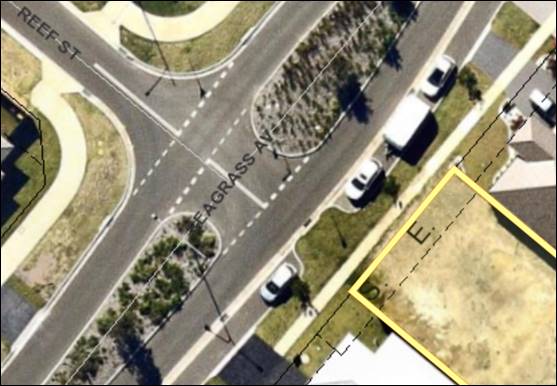
Figure
5 – Aerial photo showing the site (outlined in yellow) in relation to the
intersection of Seagrass Avenue with Reef Street
SDCP Chapter G21 contains the
following provisions indicating acceptable driveway locations, as shown in
Figure 6 below.
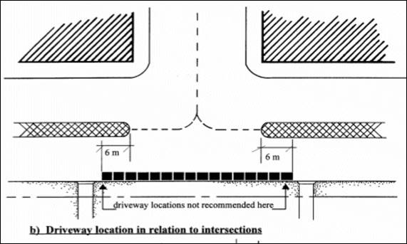
Figure
6 – Driveway locations in relation to intersections not recommended in
SDCP Chapter G21
The 6m (‘no
driveway’) distance to the north of the traffic median is where the
proposed driveway is to be located.
The extract of the site plan in
Figure 7 below shows the location of the proposed driveway occupying the site
of the on-street parking bay and essentially opposite the intersection with
Reef Street.
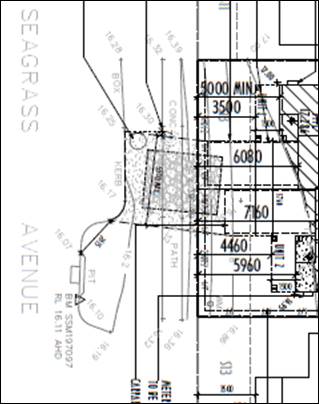
Figure
7 – Extract of site plan showing location of proposed driveway
Applicant’s submission
This non-compliance was drawn to
the attention of the applicant who submitted a variation request in respect of
the non-compliance. The variation request is reproduced at Attachment 6
and is summarised below:
· 6m distance is
arbitrary;
· Egress
is not inhibited by the road intersection, with adequate sight lines and
distance to the carriageway of Seagrass Avenue;
· Vehicles using
either Seagrass Avenue or Reef Street will not have sight lines or safety
impeded by the driveway location.
Discussion
In assessing the variation
request, it is noted that the ‘kerb blister’ in Seagrass Avenue
opposite Reef Street was constructed at the time of subdivision as a means of
minimising traffic conflict. The clear intention was for an on-street car
parking space to be located immediately north of the kerb blister and for the
driveway access to 64 Seagrass to be located at the northern end of the
frontage, i.e. as far as possible from the Reef Street intersection.
One intent of this arrangement
is to reduce traffic conflict by discouraging drivers from crossing the
southbound carriageway of Seagrass Avenue from the U turn bay at the
intersection to enter the property. As can be seen from the photograph at
Figure 8 below, the driveway location would be in a direct line from the U-turn
bay, which would encourage this movement, thereby reducing traffic safety.
Essentially motorists may be tempted to go the wrong way up the one-way
carriageway to access the premises.
Figure
8 – Street view of site from Reef Street, showing U-turn bay between the
two one-way carriageways
As the driveway services two
dwellings, the number of inappropriate traffic movements would be double that
of a driveway servicing only one dwelling. The proposed driveway location
effectively negates one of the design features of the subdivision’s road
network.
Accordingly, the variation
request is not supported.
Suitability of the site
for the development (EPA Act section 4.15 (1) (c))
This is one of the important
considerations in section 4.15.
Applicant’s submission
The applicant considers that the
site is well suited to the proposed development.
Discussion
In most cases it can be expected
that the Court will approve an application to use a site for a purpose for
which it is zoned, provided of course the design of the project results in
acceptable environmental impacts. In this instance, the site is not considered
to be suitable for the development for the following reasons:
· The
narrow block widths and their east-west orientation makes the site less
suitable for two storey development due to the heightened vulnerability to
overshadowing (as apparently reflected in a long-standing practice of the
developer designating corner sites for two storey buildings and directing such
development to those sites);
· The
‘master planned’ nature of Bayswood with its narrow roads and
minimal on street parking provides no excess capacity for on street parking;
· The
site is located at the intersection with Reef Street and this gives rise to
additional vehicle conflict and the encouragement of potentially unsafe turns
into the site;
· The
short steep slope of the lot between the front building alignment and the
footpath means that the proposed ‘stacked’ or ‘tandem’
car parking spaces in front of the garage of each dwelling have an excessive
slope which considerably exceeds the 5% specified in the revised SDCP Chapter
G13 for such spaces;
· The
site is not suitable for a dual occupancy development with a central driveway
as the lot and adjoining road layout are configured to provide for a single
driveway access adjoining the lots northern boundary and to provide an
on-street car space in the parking bay in front of the lot.
·
Planning Assessment
The DA has been assessed under
section 4.15 of the Environmental Planning and Assessment Act 1979. Please
refer to Attachment 5.
Policy Implications
There are no policy implications
arising from this application.
Consultation and Community Engagement:
This application has been notified on two occasions.
The first notification period was from 10 October to 25
October 2018. The first notification was made in accordance with
Council’s Community Consultation Policy with letters being sent to the
owners of properties within a 25-metre buffer of the site.
During the first notification period there were 48 submissions
in objection (from 38 submitters), one petition of objection with 30
signatures, and 1 submission in support (from the owner of subject land).
The applicant’s response to submissions is shown at Attachment
7.
In accordance with the Development Committee’s decision,
a Residents Briefing Meeting was held on 4 March 2019. A record of the
proceedings of that meeting is shown at Attachment 8.
Following the holding of the Residents Briefing Meeting a
second notification period was provided from 6 March to 21 March 2019. The
second notification was made in accordance with Council’s Community
Consultation Policy, with letters being sent to the owners of properties within
a 25-metre buffer of the site and to those people who made submissions during
the first round of notification.
During the second round of notification, there were 46
submissions in objection (from 40 submitters), one petition of objection with
193 signatures, and no submissions in support.
Attachment 9 is the report on the assessment of
submissions. This includes copies of submissions made on the application and an
assessment of the issues raised in each submission. Attachment 10 and 11
are copies of two submissions that were too long to include in the report on
the assessment of submissions.
Key issues raised in submissions are provided below.
Issue
The dual occupancy proposal does
not comply with the covenants for Bayswood Estate and the Bayswood Design
Essentials.
Comment
While the original sales
material for Bayswood indicated that dual occupancy would not be allowed, the
zoning and the Restrictions (‘covenants’) imposed at the time of
subdivision do not prohibit them. The statement quoted in several submissions
i.e. “single dwelling per lot with no further subdivision of lots”
was not a legal restriction on the title of properties in the Bayswood Estate.
The application was certified by
the current estate developer as being compliant with the Bayswood Design
Essentials.
Clause 1.9A of Shoalhaven LEP
2014 overrides private covenants to the extent necessary to enable development
to be carried out in accordance with the LEP.
Issue
The development is not
consistent with the zone objectives for the R2 Low Density Residential zone
Comment
The zone objectives for the R2
Low Density Residential zone under Shoalhaven LEP 2014 are:
· To provide for the
housing needs of the community within a low density residential environment.
· To
enable other land uses that provide facilities or services to meet the day to
day needs of residents.
· To provide an
environment primarily for detached housing and to ensure that other development
is compatible with that environment.
The key zone objectives that are
relevant to the proposed development are the first and third objectives. The
second zone objective relates to non-residential land uses such as child care
facilities community facilities, neighbourhood shops, and places of public
worship.
Several submissions have argued
that the dual occupancy does not qualify as ‘low density’ but
rather should be ‘medium density’. Submissions have also pointed
out that the term ‘low density’ is not defined in the Environmental
Planning and Assessment Act 1979, the Shoalhaven LEP 2014 or the Shoalhaven DCP
2014. They have pointed to commonly-accepted thresholds for ‘low
density’ and medium density’ development of 25 dwellings per
hectare and 40 dwellings per hectare, respectively.
The above thresholds equate to
typical lot sizes of 400 m2 (at 25 dwellings per hectare) and 250 m2
(at 40 dwellings per hectare).
The rationale is that existing
lots in Bayswood are typically around 500 m2 so fall clearly in the
‘low density’ category, while the proposed development will result
in two lots each of 250 m2 and therefore ought to be
categorised as ‘medium density’.
While a street full of sites
occupied by dual occupancies would likely not be regarded as being a ‘low
density’ environment, one or a few dual occupancies spread throughout an
area mainly consisting of single detached dwellings likely would. The proposal
before Council is for one dual occupancy development in an existing subdivision
that primarily consists of single detached dwellings. The proposal is therefore
not inconsistent with providing an environment primarily (report
author’s emphasis) for detached housing. The third zone objective does
not say exclusively for detached housing, or even overwhelmingly
for detached housing, but primarily.
The other element of the third
zone objective is that a proposed development should be compatible with an
environment primarily for detached housing.
In this regard it is noted that
dual occupancies are specified as a development that is permissible with
development consent in the R2 Zone.
The NSW Land and Environment
Court has established a Planning Principle (at Project Venture Developments
v Pittwater Council [2005] NSWLEC 191) in relation to the issue of compatibility
between a development and its surroundings. This Planning Principle identifies
the two major aspects of such compatibility as visual impact and physical
impact.
Visual impact of the proposal
has been considered by Council primarily under SDCP Chapter N15 (Vincentia
Coastal Village and District Centre) which contains detailed provisions
relating to the design and visual appearance of the proposal. The application satisfactorily
complies with the design and appearance guidelines in SDCP Chapter N15.
Further, it is noted that the developer has certified the plans submitted with
the application as being compliant with the Bayswood Design Essentials.
In terms of physical impact,
aspects such as noise, overlooking, overshadowing and constraining development
potential have been assessed in the Section 4.15 Assessment Report and SDCP
Chapter G13 (Dual Occupancy Development). While the proposal is broadly
compatible with the surrounding development in terms of its physical impact,
there are some issues in relation to overshadowing and impact on the
availability of on-street parking that are relevant and that are discussed
elsewhere in this report.
The NSW Land and Environment
Court has also established a Planning Principle on the relevance of zoning (in BGP
Properties Pty Limited v Lake Macquarie City Council [2004] NSWLEC 399).
This Planning Principle relevantly states that “In most cases it can be
expected that the Court will approve an application for a purpose for which it
is zoned, provided of course the design of the project results in acceptable
environmental impacts”.
Issue
The subdivision of the land does
not comply with the LEP minimum lot size.
Comment
The land size of 500 m2
meets the minimum site area requirement under SDCP 2014 for attached dual
occupancy.
There is no minimum lot size under SLEP 2014 for strata
subdivision, and Clause 4.1A of SLEP 2014 is not relevant as it is a strata
subdivision that is proposed.
Issue
The development will overshadow adjoining residence at 62
Seagrass Avenue.
Comment
Council commissioned an independent shadow review to properly
assess the shadow impact on the adjoining properties. This assessment is
complex and is detailed in the Section 4.15 Assessment Report at Attachment
5.
The conclusion of that assessment is that the development
unreasonably overshadows the adjoining residence at 62 Seagrass Avenue.
The area of the roof containing the existing hot water solar
panels at 62 Seagrass Ave will not be affected by the proposal. The possible
shadowing of future potential placement of solar panels on parts of the roof
that may be affected by the proposal is not a relevant consideration, although
it is noted that the worst-case shading of the roof of 62 Seagrass Ave occurs
at 9am, with shading decreasing after that time.
Issue
The development will overshadow the adjoining residence at 33
Summercloud Crescent.
Comment
Shadow diagrams commissioned by Council show that 33
Summercloud Crescent will not be affected by shadows from the proposal until
after 2pm on the shortest day of the year. At 3pm the shadows from the
development extend only slightly beyond the self-shading caused by the rear
boundary fence of 33 Summercloud Crescent.
Figure 9 below shows the extent of shadowing at 3pm. The
property to the right of 64 Seagrass that has the compass “True
North” (TN) superimposed upon it is 33 Summercloud Crescent. The
grey area represents the self-shading from the rear fence. The small area
of red shading to the right of the grey shading represents the additional
shading from the proposed development.
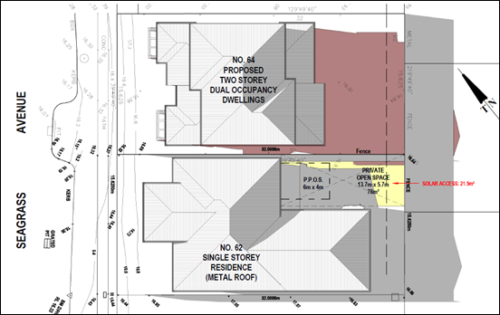
Figure 9- Extent of
shadowing of 33 Summercloud Crescent
Issue
Bayswood has narrow roads and
very limited on street parking. The development has insufficient parking
provided on site and will worsen the existing limited parking situation in
Bayswood.
Comment
Due to its location in the
centre of the block’s frontage and its width, the proposed driveway will
take up one of the spaces currently provided in the on-street parking bay in
front of the property.
The proposal is compliant with
SDCP 2014 requirements for onsite parking spaces. This aspect of the
development is assessed in detail in the Section 4.15 Assessment Report and in
the SDCP 2014 Checklists for the current and recently superseded Chapter G13 documents.
Despite compliance with the
parking space requirements above, it is agreed that it is possible that more
car spaces will be occupied by this development than are provided. It is also
undeniable that any overflow parking from the development will have to be
accommodated in the street rather than on the site, as there are no additional
spaces on site and there is insufficient space or access to park a car (or a
boat, caravan or trailer) beside or behind the building. This differs from most
of the single dwellings in Bayswood which often have double garages with two
visitor spaces on the driveway, or room to place a vehicle behind the building
line.
Issue
The development will worsen
traffic safety in the area.
Comment
The proposal will increase
traffic on Seagrass Avenue, but this increase is likely to be marginal and is
acceptable.
Some submissions raised the
concern that vehicles will make illegal right hand turns into the driveways
from the U turn bay at the Reef Street intersection.
This is made more likely by the
one-way divided carriageway design of Seagrass Avenue. This means that a
vehicle coming from the south (the usual direction for a vehicle coming into
Bayswood) would have to travel up to the intersection with Summercloud Crescent
to make a ‘U’ turn and then return on the southbound carriageway of
Seagrass Avenue before entering the property. The road widths in Bayswood are
such that the turning path available at that intersection is marginal for
larger vehicles (e.g. 4WDs) and so the incentive to make an earlier and illegal
right hand turn is heightened. Evidence of this is shown at Figure 10 below.
The inability to make a U-turn at this location while keeping to the sealed
carriageway has been confirmed by the assessing officer using a Toyota Hilux
which equates to a 99th percentile vehicle under Australian Standard
AS/NZS 2890.
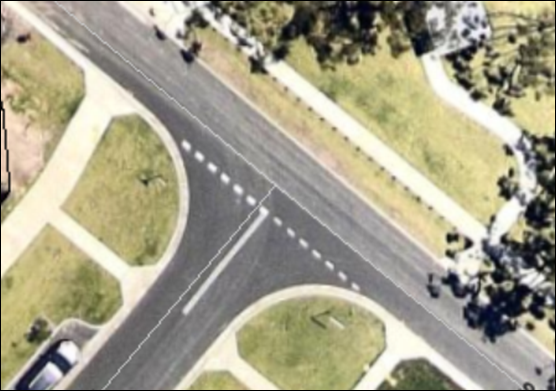
Figure
10 – Aerial photo of the intersection of Seagrass Avenue and Summercloud
Crescent
A further relevant issue is how
close the driveway is to the intersection and its compliance with the relevant
provision of SDCP Chapter G21 (Car Parking and Traffic). This issue is the
subject of a variation request by the applicant and is detailed above in this
report under the “Issues” heading.
Issue
Bayswood is not a 2 storey
developed area – 2 storey buildings have previously been restricted to
corner sites where they do not shade other houses.
Comment
There are two storey buildings elsewhere
in Bayswood although it is noted that the developer has previously encouraged
these to be confined to corner lots where impact on nearby residences would be
potentially less. The relatively small lot sizes and east-west lot
configuration of this part of Bayswood mean that individual lots are
particularly vulnerable to shadowing by two storey buildings on lots to their
north.
The applicant identified a two storey
building at 70 Seagrass Avenue. It was mentioned in support of its two storey
proposal, being a two storey building that was not located on a corner as has
been previous practice. This two storey dwelling was approved as a Complying
Development (CD17/1617) by a private certifier.
Issue
The development is medium
density, not low density.
Comment
This issue is discussed at some
length under the issue relating to zone objectives and this view is not
supported.
Issue
Development will put extra
stresses on infrastructure designed for low density housing.
Comment
Increase in traffic from the
proposal will be marginal and within the capacity of the local road system,
noting that roads in the Bayswood estate are narrow and traffic disruption
events do occur as a result of deliveries/removalists.
Existing services such as water,
sewer and electricity will accommodate the marginal increase in use arising
from one additional dwelling on this lot. Shoalhaven Water has issued a
Development Application Notice for the proposal and it is considered
adequate.
This objection is therefore not
supported.
Issue
The site is not suitable for the
proposed development.
Comment
This aspect is assessed in
detail in the Section 4.15 Assessment Report with specific reference to Section
4.15(1)(c) – the suitability of the site for the development.
The following are aspects of
concern:
· The
narrow block widths and their east-west orientation makes the site less
suitable for two storey development;
· The
‘master planned’ nature of Bayswood with its narrow roads and
minimal on street parking provides no excess capacity for on street parking;
· The
site is located at the intersection with Reef Street and this gives rise to
additional vehicle conflict and the encouragement of illegal right hand turns
into the site;
· The
short steep slope of the lot between the front building alignment and the
footpath means that the proposed ‘stacked’ or ‘tandem’
car parking spaces in front of the garage of each dwelling have an excessive
slope which considerably exceeds the 5% specified in the revised SDCP Chapter
G13 for such spaces.
Issue
The block is not large enough to
accommodate the proposed development.
Comment
The lot complies with the
minimum 500 m2 lot area for attached dual occupancies required by
SDCP Chapter G13.
Issue
Stormwater is shown on the plans
as being directed onto the property at the rear.
Comment
The Site Analysis plan shows
flow of stormwater to the rear of the property. However, there is a drainage
easement and underground storm water pipe at the rear of the property and the
Stormwater Plan shows that overflow from the rain water tanks is piped to the
easement and underground pipeline. It would be expected that there will be
minimal if any flow of stormwater onto 33 Summercloud Crescent.
Issue
Parking provision and vehicular
access do not comply with the requirements of SDCP Chapter G21 (Car Parking and
Traffic).
Comment
This issue is discussed in the
“Issues” section above in this report. Briefly, it is noted that
the tandem parking spaces in front of the garage have excessive longitudinal
slope and the driveway location is too close to the intersection with Reef
Street.
Issue
Development will reduce property
values in the area.
Comment
There is no evidence to support
the contention that approval of the proposal will adversely affect property
values in the area.
Issue
Allowing the development could
create a precedent which could endanger the character of the entire estate.
Comment
Council has to consider this
application on its merits and the likelihood of future similar developments is
not relevant to this consideration.
Issue
Development will subject surrounding
homes to unacceptable noise.
Comment
Noise impact is generally
controlled by the Protection of the Environment Operations (PoEO) Act which
establishes acceptable noise limits for residential development and provides
for enforcement action by Council, Police and the Court where these limits are
breached.
If the application was to be
approved, a condition could be imposed to ensure that noise from air
conditioning units will be kept within acceptable levels.
Issue
Development will overlook
private outdoor areas of the adjoining homes and reduce privacy.
Comment
There is potential for
overlooking from the first floor rooms of the proposal. However, all of the
first floor rooms, with the exception of a rumpus room at the rear of each of
the dwellings, will be either bedrooms or bathrooms and so are not regarded by
SDCP 2014 as a concern with respect to privacy. The rumpus rooms at the rear of
the building are more than 12m from the boundary with 33 Summercloud Crescent
and are therefore beyond the ‘privacy sensitive zone’ identified in
SDCP2014. The windows in these rooms have highset windows with a sill height of
1.5m which would also reduce the likelihood of overlooking.
Issue
The lot sizes for the proposed
subdivision are less than the minimums in Shoalhaven LEP 2014.
Comment
Strata subdivision of the
proposal is permissible under SLEP 2014. There is no minimum lot size for
strata subdivision.
Financial Implications:
If the application is appealed, it will
result in costs to Council in defending the appeal. This is not a matter
Council should consider in determining a development application. Accordingly,
it should not be given any weight in Council’s decision.
Legal Implications
If the application is refused, or if the applicant is dissatisfied
with Council’s determination, the applicant can appeal to the Land and
Environment Court.
Under some circumstances, third parties may also have a
right to appeal Council’s decision to the Land and Environment Court.
Summary and Conclusion
This application has been the
subject of extensive community consultation comprising two rounds of neighbour
notification and the holding of a Residents Briefing Meeting at Vincentia on 4
March 2019.
The application, while broadly
compliant with principal development standards in the Shoalhaven LEP 2014 and
Shoalhaven DCP 2014, has fundamental shortcomings in terms of parking
provision, vehicular access and loss of solar access to the adjoining property
at 62 Seagrass Avenue. The lack of suitability of the site for the
development also weighs against the application.
It is recommended that Council
refuse the application.
|

|
Development
& Environment Committee – Tuesday 02 July 2019
Page
0
|
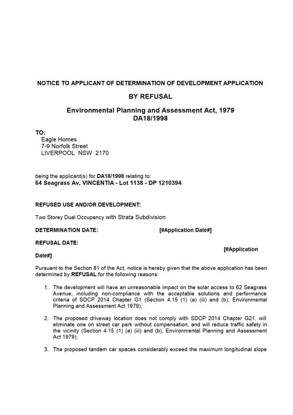
|

|
Development
& Environment Committee – Tuesday 02 July 2019
Page
0
|
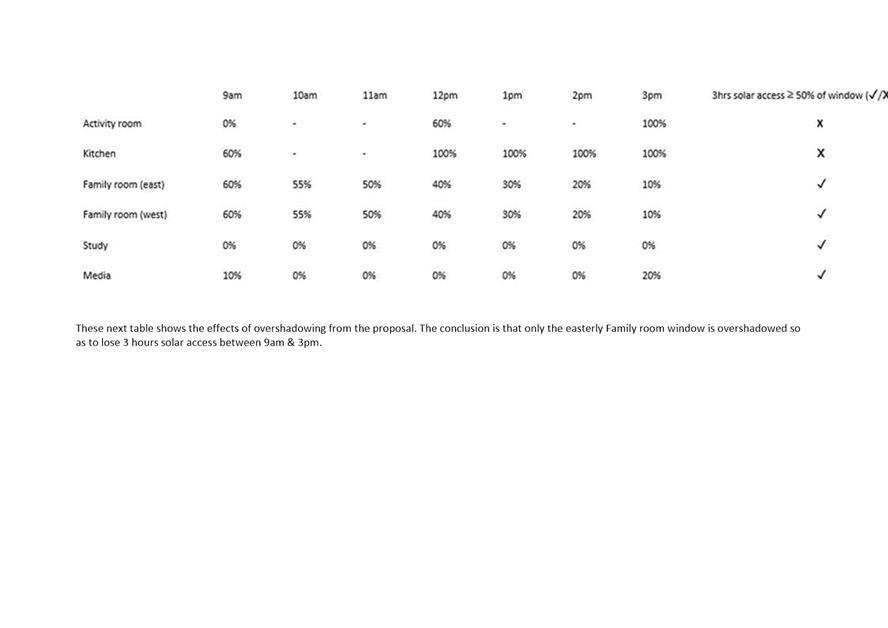
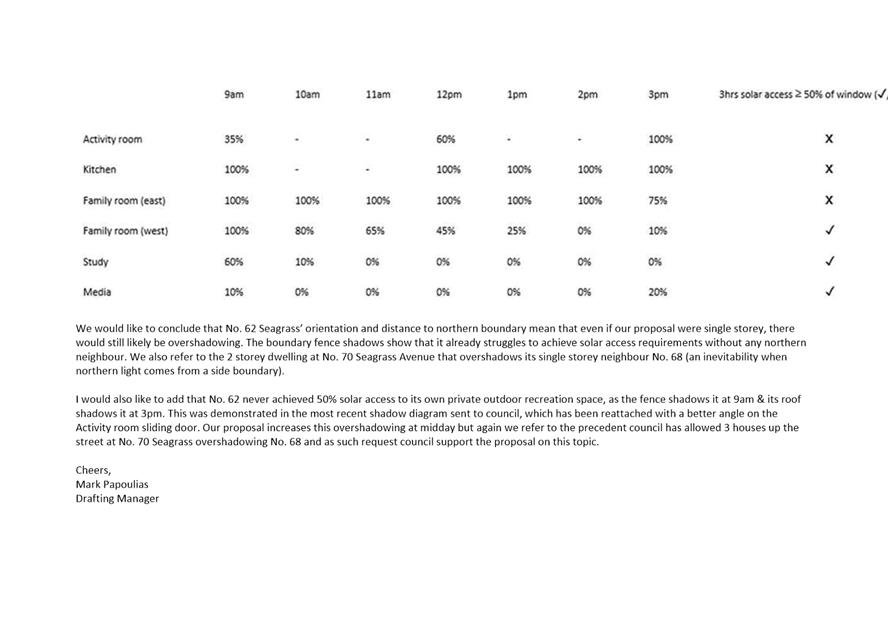

|
|
Development
& Environment Committee – Tuesday 02 July 2019
Page
0
|
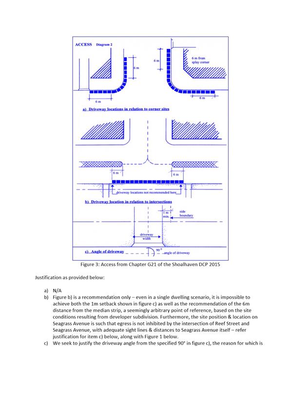
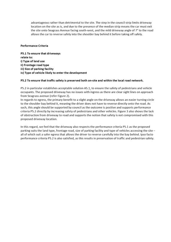
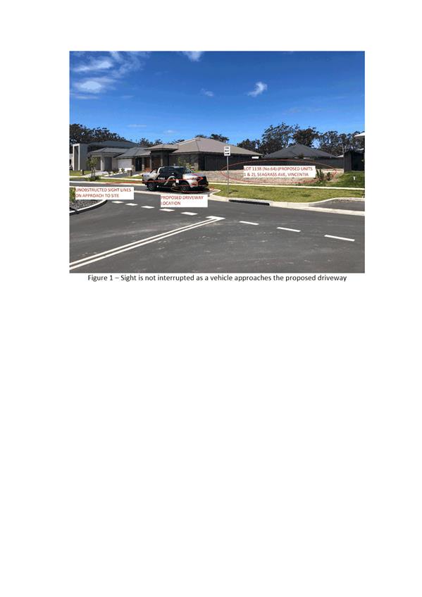
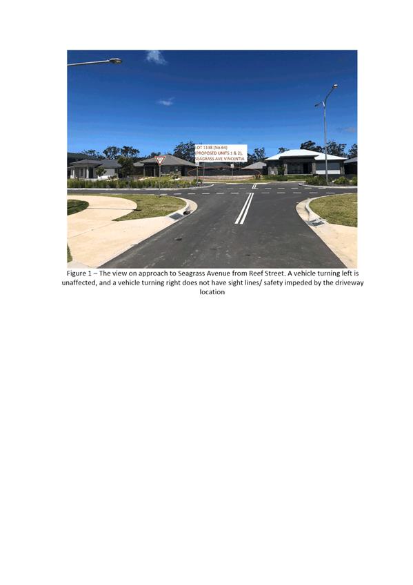
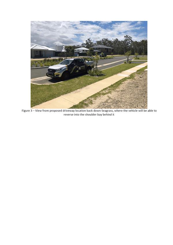
|
|
Development
& Environment Committee – Tuesday 02 July 2019
Page
0
|
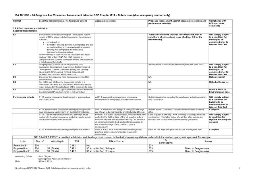
|
|
Development
& Environment Committee – Tuesday 02 July 2019
Page
0
|
Was
DE19.60 Development
Application – 38 Lyrebird Drive Nowra – Lot 74 DP 1198691 DA18/2175
DA. No: DA18/2175
HPERM Ref: D19/189185
Group: Planning
Environment & Development Group
Section: Building
& Compliance Services
Attachments: 1. Draft
Notice of Determination ⇩
2. Report
attachment - plans (excluding habitable floor plan) - Lot 74 DP 1198691 -
38 Lyrebird Dr Nowra ⇩
3. SLEP
2014 Clause 7.3 Assessment Table (under separate cover) ⇨
4. Section
4.15 Assessment Report including DCP Checklists (under separate cover) ⇨
5. Applicant's
Flood Assessment Report (under separate cover) ⇨
6. Applicant's
supplementary letter - Flood Assessment (under separate cover) ⇨
7. SDCP
2014 Chapter G9 - Riverview Road Area controls ⇩
8. SDCP
2014 Chapter G9 - Generic controls for High Hazard Floodway ⇩
9. Riverview
Road Area Floodplain Management Plan (under separate cover) ⇨
10. NSW Floodplain
Development Manual - extract relating to S.733 LG Act (under separate cover) ⇨
Description of Development: Attached dual
occupancy
Owner: AM
Rowell
Applicant: Hotondo South Coast
Notification Dates: 30 October to 14 November 2019
No. of Submissions: No submissions received
Purpose / Reason for consideration
by Council
This report provides an
assessment of the development application for the proposed dual occupancy. The
report recommends that the application be refused due to the flood hazard on
the land.
This application was called in
by Councillor White at the meeting of the Development and Environment Committee
held on 4 June 2019.
|
Recommendation (Item to be determined
under delegated authority)
That the Committee refuse
Development Application DA18/2175 for the erection of an attached dual
occupancy at Lot 74 DP 1108691, 38 Lyrebird Drive Nowra, for the reasons as
shown in the draft Notice of Determination at Attachment 1.
|
Options
1. Refuse the application as recommended
by the report.
Implications: The development will not proceed. The applicants
may seek a review of the application under Section 8.2 of the EPA Act or may
appeal the decision in the Land and Environment Court.
2. Adopt a different recommendation.
Implications: Council would need to consider and prepare a
different recommendation to that which is recommended in this report.
Location Map
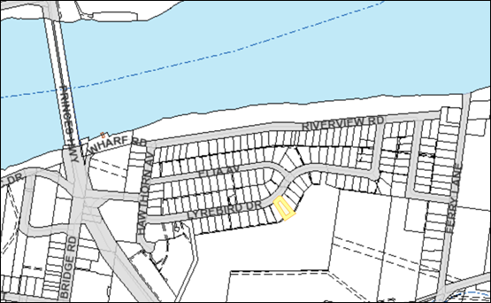
Figure 1 –
Map showing location of site (outlined in yellow)
Background
Proposed Development
The proposed development is an
attached dual occupancy comprising two, two-bedroom dwellings. The habitable
rooms are elevated above the Flood Planning Level and there is an enclosed
subfloor space for each dwelling which also houses a single garage for each
unit.
Plans of the proposed development are shown at Attachment 2.
Subject Land
The subject land is 923.5 m2
in area. It is identified as lot 74 in DP 1198691 with a street address of
38 Lyrebird Drive Nowra. The site is essentially rectangular and is flat. Spot
heights shown on the survey range from a low of 4.46 metres AHD up to 4.69
metres AHD.
The site is zoned R2 Low Density
Residential under SLEP2014 and is subject to a maximum building height of 8.5
metres under that plan. Dual occupancies are permissible in this zone with
consent.
The site is vacant and is devoid
of trees. There is a small street tree and a large shrub located on the
footpath in front of the site.
The site is flood prone. It is
categorised as High Hazard Floodway with the following flood levels:
· 2050 1% AEP
(Annual Exceedance Probability) flood level of 6.2 metres AHD; and
· 2050 PMF (Probable
Maximum Flood) of 8.2 metres AHD.
If the site is considered to
have an average height of 4.6 m metres AHD, this means that the likely depth of
floodwaters would be:
· 1.6 metres in the
2050 1% AEP flood event; and
· 3.6 metres in the
2050 Probable Maximum Flood.
The velocity for the 1% AEP
flood event is 1.2 metres per second.
A recent aerial photograph is
shown at Figure 2 below, with the subject land shown outlined in yellow.
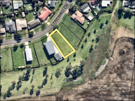
Figure
2 – Aerial photograph of site and immediate surrounds
Shown below in Figure 3 is a
street view of the site.
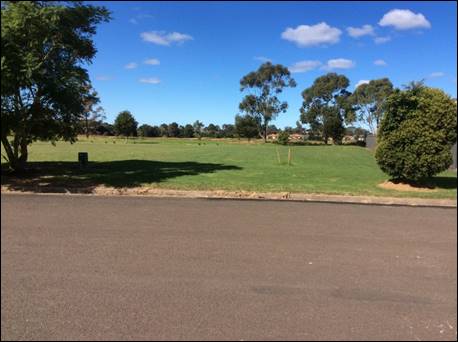
Figure
3 – Street view of the subject land
Site & Context
The site is part of a low density residential subdivision
approved in 1972 that includes Riverview Road, Ella Avenue and Lyrebird Drive.
A view of the nearby single dwelling residential development from the rear of
the site is shown at Figure 4 below.
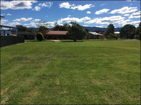
Figure 4 –
View of surrounding residences from the rear of the site
The site is within the
Shoalhaven River floodplain and it is located east of the Nowra Bridge.
It is part of a residential subdivision that preceded the current level of
flood knowledge and flood controls.
The Riverview Road Area
Floodplain Management Plan (The Plan) was adopted by Council in 2002 and
applies to the site. The Riverview Road Area Floodplain Management Plan
(Outcomes Section at page 2) found that the area is currently protected from
the 1% AEP flood level from direct inundation from the Shoalhaven River by the
2 metre high Riverview Road levee which was constructed in 1986/1987.
The Plan further found that in this area (west of Ferry Lane)
the flood hazard is low for events less than a 1% AEP and high for larger
events because of overtopping of the levee. The report states that “it
is likely that the community will not be prepared for the sudden change in
hazard which may occur with levee overtopping or failure”.
History
The Plan states that approvals
for the subdivisions in the Riverview Road, Ella Avenue and Lyrebird Drive
areas were made in 1972. The subdivision plan for the stage containing the
subject site was registered on 14 October 2014.
The subject site is vacant and
has not been previously developed.
Issues
Issue - Clause 7.3 (Flood Planning) of Shoalhaven LEP
2014
The application has been assessed
against the provisions of this clause (see Clause 7.3 Assessment Table at Attachment
3 and Section 4.15 Assessment Report at Attachment 4.
The assessment has determined
that the application does not comply with several subclauses of clause 7.3. The
most important of these are detailed below.
This clause includes
requirements that development consent must not be granted unless the consent
authority is satisfied that the development:
· is compatible with
the flood hazard of the land (clause 7.3(3)(a));
· incorporates
appropriate measures to manage risk to life from flood (clause 7.3(3)(c));
· is not likely to
result in unsustainable social and economic costs to the community as a
consequence of flooding (clause 7.3(3)(e)).
Applicant’s Submission
The applicant has submitted a
Flood Impact Statement (see copy at Attachment 5 and Supplementary
Letter at Attachment 6) that addresses the requirements of these
subclauses as follows:
In relation to subclause (3)(a):
“It is our view that the proposed development
is compatible with the flood hazard of the land. In particular, this is
achieved by the ‘pier’ construction of the development allowing the
1% AEP flood to pass safely underneath the development.”
In relation to subclause (3)(c):
“It is our view that the proposed development
meets this requirement. The proposed habitable FFL’s are entirely above
the Flood Planning Level, and the development meets the controls of SCC’s
DCP (Chapter G9).”
In relation to subclause (3)(e):
“It is our view that the proposed development
will not result in unsustainable social and economic costs to the community as
a consequence of flooding. This is demonstrated, and managed, by:
• Improvement
of residentially zoned land that is flood free in the 1% AEP event, including
allowances for climate change.
• Ensuring
habitable floor levels set at a minimum of the 1% AEP flood level plus 500mm.
• Use
of flood compatible materials below the Flood Planning Level.
• Safe
refuge in the PMF.”
Discussion
In relation to subclause (3)(a):
The land is categorised as High
Hazard Floodway.
Given current flood knowledge,
the land would not be considered suitable for a residential zoning or
subdivision. While even single dwellings are not compatible with the High
Hazard Floodway category, allowing single residential dwellings on lots
approved in the past is a concession to the historical situation. Increasing
the number of occupied residential premises by approving a dual occupancy
development is not compatible with the land’s flood hazard.
The 1% AEP flood will not be
able to pass underneath the enclosed subfloor space (including the garages)
which has dimensions of 15.8m in width and approximately 11.7m in depth and 62
square metres in area. The ‘pier’ construction referred to in the
Flood Report does not apply to the enclosed subfloor area.
Council cannot be satisfied that
the development is compatible with the flood hazard of the land.
In relation to subclause (3)(c):
The development does not meet
the controls in SDCP Chapter G9.
The proposal provides no
realistic safe refuge from the Probable Maximum Flood (PMF), given that the
elevated habitable floor levels would be inundated by 1.63m of floodwater in
the PMF. Additionally, there is no flood free evacuation route available to the
property, and the nearest land above the 1% AEP flood level is 315m to the
west, as shown in Figure 5 below.
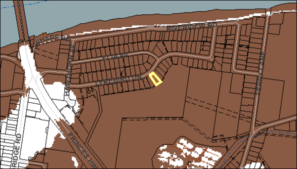
Figure
5 – Showing the site (outlined in yellow) and the extent of the 2050 1%
AEP flood event (shaded brown). The nearest flood free land is near the
intersection of Lyrebird Drive and Hawthorn Avenue, 315 metres to the west of
the site.
In a flood event the development
will increase the number of premises that require evacuation by emergency
services. Additional demand for evacuations increases the cost to the community
and the risk to emergency services personnel.
Council cannot be satisfied that
the development incorporates appropriate measures to manage risk to life from
flood.
In relation to subclause (3)(e):
The development cannot be described
as “Improvement of residentially zoned land that is flood free in the 1%
AEP event” as the land is clearly flooded by the 1% AEP flood.
The provision of safe refuge is
questionable as the habitable floors would be inundated by 1.63m of floodwater
in the 2050 PMF.
In a flood event the development
will increase the need for evacuation by emergency services. Additional demand
for evacuations increases the cost to the community and the risk to emergency
services personnel.
The risk of unsustainable social
and economic costs would be reduced by limiting development on the site to a
single residential dwelling, as is recommended by the Riverview Road Area
Floodplain Management Plan and as provided for by Shoalhaven DCP 2014 Chapter
G9.
Council cannot be satisfied that
the development is not likely to result in unsustainable social and economic
costs to the community because of flooding.
Issue - Shoalhaven DCP
Chapter G9 (Development on Flood Prone Land)
The application does not comply
with SDCP2014 Chapter G9. The parts of the DCP with which it does not comply
are:
· the site specific
flood related development controls for the Riverview Road Area;
· the generic flood
related development controls for the High Hazard Floodway category.
The Riverview Road Area controls
are shown at Attachment 7 and the generic controls set out in Schedule 2
to Chapter G9 for the High Hazard Floodway category are shown at Attachment
8.
The important elements of these
controls are:
· Within the
Riverview Road/Ella Avenue/Lyrebird Drive subdivision area, no dual occupancies
or subdivisions will be permitted;
· Within the High
Hazard Floodway category, the ‘other residential/habitable’
category (which includes dual occupancy) is not suitable for this category of
flood hazard.
Even single residential
buildings are shown as being not suitable in the High Hazard Floodway, however
this exception is provided:
“This type of development is not suitable
within the risk category - however, if existing use rights (as defined in the
Environmental Planning and Assessment Act 1979) can be established and there is
no other option, the conditions as per Schedule 2 will apply.”
Applicant’s
submission
The applicant provides a
detailed response to the SDCP provisions in the Flood Impact Statement at Attachment
5.
The Flood Impact Statement
acknowledges the ‘prohibition’ on dual occupancies and subdivision
in the specific controls for the Riverview Road Area, but argues this should be
flexibly interpreted and that density as measured by Floor Space Ratio (FSR)
ought to be the determining control in this regard. The applicant’s
argument regarding the appropriateness of FSR is expanded upon in the
Supplementary Letter at Attachment 6.
Discussion
To ensure thoroughness of
assessment, the application has been assessed against the requirements for a
single dwelling in Schedule 2, as there are no requirements specified for dual
occupancies. This is because Council has determined that land in the High Hazard
Floodway category is not suitable for this type of development. As can be seen
from the SDCP Chapter G9 Checklist in the Section 4.15 Assessment Report at Attachment
4, the application does not satisfy these requirements.
Section 4.15 (3A)(b) of the EPA
Act requires a consent authority to be flexible in applying provisions of a DCP
that set standards with respect to an aspect of the development, where
reasonable alternative solutions are put forward that achieve the objectives of
the standards for dealing with that aspect of the development.
The principal objectives set out
in Section 4 of Chapter G9 are:
i. Reduce
risk to life and property resulting from floods.
ii. Ensure
that the impacts of the full range of flood sizes up to and including the probable
maximum flood (PMF) are considered when assessing development on flood prone
land.
iii. Ensure
that the impact of climate change is considered when assessing development on
flood prone land.
iv. Ensure
the future use of flood prone land does not cause undue distress to individuals
or unduly increase potential flood liability to individuals or the community.
v. Incorporate
site specific floodplain management recommendations from local floodplain risk
management plans into Council’s overall planning framework.
The principal objectives that
are relevant to the DCP provisions in question are objectives (i), (iv) and
(v).
The specific objectives set out
in Section 5.1 of Chapter G9 are:
i. Minimise
risk to life and damage to property by controlling development on flood prone
land;
ii. Ensure
the impacts of the full range of flood sizes up to and including the PMF are
considered when assessing development on flood prone land within the
Shoalhaven;
iii. Ensure
that development does not have a significant impact on flood behaviour,
people’s safety, surrounding properties and structures, and the natural
environment;
iv. Ensure
that the effects of climate change are considered when assessing development on
flood prone land within the Shoalhaven;
v. Ensure
that development on the floodplain is consistent with the NSW Flood Prone Land
Policy and NSW Floodplain Development Manual;
vi. Ensure
that developers and the community are conscious of the potential flood hazard
and consequent risk associated with the use and development of land within the
floodplain;
vii. Protect
the integrity of floodplains and floodways, including riparian vegetation,
fluvial geomorphologic environmental processes and water quality;
viii. Ensure
that all land uses and essential services are appropriately sited and designed
in recognition of all potential floods; and
ix. Ensure
that development on flood prone land does not place an unacceptable financial
burden on landowners or the community.
The specific objectives that are
relevant to the DCP provisions in question are objectives (i) (iii), (v) and
(viii).
The applicant has not addressed
the DCP objectives and has not satisfactorily demonstrated that these
provisions should be set aside, nor have they provided an alternative that
satisfactorily addresses the objectives.
The prohibition in the DCP is
well founded. The stated prohibition is grounded in the process Council went
through in consultation with the community, State agencies and emergency
services in developing and adopting the Riverview Road Area Floodplain
Management Plan. The position that lead to the current planning controls
for this area should not be lightly set aside for an individual development.
Added to this is the potential to establish a precedent for future development,
having regard to there being a number of vacant residential allotments in this
area.
Density
The applicant’s argument
in the Supplementary Letter at Attachment 6 that density as expressed by
Floor Space Ratio (FSR) ought to be the determinant of increased population
densities is not supported in the assessment of the application.
It is instead the number of
occupancies that is critical to the proper interpretation of the provisions of
the DCP. These are derived from the recommendations and outcomes of the River
Road Floodplain Management Plan.
In a flood evacuation scenario,
it is the number of occupancies, as much as the total number of people, that is
critical. Another occupancy is another door that emergency services must be
able to access and check. Furthermore, the typical occupancy ratio of dwellings
is relatively low, so that even a five bedroom home may only have two or three
persons living there and this may be no more than might live in one of the
dwellings within a dual occupancy development.
For the reasons outlined above,
the assessment concludes that the DCP provisions are reasonable and are
grounded in the Riverview Road Area Floodplain Management Plan and the
provisions of clause 7.3 (Flood Planning) in SLEP2014.
The applicant has not provided
sufficient grounds to justify the setting aside of the clear standards set by
the DCP in relation to dual occupancy development at this location.
Issue – Referral
advice from Council’s Flood Engineering Unit
The application has been
referred to Council’s Flood Engineering Unit. The referral response
identified specific controls and did not support the development. This outcome
was considered by the applicant which then submitted the Supplementary Letter
as reproduced at Attachment 6. This was referred to and considered by
the Flood Engineering Unit, which provided the following final response:
“The site is within the high hazard flood
way. High hazard floodway condition will be developed if the levee is
overtopped. There is significant hazard and risk to life due to failure of the
levee and further burdening emergency services.
In order to limit the increase in population
requiring evacuation, no dual occupancy and subdivisions are permitted in this
area. According to Schedule 2 of Chapter G9 SDCP 2014, single residential
dwelling is not suitable within this risk category unless existing user rights
can be established and there is no other option. Given that Council is dealing
with a legacy subdivision, Council continues to permit single dwelling housing
in this area. It is clear that, in the risk category, other residential
building including dual occupancy is not permissible and noting that in Section
5.4.5 of G9 states clearly about the site-specific control within the Lyrebird
Drive subdivision that no dual occupancy or subdivisions will be permitted. As
mentioned in previous referral, this site-specific control is based on
Riverview Road Area – Nowra Floodplain Management Plan adopted by the Council
in 2002.
It is not feasible to vary both the generic and
site-specific controls of the DCP which is used by the Council as a fundamental
best practicing guide in assessing developments, based on state polices and
engineering principles. Furthermore, Council can be flexible with acceptable
solutions but not with performance criteria’s and objectives. This does
not also go with the local built environment characteristics of the area. It is
in Council’s opinion that varying numerous controls, particularly
specific controls, is an erosion of the DCP.
Moreover, approval of the proposed development will
act as a precedent and open the window for other developers to intensify
development within this area which will expose more lives and properties to
risk.
In order to achieve effective floodplain risk,
case-by-case decision making cannot account for the cumulative impacts on flood
behaviour and risks, caused by individual developments or works. The NSW
Floodplain Development Manual (2005) clearly states that this form of ad hoc
assessment contravenes the principles of the manual (see Section 1.6).
Therefore, the flood unit recommends that this
development in its current form should be refused.” (sic)
Both Council’s Flood
Engineering Unit and the assessing officer for this application have considered
the application in accordance with the required legislation and policies. The
site is highly constrained by the flood hazard and the resulting potential risk
to life and property.
The information supplied by the
applicant in relation to flood hazard is extensive and has been fully
considered. However, it remains that the site is High Hazard Floodway, which is
a constraint that makes the land fundamentally unsuitable for residential
development. It is only the fact that a subdivision was approved in 1972 that
permits residential use to be considered.
The applicant was advised by
email on 11 March 2019 that an application for a dual occupancy was likely
recommended to be refused due to non-compliance with SDCP 2014 Chapter G9 and
was offered the opportunity to withdraw the application. A second opportunity
for withdrawal was offered on 4 June 2019.
Planning Assessment
The DA has been assessed under
section 4.15 of the Environmental Planning and Assessment Act 1979.
Please refer to Attachment 4.
The only issue for refusal of
this application relates to the flood hazard.
Policy Implications
Riverview Road Area Floodplain Management Plan and SDCP
2014 Chapter G9
This Floodplain Management Plan
was prepared in accordance with the NSW Flood Prone Land Policy and NSW
Floodplain Development Manual as part of the Shoalhaven Flood Program. It was
adopted by Shoalhaven City Council in 2002 following extensive consultation
with the public, State agencies and emergency services organisations.
A copy of the Riverview Road
Area Floodplain Management Plan can be seen at Attachment 9.
As detailed in the report above,
the controls in Chapter G9 are based on the findings and recommendations of The
Plan. Also, assessment of development proposals under Shoalhaven LEP2014 Clause
7.3 (Flood Planning) and under Section 4.15 of the EPA Act are informed by the
findings and recommendations of The Plan.
The NSW Floodplain Development
Manual provides the following guidance for circumstances such as are brought
into focus by the current application:
“Case-by-case decision making cannot account
for the cumulative impacts on flood behaviour and risks, caused by individual
developments of works. This form of assessment contravenes the principles
of the manual.” (NSW Floodplain Development Manual, p.5).
“A fundamental principle of floodplain risk
management is to assess development applications within the strategic framework
of a floodplain risk management plan and not in isolation or
individually.” (NSW Floodplain Development Manual, p.12).
Appendix I of the Manual relates
to the implementation of floodplain management plans like the Riverview Road
Area Floodplain Management Plan. Section I6.3.6 relates to development types
outside those identified as appropriate by the Plan: those not foreseen, and
those that were rejected. Dual occupancies and subdivision are development
types that were clearly rejected by Council when it adopted the Riverview Road
Area Floodplain Management Plan.
If Council were of a mind to
approve Development Application 18/2175, this may constitute an abandonment of
the development standard in SDCP 2014 Chapter G9 that currently does not permit
dual occupancies. Further similar applications could then be expected,
particularly having regard to the number of vacant allotments in this area.
Approval of this application
would result in circumstances where Council should review the Riverview Road
Area Floodplain Management Plan and the relevant sections of SDCP 2014 Chapter
G9.
There are currently 169
residential allotments in the Riverview Road precinct. There are currently 10
vacant allotments (including No.38 Lyrebird). Potentially, a decision to
approve the application would set a precedent in the area.
Council has approved 2 dual
occupancy developments in the area; one in 1993 (BA93/1618) and another in 2000
(DA00/1146). These were both approved before the Riverview Road Area Floodplain
Management Plan was completed and Chapter G9 of SDCP 2014 was adopted. No dual
occupancy applications have been approved since this time.
Consultation and Community Engagement:
The application was notified in accordance with Council’s
Community Consultation Policy with letters being sent within a 25 metre buffer
of the site. The notification was for a 14 day period between 30 October and 14
November 2018.
No submissions were received.
Financial Implications:
If the applicant is dissatisfied
with Council’s determination they have a right of appeal to the Land and
Environment Court. If an appeal was pursued, Council would incur costs in
defending the appeal.
In the event of an unsuccessful appeal against refusal,
Council’s advice to the applicant of 11 March 2019 that the
application was unlikely to be approved, and its invitation to the applicant to
withdraw the application on that date and again on 4 June 2019, may provide
grounds for Council to seek costs from the applicant.
Legal Implications
Council is protected in its
decisions relating to floodplain management by Section 733 of the Local
Government Act 1993 (LG Act), provided it acts (or chooses not to act) in good
faith.
The workings of the Section 733
are set out on pages 17 and 18 of the NSW Floodplain Development Manual, which
pages are reproduced at Attachment 10.
Council may not be seen to have acted in good faith if it
was to approve a development application that is clearly inconsistent with an
adopted Floodplain Management Plan. This could, for instance, expose Council to
actions in relation to losses encountered due to flooding of the approved
development or in increasing the risk to other properties, people and emergency
services personnel.
Summary and Conclusion
This application for an attached
dual occupancy at 38 Lyrebird Drive is not supported, based on assessment
against the provisions of the Shoalhaven LEP 2014 and DCP 2014 relating to
development on flood prone land.
The land is within the High Hazard
Floodway category in the Riverview Road Area. The findings and recommendations
of the Riverview Road Area Floodplain Management Plan adopted by Council in
2002 state that no dual occupancies or subdivisions should be approved in this
area. It is accepted that the levee may protect the area up to the 1% AEP flood;
however, in the event of a bigger flood, the levee will be overtopped and the
area will rapidly change from Low Hazard conditions to High Hazard conditions.
As the Riverview Road Area Floodplain Management Plan notes,
“it is likely that the community will not be
prepared for the sudden change in hazard which may occur with levee overtopping
or failure”.
The fundamental issue in this
area is managing evacuation in the event of a flood greater than the 1% AEP,
and minimising the risk to life, for both residents and for the emergency
service personnel who will inevitably become involved in the evacuation task.
The Shoalhaven DCP seeks an
equitable outcome for existing landowners by allowing development of vacant
residential lots with single dwellings, despite the flood hazard, but draws the
line at dual occupancies or subdivisions which would increase the number of
households or occupancies in this area.
The application, because of its
inconsistency with the DCP, Riverview Road Area Floodplain Management Plan and
NSW Floodplain Development Manual, raises important policy issues for Council.
Approval in these circumstances may have an impact on the availability of the
‘good faith’ defence provided by section 733 of the Local
Government Act 1993.
Refusal of the application is
recommended.
|
|
Development
& Environment Committee – Tuesday 02 July 2019
Page
0
|
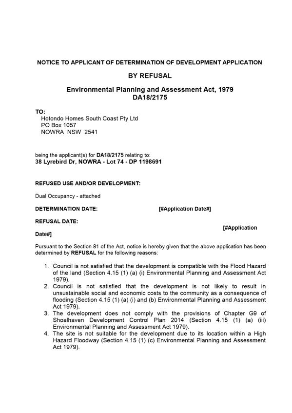
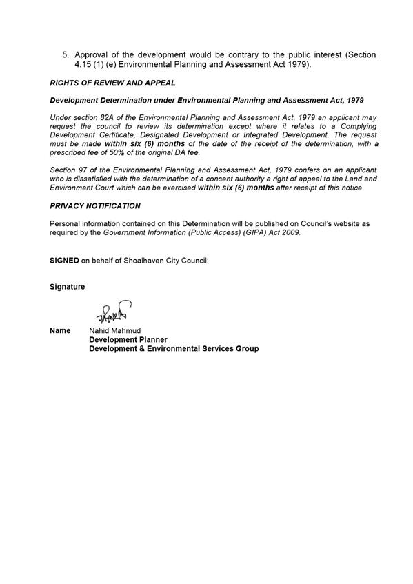
|
|
Development
& Environment Committee – Tuesday 02 July 2019
Page
0
|
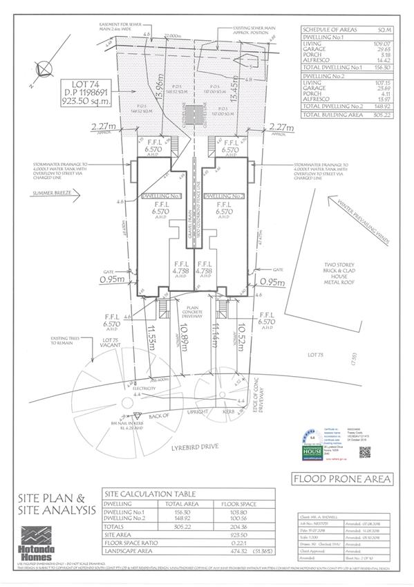
|
|
Development
& Environment Committee – Tuesday 02 July 2019
Page
0
|
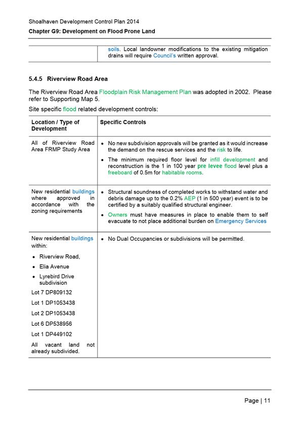
|
|
Development
& Environment Committee – Tuesday 02 July 2019
Page
0
|
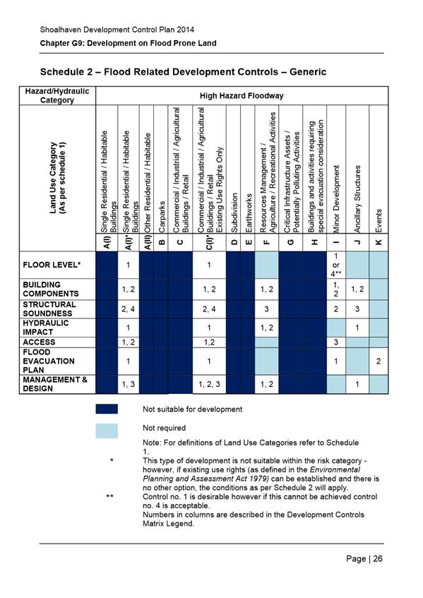
|
|
Development
& Environment Committee – Tuesday 02 July 2019
Page
0
|
DE19.61 Shoalhaven
City Council - Mobile Food Vans in the LGA - Private and Public Lands
HPERM Ref: D19/187221
Group: Planning
Environment & Development Group
Section: Building
& Compliance Services
Attachments: 1. Guidelines
for Mobile Food Vending Vehicles - Department of Primary Industries Food
Authority (under separate cover) ⇨
2. Mobile
Food Vending Vehicle Guidelines (under separate cover) ⇨
3. Shoalhaven
Local Approvals Policy 2017 (under separate cover) ⇨
4. Management of Mobile Food
Vending Vehicles on Council Owned or Managed Land - LAP - POL16 77 (under
separate cover) ⇨
Purpose / Summary
At its Ordinary meeting held on
28 May 2019 Council resolved to request a report on its current management of
mobile food vending vehicles on both private and public land (MIN19.331).
There are various approvals and
exemptions that apply to the use and operation of mobile food vending vehicles and
these are discussed in this report.
|
Recommendation (Item to be determined
under delegated authority)
That the report Mobile Food Vans in the LGA - Private
and Public Lands be received for information.
|
Options
1. As
recommended
Implications: Nil
2. Council
provide an alternative recommendation
Implications: to be advised.
Background
At its Ordinary meeting held on 28 May 2019, Council resolved
as follows (MIN19.331):
That Council prepare a report on Council’s
current management of mobile food vans in the Shoalhaven LGA both on private
and public land. Such report to include:-
1. Approvals
issued in the last 2 years in accordance with the State Government guidelines
for Mobile Food Vans on both private and public land.
2. Non-Compliance
issues & complaints reported in the last 12 months including safety issues,
property site issues, access issues, signage etc
3. Consideration
to a review of current policies.
It is important to firstly explain the legislative framework
that relates to mobile food vending vehicles. Several acts and policies
regulate this function and the requirements vary between private or public
land.
Legislative framework
Both exemptions and approvals apply for operating a mobile
food vending vehicle. The relevant policies and legislation are identified as
follows:
Private land
· State
Environmental Planning Policy (Exempt and Complying Development Codes)
2008.
· Environmental
Planning and Assessment Act. This applies where the exemptions in the SEPP
cannot be satisfied.
Public land
· Department
of Primary Industries Food Authority – Guidelines for Mobile Food Vending
Vehicles
· Shoalhaven
Local Approvals Policy 2017 (POL18/15)
· Management
of Mobile Food vending vehicles on Council owned or managed land (POL16/77)
· Shoalhaven
Council Mobile Food Vending Vehicle Guidelines.
Private land
State Environmental Planning Policy (Exempt and Complying
Development Codes) 2008
Before a property can be considered in the exempt category, it
needs to satisfy the general requirements of the SEPP as set out in Clause
1.16. Essentially this excludes certain areas such as
· land
that is a declared area of outstanding biodiversity value,
· land
that is critical habitat,
· land
that is wilderness areas or
· land
that is listed on the State Heritage Register.
If the land satisfies the requirements of Clause 1.16, then Subdivision
27A relates to the exempt provision for mobile food and drink outlets.
Subdivision 27A provides as follows:
Subdivision 27A Mobile food and
drink outlets
2.54A Specified
development
The carrying out of the retail sale of
food, drinks and related products on land from a mobile outlet such as a food
truck, van, cart or other similar vehicle is development specified for this
code.
2.54B Development
standards
The standards specified for that
development are that the development must:
(a) have
the consent of the owner of the land on which the development is carried out
or, if a council or public authority has the control and management of the
land, the consent, in writing, of the council or public authority, and
(b) not
restrict any vehicular or pedestrian access to or from the land or entry to any
building on the land, and
(c) not
obstruct the operation of, or access to, any utility services on the land or on
adjacent land, and
(d) not
be located within the canopy of, or result in damage to, any tree growing on
the land or on adjacent land, and
(e) not
result in any damage to public property on the land or on adjacent land, and
(f) if
carried out on land within or immediately adjacent to a residential zone
– only be carried out between 7.00 am and 7.00 pm on any day, and
(g) if
located on a public place – have any approval required under section 68
of the Local Government Act 1993, and
(h) if
located on private land—be limited to 1 development on that land and not
contravene any conditions of a development consent for any other use carried
out on the land.
If a mobile food vending vehicle meets with the development
standards set out in Subdivision 27A above, it can operate without any formal
planning approval.
That said, all mobile food vending vehicles within the
Shoalhaven must be inspected and approved by Council’s Environmental
Services Section as a Food Itinerant. This approval checks compliance with the
NSW Food Act 2003 and the Food Standards Code.
Environmental Planning and Assessment Act
Where a private premise does not enjoy the exemption
provisions of Subdivision 27A of the SEPP (Exempt and Complying Development
Codes) 2008, then a development application will need to be lodged and
considered by Council.
Public Land
NSW Government Department of Primary Industries
“Guidelines for Mobile Food Vending Vehicles” January 2017
This document is used by businesses and enforcement agencies
to guide them in assessing compliance with the NSW Food Act 2003 and the Food
Standards Code. The primary aim of the guidelines is to make food businesses
aware of their legal obligations and to suggest ways to assure food safety when
selling food.
Council does not refer to this generic guideline prepared by
the NSW Department of Primary Industries. Like many other Councils, Shoalhaven
has prepared its own “Mobile Food Vending Vehicle Guidelines” and
this is based on the State document.
Council’s “Mobile Food Vending Vehicle
Guidelines” provides information regarding requirements for obtaining Council
approval within the context of the “Management of Mobile Food Vehicles on
Council Owned or Managed Land (including Roads) Local Approvals Policy”
(POL16/77). Both documents are referenced in Shoalhaven Local Approvals
Policy 2017.
Shoalhaven Local Approvals Policy 2017 (POL18/15)
Shoalhaven Local Approvals Policy 2017 became effective on 21
March 2018. The purpose of a Local Approvals Policy is to provide exemptions
from the need for approval and outline the criteria for those activities where
approval is required.
The Local Approvals Policy applies to all land within the
Shoalhaven except certain land under the jurisdiction of the National Parks and
Wildlife Service. It applies to approvals under the Roads Act 1993 and Section
68 activities as prescribed in the Local Government Act 1993.
Part D of Section 68 relates to activities on Community Land
and it includes engagement in a trade or business on such land. Part F relates
to other activities and this includes the use of a standing vehicle or any article
for the purpose of selling any article in a public place. Both would relate to
mobile food vending vehicles.
The Local Approvals Policy is divided into three parts as per
Section 158 of the Local Government Act.
Part 1: Exemptions - outlines the circumstances in
which a person is not required to obtain an approval. Section A covers
exemptions provided for under State Government Legislation. Section B outlines
local exemptions applicable only to Shoalhaven. There are no local exemptions
for mobile food vending vehicles in the Shoalhaven.
Part 2: Criteria - is the criteria which must be
considered by Council when determining whether or not to grant approval to a
particular activity. Section A covers criteria provided for under State
Government Legislation. Section B outlines local criteria applicable only to Shoalhaven.
Part 3: Other matters - includes information on the
processing of an application and other relevant matters
Two important definitions relate to the category of mobile
food vending vehicle and these are defined in Council’s “Mobile
Food Vending Vehicle Guidelines” as follows:
· Category
1 (Food Itinerant):- Service of food that is not potentially hazardous, or
that involves low risk practices such as frothing milk and can trade on the
street for such a period of time necessary to engage in the actual serving of a
customer. Once the customer/s have been served they are required to move on. An
example would be Mr Whippy or Home Ice Cream.
· Category
2 (Food Van):- Allows the operator to occupy any one position on a public
road or car park for up to a maximum of 5 hours between 7am to 7pm.
The following general criteria apply to all mobile food
vending vehicles operating in the Shoalhaven:
· All
vehicles must be registered as per the requirements of the NSW Roads and
Maritime Services. No additional flashing or rotating lights permitted.
· Must
not operate as a roadside stall or to sell food to the public on any site that
requires development consent for that use.
· Control
is to be exercised over noise emissions (e.g. amplified sound and motor noise)
so as to cause no inconvenience to residents. The Protection of the Environment
Operations Act 1997 and related Regulations will apply.
· All
matter relating to the sale and storage of foods associated with this approval
shall comply with the requirements of the Food Act 2003 and Food Regulation
2015.
· The
vehicle is not permitted to use chimes or like devices to attract attention
between the hours of 8pm and 8am or to operate within 90m from any hospital,
churches in service or schools during school hours.
· The
vehicle must not stop on a hill or bend where sight distance is limited nor
located in front of driveways or entrances to properties.
· The
vehicle must not trade in locations where motorists are forced to park on
kerbside land, where parking/standing restrictions apply.
· The
vehicle is not to create a traffic hazard, obstruction or dangerous situation.
· Litter
bins are to be provided by the operator for the convenience of customers.
· Wastewater
is to be contained with the vehicle for later disposal to the sewerage system.
· The
vehicle must be made available for inspection by Council’s Environmental
Services Section for a permit under the Food Act 2003 prior to the issue of approval.
· Vehicle
must not exceed 6m in length and 2.5m in width.
· Proof
of Public Liability Insurance (minimum of $20 million) must be provided.
· The
vehicle must operate in full compliance with existing road rules and parking
restrictions.
With respect to Community Land in Part D of Section 68 of the
Local Government Act, mobile food vans on Council land (D1 activity), the
following criteria relates to Category 2 – mobile food vehicles:
· The
vehicle to occupy any one position on Council owned or managed land for up to a
maximum of 5 hours between 7am and 7pm.
· The
vehicle is prohibited from trading within 1 km of an open business serving the
same or similar food/drink (the distance being measured by the shortest route
by road).
· No
trading is to occur on NSW Roads and Maritime Services controlled roads.
With respect to Other Activities in Part F of Section 68 of
the Local Government Act, the following criteria relates to mobile food
vehicles in a public place (F7 activity) and this would include roads:
(a) Category 1 -
Mobile Food Vehicles (Itinerant Food Vendors)
· The
vehicle is not permitted to occupy any one position in a public road, except
for such period of time as may be necessary to engage in the actual serving of
a customer. On completion of serving, the vehicle must pass on and not return
soliciting customer/s over the same ground within one (1) hour and shall
restrict vending to lightly trafficked roads.
· The
vehicle is not permitted to operate within 75m of business zoned land under
Shoalhaven Local Environmental Plan 2014.
(b) Category 2
– Mobile Food Vehicles
· The
vehicle to occupy any one position on Council owned or managed land for up to a
maximum of 5 hours between 7am and 7pm.
· The
vehicle is prohibited from trading within 1 km of an open business serving the
same or similar food/drink (the distance being measured by the shortest route
by road).
· No
trading is to occur on NSW Roads and Maritime Services controlled roads.
Report
The following additional comments are made to specifically
answer the questions raised in the notice of motion.
(a) Approvals issued in
the last 2 years in accordance with the State Government guidelines for Mobile
Food Vans on both private and public land.
The State Government Guidelines for Mobile Food Vans do not
apply in the Shoalhaven. Council’s Local Approvals Policy deals
with these approvals. All mobile food vending vehicles require a Category 1
approval to operate within the Shoalhaven.
Council’s Environmental Services Unit inspect and issue
Category 1 (Food Itinerant) approvals to owners of mobile food vehicles. These
are valid for a period of 12 months only. This means that operators need
to seek approval every year and this ensures the continued compliance with food
safety standards. Council’s Environmental Health Officers also carry out
spot checks during the many functions and festivals throughout the year.
The following Category 1 approvals have been issued for the
years specified:
2017/2018 119
approvals
2018/2019 146
approvals (to 31/05/2019)
Category 2 (Food Van) approvals are issued by Council’s
Property Unit. These approvals also require the owner to hold a Category 1
approval. These approvals also last for 12 months only and the time period is
set from 1 July to 30 June each financial year.
Applications for Category 2 approvals are received from the
Property Unit during May each year. The following approvals have been issued by
the Property Unit for the years specified:
2017/2018 7
approvals
2018/2019 6
approvals
2019/2020 5
applications received to 31/05/2019.
With respect to private lands, Council does not keep a record
of properties where mobile food vending vehicles meet with the exempt
provisions of the SEPP. Some of these have been the subject of complaint in
recent times and this will be discussed shortly in this report.
There have been no separate development consents for this
specific use in the last 2 years. This means that the only mechanism for
approval has been via the exempt provisions of the SEPP.
(b) Non-Compliance
issues & complaints reported in the last 12 months including safety issues,
property site issues, access issues, signage etc
There have been areas of non-compliance with the SEPP and
operators have been advised on these issues by Council’s Rangers and
Compliance Officers. Some issues were easily addressed by the vendors and the
use was allowed to continue. Other issues could not be addressed, and the use
had to cease. Examples of where the use had to cease include one vehicle being
located within the canopy of a tree and another vehicle caused a non-compliance
with the development consent carparking requirements.
Council has received 23 complaints concerning the operation of
mobile food vending vehicles in the last 12 months. These complaints
related to the following:
|
|
Date
|
Advice from
|
Issue
|
|
1
|
16/06/2018
|
Public
(Shop owner)
|
Mobile food vending
vehicle - Coffee Van - parking issues and local business being affected
(Public Land)
|
|
2
|
04/09/2018
|
Public
|
Mobile food vending
vehicle - parking illegally (Private Land)
|
|
3
|
11/09/2018
|
Public
|
Mobile food vending
vehicle - Coffee Van illegally parked (Public Land)
|
|
4
|
08/10/2018
|
Public
|
Mobile food vending
vehicle - Myola - unauthorised signage (Private Land)
|
|
5
|
28/11/2018
|
Public
|
Mobile food vending
vehicle - Coffee Van - playing loud music until 10pm - Culburra Beach
(Private Land)
|
|
6
|
02/01/2019
|
Public
|
Mobile food vending
vehicle - Coffee Van - Cudmirrah - questioning approval (Public Land)
|
|
7
|
04/01/2019
|
Public
(Shop owner)
|
Mobile food vending
vehicle - Milton Post Office - Taking business away from shops (Private Land)
|
|
8
|
09/01/2019
|
Public
(Shop owner)
|
Mobile food vending
vehicle - Gelato Van - set up near Huskisson shops and taking business from
shops (Public Land)
|
|
9
|
10/01/2019
|
Public
|
Mobile food vending
vehicle situated on Crown Land Currarong – questioning approval (Public
Land)
|
|
10
|
10/01/2019
|
Public
(Shop owner)
|
Mobile food vending
vehicle - Coffee Van - Milton Post Office - competing business with shop
owners (Private land)
|
|
11
|
11/01/2019
|
Public
|
Mobile food vending
vehicle at Bawley Point - Parking on grassed verge outside
complainant’s residence in a very dangerous position – bend in
the road (Public Land)
|
|
12
|
17/01/2019
|
Public
(Shop owner)
|
Mobile food vending
vehicle at Milton Post Office - Taking business away from shops (Private
land)
|
|
13
|
22/01/2019
|
Public
|
Mobile food vending
vehicle - Coffee Van - customers parking in driveway blocking access to the
Care Centre – Milton (Public Land)
|
|
14
|
22/01/2019
|
Public
|
Mobile food vending
vehicle - Coffee Van - illegally parked at Mollymook Beach (Private Land)
|
|
15
|
04/03/2019
|
Public
|
Mobile food vending
vehicle - Mobile Bus Café –concerns for structural issues
(Private Land)
|
|
16
|
11/04/2019
|
Public
(Shop owner)
|
Mobile food vending
vehicle regularly setting up at South Nowra taking business away from take
away business (Private Land)
|
|
17
|
11/04/2019
|
Public
|
Mobile food vending
vehicle regularly setting up at Lake Tabourie causing parking and noise
issues (Public Land)
|
|
18
|
15/04/2019
|
Public
|
Mobile food vending
vehicle Callala Beach - causing parking and safety issues (Private Land)
|
|
19
|
23/04/2019
|
Public
|
Mobile food vending
vehicle - Callala Beach - causing parking and safety issues (Private Land)
|
|
20
|
08/05/2019
|
Public
|
Mobile food vending
vehicle Callala Beach - causing parking and safety issues (Private land)
|
|
21
|
08/05/2019
|
Public
|
Mobile food vending
vehicle Callala Beach – causing parking and safety issues (Private Land)
|
|
22
|
15/05/2019
|
Public
|
Mobile food vending
vehicle - Noise from generator causing a nuisance at Culburra Beach (Public
Land)
|
|
23
|
16/05/2019
|
MP
Ms Hancock
|
Mobile food vending
vehicle – Milton Post Office – safe access, parking issues, safe
food handing, odour and general amenity (Private land)
|
A total of 23 mobile food vending vehicle complaints have been
received in the last 12 months. Of these complaints, 14 related to private
land and 9 related to public land.
Of the 9 complaints on public land, all of these were isolated
events.
(c) Consideration
to a review of current policies
Council’s Local Approvals Policy was confirmed on 11
December 2017 and commenced on 21 March 2018 (Min17.1054). In accordance with
Section 165 of the Local Government Act, the policy is automatically revoked 12
months after the declaration of the poll for a general election of
Council.
From all accounts, there does not appear to be a problem with
Council’s Local Approvals Policy or the management and use of mobile food
vending vehicles on public lands.
It is conceded that there is a double up in some requirements
of the “Local Approvals Policy” (POL18/15) and “Management of
Mobile Food Vehicles on Council Owned or Managed Land (including Roads) Local
Approvals Policy” (POL16/77). The latter has not been endorsed by the
Office of Local Government and is therefore not considered to be a Local
Approvals Policy. The inconsistencies and the titling of the latter document
needs to be addressed and this could be done now or at the time of the next
review.
Unfortunately, the differences between the SEPP exempt development
provisions on private land and the Local Approvals Policy requirements on
public land has resulted in some confusion within the community.
Council’s Rangers and Compliance Officers have had to explain these
differences on many occasions. This particularly impacts on shop owners who
have trouble separating the 1 km business exclusion requirement for public
spaces which does not apply to private land under the SEPP. It is possible to
have a mobile food vending vehicle on private land immediately next door to a
shop offering the same service or product for sale.
The requirements of the SEPP (Exempt and Complying Development
Codes) 2008 are a product of State Government and override any local policy
provisions.
|
|
Development
& Environment Committee – Tuesday 02 July 2019
Page
0
|
DE19.62 Shoalhaven
Heads - River Road Foreshore Precinct Rehabilitation Project - Progress Update
HPERM Ref: D19/115308
Group: Planning
Environment & Development Group
Section: Environmental
Services
Attachments: 1. 95%
Design showing cost savings - as per consultation with Shoalhaven Heads Estuary
Taskforce ⇩
Purpose / Summary
To provide Council with an
update on the progress of the Shoalhaven Heads – River Road Foreshore
Precinct Rehabilitation Project.
|
Recommendation
(Item to be determined under delegated authority)
That Council:
1. Proceed
to call Tenders for the Shoalhaven Heads River Road Foreshore Precinct
Rehabilitation Project in accordance with the separable portions strategy
outlined in the report.
2. Receive
a further confidential report regarding the Tender process in accordance with
the provisions of the Local Government Act.
|
Options
1. As recommended.
Implications: This would allow Council to proceed
to a Request for Tender. The project is proposed to be broken into Separable
Portions to assist in identifying cost savings and project management. This
will also for compliance with the guidelines of the Office of Local Government
(OLG) and section 55 of the Local Government Act 1993.
2. Council direct
staff to revise the project scope and design as per the options outlined in
this report, to reduce the cost of construction to fit with the existing
project budget of $1,763,000 which would require a reduced scope of works.
Implications: Reducing the
scope and extent of the project will result in Council potentially not being
able to deliver project milestones as per the funding agreement with
Infrastructure NSW. Council would need to obtain a funding variation approval
to proceed with this option.
3. Council
provide an alternative recommendation.
Implications: This would depend on the alternative
recommendation.
Background
Generally, the scope of work is
to undertake foreshore restoration works to reconstruct part of the embankment
along the northern side of the Shoalhaven River, Shoalhaven Heads. The project
design and works are being managed by Council’s Project Delivery team in
the Assets & Works Group, and community consultation and grant
administration managed by Natural Resources & Floodplain Unit (Planning,
Environment & Development Group) in conjunction with Project Delivery. As
previously reported to Council, the foreshore suffered significant erosion
during the east coast low storms in 2016. The area in question runs parallel to
River Road generally between Renown Avenue and Mathews Street (opposite the
Heads Hotel).
The University of NSW Water
Research Laboratory (WRL) undertook an assessment of the coastal management
options for a one-kilometre length of foreshore generally aligned with Jerry
Bailey Road / Hay Avenue intersection at the west, and to the Holiday Haven
Shoalhaven Heads Caravan Park, River Road in the east.
Qualitative prioritisation of
management works determined to focus on a 170-metre-long section of the
embankment.
Grant funding for the work was
approved on 10 April 2018 for $1,213,000 from Infrastructure NSW, and Council
received formal notification from NSW Treasury that the project had been
executed on 26 September 2018. Council will be contributing $550,000 towards
the project from the stormwater levy, coastal infrastructure reserve and
coastal maintenance budgets.
The work is proposed to include
the civil engineering reconstruction of the embankment, stormwater management,
and beach access by the construction of two new beach access steps. In the
funding there is no allowance for any road / street improvements, pavements
etc., although being specifically related to the civil works, replacement
vegetation is funded.
Following a formal select
Request for Quotation process, Council engaged the services of coastal
engineering specialist Magryn & Associates Pty Ltd to prepare the detailed
design, and part of the consultants’ brief was to attend two on-site
meetings with members of the Shoalhaven Heads Estuary Taskforce (SHET).
The engineering design
consultant provided 95% detail design drawings for review along with a
pre-tender cost estimate which exceeds the original project estimates. Further
Community Consultation with SHET focussing on design and cost options led to a
determination to create Separable Portions enabling Council to prioritise the
main part of the work and consider a reduction in the length of embankment
stabilisation. Separable Portions can provide Council with strategic options
following assessment tenders regarding cost and potential staged project
delivery.
Adopting this approach, the
Tender parties would be made clearly aware that one or more separable portions
may not proceed.
Community Engagement
Council has collaborated with
SHET, holding five meetings with SHET members, and corresponding approximately
20 times about project designs. On 21 February, Council staff meet with
SHET, the owner of the Shoalhaven Heads Hotel, and Terry Magryn, the design
consultant, to consult with them on the 75% detailed design.
Council’s Natural
Resources and Floodplain Unit Manager also attended the Shoalhaven Heads
Community Forum meeting on Wednesday 6 March to give the community an overview
on the project design and answer inquiries on the project design.
The following table outlines the
community consultation undertaken and the changes made to the projects 50%, 75%
and 95% design phase because of the consultation.
At the 95% review of the tender
documentation, with the advent of the Pre-Tender cost estimate SHET was further
consulted and further amendments made.
|
Consultation
issues raised
|
Date
|
Changes
to design because of consultation
|
|
Separate access for
property 57 from rear of property shown on design
|
19/09/2018
|
Initial
design showed access to the rear of this property; this was removed as it is
illegal
|
|
Concern with retaining
trees on embankment
|
21/09/2018
|
As
many trees as is possible will be retained – no changes
|
|
Property owner of 64
River Rd concerned about losing boat launching ramp from rear of property to
the river
|
28/09/2018
|
Explained
to the owner that it is not possible to provide rock revetment protection and
retain private boat ramp – no changes
|
|
50% design send to
Shoalhaven Heads Community Forum for feedback
|
3/10/2018
|
No
changes from forum
|
|
Local Fishing Club
requested the installation of fishing platforms
|
14/10/2018
|
Explained
that the fishing platform would be at increased risk of being washed away
from wave action and the risk posed to the public from anglers casting
|
|
On-site meeting with
SHET to review 50% design stage
|
15/10/2018
|
· One larger
viewing platform changed to two smaller viewing platforms
· Move eastern
beach access steps
|
|
Shoalhaven Heads Hotel
owner raised concern over having the viewing platform opposite the pub
– concerned about issues relating to his license and Licensing Act
rules
|
12/11/2018
|
Removed
the reference to viewing platform and reduced them in size, now landings
between steps instead.
|
|
On-site meeting with
SHET to review the 75% stage
|
21/02/2019
|
· Reduce the
length of the rock channels at the outlets of the storm water pipes to reduce
the risk and improve aesthetics
· Inclusion of
poles onto the bottom of beach access steps to allow small boats to tie onto
in the design
|
|
Phone call from
property owner on River Rd, expressing concern over raised pedestrian
crossing in front of Shoalhaven Heads Hotel
|
22/02/2019
|
Pedestrian
crossing will not be raised
|
|
Meeting with SHET
members
|
24/4/19
|
Discuss
aspects of 95% detailed design and options for reducing scope of works if
necessary, to keep project within budget
|
|
Meeting in Council
offices with SHET
|
21/05/2019
|
A
reduction of both west and east scope of work from Zone 2b & Zone 3a.
Resulting in keeping the western drainage outlet and beach access steps and
reducing the essential work at the east end by redesign.
|
|
Survey of proposed design
|
15/05/2019
|
Council undertake survey
|
|
On-site meeting with SHET to inspect wall and stair
mark-out by surveyors
|
28/05/2019
|
Revision to 95% design
drawings:
Wall has been moved further
into the bank by 2m to allow for a wider beach.
Re-orientation
of each set of stairs to also allow for a wider beach.
|
Council staff again meet with SHET members on 24 April 2019,
to discuss aspects of the 95% detailed design and options for reducing the
scope of the project to reduce overall costs, which have been outlined in the
financial section of this report.
Program Implications
Currently, due to the extended
community consultation and budget implications, the project is running behind
schedule. The civil engineering design was scheduled to be completed in April
2019. Staff proposed to call tenders for the defined scope of work in May 2019
targeting contract engagement of a suitably experienced civil contractor within
the current financial year, then allowing about nine months for the construction
based on the tendered scope of works.
Council now expects to be in a
position to call tenders in August 2019, with the contract works commencing in
the second quarter of the 2019-2020 Financial Year, subject to gaining
development consent. The development application supporting documents have been
completed and are currently being reviewed, except for the acid sulfate soil
report which is in progress. It is expected the DA will be lodged in early July
2019.
Under the provisions of the new
State Environmental Planning Policy (Coastal Management) 2018 a development
application is required for this project under clause 19(b) of the SEPP and the
Coastal Management Act as the works are defined as coastal protection works,
are on land adjacent to tidal water and include a revetment or seawall works.
Although this type of work is often permissible under the State Environmental
Planning Policy (Infrastructure) 2007 without development consent, the
requirements of the Coastal Management SEPP prevail, in accordance with the
provisions of the Infrastructure SEPP. Where coastal protection works are
identified in a certified Coastal Management Program, development consent is
not required.
Policy Implications
It is proposed that the Tender
will be an open public Tender in accordance with the Local Government (General)
Regulation 2005 (as amended) Clause 167. The contract value may exceed $1,000,000, in which case a report will be
provided to Council to assess its position, with the intention of entering into
a contract for the work. The results of the Tender will provide Council with a
more accurate financial position and to determine an accurate and positive
outcome.
Financial Implications
The Office of Local Government
guidelines require councils “to not invite tenders without a firm
intention and capacity to proceed with a contract including having funds
available”.
As the 95%
detailed design cost estimates, which included contingencies, exceeded the
existing budget, Council approached the grant funding body, NSW Infrastructure,
to seek advice as whether additional grant funding could be obtained.
Correspondence from NSW Infrastructure advised that there is no additional
funding available.
There are also additional works
that SHET have requested including a shared pathway, curb and guttering and
pedestrian crossing. These works would provide additional community, tourism
and environmental benefits to the project but are currently unfunded.
Council staff met with SHET
members on 24 April 2019 to discuss options for reducing cost of the project
should these be required to keep the project within budget. These are outlined
in the table below, as well as highlighted graphically in the attached cost
saving options map.
To manage the project budget and
identify savings as well as assist management of the project, the Tender will
be broken into Separable Portions. This will give Council greater control over
budget expenditure.
Whilst a recommended funding
strategy will be reported to Council in the further Confidential report referenced
in Recommendation 2 to the report, it is suggested at this stage that should
additional funding be required to complete the full scope of works as a single
contract of works, that an internal loan be considered with repayments funded
through future years allocations from the Coastal Management and Infrastructure
Reserve.
|
Potential
cost saving item (as discussed with SHET)
|
Implications
|
|
Reduction of the length of the rock revetment at the
eastern end of the project site (at the rear of 64 & 66 River Rd) as
there is an existing rock wall already in place since 1996 (approx. 40
metres)
|
Will not provide the same level of coastal protection as
the remaining the site and will require agreement with property owners
|
|
Not upgrade the Western end stormwater outlet, as it
already has had a rock revetment placed at the outlet which acts as an energy
decapitator
|
Will mean this stormwater outlet is not upgraded to the
same standard as the other two stormwater outlets. Also, will need to assess
if the new rock revetment can be keyed into the existing one
|
|
Reduction in the length of the western end of the rock
revetment to align with the current location of the western end stormwater
outlet (approx. 30 meters)
|
Will not provide the same level of coastal protection as
the remaining the site.
|
|
Not replace the existing access stairs at the western end
of the site
|
Will mean that the stairs will need on-going maintenance
and a shorter asset life
|
These options will be considered further as part of the
review of Tenders.
Risk Implications
The main risk currently posed to
this project is the potential shortfall in the budget to meet the 95% detailed
design construction cost estimates. This may pose a risk by having to reduce
the extent of the coastal protection component of the project, which is the
primary driver of the project.
Council has revised the 95%
detailed design in consultation with SHET, to remove the 25 metres long rock
storm water scour protection, that protruded at right angles from the river
bank out into the channel. This was mainly due to the risk to walkers, from the
exposed rocks posing a public risk and adding to the trip/slip risks.
Work of this nature involving
subsurface ground works gives an increased risk for the work to become more
costly and prolonged. Furthermore, the type of work with large boulders
requiring stabilisation is specialised and may result in an increased risk for
supply, transport and placement.
During site investigations,
non-friable asbestos cement fragments were observed in an area within the
project site. A suitably qualified consultant was engaged to assess the area
and recommend clean-up works. These clean-up works of surface asbestos
fragments has been completed and a visual clearance certificate issued. It is
likely that this material was dumped many years ago and has become uncovered
were the foreshore was eroded. A management plan has been developed by a
suitably qualified consultant to manage the potential risk of further fragments
being found during construction and post construction.
For the Tender and construction
contract procurement, Council can await the results being reported from the
Tender process to determine its financial position at that stage.
In addition to requiring
prospective tenderers to respond to the RFT as a complete package of works for
the entire project, it is proposed that they also be invited to respond to the
scope of works as four prioritised Separable Portions:
1. The bulk of the
embankment stabilisation work
2. The reconstruction
of the western stormwater outlet, and embankment stabilisation
3. A reduced armour
protection at the east end of the entire scope of work of
4. The civil road and
shared user path construction
This strategy will provide
Council with options to consider to potentially contain costs within the
existing budget provision.
However, a reduced scope of
works may not meet the requirements of the funding body, therefore an approved
grant ‘variation’ would need to be obtained if necessary. A reduced
scope of works may not fulfil all of the coastal management objectives set out
in the University of NSW WRL report. A peer review of the revised scope of
works and design by WRL could be sought to address this risk.
|
|
Development
& Environment Committee – Tuesday 02 July 2019
Page
0
|
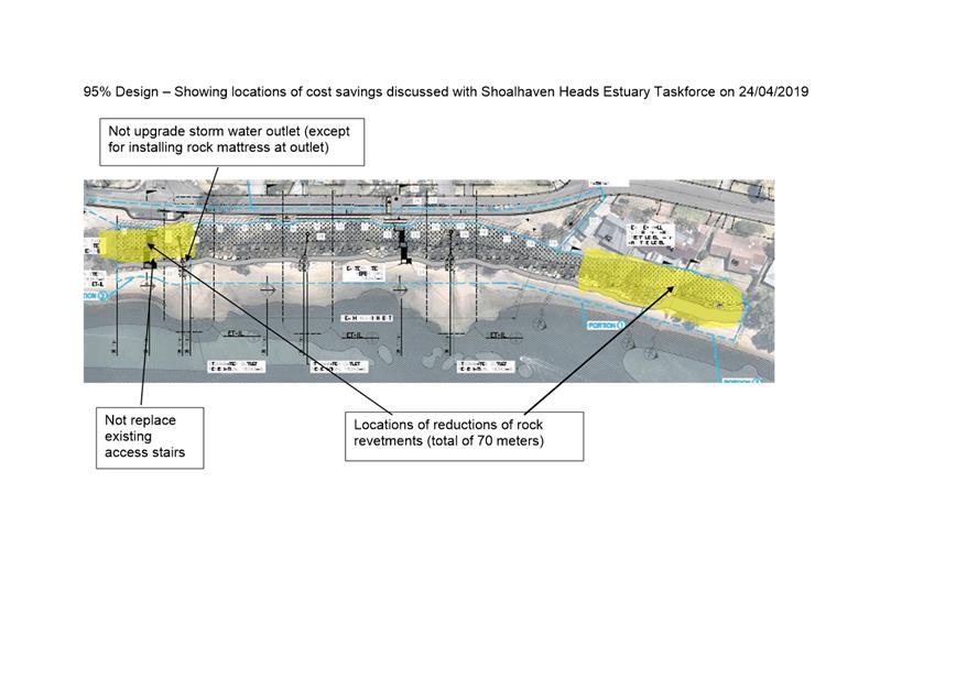
|

|
Development
& Environment Committee – Tuesday 02 July 2019
Page
0
|
Local Government Amendment (governance &
planning) act 2016
Chapter
3, Section 8A Guiding principles for councils
(1)
Exercise of functions
generally
The
following general principles apply to the exercise of functions by councils:
(a) Councils should provide strong
and effective representation, leadership, planning and decision-making.
(b) Councils should carry out
functions in a way that provides the best possible value for residents and ratepayers.
(c) Councils should plan
strategically, using the integrated planning and reporting framework, for the
provision of effective and efficient services and regulation to meet the
diverse needs of the local community.
(d) Councils should apply the integrated
planning and reporting framework in carrying out their functions so as to
achieve desired outcomes and continuous improvements.
(e) Councils should work
co-operatively with other councils and the State government to achieve desired
outcomes for the local community.
(f) Councils should manage
lands and other assets so that current and future local community needs can be
met in an affordable way.
(g) Councils should work with
others to secure appropriate services for local community needs.
(h) Councils should act fairly,
ethically and without bias in the interests of the local community.
(i) Councils should be
responsible employers and provide a consultative and supportive working
environment for staff.
(2) Decision-making
The
following principles apply to decision-making by councils (subject to any other
applicable law):
(a) Councils should recognise
diverse local community needs and interests.
(b) Councils should consider social
justice principles.
(c) Councils should consider the
long term and cumulative effects of actions on future generations.
(d) Councils should consider the
principles of ecologically sustainable development.
(e) Council decision-making should
be transparent and decision-makers are to be accountable for decisions and
omissions.
(3) Community participation
Councils
should actively engage with their local communities, through the use of the
integrated planning and reporting framework and other measures.
Chapter
3, Section 8B Principles of sound financial management
The
following principles of sound financial management apply to councils:
(a) Council spending should be responsible and
sustainable, aligning general revenue and expenses.
(b) Councils should invest in responsible and
sustainable infrastructure for the benefit of the local community.
(c) Councils should have effective financial
and asset management, including sound policies and processes for the following:
(i) performance management
and reporting,
(ii) asset maintenance and
enhancement,
(iii) funding decisions,
(iv) risk management practices.
(d) Councils should have regard to achieving
intergenerational equity, including ensuring the following:
(i) policy decisions are made
after considering their financial effects on future generations,
(ii) the
current generation funds the cost of its services
Chapter
3, 8C Integrated planning and reporting principles that apply to councils
The
following principles for strategic planning apply to the development of the
integrated planning and reporting framework by councils:
(a) Councils should identify and prioritise key
local community needs and aspirations and consider regional priorities.
(b) Councils should identify strategic goals to
meet those needs and aspirations.
(c) Councils should develop activities, and
prioritise actions, to work towards the strategic goals.
(d) Councils should ensure that the strategic
goals and activities to work towards them may be achieved within council
resources.
(e) Councils should regularly review and evaluate
progress towards achieving strategic goals.
(f) Councils should maintain an
integrated approach to planning, delivering, monitoring and reporting on
strategic goals.
(g) Councils should collaborate with others to
maximise achievement of strategic goals.
(h) Councils should manage risks to the local
community or area or to the council effectively and proactively.
(i) Councils should make appropriate
evidence-based adaptations to meet changing needs and circumstances.