Development & Environment Committee
Meeting Date: Tuesday,
04 June, 2019
Location: Council
Chambers, City Administrative Building, Bridge Road, Nowra
Time: 5.00pm
Membership (Quorum - 5)
Clr Joanna Gash - Chairperson
Clr Greg Watson
All Councillors
General Manager or nominee
Please note: The proceedings of this meeting
(including presentations, deputations and debate) will be webcast and may be
recorded and broadcast under the provisions of the Code of Meeting Practice. Your attendance at this meeting is taken
as consent to the possibility that your image and/or voice may be recorded and
broadcast to the public.
Agenda
1. Apologies / Leave of Absence
2. Confirmation of Minutes
· Development
& Environment Committee - 7 May 2019.............................................. 1
3. Declarations of Interest
4. Call Over of the Business Paper
5. Mayoral Minute
6. Deputations and Presentations
7. Notices of Motion / Questions on Notice
Nil
8. Reports
Planning Environment & Development
DE19.40...... Development Application – 17 Hawke Street
& 22 Currambene Street, Huskisson - Lot 7 & 8 DP 758530 Sec 3E -
Relocation of the former church on the subject site and demolition of the
existing associated hall and shed............................. 15
DE19.41...... Development Application – 43 Willowford
Road WOOLLAMIA – Lot 80 & DP 9289...................................................................................................................... 44
DE19.42...... Collingwood Beach - Action Plan Progress Report..................................... 62
DE19.43...... Two (2) Bushcare Group Action Plans - Review......................................... 76
DE19.44...... Strategic Planning Works Program - Proposed
2019-2020 Version........... 78
DE19.45...... Draft Medium Density Amendment (Chapter G13) -
Shoalhaven DCP 2014 - Post Exhibition Consideration and Finalisation.................................................... 91
DE19.46...... Public Exhibition Outcomes - Coastal Hazard
Review Planning Proposal and Coastal Management Areas DCP Amendment......................................................... 98
DE19.47...... New Proponent Initiated Planning Proposal -
Appleberry Close, Meroo Meadow.................................................................................................................... 103
DE19.48...... Jerberra and Verons Estates - Biodiversity
Assessment - Clause 34A Certification.................................................................................................................... 110
9. Confidential
Reports
Nil
|

|
Development
& Environment Committee – Tuesday 04 June 2019
Page
I
|
Development & Environment Committee
Delegation:
Pursuant to
s377 (1) of the Local Government Act 1993 the Committee is delegated the
functions conferred on Council by the Environmental Planning & Assessment
Act 1979 (EPA Act), Local Government Act 1993 (LG Act) or any other Act or
delegated to Council, as are specified in the attached Schedule, subject to the
following limitations:
i. The
Committee cannot make a decision to make a local environmental plan to classify
or reclassify public land under Division 1 of Part 2 of Chapter 6 of the LG
Act;
ii.
The Committee cannot review a section 8.11 or
section 8.9 EPA Act determination made by the Council or by the Committee
itself;
iii.
The Committee cannot exercise any function delegated
to the Council which by the terms of that delegation cannot be sub-delegated;
iv.
The Committee cannot exercise any function which
s377(1) of the LG Act provides cannot be delegated by Council; and
v.
The Committee cannot exercise a function which
is expressly required by the LG Act or any other Act to be exercised by
resolution of the Council.
Schedule
a. All
functions relating to the preparation, making, and review of local
environmental plans (LEPs) and development control plans (DCPs) under Part 3 of
the EPA Act.
b. All
functions relating to the preparation, making, and review of contributions
plans and the preparation, entry into, and review of voluntary planning
agreements under Part 7 of the EPA Act.
c. The
preparation, adoption, and review of policies and strategies of the Council in
respect of town planning and environmental matters and the variation of such
policies.
d. Determination
of variations to development standards related to development applications
under the EPA Act where the development application involves a development
which seeks to vary a development standard by more than 10% and the application
is accompanied by a request to vary the development standard under clause 4.6
of Shoalhaven Local Environmental Plan 2014 or an objection to the application
of the development standard under State Environmental Planning Policy No. 1
– Development Standards.
e. Determination
of variations from the acceptable solutions and/or other numerical standards
contained within the DCP or a Council Policy that the General Manager requires
to be determined by the Committee
f. Determination
of development applications that Council requires to be determined by the
Committee on a case by case basis.
g. Review
of determinations of development applications under sections 8.11 and 8.9 of
the EP&A Act that the General Manager requires to be determined by the
Committee.
h. Preparation,
review, and adoption of policies and guidelines in respect of the determination
of development applications by other delegates of the Council.
i. The
preparation, adoption, and review of policies and strategies of the Council in
respect to sustainability matters related to climate change, biodiversity,
waste, water, energy, transport, and sustainable purchasing.
j. The
preparation, adoption and review of policies and strategies of the Council in
respect to management of natural resources / assets, floodplain, estuary and
coastal management.
Minutes of the Development & Environment Committee
Meeting Date: Tuesday,
7 May 2019
Location: Council
Chambers, City Administrative Building, Bridge Road, Nowra
Time: 5.00pm
The following members
were present:
Clr Greg Watson -
Chairperson
Clr Amanda Findley
Clr Patricia White
Clr John Levett
Clr Nina Digiglio
Clr Kaye Gartner
Clr Mitchell Pakes
Clr Bob Proudfoot
Stephen Dunshea –
Acting General Manager
|
Procedural
Motion
|
|
RESOLVED (Clr Pakes / Clr
Findley) MIN19.282
That Ms Niki Willdig be permitted
to make a deputation in relation to item DE19.33
– Update – Planning Proposal – Warrah Road, Bangalee.
CARRIED
|
|
Apologies / Leave of Absence
|
Apologies were received
from Clr Gash, Clr Wells, Clr Guile, Clr Alldrick and Clr Kitchener.
|
Confirmation of the Minutes
|
|
RESOLVED (Clr Findley / Clr
Digiglio) MIN19.283
That
the Minutes of the Development & Environment Committee held on Tuesday 02
April 2019 be confirmed.
CARRIED
|
Clr White – DE19.39 New
Item - Tree Removal - Power Lines - Endeavour Energy - less than significant
non pecuniary interest declaration - her son works for Endeavour Energy –
will remain in the room and take part in discussion and vote.
|
Call Over of the
Business Paper
|
|
RESOLVED
(Clr Gartner / Clr Digiglio)
The
following items were called up for debate:
DE19.28, DE19.33, DE19.34,
DE19.36. DE19.37, DE.26, DE.27, DE.29, DE.30, DE.31, DE.32, DE.34, DE19.35
The
following item was resolved (Clr Gartner / Clr Digiglio) at this time. It is
marked with an asterisk (*) in these minutes:
DE19.38
CARRIED
|
Mayoral Minutes
Nil.
Deputations and Presentations
DE19.28
- Proposed Review - Shoalhaven LEP 2014 - Clause 2.8 Temporary Use of Land
Mr
Stuart Coughlan, representing Berry Forum, addressed the meeting and spoke
against the recommendation.
Ms
Elizabeth Clark addressed the meeting and spoke against the recommendation.
DE19.30
- Public Exhibition Outcomes - Planning Proposal (PP023) - Anson Street, St
Georges Basin - Building Heights
Ms
Maureen Webb, representing the Basin Villages Forum, addressed the meeting and
spoke in favour of the recommendation.
DE19.34
- Options - Review of Proposed Service Lane, St Georges Basin Village Centre -
Shoalhaven DCP 2014 and Shoalhaven Contributions Plan 2010
Mr
Travis Harpley addressed the meeting and spoke against the recommendation.
Mr
Russell Byrnes addressed the meeting and spoke against the recommendation.
Mr
Peter Chrisafis addressed the meeting and spoke against the recommendation.
DE19.36 - RD18/1007 – 315 Princes Highway Bomaderry
– Lot 2 DP 777260
Mr Kim Jones, representing JSA Architects, and Mr Andrew
Robinson, representing Andrew Robinson Planning Services, addressed the
meeting and spoke against the recommendation.
DE19.33 - Update – Planning Proposal – Warrah Road,
Bangalee
Ms Niki Willdig addressed
the meeting and spoke in relation to Point 6 of the recommendation.
Reports
|
Procedural
Motion - Bring Item Forward
|
|
RESOLVED (Clr Pakes / Clr
Gartner) MIN19.284
That the matter of the following
items be brought forward for consideration:
· DE19.28 -
Proposed Review - Shoalhaven LEP 2014 - Clause 2.8 Temporary Use of Land
· DE19.30
- Public Exhibition Outcomes - Planning Proposal (PP023) - Anson Street, St
Georges Basin - Building Heights
· DE19.34
- Options - Review of Proposed Service Lane, St Georges Basin Village Centre
- Shoalhaven DCP 2014 and Shoalhaven Contributions Plan 2010
· DE19.36 -
RD18/1007 – 315 Princes Highway Bomaderry – Lot 2 DP 777260
· DE19.33 -
Update - Planning Proposal - Warrah Road, Bangalee
CARRIED
|
|
DE19.28 Proposed
Review - Shoalhaven LEP 2014 - Clause 2.8 Temporary Use of Land
|
HPERM Ref: D19/109574
|
|
Recommendation (Item to be determined under
delegated authority)
That Council:
1. Proceed
to review the operation and effect of the current Clause 2.8 (Temporary use
of land) in Shoalhaven Local Environmental Plan 2014.
2. Advise
relevant stakeholders (all CCBs, Development/Tourism Industry, Shoalhaven
Tourism Advisory Group) of this decision and engage them during the Review.
3. Receive
a further report outlining the findings of the Review and options to revise
the clause as appropriate.
|
|
Motion (Clr White / Clr Proudfoot)
That
Council receive the report for information and not adopt the recommendation.
For: Clr
White, Clr Pakes, Clr Proudfoot and Clr Watson
Against: Clr
Findley, Clr Levett, Clr Digiglio, Clr Gartner and Stephen Dunshea
LOST
|
|
FORESHADOWED MOTION (RESOLVED)
(Clr Findley / Clr Gartner) MIN19.285
That Council:
1. Proceed
to review the operation and effect of the current Clause 2.8 (Temporary use
of land) in Shoalhaven Local Environmental Plan 2014.
2. Advise
relevant stakeholders (all CCBs, Development/Tourism Industry, Shoalhaven
Tourism Advisory Group) of this decision and engage them during the Review.
3. Receive
a further report outlining the findings of the Review and options to revise
the clause as appropriate.
For: Clr
Findley, Clr Levett, Clr Digiglio, Clr Gartner, and Stephen Dunshea
Against: Clr White, Clr
Watson, Clr Pakes and Clr Proudfoot
CARRIED
|
|
DE19.30 Public
Exhibition Outcomes - Planning Proposal (PP023) - Anson Street, St Georges
Basin - Building Heights
|
HPERM Ref:
D19/106974
|
|
Recommendation (Item to be determined under
delegated authority)
That Council
1. Proceed
to organise a Public Hearing for Planning Proposal No. PP023 that applies to
part of Lot 1 and Lot 6 DP 1082382, Anson Street, St Georges Basin.
2. Consider
a further report on this matter and its possible finalisation following the
Public Hearing.
|
|
RESOLVED (Clr Proudfoot / Clr
Findley) MIN19.286
That Council
1. Proceed
to organise a Public Hearing for Planning Proposal No. PP023 that applies to
part of Lot 1 and Lot 6 DP 1082382, Anson Street, St Georges Basin.
2. Consider
a further report on this matter and its possible finalisation following the
Public Hearing.
For: Clr
Findley, Clr White, Clr Levett, Clr Digiglio, Clr Gartner, Clr Pakes, Clr
Watson, Clr Proudfoot and Stephen Dunshea
Against: Nil
CARRIED
|
|
DE19.34 Options
- Review of Proposed Service Lane, St Georges Basin Village Centre -
Shoalhaven DCP 2014 and Shoalhaven Contributions Plan 2010
|
HPERM Ref:
D19/119586
|
|
Recommendation (Item to be determined under
delegated authority)
That Council:
1. In
recognition of the broader Strategic Plan for St Georges Basin Village
Centre, reaffirm the proposed Service Lane identified in Shoalhaven
Development Control Plan (DCP) 2014 Chapter N23: St Georges Basin Village
Centre with minor changes following design approval of the updated
engineering design plans.
2. Prepare
an amendment to the Shoalhaven Contributions Plan (CP) 2019 to:
a. Delete
the project 03ROAD2113 St Georges Basin Service Lane as a standalone project
and include the proposed Service Lane in Project 03ROAD2023 St Georges Basin
Village Access Road and Traffic Facilities that is part of the Village Road
Network required to facilitate the development of the overall B4 Mixed Use
zone and support the future population growth in St Georges Basin.
b. Include
the updated engineering design, land valuation and construction cost
estimates in the updated project.
c. Identify
the remaining works for construction in the CP Project 03ROAD2023 Village
Access Road and update the project cost estimates for the remaining works.
3. Depending
on the outcome of the proposed amendment to Shoalhaven Contributions Plan
2019:
a. Fund
initial expenditure on the first stage of the service lane works to provide
essential rear lane access to the properties 144-152 Island Point Road and
land acquisition using recoupment funds that may be available following the
adoption of the Shoalhaven Contributions Plan 2019 or through general revenue
allocations in the future Capital Works Program of up to $600,000 (2018/19
Indexed Estimate for 63% of the Project Costs rounded up) and request a
further report should more than this amount be required.
b. Include
the construction of the remaining section of the St Georges Basin Village
Centre Service Lane and Village Access Road in Council’s capital works
planning.
c. Recoup
the expended funds through Section 7.11 development contributions levied by
Shoalhaven Contributions Plan 2010 for future development.
4. Prepare
a minor housekeeping amendment to Shoalhaven DCP 2014 Chapter N23: St Georges
Basin Village Centre to reflect the updated design for the proposed service
lane and include the final design approved engineering plans as a supporting
document.
5. Undertake
a broader review of Shoalhaven DCP Chapter N23: St Georges Basin Village
Centre to complete/update the precinct planning for the “Future
Uses” area identified in the DCP Chapter Supporting Map as part of
Council’s Strategic Planning Works Program.
6. Advise
the applicant of DA17/2435 of the intended changes and support a future
application under Council’s Policy Payment of Development
Contributions and Section 64 Headworks Charges by Deferment or Instalments
(under Special Circumstances) to defer the payment of contributions
levied in the development consent for Project 03ROAD2113 of $45,541.91
(2018/19 Financial Year) until the future of the Service Lane is resolved and
consider waiving of the requirement for a bank guarantee given the
circumstances incumbered by the applicant through this review process.
7. Advise
the affected landowners of this resolution and the next steps.
|
|
RESOLVED (Clr Proudfoot / Clr
Findley) MIN19.287
That
Council
1. Commence
the necessary steps to remove the proposed service lane from the Shoalhaven
Development Control Plan 2014 and Shoalhaven Contributions Plan 2019 and
allow front access from Island Point Road to the four (4) relevant
properties, excluding Lot 45 DP 25550 where vehicle access from Island Point
Road would not be practical.
2. Request
a further urgent report on the options arising from this decision on the
possible development of 148 Island Point Road St Georges Basin that is the
subject of a recent development approval (DA17/2435).
For: Clr
Findley, Clr White, Clr Levett, Clr Digiglio, Clr Gartner, Clr Pakes, Clr
Watson, Clr Proudfoot and Stephen Dunshea
Against:
Nil
CARRIED
|
|
DE19.36 RD18/1007
– 315 Princes Highway Bomaderry – Lot 2 DP 777260
|
HPERM Ref:
D19/114426
|
|
Recommendation (Item to be determined under
delegated authority)
That Council:
1. Reaffirm
the determination (refusal) of DA18/1000, dated 30 November 2018, for the demolition
of existing structures and construction of a staged multi-dwelling housing
development comprising 40 dwellings at Lot 2 DP 777260, 315 Princes Highway,
Bomaderry.
2. Reissue
the determination notice removing the first reason for refusal as Endeavour
Energy has conditionally supported the proposal.
|
|
Motion (Clr Findley / Clr Gartner)
That
Council defer RD18/1007, 315 Princes Highway, for further report to the
Meeting of Council on 28 May 2019. In deferring this item, the applicant is
to:
1. Submit
an acoustic engineers report showing how the proposed development will comply
with the provisions of the Division 17 subdivision 2 of State Environmental
Planning Policy (Infrastructure) 2007, such report to be provided within 7
days from today’s resolution;
2. Provide
advice to Council as to how turf cell ‘pavement’ will be
removed from the design and an alternative pavement be incorporated;
3. Confirm
that an amended stormwater design and report will be submitted to ensure that
drainage will be achieved compliant with Council’s requirements for
“Sustainable Stormwater Management and Erosion / Sediment
Control”, Chapter G2 of the Shoalhaven Development Control Plan 2014 in
light of the turf cell pavement being removed;
4. Outline
modifications to be made to the design to include adequate landscape
buffers to the boundaries and increase landscape provision to provide for
occupants’ and neighbours’ residential amenity, to improve
outlooks, privacy and private recreation opportunities.
FOR: Clr
Findley, Clr Levett, Clr Digiglio, Clr Gartner
Against: Clr
Pakes, Clr Proudfoot, Clr White, Clr Watson and Stephen Dunshea
LOST
|
|
RESOLVED (Clr Pakes / Clr White) MIN19.288
That
Council defer the determination of this matter to allow the applicant to
provide the information required with an addendum report to be submitted to
the Council meeting on 28 May 2019.
For: Clr
Findley, Clr White, Clr Levett, Clr Digiglio, Clr Gartner, Clr Pakes, Clr
Watson, Clr Proudfoot and Stephen Dunshea
Against: Nil
CARRIED
|
|
DE19.33 Update
- Planning Proposal - Warrah Road, Bangalee
|
HPERM Ref: D19/39829
|
|
Recommendation (Item to be determined under
delegated authority)
That Council:
1. Prepare
and submit a revised PP to seek a revised Gateway determination for the
Warrah Road PP that:
a. Reflects
the revised zone and lot size maps provided in this report
b. Includes
provisions relating to the subdivision of the residual environmental and
rural land into no more than four allotments
2. Apply
to the NSW Office of Environment and Heritage to biodiversity certify the PP.
3. Not
commence the requirements under Part 6 of the LEP to actually release this
land for urban development until after BOTH the duplication of the Princes
Highway/Shoalhaven River Bridge and the Far North Collector Road are
complete.
4. Place
the PP and biodiversity certification application on public exhibition,
subject to the receipt of a satisfactory revised Gateway determination.
5. Advise
the proponent, affected land owners and previous submitters of this resolution.
6. Consider
adding the review of the southern component of the Crams Road Urban Release
Area as a new project to the Strategic Planning Works Program that is
developed for 2019/2020, with a further report back from the General Manager.
|
|
RESOLVED (Clr Findley / Clr
Gartner) MIN19.289
That Council:
1. Prepare
and submit a revised PP to seek a revised Gateway determination for the
Warrah Road PP that:
a. Reflects
the revised zone and lot size maps provided in this report
b. Includes
provisions relating to the subdivision of the residual environmental and
rural land into no more than four allotments
2. Apply
to the NSW Office of Environment and Heritage to biodiversity certify the PP.
3. Not
commence the requirements under Part 6 of the LEP to actually release this
land for urban development until after BOTH the duplication of the Princes
Highway/Shoalhaven River Bridge and the Far North Collector Road are
complete.
4. Place
the PP and biodiversity certification application on public exhibition, subject
to the receipt of a satisfactory revised Gateway determination.
5. Advise
the proponent, affected land owners and previous submitters of this
resolution.
6. Consider
adding the review of the southern component of the Crams Road Urban Release
Area as a new project to the Strategic Planning Works Program that is
developed for 2019/2020, with a further report back from the General Manager.
For: Clr
Findley, Clr White, Clr Levett, Clr Digiglio, Clr Gartner, Clr Pakes, Clr
Watson, Clr Proudfoot and Stephen Dunshea
Against: Nil
CARRIED
|
|
DE19.26 Outcomes
- Shoalhaven Local Heritage Assistance Fund 2018-2019
|
HPERM Ref: D19/66849
|
|
Recommendation (Item to be determined under
delegated authority)
That Council:
1. Receive
the annual Summary Project Report (Attachment 1), detailing the outcomes of
the Local Heritage Assistance Fund Program 2018-2019, for information.
2. Adopt the revised Shoalhaven
Heritage Strategy 2019-2022 (Attachment 2)
|
|
RESOLVED (Clr Findley / Clr
Gartner) MIN19.290
That Council:
1. Receive
the annual Summary Project Report (Attachment 1), detailing the outcomes of
the Local Heritage Assistance Fund Program 2018-2019, for information.
2. Adopt
the revised Shoalhaven Heritage Strategy 2019-2022 (Attachment 2).
For: Clr
Findley, Clr White, Clr Levett, Clr Digiglio, Clr Gartner, Clr Pakes, Clr
Watson, Clr Proudfoot and Stephen Dunshea
Against: Nil
CARRIED
|
|
DE19.27 Proposed
Amendment - Shoalhaven Development Control Plan 2014 - Low Density
Residential
|
HPERM Ref:
D19/106139
|
|
Recommendation (Item to be determined under
delegated authority)
That Council:
1. Support
the exhibition of the draft Low Density Residential Amendment to Shoalhaven
Development Control Plan 2014 for a period of 28 days as per legislative
requirements.
2. Receive
a further report on the draft Low Density Residential Amendment following the
conclusion of the public exhibition period.
3. Continue
to investigate the possibility of an off-site mature tree replacement scheme
for Shoalhaven in line with MIN18.955(4) and receive a future report on this
matter.
4. Advise
key stakeholders, including relevant industry representatives, of this
decision.
|
|
Motion (Clr Proudfoot / Clr White)
That
Council:
1. Support
the exhibition of the draft Low Density Residential Amendment to Shoalhaven
Development Control Plan 2014 for a period of 28 days as per legislative
requirements.
2. Receive
a further report on the draft Low Density Residential Amendment following the
conclusion of the public exhibition period.
3. Continue
to investigate the possibility of an off-site mature tree replacement scheme
for Shoalhaven in line with MIN18.955(4) and receive a future report on this
matter, and that an investigation be made as to the inclusion of private
rural property owners as potential recipients of an off-site mature tree
planting program.
4. Advise
key stakeholders, including relevant industry representatives, of this
decision.
For: Clr
White and Clr Proudfoot
Against: Clr
Findley, Clr Pakes, Clr Levett, Clr Digiglio, Clr Gartner, Clr Watson and
Stephen Dunshea
LOST
|
|
FORESHADOWED MOTION (RESOLVED)
(Clr Findley / Clr Gartner) MIN19.291
That
Council:
1. Support
the exhibition of the draft Low Density Residential Amendment to Shoalhaven
Development Control Plan 2014 for a period of 28 days as per legislative
requirements.
2. Receive
a further report on the draft Low Density Residential Amendment following the
conclusion of the public exhibition period.
3. Continue
to investigate the possibility of an off-site mature tree replacement scheme
for Shoalhaven in line with MIN18.955(4) and receive a future report on this
matter.
4. Advise
key stakeholders, including relevant industry representatives, of this
decision.
For: Clr
Findley, Clr Levett, Clr Digiglio, Clr Gartner and Stephen Dunshea
Against: Clr
White, Clr Pakes, Clr Watson and Clr Proudfoot
CARRIED
|
|
DE19.28 Proposed Review - Shoalhaven LEP 2014 - Clause
2.8 Temporary Use of Land
|
HPERM Ref: D19/109574
|
|
Item
dealt with earlier in the meeting see MIN19.285
|
|
DE19.29 Proposed
Council Submission - Discussion Paper: Proposed Standard Instrument LEP
Local Character Overlay
|
HPERM Ref:
D19/121980
|
|
Recommendation (Item to be determined under
delegated authority)
That Council make a submission
(Attachment 1 of this report) to the NSW Department of Planning and
Environment in relation to its Discussion Paper on a proposed Standard
Instrument LEP Local Character Overlay.
|
|
RESOLVED (Clr Findley / Clr
Digiglio) MIN19.292
That Council make a submission
(Attachment 1 of this report) to the NSW Department of Planning and
Environment in relation to its Discussion Paper on a proposed Standard
Instrument LEP Local Character Overlay.
For: Clr
Findley, Clr White, Clr Levett, Clr Digiglio, Clr Gartner, Clr Pakes, Clr
Watson, Clr Proudfoot and Stephen Dunshea
Against: Nil
CARRIED
|
|
DE19.30 Public Exhibition Outcomes - Planning Proposal (PP023) - Anson Street, St Georges
Basin - Building Heights
|
HPERM Ref: D19/106974
|
|
Item
dealt with earlier in the meeting see MIN19.286
|
|
DE19.31 Exhibition
Outcomes - Draft Council Policy - Electric Vehicle (EV) Charging
Stations on Public Land
|
HPERM Ref: D19/47332
|
|
Recommendation (Item to be determined under
delegated authority)
That Council:
1. Adopt
and finalise the draft Electric Vehicle Charging Stations on Public Land
Policy, as exhibited, with the inclusion of changes identified in Attachment
2.
2. Advise
key stakeholders and those that made submissions of this decision.
3. Continue
to consider Electric Vehicle policy developments and opportunities as they
arise.
|
|
RESOLVED (Clr Gartner / Clr
Digiglio) MIN19.293
That Council:
1. Adopt
and finalise the draft Electric Vehicle Charging Stations on Public Land
Policy, as exhibited, with the inclusion of changes identified in Attachment
2.
2. Advise
key stakeholders and those that made submissions of this decision.
3. Continue
to consider Electric Vehicle policy developments and opportunities as they
arise.
For: Clr
Findley, Clr White, Clr Levett, Clr Digiglio, Clr Gartner, Clr Pakes, Clr
Watson, Clr Proudfoot and Stephen Dunshea
Against: Nil
CARRIED
|
|
DE19.32 Proposed
Submission - Aboriginal Land Claim No.25421 and Part Claims No.42499, 42454,
42448 and 42485 - Ulladulla
|
HPERM Ref:
D19/103982
|
|
Recommendation (Item to be determined under
delegated authority)
That Council notify the NSW
Department of Industry – Crown Lands Aboriginal Land Claims
Investigation Unit that:
1. In
relation to part Claim Numbers 42448 and 42485 over Lot 16 DP 1105304:
a. Council
has no objection to these claims subject to:
i. The
exclusion of land identified for the planned future southern extension of St
Vincent Street, which also contains Council infrastructure for drainage and
wastewater disposal; and
ii. The
exclusion of land on the western boundary that contains Council infrastructure
for wastewater disposal.
2. In
relation to Claim No. 25421 and part Claim Numbers 42499 and 42454 over Part
Lot 245 DP 755967, and part Claim Numbers 42448 and 42485 over Lots 286 &
287 DP 755967 and Lot 2 DP 631894:
a. Council
does not support these claims because at the date of claim lodgement:
i. The
land was likely to be needed for an essential public purpose, being the
planned future southern extension of St Vincent Street and connector road and
roundabout to the Princes Highway; and
ii. The
land contains a significant amount of Council infrastructure for drainage,
water supply and wastewater disposal that services the southern Ulladulla
area.
|
|
RESOLVED (Clr White / Clr
Digiglio) MIN19.294
That Council notify the NSW
Department of Industry – Crown Lands Aboriginal Land Claims
Investigation Unit that:
1. In
relation to part Claim Numbers 42448 and 42485 over Lot 16 DP 1105304:
a. Council
has no objection to these claims subject to:
i. The
exclusion of land identified for the planned future southern extension of St
Vincent Street, which also contains Council infrastructure for drainage and
wastewater disposal; and
ii. The
exclusion of land on the western boundary that contains Council infrastructure
for wastewater disposal.
2. In
relation to Claim No. 25421 and part Claim Numbers 42499 and 42454 over Part
Lot 245 DP 755967, and part Claim Numbers 42448 and 42485 over Lots 286 &
287 DP 755967 and Lot 2 DP 631894:
a. Council
does not support these claims because at the date of claim lodgement:
i. The
land was likely to be needed for an essential public purpose, being the
planned future southern extension of St Vincent Street and connector road and
roundabout to the Princes Highway; and
ii. The
land contains a significant amount of Council infrastructure for drainage,
water supply and wastewater disposal that services the southern Ulladulla
area.
For: Clr
Findley, Clr White, Clr Levett, Clr Digiglio, Clr Gartner, Clr Pakes, Clr
Watson, Clr Proudfoot and Stephen Dunshea
Against: Nil
CARRIED
|
|
DE19.33 Update - Planning Proposal - Warrah Road, Bangalee
|
HPERM Ref: D19/39829
|
|
Item
dealt with earlier in the meeting see MIN19.289
|
|
DE19.34 Options - Review Of Proposed Service Lane, St Georges
Basin Village Centre - Shoalhaven DCP
2014 and Shoalhaven Contributions Plan 2010
|
HPERM Ref: D19/119586
|
|
Item
dealt with earlier in the meeting see MIN19.287
|
|
DE19.35 Development
Application – SF10671 proposed 2 lot subdivision at Lot 9 DP792386
(no.96) Princes Hwy Milton
|
HPERM Ref: D19/84342
|
|
Recommendation (Item to be determined under
delegated authority)
Council resolve with respect to the
development application SF10671, proposed 2 lot subdivision of Lot 9 DP792386
Gumley Lane, Milton, to:
1. Support
the variation to Council Interim Policy 18/55, and use of Gumley Lane for
access,
2. Support
the development and determine the application by way of approval subject to
conditions of consent, as outlined in the attached Draft Consent, Attachment
1.
|
|
RESOLVED (Clr White / Clr
Findley) MIN19.295
Council resolve with respect to the
development application SF10671, proposed 2 lot subdivision of Lot 9 DP792386
Gumley Lane, Milton, to:
1. Support
the variation to Council Interim Policy 18/55, and use of Gumley Lane for
access,
2. Support
the development and determine the application by way of approval subject to
conditions of consent, as outlined in the attached Draft Consent, Attachment
1.
For: Clr
Findley, Clr White, Clr Levett, Clr Digiglio, Clr Gartner, Clr Pakes, Clr
Watson, Clr Proudfoot and Stephen Dunshea
Against: Nil
CARRIED
|
|
DE19.36 RD18/1007
– 315 Princes Highway Bomaderry
– Lot 2 DP 777260
|
HPERM Ref: D19/114426
|
|
Item
dealt with earlier in the meeting see MIN19.288
|
|
DE19.37 Lake
Tabourie Boardwalk Replacement
|
HPERM Ref:
D19/119129
|
|
Recommendation (Item to be determined under
delegated authority)
That Council:
1. Commit
to revoting $212,520 from Coastal Foreshore Erosion Works (75742) capital
works budget from 2018/19 financial year to 2019/20 financial year to fund
the design and construction of the replacement boardwalk.
2. Progress
to design of a replacement boardwalk, to a standard that increases the asset
resilience to future coastal hazards, and includes:
a. Geotechnical
assessments and land survey
b. Review
of Environmental Factors including
i. Aboriginal
Heritage assessment
ii. Native
Title claim assessment
3. Commit
to construction of a new boardwalk at Lake Tabourie, to replace the
previously destroyed one, using Fibreglass Reinforced Polymer (FPR)
materials.
|
|
RESOLVED (Clr Findley / Clr
White) MIN19.296
That Council:
1. Commit
to revoting $212,520 from Coastal Foreshore Erosion Works (75742) capital
works budget from 2018/19 financial year to 2019/20 financial year to fund
the design and construction of the replacement boardwalk.
2. Progress
to design of a replacement boardwalk, to a standard that increases the asset
resilience to future coastal hazards, and includes:
a. Geotechnical
assessments and land survey
b. Review
of Environmental Factors including
i. Aboriginal
Heritage assessment
ii. Native
Title claim assessment
3. Commit
to construction of a new boardwalk at Lake Tabourie, to replace the
previously destroyed one, using Fibreglass Reinforced Polymer (FPR)
materials.
For: Clr
Findley, Clr White, Clr Levett, Clr Digiglio, Clr Gartner, Clr Pakes, Clr
Watson, Clr Proudfoot and Stephen Dunshea
Against: Nil
CARRIED
|
|
DE19.38 Timeframes
and Status for Lake Conjola Coastal Management Program Application - NSW
Coast and Estuary Grant Program
|
HPERM Ref:
D19/124684
|
|
Recommendation (Item to be determined under
delegated authority)
That Council receive the Lake
Conjola Coastal Management Program Application report for information.
|
|
RESOLVED* (Clr Gartner / Clr
Digiglio) MIN19.297
That Council receive the Lake
Conjola Coastal Management Program Application report for information.
CARRIED
|
|
Procedural
Motion - Matters of Urgency
|
|
RESOLVED (Clr White / Clr
Proudfoot) MIN19.298
That an additional item Tree Removal – Power
Lines be introduced as a matter of urgency.
CARRIED
|
|
The
Chairperson ruled the matter as urgent as consideration is in the public
interest.
|
|
DE19.39 Additional
Item - Tree Removal - Power Lines - Endeavour Energy
|
|
Clr White –
less than significant non pecuniary interest declaration - her son works for
Endeavour Energy – remained in the room and took part in discussion and
voted.
|
|
RESOLVED (Clr White / Clr
Proudfoot) MIN19.299
That
Council
1. Note
the Press Release regarding tree removal - power lines.
2. Note
that consent was not granted by Council for the removal of each individual
tree or removal of trees that were not deemed high risk.
3. Be
provided with a definition from Endeavour Energy as to what is a high-risk
tree.
4. Note
that the tree removals currently being undertaken by Endeavour Energy are
outside of the scope of the discussions with Council.
5. Request
that Endeavour Energy suspend the removal of trees and stop work.
6. Prior
to any further works occurring, request that a comprehensive list of proposed
tree removals be provided by Endeavour Energy.
7. Note
the reference to Council’s consent will be removed from future letters
delivered to residents by Endeavour Energy.
8. Report
back on discussions with Endeavour Energy to request that property owners be
provided with tube stock (trees/shrubs) that would be suitable to plant in
their private property as a replacement.
9. Request
Endeavour Energy to grind the stumps of trees they have removed in the
Shoalhaven.
10. Make
representations to our State Members regarding the legislation under which
the trees are being removed.
11. Congratulate
staff and especially the Director, Assets & Works for their response to
residents on this matter.
For: Clr
Findley, Clr White, Clr Levett, Clr Digiglio, Clr Gartner, Clr Pakes, Clr
Watson, Clr Proudfoot and Stephen Dunshea
Against: Nil
CARRIED
|
There being no further
business, the meeting concluded, the time being 8.21pm.
Clr Watson
CHAIRPERSON
|

|
Development
& Environment Committee – Tuesday 04 June 2019
Page
1
|
DE19.40 Development
Application – 17 Hawke Street & 22 Currambene Street, Huskisson - Lot
7 & 8 DP 758530 Sec 3E - Relocation of the former church on the
subject site and demolition of the existing associated hall and shed
DA. No: DA18/2102/4
HPERM Ref: D19/145092
Group: Planning
Environment & Development Group
Section: Development
Services
Attachments: 1. Planning
Report – S4.15 Assessment (under separate cover) ⇨
2. Draft
Determination (under separate cover) ⇨
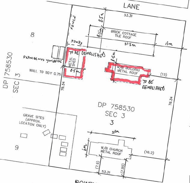
3. Site
Plan - Demolition ⇩
4. Site
Plan - Tree Location ⇩
5. Letter
- NSW OEH - Heritage Branch - received by Council 1 March 2019 ⇩
6. Ground Penetrating Radar
Survey Plans ⇩
Description of Development: Relocation
of the former church and demolition of the existing associated hall and shed
Owner: Anglican
Church Property Trust Diocese of Sydney
Applicant: Stephen
Bartlett
Notification Dates: 23
October – 7 November 2018
No. of Submissions: At
the time of finalisation of the Report there were a total of 137 submissions:
64
submissions in objection
73
submissions in support
Purpose
/ Reason for consideration by Council
On 16 October 2018, at the
Ordinary Meeting of Council it was resolved in relation to MIN18.826 that
Council:
1. Reaffirm its
strong opposition to the Heritage listing of the abandoned Anglican Church at
Huskisson and notify the NSW Heritage Office of the decision, as in
Council’s opinion nothing has changed.
2. Include with the
letter a copy of its earlier submission opposing the listing of the item as an
item of local significance.
3. Call in the
determination of the DA relating to the demolition of the Church to the full
Council for the reason of public interest.
This
Council Report is prepared in response to Item 3 of the Council’s
resolution.
|
Recommendation (Item to be
determined under delegated authority)
That Council approve Development Application DA18/2102 for
the relocation of the former church and demolition of the existing associated
hall and shed on the land at 17 Hawke Street and 22 Currambene Street,
Huskisson - Lots 7 and 8 DP 758530 Sec 3E subject to the recommended
conditions of consent contained in Attachment 1 to this report.
|
Options
1. Approve the
development application (DA) in accordance with the recommendation.
Implications: This would allow the applicant to
progress this proposal.
2. Refuse the
application.
Implications: Council would need to determine the
grounds on which the application is refused, having regard to section 4.15
considerations of the Environmental Planning and Assessment Act 1979 (the Act)
(this section sets the evaluation framework for the assessment of
applications).
The applicant would have the ability to request a review of
any refusal by Council and/or pursue an appeal through the NSW Land and
Environment Court (L&EC).
3. Alternative
recommendation.
Implications: Would depend on the nature of any
alternate resolution
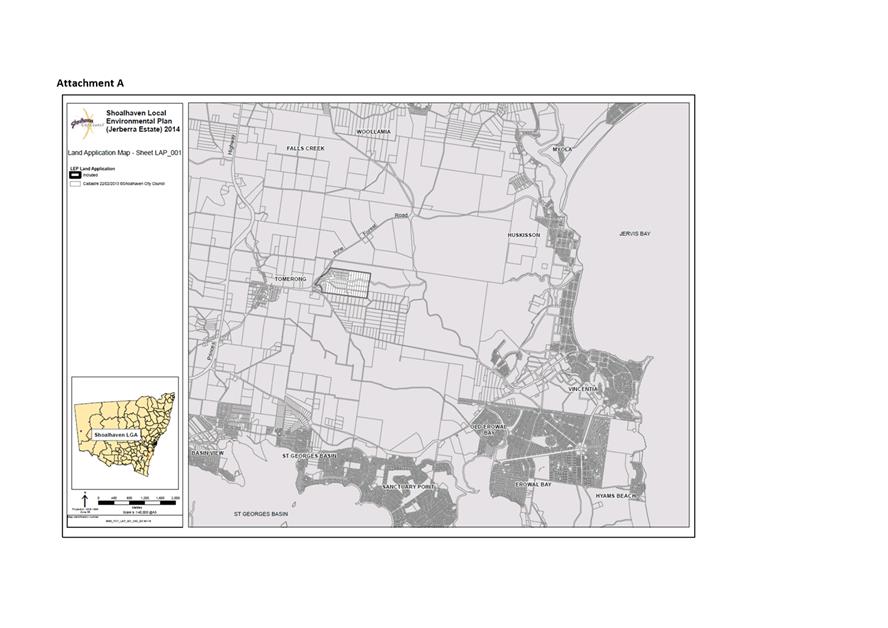
Figure 1 – Location Map

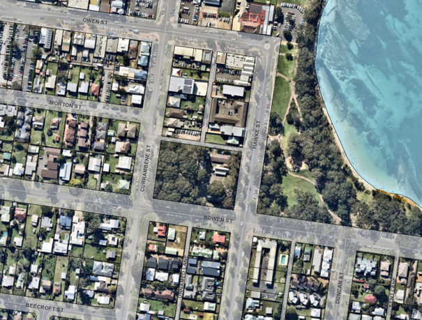
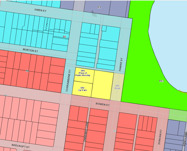
Figure 2 – Zoning Map

Background
Post lodgement of the DA
On 27 September 2018, the DA was lodged with Council to
demolish the former Holy Trinity Church building and associated hall and shed.
On 16 October 2018, at the Extra
Ordinary Meeting of Council, Council considered Notice of Motion CL18.280 Notice of Motion - Abandoned Anglican Church
– Huskisson. The Notice of Motion CL18.280 was resolved as follows
(MIN18.826):
That Council:
1. Reaffirm its
strong opposition to the Heritage listing of the abandoned Anglican Church at
Huskisson and notify the NSW Heritage Office of the decision, as in
Council’s opinion nothing has changed.
2. Include with the
letter a copy of its earlier submission opposing the listing of the item as an
item of local significance.
3. Call in the
determination of the DA relating to the demolition of the Church to the full
Council for the reason of public interest
On 17 October 2018, Save Husky Church notified Council of additional
claims that there were Indigenous burials in the graveyard, including James
Golding, known as “King Bud Billy, King of Jervis Bay”.
On 18 October 2018, the Applicant amended the application to
relocate the church within the site instead of demolition. Amended plans and
supporting information were submitted to support the amended proposal.
On 19 October 2018, Council’s
Strategic Planning Manager wrote to the NSW Office of Environment &
Heritage (OEH) to reaffirm Council’s strong opposition to the
Heritage listing of the Anglican Church at Huskisson, as in Council’s
opinion nothing had changed.
On 23 October 2018, the DA was notified in accordance with
Council’s Community Consultation Policy for a period of 14 days. A total
of 137 submissions were received, being 73 submissions in support and 64
submissions in opposition to the application.
On 7 November 2018, the State Heritage Committee resolved in
relation to the Former Holy Trinity Anglican Church, Huskisson (Resolution
2018-117) as follows:
1. Advises the Heritage Division that further research
is required to determine potential state significance of this site
2. Recommends that the Minister for Heritage make an
Interim Heritage Order for the Former Holy Trinity Church Group, 17 Hawke
Street, Huskisson.
3. Note that the full twelve-month option for
assessment would be required for this site.
On 22 November 2018, Council received correspondence from
Graham Quint, Director, Conservation, the National Trust of Australia (NSW).
The correspondence outlined the National Trust’s intent to finalise a
proposal for listing on the National Trust Register of the Holy Trinity Group
and the National Trust’s strong support for the making of this Interim
Heritage Order to allow the full heritage significance of this site to be
investigated.
On 29 November 2018, the applicant submitted the results of
ground penetrating radar investigations titled “GPR – Non
Destructive Testing” prepared by Peter Ellsmore & Associates Pty
Ltd. The report on the site was undertaken on accessible parts of the site,
excluding (under) existing buildings and some curtilage around the perimeter of
the site and buildings.
On 2 January 2019, Council received correspondence from Paul
McKenzie, Executive Director, Heritage Division, of the OEH (D19/5628) to
confirm that the Heritage Council’s State Heritage Committee considered
and resolved to recommend that the Minister place an Interim Heritage Order
(IHO) over the subject site at the 7 November 2018 meeting. The letter went on
to confirm that the matter would be brought back before the State Heritage
Register Committee in February 2019 for further consideration.
Furthermore, on page 2 of the letter from the OEH it states as
follows:
I note your previous correspondence and ask you to
revisit Council’s decision to consider development of the site without
further public consultation or investigation of the site’s potential
cultural values. We understand this is a polarising issue in the community, and
further consultation, especially with the local Aboriginal people, could go
some way towards reuniting the planning requirements of a developing coastal
area and the local community aspirations.
On 5 February 2019, Council’s Development and
Environment Committee considered a report (DE19.7) on the possible heritage
listing of the Former Huskisson Anglican Church. The report recommended the
following:
That Council:
1. Receive the report
for information.
2. Note the
correspondence received from the Heritage Division of the NSW Office of
Environment & Heritage dated 2 January 2019.
3. If necessary,
reconsider this matter following the further consideration of the site by the
NSW Heritage Council’s State Heritage Register Committee during February
2019.
The Development and Environment Committee resolved in relation
to a Motion (MIN19.49) as follows:
That Council:
1. Receive
the report for information.
2. Note
the correspondence received from the Heritage Division of the NSW Office of
Environment & Heritage dated 2 January 2019.
On 6 February 2019, the State Heritage
Committee considered the Interim Heritage Order relating to the Former Holy
Trinity Anglican Church, Huskisson, including additional information provided
to OEH since the November meeting.
The State Heritage Committee resolved not to recommend
an IHO to the Minister for Heritage, the Hon. Gabrielle Upton. The committee
concluded that this site was not likely to be of state heritage significance
but is highly likely to be of local heritage significance. As local heritage is
the responsibility of the local council, the Committee determined to write to
the Shoalhaven City Council to strongly encourage Council to consider the
heritage significance of the site when reviewing any development proposals.
On 1 March 2019, Council received a letter from Frank Howarth,
the Chair of the NSW Heritage Council. The letter provides commentary from the
State Heritage Committee on the following matters:
· Indigenous
heritage
· Church
History
· Landscape
· Ground
penetrating radar
The letter goes on to request that Council review the material
that is available and consider the following matters (‘dot’
points):
· whether
other areas of the site require investigation for the presence of graves, and
review the techniques that would be best employed;
· whether
the Cyril Blackett church could be retained in its current location;
· whether
any development that proceeds, could provide an opportunity for the
interpretation of those graves and of Aboriginal heritage in the area;
· the
heritage value of the landscape and plantings and the importance of this open
green space to the local community in a town that is so rapidly developing.
The letter concludes by asking Council to revisit its previous
decision to consider the development of the site without further consultation
or investigation of its cultural values and again notes that further
consultation with local Aboriginal people could go some way towards reuniting
planning requirements of a growing area and local community aspirations.
On 2 April 2019, Council’s Development and Environment
Committee considered a report titled Further Update - Possible Heritage
Listing - Former Huskisson Anglican Church (DE19.24). The report provided a
further update following Council’s resolution
of 5 February 2019 and requested that further direction be given to Council
staff, given the nature of subsequent advice received from the Heritage Council
of NSW in their undated letter received by Council on 1 March 2019 (Attachment
5).
Council
resolved (MIN19.209), that Council:
1. Receive the report for information.
2. Note the letter received from the Heritage Council of NSW
on 27 March 2019.
3. Seek to list the site in the Local Environmental Plan (LEP)
as a Local Heritage Item through the formal planning proposal process.
4. Authorise staff to endeavour to add this to the next
Housekeeping Amendment dealing with Heritage in June 2019.
5. Encourage the proponents (i.e. the land owner and the
proposed developer) and the community to come together in an endeavour to reach
an agreed outcome.
A rescission motion was received on this item.
On 8 April 2019, Council wrote
to the applicant to request that the applicant address the final four ‘dot’
points (see earlier in this report) raised in the letter signed by Frank
Howarth, the Chair of the NSW Heritage Council.
On 10
April 2019, the applicant provided a written response to Council’s
additional information request dated 8 April 2019.
On 26 April 2019, Graham Quint, Director,
Conservation, The National Trust of Australia (NSW), wrote to Council:
[I]n
support of local community efforts to conserve the heritage significance of the
Former Huskisson Anglican Church. This matter has been ongoing for some time
and it is our understanding that sections of the local community continue to
argue strongly for the retention of this church and the recognition of the site
for its social history and its associations with important local historical
figures.
On 30 April 2019, Councillor Levett
presented a petition containing 2851 signatures to the Ordinary Meeting of
Council. The petition states as follows:
We the undersigned petition the
Shoalhaven City Council to reconsider the heritage listing of the Church and
its grounds (Holy Trinity Church Group), which it deleted from the Draft
LEP2004 despite “strong objections” from the NSW Heritage Office.
We ask the Anglican Church and the
relevant government bodies to acknowledge the architectural, religious, social,
environmental and aesthetic significance of the Holy Trinity Anglican Church
and its surrounding land, including historical trees and burial ground, located
at Huskisson Lot 7 Section 3 DP758530 17 Hawke Street, Lot 8 Section 3 DP758530
22 Currambene Street, Lot 9 Section 3 DP758530 26 Currambene Street (Jerrinja
Local Aboriginal Land Council).
At the Ordinary Meeting Council also considered Rescission
Motion - DE19.24 Further Update - Possible Heritage Listing - Former Huskisson
Anglican Church. The recommendation of the Rescission Motion was that
Council rescind the Motion relating to Item DE19.24 of the Development and
Environment Committee held Tuesday 2 April 2019.
Council resolved in relation to the rescission motion as
follows (MIN19.230):
That Council rescind the Motion
relating to Item DE19.24 Further Update - Possible Heritage Listing - Former
Huskisson Anglican Church of the Development & Environment Committee held
Tuesday 2 April 2019.
A further Notice of Motion was duly submitted (CL19.92) to
re-affirm Council’s previously resolved position in relation to this site
and buildings.
Council resolved as follows (MIN19.231):
That
Council:
1. Re-affirm its previously resolved position in relation to
the Former Huskisson Anglican Church site and building
2. Resolve to not support the inclusion of the site known as
the former Huskisson Anglican Church and grounds, as a listed item, in either
SLEP or the State Government Heritage register of Buildings of State
Significance.
On 1 May 2019, the applicant provided additional information
as follows:
· Huskisson
Anglican Church – Unmarked Graves GPR Survey prepared by GBG
Australia dated 18 April 2019;
· Response
to Heritage Council Letter prepared by GBA Heritage dated 5 April 2019; and
· Tree
Location Plan prepared by Tree Management Strategies dated 21 November
2018.
On 9 May 2019, the applicant provided further additional
information as follows:
· Letter
from the applicant dated 8 May 2019. The letter provides a response to the
National Trust of Australia (NSW) letter dated 26 April 2019 and further detail
on the proposed method of relocation and site management relating to the church
building;
· Final
plans in relation to the ground penetrating radar prepared by BGB Australia;
and
· Letter
from GBA Heritage dated 8 May 2019 in response to the landscape heritage issue
raised in the recent letter received by Council on 1 May 2019 from Mr Frank
Howarth, Chair of the Heritage Council of NSW (Attachment 5)
On 22 May 2019, in a late submission to
the application, Alfred Wellington, Chief Executive Officer, Jerrinja Local
Aboriginal Land Council (Jerrinja LALC), wrote to Council to express the
importance of Aboriginal cultural heritage, particularly where there are
possible ancestral remains on the subject site and to request the protection of
burials if present. Furthermore, the Jerrinja LALC strongly requests that
adequate consultation should be afforded the Jerrinja LALC and the broader
Aboriginal Community with family connections to the ancestors that could be
buried there. The Jerrinja LALC submission requested that the following three
points be addressed as part of the development application:
· Council
through its DA processes to ensure due diligence is afforded by way of a
minimum six-month community consultation period taking place before any on
ground works can commence on site.
· Further
investigations are recommended, through oral history research with the
Carpenter and Speechly families. This recommendation must be followed.
· I
also note Dr Feary's precautionary principle in her Executive Summary - 'The
logical outcome is to avoid ground disturbance where Ground Penetrating Radar
has identified possible grave sites". This principle is not only logical
but more importantly highly respectable to avoid desecration of burials which
will be considered sacrilegious to the family and Aboriginal people in general.
Council has considered the above submission in the s4.15
Assessment Report (Attachment 1).
Proposed Development
On 27 September 2018, Development Application No. DA18/2102
was lodged with Council for development described in the supporting covering
letter as follows:
1. Demolition
of the former Church, Hall and Shed.
2. No
ground works to be undertaken at this time.
3. The
graves known to exist on the site, and indicated on the site plan, will be
fenced as part of this process and will not be disturbed.
On 18 October 2018, the applicant submitted additional
information in support of an amended application. The applicant’s amended
Statement of Environmental Effects (D18/367325) described the development as
follows:
1. Relocation of the former church to a location straddling the
sites (Lots 3 and 7, DP758560 Sec 3) and;
2. Demolition
of the hall and shed.
The relocated church is proposed to be continued to be used
for church-related activities and meetings from the new location. The applicant
has advised that the relocation of the church building will allow for further
ground assessment under the church and to open the corner of the site up to
allow for additional site planning associated with the planning for a future
planning proposal. It is anticipated that the church will continue to be used
for religious purposes.
The relocation of the church will require the construction of
10 piers and a set of access stairs to provide access to the church building.
Details of the location of piers and accessible ramp and stairs are to be
provided on the construction certificate (CC) plans if the application is
approved.
An extract of historic floor plans and elevations of the Holy
Trinity Church and the applicant’s proposed site plan are provided in Figure
3 and 4 below:
Figure 3 - Historic Floor plans and elevations of the Holy
Trinity Church proposed to be relocated.
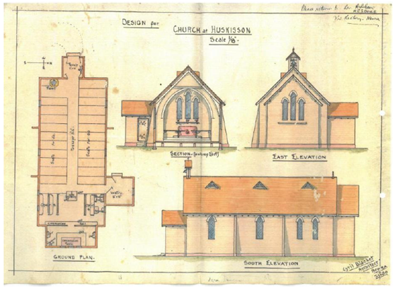
Figure 4
– Site plan of the proposed development.
Subject Land
The land is in the coastal
township of Huskisson.
The land consists of two regular
shaped allotments legally identified as 7 and 8 of DP 758530 Sec 3E and known
as 17 Hawke Street and 22 Currambene Street. The land is bound by Bowen Street
in the south, Currambene Street in the west and Hawke Street in the East. The
land is also bound by an unnamed and unformed lane in the north. The site has a
total land area of 6,070.29m2.
The site grades gradually from
the east at Hawke Street to the west on Currambene Street.
Access to the site is provided
from Bowen Street in the South and the unformed lane to the north.
Site & Context
The Holy Trinity Church group of buildings is located on the
site. It comprises the former Church, the Hall, the Rectory and equipment
storage shed, approved pursuant to Development Consent No. DA00/1957. There are
also several unmarked graves located toward the southern and south-west corner
of the site. Additional grave sites are also located on the adjoining land (26
Currambene Street - Lot 9 DP 758530 Sec 3).
The site contains extensive native vegetation consisting of Lophostemon
confertus (Brush Box), Eucalyptus teriticornis (Forest Red Gum), Corymbia
maculata (Spotted Gum) and Eucalyptus botryoides (Bangalay).
No vegetation is proposed to be removed or disturbed as part
of the application.
The broader development on the southern extent of the Huskisson
commercial area is a mix of residential, commercial and retail, tourist
accommodation and public open space.
The adjoining development is a mix of commercial, residential
and public open space as follows:
• To
the north of the site fronting Hawke Street (15 Hawke Street) is a single
storey commercial building which is currently the subject of Development
Application (DA18/2040) for the demolition of structures and construction of
shop top housing, consisting of 3 retail tenancies at ground floor, 8 apartments
on the first and second floor and basement car parking. Development running
along the western side of Hawke Street to the north is a mix of commercial and
tourist and visitor accommodation of two and three stories.
• The
adjoining lot to the west (26 Currambene St - Lot 9 DP 758530 Sec 3) remains
undeveloped.
• To
the east of the site is the public recreational area known as White Sands Park
which fronts onto Jervis Bay and connects with Voyager Memorial Park further to
the north.
• Land
to the west on Currambene Street is predominately single and two storey
dwelling houses. A residential flat building is located at the corner of
Currambene and Morton Street (19 Currambene Street) and a further residential
flat building is constructed on the land at 12 Currambene. There are also
several commercial and retail uses on the western and eastern side of
Currambene Street approaching the intersection with Owen Street.
• To
the south of the site running along Bowen Street is a mix of residential single
and two storey dwelling houses, multi-dwelling housing and tourist and visitor
accommodation.
History
On 19 March 1995, Council
commissioned a heritage study of the Shoalhaven City area. The aim of the study
was to guide appropriate development following on from the recent revival of
towns such as Berry, Milton and Kangaroo Valley following relevant heritage
studies being completed. The study was also to aid in the preparation of the
draft local environmental plan (Shoalhaven Local Environmental Plan (SLEP) 1985
Draft Amendment) and draft development control plan.
The Heritage Study
1995–1998 (Heritage Study) prepared by Peter Freeman Pty Ltd
Conservation Architects/Planners In association with JRC Planning Services,
Sydney dated February 2003 was published following lengthy investigative
process.
The State Heritage Inventory
sheet identified the Holy Trinity Anglican Church, hall and graves under
Section 15.1 as an item of Local Significance (JB016).
In November 1997 owners of existing and proposed heritage items identified
in the Heritage Study were notified by letter of the Council’s intent to
potentially heritage list their property under the Draft LEP. Furthermore, the
letter invited landowners to attend several information sessions to learn about
the implication of the heritage listing.
In June 2000, Council wrote to
all owners of existing and proposed heritage items and adjoining landowners to
notify them of proposed amendments to Shoalhaven Local Environmental Plan 1985
to include additional heritage items in the schedule to the Plan. To assist in
the management and impact of heritage items, Council prepared a Development
Control Plan (DCP) Heritage Conservation Development Guidelines. The draft LEP
and DCP were placed on exhibition for a period of two (2) months commencing in
June 2000.
From the 785 items identified
for protection (approximately 90 were already identified as heritage items
under SLEP 1985), extensive submissions were received from Government
Departments and landowners (28 letters objected to and 19 supported the
listings or nominated additional or increased protection for items).
A letter of objection to the
heritage listing of Holy Trinity Anglican Church, Hall and Graves, identified
as an item of local Significance (JB016) was received by Council in relation to
the proposed listing, from the Anglican Church. The concerns of the Church
related to the possible future sale and restrictions imposed by the
‘protection’. The concerns of the Anglican Church were considered
in an Addendum Report of General Manager to the Policy and Planning Committee
on 11 December 2001 as follows (File 1106 – 02). The Addendum Report
provided the following comment in relation to their concerns:
Comment: There are many examples where churches and land
have been sold and reused for several purposes. The conservation incentive
clauses allowing adaptive reuse, whilst other incentives such as revaluation
for rating and land tax purposes offsets some of the losses associated with
maximising the potential of the land. Recommended for protection.
On 18 December 2001, the Policy
and Planning Committee moved a motion to adopt the recommendations of the
Policy and Planning Committee, that Council not adopt the Heritage LEP and
proceed as follows:
a) A Working Party comprising all Councillors be formed
to examine the LEP and DCP in detail and the Working Party report back to
Council at the conclusion of deliberations.
b) The first meeting of the Working Party to be held at
the earliest opportunity in January.
c) Council communicate to the community changes to and
implications of the model provisions and the draft DCP and that this
communication contain a simplified response procedure relying on affirmative
response.
d) The General Manager draft this communication in
consultation with the Mayor.
In September of 2002, Council
commenced notification to landowners identified for inclusion in the SLEP
(heritage amendments) in accordance with the adopted recommendations of the
Policy & Planning Committee meeting on 18 December 2001. The notification
sought to ensure that owners were made aware of the implications of the
heritage SLEP amendments and the DCP and if it should proceed, whether the
owner agreed to the potential heritage listing of their property The Anglican
Church Property Trust as owners of the land at 17 Hawke Street, Huskisson and
the Holy Trinity Church were notified.
On 17 December 2002, following
the establishment of a Councillor Heritage Working Party, Council considered a
recommendation on the results of the surveys completed in September 2002 and
resolved on 17 December 2002 to protect:
a) Items already
protected in State, Regional or Local LEP lists;
b) Draft items of
Regional (State Significance);
c) Draft items of local
significance where owner agreements were received; and
d) Items in
Council’s ownership agreed by the General Manager.
On 10 July 2003, The Councillor
Heritage Working Party considered those matters resolved at the 17 December
2002 meeting of Council. The Councillor Heritage Working Party identified that
the Planning Services Manager had examined the objection listing again to
determine whether additional items over and above the 99 items identified to
the last Working Party could be justified on conservation grounds. The
assessment had been carried out by identifying those items where removal is not
supported and included consideration of the Illawarra Heritage Study Review
carried out by State Government but never completed. This amended retention
list contained some 139 items (228 deleted).
The Councillor Heritage Working
Group recommended: that the Working Party make a recommendation to the
Council’s Policy & Planning Committee adopt the Heritage Draft Local
Environmental Plan with the Schedule of proposed items as contained in
attachments ‘A’, ‘B’ and ‘D’.
Attachment ‘D’
included the land at 17 Hawke Street, Huskisson - Holy Trinity Church.
On 1 September 2003, Council
resolved to adopt the Draft LEP with the schedule of proposed items. This
included draft heritage items of local significance where objections were not
supported on heritage conservation grounds; Reference 1106 of July 2003. The
Holy Trinity Church was included at this time despite objections being
received.
On 7 May 2004, the Draft LEP was
submitted to the Infrastructure Planning and Natural Resource Department
(Department of Planning) in accordance with the then section 68(4) of the Act
and included the required documents for gazettal. The draft LEP that was
submitted to the Department of Planning for gazettal in 2004 included the
following as a proposed “heritage item”:
• Huskisson
- Holy Trinity Anglican Church Group, including Church Hall and Burial Site -
17 Hawke Street, Lots 7 and 9 DP 758530 Sec 3
On 2 June 2005, the Assistant to
the Bishop, Anglican Church Diocese of Sydney - Wollongong Region wrote to
Council to express concern regarding any proposal to heritage list the Holy
Trinity Church at 17 Hawke Street, Huskisson.
Following the representations to
Council by Anglican Church Diocese of Sydney - Wollongong Region, Council
commenced steps to have the item removed from the Draft LEP.
On 23 August 2005, Council
resolved to amend the draft LEP previously submitted to the Department of
Planning for gazettal to remove various proposed heritage items from the Draft
LEP.
On 30 September 2005, Council
wrote to the NSW Heritage Office advising of proposed changes to the Draft LEP.
Although the Heritage Office was concerned at the reduction in the number of
heritage items and conservation areas proposed for listing in the heritage
schedule of the Draft LEP, it advised Council and the Department of Planning
that it supported the draft plan on the basis that it would facilitate the
conservation and protection of the remaining 583 heritage items and two
conservation areas in the local government area.
The Holy Trinity Anglican Church
Group including church hall and burial site (Hawke Street) was included as an
item to be deleted from the draft LEP schedule. The deletion of the church from
the heritage schedule to the Draft LEP was justified by Council on the basis
that there was sufficient and adequate representation of similar items retained
in the draft plan.
Shoalhaven Local Environmental
Plan 2014 (SLEP 2014) was published on the legislation website on 8 April 2014
and commenced 14 days later.
The Holy Trinity Church Group
including church hall and burial sites are not listed under Schedule 5 of SLEP
2014.
Issues
Impacts on Heritage Significance of the Site
As noted previously, The Holy
Trinity Church Group including Church Hall and Burial Site are not
listed under Schedule 5 of SLEP 2014.
Despite the site not being
listed under Schedule 5 of SLEP 2014, the application is supported by the
following heritage documents:
· Heritage
Management Strategy prepared by GBA Heritage dated 12 August 2018 (D18/339362);
· Heritage
Assessment prepared by GBA Heritage dated 6 December 2018 (D19/46699);
· Aboriginal
Cultural Heritage Due Diligence Assessment (Due Diligence Assessment) prepared
by Sue Feary dated December 2018 (D19/46707);
· Response
to Heritage Council Letter Holy Trinity Anglican Church Site 17 Hawke Street,
Huskisson prepared by GBA Heritage dated 5 April 2019 (D19/144044);
· Further
Response to Heritage Council Letter Holy Trinity Anglican Church Site 17 Hawke
Street, Huskisson prepared by GBA Heritage dated 8 May 2019 (D19/154542);
The heritage significance of the
Holy Trinity Group has been considered by the OEH which resolved not to list
the group as an item of State heritage significance.
Furthermore, Council has
considered the potential listing of the Holy Trinity Church Group through two
separate processes in the preparation of the Draft LEP in 2007 and more
recently in 2018/2019 in consideration of the current application and community
consultation process.
It is noted that there remains
uncertainty in relation to the historic graves on the site, in particular, the
possible resting place of James Golding. In this regard, it is recommended that
further investigation into relevant archival records and oral history research
is completed. Such investigation and research should be completed prior to
further development on the site.
Observing the positive
recommendation made regarding the proposed development, it is recommended prior
to the commencement of demolition of the church hall and relocation of the
church, a photographic survey be submitted to Council. The photographic survey
to be prepared in accordance with the guidelines "Archival Recording of
Heritage Items Using Film or Digital Capture" published by the NSW
Heritage Office.
Impacts on unmarked or undiscovered graves on the site
The subject site has been the
subject of three (3) ground penetrating radar investigations and subsequent
written reports as follows:
1. Non-Destructive
Subsurface Investigation Using Ground Penetrating Radar to Locate Unmarked
Grave Sites at the Huskisson Church Ground, Huskisson, Report No. GBGA1800,
prepared by GBG Australia Pty Ltd completed 13 April 2015.
2. GPR –
Non-Destructive Testing prepared by Peter Ellsmore & Associates Pty Ltd.
This report was lodged with the development application.
3. Huskisson Anglican
Church – Unmarked Graves GPR Survey Report prepared by GBG Australia Pty
Ltd, dated 18 April 2018, Job No. GBGA2255.
Figure 5
– CAD drawing of the church grounds.
(Areas
surveyed by GBG and PEA previously shown in red. Lines surveyed recently
presented in this report shown in green.)
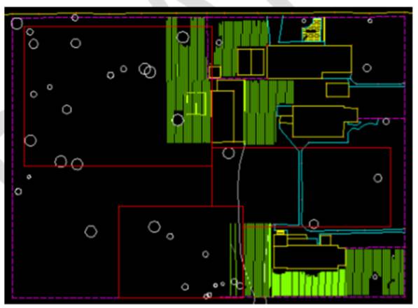
The combined results of the
ground penetrating radar survey results indicate that there is likely to be up
to 10 graves on the Holy Trinity site (17 Hawke Street) and the adjoining
Jerrinja land (26 Currambene Street).
Due to the location of the
potential grave sites relative to the proposed church (to be relocated) and
buildings to be demolished, it is considered that appropriate exclusion areas
and monitoring be implemented to ensure that these areas are not impacted by
the proposed development.
Furthermore, if a subsequent
application is lodged which would require additional soil disturbance in the
location of existing structures, additional ground penetrating radar could and
should be carried out where these structures are currently located to determine
the potential for additional unmarked graves.
Possible negative impacts on the burial site of the
grave of James Golding known as Butt Billy II, Jimmy [James] Golding or
Goulding, Monaghans Jimmy, Jimmy Carpenter, Budd Billy II, Butt Billy II
As part of the field inspection
carried out by Sue Feary in the Due Diligence Assessment, consideration
and assessment was given to the possible location of the remains of Jimmy
Golding on the site on page 27 of the Assessment and is extracted below as
follows:
In regard to the possible grave of Jimmy Golding, this
investigation has found no conclusive or irrefutable evidence that he is buried
in the church grounds or on Lot 9. There is a single newspaper article which
indicates he was buried in a churchyard in Huskisson and another which
indicates he was living in Huskisson while ill, shortly before his death. If
the Anglican Church was the only church in existence in 1905 in Huskisson, and
research by GBA Heritage indicates that it was, it can be deduced he probably
is buried in Anglican Church grounds. However, which, if any of the seven
graves located by GPR belong to him cannot be determined on currently available
evidence.
Sue Feary concedes on page 29 of
the Due Diligence Assessment that there exists the possibility of a
historic grave of an Aboriginal person remains, and ongoing investigation into
relevant archival records and oral history research is recommended to verify
its location.
As previously stated, the
subject site has been the subject of three (3) ground penetrating radar
investigations and subsequent written reports.
The GPR survey results indicate
that there may be up to 10 graves on the Holy Trinity site (17 Hawke Street)
and the adjoining Jerrinja land (26 Currambene Street).
In accordance with the advice of
Sue Feary which was provided to Council prior to the finalisation of the Huskisson
Anglican Church – Unmarked Graves GPR Survey Report prepared by GBG
Australia Pty Ltd, dated 18 April 2018 (Job No. GBGA2255), Sue Feary notes
that:
It is impossible to know which one without further
information. The oral history research would be aimed at trying to find anyone
who knows anything about where he is buried, whether it be on church grounds or
anywhere else. Ideally, the informant would be able to say exactly where he was
buried and also be able demonstrate the veracity of their information source.
At the moment, the written records, that is the newspaper article, indicates he
was buried in a church at Huskisson and the historical research done by Graham
Brooks indicates that the Anglican church was the only church in existence in
Huskisson in 1904, therefore, James Golding is likely to be buried in the
Anglican church - this is the logic I am following.
Prior to any further development
of the site that would result in additional disturbance of the soil or removal
of vegetation, it is recommended that the applicant complete further
investigation into the potential burial of Jimmy Golding on the subject site to
confirm the veracity of the current claim contained in the historical newspaper
record.
In accordance with the
recommendation of the Jerrinja LALC, such consultation may include a 6-month
community consultation period of the broader community.
Due to the limited scope of the current application, it is
considered that further investigation or community consultation is not
warranted at this time. The investigation could be carried out as part of any
further development application or planning proposal for the site.
In order to protect the areas where potential graves may be
located pending further investigation by the applicant it is recommended that
prior to the commencement of demolition and / or relocation work on the site,
the person benefitting from the consent must provide an updated site plan
indicating the potential unmarked graves and appropriate exclusion zones to be
physically marked and fenced on site to ensure that machinery is excluded from
these areas from the period that physical works commence until the first use of
the church building for community activities in the new approved location.
The heritage value of the landscape and plantings and
the importance of this open green space to the local community in a town that
is so rapidly developing
It is noted that during the submission process and in the
undated letter from the OEH received by Council on 1 March 2019 (Attachment 5),
it is requested that Council consider: “the heritage value of the
landscape and plantings and the importance of this open green space to the
local community in a town that is so rapidly developing”
In response the applicant has indicated in their letter dated
10 April 2019, that: “[a]n independent expert on heritage landscape is
currently undertaking an investigation of the Huskisson Church site.
Indications are that any heritage landscaping qualities on the site are
insufficient to reach the level of a LEP heritage listing.”
In a letter dated 8 May 2019, prepared by GBA Heritage to
Council, GBA Heritage has provided a response to the issue raised in the recent
letter to Shoalhaven Council from Mr Frank Howarth, Chair of the Heritage
Council. GBA Heritage’s response is extracted from their letter below:
CONCLUSION
Council dated 5 April 2018 and signed by Dr Cameron
Hartnell, GBA Senior Heritage Consultant. The conclusion, with regard to the
heritage significance of the trees was as follows:
· There
exists no known definitive evidence as to which trees were planted in 1938 but
it is likely that they were pittosporums planted along the Hawke Street
frontage. Only six of the original twelve pittosporum trees survive today.
· This
local tree planting effort is best understood as an event of community
interest, not one of historic significance that would justify heritage listing
of the site.
· It
is understood that the general layout of trees on the site is not an example of
elevated landscape design and has little heritage significance.
RECOMMENDATION
Based on the above evidence, Council has no reason to
regard the 1938 tree planting as being of sufficient historic interest to
warrant listing the site on Schedule 5 of the Shoalhaven LEP.
The Holy Trinity Group has not
been considered by the OEH to warrant listing as a State significant item and
Council has resolved to not list the Group as an item of local heritage
significance. As previously mentioned, Council has considered the potential
listing of the Holy Trinity Church Group through two separate processes in the
preparation of the Draft Shoalhaven Local Environmental Plan in 2007 and more
recently in 2018/2019 in consideration of the current development application.
The potential for the
development to impact on the landscape setting of the site is not considered to
be a significant consideration to the proposed development granted that the
site and landscaping are not:
· listed
as an item of local heritage significance under SLEP 2014;
· identified
as “Biodiversity—habitat corridor” or
“Biodiversity—significant vegetation” on the Terrestrial
Biodiversity Map under clause 7.5 of SLEP 2014;
· vegetation
forming part of a critically endangered ecological community (CEEC) or
endangered ecological community (EEC).
The application does not involve
the removal or disturbance of native vegetation.
Appropriate fencing is recommended to be put in place during
the demolition and relocation process to ensure that no vegetation is damaged
during the development.
Should a subsequent application be lodged for tree removal on
the site, further assessment of the impacts and assessment of the significance
of the vegetation will be required.
Public Submissions in relation to the Application
On 23 October 2018, the DA was notified in accordance with
Council’s Community Consultation Policy for a period of 14 days.
At the time of finalisation of this Report Council a total of
137 submissions were received to the application. A total of 73 submissions in
support and 64 submissions in opposition to the application.
A full assessment of the submissions is provided in the
section 4.15 Assessment report (Attachment 1) to this Report.
Objections
The key issues identified in objection to the development
through the notification process may be generally summarised as follows:
1. Heritage:
a) Potential
negative impact on the heritage significance of the Holy Trinity Group;
b) The
significance of the Holy Trinity Church as a representative example of Cyril
Blackett architecture has not been appropriately considered;
c) The
potential burial site of James Golding known as Butt Billy II, Jimmy [James]
Golding or Goulding, Monaghans Jimmy, Jimmy Carpenter, Budd Billy II, Butt
Billy II has not been appropriately considered and the significance of this to
Aboriginal cultural significance of the site should be reconsidered;
d) Potential
negative impact on unmarked graves on the site;
e) The
potential impact on potential culturally significant aboriginal site;
f) Potential
negative impacts on the landscape setting of the site;
g) The
landscape significance of the site has not been adequately considered as part
of the consideration of the heritage significance of the site.
h) Veracity,
diligence and completeness of the European heritage and Aboriginal cultural
heritage assessment provided;
i) Suitability
and completeness of the ground penetrating radar assessment of the site;
j) The
recommendation that additional investigation and reporting be completed for the
site as a cautionary approach prior to further development on the site;
2. Asbestos:
a) The
buildings are highly impacted by asbestos and present a risk to the community
through their demolition;
3. Built form and Social
Impacts:
a) The
buildings are important to the coastal look and feel of the Huskisson township
and their significance to the landscape setting should extend beyond their listing
as a state or local heritage item;
b) Potential
loss of socially and culturally significant community building.
Comment:
Heritage
The heritage impacts of the development have been addressed
earlier in this report and as part of the section 4.15 Assessment Report
(Attachment 1). The applicant has responded to and provided additional
information and justification to address concerns associated with details and
additional reports to clarify any of the assumptions and conclusions made in
the reports.
The reports, plans and documentation provided by the applicant
in support of the application are sufficient to enable the assessment of the
development application in its present form. The applicant’s future
intentions for the site are beyond the scope of the current application and
cannot be considered as part of this application. The applicant’s
‘future; intentions which are yet to be formalised, do not justify
additional assessment and investigation which would be either unreasonable or
unnecessary to enable assessment of this DA. In short, Council can only
consider the application before it.
It is noted that additional investigation and research,
including, heritage (European and Aboriginal), ground penetrating radar and
archaeological assessment will be expected to accompany any future planning
proposal for the land.
Had Council resolved to reconsider the heritage significance
of the site and review the potential for the site to be listed as a heritage
item, additional reports and investigation would be required to support the
current application. However, OEH and Council have both resolved not to list
the items as State or locally significant heritage items and therefore the
level of assessment and reporting required to assess the application is
acceptable and reasonable in this circumstance.
Asbestos
The concerns raised in relation to the potential impacts of
asbestos products used in the construction of the church and hall were largely
associated with the potential for friable asbestos to impact on the health of
persons during the demolition or continued use of the church building following
its relocation.
The potential impacts of asbestos on human health (while well
documented) are capable of being addressed throughout the demolition and
relocation process through the implementation of appropriate site management
development consent conditions in accordance with the guidelines prepared by
Safework NSW, NSW Environment Protection Authority Guidelines and Protection
of the Environment Operations (Waste) Regulation 2014.
Built Form and Social Impacts
Despite the decision of the OEH and Council to not list the
Holy Trinity Group as an item of State or Local heritage significance, the
community has identified that the buildings and their previous use are
significant to the Huskisson township and the social and cultural history of
the area based upon the shared history of the site to the Aboriginal and local
community.
The requirements for assessing and reporting on the impacts of
development on the heritage significance of a statutorily listed item is well
defined under the current regulatory regime. However, assessment requirements
for an applicant and Council in relation to a place which does not meet the
threshold for State or local statutory listing requires a merit-based
assessment, which includes a consideration of the likely environmental impacts on
both the natural and built environments, and social and economic impacts in the
locality, as required under s4.15(b) of the Act.
A detailed consideration of the likely environmental impacts
on both the natural and built environments, and social and economic impacts in
the locality, as required under s4.15(b) of the Act is provided in the s4.15
Assessment Report (Attachment 1). The likely environmental impacts are
extracted below:
Natural Environment
The application does not include any significant impact on the
natural environment. Vegetation is proposed to be retained and protected
throughout the demolition and relocation process.
Built Environment
The proposed development will have an impact on the built
environment through the relocation of the church and demolition of the church
hall and the shed.
The demolition of the church hall will not have a significant
impact on the built environment. The heritage value of the church hall (forming
part of the Holy Trinity Heritage Group) was considered by Council as part of
the Shoalhaven Heritage Study, prepared by Peter Freeman Pty Ltd for Shoalhaven
City Council. ‘Holy Trinity Heritage Group’, was originally
informally recorded in State Heritage Register, SHI Number 239389. However, as
mentioned in this report, the listing of the Holy Trinity Heritage Group was
later removed from the Heritage Register and subsequent schedule of Heritage
items listed in the Draft LEP following consideration of a submission made by
the Anglican Church.
The shed to the rear of 17 Hawke Street is a recent
unsympathetic addition to the site and does not add any significant value to
the existing structures on the site. The shed is of simple design and typical
of other Colorbond outbuildings built in the last 20 years.
The relocation of the church building is unlikely to have a
significant impact on the built environment with the church proposed to be
relocated to the existing locality of the Colorbond shed which is proposed to
be demolished and removed from the site. The relocation of the church with an
increased setback to Hawke Street will however reduce the prominence of the
structure when viewed from the public domain and adjoining public recreation
areas.
The limited scope of the proposed works is unlikely to have an
overall negative impact on the built environment.
Social Impacts
The development has gathered significant social interest in
the application from members of the public who are supportive of the
redevelopment of the site and the establishment of a new Anglican Church on
another site and conversely from members of the public opposed to the
demolition and relocation of the building, citing the strong or special
association with the community and cultural groups for social and spiritual
reasons.
While the site has not been statutorily listed as an item of
heritage significance the assessment guideline prepared by the OEH, titled Assessing
Heritage Significance provides guidance in considering whether an item has
strong or special association with a particular community or cultural group in
NSW (or the local area) for social, cultural or spiritual reasons. Types of
items which meet this criterion may include:
· items
which are esteemed by the community for their cultural
values;
· items
which if damaged or destroyed would cause the community a sense of loss; and/or;
· items
which contribute to a community’s sense of identity.
The types of items that may be excluded:
· they
are valued only for their amenity (service convenience); and/or
· the
community seeks their retention only in preference to a proposed alternative.
The Assessing Heritage Significance guidelines notes on
page 18 that:
[c]are must be taken not to confuse heritage
significance with amenity or utility. For example, a community may seek the
retention of an older building in preference to its replacement with a more
intensive development of a site.
It is considered that the proposed development will not have a
significant impact on the social value of the church building which is to be
retained on the site and will be preserved for a future adaptive reuse.
Economic Impacts
The proposed development is unlikely to have a significant
economic impact.
Summary
Based upon the above assessment the development is unlikely to
have a significant impact on both the natural andbuilt environments. The
development is not considered to result in unreasonable and unacceptable social
and economic impacts in the locality.
Comments made in support of the proposal – during
notification
The key issues raised in support of the development
through the notification process may be generally summarised as follows:
· The
heritage significance of the Holy Trinity Group is overstated and there are
better examples of this form of church in the local area;
· The
congregation has outgrown the existing church and facilities and is better
served by a new church in a location that would better serve the majority of
the congregation that reside outside of Huskisson;
· The
sale and redevelopment of the church grounds will finance the future church for
the congregation;
· The
church was deconsecrated in 2014 and has fallen into disrepair and therefore it
is not currently being utilised as a place of public worship;
· Relocation
and redevelopment of the site provides an opportunity for the adaptive reuse of
the church to aid in the ongoing maintenance of the building and its retention;
· The
unmarked graves are not proposed to be touched but may be relocated to another
site with due process afforded to the remains under the common law;
· The
current opposition to the development of the site and relocation of the church
has generally come from persons outside of the church congregation who do not
participate in the church.
Comment:
Council’s s4.15 Assessment Report (Attachment 1) has
provided due consideration of the reasons for supporting the development
application. It is noted that some of the matters raised in support of the
development application which relates to the heritage significance of the site
have been addressed by the applicant in the supporting reports and through the
consideration by Council and the OEH as part of the consideration of the State
and local heritage listing of the site.
Regarding the sale and subsequent distribution of such
finances, this is not a planning consideration as prescribed in section 4.15 of
the Act, (a head of consideration to be taken into account as part of the
technical assessment).
Planning Assessment
The application has been assessed under section 4.15 of the
Act, with all necessary heads of consideration reviewed. (Attachment
1.)
Community Engagement
The notification of the application was undertaken in
accordance with Council’s Community Consultation Policy with letters
being sent within a 100m radius of the site and Community Consultative Bodies.
On 23 October 2018, the Development Application was notified in accordance with
Council’s Community Consultation Policy for a period of 14 days.
A total of 137 submissions were received to the application. A
total of 73 submissions in support and 64 submissions in opposition to the
application.
Policy Implications
There are no specific policy implications that arise from this
matter. It is noted that there are no specific planning controls that apply to
this site or to the application that is proposed other than the Asbestos Policy
Financial Implications
There are potential cost implications for Council in the event
of a refusal of the application. Such costs would be
associated with defending any appeal in the L&EC.
Legal Implications
Pursuant to section 8.2 of the Act a decision of the Council
may be subject of a review by the applicant in the event of approval or
refusal. Alternatively, an applicant
for development consent who is dissatisfied with the determination of the
application by the Council may appeal to the Court against the determination
pursuant to section 8.7 of the Act.
Summary and Conclusions
The proposed development has been assessed in accordance with
section 4.15 of the Act.
· The
proposal is consistent with the relevant environmental planning instruments and
the Shoalhaven Development Control 2014;
· The proposed development is unlikely to result in significant
adverse environmental impacts on both the natural and built environments, or
result in unacceptable social and economic impacts in the locality; and
· The
development will not have a significant adverse impact on the landscape
character of the area and streetscape of Hawke, Bowen and Currambene Streets.
Regarding the above, the proposal is not considered
unacceptable, objectionable or warranting refusal. Accordingly, a
positive recommendation is made.
|

|
Development
& Environment Committee – Tuesday 04 June 2019
Page
1
|
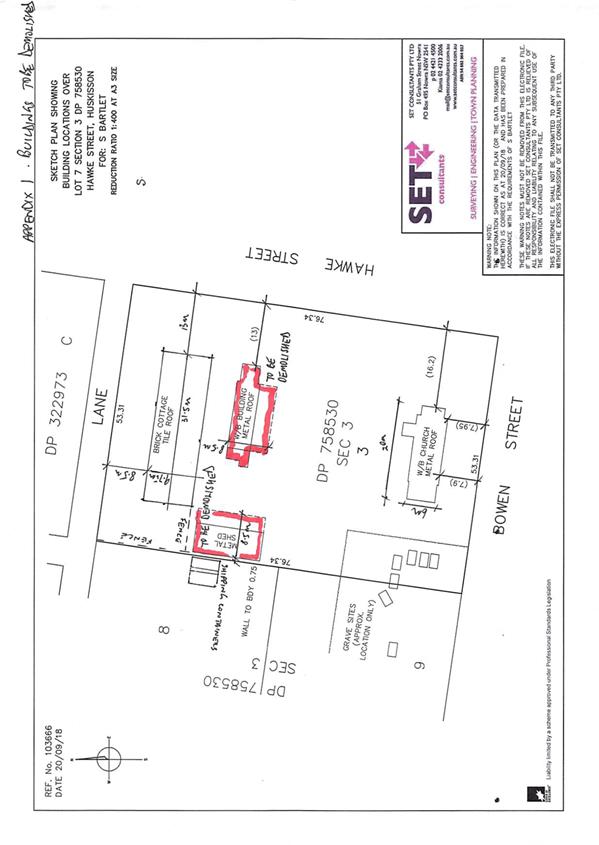
|

|
Development
& Environment Committee – Tuesday 04 June 2019
Page
1
|
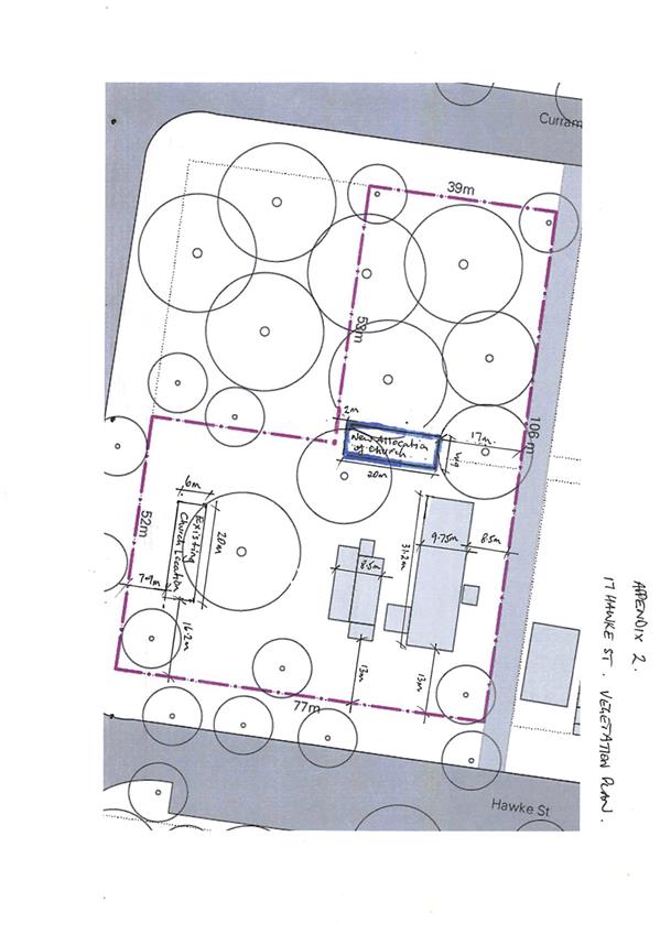
|
|
Development
& Environment Committee – Tuesday 04 June 2019
Page
1
|
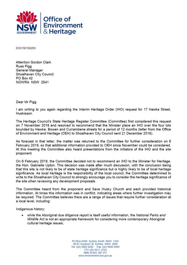
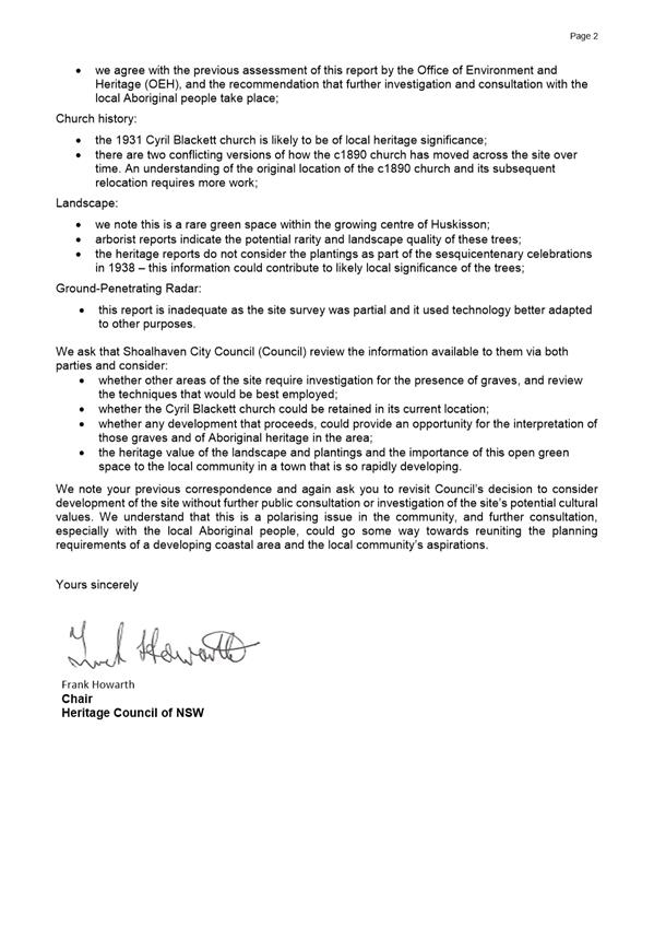
|
|
Development
& Environment Committee – Tuesday 04 June 2019
Page
1
|
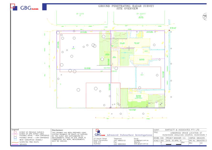
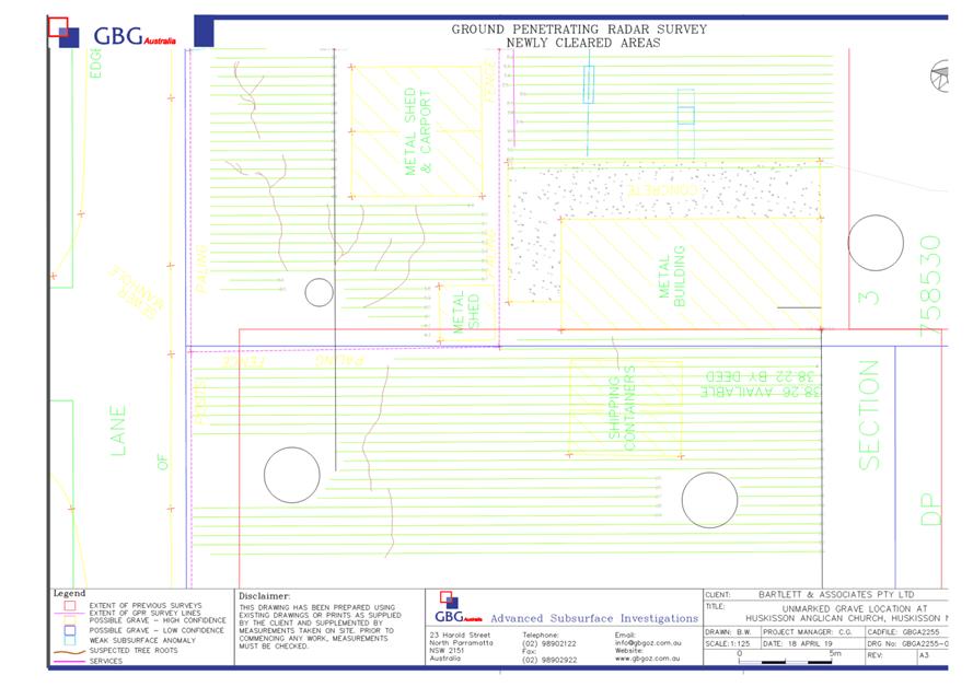
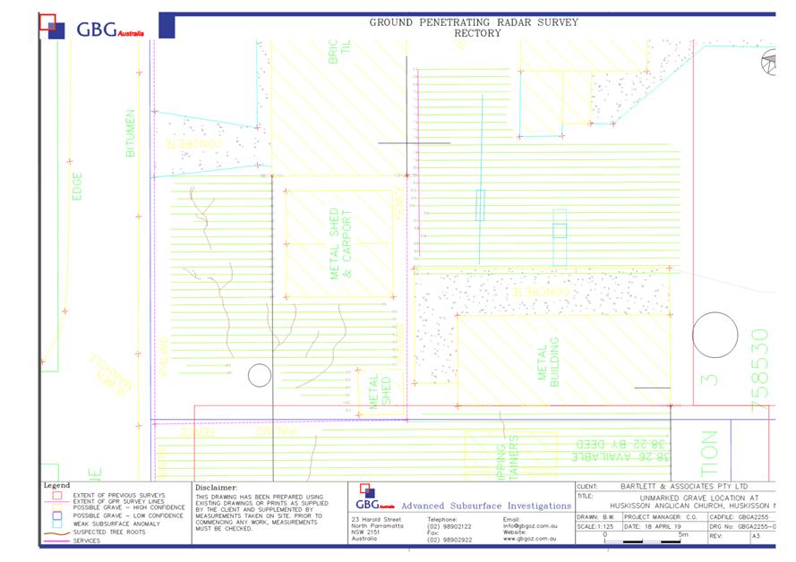
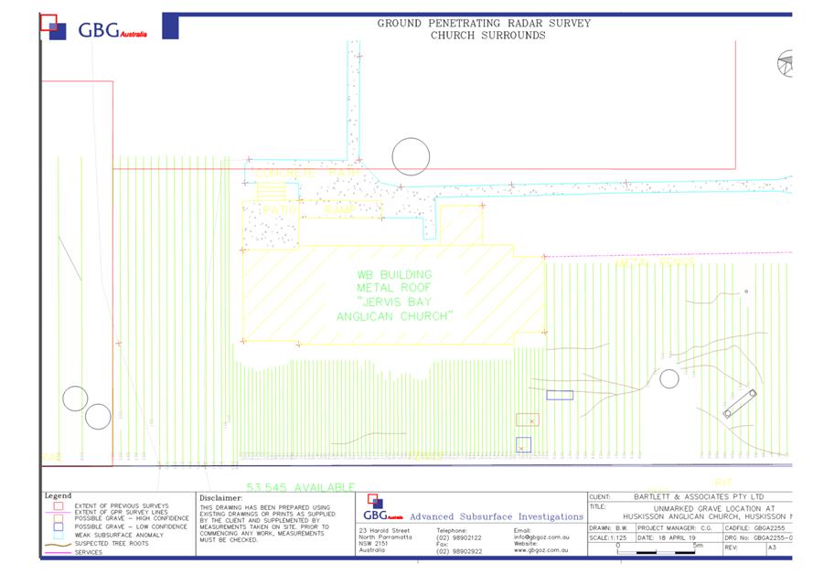
|
|
Development
& Environment Committee – Tuesday 04 June 2019
Page
1
|
DE19.41 Development
Application – 43 Willowford Road WOOLLAMIA – Lot 80 & DP 9289
DA. No: DA18/2020/4
HPERM Ref: D19/6384
Group: Planning
Environment & Development Group
Section: Building
& Compliance Services
Attachments: 1. Section
4.15 assessment (under separate cover) ⇨
2. Amended
plans lodged in February 2019 ⇩
3. Draft
Determination (under separate cover) ⇨
4. Statement
of Environmental Effects (under separate cover) ⇨
5. Bushfire
Assessment Report (under separate cover) ⇨
6. Photographic
record of unapproved works ⇩
7. Applicant's letter re staging
dated 1 February 2019 ⇩
Description:
This application seeks consent to regularise
unauthorised works, selective demolition and renovation of the primary dwelling
and use of the reconstructed Blacksmiths Shed as detached habitable rooms.
(a) Stage
1 is the completion of works on the existing dwelling, and temporary use of the
existing blacksmith’s shed as detached habitable rooms until the works on
the existing dwelling have been completed and it is habitable.
(b) Stage
2 is the relocation of the Blacksmith’s shed to a position
47.33 metres from the front boundary.
Owner:
Robert
Dominic Lacopetta and Sharyn Ann Lacopetta
Applicant: SET
Consultants
Notification:
10/10/2018 and 13/02/2019 (following amended
plans)
Submissions: One
Purpose / Reason for consideration
by Council
On 06 November 2018 this application was called into Council
for determination by Councillor Watson (Refer MIN18.894).
|
Recommendation
(Item to be determined under delegated authority)
That Council:
1. Approve
Development Application DA18/2020 subject to the conditions provided at
Attachment 1; and
2. Officers
give notice of its intention to serve a “Demolish Works Order”
under Section 9.34 of the Environmental Planning and Assessment Act 1979 in
respect of the Blacksmith’s Shed and the pergola. The order that
follows any representations received will be suitably aligned with the
recommended conditions of approval.
|
Options
1. Council support
the recommendation as submitted.
Implications: The proposal can proceed
subject to the staging and recommended conditions.
2. Refuse the
Development Application.
Implications:
Council would need to provide reasons to refuse the application. The applicant
would have the ability to request a review of any refusal by Council and/or
pursue an appeal through the NSW Land and Environment Court (L&EC).
3. Alternative
recommendation.
Implications: Council will need to specify
an alternative recommendation and advise staff accordingly. Should the
applicant be dissatisfied with Council’s decision, they would have the
ability to request a review of the determination and/or pursue an appeal
through the NSW Land and Environment Court (L&EC).
Location
The subject land is identified as Lot 80, DP9289, 43
Willowford Road, Woollamia. The site is highlighted in yellow at Figure 1
below.
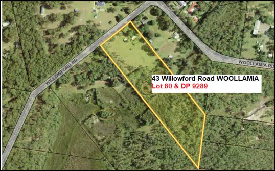
Figure 1 - Location
map with the allotment highlighted in yellow.
Background
The application was submitted to Council on 12 September 2018.
The application was submitted to address Council’s Compliance
investigation on the property where it was identified there were unauthorised
structures on the site including;
· the
main dwelling,
· the
detached habitable rooms and
· timber
pergola.
Council’s compliance action commenced following a
complaint concerning the reconstruction of the Blacksmith’s shed at the
front of the property. This shed is located only 0.13 metres from the front
boundary.
Proposed Development
The initial application sought to regularise all unauthorised
works, provide alterations and additions to the primary dwelling (also
unauthorised) and use the Blacksmith’s shed as a detached habitable room.
Council Officers did not support the existing location of the
Blacksmith’s shed and the pergola due to non-compliance with the
provisions of SDCP 2014 which require a minimum setback from the road frontage
of 30 metres.
The applicant has agreed to demolish the unauthorised pergola
and to relocate the Blacksmith’s shed to 47.33 metres from the front
boundary (see applicant’s letter at Attachment 7). Amended plans
illustrating the changes were submitted on 13 February 2019 (see amended plans
at Attachment 3).
The development is now proposed to be staged as follows:
(a) Stage 1 involves the
completion of works to the existing dwelling and seeks approval for the
temporary use of the existing Blacksmith’s shed as detached habitable
rooms. This will allow its use as worker’s accommodation during the
completion of works to the existing dwelling.
(b) Stage 2 involves the
deconstruction of the Blacksmith’s shed and its relocation to the new
position on site 47.33m from the front boundary.
Site and context
The subject land is identified
as Lot 80, DP9289, No.43 Willowford Road, Woollamia. The site has a total area
of approximately 5.15 ha, with a street frontage of 119.99m to Willowford Road,
a south western (side) boundary of 487.78m, a north eastern (side) boundary of
370.68m, and a rear boundary of 167.64m.
The land is zoned RU2 Rural
Landscape under Shoalhaven LEP 2014. The minimum lot size is 40 Ha; however,
this allotment has a dwelling entitlement. The proposal is permissible with
consent.
The site is located on the southern side of Willowford Road.
The area surrounding the land is characterised by rural residential
development, predominantly single storey dwelling houses, varying in age, style
and character.
The subject site currently contains a dwelling house under
construction, unauthorised detached habitable rooms (the Blacksmith’s
shed) and associated outbuildings.
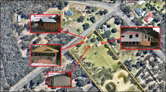
Figure 2 - The site
highlighting the existing structures
(Note: only the colorbond shed has approval).
Photographs showing the extent of the existing development
are contained in Attachment 6.
Planning Assessment
This application has been
assessed in accordance with the requirements of section 4.15 of the
Environmental Planning and Assessment Act 1979 (EPA Act 1979). Please refer to
the detailed Assessment Report at Attachment 2.
Issues
Compliance with front setback under Shoalhaven
Development Control Plan 2014, Chapter G12.
The proposal initially sought
approval to retain the reconstructed Blacksmith’s shed only
0.13 metres from the front boundary with Willowford Road.
The amended, staged proposal
lodged in February 2019 provides for the relocation of the Blacksmith’s
shed to a position of 47.33 metres from the front boundary. This will be
compliant with Chapter 12 of SDCP2014.
The pergola, which is also
located at less than 30 metres from the front boundary, is proposed to be
demolished.
Separate occupation of the Blacksmith’s Shed
The applicant has sought a
period of up to 12 months for the temporary occupation of the
Blacksmith’s shed in its current location. This will enable its use for
accommodation for workers completing the alterations to the main dwelling.
Under the circumstances this temporary use is considered to be
acceptable.
The conditions of consent by themselves are not sufficient to
ensure the removal of the pergola and the relocation of the Blacksmith’s
Shed. For example, if the application is approved and the applicants chose not
to proceed with the development, then there is nothing to trigger the
demolition of either structure. It is therefore recommended that a Demolish
Works Order be served on the owners of the premises to ensure this happens. In
the event that additional time is needed to complete the main dwelling, then
the order can be adjusted accordingly by mutual consent between the owners and
Council’s Compliance Officers.
Adequacy of existing septic system
Both the main dwelling and the Blacksmith’s Shed are
proposed to be connected to the existing septic system. While the system is
registered with Council, it may not be adequate to cater for the number of
bedrooms and potential occupants of both buildings. The septic system was
approved in 1999.
A condition is recommended to require the submission of a
waste water report that addresses the likely effluent production, assesses the
ability of the existing system to adequately treat and dispose of the effluent
and makes recommendations for any necessary upgrades of the system (see
recommended conditions at Attachment 1).
Bushfire protection
The existing buildings on site do not comply with the
requirements of Planning for Bushfire Protection 2006 and Australian Standard
AS3959-2009.
The applicant has submitted a Bushfire Assessment Report
prepared by a BPAD Accredited Practitioner which addresses the bush fire risk
and makes recommendations relating to the provision of an Asset Protection
Zone, construction standards, provision of water and utilities, access and
landscaping. The Bushfire Assessment Report can be viewed at Attachment 5.
Suitable draft conditions are included at Attachment 1.
Policy Implications
Provided that the issues of
separate occupation of the Blacksmith’s Shed and compliance with the
front setback are dealt with as recommended in this report, there are no policy
implications that arise from this application.
Consultation and Community
Engagement
The application was notified in accordance with
Council’s Community Consultation Policy with letters being sent to the
owners of properties within a 100 metre buffer of the site.
The development application was notified between 10 and 25
October 2018 and renotified from 13 to 28 February 2019 following the receipt
of amended plans.
No submissions were received during the first notification
period and only one submission was received during the second notification
period.
The submission is reproduced below:
The development at 43 Willowford Road, Woollamia
refers to a "Stage 2". "Stage 2" is not detailed in the
documents provided by Shoalhaven City Council. And it's not clear if the
Council has or has not approved "Stage 2", or if "Stage 2"
will be exhibited and available for review and comment. Can the Council clarify
Stage 2, what it is and if it will be exhibited?
Comment
The decision to stage the proposal was communicated to Council
by the applicant (SET Consultants) in an email dated 1 February 2019. Attached
to that email was a supporting letter which clearly outlined the proposal to
stage the development (see copy at Attachment 7).
The amended site plan (see Attachment 3) also contains
notes that show which parts of the development are to be included in Stage 2
(i.e. “Temporary detached habitable rooms to be demolished in Stage
2” and “Proposed detached habitable room positioned in Stage
2”). Council officers have emailed the objector and confirmed this
advice.
Summary and Conclusion
This application has resulted from the applicant seeking to
regularise construction works that were undertaken without the necessary
approvals. Council became aware of the construction works through a complaint.
Following the intervention of Council’s Compliance officers and
discussion and negotiation with Development Assessment officers, a proposal has
been received and amended. This proposal is now considered suitable for approval.
Issues such as compliance with the setback requirements of
Chapter G12 of SDCP2014 and with bushfire protection standards have been
considered in the assessment of the application. Appropriate draft conditions
have been included in Attachment 1 to address these issues.
The application is recommended for approval.
|
|
Development
& Environment Committee – Tuesday 04 June 2019
Page
1
|
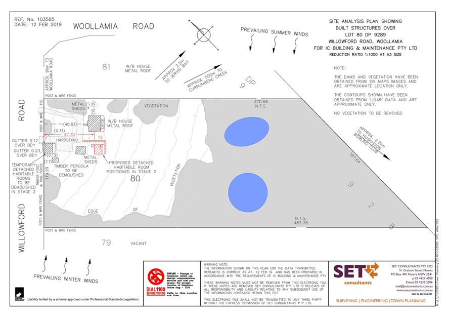
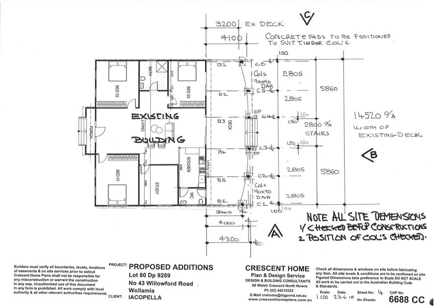
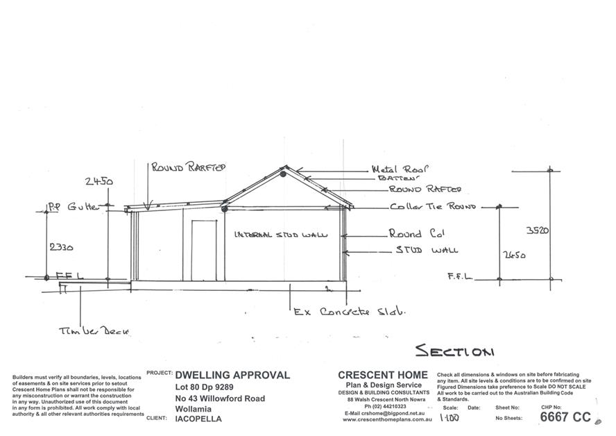
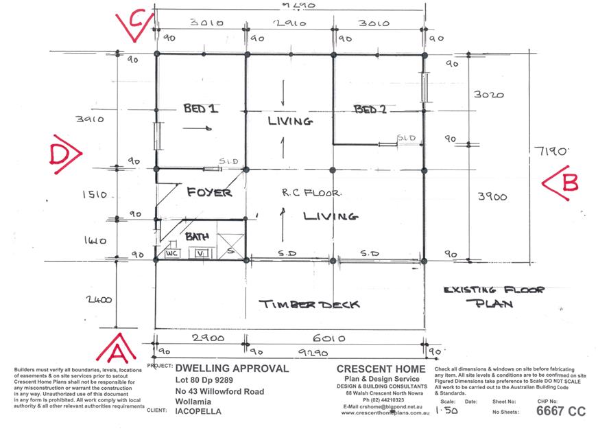
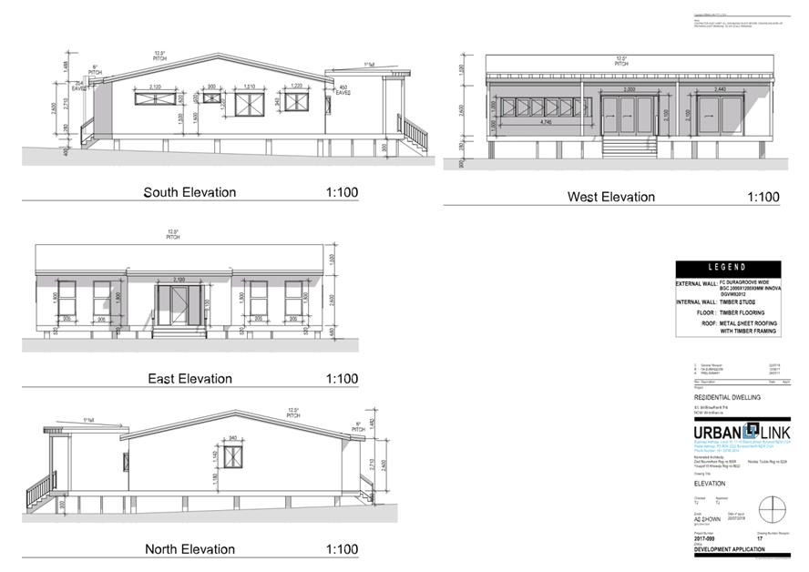
|
|
Development
& Environment Committee – Tuesday 04 June 2019
Page
1
|
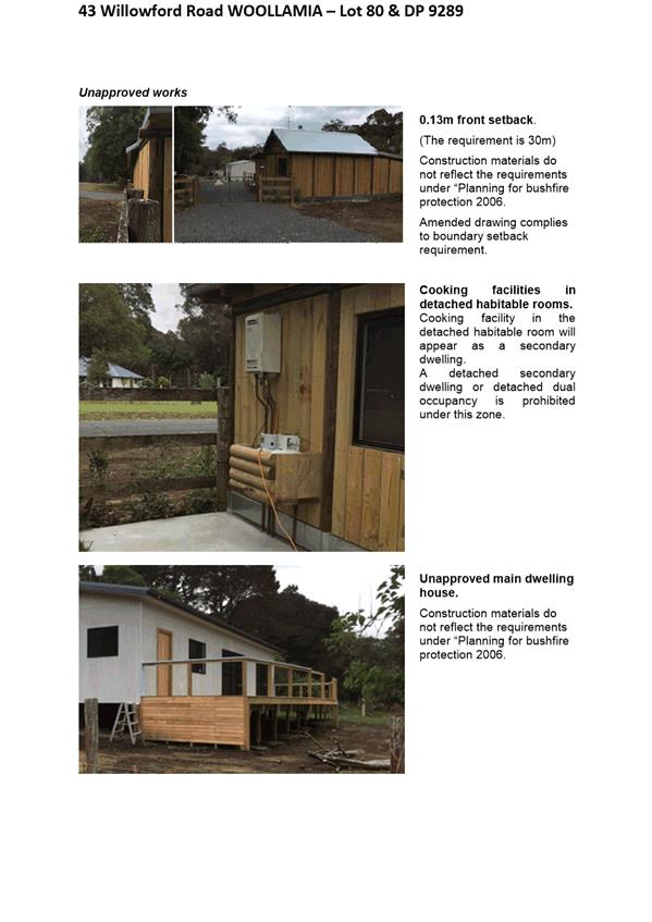
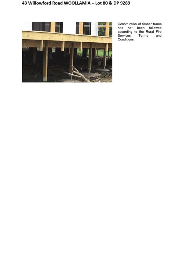
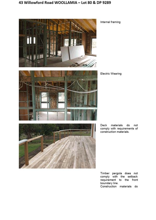
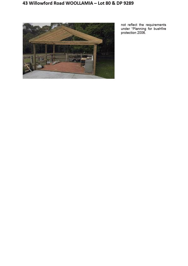
|

|
Development
& Environment Committee – Tuesday 04 June 2019
Page
1
|
|
|
Development
& Environment Committee – Tuesday 04 June 2019
Page
1
|
DE19.42 Collingwood
Beach - Action Plan Progress Report
HPERM Ref: D19/77369
Group: Planning
Environment & Development Group
Section: Environmental
Services
Attachments: 1. Monitoring
Data ⇩
2. Arborist Report (under
separate cover) ⇨
Purpose / Summary
To provide Councillors with a
6-monthly progress update on implementation of the Collingwood Beach Dune
Vegetation Two-Year Trial Action Plan.
|
Recommendation
(Item to be determined under delegated authority)
That Council
1. Receive
the report on the progress of the Collingwood Beach Dune Vegetation Two-Year
Trial Action Plan for information; and
2. Revote
any of the remaining funds in job number 15857
to the 2019/20 budget to allow implementation of the Collingwood Beach Dune
Vegetation Two-Year Trial Action Plan until the end of the two-year trial
period.
|
Options
1. Council receive
the report for information.
Implications: Nil. The Action Plan continues as
scheduled.
2. Choose an
alternative recommendation.
Implications: This would depend on the alternative
recommendation and may delay progress of the implementation of the Action Plan.
Background
On 14 August 2018, Council’s
Development Committee resolved the following (MIN18.607):
That Council endorse the Draft Collingwood Beach
Dune Vegetation two-year trial Action Plan to enable implementation of the
actions contained within the Plan.
Section 6, Communication Strategy,
of the adopted Action Plan (the Plan) requires 6-monthly progress reports to
Council. The final report will be available on December 2020, after the 2-year
trial period has expired.
Council has commenced
implementing the Plan, as adopted by Council. The Plan provides a framework for
the restoration and future management of the Collingwood Beach dune vegetation
system using two trial study sites. The purpose is to achieve a positive outcome
in terms of protecting the health and resilience of the dune system, as per the
NSW Coastal Management Act 2016, whilst also meeting the desires and
expectations of the community and other key stakeholders.
Table 1 (below) outlines the
progress of the Collingwood Beach Action Plan to date. A previous progress
report to Council (D18/348101) documents actions completed prior to November
2018. A copy of the Plan can be viewed on Council’s website at https://shoalhaven.nsw.gov.au/Environment/Collingwood-Beach
Table 1. Progress of Collingwood Beach Action plan to
date
|
Action
|
Progress
|
Timeline for completion
|
|
Pruning works
undertaken at trial site and cut wood felled throughout foreshore reserve.
|
100%
|
Completed
|
|
Pruning site fencing
works
|
100%
|
Completed (Figure 1)
|
|
Install seating at both
trial sites
|
100%
|
Completed (Figure 2 & 3)
|
|
Install viewing
platform at revegetation site with access ramp
|
100%
|
Completed (Figure 4)
|
|
Community and school
planting days. Planting of trial site.
|
|
Completed
|
|
Drone footage of trial
sites
|
100%
|
Completed February 2019
and likely to be on-going
D19/56382 – Pruning overhead
D19/56336 – Pruning panoramic
D19/56250 –
Revegetation overhead
D19/56239 – Revegetation panoramic
|
|
Vegetation Vandalism
Strategy presented to Council
|
100%
|
Completed (MIN19.107) and resolved – the matter is
to be referred to a Councillor Workshop
|
|
CCTV research
undertaken and presented to Councillors
|
100%
|
Completed (MIN19.109) and resolved – Council not
install surveillance cameras along Collingwood Beach
|
|
Collingwood Beach
‘Get Involved’ page (community engagement)
|
100%
|
Completed
|
|
Monitoring of
revegetation site
|
33%
|
Monitoring undertaken in February 2019. Ongoing for 2
years (length of trial).
4 planted shade trees have doubled in size. Less than 10%
plant loss.
|
|
Weed monitoring
|
33%
|
Weed monitoring
undertaken in October 2018 and March 2019
Weed density has
reduced significantly
|
|
Photo monitoring of
both trial sites
|
33%
|
Monitoring undertaken in February 2019. Ongoing for 2
years (length of trial)
|
|
Poster/signage program
for community appreciation of native vegetation to be implemented citywide
|
90%
|
Posters have been drafted and presented to Council in the Vegetation
Vandalism Strategy
|
|
Project management
|
Ongoing
|
|
|
Internal costs and
charges (wages, stores, fleet inventory, miscellaneous)
|
Ongoing
|
|
Figure
1: Fencing at revegetation trial site
Figure 2: Seat at pruning site
Figure
3: Seat at revegetation site
Figure
4: Viewing Platform
Monitoring Data
Council’s Staff have
undertaken the following monitoring actions:
1. Pictorial records
of Trial site 1 and 2. Aerial imaging of Trial site 1 and 2.
2. Plant species
monitoring
3. Survival of
planted specimens
4. Record of
vandalism
5. Condition of pruned
vegetation
6. Weed diversity
Refer to Attachment 1.
Additionally, Bushcare volunteers committed a total of 144
hours between August 2018 and March 2019. There were 6 working bees with 8
participants.
Community Engagement
Council’s Staff have
undertaken the following community engagement actions:
1. Door-knocked property
owners living adjacent to the two trial sites;
2. Sent letters to all
affected property owners near the trial sites;
3. Multiple media
releases;
4. Met with the Reference
Group to discuss the Action Plan and the implementation of the two trial sites;
and
5. Held two public
planting days – one with the students of Vincentia Public School and one
with the general public.
6. Completed
a ‘Get Involved’ project page on Council’s website to
inform the public and interest groups of updates to the project. This platform
allows individuals to subscribe for project updates, ask questions and report
vandalism at Collingwood Beach.
Table 2: Communication Strategy
|
Action
|
Strategy
|
|
Develop a strong engagement
and communication strategy with identified stakeholders including a program
of public consultation and education throughout trial period
|
Incorporate
multi-media, information displays and signage and/or presentations.
|
|
Implementation
|
Status
|
|
Meet with adjacent property owners
|
Letter contact and
invite to owners of properties adjacent to trial sites to meet with
Councillors and staff.
|
Door knocked property owners
living adjacent to the two trial sites.
Sent letters to all affected
property owners near the trial sites.
|
|
Website and Facebook updates to Vincentia and
Huskisson communities
|
Liaised with SCC
website developers.
|
February 2019 and ongoing
Completed a ‘Get Involved’ project
page on Council’s website to inform the public and interest groups of
updates to the project. This platform allows individuals to subscribe for
project updates, ask questions and report vandalism at Collingwood Beach.
|
|
Information posters in local villages
|
Display
information posters at local shopping centres and notice boards.
|
Not yet completed – subject to development as part of the
Draft Vegetation Vandalism Strategy/Policy
|
|
Erect explanatory signs at trial sites
|
Encourage the local
community to take ownership of the plan.
|
Installed – refer to Figure 4
|
|
Planting day
|
Inclusion of local schools,
liaised with property owners and contact high profile promotional person/s
for event (‘Wombat’ from ‘The Block’) with assistance
from SCC media team.
|
Held two public planting days
– one with the students of Vincentia Public School and one with the
general public.
|
|
Progress Report to Council
|
6 month reporting
period. Final report to be available in Dec 2020 after the 2-year trial
period has expired.
|
November 2018, May 2019 and ongoing
|
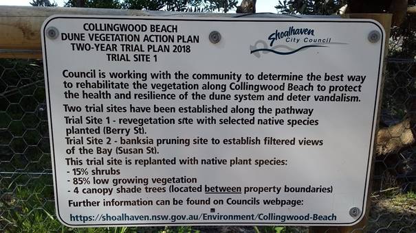
Figure
4: Explanatory sign at trial site
Table 3:
Evaluation
|
Success
|
Measure
|
Status
|
|
Pruned Banksias in good health
|
Assessment by arborist at 6
monthly intervals and prior to pruning.
|
Refer
to Arborist report – refer to Attachment 2
|
|
Surviving plant specimens
|
Percentage of survival of
planted specimens.
|
>90%
|
|
Positive social response
|
Number and opinion of
unsolicited posts, letters, etc.
|
Yet to be completed
|
|
Plant diversity
|
Number of weed vs native
species.
|
Weed species have dramatically
decreased
|
|
Filtered views
|
Cost effectiveness of view
window maintenance - time and money spent.
|
Total
cost $4,339 to date
|
|
Decreased vandalism on trial
sites:
- A
control site in Vincentia will be chosen for comparison
|
Percentage of known vandalism
decreasing over time across trial sites.
|
Evidence of vandalism within
pruning trial site
|
|
Acceptance
by the community of the outcome of the trial
|
Community survey to be
undertaken (web-based).
|
To be conducted August 2019
|
Policy Implications
If the Shoalhaven Tree Vandalism
Strategy or Policy is adopted, as recommended by the Council resolution
(MIN17.974), the Shoalhaven Foreshore Reserve Policy will need to be updated
and show the links between Council’s policies that relate the management
of trees and vegetation as well as Council’s Compliance Policy.
Financial Implications
Council
allocated a budget of $99,296 (Job number: 15857) for 2018/19 to fund
implementation of the Collingwood Beach Dune Vegetation 2-year Trial Action
Plan. Most actions within the Plan have been implemented, with ongoing
monitoring (including arborist assessment of trial pruning site), weed
management and replacement failed plantings where required to be carried out
throughout the two-year trial. A
budget of $39,859 currently remains which will fund these ongoing monitoring
actions, a new signage program and education. It is recommended that any
remaining funds from Job number 15857 be revoted and carried forward to the
2019/20 financial year.
Risk Implications
There are
risks in not taking action to implement a citywide Vegetation Vandalism
Strategy in the Shoalhaven. The vegetation vandalism occurring at Collingwood
Beach is extensive and ongoing. A lack of action will likely result in further
destruction to the health and resilience of the existing dune system that
provides coastal hazard protection to public and private assets.
A lack of
action from Council may also be seen by the community as ‘doing
nothing’ in terms of implementing Council’s previous resolutions to
adopt a robust policy/strategy and addressing the many community submissions
Council has received in recent years requesting that vegetation vandalism
occurring at Collingwood Beach and other hotspots across the Shoalhaven be
addressed.
|
|
Development
& Environment Committee – Tuesday 04 June 2019
Page
1
|
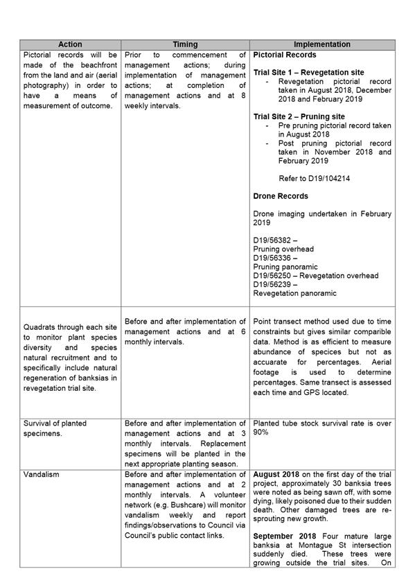
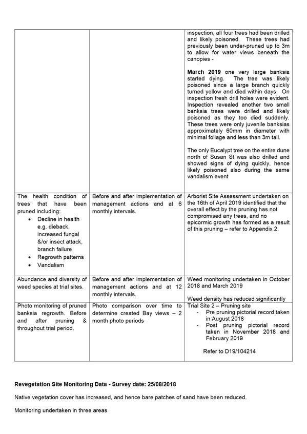

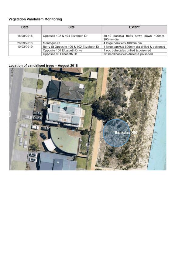
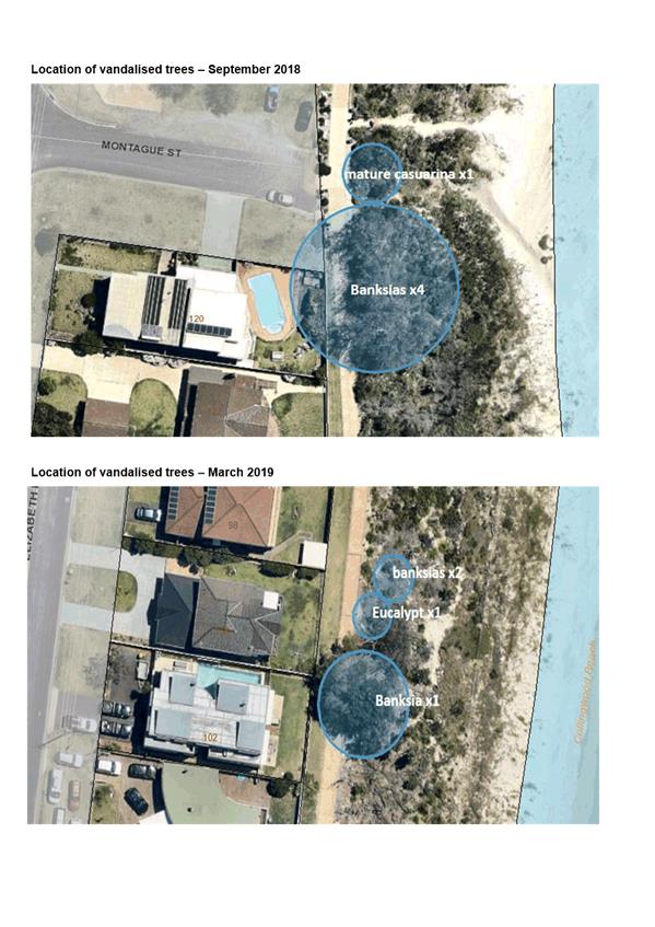
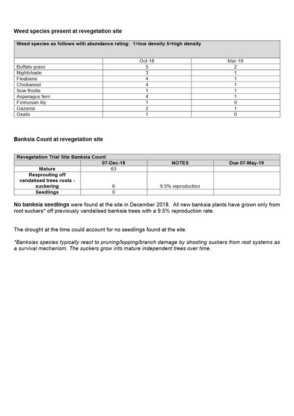
|

|
Development
& Environment Committee – Tuesday 04 June 2019
Page
1
|
DE19.43 Two
(2) Bushcare Group Action Plans - Review
HPERM Ref: D19/124016
Group: Planning
Environment & Development Group
Section: Environmental
Services
Attachments: 1. The
Grotto Bushcare Group Action Plan Review (under separate cover) ⇨
2. Camp Quality Bushcare Group
Action Plan Review (under separate cover) ⇨
Purpose / Summary
The purpose of the report is to
present two (2) reviewed Bushcare Group Action Plans for adoption – for
The Grotto (North Nowra) and Camp Quality (Berry) Bushcare Group Action Plans
|
Recommendation
(Item to be determined under delegated authority)
That Council adopt the following
two (2) reviewed Bushcare Group Action Plans:
1. The
Grotto; and
2. Camp
Quality.
|
Options
1. As recommended.
Implications: The two (2) Bushcare Group Action
Plans have been reviewed by Council’s Environmental Services Section and
State Government agencies. All plans have been sent to relevant Council
Consultative Bodies (CCBs) and all residents and ratepayers within 200 metres
of the reserve affected. This is as per the requirements of the
Bushcare/Parkcare Policy and Procedures and in line with Council’s
Community Engagement Strategy.
2. Adopt one of the
reviewed Bushcare Group Action Plan and seek further changes to the other.
Implications: The positive and negative
implications of choosing this option would depend on what the proposed changes
are.
3. Not adopt any of
reviewed Bushcare Group Action Plans.
Implications: This decision would significantly
affect volunteer morale and may result in a loss of volunteer participation in
Council’s Bushcare program.
Background
Part C of MIN08.117 Ordinary
Council meeting dated 29 January 2008 states that:
“Council affirms its direction that planting and
other associated pursuits should only be done by abovementioned groups in
accordance with Bushcare and Parkcare action plans as approved by
Council”.
This part of the Council
resolution requires that all Bushcare and Parkcare Groups that operate on
Council owned or managed land, prepare action plans that are to be reported to
Council for adoption.
Part D of MIN08.1552 Ordinary
Council meeting dated 25 November 2008 states that:
“An all-embracing Consultation Policy be developed
that will include nearby residents, the wider community, Tourism Shoalhaven,
CCBs, Chambers of Commerce, community groups, church groups and local
schools.”
The level of consultation
required is dependent on the actions outlined within the plan and is specified
in chapter 6, Community Consultation, of the Bushcare/Parkcare Group Policy
2018 and Bushcare/Parkcare Group Procedures 2012 (The Policy was updated in
2018; the procedures separated and are currently being revised). The Policy
requires Group Action Plans to be reviewed every six (6) years.
Under the Council’s
Community Engagement Policy engagement matrix, all Bushcare Action Plans are
classed as a local low impact project. Therefore, combined with the
requirements of the Bushcare Policy and Procedure, both reviewed Bushcare
Action Plans used direct communication via a mail-out to all
residents/ratepayers and the CCB’s and were made available through the
Shoalhaven City Council website.
The Bushcare Group Action Plans
were mailed to 693 adjoining residents/ratepayers near the affected public
reserves, the Nowra Local Aboriginal Land Council and, for the Camp Quality
plan, the Berry Forum.
There were no submissions
received as a result of the consultation process.
Community Engagement
CCBs, residents, ratepayers and
Local Aboriginal Land Councils were informed of the opportunity to comment on
the two (2) Bushcare Action Plans via mail. A total of 693 letters were mailed
to residents and ratepayers within 200 metres of the reserves affected by the
reviewed Bushcare Action Plans.
Residents/Ratepayers were able
to view the draft Bushcare Action Plans via a “Documents on
Exhibition” web link on Council’s website and were given 28 days to
make a submission. People without internet access were able to contact Council
and request a hard copy of the plan and make a submission via the mail. This
community engagement is in line with Council Community Engagement Policy for
low impact local projects.
Financial Implications
Over the six years of the two
(2) Bushcare Actions Plans, the cost of implementation will be a total of
$24,100. These costs include an allocation of existing staff resources which
support the Bushcare Program, which will be funded from the existing annual
operation budget (job number 15915). A materials and equipment contribution of
$400 per annum per group is also included in these costs.
The in-kind volunteer
contribution over the six years of the two Bushcare plans is estimated at
$128,000. This is a significant contribution from our volunteers in meeting the
objectives of Council’s Community Strategic Plan.
|

|
Development
& Environment Committee – Tuesday 04 June 2019
Page
1
|
DE19.44 Strategic
Planning Works Program - Proposed 2019-2020 Version
HPERM Ref: D19/94513
Group: Planning
Environment & Development Group
Section: Strategic
Planning
Attachments: 1. Adopted
2018-2019 Strategic Planning Works Program - June 2018 ⇩
2. Proposed 2019-2020 Strategic
Planning Works Program - June 2019 ⇩
Purpose / Summary
Report the proposed 2019-2020
Strategic Planning Works Program (SPWP) to Council for consideration and
adoption.
|
Recommendation
(Item to be determined under delegated authority)
That Council:
1. Adopt
and finalise Attachment 2 as Council’s 2019-2020 Strategic Planning
Works Program.
2. Receive
a report on the 2020-2021 Strategic Planning Works Program in June 2020 to
coincide with the new financial year.
3. Make
future changes or additions to the Strategic Planning Works Program only
after considering the current program, project priority, staff workload and
resources.
|
Options
1. As resolved.
Implications: This option is favoured as it builds
on the 2018-2019 SPWP to guide Council’s strategic planning effort and
ensure that we are proactively undertaking forward planning. The SPWP will
assist in the prioritisation of projects and management of staff workload.
2. Adopt an
alternative recommendation.
Implications: The 2019-2020 SPWP has been prepared
taking into consideration current and expected strategic planning tasks and
known planning challenges/expectations. Modifications to the SPWP at this stage
may, depending on the nature of the modification, delay its adoption.
3. Not adopt the
2019-2020 SPWP and react to requests, opportunities etc. as they arise in the
future.
Implications: This option would mean that Council
reacts to requests, opportunities, requirements etc. for strategic planning
work in an ad-hoc or unmanaged manner. This is not desirable as it does not
necessarily focus Council’s efforts in areas or on projects that support
the broader community or are required by legislation or other drivers.
Background
Strategic Planning Works Program - History
The SPWP originally emerged from
an internal tool that was used to track and manage strategic and land use
planning projects being undertaken by Council. It was formally reported to
Council from 2003 onward for information and to enable priorities to be
considered. The SPWP was initially reported to Council quarterly and then moved
to twice yearly.
The 2008 NSW Department of Local
Government Promoting Better Practice Review recommended that:
Council should review the projects on the Strategic
Planning Group Work program in order to give priority to finalising the Growth
Management Strategy and new Comprehensive LEP.
As part of considering the
completion of the Shoalhaven Local Environmental Plan (LEP) 2014, Council also
resolved to:
Prepare a new Planning Works Program to focus
Council’s Strategic Planning effort and arrange a Councillor briefing to
discuss the desired detail of this program before it being reported back to
Council for consideration.
In July 2017, Council resolved
(MIN17.612) under delegation to adopt and finalise the new iteration of the
SPWP (2017-2018).
The SPWP for 2018-2019 was adopted in June 2018 (MIN18.419)
and is located at Attachment 1 for convenience. As part of the 2018-2019
SPWP adoption, Council resolved to report the SPWP back to the Development
Committee (now Development and Environment Committee) annually in June to
coincide with each new financial year. As such, this report is provided
consistent with this resolution.
The 2019-2020 Strategic Planning Works Program
In preparing
the 2019-2020 SPWP (Attachment 2), the following matters were considered:
· Current
Strategic Planning tasks.
· Expected
Strategic Planning tasks.
· Community
involvement and expectations around land use planning including the Community
Strategic Plan/Integrated Strategic Plan 2027 exhibition outcomes.
· Ongoing,
known and future planning challenges.
· Matters
arising from the reforms to the NSW planning system.
The 2019-2020 SPWP retains the existing program structure,
notably the priority areas and overarching strategies outlined in Table 1
(these were established through the original 2017 Councillor workshop process).
Table 1: Retained SPWP priority areas and overarching
strategies
|
Priority
|
Priority Area
|
Overarching Strategy
|
|
1
|
Managing Future Growth
|
· Developing and maintaining a Growth Management
Strategy (GMS) to provide continued residential development and
infrastructure ‘ahead of the game’.
|
|
2
|
Economic Development, Retailing, Town Centres and Tourism
|
· Balance commercial development with cultural and
recreation opportunities.
|
|
3a
|
Natural Environment/Agriculture
|
· Maintain an ‘unspoilt’ environment, plan
for infrastructure to manage high use areas, maintain sustainable agriculture
sector focusing on diversity and quality of output.
|
|
3b
|
Affordable Housing
|
· Work to increase affordable housing opportunities in
Shoalhaven.
|
|
4
|
Population, Ageing and Social Infrastructure
|
· Facilitate a healthy, active and accessible
community.
· Identify and respond to demonstrated need and create
best practice liveable communities for all ages and stages.
|
|
5
|
Heritage and Events
|
· Maintain, investigate and bring forward our
Aboriginal and European heritage into the future.
|
|
6
|
Legislation and Policy
|
· Maintain Shoalhaven LEP, DCP and Contributions Plan.
· Monitor and respond to legislative and policy
changes/proposals – consistent with Council’s strategic
direction.
|
For each priority area, current
and future (yet to commence or on hold) projects are again identified. The
proposed 2019-2020 SPWP contains a total of 92 projects - 59 current projects
and 33 projects that are yet to commence or are on hold.
The priority projects in Table 2 (also shown in red at Attachment
2) will be advanced ahead of other projects on the SPWP. A brief update on
the priority projects is provided for convenience.
Table 2: 2019-2020 SPWP priority projects
|
Priority Project
|
Brief Update
|
|
Moss Vale Road North URA (PP, DCP and CP)
|
Various
technical studies are currently being completed by the proponents (and
submitted) and Council to enable the preparation of a master plan and
development controls for the URA. Council will be briefed on this project
shortly.
|
|
Review of Strategies and Structure Plans:
· GMS (including review of Milton-Ulladulla Structure
Plan and the Jervis Bay Settlement Strategy.
· Nowra-Bomaderry Structure Plan.
|
GMS
- Report being prepared for Council on outcomes of initial exhibition of the
GMS Discussion Paper.
Nowra-Bomaderry
Structure Plan – not actively being worked on as project outcomes will
depend on Council direction on overall GMS.
|
|
Planning Proposal PP028 - Callala Bay and Kinghorne Point (Halloran).
|
Stormwater,
infrastructure, geotechnical and traffic investigations all underway.
Awaiting Biodiversity Certification (combined with PP006).
|
|
Planning Proposal PP006 - Culburra Beach (Halloran).
|
Awaiting
Groundwater Study (due early 2020). Aboriginal Cultural Heritage Assessment
and stormwater investigations have commenced. Awaiting Biodiversity
Certification (combined with PP028).
|
|
DCP Chapter G12 Low Density Residential Review.
|
Recent resolution
(MIN19.291) to exhibit draft DCP amendment.
|
|
DCP Chapter G11 Subdivision Review.
|
Project
on hold – staff currently focussing on other priority projects.
|
|
Shoalhaven Riverfront Precinct
· Planning Proposal PP041 – Mandalay Avenue Sub
Precinct.
· Planning Proposal PP042 – Hyam Street,
Pleasant Way and Wharf Road Sub Precinct.
|
Masterplan adopted by
Council in late 2018 – PPs on hold awaiting additional detail from
proponent and the Nowra Bridge project alignment.
|
|
Tourist and Visitor Accommodation Planning Review
|
Recent resolution
(MIN19.113) to instigate an amendment Chapter G15 of Shoalhaven DCP 2014,
with possible PP to amend Shoalhaven LEP 2014.
|
|
Coastal hazard review (PP and DCP Chapter review).
|
Recently exhibited and
will be reported to Council for finalisation.
|
|
Implementation of the Illawarra-Shoalhaven Regional Plan and
Shoalhaven Affordable Housing Strategy.
|
Ongoing actions as
required.
|
|
Nowra CBD Fringe Medium Density Study.
|
Gateway determination
has been received and additional heritage work undertaken – will be
reported to Council for direction.
|
|
Local Strategic Planning Statements
|
Initial scoping work
has commenced in association with the GMS project.
|
|
Respond to legislative change.
|
Ongoing and generally
reactionary. However, it is noted that this has taken up significant staff
time in the 2018-2019 financial year due to the range of detailed and
widespread reforms being advanced by the NSW Government.
|
The Nowra-Bomaderry Retail Hierarchy Review (exhibited for
public comment late 2018/early 2019) and Cambewarra Escarpment Character
Assessment (Council resolution in December 2018 to commence investigations and
report back) were identified as priority projects in the 2018-2019 SPWP;
however, this status is now not considered necessary due to the nature of the
projects. As such, the status has been downgraded as shown in Attachment
2. Further direction from Council is however welcomed in regard to these
projects.
Table 3 identifies the projects that have been removed from
(completions etc.) or added (Council resolutions etc.) to the SPWP, as well as
projects that have been consolidated. Changes have also been made to the
descriptions of some of the projects to enhance readability and recognition.
Table 3: Projects added and removed from the SPWP
|
1. Managing Future
Growth
|
|
Added
|
· DCP - Chapter G13 Medium Density Residential
Housekeeping.
· Infrastructure Delivery/Implementation: Moss Vale
Road South URA.
· Review Southern Component of Crams Road URA. (Note:
Not considered to be a priority given that Crams Road URA identified as last
phase of release).
|
|
Removed
|
· Priority Project: Moss Vale Road South URA (PP, DCP and CP). Completed.
· Priority Project: DCP - Medium Density Review (Chapters G13/G14). Completed.
· 1310 Naval College Road (and precinct plan). PP
not supported by Council.
· South Nowra Caravan Park Planning Proposal.
Completed.
|
|
Consolidated
|
· Priority Project: The following have been consolidated into the GMS Version 2 project:
- Outstanding
investigation areas.
- Relationship
with commercial and industrial land.
- Higher
density in existing settlements.
- Additional
development opportunities (e.g. Berry Expansion).
- LEP
2014 – additional matter for future investigation - Burton Street,
Vincentia shopping centre.
- Actions
resulting from community led Strategic Plans (i.e. Shoalhaven Heads, Berry,
Sanctuary Point).
|
|
2. Economic
Development, Retailing, Town Centres and Tourism
|
|
Added
|
· Yalwal/Danjera Dam PP – recently received.
· St. Georges Basin Service Lane removal (DCP &
CP) – Council resolution.
|
|
Removed
|
· Draft Chapter G18: Streetscape Design for Town
Centres. Completed.
· Worrowing Heights Precinct Plan and Future
Directions. Completed.
|
|
3a. Natural
Environment/ Agriculture
|
|
Added
|
· Nil.
|
|
Removed
|
· PP and DCP - Review of flood controls. Completed.
· Resolving Jerberra and Verons Estate Biodiversity
Act issues. Completed.
|
|
Consolidated
|
· Priority Project: The ‘Biodiversity Certification Application (Biobanking) for
the Halloran Planning Proposal’ project has been consolidated into the
two associated planning proposal projects:
- PP006
- Culburra Beach (Halloran).
- PP028
- Callala Bay and Kinghorne Point (Halloran).
|
|
3b. Affordable
Housing
|
|
Added
|
· Nil.
Note:
Actions arising from the Housing Strategy continuing to be worked on.
|
|
Removed
|
· Homeless Shelter PP - Kinghorne Street, Nowra. Completed.
|
|
4. Population, Ageing and Social Infrastructure
|
|
Added
|
· Shoalhaven DCP 2014 – Consider accessibility
requirements throughout the DCP, or a separate chapter (MIN18.1009).
|
|
Removed
|
· Well Being Strategy (in conjunction with other
Sections of Council). Now known as the ‘Community Health and
Wellbeing Plan’ - has received grant funding and is now being managed
by another section of Council.
|
|
5. Heritage and
Events
|
|
Added
|
· Berry Heritage Investigations.
|
|
Removed
|
· Chinaman’s Island Heritage Significance. Completed
– heritage listings to be addressed in Heritage Housekeeping Planning
Proposal (PP036).
|
|
6. Legislation and
Policy
|
|
Added
|
· Priority Project: Local Strategic Planning Statement (needs to be in place by
mid-2020).
· LEP Clause 2.8 Review.
· Community Participation Plan (will be delivered as
part of a broader review of Councils Community Engagement Strategy).
· Shoalhaven Contribution Plan 2019 – Amendment
1.
|
|
Removed
|
· Priority Project: Contribution Plan Review. Completed.
· Semi-detached Dwelling Housekeeping. Completed.
· Council and Crown Land Reclassification (Land
Review). Discontinued.
· Manage proponent submitted planning proposals. PPs
outlined throughout SPWP.
· ePlanning – responding to DP&E
requirements and improving Council’s ability to process online request
and electronic payment. Component completed and now managed in the
S10.7 Certificate process.
|
Using and interrogating the
new SPWP
Councillors and key Council staff have direct access to the Interactive SPWP
on Council’s Intranet. The SPWP is generally updated on a fortnightly
basis and includes the following detail (where relevant):
· Project
name.
· Project
type and reference (LEP, DCP etc.).
· Minute
reference for the project.
· Envisage
project timeframe.
· Where
the project is up to and next steps.
· Project
officer and contact details that Councillors can pass onto stakeholders
(provisions of Councillor and Staff Interaction Policy applicable).
Councillors are able to search
for specific projects and interrogate the data
accordingly.
Councillors were briefed in August 2018 on how to use the
interactive SPWP.
Process for adding/removing
projects from the 2019-2020 SPWP
The 2019-2020 SPWP will assist
with Council’s decision making regarding new planning related projects.
Ideally, the 2019-2020 SPWP will be proactive and not reactionary. It is
inevitable, however, that changes will be required through time and this needs
to be done in a considered manner.
Prior to changing the 2019-2020
SPWP (e.g. adding a project), consideration should be given to the likely
impact on the current program, priorities, staff workload and resources.
Projects should only be included on the 2019-2020 SPWP (or reprioritised) after
consideration by Council and following a formal resolution. Ideally,
consideration should be given to how they sit against the overarching
strategies identified in the SPWP. The exception would be matters that must be
resolved operationally (legislative directions, reactive policy submissions
etc.).
It is expected that projects
will be removed from the SPWP upon completion or via a resolution of Council.
Monitoring and reporting
The SPWP will be reported back
to the Development and Environment Committee annually in June, in line with
each new financial year, to enable formal reconsideration and to highlight
progress, including what has been achieved or completed in the year. The SPWP
will also be monitored for efficiency on an ongoing basis and any required or
proposed changes to the structure or projects will be reported as needed.
Community
Engagement
The SPWP is essentially an
internal tool to manage Council’s strategic planning effort. No formal
community consultation is required as it is an internal management resource.
Based on existing knowledge,
plans and community engagement processes (especially the Community Strategic
Plan/Integrated Strategic Plan 2027 process) the broader expectations of the
community have been considered during preparation of the SPWP.
Policy Implications
It is considered important to
have a clear work program to focus Council’s current and future strategic
planning effort. This will ensure that Council has an appropriate strategic framework
in place that is forward thinking and responsive in nature.
Financial Implications
Generally, projects that are on
the SPWP will be undertaken within existing budgets. However, should a project
require specific funding allocation, this will be reported to Council for
consideration as the need arises.
|
|
Development
& Environment Committee – Tuesday 04 June 2019
Page
1
|
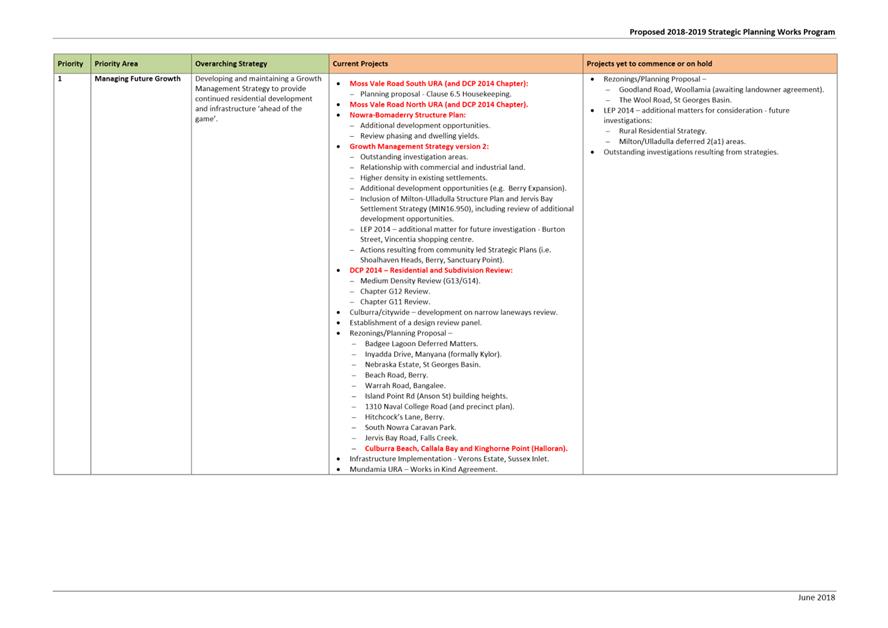
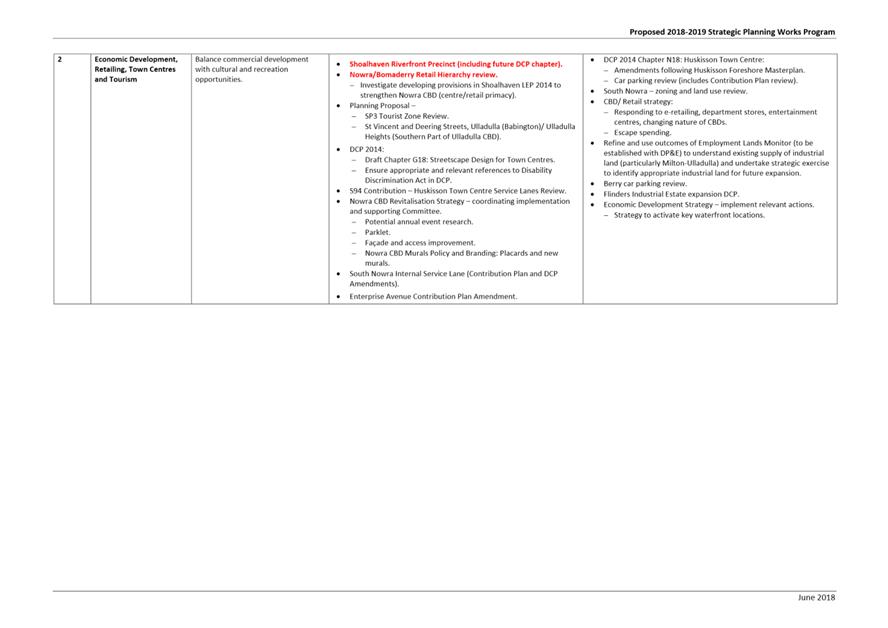
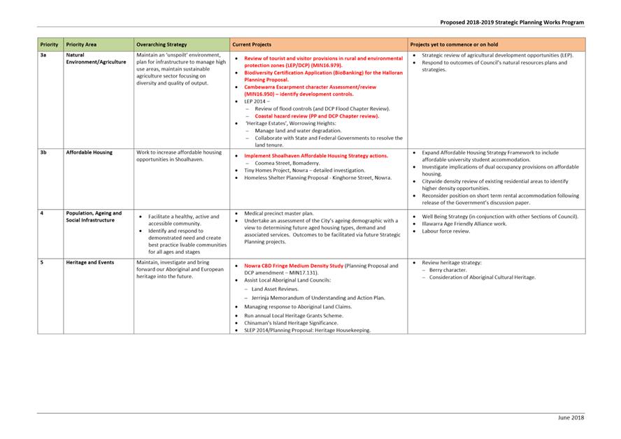
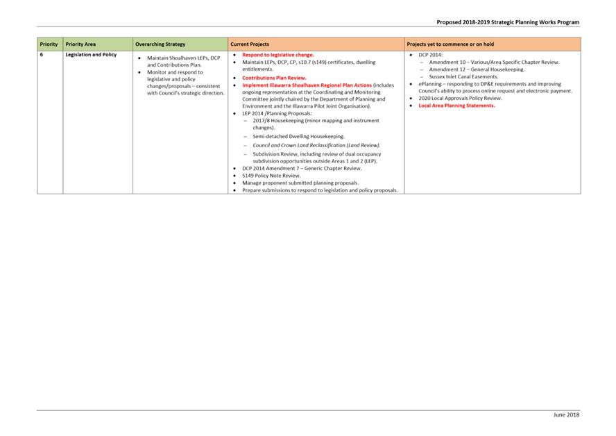
|
|
Development
& Environment Committee – Tuesday 04 June 2019
Page
1
|
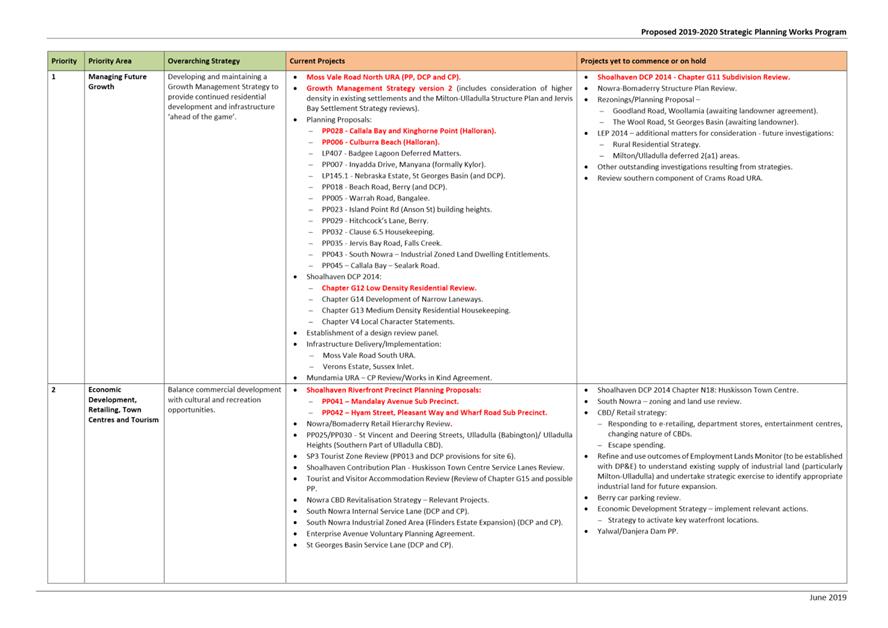
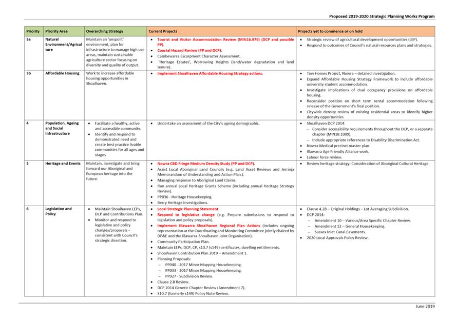
|
|
Development
& Environment Committee – Tuesday 04 June 2019
Page
1
|
DE19.45 Draft
Medium Density Amendment (Chapter G13) - Shoalhaven DCP 2014 - Post Exhibition
Consideration and Finalisation
HPERM Ref: D19/132724
Group: Planning
Environment & Development Group
Section: Strategic
Planning
Attachments: 1. External
Consultation Submission Summary ⇩
2. Proposed Post Exhibition
Changes to Chapter G13 (under separate cover) ⇨
Purpose / Summary
Consider the submissions
received as a result of the public exhibition of the draft Amendment to Chapter
G13: Medium Density and Other Residential Development of Shoalhaven Development
Control Plan 2014 (the Amendment); and consider the finalisation of the
Amendment.
|
Recommendation
(Item to be determined under delegated authority)
That
Council:
1. Adopt
the amendment to Chapter G13: Medium Density and Other Residential
Development of Shoalhaven Development Control Plan 2014 (the Amendment) as
exhibited, with the changes outlined in Attachment 2.
2. Notify
the adoption of the Amendment in local newspapers in accordance with the
requirements of the Environmental Planning and Assessment Act 1979 and
Regulations.
3. Advise
key stakeholders, including all Community Consultative Bodies, relevant
industry representatives and those who made a submission, of this decision,
and when the Amendment will be made effective.
|
Options
1. As recommended.
Implications: This is the preferred option as it
will enable Council to respond, where appropriate, to issues raised in
submissions and finalise the Amendment which largely reflects Council’s
resolution of 18 December 2018 (MIN18.993).
2. Adopt an
alternative recommendation.
Implications: This will depend on the extent of any
changes and could postpone the finalisation of the Amendment.
3. Not adopt the
recommendation.
Implications: This could stop or postpone the
Amendment which largely reflects Council’s resolution of 18 December 2018
(MIN18.993).
Background
The draft Amendment seeks to
action changes resolved by Council following a Councillor Notice of Motion
dated 18 December 2018 (MIN18.993
– see CL18.351, page 12). The key components of the Amendment
include:
· Amending
performance criteria P1.1 to address isolation of lots through land
amalgamation to ensure medium density development may still occur on those
lots.
· Changes
to Table 2 and Figure 3, which apply setback provisions for dual occupancy
development.
· Clarification
that only water tanks and storage/clothes drying areas are to be excluded from
landscaping calculations.
· Clarification
that the provision of storage is encouraged.
· Deletion
of the provision requiring 50% of the storage space to be located in the
dwelling.
· Deletion
of two performance criteria relating to Universal Design which are duplications
of two objectives in that Section.
Chapter G13 applies where dual
occupancy, multi dwelling housing, multi dwelling housing (terraces), attached
dwellings, semi-detached dwellings, manor houses, integrated housing
development, residential flat buildings, shop top housing, seniors housing,
boarding houses, group homes and hostels are permissible with development
consent.
Public Exhibition
In accordance with the
resolution (MIN18.993), the Amendment package was publicly exhibited for a
period of 30 days from 13 March to 12 April 2019 (inclusive).
Notices appeared in local newspapers
on 13 March 2019. All Community Consultative Bodies (CCBs) and 89 development
industry representatives were notified directly in writing.
The Amendment was exhibited at
Council’s Administrative Office, Bridge Road, Nowra during business
hours, and could also be viewed at the Ulladulla Administrative Office and on
Council’s website. The exhibition material included: Explanatory
Statement, Newspaper Advertisement and Draft Chapter G13: Medium Density
Development and Other Residential Development detailing the proposed
amendments.
As a result of the exhibition,
nine (9) formal submissions were received including:
· Three
(3) submissions from development industry representatives.
· Five
(5) submissions from the community.
· One
(1) submission from Council’s Inclusion and Access Advisory Group (Note:
not endorsed Group submission).
A detailed summary of the
submissions with a Council staff response to all comments raised is provided in
Attachment 1.
Copies of the actual submissions
will also be available for review in the Councillor’s Room prior
to the meeting.
Resulting from the submissions
received, two minor amendments are proposed to draft Chapter G13 as shown at Attachment
2 - for convenience, the proposed post-exhibition changes are highlighted
in yellow, with strikethroughs to note deletions.
In summary, the recommended post
exhibition changes to the draft Chapter G13 are:
· Delete
the following note in Table 2 of Chapter G13 to enable separation between the
front and rear dual occupancy dwellings (in a detached arrangement) to provide
and protect amenity:
Note: No rear setback applies for the front
dwelling (i.e. dwelling closest to the street) in a ‘one behind the
other’ arrangement.
· Insert
new Acceptable Solution A5.2 as follows, and renumber following acceptable
solutions accordingly:
A5.2 Despite A5.1, where
the predominant setback of the same street is greater than the setback
contained in Table 2, the required setback must be compatible with the existing
setbacks on the same street.
Community Engagement
The draft Amendment was publicly
exhibited for 30 days at the Nowra Administrative Building in accordance with
legislative requirements. Nine (9) submissions were received which are
summarised at Attachment 1.
Financial Implications
The finalisation of the Amendment
will continue to be resourced within the existing Strategic Planning budget.
|
|
Development
& Environment Committee – Tuesday 04 June 2019
Page
1
|
|
|
Development
& Environment Committee – Tuesday 04 June 2019
Page
1
|
DE19.46 Public
Exhibition Outcomes - Coastal Hazard Review Planning Proposal and Coastal
Management Areas DCP Amendment
HPERM Ref: D19/113261
Group: Planning
Environment & Development Group
Section: Strategic
Planning
Attachments: 1. External
Consultation Submission Summary (under separate cover) ⇨
2. Proposed Post Exhibition
Changes to Chapter G6 (under separate cover) ⇨
Purpose
/ Summary
· Report
the outcomes of the combined public exhibition of Planning Proposal PP026
– Coastal Hazards Review (PP) and Development Control Plan (DCP)
Amendment No. 20 Chapter G6: Coastal Management Areas.
· Enable
the amendments to Shoalhaven Local Environmental Plan (LEP) 2014 and Shoalhaven
DCP 2014 to proceed to finalisation.
|
Recommendation
(Item to be determined under delegated authority)
That Council:
1. Adopt
the Planning Proposal (PP026) as exhibited and forward to the NSW Department
of Planning and Environment for finalisation.
2. Adopt
and finalise Shoalhaven Development Control Plan 2014 Chapter G6: Coastal
Management Areas Amendment as exhibited, with the inclusion of the changes
highlighted in Attachment 2.
3. Advise
key stakeholders, including all CCBs, relevant industry representatives and those
who made a submission, of this decision, and when the LEP and DCP amendments
will be made effective.
|
Options
1. As recommended.
Implications: This is the preferred option as it
will ensure the amendments to Shoalhaven LEP 2014 and Shoalhaven DCP 2014
proceed to finalisation. This will increase the dependability of
Council’s coastal risk information and address several housekeeping
matters within Chapter G6: Coastal Management Areas.
2. Adopt an
alternative recommendation.
Implications: Depending on its nature, this could
delay the progress of the amendments to Shoalhaven LEP 2014 and Shoalhaven DCP
2014.
3. Not adopt the
recommendation.
Implications: This option is not preferred as the
coastal risk planning maps will remain in Shoalhaven LEP 2014 resulting in
lengthy delays to update these maps. The housekeeping matters for consideration
in Chapter G6: Coastal Management Areas of Shoalhaven DCP 2014 will remain
outstanding, which will negatively impact upon the overall application and use
of the Chapter.
Background
Public and private properties along the
coast are at risk from coastal hazards such as beach erosion, shoreline
recession, costal entrance instability, sand drift, coastal inundation, storm
water erosion, and slope instability. Council’s planning instruments
assist to manage this risk.
On 14 August 2018,
Council’s Development Committee resolved (MIN18.609) to:
1. Endorse the
Coastal Hazards Review Planning Proposal (PP026) (Attachment 1) and submit it
to the NSW Department of Planning and Environment for Gateway determination
2. Following
receipt of the Gateway determination, concurrently exhibit PP026 and draft
Chapter G6: Coastal Management Areas of Shoalhaven Development Control Plan
2014 (Attachment 2), for a period of 28 days as per legislative requirements.
3. Support the
preparation of the online coastal hazard mapping based on current coastal risk
data.
4. Receive a
further report on PP026 and draft Chapter G6: Coastal Management Areas
following the conclusion of the public exhibition period.
5. Advise key
stakeholders, including relevant Community Consultative Bodies, of this
decision.
The following is an overview of the PP and DCP amendment.
Planning Proposal
Seeks to amend the current
coastal hazard related controls in the LEP by:
· Removing
the Coastal Risk Planning Maps from the LEP (Note: detailed coastal hazard
mapping is now publicly available on Council’s
website);
· Amend
Clause 7.4 Coastal Risk Planning to apply to all land at risk of coastal
hazards identified within the Shoalhaven Coastal Zone Management Plan, coastal
management programs and/or supporting studies.
The PP was submitted to the NSW Department of Planning and
Environment (DP&E) following the August 2018 resolution and was granted a
favourable Gateway determination on 24 October 2018. Council was not granted
delegated authority to finalise the LEP amendment which means the PP will
ultimately need to be submitted to DP&E for finalisation.
DCP Amendment
The proposed amendments to DCP
Chapter G6: Coastal Management Areas respond to operational issues and matters
the require clarification. The key changes are summarised below:
· Insert
references to the Shoalhaven Coastal Hazard Interactive Mapping.
· Replace
references to 2025 Zone of Reduced Foundation Capacity (ZRFC) with 2030 ZRFC
throughout.
· Clarify
that sites landward of Precinct 2 (i.e. 2100 ZRFC) have limited restrictions,
not no restrictions.
· Include
additional commentary and provisions relating to wave runup.
· Include
Bendalong Boat Harbour Beach as a known area of beach erosion and/or oceanic
inundation, and Narrawallee as a known area of cliff/slope instability.
· Insert
references to recently adopted studies (e.g. Royal Haskoning DHV Report –
Shoalhaven Coastal Cliffs and Slopes Risk Management Program – 2018).
· Clarify
that the side setback requirements also apply to lots on the landward side of
an unformed road that adjoins a waterfront reserve.
· Include
several provisions adopted from Council Policy POL12/217 Coastal Areas –
Planning and Development relating to mitigating loss of public amenity and
managing aesthetic and environmental impacts on the foreshore and other public
areas.
· Expand
foreshore development controls in Section 5.2 to also apply to non-residential
development.
· Include
new provisions relating to public infrastructure on public land.
· Include
provisions to reflect the revised content of the Generic Community Lands Plan
of Management – Natural Areas and Foreshore Reserves Policy (e.g.
Stormwater from adjoining residences should be managed via inter-allotment
drainage and discharged directly into a stormwater facility of Council).
· Update all images
to enhance the readability of the Chapter and consistency across the DCP.
Government Agency Feedback
Prior to public exhibition, the
PP was referred to the NSW Office of Environment and Heritage (OEH) as required
by the Gateway determination. The comments from OEH and the Council staff
response is summarised in Table 1 below.
Table 1: OEH Comments on the Planning Proposal
|
OEH Comments
|
Council Staff Response
|
|
Cleary demonstrate that removing the coastal hazard
mapping will not affect or remove existing development controls for
development on land subject to coastal hazards.
|
The PP was updated prior to exhibition
to include the following additional commentary in Section 3.2 Map Change:
“It (the online coastal mapping) will be updated as and when Council
adopts new or updated coastal risk data (for example, Coastal Zone Management
Plan). The removal of the CRP Map from SLEP 2014 will not affect or remove
existing development controls on land subject to coastal hazards.”
|
|
Cleary demonstrate that there is a legal planning
mechanism in place to trigger and apply appropriate coastal hazard related
development controls for land subject to coastal hazards.
|
The PP was updated prior to
exhibition to include the following additional commentary in Section 2 Part 1
Intended Outcome: “The SLEP 2014 will then be used in conjunction
with the Shoalhaven Coastal Management Plan (CZMP) 2018 and the Shoalhaven
Development Control Plan 2014 (SDCP) to apply appropriate development
controls to areas at risk of coastal hazards as identified in the online
coastal risk mapping.”
|
|
Clarify how the proposed mapping will be linked to the
development controls within Shoalhaven LEP 2014 and Shoalhaven DCP 2014.
|
|
Update the proposed amendment to Clause 7.4(2) as
follows: “This clause applies to the land identified as being at risk
of coastal hazards in Council's Coastal Zone Management Plan, Coastal
management programs and/or supporting studies.”
|
The PP was updated prior to exhibition to reflect this
request.
|
|
Outline how the intent of the PP is consistent with
the Shoalhaven Coastal Management Plan.
|
The following additional commentary was included in
Section 4.2.2 of the PP prior to exhibition: “It is more appropriate
to remove the CRP Mapping from SLEP 2014 and move the mapped coastal risk
data to Council’s online mapping system. This will allow for more
timely updates of new risk data in perpetuity.
“The PP is considered consistent with this
Action, as although the mapping is not included in SLEP 2014 or SDCP 2014,
both draft documents refer to all risk areas, including the revised Advisian
Risk Assessment Maps, via the content and relationship to the proposed online
coastal risk mapping.”
|
Public Exhibition
In accordance with the Council
resolution (MIN18.609) and Gateway determination, the PP and proposed DCP
amendment were publicly exhibited for a period of 30 days, from 6 February to 8
March 2019 (inclusive).
Notices appeared in local
newspapers on 6 February. All CCBs, Development Industry Representatives and
affected landowners were notified directly in writing.
The combined PP and DCP
amendment were exhibited at Council’s Administrative Office, Bridge Road,
Nowra during business hours, and could also be viewed at the Ulladulla
Administrative Office and on Council’s website. The exhibition material
consisted of the following:
· Planning
Proposal (PP026) – Coastal Hazards Review.
· Draft
DCP 2014 Amendment No. 20 Chapter G6: Coastal Management Areas.
· Explanatory
Statement.
· Gateway
determination, dated 24 October 2018.
· Agency
consultation responses.
· Newspaper
advertisement.
As a result of the exhibition,
twelve (12) formal submissions were received including:
· One
(1) submission from a consultancy firm.
· Nine
(9) submissions from the community.
· Two
(2) internal Council submissions: Environmental Services and Strategic Planning
Sections.
A detailed summary of the
submissions with a Council staff response to all comments raised is provided in
Attachment 1.
Copies of the actual submissions will also be available for
review in the Councillor’s Room prior to the meeting.
Post-Exhibition Amendments
Resulting from the submissions
received, various minor amendments are proposed to the Draft Chapter G6 as
shown at Attachment 2. For convenience, the proposed changes are
highlighted in yellow, with strikethroughs to note deletions.
The recommended post exhibition
amendments to Draft Chapter G6 are summarised briefly below:
· Include
a link to the Shoalhaven Coastal Hazard Interactive Mapping in Section 1.
· Amend
the purpose to apply to development in areas of coastal risk instead of
development in areas of coastal management.
· Amend
the context to correct the number of beaches, bays and headlands and include a
link to the Shoalhaven Coastal Zone Management Plan 2018.
· Remove
the word physical from objective ii in section 4 Key Objectives.
· Remove
reference to planned retreat in acceptable solution A1.9.
· Include
the Narrawallee – Surfers Avenue/Bannister Head Road/Tallwood Avenue,
Geotechnical Scoping Study and Stability Assessment, Douglas Partner 2012
within acceptable solution A2.1.
· Include
additional wording to section 5.2 to correct a grammatical error.
· Remove
reference to the Advisian hazard mapping and Shoalhaven Coastal Zone Management
Plan as examples of properties identified but not studied.
· Include
the 2016 Shoalhaven Coastal Mapping Review within Section 6.2.
No changes are required to the
Coastal Hazard Review Planning Proposal following exhibition.
Policy and Risk Implications
Council will no longer rely upon
the Coastal Risk Planning maps within Shoalhaven LEP 2014 to identify land
subject to coastal risk. Instead, land subject to coastal risk will be
identified by the Shoalhaven Coastal Zone Management Plan, coastal management
programs and/or supporting studies.
This approach better manages
coastal hazard risk for Shoalhaven. As information is obtained or updated the
online mapping can be updated in a timely manner.
Financial Implications
Finalisation of the PP and draft
DCP amendment will continue to be undertaken within the existing Strategic
Planning budget.
|
|
Development
& Environment Committee – Tuesday 04 June 2019
Page
1
|
DE19.47 New
Proponent Initiated Planning Proposal - Appleberry Close, Meroo Meadow
HPERM Ref: D19/130924
Group: Planning
Environment & Development Group
Section: Strategic
Planning
Purpose / Summary
Present a new
proponent-initiated Planning Proposal (PP) that has been received to enable a
boundary adjustment between Lots 21 and 22 in DP 1113675 and Lot 202 in DP
1180659, Appleberry Close, Meroo Meadow, for consideration and obtain
direction.
|
Recommendation
(Item to be determined under delegated authority)
That Council:
1. Support
the Planning Proposal to permit a boundary adjustment between Lots 21 and 22
in DP 1113675 and Lot 202 in DP 1180659 provided no additional lots or
dwelling entitlements will be created, and the mechanism to achieve this
outcome be determined in consultation with the NSW Department of Planning and
Environment.
2. Prepare
and submit the PP documentation to the NSW Department of Planning and
Environment for Gateway determination, and dependent on the outcome proceed
to exhibit the PP and report back to Council post-exhibition.
3. Advance
as a ‘minor’ proponent-initiated Planning Proposal and fees be
charged in accordance with Council’s adopted Fees and Charges.
4. Advise
the proponent of this resolution.
|
Options
1. Proceed with the
PP as recommended.
Implications: This will allow the tenure of the
land to be resolved without any significant broader planning impacts.
This option is recommended.
2. Not proceed with
the PP.
Implications: The current, undesirable easement
arrangements will continue for this land.
Background
The Subject Land
The subject land is located on
the boundary of the Meroo Meadow/Bomaderry localities at the end of Appleberry
Close and comprises Lots 21 & 22, DP 1113675 and Part of Lot 202 DP
1180659. Maps showing the location of the land are provided below:
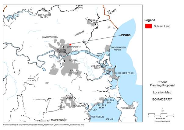
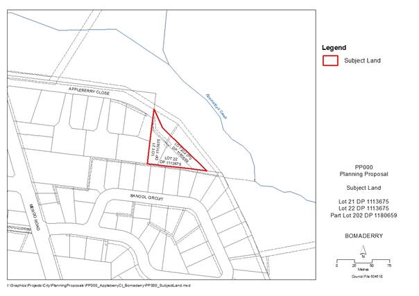
The subject land comprises Lots 21 and 22 DP 1113675, which
are currently zoned R1 - General Residential under the Shoalhaven Local
Environmental Plan (LEP) 2014, and part of Lot 202 DP 1180659, which is zoned
RU2 – Rural Landscape under the LEP and is a larger rural lot that is
subject to covenants (access, landscaping etc) benefiting the smaller
residential lots.
The following map shows the zoning of the subject land the
immediate area:
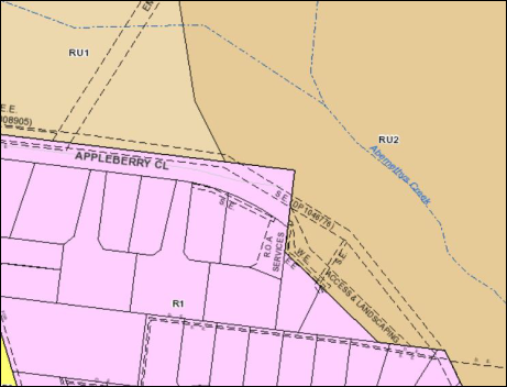
Each residential lot (Lots 21
& 22) is occupied by an existing approved dwelling. The covenants over the
rural lot give Rights of Carriageway and use of the land for private open space
to the smaller lots.
Lot 21 – has an existing
area of 831 sq. metres and is owned by Duncan Brown
Lot 22 – has an existing
area of 761 sq. metres and is owned by Peter Russell
Lot 202 – has an existing
overall area of 37ha and is owned by Allan Wallace
An aerial photograph of the
subject land is provided below:
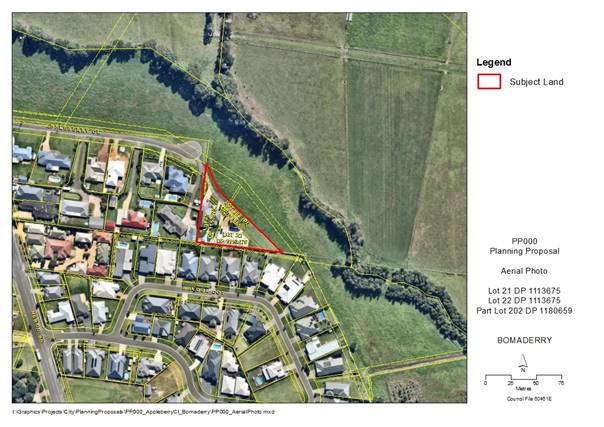
Planning History
Prior to the adoption of the
Nowra-Bomaderry Structure Plan (NBSP) in 2007, the subject land was originally
part of a road corridor for the proposed “Northern Industrial
Road”. This road was intended to provide a new road for industrial
traffic to avoid the residential areas of Bomaderry and a perimeter road for
the residential area north of Edwards Avenue and east of Meroo Road. Some of
the subdivisions in this area considered the alignment of the proposed road.
The NBSP process reconsidered
the suitability of adjoining rural land which is flood affected and the need
for the proposed road. The adopted NBSP did not include the “Northern
Industrial Road” and identified the land as a “Scenic Protection
Area”. The dwellings on Lots 21 and 22 were subsequently approved.
The decision not to proceed with
the “Northern Industrial Road” did not, however, resolve the
awkward geometry of these lots, nor did it provide road access to them. These
issues were resolved by easements over the adjoining rural land.
A PP request was submitted to
Council on 5 February 2019 and can be accessed on Council’s website at: https://shoalhaven.nsw.gov.au/Planning-amp-Building/Strategic-planning/Planning-Proposals
This PP seeks to allow boundary
adjustments so that each of the residential lots will own its access handle and
private open space, as opposed to it being located on land in another ownership
as is currently the case. The PP was submitted by Allen Price & Scarratts
Pty Ltd on behalf of the landowners.
The PP notes that no additional
residential or dwelling entitlements will result from the proposed minor
rezoning and extension of the existing residential zone.
Strategic
Planning Overview
A preliminary strategic planning
assessment of the proposal is provided below:
Shoalhaven Local
Environmental Plan 2014
The current provisions of
Shoalhaven LEP 2014 do not permit a boundary adjustment of this nature to
resolve this issue. The boundary adjustment would result in two undersized
allotments within the rural zone and this is not permissible under the LEP. The
land is not identified as a scenic protection area under the LEP.
Nowra-Bomaderry Structure
Plan 2007
The NBSP mapping shows the land
as being the boundary of urban Bomaderry with rural Meroo Meadow. It also shows
the land as part of a “Scenic Protection Area”.
The boundary adjustment that
would be permitted by this PP will not significantly alter the intended
boundary for Bomaderry’s urban area nor will it change the visual
character of the landscape given that the land is currently being used in
association with the existing dwellings.
The PP is considered to be minor and not inconsistent with
any provisions of this plan.
Shoalhaven Growth Management
Strategy 2012
The GMS largely adopts the findings and provisions of the
NBSP and does not contain any additional provisions that are relevant to this
PP.
Planning Proposal (Rezoning)
Guidelines 2018
Council’s PP guidelines
provide that Council is “more likely to support a PP request” if it
meets one of three criteria of which, the third is “Council is satisfied
that the proposed amendment is minor and has sound justification”.
The subject PP will not result
in any additional dwelling opportunities nor will it alter the pattern of
development of the land. It is considered to be of a minor nature.
The PP will, however, provide a
better outcome for the tenure of the land and this provides adequate
justification for a PP of this nature.
The PP will not require any specialist studies and therefore
classified as ‘minor’ under the PP guidelines.
NSW Guide to Preparing
Planning Proposals
The NSW Government’s Guide to Preparing Planning
Proposals provides an assessment framework for PPs. This framework requires the
planning authority (Council) to consider several questions in determining the
merit of a PP. These are considered below:
Q1. Is the PP a result of any
strategic study or report?
The PP is not the result of a strategic study or report. The
PP is minor and is not of a kind that would generally be identified in a broad
strategic planning process.
Q2. Is the PP the best means
of achieving the intended outcome or is there a better way?
The proposed boundary
adjustments are prohibited under Shoalhaven LEP 2014. There is no State
Environmental Planning Policy that provides a mechanism to permit the boundary
adjustments. A PP is the only way to achieve the desired outcome.
The form of the plan amendment is to be determined in
consultation with DP&E as part of the Gateway determination process. It is
intended to find the best possible form for the PP before it is finalised.
Q3. Is the PP consistent with
the objectives and actions of the applicable regional, sub-regional or district
plan or strategy (including any exhibited draft plans or strategy)?
The PP is minor and is not of a kind that would result in
any inconsistencies with a regional, sub-regional or district plan or strategy.
Q4. Is the PP consistent with
a council’s local strategy or other local strategic plan?
As previously noted in this report, the PP is consistent
with the NBSP and GMS.
Q5. Is the PP consistent with
applicable State Environmental Planning Policies?
The PP is minor and not of a kind that would result in any
inconsistencies with a State Environmental Planning Policy.
Q6. Is the PP consistent with
applicable Ministerial Directions?
The PP is not inconsistent with any Ministerial Direction.
In the drafting of any plan amendment, careful consideration will need to be
given to Direction 6.3 Site Specific Provisions to ensure the detail of the
instrument is consistent with this direction.
Q7. Is there any likelihood
that critical habitat or threatened species, populations or ecological
communities, or their habitats, will be adversely affected as a result of the
proposal?
The PP will not result in the removal of any native
vegetation or habitat. No adverse biodiversity impacts are anticipated.
Q8. Are there any other
likely environmental effects as a result of the PP and how are they proposal to
be managed.
No adverse environmental impacts are anticipated.
Q9. Has the PP adequately
addressed any social and economic effects?
No adverse social or economic effects are anticipated.
Q10. Is there adequate public
infrastructure for the PP?
The PP will not give rise to any additional infrastructure needs.
Q11. What are the views of
the state and Commonwealth public authorities consulted in accordance with the
gateway determination?
No consultation has been
undertaken at this early stage.
Conclusion
The PP is minor and consistent with applicable State
Government and Council policies and plans.
Community Engagement
Adjoining and directly affected land owners were advised on
the PP. One resident met with Council staff to discuss the PP but did not raise
any concerns with it progressing further. No written submissions were sought or
received.
Should the PP receive a favourable
Gateway determination it will be formally publicly exhibited as part of the
process.
Policy Implications
The PP is consistent with
Council’s Planning Proposal (Rezoning) Guidelines.
Financial Implications
The PP is proposed to be managed
as a minor, proponent funded PP. It is to be funded by the proponent on a 100%
cost recovery basis.
|
|
Development
& Environment Committee – Tuesday 04 June 2019
Page
1
|
DE19.48 Jerberra
and Verons Estates - Biodiversity Assessment - Clause 34A Certification
HPERM Ref: D19/140355
Group: Planning
Environment & Development Group
Section: Strategic
Planning
Attachments: 1. Clause
34A Biodiversity Conservation (Savings & Transitional) Regulation 2017 ⇩
2. Follow-up
correspondence to OEH (under separate cover) ⇨
3. Jerberra
Estate cl 34A certification & cover letter ⇩
4. Verons Estate cl 34A
certification & cover letter ⇩
Purpose / Summary
To advise Council that the
planning controls for Jerberra Estate (Tomerong) and Verons Estate (Sussex
Inlet) have each been certified as ‘relevant planning arrangements’
under Clause 34A of the Biodiversity Conservation (Savings and Transitional)
Regulation; outline the implications of this; and initiate the process of
amending the respective site-specific chapters in Shoalhaven Development
Control Plan (DCP) 2014.
|
Recommendation
(Item to be determined under delegated authority)
1. Receive
the update on the Clause 34A certification provided for Jerberra and Verons
Estates for information.
2. As
a way of removing uncertainty, adopt a policy position for Jerberra Estate
that requires appropriate covenants to be registered on property titles as
part of the development approval process to ensure the areas listed below are
managed for conservation into the future:
a. Bushland
Management Area (BMA)
b. Bushland
Conservation Area (BCA)
c. Orchid
Management Area (OMA)
3. Commence
to amend the Shoalhaven Development Control Plan (DCP) 2014 to update Chapter
N20 (Jerberra Estate) and S1 (Verons Estate) because of the Clause 34A
certification for each Estate, including the following:
a. the
addition of a specific provision in Chapter N20 to establish covenants
outlined in part 1. to ensure the clause 34A certification remains legally
valid in Jerberra Estate
b. update
references to legislation
c. make
other changes as required to improve the effectiveness and readability of
both chapters.
|
Options
1. Update the DCP Chapters
to reflect changes to legislation including the Clause 34A certification.
Implications: Changes to both chapters are needed
to clarify the assessment process because of the Clause 34A certification, to
assist landowners/applicants and development assessment staff. In respect
of the Jerberra Estate chapter (Chapter N20), including a specific requirement
for covenants to be placed on the relevant property titles will clarify the
situation for all stakeholders and ensure that the Clause 34A certification
remains legally valid.
2. Amend DCP
Chapters N20 or S1 but not include a requirement for covenants to be placed on
the relevant property titles in Jerberra Estate (Chapter N20).
Implications: The Clause 34A certification applies
to the LEP and DCP controls in effect at the day of certification. Hence,
amending the DCP and not including a requirement for the establishment of
covenants will make the 34A certification invalid.
3. Not amend DCP Chapters
N20 or S1.
Implications: This will result in uncertainty and
confusion for both landowners and assessment staff.
Background
Widespread changes were made to
biodiversity laws by the NSW Government in 2016. Central to this is the
Biodiversity Conservation Act 2016 (BC Act), which includes a new Biodiversity
Assessment Methodology (BAM) for assessing the impact of development on biodiversity
and a biodiversity impact offset scheme.
The supporting regulations
include a savings provision that allows development applications in areas where
a ‘relevant planning arrangement’ was in place prior to
commencement of BC Act to be assessed under the previous legislation. Clause
34A of the Biodiversity Conservation (Savings & Transitional) Regulation
2017 is provided as Attachment 1.
To be certified as a relevant
planning arrangement, the NSW Office of Environment & Heritage (OEH) must
be satisfied that:
1. the biodiversity
impacts of the proposed development were assessed before the commencement of
the BC Act; and
2. conservation measures
have been secured into the future to offset the residual impact of the proposed
development on biodiversity values.
Jerberra Estate and Verons
Estate are ‘paper subdivisions’ for which planning proposals (PPs)
were finalised in 2014. The biodiversity values in each Estate were
comprehensively assessed and considered as part of the PP process, and detailed
planning provisions were developed for each estate to ensure that biodiversity
will be protected in conjunction with allowing limited residential development.
Both PPs were finalised in 2014 and the resulting Local Environmental Plan
(LEP) provisions are supported by detailed site-specific chapters in the
Shoalhaven Development Control Plan (DCP) 2014.
While the planning controls for
each Estate have the same overall objective of achieving a balance between
allowing appropriate development while protecting important environmental
values, there are some differences in the detailed controls for each estate
given their different natures. These differences largely reflect the
differences in lot sizes between the two subdivisions. The lots in Jerberra
Estate are considerably smaller (less than 1,000 m2 up to 1.7 ha)
and therefore the planning controls are more prescriptive and
‘master-planned’ in detail compared to Verons Estate, where all the
lots are 8 ha.
Detailed information on the
planning controls for each Estate is available on Council’s webpage via
the following link:
https://shoalhaven.nsw.gov.au/Planning-amp-Building/Strategic-planning/Paper-subdivisions
Infrastructure and
development update
Special rates are in place to
fund the provision of essential infrastructure in each Estate, so that they can
be safely and appropriately developed. Information on the special rate
arrangements is also available via the above link. Brief updates on the status
of the infrastructure and development of the lots in each Estate is provided
below.
Jerberra Estate
The provision of road and
electricity infrastructure in the Estate is essentially complete.
The planning controls enable up
to 87 dwellings to be approved, of which 56 were on ‘stand-alone’
lots and 31 require amalgamation of 2 or more lots. Of the 31 property
amalgamations that are needed to secure a ‘dwelling entitlement’,
15 have occurred and significant progress has been made in respect of another 2
(both involve more than 2 lots).
At the time of writing, 11
dwellings have been approved in Jerberra Estate under the new planning
controls, and another 13 are being assessed. It is understood that several
other landowners are in the process of preparing applications.
Verons Estate
Upgrading of the road
infrastructure in the Estate commenced in April 2019.
The planning controls enable one
dwelling per lot to potentially be approved on Lots 1 to 19. It has also
been confirmed that Lots 20, 28 and 29 are ‘1964 holdings’ and
therefore a dwelling can potentially be approved on each of these Lots.
One application for a dwelling
has been approved under the new planning controls and no applications are under
assessment. An increase in development activity is expected once the road
infrastructure has been completed.
Certification requested under
Clause 34A - March 2018
On 15 March 2018, Council wrote
to OEH requesting that the planning controls for Jerberra and Verons Estates be
certified as ‘relevant planning arrangements’ under Clause
34A.
A lengthy delay ensued despite
consistent follow up to have the matter resolved. It later became clear that
the primary reason for the delay was that OEH’s legal services division
had reservations in relation to the Jerberra Estate planning controls and certainty.
Council staff were advised that
OEH’s concern was that the conservation measures detailed in the Jerberra
Estate DCP did not include a requirement to establish a legally-binding
conservation mechanism over the land (this is already a requirement in the
Verons Estate DCP chapter). It was suggested that to secure the desired 34A
certification, it may be necessary to amend the existing DCP to include a
specific requirement for owners to establish covenants over their land as part
of the development approval process.
To break the deadlock,
Council’s wrote to OEH on 27 February 2019 and advised that Council could
resolve to require the establishment of positive covenants on the relevant
properties in the Estate as part of their development. The letter noted that
Council did not necessarily need to amend the DCP to impose this requirement on
consents. The letter stated that:
While we have no issue with amending the DCP to make this
requirement explicit, the process of doing this will take at least 5-6 months.
This delay would have a major impact on the landowners seeking to develop their
land. We currently have 8 development applications that cannot be assessed
because of this issue (without BDARs) and many other landowners are seeking to
lodge applications.
To ensure the Jerberra Estate
matter was prioritised, the letter was sent to the CEO of OEH and also to
Shelley Hancock MP and Gareth Ward MP. Council’s letter to OEH dated 27
February 2019 (and preceding letters to OEH) is provided in Attachment 2
(under separate cover).
Outcomes and implications
Verons Estate
The Verons Estate planning
controls were certified as a ‘relevant planning arrangement’ by OEH
on 11 March 2019. A copy of the certification order is provided in Attachment
3.
Thus, development applications
that comply with the biodiversity provisions in Shoalhaven LEP 2014 and
Shoalhaven DCP 2014 Chapter S1, will be assessed under the legislation that
applied before the BC Act commenced.
Development applications that
comply with the Estate’s planning controls need to be accompanied by an
assessment of significance, known as a ‘7-part test’ prepared by an
appropriately qualified person. To satisfy this requirement landowners would
need to approach the NSW Biodiversity Conservation Trust to request that a
draft Conservation Agreement (CA) be prepared and then submit the draft CA with
their application.
Applications that do not
strictly comply with the biodiversity controls must be assessed under the BC
Act. In most, if not all cases, a Biodiversity Development Assessment Report
(BDAR) will be required. As is required by the legislation, any resulting
credit requirements must be retired before a construction certificate can be
issued.
DCP Chapter S1 will need to be
amended to reflect these changes. Several other updates are needed to reflect
other legislative changes and make improvements identified since the Chapter
commenced in 2014.
Jerberra Estate
The Jerberra Estate planning
controls were certified as a ‘relevant planning arrangement’ by OEH
on 12 April 2019. A copy of the certification order is provided in Attachment
4.
As noted in OEH’s cover
letter, the certification is based on the understanding that Council will
commit to condition approvals to require establishment of covenants on those
properties with bushland conservation area (BCA) or bushland management area
(BMA); and that DCP Chapter N20 will also be amended to make this a specific
requirement.
Some landowners have expressed
concerns about this requirement. At the time of preparing this report, Council
staff were in the process of drafting conditions of consent to ensure
consistency with Clause 34A. To facilitate the process, a covenant template is
also being prepared. The process will not be overly onerous or costly, particularly
in comparison to the cost of preparing a BDAR and meeting the offset
requirements. Furthermore, this will not affect any land which is not already
identified for conservation purposes in the existing planning controls, but
importantly, the restrictions and management obligations should be disclosed to
prospective purchasers prior to purchase.
Development applications which
meet the biodiversity provisions in the Jerberra Estate planning controls will
be assessed under the legislation that was in place prior to the BC Act.
Council previously commissioned an overall 7-part test to minimise the need for
individual landowners to commission their own assessment. The Clause 34A
certification enables this streamlined approach to be used again. This approach
was not appropriate for Verons Estate because the precise location and extent
of development on each lot is to be determined at development application stage
(because the lots are considerably larger).
Any applications that do not
strictly comply with the Estate’s planning controls will need to be
assessed under the BC Act, which in most cases will require a Biodiversity
Development Assessment Report (BDAR) prepared by an accredited assessor. As is
required by the legislation, any resulting credit requirements must be retired
before a construction certificate can be issued. If a BDAR is not required, the
owner will require a 5-part test prepared in accordance with the BC Act.
Regardless of the assessment pathway, appropriate conditions will be included
in consents to ensure the BMA/BCA/OMA are managed for conservation purposes
into the future.
Proposed amendments to DCP
Chapters N20 and S1
The biodiversity sections of
both DCP Chapters now need to be amended because of the Clause 34A
certification to clarify the biodiversity assessment pathways. As outlined
above, it is intended to clarify the requirement in Chapter N20 for covenants
to be established over the BMA and BCA.
Several other changes are
proposed to both Chapters such as updating references to legislation which has
changed, changes to improve readability and effectiveness, and to respond to
other issues that have been identified through application of each Chapter
since commencement (this primarily concerns Chapter N20).
This report includes a recommendation
to initiate the process of amending Chapters N20 and S1 of Shoalhaven DCP 2014.
Community Engagement
Council has written to
landowners in each Estate advising of the Clause 34A certification. Should
Council resolve to initiate the process of amending the DCP as recommended, the
following steps will be undertaken:
1. Prepare the draft
revised Chapters and report to Council before formally engaging with the
community.
2. Publicly exhibit the
draft changes to DCP Chapters N20 and S1 and consult with the relevant
stakeholders.
3. Report the outcomes of
the formal community engagement process to Council for adoption.
Policy Implications
This report includes a
recommendation to establish a policy position to require the establishment of
covenants on the relevant properties in Jerberra Estate. This will avoid any
uncertainty regarding Council’s position prior to amendment of the DCP
and is consistent with the outcome expected by OEH that allowed the Clause 34A
Certification to be issued.
Financial Implications
The proposed amendment to the
DCP will be resourced within the existing Strategic Planning budget.
|
|
Development
& Environment Committee – Tuesday 04 June 2019
Page
1
|
|
|
Development
& Environment Committee – Tuesday 04 June 2019
Page
1
|
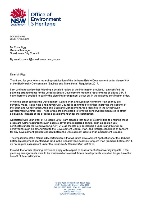

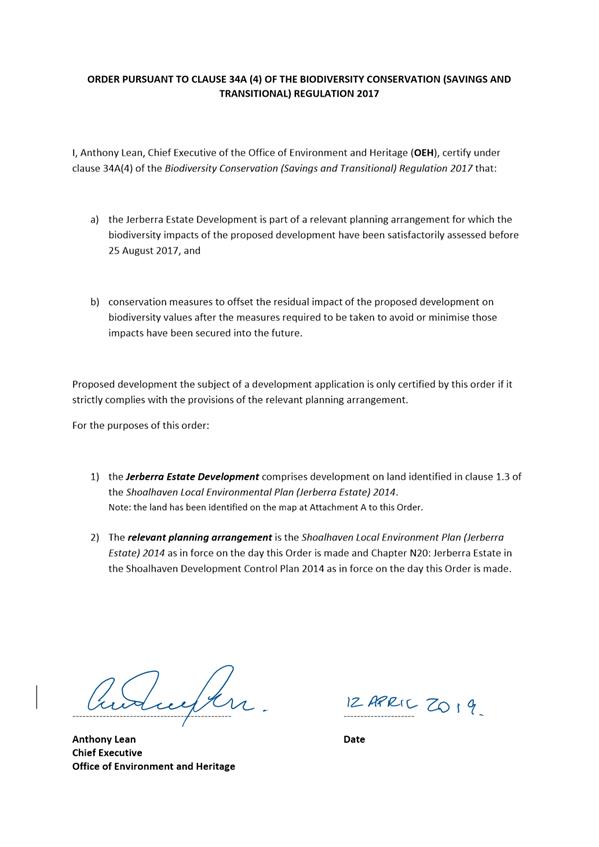
|
|
Development
& Environment Committee – Tuesday 04 June 2019
Page
1
|
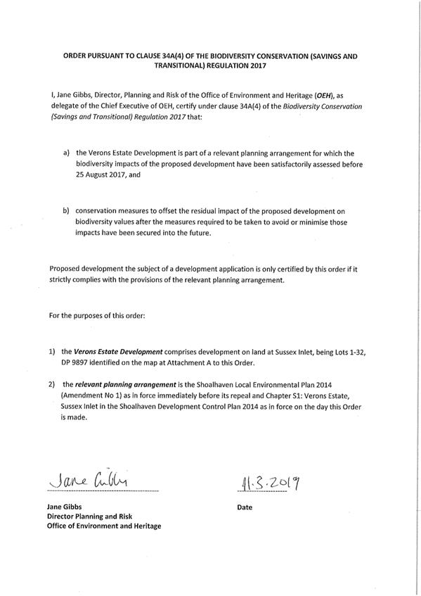
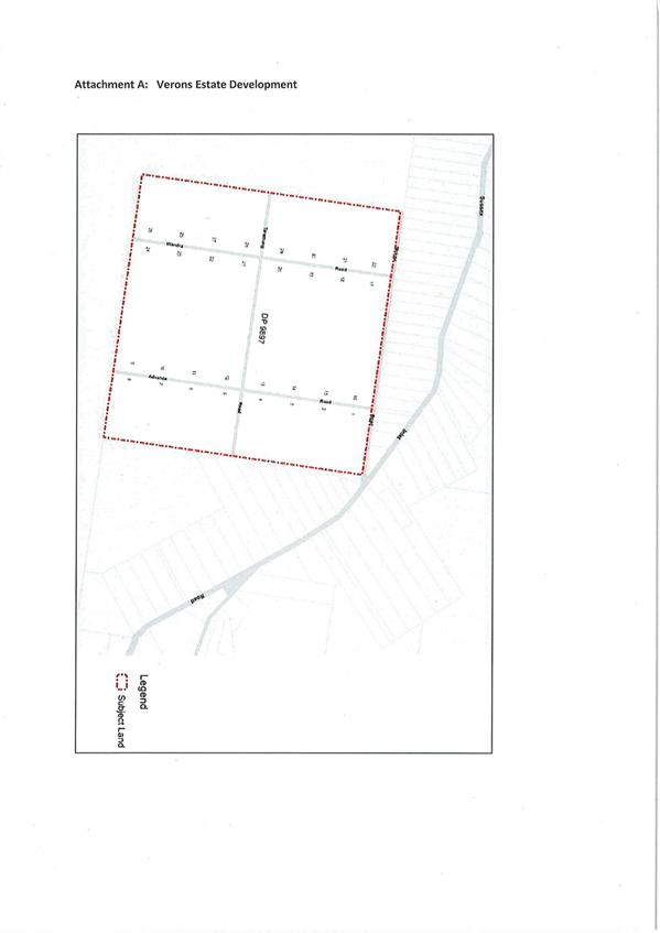
|
|
Development
& Environment Committee – Tuesday 04 June 2019
Page
1
|
Local Government Amendment (governance &
planning) act 2016
Chapter
3, Section 8A Guiding principles for councils
(1)
Exercise of functions
generally
The
following general principles apply to the exercise of functions by councils:
(a) Councils should provide strong
and effective representation, leadership, planning and decision-making.
(b) Councils should carry out
functions in a way that provides the best possible value for residents and
ratepayers.
(c) Councils should plan
strategically, using the integrated planning and reporting framework, for the
provision of effective and efficient services and regulation to meet the
diverse needs of the local community.
(d) Councils should apply the
integrated planning and reporting framework in carrying out their functions so
as to achieve desired outcomes and continuous improvements.
(e) Councils should work
co-operatively with other councils and the State government to achieve desired
outcomes for the local community.
(f) Councils should manage
lands and other assets so that current and future local community needs can be
met in an affordable way.
(g) Councils should work with
others to secure appropriate services for local community needs.
(h) Councils should act fairly,
ethically and without bias in the interests of the local community.
(i) Councils should be
responsible employers and provide a consultative and supportive working
environment for staff.
(2) Decision-making
The
following principles apply to decision-making by councils (subject to any other
applicable law):
(a) Councils should recognise
diverse local community needs and interests.
(b) Councils should consider social
justice principles.
(c) Councils should consider the
long term and cumulative effects of actions on future generations.
(d) Councils should consider the
principles of ecologically sustainable development.
(e) Council decision-making should
be transparent and decision-makers are to be accountable for decisions and
omissions.
(3) Community participation
Councils
should actively engage with their local communities, through the use of the
integrated planning and reporting framework and other measures.
Chapter
3, Section 8B Principles of sound financial management
The
following principles of sound financial management apply to councils:
(a) Council spending should be responsible and
sustainable, aligning general revenue and expenses.
(b) Councils should invest in responsible and
sustainable infrastructure for the benefit of the local community.
(c) Councils should have effective financial
and asset management, including sound policies and processes for the following:
(i) performance management
and reporting,
(ii) asset maintenance and
enhancement,
(iii) funding decisions,
(iv) risk management practices.
(d) Councils should have regard to achieving
intergenerational equity, including ensuring the following:
(i) policy decisions are made
after considering their financial effects on future generations,
(ii) the
current generation funds the cost of its services
Chapter
3, 8C Integrated planning and reporting principles that apply to councils
The
following principles for strategic planning apply to the development of the
integrated planning and reporting framework by councils:
(a) Councils should identify and prioritise key
local community needs and aspirations and consider regional priorities.
(b) Councils should identify strategic goals to
meet those needs and aspirations.
(c) Councils should develop activities, and
prioritise actions, to work towards the strategic goals.
(d) Councils should ensure that the strategic
goals and activities to work towards them may be achieved within council
resources.
(e) Councils should regularly review and
evaluate progress towards achieving strategic goals.
(f) Councils should maintain an
integrated approach to planning, delivering, monitoring and reporting on
strategic goals.
(g) Councils should collaborate with others to
maximise achievement of strategic goals.
(h) Councils should manage risks to the local
community or area or to the council effectively and proactively.
(i) Councils should make appropriate
evidence-based adaptations to meet changing needs and circumstances.