Shoalhaven Natural Resource & Floodplain
Management Committee
Meeting
Date: Wednesday,
18 April, 2018
Location: Shoalhaven Entertainment Centre - Mezzanine Conference Room, Bridge
Road, Nowra
Time: 4:00pm
Please note:
Council’s Code of Meeting Practice permits the electronic recording and
broadcast of the proceedings of meetings of the Council which are open to the
public. Your attendance at this meeting is taken as consent to the possibility
that your image and/or voice may be recorded and broadcast to the public.
Agenda
1. Apologies
2. Confirmation
of Minutes
· Shoalhaven
Natural Resource & Floodplain Management Committee – 23 November 2017........................................................................................................................ 1
· Shoalhaven
Natural Resource & Floodplain Management Committee - 22 January 2018 7
3. Declarations of Interest
4. Presentations
SN18.2........ Tourism Discussion - 360 Model
5. Reports
SN18.3........ Safe Navigation Action Group
(SNAG) - Sussex Inlet Dredging Plan 2017. 9
SN18.4........ Update on the review of the
draft 2012 Coastal Zone Management Plan.. 19
SN18.5........ Citizen Science - Utilising
Technology to Monitor the Coast....................... 21
SN18.6........ Update on the Review of the
Lake Tabourie Entrance Management Policy 24
SN18.7........ Update on the Shoalhaven River
Levee Flood Damage Restoration 2017 Project...................................................................................................................... 28
SN18.8........ South Mollymook Beach Cost
Benefit Distribution Analysis (CBA) Coastal Hazard Assessment.................................................................................................. 31
6. General Business
|

|
Shoalhaven
Natural Resource & Floodplain Management Committee – Wednesday 23 November 2017
Page
|
Membership
Clr White – Chairperson
All Councillors
General Manager or nominee
Community representatives:-
David McCorkell
Duncan Marshall
Ian Stewart
Dr Michael
Brungs
Dirk Treloar
Annie Boutland
Helen Moody
David Reynolds
Kaye Milsom
Brett Stevenson
Chris Grounds
Mike Clear
Paul Beckett
Robyn Flack
Peter Hanson
Government Agency representatives:-
Jerrinja LALC
Ulladulla LALC
NPWS
SRCMA
OEH
RMS
DPI Fisheries
Local Lands
Service
Crown Lands
NSW Office of
Water
Jervis Bay
Marine Park Authority
SES
Quorum – Three (3) provided that a
minimum of one Councillor and two community representatives are present.
Objective
To foster sustainable management of
Shoalhaven’s natural resources including floodplains, coast and
estuaries.
Role of Committee
1. Provide
overall guidance for the management of natural resource management including
floodplain management, estuary management and coastal zone management in accordance
with Federal, State and Local Government Policy and Legislative instruments;
2. Advise
Council on natural resource management including floodplain management, estuary
management and coastal zone management matters;
3. Formulate
agreed vision, goals, objectives, and targets sought from the Natural Resource
Management Plans;
4. Facilitate
the preparation of Natural Resources Management Plans;
5. Provides
input into the identification of management options for Natural Resources
Management Plans;
6. Facilitate
broad community consultation;
7. Monitor
State and Federal Government natural resource management direction and advises
Council on appropriate response;
8. Monitor
advances in knowledge and science of natural resource management issues (such
as sea level rise and climate change) and integrate this knowledge in new
Natural Resource Management Plans as well as in the review of existing Plans;
and
9. Make
recommendations for Council consideration.
Minutes of the
Shoalhaven Natural Resource & Floodplain Management
Committee
Meeting Date:
Thursday, 23 November 2017
Location: Ulladulla Civic Centre
Time: 4.07pm
The following members
were present:
Clr Patricia White – Chairperson
Clr John Levett
Annie Boutland
Chris Grounds
Bill McInnes
Frances Clements
Robyn Flack
Ian Stewart
Dirk Treloar
Kaye Milsom
John Murtagh
David McCorkell
Mike James
Paul Beckett
Duncan Marshall
Helen Moody
Michael Brungs
Others Present
Russ Pigg – General Manager
Kelie Clarke – Environmental Services
Alasdair Stratton – Natural Resources
& Floodplain Unit Manager
Ray Massie – Coast and Estuaries
Officer
Mir Abdus Subhan – Floodplain and
Stormwater Quality Engineer
Ali Sevenler – Senior Floodplain
Engineer
|
Election of
Chairperson
|
|
RESOLVED (By consent)
That Clr White
be appointed as the Chairperson for Shoalhaven Natural Resources and
Floodplain Management Committee.
CARRIED
|
An apology was received from Brett
Stevenson, Jillian Reynolds, Clr Findley, Clr Gartner and Peter Hanson.
|
Confirmation
of the Minutes
|
|
RESOLVED (Chris Grounds / Michael
Brungs)
That the Minutes of the Shoalhaven
Natural Resource & Floodplain Management Committee held on Thursday 07
September 2017 be confirmed.
CARRIED
|
Nil
PRESENTATIONS
Ali Sevenler
provided a presentation on Update on the review of the Lower Shoalhaven River
and St Georges Basin Floodplain Risk Management Study and Plan.
Mir Abdus Subhan provided a presentation on
Updates on the Shoalhaven River Levee Flood Damage Restoration 2017 Project.
Alasdair Stratton provided a presentation
on Shoalhaven Riverbank Restoration - Bolong Road Project.
Reports
|
SN17.21 Updates on the Shoalhaven River
and St Georges Basin Floodplain Risk Management Study & Plan and
Shoalhaven River Levee Flood Damage Restoration 2017 project
|
HPERM
Ref: D17/348457
|
|
Bill McInnes from SES advised that he could email a copy of minor,
moderate & major floods as defined by the SES for the committee members.
|
|
Recommendation (Item to be determined under delegated authority)
That Committee receive the report for information.
|
|
RESOLVED (Mike Clear / Duncan Marshall)
That the
Shoalhaven Natural Resources and Floodplain Management Committee receive the report and presentations for information.
CARRIED
|
|
SN17.22 Flood Mitigation Projects –
Flood Information Sign Project
|
HPERM
Ref: D17/352147
|
|
There was a
minute resolved back in 2015 in relation to the installation of flood level indicators
and historical flood signage.
An in house
project officer has been working on the project to identify potential
locations and what information will be on the signs. Council is
also working closely with the State Emergency Services. The signs will
be prioritised around where they can be highly visable and a location that is
in close prmoximity to evacuation plan announcements.
The design of
the signage is yet to be determined, the idea is to attract peoples attention
and remain informative. The Committee discussed potential graffiti
damage.
It is thought
that the sign could be mounted at the peak height of the flood, to show how
serious flooding can be.
A further report
to the Committtee is expected after further community consultation.
The Committee also commented that
this would be an additional measure to ensure home buyers and renters are
aware of the potential for flooding in areas.
|
|
Recommendation (Item to be determined under delegated authority)
That the Committee endorse the proposed locations of historical flood level
signage.
|
|
RESOLVED (David Reynolds / Ian Stewart)
That the Shoalhaven
Natural Resource and Floodplain Management Committee
endorse the proposed locations of historical flood level signage.
CARRIED
|
|
SN17.23 Currarong Coastal Erosion
Remediation
Detailed Design Progress Report November 2017
|
HPERM
Ref: D17/361283
|
|
An aboriginal
heritage study is to be undertaken as well as a review of environmental
factors prior to obtaining licences necessary to carry out proposed coastal
management works and beach access. Council officers continue to consult
with the community as part of the planning process for the proposed works.
The Committee were advised, Council
sets aside $500,000 each year as an emergency response reserve for coastal
management & infrastructure. It is protected and can accumulate
over time.
|
|
Recommendation
That Council:
1. Undertake detailed
design, review of environmental factors (REF) and seek necessary permits and
approvals for the Currarong Coastal Erosion Remediation project; and
2. Include community and
government agency consultation during the detailed design and REF process;
and
3. Place the final
detailed design and REF on public exhibition and report back to Council the
outcome of the exhibition; and
4. Once necessary permits and approvals are
obtained and Council has resolved to commence construction, complete the
erosion remediation project construction including design amendments for the
western beach access mound.
5. Should the necessary permits and approvals be
obtained, construct a temporary access (Warrain Crescent Beach Access Ramp
Plan, Drawing #PA1506/MA/1021, Royal HaskoningDHV) at Warrain Crescent, as
soon as possible whilst continuing with the detailed design process for the remediation
project.
|
|
Recommendation (David Reynolds / Annie
Boutland)
That Council:
1. Undertake detailed
design, review of environmental factors (REF) and seek necessary permits and
approvals for the Currarong Coastal Erosion Remediation project; and
2. Include community and
government agency consultation during the detailed design and REF process;
and
3. Place the final
detailed design and REF on public exhibition and report back to Council the
outcome of the exhibition; and
4. Once necessary permits and approvals are
obtained and Council has resolved to commence construction, complete the
erosion remediation project construction including design amendments for the
western beach access mound.
5. Should the necessary permits and approvals be
obtained, construct a temporary access (Warrain Crescent Beach Access Ramp
Plan, Drawing #PA1506/MA/1021, Royal HaskoningDHV) at Warrain Crescent, as
soon as possible whilst continuing with the detailed design process for the
remediation project.
CARRIED
|
|
SN17.24 Shoalhaven Dredging Survey Report
|
HPERM
Ref: D17/382332
|
|
Back in June a
resolution was passed by the Shoalhaven Natural Resources and Floodplain
Management Committee that Council submit a further report outlining positive
and negative feedback in relation to the dredging.
Council utilised
the ‘Get Involved’ webpage and conducted a survey, that targeted
Sussex Inlet and Lake Conjola residents and their opinions on the dredging in
their localities.
The survey was
sent to a wide variety of respondents including the ccbs for those areas.
The survey
asked:
·
was the dredging in the area environmentally
positive?
·
was the dredging in the area economically
positive?
·
was the dredging in the area socially
positive?
The report
outlines online survey visitation over the month and graphs for each estuary
based on responses. The report was presented to the Committee with the
results.
The Committee
members made the following comments:
·
The Committee requested that scientific and
evidence based comments be sought. The data is not collated by
scientific means and the report provides no guidance to the Committee for the
future.
·
The resolution came from a need for an
evaluation, the committee felt this does provide feedback, and did not meet
the request of the Committee for an evaluation.
·
Why was Huskisson not included?
·
What does socially positive mean? (open to
interpretation)
·
In relation to community consultation at
Huskisson, the meeting during the dredging planning introduced the dredging
& the community was told how the dredging would be done. There was
no consultation
It was clarified
by Kelie Clarke that a financial assessment of the dredging project was
undertaken, there was no funds remaining in the budget and Council had to
contribute more as the cost was greater than initially estimated.
Survey data is being collected over time to monitor the dredging however this
survey was to gauge the communities opinion and feelings toward the issue.
Further to these comments, Clr White
clarified that these are issues that matter to the community. Clr White
also said that community consultation submissions are valuable information to
the Councillors, as Councillors are representing the entire community.
When community members have taken the time to provide opinion and comments,
Councillors read all information provided to them in order to make an
informed decision.
|
|
Recommendation (Item to be determined under delegated authority)
That the SNRFM Committee receive the report on the community feedback
survey on the dredging program at Sussex Inlet and Lake Conjola for
information.
|
|
RESOLVED (David Reynolds / Kaye Milsom)
That the Shoalhaven Natural Resources Floodplain Management Committee
receive the report on the community feedback survey on the dredging program
at Sussex Inlet and Lake Conjola for information..
CARRIED
|
GENERAL BUSINESS
|
SN17.25 Additional Item - Previous Meeting
– Tourism Manager – Contact List – Request Follow Up
|
|
Helen Moody advised that at the previous meeting, Tourism Section
Manager, Coralie Bell provided a presentation, at the end of the
presentation, Coralie Bell asked the Committee if they would like to be
consulted further or would like further information etc. A number of
community members wrote their names and contact information down (approximately
11), however did not hear from anyone. Kelie Clarke will follow up with
Coralie Bell and also notify her of Mr Ian Stewarts intention to be included
in the follow up consultation.
|
|
SN17.26 Additional Item - Attachments
SN17.24 - Lake Conjola
|
|
There was an administration error in relation to the Lake Conjola
report, two additional attachments were not included. Alasdair Stratton
will send the additional attachments to Governance for sending out to the
Committee.
|
|
SN17.27 Additional Item - Lake Conjola
– Dredging – Include in Entrance Management Plan
|
|
Mike James made
a comment that in relation to Lake Conjola and the positive effect the
dredging has had. It was suggested that the Entrance Management Plan be
revisited and that dredging be included as a tool in the plan as an
option. The dredging towards the entrance assisted in mitigation of minor
flooding events in the frequency, level and duration.
Mr Dirk Treloar
advised that a community dredging analysis by plotting the data prior to and
after dredging with comparable data had been undertaken.
|
|
RESOLVED (Mike Clear / Annie Boutland)
That Council
staff consider the Shoalhaven Natural Resources and Floodplain Management
Committees request to undertake a scientific analysis of the dredging and
report back to the Committee on how staff can undertake this and how the
University of Wollongong can be incorporated into this..
CARRIED
|
|
SN17.28 Additional Item - Proposal –
Griffith University – Resilience Plan
|
|
Kelie Clarke advised there has been a proposal from Griffith
University to involve the Sustainable Futures Committee and the Shoalhaven
Natural Resources and Floodplain Management Committee in developing an
adaptation pathways plan as part of their research.
Kelie Clarke will arrange for Governance
to email the proposal to the Committee Members via an e-meeting seeking
endorsement through committee. If the majority of Committee approve,
Kelie will write a report with a recommendation to Council seeking endorsement
through Council. Governance will also send a link to the presentation
provided by Dr Rafael Carvalho – University of Wollongong, at the
recent Shoalhaven Heads Estuary Taskforce meeting about his PHD investigation
into Shoalhaven River estuary sediment.
|
|
SN17.29 Additional Item - Scoping Study
– Working Group – Feedback – Coastal Zone Management Plan
|
|
At the previous meeting it was resolved that a working group of
committee members would be established to assist staff in finalising the
scoping study for the Shoalhaven Coastal Management Program.
Kelie Clarke
advised it has been undertaken and a working group was formed. Feedback
has been gained.
Thank you to
Chris Grounds, Dirk Treloar and Brett Stevenson for making time to be on the
working group and for their contributions to the scoping study.
Progress on the
scoping study and CMP will be reported to the next meeting.
|
There being no further business, the
meeting concluded, the time being 6.11pm.
Clr Patricia
White
CHAIRPERSON
Minutes of the Shoalhaven Natural Resource
& Floodplain Management Committee
Meeting
Date: Monday,
22 January 2018
Location: E-Meeting
The
following members responded:
Clr
Patricia White - Chairperson
Clr Kaye
Gartner
Clr John
Levett
Mr David
McCorkell
Mr
Duncan Marshall
Mr Ian
Stewart
Dr
Michael Brungs
Ms Annie
Boutland
Ms Kaye
Milsom
Mr Brett
Stevenson
Mr Chris
Grounds
Mr Mike
Clear
Mr Paul
Beckett
Mr Peter
Hanson
Ms Robyn
Flack
Mr Bill
McInnes
Ms
Jillian Reynolds
Mr Phil
Costello - Director, Planning Environment and Development
|
Apologies / Leave of Absence
|
Nil
|
Confirmation of the Minutes
|
|
Note: The minutes of the meeting, held on
Thursday 23 November 2017 will be discussed, amended as required and
confirmed at the next meeting due to the feedback
received from Committee members.
|
Nil
Reports
|
SN18.1 Partnership with
Griffith University
|
HPERM
Ref: D18/13523
|
|
Recommendation (Item to be determined under delegated authority)
That:
1. Council partner in a research project with
Griffith University funded by the Australian Research Council (ARC) Discovery
grant titled “managing environmental change through planning for
transformative pathways”; and
2. Interested Committee
members participate in the project by attending workshops facilitated by
Griffith University.
|
|
RESOLVED (By consent)
That:
1. Council partner in a research project with
Griffith University funded by the Australian Research Council (ARC) Discovery
grant titled “managing environmental change through planning for
transformative pathways”; and
2. Interested Committee
members participate in the project by attending workshops facilitated by
Griffith University.
CARRIED
|
There
being no further business, the e-meeting concluded.
Clr Patricia
White
CHAIRPERSON
|

|
Shoalhaven Natural Resource & Floodplain Management Committee
– Wednesday 18 April 2018
Page 0
|
SN18.3 Safe
Navigation Action Group (SNAG) - Sussex Inlet Dredging Plan 2017
HPERM Ref: D18/13156
Group: Planning Environment & Development Group
Section: Environmental Services
Attachments: 1. SNAG - Sussex Inlet Dredging Plan 2017 (under separate
cover)
2. Shoalhaven
Citywide Dredging Feasibility Study 2014 (under separate cover)
Purpose / Summary
To provide the
Sussex Inlet Safe Navigation Action Group’s plan for dredging at Sussex,
2017 for information. Information is also provided on the implications of the
dredging plan in relation to the Shoalhaven Citywide
Dredging Feasibility Study 2014 and the St Georges Basin Estuary Management
Plan 2013.
|
Recommendation
That the Shoalhaven Natural Resources
and Floodplain Management Committee receive the report on the Safe Navigation
Action Group’s Sussex Inlet Dredging Plan 2017 for information.
|
Options
1. Receive
the report for information.
Implications: Nil.
2. Recommend
an alternative recommendation.
Implications: the Sussex Inlet Safe Navigation Action Group’s plan for
dredging at Sussex has many wide-ranging policy implications and significant financial
requirements.
Background
The Safe
Navigation Action Group Inc. (SNAG) provided a copy of their Sussex Inlet
Dredging Plan 2017 to Council in September last year. A copy of the plan is
contained in Attachment 1. The plan identifies the following desired outcomes:
· Recognition that
there is a need for regular dredging.
· Sussex Inlet
dredging program included in and budgeted for in the Shoalhaven dredging plan.
· All appropriate
licences in place to permit dredging within the agreed parameters of need and
frequency.
· Recognition and
provision for community involvement.
· Access to survey
results of all sand movements, as required by the Dredging Plan. Refer NSW
Rescuing our Waterways Grants stipulations.
· A review of the
Canal Management Plan
· An update from
Council on their submission to IPART for the Waterfront Maintenance Levy rate
rise specific to canal residents.
· Review of the Swan Lake Entrance Management Policy.
There are
twelve goals outlined in the plan. These goals have been compared to the
priorities and options in the Shoalhaven Citywide Dredging Feasibility Study
adopted by Shoalhaven Council on 8 April 2014 (Attachment 2). The plan goals
have also been compared to the:
· St Georges Basin Estuary Management Plan
http://doc.shoalhaven.nsw.gov.au/Displaydoc.aspx?Record=d13/172324
· Swan Lake and
Berrara Creek Natural Resources Management Strategy http://doc.shoalhaven.nsw.gov.au/Displaydoc.aspx?Record=D11/115647
· Swan Lake Entrance
Management Policy http://doc.shoalhaven.nsw.gov.au/Displaydoc.aspx?Record=D11/115450
· Sussex Inlet Canal Estate Management Plan (2014).
Review of
SNAG’s Sussex Inlet Dredging Plan 2017 goals:
Goal 1 - Survey
Sussex Inlet complete length of estuary.
The purpose of this survey is to define
the navigational channel from the river mouth to the entrance of St Georges
Basin.
Shoalhaven
Citywide Dredging Feasibility Study
The Feasibility Study ranks the Sussex
Inlet channel as the second ranked priority behind Currambene Creek. The study
does not recommend surveys of the entire length of the channel but does
recommend hydrodynamic assessments of the lower shoals in some locations.
St Georges
Basin Estuary Management Plan
As part of action CC2 under natural hazards
– adapting to climate change, the estuary management plan recommends
mapping areas around the Basin that are likely to be inundated as a result of
sea level rise, using detailed LiDAR or similar survey information.
Goal 2 - St Georges
Basin
The delta/entrance of St Georges Basin
which at this juncture is less than 1 metre at low tide and is considered
dangerously shallow, to be dredged to a safe navigable depth of 3 metres and 50
metres wide.
As well as improved navigational
purposes it will also provide enhanced water quality and enhance flood
mitigation for the St Georges Basin community. The dredged sand to be
placed at Council discretion.
Shoalhaven
Citywide Dredging Feasibility Study
The study does not identify any dredging
works at the St Georges Basin tide delta/entrance to Sussex Inlet. The study
identifies the priority for any dredging works to be in the last kilometre of
the inlet in the tide shoals inside the entrance and examines the feasibility
of dredging the entrance bar.
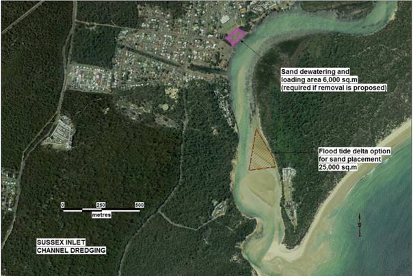
Figure 1: Sussex Inlet channel dredging
sand disposal options – Shoalhaven Dredging Feasibility Study
St Georges
Basin Estuary Management Plan
The St Georges Basin Estuary Management Plan does not have any actions to dredge
or alter the St Georges Basin tidal flood delta area. It does however state
that sediment movement in the basin is a dynamic process and that any dredging
will only ever provide short term improvements, which will be followed by
natural infilling from subsequent floods and tidal deposition. In additional to
the significant initial costs involved in dredging there is also a sizable
ongoing financial commitment required (Webb McKeon & Assoc. 2006).
Goal 3 - Sussex
Inlet (river mouth/bar)
Partly remove the sand spit to open the
river mouth and create a channel approximately 50 metres wide.
The aim of this
Goal is to dredge/extract sand as required to aid safe navigation and
contribute to flood mitigation/flood readiness. The need to remove sand will be
decided in the annual review as stated in this plan and sand will be placed at
Council discretion.
Shoalhaven
Citywide Dredging Feasibility Study
The study identifies that between 2011 and 2013
there were 623 boat log-ons with the Sussex Inlet Marine Rescue and estimated
that the majority of these boats were crossing the bar (Spurway 2014).
The study assessed likely longevity of potential
dredging projects as one of the factors for prioritising projects. The overall
longevity of project sites was rated from “poor” to
“good” based on the rate of infill following the dredging, considering
sand drift, dune erosion and scour from floods. The study rated the Sussex
Inlet bar as being poor to fair, due to sporadic medium infill rate and
irregular benefit from flooding.
The study also noted that local advice had been that the Sussex Inlet bar had
not restricted marine rescue craft, rather the inlet shoals had been
restrictive during low tide periods.
The study also identifies that the dredging of
the entrance bar would require a second booster pump to the Alamein Rd site and
the longevity of the dredged channel in this area would be limited by the
unlimited southward feed of sand from Bherwerre beach.
St Georges
Basin Estuary Management Plan
The estuary management plan states that any type
of entrance management/training would result in increased tidal range which
would lead to lower tides and may therefore reduce the depth of the navigation
channels (Hughes, 1985). It also states that any alterations to the
hydrodynamics of the waterways will affect the rate and magnitude of
tidal-flushing within the estuary.
These changes to natural timing and
magnitude of the tidal influence, due to modified entrance conditions, can have
multiple effects on the physical, chemical and biological characteristics of
the estuary. The estuary management plan has action in relation to navigation
and entrance management, stating that there will be nil intervention in
entrance of the estuary.
Goal 4 -
Navigation Channel
Restore the navigational channel of the
estuary to the centre of the river in the region of Alamein to The Haven (South
of Lions Park Boat Ramp) see figure 3.
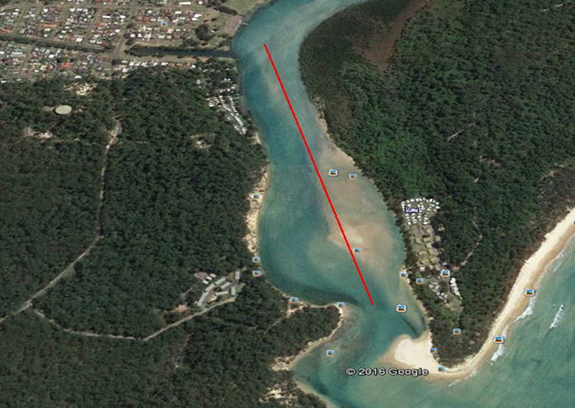
Figure 2: SNAG plan proposed location of
dredging in the Sussex Inlet entrance.
Shoalhaven
Citywide Dredging Feasibility Study
The feasibility study identified that dredging should also be undertaken in the
region of the Alamein Road, downstream to the Haven Holiday Resort, to provide
a depth of -1.5m AHD and a width of 25m metres. Although, not in the centre of
the channel as proposed by the SNAG plan, see figure 3 below.
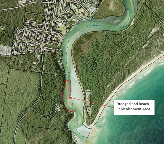
Figure 3: Location
of the proposed dredging and beach nourishment as per the dredging feasibility
study.
St Georges Basin Estuary Management Plan
The estuary management plan states that
dredging inlet/entrance can provide immediate benefits to navigation, but these
are frequently short lived. Increased depth of channel generally results in
increased speed of current and tidal range, with low tides being lower. This
effect can further reduce the depth of navigation channels (Ozcoasts, 2010;
Hughes, 1985).
Goal 5 - Chris
Creek Channel
Maintain a
navigable channel at Chris Creek on the eastern side of the bridge.
Dredge and
maintain navigable depth to avoid medium size boats bottoming out. (Medium size
boat meaning any boat capable of passing under the bridge.)
Some of this sand can be placed in front
of and around the concrete boat ramp and perhaps
some top dressing on the adjacent reserve.
Shoalhaven
Citywide Dredging Feasibility Study
The feasibility study does not identify any dredging works for this location.
St Georges
Basin Estuary Management Plan
In the estuary management plan, it
identifies that DPI Fisheries has concerns about the potential impacts of
dredging operations upon aquatic habitats and marine vegetation, particularly
seagrass. This proposed location has large areas of seagrass meadows as can be
seen from Figure 4 below.
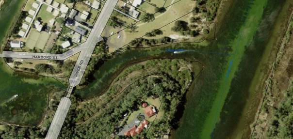
Figure 4: Chris Creek location of proposed
dredging showing darker areas are seagrass meadows
Goal 6 - Marine
Rescue
Maintain a
suitable depth to accommodate the larger boat at the Marine Rescue berths on
low tides.
Shoalhaven
Citywide Dredging Feasibility Study
The feasibility study does not identify any dredging works for this location.
St Georges
Basin Estuary Management Plan
In the estuary management plan, it identifies that DPI Fisheries has
concerns about the potential impacts of dredging operations upon aquatic
habitats and marine vegetation, particularly seagrass. This proposed location has
areas of seagrass meadows located around the berth areas of the Marine Rescue
surf craft.
Goal 7 - Swan
Lake delta and creek
Remove some of the silted sands that
have accumulated with the last three lake openings. These deposits are carried
into the lake from the lake entrance on incoming waters when the lake is
temporarily tidal and exacerbates environmental flows. It is also silt
deposited from runoff, see figure 5 below for proposed location of dredging at
Swan Lake.
Figure 5: Proposed
location of dredging at Swan Lake, SNAG Inc. plan.
Shoalhaven
Citywide Dredging Feasibility Study
The feasibility study does not identify any dredging works for this location.
Swan Lake
and Berrara Creek Natural Resources Management Strategy and the Swan Lake
Entrance Management Policy
Both of these
management plans and strategies make no reference to dredging or disturbance to
sediment within Swan Lake. The Swan Lake Natural Resources Management Strategy
has an action relating to minimising intervention in the natural entrance
behaviour. This implies that the adopted strategy would not support this goal.
One of the Swan Lake Entrance Management
Plan objectives is to ensure that, any entrance opening or manipulation of the
entrance of Swan Lake is to follow as natural regime as possible, within the constraints
of property inundation and flooding of infrastructure. This proposal clearly
does not meet this objective.
Goal 8 -
Recurring Dredging Riviera Keys
The community desire is to revisit the
maintenance issues of the canal system and to see the provision of:
· Recurring
dredging for the purpose of maintaining appropriate silt levels adjacent to
storm water drains.
· Recurring
dredging to maintain canal formation and depths as shown in original
construction specifications.
· Adequate sand
placement for beach renourishment in front of all properties.
· Maintenance of
revetment walls
· For Shoalhaven Council to continue with their submission to IPART
for the Waterfront Maintenance Levy rate rise specific to canal residents as
identified in Council minutes of The Extra Ordinary Meeting held on Tuesday
14th June 2016. This submission to IPART will be with further consultation with
SNAG Inc.
Shoalhaven Citywide Dredging Feasibility
Study
The feasibility study does refer to the
management plan for the Sussex Inlet canal estate development. It recognises
siltation as an issue for the estate and states that if the channel linking the
inlet to the canal estate does silt up, reducing tidal influence, then this
could lead to a reduction in water quality.
The feasibility study does recommend that
regular hydro surveys be undertaken to monitor the depth of the canals compared
to the Public Works Design, shown in figure 7 of the Study.
Sussex Inlet
Canal Estate Management Plan, December 2014
This Plan sets out management of the canals
in relation to dredging.
Goal 9 - Alamein
marina
Dredge Alamein
marina (Pacificana Drive). Particular attention to the western end around the
boat ramp. Make the ramp serviceable by removing the accumulated silt.
Removing accumulated silt and cleaning
up around this ramp will reduce the load on the Lakehaven Drive ramp in peak
seasons.
Shoalhaven
Citywide Dredging Feasibility Study
The feasibility study does not identify any
dredging works for this location.
Goal 10 -
Improve navigation full length of estuary
As part of the Dredging Plan of 2015
Council stated their preparedness to monitor depths on a quarterly basis this
will show where dredging is required as necessary to maintain navigational
depth.
Shoalhaven
Citywide Dredging Feasibility Study
As previously stated the feasibility study
identified that dredging should also be undertaken in the region of the Alamein
Road downstream to The Haven Holiday Resort, to provide a depth of -1.5m AHD
and a width of 25m metres. Currently Council is undertaking hydrosurveys of the
dredge locations, however on-going surveys of the entire inlet would be cost
prohibitive.
St Georges
Basin Estuary Management Plan
As part of action CC2 under natural hazards
– adapting to climate change, the estuary management plan recommends
mapping areas around the Basin that are likely to be inundated as a result of
sea level rise, using detailed LiDAR or similar survey information.
Goal 11 - NSW
Coastal Erosion Hot Spots
Recognition
and identification of NSW Coastal Erosion “Hot Spots” for the
Sussex Inlet area in addition currently listed on the NSW SEPP Map. I.e. the
entrance western foreshore dune system (Stingray Bay).
The community are asking the question,
“Should Coastal Management Policy include protection for the dune system
at Stingray Bay (river mouth) and funding for the preservation of this dune
system?”.
The St
Georges Basin Estuary Management Plan
The SNAG plan
identifies in this goal that the barrier sand dunes around the entrance are being
degraded and contributing to the infilling and siltation of the inlet entrance.
The St Georges Basin Estuary Management Plan refutes this claim. Hughes (1985)
and Manly Hydraulics Laboratory (1997) found that slip faces of the barrier
dunes at the entrance contributed only small volumes of sand to the entrance
shoals, which are insignificant in terms of the sediment transport potential
within the inlet channel.
Analysis of
historical aerial photographs from 1937 to 2009 (Muhlbaur, 2000 & Boardman
2009) support the findings of Hughs (1985) and MHL (1997).
Contrary to the claim made in the SNAG Inc.
plan Sussex Inlet is not regarded as “Erosion Hotspot” or high risk
beach, as per the Shoalhaven Coastal Hazard Review 2016, see https://shoalhaven.nsw.gov.au/Environment/Coastal-Landscape/Council-and-climate-change
Goal 12 -
Provide a foundation for a future concept
We aim to provide a permanent pedestrian
access to the river mouth for tourists and local residents. This will return to
the community an asset that was enjoyed many years ago. Walking to the
entrance, a swimming beach, and fishing, all part of a lost asset to the
public.
Figure 8: SNAG
Sussex Inlet Promenade Proposal for proposed permanent pedestrian access along
the southern shoreline of the inlet entrance (from Appendix 1 of SNAG Plan)
St Georges
Basin Estuary Management Plan
The St Georges Basin Estuary Management actions stress the importance
of maintaining and retaining foreshore buffer zones around the basin and inlet,
with linking vegetation to improve habitat corridors and reduce erosion.
It also has an
action to provide environmental protection zoning to land adjacent to foreshores,
watercourses or draining into sensitive aquatic habit.
The proposal to
construct hard structures within the dynamic environment such as the entrance
to an estuary may cause a “knock on” effect by exacerbating erosion
in other locations within the shoaling estuary.
Any such proposal would need to be subject
to environmental approval process.
Policy Implications
The SNAG Inc.
Dredging Plan for Sussex Inlet has wide ranging policy implications for
Shoalhaven Council under the Coastal Management Act 2016, Coastal Management
State Environmental Planning Policy (SEPP) as well as other guiding plans such
as the St Georges Basin Estuary Management Plan and the St Georges Basin Flood
Risk Management Plan.
Financial
Implications
To implement the actual dredging component
of the SNAG Inc. dredging plan, including all the approvals, environmental
studies, surveys and dredging works would be in the order of multiple-millions
of dollars.
Risk Implications
There are
extensive economic, environmental and social risk implications associated with
the SNAG Inc. Sussex Inlet Dredging Plan that would require assessment and
analysis.
|

|
Shoalhaven Natural Resource & Floodplain Management Committee
– Wednesday 18 April 2018
Page 0
|
SN18.4 Update on
the review of the draft 2012 Coastal Zone Management Plan
HPERM Ref: D18/73442
Group: Planning Environment & Development Group
Section: Environmental Services
Purpose / Summary
To provide an
update on the revision of the Shoalhaven Coastal Zone Management Plan (CZMP)
2018.
|
Recommendation (Item to be
determined under delegated authority)
hat Council
receive the update report on the revision of the
Shoalhaven Coastal Zone Management Plan (CZMP) 2018
for information.
|
Background
In order to
apply for the full range of grants available under NSW Coastal & Estuary
Grants Program, Council is required to have a certified coastal zone management
plan or coastal management program. At the time of its completion, the draft
2012 CZMP was not submitted to the NSW Government for certification because the
Stage 2 Coastal Reforms were announced and certification of CZMPs was put on
hold until the Reforms were implemented.
In 2016,
without any changes being made, Council resolved to submit the draft CZMP to
the NSW Government for certification. Certification was not granted and OEH
subsequently provided Council with a comprehensive list of changes that needed
to be made before re-submission.
The Stage 2
Coastal Reforms are contained within the 2016 Coastal Management Act which came
into effect on April 3. From that date, Council will have 6 months to have the
draft revised CZMP certified by the Minister. For the last two months, or more,
it will need to be with the NSW Government undergoing the certification
process, so Council will have approximately four months (from April 3) to
complete the review, place the document on public exhibition, distribute the
document to appropriate agencies, prepare the final plan and report it to
Council.
Council’s
intention is to send the CZMP 2018 to the NSW Government for certification in
late July following public exhibition.
Reviewing and
editing the draft document began last year and in January 2018, and has
included the engagement of an external consultant to assist with the review and
speed up the process to make the substantial changes required by OEH. Council
has also engaged a coastal engineering consultancy to complete the technical
updates that relate to coastal hazard risk assessment.
Summary of
amendments to the CZMP to date
· Department of
Industry staff have reviewed the document and all comments have been
incorporated
· DPI Fisheries and
JBMP staff at Huskisson have reviewed the document and all comments have been
incorporated
· The document has been
updated to be consistent with The Coastal Hazard Review report 2016 and mapping
has been updated
· The structure of the
document has been rearranged and simplified
· Redundant, out
dated, irrelevant text has been deleted
· New text has been
added
· All figures and
tables have been reviewed and updated
· All figures and
tables have been given a ‘new look’
· Citywide strategies
have been reviewed and updated
· Local Area Action
Plans are being reviewed and updated
· Appendices have been
updated
· Emergency Action Sub
Plan is being reviewed and will be included as an Appendix
· All technical
information in the document is being reviewed and updated
· The whole document
will be inserted into a ‘new look’ template before going out for
public exhibition
·
Community
Engagement
Council’s
Communications & Media team is assisting Environmental Services to provide
a new graphic look for the document. They are also preparing an engagement plan
which will include a ‘Get Involved’ page for information and feedback,
a video explaining the what and why of the CZMP and FAQs. The CZMP will go out
on public exhibition as part of the review process.
Policy Implications
Without a
certified CZMP, Council is eligible to apply for a very limited range of grant
categories in the Coastal and Estuary Grants Program. This significantly
reduces the range of coastal maintenance and capital works Council can
implement.
Financial
Implications
The OEH Coastal
and Estuary Grants Program, provides 50% of project funds. Without a certified
CZMP Council would be denied eligibility for the full range of grant
categories. This means Council would need to fully fund the many coastal
projects that become necessary over the next 3-5 years, while the new Coastal
Management Plan is being prepared and certified.
Risk Implications
With increased
stormy weather predicted, there will be more coastal projects requiring
implementation to manage risk, repair infrastructure and maintain coastal
assets to a safe and acceptable standard. If grant funds can’t be
accessed, public safety and asset protection will be at risk.
|
|
Shoalhaven Natural Resource & Floodplain Management Committee
– Wednesday 18 April 2018
Page 0
|
SN18.5 Citizen
Science - Utilising Technology to Monitor the Coast
HPERM Ref: D18/80832
Group: Planning Environment & Development Group
Section: Environmental Services
Purpose / Summary
To provide the
Committee with information about the potential for Council to engage in a
citizen science project via an App, named Photomon.
The App has been developed by WA’s Northern Agriculture Catchment
Council, and is a mechanism used for coastal monitoring via citizen science.
For further information visit the NACC Photomon website at https://www.nacc.com.au/project/beach-photo-monitoring/
|
Recommendation That:
1. Council
endorse the opportunity to engage in a citizen science project by taking up
the three-month free trial offered for the Photomon App;
2. Council
seek an expression of interest through the Shoalhaven Natural Resources &
Floodplain Management Committee, Council Consultative Bodies and Shoalhaven
Bushcare Groups for volunteers to be involved in the citizen science project
via the Photomon App; and
3. A further report be provided to the Shoalhaven
Natural Resources & Floodplain Committee and Council on the outcomes of
the trial in order to determine whether to proceed with a full subscription
for future coastal monitoring.
|
Options
1. As
recommended, proceed with the free, three-month Photomon trial.
Implications: Council officers time would be required to coordinate the trial,
including the recruitment and training of a limited number of volunteers to use
the App at a limited number of sites.
2. Not
proceed with the free, three-month trial
Implications: Council officers will need to continue researching suitable
options for the monitoring of coastal management processes.
3. Enter directly into a two-year subscription
Implications: The App may not suit Council’s needs and a trail is
recommended to determine if it meets Council needs.
Background
In September
2017, committee member, Mike Clear, provided Environmental Services with
information about an App called ‘Photomon’. The App was developed
by the Western Australian (WA) Northern Agricultural Catchments Council (NACC).
Mr Clear suggested that it could be an effective tool for recording changes in
the local environment, particularly dynamic environments such as our beaches
and estuaries.
In January
2018, king tides (peaking at 2.07m) prompted Environmental Services to discuss
options for a formalised photo monitoring program that could assist various
sections of Council to adapt to climate change and rising sea levels.
Staff in Council’s
Assets & Works Group and Shoalhaven Water expressed interest in
collaborating with Environmental Services staff to investigate the options.
The most
efficient option is to use an App so that the process of date stamping, and
storing the photos for easy comparison, is automatic.
Council
investigated the availability of photo monitoring Apps and found that the NACC
App, Photomon, is the only one of its kind available that doesn’t require
software and other infrastructure.
Features of the
App:
· Overlaid transparent
reference photos for consistent Field of View
· Automatic labelling
and uploading of photos using cellular network or wifi
· Program coordination
via the database
· Reminder function to
prompt the next photos
There are three
ways of using Photomon:
· Demo mode for free,
small-scale monitoring programs such as bush regeneration projects by community
groups
· Larger
photo-monitoring programs can be facilitated by engaging Photomon’s
developer to link the App to a separate and dedicated database. This option
requires payment for amending the App and maintaining the new database
· Large organisations
who want to link Photomon to their own database can enter into a license
agreement with NACC to amend the App to link directly to the database.
The services
NACC provides are:
· A three-month, free
trial to ensure the service meets our needs
· Introductory
information and guidence for the App
· Access to a secure
back-up and database for storing photos
· Technical support
via email and phone on how best to use Photomon
· Ongoing maintenance
and upgrading of the App and database
· A Photomon Users
Guide is available on the NACC website
Fees:
· Biennial
subscription fees from 1 July to 30 June. Pro-rata payments can be made for
periods less than 2 years
· Tiered subscription
fees depending on how many photos are uploaded annually.

Figure 1: Photomon Subscriber Level & Costs
It would be of
benefit to Council if volunteers could be recruited and trained to use the Photomon
App in nominated locations and for specific purposes such as:
· During king tides
– the next king tides will occur between June 13 and June 16 when high
tides will range from 2.10 m to 2.08 m. Sites are yet to be determined but
could include boat ramps, high risk beaches, Ulladulla Harbour, wharves,
jetties and any other sites of interest to SCC asset managers and community
groups
· High risk beaches at
regular intervals and immediately post storm
· Shoreline adjacent to sewer pump stations and other Shoalhaven Water
at-risk assets.
Community
Engagement
Initially,
prior to the commencement of the three-month trail, an expression of interest
(EOI) would be sent out to Committee members as well as Council Consultative
Bodies and Bushcare Groups to recruit volunteers to participate in the trial.
Based on the success of the trial period, if Council were to proceed with
subscription of the App, then it could be promoted in the print media, on
radio, on Council’s social media sites and on Council’s Get
Involved site. Those interested in volunteering to become a
‘Photomon’, could offer their services through the Get Involved
page.
Financial
Implications
A Council
officer would need to be allocated the task of Photomon project coordination,
including preparing the community engagement program in conjunction with the
Media and Communications Team, training and supporting volunteer Photomons and
liaising with NACC and other sections of Council.
A budget would need
to be consolidated, from the various interested sections of Council, to cover
subscription fees and all other costs associated with implementing and managing
the Photomon Project. The financial cost to Council would be based upon the
level of the subscription that it chose (see figure 1).
Risk Implications
Coastal
hazards, including rising sea level, constitute on-going risk. The Photomon App
can provide Council with useful graphic data to monitor the impacts of coastal
hazards. This data will assist Council and coastal communities prepare and
adapt to the challenges, and on-going risks, associated with climate change.
|
|
Shoalhaven Natural Resource & Floodplain Management Committee
– Wednesday 18 April 2018
Page 0
|
SN18.6 Update on
the Review of the Lake Tabourie Entrance Management Policy
HPERM Ref: D18/89903
Group: Planning Environment & Development Group
Section: Environmental Services
Attachments: 1. Tabourie Lake EMS Review Community Consultation
Questionnaire ⇩
Purpose /
Summary
The purpose of
this report is to inform Committee about the updates on the review of the Lake
Tabourie Entrance Management Policy.
|
Recommendation (Item to be determined under delegated authority)
That Committee receive the report on the
review of the Lake Tabourie Entrance Management Policy for information.
|
Options
1. As
recommended.
Implications: Nil
2. Provide
an alternative recommendation for future consideration by Council.
Implications: Unknown
Background
Council,
together with the NSW Government, manages some estuary entrances for flood
mitigation purposes. Historical development of estuary catchments and
floodplains has resulted in low-lying properties being at risk from flooding
under certain rainfall and entrance conditions.
The Tabourie
Lake Floodplain Risk Management Study (FRMS) and Plan (2016), proposed a review
of Council’s existing Tabourie Lake Entrance Management Policy (EMP) and
Review of Environmental Factors (final draft, 2005). The ocean storm event in
June 2016 further highlighted the importance of this review.
The review of
the EMP should consider the detailed flood modelling results presented in the
FRMS, the combined risks associated with catchment and ocean flooding, and the
potential impact of climate change on flooding and entrance behaviour.
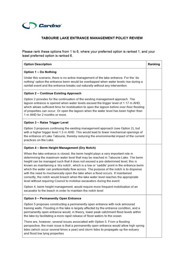
Preliminary
options have been identified and presented to the community. The following
options were presented in the following order:
Option 1 - ‘Do Nothing’ Approach
Option 2 - Continue Existing Approach
Option 3 - Raise Trigger Level
Option 4 - Berm Management
Option 5 - Dry Notch
Option 6 - Construct a
Permanently Open Entrance
An online
questionnaire was distributed during the consultation period (refer to
Attachment 1) and 100 responses were received from the community.
In the
questionnaire, the community was asked to rank the options presented (refer
above) from a scale 1 to 5.
It was found there was wide range of
opinions within the community. As demonstrated in Table 1 below, final scores
for Options 2 to 5 were very similar, with Option 1 scoring the least.
Therefore, the options assessment based on community feedback concluded that
options will come down to cost and impacts to the community.
|
Option no.
|
Management Approach
|
Score
|
|
1
|
‘Do
Nothing’ Approach
|
2.14
|
|
2
|
Continue
Existing Approach
|
3.82
|
|
3
|
Raise
Trigger Level
|
3.9
|
|
4
|
Berm
Management
|
3.91
|
|
5
|
Dry
Notch
|
3.59
|
|
6
|
Construct
a Permanently Open Entrance
|
3.63
|
Table
1: Summary of results from the community
questionnaire
At this stage, Council and the consultant
are working to assess and weigh up the modelling options, taking into
consideration the feedback from the community consultation. A second round of
community consultation is currently being planned with modelled options. This
will be undertaken in the same form as the first round of consultation.
Community
Engagement
The outcomes of
the preliminary findings of potential options have been presented to the
community. The first round of consultation has been undertaken. An information
night was held, mail-out of information, ‘Get Involved’ webpage
setup and numerous social media posts. The second round of community
consultation is being planned in the coming months.
Policy Implications
The current
Lake Tabourie Entrance Management Policy (final draft, 2005) remains current
until such time as this review is completed and formally adopted by Council.
Financial
Implications
Sufficient
funds have been allocated towards this project. The project is currently within
budget, with no anticipation of the project budget being exceeded.
The project is
for the provision of consultancy works and does not have any direct or
immediate implications on Council’s assets. The project is managed by
staff from the Natural Resources and Floodplain Unit.
|
|
Shoalhaven Natural Resource & Floodplain Management Committee
– Wednesday 18 April 2018
Page 0
|

|
|
Shoalhaven Natural Resource & Floodplain Management Committee
– Wednesday 18 April 2018
Page 0
|
SN18.7 Update on the
Shoalhaven River Levee Flood Damage Restoration 2017 Project
HPERM Ref: D18/92311
Group: Planning Environment & Development Group
Section: Environmental Services
Purpose /
Summary
The purpose of
this report is to inform the Committee about the updates on Shoalhaven River
Levee Flood Damage Restoration project.
|
Recommendation (Item to be determined under delegated authority)
That the
Committee receive the report for information.
|
Options
1. The
Committee receive the report for information.
Implications: Nil.
2. The
Committee could choose to provide an alternative recommendation for future
consideration by Council.
Implications: This option can significantly affect the project and delay
progress of the project.
Background
Council has
commenced a project to repair damaged sections of the Shoalhaven River Levee at
Terara, Numbaa and Comerong Island. The aim of the project is to repair damage
that occurred during the August 2015 flood, June 2016 flood and damage
identified during the levee audit undertaken by Royal Haskoning Pty Ltd in May
2015.
Council called
for tenders mid last year for the project; however, all tenders were considered non-conforming.
Due to the
market failure in open tendering and the limited grant funding timeline, at its
meeting on 27 June 2017, Council resolved to enter into negotiation with any
person or firm within existing tender panels (notified during previous NRFMC
meeting) and break the work into smaller packages based on the levee location.
Due to
non-availibility of a suitable tender panel, Council called for tenders for two
high priority packages to repair levee defects at Terara and Comerong Island on
19 October 2017 to find a suitably qualified contractor. The tenders closed on
23 November 2017, however, were rejected due to late submissions. Despite
rejection of the tender, Council found a contractor (NSW Soil Conservation
Service) that was technically suitable for the job, as they had previous
experince in undertaking larger scale projects in the relevant field. The other
contractor was unable to meet minimum technical criteria and was not considered
further.
As per the
Council resolution, Council entered into negotiation with the ranked (based on
price/non-price criteria) contractor i.e. NSW Soil Conservation Service (SCS-
commercial wing of DPI). After a sucessful negotiation, Council engaged NSW
Soil Conservation Service with a contract worth of $1,676,842.20 (incl GST).
The project cost is funded by both National Disaster Relief Recovery
Arrangement (NDRRA) grant and Council.
Considering the
fact that NSW Soil Conservation Service were found to be suitable for both the
packages, and can offer savings on combining two packages, Council decided to
combine two packages and issue a single contract for the project, which will
save money, time and administration costs.
The project
started on 27 Feb 2018 and is expected to be completed by August 2018. NSW Soil
Conservation Service has indicated that they have the capacity to carry out the
remaining two packages simultaneously to contracted works. Council is under
negotiation at this stage with contractors for the remaining two packages to
repair defects at Numbaa levee and levee repairs located at wedding venues at
Terara. After negotiations are completed with the contractor, the remaining two
packages can be added as a variation to the original contract.
In the past,
Council received $1.1M National Disaster Relief Recovery Arrangement 2015
(NDRRA) grant fund to repair flood damage that occurred during August 2015 flood.
Council also submitted the NDRRA 2016 claim to repair levee defects that
occured during June 2016 flood. Public Works Advisory (PWA) requested Council
resubmit Council’s NDRRA claims taking the NSW Soil Conservation Service
tender prices into account. Council currently, with the assistance from Public
Works Advisory (PWA), is reviewing the NDRRA funding claim and will submit a
revised claim shortly.
Community
Engagement
Council’s
floodplain engineers and property unit officers have visited private properties
and met with property owners to discuss access and levee repair works to be
conducted on their properties. Council has received 21 signed Deeds of
Agreement from the damaged levee affected private property owners and is
negotiating to get the remaining 2 Deeds of Agreement signed by the relevant
property owners. The remaining property owners have expressed their interest in
discussing the works with the contractor prior to reaching an agreement. This
message has been conveyed to the contractor and the contractor has agreed to do
so.
Policy Implications
Council manages
levees in the Lower Shoalhaven River area, which are identified in
Council’s Asset Management Plan for Flood Mitigation Structures.
Financial
Implications
Council
resolved to advance this project ahead of NDRRA funding confirmation. Public
Works Advisory requested to resubmit the claim taking the accepted tender price
into account. Currently, Council is revising the estimates in assistance with
Public Works Advisory.
It appears that
the current revised claim will be higher than the revised claims that were
submitted during August 2017 for both the 2015 & 2016 flood damage. The
actual volume of works and current market price are supposedly contributing to
higher claim amounts. There is no guarantee that
Council’s revised NDRRA grant funding claims will be successful.
Risk Implications
Council
resolved to undertake all flood levee restoration works to repair 2015 and 2016
flood damage including high priority levee audit defects, while waiting for the
revised NDRRA outcomes. There is no guarantee that Council’s revised
NDRRA grant funding claims will be successful. However, if these levee defects
are not restored, the levee defect locations will continue to erode leading
towards more expensive restoration in future.
|
|
Shoalhaven Natural Resource & Floodplain Management Committee
– Wednesday 18 April 2018
Page 0
|
SN18.8 South
Mollymook Beach Cost Benefit Distribution Analysis (CBA) Coastal Hazard
Assessment
HPERM Ref: D18/102646
Group: Planning Environment & Development Group
Section: Environmental Services
Attachments: 1. South Mollymook Beach Cost Benefit and Distributional
Analysis. Coastal Hazard Assessment (under separate cover)
Purpose /
Summary
Advise the Committee
on the current status of the South Mollymook foreshore protection structure,
Cost Benefit Analysis (CBA) project commissioned in January 2018.
|
Recommendation (Item to be determined
under delegated authority)
That Council
receive the South Mollymook foreshore protection
structure, Cost Benefit Analysis (CBA) “initial findings report” for information.
|
Options
1. As recommended.
Implications: Nil
2. Propose an
alternative recommendation.
Implication: Would depend on the recommendation.
Background
In 2017, consultant ‘Origin’ was engaged
by Council to carry out the cost benefit analysis for the replacement of the
foreshore protection structure at South Mollymook Beach and a distributional
analysis (partitioning of benefits to affected property and asset owners). Royal
HaskoningDHV (RHDHV) were retained by Origin to carry out a risk-based coastal
hazard assessment using a “probabilistic” coastal hazard modelling
method, consistent with the new NSW Coastal Management Manual Part C:
Coastal Management Toolkit, Using Cost Benefit Analysis to Assess Coastal
Management Options: a Guide for Local Councils (OEH, 2015). This assessment
process is outlined in attachment 1.
Coastal hazards threaten public and private assets at
Mollymook Beach. Coastal hazards can include storm and long-term erosion,
inundation, dune instability and sand movement, and geotechnical hazards https://www.shoalhaven.nsw.gov.au/Environment/Coastal-Landscape/
Coastal-Hazards
Council’s draft Coastal Zone Management Plan
(CZMP) lists a number of actions to reduce the risk of coastal hazards at Mollymook
Beach, including review of revetment installations at South Mollymook. Royal
HaskoningDHV (RHDHV) investigated foreshore stabilisation and developed a
staged upgrade to the existing walls. Concept designs were prepared for four
seawall types covering 300m of foreshore (RHDHV, 2016).
A Site meeting
was held in December 2017 with the project reference group including the Golf
Club, Mollymook Surf Club, Shoalhaven Water, NSW OEH, and Council staff to
discuss the scope of the project as well as long-term aspirations for the
precinct.
To progress the design development of any prospective
foreshore stabilisation works, a number of activities were recommended for
consideration including a formal Cost Benefit Analysis (CBA) covering the range
of management options including protection. The CBA also includes the base case
of ‘do nothing’. Four long-term options have been identified to
manage coastal hazards at South Mollymook Beach:
Option 1 Base
case/ status quo (Do nothing/ Emergency Response)
Option 2 Managed
retreat
Option 3 Protection
Option 4 Protection
and beach nourishment
Community Engagement
Council has
been in direct consultation with the owners and occupiers of the private assets
at risk at South Mollymook throughout the development of the CBA and coastal
hazard mapping, including the Mollymook Surf Life Saving Club and the Mollymook
Golf Club. This direct consultation will continue throughout the development of
the CBA.
Financial Implications
The total cost
of the CBA and coastal hazard modelling is $100,000. The NSW Office of
Environment (OEH) has funded 50% of the costs. Following the outcomes of the
CBA, Council will need to make a decision whether or not to proceed with the
preferred management option recommended by the CBA. The cost of replacing/
rebuilding the South Mollymook seawall is estimated at $3,373,500. A budget bid
for this amount over the 2018/19 and 2020/21 financial years has been prepared
for Council’s consideration in future budgets. Budget planning timeframes
meant that a budget bid needed to be prepared for consideration prior to the
completion of the CBA. Council has undertaken sand scraping, surface water
diversion and some minor repairs to the face of the sea wall to protect the
structure in an effort to increase the expected life of the structure. This
work was completed in December 2017 at a cost of $40,000 from Council’s
existing coastal maintenance budget.
Risk Implications
Eventually the existing seawalls at South Mollymook will
fail completely (storm damage greater than 30%), with the clean-up effort
expected to far exceed controlled demolition and removal at an earlier point in
time, based on the preliminary findings of the CBA. In this location, Council’s
coastal risk hazard mapping identifies the sewage pumping station, sewage
lines, shared pathway, road, storm water infrastructure and kerb and gutter at
risk from coastal hazards.