Development Committee
Meeting Date: Tuesday,
13 February, 2018
Location: Council
Chambers, City Administrative Building, Bridge Road, Nowra
Time:
5.00pm
Membership (Quorum - 5)
Clr Joanna Gash - Chairperson
All Councillors
General Manager or nominee
Please note: Council’s Code of Meeting Practice
permits the electronic recording and broadcast of the proceedings of meetings
of the Council which are open to the public. Your attendance at this meeting is
taken as consent to the possibility that your image and/or voice may be
recorded and broadcast to the public.
Agenda
1. Apologies / Leave of Absence
2. Confirmation of Minutes
· Development
Committee - 22 January 2018............................................................... 1
3. Declarations of Interest
4. Mayoral Minute
5. Deputations and Presentations
6. Notices of Motion / Questions on Notice
Nil
7. Reports
DE18.7........ Proposed Submission - Draft Greener Places
Policy.................................. 10
DE18.8........ Worrowing Heights Precinct Plan and Strategic
Directions Report - Public Exhibition Outcomes..................................................................................................... 13
DE18.9........ Shoalhaven DCP 2014 - Amendment No. 8 - Flood
Chapters G9 and G10 25
DE18.10...... Planning Proposal Request - Proponent Initiated -
9 Browns Road, South Nowra - Caravan Park ............................................................................................... 28
DE18.11...... Planning Proposal - Building Height Review -
Southern Part of Ulladulla CBD 37
DE18.12...... Aboriginal Land Claims Numbers 7780, 7781 and
41110 - Rose Street, Hyams Beach...................................................................................................................... 47
DE18.13...... Development Application DA17/1958 – 99
Sunset Strip, Manyana – Lot 115 DP 31711............................................................................................................ 58
DE18.14...... Development Application – 56 Red Gum Drive
Ulladulla – Lot 506 DP 1235307...................................................................................................................... 77
8. Confidential
Reports
Nil
|

|
Development
Committee – Tuesday 13 February 2018
Page
iii
|
Development Committee
Delegation
THAT pursuant to s377 (1) of the
Local Government Act 1993 the Committee is delegated the functions conferred on
Council by the Environmental Planning & Assessment Act 1979 (EPA Act),
Local Government Act 1993 (LG Act) or any other Act or delegated to Council, as
are specified in the attached Schedule, subject to the following limitations:
i. The
Committee cannot make a decision to make a local environmental plan to classify
or reclassify public land under Division 1 of Part 2 of Chapter 6 of the LG
Act;
ii.
The Committee cannot review a s82A or s96AB EPA
Act determination made by the Council or by the Committee itself;
iii.
The Committee cannot exercise any function delegated
to the Council which by the terms of that delegation cannot be sub-delegated;
iv.
The Committee cannot exercise any function which
s377(1) of the LG Act provides cannot be delegated by Council; and
v.
The Committee cannot exercise a function which
is expressly required by the LG Act or any other Act to be exercised by
resolution of the Council.
Schedule
a. All
functions relating to the preparation, making, and review of local
environmental plans (LEPs) and development control plans (DCPs) under Part 3 of
the EPA Act.
b. All
functions relating to the preparation, making, and review of contributions
plans and the preparation, entry into, and review of voluntary planning
agreements under Part 4 of the EPA Act.
c. The
preparation, adoption, and review of policies and strategies of the Council in
respect of town planning and environmental matters and the variation of such
policies.
d. Determination
of variations to development standards related to development applications
under the EPA Act where the development application involves a development
which seeks to vary a development standard by more than 10% and the application
is accompanied by a request to vary the development standard under clause 4.6 of
Shoalhaven Local Environmental Plan 2014 or an objection to the application of
the development standard under State Environmental Planning Policy No. 1
– Development Standards.
e. Determination
of variations from the acceptable solutions and/or other numerical standards
contained within the DCP or a Council Policy that the General Manager requires
to be determined by the Committee
f. Determination
of development applications that Council requires to be determined by the
Committee on a case by case basis.
g. Review
of determinations of development applications under sections 82A and 96AB of
the EP&A Act that the General Manager requires to be determined by the
Committee.
h. Preparation,
review, and adoption of policies and guidelines in respect of the determination
of development applications by other delegates of the Council.
Minutes of the Development Committee
Meeting Date: Monday,
22 January 2018
Location: Council
Chambers, City Administrative Building, Bridge Road, Nowra
Time: 5.00pm
The following members
were present:
Clr Joanna Gash -
Chairperson
Clr Amanda Findley
Clr Patricia White
Clr John Wells
Clr John Levett
Clr Nina Cheyne
Clr Annette Alldrick
Clr Mitchell Pakes
Clr Greg Watson
Clr Mark Kitchener
Clr Bob Proudfoot
Ms Carmel Krogh –
Acting General Manager
|
Apologies / Leave of Absence
|
Apologies were received
from Clr Gartner and Clr Guile.
|
Confirmation of the Minutes
|
|
RESOLVED (Clr Findley / Clr
Alldrick) MIN18.1
That the Minutes of the Development Committee held on
Monday 11 December 2017 be confirmed.
Note: The Development Committee was provided with a verbal
update on the development of DE17.99 - DS17/1233 – 12 Currambene
Street, Huskisson – Lot 2 DP 662583
CARRIED
|
Clr Proudfoot – DE18.5
– Proposed Planning Proposal - Citywide SP3 Tourist Zone Review –
less than significant non pecuniary interest declaration – will remain in
the room and will take part in discussion and vote –
the deputee, Maree Walsh-Harris ran for election as a member of the
Shoalhaven Independents at the last election.
Clr Kitchener – DE18.5
– Proposed Planning Proposal - Citywide SP3 Tourist Zone Review –
less than significant non pecuniary interest declaration – will remain in
the room and will take part in discussion and vote –
the deputee, Maree Walsh-Harris ran for election as a member of the
Shoalhaven Independents at the last election.
Clr Pakes – DE18.5
– Proposed Planning Proposal - Citywide SP3 Tourist Zone Review –
less than significant non pecuniary interest declaration – will remain in
the room and will take part in discussion and vote –
the deputee, Maree Walsh-Harris ran for election as a member of the
Shoalhaven Independents at the last election.
Clr Watson – DE18.5
– Proposed Planning Proposal - Citywide SP3 Tourist Zone Review –
less than significant non pecuniary interest declaration – will remain in
the room and will take part in discussion and vote –
the deputee, Maree Walsh-Harris ran for election as a member of the
Shoalhaven Independents at the last election.
Deputations and Presentations
Mr Stephen
Richardson (Cowman Stoddart – representing Tim Pembroke) addressed the
Committee in relation to DE18.1 – Development Application DA17/1264
– 77C Nerringillah Rd, Bendalong – Lot 3 & DP 858721
Mr Peter
Hudson addressed the Committee in relation to DE18.1 – Development
Application DA17/1264 – 77C Nerringillah Rd, Bendalong – Lot 3
& DP 858721
Ms Robyn
Flack (Shoalhaven Heads Forum) addressed the Committee in relation to DE18.3 -
Crown Land at Shoalhaven Heads - Proposed Rezoning – Update
Mr Howard
Jones addressed the Committee in relation to DE18.3 - Crown Land at Shoalhaven
Heads - Proposed Rezoning – Update
Ms Maree
Walsh-Harris addressed the Committee in relation to DE18.5 - Proposed Planning
Proposal - citywide SP3 Tourist Zone Review
|
Procedural
Motion - Bring Item Forward
|
|
RESOLVED (Clr Pakes / Clr Cheyne) MIN18.2
That the matters of the following
items be brought forward for consideration:
- DE18.1
– Development Application DA17/1264 – 77C Nerringillah Rd,
Bendalong – Lot 3 & DP 858721
- DE18.3
- Crown Land at Shoalhaven Heads - Proposed Rezoning – Update
- DE18.5
- Proposed Planning Proposal - citywide SP3 Tourist Zone Review
CARRIED
|
Reports
|
DE18.1 Development
Application DA17/1264 – 77C Nerringillah Road, Bendalong – Lot 3
& DP 858721
|
HPERM Ref:
D17/386304
|
|
Note:
Mr Peter Hudson and Mr Stephen provided deputations in relation to this
matter earlier in the meeting.
|
|
Recommendation
1. That
Development Application DA17/1264 for an eco-tourism development at Lot 3 DP
858721 Nerringillah Road, Bendalong be determined by way of deferred
commencement development consent with the deferred matter and conditions as
detailed in Attachment 1
|
|
Motion (Clr White / Clr Findley)
That Council, under delegated authority, refuse DA17/1264
for an eco-tourism development at Lot 3 DP 858721 Nerringillah Road,
Bendalong on the following grounds:-
1.
That the proposed development application does not meet the demonstrated
connection to the site and/or other requirements under Clause 5.13 of the
Shoalhaven Local Environment Plan 2014 which pertains to an eco-tourist
facilities.
2.
Insufficient information/details have been submitted to Council on the
proposed engineering designs and/or plans for the proposed works required for
the Right of Carriageway and Nerringillah Road that demonstrate safety; heavy
rigid vehicle access; and that the proposed works can be constructed within
the existing corridor/road and to the required standards.
3.
Traffic safety issues & maintenance with Bendalong Road;
intersection of Bendalong Road & Nerringillah Road; and Right of Carriage
Way.
4.
The proposed development is not in the public interest due to the
substance of the public objections.
For: Clr
Findley, Clr White, Clr Levett, Clr Cheyne, Clr Alldrick and Clr Kitchener
Against: Clr
Gash, Clr Wells, Clr Pakes, Clr Watson, Clr Proudfoot and Carmel Krogh
LOST
ON THE CASTING VOTED OF THE CHAIR
|
|
Note:
Clr Gash left the meeting, the time being 6.25pm.
Note:
Clr Levett assumed the chair.
Note: Clr Gash resumed
the Chair, the time being 6.28pm.
|
|
Foreshadowed Motion (Clr Proudfoot /
Clr Gash)
That
(Under Delegated Authority):
1.
The Development Application DA17/1264 for an eco-tourism development
at Lot 3 DP 858721 Nerringillah Road, Bendalong be determined by way of
deferred commencement development consent with the deferred matter and
conditions as detailed in Attachment 1
2. Council
undertake further negotiations with the applicant regarding a greater upgrade
of the Right of Way and that these negotiations be reported back to council
prior to Development Application being lodged for the Right of Way
|
|
AmendmenT (Clr White / Clr
Cheyne)
1.
That Council undertake further negotiations with the applicant
regarding a greater upgrade of the Right of Way and that the result of these
negotiations be reported back to council prior to the Development Application
being lodged for the Right of Way.
2.
The current Development Application be deferred until Council receives
the above report.
For: Clr
White, Clr Cheyne, Clr Alldrick and Carmel Krogh
Against: Clr
Findley, Clr Gash, Clr Wells, Clr Levett, Clr Pakes, Clr Watson, Clr
Kitchener and Clr Proudfoot
AMENDMENT lost
|
|
RESOLVED (Clr Proudfoot / Clr
Gash) MIN18.3
That
(Under Delegated Authority)
1.
The Development Application DA17/1264 for an eco-tourism development
at Lot 3 DP 858721 Nerringillah Road, Bendalong be determined by way of
deferred commencement development consent with the deferred matter and
conditions as detailed in Attachment 1
2.
Council undertake further negotiations with the applicant regarding a
greater upgrade of the Right of Way and that the result of these negotiations
be reported back to council prior to the Development Application being lodged
for the Right of Way.
For: Clr
Gash, Clr Wells, Clr Pakes, Clr Watson, Clr Proudfoot and Carmel Krogh
Against: Clr
Findley, Clr White, Clr Levett, Clr Cheyne, Clr Alldrick and Clr Kitchener
CARRIED ON THE CASTING VOTE OF THE CHAIR
Note: There was a rescission motion received on this item.
|
|
DE18.3 Crown
Land at Shoalhaven Heads - Proposed Rezoning - Update
|
HPERM Ref:
D17/421221
|
|
Note:
Robyn Flack and Howard Jones provided deputations in relation to this matter
earlier in the meeting.
|
|
Recommendation (Item to be determined under
delegated authority)
That Council take no further
action at present in regard to the rezoning of the Crown Land (that part of
Lot 7010 DP1035145 that is currently zoned R1 General Residential) at
Shoalhaven Heads.
|
|
RESOLVED (Clr Watson / Clr Pakes) MIN18.4
That Council
take no further action at present in regard to the rezoning of the Crown Land
(that part of Lot 7010 DP1035145 that is currently zoned R1 General
Residential) at Shoalhaven Heads.
For: Clr
Gash, Clr White, Clr Wells, Clr Levett, Clr Pakes, Clr Watson, Clr Kitchener
and Carmel Krogh
Against: Clr
Findley, Clr Cheyne, Clr Alldrick and Clr Proudfoot
CARRIED
Note:
There was a rescission motion received on this item
|
|
DE18.5 Proposed
Planning Proposal - Citywide SP3 Tourist Zone Review
|
HPERM Ref:
D17/386496
|
|
Note: Maree Walsh-Harris provided
a deputation on this matter earlier in the meeting.
Clr Proudfoot
– DE18.5 – Proposed Planning Proposal - Citywide SP3 Tourist Zone
Review – less than significant non pecuniary interest declaration
– will remain in the room and will take part in discussion and vote – the deputee, Maree Walsh-Harris ran
for election as a member of the Shoalhaven Independents at the last election.
Clr Kitchener
– DE18.5 – Proposed Planning Proposal - Citywide SP3 Tourist Zone
Review – less than significant non pecuniary interest declaration
– will remain in the room and will take part in discussion and vote – the deputee, Maree Walsh-Harris ran
for election as a member of the Shoalhaven Independents at the last election.
Clr Pakes
– DE18.5 – Proposed Planning Proposal - Citywide SP3 Tourist Zone
Review – less than significant non pecuniary interest declaration
– will remain in the room and will take part in discussion and vote – the deputee, Maree Walsh-Harris ran
for election as a member of the Shoalhaven Independents at the last election.
Clr Watson
– DE18.5 – Proposed Planning Proposal - Citywide SP3 Tourist Zone
Review – less than significant non pecuniary interest declaration
– will remain in the room and will take part in discussion and vote – the deputee, Maree Walsh-Harris ran
for election as a member of the Shoalhaven Independents at the last election.
|
|
Recommendation (Item to be determined under
delegated authority)
That Council:
1. Support
the preparation of the Citywide SP3 Tourist Zone Review Planning Proposal at
Attachment 1 and submit to the NSW Department of Planning & Environment
for Gateway determination. If Gateway determination is granted, proceed to
formal public consultation in terms of such determination.
2. Prepare
an amendment to Chapter V3: Miscellaneous Site-Specific Issues of Shoalhaven
Development Control Plan 2014 to establish site specific provisions for Site
7: Mollymook/Ulladulla.
3. Consider
the detail of the proposed amendments to Shoalhaven Development Control Plan
2014 via a separate report and if needed a Councillor Briefing prior to
exhibition.
4. Advise
the owners of the subject land, adjacent land owners and relevant community
groups of this decision, noting the opportunity for formal consultation later
in the process.
5. Following
public exhibition of the Planning Proposal and draft Chapter V3, submit a
further report to Council to address any submissions and finalisation of the
process.
|
|
Motion (Clr Findley / Clr Wells)
That Council:
1. Support
the preparation of the Citywide SP3 Tourist Zone Review Planning Proposal at
Attachment 1 and submit to the NSW Department of Planning & Environment
for Gateway determination. If Gateway determination is granted, proceed to
formal public consultation in terms of such determination.
2. Prepare
an amendment to Chapter V3: Miscellaneous Site-Specific Issues of Shoalhaven
Development Control Plan 2014 to establish site specific provisions for Site
7: Mollymook/Ulladulla.
3. Consider
the detail of the proposed amendments to Shoalhaven Development Control Plan
2014 via a separate report and if needed a Councillor Briefing prior to
exhibition.
4. Advise
the owners of the subject land, adjacent land owners and relevant community
groups of this decision, noting the opportunity for formal consultation later
in the process.
5. Following
public exhibition of the Planning Proposal and draft Chapter V3, submit a
further report to Council to address any submissions and finalisation of the
process.
|
|
AMENDMENT (RESOLVED) (Clr Watson
/ Clr Pakes) MIN18.5
That the matter of the Proposed
Planning Proposal - Citywide SP3 Tourist Zone Review be deferred, pending a
Councillor briefing.
For: Clr
Gash, Clr White, Clr Alldrick, Clr Pakes, Clr Watson, Clr Kitchener and Clr
Proudfoot
Against: Clr
Findley, Clr Wells, Clr Levett, Clr Cheyne and Carmel Krogh
CARRIED
|
|
Procedural
Motion - Adjournment of Meeting
|
|
RESOLVED (Clr Pakes / Clr
Alldrick) MIN18.6
That the meeting be adjourned for
ten minutes, until 8.06pm.
CARRIED
|
Note: The meeting
adjourned, the time being 7.56pm.
Note: the meeting
reconvened, the time being 8.06pm
When the following
members were present:
Clr Joanna Gash -
Chairperson
Clr Amanda Findley
Clr Patricia White
Clr John Wells
Clr John Levett
Clr Nina Cheyne
Clr Annette Alldrick
Clr Mitchell Pakes
Clr Greg Watson
Clr Mark Kitchener
Clr Bob Proudfoot
Ms Carmel Krogh –
Acting General Manager
|
Procedural
Motion - Bring Item Forward
|
|
RESOLVED (Clr Gash / Clr Wells) MIN18.7
That the matter of item DE18.4
– Proposed Planning Proposal - Clause 6.5 of Shoalhaven Local
Environmental Plan 2014 be brought forward for consideration.
CARRIED
|
|
DE18.4 Proposed
Planning Proposal - Clause 6.5 of Shoalhaven Local Environmental Plan 2014
|
HPERM Ref:
D17/424832
|
|
Recommendation (Item to be determined under
delegated authority)
That the Committee:
1. Support
the preparation and submission of a Planning Proposal for Gateway
determination to amend Clause 6.5 of Shoalhaven Local Environmental Plan 2014
to include reference to land associated with Urban Release Areas to rectify
the identified anomaly.
2. If
Gateway determination is received, proceed to public exhibition to at least
the requirement specified in the Gateway determination.
|
|
RESOLVED (Clr Findley / Clr
Wells) MIN18.8
That Council:
1. Support
the preparation and submission of a Planning Proposal for Gateway
determination to amend Clause 6.5 of Shoalhaven Local Environmental Plan 2014
to include reference to land associated with Urban Release Areas to rectify
the identified anomaly.
2. If
Gateway determination is received, proceed to public exhibition to at least
the requirement specified in the Gateway determination.
For: Clr
Findley, Clr Gash, Clr White, Clr Wells, Clr Levett, Clr Cheyne, Clr
Alldrick, Clr Pakes, Clr Watson, Clr Kitchener, Clr Proudfoot and Carmel
Krogh
Against: Nil
CARRIED
|
|
DE18.2 Development
Assessment Best Practice Guide for Councils
|
HPERM Ref:
D17/276640
|
|
Recommendation (Item to be determined under
delegated authority)
1. That
Council endorse the broad principles contained in the Development Assessment
Best Practice guide.
2. Council
adopt a framework for dealing with development applications which includes;
a. The
rejection of applications that do not have the required information as
nominated by Schedule 1 of the Environmental Planning and Assessment Act;
b. Requests
for additional information will be limited to one request per application and
the time frame for complying with such request shall be 21 days;
c. If
all requested information is not provided within the 21-day time frame, the
applicant shall be requested to withdraw the application within a period of 7
days or the application will be determined with the information at hand;
d. The
development Industry and general community be informed of any adopted changes
under this recommendation and the implementation of any such changes will be
discussed with relevant groups to facilitate the necessary information being available
to intended applicants;
3. Council
make a submission to the State Government at the time of review of the
Development Assessment Best Practice Guide, requesting that a formal
mechanism be introduced to allow Councils to mandate pre-lodgement meetings
for Development Applications of an agreed status, also that Council fully
support the implementation of the Planning Portal and the creation of
templates for widely used documents that can be used on a state-wide basis.
|
|
Motion (Clr Pakes / Clr Watson)
That the
matter of Development Assessment Best Practice Guide for Councils be deferred
pending a Councillor briefing from staff.
For: Clr
Pakes, Clr Watson, Clr Kitchener and Clr Proudfoot
Against: Clr
Findley, Clr Gash, Clr White, Clr Wells, Clr Levett, Clr Cheyne, Clr Alldrick
and Carmel Krogh
lost
|
|
forshadowed motion (RESOLVEd)
(Clr Wells / Clr Findley) MIN18.9
That
Council:
1. Endorse
the broad principles contained in the Development Assessment Best Practice
guide.
2. Adopt
a framework for dealing with development applications which includes;
a. The
rejection of applications that do not have the required information as
nominated by Schedule 1 of the Environmental Planning and Assessment Act;
b. Requests
for additional information will be limited to one request per application and
the time frame for complying with such request shall be 21 days or as
otherwise prescribed;
c. If
all requested information is not provided within the required time frame, the
applicant shall be requested to withdraw the application within a period of 7
days or the application will be determined with the information at hand;
d. The
development Industry and general community be informed of any adopted changes
under this recommendation and the implementation of any such changes will be
discussed with relevant groups to facilitate the necessary information being
available to intended applicants;
3. Make
a submission to the State Government at the time of review of the Development
Assessment Best Practice Guide, requesting that a formal mechanism be
introduced to allow Councils to mandate pre-lodgement meetings for
Development Applications of an agreed status, also that Council fully support
the implementation of the Planning Portal and the creation of templates for
widely used documents that can be used on a state-wide basis.
For: Clr
Findley, Clr Gash, Clr White, Clr Wells, Clr Levett, Clr Cheyne, Clr Alldrick
and Carmel Krogh
Against: Clr
Pakes, Clr Watson, Clr Kitchener and Clr Proudfoot
CARRIED
|
|
DE18.3 Crown Land At Shoalhaven Heads - Proposed Rezoning -
Update
|
HPERM Ref: D17/421221
|
|
Item dealt with
earlier/later in the meeting see MIN18.4.
|
|
DE18.4 Proposed Planning Proposal - Clause 6.5 of Shoalhaven
Local Environmental Plan 2014
|
HPERM Ref: D17/424832
|
|
Item dealt with
earlier/later in the meeting see MIN18.8.
|
|
DE18.5 Proposed Planning Proposal - Citywide Sp3 Tourist Zone
Review
|
HPERM Ref: D17/386496
|
|
Item dealt with
earlier/later in the meeting see MIN18.5.
|
|
DE18.6 Proposed
Planning Proposal - Semi-Detached Dwelling Housekeeping Amendment
|
HPERM Ref:
D17/425584
|
|
Recommendation (Item to be determined under
delegated authority)
That Council:
1. Support
the preparation of the Semi-Detached Dwelling Housekeeping Amendment Planning
Proposal at Attachment 1 and submit to the NSW Department of Planning &
Environment for Gateway determination. If Gateway determination is granted,
proceed to formal public consultation in terms of such determination.
2. Advise
relevant community groups of this decision, noting the opportunity for formal
consultation later in the process.
|
|
RESOLVED (Clr Wells / Clr White) MIN18.10
That Council:
1. Support
the preparation of the Semi-Detached Dwelling Housekeeping Amendment Planning
Proposal at Attachment 1 and submit to the NSW Department of Planning &
Environment for Gateway determination. If Gateway determination is granted,
proceed to formal public consultation in terms of such determination.
2. Advise
relevant community groups of this decision, noting the opportunity for formal
consultation later in the process.
For: Clr
Findley, Clr Gash, Clr White, Clr Wells, Clr Levett, Clr Cheyne, Clr Alldrick,
Clr Pakes, Clr Watson, Clr Kitchener, Clr Proudfoot and Carmel Krogh
Against: Nil
CARRIED
|
Note: Rescission motions
were received on the following matters:
- DE18.1 –
Development Application DA17/1264 – 77C Nerringillah Rd, Bendalong
– Lot 3 & DP 858721
- DE18.3 – Crown
Land at Shoalhaven Heads - Proposed Rezoning - Update
There being no further
business, the meeting concluded, the time being 8.30pm.
Clr Gash
CHAIRPERSON
|

|
Development
Committee – Tuesday 13 February 2018
Page
10
|
DE18.7 Proposed
Submission - Draft Greener Places Policy
HPERM Ref: D18/19106
Group: Planning
Environment & Development Group
Section: Strategic
Planning
Purpose / Summary
To advise of the exhibition by
Government Architect NSW of a draft Greener Places policy document, and
obtain endorsement to make a submission based on the content of this report.
|
Recommendation
(Item to be determined under delegated authority)
That Council make a submission to
the Government Architect NSW on the draft Greener Places policy based
on the content of this report.
|
Options
1. Adopt the recommendation and make a
submission based on the content of this report
Implications: This is the preferred option as it
ensures that Council’s comments will be considered by the Government
Architect NSW in the finalisation of the proposed policy.
2. Make changes to the issues outlined in
this report and submit to the Government Architect NSW for consideration
Implications: This option still provides the
opportunity to identify matters to be considered in relation to the proposed
policy; however, the implications of any possible changes are unknown and may
require closer consideration or refinement.
3. Not make a submission
Implications: This is not recommended, as it will
mean that Council does not provide any comment or input regarding the proposed
policy and the opportunity to identify issues for consideration or resolution
will be missed.
Background
Greener Places is a draft
policy which has been prepared by Government Architect NSW to help guide the
design, planning, design and delivery of “green infrastructure” in
urban areas across NSW.
The draft policy is currently
out for review until 26 February 2018 and can be viewed on the
internet at:
http://www.governmentarchitect.nsw.gov.au/thinking/greener-places
The website also notes that
three manuals are currently in development and will support/facilitate the
implementation of the Greener Places. These manuals will cover:
· Bushland
and waterways
· Open
space and recreation
· Urban
tree canopy
More information on the scope of
these manuals is available on the Government Architects website at the above
link and It is indicated that they are due for release in early 2018.
Also, relevant in this regard is
the Planning Circular that was issued by the NSW Department of Planning &
Environment on 16 January 2018 entitled Stepping up planning and designing
for better places: respecting and enhancing local character. This circular
can be viewed on the internet at:
http://www.planning.nsw.gov.au/~/media/Files/DPE/Circulars/local-character-planning-circular-2018-01-16.ashx
Significant amendments to the
NSW Environmental Planning & Assessment Act 1979 will commence on 1 March
2018 and will include additional objectives re good design and amenity of the
built environment. The draft Greener Places policy, along with the
Planning Circular and Better Placed, the Integrated Design Policy for
Built Environment in NSW that was finalised and released during 2017, all
appear to be part of the NSW Governments desire to encourage good design and a
strategic approach to it.
Greener Places
– Review
Green infrastructure is the
network of green spaces, natural systems and semi-natural systems including
parks, rivers, bushland and private gardens that are strategically planned,
designed and managed to support good quality of life in the urban environment.
The aim of the proposed policy
is to create a healthier, more liveable, more resilient and sustainable urban
environment by improving community access to recreation and exercise, walking
and cycling connections.
Council staff have reviewed the
draft policy document and it is proposed to make a submission to it based on
the following comments:
· Generally,
support the objectives and initiatives to proactively plan for multifunctional
green infrastructure and greater connectivity between open spaces.
· Connected
urban ecosystems of green space would clearly deliver worthwhile social,
environmental and economic benefits. However, the question is how to plan
for/require this through the planning system. This is not clearly articulated
in the draft policy. Page 44 and 46 of the draft policy relating to
implementation and statutory measures needs more detail and to be more
specific, including their practical application at the local level.
· The
document is currently very Sydney-centric in nature, when its intention is to
cover New South Wales. As such greater consideration of regional issues,
challenges, needs etc. should be included in the final document.
· There
are concerns around the future ownership and ongoing maintenance of areas of
green infrastructure. Such land is usually transferred to Council, thus,
increasing the size and number of green spaces that Council must manage,
without consideration of the impact on Council’s operating budgets. This
will potentially see further pressure placed on Council’s resources. This
includes prevention and maintenance of weeds, provision and maintenance of
walking trails, maintenance of stream bank erosion and clean-up of flood prone
lands. There is additional responsibility for Council in managing the increased
risk from bushfire spreading into built environments through green
ribbons/corridors. As such, the final policy should also consider the
longer-term financing of the maintenance and management of the green
infrastructure and not just its initial planning and design.
· In
Shoalhaven, green spaces may also contain or include protected/threatened
species, and in these circumstances, the management of these environmental
values is often inherited by Council and requires specific management depending
on the species. For example, reserves which include Green and Golden Bell Frog
habitat cannot undergo simple maintenance without Council preparing a review of
the environmental factors. Such costs are a further burden on Council’s
operating budget. The final policy also needs to consider how areas like this
are managed into the future.
· Support
the need for further work to embed the principles into policy areas and into
decision making processes. It is important that the policy is practical to
implement. As such further dialogue should occur with all end users, including
local Councils.
· Making
the draft manuals referenced in the policy available to comment on will assist
in the understanding of how the policy will be implemented and managed. The
draft manuals should incorporate instructions for practical inclusion of policy
principles into planning documents, particularly at the local government level.
They need to include the range of detail that Councils and others will need to
interpret and implement the detail of the policy. The draft manuals should
include direction on:
Bushland and waterways – riparian
vegetation protection; stormwater filtration requirements/considerations;
consideration of asset protection zones between green spaces and development.
Urban Tree Canopy – consider the
width of road reserves for green corridors and the need for them to be wide
enough to contain trees/greenery but still be serviceable for
installation/maintenance of services whether it be power, electricity, water,
sewerage, or stormwater without damaging the trees or utilities.
· Support
the issue of detailed practice notes and the availability of a model
Development Control Plan clause, subject to detailed dialogue on their
contents.
Community Engagement
The draft policy is currently on
public exhibition until 26 February 2018 with the exhibition documents
available on the Government Architect NSW website at:
http://www.governmentarchitect.nsw.gov.au/thinking/greener-places
Policy Implications
The final policy may require
future changes to various Council’s policies and strategies. The draft
policy proposes that that Greener Places will need to be included and
referred to in regional and district plans, priority precincts, open space
strategies, urban bushland and waterway strategies, and urban canopy cover
strategies. A model DCP clause regarding Greener Places is also to
be developed to assist in implementing the requirements of the policy and
related guidelines at the local level. As noted above there needs to be ongoing
and detailed dialogue with all users, including Councils as the supporting
detail is rolled out.
Financial Implications
There is a cost associated with
the management of green infrastructure, especially if there are
protected/threatened species associated with it and this is noted above.
The exact financial implication
of this proposed policy is unknown at this stage, however, it is proposed to be
raised as part of the submission.
|
|
Development
Committee – Tuesday 13 February 2018
Page
13
|
DE18.8 Worrowing
Heights Precinct Plan and Strategic Directions Report - Public Exhibition
Outcomes
HPERM Ref: D17/392947
Group: Planning
Environment & Development Group
Section: Strategic
Planning
Attachments:
1. Summary of Submissions (under separate
cover) ⇨
2.
Consultation Report (under separate cover) ⇨
3. Worrowing
Heights Precinct Plan and Strategic Directions Report (under separate cover) ⇨
Purpose / Summary
Provide the outcomes of the landowner and community
consultation in relation to the draft Worrowing Heights Precinct Plan and
Strategic Directions Report and obtain direction regarding both the Precinct
Plan and proponent initiated request for Planning Proposal (PP) that was
submitted for 1310 Naval College Road, Worrowing Heights.
|
Recommendation (Item to be determined
under delegated authority)
That
1. Council receive the submissions
provided in respect of the draft Worrowing Heights Precinct Plan and
Strategic Directions Report for information.
2. Council adopt the Worrowing Heights
Precinct Plan and Strategic Directions Report as exhibited and with the
following changes:
a. Insert a new section “2.2
Regional Context” including an explanation of the Illawarra-Shoalhaven
Regional Plan and Jervis Bay Settlement Strategy;
b. Insert comments with respect to
European, Australian and Aboriginal Cultural Heritage within Section 2.4.1
General Features – Land Use Planning;
c. Insert comments with respect to
biodiversity values and corridors within Section 2.4.3 Precinct Flora and
Fauna;
d. Insert comments with respect to
environmental impacts of bushfire hazard risk management within Section 2.4.4
Bushfire;
e. Revise Figure 9: Preferred Precinct
Plan to note that the retention of habitat/biodiversity corridor (width and
extent) and the extent and nature of any developable land will be subject to
the outcome of detailed studies; and
f. Insert two extra Suggested
Additional Detailed Studies within Section 4.4; Aboriginal Cultural Heritage
Assessment and European & Australian Cultural Heritage Assessment.
3. Council write to the NSW Department
of Planning & Environment to seek endorsement of the Worrowing Heights
Precinct Plan and Strategic Directions Report.
4. The review of the Jervis Bay
Settlement Strategy continues to be undertaken in accordance with
Council’s adopted Strategic Planning works program and as part of this
consider the incorporation of the Worrowing Heights Precinct Plan and
Strategic Directions Report as an input into the review of the Jervis Bay
Settlement Strategy.
5. The proponent initiated request for
Planning Proposal for 1310 Naval College Road, Worrowing Heights, which seeks
to amend Shoalhaven Local Environmental Plan 2014 to change the zone from RU2
Rural Landscape to SP3 Tourist and increase the height limit to 18 metres to
enable the development of a six-storey hotel resort/serviced apartment
complex not be supported by Council.
6. Council advise landowners, submitters
and State Government Agencies to the Draft Worrowing Heights Precinct Plan
and Strategic Directions Report of Council’s resolution in this regard.
|
Options
1. Adopt the recommendation.
Implications: This is the preferred option as it
will enable a wider review of the area to be undertaken including review of the
Jervis Bay Settlement Strategy (JBSS). The Precinct Plan may be revisited
and used as a background document to the review of the JBSS.
2. Adopt an alternative recommendation to
adopt the Worrowing Heights Precinct Plan and proceed to the next stage of
undertaking technical studies to further inform an appropriate land use outcome
for the precinct. This would include, but is not exclusive to, flora and
fauna, bushfire, traffic, visual impact, Aboriginal cultural heritage, European
and Australian cultural heritage, infrastructure/servicing, hydrological, land
contamination and geotechnical studies.
Implications: This option is not preferred as it
would incur significant costs to Council, which have not been budgeted or
planned for. Proceeding to the next stage of undertaking technical
studies would not allow for the broader JBSS to be reviewed and a holistic
approach be taken to investigating appropriate growth and conservation in the
Bay and Basin Region.
3. Adopt an alternative recommendation to
support the Planning Proposal (PP) over 1310 Naval College Road.
Implications: This is not
preferred as the PP expressly conflicts with the Worrowing Heights Precinct
Plan and Strategic Directions Report. It is also not identified in any
existing strategy. Should Council resolve to adopt the Precinct Plan,
then the PP would also be inconsistent with Council’s Planning Proposal
(Rezoning) Guidelines and the NSW Department of Planning &
Environment’s (DP&E) Guidelines to Preparing Planning Proposals.
4. Adopt an alternative recommendation.
Implications: Depending on the nature of the
alternative recommendation, this might result in uncertainty around the
Worrowing Heights Precinct and the PP over 1310 Naval College Road.
Background
On 18 July 2016, the Development Committee considered a
report on a proponent initiated PP that had been received for 1310 Naval
College Road, Worrowing Heights. The PP sought to rezone the site SP3
Tourist and increase (map) the maximum height of buildings to 18m under
Shoalhaven Local Environmental Plan (LEP) 2014.
It was resolved that a decision on the PP would be deferred
until a more detailed strategic planning exercise that considered the future
zoning of the broader precinct was completed. In September 2016, Locale
Consulting Pty Ltd (Locale) commenced a strategic review on Council’s
behalf of the precinct (outlined in red) illustrated in Figure 1 below.
The site subject to the PP is outlined in blue.
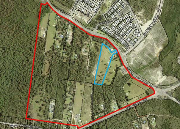
Figure 1 – Precinct Plan Boundary
The draft Strategic Directions Report prepared by Locale
contained a strategic directions (desk top) analysis/review for the precinct,
recognised key / unique attributes and presented four possible options for a
precinct plan with one identified as the preferred option.
It should be noted that the review was not a detailed
“on the ground” investigation of the precinct, but rather
considered known compiled data.
The draft Strategic Directions Report was reported to
Council at its Ordinary Meeting on 27 June 2017 and it was resolved (MIN17.540)
to:
1. Adopt
the draft Worrowing Heights Precinct Plan and Strategic Directions Report for
the purposes of landowner and broader community consultation.
2. The
draft Worrowing Heights Precinct Plan and Strategic Directions Report be made
publicly available for minimum period of 28 days.
3. Request
the proponent of the Planning Proposal for 1310 Naval College Road, Worrowing
Heights to consider the draft Precinct Plan as exhibited and modify their
proposal accordingly.
4. Council
staff report back after the landowner/community consultation and dialogue with
the proponent of the Precinct Plan.
Draft Worrowing Heights Precinct Plan and Strategic
Directions Report
Community Consultation
Following Council’s resolution, the draft Worrowing
Heights Precinct Plan and Strategic Directions report was initially publicly
available for review at Council’s Administrative Centre and on
Council’s website from 26 July to 25 August 2017 (inclusive). Given
community interest and following a Mayoral Minute (MM17.20), the closing date
for the exhibition period was extended to 29 September 2017.
During this time, a separate briefing and community drop-in
session was held on 2 August 2017 at the Bay and Basin Leisure Centre.
These sessions provided information about the draft Plan and were attended by
over 50 individuals who represented both landowners and the broader community.
During the extended community consultation period, a total
of 36 submissions were received from 33 individuals/organisation. One of the
submissions received was from a consultant on behalf of the proponent of the PP
over 1310 Naval College Road, further detail on this submission and the PP is
provided later in this report. Copies of the submissions received will be
also be available in the Councillor’s Room prior to the meeting. A
summary of the submissions is provided in Attachment 1.
In addition, a Consultation Report was prepared by
Council’s project consultant Locale which provides a summary of the
outcomes of consultation undertaken and recommended changes to the exhibited
Draft Worrowing Heights Precinct Plan and Strategic Directions Report. A
copy of the report is provided in Attachment 2. The major issues
and key themes raised in the submissions are provided and discussed below.
Submissions Overview
Lack of justification
A number of submissions raised concern over a lack of
justification or demonstrated need for the draft Worrowing Heights Precinct
Plan and the options it presents. Specific questions raised in the
submissions related to what is the Worrowing Heights Precinct; why is there a
Precinct Plan proposed / needed; and why was this area of Worrowing Heights
looked at in isolation.
Staff Comment
The Worrowing Heights Precinct covers an area of
approximately 67 hectares on the north-western corner of the intersection of
The Wool Road and Naval College Road, Worrowing Heights. The Precinct is
broadly defined based on the area currently zoned RU2 Rural Landscape under
Shoalhaven LEP 2014 around Lot 1310 Naval College Road.
The reference to “the precinct” first emerged
through Council’s determination of a development application (DA14/1391)
in May 2015 for demolition of the existing dwelling, and construction and
operation of a motel comprising 80 rooms and associated facilities. The
development was permissible under the former Shoalhaven LEP 1985 which was in
force when the DA was lodged. As part of the determination for the DA,
Council resolved (MIN15.290) in part that:
“b) Should
the proposed development proceed, that Council investigate and consider the
rezoning of the precinct.”
The intention of this part of the resolution was to
minimise the impact of the approved development on the adjoining land owners,
provide adjoining land owners similar redevelopment opportunities and address
the changing nature of the precinct. It is noted the approved development
has not yet proceeded.
A PP was subsequently lodged over the site of the
approved motel to rezone the site to SP3 Tourist and increase permissible
building heights to 18m under Shoalhaven LEP 2014. The purpose of the PP
was to enable the development of a six-storey hotel resort/serviced apartment complex
with 120 hotel rooms and 180 serviced apartments. In considering the PP,
Council resolved to commence the strategic planning exercise. The draft
Worrowing Heights Precinct Plan was prepared to provide a potential strategic
planning framework for the precinct and its potential future land use that
integrates with the surrounding area.
Impact on infrastructure and services
Several submissions raised concern related to impacts on
existing infrastructure and services that are already at capacity and are stretched
further during peak holiday periods. These infrastructure and services included
but are not limited to medical, retail, roads and transport. Several
submissions also noted that significant upgrades to infrastructure would be
required to accommodate additional demand and maintain the existing quality of
life enjoyed by existing residents.
Staff Comment
It is acknowledged that additional infrastructure and
services would be required to accommodate any future growth in the
precinct. At this preliminary stage, assessments of impact on
infrastructure and services has not been completed. Should Council
resolve to proceed further with the Precinct Plan, the next stage would involve
undertaking detailed technical investigations, including an Infrastructure/Servicing
Plan, Traffic Assessment and Hydrological Assessment and possibly others which
would detail the level of service upgrades required.
Environmental concerns
Concerns were raised over biodiversity loss as a result of
the Precinct Plan, lack of protection for remnant vegetation and habitat within
the Jervis Bay Key Biodiversity Area (KBA) and habitat corridor adjacent to
Booderee National Park. Another submission commented that the Precinct
should be nominated for the National Heritage Listing for conservation purposes
due to the high biodiversity values of the site.
Staff Comment
Biodiversity is a key constraint for the precinct (and
the overall Jervis Bay Region), with specific areas mapped as containing
significant vegetation and biodiversity habitat corridor in Shoalhaven LEP
2014. At this preliminary stage, a detailed biodiversity assessment has
not been undertaken, therefore the Precinct Plan is broad in its reference to
environmental constraints. Should Council resolve to proceed further with
the Precinct Plan, a detailed flora and fauna assessment would be required to
map and quantify the specific biodiversity values of the area, which in turn
would inform the width and extent of habitat/biodiversity corridors to be
retained or protected.
At this early stage, the four options included in the
draft Strategic Directions Report have sought to balance the known biodiversity
values of the site based on existing knowledge with the potential provision of
additional urban land. In doing so, the draft Strategic Directions Report
consistently identifies that the south-western corner of the precinct which is
densely vegetated be retained and protected due to its environmental
significance. It also acts as a corridor between the Jervis Bay National
Park and the Booderee National Park that has been recognised through the
various regional planning exercises related to Jervis Bay.
It should be noted that any future precinct plan would
need to be developed based on the results of a detailed flora and fauna
assessment over the entire site, which is likely to alter the potential
development footprint that is currently presented in the preferred option
included in the draft Strategic Directions Report. Thus, it is
recommended that the preferred option be amended to add a note that the extent
and nature of any developable land and the width and extent of the
“retention of habitat / biodiversity corridor” be subject to
detailed studies.
Aboriginal Cultural Heritage
Submissions raised concern over the protection of Aboriginal
cultural heritage on the site and statements in the draft Strategic Directions
Report that the precinct contains no known Aboriginal heritage sites and that
the likelihood of this is considered to be low.
Staff Comment
At this early stage, a detailed investigation into the
presence of Aboriginal cultural heritage within the Precinct has not been
undertaken. The information provided in the draft Strategic Directions
Report regarding Aboriginal cultural heritage is based on a search of
Council’s records, discussions with relevant Council staff and a search
of the NSW Office of Environment and Heritage (OEH) Aboriginal Heritage
Information Management System (AHIMS). It is acknowledged that these
information sources provided limited information and a detailed Aboriginal
archaeological assessment would be required should Council resolve to take the
Precinct Plan to the next stage. It is recommended that an Aboriginal
Cultural Heritage Assessment be added to the suggested additional detailed
studies in the draft Strategic Directions Report.
Other heritage concerns
Many submissions raised concern that the proposal threatens
the Commonwealth Heritage listed area of Jervis Bay, which is identified as an
Indigenous place under the Environment Protection and Biodiversity Conservation
Act 1999. Another submission stated the Precinct Plan would impact the
heritage significance of The Wool Road which is listed in Schedule 5 of
Shoalhaven LEP 2014.
Staff Comment
Again, it is noted that at this early stage, a detailed
investigation into the heritage impacts of the Precinct Plan has not been
undertaken. Should Council resolve to progress the Precinct Plan, a
detailed heritage assessment would need to be undertaken that considers any
heritage impacts, including the Commonwealth Heritage Listed area of Jervis
Bay.
Under existing provisions of Shoalhaven LEP 2014, the
Worrowing Heights Precinct includes a Scenic Protection Area along The Wool
Road, which is also subject to clause 7.8 Scenic Protection of Shoalhaven LEP
2014. Clause 7.8 requires development to consider visual impacts and
ensure that development minimises any detrimental impacts. This Scenic
Protection Area will assist in maintaining the heritage significance of the road
and the overall route it is part of. It is recommended that a European
& Australian Cultural Heritage Assessment be added to the suggested
additional detailed studies in the draft Strategic Directions Report.
Water and hydrology impacts
One submission commented that the proposal will have adverse
impacts on water quality, hydrology and the natural wetting and drying
processes that occur throughout the site and adjoining properties.
Staff Comment
In preparing the draft Strategic Directions Report, a high-level
consideration of watercourses and flooding was undertaken as part of the
overall constraints and opportunities analysis for the precinct. This
work found that there is a potential hydrology / drainage impact to the north
and potential flooding considerations in the southern part of the
precinct. These findings would be investigated in further detail through
a comprehensive hydrological assessment which will seek to quantify and
consider impacts to water flows resulting from the future development on the
land. This would be part of the next stage of the strategic planning
process should Council resolve to pursue the Precinct Plan.
Consistency with Jervis Bay Settlement Strategy
Many submissions raised concern that the draft Strategic
Directions Report may present inconsistencies with the Jervis Bay Settlement
Strategy (JBSS) 2003 and questioned whether the Strategy has since been
abandoned. Many submissions also raised concern that the JBSS has not
been updated since 2003 and suggested that a renewed consultation and
settlement strategy be undertaken.
Staff Comment
The JBSS was adopted by Council in 2003 and prepared to
provide direction and guidance for the future development of the Jervis Bay
Region to 2023. The JBSS was also endorsed by the NSW Government.
The overall vision for the Bay and Basin area outlined in the JBSS is “to
maintain and enhance the marine, estuarine and natural resources by providing
balanced future living and visiting opportunities which are environmentally,
socially and economically sustainable” (page 5). It also includes a
broad principle for Worrowing Heights to investigate “the possibility of
limited development that also provides for the protection and management of the
habitat corridor in the locality” (page 6).
While the JBSS neither earmarks the precinct for
environmental or future urban purposes, the JBSS is now some 15 years old and
the current situation is considerably different from that of the early
2000’s when the JBSS was first prepared. As noted in the JBSS,
further expansion of the Vincentia District Centre is constrained by National
Park to the west, north and east, and biodiversity value and corridor
connections between the east and west are recognised. Given the age of
the document and with Vincentia identified as a Regional Centre in the
Illawarra-Shoalhaven Regional Plan, it is considered reasonable that the future
of the precinct be considered in the context of the current situation, whilst
also continuing to recognise the overarching JBSS directions until it is
reviewed.
Council adopted a new Strategic Planning Works Program in
July 2017 and a review of the JBSS was amongst the identified priority
projects. As such, Council staff have commenced initial preparatory work
in this regard. This project will be the subject of an initial report to
Council during March/April 2018 to formally commence the review process and
detail how it will be undertaking, including potential timeframes.
In its present form however, the draft Precinct Plan is
not considered to be inconsistent with the JBSS. This is also noted by
DP&E in their submission, which made comment that whilst the Worrowing
Heights Precinct is not specifically identified for future residential
development in the JBSS, it is the only land around the Vincentia District Centre
that may be suitable for consideration for urban development. Their
submission is discussed later in this report.
Support for the Precinct Plan
Many submissions also expressed support for the Precinct
Plan. One submission stated that with the development of Bayswood and
Vincentia Marketplace and future Anglican schools, further development seems
logical for the Precinct. Another submission agreed in principle that a
rezoning of the Worrowing Heights Precinct is needed, due to Shoalhaven’s
growing population and shortage of suitable land for development in the
area. A number of submissions suggested the area needs to provide
additional residential areas within walking distance from shops such as those
at Vincentia Marketplace. Another submission stated they would like to
see commercial, recreation and community uses within the Precinct to generate
jobs and provide entertainment opportunities for young families.
Of the submissions supporting the Precinct Plan, most
recognised that any future development must achieve a balance with biodiversity
and other characteristics of the site.
Staff Comment
The draft Strategic Directions Report presents several
options for the Precinct. The Market Feasibility Analysis recognised that
there is a need for ongoing residential land in the medium to longer term in
the Bay and Basin area. The consultant’s preferred option takes
into consideration the Market Feasibility Analysis and seeks to balance the
medium to long term demand for residential land whilst managing the known
opportunities and constraints of the site.
State Government Agency Consultation
Relevant State Government agencies were also invited to
provide comments on the draft Strategic Directions Report, including DP&E,
Department of Primary Industries (DPI) – Water and NSW Office of
Environment and Heritage (OEH). Comments received from the State
Government agencies are provided below.
In addition, the Commonwealth Department of Environment and
Energy were also advised of the community consultation period. No
response was received during the consultation period and at the time of writing
this report.
Department of Planning and Environment (DP&E)
· Support
a strategic planning review of the Worrowing Heights Precinct considering
existing land use and development pattern within the precinct and its
relationship with the adjoining Vincentia District Centre to the north.
· The
Precinct Plan is not considered to be inconsistent with the Jervis Bay
Settlement Strategy. The Strategy advises that further expansion of the
Vincentia District Centre is constrained by Jervis Bay National Park to the
west, north and east. Whilst the Worrowing Heights Precinct is not specifically
identified for future residential development it is the only land around the
Vincentia District Centre that is considered suitable for urban development.
· Detailed
investigations are required prior to determining areas and possible uses within
the preferred Precinct Plan Option No. 3, including possible environment
protection zoning and consideration of biodiversity and bushfire constraints.
· Council
must ensure that the Precinct Plan is consistent with habitat corridor actions
from the JBSS.
Department of Primary Industries (DPI) - Water
· Response
was received from WaterNSW who reviewed the content of the draft plan
for. There are no regulatory issues for WaterNSW to consider in this
matter.
· No
response was received from NSW Office of Water.
NSW Office of Environment and Heritage (OEH)
· Recommend
that Council consult with the Commonwealth regarding the implications of
current precinct planning for any future controlled action approvals under the
EPBC Act 1999. This would have a bearing on the functional width of
biodiversity corridor across the southern portion of the site.
· Areas
within the precinct where the critically endangered Pretty Beard Orchid
(Calochilus pulchellus) and Swamp Sclerophyll Forest Endangered Ecological
Community (EEC) occur should be avoided.
· The
strategic direction pursued for Worrowing Heights should retain and consolidate
the existing habitat corridors under Shoalhaven LEP 2014 and the
Illawarra-Shoalhaven Regional Plan 2015 at a minimum.
· The
effectiveness of existing corridors identified in the planning framework for
Jervis Bay should be considered before pursuing future strategic rezonings in
the precinct. The preferred strategic outcome should pursue re-establishment of
the disturbed habitat corridor linkages that maintain the function and
connectivity of biodiversity corridors in Jervis Bay.
· Prior
to any preferred option advancing, detailed investigation be undertaken to
determine the width necessary for a robust and functional biodiversity corridor
in the southern portion of the planning precinct.
· Strategic
planning for the precinct should identify avoidance measures and consider
implications for biodiversity assessment under the Biodiversity Conservation
Act 2017 and supporting Biodiversity Assessment Methodology.
· Water
quality impacts from future proposals into surrounding sensitive waterways
should be carefully considered as part of strategic planning for the precinct.
· The
environmental impact of additional bushfire hazard risk management within
Jervis Bay National Park should be considered in addition to asset protection
as part of strategic planning for the precinct.
· A
full Aboriginal cultural heritage assessment in accordance with OEH guidelines
should be conducted. The assessment must include Aboriginal community
consultation and archaeological survey as set out in the OEH guidelines.
Recommended Changes to Strategic Directions Report
Based on the submissions received from individuals and State
Government agencies and the comments provided above, it is recommended that
amendments are made to the exhibited draft Worrowing Heights Precinct Plan and
Strategic Directions Report in order to address specific issues. The
recommended changes are highlighted in the Strategic Directions Report provided
at Attachment 3, and are summarised below:
· Insert
a new section “2.2 Regional Context” including an explanation of
the Illawarra-Shoalhaven Regional Plan and Jervis Bay Settlement Strategy;
· Insert
comments with respect to European, Australian and Aboriginal Cultural Heritage
within Section 2.4.1 General Features – Land Use Planning;
· Insert
comments with respect to biodiversity values and corridors within Section 2.4.3
Precinct Flora and Fauna;
· Insert
comments with respect to environmental impacts of bushfire hazard risk
management within Section 2.4.4 Bushfire;
· Revise
Figure 9: Preferred Precinct Plan to note that the retention of
habitat/biodiversity corridor (width and extent) and the extent and nature of
any developable land will be subject to the outcome of detailed studies; and
· Insert
two extra Suggested Additional Detailed Studies within Section 4.4; Aboriginal
Cultural Heritage Assessment and European & Australian Cultural Heritage
Assessment.
It is recommended that the revised Worrowing Heights
Precinct Plan and Strategic Directions Report be adopted by Council and
considered as part of the JBSS review.
Preliminary Planning Proposal – 1310 Naval College
Road, Worrowing Heights
As summarised in the background section of this report, the
current proponent initiated PP over 1310 Naval College Road was formally
received by Council on 12 April 2016. An initial review of the PP
was completed by Locale and is included in the draft Worrowing Heights Precinct
Plan and Strategic Directions Report. The initial review of the PP
indicated that the proposal is potentially an overdevelopment of the site and
the proposed height is not in keeping with the existing and future scale of
development on the urban/rural fringe of the Bay and Basin area.
As per Council’s resolution of 27 June 2017, Council
staff offered to meet with the proponent to discuss the draft Precinct Plan and
the inconsistencies between the PP and the draft Plan. The proponent was
also advised in writing that they should consider modifying their PP to
consider the Precinct Plan and Strategic Directions Report. No response
was received to this invitation and the PP has not been modified, however a
submission was received as part of the community consultation process from a
consultant on behalf of the proponent.
The submission received on the Worrowing Heights Precinct
Plan indicated that the proponent was in support of considering the Precinct
for future urban purposes in the short, medium and long term. The
submission also acknowledged that further analysis needs to be undertaken to
demonstrate the suitability of, and the demand for, the scale and anticipated
built form for the future hotel resort and serviced apartment development.
The submission raised concern that an R1 Residential Zone
for short term development of the Precinct, whilst permitting ‘tourist
and visitor accommodation’, would not provide adequate flexibility to
support a wide range of land uses and flexibility to respond to market
demand. They also raised concern that it would be difficult for their
proposed development to demonstrate consistency with the overall objectives of
the R1 zone and that supporting tourist uses such as restaurants, bars, cafes
and shops are not permissible within the R1 zone. It was suggested that a
more varied zoning structure be investigated, including opportunities to
introduce Additional Permitted Uses through Schedule 1 of Shoalhaven LEP 2014,
which could be accompanied by a precinct-specific Development Control Plan
(DCP) which would guide the delivery of a wider range of land uses.
The submission also highlighted that interest for a hotel
operator has been secured and that tourist accommodation could be delivered on
the site in the short term. As such, the submission stated the site should
be recognised and supported as an ‘anchor’ for the Precinct, being
able to deliver housing and tourist accommodation and associated and
complimentary land uses in the short term.
The decision to either support or not support the PP for
1310 Naval College Road, Worrowing Heights was deferred by Council’s
Development Committee at its meeting on 18 July 2016 until “a more
detailed strategic planning exercise that considers the future zoning of the
broader precinct” had been completed (MIN16.533). The more
detailed strategic planning exercise has now been completed and publicly
exhibited, with the outcome of its public exhibition provided in this
report.
In assessing the PP against the Precinct Plan and Strategic
Directions Report, the following should be noted:
- PP proposes
to rezone the subject site SP3 Tourist which is inconsistent with the preferred
option of a residential zone.
- PP proposes
to introduce an 18m height of buildings development standard on the subject
site which is inconsistent with the preferred option of retaining the existing
default 11m height or alternatively reducing the height to 8.5m consistent with
a residential zone.
- The Market
Feasibility Analysis concludes that there is not sufficient demand for more
land to be zoned for tourism purposes in the Bay & Basin area and therefore
within the precinct.
- The scale
of the intended development is incompatible with the existing character of the
urban / rural fringe and the future character of the precinct as established by
the Precinct Plan and the preferred option.
It is thus recommended that the
PP not be supported as it expressly conflicts with the Worrowing Heights
Precinct Plan and Strategic Directions Report. By adopting the Worrowing
Heights Precinct Plan and Strategic Directions Report, the PP is also
inconsistent with Council’s Planning Proposal (Rezoning) Guidelines and
DP&E’s Guidelines to Preparing Planning Proposals as there is no
existing strategy that supports it.
Community Engagement
As summarised above, the draft Worrowing Heights Worrowing
Heights Precinct Plan and Strategic Directions Report was publicly available
from Wednesday 26 July to 29 September 2017. During this time, a total of
36 submissions were received from 33 individuals / organisations during this
time.
Should Council resolve to proceed
with the Precinct Plan and prepare a PP for the precinct or sites within it, a
future PP will require public exhibition in accordance with the Environmental
Planning & Assessment Regulations 2000.
Policy Implications
If adopted by Council, the
Worrowing Heights Precinct Plan would form a Council Strategic Planning Policy
that could be used to rationalise the strategic basis of future amendments to
Shoalhaven LEP 2014. The Precinct Plan would complement and be considered
in the review of the existing JBSS, which has commenced.
Financial Implications
The proponent of the PP for 1310
Naval College Road has paid the initial PP lodgement fee in accordance with
Council’s Fees and Charges. Should the PP proceed further into the
process, additional fees will be payable.
The preparation of the Worrowing
Heights Precinct Plan and Strategic Directions Report has been funded by the
existing Strategic Planning budget.
Progressing the Worrowing Heights
Precinct Plan to the detailed investigation stage will incur significant
financial costs for Council or the landowners. If Council undertakes the
detailed studies there is potential for some of these costs to be recouped
through a future Section 94 Plan for the area should future planning for the
precinct continue, or alternatively through a cost sharing exercise similar to
what has been done with the Falls Creek / Woollamia Investigation Area.
This is not recommended to be pursued at the current time.
|

|
Development
Committee – Tuesday 13 February 2018
Page
24
|
DE18.9 Shoalhaven
DCP 2014 - Amendment No. 8 - Flood Chapters G9 and G10
HPERM Ref: D17/419590
Group: Planning
Environment & Development Group
Section: Strategic
Planning
Attachments:
1. Attachment 1:
Chapter G9 - Development on Flood Prone Land (under separate cover) ⇨
2.
Attachment 2: Supporting Document 1 - Chapter G9 (under separate cover) ⇨
3.
Attachment 3: Supporting Maps - Chapter G9 (under separate cover) ⇨
4.
Attachment 4: Chapter G10 - Caravan Parks in Flood Prone Areas (under separate
cover) ⇨
5.
Attachment 5: Supporting Document 1 - Chapter G10 (under separate cover) ⇨
6.
Attachment 6: Supporting Document 2 - Chapter G10 (under separate cover) ⇨
7.
Attachment 7: Draft Dictionary (under separate cover) ⇨
Purpose / Summary
Obtain endorsement for the
preparation and public exhibition of draft Amendment No. 8 to Shoalhaven
Development Control Plan (DCP) 2014 which proposes to amend:
· Chapter
9 Development on Flood Prone Land;
· Chapter
G10 Caravan Parks in Flood Prone Areas; and
· The
Dictionary.
The amendment will then be
placed on public exhibition with the associated Planning Proposal (PP012)
– Review of Flood Controls.
|
Recommendation (Item to be determined
under delegated authority)
That Council:
1. Adopt for exhibition purposes draft
Amendment No. 8 to Shoalhaven Development Control Plan 2014 which includes
amendments to Chapter 9 Development on Flood Prone Land, Chapter G10 Caravan
Parks in Flood Prone Areas, and the Dictionary (detailed in Attachment 1);
and
2. Exhibit the draft Amendment together
with the associated Planning Proposal (PP012) – Review of Flood
Controls for a minimum period of 28 days in accordance with legislation; and
3. Receive a further report after public
exhibition to consider any submissions and to adopt the amendment for
finalisation.
|
Options
1. Adopt draft Amendment No. 8 to
Shoalhaven DCP 2014 and proceed to public exhibition.
Implications: This is the preferred option as it
enables the DCP amendment and the PP to proceed to exhibition as a
package. These complementary amendments are aimed at improving the
availability of flood information and make the process of applying for development
approval in flood prone areas more straightforward.
2. Not adopt draft Amendment No. 8 to
Shoalhaven DCP 2014.
Implications: This option is not recommended as it
has potential to create inconsistencies between the LEP and DCP and misses the
opportunity to refine Chapters G9 and G10 to improve their operation.
Background
Council resolved in May 2017
(MIN17.380) to:
1. Endorse
the Planning Proposal (PP012) – Review of Flood Controls to amend
Shoalhaven Local Environmental Plan (LEP) 2014 for lodgement with the
NSW Department of Planning & Environment (DP&E) to request Gateway
determination.
2. Amend
Chapter G9: Development on Flood Prone Land and Chapter G10: Caravan
Parks in Flood Prone Areas in Shoalhaven Development Control Plan 2014 as part
of a future review of these chapters to ensure consistency with any proposed
changes to Shoalhaven LEP 2014.
3. Support
the preparation of an online Flood Planning map to provide publicly accessible
information and interactive display of adopted Flood Study mapping and historic
flooding information.
The PP intends to remove the
Flood Planning Area (FPA) Map from the LEP and rely instead on an online
mapping system that will be available on Councils website that is based on
Council’s adopted flood studies. This change will remove the delays
in updating the FPA map and the associated issues this created.
The PP received Gateway determination
on 8 June 2017 and as such can now be placed on public exhibition.
The associated changes have now
been made to DCP Chapters G9 and G10. Other changes have also been
made to the chapters to make them more user friendly and improve interpretation.
These changes are relatively minor and include:
· Removing
content from the chapters that is more informative in nature and transferring
it to a supporting guideline. This creates a clear distinction between
the controls for development in flood prone areas and the supporting
information which assists in the preparation of a development application.
· Creation
of supporting maps for Chapter G9 to identify the areas to which the
site-specific controls apply.
· Updating the
matrix for Chapter G9 to add Low Hazard Floodway, High Hazard Flood Fringe, Low
Hazard Flood Storage categories to clarify the provisions that apply to each
category and adding relevant definitions to the Dictionary.
· Updating the
matrix for Chapter G10 to include controls for ‘Minor associated
structure’ and ‘Large associated structure’ in the High
Caravan Park Flood Risk Precinct rather than completely prohibiting these
structures.
The proposed DCP Amendment No. 8 includes the following
documents which are included as attachments to this report.
1. Chapter
G9: Development on Flood Prone Land (Attachment 1)
2. Supporting
Document 1: Chapter G9 - Guidelines for Development on Flood Prone Land (Attachment
2)
3. Supporting
Maps: Chapter G9 - Guidelines for Development on Flood Prone Land (Attachment
3)
4. Chapter
G10: Caravan Parks in Flood Prone Areas (Attachment 4)
5. Supporting
Document 1: Chapter G10 – Guidelines for Caravan Parks in Flood Prone
Areas (Attachment 5)
6. Supporting
Document 2: Chapter G10 – Flood Emergency Management Plan Template (Attachment
6)
7. The
Dictionary (Attachment 7)
Each chapter and supporting document has a table of changes
at the start to help readily identify the changes that have been
made.
Adoption of proposed DCP Amendment No. 8 will enable the PP
and the DCP amendment to now be exhibited together as a package. As part of the
exhibition, Council’s adopted flood information will be added to
Council’s online mapping system so that it is publicly available.
Community Engagement
Should draft DCP Amendment No. 8
be adopted, it will be placed on public exhibition with the associated PP for a
minimum of 28 days to enable the community to view and comment on the
changes. Community Consultative Bodies (CCB’s) and other relevant
groups will be directly advised of the exhibition arrangement
Any issues raised in submissions made during this time will
be reported to Council for consideration as part of the final adoption of the
proposed amendments.
Policy Implications
Amendment No. 8 is intended to
make the DCP consistent with the amendment to the LEP that will remove the FPA
Map. The DCP will continue to operate if this amendment does not proceed
but it may result in confusion for applicants given the potential
inconsistencies between the LEP and DCP. It is best practice to update
the LEP and DCP together to ensure both documents are consistent and work
together.
Financial Implications
This project is being managed within the existing Strategic
Planning Budget using existing staff resources.
|

|
Development
Committee – Tuesday 13 February 2018
Page
27
|
DE18.10 Planning
Proposal Request - Proponent Initiated - 9 Browns Road, South Nowra - Caravan
Park
HPERM Ref: D17/421697
Group: Planning
Environment & Development Group
Section: Strategic
Planning
Attachments:
1. Proponent's
Planning Proposal Request - Browns Road South Nowra Caravan Park (under
separate cover) ⇨
Purpose / Summary
Detail a proponent initiated
request for Planning Proposal (PP) that has been received to enable the use of
the whole property as a ‘caravan park’, including part of the site
which has approved tourist cabins, to be used for long term accommodation
(consistent with the bulk of the site), and to obtain direction in this regard.
|
Recommendation (Item to be determined
under delegated authority)
That Council:
1. Prepare a Planning Proposal to amend
Shoalhaven Local Environmental Plan 2014 to permit caravan parks as an
additional permitted use for Lot 1 DP 1079345, No. 9 Browns Road South Nowra.
2. Forward this Planning Proposal to the
NSW Department of Planning and Environment for a Gateway determination and if
granted proceed to exhibition in accordance with its requirements, following
which the matter be reported back to Council.
3. Advise the proponent of this
resolution and that the proposal will be subject to fees and charges for
proponent initiated Planning Proposals, including a requirement that the full
cost of any necessary specialist studies be borne by the proponent.
|
Options
1. Request a Gateway determination for
the PP to allow caravan parks as an additional permitted use on the subject
land.
Implications: This will allow the area with the
approved tourist cabins to be used for long term accommodation without changing
the underlying zone. This is the lowest impact approach to achieve the outcome
being sought by the proponent. It will also effectively recognise the
‘existing use right’ on most of the site, while retaining the
existing B5 – Business Development zone. This is the preferred option.
2. Request a Gateway determination for
the PP to rezone the land to a zone in which caravan parks are permissible.
Implications: This would
require the zoning to be changed to a non-business zone, fundamentally changing
the zone objectives and land use table. Not only would it allow the
expansion of the existing caravan park but also other uses that may not be
appropriate in this location. While this approach will achieve the
outcome being sought by the proponent, it could lead to unintended uses on the
site and is at odds with established strategic planning directions. This option
is not recommended.
3. Not proceed with the PP.
Implications: This would prevent the
rationalisation of the uses on the site and would leave a relatively small part
of the existing caravan park not able to be used for longer term
accommodation. This option is not recommended.
Background
The Site
The subject land is Lot 1 DP 1079345, 9 Browns Road, South
Nowra. It is located on the northern edge of the South Nowra employment
lands area. The land adjoins Ison Park to the north, a small residential
development to the east of Mumbulla Street, and business uses to the south and
west. The site is an established caravan park.
Maps showing the subject land and its location are provided
below:
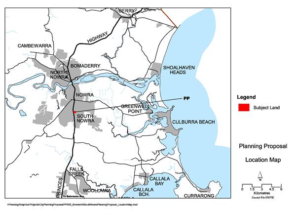
Subject Land
– Location
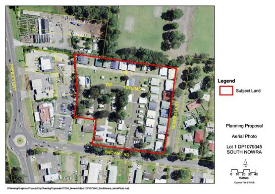
Aerial
Photograph Showing Subject Land - Lot 1 DP 1079345
Shoalhaven Local
Environmental Plan (LEP) 2014
The subject land is currently
zoned B5 – Business Development under Shoalhaven LEP 2014. The
relevant zoning map is provided below.
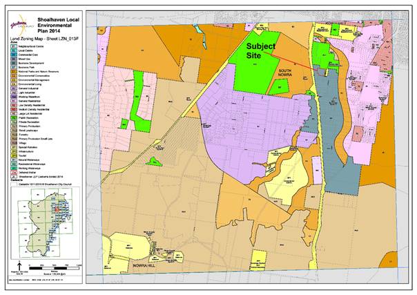
Shoalhaven LEP 2014 Land Zoning Map Showing Subject Land
One of the objectives of the B5
zone is to “allow a diversity of activities that do not significantly
conflict with the operation of existing or proposed development”.
‘Residential
accommodation’ (except for ‘shop top housing’) and
‘tourist and visitor accommodation’ (except for ‘hotel or
motel accommodation’ and ‘serviced apartments’) is prohibited
in the B5 zone. ‘Caravan parks’ are also prohibited in the B5
zone.
As outlined below, due to
previous approvals for a caravan park and tourist accommodation, the site has
certain ‘existing use rights’ under the Environmental Planning and
Assessment Act 1979.
Site History
The use of part of the site as a
caravan park dates back to the 1970’s.
The land underwent lot
consolidation in 1986. A marked-up version of this plan is provided
below.
Deposited
Plan with Mark Up - DP 747535
Historically, the use of the
site as a caravan park was confined to Lot 23 DP 747535 and Lot 4 DP 561343,
highlighted in red above. The area highlighted in blue, Lot 3 DP 508774 was
consolidated with Lots 4 and 23 in 2005 but was not used as part of the caravan
park. Consequently, at the commencement of Shoalhaven LEP 2014, Lot 3 DP
508774 did not benefit from an ‘existing use right’ for a caravan
park.
In 2004, the owner sought and
obtained development consent for a tourist facility on the former Lot 3
(outlined in blue above). This development comprised 8 tourist cabins. These
cabins however cannot be occupied by permanent residents under the current LEP
provisions.
In summary, the caravan park
currently has 61 long term sites and an area approved for 8 tourist cabins that
the proponent also wishes to use for long term accommodation.
The Proponent’s PP
The proponent’s PP request was received on 2 November
2017 from Coastplan Group (on behalf of the owners, Restpoint Holdings) and
seeks to amend Shoalhaven LEP 2014 to allow caravan parks on the entirety of
the site as an ‘additional permitted use’ (via inclusion in
Schedule 1 of the LEP). The proponent’s submission (see Attachment
1) includes a draft PP.
This will essentially allow the whole of the caravan park to
be used for long term accommodation.
Preliminary Planning Assessment
The following is an overview of strategic planning documents
that are relevant to this proposal.
· Shoalhaven LEP 2014
The subject land is currently B5 Business Development under
Shoalhaven LEP 2014. The objectives of this zone relate to enabling businesses
that require a large floor area, and allowing a diverse range of activities
that do not significantly conflict with the operation of existing or proposed
development.
In context of the site’s current and historical use,
the proposal is not considered to be inconsistent with these objectives, noting
that the underlying zoning will be retained.
· Illawarra-Shoalhaven
Regional Plan
The Regional Plan was released by the NSW Government in late
2015. This PP is minor in nature and is not inconsistent with any of the
provisions of this plan given the site’s current and historical use.
· Nowra-Bomaderry
Structure Plan
The land is within the Nowra-Bomaderry Structure Plan area
and is identified as being “Existing Industrial Land”. The
Structure Plan is provided below.
Nowra-Bomaderry
Structure Plan
This PP is minor in nature and is not inconsistent with any
of the provisions of this plan given the site’s current and historical
use.
· Shoalhaven Affordable
Housing Strategy
Council adopted the Shoalhaven Affordable Housing Strategy
in December 2017 in response to a range of issues surrounding the availability
of affordable housing in Shoalhaven. One of its ‘medium term’
(within 3-5 years) strategies is to:
Provide opportunities for permanent sites in caravan
parks.
The Strategy notes that caravan parks are an important
source of affordable housing in Shoalhaven, with on-site vans and manufactured
homes being able to be rented by all low-income households and some very
low-income households. It is however also noted that there appears to be a
decreasing supply of permanent sites in some areas through their conversion to
tourist use.
In the case of this PP it is essentially looking at enabling
the whole of the current caravan park to be used long term accommodation, given
that part (former Lot 3) only currently benefits from ‘existing use
rights’ for tourist use.
The PP is generally consistent with this Strategy as it will
provide additional permanent sites within this caravan park.
· Council’s
Planning Proposal (Rezoning) Guidelines
These guidelines detail the circumstances when a PP is
likely to be supported by Council and provide a range of detail on the PP
process. The guidelines were adopted by Council in 2016 and note that a PP is
likely to be supported in the following circumstances:
· Proposed amendment
is supported by Council or State Government strategy or plan.
· Clear zoning
anomaly exits on site.
· Proposed amendment
is considered to be minor in nature and has been sufficiently justified to
Council.
The guidelines also note that the proponents should have
pre-lodgement dialogue with Council staff before formally lodging a PP.
The guidelines make it clear that PP’s that are not
supported by a strategy or plan and are considered speculative will generally
not be supported by Council.
Pre-lodgement engagement with the proponents regarding this
matter took place during 2016 and the PP is minor in nature (see comments
below).
· NSW Guide to
Preparing PPs
The NSW Guide to Preparing Planning Proposals provides an
assessment framework for PP’s. This framework requires the planning authority
(Council) to answer questions in determining the merit of a PP. These are
considered below:
Q1. Is the Planning Proposal a result of any strategic
study or report?
The proposal is not the result of any strategic study or
report. A minor amendment is proposed in acknowledgement of the specific
history of this site. It seeks to allow that part of the site currently
used for tourist accommodation so that it can be used for long term stay
accommodation.
Council recently adopted the Shoalhaven Affordable Housing
Strategy and the role that caravan parks and manufactured homes play in
assisting with affordable housing is acknowledged in this strategy. It is also
acknowledged that the current short-term sites are not in a desirable tourist
location and as such converting them to longer term use will have minimal
impact and will potentially assist with affordable housing in the
Nowra-Bomaderry area.
Q2. Is the Planning Proposal the best means of achieving
the objectives or intended outcomes, or is there a better way?
The PP is the only way to permit a caravan park across the
entire site given the ‘existing use rights’ scenario –
amending the LEP is the only way to overcome the prohibition that currently
applies across the site.
Allowing caravan parks as an additional permitted use is the
most appropriate way to amend the LEP in the circumstance and recognise the
continuation and minor expansion of an existing use which is currently
prohibited under Shoalhaven LEP 2014.
Q3. Is the Planning Proposal consistent with the
objectives and actions of the applicable regional, sub-regional or district
plan or strategy (including any exhibited draft plans or strategies)?
The Illawarra-Shoalhaven Regional Plan is the relevant
regional strategy.
The Regional Plan does not contain any provisions that are
relevant to this minor PP.
Q4. Is the Planning Proposal consistent with a
Council’s local strategy or other local strategic plan?
The Nowra-Bomaderry Structure Plan anticipates that the
South Nowra industrial precinct will provide a “mix of industries
including storage & large footprint commercial”. The use of
the subject land as a caravan park is inconsistent with this expectation,
whether it is occupied on a temporary or permanent basis.
This PP will not alter the existing inconsistency between
the existing use of the land and the expectation of this plan. It seeks
only to allow for the permanent occupation within that part of the park which
can only currently be used for short term stays. The PP is minor and in
and of itself is not inconsistent with this plan and the underlying B5 zoning
will be retained.
Q5. Is the Planning Proposal consistent with applicable
State Environmental Planning Policies?
No inconsistencies have been identified at this stage.
It is noted that under the provisions of SEPP 36
– Manufactured Home Estates, any urban land on which a caravan park is
permissible may also be developed for a manufactured home estate. This is
considered satisfactory in the context of this site as it is largely consistent
with the existing development on site.
The NSW Government has released a discussion paper in 2015
that looked at Improving the regulation of manufactured homes, caravan parks,
manufactured home estates and camping grounds. The proposed reforms may provide
opportunities regarding this matter. Council made a submission to this review,
however its status is unknown, and it has not advanced.
Q6. Is the Planning Proposal consistent with applicable
Ministerial Directions?
There is a minor inconsistency with 117 Direction 1.1
Business and Industrial Zones. This direction requires the protection of
employment land in business and industrial zones. This PP would allow for the
permanent occupation of that part of the site that is currently used for
tourist accommodation. The change from tourist development to residential
accommodation is contrary to the protection of employment land. It is
considered that this inconsistency is minor. The difference in employment
opportunities between 8 tourist cabins and 8 manufactured homes in a fully
maintained park are minimal. It is also noted that the underlying B5 zoning
will be retained.
Q7. Is there any likelihood that critical habitat or
threatened species, populations or ecological communities, or their habitats,
will be adversely affected as a result of the proposal?
The site has been extensively cleared and is used as a
caravan park. It is not identified in Council’s mapping as being an
area of ecological significance.
Q8. Are there any other likely environmental effects as a
result of the Planning Proposal and how are they proposed to be managed?
No other environmental effects are likely to result from
this minor PP.
Q9. Has the Planning Proposal adequately addressed any
social and economic effects?
No other social or economic effects are anticipated to
result from this PP, which is of a minor nature.
Q10. Is there adequate public infrastructure for the
Planning Proposal?
The development is supported by existing infrastructure and
the PP will not increase demand.
Q11. What are the views of State and Commonwealth public
authorities consulted in accordance with the Gateway determination?
The required consultation will be undertaken if the PP
proceeds. A small part of the site is mapped as bushfire prone land and
the PP will need to be referred to NSW Rural Fire Service (RFS) as a result.
Conclusions
As detailed above, the PP is of a minor nature. If
Council supports the PP, it is recommended that a Gateway determination be
sought requiring no specialist studies to be prepared.
Community Engagement
Upon receipt of the proponent’s PP request the
surrounding landowners and the park residents were notified in writing. One
submission was received raising concerns that caravans would be installed on
the site. It was clarified with the submitter that manufactured home estates
are permissible in urban areas where caravan parks are permissible.
If the PP proceeds, formal
public exhibition will be required including advertising in a local newspaper
and a mail out to surrounding landowners.
Policy Implications
The PP is minor and is
consistent with Council’s adopted Planning Proposal (Rezoning)
Guidelines.
Financial Implications
If Council support the PP it
will be pursued on a 100% cost recovery basis, to be funded by the proponent,
in accordance with Council’s adopted fees and charges.
|

|
Development
Committee – Tuesday 13 February 2018
Page
35
|
DE18.11 Planning
Proposal - Building Height Review - Southern Part of Ulladulla CBD
HPERM Ref: D18/17734
Group: Planning
Environment & Development Group
Section: Strategic
Planning
Attachments:
1. Planning
Proposal - Building Height Review - Southern Part of Ulladulla CBD -
Pre-Gateway Version (under separate cover) ⇨
2. Report to
Development Committee on 14 November 2017 ⇩
Purpose / Summary
Obtain endorsement to submit the
Planning Proposal (PP) in this regard to the NSW Department of Planning &
Environment (DP&E) to obtain initial Gateway determination.
|
Recommendation (Item to be determined
under delegated authority)
That Council:
1. Endorse Planning Proposal (PP030)
Building Height Review – Southern Part of Ulladulla CBD (Attachment
1) and submit to the NSW Department of Planning & Environment for a
Gateway determination.
2. Notify Ulladulla & Districts
Community Forum, affected landowners and key stakeholders of this decision
and of further opportunities to be involved as this matter progresses.
|
Options
1. Adopt the recommendation.
Implications: This is the preferred option as it
will enable the initial lodgement of the PP (Attachment 1) to advance an
amendment to the height of building controls in the southern part of the
Ulladulla CBD (subject land). On 14 November 2017, Council’s
Development Committee provided in principle support for the preparation of the
PP (MIN17.954).
2. Adopt an alternative recommendation.
Implications: Depending on its nature, an
alternative recommendation could delay an amendment to Shoalhaven Local
Environmental Plan (LEP) 2014 to increase the height of building controls for
the subject land.
3. Not amend the height of building
provisions in Shoalhaven LEP 2014 for the subject land.
Implications: Given the Height of Buildings Review
that has recently been undertaken, its recommendations and Council’s
recent recommendation (MIN17.954) to prepare a PP to increase heights for the
subject land, this is not a preferred option as the existing height provisions
in Shoalhaven LEP 2014 will not be amended and it will be difficult to
stimulate and facilitate development consistent with a CBD location.
Background
On 14 November 2017, Council resolved (MIN17.954 –
part 1 & 3) to:
1. Prepare
a Planning Proposal to amend Shoalhaven Local Environmental Plan 2014 to
increase the height across the Study Area (excluding land subject to PP025) to
part 11 metres and part 14 metres as per the Review of Building Heights Report.
3. Consider
a further report/s that contains the detail of the Planning Proposal for
submission to the NSW Department and Planning and Environment for Gateway
determination …
The report to Councils Development Committee on 14 November
2017 is provided at Attachment 2.
The initial PP document has now been prepared for submission
to DP&E for Gateway determination and is included as Attachment 1 to
this report. In line with the above recommendation:
· The subject land
has been refined to exclude the land that is covered by the proponent initiated
PP025 (i.e. land known as Lots 1-7, 9 DP 21597 and Lot CP SP 42583, St Vincent
and Deering Streets, Ulladulla). This land will be progressed through an
independent PP; and
· The proposed
height of building map shows an increase in height from 7.5m to part 11m and
part 14m (see Figure 2 below).
Figure 2 - Existing
and Proposed Shoalhaven LEP 2014 Height of Building Mapping
Community Engagement
The PP will be exhibited for comment in accordance with
Council’s Community Engagement Policy at Level 1 to ‘inform’
and ‘consult’, and in accordance with the relevant legislative
requirements. The Gateway determination will also specify the minimum
exhibition period and any government agencies with whom Council must
consult. Community Consultative Bodies and other interest groups will
also be advised of the future formal exhibition arrangements.
Policy Implications
The existing height of buildings provisions in Shoalhaven
LEP 2014 are dated and somewhat inconsistent with the proposed direction of the
Milton-Ulladulla Structure Plan and general future desired character and
amenity expectations outlined in Chapter S8: Ulladulla Town Centre of
Shoalhaven DCP 2014.
The proposed height increase will assist in facilitating
development and resolve the current inequitable and inconsistent building
height controls that exist. In this regard the adjacent lower density
residential areas currently have a greater height limit (8.5m) than the study
area (7.5m).
Financial Implications
Based on the
recommended approach, there are no immediate financial implications as this
matter is being resourced within the existing Strategic Planning budget.
|
|
Development
Committee – Tuesday 13 February 2018
Page
38
|
|
|
Development
Committee – Tuesday 13 February 2018
Page
45
|
DE18.12 Aboriginal
Land Claims Numbers 7780, 7781 and 41110 - Rose Street, Hyams Beach
HPERM Ref: D18/18069
Group: Planning
Environment & Development Group
Section: Development
Services
Attachments:
1. Request for
Information - Aboriginal Land Claim - Rose Street Hyams Beach ⇩
Purpose / Summary
Obtain direction regarding Aboriginal Land Claims (ALC)
numbers 7780, 7781 and 41110 at Rose Street, Hyams Beach which are now being
investigated for determination by the NSW Government.
Note: This matter is being report to the Development
Committee due to the need to meet an extended deadline to provide comment.
|
Recommendation (Item to be determined
under delegated authority)
That Council notify the NSW
Department of Industry – Crown Lands Aboriginal Land Claims
Investigation Unit that Council:
1. Does not support the granting of ALC
Numbers 7780 and 7781 over Lot 79 DP 755907 and two Part Lots 78 DP 755907 at
Rose Street, Hyams Beach.
2. Has no objection to the granting of
ALC Number 41110 over the two Part Lots 78 DP 755907 at Rose Street, Hyams
Beach, subject to any agreements, easements of rights of way required by
Council being excluded from the claims, or being resolved as part of the
determination of the Claim.
|
Options
1. Notify the NSW Department of Industry
(DoI) – Crown Lands Aboriginal Land Claims Investigation Unit (ALCIU)
that Council does not support the granting of ALC No’s 7780 and 7781;
however, has no objection to the granting of ALC No. 41110 at Rose Street,
Hyams Beach, subject to any agreements, easements of rights of way required by
Council being excluded from the claims, or being resolved as part of the
determination of the Claim.
Implications: This is the preferred option, as it
enables Council to assist DoI with their investigations, and protect and
maintain existing assets and water and sewer infrastructure that service Hyams
Beach village, which are located on the two Part Lots 78 DP 755907.
2. Provide alterative advice to the DoI
regarding ALC No’s 7780, 7781 and 41110 at Rose Street, Hyams Beach as
directed by Council.
Implications: This option is not preferred, as the
advice provided to DoI needs to be justified and as such may not be consistent
with known history of the land at the date the claims were lodged.
3. Not respond to the invitation to
comment on these ALC’s.
Implications: This is not
preferred as it does not enable Council to present evidence to DoI regarding
the status of the land at the date the claims were lodged.
Background
Council received advice from DoI on 6 November 2017 that ALC
numbers 7780, 7781 and 41110 at Rose Street, Hyams Beach, were under
investigation for determination. These multiple claims were lodged over
the former Hyams Beach Rural Fire Station site, and affect the following lots:
· ALC No. 7780: Lot
79 DP 755907 (Por 79)
· ALC No. 7781: Two
Part Lots 78 DP 755907 (Por 78)
· ALC No. 41110: Two
Part Lots 78 DP 755907 (Por 78)
Council has been asked to provide comments on the claims
(see Attachment 1) and specifically whether, at the date the claims
were lodged, the subject land was:
· Lawfully used or
occupied
· Needed or likely
to be needed for an essential public purpose.
Any comment, assertion or statement that is made by Council
should be as at the date of the lodgement of the claims (see below) and be
supported by evidence:
· ALC 7780: 6
October 2005
· ALC 7781: 6
October 2005
· ALC 41110: 8
August 2016
Council has been granted an extension of time until 16
February 2018 to respond to the claims to allow the matter to be reported for
consideration.
Overview Summary of the Subject Land
The subject land covered by these claims comprises three
separate lots, located at the corner of Rose and Aster Streets, Hyams Beach in
the north-western corner of the village. They are bounded to the north, west
and south by Jervis Bay National Park, and to the east by the Rose and Aster
Street road reserves and residential properties (as shown in Figure 1 below).
All three lots are currently zoned SP2 Infrastructure -
Emergency Services Facilities under the provisions of Shoalhaven Local
Environmental Plan (SLEP) 2014.
Figure 1
Aerial image of the subject land (outlined in orange)
at Rose Street, Hyams Beach.
· Lot
79 DP 755907 (Por 79)
Lot 79 is the smallest of the three lots and contains the
former Hyams Beach Rural Fire Station building, which is constructed over the
boundary of the adjoining Part Lot 78 to the north and west (refer to Figure
2).
Although this lot is identified as a Crown Reserve (number
R96492) with the Reserve Purpose of “Bushfire Brigade Purposes”, it
should be noted that the land is currently owned by Council and is classified
as “community” land. Consequently, Lot 79 is the subject of ongoing
discussions between Council’s Property Unit and Crown Lands regarding
future land tenure.
Figure 2
Location of the former Hyams Beach Rural Fire Station
· Part
Lot 78 DP 755907 (Por 78) – Southern Portion
Part Lot 78 (southern portion) is Crown Land with Council as
Trust Manager. The Crown Reserve number for the site is R96492, with the
Reserve Purpose of “Bushfire Brigade Purposes”. It is a
heavily vegetated site that contains approximately 40% of the gross floor area
of the former Hyams Beach Rural Fire Station, as shown in Figure 2 above.
· Part
Lot 78 DP 755907 (Por 78) – Northern Portion
Part Lot 78 (northern portion) is the largest of the three
lots, and is Crown Land with Council as Trust Manager. The Crown Reserve number
for the site is R86766, with the Reserve Purpose of “Public Hall”;
however, this building has never been constructed.
There is also an existing approval on the site for the
construction of a tennis court facility; however, this also remains
unconstructed. This may however not be a valid reason for objection to
any claim.
Advice received from Shoalhaven Water indicates the presence
of water and sewer infrastructure on the eastern portion of the Lot, being a
standard manhole and gravity main. This lot is currently vacant and heavily
vegetated, and does not contain any structures other than the Shoalhaven Water
infrastructure, the approximate location of which is shown in Figure 3 below.
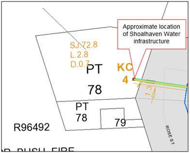
Figure
Approximate location of existing Shoalhaven Water
infrastructure over
Part Lot 78 DP 755907 (northern portion).
History of the Rural Fire Station Building
Hyams Beach Bush Fire Brigade was officially formed on 2nd
April 1965 with a fibro shed erected for the use of the Brigade in 1968.
In later years, an annexe to the fire shed was built. The building was
constructed over two lots – Lot 79 and the southern portion of Part Lot
78 – and covers a total area of 120.7m2. It is current
listed as a heritage item of Local Significance in Schedule 5 of the Shoalhaven
Local Environmental Plan 2014.
The Hyams Beach Rural Fire Station was occupied by the local
Bushfire Brigade until 2013, at which time the local service relocated to the
nearby Erowal Bay Fire Station (and later the recently constructed Crossroads
Rural Fire Station in Vincentia).
The building has remained vacant, and the land unoccupied,
since this time.
Comment Summary
As noted above, a total of three ALCs have been lodged over
the three lots and are now the subject of investigation by DoI. The following
comments are provided regarding Councils interests (or not) in each claim:
Claim Number 7780
Was lodged over Lot 79 DP 755907 on 6 October 2005. Advice
has been received from Council’s Property Unit that, at this time, the
land was lawfully occupied and being used for the Reserve Purpose of “Bushfire
Brigade Purposes”. It is also noted that, due to the land being in
private ownership (Council), the land does not meet the criteria for Claimable Crown Land nor is an Aboriginal Land
Council able to claim under the Aboriginal Land Rights Act.
Consequently, it is considered that ALC No. 7780 should not
be supported.
Claim Number 7781
Was lodged over two Part Lots 78 DP 755907 on 6 October
2005. Advice has been received from Council’s Property Unit that,
at this time, the land was lawfully occupied and being used for the Reserve
Purpose of “Bushfire Brigade Purposes”.
Consequently, it is considered that ALC No. 7781 should not
be supported.
Claim Number 41110
Was lodged over two Part Lots 78 DP 755907 (both the
northern and southern portions) on 8 August 2016. As noted above,
Council’s records indicate that the local Fire Brigade vacated the Hyams
Beach Rural Fire Station building sometime during 2013, and it has remained
vacant and unoccupied since this time. As a result, the land is no longer
being used for the lawful Reserve Purpose of “Bushfire Brigade
Purposes”. Consequently, it is considered that at the time this claim was
lodged, the land was neither lawfully used or occupied, nor needed or likely to
be needed for an essential public purpose.
However, as the building is an existing Council asset that
has been constructed over the boundaries of Lot 79 and the southern portion of
Part Lot 78, it will be necessary to create an easement over that part of Lot
78 containing the building for the purposes of ongoing maintenance, should ALC
No. 41110 be granted.
In addition, the eastern boundary of Part Lot 78 (northern
portion) contains existing Shoalhaven Water sewer infrastructure, which was
installed in 1986 and services the Hyams Beach village area. For the purposes
of assessing the claim, this portion of the land is needed for an existing
essential public purpose, and Shoalhaven Water have advised that a minimum 2.4m
wide easement over this infrastructure is required. This outcome is achievable
subject to the legal creation of the easement and imposition of appropriate
Section 88B restrictions (restrictions on the use of land).
Consequently, it is considered that Council should not
object to the granting of ALC No. 41110, subject to the creation of easements
for existing Council assets, being the former Hyams Beach Rural Fire Station
building, and the Shoalhaven Water sewer infrastructure.
Financial Implications
It is anticipated that the cost of creating the appropriate
easements for existing Council assets and Shoalhaven Water infrastructure will
be met by DoI. Should an easement be created over Part Lot 78 for the
purposes of the former Hyams Beach Rural Fire Station building following the
granting of ALC No. 41110, any ongoing costs associated with the maintenance of
the building will continue to be met by Council for the foreseeable future.
Risk Implications
There is no risk to Council in
providing this advice to DoI, as it ensures that all relevant information is
made available to assist in determining these land claims, while maintaining
access to existing Council assets and infrastructure.
|

|
Development
Committee – Tuesday 13 February 2018
Page
51
|
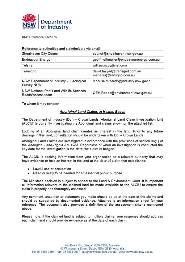
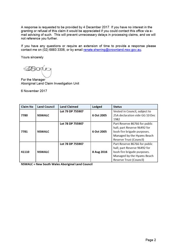
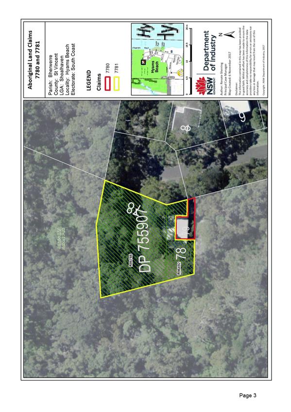
|
|
Development
Committee – Tuesday 13 February 2018
Page
56
|
DE18.13 Development
Application DA17/1958 – 99 Sunset Strip, Manyana – Lot 115 DP
31711
DA. No: DA17/1958/2
HPERM Ref: D18/23344
Group: Planning
Environment & Development Group
Section: Ulladulla
Service Centre
Attachments:
1. Applicant's
submission cl 4.6 variation ⇩
Description of Development: Alterations and
additions to an existing dwelling.
Owner: Ivan and Belinda Harris
Applicant: Integral Home Improvements
Notification Dates: 03 – 18 August 2017
No. of Submissions: Nil submissions
Purpose / Reason for consideration
by Council
This application is reported to Council as it is a clause
4.6 variation to the 7.5 metre maximum building height development standard
required by clause 4.3 of Shoalhaven Local Environmental Plan 2014 (SLEP
2014). The application is requesting a 60% variation to the development
standard to allow a maximum building height of 12 metres consistent with the
existing building.
The assumed concurrence from the
Secretary, Department of Planning requires that with all clause 4.6 variations
in excess of 10%, the exercise of the assumed concurrence must be carried out
by the full Council. The application is therefore presented to the
committee for recommendation to the Ordinary Council Meeting.
|
Recommendation
That the Development Committee
recommends:
1. Council exercise the
Secretary’s assumed concurrence under clause 4.6 and support the 60%
variation to the maximum building height development standard of 7.5m set by
clause 4.3 of Shoalhaven LEP 2014 for alterations and additions to existing
residence on Lot 115 DP 31711, 99 Sunset Strip, Manyana to a maximum building
height of 12m;
2. The application be referred back to
staff for determination.
|
Options
1. Support the variation.
Implications: The development can proceed as
proposed, subject to meeting the matters for consideration under section 79c of
the Environmental Planning and Assessment Act 1979.
2. Variation not supported but applicant
invited to submit revised plans.
Implications: The current variations are not supported but the
applicant is given feedback on changes to reduce the requested
variations. Therefore, revised plans may be resubmitted for determination
by Council or by staff if the revised proposal is less than 10% variation.
Location Maps
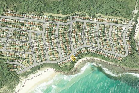
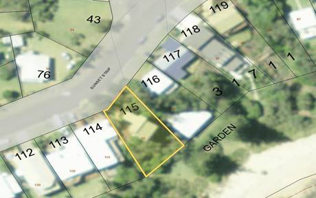
Figure 1 – Location Maps
Background
Proposed Development
The existing property has a two storey pole frame home,
approved in 1984. The proposal is to extend the existing upper deck at
the rear by 1.3m to create a more useable deck off the living area as part of
stabilising the existing structure. The application also proposes
additions and alterations to the dwelling and new a garage at street level.
(Coloured on site plan below)
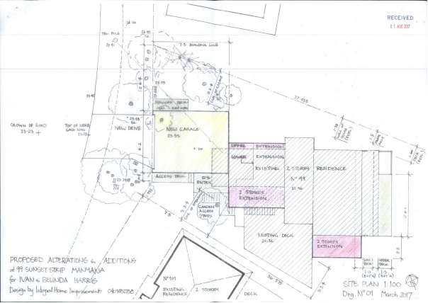
Figure 2 – Site Plan - Existing & Proposed
Development
An Engineer’s review of
the existing structure has identified a need to carry out remedial work to
existing columns supporting the house and certain landscape retaining
walls. In order to solve a number of issues, the application proposes to
provide a lower level combined footing and retaining wall, and
“open” steel frame to re-support the house and existing decks.
The deck extension will provide a safe and more useable result, maintaining
separation distances to neighbouring properties.
The following photos provide
some context for the existing lower structure of the building:
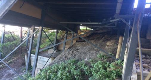
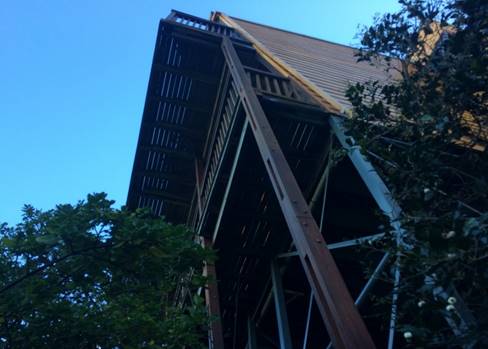
Figure 3 - Photos of
existing structural elements
Subject Land
The land is a 626m² and is within an existing
residential subdivision created in 1960’s. The allotment frontage
to Sunset Strip is 15.24m and has a depth of 36.6/37m. The land is zoned
R2 - Low Density Residential and is subject to a 7.5m maximum building height
under clause 4.3 of the SLEP 2014.
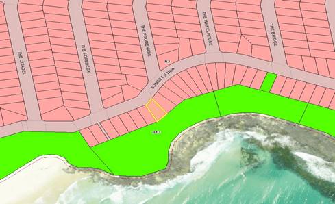
Figure 4 – Zoning
Map
Site & Context
The site is steeply sloping with
9m of fall over the first 20m from the road frontage where the building is located.
The majority of allotments on the south side of Sunset Strip east of this site
are similar as shown on the map below with contours at 1m intervals.
There are a number of similar post frame designs along Sunset Strip due to the
geotechnical challenges of the sites.
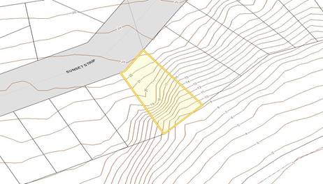
Figure 5 – Contour
map
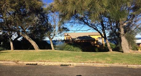
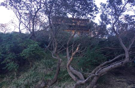
Figure 6 – Photos of existing building from front and
rear
The property is identified as "Coastal Risk
Planning” on Shoalhaven LEP 2014 overlay - clause 7.4 which applies to
land that may be impacted by coastal hazards. A geotechnical report has been
submitted with the application and its recommendations have been integrated
into the design.
Issues
Clause 4.3 Shoalhaven LEP 2014
This clause of the LEP imposes a
7.5m maximum building height on the subject land. The application
proposes additions to the existing building to a maximum height of 12m. The
existing dwelling has building elements as high as 12.5m. The part of the
building additions that exceed the 7.5m height limit include a section of the
upper level deck and roof projecting east and extensions to the northern and
southern side. These elements are highlighted in yellow and are shown in
relation to the 7.5m building height line on the elevations below:
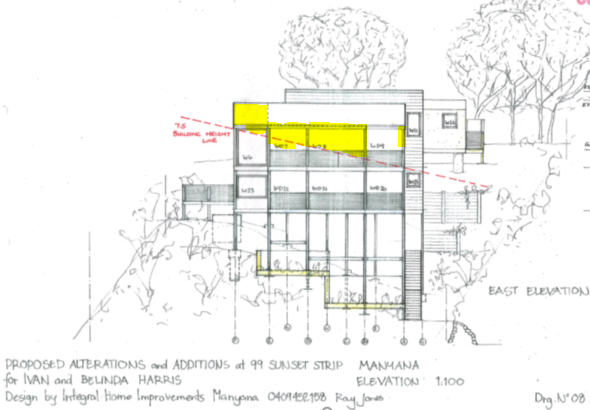
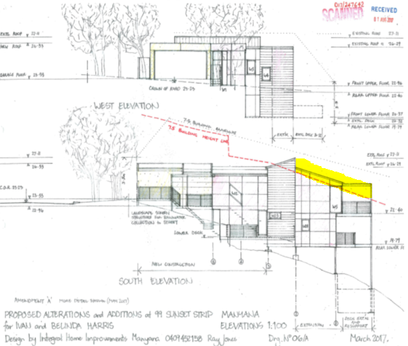
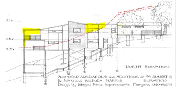
Applicant’s Submission
The applicant’s Clause 4.6 variation statement and
supporting information is included as Attachment 1 in this report. This
document satisfactorily addresses the matters required to support an
application to vary a development standard and includes mapping where relevant.
The applicants supporting statement on how the proposal is consistent with the
objectives of Clause 4.3 of the development standard includes:
The proposal provides a more useable deck to accommodate
an outside dining area for family and visitors with direct link to living and
kitchen areas which is consistent with the housing needs and facilities of a
residential dwelling. This improved facility provides for the day to day needs
of the residents and is consistent with detached housing and is compatible with
other adjacent development. The existing deck is not capable of providing a
workable dining function catering for a reasonable number of occupants.
The small percentage of the proposal that varies from the
standard is an “open” style frame and handrail design to support
shading and provide safety. These elements will be in dark earthy toned colours
to better blend into the hillside thus minimising the visual impact. The shading
system will allow solar access, whilst the length and width of the deck
extension is limited to protect views and privacy. The proposal is not on or in
the vicinity of a heritage item or conservation area.
The existing site is a complex combination of splaying
boundary shape and uneven slope whilst the existing residence is well
established. The owners are trying to work with these parameters to achieve a
“best fit” and relatively minor variation of the standard. The
openness and treatment of the building elements, and again the limiting of the
size of the deck and yet trying to meet the Development Standard as closely as
practical shows genuine consideration by the owners.
If strict compliance with the standard was enforced the
potential for a better social benefit being achieved for the owners and
visitors to the property would be restricted since the proposed deck extension
allows a more useable space which links to the existing functioning residence
in an orderly and viable economic use of the land with this proposed
development, without jeopardising the welfare of the community and environment.
The site and residence require slope instability hazard
consideration. The existing structure is a risk of future failure. The style of
the existing decks out of vertical supports and end infill treatment resembles
a “mountain chalet” form, unrelated to the coast environment. It is
proposed to provide a more conventional vertical support system incorporating a
shading system providing protection and a safer solution which is more relevant
to the coast.
The proposal is in the public interest in terms of
improving the overall stability of the site and structure, thus avoiding the
unfortunate scenario of landslip which has occurred on properties to the north
of this site. It is intended to provide better structural connection between
the existing house; and new footings which will act as a whole to create more
stable conditions. The final result will be more aesthetically pleasing than
the existing structure which appears to precariously “cling” to the
hillside.
Discussion
The applicant needs to demonstrate that compliance with the
development standard is unreasonable or unnecessary in the circumstances of the
case, and that there are sufficient environmental planning grounds to justify
contravening the development standard. Council cannot grant consent for
such a development unless it is satisfied that the applicant has adequately
addressed the above matters and that the proposal will be in the public interest
because it is consistent with the objectives of both the development standard
and the zone in which the development is proposed.
An assessment of the proposed
clause 4.6 variation against the five part test as outlined in Department of
Planning, Varying Development Standards, A Guide, August 2011 follows:
1. The objectives
of the standard are achieved notwithstanding noncompliance with the
standard;
The objectives of the development standard are:
(a) to
ensure that buildings are compatible with the height, bulk and scale of the
existing and desired future character of a locality,
(b) to
minimise visual impact, disruption of views, loss of privacy and loss of solar
access to existing development,
(c) to
ensure that the height of buildings on or in the vicinity of a heritage item or
within a heritage conservation area respect heritage significance.
It is considered that the objectives of the development
standard are achieved notwithstanding noncompliance with the standard because:
· The maximum building
height of the proposed additions and alterations is consistent with the
existing dwelling and will sit comfortably with the existing character of the
locality and is compatible with surrounding development;
· The bulk and scale
of the development has been reduced through the cantilevering of building
elements, clever articulation and selection of differing cladding systems;
· The visual impact
from the development has been minimised through the existing vegetation which
helps the home blend into terrain;
· Highly valued
views have been retained due to the deck being an open form structure;
· There
is no impact on views from houses either side or across the road.
2. The underlying
objective or purpose of the standard is not relevant to the development and
therefore compliance is unnecessary;
The
underlying objectives of Clause 4.3 preserve and support the zone objectives
and the intentions of the SLEP 2014. The objectives of the R2 - Low
Density Residential zone are
· To
provide for the housing needs of the community within a low density residential
environment.
· To
enable other land uses that provide facilities or services to meet the day to
day needs of residents.
· To
provide an environment primarily for detached housing and to ensure that other
development is compatible with that environment.
It is considered that the
proposal meets these objectives as it is proposing alterations and additions to
an existing detached dwelling providing for the housing needs of the owner and
does not propose any other land uses.
3. The underlying object of purpose would be
defeated or thwarted if compliance was required and therefore compliance is
unreasonable;
This provision is not relevant
to this application
4. The development standard has been virtually
abandoned or destroyed by the Council’s own actions in granting consents
departing from the standard and hence compliance with the standard is
unnecessary and unreasonable;
The development standard has not
been abandoned or destroyed by previous decisions, this variation request is
due to the topography of the land and existing development on the land.
In addition Council must take
into account the Secretary’s considerations required under clause 5.6(5)
when assuming concurrence:
4.6(5)(a)
whether contravention of the development standard raises any matter of
significance for State or regional planning.
It is considered that the
variation does not raise any matter of significance for State or regional
planning.
4.6(5)(b)
the public benefit of maintaining the development standard;
There is no public benefit in maintaining the maximum
building height of 7.5m over this lot as the existing building does not
currently comply with this standard and was built before this standard was part
of SLEP 2014 and the foreshore height code that applied at the time the
dwelling was originally approved in 1984.
Planning Assessment
The DA will be fully assessed under s79C of the
Environmental Planning and Assessment Act 1979 upon Council’s decision on
this variation. The proposal does include a proposed variation to the
acceptable solutions for front building setback which will be included in the
final assessment, however, this part of the structure does not exceed the
maximum building height and is consistent with existing development along this
side of Sunset Strip and previous policies that applied specifically to this
street due to the steep slope of lots on the southern side.
The proposal also does not
comply with the building envelope acceptable solutions as the existing building
does not, however, the proposed additions do not add significantly to this
noncompliance and the issues are similar to the consideration of the height of
the building. This issue can be addressed in the final assessment of the
proposal.
Policy Implications
There are no specific policy implications that arise from
this matter. The variation procedure for clause 4.6 of Shoalhaven LEP
2014 provides a framework for variation of standards in a manner which does not
undermine the policy aspects of the development standard.
Consultation and Community Engagement:
Council’s notification of the development resulted in
no submissions being received. The notification was made in accordance with
Council’s Community Consultation Policy with letters being sent within a
25m buffer of the site.
Legal Implications
If the application is refused, or if the applicant is
dissatisfied with Council’s determination, or if the applicant can appeal
on the basis of a deemed refusal because of Council’s delay in
determining the application, the applicant is entitled to appeal to the Land
and Environment Court.
Summary and Conclusion
The building height variation is supported for the following
reasons:
· The new portions
of the development do not exceed the existing height of the building above
existing ground level;
· The site is steep
and therefore provides challenges in designing a building of reasonable floor
space, amenity and utility while minimising the number of levels;
· Houses in the
street of a similar height were approved under DCP 91 prior to maximum building
height of 7.5m being transferred to a development standard in SLEP 2014;
· The proposal is
consistent with the height, bulk and scale of the existing and desired future
character of the locality;
· The proposal has
minimal visual impact, disruption of views, loss of privacy and loss of solar
access to existing development;
· The applicant has
adequately addressed the matters set out in clause 4.6 of Shoalhaven LEP 2014;
· The proposal will
be in the public interest because it is consistent with the objectives of both
the development standard and those of the R2 Low Density Residential zone.
|
|
Development
Committee – Tuesday 13 February 2018
Page
66
|
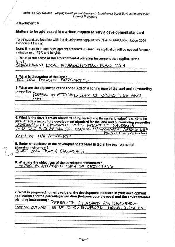
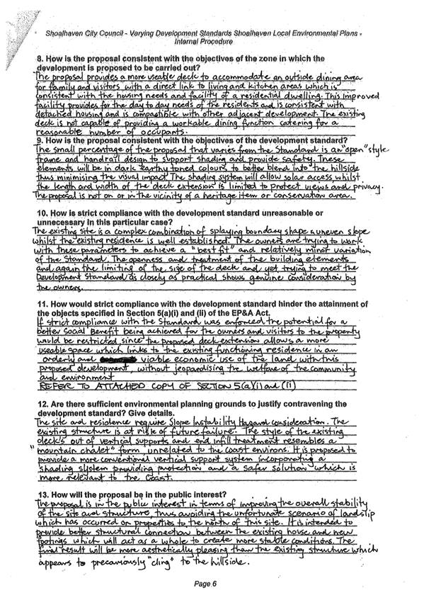
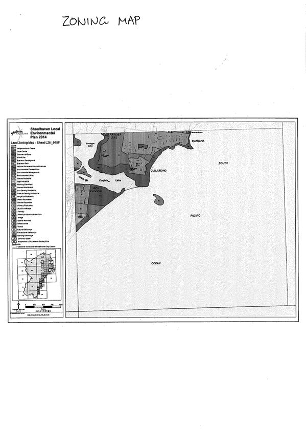
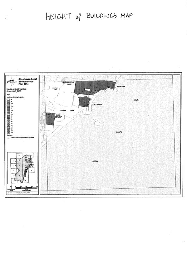
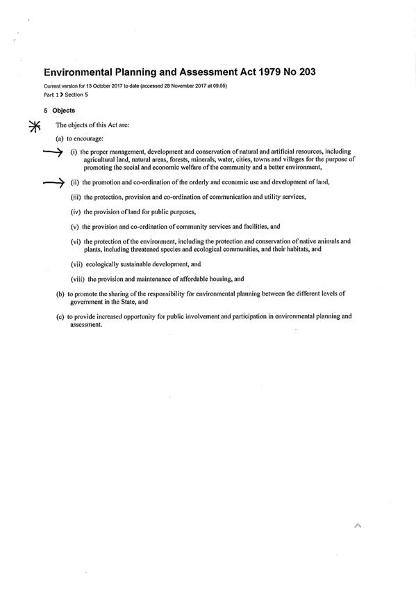
|

|
Development
Committee – Tuesday 13 February 2018
Page
74
|
DE18.14 Development
Application – 56 Red Gum Drive Ulladulla – Lot 506 DP 1235307
DA. No: DA17/2529/2
HPERM Ref: D18/24118
Group: Planning
Environment & Development Group
Section: Ulladulla
Service Centre
Description of Development: Erection of dual
occupancy and Torrens Title subdivision.
Owner: Hazcorp Pty Ltd
Applicant: Joseph & Nicole Campisi
Notification Dates: 13 December 2017 to 28
December 2017
No. of Submissions: Nil submissions
Purpose / Reason for consideration
by Council
Council is in receipt of a
development application to construct a detached dual occupancy including
Torrens Title subdivision. The site currently has an area of 957m2
and the subdivision proposes two (2) allotments, Lot 1 - 401.6m2 and
Lot 2 - 443.6m2 (555.7m2 with the access handle).
Most of the existing lot is
included in the mapped area for dual occupancy subdivision under clause 4.1A of
Shoalhaven Local Environmental Plan 2014 (SLEP 2014) with minimum lot size of
350m2, however, a portion of the rear of the lot is outside this mapped area
due to what appears to be a mapping anomaly that relates to the mapping that
was done for the future Milton Ulladulla Bypass. Therefore, in accordance with
clause 4.1, the lot size map requires a minimum subdivision lot size of 500m2
for proposed Lot 2 (excluding the access handle) the proposed lot is 443.6m2
which is a 11.3% variation to the development standard.
The assumed concurrence from the
Secretary, Department of Planning requires that with cl 4.6 variations in
excess of 10% the exercise of the assumed concurrence must be carried out by
the full Council not by delegation to staff. The application is therefore
presented to the committee for recommendation to the Ordinary Council Meeting.
|
Recommendation
That the Development Committee
recommends that:
1. Council exercise the
Secretary’s assumed concurrence under clause 4.6 and support the 11.3%
variation to the 500m2 minimum lot size set by clause 4.1 of Shoalhaven Local
Environmental Plan 2014 for Lot 2 at 443.6 m2 (555.7m2
with the access handle) for subdivision of the dual occupancy to be erected
at Lot 506 DP 1235307, 56 Red Gum Drive Ulladulla; and
2. The mapping anomaly in relation to
clause 4.1A in this location is included in a future housekeeping planning
proposal to amend Shoalhaven Local Environmental Plan 2014; and
3. The application be referred back to
staff for determination.
|
Options
1. Support the cl 4.6 SLEP 2014
variation.
Implications: Subject to the satisfactory completion of
the section 79C assessment of the development application the application can
then be determined under delegated authority.
2. Not support the variation.
Implications:
The application could not proceed and it would be determined by way of
refusal. The applicant would have a right to appeal to the Land and
Environment Court.
Location Map
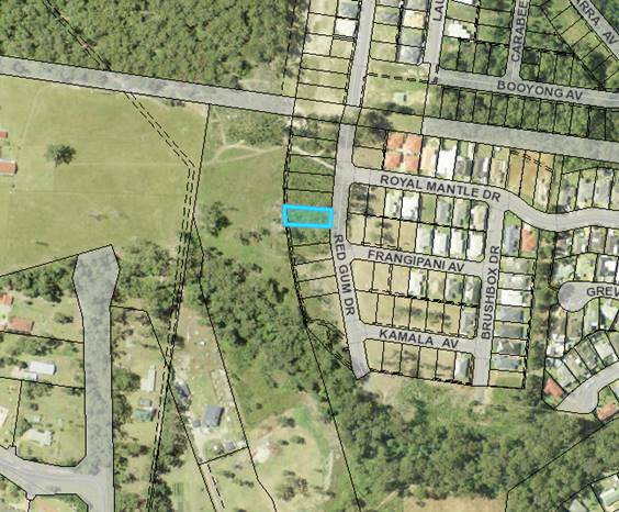
Figure 1 – An aerial view showing the location
of allotment on Red Gum Drive
Background
Proposed Development
The proposal is to construct a detached dual occupancy on the
existing allotment and subdivide on completion in the layout of the as shown in
Figure 2.
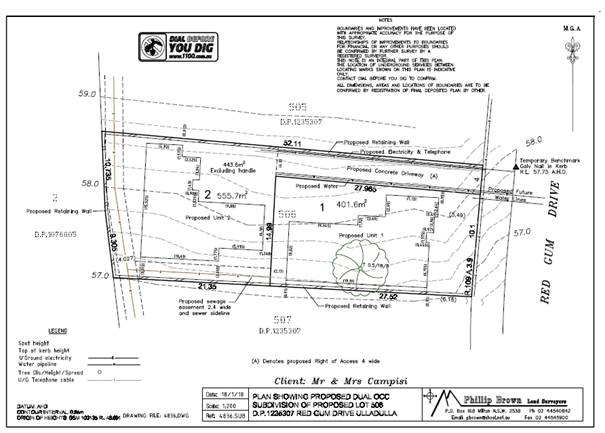
Figure 2 - Proposed
dwellings location and subdivision plan
Subject Land
The subject site is identified
as Lot 506, DP1235307, 56 Red Gum Drive, Ulladulla. The site is located in a
recent stage of a subdivision in Red Gum Drive Ulladulla and adjoins part of
the proposed Milton Ulladulla bypass at the rear.
Site & Context
The site is located on the
southern part of Red Gum Drive which is an extension of the Royal Mantle Estate
and is located approximately 1.5km north-west of Ulladulla Town Centre. The
estate extends north from Golden Wattle Drive towards the Princes Highway and
is bounded on the west by the land zoned for the future Milton Ulladulla
bypass.
The adjoining allotments to the
north and south are all of similar size and there are larger size allotments
within the estate. A group of lots to the north (which were part of an earlier
stage land release in 2009), also on the western side of Red Gum Drive, have
been subdivided for dual occupancy development in the same lot pattern as
proposed by this application as they are not impacted by the mapping anomaly.
History
This site is part of a larger staged subdivision that has
been developed over several years. The southern part of Red Gum Drive is the
most recent released stage. This application is one of the first Council
has received in this recent land release.
Prior to SLEP 2014 part of the rear of the land was zoned 5D
Special Uses under SLEP 1985 and was part of the land required for the Milton
Ulladulla bypass road. During the exhibition of the Draft LEP the RMS
advised that they no longer required this part of the land and it was rezoned
to R1 General Residential in SLEP 2014.
The SLEP 2014 Lot Size Maps have two layers that apply to
the subject land. The Lot Size Map and the Lot Size Clauses Map (cl
4.1A). During the development of SLEP 2014 the Lot Size Map was created
corresponding with the Land Zone Map, however the Lot Clauses Map inadvertently
followed the SLEP 1985 Land Zone Map and so created the anomaly that now
exists. The Lot Size Map covers the entire lot and a 500m2
minimum lot size applies to the land, and the Lot Size Clauses Map that allows
dual occupancy subdivision to min 350m2 (blue line) applies to approximately
600m2 of the front of the lot as can be seen in Figure 3 below.
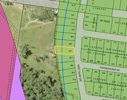
Figure 3 - SLEP 2014 Lot Size and
Clauses Map
Issues
Clause 4.1 Minimum subdivision lot size, Shoalhaven
Local Environmental Plan 2014
The subdivision proposes 2
allotments, Lot 1 - 401.6m2 and Lot 2 - 443.6m2 (555.7m2
with the access handle). Clause 4.1 of SLEP2014 requires a minimum lot
size of 500 m2 and SDCP 2014 requires that the access handle is not
included in the calculation of the minimum lot size, this means Lot 2 is 443.6m2.
This represents an 11.3% variation to the development standard (i.e. 56.4/500 =
11.3%).
Clause 4.1A of SLEP relates to
exceptions to the minimum lot sizes for dual occupancies and multi dwelling
housing. This applies to the land as the land is partly mapped within the
area identified as “Area 1” on the “Lot Size Map” of
SLEP 2014. Area 1 permits subdivision of lots down to a minimum of 350m2.
Therefore, only Lot 1 can rely on this clause for subdivision. This
appears to be a mapping anomaly as discussed previously.
Applicant’s Submission
The reasons outlined in the
applicant’s variation statement include:
· Part
of the lot is mapped in 4.1A Exceptions to minimum lot size for dual
occupancies and multi dwelling housing which allows for subdivision down to
350m2.
· The
Lot Size Map – Area 1 appears to be in error given that that it does not
include the whole lot.
· The
proposal is consistent with the objectives of the R1 zone as it will provide
for the needs of the community and adds to the available housing types.
Discussion
An assessment of the proposed
clause 4.6 variation against the five part test as outlined in Department of
Planning, Varying Development Standards, A Guide, August 2011 is made
below.
1. The objectives
of the standard are achieved notwithstanding noncompliance with the
standard;
The objectives are:
(a) to ensure that subdivision is
compatible with, and reinforces the predominant or historic subdivision pattern
and character of, an area,
(b) to minimise any likely impact of
subdivision and development on the amenity of neighbouring properties,
(c) to ensure that lot sizes and
dimensions are able to accommodate development consistent with relevant
development controls.)
The development is considered to
be consistent with the objectives of the development standard for the following
reasons:
· The
resultant allotment is only a 11.3% variation to the standard and is considered
compatible with the existing subdivision pattern;
· Both
proposed allotments can achieve a reasonable single storey three bedroom
dwelling house with adequate off street vehicle parking and sufficient private
open space;
· The
proposal also meets the general requirements of Council’s Chapter G13
Dual occupancy development of Shoalhaven Development Control Plan 2014
(SDCP2014), including solar access;
· The
proposed development will not have an adverse impact on adjoining development
in terms of loss of views, privacy and amenity.
2. The underlying
objective or purpose of the standard is not relevant to the development and
therefore compliance is unnecessary;
The underlying objectives of
Clause 4.1 preserve and support the zone objectives and the intentions of the
SLEP 2014.
The objectives of the R1 – General residential zone
are:
· To
provide for the housing needs of the community.
· To
provide for a variety of housing types and densities.
· To
enable other land uses that provide facilities or services to meet the day to
day needs of residents.
· To
identify land suitable for future urban expansion.
Development for the purpose of
detached dual occupancy is permissible with consent. The proposal to
subdivide the completed development will provide a greater diversity of housing
stock which will support the housing needs of the community. Retaining the land
as one allotment is inconsistent with the objectives of improving housing
affordability.
Single storey houses on small
lots as proposed provide for more manageable low maintenance dwellings that
appeal to the ageing population. The development is located a short drive to
the Ulladulla Town Centre that provides a wide range of services and
facilities.
Consequently, the development is considered to be consistent
with the zone objectives. The applicant has adequately addressed the
required matters and the proposal will be in the public interest because it is
consistent with the objectives of both the development standard for
subdivisions and those of the R1 General Residential zone.
3. The underlying object of purpose would be
defeated or thwarted if compliance was required and therefore compliance is
unreasonable;
The issue has arisen due to a
mapping anomaly and a relatively minor variation. Therefore, compliance with
the 500m2 minimum lot size would be unreasonable in this instance.
4. The development standard has been virtually
abandoned or destroyed by the Council’s own actions in granting consents
departing from the standard and hence compliance with the standard is
unnecessary and unreasonable;
The development standard has not
been abandoned, this variation request is due to a mapping anomaly on the Lot
Size Clauses Map which does not align with the underlying Land Zone Map, Lot
Size Map or lot cadastre.
5. The compliance with development standard is
unreasonable or inappropriate due to existing use of land and current
environmental character of the particular parcel of land. That is, the
particular parcel of land should not have been included in the zone.
As discussed above the parcel is
zoned correctly and the variation request is due to a mapping anomaly. In
addition, Council must take into account the Secretary’s considerations
required under clause 5.6(5) when assuming concurrence:
4.6(5)(a)
whether contravention of the development standard raises any matter of
significance for State or regional planning.
It is considered that the
variation does not raise any matter of significance for State or regional
planning.
4.6(5)(b)
the public benefit of maintaining the development standard; and
There is no public benefit in maintaining the lot size
standard over this lot as the intent of SLEP 2914 was that the reduced lot size
for dual occupancy would apply to the whole of the existing lot.
Planning Assessment
The DA will be assessed under
s79C of the Environmental Planning and Assessment Act 1979 following
Council’s decision on exercising the Secretary’s assumed
concurrence.
Policy Implications
There are no specific policy
implications that arise from this matter. Clause 4.6 of Shoalhaven Local
Environmental Plan 2014 provides the legal ability for Council to grant the
variation to development standards and Councils adopted Internal Procedure
PRD15/143 provides the framework to ensure the process is conducted in a manner
which does not undermine the development standard. This request has been
considered in accordance with the most recent notification of assumed
concurrence issued by the Secretary on 27 November 2017.
Consultation and Community Engagement:
Notification was carried out in accordance with
Council’s Community Consultation Policy with letters sent to owners of
ten (10) properties within a 100m buffer of the site. The notification
was for a 14 day period.
No submissions were received during or after the
notification period.
Financial Implications:
Nil
Legal Implications
If the application is refused, or if the applicant is
dissatisfied with Council’s determination, the applicant is entitled to
appeal to the Land and Environment Court.
Summary and Conclusion
The request for the variation to
the minimum lot size is considered to be well founded and:
· The
proposed development complies with Councils DCP provisions;
· The
development will not significantly impact upon the surrounding development;
· No
submissions were received in relation to the development or the variation.
|
|
Development
Committee – Tuesday 13 February 2018
Page
81
|
Local Government Amendment (governance &
planning) act 2016
Chapter
3, Section 8A Guiding principles for councils
(1)
Exercise of functions
generally
The
following general principles apply to the exercise of functions by councils:
(a) Councils should provide strong
and effective representation, leadership, planning and decision-making.
(b) Councils should carry out
functions in a way that provides the best possible value for residents and
ratepayers.
(c) Councils should plan
strategically, using the integrated planning and reporting framework, for the
provision of effective and efficient services and regulation to meet the
diverse needs of the local community.
(d) Councils should apply the
integrated planning and reporting framework in carrying out their functions so
as to achieve desired outcomes and continuous improvements.
(e) Councils should work
co-operatively with other councils and the State government to achieve desired
outcomes for the local community.
(f) Councils should manage
lands and other assets so that current and future local community needs can be
met in an affordable way.
(g) Councils should work with
others to secure appropriate services for local community needs.
(h) Councils should act fairly,
ethically and without bias in the interests of the local community.
(i) Councils should be
responsible employers and provide a consultative and supportive working
environment for staff.
(2) Decision-making
The
following principles apply to decision-making by councils (subject to any other
applicable law):
(a) Councils should recognise
diverse local community needs and interests.
(b) Councils should consider social
justice principles.
(c) Councils should consider the
long term and cumulative effects of actions on future generations.
(d) Councils should consider the
principles of ecologically sustainable development.
(e) Council decision-making should
be transparent and decision-makers are to be accountable for decisions and
omissions.
(3) Community participation
Councils
should actively engage with their local communities, through the use of the
integrated planning and reporting framework and other measures.
Chapter
3, Section 8B Principles of sound financial management
The
following principles of sound financial management apply to councils:
(a) Council spending should be responsible and
sustainable, aligning general revenue and expenses.
(b) Councils should invest in responsible and
sustainable infrastructure for the benefit of the local community.
(c) Councils should have effective financial
and asset management, including sound policies and processes for the following:
(i) performance management
and reporting,
(ii) asset maintenance and
enhancement,
(iii) funding decisions,
(iv) risk management practices.
(d) Councils should have regard to achieving
intergenerational equity, including ensuring the following:
(i) policy decisions are made
after considering their financial effects on future generations,
(ii) the
current generation funds the cost of its services
Chapter
3, 8C Integrated planning and reporting principles that apply to councils
The
following principles for strategic planning apply to the development of the
integrated planning and reporting framework by councils:
(a) Councils should identify and prioritise key
local community needs and aspirations and consider regional priorities.
(b) Councils should identify strategic goals to
meet those needs and aspirations.
(c) Councils should develop activities, and
prioritise actions, to work towards the strategic goals.
(d) Councils should ensure that the strategic
goals and activities to work towards them may be achieved within council
resources.
(e) Councils should regularly review and
evaluate progress towards achieving strategic goals.
(f) Councils should maintain an
integrated approach to planning, delivering, monitoring and reporting on
strategic goals.
(g) Councils should collaborate with others to
maximise achievement of strategic goals.
(h) Councils should manage risks to the local
community or area or to the council effectively and proactively.
(i) Councils should make appropriate
evidence-based adaptations to meet changing needs and circumstances.