Development Committee
Meeting Date: Tuesday,
14 November, 2017
Location: Council
Chambers, City Administrative Building, Bridge Road, Nowra
Time:
5.00pm
Membership (Quorum - 5)
Clr Joanna Gash - Chairperson
Clr John Levett – Deputy Chairperson
All Councillors
General Manager or nominee
Please note: Council’s Code of Meeting Practice
permits the electronic recording and broadcast of the proceedings of meetings
of the Council which are open to the public. Your attendance at this meeting is
taken as consent to the possibility that your image and/or voice may be
recorded and broadcast to the public.
Agenda
1. Apologies / Leave of Absence
2. Confirmation of Minutes
· Development
Committee - 10 October 2017............................................................... 1
3. Declarations of Interest
4. Mayoral Minute
5. Deputations and Presentations
6. Notices of Motion / Questions on Notice
Nil
7. Reports
DE17.76...... Rezoning Investigations - Goodland Road -
Landowner Committment and Future Investigation.................................................................................................... 9
DE17.77...... Hitchcocks Lane, Berry - Proponent Initiated
Planning Proposal ............... 16
DE17.78...... Draft Chapter G18 Streetscape Design for Town and
Village Centres - Shoalhaven Development Control Plan 2014 - Preparation and
Public Exhibition......... 44
DE17.79...... Outcomes - Building Height Review -
Southern Part of Ulladulla CBD...... 49
DE17.80...... Submissions Consideration - Planning Proposal
(PP022) - LEP Housekeeping Amendment 2016 - Minor Mapping & Instrument
Changes........................ 56
DE17.81...... Proposed Submission - Issues Paper: Review of
Environmental Planning and Assessment Regulation 2000....................................................................... 62
DE17.82...... Woncor Avenue Nowra Hill - Proponent Initiated
Planning Proposal.......... 72
DE17.83...... Applications (multiple) to Modify Development
Consents – Release of Easement for Carparking over Lot 1 DP 785956
& affecting Lot 4 DP785956 Island Point Road, St Georges Basin.............................................................................................. 86
DE17.84...... Development Application - 405 Princes Highway,
Bomaderry – Lot 14 DP 20626...................................................................................................................... 97
DE17.85...... DS17/1233 – 12 Currambene Street, Huskisson
– Lot 2 DP 662583....... 113
DE17.86...... Development Application – Parson St
Ulladulla – Proposed Lot 15 in Subdivision of Lot 3 DP746228 and Lots 5
& 6 DP805221............................................... 140
DE17.87...... Development Application SF10591 – 18 Calder
Close, Vincentia – Lot 34 in DP 713629........................................................................................................ 167
DE17.88...... Serious and Irreversible Impact - Biodiversity
Conservation Act - Yerriyong Moto Complex...................................................................................................... 176
DE17.89...... Works to restrict public access to Shoalhaven
Water infrastructure at Kings Point and Burrill Lake.................................................................................................. 183
8. Confidential
Reports
Nil
|

|
Development
Committee – Tuesday 14 November 2017
Page
iii
|
Development Committee
Delegation
THAT pursuant to s377 (1) of the
Local Government Act 1993 the Committee is delegated the functions conferred on
Council by the Environmental Planning & Assessment Act 1979 (EPA Act),
Local Government Act 1993 (LG Act) or any other Act or delegated to Council, as
are specified in the attached Schedule, subject to the following limitations:
i. The
Committee cannot make a decision to make a local environmental plan to classify
or reclassify public land under Division 1 of Part 2 of Chapter 6 of the LG
Act;
ii.
The Committee cannot review a s82A or s96AB EPA
Act determination made by the Council or by the Committee itself;
iii.
The Committee cannot exercise any function delegated
to the Council which by the terms of that delegation cannot be sub-delegated;
iv.
The Committee cannot exercise any function which
s377(1) of the LG Act provides cannot be delegated by Council; and
v.
The Committee cannot exercise a function which
is expressly required by the LG Act or any other Act to be exercised by
resolution of the Council.
Schedule
a. All
functions relating to the preparation, making, and review of local
environmental plans (LEPs) and development control plans (DCPs) under Part 3 of
the EPA Act.
b. All
functions relating to the preparation, making, and review of contributions
plans and the preparation, entry into, and review of voluntary planning
agreements under Part 4 of the EPA Act.
c. The
preparation, adoption, and review of policies and strategies of the Council in
respect of town planning and environmental matters and the variation of such
policies.
d. Determination
of variations to development standards related to development applications
under the EPA Act where the development application involves a development
which seeks to vary a development standard by more than 10% and the application
is accompanied by a request to vary the development standard under clause 4.6
of Shoalhaven Local Environmental Plan 2014 or an objection to the application
of the development standard under State Environmental Planning Policy No. 1
– Development Standards.
e. Determination
of variations from the acceptable solutions and/or other numerical standards
contained within the DCP or a Council Policy that the General Manager requires
to be determined by the Committee
f. Determination
of development applications that Council requires to be determined by the
Committee on a case by case basis.
g. Review
of determinations of development applications under sections 82A and 96AB of
the EP&A Act that the General Manager requires to be determined by the
Committee.
h. Preparation,
review, and adoption of policies and guidelines in respect of the determination
of development applications by other delegates of the Council.
Minutes of the Development Committee
Meeting Date: Tuesday,
10 October 2017
Location: Council
Chambers, City Administrative Building, Bridge Road, Nowra
Time: 5.03pm
The following members
were present:
Clr Joanna Gash -
Chairperson
Clr Patricia White
Clr John Wells –
left the meeting, the time being 6.41pm.
Clr Amanda Findley
Clr Kaye Gartner –
arrived, the time being 5.08pm.
Clr Nina Cheyne
Clr Annette Alldrick
Clr John Levett
Clr Mitchell Pakes
Clr Greg Watson
Clr Mark Kitchener
– arrived, the time being 5.21pm.
Clr Bob Proudfoot
Mr Russ Pigg - General
Manager
|
Apologies / Leave of Absence
|
An apology was received
from Clr Guile.
|
Confirmation of the Minutes
|
|
RESOLVED (Clr White / Clr Cheyne) MIN17.892
That the Minutes of the Development Committee held on
Tuesday 12 September 2017 be confirmed.
CARRIED
|
Nil
Deputations and Presentations
Mr Andrew Dawes, JACA Property
Group, addressed the Committee in relation to item DE17.74 DA16/2070 – 7
Beach Street, Huskisson – Lot B DP 359526 – Proposed Residential
Flat Building
Note:
Clr Gartner arrived, the time being 5.08pm.
Ms Joy Lever, addressed the
Committee in relation to item DE17.74 DA16/2070 – 7 Beach Street,
Huskisson – Lot B DP 359526 – Proposed Residential Flat Building
Note: Clr Kitchener
arrived, the time being 5.21pm
Reports
|
Procedural
Motion - Bring Item Forward
|
|
RESOLVED (Clr Pakes / Clr Levett) MIN17.893
That the matter of item DE17.74
DA16/2070 – 7 Beach Street, Huskisson – Lot B DP 359526 –
Proposed Residential Flat Building be brought forward for consideration.
CARRIED
|
|
DE17.74 DA16/2070
– 7 Beach Street, Huskisson – Lot B DP 359526 – Proposed
Residential Flat Building
|
HPERM Ref:
D17/253749
|
|
Recommendation (Item to be determined under
delegated authority)
That Development Application DA16/2070
to demolish the existing dwelling and ancillary outbuilding and construct a
residential flat building at Lot B DP 359526, 7 Beach Street, Huskisson be
approved subject to the recommended conditions of consent contained in
Attachment 6 of this report.
|
|
RESOLVED (Clr White / Clr
Gartner) MIN17.894
That Development Application DA16/2070
to demolish the existing dwelling and ancillary outbuilding and construct a
residential flat building at Lot B DP 359526, 7 Beach Street, Huskisson be
approved subject to the recommended conditions of consent contained in
Attachment 6 of this report.
For: Clr
White, Clr Gash, Clr Wells, Clr Findley, Clr Levett, Clr Cheyne, Clr
Alldrick, Clr Gartner, Clr Pakes, Clr Watson, Clr Kitchener, Clr Proudfoot
and Russ Pigg
Against: Nil
CARRIED
|
|
DE17.67 Possible
Affordable Housing Opportunity - Coomea Street, Bomaderry - Initial NSW
Government Response
|
HPERM Ref:
D17/285258
|
|
Recommendation (Item to be determined under
delegated authority)
That Council
1. Acknowledge
the advice received from the NSW Government in this regard;
2. Continue
to work on the possible demonstration affordable housing project at Coomea
Street, Bomaderry;
3. Approach
the five first phase service providers under the Social and Affordable
Housing Fund (SAHF) to see if they are interested in being part of the
project; and
4. Request
the NSW Minister for Social Housing to consider making a budget bid for
additional social and affordable housing in Shoalhaven and ensure that the
NSW Government work with Council on redeveloping some of their land to a
higher and better use to assist in this regard.
|
|
RESOLVED (Clr Findley / Clr
Cheyne) MIN17.895
That Council
1. Acknowledge
the advice received from the NSW Government in this regard;
2. Continue
to work on the possible demonstration affordable housing project at Coomea
Street, Bomaderry;
3. Approach
the five first phase service providers under the Social and Affordable
Housing Fund (SAHF) and other providers to see if they are interested in
being part of the project; and
4. Request
the NSW Minister for Social Housing to consider making a budget bid for
additional social and affordable housing in Shoalhaven and ensure that the
NSW Government work with Council on redeveloping some of their land to a
higher and better use to assist in this regard.
5. Endorse
the Mayor continuing to advocate in respect to affordable housing to State
and Federal Ministers.
For: Clr
White, Clr Gash, Clr Wells, Clr Findley, Clr Levett, Clr Cheyne, Clr
Alldrick, Clr Gartner, Clr Pakes, Clr Watson, Clr Kitchener, Clr Proudfoot
and Russ Pigg
Against: Nil
CARRIED
|
|
Note:
The Committee thanked Gordon Clark for his work on this project.
|
|
DE17.68 Proposed
Submission - Options Paper: Short Term Holiday Letting in NSW
|
HPERM Ref:
D17/306769
|
|
Recommendation (Item to be determined under
delegated authority)
That Council make a submission to
the NSW Government on the Options Paper: Short Term Holiday Letting in NSW
consistent with the content of the report and continue to be involved as
required in any outcomes that eventuates.
|
|
RESOLVED (Clr Wells / Clr Findley) MIN17.896
That Council make a submission to
the NSW Government on the Options Paper: Short Term Holiday Letting in NSW
consistent with the content of the report and continue to be involved as
required in any outcomes that eventuates.
For: Clr
White, Clr Gash, Clr Wells, Clr Findley, Clr Levett, Clr Cheyne, Clr
Alldrick, Clr Gartner, Clr Pakes, Clr Watson, Clr Kitchener, Clr Proudfoot
and Russ Pigg
Against: Nil
CARRIED
|
|
DE17.69 Berry
Landcare Grant - Berry Wildlife Corridor - Inclusion on Terrestrial
Biodiversity Map - Shoalhaven LEP 2014
|
HPERM Ref:
D17/268800
|
|
Recommendation (Item to be determined under
delegated authority)
That Council:
1. Support
making ongoing amendments to the Terrestrial Biodiversity Map as part of a
Shoalhaven Local Environmental Plan 2014 housekeeping amendment process,
where landholders in Berry and surrounds have accepted public money for
revegetation and agreed to enter into a conservation agreement over that
land.
2. Write
to the Berry Landcare group to congratulate them on gaining a substantial
grant to improve the biodiversity linkages in the area, and advise them that
this will be reflected in the Shoalhaven Local Environmental Plan 2014
through future amendments.
|
|
RESOLVED (Clr Wells / Clr White) MIN17.897
That Council:
1. Support
making ongoing amendments to the Terrestrial Biodiversity Map as part of a
Shoalhaven Local Environmental Plan 2014 housekeeping amendment process,
where landholders in Berry and surrounds have accepted public money for revegetation
and agreed to enter into a conservation agreement over that land.
2. Write
to the Berry Landcare group to congratulate them on gaining a substantial
grant to improve the biodiversity linkages in the area, and advise them that
this will be reflected in the Shoalhaven Local Environmental Plan 2014
through future amendments.
For: Clr
White, Clr Gash, Clr Wells, Clr Findley, Clr Levett, Clr Cheyne, Clr
Alldrick, Clr Gartner, Clr Pakes, Clr Watson, Clr Kitchener, Clr Proudfoot
and Russ Pigg
Against: Nil
CARRIED
|
|
DE17.70 Shoalhaven
Development Control Plan 2014, Chapter N19 Huskisson Mixed Use Zones - Draft
Amendment Preparation and Proposed Public Exhibition
|
HPERM Ref:
D17/216331
|
|
Recommendation (Item to be determined under
delegated authority)
That Council:
1. Prepare
and publicly exhibit Draft Chapter N19 Huskisson Mixed Use Zones of
Shoalhaven Development Control Plan 2014 for a minimum period of 28 days in
accordance with the Environmental Planning & Assessment Act 1979.
2. Advise
the relevant Community Consultative Body (Huskisson Woollamia Community
Voice) of the public exhibition.
3. Report
the outcomes of the public exhibition period to Council when appropriate.
|
|
RESOLVED (Clr Gartner / Clr
Cheyne) MIN17.898
That Council:
1. Prepare
and publicly exhibit the proposed amendments to Draft Chapter N19 Huskisson
Mixed Use Zones of Shoalhaven Development Control Plan 2014 for a minimum
period of 28 days in accordance with the Environmental Planning &
Assessment Act 1979.
2. Advise
the relevant Community Consultative Body (Huskisson Woollamia Community
Voice) of the public exhibition.
3. Report
the outcomes of the public exhibition period to Council when appropriate.
For: Clr
White, Clr Gash, Clr Wells, Clr Findley, Clr Levett, Clr Cheyne, Clr
Alldrick, Clr Gartner, Clr Pakes, Clr Watson, Clr Kitchener, Clr Proudfoot
and Russ Pigg
Against: Nil
CARRIED
|
|
DE17.71 Update
- Nowra Riverfront Precinct - Strategic Direction and Next Steps
|
HPERM Ref:
D17/286874
|
|
Recommendation (Item to be determined under
delegated authority)
That Council:
1. Receive
this update on the progress of the Nowra Riverfront Precinct planning work
for information; and.
2. Receive
a further report once the draft detailed urban design controls have been
prepared in accordance with the recommended strategic directions, that
considers how to proceed with a potential Planning Proposal for new
zones/building heights and supporting planning controls
|
|
RESOLVED (Clr Gartner / Clr
Watson) MIN17.899
That Council:
1. Receive
this update on the progress of the Nowra Riverfront Precinct planning work
for information; and.
2. Receive
a further report once the draft detailed urban design controls have been
prepared in accordance with the recommended strategic directions, that
considers how to proceed with a potential Planning Proposal for new
zones/building heights and supporting planning controls
3. In
preparing the draft urban design controls, consider retaining the height
controls within the citywide DCP chapter N7 and give further consideration to
a more flexible height within the precinct east of the Osborne Street
corridor.
For: Clr
White, Clr Gash, Clr Wells, Clr Findley, Clr Levett, Clr Cheyne, Clr
Alldrick, Clr Gartner, Clr Pakes, Clr Watson, Clr Kitchener, Clr Proudfoot
and Russ Pigg
Against: Nil
CARRIED
|
|
DE17.72 Shoalhaven
DCP 2014 - Required Amendment - Chapter G4: Tree & Vegetation
Management - NSW Government Land Management & Biodiversity Conservation
Reforms
|
HPERM Ref:
D17/308277
|
|
Recommendation (Item to be determined under
delegated authority)
That Council:
1. Adopt
the draft Amendment 21 to Shoalhaven Development Control Plan 2014 which
includes amendments to Chapter G4 Tree and Vegetation Management and to the
Dictionary (detailed in Attachment 1) and which is consistent with Option 1
in the report; and
2. Exhibit
the draft Amendment for a minimum period or 28 days in accordance with
legislation; and
3. Consider
a further report after public exhibition to consider any submissions received
and to adopt the amendment for finalisation.
|
|
Note:
Clr Wells left the meeting, the time being 6.41pm.
Note: Clr Gartner left
the meeting, the time being 6.43pm.
|
|
RESOLVED (Clr Findley / Clr
Levett) MIN17.900
That Council:
1. Adopt
the draft Amendment 21 to Shoalhaven Development Control Plan 2014 which
includes amendments to Chapter G4 Tree and Vegetation Management and to the
Dictionary (detailed in Attachment 1) and which is consistent with Option 1
in the report; and
2. Exhibit
the draft Amendment for a minimum period or 28 days in accordance with
legislation; and
3. Consider
a further report after public exhibition to consider any submissions received
and to adopt the amendment for finalisation.
For: Clr
White, Clr Gash, Clr Findley, Clr Levett, Clr Cheyne, Clr Alldrick, Clr
Pakes, Clr Watson, Clr Kitchener, Clr Proudfoot and Russ Pigg
Against: Nil
CARRIED
|
|
DE17.73 Development
Application – proposed 2 lot subdivision at Lot 4 DP1027849 (no.22)
James Farmer Grove, Woollamia
|
HPERM Ref: D17/99695
|
|
Recommendation (Item to be determined under
delegated authority)
That the request to permit the
provision of effluent pump out services to proposed lot 1 and subdivide the
flood affected land:
1. Be
supported.
2. Refer
the application back to staff for determination.
|
|
RESOLVED (Clr Watson / Clr Pakes) MIN17.901
That the request to permit the
provision of effluent pump out services to proposed lot 1 and subdivide the
flood affected land:
1. Be
supported.
2. Refer
the application back to staff for determination.
Note:
Clr Gartner returned to the meeting, the time being 6.43pm.
For: Clr
White, Clr Gash, Clr Findley, Clr Levett, Clr Cheyne, Clr Alldrick, Clr
Gartner, Clr Pakes, Clr Watson, Clr Kitchener, Clr Proudfoot and Russ Pigg
Against: Nil
CARRIED
|
|
DE17.74 DA16/2070
– 7 Beach Street, Huskisson
– Lot B DP 359526 – Proposed Residential Flat Building
|
HPERM Ref: D17/253749
|
|
Item dealt with
earlier/later in the meeting see MIN17.894.
|
|
DE17.75 Yalwal
Camping Area (Danjera Dam)
|
HPERM Ref:
D17/320884
|
|
Recommendation (Item to be determined under
delegated authority)
That Council:
1. Close
the Yalwal camping area and temporarily close the area to public access after
advertisements and notifications to legitimate known user groups
2. Prepare
a plan for upgrading of the area for day use in consultation with key user
groups.
3. Explore
the opportunity for biobanking the credits associated with the EEC, excluding
the proposed day-use area
4. Explore
opportunities with adjoining landowner for eco tourism potential.
|
|
Motion (Clr Gash / Clr White)
That Council:
1. Close
the Yalwal camping area and temporarily close the area to public access after
advertisements and notifications to legitimate known user groups
2. Prepare
a plan for upgrading of the area for day use in consultation with key user
groups.
3. Explore
the opportunity for biobanking the credits associated with the EEC, excluding
the proposed day-use area
4. Explore
opportunities with adjoining landowner for eco tourism potential.
|
|
Amendment (Clr Watson / Clr Pakes)
That this item be deferred to the
next Development Committee Meeting, Tuesday 14 November 2017, pending a site
inspection with Councillors and Council Staff.
Note:
Clr Alldrick left the meeting, the time being 7.06pm.
For: Clr
Pakes and Clr Watson
Against: Clr
White, Clr Gash, Clr Findley, Clr Levett, Clr Cheyne, Clr Gartner, Clr
Kitchener, Clr Proudfoot and Russ Pigg
lost
|
|
RESOLVED (Clr Gash / Clr White) MIN17.902
That Council:
1. Close
the Yalwal camping area and temporarily close the area to public access after
advertisements and notifications to legitimate known user groups
2. Prepare
a plan for upgrading of the area for day use in consultation with key user
groups.
3. Explore
the opportunity for biobanking the credits associated with the EEC, excluding
the proposed day-use area
4. Explore
opportunities with adjoining landowner for eco tourism potential.
5. A
Councillor inspection of the site be arranged.
For: Clr
White, Clr Gash, Clr Findley, Clr Levett, Clr Cheyne, Clr Gartner, Clr Pakes,
Clr Kitchener, Clr Proudfoot and Russ Pigg
Against: Clr
Watson
CARRIED
|
There being no further
business, the meeting concluded, the time being 7.17pm.
Clr Gash
CHAIRPERSON
|

|
Development
Committee – Tuesday 14 November 2017
Page
9
|
DE17.76 Rezoning
Investigations - Goodland Road - Landowner Committment and Future Investigation
HPERM Ref: D17/182093
Group: Planning
Environment & Development Group
Section: Strategic
Planning
Attachments:
1. Report to 9 October 2013 Development
Committee - Planning Proposal - LP384 - Woollamia - Goodland Rd (under separate
cover) ⇨
Purpose / Summary
To update Council on
representations received from landowners in the small lot rural subdivision
area at Goodland Road, Woollamia and provide possible options to reconsider the
rezoning investigations given changes to legislation, land tenure and the removal
of an unauthorised building in the investigation area.
|
Recommendation
(Item to be determined under delegated authority)
That Council:
1. Recommence the Planning Proposal and
Planning Agreement process to resolve the
development potential of the small lot rural subdivision at Goodland Road,
Woollamia, but only on the following basis:
a. No additional development will be
identified outside of Council’s preferred exhibited Development
Scenario (and its key elements) included in this report; and
b. All owners confirm in writing that
they accept that the progression of the PP will only be on the basis of this
Development Scenario and provide a written in-principle agreement that they
will each sign a revised Voluntary Planning Agreement.
2. Amend the previously exhibited
Landowner Agreement and Voluntary Planning Agreement, subject to the above,
to include further detail on costings for all landowners, and times at which
payments are to be made.
|
Options
1. Adopt the recommendation.
Implications: This option is preferred as it
provides another opportunity to resolve this long standing planning issue. A
number of changes have occurred since Council discontinued this matter
previously, including change in land ownership, which will hopefully ensure
this time that there is more success than the previous attempts to realise the
identified development scenario that faltered due to landowner agreement
issues. The broader community will benefit if this long-standing issue is
resolved consistent with the actions specified within the Jervis Bay Settlement
Strategy (JBSS). This option also aims to recoup the investigation costs from
landowners. Without resolution of this rezoning investigation, there is no
other mechanism for Council to recoup these costs.
The identified and preferred development scenario has the
following key elements – defined development footprint, not more than 7
dwellings and the remainder of the land in community title.
2. Council not proceed with the rezoning
investigations and provide in principle support for landowners who wish to
prepare and fund a private Planning Proposal in accordance with the identified
preferred Development Scenario included as Attachment 1 to this report
and the JBSS.
Implications: This option removes Council from the
funding commitment and provides the landowners support should they wish to
prepare and fund their own Planning Proposal. This option would still require
updated studies and investigations, however this means that the previous
planning work undertaken by Council has not gone to waste and the actions
specified in the JBSS are not abandoned.
3. Council not proceed with the rezoning
investigations until such time as all affected landowners fully commit to the
matter and the costs associated with it. This could possibly be done through
getting the owners to sign a deed of agreement or similar prior to the matter
recommencing.
Implications:
if this is possible, it would at least ensure that all owners are fully
committed prior to the matter recommencing and would avoid last minute
landowner disagreement or lack of commitment derailing the process once
considerable work has again been undertaken to resolve it.
Background
Investigations to rezone this land first commenced in the
1990s and considerable resources and staff time have been expended on the
project to date with no outcome achieved.
The Report to Council’s Development Committee Meeting
held on 9 October 2013 details the complex background to this matter. A
community title development option and rezoning of the land to allow 7 dwelling
houses (see Figure 1 below) was proposed through the exhibition of the
Goodland Road Planning Proposal (PP), draft Voluntary Agreement and draft
Landowners Agreement. A copy of the report to Council’s Development
Committee with the exhibited documents is included as Attachment 1.
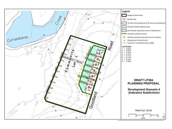
Figure 1: Preferred Development Scenario
The
overall aim of the exhibited PP was to resolve the development potential of the
small lot rural subdivision at Goodland Road, Woollamia. The purpose of the PP
was to identify land suitable for development purposes and to ensure the
conservation of land unsuitable for development consistent with the action in
the Jervis Bay Settlement Strategy (JBSS) to investigate the development
potential of the Woollamia Farmlets, including Goodland Road.
The previously exhibited PP sought to rezone the land from
Rural to part E2 Environmental Conservation and part E4 Environmental Living in
the now finalised Shoalhaven LEP 2014. An amendment to the minimum lot size to
1500m2 in the proposed E4 zoned land was
also required to allow for 7 potential dwelling entitlements following
re-subdivision of the land. The remaining E2 zoned land was proposed to be
mapped with a minimum lot size of 40 hectares.
Due to lack of consensus and commitment from the landowners,
Council resolved on 9 October 2013 to:
a) Receive
the outcomes of the exhibition of the Goodland Road Planning Proposal, Draft
Voluntary Agreement and Draft Landowners Agreement for information;
b) Not
proceed with the Goodland Road Planning Proposal at this time;
c) Reconsider
a future subsequent Planning Proposal if and only when landowner agreement is
reached and the Voluntary Planning Agreement is signed by all landowners.
Since this resolution, the landowners have not reached
formal agreement or signed the Voluntary Planning Agreement and Council
discontinued the previous Planning Proposal.
Following a request from landowners, Council staff met with
landowners in February 2015 to discuss options to move forward. Based on this
discussion and further investigations it was apparent that it was difficult for
any future rezoning investigations to proceed with the unauthorised works that
were previously located at Lot 212. The unauthorised structure has now been
removed following compliance action from Council including court
proceedings.
Current Land Ownership
Since Council’s resolution in 2013, a number of
properties in the Goodland Road investigation area have been sold. This
includes the separation of the largest landholding (Lots 220-222 and 216-218)
into 3 separate landholdings. This landholding was previously a further
sticking point in the rezoning investigations as the landowner had no legal
ability to act on the land as it was in the hands of Trustees.
There are 12 lots in the investigation area and currently
there are 9 landowners in total (previously there were 7). Council’s
preferred community title development scenario indicates 7 potential building
envelopes. This means that not all landowners will receive a dwelling
entitlement if Council’s preferred development scenario progresses
through a PP and is ultimately rezoned.
8 of the 9 landowners have provided a signed form to one of
the landowners who has been trying to coordinate things and they were forwarded
to Council for consideration. The commitment forms stated that the owner/s of
land in Goodland Road “intend for our land in Goodlands Road, Woollamia
be rezoned to allow for a residential home to be built upon it”. The
remaining landowner who did not provide a commitment form has indicated through
recent discussions with their representative that they would like to be
included in the PP, however are not in a financial position to contribute costs
and would prefer to be bought out of the subdivision by the other landowners.
It is noted that the advice provided by the owners in
somewhat non-committal. Should Council recommence the process it should only be
on the basis of the previously exhibited plan and only if all of the owners
provide a written in-principle agreement that they will each sign a revised
Voluntary Planning Agreement
If Council decides to again recommence the rezoning
investigations, there would still be a requirement for a community title
subdivision to be undertaken. This means there would be 7 lots with potential
building envelopes and 1 community title lot collectively owned by the 7
owners. The 7 owners would be responsible for the majority of the costs and
there would need to be some sort of landowner agreement to determine
compensation for the landowners who would not receive a building lot and would
effectively be bought out of the estate.
Voluntary
Planning Agreement
A Voluntary Planning Agreement
(VPA) between the landowners and Council is still considered to be the most
appropriate mechanism to recoup the costs of rezoning investigations and to
facilitate re-subdivision of the land.
The legal drafting and execution of a VPA and Landowner
Agreement was difficult to achieve previously due to some landowners not
agreeing to pay the costs and the fact that the majority of the land was in the
ownership of an Estate with no legal ability to sign on behalf of the land at
that time.
The purpose of the previously exhibited draft VPA was to:
a) Assist
the rezoning of the developable envelope of the Land as E4 Environmental Living
with the remainder of the Land being zoned E2 Environmental Conservation (under
the new Shoalhaven LEP and in accordance with the Standard Instrument);
b) Facilitate
a re-subdivision of the Land under the Community Land Development Act 1989. It
is proposed that the 12 lots that currently comprise the land be firstly
consolidated into a single allotment and then re-subdivided into 7 smaller lots
(Zoned E4) and one large Community Lot (Zoned E2). The smaller lots would range
in size from 0.10 – 0.17ha (1,000 m2 – 1,700 m2). The residual
community lot would be 2.52ha.
The draft VPA also included:
· Specifics relating
to development, such as requirements for bushfire protection, restoration
works;
· Subdivision,
electricity, road drainage and management of the community title allotment;
· The recoupment of
Council’s costs totalling $160,000 (capped at expenditure up to 2010)
which pertain to the rezoning process and studies that have already been
completed;
· Council’s
agreement and obligations to the landowners relating to the rezoning process;
· Landowners’
and Council’s agreement of the development standards such as water
supply;
· Building
construction standards, dwellings, effluent disposal systems bushfire
protection;
· Measures that will
apply to any development proposed for the subject land; and
· Dispute resolution
processes and other legal specifics.
The
draft VPA would need to be revised and updated based on current ownership
patterns and the costs within it updated. The potential staging of costs could
be considered if this is a sticking point for the landowners.
Paper Subdivision Provisions
The Environmental
Planning and Assessment Amendment (Paper Subdivisions) Regulation 2013 (the
Regulation) and corresponding paper subdivision provisions now contained in
Schedule 5 of the Environmental Planning and Assessment Act 1979 (EPA
Act) (PS Amendments) commenced on 8 March 2013.
The
provisions in the EP&A Act and Regulation provide a potential mechanisms to
help overcome common barriers to development such as fragmented ownership,
rezoning and infrastructure requirements for current subdivision standards. A
copy of the relevant Guidelines are available online: http://www.planning.nsw.gov.au/Policy-and-Legislation/Buildings/~/media/EA53A0E32FF84942B4E47E961B880864.ashx
Investigations into whether
the Paper Subdivisions Legislative Provisions could be utilised in this case
previously concluded that there was not 60% of landowners or 60% of the
landholdings that were willing to continue with the PP.
As a result of property sales
and new landowners, there is a possibility that the level of landowner support
needed to use these provisions (at least 60% of the landowners and the owners
of at least 60% of the total area of the land) could be reached. As such, this
legislation could potentially be used to allow Council (should it wish to take
on this role) to compel other landowners to co-operate with the majority of
landowners in the process. Landowner support can only be demonstrated
through a formal ballot process.
However, the process to
prepare a Development Plan and Subdivision Order and potentially implementing
the Development Plan appears to be onerous and expensive and in this case,
would draw Council into a potential dispute among private landowners over
compensation. As such, it may not be an appropriate use of Council resources.
Under the legislation, there
are limited authorities for the subdivision of land including:
· the corporation (meaning the corporation sole established under section
8 of the
EP&A Act), or
· Local council, or
· Urban Growth NSW, or
· Development corporation established under the Growth
Centres (Development Corporations) Act 1974 NSW, or
· Any other body prescribed by the Regulation (Note:
Currently, none are prescribed).
Given the complexity of the above provisions, they should only be
considered as a last resort if the recommended approach does not work.
Landowner
Costs
There are two sets of landowner costs currently
associated with this rezoning. The first set relate to Council recouping the
money expended to date associated with the preparation of environmental
studies, valuations, legal costs, consultant costs and any additional costs to
finalise the rezoning and VPAs as per a previous resolution of Council.
The second set are the future
costs associated with the implementation of any development scenario over the
site (i.e. subdivision and development costs). In order for Development
Scenario 4, or any alternative development scenario, to proceed, it is
necessary for landowners to make a commitment to cover these costs. Council
previously sought an undertaking from landowners to pay these current and
future costs as part of the implementation of Development Scenario 4 via a land
owner survey sent out in late 2010. At that point, not all owners indicated a
commitment to paying current and future costs based on Development Scenario 4.
Some owners indicated that they did not have sufficient funds to finance them.
A number of landowners have indicated that they would be
willing to fund the rezoning and development costs at the appropriate point in
time. The landowners felt that previous proposals required a risky commitment
to pay high costs without any guarantee of some development or benefit.
Community Engagement
The
broader community will benefit if this long-standing issue is resolved one way
or another consistent with the actions specified within the Jervis Bay
Settlement Strategy.
Community
engagement would occur as part of the exhibition of a PP and draft VPA if the
investigations recommence. The directly affected landowners have had the
opportunity to comment during previous rezoning investigations and would again
be directly advised of any public exhibition.
Financial Implications
To
date, Council has expended more than $180,000 on studies, valuations, legal
costs and consultant costs. Many of these costs were to be recouped via the
VPA. It was previously indicated through Council discussions that no more funds
should be expended on the resolution of this small lot rural subdivision
without gaining a commitment from owners to pay all current and future costs.
The continuation of the PP
will require significant staff time. Staff have already expended considerable
time previously on this project and there is no indication that recoupment of
costs will be achieved. Council needs to determine if it wishes to continue to
spend staff time and Council resources on this project when no resolution is
clear or guaranteed. Council also needs to determine whether this project
should be included in the Strategic Works Program given the other important
strategic planning projects such as Urban Release Area planning that is being
undertaken at this time.
|

|
Development
Committee – Tuesday 14 November 2017
Page
15
|
DE17.77 Hitchcocks
Lane, Berry - Proponent Initiated Planning Proposal
HPERM Ref: D17/325322
Group: Planning
Environment & Development Group
Section: Strategic
Planning
Attachments:
1. Executive
Summary - Proponent's Planning Proposal ⇩
2. Plans of
Proposal - Proponent's Planning Proposal ⇩
3. Berry
Forum Committee Submission ⇩
4. Proponent
Response to Berry Forum Committee Submission ⇩
Purpose / Summary
Detail a proponent initiated
Planning Proposal (PP) that has been received to enable a residential expansion
opportunity at Berry and obtain direction in this regard.
|
Recommendation (Item to be determined
under delegated authority)
That Council:
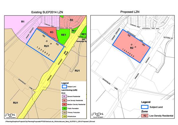
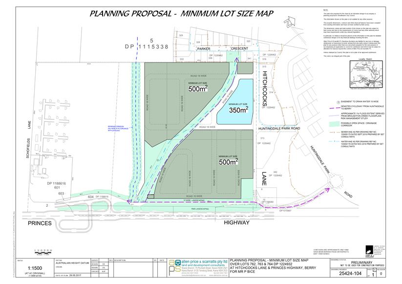
1. Prepare a Planning Proposal to rezone
part (as detailed in the plans within this report) of Lots 762 and 763 DP
1224932, Hitchcocks Lane, Berry, to an R2 - Low Density Residential Zone
with:
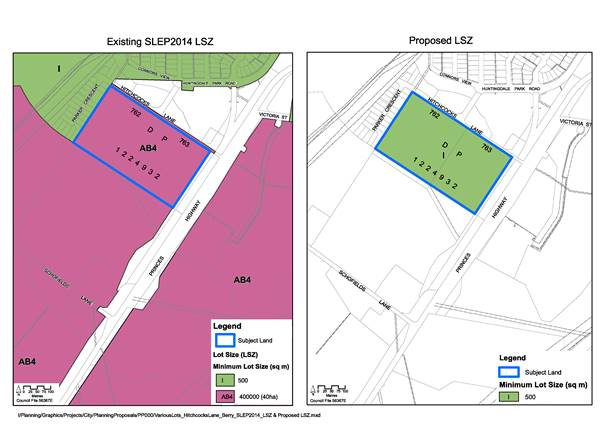
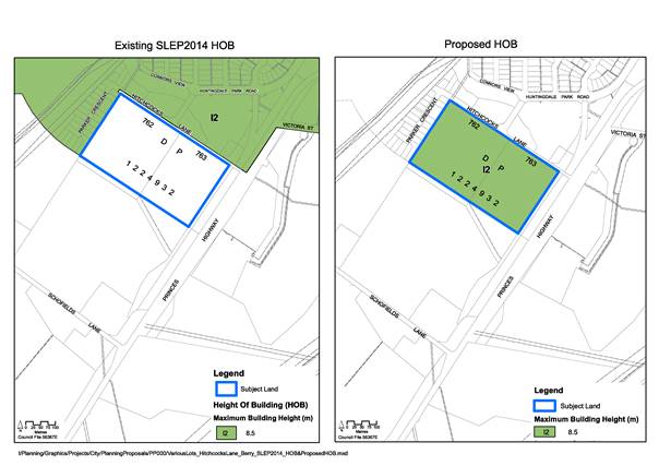
a. A 500 m2 minimum lot
size; and
b. An 8.5 m maximum height of
buildings.
2. Forward this Planning Proposal to the
NSW Department of Planning and Environment for a Gateway determination with a
request that the determination be subject to a condition allowing up to 25%
of the site to be provided with a lot size as small as 350 m2
subject to specialist studies and community consultation.
3. Advise the NSW Department of Planning
& Environment that the following studies are considered appropriate as
part of the post Gateway stage of the Planning Proposal (prior to public
exhibition):
a. Stormwater assessment including
conceptual design details for the proposed drainage reserve
b. Stage 1 preliminary contaminated site
assessment
c. Aboriginal cultural heritage
assessment
d. Flood risk assessment
e. Traffic study
f. Visual impact assessment
g. Infrastructure study and delivery
plan (including “soft” infrastructure)
h. Master plan including detailed urban
design and built form guidelines
4. Advise the proponent of this
resolution and that the proposal will be subject to fees and charges for
proponent initiated Planning Proposals, including a requirement that the full
cost of all specialist studies be borne by the proponent.
5. Advise the Berry Forum of this
resolution.
6. Consider a report on the Planning
Proposal prior to public exhibition.
7. Request a future report that provides
options for a policy framework for considering Planning Proposals that
accelerate consideration of an area ahead of its timing in Council’s
adopted strategic plans.
|
Options
1. Request a Gateway determination for
the PP that:
a. Only includes the land identified in
the Shoalhaven Growth Management Strategy (GMS); and
b. Includes a condition requiring a
detailed masterplan with urban design guidelines to be prepared and
incorporated into a Development Control Plan (DCP).
Implications: This will allow the investigation of
the land for residential rezoning to proceed further in accordance with the
area identified in the adopted GMS.
It will allow for a single community engagement process to
address both the PP and DCP issues. It will also allow for LEP controls
(e.g. height of buildings) to be provided in response to the urban design
investigation. This option is the preferred option.
2. Request a gateway determination for
the PP that:
a. Only includes the land identified in
the GMS, and
b. Identifies the land as an urban
release area (URA) under Part 6 of the LEP, requiring a detailed masterplan
with urban design guidelines to be prepared and incorporated into a DCP after
the rezoning but prior to it being developed.
Implications: This would allow the rezoning
investigation to proceed ahead of the detailed urban design process, with
community engagement undertaken at each stage. Release of the land would be
subject to Part 6 of the LEP. There are no compelling reasons to support
this staged approach in this instance. This option is not recommended,
but could potentially be considered.
3. Seek a Gateway determination for the
PP that includes all of the land identified in the proponent’s PP.
Implications:
This would commit Council to investigating additional land for urban
residential zoning beyond the position adopted in the GMS. This option is not
recommended given that it is inconsistent with relevant strategic planning
considerations for this area as noted later in the report. Given the nature of
this inconsistency with strategy, the NSW Department of Planning & Environment
(DP&E) may be unlikely to issue a Gateway determination.
4. Not proceed with the PP at this point
pending the review of the GMS.
Implications: This would defer the potential
rezoning of the site to a later date. There is little benefit in deferring this
matter when the subject land has already been identified as a long term
investigation area, provided relevant matters can be considered moving forward
including community engagement on urban design and built form.
Background
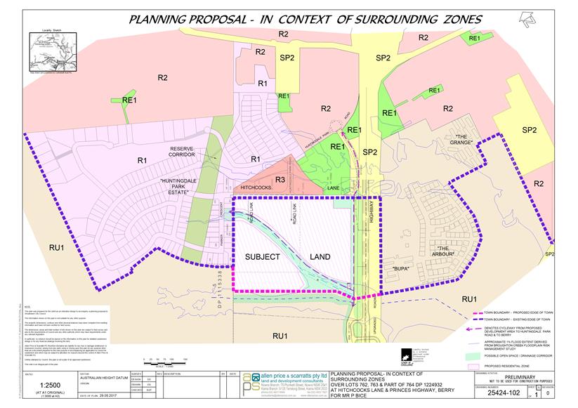
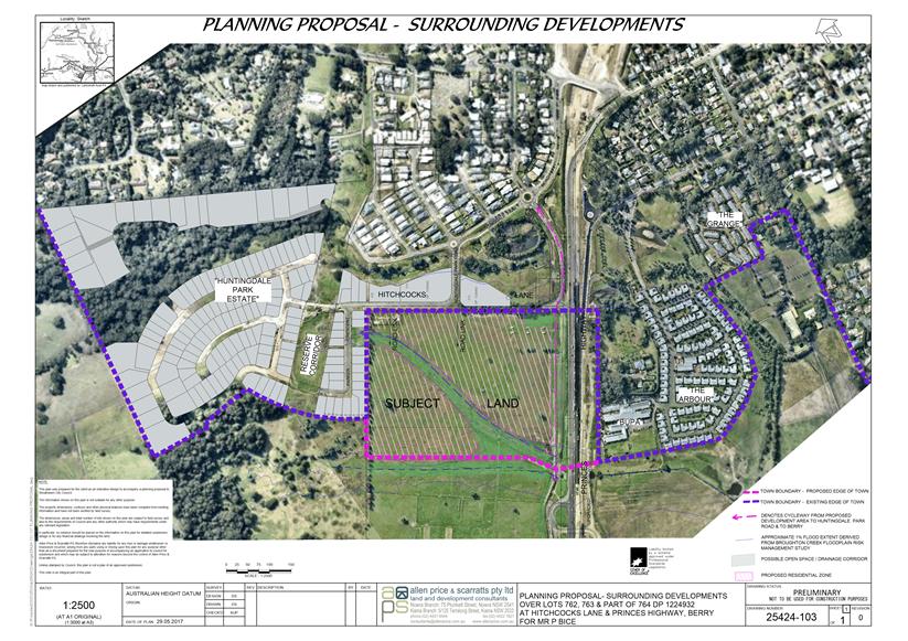
The Site
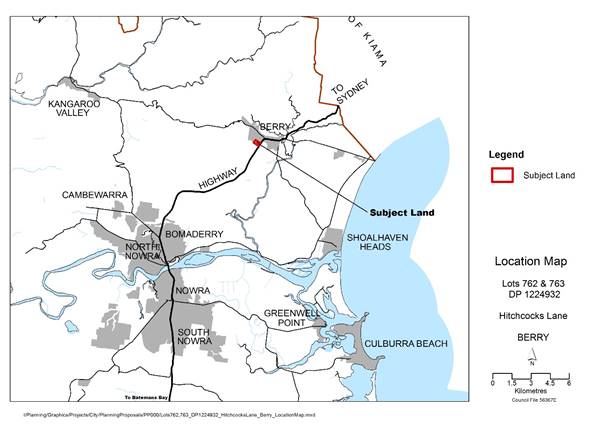
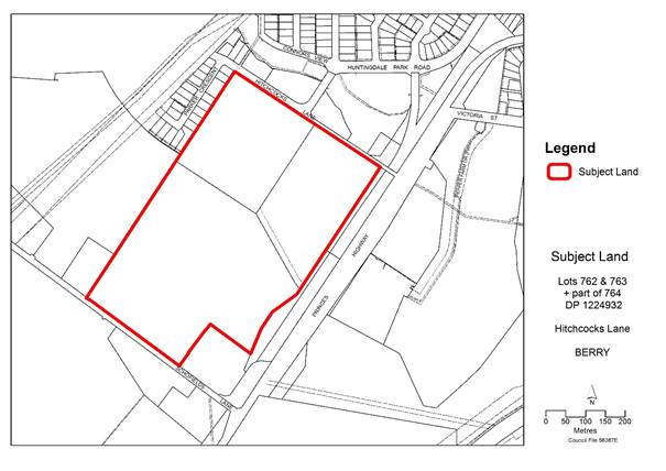
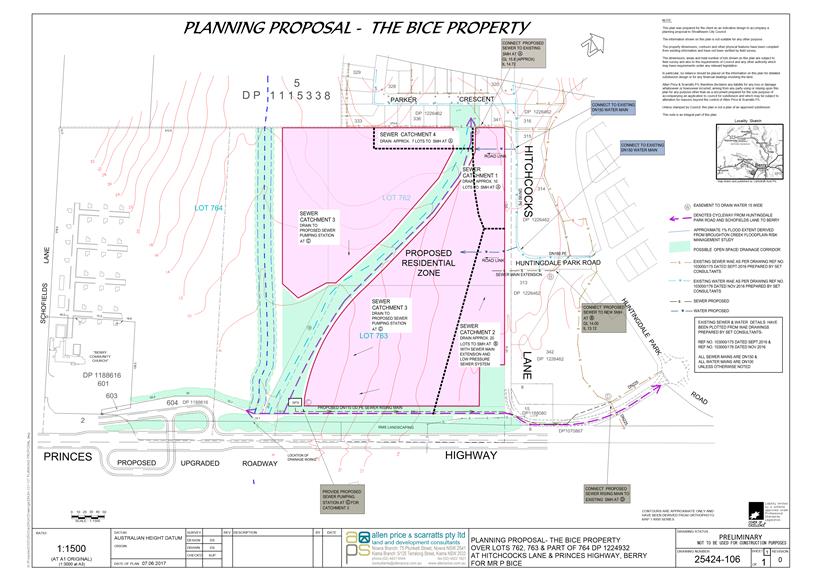
The subject land to which this
proponent initiated PP relates is Lots 762, 763 and part of 764 DP 1224932,
located on the southern edge of the Berry Urban area. The land is adjoined to
the southeast by the Princes Highway, to the north by the Huntingdale Park
residential estate and to the southwest by rural land. It is crossed by
two drainage lines which flow eastward. The site is largely cleared and
maintained as pasture.
Maps showing the subject land and its location are provided
below:
Subject Land
– Location
Subject
Land - Lots 762, 763 and 764 (part of) DP 1224932
The subject land was previously
part of the “Graham Park” complex that was previously owned by
Council and used by the University of Wollongong (UOW) as an educational
facility. The former administrative buildings were subdivided from the rest of
the Graham Park site in 2016 and are currently used as a place of public
worship. The subdivided land is Lot 601 DP 1188616 and is not part of the
PP.
There are a number of
agricultural outbuildings on the site which were previously used for livestock
related uses when the facility was a stock breeding centre. Most of these
buildings are concentrated along the south-western boundary of Lot 764 in an
area that is not proposed under the PP for rezoning to residential use.
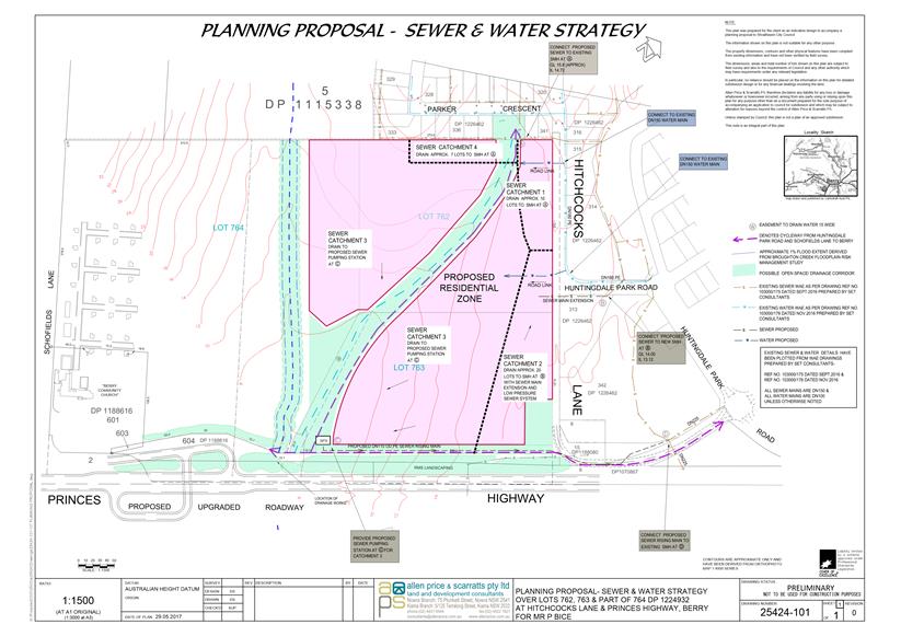
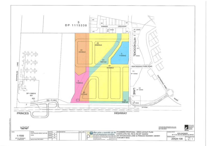
The Proponents PP
The proponents PP was received on 8 September 2017 from
Cowman Stoddart Pty Ltd (on behalf of the owners P&P Bice) and seeks to:
· Rezone Lots 762,
763 and part of 764 from RU1 Primary production to R1 General Residential.
· Rezone areas along
drainage paths and the Princes Highway to RE1 Public Recreation.
· Modify the minimum
lot size map for the rezoned area to show a 350 and 500 square metre minimum
lot sizes.
· Modify the maximum
building height limit for the rezoned area to be 8.5 metres.
The proponent’s submission includes a draft PP and a
range of supporting documentation including agricultural assessment, water and
sewerage strategy, electricity supply strategy, traffic noise intrusion
assessment and landscape plans.
The GMS identifies the subject land as a Long Term
Investigation Area for urban development (LTIA). The proponents have
argued that this area needs to be considered in the shorter term due to the
take up of residential zoned land in Berry and its rezoning should be brought
forward.
The PP seeks to include the northern part of Lot 764, using
the existing watercourse and associated approved vegetated riparian corridor as
a boundary between the RU1 and proposed R1 zones. This represents an expansion
of the area of land shown in the GMS as a LTIA. Further comment is
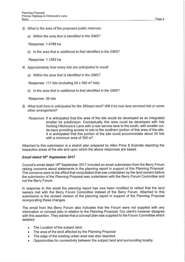
provided in this regard later in the report. The following table shows the
anticipated yields that the PP could generate and also an overview relative to
the LTIA identified in the GMS:
|
Lot Type/Size
|
Area within the
LTIA
|
Area beyond the
LTIA
|
% expansion
beyond the LTIA
|
|
500 m2
|
8.36 ha (93 lots)
|
2.78 ha (25-30
Lots)
|
29.2%
|
|
350 m2
|
1.16 ha (24 lots)
|
Nil
|
|
Drainage Reserve
|
1.48 ha
|
1.13 ha
|
76.4%
|
|
Total
|
11.0 ha
|
3.91 ha
|
35.5%
|
The proponents PP is available for viewing on Councils
website at:
https://shoalhaven.nsw.gov.au/Planning-amp-Building/Strategic-planning/Planning-Proposals
Hard copies of the proponent’s documentation will be
available in the Councillors Room prior to the meeting. The executive summary
and plans from the proponents PP are also provided as Attachment 1 and 2.
Strategic Planning Overview
The following is an overview of relevant strategic planning
documents that are relevant to this proposal.
· Shoalhaven LEP 2014
The subject land is currently RU1 Primary Production under
Shoalhaven LEP 2014. The objectives of this zone relate to conserving and
maintaining prime crop and pasture land and facilitating primary industries.
Parts of the subject land are also identified on the flood planning area map
that forms part of the LEP. This primarily relates to the drainage lines that
run through the land. The riparian and watercourses overlay also affects the
south eastern corner of Lot 763.
· Illawarra-Shoalhaven
Regional Plan
The Regional Plan was released by the NSW Government in late
2015. Under Direction 2.1 -Provide sufficient housing supply to suit the
changing needs of the region, recognises the role of new releases identified
under the Illawarra Urban Development Plan and the Shoalhaven GMS.
As noted above, this area is currently identified in the GMS
as a LTIA. More commentary in this regard is provided below.
· Shoalhaven Growth
Management Strategy
Council began its consideration of future urban expansion
opportunities on this edge of Berry in late 2002. This related to
discussions that were held with the local community in regard to the proposed
sale of Graham Park by Council and interest in the future use of the land.
Council considered a report on this matter on 17 September 2002 and the
following concept plan produced at that time identified potential urban
expansion opportunities
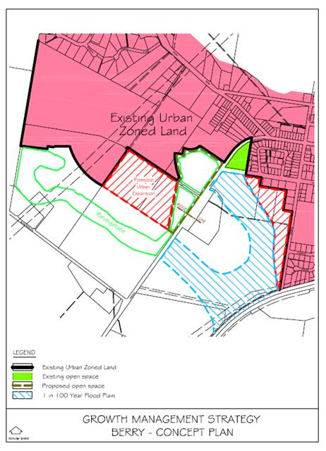
The 2002 concept plan showed the subject land, specifically
the former Lots 75 and 76 DP 4468, as ‘possible urban expansion’.
The plan also showed a proposed open space area to be revegetated along the
Princes Highway edge. Under this plan approximately 9.5 hectares of land
west of the Princes Highway was identified as ‘possible urban
expansion’.
This ultimately led to the inclusion of the part of the land
as a LTIA in the GMS that was finalised in 2014 when it was endorsed by the NSW
Government. The relevant map from the GMS is provided below:
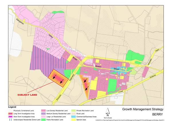
The south-western boundary of the LTIA shown in the GMS was
set based on the adjacent residential zone boundaries that existed in the
LEP. The intent was to extend the urban area in the longer term to fill a
gap between the existing urban area and the Princes Highway and finish the
urban edge in this location. This resulted in two of the lots that made up the
former Graham Park being included and the remainder being excluded from the
LTIA. It was envisaged that this would provide a south-western boundary
to the urban extent of Berry.
The GMS currently identifies this area as part of the long
term planning for the City. This means that it was intended that the area
not be released for 15 years after the GMS was finalised. This timeframe
was determined in context of the broader economic climate, uncertain
development at that time of the Huntingdale Park subdivision and to also allow
for community engagement as part of the development of planning controls for
the site. It was intended that the desired future character for this new area
would be determined in conjunction with the community following additional
engagement as part of a GMS Version 2.
The Huntingdale Park subdivision is nearly half complete,
with 107 of 251 lots being released. Many of the remaining lots are understood
to have been purchased prior to release and two more stages (63 lots) are
expected to be released in coming months. There are no other release
areas in Berry to provide ongoing additional residential land supply once the
Huntingdale Park subdivision is complete, which is likely to occur prior to the
completion of a PP for Graham Park. This outcome was not anticipated by
the GMS which appears to have assumed that Huntingdale Park would meet demand
for residential land for at least a decade.
This change in circumstances provides some justification to
bring forward the timing of this investigation area from that described in the
GMS, the underlying aim of which would be to ensure the steady supply of
housing sites in Berry but also allow for community engagement on built form
and urban design controls as originally envisaged.
The development of Huntingdale Park provides a context for
the preparation of built form and urban design controls for the Graham Park
site if the PP proceeds. This is an important prerequisite to conducting
community engagement for a PP and DCP for the site.
• Berry
Community Strategic Plan
The Berry Community Strategic Plan was prepared by The Berry
Forum during 2016. Council resolved in December 2016 to:
Endorse the Berry Community Strategic Plan as a community
plan and consider the themes and strategic priorities contained within the plan
as part of Council’s planning processes.
This plan contains some detail that is directly relevant to
this PP and the consideration of it, specifically under Theme 4 – Town
Planning. The objective of this theme is: To maintain the history, setting
and unique character of the Berry area through careful planning and
development. The following are the relevant ‘strategic focus’
areas and their ‘priority’ under this plan:
4.2 Define
the edge of the town
Provide a distinct town edge that
retains views to the escarpment to the north and minimises residential
subdivisions and housing release at the rural interface.
Priority: high
4.3 Explore ways to improve
housing affordability into the future
Examine options for promoting
improved housing affordability within the town whilst retaining key attributes
of the town in terms of heritage retention (Strategic Focus 4.1) and definition
of the town edge (Strategic Focus 4.2).
Priority: Medium
4.4 Update
planning controls
To acknowledge changes brought by
the bypass and to ensure that the character both within and external to the
town is retained and reinforced, review and update relevant planning controls
and strategic documents to reflect the desired future of the town.
Priority: medium
There is other content within this plan that is of relevance
to the PP and should be considered should Council resolve to support the matter
proceeding.
· Planning Proposal
(Rezoning) Guidelines
These guidelines detail the circumstances when a PP is
likely to be supported by Council and provide a range of detail on the PP
process. The guidelines were adopted by Council in 2016 and note that Council is
likely to support a PP in the following circumstances:
· Proposed amendment
is supported by Council or State Government strategy or plan.
· Clear zoning
anomaly exits on site.
· Proposed amendment
is considered to be minor in nature and has been sufficiently justified to
Council.
The guidelines also note that the proponents should have
pre-lodgement dialogue with Council staff before formally lodging a PP.
The guidelines make it clear that PP’s that are not
supported by a strategy or plan and are considered speculative will generally
not be supported by Council.
Pre-lodgement engagement with the proponents in regard to
this matter took place during 2015 and earlier this year and Council staff
advised that there was a need to consider consistency with the GMS
(specifically at that point the timing), residential demand/supply,
infrastructure servicing, housing affordability, urban design/character,
landscaping/setback to the highway and having a dialogue with the local
community on desired outcomes for the area
Assessment of Proponent’s PP
The NSW Guide to Preparing Planning Proposals provides an
assessment framework for PP’s. This framework requires the planning
authority (Council) to answer a number of questions in determining the merit of
a PP. These are considered below:
Q1. Is the Planning Proposal a result of any strategic
study or report?
The PP is largely consistent with the GMS, however, there
are inconsistencies with the currently adopted strategy in terms of extent and
timing.
As noted earlier in the report, the proponents PP proposes a
larger area for rezoning. This represents a 35.5% extension on what is
nominated in the adopted GMS. This inconsistency with the GMS is not
supported by any strategic study or report. This would also be contrary
to the intent of finishing off this edge of the town and could lead to
additional requests for rezoning on adjoining land, particularly to the west.
Thus, it is recommended that this extension not be
supported.
Also as discussed above, the proposal is inconsistent with
the timing for this area in the GMS (currently shown as long term). It is
considered that the early consideration of this area will achieve the
underlying intention of the GMS to ensure the steady supply of housing sites in
Berry, but steps should still be taken to enable early community engagement on
urban design controls for the area.
Q2. Is the Planning Proposal the best means of achieving
the objectives or intended outcomes, or is there a better way?
The PP process is the most appropriate mechanism to achieve
the outcome of the GMS, other than waiting for the next general review of the
LEP. The actual detail of the PP and its provisions are to be determined
following the outcomes of specialist studies.
Q3. Is the Planning Proposal consistent with the
objectives and actions of the applicable regional, sub-regional or district
plan or strategy (including any exhibited draft plans or strategies)?
The Illawarra-Shoalhaven Regional Plan is the relevant
regional strategy. There is no relevant sub-regional or district plan for this
area.
The Regional Plan identifies Berry as a centre for increased
housing activity in Direction 2.2.
The GMS provides strategic direction on potential urban
expansion in the areas not covered by an adopted structure plan or settlement
strategy. The GMS is also recognised under Direction 2.1 in this Plan.
As such, proceeding with a PP to the extent identified in
the GMS is consistent with the Illawarra-Shoalhaven Regional Plan, provided the
inconsistent timing is accepted.
Q4. Is the Planning Proposal consistent with a
Council’s local strategy or other local strategic plan?
The PP is largely consistent with the adopted GMS. As
noted, there is a 35.5% expansion to the area proposed that is inconsistent
with the GMS and is not supported by any strategic study or report. It is
recommended that this extension not be supported.
The proposal is inconsistent with the timing for the area in
the GMS. However, the early consideration of this area will achieve the
underlying intention of the GMS to ensure the steady supply of housing sites in
Berry while allowing for community engagement on urban design controls.
Q5. Is the Planning Proposal consistent with applicable
State Environmental Planning Policies?
A number of technical matters will need to be further
investigated to demonstrate consistency with the relevant State Environmental
Planning Policies. There are however no apparent inconsistencies at this stage.
Q6. Is the Planning Proposal consistent with applicable
Ministerial Directions?
There is an inconsistency with the 117 Directions on Rural
Zones and Rural Lands because the PP proposes to rezone rural land to urban
residential. This inconsistency can be justified by the GMS only to the
extent of the LTIA adopted in this strategy. This is a further reason for
recommending that the proposed extension not be supported.
A number of technical matters will need to be investigated
to demonstrate consistency with other relevant Ministerial Directions.
Q7. Is there any likelihood that critical habitat or
threatened species, populations or ecological communities, or their habitats,
will be adversely affected as a result of the proposal?
The site has been extensively cleared and managed as
pasture. It is not identified in Council’s mapping or modelling as
being an area of ecological significance.
Q8. Are there any other likely environmental effects as a
result of the Planning Proposal and how are they proposed to be managed?
A number of technical matters will need to be investigated
to demonstrate that the PP is satisfactory with regard to a range of
environmental effects.
Q9. Has the Planning Proposal adequately addressed any
social and economic effects?
A number of technical matters will need to be investigated
to demonstrate that the PP is satisfactory with regard to a range of social and
economic effects.
Q10. Is there adequate public infrastructure for the
Planning Proposal?
The required infrastructure to support the proposal will
need to be investigated as part of the PP process. The proponents have provided
a Water & Sewerage Strategy and Electricity Supply Strategic Review as part
of their PP.
Q11. What are the views of State and Commonwealth public
authorities consulted in accordance with the Gateway determination?
The required consultation will be undertaken if the PP
proceeds.
Conclusions – Revised PP
As detailed above, there is considered to be some merit in
supporting this PP. However, the proponent’s proposed expansion of
the investigation area identified in the GMS is not supported. The
inconsistency with the timing nominated in the GMS is acknowledged, but there
is merit in advancing the investigation of this area now to ensure there is a
continued land supply in Berry, provided there is community engagement on
potential built form and urban design controls for this new area.
The following set of revised PP maps have been prepared to
ensure consistency with the nominated area in the GMS. The proposed
350 m2 lot size has been removed from the minimum lot size map
at this point. It is considered that a smaller lot size may be
appropriate on part of the site, but that this should be determined as part of
the specialist studies and master planning of the site. A Gateway
condition will be sought to facilitate this.
To facilitate the advancement of the PP if Council supports
it advancing, it is recommended that a Gateway determination be sought
requiring the following specialist studies to be prepared:
a. Stormwater
assessment, including conceptual details for the proposed drainage reserve
b. Stage
1 preliminary contaminated site assessment
c. Aboriginal
cultural heritage assessment
d. Flood
risk assessment
e. Traffic
study
f. Visual impact assessment
g. Infrastructure
study and delivery plan (including “soft” infrastructure)
h. Master
plan including urban design and built form guidelines, prepared in consultation
with the community.
Community Engagement
The adjoining owners and The
Berry Forum were notified as a courtesy in accordance with standard procedures
of the receipt of this PP.
The Berry Forum Committee
initially responded, contesting comments made by the proponent in their PP
document that they had consulted with the Forum.
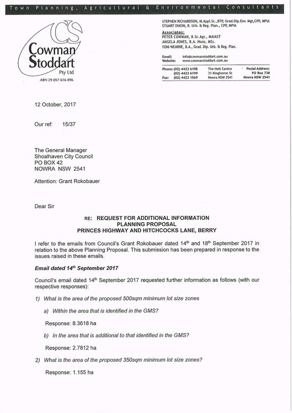
The proponent was advised of The
Berry Forum Committee’s submission and provided a response and an amended
version of the PP.
Both The Berry Forum Committee
Submission (Attachment 3) and the proponent’s response (Attachment
4) are attached.
The Berry Forum met on 12
October 2017 and considered the PP. The forum resolved to unanimously
oppose the PP for four (4) reasons which are considered below:
|
Reason
|
Comment
|
|
The GMS identifies Long
Term Investigation (15+ years) land for potential future development. This is
the only land that should be considered for rezoning at the appropriate time.
|
The proponent’s proposed
expansion of the investigation area identified in the GMS is not
supported.
The inconsistency with the
timing nominated in the GMS is acknowledged, but there is merit in advancing
the investigation of this area now to ensure there is a continued land supply
in Berry, provided there is community engagement on potential built form and
urban design controls for this new area.
|
|
The GMS was developed using
the principles of Ecologically (Sustainable) Development, including
the Precautionary Principle. We believe this requires Council not to progress
this Planning Proposal until Huntingdale Park Estate is completed and the
full impact of this development (HPE) on the infrastructure of Berry,
including schools, is apparent.
|
There is some merit in considering
this PP now ahead of the complete development of the Huntingdale Park
subdivision to ensure that there is a continued land supply in Berry.
The PP process includes an
assessment of infrastructure impacts. There will also be consultation with
relevant infrastructure agencies, including the Department of
Education. If there is doubt over the capacity of local infrastructure
to support this development then there are a number of mechanisms that can be
investigated to meet the shortfall.
|
|
Any claimed ‘shortage’
of land for development should be viewed in the context of the Moss Vale Road
major land release.
|
The Moss Vale Road release
area is a different locality to Berry and is not comparable from a land
supply perspective.
|
|
There are potentially serious
safety issues with an overall development containing more than 400 homes
(incl. Huntingdale Park Estate) with only one entry/exit road.
|
This concern is appreciated
and will be investigated as part of the PP process. The PP includes an
opportunity to investigate provision of a left-out access on to the Princes
Highway Off Ramp which will increase evacuation options to the broader
precinct. This will require consultation with the Roads & Maritime
Service as part of the PP process.
|
If the PP progresses, community
engagement will be specified in the Gateway determination and formal public
exhibition will be required at the appropriate point in accordance with the
Act.
Policy Implications
Shoalhaven Planning Proposal
(Rezoning) Guidelines
Subject to the variations to the proponent’s PP
outlined in this report, the proponent’s PP otherwise forms a
satisfactory basis to proceed to request a Gateway determination.
Precinct Sequencing
The GMS identifies the
investigation areas in Berry as long term, i.e. beyond 15 years
(2029). The sequencing that could result from this proposal would result
in this area being released before a number of investigation and release areas
that were not identified as “long term”. The GMS did not intend
this precinct to be released so soon after its adoption.
In this case, it has been concluded that the early
consideration of this area is justifiable given current circumstances and it
will achieve the underlying intention of the GMS. It is noted, however, that
Council has no adopted policy position for how this type of situation is to be
addressed. Consequently, it is also recommended that Council resolve to
investigate a policy document in this regard.
Financial Implications
The PP will be prepared on a 100%
cost recovery basis to be funded by the proponent. Infrastructure requirements
for the proposal are to be thoroughly investigated in the PP process to ensure
that there are no adverse impacts on Council’s adopted budget and forward
estimates.
|

|
Development
Committee – Tuesday 14 November 2017
Page
29
|
|
|
Development
Committee – Tuesday 14 November 2017
Page
31
|
|

|
Development
Committee – Tuesday 14 November 2017
Page
32
|
|

|
Development
Committee – Tuesday 14 November 2017
Page
38
|
|
|
Development
Committee – Tuesday 14 November 2017
Page
39
|
|
|
Development
Committee – Tuesday 14 November 2017
Page
42
|
|
|
Development
Committee – Tuesday 14 November 2017
Page
43
|
DE17.78 Draft
Chapter G18 Streetscape Design for Town and Village Centres - Shoalhaven
Development Control Plan 2014 - Preparation and Public Exhibition
HPERM Ref: D17/330934
Group: Planning
Environment & Development Group
Section: Strategic
Planning
Attachments:
1. Draft
Development Control Plan Chapter G18 Streetscape Design of Town and Village
Centres (under separate cover) ⇨
2. Draft
Streetscape Technical Manual (under separate cover) ⇨
3. Subject
Streets Map (under separate cover) ⇨
4. Draft
Development Control Plan Dictionary (under separate cover) ⇨
Purpose / Summary
Seek endorsement to prepare and
public exhibit Draft Chapter G18 Streetscape Design for Town and Village
Centres (Draft Chapter), Shoalhaven Development Control Plan (DCP) 2014.
The Draft Chapter will introduce
streetscape design controls for nominated town and village centre streetscapes
and certain development types. The provisions build on the controls that
previously existed in now rescinded DCP No. 80 Streetscape Guidelines for
Paving and Tree Planting in the Nowra CBD.
|
Recommendation (Item to be determined
under delegated authority)
That Council:
1. Prepare and publicly exhibit Draft
Chapter G18 Streetscape Design for Town and Village Centres and Dictionary of
Shoalhaven DCP 2014 for a six (6) week period and in accordance with the Environmental
Planning & Assessment Regulation 2000.
2. Advise relevant Community
Consultative Bodies of the public exhibition.
3. Receive a further report on the draft
Chapter G18 Streetscape Design for Town and Village Centres following the
conclusion of the public exhibition period.
|
Options
1. Adopt the recommendation.
Implications: The preparation and public exhibition
of the Draft Chapter will allow Council staff to enact a previous position of
Council, which sought to review the now rescinded DCP No. 80 and insert a new
chapter covering streetscape design controls into Shoalhaven DCP 2014.
The Draft Chapter will provide an endorsed policy
direction for streetscape upgrades when required by a Development Application
(DA). The Draft Chapter will ensure a coordinated approach to streetscape
design and construction that is sympathetic to the character of the relevant
nominated town and village centre. The Streetscape Technical Manual will
also have the ability to be used by Council staff or contractors working on
behalf of Council in undertaking work within the public domain.
2. Adopt an alternative recommendation.
Implications: This may significantly delay the
preparation and exhibition of the Draft Chapter and the ability to provide
streetscape upgrades in nominated town and village centres in a coordinated
manner.
Background
Following the notification of Shoalhaven Local Environmental
Plan (LEP) 2014 on 22 April 2014, Council had six months to exhibit and
finalise the Shoalhaven DCP 2014. Due to the limited time available to
review and consolidate over 100 DCPs, a number of DCP’s were unable to be
reviewed and amended as necessary, including the now rescinded DCP No. 80
Streetscape Guidelines for Paving and Tree Planting in the Nowra Central
Business District (CBD).
Prior to the LEP being made, the Nowra CBD Action Committee
at its meeting on 8 April 2013 considered a report from the General Manager
relating to the review of DCP No. 80. The report provided an update on the
progress of reviewing DCP No. 80 and noted that it would have to complement the
Citywide DCP which was underway at the time. The report also noted that whilst
DCP No. 80 applied only to Nowra CBD, the new Chapter would need to consider
other towns and villages across the City.
Following consideration of the report, the Nowra CBD Action
Committee resolved that:
a) The
report of the General Manager (Strategic Planning & Infrastructure)
regarding the review of DCP 80 be received for information;
b) It
be noted that the approach for the design of new paving in the City is being
undertaken consistent with Council’s resolution; and
c) The
approach for the maintenance/repair of existing paving be undertaken as
outlined in the report.
On 6 August 2014, Nowra CBD Action Committee considered a
report relating to ongoing civic improvements and resolved to receive it for
information. The report noted that due to the age of DCP No. 80 it
required a significant review in order to prepare a new DCP Chapter in the
Citywide DCP. The report also noted that the new DCP Chapter would
address the following points:
· Apply
in both a citywide context as well as reference treatments / themes for
specific towns and villages areas.
· Define
streetscape character with general guiding principles.
· Provide
guidance for the provision of the following main items / elements (as a minimum)
in the CBD streetscape environment:
o Entry treatments;
o Trees (including root
barriers and structural soils);
o Public artwork (within
streetscape infrastructure and standalone artwork);
o Footpath surface /
delineation / hierarchy (which recognises “Council’s preference
for “attractive concrete designs rather than pavers”);
o Street amenities
(furniture, bins, tree guards, planter boxes, lighting, etc.);
o Embellishment of civic
spaces.
· Consideration
of:
o existing CBD attributes
/ view lines;
o integration of the
public / private domains (i.e. boundary of public / private land);
o existing infrastructure
within the streetscape (i.e. car parks, vehicle lanes, drains, pit covers,
multi utilities, etc.) and how to transition such infrastructure in a
streetscape improvement program;
o accessibility /
pedestrian / cycling needs;
o priority items to
upgrade streetscapes;
o the economics of
lifecycle infrastructure (maintenance) costs.
The review of the DCP 80 is now
complete and the new Draft DCP Chapter and supporting Streetscape Technical
Manual (Manual) has been prepared and is attached to this report (Attachment
1 and 2).
Draft DCP Chapter G18 Streetscape Design for Town and
Village Centres
The draft Chapter proposes to introduce streetscape design
controls for subject streets in thirteen (13) nominated town and village
centres that have a defined centre and commercial presence, these include:
· Berry;
· Shoalhaven
Heads;
· Kangaroo
Valley;
· Bomaderry;
· Nowra;
· Culburra
Beach;
· Huskisson;
· Vincentia;
· Sanctuary
Point;
· St
Georges Basin;
· Sussex
Inlet;
· Milton;
and
· Ulladulla.
In addition to the nominated centres, the Draft Chapter will
also apply to other streetscapes where a development application (DA) is
received for a commercial premises, mixed use development, multi-dwelling
housing, attached dwelling, residential flat building, shop top housing or
seniors housing development. This is to ensure that appropriate
streetscape upgrades are provided as development is conditioned and occurs.
The Draft Chapter builds on the development controls
contained in the former DCP No. 80 and includes controls relating to
streetscape, character and function, streetscape components, and unique town
and village centre features. These controls are generic in nature and
will apply to specific streets within the nominated centres and to specific
land use types. The Draft Chapter is supplemented by a supporting
‘Subject Streets Map’ which identifies the streets subject to the
application of the DCP chapter. The supporting Subject Streets Map is
provided as Attachment 3.
The development controls contained within the Draft Chapter
refer to the Manual, which is a new document proposed to supplement the Draft
Chapter. The Manual has been prepared by Council’s City Design Team
and contains individual design and construction technical detail to guide the
provision of footpaths, planting palette, colour palette, street furniture and
unique features for each of the nominated centres, as per the report to Nowra
CBD Action Committee in August 2014. A generic design has also been
prepared for use in other localities.
The palettes for each centre have been designed to represent
the unique character of each centre and acknowledge the preference for use of
aggregate concrete over pavers in footpaths. Use of pavers has been
restricted to decorative borders, except for in Berry, Kangaroo Valley and
Milton where the use of pavers in footpath design has been retained to reflect
the heritage character of the centres. In addition, the use of pavers in
the design of footpaths in Sussex Inlet has also been retained as a result of a
recent community consultation exercise on the streetscape design.
In response to the issues faced with the previous DCP No. 80
regarding products changing and the availability of materials, the Manual has
been prepared to be used as a technical guide to ensure that updates to
proprietary products can be easily made where products are discontinued without
the need for a formal DCP amendment. Compliance with the Manual is
required through development controls contained in the Draft Chapter and can be
used to condition Development Consents and as a reference for Council when
undertaking works in the streetscapes of nominated town and village centres.
Internal
Engagement
The Draft DCP Chapter and Manual have been reviewed by
Council’s Works and Services, and Development Services areas.
Feedback received during this process has been considered and incorporated
where deemed appropriate.
Other Amendments Required
As a result of the Draft Chapter, the Dictionary of
Shoalhaven DCP 2014 will also require a minor amendment to insert two new
definitions that are referred to in the Draft Chapter. The two new
definitions relate to footpaths and pathways. The Draft Dictionary is
provided as Attachment 4.
Community
Engagement
The Draft Chapter, Dictionary and Manual will be publicly
exhibited for a six (6) week period and in accordance with the requirements of
the Environmental Planning & Assessment Regulation 2000. Given
that the public exhibition of the Draft Chapter is likely to go over the
holiday period, Council will run an extended exhibition period.
The Community Consultative Bodies from the nominated town
and village centres will also be advised of the public exhibition and if
necessary staff will arrange to meet with these bodies (as required) to explain
and discuss the proposals.
Policy
Implications
The Draft Chapter is proposed to be a new chapter within
Shoalhaven DCP 2014. The Draft Chapter enacts a previous position of
Council to undertake a review of DCP 80 and replace it with a new DCP Chapter
that applies to the City. As part of the preparation of the Citywide DCP
2014, Chapter G18 was reserved for the Draft Chapter.
Financial Implications
Preparation and finalisation of the Draft Chapter is being
undertaken within the existing Strategic Planning budget.
Risk
Implications
If the Draft Chapter is not implemented, there is a risk
that streetscape design will not be adequately considered in future DA’s
which may result in a haphazard approach to streetscape design and the eventual
deterioration of the unique streetscape character within nominated town and
village centres in Shoalhaven. The Draft Chapter is expected to mitigate
against these risk implications.
|

|
Development
Committee – Tuesday 14 November 2017
Page
47
|
DE17.79 Outcomes
- Building Height Review - Southern Part of Ulladulla CBD
HPERM Ref: D17/333579
Group: Planning
Environment & Development Group
Section: Strategic
Planning
Attachments:
1. Review of
Building Heights Report (Part Ulladulla CBD) (under separate cover) ⇨
2. PP025
Gateway Determination 29 August 2017 (under separate cover) ⇨
Purpose / Summary
To present the outcomes of the Building
Heights Review relating to the southern part of the Ulladulla CBD as per
MIN17.218.
|
Recommendation (Item to be determined
under delegated authority)
That Council:
1. Prepare a Planning Proposal to amend
Shoalhaven Local Environmental Plan 2014 to increase the height across the
Study Area (excluding land subject to PP025) to part 11 metres and part 14
metres as per the Review of Building Heights Report.
2. Prepare an amendment to Chapter S8:
Ulladulla Town Centre of Shoalhaven Development Control Plan 2014 to reflect
proposed height modifications and address resulting implications across the
Study Area, including land subject to PP025.
3. Consider a further report/s that
contains the detail of the Planning Proposal for submission to the NSW
Department and Planning and Environment for Gateway determination and the
associated amendments to Chapter S8: Ulladulla Town Centre of Shoalhaven
Development Control Plan 2014.
4. Notify Ulladulla & Districts
Community Forum, affected landowners and workshop attendees of this decision
and of further opportunities to be involved as this matter progresses.
|
Options
1. Adopt the recommendation.
Implications: This is the preferred option as it
will commence the process to amend the heights in Shoalhaven Local
Environmental Plan (LEP) 2014 relating to the Study Area (excluding land
subject to PP025) to reflect the outcomes of the review. It will also facilitate
the required amendments to Shoalhaven Development Control Plan (DCP) 2014 to
reflect the proposed change in height across the Study area and enable good
design and built form outcomes.
2. Adopt an alternative recommendation.
Implications: Depending on its nature, an alternative
recommendation could delay the revision and updating of height provisions in
Shoalhaven LEP 2014 and could result in provisions that do not facilitate
appropriate development outcomes within the Study Area.
3. Not amend the height of building
provisions in Shoalhaven LEP 2014 across the Study Area.
Implications: Given the review that has been
undertaken and its recommendations, this is not a preferred option as the
existing height provisions in Shoalhaven LEP 2014 will not be amended and it
will be difficult to stimulate and facilitate development consistent with a CBD
location.
Background
On 14 March 2017, Council’s Development
Committee considered a development application (DA16/2412) for a three (3)
storey office building at proposed Lot 15 Parson Street, Ulladulla.
The proposal sought a 46% (3.5 metre) variation to the
7.5 metre height prescribed in the Shoalhaven LEP 2014 for the
land. Although the Committee originally resolved to support the
variation (MIN17.183), a rescission motion was considered at the 28 March 2017
Ordinary Meeting (MIN17.217) and it was resolved to not support the proposed
variation (MIN17.218). As part of this resolution, Council also resolved
(part 2) to:
Undertake a review of the 7.5 metre building heights in
this part of the Ulladulla Town Centre in the next 6 months which is limited to
the area south of Deering Street and the B5 and R3 zones.
It is noted that the area of the review was expanded beyond
that of the Council resolution to ensure a holistic review of land in this
vicinity with a building height of 7.5 metres in the LEP.
The Study Area (Figure 1) is located within the southern
precinct of the Ulladulla CBD and is generally bounded by St Vincent Street,
Parson Street, Burrill Street South, Jubilee Avenue, Deering Street and the
Princes Highway, Ulladulla. The Study Area includes all land with a
building height currently mapped at 7.5 metres (Figure 2) as indicated in
Shoalhaven LEP 2014 and is zoned B4 Mixed Use, B5 Business Development and R3
Medium Density Residential.
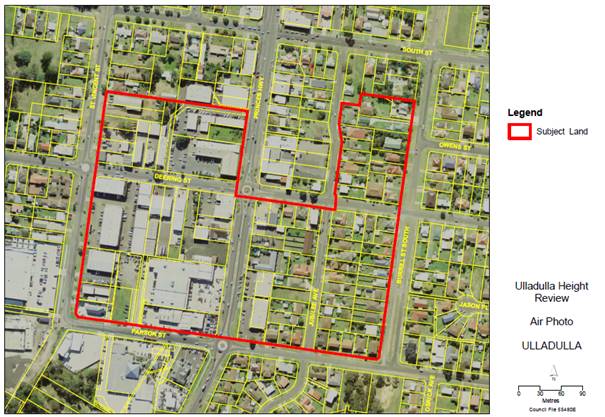
Figure 1: Study Area
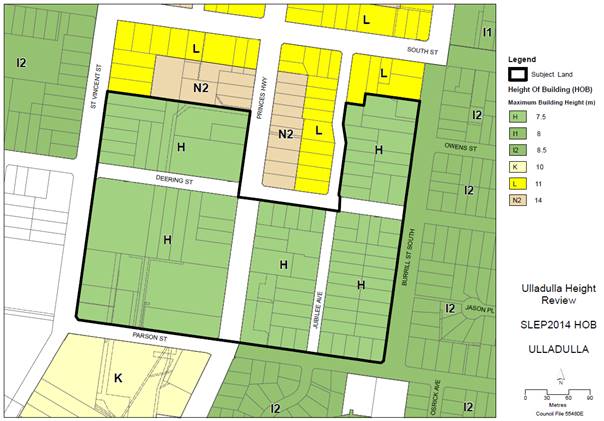
Figure 2: Existing Height of Buildings
Consultants, City Plan Services and Atlas Urban were engaged
in June 2017 to undertake a Building Height Review as an urban design and
strategic planning exercise to investigate and reconsider the urban form height
controls for the Study Area. The Review is based on a detailed analysis
of the Study Area and context, as well as targeted consultation with the
Ulladulla & Districts Community Forum, community and Council
representatives.
Community Consultation
On 31 July 2017, two consultation workshop sessions were
held; one with the Ulladulla & Districts Community Forum and community
(approximately 30 attendees), and another with Councillors. The purpose
of the workshops was to enable stakeholders to provide feedback on the height
strategy proposed by the consultants. Generally, there were varying
opinions as to what the planned heights should be, from no change to up to 17
metres. Other key themes included relationship to the existing
neighbourhood character and height, preservation of views, affordable housing
opportunities and the ability to stimulate economic growth and job
opportunities.
It was identified during the CCB/community workshop that
certain members of the community were unable to attend the workshop due to work
commitments, and as a result, the consultant’s workshop presentation was
made available for public review for a period of one week between 2 and 9
August 2017. As a result of this, seven (7) submissions were received:
· Three (3) were in
support of an increase in height, two (2) specifying a height of 17m.
· Three (3) did not
support any increase in height.
· One (1) considered
a height increase appropriate only where existing amenity and character is
maintained and quality design controls are provided.
Refer to the Review of Building Heights Report at Attachment
1 for more detail.
Outcomes of the Building
Height Review
Balancing the outcomes of the targeted consultation and the
strategic, statutory and physical parameters of the Study Area, the Review of
Building Heights Report prepared by the consultants (Attachment 1)
recommends considering an increase in height across the Study Area from 7.5
metres to part 11 metres and part 14 metres as shown in Figure 3 below.
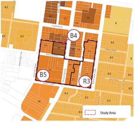
Figure 3: Proposed Height of Buildings
The recommended change in height enables a modest transition
to lower density development to the south, east and west and reflects the
height of the Ulladulla CBD core to the north of the Study Area. It also
will enable the stimulation and facilitation of development consistent with the
vision and strategic direction of the:
· Milton-Ulladulla
Structure Plan; and
· General future
desired character and amenity expectations as outlined in Chapter S8: Ulladulla
Town Centre of Shoalhaven DCP 2014.
Proposed approach
Should Council be comfortable with the changes recommended
by the consults, to enable the change in building height across the Study Area,
a formal amendment to Shoalhaven LEP 2014 will be required. This would be
facilitated via a Planning Proposal (PP).
In this regard, on 5 June 2017, the Development Committee
resolved (MIN17.476) to give in principle support for a proposed rezoning and
building height review for a site located within the Study Area (Figure 4),
known as Lots 1-7, 9 DP 21597 and Lot CP SP 42583, St Vincent and Deering
Streets, Ulladulla.
The Gateway determination (Attachment 2) for this
Planning Proposal (PP025) included a condition requiring the final height for
the site to be shaped by the outcomes of the Review of Building Heights Report.
PP025 is proponent initiated and it is considered, in the interest of clarity
and transparency, that:
· The land subject
to the proponent PP (identified as pink in Figure 4) be excluded from the Building
Height Review Planning Proposal; and
· The proponent PP
should continue to progress independently to any future PP relating to the
Review of Building Heights Report.
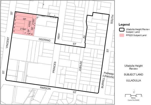
Figure 4: Study Area and PP025 Area
The Review of Building Heights Report recommends that
Chapter S8: Ulladulla Town Centre of Shoalhaven DCP 2014 also be amended to
reflect the proposed change in height across the overall Study Area (including
PP025 area). This would facilitate good design and built form outcomes
and would relate (not exclusively) to the general context, built form and
character, views and vistas, setbacks and height references in the area.
Any associated amendments to the Shoalhaven DCP 2014 would
be exhibited concurrently with the PP and PP025 to ensure a strategic approach
to planning provisions across the broader Study Area.
Conclusion
The Review of Building Heights Report discussed in this
report recommends an increase in height across the Study Area from 7.5 metres
to part 11 metres and part 14 metres. It is considered that an amendment
to Shoalhaven LEP 2014 and Shoalhaven DCP 2014 would effectively facilitate
this increase in height.
Community Engagement
The community engagement
undertaken as part of the Review of Building Heights Report is outlined above.
Any future PP would be subject to the exhibition
requirements set out in the Gateway determination in accordance with the
relevant legislation. This will involve notifying all affected landowners,
adjoining landowners, relevant community groups and other interested parties.
Any amendments to Shoalhaven DCP 2014 would be exhibited
concurrently with the PP’s, in accordance with the relevant legislation.
Policy Implications
The existing height provisions in Shoalhaven LEP 2014 are
dated and somewhat inconsistent with the proposed direction of the Milton-Ulladulla
Structure Plan and general future desired character and amenity expectations
outlined in Chapter S8: Ulladulla Town Centre of Shoalhaven DCP 2014.
The proposed height increase would assist in facilitating
development and resolve the current inequitable and inconsistent building
height controls that exist - the adjacent lower density residential areas
currently has a greater height limit (8.5 metres) than the Subject Area (7.5
metres).
Should a PP be prepared to amend the height, then amendments
will also be required to Shoalhaven DCP 2014 to reflect new heights and to
resolve any inconsistencies resulting from the modifications.
Financial Implications
As per MIN17.476, the funding for the Building Heights
Review is based on a pro rata arrangement between the Strategic Planning budget
and the proponent of PP025.
Any future amendments to Shoalhaven LEP 2014 and Shoalhaven
DCP 2014 would be managed within the existing Strategic Planning budget.
Fees for the remaining stages of PP025 will be charged in
accordance with Council’s Fees and Charges.
|
|
Development
Committee – Tuesday 14 November 2017
Page
53
|
DE17.80 Submissions
Consideration - Planning Proposal (PP022) - LEP Housekeeping Amendment 2016 -
Minor Mapping & Instrument Changes
HPERM Ref: D17/334914
Group: Planning
Environment & Development Group
Section: Strategic
Planning
Attachments:
1. Explanatory
Statement - Shoalhaven LEP 2014 - Housekeeping Amendment 2016 ⇩
Purpose / Summary
The purpose of this report is
to:
· Consider
the submissions received during the exhibition of this Planning Proposal (PP)
and consider recommend changes;
· Adopt
the revised PP; and
· Progress
the finalisation of the proposed amendment to Shoalhaven LEP 2014 in
conjunction with Parliamentary Counsel Office.
|
Recommendation (Item to be determined
under delegated authority)
That Council:
1. Adopt the Planning Proposal (PP022)
with the minor amendment outlined in this report;
2. Forward Planning Proposal (PP022) to
NSW Parliamentary Counsel Office to draft the requirement amendment to
Shoalhaven Local Environmental Plan 2014; and
3. Make the resulting amendment to the
Local Environmental Plan using the delegations issued under Section 23 of the
NSW Environmental Planning and Assessment Act 1979 related to plan making.
|
Options
1. Consider the submissions made during
the exhibition period, adopt the PP (with the change outlined in this report)
for finalisation and progress the resulting amendment to Shoalhaven LEP 2014.
Implications: This is the preferred option as it
will ensure that the relevant housekeeping matters in Shoalhaven LEP 2014 are
addressed to ensure the LEP operates as intended.
2. Adopt an alternative recommendation.
Implications: Depending on its nature, this could
delay the progress of the PP and the resulting amendment of Shoalhaven LEP
2014.
Background
Council continuously reviews Shoalhaven LEP 2014 to ensure
it aligns with strategic documents, is improved where necessary and delivers
positive outcomes for the community. As a result, Council has an ongoing
process of housekeeping amendments to improve the operation and maintain the
accuracy of the plan.
This housekeeping amendment PP (PP022) addresses those
non-urgent matters that were identified during the course of 2016 and early
2017.
The intended outcome of this PP is to:
· Add or amend
provisions to the instrument and maps to improve the operation of the LEP and
address issues that have arisen through registration of new land titles,
landowner requests, staff identified anomalies, development assessment and as
resolved by Council; and
· Amend a number of
LEP maps to correct identified anomalies or inconsistencies.
A list of the proposed changes covered by this PP can be
viewed in the Explanatory Statement which is included as Attachment 1.
The PP was granted Gateway determination by the NSW
Department of Planning and Environment (DP&E) on 13 June 2017. A
revised Gateway determination was then received on 25 August 2017 (one matter
that was delaying things was removed to allow for further investigation and possible
inclusion in a future housekeeping PP).
DP&E also granted delegated authority to Council for
this PP. Accordingly, Council will liaise directly with the NSW
Parliamentary Counsel Office (PCO) to prepare and finalise the LEP amendment
for commencement.
Public Exhibition
The PP was publicly exhibited
for a period of 30 days from Wednesday 6 September to Friday 6 October 2017
(inclusive). The public exhibition included the display of the PP, the
Gateway determination and an explanatory statement at the City Administration
Building, Nowra and on Council’s website.
The PP was referred to the NSW
Office of Environment and Heritage and the NSW Rural Fire Service as required
by the Gateway determination. NSW Roads & Maritime Services (RMS)
were also advised of the exhibition. Affected landowners were directly notified
by mail.
The exhibition document can be viewed at the following link:
http://leptracking.planning.nsw.gov.au/PublicDetails.aspx?Id=4933
Submissions:
A total of three (3) written
submissions were received from:
· Two
Landowners
· RMS
The two landowner submissions
relate to Map Change 18 – these submissions are summarised and discussed
below, copies will also be available in the Councillors Room prior to the
meeting. The RMS submission noted that they had no objections to the PP.
Map Change 18 - Lot 159 Highview Drive, Dolphin Point
The two submissions from landowners related to the same
issue, the proposal to rezone Lot 159 DP 755972 (Portion 159) Highway
Drive, Dolphin Point from E3 Environmental Management to E2 Environmental
Conservation to ensure consistency with the previous Shoalhaven LEP 1985 zone
of Environment Protection 7(f2) (Coastal Reservation) and to ensure Clause 5.1
Relevant Acquisition Authority of the LEP clearly applies (with the Minister
administering the Environmental Planning and Assessment Act 1979 as acquisition
authority).
Summary of submissions
- There
are more lots zoned E3 Environmental Management in this location than there are
E2 Environmental Conservation and as such there is better argument for
consistency to zone the E2 lots to E3 and not the other way around.
- If
DP&E were interested in acquiring these lots it would not have allowed
substantial development to occur on them.
- Map
Change 18 should be removed from the PP i.e. subject lot retain its E3 zone.
- The
other E2 zoned lots in the locality should be rezoned to E3.
Staff comment:
Whilst there is merit in the proposed rezoning, there is
also no urgency for the rezoning to occur now. DP&E has indicated
that resolving the issue of acquisition may take some time. In order not to
slow down this PP, there are no concerns with removing Map Change 18 from the
PP and revisiting the issue through a later housekeeping amendment PP.
Conclusion - Proposed changes to PP
It is recommended that the PP be adopted as exhibited, with
a minor amended to remove proposed Map Change 18 as discussed above. This
matter will be reconsidered in a future housekeeping amendment PP.
Financial Implications
The PP is being resourced within
the existing Strategic Planning budget.
|
|
Development
Committee – Tuesday 14 November 2017
Page
56
|
|
|
Development
Committee – Tuesday 14 November 2017
Page
59
|
DE17.81 Proposed
Submission - Issues Paper: Review of Environmental Planning and Assessment
Regulation 2000
HPERM Ref: D17/350165
Group: Planning
Environment & Development Group
Section: Development
Services
Attachments:
1. Proposed
Submission Issues - EP&A Regulation Review ⇩
Purpose / Summary
The purpose of this report is to
advise Council of the release by the NSW Department of Planning &
Environment (DP&E) of on Issues Paper dealing with the Review of the
Environmental Planning and Assessment Regulation 2000 and obtain
endorsement to make a submission based on the issues outlined in Attachment
1.
|
Recommendation (Item to be determined
under delegated authority)
That Council make a submission to
the NSW Department of Planning and Environment on Review of the
Environmental Planning and Assessment Regulation 2000 Issues Paper based
on the issues outlined in Attachment 1.
|
Options
1. Adopt the resolution and make a
submission based on Attachment 1 to the NSW Department of Planning and
Environment (DP&E).
Implications: This is the preferred option as it
enables Council the opportunity to identify the key areas of the Regulation
that could benefit from review, and make suggestions for updating and improving
the functionality and efficiency of the Regulation.
2. Make changes to the issues outlined in
Attachment 1 and submit to DP&E for consideration.
Implications: This option will still enable Council
the opportunity to identify areas of the Regulation that could benefit from
review; however, the implications of any possible changes are unknown and may
require closer consideration or refinement.
3. Not make a submission.
Implications: This action is not recommended as it
will mean that Council will not provide any input or suggestions into the
preliminary review of the Regulation and the opportunity to identify issues for
consideration or resolution will be missed.
Background
The NSW Environmental
Planning and Assessment Act 1979 (EP&A Act) is the primary piece of
planning legislation in NSW. It first came into effect on 1 September
1980 and has been in force for almost four decades. The EP&A Act is
supported by the NSW Environmental Planning and Assessment Regulation 2000 (the
Regulation), which is the primary subordinate legislation containing key
operational provisions for the NSW planning system.
As part of the NSW
Government’s ongoing planning reforms, DP&E commenced consultation in
2016 with the aim of improving the EP&A Act, to which Council made a
detailed submission. As a result of this consultation, a number of
amendments have now been proposed, including:
· Enhancing
community participation: establishing a new part of the Act that consolidates
community consultation provisions, and requiring decision-makers to give
reasons for their decisions
· Completing
the strategic planning framework: through local strategic planning statements,
up to date Local Environment Plans and more consistent and workable Development
Control Plans
· Development
pathways: improvements to the various development pathways and preventing the
misuse of modifications
· State
significant development: better environmental impact assessment and more
effective conditions of consent
· Clearer
building provisions: simplified and consolidated building provisions, allowing
conditions on construction certificates and ensuring consistency with
development approvals
· Elevating the
role of design: through a new design object in the act, and a Design-Led
Planning Strategy
· Improving
enforcement: with the introduction of enforceable undertakings in compliance
actions.
The NSW Environmental Planning
and Assessment Amendment Bill 2017 was introduced into NSW Parliament in
October 2017 and will be considered again when Parliament sits in
mid-November.
The review of the Regulation follows
on from the review of the EP&A Act. As a first step, DP&E have
prepared an Issues Paper outlining the key operational provisions of the
Regulation and are seeking feedback from stakeholders with regard to known
issues and suggestions for updating and improving the functionality of existing
provisions.
The Issues Paper is currently on
exhibition for eight (8) weeks until 24th November 2017 and can be
viewed at:
http://www.planning.nsw.gov.au/Policy-and-Legislation/Under-review-and-new-Policy-and-Legislation/EPA-Regulation-review
DP&E is seeking feedback on
the current Regulation to identify specific areas that are considered to be outdated,
overly complex, or inefficient.
Proposed Submission
The Issues Paper was circulated
internally to all Groups of Council for comment. The feedback received has
identified a number of key areas where the Regulation may be improved, as
detailed in Attachment 1.
A number of issues are proposed
to be raised and covered within Council’s submission, including:
· Proposed
technology updates
· Proposed changes
to public exhibition requirements
· Standardisation of
conditions of consent
· Development
contributions
· Planning
certificates
Further detail on these issues is contained in Attachment
1.
Community Engagement
The Issues Paper is currently
open for public comment until 24 November 2017.
The feedback received during
this period will be used to inform the preparation of a draft Regulation, which
is intended to be released for formal public consultation in 2018. As such
there will be a further opportunity to review and comment on the detail of the
proposed changes to the Regulation.
Policy Implications
There are no immediate policy
implications for Council in providing feedback and making a submission on the
Issues Paper. However, depending on the outcome of the proposed changes in the
draft Regulation review, the potential policy implications for Council could be
significant and wide ranging. The policy implications will become clearer once
DP&E releases the draft Regulation for review in 2018.
Financial Implications
There are no immediate financial
implications for Council in making a submission on the issues paper for the
Regulation review, this is being managed within the Strategic Planning budget.
Risk Implications
Should Council resolve not to
make a submission on the preliminary consultation phase of the Regulation
review, there is a risk that some of the issues outlined in Attachment 1 may
be overlooked and subsequently excluded from the draft Regulation when it
released for formal public consultation.
|
|
Development
Committee – Tuesday 14 November 2017
Page
62
|
|
|
Development
Committee – Tuesday 14 November 2017
Page
69
|
DE17.82 Woncor
Avenue Nowra Hill - Proponent Initiated Planning Proposal
HPERM Ref: D17/340215
Group: Planning
Environment & Development Group
Section: Strategic
Planning
Attachments:
1. Proponent's
Concept Plan for a Highway Service Centre ⇩
2.
Preliminary Advice from Roads and Maritime Services ⇩
Purpose / Summary
Detail a proponent initiated
Planning Proposal (PP) that has been received to permit a proposed highway
service centre on a site adjacent to the Princes Highway at Nowra Hill and
obtain direction in this regard.
|
Recommendation (Item to be determined
under delegated authority)
That:
1. Council resolve not to proceed with a
Planning Proposal to permit a highway service centre at Lot 2
DP 1154597, Woncor Avenue Nowra Hill, for the following reasons:
a. The proposal is not the result of any
local, regional or state strategic plan or study; and
b. The proposal will draw commercial
activity and investment away from existing employment lands precincts and is
inconsistent with the Nowra-Bomaderry Structure Plan; and
c. The proponent has not satisfactorily
demonstrated the need for the facility in this location; and
d. The proposal is inconsistent with
part 4 of Council’s Planning Proposal (Rezoning) Guidelines and would
set an adverse precedent if supported; and
e. The RMS has raised a number of
significant concerns including that this proposal is not compatible with the
grade-separated interchange required for the Shaolin Temple tourist
development; and that the proposal would result in significant delays and
road safety issues, particularly for the right turn out of BTU Road.
2. Council advise the proponent and
those who were notified of the proposal of this resolution.
|
Options
1. Resolve not to proceed with the PP.
Implications: The PP would not be supported by
Council. This is the preferred option and would be consistent with the
Nowra-Bomaderry Structure Plan (NBSP) and other relevant considerations that
are detailed in the report.
The proponent would however have the option of pursuing a
Pre-Gateway review and having the decision reviewed by the Joint Regional
Planning Proposal (JRPP). Should this occur Council Staff would detail
Councils reasons for rejection of the proposal before the JRPP if this were to
occur.
2. Resolve to proceed with the PP as
submitted.
Implications: The PP would be sent to the NSW
Department of Planning & Environment (DP&E) with a request for a
Gateway determination. If DP&E were to support the proposal, Council
would be committed to undertake the PP process and may find it difficult to
abandon the proposal at a later stage. The ultimate outcome could be an
inappropriate development on the site that would divert economic activity and
investment from other centres. This option is not recommended.
3. Resolve to proceed with the PP with amendments.
Implications: Council staff have considered
possible amendments to the proposal to achieve a satisfactory planning outcome.
It has been concluded that the site is fundamentally unsuitable for commercial
development because of its isolation from existing commercial centres and the
complication of the BTU Road and Forest Road intersections with the Princes
Highway. Consequently, no alternative version of the PP is recommended.
Background
The Site
The subject land to which this proponent initiated PP relates
is Lot 2 DP1154597 Woncor Avenue, Nowra Hill. The land is located adjacent to
the Princes Highway between the intersections of BTU Road and Forest Road with
the Princes Highway. The subject land has an overall area of 7.2
hectares, is largely cleared and maintained as pasture. There are no
improvements on the site.
Woncor Avenue is essentially
part of a large lot rural residential/lifestyle subdivision that contains
existing dwellings and some limited other uses (e.g. vet clinic, boarding
kennels etc.).
Maps showing the subject land
and its location are provided below:
Subject
Land – Location
Subject
Land – Lot 2 DP1154597
The Proponent’s PP
The proponent’s PP was submitted
by SET Consultants Pty Ltd (on behalf of owner Recep Haliloglu) and seeks to
apply an additional permitted uses provision to the subject land. The effect of
this provision would mean that a ‘highway service centre’ could
potentially be approved on the subject land without the need for a change in
the land use zone.
The proponent’s submission includes a draft PP,
economic assessment report, traffic assessment report and a conceptual
development plan for a highway service centre on the subject land.
The proponent’s justification for the PP relates to
the needs of heavy vehicle drivers travelling along the Princes Highway. The
documentation suggests that permitting a highway service centre on this site
would allow the establishment of private infrastructure that would provide rest
facilities for road users in accordance with NSW Roads & Maritime Service
(RMS) requirement. It has been suggested that an additional permitted use
provision is the only way of enabling the requested use given that ‘highway
service centres’ are a prohibited use in all zones in Shoalhaven LEP 2014
The proponents PP is available for viewing on Councils
website at:
https://shoalhaven.nsw.gov.au/Planning-amp-Building/Strategic-planning/Planning-Proposals
Hard copies of the proponent’s documentation will be
available for review in the Councillors Room prior to the meeting and the
preliminary concept plan from the proponents PP is provided as Attachment 1.
Strategic Planning Overview
The following is an overview of
relevant strategic planning documents that are relevant to the proposal.
· Shoalhaven LEP 2014
The subject land is currently zoned RU2 Rural Landscape
under Shoalhaven LEP2014. The objectives of this zone relate to encouraging
primary industry production, maintaining the rural landscape character of the
land and providing for compatible land uses, including extensive agriculture.
Under the RU2 zone, ‘highway service centres’
are a prohibited land use. It is noted that during the construction of the
Shoalhaven LEP 2014 that Council consciously did not make this use permissible
in any zone. It was noted at the time that if a use of this nature could be
justified in a particular area or location then it would be considered on its
merits.
· Nowra-Bomaderry
Structure Plan (NBSP)
The NBSP was prepared by Council and endorsed by the NSW
Government in 2008. The subject land is located within the NBSP area.
The NBSP aims to facilitate sustainable living, economic
vitality and community wellbeing. It identifies areas for commercial and
industrial expansion as shown in Maps 4.1 and 4.2 below.
The Shoalhaven Growth Management Strategy (GMS) prepared by
Council and finalised in 2014 reflects the NBSP in relation to the subject
land. Both the GMS and NBSP did not identify any need for additional
commercial uses in this location.
The former Roads & Traffic Authority (RTA) completed a
strategic study of vehicle rest areas in 2010. This study considered the
Princes Highway from Bulli to the Victorian border. It found a deficiency in
rest areas southbound between Nowra and Batemans Bay and a northbound between
Batemans Bay and Wollongong. It proposed an upgrade of the Jerrawangla
and Bewong rest areas to address these deficiencies.
Since the publication of that study, upgrade work has also
been undertaken for the service station on the Princes Highway, Tomerong (The
Log Cabin). These works provide additional truck parking and north and
south bound access to the site from the Princes Highway.
It is also noted that the RMS has recently commenced work on
a Network Strategy for Nowra-Bomaderry which will consider amongst other things
key road networks in the area.
· Planning
Proposal (Rezoning) Guidelines
These guidelines detail the circumstances when a PP is
likely to be supported by Council and provide a range of detail on the PP
process. The guidelines were adopted by Council in January 2016 and note that
Council is likely to support a PP in the following circumstances:
· Proposed amendment
is supported by a Council or State Government strategy of plan.
· Clear zoning
anomaly exists on site
· Proposed amendment
is considered to be minor in nature and has been sufficiently justified to
Council.
The guidelines also note that proponents should have
pre-lodgement dialogue with Council staff before formally lodging a PP.
The guidelines make it clear that PP’s that are not
supported by a strategy or plan and are considered speculative will generally
not be supported by Council.
Pre-lodgement engagement with the proponent in regard to
this matter took place during 2016 and Council staff advised of a range of
concerns including inconsistency with strategy.
NSW Roads & Maritime Services (RMS) Comments
Given the nature of the PP, the
location adjacent to the Princes Highway, potential impact on the highway,
comment was sought from RMS on the proposal.
It is also noted in the proponents PP documentation that
they also discussed the proposal with the RMS and they advised that:
“notwithstanding the provision of rest areas at Bewong and Mount Ousley,
they would generally support the provision of heavy vehicle facilities at a new
highway service centre”.
The advice from the RMS dated 18 October 2017 is provided as
Attachment 2. The advice raises a number of concerns, as
summarised below.
· The footprint of
the required grade-separated interchange (for the Shaolin Temple tourist
development) at Forest Road could have significant impacts on the subject
property, beyond affecting the proposed direct off ramp.
· RMS is concerned
with the suitability of the junction of the Princes Highway and BTU Road to
cater for the increased demands associated with this development. RMS is
concerned the traffic volumes would result in significant delays, particularly
for the right turn out of the BTU Road and that these delays could lead to road
safety issues.
· Concerns about a
number of assumptions used in the proponent’s traffic modelling.
· Concerns about the
constructability of the required direct off ramp or left turn slip lane.
Assessment of Proponent’s PP
The NSW Government’s Guide to
Preparing Planning Proposals provides an assessment framework for PPs. This
framework requires the planning authority (Council) to consider a number of
questions in determining the merit of a PP. These are considered below:
Q1. Is the Planning Proposal a result of any strategic
study or report?
The proposal is not the result of a strategic study or
report. Council’s GMS and the NBSP do not support the provision of
additional commercial or industrial floor space in this location. The
strategic planning undertaken to date by RMS has not identified this site as
having particular merit or need for providing a service centre/rest area for
heavy vehicles. Thus there appears to be no basis for the proposal in any
strategic plan or report.
Q2. Is the Planning Proposal the best means of achieving
the objectives or intended outcomes, or is there a better way?
The proponent’s submission seeks to justify the PP and
the overall proposed use by arguing that it meets a broader need for improved
amenities for heavy vehicle drivers passing through the City.
However, given the number of existing facilities located on
the Highway in close proximity to this site, this objective can be achieved
through existing service station sites and rest areas without drawing
commercial activity away from existing centres.
Q3. Is the Planning Proposal consistent with the
objectives and actions of the applicable regional, sub-regional or district
plan or strategy (including any exhibited draft plans or strategies)?
The Illawarra-Shoalhaven Regional Plan (ISRP) is the relevant
regional strategy. The ISRP does not identify the Princes Highway as a key
freight route, nor does it recommend a focus on this type of development.
Rather, it envisages the focusing of development around existing centres, which
is not the case for this proposal. There is no relevant sub-regional or
district plan for this area.
Q4. Is the Planning Proposal consistent with a
council’s local strategy or other local strategic plan?
Council’s GMS and the NBSP do not support the
provision of commercial or industrial floor space in this location. As such the
proposal is considered to be inconsistent with existing local strategies.
Q5. Is the Planning Proposal consistent with applicable
State Environmental Planning Policies?
The provisions of a number of State Environmental Planning
Policies would need to be investigated in detail as a part of the specialist
studies stage of the proposal if supported. However given that the proposal is
inconsistent with the GMS and the NBSP, it will be difficult to justify/support.
Q6. Is the Planning Proposal consistent with applicable
Ministerial Directions?
The PP is considered to be inconsistent with Ministerial
Direction 1.1 Business and Industrial Zones. This direction requires that
“proposed new employment areas are in accordance with a strategy that is
approved by the Director-General of the NSW Department of Planning”. The
proposed additional permitted use will create an employment area that is not
identified in any strategy approved by Council or the NSW Department of
Planning & Environment.
Q7. Is there any likelihood that critical habitat or
threatened species, populations or ecological communities, or their habitats,
will be adversely affected as a result of the proposal?
This would need to be investigated in detail as a part of
the specialist studies stage of the proposal if supported. However given that
the proposal is inconsistent with the GMS and the NBSP, it will be difficult to
justify/support.
Q8. Are there any other likely environmental effects as a
result of the Planning Proposal and how are they proposed to be managed?
This would need to be investigated as a part of the
specialist studies stage of the proposal. It is considered however, that
the proposal should not proceed to this stage because it is fundamentally
inconsistent with the GMS and the NBSP.
Q9. Has the Planning Proposal adequately addressed any
social and economic effects?
The proponent has provided an Economic Impact Assessment
(EIA) as part of their submission. This assessment concluded that there
is a need for the proposal for four reasons, which are discussed and commented
on in the table below.
|
Proponent’s
EIA Conclusion
|
Comment
|
|
There are no similar high service centres meeting RMS
guidelines along the Princes Highway South of Sydney to Eastern Melbourne.
|
There is no plan or strategy that identifies a need for
this type of facility to combat driver fatigue. The Princes Highway is not
the principle freight route from Sydney to Melbourne. The 2010 RMS review of
the Princes Highway did not find a need for this type of service centre for
this route. If this type of facility is required for the Princes Highway, it
should follow a strategic study of the whole length of the Highway to
determine the optimum locations along its total length. In the absence of
such a study, there is no basis to conclude that there is a broader need for
this type of facility on this route.
|
|
All of South Nowra’s Princes Highway service
stations are located on the southbound side of the highway and the proposed
highway service centre will be safely accessible by northbound and southbound
travellers.
|
There is a service station located at Tomerong which is on
the western (northbound) side of the Highway. This service station is safely
accessible by northbound and southbound travellers and has bowsers and
parking for B-doubles. It also has provision for a food and drink premises
and convenience store.
|
|
The development will generate net community benefits
through its contribution to road safety for the motoring public and
especially heavy vehicle drivers.
|
There is no plan or strategy that identifies a need for
this type of facility to combat driver fatigue. The Princes Highway is not
the principle freight route from Sydney to Melbourne. The 2010 RMS review of
the Princes Highway did not find a need for this type of service centre for
this route. The supposed community benefit will only result if there is a
need and this request does not demonstrate that such a need exists.
The RMS in their comments have also noted concerns
regarding potential impact on functioning of the Prince Highway/BTU Road
intersection.
|
|
Its potential economic impacts will not threaten the
viability or level of service presently enjoyed by residents and visitors but
it will enhance that level of service by providing a facility not available
in the region. Any potential impacts are likely to be short term and would be
made good through the provision of a new and multifunctional facility.
|
It is unclear how the development of a multifunction
facility will “make good” on the potential for the development to
pull economic activity and investment from established commercial centres.
The proponent needs to demonstrate that there is a regional need for this
type of facility on the Highway that cannot be met by existing centres.
Such a need has not been identified by RMS or the DP&E in any strategic
study or plan.
If there is not a regional need for through traffic then
the patrons of this facility will be drawn from existing commercial centres,
which is contrary to the ISRP, NBSP and GMS.
|
In conclusion, in terms of economic impacts, the proposal is
likely to result in the diversion of commercial activity and investment to this
site from existing centres, and is unjustified. There is no established
need for this proposal in any current strategic planning document from Council,
DP&E or the RMS.
Q10. Is there adequate public infrastructure for the
planning proposal?
This would need to be investigated as a part of the
specialist studies stage of the proposal should it proceed. It is
considered however, that the proposal should not proceed to this stage because
it is inconsistent with the GMS and the NBSP. It has been noted that the site
is awkwardly located at an intersection of the Princes Highway with BTU Road
and Forest Road. These intersections are proposed to be grade-separated in the long
term and it is considered that this outcome could be hindered or complicated by
the proposal.
Q11. What are the views of state and Commonwealth public
authorities consulted in accordance with the gateway determination?
Council has undertaken preliminary engagement with RMS.
Their advice is provided as Attachment 2. This advice raised a
number of concerns and technical matters for consideration if the proposal were
to progress to Gateway. No commentary was provided in support of the
proponent’s claim that this development is needed to service the highway
on a regional level.
Conclusion
Consistent with the commentary
provided in the report it recommended that Council not support or resolve to
proceed with the PP to permit a highway service centre in this location given:
· It has not
resulted from any local, regional or state strategic plan or study;
· Will draw
commercial activity and investment away from existing employment lands
precincts and is inconsistent with the NBSP;
· Is inconsistent
with Council’s Planning Proposal (Rezoning) Guidelines and would set an
adverse precedent if supported;
· RMS has raised a
number of significant concerns; and
· The proponent has
not satisfactorily demonstrated the need for the facility in this location.
Community Engagement
Upon receipt of the
proponent’s PP the surrounding landowners and the Nowra Business Chamber
were notified in writing. At the time of writing, Council was awaiting
feedback from the Chamber. Should a submission be received prior to the
Council meeting it will be provided to Councillors.
One submission was received from a local truck business
operator supporting the proposal. It is considered however, that the
increased flexibility that would be provided to local businesses does not
warrant the impacts the proposal would have on existing commercial centres nor
does it justify the proposal’s inconsistencies with the GMS and NBSP.
Policy Implications
The PP is inconsistent with the
adopted NBSP and the GMS. Council’s adopted Planning Proposal
(Rezoning) Guidelines provide that Council will generally not support
significant proposals that are inconsistent with these plans. If Council
were to support this PP it could further undermine Council’s strategic direction
for Nowra-Bomaderry, and create an adverse precedent that would change the
expectations of other rural landowners in the City.
It is recommended that
Council’s current policy position expressed in these plans and guidelines
be upheld and PP not be supported.
Financial Implications
If Council was to support the
PP, it would be on a 100% cost recovery basis, to be funded by the
proponent. Infrastructure requirements for the proposal could result in
an increased future cost for Council and/or the RMS depending on the
implications of the proposal for nearby roads.
|

|
Development
Committee – Tuesday 14 November 2017
Page
80
|
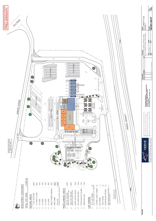
|
|
Development
Committee – Tuesday 14 November 2017
Page
81
|
|
|
Development
Committee – Tuesday 14 November 2017
Page
83
|
DE17.83 Applications
(multiple) to Modify Development Consents – Release of Easement for
Carparking over Lot 1 DP 785956 & affecting Lot 4 DP785956 Island Point
Road, St Georges Basin
DA. No: DS17/1147
HPERM Ref: D17/267465
Group: Planning
Environment & Development Group
Section: Development
Services
DA. No’s: DS16/1375, DS16/1499, DS16/1500,
DS16/1501, DS17/1147
Description of Development: Modifications to
consents to enable release of an easement for car parking purposes associated
with the Cooee Hotel.
Owner: Bovalu Pty Limited
Applicant: John Wilmott, “Your Urban
Design”
Notification Dates: 20 September – 5
October 2017
No. of Submissions: Nil
Purpose
/ Reason for consideration by Council
The
32.2% variation to Shoalhaven Development Control Plan 2014 (SDCP14), Chapter
G21 exceeds the delegated authority of Council staff.
|
Recommendation
(Item to be determined under delegated authority)
That the Development Committee
1. Support
the 32.2% variation to the car parking requirements; and
2. Refer
the modification applications back to staff for determination.
|
Options
1. Recommended:
approve the 32.2% variation to the car parking requirements for the hotel
(characterised as Pub & Registered Clubs under the Shoalhaven Local
Environmental Plan 2014 (SLEP14)). This is a variation to the
requirements of section 5.1 Car Parking Schedule of SDCP14, Chapter G21 Car
Parking & Traffic of Council’s SDCP14.
Implications: Modifications to the affected development
approvals could be determined, which will permit the release of the
‘Easement for Car parking’ on Lot 4 DP 785956. In doing so,
the applications may be perceived as a precedent for significant variations to
the car parking schedule in the SDCP14. Accordingly, for licensed
premises, a case must be made having regard to the particular circumstances but
also appreciating that over the passage of time, the way that customers
patronise licenced premise has changed as a result of changes to liquor laws
and drink driving campaigns.
2. Not approve the
variation to the car parking requirements.
Implications: The development of Lot 4 could still proceed
however, the easement would be retained on the land. This would mean that
the proposed subdivision development that triggered the modification
applications for the Cooee Hotel would require some adjustment.
Background
Subject Land
Figure 1:
Location Map Cooee Hotel (RATU over adjoining land)
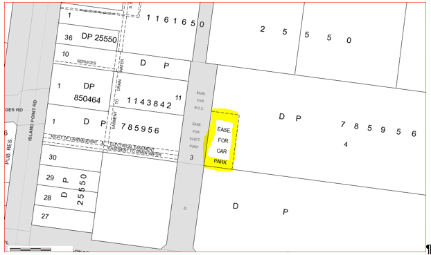
Figure
2: Subject land with location of easement
No. 124 Island Point Rd,
St Georges Basin, Lot 1 DP 785956 and ‘Easement for Car parking’ on
adjacent Lot 4 DP 785956
Proposed Development
The applicant is seeking to
remove the ‘Easement for Car parking’ on Lot 4 DP 785956 that
benefits the Cooee Hotel, which is located on Lot 1 DP 785756 as shown in
Figure 2 above. Chapter N23 St Georges Basin Village Centre, of
the SDCP14 requires alternative arrangements to be made (see extract
from the SDCP14 below). As there are a number of approvals that refer to
car parking and / or the easement, these also require modification. The
modifications must be resolved (i.e. approved) before the easement can be
released by Council:
From the SDCP14:
“P6 Onsite
car parking is to be provided to meet the needs of future development.
A6.5 The easement for
car parking over Lot 4 DP785956 shall remain in favour of the Hotel development
on Lot 1 DP 785956 (124 Island Point Rd) unless a satisfactory alternative
is approved or the development consent condition for the Hotel is amended by
Council.”
The affected approvals and
conditions are detailed in the following table 1 below.
Table
1 Affected Development Approvals for the Cooee Hotel
|
Current Application
|
Existing consents (BA or DA)
|
Development
|
Condition/s to be varied/deleted
|
Current proposal Modification sought
|
|
DS16/1375
(30/8/16)
|
DA85/0252
|
Single Storey Tavern with 1st
Floor Manager’s Residence
|
Condition no.
8 –
“In
accordance with Council’s recently adopted carparking code for taverns
which requires 1 space per 3.5sqm of licenced floor area provision shall be made for 82 car
parking spaces. The carpark and driveway areas shall be linemarked in
accordance with Council’s Car Parking code. Council will allow 29
spaces to be provided as a grass overflow on adjoin land to the north.
Details as shown in the attached sketch to be included with the Building
Application.
The
“attached sketch” denoted 29 spaces being provided on adjoining
land – in the area of the RATU.
|
Modify condition to reflect
current car parking arrangements, i.e. 39 car parking spaces and 1 car
parking space dedicated for use of Bottleshop customers
|
|
DS16/1500
(16/11/16)
|
BA89/2216
|
Brick/Fibro Dwelling
|
Condition 15
–
“The applicant is to relocate five
(5) spaces for carparking to the adjoining property and cause the necessary
adjustments to be made to the s88B of the conveyancing Act particulars to
allow such carparking spaces t be used by the tavern. Such amended subdivision
is to be submitted prior to occupation of the tavern.”
|
Delete condition
|
|
DS16/1499
(16/11/16)
|
DA90/2031
amended 18/2/1991
|
Cool Room & Bottle Shop
Extension
|
Condition 5
–
“As
the proposal will result in the loss of two (2) carparking spaces, provision
shall be made at the rear of the land for an additional two (2) spaces.
The location of these spaces shall be shown on the plans submitted with the
Building Application for the approval of the City Planner.”
|
Delete condition
|
|
DS16/1501
(16/11/16)
|
BA91/0124
|
Commercial Extensions
(Extend Bottleshop)
|
Condition 4
“As
the proposal will result in a loss of two (2) carparking spaces, provision
shall be made at the rear of the land for an additional two (2) spaces.
Condition 5
“an
overflow carparking area shall be provided as indicted on the approved plan.
|
Delete conditions
|
|
DS17/1147
(21/4/17)
|
DA04/1283
((DS04/1341))
|
Extensions to Existing
Tavern Verandah
|
Condition 11
“In accordance with
Council’s Development Control Plan DCP18 Car Parking Code a total of
seventy (70) car parking spaces shall be provided i.e. 41 onsite and a
further 29 spaces on the grass overflow area at the rear. Two spaces
shall be dedicated and appropriately marked for disabled parking.”
|
Modify condition to reflect
current car parking arrangements, i.e. 39 car parking spaces and 1 car
parking space dedicated for use of Bottleshop customers
|
Car parking
Current car parking provisions
for the Cooee Hotel, 124 Island Point Rd, St Georges Basin, Lot 1 DP 785956
consist of:
a) 39 car parking spaces and 1
additional car parking space identified for use of bottleshop patrons located
on the hotel site (lot 1); and
b) an ‘Easement for Car
parking’, 21m wide over Lot 4 DP 785956 - benefitting Lot 1 DP 785956
(hotel).
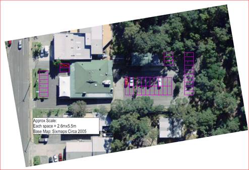
Figure
3: Existing car parking spaces at the Cooee Hotel (Lot 1)
The car parking space that has been ‘crossed
out’ cannot be used for car parking (site inspection 3/3/17). The
adjoining car parking space is for the use of bottleshop patrons.
History
The reason for the request to
release the car parking restriction is that another development proposal is
affected by the easement.
The applicant has also lodged an
application (DS15/1515) to modify the development consent for a subdivision,
referenced number - SF9847, which was originally approved on 14 August 2007,
and has already been modified multiple times:
1. DS09/1478
– 29 October 2010;
2. DS08/1543
– 15 December 2008;
3. DS08/1438
– 25 September 2008;
4. DS08/1314
- 22 July 2008; and
5. DS07/1414
– 12 October 2007 & 12 November 2007.
SF9847 relates to Lots 68 & 29 The Old Wool Road and Lot 4
DP785956 Island Point Road St Georges Basin, which approved the subdivision of
these 3 lots to create 11 lots.
DS09/1478, the currently approved plan (reference:4006V9)
dated August 2010 is reproduced below.
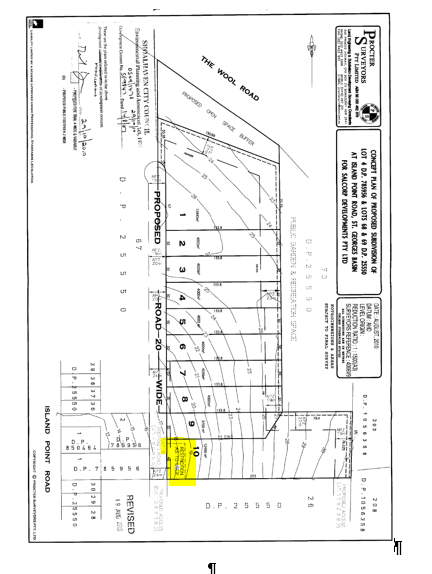
Figure 4 - Current
approved plan of subdivision
DS15/1515 (which amends the subdivision shown above)
The modification DS15/1515 to SF9847 was lodged on 23 December
2015, with additional information submitted to Council on 24 August 2016 and
the multiple s96 applications lodged over the adjoining Cooee Hotel land, to
facilitate the removal of the ratu.
For the 11 lot subdivision to proceed (refer to Figure 5), the
applicant has requested the removal of the restriction for parking over the
‘Cooee land’, and submitted the related modification applications
to the Cooee Hotel consents.
Figure 5 overleaf, is the ‘Concept plan of proposed
subdivision modification of development consent’ by ESG dated, 1
December 2016. The application for modification is changing the
subdivision layout. However, the open space as originally nominated is
retained and the residential lots are recast in an alternative design. The
proposal remains a subdivision of land albeit it is now for 11 lots. Figures 4
and 5 respectively illustrate the current approved layout and the proposed
layout.
This modification application is currently under
assessment. If the car parking restriction is not removed from the
land, in favour of the Cooee Hotel, the subdivision as submitted will not be
able to be supported in its current design. Council is still to complete
its assessment of the subdivision application however, this is contingent on
the resolution of the other modification applications.
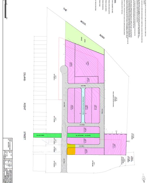
Figure 5 Proposed
(DS15/1515) Plan of Subdivision
Issues
Car Parking
Car
parking for the hotel does not currently comply with existing approvals or the
provisions of 5.1 Car Parking Schedule, Pubs & Licensed Clubs
of SDCP14 Chapter G21 Car Parking & Traffic. The table below
details what is required and what has been provided. A total of 40 spaces
is proposed. Fifty nine (59) are required to achieve strict numerical
compliance.
Table 2 - Car
parking requirements in accordance with Shoalhaven development Control Plan
2014 (SDCP14) Chapter G21 Car Parking and Traffic
5.1 Car Parking
Schedule
|
Land Use Type
|
Standard
|
Assessment for
Cooee Hotel
|
|
Pubs and Registered Clubs
|
1 space per 5m² of licensed floor area, i.e. bar,
lounge, beer garden and games room.
1 space per 40m²
gross floor area of office space.
Function rooms/restaurant or cafe - 1 space per 24m² gross floor
area within CBD areas or 1 space per 6.5m² gross dining area outside CBD
area.
Dance areas and other recreation areas will be considered separately.
Note: Alternatively, car parking requirements may be
determined by Council following the completion and submission of a parking
impact and needs study by an independent suitably qualified professional.
Comparisons must be drawn with other similar clubs/hotels in
Similar locations. Depending on individual circumstances,
Council may accept some grassed overflow areas as overflow
Parking.
Provision should be made for emergency vehicles
(doctors/ambulance) to gain ready access to the club.
|
The licensed floor area is 263m2.
Car parking space requirements are calculated at 1 space per 5m2
of floor space this equates to 52 car parking spaces.
The office space has an area of 17m2.
Car parking space requirements are calculated at 1 space per 40m2.
No additional spaces are required for this use.
The restaurant and office area is 65m. Car
parking space requirements are calculated at 1 space per 24m2 of
floor space this equates to 3 car parking spaces.
|
|
Lot 1 DP 785956 is within the area
subject to Chapter N23 St Georges Basin, Village Centre of the SDCP14, as
such, the car parking requirements for a CBD are applied.
|
|
Squash and tennis court Bowling Alley
|
3 spaces per court.
3 spaces per lane.
|
A single full sized billiard table
occupies 22m2 of floor area. The car parking requirement for
this component on similar land uses. Therefore, 3 car parking spaces
area required.
|
|
Total car parking space requirement
|
59
|
Applicant’s Submission
The
applicant has made the observation that “on not less than 12 occasions
over the past twelve months and the hotel carpark has been 50% full.”
Discussion
The site
The ‘overflow’ car parking within the
‘Easement for Car parking’ on Lot 4 has not been formally
constructed with the area used in an ad hoc manner. The applicant has
provided aerial photographs dating to 2004 that show:
Demand for
parking was such (low) that the overflow car parking area was not constructed
after this date;
The
occupation of the hotel car parking is consistent with the applicant’s
observations, that is, “on not less than 12 occasions over the past
twelve months and the hotel carpark has been 50% full”.
Aerial
photographs (D17/268837, D17/268849, D17/268852 & D17/268855) dating from
May 2004 to March 2016 indicate that the ‘overflow car parking’ has
not been constructed within the ‘Easement for Car parking’ on Lot
4.
Use of the site
The location of the hotel is within walking distance for
many patrons. Several observations and inspections were made of the site
over the duration of the assessment. Six patrons were observed arriving
on foot during a site inspection carried out by the assessing officer on 3
March 2017.
Since issue of the development consents for the Cooee
Hotel, as identified in Table 1 earlier, the supermarket and associated shops
and car parking area (DA07/1059) have been constructed on adjacent lots to the
west.
The supermarket/shopping centre car parking area now
provides additional car parking for the St Georges Basin business area.
Shoppers are able to park in the car park and frequent the shops in the IGA
complex but also access other shops / facilities nearby.
A search of Council’s Merit system has not revealed
any complaints about car parking associated with the hotel. The Council
Ranger responsible for this area for the past 18 months has advised that he has
not dealt with any car parking related issues at or in within the public roads
with frontage to the hotel site.
Since changes to liquor laws and drink driving campaigns,
it is generally accepted that the car parking for licence premises no longer
requires the same provision as that required historically. Many licenced
premises also provide a curtesy bus to address to ensure that patrons have
transport to and from the premises.
The Cooee Hotel has such a bus. Having regard to
these matters and that this particular small local hotel serves the immediate
community, it is not unreasonable to consider a reduction in the number of car
parking spaces in this context. Council has similarly accepted reduced
parking for other licenced premises observing changes to driving habits in
light of drink driving campaigns and changes to social behaviour.
With regard to car parking provision and Chapter G21, the
reduction in car parking does not frustrate the objectives of the SDCP14 in
that there will be adequate provision for the hotel having regard to the
context of the development and use of the hotel.
Policy Implications
There are no negative policy implications. The SDCP14
acknowledges that the car parking arrangement may be reconsidered by virtue of
the provisions contained in Chapter 23
“…The easement for car parking over Lot 4
DP785956 shall remain in favour of the Hotel development on Lot 1 DP 785956
(124 Island Point Rd) unless a satisfactory alternative is approved or the
development consent condition for the Hotel is amended by Council.”
However, in doing so the applicant has formally sought a
variation to the car parking provisions contained in Chapter 18, which requires
a certain number of car parking spaces.
Consultation and Community
Engagement:
The application was notified from 20 September – 5
October 2017.
No submissions were made. Importantly, the
notification made reference to all the affected consents and specifically, the
car parking easement. Council also provided an information sheet and uploaded
this onto DA Tracking.
Financial Implications:
No financial implications for Council unless the matter is
the subject of an appeal before the Land and Environment Court of NSW.
Legal Implications
There are no legal implications for Council unless the
decision is appealed.
Summary and Conclusion
The growth of the St Georges Basin CBD area has reduced the
reliance on car parking within the Cooee Hotel site. The demand for
on-site car parking by hotel patrons is further alleviated by the hotel curtesy
bus serving the local residents in response to changes to drinking / patronage
habits as a result of stronger enforcement of liquor laws and active drink
driving campaigns.
The demand for on-site parking at the Cooee Hotel has not
resulted in a car parking deficiency in the locality nor required the
development of the ‘overflow’ car parking on Lot 4.
Accordingly, the variation to 5.1 Car Parking Schedule, Pubs & Licensed
Clubs of SDCP14 Chapter G21 Car Parking & Traffic is supported.
|

|
Development
Committee – Tuesday 14 November 2017
Page
94
|
DE17.84 Development
Application - 405 Princes Highway, Bomaderry – Lot 14 DP 20626
DA. No: DA17/1780/4
HPERM Ref: D17/335451
Group: Planning
Environment & Development Group
Section: Building
& Compliance Services
Attachments:
1. Plans - Amended
Site Plan - Elevations - 405 Princes Highway Bomaderry - Lot 14 DP 20626 ⇩
2. 79C
Assessment Checklist (under separate cover) ⇨
3.
Development Consent ⇩
Description of Development: Proposed detached shed
and relocation of two shipping containers
Owner: A & V Lloyd
Applicant: A Lloyd
Notification Dates: 06 July 2017 to 21 July 2017
No. of Submissions: Nil in objection
Nil in
support
Purpose / Reason for consideration
by Council
The applicant and land owner is
a staff member working in the Planning, Environment and Development
Department. In accordance with Council’s adopted policy for Dealing
with Development Applications Lodged by Council Staff or Councillors (POL16/235),
where the applicant or land owner in respect of a development application (DA)
is a Council staff member and where the development application seeks a
substantive variation to any performance-based Development Control Plan (DCP)
or Council Policy, the DA is to be reported to Council for determination.
|
Recommendation
That the Development Committee approve
the application subject to the conditions contained in this report.
|
Options
1. Approve the application as
recommended.
Implications: Nil.
2. Resolve not to support the proposed
variations.
Implications: This would result in the applicant needing to
reconsider the design and location of the shed or possibly not proceeding with
the development.
Location Map
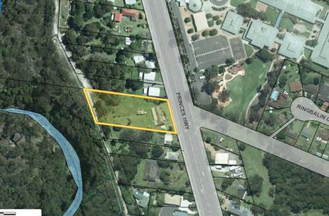
Figure 1:- Aerial view of the subject site.
Background
Proposed Development
The application is for the
construction a new detached shed and the relocation of two existing shipping
containers on the site. The shed will be located approximately 40m from
the front boundary and 1.5m from the northern boundary (refer site plan at
attachment 1).
The shed is 12m wide x 8m deep
and has a wall height of 3.5m. The shed consists of 3 parking bays and
the applicant has advised it will be used for the storage of a caravan, boat
and car. The shed is to be constructed from pre-coloured steel
(colorbond) and it will be woodland grey in colour (walls and roof).
Subject Land
The subject land is identified
as Lot 14, DP20626, No.405 Princes Highway, Bomaderry. The land is
located west of the Anglican College (Refer Figure 1).
The land is irregular in shape
with an eastern frontage of 44.275m to Princes Highway and northern and
southern depths of 108.465m and 104.111m respectively. The western
boundary to Bomaderry Creek is 46.045m. The land has an area of 4,357m2.
Site & Context
The subject site is located
within residential R2 zone under the provisions of Shoalhaven Local
Environmental Plan 2014 (SLEP-2014) (Refer Figure 2).
Surrounding allotments on the
northern and southern side of the subject site are also zoned R2.
These neighbouring allotments are of varying sizes and all have been developed
containing dwellings and ancillary structures.
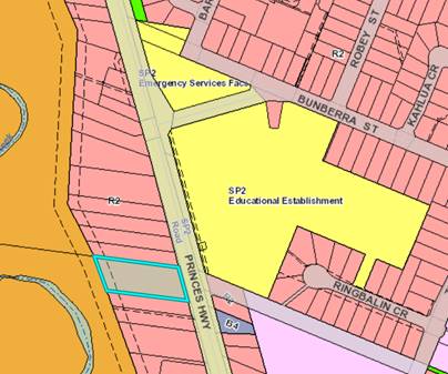
Figure
2:- Zoning map from SLEP2014
History
The site has an existing
weatherboard cottage fronting the Princes Highway and two detached
outbuildings. The cottage was built prior to 1973.
The most recent application was
in 2012 for the erection of a garage, the relocation of an existing carport and
the use of shipping containers. The approved garage is located 4m from
the northern side boundary and it is further west of the proposed location of
the new shed (refer site plan at attachment 1).
Issues
Section 5.2.3 Chapter G12 of SDCP-2014
The site is subject to side
boundary setback of 7.5m which applies to all allotments with an area between
4,001m2 and 10,000m2. The application seeks to locate the shed 1.5m from
the northern boundary and this represents an 80% variation to SDCP-2014.
Section 5.3.8 Chapter G12 of SDCP-2014
The maximum wall height for ancillary structures is set at
3.0m above natural ground level. The application seeks to have a wall height of
3.5m and this represents a 16% variation to SDCP-2014.
Planning Assessment
The Development Application has
been assessed under Section 79C of the Environmental Planning and Assessment
Act 1979. Matters for consideration in determining this development
application includes land use, height of buildings, floor space, overshadowing,
privacy and loss of views.
Apart from the variations
highlighted in this report, the application satisfies the requirements of
Section 79C of the Environmental Planning and Assessment Act 1979 (refer
attachment 2).
Policy Implications
Environmental Planning Instrument - Shoalhaven
Development Control Plan 2014
Issue: Chapter G12 –
5.2.3 and 5.3.8
The purpose of Chapter 12 of
SDCP-2014 is to outline controls and guidelines of residential development in
the Shoalhaven. The objectives of the DCP are to ensure the development
is sympathetic to the constraints of the site and ensure appropriate levels of
amenity.
Clause 5.2.3 - Side setback variation
Clause 5.2.3 deals with setbacks and building lines for
development within R2 zones that are on allotments greater than 2,000m2 in
area. Having a site area of 4,357m2, the acceptable solution for the side
boundary setback for dwellings and ancillary development is 7.5m.
The applicant proposes a setback of 1.5m to the northern
boundary and this represents an 80% variation. In support of this
location, the applicant submits that “The proposed setback is
consistent with other lots within this residential area and is not out of
character.”
Comments
The reason larger allotments have increased side boundary
setbacks is to preserve the amenity and privacy of the area. In new
subdivisions this is applied consistently however, in older areas the lot sizes
are not consistent and therefore the requirement loses its purpose.
The applicant’s submission is supported as there is
clear evidence of building encroachments for larger lots into the required side
boundary setbacks. Properties on the eastern side of the Princes Highway
and the adjoining property to the south are all less than 2,000m2 and therefore
have a 0.9m side boundary setback requirement. The properties to the
north at No.403 and No.401 both have structures within 2.5m and 3.1m
respectively.
Whilst there is room on the site to relocate the shed to
comply with the 7.5m side boundary setback requirement, this would impact on
the existing driveway and turning circles. The site is also constrained
by a sewer main located centrally through the lot and any movement further
south would necessitate concrete encasement of the sewer main.
Additionally, the shed constructed in 2012 is located 4.0m
from the northern boundary and this set a precedent that is less than the 7.5m
distance.
The variation to the side boundary setback is justified.
This type of variation is sought throughout the Shoalhaven on a regular basis
and they are approved under delegation.
Wall height variation
Clause 5.3.8 deals with the height for ancillary
structures. The acceptable solution requires that the maximum height of
the wall from the finished ground to the underside of the roof should not
exceed is 3.0m.
The applicant proposes a wall height of 3.5m and this
represents a 16% variation. In support of this height, the applicant
submits that “The wall height is necessary to enable the storage of a
large caravan and boat”.
Comments
The wall height restriction is set to reduce the impact of
overshadowing, bulk and scale on smaller allotments. On larger allotments
where structures can be located clear of adjoining dwellings, the impact is
much less.
The increase in wall height
meets the performance requirement as it does not impact on the amenity or solar
access on the adjoining property to the north. It is also considered
acceptable and consistent with recent applications for caravan and boat storage
in the city.
The variation to the wall height
is justified and it will not set an undesirable precedent in the locality.
Consultation and Community Engagement:
The application was notified in accordance with
Council’s Community Consultation Policy with letters being sent within a
25m buffer of the site. No submissions were received in relation to
Council’s notification of the development.
Financial Implications:
Should the application be
determined by way of refusal, the applicant is entitled to appeal to the Land
and Environment Court. Council would incur costs in defending its
decision in this event.
There are no other financial
implications.
Legal Implications
If the application is refused, or if the applicant is
dissatisfied with Council’s determination in the event of a deferred
commencement consent, the applicant is entitled to appeal to the Land and
Environment Court.
Under limited circumstances, third parties may have a
right to appeal Council’s decision to the Land and Environment Court.
Summary and Conclusion
The nominated building line and
wall height requirement have been thoroughly assessed against the objectives
and performance criteria of SDCP-2014. The assessment has considered the
applicants justification for the variations including the amenity of the
adjoining properties. It is concluded that the proposal satisfies the performance
criteria and the variation of the side setback from 7.5m to 1.5m and the wall
height from 3.0m to 3.5m for the proposed shed are both supported. The
variations will not set an undesirable precedent.
The shed meets the assessment
requirements of Section 79C of the Environmental Planning and Assessment Act
1979. The shed is located in the rear yard, is not viewable from the
Princes Highway and is located approximately 18m from the dwelling on the
adjoining property. The development will not have a significant impact on the
adjoining property owners by way of overshadowing, privacy view loss or the
like.
|
|
Development
Committee – Tuesday 14 November 2017
Page
99
|
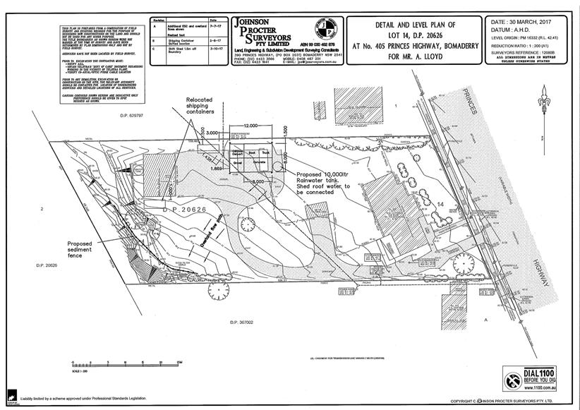
|
|
Development Committee
– Tuesday 14 November 2017
Page
101
|
|
|
Development
Committee – Tuesday 14 November 2017
Page
110
|
DE17.85 DS17/1233
– 12 Currambene Street, Huskisson – Lot 2 DP 662583
DA. No: DS17/1233/4
HPERM Ref: D17/345909
Group: Planning
Environment & Development Group
Section: Development
Services
Attachments:
1. Planning Report ⇩
2. Urban
Design Statement ⇩
Description of Development: S96(2) –
Addition of Rooftop Communal BBQ Area, Covered and Enclosed Seating Area and
Ancillary Facilities
Owner: Michael Hanna
Applicant: Allen Price & Scarratts
Notification Dates: 27 June 2017 to 12 July 2017
No. of Submissions: Two (2) in objection
Nil in
support
Purpose
/ Reason for consideration by Council
Councillors called in the
application for public interest reasons on 25 July 2017.
|
Recommendation
(Item to be determined under delegated authority)
That Council resolve to refuse Application
DS17/1233 to modify Development Consent DA15/2561 to include a rooftop
communal BBQ area with covered and enclosed seating area and ancillary
facilities at Lot 2 DP 662583, 12 Currambene Street, Huskisson for reasons
relating to:
1. Insufficient
information submitted with the application to satisfactorily demonstrate that
the development (as modified) conforms to the provisions of section 96(3) of
Environmental Planning and Assessment Act, 1979 in relation to consideration
of State Environmental Planning Policy No 65 – Design Quality of
Residential Apartment Development. (Section 79C(1)(a)(i) of Environmental
Planning and Assessment Act, 1979)
2. An inadequate
statement by a qualified designer has been submitted with the application to
satisfy that required by clause 115(3A) of Environmental Planning and
Assessment Regulation, 2000. (Section 79C(1)(a)(iv) of Environmental Planning
and Assessment Act, 1979)
3. The
development (as modified) is considered unsuitable having regard to potential
adverse amenity impacts including visual impact and residential amenity,
including noise, privacy and solar access. (Section 79C(1)(b) and (c) of
Environmental Planning and Assessment Act, 1979)
4. Having regard
to insufficient information being submitted with the application to satisfy
the relevant provisions of Environmental Planning and Assessment Act, 1979
and Environmental Planning and Assessment Regulation, 2000, along with
amenity impacts, the granting of modification to Development Consent
DA15/2561 is not considered to be in the public interest. (Section 79C(1)(e)
of Environmental Planning and Assessment Act, 1979)
|
Options
1. Refuse the application
in accordance with the recommendation of this report.
Implications: A section
96AB review or an appeal with the Land and Environment Court are possible in
the event of a refusal of the application.
2. Approve the
application.
Implications: Council could
choose to approve the application if it considers that the provisions of
section 79C(1) have been satisfactorily addressed. Any such approval would be
conditional and require a further report to Council detailing draft conditions.
3. Alternative
recommendation.
Implications: Council could
specify an alternative recommendation and advise staff accordingly.
Figure
1 – Location Map
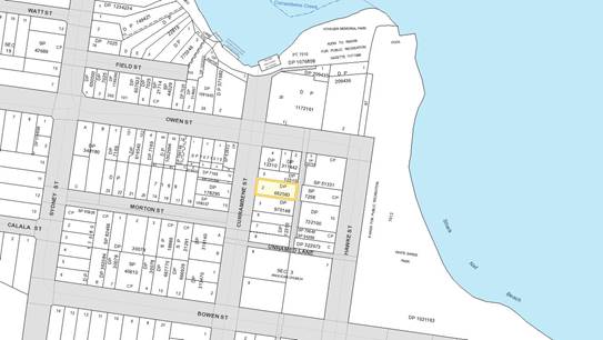
Background
Proposed Development
The application seeks approval to include a rooftop communal
BBQ area with covered and enclosed seating area and ancillary facilities (being
a toilet cubicle) to the mixed use development approved by Development Consent
DA15/2561. The approved development comprises two (2) ground floor retail units
and eight (8) x 2 bedroom residential units.
Figure
2 – Site/Ground Floor Plan

 Figure 3 – Roof Top Common Area Plan (also see Figure 7
later in this report)
Figure 3 – Roof Top Common Area Plan (also see Figure 7
later in this report)
Figure 4 – Elevations
Figure 5 – External Colours Schedule
Subject Land
The development site comprises Lot 2 DP 662583 (12
Currambene Street, Huskisson). Refer to Figure 1.
Site & Context
The development site:
§ Previously contained a single dwelling house with ancillary
shed, which were removed as part of Development Consent DA15/1561, which
approved a three (3) storey building comprising retail units on the ground
floor and two (2) levels of residential units. Construction is underway.
§ Is zoned B2 Local Centre and has an area of 1,012sqm;
§ Has two (2) existing frontages, a primary frontage to
Currambene Street and secondary frontage to an unnamed laneway. Vehicular
access is proposed from the laneway; and
§ Adjoins land zoned B2 Local Centre, under the Shoalhaven
Local Environmental Plan 2014 (SLEP 2014) as illustrated in Figure 6.
Figure
6 – Zoning Extract
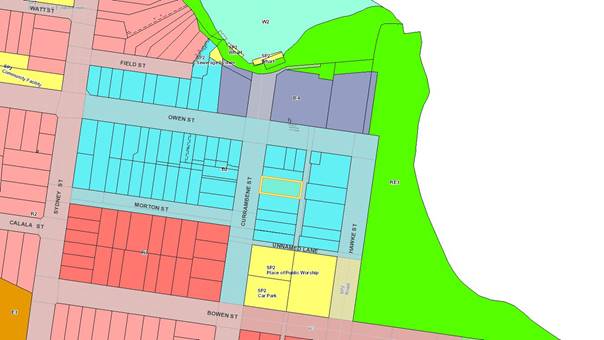
History
The following provides details on post-lodgement actions
and general site history for context:
§ The application was lodged on 19 June 2017.
§ As a result of detailed assessment of the application,
additional information was requested from the applicant on two (2) occasions
– 14 July 2017 and 11 August 2017.
§ On 19 July 2017, the applicant submitted additional
information, being a statement by a qualified designer in accordance with the
relevant provisions of the Environmental Planning and Assessment Regulation
2000.
§ On 11 August 2017, following review of this statement and
internal referrals, additional information was requested to include an
evaluation of the design quality of the development (as modified),
demonstrating how it achieves compliance with the design quality principles and
Apartment Design Guidelines (ADGs), in accordance with State Environmental
Planning Policy No 65 – Design Quality of Residential Flat Development
(SEPP 65). An acoustic report assessing the potential noise nuisance from the
development (as modified) and addressing noise controls as required, was also
requested.
§ On 28 September 2017, the applicant submitted an amended
statement (refer to Attachment 2) and acoustic report.
§ On 10 October 2017, the acoustic report was referred to
Council’s Environmental Health Officer for technical comment.
Issues
1. State
Government Design Guidelines:
State Environmental Planning Policy No 65 –
Design Quality of Residential Flat Development (SEPP 65) and Apartment Design
Guide (ADG)
As this application is for the
modification of a development consent under section 96(2) of the Environmental
Planning and Assessment Act 1979 relating to residential apartment development
and a development application which was accompanied by a design verification
from a qualified designer under clause 50(1A), it was required to be
accompanied by a statement by a qualified designer in accordance with clause
115(3) of the Environmental Planning and Assessment Regulation 2000.
The provisions of clause 115(3A) of the Regulation also
require that:
“The statement by the qualified designer must:
(a) verify that he or she designed, or
directed the design of, the modification of the development and, if applicable,
the development for which the development consent was granted, and
(b) provide an explanation of how:
(i) the design
quality principles are addressed in the development, and
(ii) in terms of
the Apartment Design Guide, the objectives of that guide have been achieved in
the development, and
(c) verify that the modifications do not
diminish or detract from the design quality, or compromise the design intent,
of the development for which the development consent was granted.”
Whilst a statement has been submitted by a qualified
designer, being Eduardo Villa of Villa & Villa, it is considered that the
statement has not adequately addressed subclauses (b) and (c).
The written statement is substantially the same submitted
for the original development application, with very minor amendments
referencing the proposed modifications to the approved development. It does not
provide detailed explanation of how the design quality principles are addressed
or in particular, the objectives of the ADG have been achieved in the
development (as modified). Further to this, no verification is included that
the proposed modifications do not diminish or detract from the design quality,
or compromise the design intent, of the approved development.
2. Council’s
LEP Controls:
Clause 4.3 (Height of buildings)
The maximum building height is 10m.
The development site is also identified as being land in the
Huskisson Town Centre and an increased building height of 13m is available in
certain circumstances under clause 7.26 of SLEP 2014. However, this clause is
not applicable to this development site as it does not satisfy the provisions of
subclause (3) with respect to lot size and building height.
The communal BBQ area with covered and enclosed seating area
and ancillary facilities proposed as part of this application exceeds the 10m
maximum building height by up to 3.65m, being 36.5%. It also exceeds the 13m
height allowable for development on certain sites in this locality, being a 5%
contravention.
Although it is acknowledged that the requirement of the
development standard is ‘bypassed’ under section 96 of the
Environmental Planning and Assessment Act 1979 and an ‘exception’
pursuant to clause 4.6 of SLEP 2014 is not required; the provisions of section
79C(1) are still a consideration in accordance with section 96(3) of the
Environmental Planning and Assessment Act 1979.
A statement by a qualified designer was submitted with the
application. However, the statement is not analytical, detailed and explanatory
having regard to the provisions of SEPP 65 and the ADG. The statement does not
provide sufficient support/explanation in regard to the impacts of the proposal
and how the overarching Objectives of SEPP65 have been met particularly in
regard to the suitability of the site for the development (as modified).
It is also evident that the development (as modified) is not
compatible with the height, bulk and scale of the existing character of the
Huskisson Town Centre and as it is proposed to exceed the maximum height (along
with the incentive height) it is considered that it will neither be compatible
with existing nor the desired future character, having regard to the strategic
controls (zone, DCP) for the locality.
Further to this, the proposed rooftop communal BBQ area with
covered and enclosed seating area and ancillary facilities will detract from
the aesthetics of the approved building, affect the amenity of the streetscape
when viewed from Currambene Street in particular, and increase loss of privacy
(i.e. particularly with regard to acoustic impacts) and solar access to
neighbouring sites. In addition to this, public submissions were also made
objecting to the development.
3. Noise
Impacts
Acoustic Report by Harwood Acoustics (Reference No.
1708007E-R)
The following issues have been
identified with the acoustic report submitted with this application:
§ The report only considers the
“main source of noise associated with the proposal will be human voice
noise” for ten (10) human voices. There are no practical controls on
residents inviting others to the rooftop terrace and estimations of predicted
noise exceeding acceptable noise limits. The number of people on the
rooftop is only constrained by the size of the terrace area.
§ There is no consideration for
other noise sources such as music (amplified/speakers or ambient), instruments,
etc. The report concedes through the following statement “main source
of noise associated with the proposal will be human voice noise” that
there may be other noise sources on the rooftop terrace which have not been
considered.
§ A full background noise
assessment was not carried out due to the property currently being under
construction. Short-term background noise measurement were taken for one (1)
hour (8:30pm to 9:30pm).
§ Noise from the lift and
stairs extended to the proposed rooftop terrace was not taken into
consideration and any mechanical plant that may be installed or modifications
to the existing mechanical plant that may occur due to the redesign of the
rooftop.
§ No other sensitive receptors
were identified in the assessment (e.g. apartments on the corner of Owen
Street, residences at the corner of Morton Street, apartments at the rear along
Hawke Street).
§ The restriction of use to the
rooftop area and how this will be achieved so that “the rooftop area
will be for residents only and will not be open to the public” has
not been specified through a plan of management or impact statement. It is a
likely scenario that residents will have invited guests and expect full ability
to utilise the rooftop entertaining area. No hours of operation were specified
for the use of the rooftop terrace either. The plan of management for the
rooftop terrace should ideally be developed so that time restrictions are
placed on the use of the area as well as restrictions to music and general
behaviour of residents using the area. However, enforcement and
compliance issues then arise with such a plan.
Plans of management
however rely on human behaviour and intervention to ensure impacts are
controlled. To this end, if a building or development can be designed in a
manner which controls use, activity and noise, this is a better outcome. By way
of example, a substantially reduced area could possibly reduce the number of
people on the terrace and its use.
Figure 7 – Detail of Proposed Terrace
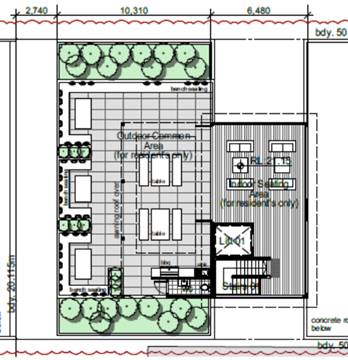
Planning Assessment
The application has been assessed under s96 of the
Environmental Planning and Assessment Act 1979. Refer to Attachment 1. It
is important to note, that Council cannot reconsider the whole
application. The assessment can only relate to the application put before
Council.
Consultation and Community
Engagement:
Notification was undertaken in accordance with
Council’s Community Consultation Policy with letters being sent within a
60m buffer of the site, including the Huskisson Woollamia Community Voice and
Huskisson Chamber of Commerce and Tourism Inc. during the period 27 June 2017
to 12 July 2017.
Two (2) submissions were received in relation to
Council’s notification of the development. They were objections to the
development.
Key issues raised as a result of the notification
include, but were not limited to, matters listed below. A more detailed
analysis can be found in the attached section 96 assessment report.
§ Scale of the development,
particularly height and density;
§ Solar access;
§ Privacy; and
§ Noise.
Financial Implications:
There are potential cost implications for Council in the
event of a refusal of the application. Such costs would be associated with
defending an appeal in the Land and Environment Court of NSW.
Legal Implications
A section 96AB review or an appeal with the Land and
Environment Court are possible in the event of a refusal of the application.
Summary and Conclusion
SEPP 65 sets out the NSW Government’s policy direction
for certain mixed use developments with a residential accommodation component
(such as this) in NSW and is underpinned by the ADG, which provides guidance on
how these proposals can meet the design principles embedded in the SEPP. In
this regard, insufficient information has been submitted with this application
to satisfactorily demonstrate that the development (as modified) conforms to
these provisions.
Other issues raised in this report and attachments, relating
to the excessive scale of the development, further loss of solar access and
privacy, and increased noise impacts are not demonstrated to be acceptable and
for this reason the development is not considered to be in the public interest.
Accordingly, refusal is recommended.
|
|
Development
Committee – Tuesday 14 November 2017
Page
119
|
|
|
Development
Committee – Tuesday 14 November 2017
Page
126
|
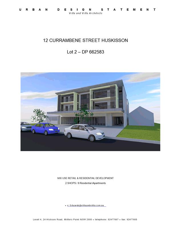
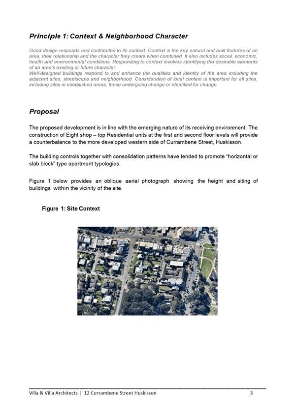
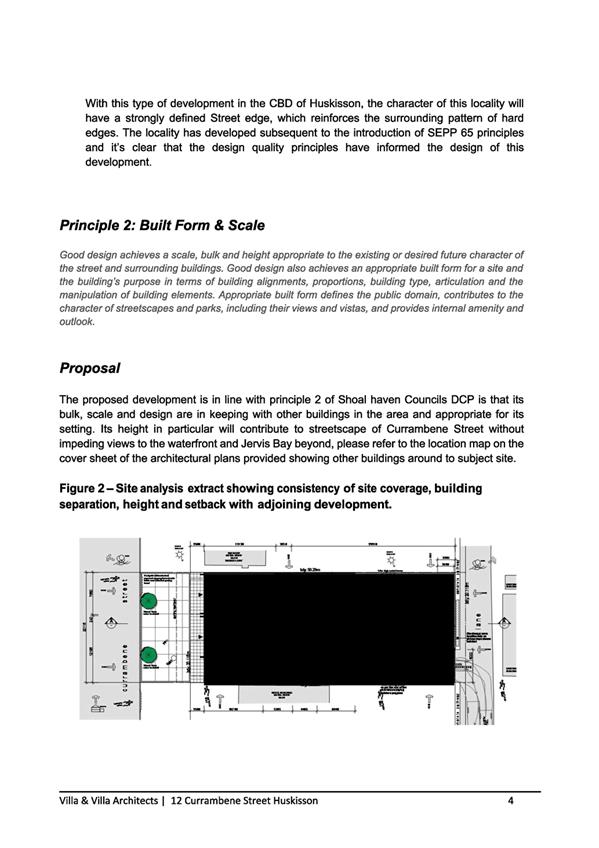
|
|
Development
Committee – Tuesday 14 November 2017
Page
136
|
DE17.86 Development
Application – Parson St Ulladulla – Proposed Lot 15 in Subdivision
of Lot 3 DP746228 and Lots 5 & 6 DP805221
DA. No: DA16/2412/4
HPERM Ref: D17/349640
Group: Planning
Environment & Development Group
Section: Ulladulla
Service Centre
Attachments:
1. Report to
Development Committee 14 March 2017 ⇩
2. DA Plans ⇩
3. Site
Context Photos ⇩
Description of Development: Construction of a
three storey office building, car parking, landscaping and associated
infrastructure
Owner: ET & ME Oberg
Applicant: Triple A Developments
Notification Dates: 12 December 2016 to 9
January 2017
No. of Submissions: 4 in objection
Nil in
support
Purpose / Reason for consideration
by Council
The purpose of this report is to
seek Council direction with respect to a request for a variation of a
development standard (building height) applicable to the site under Clause 4.6
of the Shoalhaven Local Environmental Plan 2014 (SLEP 2014).
Council has previously considered the application (MIN17.183 & MIN17.218) and the plans for consideration
remain unchanged from the plans previously considered in the Council report
(DE17.23) to the Development Committee on the 14 March 2017. The
Ulladulla CBD Heights Review is being considered by Council in a separate
report to this committee and it is appropriate to reconsider this application
in conjunction with the height review.
|
Recommendation (Item to be determined
under delegated authority)
That Council:
1. Confirm that it supports the proposed
variation to the maximum building height of 7.5m to a maximum of 11m for the main
building;
2. Refer the application back to staff
for determination by delegation.
|
Options
1. Resolve to support the proposed
variation to the development standard for height from 7.5m to 11m and refer the
application back to staff to determine the application under delegated
authority.
Implications: This would enable the application to be
finalised and conditions prepared to enable consent to be issued.
2. Resolve not to support the proposed
variation to the development standard and refer the application back to staff
to negotiate with the applicant to redesign the proposal to meet the 7.5m
height standard.
Implications: This would mean that the application could not
be supported in its current form. This would require modifications to be
made to specifically adjust the height which could have implications on the
development and its commercial viability for the owners of the site. This
option could also potentially result in litigation by the applicant.
3. Adopt an
alternative recommendation and provide direction to staff.
Location Map

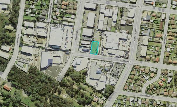
Background
On 14 March 2017, Council’s Development Committee
considered a development application (DA16/2412) for a three (3) storey office
building at proposed Lot 15 Parson Street, Ulladulla.
The proposal sought a 46% (3.5 metre) variation to the 7.5
metre height prescribed in the Shoalhaven LEP 2014 for the land.
Although the Committee originally resolved to support the variation
(MIN17.183), a rescission motion was considered at the 28 March 2017 Ordinary
Meeting (MIN17.217) and it was resolved to not support the proposed variation
(MIN17.218). As part of this resolution Council also resolved (part 2)
to:
Undertake a review of the 7.5 metre building heights in
this part of the Ulladulla Town Centre in the next 6 months which is limited to
the area south of Deering Street and the B5 and R3 zones.
Building Height Review
Consultants, City Plan Services
and Atlas Urban were engaged in June 2017 to undertake a Building Height
Review. The Review considered a detailed analysis of the Study Area and
context, as well as community consultation with the Ulladulla & Districts
Community Forum, community and Council representatives.
The outcome of the review recommends an increase in height
across the Study Area from 7.5 metres to generally 11 metres with a small area
of 14 metres. The report recommends that in the location of the subject
site that the maximum building height be increased from 7.5 metres to 11
metres.
Height consideration at 11m
The height of the building would
be consistent with an 11 metre building height standard as recommended by the
review. The extent of encroachments above the 11 metre building height
standard would be limited to the flag pole.
Planning Assessment
The application will be fully
assessed under s79C of the Environmental Planning and Assessment Act 1979
following determination of the application for variation to development
standards.
Policy Implications
The application identified a
need to review the appropriateness of the height controls in the precinct and
the recommendations from the Building Height Review will assist in facilitating
development and providing direction in the development of the surrounding area.
Should the recommendations of the Building Height Review be
adopted, then amendments will also be required to the Shoalhaven LEP & DCP
2014 to reflect new heights and to resolve any inconsistencies resulting from
the modifications.
Consultation and Community Engagement:
The notification was made in accordance with Council’s
Community Consultation Policy to properties within a 60 metres of the site and
a newspaper advertisement. The notification was for a 4 week period to
account for the Christmas/New Year’s holidays and 4 submissions were
received.
Key issues raised as a result of the notification were
discussed in detail in the previous report included
in Attachment 1.
Legal Implications
If the application is refused,
or if the applicant is dissatisfied with Council’s determination, the
applicant is entitled to appeal to the Land and Environment Court. Under
some circumstances, third parties may have a right to appeal Council’s
decision to the Land and Environment Court.
Summary and Conclusion
It is considered that the
variation is reasonable and acceptable and in this instance strict compliance
with the height development standard is considered to be unnecessary as the
development is appropriate in the location and can achieve relevant planning
objectives.
It is considered that there are
sufficient planning grounds to justify the departure from the height
development standard prescribed in the Shoalhaven LEP 2014 which is supported
by the recommendations of the Building Heights Review.
|
|
Development
Committee – Tuesday 14 November 2017
Page
139
|
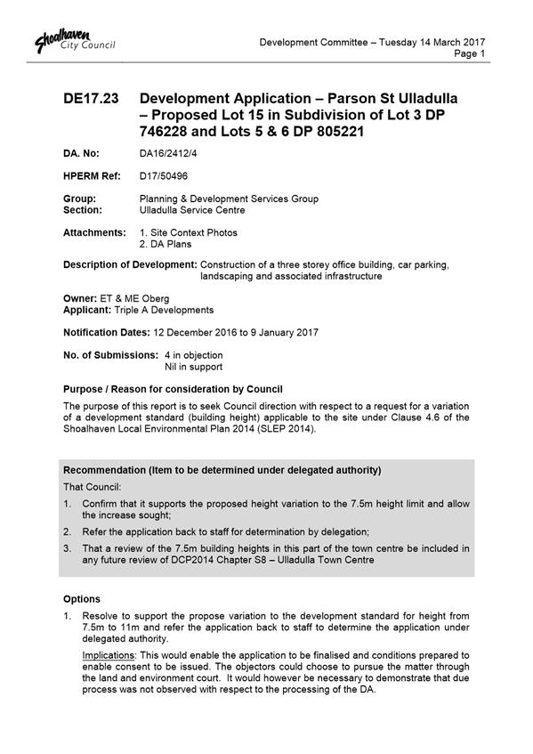
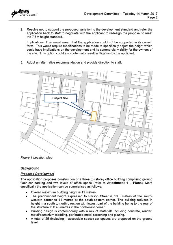
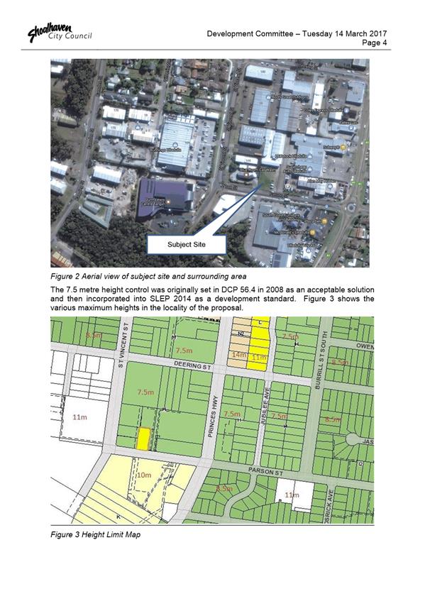
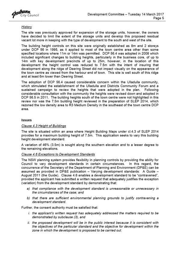
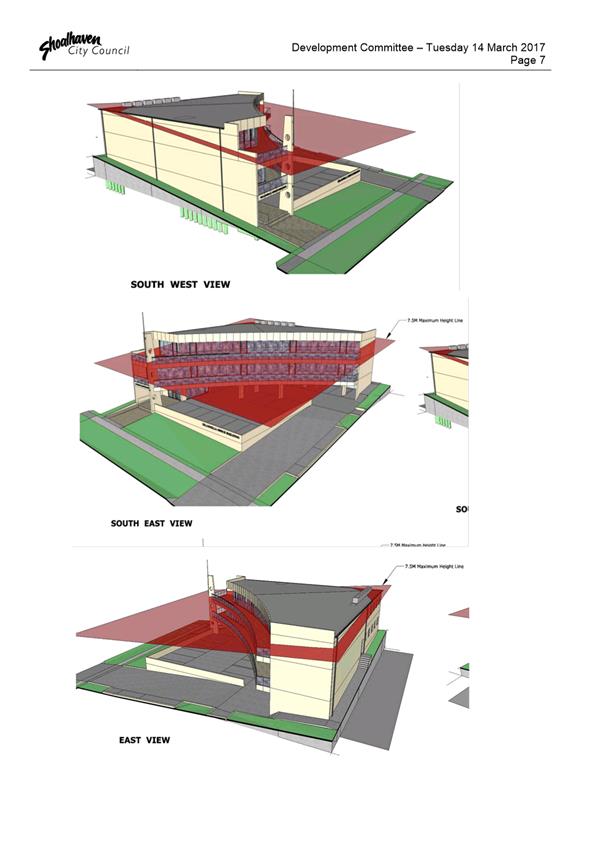
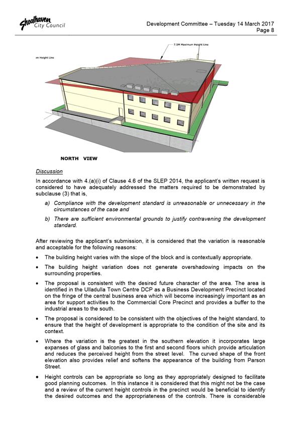
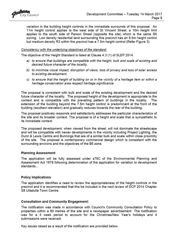

|

|
Development
Committee – Tuesday 14 November 2017
Page
150
|
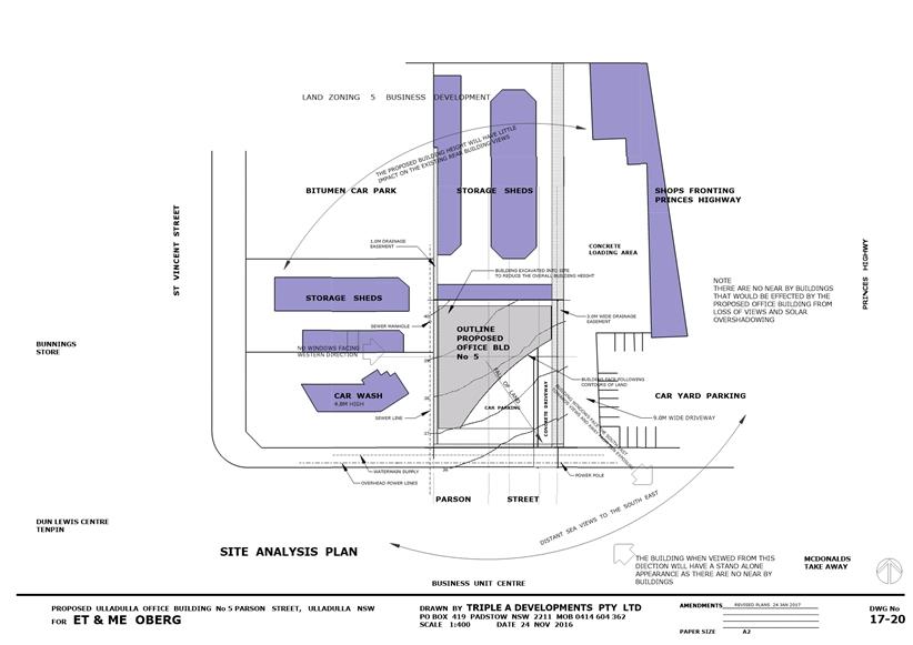
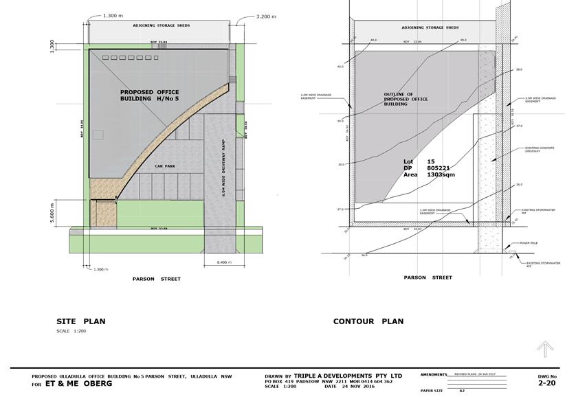
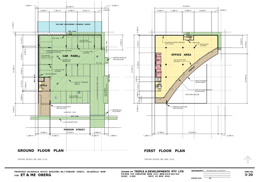
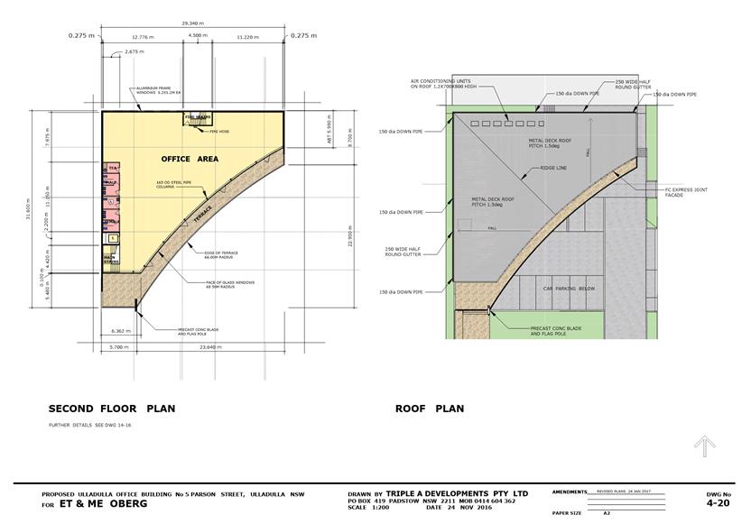
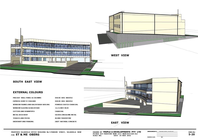
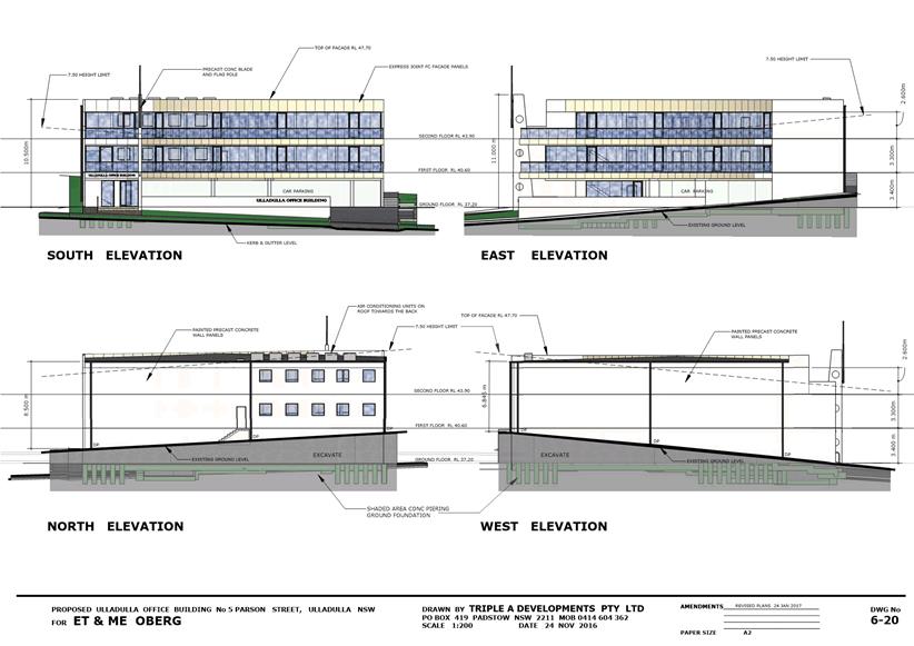
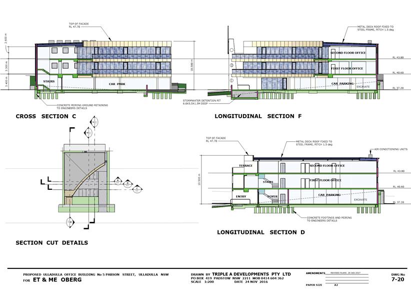
|
|
Development
Committee – Tuesday 14 November 2017
Page
157
|
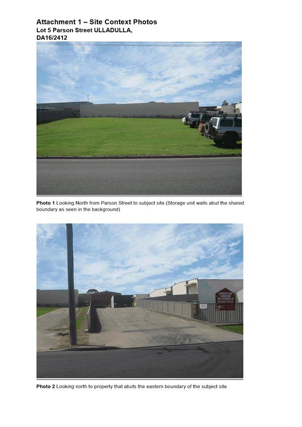
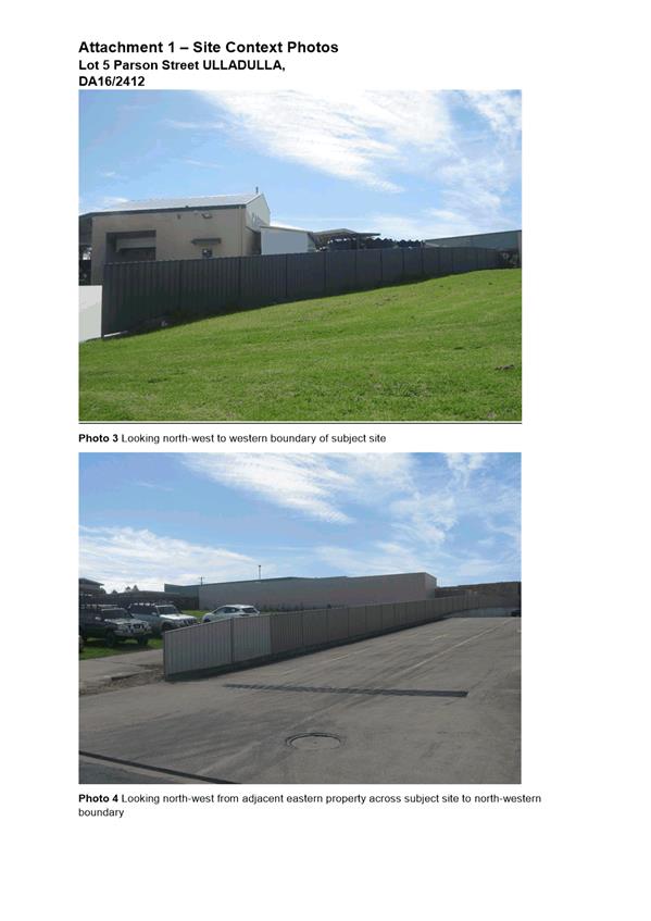
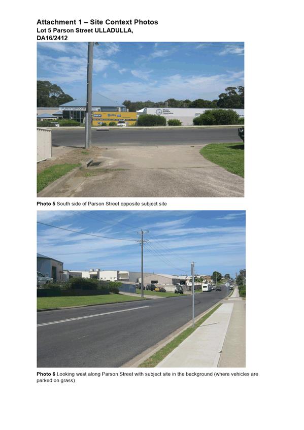
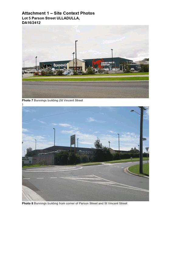
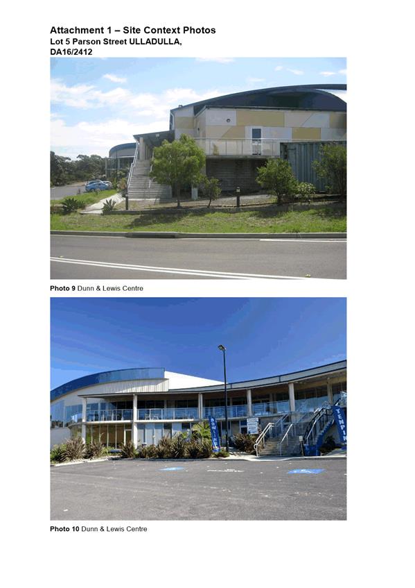
|
|
Development
Committee – Tuesday 14 November 2017
Page
162
|
DE17.87 Development
Application SF10591 – 18 Calder Close, Vincentia – Lot 34 in DP
713629
DA. No: SF10591/4
HPERM Ref: D17/350005
Group: Planning
Environment & Development Group
Section: Development
Services
Attachments:
1. Plan - Survey -
Lot 34 DP 713629 - 18 Calder Cl Vincentia ⇩
Description of Development: Two (2) Lot
Residential Subdivision
Owner: Wolfgang Witz & Kathryn Ross
Applicant: Wolfgang Witz
Notification Dates: 20th July to 4th
August 2017
No. of Submissions: No submissions received
Purpose / Reason for consideration
by Council
The
applicant proposes a Clause 4.6 exception to the minimum lot size, as specified
by Shoalhaven Local Environmental Plan 2014 (SLEP 2014). The extent of
the exception, or variation exceeds the delegated authority level (greater than
10%) of staff, and is therefore required to be considered by Council.
|
Recommendation (Item to be determined
under delegated authority)
That the Committee:
1. Pursuant to Clause 4.6 (Exceptions to
development standards) of SLEP 2014, support the applicant’s request to
vary the minimum subdivision allotment size in respect of proposed Lot 2 from
500m2 to 433.9m2; and
2. Refer the development application
(SF10591) back to staff for determination.
|
Options
1. Support the application, and the exception to
Clause 4.1 of SLEP 2014, under Clause 4.6 of SLEP 2014, as submitted.
Implications: Subject to the completion of a
satisfactory 79C assessment the application be determined under delegated
authority.
2. Decline to
support the exception to Clause 4.1 of SLEP 2014, under Clause 4.6 of SLEP
2014.
Implications: The application would not be able to
be supported, and would therefore be determined by way of refusal, under
delegated authority. The applicant would be entitled to appeal against
Council’s refusal in the Land and Environment Court.
3. Adopt an alternative recommendation and
provide direction to staff.
Location Map
Figure 1 –
Location Map


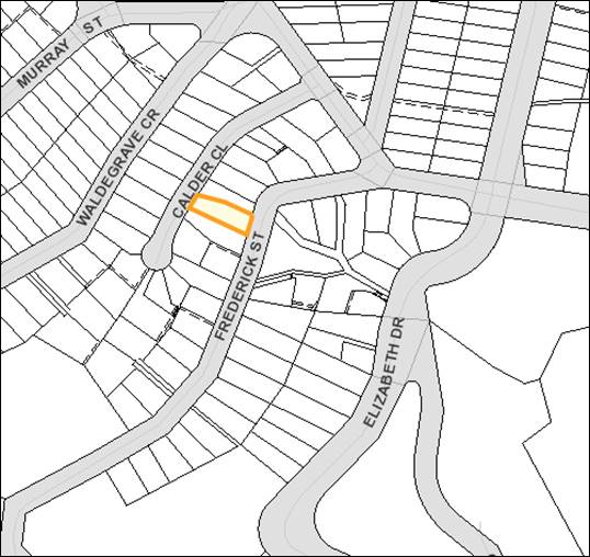
Background
Proposed Development
The applicant proposes a two (2) lot
Torrens title subdivision of the subject site. Proposed Lot 1 will have
an area of 500m2 and will contain the existing dwelling house, and
will have a frontage to Calder Close.
Proposed lot 2 will have an area of
433.9m2, and will be vacant land and will have a frontage to
Frederick Street.
The applicant is seeking an exception
(or variation) with respect to proposed Lot 2, pursuant to clause 4.6 of the
Shoalhaven Local Environmental Plan 2014 (SLEP 2014), to the minimum allotment
size of 500m2.
Subject Site
The subject site is identified as Lot 34
in DP 713629 No.18 Calder Close. The subject site consists of an
irregular-shaped allotment of land, situated on the eastern side of Calder
Close and extending through to Frederick Street (see Figure 1). The site has a
frontage of 13.405m to Calder Close and a frontage of 19m to Frederick Street,
with side boundary lengths of 57.43m (southern boundary) and 52.97m (northern
boundary). The site currently contains a two-storey dwelling house at its
western end, with direct access from Calder Close. The rear of the site,
sloping down to Frederick Street, consists of planted gardens.
Site Context
The subject site is located within an
established residential area of Vincentia. The neighbouring property to the north
is a Council-owned public reserve. The adjoining property to the south (No.17
Calder Close) is of similar size and configuration to the subject site, and
contains a dwelling house at its Calder Close frontage.
As noted in the table below, the subject
site (highlighted in bold) is one of five (5) residential allotments on the
eastern side of Calder Close that have a dual street frontage with Frederick
Street.
|
Property
|
Area
|
Existing
Development
|
|
15 Calder Close (Lot 30 DP
713629)
|
1,014m2
|
Dwelling house centrally-located within the
allotment.
|
|
17 Calder Close (Lot 33 DP
713629)
|
978.5m2
|
Dwelling house located towards Calder Close
frontage.
|
|
18 Calder Close (Lot 34 DP
713629)
|
933.1m2
|
Dwelling house located towards Calder Close
frontage.
|
|
20 Calder Close (Lot 35 DP
713629)
|
894.2m2
|
Vacant Land
|
|
21 Calder Close (Lot 36 DP
713629)
|
890.5m2
|
Dwelling house located towards Calder Close
frontage.
|
Figure
2 – Site Context
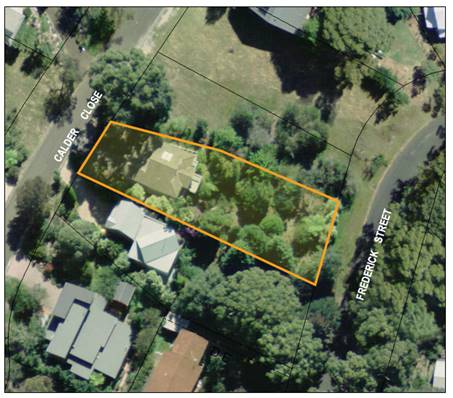
Issues
Shoalhaven Local Environmental Plan 2014
– Clause 4.1 Minimum subdivision lot size
Clause 4.1 of SLEP 2014 is reproduced
below.
4.1 Minimum
subdivision lot size
(1) The
objectives of this clause are as follows:
(a) to ensure
that subdivision is compatible with, and reinforces the predominant or historic
subdivision pattern and character of, an area,
(b) to
minimise any likely impact of subdivision and development on the amenity of
neighbouring properties,
(c) to ensure that
lot sizes and dimensions are able to accommodate development consistent with
relevant development controls.
(2) This clause
applies to a subdivision of any land shown on the Lot Size Map
that requires development consent and that is carried out after the
commencement of this Plan.
(3) The size of
any lot resulting from a subdivision of land to which this clause applies is
not to be less than the minimum size shown on the Lot Size Map
in relation to that land.
(4) This clause
does not apply in relation to the subdivision of individual lots in a strata
plan or community title scheme.
The subject land is identified on the
SLEP 2014 Lot Size Map as having a minimum lot size of 500m2.
Proposed Lot 1 has an area of 500m2 and achieves the minimum lot
size. Proposed Lot 2 has an area of 433.9m2 and is 13.22% less than
the minimum lot size.
Clause 4.6 Exceptions to development standards enables development standards, such as
the minimum lot size, to be varied and requires the applicant to provide a
written request seeking to justify the contravention of the development
standard by demonstrating that,
· compliance with the development standard
is unreasonable or unnecessary in the circumstances of the case, and
· there are sufficient environmental
planning grounds to justify contravening the development standard.
Applicant’s
Submission
The applicant has made a formal
submission (attached) requesting a variation the minimum lot size under Clause
4.6. In accordance with sub-clause 4.6(3)(a) the applicant contends that
compliance with the development standard is unreasonable or unnecessary in the circumstances of the
case, for the following reasons,
Strict compliance with the standard is
unreasonable and unnecessary in this particular case as the development
achieves the objectives of both the zone and the development standard. It is
not possible for the development standard of 500m2 to be achieved
and the additional 66.1m2 required would not positively impact upon
either the amenity of the adjoining residents to the south.
Any perceived potential adverse impact
through overlooking or overshadowing is an internal impact within this
development. The existing house is a known factor for a purchaser and a
dwelling can be designed to protect their privacy and amenity. The existing
dwelling however is designed to look over the property to vistas beyond rather
than look down into this lot.
Council can be secure in the knowledge
that the land is unlikely to be used for the purpose of a dual occupancy
development as it is undersized for that purpose but that it is suitable for a
single residential dwelling house similar to that illustrated in the
accompanying plans.
Development of the lot for a dwelling
house will not result in a development that has an overshadowing or overlooking
impact upon adjoining lots, it will allow for the erection of a dwelling house
that is of similar bulk and scale to those existing in the street and will
therefore be compatible with the character of the surrounding residential zone.
In
accordance with sub-clause 4.6(3)(b) the applicant contends that there are sufficient environmental
planning grounds to justify contravening the development standard for the
following reasons,
Our application demonstrates compliance
with the zone objectives and the objectives of the development standard despite
the 13% contravention in the lot size.
The environmental planning grounds
include:
· Compatibility with the character of the
existing residential locality including bulk, scale and height of potential
residential dwellings.
· Maintenance of the privacy and amenity
of the adjoining and adjacent residents.
· No likely overlooking or overshadowing
of existing development through the construction of new development.
· There will not be a significant increase
in traffic in the locality as a result of the creation of a vacant lot for the
purpose of a future dwelling house, an additional dwelling will generate
approximately 6 - 9 additional traffic movements daily which is within the
environmental capacity of the road network.
· The proposal will not pose a significant
drain on Council supplied infrastructure such as water or sewer, kerb and
gutter exists to both frontages and the land can be provided with electricity
and telephone services for the benefit of residents.
· The land is not mapped as bushfire prone
and the development will not increase the density of development in an area
which may suffer from intermittent bushfire threat. This reduces the risk to
both residents and fire fighters in the event of a bushfire emergency.
Comments and Discussion
In accordance with sub-clause 4.6(4)(a)(i)
of SLEP 2014, Council cannot grant consent to the development proposal unless
it is satisfied the applicant has adequately addressed the matters in
sub-clauses 4.6(3)(a) and (b); and, is satisfied that the proposal is in the
public interest because it is consistent with the objectives of both the
development standard and the zone in which the development is proposed. With
this in mind, it is considered that the applicant’s justification
statement,
· Has demonstrated that the 500m2
minimum allotment size development standard is unreasonable and unnecessary
under the circumstances of the case. It is the applicant’s submission
that strict compliance with the development standard is unreasonable and
unnecessary “as
the development achieves the objectives of both the zone and the development
standard”. With regard to the objectives of the
development standard insofar as they relate to the compatibility with the
character of the area and reinforce the predominant or historic subdivision
pattern, the applicant considers:
“the subdivision character in
this locality is generally recti-linear and this proposal provides two lots
which comply with and reinforce that character.
The area however is not characterised by
a regular grid pattern street layout due to the topography and the proposed
lots respond positively to the site topography allowing the maintenance of
privacy between lots while taking advantage of the outlook of the adjoining
drainage reserve”.
To the extent that the objectives relate
to the minimisation of the likely impact on the amenity of neighbouring
properties, the applicant contends that the proposal “will not have an
adverse or significantly detrimental impact on the amenity of the adjacent and
adjoining residential area. Privacy can be retained between dwellings and the
lots, with the retention of vegetation”. It is noted that
proposed Lot 2 is adjoined on its northern side by a public reserve and on its
southern side by the vegetated rear yard area of No.17 Calder Close. In addition,
a 2.4m wide easement is proposed along the southern boundary of Lot 2, further
increasing the setback to its southern neighbour. It is therefore likely that a
future dwelling house erected upon Lot 2 will not detrimentally impact upon the
amenity of the neighbouring properties. On this point, it is also noted that no
objections to the proposal have been received.
The final objective relates to the
adequacy of lot sizes and dimensions to accommodate development the applicant
notes that,
“plans accompanying the
application demonstrate that a dwelling is readily accommodated on the land
with compliant car parking. The lot takes advantage of the adjacent public
reserve allowing a wider expanse of open space to maintain the amenity of the
proposed lot”.
A concept site layout plan, provided by
the applicant, demonstrates that a dwelling house can be sited on proposed Lot
2 with a compliant 6m setback to Frederick Street (6m is applicable as the lot
is less than 30.5m deep) and a 3m rear boundary setback. Having regard to these
setbacks, the minimum 900mm setback to the northern side boundary and the 2.4m
wide easement proposed inside the southern boundary, a building footprint of
194m2 would be achievable. As any dwelling erected upon Lot 2 is
likely to incorporate a second level on its downslope side (facing Frederick
Street), it is quite possible to have a reasonably-sized (max. 216.95m2)
dwelling house erected on Lot 2.
The subject site is not mapped as
bushfire prone land or flood prone land, and does not contain vegetation, which
is identified as being of particular ecological or biodiversity significance,
which much of the vegetation on the site consisting of exotic species. There
are no environmental constraints affecting the site, which would preclude its
subdivision. The subject site has the benefit of dual road frontages (Lot 1
will front Calder Close and Lot 2 Frederick Street), which gives each lot a
separate street address and access point. Utility services are currently
connected to the existing allotment and can be extended to proposed Lot 2.
Stormwater from Lot 1 is able to be drained through proposed Lot 2 directly to
Frederick Street.
Having regard to the above, and the
applicant’s submission, it is considered that there are sufficient
environmental grounds to justify the variation to the development standard.
In
accordance with sub-clause 4.6(4)(a)(ii) of SLEP 2014, Council must be
satisfied that the proposed development “will be in the public
interest because it is consistent with the objectives of the particular
standard and the objectives for development within the zone in which the
development is proposed to be carried out”.
The
objectives of clause 4.1 of SLEP 2014 are,
(a) to ensure
that subdivision is compatible with, and reinforces the predominant or historic
subdivision pattern and character of, an area,
(b) to
minimise any likely impact of subdivision and development on the amenity of
neighbouring properties,
(c) to
ensure that lot sizes and dimensions are able to accommodate development
consistent with relevant development controls.
As
outlined above (in consideration of the applicant’s submission) the
development proposal is considered to achieve the objectives of standard.
The
site is zoned R2 under SLEP 2014 and the objectives of the R2 zone are as
follows,
· To provide for the housing needs of the
community within a low density residential environment.
· To enable other land uses that provide
facilities or services to meet the day to day needs of residents.
· To provide an environment primarily for
detached housing and to ensure that other development is compatible with that
environment.
The
proposed subdivision will provide an allotment that can be developed for a
dwelling house in accordance with the provisions of Chapter G12 of SDCP 2014,
with the end result of that development being no greater in density than a
detached dual occupancy (which is currently able to be constructed, and Torrens
Title subdivided on the subject site). The development proposal is therefore
consistent with the first zone objective.
The
second zone objective is not applicable to the proposal.
The
third zone objective is achieved as the proposed allotment will provide an
allotment upon which a separate, detached dwelling house can be erected.
Have regard to the above
comments and discussion, it is considered that the development proposal has
adequately addressed the matters in sub-clause 4.6(3) and will achieve
consistency with the objectives of the development standard and the R2 zone.
Therefore, the clause 4.6 justification is considered to be well-founded and
Council is able to grant consent to the development proposal.
Planning Assessment
The DA has been favourably
assessed under s79C of the Environmental Planning and Assessment Act 1979.
Policy Implications
There are no specific policy implications that arise from this
matter. Clause 4.6 of SLEP 2014 provides the legal ability for Council to grant
the variation to development standards and Council’s adopted Internal
Procedure PRD15/143 provides the framework to ensure the process is conducted
in a manner which does not undermine the development standard.
Consultation and Community Engagement:
Notification was carried out in
accordance with Council’s Community Consultation Policy with letters sent
to the owners of the adjoining and adjacent properties. The notification
was for a 14 day period.
No submissions were received during the
notification period.
Financial Implications:
There may be financial implications for
Council if the matter is challenged via an appeal in the Land and Environment
Court of NSW.
Legal Implications
If the application is refused, or if the
applicant is dissatisfied with Council’s determination, the applicant is
entitled to appeal to the Land and Environment Court.
Under limited circumstances, third parties may have a right
to appeal Council’s decision to the Land and Environment Court.
Summary and Conclusion
The applicant’s submission has provided sufficient
justification to demonstrate that given the specific circumstances of this
case, strict compliance with the 500m2 minimum allotment size
development standard is unreasonable or unnecessary, and that there are
sufficient environmental planning grounds to justify a variation to this
standard. Accordingly, support for the variation is recommended.
|
|
Development
Committee – Tuesday 14 November 2017
Page
170
|
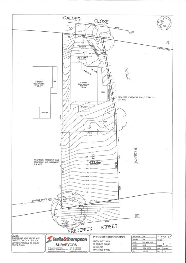
|
|
Development
Committee – Tuesday 14 November 2017
Page
171
|
DE17.88 Serious
and Irreversible Impact - Biodiversity Conservation Act - Yerriyong Moto
Complex
HPERM Ref: D17/358665
Group: Planning
Environment & Development Group
Section: Environmental
Services
Attachments:
1. Guidance Notes -
Office of Environment & Heritage ⇩
Purpose / Summary
As resolved by Council at its
Ordinary Meeting on 17 October 2017, this report provides Council advice
in relation to serious and irreversible impacts under the new Biodiversity
Conservation Act in relation to the proposed Yerriyong Motor Sports Complex.
|
Recommendation (Item to be determined
under delegated authority)
The report is provided to the
Committee for its consideration.
|
Options
1. The Committee may choose to adopt an
alternative recommendation.
Implications: Unknown
Background
At the
Ordinary Meeting of Council on 17 October 2017, Council resolved that:
1. In
recognition of the strategic importance and economic value of developing a
motor sports complex in our area, that Council, after reviewing the previous
development application (DA) by Motorcycling NSW, prepares and submits a DA as
proponent for this project.
2. Council
establish a project working group to oversee the process, comprising relevant
Council staff and representatives of the South Coast Motor Sports Club Inc.
3. Council
continue to explore and where applicable apply to both Federal and State
Government programs to facilitate funding for the project and private
partnership.
4. That
initial costs associated with the review and DA submission be funded through
the economic development budget
5. Recoupment
of all costs be factored into any future lease arrangements
6. The
General Manager provide a detailed report on how “serious and
irreversible impacts” have been addressed in similar situations, and what
precedents have been established in that regard.
This report addresses
Part 6 of the resolution.
Previous studies of
flora and fauna
The vegetation and associated fauna of Lot 3 DP1029731
Braidwood Road and Lot 7309 DP 1148878 Braidwood Rd Yerriyong, and Lot 7308 DP
1147573 Yerriyong Road Yerriyong have been the subject of ecological surveys
and assessment for the former motor sports complex development application as
listed below. The environmental constraints and biodiversity values of the site
have been identified in these assessments as well as Council’s flora and
fauna assessment completed in 2011 and the South Coast Regional Conservation
Plan (2010).
Biosis -
Motorcycling NSW Peak Motorcycle Facility, Yerriyong: Flora and Fauna
Assessment. Final reports dated 29 January and 19 February 2016, and two
Addendum reports dated 25 May and 6 June 2016.
Orchid survey of
Lot 7309 DP 1148878 by Alan Stephenson (NSW Office of Environment &
Heritage (OEH) recognised local orchid expert), February 2017.
Comments on
reports and impact assessments by Biosis have been provided by OEH and expert
Claire deLacey dated 15 March 2016 on behalf of the Parma Yerriyong Community
Group.
The flora and fauna surveys (by Biosis) identified known
habitat for 11 threatened fauna species and one flora species (confirmed by
Alan Stephenson), and potential habitat for three threatened fauna species east
of Braidwood Road. Additional species were identified west of Braidwood
Road.
Based on these studies, the NSW Office of Environment &
Heritage (OEH) recommended, amongst other things, that the proponent undertake
a Species Impact Statement for the former Development Application. This
requirement was imposed due to identified impacts on the Leafless Tongue Orchid
Cryptostylis hunteriana and potentially other threatened fauna species,
and was a result of the amount of high conservation value habitat proposed to be
cleared. The Leafless Tongue Orchid is listed as Vulnerable under both State
and Commonwealth legislation. The large number of hollow-bearing trees (HBTs)
to be cleared and a lack of survey to discount utilisation of these HBTs by
threatened species was also of particular concern.
Having regard to the acknowledged environmental significance
of the site, there are potentially two pathways available to assess compliance
with current NSW Biodiversity Conservation Act requirements.
NSW Threatened Species Act (TSC) 1995
The NSW TSC Act was repealed with effect on 25 August 2017
with transitional arrangements for applications already started.
For local developments in the Shoalhaven an application must
be submitted within 3 months (before 25 November 2017) to be eligible for
assessment under the previous legislation (TSC and EP&A Act).
Having regard to the fact that OEH have previously advised
that a Species Impact Statement is required to accompany the application, the
time frame to comply with the transitional requirements would not be able to be
met.
NSW Biodiversity Conservation (BC) Act 2016
An application pursuant to the BC Act would require an
assessment under the Biodiversity Offset Scheme, using the Biodiversity
Assessment Methodology (BAM) and the preparation of a Biodiversity Development
Assessment Report (BDAR).
In undertaking an assessment, an applicant must use the
services of an “accredited person” to undertake field work and the
collection of data, used to determine any “offset” (expressed as an
Ecosystem Credit total for each Plant Community Type (PCT) impacted and a
Species Credit total for each Species Credit species impacted).
The ‘accredited person” must follow the
Biodiversity Assessment Methodology (BAM) referred to in Section 6.7 of the BC
Act. The BAM is structured around three primary stages with Stages 1 & 2
relevant to the proposal;
1. Stage 1 establishes a
single consistent approach to assessing the biodiversity values on land.
2. Stage 2 provides for the
impact assessment on biodiversity values. This stage includes the guidelines
and requirements that apply to the hierarchy of avoid, minimise and offset, for
assessing direct and indirect impacts.
3. Stage 3 provides for the
assessment of the management requirements at a proposed biodiversity
stewardship site and the likely improvement in biodiversity values that are predicted
to occur over time.
In the hierarchy mentioned above, the applicant must
demonstrate that a project is located to avoid biodiversity values. If an
“accredited person” cannot adequately demonstrate avoidance of
direct and indirect impacts, justification for the location must be provided.
Actions to demonstrate avoidance would include a search for and analysis of
alternate sites without significant biodiversity values.
This same rationale applies to the minimise requirement, in
that a proposal should demonstrate that it is located in a position of least
environmental impact. Justification, in either regard, must be documented in
the Biodiversity Development Assessment Report (BDAR) produced by the
“accredited person”.
Thus a proponent’s decision in regard to the location
of a proposed development in an environmentally sensitive area, needs to be
based upon informed study of the area and must show full consideration of the
sites ecological values and the resulting location of the proposed development being
in a location of least environmental impact.
Under the BC Act, a determination of whether an impact is
serious and irreversible (a SAII) must be made in accordance with the
principles prescribed in section 6.7 of the BC Regulation. The reference to the
meaning of serious and irreversible within the BC Act is at Cl6.5 and states;
“ serious and irreversible impacts on biodiversity values of proposed development or activity means serious and irreversible impacts on biodiversity values as determined under section
6.5 that would remain after the measures proposed to be taken to avoid or
minimise the impact on biodiversity values of
the proposed development or activity"
There is guidance to assist a decision-maker to
determine a serious and irreversible impact (OEH, 25 August 2017) with the
“decision maker” definition including consent authorities for
development applications under Part 4 of the NSW EP&A Act. The consent
authority would be guided by the “accredited person” undertaking
the Biodiversity Assessment and its review of that assessment. The Act places
responsibility on the consent authority to ensure the assessment has been
carried out in accordance with the Act and the BAM. A copy of the guidance
notes issued by the Office of Environment and Heritage are attached.
The guidance notes include four principles for determining
SAII, with C.hunteriana likely to be included as a SAII candidate
species based on these principles. C.hunteriana is currently not listed
as a SAII candidate, but it is possible for the decision-maker to consider
entities that are not currently specifically identified, where they meet the
principles. Currently there are a number of species which have been listed as
candidates i.e. species that need to be assessed for SAII, along with guiding
benchmarks that will assist to categorise impact. This however is not a
definitive list and the principles mentioned above must be considered when
assessing SAII.
Of the threatened species or habitat for threatened species
previously identified on the site and the locality, the following are listed as
SAII candidates, meaning the application would have to be refused should impact
beyond an acceptable threshold be identified during the BAM process:
Pterostylis
vernalis orchid
Pterostylis
ventricosa orchid
Large-eared
Pied-bat (breeding habitat only)
Eucalyptus
langleyi Albatross Mallee
Genoplesium
baueri orchid
Eastern
Bent-wing Bat (breeding habitat only)
Sooty
Owl (cave breeding habitat only)
The BDAR, which must be produced by an “accredited
person” will identify whether a SAII candidate species is impacted beyond
an acceptable threshold. Should this be the case, the decision-maker is
required to refuse to grant development consent.
If it can be successfully demonstrated that impact on
significant biodiversity values were avoided and or minimised, and SAII
entities are not to be impacted beyond an acceptable threshold, the “accredited
person” upon application of the BAM will then calculate a credit total
for the loss of native vegetation plant communities (expressed as an
“ecosystem credit total”) and any species credit species
(“species credits”) for the remaining impacts. Retiring
“credits” must be completed prior to commencement of works should
the application be approved. This is an upfront cost before works can commence.
Based on the list of threatened species currently identified
on the site, and potential for other threatened species to be identified
through the BAM process, it is likely there will be a significant (large)
number of credits to be “retired” before any development can
commence, not with-standing the potential for the application to be refused due
to SAII or because it is unable to meet the ‘avoid and minimise’
requirements of the BAM.
There is no guidance at this time in regard to similar
situations or precedents that have been encountered under the newly adopted BC
Act. Having regard to the existing body of information available in regard to
the environmental constraints present on the site, and the guidelines
associated with the BC Act, it is clear that there are potentially significant
issues that may either prevent, or define the nature and extent of development
on the site.
Having regard to the above, any proponent would be strongly
advised to have an accredited person carry out a review of documentation
currently available, in regard to the environmental constraints that have been
identified as existing or potentially existing on the site, and determine what
level of further quantitative/qualitative assessment is necessary to determine
overall viability of development of the site and development for the purpose
proposed. This approach is favoured with a view to identifying evident
“red light” or significantly limiting issues at an early stage,
which will then guide ensuing actions including preparation of a Development
Application.
Financial Implications
The methodology as mentioned
above would ensure investigation work is done in a sequence to inform later
stages of the process and expenditure made accordingly.
Risk Implications
Due to the significant environmental values of the Yerriyong
site, a negative recommendation may result from the biodiversity assessment
methodology (BAM) due to impacts not being able to be avoided, minimised or if
serious and irreversible impacts on candidate species are determined.
|
|
Development
Committee – Tuesday 14 November 2017
Page
176
|

|
|
Development
Committee – Tuesday 14 November 2017
Page
178
|
DE17.89 Works
to restrict public access to Shoalhaven Water infrastructure at Kings Point and
Burrill Lake
HPERM Ref: D17/329859
Group: Shoalhaven
Water Group
Section: Water
Asset Planning & Development
Attachments:
1. Aerial
photograph showing locations of proposed access restrictions ⇩
2. Lands
& Forestry Request - Shoalhaven Water Assets ⇩
Purpose / Summary
To seek Council approval for
Shoalhaven Water to undertake works to restrict public access to its
infrastructure on Crown land in the Kings Point/Burrill Lake area due to
illegal dumping on the land.
|
Recommendation (Item to be determined
under delegated authority)
That
1. Council approve the request from
Crown Lands to install gates and rocks at the entrance to cleared pipeline
and access corridors over Lot 7305 DP1166682 at Kings Point Road, Kings Point
and Lot 201 DP75595 off Canberra Crescent and installation of rocks at
pipeline corridors at the eastern and western sides of Lot 7305 DP1166682, as
shown on the aerial photograph annexed to this report.
2. Council note that Crown Lands will be
responsible for all notifications and enquiries relating to this activity.
|
Options
1. Approve as recommended.
Implications: Council will accede to the request
from Crown Lands in order to deter any further illegal dumping in this area.
2. Not approve and provide direction to
staff.
Implications: Alternative measures to be explored.
Background
The Department of Industry, Land
& Forestry (DPI) has requested that Shoalhaven Water undertake work to
restrict access following repeated episodes of illegal dumping, on Crown land
between Kings Point Road at Lings Point and Canberra Crescent at Burrill Lake.
A copy of their request is given in the attachment.
The sites of the illegal dumping
are substantially associated with site access tracks for water mains and the
Burrill Lake water reservoir. To implement the access restrictions two gates
and large rocks will be required to close off four points of tracks used by
4WDs and other illegal dumping vehicles.
The restriction of access will reduce resources being
expended on the area by Council Regional Illegal Dumping Rangers and other
Council staff who have been required to deal with illegal dumping on the land
on numerous occasions. It also potentially protects Council and DPI staff and
the public from exposure to contaminated waste which will otherwise continue to
be dumped along the tracks.
Community Engagement
As the land administrator, DPI
has advised it will undertake the neighbour liaison process including neighbour
notifications along Canberra Crescent and notification of other neighbours as
required, as well as dealing with resultant enquiries.
Financial Implications
Shoalhaven Water is to meet the
cost of installing the gates and rocks. DPI is to provide the required gates
and undertake the community consultation.
Risk Implications
The work will reduce staff
resources dealing with illegal dumping and potential exposure of contaminated
material to staff and the public.
|
|
Development
Committee – Tuesday 14 November 2017
Page
180
|
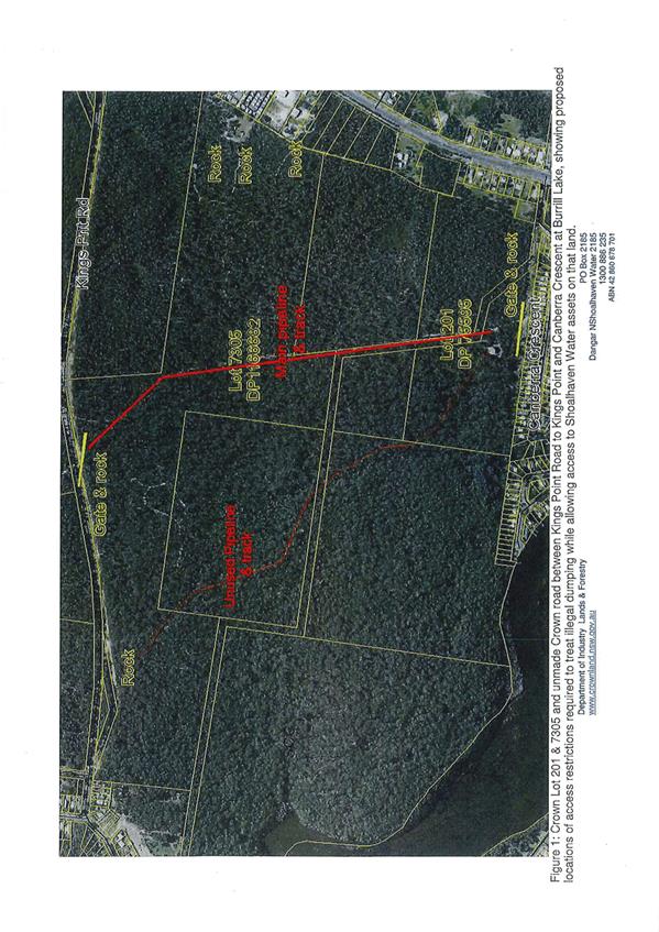
|
|
Development
Committee – Tuesday 14 November 2017
Page
181
|
|
|
Development
Committee – Tuesday 14 November 2017
Page
183
|
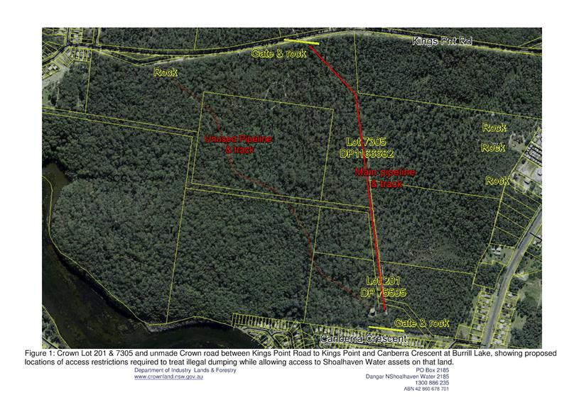
|
|
Development
Committee – Tuesday 14 November 2017
Page
184
|
Local Government Amendment (governance &
planning) act 2016
Chapter
3, Section 8A Guiding principles for councils
(1)
Exercise of functions
generally
The
following general principles apply to the exercise of functions by councils:
(a) Councils should provide strong
and effective representation, leadership, planning and decision-making.
(b) Councils should carry out
functions in a way that provides the best possible value for residents and
ratepayers.
(c) Councils should plan
strategically, using the integrated planning and reporting framework, for the
provision of effective and efficient services and regulation to meet the
diverse needs of the local community.
(d) Councils should apply the
integrated planning and reporting framework in carrying out their functions so
as to achieve desired outcomes and continuous improvements.
(e) Councils should work
co-operatively with other councils and the State government to achieve desired
outcomes for the local community.
(f) Councils should manage
lands and other assets so that current and future local community needs can be
met in an affordable way.
(g) Councils should work with
others to secure appropriate services for local community needs.
(h) Councils should act fairly,
ethically and without bias in the interests of the local community.
(i) Councils should be
responsible employers and provide a consultative and supportive working
environment for staff.
(2) Decision-making
The
following principles apply to decision-making by councils (subject to any other
applicable law):
(a) Councils should recognise
diverse local community needs and interests.
(b) Councils should consider social
justice principles.
(c) Councils should consider the
long term and cumulative effects of actions on future generations.
(d) Councils should consider the
principles of ecologically sustainable development.
(e) Council decision-making should
be transparent and decision-makers are to be accountable for decisions and
omissions.
(3) Community participation
Councils
should actively engage with their local communities, through the use of the
integrated planning and reporting framework and other measures.
Chapter
3, Section 8B Principles of sound financial management
The
following principles of sound financial management apply to councils:
(a) Council spending should be responsible and
sustainable, aligning general revenue and expenses.
(b) Councils should invest in responsible and
sustainable infrastructure for the benefit of the local community.
(c) Councils should have effective financial
and asset management, including sound policies and processes for the following:
(i) performance management
and reporting,
(ii) asset maintenance and
enhancement,
(iii) funding decisions,
(iv) risk management practices.
(d) Councils should have regard to achieving
intergenerational equity, including ensuring the following:
(i) policy decisions are made
after considering their financial effects on future generations,
(ii) the
current generation funds the cost of its services
Chapter
3, 8C Integrated planning and reporting principles that apply to councils
The
following principles for strategic planning apply to the development of the
integrated planning and reporting framework by councils:
(a) Councils should identify and prioritise key
local community needs and aspirations and consider regional priorities.
(b) Councils should identify strategic goals to
meet those needs and aspirations.
(c) Councils should develop activities, and
prioritise actions, to work towards the strategic goals.
(d) Councils should ensure that the strategic
goals and activities to work towards them may be achieved within council
resources.
(e) Councils should regularly review and
evaluate progress towards achieving strategic goals.
(f) Councils should maintain an
integrated approach to planning, delivering, monitoring and reporting on
strategic goals.
(g) Councils should collaborate with others to
maximise achievement of strategic goals.
(h) Councils should manage risks to the local
community or area or to the council effectively and proactively.
(i) Councils should make appropriate
evidence-based adaptations to meet changing needs and circumstances.