Development Committee
Meeting Date: Tuesday,
10 October, 2017
Location: Council
Chambers, City Administrative Building, Bridge Road, Nowra
Time:
5.00pm
Membership (Quorum - 5)
Clr Joanna Gash – Chairperson
Clr John Levett – Deputy Chairperson
All Councillors
General Manager or nominee
Please note: Council’s Code of Meeting Practice
permits the electronic recording and broadcast of the proceedings of meetings
of the Council which are open to the public. Your attendance at this meeting is
taken as consent to the possibility that your image and/or voice may be
recorded and broadcast to the public.
Agenda
1. Apologies / Leave of Absence
2. Confirmation of Minutes
· Development
Committee - 12 September 2017.......................................................... 1
3. Declarations of Interest
4. Mayoral Minute
5. Deputations and Presentations
6. Notices of Motion / Questions on Notice
Nil
7. Reports
DE17.67...... Possible Affordable Housing Opportunity - Coomea
Street, Bomaderry - Initial NSW Government Response.................................................................................. 6
DE17.68...... Proposed Submission - Options Paper: Short Term
Holiday Letting in NSW 15
DE17.69...... Berry Landcare Grant - Berry Wildlife Corridor -
Inclusion on Terrestrial Biodiversity Map - Shoalhaven LEP 2014....................................................................... 31
DE17.70...... Shoalhaven Development Control Plan 2014, Chapter
N19 Huskisson Mixed Use Zones - Draft Amendment Preparation and Proposed Public
Exhibition.... 39
DE17.71...... Update - Nowra Riverfront Precinct - Strategic
Direction and Next Steps . 43
DE17.72...... Shoalhaven DCP 2014 - Required Amendment -
Chapter G4: Tree & Vegetation Management - NSW Government Land Management
& Biodiversity Conservation Reforms ....................................................................................................... 49
DE17.73...... Development Application – proposed 2 lot
subdivision at Lot 4 DP1027849 (no.22) James Farmer Grove, Woollamia................................................................ 55
DE17.74...... DA16/2070 – 7 Beach Street, Huskisson
– Lot B DP 359526 – Proposed Residential Flat Building.................................................................................................. 66
DE17.75...... Yalwal Camping Area (Danjera Dam).......................................................... 86
8. Confidential
Reports
Nil
|

|
Development
Committee – Tuesday 10 October 2017
Page
iii
|
Development Committee
Delegation
THAT pursuant to s377 (1) of the
Local Government Act 1993 the Committee is delegated the functions conferred on
Council by the Environmental Planning & Assessment Act 1979 (EPA Act),
Local Government Act 1993 (LG Act) or any other Act or delegated to Council, as
are specified in the attached Schedule, subject to the following limitations:
i. The
Committee cannot make a decision to make a local environmental plan to classify
or reclassify public land under Division 1 of Part 2 of Chapter 6 of the LG
Act;
ii.
The Committee cannot review a s82A or s96AB EPA
Act determination made by the Council or by the Committee itself;
iii.
The Committee cannot exercise any function delegated
to the Council which by the terms of that delegation cannot be sub-delegated;
iv.
The Committee cannot exercise any function which
s377(1) of the LG Act provides cannot be delegated by Council; and
v.
The Committee cannot exercise a function which
is expressly required by the LG Act or any other Act to be exercised by
resolution of the Council.
Schedule
a. All
functions relating to the preparation, making, and review of local
environmental plans (LEPs) and development control plans (DCPs) under Part 3 of
the EPA Act.
b. All
functions relating to the preparation, making, and review of contributions
plans and the preparation, entry into, and review of voluntary planning
agreements under Part 4 of the EPA Act.
c. The
preparation, adoption, and review of policies and strategies of the Council in
respect of town planning and environmental matters and the variation of such
policies.
d. Determination
of variations to development standards related to development applications
under the EPA Act where the development application involves a development
which seeks to vary a development standard by more than 10% and the application
is accompanied by a request to vary the development standard under clause 4.6 of
Shoalhaven Local Environmental Plan 2014 or an objection to the application of
the development standard under State Environmental Planning Policy No. 1
– Development Standards.
e. Determination
of variations from the acceptable solutions and/or other numerical standards
contained within the DCP or a Council Policy that the General Manager requires
to be determined by the Committee
f. Determination
of development applications that Council requires to be determined by the
Committee on a case by case basis.
g. Review
of determinations of development applications under sections 82A and 96AB of
the EP&A Act that the General Manager requires to be determined by the
Committee.
h. Preparation,
review, and adoption of policies and guidelines in respect of the determination
of development applications by other delegates of the Council.
Minutes of the Development Committee
Meeting Date: Tuesday,
12 September 2017
Location: Council
Chambers, City Administrative Building, Bridge Road, Nowra
Time: 5.00
pm
The following members
were present:
Clr Patricia White -
Chairperson
Clr Joanna Gash
Clr Amanda Findley
Clr John Levett
Clr Nina Cheyne
Clr Annette Alldrick
Clr Kaye Gartner
Clr Mitchell Pakes
Clr Greg Watson
Clr Mark Kitchener
Clr Bob Proudfoot
Mr Russ Pigg - General
Manager
|
Apologies
/ Leave of Absence
|
|
RESOLVED (Clr Gash / Clr Cheyne) MIN17.773
1.
An apology be received from Clr Guile.
2.
That a leave of absence be granted to Clr Wells for the period of
Tuesday 12 September 2017 to Wednesday 20 September 2017 inclusive.
CARRIED
|
|
Confirmation of the Minutes
|
|
RESOLVED (Clr Gash / Clr Cheyne) MIN17.774
That
the Minutes of the Development Committee held on Tuesday 08 August 2017 be
confirmed.
CARRIED
|
Nil
Deputations and Presentations
Ms Di Milne addressed the Committee in relation to DE17.61
Planning Proposal (Rezoning) - Albatross Road & Kinghorne Street, Nowra -
Post Exhibition Consideration and Finalisation.
Mr Lee Carmichael, Lee Carmichael Town Planning, addressed
the Committee in relation to DE17.61 Planning Proposal (Rezoning) - Albatross
Road & Kinghorne Street, Nowra - Post Exhibition Consideration and
Finalisation.
Mr Howard Jones addressed the Committee in relation to
DE17.64 Petition - Crown Land - Shoalhaven Heads - Rezoning Request.
|
Procedural
Motion - Bring Item Forward
|
|
RESOLVED (Clr Pakes / Clr Gash) MIN17.775
That item DE17.64 Petition -
Crown Land - Shoalhaven Heads - Rezoning Request be brought forward for
consideration after DE17.61.
CARRIED
|
Reports
|
DE17.61 Planning
Proposal (Rezoning) - Albatross Road & Kinghorne Street, Nowra -
Post Exhibition Consideration and Finalisation
|
HPERM Ref:
D17/254334
|
|
Recommendation (Item to be determined under
delegated authority)
That Council:
1. Adopt
the Planning Proposal as exhibited with the following addition:
a. To
avoid uncertainty, the width of the part of the site with an 8.5m maximum
building height is 9m, as measured from the southern boundaries of Lot 1 and
Lot 30 DP 25114, and south-eastern and south-western boundaries of Lot 29 DP
25114.
2. Under
Council’s delegation as Relevant Planning Authority, forward the
Planning Proposal to NSW Parliamentary Counsel to draft the amendment to
Shoalhaven Local Environmental Plan 2014 under Section 59(1) of the Environmental
Planning and Assessment Act 1979.
3. Advise
those who made a submission, the Rural Fire Service, proponent and
surrounding landowners of this resolution and again when the LEP Amendment is
notified.
|
|
RESOLVED (Clr Gash / Clr Gartner) MIN17.776
That Council:
1. Adopt
the Planning Proposal as exhibited with the following addition:
a. To
avoid uncertainty, the width of the part of the site with an 8.5m maximum
building height is 9m, as measured from the southern boundaries of Lot 1 and
Lot 30 DP 25114, and south-eastern and south-western boundaries of Lot 29 DP
25114.
2. Under
Council’s delegation as Relevant Planning Authority, forward the
Planning Proposal to NSW Parliamentary Counsel to draft the amendment to
Shoalhaven Local Environmental Plan 2014 under Section 59(1) of the Environmental
Planning and Assessment Act 1979.
3. Advise
those who made a submission, the Rural Fire Service, proponent and
surrounding landowners of this resolution and again when the LEP Amendment is
notified.
For: Clr
White, Clr Gash, Clr Findley, Clr Levett, Clr Cheyne, Clr Alldrick, Clr
Gartner, Clr Pakes, Clr Watson, Clr Kitchener, Clr Proudfoot, Russ Pigg
AGAINST:
Nil
CARRIED
|
|
DE17.64 Petition
- Crown Land - Shoalhaven Heads - Rezoning Request
|
HPERM Ref: D17/265867
|
|
Recommendation (Item to be determined under
delegated authority)
That Council contact the Member
for Kiama, Mr Gareth Ward MP, to obtain his views in regard to the petition
that requests the rezoning of the Crown Land at Shoalhaven Heads to an
appropriate environment protection zone, prior to considering the request
further.
|
|
RESOLVED (Clr Findley / Clr
Proudfoot) MIN17.777
That Council:
1.
Write to the Member for Kiama, Mr Gareth Ward MP providing the
petition and advising that Council supports the intent of the petition.
2.
Requests that the NSW Government undertake the rezoning of the land to
protect the area as an Environmental Protection Zone.
3.
Rezone the land should the NSW Government not undertake the rezoning.
For: Clr
White, Clr Gash, Clr Findley, Clr Levett, Clr Cheyne, Clr Alldrick, Clr
Gartner, Clr Watson, Clr Proudfoot, Russ Pigg
Against: Clr
Pakes and Clr Kitchener
CARRIED
|
|
DE17.62 Planning
Proposal (Rezoning) - Halloran Trust Lands - Progression in Parts
|
HPERM Ref:
D17/254610
|
|
Recommendation (Item to be determined under
delegated authority)
That Council
1. Receive
the initial groundwater investigation report prepared by HGEO consultants for
information (Attachment 1 – under separate cover).
2. Support
splitting the Planning Proposal into two parts to allow the land at Callala
Bay and Kinghorne Point to be progressed ahead of the land at Culburra Beach,
with the mechanism to achieve this to be determined in consultation with NSW
Department of Environment & Planning.
3. Support
any necessary additional Planning Proposals that need to be prepared to
achieve item 2 above.
4. Advise
the proponent, relevant CCB’s, interest groups and those who previously
made submissions of this resolution.
|
|
RESOLVED (Clr Pakes / Clr Gash) MIN17.778
That Council
1. Receive
the initial groundwater investigation report prepared by HGEO consultants for
information (Attachment 1 – under separate cover).
2. Support
splitting the Planning Proposal into two parts to allow the land at Callala
Bay and Kinghorne Point to be progressed ahead of the land at Culburra Beach,
with the mechanism to achieve this to be determined in consultation with NSW
Department of Environment & Planning.
3. Support
any necessary additional Planning Proposals that need to be prepared to
achieve item 2 above.
4. Advise
the proponent, relevant CCB’s, interest groups and those who previously
made submissions of this resolution.
For: Clr
White, Clr Gash, Clr Findley, Clr Cheyne, Clr Alldrick, Clr Gartner, Clr
Pakes, Clr Watson, Clr Kitchener, Clr Proudfoot, Russ Pigg
Against: Clr Levett
CARRIED
|
|
DE17.63 Nowra
CBD Contributions Discount Subsidy Policy - Review
|
HPERM Ref:
D17/260722
|
|
Recommendation (Item to be determined under
delegated authority)
That Council
1. Rescind
the Nowra CBD Contributions Discount Subsidy Policy; and
2. Advise
the Nowra CBD Revitalisation Committee members, Nowra CBD Business Chamber,
and the Shoalhaven Business Chamber of the Development Committee resolution.
|
|
RESOLVED
(Clr Gash / Clr Watson) MIN17.779
That Council defer
consideration of this report and seek feedback from the Nowra CBD
Revitalisation Strategy Committee members, Nowra CBD Business Chamber, and
the Shoalhaven Business Chamber on this matter before making a decision.
For: Clr
White, Clr Gash, Clr Findley, Clr Levett, Clr Cheyne, Clr Alldrick, Clr
Pakes, Clr Gartner, Clr Watson, Clr Proudfoot, Russ Pigg
Against: Clr Kitchener
CARRIED
|
|
DE17.64 Petition
- Crown Land - Shoalhaven Heads - Rezoning Request
|
HPERM Ref: D17/265867
|
|
Item dealt with
earlier/later in the meeting see MIN.777
|
|
DE17.65 Nowra-Bomaderry
Retail Hierarchy Review - Consultants Report - Consideration
|
HPERM Ref:
D17/279940
|
|
Recommendation (Item to be determined under
delegated authority)
That Council
1. Release
the Nowra-Bomaderry Centres – Retail & Centres Planning
Assessment report prepared by David Broyd Consulting Services &
Urbacity for community comment.
2. Consider
a further report on this matter following the community consultation.
|
|
RESOLVED (Clr Proudfoot / Clr
Pakes) MIN17.780
That the Nowra-Bomaderry
Centres – Retail & Centres Planning Assessment report prepared
by David Broyd Consulting Services & Urbacity not go on public exhibition
at this stage until staff have been given the opportunity to report to
Council on its content and implications and that Councillors are briefed on
that report
For: Clr
White, Clr Gash, Clr Findley, Clr Levett, Clr Cheyne, Clr Alldrick, Clr
Gartner, Clr Pakes, Clr Watson, Clr Kitchener, Clr Proudfoot and Russ Pigg
Against: Nil
CARRIED
|
|
DE17.66 Additional
Item - Development Application - Ecotourist Facility - 77C Nerringillah Road,
Bendalong
|
|
RESOLVED (Clr White / Clr
Findley) MIN17.781
That
DA17/1264 – Ecotourist Facility – 77C Nerringillah Road,
Bendalong be called in by Council for determination due to significant public
interest.
For: Clr
White, Clr Gash, Clr Findley, Clr Levett, Clr Cheyne, Clr Alldrick, Clr
Gartner, Clr Pakes, Clr Watson, Clr Kitchener, Clr Proudfoot and Russ Pigg
Against: Nil
CARRIED
|
There being no further
business, the meeting concluded, the time being 6.34
pm.
Clr White
CHAIRPERSON
|

|
Development
Committee – Tuesday 10 October 2017
Page
6
|
DE17.67 Possible
Affordable Housing Opportunity - Coomea Street, Bomaderry - Initial NSW
Government Response
HPERM Ref: D17/285258
Group: Planning
Environment & Development Group
Section: Strategic
Planning
Attachments:
1. Mayoral Minute - Affordable Housing
Opportunity - Bomaderry ⇩
2. Possible
Affordable Housing Opportunity Site - Coomea Street, Bomaderry ⇩
3. NSW
Government Response - Affordable Housing Opportunity ⇩
4. Future
Directions for Social Housing in NSW (under separate cover) ⇨
Purpose / Summary
To advise of the NSW Governments
initial response to the Council resolution in this regard and present potential
options as a result.
|
Recommendation
(Item to be determined under delegated authority)
That Council
1. Acknowledge the advice received from
the NSW Government in this regard;
2. Continue to work on the possible
demonstration affordable housing project at Coomea Street, Bomaderry;
3. Approach the five first phase service
providers under the Social and Affordable Housing Fund (SAHF) to see if they
are interested in being part of the project; and
4. Request the NSW Minister for Social
Housing to consider making a budget bid for additional social and affordable
housing in Shoalhaven and ensure that the NSW Government work with Council on
redeveloping some of their land to a higher and better use to assist in this
regard.
|
Options
1. Continue to move forward and take the
following steps in this regard:
· Acknowledge
the advice received from the NSW Government in this regard;
· Continue
to work on the possible demonstration affordable housing project at Coomea
Street, Bomaderry;
· Approach
the five first phase service providers under the Social and Affordable Housing
Fund (SAHF) to see if they are interested in being part of the project; and
· Request
the NSW Minister for Social Housing to consider making a budget bid for
additional social and affordable housing in Shoalhaven and ensure that the NSW
Government work with Council on redeveloping some of their land to a higher and
better use to assist in this regard.
Implications: This option is recommended, as it
will ensure that Council continues to take positive action to address ongoing
affordable housing concerns in Shoalhaven.
2. Note the advice received from the NSW
Government in this regard and take no further action at this point
Implications: This option is not recommended, as it
is important that the NSW Government collaborate with Council and the community
to ensure there are ongoing affordable housing opportunities in Shoalhaven.
Background
Following consideration of a
Mayoral Minute in this regard (Attachment 1) Council resolved on 22
November 2016 (MIN16.887) that:
The General Manager submit to
the NSW Government for funding consideration the application that was
previously submitted in 2013 by Southern Cross Community Housing and Council
for the Restart NSW – Illawarra Infrastructure Fund. The
application needs to be given to the Premier, Minister for Housing, and any
other Minister who may have a funding source such as Family and Community
Services.
This report summarises that
approach that was subsequently made to the NSW Government, the response that
was received and discusses potential further steps.
Request to NSW Government
As a result of this resolution,
the Mayor forwarded a detailed briefing paper and supporting information to the
NSW Premier and the relevant Ministers.
The briefing paper provided
background on the need for affordable housing in Shoalhaven drawn from the
Affordable Housing Strategy work, summarised the previous 2013 grant
application (for potentially 16 affordable housing units) and indicated the
following advice:
· Underutilised
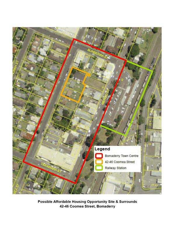
Council land at 42-46 Coomea Street, Bomaderry could be utilised to increase
the supply of affordable housing in Shoalhaven. It was also noted that
additional adjacent land could possibly be added.
· Given
the location, the land is suitable for a financially viable affordable housing
project.
· An
effective way of delivering affordable housing is through the development of
affordable housing on Council land in partnership with community housing
provider such as Southern Cross Community Housing and possibly also the private
sector.
· State
Government funding would assist Council and possible partner organisations to
implement a much-needed affordable housing project.
In conclusion, the paper
requested the following from the NSW Government:
That the 2013 application (to
be updated to current values) for grant funding for this project be
reconsidered by the NSW Government following an evaluation of costings and
partnership arrangements.
The site at 42-46 Coomea Street
and its surrounds is shown on Attachment 2.
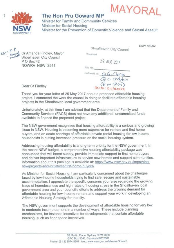
NSW Government Response
The NSW Minister for Social
Housing, Pru Goward MP, responded on behalf of the NSW Government and a copy of
her letter dated 16 August 2017 is provided as Attachment 3. In summary,
this letter advises of the following:
· Commend
work being done by Council to facilitate affordable housing projects in
Shoalhaven.
· Unfortunately,
the NSW Department of Family & Community Services (FACS) does not have any
funding available to finance the proposed project.
· Recognise
that housing affordability is a serious and growing issue and it is putting
increased pressure on social housing.
· Addressing
housing affordability is a long-term priority for the Government and recently
announced as comprehensive housing affordability package.
· Support
the development of affordable housing for very low and moderate-income earners
in various ways including planning mechanisms that provide incentives for
affordable housing.
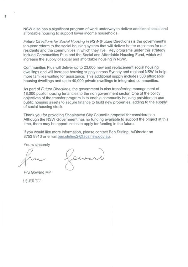
· Also,
have a significant program of works to deliver additional social and affordable
housing to support lower income households.
· The
Governments Future Directions for Social Housing in NSW (Future
Directions) will deliver better outcomes and increase the supply of social and
affordable housing in NSW.
· The
Communities Plus program which is part of Future Directions will deliver
up to 23,000 new and replacement social housing dwellings and increase housing
supply. This additional supply includes 500 affordable dwellings and up to
40,000 private dwellings in integrated communities.
· Management
of 18,000 public housing tenancies will be transferred to the non-government
sector. One of the objectives of this is to enable the assets to be used to
fund the building of new properties, adding to the supply of social housing
The letter concludes with the note
that whilst the NSW Government has no funding to support the project at this
time, there may be future grant opportunities.
The Mayor responded to the
Ministers letter on 28 August 2017 expressing her disappointment at the
response, advised that Council will continue to pursue this project in
association with other groups and noted that hopefully the NSW Government will
possibly reconsider being involved in the project as some point in the future.
Overview – Future
Directions for Social Housing in NSW
Given that the NSW
Government’s Future Directions document (copy provided as Attachment
4) is referred to in the Ministers response, the following overview of it
is provided:
This document was released by
the NSW Government in early 2016 and sets out a vision for social housing over
the next 10 years. This includes reducing homelessness, providing more housing
for those needing social housing and providing additional support to help
transition out of the social housing system. It contains three strategic priorities:
· More
social Housing
· More
opportunities, support and incentives to avoid and or leave social housing
· Better
social housing experience
Future Directions is a
whole of Government approach to transforming the NSW social housing system.
There are a wide range of actions in this document and a number that
specifically relate to affordable housing.
It is noted that one of the
supporting directions that is particularly relevant to this project, is to
“grow affordable housing supply” also Action 2.4 deals specifically
with affordable rental housing as a stepping-stone. The role that affordable
rental housing plays in providing an important stepping-stone for people to
enter the private rental market is recognised. It also plays a role in also accommodating
people who are in housing stress, who would otherwise seek social housing.
Under this action, affordable
housing will be a feature of the Social and Affordable Housing Fund and Land
and Housing Corporation redevelopments.
Under Action 2.5 Collaboration
and accountability, it is interesting to note in this context that the NSW
Department of Planning & Environment will work with FACS to identify
options to work with the other levels of government, including Councils to
increase affordable housing supply possibly using surplus Commonwealth and
local government land.
Sitting under Future
Directions is the Social and Affordable Housing Fund (SAHF), which is
intended to be a new way to deliver social and affordable housing in NSW. This
fund has been set up with $1.1 billion in seed funding investment from the
Government. Money generated as interest on this investment will be applied to
funding SAHF projects. At the end of the projects, the Government will continue
to invest the capital with a view to generating additional returns to further
support social and affordable housing projects.
The first phase of this project
was commenced in March 2017 when the following five service providers were
announced:
· BaptistCare
NSW & ACT
· Compass
Housing Services Co Ltd
· SGCH
Sustainability Ltd
· St
Vincent de Paul Housing
· Uniting
Each service provider will
deliver a package for 25 years involving access to accommodation, asset
management, tenancy management and support services.
Under this first phase up to
2,200 additional social and affordable homes will be delivered in metropolitan
and regional NSW.
Whilst the Ministers response on
this project is somewhat disappointing given was is outlined and suggested in Future
Directions, there could be an opportunity to directly involve one of the
five first phase service providers (some already operate in Shoalhaven)
and an approach should be considered in this regard.
Coomea Street, Bomaderry
– Project Update
As part of adopting the draft
Affordable Housing Strategy for exhibition, Council also resolved on 17 July
2017 to:
· Identify
the Council owned site at 42-46 Coomea Street, Bomaderry as the preferred site
for the short term strategy and investigate potential opportunities for expansion
to include additional land in the precinct;
· Continue
to pursue the possibility of an initial demonstration affordable housing
development at Coomea Street, Bomaderry with the NSW Government, Community
Housing Providers, property industry representatives (e.g. Property Council of
Australia) and relevant community consultative bodies.
Specific material was included
in the draft Affordable Housing Strategy exhibition package in this regard. The
exhibition ended on 29 September 2017. To discuss and advance the possible
demonstration affordable housing project at Coomea Street, Bomaderry a workshop
has been arranged for the 26 October 2016 in association with the Property
Council of Australia’s Illawarra Committee
Whilst the NSW Government may
not currently be able to assist with this project there is still merit in
moving ahead with it to clarify in consultation with the range of interested
parties what could be realised on this site, what delivery mechanisms might
exist and what other alternate funding opportunities exist.
Conclusions
Whilst at this point the NSW
Government has not agreed to assist with the possible affordable housing
project at Bomaderry, it is recommended that the following occur:
· Council
keeps working on the Coomea Street opportunity with other parties.
· Approach
the five first phase service providers under the SAHF to see if they are
interested in being part of the Coomea Street project.
· Request
that the NSW Minister for Social Housing to make a budget bid for additional
social and affordable housing in Shoalhaven and that
the NSW Government work with Council on redeveloping some of their land to a
higher and better use to assist in this regard.
Community Engagement
No specific community engagement
is required at this point. However, depending on the option taken by Council
and the detail that might arise from it, detailed community engagement will be
undertaken at the appropriate point.
Policy Implications
There are no immediate policy
implications arising from this report, given that Council has already
identified the Coomea Street site as the preferred short-term site for a
possible affordable housing development through the Affordable Housing Strategy
work.
Financial Implications
There are no immediate financial
implications in this regard. Should the project proceed, regular updates will
be provided to Council and any financial implications will be detailed in
these.
|

|
Development
Committee – Tuesday 10 October 2017
Page
11
|
|

|
Development
Committee – Tuesday 10 October 2017
Page
12
|
|
|
Development
Committee – Tuesday 10 October 2017
Page
13
|
|
|
Development
Committee – Tuesday 10 October 2017
Page
15
|
DE17.68 Proposed
Submission - Options Paper: Short Term Holiday Letting in NSW
HPERM Ref: D17/306769
Group: Planning
Environment & Development Group
Section: Strategic
Planning
Attachments:
1. Council Report -
Nov 2016 - Short Term Rental Inquiry (under separate cover) ⇨
2. NSW
Government Response - Short Term Rental Inquiry ⇩
3. Options
Paper - Short Term Holiday Letting in NSW (under separate cover) ⇨
4. Report,
August 2017 - Shoalhaven Tourism Advisory Group - Short Term Letting Options
Paper ⇩
Purpose / Summary
Provide an overview of the
Options Paper that has been released for community comment regarding short term
holiday letting in NSW for Council consideration and to enable a submission to
be made.
|
Recommendation (Item to be determined
under delegated authority)
That Council make a submission to
the NSW Government on the Options Paper: Short Term Holiday Letting in NSW
consistent with the content of the report and continue to be involved as
required in any outcomes that eventuates.
|
Options
1. Make a submission based on the content
of this report as recommended.
Implications: This will enable Council to make a
submission, continue to be involved in this key matter and contribute to the
dialogue in this regard. This is particularly relevant given that, depending on
the approach that the NSW Government decides to take, there could be a
significant impact on Council and the tourism economy.
2. Make a submission based on an
alternate approach, for example, that supports a more fully regulated approach
in regard to short term holiday rentals.
Implications: This will still enable Council to
make a submission and be involved, however dependent on the nature of any
alternate approach, the implications are unknown or could be significant for
Council.
3. Receive the report for information.
Implications: This will essentially see Council not
take a position on the Options Paper. This is inconsistent with the previous
involvement that Council has had in this regard.
Background
The NSW Government released an
Options Paper – Short-term Holiday Letting in NSW for community comment
until 31 October 2017. This report provides relevant background, an overview of
the discussion paper and details a proposed submission.
Holiday Homes in
Shoalhaven
Short term holiday
rentals/letting or holiday homes have been a feature of the tourism in
Shoalhaven for a long period. This important form of accommodation makes up a
large part of the overall tourism accommodation supply in the City. It was previously
estimated that there could be in excess of 4,000 holiday homes in the City.
Data from the Tourism Research
Australia’s National Visitor Survey (March 2017) for the three (3) years
ending September 2016 relating to accommodation types used by domestic
overnight visitors indicates that approximately 60% of domestic overnight
visitors to Shoalhaven stayed in what could be termed ‘holiday
homes’. This is broken down as follows compared to Regional NSW and
Coastal NSW:
|
|
Shoalhaven
|
Regional NSW
|
Coastal NSW
|
|
Rented
House/
apartment/Unit
|
17%
|
9%
|
11%
|
|
Own Property
(e.g. holiday house)
|
11%
|
4%
|
5%
|
|
Friend or relatives
property
|
32%
|
40%
|
40%
|
|
Total
|
60%
|
53%
|
56%
|
This data gives an insight into
the key role that this type of accommodation plays in the Shoalhaven tourism
economy. As such, it is important that Council continues to play a role in
research, advocacy and any regulatory changes related to this form of
accommodation.
Current Planning Controls
Court decisions related to cases
in Sydney involving the short term rental of residential apartments deemed that
the practice was a commercial activity and was thus prohibited. Specifically a
decision in 2003 involving Sutherland Shire Council (a unit in a complex at
Cronulla) lead Council to amend its Local Environmental Plan (LEP).
Given the importance of this
issue to Shoalhaven, Council took the step of amending its then Shoalhaven LEP
1985 to enable the practice of the short-term rental of existing residential
dwellings to continue without any legal uncertainty. This was done via an LEP
amendment in 2006 that included a provision that made the short-term rental of
dwellings permissible without consent. At the time, Shoalhaven was understood
to be the only Council to take this step.
As part of the move to the new
Standard LEP Instrument format the intent of the provision was retained and the
current Shoalhaven Local Environmental Plan (LEP) 2014 states that consent is
not required for the short term rental of a dwelling unless there is an impact
on neighbourhood amenity.
The current LEP2014 clause reads
as follows:
Clause
7.13 Short-term rental accommodation
(1) The objective
of this clause is to ensure that residential accommodation may be used as
tourist and visitor accommodation for a short term without requiring
development consent.
(2) Despite any
other provision of this Plan, development consent is not required for the use
of residential accommodation for the purposes of tourist and visitor
accommodation (except backpacker accommodation or bed and breakfast
accommodation) if the use is only short term and does not interfere generally
with the amenity of the neighbourhood in any way, including by noise or traffic
generation.
(3) In this
clause, short-term means for a maximum period of 45 consecutive days in any 12
month period.
Development standards associated
with this clause are provided in Chapter G16 ‘Short Term Rental
Accommodation’ of the Shoalhaven Development Control Plan (DCP) 2014 and
addresses issues particularly relating to the impact on neighbourhood amenity.
This chapter generally only
applies once a development application is required to be lodged, such as
instances where there is an unacceptable impact on the amenity of the
neighbourhood. The DCP Chapter can be viewed on the internet at:
http://dcp2014.shoalhaven.nsw.gov.au/sites/dcp2014.shoalhaven.nsw.gov.au/files/Chapter%20G16.pdf
The key difference between the
original and current LEP provisions is that Council can step in and take action
if warranted against problematic holiday homes or short term rentals.
It is understood that we have
not yet formally used the provision to require development consent in
individual circumstances. However, its general intent has been utilised. For
example, earlier this year Councils Compliance Section wrote to the owners of
some properties in the Vincentia area following concerns being raised about
amenity impacts and drew their attention to requirements of Clause 7.3 of the
LEP.
Emerging platforms
Since Council first amended its
LEP in 2006 to enable the practice to continue without the need for consent,
the landscape has changed considerably with the emergence and growth of on-line
booking platforms and the ‘sharing’ economy. This has seen
platforms such as Airbnb, Stayz etc. play an increasing role in the letting of
holiday homes in Shoalhaven. The use of these platforms has grown in recent years
and is likely to grow into the future.
As an indication of the scale
and growth of these platforms, the following is an indication of the number of
listings in Shoalhaven on two of these platforms:
|
Stayz
|
Airbnb
|
|
2015 Listings
|
2077
|
2016 Listings
|
483
|
|
2016 Listings
|
2127
|
2017 Listings
|
1062
|
Prior to the emergence and
growth of these platforms a large percentage of the holiday homes in Shoalhaven
we mostly let or rented through local real estate agents or directly by
landowners. This ensured that that there was a local presence or someone who
could be directly approached if neighbours or others had issues, for example
noise from the night before. The challenge now is that many of the properties
are rented via the internet and there is no local management presence should
immediate issues need addressing.
Shoalhaven will be part of a
research project being undertaken for the Australian Coastal Councils
Association into appropriate planning responses to the impacts of online short
term holiday rental platforms on coastal communities. The research team will be
headed by Professor Nicole Gurran from the University of Sydney. The key
outputs for this project include:
· A
report for participating councils which identifies appropriate planning
responses, tools and strategies that can be adopted by coastal councils to
address concerns in relation to the impacts of online short-term holiday rental
platforms;
· A
guideline checklist, in a form developed in consultation with participating
councils, which provides a practical framework to assist council’s
decision-making in relation to these issues; and
· Case
studies which illustrate both the range of issues affecting particular
stakeholders in different coastal contexts, as well as the application of
appropriate planning responses to the impacts of on-line short-term holiday
rental platforms on these local communities.
It is envisaged that the
research will be completed in the first half of 2018 and as such could
ultimately help inform Council further in this regard depending on what arises
from the Options Paper.
Shoalhaven Destination
Management Operational Plan
The Shoalhaven Tourism Advisory
Group adopted this plan on 28 August 2017. The plan guides tourism in
Shoalhaven and contains a range of detail that is relevant in this regard.
The plan recognises that a weakness is the high number of
holiday properties, which are difficult to engage, and absent holiday home
owners impacting on neighbourhoods. One of the threats is the potential that
State legislation and cross government responsibilities can prevent some
strategic desirable outcomes e.g. review of short term holiday accommodation
regulation. It is also acknowledges that holiday homes generally not requiring
consent is also a strength.
Holiday Homes - Issues
Council’s submission to the Parliamentary Inquiry (Attachment
1) highlighted a number of issues and matters that are relevant in this
regard including:
· Compliance issues
– pools, fire safety etc.
· Amenity
issues and resolving complaints – noise, car parking, rubbish etc.
· Local
infrastructure impacts – rubbish being dumped in public litter bins etc.
· Taxation
- benefit from funds spent on tourism marketing and resultant growth without
making a contribution.
· Use
of holiday homes and/or adjacent parks and reserves for large functions such as
weddings.
· Competition
with other forms of tourist accommodation – not a level playing field.
· Impact of
‘party houses’.
It has also been suggested that
the prevalence of short term holiday rentals also Impacts on housing
availability and affordability.
Recent History
During 2015/16 the NSW
Parliament (Legislative Assembly Committee on Environment and Planning) carried
out an Inquiry into the Adequacy of the Regulation of Short Term Holiday
Letting in NSW. The terms of reference for this Inquiry were:
That
the Committee inquire into and report on the adequacy of the regulation of
short-term holiday letting in NSW, with particular reference to:
a)
The current situation in NSW and comparison with
other jurisdictions
b)
The differences between traditional
accommodation providers and online platforms
c)
The growth of short-term and online letting, and
the changing character of the market
d)
The economic impacts of short-term letting
on local and the state economies
e)
Regulatory issues posed by short-term letting including customer
safety, land use planning and neighbourhood amenity, and licensing and taxation
f)
Any other related matters.
Detailed information on this
Inquiry can be found at:
https://www.parliament.nsw.gov.au/committees/inquiries/Pages/inquiry-details.aspx?pk=1956
Council made a detailed submission to this Inquiry and was
represented at one of the Inquiry’s Public Hearing. The Council
submission to this Inquiry was reported through Council in November 2015
– see Attachment 1.
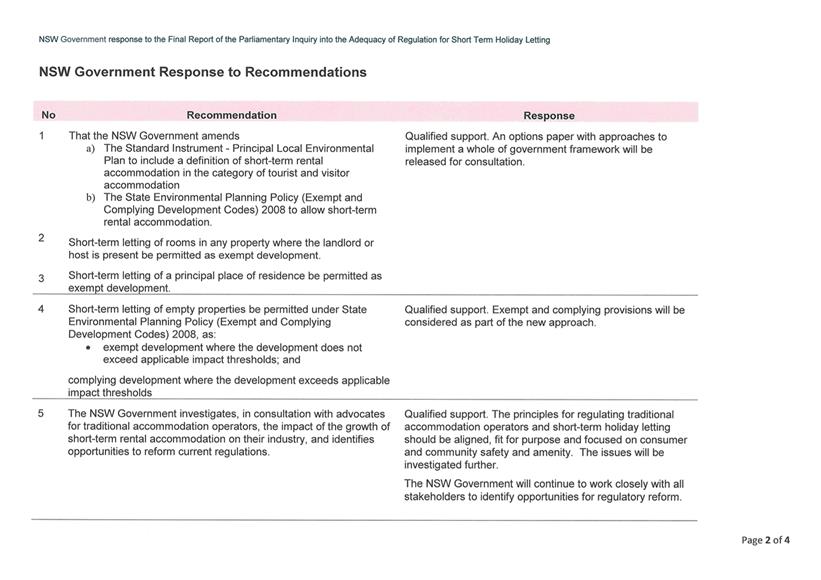
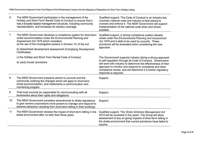
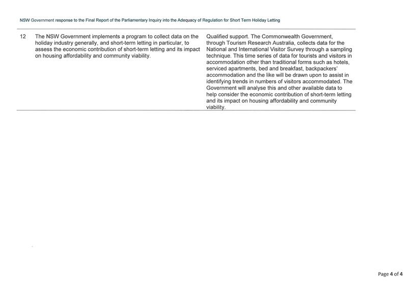
The Inquiry published its report in October 2016 and made
twelve (12) recommendations and seven (7) findings. The NSW Government
responded to the Inquiry findings in April 2017 (see Attachment 2),
supporting three (3) of the twelve (12) recommendations and providing qualified
support for the remainder. It was also flagged that the NSW Government would
release a consultation paper on potential regulatory approaches to short term
holiday letting.
Options Paper - Overview
The NSW Government released an Options Paper –
Short-term Holiday Letting in NSW (see Attachment 3) in July 2017
and the paper is out for community comment until 31 October 2017.
Additional information is also available on the NSW
Department of Planning & Environment (DPE) website at: http://www.planning.nsw.gov.au/STHL
The Discussion Paper notes that
there has been a rapid growth in short term holiday letting (STHL) nationally
and in NSW in recent years due to the emergence of online booking platforms and
the growth of the ‘sharing economy’.
The NSW Government supports putting a regulatory framework
in place for STHL and the Options Paper seeks feedback on the approaches that allow
the economic benefits while managing impacts.
STHL is estimated to be worth $31.3 billion nationally and
NSW constitutes approximately half of the national total, accounting for 25% of
total visitor nights. It is expected that STHL in NSW will continue to increase
its share of visitor night demand over the next ten (10) years.
STHL also generates impacts (noise, waste, parking etc.) on
the community and these often need to be managed. The paper notes that these
impacts vary between regional and metropolitan areas and between detached
dwellings and apartments.
The NSW Government considers that STHL is acceptable in a
residence, however there is a point where it can be considered to be a more
intensive commercial type use. Thus the paper canvasses what level of
regulation best meets the needs of the NSW community.
Building on the work of the Parliamentary Inquiry, the
Discussion Paper presents and discusses a range of options from minimal
intervention to more substantial Government regulation that could help
determine a whole of government framework.
The options presented in the Discussion Paper are summarised
in the following figure and discussed below:
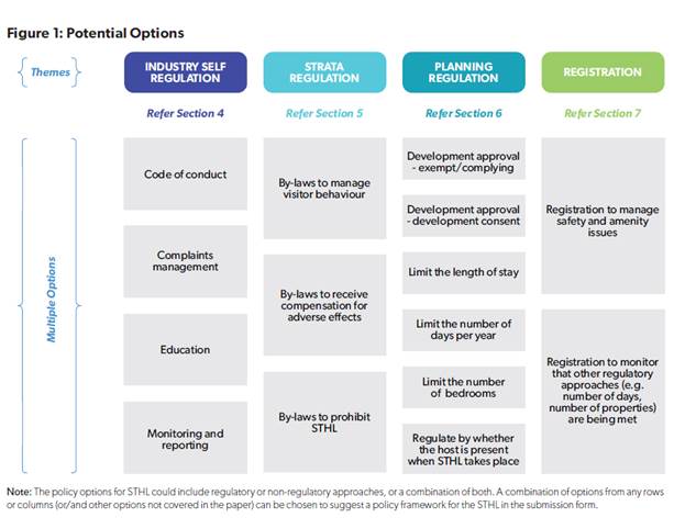
Option 1 - Industry Self-Regulation: The
industry takes greater responsibility for regulating its operation and the
effectiveness of this will influence the ongoing level of government regulation
that is needed. A strong and unified industry body with the ability to
ensure compliance with self-regulation is seen as necessary under this option.
It is noted that most properties operate without incident, and as such a
regulated approach may not be appropriate. For this option to work there would
need to be effective, accountable and transparent self-regulation involving a
Code of Conduct, education, complaint management and monitoring/reporting.
Comment – A Holiday Rental Code of Conduct was
previously launched in 2012 by a number of industry groups and Council
previously distributed a flyer with rates notices promoting the use of the
code. Whilst industry self-regulation is always helpful the take up of the current
Code of Conduct appears to have been limited and the ability to enforce things
through this approach is limited given its optional non-binding nature.
Option 2 - Strata Regulation: Strata
properties have different requirements to detached dwellings, mainly because of
the proximity and number or residents and also the shared responsibility for
common property. The ability to for owner’s corporations to manage use
and behaviours was recommended by the Parliamentary Inquiry. To enable better
management of STHL in this setting, strata laws could be amended to help manage
visitor behaviour or adverse impacts. Another option could be to allow Strata
Schemes to prohibit or restrict STHL within their schemes.
Comment – It is acknowledged that strata situations
are somewhat different to standalone dwellings, given the number of
residents/occupants, their closeness and the shared property element. As such
it may be appropriate for owner’s corporations or bodies to be able to
have a say in limiting or prohibiting STHL in their complex dependent on its
nature, circumstances etc.
Option 3 - Planning Regulation: The
Parliamentary Inquiry recommended this approach, specifically the use of
planning schemes to regulate STHL in a ‘light’ way through exempt
or complying development.
Under this option it is noted that there is currently no
consistent definition for STHL and that the Government considers the use to be
acceptable up to a point that it becomes a more intensive commercial use. The
most appropriate definition for STHL is suggested as: “a dwelling, or
part of a dwelling, that provides short term accommodation, but does not
include tourist and visitor accommodation”. Planning controls, either
through exempt or complying development, or requiring development consent could
be used to manage STHL taking into account length of stay, number of bedrooms,
presence for a host, code of conduct compliance and/or waste management
options.
Some of the detail presented under this option to trigger
types of development approval could include:
Length of Stay – setting the length of stay could be
one way of regulating the use and reducing potential amenity impacts. It is
noted that STHL is important to the economies of regional areas and
consideration should be given to different approaches for urban and regional
areas. Days per stay or days per year, or a combination, could be part of a
regulatory approach.
Number of bedrooms – limiting the number of bedrooms
could reduce the likelihood of large gatherings and the potential for noise,
traffic, parking, ‘party houses’ and the like. However there is
potentially no change to the potential number of occupants just because the use
changes from long term to short term occupancy. The paper also notes the
potential for this option to be unfairly restrictive on large houses, possibly
in regional areas.
Presence of hosts – The Parliamentary Inquiry
recommended that where a landlord or host is present on site that the short
term letting of rooms be exempt development, given that potential impacts are
lower where the principal resident is present on site
Comment – This option is perhaps the closest to the
current provision that Council has in its LEP related to STHL. Councils current
LEP Clause is effectively an “exempt” development type provision,
given that the use generally does not need consent. It does however provide
Council with the opportunity to step in and require development approval where
the use impacts on neighbourhood amenity in any way including noise and traffic
generation.
The current LEP clause also defines “short
term” as a maximum period of 45 consecutive days in any 12 month period.
Actually measuring the length of stay is however difficult to quantify on the
ground and as such this type of provision may not actually add much value.
Restricting use to the number of bedrooms has some merit and would help control
overcrowding or excessive use and stop additional unauthorised sleeping space
being constructed or used within existing dwellings e.g. if a dwelling is approved
at 4 bedrooms (2 double and 2 single) then no more than 6 people should stay.
Option 4 – Registration: Licencing
or registration of STHL’s is another management option. Any scheme would
need to be established and managed by a Government Agency rather than an
industry group. The most likely agency, being NSW Fair Trading, would work with
others to ensure compliance against codes or guidelines.
The Options Paper notes that other jurisdictions have
registration processes for STHL in association with planning requirements. In
Western Australia registration is via local Councils and applicants must submit
floor plans (number/location of sleeping rooms), onsite parking details, name
of manager and contact details and an undertaking that they will respond within
12 hours. No guest is also allowed to stay for more than 3 months in any 12
month period.
The Options Paper notes that this option could provide
greater information to potential users and help monitor the industry. It could
also address issues not addressed through the planning framework. It could work
in with the planning framework as other current licencing schemes do (e.g.
child care and liquor licensing). Pursuing this option would require the
careful consideration of the broader regulatory costs against the need to
manage negative impacts.
Comment – This option has some potential as it
could require a certain minimum standard or compliance requirements to be met.
It would also potentially enable the properties being used for this practice to
be accurately identified and as such levied to also contribute to tourism
marketing and the like. However, as noted in the Options Paper licencing/registration
is closely linked to planning requirements and as such, whilst NSW Fair Trading
may be identified as a potential implementation agency, it is likely that
Council could wear a considerable burden in this regard.
In terms of the next steps, it is indicated that the NSW
Government will consider submissions and decide whether or not to pursue any
regulation of STHL. Should new provisions, such as in State Environmental
Planning Polices (SEPP’s), or other legislative changes be considered
there will be the opportunity for further input.
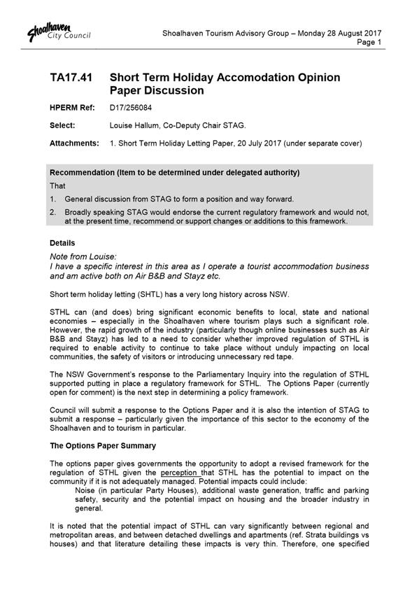
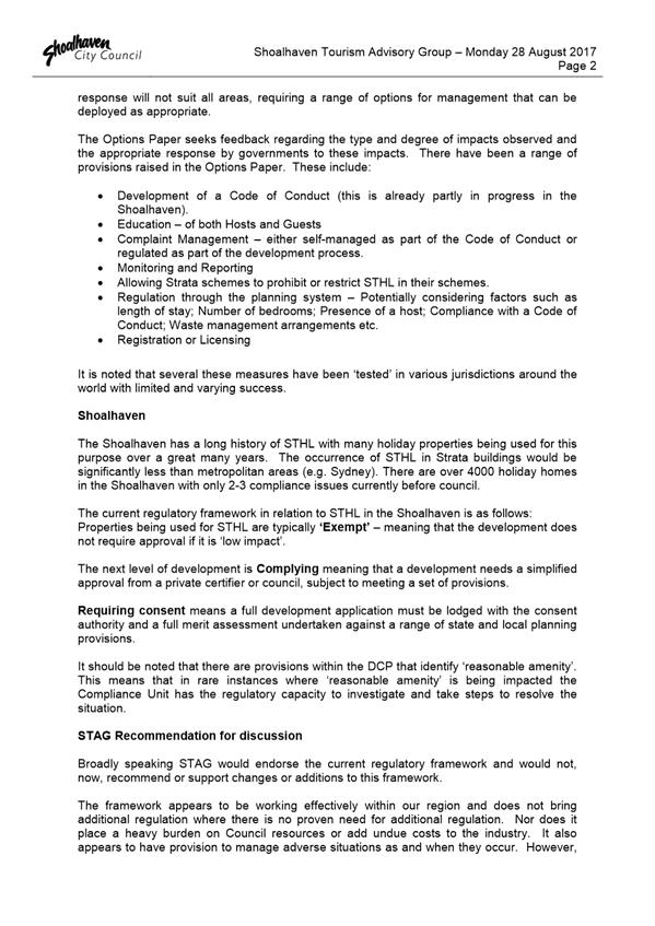
Proposed Submission
The Shoalhaven Tourism Advisory Group considered the Options
Paper on 28 August 2017 and the report (see Attachment 4) was received
for information. The Options Paper was also circulated internally to relevant
Council Groups and limited feedback was received.
The bulk of the properties in the city that are used for
STHL largely create no direct issues and given the important tourism role this
form of accommodation plays, Council has not felt the need or had the appetite
to fully regulate holiday homes or STHL in Shoalhaven. This position does not
appear to have changed, although the need and ability to resolve problematic
properties is acknowledged. The current LEP provision allow Council to step in
where there are properties that are impacting on the amenity of a
neighbourhood.
Thus it is intended that Council provide a submission to the
current Options Paper that is consistent with the content of this report and
the previous submission to the NSW Parliamentary Inquiry (Attachment 1).
Council’s current approach is still favoured as it means that we do not
have the burden of regulating every STHL in the City, but can regulate
problematic properties via a development approval if necessary.
Council’s current approach falls broadly under the
planning regulation option in the Options Paper, specifically the exempt or
complying development approach. It is suggested that a set of rules could be
established that development needs to abide by or be consistent with so as not
to require development approval. This could relate to consistency with the
current approval for the dwelling (limit number of occupants to be consistent
with the number of bedrooms, car parking limited to the number of spaces provided
etc.) or specific requirements such as on site signage to nominate a point of
contact if issues arise. This could ensure that practice continues in a
manageable manner, without Council having to consider approvals for every
single STHL. It is also acknowledged that it may be appropriate for strata
situations to be able to use their own rules to restrict/manage STHL.
To ensure consistency, but also not require one set approach
across the state, the NSW Government should provide a suite of options that
Councils can choose from and utilise. Such as standard LEP provisions for the
different approaches. This will at least ensure that there is consistency
depending on what approach a Council wishes to take based on the nature of
their local area, recognising the distinct differences between the issue in
city and regional areas.
Conclusion
Given the significance of STHL to tourism in Shoalhaven,
Council has had an ongoing and active involvement in this issue and as such it
is recommended that a submission be made that supports our current approach or
one that is similar (essentially “light-touch”) where the vast
majority do not need consent or approval, but problematic ones can be
regulated.
The NSW Government has indicated that following the Options
Paper and the responses to it, they will decide whether or not to pursue any
regulation of STHL.
Community Engagement
The NSW Government currently has
an Options Paper in this regard out for community comment and feedback. It is
also indicated that if they decide to pursue the regulation of STHL then there
will be further opportunities for comment.
Policy Implications
Council’s current
established policy is to not require consent for the use of a dwelling for
short term holiday rental. Depending on the approach taken by the NSW
Government, Council may need to reconsider or adjust this approach in the
future.
Financial Implications
There are currently no direct
financial implications associated with making a submission in this regard.
However, depending on what option or options the NSW Government ultimately
pursue there could be a range of direct and indirect implications on Council,
such as the costs associated with being involved in any licencing or
registration scheme or resource implications created by additional development
applications.
|

|
Development
Committee – Tuesday 10 October 2017
Page
24
|
|
|
Development
Committee – Tuesday 10 October 2017
Page
25
|
|
|
Development
Committee – Tuesday 10 October 2017
Page
28
|

|

|
Development
Committee – Tuesday 10 October 2017
Page
31
|
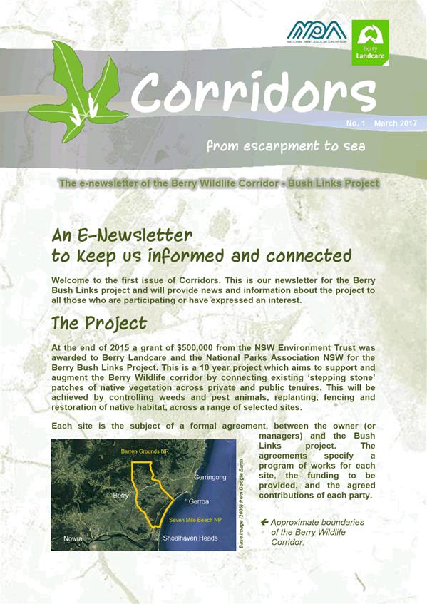
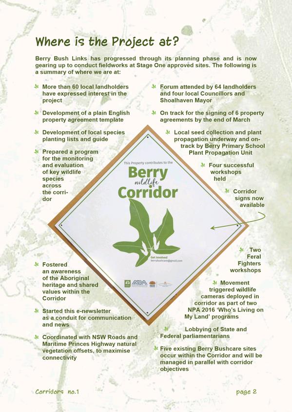
DE17.69 Berry
Landcare Grant - Berry Wildlife Corridor - Inclusion on Terrestrial
Biodiversity Map - Shoalhaven LEP 2014
HPERM Ref: D17/268800
Group: Planning
Environment & Development Group
Section: Strategic
Planning
Attachments:
1. Berry Wildlife
Corridor Newsletter ⇩
Purpose / Summary
To advise Council of the
significant grant received by the Berry Landcare group and the National Parks
Association of NSW received from the NSW Environment Trust to revegetate land
around the Berry area, and their subsequent request to have this land
recognised within Shoalhaven Local Environmental Plan (LEP) 2014.
|
Recommendation
(Item to be determined under delegated authority)
That Council:
1. Support
making ongoing amendments to the Terrestrial Biodiversity Map as part of a
Shoalhaven Local Environmental Plan 2014 housekeeping amendment process,
where landholders in Berry and surrounds have accepted public money for
revegetation and agreed to enter into a conservation agreement over that
land.
2. Write
to the Berry Landcare group to congratulate them on gaining a substantial
grant to improve the biodiversity linkages in the area, and advise them that
this will be reflected in the Shoalhaven Local Environmental Plan 2014
through future amendments.
|
Options
1. Adopt the
recommendation.
Implications:
Revegetation using public grant money will be appropriately recognised and
protected in the LEP. It will be easier for Development Assessment staff
to recognise this as protected vegetation and it will also be transparent to
future owners. There is no other effective mechanism to enable this and
ensure that the public investment is protected.
2. Not amend the
Shoalhaven LEP 2014 Terrestrial Biodiversity Map to include the areas
revegetated using public money.
Implications: If the land
is not identified in the LEP, there will be no indication to future owners that
there are areas of protected vegetation on the land. This would also be
inconsistent with the wish of the landholders for their land to form part of an
east-west vegetation corridor or the grant money that is being spent to improve
biodiversity linkages in the Berry area.
Background
The Berry Landcare group, in partnership with the National
Parks Association of NSW, was awarded a grant of $500,000 by the NSW
Environment Trust for the Berry Bush Links Project. This grant is to be
spent on securing agreements with landholders to revegetate key areas of the
Berry floodplain to improve the linkage between areas of native vegetation on
the coast and the escarpment – the Berry Wildlife Corridor.
The area subject to the grant extends from Seven Mile Beach
National Park and Coomonderry Swamp up to the escarpment at Barren Grounds and
from the Shoalhaven Local Government Area boundary in the north east down to
Coolangatta Road in the south west and Bong Bong Road and Woodhill Mountain
Road in the north west.
It is understood that more than 60 landholders have
expressed an interest in the project. Landholders will receive funding
for weeding, planting, fencing and feral animal control.
More information on this project and a map showing the broad
area of the Berry Wildlife Corridor is provided in Attachment 1.
Any revegetation on private land using public money becomes
classified as ‘protected vegetation’ to protect the public
investment. These areas are then treated the same as areas classified as
‘sensitive regulated land’ under the amended Local Land Services
Act 2013 which triggers the need for an assessment by the Native Vegetation
Panel prior to the removal of any vegetation. Efforts must be made to
minimise the impact of future development on this vegetation.
The Berry Landcare group has approached Council and
requested that land that benefits from the grant money be specifically
identified on the Terrestrial Biodiversity Map that forms part of the
Shoalhaven Local Environmental Plan (LEP) 2014. This would ensure that
future development assessments consider the value of the vegetation as part of
a biodiversity corridor and will also be a flag to potential buyers so that
they are aware of a property’s status.
The Berry Landcare group will provide a list of landholders
who have signed agreements along with a map of the areas to be included in the
LEP.
The requested amendment to the LEP is consistent with the
NSW Government’s new land management and biodiversity reforms and can be
done as part of the ongoing housekeeping amendment to Shoalhaven LEP 2014 as
information is provided on landowner agreements.
It was noted in the minutes of the Council Bushcare
Representatives Group from 4 September 2017 that:
The Council Bushcare Representative Group support the
inclusion in biodiversity overlay for work completed, as part of the Berry
Corridor in the LEP.
Community Engagement
Should Council support the inclusion of relevant land on the
Terrestrial Biodiversity Map in the Shoalhaven LEP 2014, this will occur via
future housekeeping amendments to the LEP as information is
provided.
As with any proposed amendment to an LEP via the Planning
Proposal process, the proposed adjustments will be subject to State Government
approval through the Gateway determination. The Gateway determination
will specify a minimum public exhibition period and will specify any government
agencies who should be consulted.
Any directly affected landowners will also be advised of the
exhibition arrangements in writing when that point is reached. Although it is
also assumed that will also be aware of this matter, as they have signed
funding agreements specific to their property.
Policy Implications
Adopting the recommendation would result in future amendments
to the Shoalhaven LEP 2014. This will map the land as ‘Biodiversity
– habitat’ and also ‘Excluded Land’ to ensure that
complying development under the State Environmental Planning Policy (Exempt and
Complying Development Codes) 2008 cannot be undertaken on this land.
Financial Implications
Any
amendment to the LEP will be resourced within the existing Strategic Planning
budget.
Risk Implications
If the land is not identified on the Shoalhaven LEP 2014
Terrestrial Biodiversity Map, there will potentially be no indication in the
LEP to future owners that there are areas of protected vegetation on the
land.
If Council does not proceed to include relevant land in the
LEP this will be inconsistent with the wish of the landholders for their land
to form part of an east-west vegetation corridor or the grant money that is
being spent to improve biodiversity linkages in the Berry area.
|
|
Development
Committee – Tuesday 10 October 2017
Page
34
|


|

|
Development
Committee – Tuesday 10 October 2017
Page
39
|
DE17.70 Shoalhaven
Development Control Plan 2014, Chapter N19 Huskisson Mixed Use Zones - Draft
Amendment Preparation and Proposed Public Exhibition
HPERM Ref: D17/216331
Group: Planning
Environment & Development Group
Section: Strategic
Planning
Attachments:
1. Draft DCP
Amendment - Chapter N19 Huskisson Mixed Use Zones (under separate cover) ⇨
Purpose / Summary
To obtain endorsement for the
preparation and public exhibition of Draft Chapter N19 Huskisson Mixed Use
Zones (draft Amendment), Shoalhaven Development Control Plan (DCP) 2014 to:
· Include
adopted changes from the rescinded DCP No. 99 Huskisson Foreshore Business
Development Zones 3(g) Amendment No 2, which were inadvertently omitted during
the conversion to the new Citywide DCP.
· Review
and revise the waste and traffic management related controls that apply to the
laneways in Precincts 1, 2, 3 and 4.
· Improve
the overall legibility of the DCP Chapter.
|
Recommendation
(Item to be determined under delegated authority)
That Council:
1. Prepare
and publicly exhibit Draft Chapter N19 Huskisson Mixed Use Zones of
Shoalhaven Development Control Plan 2014 for a minimum period of 28 days in
accordance with the Environmental Planning & Assessment Act 1979.
2. Advise
the relevant Community Consultative Body (Huskisson Woollamia Community
Voice) of the public exhibition.
3. Report
the outcomes of the public exhibition period to Council when appropriate.
|
Options
1. Adopt the
recommendation.
Implications: This will enable the intent of a
previous Council resolution to be enacted, which sought to consider submissions
received during the exhibition of Shoalhaven DCP 2014, relating to Area
Specific Chapters.
The draft Amendment will incorporate controls previously
adopted by Council and made effective by the previous DCP No. 99 Amendment No.
2, which addressed issues relating to traffic management and waste collection
of the Huskisson Laneways, specifically Kent Lane, Winnima Lane and Unnamed
Lane.
In addition, the draft Amendment will delete duplicate or
contradictory controls, address additional concerns raised by Council’s
Development Services, Traffic Unit and Waste Services Section, and simplify the
wording of existing controls relating to the three laneways.
2. Adopt an
alternative recommendation or defer the public exhibition of the draft
Amendment to enable further changes to the DCP.
Implications: Dependent on the changes requested,
this may delay the adopted controls from DCP No. 99 being inserted as
previously intended into Chapter N19. This may result in waste collection and
traffic management issues for new development in the area.
3. Not support the
recommendation to include the adopted changes from previous DCP No. 99 process.
Implications: DCP No. 99 was rescinded as a result
of Shoalhaven DCP 2014 coming into effect. Given that the adopted changes
to DCP No. 99 were carried over, the missing controls have no effect on any new
development in Kent Lane, Winnima Lane and he Unnamed Lane.
Issues with respect to waste collection and traffic
management cannot be appropriately mitigated or managed with the existing
controls in Chapter N19 and as such may result in adverse impacts to existing
and proposed development and the street network should this not be addressed.
Background
Following the notification of Shoalhaven Local Environmental
Plan (LEP) 2014 in April 2014, Council had six months to make its single
Citywide DCP effective. This task involved reviewing and consolidating
over 100 DCP’s into the single plan. Due to the limited time
available to undertake this involved task, a number of DCP’s were unable
to be fully reviewed and amended as necessary. Housekeeping amendments to
the DCP are continuing to take place to address issues as a result of this
process and other issues that have arisen since its adoption.
In adopting the Shoalhaven DCP on 9 October 2014, the
Special Development Committee also resolved the following (Part MIN14.728(a)):
That
Council:
a) Consider
the submissions received during the exhibition of the draft Shoalhaven DCP 2014
relating to Part 2 Area Specific Chapters and the individual preferred
options/changes to the draft Shoalhaven DCP 2014 as set out in the sections of
this report via the successive recommendations.
Part a) of the above resolution sought to make changes to
the Area Specific Chapters based on the successive recommendations addressing
submissions received during the public exhibition of the draft Citywide DCP.
The report to the Special Development Committee summarised a submission with
respect to the Huskisson Mixed Use Zones precinct as follows:
“DCP 99 Huskisson Foreshore Business Development
Zone 3(g), Duncan, Bowen, Fegan and Nowra Streets has recently been amended in
2012 and 2014. Ensure the amendments have been included in Chapter N19.”
The corresponding resolution was to (MIN14.728 N19c):
“Ensure that the content of the 2012 and 2014
amendments to DCP No. 99 are included in Chapter N19.”
This draft Amendment essentially seeks to enact this
resolution.
Draft Chapter N19 Huskisson Mixed Use Zones
The draft Amendments address important issues relating to
waste collection and traffic management within Kent Lane, Winnima Lane and the
Unnamed Lane at Huskisson. Other minor housekeeping amendments have been made
with respect to Murdoch Street to ensure a consistent approach between the four
precincts, improving the legibility of the chapter through use of simplified
and clearer language and figures.
The draft Amendments are summarised with relevant
justifications in the table of changes at the beginning of the draft Chapter
(see Attachment 1). The draft Amendments throughout the document are
highlighted in green, yellow and blue to indicate whether they are:
· Green - Existing
controls to be reworded and/or relocated, or
· Yellow –
Existing controls to be deleted, or
· Blue – New
controls or additional advisory text to be inserted.
Generally, the changes seek to incorporate the missing
controls adopted through DCP No. 99 Amendment No 2, utilise consistent wording
(i.e. waste collection, not services), delete duplicated or contradictory
controls, address additional recent concerns raised by Councils Traffic Unit
and Waste Services Section, minimise conflict between pedestrians and vehicles,
and simplify the wording of existing controls relating to the three laneways.
In preparing the draft Amendment, relevant Sections of
Council were consulted including Development Services, Waste and Traffic.
The issues they raised generally relate to the location of waste collection
services in the subject laneways, consistent use of references, improving
legibility of locational figures, structures and landscaping adjacent to laneways
and traffic management.
Some issues had already been included and addressed as part
of the draft Amendment, other issues raised were addressed through further
revisions to controls where considered appropriate. Where issues raised
were outside the scope of this draft Amendment, they have been noted and will
be considered as part of a future broader Amendment to this DCP Chapter.
It is also noted that as part of the post-exhibition review, LEP and DCP
dictionary terms will need to be highlighted in this Chapter.
Proceeding to exhibit the draft Amendment to Chapter N19
will enable Council staff to action the two minutes referred to above.
Community Engagement
The draft Amendment will be
publicly exhibited for a minimum period of 28 days in accordance requirements
of the Environmental Planning & Assessment Act 1979.
Policy Implications
The draft Amendment proposes
changes to Chapter N19 of the Shoalhaven DCP 2014. The proposed
amendments relate to an adopted position of Council from 2014 and additional
matters to address concerns from Council’s Waste Services and Traffic
Unit.
Financial Implications
The draft Amendment is to be
undertaken within the existing Strategic Planning budget.
Risk Implications
If the draft Amendment does not progress, there is a risk
that any future development adjacent to Kent Lane, Winnima Lane or the Unnamed
Lane will not provide sufficient space to allow for waste collection to be
provided, or for waste collection trucks to safely manoeuvre in and out of the
laneways. Including clear controls in the DCP will help provide clarify for
future development applications.
The current laneway arrangement of narrow widths and limited
kerb side access may restrict waste collection truck access to the laneways or
ability to exit the laneway in a forward direction. This is a particular
issue during holiday periods.
The proposed amendments to Chapter N19 are intended to
mitigate against these risk implications.
|
|
Development
Committee – Tuesday 10 October 2017
Page
43
|
DE17.71 Update
- Nowra Riverfront Precinct - Strategic Direction and Next Steps
HPERM Ref: D17/286874
Group: Planning
Environment & Development Group
Section: Strategic
Planning
Attachments:
1. Draft Report -
Nowra Riverfront Strategic Direction: Review & Analysis (under
separate cover) ⇨
Purpose / Summary
To provide an update on the work
completed so far for the Nowra Riverfront Precinct and seek endorsement to
proceed to the next stage and prepare detailed urban design controls.
|
Recommendation
(Item to be determined under delegated authority)
That Council:
1. Receive
this update on the progress of the Nowra Riverfront Precinct planning work
for information; and.
2. Receive
a further report once the draft detailed urban design controls have been
prepared in accordance with the recommended strategic directions, that considers
how to proceed with a potential Planning Proposal for new zones/building
heights and supporting planning controls
|
Options
1. Adopt the
recommendation.
Implications: This will enable Council staff to
enact the previous Council resolution and not be delayed by the release of the
final concept design for the new bridge crossing.
2. Not proceed
further with this project.
Implications: This option is not recommended given
the work that has been undertaken to date on this important precinct and the
expectation that steps will be taken to facilitate its redevelopment.
Background
In 2014, Council initially commissioned Studio GL (consultant)
to undertake work on the overall Nowra CBD Urban Design Development
Controls. At the time, this also included the business zoned land within
the Nowra Riverfront Precinct.
The Riverfront Precinct was however deferred from this
project due to the announcement by the NSW Government that they would pursue a
new bridge crossing to the west (upstream) of the existing bridges. Given that
the impact that this crossing and associated relocation of the intersections at
Pleasant Way and Bridge Road would have on the precinct and properties in it
was unknown.
Council proceeded to adopt the Nowra CBD Urban Design
Development Controls in November 2015 and in making that decision also resolved
to:
Proceed to prepare detailed urban design controls
for the northern Riverfront/Gateway precinct and report back to Council on the
steps required to enable redevelopment of this important precinct.
As a result planning work recommenced on this important
precinct.
Nowra Riverfront Precinct
Various strategic planning work has been undertaken in the
last decade related to the Nowra Riverfront Precinct. The proposed
detailed urban design controls are intended to build on these documents and
move onto the next stage to enable and encourage the positive redevelopment of
this important precinct that activates the riverfront, improves connections
between the riverfront and the CBD and reinforces the gateway to Nowra.
In proceeding with the
Riverfront Precinct work, the precinct area was rationalised and
broadened. A number of current projects, spatial constraints, key
facilities and uses stimulated the broadening of the precinct to include both
sides of the Princes Highway, including:
- Potential
impact of the new bridge crossing and associated realignment of the highway and
intersections at Pleasant Way and Bridge Road;
- Proposed
Shoalhaven Hospital Masterplan;
- Desire
to activate the Riverfront as identified in the Illawarra-Shoalhaven Regional
Plan;
- Opportunity
for increased development close to the CBD and key services to address the need
for a variety of housing stock at different price points and for a range of
home buyers; and
- The
precincts potential as a ‘gateway’ location to shape the character
of Nowra in the future and strengthen the town’s role as the civic, community,
tourism and recreation hub for the Region.
The Riverfront Precinct area is bound by Shoalhaven River to
the north, Hawthorn Avenue to the east, Hyam Street and Graham Street to the
south, and Shoalhaven Street to the west.
The Precinct area is shown graphically in Figure 1
below.
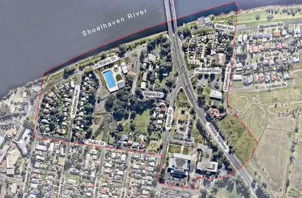
Figure 1 –
Riverfront Precinct Area
The project consultants prepared a strategic analysis of the
precinct that investigated the constraints and opportunities of the area,
including its topography and landform, flood risk, urban structure, land
ownership, access network, and built form and heritage.
The initial work also involved a detailed review of previous
work that has been undertaken including:
- Shoalhaven
Development Control Plan (DCP) 2014, Chapter N7 Nowra Hotel Site and Civic
Precinct (previously DCP No. 119)
- Nowra
Gateway Masterplan (Cox Humphries Moss)
- Nowra
CBD Urban Design Master Plan (ARUP)
- Riverfront
Precinct Master Plan (Elton Consulting)
- Nowra
CBD Heights and Floor Space Ratio (Jackson Teece)
The consultants also reviewed the NSW Roads & Maritime
Services (RMS) information on the preferred bridge option as part of the
analysis.
In addition, the consultants undertook initial consultation
with NSW Government agencies who have an interest in the precinct including NSW
Department of Health, Land & Housing Corporation, Department of Planning
& Environment, and RMS. Initial discussions were also held with landowners
within the precinct. Councillors were also briefed on the initial work in
December 2016.
The purpose of the initial consultation exercises was to
present the ideas that evolved from the strategic analysis and gauge the
response from the various stakeholders. The responses received during the
consultations were generally positive and enabled an identification of the
preferred direction.
The consultants provided the Strategic Direction: Review and
Analysis Report (Attachment 1 to this report) in August 2017 following
the completion of the strategic analysis stage and initial stakeholder
consultation.
While the consultants were finalising their strategic
direction report for the Nowra Riverfront Precinct, the Nowra Sailing Club was
destroyed by fire in June 2017. The report on the Nowra Sailing Club to
Council in June 2017 included the following commentary on this project:
Urban design consultants Studio GL Pty Ltd are currently
assisting Council with this project. Councillors were briefed on the project
and its next steps in December 2016. Most recently targeted consultation has
been undertaken with relevant Government Agencies and also landowners within
the precinct.
The primary objective of the Shoalhaven River front
masterplan is to recognise the opportunities that exist within the Riverfront
precinct, identify planning and design principles and recommend a strategic
direction for the precinct and the areas within it. It is intended that this
Plan will act as a catalyst for future investment and development within the
precinct and could lead to the adjustment of planning controls in the area to
assist.
Opportunities for the Riverfront precinct to also be put
forward as potential location for a future regional ‘city deal’ are
also being considered and investigated to help ensure that the long held desire
to ‘activate’ the precinct can be realised.
As part of this exercise, the physical connection and
relationship with the River generated by the Nowra Sailing Club building has
been identified as an opportunity to take advantage of. Whilst it was
acknowledged that the building had structural issues, the Plan always intended
on building on and fostering the opportunity provided by the existing Nowra
Sailing Club building. Thus, the opportunity for a replacement building or
structure to provide a focus and opportunity in this location is likely to be
something the masterplan will identify.
The Nowra Sailing Club building and surrounds also have
local historical significance.
As noted, this planning work provides an opportunity to
investigate ways in which the legacy of the previous Nowra Sailing Club
building could be honoured or celebrated.
Progress on this project has also been somewhat delayed by
the lack of definitive advice from the NSW Government on the likely design for
the new bridge and its associated intersections.
Strategic Direction: Review and Analysis Report
The report prepared by the consultants identifies a number
of directions to move forward with in regard to the detailed planning of the
precinct and to act as a catalyst for positive development.
The strategic directions are built on five objectives of:
1. Increasing
safety,
2. Enhancing
open space,
3. Improving
connections,
4. Strengthening
the gateway, and
5. Providing
a catalyst for renewal.
These objectives will be achieved through the following
actions and design elements, all of which have their own challenges in being
achieved.
The recommended strategic directions specifically include:
· Seek to build new
roads within the open space area in order to improve connections, enhance access
to open space, increase safety, and act as a catalyst for renewal;
· Explore
the opportunity to negotiate a "land swap" with the owner of the
Riverfront Motel to expand the size of the open space next to the river;
· Poorly
located land should be rezoned and sold to help fund open space improvements;
· Move
car parks away from the waterfront and reallocate areas with views to
riverfront open space;
· In
association with the new bridge crossing, seek to create a more legible urban
structure and showcase key heritage items;
· The
new bridge and gateway intersection should provide an opportunity to improve
wayfinding and pedestrian and bicycle access to the precinct and around the
precinct; and
· Consider
alternative heights in the precinct to encourage growth (additional comment
provided below).
In identifying opportunities within the precinct,
rationalising building heights was considered as one of the key drivers that
could act as a catalyst for positive development and urban renewal in the
precinct.
Potential alternative heights have been identified by the
consultant that build on the precincts strengths, will encourage growth,
achieve an urban edge to the open space and riverfront areas, respect views
across the wider landscape and that also addresses potential constraints.
The alternative heights currently identified by the
consultant range from two to six storeys and are illustrated in Figure 4
below. It should be noted that more work is required in this regard and this
will be part of the next stage of this project.
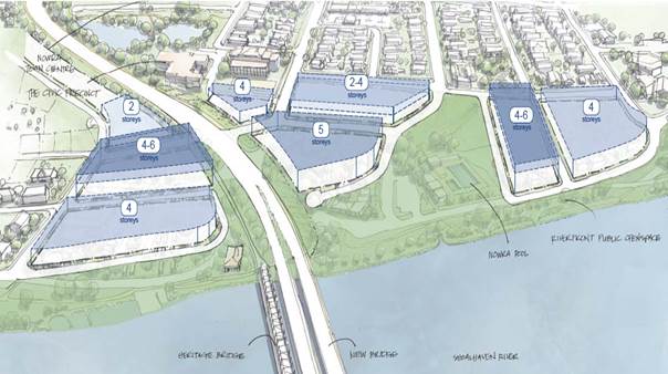
Figure 4 –
Recommended Alternative Heights
The alternative heights that are ultimately recommended by
the consultant will be implemented, when that point is reached, through a
future Planning Proposal (PP) to amend the Height of Buildings development
standard in the LEP that applies to the precinct.
Through the actions and design elements that are described
above, the Nowra Riverfront has the potential to achieve three primary
outcomes:
1. Connect the Nowra CBD to the riverfront
2. Revitalisation of the riverfront
3. An improved open space along the river
As noted in the report to Council in June 2017 it is
intended that this work when completed will act as a catalyst for future
investment and development within the precinct. Opportunities for the
Riverfront precinct to also be put forward as potential location for a future
regional ‘city deal’ will also be considered and investigated to
help ensure that the community’s long held desire to ‘activate’
this precinct can be realised.
Next Steps
The next stage of the Nowra Riverfront Precinct work is to
develop detailed urban design controls in accordance with the November 2015
resolution of Council. This will ultimately potentially lead to adjusted
planning controls in this area to help achieve the desired outcomes. This will
be the subject of future reports to Council as required.
Although there has been no decision on the final concept
design for the new bridge crossing by RMS, it is still recommended that Council
proceed with the next steps in this project to prevent any further
delays.
Community
Engagement
The consultant facilitated three landowner presentations on
18 and 19 May 2017 and the findings of the site analysis and the initial ideas
on how the development of the Riverfront Precinct could proceed. The
concept of increasing height of building development standards, rationalising
the road network to provide a more legible and permeable precinct, potential
land swap arrangements to optimise public open space and riverfront were
discussed with landowners in an open forum.
Additional community engagement will be carried out as this
project proceeds and in ultimately moving to implement the existing Council
resolution, the future detailed urban design controls for the precinct will
require the preparation of a Planning Proposal and DCP Chapter that will be
publically exhibited to enable community comment as required by legislation.
Policy
Implications
In implementing the existing
Council resolution future reports to Council will detail any required DCP
Amendment and possible the possible PP to amend the LEP Amendment as a result.
With respect to the DCP, any adoption of a chapter that applies specifically to
this precinct may also result in the repeal of existing Chapter N9 - Nowra
Hotel Site and Civic Precinct.
Risk Implications
The final concept design for the
Shoalhaven River bridge crossing has not been released by RMS, therefore the
new river crossing has an unidentified impact on land immediately adjacent to
the existing bridges and the southern intersections. Another current
unknown is what will ultimately happen to the existing heritage bridge and
whether it will stay and be utilised for something else or be removed.
|
|
Development
Committee – Tuesday 10 October 2017
Page
49
|
DE17.72 Shoalhaven
DCP 2014 - Required Amendment - Chapter G4: Tree & Vegetation
Management - NSW Government Land Management & Biodiversity Conservation
Reforms
HPERM Ref: D17/308277
Group: Planning
Environment & Development Group
Section: Strategic
Planning
Attachments:
1. Chapter G4 &
Dictionary (under separate cover) ⇨
Purpose / Summary
To advise of the recent changes
to NSW legislation in relation to tree and vegetation management, and detail
required corresponding amendments (draft Amendment No.21) to Chapter G4: Tree
and Vegetation Management of the Shoalhaven Development Control Plan (DCP) 2014
so they can proceed to public exhibition.
|
Recommendation
(Item to be determined under delegated authority)
That Council:
1. Adopt
the draft Amendment 21 to Shoalhaven Development Control Plan 2014 which
includes amendments to Chapter G4 Tree and Vegetation Management and to the
Dictionary (detailed in Attachment 1) and which is consistent with Option 1
in the report; and
2. Exhibit
the draft Amendment for a minimum period or 28 days in accordance with
legislation; and
3. Consider
a further report after public exhibition to consider any submissions received
and to adopt the amendment for finalisation.
|
Options
1. Adopt draft
Amendment No. 21 to Shoalhaven DCP 2014 with the inclusion of Environmental
zones (option is discussed in detail later in the report) and proceed to public
exhibition
Implications: This option will ensure that the DCP
is revised and inconsistencies with the recent commencement of the NSW
legislation associated with the land management and biodiversity conservation
reforms are rectified. The inclusion of Option 1 for Environmental zones
is consistent with the intent of these zones and will allow the impact of any
clearing in these zones to be assessed. The general DCP exemptions e.g. the 45
degree rule, will continue to apply.
This is the preferred option given that Environmental
zoned land has an important conservation and amenity role.
2. Adopt draft
Amendment No.21 to Shoalhaven DCP 2014 with the inclusion of Environmental
zones and a limited number of exemptions (called allowable activities to be
consistent with the Local Land Services Act 2013 (LLS Act)) based on a reduced
number of routine agricultural management activities (RAMA’s) that were
permitted under the repealed Native Vegetation Act 2003 (option is discussed in
detail later in the report) and proceed to public exhibition.
Implications: This option whilst not being
recommended, would still ensure that the DCP is revised and inconsistencies
with the recent commencement of the NSW legislation associated with the land
management and biodiversity conservation reforms are rectified. However
the inclusion of Option 2 for Environmental zones still allows a reduced number
of exemptions (allowable activities) based on the RAMA’s under the now
repealed Native Vegetation Act 2003 (NV Act) that may be considered more
appropriate in the Environmental zones.
This option allows landowners to undertake the clearing
required for more routine farming activities without consent (e.g.
fencing) while requiring assessment of the clearing required for those less
routine types of farming activities (e.g. erection of shearing sheds).
Note: the legislation provides a transitional provision
for clearing that was permissible without consent under the NV Act for 12
months (until 25 August 2018).
3. Adopt draft
Amendment No.21 to Shoalhaven DCP 2014 with the inclusion of Environmental
zones with exemptions (allowable activities) based on the full list of
RAMA’s that were permitted under the now repealed NV Act (option is
discussed in detail later in the report) and proceed to public exhibition.
Implications: This option whilst not being
recommended, would still ensure that the DCP is revised and inconsistencies
with the recent commencement of the NSW legislation associated with the land
management and biodiversity conservation reforms are rectified. However
the inclusion of Option 3 for E zones maintains what could be considered to be
the status quo as it includes additional exemptions (allowable activities) to
cover all the situations where RAMA’s would have applied under the NV
Act. This is a broad list of activities and includes ones where the level of
clearing required would perhaps be better considered under a permit process
e.g. clearing for a shearing or machinery shed, which permits up to 20 metres
of clearing around the structure as well as any clearing required for the footprint
of the structure.
4. Not adopt draft
Amendment No.21 to Shoalhaven DCP 2014.
Implications: This option is not recommended as it
does not address the inconsistencies in the DCP with the recent commencement of
the NSW legislation associated with the land management and biodiversity
conservation reforms.
Background
On 25 August 2017, NSW Government commenced the relevant
legislation to enact their new framework for land management and biodiversity
conservation in the State. A range of legislation commenced, was amended,
or repealed, including the following:
· Biodiversity
Conservation Act 2016 - commenced
· State Environmental
Planning Policy (Vegetation in Non-Rural Areas) 2017 - commenced
· Local Land Services Act
2013 and Regulation – amended
· Standard Instrument
(Local Environmental Plans) Order – amended
· Environmental Planning
and Assessment Act 1979 and Regulation – amended
· National Parks and
Wildlife Act 1974 – amended
· Native Vegetation Act
2003 - repealed
· Threatened Species
Conservation Act 1995 - repealed
Automatic Amendment to Shoalhaven LEP 2014
Any amendment to the Standard Instrument (Local
Environmental Plans) Order automatically results in the subsequent amendment of
any LEP’s based on the Standard Instrument; thus Shoalhaven LEP 2014 was
also amended through this process.
The amendment had the effect of repealing Clause 5.9
Preservation of trees or vegetation. Clause 5.9 set out that Council could
prescribe in a DCP the trees or other vegetation that required development consent
or a permit issued by Council for their removal or pruning.
SEPP (Vegetation in Non-Rural Areas) 2017
The previous LEP Clause 5.9 has been replaced with State
Environmental Planning Policy (Vegetation in Non-Rural Areas) 2017 (the
Vegetation SEPP) which applies to all zones except the Rural Zones RU1 to
RU4. It sets out when a permit from Council is required for the clearing
of vegetation in non-rural areas and requires a DCP to declare the vegetation
to which the SEPP applies.
Consistent with the Vegetation SEPP, the DCP can only apply
to non-rural land that does not exceed the biodiversity offsets scheme
threshold (as per section 7.4 of the Biodiversity Conservation Act 2016
– see table below). Any clearing that exceeds the threshold is
to be assessed by a Native Vegetation Panel.
|
Note: Clearing of vegetation exceeds the biodiversity
offsets scheme threshold if it is:
· the clearing of native vegetation of an area that
exceeds the threshold (see Table below), or
· the clearing of native vegetation is on land mapped
as ‘Sensitive Values’ on the Biodiversity Values Map prepared by
the Office of Environment and Heritage (OEH) and located on their website.
Table:
Threshold by minimum lot sizes
|
Minimum lot size of land
|
Area of clearing
|
|
Less than 1 hectare
|
0.25 hectare or more
|
|
Less than 40 hectares but not less than 1 hectare
|
0.5 hectare or more
|
|
Less than 1,000 hectares but not less than 40
hectares
|
1 hectare or more
|
|
1,000 hectares or more
|
2 hectares or more
|
The
minimum lot size applicable to any land being cleared is as follows:
(a) the minimum lot size
as shown on the Shoalhaven LEP 2014 Lot Size Map, or
(b) if the Lot Size Map does not map a minimum lot
size for the land, the actual size of the allotment of land on which the
proposed development is to be carried out.
|
The new SEPP includes provisions regarding the permit
process, and the functions and approval process of the Native Vegetation Panel
(including the ability to delegate the exercise of its functions to a council).
There is a special transitional provision for existing
allowable NV Act clearing within R5, E2, E3 and E4 zones which gives landowners
12 months from the commencement of the SEPP to continue certain clearing that
was permitted without consent under the NV Act.
DCP Chapter G4: Tree & Vegetation Management.
The SEPP contains a transitional provision so Chapter G4 of
Shoalhaven DCP 2014 is taken to be a DCP for the purposes of the SEPP, however,
there are inconsistencies between the Chapter and the SEPP that need to be
resolved, for example, any requirements in the DCP that relate to Rural Zones
RU1 to RU4 e.g. trees along rural roads, are no longer enforceable under the
new legislation. There is also an issue with Environmental zones which is
discussed in detail below.
Clearing in Environmental zones
The NV Act has been repealed and has been replaced in part
by amendments to the LLS Act. However, these amendments only apply to
land in the RU1 to RU4 zones. Environmental zones were previously covered
by the NV Act, but are not covered the LLS Act. Therefore, any clearing below
the new biodiversity offsets scheme threshold is now not covered by any
restrictions and can be carried out without consent.
Under the previous NV Act, clearing required consent from
State Government unless exempt via a RAMA. Environmental zones were
previously not specifically included in the DCP (except where mapped as a
verified Endangered Ecological Community or other specific situation) as this
would have created a dual consent requirement where an applicant would require
consent from both Council and State Government for the same clearing
There are three potential options to resolve this issue or
omission in the DCP Chapter, as follows:
Option 1 (preferred option)
Add the Environmental zones as land to which the DCP Chapter
applies - means that any clearing under the threshold will require a permit
application to be made to Council. This is consistent with the intent of
these zones to protect, manage and restore areas of ecological, scientific,
cultural and aesthetic value. It will allow the impact of any clearing to be
assessed. The general exemptions in the current DCP (e.g. the 45 degree rule),
will continue to apply.
This is the preferred option given that Environmental zoned
land has an important conservation and amenity role that needs to be
safeguarded. Attachment 1 contains the suggested draft changes to the
DCP.
Option 2
Add the Environmental zones as land to which the DCP Chapter
applies but include a reduced number of exemptions (allowable activities) based
on the RAMA’s under the previous NV Act, but that are more appropriate in
the Environmental zones and more in keeping with the objectives of the zones.
The potential allowable activities and associated clearing are set out in the
table below.
Option 2: Allowable
activities in E zones
|
Allowable activity
|
Maximum amount of clearing permitted
(only to the minimum extent of
clearing necessary for that purpose)
|
|
Permanent boundary fence
|
6 metres either side
|
|
Permanent internal fence
|
6 metres total width of clearing
|
|
Temporary fence
|
3 metres total width of clearing
|
|
Road or track
|
6 metres total width of clearing
|
Option 3
Add the Environmental zones as land to which the DCP Chapter
applies but include additional exemptions (allowable activities) to cover all
the situations where RAMA’s would have applied under the NV Act.
This is quite a broad list of activities, most of which
require consent from Council irrespective. The level of clearing
required would be better considered through the development application process
for the associated structure e.g. clearing for a shearing or machinery shed
which permits up to 20 metres of clearing around the structure as well as any
clearing required for the footprint of the structure. The potential allowable
activities and associated clearing are set out in the table below.
Option
3: Allowable activities in E zones
|
Allowable
activity
|
Maximum
amount of clearing permitted
(only
to the minimum extent of clearing necessary for
that purpose)
|
|
Permanent boundary fence
|
6 metres either side
|
|
Permanent internal fence
|
6 metres total width of clearing
|
|
Temporary fence
|
3 metres total width of clearing
|
|
Road or track
|
6 metres total width of clearing
|
|
Pipeline
|
3 metres total width of clearing
|
|
Shearing or machinery shed
|
20 metres from the outer edge of
the structure
|
|
Ground tank
|
15 metres from the outer edge of
the structure
|
|
Tank (other than a ground tank)
|
3 metres from the outer edge of
the structure
|
|
Dam
|
15 metres from the outer edge of
the structure
|
|
Stockyards
|
20 metres from the outer edge of
the structure
|
|
Bore
|
10 metres from the outer edge of
the structure
|
|
Pump
|
3 metres from the outer edge of
the structure
|
|
Water point
|
3 metres from the outer edge of
the structure
|
|
Windmill
|
10 metres from the outer edge of
the structure
|
DCP Amendment No.21
Draft Amendment No.21 is
intended to update DCP Chapter G4 in response to NSW Government’s land
management and biodiversity conservation reform, remove any inconsistencies,
and ensure that it complies with the Vegetation SEPP. The amendment:
· Aligns
the DCP with the removal of Clause 5.9 Preservation of trees or vegetation
from Shoalhaven LEP 2014 and the introduction of the Vegetation SEPP.
· Includes
Environmental zones in the DCP to control clearing in Environmental zones given
the repeal of the NV Act.
· Amends
the Supporting Maps to remove any mapped rural areas as the Chapter can no
longer apply to land zoned RU1-RU4.
Flow on amendments to the Shoalhaven DCP 2014 Dictionary and
minor changes (typos, formatting, changes for document consistency and
usability etc.) are also included in this amendment.
The draft amended Chapter G4 and Dictionary are included as
Attachment 1. Both the Chapter and the Dictionary include a table
of changes which outline the changes that are being made, with a reason for
each of the changes.
Community Engagement
Should draft Amendment No. 21 be
adopted, it will be placed on public exhibition for a minimum of 28 days to
allow the community to view and comment on the changes.
Any issues raised in submissions
made during this time will be reported to Council for consideration.
Policy Implications
The Vegetation SEPP includes a
savings provision relating to DCP’s which means that a DCP that
prescribed trees and vegetation for the purpose of Clause 5.9 of Shoalhaven LEP
2014 is taken to be a DCP that declares trees and vegetation for the purpose of
the Vegetation SEPP. Therefore, Chapter G4 continues to operate for the
purposes of the Vegetation SEPP, albeit no longer applying to rural
zones.
The Chapter still needs to be
updated to reflect the legislation changes and more importantly to put in place
provisions relating to Environmental zoned land which are now partially unregulated
with the repeal of the NV Act.
Other DCP chapters will also
need to be updated to reflect the changes in legislation including:
· G5:
Threatened Species Impact Assessment
· N20:
Jerberra Estate
These chapters will be included in a future amendment once
Council staff have a better understanding of the operation of the new
legislation.
Financial Implications
This project is being managed within the existing Strategic
Planning Budget using existing staff resources.
Risk Implications
DCP Chapter G4 is now
inconsistent with the new legislation, and is likely to cause confusion and
misinterpretation for Council staff, landowners, and community members,
particularly in relation to:
· Clearing
on rural land which is now solely regulated under the Local Land Services Act
2013 as there is a risk that landowners may rely on the Chapter to undertake
clearing in rural zones.
· Landowners
may inadvertently undertake illegal clearing of land that is mapped on the
Biodiversity Values Map without being aware of its existence given that there
is no reference to the map or associated threshold in the current chapter.
There is also a risk of negative
impacts on the amenity and biodiversity values of Environmental zoned land
given the current situation where landowners can undertake relatively large
amounts of clearing in these zones (up to 5000m2) without the need
for assessment through a permit application.
|
|
Development
Committee – Tuesday 10 October 2017
Page
55
|
DE17.73 Development
Application – proposed 2 lot subdivision at Lot 4 DP1027849 (no.22) James
Farmer Grove, Woollamia
DA. No: SF10551/4
HPERM Ref: D17/99695
Group: Planning
Environment & Development Group
Section: Development
Services
Attachments:
1. Proposed Plan of
Subdivision - SF10551 ⇩
Description of Development: Two (2)
lot subdivision
Owner: M & J Brooks
Applicant: Lee Carmichael Town Planning (LCTP)
Notification Dates: 14 – 28 February
2017
No. of Submissions: Nil
Purpose
/ Reason for consideration by Council
The development application (DA)
proposes a variation to Shoalhaven Development Control Plan 2014 (SDCP 2014),
Chapter G8 Onsite Sewage Management, to permit the provision of pump out
services to a proposed lot to be created via the subdivision of land as
proposed in Development Application SF10551.
Provision of pump out services
to new lots requires Council approval.
The land is mapped as being
within the flood planning area. The land contains land that is high
hazard storage. Council’s SDCP 2014, Chapter G9 states that
subdivision should not create new lots that are in a high hazard area or flood
way in today’s conditions or in the climate change conditions up to the
year 2100.
|
Recommendation
(Item to be determined under delegated authority)
That the request to permit the
provision of effluent pump out services to proposed lot 1 and subdivide the
flood affected land:
1. Be
supported.
2. Refer
the application back to staff for determination.
|
Options
1. Support the
variation to Shoalhaven Development Control Plan 2014 with respect to, pump out
and the subdivision of a flood affected lot:
This will permit the provision of a pump out service to
proposed Lot 1 and subdivision of flood affected land.
Implications: This will enable the completion of the s79C
assessment and determination of the application.
2. Not support the variations
to Shoalhaven Development Control Plan 2014.
Implications: The DA as currently submitted will not be able
to be supported and would therefore be determined by way of refusal under
delegated authority.
3. Adopt an
alternative recommendation and provide direction to staff.
Location Map
The subject land is Lot 4 DP1027849 (no. 22) James Farmer
Grove, Woollamia. The lot also enjoys frontage to Woollamia Road.
The land is part zoned E2 – Environmental Conservation, part RU2 –
Rural Landscape and part RU5 Village under the Shoalhaven Local Environmental
Plan 2014 (SLEP 2014) as illustrated in Figure 1 below.
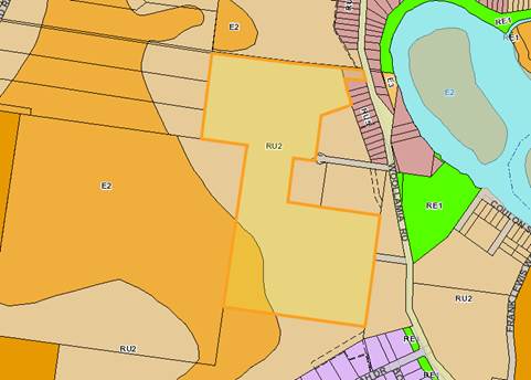
Figure 1 –
Subject Land & Zonings
Extract from
Shoalhaven Local Environmental Plan 2014
Background
History
The subject property was created
via SF7919 and registered on 9/5/2001.
The existing dwelling on
proposed lot 2 was approved via DA05/1325.
Subject Land
The land is located on the
western side of Woollamia Road, at the southern end of the Woollamia
village.
The land is unsewered.
There is an existing dwelling on land zoned RU2 – Rural Landscape, (which
is part of the proposed Lot 2) and has a current Approval to Operate a Sewage
Management Facility. Proposed Lot 1 will be vacant land, zoned RU5 with
direct frontage to Woollamia Road.
Shoalhaven Water has advised
that town sewer will not be available to this site in the immediate
future. That is, not within the next four years.
The land is also flood affected,
bushfire prone and partly within a Sensitive Coastal Location as mapped under
State Environmental Planning Policy No. 71 – Coastal Protection (SEPP71).
The land is also flood
affected. Figure 2 shows the site within the Flood Planning Area.
The RU2 zoned land has recently
been cleared. (The clearing issue has been dealt with by the Compliance
Unit as a separate matter.)
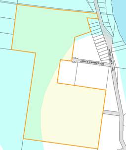
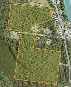
Figure 2 – Flood Planning Area Figure
3 – Aerial Photo
Proposed Development
In summary:
· The
proposal is for a 2 lot subdivision under Clause 4.1E minimum lot size for
certain split zone lots.
· Clause
4.1E enables the subdivision with multiple zones where the rural or
environmental zoned land does not and would not achieve the minimum lot size
requirement.
· Proposed
lot 1 would have an area of 1,419m2, whereas proposed Lot 2 would
have an area of 24.97ha.
· Proposed
lot 1 would be a vacant block of RU5 zoned land.
· Proposed
lot 2 would have the existing dwelling and outbuildings and would contain RU5,
RU2 and E2 zoned land.
· To
ensure compliance with Clause 4.1E, a small area (535m2) of RU5
zoned land must be attached to the proposed Lot 2. This is the hatched
area shown in Figure 4 below.
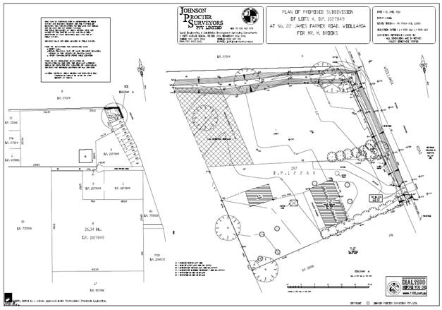
Figure 4 – Proposed Subdivision (Refer also to
separate attachment for greater detail)
Issues
Issue 1 - Shoalhaven Development Control Plan 2014, Chapter
G8 – Onsite Sewage Management
Chapter G8 section 5.3 Effluent
Pump out states:
“New pump out services are not to be provided to
new subdivisions or new rezonings.
Pump out services are not cost effective or efficient
compared to on-site sewage management or reticulated sewerage.
Transportation of effluent by truck (tanker) creates traffic and pollution
issues. In addition the transport of trade waste prevents Council
from entering and implementing good management
practices outlined in Council’s Liquid
Trade waste Discharge to the Sewerage System Policy.”
Council may however choose to
approve pump out services in other or particular circumstances, by way of
example where there are particular environmental attributes, which warrant pump
out to protect the environment
Applicant’s Submission
In
support of the proposal, the applicant stated:
The applicant also states:
The whole of
proposed Lot 1 is low lying and unsuited to on-site effluent disposal.
Proposed Lot 1 has however a residential zone, which creates an expectation
that the land can be used for a residential purpose.
Whilst there are environmental
risks associated with the provision of pump out service to proposed Lot 1, it
is anticipated that reticulated town sewer will be available within five years.
In this regard, pump out may be an appropriate option noting that it is an interim
solution.
Environmental Health Officer Comments
Chapter 8
– On-site Sewage Management states that new pump out services are not to
be provided to new subdivisions. This is due to pump out being less cost
effective and less efficient compared to on-site sewage management or
reticulated sewerage. There are also traffic and pollution issues associated
with transportation of effluent by truck.
In addition,
Council has received complaints from residents regarding pump out systems in
Woollamia during times of flood.
Such
complaints include the truck not being able to access properties due to flood
waters and complaints of effluent leaking from tanks during time of flood and
being present in floodwaters, creating a public health and environmental risk.
The most recent of such complaints was a submission during the release of the
Currambene and Moona Mona Creeks Floodplain Risk Management Study and Plan,
dated April 2016.
The
environmental health comments also mentioned that in addition, the applicant
has claimed that the size of the new proposed lot 1 (1,419 m2) would
not facilitate on-site disposal. A minimum lot size of 2,500 m2 is
listed as an acceptable solution for on-site sewage management. Accordingly, it
was suggested that the applicant could review the proposed lot sizes and have
an on-site wastewater assessment completed by a suitably qualified consultant.
Whilst the
comments provided by the environmental health officer were not supporting it
was acknowledged that:
“Sometimes
pump out may be appropriate where an area is soon to be connected to sewer.
Confirmation of any proposal and timeframe to connect the Woollamia Village
area to reticulated sewer should be received from Council’s Shoalhaven
Water Group.”
Shoalhaven
Water comment
The 2017/18 Capital Expenditure
Budget – Water & Wastewater, notes that in 2018/19 and 2019/20,
Woollamia is programmed to receive pressure sewer services.
However, whilst this is the current planning horizon the
Capital Expenditure Budget may be subject to change should priorities and
funding issues arise.
Summary
· Proposed lot 1 would have insufficient
area for on-site disposal.
· Use
of pump out facilities are likely to be an interim arrangement until such time
as connection to pressure sewer services become available to the Woollamia
Village.
Issue 2 – Flooding
Access
Natural Resources comment:
“The greatest concern for
subdivision development in high hazard flood storage is access, thus why the
Chapter G9 indicates this sort of development being not suitable. However, the
access onto Woollamia Road is not restricted in a 1% AEP flood event (as
demonstrated in Council’s flood information).
Any future dwelling proposal will
need comply with Chapter G9. It is recommended that flood affectation be
indicated in the 88B for awareness to future buyers.
…..For the internal access
taking the assumption that it comes off Woollamia Rd along the southern
boundary, and if assumed that the access is constructed on the ground the
access can be inundated with up to 300mm of water in a 1% AEP flood event.
Checking the water depth-velocity product (pg. 63), the proposal complies with
0.3m2/s requirement. However practically the access would need to be
raised to meet Council’s driveway standards.”
Therefore,
based on the above findings the proposed subdivision can achieve suitable
egress, an important consideration having regard to development in flood
affected locations.
Building
Envelope
The proposal has been assessed
as also containing an adequate building envelope / area, subject to some minor
filling.
Natural
Resources comment:
“The
flood certificate indicates the land being effected by high hazard flood
storage. However not all of the lot is categorised high hazard flood storage.
Part of the property is categorised low hazard flood storage, part of the
property is categorised low hazard flood fringe and part of the property is
above the flood planning level as seen below:
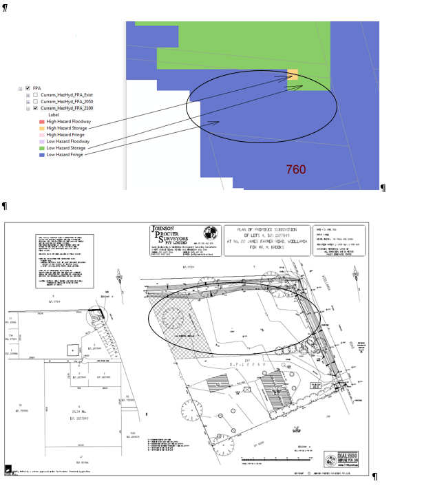
Figure
5 – Diagrammatic representation of flooding /
Comparison
to subdivision plan
Given the above is diagrammatical
representation of the flooding, further checks were made using:
· Figure
L2 of the Floodplain Development Manual 2005 to check hazard categories;
· Survey
provided by the consultant;
· 1%
AEP flood levels (based on 2100 i.e. 2.4mAHD) and velocities from
Council’s Currambene Floodplain Risk Management Study and Plan (2016).
After checking the flood data against
the survey, the above diagrammatical representation can be relied on for this
assessment. Based on this information only a small portion of the site is
effected by high hazard flooding as shown above which is negligible. Therefore,
the site is considered low hazard and subdivision is permissible under Chapter
G9 - Schedule 6 (pg. 60) providing reliable access for pedestrian and emergency
services is provided during a 1% AEP flood event (as per A3.2 page 8).
Based on Chapter G11 A79.3 (pg. 41),
the proposed development does not comply as they (sic) don’t have enough
nominal building envelope above the 1% AEP flood level of 2.4mAHD.
Assessing the survey, a fair section of the building envelope is above 2.2mAHD
and increases as the block slopes to the west. Practically, site regarding
(sic) (filling) will be required prior building construction and this may
result in raising the land which may end up complying with this requirement.
The filling/regrading of the building envelope does not trigger any filling
controls in Chapter G9.
To
conclude, the proposed subdivision developments meets Chapter G9 requirements,
however does not meet the Chapter G11 control A79.3. For Chapter G11 control
A79.3, as explained above the control can be met given site regarding will be
required prior building construction.
Chapter G11
is Subdivision of Land, A79.3 is an acceptable solution which is:
“A79.3 Small scale infill subdivision on flood prone land – For
small scale infill subdivisions a nominal building envelope of
approximately 15m wide and 21m deep, sited in accordance with the requirements
of Chapter G12: Dwelling Houses, Rural Worker’s Dwellings, Additions and
Ancillary Structures be provided above
the 1% flood level on each proposed lot in the
subdivision.”
The
development is capable of achieving the acceptable solution but importantly
with a combination of filling and suitable design the performance criteria can
be met which is:
“Lots have the appropriate area and dimensions for the siting and
construction of a dwelling and ancillary outbuildings, the provision of outdoor space,
convenient vehicle access and parking.”
In support
of the application, a detailed Flood Impact Statement for Proposed Subdivision
was prepared by Rienco. The report concluded as follows:
· “The subject site is located within the Currambene
Creek and Moona Moona Creek catchment. The site is currently developed as a
residential property with rural uses and ranges in height from RL +0.8m AHD to
RL +3.27m AHD.
· Flood levels applicable to the subject site are as follows:
o RL +2.10 m AHD for a 1%
AEP event that occurs today (i.e. 2016).
o RL +4.30m AHD for the PMF event that occurs today (i.e.
2016).
· The Flood Planning Level (FPL) applicable to future
development on the site is RL +2.90m AHD for 2100 climate change scenario.
· The proposed development meets all the requirements of the
Shoalhaven LEP (2014) Clause 7.3.”
Of significance to this
application is that reliable access is achievable on the newly created lot up
to 500mm higher than the current 1% AEP peak flood level and that Woollamia
Road at the frontage of the proposed lot, it is flood free in the 1% AEP event.
Construction of an access point would be required from Woollamia Road to Lot 1.
Planning Assessment
The DA is being assessed under
s79C of the Environmental Planning and Assessment Act 1979.
In the event that pump out
services are not supported or that the subdivision of the lot is not considered
acceptable, the final s79C assessment would not result in a favourable
recommendation.
Policy Implications
Shoalhaven Development Control Plan 2014 (SDCP 2014)
Chapter G8 of the SDCP 2014 does not support the provision of
new pump out services to new subdivisions unless the environmental impacts are
minor or the alternative carries a greater environmental risk.
Chapter G9 of the SDCP 2014 indicates that a subdivision of
High Hazard Flood Storage area is not considered suitable. However, a
detailed report has been submitted and accepted by Council’s technical
staff, noting in particular that reliable access is achievable.
Consultation and Community
Engagement:
The DA was notified in
accordance with Council’s Community Consultation Policy with letters
being sent to property owners within a 100m buffer of the site. The
notification was for a two (2) week period. No submissions were received.
Financial Implications:
In the event that Council
decides to adopt the recommendation, the application will still need to have a
favourable final s79C assessment to enable consent to be issued however the
issue of effluent and flooding will have been resolved.
It is also important to note Council resolved on 19
December, 1995 that:
“If Council
resolves to allow a new effluent pump out
service for a particular circumstance which is not in accordance with policy
then the pump out service be at the full cost of providing the pump out service
and this will be noted on the Section 149 Certificate and Title Deeds.” (Chapter G8 page 13)
If the pump out and subdivision of the flood affected land
is not supported (which would result in an unfavourable assessment), the
applicant could potentially appeal the decision in the Land and Environment
Court. Legal action would have cost implications for Council.
Legal Implications
Should the pump out or subdivision of flood affected land not
be supported and the application ultimately refused, then the applicant may, as
mentioned above, appeal to the Land and Environment Court.
Summary and Conclusion
The residential zoning of
proposed Lot 1 creates an expectation that the land can be used and developed
for residential purposes.
Whilst there are environmental
risks associated with the provision of a pump out service to proposed Lot 1, it
is acknowledged that this would be an interim arrangement noting that
reticulated town sewer is likely to be available within five years. The
lot is unsuitable for alternative forms of effluent disposal. On this
basis, the proposal for pump out services is considered a suitable option in
the circumstances of the case.
Whilst the land is flood
affected, noting that a suitable flood level is considered achievable for a
future dwelling and that reliable access is available to the land, the proposal
is considered capable of support.
|

|
Development
Committee – Tuesday 10 October 2017
Page
64
|
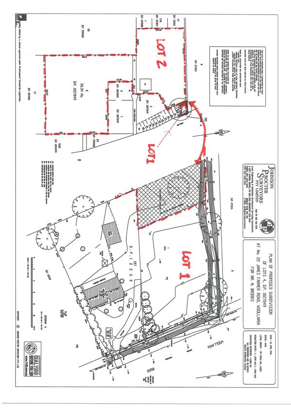
|
|
Development
Committee – Tuesday 10 October 2017
Page
65
|
DE17.74 DA16/2070
– 7 Beach Street, Huskisson – Lot B DP 359526 – Proposed
Residential Flat Building
DA. No: DA16/2070/4
HPERM Ref: D17/253749
Group: Planning
Environment & Development Group
Section: Development
Services
Attachments:
1. Planning Report
- Residential Flat Building (under separate cover) ⇨
2. Appendix
A - Apartment Design Guide Compliance Summary (SEPP 65) (under separate cover) ⇨
3. Excerpt
to Council Response Report - 7 Beach St Huskisson (under separate cover) ⇨
4. Addendum
to SEE - FSR Clause 4.6 Variation - 7 Beach St Huskisson (under separate cover)
⇨
5. Solar
Study (under separate cover) ⇨
6. Draft
Development Consent - Residential Flat Building (under separate cover) ⇨
Description of Development: Demolition of existing
dwelling and ancillary outbuilding, and Construction of a residential flat
building
Owner: JACA Property Group Pty Ltd
Applicant: JACA Property Group Pty Ltd
Notification Dates: 23 September 2016 to 10
October 2016
No. of Submissions: Five (5) in objection
Nil in
support
Purpose
/ Reason for consideration by Council
Councillors called in the
Development Application (DA) due to extensive public interest on 25 October
2016.
The matter was previously
reported to Council on 11 April 2017. At that meeting, Council resolved not to
support the application in its current form and for the DA to be reported back
to the Committee for determination when further analysis was completed.
|
Recommendation
(Item to be determined under delegated authority)
That Development Application DA16/2070
to demolish the existing dwelling and ancillary outbuilding and construct a
residential flat building at Lot B DP 359526, 7 Beach Street, Huskisson be
approved subject to the recommended conditions of consent contained in
Attachment 6 of this report.
|
Options
1. Approve
the development application (DA) in accordance with the recommendation of this
report.
Implications: This would
allow the applicant to pursue construction of the residential flat building.
2. Refuse
the application.
Implications: Council would
need to determine the grounds on which the application is refused, having
regard to section 79C considerations.
3. Alternative
recommendation.
Implications: Council will
need to specify an alternative recommendation and advise staff accordingly.
Figure
1 – Location Map
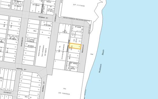
Background
Proposed Development
The DA seeks approval for the demolition of the existing
dwelling and ancillary outbuilding and construction of a five (5) storey
residential flat building (including basement parking), containing twelve (12)
dwelling units:
§ 2 x 2 bedroom and 10 x 3 bedroom apartments; and
§ 22 car spaces, with 2 spaces also provided at ground level
adjacent to Winnima Lane.
Vehicular access is proposed from Winnima Lane only,
effectively providing rear access to the development.
Figure
2 – Landscape Plan
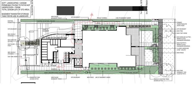
Figure
3 – Section
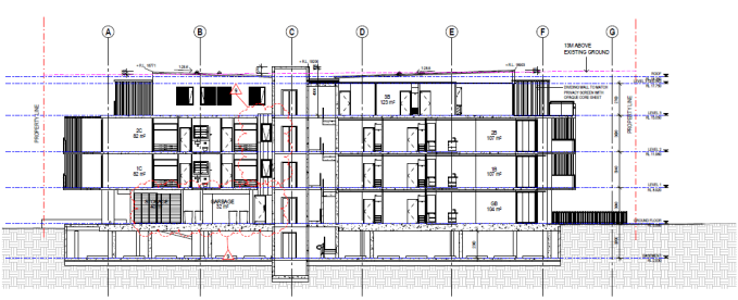
Figure
4 – North and East Elevations
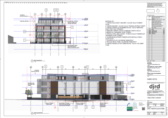
Figure
5 – South and West Elevations
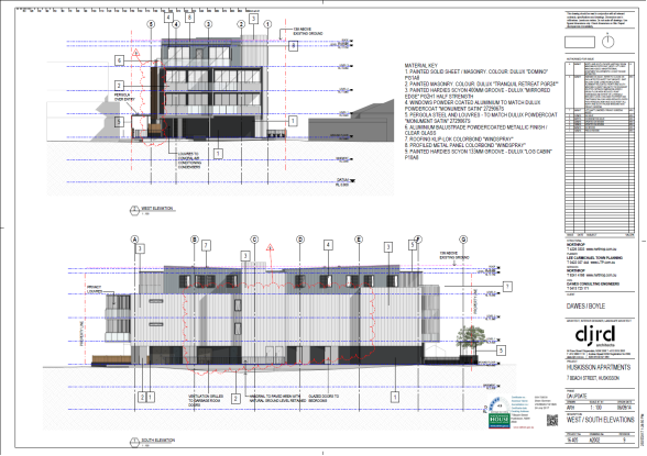
Figure
6 – View from Beach Street
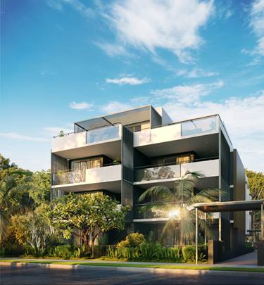
Figure
7 – View from Winnima Lane
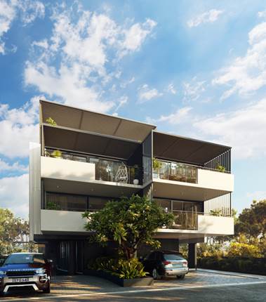
Subject Land
The development site comprises Lot B DP 359526 (7 Beach
Street, Huskisson). Refer to Figure 1.
Site & Context
The development site:
§ Contains an existing two (2) storey dwelling house and
ancillary outbuilding;
§ Is zoned B4 Mixed Use and 1,011.71sqm in area;
§ Is identified as being part bush fire prone land;
§ Has existing access from Beach Street. The rear boundary of
the site adjoins Winnima Lane; and
§ Adjoins land zoned B4 Mixed Use and RE1 Public Recreation,
under the Shoalhaven Local Environmental Plan 2014 (SLEP 2014) as illustrated
in Figure 8.
Figure
8 – Zoning Extract
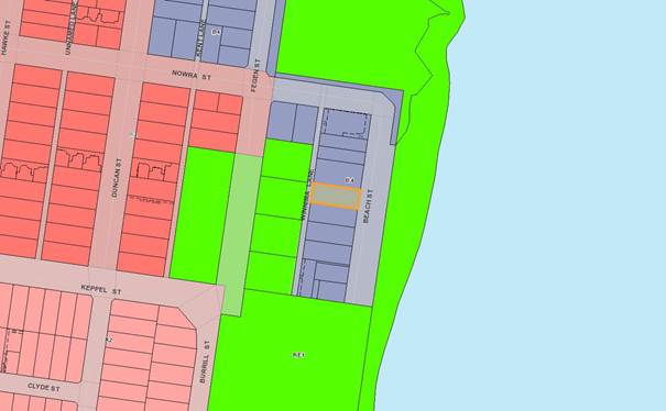
History
The
following provides details on pre-lodgement discussions, post-lodgement actions
and general site history for context:
§ A pre-lodgement meeting was held with planning, building
and engineering staff and the applicant’s planning consultants
(Development Advisory Unit (DAU) Meeting on 19 April 2016).
§ The application was lodged on 8 September 2016.
§ As a result of detailed assessment of the application,
additional information was requested from the applicant on eight (8) occasions
– 19 September 2016, 14 October 2016, 18 October 2016, 15 November 2016,
13 December 2016, 8 March 2017, 22 June 2017 and 20 July 2017.
§ On 20 and 21 December 2016, the applicant submitted
additional information, which was subsequently referred to the relevant
sections of Council for comment.
§ On 8 March 2017, following detailed assessment of the
application and submitted information, additional information was requested in
order to particularly address the provisions of clause 4.6, SLEP 2014 and State
Environmental Planning Policy No 65 – Design Quality of Residential Flat
Development (SEPP 65) and associated Apartment Design Guidelines (ADGs).
§ On 13 March 2017, the applicant submitted a written
response detailing that design modifications are proposed to assist in
addressing privacy and solar impact issues.
§ The application was reported to the Development Committee
Meeting on 11 April 2017, in which Council resolved that:
“1. On
the basis of the information provided to date, Council is not prepared to
support the variations to the SEPP65 guidelines and Council’s DCP2014;
2. Determination
of the application be deferred to further assess the impacts with respect to
solar, privacy and streetscape considerations having regard to future
development on neighbouring sites; and
3. Staff
report the application back to the Committee for determination when the further
analysis is complete.”
§ On 1 June 2017, additional information received from the
applicant in response to the above Council resolution was referred to Studio
Zanardo (an urban design consultancy) in order to undertake a design review of
the proposal.
§ The review was to include the preparation of a compliance
table against relevant provisions of SEPP 65, the Apartment Design Guide (ADG)
and Council’s Chapter N19: Huskisson Mixed Use Zones, Shoalhaven
Development Control Plan 2014 (SDCP 2014) and provide a commentary on design
outcomes.
§ On 22 June 2017, following an urban design review of the
application by Studio Zanardo, additional information was requested of the
applicant to resolve issues under the relevant objectives of the ADG and
Chapter N19, SDCP 2014.
The major issues identified were:
· visual privacy and noise related to;
· building separation; and
· windows to corridors.
§ On 14 July 2017, the applicant submitted a written response
with amended plans addressing Studio Zanardo’s comments.
§ On 20 July 2017, following assessment of the latest
documentation, additional information was again requested in relation to the
extent of storage space in the basement, reconfiguring the arrangement of the
entry holding bay and the BASIX Certificate.
§ On 26 July 2017 and 18 August 2017, the applicant submitted
amended plans and BASIX Certification addressing Council’s request.
Issues
1. State
Government Design Guidelines:
State Environmental Planning Policy No 65 –
Design Quality of Residential Flat Development (SEPP 65) and Apartment Design
Guide (ADG) – Non-compliance with Design criteria (1) of Section 3F
– Visual Privacy.
The required separation distance from habitable rooms and
balconies of the proposed building to side and rear boundaries is 6m and
3m for non-habitable rooms.
The proposed separation at 2.5 – 4m to
the side boundaries is less than required. This results in a numerical
variation of approximately 33-58% for habitable rooms and balconies.
The proposed separation of a minimum 1.8m to the rear
boundary is less than required (Unit 1C, 1D, 2C and 2D). This results in a
maximum variation of 70% for habitable rooms and balconies, though it is
noted that the rear boundary adjoins Winnima Lane.
It is also evident that solar access for neighbouring sites
will be reduced by this proposal, especially given the reduced side boundary
setbacks. The design guidance component of Section 3B – Orientation
suggests that if a proposal significantly reduces the solar access of
neighbours, building separation should be increased beyond the minimums
contained in Section 3F. Consideration also needs to be given to solar and
daylight access to areas (i.e. living areas, private open space etc.) within
the proposed building.
Whilst reduced setbacks and solar access are still in play,
Studio Zanardo commented on the proposal and non-compliance/s; advising that
generally all issues are resolvable and importantly that:
“the proposal is
considered, in many respects, to be of good quality from an urban design
perspective.”
The amended design has addressed the comments made by Studio
Zanardo and these responses (as detailed below in Table 1) are considered
acceptable solutions.
Table
1 – ADG Design Responses
|
Studio Zanardo Comments
|
Response
|
|
Visual Privacy
§ Objective 3F-1
“Consideration
should be given to adjusting the noncompliant habitable windows such that
windows do not face directly towards the boundary. ‘Pop-out’
windows, or similar, can effectively present a solid wall to the boundary for
privacy whilst diverting views to run along the side boundary setbacks towards
more desirable outlooks.”
§ Objective 3F-2
“Consider
introducing privacy louvres, to match those used on balconies, along the
southern side of the entry path. Ensure that the planters in front of the
windows provide a positive outlook from the habitable rooms.”
|
Side windows facing north or south have been redesigned
with splayed walls to face east or west, and not directly towards the
boundary. All splayed walls are a minimum 3m from the boundary.
Privacy louvres have been added to the southern side of
the entry path, with planters in place to provide a positive outlook.
|
|
Bicycle and Car Parking
§ Objective 3J-1
“It
is noted that the number of car spaces provided exceeds the minimum required
under Guide to Traffic Generating Developments (GTTGD) and could be
reduced.”
Note:
Council’s (assessment officers) position in relation to this is that it
supports the numeric provision of spaces; however, the usability of the
on-grade spaces is questioned (see later comments).
§ Objective 3J-2
“No
parking has been provided for motorbikes or scooters. Motorcycle and scooter
parking could be provided in the space at the basement level adjacent to the
car park ramp (A1000).”
§ Objective 3J-3
“A
safe, direct and accessible path has not been provided from the on-grade car
parking spaces to the lobby. This could occur through the space where the
air-conditioning units are currently located and with a small adjustment to
the corner of the hydraulic pump room to allow an adequate path.”
|
No change to the number of parking spaces.
Parking for motorcycles and scooters has been included
in the basement.
A safe, direct and accessible path has been included
from the on-grade car parking spaces to the lobby.
|
|
Solar and Daylight Access
§ Objective 4A-1
“The
sunlight received to living rooms has not been optimised. However, it is
presumed that 3 hours solar access is required outside of the Sydney
Metropolitan Area, Newcastle or Wollongong because of an assumption about
lower density buildings and/or context. The density and built form envisaged
through the controls for this site are equivalent to those in denser areas.
Therefore,
it may be reasonable…that the 2 hours provided in the proposal is a
satisfactory level of amenity. Only 8 of 12 units (67%) of units receive 2
hours direct sunlight between 9am and 3pm in midwinter. Unit GA could be
included by bringing forward the glass line of the living room (A8210). This
would bring the total to 9 of 12 units (75%).”
|
The glass line of Unit GA living room has been brought
forward to increase the solar access. This brings the total to 9 of 12 units (75%)
as recommended by Studio Zanardo.
The orientation and width of the lot affects the design
of the building and limits the opportunities to achieve the 3 hours of solar
access to units.
Studio Zanardo comments:
“…The density and built form envisaged
through controls for this site are equivalent to those in denser areas.
Therefore, it may be reasonable for Council to take the position that the 2
hours provided in the proposal is a satisfactory level of amenity.”
Importantly, the site is within a precinct that is
zoned and planned for higher density development. These lots run east
west and are relatively narrow. Given the controls are for 3 – 4
storey buildings it is highly likely that the design approach adopted for No.
7 will be similarly adopted when the adjoining lots are developed.
Future applications will need to similarly demonstrate compliance with the
objectives to address solar access and also privacy.
The development site is one of several, which in time
will be developed creating an apartment precinct.
|
|
Private Open Space and Balconies
§ Objective 4E-3
“Private open space and
balcony design does not contribute to the overall architectural form. Full
width full height glass balustrades are used for all east-facing balconies
and will not screen clothes drying. It is suggested that a small portion of
the balustrade be made solid (like the west facing balconies), to assist with
visual privacy from the street and conceal the contents of the balcony
including clothes drying. The balustrade in front of the bedrooms may be the
most suitable.”
|
Solid balustrades have been added to a portion of the
east-facing balconies. Example, level 1 and 2 – in front of
bedrooms and part of the living areas on level 3 to provide an area which can
be screened for clothes drying.
|
|
Common Circulation and Spaces
§ Objective 4F-1
“Common circulation
spaces do not receive good amenity. No window providing daylight or natural
ventilation is provided to common circulation spaces on levels 1, 2 and 3. A
window should be provided to each of these corridor spaces by adjusting an
adjacent unit.”
|
A window has been provided to each lobby. The window
will be frosted louvered glass to allow ventilation and maintain boundary
privacy.
|
|
Acoustic Privacy
§ Objective 4H-1
“The siting of
buildings and building layout does not minimise noise transfer. Consideration
should be given to adjusting the noncompliant habitable windows such that
windows do not face directly towards the boundary (see 3F-1). The southern
side of the entry path could include a relatively solid screen to reduce
noise transfer (see also 3F-2). Ensure that the planters in front of the
windows provide a positive outlook from the habitable rooms.”
§ Objective 4H-2
“Noise impacts are not
mitigated within apartments through layout and acoustic treatments. The
southern side of the entry path could include a relatively solid screen to
reduce noise transfer (see also 3F-2). Ensure that the planters in front of
the windows provide a positive outlook from the habitable rooms.”
|
Windows have been modified to face east/west, privacy
louvres have been added to the southern side of the entry path to reduce
noise transfer and landscaping will be implemented to maintain a positive
outlook.
|
|
Roof Design
§ Objective 4N-3
“The roof design does
not incorporate sustainability features. The opportunity exists for skylights
to units 3A and 3B.”
|
Sky domes have been included for units 3A and 3B.
|
|
Universal Design
§ Objective 4Q-1
“Universal design
features are not included in apartment design. 3 units are required to be
silver level universal design. It is suggested that typical unit A or B is
adjusted to meet the requirements. It is also noted that not all spaces for
use in common by the residents are accessible as required by BCA/NCC Table
D3.1, including the storage room, garbage room and the car wash
(A1001).”
|
Units GB, 1B and 2B are all designed in accordance with
requirements of an adaptable dwelling to silver level universal design. This
is demonstrated on drawing A8300.
Access to the storage room, garbage room and the car
wash has been modified to be compliant with BCA/NCC Table D3.1 (in relation
to access for people with disabilities).
|
|
Energy Efficiency
§ Objective 4U-1
“Passive environmental
design through well located, screened outdoor areas have not been provided
for clothes drying It is suggested that a small portion of the balustrade be
made solid (like the west facing balconies), to conceal clothes drying. The
balustrade in front of the bedrooms may be the most suitable (see
4E-3).”
§ Objective 4U-3
“Inadequate natural
ventilation will require mechanical ventilation. Adequate natural ventilation
is not provided to the common circulation spaces on levels 1, 2 and 3. A
window should be provided to each of these corridor spaces by adjusting an adjacent
unit (see 4F-1).”
|
As above (4E-3 and 4F-1).
|
|
Waste Management
§ Objective 4W-1
“Waste storage
facilities do not minimise the impact on the amenity of residents. The waste
and recycling storage area should be ventilated. A temporary storage space
for large bulk items should be provided.”
|
Waste and recycling areas will be mechanically
ventilated. A temporary bulky good storage area has been provided in the
basement below the entry ramp.
|
Another point to note is that the applicant has designed
this proposal in relation to future development on neighbouring sites.
Notably, the existing single dwelling developments on the
neighbouring sites are no longer permissible in the prescribed land use zone
and these developments now rely on existing use rights. The provisions of
Shoalhaven Local Environmental Plan 2014 (SLEP 2014) and Shoalhaven Development
Control Plan 2014 (SDCP 2014) specifically encourage redevelopment of these
sites. In other words, these strategic controls foreshadow a different higher
density residential character.
The applicant has provided a shadow study (Attachment 5)
confirming that a similar development on the property to the south (being Lot A
DP 359526, 9 Beach Street) will be able to receive a minimum of 2 hours direct
sunlight between 9am and 3pm at midwinter to living rooms and private open
spaces of at least 70% of apartments within.
Taking into consideration the above, the design achieves the
desired outcomes of the ADG, particularly in relation to visual privacy and
solar access.
2. Council’s
LEP Controls:
Clause 4.3 (Height of buildings)
The maximum building height is 13m.
Part of the proposed building (lift overrun) exceeds the
maximum height by 574mm, being approximately 4.4%. Other sections of the roof
also make minor encroachments to the height limit – eastern section being
approximately 208mm (1.6%) and western section being approximately 239mm
(1.8%).
The applicant has consequently sought an ‘exception’
to the development standard pursuant to clause 4.6 of SLEP 2014.
The contraventions to the height control are considered
relatively minor and negligible in terms of the overall design of the proposed
building. In particular, the height of the lift overrun does not detract from
the aesthetics of the building and does not affect views, privacy and solar
access to neighbouring sites.
The proposed building height is considered compatible with
the desired future character of the locality, having regard to the strategic
controls (zone, DCP) for the locality.
Clause 4.4 (Floor space ratio)
The maximum floor space ratio requirement is 1.4:1. This
equates to 1,416.4sqm for the subject site.
The
proposed floor space ratio is 1.428:1, being 1,445sqm. It is noted that the
applicant miscalculated the ratio to be 1.427:1, being 1,444sqm. The proposed
building exceeds the maximum floor space ratio by 28.6sqm, being approximately
2.01%.
The applicant has accordingly sought an
‘exception’ to the development standard pursuant to clause 4.6 of
SLEP 2014.
The contravention is relatively minor and negligible in
terms of the overall design of the proposed building. Compliance with the
standard could be achieved by modifying the internal design (i.e. relocation of
storage and garbage collection areas to the basement) however; this would
affect car parking spaces required by SDCP 2014. By including these areas in
the basement, they would not be ‘counted’ as floor space. The
deletion of the bin and service areas at the rear of the development would not
result in a change to the streetscape or overall appearance of the development
unless the development was modified substantially by removing apartments from
the design, which would be necessary to address the resultant car-parking
shortfall.
FSR is intended to assist in controlling bulk and scale of
development. In this instance, the bulk and scale is considered consistent with
the strategic vision for the locality. The strategic vision is a
higher density type of accommodation in a high amenity location.
Clause 4.6 (Exceptions to development standards)
As discussed above, the applicant has sought an
‘exception’ to the development standards in relation to height of
buildings and floor space ratio pursuant to clause 4.6 of SLEP 2014.
Therefore, Council is required to consider subclauses 3 and
4.
(3)
Development consent must not be granted for development that contravenes a
development standard unless the consent authority has considered a written
request from the applicant that seeks to justify the contravention of the
development standard by demonstrating:
(a)
that compliance with the development standard is unreasonable or unnecessary in
the circumstances of the case, and
(b)
that there are sufficient environmental planning grounds to justify
contravening the development standard.
Comment: Satisfied. The applicant provided advice in relation to
this clause, entitled ‘Council Response Report’ (Attachment 3) and
subsequently updated by advice in relation to the contravention to the floor
space ratio (Attachment 4).
(4) Development consent must not
be granted for development that contravenes a development standard unless:
(a)
the consent authority is satisfied that:
(i)
the applicant’s written request has adequately addressed the matters
required to be demonstrated by subclause (3), and
(ii)
the proposed development will be in the public interest because it is
consistent with the objectives of the particular standard and the objectives
for development within the zone in which the development is proposed to be
carried out, and
(b)
the concurrence of the Secretary has been obtained.
Comment: The non-compliances are relatively minor.
The applicant request adequately addresses subclause 3 and the proposal will be
in the public interest as it is consistent with the objectives of the relevant
standards (particularly noting the desired future character of the locality)
and not inconsistent with the objectives of the B4 Mixed Use zone.
In
relation to clause 4.3, the contraventions are minor and negligible in terms of
the overall design of the proposed building and still ensure that the proposed
building is compatible with the height, bulk and scale of the desired future
character of the locality.
In relation to clause 4.4, again the contravention is minor
and negligible in terms of the overall design of the proposed building.
Compliance with the standard would only result in internal design amendments
and would not alter the bulk and scale of the building in relation to the
desired future character of the locality. The reduction of floor space
(28.6sqm) over the whole building to meet the FSR would not result in
substantial changes to the setbacks, bulk, scale or overall appearance.
3. Council’s
DCP Controls – urban design principles for the precinct:
The DCP controls were adopted by Council following extensive
community engagement and with the benefit of expert urban design advice.
A1.2 of Control 5.5 Orientation and Separation,
Chapter N19 Huskisson Mixed Use Zones, SDCP 2014
Chapter N19 requires separation distances, measured between
residential windows facing one another, as follows:
Table 1 – DCP
separation distance requirements and proposed development
|
Separation distance
|
Minimum distance between windows facing one another
|
Minimum distance to boundaries to achieve the minimum
distance between windows
|
Proposed development minimum distance to boundaries
|
|
Between non-habitable rooms, windows (can be measured
diagonally).
|
3m
|
1.5m
|
2.5m
|
|
Between all other windows except primary windows of
living areas/external edge of balconies and terraces.
|
6m
|
3m
|
3m
|
|
Between primary windows of living areas/external edge
of balconies and terraces and all other windows except between primary
windows of living areas/external edge of balconies and terraces.
|
9m
|
4.5m
|
3m
|
|
Between primary windows of living areas/external
living areas and primary windows of living areas/external edge of balconies
and terraces for buildings up to and including four storeys.
|
12m
|
6m
|
3m to balconies – privacy screens
proposed
|
The applicant has designed the proposed building in relation
to separation to windows of future residential flat building development on
neighbouring sites. Separation between windows and future windows on adjoining
sites has been achieved through the provision of privacy louvres on balconies
and windows being orientated so they do not face the adjoining boundary.
The proposed design responses (i.e. reduction in the extent
of balconies and installation of additional privacy screens etc.) are
considered reasonable and consistent with the performance criteria.
Whilst numerical compliance with all the setbacks is not
achieved at present with existing development on
neighbouring sites, the provisions of Chapter N19, SDCP 2014 have been formed
and designed for future development. Future development is
likely to do similarly. The adjoining narrow lots are likely to have a
similar design solution and in this regard, future proposals will need to deal
with setback issues and design solutions to address privacy and solar access eg
stepping, pop-out windows, tiering, etc.
The design, although restricted due to the lot size and
width, is consistent with objectives of the DCP, in that the building
orientation and separation provides the primary source of light, air and
outlook to living room areas and private open space areas. Further, the
acoustic privacy for residents and the visual and acoustic privacy of nearby
residents will be also be protected.
Clause 6A of SEPP 65 confirms (that with respect to the
objectives, design criteria and design guidance set out in Parts 3 and 4 of the
ADG), development control plans cannot be inconsistent with this guide in
respect of the following:
“(a) visual privacy,
(b) solar and daylight access,
(c) common circulation and spaces,
(d) apartment size and layout,
(e) ceiling heights,
(f) private open space and balconies,
(g) natural ventilation,
(h) storage.”
Further, subclause 6A(2) clarifies that:
"if a development control
plan contains provisions that specify requirements, standards or controls in
relation to a matter to which this clause applies, those provisions are of no
effect"
Whilst subclause 6A(3) clarifies that:
"this clause applies
regardless of when the development control plan was made".
The provisions of Chapter N19 (Council’s DCP) in
relation to setbacks are inconsistent with SEPP 65 in that they refer to window
separation. The SEPP refers to building separation. Accordingly, the SEPP
prevails and separation distances should be to the site boundaries (in
accordance with Design Criteria (1) of Section 3F – Visual Privacy) and
not to the windows of future buildings on neighbouring sites.
However, the ADG also states that if the design criteria
cannot be met design responses can be used to achieve the objectives of the
criteria. The objective of the design criteria is that adequate building
separation distances are shared equitably between neighbouring sites to
achieve reasonable levels of external and internal visual privacy. The
design response in this instance has been to modify the window placement and
design to avoid looking directly into the neighbouring site.
It is noted that the SEPP does allow for reduced setbacks
for transitional zones. Arguably, this location or precinct is an area
that is undergoing transition and change as foreshadowed by the DCP with a new
highly urban character.
In summary, the applicant made a number of modifications to
the design in response to the urban design review undertaken by Studio Zanardo
and it is considered that the objectives of the ADG have been achieved through
the provision of privacy louvres on balconies and windows being orientated so
they do not face the adjoining boundary.
A1.2 of Control 7.3 Building Height, Chapter N19, SDCP
2014
The
maximum building form for Precinct 2 is 3 storeys with a 4th level setback.
Studio
Zanardo commented on this:
“The objectives are not achieved as the acceptable
solutions are not met. The building is modulated backwards and forwards from
the front and rear boundaries, however it is not modulated side-to-side
(perspectives). The lack of a fourth level setback at the leading front corners
of the building to Beach Street gives a clear fourth storey reading which
contributes to bulk and scale. The height of the development is not compatible
with the desired future character, which is for the fourth level to be set
back.
The fourth level of the building does not entirely setback
on the north and south facades.”
The
applicant amended the design to address this concern. The front leading corners
of the development have been set back significantly. The fourth level is now
setback along the northern, eastern, southern and western sides. The applicant
considers that the building now ‘appears’ as a 3 storey building
from the east and west. Refer to Figures 6 and 7 in this report.
The amended design achieves a satisfactory design result and
in this regard, the objectives of this control have been achieved. The
objectives are:
· “Ensure development responds to the desired scale and
character of the street within the precinct.
· Provide highly modulated buildings to reduce the bulk and
scale of the buildings.
· Provide
buildings forms that create distinctive and attractive coastal town
streets.”
Notably, the building has been modulated with side windows
on north or south elevations redesigned with splayed walls to face east or
west, and not directly towards the boundary. All splayed walls are a minimum 3m
from the boundary.
Privacy louvres have been added to the southern side of the
entry path, with planters in place to provide a positive outlook.
A1.3 of Control 7.4 Setbacks and Alignments, Chapter
N19, SDCP 2014
Along
Beach and Nowra Streets (except for the commercial component of buildings), a
minimum 60% of the buildings street elevation is to be located on the front
setback line and the remainder located behind the front setback line.
The
design provides 46% of the street elevation on the 5m setback line. The
balance of the development exceeds the setback.
The
applicant considers there will be no adverse impacts and that the objectives
are met, given:
· “the building has been designed to reduce the overall
bulk and increase soft landscaping by reducing the overall footprint. The
frontage has been maximised along the 5m setback line taking into consideration
of design excellence, internal apartment layout and streetscape; and
· the majority of the building façade is setback
between 7m-9m, which is a favourable result in terms of bulk and solar access
to neighbouring properties.”
The
design is considered satisfactory (as referred to under A1.5 below) observing
that there is adequate landscaping, a clear definition of private and public
domains and that it is consistent with the envisaged future character of the
area. The proposal is considered to satisfy the objectives of the control which
are to:
· “Provide building forms that create distinctive,
attractive and pedestrian friendly coastal town streets.
· Allow for deep soil planting areas.
· Define boundary between private and public land, which
contributes positively to the streetscape.
· Establish
a well-proportioned rhythm between buildings consistent with a residential
streetscape.”
A1.5 of Control 7.4 Setbacks and Alignments, Chapter
N19, SDCP 2014
Chapter N19 states that the second level (third storey) of a
building is to have a maximum 70% footprint of the floor below (second storey)
and the third level (fourth storey) is to have a 70% footprint of the floor
below it; and be set back 4m from the level below along the street frontage.
This control effectively results in development being ‘tiered’ with
a smaller footprint for each level as the building increases in height.
Having regard to the height controls in section 7.3 of the
DCP, this control is slightly ambiguous given that the acceptable solution A1.2
in 7.3.2 states that the maximum building form shall be 3 storey’s with a
4th level setback.
The objectives for the controls are intended to assist in
the creation of distinctive built forms, with a positive streetscape
contribution and
“establish a
well-proportioned rhythm between buildings consistent with a residential
streetscape”.
The second and third levels do not achieve a maximum
footprint of 70% of the level below and the levels are not fully compliant
with the 4m setback from the level below. The second level has the same
footprint as the first level. Refer to Figure 3.
The applicant has only applied this provision to the third
level and indicated that this level is 66% of the lower level and contains a
dwelling unit with the building line set back 2m from the level below.
In addition to this control being designed to encourage a
certain design outcome, it reinforces setback controls, which have not been
achieved. (It is noted that detailed analysis and consideration has been given
to solar, privacy and streetscape impacts.)
The applicant has submitted a detailed report in support of
the development. The report addresses various matters including but not limited
to design and how the building is considered to be a satisfactory design
response and refers to proposed amendments.
The
second level (third storey) is 81% of the allowable maximum floor area with no
façade setback and third level (fourth storey) is 66% of the level below
with façade setback. The applicant also considers there will be no
adverse impacts and that the objectives are met, given:
“the proposed development provides a building that
reduces the floor plate from the maximum allowable to increase deep soil
planting and setbacks.”
A comment is made in the report that the design is
consistent with the four (4) storey residential flat building approved at No. 1
Beach Street.
Studio
Zanardo commented on this:
“The objectives are not achieved as the acceptable
solutions are not met. Less than 60% of the street elevation is located on the
front setback, however the built form in this respect is considered to be
acceptable in defining the street (perspectives). The development does not
setback and get smaller as the building gets taller as the controls
indicate.”
The
applicant has made no change to the 5m building line, however, it is appropriate
to consider a departure from this solution, noting the source document Urban
Design Strategy Nowra and Beach Street North Huskisson (prepared by Ruker
Urban Design, dated 29 August 2008) states:
“Maximum building form of 3 storeys with a 4th
level in the roof. The 4th level can have a maximum footprint of
70% of the level below and is to be setback 4m from the level below along
streets.”
This report informed the DCP controls. The DCP
controls however do not reference a 4th floor in a roof design.
With regard to the residential flat building at 1 Beach
Street, it was approved on 19 February 2008, prior to the adoption of DCP 99
– Huskisson Business 3(g) Zone Precincts, Amendment No. 1, which was
adopted on 7 November 2012.
The residential flat building at 2 Murdoch Street was also
approved in 2008 prior to Amendment 1 being adopted. Therefore, neither of
these two developments were assessed using the amended DCP 99 (Chapter N19
DCP2014).
A1.9 of Control 7.5 Car Parking, Vehicle Access and Vehicle
Movement, Chapter N19, SDCP 2014
Basement
garages are to be setback a minimum of 1.5m from the side boundaries but
preferably in line with the building above.
The
proposed basement setback is 1.3m on the southern side and varies from
1.03m-1.7m on the northern side.
The
applicant considers a variation is required “to maximise basement
parking”, there will be no adverse impacts and that the
objectives are met:
“by providing adequate and convenient
parking that minimises visual impact” and “the setback is
offset by exceeding the minimum for the majority of the northern side so the
basement complies with the minimum deep soil requirements.”
The departure is relatively minor and negligible in terms of
the overall design of the proposed building and considered to satisfy the
objectives of this control. The basement design allows for an adequate number
of car parking spaces, does not visually affect either streetscape, integrating
at grade spaces “without compromising street character, landscape
quality or pedestrian amenity and safety.” Services are also
integrated into the building in a “sensitive manner.”
Planning Assessment
The DA has been assessed under s79C of the Environmental
Planning and Assessment Act 1979. Refer to Attachment 1.
Consultation and Community
Engagement:
Notification was undertaken in accordance with
Council’s Community Consultation Policy with letters being sent within a
120m buffer of the site, including the Huskisson Woollamia Community Voice and
Huskisson Chamber of Commerce and Tourism Inc. during the period 23 September
2016 to 10 October 2016. The proposal was also advertised in the local press on
one occasion (South Coast Register and Nowra News).
Five (5) public submissions were received in relation to
Council’s notification of the development. They were all objections to
the development.
Key issues raised as a result of the notification include
but were not limited to matters listed below. A more detailed analysis can be
found in the attached section 79C assessment report.
§ Scale of the development,
including height and density;
§ Building separation and
non-compliance with SEPP 65 and ADG;
§ Amenity; and
§ Onsite car parking.
Financial Implications:
There are potential cost implications for Council in the event
of a refusal of the application. Such costs would be associated with defending
an appeal in the Land and Environment Court of NSW.
Legal Implications
A section 82A review or an appeal with the Land and
Environment Court are possible in the event of a refusal of the application.
Summary and Conclusion
The SEPP sets out the NSW Government’s policy
direction for residential apartment development is NSW and is underpinned by
the Apartment Design Guide (ADG), which provides guidance on how residential
development proposals can meet the design principles embedded in the SEPP.
Importantly, the SEPP whilst providing measureable
benchmarks acknowledges “if it is not possible to satisfy the design
criteria, applications must demonstrate what other design responses are used to
achieve the objective…” thus allowing for some flexibility
appreciating that there can be a number of unique circumstances and design
responses. The design in this instances has, through the assessment
process, been modified in a manner, whereby it is considered a suitable design.
With respect to Council’s DCP, the objectives
contained in Chapter N19, Section 4 have also been observed.
Specifically, good design, additional higher density housing within a high
amenity precinct in a unique coastal setting.
This application has been subjected to detailed
(independent) analysis of the main issues identified in this report, being
solar, privacy and streetscape impacts along with achievement of ADG design
outcomes. These issues have also been extensively investigated by the
applicant. The issues have been discussed in both this report and
attachments.
The concerns (SEPP and DCP issues) raised by Council and by
Studio Zanardo are now considered resolved by appropriate design responses.
Accordingly, the application is supported and there are no overwhelming reasons
to warrant refusal.
|

|
Development
Committee – Tuesday 10 October 2017
Page
84
|
DE17.75 Yalwal
Camping Area (Danjera Dam)
HPERM Ref: D17/320884
Group: Shoalhaven
Water Group
Purpose / Summary
To report the outcome of investigations into formalising
camping at Danjera Dam and explore options to facilitate recreational use of
this area consistent with councils legislative and duty of care obligations.
|
Recommendation
(Item to be determined under delegated authority)
That Council:
1. Close
the Yalwal camping area and temporarily close the area to public access after
advertisements and notifications to legitimate known user groups
2. Prepare
a plan for upgrading of the area for day use in consultation with key user
groups.
3. Explore
the opportunity for biobanking the credits associated with the EEC, excluding
the proposed day-use area
4. Explore
opportunities with adjoining landowner for eco tourism potential.
|
Options
1. Shut Danjera Dam
permanently to all recreational use.
Implications: This would
effectively remove Council’s current liability for accidents and
incidents associated with the unregulated and unapproved camping use.
However, it does not take advantage of the site as a community asset that could
be developed for longer term sustainable uses.
2. Keep the site
open for camping.
Implications: This option
exposes Council to significant risks associated with the current unregulated
use and the associated uncontrollable behaviour of some visitors. This option
is not recommended in the strongest terms.
Background
Yalwal, located on Danjera Creek, operated as a gold mining
town from 1870 to 1939 when bushfire destroyed what remained of the old
township. In 1972 the town was flooded following the construction of
Danjera dam and since then the subject land has been used as a camping and
picnic area. The subject land is owned by Council and is classified as
“operational” land under the Local Government Act 1993.
These lots are part of a group of allotments that are listed in Shoalhaven LEP
2014 as heritage item 527 ‘Former Yalwal gold mine and township
site’.
The land is currently zoned E2 Environmental Conservation
which does not permit “camping grounds”. Whilst camping has
occurred at the site for many years, this use has never been formalised via
development consent. Camping was a permitted use at the site under an
enabling clause under the 1985 LEP, though this clause was not continued to the
new LEP, nor was a development application ever made under the 1985 LEP.
The objectives of the E2 Zone are:
· To protect, manage
and restore areas of high ecological, scientific, cultural or aesthetic values.
· To prevent
development that could destroy, damage or otherwise have an adverse effect on
those values.
· To protect water
quality and the ecological integrity of water supply catchments and other
catchments and natural waterways.
· To protect the
scenic, ecological, educational and recreational values of wetlands,
rainforests, escarpment areas and fauna habitat linkages.
· To conserve and,
where appropriate, restore natural vegetation in order to protect the erosion
and slippage of steep slopes.
No activities are permitted without consent.
Activities Permitted with consent are:
Aquaculture; Bed and breakfast accommodation; Boat sheds;
Dwelling houses; Eco-tourist facilities; Emergency services facilities;
Environmental facilities; Environmental protection works; Home businesses;
Recreation areas; Research stations; Roads; Sewerage systems; Water recreation
structures; Water supply systems.
Prohibited activities are:
Business premises; Hotel or motel accommodation; Industries;
Multi dwelling housing; Recreation facilities (major); Residential flat
buildings; Restricted premises; Retail premises; Seniors housing; Service stations;
Warehouse or distribution centres; and any other development not specified
above.
In an attempt to allow for the continuation of the existing
use of the land and enable a future upgrade to the existing camping and day
use/picnic areas a number of studies have been undertaken over the last few
years, culminating in a Planning Proposal that was submitted to NSW Department
of Planning & Environment for the initial Gateway Determination. The
Proposal was subsequently determined to proceed subject to a number of
conditions. One of those conditions related to bushfire assessment and
the requirements of the Rural Fire Services, including the need for an Asset
Protection Zones (APZ) which has implications for vegetation removal.
A preliminary Flora and Fauna assessment was required to
enable the bushfire assessment report to be completed. The preliminary
Flora and Fauna assessment report was completed in December 2016 and, in part,
documented the occurrence of an Endangered Ecological Community (in an area
that would have been required to clear for the provision of required bushfire
APZs). The EEC is the Illawarra Lowlands Grassy Woodland (which is both
State and Commonwealth listed).
Council will not get approval to clear large areas of
vegetation at this site due to the status and nature of the EEC at the
site. This makes it difficult to meet Asset Protection Zone requirements
for any proposed camping. Any development must minimise the amount of
disturbance to this EEC. Any disturbance that has the potential to cause
a significant impact to the EEC has to be referred to the Commonwealth for
assessment. This is a long and costly process.
The studies undertaken to date are summarised as follows:
2014
- Preparation
of Preliminary Investigation into Yalwal Tourist Precinct. This uncovered an
older study and more files leading to below.
- Review
of files/ background documents and inter-agency workshop to document existing
situation and key considerations. This uncovered that there was no
approval for the existing camping ground.
2015
- Preparation
of Planning Proposal to permit the “camping ground” use at the
site. The PP was needed as the enabling clause was left out of the new
LEP (Additional Permitted Use Schedule in SLEP 2014).
- Preparation
of draft Operations & Management Plan – which included an on-site
inter-agency workshop. Prepared to continue towards the DA in parallel
with the PP.
- Council
resolution to support the Planning Proposal.
- Gateway
determination for Planning Proposal – which in part required preliminary
bushfire assessment to enable exhibition of Planning Proposal.
2016
- Preliminary
bushfire assessment options prepared by SET – which included meeting with
RFS and refuge building vs open air refuge.
- Preliminary
Flora & Fauna Assessment undertaken by consultant to enable bushfire
assessment options to progress. This uncovered the existence of an EEC.
2017
- In-house
Assessment to assess extent and condition of EEC.
- In-house
Assessment of significance of the clearing impacts for camping options to
determine whether referral to the Commonwealth would be triggered. Both open
area refuge options which were investigated would require an assessment under
the EPBC Act due to the amount of vegetation clearing required.
In summary, the investigations have bought to light some new
information, including that Danjera Dam is surrounded by a Commonwealth and
State listed critically endangered vegetation community (EEC). This presents
both opportunities and constraints and needs to be considered to determine the
options for future use of the site.
Current Risks
The attempt to formalise the camping occurring on this site
to allow for better management was driven not only from a land use compliance
perspective but also from a safety perspective. The site has been affected by
bushfires over the years, and bushfire threat is present from all directions
and access to the site is via a single dirt road. There is no mobile
phone communication available in the camping area.
For some time now Council has been trying to address
anti-social behaviour at the camping area. The 2016/2017 summer period saw
antisocial behaviour force Council to establish a user pays arrangement with
the NSW Police and set up regular Ranger patrols.
Issues requiring attention have
included:
- Firearm
misuse
- Trail
bike riding and group 4WD activities being undertaken both legally and
illegally on and around the site;
- Vandalism
and misuse of facilities
- Unregulated
and unapproved camping activities including aggregation of large groups which
intimidate other groups.
- Unsafe
behaviour involving vehicles and alcohol.
- Lack
of animal control
- Threats
to campers and the adjoining landowner
Biodiversity Banking
Opportunity
The opportunity presented by the EEC is to make some income
for site management by biobanking the credits associated with this rare
vegetation. It is the largest known patch of this EEC in NSW.
BioBanking is a market-based scheme that provides an
offsetting scheme for developers as well as an opportunity for landowners to
generate income by managing land for conservation.
BioBanking enables 'biodiversity credits' to be generated by
landowners who commit to enhance and protect biodiversity values on their land
through a biobanking agreement. These credits can then be sold to offset a
development, generating funds for the management of the site.
The financial benefits of biobanking the remaining site
should not be underestimated. This could bring in the revenue to properly
manage the EEC across the site. Income from biobanking can fund
activities that are associated to the conservation of the land. For
example, this might include fencing, track maintenance, rehabilitation of
degraded areas, feral animal control, signage, weeding and erosion
control.
The EEC, Illawarra and South Coast Lowland Forest and
Woodland Ecological Community is very valuable in biobanking terms.
There is very little areas of this EEC that available to developers for
offsetting. The Biobanking Credit Register documents that in July 2016
229 credits were sold for $7500 each. This equates to over $1.7 million
dollars. This demonstrates the value of the vegetation on the subject site.
A nominated day use area could still be progressed and occur
in parallel to a biobanking assessment. The proposed day-use area would
be excluded from the biobank to enable greater levels of disturbance to
occur.
Community Engagement
Community engagement will occur
once Council has provided direction on this issue. It will be essential
that the community understands the constraints and issues at this site and
Council’s liabilities/ risks. Council would need to widely
publicise the proposed closure of the site prior to next summer.
Financial Implications
The financial implications
depend upon the chosen way forward. These will need to be the subject of
a future report which will provide specific details on the chosen option.
Generally there are costs
associated with all options which may range from basic improvements that could
be funded by Shoalhaven Water, through to more substantial improvements that
Council would seek through grant opportunities.
Risk Implications
There are serious risks in not
taking action to formalise the use of this site. Large groups of people
are currently camping at the site with no bushfire safety measures in place and
no means of providing compliance. Council has a duty of care to ensure that
action is taken reduce our liability under the Local Government Act, 1993.
|
|
Development
Committee – Tuesday 10 October 2017
Page
88
|
Local Government Amendment (governance &
planning) act 2016
Chapter
3, Section 8A Guiding principles for councils
(1)
Exercise of functions
generally
The
following general principles apply to the exercise of functions by councils:
(a) Councils should provide strong
and effective representation, leadership, planning and decision-making.
(b) Councils should carry out
functions in a way that provides the best possible value for residents and
ratepayers.
(c) Councils should plan
strategically, using the integrated planning and reporting framework, for the
provision of effective and efficient services and regulation to meet the
diverse needs of the local community.
(d) Councils should apply the
integrated planning and reporting framework in carrying out their functions so
as to achieve desired outcomes and continuous improvements.
(e) Councils should work
co-operatively with other councils and the State government to achieve desired
outcomes for the local community.
(f) Councils should manage
lands and other assets so that current and future local community needs can be
met in an affordable way.
(g) Councils should work with
others to secure appropriate services for local community needs.
(h) Councils should act fairly,
ethically and without bias in the interests of the local community.
(i) Councils should be responsible
employers and provide a consultative and supportive working environment for
staff.
(2) Decision-making
The
following principles apply to decision-making by councils (subject to any other
applicable law):
(a) Councils should recognise
diverse local community needs and interests.
(b) Councils should consider social
justice principles.
(c) Councils should consider the
long term and cumulative effects of actions on future generations.
(d) Councils should consider the
principles of ecologically sustainable development.
(e) Council decision-making should
be transparent and decision-makers are to be accountable for decisions and
omissions.
(3) Community participation
Councils
should actively engage with their local communities, through the use of the
integrated planning and reporting framework and other measures.
Chapter
3, Section 8B Principles of sound financial management
The
following principles of sound financial management apply to councils:
(a) Council spending should be responsible and
sustainable, aligning general revenue and expenses.
(b) Councils should invest in responsible and
sustainable infrastructure for the benefit of the local community.
(c) Councils should have effective financial
and asset management, including sound policies and processes for the following:
(i) performance management
and reporting,
(ii) asset maintenance and
enhancement,
(iii) funding decisions,
(iv) risk management practices.
(d) Councils should have regard to achieving
intergenerational equity, including ensuring the following:
(i) policy decisions are made
after considering their financial effects on future generations,
(ii) the
current generation funds the cost of its services
Chapter
3, 8C Integrated planning and reporting principles that apply to councils
The
following principles for strategic planning apply to the development of the
integrated planning and reporting framework by councils:
(a) Councils should identify and prioritise key
local community needs and aspirations and consider regional priorities.
(b) Councils should identify strategic goals to
meet those needs and aspirations.
(c) Councils should develop activities, and
prioritise actions, to work towards the strategic goals.
(d) Councils should ensure that the strategic
goals and activities to work towards them may be achieved within council
resources.
(e) Councils should regularly review and
evaluate progress towards achieving strategic goals.
(f) Councils should maintain an
integrated approach to planning, delivering, monitoring and reporting on
strategic goals.
(g) Councils should collaborate with others to
maximise achievement of strategic goals.
(h) Councils should manage risks to the local
community or area or to the council effectively and proactively.
(i) Councils should make appropriate
evidence-based adaptations to meet changing needs and circumstances.