Shoalhaven Natural Resource & Floodplain
Management Committee
Meeting Date: Tuesday,
06 June, 2017
Location: Seven
Mile Room, Nowra Administrative Centre
Time:
4.00
pm
Please note: Council’s
Code of Meeting Practice permits the electronic recording and broadcast of the
proceedings of meetings of the Council which are open to the public. Your
attendance at this meeting is taken as consent to the possibility that your
image and/or voice may be recorded and broadcast to the public.
Agenda
1. Apologies
2. Confirmation of Minutes
· Shoalhaven
Natural Resource & Floodplain Management Committee - 29 November 2016........................................................................................................................ 1
3. Declarations of Interest
4. Reports
SN17.1........ Vacant Community Member Position............................................................. 8
SN17.2........ Update on the status of the Broughton Creek and
Shoalhaven River water quality buoys ........................................................................................................... 11
SN17.3........ Update on the certification process for the
draft CZMP and update on the development of the new Coastal Management Plan................................... 15
SN17.4........ Update on the Lower Shoalhaven River and St
Georges Basin Flood Risk Management Study and Plan....................................................................... 20
SN17.5........ Shoalhaven River Levee Repair Works Update.......................................... 22
SN17.6........ Shoalhaven dredging monitoring update and
Rescuring Our Waterways Program Funding update 2017.................................................................................... 28
SN17.7........ 2016 East Coast Low Storm Damage Remediation
review May 2017....... 37
SN17.8........ Environmental Strategy and Planning.......................................................... 54
5. General Business
|

|
Shoalhaven
Natural Resource & Floodplain Management Committee – Tuesday 06
June 2017
Page
iii
|
Membership
Clr Findley – Chairperson
All Councillors
General Manager or nominee
Community representatives:-
Jessica Zealand
David McCorkell
Duncan Marshall
Ian Stewart
Dr Michael Brungs
Dirk Treloar
Annie Boutland
Thomas Booler
Helen Moody
David Reynolds
Kaye Milsom
Brett Stevenson
Chris Grounds
Mike Clear
Paul Beckett
Government Agency representatives:-
Jerrinja LALC
Ulladulla LALC
NPWS
SRCMA
OEH
RMS
DPI Fisheries
Local Lands Service
Crown Lands
NSW Office of Water
Jervis Bay Marine Park Authority
SES
Quorum – Three (3) provided that a minimum of one
Councillor and two community representatives are present.
Objective
To foster sustainable management of Shoalhaven’s
natural resources including floodplains, coast and estuaries.
Role of Committee
1. Provide
overall guidance for the management of natural resource management including
floodplain management, estuary management and coastal zone management in
accordance with Federal, State and Local Government Policy and Legislative
instruments;
2. Advise
Council on natural resource management including floodplain management, estuary
management and coastal zone management matters;
3. Formulate
agreed vision, goals, objectives, and targets sought from the Natural Resource
Management Plans;
4. Facilitate
the preparation of Natural Resources Management Plans;
5. Provides
input into the identification of management options for Natural Resources
Management Plans;
6. Facilitate
broad community consultation;
7. Monitor
State and Federal Government natural resource management direction and advises
Council on appropriate response;
8. Monitor
advances in knowledge and science of natural resource management issues (such
as sea level rise and climate change) and integrate this knowledge in new
Natural Resource Management Plans as well as in the review of existing Plans;
and
9. Make
recommendations for Council consideration.
Minutes of the Shoalhaven Natural Resource & Floodplain
Management Committee
Meeting Date: Tuesday,
29 November 2016
Location: Jervis
Bay Rooms 1-3, Level 3, Nowra Administrative Centre, Nowra
Time: 6.07pm
The following members
were present:
Clr Findley –
Chairperson
Clr White
Clr Watson
Clr Alldrick
Clr Pakes
Clr Gartner
Clr Cheyne
Clr Kitchener
Clr Levett
Clr Proudfoot
John Bucinskas –
OEH
Jason Carson – LLS
Duncan Marshall
Mike Clear
Brett Stevenson
Annie Boutland
Chris Grounds
David Reynolds
John Murtagh – OEH
Matt Carr – JBMP
Alex Deura – NPWS
Jillian Reynolds –
DPI Fisheries
Mohammed Ullah –
OEH
Helen Moody
Ian Stewart
Paul Beckett
Tim Fletcher - Director
Planning & Development Services
Others present:
Kelie Lowe -
Environmental Services Manager
Isabelle Ghetti –
Natural Resource and Floodplain Manager
Ailsa Schofield –
Senior Floodplain Engineer
|
Apologies / Leave of Absence
|
An apology was received
from David McCorkell, Ian Borrowdale, Michael Brungs, Dirk Treloar, Kaye
Milsom, Allan Lugg, Mike Hammond and David Zerafa.
David Reynolds and Annie
Boutland left early during the Presentations.
|
Confirmation of the Minutes
|
|
Recommendation
That the Minutes of the
Shoalhaven Natural Resource & Floodplain Management Committee held on
Wednesday 20 July 2016 be confirmed.
|
|
Note:
- Item 4 in the
previous Minutes should note that: Shoalhaven City Council’s
current Community Engagement Policy is based on the IAPP2 model.
- Chris Grounds
advised that the Item 7 – Sub Committee met and developed the TOR
for the Committee.
- Staff advised
that there is a report in the Agenda which relates to this item
- Item 6 –
It was noted in the previous meeting that there were two (2) resolutions
by the Committee in regard to sea level rise
These
recommendations were reported to Council for their consideration. Council
resolved to receive the recommendations for information.
A
question was also asked as to whether or not the legal advice that the
General Manager had sought peer review had been done. Staff advised that
Council had sought legal advice on similar matters in regard to provisions
under Section 733 of the Local Government Act 1993 and the advice was
consistent with that of previous advice.
|
|
RESOLVED (By consent)
That
the Minutes of the Shoalhaven Natural Resource & Floodplain Management
Committee held on Wednesday 20 July 2016 be confirmed.
CARRIED
|
Nil
Reports
|
SN16.2 Community
engagement on Coastal Management - Our Coast Our Lifestyle
|
HPERM Ref:
D16/351599
|
|
Note:
A presentation was made by Nicola Wass from Straight Talk in relation to
recent survey and results.
|
|
Recommendation
That Council
1. Place
the full report on Council’s website and inform the community via media
release and emails to stakeholders who participated in this project
2. The
outcomes of ‘Our Coast Our Lifestyle’ inform the development of a
future Coastal Management Program for the Shoalhaven.
|
|
Recommendation
(Helen Moody / Mike Clear)
That:
1. Council
place the full report on Council’s website and inform the community via
media release and emails to stakeholders who participated in this project
2. The
outcomes of ‘Our Coast Our Lifestyle’ inform the development of a
future Coastal Management Program for the Shoalhaven.
CARRIED
|
|
SN16.3 Shoalhaven
Coastal Hazard Review
|
HPERM Ref: D16/361774
|
|
Note: A Presentation was
made by Chris Adamantidis, Principal Coastal Engineer from Advisian in
relation to Coastal Hazard Review
|
|
Recommendation
That the committee:
1. Receive
the presentation on the draft Shoalhaven Coastal Hazard Review.
2. Recommend
Council consider placing the draft Shoalhaven Coastal Hazard Review on public
exhibition.
|
|
Recommendation
(Mike Clear / Clr Levett)
That:
1.
The Committee receive the presentation on the draft Shoalhaven Coastal
Hazard Review;
2.
Subject to Councils affirmation of the current policy position on sea
level rise which will be reported to the upcoming meeting of Strategy and
Assets Committee Meeting on 13 December 2016, Council place the draft
Shoalhaven Coastal Hazard Review on public exhibition.
CARRIED
|
|
SN16.4 2016/17
Flood Program Update
|
HPERM Ref:
D16/345608
|
|
Recommendation
That the Committee recommend that
Council write to the Office of Environment and Heritage to seek direction on
how adopted Floodplain Risk Management Studies and Plans are to be revised in
light of changes to modelling inputs or catchment characteristics.
|
|
Recommendation
(Clr Watson / Clr Gartner)
That
Council write to the Office of Environment and Heritage to seek direction on
how adopted Floodplain Risk Management Studies and Plans are to be revised in
light of changes to modelling inputs or catchment characteristics.
CARRIED
|
|
SN16.5 Shoalhaven
River Levee Repair Works update
|
HPERM Ref:
D16/346291
|
|
Recommendation
That Council:
1. Write
to the Minister for the National Disaster Relief Assistance Program funding
thanking him for providing the funding to Council to repair the 2015 flood
levee damages.
2. Note
that based on the successful 2015 National Disaster Relief Assistance Program
funding application, works will be prioritised to utilise the NDRA funding
and Council contribution to undertake levee repairs.
|
|
Recommendation
(Clr Gartner / Clr Pakes)
That Council:
1.
Write to the Minister for the National Disaster Relief Assistance
Program funding thanking him for providing the funding to Council to repair
the 2015 flood levee damages.
2.
Note that based on the successful 2015 National Disaster Relief
Assistance Program funding application, works will be prioritised to utilise
the NDRA funding and Council contribution to undertake levee repairs.
CARRIED
|
|
SN16.6 June
2016 Storm Remediation Response
|
HPERM Ref:
D16/347267
|
|
Recommendation
That the Committee recommend that
Council
1. Proceed
with detailed design, Review of Environmental Factors, Aboriginal Heritage
assessment for long-term coastal erosion management works at Currarong
including a trial geotextile sand groyne and sand nourishment. That further
community consultation be undertaken as part of this process.
2. Council
recognise the opportunity provided by the August 2015 and June 2016 East
Coast Lows to investigate adaptive strategies to the management of
Council’s Coastal Assets such as retreat, relocate and/or
rationalisation of the number of assets where possible.
|
|
Recommendation
(Clr Watson / Clr Gartner)
That Council:
1.
Proceed with detailed design, Review of Environmental Factors,
Aboriginal Heritage assessment for long-term coastal erosion management works
at Currarong including a trial geotextile sand groyne and sand nourishment.
That further community consultation be undertaken as part of this process.
2.
Recognise the opportunity provided by the August 2015 and June 2016
East Coast Lows to investigate adaptive strategies to the management of
Council’s Coastal Assets such as retreat, relocate and/or
rationalisation of the number of assets where possible.
CARRIED
|
|
SN16.7 Natural
Resources and Floodplain Management Committee - Terms of Reference - review
|
HPERM Ref:
D16/351800
|
|
Note:
Chris Grounds advised the Committee that the Sub Committee met and developed
the attached draft TOR.
Mike
Clear thanked Chris Grounds and John Murtagh for their involvement in
developing this important document for this Committee.
|
|
Recommendation
That the Committee discuss and
consider adoption of the revised Terms of Reference provided in attachment 2
of this report.
|
|
Recommendation
(Clr Watson / Chris Grounds)
That
the revised Terms of Reference (Attached) be submitted to Council for
Adoption.
CARRIED
|
|
SN16.8 Water
Quality Remote Sensor Installation - Shoalhaven Heads
|
HPERM Ref:
D16/362315
|
|
Recommendation (Item to be determined under
delegated authority)
That the Committee receive the
report for information.
|
|
RESOLVED (Clr Gartner / Brett
Stevenson)
That the
Committee receive the report for information.
CARRIED
|
|
SN16.9 Sea
Level Rise Projection in Shoalhaven - Science & Policy
|
HPERM Ref:
D16/351224
|
|
Note:
The Committee discussed precautionary measures in relation to sea level rise
projections and science and policy.
|
|
Recommendation (Item to be determined under
delegated authority)
Submitted to the Committee for
discussion.
|
|
RESOLVED (By consent)
That
the report regarding Sea Level Rise Projection in Shoalhaven – Science
and Policy be received for information.
CARRIED
|
|
SN16.10 Current
Methods of Protection of the Environment
|
HPERM Ref:
D16/351252
|
|
Recommendation (Item to be determined under
delegated authority)
Submittee to the Committee for
discussion.
|
|
RESOLVED (Clr Watson / Clr
Gartner)
That
the report regarding Current Methods of Protection of the Environment be
received for information and the Committee thanked Paul for his information.
CARRIED
|
GENERAL BUSINESS
|
SN16.12 Attendance
at the Floodplain Management Conference
|
|
Note: Mike Clear
thanked the Committee and Council for the opportunity to attend the
Floodplain Management Conference.
|
|
RESOLVED (Mike Clear / Brett
Stevenson)
That
the Committee thank Council for the opportunity for members and Councillors
to attend the Floodplain Management Conference.
CARRIED
|
|
SN16.13 Appreciation
for Ailsa Schofield - Senior Floodplain Engineer
|
|
Note: Clr Findley, Tim
Fletcher, Kelie Lowe, Isabelle Ghetti and the Committee expressed their
appreciation and thanks to Ailsa Schofield and wished her well in her future
endeavours as Ailsa has resigned from Council as Senior Floodplain Engineer
to take up a position with SES.
|
Addendum Reports
|
SN16.11 Member
Resignation - Thomas Booler
|
HPERM Ref:
D16/371293
|
|
Recommendation
That:
1. The
Membership resignation of Thomas Booler be accepted and that he be thanked
for his contribution to the Shoalhaven Natural Resources and Floodplain
Management Committee.
2. That
Council advertise the vacant community representative position.
|
|
Recommendation
(Clr Watson / Duncan Marshall)
That:
1. The
resignation of Thomas Booler be accepted and that he be thanked for his
contribution to the Shoalhaven Natural Resources and Floodplain Management
Committee.
2. Council
advertise the vacant community representative position.
CARRIED
|
There being no further
business, the meeting concluded, the time being 7.09pm.
Clr Findley
CHAIRPERSON
|

|
Shoalhaven
Natural Resource & Floodplain Management Committee – Tuesday 06
June 2017
Page
8
|
SN17.1 Vacant
Community Member Position
HPERM Ref: D17/168184
Group: Finance
Corporate & Community Services Group
Section: Human
Resources, Governance & Customer Service
Attachments:
1. Membership applications received ⇩
Purpose / Summary
To advise the Committee of the
potential new community member to fill the vacant position.
|
Recommendation
That
1. Mr Peter Hanson be appointed as a
Community Member on the Shoalhaven Natural Resources and Floodplain
Management Committee, filling the current vacancy on the Committee.
2. Mr Hanson be notified of his
appointment and be invited to all future meetings.
3. That the ten (10) other persons who
applied for the position be thanked for their applications and interest in
the Committee.
|
Options
1. As recommended.
Implications: this appointment will fill the
community member vacancy on the committee.
2. That the Shoalhaven Natural Resources
and Floodplain Management Committee adopt an alternative recommendation.
Background
Thomas Booler (community member)
resigned Wednesday 20 July 2016. The community member position was
advertised and applications closed Tuesday 28 February 2017. Shoalhaven
City Council received 11 applications for the community member position.
The matrix in attachment 1 lists those people that applied. A
simple score rating was used to assist in selecting a person to recommend to
the Committee.
It is recommended Peter Hanson
be appointed as the community member for the Shoalhaven Natural Resources and
Floodplain Management Committee.
Mr Hanson is a resident of Nowra who has lived in the
Shoalhaven for over 60 years. His family history includes goldmining and
fishing in the Shoalhaven, which provides a historical connection to those
using natural resources as their livelihood. Mr Hanson is an active
member of Shoalhaven River Watch who carry out Natural Resources Management
Activities within the catchment and along riverbanks.
Community Engagement
The vacancy was advertised on
2ST and PowerFM, the South Coast Register and Milton Ulladulla Times and social
media platforms.
|

|
Shoalhaven
Natural Resource & Floodplain Management Committee – Tuesday 06
June 2017
Page
10
|
Shoalhaven Natural Resources & Floodplain Management Committee
– Applications received (closing date 28 Feb 2017)
|
Name
|
Locality
|
Did the response to question 2 indicate that the
person has a broad interest in natural resource management?
|
Did the applicant answer yes to all of the attribute
questions?
|
Is the person a member of an existing group or
consultative body?
|
Does the person have professional experience in
natural resources or related field?
|
Which part of the Shoalhaven and which waterways
does the person have particular interest in?
|
|
Ian Zandstra
|
Nowra
|
ü
|
ü
|
ü
|
ü
|
Northern
|
|
Michael Leggett
|
North Nowra
|
ü
|
ü
|
ü
|
|
Northern/Central
|
|
Robyn Kerves
|
Lake Conjola
|
ü
|
ü
|
ü
|
|
Southern/Lake Conjola
|
|
Dawn Thompson
|
Vincentia
|
ü
|
ü
|
ü
|
ü
|
Central/Jervis Bay
|
|
Robyn Flack
|
Shoalhaven Heads
|
ü
|
ü
|
ü
|
|
Northern
|
|
Jane Curran
|
Tapitallee
|
ü
|
ü
|
|
ü
|
Northern
|
|
Deborah Hargraves
|
Nowra
|
ü
|
|
ü
|
ü
|
Northern
|
|
Peter McVay
|
Vincentia
|
ü
|
ü
|
ü
|
ü
|
Northern/Central
|
|
Peter Hanson
|
Nowra
|
ü
|
ü
|
ü
|
ü
|
Northern/Central
|
|
Anne Norton
|
Currarong
|
ü
|
ü
|
ü
|
ü
|
Central
|
|
Robert Stafford
|
Bomaderry
|
ü
|
|
ü
|
ü
|
Northern
|
|

|
Shoalhaven
Natural Resource & Floodplain Management Committee – Tuesday 06
June 2017
Page
11
|
SN17.2 Update
on the status of the Broughton Creek and Shoalhaven River water quality buoys
HPERM Ref: D17/79973
Group: Planning
Environment & Development Group
Section: Environmental
Services
Purpose / Summary
1. To provide an update on
the use of remote water quality sensors deployed and located in Broughton Creek
and the Shoalhaven River at Shoalhaven Heads.
2. To seek funding for the
ongoing maintenance, repairs and web hosting of the two existing water quality
buoys.
|
Recommendation (Item to be determined
under delegated authority)
1. That an update of the functions of
remote sensor water quality buoys installed in the Shoalhaven River and
Broughton Creek be received for information.
2. That Council consider allocating to
Environmental Services budget for the ongoing maintenance and repairs of the
two existing water quality buoys located at Shoalhaven Heads and Broughton
Creek to allow the program to continue.
|
Options
1. The Committee recommend to Council the
allocation of the funds to allow for the ongoing maintenance and repairs of the
remote water quality sensors.
Implications: This will ensure the equipment
ongoing live streaming of real-time data to Council’s website and will
greatly enhance the accuracy of data collected for access by the Public.
2. Not allocate funding.
Implications:
The equipment was originally provided to Council free of charge with only the
cost of installation having to be borne by Council. Unfortunately, the
equipment has proved to require a lot of maintenance as by its very nature, the
water quality sensors must be continuously immersed in salt water and so
attracts marine growth, which requires regular removal.
Probes do not last
indefinitely and also require ongoing maintenance or replacement.
Without adequate
funding, this asset will inevitably become unserviceable.
Background
Council was gifted a number of
water quality sensors known as “Hydro-labs” which were previously
used in Botany Bay. These were offered free of charge, having been surplus to
requirements by Australian Laboratory Supplies (ALS). Two of these sensors and
associated buoys have been deployed, one in the Shoalhaven River at Shoalhaven
Heads and another in Broughton Creek.
Prior to receiving this
equipment from ALS, it was a requirement that it was decontaminated to ensure
no marine organisms from another catchment would be introduced into our waterways.
This was done by mechanically removing all marine debris and leaving the
equipment in the sunlight for a minimum of 4 weeks. Then as a final measure,
the equipment immersed in chlorine solution.
Real time data from these
sensors is accessed through the “AQUADATA” portal, which is
available to the public on Council’s website. Please see below
example of “real time” data reporting.
 This is a
Council initiative to provide web-based communication of real-time water
quality indicators of estuary health for access by the public, developers and
Government agencies as well as by Shoalhaven Water and Waste Services to
satisfy their statutory water quality monitoring requirements by the
Environment Protection Authority (EPA).
This is a
Council initiative to provide web-based communication of real-time water
quality indicators of estuary health for access by the public, developers and
Government agencies as well as by Shoalhaven Water and Waste Services to
satisfy their statutory water quality monitoring requirements by the
Environment Protection Authority (EPA).
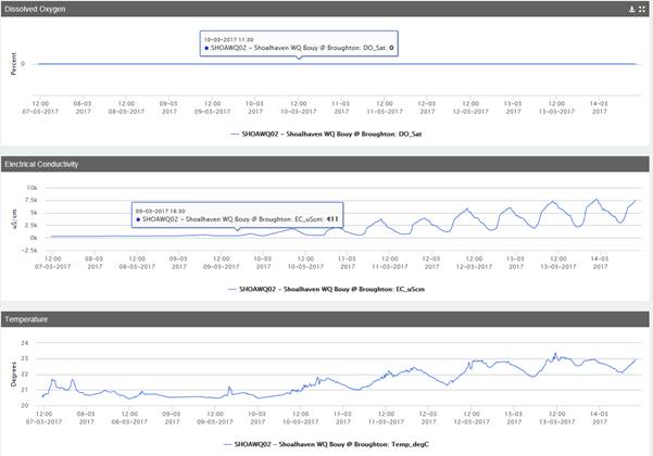
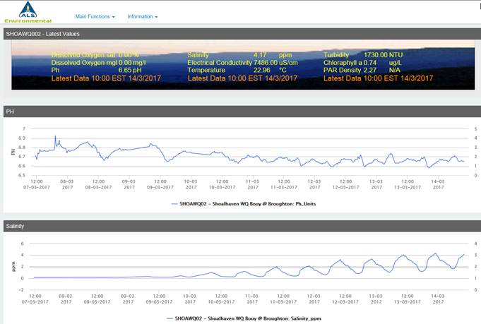
This snap shot of data shows real time recording of pH,
salinity, conductivity and temperature over a week period from 7th
– 13th March 2017. (Note that the dissolved oxygen shown is
static due to that sensor never being installed.)
The salinity level from the 7th March 2017 shows
that the water had next to zero salinity following 53mm of rainfall experienced
in the previous 24hrs. This rainfall event impacted the catchment for two days.
Then salinity can be seen to increase back to normal tidal influences over the
next couple of days.
Similar trends can be observed with the other parameters
such as a decrease in temperature of a couple of degrees and increase in the pH
over the same period.
Maintenance
Currently the water quality buoys need to be serviced every
fortnight to remove marine build up. One sonde is swapped out for another to
allow for defouling and calibration. This is labour intensive but as the
Shoalhaven has high marine biological activity is a very necessary step to keep
them functioning day in day out.
However, as these sondes are constantly submerged in a
marine environment the life expectancy is only be a few years at best without
failure of some of the equipment. Replacing individual probes costs in the
order of $1500 each and with each sonde having multiple probes the risk of
damage to one of them and requirement for replacement increases.
If this project is to continue beyond the current life
expectancy, an ongoing budget will be required. Currently Environmental
Services has absorbed the cost of installation and maintenance but will not be
capable of replacing the inevitable failed sonde. This is why consideration
needs to be given for planning replacement of this equipment.
Community Engagement
Accessibility of water quality
data obtained in this way is a method of providing the community with data on
environmental estuary health and recreational water quality.
Water quality data, particularly to determine salinity
profiles in the Shoalhaven River at Shoalhaven Heads has been requested in the
past by the Committee and local oyster farmers. Data is also of interest to the
general public and developers when needed to access base-line water quality
indicators.
Water quality monitoring provides much needed information to
Council when making estuary management decisions as well as monitoring and
responding to point source and diffuse pollution sources within the catchment.
Policy Implications
Data obtained satisfies the
requirements stated in the Council’s Estuary Management Plans and
Community Strategic Plan.
Financial Implications
Without ongoing operational
budget the continuing maintenance and replacement of parts such as probes, will
mean that Council will not be able to continue this project beyond the life of
the existing hardware. For example, one pH probe costs $1408.00 to replace with
the whole sonde costing in the vicinity of $20,000.
On top of this, the data is made
available from sites hosted by Australian Laboratory Supplies (ALS). This
presently costs $960 per year for the two sites.
|
|
Shoalhaven
Natural Resource & Floodplain Management Committee – Tuesday 06
June 2017
Page
15
|
SN17.3 Update
on the certification process for the draft CZMP and update on the development
of the new Coastal Management Plan
HPERM Ref: D17/159762
Group: Planning
Environment & Development Group
Section: Environmental
Services
Purpose / Summary
To inform the Shoalhaven Natural
Resource & Floodplain Management committee (NR&FMC) of progress to date
of
· Certification
of the 2012 draft Coastal Zone Management Plan and
· Development
of the new Coastal Management Plan.
|
Recommendation
The Committee recommend to Council that:
1. Allocate $40,000 from the 2018/19
coast and estuary budget, as its 50% contribution, towards the development of
the Coastal Management Plan subject to the Coastal Management Act being
enacted; and
2. Allocate $30,000 from the 2018/19
coast and estuary budget to update three (3) estuary health report cards to
inform the development of the Coastal Management Program.
|
Options
1. As
recommended.
Implications:
This will mean that Council will provide funding to engage a consultant to
develop a Coastal management Plan in accordance with the new coastal
legislation when it is adopted.
2. Receive
the report for information only and not support the allocation of $40,000/50%
contribution towards the development of a Coastal Management Plan
Implications:
Not providing a 50% contribution towards the development of a Coastal
Management Plan will affect Council’s future ability to secure on-going
grant funding under the NSW Coastal Program for coastal/estuary works and
review of Estuary Management Plans
3. Request
further information.
Implications:
A further report will be provided to the Committee.
4. Alternative
recommendation.
Implications:
Unknown.
Background
The NSW Coastal Reforms
In November 2014, the NSW
Government announced Stage 2 of its coastal reforms.
Stage 1 reforms were announced
in September 2012. This was unfortunate timing for Shoalhaven as the draft
Shoalhaven Coastal Zone Management Plan (CZMP) had been completed in May 2012.
As a component of the reforms, the NSW Government announced that certification
of draft CZMPs would be deferred until the Stage 2 reform process had been
completed. So the Shoalhaven CZMP remained in draft form.
Stage 2 reforms provide a new
legislative and regulatory framework for coastal management. This takes the
form of the new Coastal Management Act 2016 (still not gazetted) to
replace the Coastal Protection Act 1979.
The new Act requires Council to
prepare a Coastal Management Plan (CMP) which will replace the 2012 draft CZMP.
A new Coastal Management Manual has been prepared to guide councils through the
preparation process and 50% funding is available to engage a consultant to
prepare the document.
Stage 1, in the preparation of a CMP, is the preparation of
a Scoping Study for Shoalhaven City Council’s Coastal Management Program.
The Scoping Study
A draft Scoping Study for Shoalhaven City Council’s
Coastal Management Program is being prepared by Environmental Services. The
draft must be reviewed by NSW Office of Environment Heritage (OEH). NSW
OEH officers from the Wollongong office Coast and Estuaries Section have agreed
to ‘workshop’ the draft Scoping Study with Council staff within the
next three months.
The Scoping Study sets the scene for the CMP and provides a
framework for what needs to be included in the CMP that is specific to
Shoalhaven.
It will identify:
· Which
of the four management areas are applicable (all four in Shoalhaven)
o Coastal
wetlands and littoral rainforest area
o Coastal
vulnerability area
o Coastal
environment area Coastal use area
o Current
management practices for each of the management areas
· Gaps
in current management
· Which
of the management areas need more focus
· Opportunities
for improvement
· Any
additional information or studies that are required
· The
way forward in the process of developing the CMP
The current draft of the
Scoping Study provides information for all these items.
Some
of the major gaps identified to date include,
· Six estuary management plans/natural resource management strategies
need reviewing
· Seven Estuary Health Report Cards need updating
· Dedicated resources required for estuary management, including
facilitating the process for updating EMPs and NRM strategies and ensuring
implementation of the actions
· Resources required for a Communications Plan and ongoing community education
The
Coastal Management Plan
In accordance with section 14 of the new Coastal
Management Act, a local Council must prepare a CMP in accordance with the
coastal management manual and give effect to the coastal management areas
defined in Part 2 of the new Act. Section 18 of the new Act requires that
Council review its CMP at least once every 10 years.
On15 December 2016, Council
resolved to:
1. Adopt and
submit Council’s draft 2012 Coastal Zone Management Plan and adopted
estuary management plans to the Minister for Planning, The Hon Rob Stokes MP,
for certification, to ensure Council is eligible to apply for future
grant funding for works under the NSW Government’s coast and estuary
program, while Council prepares a new Coastal Management Program.
2. The Minister
be advised that Council is aware that the hazard lines within the revised
hazard study do not reflect Council’s adopted sea level lines and is
urgently reviewing those lines.
3. Council commits to amending the
certified Coastal Zone Management
Plan (CZMP) as soon as the revised
coastal hazard study has been adopted and by 30 June 2017
In
accordance with the new Act, the preparation of a CMP must comply with the new
coastal management manual, which is still only in draft form. At this time, due
to the following reasons Council is not in a position to commence preparation
of a CMP:
· The Scoping Study is a preliminary requirement to a
CMP. Whilst the preparation of the Scoping Study is well underway, it requires
the collation and distillation of a large amount of information and the input
of several staff and, as stated above, will need to be reviewed by OEH staff.
· In preparing the 2012 draft CZMP, Council was very
much ‘ahead of the game’. This worked against us for reasons
outlined above. Given the uncertainty and lack of information flowing from the
NSW Government regarding the status of the Coastal Management Act 2016, and
when it may commence, it’s advisable to take a circumspect,
‘wait-and-see’ approach to the preparation of the CMP.
From the
date of commencement (gazettal) of the new Act, Council would have 5 years to
complete the CMP. OEH have further advised that, even without a certified CZMP,
Council can apply to the NSW Government for funds to engage a consultant to
develop the CMP. Five years would be a comfortable amount of time to
prepare a quality CMP.
· The Stage 2 Coastal reforms are still in progress. The
new Act and supporting legislation have not been enacted and the draft coastal
management manual and supporting technical information are still in draft form.
Therefore, there is no certainty that if Council progresses with the
development of a CMP that this will comply with legislative requirements and
the manual as these could change.
Therefore,
Council needs to be in a position to commence preparation of a CMP once the
Stage 2 coastal reforms are finalised.
2012
Draft CZMP
Schedule
3 of the new Act provides a savings provision for councils and a certified CZMP
is taken to be a CMP prepared and adopted under the new Act for a period of 5
years. The funding guidelines for NSW coast and estuary grant funding
program changed in 2016 and councils are only eligible to apply for funding for
projects identified within a certified CZMP or CMP. Therefore, Council
resolved in December 2016 to seek certification of the draft 2012 CZMP.
Council
has recently been advised by OEH staff on the status of the draft CZMP. After
having gone to OEH and then to the Minister for Planning, who passed it on to
the Coastal Panel, it is now back with the Minister and we understand that
amendments will need to made before certification can be provided. OEH
have advised that this would be the best course of action for Council, i.e. to
amend the draft CZMP and have it certified, whilst at the same time, continuing
with the Scoping Study and applying for funds to prepare the CMP.
OEH
have further advised that Council can also amend the three most recently
reviewed Estuary Management Plans and submit them for certification with the
CZMP, i.e. St Georges Basin, Lake Conjola and Tabourie Lake.
Council
officers have concerns as to the full extent of the amendments that may be
required by NSW OEH in relation to both the CZMP and the Estuary Management
Plans. There is also concern about the length of time that this process
could take, as this will have a direct impact on Council’s resources and
ability to implement both the CZMP and Estuary Management Plans. This is
because the plans will remain uncertified during the time it takes to update
them, which means that Council will not be eligible to apply for funding to
implement the plans.
Community Engagement
The Our Coast Our Lifestyle community
engagement project was completed in 2016.
The purpose of the project was to
· Educate the
community about the risk of coastal erosion and the coastal management options
that are available to respond to that risk
· Understand
community preferences for these different management options and the factors
Councils should be considering when making decisions in response to coastal
erosion risk and storm damage.
The final report was received in September 2016 and provides
Council with clear community views about the management of coastal risks. With
this information already gathered, it is not proposed that another major
citywide consultation will be undertaken in the development of the Scoping
Study. However, the amended draft CZMP, together with the three amended
EMPs, will need to go on public exhibition prior to being sent back to the
Minister for certification.
Policy Implications
Council’s Coast and
Estuary Programs and Policies are linked, in one way or another to the
certification of the CZMP and the development of the CMP. The on-going
uncertainty of the Stage 2 Coastal Reforms has impacted on Council’s
ability to plan with any certainty the management of our Coast and Estuary
program and related polices/strategies.
Financial Implications
The Scoping Study is being prepared
by Environmental Services and will be reviewed by OEH. Therefore, no dedicated
budget will be required. The CMP will be prepared by consultants and the
NSW Government will provide 50% funding to coastal councils for this purpose, it
is estimated that the total cost will be $80,000, requiring SCC to provide
$40,000.
However, the scoping study may identify that additional
matching funds are required to complete the CMP to fill information gaps.
Whilst Council can apply for state government funds to develop a CMP, without a
certified CZMP or CMP, Council is unable to apply for funding to implement other
projects under the NSW Coast and Estuary Grants.
Risk Implications
The risk of not seeking
certification of Council’s draft 2012 CZMP whilst progressing developing of
a CMP will be that Council will have limited opportunities to apply for grant
funds to implement coast and estuary management projects within our City.
|

|
Shoalhaven
Natural Resource & Floodplain Management Committee – Tuesday 06
June 2017
Page
19
|
SN17.4 Update
on the Lower Shoalhaven River and St Georges Basin Flood Risk Management Study
and Plan
HPERM Ref: D17/164327
Group: Planning
Environment & Development Group
Section: Environmental
Services
Purpose / Summary
To provide the Committee with
an update of the review of the Flood Risk Management Study and Plan for the
Lower Shoalhaven River and St Georges Basin (FRMS&P).
|
Recommendation (Item to be determined
under delegated authority)
That the Shoalhaven Natural Resources and Floodplain
Management Committee receive the report for information regarding the status
update of the of the review of the Flood Risk Management Study and Plan for
the Lower Shoalhaven River and St Georges Basin for information.
|
Options
1. As recommended.
Implications: this will
allow for Council to continue to met its milestones and funding obligations to
commence the review of the flood flood risk management studies and plans.
2. Alternative recommendation.
Implications: Unknown.
Background
Council is seeking Consultants to undertake the review of
the Flood Risk Management Study & Plan
(FRMS&P) for the Lower Shoalhaven River and St Georges Basin
catchments. The successful Consultant/s will be required to undertake detailed
flood modelling of the catchments as well as undertake floodplain risk
management options assessment and consultation in accordance with the NSW
Floodplain Development Manual 2005, Australian Rainfall & Runoff: A Guide
to Flood Estimation 2016 and industry best practice.
Shoalhaven City Council is currently inviting tenders for
the carrying out of Consultancy these services. Tenders are closing 8 June
2017.
Community Engagement
The community will continue
to be involved as part of the FRMS&P’s for the Lower Shoalhaven River and St Georges Basin. Status updates
will continue to be reported to and discussed with members of the Shoalhaven
Natural Resources and Floodplain Management Committee.
Financial Implications
The FRMS&P’s are 2/3
funded by OEH and 1/3 funded by Council.
|
|
Shoalhaven
Natural Resource & Floodplain Management Committee – Tuesday 06
June 2017
Page
21
|
SN17.5 Shoalhaven
River Levee Repair Works Update
HPERM Ref: D17/164448
Group: Planning
Environment & Development Group
Section: Environmental
Services
Attachments:
1. Report -
Shoalhaven River Levee Repair Works update - Shoalhaven Natural Resources &
Floodplain Management Committee 29 November 2016 ⇩
2. MIN -
Flood - Shoalhaven River - Flood Levee - Category 1 - Advance Restoration -
2016 / 2017 Budget bid ⇩
Purpose / Summary
To update the Committee on the Shoalhaven River Levee Flood
Damage Restoration 2017 Project.
|
Recommendation
(Item to be determined under delegated authority)
That
Committee receive the report on the Shoalhaven River Flood Levee Works Update
for information.
|
Options
1. As recommended.
Implications: Council will continue the tender
process to undertake levee repair works.
2. Alternative
recommendation.
Implications: Unknown.
Background
Council received National Disaster Relief Authority (NDRA)
program funding to repair the levee flood damages that occured in 2015 ($1.13
million) which was reported to this committee on 29 November 2016 (attachment
1). Council also submitted a NDRA claim ($272,470) to repair flood
damages occured in June 2016 and this is still pending. NDRA is a joint
funding initiative from Commonwealth and State Governments to provide disaster
relief and recovery payments and infrastructure restoration to assist
communities recover from the effects of natural disasters.
Council engaged NSW Public Works immediately following the
August 2015 flood event to inspect and prepare estimates to repair the levee
system to pre-flood condition. Council also engaged NSW Public Works to
project manage the current Shoalhaven River Levee Flood Damage Restoration 2017
project. In addition, a Review of Environmental Factors for the
restoration works has been prepared by Ecological Consultants Australia.
Council invited tenders on 21 March 2017 to select a
suitable contractor to conduct the restoration of Shoalhaven River levee
damages that occurred during August 2015 and June 2016 flood including the high
priority levee audit defects that were identified prior to August 2015 flood.
The tender closing date was 18th April 2017.
The tender evaluation is underway and Council will receive a
tender evaluation report from the NSW Public Works. The tender evaluation
report will be submitted directly to the Ordinary Council Meeting pursuant to
Clause 3 of Council’s “Acceptance of Tenders – Reports to
Council” Policy. It is anticipated that Council will be in a position to
engage a contractor during July 2017.
In accordance with Section 10A(2)(d)(i) of the Local Government
Act 1993, some information will remain confidential as it would, if disclosed,
prejudice the commercial position of the person who supplied it. It is not in
the public interest to disclose this information as it may reveal
commercial-in-confidence provisions of a contract, diminish the competitive
commercial value of any information to any person and/or prejudice any
person’s legitimate business, commercial, professional or financial
interests.
Community Engagement
Council’s Floodplain Engineers and Property Unit
Officer had met with property owners to discuss access and levee repair works
to be conducted on their properties. Deed of Agreements (DoA) have been
sent to property owners who would be affected by the levee repair works.
DoA’s will allow Council to conduct the current levee repair works and
future maintenance work on levees located on private properties. To date,
most of the DoA’s been received from the property owners, Council is
negotiating with the remaining property owners to finalise the remaining
DoA’s.
Policy Implications
Council’s Asset Management
Plan for flood mitigation drainage structures documents the required inspection
and maintenance of the Sholahaven River levee system.
Financial Implications
The result of Councils claims
for funding under NDRA to repair the flood damages caused in 2015 ($1.13
million) was successful and the 2016 claim ($272,470) is currently unknown. The
tender process has identified that the actual costs to complete the 2016
repairs are higher than the estimated repair costs. Council is in the process
of updating and increasing the 2016 damages claim to reflect these increased
costs.
Council included a capital works
bid of $200,000 for the high priority levee repair works identified in the
levee audit report following the Council resolution (MIN16.119b) (attachment
2). A report to Council will be prepared if more funds are required to
complete the works.
Risk Implications
It is
necessary to conduct the repairs so that the levees can continue protecting
people and property from river flooding and to ensure existing damaged levee
sections are not damaged further.
|
|
Shoalhaven Natural
Resource & Floodplain Management Committee – Tuesday 06 June 2017
Page
23
|
|

|
Shoalhaven
Natural Resource & Floodplain Management Committee – Tuesday 06
June 2017
Page
26
|
|
|
Shoalhaven
Natural Resource & Floodplain Management Committee – Tuesday 06
June 2017
Page
27
|
SN17.6 Shoalhaven
dredging monitoring update and Rescuring Our Waterways Program Funding update
2017
HPERM Ref: D17/165042
Group: Planning
Environment & Development Group
Section: Environmental
Services
Attachments:
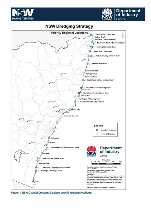
1. NSW Government
Dredging Strategy Map ⇩
2. Citywide
Dredging Feasibility Study (under separate cover) ⇨
3. Council
adopted dredging strategy ⇩
Purpose / Summary
To provide Shoalhaven Natural
Resources & Floodplain Committee with an update on the post-dredging
monitoring following Shoalhaven Council dredging projects at Currambene Creek
(Huskisson), Sussex Inlet and Lake Conjola entrance under the Rescuing Our Waterways
Program. To provide information on stage four of the Rescuing Our Waterways
Program funding.
|
Recommendation
The Committee receive the
dredging monitoring report for Lake Conjola and Sussex Inlet and the Rescuing
our Waterways Program funding program update for information and
consideration.
|
Options
1. As recommended.
Implications: Nil
2. The
Committee could make recommendations to Council for Rescuing Our Waterways
Program funding application/s.
Implications: Council would need to contribute
50% of the project costs and prepare and lodge a grant application by 23 June
2017. Previously Council engaged an experienced consultant to prepare the grant
applications under the Rescuing Our Waterways Program.
3. Alternative
recommendation.
Implications: Unknown.
Background
Summary of Dredging Works at
Currambene Creek, Sussex Inlet and Lake Conjola Entrance
Shoalhaven City Council
undertook dredging at three locations across the City between March –
September 2016. The following is a summary of the aims and dredging works
undertake at each site.
Currambene Creek
The aim of the work was to make
navigation improvements to the Creek entrance and access wharves. The scope of
work of the project was identified to dredge the entrance channel from the
Myola Spit to the Jervis Bay sanctuary zone, 20m wide to a depth of -2.5m AHD.
The August flood in 2015 washed
out most of the sand from the system and all that remained to be removed was
the rock shelf at the entrance near the Jervis Bay sanctuary zone. The rock
itself was quite dense and required the use of heavy machinery with rock
breaker attachments to break up the rock before it could be excavated from
dredge area. Approximately 55m3 of rock was removed from site (see attached map
for details)
Sussex Inlet
The aim of the work for the Sussex Inlet navigation channel
works was to improve safety and navigation in the channel, particularly for
marine rescue. To achieve this, the scope of work involved dredging the channel
from the vicinity of Alamein Road through to The Haven Holiday Resort, to
provide a 25m wide channel to a depth of -1.5m AHD.
Following the August 2015 flood, much of the sand was washed
out of the channel resulting in no work being required in the upstream areas
near Alamein Road. Therefore, the dredge footprint was reduced to only the area
in from of The Haven Holiday Resort. During the dredging works the area
experienced an East Coast Low (in June 2016) which resulted in a small area
upstream of the Haven also requiring dredging and so this additional area was
also dredged. All sand dredged from Sussex Inlet was placed along the
foreshore/dune in front of the Haven Holiday Resort together with geotextile
sand bags groynes (see map attached map for details).
Lake Conjola Entrance
The aim of the dredging at Lake Conjola was to improve
navigation to reconnect the boat ramp at Cunjurong Point to the main lake body
and to better facilitate separation of boat users from swimmers. Additionally,
it aimed at improving circulation around the lake to facilitate future entrance
management by creating a channel along the north and western perimeter of the
lake entrance to replicate the regime entrance state of the lake (refer
attached memorandum).
At the commencement of the dredging the entrance to the Lake
was closed and dredge was able to make good progress on the works. In May 2016
a minor rainfall event in the catchment caused the lake to open naturally but
subsequently caused the lake to become tidal and began to slow progress
somewhat as fast moving water made some areas difficult to navigate and dredge.
The June 2016 East Coast Low exacerbated this and a significant amount of sand
moved within the lake. Since the sand became more mobile it became increasingly
difficult to make good progress as typically the overnight tidal changes would
cause the more mobile sand to infill the dredged lake channel. The work
performed by the contractor involved: (see map for details)
· Dredging of
approximately 20,000m3 of sand from the lake to form a channel from the
Cunjurong Point boat ramp back to the main lake body.
· Placement of
approximately 13,500m3 of dredged sand along the toe of the dune east of the Lake
Conjola boat ramp to form a beach.
· Exporting
approximately 6,500m3 of sand from the Lake to various sites within the
Shoalhaven (approximately 4,000m3 to Mollymook).
· Overall 1,250
lineal metres of channel was dredged 15m wide to a depth of -0.8m to -1.2m AHD.
Post-Dredging Monitoring
As part of the Rescuing Our Waterways Grant and licensing
conditions from NSW Crown Lands, Council is required to undertake post dredging
monitoring of the dredged areas at each location.
The monitoring consists of undertaking work-as-executed
(WAE) surveys of the dredged channels to access changes over time. As stated in
the background information, in June 2016 an East Coast Low occurred during the
dredging operations. This had a significant impact on the dredging channels,
particularly at Lake Conjola entrance. Where significant amounts of sand moved
into the entrance.
The following tables are a summary of the survey results for
each of the dredging monitoring taken in December 2016 (immediately following
the completion of the dredging) and in February 2017 three months post
dredging.
The figures given in the summary of the survey table are
based on the original dredge profile design for the levels in metres based on
Australian Height Datum (AHD) and the figures volumes of sand m3 (cubic
meters) as well as the average cut depth in metres.
Currambene Creek
· No sand was dredge
from this location only bedrock
|
Overall dredge design area square metres
|
Net volume of rock cut from the creek entrance
|
Average cut depth (m)
|
|
4,449 square meters
|
449 m3
|
0.341 metres
|
Sussex Inlet
|
Overall dredge design area square metres
|
Net volume of sand required to cut to meet design m3
|
Average cut depth (m) to meet design
|
Number of cubic of sand that has filled in dredge channel
since Dec 2016
|
Height of dredge channel that has infilled since Dec 2016
|
|
21,249 square meters
|
5,746 m3 Dec 2016
|
0.183 metres Dec 2016
|
1,259 m3
|
0.016 metres
|
|
4,487 m3 Feb 2017
|
0.199 metres Feb 2016
|
Lake Conjola Entrance
|
Overall dredge design area square metres
|
Net volume of sand required to cut to meet design m3
|
Average cut depth (m) to meet design
|
Number of cubic of sand that has filled in dredge channel
since Dec 2016
|
Height of dredge channel that has infilled since Dec 2016
|
|
12,699 square meters
|
5,631 m3 Dec 2016
|
0.470 metres Dec 2016
|
6,454 m3
|
0.481 meters
|
|
11,978 m3 Feb 2017
|
0.951 metres Feb 2017
|
At the time of writing this report, a further survey has
been scheduled.
NSW Rescuing Our Waterways
Program 2017 Update
As part of the NSW Government
commitment to delivery of the Coastal Dredging Strategy to improve the
accessibility and environmental health of the state waterways. The Rescuing our
Waterways Program has released the fourth stage of funding to run over 4 years
(2017/18 – 2020/21) with $6 million dollars available.
Coastal Councils can apply for
funding but will need to contribute at least 50% of the dredging project cost
and be responsible for the development and management of projects. Eligible
projects enable navigational benefits and promote economic growth and
productivity.
What will be funded?
Dredging projects that may be
subsidised under the Rescuing our Waterways Program include:
· Navigation
for a range of vessels (recreational, tourism and commercial)
· Access
to public to public waterways infrastructure such as boat ramps and wharfs
· Dredging
strategies and/or their supporting studies (e.g. sediment hydrodynamics) and
· Pre-dredge
activities for projects which are eligible and likely to proceed to dredging
for vessel navigation
Assessment Criteria
To be eligible the projects must
meet the following criteria:
· The
organisation has the capacity and capability to insure that the activity is
effectively, efficiently and safely completed.
· The
organisation agrees to enter into, and be bound by, the conditions in the
funding agreement.
· The
activity is consistent with the NSW Government Coastal Dredging Strategy,
including:
o Be
located in the NSW Government’s priority locations (see attached map for
priority locations)
o Support
local government and build their capacity to undertake dredging operations in
local waterways
o Assisting
councils to prioritise and establish long term dredging delivery plans to
maximise funding opportunities under the Rescuing Our Waterways Program
o Assisting
councils to identify linkages with dredging works and coastal hazard mitigation
and beach amenity improvements and to identify co-funding opportunities under
the Coastal Management Program.
Funding Priorities
Projects will be assessed based
on the following priorities, with the highest priority given to the
applications involving:
1. Preparation of dredging
strategies.
2. Demonstrated navigation
improvements on waterways for a range of boating enthusiasts and the continued
viability of commercial boating operations and tourism where compatible with
estuary management planning process.
3. Reinstates waterways
access to public aquatic infrastructure such as boat ramps and wharfs.
4. Pre-dredge activities
for projects which would be eligible for funding and are likely to proceed to
dredging including investigations (such as sediment analysis, sediment
hydrodynamics, aquatic flora and fauna surveys) and environmental impact
assessments.
Deadline for application is 5pm
on Friday 23 June 2017.
Council has previously adopted a
dredging feasibility study (see attachment 1) and resolved to apply for grant
funding under the Rescuing Our Waterways program at the three locations
outlined above (see attachment 2). An application for studies to improve the
Shoalhaven Heads River entrance way was also submitted but was unsuccessful.
As part of the process, which
sought expressions of interest to undertake the 2016 dredging, the market was
tested to determine if there was commercial interest in purchase of the sand,
as the feasibility study identified this as a potential way of offsetting the
costs of dredging. This was found to be unviable for commercial operators. The
potential sale of dredged sand would have also required additional assessment
and approvals, which would have significantly increased the project costs.
Community Consultation
Any future dredging proposal
would require community consultation, environmental assessment and consultation
with government agencies as well as obtaining the necessary approvals and
permits.
Financial Implications
Any Rescuing Our Waterways grant
application would require Council to contribute 50% of the dredging project
costs. Currently there is no budget allocated for potential dredging projects.
|
|
Shoalhaven
Natural Resource & Floodplain Management Committee – Tuesday 06
June 2017
Page
32
|
|
|
Shoalhaven Natural
Resource & Floodplain Management Committee – Tuesday 06 June 2017
Page
33
|
|
|
Shoalhaven
Natural Resource & Floodplain Management Committee – Tuesday 06
June 2017
Page
36
|
SN17.7 2016
East Coast Low Storm Damage Remediation review May 2017
HPERM Ref: D17/165314
Group: Planning
Environment & Development Group
Section: Environmental
Services
Purpose / Summary
Provide the Committee with an
update on the outcomes of interim erosion remediation works completed and in
progress, following the June 2016 East Coast Low.
|
Recommendation
The Committee recommends that
Council receive the report for information and make the following
recommendations, subject to funding being allocated in the 2017/18 Budget to
progress the coastal erosion remediation projects:
1. Council
proceed with detailed design, Review of Environmental Factors, Aboriginal
Heritage assessment for coastal erosion management works at Currarong
including a trial geotextile sand groyne and sand nourishment and protection
of the Beecroft Avenue precinct subject to undertaking the necessary
consultation and obtaining the necessary permits and approvals. That further
community consultation be undertaken as part of this process.
2. Council
seek advice from NSW Office of Environment & Heritage about the potential
development of an emergency action plan or interim management plan for the
South Mollymook coastal protection structure as an interim measure until a
long-term management strategy is developed as a result of the cost benefit
analysis and impact assessment.
|
Options
1. Adopt the
recommendation of this report
Implications: This will allow progress of long-term
erosion management at Currarong and more effective coastal assets management.
2. The Committee
could provide an alternate recommendation to Council
Implications: unknown
Background
Following the June 2016 East
Coast Low event (overview provided in Attachment 1), reports to Council were
prepared to provide an overview of damages and a priority list of repair
works. In response, Council allocated $500,000 to implement these
works. $350,000 for coastal management priority works and $150,000 for
restoration works in the immediate vicinity of adjoining Holiday Haven Tourist
Parks (min 16.586).
This report provides an update
on status of repairs to date.
Ulladulla Harbour
foreshore protection
The June 2016 storm caused major
erosion of a 30-metre section of the existing rear harbour revetment and the loss
of the tidal beach affecting park infrastructure, public amenity and
potentially the Princes Highway if no remediation was carried out.
Response:
· Post
storm survey investigations completed and hazard management installed and
undermined park furniture removed;
· Site
meetings held with Roads & Maritime Services (RMS), Office of Environment
& Heritage (OEH) and Crown Lands. Council did seek funding but was
unsuccessful.
· Jirgens
Civil was engaged to undertake remediation works including extension of protection
and rock fill of the upper embankment and beach scraping as well as relocating
sand from the southern beach fronting the boat ramp carpark.
· Remediation
works completed December 2016: $60,000 cost
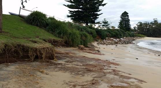
Figure1:
Impacts of June 2016 storm on Ulladulla Harbour foreshore
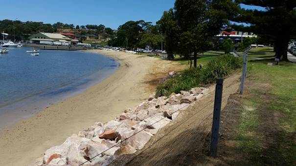
Figure 2: Completed remediation
works at Ulladulla Harbour
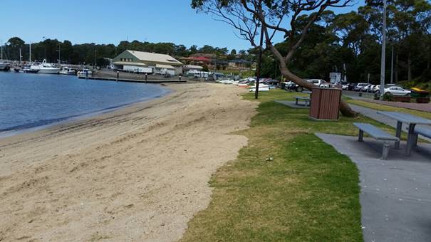
Figure 3: Completed beach
scraping at Ulladulla Harbour
Currarong Beach
The June 2016 storm caused
significant beach sand loss. More than 20,000m3 of sand was lost under elevated
tide and NE storm conditions along Warrain Crescent. There were also damages to
park and road assets at the rock pool and Dolphin Reserves. Nine (9) beach
access ways were closed along Warrain Crescent, except for Peel St sand ramp
and the Currarong Creek inlet steps.
Response:
· Short
term safety and clean up measures included temporary hazard fencing and
remediation of park infrastructure around Abrahams Bosom reserve carpark. Sand
recovery and rock pools remediation completed at a cost of $25,000;
· Beach
access hazard closure and reshaping of beach access at Peel St and Currarong
Creek completed;
· Land
survey of erosion profiles as part of beach erosion monitoring program;
· Community
consultation, public meeting, in September 2016 by Coastal Engineer from Royal
Haskoning to discuss short and long term responses. The meeting discussed the
storm impact review by Advisian and the previous SMEC Erosion Remediation
options study recommending the trial geofabric groyne and sand nourishment.
· Review
of Environmental Factors (REF) completed and relevant permits obtained for
interim works; and
· Coastal
engineering advice, Aboriginal Heritage assessment, consultation with OEH and
local Aboriginal community as well as Currarong community informed short-term
works (beach scraping and nourishment) and step access replacement (limited to
two) along Warrain Crescent. Soil Conservation Service were contracted to
do the works in early November at an approximate cost of $150,000; which
required Aboriginal Land Council supervision given the sensitivity of the site.
· Following
community consultation, Royal Haskoning DHV have been engaged and are
progressing with detailed design for a trial geofabric groyne construction and
placement of 10,000m3 sand nourishment on Currarong Beach, sourced from the
western beach. Future construction of an additional beach access on the western
end of the beach is subject to Aboriginal Heritage assessment and approval.
Beecroft Avenue frontage will require rock armour protection to safeguard the
public sewer, reserve and private property. Royal Haskoning DHV have also been
engaged to complete the detailed design for these works.
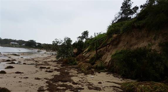
Figure 4: Eight
beach access stairs were destroyed at Currarong along Warrain Cres
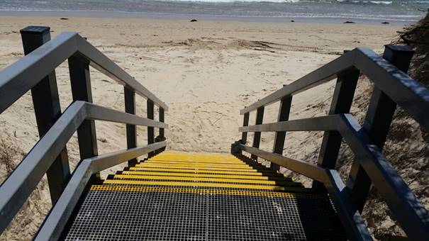
Figure 5: New Currarong Beach
access stairs

Figure 6: New Currarong Beach
access stairs
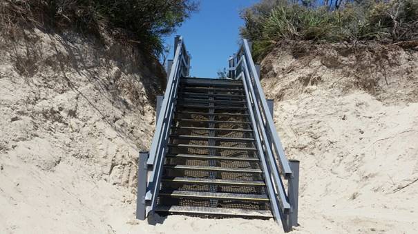
Figure 7: New Currarong Beach
access stairs
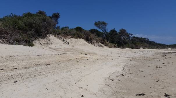
Figure 8: Sand nourishment -
6000m3 sand relocated from creek mouth and Peel St reef shoulder shoals then
reshaped to safe profiles to avoid Aboriginal middens with Aboriginal Land
Council supervision given the sensitivity of the site.
Next Steps/community
consultation/design and approvals:
· The
community meeting at Currarong was attended by approximately 125 community
members. The meeting clearly highlighted that a trial geotextile sand
groyne is the recommended option by three coastal experts and State Government
to manage long-term erosion at Currarong.
· Royal
Haskoning DHV has been engaged to undertake the detailed design of Warrain
Crescent and Beecroft Avenue frontages, the REF and Aboriginal Heritage
assessments $90,000. An onsite meeting with government agencies and
community representative was held. Further community consultation will be held
to confirm willingness to proceed to construction. Further consultation with
the local aboriginal community, government agencies and the coastal panel will
be required prior to obtaining the necessary approvals and permits before any
works can proceed.
· Attachment
1 contains Royal Haskoning DHV Basis of Design report that will guide the
procedure to construction. A cost benefit analysis may also be required in
accordance to the 2016 OEH Coastal Management Manual.
Lake Tabourie
The 80m foreshore boardwalk was
lifted during the combined ocean storm/flood event and damaged beyond repair.
Response:
· Short
term responses included hazard signage, temporary fencing with the staged
removal of the structure completed with post foundations removed prior to
September school holidays to make site safe; and
· Land
survey was completed in late September and confirmed existing land level
provided reasonable access along the estuary foreshore within the current
“open entrance” scenario and reasonable access levels within the
intervention level for Tabourie entrance of 1.2m AHD.
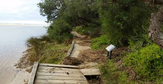
Figure 9: Damaged Lake Tabourie boardwalk
Next Steps/community
consultation:
· Council
staff will continue discussions with the community to confirm a reasonable
outcome for this popular foreshore walking precinct.
· Interim
arrangements have been scheduled for a 100m section of the Holey Belt currently
covering Lake Conjola boardwalk to be relocated to the frontage in July 2017.
Investigations and REF preparation would be required to plan for the requested
replacement when funding is provided. Interim costs of $10,000 will be provided
from existing operational budgets.
· Replacement
costs for the 80m boardwalk is expected to be in the order of $2000 per linear
metre $180,000 and is currently not funded.
Shoalhaven Heads
The River Rd estuary foreshore
experienced moderate erosion impact as the flood notch breached and allowed the
significant ocean swell / king tide to enter and combine with local catchment
flooding.
The Shoalhaven open beach access
ways were damaged and beach erosion warning signs in place since the 2015 event
were upgraded during September.
Response:
· Contactors
were engaged to reshape the main beach access points for public safety with
other beach access points remaining closed;
· Tree
inspection along the River Road foreshore led to the removal of 45 dangerous
trees;
· Building
waste has emerged from bank failures containing asbestos, a monitoring program
has commenced with removal of asbestos;
· Land
survey and comparative survey has commenced to monitor erosion of the River
Road frontage;
· Contractors
were engaged to undertake additional ‘make safe’ works along the
River Rd foreshore including beach scraping to cover exposed tree root plates
that present a public risk, and spread tree mulch left on site from initial
dangerous tree removal.
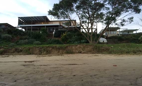
Figure 10:
Eroded foreshore along River Road, Shoalhaven Heads
Next Steps/community
consultation:
· Water
Research Laboratory (WRL) has been engaged to develop a remediation design,
with the pub frontage identified as a priority area due to risk; and
· Council
staff and WRL attended a public meeting organised by the Shoalhaven Heads
Community Forum on 7 December 2016 to discuss management options for River Road
erosion. Council has sought comment from government agencies on the Draft River
Road Erosion Remediation Concept Plan prepared by WRL.
· The
whole frontage remediation is estimated at $1.75 million. Council has
lodged a Rebuilding NSW grant application for Stage 1 of these works.
· Council’s
Asset and Works team have are assessing the road stormwater network to assess
the potential to combine outfall discharge points and reduce the impact of
catchment erosion on the bank stability.
· Interim
remediation works continue to keep the area safe for public use.
Mollymook Beach
The south end of the beach
damage included exposure of the Golf Club protective gabion wall and inundation
of the Ocean St road stormwater system and damage to the sandstone retaining
wall.
The Blackwater creek sand
nourishment area suffered minor damages.
The creek training wall at north
end of the beach was also damaged.
Response:
· Repair
to the northern creek retaining wall was completed in October 2016 where a
section of rock gabions was replaced with geotextile sand bags (cost $25,000);
· Minor
beach reshaping to beach access and repair of sand nourishment at Blackwater
Creek was completed in October 2016;
· The
south Mollymook foreshore (gabion) protection structure protecting the sewer,
stormwater, road, pathway, foreshore and Golf Club was partly exposed and
damaged during the storm. The structure is also nearing the end of its useful
life. Regular inspections of gabion structure to monitor public risk will
continue (in particular from protruding gabion structure’s wire). Several
sand nourishment covers of the gabions have been funded by Council to maintain
sand protection for the wall’s integrity and public safety:
.
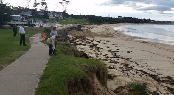
Figure 11: Eroded
foreshore and gabion protection structure adjacent to Mollymook Golf Club
Next Steps/community
consultation:
· Council
has received 50% funding under the NSW coast and estuary program to undertake a
cost benefit analysis (CBA) and impact assessment of the south Mollymook
foreshore protection structure in accordance with the new draft Coastal
Management Manual. This project is estimated to take twelve months.
· As
this project will take some months to complete, it is recommended that Council
seek advice from NSW Office of Environment & Heritage about the potential
development of an emergency action plan or interim management plan for the South
Mollymook coastal protection structure as an interim measure until a long-term
management strategy is developed as a result of the CBA and impact assessment.
Culburra
Beach
Southern beach access ways were
damaged from The Haven north along the entire beach with some rock outcrops
uncovered.
Response:
· Short-term
response included preliminary staff inspection and engagement of contractors to
inspect and reshape some beach access points where feasible.
Next steps:
· Inspection
and repair work will continue.
Vincentia
Collingwood Beach stormwater
outlets were inundated and erosion occurred at the bridge abutments of the
shared pathway along Collingwood Beach.
Beach access points at
Plantation Point were damaged.
Response:
· Repair
of the shared pathway bridge abutments and additional rock protection was
completed in October - $7500; and
· The
most northern access to Nelsons Beach from Plantation Point reserve, closest to
the point, was closed due to erosion and risk to users. Upgrade of the access
point near the play equipment was completed prior to Christmas at a cost of
$15,000. A survey of users at the site identified the access near the
playground more frequently used compared to the most northern access.
· Closure
of a cliff line access further east was recently required due to public safety.
Assessment of potential repairs and replacement is underway.
Next step/community
consultation:
· Inspection
and repair work will continue in the 2017-18 financial year under the annual
Coastal Risk Assessment in July; and
Figure 12: Erosion along the shared path at Vincentia
Figure 13: Elevated stairs recently closed
Greenwell Point Foreshore
Existing shoreline protection
structures at Adelaide St were eroded. The shared footpath at Titania
Park was eroded/undermined and the sandstone wharf site, which was damaged in
2015, was further undermined.
Responses:
· Hazard
areas immediately isolated with hazard signage and barriers;
· Beach
scraping of shared cycleway frontage completed; and
· Minor
repairs of damaged rock protection and recreation beaches completed.
Next steps:
· Repairs
of rock protection assets, including the storm damaged boat ramp-turning circle
have been scheduled.
· A
draft landscape design for the Heritage Stone Wharf Precinct prepared to submit
to OEH Heritage for a Permit to proceed with remediation works when funds
become available. As drawn, these works are estimated at $100,000. Any future
works would require community consultation.
Figure 14: Erosion along the shared path at Greenwell Point
Bendalong Boat Harbour
The storm scoured several areas
in the bay uncovering Aboriginal midden deposits and shell deposits. In two
sections of this high use park, the embankment and trees were undermined.
The Office of Environment and
Heritage (OEH) heritage staff have inspected the site and provided preliminary
advice and detailed assessment has commenced to accompany a landscape master
plan for the reserve.
Responses:
· Contractors
were engaged to place safety fencing in high public risk areas and place rock
bollards along the road verge; and
· Several
beach scraping and rock bollard installations were required following repeated
extreme rain events and beach erosion episodes.
Next steps:
· A
draft Bendalong Boat Harbour Masterplan is currently being developed in
consultation with the community. The aim for this Masterplan is to guide the
long-term management of the park, boat ramp and foreshore whilst also
addressing coastal and stormwater erosion.
Figure 15: Erosion along
Bendalong Boat Harbour foreshore
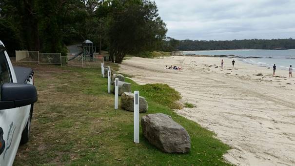
Figure 16: Beach nourishment
works and rock bollards
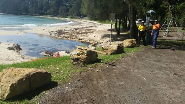
Figure 17: Intense rain damage
at Bendalong post remediation works
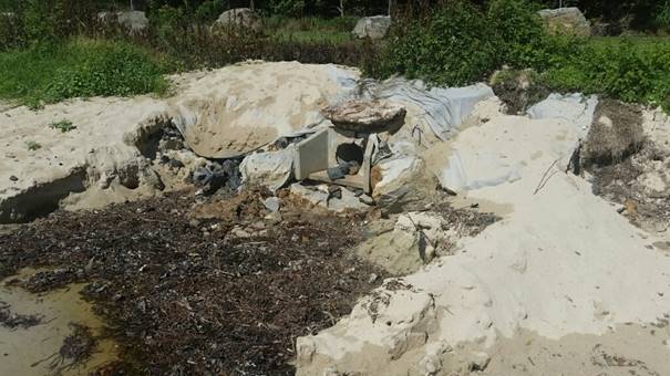
Figure 18: Stormwater damage at
Bendalong post remediation works
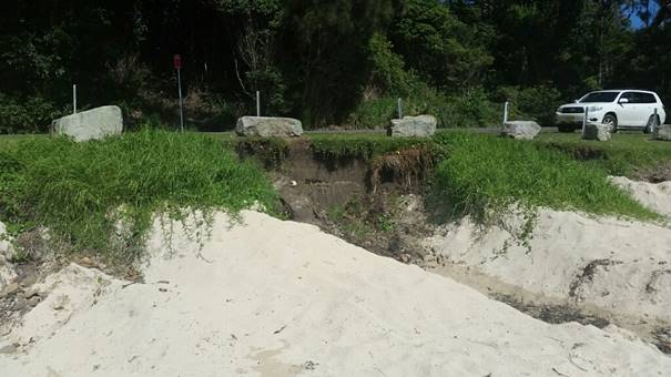
Figure 19: Stormwater damage at
Bendalong post remediation works
Community Engagement
Remediation sites in locations
where works still need to be carried out will require further community
consultation as options are developed.
The east coast low event and its
impacts were documented in a special edition of Council’s Frontline News,
which is distributed to the community.
http://doc.shoalhaven.nsw.gov.au/DisplayDoc.aspx?record=D16/279931
Financial Implications
Council’s Coastal and
Estuary Assets Management Plan guides the management of beach access ways in
the Shoalhaven. Council has about 220 beach access ways that for most
were built in the 80s under the State Beach Improvement Program that followed
the devastating storms of the 70s.
These access ways are regularly
maintained to keep them safe and useable, however most are approaching the end
of their useful life and most are in need of major repair or replacement.
On average, a new access ways costs $25,000 with an annual allocation of
$50,000 for coastal access capital works.
Council is faced with a major
budgetary challenge. With many park assets (tables and seats) being
removed or relocated and beach accesses being damaged and closed as a result of
the June East Coast low, we now need to consider some adaptive strategies to
our coastal assets.
Reducing the number of coastal
access ways in areas that are ‘over serviced’ would allow savings
to be directed towards upgrading the retained assets. At beaches where
this approach could be considered, discussion and consultation with affected
communities will occur.
Council recognised the challenge
in managing coastal assets, particularly in response to storm events and in
February 2016 resolved:
That:
1. Council
consider funding the Coastal Management and Infrastructure Reserve
(MIN16.998) by transferring $500,000 each year from the Strategic Projects
Reserve or another source, to fund priority coast and estuary management and
infrastructure projects commencing in 2017/18 financial year.
2. In
2017/18 Council allocate $400,000 to complete and implement the Currarong
coastal erosion strategy and determine the source of funds during the consideration
of the draft 2017/18 budget.
Council is currently considering
this budget allocation as part of its 2017/18 budget.
|

|
Shoalhaven
Natural Resource & Floodplain Management Committee – Tuesday 06
June 2017
Page
52
|
SN17.8 Environmental
Strategy and Planning
HPERM Ref: D17/114940
Submitted by: Ian Stewart
|
Recommendation
That Council review and develop
its current approach to align vision, values, principles, priorities,
guidelines, strategies and plans for strategically managing the natural
environment.
|
Details
Council has been given the clear
message from the community, through the ‘Our Coast Our Lifestyle’
community engagement, that the natural environment is strongly valued. It is
therefore important for Council keep faith with this view and demonstrate a
disciplined approach to strategically managing the natural resources that are
so strongly valued by the community in the Shoalhaven.
The challenge and associated
objective for Council should be to ensure that management policies and
practices and development decisions and approvals do not adversely impact and
damage the natural environment. The objective should also be to develop a more
proactive less reactive approach to the management of development pressures and
demands.
With this objective in mind it
is suggested that Council review and develop its current approach to align
vision, values, principles, priorities, guidelines, strategies and plans for
strategically managing the natural environment.
An important practical outcome
will be greater clarity of intent that can inform and contribute to consistency
across all of Council’s management and development processes. It will
also be possible to express Council’s position and intent in relation to
the natural environment with greater clarity, force and confidence.