Development Committee
Meeting Date: Tuesday,
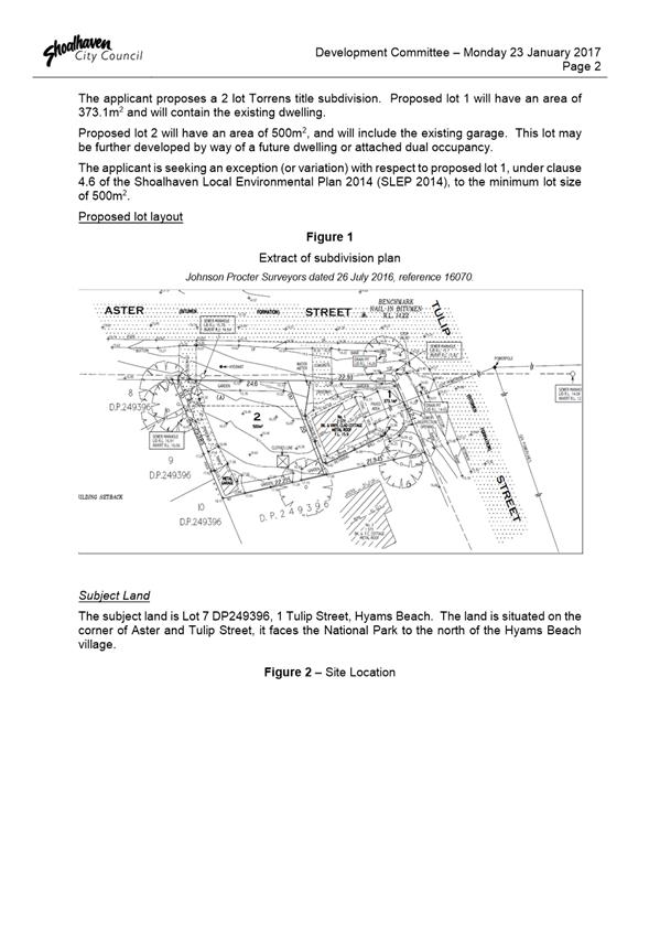
14 March, 2017
Location: Council
Chambers, City Administrative Building, Bridge Road, Nowra
Time:
5:00pm
Membership (Quorum - 5)
Clr Patricia White - Chairperson
All Councillors
General Manager or nominee
Please note: Council’s Code of Meeting Practice
permits the electronic recording and broadcast of the proceedings of meetings
of the Council which are open to the public. Your attendance at this meeting is
taken as consent to the possibility that your image and/or voice may be
recorded and broadcast to the public.
Agenda
1. Apologies / Leave of Absence
2. Confirmation of Minutes
· Development
Committee - 14 February 2017............................................................. 1
3. Declarations of Interest
4. Mayoral Minute
5. Deputations and Presentations
6. Notices of Motion / Questions on Notice
Nil
7. Reports
DE17.20...... Subdivision Controls in Greenwell Point - Legal
Advice and Policy Direction 8
DE17.21...... Restaurants and Cafes - A new interim restaurant
authorisation system for liquor licences......................................................................................................... 24
DE17.22...... Future Potential Subdivision within the R2 Zone
Hyams Beach.................. 26
DE17.23...... Development Application – Parson St
Ulladulla – Proposed Lot 15 in Subdivision of Lot 3 DP 746228 and Lots 5
& 6 DP 805221..................................................... 41
8. Confidential
Reports
Nil
|

|
Development
Committee – Tuesday 14 March 2017
Page
ii
|
Development Committee
Delegation:
Pursuant to s377 (1) of the
Local Government Act 1993 the Committee is delegated the functions conferred on
Council by the Environmental Planning & Assessment Act 1979 (EPA Act),
Local Government Act 1993 (LG Act) or any other Act or delegated to Council, as
are specified in the attached Schedule, subject to the following limitations:
i. The
Committee cannot make a decision to make a local environmental plan to classify
or reclassify public land under Division 1 of Part 2 of Chapter 6 of the LG
Act;
ii. The
Committee cannot review a s82A or s96AB EPA Act determination made by the
Council or by the Committee itself;
iii. The
Committee cannot exercise any function delegated to the Council which by the
terms of that delegation cannot be sub-delegated;
iv. The Committee
cannot exercise any function which s377(1) of the LG Act provides cannot be
delegated by Council; and
v. The
Committee cannot exercise a function which is expressly required by the LG Act
or any other Act to be exercised by resolution of the Council.
Schedule:
1. All
functions relating to the preparation, making, and review of local
environmental plans (LEPs) and development control plans (DCPs) under Part 3 of
the EPA Act.
2. All
functions relating to the preparation, making, and review of contributions
plans and the preparation, entry into, and review of voluntary planning
agreements under Part 4 of the EPA Act.
3. The
preparation, adoption, and review of policies and strategies of the Council in
respect of town planning and environmental matters and the variation of such
policies.
4. Determination
of variations to development standards related to development applications
under the EPA Act where the development application involves a development
which breaches a development standard by more than 10% and the application is
accompanied by a request to vary the development standard under clause 4.6 of
Shoalhaven Local Environmental Plan 2014 or an objection to the application of
the development standard under State Environmental Planning Policy No. 1
– Development Standards.
5. Determination
of variations from the acceptable solutions and/or other numerical standards
contained within the DCP or a Council Policy that the General Manager requires
to be determined by the Committee
6. Determination
of development applications that Council requires to be determined by the
Committee on a case by case basis.
7. Review
of all determinations of development applications under sections 82A and 96AB
of the EP&A Act.
8. Preparation,
review, and adoption of policies and guidelines in respect of the determination
of development applications by other delegates of the Council.
Minutes of the Development Committee
Meeting Date: Tuesday,
14 February 2017
Location: Council
Chambers, City Administrative Building, Bridge Road, Nowra
Time: 5:02pm
The following members
were present:
Clr Amanda Findley
Clr Patricia White -
Chairperson
Clr Joanna Gash
Clr John Wells
Clr John Levett
Clr Nina Cheyne
Clr Annette Alldrick
Clr Kaye Gartner
Clr Andrew Guile
Clr Mitchell Pakes
Clr Greg Watson
Clr Mark Kitchener
Clr Bob Proudfoot
Mr Russ Pigg - General Manager
|
Apologies / Leave of Absence
|
Nil
|
Confirmation of the Minutes
|
|
RESOLVED (Clr Wells / Clr Guile) MIN17.73
That the Minutes of the
Development Committee held on Monday 23 January 2017 be confirmed.
CARRIED
|
Clr Kitchener –
DE17.17 – DA Fee Exemption South Coast Branch Surf Life Saving –
less than significant non pecuniary interest declaration – is a member of
the Mollymook Surf Life Saving Club, a reasonable person might consider I am
taking an advantage to Surf Life Saving – will remain in the room and will take part in discussion or vote.
Clr Pakes – DE17.17 – DA Fee Exemption South
Coast Branch Surf Life Saving – significant non pecuniary interest
– he is the elected vice president of the South Coast Surf Life Saving
Branch – will leave the room and will not take part in discussion or
vote.
Clr Alldrick – DE17.11 – Notice of Motion
– Subdivision Application – 7 Bangalee Road, Tapitallee –
pecuniary interest – she is a resident of Tapitallee – will leave
the room and will not take part in discussion or vote.
Clr Wells – DE17.12 – Notice of Motion –
Development Application – Coastal Palms Caravan Park - Shoalhaven Heads
– DA17/1019 – significant non pecuniary interest – his
mother in law resides permanently at this property – will leave the room
and will not take part in discussion or vote.
Deputations and Presentations
Mr Andrew Lesley made submission but withdrew his request to
provide a deputation in relation to DE17.14 – Council Land
Reclassification Housekeeping Planning Proposal - Post Exhibition Consideration
and Finalisation.
Mr
Peter Price addressed the Committee in relation to DE17.15 – Development
Application DA16/1123 – 56 - 69 Graham St, Nowra, Lots H, J & K &
DP 39320
Mr Matthew Wales (Wales & Associates) addressed the
Committee in relation to DE17.15 – Development Application DA16/1123
– 56 - 69 Graham St, Nowra, Lots H, J & K & DP 39320
|
Procedural
Motion - Bring Item Forward
|
|
RESOLVED (Clr Wells / Clr Gash) MIN17.74
That the matter of item DE17.15 Development
Application DA16/1123 – 56 - 69 Graham St, Nowra, Lots H, J & K
& DP 39320 be brought forward for consideration.
CARRIED
|
|
DE17.15 Development
Application DA16/1123 – 56 - 69 Graham St, Nowra, Lots H, J & K
& DP 39320
|
HPERM Ref: D17/217
|
|
Recommendation (Item to be determined under
delegated authority)
That Council:
1. Confirm
that it supports the height variation
2. Refer
the application back to staff for determination.
|
|
RESOLVED (Clr Gash / Clr Gartner) MIN17.75
That Council:
1. Confirm
that it supports the height variation
2. Refer
the application back to staff for determination.
For: Clr
Findley, Clr White, Clr Gash, Clr Wells, Clr Levett, Clr Cheyne, Clr
Alldrick,
Clr Gartner, Clr Guile, Clr Pakes, Clr Kitchener and Russ Pigg
Against: Clr
Watson and Clr Proudfoot
CARRIED
|
Notices of Motion / Questions
on Notice
|
DE17.11 Notice
of Motion - Subdivision Application - 7 Bangalee Road, Tapitallee
|
HPERM Ref: D17/39662
|
|
Clr Alldrick –
pecuniary interest – she is a resident of Tapitallee – left the
room and did not take part in discussion or vote.
|
|
Recommendation (Item to be determined under
delegated authority)
To report to Council
recommendations and updates on the progress of the Tapitallee Development
Application.
|
|
RESOLVED (Clr Cheyne / Clr
Gartner) MIN17.76
That the report in relation to
Notice of Motion - Subdivision Application - 7 Bangalee Road, Tapitallee be
received for information.
For: Clr
Findley, Clr White, Clr Gash, Clr Wells, Clr Levett, Clr Cheyne, Clr Gartner,
Clr Guile, Clr Pakes, Clr Watson, Clr Kitchener, Clr Proudfoot and Russ Pigg
Against: Nil
CARRIED
|
|
DE17.12 Notice
of Motion - Development Application - Coastal Palms Caravan Park - Shoalhaven
Heads - DA17/1019
|
HPERM Ref: D17/39684
|
|
Clr Wells – significant
non pecuniary interest – his mother in law resides permanently at this
property – left the room and did not take part in discussion or vote.
|
|
Note:
Clr Alldrick returned to the meeting, the time being 5.50pm.
Note: Clr Gartner left
the meeting, the time being 5.55pm.
|
|
Recommendation (Item to be determined under
delegated authority)
That the time for consideration of DA17/1019 be extended
to allow for more considered feedback to Council and that an information
evening be held with Council representation to attend the meeting to further
explain the elements of the DA.
|
|
RESOLVED (Clr Cheyne / Clr Guile) MIN17.77
That the time for consideration
of DA17/1019 be extended to allow for more considered feedback to Council and
that an information evening be held with Council representation to attend the
meeting to further explain the elements of the DA.
For: Clr
Findley, Clr White, Clr Gash, Clr Levett, Clr Cheyne, Clr Alldrick, Clr
Guile,
Clr Pakes, Clr Watson, Clr Kitchener, Clr Proudfoot and Russ Pigg
Against: Nil
CARRIED
|
|
DE17.13 Notice
of Motion - Crown Land adjacent to Shoalhaven Heads Golf Course
|
HPERM Ref: D17/40293
|
|
Recommendation (Item to be determined under
delegated authority)
That
1. The
General Manager report back to Council on the botanical status of the land at
Lot 7010 DP 1035145, Scott Street, Shoalhaven Heads, and
2. If
it is confirmed that it is littoral rainforest, council consider submitting
making an additional submission to have the land identified in the final
State Environmental Planning Policy (Coastal Management) 2016, maps as a
coastal wetland and littoral rainforest area.
|
|
Note: Clr Wells and Clr
Gartner returned to the meeting at 5:58pm
|
|
RESOLVED (Clr Cheyne / Clr
Findley) MIN17.78
That
under the delegation of the Development Committee, the note from the General
Manager be received for information.
For: Clr
Findley, Clr White, Clr Gash, Clr Wells, Clr Levett, Clr Cheyne, Clr
Alldrick,
Clr Gartner, Clr Watson, Clr Kitchener, Clr Proudfoot and Russ Pigg
Against: Clr
Guile and Clr Pakes
CARRIED
|
Reports
|
DE17.14 Council
Land Reclassification Housekeeping Planning Proposal - Post Exhibition Consideration
and Finalisation
|
HPERM Ref:
D16/393791
|
|
Recommendation (Item to be determined under
delegated authority)
That Council:
1. Adopt
the Planning Proposal as exhibited with the following change:
· Amend
the Planning Proposal to refer to MIN 812 in relation to the sale of 50
Shoalhaven Heads Road, Shoalhaven Heads.
2. As
per Council’s delegated functions as Relevant Planning Authority,
forward the Planning Proposal to NSW Parliamentary Counsel to draft the
amendment to the Shoalhaven Local Environmental Plan 2014 and enable it to
proceed to finalisation.
3. When
considering the future management of the Lively Street, Vincentia land; have
regard to issues raised in submissions at Attachment 1 and those identified
in the 3 November 2015 Development Committee Report (D15/324914); and
4. Notify
submitters and Community Consultative Bodies of this resolution, and again
when the Planning Proposal is notified and comes into effect.
|
|
RESOLVED (Clr Watson / Clr
Proudfoot) MIN17.79
That Council:
1. Adopt
the Planning Proposal as exhibited with the following change:
· Amend
the Planning Proposal to refer to MIN15.812 in relation to the sale of 50
Shoalhaven Heads Road, Shoalhaven Heads.
2. As
per Council’s delegated functions as Relevant Planning Authority,
forward the Planning Proposal to NSW Parliamentary Counsel to draft the
amendment to the Shoalhaven Local Environmental Plan 2014 and enable it to
proceed to finalisation.
3. When
considering the future management of the Lively Street, Vincentia land; have
regard to issues raised in submissions at Attachment 1 and those identified
in the 3 November 2015 Development Committee Report (D15/324914); and
4. Notify
submitters and Community Consultative Bodies of this resolution, and again
when the Planning Proposal is notified and comes into effect.
For: Clr
Findley, Clr White, Clr Gash, Clr Wells, Clr Cheyne, Clr Alldrick, Clr
Gartner,
Clr Guile, Clr Pakes, Clr Watson, Clr Kitchener, Clr Proudfoot and Russ Pigg
Against: Clr
Levett
CARRIED
|
|
DE17.15 Development
Application DA16/1123 – 56 - 69 Graham St, Nowra, Lots H, J & K
& DP 39320
|
HPERM Ref: D17/217
|
|
Item dealt with
earlier/later in the meeting see MIN17.75.
|
|
DE17.16 Development
Application – 1 Brooks Lane, Kangaroo Valley – Lot 102 in DP
1056895
|
HPERM Ref: D17/31245
|
|
Recommendation (Item to be determined under
delegated authority)
That the Council:
1. Support
the variations to the 5.5 metre height limit set by clause 4.3 of SLEP-2014;
2. Refer
the application back to staff for determination
|
|
RESOLVED (Clr Guile / Clr Wells) MIN17.80
That the Council:
1. Support
the variations to the 5.5 metre height limit set by clause 4.3 of SLEP-2014;
2. Refer
the application back to staff for determination.
For: Clr
Findley, Clr White, Clr Gash, Clr Wells, Clr Levett, Clr Cheyne, Clr
Alldrick,
Clr Gartner, Clr Guile, Clr Pakes, Clr Watson, Clr Kitchener, Clr Proudfoot
and
Russ Pigg
Against:
Nil
CARRIED
|
|
DE17.17 DA
Fee Exemption - South Coast Branch Surf Life Saving (NSW) - Proposed
Administration, Training & Storage Facility - Integrated Emergency
Management Centre, 92 Albatross Road, Nowra.
|
HPERM Ref: D17/26984
|
|
Clr Kitchener
– less than significant non pecuniary interest declaration – is a
member of the Mollymook Surf Life Saving Club, a reasonable person might
consider I am taxing an advantage to Surf Life Saving –remained
in the room and did take part in discussion & vote.
Clr Pakes – significant non
pecuniary interest – he is the elected vice president of the South
Coast Surf Life Saving Branch – left the room and did not take part in
discussion or vote.
|
|
Recommendation (Item to be determined under
delegated authority)
For Committee’s consideration.
|
|
RESOLVED (Clr Wells / Clr Gash) MIN17.81
That the fees be waived for the
South Coast Branch Surf Life Saving (NSW) - Proposed Administration, Training
& Storage Facility - Integrated Emergency Management Centre, 92 Albatross
Road, Nowra.
For: Clr
Findley, Clr White, Clr Gash, Clr Wells, Clr Levett, Clr Cheyne, Clr
Alldrick,
Clr Gartner, Clr Guile, Clr Watson, Clr Kitchener, Clr Proudfoot and Russ
Pigg
Against: Nil
CARRIED
|
|
Procedural
Motion - Matters of Urgency
|
|
Note:
Clr Pakes returned to the meeting, the time being 6.43pm.
|
|
RESOLVED (Clr Pakes / Clr Guile) MIN17.82
That an additional item the old
Service Station at Culburra Beach Contamination be introduced as a matter of
urgency.
CARRIED
|
|
The
Chairperson ruled the matter as urgent as it deals with contamination.
|
|
DE17.18 Contamination
- Culburra Beach Old Service Station Site
|
|
RESOLVED (Clr Pakes / Clr Guile) MIN17.83
That Council receive a verbal
report on:
1.
The progress of the clean up and clean up order issued to the property
owner
2.
Options available to Council should the property owner not comply with
the clean up orders
3.
Receive the verbal report from the Director Planning and Development
Services for information
CARRIED
|
|
Procedural
Motion - Matters of Urgency
|
|
RESOLVED (Clr Proudfoot / Clr
Findley) MIN17.84
That an additional item DS16/1532
- Section 96 amendment for the quarry on Parnell Rd, Tomerong – Extend
Time for Submissions be introduced as a matter of urgency.
CARRIED
|
|
The
Chairperson ruled the matter as urgent as the submissions close tomorrow.
|
|
DE17.19 DS16/1532
- Section 96 Amendment for the Quarry on Parnell Rd Tomerong - Extension of
Time for Submissions
|
|
RESOLVED (Clr Proudfoot / Clr
Findley) MIN17.85
That
1.
Regarding DS16/1532 Section 96 Amendment Quarry Parnell Rd Tomerong,
public submissions be extended by a further 21 days.
2.
And a residents briefing be held
CARRIED
|
There being no further
business, the meeting concluded, the time being 6.52pm.
Clr White
CHAIRPERSON
|

|
Development
Committee – Tuesday 14 March 2017
Page
8
|
DE17.20 Subdivision
Controls in Greenwell Point - Legal Advice and Policy Direction
HPERM Ref: D17/28315
Group: Planning
& Development Services Group
Section: Strategic
Planning
Attachments:
1. Legal Advice - Marsden Law Group - 15
December 2016 (Confidential - under separate cover)
2.
Correspondence - Greenwell Point emergency classification - State Emergency
Services ⇩
3. Adopted
Greenwell Point Floodplain Risk Management Options Feasibility Study
(councillors information folder) ⇨
Purpose / Summary
This report is provided in
response to Council’s resolution of 7 November 2016 to adopt Amendment
No. 5 to Shoalhaven Development Control Plan (DCP) 2014 and “defer the
draft changes to Chapter G9: Development on Flood Prone Land relating to
subdivision in Greenwell Point to seek legal advice and remove the current
wording in the DCP pending a further report on further advice”.
The report considers and
addresses the appropriateness of planning controls relating to subdivision in
Greenwell Point and legal advice in this regard.
|
Recommendation (Item to be
determined under delegated authority)
That Council:
1. Form
a position on development controls relating to flood risk management in
Greenwell Point by selecting Option 1 or 2; and,
2. Undertake
a review of the Lower Shoalhaven River Flood Risk Management Plan, Shoalhaven
Local Environmental Plan 2014 and Chapter G9 of Shoalhaven Development
Control Plan 2014 as required by this Interim Policy position.
|
Options
1. Adopt an Interim
Policy position to refuse new or expanded development that will increase the
population within in the village of Greenwell Point including subdivision
(Torrens title and strata), dual occupancy, medium density and tourist
development. The objective of this is to reduce the risk to property and life
and reduce the burden on emergency services during a flood event.
Implications: This option ensures that Council
maintains protection from statutory indemnity provided under Section 733 of the
Local Government (LG) Act 1993 by providing development controls that are
consistent with the Lower Shoalhaven River Flood Risk Management Study and Plan
(FRMS&P) and has followed the process set out in the NSW Floodplain
Development Manual 2005.
This option is consistent with the advice from SES –
refer Attachment 2.
The current FRMS&P includes actions that require
specific planning responses to address the evacuation issues caused by the
isolation of the village of Greenwell Point during a flood event. A number of
mitigation options were investigated through the FRMS&P including:
· Construction
of levees to protect existing properties;
· Raising
Greenwell Point Road; and
· Possible
house raising.
Community feedback received during the exhibition of the
Greenwell Point Floodplain Risk Management Options Feasibility Study (the
Study) showed little support for the engineered/structural mitigation options
outlined above. Planning responses and community awareness were the preferred
methods of implementing flood risk management at Greenwell Point as reflected
in the adopted Study.
In reporting the exhibition outcomes of the draft
Shoalhaven DCP 2014 (Housekeeping Amendment Stage 2) and a further review of
the FRMS&P and the controls provided in the version of Chapter G9:
Development on Flood Prone Land prior to the adoption of the DCP Amendment No.
5, it became clear that the actions adopted in the FRMS&P were not
appropriately elevated for consideration in the Local Environmental Plan (LEP).
If Council resolves to restrict new or expanded
development, a detailed review of the appropriate zoning and controls in
Shoalhaven LEP 2014 is required to provide the controls intended by the
FRMS&P. As outlined in the report to Council’s Development Committee
dated 7 December 2016, a Development Control Plan (DCP) cannot prohibit
development that the LEP potentially enables, thus any controls to limit
development will need to be reflected in an amendment to the LEP zones and
controls.
2. Not provide
additional development restrictions in Greenwell Point and consider each
development application on its merit in accordance with the provisions of
Shoalhaven LEP 2014 and Shoalhaven DCP 2014.
Implications: Greenwell Point is somewhat unique
from Shoalhaven’s other villages and towns that are also flood affected,
given that the village becomes isolated creating an island in which evacuation
and access is severely affected for an extended period of time. The
liability for Council in allowing further population intensification of
Greenwell Point, contrary to the recommendations of the relevant flood study,
could at this stage, be significant. It is difficult to determine
the scale of litigation that Council could be open to, if a major flood event
occurs and there is substantial damage to assets.
Following consideration of the legal advice, it is
apparent that the most straight forward approach to ensure the indemnity
offered by Section 733 of the Local Government Act is protected, requires
Council to follow the process prescribed in the Floodplain Manual and undertake
actions in ‘good faith’ to maintain this indemnity. If Council
resolves to not restrict development in Greenwell Point as recommended by the
FRMS&P, it must acknowledge that if challenged, Council will need to
demonstrate how, and on what basis it has acted in ‘good faith’
even though it did not comply with the processes set out in the Floodplain
Development Manual. The loss of indemnity is not limited to any policy
decisions made by Council regarding its planning controls, but potentially
impacts on future decisions by Council in determining development applications
in accordance with Council’s adopted policy position.
A review of the FRMS&P is due to commence shortly and
it will be carried out in accordance with the principles and process set out in
the NSW Floodplain Development Manual 2005. Section 2.7 of which states that
“this review should account for changes across the full range of
issues originally addressed and consider any associated emergent issues”.
A detailed explanation of the process prescribed in the Manual is provided
in this report and the attached legal advice (Confidential Attachment 1).
One-off changes to the FRMS&P would still require to
follow the process in the Manual and any review would need to be facilitated by
a Floodplain Risk Management Committee appointed by the Council to make
recommendations following a proper and reasoned process that substantially
accords with the principles contained in the Floodplain Development Manual.
This option requires no change to Shoalhaven LEP 2014 or
Shoalhaven DCP 2014 (as per the amendment that commenced 30 November 2016),
however given that Council would be adopting this option, prior to undertaking
any review of the flood study and plan, it would potentially be inconsistent
with the existing FRMS&P and Council’s adopted Greenwell Point
Floodplain Risk Management Options Feasibility Study 2014 (Attachment 3 –
Councillors Information Folder). Until the review is completed in approximately
2 years time and assuming that this review would resolve the current
inconsistency between the Floodplain Plan and Council’s DCP, the Council
would be exposed and need to be confident it could defend the position adopted.
Background
Following a Notice of Motion,
Council resolved on 15 December 2015 to amend the Shoalhaven DCP 2014 (Part D
in Schedule 5 of Chapter G9) (MIN15.813) to:
allow the subdivision of land and the creation of
strata title lots within the Village of Greenwell Point subject to the lots
whether strata or real property having access to flood free land, in compliance
with Shoalhaven LEP 2014.
Council’s Development
Committee considered the exhibition outcomes and finalisation of Amendment No.
5 to Shoalhaven DCP 2014 on 7 November 2016 (MIN16.838). At this meeting, the
matter of subdivision of flood free land within the village was again raised in
considering submissions received during the public exhibition of the draft amendment
to the DCP.
Consistency with the FRMS&P is
important, not only to ensure Council’s planning documents include
suitable controls consistent with the Floodplain Development Manual and
Guidelines but to also ensure Council is afforded statutory indemnity under
Section 733 of the Local Government (LG) Act 1993 when providing flood risk
controls.
There was however concern that
the Council resolution could be inconsistent with the FRMS&P and therefore
Council could be seen to have planning controls that are inconsistent with the
‘good faith’ test in regard to Section 733 of the LG Act.
Council ultimately resolved at
the November 2016 Development Committee Meeting to adopt Amendment No. 5 to
Shoalhaven Development Control Plan (DCP) 2014 and “defer the draft
changes to Chapter G9: Development on Flood Prone Land relating to subdivision
in Greenwell Point to seek legal advice and remove the current wording in the
DCP pending a further report on further advice”.
In accordance with the
resolution, Amendment No. 5 to the DCP was notified on 30 November 2016
including the removal of the wording relating to subdivision in Greenwell from
Part D, Schedule 5 in Chapter G9: Development on Flood Prone Land.
Legal Advice
Legal Advice was sought from
Marsdens Law Group (Confidential Attachment 1) which considers the following
main points and the relationship between them:
· Whether Shoalhaven
DCP 2014 and Shoalhaven LEP 2014 are consistent with the Floodplain Development
Manual 2005, Floodplain Risk Management Plan 2008 and Floodplain Risk
Management Study 2008;
· Whether Council
and its Councillors would benefit from the statutory indemnity provided by
Section 773 of the LG Act; and
· What
amendments could be made to Shoalhaven DCP 2014 or Shoalhaven LEP 2014 in
relation to subdivision in Greenwell Point?
As the advice is confidential
and privileged, it has been included as a confidential attachment. A
confidential Councillor Briefing was held to discuss the details and implications
for Council raised in this advice. .
Section 733 of the Local
Government (LG) Act 1993
Section 733 of the LG Act provides
Council with a statutory exemption from liability in respect of advice
furnished or things done or omitted to be done in “good faith” in
so far as it relates to the likelihood of land being flooded or the nature or
extent of any such flooding. Section 733 applies to (among other
things):
· The
preparation or making of an environmental planning instrument, or a development
control plan under the Environmental Planning and Assessment Act 1979 (EP&A
Act),
· The
granting or refusal of consent to a development application under the EP&A
Act,
· The
determination of an application for a complying development certificate under
the EP&A Act.
Council would normally be
considered to have acted in good faith if it acts substantially in accordance
with the principles contained in the Floodplain Development Manual and the
Guideline.
Council has mostly demonstrated
compliance with the principles and processes contained in the Floodplain
Development Manual and Guideline in respect of the process undertaken and in
accordance with Section 2 of the NSW Floodplain Development Manual 2005. The
process lead to development controls being included in Shoalhaven Development
Control Plan No.106 Amendment No. 1 (adopted by Council April 2011). The
specific subdivision controls for Greenwell Point were carried across into
Chapter G9: Development on Flood Prone Land of Shoalhaven DCP 2014, however
those controls were removed in accordance with Council’s resolution of 7
November 2016 to adopt Amendment No. 5 to DCP 2014 and “defer the
draft changes to Chapter G9: Development on Flood Prone Land relating to
subdivision in Greenwell Point to seek legal advice and remove the current
wording in the DCP pending a further report on further advice”.
The legal advice (Confidential
Attachment 1) addresses the changes proposed through Council’s resolution
of 7 November 2016 to allow subdivision in Greenwell Point.
NSW Floodplain Manual 2005
The NSW Floodplain Manual has been
in place since April 2005, and is supplemented by the “Guideline on
Development Controls in Low Flood Risk Areas” dated January 2017.
The primary objective of the
Manual is to “reduce the impact of flooding and flood liability
on individual owners and occupiers of flood prone property, and to reduce
private and public losses resulting from floods, utilising ecologically
positive methods wherever possible.” The process for adopting and
implementing a Floodplain Management Plan and Study is detailed in Figure 1
below.
The manual recognises that the
management of flood prone land is, primarily, the responsibility of councils.
The NSW Department of Planning & Environment (DP&E) has a lead role in
the development of regional strategies and plans under the Environmental
Planning and Assessment Act (EP&A Act) and ensuring that any Planning
Proposals are consistent with the Minister for Planning’s Section 117
Directions, including Direction 4.3 Flood prone Land issued 1 July 2009.
The NSW Government, through the
Office of Environment and Heritage (OEH) and the State Emergency Service (SES)
play an important role in providing specialist technical assistance on all
flooding and land use planning matters. The NSW Government continues to provide
funding to subsidise flood risk management studies, works and measures through
their Floodplain Management Program.
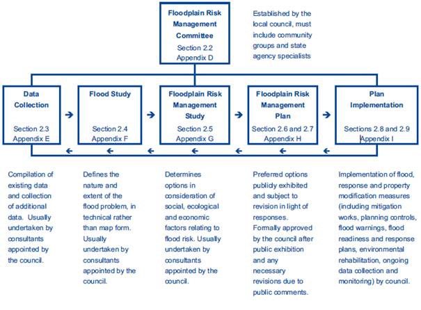
Fig 1: The
Floodplain Risk Management Process
(NSW Floodplain
Development Manual 2005)
Lower Shoalhaven River
Floodplain Risk Management Plan and Study (FRMS&P)
The
FRMS&P examines flooding issues relating to the floodplain of the Lower
Shoalhaven River and identifies issues raised in the course of the study
relating to “Subdivision of Land and Evacuation Access” at
Greenwell Point. A copy of the Flood Study Report, the Risk Management Study
and Plan as well as the Climate Change Assessment completed in 2011 for the
Lower Shoalhaven River are available from Council’s website at:-
http://shoalhaven.nsw.gov.au/Environment/Flood-risk/Flood-program#lowershoalhaveninprog
Section
5.2.4 of the FRMS&P states (pp 43-44):
Any proposal for further subdivision of land at Greenwell Point
will increase the population at risk and potential damages due to flooding for
the area. There will also be a greater reliance on emergency services, since
the subdivision is likely to attract new people to the area who are not
necessarily flood aware.
Ensuring that high hazard flood prone land situated in the
existing developed areas is zoned low density and enforcing minimum floor
height restrictions will prevent large increases in population or potential
flood damages.
Land not classified as flood prone should have similar low density
restrictions because the entire area can be isolated from services such as
fresh water, sewer and electricity during major flood events. Even though there
will be no threat to property in the flood free areas there will still be a
burden for emergency services because of the isolation. Any further expansion
or new development beyond the current residential zoning should not be
permitted at all.”
The FRMS&P is due for review
and Council’s Natural Resources team are currently developing a project
brief and anticipate that the tender process will commence in the next month or
so. This review will take approximately 2 years to fully complete and will be
undertaken in accordance with the principles and processes defined in the Floodplain
Development Manual
Greenwell Point Evacuation
Issues
The village
of Greenwell Point experiences access and evacuation difficulties in
potentially as little as a 10% AEP design event and greater. Greenwell Point is
classified as an ‘island’ under the Floodplain Manual 2005. The formation of islands in the floodplain during a
flood is a potentially dangerous situation. People trapped on the island and
their rescuers will be placed at undue risk. Thus, the development of land that
becomes isolated prior to ultimate inundation needs to be carefully considered.
In comparing
Greenwell Point to other villages and townships, the following were considered
(although not directly the same):
· Burrill
Lake;
· Conjola
Lake;
· Lake
Tabourie;
The flood
behaviour for the above villages is similar in regard to:
· Catchment
flooding,
· Oceanic
inundation,
· Low-level
persistent flooding, or
· Combination
of the above.
However none
of the above villages become totally isolated (island) for extended periods of
time during floods. The lower Shoalhaven River catchment is large and has flat
topography, thus flood waters can remain for longer periods.
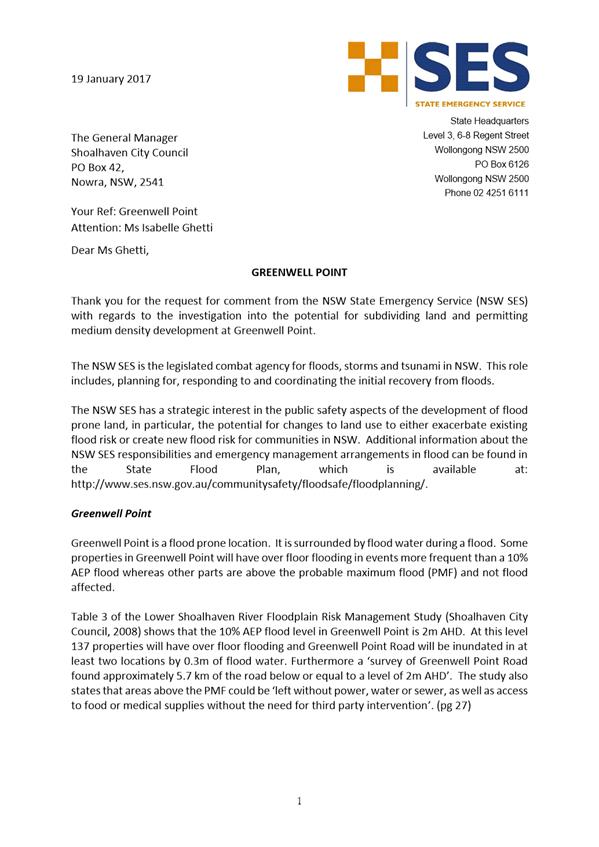
Advice was provided by the State
Emergency Services (SES) State Headquarters in relation to a
current development application for subdivision in the village. The detailed
response from SES is included as Attachment 2. The SES acknowledge that an
assessment to determine emergency response classifications has not been
conducted for Greenwell Point, however it is likely that there are areas above
the Probable Maximum Flood (PMF) level that would be classified as ‘high
flood islands’.
Greenwell Point Floodplain
Risk Management Options Feasibility Study
The Greenwell Point Floodplain
Risk Management Options Feasibility Study (Attachment 3 – Councillors
Information Folder) thoroughly investigated the floodplain mitigation and
management measures recommended in the adopted FRMS&P. The
Feasibility Study demonstrates that the structural mitigation options of a
levee and the raising of Greenwell Point Road would provide significant flood
benefits. However, these measures were generally not supported by the
community and are therefore not considered feasible at this time.
Based on the community feedback,
the adopted study recommended planning and education initiatives as the most
feasible measures that can be implemented for the area.
Council resolved on 10 February
2015 to:
a) Adopt
the Greenwell Point Floodplain Risk Management Options Feasibility Study;
b) Remove
the site specific flood related development controls from the table in Chapter
G9 (formerly DCP 106) of Shoalhaven DCP 2014, Schedule 5 Part D for the
properties: 3, 7, 9, 11, 42, 59 Adelaide Street; 59 Haiser Road, 2 Keith
Avenue, 1 Church Street and 68, 70, 76 Greens Road in Greenwell Point through
the Shoalhaven DCP 2014 ‘Housekeeping Amendment’ Part 1;
c) Continue
to work with the SES on community awareness and education programs to raise
awareness of the flood risk at Greenwell Point;
d) Request
Council’s Roads Manager, for any future upgrade works of Greenwell Point
Road, assess the possibility of incrementally raising the lower sections of the
road without impacting on drainage effectiveness
The change to Chapter G9 of
Shoalhaven DCP 2014 detailed in part b) of this resolution was made effective
on 1 July 2015. The possible raising of the lower sections of Greenwell
Point Road is being investigated and Council’s staff will continue to
work with the SES on community awareness and education programs to raise
awareness of flood risk at Greenwell Point.
Shoalhaven LEP 2014
Clause 7.3 Flood Planning in the
Shoalhaven LEP 2014 is a ‘model clause’ provided by the NSW
Department of Planning & Environment (DP&E) that has been slightly
adapted to meet the local situation in Shoalhaven.
Clause 7.3 (3) in Shoalhaven LEP
2014 includes the following criteria for the assessment of development
applications that are affected by this clause:
Development consent must not be granted to development on
land to which this clause applies unless the consent authority is satisfied
that the development:
a) is
compatible with the flood hazard of the land, and
b) will not
significantly adversely affect flood behaviour resulting in detrimental
increases in the potential flood affectation of other development or
properties, and
c) incorporates
appropriate measures to manage risk to life from flood, and
d) will not
significantly adversely affect the environment or cause avoidable erosion,
siltation, destruction of riparian vegetation or a reduction in the stability
of river banks or watercourses, and
e) is not likely to
result in unsustainable social and economic costs to the community as a
consequence of flooding, and
f) will not affect the safe occupation
or evacuation of the land.
DP&E’s drafting
instructions related to this Clause encourages Council’s to:
“first identify flood planning areas
through their strategic work and to zone appropriately, wherever possible. Care
should therefore be taken in determining the permissible development on land
that may be subject to flooding to ensure that appropriate uses are included
and that relevant types of development require consent under the applicable
zones. Councils are then encouraged to apply this model clause in flood
planning areas, particularly where flooding matters cannot be fully addressed
by limiting land uses e.g. in areas where an existing zone and existing land
uses include residential accommodation.”
As shown in Figure 2 below, the
majority of Greenwell Point is currently zoned R2 Low Density Residential (with
a minimum lot size of 500m2). There are some areas that are also zoned SP3
Tourist, B2 Local Centre, R1 General Residential, IN2 Light Industrial and R3
Medium Density. Most of the zones were a ‘best fit’ transfer
from the previous Shoalhaven LEP 1985.
As discussed at Council’s
Development Committee Meeting held on 7 November 2016, Council had resolved to
rezone Lot 1 DP 530097 and Lots A-D in DP 391663 at 1 Greens Road, Greenwell
Point from industrial to residential in July 2005. Arising from the
introduction of the Standard Instrument LEP, Council was advised by DP&E
that rezoning proposals should not be considered while Councils were in the
process of preparing their Standard Instrument LEP’s. The draft
Shoalhaven LEP under this process included a change of zone to residential in
accordance with Council’s resolution. The draft LEP was exhibited twice,
showing this change and it was eventually included in the notified Shoalhaven
LEP 2014. This zoning did not follow the general process required for
Planning Proposals which would have required an assessment against the
FRMS&P, the Floodplain Development Manual or relevant Section 117 Planning
Directions.
Following consideration of the
legal advice, the importance of the reconciliation
of the rezoning of the additional land in Greenwell Point (Greens Road)
to Zone R2 Low Density Residential under Shoalhaven LEP 2014 after the adoption
of the Flood Management Risk Study (FMRS) in October 2007 was highlighted;
especially in terms of it’s consistent with either the principles of the
Floodplain Development Manual or with the floodplain risk management process
that had been undertaken by Council.”
The rezoning, based on the
existing flood study and adopted plan, is unlikely to be considered as
“substantially in accordance with the principles contained in the
Floodplain Development Manual” or to accord with the floodplain risk
management process set out in the Manual. As a result, the Council would
have to demonstrate how it acted in good faith if challenged. .
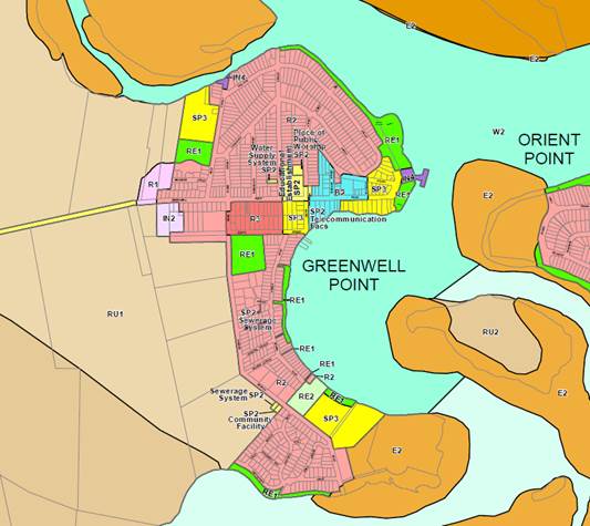
Fig
2: Shoalhaven LEP 2014 zoning map
Shoalhaven DCP 2014
The previous wording in the DCP
was problematic in that it did not have the power to prohibit subdivision
or additional development, only an Environmental Planning Instrument (e.g. LEP)
can prohibit development. The DCP can however provide controls and criteria
that must be considered in any development application and Council may refuse
development applications where the proposed development does not meet the
requirements in the DCP.
Any amendment to Part D of
Schedule 5 in the DCP in line with the 2015 notice of motion is unlikely to
have the benefit of the indemnity from liability provided in section 733 of the
LG Act as it is not “substantially in accordance with the principles
contained in the Floodplain Development Manual”, nor does it accord
with the floodplain risk management process that has been undertaken by
Council. It is therefore recommended that any changes to restrict development
in accordance with the FRMS&P be undertaken through a review of the land
zoning and minimum lot size controls in Shoalhaven LEP 2014 and a subsequent
review of the DCP to ensure consistency.
Subdivision Application
A Development Application (DA)
for a 9 lot residential subdivision over 1 Greens Road, Greenwell Point was
submitted on 20 December 2016. The application is currently under assessment,
however concerns have been raised through the referral process for this
application.
Conclusion
Even though
the flood behaviour is similar, what makes Greenwell Point unique is that it
becomes an isolated island where evacuation and access is severely affected for
an extended period of time. The liability for Council of allowing further
population intensification is difficult to estimate and would require further
investigation to determine the scale of the liability. Following
consideration of the legal advice, it is clear that Council’s indemnity
offered by Section 733 of the Local Government Act requires Council to either
follow the process prescribed in the Floodplain Manual and undertake
actions in ‘good faith’ to maintain indemnity or alternately be
able to demonstrate how it has acted in good faith, and on what basis.
Following
consideration of the legal advice (confidential Attachment 1), it is important
to ensure that ‘one-off’ changes are not made to the management
plan or the Council’s planning instruments and controls that have
potential consequences on the flood risk to life and property associated with
the use of land. Council must determine a clear policy position in relation to
development at Greenwell Point by adopting either Option 1 or 2 following
consideration of the implications outlined in this report.
Community Engagement
Council has
met its current legislative requirement for consultation through the exhibition
of Amendment No. 5 to Shoalhaven DCP 2014.
Any further
review of Shoalhaven LEP 2014 or Shoalhaven DCP 2014 will involve consultation
with the community and affected landowners. Any resultant draft
amendments would also need to be exhibited as required by legislation.
Policy Implications
The current
FRMS&P was prepared in accordance with the Floodplain Development Manual
and Guidelines.
Council
needs to clarify and resolve the difference between the existing zoning
provisions that imply further development ability and the recommendations of
the FRMS&P, which suggest restrictions on the intensification of
development. A review of the FRMS&P will enable Council to determine
whether any changes should be made to enable further expansion or new
development in Greenwell Point.
The controls
within Shoalhaven DCP 2014 are ultimately the last stage in the process and
implement the actions of the FRMS&P.
Financial Implications
There are no
immediate and direct financial implications for Council if development is
restricted in Greenwell Point in accordance with the FRMS&P and legal
indemnity is maintained. A future review of Shoalhaven LEP 2014 and Shoalhaven
DCP 2014 would be resourced within the existing Strategic Planning
budget. Any review of the FRMS&P will potentially need to be
resourced within the Environmental Services budget.
If there is
a mind to not restrict development in Greenwell Point, Council may not be
afforded protection under Section 733 of the LG Act, unless it can demonstrate
how it has acted in good faith. If Council is legally challenged on this
decision, there is a risk that Council could be liable for damages following a
flood event if it is found to not have acted in good faith by providing
suitable flood risk management controls in accordance with the
FRMS&P.
Risk Implications
Increased
density through subdivision or new development will potentially increase the
existing burden on emergency services and will increase the number of people at
risk during a flood event.
Consistency
with the FRMS&P is the most straight forward way to ensure Council’s
planning documents include suitable controls consistent with the Floodplain Development
Manual and Guidelines and to ensure Council is acting in good faith when
providing flood risk controls maintain legal indemnity.
|

|
Development
Committee – Tuesday 14 March 2017
Page
18
|
|

|
Development
Committee – Tuesday 14 March 2017
Page
24
|
DE17.21 Restaurants
and Cafes - A new interim restaurant authorisation system for liquor licences
HPERM Ref: D17/43541
Group: Planning
& Development Services Group
Section: Development
Services
Purpose / Summary
The NSW Government is making it
easier for restaurants and cafes to seek on-premises licences to sell liquor as
soon as they have lodged a liquor licence application online. This is
referred to as an interim arrangement. To qualify applicants need to meet
and adherer to certain requirements.
Council has received correspondence
from Liquor and Gaming NSW advising also that they would appreciate Council
informing applicants (of Development Applications (DAs)) to include advice with
respect to any intentions concerning the sale of liquor and the purpose of the
venue (café or restaurant) when lodging a DA. The reason for this
being a quicker turnaround of interim applications.
|
Recommendation (Item to be determined
under delegated authority)
That this report be noted for
information.
|
Options
1. Note this report for information.
Implications: Nil.
2. Resolve alternatively to the above and
advise and direct staff accordingly.
Background
On 8 December 2016, the NSW
State Government announced a range of changes to areas of the State’s
liquor laws.
The changes included a provisional
approval system that grants interim restaurant authorisations for restaurants
and cafes so they can begin serving liquor as soon as they lodge a licence
application online provided they meet certain requirements. The
authorisations were made available from 31 January 2017.
Details
Eligibility for an interim
authorisation
To be eligible, applicants must
apply online for an on-premises licence for a restaurant and fulfil certain
requirements including but not necessarily limited to:
1. Seeking
standard trading hours with liquor to be sold only with meals.
2. No
authorisations such as extending hours of trade must have been applied for.
3. Have
development consent to use the premises as a restaurant or café.
Council and the community must be informed about the intention to sell
liquor. This is expected to be done with the notification of the
development application.
An interim authorisation is
exempted from advertising and public submission requirements under the liquor
laws on the basis that consultation would have occurred as part of the
development application assessment and approval process.
Cost
Development Application fees
apply as prescribed by the Planning and Assessment Regulations 2000.
There is no additional fee for an interim restaurant authorisation on the
standard fee which is $700 for an on-premises liquor license applies and no GST
is applicable.
When can liquor start to be
served?
If an interim authorisation has
been granted:
· The
licensee must comply with the licence conditions and the Liquor Act 2007.
· Staff
must have a Responsible Service of Alcohol (RSA) certification before liquor is
serviced.
· Signage
must be displayed at the premises indicating the name of the premises, type of
liquor sold, type of license g Interim Restaurant Authorisation and what
business is being conducted eg restaurant. The sign must be visible from
outside of the front of the premises.
Hours of trade
If an interim restaurant
authorisation is granted, liquor can be served between 10am to Midnight Monday
to Saturday and 10am to 10pm on Sunday.
Cancellation
Cancellation can occur if the
licensee does not provide information to Liquor and Gaming NSW within 30 days
if information is requested or if conditions of the licence are not complied
with. There are penalties of up to $11,000 or 12 months imprisonment for
breaches of NSW liquor laws such as underage drinking.
Full licence
Once an interim authorisation
has been issued, Liquor and Gaming NSW will assess a licence application as per
the existing arrangements in place and thereafter a full licence will be issued
or alternatively a refusal. If a refusal is issued, liquor sales must
cease.
Toilet facilities
The Building Code of Australia only requires toilet
facilities in restaurants when the population exceeds 20. However,
alcohol is a diuretic and there is a need to ensure at least one unisex toilet
facility is provided at these smaller venues if alcohol is to be sold.
Council Officers have raised this with the Compliance Section of Liquor, Gaming
and Racing and it is currently being considered.
|

|
Development
Committee – Tuesday 14 March 2017
Page
26
|
DE17.22 Future
Potential Subdivision within the R2 Zone Hyams Beach
DA. No: SF10534
HPERM Ref: D17/46796
Group: Planning
& Development Services Group
Section: Development
Services
Attachments:
1. Report -
Development Committee 23 January 2017 ⇩
2.
Subdivision Potential Hyams Beach Village ⇩
Purpose
/ Reason for consideration by Council
Development Committee (23 January 2017) deferred consideration
of Development Application (DA) SF10534 – Proposed 2 lot subdivision at
Lot 7 DP249396 (No.1) Tulip Street, Hyams Beach to the “Development
Committee Meeting, Tuesday 14 March 2017 in order to assess the flow on effects
of future potential subdivisions”. The report to Development
Committee of 23 January 2017 is available in full, in ATTACHMENT 1.
Since consideration of the
matter on 23 January 2017, the applicant has chosen to amend the DA. The
revised plan of subdivision (Figure 1), submitted 15 February 2017, has
adjusted the proposed boundary so that Lot 1 has an area of 437m2
and proposed Lot 2 has an area of 436.1m2.
Figure 1
Extract of revised
plan of subdivision for SF10534 submitted 15/2/17
The applicant proposes
variations to the minimum lot size of 12.6% and 12.8% to proposed Lots 1 and 2
respectively. This however is still a 25.4% variation over two lots instead of
an equivalent variation for a single lot.
Given the change to the
application and submission of additional information, due process must be
observed and in this regard, referrals are underway (Rural Fire Service (RFS)
and Threatened Species Officer (TSO). The proposal is also being
renotified to ensure neighbours and submitters are aware of the change.
On receipt of all referral
responses the revised application will be subject to the full assessment
process that includes consideration of submissions and the policy direction
provided by Council.
|
Recommendation
(Item to be determined under delegated authority)
That:
1. Council
note the findings of this report; and
2. Confirm
the variations to the minimum lot size proposed in development application
SF10534, as modified, not be supported and the application be determined
under delegated authority.
|
Options
1. Support the recommendation.
Implications: The revised application would
not proceed and would result in a refusal given that the lot size variation is
not supported. This could result in an appeal to the Land and Environment
Court. There would also be cost implications to Council if litigation
ensued.
2. Given the significant
implications of permitting the variations, that prior to making any decision,
the whole village be invited to comment on a Hyam’s Beach lot size policy
variation.
Implications: This would require Council to write to the
community, seek comments, compile the results of the consultation and
potentially report the matter to Council. This information could
potentially inform a potential amendment to the minimum lot size map in SLEP14
with respect to Hyams Beach. This would be the most equitable approach if
Council wishes to allow smaller lot sizes within the village.
3. Not support the
recommendation.
Implications: The Committee would need to provide
direction to staff.
Background
The following analysis of potential subdivision in Hyams Beach
is based solely on existing lot size. A detailed assessment of
constraints that may limit or preclude subdivision would require a detailed
investigation of building and environmental impacts on individual lots.
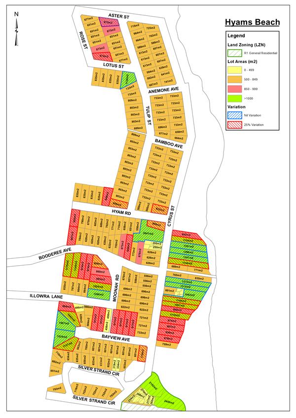
ATTACHMENT 2 maps the lot sizes and subdivision
potential with the R2 zone in Hyams Beach.
Table 1 shows the subdivision potential for the village of
Hyams Beach based on lots that may comply with minimum lot sizes and lots that
may be subdivided with a total variation of 25% to the minimum lot sizes.
Table 1
Subdivision
Potential R2 Zone Hyams Beach
|
Extent
of variation to minimum parent lot size
|
No. lots with
subdivision potential
|
Additional lots
|
Additional lots
less than 500m2 after subdivision
|
|
Nil
variation
|
11
|
12
|
23
|
|
25%
variation
|
36
|
36
|
72
|
|
Total
|
47
|
48
|
95
|
Assumptions:
· The
number of lots with subdivision potential includes the lot subject of this
report, i.e. Lot 7 DP 249396.
· Lots
within R1 zone are not included.
· Subdivision
potential is based on lot size only. Environmental or building
constraints that may affect the suitability of a lot for further subdivision
are not considered.
· Lots
with subdivision potential, nil variation required:
§ Corner
lot subdivision: 2 x 500m2 = 1000m2 or greater;
§ Battle-axe
lot subdivision: 500m2 + 650m2 + 60m2 (handle,
4m x 15m) = 1210m2 or greater.
· Lots
resulting from 25% variation to minimum parent lot size:
§ Corner
lot subdivision: 1000m2/0.75 = 750m2;
§ Battle
axe lot subdivision: 1210m2/0.75 = 907.5m2, adjust
to 900m2.
Table 2 below shows the existing
number of lots less than the minimum 500m2 and the potential impact
on the subdivision pattern should the potential subdivisions in Table 1 proceed
. This does not include seven lots in Community Title Schemes for
approved tourist developments.
Table
2
Lot Size in the R2
Zone Hyams Beach
|
Existing lots
|
218
|
Potential lots
|
266
|
|
Existing lots
<500m2
|
5
|
Potential lots
<500m2 with 25% variation
|
72
|
|
% existing lots
< 500m2
|
2.29%
|
% potential lots
< 500m2
|
27%
|
The result of the subdivision is
potentially a higher density of development which is of concern, noting the
isolated location (only one road into / out) of Hyams Beach.
The following table shows the subdivision potential for the
village of Hyams Beach based on lots that may comply with minimum lot sizes and
lots that may be subdivided with a total variation of 25% to the minimum lot
sizes.
Table
3
Subdivision
Potential – lots with a 25% Variation
|
Extent
of variation to minimum lot size
|
No. lots with
subdivision potential
|
Additional lots
|
|
Nil
variation
|
11
|
12
|
|
25%
variation to minimum parent lot size
|
36
|
36
|
|
Total
|
47
|
48
|
Again, there have been certain assumptions made. Refer
to the information associated with Table 1.
Policy Implications
Approval of a subdivision with a 25% variation is considered
to create an undesirable precedent that may facilitate and provide weight to
further subdivision within the Hyams Beach village.
Significant variation to the minimum lot size will compromise
the integrity of the development standards of the SLEP14, and over time
increase densities to a greater level than that currently allowed; inevitably
this will change the character of the village.
Consultation and Community
Engagement:
The revised plan of subdivision, Statement of Environmental
Effects, bushfire report and flora and fauna assessment are being been
re-notified to persons making previous submissions. Additionally,
technical referrals have also been made.
Summary and Conclusion
Based on the application of 25%
variation to minimum lot size, there is potential for an additional 36
residential lots, this could result in 72 lots less than the minimum lot size,
see Table 1. In addition, the potential for subdivision without variation
is for 12 additional lots equal to or greater than the minimum lot size.
The total subdivision potential is 48 additional lots, this includes lots that
meet the minimum lot size and lots with a 25% variation.
There are a small number of
existing lots (5) in the R2 zone that are less than the minimum lot size, that
is, 2.29% of existing R2 zoned lots. A 25% variation to the minimum lot
size has the potential to create 72 lots less than the minimum, an increase of
27% in the number of lots less than the minimum, see Table 2.
Supporting the lot size variations creates a potential that
may lead to other applications and possibly also for greater variation.
Council’s ability to withstand substantial departures from the minimum
lot size, in the event of an approval, will be compromised which in turn will
call into question the integrity of the development standard.
The potential for additional
lots is not insignificant. The impacts of the additional lots will result
in additional development and population in a sensitive coastal village that
currently enjoys a very attractive and somewhat distinctive character.
Hyams Beach is a unique coastal village accessed by a single road that is
bushfire affected. The village places significant demands on Council
resources during peak holiday periods and the increased population and
associated demands with any increased residential densities may contribute
further to these holiday impacts.
Support for the proposed variations subject of the current
application will not by itself necessarily change the character of the village
but it will encourage further similar development which
cumulatively, will contribute to alterations in the appearance of area
which in turn will impact on the low scale and low density ‘coastal
village’ character of Hyams Beach.
|
|
Development
Committee – Tuesday 14 March 2017
Page
30
|
|

|
Development
Committee – Tuesday 14 March 2017
Page
40
|
|
|
Development
Committee – Tuesday 14 March 2017
Page
41
|
DE17.23 Development
Application – Parson St Ulladulla – Proposed Lot 15 in Subdivision
of Lot 3 DP 746228 and Lots 5 & 6 DP 805221
DA. No: DA16/2412/4
HPERM Ref: D17/50496
Group: Planning
& Development Services Group
Section: Ulladulla
Service Centre
Attachments:
1. Site Context
Photos ⇩
2. DA
Plans ⇩
Description of Development: Construction of a three storey office building, car
parking, landscaping and associated infrastructure
Owner: ET & ME Oberg
Applicant: Triple A Developments
Notification Dates: 12 December 2016 to 9 January
2017
No. of Submissions: 4 in objection
Nil in
support
Purpose
/ Reason for consideration by Council
The purpose of this report is to seek Council direction with
respect to a request for a variation of a development standard (building
height) applicable to the site under Clause 4.6 of the Shoalhaven Local
Environmental Plan 2014 (SLEP 2014).
|
Recommendation
(Item to be determined under delegated authority)
That Council:
1. Confirm
that it supports the proposed height variation to the 7.5m height limit and
allow the increase sought;
2. Refer
the application back to staff for determination by delegation;
3. That
a review of the 7.5m building heights in this part of the town centre be
included in any future review of DCP2014 Chapter S8 – Ulladulla Town
Centre
|
Options
1. Resolve to
support the propose variation to the development standard for height from 7.5m
to 11m and refer the application back to staff to determine the application
under delegated authority.
Implications: This would enable the application to be
finalised and conditions prepared to enable consent to be issued. The objectors
could choose to pursue the matter through the land and environment court.
It would however be necessary to demonstrate that due process was not observed
with respect to the processing of the DA.
2. Resolve not to
support the proposed variation to the development standard and refer the
application back to staff to negotiate with the applicant to redesign the
proposal to meet the 7.5m height standard.
Implications: This would mean that the application could not
be supported in its current form. This would require modifications to be
made to specifically adjust the height which could have implications on the
development and its commercial viability for the owners of the site. This
option could also potentially result in litigation by the applicant.
3. Adopt an
alternative recommendation and provide direction to staff.
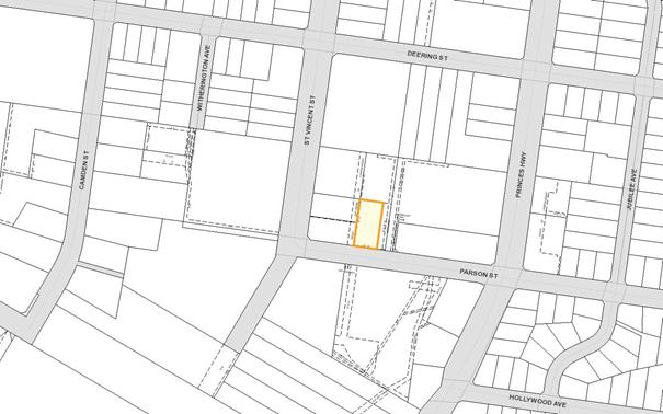
Figure 1 Location Map

Background
Proposed Development
The application proposes
construction of a three (3) storey office building comprising ground floor car
parking and two levels of office space (refer to Attachment 1 – Plans).
More specifically the application can be summarised as follows:
· Overall maximum
building height is 11 metres.
· The predominant
height expressed to Parson Street is 10.5 metres at the south-western corner to
11 metres at the south-eastern corner. The building reduces in height in a
south to north direction with lowest part of the building being to the rear of
the structure at 6.48 metres in the north-west corner.
· Building design is
contemporary with a mix of materials including concrete, render,
metal/aluminium cladding, perforated metal screening and glazing.
· A total of 25
(including 1 accessible space) car spaces are proposed on the ground level.
· Two office levels
comprising floor areas of 504m2 (first floor) and 492m2 (second
floor).
· Vehicle
entry and egress to and from the site is proposed via Parson Street.
Subject Land
The site is located on the
northern side of Parson Street approximately 124 metres west of the Princes
Highway and will be created by a separate approval for the consolidation and
boundary adjustment of Lots 5 & 6 DP805221 and Lot 3 DP 746228.
The land upon finalisation of a
consolidation plan will have a frontage to Parson Street of 33.84 metres and a
slightly variable depth averaging 38.5 metres with a total site area of 1303m2.
The land has a fall of approximately 4.5 metres from the northwest to
southeast. The site is currently vacant.
The lot will be encumbered by a
1m wide drainage easement along the western and southern boundaries and a 3m
wide drainage easement along the eastern boundary.
Site & Context
The site is in surrounded by a
range of commercial premises which are characteristic of the B5 Business
Development zone.
To the immediate north is a
storage facility whilst to the western boundary abuts two lots which comprise a
storage facility and car wash with frontages to St Vincent Street. A Right of
way adjoins the eastern boundary and beyond this is a car dealership and
commercial building with multiple occupancies along the Highway.
On the southern side of Parson
Street is the Home Maker Centre with multiple commercial and retail occupancies
whilst the Dunn & Lewis Centre and Bunnings are located further west and
south-west of the site.
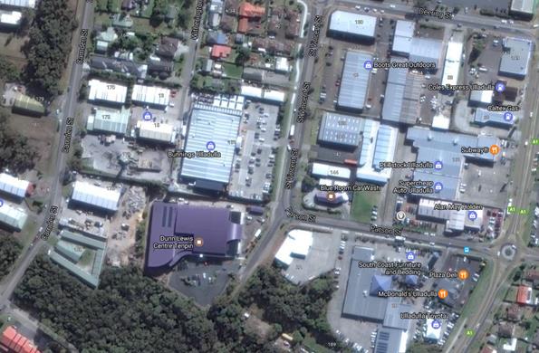
Strategic Context
The development site is located
within an existing commercial precinct identified as Precinct 5: Business
Development under chapter S8 Ulladulla Town Centre of the Development Control
Plan (DCP 2014). The site is characterised by predominantly commercial uses.
Buildings are typically single storey however there are more recent larger
developments in the immediate surrounds including the Dunn & Lewis Centre,
Bunnings and Project Lighting.
The area bounded by Deering
Street, St Vincent Street, Parson Street and the Princes Highway is an area of
mixed built form and character, with a mix of large format retail buildings
with either multiple occupancies or single buildings purposely built such as
the car wash and storage facilities, Bunnings and McDonalds restaurant. The
area is essentially a mix of business and warehouse and bulky goods premises
which are consistent with the objectives of the zone. (refer to Attachment 2
– Site Context Photos)
The site is located
approximately 400 metres from the Commercial Core of Ulladulla.
Figure 2 Aerial view of subject site and surrounding area

The 7.5 metre height control was
originally set in DCP 56.4 in 2008 as an acceptable solution and then
incorporated into SLEP 2014 as a development standard. Figure 3 shows the
various maximum heights in the locality of the proposal.
Figure 3 Height Limit Map
History
The site was previously approved
for expansion of the storage units, however, the owners have decided to limit
the extent of the storage units and develop this proposed residual vacant lot
more in keeping with the type of development to the south and west of the site.
The building height controls on
this site were originally established as 8m and 2 storeys under DCP 56 in 1995,
as it applied to most of the town centre area other than some specified
locations where 11m or 14m was permitted. DCP 56.4 was adopted in 2008
which included significant changes to building heights, particularly in the
business core, of up to 14m with key development precincts of up to 25m,
however, in the location of this development the height control was reduced to
7.5m with the intent of insuring that development along the ridge of Deering
Street did not impact visually on the appearance of the town centre as viewed
from the harbour end of town. This site is well south of this ridge and
at least 6m lower than Deering Street.
The adoption of DCP 56.4 caused
considerable concern within the Ulladulla community, which stimulated the
establishment of the Ulladulla and Districts Community Forum and a sustained
campaign to review the heights that were adopted in the plan. Following
considerable consultation with the community the heights were revised down and
adopted in DCP 56.5 in 2011. The building heights south of the town
centre were not highlighted in this review nor was the 7.5m building height
reviewed in the preparation of SLEP 2014, which rezoned the low density area to
R3 Medium Density in the southeast of the town centre DCP area.
Issues
Clause 4.3 Height of Buildings
The site is situated within an
area where Height Building Maps under cl.4.3 of SLEP 2014 provides for a
maximum building height of 7.5m. This application seeks to vary this
building height development standard.
A variation of 46% (3.5m) is
sought along the southern elevation and to a lesser degree to the remaining
elevations.
Clause 4.6 Exceptions to Development Standards
The NSW planning system provides flexibility in planning
controls by providing the ability for Council to vary development standards in
certain circumstances. In this regard, the concurrence of the Secretary
of the Department of Planning and Environment (DP&E) can be assumed as
provided in DP&E publication – Varying development standards: A
Guide – August 2011 (the Guide). Clause 4.6 enables a development
standard to be “contravened”, provided the applicant has submitted
a written request that adequately justifies the exception (variation) from the
development standard by demonstrating that:
a) that compliance with the
development standard is unreasonable or unnecessary in the circumstances of the
case; and
b) that there are sufficient
environmental planning grounds to justify contravening a development standard.
Further, the consent authority
must be satisfied that:
i. the applicant’s written
request has adequately addressed the matters required to be demonstrated by
subclause (3), and
ii. the proposed
development will be in the public interest because it is consistent with the
objectives of the particular standard and the objective for development within
the zone in which the development is proposed to be carried out.
Applicant’s Submission
The applicant provided Council with a justification to
variation of the development standards as follows:
There are no nearby buildings
apart from the adjoining rear storage sheds, the corner Car wash is 8.0 M away
to the west and the Car dealership is 28.0 M to the east.
The proposed development will
be a landmark Office Building just off the Princes Highway and because the site
elevation and location of surrounding buildings, the proposed development will
have a stand alone appearance.
The proposed building will be
three levels, a Car Park and two Office floors above, the Car Park will be
excavated into the rear of the site so that the rear of the building appears
two levels and is under the 7.50 M height requirement while the building
appearance from Parson Street will be 3 levels with open Car parking across the
frontage and the top storey roof facade will be 10.00 M high above natural
ground.
The proposed building
frontage has been design to go diagonally across the site following the
existing contours of the land with the building frontage set back at the Entry
at 5.50 M to the furthest point set back 28.50 M off the front boundary, by
following the contour of the land the building design maintains a
constant height across the site above natural ground and the bulk of the
building height recedes to the rear of the site so there is not a lot of
building bulk at the street There is also a precast concrete blade with flag
pole which reflects the masthead on a ship which is 11.0 M above ground and
ties in with the front Office Terraces, this is a significant feature of the
building design as it stands out from the building as the Office terraces
recede to the back of the site.
Apart from the Entry
frontage and feature concrete blade which are position towards the front of
road the building frontage consist mainly of an open Car Parking area with side
driveway access, the top floor Offices continues to recede back to the rear of
the site, this design reduces the height and bulk appearance of the building from
the street frontage.
The fall in the land has made
it difficult to keep the building height under the 7.50m limitation the
diagonal frontage will reduce the impact of the building height on the
streetscape and the sweeping curved front terraces will provide an attractive
appearance, due to the unique site location there will not be any adjoining
buildings next to the building proposal, the building will not compete or
detract from the adjoining sites, the request for building height variation in
this instance will have no impact on the adjoining and surrounding sites.
The proposed development will
have minimal impact on adjoining buildings as the height variation requested
will not cause any loss of views, privacy and solar access.
The applicant has also submitted
plans which illustrate the extent of the intrusion of the building above the
7.5m height plane.
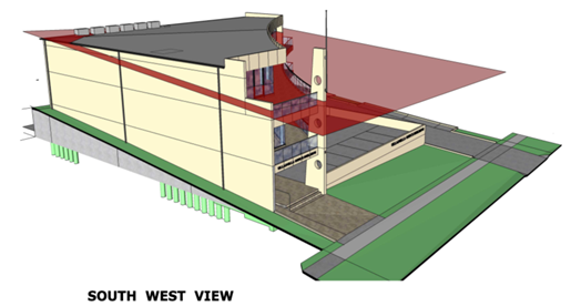
Discussion
In accordance with 4.(a)(i) of
Clause 4.6 of the SLEP 2014, the applicant’s written request is
considered to have adequately addressed the matters required to be demonstrated
by subclause (3) that is,
a) Compliance with the development
standard is unreasonable or unnecessary in the circumstances of the case and
b) There
are sufficient environmental grounds to justify contravening the development
standard.
After reviewing the
applicant’s submission, it is considered that the variation is reasonable
and acceptable for the following reasons:
· The
building height varies with the slope of the block and is contextually
appropriate.
· The
building height variation does not generate overshadowing impacts on the
surrounding properties.
· The
proposal is consistent with the desired future character of the area. The area
is identified in the Ulladulla Town Centre DCP as a Business Development
Precinct located on the fringe of the central business area which will become
increasingly important as an area for support activities to the Commercial Core
Precinct and provides a buffer to the industrial areas to the south.
· The
proposal is considered to be consistent with the objectives of the height
standard, to ensure that the height of development is appropriate to the
condition of the site and its context.
· Where
the variation is the greatest in the southern elevation it incorporates large
expanses of glass and balconies to the first and second floors which provide
articulation and reduces the perceived height from the street level. The
curved shape of the front elevation also provides relief and softens the
appearance of the building from Parson Street.
· Height controls
can be appropriate so long as they appropriately designed to facilitate good
planning outcomes. In this instance it is considered that this might not
be the case and a review of the current height controls in the precinct would
be beneficial to identify the desired outcomes and the appropriateness of the
controls. There is considerable variation in the building height controls in
the immediate surrounds of this proposal. An 11m height control applies
to the west side of St Vincent Street, a 10m height limit applies to the south
side of Parson Street (opposite the site) which is the same B5 zoning.
Low density residential land surrounding this precinct has an 8.5m height
control but medium density R3 within the precinct has a 7.5m height control
(Refer Figure 3).
Consistency with the
underlying objectives of the standard:
The objective of the Height
Standard is listed at Clause 4.3 (1) of SLEP 2014.
a) to ensure that buildings are
compatible with the height, bulk and scale of existing and desired future
character of the locality,
b) to minimise visual impact,
disruption of views, loss of privacy and loss of solar access to existing
development,
c) to ensure that the height of
building on or in the vicinity of a heritage item or within a heritage
conservation area respect heritage significance.
The proposal is consistent with
bulk and scale of the existing development and the desired future character of
the locality. The proposed height of the development is appropriate to
the context and is compatible with the prevailing pattern of buildings in the
locality. The extension of the building beyond the 7.5m height control is
predominant at the front of the building (southern elevation) and gradually
reduces towards the rear of the building.
The proposal positively responds
and satisfactorily addresses the particular characteristics of the site and its
broader context. The proposal is of a height and scale that is sympathetic to
its immediate context.
The proposed development, when viewed from the street, will
not dominate the streetscape and will be compatible with newer developments in
the vicinity including Project Lighting, the Dunn & Lewis Centre and
Bunnings that are of a similar bulk and scale within close proximity of the
site. The proposal is contemporary commercial design which is consistent
with the surrounding environs and the objectives of the B5 zone.
Planning Assessment
The application will be fully
assessed under s79C of the Environmental Planning and Assessment Act 1979
following determination of the application for variation to development
standards.
Policy Implications
The application identifies a
need to review the appropriateness of the height controls in the precinct and
it is recommended that this be included in the next review of DCP 2014 Chapter
S8 Ulladulla Town Centre.
Consultation and Community
Engagement:
The notification was made in
accordance with Council’s Community Consultation Policy to properties
within a 60 metres of the site and a newspaper advertisement The
notification was for a 4 week period to account for the Christmas/New
Year’s holidays and 4 submissions were received.
Key issues raised as a result of
the notification are provided below.
Issue
Development should comply with
the existing height controls/Development will set undesirable precedent if
approved at proposed height.
Comment
It is considered that this issue has been addressed in the
preceding assessment.
Issue
Not enough time given for
public evaluation.
Comment
Whilst the application was notified over the Christmas/New
Year period, it was advertised for four (4) weeks rather than the regular two
(2) week period timeframe to account for the holiday period. It is considered
that notification of the application was undertaken in a fair and reasonable
process.
Issue
Increased traffic demand and
pressure on existing infrastructure.
Comment
The proposed use is of a size and intensity which would be
anticipated in the zone and is unlikely to cause significant traffic impacts.
Whilst there is congestion in peak holiday periods at the roundabout at the
intersection of The Princes Highway and Parson Street this is not directly
related to the proposal and it is unlikely to contribute significantly as
traffic can enter and exit away from the roundabout on local roads.
Issue
Appearance of building out of
character and not ‘coastal’ in appearance. Large blank walls
Comment
The proposed building is
consistent with surrounding built form character and consistent with the
objectives of the Business Development precinct (S8 Ulladulla Town Centre DCP)
by providing an attractive and active street frontage. The DCP does not require
a coastal design in this precinct.
In relation to the comments on
the blank wall on the western boundary and its visibility from adjoining
properties, these walls will be in part obscured by the car wash and storage
facility on the western boundary. Also the design of the wall
incorporates delineation of the different levels of the building which will
provide some relief.
Financial Implications:
Not applicable
Legal Implications
If the application is refused,
or if the applicant is dissatisfied with Council’s determination, the
applicant is entitled to appeal to the Land and Environment Court.
Under some circumstances, third
parties may have a right to appeal Council’s decision to the Land and
Environment Court.
Summary and Conclusion
It is recommended that the
variation is reasonable and acceptable and in this instance, strict compliance
with the height development standard is considered to be unnecessary as the
development is appropriate in the location and can achieve relevant planning
objectives.
It is considered that there are
sufficient planning grounds to justify the departure from the height
development standard prescribed in the Shoalhaven LEP 2014. Therefore,
the proposed variation to the building height development standard is
considered to be well founded in this instance.
|
|
Development
Committee – Tuesday 14 March 2017
Page
51
|
|
|
Development
Committee – Tuesday 14 March 2017
Page
56
|

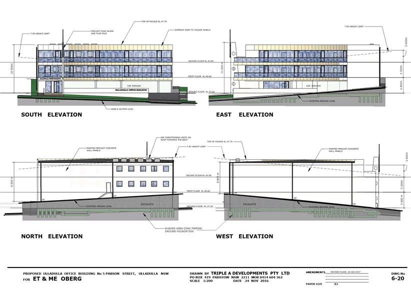
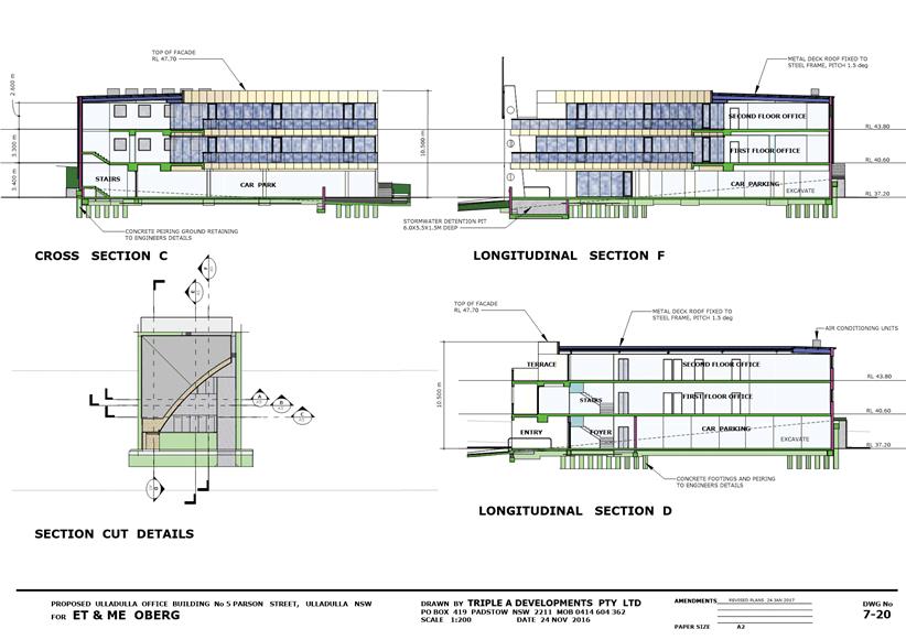
|
|
Development
Committee – Tuesday 14 March 2017
Page
63
|
Local Government Amendment (governance &
planning) act 2016
Chapter
3, Section 8A Guiding principles for councils
(1)
Exercise of functions
generally
The
following general principles apply to the exercise of functions by councils:
(a) Councils should provide strong
and effective representation, leadership, planning and decision-making.
(b) Councils should carry out
functions in a way that provides the best possible value for residents and
ratepayers.
(c) Councils should plan
strategically, using the integrated planning and reporting framework, for the
provision of effective and efficient services and regulation to meet the
diverse needs of the local community.
(d) Councils should apply the
integrated planning and reporting framework in carrying out their functions so
as to achieve desired outcomes and continuous improvements.
(e) Councils should work
co-operatively with other councils and the State government to achieve desired
outcomes for the local community.
(f) Councils should manage
lands and other assets so that current and future local community needs can be
met in an affordable way.
(g) Councils should work with
others to secure appropriate services for local community needs.
(h) Councils should act fairly,
ethically and without bias in the interests of the local community.
(i) Councils should be
responsible employers and provide a consultative and supportive working
environment for staff.
(2) Decision-making
The
following principles apply to decision-making by councils (subject to any other
applicable law):
(a) Councils should recognise
diverse local community needs and interests.
(b) Councils should consider social
justice principles.
(c) Councils should consider the
long term and cumulative effects of actions on future generations.
(d) Councils should consider the
principles of ecologically sustainable development.
(e) Council decision-making should
be transparent and decision-makers are to be accountable for decisions and
omissions.
(3) Community participation
Councils
should actively engage with their local communities, through the use of the
integrated planning and reporting framework and other measures.
Chapter
3, Section 8B Principles of sound financial management
The
following principles of sound financial management apply to councils:
(a) Council spending should be responsible and
sustainable, aligning general revenue and expenses.
(b) Councils should invest in responsible and
sustainable infrastructure for the benefit of the local community.
(c) Councils should have effective financial
and asset management, including sound policies and processes for the following:
(i) performance management
and reporting,
(ii) asset maintenance and
enhancement,
(iii) funding decisions,
(iv) risk management practices.
(d) Councils should have regard to achieving
intergenerational equity, including ensuring the following:
(i) policy decisions are made
after considering their financial effects on future generations,
(ii) the
current generation funds the cost of its services
Chapter
3, 8C Integrated planning and reporting principles that apply to councils
The
following principles for strategic planning apply to the development of the
integrated planning and reporting framework by councils:
(a) Councils should identify and prioritise key
local community needs and aspirations and consider regional priorities.
(b) Councils should identify strategic goals to
meet those needs and aspirations.
(c) Councils should develop activities, and prioritise
actions, to work towards the strategic goals.
(d) Councils should ensure that the strategic
goals and activities to work towards them may be achieved within council
resources.
(e) Councils should regularly review and
evaluate progress towards achieving strategic goals.
(f) Councils should maintain an integrated
approach to planning, delivering, monitoring and reporting on strategic goals.
(g) Councils should collaborate with others to
maximise achievement of strategic goals.
(h) Councils should manage risks to the local
community or area or to the council effectively and proactively.
(i) Councils should make appropriate
evidence-based adaptations to meet changing needs and circumstances.