Development Committee
Meeting Date: Tuesday,
14 February, 2017
Location: Council
Chambers, City Administrative Building, Bridge Road, Nowra
Time:
5:00pm
Membership (Quorum - 5)
Clr Patricia White - Chairperson
All Councillors
General Manager or nominee
Please note: Council’s Code of Meeting Practice
permits the electronic recording and broadcast of the proceedings of meetings
of the Council which are open to the public. Your attendance at this meeting is
taken as consent to the possibility that your image and/or voice may be
recorded and broadcast to the public.
Agenda
1. Apologies / Leave of Absence
2. Confirmation of Minutes
· Development
Committee - 23 January 2017............................................................... 1
3. Declarations of Interest
4. Mayoral Minute
5. Deputations and Presentations
6. Notices of Motion / Questions on Notice
DE17.11...... Notice of Motion - Subdivision Application - 7
Bangalee Road, Tapitallee.... 8
DE17.12...... Notice of Motion - Development Application -
Coastal Palms Caravan Park - Shoalhaven Heads - DA17/1019.................................................................. 10
DE17.13...... Notice of Motion - Crown Land adjacent to
Shoalhaven Heads Golf Course 12
7. Reports
DE17.14...... Council Land Reclassification Housekeeping
Planning Proposal - Post Exhibition Consideration and Finalisation...................................................................... 15
DE17.15...... Development Application DA16/1123 – 56 - 69
Graham St, Nowra, Lots H, J & K & DP 39320...................................................................................................... 19
DE17.16...... Development Application – 1 Brooks Lane, Kangaroo
Valley – Lot 102 in DP 1056895...................................................................................................................... 42
DE17.17...... DA Fee Exemption - South Coast Branch Surf Life
Saving (NSW) - Proposed Administration, Training & Storage Facility -
Integrated Emergency Management Centre, 92 Albatross Road, Nowra............................................................... 52
8. Confidential
Reports
Nil
|

|
Development
Committee – Tuesday 14 February 2017
Page
iii
|
Development Committee
Delegation:
Pursuant to s377 (1) of the
Local Government Act 1993 the Committee is delegated the functions conferred on
Council by the Environmental Planning & Assessment Act 1979 (EPA Act),
Local Government Act 1993 (LG Act) or any other Act or delegated to Council, as
are specified in the attached Schedule, subject to the following limitations:
i. The
Committee cannot make a decision to make a local environmental plan to classify
or reclassify public land under Division 1 of Part 2 of Chapter 6 of the LG
Act;
ii. The
Committee cannot review a s82A or s96AB EPA Act determination made by the
Council or by the Committee itself;
iii. The
Committee cannot exercise any function delegated to the Council which by the
terms of that delegation cannot be sub-delegated;
iv. The Committee
cannot exercise any function which s377(1) of the LG Act provides cannot be
delegated by Council; and
v. The
Committee cannot exercise a function which is expressly required by the LG Act
or any other Act to be exercised by resolution of the Council.
Schedule:
1. All
functions relating to the preparation, making, and review of local
environmental plans (LEPs) and development control plans (DCPs) under Part 3 of
the EPA Act.
2. All
functions relating to the preparation, making, and review of contributions
plans and the preparation, entry into, and review of voluntary planning
agreements under Part 4 of the EPA Act.
3. The
preparation, adoption, and review of policies and strategies of the Council in
respect of town planning and environmental matters and the variation of such
policies.
4. Determination
of variations to development standards related to development applications
under the EPA Act where the development application involves a development
which breaches a development standard by more than 10% and the application is
accompanied by a request to vary the development standard under clause 4.6 of
Shoalhaven Local Environmental Plan 2014 or an objection to the application of
the development standard under State Environmental Planning Policy No. 1
– Development Standards.
5. Determination
of variations from the acceptable solutions and/or other numerical standards
contained within the DCP or a Council Policy that the General Manager requires
to be determined by the Committee
6. Determination
of development applications that Council requires to be determined by the
Committee on a case by case basis.
7. Review
of all determinations of development applications under sections 82A and 96AB
of the EP&A Act.
8. Preparation,
review, and adoption of policies and guidelines in respect of the determination
of development applications by other delegates of the Council.
Minutes of the Development Committee
Meeting Date: Monday,
23 January 2017
Location: Council
Chambers, City Administrative Building, Bridge Road, Nowra
Time: 5:04pm
The following members
were present:
Clr Patricia White -
Chairperson
Clr Amanda Findley
Clr Joanna Gash
Clr John Wells
Clr John Levett
Clr Nina Cheyne
Clr Annette Alldrick
Clr Kaye Gartner
Clr Mitchell Pakes
Clr Greg Watson
Clr Mark Kitchener
Clr Bob Proudfoot
Mr Ben Stewart –
Acting General Manager
|
Apologies / Leave of Absence
|
Nil
|
Confirmation of the Minutes
|
|
Recommendation
That the Minutes of the
Development Committee held on Tuesday 06 December 2016 be confirmed.
|
|
RESOLVED (Clr Findley / Clr
Wells) MIN17.1
That the Minutes of the
Development Committee held on Tuesday 06 December 2016 be confirmed.
CARRIED
|
Clr Cheyne – less than significant non
pecuniary interest – DE17.1 Rescission Motion - Gateway Determination -
Planning Proposal - Warrah Road, Bangalee. will remain in the room and will
take part in discussion or vote – the conflict is one of perception that
the subdivision could affect my property value. She does not believe that she
has a specific pecuniary interest as she is one of the many residents who live
within the vicinity of the subdivision.
Deputations and Presentations
Mr Dennis Johnson
addressed the Committee in relation to DE17.1 – Rescission Motion -
Gateway Determination - Planning Proposal - Warrah Road, Bangalee.
Mr Lee Carmichael
addressed the Committee in relation to DE17.6 - Development Application SF10534
– Proposed 2 lot subdivision at Lot 7 DP249396 (No.1) Tulip Street, Hyams
Beach.
|
Procedural
Motion - Bring Item Forward
|
|
RESOLVED (Clr Proudfoot / Clr
Wells) MIN17.2
That the following items be
brought forward for consideration:
- DE17.1 –
Rescission Motion - Gateway Determination - Planning Proposal - Warrah
Road, Bangalee and
- DE17.6 - Development Application
SF10534 – Proposed 2 lot subdivision at Lot 7 DP249396 (No.1)
Tulip Street, Hyams Beach.
CARRIED
|
|
Procedural
Motion – Deputation
|
|
RESOLVED (Clr Findley / Clr
Levett) MIN17.3
That Mr James McCullough be
permitted to provide a deputation in relation to DE17.6 - Development
Application SF10534 – Proposed 2 lot subdivision at Lot 7 DP249396
(No.1) Tulip Street, Hyams Beach.
CARRIED
Mr James McCullough addressed
the Committee in relation to DE17.6 - Development Application SF10534 –
Proposed 2 lot subdivision at Lot 7 DP249396 (No.1) Tulip Street, Hyams
Beach.
|
Notices of Motion / Questions
on Notice
|
DE17.1 Rescission
Motion - Gateway Determination - Planning Proposal - Warrah Road, Bangalee
|
HPERM Ref:
D16/400228
|
|
Note:
Clr Cheyne – less than
significant non pecuniary interest – DE17.1 Rescission Motion - Gateway
Determination - Planning Proposal - Warrah Road, Bangalee – remained in
the room and took part in discussion or vote – the conflict is one of
perception that the subdivision could affect my property value. She does not
believe that she has a specific pecuniary interest as she is one of the many
residents who live within the vicinity of the subdivision.
|
|
Recommendation (Item to be determined under
delegated authority)
That Council rescind the Motion relating to Item DE16.20
of the Development Committee Meeting held 6 December 2016.
|
|
motion (Clr Gartner / Clr Cheyne) MIN17.4
That Council
rescind the Motion relating to Item DE16.20 of the Development Committee
Meeting held 6 December 2016.
For: Clr
Findley, Clr Levett, Clr Cheyne, Clr Alldrick, Clr Gartner and Ben Stewart
Against: Clr
White, Clr Gash, Clr Wells, Clr Pakes, Clr Watson, Clr Kitchener and Clr
Proudfoot
LOST
|
|
DE17.6 Development
Application SF10534 – Proposed 2 lot subdivision at Lot 7 DP249396 (No.1)
Tulip Street, Hyams Beach
|
HPERM Ref:
D16/404195
|
|
Recommendation (Item to be determined under
delegated authority)
That the request for the
exception under Clause 4.6 of the Shoalhaven Local Environmental Plan 2014
(variation), to the minimum lot size:
1. Not
be supported; and
2. Refer
the application back to staff for determination.
|
|
Motion (Clr Findley / Clr Levett)
That the request for the
exception under Clause 4.6 of the Shoalhaven Local Environmental Plan 2014
(variation), to the minimum lot size:
1. Not
be supported; and
2. Refer
the application back to staff for determination.
|
|
RESOLVED (Clr Watson / Clr
Kitchener) MIN17.5
That
the Development Committee defer the Development Application SF10534 –
Proposed 2 lot subdivision at Lot 7 DP249396 (No.1) Tulip Street, Hyams Beach
to the Development Committee Meeting, Tuesday 14 March 2017 in order to
assess the flow on effects of future potential subdivisions.
For: Clr
White, Clr Findley, Clr Gash, Clr Wells, Clr Cheyne, Clr Alldrick, Clr Gartner,
Clr Pakes, Clr Watson, Clr Kitchener and Clr Proudfoot
Against: Clr
Levett and Ben Stewart
CARRIED
|
|
DE17.2 Notice
of Motion - Gateway Determination - Planning Proposal - Warrah Road, Bangalee
|
HPERM Ref:
D16/400234
|
|
Recommendation
(Item to be determined under delegated authority)
That Council proceed to public
exhibition in accordance with the Gateway determination.
|
|
Note:
As advised by the Chair, this item was not dealt with as the recission motion
was lost, see MIN17.4 (DE17.1).
|
Reports
|
DE17.3 Submission
- Department of Planning & Environment - Improving Voluntary Planning
Agreements
|
HPERM Ref:
D16/389453
|
|
Recommendation (Item to be determined under
delegated authority)
That Council make a submission to
the NSW Department of Planning & Environment on the draft Voluntary
Planning Agreement Framework based on Attachment 1 prior to the deadline of
27 January 2017.
|
|
RESOLVED (Clr Wells / Clr Gash) MIN17.6
That
Council make a submission to the NSW Department of Planning & Environment
on the draft Voluntary Planning Agreement Framework based on Attachment 1
prior to the deadline of 27 January 2017.
CARRIED
|
|
DE17.4 Draft
State Environmental Planning Policy (Coastal Management) 2016 -
proposed Council submission
|
HPERM Ref:
D16/393179
|
|
Recommendation (Item to be determined under
delegated authority)
That Council make the submission
attached to this report to the NSW Department of Planning and Environment on
the draft State Environmental Planning Policy 2016 (Coastal Management),
accompanying maps and draft section 117 Ministerial direction by 31 January
2017.
|
|
RESOLVED (Clr Wells / Clr
Kitchener) MIN17.7
That:
1.
Council make the submission attached to this report to the NSW
Department of Planning and Environment on the draft State Environmental
Planning Policy 2016 (Coastal Management), accompanying maps and draft
section 117 Ministerial direction by 31 January 2017.
2.
Council make representations to the State Government through our Local
Members in regards to Councils concerns in this regard.
3.
The General Manager seek as a matter of urgency a deputation to the
NSW Planning Minister Hon Rob Stokes, the Member for the South Coast, Hon
Shelley Hancock, The Member for Kiama, Hon Gareth Ward, the Upper House
Member Hon Paul Green and the Upper House Green Member, Hon Justin Fields and
that those representatives be given a thorough briefing prior to the
deputation.
CARRIED
|
|
DE17.5 Draft
Planning Agreement - 18 Haigh Ave, Nowra and 103 Plunkett St, Nowra –
Lot 1 in DP 781046 & Lot 1001 in DP 1176270
|
HPERM Ref:
D16/397895
|
|
Recommendation (Item to be determined under
delegated authority)
That in accordance with the
Committee’s delegated authority from Council, the Committee endorse the
draft Planning Agreement between Shoalhaven City Council (Council) and the
Developer (RG Property Ten Pty Ltd) of Lot 1 DP 781046 (No. 18 Haigh Ave,
Nowra) and Lot 101 DP 1176270 (No. 103 Plunkett St, Nowra), which was
publicly exhibited from 26 October – 30 November 2016.
|
|
RESOLVED (Clr Wells / Clr Gash) MIN17.8
That in accordance with the
Committee’s delegated authority from Council, the Committee endorse the
draft Planning Agreement between Shoalhaven City Council (Council) and the Developer
(RG Property Ten Pty Ltd) of Lot 1 DP 781046 (No. 18 Haigh Ave, Nowra) and
Lot 101 DP 1176270 (No. 103 Plunkett St, Nowra), which was publicly exhibited
from 26 October – 30 November 2016.
CARRIED
|
|
DE17.6 Development Application SF10534 – Proposed 2 Lot
Subdivision At Lot 7 Dp249396 (No.1) Tulip Street, Hyams Beach
|
HPERM Ref: D16/404195
|
|
Item dealt with earlier
in the meeting see MIN17.5
|
|
DE17.7 Development
Application SF10532 Two Lot Subdivision – E754 Woollamia Rd, Woollamia
– Lot 8 DP 27524
|
HPERM Ref: D17/2635
|
|
Recommendation (Item to be determined under
delegated authority)
That the request to permit the
provision of effluent pumpout service to proposed Lot 2:
1. Be
supported.
2. Refer
the application back to staff for determination.
|
|
RESOLVED (Clr Pakes / Clr Wells) MIN17.9
That the request to permit the
provision of effluent pumpout service to proposed Lot 2:
1. Be
supported.
2. Refer
the application back to staff for determination.
CARRIED
|
|
Procedural
Motion - Matters of Urgency
|
|
RESOLVED (Clr Watson / Clr
Proudfoot)
That an additional item Property
Matter - Additional Lane on Princes Hwy, Nowra – be introduced as a
matter of urgency.
CARRIED
|
|
The
Chairperson ruled the matter as urgent due to the potential sale of the
property.
|
|
DE17.8 Property
Matter - Additional Lane on Princes Hwy, Nowra
|
|
RESOLVED (Clr Watson / Clr
Proudfoot) MIN17.10
That:
1.
This be dealt with under the Development Committees delegated
authority from Council
2.
Council bring to the attention of the Roads and Maritime Services the
property on the corner of the Princes Hwy that is currently for sale and is
critical for the future highway widening and the additional travel lane.
CARRIED
|
|
Procedural
Motion - Matters of Urgency
|
|
RESOLVED (Clr Alldrick / Clr
Cheyne)
That an additional item
Development Application – Lot 1 DP 130825 Princes Hwy (Emerald Dr),
Meroo Meadow, be introduced as a matter of urgency.
CARRIED
|
|
The
Chairperson ruled the matter as urgent as the submission closed and the residents
feel they need more time for considerations such as access and it could be
determined prior to the next available meeting.
|
|
DE17.9 Development
Application - Lot 1 DP130825 Princes Hwy (Emerald Dr) Meroo Meadow
|
|
RESOLVED (Clr Alldrick / Clr
Cheyne) MIN17.11
That:
1.
All delegations for SF10541 be withdrawn and
this matter be reported to council for consideration.
2.
A residents briefing meeting be held on the
abovementioned application.
3.
The time for submissions be extended until the
residents briefing meeting can be held.
Note:
Clr Proudfoot left the meeting at 7:23pm.
CARRIED
|
|
Procedural
Motion - Matters of Urgency
|
|
RESOLVED (Clr Levett / Clr White)
That an additional item DS16/1512
- Section 96 amendment for the quarry on Parnell Rd, Tomerong to increase the
extraction rate be introduced as a matter of urgency.
CARRIED
|
|
The
Chairperson ruled the matter as urgent due to the broad public interest.
|
|
DE17.10 DS16/1512
- Section 96 Amendment for the Quarry on Parnell Rd Tomerong
|
|
RESOLVED (Clr Levett / Clr White) MIN17.12
That the Development Committee
call in an application to Council for determination (DS16/1512) - Section 96
amendment for the quarry at Parnell Rd, Tomerong.
Note: Clr Proudfoot
returned to the meeting at 7:25pm
Note: Clr Watson left
the meeting at 7:29pm
CARRIED
|
There being no further
business, the meeting concluded, the time being 7.29pm.
Clr White
CHAIRPERSON
|

|
Development
Committee – Tuesday 14 February 2017
Page
8
|
DE17.11 Notice
of Motion - Subdivision Application - 7 Bangalee Road, Tapitallee
HPERM Ref: D17/39662
Submitted by: Clr
Nina Cheyne
Purpose / Summary
The following Notice of Motion,
of which due notice has been given, is submitted for Council’s
consideration.
|
Recommendation
(Item to be determined under delegated authority)
To report to Council
recommendations and updates on the progress of the Tapitallee Development
Application.
|
Background
Concerns include:
a) Size of lots, not in
keeping with character of area, waste management & privacy
b) Runoff and drainage,
emergency evacuation in case of extreme bushfire
c) Traffic both local and
Illaroo Road Way the animal count was conducted
d) No one in Council had
looked at DA so no answers to resident questions, yet time for submissions
continued Most attendees were keen to support the Bangalee Resident group -
tired of lack if action with regards to upgrade of Illaroo Rd and general
services in the area, yet development continues
e) Sewerage issues
f) Lack of
infrastructure to cope with numbers of cars and people in that vicinity on top
of the proposed Bangalee submission.
Note by the General Manager
This development application is
currently under assessment with a number of technical assessments underway and
issues identified. The applicant will be provided with the
opportunity to respond. The results of the referrals and responses in
reply are or will be available on line.
With respect to the specific
points in the notice of motion including: drainage, bushfire, traffic impacts
including issues on Illaroo Rd, flora. fauna and effluent disposal are all
technical matters that will be carefully considered and assessed by
Council’s technical officers.
Some of these assessments are
already available and will require further detailed exploration by the
applicant.
The lot sizes are compliant with
the lot size map layer in the Shoalhaven Local Environmental Plan 2014.
Whilst they comply, there are a number of other factors that contribute to lot
sizes, including physical site constraints, soil characteristics, flora and
fauna impacts and so on. These are again, matters for assessment.
The Section Manager –
Development recently met with a small group of residents and discussed the
proposal. It is noted that the formal exhibition did not commence until 18
January and that a Resident’s Breifing Meeting will be arranged to ensure
that the public is informed about the application. This will also provide
an opportunity to explain the assessment process.
Consideration will be given with
respect to the strategic context of the subdivision, including infrastructure
in the area including what section 94 contributions apply to the
proposal. Contributions that can be levied for this particular
development include but are not limited to community facilities eg sports
stadium, recreation facilities up grades, community hall at North Nowra and
City wide fire fighting services.
|

|
Development
Committee – Tuesday 14 February 2017
Page
10
|
DE17.12 Notice
of Motion - Development Application - Coastal Palms Caravan Park - Shoalhaven
Heads - DA17/1019
HPERM Ref: D17/39684
Submitted by: Clr
Nina Cheyne
Purpose / Summary
The following Notice of Motion,
of which due notice has been given, is submitted for Council’s
consideration.
|
Recommendation (Item to be determined
under delegated authority)
That the time for consideration of DA17/1019 be extended
to allow for more considered feedback to Council and that an information
evening be held with Council representation to attend the meeting to further
explain the elements of the DA.
|
Background
Issues raised by the local Forum
included:
· Mix
of temporary sites to permanent sites – is the 99 camping sites merely a
ruse to get the additional permanent sites
· How
is the traffic issues going to managed – Shoalhaven Heads road was
congested over the holiday period with traffic movements and parking.
· Flood
evacuation plan is inadequate
· Inadequate
access for fire trucks
· Potential
noise to adjoining residents from the 99 camping sites
· Social
balance of the community of Shoalhaven Heads – there were a number of
“annual” site occupiers at the meeting and they have been given
little notice of the changes and have made submissions but feel they have not
been given adequate time to consider their situation
· How
is this a Holiday Park when the park will only accept permanent residents who
are over 55 (feedback is that this is the same at Tall Timbers)
· The
development is changing the balance of tourist to the Shoalhaven (there were a
number of younger temporary site holders at the meeting who have been coming to
holiday in Shoalhaven Heads for years who say they have no where to go with
their vans)
· Several
trees already removed & no replacement planting
· Lush
gardens removed from entrance, now one palm tree. No natives for
Lorikeets etc
· 99
proposed camp sites, toilet blocks not cleaned now, what will happen with 396
extra people?
· Extra
noise of 99 camp sites on flood prone land (flooded June 2016)
· Traffic
through park with extra 99 camp sites
· Overnight
cabins, already sold off & people living in them? Can you sell off
before DA approved?
· Carports
etc already added to sold off cabins
Note by the General Manager
The application is under
assessment and is some way off being finalised. There is no issue with
submissions continuing to be made albeit the notification period has formally
closed. Council does and is happy to continue to accept submissions on
this application noting also the level of community interest and concern.
Council officers are arranging
to attend a Community Forum meeting at Shoalhaven Heads in March to explain the
application and assessment process. Contact has been made with the Forum
and confirmation of attendance is being arranged.
The issues raised in the notice
of motion are noted and will be considered during the assessment.
|

|
Development
Committee – Tuesday 14 February 2017
Page
12
|
DE17.13 Notice
of Motion - Crown Land adjacent to Shoalhaven Heads Golf Course
HPERM Ref: D17/40293
Submitted by: Clr
Nina Cheyne
Purpose / Summary
The following Notice of Motion,
of which due notice has been given, is submitted for Council’s
consideration.
|
Recommendation (Item to be determined
under delegated authority)
That
1. The General Manager report back to
Council on the botanical status of the land at Lot 7010 DP 1035145, Scott
Street, Shoalhaven Heads, and
2. If it is confirmed that it is
littoral rainforest, council consider submitting making an additional
submission to have the land identified in the final State Environmental
Planning Policy (Coastal Management) 2016, maps as a coastal wetland and
littoral rainforest area.
|
Background
A recent walk with ecologists
through bushland adjacent to Shoalhaven Heads Golf Course revealed that the
south eastern part of the land in question (refer to attached map) consists of
Endangered Ecological Community (EEC) littoral rainforest with EEC bangalay
sand forest over story.
The draft State Environmental
Planning Policy (Coastal Management) 2016 sets out to protect coastal wetlands
and littoral rainforest within the coastal zone.
Recently the NSW Department of
Planning & Environment sought submissions to assist in the mapping of
coastal wetland and littoral rainforest and other areas identified in this
Plan.
If it is confirmed that the land
in question is in fact littoral rainforest then Council has a responsibility to
ensure this endangered coastal rainforest vegetation is recognised and
identified within this Plan.
Note by the General Manager
The subject land is a piece of
Crown Land at Shoalhaven Heads that is currently zoned R1 General Residential
under Shoalhaven Local Environmental Plan 2016.
Community representations have
been received regarding the possible establishment of a retirement village and
children’s facility on part of the subject land and Council resolved on 4
October 2016 to investigate the acquisition of the land from the Crown. Work is
ongoing in this regard.
The draft State Environmental
Planning Policy (Coastal Management) 2016, including its associated draft maps,
was on public exhibition for comment from 11 November 2016 to 20 January 2017.
Council resolved on 23 January 2017 to make a submission on the draft SEPP.
This matter at Shoalhaven Heads did not form part of Councils submission dated
30 January 2017 (note we had an extension of time).
In Councils submission to the
Draft SEPP, it was noted that the associated mapping for littoral rainforests
needs to be amended to be consistent with areas that had been verified. Council
has provided data to the Department in this regard and the submission
specifically highlighted examples at Mollymook, Comerong Island, Currarong,
Ulladulla and possibly Bawley Point that needed to be refined or added. The
highlighted area at Shoalhaven Heads was however not one of the areas
identified in Councils submission and in this regard it is noted that the
Species Impact Statement (SIS) that was prepared as part of the Shoalhaven
Heads Golf Course development, verified the subject land as the EEC Bangalay
Sand Forest. The SIS did not however identify the subject land as littoral
rainforest. It is also noted that the SIS also identified that, at least part
of, the identified area was affected by heavy Lantana infestations.
As such the verified information
currently held by Council does not identify this area as littoral rainforest.
|
|
Development
Committee – Tuesday 14 February 2017
Page
15
|
DE17.14 Council
Land Reclassification Housekeeping Planning Proposal - Post Exhibition
Consideration and Finalisation
HPERM Ref: D16/393791
Group: Planning
& Development Services Group
Section: Strategic
Planning
Attachments:
1. Submission Summary (under separate cover) ⇨
2. Revised
Planning Proposal PP010 Council Land Reclassification (Housekeeping) (under
separate cover) ⇨
3. Revised
Gateway Determination (under separate cover) ⇨
4. Revised
Explanatory Statement Reclassification PP (under separate cover) ⇨
5. 3
November 2015 - Development Committee Report - Exhibition Outcomes (under
separate cover) ⇨
6. Report of
Public Hearing - November 2016 (under separate cover) ⇨
7.
Additional Matters to be Addressed when Governor's Approval is Required (under
separate cover) ⇨
Purpose / Summary
a) To
consider submissions received during the public exhibition and public hearing
into the Council Land Reclassification Housekeeping Planning Proposal (the PP);
and
b) Finalise
the PP and undertake the required steps to enable drafting of the amendment to
Shoalhaven Local Environmental Plan (LEP) 2014.
|
Recommendation
(Item to be determined under delegated authority)
That Council:
1. Adopt
the Planning Proposal as exhibited with the following change:
· Amend
the Planning Proposal to refer to MIN 812 in relation to the sale of 50
Shoalhaven Heads Road, Shoalhaven Heads.
2. As
per Council’s delegated functions as Relevant Planning Authority,
forward the Planning Proposal to NSW Parliamentary Counsel to draft the
amendment to the Shoalhaven Local Environmental Plan 2014 and enable it to
proceed to finalisation.
3. When
considering the future management of the Lively Street, Vincentia land; have
regard to issues raised in submissions at Attachment 1 and those identified
in the 3 November 2015 Development Committee Report (D15/324914); and
4. Notify
submitters and Community Consultative Bodies of this resolution, and again
when the Planning Proposal is notified and comes into effect.
|
Options
1. Adopt the
recommendation.
Implications: This is the preferred option as it
will enable the Council Land Reclassification Housekeeping Planning Proposal
(the PP) to be finalised. This will ultimately enable the subject land to
be reclassified to ‘operational’ then sold or licensed.
2. Adopt an
alternative recommendation.
Implications: This may result in changes to the PP
that could complicate the intent of the PP or delay the finalisation of the PP.
3. Not proceed with
the PP.
Implications: This is not favoured as the land will
remain classified as ‘community’ which will not enable its sale or
lease. Further, the information in Schedule 4 of Shoalhaven Local
Environmental Plan (LEP) 2014 will remain inaccurate and a new planning
proposal will be required to include the land in Part 3 of Schedule 4 of LEP
2014.
Background
The PP relates to the following
parcels of Council-owned land (the subject land):
1. Lot 21 DP 252581 -
Shoalhaven Heads Road, Shoalhaven Heads
2. Lot 12 DP 617101 -
Bolong Road, Coolangatta
3. Lot 3 DP597223 - Bolong
Road, Coolangatta
4. Lot 4 DP 550354 -
Island Point Road, St Georges Basin
5. Part Lot 2081 DP 216860
- Lively Street, Vincentia (land along the rear of Nos. 83-109 Frederick Street
and No. 7 Sutton Street only)
When LEP 2014 was prepared, the
subject land was reclassified from ‘community’ to
‘operational’. While it was intended that the interests in
the land be extinguished at the same time, due to a drafting error this did not
occur. In addition, all of Lot 2081 DP 216860 – Lively Street,
Vincentia was reclassified ‘operational’, however it was the
intention that only part of the lot was to be reclassified.
To correct these administrative
errors, Council prepared and exhibited a PP (30 September to 16 October 2015)
which sought to:
a) Remove the interests
from sites 1 to 5; and
b) Reclassify part of the
land at Lively Street, Vincentia back to ‘community’.
After the PP was sent to the Department
of Planning and Environment (DP&E) for finalisation, Council was advised
that the LEP could not be made as the Local Government Act 1993 (LG Act)
does not allow the removal of interests from land which is already classified
as ‘operational’. This can only be done when land is
reclassified from ‘community’ to ‘operational’.
Consequently on 5 April 2016, Council
resolved to reclassify the subject land from ‘operational’ to
‘community’ and to prepare a PP to reclassify the parcels of land
to ‘operational’ with interests removed under Section 30 of the LG
Act. This process would correct all administrative errors relating to the
subject land.
A revised PP
(Attachment 2) was submitted to DP&E in August 2016 and a revised
Gateway determination issued with conditions shortly thereafter (Attachment
3).
Public Exhibition
As per the requirements of the
revised Gateway determination, the PP was exhibited for a period of 16 days
from 5 October 2016 to 21 October 2016. A notice was placed in the South
Coast Register on 5 October 2016. All adjoining land owners (including
the National Parks and Wildlife Service) and the relevant Community
Consultative Bodies (CCBs) were notified in writing.
The PP was exhibited at Council’s Administrative Office, Bridge Road, Nowra
during business hours, and could also be viewed at the Ulladulla Administrative
Office and on Council’s website. The exhibition material remains
available on Council’s website (http://shoalhaven.nsw.gov.au/My-Council/Public-exhibition/Documents-on-exhibition) and includes:
· Planning
Proposal (PP010) - Council Land Reclassification (Housekeeping) dated August
2016
· Explanatory
Statement (Attachment 4) summarising the interests in the land to be
extinguished, anticipated development, asset management objectives and
financial implications as a result of the proposed reclassifications.
· Revised
Gateway Determination dated 21 August 2016
· Newspaper
advertisement
· LEP
Practice Note PN 09-003 – Classification and reclassification of public
land through a local environmental plan
· Best
Practice Guideline - LEPs and Council Land
Submissions
Nine (9) submissions were
received in response to the October 2016 public exhibition. The key issues
raised and Council Staff comments in response are summarised at Attachment 1.
A copy of all submissions received will be available before the Development
Committee meeting in the Councillors’ room.
Eight (8) submissions were
received in relation to part Lot 2081 DP 216860 - Lively Street,
Vincentia. These submissions were from owners of properties on Frederick
and Sutton Streets; most of whom adjoin the land. Key themes for this
land include the reclassification, licencing, access, traffic and car parking,
Jervis Bay National Park/matters of environment/biodiversity, and development
of the land. The majority of submission concerns can be addressed via
appropriate licencing conditions and additional arrangements that will require
licence holders to contribute to the maintenance and upgrade of the access way.
No changes to the PP are recommended as a result of these submissions.
One (1) informal submission was
received from the Shoalhaven Heads Forum in relation to the Shoalhaven Heads
Road, Shoalhaven Heads site. This submission requested an amendment to
the Explanatory Statement documentation to reflect the latest Council
resolution regarding the future sale of the land. This report recommends
a change to the PP to respond to this matter.
The submissions received during the September/October 2015
public exhibition relating to the superseded PP were previously addressed in
the 3 November 2015 Development Committee report (Attachment 5).
Public Hearing
The revised Gateway
Determination required Council to conduct a public hearing in accordance with
the legislative requirements of the LG Act. Accordingly, a public hearing
was conducted by an independent chair (Mr Allen Grimwood of Zenith Town Planning)
on 16 November 2016. A notice was placed in the South Coast
Register on 26 October 2016 advising of the public hearing. All
adjoining land owners (including the National Parks and Wildlife Service) and
the relevant CCBs were notified in writing on 24 October 2016, allowing 21 days
notice following the conclusion of the exhibition period.
The Public Hearing was carried
out in accordance with the relevant provisions of the Environmental Planning
and Assessment Act 1979 and the LG Act. Four individuals attended the
hearing and three made a verbal submission. Consideration of these submissions
and the outcome of the hearing is detailed in the consultant’s Public
Hearing Report at Attachment 6. The Public Hearing Report was made
publically available on Council’s website within 4 days of receipt.
The Public Hearing Report recommended that the PP to
reclassify the lands to ‘operational’ with interests removed should
proceed without change. The Public Hearing process is independent to
Council and the Public Hearing Report has been considered as a further
submission to the PP.
Governor’s Approval
In accordance with section 30 of the LG Act, the
Governor’s approval is required when a reclassification proposal seeks to
remove any public reserve status and/or discharge any interests affecting
public land. Council is required to address a list of requirements relating to
the land and the PP process in the Council report which is sent back with the
PP to DP&E for finalisation. These requirements have been addressed in Attachment
7.
Conclusion
The PP will reclassify the land from ‘community’
to ‘operational’ and extinguish the public reserve status and other
interests in the subject land to enable Council to explore the sale or
licensing of the land. The PP corrects an administrative error in the
drafting of the LEP 2014 and will ensure that the original intent of the
reclassifications is reflected in the written plan. As such, it is
recommended that Council adopt the PP and forward it to NSW Parliamentary Counsel
for finalisation.
Community
Engagement
The PP was exhibited for 16 days
in accordance with the revised Gateway determination issued 28 August
2016. Eight (8) submissions were received in relation to the licensing,
management and impact on the Vincentia land and one (1) in relation to the sale
of the Shoalhaven Heads land.
A small change to the PP is
recommended to reflect the latest Council resolution in relation to the sale of
the land at Shoalhaven Heads. No other changes are recommended as a
result of the submissions or the Public Hearing Report.
It is recommended that the relevant sections of Council are
made aware of the concerns identified in the submissions relating to Lively
Street, Vincentia. This will enable due consideration of the concerns
raised when making future decisions relating to the management and licensing of
the subject land.
Policy
Implications
Finalisation of the PP as recommended will enable Council to
resolve a long standing administrative error in LEP 2014. Reclassifying
the land to ‘operational’ with interests removed will ultimately
enable the sale or licensing of the subject land.
Financial
Implications
Finalisation of the PP will be
resourced via the existing Strategic Planning budget. As a result
of the reclassifications, Council could realise a small financial gain through
the sale and licensing of the subject land.
|
|
Development
Committee – Tuesday 14 February 2017
Page
19
|
DE17.15 Development
Application DA16/1123 – 56 - 69 Graham St, Nowra, Lots H, J & K &
DP 39320
DA. No: DA16/1123/4
HPERM Ref: D17/217
Group: Planning
& Development Services Group
Section: Development
Services
Attachments:
1. DA16-1123
section 79C Development Assessment Report - Graham St, Nowra (under separate
cover) ⇨
Description of Development: Demolition of existing buildings and construction of a
five storey residential flat building (31 units - 15 x 2 bedroom and 16 x 3
bedroom, over 3 to 5 levels) car parking, landscaping and associated
infrastructure
Owner: South
Coast Property Development
Applicant: Ghazi Al Ali Architects Pty Ltd
Notification Dates: 24 February
to 11 March 2016.
No. of Submissions: Four (4) submissions from
two persons.
Purpose
/ Reason for consideration by Council
The Development Application (DA)
is being reported to Council due to a policy variation that is beyond staff
delegation. The variation relates to a height exceedance. Under the
current controls, a maximum height of 11m applies. The majority of the
development is 15m.
The top of the parapet of the
proposed building is RL19.2m AHD and RL 20m AHD to the top of one of the two
lift overruns.
The vertical distance to the top
of the lift overruns is 15.6m (from the existing ground level of RL4.4m AHD) at
these points of the site. Utilising the slightly lower part of the site
(RL4.2m AHD), the maximum vertical height to the rooftop parapet which
represents the majority of the building height (at RL19.2m AHD) is 15m.
The development therefore does not comply with the current 11m
development standard.
The applicant has formally
sought an exception to this development standard pursuant to clause 4.6 of the
Shoalhaven Local Environmental Plan 2014 (SLEP 2014).
It is important to note that on
2 November 2016 Council commenced public exhibition of a Planning Proposal (PP)
and draft Development Control Plan (DCP). The PP proposes to add a set of
maximum building heights for the Nowra CBD into the SLEP 2014. The
proposed new height control is 15m.
|
Recommendation
(Item to be determined under delegated authority)
That Council:
1. Confirm
that it supports the height variation
2. Refer
the application back to staff for determination.
|
Options
1. Support the
height variation (recommended).
Implications: This would enable the application to be
finalised and conditions prepared to enable consent to be issued, noting that
there has been a favourable section 79C assessment of the application by TCG
Planning.
Refer to attachment 1. This is the full section 79 development
assessment report prepared by TCG. The conditions of consent referred to
as attachment E in that report have not been included as they are incomplete.
This option would not satisfy the objectors. The objectors
could choose to pursue the matter through the land and environment court.
It would however be necessary to demonstrate that due process was not observed
with respect to the processing of the DA.
2. Not support the
variation.
Implications: This would mean that the application could not
be supported in its current form. This would require modifications to be
made to specifically adjust the height which could have implications on the
number of units in the development and potentially commercial considerations
for the owners of the site. This option could also potentially result in
litigation - by the applicant.
3. Defer
consideration of height variation.
Implications: Council could defer consideration of the matter
subject to the consideration of the formal exhibition of the PP and DCP for the
Nowra CBD building heights and reconsider the issue thereafter. This
option could potentially result in litigation by the applicant.
4. Adopt an
alternative recommendation and provide direction to staff.
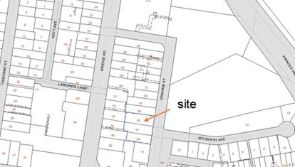
Location Map
Figure
1 – Location Map
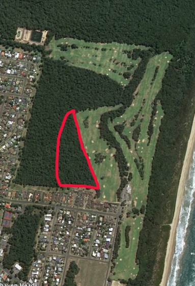
Site - 65-69 Graham St, Nowra
Background
Proposed Development
The DA, as amended, seeks
approval for the demolition of the existing commercial buildings and
construction of a five (5) storey residential apartment building comprising 31
apartments (16 x 3 bedroom units and 15 x 2 bedroom units).
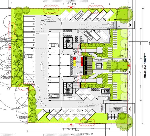
The ground floor comprises two
separate entry lobbies and an open undercroft parking area, comprising 49
parking spaces for cars (9 to be allocated for visitors) and 8 bicycle racks
(accommodating up to 16 bicycles).
The apartments are located on
Levels 1 - 4 of the building. The majority of the bulk of the building
(ie. 5 storey component) is to the rear of the subject land. The front
portion of the building predominantly presenting to the street is three (3)
storeys and separated into two "wings".
Note that the various floors of
the building have not been included as illustrations in this report for privacy
reasons.
Figure
2 – Ground Floor Plan
(From Architectural Drawings, Issue E)
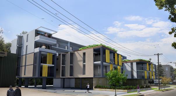
Figure
3 - photomontage
(Note:
the proposal has had some design modifications since submitted which alter this
photomontage – eg fence and design changes to the upper levels.)
Subject Land
The development site comprises
three parcels of land known as Lots H, J and K in DP 39320 (65-69 Graham
Street, Nowra). Refer to Figure 1.
Site & Context
The development site:
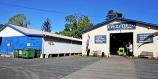
· Contains
an aging single storey commercial premises (No. 65 currently occupied by
"The Everything Store"; No. 69 is occupied by "Nowra
Hydroponics" and No. 67 is vacant and is ‘boarded up’.
· Has
a combined area of 2858.22m²;
· Has
a combined frontage to Graham Street of 54 metres and northern (side boundary)
of 53.968m. The south-western corner of the site is staggered as Lot K
has a shorter northern (side) boundary of 46.315m. Lot K (No. 69) has a
rear boundary of 16.5m and Nos. 65-67 have a combined rear boundary of
36.627m.
· Is
predominantly level, with a slight crossfall from the south-western portion of
the site (at RL5m AHD) to the north-eastern street frontage (at RL3.82m
AHD).
· Is
flood-prone.
· Is
identified as contaminated land, and is within the vicinity of a heritage item.
· Is
impacted upon by a small easements/restrictions as to user at the south-western
corner of Lot J (No. 67).
· Is
located at the northern part of the Nowra Central Business District (CBD) and
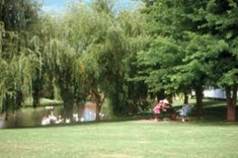
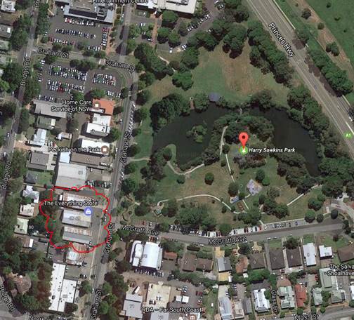
in located opposite the southern portion of Harry Sawkins Park.
Figure
4 – context photos / images
“The
Everything Store” and Harry Sawkins Park
Figure
5 – aerial photo of site and context relative to Harry Sawkins Park,
Nowra
In summary, it is believed that
the site has no significant features or physical impediments that would prevent
the proposed development.
History of Application
The following provides details
on pre-lodgement discussions, post lodgement actions and general site history:
a) Pre
Lodgement: A pre-lodgement meeting was held with Council planning, building
and engineering staff and the applicant's planning consultant (Development
Advisory Unit (DAU) Meeting on 19 August 2015).
b) Post Lodgement: The DA
was lodged on 5 February 2016. TGC Planning was engaged to independently
assess the application on 3 March 2016.
During the assessment of the application Council officers
requested additional information from the applicant on four occasions, 19
February 2016), 11 October 2016, 22 March 2016 and 16 June 2016.
Additional/amended information was provided by the
applicant on 27 May 2016. The plans altered the unit mix from 20 x 2
bedroom units and 12 x 3 bedroom units, to 16 x 2 bedroom units and 16 x 3
bedroom units.
An assessment report of the matters of consideration under
section 79C of the Environmental Planning and Assessment Act 1979 was
prepared by TCG Planning dated 6 July 2016 recommended that the application not
be supported at that time as some of the information was still considered to be
inadequate and/or issues not satisfactorily resolved.
On 12 July 2016 the applicant was provided another
opportunity to address the inadequate aspects of the application (in summary:
clause 4.6 statement; setbacks, solar access and overshadowing; storage areas;
safety and security, waste collection arrangements) and submit further amended
information to address these matters.
On 10 October 2016 the applicant submitted amended plans
and documents (cover letter, Crime Prevention by Environmental Design (CPTED)
report, waste servicing letter, BASIX certificate), which was deemed to be
unacceptable.
On 18 October 2016 the applicant was requested to meet with
Council staff and the Council's planning consultant (held 2 November
2016). The revised design deleted one unit on Level 4 (therefore 15 x 2
bedroom units and 16 x 3 bedroom units) and increased setbacks to side setbacks
to Level 4.
On 28 November 2016 the applicant submitted further amended
plans and documents (cover letter containing Clause 4.6 statement; revised SEPP
65 Verification Statement, correspondence addressing parking accessibility and an
updated BASIX Certificate).
c) Site History: The site contains three (3) aging commercial
properties that have existed on the site since the 1950s / 60s.
Issues
Clause 4.3 (Height of Buildings)
The SLEP 2014 'Height of
Buildings' map does not stipulate a maximum building height for the subject
land. Therefore subclause (2A) applies which states: "if the
Height of Buildings Map does not show a maximum height for any land, the height
of a building on the land is not to exceed 11m."
The majority of the building
height is 15 metres. The development therefore does not conform to the
11m development standard. The applicant has consequently sought an
‘exception’ to the development standard pursuant to clause 4.6 of
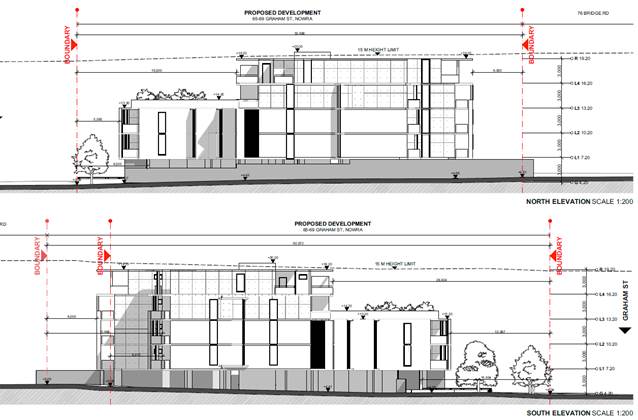
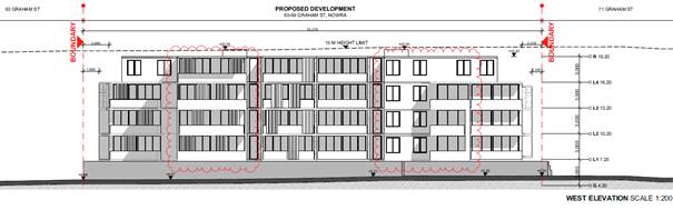
the SLEP 2014. The following diagrams illustrates the building elevations
and shows the proposed 15m height control and the lift overrun protrusions.
Figure
6 - east elevation, Graham St, Nowra
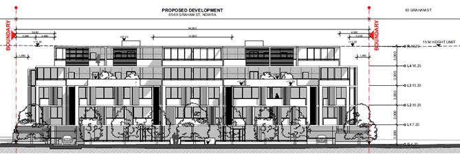
Figure
7 - North and South Elevations (side elevations)
Figure
8 - west (rear elevation)
Clause 4.6 (Exceptions to
Development Standards)
As required by this clause, the
applicant provided a written request for an exception to the required maximum
11m building height development standard. The discussion and table below
is extracted, edited and reproduced in part from TCG’s report. It
assesses and discusses the provisions of clause 4.6.
The full TCG report is attached
to this report.
In summary, the amended Clause
4.6 variation statement submitted in November 2016 is improved from the
original submission and is acceptable for the purposes of an assessment of
height.
|
Clause 4.6 Variation to Height Control
 The
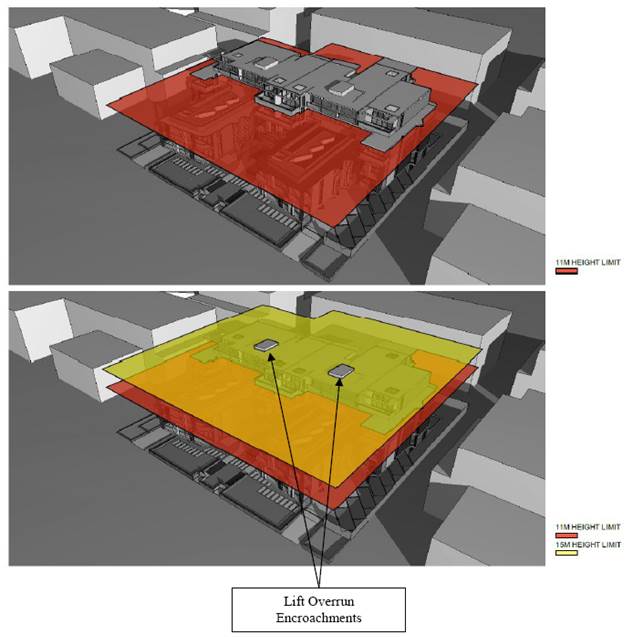
diagram below is Figure 2 within the applicant's Clause 4.6 Statement (dated
19/11/2016) and illustrates the extent of exceedence of the building above
the current 11m height plane (top) and proposed 15m height limit, being the
minor lift overruns (bottom). The
diagram below is Figure 2 within the applicant's Clause 4.6 Statement (dated
19/11/2016) and illustrates the extent of exceedence of the building above
the current 11m height plane (top) and proposed 15m height limit, being the
minor lift overruns (bottom).
|
|
EDITED Table 5: Compliance with SLEP 2014 -
Contravention of Clause 4.3 Building Height
|
|
Clause 4.6
Exceptions to
Development Standards
|
Applicant's
Response/Justification (in italics) and
Assessment
Officer's Comment
|
Consistent/
Complies
|
|
(1) The
objectives of this clause are:
a) to
provide an appropriate degree of flexibility in applying certain development
standards to particular development ;
b) to
achieve better outcomes for and from development by allowing flexibility in
particular circumstances.
|
|
(3)
Consent must not be granted for development that contravenes a development
standard unless the consent authority has considered a written request from
the applicant that seeks to justify the contravention of the development
standard by demonstrating:
|
The
proposal seeks a building height of fifteen (15) metres (15.6m including the
lift overrun) in line with the Nowra CBD Building Height and FSR Study prepared
by Jackson Teece and adopted by Council on the 22nd October 2013 which is
four (4) metres higher (4.6m including lift overrun) than the maximum
permissible building height under the Shoalhaven Local Environmental Plan
2014. The extent of the variation to the height controls is shown in Figure
2 with only minor encroachments from the lift overrun through the 15
metre height plane."
|
Provided
|
|
(a) that
compliance with the development standard is unreasonable or unnecessary in
the circumstances of the case, and
|
The
applicant’s written request stated:
"In relation to the question as to whether
compliance with the development standard unreasonable or unnecessary in the
circumstances (Clause 4.6 Sub-clause (3)(a)), it is the applicants view that
strict compliance with the Height of Buildings development standard is
considered to be unreasonable in this particular case as the proposed
variation simply seeks to maximise the site outcomes and improve the
residential standard of the precinct.
It
also proposes a high quality residential interface with the Graham Street
frontage in line with the Draft Nowra Development Control Plan. It will
ensure a more viable development and higher standard of residential yield
compared to that which would otherwise be provided should strict adherence to
the LEP standard be applied. The proposal is an efficient use of the land
which delivers social, economic and environmental benefits to the local
community.
The
variation will not adversely affect the amenity of the immediate locality or
compromise the objectives of Clause 4.3 of the Shoalhaven Local Environmental
Plan 2014 (SLEP 2014) or Section 5(a)(i)(ii) of the EP&A Act.
The
applicant further concludes:
"....Based on the above assessment, the attached amended
architectural plans and the previously submitted supporting documents, it is
considered that the proposed residential development will deliver a better
planning outcome than one that strictly complies with the current 11.0 metres
height limit for the following reasons:-
i) strict compliance would not be responsive to the intent
of the Nowra Development Control Plan (Draft) objectives and the associated
Nowra CBD Building Height and FSR Study prepared by Jackson Teece as adopted
by Council on the 22nd October 2013;
ii) strict compliance would not be responsive to the intent
of the Urban Design Development Controls for the Nowra CBD as adopted by
Council on the 5th April 2016;
iii) strict compliance would restrict building height and
subsequent floor space outcomes to the extent that the alternative would be
an underutilisation of the site in an area within the Nowra CBD that seeks
higher height and density outcomes; and
iv) strict
compliance would not meet the desired future character of the precinct.
In relation to this clause, it is considered that the
objection to the Height of Buildings standard is well founded and that based
on the details provided above, strict adherence to the development standard
would appear to be unreasonable and unnecessary in the circumstances of this
development application. Therefore, Council’s favourable consideration
of the application under the provisions of Clause 4.6 is sought."
Evaluation: With the
exception to increased development yield and ensuring the highest and best
use of the land, it provides limited satisfactory reason as to why the
outcome requires an increased building height.
Council notes that the site is flood affected which has
in part contributed to the design solution and increased height. This
is discussed later in this table. Council also notes that the applicant
has also relied on the new proposed height controls.
In
Four2Five Pty Ltd v Ashfield Council [2015] NSWLEC 1009, para 61,
Commissioner Person summarises the considerations from Wehbe v Pittwater Council [2007] NSWLEC 827 at [42]
per Preston CJ, and notes in para 62 that clause 4.6 can be considered in a
similar way to that of SEPP 1. In Wehbe at
[44]-[48] Preston CJ identified other ways in which an applicant might
establish that compliance with a development standard is unreasonable or
unnecessary, namely that the underlying objective or purpose is not relevant
to the development; that the objective would be defeated or thwarted if
compliance was required; that the development standard has been virtually
abandoned or destroyed by the Council’s own actions in departing from
the standard; or that the zoning of the land is unreasonable or inappropriate.
A
brief response to these has been undertaken to establish whether there is
some merit in considering Clause 4.6:
§ The
underlying objective or purpose is not relevant to the development: The
objective of Clause 4.3 is relevant and addressed elsewhere.
§ That
the objective would be defeated or thwarted if compliance was required: If
the PP currently being exhibited is adopted and gazetted, then the objective
of Clause 4.3 in terms of compatibility of desired future character and
building height would not be achieved if the 11m height was adhered to.
§ That
the development standard has been virtually abandoned or destroyed by the
Council’s own actions in departing from the standard: No known
departures have occurred from the standard to date by Council within the
locality. However, Council has recently adopted and exhibited documents
that confirm a desired future building height exceeding the current standard
of 11m within the planning instrument and development controls.
§ The
zoning of the land is unreasonable or inappropriate: The zoning of the
land is appropriate.
Overall,
the desired future character and height of the precinct in exhibited draft
planning instrument and controls warrants consideration of the 11m height
limit being unreasonable or unnecessary.
|
Satisfied
|
|
a) that there are
sufficient environmental planning grounds to justify contravening the
development standard.
|
The applicant’s written request stated the
following in response to this provision:
"...the
subject site has particular circumstances in relation to flooding impacts
which has triggered the specific design response. The site is affected by
flooding in 100-yr ARI storm and the PMF as identified by Shoalhaven City
Council, who have provided a flood certificate which identified the 1% AEP
flood level for the site at RL5.8m AHD and the PMF flood level is RL 8.8m
AHD. The existing ground levels range between RL3.88m AHD and RL5.01m AHD
which is below the flood planning level.
This
has necessitated that the building be designed such that on-grade parking is
provided with habitable floor levels on top. Basement or sub-basement parking
is negated due to the flooding impacts. The lowest habitable level is
proposed at RL 7.20m AHD which is clear of the 1% AEP flood + 500mm freeboard
(ie: RL6.30m AHD). If strict adherence to the 11.0 metre height limit were
observed, then the maximum number of levels would be three without under
croft car parking. This would be further reduced to two levels if under croft
parking were provided. This would represent an underdevelopment of the site
and would be contrary to the intent of the Nowra Development Control Plan
(Draft) objectives and the associated Nowra CBD Building Height and FSR Study
prepared by Jackson Teece as adopted by Council on the 22nd October 2013.
By adopting the proposed fifteen (15) metre height
controls and raising the building such that it is clear of the flood planning
level (with under croft parking) results in a more efficient and orderly use
of the land and will produce a better outcome than would otherwise be the
case if strict adherence to the standard were observed. In relation to this
clause, it is considered that the objection to the Height of Buildings
standard is well founded."
In
Four2Five Pty Ltd v Ashfield Council [2015] NSWLEC 1009, Commissioner Person
determined that it is necessary for applicants to show sufficient grounds
particular to the
development
in the Clause 4.6 objection. While not referencing this
Judgement, and limiting the response to this provision as above, the
applicant has addressed the site-specific flood impacts and how compliance
with the 11m height would limit the feasibility and appropriate development
of the site having consideration to this particular constraint.
Other
justification for the variation to the development standard (building height
from 11m to 15m) provided by the applicant, but not specifically under this
heading, is that the development (with the exception of the inconsequential
lift overruns), is within the recently adopted and exhibited desired future
character and proposed maximum allowable building height within
Council’s Strategic Planning documents for the CBD. It also achieves
the intended front/street wall heights, front building setbacks, landscaping
and streetscape compatibility. Therefore the achievement of the built
form/wider environmental planning outcomes.
|
Satisfied
|
|
(4) Consent must not be granted for development
that contravenes a development standard unless:
(a) the consent authority is satisfied
that:
|
See below
|
|
|
(i) the applicant’s written request has
adequately addressed the matters required to be demonstrated by subclause
(3), and
|
Refer to (3) above
|
Satisfied
|
|
(ii) the
proposed development will be in the public interest because it is consistent
with the objectives of the particular standard and the objectives for
development within the zone in which the development is proposed to be
carried out, and
Shoalhaven
LEP 2014:
Objectives of the Standard (Clause 4.3)
a) to ensure that buildings are compatible
with the height, bulk and scale of the existing and desired future character
of a locality,
b) to minimise visual impact, disruption of
views, loss of privacy and loss of solar access to existing development,
c) to ensure that the height of buildings on
or in the vicinity of a heritage item or within a heritage conservation area
respect heritage significance.
Objectives of the B4 Zone
§ To provide a mixture of compatible land uses.
§ To integrate suitable business, office, residential,
retail and other development in accessible locations so as to maximise public
transport patronage and encourage walking and cycling
|
Applicant's response to how the proposal meets the
objectives of Clause 4.3 (Building Height):
i) "ensuring that the proposed building is compatible
with the height, bulk and scale of the desired future character of a locality
as articulated in the Draft Nowra Development Control Plan;
ii) minimising
visual impact, disruption of views, loss of privacy and loss of solar access
to existing development as shown on the attached amended architectural plans;
and
iii) ensuring
that the height of buildings on or in the vicinity of a heritage item or
within a heritage conservation area respect heritage significance. The
proposal will not have detrimental impact on “Rodway’s
Cottage”, a local heritage listed item located at #86 Bridge Road,
Nowra. The previously submitted Heritage Impact Assessment Letter prepared by
URBIS assessed the potential heritage impact associated with the
redevelopment of the subject site. Whilst the subject site is not a heritage
listed item on Schedule 5 of the Shoalhaven Local Environment Plan (LEP)
2014, it is however in the vicinity of “Rodway’s Cottage” which
is identified as Item 336 on the LEP. Therefore, consideration of the
heritage impact on the visual setting of nearby heritage items was required
with the report supporting the proposal on heritage grounds. It will not have
any adverse physical and visual impacts on the local heritage significance of
the nearby Rodway’s Cottage."
In respect to impacts to compatibility and existing
development (Objectives a and b above), the applicant provides the following
commentary in the correspondence/Clause 4.6 Statement dated 19/11/2016
(excerpts from p2 and 8):
"Shadow Diagrams and Design Changes
The
attached amended architectural plans (Revision E) provide additional details
in relation to the analysis for the site the south and what may be built in
the future. A solar access 3D comparison plan (see Issue A - Sheet A1055) is
also provided which shows potential solar impacts from the eleven (11) metre
height compliant development on #71 Graham Street compared to the improved
impacts resulting from the proposed development.
Future impacts on amenity of the potential residents at
the sites towards the south would not be negatively impacted by the proposed
development. Figure 1...shows that a compliant scheme on the subject
site will overshadow the site to the south. Notwithstanding, the proposed
development would in fact improve the solar access in comparison with an
eleven (11) metre high building compliant with the current controls. Further
assessment on various times of the day is also available in drawing (Sheet
A1055 Solar Access 3D Comparison). Conclusively, the proposed built form
would result in a positive outcome in terms of its marginal impact on the
amenity of any future building within the subject precinct between Graham and
Bridge Street.
The height variation is considered to be reasonable
when considered within the context of the overall streetscape with its
primary frontage to Graham Street and the intent of the Nowra CBD Building
Height and FSR Study prepared by Jackson Teece adopted by Council on the 22nd
October 2013. The building is four storeys and integrates satisfactorily
within the future street context (see Figure 3 - copy of excerpt
below).
The satisfactory streetscape impacts are further
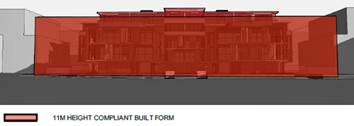
highlighted in the amended plans (3D Comparison 11 Built Form – Issue A
Sheet A1800) as shown in Figure 4 (copy of excerpt below) where
an eleven (11) metre compliant built form would have a significantly greater
impact that the proposed development as viewed from McGrath Avenue."
Applicant's response to how the proposal meets the
objectives of the B4 Zone:
"The
proposed development meets the objectives of the zone in that:-
i) it provides a mixture of compatible land uses comprising
residential units close to the Nowra town centre and public transport; and
ii) it integrates suitable residential accommodation in an
accessible locations that maximises public transport patronage (ie: bus
services) and encourages walking and cycling.
Therefore, it is considered that the proposal satisfies
the public interest test as it is consistent with both the objectives of the
standard and for development within the zone. In relation to this clause, it
is considered that the objection to the Height of Buildings standard is well
founded."
|
Justified
(subject to side setback controls and solar access being
satisfied)
Generally satisfied
|
|
(b) the concurrence of the Director-General has been
obtained.
|
Concurrence of the DG can be assumed in accordance with
Planning Circular PS 08-003-Variations to Development Standards (Department
of Planning, May 2008).
|
Satisfied
|
|
(5)
In deciding whether to grant concurrence, the Director-General must consider:
|
|
Council has this function.
|
|
(a) whether contravention
of the development standard raises any matter of significance for State or
regional environmental planning, and
|
There are no anticipated matters of State or Regional
significance that would hinder the Director-General from providing
concurrence,
|
Satisfied
|
|
(b) the public benefit of
maintaining the development standard, and
|
There is not considered to be an overall public benefit
which would be achieved by maintaining the development standard.
|
Satisfied
|
|
(c) any
other matters required to be taken into consideration by the Director-General
before granting concurrence.
|
There are no anticipated environmental planning
considerations that would hinder the Director-General from providing
concurrence, with the exception of an inconsistent building height if the
proposed amendments to allowable building height within SLEP 2014 and associated
controls within SDCP 2014 are not supported/do not proceed. If
approved, the building will be inconsistent with existing and other future
buildings. This is however unlikely.
|
Satisfied
|
Draft Amendments to SLEP 2014 and SDCP
2014 (Nowra CBD Height, FSR and Urban Design Development Controls)
Section 79C(i)(a)(ii) requires the consent
authority to take into consideration the provisions of
"any
proposed instrument that is or has been the subject of public consultation
under this Act and that has been notified to the consent authority (unless the
Secretary has notified the consent authority that the making of the proposed
instrument has been deferred indefinitely or has not been approved)."
On 2 November 2016 Council
commenced public exhibition of a PP and draft Development Control Plan (DCP)
Chapter for the Nowra CBD Building Heights and Urban Design Development
Controls.
The PP proposes to add a set of
maximum building heights for the Nowra CBD into the Shoalhaven Local Environmental
Plan 2014; and the draft DCP Chapter, for proposed inclusion in the SLEP 2014,
seeks to establish a set of urban design controls to support the increased
building heights and guide future built form in the Nowra CBD.
At the time of preparation of
the TCG assessment report (early December 2016), the PP and Draft DCP Chapter
were still being publicly exhibited (concluding on 16 December 2016).
While the draft controls were
not publicly exhibited at the time of lodgement of the application (and for the
majority of the assessment period), the application relied heavily on the
proposed new height control of 15 metres, which had previously been adopted by
Council within studies and draft documents (as detailed in the background
below). However, the current exhibition of the PP (and associated
documents) now requires statutory consideration of these documents under
Section 79(c)(i)(a)(ii).
The proposal is five
‘storeys’ and 15.6 metres high (at the lift overruns) and 15 metres
elsewhere on the building, significantly higher than the maximum allowable
height of 11 metres within the current development standard. Refer to
Figure 1.
Given the proposed development
relies heavily on the proposed amendments to the height controls within the
SLEP 2014 and SDCP 2014 (and subsequent desired future character) a brief
background, content and status of the relevant draft documents is provided
below so that the relevance of the draft reports are clearly understood in the
context of the assessment of the proposal. Further detail is contained in
the attached section 79C Report.
Background to Nowra
CBD Building Height & FSR Study (Jackson Teece – 2013)
Council commissioned consultants
Jackson Teece P/L to prepare a Draft Building Height and FSR Study (hereby,
‘Draft Study’) over the area of the proposed Commercial Core (B3)
and Mixed Use (B4) zones in the Nowra CBD as exhibited in the Draft SLEP 2013.
A detailed report on the Draft
Study was submitted to Nowra CBD Action on 20 June 2013, and Council, resolved
on 21 June 2013 (MIN 13.684) that:
a) The Draft Nowra CBD Building
Height and Floor Space Ratio (FSR) Study be placed on public exhibition for a
period of 28 days;
b) The Draft Nowra CBD Building
Height and Floor Space Ratio (FSR) Study be placed on Council’s internet
site and also displayed at Nowra Administrative Building and Nowra Library;
c) Landowners within the study
boundary be informed in writing of the public exhibition;
d) The Department of Planning
& Infrastructure be informed of the public exhibition and of
Council’s intention to incorporate the final outcome of the Draft Study
into the SLEP 2013 at the appropriate point;
e) A further report be submitted
to Council following the public exhibition period.
The draft Study was publicly
exhibited in accordance with the above resolution. In summary, the
exhibited draft Study outcomes recommended that that the subject site have a
proposed maximum building height of 15 metres and FSR of 2.3:1.
A report to the Planning and
Development Committee was prepared on 10 October 2013 on the outcome of the
exhibition.
Council
received 3 (three) written submissions from individuals. Two more submissions
were received after the close of the exhibition. The submissions were summarised
and the only relevant comments with respect to the subject land/vicinity was
that the area between Bridge Road and Harry Sawkins Park was that there should
be 12m height limit (not 15m). The report recommended the proposed height
controls of 15m remain.
Council resolved (in part) on 22nd
October 2013 to:
· Adopt the exhibited
building heights and FSRs (ie. a desired height of 15 metres for the
Bridge Road and Graham Street vicinity)
· Commence the
preparation of a planning proposal be prepared to incorporate the final
height and FSR outcomes into the SLEP 2013;
· Prepare
an urban design Development Control Plan (DCP) to support the
adopted heights and FSRs, and placed a high priority project in
the Council’s Delivery Program."
Background to Urban Design
Development Controls for the Nowra CBD (Studio GL)
The following excerpts (as
extracted from the attached TCG Report) from the Development Committee Report
of 4 April 2016 provide some background to these controls:
"The exhibited Urban Design Development
Controls Report (Studio GL, Final Draft, dated Sept 2015) contains a range of
controls for building and floor heights, building setbacks, building bulk and
scale, articulation, heritage conservation and solar access. The report also
identifies opportunities to build on the existing character of the different
precincts within the CBD, opportunities for active street frontages, improved
vehicle and pedestrian linkages, and the protection of views and vistas.
A copy of
the exhibited draft Urban Design Development Controls Report was made available
to Councillors for review prior to the meeting. Councillors were also
given a detailed briefing by the project consultant (Di Griffiths from Studio
GL) on 24 September 2015.
Community
Engagement and Public Exhibition
The draft
urban design development controls were prepared in consultation with a project
liaison group that was made up of local property/business owners, architects,
planning consultants and community representatives. The consultants facilitated
3 workshops with the group during the development and testing of the controls.
The draft report was public exhibited from 25 November 2015 to 8 January 2016
(inclusive). Only one (1) formal submission was received, as well as internal
comments from Council’s Traffic and Transport Section.
Submission
Comments
The
submission congratulates Council on the draft report and the efforts to improve
the usability of the Nowra CBD. Strongly supports the preservation of views,
the recognition and preservation of heritage items, solar principles and the
focus on walkability in the CBD. The submission also made a number of
suggestions in relation to civic upgrades, healthy living, historical walks and
new development proposals that are generally consistent with the Nowra CBD Master
Plan and Revitalisation Strategy, but outside of the scope of the
detailed Development Controls Report.
Planning
Proposal (LEP Amendment) and DCP Chapter
The Urban Design Development
Controls Report recommends setting building heights in the Nowra CBD, as shown
in Figure 1 below. A PP has been prepared to incorporate the recommended
heights into Shoalhaven Local Environmental Plan (LEP) 2014 and the other
related urban design development controls will be included as a Chapter in
Shoalhaven Development Control Plan (DCP) 2014. Council resolved on 5 November
2015 to prepare the required PP and DCP Chapter. Following the receipt of
Gateway determination for the PP, the proposal and draft DCP chapter will be
exhibited as a package.
Council resolved to:
a) Adopt the Nowra CBD Urban Design
Development Controls Report as exhibited with the following minor changes:
i. Include
a note in Section 3.2 of the report to ensure corner building setbacks do not
impact on planned intersection upgrades in the CBD.
ii. Include
a note in Section 3.9 of the report that outlines the requirements for active
ground floor uses under Clause 7.16 of Shoalhaven Local Environmental Plan
2014.
b) Advise the NSW Department of
Planning and Environment and those who made submissions on the draft report of
Council’s resolution in this regard.
c) Report back to Council following
the public exhibition of the resulting Nowra CBD Planning Proposal and
Shoalhaven Development Control Plan 2014 chapter."
The recently exhibited documents
include the final version of the Urban Design Development Controls for the
Nowra CBD Report (Studio GL, 5 April 2016), (including a few minor edits from
the Sept 2015 version) (with no changes relating to the subject
application). The exhibited draft Nowra CBD Urban Design Development
Controls DCP Chapter directly adopts the controls from within the above Studio
GL report.
Consistency
of the Development Application with the exhibited Planning Proposal and draft Nowra
CBD Urban Design Development Controls DCP Chapter
The Shoalhaven LEP 2014 Height
of Buildings Map will be amended if the PP is finalised as exhibited.
Clause 4.3(2) 'Height of Buildings' will therefore apply to the subject
application which states "the height of a building on any land is not
to exceed the maximum height shown for the land on the Height of Buildings Map."
The proposed development
conforms to the proposed maximum height of 15 metres (with the exception of the
two lift overruns, which are at a height of 15.6m (ie. exceeds by 600mm).
The applicant did not address
the proposed draft DCP controls (as they were adopted subsequent to the
lodgement of the DA). It is noted however that the draft document had
been exhibited, with the landowner notified in November 2015 - January 2016,
prior to the lodgement of the DA.
However, most controls are
satisfied/complied with, with the exception of the minor exceedence of the
maximum 15m building height by the two lift overruns (15.6m), and provision of
an east-west pedestrian link between Graham St and Bridge Road.
The latter
non-compliance/inconsistency has been raised with Council’s Strategic
Planning Division as, if approved and constructed, the proposed linkage will
not be achieved in the mapped location. Further, whilst there is an
intention to facilitate a pedestrian connection, it is on private land and
there are no mechanisms / incentives currently in place to facilitate the
outcome.
What
weight should be given to the recently exhibited Planning Proposal and draft Nowra
CBD Urban Design Development Controls DCP Chapter
The draft SLEP and SDCP
amendments detailed above, now have some statutory weight, as they have progressed
to an exhibited draft environmental planning instrument/PP [considered within
Section 79C(1)(a)(ii)].
A ‘planning
principle’ on the correct approach to consideration of and the weight to
be given to detailed planning policies adopted by a council has therefore been
considered in the assessment (within Stockland Development Pty Ltd v Manly
Council [2004] NSWLEC 472 revised - 01/10/2004). Refer to the attached
section 79C report for further information and detail.
In summary:
· The
proposed height controls can now be considered under Section 79C(1)(a)(ii) of
the Environmental Planning and Assessment Act 1979 (relating to an exhibited
draft environmental planning instrument).
· The
controls have some weight in the assessing the development.
· The
public interest [section 79C(e)] is also of relevance, in particular given that
the exhibition of the draft instrument is currently occurring (at the
'tail-end' of the assessment of the application).
· TCG
has advised it is therefore prudent to also consider the level of public
consultation of the proposed controls (height) prior to the current formal
exhibition of the draft planning instrument and development controls.
· A
fairly robust study was prepared which arrived at the proposed height of 15m
for the site (Jackson Teece, 2013), in addition to more detailed urban design
controls (Studio GL, 2015).
· Both
studies have been adopted by Council following a detailed process of
consultation with the community, with relatively little interest and objection
to the proposed height of 15m for the precinct within which the subject site is
located.
· The
development application was also widely notified/exhibited (as being a 3 to 5
storey building) and only two objections to this application were made on the
basis of inappropriate building height.
TCG’s consultation with
Council's Strategic Planning Staff at the time of writing [the TCG report
(early December 2016)] indicated there were only a few enquiries being received
at that time (during the current formal exhibition of the proposed increased
building heights (ie. PP amending SLEP 2014 and controls within SDCP 2014).
The assessment of the
application therefore places a reasonable weight on the intended building scale
(15m) for the site, however places greater and more significant weight on the
objectives of the controls (including the provisions of clauses 4.3 and 4.6 of
SLEP 2014), and the merits of the proposal under SEPP 65 associated Apartment
Design Guidelines and the SDCP 2014.
If this assumption is incorrect,
and future community concern from the future exhibition of a draft amending LEP
and DCP results in amendment to the 15m height control in particular, then
Council could take the view that the application is premature and will set a
precedent for the locality that may be inconsistent to the ultimate gazetted
height control and associated development controls.
Exhibition of the PP and
draft DCP
This will be reported to Council
in due course. Preliminary advice, dated 4 January 2017, from Strategic
Planning advises:
“During the public exhibition period a total of 11
submissions were received (two of which were received from one
company/individual). The submissions do not relate solely to the draft
DCP, but also the Planning Proposal to amend the building heights in the Nowra
CBD which was exhibited concurrently.
Majority of the submissions object to the proposed
building height controls with some suggesting they are too high for a
‘regional’ context, create visual and overshadowing impact, and do
not have regard to the heritage / character of Nowra. A maximum HOB of 12m is
suggested as being the most suitable / sympathetic especially within proximity
to heritage items or buildings with heritage character or streets that maintain
vistas of Cambewarra Mountains. There is some acceptance of proposed
higher HOB away from primary streetscapes, i.e. in Stewarts Place. Where
buildings in excess of 12m are supported, it is suggested that there should be
upper storey setbacks (this is a requirement of the DCP with customised upper
storey setbacks for different streets/areas).
One submission makes reference to the current application
on Graham Street (Central Park development). Objections are made with
respect to the building height, contamination, overshadowing of adjacent
heritage property and bulk and scale of the proposed development. This
submission states that development in Nowra should be capped at no greater than
3 storeys.....”
Planning Assessment
The DA has been assessed under
section 79C of the Environmental Planning and Assessment Act 1979. The
assessment considers matters prescribed by section 79C including but not
limited to planning instruments, Council’s DCP, site suitability, impacts
of the development and public interest. The draft planning controls have
also been considered in the assessment.
In summary, the assessment is
favourable.
Policy Implications
TCG Planning comments in
conclusion that:
The application relies on draft development standards
and controls that have been exhibited in strategic planning studies and draft
plans, and are currently being formally exhibited as a Planning Proposal/draft
environmental planning instruments (with associated development controls), but
are not yet in force.
The desired future character is well articulated within
the community based on the draft strategic planning documents for the Nowra CBD
heights, however relies on consistent community and council opinion for the
future controls which are still being exhibited. If the development is
approved and circumstances change, then there is a risk that the proposed
development will not be consistent with the final gazetted planning instrument
and associated development controls. Notwithstanding this, considerable
weight should be given to the proposed building height as detailed in this
report. The assessment has identified that the overall compatibility of
the proposal and consideration of streetscape, bulk and scale are considered
acceptable. The bulkier rear portions of the building are offset by
compliant building setbacks and separation from the rear/western boundary and
deep soil planting area.
The building height and side setbacks (in accordance
with the current LEP and ADG respectively) are not compliant, however the
applicant has amended the plans to improve the setbacks of the upper
level. With some recommended additional minor design amendments (which
can be conditioned), the privacy impacts can be ameliorated. Analysis of
the impacts with respect to overshadowing and/or solar access was undertaken,
being the first of its scale within the precinct, as the non-compliant side
setbacks could detrimentally impact on the development potential for the properties
on either side. The analysis identified that if the property to the south
was developed for commercial (non-residential) purposes, the proposed
development is reasonable and the future development to the south will comply,
regardless of the height or setback non-compliance. If the property to
the immediate south was developed for residential purposes, then the height and
side setbacks of the proposed building would most likely unreasonably limit the
development footprint and associated yield to achieve the required solar access
to the northern facade than if it complied with the 11m height control.
However, the proposed development has a similar impact to that of a compliant
commercial development on that land, and there are no current or proposed
controls that require consideration of the overshadowing impacts to
Business-zoned land, nor to consider whether the likely future use of the
adjacent land will be developed for residential purposes. Therefore, on
balance, having regard to: the CBD location/context and Business-zoning; the
existing commercial use of the land to the south; lack of objection from the
property owner to the immediate south, and the probability that the site to the
south will be developed for commercial purposes, the proposed height and
southern side setbacks (and associated overshadowing impacts) are considered to
be acceptable.
Consultation and Community
Engagement:
In accordance with the requirements of the Environmental
Planning and Assessment Act (EPA Act), Environmental Planning and Assessment
Regulation (EPA Regulation) and applicable components of Council’s
“Community Consultation Policy” the DA was notified as
follows. It is noted that the development was described as
"demolition of existing buildings and construction of a residential flat
building (32 units - 12 x 2 bedroom units and 20 x 3 bedroom, over 3 to 5
levels) car parking, landscaping and associated infrastructure".
· Individual
property owners within a 200 metre radius of the site were notified of the proposal.
Council should confirm that relevant community groups and the Chamber of
Commerce were also notified. The notification period was from 24 February to 11
March 2016;
· A
notice was not placed on the land (according to administration procedures checklist
on file);
· The
proposal was advertised in the local press on one occasion (South Coast
Register 24 February 2016– copy of press notification on file); and
· The
application and supporting documentation were on display at Council’s
City Administrative Centre in Nowra as well as Council’s website.
An article on the proposed development was also placed in the
South Coast Register and Illawarra Mercury on 9 February 2016.
Two separate submissions from a
nearby property owner, and two submissions from another interested person was
received by Council. Further discussion of the issues raised in the
submissions that have been received is provided in the following sections of
this report.
The minor amendments to the
development application and additional information received by Council in May,
October and November 2016 were not re-notified as Council was of the opinion
that the amended application differed only in minor respects from the original
application. The changes resulted in increased setbacks, changes the unit
mix (number of bedrooms) and reduced number of units from 32 to 31. The
overall shape and characterisation of the development remained however as
originally put to Council.
Key issues raised as a result of
the notification include but were not limited to matters listed below. A
more detailed analysis can be found in the attached section 79C assessment
report by TCG.
· Exceed
height control.
· The
existing 1-2 storey character should be maintained.
· Impact
on Rodway cottage.
· Contaminated
site.
· Plans
are misleading. Accuracy of shadow diagrams is questionable.
· Traffic
impacts.
· Impacts
on Harry Sawkins Park.
· Visual
impact.
· Noise
and light emissions.
Financial Implications:
In the event that Council decides not to support the height
variation, this will mean that the design as submitted could not be
approved. The applicant could elect to pursue an amended design or pursue
an approval via the Land and Environment Court. Litigation has cost
implications for Council. Further, the objectors could also seek to
challenge Council’s decision if the development is ultimately approved,
however this can legally only relate to the process followed by Council not the
merits of the application. Again, this has potential cost implications
for Council.
Legal Implications
In the event that the variation
is not supported and a refusal issued in the event that the proposal was not
modified to conform with current height controls, an appeal with the land and
environment court is possible. The applicant also has the option to
request a section 82A review in the event of a refusal which would mean that
the matter would be brought before the Council again for reconsideration.
A request for a review or the lodgement of an appeal must be made within 6 months
of the date of determination.
Summary and Conclusion
The proposal has been assessed
under section 79C of the Environmental Planning and Assessment Act 1979 and
found to be satisfactory. There have been no substantive planning
reasons or significant defects with the application to warrant recommending a
refusal. Furthermore, the height variation or ‘exception’ has
been supported having regard to the criteria contained within clause 4.6 of the
SLEP 2014.
The modifications to the design
made during the assessment, have substantially addressed issues raised during
the assessment. There are some matters which may warrant
‘conditioning’ in the event of an approval being issued, which
would address the recommendation made in TCG Report, section 10. (It is
noted that during the preparation of the report, revised stormwater details
were submitted and with a revised landscape plan.)
|

|
Development
Committee – Tuesday 14 February 2017
Page
41
|
DE17.16 Development
Application – 1 Brooks Lane, Kangaroo Valley – Lot 102 in DP
1056895
DA. No: DA16/1561
HPERM Ref: D17/31245
Group: Planning
& Development Services Group
Attachments:
1. Clause 4.6
Statement - 2nd May 2016 (under separate cover) ⇨
2.
Supporting information Nov 2016 (under separate cover) ⇨
3. Statement
of Environmental Effects - by applicant - 2 May 2016 (under separate cover) ⇨
4. Statement
of Heritage Impact - 2 May 2016 (under separate cover) ⇨
5. Site Plan
⇩
6. Section
Plan ⇩
7.
Submission (under separate cover) ⇨
Description of Development: Erection of new
dwelling house
Owner: John Sinclair and Simone O’Halloran
Applicant: Anika Ekholm of Teknemodus Pty Ltd
Notification Dates: 28 June to 13 July 2016
No. of Submissions: One (1) in objection
Nil in
support
Purpose
/ Reason for consideration by Council
Council is in receipt of an
application to construct a new dwelling which exceeds the 5.5 metre height
limit set by clause 4.3 of Shoalhaven Local Environmental Plan 2014
(SLEP-2014). The two storey portion of the dwelling has a height of 6.63
metres (20.5%) and 6.55 metres (19.1%) and the rear single storey portion has a
part encroachment to 6.3 metres (14.5%).
These variations are beyond the
delegated authority of Council staff which is set at 10%. The application
is therefore presented to Council for determination.
|
Recommendation
(Item to be determined under delegated authority)
That the Council:
1. Support
the variations to the 5.5 metre height limit set by clause 4.3 of SLEP-2014;
2. Refer
the application back to staff for determination
|
Options
1. Support the
variations as presented in the application.
Implications: The development can proceed as proposed, subject
to meeting other considerations under section 79C of the Environmental Planning
and Assessment Act and subject to such conditions as may be imposed arising
from those considerations.
2. Decline to
support the variations.
Implications: The application as submitted would be refused on
the grounds that it exceeds the maximum building height set out in SLEP-2014
and that Council does not support the proposed variations. The applicant
would be entitled to appeal against Council’s refusal in the Land and
Environment Court.
3. Decline to
support the variation and invite the applicant to redesign the proposal so as
to meet the height limit.
Implications: The applicant would need to substantially
redesign the proposal. If the applicant refuses to change the design they
would be entitled to appeal Council’s failure to determine the
application to the Land and Environment Court as a deemed refusal.
Background
Proposed Development
The allotment is identified as
Lot 102, DP1056895, No.1 Brooks Lane Kangaroo Valley. The allotment is
located on the corner of Brooks Lane and the unformed portion of Murray Street
(Refer Figure 1).
Figure
1 - Location Map
The application proposes the
erection of a dwelling house of partly one and two storeys. The walls are
a mixture of rendered blockwork and painted fibre cement sheeting and the roof
is corrugated steel. The building has three bedrooms and a total floor
area of 280 m2 (ground floor 150 m2, first floor 70 m2
and garage 60 m2). The site plan for the application is at
Attachment 5.
The building steps down the
steeply sloped site in a series of pavilions. The simple skillion roofs
of the garage and two storey element of the building run at a slope of 14
degrees which is approximately parallel with the slope of the ground. The
roof of the single storey dining room area at the northern end of the building
slopes in the opposite direction at an angle of 11 degrees. This provides
interest in the design and is aesthetically appealing. The roof form and
proposed heights are shown in the section drawing below in Figure 2 (also see
Attachment 6).
Figure 2 also shows a maximum
cut of 1.5 metres and fill of 1.4 metres. The design has a mixture of
slab on ground and elevated floors and is generally considered site responsive.
Figure 2 - Section drawing
The land is zoned RU5 Village
zone. The height of buildings map referred to in clause 4.3 of SLEP-2014
sets the maximum building height for this allotment at 5.5m.
In Figure 2 the dotted line represents the 5.5 metre height
limit and the following comments are made:
· The garage at the
front of the allotment is fully below the height limit.
· The 2 storey portion
exceeds the height by 1.13 metres (20.5%) at the front and 1.05 metres
(19.1%) at the rear.
· The single storey
portion at the rear over the dining room has a point encroachment of up to 0.8
metres (14.5%).
As these variations exceed the height limit by more than 10%,
it is beyond the delegations of staff. The application therefore needs to
be referred to Council for determination.
Subject Land
The allotment was created by a
subdivision in 2003. It is rectangular in shape being 20.115 metres
in width and 45.46 metres in depth. The area of the allotment is 914 m2.
The allotment fronts Brooks Lane
to the south and adjoins the unmade portion of Murray Street to the west.
This allotment is ideally orientated for maximum solar access from the north to
the rear of the allotment.
Site & Context
The land is vacant and falls
steeply from its frontage with Brooks Lane towards the north. The site is
in an elevated older part of Kangaroo Valley and is in the vicinity of a number
of heritage listed properties, namely:
· 20
Quirk St – “Hilltop”. This is a federation period
weatherboard residence and former doctor’s surgery (Item No 244) (across
Brooks Lane and uphill of the site);
· a
number of weatherboard federation period cottages and shops at H/N’s 116,
118, 120 and 124 Moss Vale Rd (Items Nos. 220, 221, 222 and 223).
The 5.5 metre height limit was
set in SLEP-2014. Figure 3 shows the location of both 5.5 metre
(blue) and 8.5 metre (green) height limited allotments.
Figure 3 - Height limit map (Blue = 5.5 metre height
limit, Green = 8.5 metre height limit)
The site is one of only two
vacant lots fronting Brooks Lane. The other vacant allotment is
3 Brooks Lane and this adjoins the subject site to the east.
History
The subject lot was subdivided
from 110 Moss Vale Road by a subdivision registered on 8 August 2003 (S/F
9274). This subdivision also dedicated a strip of land 5 metres wide to
Council as road widening to Brooks Lane.
Council granted consent for the
erection of a two storey dwelling house and detached double garage on the
subject allotment (DA07/2861). This consent was not commenced and
subsequently lapsed. This application included a building height of
approximately 7.5m, which was compliant with the then DCP66 height limit of 8m.
SLEP-2014 reduced the height limit to 5.5 metres. The
rationale for this was to provide a buffer for the heritage precinct which
needs to be considered in this current assessment.
Issues
Clause 4.3 Shoalhaven LEP 2014
Clause 4.3 of SLEP-2014 imposes
a 5.5 metre height limit on the subject land. The application proposes a
building with a maximum height of 6.63 metres. The elements of the
building that exceed the 5.5 metre height limit are the roof and upper walls of
the two storey part of the building and the upper edge of the dining room roof.
Applicant’s Submission
The following information was
provided by the applicant in support of this variation:
· Clause
4.6 variation statement (Attachment 1)
· Documents
including maps, annotated copy of objector’s letter addressing alleged
inaccuracies and photographs of buildings showing skillion roofed buildings
that the applicant considers are compatible with the landscape (Attachment 2).
· Statement
of Environmental Effects (Attachment 3);
· Statement
of Heritage Impact (Attachment 4).
In their clause 4.6 variation
statement, the applicant states that the main reason for the variation is the
steeply sloping site. The stepped design with its partly 2 storey portion
minimises the building footprint and its bulk and scale. This also allows
for generous setbacks to provide privacy and amenity for neighbours and
occupants.
Discussion
The
applicant needs to demonstrate that compliance with the development standard is
unreasonable or unnecessary in the circumstances of the case and that there are
sufficient environmental planning grounds to justify contravening the
development standard. Council cannot grant consent for such a development
unless it is satisfied the applicant has adequately addressed the above matters.
Further, the proposal must be in the public interest because it is consistent
with the objectives of both the development standard and the zone in which the
development is proposed.
The
objectives of the development standard are:
(a) to ensure that buildings are compatible with the
height, bulk and scale of the existing and desired future character of a
locality,
(b) to minimise visual impact, disruption of views,
loss of privacy and loss of solar access to existing development,
(c) to ensure that the height of buildings on or in
the vicinity of a heritage item or within a heritage conservation area respect
heritage significance.
The development is considered consistent with the
objectives of the development standard for the following reasons:
· the building is a single dwelling of modest size and it
will sit comfortably with the existing and desired future character of the
area. The proposed height is compatible with surrounding development.
· the development will not have any adverse impact in terms
of disruption of views, loss of privacy or solar access to existing development
and will have minimal visual impact.
· the top of the roof of the building is at least 2 metres
below the floor level of 20 Quirk St (Heritage Item No. 244). At its
closest point, the proposed development is over 30 metres from this
heritage item and it is screened by substantial vegetation. The increased
building height to 6.63 metres will not have any adverse impact on the heritage
significance of this heritage item.
· in relation to the other heritage items at 116, 118, 120
and 124 Moss Vale Road, the proposed development is at least 30 metres from the
closest of these sites and 70 metres from the closest building.
Whilst vertically there is more than 10 metres difference between ground
levels, the substantial vegetation screening results in no adverse impact on
these heritage items.
Heritage impact of the
proposal is specifically addressed in the Statement of Heritage Impact (see
Attachment 4).
The
objective of the RU5 Village zone is:
· to provide for a range of land uses, services and facilities that are
associated with a rural village.
The development is clearly consistent with the zone
objectives.
The primary reason advanced by
the applicant for seeking a variation to the height limit is because of the
steep slope of the site. The slope of the site is 14 degrees which
equates to a fall of 1 in 4 (or 25%). Restricting development on the site
to a height of 5.5 metres would limit the building to one storey, reduce an
already modest floor space and significantly limit functionality.
The partial increased height in
respect of the roof to the dining area (single storey component) provides
generous solar access to the full depth of the living areas.
The applicant has adequately
addressed the required matters and the proposal will be in the public interest
because it is consistent with the objectives of both the development standard
and those of the R1 General Residential zone.
Overall the design is a
reasonable response to a difficult site and the variation should be supported.
Planning Assessment
The DA will be assessed under
section 79C of the Environmental Planning and Assessment Act 1979.
Policy Implications
There are no specific policy implications
that arise from this matter. The procedure in clause 4.6 of
SLEP-2014 provides a framework for the variation of standards in a manner which
does not undermine the policy aspects of the development standard.
Consultation and Community Engagement:
The notification was made in accordance with Council’s
Community Consultation Policy with letters being sent to the owners of ten (10)
properties lying within a 25m buffer of the site. The notification was
for a 14 day period.
One submission was received in relation to Council’s
notification of the development and this objected to the development (refer
Attachment 7). Key issues raised as a result of the notification are
provided below.
Issue: There is no reason why the development should not
conform with the 5.5m height limit having regard to other similar development
in Brooks Lane
The submission contends that the
five dwellings on the northern side of Brooks Lane all comply with the 5.5
metre height limit. Four of these dwellings (H/N 5, 7, 9 and 11) are on
similar sized lots with similar slope to the subject building.
Comment
The applicant has provided a
response to this issue and states that the owner’s research using
Council’s DA Tracking site has found that the buildings have the following
heights:
· 5
Brooks Lane – 6.4 metres high;
· 7
Brooks Lane – drawings not available on line;
· 9
Brooks Lane – 6.4 metres high;
· 11
Brooks Lane – 6.6 metres high;
· 122
Moss Vale Rd – 6.3 metres high.
The plans have been checked by
Council staff and while the heights appear to be correct for 5 Brooks Lane and
122 Moss Vale Rd, the heights of 7 and 9 Brooks Lane appear to be 5 metres
and 5.5 metres respectively. The plans for 7 Brooks Lane were not readily
available.
Neither the respondent nor the applicant’s arguments
are fully sustained. The fact there are already variations supports the
case for approving this application.
Issue: Disagreement with statements in the clause 4.6
statement
The respondent alleges the
following inaccuracies in the clause 4.6 statement provided by the applicant:
· slope
is incorrectly stated as 25% - it is 15.5%;
· building
is stated to be of 1 ½ storeys – it is 1 and 2 storeys;
· building
is described as articulated whereas the building and garage are simple
rectangles whose bulk and scale is not reduced by articulation of the building
form.
Comment
The applicant has provided a
response to this issue at Attachment 2 and is summarised below:
· the
slope is indeed 25% and not 15.5% as indicated by the respondent. The
relationship is illustrated in the Table on page 3 of Attachment 2.
· the
2 storey part of the house is half the size of the ground floor which is why it
is referred to as 1 ½ storeys.
It is considered that the
applicant has correctly identified the slope as 25%. The respondents
comments are not supported.
The building should be described
as being of 1 and 2 storeys. The description of 1 ½ storeys is
incorrect and the respondents comments are supported. The number of
storeys is irrelevant to Council’s consideration as the overall height of
the building is the issue.
“Articulation” as
referred to in architectural terms can be described as the breaking up of
large, otherwise featureless surfaces or masses to provide meaning and
interest. Articulation of building elements is encouraged in
Council’s DCP Chapter 12 specifically to minimise the length of unbroken
walls and glazed areas.
The respondent’s comments
about the lack of articulation are not supported. While the buildings may
be rectangular in plan, the maximum wall length is a little over 12 metres and
all wall surfaces are articulated by the use of glazing and battened panels.
Issue: The non-compliance is significant and Council is
requested to uphold the development standard
The respondent states that 70% of the dwelling exceeds the
height limit and the 2 storey portion exceeds the height limit by 20%.
The non-compliance is significant; the development standard is reasonable and
necessary in this case and Council is requested not to vary the building height
control.
Comment
The applicant states that the total roof area of the
dwelling and garage is 265 sq m, of which 125 sq m or 47% is above the 5.5m
height limit.
It is considered that the respondent is correct in assessing
that the height of the 2 storey portion exceeds the height limit by 20%.
The variation is significant which is why the matter is being reported to
Council.
Financial Implications:
If the application is appealed
it will result in costs to Council for defending the appeal. In most
cases this prospect is reasonably remote and is not a matter Council is
required or entitled to consider in determining a development
application. Accordingly it should not be given any weight in
Council’s decision.
Legal Implications
If the application is refused, or if the applicant is
dissatisfied with Council’s determination, the applicant is entitled to
appeal to the Land and Environment Court.
Under some circumstances, third
parties may have a right to appeal Council’s decision to the Land and
Environment Court.
Summary and Conclusion
The variation to the 5.5 metre
height limit is supported for the following reasons:
· the site is steep
and therefore provides challenges in providing for a building of reasonable
floor space, amenity and utility while minimising the number of levels;
· the site is on the
very fringe of the 5.5 metre height limit under SLEP-2014 and arguably should
be considered for some flexibility in the application of the height
limit. Land that is less than 20 metres away has an SLEP-2014 height
limit of 8.5 metres;
· no issues of loss
of amenity, views, solar access, or adverse impact on heritage significance on
nearby heritage items have been raised either in submissions or in assessment;
· the applicant has
adequately addressed the matters set out in clause 4.6 of SLEP-2014;
· the proposal will
be in the public interest because it is consistent with the objectives of both
the development standard and those of the R1 General Residential zone.
|

|
Development
Committee – Tuesday 14 February 2017
Page
49
|
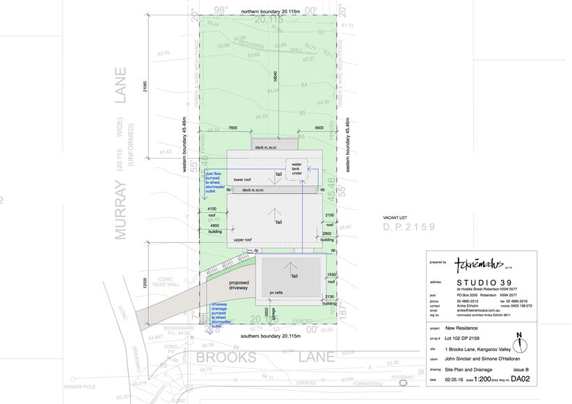
|

|
Development
Committee – Tuesday 14 February 2017
Page
50
|
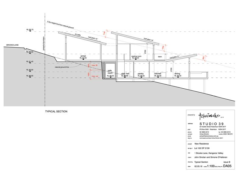
|
|
Development
Committee – Tuesday 14 February 2017
Page
51
|
DE17.17 DA
Fee Exemption - South Coast Branch Surf Life Saving (NSW) - Proposed
Administration, Training & Storage Facility - Integrated Emergency
Management Centre, 92 Albatross Road, Nowra.
HPERM Ref: D17/26984
Group: Planning
& Development Services Group
Section: Development
Services
Purpose / Summary
To consider a request from the
South Coast Branch Surf Life Saving (NSW) to waive normal development
applications fees for a proposed development for an administration, training
and storage facility at 92 Albatross Road, Nowra. Under the Policy on
Waiving of Development Application Fees and Other Fees for Charitable
Organisations and Community Groups (the Policy), clause 2.4 states:
Applicants / organisations who meet the exemption
criteria in clause 2.1 are required to pay upfront any amount above the fee
waiver threshold set in clause 2.2. The application / organisations can
apply for reimbursement of the amount paid and Council will consider this
request on merit in accordance with clause 2.4.
Under clause 2.4, a written
request outlining grounds for the reimbursement must be submitted. The
applicant has made a submission.
In this instance a fee has not
been paid. The applicant is seeking a waiver up-front as opposed to the
normal process which is paying fees and seeking a reimbursement thereafter.
The value of the development is
$800,000. The development application fee is $2,274.45, excluding the
notification component. The notification that would be undertaken for
this development would be via on line tracking and letters to adjoining
owners. This fee is $182. (Where advertising incudes press
notification, that fee is $300.)
|
Recommendation (Item to be determined
under delegated authority)
For Committee’s consideration.
|
Options
1. Resolve to waive the fees.
Implications: No fees would be charged.
Council would have to absorb the total cost of processing and determining the
development application (when lodged). This includes technical referrals,
notification, correspondence, general administration and final assessment and
determination of the DA.
2. Resolve to seek a part payment of fees
for an amount determined by Councillors.
Implications: This would assist in partial cost
recovery.
3. Decline the request to waive fees.
Implications: This would mean that normal fees
would be paid and those fees would expended on the assessment and processing of
the development application.
Background
Council’s Policy exempts a
non-profit organisation (e.g. registered charities, local sporting groups,
schools and the like) from the payment of fees associated with a DA so long as
the DA does not involve an ongoing commercial venture. The South Coast
Branch meets this criteria.
Where the sum of all fees
exceeds $1,000, the applicant, may apply to Council for a reimbursement of the
fees outlining the ground(s) for reimbursement.
The applicant has in this
instance requested for the fee waiver to be considered and dealt with up
front. That is, prior to the application being lodged.
The applicant wrote to Council
via letter dated 12 December 2016 as follows:
I write to you on behalf of the members of the South
Coast Branch Surf Life Saving to seek councils support in granting an exemption
to the payment of Development Application fees for the lodgement of our
application to building an Administration, Training and Storage facility on
site 9 located within the Integrated Emergency Management Centre, 92 Albatross
Road, Nowra.
The facility will greatly assist South Coast Surf Life
Saving to provide improved training facilities and opportunities to our members
as well as an administration centre and storage facility for our large amount
of equipment currently distributed throughout the south coast branch.
The granting of an exemption of Development Application
fees will relieve funding pressure on our volunteer organisation. I seek
your support to our request for exemption.
In further support of the fee waiver, the applicant also
submitted as follows:
SC Branch has had along
association and communication with Shoalhaven Council. And (sic) is sought out
for advice on lifesaving matters. We communicate regularly with the Manager
Aquatics Services within council.
There is a four tier
organisational structure within Surf Life Saving,
1. Surf
Life Saving Australia, the peak body at National Level
2. Surf
Life Saving NSW, State Body which is Governed by a Board and has 11 State
Councillors who are the 11 Branch Presidents representing the 129 clubs and
members in NSW.
3. 11
NSW Branches in NSW who are responsible for the Governance, Lifesaving
Operations, Training & Administrative Oversight/Supervision of the Surf
Life Saving Clubs with the branch.
4. Surf
Life Saving Clubs who are the operations face of the organisation, with Surf
Life Saving Beach Patrol & Rescue Service and Junior Development Program
for 5 to 14 yr. old children.
5. South
Coast Branch Clubs; Warilla-Barrack Point, Shellharbour, Kiama Downs, Kiama,
Gerringong, Shoalhaven Heads, Nowra-Culburra, Sussex Inlet & District and
Mollymook.
The SC Branch has five (5)
elected Directors, four of whom have portfolios, Lifesaving, Education,
Administration & Surf Sports and Myself as President. I perform 25 to 30
hrs per 7 day week on behalf of Surf Life Saving in my time after work and
weekends and my Directors Commit to similar Hours.
Three Directors including
myself live in the Shoalhaven and operate home offices on behalf of SC Branch
SLS. For approx. 3 – 4 years up to 2004 SC Branch had a lease with
Council in the North Nowra Community Centre and this was our office for a
period of time. Until fraud was committed on the branch.
Our postal address for more
than 20 years has been PO Box 1598, Nowra NSW 2541
We have a Board of Lifesaving
with 22 members who are the District Inspectors responsible for Club Patrol
Inspections and Compliance of the Lifesaving Operations. Four Duty
Officers responsible for Emergency Response, attendance to emergencies and Referral
in emergencies.
An Education Panel of 5 with 15
Trainers and Assessors. SC Branch is responsible for the Assessment of all
Lifesaving Club members who undergoing training at club level for various
awards and qualification. Our Branch also conducts higher level qualification
training for all clubs members in the branch.
Our Director of Education has
authority in regard to all club training activities and training instructors
within the branch. Our Director of Liesaving has authority for all Branch and
Club Lifesaving Operations and Club Captains report to the Dir. Lifesaving.
As Branch President I represent
the clubs within the Local Government Areas of Shellharbour, Kiama and
Shoalhaven on wider branch issues affecting clubs. The clubs have authority to
liaise with their council respecting buildings, leases, repairs and
ground upkeep. The Branch has responsibility and oversight of Patrol
Service Agreements with each club and Governance oversight of activities and
junior development as well as the fore mentioned maters.
All surf life saving clubs are
required to be affiliated with their Branch, State and National Body to be
recognised, they must accept and following SLSA Regulations. To receive funding
assistance, Government Grants, Coverage of Public Liability Insurance,
WorkCover Insurance and to be recognised as part of Surf Life Saving.
All are independently
registered as an Incorporated Association in NSW under the Dept. of Fair
Trading within the Incorporated Associations Legistlation (sic).
This is a brief summary, I hope
this brief assists you.
Thank you for your support, as
you have always been there for surf lifeaving.
Policy Implications
The request for a waiver can be considered under the
applicable Policy. Additionally, it is noted that the request is in
advance of the DA being lodged which is also a ‘variation’ to the
normal procedure. This early request will however avoid multiple
financial transactions.
Financial Implications
The DA (only – no Construction or other associated)
fees that would be payable to Council (excluding advertising) are
$2,274.45. Advertising fees for the development are estimated to be
$182. It is recommended that the full fees be waived.
The Policy sates that any donations by way of whole or
partial reimbursement / payment be determined by the Council and that they will
be paid out of the (if available) unallocated donations budget or a source
identified in Council’s resolution.
Conclusion
Having regard to the functions
of the Branch and capital outlay for a facility which will of benefit to the
local community, the request to waive fees is considered supportable.
|
|
Development
Committee – Tuesday 14 February 2017
Page
55
|
Local Government Amendment (governance &
planning) act 2016
Chapter
3, Section 8A Guiding principles for councils
(1)
Exercise of functions
generally
The
following general principles apply to the exercise of functions by councils:
(a) Councils should provide strong
and effective representation, leadership, planning and decision-making.
(b) Councils should carry out
functions in a way that provides the best possible value for residents and
ratepayers.
(c) Councils should plan
strategically, using the integrated planning and reporting framework, for the
provision of effective and efficient services and regulation to meet the
diverse needs of the local community.
(d) Councils should apply the
integrated planning and reporting framework in carrying out their functions so
as to achieve desired outcomes and continuous improvements.
(e) Councils should work
co-operatively with other councils and the State government to achieve desired
outcomes for the local community.
(f) Councils should manage lands
and other assets so that current and future local community needs can be met in
an affordable way.
(g) Councils should work with
others to secure appropriate services for local community needs.
(h) Councils should act fairly,
ethically and without bias in the interests of the local community.
(i) Councils should be
responsible employers and provide a consultative and supportive working
environment for staff.
(2) Decision-making
The
following principles apply to decision-making by councils (subject to any other
applicable law):
(a) Councils should recognise
diverse local community needs and interests.
(b) Councils should consider social
justice principles.
(c) Councils should consider the
long term and cumulative effects of actions on future generations.
(d) Councils should consider the
principles of ecologically sustainable development.
(e) Council decision-making should
be transparent and decision-makers are to be accountable for decisions and
omissions.
(3) Community participation
Councils
should actively engage with their local communities, through the use of the
integrated planning and reporting framework and other measures.
Chapter
3, Section 8B Principles of sound financial management
The
following principles of sound financial management apply to councils:
(a) Council spending should be responsible and
sustainable, aligning general revenue and expenses.
(b) Councils should invest in responsible and
sustainable infrastructure for the benefit of the local community.
(c) Councils should have effective financial
and asset management, including sound policies and processes for the following:
(i) performance management
and reporting,
(ii) asset maintenance and
enhancement,
(iii) funding decisions,
(iv) risk management practices.
(d) Councils should have regard to achieving
intergenerational equity, including ensuring the following:
(i) policy decisions are made
after considering their financial effects on future generations,
(ii) the
current generation funds the cost of its services
Chapter
3, 8C Integrated planning and reporting principles that apply to councils
The
following principles for strategic planning apply to the development of the
integrated planning and reporting framework by councils:
(a) Councils should identify and prioritise key
local community needs and aspirations and consider regional priorities.
(b) Councils should identify strategic goals to
meet those needs and aspirations.
(c) Councils should develop activities, and
prioritise actions, to work towards the strategic goals.
(d) Councils should ensure that the strategic
goals and activities to work towards them may be achieved within council
resources.
(e) Councils should regularly review and
evaluate progress towards achieving strategic goals.
(f) Councils should maintain an integrated
approach to planning, delivering, monitoring and reporting on strategic goals.
(g) Councils should collaborate with others to
maximise achievement of strategic goals.
(h) Councils should manage risks to the local
community or area or to the council effectively and proactively.
(i) Councils should make appropriate
evidence-based adaptations to meet changing needs and circumstances.