Development Committee
Meeting Date: Tuesday,
06 December, 2016
Location: Council
Chambers, City Administrative Building, Bridge Road, Nowra
Time:
4.00pm
Membership (Quorum - 5)
Clr Patricia White - Chairperson
All Councillors
General Manager or nominee
Please note: Council’s Code of Meeting Practice
permits the electronic recording and broadcast of the proceedings of meetings
of the Council which are open to the public. Your attendance at this meeting is
taken as consent to the possibility that your image and/or voice may be
recorded and broadcast to the public.
Agenda
1. Apologies / Leave of Absence
2. Confirmation of Minutes
· Development
Committee - 7 November 2016............................................................. 1
3. Declarations of Interest
4. Mayoral Minute
5. Deputations and Presentations
6. Notices of Motion / Questions on Notice
Nil
7. Reports
DE16.11...... Planning Proposal - Falls Creek/Woollamia
Deferred Areas - Bushfire Planning Issues...................................................................................................................... 10
DE16.12...... Shoalhaven LEP 2014 - Review of Flood Controls...................................... 26
DE16.13...... Review of the Nowra CBD Contributions Discount
Subsidy Policy............ 32
DE16.14...... Huskisson Town Centre - Service Lanes Review -
Funding and Costing Options...................................................................................................................... 37
DE16.15...... Interim Heritage Order Request - Chinaman's
Island Cottages, Lake Conjola 49
DE16.16...... Council Submission - Proposed Medium Density
Housing Code and Draft Design Guide ........................................................................................................... 53
DE16.17...... Exhibition Outcomes/Finalisation - Shoalhaven
Development Control Plan 2014 - Draft Amendment No. 13 - Chapter G4: Tree and
Vegetation Management 73
DE16.18...... Possible Change - Height of Buildings -
Shoalhaven Local Environmental Plan 2014 - Anson Street, St.Georges Basin .................................................................. 83
DE16.19...... Strategic Planning Works Program -
Formulation ..................................... 88
DE16.20...... Gateway Determination - Planning Proposal -
Warrah Road, Bangalee... 100
8. Confidential
Reports
Reports
CDE16.1..... Review of Determination - Development Application
– Lot 2 DP165748 Bowen Street Huskisson
Local Government Act - Section 10A(2)(g) - Advice
concerning litigation, or advice as comprises a discussion of this matter, that
would otherwise be privileged from production in legal proceedings on the
ground of legal professional privilege.
There is a
public interest consideration against disclosure of information as disclosure
of the information could reasonably be expected to prejudice any court
proceedings by revealing matter prepared for the purposes of or in relation to
current or future proceedings or prejudice the fair trial of any person, the
impartial adjudication of any case or a person’s right to procedural
fairness.
|

|
Development
Committee – Tuesday 06 December 2016
Page
iii
|
Development Committee
Delegation:
Pursuant to s377 (1) of the
Local Government Act 1993 the Committee is delegated the functions conferred on
Council by the Environmental Planning & Assessment Act 1979 (EPA Act),
Local Government Act 1993 (LG Act) or any other Act or delegated to Council, as
are specified in the attached Schedule, subject to the following limitations:
i. The
Committee cannot make a decision to make a local environmental plan to classify
or reclassify public land under Division 1 of Part 2 of Chapter 6 of the LG
Act;
ii. The
Committee cannot review a s82A or s96AB EPA Act determination made by the
Council or by the Committee itself;
iii. The
Committee cannot exercise any function delegated to the Council which by the
terms of that delegation cannot be sub-delegated;
iv. The Committee
cannot exercise any function which s377(1) of the LG Act provides cannot be
delegated by Council; and
v. The
Committee cannot exercise a function which is expressly required by the LG Act
or any other Act to be exercised by resolution of the Council.
Schedule:
1. All
functions relating to the preparation, making, and review of local
environmental plans (LEPs) and development control plans (DCPs) under Part 3 of
the EPA Act.
2. All
functions relating to the preparation, making, and review of contributions
plans and the preparation, entry into, and review of voluntary planning
agreements under Part 4 of the EPA Act.
3. The
preparation, adoption, and review of policies and strategies of the Council in
respect of town planning and environmental matters and the variation of such
policies.
4. Determination
of variations to development standards related to development applications
under the EPA Act where the development application involves a development
which breaches a development standard by more than 10% and the application is
accompanied by a request to vary the development standard under clause 4.6 of
Shoalhaven Local Environmental Plan 2014 or an objection to the application of
the development standard under State Environmental Planning Policy No. 1
– Development Standards.
5. Determination
of variations from the acceptable solutions and/or other numerical standards
contained within the DCP or a Council Policy that the General Manager requires
to be determined by the Committee
6. Determination
of development applications that Council requires to be determined by the
Committee on a case by case basis.
7. Review
of all determinations of development applications under sections 82A and 96AB
of the EP&A Act.
8. Preparation,
review, and adoption of policies and guidelines in respect of the determination
of development applications by other delegates of the Council.
Minutes of the Development Committee
Meeting Date: Monday,
7 November 2016
Location: Council
Chambers, City Administrative Building, Bridge Road, Nowra
Time: 4.05
pm
The following members
were present:
Clr John Wells -
Chairperson (Acting)
Clr Amanda Findley
Clr Joanna Gash
Clr Nina Cheyne
Clr Kaye Gartner
Clr Annette Alldrick
Clr Andrew Guile –
arrived 4.19pm
Clr Mitchell Pakes
Clr Greg Watson
Clr Mark Kitchener
Clr Bob Proudfoot
Mr Russ Pigg - General
Manager
|
Election
of Chairperson
|
|
RESOLVED (Clr Findley / Clr
Gartner) MIN16.834
That Clr Wells be appointed as
the Acting Chairperson for the Meeting in the absence of Councillor White.
CARRIED
|
|
Apologies / Leave of Absence
|
Clr White and Clr Levett
|
Confirmation of the Minutes
|
|
RESOLVED (Clr Findley / Clr
Cheyne) MIN16.835
That the Minutes of the
Development Committee held on Monday 10 October 2016 be confirmed.
CARRIED
|
Nil.
Deputations
DEV16.4 - Exhibition Outcomes/Finalisation
- Shoalhaven Development Control Plan 2014 - Draft Amendment No 5 - Stage 2
Housekeeping – Mr Steve Richardson (Cowman and Stoddart) spoke against
parts of the recommendation.
DEV16.8 – 25
Junction Street, Nowra Lot 1 DP 81167 – Mr Alex Kelly (Lawyer requested
by Lee Carmichael of Lee Carmichael Town Planning) spoke for the
recommendation.
Note: Clr Guile arrived,
the time being 4.19pm
|
Procedural
Motion – Permission to Address the Committee
|
|
RESOLVED (Clr Proudfoot / Clr
Gash) MIN16.836
That Lee Carmichael of Lee
Carmichael Town Planning be permitted to address the Development Committee.
CARRIED
|
DEV16.8 – 25
Junction Street, Nowra Lot 1 DP 81167 – Mr Lee Carmichael of Lee
Carmichael Town Planning addressed the Committee.
DEV16.8 – 25
Junction Street, Nowra Lot 1 DP 81167 – Ms Jennifer Parkyn - spoke
against the recommendation.
|
Procedural
Motion - Bring Item Forward
|
|
RESOLVED (Clr Wells / Clr Gash) MIN16.837
That the matters of items
DE16.4 Exhibition Outcomes/Finalisation - Shoalhaven Development Control Plan
2014 - Draft Amendment No 5 - Stage 2 Housekeeping and DE16.8 Development
Application – 25 Junction Street, Nowra – Lot 1 DP 81167 be
brought forward for consideration.
CARRIED
|
Reports
|
DE16.4 Exhibition
Outcomes/Finalisation - Shoalhaven Development Control Plan 2014 - Draft
Amendment No 5 - Stage 2 Housekeeping
|
HPERM Ref:
D16/298267
|
|
Recommendation (Item to be determined under
delegated authority)
That the Development Committee:
1. Note
the submissions received during the exhibition of Shoalhaven DCP 2014 Draft
Amendment No. 5 - Stage 2 Housekeeping
2. Adopt
Amendment No.5 to Shoalhaven DCP 2014 as exhibited with the inclusion of the
following changes to respond to the submissions as per Attachment 2 -
Submission Summary Table:
a. Minor
editorial changes in Chapter G9: Development on Flood Prone Land; and
b. Content
changes in Chapter G9: Development on Flood Prone Land, Chapter G10: Caravan
Parks in Flood Prone Areas and the Dictionary as outlined in Attachment 2 and
Attachment 4.
c. Defer
the draft changes to Chapter G9: Development on Flood Prone Land relating to
subdivision in Greenwell Point to seek legal advice and remove the current
wording in the DCP to consider alternative provisions in Shoalhaven Local
Environmental Plan 2014 to implement development controls identified in the
Lower Shoalhaven River Floodplain Risk Management Plan. Prepare an additional
report following the receipt of legal advice to outline possible alternative
provisions.
3. Rescind
Council Policy: POL 12/118 Finders Estate – Zincalume Roofs
4. Undertake
a future review of DCP Chapter G9: Development on Flood Prone Lane to improve
the readability of controls with simplified wording and formatting
5. Notify
the adoption of Amendment No.5 to Shoalhaven Development Control Plan 2014 in
the local newspapers in accordance with the requirements of the Environmental
Planning & Assessment Act 1979 and Regulations
6. Notify
the NSW Department of Planning & Environment and those who made a
submission on this matter that Amendment No.5 to Shoalhaven DCP 2014 has been
adopted.
|
|
Motion (Clr Watson / Clr Guile)
That the Development Committee:
1. Note
the submissions received during the exhibition of Shoalhaven DCP 2014 Draft
Amendment No. 5 - Stage 2 Housekeeping
2. Adopt
Amendment No.5 to Shoalhaven DCP 2014 as exhibited with the inclusion of the
following changes to respond to the submissions as per Attachment 2 -
Submission Summary Table:
a. Minor
editorial changes in Chapter G9: Development on Flood Prone Land; and
b. Content
changes in Chapter G9: Development on Flood Prone Land, Chapter G10: Caravan
Parks in Flood Prone Areas and the Dictionary as outlined in Attachment 2 and
Attachment 4.
c. Adopt the draft changes to Chapter
G9: Development on Flood Prone Land relating to subdivision at Greenwell
Point.
d. Should Staff believe the
Shoalhaven River Floodplain Risk Management Plan is inconsistent with the D C
P seek legal advice regarding the desirability of amending the Plan and then
refer matter to Shoalhaven Natural Resources and Floodplain Management
Committee.
3. Rescind
Council Policy: POL 12/118 Finders Estate – Zincalume Roofs
4. Undertake
a future review of DCP Chapter G9: Development on Flood Prone Lane to improve
the readability of controls with simplified wording and formatting
5. Notify
the adoption of Amendment No.5 to Shoalhaven Development Control Plan 2014 in
the local newspapers in accordance with the requirements of the Environmental
Planning & Assessment Act 1979 and Regulations
6. Notify
the NSW Department of Planning & Environment and those who made a
submission on this matter that Amendment No.5 to Shoalhaven DCP 2014 has been
adopted.
LOST on
the casting vote of the chair
For: Clr
Guile, Clr Pakes, Clr Watson, Clr Kitchener, Clr Proudfoot and Russ Pigg
Against: Clr
Findley, Clr Gash, Clr Wells, Clr Cheyne, Clr Alldrick and Clr Gartner
|
|
RESOLVED (Clr Findley / Clr
Gartner) MIN16.838
That the Development Committee:
1. Note
the submissions received during the exhibition of Shoalhaven DCP 2014 Draft
Amendment No. 5 - Stage 2 Housekeeping
2. Adopt
Amendment No.5 to Shoalhaven DCP 2014 as exhibited with the inclusion of the
following changes to respond to the submissions as per Attachment 2 -
Submission Summary Table:
a. Minor
editorial changes in Chapter G9: Development on Flood Prone Land; and
b. Content
changes in Chapter G9: Development on Flood Prone Land, Chapter G10: Caravan
Parks in Flood Prone Areas and the Dictionary as outlined in Attachment 2 and
Attachment 4.
c. Defer
the draft changes to Chapter G9: Development on Flood Prone Land relating to
subdivision in Greenwell Point to seek legal advice and remove the current
wording in the DCP pending a further report on further advice.
3. Rescind
Council Policy: POL 12/118 Finders Estate – Zincalume Roofs
4. Undertake
a future review of DCP Chapter G9: Development on Flood Prone Lane to improve
the readability of controls with simplified wording and formatting
5. Notify
the adoption of Amendment No.5 to Shoalhaven Development Control Plan 2014 in
the local newspapers in accordance with the requirements of the Environmental
Planning & Assessment Act 1979 and Regulations
6. Notify
the NSW Department of Planning & Environment and those who made a
submission on this matter that Amendment No.5 to Shoalhaven DCP 2014 has been
adopted.
For: Clr
Findley, Clr Gash, Clr Wells, Clr Cheyne, Clr Alldrick, Clr Gartner, Clr
Guile, Clr Pakes, Clr Watson, Clr Kitchener, Clr Proudfoot and Russ Pigg
Against: Nil
CARRIED
|
|
DE16.8 Development
Application – 25 Junction Street, Nowra – Lot 1 DP 81167 DP
|
HPERM Ref:
D16/316144
|
|
Recommendation (Item to be determined under
delegated authority)
That the Committee grant consent
to Development Application DA16/1369 for a multi-unit housing development,
comprising, 3 single storey units with garages (2 x 3 bedroom and 1 x 2
bedroom) in accordance with the conditions as detailed in Attachment 1.
|
|
RESOLVED (Clr Gash / Clr Wells) MIN16.839
That the Committee grant consent
to Development Application DA16/1369 for a multi-unit housing development,
comprising, 3 single storey units with garages (2 x 3 bedroom and 1 x 2
bedroom) in accordance with the conditions as detailed in Attachment 1.
For: Clr
Findley, Clr Gash, Clr Wells, Clr Cheyne, Clr Alldrick, Clr Gartner, Clr
Guile, Clr Pakes, Clr Watson, Clr Kitchener, Clr Proudfoot and Russ Pigg
Against: Nil
CARRIED
|
|
DE16.4 Exhibition
Outcomes/Finalisation - Shoalhaven Development Control Plan 2014 - Draft
Amendment No 5 - Stage 2 Housekeeping
|
HPERM Ref: D16/298267
|
|
Item dealt with
earlier/later in the meeting see MIN16.837
|
|
DE16.5 Development
of an Affordable Housing Strategy for Shoalhaven
|
HPERM Ref:
D16/312373
|
|
Recommendation (Item to be determined under
delegated authority)
That the Development Committee
1. Receive
the Affordable Housing Background Report, Discussion Paper and Strategic
Framework prepared by Judith Stubbs and Associates as the initial stages of
the development of an Affordable Housing Strategy for Shoalhaven for
information
2. Make
the Background Report, Discussion Paper and Strategic Framework publicly
available and endorse the continued preparation of a draft Affordable
Strategy for Shoalhaven based on the Strategic Framework.
3. Receive
a future report on the draft Affordable Housing Strategy for Shoalhaven, to
enable it to be fully considered prior to proceeding to community
consultation/engagement
4. Arrange
for Dr Judy Stubbs to brief Council, when appropriate, on the Affordable
Housing Strategy work for Shoalhaven
|
|
RESOLVED (Clr Findley / Clr
Wells) MIN16.840
That the Development Committee
1. Receive
the Affordable Housing Background Report, Discussion Paper and Strategic
Framework prepared by Judith Stubbs and Associates as the initial stages of
the development of an Affordable Housing Strategy for Shoalhaven for information
2. Make
the Background Report, Discussion Paper and Strategic Framework publicly
available and endorse the continued preparation of a draft Affordable
Strategy for Shoalhaven based on the Strategic Framework.
3. Receive
a future report on the draft Affordable Housing Strategy for Shoalhaven, to
enable it to be fully considered prior to proceeding to community
consultation/engagement
4. Arrange
for Dr Judy Stubbs to brief Council, when appropriate, on the Affordable
Housing Strategy work for Shoalhaven
For: Clr
Findley, Clr Gash, Clr Wells, Clr Cheyne, Clr Alldrick, Clr Gartner, Clr
Guile, Clr Pakes, Clr Watson, Clr Kitchener, Clr Proudfoot and Russ Pigg
Against: Nil
CARRIED
|
|
DE16.6 Draft
Huskisson Foreshore Masterplan - Exhibition Outcomes & Process
Finalisation
|
HPERM Ref:
D16/312632
|
|
Recommendation (Item to be determined under
delegated authority)
That Council
1. Adopt
the draft Huskisson Foreshore Masterplan with the following changes:
a. Remove
the four development scenarios for 59 Owen Street and any content that
specifically relates to the development scenarios; and
b. Identify
priority projects to implement the Wider Town Centre Concept Plan.
2. Commence
the process to amend Shoalhaven Development Control Plan 2014 Chapter N18
– Huskisson Town Centre to include relevant aspects of the Urban Design
Principles and Wider Town Centre Concept Plan, and to restrict development
above ground level on 59 Owen Street.
3. Using
the material gathered during the preparation of the draft Masterplan prepare
a preferred option for the site that is consistent with the proposed
‘community’ classification and that maintains the view, for
possible incorporated into a management plan for the site that supports the
proposed ‘community’ classification.
4. Advise
submission makers, the Huskisson Chamber of Business and Tourism and the
Huskisson -Woollamia Community Voice of this resolution and provide a letter
of thanks to the members of the Community Reference Group who assisted with
this project.
5. Council
staff be thanked and Council continue to support them in the exercise of
their duties.
|
|
RESOLVED (Clr Watson / Clr Guile) MIN16.841
That Council
1. Adopt
the draft Huskisson Foreshore Masterplan with the following changes:
a. Remove
the four development scenarios for 59 Owen Street and any content that
specifically relates to the development scenarios; and
b. Identify
priority projects to implement the Wider Town Centre Concept Plan.
2. Commence
the process to amend Shoalhaven Development Control Plan 2014 Chapter N18
– Huskisson Town Centre to include relevant aspects of the Urban Design
Principles and Wider Town Centre Concept Plan, and to restrict development
above ground level on 59 Owen Street.
3. Using
the material gathered during the preparation of the draft Masterplan prepare
a preferred option for the site that is consistent with the proposed
‘community’ classification and that maintains the view, for
possible incorporated into a management plan for the site that supports the
proposed ‘community’ classification.
4. Advise
submission makers, the Huskisson Chamber of Business and Tourism and the
Huskisson -Woollamia Community Voice of this resolution and provide a letter
of thanks to the members of the Community Reference Group who assisted with
this project.
5.
Council staff be thanked and Council continue to support them in the exercise
of their duties.
Note:
Clr Watson left the meeting, the time being 6.08pm and was not present for
the vote.
For: Clr
Findley, Clr Levett, Clr Cheyne, Clr Alldrick, Clr Gartner, Clr Guile, Clr
Pakes, Clr Kitchener, Clr Proudfoot and Russ Pigg
Against: Clr
Gash and Clr Wells
CARRIED
|
|
DE16.7 Development
Application – No.160 Bolong Road, Bomaderry – Lot 1 DP 838753
|
HPERM Ref:
D16/314387
|
|
Recommendation (Item to be determined under
delegated authority)
That the Committee:
1. Confirm
that it supports, pursuant to Clause 4.6 (Variation to development standards)
of SLEP 2014, the applicant’s request to vary the height limit of 11m
to 34.12m; and
2. Refer
the development application (DA14/2161) back to staff for determination.
|
|
Note:
Clr Watson returned to the meeting, the time being 6.09pm
|
|
RESOLVED (Clr Gash / Clr Pakes) MIN16.842
That the Committee:
1. Confirm
that it supports, pursuant to Clause 4.6 (Variation to development standards)
of SLEP 2014, the applicant’s request to vary the height limit of 11m
to 34.12m; and
2. Refer
the development application (DA14/2161) back to staff for determination.
For: Clr
Findley, Clr Gash, Clr Wells, Clr Cheyne, Clr Alldrick, Clr Gartner, Clr
Guile, Clr Pakes, Clr Watson, Clr Kitchener, Clr Proudfoot and Russ Pigg
Against: Nil
CARRIED
|
|
DE16.8 Development
Application – 25 Junction Street, Nowra – Lot 1 DP 81167 DP
|
HPERM Ref: D16/316144
|
|
Item dealt with
earlier/later in the meeting see MIN16.838
|
|
DE16.9 Possible
Planning Proposal - The Wool Road, St Georges Basin
|
HPERM Ref:
D16/319525
|
|
Recommendation (Item to be determined under
delegated authority)
1. Provide
in principle support for the proposal to jointly rezone Lot 7 DP 827728 and
Lot 218 1071257, subject to the following:
a. Any
loss of industrial zoned land being offset by the identification of new
industrial zoned land.
b. A
detailed biodiversity assessment being completed prior to formally
considerring a Planning Proposal over the site.
c. An odour asssessment
being completed within the identified buffer area around the Sewerage
Treatment Plant following Gateway determination.
2. Seek
initial input from the NSW Department of Planning and Environment in regard
to the proposed Planning Proposal, particularly in regard to the strategic
issue of maintenance of industrial zoned land.
3. Notify
the proponents of the Council resolution, the outcome of consultation with
the NSW Department of Planning and Evironment and the studies that need to be
prepared to support a formal Planning Proposal.
4. Encourage
the proponents to have early discussions with the Basin Villages Forum in
regard to the Planning Proposal should it proceed to formal lodgement.
5. Report
back to Council when a formal Planning Proposal has been lodged, following
the completion of the necessary studies.
|
|
RESOLVED (Clr Guile / Clr Wells) MIN16.843
1. Provide
in principle support for the proposal to jointly rezone Lot 7 DP 827728 and
Lot 218 1071257, subject to the following:
a. Any
loss of industrial zoned land being offset by the identification of new
industrial zoned land.
b. A
detailed biodiversity assessment being completed prior to formally
considerring a Planning Proposal over the site.
c. An odour asssessment
being completed within the identified buffer area around the Sewerage
Treatment Plant following Gateway determination.
2. Seek
initial input from the NSW Department of Planning and Environment in regard
to the proposed Planning Proposal, particularly in regard to the strategic
issue of maintenance of industrial zoned land.
3. Notify
the proponents of the Council resolution, the outcome of consultation with
the NSW Department of Planning and Evironment and the studies that need to be
prepared to support a formal Planning Proposal.
4. Encourage
the proponents to have early discussions with the Basin Villages Forum in
regard to the Planning Proposal should it proceed to formal lodgement.
5. Report
back to Council when a formal Planning Proposal has been lodged, following
the completion of the necessary studies.
For:
Clr
Findley, Clr Gash, Clr Wells, Clr Cheyne, Clr Alldrick, Clr Gartner, Clr
Guile, Clr Pakes,
Clr Watson, Clr Kitchener, Clr Proudfoot and Russ Pigg
Against: Nil
CARRIED
|
|
DE16.10 Central
Nowra Residential Zones - Character Related Development Controls
|
HPERM Ref:
D16/320236
|
|
Recommendation (Item to be determined under
delegated authority)
That Council:
1. Finalise
the character analysis that is currently underway in central Nowra, including
the planned consultation with the Old Houses Our History group, landowners
and other key stakeholders.
2. Following
the completion of the character analysis, Council:
a. Receive
a further report on the outcomes of the consultants work including
recommendations on suitable mechanisms to protect the character of central
Nowra.
b. Identify
specific locations to be considered for a backzoning to an R2 Low Density Residential
Zone, where appropriate.
c. Prepare
a set of detailed planning and character development controls that seek to
maintain the character of the central Nowra area.
|
|
Note:
Clr Guile left the meeting, the time being 6.28pm
|
|
RESOLVED (Clr Gash / Clr Cheyne) MIN16.844
That Council:
1. Finalise
the character analysis that is currently underway in central Nowra, including
the planned consultation with the Old Houses Our History group, landowners
and other key stakeholders.
2. Following
the completion of the character analysis, Council:
a. Receive
a further report on the outcomes of the consultants work including
recommendations on suitable mechanisms to protect the character of central
Nowra.
b. Identify
specific locations to be considered for a backzoning to an R2 Low Density
Residential Zone, where appropriate.
c. Prepare
a set of detailed planning and character development controls that seek to
maintain the character of the central Nowra area.
For:
Clr
Findley, Clr Gash, Clr Wells, Clr Cheyne, Clr Alldrick, Clr Gartner, Clr
Guile, Clr Pakes,
Clr Watson, Clr Kitchener, Clr Proudfoot and Russ Pigg
Against: Nil
CARRIED
|
There being no further
business, the meeting concluded, the time being 6.30pm.
Clr Wells
CHAIRPERSON
|

|
Development
Committee – Tuesday 06 December 2016
Page
10
|
DE16.11 Planning
Proposal - Falls Creek/Woollamia Deferred Areas - Bushfire Planning Issues
HPERM Ref: D16/328009
Group: Planning
& Development Services Group
Section: Strategic
Planning
Attachments:
1. 111 Woollamia Road - Draft Subdivision
Proposal 20/6/2016 ⇩
2. 1, 3, 5
& 7 Seasongood Road - Draft Subdivision Proposal 26/6/2016 ⇩
3. 21 &
23 Seasongood Road - Draft Subdivision Proposal 8/6/2016 ⇩
4. RFS
letter 25/8/2016 ⇩
5.
Conceptual dwelling location map - 21 & 23 Seasongood Road ⇩
6. DPE
Gateway extension 31/8/2016 ⇩
Purpose / Summary
· Provide
an update on the Planning Proposal (PP) following Council’s resolution on
5 April 2016 to enable landowners to commission their own bushfire planning
reports with the aim of maximising their lot yield.
· Clarify
the proposed subdivision and development outcomes to be sought through the PP.
|
Recommendation
(Item to be determined under delegated authority)
That Council:
1. Proceed with the Planning Proposal
based on the following potential development outcomes:
a. In respect of 1, 3, 5, 7, 9, 11, 13,
18, 20, 21 and 23 Seasongood Road, and 49, 53, and 59 Woollamia Road, to
potentially enable a two lot subdivision of each of the lots, such that:
i. New dwelling sites will be
located within 200 metres of the public road.
ii. In respect of 21 and 23
Seasongood Road, the new dwelling sites be positioned no further from the
road than the existing dwelling at 21 Seasongood Road and Asset Protection
Zones be based on a maximum bushfire attack level of 19 kW/m2
b. In respect of 111 Woollamia Road, to
potentially enable a three lot subdivision based on establishment of a
reciprocal right of way between Woollamia Road and Falls Road as outlined in
the report prepared by SET Consultants, subject to the owner surrendering the
consent for three tourist cabins (DA00/2847) which have not yet been
constructed.
2. Revise the Planning Proposal based on
the above proposed development outcomes and seek the NSW Department of
Planning and Environment’s approval to publicly exhibit the Planning
Proposal.
3. Prepare a draft site-specific chapter
(Chapter N16) for inclusion in Shoalhaven Development Control Plan 2014 and
brief Council prior to exhibiting the draft DCP chapter concurrently with the
Planning Proposal.
4. Invoice each landowner for 50% of the
costs (currently $1,423.50) prior to exhibition of the Planning Proposal, and
the remaining 50% after Council has resolved to finalise the Planning
Proposal.
|
Options
1. Adopt the recommended approach.
Implications: This addresses the bushfire planning
concerns, and hence should enable the PP to progress.
2. Adopt an alternative approach as
directed by Council.
Implications: The PP may not be able to be
finalised within the required timeframe. There is a risk that the NSW
Department of Planning and Environment (DP&E) may not be willing to grant a
further (fifth) gateway extension, and hence the PP will not progress.
Background
Council initially resolved to
commence this PP and the investigations associated with it in 2011, in
accordance with the action in the Jervis Bay Settlement Strategy (JBSS) to
investigate increased densities in the rural residential deferred areas.
The JBSS states that: “it
may be possible to increase the density of rural residential development in
some of these existing areas and to use this process to also achieve outcomes
for biodiversity, riparian areas and so on” with a one (1) hectare as
the minimum lot size to be considered.
The PP that was submitted for
Gateway determination in 2012, identified a number of technical investigations
that would need to be undertaken to enable the potential subdivision and
development options to be developed.
The Gateway determination issued
by the DP&E for this PP in 2012 originally covered 87 lots. Over the course
of the investigations, this has been reduced to 15, and any potential
development within these lots must be confined to the ‘investigation
area’ on each that was adopted by Council in 2014.
Reports were prepared for
Council’s consideration as these investigations have been progressed and
the resulting Council resolutions can be viewed on Council’s website at:
http://shoalhaven.nsw.gov.au/Planning-amp-Building/Strategic-planning/Paper-subdivisions/Woollamia-Falls-Ck-Deferred-Areas
Bushfire planning requirements and
issues
There is a statutory requirement for Council to
consult with the NSW Rural Fire Service (RFS) when preparing PP’s over
bushfire prone land. The Gateway determination issued by DP&E
for this PP also includes a specific requirement to consult with the RFS and
address any bushfire planning concerns prior to public exhibition.
Following completion of the Strategic Water Cycle
Assessment in October 2015, advice was sought from the RFS in November 2015 on
the possible subdivision and development options. The RFS raised a number
of bushfire planning concerns relating to:
· The public road network and the
broader locality; and
· Inconsistencies with the RFS’s
Planning for Bushfire Protection (BPB) guideline under the maximum development
scenario, particularly where new dwellings would be located more than 200
metres of a public road.
This matter was reported to Council on 5 April 2016
and it was resolved to:
1. Provide
an eight (8) week period for the landowners in each of the five (5) clusters of
properties to collectively provide their own detailed bushfire report prepared
by a suitably qualified consultant, addressing PBP 2006 and the RFS specific
comments/concerns with the aim of maximising the lot yield.
2. Where
full cooperation of land owners in the respective clusters cannot be achieved
part clusters or individual fire reports be considered subject to the reports
satisfying PBP 2006 requirements for protection from bushfire.
3. Council
seek a further extension from the Department of Planning and if that extension
is not forthcoming then Council revert to Option 1 (staff recommendation
outlined in report).
After advising the landowners of
the above resolution, Council received three (3) landowner bushfire planning
reports covering a total of seven properties, as summarised in Table 1.
In relation to the remaining eight properties, the PP will seek to allow a two
lot subdivision of each, with the new dwelling sites to be located within 200
metres of the public road, referred to herein as the ‘default
option’.
Table 1 - Summary of bushfire reports commissioned by
landowners
|
Address
|
Proposed lot yield
|
Consultant
|
|
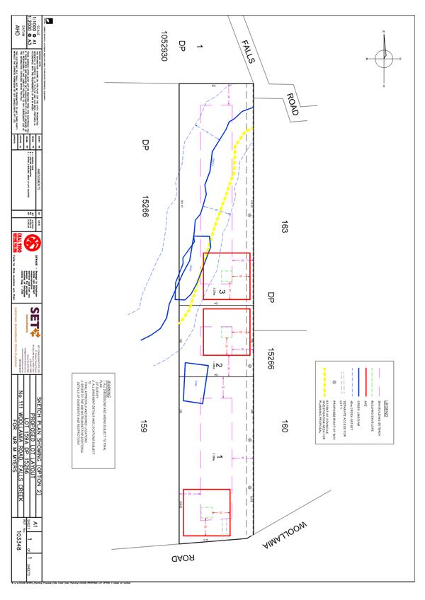
111 Woollamia Road
|
Three (3) - see Attachment 1
|
SET Consultants
|
|
1, 3, 5 and 7 Seasongood Road
(four adjoining lots)
|
Three (3) on each existing lot
- see Attachment 2
|
EcoLogical Australia
|
|
21 and 23 Seasongood Road (two
adjoining lots)
|
Four (4) at 21 Seasongood Road
and five (5) at 23 Seasongood Road - see Attachment 3
|
Bushfire Building Solutions
|
The above reports were forwarded
to the RFS for review and comment. The RFS responded on 25 August 2016,
stating that it has no objection to the proposal for 111 Woollamia Road, but
raising a number of concerns regarding the proposals for 1, 3, 5 and 7
Seasongood Road, and 21 and 23 Seasongood Road. A copy of the RFS
letter is provided in Attachment 4.
However, the RFS stated that it
would have no objection to the PP if it ensures that future lots are within 200
metres of Seasongood Road, or a suitable public road network complying with the
performance criteria in PBP is provided.
A copy of the RFS’s letter
was forwarded to the respective consultants, leading to further discussions
with the landowners, their consultants and the RFS. The outcome in respect of
each proposal is discussed further below.
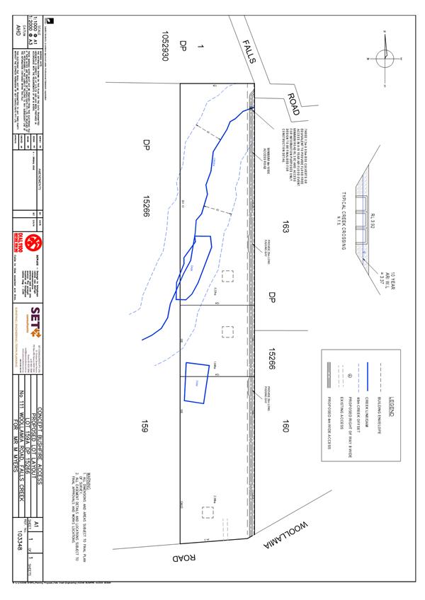
111
Woollamia Road (Lot 159A, DP 15266)
The proposed three-lot
subdivision is based on establishing an 8 metre wide reciprocal right of way
(property access road) along the eastern boundary of the property, linking
Woollamia Road and Falls Road (Refer to Attachment 1). The
property access road would be approximately 640 metres long, with a creek
crossing at the northern end.
The RFS raised no objections to
the proposal.
In 2001, Council issued
development consent (DA00/2847) for the construction of three tourist cabins on
the Lot. The cabins have not been constructed and the consent would have
lapsed except that in 2007, Council advised the applicant that ‘suitable
commencement’ has occurred. Hence, the approval will not lapse
unless it is surrendered.
The cumulative impacts (and
conflicts) of the tourist cabins and a three lot subdivision on local amenity
could be significant, e.g. noise, dust and visual impacts on adjoining
properties. Hence, it is recommended that in relation to 111 Woollamia
Road, the PP seek to allow a three lot subdivision on the basis that the
approval for the cabins be ‘surrendered’ and that this be done
prior to finally amending Shoalhaven LEP 2014. This could be done without
delaying the LEP amendment for the other lots within the PP.
The proposed subdivision layout
may also need to be further refined to minimise impacts on adjoining properties
and achieve environmental outcomes.
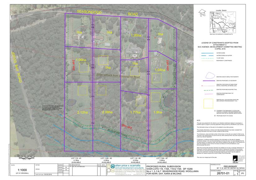
1,
3, 5 and 7 Seasongood Road (Lots 119, 119A, 118 and 118A, DP 15266)
To address the perimeter access
requirements of PBP, the proposed subdivision incorporated a perimeter fire
trail (see Attachment 2) approximately 1100 metres long. As noted
in the RFS letter, the reliance of fire trails rather than public roads around
the perimeter of the site is not consistent with PBP.
The owner of 1 Seasongood Road
advised Council that they did not want to pursue a three–lot subdivision
of their lot.
A meeting was held with the
consultant and the RFS on 11 October 2016, in which the RFS reiterated its
concerns, and the merits and issues of the proposal were discussed and debated.
The outcome of this meeting was that for the three-lot subdivision option to be
pursued, additional information would be required relating to 1) the proposed
perimeter access arrangements, and 2) safety concerns about the road network in
a bushfire emergency.
The owners of 3, 5 and 7 Seasongood
Road subsequently advised Council of their collective decision not to further
pursue the three-lot subdivision option, noting their considerable
disappointment in reaching this decision. Thus this report recommends
that the PP aim to allow a two-lot subdivision of each property (1, 3, 5 and 7
Seasongood Road). This would essentially enable consideration of one additional
dwelling house lot on each property.
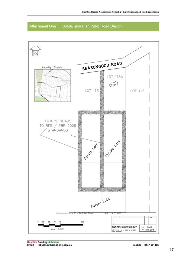
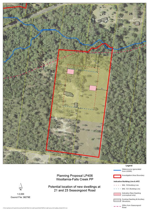
21
and 23 Seasongood Road (Lots 113 and 113A, DP 15266)
This proposed subdivision layout
was based on establishment of an internal/link public road straddling the
common boundary between the two lots and a perimeter road – see Attachment
3. The combined length of the proposed roads was approximately 1500
metres and the proposed link road incorporated a watercourse crossing.
The report provided limited detail on the proposed road system.
The RFS’s comments (see Attachment
4) stated that for the proposal to be supported by the RFS, Council would
need to endorse the creation of the proposed road layout as public roads,
including the perimeter road network.
A meeting was held with the
consultant and the RFS on 11 October 2016, in which the RFS reiterated its
concerns and clarification was sought on the proposed road layout.
Council staff had subsequent
discussions with the consultant, the owner of 23 Seasongood Road and the
RFS. The owner and the RFS have verbally indicated general support
to progress the PP based on allowing one additional dwelling lot on each
property, with the new dwellings to be positioned in proximity to or forward of
the existing dwelling at 21 Seasongood Road, as conceptually shown in Attachment
5.
Note: For each of the areas a
nominated contact was requested after the previous Council resolution related
to the submission of bush fire reports by the owners. Staff have not had direct
contact with the owner of 21 Seasongood Road. The owner of 23 Seasongood Road
advised that they would not be opposed to the PP proceeding as recommended in
this report. The owner of No.21 will have the formal opportunity to comment,
should they wish, when the PP is exhibited.
A draft conceptual map shows
that larger bushfire asset protection zones (APZ’s) can be achieved,
potentially providing an increased level of safety. If Council adopts the
recommendations of this report, this map will be refined and included in a
supporting draft DCP chapter (proposed Chapter N16).
Gateway extension
Council sought and was granted a one year extension by
DP&E to complete this PP. The PP is now due to be finalised by 5
September 2017. The DP&E letter states:
“This is the third extension of twelve months and
brings the total time for completion of the LEP to five years. The
Department may not be willing to support any further requests for extension.
Council is requested to provide a timeline for the project’s milestones
that can be used to track progress towards the completion of the LEP by 5
September 2017.”
A copy of DP&E’s letter dated 31 August 2016 is
provided in Attachment 6. A
timeline will be forwarded to DP&E pending the outcome of this
report. If the recommendations are adopted, an indicative timeline is as
follows:
|
Task
|
Indicative completion by dates
|
|
Prepare mapping and update the PP
|
March/April 2017
|
|
Prepare draft Chapter N16 of Shoalhaven DCP 2014
|
March/April 2017
|
|
Report to / Brief Council prior to exhibition
|
May 2017
|
|
Publicly exhibit PP and draft Chapter N16, and consult
with Government agencies
|
May/June 2017
|
|
Consider submissions and prepare post exhibition
report
|
July 2017
|
|
Adopt PP
|
July/August 2017
|
|
Consult with DP&E to prepare and finalise LEP
amendment
|
July/August/September 2017
|
In addition to the specific bushfire risk management
measures outlined earlier in this report, the DCP chapter would also
incorporate the recommendations and findings of the Strategic Water Cycle
Assessment to protect water quality and catchment health, and appropriate
controls relating to biodiversity and riparian corridors in accordance with the
JBSS.
Community Engagement
Consultation with directly
involved landowners has been ongoing as the PP has evolved. A formal
public exhibition process will still need to be undertaken as part of the PP
and DCP process. This will also allow landowners, including those
adjoining the PP area, the broader community, and relevant Government agencies
to formally comment on the details provided as part of the PP and draft DCP
exhibition package.
Financial Implications
The costs that are ultimately
proposed to be recovered from the benefitting landowners are based on
Council’s adopted PP fee structure. Given the evolving and
longstanding nature of this project, it is likely that Council has incurred
costs in excess of what will be recovered from landowners. It is
imperative that finalisation of this PP and supporting DCP chapter be concluded
in a timely and efficient manner.
Conclusion
The proposed development
outcomes outlined in the recommendations of this report appear have the support
of the landowners and the RFS. The indicative timeline suggests that the
PP could be finalised within the required period provided there are no
significant delays in respect of the PP and draft DCP. This is important
in context of DP&E’s comments regarding any further Gateway extension
request.
|
|
Development
Committee – Tuesday 06 December 2016
Page
16
|
|

|
Development
Committee – Tuesday 06 December 2016
Page
18
|
|
|
Development
Committee – Tuesday 06 December 2016
Page
19
|
|
|
Development
Committee – Tuesday 06 December 2016
Page
20
|
|

|
Development
Committee – Tuesday 06 December 2016
Page
23
|
|
|
Development
Committee – Tuesday 06 December 2016
Page
24
|
|
|
Development
Committee – Tuesday 06 December 2016
Page
26
|
DE16.12 Shoalhaven
LEP 2014 - Review of Flood Controls
HPERM Ref: D16/334860
Group: Planning
& Development Services Group
Section: Strategic
Planning
Purpose / Summary
It is proposed to review the
current flood related development controls in Shoalhaven Local Environmental
Plan (LEP) 2014 to:
- Remove
the Flood Planning Area mapping to ensure that the most accurate and up to date
flood mapping is relied upon from Council’s adopted Flood Risk Management
Studies and Plans (FRMSP).
- Update Clause 7.3 in Shoalhaven LEP 2014 to
ensure consistency with the definitions in the NSW Floodplain
Development Manual and to identify historic flooding information and
subsequently provide controls for areas previously mapped as Rural 1(g) (Flood
Liable) and Residential 2(a4) (Restricted Development) in Shoalhaven LEP 1985
that fall outside the adopted flood study areas.
- Incorporate
provisions for stock mounds in flood prone or acid sulphate soil areas.
|
Recommendation (Item to be determined
under delegated authority)
That the Committee:
1. Prepare a Planning Proposal (PP012)
– Review of Flood Controls to amend Shoalhaven LEP 2014 as follows:
a. Remove the Flood Planning Area maps
from Shoalhaven LEP 2014 to ensure that the most accurate and up to date
flood mapping is relied upon from Council's adopted Flood Risk Management
Studies and Plans (FRMSP).
b. Update Clause 7.3 in Shoalhaven LEP
2014 to provide consistency with the definitions in the NSW Floodplain
Development Manual and to identify historic flooding information and
subsequently provide controls for areas previously mapped as Rural 1(g)
(Flood Liable) and Residential 2(a4) (Restricted Development) in Shoalhaven
LEP 1985 that fall outside the adopted flood study areas.
c. Incorporate provisions for stock
mounds in flood prone or acid sulphate soil areas.
2. Consider a further report to adopt
PP012 – Review of Flood Controls for submission to the NSW Department
of Planning of Environment for Gateway determination.
3. Endorse the preparation of an online
Flood Planning map to provide a publicly accessible and interactive display
of adopted Flood Study mapping and historic flooding information.
|
Options
1. Adopt the recommendation.
Implications: This is the
preferred option as it will enable a review of flood controls in Shoalhaven LEP
2014 to ensure they reflect Council’s adopted Flood Risk Management Study
and Plans. This will ensure that the LEP reflects one mapping source meet
the definition of ‘Flood Planning Level’ in Clause 7.3 in
Shoalhaven LEP 2014. The proposal to remove the Flood Planning Area map
from the actual LEP will reduce the need for constant updating of the
Shoalhaven LEP 2014 via Planning Proposals as ongoing changes to the FRMSP’s
are adopted.
2. Adopt an alternative recommendation.
Implications: Depending on
its nature, an alternative recommendation could delay the updating of flood
controls in Shoalhaven LEP 2014 and could result in mapping that is not
necessarily up to date being utilised in the development application process.
Background
Stage 4 Housekeeping Planning Proposal (PP)
On 3 June 2014, the Development Committee resolved to
commence the process to make necessary housekeeping amendments to Shoalhaven
LEP 2014 and report these for consideration as required.
The housekeeping amendments are now complete except for
Stage 4 (PP012). The original intent of the Stage 4 Housekeeping PP was
to:
· Update the LEP
Flood Planning Area Map with any new flood data that has been prepared and
finalised since the commencement of Shoalhaven LEP 2014 on 22 April 2014.
· Add those areas of
former Rural 1(g) land that are outside the scope of existing flood studies to
the Flood Planning Area Map.
· Include a
provision to regulate the construction of stock mounds in flood prone areas.
Updated Flood Mapping
When Shoalhaven LEP 2014 was prepared, the most up to date
flood data available was used to create the Flood Planning Area Map that forms
part of the plan. Since then, new data has become available as additional
flood studies and/or risk management plans have been completed and adopted by
Council for the following catchments:
• Kangaroo
River
• Broughton
Creek
• Bomaderry
Creek
• Shoalhaven
River
• Nowra
Creek
• Browns
Creek
• Lake
Wollumboola
• Currambene
Creek
• Moona
Moona Creek
• St
Georges Basin
• Lake
Conjola
• Burrill
Lake
• Lake
Tabourie
Further, Council resolved on 12 April 2016 that the Flood
Planning Area Map in the Shoalhaven LEP 2014 be updated to include flood
extents from the Lake Tabourie, Kangaroo River, Nowra and Browns Creeks,
Bomaderry Creek and the Currambene and Moona Moona Creeks Floodplain Risk
Management Studies and Plans (FRMSP). Council also resolved on the 19 July
2016, to update the map in Shoalhaven LEP 2014, also to include the flood
extents from the revised Broughton Creek catchment flood information and
mapping.
The data for the Lake Tabourie, Nowra and Browns Creeks,
Bomaderry Creek and the Currambene and Moona Moona Creek's catchments also
includes Council’s resolved sea level rise benchmark of 0.36 metres (2100
sea level rise projection).
During the background research for this PP and following
discussions with NSW Office of Environment and Heritage (OEH) and a number of
Councils with flood controls, it became apparent that a number of Councils do
not have a Flood Prone Land layer (Flood Planning Area Map) in their
LEP’s and rely solely on the application of LEP Clause 7.3, that relates
to land that is defined as below the ‘flood planning level’. This
approach appears to be a sensible option for Council to adopt considering the
number of flood affected areas identified in Councils FRMSP which are updated
and amended on a regular basis. However the Flood Planning Area maps in
Shoalhaven LEP 2014 can only be amended through a PP and the process for a
simple PP can take 6-12 months before an LEP amendment is made. As such
there is a time lag.
Council’s adopted FRMSP’s are available on
Council’s website, however most of the mapping is located within the
documents and can be difficult for the public to interpret. As part of
this review, it is recommended that the data from the adopted FRMSP’s be
displayed on Council’s interactive mapping system enabling the public to
search and locate a property very easily. This will also mean that the
online map can be updated without delay as it sits outside the formal LEP.
Proposed Changes - Clause 7.3 Flood Planning
Clause 7.3 Flood Planning in the Shoalhaven LEP 2014 is a
‘model clause’ provided by the NSW Department of Planning &
Environment (DP&E) that has been slightly adapted to meet the local
situation in Shoalhaven.
The clause applies to:
2) (a)
land that is shown as “Flood planning area” on the Flood Planning
Map, and
(b) other
land at or below the flood planning level.
DP&E’s Clause
7.3 model clause and drafting instructions, indicate that the wording of
Clause 2 is aimed at identifying areas that are mapped as the ‘flood
planning area’ but also applies to other areas where accurate mapping is
not possible. Consequently, the wording captures land that can be
accurately mapped and also land that cannot. Unmapped land includes the
“flood planning area” (as defined in the NSW Floodplain
Development Manual) up to the “flood planning level”.
Council’s Section 149 (2) Planning Certificates currently identify
properties that are mapped on the Flood Planning Area map, also areas that are
not mapped in Shoalhaven LEP 2014 but that meet the definition of subclause
Clause 7.3 2(b), being land at or below the ‘flood planning level’
in Council’s adopted FRMSP’s. By removing the Flood Planning
Area map from the Shoalhaven LEP 2014 there is no real change to the
application of Clause 7.3, it will however result in an improvement for the
public accessing accurate and up to date information.
Clause 7.3 (4) in Shoalhaven LEP 2014 states that words or
meanings used in this clause have the same meaning as in the NSW Floodplain
Development (April 2005), unless otherwise defined in the clause. Clause
7.3 (5) goes on to provide the following definition:
‘Flood
planning level’ means the level of a 1:100 ARI (average recurrent
interval) flood event plus 0.5 metre freeboard.
At the time of preparing the Shoalhaven LEP 2014, the
definition of ‘flood planning level’ was one (1) definition out of
four (4) possible definitions that could be used from model Clause 7.3 (see
link above). To provide consistency with the NSW Flood Plain
Development Manual, it is recommended that the PP include a request to
remove subclause 7.3(5) so that the definition of ‘flood planning
level’ in the NSW Floodplain Development Manual can instead be
relied. This will enable a broader approach that includes flood levels
derived from significant historical flood events. The definition in the
Manual is provided below:
‘Flood planning
levels’ (FPLs) are the combinations of flood levels (derived from
significant historical flood events or flood of specific AEPs) and freeboards
selected from floodplain risk management purposes, as determined in management
studies and incorporated in management plans. FPLs supersede the
“standard flood event” in the 1886 manual
Standard Instrument LEP issues
Through the introduction of the Standard Instrument
LEP and the transfer of zones from Shoalhaven LEP 1985 to Shoalhaven LEP 2014,
a number of zones that provided additional restrictions for development on
flood prone land were unable to be carried over and were lost. Zones including
Rural 1(g) (Flood Liable) and Residential 2(a4) (Restricted Development) were
not able to be carried over. In the areas where these zones applied, a
similar zone has been applied and the land has as appropriate also been identified
on the Flood Planning Area – Other map in Shoalhaven LEP 2014.
Inclusion of zone Rural 1(g) (Flood Liable) land
The Rural 1 (g) (Flood Liable) zone under Shoalhaven LEP
1985 previously applied to land that had been identified as flood prone
land. In the transfer to Shoalhaven LEP 2014, Rural 1(g) land was zoned
RU1 Primary Production or RU2 Rural Landscape and also shown on the Flood
Planning Area - Other Map as there was no equivalent zone in the Standard
Instrument LEP. In areas where a contemporary flood study had been
undertaken, it was assumed that this data would supersede the data underpinning
the Rural 1(g) zone and that any properties zoned Rural 1(g) that were not
identified in the flood study for that catchment were assumed to not be flood
prone and therefore were not shown on the Flood Planning Area map.
It has since been found that this was an erroneous
assumption as the flood study areas do not always incorporate all of a
catchment. Subclause 7.3(2) does not reference land mapped as ‘other’
on the Flood Planning Area map in Shoalhaven LEP 2014 and therefore carries no
legal weight.
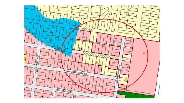
Thus there are some instances where former Rural 1(g) land
which was excluded from a flood study area, was not transferred to the Flood
Planning Area map. The map below shows an example at Erowal Bay where the
Flood Planning Area map (blue area) has been overlaid over the Shoalhaven LEP
1985 map. The properties zoned Rural 1(g) or Residential 2(a4) in
Shoalhaven LEP 1985 within the red circle are not shown on the Flood Planning
Area map in Shoalhaven LEP 2014 which was clearly ‘cut-off’ partway
along the waterway that runs through Erowal Bay. As a result, it is not
readily apparent that these properties are flood prone. To rectify this,
it was originally intended that properties be included on the Flood Planning
Area map. Through the relevant PP to remove the Flood Planning Area map,
historic flood information needs to be captured through Clause 7.3 in
Shoalhaven LEP 2014. As outlined earlier in this report it is recommended
that Clause 7.3 be amended to remove subclause (5) to rely on the definition of
‘flood planning levels’ in the NSW Floodplain Development
Manual. This will provide a consistent approach to definitions in the LEP
as well as provide a broader definition to cover flood levels derived from
significant historic flood events.
Stock mounds
Stock mounds provide an elevated mound of fill to raise
stock above the probable maximum flood level at a size large enough to provide
suitable holding, feed and water space for the duration of the flood event
(usually 14 days) where adequate flood free access/refuge is not available
elsewhere on a property.
Under Clause 29 Development of flood liable land in the
previous Shoalhaven LEP 1985 development consent was required for filling in
the floodplain that was ancillary to agriculture. This meant that the
construction of a stock mound required consent.
Shoalhaven LEP 2014 does not have similar clause which means
that stock mounds are considered ancillary to extensive agriculture and
therefore are unregulated. As unregulated stock mound construction could
have significant environmental and flooding relating impacts (within a site and
across the wider floodplain); Shoalhaven LEP 2014 needs to also be amended to
require consent for their construction to enable sufficient consideration of
their potential impacts.
The Planning Proposal (PP012) – Review of Flood
Controls will propose to include an additional provision in Shoalhaven LEP 2014
to require development consent for stock mounds as detailed in the table below:
|
3
|
Clause 7.3A Exceptions to
earthworks in a Flood Planning Area
|
Insert an additional provision in
the instrument to clarify that stock mounds require consent. The
objectives of such a provision are to:
· To
provide for the orderly development of a stock mound in a flood planning
area.
· To
ensure that stock mounds do not have a detrimental impact on environmental
functions and processes in a flood planning area.
It is intended that the provision
apply in the following circumstances:
· Land is zoned RU1 Primary
Production and RU2 Rural Landscape; and
· Land
identified as “Flood Planning Area’’ on the Flood Planning
Areas Map and/or land identified at or below the “Flood Planning
Level” and/or land identified as Class 1-4 Acid Sulfate soils on the
Acid Sulfate Soils Map; and
· where
the usable surface area of the stock mound is 100 square metres or greater in
area.
|
Community Engagement
Should the proposed PP ultimately proceed further it will be
exhibited for comment in accordance with Council’s Community Engagement
Policy at Level 1 to ‘inform’ and ‘consult’, and in
accordance with the relevant legislative requirements. The Gateway
determination will specify the minimum exhibition period and any government
agencies with whom Council must consult. Community Consultative Bodies
(CCB’s) and other interest groups will also be advised of future
exhibition arrangements.
Policy Implications
The proposed
review of flood controls in Shoalhaven LEP 2014 is consistent with
Council’s Flood Risk Management Studies and Plans, Shoalhaven LEP 1985
and relevant Chapters. The relevant DCP chapters can be reviewed in the future
if needed to ensure consistency with any changes to the LEP.
Financial Implications
Based on the
recommended approach, there are no immediate financial implications for Council
as the proposed approach will be resourced within the existing Strategic
Planning budget.
Risk Implications
Consistency
with the FRMSP’s is important to ensure Council’s planning
documents include suitable controls consistent with the Floodplain
Development Manual and to ensure Council is acting in good faith when
providing flood risk controls to ensure legal indemnity is maintained. By
providing one source of up to date information for flood affected properties
that are identified through adopted FRMSP’s, Council is providing the
most accurate information available to current and future landowners.
|
|
Development
Committee – Tuesday 06 December 2016
Page
32
|
DE16.13 Review
of the Nowra CBD Contributions Discount Subsidy Policy
HPERM Ref: D16/324536
Group: Planning
& Development Services Group
Section: Strategic
Planning
Attachments:
1. Nowra CBD
Contributions Subsidy ⇩
Purpose / Summary
To seek direction in relation to
the review of the Nowra CBD Contributions Discount Subsidy Given that the two
(2) year trial period for the subsidy has now been completed, and Council needs
to determine whether they wish to continue providing the subsidy.
|
Recommendation (Item to be determined
under delegated authority)
That the Development Committee
1. Extend the Nowra CBD Contributions
Discount Subsidy Policy for an additional 12 months from the initial review
date
2. Advise the Nowra CBD Revitalisation
Committee members, Nowra CBD Business Chamber and the Shoalhaven Business Chamber
of this resolution
|
Options
1. Adopt the resolution outlined in the
report.
Implications: This is the preferred option. The
trial subsidy was intended to stimulate/encourage new development within the
Nowra CBD. This does not appear to have occurred. It is proposed
that the trial be extended by another 12 months to see whether there is further
interest.
2. Adopt an alternative resolution.
Implications: Council can choose to rescind or
amend the current Nowra CBD Contributions Discount Subsidy Policy if it wishes.
Background
The Shoalhaven Contributions
Plan 2010 allows Council to levy contributions on new development for the
provision of essential community infrastructure. Where a commercial
development cannot meet all of their parking requirements on-site, a developer
has the option of paying a monetary contribution in lieu of providing on-site
parking. In the Nowra CBD, the current contribution rate for car parking
is $25,662.36 per space.
On 28 October 2014, Council
resolved to adopt the Nowra CBD Contributions Discount Subsidy Policy (Attachment
1).
The subsidy was in response to
concerns raised by the development industry and others that the cost of current
car parking contributions is inhibiting development in the Nowra CBD. Council
resolved to subsidise car parking contributions by 50% as a trial measure, to
hopefully stimulate new development. This was intended to encourage
redevelopment within the Nowra CBD through the provision of a short term
discount subsidy applied to the Nowra Car Parking Contributions Project.
The policy is primarily aimed at
small to medium development scenarios that generally have a net development
area of less than 1,500m2 and excludes supermarkets, clubs, hotel and motel
developments. The policy operates separately and in isolation of
Council’s Contributions Plan and the discount subsidy is paid from
Council’s General Revenue funds and not from the contribution projects
funds.
A review was set two years from
the date of adoption to analyse the uptake of the policy, its effectiveness in
encouraging development in the Nowra CBD and financial implications to Council.
Analysis
During the two years of
operation, the policy has only been utilised twice:
The first was for a development
that had already been completed, and the subsidy was applied
retrospectively. The second was a recent application for an expansion of
an existing medical centre.
As such, the policy has not had the
desired outcome of encouraging new development within the CBD. The two
instances where the subsidy has been issued were of a relatively minor nature.
Notwithstanding, it is recommended that the trial of the subsidy continue for
an additional 12 months, to be reviewed on 27 October 2017.
Continuing the trial of the
policy requires Council to provide a funding source in its annual Management
Plan for the period of the subsidy. The amount required cannot be accurately
predicted, therefore the status of the subsidy will be monitored every three
months in Council’s quarterly budget reviews.
Policy Implications
This report recommends that the
Nowra CBD Contributions Discount Subsidy POL14/24 be extended for an additional
12 months.
Chapter G21: Car Parking and
Traffic in the Shoalhaven Development Control Plan (DCP) 2014 contains a
related Clause 5.17 Nowra CBD – Development Incentive. This was
introduced at the same time as the policy and the status of the clause will be
reviewed as part of the wider review of the DCP chapter.
Financial Implications
Continuing the trial of the
policy requires Council to provide a funding source for the period of the
policy. The amount required cannot be accurately predicted given the nature of
the policy.
|
|
Development Committee
– Tuesday 06 December 2016
Page
34
|
|

|
Development
Committee – Tuesday 06 December 2016
Page
37
|
DE16.14 Huskisson
Town Centre - Service Lanes Review - Funding and Costing Options
HPERM Ref: D16/324563
Group: Planning
& Development Services Group
Section: Strategic
Planning
Attachments:
1. Report to
Development Committee 7/6/16 - Huskisson Town Centre - Service Lanes Review
(under separate cover) ⇨
2. Draft
Contribution Project and Amendment Maps - Morton Street and Currambene Street
Service Lanes ⇩
3.
Supporting Information - draft CP 03ROAD0058 and CP03ROAD0057 ⇩
4.
Confidential - Updated Costing Information - Huskisson Service Lanes
(Confidential - under separate cover)
Purpose / Summary
To provide further information on costing and funding
options to facilitate the implementation of the proposed Huskisson Town Centre
service lanes, in response to a previous Council resolution and enable a
preferred way forward to be determined.
|
Recommendation
That the Development Committee:
1. Prepare
an amendment to the Shoalhaven Contributions Plan 2010 to:
a. Amend
the acquisition area of Currambene Street service lane Section 94 project
(03ROAD0057) to reflect Council’s resolved position to not acquire No.
12 Currambene Street for a proposed vehicle link (as per the map included in
Attachment 2).
b. Include
the previously exhibited draft Morton Street service lane Section 94 project
(03ROAD0058) as per the map included in Attachment 2 with minor amendments
determined by infrastructure requirements and design and the exclusion of the
proposed laneway from Lot 12 DP 7169, No. 11 Currambene Street.
c. Obtain
updated acquisition and construction costs for both projects and include
these in the draft Shoalhaven Contributions Plan 2010 amendment.
2. Receive
a further report to consider the actual draft amendments to Shoalhaven
Contributions Plan 2010.
3. Consider
the following changes to Chapter N18 of the Shoalhaven Development Control
Plan 2014 through a future review of this chapter to:
a. Remove
the proposed service vehicle link between the Currambene Street service lane
and Currambene Street (through Lot 2 DP 662583, No. 12 Currambene Street) and
include provisions relating to service vehicle access on individual
properties.
b. Update
the service lane provisions in accordance with updated infrastructure
requirements and design.
4. Commit
to funding the upfront costs for the construction of the Morton Street and
Currambene Street service lanes in accordance with the following principles:
a. Fund
the initial expenditure of the works using loan funds or through general
revenue allocations in the future Capital Works Program of up to $3.24
million and request a further report should it require more than this amount.
b. Recoup
part of the expended funds through Section 94 contributions levied by
Shoalhaven Contributions Plan 2010 for future development.
c. Include
the design and construction of the Currambene Street and Morton Street
service lanes in Council’s capital works planning.
5. Notify
the affected landowners of Council’s resolution.
|
Options
1. Adopt the
recommendation
Implications: Council can
choose to fund the service lanes through external borrowings or through general
revenue allocations in the future Capital Works Program in order to commence
the planning, design and construction of the Currambene Street and Morton
Street service lanes.
This option moves the timeframe
for construction ahead of the development and will hopefully stimulate
development in the benefiting areas. The construction of the service lanes will
help ensure the best future development outcomes for servicing and access
arrangements.
By including both projects in
the Section 94 contribution project, landowners within the project benefit area
will contribute to the costs through Section 94 contributions at development
stage.
2. Adopt an
alternative recommendation
Implications:
As detailed in this report,
there are a number of funding options available in this regard:
a) Funding the project
through general revenue
b) Funding the project
through loan funds and seeking recoupment through:
· Section
94 Contributions (recommended option)
· Voluntary
Planning Agreement
· Special
Rate Variation applied to benefitting landowners or the broader Huskisson Town
Centre landowners
Council could also decide not to
proceed with delivery of the service lanes. This option would involve amending
Shoalhaven Contributions Plan (CP) 2010 to remove the Currambene Street service
lane project and amending Chapter N18 in Shoalhaven DCP 2014 to identify the
proposed service lanes as desirable. This option would require each individual
landowner to provide safe and practical servicing options for each individual
property. This removes Council’s financial liability to fund a portion of
the cost of providing the service lanes. As detailed in the previous report,
this option seems to be generally preferred by the landowners, however this
approach does not provide the best longer term development/planning outcome for
the town centre.
Background
The ongoing review of Huskisson
service lanes was reported to Council’s Development Committee Meeting on
7 June 2016. A copy of this report is included as Attachment 1. At this
meeting it was resolved:
That this matter be deferred
pending further investigation by staff on costing and funding options to
facilitate the implementation of the service lanes.
Shoalhaven Development
Control Plan (DCP) 2014 – Chapter N18 Huskisson Town Centre
As outlined in the report to
June 2016 report, Shoalhaven DCP 2014 Chapter N18 – Huskisson Town Centre
currently proposes rear service lanes with the intention of removing service
vehicles from the main commercial streets of Huskisson and to also facilitate
better development outcomes by providing rear access for vehicles, servicing and
car parking.
The proposed service lanes,
known as the Currambene Street service lane and the Morton Street service lane
are shown in Figure 1 (DCP extract) below.
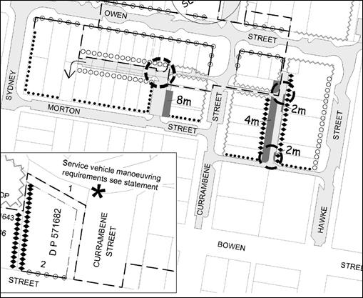
Figure 1 - Extract from Chapter N18 - Shoalhaven DCP 2014,
Proposed Service Lanes
Shoalhaven Contributions Plan
(CP) 2010
In 2012, the proposed Currambene
Street service lane was incorporated into the Shoalhaven CP 2010, which enabled
Council to levy contributions from development towards the cost of land
acquisition and the construction of the proposed service lane.
At that time, Council resolved
not to include the proposed Morton Street service lane in the CP (Attachment
2 contains the relevant maps), however this proposal is still identified in
the Shoalhaven DCP 2014.
Council resolved as part of the
consideration of draft Amendment No.1 to Shoalhaven CP 2010 (MIN12. 867) that:
Council confirm its previous
decision to not acquire the land from the property known as Huski Bakery (11
Currambene St) for the purpose of widening the laneway as part of the proposed
Morton Street Service Lane.
It is thus recommended that any
proposed CP project over the proposed Morton Street service lane recognise
Council’s previous resolution in this regard and remove 11 Currambene
Street from the proposed acquisition area.
In 2014, Council was approached
by the then owner of 12 Currambene Street to acquire that part of their
property affected by the proposed service lane (the link between the proposed
Currambene Street service Lane and Currambene Street). At the time,
Council resolved not to acquire the land, and to review the proposed service
lanes identified in Shoalhaven DCP 2014. Thus it is recommended that
Council’s position in this regard also be reflected through an amendment
to the Currambene Street service lane CP Project by also removing this proposed
vehicle link. An updated draft plan is included in Attachment 2 with the
vehicle link removed.
The report to Council’s
Development Committee on 7 June 2016 (Attachment 1) includes further
details on the review process to date and the outcomes of landowner meetings
and overview of landowner comments.
Updated Service Lane Design
and Costings
At this stage, detailed
infrastructure designs have not been completed for the two proposed service
lanes, however land acquisition and construction cost estimates were sought in
2009 during the preparation of the draft Shoalhaven CP 2010 (Amendment No. 1)
and are included in the supporting information provided as Attachment 3.
A number of properties have already been acquired along the Morton Street
service lane project area via previous development consents requiring
dedication or through acquisition. As detailed in the Confidential Attachment
4, Council has already spent $195,136.00 on the acquisition of properties
along the Morton Street service lane.
It is recommended that relevant
land acquisition, construction cost estimates and apportionment percentages for
the draft Section 94 projects be updated before the exhibition of any draft
amendment to the Shoalhaven CP 2010 is undertaken. A quote has been sought to
engage a valuation firm to update the valuation schedule to reflect current
market value and amend the area of acquisition arising from Council decisions.
An updated valuation schedule with rough estimates based on recent sale
information and internal valuation advice, with an updated list of affected
properties, is included as a Confidential Attachment for Council’s
information.
The estimated construction costs
for the projects from 2009 are likely to increase substantially given an
increase to unit rates for certain materials and an increase of 21.24% for the
Building Price Index. Further detailed cost estimates will be sourced
internally from Council’s Assets & Works Group with the preparation
of infrastructure design plans.
As indicated in the spreadsheet
(Confidential Attachment 4) the initial cost of both projects with an
updated property list, estimate land values and constructions costs is likely
to be in excess of $3.24 million.
Funding Options
Advice from Council’s
Finance Section has been incorporated into the commentary in this section.
There are a limited range of
mechanisms available for Council to fund and deliver community infrastructure.
Council can choose to fund this project using external borrowings or by
committing to fund it through future capital works programs, however it is
recommended that Council commit to some form of recoupment option as security
over the land. Both proposed service lanes will help activate development and
will provide good development outcomes for the Huskisson Town Centre, however
they will come at a high cost to Council and directly benefit only a small
number of land owners.
There is currently no available
budget for the Currambene Street and Morton Street service lane projects.
Section 94 funds are yet to be recouped from the current Section 94 Project for
the Currambene Street service lane (03ROAD0057). The recoupment of costs
through a direct invoice to landowners is not appropriate for these projects as
it offers no security for Council in recouping costs and requires Council to
amend its fees and charges. This option would not cover land acquisitions
costs. Any costs invoiced to landowners for construction works would need to be
sought through debt collection and this could result in legal action and
additional costs. This option could place an unnecessary financial burden on
landowners who may not be in the position to commit to the project and could result
in poor credit ratings for landowners if a debt collection process ends up
being undertaken.
Council will ultimately incur
the cost of constructing the Currambene Street and Morton Street service lanes,
however the total amount that can be recouped is yet to be determined. Under
the current Shoalhaven CP 2010, Council is currently required to fund a portion
of the cost of providing the Currambene Street service lane. The current
apportionment rate to future development in the Section 94 Project for the
Currambene Street service lane (03ROAD0057) is 51.8%. Council’s
contribution to this project is estimated to be 48.2% of the total estimate or
approximately $545,105 at the current indexed project estimate of
$1,130,922.65. As detailed in Confidential Attachment 4, the total
project estimate is expected to substantially reduce due to the reduction in
the acquisition area for No. 12 Currambene Street, Huskisson as already
resolved by Council.
The Shoalhaven CP 2010 will need
to be amended to include the Morton Street service lane project, Council will
also be required to fund a portion of providing this service lane and a
reasonable apportionment rate will need to be considered in preparing this
draft Section 94 project.
Possible recoupment methods are
outlined below:
a) Section 94
Contributions (preferred option):
- Landowners/developers
contribution requirements may be satisfied by a monetary contribution,
dedication of land to Council, the provision of a material public benefit or
works-in-kind, or a combination of these.
- Council
would still be required to fund a portion of the cost.
- Contributions
can only be required if a contributions plan is in place at the time a
development application is determined.
- Seed
funding through Section 94 funds could be used as initial expenditure for both
projects and will be recouped as development occurs, however it is noted that
there are currently no available funds in the Planning Area 3 pool. If Council
decides to proceed with the projects before funds become available through
Section 94 contributions, Council will need to commit to borrow loan funds or
allocate future budget in the future capital works program.
b) Voluntary Planning
Agreement
- A
voluntary planning agreement (VPA) is an agreement entered into by a planning
authority (such as Council) and a developer
- Under
the agreement a developer can agree to provide or fund infrastructure
- Contributions
can be made through dedication of land, monetary contributions, construction of
infrastructure and the provision of materials for public benefit and/or use.
- A VPA
would need to be entered into voluntarily with each individual landowner and
Council. This is unlikely to be successful given that most landowners have not
indicated a clear desire to further develop their land at present or to
contribute towards a service lane to increase their development potential.
c) Special Rate
Variation
- This
option would involve the initial expenditure of loan funds and the recoupment
of costs through a Special Rate Variation applied to the benefitting landowners
or alternatively to the wider Huskisson Town Centre landowners.
- Council
can apply to the NSW Independent Pricing and Regulatory Tribunal (IPART) for a
Special Rate Variation to increase rates above the rate peg.
- This
application will be considered against the guidelines set by the NSW Office of
Local Government guidelines.
- This
application is unlikely to meet the criteria considering the scale of the
projects, the small number of benefiting owners, the existing Section 94
project and other more suitable recoupment options.
d) General Revenue (no
recoupment)
- There is
currently no budget available to fund both projects through Council’s
General Revenue (rate income).
- Any
expenditure will require loan funds to be borrowed. Without a secured
recoupment method, this option would put Council in a difficult financial
position for the benefit of a relatively small number of landowners.
Community Engagement
Council staff facilitated a
number of meetings with affected landowners to discuss the proposed service
lanes, and the recommendation of the report largely reflects the feedback
received at the public meetings.
The formal amendments to
Shoalhaven DCP 2014 and Shoalhaven CP 2010 will be publicly exhibited for a
minimum period of 28 days and further landowner and broader community feedback
will be undertaken at that point.
Policy Implications
Shoalhaven DCP 2014 and
Shoalhaven CP 2010 will need to be amended to reflect Council’s decision.
It is recommended that the exhibition of the draft Amendments occur
simultaneously. Any change to the service lanes proposed will require an
amendment to both the DCP and CP in some form to reflect Council’s
previous resolution not to acquire 12 Currambene Street, Huskisson for the
purposes of a vehicle link.
Financial Implications
There is currently no funding
set aside for project delivery or acquisitions of this kind nor have any funds
been collected under a relevant contributions plan. Seed funds for the delivery
of the service lanes projects will require external borrowings.
Updated land acquisition
estimates will be provided for the preparation of the draft amendment to
Shoalhaven CP 2010. Initial disbursement items of legal and valuation fees will
be included in the valuation schedule.
Council will ultimately incur
the cost of constructing the Currambene Street and Morton Street service lanes,
however the total amount that can be recouped is yet to be determined. Under
the current Shoalhaven CP 2010, Council is currently required to fund a portion
of the cost of providing the Currambene Street service lane. If the Shoalhaven
CP 2010 is amended to include the Morton Street service lane project, Council
will also be required to fund a portion in providing this service lane.
|
|
Development
Committee – Tuesday 06 December 2016
Page
43
|
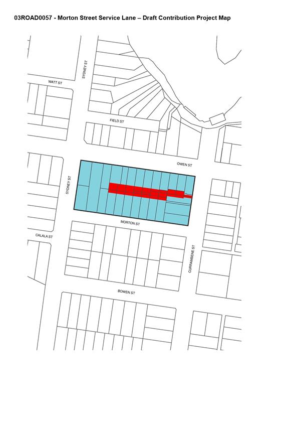
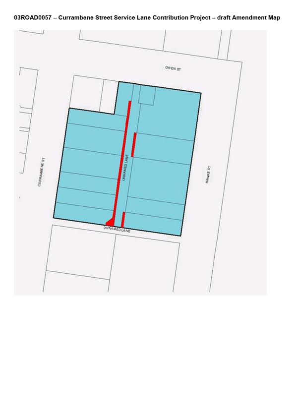
|
|
Development
Committee – Tuesday 06 December 2016
Page
45
|
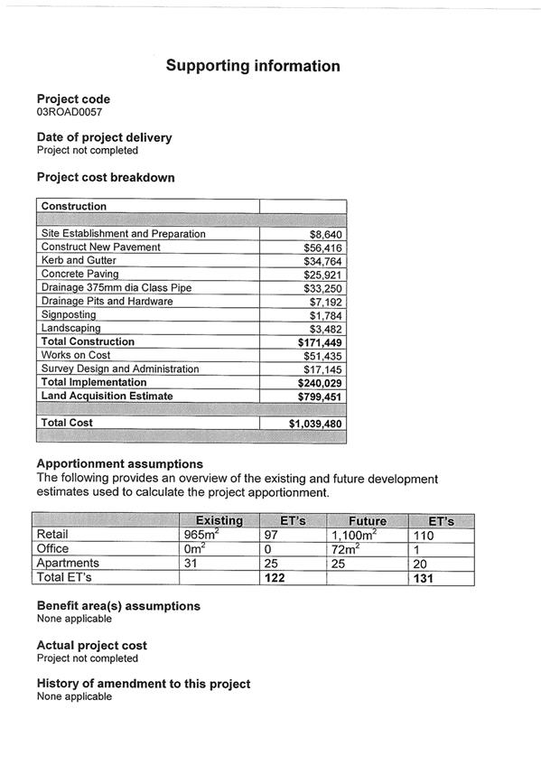
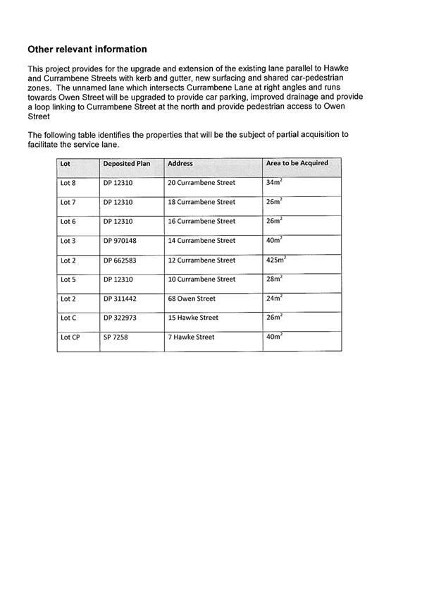
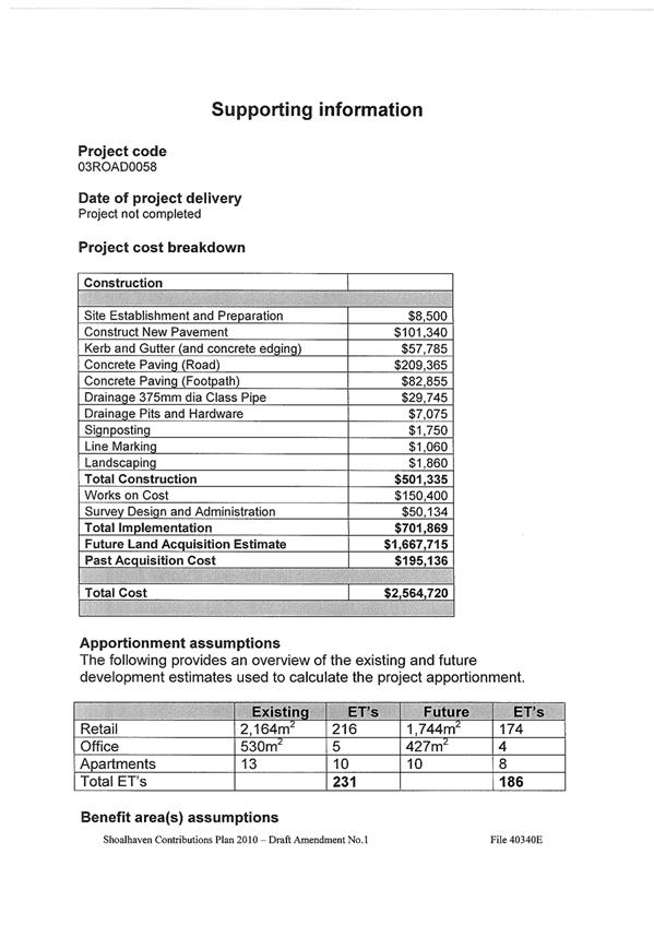
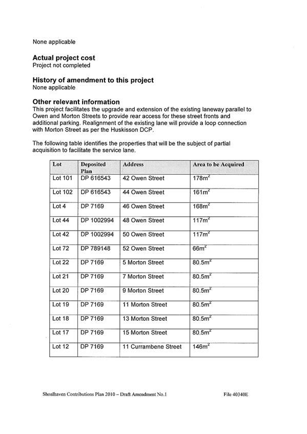
|

|
Development
Committee – Tuesday 06 December 2016
Page
49
|
DE16.15 Interim
Heritage Order Request - Chinaman's Island Cottages, Lake Conjola
HPERM Ref: D16/346783
Group: Planning
& Development Services Group
Section: Strategic
Planning
Purpose / Summary
To seek direction on a recommendation from the NSW Minister
for Heritage, that Council assess the likely heritage significance of the
cottages located on Chinaman’s Island, Lake Conjola.
|
Recommendation (Item to be determined
under delegated authority)
That in accordance with the
Committee’s delegated authority from Council, that Council not support
a heritage assessment and allow the current end of lease demolition
arrangements with DPI - Lands to remain.
|
Options
1. Not support a heritage assessment and
allow the current end of lease demolition arrangements with DPI - Lands to
remain.
Implications: This would
enable DPI – Lands to continue with their end of lease arrangements.
2. Undertake a heritage assessment of the
Chinaman’s Island cottages to determine their heritage significance.
Implications: This option
will enable Council to determine whether the cottages should be identified as
items of local environmental heritage in Shoalhaven Local Environmental Plan
(LEP) 2014 or whether they should be subject to an archival recording prior to
demolition.
3. Support the preparation of archival
recording prior to demolition.
Implications: This option
will enable the history and stories associated with the cottages to be
documented. It would be consistent with the preferred approached of NSW
Department of Primary Industries – Lands (DPI – Lands) and enable
sustainable long term maintenance and management of Chinaman’s Island.
Background
Chinaman’s Island is located in Lake Conjola, north of
the existing urban area as shown in Figure 1 below.
Figure 1: Chinaman’s Island, Lake Conjola
The island is currently owned by the NSW Government and is
managed by DPI – Lands. Early last century 12 lots were offered for lease
by ballot on a permissive occupancy (lease). A number of small cottages
were subsequently constructed by the leaseholders during the 1940s and 1950s,
with some used as permanent occupancies and others as holiday cottages.
During the 1970s, DPI - Lands informed the leaseholders that the cottages would
be demolished when the last surviving occupant died.
Of the 12 original cottages:
· 5 have been
demolished (the last of which was removed in 2012).
· 4 are earmarked
for removal.
· 3 are subject to a
current lease:
o 1 is permanently occupied;
o 2 are used for holiday
purposes.
The Interim Heritage Order
and Heritage Significance
In 2015, relatives of the
leaseholders petitioned the NSW Government to issue an Interim Heritage Order
(IHO) under the NSW Heritage Act 1977 to preserve the remaining cottages.
The purpose of an IHO is to
provide a "breathing space" of no more than 12 months during which a
full heritage assessment can be completed. They are thus intended to be
temporary in nature and the majority are made in response to community
representations or concerns raised by local government.
The cottages were not identified
or considered through the Shoalhaven Heritage Study that led to the amendments
to the Heritage Schedule in Shoalhaven Local Environmental Plan 2014.
The NSW Office of Environment
and Heritage (OEH) advised Council on 2 June 2016 that they had received a
request for an IHO. On 12 July 2016 the NSW Minister for Heritage advised that
he had resolved not to proceed with an IHO for the cottages. The advice
noted that the cottages may be representative examples of mid-20th
century vernacular and weekender style holiday cottages in a coastal setting,
however, they were unlikely to meet the criteria of state significance for
listing on the State Heritage Register. Due to the urgency of the
situation (possible pending demolition), the Minister recommended that Council
assess the likely significance of the cottages with a view to possibly listing
them as a local heritage item in Shoalhaven LEP 2014. In addition, the Minister
has recommended that the owner DPI –Lands undertake an archival recording
of the remaining cottages to record the historic stories of the cottages for
future generations.
Council’s Heritage Advisor
has advised that it is possible that the cottages:
· Were associated
with the wave of tourists to the south coast after World War II, which defines
the culture of coastal villages in Shoalhaven and NSW.
· May
be examples of themes of recreation and leisure in the post war period.
· May be comparable
to heritage listings of similar holiday cabins in the Lake Conjola area.
Council’s Heritage Advisor
agrees with the Ministers recommendation that the significance of the cottages
requires assessment and has also suggested that this should include
investigation into the Chinese man after whom the island is named.
Key Environmental Issues
Zoning
Chinaman’s Island is
currently zoned E2 Environmental Conservation under Shoalhaven LEP 2014 which
reflects its location in an environmentally sensitive water body and the
significant vegetation/habitat identified on the Island. The Island is also partly
mapped as bushfire prone.
Flooding
Chinaman’s Island is flood
prone and categorised as a high hazard floodway. Therefore it is not considered
an appropriate location for residential development. The danger of occupation
is increased given that the Island itself will be completely inundated in
larger flood events, and access to and from the Island would be dangerous.
Wastewater Disposal
The existing cottages currently
have onsite waste water disposal systems. Any increased use of them would
likely require improved effluent disposal systems. Systems in this
location will be classified as high risk due to the proximity to Lake Conjola
and other constraints such as soil and buffer zones. Traditional effluent
disposal systems are unlikely to be supported given the increased risk to water
quality and the fact that the Island is located less than 500 metres from
oyster leases and the lake is used extensively for recreational activities.
Asbestos
The cottages were constructed
from weatherboard and fibro-cement sheeting which contain asbestos.
Previous consents for demolition have contained conditions regarding the safe
removal of asbestos.
The Lease and Long Term
Management
DPI - Lands have advised that
regardless of whether Council lists the structures as local items of
environmental heritage, they will not renew the leases over the cottages which
will continue to be revoked on the death of the lease holders.
Should the cottages be heritage
listed, it is unlikely that demolition would be pursued, however DPI –
Lands is opposed to any form of heritage listing. It is the view of
DPI - Lands that the heritage listing of these cottages would have significant
cost and management implications for Government. The buildings are not
considered suitable for continued long-term use for residential purposes or for
redevelopment for a new use. Given the poor condition of the cottages and
the fact that they contain asbestos and are located on an island with limited
supporting infrastructure, DPI - Lands have advised that they cannot justify
maintaining the structures on the basis of their potential heritage
significance alone.
DPI - Lands believes that the
environmental value in returning the Island to its natural state outweighs the
merits of retaining the cottages and that it would be in the greater public
interest to recognise the use of the Island by other means such as archival
recording. DPI-Lands strategic plan for Chinaman’s Island is for
the removal of all cottages, the rehabilitation of the grounds and reservation
for public recreation and environmental protection. This has been the
case for the last 30 years.
DPI - Lands also intends to
appoint Council as trustee of the reserve (charged with care, control and
management) as previously discussed with Council. Should this eventuate
and the cottages were listed as local heritage items, Council would then most
likely be responsible for the ongoing maintenance of the vacant cottages (e.g.
vandalism, unauthorised occupations etc.).
Summary
It is apparent that DPI - Lands
will not renew the lease of the remaining 3 occupied cottages, regardless of
whether a heritage assessment recommended the cottages for a local heritage
listing.
Should Council ultimately become
Trustee (CCM) of Chinaman’s Island in the future, if the cottages were
listed, it would be responsible for the ongoing management and maintenance of
vacant and potentially hazardous structures. Supporting DPI – Lands
end of lease arrangements would be a more practical approach to overcome the
liability of ongoing management and maintenance.
Community Engagement
No formal community engagement
has been undertaken at this stage. The representative of the remaining
leaseholders (and relatives) has been advised that this matter will be
presented to Council’s Development Committee for consideration.
Financial Implications
The immediate financial cost to
Council would be in engaging a heritage consultant to undertake the assessment
of heritage significance, should this option be pursued.
Should the item warrant local
heritage listing, Council staff time would be required to prepare a Planning
Proposal to include the item in Schedule 5 of Shoalhaven LEP 2014. This cost
could possibly be recovered through heritage grants from the State
Government.
Council will also need to
consider the financial implications of ongoing management and maintenance of
Chinaman’s Island should Council become the Trustee for it in the future.
|
|
Development
Committee – Tuesday 06 December 2016
Page
53
|
DE16.16 Council
Submission - Proposed Medium Density Housing Code and Draft Design Guide
HPERM Ref: D16/347254
Group: Planning
& Development Services Group
Section: Strategic
Planning
Attachments:
1. Draft Submission
- December - Medium Density Housing Code & Guide ⇩
2. Draft
Submission February 2016: Expanding Complying Development ⇩
Purpose / Summary
To obtain endorsement to make the attached submission (Attachment
1) on the proposed Medium Density Housing Code
and draft Design Guide.
|
Recommendation
(Item to be determined under delegated authority)
That Council make a submission to
the NSW Department of Planning & Environment on the proposed Medium Density Housing Code and draft Design Guide
based on Attachment 1 prior to the deadline of 12 December 2016.
|
Options
1. Endorse Attachment
1 as Council’s submission on the proposed Medium
Density Housing Code and draft Design Guide.
Implications: This is the preferred option as it
will enable Council to provide a submission within the nominated exhibition
period and have input into this proposal.
2. Adjust Attachment
1 and include additional comments as necessary and submit to the NSW
Department of Planning and Environment (DP&E).
Implications: This option will still enable Council
to provide a submission within the nominated exhibition period.
3. Not make a
submission.
Implications: This is not favoured as the proposed Medium Density Housing Code and draft Design Guide
may have direct implications on Shoalhaven.
Background
State Environmental Planning Policy (Exempt and Complying
Development Codes) 2008 (Codes SEPP) currently provides for a number of
complying development codes including:
· General Housing;
· Rural Housing;
· Housing
Alterations;
· General
Development;
· Commercial and
Industrial Alterations;
· Commercial and
Industrial (New Buildings and Additions);
· Subdivisions;
· Demolition;
· Fire safety.
At this point, the Codes SEPP does not provide complying
development provisions for the construction of multi dwelling housing, dual
occupancy or attached dwellings. As a result, applications for this type
of development must be made via a development application to Council,
considering the provisions of Councils Local Environmental Plans (LEP) and
Development Control Plan (DCP). The one exception is
dual occupancy and multi dwelling housing development which can also be
considered under State Environmental Planning Policy (SEPP) (Affordable Rental
Housing) 2009, however such development must be used for affordable housing for
a period of 10 years.
The subdivision of dual
occupancy and multi dwelling housing can be undertaken under Shoalhaven LEP
2014 as either Torrens, Strata or Community title depending on the location,
zone or land use. Under the Codes SEPP, the strata subdivision of multi
dwelling housing is considered to be complying development where specified.
In 2015, DP&E released a
Discussion and Background Paper ‘Options for low rise medium density
housing as comply development’. The Discussion Paper acknowledged
the gap in state policy and proposed the expansion of the Codes SEPP to include
medium density housing as complying development and the preparation of a Design
Guide. The Discussion and Background Paper was publically exhibited
between 27 November 2015 and 1 March 2016. Council’s previous
submission on this is provided at Attachment 2.
About the proposed Medium Density Housing Code (proposed
Code) and draft Design Guide:
The proposed Code and draft
Design Guide were released by the NSW Government on 12 October 2016 and are
currently on exhibition for comment until 12 December 2016.
The draft Design Guide, explanation of intended effects for the proposed Code
and the frequently asked question documentation is available on
DP&E’s website at:
http://www.planning.nsw.gov.au/mediumdensityhousing
Copies of the exhibition material will also be available for
review in the Councillors Room prior to the meeting.
The proposed Code attempts to fill the gap in complying
development policy in the Codes SEPP by introducing provisions that will apply
to low rise medium density housing types including:
· Attached
dwellings.
· Dual occupancies.
· Semi-detached
dwellings.
· Multi dwelling
housing (strata titled terrace housing).
· Multi dwelling
housing (strata titled villas and townhouses).
· Community titled
master-planned medium density developments up to two storeys.
· Manor homes.
This gap has been referred to as the ‘Missing
Middle’ as shown in Figure 1.
Figure 1: The Missing Middle (source: DP&E)
Accompanying the proposed Code is the draft Design Guide
which is a comprehensive set of design guidelines that seek a state-wide
approach to promote well designed and environmentally sustainable medium
density development that contributes positively to the existing character of an
area. It is also expected that the Design Guide would be used for
development applications.
The NSW Government anticipates that the proposed Code and
draft Design Guide will make approvals more efficient and consistent, increase
supply and choice to the market and assist with housing affordability.
The NSW Government has established the ‘Missing Middle Design
Competition’ (Design Competition). The Design Competition seeks
high quality, innovative design solutions for low-rise medium housing within
three categories: terraces, dual occupancies and manor homes. A prize
pool of $50,000 is available for winning entries.
Significant Relevant Highlights
The following is a summary overview of some of the
significant components of the proposed Code and draft Design Guide that are
relevant to Shoalhaven, with observations and comments where relevant. It
is noted that the proposed Code and draft Design Guide are detailed and have
generally been well thought out for a metropolitan context, however they will
have a state wide application and there appears to be no flexibility for a
regional context.
The proposed Medium Density Code
The land use types included in the proposed Code are
considered to be ‘low rise’ with entry and private open space at
the ground level. Each dwelling must have a frontage to a road (i.e. side
by side) except dual occupancy (attached – one above the other) and manor
houses. Development is to appear to be of a similar scale to a dwelling house
that can be currently carried out as complying development under the Codes SEPP
General Housing Code.
Development types included and excluded from the proposed
Code are noted in the following table:
|
Development included
|
Development excluded
|
|
Dual occupancy:
· Attached - side
by side
· Attached –
one above the other
· Detached - side
by side
|
Dual occupancy:
· Attached - one
dwelling with road frontage, other directly behind
· Detached - where
one dwelling does not have a frontage to a road.
|
|
Attached dwellings
|
Multi dwelling housing (terraces) – width of
dwelling less than 6m and lot less than 200m2.
|
|
Multi dwelling housing (terraces)
|
Multi dwelling housing where each dwelling does not
have frontage to the street
|
|
Manor houses (3-4 dwellings)
|
|
Development will only be considered as complying development
where it is permissible with consent in Shoalhaven LEP 2014. Further, it
is restricted to the following zones:
· R1 General
Residential
· R2 Low Density
Residential
· R3 Medium Density
Residential
· RU5 Village
Attached dual occupancy and attached dwellings are
permissible with consent in a number of additional zones in Shoalhaven SLEP
2014 (attached dwellings - B4 zone, attached dual occupancy - RU1, RU2, RU4,
R5, E3 and E4 zones) and therefore development could only be considered via a
development application in these zones.
To be complying development under the proposed Code, the
development must not be carried out on specific land, for example land within a
heritage conservation area, ecologically sensitive area, land reserved for a
public purpose etc. This is the same approach as the current General
Housing Code and Rural Housing Code.
The proposed Code will include provisions such as floor
space ratio, landscaped area, height and setbacks which would prevail over
Shoalhaven LEP 2014. It is noted that the maximum height under the
proposed Code is 9 metres for some development types (e.g. terrace houses)
which exceeds the maximum height limit mapped under Shoalhaven LEP 2014 for a
number of residential areas or zones in Shoalhaven (e.g. 8 metres and 8.5
metres). There is currently no proposed scope for regional variation in
the proposed Code to address this concern.
Complying development under the proposed Code can be
assessed by a Principal Certifying Authority, which could be Council or a
private certifier. There is concern about the ability of a private
certifier to assess complying development applications of this
scale/nature. Further, the question of conflict of interest continues to
be of concern, especially if a developer has the ability to appoint their own
certifier.
Proposed amendment to the Subdivisions Code
Strata subdivision of a multi dwelling housing development
can already be undertaken as complying development under the Codes SEPP
Subdivisions Code. As part of the proposed Code package, it is planned to
expand the specified complying development under the Subdivisions Code to
include:
· Strata subdivision
of dual occupancy development.
· Torrens
subdivision of medium density development with frontage to a public road.
For both forms of proposed subdivision, the medium density
development must be approved as complying development under the Codes
SEPP. Where a concurrent complying development certificate for medium
density development and subdivision is issued, the subdivision can only be
registered after the interim occupation certificate has been issued for the
dwellings.
Apart from dual occupancy (attached – one above the
other) and manor houses, the minimum lot width for strata or Torrens
subdivision is 6 metres and minimum lot size is 200m2. This is
consistent with the minimum subdivision size for a dwelling house approved as
complying development. This does however result in very narrow and
significantly smaller Torrens lots than typically currently occur in
Shoalhaven.
Standard Instrument LEP and Shoalhaven LEP 2014
The proposed Code package would require amendments to the
Standard Instrument LEP and Shoalhaven LEP 2014 to ensure there are no
conflicts between planning instruments and to enable certain development:
· A new standard
instrument clause will be introduced to standardise requirements for concurrent
consent for dwelling and subdivision to ensure that subdivision on smaller lots
is undertaken in a co-ordinated manner. Council would be required to make
relevant amendments to Shoalhaven LEP 2014 in the future to respond to this
direction. It is hoped this would be managed NSW wide via an amendment to
the Standard Instrument LEP. This was always the intent of the Standard
Instrument LEP.
· Council may be
required to amend Shoalhaven LEP 2014 to conform to the model clause
‘Minimum lot sizes for dual occupancies, multi dwelling housing and
residential flat buildings’. Shoalhaven LEP 2014 minimum lot
sizes have generally been formulated based on a conventional subdivision for a
single dwelling. This clause will clarify the amount of land required
before certain medium density development can occur (essentially lot fixing) to
ensure a suitable minimum lot size for the parent lot.
There is merit in applying such a
clause in Shoalhaven LEP 2014. However it is also noted that we currently allow
the subdivision of dual occupancies only in certain localities under the LEP
and there are specific lot sizes to the localities. As such we may need a flexible
approach in this regard to allow the setting of lot sizes, but also flexibility
to retain our locality specific controls if possible.
· The Standard
Instrument LEP, and therefore Shoalhaven LEP 2014, will need to be amended to
include three new/amended definitions as outlined in the following table.
|
Land use
|
Existing definition
|
Proposed definition
|
|
Multi
dwelling housing
|
means 3 or more dwellings (whether
attached or detached) on one lot of land, each with access at ground level,
but does not include a residential flat building.
|
means 3 or more dwellings (whether
attached or detached) on one lot of land, each with direct access at ground
level, but does not include a residential flat building.
|
|
Multi
dwelling housing (terraces)
|
-
|
means 3 or more dwellings (whether
attached or detached) on one lot of land, each dwelling has a frontage to a
public road and no other dwellings are above or below.
Note. Multi dwelling housing
(terraces) is a type of multi dwelling housing.
|
|
Manor
house
|
-
|
Means a building containing 3 or 4
dwellings on one lot of land, where:
a) Each
dwelling is attached to another dwelling by a common wall and/or floor; and
b) The
building contains no more than two storeys, excluding any basement storey.
|
Note: Until the planning
instruments have been amended and the term added to the appropriate zone land
use tables, a manor house could be considered as complying development anywhere
that multi dwelling housing or residential flat buildings are permissible with
consent. For Shoalhaven, this would be in the R1, R3, RU5 and B4
zones. This approach appears to be reasonable and the form of development
consistent with the expected future character of these zones.
The draft Design Guide
The draft Design Guide is a companion document to the
proposed Code which will apply state wide to complying development. It is
based on best practice design principles and has been prepared to be a
benchmark for designing and assessing applications. Its goal is to produce
well designed and liveable development that is respectful of the environment
and existing built form.
The draft Design Guide is based on a set of design
criteria. Complying development can meet the design criteria or use an
alternative solution that meets the objective/s. This is generally the
same principle as Shoalhaven DCP 2014 which also uses the performance criteria
and acceptable solution approach. A design verification statement would
be required as part of the complying development application to ‘ensure
consistency in planning approach across the state’. In a basic
sense, the design verification statement is a tailored approach based on a
standard Statement of Environmental Effects. It should respond to the
design criteria and explain how the development fits in with the local
context. The design verification statement would need to be signed off by
the development designer.
The Design Guide is legally enforceable for complying
development, however it may also apply to development applications. When
relating to a development application, the Design Guide is not legally
enforceable and Council has the flexibility to:
· Adopt the Design
Guide in its entirety for the development to which it applies (including the
requirement for a design verification statement). The Design Guide would
need to be referenced in Shoalhaven DCP 2014; or
· Include certain
components of the Design Guide in Shoalhaven DCP 2014 in some form, but not
formally adopt the overall Design Guide; or
· Choose not to
adopt any component of the Design Guide and continue to solely rely on the
existing Shoalhaven DCP 2014 provisions.
There are a number of good design criteria in the draft
Design Guide which would be of benefit to Shoalhaven. There could be
merit in adopting the Design Guide in its entirety for the purpose of
development applications, particularly as matters such as building envelope,
height, setbacks, floor space ratio, car parking and landscaping are to
consider the controls in the LEP or DCP that applies to the land (not the
Design Guide). In essence, the Design Guide would only apply for:
· Requirement for a
design verification statement;
· Local character
and context;
· Public domain
interface;
· Internal streets
– pedestrian and vehicle access;
· Orientation and
siting;
· Building
separation;
· Solar and daylight
access;
· Natural
ventilation;
· Ceiling heights;
· Dwelling size and
layout;
· Private open
spaces;
· Storage;
· Bicycle parking;
· Visual and
acoustic privacy;
· Noise and
pollution;
· Universal design
(e.g. adaptable and accessible provisions);
· Architectural form
and roof design;
· Visual appearance
and articulation;
· Pools and
ancillary development;
· Energy efficiency;
· Water management
and conservation;
· Waste management.
Of the above points, the size of private open space areas
(minimum of 16m2) and waste management are the main areas of
concern:
· Shoalhaven DCP
2014 currently requires 50m2 per dwelling for a dual occupancy and
35m2 per dwelling for multi dwelling housing and attached
dwellings. There is a significant difference between the proposed state
(16m2) and current local requirements.
· The draft Design
Guide does not provide adequate waste related design based provisions:
o Greater consideration needs to
be given to height, width and material of internal streets, driveways and
basements to enable servicing of side-lift and front-lift vehicles.
o Detail on the size and
location of waste storage areas (including kerbside presentation) has been
omitted.
o No differentiation between
commercial waste contractor and kerbside council collection service
requirements.
o Omission of a Waste Management
Plan or similar document at the assessment stage.
These areas of concern have the potential to have
significant impacts on long term liveability and practical servicing.
Unless the above points can be addressed in the draft Design Guide, it would be
unwise of Council to adopt the Design Guide in its entirety. A better
outcome would be to include certain components of the Design Guide in
Shoalhaven DCP 2014 in some form but not formally adopt the Design Guide in its
entirety.
Council staff are currently undertaking a review of the
existing medium density residential provisions in Shoalhaven DCP 2014 (Chapters
G13: Dual Occupancy Development and G14: Other Residential Development) and the
review of the Design Guide (once made effective) and its integration could be
considered concurrently with this process. The outcome of this review
could assist determine whether Council is better placed adopting the Design
Guide in its entirety or only certain components, should matters of waste and
private open space remain unresolved.
Any proposed changes to Shoalhaven DCP 2014 would be
reported to Council and exhibited as per legislative requirements.
Summary
Council has no option but to work with the proposed Code and
draft Design Guide in relation to complying development if the policy becomes
effective state wide. It is therefore imperative that Council makes a
submission on this matter to ensure that the final Code and Design Guide are
appropriate for a Shoalhaven (and regional) context. The Code and Design
Guide must also be appropriate for those matters that proceed as development
applications, should Council adopt the Design Guide in the future for this
purpose. The submission at Attachment 1 seeks to achieve this.
DP&E are anticipating that the Code and Guide will be
made effective by mid-2017.
Community Engagement
The draft documentation is on exhibition for community
comment for a period of 8 weeks from 12 October to 12 December 2016 and is
available for viewing on the DP&E’s website (http://www.planning.nsw.gov.au/mediumdensityhousing).
Policy Implications
Should the proposed Code and
draft Design Guide be adopted, Council will be required to amend Shoalhaven LEP
2014 accordingly as outlined above. Further, should Council decide to
adopt elements of the Design Guide in Shoalhaven DCP 2014 for development applications,
amendments to Shoalhaven DCP 2014 will be required.
Any proposed changes to Shoalhaven LEP 2014 and Shoalhaven
DCP 2014 would be reported to Council and prepared and exhibited as per legislative
requirements.
The content of the proposed Code and draft Design Guide is
mostly ‘generic’ and there currently appears to be limited
opportunity to reinforce or protect the existing or desired future character of
certain areas in Shoalhaven. For example areas such as Kangaroo Valley, Huskisson,
Milton etc. which currently have specific development controls aimed at
acknowledging their character and which were developed in consultation with the
community.
Financial Implications
There are no immediate financial implications for Council in
making a submission on the proposed Code and draft Design Guide. Any
amendment to the LEP or DCP will require future financial commitments from
Council. These will be separately considered and reported as needed in
the future.
|
|
Development
Committee – Tuesday 06 December 2016
Page
61
|
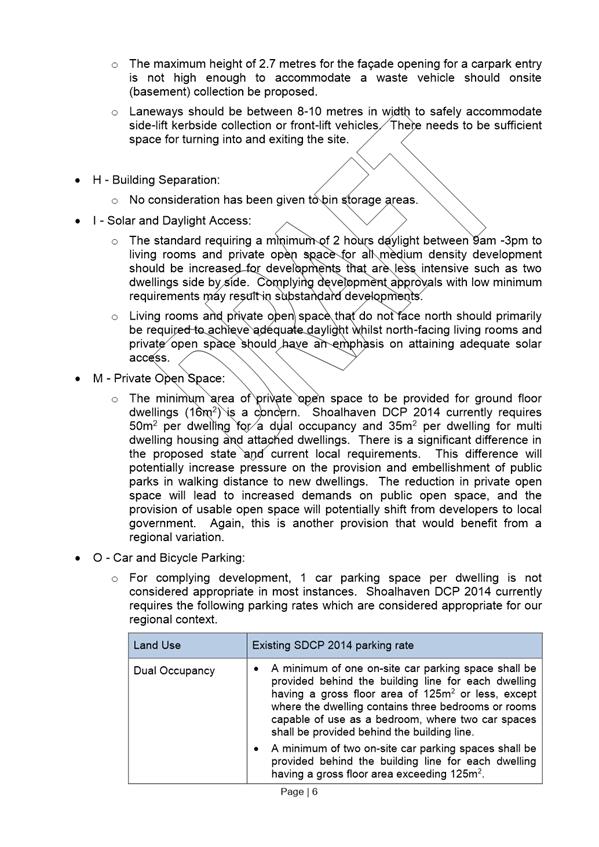
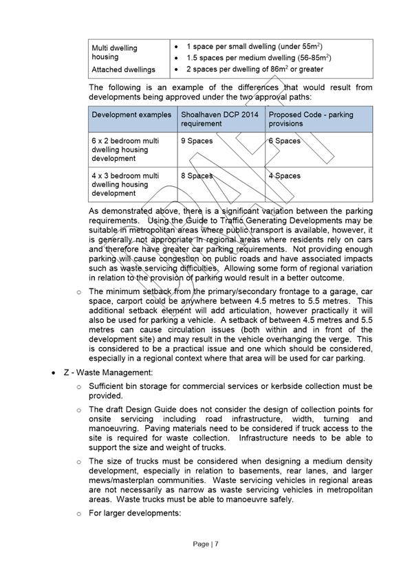
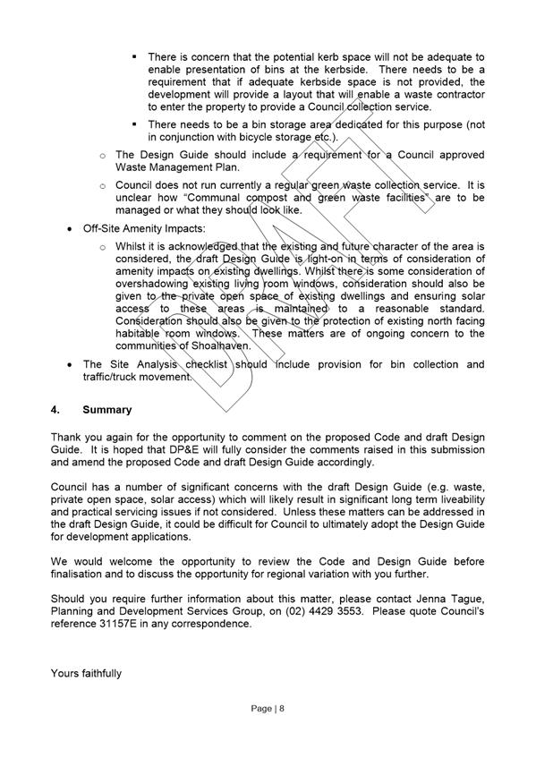
|
|
Development
Committee – Tuesday 06 December 2016
Page
70
|
|
|
Development Committee
– Tuesday 06 December 2016
Page
73
|
DE16.17 Exhibition
Outcomes/Finalisation - Shoalhaven Development Control Plan 2014 - Draft
Amendment No. 13 - Chapter G4: Tree and Vegetation Management
HPERM Ref: D16/348177
Group: Planning
& Development Services Group
Section: Strategic
Planning
Attachments:
1. Draft Chapter G4
Tree and Vegetation Management - Post Exhibition Track Changes Version (under
separate cover) ⇨
Purpose / Summary
The purpose of this report is
to:
· Detail
the submissions received during the exhibition of the proposed amendment to
Chapter G4 of the Shoalhaven Development Control Plan (DCP) 2014
· Enable
the finalisation of the amendment with the recommended changes, rescind the
previous DCP Chapter and detail the subsequent steps required in this regard.
|
Recommendation
(Item to be determined under delegated authority)
That the Development Committee
1. Note
the submissions received during the exhibition of Shoalhaven Development
Control Plan 2014 Draft Amendment No. 13 – Chapter G4: Tree and
Vegetation Management
2. Adopt
Amendment No. 13 to the Shoalhaven Development Control Plan 2014 as exhibited
with the inclusion of the following changes to Chapter G4:
a. Minor
editorial changes
b. Content
and mapping changes as outlined in the submission summary table in the report
3. Notify
the adoption of Amendment No.13 to Shoalhaven Development Control Plan 2014
in the local newspapers in accordance with the requirements of the
Environmental Planning & Assessment Act 1979 and Regulations
4. Notify
the NSW Department of Planning & Environment and those who made a
submission on this matter that Amendment No. 13 to Shoalhaven DCP 2014 has
been adopted
5. Prepare
a separate Development Application form, checklist and brochure to clarify
and simplify the application process for the removal of trees and vegetation
prescribed by Shoalhaven LEP 2014 and Shoalhaven DCP Chapter G4: Tree and
Vegetation Management
6. Undertake
a further review of the exempt provisions in Chapter G4: Tree and Vegetation
Management to ensure consistency with Clause 5.9 of Shoalhaven LEP 2014.
7. Continue
the preparation of a Planning Proposal to amend Shoalhaven LEP 2014 Clauses
Map to ensure the Clause 5.9 mapping is consistent with the DCP Chapter G4
maps and submit to State Government for initial Gateway determination.
|
Options
1. Adopt the
recommendation
Implications: This is the preferred option as it
will enable Council to consider the submissions received during the public
exhibition and make minor appropriate changes. This will also enable the
finalisation of the new DCP chapter which will:
· Increase
the readability/usability of DCP Chapter G4.
· Streamline
the relevant DCP controls.
· Remove
duplicate controls.
· Simplify
processes relating to tree removal applications.
2. Request that the
consultants who undertook the legal and planning review for Council also review
the submissions received and comment on the options to finalise this DCP
Implications: This option would delay the process,
but would provide an opportunity for the consultants who have been assisting
Council with this project to comment on the submissions received and as a
result the options to finalise the DCP.
3. Adopt an
alternative recommendation
Implications: Depending on its nature, this could
also delay the finalisation of the new DCP Chapter G4.
Background
Through the Standard Instrument
Local Environmental Plan (LEP) process, the State Government introduced a
standard clause for the management of tree removal (Clause 5.9 Preservation of
trees and vegetation) to replace previous Tree Preservation Orders (TPO) as the
mechanism to require consent for tree removal in certain circumstances.
The LEP clause requires that
Council prepare a DCP to prescribe the kind of trees or vegetation to which the
clause applies and for which Council consent is required.
Shoalhaven LEP 2014 contains
Clause 5.9 and Shoalhaven DCP 2014 contains the current corresponding chapter
(Chapter G4 Removal and Amenity of Trees). This current chapter was based on
Council’s previous TPO which required the consent of Council for the
removal of trees in specified circumstances – generally for trees in
urban areas and some limited instances in rural areas.
Review – Current DCP
Chapter G4
The review of current Chapter G4
arose from a particular incident of unauthorised clearing of land at Griffin
Street, Callala Bay, for which Council undertook successful legal action in the
Land and Environment Court (Council of the City of Shoalhaven v Elachi
[2015] NSWLEC85). However, the Court decision highlighted issues in
relation to inconsistencies between the LEP and DCP and the potential for
misinterpretation of the current DCP controls.
As a result Locale Consulting
Pty Ltd were engaged by Council to undertake the following:
· Legal review
taking into account the Court decision.
· Planning
review to, as a result:
o Ensure
a clear legal framework, particularly in regard to the relationship between the
Shoalhaven LEP 2014 and Shoalhaven DCP 2014; and
o Simplify
the DCP content, remove any inconsistencies and potential for
misinterpretation.
Arising from this a draft
revised DCP chapter was prepared, however an appeal was lodged against the
Court decision. The appeal was unsuccessful but raised further issues with the
drafting of the LEP clause and the DCP Chapter, resulting in a further legal
review and further revisions to the draft DCP chapter.
The exhibited draft DCP Chapter is
essentially intended to clarify the content to improve interpretation and
address issues raised in the Court judgements and not necessarily revisit or
reconsider the overall provisions. The legal advice and planning review
undertaken by Locale Consulting highlighted the need for a further review of
Chapter G4 to consider:
- Reviewing the controls regarding
the removal or pruning of a tree or other vegetation when considered a
‘risk to human life or property’; and
- Adopt internal processes and
external guidelines for the public for being satisfied of the criteria in
clause 5.9(6) of SLEP 2014.
A further review of Chapter G4
is required to ensure that the provisions in Chapter G4 clearly align with
Clauses 5.9(5) and Clause 5.9(6) in SLEP 2014. Section 74C (5) of the
Environmental Planning and Assessment Act 1979 outlines that a provision in a
DCP has no effect to the extent that it is the same or substantially that same
as a provision in an LEP or it is inconsistent or incompatible with a provision
an LEP. It is arguable that these controls in Section 5 of Chapter G4 have no
work to do as an exemption from obtaining development consent in these
circumstances exists in Shoalhaven LEP 2014. This leaves open the possibility
of differing interpretations about the need for development consent in the
circumstances arising under clause 5.9(6) of the SLEP.
A copy of the draft Chapter and
the explanatory statement that was exhibited is available online: http://shoalhaven.nsw.gov.au/My-Council/Public-exhibition/Documents-on-exhibition.
The
proposed amendments which were exhibited within the draft DCP Chapter include:
· Renaming
the Chapter from “Removal and Amenity of Trees” to “Tree and
Vegetation Management”.
· Clarifying
the purpose of the Chapter and simplifying its format.
· Making
terminology consistent throughout.
· Clarifying
arborist qualifications.
· Clarifying
that a building must be a ‘lawful’ building for the 45 degree rule
to apply.
· Removing
the permit process and creating a new section on the development assessment
process.
· Adding
a requirement to identify “exempt” development for which tree or
vegetation removal is a pre-curser.
· Removing
any duplicate controls e.g. bushfire, heritage.
· Add
and/or clarify advisory notes.
· Removing
references to Illawarra Regional Environmental Plan as it is no longer in
force.
· Limiting
the exemptions to those related to the species, size or location to link back
to Clause 5.9(2) of the LEP.
· Simplifying
controls in Section 5.4 given that Clauses 5.9(5) and (6) of Shoalhaven LEP
2014 state that the clause does not apply where:
o Council
is satisfied the tree or other vegetation is dying or dead and is not required
as the habitat of native fauna; or
o Council
is satisfied that the tree or other vegetation is a risk to human life or
property.
· Amending
Map Sheet 14 in the DCP to remove an area of developed urban land that was
inadvertently mapped as a “paper subdivision”.
Public Exhibition
The Development Committee (under
delegation) resolved on 7 June 2016 to:
a) Adopt
the draft revised Shoalhaven DCP 2014 Chapter G4 Removal and Amenity of Trees
for public exhibition and exhibit for a minimum period of 28 days; and
b) Commence
the preparation of a Planning Proposal to amend Shoalhaven LEP 2014 Clauses Map
to ensure the Clause 5.9 mapping is consistent with the DCP Chapter G4 maps and
submit to State Government for initial Gateway determination.
As a result, Draft Chapter G4 -
Tree and Vegetation Management Amendment was publicly exhibited for comment
from Wednesday 17 August until Friday 16 September 2016.
Submissions
During the exhibition period, a
total of ten (10) submissions were received as outlined and below:
· 5
Individuals
· 4
Community Consultative Bodies (CCB’s)/ Community Groups
· 1
Internal Council
The submissions received have
been summarised below:
|
No.
|
Type
|
Submission
|
Staff comments
|
Recommendations
|
|
1.
|
Individual
|
Properties
at Callala Beach have been wrongly mapped as a paper subdivision. Provides
reasoning for this - based on belief that the previous TPO only identified
Rural 1(g) zoned land in DP 9063.
|
The
land is correctly identified as it is located in an original ‘paper
subdivision’ deposited plan (DP9063).
There
is no ‘best fit’ zone in the Shoalhaven LEP2014 that reflects the
previous Rural 1(g) Flood Liable zone in Shoalhaven LEP 1985. The provisions
of the previous TPO were also updated as part of the transfer to Shoalhaven
LEP 2014 and Shoalhaven DCP 2014.
To
reduce confusion, there is merit in amending Section 5.1 of the DCP to
reference land in the ‘paper subdivision’ Deposited Plans, as
mapped, rather than referring to the wording of the previous TPO.
|
Amend
Section 5.1 of the DCP Chapter to reference land in the ‘paper
subdivision’ Deposited Plans, as mapped, rather than referring back to
the previous TPO.
|
|
2.
|
Community
Group – Birdlife Shoalhaven
|
In
general supports the proposal.
Outlines
need for community education.
Suggests
more specific statements in the objectives in relation to the importance of
trees and bird habitat, especially in urban areas.
Inclusion
in relation to “old growth trees” as a distinctive element of the
tree community.
Questions
the listing of Black Wattle and Sweet Pittosporum as “non-native and/or
invasive”.
List
of recommended amenity plantings should be removed and re-thought.
Trees
should not be allowed to be removed without the identification of species and
an assessment made of the threat to this species and its importance to fauna
and birdlife.
Requests
the survey and inclusion of all SEPP14 type wetlands that are not currently
listed.
|
Noted.
Future community education options will be
discussed with Council’s Environmental Services team.
Proposal to strengthen the objectives to emphasise
the importance of trees in urban areas.
In
regard to “old growth trees” Council does have access to some
mapping provided by NSW Office of Environment & Heritage (OEH), however
the mapping provided is coarse and not comprehensive.
These
species are native, but are still considered to be invasive and can become a
monoculture if not effectively managed.
These
trees are known to occur in sensitive areas and therefore they have been
identified as requiring consent for removal only if they are greater than 10
metres tall.
Agreed.
Species name to be required under 5.3.2 Application Documents.
The
classification of wetlands as SEPP14 Coastal Wetlands falls outside of the
scope of this review, however, any lands identified as SEPP14 Coastal
Wetlands in future would be included.
|
Amend
point under 5.3.2 Application documents to read “A description of the
trees or vegetation, including species name, proposed for removal or
pruning.”
|
|
3.
|
Community
Group – Jervis Bay Regional Alliance
|
Strongly
supports the replacement of removed trees with local or endemic species, but
does not support the removal of healthy, mature trees for reasons of
convenience.
Encourages
a policy that would see any removed tree on private land replaced with a
native species.
|
Amenity
considerations provide for limited reasons to remove trees. These are
important in maintaining character and amenity in areas, while balancing the needs
for healthy streetscapes and solar access.
Council
does encourage the replacement of trees endemic to the region to maintain the
character of an area. This is outlined in Section 5.4.3.
|
No change recommended.
|
|
4.
|
Individual
|
Concerned
with the omission of the words “when it is dangerous to life or
property” in 5.4 assessment criteria, believes it should be retained.
Believes
removing the tree removal permit and making it a DA process just makes it a
more arduous task.
|
The controls
in DCP Section 5.4 have been simplified as Clauses 5.9(5) and (6) of the
Shoalhaven LEP 2014 state that the clause does not apply where Council is
satisfied that the tree is dying or when the tree is a risk to human life or
property.
The
“dual application” type process has been proposed to be
discontinued to reduce confusion.
|
No change recommended.
|
|
5.
|
Community
Group – Collingwood Beach Preservation Group
|
The
new plan is not as concise as the current plan and the current plan should be
retained with minor terminology changes.
Should
reinstate tree removal permits and not require DAs.
Should include criteria/definition of a tree.
Create
provisions that allow for the control of trees for amenity reasons by not
requiring replanting and allowing pruning to scenic and iconic views.
The
plan should include an additional amendment to protect the amenity of
ratepayers with words to the effect:
“That,
where possible, public and Crown Land in coastal areas be managed in such a
way that the impact on the amenity of adjacent property owners is minimised
and that coastal views are protected.”
|
Changes
to the DCP chapter have been proposed to adequately respond to issues that
were raised as part of a recent Court proceedings which Council was involved
in. The exhibited draft Chapter has also has arisen from a legal and planning
review. The whole aim of the review is to clarify its operation.
The
“dual application” type process has been proposed to be
discontinued to reduce confusion.
Prescribed
trees are defined in Section 5.1 of the DCP. This provides a definition of
trees and other vegetation for the purposes of Clause 5.9(2) of Shoalhaven LEP2014.
This
would not be an acceptable provision in sensitive coastal and foreshore
locations. It is also inconsistent with Councils approach in this
regard.
The
purpose this DCP Chapter is to generally protect trees and vegetation rather
than manage coastal views.
|
No change recommended.
|
|
6.
|
CCB
- Basin Villages Forum
|
Wishes
to see policies that retain understorey.
Supports
the efforts to ensure property owners are aware of their responsibility in
regards to tree and vegetation management.
Concerned
about the rates of bush and tree loss in St. Georges Basin and in Shoalhaven.
Compliments Council’s initiative but would like to see the wholesale
removal of existing vegetation and trees stopped to limit future problems.
|
Understorey
is included as “other vegetation” in the draft chapter.
The
draft chapter aims to make the processes clearer and consistent with
legislative requirements.
In
general, housing development is planned where ever possible, in appropriate
areas that are not identified as being of high ecological value. However it
is acknowledged in some circumstances vegetation removal is unavoidable.
|
No changes recommended.
|
|
7.
|
Individual
|
Objects
to the new chapter stating it is confusing and convoluted.
Wants
Tree removal permits reinstated to provide a simple process for inappropriate
trees.
Wants
to be able to prune in scenic areas and coast line areas.
|
This
draft chapter aims to make the processes clearer and consistent with legislative
requirements.
The
Standard Instrument LEP introduced Clause 5.9 Preservations of trees or
vegetation to replace existing Tree Preservation Orders (TPOs) in NSW. Clause
5.9 requires that Council must adopt a DCP (Chapter G4) to prescribe the kinds
of trees or vegetation that Clause 5.9 applies to and for which the consent
of Councils. Council no longer issues Tree Removal permits where the removal
of prescribed trees or vegetation is proposed. This is because assessment of
a development application is required under Part 4 of the Environmental
Planning & Assessment Act 1979. The draft DCP Chapter G4 amendment
notes that Council no longer issues Tree Removal Permits. A specific
development application form for the removal or trees/vegetation will be
available when the draft Chapter G4 is made effective.
This
would not be an acceptable solution in a sensitive coastal area.
|
No changes recommended.
|
|
8.
|
Individual
|
Supports
same points as Submission 5.
Suggests
a provision be made to reinstate provision not only for risk to life or
property but extend that to cover risk to the safety of persons or property
including near misses to the safety of persons or property.
|
Noted.
The
controls in Section 5.4 of the DCP have been simplified as Clauses 5.9(5) and
(6) of the Shoalhaven LEP 2014 state that the clause does not apply where
Council is satisfied that the tree is dying or when the tree is a risk to
human life or property.
|
No changes recommended.
|
|
9.
|
Individual
|
The
original chapter is much clearer.
Tree
removal permits should be retained.
Something
needs to be done about coastal view amenity and tree pruning.
|
The
draft chapter aims to make the processes clearer and consistent with
legislative requirements.
The
Standard Instrument LEP introduced Clause 5.9 Preservations of trees or
vegetation to replace existing Tree Preservation Orders (TPOs) in NSW.
Clause 5.9 requires that Council must adopt a DCP (Chapter G4) to prescribe
the kinds of trees or vegetation that Clause 5.9 applies to and for which the
consent of Council is required. Council no longer issues Tree Removal permits
where the removal of prescribed trees or vegetation is proposed. This is
because development assessment through the lodgement of a development
application is required under Part 4 of the Environmental Planning &
Assessment Act 1979. The draft DCP Chapter G4 amendment notes that
Council no longer issues Tree Removal Permits. A specific development
application form for the removal or trees/vegetation will be available when
the draft Chapter G4 is made effective.
This
would not be an acceptable solution in a sensitive coastal area.
|
No changes recommended.
|
|
10
|
Internal
– Environmental Services Section
|
To
reduce confusion relating to riparian areas, trees proximate to waterways
should be given appropriate protection areas in line with Clause 7.6(2) (c)
of the LEP - that is 50 metres for Category 1 waterways and 30 metres for
Category 2 waterways. This would be appropriate to protect riparian areas.
Hollow
Bearing Trees – remove them from any of the listed exemptions to ensure
they require approval. To be included in Sections 5.2.1 and 5.2.2 of the
draft DCP.
|
Agree
with the need for clarity in this regard. The distance of 50 metres from a
Category 1 waterway, and a reduced distance of 30 metres for Category 2
Waterways would provide for appropriate corridors along waterways in all
zones to provide consistency with LEP controls.
Change
is warranted to provide adequate protection to hollow bearing trees. Hollow
bearing trees will be added to Sections 5.2.1 and 5.2.2 as suggested.
|
Amend
the Chapter G4 mapping to identify SLEP 2014 Category 1 waterways and apply a
buffer of 50 metres and apply a 30 metre buffer for Category 2 waterways.
Amend
Section 5.2.1 to read “None of the exemptions listed in this section
apply to hollow bearing trees or trees and other vegetation located on
a heritage listed item…”
Amend
Section 5.2.2 (a) to include “Hollow bearing trees can only be removed
without assessment under the 45 degree exemption if an animal handler is
present”
|
Copies of the submissions received will be available in a
folder in the Councillors Room for review prior to the meeting.
Attachment 1 provides a marked up version of the
draft Chapter that is proposed for adoption and shows the changes highlighted
in the table above in context.
Planning Proposal to amend
Local Environmental Plan
The review of DCP Chapter G4 has
also highlighted a discrepancy between the LEP and DCP maps in that rural roads
and category 1 and 2 waterways are not mapped on the Clauses Map in the LEP but
are shown in the DCP.
Thus the LEP maps need to be
amended to ensure the consistent application of Clause 5.9 of the LEP and also
the DCP. The PP will only amend and update the Clauses Map in the LEP - it is
not proposed to make any changes to LEP Clause 5.9 (mandated clause set by
State Government that Council cannot change).
Community Engagement
The draft DCP Chapter G4 was
exhibited from Wednesday, 17 August to Friday, 16 September 2016. In that time
ten submissions were received. The future Planning Proposal to be submitted for
Gateway determination will also be publicly exhibited for community comment in
due course.
Policy Implications
Adopting the report
recommendation will amend via replacement, Chapter G4 of the DCP and bring it
in line with Clause 5.9 of Shoalhaven LEP2014. This will also be followed by
mapping changes to Shoalhaven LEP2014 via a subsequent Planning Proposal.
Financial Implications
This DCP amendment is being
undertaken using existing resources in Council’s Strategic Planning
Section and as such is being managed within existing budgets.
Risk Implications
If this amendment is not
adopted, the inconsistency between Shoalhaven LEP 2014 and Shoalhaven DCP 2014
considered by the legal and planning review and raised during the Court cases
will not be addressed. This could leave Council open to legal challenges and
future uncertainty in this regard.
|

|
Development
Committee – Tuesday 06 December 2016
Page
82
|
DE16.18 Possible
Change - Height of Buildings - Shoalhaven Local Environmental Plan 2014 - Anson
Street, St.Georges Basin
HPERM Ref: D16/350122
Group: Planning
& Development Services Group
Section: Strategic
Planning
Purpose / Summary
Detail the options that are
available to Council to consider reducing the ‘height of building’
controls in the Shoalhaven Local Environmental Plan (LEP) 2014 that apply to
land on Anson Street, St. Georges Basin.
|
Recommendation (Item to be determined
under delegated authority)
That the Development Committee decide
whether it wishes to pursue reducing the ‘height of building’
controls in Shoalhaven Local Environmental Plan 2014 over Lots 1 and 6
DP1082382 Anson Street, St. Georges Basin and if so which of the options
outlined in the report to pursue.
|
Options
1. Retain the current 8 metre height control
over the western part of Lot 1 DP1082382 and prepare a Planning Proposal (PP)
to amend the ‘height of buildings’ map over the remainder of Lot 1
and the whole of 6 DP1082382 Anson Street, St. Georges Basin to remove the
current 13 metre height and replace it with a more suitable mapped height
(Note: Council would need to determine what height it wishes to apply should it
proceed with this option).
Implications: This option if successful would see
the existing 8 metre height retained over the western part of Lot 1 DP1082382
and a new height placed over the remainder of the subject land. That new height
would however need to be determined.
In the absence of detailed work in this regard an 8.5
metre height could be applied to Lot 6 DP1082382 which is currently zoned
R1 General Residential. An 8.5 metre height would be consistent with other
residential zones in the area and in keeping with the scale/character of the
existing adjacent residential development. It would however be inconsistent
with the majority of other R1 zones city wide, where there is no mapped height
(the general 11 metre maximum currently applies) to enable some flexibility
given the development nature of the zone.
The remainder of Lot 1 DP1082382 (eastern part) is zoned
B4 Mixed Use. There is no consistent height that has been applied to this zone
city wide. In most cases the general 11 metre maximum applies, but in other
specific locations higher heights have been mapped based on detailed work that
has been undertaken.
2. Retain the current 8 metre height over
the western part of Lot 1 DP1082382 and prepare a PP to amend the ‘height
of buildings’ map over the remainder of Lot 1 (eastern part) and the
whole of 6 DP1082382 Anson Street, St. Georges Basin to remove the current 13
metre height.
Implications: This option
would be consistent with the recommended approach that was suggested during the
preparation of the Shoalhaven LEP 2014, in that it maintained the ‘status
quo’ that previously applied. It would mean that the majority of the land
would have no mapped height and the general 11 metre maximum in the LEP would
apply. This would enable some flexibility up to 11 metres given the nature of
the zone.
Background
It was resolved on the 25th
October 2016 that:
The General Manager prepare a
report in respect to options that consider reducing the height limits at Lot 1
& 6 DP1082382 Anson Street, St. Georges Basin.
As such, this report provides
relevant background and details the options that are available to Council to
consider amending the LEP in this regard.
LEP Existing Zones
Under the Shoalhaven LEP 2014
the subject land has the following zoning:
Lot 1 DP 1082382 – B4
Mixed Use (Note: lot is in 3 parts)
Lot 6 DP 1082382 – R1
General Residential.
The existing zones are shown on
the following map:
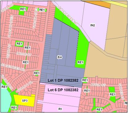
Extract: Shoalhaven LEP2014 – Zones
St. Georges Basin
The B4 Mixed Use zone allows a
mix of compatible land uses including business, office, residential, retail and
other development in accessible locations. The R1 General Residential zone
provides for a variety of housing types and densities. It also allows other
land uses that provide facilities or services to meet the needs of residents.
As such both zones in this location are relatively flexible and allow a range
of land uses.
LEP Background – Height
of Buildings
Prior to the preparation of the
Shoalhaven LEP 2014, building height controls largely sat outside the LEP and
in appropriate areas or zones were controlled via Development Control Plans
(DCP’s) and a provision in the previous Illawarra Regional Environmental
Plan (REP) that enabled Council to consider development up to 11 metres.
With the move to the new
Standard LEP Instrument in NSW, Council was required to include ‘height
of building’ controls in its new LEP. This occurred in our LEP in two
ways:
· Zones,
areas or sites were mapped at a specific height based on existing controls that
may have been in place in existing DCP’s
· Provision
included in Clause 7.3 Height of Buildings in the LEP instrument for those
areas that are not mapped, requiring the height of buildings on the land to not
exceed 11 metres.
Throughout the LEP preparation
and exhibition processes, the ‘height of building’ control was an
issue of general community concern throughout Shoalhaven.
Specific ‘height of
building’ decisions were made during the LEP preparation process and in
respect to the land which is the subject of this resolution, these are
summarised below.
Draft LEP 2011 Exhibition
– two submissions were received that commented on the proposed height
controls in the vicinity of the St. Georges Basin Village Centre.
· One
supported the proposed mapped height limit of 8 metres for the St. Georges
Basin Village Centre (note not all the zoned area) that was consistent with the
former DCP No.17 that covered this area.
· One
requested a 13 metre building height for Lot 1 and 6 DP1082382 to ensure that a
realistic development opportunity for the subject land was economically
feasible (Note: economic feasibility study was included with the submission).
It was noted in the Council
report following the exhibition that changing the height of buildings map for
Lots 1 and 6 DP1082382 to 13 metres would be inconsistent with the DCP and
maybe inconsistent with the existing and desired future character for the area.
The report went on to note that the submission argued that higher density
residential development, as per the master plan that the landowner has
developed for the site, was only economically viable if the height of buildings
for the two sites is increased to 13 metres. The submission acknowledged that
this was not likely to be popular with the community.
Staff noted that should a future
development proposal warrant heights that are inconsistent with the DCP then a
future PP can be considered for the site and this would enable specific
dialogue with the community on the proposal. As a result the report recommended
that the height of buildings remain unchanged in this location – 8 metres
for the village centre as per the DCP and the 11 metres general maximum
elsewhere.
Council however ultimately
resolved on 30 May 2012 to:
Change the maximum height of
buildings for Lots 1 and 6 DP 1082382 St. Georges Basin to 13 metres to
facilitate the feasibility of higher density development on the site.
Draft LEP 2013 Exhibition
– during this exhibition five submissions (including one from
the Basin Villages Forum) were received on the change that was made to the
height of buildings for Lot 1 and 6 DP 1082382 St. Georges Basin, noting that
it was a significant change that was contrary to the LEP ground rules and as
such should not be supported.
One submission was also received
on behalf of the owners who requested that the height for Lot 1 DP 1082382 be
increased from 13 metres to 14 metres to enable buildings up to four storeys
and to enable a commercial component consistent with the zoning provisions.
The Council report following the exhibition again recommended
that the exhibited maximum 8 metre height
of building overlay for the western portion of Lot 1 DP 1082382 be retained and
that the overlay be removed from the remaining eastern portion of Lot 1 DP
1082382 and entirely from Lot 6 DP 1082382.
Council
however ultimately resolved on 17 July 2013 to:
Retain
the exhibited maximum 8 metre Height of Building overlay for the western
portion of Lot 1 DP 1082382, and the Height of Building overlay for the
remaining eastern portion of Lot 1 DP 1082382 and Lot 6 DP 1082382 be retained
at 13 metres.
As
such the Shoalhaven LEP 2014 was finalised and ultimately notified on 8 April
2014 with the following ‘height of building’ controls:
· Western portion of Lot 1 DP 1082382 – mapped at
8 metres.
· Eastern portion of Lot 6 DP 1082382 – mapped at
13 metres.
The
following map provides shows the current mapped areas and their heights in this
location:
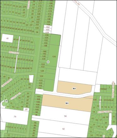
Extract: Shoalhaven LEP2014 – Height of
Buildings Map
St. Georges Basin
The
above map shows the following:
Green
and notated l1 – mapped ‘height
of buildings’ is 8 metres. Note this is consistent with the area
identified at this height in the former DCP No.17 – St. Georges Basin
Village Centre.
Brown
and notated N1 – mapped ‘height
of buildings’ is 13 metres.
Uncoloured – no specific mapped height, however the
provision in Clause 7.3 Height of Buildings in the LEP instrument enables
buildings up to 11 metres to be considered. This provision also applies to the
remainder of the land zoned B4 Mixed Use to the north of Anson Street and R1
General Residential to the south of Anson Street.
Community Engagement
Should Council decide to proceed
with a PP to amend the Shoalhaven LEP 2014 to adjust the ‘height of
building’ controls in this location and the matter receives a favourable
Gateway determination from the NSW Department of Planning & Environment
(DP&E), then there will be a formal community consultation opportunity as
part of the PP process.
Policy Implications
It is noted that the specific
‘height of building’ controls in this location resulted from a
submission during the draft LEP 2014 preparation process. They did not result
from any strategic work that justified specific heights in this location.
It is noted that the Council
reports in 2012 and 2013 both recommended against placing the requested
building height in this location as part of the new LEP process. The reports
noted that should a future development proposal warrant heights that are
inconsistent with the then DCP or the generic height controls then a future PP
could be considered for the site. This would have enabled specific dialogue
with the community on the proposed changes.
Given that the ‘height of
building’ controls were effectively a ‘one-off’ change that
occurred during the new LEP process, changing or adjusting them is unlikely to
be inconsistent to any great deal with existing Council or NSW Government Policy.
As such Council is able to consider making this change and appropriate
justification for any change would be included in the PP that is forwarded to
the DP&E.
Should the ‘height of
building’ controls in this location ultimately change and depending on
the outcome of the development application in this this location it could
result in a 13 metre development eventuating on part of Lot 6 and the remainder
of the land having a lesser height control. This is a potential outcome given
that a development application is currently pending over part of the lot.
Financial Implications
Any future PP would be
undertaken using existing resources in Councils Strategic Planning Section and
as such would be managed within existing budgets.
|
|
Development
Committee – Tuesday 06 December 2016
Page
87
|
DE16.19 Strategic
Planning Works Program - Formulation
HPERM Ref: D16/351866
Group: Planning
& Development Services Group
Section: Strategic
Planning
Attachments:
1. Interim Strategic
Planning Works Program ⇩
Purpose / Summary
To obtain direction on the
formulation of a new Strategic Planning Works Program for Council and also
provide relevant background in this regard.
|
Recommendation (Item to be determined
under delegated authority)
That the Development Committee
1. Adopt Attachment 1 as Council’s
interim Strategic Planning Works Program.
2. Request Council staff to arrange a
half day workshop for Councillors in early 2017 to provide an opportunity for
their detailed input into the structure and content of the suggested new
Strategic Planning Works Program
3. Request that the new Strategic Planning
Works Program be reported back to Council for consideration by mid-2017 at
the latest.
|
Options
1. Council prepare a new Strategic
Planning Works Program that is proactive and focusses Councils future strategic
planning efforts.
Implications: This option is favoured as it builds
on the earlier approach of Council in this regard to have a works program that
guides our strategic planning effort and ensure that we are undertaking
proactive planning. It also helps to prioritise projects and manage staff
efforts/workload
2. Not prepare a new a new Strategic
Planning Works Program and react to requests, opportunities etc. as they arise
in the future.
Implications: This option would mean that Council
reacts to requests, opportunities, requirements etc. for strategic planning
work in an ad-hock or unmanaged manner. This is not desirable as it does not
necessarily focus efforts in areas or on projects that support the broader
community.
Background
Planning Works Program -
History
As part of reporting the
completion of the Shoalhaven Local Environmental Plan (LEP) 2014 to Council it
was also resolved to:
Prepare a new Planning Works
Program to focus Councils Strategic Planning effort and arrange a Councillor
briefing to discuss the desired detail of this program before it being reported
back to Council for consideration.
Prior to this resolution a
“Planning Works Program” had previously been in place within
Council for some time and was used to coordinate and manage Councils strategic
planning efforts. Historically the works program related to projects undertaken
under the provisions of the NSW Environmental Planning & Assessment Act
1979 or that would/could lead to projects under this Act, and included:
· Local
Environmental Plans (LEP’s)
· Development
Control Plan (DCP’s) and development related policies
· Contribution
Plans (CP’s)
· Land
use related strategies (e.g. Settlement Strategies, Structure Plans etc.).
· Urban design
related strategies or plans (e.g. Masterplans)
The works program originally emerged
from an internal tool that was used to track and manage planning projects. It
was reported to Council from 2003 onward for information and to enable
priorities to be considered – this initially occurred quarterly and then
moved to twice yearly.
The 2008 NSW Department of Local
Government Promoting Better Practice Review, recommended that:
Council should review the
projects on the Strategic Planning Group Work program in order to give priority
to finalising the Growth Management Strategy and new Comprehensive LEP.
As a result the works program
focussed on the completion of the Shoalhaven LEP, Shoalhaven DCP and Growth
Management Strategy, which were all ultimately finalised during 2014. Since the
completion of these significant planning documents, Councils Strategic Planning
Staff have been working on a range of ‘housekeeping’ amendments to
the LEP and DCP and a range of other significant planning projects.
Given that we have a new
Council, it is now opportune and appropriate to create a new forward thinking
and aspirational Strategic Planning Work Program (work program) to focus
Councils current and future strategic planning effort.
Having a work program will also
assist with some discipline in regard to Councils decision making regarding new
planning related projects and require consideration of the likely impact on the
current program, priority, staff workload or resources. Ideally this new work
program will be proactive and not reactionary.
Overview – Current
Strategic Planning Tasks
Attachment 1 shows the
current tasks that Councils Strategic Planning Staff are currently working on
and their status.
The following however are some
the main tasks that staff are currently working on or involved in:
· Shoalhaven LEP2014
& Shoalhaven DCP2014 – ongoing maintenance, updating and review.
Range of ongoing housekeeping amendments underway or required.
· Contributions Plan
2010 – ongoing maintenance, updating and review.
· Council initiated
PP’s e.g. Shoalhaven Animal Shelter Planning Proposal (PP).
· Resolving Legacy
Planning Issues – ‘paper’ subdivisions (e.g. Nebraska Estate
PP), deferred areas, revisiting matters etc.
· Shoalhaven
Affordable Housing Strategy.
· Nowra-Bomaderry
Urban Release Areas – detailed planning to enable actual release of land.
This is becoming a greater priority given the diminishing stock of subdividable
land.
· Nowra CBD
Revitalisation Strategy – coordinating its implementation and supporting
the Nowra CBD Revitalisation Committee.
· Nowra CBD Building
Heights PP and draft Urban Design DCP Chapter.
· Nowra Riverfront
Masterplan.
· Nowra CBD
residential areas character controls.
· Ongoing town centre
DCP Reviews e.g. Huskisson, Ulladulla etc.
· Nowra-Bomaderry
Retail Hierarchy Review.
· Comprehensive
Council Land Audit/Reclassification LEP.
· Shoalhaven Local
Approvals Policy Review.
· Citywide Section
149 Certificate policy note review.
· Citywide review of
the SP3 Tourist zone.
· Proponent
initiated PP’s (rezoning) – currently have 8 active PP’s that
are at various steps in the process. These range from minor single site ones
through the larger and more complex ones (e.g. Halloran PP at Culburra
Beach/Callala/Currarong) There are a range of others for which preliminary
approaches have been made.
Outside the more formal
projects, strategic planning staff are also actively involved in a range of
other important ongoing activities, including:
· Assisting with the
implementation of the Illawarra-Shoalhaven Regional Plan and its relevant
actions.
· Managing Councils
continued response to planning and other reforms proposed by the NSW
Government.
· Government Liaison
– NSW Department of Planning & Environment, NSW Office of Environment
& Heritage etc.
· Managing Council
comment on relevant land matters e.g. Aboriginal Land Claims.
· Representing
Council on external committees and taskforces e.g. Illawarra Urban Development
Program.
· Economic
Development Projects – assisting with relevant planning aspects of these
projects.
· Assisting
community and other groups with relevant projects.
· Local Heritage
Grants Program – running and administering the grants.
· Heritage Estates
– on going involvement in the voluntary acquisition project and the
erosion control project.
· Verons
Estate – continued involvement in the infrastructure and associated
special rates project.
Land Use Planning –
Community Involvement
A series of questions were asked
as part of the 2016 Shoalhaven Community Survey undertaken by IRIS Research for
Council, regarding ‘land use planning’ (essentially the strategic
planning that is the subject of this report) and residents knowledge and
participation in related projects
Some of the key outcomes of this
were:
· 38% of residents
indicated they were aware of land use planning projects in Shoalhaven in the
past 12 months.
· 66% of residents
were unable to name any specific planning project or initiative.
· 61% of residents
indicated they were moderately/very satisfied with land use planning in
Shoalhaven. Further 30% indicated they did not know or could not say.
· 6%
of residents indicated they had directly participated in a land use planning
project or initiative.
These results essentially show
that residents are generally not that heavily involved or engaged in strategic
land use planning in Shoalhaven. This is not unusual and is consistent with what
is observed elsewhere and is an acknowledgement that more needs to be done to
get people involved in strategic planning. This is however often difficult
given the time horizons and broad scale nature of the plans or that it does not
directly impact on them right now, as opposed to a development application
where the likely impacts can be directly identified.
Planning Challenges and
Expected Tasks
Some of the known expected or
likely planning tasks on top of the ones listed above that will need to be
included in any new work program include:
· Growth Management
Strategy, Version 2 – there is a community expectation that further work
will be done on this Strategy to add detail for those centres that have been
identified as having longer term growth potential (however not revisit the
areas).
· Land Monitor
– is a requirement arising from the Illawarra-Shoalhaven Regional Plan
and there is a need to maintain and improve it.
· LEP and DCP
outstanding Council resolutions – there a range of resolutions arising
from the preparation of the new LEP and DCP’s that need to be considered.
· Locality Planning
Controls – for example for individual coastal villages in the form of a
whole of village or town DCP.
· Projects arising
from strategic plans prepared by local communities and their priority e.g.
Shoalhaven Heads, Berry and others in the future.
· Positioning
Shoalhaven to take up the opportunities that will arise from the Australian
Governments ‘Smart Cities Plan’ – City Deals and Smart Cities
& Suburbs Program.
There are also a range of more
general current and emerging strategic planning challenges, demands, wants etc.
around the following:
· Facilitating
economic development opportunities.
· Planning for an
ageing population given the profile of Shoalhaven.
· Transport -
alternative options and effective/timely transport planning
· Retail hierarchy
– given changes and current pressures, is it right?
· Agriculture
– protect the existing and provide additional/new opportunities.
· Town Centres
– acknowledging that they are about more than just retailing and helping
revitalising CBD’s.
· Activating our key
waterfront locations – Shoalhaven River, Jervis Bay, Sussex Inlet and
Ulladulla Harbour.
· Housing supply
– accommodating population growth and providing appropriate future
housing choices.
· Affordable
housing/homelessness – address the need for increased affordable housing
options.
· Overall housing
strategy – options, increasing residential densities etc. What role does
rural residential play?
· Childcare planning
and the needs of young people.
· Tourism strategy
– responsive planning.
· Effective
community engagement/involvement – as noted above, getting the community
involved is a challenge. But it is important in that they need to help shape or
drive change.
· Future
Infrastructure – where, when, how?
· Planning Proposals
– implement a program to manage. Consider opportunities for broader
benefits?
· Community
expectations – heritage management, environment, natural hazards etc.
· Refining the LEP
– does it achieve what is expected, some things may need review and
refinement?
· Promoting the role
of planning in the community.
· Heritage
management – What is Councils role?
· Natural
environment – are there planning gaps and responding to natural hazards?
· Community events
– planning to facilitate/promote.
New Planning Work Program
As noted earlier in the report the formulation of a new work
program is opportune and many of the matters listed above and in the following
section were discussed initially with the previous Council at a briefing in
September 2015.
It was noted at this briefing that as the decision makers
Council needs to decide where our future strategic planning effort should be
focussed, specifically:
· What do we need to
be doing or working on?
· What is currently
missing?
· What is important
to you and your community?
· What sort of
community or development do we want to deliver?
· What evidence base
should we be investing in?
In this regard we also need to gain an understanding of what
the community wants and expects and what is expected of us from the other
levels of government.
Ideally it would be desirable to get agreement on 10 to 12
broader areas that are important and where Council should focus its future strategic
planning work. Then a higher order strategy or policy position could be
established for each area or issue and a work program would be developed around
the 10 to 12 areas, with individual, tasks etc. under each.
Once the new work program is agreed upon it could be made
available and kept updated via Councils internet page so that the community,
Councillors Etc. can track what projects are currently being worked on and
their progress. The new program could also be reported regularly (suggest twice
year) to Council for formal consideration if this is considered beneficial.
Conclusion
It is proposed that at least a half day workshop be arranged
for Councillors in early 2017 to provide an opportunity for focussed and
detailed input into the structure and content of the suggested new work
program, with the aim of reporting the matter back to Council for consideration
by mid-2017 at the latest.
In the meantime it is also recommended that Council adopt
Attachment 1 as Councils ‘interim’ work program so that Strategic
Planning staff can continue to work on the listed projects and also that any
new strategic planning related projects or tasks consider the impact on this
interim program or alternatively be held over for consideration in the new work
program deliberations.
Community Engagement
The work program is essentially
intended to be a tool to manage Council’s strategic planning effort. In
preparing it, it will be important to incorporate community expectations on
what planning projects should be undertaken. This will initially be drawn from
existing knowledge, plans and community engagement processes.
This aspect can be further
discussed, if needed, at the proposed Councillor Workshop on this matter.
Policy Implications
It is considered important to
have a clear work program to focus Councils current and future strategic
planning effort. This will also ensure that we have appropriate strategic
planning policies in place and are also able to respond when they need to be
changed or updated.
Financial Implications
Generally projects that are on
the works program will be undertaken within existing budgets. However, should
projects require specific funding allocations these will be reported to Council
for consideration in the future as the need arises.
|
|
Development
Committee – Tuesday 06 December 2016
Page
92
|
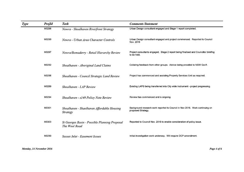
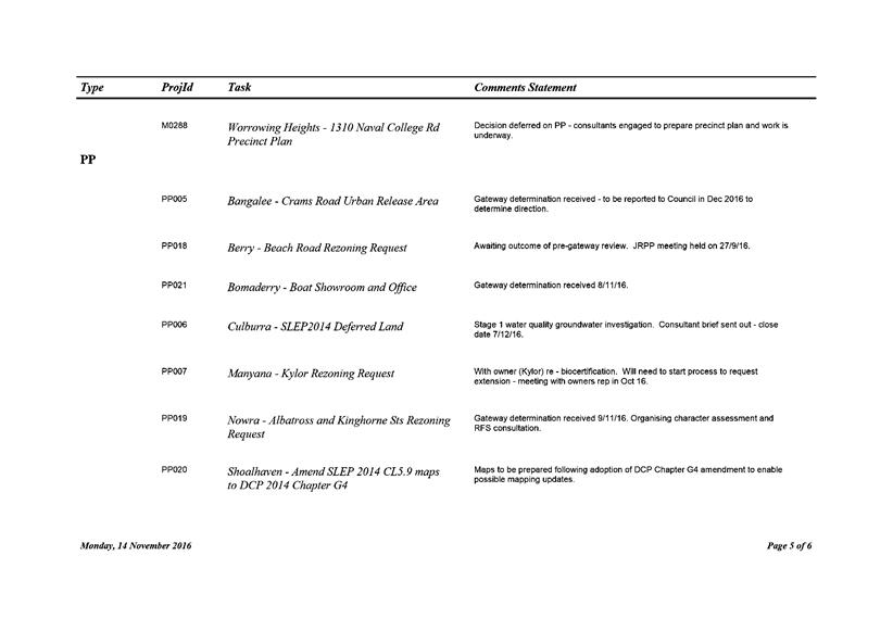
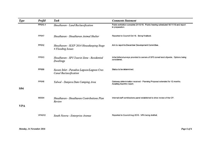
|
|
Development
Committee – Tuesday 06 December 2016
Page
98
|
DE16.20 Gateway
Determination - Planning Proposal - Warrah Road, Bangalee
HPERM Ref: D16/357943
Group: Planning
& Development Services Group
Section: Strategic
Planning
Attachments:
1. Development
Committee Report - December 2015 (under separate cover) ⇨
2. Gateway
Determination (under separate cover) ⇨
Purpose / Summary
To advise of the Gateway
determination has been received for the Planning Proposal (PP) relating to land
at Warrah Road, Bangalee that was ‘deferred’ from the Shoalhaven
Local Environmental Plan (LEP) 2014 and obtain direction on its progression.
|
Recommendation (Item to be determined
under delegated authority)
That Council:
1. Proceed to publicly exhibit the
Planning Proposal to rezone land (Lot 21 to 24 DP 714096) at Warrah Road,
Bangalee, in accordance with the Gateway determination with the following changes:
a. The proposed residential area be
shown as R2 Low Density Residential
b. The proposed residential area be
given a minimum lot size of 2,500m2
c. The proposed residential area be
given a maximum height of building of 8.5m
2. Update the supporting Bushfire Hazard
Study and Aboriginal Archaeological Assessment prior to exhibition the
Planning Proposal.
3. Write to the Department of Planning
and Environment in relation to the reasonableness of the Gateway
determination requirement to prepare a biodiversity review of Lots 21-23 and
Provision of Infrastructure Assessment.
4. Write to the proponent to advise them
of this resolution and advise them to submit the additional biodiversity
assessment as part of the formal public exhibition period for the Planning
Proposal.
5. Advise adjoining land owners and
relevant community groups of the future exhibition arrangements for the
Planning Proposal.
|
Options
1. Proceed to public exhibition in
accordance with the Gateway determination.
Implications: This option is consistent with the
established PP process and allows the proponent to formally submit the
additional biodiversity assessment as part of the formal exhibition period
which would then need to be considered by Council following the exhibition.
This option does not require an amended Gateway
determination, however, if an increase in the residential footprint is
supported following the exhibition, the Bushfire Hazard assessment may need to
be updated again to reflect the new residential footprint and may require a
re-exhibition of the PP.
2. Consider the proponents additional
biodiversity assessment prior to the public exhibition of the PP.
Implications: This option would require Council to
engage a consultant to peer review the assessment (at the proponents
cost). Depending on the outcomes of the peer review, Council may need to
reconsider the matter and apply for a revised Gateway determination if an
increased residential footprint is considered appropriate.
Background
The Crams Road New Living Area
was one of seven (7) potential future living areas originally identified in the
Nowra-Bomaderry Structure Plan (NBSP) to possibly be rezoned in the Shoalhaven
LEP 2014. The new living areas were generally rezoned through the LEP process
and identified as Urban Release Areas (URA’s) in the final plan.
However, this site has been the
subject of a number of conflicting biodiversity studies undertaken on behalf of
Council and the proponents. Thus, following the exhibition of Shoalhaven LEP
2014 Council resolved (July/August 2013) to:
a) Defer
the area identified as Lots 21, 22, 23, 24 DP 714096 from the Draft LEP 2013 to
enable further specific consideration;
b) Remove the deferred area from all relevant overlays;
and
c) Consider
a planning proposal for the site after the completion of the investigations
into alleged illegal clearing.
In an attempt to reconcile the
conflicting biodiversity studies over the subject land, Council engaged NGH
Environmental Pty Ltd to undertake an independent peer review of the
biodiversity studies and make recommendations on biodiversity significance. NGH
were asked to review the existing studies, not to undertake further
surveys/studies over the site.
The NGH peer review applied a
‘precautionary approach’ and found that without more detailed
surveys it was not possible to rule out areas as High Conservation Value (HCV).
Therefore, the majority of the site was deemed to be HCV based on the review of
the studies, as shown in Figure 1 below.
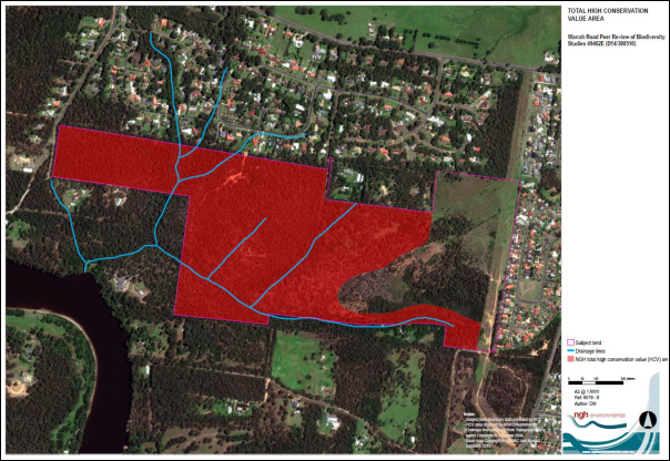
Figure 1 – High Conservation Value Land (NGH
Environmental)
The NGH Report also outlined the survey requirements and
level of information that would be required to consider reducing the HCV land
and increasing the residential zoned land.
Following the peer review of existing biodiversity studies
by NGH, Council considered the proponents (Huntingdale Developments Pty Ltd and
Southbank Land Pty Ltd) PP over the site in December 2015, where it was
resolved to:
a) Prepare
a Planning Proposal to rezone the non-High Conservation Value areas on the
site, as identified in the NGH Environmental Report, to an appropriate
residential zone;
b) Include
an assessment of residential land supply in the Nowra-Bomaderry Structure Plan
area, particularly north of the Shoalhaven River in the Planning Proposal;
c) Submit
the Planning Proposal for Gateway determination and request the NSW Department
of Planning and Environment determine the appropriateness of further
biodiversity investigations over the site, to support the possible increase in
residential zoned land; and
d) Notify
the proponent and adjoining landowners of this resolution.
The Council report that led to this resolution provides
further background detail on the Crams Road URA and Council’s decision to
submit the PP for Gateway determination and is provided as Attachment 1.
In accordance with the above resolution, Council submitted
the PP for Gateway determination and requested the NSW Department of Planning
and Environment (DP&E) to determine the appropriateness of further
biodiversity investigations over the site, to support a possible increase in
residential zoned land.
During this time, the proponent engaged a consultant to
undertake the additional site survey works as outlined in the NGH report.
These additional surveys were not requested by Council and they were cautioned
about it at the time, however the proponent advised that the work was commenced
to ensure surveys could be completed at the appropriate times of the year.
The proponent’s additional biodiversity assessment has now been
completed, but is yet to be reviewed by Council.
Gateway Determination
DP&E issued a Gateway determination for the site on 12
July 2016 that allowed the PP to proceed subject to variations and
conditions. It was determined that the NGH Environmental Peer Review was
sufficient to define areas of HCV land and that ‘…no further
biodiversity studies are required at this time for Lot 24’. The
Gateway determination also requires land currently subject to a remediation
order (as a result of unauthorised clearing) to be given an appropriate
environmental protection zone, and for the PP to be updated to confirm the
proposed zoning, lot size and height of building maps prior to public exhibition.
The Gateway determination also required the following
studies to be prepared or reviewed prior to the exhibition of the PP:
· Bushfire Hazard
Study (to reflect the reduced development footprint)
· Aboriginal
Archaeological Assessment
· Biodiversity
Review of Lots 21-23 (not considered in the NGH Peer Review as they had
previously been accepted as R1 General Residential under the draft Shoalhaven
LEP 2014)
· Provision of
infrastructure – water, sewerage and electricity to confirm demand and
supply issues.
A copy of the Gateway determination is provided as Attachment
2.
The Biodiversity Review of Lots 21-23 is considered
unnecessary at this time. The lots in question were not considered in the
NGH Peer Review as they had previously been accepted by DP&E as a proposed
R1 General Residential zone under the draft Shoalhaven LEP 2014.
Similarly, the provision of an infrastructure assessment is not considered
appropriate at this time. The Crams Road URA is a long term release area,
and Part 6 of Shoalhaven LEP 2014 already provides the appropriate mechanism to
ensure that adequate infrastructure is provided prior to the land being
released.
Post Gateway Determination Review
Following the Gateway determination, the proponent initiated
a review of the determination with DP&E through the Post Gateway Review
process. Their review requested that the Gateway determination be amended
to allow Council to consider the recently completed biodiversity assessment
that was undertaken by the proponent.
DP&E ultimately determined that it was Council’s
role as the Relevant Planning Authority (RPA) to determine if and how the
additional biodiversity assessment should be considered as part of the PP
process.
Council could either consider the proponents additional
study formally prior to exhibiting the PP or alternatively, the proponent could
submit the additional information as part of the formal public exhibition and
it will be considered by Council following the exhibition. These two (2)
options are discussed in more detail below. It is noted that either
option will require Council to again engage an independent consultant to peer
review the new study at the appropriate point.
Option 1 – Consider the additional biodiversity
study following the public exhibition
Council could undertake or request the relevant studies
required by the Gateway determination (Bushfire hazard etc.) and proceed to
publicly exhibit the PP. The proponent could then formally submit the
additional biodiversity assessment as part of the exhibition period. This would
then need to be considered by Council following the exhibition.
At this point, Council would need to engage a consultant (at
the proponents cost) to peer review the study. This option is consistent
with the established PP process and does not require an amended Gateway
determination. However, if an increase in the residential footprint is
supported following the exhibition, the Bushfire Hazard assessment may need to
be updated again to reflect the new residential footprint and depending on the
nature of any changes the PP may need to be re-exhibited.
This option also affords the local community to express a
position on the PP. Council would then be in a more informed position to
consider additional biodiversity assessment.
Option 2 – Consider the additional
biodiversity study prior to public exhibition
Council could consider the additional biodiversity
assessment prior to proceeding to exhibit the PP. This option would again
require Council to engage a consultant (at the proponents cost) to peer review
the study. Depending on the outcome of the peer review, Council may need
to reconsider the matter and apply for a revised Gateway determination if an
increased residential footprint is considered appropriate. This would
require a new resolution from Council to support an increased residential footprint.
This option does not allow community input at this stage.
Council staff have met with the proponents, who have
indicated that this is their preferred or favoured option.
Proposed Land Use Zone and Minimum Lot Size
The PP that was submitted for Gateway determination did not
identify a specific residential zone or minimum lot size for the proposed
residential area. It was considered that the most appropriate residential
zone and minimum lot size would depend on the size of the area ultimately being
rezoned.
If a larger residential development area eventuates it would
most likely be given an R1 General Residential zone, consistent with other
URA’s in the Nowra-Bomaderry area. The proposed minimum lot size would
also then most likely need to be consistent with the other URA’s and be
500 sq. metres.
If a smaller residential development area eventuates one of
the lower density zones (R2 Low Density Residential or R5 Large Lot
Residential) would be applied, along with a larger minimum lot size. The low
density zone and larger lot size has added benefits in that it is more in
character with the adjoining subdivisions as well as affording an opportunity
for a bushfire buffer to existing lots.
If Council proceeds with Option 1 to exhibit the smaller
residential development footprint, it will need to determine the most
appropriate zone and minimum lot size for the site prior to exhibition.
In this case, it is recommended that Council adopt an R2 Low Density
Residential Zone with a minimum lot size of 2,500m2. Alternatively, if
Council proceeds with Option 2, they will need to determine the most
appropriate zone and minimum lot size for the site prior to requesting an
amended Gateway determination. Again, the most appropriate zone and
minimum lot size will depend on the size of the area being rezoned to
residential.
Community Engagement
When the PP was first received
and reported to Council, representations and objections were received from a
number of landowners in the Bangalee area raising concerns about the proposed
density of development, its consistency with and impact on the adjoining areas.
When the PP is ultimately
exhibited in accordance with the relevant Gateway determination, the adjoining
residents have been advised that this will provide an opportunity to provide
any comments or raise any concerns in relation to the PP.
If the land is rezoned, the
landowner would need to submit an application to subdivide the land, and the
community will have another opportunity to comment on the proposal at this stage.
Financial Implications
The proponent has paid the PP
lodgement and preparation fee in accordance with Council’s fees and
charges and met the costs of the NGH peer review. Any additional studies
required by the PP are required to be wholly funded by the proponent, as would
any further peer reviews that may need to be undertaken.
|
|
Development
Committee – Tuesday 06 December 2016
Page
103
|
Local Government Amendment (governance &
planning) act 2016
Chapter
3, Section 8A Guiding principles for councils
(1)
Exercise of functions
generally
The
following general principles apply to the exercise of functions by councils:
(a) Councils should provide strong
and effective representation, leadership, planning and decision-making.
(b) Councils should carry out
functions in a way that provides the best possible value for residents and
ratepayers.
(c) Councils should plan
strategically, using the integrated planning and reporting framework, for the
provision of effective and efficient services and regulation to meet the
diverse needs of the local community.
(d) Councils should apply the
integrated planning and reporting framework in carrying out their functions so
as to achieve desired outcomes and continuous improvements.
(e) Councils should work
co-operatively with other councils and the State government to achieve desired
outcomes for the local community.
(f) Councils should manage
lands and other assets so that current and future local community needs can be
met in an affordable way.
(g) Councils should work with
others to secure appropriate services for local community needs.
(h) Councils should act fairly, ethically
and without bias in the interests of the local community.
(i) Councils should be
responsible employers and provide a consultative and supportive working
environment for staff.
(2) Decision-making
The
following principles apply to decision-making by councils (subject to any other
applicable law):
(a) Councils should recognise
diverse local community needs and interests.
(b) Councils should consider social
justice principles.
(c) Councils should consider the
long term and cumulative effects of actions on future generations.
(d) Councils should consider the
principles of ecologically sustainable development.
(e) Council decision-making should
be transparent and decision-makers are to be accountable for decisions and
omissions.
(3) Community participation
Councils
should actively engage with their local communities, through the use of the
integrated planning and reporting framework and other measures.
Chapter
3, Section 8B Principles of sound financial management
The
following principles of sound financial management apply to councils:
(a) Council spending should be responsible and
sustainable, aligning general revenue and expenses.
(b) Councils should invest in responsible and
sustainable infrastructure for the benefit of the local community.
(c) Councils should have effective financial
and asset management, including sound policies and processes for the following:
(i) performance management
and reporting,
(ii) asset maintenance and
enhancement,
(iii) funding decisions,
(iv) risk management practices.
(d) Councils should have regard to achieving
intergenerational equity, including ensuring the following:
(i) policy decisions are made
after considering their financial effects on future generations,
(ii) the
current generation funds the cost of its services
Chapter
3, 8C Integrated planning and reporting principles that apply to councils
The
following principles for strategic planning apply to the development of the
integrated planning and reporting framework by councils:
(a) Councils should identify and prioritise key
local community needs and aspirations and consider regional priorities.
(b) Councils should identify strategic goals to
meet those needs and aspirations.
(c) Councils should develop activities, and
prioritise actions, to work towards the strategic goals.
(d) Councils should ensure that the strategic
goals and activities to work towards them may be achieved within council
resources.
(e) Councils should regularly review and
evaluate progress towards achieving strategic goals.
(f) Councils should maintain an integrated
approach to planning, delivering, monitoring and reporting on strategic goals.
(g) Councils should collaborate with others to
maximise achievement of strategic goals.
(h) Councils should manage risks to the local
community or area or to the council effectively and proactively.
(i) Councils should make appropriate
evidence-based adaptations to meet changing needs and circumstances.