Southern Floodplain Risk Management Committee
Meeting Date: Wednesday,
14 May, 2025
Location: Jervis
Bay Room, City Administrative Centre, Bridge Road, Nowra
Time: 4.00pm
Please note: Council’s Code of Meeting Practice
permits the electronic recording and broadcast of the proceedings of meetings
of the Council which are open to the public. Your attendance at this meeting is
taken as consent to the possibility that your image and/or voice may be
recorded and broadcast to the public.
Agenda
1. Meeting Conduct Statement
2 Acknowledgement of Country
3. Apologies
4. Confirmation of Minutes
· Southern
Floodplain Risk Management Committee - 4 December 2024.............................................. 1
5. Declaration of Interests
6. Reports
SFM25.1...... General Update on Flood Projects Report..... 5
SFM25.2...... Clyde River Flood Study and Floodplain Risk
Management Study and Plan......................... 8
SFM25.3...... Willinga Lake Flood Study and Floodplain Risk
Management Study and Plan............... 14
7. General Business
|

|
Southern
Floodplain Risk Management Committee – Wednesday 14 May 2025
Page
|
Membership
Chairperson – Clr Patricia White
All Councillors (Non-voting members)
Chief Executive Officer or nominee (Non-voting member)
Michael
Brungs
Adam
Crossley
Holly
Gunton
David
Laidlaw
Carol
Saad
Government Agency representatives:-
Local Aboriginal Land Council
NSW State Emergency Services
Department of Planning & Environment (DPE)
Other relevant Government Agency
representatives
Quorum – Three (3) (provided that a
minimum of one (1) Councillor as the Chair or Acting chair and two community
representatives are present)
Note: Any non-voting Councillor in attendance at any
Committee meeting may act as an alternate voting member in circumstances where
achievement of a quorum is required, noting that this doesn’t apply when
quorum specifies the quorum to require community member attendance.
Purpose:
The principal objective of the Southern Floodplain Risk
Management Committee is to assist Shoalhaven City Council in the development
and implementation of one or more floodplain risk management plans for the
southern area of the Council. This will need to be in accordance with the NSW
Floodplain Development Manual. The southern area applies to the following
catchments:
· Lake
Conjola;
· Narrawallee;
· Mollymook;
· Ulladulla;
· Burrill
Lake;
· Lake
Tabourie; and
· Willinga Lake
Role:
a.
To assist the Council in the
development and implementation of a Flood Study, Floodplain Risk Management
Study and Floodplain Risk Management Plan for the areas listed under
‘Purpose’ (see above);
b.
To assist the Council monitoring and
assessing the effectiveness of the management plans during and after their
implementation;
c.
To assist the Council by providing
input into known flood behaviour as part of the Flood Study; and
d.
Facilitate broader community consultation and
participation in floodplain risk management through informing and liaising with
member community groups.
Minutes of the Southern Floodplain Risk Management Committee
Meeting Date: Wednesday,
4 December 2024
Location: Jervis
Bay Room, City Administrative Centre, Bridge Road, Nowra
Time: 4.02pm
The following members
were present:
Clr Patricia White -
Chairperson
Clr Matthew Norris
(Remotely)
Mr Michael Brungs
Ms Carol Saad (Remotely)
Others present:
Mr Colin Bron - (NSW SES)
State Emergency Service (Remotely)
Mr Bill McInnes - (NSW
SES) State Emergency Service (Remotely)
Ms Amanda Pollock - (NSW
SES) State Emergency Service (Remotely)
Ms Tracey Provest - (NSW
SES) State Emergency Service - Joined remotely at 4.17pm
Mr Leon Collins - Worley
(Remotely)
Mr Luke Evans - Rhelm
(Remotely)
Mr Nathan Pomfret -
DCCEEW Biodiversity & Conservation (Remotely)
Dr Michael Roberts -
Manager Environmental Services
Mr Mark Stone –
Lead – Floodplain Management
Mr Alexander Aronsson
– Floodplain & Stormwater Quality Engineer
|
Apologies / Leave of
Absence
|
Nil.
|
Confirmation of the
Minutes
|
|
RESOLVED (Clr White / Michael
Brungs)
That the Minutes of the
Southern Floodplain Risk Management Committee held on Wednesday 22 November
2023 be confirmed.
CARRIED
|
During the meeting, Clr White declared a non-pecuniary
significant interest in relation to item SFM24.3 - Clyde River Flood Study and Flood Risk Management
Study and Plan Public Exhibition -
Clr Whites son and daughter in law owns a property along the river in
Eurobodalla Shire Council that is outlined in this report and as discussed
during the Rhelm presentation - Clr will remain in the room and take part in
the discussion and vote.
Presentations and reports
|
SFM24.1 Clyde River Flood Study and
Floodplain Risk Management Study & Plan
|
HPERM Ref: D24/488572
|
|
Mr Luke Evans - Rhelm provided a presentation to the
Southern Floodplain Risk Management Committee on the Clyde River Flood Study
and Floodplain Risk Management Study and Plan.
Clr White queried if Eurobodalla Council are involved in
this study as the plan outlines areas within this LGA. Mr Mark Stone – Lead
– Floodplain Management clarified Shoalhaven Council reached out to
Eurobodalla to seek their involvement and collaboration on this study and
plan however, due to funding Eurobodalla were unable to contribute. The
outcomes of this study will be published and the flood model made available
to Eurobodalla upon completion although it is worth noting, Eurobodalla would
still require to conduct their own study and plan, however, they can
significantly leverage off the flood model developed as part of this study.
The presentation is attached to the minutes.
|
|
SFM24.3 Clyde River Flood Study and
Flood Risk Management Study and Plan Public Exhibition
|
HPERM Ref: D24/479290
|
|
Note: Clr White declared a significant non-pecuniary
interest - Clr Whites son owns a property along the river that is outlined in
this report and as discussed during the Rhelm presentation - Clr remained in
the room and took part in the discussion and voted.
|
|
Recommendation (Item to be determined under
delegated authority)
The Committee:
1. Receive
the draft Clyde River Flood Study, draft Floodplain Risk Management Study and
draft Floodplain Risk Management Plan reports for information; and
2. Endorse
the commencement of public exhibition and community consultation for the
draft Clyde River Flood Study, draft Floodplain Risk Management Study and
draft Floodplain Risk Management Plan.
|
|
RESOLVED (Michael Brungs / Clr
White)
The Committee:
1. Receive
the draft Clyde River Flood Study, draft Floodplain Risk Management Study and
draft Floodplain Risk Management Plan reports for information; and
2. Endorse
the commencement of public exhibition and community consultation for the
draft Clyde River Flood Study, draft Floodplain Risk Management Study and
draft Floodplain Risk Management Plan.
CARRIED
|
|
SFM24.2 Willinga Lake Flood Study and
Floodplain Risk Management Study & Plan
|
HPERM Ref: D24/488574
|
|
Mr Leon Collins - Worley provided a presentation to the
Southern Floodplain Risk Management Committee on the Willinga Lake Flood
Study and Floodplain Risk Management Study and Plan.
The presentation is attached to the minutes.
|
|
SFM24.4 Willinga Lake Flood Study and
Flood Risk Management Study and Plan Public Exhibition
|
HPERM Ref: D24/480636
|
|
Recommendation (Item to be determined under
delegated authority)
The Committee:
1. Receive the draft Willinga Lake
Flood Study, draft Floodplain Risk Management Study and draft Floodplain Risk
Management Plan reports for information; and
2. Endorse
the commencement of public exhibition and community consultation for the
draft Willinga Lake Flood Study, draft Floodplain Risk Management Study and
draft Floodplain Risk Management Plan.
|
|
RESOLVED (Michael Brungs / Clr
White)
The Committee:
1. Receive
the draft Willinga Lake Flood Study, draft Floodplain Risk Management Study
and draft Floodplain Risk Management Plan reports for information; and
2. Endorse
the commencement of public exhibition and community consultation for the
draft Willinga Lake Flood Study, draft Floodplain Risk Management Study and
draft Floodplain Risk Management Plan.
CARRIED
|
|
SFM23.5 General Update on Flood
Projects
|
HPERM Ref: D23/429501
|
|
Catchments Flash
Flood Warning Systems
It was advised that the
Total Flood Warning System detailed design is now completed and ready to be
implemented subject to funding. Council has applied for 2/3 grant funding
through the NSW Department of Climate Change, Energy, the Environment and
Water (DCCEEW) Flood Program. It is expected the outcome of this funding
application will be announced by the end of the year. If successful, Council
would need to allocate 1/3 funding for the project to be implemented.
Lake Conjola Flood
Information Letters
The Committee discussed
the letters Council sent to the Lake Conjola residents regarding flood
information. Clr White queried if there were any complaints received in
response from these outgoing letters. It was advised that out of the approx.
166 letters there were approx. 2 complaints received.
|
|
Recommendation (Item to be determined under
delegated authority)
The
Committee receive the General Update on Flood Projects report for
information.
|
|
RESOLVED (By consent)
The
Committee receive the General Update on Flood Projects report for
information.
CARRIED
|
GENERAL BUSINESS
|
SFM24.5 Additional
Item - Update on Floodplain Risk Management and Coastal Management Program
Advisory Committees
|
|
Dr
Michael Roberts – Manager Environmental Services provided a verbal
update on the Floodplain Risk Management and Coastal Management Program
Advisory Committees following a recent Council resolution (MIN24.647) on 26
November 2024.
Council resolved to
combine the Floodplain Risk Management and the Coastal Management Program
Committees by geography (northern / central / southern). This is to come into
effect once a new Terms of Reference has been established and adopted by
Council. It is expected this will occur by mid-2025. The membership will be
reviewed and discussed with further advice to be provided to all committee
members following the establishment of the Terms of Reference and the
determination of the membership process.
|
|
SFM24.7 Additional
Item - Request Report Back - Big Map Educational Tool
|
|
The Committee discussed
the ‘Big Map’ that was recently displayed for Lake Conjola
community at the Lake Conjola Community Centre. The Big Map shows the size of
the Lake Conjola catchment and demonstrates how restricted the outlet is in
comparison.
|
|
Recommended (Item to
be determined under delegated authority)
That Council provide a
report back to the next Floodplain Risk Management or Coastal Management
Program Advisory Committee on how the community can use the Lake Conjola Big
Map as an educational tool.
|
|
RESOLVED (By consent)
That Council provide a
report back to the next Floodplain Risk Management or Coastal Management
Program Advisory Committee on how the community can use the Lake Conjola Big
Map as an educational tool.
CARRIED
|
There being no further
business, the meeting concluded, the time being 5.13pm.
Clr Patricia White
CHAIRPERSON
|

|
Southern
Floodplain Risk Management Committee – Wednesday 14 May 2025
Page
0
|
SFM25.1 General
Update on Flood Projects Report
HPERM Ref: D25/158784
Department: Environmental
Services
Approver: Lindsay
Usher, Acting Director - City Development
Purpose:
To provide
the Southern Floodplain Risk Management Committee (SFRMC) with an update on
various flood related projects in the SFRMC region.
Summary and Key Points for
Consideration:
An update for the
committee’s information is provided on the following projects:
· Intermittently
Closed and Open Lake and Lagoon (ICOLL) Catchments Flash Flood Warning System
Scoping Study.
· Flood
Alert Network Upgrade.
· Enviromon
Replacement.
· Lake
Conjola Big Map Educational Tool.
· Lake
Conjola Entrance Management Policy and Review of Environmental Factors.
|
Recommendation
The Committee
receive the General Update on Flood Projects Report for information.
|
Options
1. The
Committee receive the General Update on Flood Projects report for information.
Implications: Nil.
2. The
Committee could choose to provide an alternative recommendation for
consideration by Council.
Implications: Unknown.
Background and Supplementary
information
Intermittently Closed and
Open Lake and Lagoon (ICOLL) Catchments Flash Flood Warning System Scoping
Study
Council engaged a consultant,
Manly Hydraulics Laboratory (MHL), to complete this study.
The primary objectives of this
study were to scope the requirements and determine feasible options for the
implementation of a fit-for-purpose location-based flash flood warning system
for the catchments of Lake Conjola, Burrill Lake and Tabourie Lake to
proactively improve flood warning and evacuation capabilities within the
townships of these areas.
The ICOLL Catchments Flash Flood
Warning System Scoping Study investigation has been successfully completed for
the Lake Conjola, Burrill Lake and Tabourie Lake catchments and the grant is
currently being acquitted.
Council has received grant
funding from the NSW Government Floodplain Management Program for 2/3 of the
cost to implement the proposed Total Flood Warning System in each catchment.
When the final 1/3 funding contribution from Council has been made available,
Council will proceed to engage a contractor to implement the proposed Total
Flood Warning System in each catchment.
When eventually implemented,
these Total Flood Warning Systems will predict lake levels in a flood event,
provide early warning, and assist with flood event response and pre-flood
entrance management procedures.
Flood Alert Network Upgrade
Council has funding for the
staged upgrade of existing rainfall and water level gauges to Alert 2
equipment.
The existing Burrill Lake
rainfall gauge has been recently relocated, and the Burrill Lake water level
gauge is planned to be relocated and upgraded in May 2025.
Enviromon Replacement
Council’s Enviromon
software (historically provided and supported by the Bureau of Meteorology)
allows rainfall and water level gauge data to be accessed in real time.
Enviromon also allows alerts to be sent to Council and NSW SES staff based on
predetermined trigger levels.
The Bureau of Meteorology is
replacing Enviromon software from mid to late 2025 and only providing technical
support to third-party Enviromon users (such as Shoalhaven City Council) until
late-2025. Council therefore needs to transition to an Enviromon replacement
system and has requested funding for the 2025/26 financial year via
Council’s Delivery Program Operational Plan (DPOP) and Budget process. If
this budget is made available, Council will implement an Enviromon replacement
system in the 2025/26 financial year.
Lake Conjola Big Map
Educational Tool
The Lake Conjola Big Map was
discussed at the 4 December 2024 SFRMC meeting. Council was asked to report
back (SFM24.7) to the next Floodplain Risk Management or Coastal
Management Program Advisory Committee on how the community can use the Lake
Conjola Big Map as an educational tool.
Council have obtained feedback
from the NSW Reconstruction Authority on the whereabouts and ownership of the
Lake Conjola Big Map.
Council has been advised that
the Lake Conjola Big Map is being looked after by the Conjola Community
Association and that contact should be made with Dirk Treloar or Lynne Wright
to discuss any planned future use of the Lake Conjola Big Map.
Lake Conjola Entrance
Management Policy and Review of Environmental Factors
Council has completed a review
of the entrance management arrangements for Lake Conjola. This involved the
preparation of a Review of Environmental Factors (REF) to implement the draft
Lake Conjola Entrance Management Policy (EMP).
The draft Lake Conjola Entrance
Opening REF (2025) was on public exhibition until Sunday 11 May 2025 and can be
viewed in the Document Library on the Shoalhaven Entrance Management Policy
Review Get Involved webpage.
The EMP takes into consideration
a range of environmental factors and includes the outcome of an evidence-based,
technical review of the trigger levels to inform the entrance management
options within the document.
The REF and EMP have been
developed in consultation with several NSW Government agencies.
The draft Lake Conjola
EMP can also be viewed in the Document Library on the Shoalhaven Entrance
Management Policy Review Get Involved webpage.
At the conclusion of the public
exhibition period a report will be prepared seeking endorsement by the
Committee prior to reporting to Council for adoption. This report will include
the outcome of the community consultation and any amendments to the EMP.
Internal
Consultations
Staff have collaborated with
Council’s Coastal Management Unit to deliver the Lake Conjola EMP and
REF.
The Floodplain Management Unit
collaborate closely with ShoalWater technicians to deliver the Flood Alert
Network Upgrade.
External
Consultations
The NSW SES and NSW DCCEEW have
been consulted as part of the delivery of the ICOLL Catchments Flash Flood
Warning System Scoping Study project.
The Floodplain Management Unit
is consulting with the Bureau of Meteorology in relation to the Enviromon
Replacement.
Community
Consultations
The Lake Conjola, Burrill Lake
and Tabourie Lake communities have been consulted through the delivery of the
ICOLL Catchments Flash Flood Warning System Scoping Study project.
Policy
and Statutory Implications
Implementing the Total Flood
Warning System will improve Council’s ability to pre-emtively implement
the relevant Entrance Management Policies. These policies will need to be
updated accordingly to capture the Total Flood Warning System, once
implemented.
Upgrading the Flood Alert
Network improves the network’s reliability during flood events. This
system is used by all levels of government.
Financial
Implications
This report provides an update
on ongoing projects and does not in itself have any financial implications. No
additional funding is sought from this report.
Risk Implications
This report provides an update
on ongoing projects and does not in itself have any risk implications. The
works listed in this report are business as usual activities for the Floodplain
Management Unit.
|

|
Southern
Floodplain Risk Management Committee – Wednesday 14 May 2025
Page
0
|
SFM25.2 Clyde
River Flood Study and Floodplain Risk Management Study and Plan
HPERM Ref: D25/159248
Department: Environmental
Services
Approver: Lindsay
Usher, Acting Director - City Development
Purpose:
To provide the Southern Floodplain Risk Management Committee
(SFRMC) with an update on the outcomes of the draft Clyde River Flood Study and
Clyde River Floodplain Risk Management Study & Plan public exhibition and
community consultation. Then seek endorsement from the SFRMC for Council to
adopt the Clyde River Flood Study, Clyde River Floodplain Risk Management Study
and Clyde River Floodplain Risk Management Plan.
Summary and Key Points for
Consideration:
Council has completed the Clyde
River Flood Study and Clyde River Floodplain Risk Management Study & Plan.
These studies document the flood
behaviour and risk within the Clyde River catchment.
A broad range of flood risk mitigation measures has been
investigated. Practical, feasible and suitable measures has been recommended
for adoption in the Clyde River Floodplain Risk Management Plan for
implementation into the future.
|
Recommendation
That the Committee endorse the Clyde
River Flood Study (Rhelm, 2025), Clyde River Floodplain Risk Management Study
(Rhelm, 2025) and Clyde River Floodplain Risk Management Plan (Rhelm, 2025) and endorse that these documents be provided to Council
for adoption.
|
Options
1. That the
Committee endorse the Clyde River Flood Study (Rhelm, 2025), Clyde River
Floodplain Risk Management Study (Rhelm, 2025) and Clyde River Floodplain Risk
Management Plan (Rhelm, 2025) and endorse that these documents be provided
to Council for adoption.
Implications: Nil.
2. The
Committee could choose to provide an alternative recommendation for
consideration by Council.
Implications: This option
could incur costs on Council given the Clyde River Flood Study and Floodplain
Risk Management Study & Plan project has been completed and there are no
remaining grant funds available for further work on this project. By not
endorsing the studies, Council may not meet its obligations under the NSW Flood
Prone Land Policy by not implementing best available flood information to
inform strategic land-use and flood risk management decisions on flood liable
land. This could jeopardise Council’s exemption from liability for
decisions made within the Clyde River catchment relating to flood liable land
under section 7.33 of the Local Government Act 1993.
Background and Supplementary
information
Council received grant funding
from the Australian Government's Preparing Australian Communities Program to
undertake the Clyde River Flood Study and Floodplain Risk Management Study and
Plan to investigate the flood risk within the catchment.
The primary study area is the
50km reach of the Clyde River from upstream of the Yadboro River confluence
through the localities of Yadboro, Mogood, Morton, Brooman and Currowan to the
southern boundary of the Shoalhaven City Council LGA at the confluence with the
Currowan River.
This stretch of the Clyde River
comprises large areas of land owned by the NSW National Parks and Wildlife
Service (NPWS) and State Forests of NSW, but with private land tenures along
the river length. The focus of the flood study is predominantly privately owned
land and public roads but investigating the full 50km length is necessary to
better understand flow times and discharge relationships between different
waterway crossings over the Clyde River. The catchment includes properties that
quickly, and for an extended period, become isolated due to inundation of
existing low-level waterway crossings.
This project was undertaken in
accordance with the NSW Flood Prone Land Policy, the NSW Flood Risk
Management Manual (2023) and in close collaboration with the NSW State
Emergency Service (SES), the NSW Department of Climate Change, Energy, the
Environment and Water (DCCEEW), and other agencies and stakeholders as
required.
Council engaged a consultant,
Rhelm, to assist with the preparation of the Clyde River Flood Study and
Floodplain Risk Management Study and Plan. This study will improve
Council’s understanding of flood behaviour and impacts on the community
and better inform management of flood risk in the study area.
Community consultation was undertaken at the commencement of
the project from 24 July to 25 August 2023. Public exhibition and community
consultation of the draft studies was held over a 28-day period from 28 January
to 24 February 2025. More details are provided below under the Community
Consultation section of this report
The following amendments have been made to the final project
deliverables following the public exhibition period:
Clyde River Flood Study (Rhelm, 2025)
§ Updated
to final revision.
§ Section
2.9, Historical Flooding Data. Additional paragraph added noting some historic
flood information made available to Council during the public exhibition
period.
§ Section
3.4, Public Exhibition. This section was updated to summarise the outcomes of
the public exhibition period.
§ Section
9, Tidal Influence. Additional paragraph added regarding some photos received
of Shallow Crossing tidal inundation during the public exhibition period.
§ Appendix
B, Community Survey. The online survey questions from the public exhibition
have been included in Appendix B.
Clyde River Floodplain Risk Management Study (Rhelm,
2025)
§ Updated
to final revision.
§ Section
2.4, Public Exhibition. This section was updated to summarise the outcomes of
the public exhibition period.
§ New
Section 5.4, Shelter in Place Guideline for Flash Flooding added. This
considers the suitability of shelter in place in the Clyde River catchment in
accordance with the final Shelter in Place Guideline which was released at the
same time as the public exhibition.
Clyde River Floodplain Risk Management Plan (Rhelm,
2025)
§ Updated
to final revision.
§ No
changes were made to the flood risk management measures included in the Plan as
these were all supported or strongly supported by the community based on
feedback from the public exhibition period.
Clyde River Map Compendium (Rhelm, 2025)
§ Updated
to final revision.
§ No
changes have been made to any flood maps.
The final Clyde River Flood Study, Clyde River Floodplain Risk
Management Study, Clyde River Floodplain Risk Management Plan, and Clyde River
Map Compendium can be viewed at the following link: https://flooddata.ses.nsw.gov.au/flood-projects/clyde-flood-study-and-floodplain-risk-management-study
Internal
Consultations
No formal consultation has occurred, but relevant internal
stakeholders have been consulted on an as needs basis throughout the project.
External
Consultations
The Floodplain Management Unit has worked closely with the
NSW SES and NSW DCCEEW to deliver this project.
Community
Consultations
Public Exhibition and
Community Consultation
The first round of community
consultation was undertaken from 24 July to 25 August 2023. A project Get
Involved website was published by Council to inform the community about this
project. The website has been developed to provide the community with detailed
information about the study and to gather information. The website has been
updated during the duration of the project to provide relevant information at
each stage of the study.
Council received endorsement
from the SFRMC in December 2024 to undertake public exhibition and community
consultation of the draft Clyde River Flood Study and Clyde River Floodplain
Risk Management Study & Plan.
The aim of the public exhibition
and community consultation phase was for Council to seek feedback from the
community regarding the draft Clyde River Flood Study (Rhelm, 2025) and
mitigation measures included in the draft Clyde River Floodplain Risk
Management Plan (Rhelm, 2025) such that comments could be considered prior to
finalisation of the Flood Study and Floodplain Risk Management Study &
Plan.
The public exhibition and
community consultation was held over a 28-day period from 28 January to 24
February 2025. The following community consultation was undertaken:
§ Media
release to inform the community of the public exhibition and community
consultation period.
§ Notification
of the public exhibition and community consultation period in the In Your
Neighbourhood Community Newsletter and on Council social media pages.
§ Notification
of Community Consultative Bodies (CCBs) and community groups of the public
exhibition and community consultation period.
§ Mail
out to property owners within the study area. This letter provided a link to the
project Get Involved webpage. Forty nine (49) letters were sent.
§ The
Get Involved webpage, included the following information:
o A
Summary Report of the Clyde River Flood Study and Floodplain Risk Management
Study & Plan (Rhelm, 2025).
o Clyde
River Flood Study (Rhelm, 2025) draft report.
o Clyde
River Floodplain Risk Management Study (Rhelm, 2025) draft report.
o Clyde
River Floodplain Risk Management Plan (Rhelm, 2025) draft report.
o Clyde
River Map Compendium (Rhelm, 2025) draft report.
o A
Video Presentation that discusses the Flood Study and Floodplain Risk
Management Study & Plan development and key outcomes.
o Link
to an online Community Survey.
o NSW
State Emergency Service (NSW SES) FloodSafe brochure.
§ Hard
copies of the Flood Study, Floodplain Risk Management Study, Floodplain Risk
Management Plan and Map Compendium reports were made available at Council
(Ulladulla and Nowra) for viewing.
§ General
enquiries via phone calls and community members visiting the Nowra
Administration Building throughout the community consultation period.
§ A
community drop-in session was held on Wednesday 12 February 2025 at the
Ulladulla Civic Centre attended by Council staff, DCCEEW staff, local SES
volunteers and consultants from Rhelm working on this project.
A number of online surveys were
completed by the community and a small number of Clyde River catchment
residents attended the drop-in session at the Ulladulla Civic Centre.
Feedback from Public
Exhibition
The online survey during the
public exhibition period asked for any feedback on the draft Clyde River Flood
Study and whether each flood mitigation measure included in the draft Clyde
River Floodplain Risk Management Plan were either strongly supported, supported,
neutral, opposed or strongly opposed. This community feedback was used to
identify the level of community support for the flood mitigation measures
included in the draft Clyde River Floodplain Risk Management Plan.
No feedback was provided on the
draft Clyde River Flood Study or Map Compendium.
All flood mitigation measures included in the draft Clyde
River Floodplain Risk Management Plan were either supported or strongly
supported in the completed surveys and by drop-in session attendees.
Policy
and Statutory Implications
Following adoption of the Clyde
River Flood Study and Floodplain Risk Management Study & Plan deliverables,
the outcomes from this investigation will be used as follows:
§ Final
Clyde River Flood Study and Floodplain Risk Management Study & Plan reports
and Map Compendium will be made available on Council’s website. The
mapping will be made available on Council’s online flood mapping.
§ This
data will be available via flood certificate requests and be included in
Section 10.7 planning certificates for the Clyde River catchment.
§ This
information will be used to assess proposed development on flood prone land in
accordance with the Shoalhaven LEP 2014 and DCP Chapters G9 and G10.
All flood information completed
in the Clyde River Flood Study and Floodplain Risk Management Study & Plan
investigation will be provided to the NSW SES. This information ensures that
Council satisfies its obligations from the NSW Flood Prone Land Policy
(2023) and the NSW Flood Risk Management Manual (2023).
The final Clyde River Floodplain
Risk Management Plan includes the following flood risk management measures for
adoption.
Table 1: Summary of recommended
floodplain risk management measures
Financial
Implications
The Clyde River Flood Study and
Clyde River Floodplain Risk Management Study & Plan is fully funded by the
Australian Government's Preparing Australian Communities Program – Local
Stream.
The Clyde River Flood Study and Clyde River Floodplain Risk
Management Study & Plan investigation has been completed, and the grant is
in the process of being acquitted.
Risk
Implications
By completing and adopting these
studies, Council meets its obligations under the NSW Flood Prone Land Policy to
manage flood risk within the Clyde River catchment. The completed studies
present best available flood information that should be implemented to inform
strategic land-use and flood risk management decisions on flood liable land
within the study area. Should the committee choose not to adopt these studies,
it may jeopardise Council’s exemption from liability for decisions made
within the Clyde River catchment relating to flood liable land under section
7.33 of the Local Government Act 1993.
|

|
Southern
Floodplain Risk Management Committee – Wednesday 14 May 2025
Page
0
|
SFM25.3 Willinga
Lake Flood Study and Floodplain Risk Management Study and Plan
HPERM Ref: D25/159371
Department: Environmental
Services
Approver: Lindsay
Usher, Acting Director - City Development
Purpose:
To provide the Southern Floodplain Risk Management Committee
(SFRMC) with an update on the outcomes of the draft Willinga Lake Flood Study
and Willinga Lake Floodplain Risk Management Study and Plan public exhibition
and community consultation. Then seek endorsement from the SFRMC for Council to
adopt the Willinga Lake Flood Study and Willinga Lake Floodplain Risk
Management Study and Plan.
Summary and Key Points for
Consideration:
Council has completed the
Willinga Lake Flood Study and Willinga Lake Floodplain Risk Management Study
& Plan.
These studies document the flood
behaviour and risk within the Willinga Lake catchment, and local catchments
along Bawley Point Road and Murramarang Road.
A broad range of flood risk
mitigation measures has been investigated. Practical, feasible and suitable
measures has been recommended for adoption in the Willinga Lake Floodplain Risk
Management Plan for implementation into the future.
|
Recommendation
(Item to be determined under delegated authority)
That the Committee endorse the Willinga Lake Flood
Study (Worley, 2025) and Willinga Lake Floodplain
Risk Management Study and Plan (Worley, 2025) and endorse that these documents be provided to Council
for adoption.
|
Options
1. That the
Committee endorse the adoption of the Willinga Lake Flood Study (Worley,
2025) and Willinga Lake Floodplain Risk Management Study and Plan
(Worley, 2025) and endorse that these documents be provided to Council for
adoption.
Implications: Nil.
2. The
Committee could choose to provide an alternative recommendation for
consideration by Council.
Implications: This option
could incur costs on Council given the Willinga Lake Flood Study and Floodplain
Risk Management Study and Plan project has been completed and there are no
remaining grant funds available for further work on this project. By not
endorsing the studies, Council may not meet its obligations under the NSW Flood
Prone Land Policy by not implementing best available flood information to
inform strategic land-use and flood risk management decisions on flood liable
land. This could jeopardise Council’s exemption from liability for
decisions made within the Willinga Lake catchment relating to flood liable land
under section 7.33 of the Local Government Act 1993.
Background and Supplementary
information
Council received grant funding
from the Australian Government's Preparing Australian Communities Program to
undertake the Willinga Lake Flood Study and Floodplain Risk Management Study
and Plan to investigate the flood risk within the catchment.
The Bawley Point and Kioloa
villages are all accessed by Bawley Point Road which is occasionally inundated
when water levels are elevated in Willinga Lake. The nature of the flood risk
in the Willinga Lake Catchment is mainly from potential isolation to more than
1,000 properties, businesses, including three large caravan parks. Few
properties are at risk from direct flood inundation.
The flood risk to these
communities is expected to be exacerbated by predicted climate change impacts,
both in terms of frequency and magnitude. The Studies recommend management
measures to reduce the flood risk within this catchment and include infrastructure
upgrades and emergency management procedures.
This project was undertaken in
accordance with the NSW Flood Prone Land Policy, the NSW Flood Risk
Management Manual (2023) and in close collaboration with the NSW State
Emergency Service (SES), the NSW Department of Climate Change, Energy, the
Environment and Water (DCCEEW), and other agencies and stakeholders as
required.
Council engaged a consultant,
Worley, (previously Advisian), to assist with the preparation of the Willinga
Lake Flood Study and Floodplain Risk Management Study and Plan. This study will
improve Council’s understanding of flood behaviour and impacts on the
community and better inform management of flood risk in the study area.
Community consultation was undertaken at the commencement of
the project from 24 July to 25 August 2023. The formal public exhibition and
community consultation was held over a 28-day period from 28 January to 24
February 2025. A detailed overview of this is provided under the Community
Consultation section of this report.
The following amendments have been made to the final project
deliverables following the public exhibition period:
Willinga Lake Flood Study (Worley, 2025)
§ Updated
to final revision.
§ Updated
referencing for cover image and Figure 2-1.
Willinga Lake Floodplain Risk Management Study and Plan
(Worley, 2025)
§ Updated
to final revision.
§ Updated
referencing for cover image.
§ Section
5.5 Public Exhibition. This section was updated to summarise the outcomes of
the public exhibition period.
§ Some
amendments were made to the wording for recommended planning measure PM.2.
§ Some
amendments to emergency response measure ER.3 to remove the flood warning
signage from the private road within Willinga Park. This reduced the number of
locations with recommended flood warning signage from 10 to 9.
§ Recommended
measure FM.1. The priority has been changed to high and timeframe to short i.e.
less than 5 years.
§ New
Section 8.5 Shelter in Place Guideline for Flash Flooding added. This considers
the suitability of shelter in place in the Willinga Lake catchment in
accordance with the final Shelter in Place Guideline which was released at the
same time as the public exhibition.
Willinga Lake Map Compendium (Worley, 2025)
§ Updated
to final revision.
§ Updated
referencing for cover image.
§ Updated
Acknowledgements which had an outdated reference to DPE rather than DCCEEW.
§ Figure
9-1. Removed Forster Road flood depth marker location as this is on a private
road within Willinga Park.
§ No
changes made to any flood mapping.
The final Willinga Lake Flood Study, Willinga Lake Floodplain
Risk Management Study and Plan, and Willinga Lake Map Compendium can be viewed
at the following link: https://flooddata.ses.nsw.gov.au/flood-projects/willinga-lake-flood-study-and-floodplain-risk-management-study-plan-2025
Internal
Consultations
No formal consultation has
occurred, but relevant internal stakeholders has been consulted on an as needs
basis throughout the project.
External
Consultations
The Floodplain Management Unit
has worked closely with the NSW SES and NSW DCCEEW to deliver this project.
Community
Consultations
Public Exhibition and
Community Consultation
The first round of community consultation
was undertaken from 24 July to 25 August 2023. A project Get Involved website
was published by Council to inform the community about this project. The
website has been developed to provide the community with detailed information
about the study and to gather information. The website has been updated during
the duration of the project to provide relevant information at each stage of
the study.
Council received endorsement
from the SFRMC in December 2024 to undertake public exhibition and community
consultation of the draft Willinga Lake Flood Study and Willinga Lake
Floodplain Risk Management Study and Plan.
The aim of the public exhibition
and community consultation phase was for Council to seek feedback from the
community regarding the draft Willinga Lake Flood Study (Worley, 2025)
and mitigation measures included in the draft Willinga Lake Floodplain Risk
Management Plan (Worley, 2025) with these comments then considered prior to
finalisation of the Flood Study and Floodplain Risk Management Study and Plan.
The public exhibition and
community consultation was held over a 28-day period from 28 January to 24
February 2025. The following community consultation was undertaken:
§ Media
release to inform the community of the public exhibition and community
consultation period.
§ Notification
of the public exhibition and community consultation period in the In Your
Neighbourhood Community Newsletter and on Council social media pages.
§ Notification
of Community Consultative Bodies (CCBs) and community groups of the public
exhibition and community consultation period.
§ Mail
out to property owners within the study area. This letter provided a link to
the project Get Involved webpage. Eighty eight (88) letters were sent out
to flood affected properties.
§ Get
Involved webpage, including the following:
o A
Summary Report of the Willinga Lake Flood Study and Floodplain Risk
Management Study & Plan (Worley, 2025).
o Willinga
Lake Flood Study (Worley, 2025) draft report.
o Willinga
Lake Floodplain Risk Management Study and Plan (Worley, 2025) draft report.
o Willinga
Lake Map Compendium (Worley, 2025) draft report.
o A
Video Presentation that discusses the Flood Study and Floodplain Risk
Management Study and Plan development and key outcomes.
o Link
to an online Community Survey.
o NSW
State Emergency Service (NSW SES) FloodSafe brochure.
§ Hard
copies of the Flood Study, Floodplain Risk Management Study and Plan and Map
Compendium reports were made available at Council (Ulladulla and Nowra) for
viewing.
§ General
enquiries via phone calls throughout the community consultation period.
§ A
community drop-in session was held on Tuesday 11 February 2025 at the Bawley
Point RFS (Thrush Street) attended by Council staff, DCCEEW staff, local
SES volunteers and consultants from Worley working on this project.
A number of online surveys were
completed by the community in addition to attendance from Bawley Point
residents at the drop-in session at the Bawley Point RFS.
Feedback from Public
Exhibition
The online survey during the
public exhibition period asked for feedback on the draft Willinga Lake Flood
Study and whether each flood mitigation measure included in the draft Willinga
Lake Floodplain Risk Management Plan were either strongly supported, supported,
neutral, opposed or strongly opposed. This community feedback was used to
identify the level of community support for the flood mitigation measures
included in the draft Willinga Lake Floodplain Risk Management Plan.
No feedback was provided on the
draft Willinga Lake Flood Study or Map Compendium.
Feedback on the flood mitigation
measures included in the draft Willinga Lake Floodplain Risk Management Plan is
summarised in Section 5.5 of the Willinga Lake Floodplain Risk Management Plan
report. The key outcomes are summarised below.
The Get Involved webpage
received 139 visitors, 18 responses to the survey, 18 downloads of the Summary
Report, 12 downloads of Volume 2: Floodplain Risk Management Study and Plan, 9
downloads of Volume 3: Flood Mapping Compendium, 8 downloads of Volume 1: Flood
Study Report, and 9 views of the video.
Community responses as to
whether they support or oppose the specific flood risk management measures
recommended in the draft Floodplain Risk Management Plan report are summarised
in Figure 1 below.
While the public exhibition
survey identified minor opposition to some measures recommended in the draft
Willinga Lake Floodplain Risk Management Plan, at least 72% of respondents (and
as many as 94%) were supportive of each measure. On this basis, no
changes have been made to the flood mitigation measures included in the
Willinga Lake Floodplain Risk Management Study and Plan report. However,
further consultation should be undertaken as the implementation of each measure
progresses to gain an understanding of attitudes across a broader section of
the community and the reasons for any opposition.
It should also be noted that
Bawley Point Road is a Council asset that, regardless of the flood-related
upgrades recommended in the Floodplain Risk Management Study & Plan, will
be required to adapt to future climate change including sea level rise, associated
impacts on entrance berm level, and other flow on impacts such as subgrade
saturation which would reduce the structural integrity of the road and lead to
higher maintenance and rejuvenation costs over time. Accordingly, it is
expected that the eventual upgrade of Bawley Point Road adjacent to Willinga
Lake is inevitable.
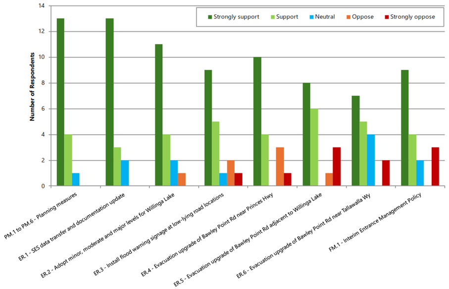
Figure 1. Community feedback
on support for recommended flood risk management measures
The reasoning for each negative
response is not known, however inferring from limited additional comments
received through the survey and discussions at the drop-in session themes
include the following:
§ A
preference for the Willinga Lake entrance to operate in a natural state.
§ A
low level of concern regarding flooding due to limited historical occurrence
within their lived experience.
§ Environmental
concerns.
§ Concerns
regarding costs to Council.
§ Concerns
that improved road access may facilitate further development.
Policy
and Statutory Implications
Following adoption of the
Willinga Lake Flood Study and Floodplain Risk Management Study and Plan
deliverables, the outcomes from this investigation will be used as follows:
§ Final
Willinga Lake Flood Study and Floodplain Risk Management Study and Plan
reports and Map Compendium will be made available on Council’s website.
The mapping will be made available on Council’s online flood mapping.
§ This
data will be available via flood certificate requests and be included in
Section 10.7 planning certificates for the Willinga Lake catchment.
§ This
information will be used to assess proposed development on flood prone land in
accordance with the Shoalhaven LEP 2014 and DCP Chapters G9 and G10.
All flood information completed
in the Willinga Lake Flood Study and Floodplain Risk Management Study and Plan
investigation will be provided to the NSW SES.
This ensures that Council
satisfies its obligations from the NSW Flood Prone Land Policy (2023)
and the NSW Flood Risk Management Manual (2023).
The final Willinga Lake
Floodplain Risk Management Plan includes the following flood risk management
measures for adoption.
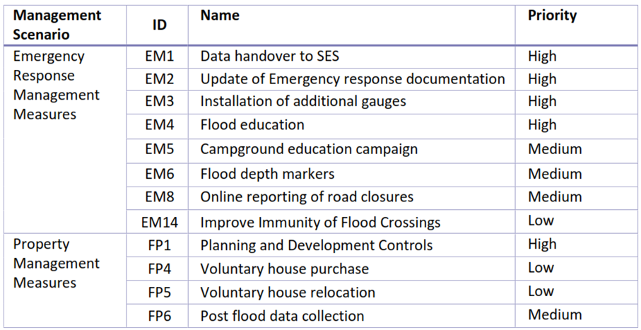
Table 1: Summary of recommended floodplain risk
management measures
|
Management Scenario
|
ID
|
Name
|
Priority
|
|
Planning Measures
|
PM.1
|
Update LEP Clauses 5.9 and 5.9A
|
Medium
|
|
PM.2
|
Updated LEP Land Zoning to limit residential
subdivision
|
Medium
|
|
PM.3
|
Develop Site-Specific Flood Related Development
Controls for Willinga Lake catchment
|
High
|
|
PM.4
|
Adopt Flood Planning Area (FPA) and Flood Planning
Level (FPL) mapping
|
High
|
|
PM.5
|
Adopt Combined Flood Hazard/Hydraulic Category mapping
|
High
|
|
PM.6
|
Adopt Flood Planning Constraint Categories (FPCCs)
|
High
|
|
Emergency Response Measures
|
ER.1
|
SES Data Transfer and Documentation Update
|
High
|
|
ER.2
|
Adopt Minor, Moderate and Major Levels for Willinga
Lake Gauge
|
High
|
|
ER.3
|
Install Flood Warning Signage
|
Medium
|
|
ER.4
|
Flood Evacuation Route Upgrade - Bawley Point Road
near Princes Highway (BPR-1)
|
Medium
|
|
ER.5
|
Flood Evacuation Route Upgrade - Bawley Point Road
adjacent to Willinga Lake
|
Medium
|
|
ER.6
|
Flood Evacuation Route Upgrade - Bawley Point Road
near Tallawalla Way (BPR-2)
|
Low
|
|
Flood Modification Measures
|
FM.1
|
Entrance Management
|
High
|
Financial
Implications
The Willinga Lake Flood Study
and Willinga Lake Floodplain Risk Management Study and Plan is fully funded by
the Australian Government's Preparing Australian Communities Program –
Local Stream.
The Willinga Lake Flood Study
and Willinga Lake Floodplain Risk Management Study and Plan investigation has
been completed, and the grant is in the process of being acquitted.
Risk
Implications
By completing and adopting these
studies, Council meets its obligations under the NSW Flood Prone Land Policy to
manage flood risk within the Willinga Lake catchment. The completed studies
present best available flood information that should be implemented to inform
strategic land-use and flood risk management decisions on flood liable land
within the study area. Should the committee choose not to adopt these studies,
it may jeopardise Council’s exemption from liability for decisions made
within the Willinga Lake catchment relating to flood liable land under section
7.33 of the Local Government Act 1993.