|
|
Addendum Agenda - Ordinary Meeting – Tuesday 15 April 2025 Page 1 |
CL25.121 Report Back on Proposed Road Closure - Illfracombe Avenue (Banksia Street), Vincentia
HPERM Ref: D25/115808
Department: Buildings & Property Services
Approver: Kevin Norwood, Acting Director - City Services
Purpose:
The purpose of this report is to provide Council with an update on the proposed road closure of Illfracombe Ave (Banksia Street), Vincentia following the resolution of Council on 11 March 2025 (MIN25.99).
That a report on the proposed closure of Banksia Street Vincentia be presented on the first regular Ordinary meeting in April 2025.
The proposed road closure was previously reported to Council on 8 April 2024 (MIN24.179). Council resolved to:
Close approximately 2,162sqm, subject to final survey, of unformed road reserve known as Banksia Street, Vincentia, shown in red on Attachment 3 – Banksia Road Closure (D24/123291) by notice published in the Government Gazette;
a) Create a right of carriageway over the closed road maintaining access for the adjacent neighbours of the closed road at Banksia Street, Vincentia.
b) Sell the closed road at Banksia Street, Vincentia for not less than the market value as determined by an independent valuer through a competitive sales process.
Summary and Key Points for Consideration:
· Pursuant to Section 38A of the Roads Act 1993, Council may propose the closure of a Council public road for which it is the Roads Authority.
· Public submissions were received and are being reviewed.
· Council is awaiting a final assessment from the Notifiable Authorities for the land parcel and cannot progress until such time as they are received.
In relation to a council public road, the term "notifiable authority" under the Roads Act 1993 refers to several key entities. This includes network operators defined under the Electricity Supply Act 1995 and the Gas Supply Act 1996, which manage transmission and distribution systems or pipelines in the area. It also includes the Secretary of the Department of Planning and Environment, the Secretary of the Department of Industry, Transport for NSW, Sydney Metro, the State Transit Authority, and the Commissioners of Fire and Rescue NSW and the NSW Rural Fire Service. Additionally, any other individuals or groups specified by regulation may also be considered notifiable authorities.
· Council resolution is required for the closure of a public road by gazette notice, to affect the closure of a road under section 38D of the Roads Act 1993 as well as sale of land. Notwithstanding the Council resolution on 8 April 2024 (MIN24.179) to close the road by gazette notice and sell the land, this report provides information to Councillors arising from the statutory road closure process.
|
That Council receive the report regarding the proposed road closure of Illfracombe Ave (Banksia Street), Vincentia for information, with a future report to be provided to Council upon receipt of the final assessment from the Notifiable Authorities. |
Options
1. That the report be received for information.
Implications: Nil
2. That the Council may seek further information.
Implications: Further information be provided to Council in a future report.
Background and Supplementary information
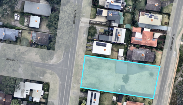
The subject area of road proposed for closure is shown in Figure 1 being Council public road reserve by way of Government Gazette No.81 of 20 July 1923.
Figure 1 – Proposed road closure area
The Roads Act 1993 (section 38A) states;
Council may propose the closure of a Council public road for which it is the roads authority if:
a) the road is not reasonably required as a road for public use (whether for present or future needs), and
b) the road is not required to provide continuity for an existing road network, and
c) if the road provides a means of vehicular access to particular land, another public road provides lawful and reasonably practicable vehicular access to that land.
Based on the above, Council can consider closure of the subject unformed road reserve together with provisions for continuity of access to adjoining private property having consideration to section 38A of the Roads Act 1993.
Provision of a right of carriageway
Council’s resolution of 8 April 2024 made provision for the creation of rights of carriageway over the unformed road reserve, to maintain private access for adjacent private property owners on Elizabeth Drive and Illfracombe Avenue respectively. A right of carriageway would be required on both sides of the road reserve.
Southern Access (No.35 Illfracombe Ave)
The current constructed driveway width benefitting No.35 Illfracombe Avenue is approximately 3.5m wide and viable, leaving approximately 5.5m for continued public access, to meet the requirements of Endeavour Energy and will enable continued private property access to No.35 Illfracombe Avenue.
The preferred outcome is to retain the minimum 9m width as public road reserve shown indicatively on Figure 2 in orange, negating the need for an easement.
Northern Access (No.33 Illfracombe Ave and No.18 Elizabeth Drive)
The current constructed driveways occupy a substantial part of the unformed road reserve – an area approximately 120m2 directly servicing No.18 Elizabeth Drive, and approximately 200m2 adjoining No.33 Illfracombe Avenue.
Future right of carriageway provision servicing the two privately owned properties would include provision for a 3m-3.5m wide corridor, being contemporary right of carriageway width in residential subdivisions generally. Future right of carriageway location is shown indicatively on Figure 2 in green.
Figure 2 – Indicative future right of carriageway - north side of subject land
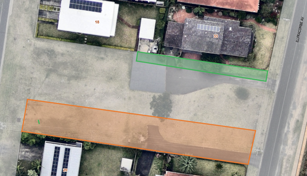
An alternate solution to the proposed right of carriageway location shown in Figure 2 in green is to create the legal right of carriageway with future access from Elizabeth Drive only. Whether the future right of carriageway is from Illfracombe Avenue or Elizabeth Drive, new driveway construction would be required as can be seen on Figure 2.
Another option to retain a 3.5m strip as public road reserve (the recommended outcome on the southern side of the subject land) has been considered but ultimately, the principal objective is provision for continued access to the adjoining private properties, and separation of vehicles from public (non-vehicle) access would be a desirable outcome.
The proposed retention of a minimum 9m wide public road reserve (southern boundary of the subject land) together with a recommended 3m-3.5m wide right of carriageway provision (part of northern boundary of the subject land), would result in a newly created residential lot of approximately 17.5m width (maximum), subject to continuing investigations into stormwater drainage requirements and potential sewer line relocation within the site. A 17.5m wide allotment results in 42% of the current site frontage/width being retained as non-developed land and used for the continuing purposes of; public access, utility infrastructure provision and vehicle access corridor benefitting directly adjoining property (that is, current uses occurring on the site).
In the event the final drainage and sewer utility investigations require more than a 9m wide public road corridor along the southern boundary, an increased site frontage/width will be retained as non-developed land.
Public submissions
A total of 25 public submissions were received following public notification of the proposed road closure under the Roads Act 1993. The summary of the issues raised in submissions is provided below.
|
Concern / Issue raised |
Number of times raised |
|
Public access removed Unformed road serves as public access route for pedestrians |
19 |
|
Loss of green / open space and recreation Unformed road serves as open space perceived to be public reserve for purpose of recreation. |
19 |
|
Impact on broader public use and enjoyment (e.g. Husky Triathlon) Unformed road reserve used for various events including Husky Triathlon as first aid and water station. |
16 |
|
Utilities / infrastructure on land including stormwater drainage Critical water, sewer and electricity infrastructure on land and drainage issues |
13 |
|
Collateral impact on traffic and parking congestion on Illfracombe Ave Unformed road serves as public access route for pedestrians. Closing this space will result in greater parking congestion on Illfracombe Ave |
11 |
|
Emergency services access / evacuation route Unformed road serves as access route emergency vehicles and evacuation point |
7 |
|
Access for adjoining residence Unformed road currently used by adjoining residences for private property access and road required for their access. |
7 |
|
Environmental / wildlife concerns Unformed road serves as wildlife corridor and supports vegetation. |
7 |
|
Loss of view corridor Unformed road provides open space and beach / ocean views for surrounding properties
|
6 |
|
Other comments The following individual comments were raised in submissions and are individually listed below as they were one-off or infrequently raised matters: - Insufficient notification - Impact on streetscape - Use of funds for closed road - Lack of community consultation - Climate change and coastal erosion risk - Future development height limitation - Part of suburb masterplan Infrastructure inadequate to support new development |
|
Loss of public access between Illfracombe Avenue and Elizabeth Drive was the most frequently raised concern in the public submissions with road closure notification. Retention of a minimum 9m wide public road reserve along the southern boundary of the subject land will overcome community concerns over loss of access and additionally, will overcome other concerns expressed in submissions of potential collateral traffic and parking impact along Illfracombe Avenue, by drivers no longer having the option of parking along Elizabeth Drive and utilising the unformed road reserve for direct access the beachfront.
Loss of access to directly adjoining residences was also raised as an issue of concern in the public submissions.
Comments raised in public submissions also cited the unformed road has an open space function, both directly and indirectly. The unformed road reserve currently has a road function under the Roads Act. Although it might be considered as a green or open space corridor, Council is obliged to use the land under the status being public road which may or may not include road and access construction consistent with its primary purpose.
Internal Consultations
Ongoing consultation is taking place with internal stakeholders to address certain requirements in relation to the proposed road closure. These consultations are ongoing and when resolved will inform the final road closure outcome. The consultation includes but is not limited to further assessment of road stormwater drainage, and infrastructure assets within the unformed road reserve.
Both stormwater drainage and potential sewer utility re-location are undergoing preliminary concept design and cost estimate (feasibility). The stormwater drainage concept will inform the management of future stormwater and whether part of the subject land is required to accommodate projected stormwater management. The current sewer infrastructure within the site does not preclude future development on the subject land, if the road is closed. Additional investigation is being undertaken to assess the merits of sewer line relocation within the site and future development footprint/building envelope.
External Consultations
The Roads Act provides notification requirements for a road closure proposal. Submissions were received from Notifiable Authorities. Pursuant to Section 38D of the Roads Act 1993, in the case where a Notifiable Authority has formally objected to the closing of a road, Council cannot close the road by gazette notice until the objection is withdrawn by the authority or set aside by the Land and Environment Court under section 38F of the Roads Act.
At the time of writing this report it has been established that Endeavour Energy require an easement for overhead electricity, minimum 9m wide, along the southern boundary of the unformed road reserve, or equivalent section retained as public road reserve. Figure 3 shows the extent of the 9m wide corridor (orange) within the current road reserve.
Figure 3 – Area required by Endeavour Energy for easement for electricity
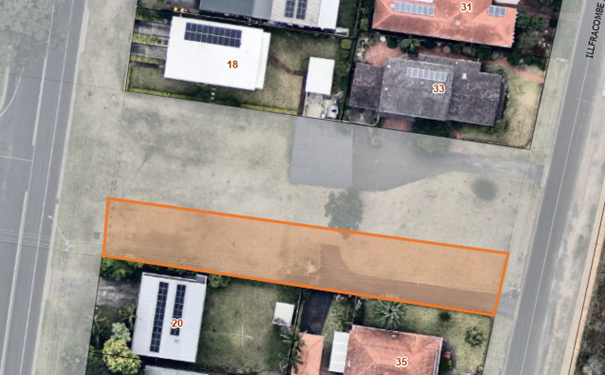
Endeavour Energy has confirmed that the creation of an easement or retained section of public road reserve would satisfy their concerns and objection to the road closure withdrawn.
Community Consultations
A total of 25 public submissions were received following public notification of the proposed road closure under the Roads Act 1993. The summary of the issues raised in submissions are shown in the body of this report.
Policy and Statutory Implications
Council is conducting the proposed road closure under the Roads Act 1993. Council Policy 22/47 (Development and/or Disposal of Council Lands) is relevant for the sale of the land, following gazettal of the road closure.
If the road closure is gazetted, Council will need to resolve to classify the land as Operational land, in order to satisfy MIN24.179 and sale of the land.
Financial Implications
At this stage it is not possible to provide complete financial implications as further investigation is taking place with stormwater drainage and utility infrastructure location. In accordance with MIN24.179, the closed road will be sold at not less than market value as determined by independent valuer through a competitive sales process. Valuation advice will be obtained prior to any sale to assess prevailing market value. If the road is closed by gazette notice, the market will ultimately determine the land value through competitive open sale process.
Costs incurred in the road closure process will be met through proceeds from land sale.
Net land sale proceeds will go the Strategic Property Reserve and used for the purposes expressed in section 43 of the Roads Act 1993.
Risk Implications
Council’s interests are being considered through the process and there is minimal risk associated with the proposed road closure and sale.