Development & Environment Committee
Meeting Date: Tuesday,
13 July, 2021
Location: Council
Chambers, City Administrative Building, Bridge Road, Nowra
Time: 5.00pm
Membership (Quorum - 5)
Clr Mitchell Pakes - Chairperson
Clr Bob Proudfoot
All Councillors
Chief Executive Officer or nominee
Please note: The proceedings of this meeting
(including presentations, deputations and debate) will be webcast and may be
recorded and broadcast under the provisions of the Code of Meeting Practice. Your attendance at this meeting is taken
as consent to the possibility that your image and/or voice may be recorded and
broadcast to the public.
Agenda
1. Apologies / Leave of Absence
2. Confirmation of Minutes
· Development
& Environment Committee - 1 June 2021............................................. 1
3. Declarations of Interest
4. Mayoral Minute
5. Deputations and Presentations
6. Notices of Motion / Questions on Notice
Notices of Motion / Questions on Notice
DE21.62...... Notice of Motion - Companion Animals Act - Cats......................................... 7
DE21.63...... Notice of Motion - Nowra CBD - Parks Audit............................................... 10
7. Reports
City Futures
DE21.64...... Draft Amendment No. 45 - Shoalhaven Development
Control Plan 2014 Chapter S8: Ulladulla Town Centre.................................................................................. 10
DE21.65...... Progressing the Planning - Moss Vale Road North
Urban Release Area... 14
DE21.66...... Proposed Planning Agreement - Stage 1 Moss Vale
Road South Urban Release Area - Lot 1 DP 949932 - SF10632...................................................................... 35
DE21.67...... Proposed Planning Agreement - Construction of
Kent Lane, Huskisson.... 47
DE21.68...... Proposed Finalisation - Voluntary Planning
Agreement (VPA15): Landscape Screen, South of Hitchcocks Lane, Berry.................................................................. 53
DE21.69...... Exhibition Outcomes and Finalisation - Planning
Proposal - Huntingdale Park Estate Large Lot Residential Areas, Berry (PP060)................................................ 58
DE21.70...... Post Exhibition & Finalisation Report -
Planning Proposal (PP040) - Housekeeping Amendment 2018 (Mapping) - Shoalhaven
LEP 2014................................ 65
DE21.71...... Post Exhibition and Finalisation - Planning
Proposal - Berry Heritage (PP056) 74
DE21.72...... Funding Offer & Commencement - Shoalhaven
Local Heritage Assistance Fund 2021-2023..................................................................................................... 85
DE21.73...... Strategic Planning Works Program - Proposed
2021-2022 Version........... 88
DE21.74...... Proposed Submission - NSW Planning Reforms -
Employment Zones Framework.................................................................................................................... 100
DE21.75...... Proposed Submission - Review of NSW Heritage
Legislation.................. 113
DE21.76...... Community Participation Plan - Review..................................................... 124
City Development
DE21.77...... DA20/2172 - 8 Homestead Lane Berry - Lot 101 DP
1057897................. 126
DE21.78...... DA20/1621 – 260 Mount Hay Road (Private),
Broughton Vale – Lot 2 DP 4498 177
DE21.79...... DA21/1333 – 23 Parker Crescent Berry
– Lot 331 DP 1226462............... 202
DE21.80...... DA21/1370 – 3 Cumberland Ave South Nowra
– Lot 2 DP 260264.......... 232
DE21.81...... DA20/2322 – 12-16 The Wool Road & 5
Burton Street, Vincentia – Lots 1779 & 1780 DP 26434, Lot 5 DP 539867
& Lot 1 DP 615796...................................... 256
DE21.82...... DA19/1102 & DA21/1304 - 252 Princes Highway
Ulladulla – Lot 1 DP 784732 281
DE21.83...... DA20/2061 – 60 Macleay Street Narrawallee
– Lot 145 DP718994......... 305
8. Confidential
Reports
Nil
|

|
Development
& Environment Committee – Tuesday 13 July 2021
Page
|
Development & Environment
Committee
Delegation:
Pursuant to
s377(1) of the Local Government Act 1993 (LG Act) the Committee is
delegated the functions conferred on Council by the Environmental Planning
& Assessment Act 1979 (EPA Act), LG Act or any other Act or delegated
to Council, as are specified in the attached Schedule, subject to the following
limitations:
i. The
Committee cannot make a decision to make a local environmental plan to classify
or reclassify public land under Division 1 of Part 2 of Chapter 6 of the LG
Act;
ii.
The Committee cannot review a section 8.11 or
section 8.9 EPA Act determination made by the Council or by the Committee
itself;
iii.
The Committee cannot exercise any function delegated
to the Council which by the terms of that delegation cannot be sub-delegated;
iv.
The Committee cannot exercise any function which
s377(1) of the LG Act provides cannot be delegated by Council; and
v.
The Committee cannot exercise a function which
is expressly required by the LG Act or any other Act to be exercised by
resolution of the Council.
SCHEDULE
a. All
functions relating to the preparation, making, and review of local
environmental plans (LEPs) and development control plans (DCPs) under Part 3 of
the EPA Act.
b. All
functions relating to the preparation, making, and review of contributions
plans and the preparation, entry into, and review of voluntary planning
agreements under Part 7 of the EPA Act, as well as the preparation, entry into,
and review of works in kind agreements that provide a material public benefit
in part or full satisfaction of a condition imposed under Part 7 of the EPA
Act.
c. The
preparation, adoption, and review of policies and strategies of the Council in
respect of town planning and environmental matters and the variation of such
policies.
d. Determination
of variations to development standards related to development applications
under the EPA Act where the development application involves a development
which seeks to vary a development standard by more than 10% and the application
is accompanied by a request to vary the development standard under clause 4.6
of Shoalhaven Local Environmental Plan 2014 or an objection to the application
of the development standard under State Environmental Planning Policy No. 1
– Development Standards.
e. Determination
of variations from the acceptable solutions and/or other numerical standards
contained within the DCP or a Council Policy that the Chief Executive Officer
requires to be determined by the Committee
f. Determination
of development applications that Council requires to be determined by the
Committee on a case by case basis.
g. Review
of determinations of development applications under sections 8.11 and 8.9 of
the EP&A Act that the Chief Executive Officer requires to be determined by
the Committee.
h. Preparation,
review, and adoption of policies and guidelines in respect of the determination
of development applications by other delegates of the Council.
i. The
preparation, adoption and review of policies and strategies of the Council in
respect to sustainability matters related to climate change, biodiversity,
waste, water, energy, transport, and sustainable purchasing.
j. The
preparation, adoption and review of policies and strategies of the Council in
respect to management of natural resources / assets, floodplain, estuary and coastal
management.
Minutes of the Development & Environment Committee
Meeting Date: Tuesday,
1 June 2021
Location: Council
Chambers, City Administrative Building, Bridge Road, Nowra
Time: 5.00pm
The following members
were present:
Clr Patricia White
– Acting Chairperson
Clr Bob Proudfoot
Clr Amanda Findley
Clr Joanna Gash
Clr John Wells
Clr Kaye Gartner
Clr Nina Digiglio
Clr Annette Alldrick
Clr John Levett
Clr Andrew Guile - joined
6:35pm (remotely)
Clr Greg Watson
Clr Mark Kitchener
Mr Stephen Dunshea -
Chief Executive Officer
|
Election
of Chairperson
|
|
RESOLVED (Clr Proudfoot / Clr
Wells) MIN21.350
That Clr White be appointed as
the Acting Chairperson for the meeting.
CARRIED
|
|
Apologies / Leave of Absence
|
A leave of absence was
received from Clr Pakes.
|
Confirmation of the Minutes
|
|
RESOLVED (Clr Findley / Clr
Alldrick) MIN21.351
That
the Minutes of the Development & Environment Committee held on Tuesday 11
May 2021 be confirmed.
CARRIED
|
Nil
Deputations and Presentations
DE21.57 - Proponent Initiated Planning
Proposal - Taylors Lane, Cambewarra (Moss Vale Road South URA) - Exhibition
Outcomes and Proposed Finalisation (page 25)
Mr Dan Thompson representing
Cambewarra Ventures addressed the meeting and spoke in favour of the
recommendation.
DE21.59
- DS20/1397 – 408 Bunkers Hill Road, Barrengarry – Lot 144 DP
751262 (page 50)
Arwen
Apps and Sam Quick addressed the meeting and spoke against the recommendation.
Mr Matt Philpott of Allen Price
& Scarratts addressed the meeting and spoke in favour of the recommendation.
DE21.61 - Section 138 Application - SF10632 –
Approved Subdivision, Moss Vale South URA – Lot 1 DP 949932 and Lot 3 DP
851823, Taylors Lane, Cambewarra
(page 83)
Mr Dan Thompson representing
Cambewarra Ventures addressed the meeting and spoke in favour of the
recommendation.
Reports
|
DE21.57 Proponent Initiated Planning
Proposal - Taylors Lane, Cambewarra (Moss Vale Road South URA) - Exhibition
Outcomes and Proposed Finalisation
|
HPERM Ref: D21/188736
|
|
Recommendation (Item to be determined under
delegated authority)
That Council:
1. Adopt
and finalise the Planning Proposal (PP054): Rezoning of Riparian Land at Lot
1 DP 949932, Taylors Lane, Cambewarra, as exhibited.
2. Forward
PP054 to NSW Parliamentary Counsel’s Office to draft the required
amendment to Shoalhaven Local Environmental Plan 2014.
3. Make
the resulting amendment to the Shoalhaven Local Environmental Plan 2014 using
Council’s delegation.
4. Adopt
and finalise the amendment to Shoalhaven DCP 2014 Chapter NB3 - Moss Vale
Road South URA as exhibited and give the required public notice advising of
its commencement date.
5. Adopt
and finalise the amendment to Shoalhaven CP 2019 as exhibited and give the
required public notice advising of its commencement date.
6. Amend
the exhibited IWCA Addendum Report to identify the subject land as
“medium density / integrated housing”, consistent with the
exhibited DCP amendment, then proceed to finalise it.
7. Advise
key stakeholders, including the Proponent, adjoining landowners, the
Cambewarra Residents and Ratepayers Association, development industry
representatives and those who made a submission, of this decision and when
the LEP, DCP and CP amendments will be made effective.
|
|
RESOLVED (Clr Findley / Clr
Wells) MIN21.352
That Council:
1. Adopt
and finalise the Planning Proposal (PP054): Rezoning of Riparian Land at Lot
1 DP 949932, Taylors Lane, Cambewarra, as exhibited.
2. Forward
PP054 to NSW Parliamentary Counsel’s Office to draft the required
amendment to Shoalhaven Local Environmental Plan 2014.
3. Make
the resulting amendment to the Shoalhaven Local
Environmental Plan 2014 using Council’s delegation.
4. Adopt
and finalise the amendment to Shoalhaven DCP 2014 Chapter NB3 - Moss Vale
Road South URA as exhibited and give the required public notice advising of
its commencement date.
5. Adopt
and finalise the amendment to Shoalhaven CP 2019 as exhibited and give the
required public notice advising of its commencement date.
6. Amend
the exhibited IWCA Addendum Report to identify the subject land as
“medium density / integrated housing”, consistent with the
exhibited DCP amendment, then proceed to finalise it.
7. Advise
key stakeholders, including the Proponent, adjoining landowners, the Cambewarra
Residents and Ratepayers Association, development industry representatives
and those who made a submission, of this decision and when the LEP, DCP and
CP amendments will be made effective.
For: Clr
Findley, Clr Gash, Clr Wells, Clr White, Clr Gartner, Clr Digiglio, Clr
Alldrick, Clr Levett, Clr Watson, Clr Kitchener, Clr Proudfoot and Stephen
Dunshea
Against: Nil
CARRIED
|
|
Procedural
Motion - Bring Item Forward
|
|
RESOLVED (Clr Wells / Clr
Gartner) MIN21.353
That the matter of item DE21.61-
Section 138 Application - SF10632 – Approved Subdivision, Moss Vale
South URA – Lot 1 DP 949932 and Lot 3 DP 851823, Taylors Lane,
Cambewarra - be brought forward for consideration.
CARRIED
|
|
DE21.61 Section 138 Application -
SF10632 – Approved Subdivision, Moss Vale South URA – Lot 1 DP
949932 and Lot 3 DP 851823, Taylors Lane, Cambewarra
|
HPERM Ref: D21/210854
|
|
Recommendation (Item to be determined under
delegated authority)
That this report be received for information, noting,
and endorsing the intention of staff to approve the subject S138 application
for roadworks within the Taylors Lane road reserve which will also require
tree removal from Taylors Lane.
|
|
RESOLVED (Clr Findley / Clr
Wells) MIN21.354
That this report be received for information, noting,
and endorsing the intention of staff to approve the subject S138 application
for roadworks within the Taylors Lane road reserve which will also require
tree removal from Taylors Lane.
For: Clr
Findley, Clr Gash, Clr Wells, Clr White, Clr Gartner, Clr Digiglio, Clr
Alldrick, Clr Levett, Clr Watson, Clr Kitchener, Clr Proudfoot and Stephen
Dunshea
Against: Nil
CARRIED
|
|
DE21.59 DS20/1397 – 408 Bunkers
Hill Road, Barrengarry – Lot 144 DP 751262
|
HPERM Ref: D21/131520
|
|
Recommendation (Item to be determined under
delegated authority)
That modification application DS20/1397
to modify the design of the approved animal boarding and training
establishment (equine education centre) at Lot 144 DP 751262, 408 Bunkers
Hill Road, Barrengarry be approved subject to the recommended conditions of
consent contained in Attachment 2 of this report.
|
|
Motion
(Clr Gash / Clr Watson)
That
1. Modification
application DS20/1397 to modify the design of the approved animal boarding
and training establishment (equine education centre) at Lot 144 DP 751262,
408 Bunkers Hill Road, Barrengarry be approved subject to the recommended
conditions of consent contained in Attachment 2 of this report.
2. A
draft condition be included in the consolidated determination notice, in Part
G being Condition 52 b) (with Condition 52 renumbered to condition 52 a), as
follows:
a. Passing
bays (a minimum of 2) must be provided within the Bunkers Hill Road reserve.
The bays are to be positioned in a location selected in consultation with
Council’s City Services and constructed to the relevant standards
required by Council. The bays are to be constructed and completed prior to
issue of an Occupation Certificate.
b. Works
in the Road Reserve require Council’s approval under section 138 of the
Roads Act 1993. Note: A section 138 application should be made in well in
advance of project completion (i.e. Occupation Certificate) and will require
but not be limited to detailed drawings, traffic management details,
insurance details, etc). Further information can be obtained from
Council’s Development Services (Subdivision & Development
Engineers).
For: Clr
Gash, Clr Watson and Clr Kitchener
Against: Clr Findley,
Clr Wells, Clr White, Clr Gartner, Clr Digiglio, Clr Alldrick, Clr Levett,
Clr Guile, Clr Proudfoot and Stephen Dunshea
lost
|
|
Foreshadowed Motion (Clr Levett / Clr
Digiglio)
That Modification application DS20/1397
to modify the design of the approved animal boarding and training
establishment (equine education centre) at Lot 144 DP 751262, 408 Bunkers
Hill Road, Barrengarry be refused as it is contrary to public interest
specifically with respect to traffic and safety issues.
|
|
RESOLVED (Clr Levett / Clr
Digiglio) MIN21.355
That Modification application DS20/1397
to modify the design of the approved animal boarding and training
establishment (equine education centre) at Lot 144 DP 751262, 408 Bunkers
Hill Road, Barrengarry be refused as it is contrary to public interest
specifically with respect to traffic and safety issues.
For: Clr
Findley, Clr Wells, Clr White, Clr Gartner, Clr Digiglio, Clr Alldrick, Clr
Levett, Clr Guile, Clr Proudfoot and Stephen Dunshea
Against: Clr Gash, Clr
Watson and Clr Kitchener
CARRIED
|
Items marked with an *
were resolved ‘en bloc’.
|
DE21.58 Natural Areas Volunteers -
Parkcare Action Plans - Carrington Park / George Street Park / Greenwell
Point
|
HPERM Ref: D21/167911
|
|
RESOLVED* (Clr Proudfoot / Clr
Gartner) MIN21.356
That Council
1. Endorse
the updated and new “Parkcare” plans for
a. Carrington
Park – Worrigee (UPDATED)
b. George
Street Park / Berry & District Garden Club – Berry (NEW)
c. Greenwell
Point – (UPDATED)
2. Continue
to allocate ongoing annual operating funding of $400 (GST exclusive and CPI
adjusted) for each Parkcare Group, totalling $1,200 to cover safety PPE,
miscellaneous materials, waste disposal and purchase minor tools.
For: Clr
Findley, Clr Gash, Clr Wells, Clr White, Clr Gartner, Clr Digiglio, Clr
Alldrick, Clr Levett, Clr Guile, Clr Watson, Clr Kitchener, Clr Proudfoot and
Stephen Dunshea
Against: Nil
CARRIED
|
|
DE21.60 DA16/1465 - 173 Kinghorne St and
2 & 4 Albatross Rd Nowra - Lot 1, 29 and 30 DP 25114
|
HPERM Ref: D21/203656
|
|
RESOLVED* (Clr Proudfoot / Clr
Gartner) MIN21.357
That Council receive this report
as an update on the progress of the assessment of DA16/1465 and in
satisfaction of the 11 May 2021 resolution of the Development &
Environment Committee (DE21.50).
For: Clr
Findley, Clr Gash, Clr Wells, Clr White, Clr Gartner, Clr Digiglio, Clr
Alldrick, Clr Levett, Clr Guile, Clr Watson, Clr Kitchener, Clr Proudfoot and
Stephen Dunshea
Against: Nil
CARRIED
|
|
DE21.56 Proposed Amendments to
Chapter G21: Car Parking and Traffic of Shoalhaven DCP 2014
|
HPERM Ref: D21/179024
|
|
Recommendation (Item to be determined under
delegated authority)
That Council:
1. Endorse
and proceed to publicly exhibit the proposed amendments to Chapter 21: Car
Parking and Traffic of Shoalhaven Development Control Plan 2014 as outlined
in Attachment 1, for a period of at least 28 days as per legislative
requirements.
2. Receive
a further report following the conclusion of the public exhibition period to
consider feedback received and enable finalisation of the amendment.
3. Notify
key stakeholders (including CCBs and Development Industry Representatives) of
the exhibition arrangements, in due course.
|
|
RESOLVED (Clr Findley / Clr
Wells) MIN21.358
That the item be deferred to the
Ordinary Meeting on Tuesday 29 June 2021.
For: Clr
Findley, Clr Gash, Clr Wells, Clr White, Clr Gartner, Clr Digiglio, Clr
Alldrick, Clr Levett, Clr Guile, Clr Watson, Clr Kitchener, Clr Proudfoot and
Stephen Dunshea
Against: Nil
CARRIED
|
|
DE21.57 Proponent Initiated Planning Proposal - Taylors Lane,
Cambewarra (Moss Vale Road South URA)
- Exhibition Outcomes and Proposed Finalisation
|
HPERM Ref: D21/188736
|
|
Item
dealt with earlier in the meeting see MIN21.352
|
|
DE21.58 Natural Areas Volunteers - Parkcare Action Plans -
Carrington Park / George Street Park/ Greenwell Point
|
HPERM Ref: D21/167911
|
|
Item
dealt with earlier in the meeting see MIN21.356
|
|
DE21.59 DS20/1397
– 408 Bunkers Hill Road,
Barrengarry – Lot 144 DP 751262
|
HPERM Ref: D21/131520
|
|
Item dealt
with earlier in the meeting see MIN21.355
|
|
DE21.60 DA16/1465
- 173 Kinghorne St And 2 & 4
Albatross Rd Nowra - Lot 1, 29 and 30 DP 25114
|
HPERM Ref: D21/203656
|
|
Item
dealt with earlier in the meeting see MIN21.357
|
|
DE21.61 Section 138 Application -
SF10632 – Approved Subdivision, Moss Vale South URA – Lot 1 DP 949932 and Lot 3 DP 851823, Taylors Lane, Cambewarra
|
HPERM Ref: D21/210854
|
|
Item
dealt with earlier in the meeting see MIN21.354
|
There being no further
business, the meeting concluded, the time being 7:32pm.
Clr White
ACTING CHAIRPERSON
|

|
Development
& Environment Committee – Tuesday 13 July 2021
Page
0
|
DE21.62 Notice
of Motion - Companion Animals Act - Cats
HPERM Ref: D21/280734
Submitted
by: Clr John Levett
Purpose / Summary
The following Notice of Motion,
of which due notice has been given, is submitted for Council’s
consideration.
|
Recommendation (Item to be determined under delegated authority)
That
the CEO write to Premier Gladys Berejiklian, the Member for South Coast and
Minister for Local Government Shelley Hancock, the Minister for Energy
and Environment Matt Kean and the Member for Kiama Gareth Ward urging that
the Companion Animals Act 1998 be reviewed so that domestic and feral cats
are no longer “free to roam” outside the boundary of the
owner’s property and empower individual local councils
to:
1. Introduce and police new regulations
in relation to cat control that are deemed appropriate in their local
government area for the protection of native species, the suppression of
diseases carried by cats, and for the health and safety of cats generally.
2. Introduce curfews on cats on a trial
basis for the hours between sunset and sunrise and consult with the community
with a view to eventually introducing a 24 hour curfew.
3. Bring regulations applying to cats
into line with those applying to dogs in NSW, to streamline them and make
them easier to police.
4. Make 24 hour curfews a condition of
consent on all new greenfield development sites.
|
Background
The Companion Animals Act
Regulation of domestic cats by Councils is guided in NSW by
the Companion Animals Act 1998, which essentially permits cats to roam freely
beyond the perimeter of the owners property as long as they are microchipped,
registered and wearing a collar. This is out of step with the regulations
relating to dogs and prevents the impounding of a cat on the loose unless an
order has been issued nominating the animal as a “nuisance cat”
(Section 31). There are a number of reasons why a cat can be declared a
“nuisance” but it’s a process that is cumbersome, slow and
impractical and effectively puts the onus on the “complainant” to
make the case when the control of the cat should be the responsibility of the
owner. Under the Act, cats are prohibited in any public place set apart by the
local authority for the protection of wildlife and where signs are
conspicuously displayed to that effect. They are also restricted in areas where
food is prepared or consumed. Any person may seize a cat that is in a prohibited
place “for the cat’s own protection”.
Cat
Populations in Australia
More than a quarter of
Australian households have pet cats and the population of domestic cats is
somewhere around 3.8 million… about 70 percent of these are
permitted to roam and hunt. More difficult to determine is the population of
feral cats but estimates are between two and six million. (The Conversation,
14 May 2020)
The
Impact of Cats on Native Animals
Native animals don’t
generally have high reproductive rates so they are susceptible to species
decline because of the efficiency of the cat as a predator. Feral cats have
been implicated in at least 25 mammal extinctions in Australia, they kill
around 2 billion birds, reptiles and mammals a year, and domestic cats eliminate
about 230 million animals each year. (The Guardian, 6 January 2021)
The Australian Government is developing a new threatened
species strategy which is expected to be released in late 2021. About 844,000
cats were culled between July 2015 and June 2018. Cats hunt instinctively and
not necessarily for food, their presence alone puts native animals under
stress, effecting their capacity to reproduce and raise young.
Cats Carry Diseases
Toxoplasmosis is a serious disease resulting from infection
with a common parasite found in cat faeces. There is no vaccination against the
disease and it can live in the environment for many months, contaminating soil,
sandboxes, water, fruits, vegetables, paddock grass or any place an infected
cat may have defecated. Toxoplasmosis can cause severe illness in infants
infected in utero or in people with a weakened immune system and can
cause abortion, stillbirth or neonatal death among livestock, especially sheep.
Native animals particularly susceptible are those that forage at ground level
such as: wallabies, bettongs, potoroos and bandicoots. Treatment of infected
animals is invariably unsuccessful.
Summary
New South Wales is behind the
ACT and other states in cat control. Most are pushing ahead with regulations to
confine cats to the dwelling of the owner or a race in the yard. After 1 July
2022 all newly acquired cats in the ACT must be confined to the owner’s
property as is the case in Queensland. The Victorian and South Australian
governments have given the responsibility for regulation over to individual
councils which are generally introducing curfews.
Knox City Council for example,
south east of Melbourne and bordering the Dandenong Ranges National Park,
trialled a sunset to sunrise curfew in 2020 and consulted with residents
through the process. Of the 720 respondents, 86 percent supported the night
time curfew and in fact indicated a greater preference for a full 24 hour
curfew which will be introduced on 1st October this year.
Tasmania and WA regulations are
slightly different and somewhat vague. Cats are technically still free to roam
but any “unowned cat” can be captured by any “authorised
person” on public property or any person on private property. As in other
jurisdictions, the process that follows leads to the cat being returned to the
owner, rehomed or euthanised.
The Companion Animals Act in NSW
needs reform:
· To
keep it in step with other states.
· To
make cat owners responsible for the control of their pets in the same way dog
owners are.
· To
reduce the rate of extinction and species decline in native animals.
· To
prevent the spread of cat borne diseases.
· To
protect domestic cats, which are an important companion animal, from death and
injury when they stray into the foreign environment outside the safety of the
owner’s home.
|
|
Development
& Environment Committee – Tuesday 13 July 2021
Page
0
|
DE21.63 Notice
of Motion - Nowra CBD - Parks Audit
HPERM Ref: D21/281411
Submitted
by: Clr John Levett
Purpose / Summary
The following Notice of Motion, of which due notice has been
given, is submitted for Council’s consideration.
|
Recommendation (Item to be determined under delegated authority)
That
the manager of the appropriate Council Department undertake an audit of CBD
parks, in particular Harry Sawkins Park, and report back to Council in
relation to:
1. Lighting for the purposes of night
time security
2. Adequacy of maintenance schedules
and rubbish receptacles
3. The water quality of any lakes,
ponds or streams within the parks and advise on and cost any improvements
necessary to bring them up to standard.
|
|
|
Development
& Environment Committee – Tuesday 13 July 2021
Page
0
|
DE21.64 Draft
Amendment No. 45 - Shoalhaven Development Control Plan 2014 Chapter S8:
Ulladulla Town Centre
HPERM Ref: D21/165066
Department: Strategic
Planning
Approver: Robert
Domm, Director - City Futures
Attachments: 1. Draft
DCP Chapter S8: Ulladulla Town Centre (under separate cover) ⇨
Reason for Report
· Present
Draft Amendment No. 45 to Shoalhaven Development Control Plan (DCP) 2014
Chapter S8: Ulladulla Town Centre - the amendments reflect building height and
zoning changes made over the southern part of Ulladulla town centre in Shoalhaven LEP 2014 via Amendment No. 33 which took effect
on 26 June 2020, as well as other minor updates of a more
‘housekeeping’ nature;
· Obtain
endorsement to place the Draft Amendment on public exhibition; and
· Obtain
a resolution to prepare a further housekeeping amendment to Chapter S8 to
review and update other matters relevant to the broader Ulladulla town centre
area including general context, built form and desired character, maps and
figures and other minor matters.
|
Recommendation (Item to be determined under delegated authority)
That
Council
1. Endorse the draft proposed Amendment
to Shoalhaven Development Control Plan 2014 Chapter S8: Ulladulla Town
Centre, as provided in Attachment 1 and place the Draft Amendment on
public exhibition for a period of at least 28 days as per legislative
requirements.
2. Receive a further report on the
Draft Amendment following the conclusion of the public exhibition period to
consider feedback received, any necessary adjustments, and the finalisation
of the Amendment.
3. Advise key stakeholders, including
affected and adjoining landowners, the Ulladulla & Districts Community
Forum and development industry representatives, of this decision and the
public exhibition arrangements in due course.
4. Endorse the preparation of a further
housekeeping amendment to Chapter S8 to review and update other matters that
are relevant to the broader Ulladulla town centre area including general
context, built form and desired character, maps and figures, and other minor
matters identified during the review, with the Draft Amendment to be reported
to Council for consideration prior to public exhibition.
|
Options
1. As recommended.
Implications: This is the
preferred option as it will enable Chapter S8 to be updated to address the
changes to building heights and zones in the southern part of the Ulladulla
Town Centre, which took effect in June 2020 with Shoalhaven LEP 2014 (Amendment
No. 33). It will also enable other minor changes of a
‘housekeeping’ nature to be made to resolve inconsistencies with
the LEP, update references to external policy / guidelines and to enhance the
overall readability of the Chapter. Staff will commence the preparation of a
more holistic housekeeping amendment to Chapter S8 to review and update
provisions that are relevant to the broader Ulladulla town centre area.
2. Adopt an
alternative recommendation.
Implications: This will
depend on the extent of any changes and could delay the implementation of
updated DCP provisions that will address recent changes to building heights and
zones in the southern part of the Ulladulla Town Centre and improve the overall
readability of the Chapter.
3. Not adopt the recommendation.
Implications: The current
DCP chapter would remain as is and be inconsistent with the current LEP
building heights and zones that came into effect with Shoalhaven LEP 2014
(Amendment No. 33). This may create uncertainty for developers and the
community and lead to undesirable development outcomes. Other necessary updates
and changes to improve the overall readability of the Chapter would not be
made.
Background
On 5 May 2020, Council resolved
(MIN20.307) to adopt and finalise the Planning Proposal (PP030) relating to
increased LEP building heights and zoning changes in the southern part of the
Ulladulla Town Centre (the land shown in Figure 1). The resulting LEP
Amendment (No.33) took effect on 26 June 2020.
The general increase to LEP
building heights implemented the recommendations of the Ulladulla Building
Height Review Report (Atlas Urban) commissioned by Council in June 2017. This
report identified the changes necessary to encourage the continued development
of the town centre as a vibrant, mixed-use centre with a diversity of shops and
businesses and quality residential and holiday apartments.
The land on the corner of
Deering Street and St Vincent Street was also rezoned from B5 Business
Development to B4 Mixed Use at the request of the owners of those sites to
enable them to be possibly redeveloped for a mixed-use development of shops and
businesses on the ground floor with apartments above.
Figure 1: PP030
Subject land
Arising from the zoning and building
height amendments, Council also resolved, in part, to:
“5. Commence
the preparation of a Draft Amendment to Chapter S8: Ulladulla Town Centre of
Shoalhaven DCP 2014 to reflect the building height and zoning changes and
address resulting matters such as general context, built form and character,
views and vistas, setbacks and height references in the subject area, with the
amendment to be reported to Council prior to placing it on public
exhibition.” (MIN20.307)
As a result, an amendment to DCP 2014 Chapter S8: Ulladulla
Town Centre has been prepared to reflect the building height and zoning changes
in the southern part of the Town Centre and update controls addressing views
and vistas, setbacks and height references. The amendment includes a
number of other more minor ‘housekeeping’ changes to controls
applicable to the broader Ulladulla Town Centre area to resolve inconsistencies
with the LEP, update references to external policy/guidelines and to enhance
the overall readability of the Chapter.
The draft DCP Chapter S8 is
provided as Attachment 1. The Table of Changes on pages 1 to 3 of the
attachment describes the proposed amendments in detail and a summary of them is
also provided below:
· Maps
1 – 5: Update to reflect the current LEP building heights and zoning
in the southern part of Ulladulla Town Centre arising from the PP.
· View
Sharing: Insert an updated acceptable solution for view sharing which
reflects current Land & Environment Court planning principles and is
consistent with other DCP Chapters (G12: Dwelling Houses and Other Low Density
Residential Development, Chapter G13: Medium Density and Other Residential
Development and V3: Miscellaneous Site Specific Provisions –
Ulladulla-Mollymook Gateway Precinct).
· Map
3 Setbacks: Extend the ‘5m average setback’ control to the
entire block north of Deering Street between St. Vincent Street and Jubilee
Avenue, to reflect existing setbacks specified in the supporting Table 1
Setbacks and to reflect the increases to building height along Deering Street
resulting from the PP.
· Delete
certain text / requirements that are now separately addressed in SEPP 65, the
Apartment Design Guide (ADG) and Building Code of Australia (BCA).
· Correction
/ Deletion of typographical errors, grammatical errors and out of date
references, policy, guidelines and legislation throughout the chapter.
Proposed Future Housekeeping
Amendment
The Ulladulla Building Heights
Review Report prepared for the PP included recommendations to review and
further update DCP provisions including general context, built form and desired
character, to support the proposed increases in building height. These
provisions are relevant to the broader Ulladulla Town Centre area (not just the
southern part). During the initial review of Chapter S8 Council staff
identified other provisions applicable to the broader Town Centre area which
require minor updates and corrections.
As such, it is intended that a
future housekeeping amendment will also be prepared to review and update these
provisions, to be undertaken following the review of the Milton-Ulladulla
Structure Plan (expected to be completed in mid-2022). At this stage, the
following potential amendments have been identified for this future
housekeeping amendment:
1. Review and update
the context / built form / character statements for each Town Centre precinct
in section 3. In particular:
a. Consider whether
the maritime theme / identity should be retained and, if so, include criteria /
guidance for built form, building appearance, materials and finishes (the
maritime theme can be widely interpreted at present);
b. Include imagery
to illustrate best practice examples, desired building forms etc.
2. Include
a context / built form / character statement for Precinct 7 Medium Density
Residential Precinct in section 3 (Precinct 7 does not currently have one).
3. Make
consequential updates to built form and character controls throughout the
chapter to reflect items 1 and 2.
4. Review
and update maps, figures and provisions where needed, for example:
a. Map
6 Infrastructure Improvements Concept Plan (update where works have been
completed, have changed or are no longer required);
b. 5.4.4 Soil and
Stormwater Management – given the recent update of DCP Chapter G2
Sustainable Stormwater Management and Erosion/Sediment Control, the provisions
in 5.4.4 are possibly redundant or may need revision.
5. 5.2.4
Building roofscapes: Consider limiting the height of building parapets and
other roof features that exceed the LEP building height limit. Under LEP clause
5.6 architectural roof features are permitted to exceed the maximum building
height but there is no limit on how far they may exceed it by.
6. 5.2.2 Building
form / orientation: review the controls to be more flexible and encourage creative
design solutions.
There may also be a need to
respond to any outcomes from the broader Structure Plan review.
This amendment would also
include other minor changes to update provisions, correct errors and clarify
provisions identified during the review.
The detail of any future housekeeping amendment would be
reported to Council for consideration and endorsement prior to it proceeding
further and being placed on public exhibition.
Community
Engagement
If accepted by Council, the Draft Amendment to DCP Chapter
S8 in Attachment 1 will be publicly exhibited for at least 28 days in
accordance with legislative requirements. Key stakeholders, including affected
and adjoining landowners, the Ulladulla & Districts Community Forum and
development industry representatives, will be directly notified of the
exhibition arrangements. The outcomes of the exhibition will then be reported
back to Council for further consideration.
Policy
Implications
The Draft Amendment to DCP Chapter S8 is required to reflect
the changes to building heights and zones in the southern part of the Ulladulla
Town Centre, which took effect in June 2020 with Shoalhaven LEP 2014 (Amendment
No. 33). It will also enable other minor changes of a ‘housekeeping’
nature to be made to resolve inconsistencies with the LEP, update references to
external policy / guidelines and improve the operation of Shoalhaven DCP 2014.
Financial
Implications
The Draft Amendment will be
resourced within the existing Strategic Planning budget.
|
|
Development
& Environment Committee – Tuesday 13 July 2021
Page
0
|
DE21.65 Progressing
the Planning - Moss Vale Road North Urban Release Area
HPERM Ref: D21/221014
Department: Strategic
Planning
Approver: Robert
Domm, Director - City Futures
Attachments: 1. Indicative
Layout Plan ⇩
2. Summary
of Agency Submissions ⇩
3. Additional Areas of
Biodiversity Value (E Zoned Areas) ⇩
Reason for Report
· Provide
an update on the detailed planning of the Moss Vale Road North Urban Release
Area (URA).
· Obtain
endorsement to continue the work required to “release” the subject
land for subdivision and housing delivery.
This involves the continued preparation and public
exhibition of the package of planning documents required to guide the actual
development of the URA and delivery of the infrastructure required to support
the future community. This consists of a Planning Proposal (PP) recommending
amendments to the current planning controls, a set of development controls (as
a chapter in the City-wide Development Control Plan), and a development
contributions framework to secure the required infrastructure.
· Obtain
endorsement to organise the naming of a new suburb encompassing the release
area and adjoining Moss Vale Road South URA.
This requires the public
exhibition of short-listed suburb names, before settling the suburb
arrangements (name and boundary) through the NSW Geographical Names
Board’s formal processes.
· Provide
an update on the delivery of infrastructure to support the two URAs.
|
Recommendation (Item to be determined under delegated authority)
That
Council:
1. Endorse the continued preparation
and advancement of a Planning Proposal, draft Development Control Plan, and
proposed Development Contributions Framework, including consultation with
relevant NSW Government Agencies (NSW Rural Fire Service & NSW Natural
Resources Access Regulator).
2. Delegate authority to the CEO
(Director – City Futures) to make necessary changes to the Planning
Proposal and draft Development Control Plan to reflect the outcomes of the
remaining Agency Consultation and technical studies as they are completed.
3. Receive a further detailed report on
the proposed Development Contributions Framework (list of costed
infrastructure and options to secure funding) when prepared.
4. Publicly exhibit the Planning
Proposal and draft Development Control Plan, as amended, for a minimum of 28
days.
5. Receive a further report on the
results of the public exhibition of the Planning Proposal and draft
Development Control Plan and the work required to finalise these documents.
6. Endorse the public exhibition of
suburb naming options (Badagarang and Gumbeengang) for a minimum of 28 days
and receive a further report on the results of the public exhibition and the
work required to settle new suburb arrangements.
7. Advise affected and adjoining
landowners and relevant Community Consultative Bodies of this decision and
associated public exhibitions).
|
Options
1. Adopt the
recommendation.
Implications: This is the preferred option as it
will enable the required planning documents required to “release”
the site, guide future development, and coordinate the delivery of required
infrastructure to keep moving to finalisation. It also allows new suburb arrangements
to be settled to distinguish the new urban area from surrounding communities
and provide efficiencies for the emergency services, and postal and delivery
services.
The timely delivery of the URA and new residential land to
the market is a high priority project confirmed by Council in the Strategic
Planning Works Program and previous resolutions.
2. An alternative
resolution.
Implications: Any implications are subject to the
nature of the resolution, but decisions requiring further analysis, studies, or
setting an alternative outcome for the URA, will require time, and potentially
delay the delivery of the URA. The requirement to complete the PP by December
2021 would most likely not be met as a result.
3. Not
support a recommendation.
Implications: This would
cease current work and the planning controls currently applying to the URA
would be maintained. These include the requirement for a development control
plan to be prepared and arrangements for infrastructure to be settled before
any subdivision or development could occur (applications for Council’s
development consent could not be determined).
Background
The URA was originally
identified as a ‘New Living Area’ in the Nowra-Bomaderry
Structure Plan (2006), to provide a potential 1,300 dwellings. The proposed
area of residential land was changed/increased through the Shoalhaven Local
Environmental Plan (LEP) 2014 process that confirmed its land use zones and
related provisions guiding its release.
In 2019, the Moss Vale North
Owners Group, comprising major landowners within the release area,
submitted an alternative outcome for the URA for Council’s consideration.
This sought to bring the release of the area forward to deliver about 2,500
dwellings (an increase on previous/existing indications), adjust the size and
function of the retail centre, and refine the zoning of environmentally
sensitive areas. The proposal was supported by several technical studies. On
considering the proposal, Council resolved to work with the Owners Group,
giving “in principle” support to use their submission as the basis
for the preparation of planning documents for the release area.
In October 2020, Council
considered a progress report on the delivery of this significant URA including
the outcomes of additional technical studies (commissioned for Council) to
build on the studies provided by the Owners Group or refine the outcomes. These
studies included transport infrastructure and road design, retail demand
analysis, a safety management study for the high-pressure gas pipeline
(traversing part of the release area), identification of community
infrastructure and a landscape assessment. Council endorsed the continued
planning for the site enabling:
· Submission of a PP
to the NSW Government’s Gateway process,
· Preparation of
draft development controls,
· Work to commence
on identifying required infrastructure, and
· Settling of
indicative suburb naming arrangements.
Council received a favourable
Gateway determination for the PP in December 2020 setting several conditions
requiring extra justification for the recommended changes to the current
planning controls and setting out consultation requirements for NSW Government
Agencies and the community. The current Determination expires in December 2021,
a copy of which is available on the NSW Planning Portal (link
to website). The required
consultation with NSW Government Agencies (a priority task in the
Determination) is well progressed and continuing, with results summarised later
in this report and the relevant attachment. Final consultation with the NSW
Rural Fire Service (RFS) and the NSW Natural Resources Access Regulator (NRAR)
is still to occur and may identify further matters to be addressed/resolved.
In response to the Gateway
determination, additional technical studies have been commissioned to build on
earlier work. These respond to contemporary requirements (such as updated bushfire
planning guidance), resolve feedback from NSW Government Agencies, and respond
to matters raised by the Owners Group (e.g. the location of the retail centre
and selection of water management infrastructure). Completed studies include:
· Independent reports –
design and optimal location of the proposed retail centre.
· Contemporary
bushfire report identifying asset protection zones for future development (from
future riparian corridors and open space).
· Riparian
restoration plans for future riparian corridors.
· Funding
models for the ongoing management of public land dedicated through the
subdivision of the release area.
In late June 2021,
Council’s Strategic Planning Working Party was briefed on the outcomes of
the above studies and the refinements to indicative development outcome
outlined in this report.
Other studies underway, but not
yet finally completed, include:
· Water
management study – inform the selection and design of infrastructure to
manage stormwater flows and water quality.
· Flood
modelling – inform the management of residual flood risk and possible
earth works.
· Ecological
analysis – support proposed adjustments to the planning controls for
riparian corridors.
· Concept
design and costing of road, drainage and community infrastructure and other
related tasks to inform the contributions framework (legal advice, land
valuations, staging considerations etc.).
Once completed this work will
provide a significant, comprehensive evidence base informing and justifying the
development outcome and associated package of planning documents.
The remaining work set out above
focusses on matters managed by development controls and will inform the
development contributions framework. Significant changes to the currently
proposed outcome and the PP are not anticipated. The formal position of the
remaining NSW Government Agencies (RFS and NRAR) is unknown at this point.
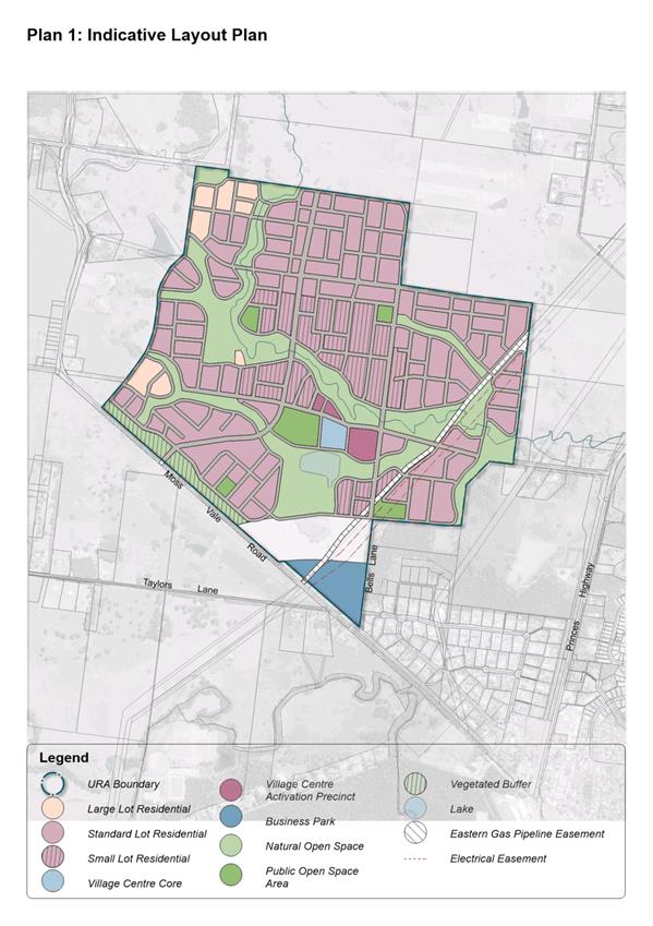
Proposed Development Outcome
The current indicative
layout plan for the URA is provided as Attachment 1. This indicative
outcome has been informed by the recommendations of necessary technical studies
and NSW Government Agencies’ feedback to date on the PP. Current work and
additional feedback from NSW Government Agencies may result in further changes.
Notable highlighted adjustments/revisions include:
· To
implement the recommendations of independent reports on the retail centre:
o Locating
the centre close to the intersection of Bells and Abernethys Lane (two
collector roads) and a unique setting close to a retained natural area and
waterbody.
o The
proposed structure of the centre to include a retail core and surrounding
activation precincts to deliver flexibility for a range of residential and
business uses, provide opportunities for early activation of the centre and
strengthen its trading once delivered.
· Locating
the area allowing small lots (a measure to increase housing diversity) to
complement the revised centre location. Approximately 27 hectares of the URA is
provided with the ability to deliver smaller lots (subject to demand etc),
principally within the walking catchment of the retail centre and areas with
high amenity (open space and riparian corridors).
· The
identification of active and passive open space in a variety of locations,
including close to the retail centre (co-locating community and retail uses),
connected to riparian corridors and containing remnant stands of significant
vegetation.
· In
response to the feedback received from the Environment, Energy and Science
Division of the NSW Department of Planning, Industry and Environment (DPIE),
the adjustment of two park locations and an additional large lot residential
area (previously general residential) to help secure three remnant stands of
significant vegetation. This will promote the retention
of this vegetation, its biodiversity values, and its contribution to urban
vegetation in the release area by providing space for its retention in public
open space and the gardens of large lots.
Planning Proposal
The PP has continued to be
refined in response to the recommendations of technical studies as they are
completed and as the feedback from NSW Government Agencies is received. The
Gateway determination set several conditions, including consultation and public
exhibition requirements, and the need for DPIE approval of the PP prior to
public consultation. DPIE’s Regional Team have been provided with
progress updates and copies of technical studies to facilitate its accelerated
consideration of the PP when required. It also confirmed that a public hearing
is not required, and the plan making authority has been delegated to Council,
which will assist with the faster finalisation of the new planning controls.
Consultation with NSW Government
Agencies commenced in January 2021. NRAR and NSW Fisheries are still to provide
feedback. RFS have been involved in discussions and formal feedback is still
required. The delay is understood to be in part due to resourcing constraints
and the following measures have been pursued to help secure/facilitate
feedback:
· Examination
of the Agencies’ published requirements and additional information to
justify/confirm the proposed changes to planning controls applying to riparian
corridors.
· Assistance
requested from the DPIE’s Planning Delivery Unit – a team set up to
facilitate agency feedback.
Consultation with RFS has recently commenced following
recent receipt of a contemporary bushfire study. It is anticipated this may
result in adjustments to asset protection zones adjacent to existing and
proposed natural areas and riparian corridors to manage the risk associated
with these areas as they are revegetated (naturally and planned) and the fuel
load increases. Options are being investigated to provide appropriate asset
protection zones in the design of the roads and adjacent verges (public and
private property). This may have an impact on where and how development can
occur. The ultimate outcome will be outlined in the documents proposed for
public exhibition.
All other Government agencies
have responded, with a summary of their submissions provided as Attachment
2. Full copies of submissions are included in the PP. Significant feedback
and resultant adjustments to the PP include:
1. NSW Heritage
- require an Aboriginal Cultural Heritage Assessment to support the PP.
The PP has been updated to confirm the recommendation of
the Aboriginal Archaeological Study (prepared by NSW Archaeology Pty Ltd in
2018) which noted that the URA is already zoned and that assessments be carried
out to support future development applications.
This approach has also been
confirmed with DPIE’s Regional Team.
2. Environment,
Energy and Science Division (part of DPIE) – requested that
environmental conservation zones be applied to three areas of moderate-high
condition vegetation currently proposed to be zoned residential (identified in Attachment
3).
Several options were examined in response, from applying
the requested zone to the identified areas through to the application of a
“sensitive vegetation overlay” in the LEP requiring additional
development considerations.
An environmental zone would potentially provide the best protection
for the vegetation; however, it would reduce the potential development area. It
also does not reflect the fragmented nature of the vegetation (e.g. it is not
connected to riparian corridors). Conversely, the use of an overlay in other
new subdivision areas has not necessarily resulted in the retention of
vegetation.
The adjustment of two park locations and an additional
large lot residential area and a supporting sensitive vegetation overlay
however provides a potentially balanced approach to manage this request. It
promotes the retention of the vegetation in open space and gardens and allows
development, albeit on larger lots resulting in the loss of about 17 lots. It
also “switches off” the alternative development approval pathway provided
by the NSW Government’s Complying Development Code from these areas. The
PP has been updated accordingly and now identifies necessary changes to the
land use zones, minimum lot size, and vegetation overlay maps.
Other required and recommended
amendments include:
· Additional
“permitted uses” to provide for extra commercial uses in the
Activation Precincts proposed to surround the retail centre and medium density
residential areas adjacent to the centre to encourage the delivery of units and
apartments (up to 3 storeys) over detached dwellings. These outcomes aim to
provide density to support the centre and respond to the recommendations of the
retail related studies.
· Consequential
rezoning of approximately 6,500m2 of an area previously proposed to
be zoned environmental conservation to residential as it does not contain
biodiversity resources.
· Minor
adjustment to the width of the scenic buffer along Moss Vale Road to reflect
the recommendations (road network layout) of the technical studies.
Development Control Plan
The draft set of development controls provided by the Owners
Group has been continually refined in response to the recommendations of the
technical studies and, more recently, through a comprehensive collaborative
review with relevant Council Departments (asset custodians, transport, drainage
and subdivision, recreation and development planners) to enable a good balanced
development outcome.
This work has resulted in the preparation of a draft
Development Control Plan (DCP) Chapter to guide the future development of the
URA. This document focuses on:
· Subdivision
and staging.
· Residential
development, including the promotion of a variety of housing types to provide
housing diversity and help meet the needs of the future community.
· The
street network and road design to provide a connected, safe, and efficient
movement network integrating with shared user pathways and public transport.
· The
design, function, and activation of the village centre.
· The
design of open space and natural areas, active and passive recreation, and the
protection and enhancement of riparian corridors and other vegetation.
· A
landscaping strategy.
· Management
of environmental risks (flooding and bush fire).
· Crossings
of and development in the vicinity of the high-pressure gas pipeline.
Remaining work underway will
confirm final controls for staging of subdivision and management of
environmental risks. It is intended to publicly exhibit the draft DCP chapter
in support of the PP.
Both the
updated PP document and draft DCP document (and the Council commissioned
studies that have informed them) are available at this
link
Development Contributions Framework
The purpose of the proposed
development contributions framework is to identify the full range and cost of
physical road, drainage, and community infrastructure (parks, playgrounds, and
other community facilities) needed to support the future community in this
location. The framework will also examine potential mechanisms to secure the
funding for the infrastructure.
The selection of infrastructure
is informed by the technical studies, for example the transport study,
community infrastructure report and yet to be completed water management study.
However, the NSW Government’s current infrastructure contribution reform
(foreshadowed but not yet finalised) and current “cap” on
development contributions ($20,000 per lot) will heavily influence the final
list of infrastructure and selection of mechanisms (funding and otherwise) to
help its delivery. Negotiations are currently underway to increase the cap for
the release area to $30,000 per lot.
This uncertainty means it is not
yet possible to settle a potential development contributions framework for the
URA at this point. As such it is proposed to bring a further report back to
Council once the detailed results of the reform and negotiations are known.
This will set out and seek the public exhibition of a proposed framework
providing a list of infrastructure, indicative costings, and a range of funding
mechanisms. It is however intended to exhibit as much of the proposed framework
as possible alongside the PP and draft DCP Chapter and aim to ultimately
finalise all three documents at the same time.
Current work focuses on the final selection of
infrastructure, as well as concept designs and costings. It is also examining:
· Potential
contribution mechanisms, such as a new development contributions plan,
Voluntary Planning Agreement(s), and satisfactory arrangement development
controls.
· Other funding
sources such as special rate variations and future rounds of the NSW
Government’s Housing Acceleration Fund and Low-Cost Loan initiatives.
· Monetary
contributions towards the expansion and/or upgrade of existing district or
regional facilities and services.
· Necessary land
acquisitions.
· Mechanisms,
including funding, for the ongoing management of natural areas and bushfire
asset protection zones, and
· Indicative triggers
or timing for the delivery of infrastructure and payment of contributions.
Suburb Naming
Consultation with the NSW Geographical Names Board (GNB)
confirmed its preference for new suburb arrangements for the two Moss Vale Road
URAs to:
· Distinguish
between the new URAs and adjacent rural areas, helping to contribute to the
identity of the new community.
· Capture the URAs,
noting the size, both area and number of proposed homes, and range of other
uses (retail and open space).
· Provide clear and
consistent addressing for future residents, emergency services and postal and
delivery services.
The GNB has a policy preference for the use of indigenous
naming options and through research and collaboration with the Nowra Local
Aboriginal Land Council and Council’s Aboriginal Advisory Committee the
following options have been identified:
· Badagarang
(Bad-a-garang) meaning Eastern Grey Kangaroo – a Dharawal Totem.
· Gumbeengang
(Goom-been-gang) a traditional name for Cambewarra Mountain.
To enable the new suburb naming to be settled, the two
options now need to be publicly exhibited for community feedback (28 days) and
a future report presented for Council’s consideration on the outcome of
this.
Once a preferred name has been
selected, it will be progressed through the GNB’s process, which includes
a separate and independent community engagement exercise. An indicative
boundary for the new suburb will also be settled with the GNB.
Infrastructure Delivery
Work is well advanced on the
planning and delivery of road, water and wastewater infrastructure to service
the two URAs. Council is delivering the infrastructure with grant funding from
the NSW Government’s Housing Acceleration Fund (HAF). This includes:
· Water:
Delivery of new mains, upgrades and extensions to existing mains, new pumping
stations, and a new reservoir. Work will be delivered in stages from 2022-2029
in response to demand. Construction of lead-in mains along Moss Vale Road and
Main Road has commenced and will provide interim connections.
· Wastewater:
Delivery of new mains, three new pumping stations, and connections to existing
wastewater treatment plant is scheduled for delivery between 2022-24.
· Release area
roundabout: Delivery of the first major road intersection providing access
for the URA’s from Moss Vale Road. The developer of Moss Vale Road South
- Stage 1 DA will construct the roundabout with Transport for NSW and Council
oversight. Construction is expected to be completed by the end of 2021.
Next steps
On completion of the remaining
technical studies and consultation with NSW Government Agencies, the PP and
Draft DCP Chapter will be finalised for public exhibition. Prior to the
exhibition occurring the PP will be submitted to DPIE for review and approval
(a requirement of the Gateway determination). To allow amendments to these
documents in response to the technical studies, agency responses, and any
further direction from DPIE, it is recommended that delegation be given to the
CEO (Director – City Futures) to make any necessary changes. This will
enable this priority project to keep moving by avoiding the need for a further
Council decision until the public exhibition is complete, helping to progress
the delivery of the release area within the remaining timeframe set by the
current Gateway determination (December 2021).
The proposed reports to future
Council meetings include:
· Details of the
proposed development contributions framework, including proposed public exhibition
arrangements.
· Results of the
public exhibition of the PP and draft DCP.
· Results of the
public exhibition of the suburb naming options.
· Results
of the public exhibition of the proposed development contributions framework.
Interim updates on the PP, draft
DCP and suburb naming will be issued as key milestones are reached, such as on
the exhibition process and notification arrangements at the start of exhibition
periods.
Community
Engagement
Monthly updates are issued to
the Moss Vale Road North Owners Group and other landowners within the release
area. On 9 July 2021, a meeting was held with landowners (all were invited) to
provide an update ahead of this meeting and outline the changes to the
indicative development outcome.
The Gateway determination
requires the formal public exhibition of the PP for a minimum period of 28
days. It is proposed to publicly exhibit the draft DCP chapter and as much of
the proposed development contributions framework as possible at the same time.
The complete proposed development contributions framework will be the subject
of a separate exhibition when all the detail is known.
The exhibition of suburb naming
options will occur separate from the planning documents to ensure suburb
arrangements are settled prior to the delivery of a substantial number of homes
in the two release areas.
This project has a dedicated
page on Council’s “Get Involved” engagement website:
www.getinvolved.shoalhaven.nsw.gov.au/planning-for-growth-nowra-and-bomaderry.
This will be the focus of
ongoing community engagement and will provide copies of the planning documents,
exhibition information and advice on how to make a submission and seek more
information. Notification of affected and adjacent landowners will also occur,
and relevant updates will be issued to relevant Community Consultative Bodies.
Policy Implications
The adjusted indicative development outcome outlined in this
report builds on the Owner Group’s proposal to facilitate the delivery of
a high-quality urban development outcome and much needed new living area in
Nowra-Bomaderry. The finalisation of the planning documents for the URA is a
high priority project, confirmed by Council’s earlier decisions and the
adopted Strategic Planning Works Program. The documents, when finalised, will
facilitate subdivision activity and the release of lots, helping to meet
identified housing demand.
Financial Implications
In response to the high priority
placed on the project, a dedicated project team has been working on it within
Councils Strategic Planning Team. Significant funds have also been spent on
necessary technical studies to ensure the investigation and preparation of a
well-founded and responsible development outcome. There is likely to be a range
of longer-term financial and resourcing considerations for Council associated
with the delivery of the release area which will be addressed in future
reports.
Delay in the delivery of the
planning documents also has implications for the current landowners who
continue to pay “holding costs” and other associated ownership
costs.
Risk Implications
This report, the work leading to
it, and the recommendation contributes to the completion of the suite of
planning documents managing the future development and infrastructure delivery
for the release area. Any delays to the project ultimately delay the delivery
of new homes in the URA. Current risks include:
· The
requirements of the RFS (to be confirmed through ongoing consultation).
· Feedback
from NRAR.
· DPIE’s
consideration of Heritage NSW’s request for an Aboriginal Cultural
Heritage Assessment (estimated to take 12-18 months and a cost of $200,000).
· Any
DPIE requirements stemming from its review of the final PP prior to public
exhibition.
· The
outcomes of the NSW Government’s contribution review and new limitations
on the delivery of the infrastructure necessary to support the future
community.
The public exhibition of the PP and draft DCP may also trigger
the lodgement of subdivision or development applications to deliver the future
release areas. However, further amendments to the planning documents is highly
likely in response to technical studies, NSW Government Agency feedback,
community consultation etc. As such the lodgement of development applications
prior to the substantial completion of the planning documents should be
strongly avoided/discouraged as it will lead to a delay in assessment timeframes
and potential refusal of development consent or substantial modification of
applications and associated costs.
|

|
Development
& Environment Committee – Tuesday 13 July 2021
Page
0
|
|
|
Development
& Environment Committee – Tuesday 13 July 2021
Page
0
|
|
|
Development
& Environment Committee – Tuesday 13 July 2021
Page
0
|

|
|
Development
& Environment Committee – Tuesday 13 July 2021
Page
0
|
DE21.66 Proposed
Planning Agreement - Stage 1 Moss Vale Road South Urban Release Area - Lot 1 DP
949932 - SF10632
HPERM Ref: D21/252061
Department: Strategic
Planning
Approver: Robert
Domm, Director - City Futures
Attachments: 1. VPA
Letter of Offer and Associated Plan ⇩
Reason for Report
Obtain ‘in principle’ support to commence the
process of entering into a Voluntary Planning Agreement (VPA) with the
Owner/Developer (Cambewarra Ventures Pty Ltd) of Lot 1 DP 949932, Taylors Lane,
Cambewarra relating to the construction of road and drainage infrastructure and
acquisition of a drainage reserve.
|
Recommendation (Item to be determined under delegated authority)
That
Council:
1. Provide ‘in-principle’
support to finalise negotiations and enter into a Voluntary Planning
Agreement (VPA) with the Owner/Developer of Lot 1 DP 949932,
Taylors Lane Cambewarra for the following; except where further
negotiations result in substantial changes to the proposal, in which case
Council will receive a further report prior to finalisation:
a. Acquisition
of a drainage reserve (Lot 29) and wetland construction
b. Construction of the roundabout at
the intersection of Road01 and Road02.
c. Construction of part of Road01,
including access from Moss Vale Road to the
Road01 and Road02 roundabout, associated
pathways and the kerb returns and pavement construction at the intersection
of Road01 and Taylors Lane, adjacent to Lots 37 and 51.
d. Offset conditioned s7.11
contributions for SF10632 relating to 01DRAI0006 and 01ROAD0154 against the
relevant construction costs, and reimbursement of the balance of construction
works undertaken above.
e. Waiver of 01DRAI0006 contributions
relating to approved Lots 38-51 and 53.
2. Delegate
authority to Council’s Chief Executive Officer, or his delegate, to:
a. Prepare the draft VPA and associated
Explanatory Note, including the addition of a provisional clause encompassing
the security of indexation in line with the Shoalhaven Contributions Plan
2019 to compensate for inflation and the potential timing of the VPA.
b. Publicly exhibit the draft VPA and
associated Explanatory Note for a minimum period of 28 days as required by
legislation.
c. Enter into the Agreement consistent
with the detailed key terms, except where objections or substantial issues
are raised as a result of public notification, in which case the Agreement is
to be reported to Council before it is entered into.
3. Notify landowners adjacent to the
subject land of the public exhibition arrangements in due course.
|
Options
1. As recommended.
Implications: The proposed VPA will result in a
positive public benefit through the construction of essential road and drainage
infrastructure to support the first stage of the Moss Vale Road South Urban
Release Area (URA). The delivery of this URA is a priority of Council and funds
have specifically been obtained (Low Cost Loans and deleted funds -
contributions “recoupment fund”) to facilitate the early delivery
of this infrastructure.
SF10632 will bring 46 residential lots to the market and
the subdivision also establishes the lead in road infrastructure to the initial
stages of the URA and the roundabout at Moss Vale Road which will enable subsequent
subdivision throughout the URA to occur.
2. Adopt an
alternative recommendation.
Implications: An alternative recommendation may
affect the timely delivery of the lead in infrastructure for Stage 1 and the
wider URA which may delay the release of much needed land to the market in the
Nowra-Bomaderry area.
Background
Development consent (SF10632, subsequently modified) was
granted on 5 June 2020 for a staged residential subdivision to create 46
residential lots, three open space lots and one residue lot (plus associated
road, drainage and utility infrastructure and landscaping) at Lot 1 DP 949932,
Taylors Lane Cambewarra. This subdivision is the first stage in the release of
the Moss Vale Road South URA and construction has now commenced on site.
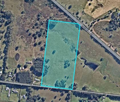
Figure 1: Aerial of subject land
The Letter of Offer
Following initial negotiations, Council received a letter of
offer for a VPA from the developer in June 2021. The letter of offer and
associated plan can are provided as Attachment 1. An excerpt of the plan
at Attachment 1 is provided as Figure 2 below for convenience. The other
attachments can be provided to Councillors upon request if required.
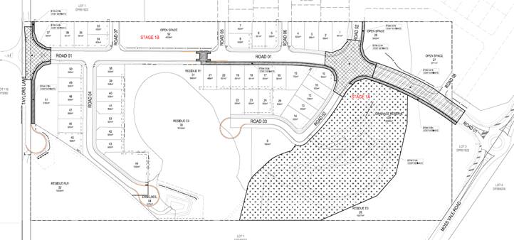
Figure 2: Indicative subdivision layout (Source: Maker
Engineering, June 2021)
The VPA letter of offer proposes:
· Acquisition
of a drainage reserve (Lot 29) for detention and water quality treatment and
construction of a wetland within Lot 29.
· Drainage
basin construction (Lot 54).
· Construction
of the roundabout at the intersection of Road01 and Road02.
· Construction
of part of Road01, including:
- Pathway.
- Access
road from Moss Vale Road to the Road01 and Road02 roundabout.
- Kerb
returns and pavement construction at the intersection of Road01 and Taylors
Lane, adjacent to Lots 37 and 51.
· Payment
of conditioned monetary contributions and reimbursement for all construction
works undertaken (excluding wetland at Lot 54). The developer has since advised
that offsetting contributions is preferable to paying conditioned monetary
contributions up front.
· Waiver
of 01DRAI0006 contributions relating to 15 lots.
Each of the above matters are discussed in more detail
below.
Drainage
Reserves
The VPA letter of offer proposes
the:
· Acquisition
of a drainage reserve (Lot 29) and wetland construction.
· Drainage
basin construction (Lot 54).
The Shoalhaven Contributions
Plan CP) 2019 identifies two drainage infrastructure locations in the
Contributions Project 01DRAI0006 Moss
Vale Road South URA Drainage relating to Lot 1, as shown in Figure 3 below.
These are known as discharge points B1 and C1 which relate to biofiltration
devices with associated swales. Whilst identified for acquisition, the
acquisition was planned to occur via Contributions Plan project 01OREC5015 Moss
Vale Road South URA Passive Recreation as drainage infrastructure was
intended to be co-located with the passive recreation spaces to rationalise the
land required and resulting acquisition costs.
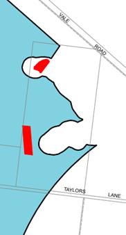
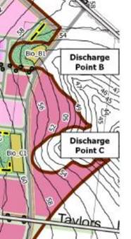
Figure 3: Contributions Project 01DRAI0006 drainage
infrastructure locations
Through the assessment of
SF10632, an alternative drainage infrastructure design and location was
approved. Instead of two bioretention devices, a larger wetland (Lot 29) and a
separate smaller bioretention device (Lot 54) were approved. The wetland is not
co-located with the passive recreation networks (proposed lots 26, 27 and 52)
and the ultimate design and location of the drainage reserve and wetland have
been accepted by Council. The approved bioretention device at Lot 54 exceeds
the requirements of the CP and is to be constructed and dedicated to Council by
the developer.
As a result of the above
approved changes, an additional area of 20,088m2 is required to be
acquired for the Lot 29 drainage reserve. The agreed acquisition value is
17.50m2 which results in a total acquisition cost of $351,540.
The estimated construction cost
(2017 values) of the drainage devices in Lot 1 as per the CP was in the
vicinity of $252,000+. The wetland at Lot 29 is a much larger device and is
expected to cost $799,869.61 ($1,119,817.45 including survey/design,
geotechnical, project management and contingency). The difference can be
managed and is expected to be recovered in the following ways:
· A
future modification to contributions project 01DRAI0006 to reflect updated
costs will recover significant proportion of this difference for any future
consents issued within the URA after the modification would come into effect.
· The
CP anticipates that the URA will deliver 840 equivalent tenements. It is likely
that this number will be higher, however, especially considering the increase
in popularity of secondary dwellings and dual occupancy development.
· It
is noted that the increased construction costs will be offset to an extent by
the reduced maintenance required for the wetland into the future, compared to
the bioretention device.
Council has been successful in
obtaining Low Cost Loan funding from the NSW Government for the 01DRAI0006
contributions project and deleted funds have also been allocated to the
project, which means the full value of construction costs eligible are
available and can be reimbursed at the appropriate point and acquisition costs
can be covered up front.
The construction of the drainage device at Lot 54 should not
form part of the VPA as this infrastructure is to be provided by the developer
and does not form part of the CP requirements for the site.
Road
and Roundabout
The VPA letter of offer proposes
the:
· Construction
of the roundabout at the intersection of Road01 and Road02.
· Construction
of Road01, including:
- Pathway.
- Access
road from Moss Vale Road to the Road01 and Road02 roundabout.
- Kerb
returns and pavement construction at the intersection of Road01 and Taylors
Lane, adjacent to Lots 37 and 51.
The CP identifies the need for
road, roundabout and shared path/threshold crossing construction in the
Contributions Project 01ROAD0154 Moss
Vale Road South URA Roads relating to Lot 1, as shown in Figure 4 below.
The annotations in Figure 4 relate to:
1. Road construction,
including kerb & gutter, passing lane, drainage, lighting, landscape median
and acquisition. It is noted that the acquisition is being considered
separately by Council.
2. Shared pathways and
crossing thresholds.
3. Roundabouts.
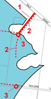
Figure 4: Contributions Project 01ROAD0154 road infrastructure
locations
The ultimate design and location
of the road infrastructure has been accepted by Council through the Subdivision
Works Certificate process.
It is noted that a roundabout is
required at the intersection of Taylors Lane and Road01 as per the CP; however,
the roundabout will not be constructed at this point in time as the Taylors
Lane Corridor Review that is being separately undertaken by Council has not yet
been finalised. At the appropriate point, the roundabout will be constructed by
Council with funds collected from s7.11 contributions. As such, the VPA letter
of offer proposes partial pavement construction and the kerb returns adjacent
to approved Lots 37 and 51. Whilst this is not ideal and the preference is that
no construction occurs along Taylors Lane until the Taylors Lane Corridor
Review has been completed, it is noted that the developer does have consent to
undertake this work, and this is therefore considered an acceptable
compromise.
The estimated construction cost
of the road works is $1,678,831.80. Council has been successful in also
obtaining Low Cost Loan funding from the NSW Government for the 01ROAD0154
contributions project and deleted funds have also been allocated to the
project, which means the full value of construction costs eligible for
reimbursement are available and can be reimbursed at that appropriate point. No
further funds need to be secured.
Delegation Opportunities
In accordance with
Council’s Planning
Agreement Policy, Council may resolve to delegate authority to Council’s
Chief Executive Officer, or his delegate, to negotiate, publicly notify, enter
into and register the VPA.
The proposal is supported ‘in principle’, noting
that detailed costings submitted by the developer will need to be peer
reviewed. The extent to which s7.11 contributions are considered in the VPA also
needs to be resolved (see further discussion point below). However, it is
considered that these matters can be addressed relatively easily and quickly.
As such, it is recommended that Council extend delegation for the above
functions, unless:
· The
peer review determines that the costs are substantially different to those
outlined in the report, in which case Council will receive a further report
prior to finalisation.
· There
are objections or substantial issues raised as a result of public notification,
in which case Council will receive a further report prior to
finalisation.
Conclusion
Due to the public benefit realised from the upfront delivery
of the road and drainage infrastructure relating to Stage 1 of the Moss Vale
Road South Urban Release Area, it is in Council’s interest to support the
proposal, finalise negotiations and proceed to prepare and publicly exhibit the
draft VPA for review and comment.
Community Engagement
The Environmental Planning and Assessment Regulation 2000
requires that the draft VPA be publicly exhibited for a minimum period of 28
days. Community engagement will be encouraged through the public exhibition
period.
Policy Implications
Following the construction of
the road works relating to Stage 1 envisaged in the proposed VPA, changes to
the current contributions plan project 01ROAD0154 would be required in due
course. Changes would reflect the partial completion status of the project,
updated cost estimates, and subsequent changes to the contribution rate.
Following acquisition of the
drainage reserve at Lot 29 and construction of the wetland as envisaged in the
proposed VPA, 01DRAI0006 will need to be amended. Changes would reflect the
partial completion status of the project, additional acquisition costs, updated
cost estimates and device locations, reduction in equivalent tenements
benefiting from the infrastructure and subsequent changes to the contribution
rate.
The changes to 01ROAD0154 and
01DRAI0006 can be undertaken as part of a future amendment/s to the Shoalhaven
CP 2019 and would be reported separately at the appropriate point in time.
Risk and Financial Implications
Detailed Costings
As part of the VPA letter of
offer package, the developer has submitted detailed costings for the
construction elements. As per standard procedure, these costings will need to
be peer reviewed for probity purposes.
In addition to the standard
construction costs, the peer review will also need to consider the percentage
set aside for survey/design, geotechnical, project management and contingency.
The developer has set aside the percentage based on the 01DRAI0006
contributions project estimates (based on concepts) which may need to be refined
through the detailed costing process.
It is recommended that the peer review be undertaken
following Council’s ‘in-principle’ endorsement of the
proposed VPA. Council will receive a further report prior to finalisation
should the costs be substantially different to those outlined in this report.
Development Contributions
Consent Conditions, Reimbursement for Construction & COVID Subsidy
The developer initially proposed
to pay s7.11 contributions up front; however, now seeks that the levied SF10632
s7.11 contributions be offset against the construction costs. The developer
also seeks reimbursement for all construction works (excluding the wetland at
Lot 54), minus the s7.11 contributions offset. This is satisfactory as this is
common practice and funds are available for the reimbursement (combination of
Low Cost Loan funding and deleted funds). The s7.11 contributions offset will
only apply to 01DRAI0006 and 01ROAD0154 and monetary contributions for all
other relevant contributions projects will still be required.
As part of the final
negotiations, the extent that s7.11 contributions are considered in the VPA
will need to be considered. Essentially, will the VPA relate to 01DRAI0006 and
01ROAD0154 contributions only (the consent retains the balance), or are all
conditioned contributions covered by the VPA.
The developer has requested that
Council waive contributions for 01DRAI0006 for Lots 38-51 and 53 (15 lots,
total $50,652.75, 2020-21FY) to recognise that these lots benefit from the
smaller bioretention basin to the south (Lot 54) and they do not result in any
demand on the broader drainage infrastructure specified in the CP. The developer
is proposing to undertake all construction works and land dedication relating
to this device as per consent conditions. It is agreed that the 15 lots benefit
from the device at Lot 54 only and it is considered reasonable that 01DRAI0006
contributions are not levied for these lots as they are not placing any demand
on the drainage infrastructure specified in the 01DRAI0006 project.
Should Council endorse the
progression of the proposed VPA, the development consent for SF10632 will need
to be modified to:
· Reflect the s7.11
contributions offset for 01DRAI0006 and 01ROAD0154 in the VPA, as well as the
waiver of contributions relating to Lots 38-51 and 53 for 01DRAI0006.
· Relocate s7.11
contributions required for the remaining projects to the VPA (need depends on
final negotiations with Developer).
· Reference
the VPA where relevant.
Depending on when the SF10632 s7.11 contributions are paid
(or works undertaken in kind), the development may be eligible for the COVID-19
Contributions Discount Subsidy (refer to the COVID-19
Contributions Discount Subsidy Policy), noting the eligibility criteria and
exclusions within. The Subsidy should be considered separately to the VPA, however
the VPA mechanism should not be considered a reason for ineligibility as the
monetary contributions are essentially being paid by works in kind.
Costs associated with the
drafting, exhibition and entering into the VPA
In accordance with
Council’s Planning
Agreement Policy, the Developer will cover Council’s costs (direct
and incidental) relating to the negotiation, preparation and entering into the
agreement (including associated legal costs) and enforcing the agreement. This
has been recognised in the letter of offer.
It is noted that the letter of offer package included a
draft VPA based on Council’s template. The draft VPA will need to
be peer reviewed by a legal professional at the Developer’s cost.
The letter of offer is also based on costings prepared for the developer. For
probity reasons, these costings will also need to be peer reviewed prior to
acceptance.
|

|
Development
& Environment Committee – Tuesday 13 July 2021
Page
0
|
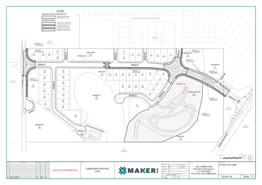
|
|
Development
& Environment Committee – Tuesday 13 July 2021
Page
0
|
DE21.67 Proposed
Planning Agreement - Construction of Kent Lane, Huskisson
HPERM Ref: D21/235221
Department: Strategic
Planning
Approver: Robert
Domm, Director - City Futures
Attachments: 1. Letter
of Offer for Proposed Agreement ⇩
Reason for Report
Obtain ‘in principle’ support to commence the
process of entering into a Planning Agreement (PA) with the owner and
developers (Binah Developments Pty Ltd & SK Group Manufacturing Australia
Pty Ltd) Lots A and B DP 390332, 15-17 Fegen Street, Huskisson for the
construction of Kent Lane, Huskisson.
|
Recommendation (Item to be determined under delegated authority)
That
Council:
1. Provide ‘in-principle’
support to enter into a Voluntary Planning Agreement (VPA) with the owner and developers of
Lots A and B DP 390332, 15-17 Fegen Street, Huskisson for the construction of
Kent Lane, Huskisson as detailed in the
letter of offer at Attachment 1 and in accordance with the design drawings specified in the Amended Engineer Design
Approval issued by Council on 4 May 2021.
2. Endorse the allocation of
‘deleted funds’ to cover the shortfall in funds available
(approximately $108,572.34 in 2020-21 Financial Year).
3. Delegate
authority to Council’s Chief Executive Officer, or his delegate, to:
a. Prepare the draft VPA and associated
Explanatory Note, including the addition of a provisional clause encompassing
the security of indexation in line with the Shoalhaven Contributions Plan
2019 to compensate for inflation and the potential timing of the VPA.
b. Publicly exhibit the draft VPA and
associated Explanatory Note for a minimum period of 28 days as required by
legislation.
c. Enter into the Planning Agreement
consistent with the detailed key terms, except where objections or
substantial issues are raised as a result of public notification, in which
case the Planning Agreement is to be reported to Council before it is entered
into.
4. Notify landowners adjacent to Kent
Lane of the public exhibition arrangements in due course.
|
Options
1. As recommended.
Implications: The proposed VPA will result in a
positive public benefit through the construction of Kent Lane, Huskisson; and
will also assist in satisfying consent conditions relating to the approved
adjoining residential apartment development (DA17/2574) enabling this
development to proceed.
2. Adopt an
alternative recommendation.
Implications: An alternative recommendation may
affect the timely delivery of Kent Lane and the ability of the Developer to
satisfy consent conditions that require the construction of Kent Lane to be
completed prior to the occupation of the development.
Background
On 4 January 2019, development consent (DA17/2574) was
granted for two residential flat buildings at 15-17 Fegen Street, Huskisson
(Figure 1 below), containing 25 dwelling units and basement parking.
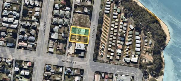
Figure 1: 15-17 Fegen Street, Huskisson (the Site)
Vehicular access to the site is via Kent Lane only, and the
developer is required to upgrade and reconstruct Kent Lane prior to the
development being occupied.
The construction of Kent Lane is a
road project identified in the current Shoalhaven Contributions Plan 2019 as 03ROAD5060 Kent
Lane – Huskisson (formerly 03ROAD2060) and is also a requirement of
Shoalhaven Development Control Plan 2014, Chapter N19: Huskisson Mixed Use
Zones. Contributions project 03ROAD5060 seeks to provide improved, efficient
and safe public road networks through the construction of Kent Lane between
Bowen and Nowra Streets.
Construction of Kent Lane is
expected to cost $324,317.14 to construct, based on the recently obtained
independent costings. These costings are based on the design drawings specified
in the Amended Engineer Design Approval issued by Council on 4 May 2021. It is noted that DA17/2574 was modified on 8 June 2021
(DS21/1093), however this modification did not make any changes to the Kent
Lane construction obligations or designs.
Letter of Offer
The Letter of Offer submitted by
the developer (Attachment 1) proposes:
· To
construct Kent Lane on behalf of Council.
· To
contribute $162,967.80 towards the construction, which is the value of the
s7.11 development contributions levied for DA17/2574 (as indexed, 2020-21 FY).
· That
Council cover the shortfall of $161,349.34 (2020-21 FY).
A VPA is considered to be an appropriate way to deliver this
infrastructure as the cost of the works exceeds the Developer’s
contribution for the project (i.e., it is not purely works-in-kind) and the
shortfall needs to be addressed in some way.
Options to Address the Funding Shortfall
The contributions payable for 03ROAD2060 for DA17/2574
represents approximately 50% of the cost of the construction of Kent Lane. This
means that a funding source needs to be identified for the remaining 50%
($161,349.34 (20-21 FY)).
To date approximately $52,777 in
s7.11 contributions has been collected (and is available to spend) for the
03ROAD5060 project, which should be used in the first instance.
It is preferable that the
balance of $108,572.34 be covered by recently received deleted funds. On 2
April 2019, Council resolved (MIN19.212(4)) to:
Endorse the position that all funds from deleted projects
are to remain within each relevant planning area and be transferred to a
“recoupment fund”, with those funds used as Council's apportionment
towards projects and to provide seed funding for community infrastructure
projects identified in the revised contributions plan.
This project is an excellent
candidate for the use of deleted funds and this option is preferred.
Alternatively, the balance of
$108,572.34 could possibly be covered by the developer upfront. The VPA could
be drafted so that regular claims can be made for any contributions received
overtime for 03ROAD5060 to the value of the difference (i.e. a reimbursement
mechanism). Whilst this is a viable option, it is not preferred as deleted
funds have been set aside by Council specifically to ‘seed fund’
infrastructure delivery in circumstances like Kent Lane.
Delegation Opportunities
In accordance with Council’s Planning
Agreement Policy, Council may resolve to delegate authority to
Council’s Chief Executive Officer, or his delegate, to negotiate,
publicly notify, enter into and register the Planning Agreement. As the
proposed VPA is relatively straightforward, it is recommended that Council
extend delegation for the above functions, unless there are objections or
substantial issues raised as a result of public notification, in which case
Council will receive a further report prior to finalisation.
Conclusion
Due to the public benefit realised from the ultimate
construction of Kent Lane, it is in Council’s interest to support the
proposal and proceed to prepare and publicly exhibit the draft VPA for review
and comment.
Community Engagement
The Environmental Planning and Assessment Regulation 2000
requires that draft VPA be publicly exhibited for a minimum period of 28 days.
Community engagement will be encouraged through the public exhibition period.
Financial Implications
Council Contribution for road
design and construction
The Developer has requested that Council cover the shortfall
between the contributions payable for 03ROAD5060 for DA17/2574 and the
construction value of Kent Lane. As discussed above, it is considered
appropriate that the shortfall be managed through the use of the s7.11 contributions
collected for the 03ROAD5060 project to date ($52,777) and recently received
deleted funds. This is consistent with Council’s resolution
(MIN19.212(4)) to support the provision of seed funding for community
infrastructure projects.
Development Contributions Consent Conditions
Should Council endorse the progression of the VPA proposal,
the development consent for DA17/2574 will need to be modified to remove the
application of s7.11 contributions for 03ROAD5060, and insert a suitable
condition relating to the VPA to reflect the offset.
Costs associated with the drafting, exhibition and
entering into the VPA
In accordance with Council’s Planning
Agreement Policy, the Developer will cover Council’s costs (direct
and incidental) relating to the negotiation, preparation and entering into the
agreement (including associated legal costs) and enforcing the agreement.
Policy Implications
Following the construction of Kent Lane as envisaged in the
draft VPA, changes to the current contributions plan project 03ROAD5060 will be
required. Changes should reflect the completed status of the project, the
actual costings, and subsequent changes to the contribution rate. This will be
undertaken as part of a future amendment to the Shoalhaven Contributions Plan
2019 and would be reported separately at the appropriate point in time.
|
|
Development
& Environment Committee – Tuesday 13 July 2021
Page
0
|
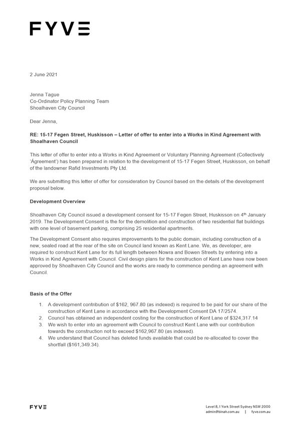
|
|
Development
& Environment Committee – Tuesday 13 July 2021
Page
0
|
DE21.68 Proposed
Finalisation - Voluntary Planning Agreement (VPA15): Landscape Screen, South of
Hitchcocks Lane, Berry
HPERM Ref: D21/237140
Department: Strategic
Planning
Approver: Robert
Domm, Director - City Futures
Reason for Report
· Present
the outcomes of the public exhibition of Voluntary Planning Agreement (VPA15)
relating to the establishment and maintenance of a proposed landscape screen
for visual impact mitigation associated with the rezoning and future
development of Lots 762 and 763 DP 1224932 (land south of Hitchcocks Lane at
Berry).
· Seek
Council endorsement to enter into VPA15 with the owners of the subject lots.
Options
1. Endorse and
enter into VPA15, as exhibited, for a landscape screen south of Hitchcocks
Lane, as exhibited – Recommended.
Implications: This is consistent with
Council’s previous resolution (of 11 May 2021 – MIN21.242) and will
enable the Planning Proposal (PP029) to rezone land for housing to be
finalised.
2. Make changes to
VPA15 - Not recommended.
Implications: VPA15 results from more than a
year-long negotiation between landowners and Council and is linked to the
finalisation of PP029. Changes may require re-exhibition and would delay the
rezoning of land for housing.
3. Not endorse and
finalise Planning Agreement VPA 15 – Not recommended.
Implications: The VPA is needed to ensure that the
landscape screen will be established as shown in the adopted Planning Proposal,
prior to development occurring on the land. Council adopted PP029 on the basis
that the VPA would be signed and registered on title before the Local
Environmental Plan (LEP) is amended to rezone the land. Not proceeding to enter
into the VPA would jeopardise the visual outcome and also delay the LEP
amendment.
Background
Council resolved on 11 May 2021,
to adopt Planning Proposal PP029 to rezone 11 ha of land south of Hitchcocks
Lane at Berry to R2 Low density residential to permit residential subdivision
(MIN21.242). The resolution included a requirement to finalise a Voluntary
Planning Agreement (VPA) with the landowners to provide a landscape screen
adjacent to the southern boundary of the development land.
Planning Agreements, also known
as VPAs, are a planning tool used to negotiate development outcomes for a
variety of public purposes. Establishing the intended landscape screen was a
key recommendation of the Visual Impact Assessment and Urban Design
Guidelines (May 2019), prepared by Peter Andrews and Associates to support
PP029.
Council first resolved to secure
the proponents’ commitment to implement the landscape screen through a
VPA on 7 April 2020 (MIN20.257) and reaffirmed this position on 1 September
2020 (MIN20.610) and 11 May 2021 (MIN21.242).
Resolution MIN21.242 included
the following parts:
2. Prepare
and exhibit a draft Planning Agreement for a Landscape Screen (to mitigate
visual impacts of development) based on the draft Planning Agreement Terms
(negotiated terms of agreement between Council and the proponents) for a
minimum of 28 days.
3. Liaise with
the NSW Parliamentary Counsel’s Office (PCO) to amend the Shoalhaven
Local Environmental Plan (LEP) 2014 under Council’s delegation, with
finalisation of the LEP amendment to occur only when the Planning Agreement for
the Landscape Screen is signed and registered.
As such, PP029 will be finalised
once VPA15 is signed and registered on the land. Thus, this report presents the
outcomes of the required public exhibition of the draft agreement (no
submissions received) and seeks Council endorsement to proceed to enter into
VPA15 to facilitate establishment and maintenance of the landscape Screen.
Proposal
Draft VPA15 was prepared in
discussion with the landowners (the proponents of PP029) throughout 2020 and
2021. It will facilitate the establishment and maintenance of a landscape screen,
adjacent to the southern boundary of land to be rezoned as part of PP029
– Part Lots 762 and 763 DP 1224932, south of Hitchcocks Lane, Berry (See
Figure 1 below).
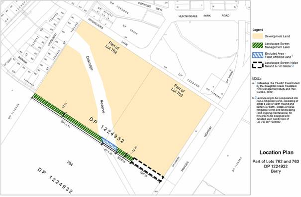
Figure 1
– Excerpt from exhibited VPA15 showing location of proposed landscape
screen
The proposed landscape screen is
intended to minimise visual impacts associated with the future development
enabled by PP029, and assist with the scenic amenity of the area.
The landscape screen will be
situated within a 12m wide strip of land adjacent to the southern boundary of
the development land (rezoned as part of PP029), and will be planted densely
with native trees, shrubs, and groundcovers.
The 12m wide strip of land will
consist of 8m of planted area and a 2m wide grassed area either side for
maintenance. The screen will extend approximately 300m along the southern
boundary of the development land. At maturity, the area is intended to present
as a strip of native bushland, largely obscuring views of development beyond. A
stock exclusion fence will be located along the southern boundary of the
landscape screen area to protect the plants from any livestock impacts
associated with neighbouring rural land uses. This fence will be the
responsibility of the rural landowner to maintain.
More detail is available in the
exhibition package - see below.
Excluded land –
flood-prone land and future noise barrier area.
No trees or shrubs are proposed
to be planted within the area affected by the 1% AEP flood extent, to ensure
drainage patterns and flood behaviour are not adversely impacted.
In addition, the Noise Impact
Assessment Update (February 2021) by Harwood Acoustics, submitted to
support PP029, identified a noise barrier(s) is/are likely to be required along
the south-eastern boundary of Lot 763 – see Figure 1 above.
Design of the noise barrier(s)
will depend on future proposed subdivision details. Noise mitigation
requirements are included in the new Chapter N3 Berry – West of the
Princes Highway in Shoalhaven DCP2014. Landscaping and maintenance requirements
for the noise barrier area will be worked out in more detail at subdivision
development application stage and therefore the affected area is excluded from
VPA15.
More information on the
landscape screen specifications can be found within the Landscaping Plan
included in VPA15 that was part of the exhibition package – see below.
Establishment
and Maintenance of Landscape Screen
The full landscape screen
subject to VPA15 will need to be established before the first subdivision
certificate is issued for the land. This means no housing development will
occur before the screen is planted.
The landscape screen will be
maintained in the short term (for a minimum of 3 years) by the
landowners/developers. After 3 years and upon meeting the terms of the VPA, the
landscape screen will be maintained by Council in perpetuity. The landscape
screen will be located on private land and accessed from the future perimeter
road(s). The VPA includes an interim provision, for Council to access the
screen via an easement, if required.
Importantly, the landscaping has been designed to be
low-maintenance and relatively self-sufficient over time as the plants
establish. Ultimately, the screen will appear and function as a strip of
bushland with very low ongoing maintenance obligations. As part of the VPA, the
landowners will fund the ongoing maintenance after handover (more information
is provided in the Financial Implications section of this report).
Community Engagement
VPA15 was publicly exhibited
between 2 June and 2 July 2021 (31 days), complying with the minimum 28 day
exhibition requirement of the Environmental Planning and Assessment
Regulation 2000 and Council’s Planning Agreements Policy.
The following documents were placed on Council’s
‘Documents on Exhibition’ webpage and are currently still available
to view (note: links will expire in August 2021):
The VPA was publicly notified on
Council’s webpage; notification letters were sent to neighbouring
property owners (11) and email notification was sent to the Berry Forum CCB and
the Huntingdale Park Resident Action Group for distribution amongst their networks.
The VPA is associated with the
Planning Proposal PP029 to rezone land south of Hitchcocks Lane at Berry, and
PP029 was publicly exhibited for 73 days between October 2020 and January 2021.
Therefore, it is considered that there is broad awareness of the proposal in
the local community.
No (0) submissions were received
during the public exhibition period for VPA15.
Internal Stakeholder
Engagement
Input from many sections across Council has informed the
preparation of the VPA and design and maintenance requirements of the landscape
screen.
Policy Implications
VPA15 has been prepared in accordance with the Environmental
Planning and Assessment Regulation 2000 (the EP&A Regulation) and is
consistent with DPIE’s Practice Note for Planning Agreements
(February 2021). In addition, VPA15 conforms with Council’s Planning
Agreements Policy (recently updated in January 2021).
Financial Implications
The costs associated with
preparation of VPA15 will be met by the landowners (proponents of PP029) in
accordance with Council’s Planning Agreements Policy.
The entire costs of establishing
the landscape screen and initial maintenance (minimum 3 year maintenance
period) will also be met by the landowners/developers of the land.
The VPA contains provisions that
require payment of a monetary contribution to Council upon satisfactory
completion of the establishment and initial maintenance of the landscape
screen. This contribution will be paid as a lump sum and invested by Council to
fund ongoing future maintenance.
The total
contribution to be paid to Council is $149,053 (indexed from the date of the
agreement to the date of payment in accordance with CPI). For information about
how these costs were calculated please refer to the FAQs and Monetary
Contributions Calculations Factsheet links in the Community Engagement Section
of this report.
VPA15 also contains provisions
for security payments to comply with Council’s Planning Agreement
Policy. In this case, the security payment amount seeks to cover the costs
related to any future enforcement of the agreement and any unrequired security
funds will be refunded to the landowners upon satisfactory completion of the
VPA obligations.
The VPA provides a mechanism to
secure ongoing funded maintenance of the landscape screen, with the developers
of the land funding the establishment phase and providing funding to Council to
pay for ongoing maintenance.
Risk Implications
VPA15 seeks to provide community
benefits and reduce risks of adverse visual impacts associated with future
development. Risks to Council and the broader community have been considered
and mitigated throughout the negotiation and legal drafting process.
Conclusion
VPA15 will provide public
benefits by way of visual impact mitigation, protection of scenic amenity and
enhancement of the natural environment. In addition, finalisation of VPA15 will
allow land to be rezoned for future housing delivery south of Hitchcocks Lane
at Berry. It is therefore recommended that Council endorse VPA15.
|
|
Development
& Environment Committee – Tuesday 13 July 2021
Page
0
|
DE21.69 Exhibition
Outcomes and Finalisation - Planning Proposal - Huntingdale Park Estate Large
Lot Residential Areas, Berry (PP060)
HPERM Ref: D21/228774
Department: Strategic
Planning
Approver: Robert
Domm, Director - City Futures
Attachments: 1. Summary
of Submissions - PP060 (under separate cover) ⇨
2. Final Planning Proposal
(PP060) Huntingdale Park Estate Large Lot Residential Areas (under separate
cover) ⇨
Reason for Report
· Consider the outcomes of the public exhibition of Planning
Proposal (PP060).
· Obtain
Council endorsement to finalise PP060 and amend the Shoalhaven Local
Environmental Plan (LEP) 2014 to rezone the large lot
areas of Huntingdale Park Estate in Berry to R5 Large Lot Residential and amend
the minimum subdivision lot size to 2000m2 to ensure the envisaged
outcome is reflected.
|
Recommendation (Item to be determined under delegated authority)
That Council:
1. Adopt Planning Proposal (PP060 -
Huntingdale Park Estate Large Lot Residential Areas) as exhibited, with the
minor changes outlined in this report, and proceed to amend the Shoalhaven
LEP 2014 to rezone the large lot areas of
Huntingdale Park Estate in Berry to R5 Large Lot Residential and amend the
minimum subdivision lot size to 2000m2.
2. Advise submitters and key
stakeholders of this decision when the LEP has been amended.
|
Options
1. As recommended.
Implications: This is the preferred option. The
resulting LEP amendment will ensure planning controls remain consistent with
established strategic planning objectives for the Huntingdale Park Estate.
2. Adopt an
alternative recommendation/change the PP.
Implications: This would depend on the nature of
any proposed change, and may require an alteration to the NSW State
Government-issued Gateway determination and re-exhibition of the PP.
3. Do not adopt the
PP.
Implications: This would result in the large lot
areas on the periphery of the Estate retaining the R1 General Residential zone.
The R1 zone allows (with consent) the additional subdivision of large lot areas
associated with higher density housing types and the Low Rise Housing Diversity
Code applies to the R1 zone, allowing for certain forms of higher density
development as Complying Development. Additional residential subdivision and
development in the area, beyond that which was originally intended, planned and
approved, could have character, environmental and infrastructure implications.
This option is not recommended.
Planning Proposal
In January 2021, Council resolved to rezone the large lot
areas of Huntingdale Park Estate (the Estate) in Berry to better align planning
controls with the desired character of the area that was originally established
through strategic planning processes and community engagement going back to at
least the Development Control Plan (DCP) No.70 that was first prepared for the
area in 1998. The January 2021 resolution (MIN21.5) reads:
That Council:
1. Endorse the
preparation of a Planning Proposal with the following scope, and proceed to
submit it to the NSW Government for a Gateway determination, and if this is
favourable, proceed to exhibition as per the legislative and any determination
requirements:
a. Huntingdale Park Estate
Precinct (Berry):
i. Rezone the subject
land to R5 Large Lot Residential.
ii. Set a 2,000m2
minimum lot size for the entirety of the subject land.
2. Receive a
further report following the conclusion of the public exhibition period or if
the Gateway determination is not favourable.
3. Advise key
stakeholders of this decision and the resultant exhibition arrangements,
including affected landowners, relevant Community Consultative Bodies and
Development Industry representatives.
The resolved Planning Proposal
(PP) was subsequently prepared (PP060) and a Gateway determination was issued
by the NSW Department of Planning, Industry and Environment (DPIE) on 16 April
2021.
The PP relates to the large lot
areas of the Estate (i.e. where property lot sizes are 2000m2 or
larger). There are forty-three (43) properties affected by the PP as shown on
the subject land map on the following page – the approved large lot areas
located on the western periphery, along Parker Crescent and Connors View. These
areas are generally consistent with the provisions of the DCP No.70 that were
originally established in 1998 and identified that the desired outcome for
subdivision on the western and northern edges was ‘larger lots –
minimum 2000m’. It is also noted that the remainder of Huntingdale Park
was identified in the DCP as ‘low density lots’.
The PP proposes the following
amendments to Shoalhaven Local Environmental Plan 2014:
· Rezone forty-two (42) existing large lots along the
western and northern boundary of the Estate from R1 General Residential to R5
Large Lot Residential.
· Increase the minimum lot size to 2000m2
across the entire area proposed to be zoned R5 Large Lot Residential.
· Apply a minimum lot size of 500m2 across
Lot 712 DP 1247531 (60 Parker Crescent). This lot is currently 784m2
and is not a large lot. The current R1 General Residential zone will be
retained over this property. This change rectifies a minimum lot size mapping
anomaly over this lot as it is currently mapped as having two different minimum
lot size restrictions.
The proposed R5 Large Lot
Residential Zone complements the established strategic planning aims for the
large lot areas of the Estate (established through the DCP and original
approvals) and allows for compatible low-density housing types on the lots that
have been created, orderly development, and efficient infrastructure planning
and delivery. Extending a 2,000m2 minimum lot size to all areas
within the precinct (currently part 500m2 and part 2,000m2)
will prevent future fragmentation of the approved large lots and help mitigate
any associated character, amenity and design concerns.
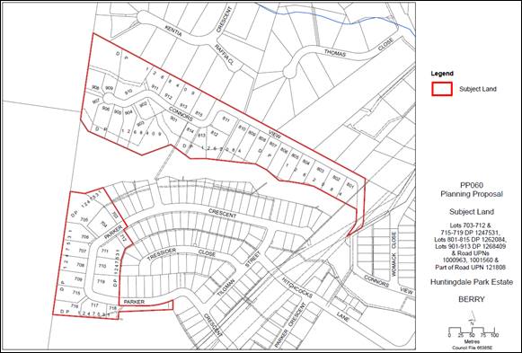
Figure 1: Subject Land Map PP060
Community Engagement
The PP was exhibited for thirty-one (31) days between 26 May
to 25 June 2021 (inclusive). The Gateway
determination required a public exhibition period of a minimum of 28 days.
The
exhibition was publicly notified via Council’s website. Affected and
adjoining landowners (74 households) were notified in writing. Key stakeholders
were also notified in writing, including Berry Forum (Community Consultative
Body); Huntingdale Park Resident Action Group; Berry Chamber of Commerce and
Tourism; Nowra Local Aboriginal Land Council and development Industry
representatives.
The PP
package was available on Council’s webpage and electronically at the
Nowra Administration Building as well as on the NSW Planning Portal
(PP2021-2380). The exhibition package comprised the following (Note:
links will expire in August 2021):
Community Feedback/Submissions Overview
Eighty-seven
(87) submissions were received during the exhibition period.
Eighty-five
(85) submissions expressed support for the proposal. The submissions of support
included twelve (12) form letters. One (1) submission was neutral on the
proposal and related to growth concerns in Berry generally. One (1) objection
was received.
The
submissions of support were made by seventy-nine (79) households (representing
117 people) and of these households, sixty-three (63) live in Huntingdale Park
Estate (representing 85 people).
The
submissions of support agreed the proposal would align the planning controls in
the LEP with the original strategic planning intent and desired future
character of the large lot areas. The submissions reiterated that many people
bought in the area because of the approved large lot characteristics. Many
submissions expressed concern about permissibility of medium density
development, additional further subdivision of large lots and the risk of
overdevelopment. The submissions in support noted the following additional
benefits of the PP:
· Protection of existing vegetation and wildlife habitat;
· Estate
will have a less built-up appearance and a positive interface with surrounding
rural landscapes and bushland (more in keeping with the character of Berry);
and
· Fewer
traffic and amenity impacts.
One
(1) submission (PDC Lawyers & Planners on behalf of an affected property
owner) objected to the proposal on the following grounds (summary):
· Will
devalue land - purchased it knowing multi-dwelling development was permitted.
· Will
limit housing supply in Berry which has little land available for in-demand
multi-dwelling development. Will limit affordability.
· Argue
that multi-dwelling housing was permissible under previous planning controls as
area was zoned 2(c) under pervious Shoalhaven LEP1985.
· Disagree
that permitted development (under R1 zoning) will have adverse visual impacts
– Estate established and largely screened by current and proposed future
landscaping.
· Disagree
that significant portion of community object to multi-dwelling development in
area (argue that the proportion of objections to the overall population size is
low).
· Disagree
that land is too far from public transport – it is a short drive to train
station.
· Disagree
need to protect rural land in this area, state neighbouring land unlikely to be
used for agriculture, mapped as severely limited in soil capability.
· Unsustainable
as large houses will be built on large lots and this is an underutilisation of
scarce land.
· Economic
impacts - will limit construction activity and Council will not meet housing
targets.
Overall,
the proposal is supported by strategic plans for, and relating to, the area
generally. These plans emphasise the importance of protecting rural land and
scenic landscapes around towns such as Berry. The PP seeks to preserve the
approved large lot character of the western edge of the Huntingdale Park
Estate.
The PP
has attracted strong support from residents in the Estate with these residents
commonly stating they value these blocks because of the low-density character,
rural and bushland outlook and amenity, as well as their rarity, with some
describing paying a premium for these characteristics.
Berry,
including Huntingdale Park Estate, is a high value area, with a median house
price of $1,365,000 and a median rental of $730 per week (June 2021, www.realestate.com.au).
Affordability
is a concern, and as a result of the PP if adopted/finalised, future
multi-dwelling housing will be prohibited on the 42 affected properties.
However, housing affordability is complex, with one housing type not
necessarily always more affordable than another, as affordability depends on
size, specification, tenure and local market and economic conditions.
Attached
dual occupancy and secondary dwellings (granny flats) will remain permissible
in the R5 zone, providing for some housing diversity and relative
affordability. In particular, secondary dwellings (granny flats) are
size-restricted and most likely to provide affordable housing options. Attached
dual occupancy and secondary dwellings are considered a compatible housing type
with the low-density character of the subject land.
Huntingdale
Park Estate, and the new release area south of Hitchcocks Lane, have been
planned to provide a new housing supply for Berry with a variety of housing
types. The PP reflects a place-based planning approach, recognising land
constraints and opportunities to protect and enhance local character whilst
providing new housing.
The PP
is also consistent with Council’s approach to larger subdivision areas
that were initially zoned Residential 2(c) under Shoalhaven LEP1985 (now zoned
R1 General Residential under LEP2014) that saw the zoning of the area change
when appropriate to reflect the nature/character of the subdivision once
approved. The initial 2(c)/R1 zoning provided some initial flexibility until the
final subdivision pattern is known or established and then areas rezoned
accordingly. This has occurred in various areas throughout the city and as such
is not an unusual approach.
Whilst it is acknowledged that more intensive forms of
housing were permissible under the previous general 2(c) zoning, Council had a
practice of using its DCP’s to identify areas where other forms of
housing would be encouraged/allowed and/or encouraged the identification of
more intensive lots (e.g. dual occupancy or medium density) at the subdivision
stage where possible. This was aimed at providing up front certainty to
potential purchasers in relevant areas. In this case the original DCP No.70
that applied to the area from 1998 through to 2014 identified the area as
‘low density lots’ and ‘larger lots – minimum
2000m’. It also identified a defined ‘medium density’ area
adjacent to Hitchcock Lane (essentially the area that is now zoned R3 Medium
Density).
The
future development of the adjacent Hitchcocks Lane subdivision, south-east of
the subject land, as outlined in Shoalhaven Growth Management Strategy 2014,
will also provide additional greenfield housing supply and construction for the
Berry area, including efficient use of land through provision of some smaller
lot sizes. By contrast, the steep, elevated ridgelines of the periphery of
Huntingdale Park Estate that are proposed to be rezoned were always intended to
be developed for large lot housing, as a physical and visual transition between
rural land, bushland and suburban development and the PP upholds this policy
position.
The
submissions are summarised and commented on in detail in Attachment 1:
Summary of Submissions. The actual submission can be made available to
Councillors if needed.
Minor changes to the PP document
have been made (see Attachment 2: Final Planning Proposal), to add
commentary regarding the PP’s consistency with the following strategic
plans: the recently adopted Illawarra-Shoalhaven Regional Plan 2014, Shoalhaven
Character Statements by Roberts Day (2019) and the Berry Community Strategic
Plan (2016). These changes have been made in response to concerns raised within
the objection regarding consistency with strategic plans. Importantly, these
changes add context to the proposal but do not affect the proposed planning
control amendments, and the proposal therefore remains the same as exhibited.
State Agency Consultation
The Gateway determination required consultation with the NSW
Rural Fire Service (RFS) and DPIE’s Biodiversity and Conservation Division
(BCD).
These agencies were consulted prior to the public exhibition.
On 7 May 2021, the RFS issued advice stating they had
considered the information and raised no concerns or issues in relation to
bushfire.
Comments from BCD were received on 6 May 2021 and they did not
object to the PP, recognising the proposed rezoning will (in principle) reduce
pressure to remove trees and vegetation given the lower density and intensity
of permitted uses.
BCD noted the riparian (creek)
corridors in the area contain significant vegetation and provide a link to
remnant vegetation west of the Estate. The BCD requested that the riparian
areas within the upper reaches of the Estate be rezoned from their current R1
General Residential Zone to E3 Environmental Management or similar to better
reflect their environmental character and function. The riparian corridor will
remain unchanged as part of this PP, and the corridor has been dedicated to
Council so is not under any development pressure. This suggested zoning change
to the riparian corridor is not within the scope of the current PP, but will be
considered as part of a future housekeeping amendment to the LEP.
Policy Implications
Consistency with strategic
plans and policies
This PP seeks to ensure planning
controls align with the established strategic planning intent for the large lot
residential areas of the Estate. The PP is consistent with relevant State and
Council strategies and policies, including (but not necessarily limited to):
the Illawarra Shoalhaven Regional Plan 2041; Shoalhaven Local Strategic
Planning Statement (Shoalhaven 2040) and the Shoalhaven Growth Management
Strategy 2014. Further detailed discussion on consistency with strategic
planning and development assessment decisions for the area is provided in the
PP document.
Dwelling Entitlements
The PP will maintain the
dwelling entitlements on all existing and approved lots. Lots within the R5
zone trigger clause 4.2D(3)(a) of Shoalhaven LEP 2014, which requires a lot to
have a dwelling entitlement prior to the erection of a dwelling house or dual
occupancy. As a result of this, all lots would be required to be greater than
2000m2 (the minimum lot size for the land) to meet the requirements
of clause 4.2D(3) or the lots would need to meet the requirements of another
part of clause 4.2D(3).
All lots proposed to be rezoned
from R1 General Residential to R5 Large Lot Residential contain an area greater
than 2000m², exceeding the minimum lot size for the land, and will
therefore continue to benefit from a dwelling entitlement.
Low Rise Housing Diversity
Code (Complying Development)
The Low Rise Housing Diversity Code (part of the State
Environmental Planning Policy (Exempt and Complying Development Codes) 2008)
does not apply to the R5 zone and medium density opportunities are therefore
limited. The Estate was planned to provide a variety of lot sizes and housing
types and medium density was not intended within the areas designated for
larger lots. Medium density development and low-density housing opportunities
are provided in the central, less constrained areas within the Estate.
Conclusion
This PP will ensure planning controls for large lots in
Huntingdale Park Estate in Berry align with the current and future desired
character of the area that was first established through detailed community
engagement in 1998. In addition, this PP responds to community concerns about
recent planning changes that impact the area and community support for the
proposed change was expressed during the public exhibition period. All
requirements of the Gateway determination have been met and it is recommended
that the PP be adopted and the associated amendments to Shoalhaven LEP 2014 be
made.
Financial Implications
There are no financial implications
resulting from this PP. As described above, this PP is aligned with strategic
plans. The PP is being resourced within the Strategic Planning budget.
Risk Implications
The proposal aligns with
strategic plans and development decisions for the area. Should the PP not
proceed, medium density housing types and further subdivision will remain
permissible (including as complying development) and development of this type
could impact on the area’s desired large lot character and scenic quality.
|
|
Development
& Environment Committee – Tuesday 13 July 2021
Page
0
|
DE21.70 Post
Exhibition & Finalisation Report - Planning Proposal (PP040) - Housekeeping
Amendment 2018 (Mapping) - Shoalhaven LEP 2014
HPERM Ref: D21/236166
Department: Strategic
Planning
Approver: Robert
Domm, Director - City Futures
Attachments: 1. Attachment
1 - Submission Summary - PP040 - 2018 Housekeeping - Mapping - External Version
⇩
Reason for Report
Detail
the outcomes of the public exhibition of Planning Proposal (PP040) – 2018
Housekeeping Amendment (Mapping) and enable the resultant amendments to
Shoalhaven Local Environmental Plan (LEP) 2014 to proceed to finalisation.
|
Recommendation (Item to be determined under delegated authority)
That
Council:
1. Adopt and finalise Planning Proposal
(PP040) as exhibited, with the changes outlined in Table 3 of this report,
and forward it to the NSW Department of Planning, Industry and Environment to
draft the amendment to Shoalhaven Local Environmental Plan 2014.
2. Advise key stakeholders, including
all Community Consultative Bodies, relevant industry representatives and
those who made a submission, of this decision, and when the Amendment will be
made effective.
|
Options
1. Adopt the
recommendation.
Implications: This is the preferred option as it
will ensure that the relevant housekeeping matters in the LEP are addressed and
progressed in a timely manner so that the plan operates correctly.
2. Adopt
an alternative recommendation.
Implications: Depending on its nature, this could
delay the progress of the Planning Proposal (PP) and the resulting amendments
to the LEP.
3. Not adopt the
recommendation.
Implications: This is not the preferred option as
the identified housekeeping matters will not be resolved.
Background
The Shoalhaven LEP 2014 is
continuously updated to ensure that it aligns with strategic documents, is
improved/corrected where necessary, relevant matters are resolved, and positive
planning outcomes are delivered for the community. As a result, Council has an
ongoing process of housekeeping amendments to improve the operation and
maintain the accuracy of the LEP.
PP040 intends to amend a number
of maps within the LEP to:
· Correct
identified anomalies or inconsistencies in the LEP mapping.
· Correct
administrative errors (e.g. items incorrectly or incompletely identified in
mapping).
· Respond
to the registration of new land titles, relevant landowner requests and
development assessment processes/outcomes.
The PP contains thirty-seven
(37) mapping items that were identified during the 2018 calendar year, which
cover a variety of more minor mapping issues relating to minimum lot size,
zoning, height, terrestrial biodiversity, bushfire, buffer zones, natural
resource sensitivity and land reservation acquisition.
Two items are associated with
Council’s sewage treatment plants (STP) located at Bomaderry and Nowra
and involve rezoning land to SP2, as well as amending the buffer relating to
the STP.
The PP also proposes the removal
of the mapping associated with the former Clause 5.9 Preservation of Trees or
Vegetation as the clause was repealed from the NSW Standard Instrument LEP and
LEP in 2017. As such the map layer is no longer required/relevant and needs to
be removed.
On 6 October 2020, Council
resolved (MIN20.714) to:
· Submit
the adjusted PP040 (excluding 2 Crookhaven Parade, Currarong) to the NSW
Department of Planning, Industry and Environment for initial Gateway
determination and,
· If
favourable, proceed to formal public exhibition in accordance with the terms of
the determination/legislative requirements.
· Receive
a further report following the conclusion of the public exhibition to enable
its finalisation.
The PP was submitted to the NSW
Department of Planning, Industry and Environment (DPIE) and received a
favourable Gateway determination on 12 November 2020. The determination granted
delegated authority to Council for this PP which means that Council can liaise
directly with the NSW Government to prepare and finalise the LEP amendment
following exhibition.
Government Agency Feedback
Prior to the required public
exhibition, the PP was referred to the following State authorities:
· NSW
Rural Fire Service.
· WaterNSW
(prior to Gateway).
· DPIE
(Biodiversity and Conservation Division).
· NSW
Environmental Protection Authority.
· National
Parks and Wildlife Service.
· Transport
for NSW.
The comments received on the PP
as a result are summarised in Table 1 below.
Table 1: Agency Consultation
|
Agency
|
Response
Summary
|
|
NSW Rural Fire Service
|
Supports the draft PP
proceeding to exhibition phase following receipt of additional information
(Attachment G in PP). Notwithstanding the above, future development within
the lots subject to the PP must comply with Planning for Bushfire Protection
2019.
|
|
WaterNSW
|
Notes that only Item 1
relates to land within the Sydney Drinking Water Catchment. No objection
raised to the proposed amendment to this land as the amendment is of minor
significance.
|
|
DPIE (Biodiversity and
Conservation Division)
|
Thank you for the
referral – no comment.
|
|
NSW Environmental
Protection Authority
|
Thank you for the
referral – no comment.
|
|
National Parks and
Wildlife Service (NPWS)
|
Supports Item 28, being
the rezoning of Lot 4 DP 1015690 The Wool Road/Naval College Road, Worrowing
Heights from RU2 to E1. No further comment provided.
Note: land has been in NPWS ownership since 2014.
|
|
Transport for NSW
|
Supports changes to
Items 8, 21, 30 (all Princes Highway, Berry), 33, 34 (both Princes Highway,
Burrill Lake).
Item 17 (Princes
Highway, Termeil) - support changes proposed in relation to lots 3-7 DP
1193476 but note that Lot 2 DP 1193476 is in private ownership and should not
be rezoned to SP2 Infrastructure. In response, Lot 2 is in private ownership
and no changes are required. Item 17 should only relate to Lots 3-7 DP
1193476 and the PP has been updated to remove reference to Lot 2 DP 1193476.
No changes to the associated PP maps are required as reference to Lot 2 was a
typographical error and the maps presented to Gateway did not show any
proposed changes to Lot 2. Note: This matter has been satisfactorily
resolved.
|
Public Exhibition
In accordance with the Gateway
determination and Council resolution (MIN20.714) the PP was publicly exhibited
for a period of more than 28 days, from Wednesday 5 May to Friday 4 June 2021
(inclusive) on Council’s website.
Key industry stakeholders
including Community Consultative Bodies (CCBs) and all directly affected
landowners were notified in writing.
The
exhibition material remains available on Council’s
website and includes the:
· Planning
Proposal
· Explanatory
Statement
· Gateway
Determination
· Public
Exhibition Notification
As a result of the exhibition,
seven (7) formal submissions were received including:
· Four
(4) individual submissions from community members relating to the proposed
increase to the sewage treatment plant buffer (STP) in Nowra.
· One
(1) submission from a community member requesting the removal of a proposed
terrestrial biodiversity layer on their property, as it did not match the property
vegetation.
· One
(1) submission/ enquiry was received relating to clause 5.9 Preservation of
Trees and Vegetation.
· One
(1) submission from Endeavour Energy outlining that they did not have any
issues with the PP.
Attachment
1 provides a summary of the submissions received and comments from Council
staff and recommendations. Copies of the actual submissions can be made
available to Councillors on request prior to the meeting if necessary.
A summary of
key themes raised during the exhibition period and staff comments are provided
in Table 2 below:
Table
2: Summary of key themes raised during the exhibition period and staff
comments.
|
Summary
of issues raised
|
Staff comment
|
|
Terrestrial Biodiversity Mapping
Objection to the application of the terrestrial
biodiversity mapping proposed to be applied to Lot 1 DP 1182150, Culburra
Road, Wollumboola as it does not reflect vegetation on property.
|
Vegetation on the property has been legally cleared
under Schedule 5A of the NSW Local Land Services Act 2013. As there is no
vegetation present, it is recommended that the proposed terrestrial
biodiversity layer not be applied - refer to Table 3 below.
|
|
Sewage Treatment Plants
Objection
to the proposed increase to the buffer zone applying to the Nowra STP, as it
affects residents located at Terara.
|
The
buffer was originally proposed to be extended due to an increase in size of
both the Nowra and Bomaderry STPs; however, as a result of a new buffer methodology identified
by Shoalhaven Water during the public exhibition period, the existing buffer
layer associated with the sewerage treatment plant needs to be decreased to
place the buffer 400 metres from the inlet valve/works rather than the lot
boundary, as a result of new technology.
Additionally,
it has also been determined that although Lot 1 DP 1224568 (Terara STP) is used for drainage
and playing fields, and includes certain infrastructure for drainage purposes
(i.e. the rising main and infrastructure to drain sewage), the land does not
actually form part of the STP. As a result, Lot 1 DP
1224568 does not need to be rezoned to SP2 Infrastructure nor does the buffer associated with the STP require increasing.
It
is therefore recommended that the buffer associated with both Nowra and
Bomaderry STP’s be mapped 400m from the inlet valve of each STP (refer
to Table 3 below). This will significantly reduce the impact of the buffer on
private property and resolve implications for complying development and limit
the impact of LEP Clause 7.15 Development in the vicinity of sewerage
treatment plants.
|
|
Clause 5.9 Preservation of Trees and Vegetation
mapping
Confusion regarding
proposal.
|
A number of written and telephone enquiries were
received during the exhibition period in relation to the removal of mapping
associated with the previous Clause 5.9 Preservation of Trees and Vegetation
in the LEP that was repealed by the State Government in 2017.
As the PP affects land located at Worrowing Heights
and Erowal Bay, which forms part of the Heritage Estate Paper subdivision
area, a number of enquiries were received from these landowners.
These enquiries were responded to by confirming that
the removal of the clause 5.9 mapping is administrative in nature and will
have no physical effect on the land.
Three submissions were received objecting to the
proposed changes, subject to receiving clarification from Council. Whilst
staff have provided clarification, as no response has been received
confirming that the advice is
satisfactory, these will continue to be treated as submissions.
No change is required or recommended as a result of
these submissions.
|
Proposed Changes
Based on the submissions received during the public
exhibition, three amendments are proposed to the exhibited PP as outlined in Table
3 below:
Table 3: Recommended
Changes to PP
|
Item 19: Bomaderry
STP Mapping Change
|
|
Amend the buffer zone
associated with item 19 and the STP, to map the buffer zone as 400m from the
inlet works valve, consistent with Shoalhaven Water’s methodology.
|
|
Current
LEP
|
Exhibited
PP
|
Post-Exhibition
Change
|
|
|
|
|
|
Item 20:
Nowra STP Mapping Change
|
|
Amend item 20 to only
rezone Lot 401 DP 1256042, Terara Road, Terara from RU1 Primary Production to
SP2 Infrastructure, as well as amend the buffer zone associated with this
item and the STP, to map the buffer zone as 400m from the inlet works valve,
consistent with Shoalhaven Water’s methodology.
|
|
Current LEP
|
Exhibited
PP
|
Post-Exhibition
Change
|
|
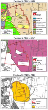
|
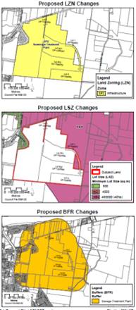
|
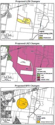
|
|
Item 35:
Remove Proposed Terrestrial Biodiversity Mapping
|
|
Remove item 35 (Lot 1 DP 1182150, Culburra Road,
Wollumboola) relating to proposed terrestrial biodiversity mapping from the
PP as the subject vegetation has been lawfully cleared.
|
Conclusion
The PP can now be finalised in accordance with the changes outlined
above and the matter proceed to finalisation.
Policy Implications
Finalising these amendments will ensure Shoalhaven LEP 2014
is both accurate and is operating as intended.
Financial Implications
There are no immediate financial
implications for Council. This PP will continue to be resourced within the
Strategic Planning budget.
|
|
Development
& Environment Committee – Tuesday 13 July 2021
Page
0
|
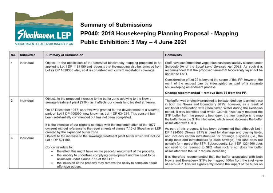
|
|
Development
& Environment Committee – Tuesday 13 July 2021
Page
0
|
DE21.71 Post
Exhibition and Finalisation - Planning Proposal - Berry Heritage (PP056)
HPERM Ref: D21/241446
Department: Strategic
Planning
Approver: Robert
Domm, Director - City Futures
Attachments: 1. PP056
Submission Summary ⇩
Reason for Report
Present the public exhibition
outcomes and enable the finalisation of Planning Proposal (PP056) – Berry
Heritage, which seeks to amend Schedule 5 Environmental Heritage of Shoalhaven
Local Environmental Plan (LEP) 2014.
|
Recommendation (Item to be determined under delegated authority)
That
Council:
1. Adopt Shoalhaven LEP 2014 –
Berry Heritage Planning Proposal (PP056) as exhibited, and using
Council’s delegation, forward to the NSW Parliamentary Counsel’s
Office to draft the amendment to Shoalhaven LEP 2014.
2. Advise key stakeholders, including
those who made a submission, of this decision and when the Amendment will be
made effective.
|
Options
1. Adopt the
recommendation.
Implications: This is the preferred option as it
will enable the Planning Proposal (PP) to be finalised to ensure the proposed
twelve (12) heritage items and two (2) Heritage Conservation Areas (HCAs) are
appropriately protected.
2. Adopt an
alternative recommendation.
Implications: This will depend on the extent of any
changes and could delay the finalisation of the PP. Depending on the nature of
these changes, this option could have implications for proposed items and
HCA’s of heritage significance within Berry.
3. Not adopt the
recommendation.
Implications: This is not the preferred option as
not implementing appropriate heritage protection for individual items and HCA s
within Berry could result in adverse impacts on the heritage and character of
Berry through unsympathetic development.
Background
The origins of this PP go back
to the feedback received during the preparation of the current Shoalhaven
LEP2014. During the preparation of the LEP representations were received
regarding the establishment of a Heritage Conservation Area (HCA) over the
township of Berry. There were subsequent community representations raising
concern that unsympathetic development was eroding the unique heritage
character of Berry.
In 2017 Council considered a
report that presented two options for consideration:
· Option
1: Additional Heritage Listings (as per MIN17.481)
· Option
2: Urban Conservation Area (as per MIN12.494)
Council resolved to pursue
Option 1 and the required heritage review of the town commenced as a result.
This thorough review identified that two HCAs and a number of properties
possessed heritage significance and were worthy of listing in the LEP.
On 1 September 2020, Council
resolved (MIN20.611) to support the preparation of a PP and submit to the NSW
Development of Planning, Industry & Environment (DPIE) for a Gateway
determination. There was a level of early property owner and community
engagement that informed this resolution.
The Berry Heritage PP seeks to
amend Schedule 5 Environmental Heritage of the LEP to list the proposed Queen
Street and Berry Showground HCAs and the following twelve (12) additional
dwellings as heritage items:
· 27
Albany Street – Inter-War Federation Weatherboard Cottage
· 29
Albany Street – Inter-War Californian Bungalow
· 46
Albert Street – Federation Weatherboard Cottage
· 36
Prince Alfred Street – Federation Weatherboard Cottage
· 64
Princess Street – Federation Weatherboard Cottage
· 71
Princess Street – Federation Weatherboard Cottage
· 51
Queen Street – Federation Weatherboard Cottage
· 54
Queen Street – Federation Weatherboard Cottage
· 44
Victoria Street – Federation Weatherboard Cottage
· 63
Victoria Street – Inter-War Weatherboard Cottage
· 69
Victoria Street – Federation Weatherboard Cottage
· 75-77
Victoria Street – Inter-War Californian Bungalow
The PP received a favourable
Gateway determination from DPIE on 22 March 2021. The determination granted
delegated authority to Council for the PP, which means that Council can liaise
directly with the NSW Parliamentary Counsel’s Office to prepare and
finalise the resulting LEP amendment.
Government Agency Feedback
Heritage NSW were consulted
prior to the public exhibition in accordance with the conditions of the Gateway
determination. They raised no objections to the proposal, noting that three (3)
heritage items on the State Heritage Register are located within the proposed
HCAs. The inclusion of State Heritage Register listed items within the proposed
HCAs is supported as it will potentially improve protections on the local
setting and facilitate future development that responds to the context of these
heritage items.
Community Engagement
In accordance with the Gateway
determination, and Council resolution (MIN20.611), the PP was recently publicly
exhibited for a minimum of 28 days, from 19 May to 18 June 2021 (inclusive) on
Council’s website and DPIE’s Planning Portal. Key stakeholders including
affected landowners and relevant community groups were notified in writing.
The exhibition material remains
available on Council’s
website and includes the following:
· Planning
Proposal (PP056)
· Explanatory
Statement
· Gateway
determination
· Public
Exhibition Notification
As a result of the exhibition
twenty-eight (28) formal submissions were received including:
· Twenty-five
(25) individual submissions in support of the proposed amendments to Schedule
5.
· One
(1) individual submission, not from the landowner, raising concerns relating to
64 Princess Street.
· One
(1) submission from the Berry and District Historical Society in support of the
proposal.
· One
(1) submission from Endeavour Energy advising they do not have any objections
to the PP.
A number of submissions were
received from members of the Berry Forum detailing support for the Berry
Heritage PP (PP056) as part of submissions for the Huntingdale Park Large Lot
Residential Precinct, Berry PP (PP060). Submissions received after the close of
the exhibition period have not been formally considered, however it is noted
all these submissions were in support of the proposed amendments.
Attachment 1 provides a
summary of the submissions received and comments from Council staff. Copies of
the actual submissions can be made available to Councillors on request prior to
the meeting if required. Table 1, below, provides a summary of the key
submission themes and comment from Council staff.
Table
1: Summary of key themes raised during the exhibition period and staff comments
|
Summary of Issue
|
Staff Comment
|
|
In support of the listing of 12 dwellings and two
HCAs in Schedule 5 of Shoalhaven LEP 2014.
Twenty-two (22) submissions were received in support
of the proposed amendments.
|
Support acknowledged.
|
|
Support from landowners.
Four (4) submissions were received from landowners
expressing further support for the listing of their properties:
· 51
Queen Street
· 46
Albert Street
· 27
Albany Street
· 44
Victoria Street
|
Support acknowledged.
|
|
Concern raised in regard to unsympathetic
development.
Nine (9) submissions were received requesting that
Council ensure future development in Berry considers the existing heritage
values of the town.
|
Concern noted. The PP is intended to assist in this
regard.
No change is required or recommended as a result of
these submissions.
|
|
Pursue the listing of items of heritage significance
where the landowners objected to the listing during preliminary consultation.
Three (3) submissions were received requesting that
Council pursue the listing of items where the owners objected to the possible
listing during preliminary consultation.
|
Council resolved to not pursue the heritage listing
of a number of dwellings with potential heritage significance where the
landowner objected to the listing in the initial consultation phase. The
Council has consistently maintained this general principle in other similar
investigations.
Council can in the future consider heritage listing
the 15 dwellings in question if they change ownership and the new owners
support listing. If in the future the landowners express interest in heritage
listing, the inclusion of the items in the Shoalhaven LEP 2014 will be
considered in future housekeeping amendments.
No change is currently required or recommended as a
result of these submissions.
|
|
Request for the boundary of the proposed HCAs to be
extended.
Two (2) submissions were received requesting that the
boundary of the proposed Showground HCA to be extended to encompass
structures on Alexandra Street.
|
The supporting heritage data sheet details that
residential properties along Alexandra Street have been excluded from the
Showground HCA as the majority make no contribution to the heritage
significance of the HCA. The structures are still considered ‘in the
vicinity of’ a heritage listed item and/or HCA and will have to
consider any impact of future development on the heritage significance.
No change is required or recommended as a result of
these submissions.
|
|
Request Council to investigate the addition of
further HCAs to protect Berry’s heritage streetscape.
Eight (8) submissions were received in support of an
additional HCA.
|
This is beyond the scope of the current PP and
would delay its finalisation. Council may however wish to investigate the
addition of further HCA’s within Berry in the future as part of the
annual setting of its Strategic Planning Works Program.
No change is currently required or recommended as a
result of these submissions.
|
|
Request Council prioritise a revised DCP for Berry.
Nine (9) submissions indicated interest in Council
prioritising a revised Shoalhaven Development Control Plan (DCP) 2014 chapter
for Berry, similar to Milton’s, that aligns with the
Illawarra-Shoalhaven Regional Plan and integrates local character into
planning documents.
|
This is beyond the scope of the current PP and
would delay its finalisation.
There is currently no specific overall DCP Chapter
applying to Berry as a whole. Existing chapters do apply to parts of the
town, e.g. Chapter N2: Berry Town Centre.
It is noted that the preparation of the Milton DCP
Chapter involved the engagement of specialist consultants, detailed
community engagement and required a dedicated budget from Council.
Council may however wish to consider undertaking a
review of Shoalhaven DCP 2014 to create a specific chapter applying to the
whole town in the future as part of the annual setting of its Strategic
Planning Works Program.
No change is currently required or recommended as a
result of these submissions.
|
|
64 Princess Street, Berry
One (1) submission raised concern that the dwelling at
64 Princess Street is a new build.
|
Dwelling additions were approved by Council in
2006, although the works maintained the integrity of the façade.
No change is required or recommended as a result of
this submission.
|
Conclusion
No changes are recommended to PP
as a result of state agency consultation or the public exhibition period. The
PP can now be finalised and the resulting LEP amendment proceed to
finalisation.
Policy Implications
The PP is considered to be
consistent with the Illawarra-Shoalhaven Regional Plan, Shoalhaven Local
Strategic Planning Statement, Shoalhaven 2040 and the Berry Community Strategic
Plan.
Eight (8) submissions requested
additional listings and a specific DCP Chapter for the whole town (similar to Milton)
to consider local character. This can be considered in the future when the
Council identifies its priorities for inclusion on the Strategic Planning Works
Program.
Financial Implications
There are no immediate financial
implications for Council. The PP will continue to be resourced from the
Strategic Planning budget.
Risk Implications
Not including the twelve (12)
dwellings and the two (2) HCAs within Schedule 5 of Shoalhaven LEP 2014 may
result in unsympathetic development which could impact on the items or areas in
question and broader heritage significance and character of Berry.
|

|
Development
& Environment Committee – Tuesday 13 July 2021
Page
0
|

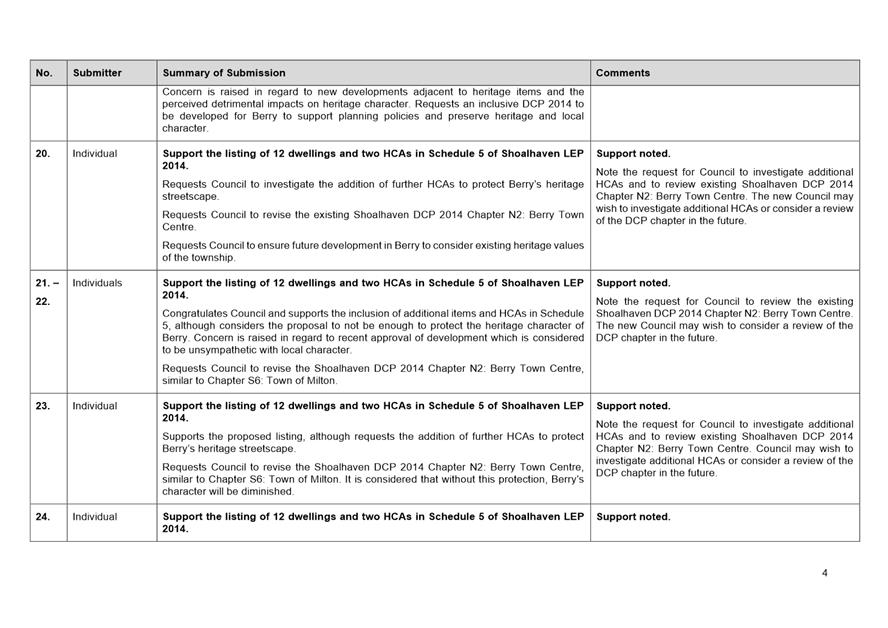
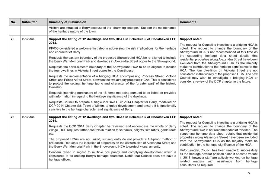
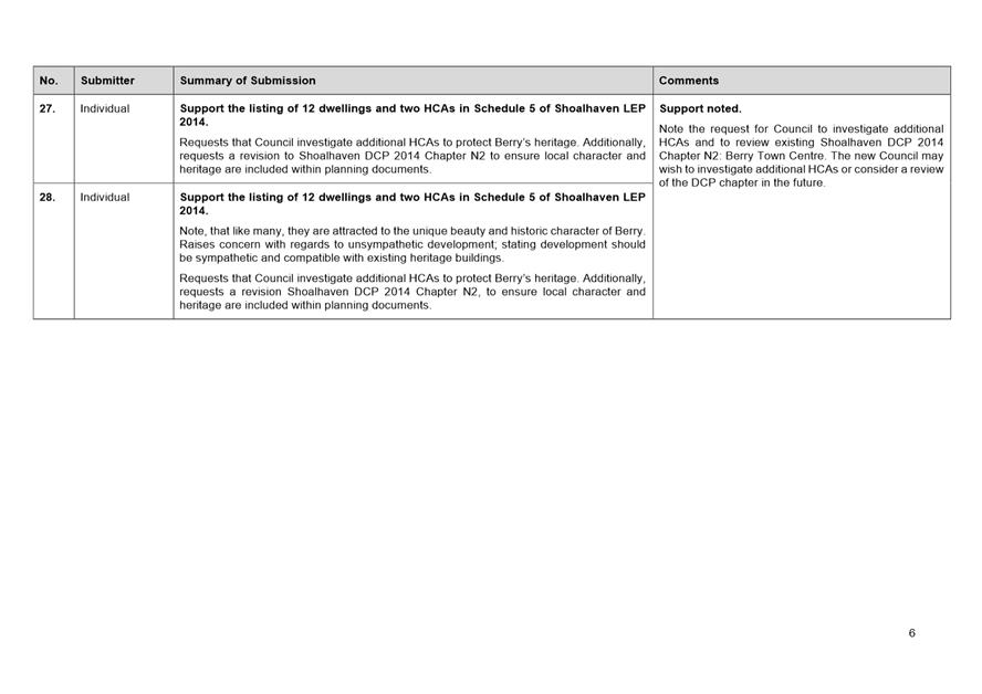
|
|
Development
& Environment Committee – Tuesday 13 July 2021
Page
0
|
DE21.72 Funding
Offer & Commencement - Shoalhaven Local Heritage Assistance Fund 2021-2023
HPERM Ref: D21/208808
Department: Strategic
Planning
Approver: Robert
Domm, Director - City Futures
Reason for Report
Formally commence the
2021–2022 Shoalhaven Local Heritage Assistance Fund Program and accept
grant funding for this grant and the Local Government Heritage Advisors Grant.
|
Recommendation (Item to be determined under delegated authority)
That
Council:
1. Accept the NSW Heritage Grant
funding offers for the 2021–2022 and 2022–2023 financial years.
2. Endorse a tourism theme for the
2021-2022 Local Heritage Assistance Fund Program.
3. Commence the Shoalhaven Local
Heritage Assistance Fund for the coming 2021-2022 year and reallocate any
declined offers amongst the remaining successful and eligible applicants, if
required.
4. Extend the review date in the
Shoalhaven Heritage Strategy 2019-2022 to 31 July 2024 and change the
operating period to 2021-2024.
|
Options
1. Adopt the
recommendation.
Implications: This will
enable the grant funding offers to be accepted which will help ensure the
continuation of both the Heritage Advisor Service and Shoalhaven Local Heritage
Assistance Fund Program for 2021-22 to 2022-23. This option will also enable
the commencement of the 2021-2022 Shoalhaven Local Heritage Assistance Fund
grant program.
2. Adopt an
alternative recommendation.
Implications: Depending
on the nature of any alternative recommendation, this may possibly prevent the
opening of the 2021-2022 Shoalhaven Local Heritage Assistance Fund grant
program.
Background
Council has continued its
commitment to local heritage projects by supporting the NSW Heritage Grants.
The grant funding provided by the NSW Government assists Council to potentially
provide the services of a Heritage Advisor and to run an annual Local Heritage
Assistance Fund to provide grants of up to $5,000 for a wide range of small
heritage projects including general maintenance, adaptive reuse and sympathetic
alterations / additions to heritage items. The grants program has been ongoing
for some time and has been well received.
The conservation of Shoalhaven’s cultural heritage by
its owners is clearly beneficial to the broader community and visitors to the
area. These grants, although small, show that Council and the NSW State
Government are committed to helping owners to conserve and enhance their
properties for future generations. These heritage projects contribute to
heritage conservation management, promote cultural sustainability and encourage
heritage tourism.
NSW Heritage Grants Program
2021-2022 and 2022-2023
An offer for NSW Heritage Grant
funding has been extended to Council by Heritage NSW under the following
streams:
· Local
Heritage Places (Shoalhaven Local Heritage Assistance Fund – Council has
been offered a grant of up to $5,500 (ex GST) for the 2021-2022 and 2022-2023
financial years, with a funding formula of $1:$1 (NSW Government: Council).
· Local
Government Heritage Advisors – Council has been offered a grant of
up to $6,000 (ex GST) for the 2021-2022 and 2022-2023 financial years towards
providing a Heritage Advisory Service for Shoalhaven. It is noted that Council
was not able to engage the services of a heritage advisor during the 2020-2021
financial year.
It is unclear whether a heritage advisor will be appointed
during the 2021-2023 period; however, options in this regard continue to be
investigated and the grant funding remains available if required.
2021-2022 Shoalhaven Local
Heritage Assistance Fund Grant Theme - Tourism
In accordance with
Council’s COVID-19 response and the financial impacts experienced across
the Shoalhaven, it is proposed that the 2021-2022 Local Heritage Assistance
Fund will focus on tourism within a heritage setting. This will support the
owners of heritage items with maintenance and restoration works, but also will
increase exposure to the rich heritage of the Shoalhaven region and promote
heritage tourism within the Local Government Area.
The 2022-23 theme has not yet
been settled, but will likely focus on centres (Berry, Nowra, Milton etc.) to
broaden positive heritage exposure within these active and vibrant locations.
Council will receive a report in 2022 seeking endorsement to open the
2022–2023 program and a theme will be refined and presented at that point
in time.
Community
Engagement
The 2021-2022 Shoalhaven Local
Heritage Fund Program will be advertised in local newspapers and on
Council’s website. Direct advice will also be provided to persons who had
previously expressed an interest in the program.
Policy
Implications
As part of the funding agreement
for the Local Government Heritage Advisors Grant and to enable a claim for
reimbursement, Council is required to submit a four-year Heritage Strategy
covering 2021-2022. Council amended the Shoalhaven Heritage
Strategy on 7 May 2019 (MIN19.920) to cover the 2019-2022 period. The
Heritage Strategy will need to be revised to cover the 2021-2024 period and the
review date of the Shoalhaven Heritage Strategy should be extended until 31
July 2024 to facilitate this.
The Shoalhaven Heritage Strategy
notes that the Heritage Advisor is to inspect all completed projects to ensure
compliance with the application details and sound conservation practice. In the
current absence of a retained Heritage Advisor, this process will be undertaken
by appropriate Council staff, with input from a Heritage Consultant, as
required.
Financial
Implications
Shoalhaven Local Heritage
Assistance Fund (Local Heritage Places Grant)
The funding offer from the NSW
Government for the 2021-2022 and 2022-2023 financial years is up to $5,500 (ex
GST) per annum, with a funding formula of $1:$1 (NSW Government: Council). Recurrent
funding to match the Grant, plus additional funding will need to continue to be
provided in Council’s annual budget.
Local Government Heritage
Advisors Grant
The funding offer from the NSW
Government for the 2021-2022 and 2022-2023 financial years is up to $6,000 (ex
GST), with a funding formula of $1:$1 (NSW Government: Council).
The grant funding remains available for the 2021-2023 period
should a heritage advisor be appointed during each of those financial
years. Recurrent funding to match the Grant, plus additional funding,
will need to continue to be provided in Council’s annual budget.
|
|
Development
& Environment Committee – Tuesday 13 July 2021
Page
0
|
DE21.73 Strategic
Planning Works Program - Proposed 2021-2022 Version
HPERM Ref: D21/171582
Department: Strategic
Planning
Approver: Robert
Domm, Director - City Futures
Attachments: 1. Adopted
2020-2021 SPWP ⇩
2. Proposed 2021-2022 SPWP ⇩
Reason for Report
Report the proposed 2021-2022
Strategic Planning Works Program (SPWP) to Council for consideration and
adoption. This report was considered by Council’s Strategic Planning
Working Party at its meeting on 17 June 2021.
Note: At present, Council
staff will continue, alongside ongoing work, to focus on the following key
priority projects during the remainder of 2021:
· Moss Vale Road North Urban
Release Area - package of plans (exhibition and finalisation);
· Nowra CBD Planning Controls
Review;
· Nowra Riverfront Masterplan
Realisation; and
· Milton-Ulladulla Structure Plan
Review.
|
Recommendation (Item to be determined under delegated authority)
That
Council:
1. Adopt and finalise Attachment 2 as
Council’s 2021-2022 Strategic Planning Works Program.
2. Receive a report on the 2022-2023
Strategic Planning Works Program in June / July 2022 to coincide with the new
financial year.
3. Make future changes or additions to
the Strategic Planning Works Program only after considering the current program, project priority, staff workload and
resources.
|
Options
1. As recommended.
Implications: This option is favoured as it builds
on the 2020-2021 SPWP and continues to guide Council’s strategic planning
effort, ensuring we are proactively undertaking forward planning.
The SPWP assists in the
prioritisation of projects and management of staff workload.
2. Adopt an
alternative recommendation.
Implications: The 2021-2022
SPWP has been prepared taking into consideration current and expected strategic
planning tasks and known planning challenges/expectations. Modifications to the
SPWP at this stage may, depending on the nature of the modification, delay its
adoption.
3. Not adopt the 2021-2022
SPWP and react to requests, opportunities etc. as they arise in the future.
Implications: This option
would mean that Council reacts to requests, opportunities, requirements etc.
for strategic planning work in an ad-hoc or unmanaged manner. This is not
desirable as it does not necessarily focus Council’s efforts in areas or
on projects that support the broader community or are required by legislation
or other drivers.
Background
Strategic Planning Works Program – Recent History
In 2017, following a number of
workshops, Council (MIN17.612) adopted and finalised the new iteration of the
SPWP (2017-2018) to guide Council’s strategic planning efforts and
workload.
Most recently the SPWP for
2020-2021 was adopted in June 2020 (MIN20.385) and is provided as Attachment
1.
As part of the 2018-2019 SPWP
adoption, it was resolved that the work program be reported to Council annually
in June to coincide with each new financial year. This annual report is
provided consistent with this resolution, noting that the report was initially
presented to Councils new Strategic Planning Working Party on 17 June 2021.
2021-2022 Strategic Planning
Works Program
In preparing the 2021-2022 SPWP (Attachment 2) for
consideration by Council, the following matters were considered:
· Current
Strategic Planning tasks.
· Expected
Strategic Planning tasks (e.g. Arising from the Local Strategic Planning
Statement).
· Community
involvement and expectations around land use planning (e.g. Community Strategic
Plan/Integrated Strategic Plan 2027 exhibition outcomes).
· Ongoing,
known and future planning challenges.
· Matters
arising from the ongoing and immediate reforms to the NSW planning system.
At this point the 2021-2022 SPWP
retains the existing program structure, notably the priority areas and
overarching strategies outlined in Table 1 (established through the original
2017 Councillor workshop process).
Table 1:
Retained SPWP priority areas and overarching strategies
|
Priority
|
Priority Area
|
Overarching Strategy
|
|
1
|
Managing Future Growth
|
· Developing
and maintaining a Growth Management Strategy (GMS) to provide continued
residential development and infrastructure ‘ahead of the game’.
|
|
2
|
Economic Development,
Retailing, Town Centres and Tourism
|
· Balance
commercial development with cultural and recreation opportunities.
|
|
3a
|
Natural Environment /
Agriculture
|
· Maintain
an ‘unspoilt’ environment, plan for infrastructure to manage high
use areas, maintain sustainable agriculture sector focusing on diversity and
quality of output.
|
|
3b
|
Affordable Housing
|
· Work
to increase affordable housing opportunities in Shoalhaven.
|
|
4
|
Population, Ageing and
Social Infrastructure
|
· Facilitate
a healthy, active and accessible community.
· Identify
and respond to demonstrated need and create best practice liveable
communities for all ages and stages.
|
|
5
|
Heritage and Events
|
· Maintain,
investigate and bring forward our Aboriginal and European heritage into the
future.
|
|
6
|
Legislation and Policy
|
· Maintain
Shoalhaven Local Environmental Plan (LEP), Development Control Plan (DCP) and
Contributions Plan (CP).
· Monitor
and respond to legislative and policy changes/proposals – consistent
with Council’s strategic direction.
|
For each existing priority area, current and future (yet
to commence or on hold) projects are again identified. The proposed 2021-2022
SPWP contains a total of 85 projects - 51 current projects and 34
projects that are yet to commence or are on hold.
The priority projects in Table 2 (also shown in red at Attachment
2) will be advanced ahead of other projects on the SPWP. A brief update on
the identified priority projects is provided for convenience in Table 2.
Table 2: 2021-2022 SPWP priority projects
|
Priority Project
|
Brief Update
|
|
Moss Vale Road North URA
(PP, DCP and CP)
|
The
required Planning Proposal recommending LEP adjustments, a new Development
Control Plan Chapter, and a Development Contributions Framework are being
prepared to guide the future development of this release area. This project
is currently a major staff resource commitment.
These documents and their status to Council shortly to
enable them to proceed to exhibition.
|
|
Implement the Local
Strategic Planning Statement (LSPS) Actions
|
The priority action to
undertake a City-wide economic review will commence in the 2021-22 financial
year as this is dependent on a budget allocation. Several significant actions
listed in the Statement rely on the completion of this work.
Work
on another priority action for the update of the Milton-Ulladulla Structure
Plan has commenced and is ongoing - see update in next row.
The
consideration of other actions in the document will be examined with the
Strategic Planning Working Party on as needs basis.
Note: the new Illawarra-Shoalhaven Regional Plan was released
in early June 2021, as such and also following the impending Local Government
Elections, an update of the LSPS will need to be considered.
|
|
Milton-Ulladulla
Structure Plan Review
|
Current work includes
constraint analysis, updated demographic information and housing demand
analysis. A further update and indicative options for managing growth was
presented to the Strategic Planning Working Party on 17 June 21.
|
|
Planning Proposal PP028
- Callala Bay and Kinghorne Point (Halloran)
|
Current work includes
collating internal feedback on the proponent-managed studies. Subject to
feedback, the required studies have been completed. The next phase will
involve updating the Planning Proposal for Council’s consideration.
The related Federal Environment Protection and
Biodiversity Conservation Act decision was issued 1 June 2021. This has
implications for the PP and this is currently being considered in detail.
|
|
DCP Chapter G11
Subdivision Review
|
Preparation of the amendment is well underway.
Internal consultation has been undertaken and following incorporation of
changes resulting from Council’s Engineering Design Specification
Review, the draft package will be presented to Council shortly seeking a
resolution to exhibit.
|
|
Shoalhaven Riverfront
Precinct
· Planning
Proposal PP041 – Mandalay Avenue Sub Precinct.
· Planning
Proposal PP042 – Hyam Street, Pleasant Way and Wharf Road Sub Precinct.
|
Planning for the Riverfront Precinct is now being
progressed through the Nowra Riverfront Advisory Taskforce (NRAT) established
by the NSW Government. The NRAT is currently scoping the studies that are
required to support the development of the precinct and a future precinct-wide
Planning Proposal, as well as potential funding sources for them.
Early work has however commenced on the following key
pieces of support work to help realise the redevelopment of the precinct:
- Flood
Impact & Risk Assessment
- Integrated
Transport Plan
|
|
Coastal Hazard Review
|
Revised Planning Proposal has recently received a
favourable Gateway determination from the NSW Department of Planning,
Industry and Environment. The proposal (in part) seeks to update the SLEP
2014 Coastal Risk maps to reflect current data which includes specifying the
type of coastal risk associated with the land.
|
|
Illawarra-Shoalhaven
Regional Plan (ISRP) Review and Action Implementation
|
The new Illawarra-Shoalhaven Regional Plan 2041 was
released on 2 June 2021. The release was accompanied by a Consultant Outcomes
Report which is currently being reviewed to ascertain how Councils comments
were considered/resolved and what resulting detailed work involves Council.
The implementation of the new Plan will be managed by a
Coordinating and Monitoring Committee, on which Council will be represented.
The Illawarra-Shoalhaven Special Infrastructure
Contribution (SIC) was also finalised and released alongside the Regional
Plan.
Both the Regional Plan and SIC were discussed at
Councils Strategic Planning Working Party on 17 June 2021 and will be the
subject of a more detailed information report to Council in due course
|
|
Implementation and monitoring of the Shoalhaven
Affordable Housing Strategy, with a focus on implementing/realising the
affordable housing project on Council land at Coomea Street, Bomaderry
|
Council’s subscription to a new demographic
resource to assist in the monitoring and future review of this Strategy is
being investigated. The need to update and revise the Strategy will also
needed in light of Councils resolution of 25 May 2021.
The transfer of the Council land at Coomea Street,
Bomaderry to Southern Cross Housing (SCH) is currently close to finalisation.
SCH are undertaking early works to remove the existing dwellings from the
site and will start community engagement shortly on the possible affordable
housing development outcome.
|
|
Respond to legislative
change
|
Ongoing and generally reactionary. However, it is
noted that this has taken up significant staff time in the 2020-2021
financial year due to the range of detailed and widespread reforms being
advanced by the NSW Government and also resulting from the COVID-19 Pandemic.
Intended Future Direction –
given the workload created in this regard and the often quick comment
timeframes it is intended that Council staff will mainly focus on key
relevant ones as required.
|
Table 3 identifies the projects that have been removed from
(completions etc.) or added (Council resolutions etc.) to the SPWP, as well as
projects that have been consolidated or reprioritised. Changes have also been
made to the descriptions of some of the projects to enhance readability and
recognition.
Table 3:
Projects added and removed from the 2021-2022 SPWP
|
1. Managing Future Growth
|
|
Added
|
· Priority Project: Milton Ulladulla Structure Plan Review.
· PP060 – Huntingdale Park Estate, Berry.
· Review of Zoning and Planning Controls –
Taylors Lane, Cambewarra (Note: separate project to PP054).
· Review of Old Southern Road, South Nowra
Contributions Project 01ROAD2038 (+ DCP).
|
|
Removed (and why)
|
· PP043 - South Nowra – Industrial Zoned Land Dwelling Entitlements. Completed.
· PP051 - Wire Lane, Berry. Completed –
Received unfavourable Gateway determination.
· PP052 –10 Victoria St, Berry - The Arbour
Retirement Village. Completed.
· PP55 – Clause 4.1H Amendment for small lots in
URAs (+ DCP). Completed.
· DCP Chapter N20: Jerberra Estate and Chapter S1
Verons Estate. Completed.
· DCP Chapter N9: Nebraska Estate. Included
in planning proposal LP145.1 Nebraska Estate, St Georges Basin project.
· Other outstanding investigations resulting from
strategies. Included in the scope of the Growth Management Strategy
and Milton Ulladulla Structure Plan Review.
· LEP 2014 – additional matters for
consideration - future investigations: Milton/Ulladulla deferred 2(a1) areas.
Included in the scope of the Milton Ulladulla Structure Plan Review.
|
|
Current Projects Placed on Hold
|
· Priority Project: Growth Management Strategy version 2 (pending the completion of the
City-wide economic review).
· PP006 – Culburra Beach (Halloran).
· PP007 – Inyadda Drive, Manyana (pending
outcome of initial EPBC Act referral)
|
|
On Hold Projects Moved to Current
|
· Priority Project: DCP - Chapter G11 Subdivision Review.
· PP054 - Taylors Lane, Cambewarra (+ DCP and CP).
|
|
2.
Economic Development, Retailing, Town Centres and Tourism
|
|
Added
|
· Priority Project: Nowra CBD Planning Controls Review.
|
|
Removed (and why)
|
· Shoalhaven LEP 2014 Clause 2.8 Review. Completed
– discontinued by Council.
· PP025/PP030 - St Vincent and Deering Streets,
Ulladulla (Babington)/ Ulladulla Heights (Southern Part of Ulladulla
CBD). Completed.
· PP049 - Yalwal/Danjera Dam PP. Completed.
· Covid-19 Contributions Discount Subsidy Policy (and
subsequent amendment). Completed.
· Economic Development Strategy – implement
relevant actions (including strategy to activate key waterfront locations). Work
to be undertaken by the Economic Development Section of Council.
· Employment Lands Audit/Illawarra-Shoalhaven Urban
Development Program. Included in ‘Implement Illawarra
Shoalhaven Regional Plan Actions’ (priority project).
|
|
Current Projects Placed on Hold
|
· South Nowra Internal Service Lane (DCP and CP).
· South Nowra Industrial Zoned Area (Flinders Estate
Expansion) (DCP and CP) – pending resource allocation that is currently
being resolved.
|
|
On Hold Projects Moved to Current
|
· DCP Chapter S8: Ulladulla Town Centre Review.
|
|
3a.
Natural Environment/ Agriculture
|
|
Added
|
· DCP - Solar Roof Panel Amendment.
|
|
Removed (and why)
|
· Respond to outcomes of Council’s natural
resources plans and strategies. Included in the ‘Implement the
Local Strategic Planning Statement Actions’ project, which recognises a
number of actions relating to the management of natural resources.
|
|
3b.
Affordable Housing
|
|
Added
|
· Nil. (Note: work is continuing on range of fronts).
|
|
Removed (and why)
|
· Nil.
|
|
4. Population, Ageing and Social
Infrastructure
|
|
Added
|
· Population Policy (no immediate action required)
|
|
Removed (and why)
|
· Nil.
|
|
5.
Heritage and Events
|
|
Added
|
· Nil.
|
|
Removed (and why)
|
· PP036 – Heritage Housekeeping. Completed.
· PP053 – Bushfire Heritage (Yatte Yattah
– heritage item removal). Completed.
|
|
6.
Legislation and Policy
|
|
Added
|
· DCP - Chapter G21 Car Parking and Traffic (housekeeping).
· Contributions Plan Amendment 8 – Old
Subdivision Properties.
· 2021/2022 Local Approvals Policy Review.
· Community Participation Plan Review.
|
|
Removed (and why)
|
· PP027 – Subdivision Review. Completed.
· DCP – Chapter G21 Car Parking and Traffic
(large scale review). Completed.
· Contributions Plan Amendment 1 – Housekeeping.
Completed.
· Contributions Plan Amendment 5 – Boarding
House Amendment (exhibition underway). Completed.
|
|
Current with change in
project scope
|
· Priority Project: Implement the Immediate and Short Term Local Strategic Planning
Statement Actions (formally ‘Local Strategic Planning
Statement’. The preparation of the LSPS has been
completed, however the implementation of the LSPS actions remains ongoing.
|
Using and interrogating the
SPWP
Councillors and key Council staff have direct access to the Interactive SPWP
on Council’s Intranet. The SPWP is generally updated on a regular basis
and includes the following detail (where relevant):
· Project
name.
· Project
type and reference (LEP, DCP etc.).
· Minute
reference for the project.
· Envisaged
project timeframe.
· Where
the project is up to and next steps.
· Project
officer and contact details that Councillors can pass onto stakeholders
(provisions of Councillor and Staff Interaction Policy applicable).
Councillors can search for specific projects and interrogate
the data accordingly.
Process for adding/removing
projects from the 2021-2022 SPWP
The 2021-2022 SPWP will assist
with Council’s decision making regarding new planning related projects.
Ideally, the 2021-2022 SPWP will be proactive and not reactionary. It is
inevitable, however, that changes will be required through time and this needs
to be done in a considered manner.
Prior to changing the 2021-2022
SPWP (e.g., adding a project), consideration should be given to the likely
impact on the current program, priorities, staff workload and resources.
Projects should only be included on the 2021-2022 SPWP (or reprioritised) after
consideration by Council and following a formal resolution. Ideally,
consideration should be given to how they sit against the overarching
strategies identified in the SPWP. The exception would be matters that must be
resolved operationally (legislative directions, reactive policy submissions
etc.).
The Strategic Planning Working
Party will now have a role in the SPWP process, specifically through the
provision of early input into projects within the SPWP, focusing on
‘priority’ projects and other projects that may require ongoing
consideration and direction.
It is expected that projects will be removed from the SPWP
upon completion or via a resolution of Council.
Monitoring and reporting
The SPWP will be reported back
to the Development and Environment Committee annually in June/July, in line
with each new financial year, to enable formal reconsideration and to highlight
progress, including what has been achieved or completed in the year. The SPWP
will also be monitored for efficiency on an ongoing basis and any required or
proposed changes to the structure or projects will be reported as needed.
Community
Engagement
The SPWP is an internal tool to
manage Council’s strategic planning effort and workload. No formal
community consultation is required as it is an internal management resource.
Based on existing knowledge,
plans and community engagement processes (especially the Community Strategic
Plan/Integrated Strategic Plan 2027 process) the broader expectations of the
community have been considered during preparation of the SPWP.
However, approaches continue to
be receive requesting specific additional work in regard to issues or areas,
for example character controls for villages.
Policy
Implications
It is considered important to
have a clear work program to focus Council’s current and future strategic
planning effort. This will ensure that Council has an appropriate strategic
framework in place that is forward thinking and responsive in nature.
Financial/
Resourcing Implications
Generally, projects that are on
the SPWP will be undertaken within existing budgets. However, should a project
require specific funding allocation, this will be reported to Council for
consideration as the need arises.
|
|
Development
& Environment Committee – Tuesday 13 July 2021
Page
0
|
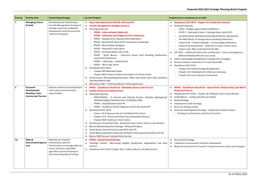
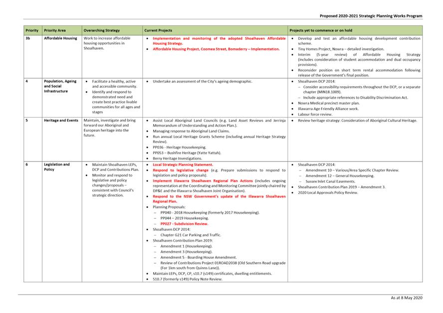
|
|
Development
& Environment Committee – Tuesday 13 July 2021
Page
0
|
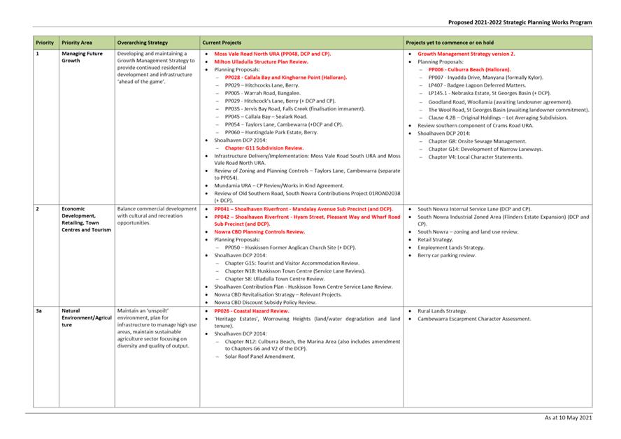
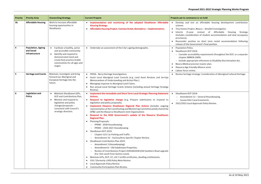
|
|
Development
& Environment Committee – Tuesday 13 July 2021
Page
0
|
DE21.74 Proposed
Submission - NSW Planning Reforms - Employment Zones Framework
HPERM Ref: D21/228844
Department: Strategic
Planning
Approver: Robert
Domm, Director - City Futures
Attachments: 1. Submission
- Proposed Employment Zones Framework ⇩
Reason for Report
· Advise
of the public exhibition of a Position Paper on proposed amendments / reforms
to the NSW planning system relating to employment zones.
· Obtain
endorsement to make the submission at Attachment 1.
|
Recommendation (Item to be determined under delegated authority)
That
Council:
1. Endorse the draft submission on the
proposed planning reforms relating to the proposed employment zones framework
(Attachment 1) so it can be finalised and sent to the NSW Department
of Planning, Industry & Environment for consideration.
2. Request further consultation and
dialogue from the NSW Department of Planning, Industry & Environment on
the proposed reforms before they are finalised.
3. Receive future reports, if required,
to enable further comment on the detail of the proposed planning reforms.
|
Options
1. As recommended.
Implications: This is the preferred option and will
enable Council to provide a submission highlighting matters that should be
considered by the Department in relation to the proposed planning
reforms.
2. Make changes to
the draft submission (Attachment 1) and submit.
Implications: This will still enable Council to
provide a submission; however, the implications of any possible changes are
unknown and may require closer consideration and refinement.
3. Not make a
submission.
Implications: This is not favoured as it will mean
Council will not provide input on the proposed planning reforms which could
have a range of implications.
Background
The NSW Government is currently
proposing amendments to the NSW planning system, which will replace the
existing Business (B) and Industrial (IN) zones with five new employment zones
and three supporting zones under the Standard Instrument Principal Local Environmental
Plan (2006) (SI LEP).
Whilst the reform responds to various trends that have been
exacerbated by the COVID-19 pandemic, including the growth of online retail,
reliance on freight and logistics, the importance of local centres, flexible
working arrangements and the continued rise of multi-use businesses and the
experience economy, the intent of the reform is to:
· Maximise productivity while minimising land use conflicts
and ensuring they are fit for purpose;
· Address current barriers within the planning system that
limit the ability of businesses to establish, expand or adapt; and
· Better support councils in the delivery of the strategic
vision contained in their Local Strategic Planning Statements and background
studies.
The proposed amendment package
can be viewed at the following link:
https://www.planningportal.nsw.gov.au/employment-zones-reform
The proposed reform intends to
introduce the following:
· Five new employment (E) zones are proposed, as follows:
- E1 Local Centre
- E2 Commercial Centre
- E3 Productivity Support
- E4 General Industrial
- E5
Heavy Industrial
· The proposed E1 Local Centre zone will fundamentally
replace the current B1 Neighbourhood Centre and most B2 Local Centres, whilst
introducing a range of new land uses which will be mandated under the SI LEP.
· The proposed E4 General
Industrial zone intends to accommodate light and general industrial uses and
warehousing uses and will generally replace the existing IN1 General Industrial
and IN2 Light Industrial zones.
· In addition to the introduction of the new E zones, a new
Mixed Use (MU) zone is proposed. This is intended to support a mix of
residential, retail, light industry and tourist accommodation. This zone
will essentially replace the existing B4 Mixed Use zone and also some B2 Local
Centres. It is also proposed to mandate a number of additional permitted land
uses via the SI LEP in the new MU zone, including:
- Farm stay accommodation
- All light industries
(including artisan food and drink industry, creative industries, high
technology industries, data centres, home industry, and domestic goods repair
and reuse facilities)
- Local
distribution premises
· A new SP4 Local Enterprise zone is also proposed.
This will not be mandated through the SI LEP, but Councils have the option of
including it within their LEP. The zone will provide a place for planned
precinct processes, special activation precincts and regional job precincts.
· The W4 Working Foreshore is proposed to be a direct
translation of the existing IN4 Working Waterfront zone. The W4 zone has been
introduced as land applying to this zone has more in common with the waterways
zone grouping than it does to employment zones.
· The following new
definitions are proposed:
- Circular economy facilities
- Creative industries
- Data
centre
· Numerous updated
definitions are proposed, including:
- Business premises
- Industrial retail outlet
- Kiosk
- Neighbourhood shop
- Shop-top housing
- Crematorium
- Local distribution premises
Council staff comments
The proposed reforms have been
reviewed by relevant sections of Council and the following comments reflect the
feedback received.
The proposed reforms seek to
introduce a number of changes that are generally supported, including:
· Proposed updates to
definitions to remove reference to components that are outdated and to include
reference to new and emerging land uses.
· Consolidation of existing definitions to provide for
streamlining of definitions and reduce potential misinterpretation.
· Introduction of the intended mixed-use zone and the range
of additional permitted uses is generally supported; however, clarification of
the prefix ‘m’ and ‘mu’ is sought, as these are used
interchangeably throughout the position paper.
· Introduction of the working foreshore zone.
· Intent that the proposed E4 zone does not permit
residential accommodation (Note: managers or caretakers dwellings could
still be considered as ancillary development as is currently the case).
The proposed reforms are detailed
and whilst parts of the reforms have the potential to have a positive impact, a
number of concerns have been identified in relation to the proposed changes and
potential impact on both Council and the broader community, including:
· The prefix of the proposed new ‘E’ zones
conflicts with the existing and currently accepted SI LEP environment
protection zones that currently have an ‘E’ prefix. The related
proposal to rename the existing environment protection zones will create significant
and unnecessary resourcing issues for Council, as well as cause confusion for
users. This naming change is not supported and should be
reconsidered as it will cause confusion and an unnecessary workload to adjust.
· The general inclusion of data centres proposed within existing
B2 Local Centres zones is not supported. Several of Shoalhaven’s existing
B2 zones are embedded within existing residential areas or popular tourism
locations, such as Huskisson and Culburra Beach. As such, these localities (and
their size/scale) are not necessarily considered appropriate to accommodate
data centres.
· Enabling data centres in the proposed W4 zone is also
generally not supported.
· There has been no advice that the suggested Online Noise
Assessment Tool and air quality studies relating to Data Centres had been
completed and made available as yet. In the first instance, confirmation will
be sought that these have now been completed. Additionally, further
consultation was requested once relevant development standards for data centres
had been refined – again this has not occurred as yet.
· Many existing B1 zones in Shoalhaven are small and within
existing residential areas. Expanding the
range of land uses permissible in the B1 zone, to enable traffic generating
development (i.e. medical centres, specialised
retail premises) where parking is already
limited, will potentially create issues for surrounding residents and the
broader community.
Consistent with the submission
on the ‘Building Business Back Better’ reforms, it is reiterated
that in order for business growth to increase in industrial and commercial
zones, the following actions would more practically assist:
· Improved
telecommunications services - Metropolitan speeds and pricing.
· Seed funding to open
undeveloped industrial zoned land.
· Addressing the impacts
that the NSW Biodiversity Conservation Act is having on the viability of
subdividing and releasing industrial zoned land.
The proposed submission at Attachment
1 provides more detail on these concerns and other matters of interest to
Shoalhaven.
Conclusion
It is appreciated that the
recent spate of planning reforms is largely responding to various trends
exacerbated by the COVID-19 pandemic. Whilst regional areas like the Shoalhaven
are always keen to assist in addressing current barriers within the planning
system, there is a need to ensure that any planning reforms in this regard are
balanced, justified and things work together and do not create unintended consequences.
This said, the logic behind the
Department’s proposal to amend the existing zoning prefixes remains
unclear. For this reason, this aspect of the proposed amendments needs to be
reconsidered and further dialogue. The proposed prefixes will not only generate
confusion amongst community members, Council staff and the development
industry, but will also necessitate significant time and staffing resources to
implement the proposed name changes to the relevant zones though existing
documents, systems etc. The changes proposed to the employment zones can be
made, regardless of the proposed prefix used.
Additional consultation and
engagement with Council is essential to get the changes right and will be
requested as the Department move to further consider and resolve the proposed
reforms.
Community Engagement
The Position Paper was on public
exhibition between 20 May – 30 June 2021 to provide an opportunity for
Council, the community and industry stakeholders to provide comments and
feedback.
Due to reporting dates, a draft
staff submission based on Attachment 1 was provided to the Department on
30 June 2021 as a ‘placeholder’. The Council endorsed submission
will be provided following this meeting.
Policy Implications
In response to the proposed
changes, Council would be required to undertake the following changes (possibly
significant and time consuming) to its existing policies and procedures:
· Recode and re-map all affected zones within Council’s
GIS system.
· Potentially undertake a strategic exercise to assign the
new zones in certain locations.
· Make significant amendments to Shoalhaven Development
Control Plan (DCP) 2014 to reflect name changes to existing environmental,
industrial and business zones.
· Amend relevant Council policies and procedures that
reference existing environmental, industrial and business zones.
Financial Implications
There are no immediate financial implications for Council;
however, the reforms may result in potential issues with regard to resourcing
because of the changes required to GIS mapping and data, as well as Shoalhaven
DCP 2014 and other Council policies and procedures as a result of the proposed
amendments.
Risk Implications
There are no immediate risks for
Council; however, there are concerns that the proposed zone name prefixes will
not only generate confusion amongst community members, Council staff and the
development industry, but will also necessitate significant time and staffing
resources to implement the proposed name changes to the relevant zones.
|
|
Development
& Environment Committee – Tuesday 13 July 2021
Page
0
|
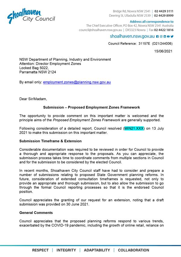
|
|
Development
& Environment Committee – Tuesday 13 July 2021
Page
0
|
DE21.75 Proposed
Submission - Review of NSW Heritage Legislation
HPERM Ref: D21/241947
Department: Strategic
Planning
Approver: Robert
Domm, Director - City Futures
Attachments: 1. Proposed
Submission - Review of Heritage Legislation ⇩
Reason for Report
Advise of the public exhibition
of a Discussion Paper for the Review of NSW Heritage Legislation and obtain
endorsement to make the submission at Attachment 1.
|
Recommendation (Item to be determined under delegated authority)
That
Council:
1. Endorse the draft submission on the
proposed planning reforms relating to the Review of NSW Heritage Legislation
(Attachment 1) so it can be finalised and submitted to the Standing
Committee on Social Issues.
2. Request further consultation and
dialogue on the proposed amendments to the Heritage Act 1977 before
the amendments are finalised.
3. Receive future reports, if required,
to enable further comment on the detail of the proposed amendments to the Heritage
Act 1977.
|
Options
1. As recommended.
Implications: This is the preferred option and will
enable Council to provide a submission highlighting matters that should be
considered by the Standing Committee on Social Issues and Heritage NSW in
relation to the review of NSW Heritage Legislation.
2. Make changes to
the draft submission (Attachment 1) and submit it.
Implications: This will still enable Council to
provide a submission; however, the implications of any possible changes are
unknown and may require closer consideration and refinement.
3. Not make a
submission.
Implications: This is not favoured as it will mean
Council does not provide input into the review of NSW Heritage Legislation,
which could have a range of implications.
Background
In April 2021, the NSW
Government asked the NSW Legislative Council’s Standing Committee
(Standing Committee) on Social Issues to conduct a review of the NSW Heritage
Act 1977 (Heritage Act).
On 13 May 2021, the Standing
Committee formally commenced the review and have provided the opportunity for
key stakeholders and the broader community to have their say on NSW Government
heritage policy.
Heritage NSW have published a
discussion paper, encompassing nineteen (19) focus questions, which can be
viewed at the following link:
https://www.heritage.nsw.gov.au/assets/A-Review-of-Heritage-Legislation-discussion-paper.pdf
Council staff comments
It is noted that the Review of
NSW Heritage Legislation discussion paper is the starting point of the public
inquiry, and it is appropriate for Council to be involved in future
consultation of related proposed reforms.
The discussion paper highlighted a number of important key
issues and policy concepts in order to gain feedback from community members and
key stakeholders to inform analysis of the current legislative framework and
potential reforms. The proposed reforms and a summary of staff feedback is
outlined in the following table.
|
Proposed Reform
|
Staff Feedback
|
|
NSW adopt a more nuanced set of heritage listing
categories, as below:
· Heritage
of exceptional and iconic value.
· State
significance heritage landscapes.
· State
significant heritage.
· Local
heritage.
|
The proposed heritage listing categories are
generally supported, as it will allow for more tailored heritage protections
to be applied to items to suit their individual circumstances.
|
|
Introduce a community-driven nomination process.
Community-based ‘early-round’ nominations would be submitted for
Heritage Council consideration.
|
A community-driven nomination process is generally
supported, noted that it can only be achieved with a streamlined process for
the listing of State Heritage Register items. Greater community involvement
will potentially assist in delivering a more robust and diverse State
Heritage Register, and increase the community’s awareness, interest and
connection to heritage items.
|
|
Introduce a streamlined process to update heritage
listings to allow State Heritage Register listings to be periodically
reviewed and amended.
|
A streamlined process to update heritage listings
will ensure listings remain relevant, and those that have perhaps lost their
value are removed. The streamlined process will also assist in addressing
site changes and ensuring a site’s full significance is recognised and
protected.
|
|
The Minister responsible for heritage could be
responsible for determining, in consultation with the Heritage Council, the
regulatory thresholds for standard exemptions, fast-track applications and
standard applications for permits under the Act.
|
Listing items on the State Heritage Register should
not mean that the item cannot be changed or modified, rather should ensure
any work carried out is compatible and complements the heritage significance.
Enabling the Minister to determine permits under the
Heritage Act and subsequent fast tracking of applications will reduce
timeframes and encourage heritage owners to maintain and conserve their
properties.
|
|
Introduction of a series of intermediate enforcement
powers to allow heritage regulators to take a graduated and proportionate
response to non-compliance.
|
The proposed intermediate enforcement powers are
supported, which enable heritage regulators to take a graduated and
proportionate response to non-compliance. It is recommended that revenue
raised from non-compliance be paid into the Heritage Conservation Fund and
utilised for grants or loans for the purpose of reactivation, reuse and
conservation of heritage items.
|
Additional key suggested
considerations raised in the proposed submission include:
· The NSW Government
was previously proposing standalone Aboriginal cultural heritage legislation
– the status of this reform is currently unknown. Thus it is important
for Aboriginal Cultural Heritage to be acknowledged and considered within the
reviewed Heritage Act if it is to remain the main piece of relevant
legislative. It is however, acknowledging that it should be addressed by those
who understand Aboriginal Cultural Heritage and ultimately determined
subsequent to consultation with peak Aboriginal bodies.
· As
heritage is intrinsically valued, it is crucial for community members to
understand and appreciate the importance of heritage in order for it to remain
meaningful. There is a need for heritage legislation to promote the ownership
and interaction with heritage items, through incentives and increasing
awareness.
· Heritage
legislation needs to be clear and must preference heritage preservation through
the provision of unambiguous regulatory controls, heritage advisors and awareness
of opportunities to access grants and loans for maintenance and conservation
purposes.
· The
need to ensure regulatory mechanisms for residential properties that are
heritage listed are not overly onerous, while still protecting the significance
of the item. Current provisions are considered to be onerous and complicated,
creating barriers to potential purchases. Easy to understand regulatory
mechanisms will assist in encouraging and promoting heritage conservation of
privately owned items.
· Heritage
consideration can be improved within the land use planning system through the
provision of standardised heritage controls for Development Control Plans,
greater incentives for heritage advisors (particularly in regional areas) and
strengthening Clause 5.10 in the Standard Instrument Local Environmental Plan.
· Heritage
legislation should provide financial assistance for local councils to maintain
public heritage facilities to a high standard, as well as to provide
enhancements for greater public use potential.
The draft submission (Attachment 1) provides a
response to each of the consultation questions that are posed.
Conclusion
Since the Heritage Act 1977
was first introduced, a more complex understanding of heritage has been
developed and a number of changes have fundamentally altered the operating
context of the Act. Subsequently, a significant need has arisen for the review
of NSW Heritage Legislation, to ensure it adequately protects the State’s
diverse heritage and is reflective of contemporary NSW. The proposed reforms
are generally supported.
Additional consultation and engagement with Council is
essential to ensure any changes to NSW Heritage Legislation are appropriate and
will be requested as the review progresses.
Community Engagement
The Discussion Paper was on
public exhibition between 18 May and 27 June 2021 to provide the opportunity
for key stakeholders and the broader community to provide comments and
feedback.
Due to reporting deadlines, an
extension was granted to Council to submit an endorsed submission following
this meeting.
Policy Implications
No immediate policy implications
for Council.
Financial Implications
No immediate financial
implications for Council.
|
|
Development
& Environment Committee – Tuesday 13 July 2021
Page
0
|
|
|
Development
& Environment Committee – Tuesday 13 July 2021
Page
0
|
DE21.76 Community
Participation Plan - Review
HPERM Ref: D21/247506
Department: Strategic
Planning
Approver: Robert
Domm, Director - City Futures
Reason for Report
Obtain endorsement to:
· Review
the 2019 Community Participation Plan (CPP) to ensure it
is up to date and is consistent with legislative requirements, reflects
Council’s policies, and considers feedback and issues identified since
its adoption.
· Prepare
a revised version for consideration and exhibition purposes.
|
Recommendation (Item to be determined under delegated authority)
That
Council
1. Commence a review of the 2019
Community Participation Plan and the preparation of a revised version; and
2. Receive a further report at the
appropriate point on the revised version prior to its public exhibition.
|
Options
1. As recommended.
Implications: This is the preferred option as the
proposed review will ensure that the CPP, which is a legislative requirement,
is up to date and responsive to any issues identified since its adoption.
2. Not adopt the
recommendation.
Implications: The current CPP will remain in place
but any issues or will remain unaddressed until such time it is reviewed.
Background
The requirement for councils to
have a Community Participation Plan (CPP) emerged from the ongoing NSW planning
reforms in 2018/19.
Shoalhaven’s CPP was endorsed by Council on 26
November 2019 (MIN19.904) and is currently available to view via Council’s
website (www.shoalhaven.nsw.gov.au/Projects-Engagement/Community-Participation)
and the NSW
Planning Portal.
The CPP is required under the NSW
Environmental Planning and Assessment Act 1979 (EP&A Act) to be
reviewed periodically. At the time of its adoption, it was intended that the
CPP would be subject to an early review as a number of minor inconsistencies or
items requiring clarification had been identified through its preparation and
exhibition process. Therefore, it is considered appropriate to commence a
review of the CPP to ensure it remains consistent with legislative
requirements, reflects Council’s policies, responds to feedback and
issues identified since its adoption, and is generally fit for purpose.
The CPP review should also
factor in other separate but related work that Council is undertaking or
committed to undertake, including the review of the following:
· Development
Application Tracking tool.
· Community
Engagement Policy.
· Community Consultation Policy for Development
Applications (Including Subdivision) and the Formulation of Development
Guidelines and Policies.
· Overarching
community engagement framework.
The relationships and any
implications arising from this other work will be determined as the CPP review
progresses.
Community Engagement
Consultation with key
stakeholders will be undertaken as appropriate.
Following the review process, if
adopted, the draft CPP will be required to be publicly exhibited for a period
of 28 days.
Policy Implications
Other related policies including
the Community Engagement Policy and Community Consultation Policy for
Development Applications (Including Subdivision) and the Formulation of
Development Guidelines and Policies will also need to be reviewed as
separate items of work in order to inform and ensure consistency with the CPP.
Consideration will be given to
the most appropriate arrangement or relationship between each of these
documents going forward, for instance whether they should remain separate or be
incorporated to some extent into the CPP.
Financial Implications
There are no immediate financial
implications for Council and the review of the CPP will be resourced within the
existing Strategic Planning budget.
Risk Implications
The CPP is intended to be a
single source for explaining how and when Council engages the community across
its planning functions.
If the CPP is not kept up to
date, there is a risk that it will not convey accurate information to the
community nor meet its statutory requirements under the EP&A Act.
|
|
Development
& Environment Committee – Tuesday 13 July 2021
Page
0
|
DE21.77 DA20/2172
- 8 Homestead Lane Berry - Lot 101 DP 1057897
DA. No: DA20/2172/4
HPERM Ref: D21/72971
Department: Development
Services
Approver: Phil
Costello, Director - City Development
Attachments: 1. Section
4.15 Planning Report - 8 Homestead Lane Berry - Lot 101 DP 1057897
(under separate cover) ⇨
2. Draft
Determination - Refusal - 8 Homestead Lane Berry - Lot 101 DP 1057897 ⇩
3. Heritage
Review - Dr Peter Kabaila - 8 Homestead Lane, BERRY - Lot 101 DP 1057897 ⇩
4. Email
- Stephen Gauld - Day Design - Acoustic Advice - 8 Homestead Lane, Berry- Lot
101 DP 1057897 ⇩
5. Legal Advice - CONFIDENTIAL
- 8 Homestead Lane, BERRY - Lot 101 DP 1057897 (Confidential)
Description
of Development: Alterations and additions to an existing building and use
as a function centre
Owner: Matthew and Julie Quinn
Applicant:
Cowman Stoddart Pty Ltd
Notification
Dates: The application was notified on three (3) occasions throughout the
assessment period, the relevant notification periods were:
· 24
November – 10 December 2020
· 9
February – 25 February 2021
· 12 May
– 26 May 2021
No. of Submissions: 552
public submissions were received in relation to Council’s notification of
the development. The majority of the submissions were in objection to the
development.
· First notification
– 142 submissions;
· Second
notification – 152 submissions; and
· Third notification
– 258 submissions.
A total of 53 submissions
received in support of the Development Application and 499 submissions
objecting to the development application.
Purpose
/ Reason for consideration by Council
On 8 December 2020, the Strategy
& Assets Committee resolved in relation to item SA20.257:
“That DA20/2172 – 8 Homestead Lane Berry -
Lot 101 DP 1057897 - Commercial Additions - Alterations & Additions &
Use of Existing 'Mananga Homestead' for Functions & Events be called to
Council for determination due to significant public interest.” (MIN20.918)”
This report is prepared in response to the Strategy &
Assets Committee resolution to call in DA20/2172.
|
Recommendation (Item to be
determined under delegated authority)
The
Development Application DA20/2172, for alterations and additions to an
existing building and use as a function centre at 8 Homestead Lane Berry - Lot 101 DP 1057897, be determined by way
of refusal for the reasons set out in the Notice of Determination, Attachment
2 to this report.
|
Options
1. Refuse
the Development Application in accordance with the recommendation.
Implications: The proposal would not proceed. The applicant can however
apply for a section 8.2 review of Council’s decision and/or could lodge
an appeal with the NSW Land and Environment Court (LEC) against Council’s
decision.
2. Obtain
legal advice regarding the potential for the approval of the application.
Implications: Staff will pursue obtaining legal advice to explore
mechanisms for the approval of such a development, noting that in the opinion
of staff the development is not capable of a positive recommendation.
3. Alternative
recommendation.
Implications: Council will need to specify an alternative
recommendation and advise staff accordingly.
Location
Map
Figure 1 - Aerial image of the subject site in
the local context.


Figure 2 - Aerial image of the subject site with
the building nominated for use as a function centre and tourist cabins approved
by Council pursuant to Development Consent No. DA19/2134.
Background
Proposed Development
The Statement of
Environmental Effects (SEE) prepared by Cowman & Stoddart dated 4 May
2021 (D20/184961), describes the proposed development as follows:
“The proposal involves the use of the subject land
for functions or events for up to 120 guests and comprises:
· Alterations
and additions to the former cowshed building as follows: -
o Addition
to the western end of the cowshed measuring approximately 9.5 m x 3 m to
provide suitable amenities.
o Installation
of commercial kitchen.
o Provision
of exit doors to the eastern and northern elevations of the cowshed.
· The
use of an existing building that will be able to accommodate functions or
events for up to 120 guests.
· Construction
of a timber pergola over part of an existing paved area.
· The
use of the property is restricted to the cowshed building itself, plus the
brick paved area to the north of this building
· On-site
parking for 10 staff adjacent an existing internal accessway, plus capacity for
10 guests as emergency overflow.
· Conservation
works as outlined in the Conservation Management Plan prepared by Navin Officer
including:
o Replacement
of plastic roof sheeting for Mananga Homestead dwelling with high quality
translucent panels;
o Repoint
brickwork in chimney stacks;
o Repairs
to existing decking on Mananga Homestead dwelling involving punching exposed
fittings, sanding back and staining timber decking to match existing;
o Damp-proofing
of Mananga Homestead dwelling;
o Draught
proof existing external timber doors to Mananga Homestead dwelling using
sympathetic materials;
o Provision
of interpretative signage to outline the history and function of the subject
site;
o Provision
of a sculpture/artwork which reflects the history of the site;
o
Contouring of existing earth embankment adjacent the eastern boundary of the
site;
o Establishment
of an Heirloom garden, including pathways;
o Retaining
wall and contouring of embankment to the eastern boundary of the site
o Planting
of an avenue of trees adjacent the eastern boundary of the site.
· Site
Landscaping and its management, as outlined in the Landscaping Plan and
Management Schedule prepared by Savile & Will (Annexure 1), and which
includes the retention of all significant vegetation and that having heritage
significance, including a Norfolk Island Pine and grove of Eucalypt trees; and
· Ongoing
maintenance works as outlined in the schedule prepared by Mitchell Brandtman.
The functions are to be undertaken between the hours of
10:00 am and 11:00 pm, and only one function is to occur on any day. Functions
are typically likely to involve the use of the site for approximately 5 to 6
hours, and the hours proposed provide opportunity for both daytime or evening
functions. For those functions undertaken of an evening, all music is to cease
by 10:30 pm in order that all guests vacate the site by 11:00 pm.
The proposal is for up to 40 commercial functions in any
one year, and a maximum of 1 in any week. In addition to the commercial
component, it is proposed that the building be available to local charity
groups for fund raising purposes, at no cost, on up to 10 occasions in any
year.
Parking is proposed for 10 vehicles for staff associated
with the functions. Formal parking is not proposed for guests, apart from those
temporarily residing in the on-site accommodation units. Other guests will be
transported to and from the site in mini-buses. As outlined above however, 10
spaces will be available as emergency overflow if required and these are
located immediately adjacent an existing internal accessway and are not
proposed to be formalised given their very infrequent use.”
Functions will cater for a
maximum of 120 guests with amplified music. Receptions will be held within the
shed building and music will be played within the shed building only; however,
guests may access the paved courtyard and lawn area to the north and east of
the building during functions.
Minibuses will be used to
transport guests to and from the site and there is on-site accommodation (five
(5) tourist cabins – approved according to Development Consent No.
DA19/2134), that will be used by function centre attendees.
An overall site plan and floor plan of the shed for use as a
function centre are provided in Figures 3 and 4 below.
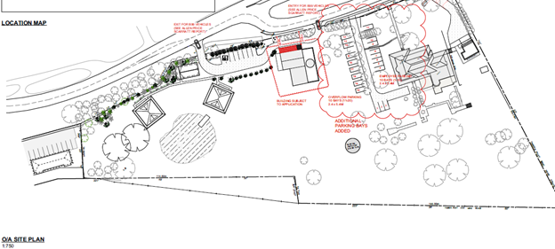
Figure 3 – Extract of the overall site plan (D21/1849737).
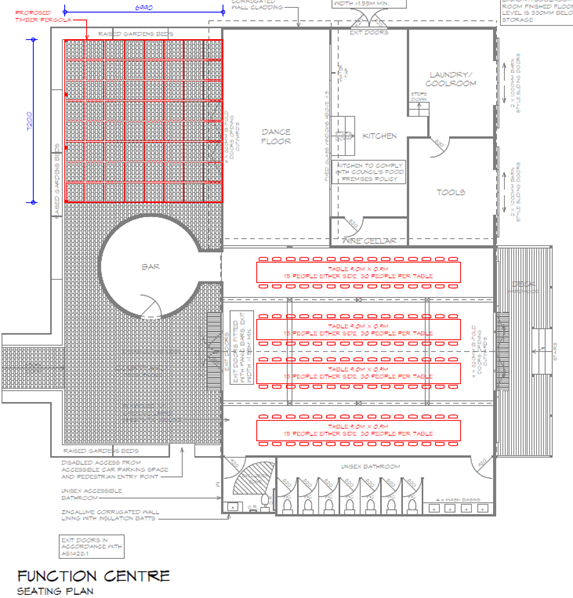
Figure 4 - Extract of the proposed floor plan associated with the
function centre, including works for additional bathrooms and timber pergola to
the northern elevation (D21/45180).
Subject Land
The subject site is located on
the eastern side of Homestead Lane and Queen Street, 600m north-east of the
township of Berry. The property is an irregular-shaped allotment of
approximately 1.98ha. The site is legally identified as Lot 101 DP 1057897 and is
described as 8 Homestead Place, Berry. The site is also referred to as Mananga
Homestead.
The land slopes gradually from
the northwest to the southeast corner of the site. A recently approved dam is
located in the south-eastern corner of the site and receives a portion of the
runoff from the site. There are presently four (4) formalised access points to
the site.
There is
limited native vegetation across the site, with significant ornate European
landscaped gardens around the curtilage of the dwelling and detached garage.
The ornate landscaping forms a significant component of the heritage
significance of the site. The property is locally listed under Schedule 5 of
the Shoalhaven Local Environmental Plan 2014 (SLEP 2014) as an Item of
environmental heritage (Item I63 - Mananga - Berry Estate Managers Farm
Complex).
The existing development on the
site consists of a Federation Queen Anne style homestead, associated
outbuildings, earth dam and jetty, recently renovated associated shed for use
as a home business (home industry and arts) and inground swimming pool. The
site is listed, as mentioned above, and is identified as locally significant in
the SLEP 2014 (Item No. I63).
Council has previously approved
the renovation and use of the shed located to the south of the dwelling for use
as a home industry/business (DA19/2060). The detached habitable rooms and a
portion of the breezeway connecting the structure to the dwelling house,
located to the north of the dwelling-house were destroyed by fire and are
currently in the process of being rebuilt in accordance with Development
Consent No. DA20/1266.
On 2 June 2020, Council granted
Development Consent No. DA19/2134 for development described as
“Tourist and visitor
accommodation and associated works, consisting of a total of five (5)
individual tourist and visitor accommodation rooms, as follows:
· Demolition and
rebuild of existing structure ‘Old Bails’ building for use as
tourist and visitor accommodation (tourist cabin); and
· construction of
two (2) detached single storey buildings each with two (2) rooms for use as
tourist and visitor accommodation (tourist cabins)”
A Construction Certificate (CC20/1814) has been issued in
relation to DA19/2134 and the tourist cabins are substantially commenced (refer
to the aerial image of the subject site at Figure 2).
Site & Context
The site immediately adjoins the
Bangalee Motel located to the south at 180 Queen Street. The Bangalee
Motel features a single storey masonry motel building comprising 10 motel
units, attached reception and manager’s residence, swimming pool and
parking. Council has recently granted development consent to substantial
additions to the available motel accommodation on this site through the
construction of two x 2-storey buildings that will contain an additional 16
accommodation units, bringing the total to 26 (Development Consent DA17/1357).
Development on the western side of Queen Street consists of detached dwelling
houses and their associated uses. Development to the north and east largely consists
of rural and residential land uses. Located further to the south of the site is
the Pulman Heritage Conservation Area Scheduled under the SLEP 2014.
History
The property is locally listed under Schedule 5 of SLEP
2014, as an Item of environmental heritage (Item I63 - Mananga - Berry
Estate Managers Farm Complex). The property was identified in the Shoalhaven
Council Heritage Study 2003 and identified as reference number B087 "
Mananga Federation, Queen Anne Style Farmhouse". The building is described
as having regional significance.
The statement of significance provided by Heritage NSW
indicates that
“Mananga”—Berry
Estate manager’s farm complex is “an excellent Federation
Queen Anne style farmhouse in weatherboard designed by noted Sydney architect
Howard Joseland. Historical interest as a leasehold property, originally, on
the Berry Estate. Closely associated with the early private town of Broughton
Creek.”
The physical description of “Mananga” provided
on the Heritage NSW State Heritage Inventory is as follows:
“The homestead and attached land is situated on
the crest and eastern fall of a low but locally prominent spurline shoulder
which forms the watershed between the Broughton Creek to the east, and
Broughton Mill Creek to the west. The homestead is situated 80 metres to the
east of Broughton Mill Creek and is elevated approximately eight metres above
the surrounding valley floor.
A Federation Queen Anne style weatherboard homestead
featuring a complex corrugated iron roof with decorative timberwork to gables
(with Art Nouveau character), hipped skillion verandah returning to sides,
timber posts and brackets. Verandas appear to have originally surrounded an
original core building. An additional wing has been added to the north eastern
corner of the building, sometime prior to 1949. A conservatory has been
relatively recently added to the eastern side of the building. The building is
surrounded by a mature garden. The homestead building is thought to be designed
by noted Sydney architect Howard Joseland (1860-1930) (Peter Freeman Pty Ltd
1998).
The current property holding includes five outbuildings
to the south of the current homestead, including a concrete silo, associated
large iron sheds and disused milking bails. Eight outbuilding structures are
visible on the 1958 aerial photo (Figures 6.91). Images appear to show interior
rendered walls (and/or ceilings) within an outbuilding (buttery) constructed
using sawn timber studs filled in using multiple timber slats with applied
plaster or render.
At the southern end of the property there are landform
traces of the excavated trench through the spurline (now filled in for the
Princes Highway platform) which formed part of the infrastructure for the
waterrace for the Berry Estate saw mill which dates from the 1830s.
Immediately north of the race alignment is the location
of the original Mananga homestead or cottage. This site is associated with some
exotic plantings and mature trees. This site, together with the infilled mill
race should be considered and managed as archaeological deposits.
Original building had approximate dimensions 24 x 18
metres. The additional wing on NE corner has approximate dimensions: 15 x
11metre.
The current property attached
with the homestead is approximately 250 x 118 metres in cross
dimensions.”
Chronology of Development
On 27 April 1994, Council granted Development
Consent No. DA93/3283, for development described as “Alteration &
Additions to Existing Dwelling & Change of Use to Bed & Breakfast
Accommodation” relating to the subject site. However, on 2 June 2020,
this approval was surrendered by the owner.
On 20 October 2004, Council refused a Development
Application (DA03/2381) for a brick fence on the subject site.
On 9 September 2019, Council granted Development
Consent No. DA19/1519 for the continued use of an earth dam sited to the south
of the building the subject of this current application.
On 9 December 2019, Council granted Development
Consent No. DA19/2101 for a jetty to be constructed on the western bank of the
approved earth dam.
On 30 January 2020, Council granted Development
Consent No. DA19/2060 (as modified by DS20/1307) for “alterations and
additions to an existing shed and silo and part use for the purpose of a home
business, including the following activities: repair and restoration of
furniture, flower arranging, holding of classes for furniture restoration,
flower arranging, painting and other craft related activities, and knitting,
sewing and craft”. The alterations and additions related to the
building are the subjects of the current application.
On 21 March 2020, Council
granted Development Consent No. DA20/1266 for the “partial demolition
of structures (detached habitable rooms, carport and connecting breezeway). The
structures were destroyed by a building fire.
On 26 March 2020, Council
granted Development Consent No. DA20/1231 for development described as “additions
to existing dwelling house consisting of detached habitable rooms, carport and
breezeway. The approval enabled the elements destroyed by the building fire
which were demolished via DA20/1266 to be rebuilt.
On 2 June 2020, Council
granted Development Consent No. DA19/2134 for development described as
“tourist and visitor accommodation and associated
works, consisting of a total of five (5) individual tourist and visitor
accommodation rooms, as follows:
• Demolition and rebuild of existing structure
‘Old Bails’ building for use as tourist and visitor accommodation
(tourist cabin); and
• construction of two (2) detached single storey
buildings each with two (2) rooms for use as tourist and visitor accommodation
(tourist cabins)
A Construction Certificate
(CC20/1814) has been issued in relation to DA19/2134 and the tourist cabins are
substantially commenced (refer to the aerial image of the subject site).
On 1 February 2021,
Council granted Development Consent No. DA20/2353 for an inground swimming pool
to be located to the east of the residence.
On 17 February 2021,
Council granted Development Consent No. DA21/1044 for business identification
signage relating to the approved tourist cabins. A Construction Certificate
(CC21/1173) was issued for the swimming pool and deck on 3 March 2021.
Issues
Heritage
The site is
zoned RU1 Primary Production under the provisions of SLEP 2014. Development for
a ‘function centre’ is prohibited in the RU1 zone in
accordance with the Land Use Table for the zone.
The development
application (DA) has been made with regard to cl. 5.10(10) of the SLEP 2014.
Clause 5.10(10)
of SLEP 2014 is extracted below as follows:
“(10) Conservation
incentives
The consent authority may grant consent
to development for any purpose of a building that is a heritage item or of the
land on which such a building is erected, or for any purpose on an Aboriginal
place of heritage significance, even though development for that purpose would
otherwise not be allowed by this Plan, if the consent authority is satisfied
that—
(a) the
conservation of the heritage item or Aboriginal place of heritage significance
is facilitated by the granting of consent, and
(b) the
proposed development is in accordance with a heritage management document that
has been approved by the consent authority, and
(c) the
consent to the proposed development would require that all necessary
conservation work identified in the heritage management document is carried
out, and
(d) the
proposed development would not adversely affect the heritage significance of
the heritage item, including its setting, or the heritage significance of the
Aboriginal place of heritage significance, and
(e) the
proposed development would not have any significant adverse effect on the
amenity of the surrounding area.”
The application is supported by the following heritage and
planning documents that have been prepared in support of the Development
Application:
· Mananga
Homestead-Function Centre (Former Cowsheds and Silo) Statement of Heritage
Impact (SoHI) prepared by Navin Officer dated April 2021, Project No.
210048 (D21/184997);
· Capital
Works & Maintenance Cost Report prepared by Mitchell Brandtman dated 25
January 2021 (Project Ref No. 28644) (D21/184959);
· Mananga,
Berry Estate Manager’s Farm Complex (Mananga Homestead) Conservation
Management Plan (CMP) prepared by Navin Officer dated April 2021 (Project
no. 210049) (D21/185437)
· Letter
prepared by Beatty Legal dated 4 February 2021 (D21/45147);
· Memorandum
of Advice – Mananga Homestead DA for Function Centre and Heritage
Conservation Works (Memorandum of Advice) prepared by Tim Robertson SC
dated 5 May 2021 (D21/185981);
· Statement
of Environmental Effects prepared by Cowman Stoddart Pty Ltd dated 4 May
2021 (Ref No. 18/19) (D21/184961);
The heritage impacts of the development and use of clause
5.10(10) of SLEP 2014, have been reviewed by an external consultant - Dr Peter
Kabaila of Black Mountain Designs as part of the assessment of the application
(Refer to Heritage Review (D21/222540) - Attachment 3).
Applicant’s Submission
Effect of the proposed development on heritage significance
– clause 5.10(4)
Based on the assessment of Navin Officer provided in the SoHI,
the proposal does not adversely impact the heritage significance of the “Mananga”—Berry
Estate manager’s farm complex (Item 63 – Schedule 5 –
SLEP 2014).
Furthermore, it is not considered that the proposed works and
use will have a significant impact on any listed heritage items and
conservation areas in the vicinity of the subject site, which have local
heritage significance, including:
· Pulman
Street Conservation Area – Shown by red hatching and labelled
“C1” – Schedule 5 – SLEP 2014
· “Constables
Cottage”—Victorian Georgian style weatherboard cottage and garden -
185 Queen Street, Berry - Lot 1, DP 558065; Lot 5, DP 600374 – Item
– 62 - Schedule 5 – SLEP 2014
It is considered by the applicant that the proposal provides
an opportunity to formalise heritage management measures through the
implementation of the CMP to ensure the ongoing conservation of the property to
maintain its significance.
Conservation Incentives – Clause 5.10(10)
The SEE prepared by Cowman Stoddart summarises the
applicant’s response to the five requirements of the clause in Table 4 of
the SEE and is extracted in Table 1 below. Furthermore, the Memorandum of
Advice prepared by T Robertson SC has reviewed the relevant application of
clause 5.10(10) in light of current case law from paragraph [17]-[31] of the
advice and concludes at [31] that:
“it is open to Council to be satisfied (now) that
the application complies with the preconditions to the conservation incentives
clause and therefore that the development of a function centre is permissible
with consent.”
Table 1 - Applicant's assessment of clause 5.10(10) as extracted
from the submitted SEE (D21/184961) pg 49-50
|
Clause
5.10(10) – Conservation Incentives
|
Applicant’s
Response
|
|
(a) the
conservation of the heritage item or Aboriginal place of heritage
significance is facilitated by the granting of consent, and
|
Accompanying this SEE are
the following separate assessments and documents:
· A Statement of Heritage Impact and Conservation Management Plan
prepared by Navin Officer;
· Capital Works and Maintenance Costs Report prepared by
Mitchell Brandtman Quantity Surveyors (MBQS). MBQS have expertise in
quantifying costs associated with the ongoing maintenance and conservation of
heritage buildings.
The use of the property as a
function centre will facilitate the conservation of the heritage significance
of Mananga Homestead in a number of ways.
Firstly, the proposal will
ensure the ongoing retention and conservation of the cowshed building and
silo, both features identified by Navin Officer as contributing to the
heritage significance of the place, and which contribute to the landscape
qualities of the Berry District Landscape Conservation Area. This is in
addition to the conservation of other elements of the site including the
Mananga Homestead, significant heritage trees, surrounding gardens and water
race.
Secondly, the proposal will
involve interpretative signage concerning the old Broughton Post Office and
remnant water race (implemented through the CMP) which will assist visitors
to the site understand the history of the old Broughton Creek settlement,
relevant to both the Pulman Street Conservation Area and Constables Cottage.
Thirdly, whilst the property
is currently in good condition, funds generated through the commercial use
will contribute to the maintenance of the property to ensure its ongoing
conservation. The Capital Works and Maintenance Costs Report prepared by MBQS
provides a very detailed assessment of the costs associated with this
development proposal, and which separately identifies costs associated with
its maintenance, identifying costs in the short term (1 year), medium term (2
to 4 years) and recurrent costs both on an annual and biennial basis. The
works identified in the MBQS align with conservation measures outlined in the
Conservation Management Plan.
The MBQS identifies the
following costs for maintenance associated with the property:
· Short term - $154, 800;
· Medium term - $62,000;
· Recurring annual - $161, 900;
· Recurring biennial - $24,700.
Navin Officer consider that
the costings outlined by MBQS are a realistic assessment of the maintenance
costs associated with properties such as Mananga Homestead.
Finally, the proposal
enhances the heritage significance of the site by enabling the property to be
seen by the public (being visitors and guests of functions) who would
otherwise be excluded from this private property.
The Statement of Heritage
Impact prepared by Navin Officer has considered the assessment of MBQS and
advises that these works contribute to the conservation of the heritage
significance of the subject site.
The use
of the property as a function centre will clearly facilitate the conservation
of the heritage significance of Mananga Homestead in many ways, thereby
satisfying the provisions of subclause (a).
|
|
(b) the
proposed development is in accordance with a heritage management document
that has been approved by the consent authority, and
|
For the purposes of the
Shoalhaven LEP 2014, a heritage management document is defined as:
(a) a heritage conservation
management plan, or
(b) a heritage impact
statement, or
(c) any other document that
provides guidelines for the ongoing management and conservation of a heritage
item, Aboriginal object, Aboriginal place of heritage significance or
heritage conservation area.
The
proposal is accompanied by a SHI prepared by Navin Officer and a CMP to
further establish the relative significance of the various elements of the
property and outline agreed heritage conservation policies to guide its
future management.
|
|
(c) the
consent to the proposed development would require that all necessary
conservation work identified in the heritage management document is carried
out, and
|
The recommendations of the
SHI and CMP can be included as conditions of consent.
|
|
(d) the
proposed development would not adversely affect the heritage significance of
the heritage item, including its setting, or the heritage significance of the
Aboriginal place of heritage significance, and
|
This has been assessed by
Navin Officer and which concludes that the proposal does not adversely affect
the heritage significance of the subject site. Furthermore, the assessment of
Navin Officer has concluded that the proposal will not significantly
adversely affect the heritage significance of other identified heritage
times, including the Berry District Landscape Conservation Area, Pulman
Street Conservation Area, or Constable's Cottage.
|
|
(e) the
proposed development would not have any significant adverse effect on the
amenity of the surrounding area.
|
The proposal has been
subject of a number of separate expert assessment including:
· Environmental Noise Impact Assessment prepared by Harwood Acoustics;
· Traffic and Parking Impact Assessment prepared by McLaren Traffic
Engineering; and
· Statement of Heritage Impact prepared by Navin Officer.
All of these assessments
conclude that the proposal does not result in significant adverse impacts.
In
addition, the proposal has been assessed in the Statement of Environmental
Effects prepared by our firm which also concludes that the proposal does not
adversely affect the amenity of the locality.
|
Based upon the analysis, assessment, and conclusions of the
SOHI, the SOHI makes the following recommendations in relation to the works and
use of the site (Refer to page 43 of the SOHI – D21/184997):
“1. The proposed
further works: The proposed works as detailed in this report are considered
to have minimal heritage impacts on Mananga and no negative heritage impacts on
neighbouring heritage items and are therefore recommended for approval as they
will complete and compliment the works already approved as part of the adaptive
reuse of these structures.
2. The change of use
to include use as a function centre: The proposed variation of use to
include wedding receptions, and similar, is not considered to be detrimental to
the heritage values. The property has been periodically exposed to large
numbers of visitors through the annual open garden program. While use of the
cowsheds and silo as a function centre will involve more wear and tear on the
structures, this can be managed through regular maintenance in line with the
policies in the CMP. The change of use has the benefit of providing a more
resilient income stream to ensure the long-term management of the property.
3. Long term
management of the heritage values of Mananga: It is recommended that the CMP
which has recently been prepared for the property is formerly adopted to guide
the future management of the property. It establishes the relative significance
of the various elements of the property and sets out agreed heritage
conservation policies and strategies to guide its future management. The
Capital Works and Maintenance Cost Report (Mitchell Brandtman 2021) provided
information that has been integrated into the cyclical maintenance schedule of
the CMP.
4. Heritage
Interpretation: The CMP provides policies to guide the interpretation for
the property. The owner already has ideas for interpretation of the remnant
water race and the former Berry post office.
5. Unanticipated
archaeological finds: Although the archaeological potential around the cowsheds
and silo has been assessed as low, it is always possible that unexpected
archaeological material may be encountered on historic properties during ground
disturbance works. It is important to note that archaeological deposits of
either Aboriginal or historical settler origin are protected by legislation in
NSW. Therefore, it is recommended that the unanticipated finds protocols
included as Appendix 3 in this report are adopted and are included in
contractor’s contracts.
Provided these recommendations are followed, then
landscape values associated with the Mananga - Berry Estate Manager's Farm
Complex, and the properties inherent value to the broader local area, are not
considered to be at risk. In particular, the rural/agricultural setting of the
structures are maintained and are readily interpretable within the landscape.
Indeed, the retention of the structures and their re-purposing is desirable and
will ensure their future maintenance and active interpretation”.
Council’s Assessment
Clause 5.10 - Heritage Conservation
As the site contains a heritage item, cl. 5.10 Heritage
conservation applies to the development. The objectives of cl 5.10 of SLEP
2014, ‘Heritage Conservation’ at sub-cl (1)(a)-(d), are:
(a) to conserve the
environmental heritage of Shoalhaven,
(b) to conserve the
heritage significance of heritage items and heritage conservation areas,
including associated fabric, settings and views,
(c) to conserve
archaeological sites,
(d) to conserve
Aboriginal objects and Aboriginal places of heritage significance.
Council as the consent authority must, before granting consent
in respect of a heritage items and heritage conservation areas, consider the
effect of the proposed development on the heritage significance of the item and
the area.
Clause 5.10(4) - Effect of the proposed development on
heritage significance
Clause 5.10(4) sets out the matters that the consent authority
must consider - specifically "the effect of the proposed development on
the heritage significance of the item or area concerned". Council must
form the opinion that the impact of the proposed development on the heritage
significance of the item is acceptable.
The heritage impacts of the development on the item and the
surrounding items of heritage significance, including the Constables Cottage
and Pulman Conservation Area, has been reviewed by an external consultant - Dr
Peter Kabaila of Black Mountain Designs as part of the assessment of the
application (the Heritage Review is provided as Attachment 3).
The outcomes of the Heritage Review indicate that the only
specific suggestion of adverse effect is the position of proposed car park
spaces 4-11. The Heritage Review does not otherwise suggest that this
particular development will adversely affect the significance of the heritage
item, however, it does observe that previous developments have cumulatively
affected that significance.
It is not considered that the proposed works and use will be
sufficiently detrimental to any adjoining heritage item or conservation area to
warrant refusal of the application pursuant to s4.15(1)(b) of the EP&A Act.
Clause 5.10(5) - Heritage assessment
Clause 5.10(5) may require the preparation of a heritage
management document that assesses the extent to which the carrying out of development
that would affect the heritage significance of the heritage item or heritage
conservation area concerned, in relation to development:
(a) on land on which a
heritage item is located, or
(b) on land that is within a
heritage conservation area, or
(c) on land that is within
the vicinity of land referred to in paragraph (a) or (b),
The development application is supported by Mananga
Homestead-Function Centre (Former Cowsheds and Silo) Statement of Heritage
Impact (SoHI) prepared by Navin Officer dated April 2021, Project No.
210048 (D21/184997) and the other heritage and legal documents listed
previously. These documents satisfactorily address clause 5.10(5) and have been
reviewed by an external Heritage Consultant engaged by Council - Heritage
Review (D21/222540).
Clause 5.10(10) - Conservation incentives
In accordance with sub-clause (10) of cl. 5.10, the consent
authority has a discretionary power to grant consent to development for any
purpose of a building that is a heritage item or of the land on which such a
building is erected, or for any purpose on an Aboriginal place of heritage
significance, even though development for that purpose would otherwise not be
allowed by this Plan if the consent authority is satisfied that the application
meets sub-cl. (a) – (e).
The five requirements are conjunctive and jurisdictional and
so the proposed development, for a use otherwise prohibited under SLEP 2014,
must meet each of the five requirements to be capable of being granted
consent under the clause.
“(a) the conservation
of the heritage item or Aboriginal place of heritage significance is
facilitated by the granting of consent, and
(b) the proposed
development is in accordance with a heritage management document that has been
approved by the consent authority, and
(c) the consent to the
proposed development would require that all necessary conservation work
identified in the heritage management document is carried out, and
(d) the proposed
development would not adversely affect the heritage significance of the
heritage item, including its setting, or the heritage significance of the
Aboriginal place of heritage significance, and
(e) the proposed
development would not have any significant adverse effect on the amenity of the
surrounding area.”
Furthermore, the development alone must satisfy the
jurisdictional requirements alone to satisfy Council of the requirements under
sub-cl. (a) – (e), Council cannot look to impose a condition that
would otherwise, in the view of Council, enable the requirement to be
satisfied. In this regard, it is important to note that conditions cannot
be used to satisfy a requirement under clause 5.10(10).
In Council’s consideration of the application of clause
5.10(10) Council has considered the supporting information submitted by the
applicant, the heritage consultant engaged by Council and independent legal
advice.
The focus of the heritage incentive
clause is on expanding the uses to which a building (or an Aboriginal place)
identified as a heritage item, or the land on which the building is erected,
can be put to, in order to facilitate the conservation of the building
(or the Aboriginal place) - Howe Architects Pty Ltd v Ku-ring-gai Council
[2021] NSWLEC 1233 at [37].
a) the conservation
of the heritage item or Aboriginal place of heritage significance is
facilitated by the granting of consent, and
The first step in consideration of cl. 5.10(10) is to first
identify what is the heritage item and what is its significance. It is
considered that the identification of the heritage item and its significance
has been appropriately detailed through the applicant’s supporting
information.
The term ‘conservation’ is not defined in
the Dictionary to SLEP 2014 and therefore it is appropriate to consider the
definition of ‘conservation’ as defined by the Burra
Charter, 2013. Article 8 of the Burra Charter (2013) provides as follows:
“Conservation requires the retention of an
appropriate setting, this includes retention of the visual and sensory setting,
as well as the retention of spiritual and other cultural relationships that
contribute to the cultural significance of the place.
New construction, demolition, intrusions or other
changes which would adversely affect the setting or relationships are not
appropriate.”
Likewise, the term ‘facilitated’ is not
defined in the Dictionary to SLEP 2014. Reasonably construed, it is not the
purpose of the clause to enable reliance upon works of a de minimis nature
(Parramatta City Council v Hale (1982) 47 LGRA 319 at p. 335 per Street
CJ).
In relation to the interpretation of
the meaning of ‘facilitate conservation’, the Court found in
David Fox v North Sydney Council [2016] NSWLEC 1366 at [47]:
“Facilitating
conservation requires a higher threshold than just ensuring the proposal does
not adversely impact on the identified heritage significance of an item. In
order to facilitate the conservation of the heritage item, the proposal must
assist in retaining its cultural significance, such as by revealing and
interpreting the heritage significance of the item.”
From the case law, it is generally held that the need to carry out minor maintenance works which is an
ordinary incident of property ownership is not within the scope and purpose of
conservation work within the meaning of cl 5.10(10) and would not ‘facilitate’
the conservation of the heritage item.
The Heritage Review (D21/224818)
suggests that the Development Application entails
very little conservation of the heritage item. In particular, it identifies
that seven (7) of the items in the Capital Works & Maintenance Cost
Report could be seen as conservation works, with the remaining thirty (30)
items being works for “maintaining the property at its current, highly
renovated, standard”. There is a suggestion that interpretive works
could be key to “heritage conservation”, given the highly renovated
status of the item and that any detail of heritage interpretation is missing
from the heritage documentation.
Based upon Council review of the
application and the outcomes of the Heritage Review it is questionable whether
the proposed development does in fact facilitate conservation of the
heritage item.
Council is therefore not
satisfied that the DA meets the criterion in sub-cl. 5.10(10)(a) of the
SLEP 2014 notwithstanding the cost to carry out the proposed works.
b) the proposed
development is in accordance with a heritage management document that has been
approved by the consent authority, and
The applicant has provided the following heritage
documentation in satisfaction of this sub-clause:
· Mananga
Homestead-Function Centre (Former Cowsheds and Silo) Statement of Heritage
Impact (SoHI) prepared by Navin Officer dated April 2021, Project No. 210048
(D21/184997);
· Capital
Works & Maintenance Cost Report prepared by Mitchell Brandtman dated 25
January 2021 (Project Ref No. 28644) (D21/184959);
· Mananga,
Berry Estate Manager’s Farm Complex (Mananga Homestead) Conservation
Management Plan (CMP) prepared by Navin Officer dated April 2021 (Project
no. 210049) (D21/185437)
Clause 5.10 refers separately to a heritage management
document “that assesses the extent to which the carrying out of the
proposed development would affect the heritage significance of the heritage
item” and a heritage conservation management plan. In requiring that
the development is in accordance with a “heritage management document
that has been approved”, the clause has no clear pathway for
“approval” of either of those documents.
The wording of this clause would require that a heritage
management document be firstly approved by Council prior to the grant of
consent under this sub-cl. Council has not approved a heritage management
document relating to the development. Furthermore, the above three documents
(if considered as a single document forming a heritage management document)
are not in a form and containing relevant conservation works to satisfy sub-clause. 5.10(10)(a) of the SLEP 2014. Council could not
approve these documents in their current form and conditions could not be
imposed to rectify any deficiency or inadequacy in these documents.
It follows that Council is not
satisfied that the DA meets the criterion in sub-cl. 5.10(10)(b) in that
the Heritage Management Document could not be approved in its current form.
c) the consent to the
proposed development would require that all necessary conservation work
identified in the heritage management document is carried out, and
A Capital Works & Maintenance Cost Report and Conservation
Management Plan have been submitted as part of the application.
Council must be satisfied that development consent will, by
reference to these documents, satisfy Council that all necessary conservation
work will be carried out, in that the policies are adequately tied to actions,
priorities and timing.
The Heritage Review indicates
that the Development Application does not include all necessary conservation
works to an extent that would allow Council to be satisfied of this criterion.
The Heritage Review maintains that:
· the
Capital Works & Maintenance Cost Report is not a schedule of
necessary conservation work;
· the
heritage landscape plan does not describe works which go towards the heritage
item and its conservation;
· there
is a need for details of the interpretive works and a timeframe for those
works;
· redesign
and rebuilding of the carport and its link is necessary; and
· there
is a need for a low hedge or stone wall at the northern edge of the house
driveway if the additional car parking spaces are to be provided to service the
development.
Council is not satisfied that the Development
Application meets the criterion in sub-clause. 5.10(10)(c) of the SLEP 2014.
d) the proposed
development would not adversely affect the heritage significance of the
heritage item, including its setting, or the heritage significance of the
Aboriginal place of heritage significance, and
The applicant’s Statement of Heritage Impact
(D21/184997) and Conservation Management Plan (D21/185437) both indicate
that the Development Application will not adversely affect the significance of
the heritage item.
The only specific suggestion of adverse effect in the Heritage
Review is the position of proposed car park spaces 4-11 (refer to Figure 6).
Were car parking spaces 4 -11 to be required to be formalised there would
likely be an impact on the heritage item and Council could not be satisfied
that the Development Application meets the criterion in subclause 5.10(10)(d)
of the SLEP 2014. However, the applicant has not proposed to formalise these
car parking spaces and does not seek to utilise these as part of the
application.
The Heritage Review does not otherwise suggest that this
particular development will adversely affect the significance of the heritage
item, however, it does observe that previous developments have cumulatively
affected that significance.
It is important to note that a condition could not be
imposed to delete car parking spaces 4-11 from the plans in order to
satisfy this sub-clause. Granted that a condition cannot be imposed to delete
these car parking spaces the inclusion of these spaces, on the account of the
Heritage Review, will result in an adverse impact. Were the parking spaces to
be removed by the applicant prior to determination it is considered that the
development would not have an adverse effect on the heritage significance of
the heritage item, including its setting. However, the removal of the
spaces raises another issue which is discussed later in this report, and that
is car parking.
Council is not satisfied that the Development
Application meets the criterion in sub-cl. 5.10(10)(d) of the SLEP 2014. The
proposed development as currently proposed includes car parking spaces 4-11
which are considered to have an adverse impact on the heritage significance of
the heritage item, including its setting.
e) the proposed
development would not have any significant adverse effect on the amenity of the
surrounding area.
As stated by the Court in Fox v North Sydney Council
[2020] NSWLEC 1056 at [43]:
“Under cl 5.10(10)(e), a consent authority needs
to, in a sense, turn away from heritage factors and be satisfied of a further
factor before the incentivising provisions of the clause are triggered. This is
that “the proposed development would not have any significant adverse effect
on the amenity of the surrounding area”
The term ‘amenity’ is not defined in the
Dictionary to SLEP 2014; however, the concept was considered by the Court in
the case of New Century Developments Pty Limited v Baulkham Hills Shire
Council [2003] NSWLEC 154 at [53]
“The amenity of the locality is encompassed by the
consideration of environmental impacts on both the natural and built
environments, and social and economic impacts in the locality required by s
79C(1)(b) of the EP&A Act. The concept of “amenity” is wide and
flexible (Broad v Brisbane City Council & Anor (1986) 59 LGRA 296),
transcending the merely physical content (Perry Properties Pty Ltd v Ashfield
Council (No. 2) (2001) 113 LGERA 301 at 317 per Bignold J).”
The physical works to the site are minor and will not impact
the significance of the heritage item or the surrounding items of heritage
significance (except for the car parking as mentioned above). Furthermore, it
is not likely that there will be any significant visual impacts associated with
the development. The visual issues raised as part of the Heritage Review point
to previous developments (such as the carport/garage) rather than the
“proposed development”. In this regard, it is not anticipated that
the proposal will have any significant adverse impact on the built environment.
It is not anticipated that the proposal will have any
significant adverse social or economic impact on the locality.
In relation to the potential noise
impacts or impacts on the natural environment associated with the development,
however, it is noted later in this report that the development does not provide
sufficient assessment of the noise impacts to justify that the impacts will be
reasonable and not result in a significant adverse impact. The Acoustic Review
completed by Day Design suggests that:
a. the
liquor and gaming noise criteria should apply which are more stringent.
However, it is not suggested that this would then result in a significant
amenity impact.
b. Noise
impacts are not relevant to the Transport for NSW property, as the dwelling
there is derelict and there is no imminent residential use of the land.
Accordingly, it is not an affected receptor. This approach is taken by the
applicant’s acoustic assessment and supported by the Memorandum. It is
however contrary to the position taken by Transport for NSW.
c. Contrary
to the amended noise impact assessment, the calculated noise level at receptor
1 should be 43 dBA. However, this only affects amenity from 10 pm with regard
to outside guests. A restriction on the use of the outdoor space after 10 pm is
proposed.
Given that the DA does not provide sufficient information to
satisfy Council of the potential noise impacts it would not be open to Council
to conclude that the development has satisfied this requirement. Furthermore,
Council cannot impose a condition to require satisfaction of this clause where
it is unclear as to the development’s satisfaction of the sub-clause.
Council is not satisfied that the Development
Application meets the criterion in sub-cl. 5.10(10)(e) of the SLEP 2014.
Conclusion
As previously stated, the relevant assessment under sub-cl.
5.10(10) requires Council to be satisfied with each of the five (5)
requirements (i.e. they are conjunctive) and so the proposed development, must
meet each of the five (5) requirements to be capable of being granted consent
under the clause.
The proposed development has been assessed and established not
to satisfy sub-clauses. (a)-(c) and (e). Council, therefore, cannot
approve the DA in accordance with cl. 5.10 of SLEP 2014.
Noise Impacts
The proposal is the use of the buildings on the site for a
function centre for a maximum of 120 guests with amplified music.
Receptions will be held within the shed building and music will only be played
within the shed building. Guests may access the paved courtyard and lawn area
to the north and east of the building during functions.
The main sources of noise from any proposed functions will
include amplified music, guest noise and motor vehicle movements.
In order to assess the potential for any significant impact on
surrounding neighbours, the DA is supported by a noise impact assessment and
response to submissions relating to noise impacts and veracity of noise
assessment:
· Noise
Impact Assessment – Response to Submission prepared by Harwood
Acoustics dated 2 February 2021 (D21/45140);
· Environmental
Noise Impact Assessment (ENIA) prepared by Harwood Acoustic dated 7 April
2021 (D21/207955).
The noise impacts associated with the development application
have been reviewed by Council’s Environmental Health Officers and by an
external consultant – Stephen Gauld of Day Design Pty Ltd.
The relevant test of the impact associated with noise and
amenity is reflected under cl 5.10(10) of SLEP 2014. Sub-clause. 5.10(10(e)
requires Council to be satisfied that the development would not have any
significant adverse effect on the amenity of the surrounding area.
Applicant’s Submission
Sensitive Receptors
The closest residences to the site are 12 Homestead Lane,
Berry to the northeast, 185 Queen Street to the south-west and 1 Pulman Street
further to the south-west (refer to Figure 5 below). Consideration is also
given in this assessment to the Bangalee Motel, although this is a commercial
receptor and not a residential receptor. The derelict property opposite the
subject site (191 to 195 Queen Street), were not considered at this stage to be
a potentially affected residential receptor.
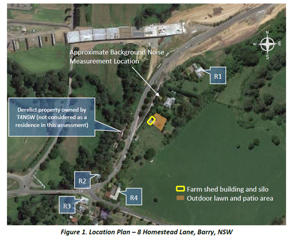
Figure 5 - Figure 1 extracted from the
applicant's ENIA. R1 – 12 Homestead Lane (Circa 150 metres), R2 –
185 Queen Street (Circa 180 metres) R3 – 1 Pulman Street (circa 245
metres) R4 – 180 Queen Street (circa 180 metres) Bangalee Motel –
Commercial Receptor
Assessment Methodology
The
applicant has adopted the noise assessment methodology from the EPA’s
Noise Guide for Local Government 2013, to assess the potential for any
significant impact on surrounding neighbours. Acceptable noise limits are
derived from the EPA’s Noise Guide criteria at the nearest
residences to the site. These are 51 dBA Leq, 15 minutes during the day period
(7 am to 6 pm), 45 dBA Leq, 15 minutes during the evening period (7 pm to 10
pm) and 38 dBA Leq, 15 minutes during the early night-time period between the
hours of 10 pm and 12 midnight.
These noise limits are based on
measured background noise levels in the vicinity of the nearest neighbours to
the site. Consideration was also given to the potential for sleep disturbance
as well as on-road traffic noise.
The applicant has considered the
potential noise from any proposed functions, including; amplified music, guest
noise and motor vehicle movements.
Recommendations
The applicant’s ENIA has recommended management and
operational requirements to reduce the level of noise emission to within
acceptable limits as received at all receptors. These include limiting the
level emitted from the playing of amplified music at various times and
establishing a Noise Management Plan. The recommendations of the ENIA are
extracted and summarised below:
· Maximum
allowable amplified music level and restriction on amplified music:
o 88 dBA Leq, 15 minutes; and
o cease
all amplified music at 10.30 pm;
· Building
openings:
o Day
time (7 am to 6 pm) - no restriction and no limitation on the use of the
courtyard or southern deck by guests.
o Evening
time and early night time (6 pm to 12 am)
§ amplified
music is restricted to within the building;
§ Openings
in the southern or northern facade of the building should not exceed 2m2;
and
§ No
restriction on building opening where there is no amplified music.
· Operational/management
requirements;
o An
electronic noise limiting device may be installed inside the building with a
warning that the maximum noise level is close to being breached.
o All
amplified music should be controlled through an in-house sound system that is
directed through the noise limiting device.
o a
sound level meter may be purchased from an electronics store so that the owner
or property manager may ‘spot check’ for noise compliance during or
prior to functions.
o There
should be no function activity at the site after midnight on any day.
Providing these recommendations are implemented and
maintained, the acceptable noise limits set by the EPA and required by
Shoalhaven City Council can be met at all receptor locations.
The proposal can be controlled to ensure there is no
significant impact on neighbouring receptors in accordance with the acoustical
requirements of Clause 5.10(10)(e) of SLEP 2014 can be satisfied.
Council’s Assessment
Council’s Environmental Health Officers have reviewed
the applicant’s ENIA and supporting information and have concluded in
their referral (D21/48725) in relation to the assessment, recommendations and
conclusions of the ENIA, that:
“The additional acoustic assessment prepared by
Harwood Acoustics has addressed the further information requested to some
extent, however, it has not given any consideration to the TfNSW property
directly across the road at 191-195 Queen Street which according to Councils
GIS is approximately 80m. (Refer map below). This distance is less than half
that which has been considered for the other nearby receivers (150-180m) and
would therefore require a considerable acoustic re-assessment of the proposed
function venue to assess the potential noise impact upon this rural/residential
property.”
Council cannot determine the application until such time as
the following additional information is provided:
1. Additional information
(acoustic assessment) should be submitted addressing the potential noise impact
upon the Bangalee Hotel at 180 Queen Street and the existing residence at
191-195 Queen Street. These two residential locations were not considered as
part of the ENIA.
Consideration could also be given to some of the
residents in Pulman Street, especially those located to the North.
2. Further
information on how the in-house sound system can cater for two
pre-set maximum allowable amplified noise levels (86dBA and 91dBA) and remain
secure from being accessible to others is requested. Achieving this provision
is critical if this proposal is to operate in a manner that would not have a
significant adverse impact upon other residential receivers.
Subsequent to the comments and recommendations being received
by Council’s Environmental Health Officers, Council engaged an external
specialist noise consultant – Stephen Gauld of Day Design Pty Ltd to
review the applicant’s ENIA and the noise conclusions drawn in the
Memorandum of Advice provided by T Robertson SC.
The Acoustic Review (Attachment 4) concludes that:
· The
ENIA relies on standard assessment criteria, based on EPA’s Noise
Guide for Local Government 2013. Granted that the facility will operate in
the same way as a licensed facility (albeit that guests will be responsible for
providing alcohol, food and entertainment and as such the owners will not
require a liquor licence), the more stringent Liquor and Gaming Noise
Criteria should apply as the facility will operate more in line with a
licensed facility with the service of alcohol being the responsibility of the
catering staff and not the function venue.
· Noise
impacts are not relevant to the Transport for NSW property, as the dwelling
there is derelict and there is no imminent residential use of the land. Accordingly,
it is not an affected receptor.
· Separate noise predictions have been made for different
aspects of the proposal (eg patrons & music, mechanical plant, traffic),
which is not correct unless a cumulative noise level is also calculated, which
has not been shown. Nevertheless, the dominant noise will be from the music
inside the building and from guests outdoors, with other aspects of the
proposal adding little to the cumulative noise level.
· Concerns have also been raised in relation to data
presented in Table 10 of the ENIA. For a sound power level (SWL) of 95 dBA
(Section 4.1.2) for guests outdoors, and a distance of 150m to 12 Homestead
Lane, the calculated noise level at 12 Homestead Lane should be 43 dBA, not 38
dBA. This higher level is acceptable until 10 pm, but not after 10 pm (see
Table 10). Note that no assessment has been provided for guests outside after
10 pm.
· There is also no assessment of the noise emission for the
end of the function as guests farewell the wedding couple and perhaps mingle
outside. I note the main outdoor area directly faces the residence
at 12 Homestead Lane.
Conclusion
The submitted ENIA has been reviewed by Council’s EHOs.
Furthermore, an external specialist noise consultant – Stephen Gauld of
Day Design Pty Ltd (Attachment 4) has review the applicant’s ENIA
and the noise conclusions drawn in the Memorandum of Advice provided by T
Robertson SC.
In conclusion, the information before Council is not
satisfactory to enable a definitive determination as to whether the use of the
site will have a significant adverse impact on the surrounding area. Additional
assessment of the application against the more stringent Liquor and Gaming
Noise Criteria should apply as the facility will operate more in line with a
licensed facility with the service of alcohol the responsibility of the
catering staff and not the function venue. Furthermore, an assessment of the
impacts of guests outside after 10 pm would be required.
While the Acoustic Review recommends the implementation of a
number of conditions to ameliorate noise it is unclear if this will be
acceptable. Further, the amelioration measures, should form part of the
application to properly resolve sub-clause (e).
Car Parking and Traffic
The car parking
requirements and traffic impacts of the development have been considered as
part of the assessment of the development application. In support of the
applicant’s proposal the applicant has submitted the following reports:
· Traffic and
Parking Impact Assessment (TPI) prepared by McLaren Traffic Engineering
dated 30 March 2021 (D21/184960);
· Letter of
Response to Council Comments for The Events & Wedding Functions Facility At
8 Homestead Lane, Berry prepared by McLaren Traffic Engineering (Reference:
210019.02FE) dated 30 March 2021 (D21/184966); and
· Statement
of Environmental Effects prepared by Cowman Stoddart Pty Ltd dated 4 May
2021 (Ref No. 18/19) (D21/184961).
Access
Four (4)
separate access points are provided to the site along the Homestead Lane and
Queen Street frontage. The Mananga Homestead may be accessed via two access
points located toward the northern extent of the site off Homestead Lane. The
tourist accommodation is serviced by separate ingress and egress driveways. The
ingress point being on Homestead Lane near the Queen Street intersection and
the egress point located to the south of the same intersection on Queen Street.
No change to
the access points is proposed as part of the application.
Car Parking
In accordance
with Chapter G21: Car Parking and Traffic of Shoalhaven Development Control
Plan 2014 (SDCP 2014), car parking for a function centre is required to be
provided at a rate of 1 space per 6.5m² of public dining area.
Car parking
details are provided as follows:
· The floor area of
the function centre is 155m2 (110m2 dining room and 45m2
dance floor).
· A total of 23.8
(24) off-street car parking spaces are required.
· Guests (other than
those accommodated on-site) will be transported via two (2) x 12-seat minibuses
from their local off-site accommodation to the function centre.
· A total of ten
(10) staff will be required during functions.
· A total of twelve
(12) car parking spaces are proposed to the south of the Mananga Homestead. Ten
(10) of the nominated car parking spaces are proposed for use by staff. A total
of two (2) car parking spaces will be available for the use of function guests.
· An additional
seven (7) car parking spaces (including one (1) accessible space) are approved
and support the existing tourist accommodation (DA19/2134). Five (5) of the car
parking spaces proposed (including one (1) accessible spaces) are required to
service the existing development.
An extract of
the applicant’s site plan with details of the car parking arrangements is
provided in Figure 6 below:
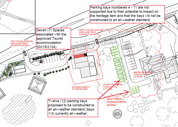
Figure 6 - Extract of Site Plan with further
details of proposed parking arrangements. Council has marked-up aspects of the
plan to highlight the proposed parking arrangements
Applicant’s
Submission
The
applicant’s TPI (D21/184960) provides an assessment of the following
traffic and car parking issues associated with the Development Application:
· The
existing traffic and parking conditions, including:
o The road
hierarchy.
o The existing
traffic management
o The existing
traffic and parking environment
o The future
road and infrastructure upgrades
· Parking
assessment, including:
o A parking
justification for use by minibus
o Disabled
parking
o Bicycle and
motorcycle parking
o Servicing
and loading
o Car parking design and compliance
The
applicant’s TPI (D21/184960) makes the following conclusions on page 18
of the Report as follows:
“In
view of the foregoing, the subject proposal at 8 Homestead Lane, Berry for a
function facility is fully supportable in terms of its traffic and parking
impacts with due regard to traffic flow efficiency and road safety
considerations. The following outcomes of this report are relevant to note:
• The proposed
development requires 24 car parking spaces based upon Council’s
DCP. The proposed plans detail a combined total of 19 car parking
spaces, resulting in a parking shortfall of five (5) spaces from Council’s
DCP requirement when considering the tourist accommodation being occupied by
guests attending the function.
• Sufficient room is
provided for 10 informal spaces dedicated primarily to staff, adjacent to the
Mananga Homestead, meeting the function centres staff parking demand.
Carpooling between staff will be promoted to reduce the staff car parking
demand with any available parking spaces used by guests who do not comply with
the Plan of Management and advertised requirements.
• All visitors not
staying on-site will be transported to and from their accommodation within
Berry using two (2) private 12-seater Minibuses (Toyota HiAce Commuter,
Mercedes-Benz Sprinter Transfer Minibus or similar), which can carry 11
passengers before and after each event. A plan of management shall be developed
to communicate to guests that no-parking is available on-site for guests and
that they shall use the minibus transport service to get to and from the
function facility.
• It is expected
that the proposed development will operate with no change to waste collection
compared to the existing operation of the site. Waste generated from functions
will be removed from the site by staff after the conclusion of the function.
• The site is
expected to generate a worst-case peak of 39 (29 IN, 10 OUT) vehicle trips in
the one-hour period before a function on either a Saturday or Sunday. The
impacts of the traffic generation have been modelled using SIDRA INTERSECTION
8.0, indicating that there will be no detrimental impact to the performance of
the intersections as a result of the generated traffic.
• The existing car
park layout (associated with the tourist accommodation) meets the dimension
requirements of both AS2890.1:2004, AS4299:1995 and AS2890.6:2009. Informal
staff parking, during functions will be provided on the gravel/grass area,
adjacent to the Mananga Homestead.
• The exit driveway
exceeds the sight line requirements for an 80km/h road design and is located
within a superior location compared to Homestead Lane.
• In accordance with
Clause 5.10(10)(e) of the Shoalhaven LEP 2014, from a traffic and parking
perspective, the proposed development will not have any significant adverse
effect on the amenity of the surrounding area.”
Council’s Assessment
The car parking requirements and traffic impacts of the
development have been reviewed by Council Development Engineer and City
Services.
The car parking does not comply with Chapter G21: Car Parking
and Traffic of SDCP 2014. The shortfall in car parking and the design of the
additional proposed car parking to the south of Mananga Homestead are not
supported for the following reasons:
· The
development is required to provide a total of 24 spaces for the use of staff
and guests associated with the function centre. The applicant has nominated 20
spaces to the south of the Mananga Homestead (refer to Figure 6 above).
Twelve of the car parking spaces highlighted green are proposed to be
constructed to an all-weather standard.
Car parking numbered 4 – 11 are to be retained as
grass and are not supported by Council’s development engineers as any car
parking supporting the function venue are required to be constructed to an
all-weather standard. In accordance with the applicant’s TPI (D21/184966)
(refer to page 2):
“It has been advised by the client that an
additional ten (10) informal overflow parking spaces are available
within the employee parking area as identified on the updated plans provided in
Annexure C. These parking spaces will cater for any patrons who do not
follow the clear directions of the Plan of Management, and instead drive to the
site. Their existence will not be advertised, and their use will be at the
discretion of the operator.”
Ten (10) of the 12 car parking spaces are not designed to
be open and accessible to the public and will be informal overflow
parking spaces are available within the employee parking area. This is a
shortfall of 12 spaces or 50% of the required car parking.
· Notwithstanding
the above numerical shortfall, Section 5.2.3 of Chapter G21 allows Council to take
into consideration the shared or co-use of on-site car parking facilities
following the completion and submission of a parking impact and needs study by
an independent suitably qualified professional. Any discounting that may be
allowable for multi-purpose trips within a mixed-use development will have a
maximum discount of 25%.
As noted previously, an additional seven (7) car parking
spaces (including one (1) accessible space) are approved and support the
existing tourist accommodation (DA19/2134). Five (5) of the car parking spaces
proposed (including one (1) accessible spaces) are required to service the
existing development.
Taking into account the existing use (tourist cabins) and
function centre a total of 29 car parking spaces are required to service these
two uses.
Granted the tourist use and function centre are to be used
concurrently and will not be independently utilised the development should, at
a minimum, be required to provide the total number of car parking spaces
required for the function centre (24 car parking spaces). The development
provides a total of 19 car parking spaces for use by the two uses. This amounts
to a 5-car parking space shortfall (17%) in the total number of car parking
spaces required.
The application of a full 25% reduction in the required car
parking under Section 5.2.3, does not reflect the likely demand for car parking
on the site with all tourist car parking likely to be utilised by the bride and
groom and the bridal party and no less than ten of the car parking spaces to
the south of the Mananga Homestead required for use by staff. This results in
only three car parking spaces available for guests or associated function
guests (i.e. photographers, band/DJ, wedding MC and planners etc).
· Section
5.2.6 Conservation Incentives of Chapter G21 provides a discretionary provision
to allow Council to consider a reduction in the total number of car parking
spaces required If a development proposal involves the retention and
enhancement of an item of environmental heritage, as identified in SLEP 2014,
if it is felt that this parking would reduce the significance of the item.
As detailed earlier in the assessment of the application
against cl. 5.10(10), Council is not satisfied that the DA meets the criterion
in subclause 5.10(10)(a) of the SLEP 2014 notwithstanding the cost to carry out
the proposed works. It follows that a reduction in the total car parking
required is not warranted or recommended.
· The applicant's justification for a reduction in the car
parking rate relies upon the continued use of bus pick-up and drop-off
associated with events. Granted that the management of the site may change in
the future and patron transport to the venue will likely also change, the
reduction in the required car parking relies heavily upon the ongoing proper management
of the site and likely monitoring of the car parking by surrounding residents.
A reduction in the required car parking on-site is not a desirable planning
outcome and should not be supported. Given the placement of buildings,
access points, heritage impacts and topography, the site has constraints
concerning the placement of car parking.
· The
construction or use of car parking spaces 4-11 is not supported.
The location and any formalisation of these car parking
spaces will have an impact on the heritage significance of the item and would
be contrary to clause 5.10(10)(d) which requires that: “the proposed
development would not adversely affect the heritage significance of the
heritage item, including its setting.” This position is supported by the
outcomes of the Heritage Review completed by Dr Peter Kabaila of Black Mountain
Designs (Refer to Attachment 3).
· The
twelve (12) car parking spaces to the south of Mananga Homestead and access to
these spaces are not currently designed in compliance with AS2890.1:2004. The
aisle dimensions, offsets from trees and the width of the driveway access to
these spaces do not currently comply with AS2890.1:2004.
Furthermore, no swept path details have been provided to
demonstrate that the overflow parking provided to the south of Mananga
Homestead will be compliant with an AS 99th percentile vehicle.
· The
development does not provide a dedicated accessible car parking space and an
associated compliant path of travel for that space to the function centre. It
is noted that an accessible parking space is provided to service the tourist
cabin.
In accordance with G21, Acceptable Solution A2.2, Where
access for people with a disability is expected, a minimum of 1 accessible
space is required and thereafter one additional space per 100 spaces or part
thereof.
The function centre is classified as a Class 9b Public
Assembly building and is required to provide 1 accessible car parking space
(Section D3.5 The proposal is to consist of 1 car parking space complying with
AS1428).
The applicant’s TPI (D21/184960) (Section 3.3)
indicates that:
“The proposed development requires the provision of
one (1) disabled car parking spaces. One (1) disabled space is associated with
the existing tourist accommodation that is provided on-site which will also
cater for the disabled parking requirements of the function centre. This
disabled parking space has been provided in accordance with AS2890.6:2009.”
An accessible car parking space is required to be provided
for each use (tourist cabins and function centre) the sharing of the space does
not take into account the fact that a person with a disability may be staying
in the cabins and therefore there would be no accessible space provided for use
by a guest not staying on-site or a worker associated with the function venue.
· In
accordance with Section 4.15(3A) of the
EP&A Act, Council is to be flexible in
applying those provisions and allow reasonable alternative solutions that
achieve the objects of those standards for dealing with that aspect of the
development. The applicant’s proposal is not considered to be a
reasonable solution that would achieve the objects of the standard.
It is not considered that the
proposed alternate solution meets objectives (i) and (iii) under Section 4 of
Chapter G21, Objectives (i) and (iii) state as follows:
i. “Ensure
that adequate off-street parking is provided in conjunction with development
throughout the City, including any overflow parking.
iii. Ensure
that car parking areas are visually attractive, functional, operate
efficiently, are safe and meet the needs of users.”
· The
shortfall in car parking is likely to result in on-street car parking within the
Homestead Lane and Queen Street Road reserve. The reliance on on-street car
parking to service the development is not recommended and does not reflect the
desire for each development to cater sufficiently for its own car parking on
the development site.
· Support
for the variation is likely to result in an undesirable precedent. The
requirement for the provision of car parking to be provided at a rate of one
space per 6.5m2, has been consistently applied to other permanent
functioning venues in rural and urban localities.
Community Concerns
The notification of the
application resulted in significant public interest and the receipt of 552
submissions.
There have been a number of
submissions made by members of the community with expertise in heritage,
architecture and acoustic impacts which raise salient points of concern. The
concerns raised are summarised in the table below and response to each matter
identified.
|
Submission
|
Response
|
|
Impact on the heritage
significance of the Mananga farm complex and the broader heritage context,
including the Pulman Street Heritage Conservation Area will be significant
and the application should be refused.
|
The development in its current
form (which excludes the formalisation of car parking spaces 4-11) would not
adversely affect the heritage significance of the heritage item, including
its setting.
The Heritage Review prepared
Dr Peter Kabaila does not otherwise suggest that this particular development
will adversely affect the significance of the heritage item, however, it does
observe that previous developments have cumulatively affected that
significance.
|
|
Clause 5.10(10) has not been
satisfied, there is no necessity for the proposed use to facilitate the
ongoing management of the heritage item
|
Council does not have the
jurisdiction to grant consent pursuant to cl. 5.10(10) given that Council is
not satisfied with respect to all of the relevant tests in sub-cl. (a) to
(e). As a result, the proposed development is prohibited, and the development
application must be refused.
|
|
The conservation works
proposed do no facilitate the conservation of the item and are largely
associated with the upgrading of the site for the function use and
|
It is noted that de minimis
conservation works and ordinary maintenance works will not be sufficient
to show that the conservation of the heritage item will be “facilitated
by” the granting of development consent.
The Heritage Review suggests
that the Development Application entails very little conservation of the
heritage item. In particular, it identifies that seven (7) of the items in
the Capital Works & Maintenance Cost Report could be seen as conservation
works, with the remaining thirty (30) items being simply works for
“maintaining the property at its current, highly renovated,
standard”. There is a suggestion that interpretive works could be key
to “heritage conservation”, given the highly renovated status of
the item and that any detail of heritage interpretation is missing from the
heritage documentation.
|
|
The heritage management and
conservation documents lodged with the application fail to provide the
required assessment and conservation incentive works to satisfy cl. 5.10(4)
and (10).
|
The Heritage Review indicates
that the Development Application does not include all necessary conservation
works to an extent that would allow Council to be satisfied with this
criterion. The Heritage Review argues that:
a. the Capital Works &
Maintenance Cost Report is not a schedule of necessary conservation work;
b. the heritage landscape plan
does not describe works that go towards the heritage item and its
conservation;
c. there is a need for details
of the interpretive works and a timeframe for those works;
d. redesign and rebuilding of
the carport and its link is necessary; and
e. there is a need for a low
hedge or stone wall at the northern edge of the house driveway associated
with the overflow car parking highlighted in green in Figure 6.
|
|
The existing approved use of
the site, in particular the five tourist units, are sufficient to enable
management of the heritage significance of the site.
|
Council cannot limit the
lodgement of development applications and must assess every application on
its merits.
Clause 5.10(10) does not
require an assessment of the current uses on the site or the ability for
these uses to contribute to ongoing maintenance of the heritage item and any
conservation management works.
|
|
The noise impacts will result
in a significant adverse impact on adjoining property owners (including those
identified by Transport for NSW in their submissions).
The noise impacts associated
with the proposed use have not been appropriately measured and considered by
the submitted Environmental Noise Impact Assessment prepared by
Harwood Acoustic and additional testing and consideration of additional
management arrangements are required.
|
Council engaged an external
specialist noise consultant – Stephen Gauld of Day Design Pty Ltd to
review the applicant’s ENIA and the noise conclusions drawn in the
Memorandum of Advice provided by T Robertson SC.
It is considered that
additional information is required to be provided to justify the impacts of
the development on the adjoining receptors and an assessment against the more
stringent Liquor and Gaming Noise Criteria should apply as the
facility will operate more in line with a licensed facility with the service
of alcohol the responsibility of the catering staff and not the function
venue.
|
|
Amenity impacts associated
with the operation of the function venue, including patron behaviour and any
light spill from the site to neighbouring properties, has not been considered
and as the potential to result in significant adverse impact.
|
Potential impacts associated
with patron behaviour and light spill is not considered to be significant.
Furthermore, the behaviour of patrons can likely be managed through a plan of
management for the overall use of the site.
|
|
Insufficient on-site car
parking to service the development and the potential for the overflow parking
on the local roads surrounding the site.
|
An assessment of the car
parking in accordance with Chapter G21 of SDCP 2014 details that the
development does not provide sufficient car parking and that the request to
vary the requirement for car parking through the use of patron bus service is
not supported. The use of a mini-bus is considered a reasonable
suggestion however it needs to be in conjunction with appropriate and
adequate car parking. For reasons detailed earlier in this report, the
car parking is deficient.
|
|
Additional car parking on the
site to accommodate patron parking is likely to have an adverse impact on the
heritage significance of the heritage item.
|
The Heritage Review completed
by Dr Peter Kabaila provides support to the removal of spaces 4-11 (refer to Figure
6). The additional spaces highlighted green in Figure 6 are not
considered to have an impact on the heritage significance of the item if
formalised to an all-weather standard and provided with a low height hedge.
|
|
Traffic impacts on the local
road network from unregulated car parking in the surrounding road reserve and
traffic on the local road network.
|
Overflow car parking may occur
within Homestead Lane. Although a condition could be imposed to require all
car parking on the development site, the enforcement and management of this
requirement without signposting (i.e. No Stopping”) would be difficult
to manage.
|
|
The cumulative impact of this
development and the proposed inground swimming pool (DA20/2353) should be
considered when assessing the potential impacts on the heritage significance
of the heritage item.
|
The only specific suggestion
of adverse effect in the Heritage Review is the position of proposed car park
spaces 4-11. The Heritage Review does not otherwise suggest that this
particular development will adversely affect the significance of the heritage
item, however, it does observe that previous developments have cumulatively
affected that significance.
|
|
The prior use of the site for
functions should not set a precedent to justify the current use of the
site.
|
There was a claim by the owner
that the site had been historically used as a function venue for a
significant number of years prior to the current owners taking management of
the site.
It is noted that no prior
consent for the use of the site as a function centre was ever granted and
therefore Council does not consider that any alleged prior use of the site
would justify the current proposed use and has not been taken into account in
the assessment of the application.
|
|
The comparison of the subject
site with Terrara House should be rejected
|
Council’s assessment of
the development application has been carried out on the merits of the
application before Council. The assessment has not sort to compare this
application with other approved function centres in the LGA.
|
|
The applicant has failed to
address any of the issues that a function centre at Mananga would cause in
terms of the Significant Adverse Effect on the amenity of the surrounding
area. In particular, its impact on the "quality of life" of the
neighbouring local residents due to the unavoidable noise, traffic and
associated parking issues associated with operating a Function Centre in
close proximity to the Pulman Street Heritage Conservation Area.
|
Council’s assessment of
the impacts of the development taking into account amenity impacts (as
required under clause 5.10(10(e)) does not indicate that there will be a
“significant” level of impact on the amenity of the surrounding
area.
|
|
A "confidential"
Councillor briefing document was prepared by Mr & Mrs Quinn and provided
to Councillors in January 2021. While this document has to date been
protected from public scrutiny, we note that Council has ruled that it be
released on the basis "...that the information was not received in a
confidential context include: The information was provided voluntarily."
|
Council’s assessment has
not included an assessment of or reliance upon any statement in the
document referred to as the “confidential Councillor briefing”
document.
|
|
Potential adverse impacts on
Aboriginal cultural heritage have not been addressed through the development
application.
The Jerrinja LALC has raised
concern in relation to the consultation with the local Aboriginal Community,
potential impacts of the development on a significant site,
misrepresentations made by the Navin Officer Statement of Heritage Impact and
potential for the development to impact on cultural artefacts.
|
The development application
involves minor works to the associated outbuilding (“cowshed”)
and potential works to formalise the car parking identified to the south of
the Mananga Homestead (highlighted green in Figure 6). The works
proposed were not identified within the Navin Officer Heritage Report as
potentially impacting on any Aboriginal place of heritage significance.
It is important to note that
the site is not currently identified under Schedule 5 of SLEP 2014 as an
Aboriginal place of heritage significance.
Furthermore, an appropriate
condition could be recommended that: if an Aboriginal object (including
evidence of habitation or remains) is discovered during the course of the
work:
All excavation or disturbance
of the area must stop immediately
The Office of Environment,
Energy and Science must be advised of the discovery in accordance with
section 89A of the National Parks and Wildlife Act 1974.
|
A number of the submissions (53)
were lodged by members of the community in support of the application. The
submissions noted that the development application should be supported for the
following reasons:
· The
site is located in close proximity to the Berry Township and can be accessed by
patrons and guests of the existing tourist cabins.
· The
application will support other business in Berry.
· The
development is reflective of the existing development on the site and its rural
and heritage context.
· The
location is unlikely to result in amenity impacts on the surrounding land uses.
There were also a significant
number of submissions lodged which went to the character of the owner’s
and did not relate to substantive planning matters.
Council has considered the
reasons for support of the development application and given equal weight to
the valid planning reasons to support the application.
Planning Assessment
The Development Application has
been assessed under s4.15 of the Environmental Planning and Assessment Act
1979. Please refer to Attachment 1.
Policy Implications
There are no policy implications as a result of the
development as proposed.
Consultation and Community
Engagement:
The Development Application was
notified on three (3) occasions throughout the assessment period, the relevant
notification periods were:
· 24 November
– 10 December 2020;
· 9 – 25
February 2021; and
· 12 – 26 May
2021.
552 public submissions were
received in relation to Council’s notification of the development. the
majority of the submissions were in objection to the development.
· First notification
– 142 submissions;
· Second
notification – 152 submissions; and
· Third notification
– 258 submissions.
The notification was for a
period of 14 days on each occasion
The notification of the
application resulted in significant public interest. It is noted that
submissions that did not go towards the application (character references for
example) or raise substantive planning matters relating to the development
application were not considered in the assessment but were counted in the
figures of submissions provided above.
The key issues raised as a
result of the notification have been identified earlier in this report and
Council’s consideration of the issues raised identified.
Financial Implications:
There are potential cost implications for Council in the
event of a refusal of the application. Such costs would be associated with
defending any appeal in the Land and Environment Court, should the applicant
utilise appeal rights afforded under the Environmental Planning and
Assessment Act 1979 (EP&A Act).
Legal Implications
According to section 8.2 of the
EP&A Act, a decision of the Council may be subject to a review by the
applicant in the event of approval or refusal.
Alternatively, an applicant may
also appeal to the Court against the determination according to section 8.9 of
the EP&A Act.
Summary and Conclusion
This Report and the attached s.
4.15 Assessment Report (Attachment 1) provides an assessment of an
application to complete alterations and additions to an existing building for
use as a function centre in accordance with the heritage incentive provisions
under cl 5.10(10) of SLEP 2014.
The proposal has been assessed
against all relevant environmental planning instruments and SDCP 2014. The
proposed development has been assessed and established not to satisfy Clause
5.10(10) of SLEP 2014. Accordingly, as the proposed use is prohibited in the
RU1 Primary Production zone under SLEP 2014, Council cannot approve the
Development Application.
The application is recommended
for refusal in accordance with the attached determination document (Attachment
2).
|

|
Development
& Environment Committee – Tuesday 13 July 2021
Page
0
|
|

|
Development
& Environment Committee – Tuesday 13 July 2021
Page
0
|
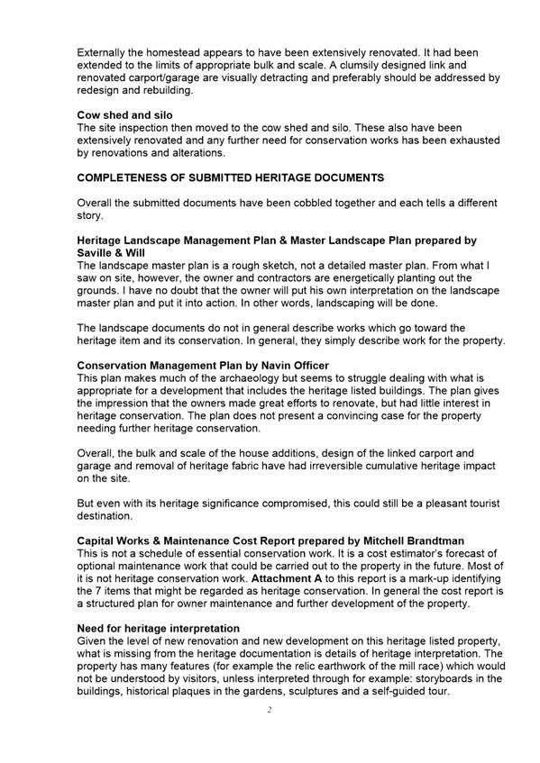
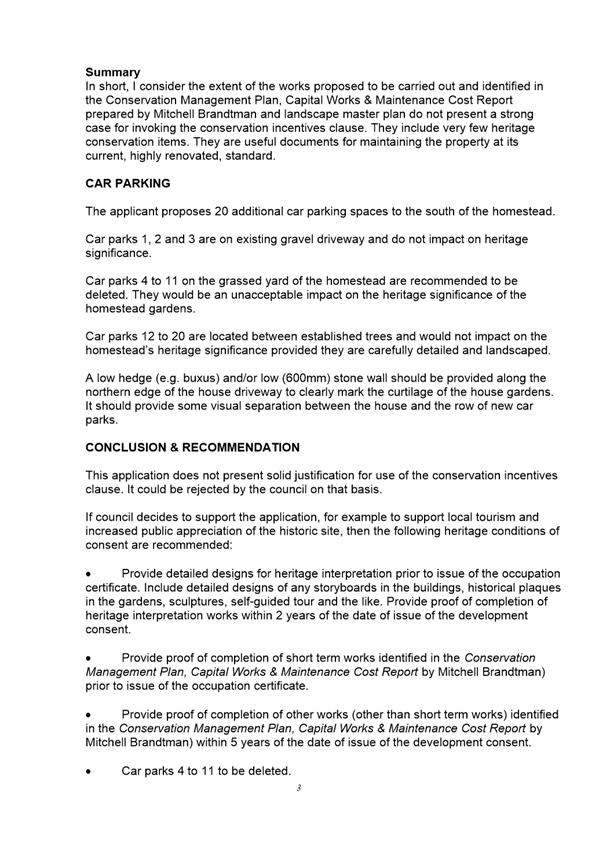
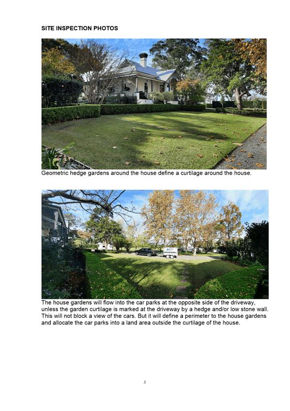
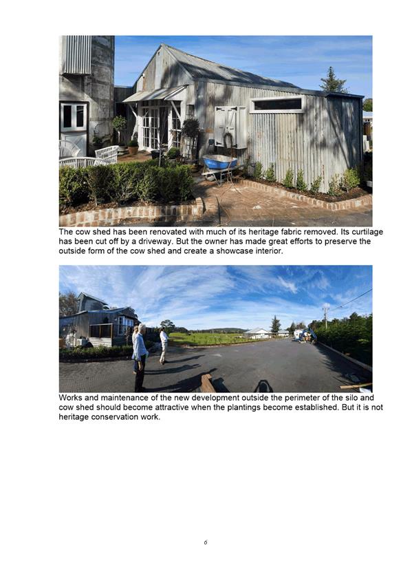
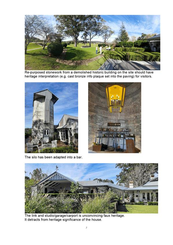
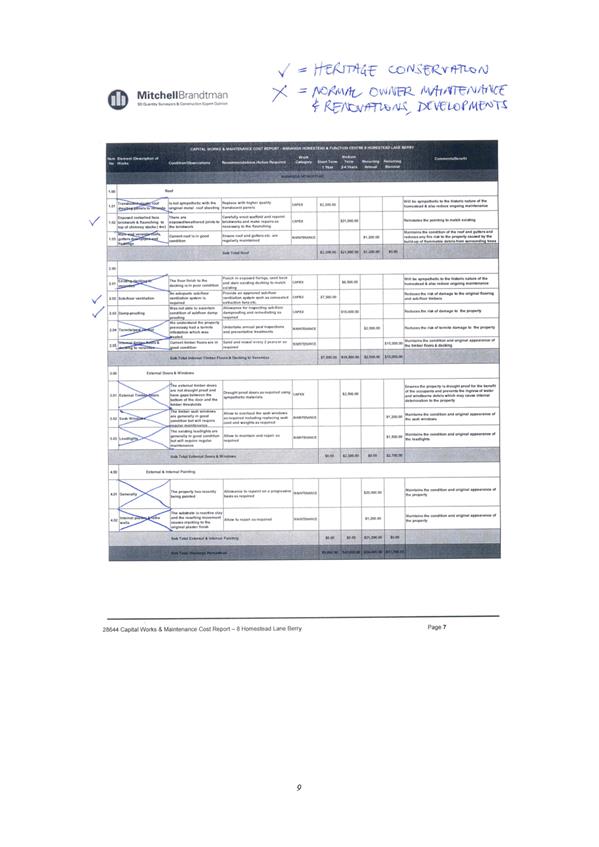
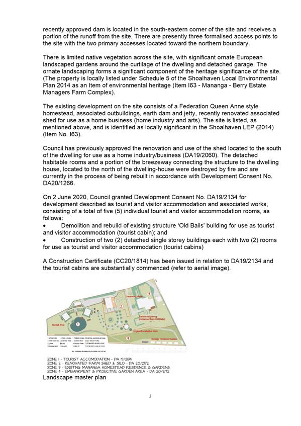
|
|
Development
& Environment Committee – Tuesday 13 July 2021
Page
0
|
|
|
Development
& Environment Committee – Tuesday 13 July 2021
Page
0
|
DE21.78 DA20/1621
– 260 Mount Hay Road (Private), Broughton Vale – Lot 2 DP 4498
DA. No: DA20/1621/4
HPERM Ref: D21/252358
Department: Development
Services
Approver: Phil
Costello, Director - City Development
Attachments: 1. Planning
Report - 260 Mount Hay Rd (Priv) Broughton Vale - Lot 2 DP 4498 (under
separate cover) ⇨
2. Draft
- Determination - 260 Mount Hay Rd (Priv) Broughton Vale - Lot 2 DP 4498 ⇩
3. Legal
Advice - Glamping/Primitive Camping (Confidential - under separate cover)
4. Plan - Existing access
features and proposed upgrades - 260 Mount Hay Road Broughton Vale - Lot 2 DP
4498 ⇩
Description of Development: Primitive camping
grounds comprising six (6) tent sites and a communal camp kitchen building
Owner: WL Houghton
Applicant: Anthony Houghton of Mt Hay Pty Ltd c/o
SET Consultants Pty Ltd
Notification Dates: 29 July 2020 to 13 August 2020
No. of Submissions: 158 in objection
Purpose
/ Reason for consideration by Council
On 1 September 2020, it was resolved by the Development &
Environment Committee that this Development Application (DA) be called in to
Council for determination due to public interest and concern (MIN20.603).
To assist with characterisation
and assessment, legal advice was obtained.
There is however a public interest consideration against
disclosure of this legal advice as disclosure of the information could
potentially prejudice any legal proceedings. Accordingly, the advice is
provided as a confidential attachment.
|
Recommendation (Item to be determined under delegated authority)
That Development Application DA20/1621 for primitive camping
grounds comprising six (6) tent sites and a communal camp kitchen building at Lot 2 DP 4498, 260 Mount Hay Road (Private), Broughton Vale be refused having
regard to the reasons contained in Attachment 2 of this report.
|
Options
1. Refuse the
development application (DA) in accordance with the recommendation of this report.
Implications: The
development is unable to proceed as applied for and a section (s) 8.2A review
may be sought by the applicant or an appeal with the Land and Environment Court
of NSW (LEC) is possible.
2. Approve the
application.
Implications: Council would
need to determine the grounds on which the application is approved, having
regard to section 4.15(1) considerations.
3. Alternative
recommendation.
Implications: Council will
need to specify an alternative recommendation and advise staff accordingly.
Location Map
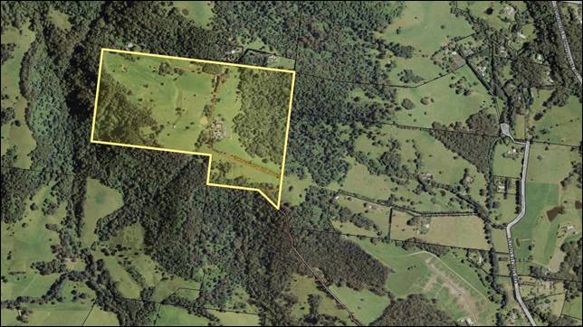
Figure 1 –
Location Map – Site Context
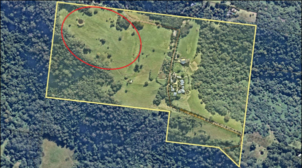
Figure 2 –
Location Map indicating the development area (approx.)
Background
Proposed Development
The DA seeks approval for
“primitive camping grounds catering for a
total of 12 guests, consisting of six (6) tent sites each provided with
individual amenities.”
‘Primitive camping
ground’ is not a defined land use term under Shoalhaven Local
Environmental Plan 2014 (SLEP 2014) or relevant environmental planning
instruments under the Environmental Planning and Assessment Act 1979 (EP&A
Act). The proposed use however seeks to meet the definition of “camping
ground” under SLEP 2014 (provided below) and accordingly the subject DA
is being assessed for this purpose.
camping ground means an area of land that
has access to communal amenities and on which campervans or tents, annexes or
other similar portable and lightweight temporary shelters are, or are to be,
installed, erected or placed for short term use, but does not include a caravan
park.
The tent sites are proposed to
be located on the north western portion of the subject site (refer to Figures 1
and 2).
Each of the tent sites is to be
provided with permanent amenities and a timber platform for the tents (refer
Figure 4). These platforms also include ensuites and possible privacy screens
with an outdoor bath placed on the deck. These items are considered to be
permanent fixtures. The plans note that the drawings are only “an
indication of the layout however placement of items will vary from site to site
for privacy, cooling etc”. The plans also specify that the deck
maximum size is 70sqm, while the maximum bathroom size will be 8sqm.
The submitted plans demonstrate
a possible tent which could be provided to the tent site (refer to Figure 4).
The applicant has indicated in the submitted Statement of Environmental Effects
(SEE) that “the tent sites provide flexibility for tents such as a bubble
tent, tiny home, or could be provided without accommodation on site for
clients to bring their own.”
The applicant has also submitted
an Operational Plan of Management (POM) with this application, which sets out the
management procedures for the safe and effective management of the proposed
camping grounds.
It is noted that the grounds are to be staffed and managed
by existing personnel who live at the subject site.
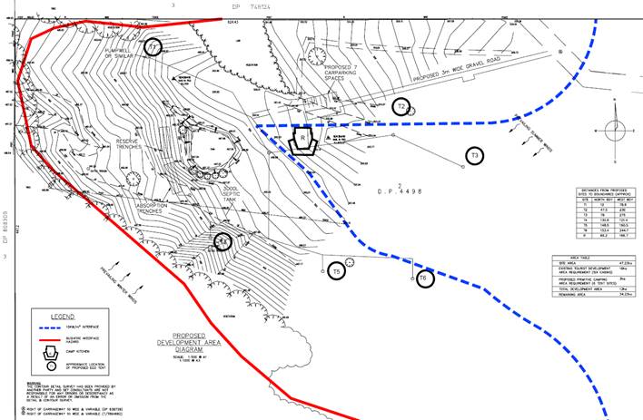
Figure 3 –
Extract of the Site Plan
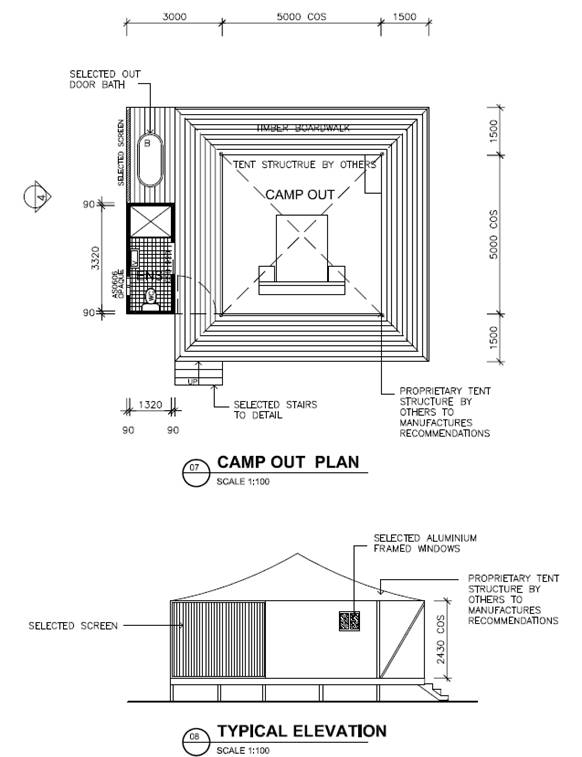
Figure 4 –
Extract of the Floor & Elevation Plan for the Tent Site and Amenities
Structure
a) Communal
camp kitchen building, to be used as a bush fire refuge
The proposed communal camp kitchen is to consist of a
kitchen, dining area, outside deck, games room, accessible bathroom, and store
(refer to Figure 5). The camp kitchen is to be located centrally to the
proposed development area. The proposed bathroom has been designed with a
secondary function as a refuge building in the event of a bush fire where
evacuation of the site is not feasible.
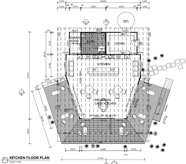
Figure 4 –
Extract of the Floor Plan for the Camp Kitchen
b) Access
driveway and parking
The subject site is accessed by
a Right of Way known as Mount Hay (private) Road (refer Figure 6). The site and
several other allotments to the north of this site benefit from a Right of Way
that burdens Lot 102 and Lot 103 DP 786955 which are located to the south, with
Lot 102 adjoining at the southern boundary of the subject site. Mount Hay
(private) Road comprises sections of Crown road reserve and Rights of Way
through Lots 102 and 103.
The Right of Way that extends to
the west from Mount Hay (private) Road is proposed to be used to access the
camp site, with a 3m wide gravel track to be extended to the proposed camp
kitchen (refer to Figure 6). The applicant has indicated in the submitted
Statement of Environmental Effects that “the track location is
currently used by maintenance vehicles to access the site.”
There are also items/works
proposed within Mount Hay (private) Road as outlined within the submitted
report by McLaren Traffic Engineering and shown at Attachment 4. These include
passing bays, traffic signs and tree trimming, which the applicant has advised
are capable of being located within the Right of Way.
In relation to parking, each
tent site is to be provided with one (1) vehicle parking space. A total of
seven (7) onsite parking spaces are proposed and these are to be provided
adjacent to the camp kitchen.
A LEC decision in relation to a DA on
the subject site (lodged with Council in 2000), for a staged development
including a new dwelling and tourist development required the developer of the
site to obtain insurance but to also emplace an 88B instrument on the land. The
text below has been extracted from a LEC Order, case 10581 of 2012 Wayne
Lawrence Houghton v Shoalhaven City Council dated 7 September 2012, dated
entered 20 September 2012.
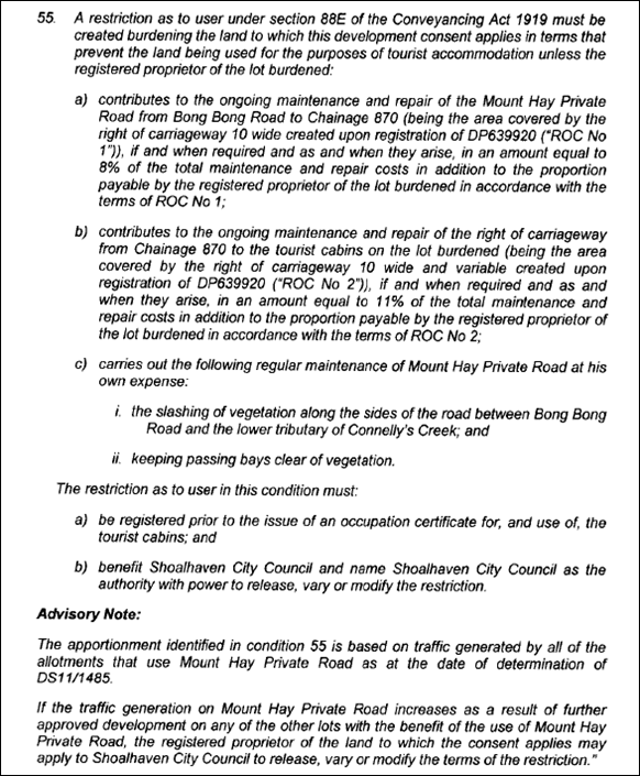
It is considered that this
development has the potential to impact on the apportionment identified in
condition 55 of the Order and this issue warrants exploration. Note, Attachment
4 (reproduced at Figure 7) showing the extent of additional works proposed with
the application and described earlier in this report including “passing
bays, traffic signs and tree trimming, which the applicant has advised are
capable of being located within the Right of Way.”
As indicated in supporting
documentation, the development would generate 18 daily vehicle movements. It is
noted that the applicant considers that the additional traffic generated
by the development will not significantly impact on the existing road/s
which provide access to the site and surrounding properties. Further to this,
the additional traffic, along with the existing traffic generated by the
existing tourist facility is not considered to generate traffic in excess of
what the existing access road (with improvements) is capable of supporting.
As indicated in the advisory
note above if the traffic generation on Mount Hay (private) Road is to increase
(as proposed) as a result of this development, the registered proprietor of the
subject site needs to apply to Council to release, vary or modify the terms of
the restriction.
This matter has not been
addressed by the applicant and no request has been made, presumably on the
.basis that the development will not have a significant impact on the roads.
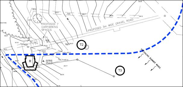 Figure
6 – Extract of the Site Plan showing the location of the proposed access
track and onsite parking
Figure
6 – Extract of the Site Plan showing the location of the proposed access
track and onsite parking
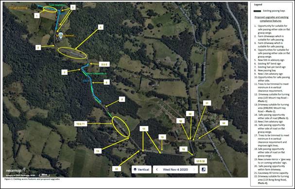
Figure 7 –
Existing access features and proposed upgrades to Mount Hay (private) Road (See
larger copy at Attachment 4)
c) Onsite
effluent disposal
The proposed development
requires onsite effluent disposal, as reticulated sewer is not available to the
subject site (refer Figure 8). The submitted report by Harris Environmental
Consulting recommends the following:
· Installation of
a minimum 3,000L septic tank (4500L preferable), fitted with baffles to
minimise turbulent mixing of wastewater in the septic tank;
· Installation of
600L RELN pumpwell (or similar) for each structure to pump wastewater via a 40mm
reticulated line to the proposed septic tank;
· Installation of
192sqm of soil absorption trenches, installed as three (3) x 3.2m wide by 20m
long trenches to dispose of treated wastewater from the septic tank; and
· Reservation of
192sqm of land for the reserve effluent disposal site, for future expansion or
replacement of the existing effluent disposal area.
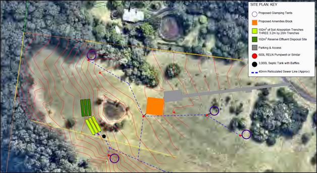 Figure 8 –
Extract of the Wastewater Management Plan
Figure 8 –
Extract of the Wastewater Management Plan
Subject
Land
The development site is Lot 2 DP 4498 (260 Mount Hay Road
(Private), Broughton Vale). Refer to Figure 1.
Site & Context
The development site:
§ Contains an existing tourist and
visitor accommodation facility known as the Mt Hay Retreat. There are also a
number of ancillary structures and dams on the site. There is scattered
vegetation throughout the site, however, the area to be developed as part of
this application is cleared.
§ Is zoned E3 Environmental
Management. The items/works proposed within Mount Hay (private) Road is land
zoned RU1 Primary Production and RU2 Rural Landscape.
§ Is 47.30ha in area.
§ Is identified as being
partially bush fire prone land.
§ Is located on Mount Hay
(private) Road, which intersects through the site.
§ Adjoins land zoned E3
Environmental Management, RU1 Primary Production and RU2 Rural Landscape
(Figure 9).
Figure 9 –
Zoning Extract
History
The
following provides details on post-lodgement actions for context:
§ This application was lodged on 26
June 2020.
§ As a result of detailed assessment
of the application, additional information was requested from the applicant on
seven (7) occasions – 3 July 2020, 5 September 2020, 22 September 2020, 2
November 2020, 17 December 2020, 13 January 2021 and 4 February 2021. The main
issues related to the following:
o Characterisation of the
proposed development as “camping grounds”. The structures did not
appear to be temporary or portable and lightweight.
o Ability to comply with the
requirements of the Local Government (Manufactured Home Estates, Caravan Parks,
Camping Grounds and Moveable Dwellings) Regulation 2005.
o The bush fire assessment
report submitted at lodgement incorrectly assessed the proposed development
against the requirements of Planning for Bush Fire Protection 2006 instead of
Planning for Bush Fire Protection 2019. Further to this, inadequate information
was subsequently provided for NSW Rural Fire Service (RFS) to complete their
assessment.
o The items/works proposed
within Mount Hay (private) Road as outlined within the submitted report by
McLaren Traffic Engineering. It was also relayed to the applicant on 4 February
2021 that it appears that works may be proposed on adjoining land in which case
they were requested to provide evidence of owners consent and legal ability to
undertake the required works.
§ Councillors
called in the application due to public interest and concern on 1 September
2020 (MIN20.603).
§ On 14
July 2020, 23 October 2020, 28 October 2020, 23 November 2020, 17 December 2020
and 25 March 2021, the applicant submitted additional information, which was
subsequently referred to the relevant sections of Council and external agencies
where necessary for comment.
The applicant addressed the matters
raised for consideration. However, in relation to the matter of owners consent
for items/works proposed within Mount Hay (private) Road (see Attachment 4 and
Figure 7), the applicant responded as follows in email dated 25 March 2021:
“…Mount
Hay is a private road consisting of parts within the Crown road reserve, and
parts within the Right of Way is variable in width being mostly 10m wide. The
proposed passing bays, traffic signs and tree trimming are capable of being
located within the Right of Way. All required consent and approvals will be
obtained and in place before any work takes place along the private road. It is
anticipated this be reflected in conditions of consent.”
Issues
Categorisation of land use
The proposal involves the temporary erection of tents (or the
like) on permanent timber deck structures, with private ensuite bathrooms and
with access to communal amenities.
Camping ground is defined under the Dictionary of SLEP 2014 as:
Camping
Ground means an
area of land that has access to communal amenities and on which
campervans or tents, annexes or other similar portable and lightweight
temporary shelters are, or are to be, installed, erected or placed for short
term use, but does not include a caravan park. (emphasis added)
Land is
defined under the EP&A Act
(Section 1.4) as:
“land includes—
(a) the sea or an arm of the sea,
(b) a bay, inlet, lagoon, lake or body of water,
whether inland or not and whether tidal or non-tidal, and
(c) a river, stream or watercourse, whether
tidal or non-tidal, and
(d) a building erected on the land.” (emphasis added)
Building
is defined under the EP&A Act (Section 1.4) as:
“building includes part of a building, and also
includes any structure or part of a structure (including any temporary
structure or part of a temporary structure), but does not include a
manufactured home, moveable dwelling or associated structure within the meaning
of the Local Government Act
1993.” (emphasis
added)
Accordingly, while the tents are
to be erected on structures, these proposed structures are considered to be
both:
- Defined as
“land” for the purpose of the definition of “camping
ground”; and
- Ancillary to
the proposed use.
The definition of a
“camping ground” when referring to “an area of land”
includes the proposed structure and that by erecting tents on the structure
does not cause the use to be contrary to the definition. The proposed timber
structures themselves are considered to be ancillary and incidental to the use
of the land for the purpose of a camping ground.
Figure 10 –
Marked up elevation plan of proposed platforms and ensuite
The proposed platforms
(highlighted in blue at Figure 10), however, also include the construction of
private bathrooms (highlighted in brown) which are permanent fixed buildings.
The tent structure (highlighted in red) would affix to these permanent components
of the development.
While the platforms themselves
may be an ancillary structure to a camping ground, the proposed private ensuite
bathrooms are permanently fixtured, and not “portable and lightweight”. Being permanent
private bathrooms, which are additional to the provision of communal bathrooms
provided in the camp kitchen building, these are not considered incidental to
the use as a camping ground. While the definition of a camping ground does not
prevent or prohibit the provision of private facilities, it is considered the
permanency of the ensuite bathrooms undermines the ability of the development
to be properly characterised as development for the purpose of a “camping
ground” as defined in SLEP 2014.
Any ancillary or incidental
structure associated with the erection of a tent, that is not a “communal
amenity”, should also be “lightweight and portable” in
nature, including any ancillary private ensuite or bathroom which any tent
would privately utilise. The proposed development as a whole therefore is not
considered to be consistent with the definition of ‘camping
ground’.
This forms a reason for refusal
of the application.
It is
further noted that the proposal could also be characterised as ‘tourist
and visitor accommodation’; however camping ground is still considered
the best characterisation as the applicant has used this terminology within the
submitted application, and forms the basis for the subsequent assessment of
parking, access and requirements of the development under Shoalhaven Development
Control Plan (SDCP) 2014. Further to this, the application has not been
sought for this purpose and council is limited in its ability to assess the
application as has been proposed by an applicant.
The application as a tourist and
visitor accommodation has not been considered / assessed by the applicant in
the submitted documentation, and accordingly insufficient information is
available to demonstrate the suitability of the proposal within the zone.
Concerns
raised in public submissions.
Submissions from 158 objectors
were received by Council.
The matters raised are
considered in the assessment of submissions below.
|
Summary of Public
Submissions
|
|
Objection
Raised
|
Comment
|
|
Land
use and permissibility
The definition of a camping ground means an area of land
on which tents or similar portable and lightweight temporary shelters are
placed.
However, the DA states —
§ Each tent site has a permanent
base, with timber boardwalk, ensuite amenities & luxury bath
§ Permanent facilities capable
of supporting tent structures such as; a bubble tent, tiny home
§ Each tent site is provided
with an amenities structure for private use.
Based on the proposed description of development, it is
unclear as to whether the structures will be portable, lightweight and/or
temporary. In effect, they may be erected on a permanent basis.
Further to this, SLEP 2014 Aims include: (e) to
minimise the risk of harm to the community through the appropriate management
of development and land use. The proposal is inconsistent with the above
aim and increases the risk of harm to the local community through
inappropriate development and land use.
|
§ The subject development has been
presented to Council as “proposed primitive camping grounds
consisting of six (6) tent sites and amenities, and a communal camp
kitchen”.
§ It is noted that there are
inconsistencies in the submitted documentation in relation to the proposed
use. Including:
o The submitted traffic report
refers to that proposed as “tourist cabins”.
o The applicant has also
indicated in the submitted Statement of Environmental Effects that “the
tent sites provide flexibility for tents such as a bubble tent, tiny home, or
could be provided without accommodation on site for clients to bring their
own”.
Tourist cabins are not
consistent with the ‘camping ground’ definition, and “tiny
homes” may be considered as caravans and therefore also would not be
consistent with the proposed camping grounds use.
In this regard however, no
details have been provided with the application supporting either of these
uses. The submitted plans have only demonstrated a possible tent which
could be provided to each tent site.
Accordingly, Council has based
its assessment on the documentation provided on the DA form and that shown on
the submitted plans as a primitive camping ground, or ‘camping
ground’ as defined under SLEP 2014.
§ The proposal as a camping ground
is a permitted use within the relevant land use zones with the consent of
Council.
§ Further to this, as per the SLEP
2014 Aims, it is considered that the proposed development and land use can
potentially be appropriately managed to reduce risk of harm to the local
community.
|
|
Incorrect Characterisation
In reference to Local Government (Manufactured Home
Estates, Caravan Parks, Camping Grounds, Moveable Dwellings) Regulation 2005 (Part
3, Division 3) and classifying the development as a “primitive camping
ground” the applicant is aiming to avoid the requirements of
Subdivisions 1 to 8. These subdivisions specify critical requirements for
campgrounds including public safety, facilities for people with disabilities
and prohibiting the use of the campground for any other commercial purpose
(including a function centre).
The nature and scale of the proposed development appears
to be well outside the definition of a “primitive camping
ground”.
The NSW Department of Planning Guide on a “primitive
camping ground” (PCGs) is also noted:
§ PCGs are lower key than
conventional camping grounds and are not required to have, for example,
sealed roads, hot water or laundries.
§ A PCG is generally remote from
urban areas with only a limited range of facilities However, the proposed PCG
site at Mount Hay is –
o accessed by a sealed road
and has access to hot water
o adjacent to an existing
tourist facility with up to 14 guests and three other dwellings
o according to the website
"just a few minutes away from the heart of exclusive Berry village"
o has individual amenities
structures for private use, a luxury bath and access to a dining facility
• has permanent structures that cannot be removed when the camp site is
unoccupied
|
Primitive camping ground
§ As detailed earlier in this
report, the proposal is best defined under SLEP 2014 as a ‘camping
ground’. ‘Primitive camping grounds’ are not a defined land
use term under SLEP 2014.
§ The Local Government
(Manufactured Home Estates, Caravan Parks, Camping Grounds and Moveable
Dwellings) Regulation 2005 definition of a primitive camping ground is
not relevant for the purpose of characterisation of the use under the
EP&A Act and the subject application. It is considered appropriate for
future section 68 approvals and the requirements under the Local Government
Act 1993 and associated Regulations.
§ While it is inferred that the
comment on the Department of Planning Guide relates to Planning Circular
PS06-001, issued on 10 January 2006, this circular is irrelevant for the
assessment of this DA, being related to the Local Government (Manufactured
Home Estates, Caravan Parks, Camping Grounds and Moveable Dwellings)
Regulation 2005, which would be further assessed under a future section 68
application.
§ The designation of camp sites is
in a formal manner with the timber structures delineating the location of
tents and allowing for the management and mitigating of the impact of
surrounding areas of the site. This is not considered to be a reason for
refusal in that the land use is appropriately defined as a camping ground
which is a permissible use within the zone. Further categorisation as a
“primitive campground” under the Local Government Act, is not a land
use consideration for the purposes of this EP&A Act development
assessment.
Camping ground
§ As detailed earlier in this
report, the proposed permanent platform and ensuite are not considered to be
consistent with the definition of a camping ground, which forms a reason for
refusal.
A camping ground, as defined
earlier in this report, means “an area of land that has access to communal amenities and on
which campervans or tents, annexes or other similar portable and
lightweight temporary shelters are, or are to be, installed, erected or
placed for short term use, but does not include a caravan park. (emphasis
added)”
|
|
Ancillary use
The land uses which are either
permissible, with or without consent, or prohibited, are set out in the land
use clause for the E3 zoning in the Land Use Table in the LEP. The
permissible use of "tourist and visitor accommodation" was
previously approved. However, the disproportionate size of the camp kitchen
suggests it cannot in truth be described as ancillary either to the owners or
the visitors to the site but is in essence of the size more likely to be used
for functions which is not permissible.
|
§ Council cannot consider a
proposed use other than what has been sought under the subject application.
Speculation on possible or potential future uses based on the size of the
camp kitchen cannot form part of the consideration of the application.
|
|
Inconsistency with E3 zone objectives
There is issue raised in relation to the E3 zone
objectives in relation to the prospective visual impact of the camp kitchen,
and the parking of caravans and the like on the ridgeline.
Consideration to the objectives needs to be proper,
genuine and realistic. The intrusive nature of the proposal seems to be
contrary to the objectives of the E3 zone, and consequentially leaves open
the opinion that the objectives are not, and cannot be met.
|
§ The SLEP, clause 2.3(2) states
that the consent authority must have regard to the zone objectives.
§ It is considered that the
proposal as a camping ground is not inconsistent with the relevant
objectives. Camping grounds are a permissible use which are permissible due
to their minimal effects on the environment. As detailed earlier in this
report however, it is not considered the proposal adequately meets the
definition of ‘camping ground’ and accordingly is recommended for
refusal.
|
|
Future non-compliant use
With this scale of development there is potential of the
proposed buildings to be repurposed for other commercial purposes that are
prohibited in this zoning (e.g. function centres).
|
§ Council can only consider that
proposed as part of this application.
§ Should the development
application be determined by way of approval, any consent (if issued) would
be limited to camping and therefore no approval would be given or implied for
anything else.
|
|
Undesirable precedent
Approval of this application will set a precedent for further
inappropriate tourist development that does not comply with Council’s
requirements.
|
§ Any proposed development the
subject of a DA is to be assessed against the relevant provisions of section
4.15(1), EP&A Act 1979 and relates to the subject development site only.
§ Whether or not other developments
of a similar nature will follow is unknown and is dependent on a number of
factors including the intentions of individual owners, individual
characteristics of the development and unique attributes of the site.
§ Council needs to be satisfied
that the site is suitable for each development. If a development has
been approved, it does not necessarily stand that a similar development will
be approved nearby as mentioned above, the unique attributes of each site and
development must be assessed having regard to the planning framework at the
time.
|
|
Out of character
The scale of the proposed development is at odds with its
secluded rural setting.
|
§ The design of the development is
not considered out of character in this locality. Camping is typically
a low key activity. While the associated private ensuite bathroom
building are not considered to be consistent with the definition of camping
ground, they are not however out of character or ‘at odds’ with
the rural character given their low scale nature.
§ The issue of character goes to
matters such as height bulk and scale. Often scale is used to reference
size.
§ See paragraphs 26 – 29) Project
Venture Developments Pty Ltd v Pittwater Council [2005]
NSWLEC 191. This established what is called a planning
principle in the LEC. The principle assists in assessing character by posing
a series of questions. Including are the impacts consistent with the
impacts that may be expected under the planning controls and are there
controls in place intended to maintain the character.
|
|
Disproportionate size of camp kitchen
The proposed 220sqm building (similar to a function centre)
is described in the application as a “communal camp kitchen” for
a maximum of 12 campers.
The proposed footprint of the camp kitchen is an
unrealistic 16,351m x 10,320m with a height of 5.176m. To put the size into
perspective, and apart from the exceptionally high building, a 6 x 12m
marquee will seat 80 guests on round tables, and a 6 x 21m marquee will seat
140 guests on round tables. Arguably therefore, the size of the proposed camp
kitchen is disproportionate to accommodating 12 guests, and it can only be
surmised that the applicant has a secondary purpose to use this building to
hold functions.
|
§ The requirements of SEPP 21 are
not prescriptive with regard to the size of ancillary structures and
facilities to a campground.
§ It is considered that
“necessary” community facilities and services are proposed for
the camping grounds as part of this application.
§ As mentioned earlier, a consent
authority, i.e., Council can only assess what is put to it in an
application. It cannot foreshadow any wrongdoing and/or alternative
future development etc. If another use is proposed, a further DA would
be potentially required. In the event of a compliance issue, there are
separate provisions in legislation that deal with breaches, unlawful
development etc.
|
|
Tent structures
Each tent structure has an excessively large floor area of
75sqm. A 25sqm tent site would comply with the legislation.
These structures are also permanent and not temporary.
|
§ Addressed above.
§ The permanency of the ancillary
elements of the ensuite bathroom and platform is not considered in keeping
with the definition of camping ground. Being an ancillary use it is
considered these should also be ‘portable and light weight’ in
accordance with the definition of camping ground.
|
|
Access and Traffic
§ Mount Hay (private) Road is a 3km
steep, single lane, winding access road. It has two (2) right hand bends and
a hairpin bend on its steepest section. There are unsafe crests and hidden
drainage culverts.
§ Passing bays specified as
conditions of consent in a past DA are not adequately maintained.
§ The submitted bush fire
assessment report is out of date. The road does not meet current RFS
requirements – e.g., the width of the road narrows considerably through
the steepest section to around only 2m.
§ The RFS has informed the
road’s property owners that in a significant fire event they would be
unable to respond past Bong Bong Road, due to safety concerns for their staff
and equipment.
§ Three (3) times in the past six
(6) months the bridge access to the road was severely flooded and impassable
for hours, requiring a major clearing exercise. Emergency access would be
impossible.
§ Road usage is considered by the
road’s residents to already be at capacity.
|
§ As detailed earlier in this
report, Council’s Development Engineer raised no objections to the
submitted report by McLaren Traffic Engineering and the accompanying plan
detailing improvement works, subject to recommended conditions of consent (dated
27/05/2021). Should the application be determined by approval, then these
conditions would be included.
§ Again, as detailed earlier in
this report, it is considered that this development has the potential to
impact on the apportionment identified in condition 55 of the LEC Order and
this issue warrants exploration. Note Figure 5 showing the extent of additional
works proposed with the application and described earlier in this report including
“passing bays, traffic signs and tree trimming, which the applicant
has advised are capable of being located within the Right of Way.”
§ As indicated in supporting documentation,
the development would generate 18 daily vehicle movements. It is noted that
the applicant considers that the additional traffic generated by the
development will not significantly impact on the existing road/s which
provide access to the site and surrounding properties. Further to this, the
additional traffic, along with the existing traffic generated by the existing
tourist facility is not considered to generate traffic in excess of what the
existing access road is capable of supporting.
§ As indicated in the advisory note
relating to condition 55 if the traffic generation on Mount Hay (private)
Road is to increase (as proposed) as a result of this development, the
registered proprietor of the subject site needs to apply to Council to
release, vary or modify the terms of the restriction.
§ This matter has not been
addressed by the applicant and no request has been made, presumably on the
basis that the application concludes that there no significant impact.
§ In relation to bush fire, General
Terms of Approval and a Bush Fire Safety Authority were issued by NSW Rural
Fire Service (dated 19/05/2021).
It is noted that certification
would be required prior to the issue of a Construction Certificate from a
traffic engineer for the access road from Bong Bong Road to the refuge
building (camp kitchen) to demonstrate that the existing road and proposed
roadworks comply with Planning for Bush Fire Protection 2019. A suitably
qualified person would need to provide a certificate of completion that all required
work has been satisfactorily achieved, prior to the issue of an Occupation
Certificate.
§ In relation to flooding, no flood
assessment report has been submitted as the subject site is not identified as
being flood prone.
§ However, it is noted that Mount
Hay (private) Road does contain a small portion of flood affected land in
close proximity to Bong Bong Road.
§ The applicant has contended that
the subject site is deemed to have reliable access during 1% AEP flood
events.
§ It is noted that the proposed
development is located on a flood free portion of the site, however, access
to the site is restricted in the event of a flood. A flood evacuation plan is
to be prepared for this development subject to conditions of consent being
imposed should the application be determined by approval.
§ It is important to note, the road
is a private concern and the traffic on that road is managed or controlled
largely by the types of development that adjoin / access it. Most
properties are rural residential with the exception of the Houghton’s
property which has tourist and visitor accommodation component. The
development has historically caused concern with neighbours with respect to
traffic and road maintenance issues.
§ In the LEC, a condition was
imposed on the development (for the dwelling and tourist cabins) apportioning
maintenance costs to address the concerns about the upkeep of the road. The
apportionment specifies a percentage which was based on the development at
the time. Since then, an additional cabin was approved which was
considered to be capable of being absorbed into the regime. However,
this development intensifies the development and will add an additional six
(6) ‘camp sites’ and therefore additional traffic movements,
being 18 daily vehicle movements.
|
|
Noise and lighting impacts
The location of this property
on the ridgeline would mean that noise and lighting from the development
would have an adverse impact on more than just the neighbouring properties.
|
§ Ongoing management of noise and
lighting could be subject to a condition of any consent granted. Should the
application be determined by approval, then this condition would be included.
§ If there is concern about
antisocial behaviour, this is a matter for the Police.
|
|
Bush fire risk
There are concerns with bush
fire risk and the submitted assessment report and its accuracy.
|
§ It is considered bushfire risks
have been adequately addressed. General Terms of Approval and a Bush Fire
Safety Authority were issued by NSW RFS (dated 19/05/2021).
|
|
Owner’s consent
The only vehicular access the
subject site is via Mount Hay (private) Road comprising an easement/Right of
Way over Lot 103 DP 786955.
Applying the terms of Clause
49 of the EP&A Regulation 2000, the application requires the consent of
Thoroughbred Property Holdings Pty Ltd for an intensification of use of the
Right of Way/existing easement. That consent has not been obtained.
|
§ It is agreed that no evidence has
been provided that this application has been made with the consent of all
relevant landowners, noting the items/works proposed within Mount Hay
(private) Road as outlined within the submitted report by McLaren Traffic Engineering
are located on land not under the ownership of the applicant or the owner of
the subject site, WL Houghton.
|
|
Previous conditions of
development consent
Conditions of consent granted
to the applicant in the former approval should be reflected in any subsequent
consent to achieve the same planning objectives, of protecting the road and
its users, and from increased usage caused by increase traffic to the applicant's
property.
In addition, under condition
46 of the original development consent, the applicant was required to provide
minimum standard cattle fencing between cattle grids 2 and 3. However the
applicant unilaterally decided there was a dispute as to what comprised
"minimum standard cattle fencing", and unequivocally refused to
comply with that condition. Council nonetheless provided an Occupation
Certificate in the absence of the applicant fulfilling that condition.
Cattle currently graze over that
portion of Lot 103, and the applicant should be required to construct the
minimum cattle fence as contemplated in the original application for a
tourist facility.
|
§ Whilst there may be compliance
issues, Council cannot take these alleged breaches into account in the
assessment of this application. There are separate compliance provisions in
the legislation and Council policy and procedures to deal with breaches.
|
Clause 49(1) of the
EP&A Regulation 2000 - Owners consent.
Clause 49(1) (b) of the Environmental
Planning and Assessment Regulation 2000 indicates that a DA may be made by the
owner of the land to which the development application relates, or by any other
person, with the consent of the owner of that land.
This application has been made
by a person other than the owner of the subject land, being Mr Anthony Houghton
of Mt Hay Pty Ltd c/o SET Consultants Pty Ltd.
No evidence has been provided
that this has been made with the consent of all relevant landowners,
noting the items/works proposed within Mount Hay (private) Road as outlined
within the submitted report by McLaren Traffic Engineering.
Given that the application makes
reference to works in the road reserve, consent is required. (Stokes v
Waverley Council (No. 2) [2019] NSWLEC 1137 & 174 and [2020] NSWLEC
1224)
As detailed earlier in this
report, the subject site is accessed by a Right of Way known as Mount Hay
(private) Road. The site and several other allotments to the north of this site
benefit from a Right of Way that burdens Lot 102 and Lot 103 DP 786955 which
are located to the south, with Lot 102 adjoining at the southern boundary of
the subject site. Mount Hay (private) Road comprises sections of Crown road
reserve and Rights of Way through Lots 102 and 103 which do not align with
Crown road reserve. It remains a private road.
The applicant has indicated in
email advice dated 25/03/2021 that “all required consent and approvals
will be obtained and in place before any work takes place along the private
road”.
Owner’s consent must be
provided by the time a consent authority determines whether to grant
development consent.
Planning Assessment
The DA has been assessed under
s4.15(1) of the Environmental Planning and Assessment Act 1979. Please refer to
Attachment 1.
Consultation and Community
Engagement:
Notification was undertaken in
accordance with Council’s Community Consultation Policy with letters
being sent within a 200m buffer of the site, during the period 29 July 2020 to
13 August 2020.
158 public submissions were
received in relation to Council’s notification of the development, all
objecting to the development.
Key issues raised as a result of
the notification have been listed and addressed above.
The assessment of the
application considered the matters raised in the submissions and concluded that
the application should not be supported.
Financial Implications:
There are potential cost
implications for Council in the event of a refusal of the application. Such
costs would be associated with defending an appeal in the Land and Environment
Court of NSW.
Legal Implications
A section 8.2 review or an
appeal with the Land and Environment Court are possible if the application is
refused.
Summary and Conclusion
The proposed development is
generally compliant with the provisions of SLEP 2014 and is broadly consistent
with the SDCP 2014.
This application has been
subjected to detailed analysis of the main issues identified in this report,
being the access and traffic, characterisation of the development, and
owner’s consent.
These issues have also been
investigated and addressed by the applicant.
However, the application is not
currently considered capable of support, given the proposed ensuite bathroom
buildings result in the proposal not meeting the definition of camping ground,
that no evidence has been provided that this application has been made with the
consent of all relevant landowners (noting the items/works proposed within
Mount Hay (private) Road), and the considerable public interest and concern
evident in the submissions received. Further, there is an issue with the
apportionment of maintenance which also warrants consideration.
Accordingly, a negative conclusion has been reached and
recommendation made. Attachment 2 contains the draft determination notice
and the reasons for the refusal.
|
|
Development
& Environment Committee – Tuesday 13 July 2021
Page
0
|
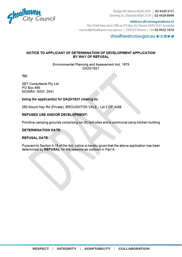
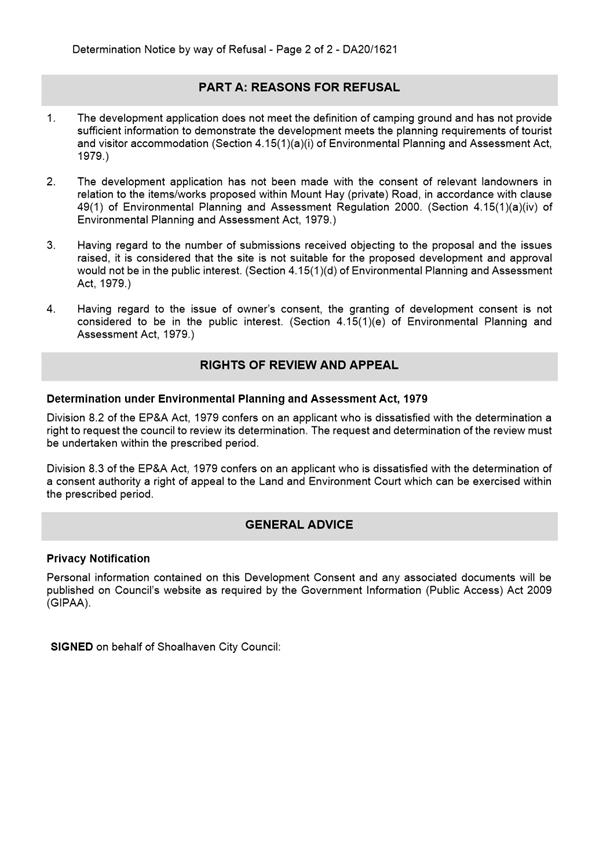
|
|
Development
& Environment Committee – Tuesday 13 July 2021
Page
0
|
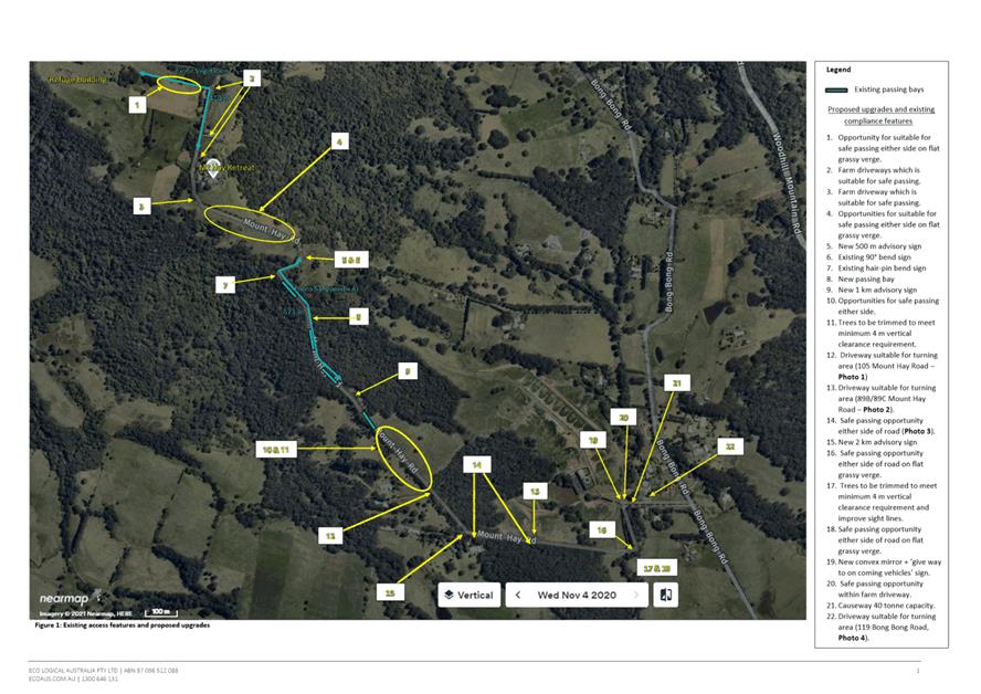
|
|
Development
& Environment Committee – Tuesday 13 July 2021
Page
0
|
DE21.79 DA21/1333
– 23 Parker Crescent Berry – Lot 331 DP 1226462
DA. No: DA21/1333
HPERM Ref: D21/245046
Department: Development
Services
Approver: Phil
Costello, Director - City Development
Attachments: 1. Planning
Report - 23 Parker Cr Berry - Lot 331 DP 1226462 (under separate cover) ⇨
2. DRAFT
Determination - Refusal - 23 Parker Cr Berry - Lot 331 DP 1226462 ⇩
3. Clause 4.6 Request to Vary
Development Standard prepared by the Applicant - 23 Parker Cres Berry - Lot 331
DP 1226462 ⇩
Description of Development: Multi-Unit Housing and
Strata Subdivision
Owner: Comsult Pty Ltd
Applicant: Hotondo South Coast Pty Ltd
Notification Dates: 12 May 2021 to 28 May 2021
No. of Submissions: 45 in objection
Nil
in support
Purpose
/ Reason for consideration by Council
The Development Application (DA) was called in due to the
significant public interest at Council’s Strategy and Asset’s
Committee meeting on 18 May 2021 (MIN21.297).
|
Recommendation (Item to be determined under delegated authority)
That Development Application
DA21/1333 to construct a multi dwelling housing
development comprising three (3) two-storey dwellings, and Strata title
subdivision, at Lot 311 DP 1226462, 23 Parker Crescent, Berry be determined
by way of refusal, for the reasons contained in the Notice of Determination,
Attachment 2 of this report.
|
Options
1. Refuse the
Development Application (DA) in accordance with the recommendation.
Implications: The
development is unable to proceed as applied for and a section (s) 8.2A review
may be sought by the applicant or an appeal with the Land and Environment Court
of NSW (LEC) is possible in the event of a refusal of the application.
2. Approve the
application.
Implications: Council would need to
determine the grounds on which the application can be approved, having regard
to section 4.15(1) considerations.
3. Alternative
recommendation.
Implications: Council will need to specify an alternative
recommendation and advise staff accordingly.
Location Map
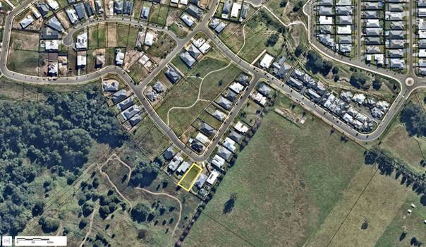 Figure 1 – Site Location
Background
Proposed Development
The proposed development is for the
construction of a multi-dwelling development consisting of three (3) x four (4)
bedroom dwellings. All proposed units are double storey and constructed from
brick veneer to the lower level, horizontal cladding to the upper level and
Colourbond roofing.
The units within the development are described as follows:
· Unit
One: is free-standing facing Parker Crescent, and includes:
· Ground
floor: two (2) bedrooms, double garage, rumpus with ground floor alfresco and
laundry.
· First
floor: two (2) bedrooms including the main bedroom with walk-in-robe and
ensuite; open plan kitchen, living and dining with gas fireplace; bathroom;
powder room; upper-level balconies to the street, and west and eastern
boundaries.
· Unit
Two: is attached to Unit Three, and includes:
· Ground
floor: double garage; laundry; two (2) bedrooms; rumpus; study; bathroom; and
ground floor alfresco area.
· First
floor: two (2) bedrooms including the main with walk-in-robe and ensuite and
balcony; open plan kitchen with walk-in pantry, living and dining with gas
fireplace; powder room; and upper-level balconies to the west and eastern
boundaries.
· Unit
Three: is attached to Unit Two and is generally a mirror-reverse design of Unit
Two consisting of a similar layout and description.
Access to and from the site will be by a single driveway off
Parker Crescent, with one (1) visitor parking space towards the rear of the
site.
The proposal includes
Strata Subdivision which will result in three (3) Strata Lots comprised of:
· Lot
1 – Unit 1, balconies, and courtyard = 338.0m2
· Lot
2 – Unit 2, balconies, and courtyard = 266.0m2
· Lot
3 – Unit 3, balconies, and courtyard = 483.0m2
The remaining lot area
will be classed as ‘common property’ including all retaining walls
and driveways.
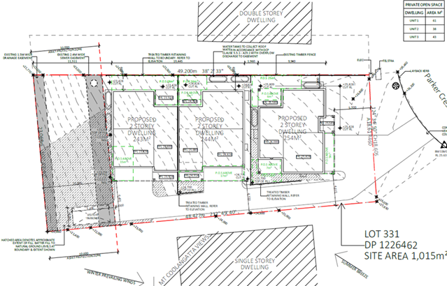
Figure 2 – Proposed
Site Plan
Subject Land
The subject site is situated at 23 Parker Crescent, Berry,
legally described as Lot 331 DP 1226462.
Site & Context
· The
site has an 18.61m frontage to Parker Crescent with a total site area of
1,015.00m2.
· The
site is currently vacant and cleared of all vegetation. The site slopes down
from the street with a fall of just over 5m or 1:0.1.
· The
site has legal and practical access to Parker Crescent.
· The
site is zoned R1 General Residential under the SLEP 2014.
· The
are no known site constraints over the site.
· The
subject site is located within ‘Stage 3’ of Huntingdale Estate,
Berry. The surrounding character is comprised of existing residential
development, predominately single dwellings.
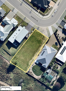
Figure 3 – Subject Site
History
The application was lodged on 01 April 2021.
As a result of the initial vetting of the assessment,
additional information was requested from the applicant on 12 April 2021,
including:
· Site
analysis plan in accordance with Chapter G1 of Shoalhaven Development Control
Plan 2014 (SDCP 2014);
· Landscape
Plan in accordance with Chapter G3 of SDCP 2014;
· Civil
design plans to indicate all cut and fill works proposed;
· Amended
site plans to provide one (1) visitor parking space as required under Chapter
G21 of SDCP 2014;
· Amended
elevation and section plans which indicate natural and finished floor levels
and the maximum height of the dwellings;
· Amended
Strata plan;
· Amended
Statement of Environmental Effects (SEE) to address:
· State
Environmental Planning Policy No 55—Remediation of Land (SEPP55);
· SDCP
2014:
§ Chapter
G13: Medium Density and Other Residential Development including any variations;
and
Chapter N3: Berry Residential Subdivision.
The applicant submitted additional information on 16 April
2021, which was subsequently referred to the relevant sections of Council and
external agencies for comment.
The application was notified to adjoining landowners between
12 May 2021 to 28 May 2021. In response, 45 submissions by way of objection
were received.
As a result of a detailed assessment of the application,
further additional information was requested from the applicant on 07 June
2021, including:
· A
clause 4.6 variation under Shoalhaven Local Environmental Plan 2014 (SLEP 2014)
to address the exceedance to the maximum height control under clause 4.3
‘Height of buildings’;
· Amended
floor plans to provide one (1) accessible unit as required under Chapter G13 of
SDCP 2014;
· Revised
shadow diagrams to indicate the location of neighbouring properties;
· A
revised landscape plan to address the requirements of Chapter G3: Landscaping
Design Guidelines;
· Revised
SEE to address:
· 88b
restrictions applying to the site;
· DCP
Chapter G3: Chapter G3 Landscaping Design Guidelines;
· Variations
to DCP Chapter G13 – the proposed development includes numerous
deviations from the DCP which have not been addressed. A variation statement is
required for each of the following deviations:
§ A3.1:
Building envelopes
§ A4.1:
Height
§ A5.4:
Setbacks
§ P17:
Private Open Space.
The applicant submitted additional information on the 17 June
2021.
Issues
Exceedance of the maximum height of buildings under SLEP
2014.
The subject site has a maximum permitted building height of
8.5m as per sub-clause 2 (Height of Buildings Map), under clause 4.3 Height of
buildings of SLEP 2014 (refer to Figure 4 below).
Unit 3 exceeds the maximum permissible height by 0.19m or
2.2%, for a total building height of 8.69m. The extent of the variation is
depicted in Figure 5 below.
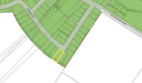
Figure 4 – Extract
from the Height of Buildings Map from SLEP 2014. The subject site is identified
as wholly within land mapped I2 - 8.5 maximum building height.
The application seeks a variation to clause 4.3 in accordance
with clause 4.6, SLEP 2014.
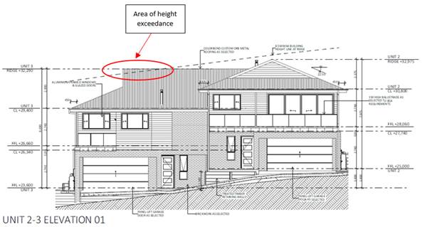
Figure 5 – South-east Elevation showing height
exceedance.
Clause 4.6 (Exceptions to
development standards) of SLEP 2014
Development
consent may, subject to clause 4.6, be granted for development even though the
development would contravene a development standard imposed by this or any
other environmental planning instrument. The height control is not a
prohibition. It can be exceeded subject to a written request and for the
relevant ‘tests’ to be passed. These tests are well
established and documented by the Land and Environment Court.
The applicant has submitted a
written request to justify the contravention of the height of buildings
development standard pursuant to the requirements of clause 4.6 of SLEP 2014 (Attachment
3). Refer to Attachment 1 for the detailed request made by the
applicant and Council’s assessment.
The following provides
Council’s review (summary) of the request for a height variation in
relation to the requirements of clause 4.6. Refer to the attached assessment
report (Attachment 2) for additional detail.
Council is required to consider subclauses (3), (4) and (5) of Clause 4.6.
Clause 4.6(3)-(5) are extracted from SLEP 2014 below:
(3) Development consent must not be granted for development
that contravenes a development standard unless the consent authority has
considered a written request from the applicant that seeks to justify the
contravention of the development standard by demonstrating—
(a) that compliance with the development
standard is unreasonable or unnecessary in the circumstances of the case, and
(b) that there are sufficient environmental
planning grounds to justify contravening the development standard.
(4) Development consent must not be granted for development
that contravenes a development standard unless—
(a) the consent authority is satisfied
that—
(i) the applicant’s written request
has adequately addressed the matters required to be demonstrated by subclause
(3), and
(ii) the proposed development will be in the public
interest because it is consistent with the objectives of the particular
standard and the objectives for development within the zone in which the
development is proposed to be carried out, and
(b) the concurrence of the Planning
Secretary has been obtained.
(5) In deciding whether to grant concurrence, the Planning
Secretary must consider—
(a) whether contravention of the
development standard raises any matter of significance for State or regional
environmental planning, and
(b) the public benefit of maintaining
the development standard, and
(c) any other matters required to be taken
into consideration by the Planning Secretary before granting concurrence.
Clause
4.6(3)(a) – Compliance with the Development Standard is Unreasonable or
Unnecessary in the Circumstances of the Case
It is considered that the
applicant has not satisfactorily demonstrated that compliance with the
development standard is unreasonable or unnecessary.
The applicant’s written
request includes the following justification for the development standard being
unreasonable or unnecessary in the circumstances:
Strict compliance is not necessary in this case as the
proposed development is the best outcome for the site under current zoning,
will not result in a loss of amenity to neighbouring properties, and the
proposed layout makes best use of the site.
The applicant’s argument
in relation to clause 4.6(3)(a) do not go toward demonstrating that the development
standard is unreasonable or unnecessary in the circumstances of the case. It
may be reasoned that the applicant’s justification goes toward providing
planning grounds for the support of design, but there is no justification to
demonstrate that compliance is either unreasonable or unnecessary.
Clause
4.6(3)(b) – Are there Sufficient Environmental Planning Grounds to
Justify Contravening the Development Standard?
The consent authority must form
the positive opinion that the applicant’s written request has adequately
addressed those matters required to be demonstrated by clause 4.6(3)(b).
In this regard, the proposed portion
of the development that contravenes the development standard is not
justified on environmental planning grounds as the
written submission by the applicant has not provided suitable justification for
the proposed variance to be supported.
In
this regard, the applicant states:
“The development
standard to be varied under this application is the maximum building height requirement of 8.5m. The proposed design is two storey and will result
in a maximum building height of 8.69m. This is a 2.21% variation on the standard but is not inconsistent
with the objectives of either Clause 4.6 or the objectives of the R1 zone.
The site is zoned to
facilitate housing. The objectives of the R1 zone are:
· To provide for the housing needs of the community.
The proposed development is
multi dwelling housing which is a permitted use within the R1 zone and will
provide housing acceptable for the residential zoning. CONSISTENT
· To provide for a variety of housing types and densities.
The proposal will provide
additional housing types for future residents and only residential land uses
are proposed. CONSISTENT
· To enable other land uses that provide facilities or
services to meet the day to day needs of residents.
The proposed multi dwelling
housing will not interfere with other land uses and will help increase the
demand for facilities or services associated with the general residential zone.
CONSISTENT
· To identify land suitable for future urban expansion.
The proposed development is
located in a newly created estate within proximity to the Berry town centre in
an area having been previously earmarked for urban expansion. CONSISTENT
As above, the proposed
development is in accordance with the aims and objectives of the land use zone.
Further, the objectives of Clause 4.3 Height of Buildings are:
(a) to
ensure that buildings are compatible with the height, bulk, and scale of the
existing and desired future character of a locality,
The site is located in a new
residential area that supports a mix of free-standing dwellings, units, and
dual occupancies. There is also a mix of single and two storey dwellings. The
building height proposed with this application does not contravene this
objective and is considered in keeping with the character of the area.
CONSISTENT
(b) to
minimise visual impact, disruption of views, loss of privacy and loss of solar
access to existing development,
The proposed development is
of an appropriate building height when viewed from the street and will not have
a disproportionate visual impact or disrupt significant views. Further, it is
not expected to decrease the privacy or solar access of adjoining properties.
Therefore, the proposed development
will fit within the character of the area and contribute positively toward the
existing built form in the immediate vicinity. CONSISTENT
(c) to
ensure that the height of buildings on or in the vicinity of a heritage item or
within a heritage conservation area respect heritage significance.
There are no heritage items
or heritage conservation areas within the vicinity of the development or
surrounding estate and therefore the proposal will not affect heritage
significance. CONSISTENT
The proposed development is in
keeping with the character of the surrounding area and other new developments.
Further, the proposed variation will not result in a detrimental impact to the
environment, the amenity of the area or the public realm, it is considered that
strict compliance is unreasonable”.
The
applicant has only stated that they believe the proposed development is
“consistent” with each of the environmental planning grounds,
however, have not provided evidence as to “how” the proposed
development meets these grounds to justify contravening the development
standard. It is therefore considered that the applicant’s clause 4.6
variation report has not adequately provided justification that there are
sufficient environmental planning grounds to justify contravening the
development standard.
Clause
4.6(4)(a)(ii) – Will the Proposed Development be in the Public Interest
Because it is Consistent with the Objectives of the Particular Standard and
Objectives for Development within the Zone in Which the Development is Proposed
to be Carried Out?
Clause
4.6(4)(a)(ii) states that development consent must not be granted for
development that contravenes a development standard unless the proposed
development will be in the public interest because it is consistent with the
objectives of the particular standard and the objectives for development
within the zone in which the development is proposed to be carried out.
An
assessment of the objectives of the zone and development standard is provided
below. As detailed further below, the proposed departure from the development
standard is not considered to be in the public interest as while the proposal
is consistent with the objectives of the R1 General Residential zone by its
inherent nature of being a residential development, the proposal is
inconsistent with the applicable development standard.
Zone Objectives
Pursuant to
the provisions of the SLEP 2014, the land is zoned R1 General Residential. The objectives of this zone are as follows:
- To provide
for the housing needs of the community.
- To provide for
a variety of housing types and densities.
- To enable
other land uses that provide facilities or services to meet the day to day
needs of residents.
- To identify
land suitable for future urban expansion.
The proposed development is
consistent with the objectives of the R1 zone, being a permissible use, which
provides for additional housing of a permissible housing type, in an existing
urban expansion area.
Development
Standard Objectives
Pursuant
to the provisions of the SLEP 2014, the development standard proposed to be
varied is clause 4.3 Height of buildings.
The
objectives of this standard are as follows:
i. to
ensure that buildings are compatible with the height, bulk, and scale of the
existing and desired future character of a locality,
ii. to
minimise visual impact, disruption of views, loss of privacy and loss of solar
access to existing development,
iii. to ensure that the height of buildings on
or in the vicinity of a heritage item or within a heritage conservation area
respect heritage significance.
The proposal does not comply
with the development standard objectives in the following ways:
- The proposed
dwellings are not considered to be compatible with the height, bulk, and scale
of the existing and desired future character of a locality The three units are
each 4-bedroom two-storey dwellings which extend for a length of 31.35m down
the 49.20m long block (see Figure 6). With a setback of only 10m to the rear
boundary, the overall built form is far closer than the established rear
setback of neighbouring properties as shown in Figures 7 & 8);
- The proposed
development will result in a loss of shared views from adjoining sites with the
rear Unit 3 sitting directly within the view outlook of both 21 and 25 Parker
Crescent;
- The proposed
development will result in a loss of privacy to neighbouring properties as a
result of overlooking. The positioning of the main living areas on the first
floor with adjoining private open space (balconies) will mean occupants have
direct view opportunities to the neighbouring rear yards. This is only achieved
as a result of the extended length of the development down the lot and the
overall height of the buildings (refer Figure 9); and
- As a result
of the elongated built form down the length of the lot, the proposed
development will result in a loss of solar access to existing neighbouring
properties. This is further exacerbated as a result of the two-storey design
not responding to the sloping site and/or the breaking up of the massing of the
building through reducing upper-level floor plates (refer Figure 10). In this
regard, attention is drawn to the 3pm shadow diagram which demonstrates that
modified design would not be as extreme.
No compelling argument has been provided by the applicant as
to the how the proposed development meets the objectives of clause 4.3 and how
the buildings are compatible with the height, bulk, and scale of the existing
and desired future character of a locality. Most importantly the existing and
desired future building heights of development within the Estate is to remain
below the 8.5m height into the future.
Clause
4.6(4)(a)(ii) asks ‘Will the proposed development be in the public
interest because it is consistent with the objectives of the particular
standard and objectives for development within the zone in which the
development is proposed to be carried out?’.
The proposal meets the
objectives of the R1 General Residential zone in the sense that it literally
provides for an additional residential development within a residential zone.
However, it is fundamental that development also meets the associated built
form objectives and standards in relation to the development type (in this case
multi dwelling housing), to ensure it is consistent with the character of the
environment in which it is situated. This underpins the site
suitability/unsuitability of the development, and without meeting both sets of
objectives, approval of the development cannot be considered to be in the
public interest.
The
development does not meet the objectives of the particular development standard
of maximum building height as while the numerical standard being varied is
minimal; the privacy, overshadowing and visual impacts caused by the design and
overall bulk of the development are incompatible with the established character
of the area and result in unacceptable impacts on neighbours.
The
requirements of Clause 4.6(4)(a)(ii) ask if the proposed development is in the
public interest because the development is consistent with the objectives of
the particular standard and the zone, despite the noncompliance with the
particular development standard. Accordingly, the proposed development is not
considered to be in the public interest and does not meet Clause 4.6(4)(a)(ii).
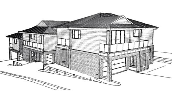
Figure 6 – 3D image of proposed development
submitted by the applicant looking south-west.
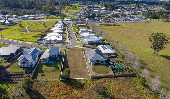
Figure 7 – Marketing drone image of subject site in
its context looking northeast up Parker Crescent towards Hitchcock’s Lane
(Source: realestate.com.au, dated July 2020)
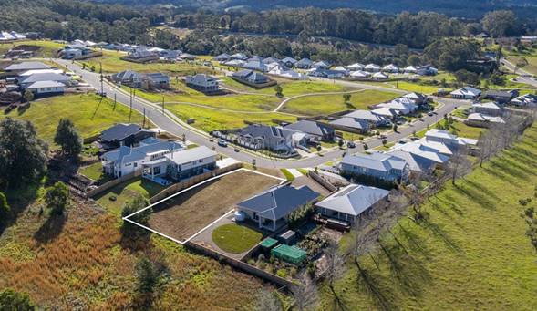
Figure 8 – Marketing drone image of subject site in
its context looking north
(Source: realestate.com.au, dated July 2020)
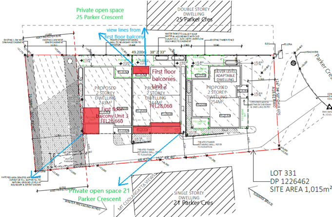
Figure 9 – Excerpt of submitted site plan
indicating potential overlooking of the development to neighbouring properties.
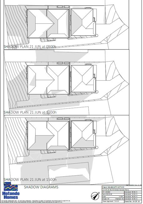
Figure 10 – Submitted shadow diagrams.
Clause 4.6 (4)(b) – Concurrence of the Secretary has
been obtained.
Council may assume concurrence if
it were of the view to support the variation.
Clause
4.6(5)(a) – Would Non-Compliance Raise any Matter of Significance for
State or Regional Planning?
The
contravention does not raise any matters of significance having regard to State
or regional environmental planning. It does not have implications for any State
Environmental Planning Policies in the locality or impacts which are considered
of a State or regional scale.
Clause
4.6(5)(b) – Is There a Public Benefit of Maintaining the Planning Control
Standard?
In the
judgement of Ex Gratia P/L v Dungog Council [2015] (NSWLEC 148),
Commissioner Brown of the NSW LEC outlined that the question that needs to be
answered in relation to the application of clause 4.6(5)(b) is “whether
the public advantages of the proposed development outweigh the public
disadvantages of the proposed development”.
The
applicant is to demonstrate that there will be better planning outcomes
achieved through variation to the development standard as opposed to strict
compliance with the development standard or amending the application to reduce
the extent of the variation.
In
this regard, it is considered that strict compliance with the development
standard would result in a better outcome. The extent of the departure from the height control, whilst
numerically small does not relate to a design that demonstrates considered
design having regard to the established character within the area as detailed
in the assessment against Clause 4.6(a)(ii).
The
departure from the development standard is the result of inadequate regard to
the site context and the applicable planning controls relating to the site and
the proposed land use. It is further noted that due to the circumstances
of the site situated within the Estate, the contravention is likely to set an
undesirable precedent for a departure of this development standard in the
locality.
There appears to be no reason or
specific site characteristic as to why a development could not be designed to
comply with the height control.
Summary
and conclusion with regard to clause 4.6
In
considering a clause 4.6 variation, clause 4.6(4) states development consent must
not be granted for development that contravenes a development standard
unless—
i. the
applicant’s written request has adequately addressed the matters required
to be demonstrated by subclause (3), and
ii. the proposed development will be in
the public interest because it is consistent with the objectives of the
particular standard and the objectives for development within the zone in which
the development is proposed to be carried out, and
The applicant’s written request is inadequate in
addressing these requirements as the written
submission provided by the applicant is not considered to satisfy the
requirements of clause 4.6(3) and the proposed development is not considered to be in the public interest.
Chapter G13: Medium Density and other Residential
Development of Shoalhaven Development Control Plan 2014.
Notwithstanding that the application is considered to be
non-compliant with cl.4.3 of SLEP 2014, it is prudent to consider the proposed
development against the provisions of Chapter G13 of
SDCP 2014.
A consideration of the proposed development against Chapter
G13 reveals that the proposed development is not consistent with the following
provisions:
1. Minimum Lot Size;
Density; and Building Envelope, Heights, and Setbacks
The proposed development is not consistent with the
following performance criteria:
A1.4 The
development site for multi dwelling housing, multi dwelling housing (terraces)
or a manor house must be of an appropriate size and dimension.
P2 The
bulk and scale of new development, particularly on the perimeter of the
development site, or where that locality or development site has heritage
significance and/or distinctive character, is:
§ Compatible,
consistent, and sympathetic to the bulk and scale of existing development in
the locality.
§ Sympathetic
with the streetscape and complements the existing and desired future character
of the area.
P3.1 The
bulk and scale of development is compatible with the existing or desired future
character of the area and minimises adverse amenity impacts on neighbours, the
streetscape and public domain.
P3.2 Development
enables view sharing with neighbours and the public domain.
P4 The
height of development:
§ Is
compatible with the existing or desired future character of the area.
§ Minimises
adverse amenity impacts associated with overlooking and overshadowing of
adjoining properties.
§ Relates
to the landform, with minimal cut and fill.
P5.1 The
front setback is generally consistent with adjoining development and does not
undermine the integrity of the prevailing building lines.
P5.2 The
location and siting of the building complements the existing setbacks in
proximity to the site, foreshore (if applicable) and the streetscape.
P5.3 The
proposed development is setback and of a scale that is relative to the street
reserve width, in such a way to ensure pedestrians do not feel buildings are
overbearing.
With regard to the front setback
control under P5, the applicant provided a variation statement stating the
following:
“A variation is requested to the development
standard, as the upper-level balcony encroaches the required front setback by
0.18m. This encroachment is considered minor in this case as the proposed
balcony primarily addressed the street and will not affect the privacy or solar
access of adjacent properties. However, a reduction to the size of the
upper-level balcony will result in a decrease to the amenity of future
residents and is not considered a desirable outcome for the development”.
A variation has
not been submitted in relation to the other controls.
The proposal is
inconsistent with these controls for the following reasons:
· The site is 1,015m2 with the rear 230m2
(approximate) unable to be built upon due to asset protection zones and
easements, the useable site area is reduced to approximately 785m2. Given the minimum lot size for a
detached dual occupancy (2 dwellings) is 700m2 and multi-dwelling
housing is 900m2, 785m2 of usable site area is not
considered suitable for three (3) dwellings, as demonstrated by the numerous
variations to Council’s DCP.
· The
proposed development is inconsistent with the surrounding character and bulk
and scale of the existing development. Surrounding development comprises of
single dwellings on individual allotments that generally sit within the front
portion of the site with substantial rear yards. The introduction of
multi-dwelling housing on a single allotment will be “out of character”
for the area.
· The minimum front setback is required under P5.4 to be 4.5m
to verandahs and 5.5m to the dwelling for the ground floor and an additional
1.0m to the upper floor. The proposal has a setback of
5.2 to the verandah and 6.62m to the dwelling of Unit 1. This requires a
variation of 0.18m to the upper-level verandah, a variation of 3.3%.
· While
the variation statement with regard to the front setback is noted, however due
to non-compliance with the height and front setbacks, the proposed dwelling is
not located within the permissible building envelope.
· The
extent of the proposed development footprint far exceeds that of any
established development within the Estate. The two-storey elevation sits
forward of the building line of all other dwellings in the street and extends
31.35m down the length of the block and provides little architectural relief to
break up the overall dominance and scale of the development within an otherwise
low-density environment.
· The
proposal requires a variation of 0.18m to the upper-level verandah, a variance
of 3.3%. The front setback is inconsistent with adjoining development as it is
approximately 1m closer to the frontage than the average street setback (refer
Figure 12). Furthermore, due to its location on the corner bend of Parker
Crescent, the adjoining property to the south-east is setback 9.967m from the
shared boundary frontage, meaning the proposed development appears to sit some
4.65m in front of the adjoining south-east property, in addition to siting
0.73m in front of the residence to the north-west of the site.
· The
site’s location at the corner bend of Parker Crescent, makes the site and
any development a dominant and visible feature within the Estate (refer Figure
11). The noncompliance of the front setback controls will contribute to the
dominance of the development and undermine the integrity of prevailing building
lines (refer Figure 6).
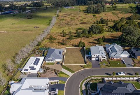
Figure 11 – Marketing drone image of subject site
in its context looking south
(Source: realestate.com.au, dated July 2020)
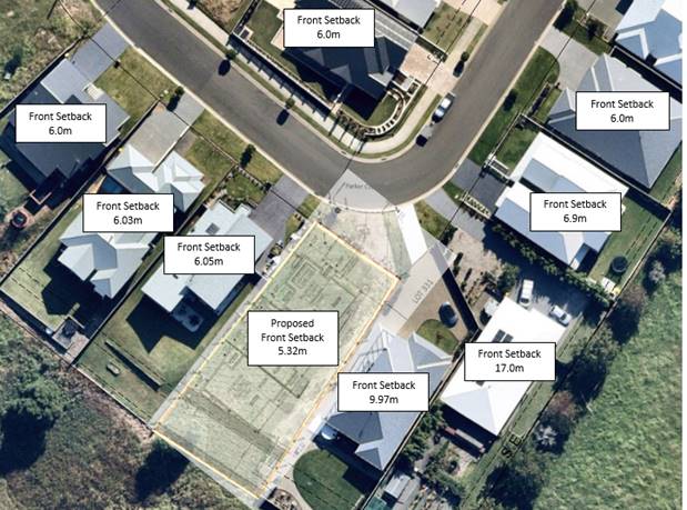
Figure 12 – Existing front setbacks of adjoining sites
2. Local Character and
Context
The proposed development is not consistent with the
following performance criteria:
P7 The scale and
appearance of new development is compatible with, and sympathetic to, existing
and future desired:
§ Development
in the locality; and
§ Amenity
and character of the locality;
Particularly where the development site or its surrounds
has some heritage significance or distinctive character.
P8 Existing views from
the private or public domain (including heritage or familiar dominant landmarks
that are recognised and valued by the community) are not substantially or
unreasonably affected where it is possible to design for the sharing of views.
The proposal is
inconsistent with these controls for the following reasons:
· As
outlined earlier in the report, the proposed development is not considered
sympathetic or compatible with the existing or desired character and amenity of
the locality.
· The
subject site is not located within a Heritage Conservation Area however
it is within close proximity to the Berry Conservation Area and numerous
heritage items of both Local and State significance. The proposed development
is located on a prominent ridge line on the southern approach to Berry along
the Princes Highway. The visual significance of the subject site requires any
proposed development to reinforce the historic character of Berry and maintain
the existing and desired future character for the area.
· The
current design of the development is considered out of character in this locality.
The proposed front building setback variation in conjunction with the
uncharacteristic rear setbacks, is drastically different to the character of
other development within the Estate. Unlike surrounding development within the
Estate, the design does not respond to the site
topography and when contributes to the overall mass of the proposed
built form. Although the Estate is still
undergoing further development, and the subject planning controls will
establish the character of the area, residential amenity both within and
adjoining the site would not be maintained. Having regard to the Planning
Principle established in Veloshin v Randwick Council [2007] NSWLEC 428
the proposal is inconsistent with the emerging character of the area which is
single conventional low-density development.
3. Section 5.3.1
Building Separation and Visual/Acoustic Privacy
The proposed development is not consistent with the
following performance criteria or acceptable solution:
P14.2 Direct overlooking of main
internal living areas and private open space of other dwellings and adjoining
properties is minimised by building layout, location and design of windows,
balconies, screening devices, landscaping, or other effective means.
The proposal is inconsistent with
these controls as the location of private open space on the upper
levels, especially of proposed Units 2 and 3, and elevation of the site,
will lead to direct overlooking of private open space of the property to the
north – 25 Parker Crescent, and to the south – 21 Parker Crescent
(refer Figure 8 earlier). It is noted the finished floor levels of the first
floor sit up to 4m above the natural ground level of adjoining properties,
allowing for direct view lines over fences or screening.
The floorplans of the units show the upper levels to
contain the day to day living spaces of the dwellings. Including kitchen,
dining, and living spaces.
Further, the orientation and layout of the proposal is to
maximise its views at the expense of view sharing with the neighbours and of
privacy for the neighbours. This is demonstrated on the submitted Site Plan
which depicts the proposed first floor alfresco areas to be situated to the
rear of the adjoining dwelling at 25 Parker Crescent, to the north of the site
(see Figure 8) which currently enjoys southeast views to Coolangatta Mountain
but will be reduced by the proposed height and footprint of the proposed
development.
4. Section 5.3.2 Solar
and Daylight Access
The proposed development is not consistent with the performance
criteria or acceptable solution:
P16 Dwellings are sited and designed
to maximise solar access to living areas and private open space; and
A16.1 Dwellings are to be:
· Oriented
to make appropriate use of solar energy by maximising solar access to
north-facing windows.
· Sited
and designed to ensure that the energy efficiency of existing dwellings on
adjoining lots is not unreasonably reduced.
· Designed
to locate living areas and private open space on the northern side of the
development and nonhabitable areas to the south and west of dwellings.
The proposal is inconsistent with
these controls. Suitable shadow diagrams were requested to be provided
by the applicant which were to clearly show the neighbouring developments. The
submitted shadow diagrams received in additional information dated 15 June 2021
do not adequately identify the adjoining sites as requested.
As suitable shadow diagrams have not been provided it is
difficult to assess the extent of impact on adjoining properties and compliance
with this development control. It is identified however that the overall
two-storey length of the development and it is elongated positioning down the lot,
exacerbates the overshadowing impacts on neighbouring properties.
While the plans fail to show detail on the neighbouring
properties to enable an appropriate detailed assessment of the impacts of the
proposal (as required by Schedule 1), it can be seen from the basic level of
information provided that the impacts of the development are exacerbated by the
height, bulk, and scale of the development.
5. Section 5.3.3 Private
Open Space (POS)
The proposed development is not consistent with the
performance criteria or acceptable solution, which states:
A17.1 A minimum area of
private open space shall be provided for each dwelling in accordance with Table
5.
A17.3 Where
the private open space of a dwelling is provided at the ground level, it shall:
· Include
a defined hardstand area (e.g., concrete, paving, decking) of usable space
which:
- Is setback at least 1.2m
from an external boundary.
- Has a minimum dimension of 5m x 4m, of which 50%
shall be covered to provide protection from the elements.
· Have
a minimum dimension of 2m for all other areas.
· Have
a gradient no steeper than 1:20.
· Be
adequately screened to provide privacy to residents.
The identified POS on the plans does not meet the minimum
requirements to be classed as POS in accordance with the standards identified
in the DCP. This results in Unit 1 (16.4% reduction) and Unit 2 (23.9%
reduction) not meeting the required minimum POS. Furthermore, the ground floor POS does not include a 5m x 4m (20m2) hardstand area as required, for
any of the proposed dwellings. The applicant states that there is no
variation and therefore has not provided comment for the variance.
The current design, layout and site restrictions do not
allow for the private open space to comply with the minimum requirements and
demonstrate an overdevelopment of the site.
Open space is required for residential amenity for future
occupants. Noting that these are 4-bedroom dwellings, it is highly likely that
they will be occupied by households of more than 2 people or families. In
this regard, the provision of useable well orientated outdoor open spaces for
recreation purposes is important for amenity reasons.
6. Section 5.3.4 Storage
and Laundry Facilities
The proposed development is not consistent with the
performance criteria or acceptable solution, which states:
P18.1 External clothes drying facilities are provided for
each dwelling; and
P20.1 Adequate, well-designed storage areas are provided
for each dwelling.
The proposal is inconsistent with this control as no
external clothes drying has been identified and it is considered a suitable
location can be provided. No variation has been submitted in relation to P18.1
external clothes drying facilities. Conditions could be imposed requiring
clothes drying areas however the room available is small and would require wall
mounted devices excepting for the rear unit which ‘appears’ to have
a good yard area effectively as a result of being impinged by easements on
title. This yard however is assigned to the Strata community in the submitted
Strata plan.
Proposed Units 2 and 3 do not meet the minimum encouraged
storage. The applicant has provided a variation statement towards the reduced
storage facilities:
“A variation is requested in this instance as the
proposed design shall support ample storage in bedrooms, laundry, garage, and
study to comply with this control”.
Due to significant other variances, specifically solar and
daylight access, which have compounding impacts on the development, the
proposed development cannot suitably accommodate these facilities. The proposed
development is relatively large. All units all contain 4-bedrooms which
are likely to be occupied by families and/or greater than average household sizes
(also a reason to ensure adequate open space). For a dwelling of this size,
satisfactory storage is essential to ensure adequate amenity for households and
ensure developments are liveable and fit for purpose.
7. Section 5.5.3 Waste
Management
The proposed development is not consistent with the
performance criteria or acceptable solution, which states:
A31.1 For each dwelling in a development, the kerbside
frontage required for waste collection is at least 1m per bin, 0.5m separation
between bins and 1m behind each bin.
The development is not compliant with this control as the
proposed development would require a minimum street frontage of 8.5m to
adequately provide for safe kerbside collection. The site can only provide a
kerbside frontage of approximately 7m. It is noted the same control does not
apply to single dwelling development, and the site would be able to cater for
the waste requirements of a dual occupancy development. By not having
ample frontage available, bins may be placed in front of neighbouring
properties. The issue with this is that uncollected bins and placement in
front of other properties can be a source of complaint and
‘amenity’ for neighbours.
The applicant has not identified this as an issue and as
such has not provided any comment.
Due to the limited street frontage and the number of
existing driveways on the bend, the ability of the site to cater for the
appropriate, safe placement and collection of waste bins is not considered
suitable.
Due to the significant number of DCP variances, which are
explained in further detail the attached s. 4.15 Assessment Report (Attachment
1), the proposed development is considered to be an unsuitable development over
the subject site. While a variation request was submitted for the front setback
(under P5 & A5.4), and storage requirements (under P20 & A20.1), no
acceptable performance solutions were submitted to support the variations. No
other variation requests were submitted to support the numerous other issues as
outlined in this report.
It is further noted that two (2) separate requests for
information have been issued to the applicant requesting the application
address the abovementioned noncompliance’s and/or to provide a revised
design that is constant with Council’s controls. Despite this however,
the applicant has not amended the proposal to provide a compliant development
or provide a full claim against the performance solutions.
Access
A single driveway has been provided
off Parker Crescent. The proposed development is located on a 90° bend along where the street is quite
narrow (as per Figure 11 below). The location of the proposed driveway access
is considered suitable in relation to the street and verge placement, however,
Council’s Development Engineer raised concerns with entry and exit into
the garage for Unit 1 (Figure 12 below).
Chapter 21: Car Parking and Traffic of SDCP 2014 outlines both
in the objectives of the chapter and in the performance criteria and acceptable
solutions that vehicles are to enter and leave a site in forward direction
(refer s.4(vi), s5.4, and s5.6).
The location and design of Unit 1 however requires vehicles to
exit the driveway in reverse, having adverse road safety impacts, particularly
given the location of the driveway on 90°
bend along where the street is quite narrow. Whilst Parker Crescent is unlikely
to carry large traffic volumes, the manoeuvre is unnecessary and could be
addressed by an alternative design.
Council’s Development Engineer has provided the
following:
“The garage for Unit 1 should be re-oriented to
the south, towards the common driveway to facilitate forward ingress and
egress. The current arrangement would encourage vehicles to reverse out, which
is not supported given the ample opportunity to comply with DCP G21 by rotating
the garage”.
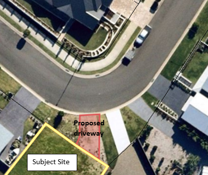
Figure 13 – Location of proposed driveway in
relation to existing adjacent driveways.
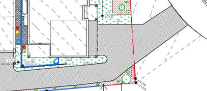
Figure 12 – Unit 1 garage as per the submitted plans.
Deposited Plan and 88B Instrument:
The subject site is burdened by a number of Restrictions on
the Use of Land created pursuant to Section 88B of the Conveyancing Act 1919
in relation to Deposited Plan No. DP122646.
· Restriction
as to user numbered 3(b) states that “No dwelling shall be designed in
such a manner that they will detract from and not be compatible with the
existing bulk and scale of the housing stock within Berry township”.
Comment: The proposed development is not considered to
be designed in a “manner compatible with the existing bulk and scale of
the housing stock within Berry township”.
· Restriction
as to user numbered 3(e) limits floor area of a building constructed on lots
ranging from 650m2 through to lots larger than 1000m2.
Comment: It is noted that a site with a total allotment
size of 1,015.0m2 allows for a total floor area of 35% or 355.25m2. The total
floor area across all three (3) dwellings is 740m2 which exceeds the maximum
permissible floor area.
Due to significant DCP variances specifically in relation to
building envelope, height, and setbacks; solar access; private open space; the
proposed development is considered to be an overdevelopment of the site.
· Restriction
as to user numbered 5(a) states that “Not more than one main building
may be erected or be permitted to remain on any lot burdened and that main
building must not be used for any purpose other than a single residential
dwelling, but this restriction does not prevent the erection and use of a building
or buildings on any lot burdened strictly in accordance with the conditions of
the Shoalhaven Local Environmental Plan 2014.”
Comment: The terms of restriction limit the permissible
number of dwellings on a single site to one (1) dwelling only. However, The
SLEP 2014 permits the multi dwelling development within the zone and as such
the proposed development is considered permissible.
Furthermore, cl. 1.9A Suspension of covenants, agreements, and
instruments under SLEP 2014 enables development on land in any zone to be
carried out in accordance with this Plan or with a consent granted under the
Act, any agreement, covenant, or other similar instruments that restricts the
carrying out of that development does not apply to the extent necessary to
serve that purpose.
The relevant restriction was not a covenant imposed by the
Council or that the Council requires to be imposed and therefore, council may
set the restriction aside if they are approving a lawful development. However,
as indicated by the assessment of character earlier this report, all other
dwellings within the Estate have complied with the restriction. This has firmly
set the established character of the area, and while the provisions of cl. 1.9A
mean the terms of the covenant do not apply to the assessment of a DA under the
SLEP 2014, this has created a dominant character in the area of single
residential dwellings, which is a consideration in the assessment of the
development.
Development for the purpose of “multi dwelling
housing” is however permissible in the R1 General Residential zone via
the SLEP 2014.
· Restriction
as to user numbered 5(m) and (n) relate to fencing design and construction on a
burdened lot. Relevantly, no fence on site is to be 1.8m high or more and
constructed of timber.
Comment: There is no front fencing proposed as part of
the development. The side fencing to the north-west is an existing 1.8m high
timer fencing. There is currently no fence along the rear or side south-east.
The proposal seeks to install 1.8m high Colourbond fencing to the unfenced
boundaries and between the proposed dwellings.
While the proposal states that the existing timber fencing
along the north-west boundary is to remain, this boundary has significant cut
of up to 1.6m. No detail is provided regarding how the fence will remain, and
to address the amenity impacts from a 1.6m retaining wall with 1.8m fence on
top, resulting in a 3.4m high barrier when viewed from the finished outdoor
levels of Unit 3. This does not comply with the restriction, and notably will
have a detrimental amenity impact on the indoor living spaces on the ground
floor of Unit 3.
The existing materials within Huntingdale Estate are timber
fencing as per the Restriction as to User numbered 4(n). The proposed fencing
does not comply however Conditions of Consent can require timber fencing in
accordance with the restriction on fencing design and construction.
As previously stated, Clause 1.9A(1) suspends the application
of a covenant for developments that are to be carried out in accordance with
the LEP (including the subject DA). However, Clause 1.9A(2)(a) preserves the
applicability of a covenant that is either ‘imposed by the
Council’, or ‘that the Council requires to be imposed’.
Granted that the above restrictions were imposed by the
developer and not ‘imposed by Council’ Council may set these
restrictions aside if approving a lawful development.
Notwithstanding, that clause 1.9A provides the legislative
authority to ignore the aforementioned covenants that the development would appear
to be inconsistent with, Council does not consider that the setting aside of
the restrictions is necessary to serve the purpose of enabling development on
land in any zone to be carried out in accordance with this Plan.
Planning Assessment
The Development Application has been assessed under s4.15(1)
of the Environmental Planning and Assessment Act 1979. Please refer to
Attachment 1.
Policy Implications
There are no policy implications as a result of the
development as proposed.
Consultation and Community
Engagement:
Notification was undertaken in accordance with Council’s
Community Consultation Policy with letters being sent to landholders within a
100m buffer of the site, during the period 12 to 28 May 2021.
Forty-five (45) public submissions were received in relation
to Council’s notification of the development. They were all objections to
the proposed development.
Key issues raised as a result of the notification include but
were not limited to matters listed below.
· Overdevelopment
of the site;
· Proposed
Strata Subdivision is not permissible;
· Contrary to
88b restrictions;
· Privacy
and overshadowing;
· Traffic
and safety;
· Height
and building lines;
· Compatibility
with the surrounding area; and
· Landscaping,
including fencing and cut and fill.
The assessment of the application considered the matters
raised in the submissions (as prescribed by s4.15(d) and concluded on balance
having regard to all the heads of consideration (section 4.15 Evaluation), that
the application should be refused. A detailed analysis can be found in the
attached s. 4.15 Assessment Report (Attachment 1).
Financial Implications:
There are potential cost implications for Council in the event
of a refusal of the application. Such costs would be associated with defending
any appeal in the Land and Environment Court, should the applicant utilise
appeal rights afforded under the Environmental Planning and Assessment Act
1979 (EP&A Act).
Legal Implications
According to section 8.2 of the EP&A Act, a decision of
the Council may be subject of a review by the applicant in the event of
approval or refusal. If such a review is ultimately pursued, the matter would
be put (again) to Council for consideration.
Alternatively, an applicant may also appeal to the Court
against the determination according to section 8.9 of the EP&A Act.
Summary and Conclusion
This Report and the attached s. 4.15
Assessment Report (Attachment 1) provides an assessment of a
proposal to construct a Multi Dwelling Housing development consisting of three
(3) dwellings, and Strata Title Subdivision on the land identified as 23 Parker
Crescent, Berry legally described as Lot 311 DP 1226462.
The proposed development has been assessed against all
relevant environmental planning instruments.
The proposed development has a significant number of
departures from both the Shoalhaven Local Environmental Plan 2014 and
the Shoalhaven Development Control Plan 2014, which are not supported.
The applicant has been provided with an opportunity to submit
an amended compliant design that better responds to the site and
Council’s controls; however, an amended proposal has not been provided.
Further, the submitted clause 4.6 variation is inadequate in addressing the
requirements of SLEP 2014 to vary a development standard and accordingly the
proposed height variation cannot be supported.
The application is recommended for refusal in accordance with
the attached Notice of Determination document (Attachment 2).
|
|
Development
& Environment Committee – Tuesday 13 July 2021
Page
0
|
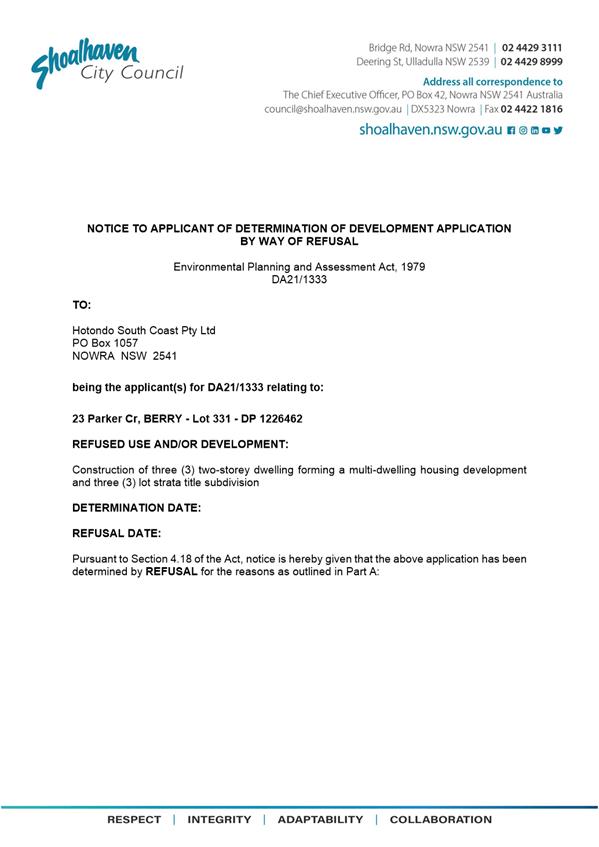
|
|
Development
& Environment Committee – Tuesday 13 July 2021
Page
0
|
|
|
Development
& Environment Committee – Tuesday 13 July 2021
Page
0
|
DE21.80 DA21/1370
– 3 Cumberland Ave South Nowra – Lot 2 DP 260264
DA. No: DA21/1370
HPERM Ref: D21/248840
Department: Development
Services
Approver: Phil
Costello, Director - City Development
Attachments: 1. Determination
- Refusal - 3 Cumberland Av South Nowra - Lot 2 DP 260264 ⇩
2. Planning
Report - 3 Cumberland Av South Nowra - Lot 2 DP 260264 (under
separate cover) ⇨
3. Plans
- Overall Site Plan - 3 Cumberland Av South Nowra - Lot 2 DP 260264 ⇩
4. Plans - Engineering Schedule
-3 Cumberland Av South Nowra - Lot 2 DP 260264 ⇩
Description of Development: Alterations and
Additions to existing Industrial Development
Owner: Provadon Pty Ltd
Applicant: Damien Radburn
Notification
Dates: Not able to be carried out – further details provided in
report below.
No. of Submissions: As above – not able
to be carried out.
Purpose
/ Reason for consideration by Council
Council Resolved on 7 April 2020
(MIN20.240) with respect to COVID-19 Response, that:
“The delegation to the CEO be rescinded to determine a
development application by refusal until the end of COVID 19 crisis.
The refusal of a development
application must only be by Council/Committee resolution.”
This report recommends refusal of the above Development
Application and is therefore prepared for consideration by the Development
& Environment Committee in accordance with the 7 April 2020 Resolution of
Council.
|
Recommendation (Item to be determined under delegated authority)
That Development Application No.
DA21/1370 for Alterations and Additions to existing Industrial Development,
at Lot 2 DP 260264, 3 Cumberland Ave South Nowra be determined by way of
refusal for the reasons contained in Attachment 1 of this report.
|
Options
1. Refuse the
Development Application (DA) in accordance with the recommendation.
Implications: The development is unable to proceed as applied for and a
section (s) 8.2A review may be sought by the applicant or an appeal with the
Land and Environment Court of NSW (LEC) is possible in the event of a refusal
of the application.
2. Approve the
application.
Implications: Council would have to provide the grounds to
support the proposal, that is, provide reasons to support the development,
having regard to section 4.15 considerations. Should Council resolve to approve
the DA with a suite of conditions which would be required to be drafted for
reconsideration by the Development & Environment Committee. Under some
circumstances, third parties (i.e., objectors) can seek a judicial review of
Council’s decision in the NSW Land and Environment Court.
3. Alternative recommendation.
Implications: Council will need to specify an alternative
recommendation and advise staff accordingly.
Location Map
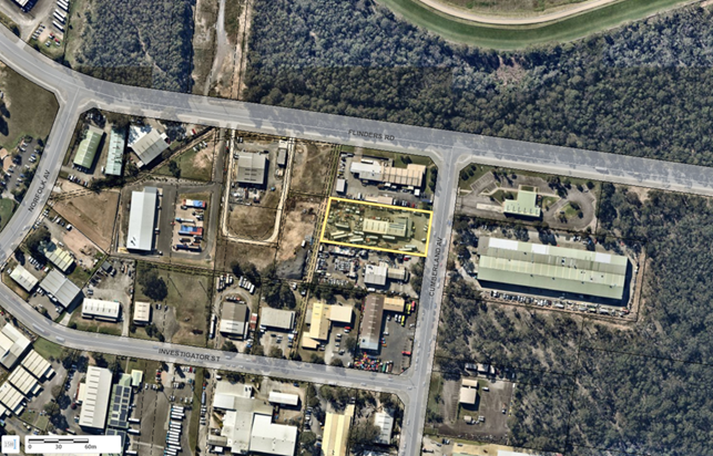 Figure 1 – Location Map
Background
Proposed Development
The subject development
application seeks approval for “alterations and additions to an existing
industrial development”.
The submitted Statement of Environmental Effects (SEE)
describes the proposed works as: “Build an attached Steel Colourbond
shed to match existing shed already constructed. Floor to be of concrete
construction”.
Based on the information
submitted with the application it is unclear whether the shed is an extension
of the existing shed, a standalone structure abutting the existing shed, or an
extension to the existing shed. Plans submitted to date (refer Attachments 3
and 4) depict the proposed development as being an extension to the existing
industrial shed; however, the engineering plans depict a standalone shed. The
following outlines Council’s present understanding of the development:
· The
proposal seeks consent for a 307.2m² (24m long 12.8m wide) extension to
the existing industrial building.
· The
proposed extension would be located on the western rear elevation of the
existing building with a setback of 19.0m to the western rear boundary.
· The
extension would be constructed with corrugated steel with a pre-painted finish
(‘slate grey’).
Subject Land
The subject site is situated at 3 Cumberland Av, South
Nowra, legally described as Lot 2 DP 260264.
Site & Context
The development site:
· Has
a total site area of 4,782m2.
· Has
a 45m frontage to Cumberland Ave which forms the primary frontage to the east.
· Contains
structures including a single storey masonry building, approximately 18m x 5m
which sits centrally on the lot and setback approximately 14m from Cumberland
Ave and an industrial building approximately 12m x 42m with a height of 5m,
providing a covered storage area.
· Is
located within Zone IN1 General Industrial (refer Figure 2 below).
· is
identified as bushfire prone land (buffer zone).
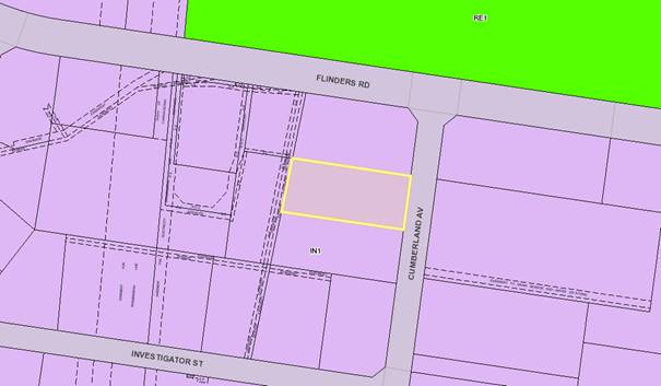
Figure 2 – Zoning Map
History
|
Date
|
Comment
|
|
16 April 2021
|
Application Lodged
|
|
23 April 2021
|
Additional
Information Requested (a.k.a Request for Information (RFI)) – given
twenty-one (21) days to respond. Information required:
1. Owner’s
consent. The submitted owner’s consent would appear to be signed by a
single director. If the owner of the property is a company, the application
must either:
a) be
signed by two directors or a director and a company secretary;
b) be
signed by an authorised person of the company. The authorised person must
demonstrate authority to lodge the development application by providing
either minutes of a board meeting resolving to provide such authorisation to
that person or by way of a letter signed by two directors or a director and a
company secretary providing such authorisation;
c) be
signed by a sole director in the case of sole director companies; and
d) the
nature of their position of authority must be stated on the form (e.g.
director, sole director, or company secretary).
2. A
stormwater concept plans, prepared in accordance with Chapter G2 Sustainable
Stormwater Management and Erosion/Sediment Control of Shoalhaven Development
control Plan 2014.
3. Amended
site plans to provide the following details in accordance with Schedule 1 of
the Environmental Planning and Assessment Regulation 2000:
a) All
existing structures and use of structures on the subject site and adjoining
site.
b) Setbacks
of the proposed building addition to all boundaries
c) The
storage of materials on the site.
d) All
car parking spaces existing and proposed on the site.
4. Amended
floor plans to provide the following details:
a) floor
plans of the existing building showing the extent of the changes or
connection of the proposed building to the existing building.
b) the
fitout and use of the building addition.
c) FFL
(Finished Floor Level) of the existing and proposed building.
5. Amended
elevations and sections to provide the following details:
a) All
elevations are to be provided with relevant cardinal directions i.e. southern
and northern elevations (front, left and right are not appropriate)
b) All
elevations and sections are to be provided with FFL (Finished Floor Level),
FGL (Finished Ground Level), NGL (Natural Ground Level)and finished ridge
heights.
6. A
swept path plan to be included to demonstrate the movement of the largest
vehicle servicing the site, to and from the service doors. This is required
to ensure that the location of the proposed roller door access points are
provided with sufficient area to enable the largest vehicle to access these
areas without conflicting with the existing storage areas.
7. An
amended statement of environmental effects to be prepared to address the
following matters:
a) Clarification
of the existing use and extension of that use to the new building. this would
include consideration of the broader use of the site. It does not appear that
the site has prior approval for the use of the external areas of the site for
the storage of industrial goods and material. It would appear that the site
is currently being used for the storage of materials external to the building.
Clarification is required as to the current approval for the use of these
areas for the storage of materials.
b) Assessment
of the development against the following provisions of the Shoalhaven
Development Control Plan 2014:
i. Chapter
G20: Industrial Development
ii. Chapter G21: Traffic and Car Parking
|
|
As sufficient information has been
provided by the applicant no notification or referrals have been undertaken.
|
|
19 May 2021
|
As no information or contact was made
by the applicant in response to the 23 April 2021 letter, an ‘Intent to
Refuse’ letter was issued and the applicant given seven (7) days to
respond.
|
|
25 May 2021
|
Staff left a message with
receptionist for applicant to call Council to discuss application and the
required additional information.
|
|
09 June 2021
|
The Applicant
contacted Council and advised the additional information was still 4-6 weeks
away.
The assessing
officer advised the applicant to withdraw the application and relodge once
all the information required had been prepared and that they would receive a
100% refund (of applicable fees).
The applicant refused to withdraw,
and was accordingly advised that the matter would need to be finalised and
would be reported to Council for refusal.
|
Issues
1. Inadequate Documentation
and Plans – Non-Compliance with Provisions of the Environmental Planning
and Assessment (EP&A) Regulation 2000
The Development Application
(DA21/1370) was lodged with Shoalhaven City Council on 16 April 2021. As part
of Council’s initial vetting of the application, key issues were
identified with the application (as identified in the “history”
summary above) and additional information (RFI) was requested on 23 April 2021
to enable the application to progress to a full assessment.
Discussion
Given no response was received
to Council’s request for further information, the development is
non-compliant with the following mandatory requirements of the EP&A
Regulation 2000:
· Clause
49 – Persons who can make Development Applications.
As land owners consent was not
provided, Council cannot be satisfied that the appropriate owner’s
consent for the land has been provided in accordance with the requirements of
clause 49 of the EP&A Regulation 2000.
· Clause
77 – Notice of Development Applications
As adequate plans capable of
being notified in accordance with the requirements of Council’s Community
Consultation Policy were not provided, the development was unable to be
notified within the surrounding locality per the requirements of clause 77 of
the EP&A Regulation 2000. Noting the submitted plans fail to adequately
show the relationship of the proposed extension with the existing warehouse
development.
· Schedule
1 – Forms
As neither an adequate site plan
nor adequate sketch plans depicting the development were provided, the
development is non-compliant with the provisions of Schedule 1 of the EP&A
Regulation 2000.
2. Non-Compliance with provisions of the Shoalhaven
Development Control Plan 2014
As a response to Council’s
RFI was not received clarifying any of the matters raised (refer Report above),
the following non-compliances with the Acceptable Solutions and Performance
Criteria of provisions within various Chapters of the Shoalhaven Development
Control Plan (SDCP) 2014 were identified:
· The proposal
is not compliant with the following provisions of Chapter G1 – Site
Analysis, Sustainable Design and Building Materials of the SDCP 2014:
o Acceptable
Solution A1.1 – A1.3 / P1.1-P1.4 – Site Plan / Site Analysis.
· The proposal
is not compliant with the following provisions of Chapter G2 – Sustainable
Stormwater Management and Erosion/Sediment Control of the SDCP 2014:
o Acceptable
Solution A2.1 / P2 – Stormwater Drainage.
· The proposal
is not compliant with the following provisions of Chapter G20 –
Industrial Development of the SDCP 2014:
o Acceptable
Solution A3.2 / P3 – Drainage Plan.
· The proposal
is not compliant with the following provisions of Chapter G21 – Car
Parking and Traffic of the SDCP 2014:
o Section 5.1 – Car Parking
Schedule; and
o Acceptable Solutions A12.1 and A12.2
/ P12 – Manoeuvrability.
Discussion
The following details the
reasons for the non-compliance with the relevant Acceptable Solutions and
Performance Criteria of the SDCP 2014 as described above. The absence of
sufficient detail and information pertaining to the proposed development has
meant a full assessment against Council’s controls has been unable to be
undertaken. Despite Council officers following up with the applicant to obtain
this information, the updated documentation has not been forthcoming, and the
application cannot be held in abeyance indefinitely.
Chapter
G1 – Site Analysis, Sustainable Design, & Building Materials –
Acceptable Solutions A1.1 to A.3 / Performance Criteria P1.1–P1.4
A1.1 A site analysis plan is provided with a development
application that shows the following, as appropriate:
· Constraints
(including but not limited to):
-
Location of services such as power, sewer, water and drainage lines.
-
Existing trees and vegetation within and adjacent to the land being developed.
- Natural hazards
which are likely to impact upon the development such as bush fire prone land,
coastal hazard areas or flood prone land.
· Opportunities
(including but not limited to):
-
Views from the site.
-
Solar access.
- Existing mature
trees and vegetation.
· Context information
for the site and adjoining/ adjacent development (inc. but not limited to):
-
Height and use of buildings.
-
Front setbacks.
-
Driveways.
-
Boundary treatments (including retaining walls).
-
Easements.
- Stormwater
management.
The Site Plan / Site Analysis
Plan provided insufficient information which also resulted in non-compliance
with Schedule 1 of the EP&A Regulation 2000. In particular, the submitted
Plan did not satisfactorily provide details including the height of the existing
and proposed building, location and design of driveways (swept paths), or
stormwater management.
A1.2 For development other than for a single dwelling
house and associated structures, a development application must detail, as
appropriate:
· Topographical
features such as slope, existing natural trees and vegetation and opportunities
for the creation of views and vistas.
· Opportunities
to orientate buildings and private open spaces having regard to solar access,
winds and views.
· The
character of the surrounding development, particularly to setbacks and
subdivision layout.
· The
likely impact on surrounding development, particularly with regard to
overshadowing, privacy and obstruction of views.
· The
extent to which driveways and/or parking areas are likely to dominate the
appearance of the development.
· The
visibility, width and design speed of proposed roads and/or driveways.
· Bush
fire, flooding and drainage constraints, easements for services and extent of
contaminated land.
· The
character of any adjacent public land/reserves, particularly the location of
mature trees in relation to the proposed development.
The Site Plan / Site Analysis
Plan provided insufficient information which also resulted in non-compliance
with Schedule 1 of the EP&A Regulation 2000. In particular, the submitted
Plan did not satisfactorily provide details including the likely impact on
surrounding development (no buildings on surrounding properties were
referenced), slope of the land and any required earthworks, and suitability of
the driveway area for the likely vehicle types.
A1.3 The proposed site layout
responds to and implements the findings of the site analysis plan prepared in
accordance with A1.1 and A1.2.
Having regard for the deficiencies to the submitted Site Plan
/ Site Analysis Plan, Council cannot clarify if the proposed layout adequately
responds to its findings.
Performance Criteria P1.1 to 1.4
of Chapter G1 states the following:
P1.1 The characteristics of the site and its surrounds
have been adequately considered through preparation of a thorough site analysis
plan.
P1.2 The site analysis informs the site design and
layout.
P1.3 The site layout integrates with the surrounding
environment through:
· Adequate pedestrian,
cycle and vehicle links to street and open space networks.
· Buildings that face
and address streets and the public domain.
· Buildings,
streetscape and landscape design that relates to the site topography and to the
surrounding neighbourhood character.
P1.4 The site layout enhances personal safety and
minimises potential for crime and vandalism.
Chapter 1 – Introduction,
Clause 11 of the SDCP 2014 requires that a ‘Variation Statement’ be
prepared which justifies any non-compliance with the acceptable solution.
The applicant failed to submit a Variation Statement as
required by Chapter 1, therefore justification has not been provided
demonstrating that the development can meet the performance criteria. Council
is unable to undertake a full and proper analysis of the development against
the DCP controls as required by s4.15(1)(a)(iii) of the EP&A Act 1979 and
Council should not grant consent to a development where compliance with neither
the acceptable solution nor performance criteria has been demonstrated by the
applicant.
Chapter G2 –
Sustainable Stormwater Management & Erosion and Sediment Control –
Acceptable Solution A2.1 / Performance Criteria P2
A2.1 Roof water is to be collected by gutter and downpipe
systems, or other equivalent means, and conveyed to an approved discharge point
in accordance with the requirements of Part 3.1.2 of the Building Code of
Australia and AS 3500.3. This could be:
a) A gutter or table drain in a road reserve, or
b) A stormwater easement or easement to drain
water, or
c) A charged line system where (a)
and (b) above are not available and the development site will have no more than
two dwellings. Where a charged line system is proposed, the following must be
included with the development application:
· Acknowledgement
from adjoining property owners indicating a refusal to grant a drainage
easement. The acknowledgement must indicate that a reasonable amount of
compensation has been offered for the proposed drainage easement and that the
advantages of creating as easement were explained.
· Demonstrate
a minimum of 1.8m of fall between the roof gutters and the front boundary of
the site.
· Demonstrate
fall from the front boundary to the kerb line.
· Detailed
design, inclusive of site plan and longitudinal section including all calculations,
levels and further details of pits, gutters and maintenance facilities as
required
d) A disposal/absorption trench,
where (a), (b) or (c) above are not available, and soil conditions are
suitable, or
e) A water tank/on-site detention
system with an overflow connected to a disposal method in (a), (b), (c) or (d),
above.
As part of the RFI sent to the
applicant, Council requested a Stormwater Concept Plan to identify how runoff
from the additional 307.2m² of impervious area (24m x 12.8m extension)
would be captured and disposed. This is considered appropriate given the
considerable extent of additional roofed area being proposed.
Given no response to Council’s request was received,
the applicant has not satisfactorily nominated the method of stormwater disposal
from the site.
Performance Criteria P2 of
Chapter G2 states the following:
Stormwater is appropriately accommodated in the design
including:
· Stormwater
from roofed areas is collected, stored and/ or conveyed to appropriate
discharge points or disposal areas.
· Paved/impervious
areas associated with buildings and driveways are graded and drained to prevent
the discharge of surface water onto adjoining land.
· Permeable
areas are utilised to reduce stormwater runoff.
Chapter 1 – Introduction,
Clause 11 of the SDCP 2014 requires that a ‘Variation Statement’ be
prepared which justifies any non-compliance with the acceptable solution.
The applicant failed to submit a Variation Statement as
required by Chapter 1, therefore justification has not been provided
demonstrating that the development can meet the performance criteria. Council
is unable to grant consent to a development where compliance with neither the
acceptable solution nor performance criteria has been demonstrated by the
applicant.
Chapter G20 –
Industrial Development – Acceptable Solution A3.2 / Performance Criteria
P3
A3.2 A drainage plan is submitted with the development
application.
Despite Council’s RFI
requiring the submission of the drainage plan / stormwater concept plan, no response
was received. The applicant has therefore not adequately demonstrated that
runoff from the additional 307.2m² of roof space can be appropriately
managed using existing facilities.
Performance Criteria P3 of
Chapter G20 states the following:
P3 Adjoining sites are not to be negatively impacted by
the proposed development and drainage works.
Chapter 1 – Introduction,
Clause 11 of the SDCP 2014 requires that a ‘Variation Statement’ be
prepared which justifies any non-compliance with the acceptable solution.
The applicant failed to submit a Variation Statement as
required by Chapter 1, therefore justification has not been provided
demonstrating that the development can meet the performance criteria. Council
is unable to grant consent to a development where compliance with neither the
acceptable solution nor performance criteria has been demonstrated by the
applicant.
Chapter G21 – Car
Parking & Traffic – Section 5.1 – Car Parking Schedule
The proposal has not
satisfactorily demonstrated that provision is capable of being made for car
parking spaces to be provided, as required in accordance with Section 5.1
– Car Parking Schedule of Chapter G21 of the SDCP 2014. In particular,
the following is noted:
· The
applicant has not demonstrated on the submitted Site Plan, the location where
any additional parking spaces are capable of being provided (also noting that
external areas of the site in the vicinity of the proposed building appear to
be used for the storage of materials).
· The
applicant has not demonstrated on the submitted Site Plan, the location where
any existing parking spaces are provided.
· The applicant has
not provided an assessment against Chapter G21 in their submitted Statement of
Environmental Effects Report, which discusses car parking or the likely future
car parking rate for the development.
Chapter G21 – Car
Parking & Traffic – Acceptable Solution A12.1 and A12.2 / Performance
Criteria P2
A12.1 The minimum turning paths in Table 2 are achieved.
A12.2 Turning paths for vehicles will be based upon the
largest vehicles likely to utilise the premises.
It is noted that the extended
building to be constructed in the western rear part of the site would reduce
the hardstand area available on the site for manoeuvring of vehicles. As such,
Council requested swept paths be provided as part of the RFI, demonstrating
that the largest vehicle requiring access to the site, is capable of achieving
that access. Council were in particular concerned with access to the roller
doors which appear to be located in the western rear elevation with a rear
setback of only 19m.
However no response was
received, and as such, the requested swept paths demonstrating manoeuvrability
were not provided.
Performance Criteria P12 of
Chapter G21 states the following:
P12 Adequate space is provided for the manoeuvring of
vehicles, particularly rigid and articulated heavy vehicles.
Chapter 1 – Introduction,
Clause 11 of the SDCP 2014 requires that a “Variation Statement” be
prepared which justifies any non-compliance with the acceptable solution.
The applicant failed to submit a Variation Statement as
required by Chapter 1, therefore justification has not been provided
demonstrating that the development can meet the performance criteria. Council
is unable to grant consent to a development where compliance with neither the
acceptable solution nor performance criteria has been demonstrated by the
applicant.
Planning Assessment
The DA has been assessed under s4.15(1) of the Environmental
Planning and Assessment Act 1979. Please refer to Attachment 1.
Consultation and Community
Engagement:
As insufficient information has been provided by the
applicant no notification has been undertaken. In accordance with Council
Policy the application was required to be notified for a minimum of fourteen
(14) days to property owners within a 100m radius.
Financial Implications:
There are potential cost implications for Council in the
event of a refusal of the application. Such costs would be associated with
defending any appeal in the Land and Environment Court, should the applicant
utilise appeal rights afforded under the Environmental Planning and Assessment
Act 1979 (EP&A Act).
Legal Implications
According to section 8.2 of the EP&A Act, a decision of
the Council may be subject of a review by the applicant in the event of
approval or refusal. If such a review is ultimately pursued (if the
recommendation is not adopted), the matter would be put (again) to Council for
consideration.
Alternatively, an applicant may also appeal to the Court
against the determination according to section 8.9 of the EP&A Act.
Summary and Conclusion
This Report and the attached s4.15 Assessment Report (Attachment
2) provide an assessment of a proposal for “alterations and additions
to an existing industrial development” on land described as Lot 2 DP
260264, No. 3 Cumberland Av South Nowra.
The application has been submitted with inadequate information
to enable a full and proper assessment of the application and its impacts per
the requirements of section 4.15 of the EP&A Act. Accordingly, several
non-compliances with the documentation requirements of Council’s DCP were
identified, in addition to failure to supply Council with mandatory details
specified in the EP&A Regulation 2000. Council staff have liaised with the
applicant during the assessment period; however the additional information has
not been forthcoming.
Having regard to the assessment and lack of detail submitted
with the application, the proposal is not considered capable of support and is
recommended for refusal for the reasons at Attachment 1.
|
|
Development
& Environment Committee – Tuesday 13 July 2021
Page
0
|
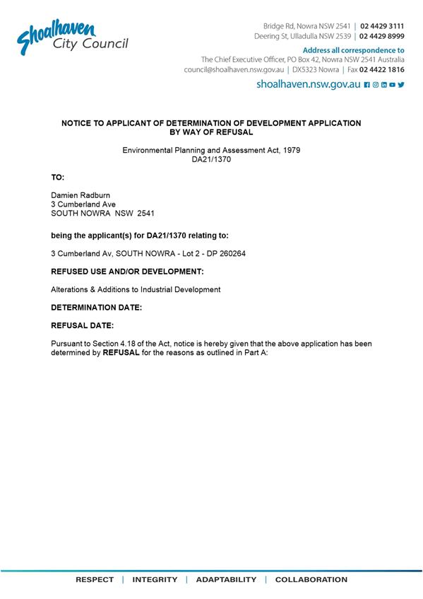
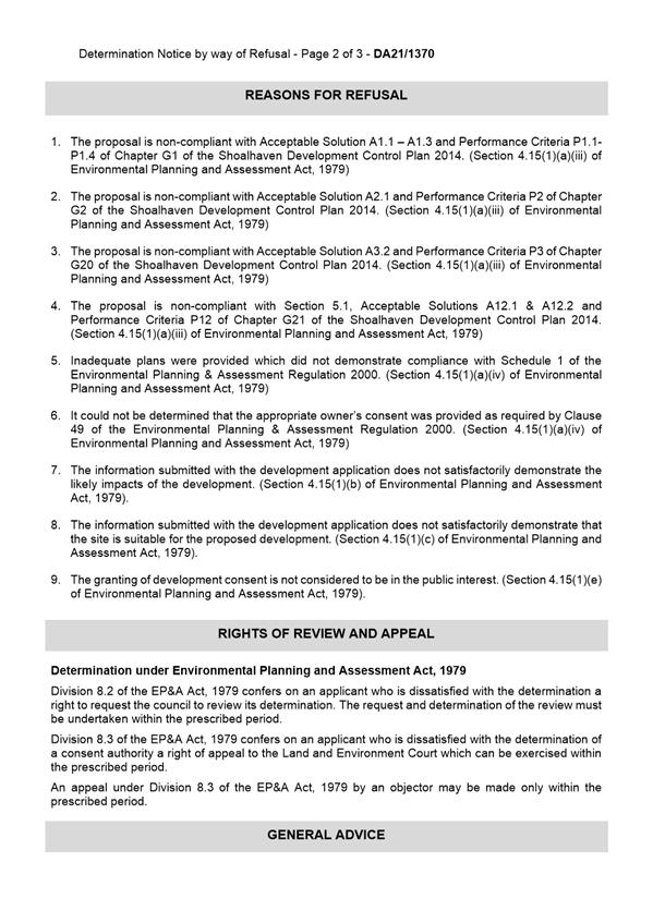

|
|
Development
& Environment Committee – Tuesday 13 July 2021
Page
0
|
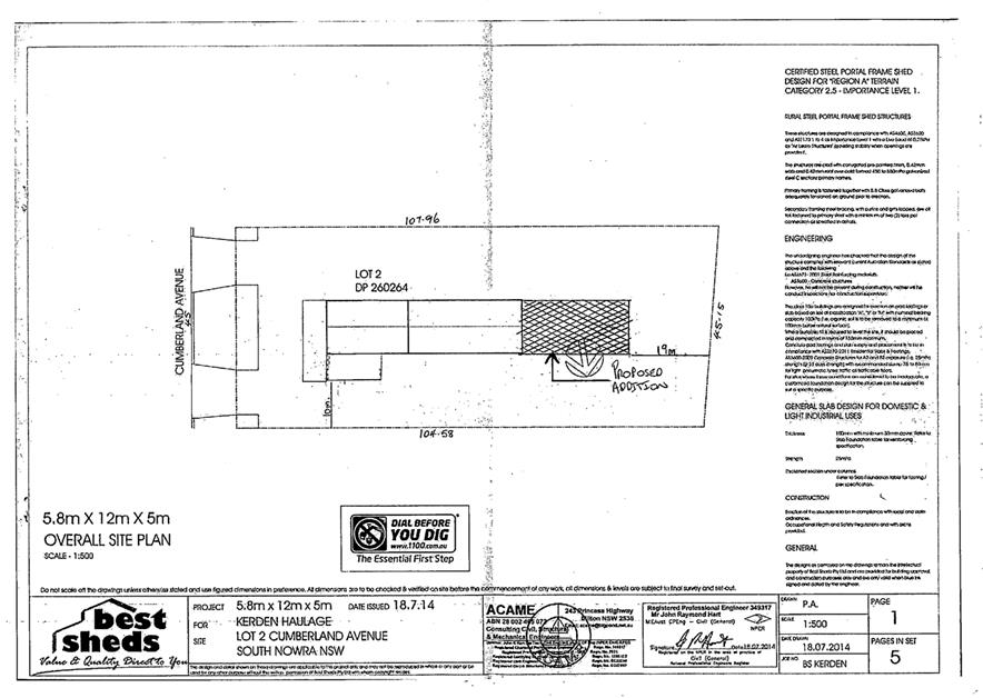
|
|
Development
& Environment Committee – Tuesday 13 July 2021
Page
0
|
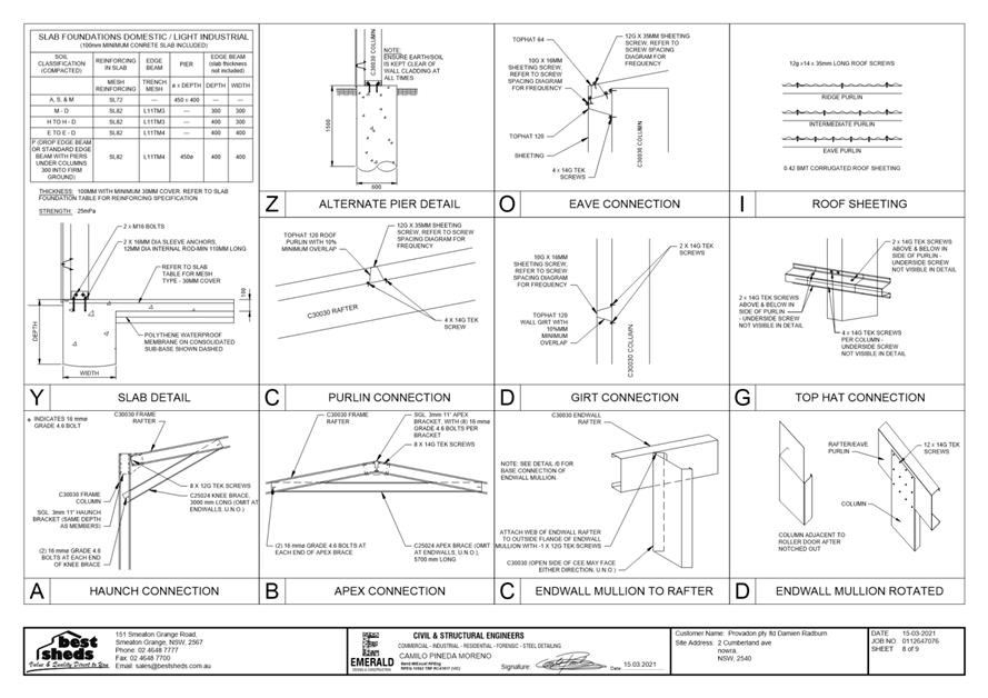
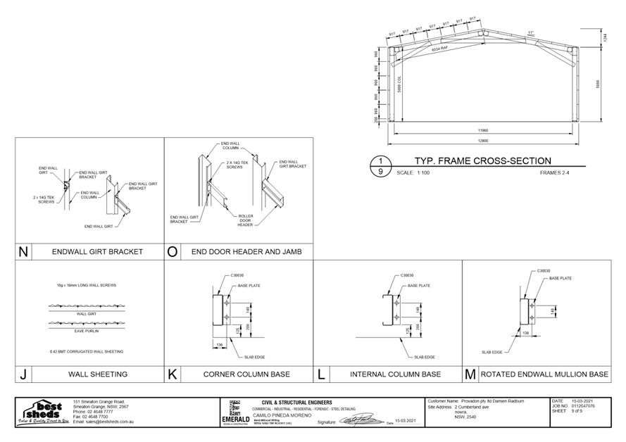
|
|
Development
& Environment Committee – Tuesday 13 July 2021
Page
0
|
DE21.81 DA20/2322
– 12-16 The Wool Road & 5 Burton Street, Vincentia – Lots 1779
& 1780 DP 26434, Lot 5 DP 539867 & Lot 1 DP 615796
DA. No: DA20/2322/4
HPERM Ref: D21/245916
Department: Development
Services
Approver: Phil
Costello, Director - City Development
Attachments: 1. Planning
Report - 12 -16 The Wool Rd, Vincentia (under separate cover) ⇨
2. Draft - Determination - 12-16
The Wool Rd, Vincentia (under separate cover) ⇨
Description
of Development: Demolition of Existing Structures and Construction of Hotel
Accommodation with Ancillary Bar / Bistro and Function Centre
Owner: Error! Unknown document
property name.
Applicant: Error! Unknown
document property name. c/o PDC Lawyers & Town Planners
Notification Dates: 23 December 2020 to 20 January
2021
No. of Submissions: 45 in objection
Two
(2) in support
Purpose
/ Reason for consideration by Council
On 19 January 2021, it was resolved by the Strategy and Assets
Committee that this DA be called in to Council for determination in response to
considerable public concern.
|
Recommendation (Item to be determined under delegated authority)
That Development Application DA20/2322 for demolition of
existing structures and construction of hotel accommodation with ancillary
bar / bistro and function centre at Lots 1779 & 1780 DP 26434, Lot 5 DP 539867 & Lot
1 DP 615796, 12-16
The Wool Road & 5 Burton Street, Vincentia
be approved subject to the recommended
conditions of consent contained in Attachment 2 of this report.
|
Options
1. Approve the
development application (DA) in accordance with the recommendation of this
report.
Implications: This would
allow the applicant to pursue construction of the development.
2. Refuse the
application.
Implications: Council would
need to determine the grounds on which the application is refused, having
regard to section 4.15(1) considerations.
3. Alternative
recommendation.
Implications: Council will
need to specify an alternative recommendation and advise staff accordingly.
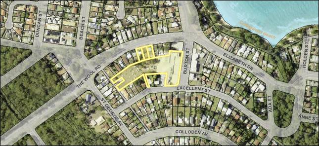 Figure 1 – Location Map
Background
Proposed
Development
The DA seeks approval for the demolition
of existing structures and construction of hotel accommodation with ancillary
bar / bistro and function centre.
The proposed hotel is situated
entirely over Lots 1779 & 1780 DP 26434 and Lot 5 DP 539867 fronting The
Wool Road, and over a portion of Lot 1 DP 615796.
The
submitted Statement of Environmental Effects
(dated 4 June 2021) provides the following detail with regard to the
development description:
· Lot
Consolidation & Demolition:
“The
subject site will be created by subdividing Lot 1 DP 615796 and consolidating
all lots within the subject site (refer to
Figure 4)
It is
proposed for all structures and vegetation within the subject site boundaries
to be removed” (shown at Figure 2)
· Hotel
accommodation, ancillary bistro/bar and function centre:
“Construction of a three and four
storey hotel (Figure 5) containing:
· Basement floor:
o 45 standard car spaces
o Three accessible car spaces
o Two stacked staff parking spaces
o One service/courier vehicle space
o Store and service rooms
· Ground floor:
o Bar and Bistro with 165m2 floor area
o Function Room with 156m2 floor area
o Service areas, bin storage, circulation spaces etc
o Lobby/Reception and office
o Eleven studio hotel rooms
· First Floor:
o Twenty-one studio hotel rooms with balconies
· Second Floor (fourteen rooms):
o Four studio hotel room
o Three interconnecting rooms (capable of being used either
as two-bedroom interconnecting units or separately as one studio and one
one-bedroom unit)
o Three one-bedroom hotel room
o One two storey, five-bedroom penthouse with rooftop garden
and balcony. This room spans the second and third floors.
The bar /
bistro and function centre are provided as ancillary to the hotel
accommodation. The bar / bistro will be open seven days with breakfast for
guests only and lunch/dinner open to the public.
The
function centre will operate on an as-booked basis and is available for use by
hotel guests and the general public. The function centre has an anticipated
maximum capacity of 50-60 people, though it is noted that this is highly
variable in light of Government mandated social distancing rules.
The hotel
component will employ five staff (2 front desk/admin, 1 general duties and 2
cleaners). There will be staff presence 24 hours a day, however staffing ratios
will be higher during normal business hours and drop to one staff member
overnight”.
The
following was further clarified in the submitted cover letter with additional
information response (dated 16 April 2021):
“…It is anticipated breakfast will be available
from 6am, Lunch from 11am – 3pm and Dinner from 5pm – 10pm. (in relation to the bar / bistro).
…Function times will depend on individual bookings,
though it is anticipated that bookings will occur between 9am and 12am /
midnight.
The bar /
bistro will employ approximately five staff (3 chef / cook staff and 2 waiters
/ waitresses). The function centre will also employ approximately five staff (3
chef / cook staff and 2 waiters / waitresses).”
· Vehicular
access and parking:
“Vehicular
access to the site will be from the car park to the south and includes a
port-cochere check-in / drop off bay and basement parking for 51 vehicles
(including staff and loading / service bay). The 51 basement parking spaces
accommodate all hotel visitors and staff. Additional parking for use by short
term users of the site (bistro / bar and function centre) is accommodated
within the existing car park. A traffic and parking assessment is provided in
this regard”.
The proposal proposes a total of
83 parking spaces for the development, including a basement level carpark
comprising 51 parking spaces within the footprint of the proposed building for
all hotel visitors and staff, and at least 32 parking spaces are to be provided
within the existing shopping centre parking area on Lot 1 DP 615796 for the
associated bar / bistro and function centre.
“A
service bay is provided on the basement floor near the lifts for use by smaller
daily service vehicles. It is anticipated that given the size of the hotel
development the daily service vehicles will be the size of a large van. The
largest vehicle expected to be required for service of the site generally is
likely to be a small rigid vehicle for bin servicing. This vehicle will not
actually enter the site as a suitable loading bay is provided within the
existing car park area to the east of the port-cochere. Swept path diagrams are
provided in the traffic and parking assessment”.
· Landscaping:
“Landscaping includes private courtyards for several
ground floor studio units, a swimming pool at The Wool Road frontage, dense
boundary landscaping and a number of rooftop gardens, as indicated on the
submitted plans. Additional landscaping will be provided within the existing
car park between the entry and exit points for the proposed hotel.”
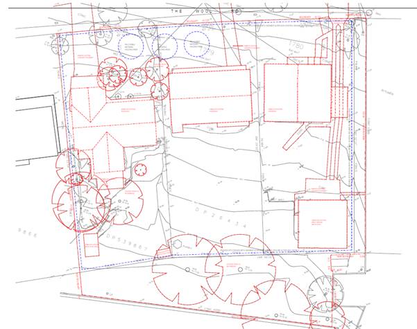
Figure 2 – Demolition
Plan
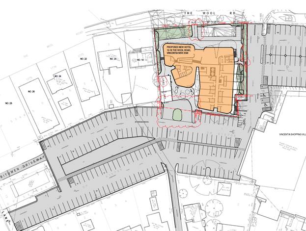
Figure 3 – Site Plan
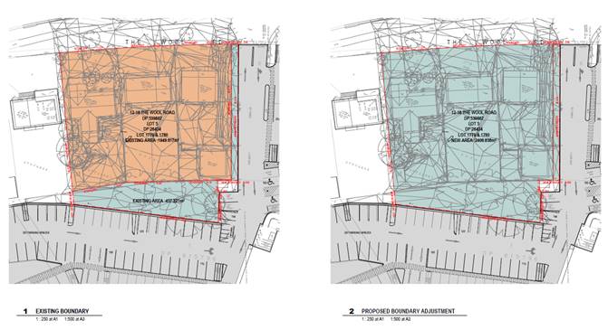 Figure 4 – Boundary Adjustment Plan
Figure 5 – Elevations
Subject Land
The development site comprises Lots 1779 & 1780 DP
26434, Lot 5 DP 539867 & Lot 1 DP 615796 (12-16 The Wool Road & 5
Burton Street, Vincentia). Refer to Figure 1.
Site & Context
The development site:
· Is
located on the southern side of The Wool Road, immediately west of the entrance
to the carpark associated with the Vincentia Village shops.
· Consists
of:
o The three (3) lots fronting The Wool Road (12-16 The Wool
Road), each contain a single dwelling house and ancillary structures.
o The remaining part of the site contains part of the carpark
and a small section of land between the northern edge of the carpark and the
southern boundary of the three (3) lots fronting The Wool Road (5 Burton
Street).
· Includes
12-16 The Wool Road which are zoned R1 General Residential while 5 Burton
Street is zoned B2 Local Centre. Refer to Figure 6.
· Has
existing access to The Wool Road, which is identified as a “local”
heritage item – Item No. 218, Colonial road—remnants (former Wool
Road).
· Adjoins
land comprising the carpark to the east and south associated with the Vincentia
Village shops to the southeast (being zoned B2 Local Centre), and low-density
residential development to the north and west (being zoned R1 General
Residential).
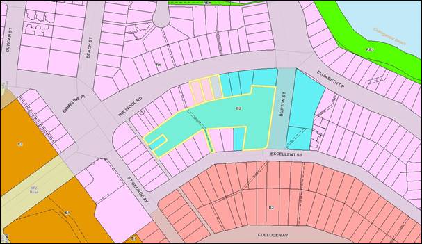
Figure 6 – Zoning Extract
History
The following provides details on post-lodgement actions
for context:
· This
application was lodged on 8 December 2020.
· As
a result of detailed assessment of the application, additional information was
requested from the applicant on five (5) occasions – 10 December 2020, 23
December 2020, 22 January 2021, 25 March 2021 and 20 May 2021. The main issues
related to the following:
o The development as submitted included clause 4.6 written request
in relation to a contravention to the building height limit under Shoalhaven
Local Environmental Plan 2014 (SLEP 2014).
It was
considered that the request did not provide sufficient comprehensive assessment
as required against the provisions of clause 4.6 Exceptions to development
standards, SLEP 2014 in order to justify why the contravention to the
stated development standard should be considered by Council. The request did
not include environmental planning grounds as to why exceedance is necessary,
along with the unique characteristics and circumstances. The request
along with the submitted plans did not clarify the extent of contravention to
the height of building limit across the subject site, noting the site is
affected by both an 8.5m and 11m limitation.
o The submitted Traffic and Parking Impact Assessment Report.
Council was
not supportive of the proposal to entirely rely on existing parking within the
Vincentia Shopping Village carpark and surrounding areas.
o The submitted stormwater drainage design. Council required
the design to demonstrate extension and connection to the underground
stormwater system in The Wool Road.
o Endeavour Energy’s objection to the application
· Councillors
called in the application in response to considerable public concern on 19
January 2021 (MIN21.15).
· A
(digital) Resident Briefing Meeting (RBM) was held on 16 March 2021. Seventeen (17)
residents attended. All objectors were sent a digital invitation to attend.
· The
concerns raised from the RBM for the applicant’s consideration included
the following:
o The removal of the existing (substantial) gum trees and the
inclusion of additional significant trees as part of the proposed landscaping.
o Environmental management issues such as waste, power and
water management and consideration of alternatives, including wastewater
collection and recycling, solar power and composting etc. to address climate
change. These are considered to be common practices in many hotel/resort, club
and shopping mall developments.
o Confirmation of the operating hours of the bar/bistro and
function centre.
o Confirmation of the total number of staff to be employed
for the development, including the bar/bistro and function centre.
o Confirmation as to the intended use of the penthouse,
whether for personal use or as part of the hotel accommodation.
· On
23 February 2021, 2 March 2021, 23 April 2021, 5 May 2021 and 7 June 2021, the
applicant submitted additional information via the Planning Portal; this
included a response to Council’s request for information, and addressed
the matters raised at the RBM. This information was subsequently referred to
the relevant sections of Council and external agencies where necessary.
The applicant
addressed the matters raised for consideration, by:
o Including a basement level carpark comprising 51 parking
spaces within the footprint of the proposed building for all hotel visitors and
staff. At least 32 parking spaces are however still to be provided within Lot 1
DP 615796, within close proximity to the development, for the associated
bar/bistro and function centre.
(It is noted
that the application as originally lodged relied entirely on existing parking
within the shopping centre carpark.)
o Proposing to connect stormwater to the existing
infrastructure in The Wool Road.
o Proposing to reflect the requirements of Endeavour Energy
in the design, and
o Amending the design of the proposed development to reduce
the maximum height of the building to comply with the height limits under SLEP
2014.
(It is noted that the application as originally lodged
proposed the building as much as 2.1m above the 8.5m and 11m height limits.)
Issues
Concerns raised in public
submissions.
Submissions from 45 objectors
were received by Council.
The matters raised are considered
in the assessment of submissions below.
|
Summary of Public
Submissions
|
|
Objection Raised
|
Comment
|
|
Inconsistency with zone objectives
The area is zoned R1 General Residential under SLEP 2014.
The objectives of this zone are to provide housing and facilities and
services for residents etc. not hotels accommodation and bar for tourists.
None of the zone objectives are met by this proposal.
Vincentia is a low-density residential area. Although it
is agreed that Vincentia is a highly sought-after tourist location, there is
objection to the statement that there is a “paucity of existing
commercial accommodation developments”. That is not appropriate in
a low-density residential area. Huskisson is the appropriate location for
high rise commercial accommodation developments, not Vincentia.
|
§ The site is zoned R1 General
Residential and B2 Local Centre under SLEP 2014. The proposal is best
characterised as tourist and visitor accommodation (hotel or motel
accommodation) and is permitted within both the
subject R1 and B2 zones with the consent of Council.
In short, the use is a
permissible use in the zones. Having regard to the zone objectives, an
important consideration is the compatibility of the use with adjoining
development.
§ The SLEP, clause 2.3(2) states
that the consent authority must have regard to the zone
objectives.
§ The objectives of the R1 General
Residential zone are:
§ “To provide for the
housing needs of the community.
§ To provide for a variety of
housing types and densities.
§ To enable other land uses that
provide facilities or services to meet the day to day needs of residents.
§ To identify land suitable for
future urban expansion”.
§ The objectives of the B2 Local
Centre zone are:
§ “To provide a range of retail,
business, entertainment and community uses that serve the needs of people who
live in, work in and visit the local area.
§ To encourage employment
opportunities in accessible locations.
§ To maximise public transport
patronage and encourage walking and cycling”.
§ The objectives of the R1 zone
relate to the dominant use or intention of that zone. However
importantly the zone permits a range of uses that are not residential
including but not limited to a hotel, place of public worship (e.g. church),
community facilities and more.
§ It is considered that the
proposal is not inconsistent / incompatible with the relevant objectives
having regard to the range of uses permitted within the zone.
§ The proposed bar/bistro and
function room on the ground floor are proposed to be ancillary to the
“hotel or motel accommodation” land use. That is, it is a
component of the dominant purpose of the “hotel or motel
accommodation” and is subservient to that dominant purpose.
|
|
Non-compliance with building height limit
The proposal does not comply with the building height
restriction of 8.5m along The Wool Road, being almost 12m in height.
It is appropriate to approve developments in Vincentia
that are in keeping with the existing buildings. The scale, bulk and usage of
that proposed is inconsistent with the low-density residential nature of the
area. An 8.5m height limit has been widely agreed as sufficient for The Wool
Road. Taking a piece of land from 5 Burton Street which has a height limit of
11m (by removing trees and car parking spaces from the Vincentia Village
Shopping Centre) to enable a building on The Wool Road go to almost 12 (11.955)
metres, is not meeting the spirit/intent of planning rules nor the objectives
of the standard. It is completely inappropriate.
The original and revised proposed elevations show the
majority of roof is above the LEP maximum height blanket. The applicant has
proposed ~10% across the majority of the building (not including the terrace,
roof landscaping and glass balustrade which would make it well more than
10%). The elements that protrude above the height limit will impact on views
and noise.
The applicant indicates that the application demonstrates
how the objectives of the height limit control are met despite non-compliance
with the numerical standard but does not demonstrate it at all. The applicant
does not meet any of the five (5) tests of 'unreasonable' or 'unnecessary'.
There is no merit to justify this variation under Clause 4.6. The building is
not compatible with the height, bulk or scale of existing buildings. The
surrounding buildings are low density residential (2 storey separate dwellings
not a 4-storey bulky building). It is not compatible with the height, bulk or
scale of future buildings of the future character of the area given the R1
zoning. The three (3) lots fronting The Wool Road are mapped as having a
maximum building height of 8.5m. While there may be no public benefit in a
boxy hotel, there is no public benefit in the proposal which does not meet
requirements. Just because the proposal is not 'box shaped' does not make it
compatible with surrounds. There is no guarantee a box shaped proposal would
be approved either.
|
§ While the proposal as originally
lodged exceeded the maximum height controls under SLEP 2014, through the
assessment process the design of the hotel was amended. The height of the
building now complies with the maximum height limits of 8.5m and 11m required
under the SLEP 2014.
§ It is considered that the
objectives of this (height) clause are now satisfied.
§ The draft consent at Attachment 1
includes a recommended condition requiring a survey certificate during works
to ensure compliance with the maximum height control is complied with if
approval is granted.
|
|
Traffic and parking
There is concern is the extra traffic movement which will
be generated in and out of the complex, in and out of the carpark, and in the
nearby streets, including traffic travelling through the roundabout joining
Elizabeth Drive and Wool Road which is already very heavily congested in
holiday times.
The narrow entries and turning areas also cause
significant congestion within the carparks themselves. This proposal (with
all its contingent deliveries, services and trades, waste removal, guest
arrivals and departures) will exacerbate the traffic and congestion in this
area.
The heavier traffic movement will also add further risk to
the safety of pedestrians, especially school children who walk along The Wool
Road and Elizabeth Drive. It is already hazardous for pedestrians along this
route especially when trying to cross the driveway entrance into the
Vincentia Village Shopping Centre carpark. More traffic will only make things
worse.
The submitted plans imply that the car parking spaces that
are nearest to the entrance to the shops which are required by the many
elderly residents will not be available if the development is approved in
this form. It also remains a concern that traffic flow into the proposed
hotel will be maximised in peak periods when the flow into the shopping
centre is also at its heaviest.
The submitted Traffic and Parking Impact Assessment Report
is flawed. The survey was undertaken on 23-24 October 2020, which would not
be a true reflection of the parking problems which occur in the holiday
times. A more appropriate time would be to undertake this survey in the
busiest time when the most tourists are visiting the area.
If this development is approved it must provide for
improved traffic management on The Wool Road and the nearby roundabout on
Elizabeth Drive, and address safety risks for pedestrians and cyclists on the
shared path along the side of The Wool Road.
|
§ Council’s Development
Engineer raised no objections subject to recommended conditions of consent
(dated 22/03/2021). Should the application be determined by approval, then
these conditions would be included.
§ While Council raised concern with
the development as originally submitted, plans have been revised along with a
revised Traffic and Parking Impact Assessment Report.
§ The design now provides for a
basement parking level with 51 spaces. This is considered a significant
improvement for the development from the previous proposal (no parking on
site). The basement parking layout complies with AS2890.1 and
manoeuvring has been demonstrated with swept paths being detailed / provided.
§ The basement carpark meets the
DCP parking requirements for the hotel accommodation and staff component,
however excess parking demand generated by the restaurant and function centre
(32 spaces per the DCP rates including a 25% reduction for co-use) is not
catered for within the development site and rely on the shopping centre
carpark.
§ The most recent approval for the
Vincentia Shopping Village (DA16/1748) carpark, identified the parking area
contained a surplus of 34 car parking spaces to that required by the DCP. The
current proposal will result in a reduction of 6 parking spaces, resulting in
a surplus of 28 parking spaces.
As indicated in the submitted
Traffic Report:
The proposed development
includes works within the car parking area, resulting in a net decrease of
six (6) car parking spaces to facilitate the turning bulb and drop off area.
The changes to the existing car parking area result in the shopping centre
carpark having a net surplus of 28 spaces under future conditions. It is
reasonable for the proposal to rely on the oversupply of parking in the
adjoining car park for restaurant users and for function centre users,
particularly considering these uses involve short term parking that will peak
in demand at times that do not coincide with the adjacent shopping centre.
Considering the parking requirements of the restaurant and the function
centre under the DCP of 32 spaces and the approved surplus of 28 spaces, the
resultant car parking provision results in a shortfall of four (4) spaces
from Council’s DCP requirements which can be easily accommodated in the
shopping centre car park.
§ The use of the shopping centre
carpark for patrons of the restaurant and function room is considered to be a
more appropriate use than hotel guests, given the more short-term nature of
parking and the fact that it will be less likely for vehicles to be left
overnight. The Report also details that the peak times for restaurant and
function use would generally not coincide for peak times at the
shopping centre.
§ An easement for parking will
still be required over parking spaces that are required for the use of the
development, to ensure the parking needs are met in perpetuity in the event
that the hotel is sold off separately to the shopping centre.
§ The Report also includes analysis
of intersection treatments required at the carpark entrance off The Wool
Road. Based on the traffic data, Austroads suggests a channelised right-turn
(CHR) or auxiliary left-turn (AUL) treatment is necessary. The Report refers
to alternative published research that provides a lower burden on brownfields
sites to provide such intersection treatments, resulting in a requirement of
a basic right-turn (BAR) or basic left-turn (BAL) treatment. The existing
situation complies as a BAR/BAL treatment according to the Report, and
measurements off aerial photos suggest this is generally correct. However,
Austroads is considered the industry standard document and referred to by
Council’s DCP and Engineering Design Specifications, and given the
triggers within that document are exceeded, warrants for provision of a CHR
treatment are met and would therefore be ‘conditioned’ should the
application be determined by approval.
§ It is noted that the Report
states the development will be serviced by a vehicle no larger than a small
rigid vehicle (SRV), including waste collection by contractors. Many waste
collection vehicles are closer to medium rigid vehicle (MRV) dimensions, and it
may prove restrictive to limit servicing to an SRV. It is also noted that the
waste storage area is now further from the service bay compared to the
previous design, and some of the paths between the loading bay and waste room
appear quite constrained, and it would be difficult to wheel a 1100L bin
through (such as past the raised concrete surrounds around the columns near
the turning circle).
§ The applicant was requested to
reconsider the service bay/waste room arrangement to improve the ease of
waste collection and allow for vehicles larger than an SRV to service the
development. They were advised that if they wish to proceed on the basis of only
using an SRV, conditions of consent would be imposed should the application
be determined by approval to limit vehicles to this size. If this is the
case, they were requested to provide evidence from a waste contractor that
they can service the site with an SRV sized vehicle.
§ The applicant confirmed in advice
dated 16/04/2021 that the proposed design
has considered the likely size of service vehicles and allowance for an SRV
has been made. They are agreeable to a condition of consent being imposed.
|
|
Insufficient onsite car parking spaces
The proposal does not provide the 83 car parking spaces
required by Shoalhaven Development Control Plan 2014.
It is not believed that the proposed onsite parking will
be sufficient for users and staff of the proposed development during peak
periods. Many visitors to the Vincentia region come to enjoy aquatic
activities within Jervis Bay and therefore bring boats, trailers and rooftop
kayaks which will not be accommodated within the onsite parking.
Using ~30 carparks from the Vincentia Village Shopping
Centre and still being short four (4) spaces is not acceptable.
Coles is the main attractor to the Vincentia Village
Shopping Centre area and the proposed development is removing car parking
spaces from immediately in front of the entrance to Coles where people with
limited mobility need parking spaces. While there are parking spaces further
away that is not practical for people with limited mobility.
With climate change such a prominent issue it is important
they provide bicycle parking facilities.
Another suggestion is that an extension of the proposed
covered car parking for the existing Coles car parking area could supply
defined areas for extra parking, boat storage and then secured parking for the
hotel.
|
§ Council’s Development
Engineer raised no objections subject to recommended conditions of consent
(dated 22 March 2021). Should the application be determined by approval, then
these conditions would be included.
§ As addressed above, the proposed
onsite parking arrangements are considered acceptable, noting that the
application now proposes a basement level carpark comprising 51 parking
spaces within the footprint of the proposed building for all hotel visitors
and staff and at least 32 parking spaces are to be provided within close
proximity to the development, for the associated bar/bistro and function
centre.
§ Observing that the restaurant and
function components are more likely to be used in the evening, it is not
unreasonable to accept that the adjoining shopping centre car park could be
used for this purpose. To ensure that this relationship between the car
spaces and the proposed hotel is however retained, it is recommended that an
appropriate ‘restriction / easement’ be placed on title ensuring
that, if the shopping centre or hotel are sold separately, it is clear that
the car park is available for hotel purposes.
§ Bicycle parking has not been
proposed as part of the basement carpark design. The DCP does not
provide a parking rate for this type of development.
§ Having regard to historic
approvals and the floor area of development at the Shopping Centre, the
applicant has also submitted the following:
“Reference
is made to the most recent approval document related to the Vincentia Shopping
Village, Development Consent from Shoalhaven City Council (DA16/1748) dated
24 August 2016 in relation to “Proposed alteration to driveway entrance
to Stockland Vincentia Shopping Centre car park, alterations to layout of car
park and alterations to tenancy”. This approval allowed for the
alterations and additions to the existing car park, resulting in a net
increase of + 34 car parking spaces under future conditions.
Further,
reference is made to the Traffic Report of Colston Budd Rogers & Kafes
Pty Ltd dated June 2016 (Ref: 10146) for the Vincentia Shopping Village as
part of DA16/1748. This report assesses a scale of 3,758m2 GLA for the centre
(being 3847m2 GLA minus a reduction of 89m2 GLA associated with the
proposal). The report states the net increase of + 34 car parking
spaces associated with the shopping centre upon approval of DA16/1748,
without any increase in car parking demand”.
While the proposal involves a
reduction of 6 parking spaces from the existing shopping centre car park, the
resulting 28 car spaces which are surplus to the shopping centre needs are
considered suitable to meet the parking needs of the proposed hotel and
ancillary uses.
|
|
Tourist bus parking – future demand
It is not improbable that a hotel of this scale will be
promoted to or attract tour operators. The applicant has not described how
the parking of coaches, minibuses etc. will be accommodated. Similarly, there
is no description on where hotel guests arriving by coach, minibus will
alight from these vehicles.
|
§ Council’s Development
Engineer raised no objections to the proposed parking arrangements.
§ The parking of coaches and
minibuses etc. has not been proposed.
§ It is noted that there is no
requirement under the DCP for this. There is considered to be suitable area
within the street for parking of these vehicles and for the set down and pick
up of passengers.
|
|
Detrimental
impact on adjoining residential amenity
The
proposal would have a detrimental impact on adjoining residential amenity and
the amenity of a large section of Vincentia due to:
- increased traffic (the traffic survey taken in October
i.e. outside peak season and during COVID-19 is not sufficient);
- overshadowing,
- noise from the bar, function centre and rooftop
penthouse;
- light pollution; and
- drunken behaviour from patrons of the bar/function
centre.
|
Traffic impacts:
§ As already mentioned, the revised
Traffic and Parking Impact Assessment Report was assessed and determined to
be acceptable.
§ In this regard, Council’s
Development Engineer raised no objections in relation to the matter of
increased traffic subject to recommended conditions of consent (dated
22/03/2021). Should the application be determined by approval, then these
conditions would be included.
§ The hotel includes guest rooms
for overnight accommodation. It is in the interest of management to
ensure that the hotel is operated in a manner to provide guest amenity and
that of neighbouring developments. In the event of anti-social
behaviour, this is a police matter (see further below).
Overshadowing:
§ Overshadowing has been adequately
addressed with no unreasonable overshadowing occurring. The site faces a road
and there is a car park to the south. The proposed building design is now
compliant with the LEP and DCP requirements, particularly noting the (now)
reduced height. The impacts of ‘shade’ can be seen below on
21 June at 9am, noon and 3pm (Winter and the shortest day of the year).
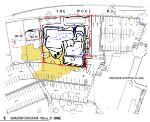
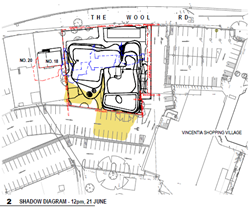
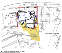
Noise impacts:
§ A condition is recommended on the
draft consent to manage noise and lighting of the development if approval is
granted.
Antisocial behaviour:
§ If there is concern about
antisocial behaviour, this is a matter for the Police. Should the application
be determined by approval, then conditions would be included to address
Police recommendations in advice (dated 2 March 2021).
§ The proposal is a permissible use
within the zoning and Liquor & Gaming licencing restrictions will apply
to any future liquor licence for the hotel and associated bar/ restaurant and
function centre.
§ Given that the proposal includes
guest accommodation, it is considered that it is in the interest of hotel management
to ensure a properly run establishment to ensure the amenity of guests and
residents alike.
|
|
Out
of character
The proposal does not retain
the elements of the neighbourhood character i.e. low-density residential
suburbia, generally characterised by one and two-storey detached dwellings;
and as such does not reinforce local identity or sense of place. It is this relaxed,
family character that makes Vincentia so desirable and enjoyable in contrast
to the overdeveloped and crowded Huskisson.
The building form is also
entirely unsuitable for a seaside village. It is massive and brooding and in
effect a huge concrete pour with solid balcony balustrades and absolutely no
lightness of form that invokes a seaside character. Sadly, if it proceeds in
its current form, even if ultimately complying it sets an urban tone that the
community will have to live with.
|
§ The design of the development is
not considered out of character in this locality.
§ The design of a building must
have regard to the purpose of the building. It would be unusual to have a
hotel with numerous rooms and associated facilities to be contained in a domestic
scale building. To this extent, a larger building is not unreasonable
however it is the design relationship between the building and neighbouring
development that needs careful consideration.
§ It is noted that
“compatible” does not encourage “sameness” in built
form, but rather requires a development fits within its urban context.
It is considered that the design of the development achieves this.
§ Further to this, for a new
development to be “compatible”, building height, setbacks and
landscaping are key. Where there are significant differences in height,
compatibility can be achieved by a gradual change as opposed to an abrupt
change (see paragraphs 26 – 29) Project Venture Developments Pty Ltd
v Pittwater Council [2005]
NSWLEC 191. The extent of the height differences also depends
on the consistency of height in the streetscape.
§ The development is compliant with
the relevant requirements of SLEP 2014 (i.e. maximum height) and SDCP 2014,
noting that the DCP is silent in relation to the built form or design of
“hotel or motel accommodation”, with no specific setback or floor
space ratio controls applying. It is noted that the building is proposed to
be set back at least 4m from the nearest residential neighbour.
§ As detailed earlier in this
report, Chapter G18: Streetscape Design for Town and Village Centres of SDCP
2014 is applicable to this development type and all required streetscape
works for the development are to be provided in accordance with the Streetscape
Technical Manual as required by this chapter. Crime Prevention
Through Environmental Design (CPTED) principles are also to be considered in
the provision of these works.
|
|
Undesirable
precedent
The proposal would set a
severely negative and undesirable precedent for building height and car space
and noise levels, etc. in future developments. It is important to set the
right precedent because this is the start of the re-development of the
Vincentia Shops given that this developer owns adjoining properties and other
developers may have/acquire adjoining properties.
|
§ Any proposed development the
subject of a DA is to be assessed against the relevant provisions of section
4.15(1), EP&A Act 1979 and relates to the subject development site only.
§ Whether or not other developments
of a similar nature will follow is unknown and is dependent on a number of
factors including the intentions of individual owners.
§ Each DA is assessed having regard
to its particular characteristics, the site attributes and what the relevant
planning controls may be.
§ The development is a permissible
use, complies with the applicable development standards.
Council needs to be satisfied
that the site is suitable for the development. In this regard, it is
considered the subject is suitable for the proposed development.
|
|
No additional tourist accommodation required
The proposal is not required
in order to add to the choice to tourist accommodation at Jervis Bay. In
addition to hotels/motels/apartments already in existence at Huskisson, a
number of other hotels are being built at Huskisson: Moona Moona Creek, the
site of the former Holy Trinity Family Church; and Owen Street.
|
§ While section 4.15 of the
EP&A Act requires an assessment of economic impacts of a development,
Council must be careful not to weigh into commercial and private business
decisions. Council must determine that a development will not be broadly
adverse, having regard to matters such as jobs, the viability of a commercial
area etc. Business competition and the success of a business are not matters
for Council’s section 4.15 assessment.
§ The Shoalhaven is a major tourist
destination attracting numerous visitors. A counter view to the objection
could be that this type of accommodation will provide another dimension and
type of accommodation to the caravan and camping facilities, existing motels
and AirBnBs in the locality.
§ The references to potential other
developments is noted, these are proposals that are yet to become formal
development applications.
§ The success of a business or
otherwise and competition between providers is not something that Council
typically involves itself in. These are largely private business decisions
which Council has no role to play.
§ A
development consent, if issued is valid for a period of 5 years.
|
|
Economic
impact
The proposal is unlikely to
bring economic benefits to the Shoalhaven. It is suggested that its type of
construction will require the skills of tradespeople from Sydney, rather than
the Shoalhaven. After construction, the number of ongoing jobs will be few,
seasonal and low skilled (the good jobs of management, chefs, accounting, legal
will likely be provided by people from/in Sydney). The low-skilled seasonal
workers may not even be locals (who need a regular income), but foreign
working holidaymakers or students seeking holiday jobs, assuming they can
find and afford accommodation at peak time of the year.
|
§ Section 4.15 of the EP&A Act
requires an assessment of economic impacts of a development. See comments
above.
§ In this regard it is considered
that there will be no adverse economic impacts warranting refusal of the application.
In reaching this conclusion regard has been given to impacts there will be
within the locality. There will be short term economic benefits in
construction work and hospitality work in the longer term.
|
|
Impact from excavation for basement carpark
There is concern resulting
from the revised plan and the impact of an excavation at depth to accommodate
parking onsite.
It is also important to be
aware that Vincentia ground is rock. Drainage has been a problem for many in
the area and there is concern about how the water will escape and where it
will be piped to especially from the basement carpark.
|
§ Council’s Development
Engineer raised no objections subject to recommended conditions of consent
(dated 22 March 2021). Should the application be determined by approval, then
these conditions would be included.
§ A dilapidation report will
address concerns regarding impact on adjoining land.
§ The full engineering design will
also need to address details at Construction Certificate stage. If rock
is encountered or there are additional expenses as a result of unexpected
finds, these are matters that the engineering experts will need to resolve
having regard to the approval in place, if issued.
|
|
Stormwater discharge
There is concern with the
impact on stormwater discharge and the consequences any more stormwater added
to existing volumes, in particular, if it is discharged into Jervis Bay and
the southern section of Collingwood Beach. Current stormwater discharge is
causing safety problems and loss of sand from the southern end of Collingwood
Beach.
Further to this, The Wool Road
system is clearly already inadequate. There are enormous quantities that flow
from this area under properties into Garlies Close and Argyle Street and
cause localised flooding. This area's stormwater capacity is barely adequate
and specific provision should be required.
|
§ Council’s Development
Engineer raised no objections subject to recommended conditions of consent
(dated 22/03/2021). Should the application be determined by approval, then
these conditions would be included.
§ The stormwater drainage design
meets the requirements of the DCP. It is noted that the DRAINS modelling
provided indicates that the post-development flow leaving the site has now
been reduced below 55L/s through changes to the OSD system. This is
acceptable.
|
|
Sewage
treatment inadequacies
It is note that Council has
claimed there is adequate capacity in the sewage treatment at Vincentia.
This does not overcome the
fact that from 1953 to about 10 years ago there had never been an algal bloom
in Jervis Bay affecting the whole bay. In the last 10 years there have been
two (2). The main cause is inadequacy in sewage treatment and may be
contributed to by stormwater runoff.
No development of this size
should be approved in this area, where sewage will be treated at Vincentia,
until there is an open ocean outfall from the sewage treatment works.
|
§ Council’s Shoalhaven Water
raised no objections with regard to sewage treatment capacity and have
recommended conditions within their provided Notice (dated 22 December 2020).
|
|
Endeavour Energy
The Endeavour Energy referral
response states:
"in this instance as
shown in the following extracts of the Ground Floor Plan and Google Maps
Street View, the proposed location of the infinity pool and deck area /
Lounges in proximity of the pole and overhead power lines is not supported by
Endeavour Energy and represents a risk will encourage people who are wet with
bare feet to congregate and/or spend time within the proximity of the
electrical infrastructure and if there is a fault it could result in voltages
being transferred to the pool area. Please refer to the below point
'Earthing'.
The pad mount substation
requires a minimum easement of 2.75 x 5.5 metres and the low voltage and 11
kV high voltage.... ...the proposed location of the hotel accommodation in
proximity of the pad mount substation is likely to require the use of fire
rated construction or the erection of a fire screen /wall.
…Due to the foregoing
Endeavour Energy objects to the Development Application.”
|
§ No objections raised by Endeavour
Energy subject to recommendations and comments in latest advice dated 23
March 2021.
§ Noting the recommendations and
comments, Council suggested a condition of any consent granted requiring
documentary evidence be provided by Endeavour Energy prior to the issue of a
Construction Certificate, confirming that satisfactory arrangements have been
made for the connection of electricity and the design requirements for fire
rating construction and the pad mount substation. Should the application be
determined by approval, then this condition would be included.
§ Endeavour Energy confirmed that
conditioning this matter in the Council’s notice of
determination/consent as suggested is satisfactory.
|
|
Removal
of trees
The proposal to remove the
remnant existing mature eucalyptus trees from the Vincentia Village Shopping
Centre carpark is inappropriate under Chapter G4: Tree and Vegetation
Management, SDCP 2014.
The two (2) mature brittle
gums are of high significance as noted in the Arboricultural Impact
Assessment Report (trees labelled ‘1’ and ‘2’). For
this reason, the applicant should consider redesigning the hotel to
accommodate the two (2) gums in their landscaped gardens. The trees are
beautiful, they are in good condition with no defects, they take a long time
to grow to such a spectacular height, and they have a life expectancy of
15-40 years. They provide habitat for native birds and animals and promote
health and wellbeing for residents and visitors.
The Report has used 'potential
for limb shedding' as reason for removal of these 2 x mature Brittle Gums.
However, those trees have been in the Vincentia Village Shopping Centre
carpark for years and the area has been used by the public for decades. If
they really were considered unsafe, they should have been removed years ago.
This is just an excuse to remove them to develop the site.
Similarly, the tree labelled
'4' is one (1) x Red Bloodwood with 15-40 years life expectancy in average
condition and assessed as medium significance. The justification for moving
this tree is that a defect will make it hazardous 'in future years'. It
should not be removed until it presents a hazard.
Australian Standards
4970-2009, Protection of trees on development sites, was established
to provide appropriate guidelines to ensure the long-term viability and
stability of trees to be retained on development sites. Instead of removing
these three (3) significant local native mature trees for the development (in
addition to 8 others >5rn tall), the development should be modified to accommodate
these three (3) trees as a minimum, based on the tree protection zone and
structural root zone required for tree stability as outlined in AS 4970-2009.
These trees are visually prominent and visible from a considerable distance.
They make a positive contribution to the local amenity and are valued by
residents and visitors who shop at the Vincentia Village Shopping Centre and
are expected to live for another 15-40 years.
|
§ The provisions of Chapter G4 have
been considered and no objections are raised from assessment with the
submitted Arboricultural Impact Assessment Report.
§ As indicated in the submitted Report:
“On
the 8th of October 2020, gummifera assessed 11 trees within
the development site. Three trees were located outside the southern boundary
of 12-16 The Wool Road within a garden bed between the boundary fence and the
Vincentia Shopping Village carpark whist the remaining 8 trees were located
within the boundaries of 12-16 The Wool Road. Five of the 11 trees were
native to the area whilst the remaining 6 trees were non-native species. Due
to the locations of each tree in relation to the proposed development
application it is recommended that all 11 trees will require complete removal
as they are either within the construction footprint or are too close to the
construction zone to preserve their structural integrity.”
§ Although all trees are proposed
to be removed from the site, the landscaping design will be required to
replace these with trees that are native to the region in appropriate
locations.
§ The submitted design proposes
substantial landscaping, comprising a number of trees, including Old man
banksia, Water Gum, and Lilly Pilly (Riberry) and shrubs, particularly to The
Wool Road frontage. The plan notes 12 trees of heights between 3m and 7m to
be planted which are considered to adequately offset the removal of the
existing trees onsite in the context of the proposed, permissible
development.
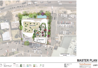
|
|
Noise
impact
The
noise from the operation is likely to be significant and a detriment to
neighbourhood amenity, yet no acoustic reports have been provided with this
proposal.
The
2 storey, 5-bedroom penthouse with rooftop garden and balcony will generate
noise that impacts on homes a long distance from the hotel, due to the
expansive outdoor entertaining areas at the extraordinary proposed height. A
5-bedroom penthouse is unusual for a hotel development and is likely to
become a party venue. Will this be used by the hotel or is it luxury
accommodation for the developer?
Vincentia
is a family oriented residential area with a village atmosphere and does not
need a public bar which comes with antisocial behaviour.
|
§ Ongoing management of noise could
be subject to a condition of any consent granted. Should the application be
determined by approval?
§ The applicant clarified in advice
dated 16/04/2021 that the penthouse forms part of
the hotel accommodation. In this regard the noise impacts of this space can
be managed by the hotel operators and conditions of the consent as
recommended.
§ As guests will be occupying hotel
rooms, guests will be seeking a level of amenity which will warrant the hotel
to be managed to ensure all occupants are all catered for.
§ It is further noted that the
proposal is a permissible use within the R1 and B2 zoning in which it is
located.
|
|
Disruption during demolition and building
This proposal will result in a
period of disruption for residents, visitors and local businesses during
demolition and construction. If this proposal is approved, Council should
hold any construction approval until after the Burton Street redevelopment is
completed and access to local businesses has returned to normal. Council
should also stipulate that demolition and construction should occur outside
peak holiday periods.
|
§ Council is unable to condition
the delay or timing of construction to be contingent on other projects
unrelated to the development or where there may be potential development of
other sites.
§ Council can however require a
construction management plan to ensure that the impacts are properly managed,
and the local businesses and residents are not inconvenienced (e.g. access to
properties is maintained). Council also generally stipulates hours of
construction in its consents. However, it should be noted that the State can
specify or legislate to allow extended construction hours such as it has done
with the COVID initiatives.
https://www.planning.nsw.gov.au/News/2020/Construction-hours-extended-to-support-industry-during-covid-19
|
|
Lack
of notification about this application
A development of this scale in
a residential suburb has a wide impact on the community. It is both
surprising and disappointing that this development application was not
formally notified to all Vincentia residents. Many may be unaware of the
application and have missed out on the opportunity to consider the
application and submit their views.
|
§ The DA was notified in accordance
with Council’s Community Consultation Policy for Development
Applications, being advertised in the local paper, notified to affected
owners within a buffer of 200m and relevant Community Consultation bodies.
§ As detailed earlier in this
report, a Resident Briefing Meeting was also held.
§ All DAs are available for viewing
on DA Tracking. The DA has been digitally viewable since lodgement.
|
|
Devaluation of Property
Adjoining land will decrease in
value as a result of this development.
|
§ Potential loss of property value
is not a consideration under section 4.15 of EP&A Act 1979.
§ A Commissioner of the Court
stated: “I pay no regard to the fears about loss of property values
as, consistent with the position long taken in the Court, this is not a
relevant planning consideration” (Alphatex Australia v The Hills
Shire Council (No 2) [2009]).
§ Neighbouring properties are also
zoned R1 General Residential and B2 Local Centre and have the same
permissible and arguably ‘higher’ uses as the subject site.
|
Planning Assessment
The DA has been assessed under
s4.15(1) of the Environmental Planning and Assessment Act 1979. Please refer to
Attachment 1.
Consultation and Community
Engagement:
Notification was undertaken in accordance
with Council’s Community Consultation Policy with letters being sent
within a 200m buffer of the site and advertised in the local paper, during the
period 23 December 2020 to 20 January 2021.
Forty-seven (47) public
submissions were received in relation to Council’s notification of the
development. Forty-five (45) of these were in objection to the development.
Key issues raised as a result of
the notification have been listed and discussed above.
As detailed earlier in this report, a Resident Briefing
Meeting (RBM) was held on 16 March 2021. The concerns raised from this meeting
(as mentioned earlier in this report) for the applicant’s consideration
included the following:
· The removal of the existing gum trees and the inclusion of
additional significant trees as part of the proposed landscaping.
· Environmental management issues such as waste, power and
water management and consideration of alternatives, including wastewater
collection and recycling, solar power and composting etc. to address climate
change. These are considered to be common practices in many hotel/resort, club
and shopping mall developments.
· Confirmation of the operating hours of the bar/bistro and
function centre.
· Confirmation of the total number of staff to be employed
for the development, including the bar/bistro and function centre.
· Confirmation as to the intended use of the penthouse,
whether for personal use or as part of the hotel accommodation.
The assessment of the
application considered the matters raised in the submissions and concluded that
the application is capable of support with no reason warranting refusal.
Financial Implications:
There are potential cost
implications for Council in the event of a refusal of the application. Such
costs would be associated with defending an appeal in the Land and Environment
Court of NSW.
Legal Implications
A section 8.2 review or an
appeal with the Land and Environment Court are possible if the application is
refused.
Summary and Conclusion
The proposed development is
compliant with the provisions of SLEP 2014 and is broadly consistent with the
SDCP 2014.
This application has been
subjected to detailed analysis of the main issues identified in this report,
being the scale/height of the development, inconsistency with character and
zone objectives, traffic impacts, onsite car parking, stormwater discharge, and
tree removal.
While Council raised concern
with the development as originally lodged, specifically in relation to building
height and parking, these were resolved during and in the assessment of the
application including the submission of amended plans by the applicant.
The proposed built form is a
modern architectural design style suitable for a hotel style (tourist)
accommodation. It is a permissible use which is compliant with the
development standards under SLEP 2014.
Further to this, Council is
satisfied that the proposal as amended meets the relevant development standards
and objectives under SLEP 2014 and SDCP 2014 applying to the site and any
potential impacts can be adequately addressed via conditions of consent
relating to the construction and operations of the development.
The application is considered capable of support as there
are no substantive planning reasons to warrant refusal. Accordingly, it is
recommended it is approved subject to the recommended conditions of consent as
per Attachment 2.
|
|
Development
& Environment Committee – Tuesday 13 July 2021
Page
0
|
DE21.82 DA19/1102
& DA21/1304 - 252 Princes Highway Ulladulla – Lot 1 DP 784732
DA. No: DA19/1102/4
HPERM Ref: D21/153385
Department: Development
Services
Approver: Phil
Costello, Director - City Development
Attachments: 1. Planning
Report (DA19/1102) - 252 Princes Highway Ulladulla - lot 1 DP 784732 (under
separate cover) ⇨
2. Planning
Report (DA21/1304) - 252 Princes Highway Ulladulla - Lot 1 DP 784732 (under
separate cover) ⇨
3. Recommended
Conditions (DA19/1102) - 252 Princes Highway Ulladulla - Lot 1 DP 784732 (under
separate cover) ⇨
4. Recommended Conditions
(DA21/1304) - 252 Princes Highway Ulladulla - Lot 1 DP 784732 (under separate
cover)
Description of Development: Demolish
existing buildings and construct a Manufactured Home Estate (MHE) comprising
(49) dwelling sites and associated infrastructure including new roundabout to
the intersection of Princes Highway and Pitman Ave and associated civil
infrastructure.
Owner: Ocean Point Assets Pty Ltd
Applicant: Ocean Point Assets Pty Ltd C- / SET
Consultants Pty Ltd
Notification Dates: 28/08/2019 to 27/09/2019 and
9/09/2020 to 9/10/2020
No. of
Submissions:
DA19/1102 - 109
inside notification periods including 1 petition in objection (196) total.
DA21/1304
– 83 inside notification period including 1 petition in objection
(99) total.
Purpose
/ Reason for consideration by Council
Council resolved on 26 November
2019 (MIN19.852) to call in the application due to public interest.
There are two development applications (DAs) subject of this
report. They are identical, excepting that the latter one being DA21/1304 was
not lodged as integrated development. This is explained in further detail in
the body of the report.
|
Recommendation
That:
1. Development Application DA19/1102
to demolish existing buildings and construct a manufactured home estate
comprising (49) dwelling sites and associated infrastructure including new
roundabout to the intersection of Princes Highway and Pitman Ave and
associated civil infrastructure at Lot 1 DP 784732, 252 Princes Highway Ulladulla
be approved subject to the recommended conditions of consent contained in
(Attachment 3) of this report.
2. That
Development Application DA21/1304 to
demolish existing buildings and construct a manufactured home estate
comprising (49) dwelling sites and associated infrastructure including new
roundabout to the intersection of Princes Highway and Pitman Ave and
associated civil infrastructure at Lot 1 DP 784732, 252 Princes Highway
Ulladulla be approved subject to the recommended deferred commencement
conditions of consent contained in (Attachment 4) of this report.
|
Options
1. Approve
Development Application DA19/1102 as recommended as this application includes a
Bush Fire Safety Authority (BFSA) issued by the Rural Fire Service (RFS).
Approve identical Development Application DA21/1304 as a deferred commencement
consent as this application was not lodged as Integrated Development with the
RFS and therefore does not have a Bush fire Safety Authority.
Implications: This would allow the applicant to proceed with
the proposal.
2. Refuse both
Development Applications.
Implications: The applicant has indicated an intention to
lodge an appeal with the NSW Land and Environment Court in the event that
Council’s decision is to refuse the applications.
3. Alternative
recommendation.
Implications: Council will need to specify
an alternative recommendation and advise staff accordingly.
Location Map
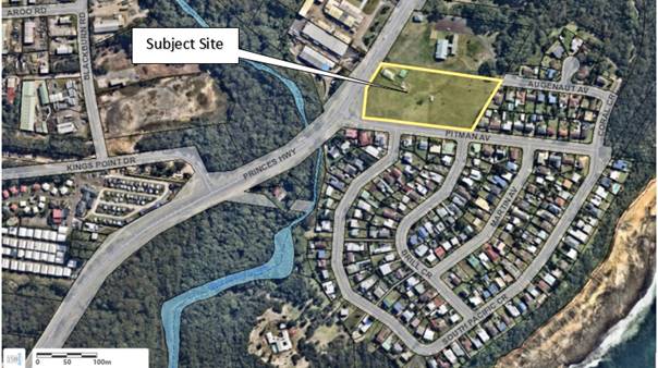
Figure 1 – Extract of the subject site in the
local context
Background
Dual Applications DA19/1102 & DA21/1304
This report addresses two
separate, identical development applications lodged by the applicant for the
same proposal. The initial application DA19/1102 was lodged in May 2019
as Integrated Development with the RFS that provided for a 60 day deemed
refusal trigger enabling an Appeal to the Land & Environment Court in
accord with s8.11 of the Environmental Planning and Assessment Act 1979 (EPA
Act).
Due to the time period involved
in resolving the intersection roundabout upgrade design for Pitman Ave and the
Princes Highway with Transport for NSW (TfNSW) (formerly the Roads and Maritime
Services (RMS)), the deemed refusal period subsequently lapsed. This means that
the applicant is prevented from lodging an appeal for DA19/1102 until
such time as Council determines this application.
The second application DA21/1304
was lodged with the NSW Planning Portal on 25 March 2021 as a non-Integrated Development application with the RFS to secure a shorter
deemed refusal period enabling an appeal after 40 days from lodgement.
Under this referral path, the
RFS can only issue recommended conditions and no Bush Fire Safety Authority
(BFSA).
The applicant is potentially at
some risk (lot noting a BFSA has been issued for an identical application)
concerning the issue of a BFSA under s100(B)(3) Rural Fires Act 1997 (which
would have to occur, after obtaining development consent).
In the event that Council were
to approve DA21/1304, a Deferred Commencement condition would be the
appropriate mechanism to address this matter given that the RFS has previously
issued a BFSA for the identical development under DA19/1102.
Post lodgement
(DA19/1102) - Key dates are as follows:
· 5
February 2019, Integrated DA was lodged with Council.
· 30
May 2019, Council requested additional information in relation to
accessible parking, location and design of community building, section (s)82
variation to the LG Regulations for lightweight structure, acoustic report, map
of intended dwelling types, parking details, whether any dwellings would be 2 storey,
landscaping and recreation design, passing bay requirements for internal roads,
waste storage area, asbestos report for demolition of existing buildings,
services plans.
· 28
August 2019, application was notified to surrounding
residents and an advertisement placed in the Milton Ulladulla Times Newspaper.
· 2
September 2019, Council staff presented to the Ulladulla Community Forum.
· 30
September 2019, Council’s Development and Environment
Committee (DEC) resolved (MIN19.625) that an investigation into historical
correspondence in respect of the Pitman Ave & Princes Highway intersection
treatment be prepared and submitted to Transport for NSW (TfNSW) (the former
Roads and Maritime Services (RMS) to build their understanding of the
communities’ desires for safe and passable intersection with the highway.
· 12
September 2019, TfNSW requested further information in relation to
intersection modelling.
· 26
November 2019, (MIN19.852) the application was called in for determination.
· 6
April 2020, Council requested additional information in relation to civil
design, stormwater design.
· 7
April 2020, Rural Fire Service (RFS) issued General Terms of Approval (GTA)
in error based on erroneous material contained within the SEE and bushfire
report.
· 26
May 2020, TfNSW requested more information on proposed intersection and
removal of the manufactured home estate (MHE) infrastructure from SP2 zoned
land and acknowledged receipt of historical traffic issues information in
accord with Resolution DE 19.93.
· 5
August 2020, the applicants revised the design to move the internal waste
storage area to the western side of the park and submitted revised landscape
and civil design plans that moved physical development out of the SP2 zoned
portion of the site as this land is set aside for future land acquisition by
TfNSW.
· 10
June 2020, applicant’s traffic consultants met with TfNSW to resolve
highway intersection upgrade requirements for the proposal.
· 21
July 2020, applicant’s traffic consultants provided concept
roundabout sketch and commentary to TfNSW for consideration.
· 13
August 2020, TfNSW requested more information on the concept roundabout
design works.
· 20
August 2020, applicant’s traffic consultants provided updated concept
roundabout design and responses to a request for information (RFI) made by
TfNSW on 13/08/2020.
· 9
September 2020, application was re-notified to surrounding residents and,
in the Milton Ulladulla, Times newspaper.
· 21
January 2021, applicants submitted updated Statement of Environmental
Effects (SEE), Bushfire Reports and revised Princes Highway / Pitman Ave
Roundabout Design Report and advised council that their client have instructed
SET Consultants to lodge a separate development application, for the same
development with the intention to lodge a deemed refusal Appeal after waiting
the required time for the new application in the event that DA19/1102 is not
determined by way of approval at that date.
· 8
February 2021, Council requested RFS review the bushfire assessment upon
receipt of revised SEE & Bushfire reports.
· 15
March 2021, TfNSW issued approval conditions for the construction of a
roundabout intersection of the Princes Highway and Pitman Ave.
· 1
April 2021, RFS issued corrected General Terms of Approval based on updated
SEE and Bushfire Report.
· 4
May 2021, application referred back to RFS for a review of conditions under
Planning for Bushfire 2019 standard.
· 26
May 2021, RFS provided revised GTA and Bush Fire
Safety Authority.
· 31
May 2021, SET provided response to request for additional
information addressing – management of the MHE, demographics of expected
tenants, tenancy model, confirmation not seeking affordable housing and
parking.
(DA21/1304) - Key dates are as follows
· 25
March 2021, Non-Integrated DA (PAN-64368) lodged through the NSW Planning
Portal for an identical application over the same parcel of land. The
applicants indicated that the second application was lodged to enable a 40 day
deemed refusal period as the deemed refusal window for DA19/1102 had already
lapsed.
· 31
March 2021, application referred to RFS as non-integrated
development in accord with applicant’s request.
· 31
March 2021, application referred to Endeavour Energy, Transport for
NSW, Shoalhaven Water, Development Engineer, Environmental Health Officer,
Building Surveyor.
· 14
April 2021, application was notified to surrounding residents and, in the
Milton Ulladulla, Times Newspaper. Notification to close 28 April 2021.
· 14
April 2021, RFS provided recommended conditions of consent.
· 14
April 2021, TfNSW issued approval conditions for the construction of
a roundabout upgrade and associated infrastructure to the intersection of the
Princes Highway and Pitman Ave.
· 20
April 2021, Shoalhaven Water requested an application for a
Certificate of Compliance via the NSW Planning Portal.
· 4
May 2021, application referred back to RFS for a review of conditions under
Planning for Bushfire 2019 standard.
· 26
May 2021, RFS provided revised recommended conditions of consent.
· 31
May 2021, SET provided response to request for additional
information addressing – management of the MHE, demographics of expected
tenants, tenancy model, confirmation not seeking affordable housing and
parking.
Site History and Previous Approvals
BA80/0700 dwelling
additions approved
BA73/0206 fibro
garage approved
Proposed Development
Demolition of existing buildings and construction a MHE
comprising 49 dwelling sites incorporating 17 x 2 bed manufactured homes and 32
x 3 bed manufactured homes, a community building, BBQ area, outdoor recreation
facilities and associated infrastructure, roundabout and associated
infrastructure to the intersection of Princes Highway and Pitman Ave.
 Figure 2 – Site plan of the proposed development.
Figure 3 – Landscape Plan of proposed
development.
Figure 4 – Manufactured home dwelling typology
layout plan.
Figure 5 - Typical 3 bed Manufactured Home layout
Figure 6 - Typical 2 bed Manufactured Home layout
Figure 7 – Visual of typical dwelling type
Figure 8 – Concept Community Centre floor plan
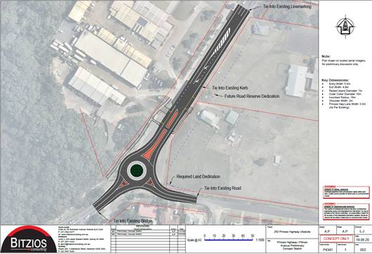
Figure 9 – Princes Highway / Pitman Ave Upgrade
Concept Design
Subject Land
The subject site is located approx. 1.7 km south of the
Ulladulla Town Centre on the north-east corner of the Princes Highway and
Pitman Ave. The subject site is described and legally identified as Lot 1 DP
784732 – 252 Princes Highway Ulladulla.
The subject site is an irregular shaped lot with a frontage of
98m to the Princes Highway and 183m to Pitman Ave. The site falls gently from
the eastern boundary (23.5m AHD) to the Princes Highway (13-14.5m AHD).
Site & Context
An existing dwelling and
associated structures occupy the north-west corner of the subject site with the
remainder of the land used for equine grazing. The site is burdened by an
existing sewer main that transects the western end adjacent the Princes Highway
and SP2 zoned strip of land for Arterial Road Widening.
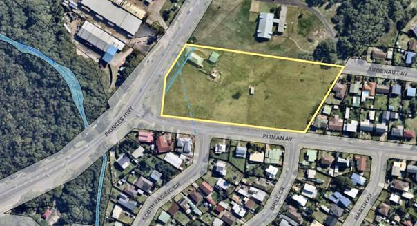
Figure 10 – site identified by yellow border with
sewer main indicated by broken blue line & SP2 Zoned land indicated west of
solid blue line.
Surrounding development is as
follows:
· North
– Place of public worship – Highway Church.
· West
– South Ulladulla industrial land, Princes Highway and Racecourse Creek.
· East
and South – low density residential comprising a mix of 1 & 2 storey
dwellings.
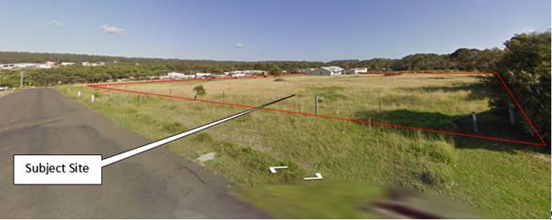
Figure 11 - Pitman
Ave Looking west from 22 Pitman Ave. Site approximated by red border.
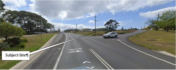
Figure 12 - Princes
Highway northbound approx. 20m south of intersection with Pitman Ave
Zoning
Currently, (DA19/1102)
the land is zoned SP3 Tourist and SP2 Infrastructure under the SLEP 2014.
Initially the development covered both zones until TfNSW objected to the SP2
land being burdened by development as this narrow strip of land is identified
for future road works. DA19/1102 was subsequently revised by moving all of the
physical development from the SP2 zone.
DA21/1304 was only lodged over SP3 zoned land.
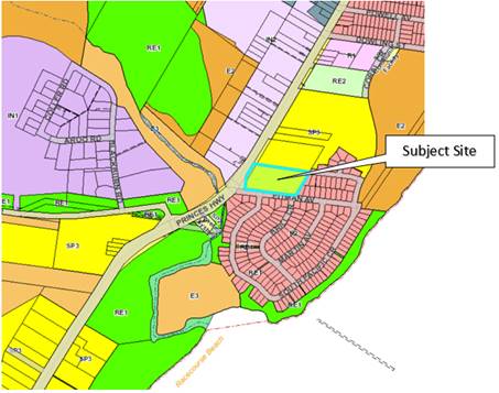
Figure 13 – Extract of the Shoalhaven Local
Environmental plan 2014 Land Use Zoning Map with the subject site with blue
border.
The proposal is best characterised as an innominate use
(having regard to the provisions in the SLEP 2014). While an MHE is not a
nominated permitted use within the SP3 zone, caravan parks are permitted use
with consent in the zone. This is relevant as there is a State Policy that
applies to this type of development which is the enabling mechanism. This is
detailed further below.
The objectives of the SP3 zone
are:
· To
provide for a variety of tourist-oriented development and related uses.
· To
enable compatible residential and recreational uses.
A third objective in effect at lodgement of DA19/1102 was
removed from the current version of the SLEP 2014 on 27 September 2019:
· To provide for dwelling houses that form an integral part of
tourist-oriented development.
Comment
Permissibility for a MHE at the subject site is enabled by the
application of clause 6(6) of SEPP 36 —Manufactured Home Estates (SEPP
36) that allows the development of a MHE on any land on which development
for the purposes of a caravan park may be carried out.
MHEs provide both permanent
accommodation and enable short term rental accommodation in accord with clause
7.13 of the SLEP2014 without the need for further consent.
The development proposes 49
dwellings that may be used for permanent residential accommodation and / or may
be used for short term rental accommodation with ancillary recreational
facilities in the form of bowling green, outdoor gym, BBQ area, garden and
walking paths.
Issues
Traffic and Parking impacts
on the local road network
The following roads are impacted
by the proposed development:
· Princes
Highway
· Pitman
Ave
· South
Pacific Crescent
· Brill
Crescent
· Martin
Ave
· Augenaut
Ave
The application proposes the
following access and upgrades to the local road network:
· Construct
a new roundabout at the intersection of Princes Highway and Pitman Ave with
associated splitter islands, path upgrades and pedestrian refuges. The
roundabout has been designed to cater for the 25m B-double and 19m AV design
service vehicles as required.
· Construct
pedestrian pathway for the full frontage of the subject site with connection to
highway upgrade works including bus stops.
· Vehicle
access to site from Princes Highway via roundabout to Pitman Ave entry/exit.
The site has a single entry / exit driveway to Pitman Ave
with a ring road layout with one internal crossroad. Internal road widths and
turning circles can accommodate manoeuvring by medium rigid vehicle (MRV) in
and out of the development.
State Environmental Planning
Policy (Infrastructure) 2007 (ISEPP)
The subject site has frontage to
Princes Highway, being a classified road.
Accordingly, clause 101 of ISEPP
applies and reads as follows:
101 Development with frontage to classified road
(1) The objectives of this clause are—
(a) to ensure that new development
does not compromise the effective and ongoing operation and function of
classified roads, and
(b) to prevent or reduce the
potential impact of traffic noise and vehicle emission on development adjacent
to classified roads.
(2) The consent authority must not
grant consent to development on land that has a frontage to a classified road
unless it is satisfied that—
(a) where practicable and safe,
vehicular access to the land is provided by a road other than the classified
road, and
(b) the
safety, efficiency and ongoing operation of the classified road will not be
adversely affected by the development as a result of—
(i) the
design of the vehicular access to the land, or
(ii) the emission of smoke or dust from the development, or
(iii) the nature,
volume or frequency of vehicles using the classified road to gain access to the
land, and
(c) the development is of a type
that is not sensitive to traffic noise or vehicle emissions, or is
appropriately located and designed, or includes measures, to ameliorate
potential traffic noise or vehicle emissions within the site of the development
arising from the adjacent classified road.
Under subclause 101(2) the
consent authority must not grant consent to development on land that has a
frontage to a classified road unless it is satisfied that the subsequent
considerations have been met by the proposal.
The three (3) preconditions in subclause 101(2) are
collective. Therefore, any one of the preconditions in subclause 101(2) about
which Council is not satisfied could prevent the issue of consent:
· Subclause
101(2)(a) (‘where practicable and safe, vehicular access to the land
is provided by a road other than the classified road’), is relevant
because the site has frontage to Pitman Ave (unclassified at this location) and
Princes Highway (regional classified road at this location).
The applicant has submitted concept plans (refer to
Figures 2 & 9) for an upgraded roundabout intersection treatment at the
junction of Pitman Ave and the Princes Highway that has been accepted by TfNSW
and Council’s traffic engineers as providing a practicable and safe,
vehicular access to the land that can be provided by a road (Pitman Ave) other
than the classified road.
In accord with the test of practicability established by
the case of Modern Motels Pty Ltd v Fairfield City Council [2013]
NSWLEC 138, the desired outcome is for access to the land to be via the
unclassified local road – Pitman Ave, which will ensure that the
development does not compromise the effective and ongoing operation and
function of the classified road (Princes Highway).
· Subclause
101(2)(b) (the safety, efficiency and ongoing operation of the classified
road will not be adversely affected by the development) is relevant due to the
proposed highway intersection upgrade design for a roundabout with Pitman Ave
and associated pedestrian paths, refuges and bus shelter upgrades.
A Traffic Impact Assessment (TIA) prepared by Bitzios
Consulting concluded that:
o The
Princes Highway / Pitman Avenue intersection operates within acceptable
performance limits in the peak with or without the proposed development at the
year 2020. However, with development traffic, the intersection does not operate
within acceptable performance limits in the AM peak at the year 2020.
o The
Princes Highway / Pitman Avenue intersection is expected to operate significantly
outside acceptable performance limits by the year 2030 with or without the
proposed development and would fail to operate within acceptable performance
limits by the year 2021 without the proposed development.
o The
proposed roundabout generally operates within acceptable performance limits at
the year 2030 with or without the proposed development. It is also noted that
development generated trips have a minimal impact on intersection operations.
o The
roundabout treatment has been designed to accommodate up to a 23m B-Double for
north/south highway traffic movement and up to 19m articulated vehicle (AV) for
the Pitman Ave leg.
o The
proposed roundabout is expected to act as a traffic calming device for
northbound traffic entering Ulladulla and provide significant safety benefits
at the Princes Highway / Pitman Avenue intersection. The proposed roundabout is
therefore considered an appropriate upgrade, mitigating short and long-term
intersection safety and operational issues.
It is clear that the introduction of the proposed
roundabout treatment at the intersection of the Princes Highway and Pitman Ave
with associated pedestrian crossings and pathways will improve the safety,
efficiency and ongoing operation of the classified road (Princes Highway).
· Subclause
2(c) (the development is appropriately located and designed, or includes
measures, to ameliorate potential traffic noise or vehicle emissions within the
site of the development arising from the adjacent classified road) applies to
the development as it proposes residential use in proximity to a classified
road.
A Traffic Noise Intrusion Assessment prepared by Harwood
Acoustics was submitted with the application. The report includes
recommendations which are incorporated in the draft conditions to ensure the
development will not be impacted by noise generated by the surrounding uses if
approved.
Car Parking
Car parking for the development is required to be provided in
accordance with the requirements of the Local Government (Manufactured Home
Estates, Caravan Parks, Camping Grounds and Moveable Dwellings) Regulation 2005
which require:
Parking Rate:
· 1
parking space per MHE dwelling site retained within each site or provided
elsewhere in the estate derived from cl 45 of the regs.
· Visitor
Parking - 12 spaces for a manufactured home estate containing more than 35
sites but not more than 70 sites derived from Cl 23 of the regs.
Residential parking demand for
49 site MHE:
· Residents
- 49 MHE dwelling sites x 1 space per site = 49 spaces
· Visitors
- 12 spaces for a manufactured home estate containing more than 35 sites but
not more than 70 sites
Total number of parking
spaces required = 61 spaces required
Total number of parking
spaces proposed = 49 resident spaces + 15 visitor = 64 spaces
The development is therefore
compliant.
Planning Assessment
The DA has been assessed under
s4.15(1) of the Environmental Planning and Assessment Act 1979. Please
refer to (Attachments 1 & 2).
Policy Implications
Nil
Consultation and Community
Engagement:
DA19/1102 - Notification
was undertaken in accordance with Council’s Community Consultation Policy
with letters being sent within a mapped buffer of the site and advertised in
the Milton Ulladulla Times Newspaper from 28 August to 27 September 2019 and
9 September 2020 to 9 October 2020.
One hundred and ninety-six (196)
public submissions including (one) 1 petition were received in relation to
Council’s notification of the development. They were all objections to
the development. Eighty-seven (87) of the submissions were received outside of
the notification period.
DA21/1304 - Notification
was undertaken in accordance with Council’s Community Consultation Policy
with letters being sent within a mapped buffer of the site and advertised in
the Milton Ulladulla Times Newspaper from 14 to 28 April 2021.
Ninety-nine (99) public
submissions including (one) 1 petition were received in relation to
Council’s notification of the development. They were all objections to
the development. Sixteen (16) of the submissions were received outside of
notification period.
Key issues raised as a result of
the notification are provided below.
Issue
An MHE is inconsistent
with the zoning of the residential neighbourhood
Comment
As previously mentioned above,
the SP3 Tourist Zoning of the subject site permits the development of an MHE
with consent under SEPP 36.
The surrounding residential
neighbourhood to the east and south has a different zoning, R2 low density
residential which permits residential accommodation forms comprising single
dwellings, dual occupancies and detached dwellings.
An MHE provides for single
dwellings in a compressed form within the subject development that while
different to the building form in the R2 zone is not considered to be
incompatible.
Issue
Concerned that the
proposed development is visually intrusive and aesthetically unappealing given
the location at southern gateway to Ulladulla.
Comment
The site is located at the
interface between a commercial SP3 tourist zone, low density R2 residential
zone and IN2 light industrial zone. Existing development is an open paddock
with a single dwelling and associated outbuildings. There is no kerb and
gutter, or footpaths and stormwater is presently collected and drained along
Pitman Ave via a deep open drain.
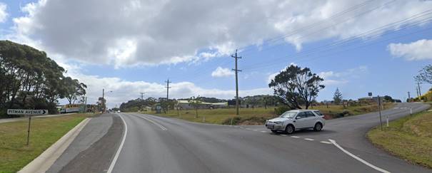
Figure 14 – Photo of current Princes
Highway/Pitman Ave Intersection - Google Maps
The proposed design will provide
a single storey built form contained within formalised perimeter fencing with
landscaping, kerb and gutter, drainage, and pathways to pedestrian refuges that
connect with a new roundabout treatment on the highway that will change the
aesthetics of the southern gateway.
The concern may also stem from
the relatively compact type of development and the relatively homogenous nature
of the dwellings. However, a tidy landscaped development that is compliance
with the SEPP should not result in an offensive development or landscape
blight.
Issue
Concern the development
not in keeping with existing residential area and will devalue the overall
quiet feel of the neighbourhood and change the image of the area to a low-cost
housing precinct.
Comment
The subject site is zoned for a
commercial SP3 Tourist purpose that permits and potentially foreshadows a
higher density footprint than the adjoining low-density residential precinct.
In Project Venture
Developments v Pittwater Council [2005] NSWLEC 191 Senior Commissioner Dr
John Roseth established Planning principle: compatibility in the urban
environment.
There are many dictionary definitions of compatible. The
most apposite meaning in an urban design context is capable of existing
together in harmony. Compatibility is thus different from sameness. It
is generally accepted that buildings can exist together in harmony without
having the same density, scale or appearance, though as the difference in
these attributes increases, harmony is harder to achieve. Where compatibility
between a building and its surroundings is desirable, its two major aspects are
physical impact and visual impact. In order to test whether a proposal
is compatible with its context, two questions should be asked.
Are the proposal’s
physical impacts on surrounding development acceptable? The physical impacts
include constraints on the development potential of surrounding sites.
The existing character of Pitman
Ave in the vicinity of the proposed development comprises 1 and 2 storey single
dwellings.
There is no evidence that the
proposed development will constrain development or result in any overlooking or
overshadowing impacts. There is the potential for some light impact to the
residential premises immediately adjacent to the entry driveway for the
proposed facility when vehicles leave the site at night and a slight increase
in road noise associated with additional traffic movements.
Is the proposal’s
appearance in harmony with the buildings around it and the character of the
street?
For a new development to be visually compatible with its
context, it should contain, or at least respond to, the essential elements that
make up the character of the surrounding urban environment. The most important
contributor to urban character is the relationship of built form to surrounding
space, a relationship that is created by building height, setbacks and
landscaping.
Building Height - Existing built form
for the surrounding estate ranges from 1-2 storey residential dwellings.
Existing residential properties adjacent to the subject site comprises 8 single
storey and 2 double storey dwellings. Refer to Figure 15. Pitman Ave contains
14 double storey and 11 single storey dwellings.
The proposed development is 1 storey in height, has
significant external boundary setbacks and internal separation.
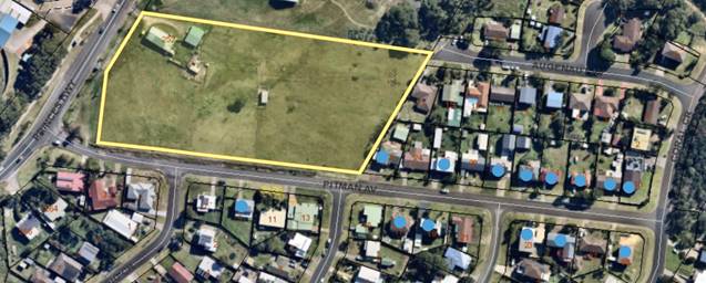
Figure 15 - Two (2) storey dwellings in pitman Ave
represented by blue dot. Subject site identified by yellow border.
Front Setbacks - Setbacks
for existing dwellings in Pitman Ave adjacent range from 4-13m from the front
boundary.
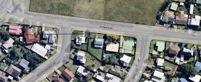
Figure 16 - Variable setback represented by broken blue
line.
The proposed development
provides a setback of 10m for MHE dwelling sites from Pitman Ave. Cl 44 of the
LG Regs requires a further setback of 1m to a road reserve providing a minimum
setback of 11m to Pitman Ave for the built form. Front setback is considered
compatible with surrounding built form.
Side Setbacks - Existing
side setbacks in Pitman Ave are variable ranging from 1.8m to 8+m
approximately.
Clause 47 of the Local
Government (LG) Regulations requires a minimum side setback of 1m to the
boundary of an adjoining dwelling site for an MHE development. This in effect
provides a minimum separation of 2m between manufactured homes. When viewed
from Pitman Ave looking north, the MHE proposal would present as (10 x 3 bed)
and (2 x 2 bed) dwellings of uniform spacing (12 in total) with a detached
community building on the SW corner.
In contrast, the streetscape
looking south from Pitman Ave is broken up by South Pacific Crescent and
presents as (7) dwellings between the highway and Brill Crescent.
It is acknowledged that side
setbacks for the proposed development are uniformly smaller than the existing
side setbacks of surrounding residential development. While the proposed
development would appear denser in the local context, it is not considered to
be incompatible or unreasonable having regard to the type of development it is.
Landscaping - The
existing character of landscaping in Pitman Ave is informal with very few trees
and occasional low set front fences (1.2m max) of variable design and
materials.
The proposed development
incorporates formal landscaping incorporating (3) different types of boundary
fencing, perimeter plantings and street trees.
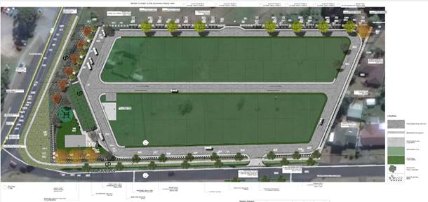
Figure 17 – Landscape Plan
Proposed fencing comprises:
Figure 18 -Fence Type 1 - Capped and lapped 1.8m high
timber fence with indented landscape bays along north boundary with Highway
Church.
Figure 19 - Fence Type 2 – Modular Wall –
Estate Wall 2.2m High proposed along the highway frontage with return in Pitman
Ave east of the proposed BBQ area.
Figure 20 - Fence Type 3 – Aluminium Slat Fence
1.2m high – note image above appears 1.8m high
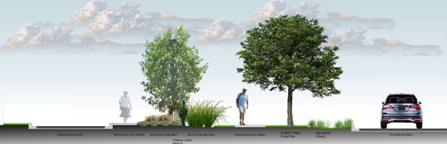
Figure 21 - Pitman Ave Streetscape – Sectional Elevation
of fence and landscaping
Landscaping and 1.2m high
fencing facing Pitman Ave were proposed in response to existing context of low
set fences and generally open front yards.
Neighbour submissions from
surrounding residents suggest that the proposed MHE dwelling forms are not
adequately screened from Pitman Ave by a 1.2m high slatted aluminium fence.
Comment - the proposed fencing
height along the Pitman Ave frontage is appropriate and compatible with the
existing context.
To address the visual screening
concern, it is recommended that a suitable hedge planting is provided on the
development side off the Pitman Ave boundary fence that is grown and maintained
to a height of 2.0 m. This would effectively screen the development from the
street and help minimise light spill from vehicle lights at night.
The development seeks to retain
the existing eastern boundary fence without alteration. Neighbour submissions
have identified the need to upgrade this boundary fence to minimise vehicle
light spill / noise amenity impacts from the development to adjoining
neighbours. It is recommended that a 1.8m high capped and lapped acoustic hard
wood fence be provided along the entire eastern boundary of the site from the
north east corner adjacent 17 Augenaut Ave to the front building alignment of
22 Pitman Ave.
The subject site is near
industrial zoned land on the highway West and commercial land to the North.
Proposed fencing typologies for those two frontages are considered to be
appropriate for screening and sound attenuation. It is considered
compatible with existing and future context.
Change Image of residential
estate to Low-Cost Housing - The proposed development presents as a compact
gated residential estate covering an area of 1.8 hectares (ha) at the entry to
Pitman Ave compared to the 18.4 ha of R2 zoned residential land to the east and
south of the subject site.
While submissions raised
concern that the development would add to the strip of “ugly” MHEs
in the vicinity, this assertion needs to be tested. There are no other MHEs
located in the vicinity. There are however 4 caravan parks located within 1.1km
south of the proposed MHE that incorporate manufactured homes for long term
occupation.
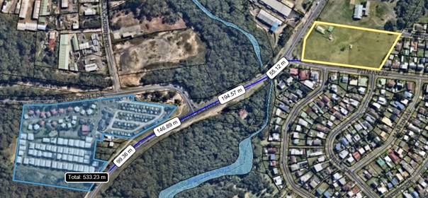
Figure 22 – Proximity of subject site to existing
Kings Point Caravan Park
Kings Point Retreat is the only
caravan park development within view of the proposed MHE development. The other
caravan parks are sufficiently remote and located out of sight around a bend in
the highway. The Long Term (LT) portion of Kings Point Retreat is located
approximately 500m south from the proposed MHE development and is partially
screened from view by vegetation and a number of dwellings fronting the highway
and is therefore considered that it does not add to a negative cumulative visual
impact for the proposed development.
Figure 23 – Image of Manufactured Homes installed
in the Long-Term portion of the kings Point Caravan Park viewed from Princes
Highway facing north.
There is no evidence that the
proposed MHE would change the image of the area to a low-cost housing precinct.
Land values – As
detailed in a publication by Gadens lawyers, December 2013:
…..It will generally be a stretch to argue that a
loss of value to a single neighbouring landowner is a proper matter for consideration.
For example, at its simplest level, many neighbours argue that a new home next
door to them will result in a loss of property value to them, and that is no
doubt very often correct (for example, when it causes some view loss or loss of
sunlight or additional privacy impacts). But the Courts typically refuse to
consider such impacts, on the basis that some broader economic impacts are
required ‘in the locality’ …..However in a more recent appeal
a commissioner dismissed such arguments out of hand, simply saying “I pay
no regard to the fears about loss of property values as, consistent with the
position long taken in the Court, this is not a relevant planning
consideration” (Alphatex Australia v the Hills Shire Council (No 2) [2009]……
In short, the impacts on land
and property valuations is not a consideration under section 4.15 which
prescribes the planning assessment of a DA.
Issue
Concerned that the density
of the proposed development is not in keeping with the character of surrounding
land use (over development of the site).
Comment
Proposed density is appropriate
for the SP3 tourist zone of the subject site which is different to the R2 low
density zone for surrounding residential land.
Issue
Concern with effective and
efficient evacuation in extreme bushfire situations to the Princes Highway
being made worse by the proposal.
Comment
The current access to the
Princes Highway provides limited opportunity for residents to break into
continuous traffic flows on the highway during normal and peak flow periods.
The proposed roundabout would act to significantly improve access / safety to
the highway both in normal flow and peak flow times including emergency events.
It also requires northbound traffic on the highway to give way to Pitman Ave
traffic.
Issue
Need for an Evacuation
Management Plan.
Comment
This has been addressed by the
RFS General terms of Approval (2019 DA) dated 26/05/2021. A condition is
also recommended for the 2021 DA.
Issue
Princes Highway/Pitman Ave
intersection concerns include:
· Existing
safety and wait time particularly during peak holiday periods
· Additional
traffic generated by the proposed development would exacerbate existing
problems for access to and from the highway
· Lack
of safe walking path for students walking to UHS or older residents who walk to
the bus stop on the highway.
· Need
for a commitment to a roundabout at the intersection of Princes Highway and
Pitman Ave prior to any development consent being issued.
Comment
Referring to comments above, it
is clear that the provision of the proposed roundabout will significantly
reduce wait times/queuing distance during normal and peak flow/emergency events
and includes formalised pathways and pedestrian refuges that improve pedestrian
safety. The development provides a commitment to build the roundabout and
associated infrastructure which is a requirement of TfNSW before occupation of
the development can occur.
Issue
Concerned that there is
inadequate parking for residents & visitors which will lead to an increase
in on street parking.
Comment
Proposed parking for the
manufactured home estate exceeds the State Government parking requirements
under the Local Government Regulations for this form of development.
Recommended conditions (in the
draft consent) require the installation of upright kerb and gutter, pedestrian
path and formalised subsoil drainage behind the kerb along the full frontage of
the development in Pitman Ave and Princes Highway. This required road upgrade would
enable some formalised parallel parking along north side of Pitman Ave to occur
when necessary.
Issue
Concern with odour/noise impacts from waste servicing
located too close to existing dwellings at eastern end of the site.
Comment
The applicant revised the plans and
moved the waste disposal area to the western end of the site away from
adjoining residents. It is it acknowledged that the existing eastern dividing
fence is not of a suitable standard to reduce vehicle noise to nearby
residents. The landscape plan incorporates appropriate screening planning along
this boundary that will adequately address light spill once established. In the
interim period, it is reasonable for council to condition a requirement for the
installation of a 1.8-metre-high hardwood capped and lapped acoustic fence
along the full eastern boundary off the subject site.
Issue
Concern regarding potential light spill and vehicle noise
amenity impact generated by car headlights leaving the development at night
impacting general amenity, health and causing sleep disturbance at night.
Comment
This issue is of particular
relevance to the existing residents living opposite the location of the
proposed MHE access driveway. To minimise light spill, the applicants have
agreed to provide for additional Street tree planting on both sides of Pitman
Ave in the vicinity of their entry driveway.
After considering the
submissions it is considered reasonable for council to condition the provision
and maintenance of a 1.8m high screening hedge behind the Type 3 Fence proposed
for Pitman Ave frontage.
Issue
Concerned that the proposed development does not comply or
provide appropriate affordable housing.
While the applications Statement of Environmental Effects may
promote affordability of dwellings in the proposed MHE, it is noted that
neither application has not been lodged as affordable housing development under
SEPP (Affordable Rental Housing) 2009.
Financial Implications:
There are potential cost implications for Council in the
event of a refusal of the application.
Such costs would be associated with defending an appeal in
the Land and Environment
Court of NSW.
Legal Implications
A
section 8.2 review or an appeal with the Land and Environment Court are
possible if the
application is refused.
Summary and Conclusion
The Report and the attached s.
4.15 Assessment Reports (Attachments 1 & 2) provide an assessment of
the proposal to demolish existing buildings and construct a manufactured home
estate (MHE) comprising 49 dwelling sites incorporating 17 x 2 bed manufactured
homes and 32 x 3 bed manufactured homes, a community building, BBQ area,
outdoor recreation facilities and associated infrastructure on land identified
as 252 Princes Highway and roundabout and associated civil infrastructure to
the intersection of Princes Highway and Pitman Ave Ulladulla under DA19/1102
& DA21/1304.
The proposed development has
been assessed against all relevant environmental planning instruments. Both
applications have received recommended conditions of consent from the RFS
(Planning for Bushfire 2019) and TfNSW (roundabout upgrade intersection for
Pitman Ave & Princes Highway) and Council engineers.
It is acknowledged that while
both applications have received a significant number of objections from nearby
residents and interested parties, the issues raised are considered to have been
satisfactorily addressed by the submitted application and recommended
conditions of consent.
The applications are recommended
for approval in accordance with the attached Notices of determination document
(Attachments 3 & 4).
|

|
Development
& Environment Committee – Tuesday 13 July 2021
Page
0
|
DE21.83 DA20/2061
– 60 Macleay Street Narrawallee – Lot 145 DP718994
DA. No: DA20/2061/4
HPERM Ref: D21/245863
Department: Development
Services
Approver: Phil
Costello, Director - City Development
Attachments: 1. Planning
Report S4.15 Assessment-60 Macleay St Narrawallee (under separate cover) ⇨
2. Draft
Conditions - 60 Macleay St Narrawallee (under separate cover) ⇨
3. Site
Analysis Plan (under separate cover) ⇨
4. Roof
Plan (under separate cover) ⇨
5. Elevations
(under separate cover) ⇨
6. Sections
(under separate cover) ⇨
7. Colours & Finishes (under
separate cover) ⇨
Description of Development: New two storey
dwelling, carport, and swimming pool
Owner: Donna Hartwig
Applicant: Smyth & Smyth Pty Ltd
Notification Dates: 19 October 2020- 4 November
2020
No. of Submissions: 5 objections
Purpose
/ Reason for consideration by Council
At the Development &
Environment Committee meeting of Council held on 6 April 2021 Council resolved
to “call-in” the DA for determination.
|
Recommendation (Item to be determined under delegated authority)
That the Development Application
for New two storey dwelling, carport, and
swimming pools on the land at 60 Macleay
Street Narrawallee – Lot 145 DP718994 be approved subject to the
recommended conditions of consent contained in Attachment 2 of this report.
|
Options1. Approve
the development application (DA) in accordance with the recommendation of this
report.
Implications: This would
allow the applicant to proceed with the proposal and seek a construction
certificate (CC)for development on the subject site.
2. Refuse the
application.
Implications: Council would
need to determine the grounds on which the application is refused, having
regard to section 4.15 considerations. The applicant would be able to request a
s8.2 Review and /or pursue an Appeal through the Land and Environment Court of
NSW (LEC).
3. Alternative
recommendation.
Implications: Council will need to specify an alternative
recommendation and advise staff accordingly.
Location Map
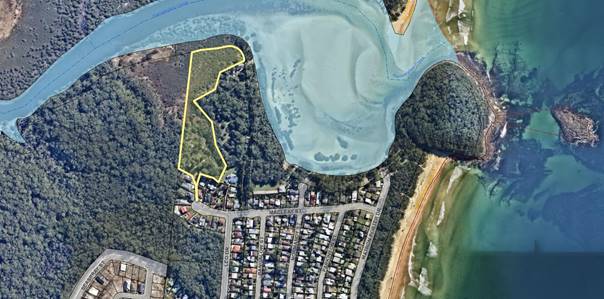
Figure 1 –
Location Map
Background
Proposed Development
The application seeks consent for a new two storey
dwelling, carport, and swimming pools. The dwelling essentially comprises two
detached buildings linked via a breezeway. The dwelling comprises nine (9)
bedrooms, each with their own ensuite. One building contains the living areas
and the main bedroom and the second building contains the remainder of the
bedrooms.
Further details of the proposal
are as follows:
Ground Floor
· Ground level
to accommodate open-plan kitchen, meals and living area which open out to the
deck areas on the northern and western elevations.
· Four
bedrooms each with an ensuite & plunge pool.
· Detached
laundry, plant, and storeroom.
· Carport,
sauna & communal plunge pool.
· A
green roof is proposed above laundry/store area and the breezeway.
First Floor
· Master
suite, walk-in-robe, ensuite, study and balcony area.
· Four
bedrooms each with an ensuite.
The
application also proposes:
· Overall
height of 7.45 metres.
· The dwelling
would be composed of a mix of materials including metal cladding, glass, and
brick.
· A one (1)
metre rear setback is proposed to the shared southern boundary.
· The dwelling
includes a double carport to be directly accessed off the existing right of way
access handle.
· A swimming
pool is proposed to the north-western corner of the dwelling.
· No
vegetation removal is required.
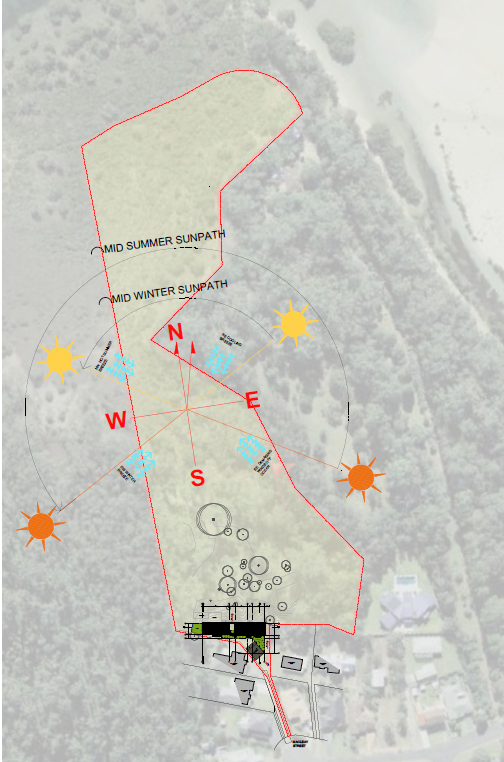
Figure
2 Site Analysis Plan

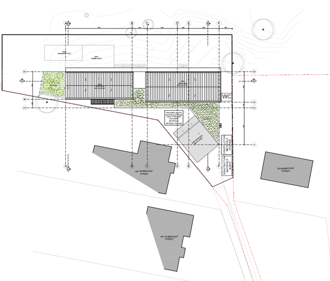
Figure 3 – Site
Detail
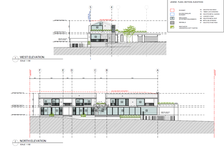
Figure
4 North & West Elevations
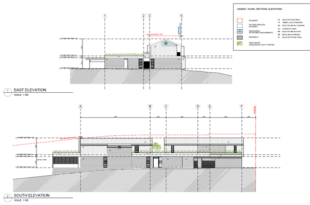
Figure
5 East & South Elevations
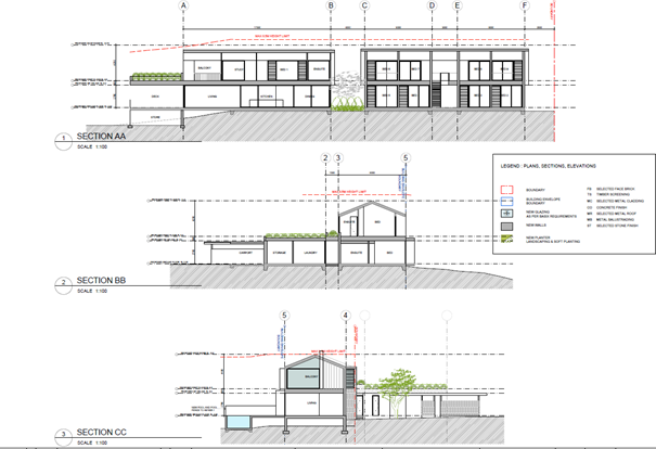
Figure
6 Section Plans
Subject Land
The subject site is located on
the northern side of the Macleay Street cul-de-sac side and located at the end
of an access handle which currently services two (2) existing dwellings. The
site is irregular in shape yielding an overall site area of approximately 3.18
hectares.
The site is accessed via an
access handle which extends to the south. An existing driveway extends to the
south along the access handle and is shared with properties known as No. 62 and
64 Macleay Street.
The lot is currently vacant, and
mostly consists of vegetated land, with an area of cleared land located
adjacent to the access handle which is nominated as the building envelope /
site.
The land is zoned, Part R2 Low
density Residential and E2 Environmental Conservation as shown in Figure 7
below.

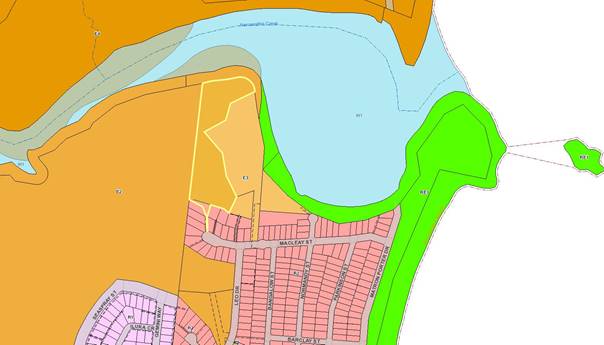
Figure
7 – Zone Extract (SLEP 2014)
Immediate surrounding area
The site is in a predominantly
residential area. There are two single storey dwellings which share the access
handle with the subject site and there is a two-storey dwelling with frontage
to Macleay Street located at the southern end of the access handle.
The surrounding built form is a
mix of single and double storey dwellings.
Beyond the immediate surrounds are predominantly residential
dwellings. Narrawallee Inlet is located to the immediate north and east of the
site.
History
The following applications,
listed as considered relevant to the current proposal, have previously been
considered for the subject site:
|
DA number
|
Description of Proposal
|
Decision
& Date of Decision
|
Officer
Comment
|
|
DA00/3615
|
New
dwelling and partial filling of land
|
Approved
13/3/01
|
Consent
has lapsed
|
Issues
Concern raised in regard to the
use of the dwelling as an alternative form of accommodation prohibited under
the current zone.
The main area of contention is
the intended use of the dwelling.
The large number of bedrooms
each with their own ensuite and the multiple plunge pools proposed raises
concerns that the intent is to use the development for tourist accommodation.
Applicant’s Submission
In regard to the matters raised
above the applicant responded with the following:
· This
application is proposing a two-storey dwelling house swimming pools, and
landscaping. The application is not for a tourist facility, boarding house, or
hotel/motel accommodation. Dwelling houses are listed as being permissible in
the R2 zone. It is acknowledged that the proposed floor plan provides a unique
design. The owner engaged Smyth & Smyth to design a dwelling house which
will satisfy the needs of the owner (sic) and their family. A Statutory
Declaration has been provided by the owner which confirms the following:
‘To
confirm our current permanent place of residence is in Wagga Wagga NSW, and we
intend to use this dwelling as a family holiday home initially and then retire
here in the future. We engaged Architects Smyth and Smyth Pty Ltd to design a
high-quality dwelling which will satisfy the needs of our family. We have a
large extended family with older children who also have their own families, the
proposed dwelling has been designed to reflect the needs of our family
situation. The design allows for our family to come together while still
maintaining the privacy and separation which we require. We confirm that the
proposal is not for a tourist facility boarding house or hotel.’
Discussion
The main area of concern is the
foreshadowed use of the building as tourist accommodation, as result of the
multiple bedrooms and ensuites and multiple plunge pools. Hence in deciding
whether a building is a dwelling, regard should be given to the intention of
the owner to use the building as a dwelling, not just the potential capability
of the building to be used as tourist and visitor accommodation (the group term
is prohibited in the zone).
Pursuant to the Shoalhaven LEP
2014, a “dwelling” is defined as follows:
dwelling means a room or suite of rooms occupied or used or so
constructed or adapted as to be capable of being occupied or used as a separate
domicile.
The proposal is consistent with
the definition, and the definition does not limit a dwelling by the number of
bedroom and ensuites. The subject site is also identified as bushfire prone
land and a tourist facility would be considered a special fire protection
purpose under Planning for Bushfire Protection 2019 which requires a Bushfire
Attack Level (BAL) that must not exceed BAL-29. The RFS have deemed that the
proposed dwelling must be constructed to BAL Flame Zone hence a tourist
facility would find it difficult to gain a consent with a Flame Zone rating.
At present, there is
insufficient evidence that the building (as opposed to the
‘capability’ of the building) is to be utilised as tourist
accommodation, nor any clear evidence that this is the intended future use.
In the assessment of an
application, Council cannot foreshadow what might happen in the future,
possible changes, or additional development. It can only assess what is before
it and decide to conditionally approve or refuse, with reasons based on
planning considerations such as impacts on amenity and the like.
Further, if an approval is forthcoming
conditions cannot be imposed preventing further DAs or types of development, as
these may be permissible (or prohibited) and the correct avenue to reach a
conclusion on a development is via a planning assessment pursuant to section
4.15 of the Environmental Planning and Assessment Act 1979.
Conditions imposed to prevent
future development or relying on a promise and capturing those in a condition
of consent would not satisfy Newbury criteria in that “the conditions
imposed must be for a planning purpose and not for any ulterior one, and
…. they must fairly and reasonable relate to the development permitted.
Also, they must not be so unreasonable that no reasonable planning authority
could have imposed them.” (LEC of NSW, Judicial Newsletter, October
2020).
Having regard to Jonah Pt
Limited v Pittwater Council [2006] NSWLEC 99 At paragraph 35, Justice
Preston specifically noted:
“….it is irrelevant
to enquire as to who is the current owner /operator or who might be the future owner / operator, or whether the present
owner / operator has in the past acted or used the land unlawfully, or whether
the future owner / operator is likely in the future to act or carry out any
approved use unlawfully.”
Whilst this decision was in
reference to a modification application, the principle still has relevance to
the making of a development application.
The applicant has responded to
the concerns regarding intended use by providing a statement of the anticipated
use of the dwelling and also provided a signed statutory declaration confirming
the same. The consent, if issued will be for a dwelling. No other
approval will be given or implied for anything else other than a dwelling.
With regard to the design of the dwelling, the proposal is
considered to provide a design that adequately responds to the surrounding
neighbourhood character context given:
a) The height of the proposal is
comparable to heights within the surrounding area.
b) The proposal provides a pitched roof
form which is considered to appropriately reflect roof forms in the surrounding
area.
c) Site coverage (relative to the size of
the land) is minimal.
d) The height, massing and appearance of
the building would not be incongruent to the existing residential character of
the surrounding area whilst minimising impacts on remainder of the E2
Environmental Conservation land.
e) Visual
interest is provided by setbacks and the articulation of the facades with a
variety of materials and colours.
f) The
proposal accords with strategic planning objectives to increase housing density
and diversity in an established area with good access to services.
Short Term Rental
Accommodation (STRA)
Despite the discussion above,
this does not prevent the owner (or indeed other owners of dwellings) utilising
the short-term rental accommodation provisions at clause 7.13 of the Shoalhaven
LEP 2014 which states:
(1) The objective
of this clause is to ensure that residential accommodation may be used as
tourist and visitor accommodation for a short term without requiring
development consent.
(2) Despite
any other provision of this Plan, development consent is not required for the
use of residential accommodation for the purposes of tourist and visitor
accommodation (except backpackers accommodation or bed and breakfast
accommodation) if the use is only short-term and does not interfere generally
with the amenity of the neighbourhood in any way, including by noise or traffic
generation.
It is noted that amendments have
been made to SEPP (Affordable Rental Housing) 2009 and the Environment Planning
& Assessment Regulation to introduce new policy framework for STRA that
will commence on 1 November 2021.
Regardless, even if the owner
were to utilise the STRA provisions the mandatory Code of Conduct which is part
of the recently amended regulatory framework to manage short-term rental
accommodation must be complied with.
Breaches of the code of conduct
may result in the dwelling being registered on the Exclusion Register which
lists guests and host who have been excluded from participating in the
short-term rental accommodation industry. Again, however Council can only
consider what is before it for assessment and that is a dwelling.
Planning Assessment
The DA has been assessed under
s4.15(1) of the Environmental Planning and Assessment Act 1979. Please
refer to Attachment 1.
Policy Implications
There are no specific policy
implications that arise from this matter.
Consultation and Community
Engagement:
Five (5) public submissions were received in relation to
Council’s notification of the development. All five (5) were
objections to the development. The notification was made in accordance with
Council’s Community Consultation Policy with letters being sent within a
25m buffer of the site. The notification was for a 2-week period.
Key issues raised as a result of the notification are
provided below.
Issue
The proposal is intended to
be used as motel/tourist accommodation.
Comment
This has been addressed in the preceding sections of the
report.
Issue
The building envelope is not
large enough to accommodate a development of this size. This is apparent
by the applicants request to vary the 88B.
Comment
A condition of consent will require a variation to the
existing 88b to vary the building envelope to include the intrusions outside of
the building envelope for the swimming pool and decking area.
Issue
The
proposal is out of character and excessive in size and scale.
Comment
The proposed
building is considered appropriate in this context. The proposed dwelling is
contemporary in its design expression and references the traditional pitched
roof character in the street. It will also utilise a blend of brickwork, timber
cladding and metal roofing finishes commonly utilised in the immediate area,
albeit in a modern interpretation of the older housing stock in the street.
Further it is generally acceptable in terms of height, scale, and massing.
The proposal respects the preferred neighbourhood character
of the area. This is achieved through conforming to the single and double
storey building scale and form of the streetscape. The proposal aligns
satisfactorily with the preferred character of the surrounding area and
balances the need to protect the existing character with growth in housing.
Issue
Overshadowing of adjoining
properties.
Comment
Additional overshadowing by the proposed development would
not adversely impact upon the surrounding properties, including the adjacent
dwelling to the immediate south. The shadow diagrams submitted with the
application show that additional overshadowing caused by the proposal would not
adversely impact the adjacent site and satisfies the standard in the DCP by providing
a minimum of at least 3 hours of direct sunlight to at least 10m2 of
private open space.
Issue
Inadequate
car parking/lack of manoeuvring to allow vehicles to exit in a forward
direction.
Comment
Council’s DCP requires that only 2 car spaces are
required for dwellings with 3 or more bedrooms. Whilst the proposal satisfies
the provision, the applicant has also submitted plans that allow for 3
additional car spaces along the eastern boundary. There is adequate room along
this boundary for the provision of these car spaces and the area in front of
the proposed building also allows for adequate manoeuvring to allow vehicles to
turn around and exist the site in a forward direction.
Issue
The proposal will increase
noise and impact on existing residential amenity.
Comment
Concerns have been raised
regarding the potential noise generated from the dwelling after occupancy. Most
of the outdoor living areas that could potentially generate noise amenity
impact are located on the northern side of the proposed dwelling away from
neighbouring premises with the exception of the larger plunge pool and sauna
located between the dwelling and carport. Given that the use of this area could
generate amenity noise impact to adjoining residents, it is recommended that a
condition be imposed requiring a solid fence be installed along the southern
boundary in proximity to these facilities.
Residential noise associated with a dwelling is considered
normal and reasonable in an urban setting. Any future issues of amenity or
anti-social behaviour, if they arise should be pursued as a civil matter or
with the Police if of a serious nature as would be the case for any other
dwelling / adverse social behaviour in a neighbourhood setting.
Issue
The
proposal exceeds height limit.
Comment
The property is situated within an
area where a maximum building height of 8.5m applies as per the height of
Buildings Map specified at cl.4.3 of the Shoalhaven LEP 2014. The proposal has
a maximum height of 7.45m and as such is consistent with the 8.5m height limit.
Issue
Increased
traffic utilising shared access driveway and potential traffic safety issues.
Comment
There may be more vehicles utilising the access driveway
once the development is completed, however this is an expectation of urban
development. It is not uncommon for households to have more than one or
two vehicles, particularly if older children reside in the family home, or if
it is a shared house.
Issue
Lack
of separation between the proposal and existing dwelling to the immediate
south.
Comment
A minimum 1 metre setback is
proposed between the proposed dwelling and the boundary of the existing
dwelling to the south. Chapter G12 of the Shoalhaven DCP 2014 requires a 7.5m
front setback to the primary road frontage. The application is located on a
battle-axe lot approximately 50 metres from the road frontage. The DCP is
silent regarding a battle-axe lot and front setbacks hence if the proposal is
assessed based on the current DCP requirement it satisfies the acceptable
solution.
Further the lot is constrained
by the dwelling envelope which can limit design options. In this instance it is
considered that separation between the dwellings is considered satisfactory.
Financial Implications:
Not applicable
Legal Implications
Pursuant to section 8.2 of the Environmental
Planning and Assessment act 1979 (EP&A Act) a decision of the Council
may be subject of an application for review by the applicant in the event of an
approval or refusal. Alternatively, an
applicant for development consent who is dissatisfied with the determination of
the application by the Council may appeal to the Court against the
determination pursuant to section 8.7 of the EP&A Act.
Summary and Conclusion
The proposed development has
been assessed in accordance with section 4.15 of the EP&A Act and is
recommended for approval.
· The proposed
use and development of part of the site for a dwelling is a use contemplated
and permissible in a R2 Low Density Zone.
· Whilst
concerns are raised in regard to the intended use of the development any
approval issued, will be for a dwelling. No other use would be approved or
implied by that consent.
· The proposal
is consistent with the relevant environmental planning instruments and the
Shoalhaven Development Control Plan 2014.
|

|
Development
& Environment Committee – Tuesday 13 July 2021
Page
0
|
Local Government Amendment (governance &
planning) act 2016
Chapter
3, Section 8A Guiding principles for councils
(1)
Exercise of functions
generally
The
following general principles apply to the exercise of functions by councils:
(a) Councils should provide strong
and effective representation, leadership, planning and decision-making.
(b) Councils should carry out
functions in a way that provides the best possible value for residents and
ratepayers.
(c) Councils should plan
strategically, using the integrated planning and reporting framework, for the
provision of effective and efficient services and regulation to meet the
diverse needs of the local community.
(d) Councils should apply the
integrated planning and reporting framework in carrying out their functions so
as to achieve desired outcomes and continuous improvements.
(e) Councils should work
co-operatively with other councils and the State government to achieve desired
outcomes for the local community.
(f) Councils should manage
lands and other assets so that current and future local community needs can be
met in an affordable way.
(g) Councils should work with
others to secure appropriate services for local community needs.
(h) Councils should act fairly,
ethically and without bias in the interests of the local community.
(i) Councils should be
responsible employers and provide a consultative and supportive working
environment for staff.
(2) Decision-making
The
following principles apply to decision-making by councils (subject to any other
applicable law):
(a) Councils should recognise
diverse local community needs and interests.
(b) Councils should consider social
justice principles.
(c) Councils should consider the
long term and cumulative effects of actions on future generations.
(d) Councils should consider the
principles of ecologically sustainable development.
(e) Council decision-making should
be transparent and decision-makers are to be accountable for decisions and
omissions.
(3) Community participation
Councils
should actively engage with their local communities, through the use of the
integrated planning and reporting framework and other measures.
Chapter
3, Section 8B Principles of sound financial management
The
following principles of sound financial management apply to councils:
(a) Council spending should be responsible and
sustainable, aligning general revenue and expenses.
(b) Councils should invest in responsible and
sustainable infrastructure for the benefit of the local community.
(c) Councils should have effective financial
and asset management, including sound policies and processes for the following:
(i) performance management
and reporting,
(ii) asset maintenance and
enhancement,
(iii) funding decisions,
(iv) risk management practices.
(d) Councils should have regard to achieving
intergenerational equity, including ensuring the following:
(i) policy decisions are made
after considering their financial effects on future generations,
(ii) the
current generation funds the cost of its services
Chapter
3, 8C Integrated planning and reporting principles that apply to councils
The
following principles for strategic planning apply to the development of the
integrated planning and reporting framework by councils:
(a) Councils should identify and prioritise key
local community needs and aspirations and consider regional priorities.
(b) Councils should identify strategic goals to
meet those needs and aspirations.
(c) Councils should develop activities, and
prioritise actions, to work towards the strategic goals.
(d) Councils should ensure that the strategic
goals and activities to work towards them may be achieved within council
resources.
(e) Councils should regularly review and
evaluate progress towards achieving strategic goals.
(f) Councils should maintain an
integrated approach to planning, delivering, monitoring and reporting on
strategic goals.
(g) Councils should collaborate with others to
maximise achievement of strategic goals.
(h) Councils should manage risks to the local
community or area or to the council effectively and proactively.
(i) Councils should make appropriate
evidence-based adaptations to meet changing needs and circumstances.