Development & Environment Committee
Meeting Date: Tuesday,
11 May, 2021
Location: Council
Chambers, City Administrative Building, Bridge Road, Nowra
Time: 5.00pm
Membership (Quorum - 5)
Clr Mitchell Pakes - Chairperson
Clr Bob Proudfoot
All Councillors
Chief Executive Officer or nominee
Please note: The proceedings of this meeting
(including presentations, deputations and debate) will be webcast and may be
recorded and broadcast under the provisions of the Code of Meeting Practice. Your attendance at this meeting is taken
as consent to the possibility that your image and/or voice may be recorded and
broadcast to the public.
Agenda
1. Apologies / Leave of Absence
2. Confirmation of Minutes
· Development
& Environment Committee - 6 April 2021.............................................. 1
3. Declarations of Interest
4. Mayoral Minute
5. Deputations and Presentations
6. Notices of Motion / Questions on Notice
Notices of Motion / Questions on Notice
DE21.36...... Notice of Motion - Call in DA20/1762 - 127
Princes Highway, Ulladulla..... 12
7. Reports
City Futures
DE21.37...... Proposed 2020/2021 Housekeeping Amendment to
Shoalhaven Local Environmental Plan 2014 (PP044)....................................................................................... 13
DE21.38...... Proposed Review - Planning Controls - Nowra CBD................................... 18
DE21.39...... Shoalhaven Population Forecasts............................................................... 23
DE21.40...... Report Back - Rezoning Options - Tomerong Quarry,
Lot 4 DP775296, Parnell Road, Tomerong..................................................................................................... 27
DE21.41...... Proposed Submission - NSW Planning Reforms -
Agritourism and Small-scale Agriculture Development.............................................................................. 37
DE21.42...... Exhibition Outcomes and Finalisation - Planning
Proposal - Hitchcocks Lane, Berry (PP029)......................................................................................................... 42
DE21.43...... Update - Planning Proposal PP050 - Former
Anglican Church, Huskisson - Ground Penetrating Radar Survey............................................................................ 71
City Services
DE21.44...... Parkcare Action Plans - Bishop Reserve / Callala
Beach / Clifton Park / Mount Vista Close / Nulla Place Reserve......................................................................... 77
City Development
DE21.45...... Development Application – 39 The Lake
Circuit, Culburra Beach – Lot 1553 DP 12278............................................................................................................ 99
DE21.46...... DA20/1970 – 1178 Comerong Island Road,
Numbaa – Lot 2 DP 1077521 116
DE21.47...... SF10804 – 104 Taylors Lane, Cambewarra
– Lot 3 DP 851823.............. 140
DE21.48...... Modification Application No. DS20/1619 – 2
Lawrence Ave & 61 Kinghorne St Nowra – Lot 2 DP 1264717 (formally
known as Lot 2 DP 1243710) & Lot 1 DP 1243710.................................................................................................................... 156
DE21.49...... DA20/1966 - 29 Strongs Road, Jaspers Brush - Lot
215 DP 1210788 - Single A-Frame Advert Sign...................................................................................... 178
DE21.50...... DA16/1465 - 173 Kinghorne St and 2 & 4
Albatross Rd Nowra - Lot 1, 29 and 30 DP 25114.......................................................................................................... 184
DE21.51...... Northern Coastal Management Program Advisory
Committee - Amendment to Terms of Reference............................................................................................... 225
DE21.52...... Quarterly Review for Compliance Matters................................................. 226
8. Confidential
Reports
Nil
|

|
Development
& Environment Committee – Tuesday 11 May 2021
Page
|
Development & Environment
Committee
Delegation:
Pursuant to
s377(1) of the Local Government Act 1993 (LG Act) the Committee is
delegated the functions conferred on Council by the Environmental Planning
& Assessment Act 1979 (EPA Act), LG Act or any other Act or delegated
to Council, as are specified in the attached Schedule, subject to the following
limitations:
i. The
Committee cannot make a decision to make a local environmental plan to classify
or reclassify public land under Division 1 of Part 2 of Chapter 6 of the LG
Act;
ii.
The Committee cannot review a section 8.11 or
section 8.9 EPA Act determination made by the Council or by the Committee
itself;
iii.
The Committee cannot exercise any function delegated
to the Council which by the terms of that delegation cannot be sub-delegated;
iv.
The Committee cannot exercise any function which
s377(1) of the LG Act provides cannot be delegated by Council; and
v.
The Committee cannot exercise a function which
is expressly required by the LG Act or any other Act to be exercised by
resolution of the Council.
SCHEDULE
a. All
functions relating to the preparation, making, and review of local
environmental plans (LEPs) and development control plans (DCPs) under Part 3 of
the EPA Act.
b. All
functions relating to the preparation, making, and review of contributions
plans and the preparation, entry into, and review of voluntary planning
agreements under Part 7 of the EPA Act, as well as the preparation, entry into,
and review of works in kind agreements that provide a material public benefit
in part or full satisfaction of a condition imposed under Part 7 of the EPA
Act.
c. The
preparation, adoption, and review of policies and strategies of the Council in
respect of town planning and environmental matters and the variation of such
policies.
d. Determination
of variations to development standards related to development applications
under the EPA Act where the development application involves a development
which seeks to vary a development standard by more than 10% and the application
is accompanied by a request to vary the development standard under clause 4.6
of Shoalhaven Local Environmental Plan 2014 or an objection to the application
of the development standard under State Environmental Planning Policy No. 1
– Development Standards.
e. Determination
of variations from the acceptable solutions and/or other numerical standards
contained within the DCP or a Council Policy that the Chief Executive Officer
requires to be determined by the Committee
f. Determination
of development applications that Council requires to be determined by the
Committee on a case by case basis.
g. Review
of determinations of development applications under sections 8.11 and 8.9 of
the EP&A Act that the Chief Executive Officer requires to be determined by
the Committee.
h. Preparation,
review, and adoption of policies and guidelines in respect of the determination
of development applications by other delegates of the Council.
i. The
preparation, adoption and review of policies and strategies of the Council in
respect to sustainability matters related to climate change, biodiversity,
waste, water, energy, transport, and sustainable purchasing.
j. The
preparation, adoption and review of policies and strategies of the Council in respect
to management of natural resources / assets, floodplain, estuary and coastal
management.
Minutes of the Development & Environment Committee
Meeting Date: Tuesday,
6 April 2021
Location: Council
Chambers, City Administrative Building, Bridge Road, Nowra
Time: 5.00pm
The following members
were present:
Clr Mitchell Pakes -
Chairperson
Clr Amanda Findley
Clr Joanna Gash
Clr John Wells –
left 8.37pm
Clr Patricia White
Clr Kaye Gartner
Clr Nina Digiglio
Clr Annette Alldrick
– joined 5.17pm
Clr John Levett
Clr Andrew Guile –
joined 6.02pm (remotely) – left 8.37pm
Clr Greg Watson
Clr Mark Kitchener
Clr Bob Proudfoot
Mr Stephen Dunshea -
Chief Executive Officer
|
Apologies / Leave of Absence
|
Nil
|
Confirmation of the Minutes
|
|
RESOLVED (Clr White / Clr
Findley) MIN21.169
That
the Minutes of the Development & Environment Committee held on Tuesday 2
March 2021 be confirmed.
CARRIED
|
Nil
Mayoral Minutes
Nil
Deputations and Presentations
DE21.31 - Modification
Application - DS20/1619 - 2 Lawrence Ave & 61 Kinghorne St Nowra - Lot 2 DP
1264717 (formerly known as Lot 2 DP 1243710) & Lot 1 DP 1243710
Mr
Adrian Turnbull addressed the meeting and spoke in favour of the
recommendation.
DE21.33
- Development Application - DA20/1494 – 25 Sunnymede Lane, Berry –
Lot 3 DP 713138
Ms
Melissa Scarr addressed the meeting and spoke in favour of the recommendation.
Note: Clr Alldrick joined
the meeting at 5.17pm
|
Procedural
Motion - Bring Item Forward
|
|
RESOLVED (Clr Wells / Clr
Gartner) MIN21.170
That the matters of the following
items be brought forward for consideration.
· DE21.31 – Modification Application - DS20/1619 - 2
Lawrence Ave & 61 Kinghorne St Nowra - Lot 2 DP 1264717 (formerly known
as Lot 2 DP 1243710) & Lot 1 DP 1243710
· DE21.33 – Development Application - DA20/1494
– 25 Sunnymede Lane, Berry – Lot 3 DP 713138
CARRIED
|
|
DE21.31 Modification Application -
DS20/1619 - 2 Lawrence Ave & 61 Kinghorne St Nowra - Lot 2 DP 1264717
(formerly known as Lot 2 DP 1243710) & Lot 1 DP 1243710
|
HPERM Ref: D21/70921
|
|
Recommendation (Item to be determined under
delegated authority)
That
Modified Development Application No. DS20/1619 seeking minor alterations
and modification to conditions of Development Consent No. DA18/2326 be
determined by way of part approval as set out in the Draft Notice of
Determination (Attachment 1) and part refusal for the reasons outlined in
this Report.
|
|
RESOLVED (Clr Findley / Clr
Digiglio) MIN21.171
That
Council:
1. Determine
by way of approval the proposed modifications to conditions of consent other
than Conditions 17 and 33.
2. That
in respect of Condition 17 a further report be submitted to Council in
respect of contributions and any discount conditions applicable or other
legal issues arising from State legislation or case law in respect of varying
the car parking.
3. That
in respect of Condition 33, access design standards for Lawrence Avenue, a
further report be submitted to the next meeting of the Development &
Environment Committee proposing an interim solution to pedestrian access
issues (including disability access).
For: Clr
Pakes, Clr Findley, Clr Gash, Clr Wells, Clr White, Clr Gartner, Clr
Digiglio, Clr Alldrick, Clr Levett, Clr Watson, Clr Kitchener, Clr Proudfoot
and Stephen Dunshea
Against: Nil
CARRIED
|
Note: Clr Guile joined
the meeting at 6.02pm
|
DE21.33 Development Application - DA20/1494
– 25 Sunnymede Lane, Berry – Lot 3 DP 713138
|
HPERM Ref: D21/79136
|
|
Recommendation (Item
to be determined under delegated authority)
That Council determine Development Application DA20/1495
by way of approval subject to the conditions at attachment 10.
|
|
RESOLVED (Clr Gash / Clr Pakes) MIN21.172
That Council determine
Development Application DA20/1495 by way of approval subject to the
conditions at attachment 10.
For: Clr
Pakes, Clr Findley, Clr Gash, Clr Gartner, , Clr Watson, Clr Kitchener, Clr
Proudfoot and Stephen Dunshea
Against: Clr
Wells, Clr White, Clr Digiglio, Clr Alldrick, Clr Guile and Clr Levett
CARRIED
Note:
A Rescission Motion was received on this item.
|
Notices of Motion / Questions
on Notice
|
DE21.22 Notice of Motion - DA20/2284 -
Island Point Rd St Georges Basin - Lot 11 DP 1143842 - Extension of Time
|
HPERM Ref: D21/117811
|
|
Recommendation (Item to be determined under
delegated authority)
That the time for submission of
additional changes to Development Application DA20/2284 - Island Point Rd St
Georges Basin - Lot 11 DP 1143842 by the applicant be extended by 5 weeks
from today’s date, and Council provide advice as to whether, subject to
the requested changes being made, it could support an approval potentially
against RFS advice.
|
|
RESOLVED (Clr Watson / Clr Pakes)
MIN21.173
That the time for submission of
additional changes to Development Application DA20/2284 - Island Point Rd St
Georges Basin - Lot 11 DP 1143842 by the applicant be extended by 5 weeks
from today’s date.
For: Clr
Pakes, Clr Findley, Clr Gash, Clr Wells, Clr White, Clr Gartner, Clr
Alldrick, Clr Guile, Clr Watson, Clr Kitchener, Clr Proudfoot and Stephen
Dunshea
Against: Clr
Digiglio and Clr Levett
CARRIED
|
|
DE21.23 Notice of Motion - Biodiversity
Conservation Act Exemption for Employment Lands
|
HPERM Ref: D21/122033
|
|
Recommendation (Item to be determined under
delegated authority)
That:
1. The
CEO and other appropriate staff take part in a joint Deputation with the
property owners of 13 Central Avenue South Nowra (Lot 36 DP 19407) to the
Minister for the Environment The Hon. Matt Kean MP with a view to having the
NSW Government introduce a general exemption from the biodiversity offset
scheme for zoned employment lands in NSW.
2. The
deputation be organised through the Member for South Coast the Hon. Shelley
Hancock MP.
|
|
RESOLVED (Clr Watson / Clr Wells)
MIN21.174
That:
1. The
CEO and other appropriate staff take part in a joint Deputation with
representatives of affected owners in the South Nowra Industrial Lands to the
Minister for the Environment The Hon. Matt Kean MP with a view to having the
NSW Government introduce a general exemption from the biodiversity offset
scheme for zoned employment lands.
2. The
deputation be organised through the Member for South Coast the Hon. Shelley
Hancock MP.
For: Clr
Pakes, Clr Gash, Clr Wells, Clr White, Clr Guile, Clr Watson, Clr Kitchener,
Clr Proudfoot and Stephen Dunshea
Against: Clr Findley,
Clr Gartner, Clr Digiglio, Clr Alldrick and Clr Levett
CARRIED
Note: A Rescission
Motion was received on this item.
|
|
Clr Watson raised a Point of
Order against Clr Levett for making assertions about Clr Watson’s
relationship with the property owners and potential non-pecuniary conflicts
of interest, and asked Clr Levett to withdraw the comment and apologise unreservedly.
The Chairperson cautioned Clr Levett asked Clr Levett to withdraw his
comments and apologise, and issued a reminder that all Councillors are
individually responsible for disclosure of any conflicts of interest. Clr
Levett withdrew the comments.
Clr Watson requested that Clr
Levett also make an apology.
Clr Watson raised a Point of
Order against Clr Levett for being disorderly. The Chairperson clarified that
under Paragraph 15.11(d) of the Code of Meeting Practice, he had upheld the
earlier Point of Order and required Clr Levett to withdraw the comments and
apologise unreservedly. Clr Levett apologised unreservedly for the comments.
|
|
Procedural
Motion - Bring Item Forward
|
|
RESOLVED (Clr Wells / Clr
Proudfoot) MIN21.175
That the matter of item DE21.30 - Draft Collingwood
Beach Dunecare Action Plan be brought forward for consideration.
CARRIED
|
|
DE21.30 Draft
Collingwood Beach Dunecare Action Plan
|
HPERM Ref: D21/93736
|
|
Recommendation (Item to be determined under
delegated authority)
That Council:
1. Adopt
the Collingwood Beach Dunecare Action Plan (see attachment 1).
2. Endorse
the Collingwood Beach maintenance standard for cycleways and beach accessways
(see attachment 2).
3. Note
that $37,700 has been allocated in the 2021/22 budget as Council’s
contribution for the 2020 Collingwood Beach Coastal and Estuary Grant.
4. Note
that $15,000 has been allocated in the 2021/22 Operational Budget and onwards
to implement Council’s Vegetation Prevention Vandalism Policy across
the Shoalhaven.
5. Note
that replacement trees planted will be on the approved re-vegetation species
listed in the Collingwood Beach Dunecare Action Plan (attachment 1).
6. Note
that Council is awaiting advice from the Department of Planning Industry
and
Environment on the outcome of its grant application in relation to
preparation of the Jervis Bay CMP.
|
|
RESOLVED (Clr White / Clr
Proudfoot) MIN21.176
That Council:
1. Adopt
the Collingwood Beach Dunecare Action Plan (see attachment 1).
2. Endorse
the Collingwood Beach maintenance standard for cycleways and beach accessways
(see attachment 2).
3. Note
that $37,700 has been allocated in the 2021/22 budget as Council’s contribution
for the 2020 Collingwood Beach Coastal and Estuary Grant.
4. Note
that $15,000 has been allocated in the 2021/22 Operational Budget and onwards
to implement Council’s Vegetation Prevention Vandalism Policy across
the Shoalhaven.
5. Note
that replacement trees planted will be on the approved re-vegetation species
listed in the Collingwood Beach Dunecare Action Plan (attachment 1).
6. Note
that Council is awaiting advice from the Department of Planning Industry
and
Environment on the outcome of its grant application in relation to
preparation of the Jervis Bay Coastal Management Plan.
For: Clr
Pakes, Clr Gash, Clr Wells, Clr White, Clr Alldrick, Clr Guile, Clr Watson,
Clr Kitchener, Clr Proudfoot and Stephen Dunshea
Against: Clr
Findley, Clr Gartner, Clr Digiglio and Clr Levett
CARRIED
|
|
DE21.24 Notice of Motion - Call In -
DA21/1145 - DA20/2061
|
HPERM Ref: D21/127571
|
|
Recommendation (Item to be determined under
delegated authority)
That Council call in the
following Development Applications for determination by the Development &
Environment Committee:
1. DA21/1145
- 59 Journal St, Nowra – Lot 21 DP 2607 due to public interest.
2. DA20/2061
– 60 Macleay Street Narrawallee – Lot 145 DP 718994 due to public
interest – Garrads Reserve & E2 land.
|
|
RESOLVED (Clr White / Clr Wells) MIN21.177
That Council call in the
following Development Applications for determination by the Development &
Environment Committee:
1. DA21/1145
- 59 Journal St, Nowra – Lot 21 DP 2607 due to public interest.
2. DA20/2061
– 60 Macleay Street Narrawallee – Lot 145 DP 718994 due to public
interest – Garrads Reserve & E2 land.
For: Clr
Pakes, Clr Findley, Clr Gash, Clr Wells, Clr White, Clr Gartner, Clr Digiglio,
Clr Alldrick, Clr Guile, Clr Levett, Clr Watson, Clr Kitchener, Clr Proudfoot
and Stephen Dunshea
Against: Nil
CARRIED
|
|
Procedural
Motion - Adjournment of Meeting
|
|
Motion (Clr Pakes / Clr Gash)
That the meeting be adjourned until 8.37pm.
|
Note: The meeting
adjourned, the time being 8.07pm
Note: The meeting
reconvened, the time being 8.37pm
When the following
members were present:
Clr Mitchell Pakes -
Chairperson
Clr Amanda Findley
Clr Joanna Gash
Clr Patricia White
Clr Kaye Gartner
Clr Nina Digiglio
Clr Annette Alldrick
Clr John Levett
Clr Greg Watson
Clr Mark Kitchener
Clr Bob Proudfoot
Mr Stephen Dunshea -
Chief Executive Officer
Reports
|
DE21.25 Public Exhibition Outcomes and
Finalisation - Planning Proposal: Jervis Bay Road, Falls Creek (PP035)
|
HPERM Ref: D21/83338
|
|
Recommendation (Item to be determined under
delegated authority)
That Council:
1. Adopt
Planning Proposal (PP035) as exhibited.
2. Liaise
with the Office of the NSW Parliamentary Counsel’s Office (PCO) to amend
the Shoalhaven LEP 2014.
3. Ensure
that Aboriginal cultural heritage values are considered and addressed as part
of the development application to undertake the community title subdivision
that will be permitted by the proposed LEP amendment.
4. Advise
key stakeholders of this decision when the LEP has been amended.
|
|
RESOLVED (Clr Gash / Clr
Digiglio) MIN21.178
That
Council:
1. Adopt
Planning Proposal (PP035) as exhibited.
2. Liaise
with the Office of the NSW Parliamentary Counsel’s Office (PCO) to
amend the Shoalhaven LEP 2014.
3. Ensure
that Aboriginal cultural heritage values are considered and addressed as part
of the development application to undertake the community title subdivision
that will be permitted by the proposed LEP amendment.
4. Advise
key stakeholders of this decision when the LEP has been amended.
For: Clr
Pakes, Clr Findley, Clr Gash, Clr White, Clr Gartner, Clr Digiglio, Clr
Alldrick, Clr Levett, Clr Watson, Clr Kitchener, Clr Proudfoot and Stephen
Dunshea
Against: Nil
CARRIED
|
|
DE21.26 Proposed Housekeeping Amendment
- Encourage Renewable Investment and Protect Rooftop Solar Systems –
Shoalhaven DCP 2014 Amendment (DCP 2014.48)
|
HPERM Ref: D21/95097
|
|
Recommendation (Item to be determined under
delegated authority)
That Council:
1. Endorse
and proceed to exhibit the initial draft Housekeeping Amendments (the draft
Amendment) to the following chapters of Shoalhaven Development Control Plan
2014 as outlined in Attachment 1 for a period of at least 28 days as per
legislative requirements.
a. Chapter
G13: Medium Density and Other Residential Development.
b. Chapter
G17: Business, Commercial and Retail Activities.
c. Chapter
G20: Industrial Development.
d. The
Dictionary.
2. Receive
a further report on the draft Amendments following the conclusion of the
public exhibition period to consider feedback received and enable
finalisation of the Amendments.
3. Notify
key stakeholders (including CCBs and Development Industry Representatives) of
the exhibition arrangements in due course.
|
|
RESOLVED (Clr Findley / Clr
Levett) MIN21.179
That Council:
1. Endorse
and proceed to exhibit the initial draft Housekeeping Amendments (the draft
Amendment) to the following chapters of Shoalhaven Development Control Plan
2014 as outlined in Attachment 1 for a period of at least 28 days as per
legislative requirements.
a. Chapter
G13: Medium Density and Other Residential Development.
b. Chapter
G17: Business, Commercial and Retail Activities.
c. Chapter
G20: Industrial Development.
d. The
Dictionary.
2. Receive
a further report on the draft Amendments following the conclusion of the
public exhibition period to consider feedback received and enable
finalisation of the Amendments.
3. Notify
key stakeholders (including CCBs and Development Industry Representatives) of
the exhibition arrangements in due course.
For: Clr
Pakes, Clr Findley, Clr Gash, Clr White, Clr Gartner, Clr Digiglio, Clr
Alldrick, Clr Levett, Clr Watson, Clr Kitchener, Clr Proudfoot and Stephen
Dunshea
Against: Nil
CARRIED
|
|
DE21.27 Proposed
Housekeeping Amendment No. 8 - Shoalhaven Contributions Plan 2019 (CP2019.8)
|
HPERM Ref: D21/95878
|
|
Recommendation (Item to be determined under
delegated authority)
That Council:
1. Endorse
the draft Housekeeping Amendment (draft Amendment) to Schedule 2 (Old
Subdivision Properties) in the Shoalhaven Contributions Plan 2019 at
Attachment 1 and proceed to exhibit the draft Amendment for a period of at
least 28 days as per legislative requirements.
2. Receive
a further report on the draft Amendment following the conclusion of the
public exhibition period to consider any feedback received, as well as any
necessary adjustments and the finalisation of the amendment. If no
submissions are received, resolve to adopt Amendment No. 8 as exhibited and
proceed to finalise the draft Amendment.
3. Notify
key stakeholders (including Development Industry Representatives) of the exhibition
arrangements in due course.
|
|
RESOLVED (Clr Gash / Clr White) MIN21.180
That Council:
1. Endorse
the draft Housekeeping Amendment (draft Amendment) to Schedule 2 (Old
Subdivision Properties) in the Shoalhaven Contributions Plan 2019 at
Attachment 1 and proceed to exhibit the draft Amendment for a period of at
least 28 days as per legislative requirements.
2. Receive
a further report on the draft Amendment following the conclusion of the
public exhibition period to consider any feedback received, as well as any
necessary adjustments and the finalisation of the amendment. If no
submissions are received, resolve to adopt Amendment No. 8 as exhibited and
proceed to finalise the draft Amendment.
3. Notify
key stakeholders (including Development Industry Representatives) of the
exhibition arrangements in due course.
For: Clr
Pakes, Clr Findley, Clr Gash, Clr White, Clr Gartner, Clr Digiglio, Clr
Alldrick, Clr Levett, Clr Watson, Clr Kitchener, Clr Proudfoot and Stephen
Dunshea
Against: Nil
CARRIED
|
|
DE21.28 Proposed
Submission - Design and Place SEPP - Explanation of Intended Effects
|
HPERM Ref: D21/107753
|
|
Recommendation (Item to be determined under
delegated authority)
That Council make a submission
(Attachment 1 of this report) to the NSW Department of Planning, Industry and
Environment in relation to the proposed Design and Place State Environmental
Planning Policy (SEPP).
|
|
RESOLVED (Clr Gartner / Clr
Digiglio) MIN21.181
That Council make a submission
(Attachment 1 of this report) to the NSW Department of Planning, Industry and
Environment in relation to the proposed Design and Place State Environmental
Planning Policy (SEPP).
For: Clr
Pakes, Clr Findley, Clr Gash, Clr White, Clr Gartner, Clr Digiglio, Clr
Alldrick, Clr Levett, Clr Watson, Clr Kitchener, Clr Proudfoot and Stephen
Dunshea
Against: Nil
CARRIED
|
|
DE21.29 Wetland
Walking Tracks CL20.308
|
HPERM Ref: D21/69683
|
|
Recommendation (Item to be determined under
delegated authority)
That Council:
1. Note
the report and await the outcome of the reclassification of the Bherewerre
Wetlands site.
2. Await
representations from community groups and/or from Council staff on areas that
may be enhanced by the construction of wetland boardwalks.
|
|
RESOLVED (Clr Proudfoot / Clr
White) MIN21.182
That Council:
1. Note
the report and await the outcome of the reclassification of the Bherewerre
Wetlands site.
2. Encourage
representations from community groups and/or from Council staff on areas that
may be enhanced by the construction of wetland boardwalks.
3. Should
the owner (Vincentia Nominees Pty Ltd) be desirous of creating a wetland
walking track, assist by providing preliminary advice for the project.
For: Clr
Pakes, Clr Findley, Clr Gash, Clr White, Clr Gartner, Clr Digiglio, Clr
Alldrick, Clr Levett, Clr Watson, Clr Kitchener, Clr Proudfoot and Stephen
Dunshea
Against: Nil
CARRIED
|
|
DE21.30 Draft Collingwood Beach Dunecare Action Plan
|
HPERM Ref: D21/93736
|
|
Item
dealt with earlier in the meeting see MIN21.176
|
|
DE21.31 Modification Application - DS20/1619 - 2 Lawrence Ave & 61 Kinghorne St Nowra - Lot 2 DP 1264717 (Formerly Known as Lot 2 DP 1243710) & Lot 1 DP 1243710
|
HPERM Ref: D21/70921
|
|
Item
dealt with earlier in the meeting see MIN21.171
|
|
DE21.32 Development Application -
DA20/2152 - 1282 Naval College Rd Worrowing Heights - Lot 1749 DP 28785
|
HPERM Ref: D21/70916
|
|
Recommendation (Item to be determined under
delegated authority)
That Development Application No.
DA20/2152 for use of the land as Rural Industry (Sawmill and Log Processing
Works) and Depot pursuant to the Shoalhaven Local Environmental Plan (SLEP)
2014 at Lot 1749 DP 28785, 128 Naval College Rd, Worrowing Heights be
determined by way of refusal for the reasons contained in Attachment 1 of
this report.
|
|
RESOLVED (Clr Gartner / Clr
Digiglio) MIN21.183
That Development Application No.
DA20/2152 for use of the land as Rural Industry (Sawmill and Log Processing
Works) and Depot pursuant to the Shoalhaven Local Environmental Plan (SLEP)
2014 at Lot 1749 DP 28785, 128 Naval College Rd, Worrowing Heights be determined
by way of refusal for the reasons contained in Attachment 1 of this report.
For: Clr
Pakes, Clr Findley, Clr Gash, Clr White, Clr Gartner, Clr Digiglio, Clr
Alldrick, Clr Levett, Clr Kitchener, Clr Proudfoot and Stephen Dunshea
Against: Clr
Watson
CARRIED
|
|
DE21.33 Development Application -
DA20/1494 – 25 Sunnymede Lane, Berry – Lot 3 DP 713138
|
HPERM Ref: D21/79136
|
|
Item
dealt with earlier in the meeting see MIN21.172
|
|
DE21.34 Development Application -
DA20/2280 - 95 Greenbank Gr Culburra Beach - Lot 214 DP 11892
|
HPERM Ref: D21/95023
|
|
Recommendation (Item to be determined under
delegated authority)
That Development Application
DA20/2280 to construct one (1) single dwelling house to create a dual
occupancy (detached) and a single carport for the existing dwelling house and
subdivide the land into two (2) Torrens Title lots at Lot 214 DP 11982, 95
Greenbank Grove, Culburra Beach be approved subject to the recommended
conditions of consent contained in Attachment 2 of this report.
|
|
RESOLVED (Clr Pakes / Clr
Gartner) MIN21.184
That Development Application
DA20/2280 to construct one (1) single dwelling house to create a dual
occupancy (detached) and a single carport for the existing dwelling house and
subdivide the land into two (2) Torrens Title lots at Lot 214 DP 11982, 95
Greenbank Grove, Culburra Beach be approved subject to the recommended
conditions of consent contained in Attachment 2 of this report.
For: Clr
Pakes, Clr Findley, Clr Gash, Clr White, Clr Gartner, Clr Digiglio, Clr
Alldrick, Clr Levett, Clr Watson, Clr Kitchener, Clr Proudfoot and Stephen
Dunshea
Against: Nil
CARRIED
|
|
DE21.35 CL21.30 - Response to Question
on Notice - West Culburra Development
|
HPERM Ref: D21/81267
|
|
Recommendation (Item to be determined under
delegated authority)
That the Response to Question on
Notice – West Culburra Development report be received for information.
|
|
RESOLVED (Clr Findley / Clr
Levett) MIN21.185
That the Response to Question on
Notice – West Culburra Development report be received for information.
CARRIED
|
Note: A
Rescission Motion was received in relation to DE21.23 – Notice of Motion
- Biodiversity Conservation Act Exemption for Employment Lands signed by Clr
Findley, Clr Gartner, and Clr Levett.
Note: A Rescission Motion was
received in relation to DE21.33 – Development Application –
DA20/1494 – 25 Sunnymede Lane, Berry – Lot 3 DP 713138 signed by
Clr Guile, Clr Wells, and Clr White.
They will be considered at the
Ordinary Meeting on Tuesday 27 April 2021 at 5.00pm in the Council Chambers.
There being no further
business, the meeting concluded, the time being 9.15pm.
Clr Pakes
CHAIRPERSON
|

|
Development
& Environment Committee – Tuesday 11 May 2021
Page
0
|
DE21.36 Notice
of Motion - Call in DA20/1762 - 127 Princes Highway, Ulladulla
HPERM Ref: D21/148291
Submitted
by: Clr Patricia White
Purpose / Summary
The following Notice of Motion,
of which due notice has been given, is submitted for Council’s
consideration.
|
Recommendation (Item to be determined under delegated authority)
That
Council call in for determination by the full Council DA20/1762 127 Princes
Highway, Ulladulla, due to public interest.
|
|
|
Development
& Environment Committee – Tuesday 11 May 2021
Page
0
|
DE21.37 Proposed
2020/2021 Housekeeping Amendment to Shoalhaven Local Environmental Plan 2014
(PP044)
HPERM Ref: D20/537903
Department: Strategic
Planning
Approver: Robert
Domm, Director - City Futures
Attachments: 1. Proposed
Planning Proposal PP044 - Housekeeping Amendment 2020-2021 (under separate
cover) ⇨
Reason for Report
Obtain the required resolution
to progress the 2020-2021 Housekeeping Amendment Planning Proposal (PP044)
which covers a range of instrument and mapping amendments of a housekeeping
nature to Shoalhaven Local Environmental Plan (LEP) 2014.
|
Recommendation (Item to be determined under delegated authority)
That
Council:
1. Submit Planning Proposal PP044 to
the NSW Department of Planning, Industry and Environment for an initial
Gateway determination, and if favourable:
a. Proceed to formal exhibition in
accordance with the terms of the determination/legislative requirements; and
b. Receive a further report following
the conclusion of the public exhibition to enable its finalisation.
2. Advise key stakeholders, including
relevant Community Consultative Bodies and any directly affected landowners,
of the public exhibition agreements.
|
Options
1. As recommended.
Implications: This is the preferred option. Since
the commencement of Shoalhaven LEP 2014, anomalies and minor issues continue to
be identified that need to be resolved. The matters in PP044 relate to LEP
instrument and mapping issues that were generally identified in the 2020
calendar year. This PP will enable the matters to be resolved to ensure the LEP
remains accurate.
2. Adopt an
alternative recommendation.
Implications: Depending on its nature, an
alternative recommendation could delay the resolution of the identified
housekeeping matters.
3. Not proceed with
the PP.
Implications: This is not the preferred option as
the identified housekeeping matters will not be resolved.
Background
Shoalhaven LEP 2014 first
commenced on 22 April 2014. As part of the completion of the Citywide LEP
process, and since the LEP has been in force, housekeeping amendments have been
undertaken annually and as needed to continue to improve the operation and
accuracy of the Plan. These regular amendments and associated reviews help
maintain the currency of the Plan.
2020-2021 Housekeeping Amendment
The intended outcome of the PP
is to amend a number of clauses in the LEP instrument and associated maps in
order to correct identified anomalies or inconsistencies within the LEP and improve
the Plan’s operation, specifically:
· Ten (10) items
have been identified that require administrative amendments to the written
instrument of Shoalhaven LEP 2014. These amendments include updates to clauses,
land use zones and Schedule 5 Environmental Heritage.
· Twenty-nine (29) items
have been identified that require amendments to the Shoalhaven LEP 2014 maps,
covering a variety of minor mapping issues relating to land zoning, lot size,
height of building, buffer and heritage.
· Two
(2) items have been identified for amendment that relate to both the instrument
(Schedule 5 of Shoalhaven LEP 2014) and the associated heritage mapping.
The proposed amendments will
help to improve the overall operation of the Plan. The proposed PP is included
at Attachment 1 and contains the detail of the proposed LEP amendments,
with the key matters/issues summarised in Table 1 below for
convenience.
Table
1: Summary of the 2020-2021 Housekeeping PP key issues.
|
Proposed Instrument Amendments
|
|
Instrument Item 1:
Insert ‘secondary
dwellings’ as a land use permitted with consent in the R1 General
Residential, R2 Low Density Residential, R3 Medium Density Residential and R5
Large Lot Residential zones.
|
Under the State and
Environmental Planning Policy (Affordable Rental Housing) 2009 (AHSEPP),
‘Secondary Dwellings’ are permissible with consent within the R1 General Residential, R2 Low Density Residential,
R3 Medium Density Residential and R5 Large Lot Residential zones. It is
considered appropriate to amend Shoalhaven LEP 2014 to be consistent with the
AHSEPP and increase alternative housing opportunities within the Shoalhaven.
|
|
Instrument Item 2:
Insert ‘artisan food and drink industry’ as a land use permitted with consent in the B2 Local
Centre, B3 Commercial Core and B4 Mixed Use zones.
|
‘Artisan food and
drink industry’ is currently not permissible in the B2 Local Centre, B3
Commercial Core and B4 Mixed Use zones. It is however considered appropriate
for the term to be permissible with consent in these zones to support the
growing artisan/craft food and drink industry in Shoalhaven. This approach
has been taken by other regional Councils, for example Orange.
The proposed amendment
is supported by Council’s Nowra CBD Revitalisation Strategy Committee,
which resolved (CBD21.3) on 3 February 2021 to:
1. Support
the preparation and progression of a Planning Proposal to add ‘Artisan
Food & Drink Industry’ as a permissible use in the B2 Local Centre,
B3 Commercial Core and B4 Mixed Use zones in the Shoalhaven Local
Environmental Plan 2014.
2. Receive future updates on the progress of the
Planning Proposal.
|
|
Instrument Item 5:
Amend Clause 4.2D to
include the term waterbody.
|
The proposed inclusion
of ‘waterbody’ within the existing definition of a
‘holding’ relating to dwelling entitlements reflects
Council’s longstanding practice that a holding separated by water is
still considered to be a holding.
|
|
Instrument Item 10:
Insert a local clause
that enables the creation of two residue lots containing all of the rural or
environmental land within the parent lot.
|
There are four
identified lots within Nowra Hill and Sussex Inlet that cannot be practically
subdivided under existing Clause 4.1E (split zone subdivision) provisions as
the environmental or rural portion of land cannot be held within the one
residue lot, as a result of environmental or other constraints.
This is not
Council’s intent and can be rectified through the implementation of a
proposed new local clause, aimed at enabling the creation of two residue lots
that would contain the entirety of the rural or environmental zoned portion
within the parent lot.
|
|
Proposed Mapping Amendments
|
|
Mapping Item 1:
Lot 7 DP 731147 &
Road UPN 103401, The Springs Road, Sussex Inlet
|
The lot is currently
zoned part RE1 Public Recreation, which is considered an inappropriate zoning
for privately owned land.
Historically, the
portion of land has been set zoned as a buffer for visual amenity purposes.
Rezoning the RE1 Public Recreation portion of both Lot 7 and the Road
Casement to E3 Environmental Management will protect this function into the
future.
|
|
Mapping Item 4:
Part of Lot 700 DP
1265509 & Lot 542 DP 1250028, Macquarie Drive, Burrill Lake
|
The subject lots are
zoned part E2 Environmental Conservation and part R1 General Residential and
area within the Burrill Lake residential subdivision area. Rezoning part of
the E2 zone that currently protrudes into the residential subdivision
proposed for Lot 700 DP 1265509 will enable development approved to be
undertaken in an efficient manner.
Additionally, rezoning
Lot 542 to RE1 Public Recreation reflects the land dedication as part of the
approved subdivision.
|
|
Mapping Item 7:
Lot 17 DP 857006,
Huskisson Road, Huskisson
|
The RE1 Public
Recreation portion of the subject lot is considered an inappropriate zoning
for privately owned land. Rezoning the RE1 portion to E2 Environmental
Conservation will maintain and secure the naturally vegetated corridor that
links the Jervis Bay National Park with Council’s Huskisson BioBank
site.
|
|
Mapping Item 10:
Lots 116-120 DP 1248050
& Part of Road UPN 121947, Dune Crescent, Manyana
|
The subject lots are
currently zoned E3 Environmental Management and R2 Low Density Residential,
and form part of a recent residential subdivision. Rezoning the subject land
to R2 will ensure that housing can be developed consistently with the intent
of the subdivision, in an efficient manner.
|
|
Mapping Item 13:
Lot 3 DP 1069042,
Wallace Street, Nowra
|
The subject lot is
zoned RE1 Public Recreation and R1 General Residential. Council has no
intention to acquire the RE1 portion of the lot. Rezoning the RE1 portion of
land to R1 is consistent with the land use and will assist in facilitating
development.
|
|
Mapping Item 15:
Lots 100 and 101 DP
1247844, Golf Course Way, Sussex Inlet
|
Lot 100 DP 1247844 is
currently zoned R1 General Residential and RE2 Private Recreation. The lot is
the subject of a residential subdivision. Rezoning Lot 100 to R1 is
consistent with the intended future residential land use of the
lot.
|
|
Mapping Item 22:
Lots 1-5 DP 700116,
Pitt Street, North Nowra
|
The subject land (part
of the Pitt Street industrial precinct) is currently zoned R2 Low Density
Residential and IN2 Light Industrial. Realigning the R2 zoning to the actual
built industrial interface will facilitate future industrial development,
accurately reflect the intention of the land and existing development
character.
|
|
Mapping Item 26:
Westhaven Avenue &
Shoalhaven Street, Nowra
|
The subject land
currently has no height of building applying. Council intended to apply a I2
(8.5m) height of building to the subject area as part of the Nowra CBD Fringe
Planning Proposal (PP038), however the exhibited maps presented the subject
land without a height of building. Applying the I2 (8.5m) height of building
to the land will be consistent with Council’s intentions.
|
|
Mapping Item 28:
Lots 145-146 DP 1190108
& Lot 102 DP 1093762, Peacehaven Way & Sussex Inlet Road, Sussex
Inlet
|
The subject lots are
currently zoned R1 General Residential.
Lots 145 and 146 DP
1190108 were dedicated as open space for the purpose of community land, in
accordance with SF9055. Rezoning Lots 145 and 146 to RE1 Public Recreation is
considered to be more consistent with the public reserve land use.
Additionally, Lot 102
DP 1093762 was acquired by Shoalhaven Water and subsequently classified as
operational land for the purpose of a sewerage pumping station. Rezoning the
lot to SP2 Infrastructure (Sewerage System) and applying a Sewerage Treatment
Plant buffer (with a 400m radius) is consistent with the land use.
|
|
Mapping Item 29:
Lot 1 DP 1264873, Bells
Lane, Meroo Meadow
|
The subject land is
partially located within the Moss Vale North Urban Release Area (URA).
Subsequent to a recent boundary adjustment, the zoning, minimum lot size,
clauses (Schedule 1.5) and URA layer should be amended to reflect the
consistent line and intent of the Moss Vale Road North URA.
|
|
Mapping Items 6, 14,
17, 18:
|
Four mapping items
propose the rezoning of a number of lots around various classified roads,
following works undertaken by Transport for New South Wales. The subject land
is proposed to be rezoned to be consistent with the land use and surrounding
land zonings.
|
|
Proposed Instrument and Mapping
Amendments
|
|
Heritage Item No.
355:
Mafeking
Boer War Memorial
|
Update Heritage Map
Sheet (Sheet HER_013E) to remove the heritage overlay from Lot 2 DP 363266
and the adjoining road reserve (retaining on Lot 3 DP 363266), to assist the
better identification the heritage item. This is consistent with the heritage
data sheet.
|
|
Heritage Item No.
407:
Former Nowra Sailing
Club site and Timber Wharf
|
Update Heritage Map
Sheet (Sheet HER_013E) to include additional lots (Lot 263 DP 755952 and Lot
383 DP 755952 – the current Ponte Bar and Dining) and update the
item name to reflect the history of the site and its components, to read:
‘Site of former Illawarra Steam Navigation Co. store and wharf, Nowra
Wharf, Sandstone ramp and sea walls, former Boatshed Restaurant and site of
former boatshed, slipway and jetty’.
|
Following initial endorsement
from Council, the PP would be submitted to the NSW Department of Planning,
Industry and Environment for a Gateway determination.
As detailed in the Project
Timeline in the PP (Attachment 1), it is anticipated that the LEP
amendment would be finalised by early 2022.
Community Engagement
Should the PP receive a
favourable Gateway determination, it will be exhibited in accordance with the
relevant legislative and Gateway requirements. The Gateway determination will
specify the minimum exhibition period and any government agencies who should be
consulted.
Any directly affected landowners
will be advised of the exhibition arrangements in writing, as will all
Community Consultative Bodies and other relevant stakeholders.
Financial Implications
There are no immediate financial
implications for Council. The amendment to Shoalhaven LEP 2014 will be
resourced from the existing Strategic Planning budget.
|

|
Development
& Environment Committee – Tuesday 11 May 2021
Page
0
|
DE21.38 Proposed
Review - Planning Controls - Nowra CBD
HPERM Ref: D21/155943
Department: Strategic
Planning
Approver: Robert
Domm, Director - City Futures
Reason for Report
Obtain Council’s
endorsement to commence a review of the planning controls in the Nowra CBD,
including undertaking the relevant supporting technical studies and community
consultation.
The review and subsequent
response will help ensure that the controls remain current and are able to
continue to assist with the ongoing and future revitalisation of
Shoalhaven’s key regional centre. This will include considering
opportunities for further residential development in the CBD, such as
identifying key locations where increased height could be considered/pursued,
to inform a possible future Planning Proposal to amend Shoalhaven Local
Environmental Plan (LEP) 2014.
|
Recommendation (Item to be determined under delegated authority)
That
Council:
1. Commence a review of relevant
planning controls in the Nowra CBD / commercial core area, including the
relevant technical studies (urban design / visual impact assessment, economic
feasibility analysis and infrastructure/servicing assessment) and community
consultation to identify potential key locations where controls should be
revised to encourage positive opportunities that contribute to the
revitalisation of the centre.
2. Receive a further report on the
outcomes of the review, to consider the detail, prior to proceeding with any
Planning Proposal to amend relevant controls in Shoalhaven Local
Environmental Plan 2014.
|
Options
1. Adopt the
Recommendation.
Implications: This is the preferred option. It
provides an opportunity to review relevant planning controls (for example
building height) in Nowra CBD in a managed way in response to broader
socio-economic changes such as COVID-19, nearby infrastructure projects, increasing
migration to Shoalhaven from Sydney and the draft Illawarra-Shoalhaven Regional
Plan.
The relevant technical studies and community consultation
will be undertaken with the assistance of consultants if necessary. This work
may identify that changes to building height controls are appropriate or needed
in certain key locations (e.g. Egan’s Lane and Stewart Place car parks
and adjoining land) to continue to encourage appropriate redevelopment,
including further residential development, and assist in the revitalisation of
Nowra CBD. There is also understood to be landowner interest in this regard.
2. Adopt an
alternative resolution.
Implications: this will depend on the nature of the
alternative resolution. Recent redevelopment interest and broader socio-economic
changes indicate that there may be a need to review and reconsider planning
controls in the Nowra CBD. It is important that any proposed changes, for
example to building heights, have sound justification in terms of urban
design/built form, servicing and economic/practical feasibility and consider
the views of the community, rather than possibly being considered in an ad-hoc
manner via one off changes.
3. Not adopt the
Recommendation.
Implications: This is not the preferred option. The
planning controls in Nowra CBD will not be reviewed and will remain unchanged.
This may be a lost opportunity to identify changes to planning controls that
would encourage redevelopments and assist in the revitalisation of Nowra CBD.
Background
The current high level LEP
mapped building height controls in the Nowra CBD / commercial core were
introduced in 2017 amendment that resulted from the requirement of the NSW
Government’s Standard LEP Instrument. The process to add these controls
to the LEP commenced in early 2014 and was informed by detailed urban design
work undertaken for Council by Studio GL Pty Ltd.
The current Nowra CBD is shown
on the map below and it is predominantly zoned B3 Commercial Core and B4 Mixed
Use under the LEP.
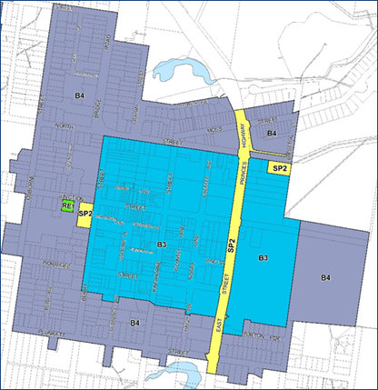
Nowra CBD Zones
The buildings heights that were
introduced through the 2017 amendment are 12 metres (M), 15 metres (Q1) and 20
metres (Q) and these are shown on the following map:
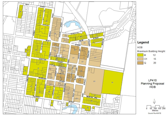
2017 LEP Amendment – Building Heights
The current heights generally
equate to the following in terms of storeys:
· 12m
= 3 storeys
· 15
m = 4 storeys
· 20
m = 5/6 storeys
The LEP height controls are supported by a detailed chapter
in the Shoalhaven Development Control Plan (DCP) 2014 – Chapter N8: Nowra
CBD Urban Design Development Controls that can be accessed via the following
link:
https://dcp2014.shoalhaven.nsw.gov.au/content/nowra-cbd-urban-design-development-controls
The DCP Chapter has been in
place since 2017 and followed a detailed engagement process. It contains a
range of detail development controls including set back, site coverage, bulk
and scale, facades, frontages and design.
Since 2017 some resulting
development has eventuated, such as the apartment complex in Graham Street,
Nowra. Interest is however now being received from landowners/developers for
possible redevelopment proposals that, in some cases, would exceed the current
planning controls, such as building height. Such proposals seek to leverage
recent changes in the property market locally and provide additional in centre
residential use. This could potentially result in Council receiving
proponent-initiated Planning Proposal (PP) requests to amend the planning controls
on a ‘site-by-site’ basis.
Broader socio-economic changes
since the commencement of Shoalhaven LEP 2014 (for example COVID-19,
significant infrastructure projects and increasing migration from Sydney to
Shoalhaven) are also now influencing development opportunities in the Nowra
CBD.
As a result, it is considered
timely to commence a holistic review of the planning controls applicable to the
Nowra CBD, including building height, with a particular focus on the commercial
core area (B3 zoned), to identify potential key locations where new controls
could be considered/pursued (e.g. Egan’s Lane and Stewart Place car parks
and adjoining land) to encourage appropriate redevelopment, including
residential uses. This will help ensure that the controls are forward
thinking.
This is preferrable to
considering one off ad-hoc PP requests that could result if nothing is done and
would identify whether further LEP changes (for example height) are needed to
support redevelopment, for example in identified areas, and to assist in the
revitalisation of Nowra CBD.
It would also provide the
necessary evidence base to ensure that any changes to building heights are
appropriate in terms of urban design / built form, visual impact, economic
viability and servicing. This work would be necessary to support any subsequent
PP to amend and increase building heights in parts of the CBD in the LEP or
revise the provisions of the DCP.
Draft Illawarra Shoalhaven
Regional Plan 2041 (ISRP)
Policies and objectives in the recently
released draft Regional Plan also provide a basis for reviewing and
reconsidering the planning controls in Nowra CBD:
· It
identifies Nowra CBD as a ‘Regional City’ and states that it should
“provide an urban lifestyle where people can easily walk to shops,
services, schools or work”.
· It
recognises a need to establish a “vision and strategic roadmap to
activate Nowra CBD”.
· Its
Objective No. 2 is to ‘Grow the region’s regional cities’.
· It
recognises the increasing demand for apartment living in Nowra CBD and the
associated benefits such as increased “vibrancy”, “activity”
and “much-needed housing choice that is often more affordable”.
· Importantly
its Strategy 2.1 aims to Activate Nowra City Centre in local strategic
planning and local plans by identifying clear planning and approval pathways
and removing planning barriers to increase residential development”.
Undertaking a review would thus
assist Council to deliver on these objectives by identifying whether the
current controls are a barrier to increased residential development and if so,
the changes that are needed in identified key/appropriate locations to help
strengthen, activate and support redevelopment in Nowra CBD.
Shoalhaven Local Strategic
Planning Statement (LSPS)
Council’s LSPS recognises
that the sustainable supply of a complex housing product in Shoalhaven should
include “Areas of compact homes like medium density, apartments and
townhouses in and around Nowra City Centre”.
It also acknowledges the current
work of Council of “amending planning and development controls to
encourage increased residential density (town houses and apartments) in and
around Nowra City Centre…”. And recognises that “with
significant changes in local economies and the way we use and want to use
cities, we need to revisit and review some strategies in collaboration with
business and our communities”.
The proposed review will help
deliver on these policy directions and commitments and will also inform future
efforts by Council to deliver upon Collaboration Activity 4.4 “Work
with landowners and businesses to identify opportunities to use vacant
properties and activate street frontages”.
Conclusion
It is considered timely to again
review and if needed be reconsidering the current planning controls in Nowra
CBD to ensure that they are appropriate and providing opportunities for the
additional residential development in key locations to assist with the ongoing
viability of the centre.
Policy Implications
The proposed review may
recommend changes to current building height controls in parts of the Nowra CBD
that would form the basis of a future PP to amend Shoalhaven LEP 2014 and
revisions/adjustments to Chapter N8 – Nowra CBD Urban Design Development
Controls of Shoalhaven Development Control Plan 2014.
Financial Implications
The proposed review would be
funded from the Strategic Planning recurrent budget.
Risk Implications
There is a risk that the current
building height controls in Nowra CBD are specifically not facilitating
development and revitalisation of the CBD, for example mixed use residential.
The proposed review would identify whether changes to controls are needed, in
possible key locations, that would help strengthen, activate and support
redevelopment in Nowra CBD. It is important that any proposed changes have
sound technical justification and community input to ensure that resulting
development outcomes are appropriate and realistic in terms of urban
design/built form, servicing and economic feasibility.
If Council resolves not to
proceed with the proposed holistic review across the Nowra CBD there is the
potential that proponents will submit PP requests on a site-by-site basis to
increase building heights. This may lead to ad-hoc development patterns and
compromise the coordinated development and revitalisation of Nowra CBD.
|

|
Development
& Environment Committee – Tuesday 11 May 2021
Page
0
|
DE21.39 Shoalhaven
Population Forecasts
HPERM Ref: D21/155520
Department: Strategic
Planning
Approver: Robert
Domm, Director - City Futures
Attachments: 1. Presentation
Slides - Forecast .iD - Shoalhaven Population Forecasts Update (under separate
cover) ⇨
Reason for Report
Advise
Council of the latest updated population projections/forecasts for Shoalhaven
following their presentation and discussion at Council’s Strategic
Planning Working Party on 15 April 2021.
|
Recommendation (Item to be determined under delegated authority)
That
Council:
1. Use the updated population forecasts
to inform service planning and delivery across Council.
2. Promote the updated population
projections/forecasts to external stakeholders as a resource for their
planning and investment decisions, including industry representatives from
the Property Council and Urban Development Institute of Australia and local
developers.
3. Consider
the impact of the updated population projections/forecasts when reviewing the
Strategic Planning Work Program, noting that the Program is due to next be
considered and confirmed by Council in June 2021.
|
Options
1. As recommended
Implications: This is the
preferred option as it will provide the best-informed foundation for service
planning and delivery by Council.
Contemporary population data provides a robust evidence
base to inform long-term land-use planning activities, advocacy efforts, and
the planning and delivery of Council’s services. Its promotion to
external stakeholders facilitates collaboration with industry partners to help
plan and deliver the City’s future.
2. Not endorse the Recommendation
Implications: This is not
favoured as it would mean that Council (and industry) service planning and
delivery would not be based on the most up to date information and would
need to be considered on a project-by-project basis.
Background
Council’s demographic consultant .id (Informed
Decisions) has recently updated the City-wide population projections/forecasts.
These are used to provide a contemporary evidence base to inform
Council’s strategic planning work, including strategic land use planning
and more broadly the foundation for service planning and delivery.
.id
support several hundred councils across Australia and New Zealand through their
demographic advice. Their methodology uses detailed data from Council on
development approvals, construction activity and planning initiatives (such as
Urban Release Area planning) which will have a critical impact on the location,
extent and timing of population growth. As such, the forecasts are considered
to provide a sound local foundation for service delivery and planning, both for
Council and other entities serving the Shoalhaven into the future.
Council has used the expertise of .id since 2011 and
this update is the fourth since that time. For the first time the forecasts
span the period out to 2051 and incorporate assumptions about the impact of the
COVID-19 pandemic on future population change in Shoalhaven.
The projections/forecasts were published by .id on 1 April
2021 and can be viewed online: https://forecast.id.com.au/shoalhaven
Attachment 1 provides a summary of the population forecasts.
Key Conclusions
The key findings of the updated forecasts are summarised
below (figures rounded) with more detail provided in Attachment 1.
· Population to increase from 107,000 in 2021 to 138,000 in
2051 (29% increase)
· Number of households to increase from 45,500 to 60,000 (32%
increase)
· Average household size to fall from 2.32 to 2.23
· Number of dwellings to rise from 55,250 to 72,050 (30%
increase)
· Occupancy rate to increase by 5% overall, noting that this is
quite variable across the City
· Approximately 500 extra dwellings needed each year, with
growth concentrated around Nowra-Bomaderry
· ‘Ageing in place’ (staying in your own home as
you get older) will increase with implications for the types of housing and
services required
· The most common household types will increasingly be
‘couples without dependents’ and ‘lone person
households’ with a third peak in the couples with dependents category.
· Net migration into Shoalhaven shows the following pattern
over time with a loss of population in the teenage years, a return in the 25-35
age group, a dip in the 35-50 age group and a strong peak in the retired age
group. This has implications for a range of planning and servicing issues,
including types of housing required and advocacy activities for service and
infrastructure delivery.
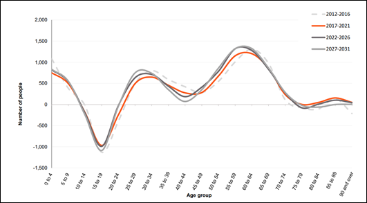
Shoalhaven – Predicated Net Migration 2012 to
2031
Conclusion
The forecasts are considered to provide the best available
information base to inform long-term land-use planning program, advocacy
activities, and the planning and
delivery of Council’s
services.
The updated
forecasts would also be beneficial for other community organisations,
infrastructure and service delivery agencies, and the development industry to
ensure that their respective activities respond to the needs of
Shoalhaven’s future population.
Community Engagement
The potential importance of contemporary
population data for a wide range of organisations operating in
Shoalhaven, suggests the updated forecasts should be publicised on
Council’s website and, where relevant, promoted to specific industry and
community groups (including local developers, the Property Council, and
Urban Development Institute of Australia) to inform their planning and
investment decisions.
Policy Implications
The
forecasts have no immediate policy implications but should be used to inform
Council’s policy development.
In the
shorter term, it would be appropriate in the next review of Council’s
Strategic Planning Work Program to take the updated forecasts into account when
setting planning work priorities.
Financial Implications
The
forecasts have no immediate implications for Council’s financial
position. However, use of the forecasts to inform planning and service
delivery will ensure resources are best directed to meeting the
communities’ needs.
Risk Implications
The forecasts present no immediate
risk to Council. However, use of the forecasts to inform planning and service
delivery will help target activity to address the most appropriate outcomes
with a consequent reduction in risk exposure.
|
|
Development
& Environment Committee – Tuesday 11 May 2021
Page
0
|
DE21.40 Report
Back - Rezoning Options - Tomerong Quarry, Lot 4 DP775296, Parnell Road,
Tomerong
HPERM Ref: D21/101234
Department: Strategic
Planning
Approver: Robert
Domm, Director - City Futures
Attachments: 1. Previous
Council Report - Tomerong Quarry Rezoning Options ⇩
The CEO has submitted a Significant Non Pecuniary
Interest declaration in relation to this item as he is a property owner and
resident of Tomerong. This report has been approved by the Director –
City Development.
Reason for Report
Council resolved In March 2020
(MIN20.163) to seek formal feedback from the NSW Department of Planning,
Infrastructure & Environment (DPIE) regarding the extractive resource in
this location, its possible rezoning to E3, and to then receive a subsequent report
in this regard.
|
Recommendation
(Item to be determined under delegated authority)
That
Council receive the report back on the rezoning options for Tomerong Quarry,
Lot 4 DP775296, Parnell Road, Tomerong for information.
|
Options
1. Pursue a rezoning of the subject land
to E3 Environmental Management under the Shoalhaven LEP 2014 as part of the
next appropriate housekeeping Planning Proposal (PP).
Implications: This alone may not prohibit
‘extractive industries’ on the subject land as State level planning
provisions would still enable the use to be considered.
2. Receive the report for information
– this would mean that nothing further is done at this point, the current
zoning in place is retained and any future proposals/applications are
considered on their merits.
Implications: This option may not be favoured as it
does not address the intent of the original resolution. However, there is no
clear or logical zoning pathway that would prohibit extractive industries on
this site. The zoning could be reconsidered in future comprehensive reviews of
the LEP should legislative provisions change or the nature or use of the quarry
changes.
Background
Following consideration of a
report on potential rezoning options in this regard (see Attachment 1)
It was resolved on 3 March 2020:
That Council
1. Seek
formal feedback (planning and mineral resources) from the NSW Department of
Planning, Infrastructure & Environment on the current significance of the
mineral resource at Lot 4 DP775296, Parnell Road, Tomerong and their views on a
possible rezoning of the subject land to E3 Environmental Management under
Shoalhaven Local Environmental Plan 2014.
2. Receive
a subsequent report in this regard once the feedback has been received to
enable a decision to be made on whether to pursue a rezoning.
The previous report provides a range of background
information in regard to this matter and this report presents the specific
outcomes of the above resolution.
Feedback Received –
DPIE
Formal feedback was sought from
DPIR (Planning and Mineral Resources teams) in April 2020, specifically:
· The
current planning significance of the mineral resource at Lot 4 DP775286,
Parnell Road, Tomerong (know previously as Bellfield’s Quarry and now as
Tomerong Quarry); and
· Depending
on comment on point 1, the Department’s views on a possible rezoning of
the subject land to E3 Environmental Management under Shoalhaven LEP2014.
Additional information was
subsequently provided to DPIE, at their request, on existing consents and the
current operation of the quarry. The following response was received from DPIE
in May 2020:
The Mining, Exploration and
Geosciences team from the newly created Department of Regional NSW have advised
that the Tomerong Quarry resource is not considered to be of state
significance. The Geosciences Team, however, ideally requires formal
notification and some evidence from the owner/operator of the quarry that the
resource is either exhausted or that it is no longer economically viable to
extract. The Geosciences Team can then remove the quarry from the mapping
that supports the s9.1 Direction 1.3 Mining, Petroleum Production and
Extractive Industries mapping.
Subject to the removal of the
quarry from the s.9.1 Direction mapping, DPIE or Department of Regional NSW are
unlikely to object to the rezoning of the site from RU2 Rural Landscape to an
alternative zone such as an E3 Environmental Management Zone. An E3 Zone
is considered suitable as it would facilitate the rehabilitation of the site.
It is, however, noted that
mining may still be permissible on land zoned E3 under clause 7 of the SEPP
(Mining, Petroleum Production and Extractive Industries) where development for
the purposes of agriculture or industry may be carried with or without
development consent. It is noted that extensive agriculture is a permissible
use in the E3 Zone under the Shoalhaven LEP 2014.
Feedback
Received – Quarry Owners and Operators
As a result of the DPIE advice,
feedback was subsequently sought also from the quarry owners and operators regarding
the question about the resource either being exhausted (or close to being) or
being no longer economically viable to extract. The following is a summary of
the responses:
Landowner - Considers
that there are still sufficient resources left to be mined (one estimate
indicated that there were at least 20 years of resource available on the
property). Considers that it is economically and financially viable to
remove the resources.
Also considers that the
quarry should remain listed as a “State significant asset” because
of future projects within Shoalhaven that will require its resources.
Bemused that the State
government would “de-list” the quarry when it is proposing
significant development within Shoalhaven where there are no other facilities
to meet these needs.
Operator – Appreciate
the opportunity to provide the operators perspective and surprised by
the NSW Government response given the number of announced road infrastructure
projects in the region and the lack of operating quarries on the NSW South Coast
that provide materials to the required specification for these projects.
The quarry has significant
quantity rock in reserve that is highly appreciated by local construction
industry. Based on experience operating the quarry in recent years, it
would appear that the Quarry could continue to operate in the order of 30 years
without having to construct a new pit.
Based on the results of
recent testing, the quarry product is improving in quality as the pit moves
west. This would be the natural direction to take an extended pit. The
testing indicates processed road construction material has the potential to
meet RMS3051 highway specification.
The quarry is the closest
rock resource for multi-billion dollar road projects commencing within next 5
years such as the Jervis Bay Road interchange, Milton/Ulladulla bypass and
Princes Highway duplication.
Believe the Quarry has a lot
to offer NSW, the South Coast and Shoalhaven in the short, medium and long term
if afforded the correct operating conditions.
Draft Regional Plan
The draft Illawarra Shoalhaven
Regional Plan 2041 was exhibited for comment during November/December 2020.
The ‘resource map’
in the draft plan shows part if the subject land as a mapped ‘mineral
resource’. The text within the draft plan notes that the region has
valuable hard rock resource land including scattered quarries in Shoalhaven.
Strategy 10.1 in the draft Plan
identifies the need to consider the ongoing operation of existing mining and
resource extraction and future development of known resources in local
strategic planning and local plans.
As such at present the resource
in this location is still identified as significant.
Discussion - Next Steps
Given the feedback received from
relevant NSW Government Agencies and also the quarry owners and operators,
Council now needs to decide whether or not to pursue a possible change in
zoning.
DPIE indicated that, whilst the
resource is no longer considered to be state significant, formal notification
and some evidence from the owner/operator of the quarry that the resource is
either exhausted or that it is no longer economically viable to extract would
be required before they would take the necessary steps to amend the relevant
policy. However, the owner and current operator have advised that they consider
that the quarry is still viable and that it can play a future role in supplying
material.
The previous report flagged that
an E3 zoning may be the only zone that could prohibit ‘extractive
industries’ on the subject land. However there is still an approval
pathway under the State Environmental Planning Policy (SEPP)(Mining, Petroleum
Production and Extractive Industries) and ‘existing us rights’ may
also play a role. The SEPP pathway was confirmed in the advice received from
DPIE.
Based on the feedback received from DPIE and also from the
owners and current operators, it may be prudent to leave the current zoning in
place and consider any future proposals/applications on their merits. The
zoning of the subject land could be reconsidered in future LEP reviews if
appropriate.
Community Engagement
No community engagement has been
undertaken in this regard. Feedback was however sought from the current
landowner and operator given advice received from the NSW Government.
Should Council resolve to pursue
a change in zoning there would be broader community engagement as part of this
process.
Policy Implications
Pursuing a zoning change to E3
may not achieve the desired outcome given the permissibility that exist under
the SEPP.
|
|
Development
& Environment Committee – Tuesday 11 May 2021
Page
0
|
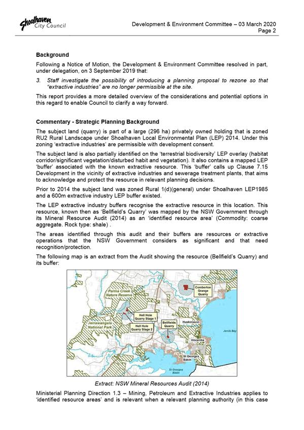
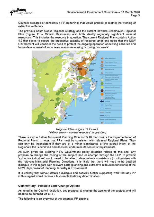
|
|
Development
& Environment Committee – Tuesday 11 May 2021
Page
0
|
DE21.41 Proposed
Submission - NSW Planning Reforms - Agritourism and Small-scale Agriculture
Development
HPERM Ref: D21/128569
Department: Strategic
Planning
Approver: Robert
Domm, Director - City Futures
Attachments: 1. Draft
Council Submission - Proposed Planning Reforms: Agritourism and small-scale
agriculture development (under separate cover) ⇨
Reason for Report
Advise of the public exhibition
by the NSW Department of Planning, Industry & Environment (DPIE) of an
Explanation of Intended Effect (EIE) for proposed amendments to the NSW
planning system relating to agritourism and small-scale agriculture development
and obtain Council endorsement to make the submission at Attachment 1.
|
Recommendation (Item to be determined under delegated authority)
That
Council:
1. Endorse the draft submission on the
proposed planning reforms related to agritourism and small-scale agriculture
development (Attachment 1) so it can be finalised and sent to the NSW
Department of Planning, Industry & Environment for consideration.
2. Request further consultation and
dialogue on the proposed reforms before they are finalised.
3. Receive future reports, if required,
to enable further comment on the detail of the proposed planning reforms.
|
Options
1. As recommended.
Implications: This is the preferred option and will
enable Council to provide a submission highlighting matters that should be
considered by DPIE in relation to the proposed planning reforms.
The proposed submission attempts to balance a range of
views and interests within Council and raises/addresses matters that could have
implications for Shoalhaven.
2. Make changes to
the draft submission (Attachment 1) and submit.
Implications: This will still enable Council to
provide a submission; however, the implications of any possible changes are
unknown and may require closer consideration and refinement.
3. Not make a
submission
Implications: This is not favoured as it will mean
Council does not provide input on the proposed planning reforms which could
have a range of implications.
Background
The NSW Government is currently
proposing amendments to the NSW planning system to streamline the approval of
agritourism development and small-scale agricultural development.
The reforms are part of the
Government’s response to the recent economic impacts of natural
disasters, such as droughts, bushfires and floods, as well as the impact of
COVID-19 on the farming community and the economy more broadly.
A copy of the proposed amendment package can be viewed at
the following link:
https://www.planningportal.nsw.gov.au/draftplans/exhibition/agriculture-changes
The Explanation of Intended
Effect (EIE) which is the key component of the exhibition package outlines
proposed amendments to:
· The
Standard Instrument (Local Environmental Plans) Order 2006 (Standard
Instrument LEP Order),
· The
State Environmental Planning Policy (Primary Production and Rural
Development) 2019 (PPRD SEPP), and
· The
State Environmental Planning Policy (Exempt and Complying Development Codes)
2008 (Codes SEPP).
The proposed changes outlined in
the package include:
· Amending
the existing definition for ‘farm stay accommodation’ in the
Standard Instrument (Local Environmental Plans) Order 2006 (Standard
Instrument) to support more farm stays.
· Introducing
two new land use terms in the Standard Instrument LEP for ‘farm gate
activities’ and ‘farm events’ to enable these types of
development to be established/considered.
· Providing
fast track exempt and complying development approval pathways for agritourism
activities where certain development standards are met.
· Allowing
the reconstruction of farm buildings and other structures as exempt development
following natural disaster, where constructed to the same size, location, and
contemporary building standards.
· Allowing
the establishment of small-scale processing plants as complying development for
meat, dairy and honey and other agricultural produce where certain development
standards are met.
· Updating
development standards for poultry farms and pig farms to align separation
distances with recommended biosecurity standards.
· Clarifying
terminology and approval pathways used for farm dams.
· Updating
controls that allow dwellings on rural lots as complying development to ensure
enough separation from adjacent primary production enterprises.
· Updating
and rationalising existing controls for stock containment lots to reflect
current practice and ensure stock containment areas used temporarily, such as
during drought, do not impact negatively on surrounding uses.
· Providing
an exempt development pathway for recreational beekeeping to improve certainty.
· Introducing new
optional clauses for farm stay accommodation and farm gate activities that
councils can choose to adopt in their local plans for development applications.
Council
reviews and related
During 2019/2020, Council
completed local planning reviews related to both ‘tourist and visitor
accommodation’ and ‘temporary events’ (using Clause 2.8 of
the existing LEP). No substantial changes resulted.
The Shoalhaven Local Strategic
Planning Statement (LSPS) that was adopted by Council in October 2020 includes
the following action:
A7.1 Review planning and
development controls for tourist and visitor accommodation and temporary uses
to balance the support of tourism activity and manage impacts on communities
and sensitive locations. Short-term (Note: this means between 2022-2024)
Destination Sydney Surrounds
South (DSSS) have also continued to advocate for a more certain planning
framework for rural and agricultural tourism/visitor opportunities.
Council has continued to receive
representations from Community Consultative Bodies (CCBs) and community members
about the need for rural and agricultural tourism/visitor uses to be restricted
or regulated. Copies of community submissions on the current NSW Government
reforms has also been provided to Council.
Council staff comments
The current proposed NSW reforms
have been reviewed by relevant sections of Council and the following comments
reflect the feedback received.
The proposed reforms seek to
introduce a number of changes that are generally supported, including:
· Provisions
for recreational beekeeping.
· Increased
setbacks for new rural dwellings where they share a boundary with an intensive
agricultural use to avoid land use conflicts.
· Clarifying
terminology and approval pathways used for farm dams.
· Implementing
planning controls to make it easier for farming communities impacted by
bushfires to recover and rebuild.
Whilst parts of the proposed
reforms will have a positive impact and clarify things, and it is good that the
planning pathway for ‘farm events’ is being considered, a number of
concerns have been identified in relation the proposed changes and potential
impact on both Council and the broader community, including:
· Consideration
of ‘destination weddings’ (proposed new land use) via a development
application in certain zones. The RU1, RU2 and E3 zones may be appropriate for
this purpose but it is requested that specific consultation occur with Councils
in regard to zone suitability - the SI LEP must remain flexible enough for each
Council to decide to opt in or out regarding permissibility (i.e. the
ultimate inclusion of the ‘destination weddings’ land use should
not be a mandated).
· There
could be a range of compliance questions that will fall to Council to consider
and resolve.
· Increases
in exempt and complying development and development without consent which will
mean that the community will have fewer opportunities to have a say.
· The
proposed development standards for exempt and complying development appear to
lack integration with the wider planning system and other legislation. This
includes a number of land-based exclusions which would normally prevent exempt
and complying development from occurring.
· Development
standards appear to fail to consider important requirements, such as food safety
standards and effluent disposal.
· It
is proposed that ‘Farm events’ can operate as exempt development
for 52 event days per year with up to 30 guests per event or 10 events per year
with up to 50 guests per event.
· Events
of this nature have the potential to have significant adverse impacts on
neighbouring properties, however landowners/residents will not be able to
consider a proposal and make comment on it. Whereas LEP Clause 2.8 currently
enables any ‘adverse’ impacts to be considered – i.e. noise,
traffic etc.
· Developments
approved under Clause 2.8 already generate significant compliance work for
Council. The ability for this form of development to proceed via an exempt
development pathway could see a further increase in these types of events and
also the associated complaints.
The proposed submission at Attachment
1 provides more detail on these concerns and other matters of interest to
Shoalhaven.
Conclusion
Tourism and its economic impacts
are important to Shoalhaven, particularly post Covid-19. As such it is
important that there are clear development pathways for existing and emerging
forms of tourism development. There is however a need to make sure that any
planning reforms in this regard consider and balance the potential adverse
community etc impacts that could result.
Given the relevance of this
matter to Shoalhaven it is important that Council makes a submission at this
point balancing tourism benefits with community impact. Additional consultation
and engagement with Council is essential to get the changes right and will be
requested as DPIE move to further consider and resolve the proposed reforms.
Community Engagement
The EIE was on public exhibition
between 9 March and 19 April 2021 to provide an opportunity for Council, the
community and industry stakeholders to provide comments and feedback.
Council has received copies of
some submissions to DPIE on this matter from the Berry Forum and some community
members in the Berry and Kangaroo Valley areas.
Due to reporting dates, a draft
staff submission based on Attachment 1 was provided to DPIE on 19 April
2021 as a ‘placeholder’. The Council endorsed submission will be
provided following this meeting.
Policy Implications
The EIE proposes amendments to
the NSW planning system, including the Standard Instrument (Local
Environmental Plans) Order 2006.
As a result, the proposed
planning reforms will have an immediate impact on existing LEPs upon finalisation.
Financial Implications
There are no immediate financial implications for Council;
however, the reforms may result in potential issues with regard to resourcing
of future compliance action.
Risk Implications
There are no immediate risks for
Council; however, there are concerns that the increasing nature of exempt and
complying development and development without consent, along with the expanding
Codes SEPP means that the community is slowly having fewer opportunities to
have a say as it reduces the community’s ability to consider development
applications on their merit. Understanding the planning system and what is
permissible where is a growing broader concern.
|

|
Development &
Environment Committee – 11 May 2021
Page
0
|
DE21.42 Exhibition
Outcomes and Finalisation - Planning Proposal - Hitchcocks Lane, Berry (PP029)
HPERM Ref: D21/135895
Department: Strategic
Planning
Approver: Robert
Domm, Director - City Futures
Attachments: 1. Summary
of Submissions (under separate cover) ⇨
2. Final
Planning Proposal (under separate cover) ⇨
3. Post
Exhibition Changes to DCP Chapter N3: Berry - West of the Princes Highway
(under separate cover) ⇨
4. Draft
Planning Agreement Terms dated 8 April 2021 (under separate cover) ⇨
5. Proponent's updated Noise
Impact Assessment (under separate cover) ⇨
Reason
for Report
· Present
the outcomes of the public exhibition of Planning Proposal (PP029) and draft
Development Control Plan (DCP) Chapter N3 Berry Residential Subdivision
(renamed Chapter N3: Berry – West of the Princes Highway).
· Address
the issues raised within submissions and propose refinements to planning
controls in response.
· Provide
updates regarding:
o the Planning Agreement
for a Landscape Screen (to mitigate visual impacts of development); and
o the review of the
Shoalhaven Contributions Plan 2019 (to provide for embellishment of the park
area between Hitchcocks Lane and Huntingdale Park Road).
· Seek
Council endorsement to adopt Planning Proposal (PP029) and the supporting draft
Development Control Plan (DCP) Chapter N3: Berry – West of the Princes
Highway, which will rezone land for residential development and provide
planning controls for subdivision and housing on land south of Hitchcocks Lane
at Berry.
· Obtain
Council endorsement to prepare and publicly exhibit a draft Planning Agreement
for the required Landscape Screen and finalise the LEP amendment (resulting
from PP029) once the Planning Agreement is signed and registered.
|
Recommendation (Item to be determined under delegated authority)
That Council:
1. Adopt Planning Proposal (PP029) as
exhibited with the minor changes outlined in this report.
2. Prepare and exhibit a draft Planning
Agreement for a Landscape Screen (to mitigate visual impacts of development)
based on the draft Planning Agreement Terms (negotiated terms of agreement
between Council and the proponents) for a minimum of 28 days.
3. Liaise with the NSW Parliamentary
Counsel’s Office (PCO) to amend the Shoalhaven Local Environmental Plan
(LEP) 2014 under Council’s delegation, with finalisation of the LEP
amendment to occur only when the Planning Agreement for the Landscape Screen
is signed and registered.
4. Adopt and finalise Chapter N3 of
Shoalhaven Development Control Plan (DCP) 2014 as exhibited, except for the
changes outlined in this Report.
5. Prepare and progress an amendment to the
Shoalhaven Contributions Plan (CP) 2019 Project 01OREC0009 (Land acquisition
for passive open space – Princes Highway, Berry) to provide
embellishments to the passive open space area between Hitchcocks Lane and
Huntingdale Park Road, in response to increased demand due to population
growth.
6. Advise key stakeholders of this decision
and when the LEP and DCP amendments are finalised.
|
Options
Notes: Council’s
recently updated Planning Agreements Policy (updated January 2021) states that:
Council will seek to have the planning agreement
executed prior to finalisation of any instrument change referred to in the
planning proposal, or before Council makes that instrument change under
delegation.
The administrative tasks
involved in amending the LEP typically take several weeks, during which time
the draft Planning Agreement could potentially be exhibited. In other
words, if the Planning Agreement progresses as hoped, it may be ready to sign
at, or close to, the notification date for the LEP amendments.
1. Adopt the PP but
not proceed to amend the LEP until a Planning Agreement for the Landscape
Screen has been signed and registered on title.
Implications: This option is preferred as it will
guarantee that the legal mechanism to deliver the Landscape Screen is in place
before the LEP is amended.
Rezoning the subject land to allow for housing development
in Berry is consistent with the Shoalhaven Growth Management Plan.
The Landscape Screen is a critical component of the future
development as it will (at maturity) help mitigate visual impacts and have a
positive effect on local amenity (for residents of the future subdivision). The
Planning Agreement is the legal mechanism to ensure the screen is established
in a timely and coordinated manner.
This approach would be consistent with advice from
Council’s lawyers, as well as the approach used for the Planning Proposal
at 510 Beach Road (PP043). This option could however potentially delay the LEP
amendment, although there would be a strong incentive for the parties to
finalise the Planning Agreement as soon as possible.
2. Adopt the PP and
undertake the administrative tasks associated with finalising the amendment,
but not finally amend the LEP unless the Planning Agreement has been placed on
public exhibition.
Implications: This option may be workable for all
parties but does not give the security of Option 1. The proponents have
indicated they are committed to establishing the screen and their preference is
to amend the LEP as soon as the draft Planning Agreement has been placed on
public exhibition.
It is acknowledged that this would be an important
milestone and the details for the Planning Agreement have been developed in
collaboration with the proponents. However, Council’s lawyers have
recommended against amending the LEP before the Planning Agreement has been
finalised as a general principle. Furthermore, the land is in two separate
ownerships and either property could potentially be sold prior to the Agreement
being signed.
3. Adopt
the PP and DCP as exhibited, or with only some of the changes recommended in
this report.
Implications: The PP is part of a package of
planning amendments and projects. The PP is accompanied by a site-specific DCP
Chapter and an intention to prepare and exhibit a draft Planning Agreement and
amendment to a Contributions Plan project for a park in the area. Proceeding
with the rezoning of the land and abandoning one or more of the related
projects could compromise the intended beneficial outcomes for the community,
which cannot be secured through amendments to the LEP only. Any late-stage amendments
to the proposal could compromise the planning outcomes and potentially require
re-exhibition. Not recommended.
4. Not proceed with
rezoning of the land.
Implications:
This would result in no rezoning of the subject land and no additional greenfield
housing supply in Berry. This option is not recommended because additional
housing is required in Berry; the proposal complies with adopted strategic
growth plans; and the proposal aims to address potential impacts via a DCP
amendment, Planning Agreement and provision of park embellishments in the area.
Not recommended.
Background
Location
Planning Proposal (PP029) seeks
to rezone 11.02 hectares of land south of Hitchcocks Lane, Berry from RU1
Primary Production to R2 Low Density Residential to facilitate new housing
development. The current endorsed Shoalhaven Growth Management Strategy
(Version 1) 2014 (GMS) identifies the subject land as an
investigation area for growth.
The subject land (part of Lots 762
and 763 DP 1224932, and part of the Hitchcocks Lane Road Reserve) is shown in Figure
1 below.
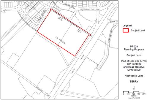
Figure: Subject Land PP029
PP
Preparation and Gateway determination
In September 2017, a request was
received on behalf of private landowners to rezone land between Hitchcocks Lane
and Schofields Lane (Lots 762, 763 and 764 DP 1224932) from rural to
residential.
Council resolved on 14 November
2017 (MIN17.953) to prepare and advance the current PP applying only to the
land identified for growth in the GMS (see Figure 1), as additional
urban expansion southwards towards Schofields Lane is not supported by
strategic growth plans.
The NSW Department of Planning,
Industry and Environment (DPIE) issued a Gateway determination for the PP on 3 April
2018 enabling the PP to proceed further. The Gateway determination included a
completion date in October 2019. However, to allow for completion of technical
studies and public exhibition, an extension of 12 months was granted, requiring
finalisation by 3 October 2020. This deadline has now passed and a request for
a further extension was declined on 2 October 2020, with DPIE advising that the
PP should be completed as soon as practicable. Correspondence from DPIE, dated
19 March 2021 reiterated the urgency to complete PPs that over 2 years old,
including PP029.
Planning
Proposal Overview
The PP proposes the following amendments to Shoalhaven LEP
2014:
· Rezone
the subject land from RU1 Primary Production to R2 Low Density Residential (See
Map 1 in Attachment 2).
· Introduce
a building height limit of 8.5 m (See Map 2 in Attachment 2).
· Amend the minimum
lot size for subdivision to enable a future mix of urban lot sizes, with the
majority proposed to have a minimum allowable lot size of 500 m2 and
along the southern boundary 700 m2 will apply, and 25% of the site
area will be able to have a minimum lot size of 350 m2. The proposed
drainage reserve will have a minimum lot size for subdivision of 1 ha, to
enable it to be retained as one land parcel (See Map 3 in Attachment 2).
Proposed Development Control
Plan (DCP) Chapter N3
The intended LEP amendments are
proposed to be supported by changes to DCP Chapter N3: Berry Residential
Subdivision which will be renamed ‘Berry – West of the Princes
Highway’ (The revised name more clearly identifies where the Chapter
applies, following the convention of other area-specific chapters).
DCP Chapter N3 will include
site-specific planning objectives and controls to guide future development
outcomes in the Hitchcocks Lane subdivision area (see Attachment 3). It
focuses on coordinated and efficient infrastructure delivery and promotion of
high quality subdivision and housing design, to reinforce key character
qualities of Berry. The majority of proposed planning objectives and controls
apply to the subdivision of land south of Hitchcocks Lane. The section applying
to building of homes in this area is kept intentionally simple, containing 10
Performance Criteria, to provide beneficial design guidance and to streamline
approvals for building of homes.
Public Exhibition
Council resolved on 1 September
2020 to exhibit the PP and draft DCP chapter to enable stakeholder and
community feedback (MIN20.619). As a result, they were placed
on public exhibition seeking community feedback for an extended period between 28
October 2020 – and 8 January 2021.
The
Gateway determination required a public exhibition period of a minimum 60 days.
In recognition of restrictions imposed by Covid-19 and the holiday period, the
public exhibition ran for over 10 weeks (a total of 73 days) to provide
additional time to view the plans and comment.
A
project website was set up on Council’s ‘Get Involved’ page
and the exhibition material was also available on Council’s website, and
included:
· PP029
Planning Proposal (October 2020) – proposed
changes to the LEP.
· Draft
Development Control Plan (DCP) Chapter N3 Berry Residential Subdivision – site-specific planning controls and design
guidance for future development.
· Explanatory
Statement – short summary of proposal
· FAQs
· Public
Notice
· 9
Technical Supporting Studies (including Traffic Impact Assessment, Bushfire
Hazard Assessment and Aboriginal Cultural Heritage Assessment)
· Gateway
determinations dated 3 April 2018 and 22 October 2019, and related
correspondence.
· Related
Council Reports and Resolutions
The
‘Get Involved’ page was visited 554 times during the public
exhibition, with 141 downloads of documents. No statistics are available for
visitors to the Council website.
Due to
Covid-19 restrictions at the time, a hard copy exhibition was not provided at
the Administration Building; however the community notification letters noted
the ability to request hard copy documents for those with limited internet
access.
322
households were sent notification letters - all landowners in Huntingdale Park
Estate and residents of Ford Street, The Gables and Host Place. Relevant
stakeholder groups were also directly advised including:
|
• Berry Forum Community Consultative Body (CCB)
|
• Nowra Local Aboriginal Land Council
|
|
• Berry Chamber of Commerce and Tourism
|
• Rotary Club of Berry
|
|
• National Trust Illawarra Shoalhaven Branch
|
• Berry & District Historical Society
|
|
• Berry & District Garden Club
|
• Berry Alliance/Sustainable Berry
|
|
• Berry Landcare
|
• Berry Bus Service
|
|
• Berry Medical Centre
|
• Berry Public School
|
|
• Berry Community Pre-school
|
• Natural Play Children’s Centre
|
|
• Jumping Jellybeans Early Childhood Centre
|
• The Learning Tree OSHC
|
|
• Berry
Police Station
|
|
Notification
of the exhibition was published on Council’s main webpage. The matter
received good media coverage, including the following mentions:
· ABC
Illawarra – Facebook Post – 27 October 2020
· Berry
Town Crier – Facebook Post – 27 October 2020
· Radio
2ST– 28 October 2020 and 11 November 2020 (stories on website)
· South
Coast Register – 12 November 2020
· Illawarra
Mercury – 13 November 2020
· Berry
Alliance Town Crier – December and February editions
· Daily
Telegraph – 9 December 2020
· Shoalhaven
City Council – Facebook Post – 3 January 2021
Council’s
‘In Your Neighbourhood’ Newsletter of 12 November 2020 covered the
exhibition. In addition, the Town Crier, Huntingdale Park Residents Action
Group and the Berry Forum CCB distributed information to their networks.
Council staff were available via phone or email to answer enquiries. An error
in the published direct line phone number of the Strategic Planner was
corrected when it was brought to Council’s attention. The ability to call
via the general Council phone number was always available. A small number of
enquiries (~10) were received over the phone or via email.
Whilst ‘face to face’
methods of community engagement were constrained by Covid-19 restrictions at
the time, the proposal was broadly advertised across the local area, and
residents were provided with an extended exhibition period during which to
obtain additional information and provide comments.
Public Exhibition Results
Forty-five
(45) submissions were received from members of the community and two groups
(the Huntingdale Park Residents Action Group and the Berry Forum) during the
public exhibition period. The majority of submissions (38) received were from
people living in Berry. The others were received from other areas or had no
address listed.
A
submission was received from the Huntingdale Park Residents Action Group
(HPRAG), signed by forty-two (42) residents of Huntingdale Park Estate
(representing twenty-seven (27) households). Twenty (20) HPRAG members also
provided individual submissions (included in the total count of 45
submissions).
The
Berry Forum - Community Consultative Body (CCB) has provided a submission. The
Nowra Local Aboriginal Land Council stated that a representative was involved
during the preparation of the Aboriginal Cultural Heritage Assessment for the
proposal and that they would not be providing a submission at this stage.
Thirty-seven (37) of the submissions objected to the
rezoning proposal; five (5) supported aspects of the proposal, but opposed
others; and three (3) did not express support nor opposition to the proposal
overall. Each submission is summarised and
addressed individually in Attachment 1 Summary of Submissions. The main
themes raised are discussed below.
Public Exhibition Feedback –
Summary of Main Themes
The main submission themes
related to:
· Infrastructure
capacity concerns (particularly road capacity and traffic impacts).
· Impacts
of development on local character.
· Concerns
about overdevelopment and poor design.
Comments
relating to these themes are summarised in the graphs below (Figures 2 to 4).
These main themes are discussed further in Table 2.
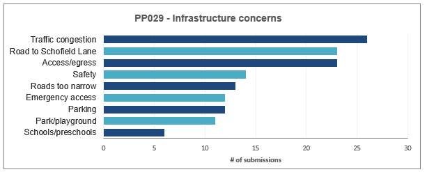
Figure 1: Summary of themes relating to infrastructure
capacity.
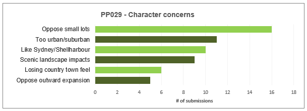
Figure 2: Summary of themes relating to character impacts.
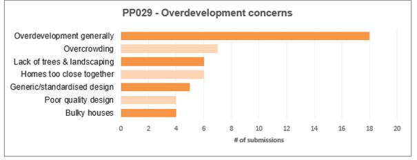
Figure 3: Summary of themes relating to overdevelopment and
design issues.
The
community group submissions are summarised in Table 1 below and considered
further in Attachment 1.
Table 1:
Summary of Community Group Submissions
|
Name of group
|
#
|
Summary
|
|
Huntingdale
Park Residents Action Group (HPRAG)
|
34
|
Lamentable
that engagement compromised.
Accept Council need to provide further housing but
traffic past existing residents should be stopped or at least greatly
reduced.
DCP generally well-meaning and supported but limited in
power. Want to limit lots to maximum of 110 with maximum of 132 dwellings.
Want connection from development back to Schofields Lane
to limit traffic impacts on existing residents. This link will reduce
traffic, noise, reduce conflicts and improve safety.
Want access denied to Hitchcocks Lane – do not want
more cars on this road. The Unnamed Link Road should be constructed to higher
flood standard.
Should have clearly identified proportion of
contributions funds directed to development of passive open space to enhance
community use. Engagement with community should determine required
embellishments.
Existing local road network already busy and traffic
impact assessment questioned. Believe traffic impacts on existing residents
from proposed development will be unreasonable. Need to protect existing
resident’s current levels of amenity as top priority.
|
|
Berry
Forum CCB
|
28
|
Prefer
proposed R2 Low Density zone over R1 General Residential zone applied
elsewhere in Huntingdale Park to prevent issues related to higher density.
DCP controls should result in high quality subdivision sensitive to character
of Berry, however, must be strictly enforced.
Still
concerned about excessive bulk and visual impacts and multiple dual occupancy
development on larger lots (700 m2).
Encourage
provision of passive open space.
Need
further traffic studies – existing hazards at Kangaroo Valley Road
roundabout. Need to resolve foot traffic issues and opportunities at this
stage.
Noise
issues to be resolved at early stage with good initial mitigation, negating
need for retrospective measures. Should embrace natural materials (earth
berms) rather than unsightly concrete walls.
|
Table 2: Community
feedback - main themes - responses
|
Submission Theme & Summary
|
Comment
|
Proposed planning control
changes
|
|
Traffic congestion impacts
Many submissions
expressed significant concerns about additional traffic volumes:
· Concerned
roads will become unreasonably congested and that traffic noise and
construction traffic impacts will unfairly impact on amenity and lifestyle.
· Roads
of particular concern include Hitchcocks Lane, Huntingdale Park Road and the
roundabout at Kangaroo Valley Road.
· Residents
concerned that new development traffic would overwhelm these roads.
· Some
residents expressed concerns about these roads being too narrow and already
busier than expected.
|
Traffic volumes will increase in line with expectations
for growth areas. The projected traffic increase is assessed to fall within
acceptable limits. Proposed site-specific planning controls within DCP
Chapter N3 seek to reduce potential amenity impacts to residents and
encourage increased walking and cycling for local trips.
A Traffic Impact Assessment (TIA) (Bitzios, May 2019)
accompanies the PP and describes expected future traffic and its impact on
the surrounding road network capacity. Council’s Traffic Section have
reviewed the TIA and provided input into the access and transport
requirements of DCP Chapter N3.
Total eventual traffic is expected to consist of
approximately one-third traffic from proposed development (south of
Hitchcocks Lane) and two-thirds of traffic from Huntingdale Park Estate.
TIA illustrates that Huntingdale Park Road and Kangaroo
Valley Road intersection will operate within capacity during peak times.
Huntingdale Park Road (east of Brangus Close) is a Local Distributor Road
with design capacity for 6000 vehicles per day (vpd). Post development
traffic volumes in 2030 expected at 3700 - 4100 vpd (for 110-150 lots), and
300 - 350 vehicles in peak - within acceptable capacity limits.
Intersections in this area expected to provide
performance levels of A and B (intersection levels of service (LOS) are rated
from A – F). This means turning delays/wait times, queuing and
congestion saturation measures all fall within acceptable levels. TIA models
expected average in peak times: delays of between 8 – 11 seconds
for turning (including U-turns), average of two cars queuing and saturation
measure of 0.3 (with congestion saturation occurring at >0.85).
Future traffic analysis as part of subsequent development
applications will require specific consideration of impacts from development
on Connors View, Brangus Close and Huntingdale Park Road intersection. The required upgrade of the Unnamed Link Road will take
traffic pressure off Huntingdale Park Road (west of the Lincoln Close -
Unnamed Link Road intersection) and Hitchcocks Lane.
The DCP has been updated post-exhibition to describe the
trigger points for the upgrade of the Unnamed Link Road to prompt timely
provision of this upgrade and minimise potential traffic impacts to residents
in this area.
Sufficient information exists to support the rezoning of
the land showing that potential traffic impacts can be managed within
acceptable thresholds. However more
detail on roads and upgrades will be required and assessed at subdivision
stage. Additional community comment opportunities will also occur at this
stage.
|
The DCP Chapter N3 has been updated in response to
submissions concerned about traffic congestion. The DCP Chapter provides a
framework to guide efficient, safe and attractive road and lot design.
The Chapter has been updated in the following manner:
· The Indicative Layout Plan (ILP) updated to reflect the
planning objectives and controls within the DCP Chapter and to highlight that
proposed road connections are conceptual. Actual road layouts will be
designed and assessed at subdivision stage of development.
· The Unnamed Link Road highlighted as a major new road
connection required to be built (along with the Entry Road), recognising its
importance in carrying traffic from the completed development (see revised
Indicative Layout Plan).
· Clarified triggers for the complete construction of the
Unnamed Link Road and Entry Road, should the development be staged to ensure
timely and coordinated delivery of roads (see Section 6.5).
· Updated controls relating to encouraging walking and
cycling, including introducing new ‘Walking and Cycling links’
map showing required path network (see Figure 14 in DCP Chapter N3). This
includes provision of shared path along the Unnamed Link Road to provide a
direct link to Berry Town Centre and a new requirement to plant shade trees
along pathways for comfort.
|
|
Submission
Theme & Summary
|
Comment
|
Proposed planning control changes
|
|
Schofields Lane road link
Many submissions requested Council require an additional
road to be built to connect the new development area to Schofields Lane to
the south (illustrated in Figure 5 below).
This request resulted from concerns about increased
traffic volumes in Huntingdale Park Estate and stated the suggested road link
would alleviate traffic congestion for existing residents.
Construction of a road link to Schofields Lane is not
currently proposed (nor recommended) within the PP or DCP.
|
Requiring an additional road linking the new development
area to Schofields Lane is not supported at this stage.
The Traffic Impact Assessment (Bitzios, Jan 2019)
indicates the road network to the north (comprising Huntingdale Park Road,
the to-be-upgraded Unnamed Link Road and Hitchcocks Lane) are able to
accommodate the proposed development safely and efficiently.
As detailed below, the costs and potential adverse
impacts of a Schofields Lane road link outweigh the (possible) benefits to a
small number of residents affected by an increase in traffic volumes. The
area covered by the PP has been earmarked for residential development in
Council’s GMS. The additional traffic is not expected to result in
unacceptable impacts to existing residents and forms an inevitable part of
planned growth. Planning controls within the site-specific DCP Chapter N3
seek to minimise traffic and amenity impacts resulting from development where
possible.
Transport for NSW has reviewed the request relating to
the Schofields Lane link and indicated at this stage they would be unlikely
to support this proposed road link (refer to submission # 47 in Attachment
1).
It is noted that ‘roads’ are permissible with
consent in most zones in the LEP. As such should circumstances change as part
of the detailed subdivision design stage of development, the current planning
controls do not prevent further consideration of a road link to Schofields
Lane as part of any future development.
Any such proposed road link would need to be supported by
traffic impact assessment and rigorous planning justification which would be
assessed at the subdivision application stage of development. At this
rezoning stage, sufficient information has been provided to show that traffic
impacts can be managed appropriately without the need to mandate construction
of a link road to Schofields Lane.
Benefits/Advantages of link to Schofields Lane
· Could reduce traffic volumes on existing local road links
and reduce amenity impacts for some residents associated with increased
traffic.
· Provides additional south-bound connection to Princes
Highway (benefit would depend on whether safe entry onto Highway could be
assured).
· Additional access for construction vehicles and reduction
in construction vehicle traffic impacts to existing residents (depending on
timing of road construction).
· Additional possible access route for emergency
evacuation.
· Additional access point to Church and future (proposed)
equestrian centre.
Costs/Risks/Disadvantages of link to Schofields Lane
· Presence of new road link could be used as justification
for future rezoning proposals and result in development pressure to subdivide
the surrounding rural land area. Additional rezoning (urban expansion) of
Berry to the south is not supported by strategic growth plans.
· Road would have visual impacts and further compromise the
scenic rural landscape on southern approach into Berry. Any future
development along road link would have visual impacts.
· Would need to traverse watercourse and flood-prone area,
raising costs & potentially increasing visual impacts (e.g., bridges and
flood mitigation structures).
· Would result in fragmentation of rural land, reducing
suitability of land to potentially be used for agriculture.
· Unlikely to be cost-effective or efficient way to provide
infrastructure as existing road network (with proposed Unnamed Link Road
upgrade) can accommodate projected growth. Expense of providing road link
could impact Hitchcocks Lane development viability (without additional
development of surrounding rural land). Would result in increased ongoing
road maintenance costs.
· Could have safety and congestion implications at
Schofields Lane intersection with Princes Highway (which has been designed
only for relatively low volumes of traffic associated with rural uses).
· TfNSW indicate unlikely to support at this stage due to
possible impacts on state road network and increased possibility of use of
Highway for local trips.
· Increased traffic impacts on residents of rural land
along Schofields Lane.
· Not necessarily of benefit as an emergency evacuation
route, would depend on design and specification as land is flood-prone and
land to south and west is direction of most likely bushfire hazard.
· May not be a preferred link as other roads will provide
quicker, safer, and more convenient access to key destinations. For example,
will not provide improved access and support to Berry Town Centre.
· May not support/encourage active forms of transport such
as walking and cycling.
|
It is not proposed to change the DCP Chapter as exhibited
to require or reference any road link to Schofields Lane.
Any requirement to mandate the road link in a DCP (prior
to detailed design of future subdivision and accompanying traffic impact
assessment) in light of the above information could be considered
unreasonable and difficult to require or negotiate.
All road links provide benefits and involve trade-offs
and the cost-benefit analysis of the Schofields Lane link could change over
time. However, at this stage, considering available information, mandating
provision of a link to Schofields Lane is not considered necessary nor
desirable.
The existing planning controls do not preclude further
consideration as part of future development applications, if warranted, of a
connection to Schofields Lane.
|
|
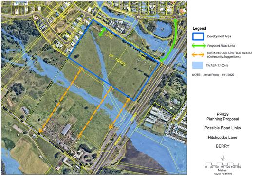
Figure 4:
Possible future road links to Schofields Lane as requested in community
submissions
|
|
Submission Theme & Summary
|
Comment
|
Related planning control changes
|
|
Access into and out of the Estate and emergency access
Concerns about having one way in and out of Huntingdale
Park Estate (via Huntingdale Park Road and Kangaroo Valley Road) were
relatively common, with access and evacuation during emergencies
(fire/flood/accident) a concern for residents.
The capacity of Huntingdale Park Road to cater for
additional traffic was questioned, with submissions stating it has not been
designed to accommodate growth and could become clogged in an emergency.
|
Some residents are concerned about emergency access given
recent bushfire, flood, and health emergencies. Whilst the subject land is
well-located in terms of access to services and built up areas (it is not an
isolated location and is within walking distance to Berry Town Centre), it is
still prudent to consider planning for emergencies.
All homes within the proposed development will be located
above the flood planning level and existing planning controls require at
least one road link into and out of the subdivision to be raised above the 1%
AEP flood extent (a rare but severe flood with a 1% chance of occurring in
any one year, sometimes also expressed as a 1:100 flood event). Hitchcocks
Lane and Huntingdale Park Road are constructed above the 1% AEP flood extent.
This route will be available for emergency services access. The DCP requires
all areas of the proposed subdivision to be accessible during a 1% AEP flood;
for example, by requiring the road crossing the drainage reserve to be
constructed above the 1% AEP flood level.
It is important to note that the Broughton Creek
Floodplain Management Study (2012) states that given the type and short
duration of the flooding experienced in most of the catchment and roads
surrounding Berry township, evacuation is generally not recommended (refer to
Section 8 of that Study for more information).
Bushfire hazard is greatest from the west and south, with
the development land located in the south-eastern part of Huntingdale Park
with good connections to Berry Town Centre and the Highway. The DCP requires
a perimeter road to be constructed along the southern boundary of the
development land. Perimeter roads separate development from bushfire hazards
and provide space to conduct active firefighting operations.
Specific emergency access arrangements will be detailed
within future subdivision application stages.
|
The exhibited planning requirements are not proposed to
be altered; however, parts of Section 6.5.2 of the DCP relating to road
construction standards have been rewritten to more clearly explain road
construction requirements to minimise flooding and bushfire risks.
|
|
Submission Theme & Summary
|
Comment
|
Related planning control changes
|
|
Parking, road safety and design
Traffic and pedestrian safety, parking and narrow roads were also of
concern, with suggestions that existing issues would be exacerbated. These
issues included speeding vehicles, unsafe conditions for children, difficulty
in passing garbage trucks, construction vehicles and caravans on narrow
roads, on-street parking difficulties in the Estate and in Berry Town Centre.
|
The DCP Chapter N3 emphasises designing slow speed
residential environments to maximise safety for pedestrians, cyclists, and
drivers. Road geometry, including road widths and on-street parking, plays an
important role in slowing vehicle traffic. Road layouts and traffic calming
measures will be detailed and assessed at the subdivision stage of
development.
Some of the concerns raised relate to
management/compliance measures (e.g. enforcing speed limits;
construction-stage impacts; pothole repair; scheduling of waste service
collection; use of dedicated parking facilities for large/long vehicles etc).
Also, the site-specific DCP Chapter N3 seeks to support
sustainable design; encourage walking and cycling as far as practicable for
recreation and for local trips; and balance provision of parking and vehicle
circulation space with landscaped areas and wide verges. The DCP includes provisions for the Estate’s roads
to be designed for slow traffic, to create a pleasant, safe and quiet
residential environment, safe for people to walk, cycle and cross safely.
Chapter G21 Car Parking and Traffic of Shoalhaven DCP 2014 contains
off-street parking requirements for residential development.
|
· Simplified presentation of the road cross sections and
road design specifications in Section 6.5 of the DCP Chapter N3.
· No further changes proposed.
|
|
Submission Theme & Summary
|
Comment
|
Related planning control changes
|
|
Need for local park and playground
Other infrastructure capacity concerns raised included
the lack of recreational facilities within walking distance, including the
need for a playground and useable open space.
A general dissatisfaction with existing open space was
expressed (i.e. the unembellished/unimproved open space under the electricity
easement), with the facilities within and planned for Berry Town Centre
(including Boongaree) being viewed as appreciated but not accessible to meet
the day to day needs of the growing population west of the Princes Highway.
|
A local park is proposed to be provided between
Huntingdale Park Road, Hitchcocks Lane and the Unnamed Link Road, and
embellishments will be funded via collected contributions funding. The
planning and delivery of this park project will progress following the
completion of the PP and will involve additional community consultation.
|
· No changes to PP or DCP as exhibited are proposed.
|
|
School/preschool
capacity
Some concerns raised that local schools and preschools cannot cater for
the proposed increase in population.
|
Berry has one public primary school and the nearest
public high school is Bomaderry, approximately 15 km to the south.
Information on these and nearby schools can be found on the NSW
Government’s My Schools website (data from 2015 onwards) - Berry Public
School had 314 enrolments in 2020, down from a peak of 339 in 2017.
School capacity is a common concern in many growth areas
across NSW. School funding and school infrastructure investment is a State
Government responsibility. The NSW Department of Education and Training
(Schools Infrastructure NSW) were notified of the PP and no response was
received. Growth planning including for state government infrastructure such
as schools occurs between the NSW government and local government in a number
of ways including through the Regional Planning process. The proposed
development has been included in the Shoalhaven Growth Management Strategy
2014 and future growth planning for Berry and Shoalhaven will consider wider
demographic trends, population forecasts and infrastructure needs.
There are several pre-schools and child-care facilities
in Berry and surrounds and planning controls allow for new and expanded
facilities to respond to growing demand for these services.
|
· No changes to PP or DCP as exhibited are proposed.
|
|
Submission Theme & Summary
|
Comment
|
Related planning control changes
|
|
Opposition to small lots
A common concern expressed in submissions was the small lot areas
proposed as part of the development. 25% of the site area is proposed to be
able to have a minimum lot size of 350 m2 (spread out over three
areas – refer to Figure 3 Lot Size Map). The remaining land will
have a minimum lot size of between 700 m2 and 500 m2.
Reasons for opposition to the small lot areas included:
· Out of character with Berry and Huntingdale Park Estate.
· Too urban or suburban in appearance.
· Privacy and noise impacts.
· Traffic and parking impacts.
· Homes will be too close together with the area becoming
overcrowded.
· Small lot housing will be unattractive and will not be
compatible with the Estate’s look and feel.
· Prefer land to be developed as large, semi-rural lots.
|
Providing a diverse range of housing and improving choice
and access to housing is a crucial goal for the area, especially given
changing demographics, very high housing prices, limited rental availability
and high demand. To illustrate some of the magnitude of change in the Berry
housing market, the median house price in Berry suburb based on 35 house
sales in 2010 was $435,000 with a median rental price of $330/week (p.100,
State of the State NSW Property Report, St George Bank, RPdata 2010). In
2020, the median house price had risen to $1.15 million (based on 63 house
sales) and median rental of $650/week (2021, REA Group Ltd):
https://www.realestate.com.au/neighbourhoods/berry-2535-nsw).
The subject land is proposed to have an R2 zone,
precluding housing types such as townhouses, terraces (multi-dwelling
housing) and apartments. These housing types will not be able to be approved
as complying development under the state-wide Low-Rise Housing Diversity
Code.
However, managed small lots will provide opportunities
for smaller detached or semi-detached homes, providing more housing choices
for a wider range of households and household types. Smaller homes (2 bedroom
and smaller 3 bedroom homes) are a recognised gap in the local housing market
and are not likely to be built on larger lots. Recently updated population
forecasts indicate that the largest forecast increase in household types in
Berry and surrounds to 2031 will be in single person households (2021, .id
community: https://forecast.id.com.au/shoalhaven). The report to Council on PP029 dated 1 September 2020,
provides additional housing supply and demographic statistics illustrating the
need for a variety of homes to be delivered in the region, including
addressing a gap in providing smaller, entry-level homes.
It is important to recognise that lot size controls
represent the minimum allowable, and lots may still be developed above the
minimum required, based on design constraints/DCP controls or because of
developer choices (much of Huntingdale Park Estate was developed above the
minimum lot size). In any case, small lots will represent a minority of lot
types in the housing estate, and the majority of lots will be sized at 500 m2
or larger.
It is estimated that the proposal can accommodate between
110 - 150 new housing lots plus roads and a drainage reserve in an area of 11
hectares south of Huntingdale Park (and within approx. 2 km from Berry Town
Centre). Accommodating that same number of semi-rural blocks (at 4,000 m2
each) would require > 45 – 60 hectares of land (plus space for
roads, flood-affected areas) to be rezoned for housing on the outskirts of
Berry, which would have additional character and infrastructure
implications.
|
· A requirement to limit small lot development to 25% of
the total site area (former section 6.4 of the draft DCP Chapter N3) has been
deleted, as this restriction is enforced via the minimum lot size mapping in
the LEP, rendering this DCP control redundant.
· No other changes to the PP or DCP are proposed in
relation to small lot housing development, although several notes have been
added to clarify the intent of existing proposed design controls to deliver
improved housing choice and address gaps in supply.
DCP planning controls require floor sizes to be proportional to lot
size and for landscaped area to represent a fixed 35% of lot area regardless
of lot size. These planning controls combined with setback requirements and
other design guidance seek to minimise any potential amenity impacts
associated with the development of housing on small lots.
|
|
Submission Theme & Summary
|
Comment
|
Related planning control changes
|
|
Growth and local character impacts
Most character-related concerns related to three main
issues:
· Oppose suburban development extending outwards into rural
areas as is occurring elsewhere, which undermines uniqueness and character.
· This type of development is causing Berry to change from
a small country town/semi-rural area to an area that is too busy and
urbanised.
· Concerns about the scenic view impacts on approach into
Berry.
|
Change is occurring in Berry, as it is a highly desirable
lifestyle destination for tourists and is attracting new residents. Change is
being managed in accordance with strategic planning policies such as the
Shoalhaven Growth Management Plan (GMS) 2014. As identified within the GMS,
the PP area will define the edge of planned residential expansion in the
south-west of Berry. Residential subdivision will be contained to an area in
line with properties on the southern edge of Huntingdale Park Estate (21 - 41
Parker Crescent) with land further south to remain rural in land use and
appearance.
The proposal seeks to limit outward expansion of Berry
while providing homes within the growth boundary defined by the GMS.
Site-specific controls are proposed to guide building of homes that are
compatible in bulk, scale and open space with neighbouring development.
The development boundary will be reinforced by a proposed
landscape screen to minimise visual impacts of development. Significant work
has occurred in the last year to negotiate a Planning Agreement to provide
this landscape screen. A draft Planning Agreement is expected to be ready
shortly, to be placed on public exhibition and then finalised.
|
· No changes to proposed PP or DCP controls – however
it is recommended that the Planning Agreement to establish a Landscape Screen
be signed/registered, or at least publicly exhibited, prior to amending the
LEP.
|
|
Overdevelopment and design concerns
Overdevelopment concerns are discussed and addressed
above and in detail within Attachment 1: Summary of submissions
|
The site-specific DCP Chapter N3 seeks to promote high
quality subdivision and dwelling design to manage overdevelopment concerns.
The DCP Chapter focuses on objectives and controls
applying to the subdivision stage of development, recognising that site-sensitive
subdivision design will provide greater opportunity for cost-effective
housing design and streamlined assessment of housing applications. A
well-considered subdivision layout that priorities positive urban design
measures will provide increased opportunities for building in a way that
respects, and adds to, local character.
Subdivision controls focus on reinterpreting the key
character qualities of Berry within a modern housing estate setting, for
example by providing walkable, connected streets, generous tree planting (on
public streets, wide verges and on private land) and room for gardens and
neighbourhood social interactions.
The DCP Chapter N3 is mostly focused on providing
adequate landscaped area and sensitively proportioned building envelopes. The
DCP allows for flexibility to design homes according to beneficial design
principles, but allows for homes that vary in size, style and appearance.
|
· No changes are proposed to the PP or DCP.
· The DCP Chapter contains many controls which seek to shape
positive development outcomes and promote best practice neighbourhood design.
|
|

|
Development
& Environment Committee – Tuesday 11 May 2021
Page
0
|
State Government
Agency Feedback
The Gateway determination required consultation with the
following State Government Agencies:
· Roads and Maritime Services (now Transport for NSW)
· Shoalhaven Water
· Endeavour Energy
· NSW Department of Primary Industries Agriculture
· NSW Department of Primary Industries Fisheries
These
additional State Government Agencies were also notified of the proposal:
· NSW Rural Fire Service
· Heritage NSW
· Illawarra-Shoalhaven Local Health District
· NSW Department of Education - Schools Infrastructure NSW
No submissions were received from
NSW Department of Primary Industries – Fisheries; Heritage NSW,
Illawarra-Shoalhaven Local Health District nor Schools Infrastructure NSW.
The submissions received on behalf
of State Government Agencies are addressed in Attachment 1 and briefly
summarised below.
Table 3: Agency submission summary
|
Agency
|
Summary of submission
|
|
Transport for NSW (1st submission)
|
No objection to proposed
rezoning of land in principle as unlikely to impact on state road network.
Intention to dedicate
Unnamed Link Road to Council as public road – understand this could be
upgraded to service development. Any required improvements must not impact on
Princes Highway.
Concerned about noise
impacts, higher order treatment such as noise barrier may be required.
Support noise mitigation being investigated and installed where necessary at
subdivision stage as opposed to reliance on individual house design and
construction requirements. Concerns with proponent’s Noise Assessment.
Noise Barrier Assessment is required in accordance with EPA’s NSW Road
Noise Policy. Any future noise barriers must be located on private land and
TfNSW will not accept any maintenance responsibility. Concerned that DCP
infers that landscaping can be used as noise attenuation, when landscaping is
not an effective noise attenuation measure.
Strongly supports
development that provides for walking, cycling and public transport and
reduces car dependency, proposal should ensure support for these measures to
the greatest extent possible.
Notes Traffic Impact
Assessment considers impact of 110 new lots, whilst PP states capacity for up
to 150 new lots. No additional vehicular or pedestrian access to/from Princes
Highway will be permitted.
|
|
Transport for NSW (2nd submission: responding to Council’s
request for additional comments relating to provision of access to PP land
via Schofields Lane – in response to community submissions)
|
TfNSW
has no current plans or funding to investigate, develop, and deliver road
infrastructure upgrades along the Princes Highway at its existing connections
with Schofields Lane.
Concerned additional link
would increase trips into Berry using Highway rather than local roads.
Current policy is to limit access points to the state road network (Princes
Highway) for local trips.
Based on limited information
currently available, have some concerns and unlikely to be supportive of
additional access to the PP site via Schofields Lane.
Unsure whether a road link
from PP site to Schofields Lane would allow for additional future development
south of PP subject land, if this were to occur, this would further increase
vehicle movements via Schofields Lane/Princes Highway for local trips.
Noting comments above (i.e.
generally unlikely to be supportive of proposed link to Schofields Lane),
further information would be required to allow for an informed decision
including an updated Traffic Impact Study (TIS) that considers the increased
traffic volumes from both the PP and possible future land rezoning to the
south; mitigation measures required to address safety/traffic concerns (e.g.
acceleration lanes); mechanisms for funding any identified works and
upgrades; and impacts of local trips on the state road network.
Noise issues raised in the
TfNSW submissions are discussed further below.
|
|
Shoalhaven Water
|
Water supply capacity will
exist for the PP. The Berry water supply system with the proposed lead in
water infrastructure (a DN 200 Main to maintain/improve water pressure to the
upper reaches of Huntingdale Park Estate) will be able to support the
existing development and proposed development.
Sewer system in the area can
accommodate the proposal as there are a number of options available to extend
sewer services to the development (which can be detailed further at
subdivision stage). Will be at the developers cost.
|
|
Endeavour Energy
|
No objection. PP is
supported by Infrastructure Assessment with input from certified consultant.
All existing electricity assets protected by law, and any works need approval
from Endeavour Energy. Existing distribution substations in the vicinity have
some spare capacity, but not enough to cater for development –
therefore network required to be augmented/extended, with extent of works to
be assessed at subdivision application stage (after final load assessment
completed).
|
|
DPI Agriculture
|
Part of site mapped as
Biophysical Strategic Agricultural Land, but acknowledge land is identified
as an urban investigation area in state-endorsed Strategy. Regrettably,
Gateway determination did not require preparation of land capability
assessment to determine agricultural value of land and address land use
conflict issues.
Support perimeter road and
provision of landscape screen as these also provide buffer to rural land to
the south which can limit land use conflict impacts.
|
|
NSW Rural Fire Service
|
Land not currently mapped as
bush fire prone land, however intention to map land near southern boundary as
a Category 3 Grassland hazard in future. No objections to proposal subject to
compliance with Planning for Bushfire Protection 2019 (provision of Asset
Protection Zones, perimeter roads and provision of adequate water,
electricity and gas services).
|
Planning
Proposal - Post Exhibition Changes
Two
minor changes are proposed to the exhibited PP, as described below.
- The
minimum lot size applying to the drainage reserve has been changed from 40 ha
to 1 ha (see Figure 7). This is necessary to allow subdivision of the
drainage reserve as one land parcel, allowing for coordinated management and
future land dedication consistent with its intended purpose to convey
stormwater and floodwaters.
- The
drainage reserve boundaries have been changed slightly to better align with the
Flood Planning Area (FPA). This change is illustrated in Figure 8 below. This ensures that all the FPA will sit within the
drainage reserve and confirms that no development will be allowed below the
FPA.
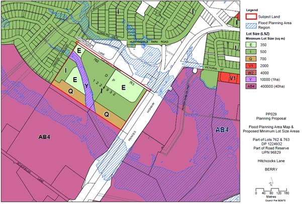
Figure 5: Flood Planning Area superimposed over amended Minimum
Lot Size Map.
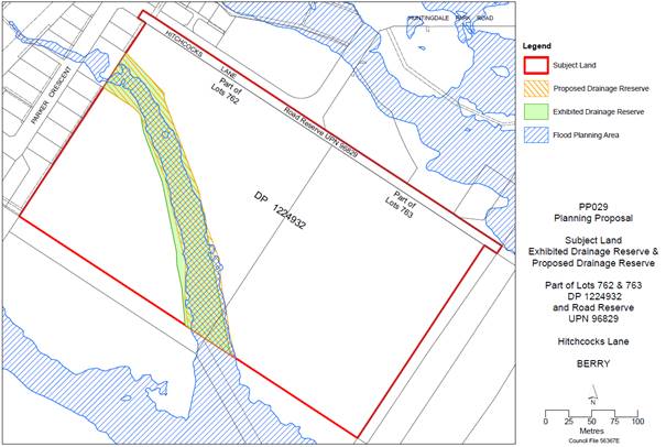
Figure 8: Flood Planning Area superimposed over exhibited
and proposed drainage reserve boundaries.
DCP - Post Exhibition Changes
A number of post-exhibition refinements are proposed to the
DCP Chapter in response to community feedback summarised earlier. Changes
proposed to the exhibited version of the DCP are highlighted in Attachment 3.
The DCP sets parameters and expectations for development.
However, not all suggestions put forward in community submissions have been
incorporated into the DCP. This is because according to NSW planning legislation,
the DCP must enable development permitted by the LEP and include
reasonable planning requirements that do not contradict the LEP or State
Environmental Planning Policies (SEPPs).
The Shoalhaven LEP 2014 (and some SEPPs) detail what
development is allowed and provide key planning controls relating to
permissible development, allowable density, height limits etc. The DCP supports
these statutory planning instruments by detailing how development should be
carried out. Therefore, the DCP provides a framework to shape a variety of
subdivision layout and housing design options. Any future development
applications will involve additional community consultation and assessment
against the provisions of the LEP and DCP.
DCP
changes - response to TfNSW concerns and updated Noise Impact Assessment
In response to concerns and TfNSW’s comments
regarding potential adverse noise impacts, the proponents completed an
additional Noise Impact Assessment (Harwood Acoustics, dated 24 February 2021)
to illustrate that the PP can comply with the EPA’s Road Noise Policy.
The proponent’s update Noise Impact Assessment is provided as Attachment
5.
The EPA’s Road Noise Policy provides noise
criteria for external (outdoors) noise levels during the day and at night,
measured 1 m from the dwelling facade. Consideration of external noise levels
ensures that residents can open windows for ventilation without increased
exposure to adverse noise levels and can assist in increasing outdoor comfort.
The DCP Chapter has been updated to reflect TfNSW’s
comments and the findings of the updated Noise Impact Assessment (NIA). The
updated assessment illustrates the proposal can comply with the EPA Road
Noise Policy. According to the updated NIA, a noise barrier extending along
the eastern boundary of the PP land will likely be required including a return
along the south-eastern corner, extending approximately 88 m to the west. This
could take the form of a noise wall or earth mound or a combination of the two.
The DCP requires that any such barrier/mound have a natural appearance.
Additional noise assessment will be required for
subdivision of Lot 763 (the eastern-most property), that considers the finished
ground levels and expected floor levels of development. The installation of
noise barriers will be required at the subdivision stage of development, with
the type and final extent of the barriers to be investigated further as part of
the development application. Addressing noise impacts at the subdivision stage
is best practice and is essential as it avoids the need to expensively retrofit
any required noise mitigation measures in the future or rely on expensive
construction methods or house design constraints and compromises.
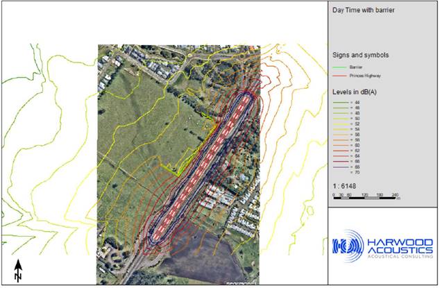
Figure 6: Extract from updated Noise Impact Assessment
(February 2021) showing modelled impact of noise barrier along eastern boundary
and south-east corner (5 m high). Note the height and extent of noise barriers
will be subject to further detailed design at subdivision stage.
Supporting Documents - Progression
Council resolved on 7 April
2020, (MIN20.257) to progress the following related projects related to the
proposed LEP and DCP changes:
· secure
the proponent’s commitment to provide a landscape screen adjacent to the
southern boundary of the land to obscure views of development (i.e. a Planning
Agreement); and
· commence a review
of the Shoalhaven Contributions Plan 2019 project 01OREC0009 to recognise the
demand additional housing places on the passive open space network in the area.
These projects will improve the
ultimate development outcomes and assist in addressing community concerns about
the rezoning. Updates on the Planning Agreement and
Contributions Plan amendment are provided below.
Planning Agreement - Landscape Screen
The planting of a dense
Landscape Screen adjacent to the southern boundary of the development land will
help mitigate visual impacts of the proposed development (refer to Figure 2 and
Attachment 4). The landscape screen will also reinforce the intended urban
edge of Berry (as identified in the GMS – see Figure 1). The
Landscape Screen was the key recommendation from the Visual Impact Assessment
(PAA Design, May 2019).
It is intended that the
Landscape Screen will be established before any housing is constructed on the
land and will be established before the release of the Subdivision Certificate
(SC) for the first stage of the subdivision of the land.
A Planning Agreement is the
legal mechanism to deliver the Landscape Screen and provide for future
maintenance. The landowners/developers will be responsible for its
establishment, and short-term maintenance (for 3 years following release of the
first SC), with Council taking on the long-term maintenance of the asset. The
Landscape Screen will be designed to be low maintenance in the long-term. The
Planning Agreement will include a lump sum payment to Council from the
development to fund future ongoing maintenance.
At the time of writing this
report, Council staff and the proponents had agreed to the general terms of the
Planning Agreement and Lindsay Taylor Lawyers had been engaged by Council to
prepare the draft Agreement that is expected to be received prior to the May Development
and Environment Committee meeting and if so, will be made available to
Councillors.
The remaining issue to be
resolved in relation to the landscape screening is the future ownership of the
land that the screen sits on. The proponents have indicated a preference for
the screen to remain in private ownership with long-term maintenance to be
carried out by Council under an easement and public positive covenant
arrangement. This option has benefits for Council as the landscape screen can
be incorporated into the neighbouring rural land parcel and be managed as a
vegetated buffer between residential and rural land uses without Council
holding the land. The other option for consideration is the possible dedication
of this land to Council to own and manage. This issue will need to be resolved
before a Planning Agreement is signed and a further report to Council will be
prepared post-exhibition of the draft Planning Agreement.
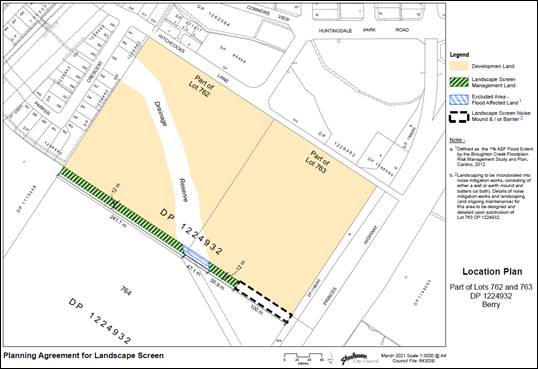
Figure 9: Draft Planning Agreement for Landscape Screen
- Location Map
Contributions
Plan Amendment – Park Improvements
An area between Huntingdale
Park Road and Hitchcocks Lane has been set aside as passive open space.
Embellishment of this area is proposed to be funded through an amendment to the
existing project 01OREC0009 in the Shoalhaven Contributions Plan 2019, which
will be advanced once the PP is finalised.
It is recognised that
development of the Huntingdale Park Estate and land south of Hitchcocks Lane
creates additional demand for park and playground facilities in the area.
An area (approx. 3 ha) between
Huntingdale Park Road and Hitchcocks Lane is zoned RE1 Public Recreation and is
set aside as passive open space (see Figure 3 below). Embellishment of
this area (with play equipment, paths, seating etc) is proposed to be funded
through an amendment to the existing project 01OREC0009 in the Shoalhaven
Contributions Plan (CP) 2019.
This will provide the area with
a Local Recreation Park as classified within the Shoalhaven Community
Infrastructure Strategic Plan (CISP) (Ross Planning 2018). Embellishment of the
park will ensure that the Hitchcocks Lane subdivision area will be within
400 m of a user-friendly public open space, enhancing the liveability and
residential amenity of the area.
The next stage in planning for
park improvements is the drafting and costing of a Concept Plan (informed by
community feedback). The Concept Plan and proposed CP amendment will then be
reported to Council for public exhibition. After refinement in response to
additional community feedback and making of the amendment, the project can
progress to detailed design and delivery of the improvements.
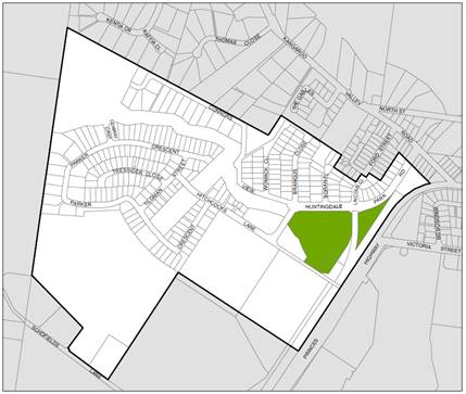
Figure 10: Location Map - Passive Open Space Area -
Contributions Plan Project
Conclusion
The PP complies with all relevant planning policies and
aligns with the Shoalhaven Growth Management Strategy.
All requirements of the Gateway determination have been
satisfied and a significant amount of work completed to positively shape future
development outcomes, including preparation and refinement of a site-specific
DCP Chapter; Planning Agreement negotiations for a landscape screen; and the
initial research, planning and design investigations for a local park
embellishment project.
It is recommended that the PP be finalised and the LEP
amended accordingly. Future development in the area will be guided by the
provisions of DCP Chapter N3 that has been refined in accordance with feedback
received during the public exhibition period and is recommended for adoption.
The provision of a Landscape Screen is critical to
mitigating the visual impacts of future development, with a Planning Agreement
being advanced as the appropriate mechanism to secure this commitment.
An amendment to Shoalhaven Contributions Plan 2019 is also
recommended, to fund embellishments to the passive open space area between
Hitchcocks Lane and Huntingdale Park Road. Improvements to this area will
provide current and future residents with a local recreation park within
convenient walking distance.
Policy Implications
The PP is consistent with the
endorsed Shoalhaven Growth Management Strategy 2014.
Financial Implications
Costs
associated with the PP are being met by the proponents in accordance with
Council’s Planning Proposal Guidelines and adopted fees and charges.
Risk Implications
The
key risk concern is the timing of notifying the LEP amendment in relation to
the Planning Agreement for the Landscape Screen.
The
proponents have indicated that they are committed to establishing the screen
and the detailed terms have been developed collaboratively with them. If the
draft Planning Agreement is at least placed on public exhibition before the LEP
is amended, Council would have a level of comfort that the Agreement will
proceed based on the currently agreed terms, although this could not be
guaranteed. Any post exhibition changes to the Planning Agreement would
need to be publicly reported (unless it is confidential).
However,
Council’s lawyers engaged to draft the Agreement, have advised as a matter
of principle, against finalising the amendment to the LEP until the Planning
Agreement has been signed and registered. This position is consentient with
Councils recently updated Planning Agreements Policy. Furthermore, there are
two properties/landowners (increasing the chances that negotiations could
stall) and it is possible that one or both could sell their land once it is
rezoned. Linking the LEP amendment to signing the Planning Agreement would
provide a clear motivation for the owners to bring the Agreement to a
conclusion in a timely manner.
Provided
negotiations do not stall, the LEP amendment is unlikely to be delayed by more
than a few weeks.
|

|
Development
& Environment Committee – Tuesday 11 May 2021
Page
0
|
DE21.43 Update
- Planning Proposal PP050 - Former Anglican Church, Huskisson - Ground
Penetrating Radar Survey
HPERM Ref: D21/171031
Department: Strategic
Planning
Approver: Robert
Domm, Director - City Futures
Reason for Report
· Provide
an update on the Ground Penetrating Radar (GPR) survey that has been undertaken
to support the Planning Proposal (PP) for the former Anglican Church site at
Huskisson.
· Advise
that low impact excavation (i.e. shallow surface scrapes) has been recommended
by Council’s heritage consultant to verify the GPR survey results and
seek support to undertake this work.
· Obtain
endorsement to fund the verification work on Lot 9, which is owned by the
Jerrinja Local Aboriginal Land Council (LALC), if the LALC is agreeable to the
additional work being done but is not able to fund it. Lot 9 does not form part
of the subject land for PP but was part of the GPR survey to enable an holistic
review.
|
Recommendation
That
Council:
1. Receive the Planning Proposal PP050
- Former Anglican Church, Huskisson - Ground Penetrating Radar Survey update
for information.
2. Proceed with the verification work
(shallow scrapes to identify grave cuts) as recommended by Navin Officer
Heritage Consultants on Lots 7 and 8 to verify the GPR survey results, to be
funded by the proponent.
3. Consistent with Council’s
previous decision to fund the GPR work on the adjoining Lot 9, allocate
$6,220 (excl GST) to fund the verification work on Jerrinja LALCs land (Lot
9) subject to their agreement.
4. Continue to liaise with key
stakeholders including the Jerrinja LALC, Council’s Aboriginal Advisory
Committee, and the Huskisson Heritage Association (HHA).
|
Options
1. Proceed with the
recommended surface scrapings to verify the GPR results. This is the
recommended approach.
Implications: This option has been recommended by
Council’s consultant on this matter, Navin Officer Heritage Consultants
(NOHC). Advice from NOHC is that the most efficient way to clarify which of the
anomalies are actually graves is to undertake low impact ground excavation
(surface scraping) aimed at exposing the grave cuts.
2. Not proceed with
the surface scrapings to verify the GPR results.
Implications: Unless the presence or absence of
graves is demonstrated more conclusively, then it is likely that using the
precautionary principle that all anomalies will need to be treated as if they
are real. This would make it extremely difficult to progress the PP.
Background
Council resolved on 20 January
2020 to progress a proponent-initiated Planning Proposal (PP) over the former
Anglican church site at Huskisson.
Council resolved to provide
in-principle support for the PP subject to undertaking several studies,
including “a new independent Ground Penetrating Radar (GPR) survey
over the entire site by a grave detection specialist using best practice
methodology.”
A patchwork of GPR surveys had
previously been done over parts of the PP subject land (Lots 7 and 8) and the
adjoining Lot 9 which is owned by the Jerrinja Local Aboriginal Land Council
(LALC).
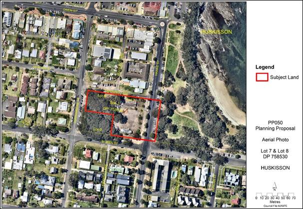
Figure 1
– Subject land for PP050 (bound by red) and the adjoining Lot 9 (Jerrinja
LALC)
The results of the previous GPR
surveys suggested the presence of between 6 and 8 grave sites on the southern
side of Lot 7 (No. 17 Hawke Street) including one which straddles the boundary
with the adjacent Lot 9 (No. 26 Currambene Street) on which another two
potential graves had been detected. Links to the previous GPR survey reports
are provided in the Planning Proposal that was submitted to DPIE for Gateway
Determination, which can be access via the NSW Planning Portal.
One of the graves on either Lot
7 or Lot 9 is possibly that of an Aboriginal leader named Jimmy Golding/King
Bud Billy who died in 1905. A Heritage Assessment prepared for the proponent by
GBA Heritage in December 2018 suggests that “…an unofficial
graveyard almost certainly already existed…” on the land prior to
it being granted to the church.
Planning Proposal (PP050)
The PP (PP050) and supporting documentation can be accessed
via the NSW Planning Portal at:
https://www.planningportal.nsw.gov.au/ppr/pre-exhibition/planning-proposal-lots-7-8-section-3-dp758530-huskisson-former-anglican-church
In summary, the PP seeks to
resolve and revise the planning controls that apply to the former Church site
as it is no longer used as a ‘place of public worship’ and the
current SP2 zoning effectively prevents other forms of development. The
intended outcome is ultimately to potentially enable:
· Mixed-use
development comprising a residential apartment building, tourist and visitor
accommodation (hotel and serviced apartments), and retail premises (including
food and beverage) on Lots 7 and 8, Section 3, DP 758530 (No. 17 Hawke Street
and No. 22 Currambene Street) Huskisson.
· Lot
7 Section 3, DP 758530 (No. 17 Hawke Street) to potentially be developed up to
16 m above the natural ground level.
Relevant Gateway conditions
The Gateway determination issued
by the NSW Department of Planning, Industry and Environment (DPIE) on 30 April
2020 includes the following conditions:
2. Council shall prepare
the following assessments prior to public exhibition:
a. A new independent
Ground Penetrating Radar (GPR) survey over the entire site to which the
Planning Proposal applies by a grave detection specialist using best practice
methodology.
b. An independent
assessment by an appropriately qualified historical archaeologist of the entire
area to which the Planning Proposal applies that must determine the status of
the graves and if they are “relics” under the NSW Heritage Act 1977
in compliance with Heritage Council of NSW Guidelines including
“Assessing Significance for Historical Archaeological Sites and Relics,
2009”.
c. A full Aboriginal
Cultural Heritage Assessment Report of the entire area to which the Planning
Proposal applies prepared in accordance with the “Guide to investigating,
assessing and reporting on Aboriginal Cultural Heritage in NSW” (Office
of Environment and Heritage, April 2011) that includes Aboriginal community
consultation and archaeological survey and reporting in accordance with the
“Aboriginal Cultural Heritage Consultation Requirements for Proponents
2010” (DECCW, April 2010) and the “Code of Practice for
Archaeological Investigation of Aboriginal Objects in NSW” (DECCW
September 2010).
Navin Officer Heritage Consultants
(NOHC) were engaged by Council to complete the above assessments. This work is
being funded by the proponent in accordance with Council’s Planning
Proposal Guidelines. In accordance with Council’s resolution on 9
September 2020 (MIN20.612) Council also provided additional funding to enable
the GPR survey to also cover Lot 9 as requested by its owner the Jerrinja
LALC.
The GPR survey component of this
heritage assessment was subcontracted to Hunter Geophysics, a Victorian-based
GPR specialist with specific experience in grave detection. The GPR field
survey was undertaken by Hunter Geophysics in December 2020. This fieldwork had
been delayed by the earlier closure of the Victorian-NSW border due to
COVID-19.
NOHC received the report from
Hunter Geophysics in early April 2021 and advised that a number of ground
anomalies had been identified which may or may not be graves, and that advice
would be provided on next steps.
On 26 April, NOHC provided a
written summary of the results and a fee proposal to enable the GPR results to
be further ‘ground truthed’ using ‘low impact
excavation’. i.e. shallow surface scrapes. While the fee proposal
is ‘commercial in confidence’, NOHC have agreed to including the
following information for the purpose of this Report:
The GPR survey has been completed and the results as
analysed by [Hunter Geophysics] identify over 50 individual graves that he
records as ‘high confidence’. While this is possibly correct, and
[Hunter Geophysics’s] criteria used to identify the anomalies as graves
seem reasonable, this nevertheless seems to be an unlikely high number of
graves given the historical window within which the graves would have been laid
down. In addition, the distribution across the entire property seems unusual.
[emphasis added]
The GPR report includes a
statement of indemnity which describes the limitations of GPR in some detail
and states:
The results and interpretation of the geophysical surveys
described herein should not be considered an absolute representation of the
underlying soil or archaeological features, but instead as a hypothesis yet to
be verified. Confirmation of geophysical interpretations is only possible
through careful (preferably archaeological) excavation. Hunter Geophysics does not
guarantee that the interpretations of geophysical data provided herein are
accurate.
…
Of particular importance is the similar appearance of
tree roots and rabbit burrowing with unmarked graves.
NOHC attributes some of the
anomalies to foundations from past structures (signs, buildings etc). According
to NOHC, of the remaining anomalies, 21 are within the subject land of the PP,
3 straddle the boundary with Jerrinja’s land (Lot 9) and another 27 are
located wholly within Lot 9. NOHC conclude that:
Unless the presence or absence
of graves is demonstrated then it is likely that using the precautionary
principle that all anomalies will need to be treated as if they are real.
The most efficient way to clarify which of the anomalies are actually graves is
to undertake low impact ground excavation aimed at exposing the grave cuts. [emphasis
added]
Next steps (Tasks recommended
by NOHC)
|
Tasks
|
Comment
|
|
1. Apply for a Section
139 exception under the NSW Heritage Act.
|
Initiated
|
|
2. Use a skilled machine
operator with a flat bladed bucket to scrape the surface across each of the 4
most likely clusters of possible graves. These scrapes will be carefully
inspected to identify any exposed grave cuts. If grave cuts are found an
additional scrape at an angle to the first may be required to identify at
least one of the corners of the grave so that it can be accurately plotted.
|
Cannot
be undertaken until the s139 exception has been approved
|
|
3. Plot and peg
identified graves
|
|
|
4. Once the four most
likely areas are investigated the others will be checked in a similar manner
to confirm or eliminate them. This will involve at least two similar scrapes
on the land subject to the PP.
|
|
|
5. Optional - Should the
Jerrinja LALC land be included we would propose at least 2 long scrapes at
right angles to each other to pick up most of the anomalies with several
smaller scrapes if necessary.
|
To
be discussed / confirmed with the Jerrinja LALC
|
|
6. Preparation of a short
letter report on the findings and an adjusted map showing any graves verified
(this report would be referred to in the Aboriginal Cultural Heritage
Assessment (ACHA) Report already under preparation.
|
See
discussion below on legal status of the graves
|
Legal status -
graves/potential graves
NOHC’s project brief
includes undertaking further historical research on the land’s history as
a cemetery and to confirm the legal status of any graves. NOHC will provide
their full report to Council after the GPR results have been verified and the
ACHA process has been completed. However, NOHC’s interim advice is that
‘King Bud Billy’ AKA ‘Jimmy Golding’ and his daughter,
‘Rebecca Goulding’ are likely to have been buried on the property
(including possibly Lot 9).
In terms of the legal status of
the graves/potential graves, NOHC’s interim advice is that:
All of the graves associated with the Huskisson Church
would be covered under the Heritage Act 1977, NSW. The National Parks and
Wildlife Act, 1974, NSW does not cover post-contact graves buried in official
graveyards. Archaeological deposits in NSW are protected whether or not they
are list on any heritage schedules. We suggest a minimal surface disturbance to
reveal the absence or presence of grave cuts. This would require applying for
an exception, under s139 of the Heritage Act NSW to the requirement for an
excavation permit.
Conclusion
The aim of the new GPR work was to attempt to holistically and
independently resolve the existence or otherwise of graves as part of
the overall heritage work associated with the PP. This report provides an
overview of the outcomes from the new GPR work and additional work that is now
needed to provide a more conclusive outcome.
The approach recommended by NOHC will help confirm the
presence/absence of grave cuts, and allow more informed interpretation of the
GPR survey results. This work must be undertaken to allow the PP for the former
Anglican Church site (Lots 7 and 8) to be advanced and resolved.
If the Jerrinja LALC supports the recommended verification
work also being done on their land (Lot 9) this should be facilitated to ensure
that uncertainties arising from the GPR results are minimised or resolved and
improve the understanding of the history of the overall site.
Community Engagement
Given the high level of
community interest it this site/proposal, a Get Involved page was established for this
project. Persons who subscribe to this page receive an email update each time a
‘newsfeed’ is added. A newsfeed was added to notify interested
stakeholders that this Report is being considered by Council.
Council staff intend to meet
separately with the proponent, Jerrinja LALC and the Huskisson Heritage
Association in the lead up to this report being considered by Council on 11 May
2021. Council’s Aboriginal Advisory Committee will be advised/updated.
The PP and supporting
documentation will be publicly exhibited at the appropriate point, subject to a
further report to Council, once all the requirements of the Gateway
determination have been satisfied.
Financial Implications
The cost of the studies required
by the Gateway determination is being met by the proponent, consistent with
Council’s Planning Proposal Guidelines.
Council funded the GPR work on
Lot 9, as resolved on 1 September 2020 (MIN20.612). Consistent with this
approach, the cost of the proposed ‘surface scraping’ on Lot 9 ($6,220
excl GST) will need to be funded by Council should the Jerrinja LALC agree to
this work being undertaken, but not have the required funding.
Risk Implications
The proposed approach is to
undertake ‘low impact excavation’, i.e. minimal surface disturbance
to reveal the absence or presence of grave cuts. This work would be subject to the
condition of the s139 exception under the NSW Heritage Act. S139 (1B)
allows:
S139 (1B) Excavation or disturbance of land that will
have a minor impact on archaeological relics. This can include the testing of
land to verify the existence of relics without destroying or removing them.
Explanation: This exception could also be applied where the nature of the
proposed excavation will not affect significant areas/deposits of a known
archaeological site. For example, the excavation would only affect peripheral
areas of a significant archaeological site or would occur in areas known to
have been previously disturbed.
NOHC’s advice is that the
proposed approach fits the above description of minor works.
|
|
Development
& Environment Committee – Tuesday 11 May 2021
Page
0
|
DE21.44 Parkcare
Action Plans - Bishop Reserve / Callala Beach / Clifton Park / Mount Vista
Close / Nulla Place Reserve
HPERM Ref: D21/33071
Department: Works
& Services
Approver: Paul
Keech, Director - City Services
Attachments: 1. Draft
- Bishop Reserve - Mollymook - Parkcare Action Plan ⇩
2. Draft
- Callala Beach Entries - Parkcare Action Plan ⇩
3. Draft
- Clifton Park - Sanctuary Point - Parkcare Action Plan ⇩
4. Draft
- Mount Vista Close - Berry - Parkcare Action Plan ⇩
5. Draft - Nulla Place Reserve -
St Georges Basin - Parkcare Action Plan ⇩
Reason for Report
To allow Council to consider two
updated and three new Parkcare Action Plans that have been prepared by Parkcare
Groups and Council staff. The plans are:
|
1.
|
Bishop
Reserve – Mollymook – Parkcare Action Plan
|
Mollymook
|
Updated
|
|
2.
|
Callala
Beach Entries – Parkcare Action Plan
|
Callala Beach
|
New
|
|
3.
|
Clifton
Park – Sanctuary Point – Parkcare Action Plan
|
Sanctuary
Point
|
Updated
|
|
4.
|
Mount
Vista Close – Berry – Parkcare Action Plan
|
Berry
|
New
|
|
5.
|
Nulla
Place Reserve – St Georges Basin – Parkcare Action Plan
|
Sanctuary Point
|
New
|
|
Recommendation (Item to be determined under delegated authority)
That
Council
1. Endorse the updated and new Parkcare
Plans for
a. Bishop
Reserve – Mollymook (UPDATED)
b. Callala
Beach Entries – Callala Beach (NEW)
c. Clifton
Park – Sanctuary Point (UPDATED)
d. Mount
Vista Close – Berry (NEW)
e. Nulla
Place Reserve – St Georges Basin (NEW)
2. Continue to allocate ongoing annual
operating funding of $400 (GST exclusive and CPI adjusted) for each Parkcare
Group, totalling $2,000, to cover safety PPE, miscellaneous materials, waste
disposal and purchase minor tools. This has been provided for in the Draft
2021/2022 Operating Budget.
|
Options
1. Approve
continued endorsement of Bishop Reserve – Mollymook Parkcare Group,
Clifton Park – Sanctuary Point Parkcare Group and approve new endorsement
of Callala Beach Entries Parkcare Group, Mount Vista Close - Berry Parkcare
Group, Nulla Place Reserve – St Georges Basin Parkcare Group and adopt
the draft Action Plans.
Implications: Two groups are currently allocated a
total of $800 for continuing support and if this option is adopted three new
groups would be allocated a total of $1,200, both for ongoing support of
Parkcare objectives which would be offset by the free resource offered to
Council. The total cost of supporting the five Parkcare Groups would be an
annual cost of $2,000 which would be provided from the Parks Operational budget.
2. Not approve the
ongoing support of Bishop Reserve – Mollymook Parkcare Group, Clifton
Park – Sanctuary Point Parkcare Group, and refuse any new endorsement of
Callala Beach Entries Parkcare Group, Mount Vista Close - Berry Parkcare Group,
Nulla Place Reserve – St Georges Basin Parkcare Group pending changes to
the Action Plan.
Implications: There would be a lost opportunity for
Council. It is estimated, from actual volunteer hours of existing Parkcare
groups, that these additional three Action Plans and the volunteer effort that
supports them allows the groups to supplement Council’s maintenance
schedule at a higher level of service thus adding approximately $24,750 of
extra value per annum (3 parks x average of 275 volunteer hours x $30 per hour
for labour) to present high quality parks and reserves to the various
communities.
Background
Council engages volunteers such
as Parkcare Groups to achieve higher levels of maintenance at minimal cost to
Council. Council currently has 53 Parkcare Groups with 448 volunteer members
under its Parkcare Programme.
The following two draft Parkcare
Action Plans are up for readoption with no changes:
1. Bishop Reserve - Mollymook -
Parkcare Action Plan
2. Clifton Park – Sanctuary
Point - Parkcare Action Plan
The following three Parkcare
Action Plans have been requested from residents who are willing to supplement
Council’s maintenance schedules to enhance their local area.
1. Callala Beach
Entries – Parkcare Action Plan
2. Mount Vista
Close – Berry - Parkcare Action Plan
3. Nulla Place
Reserve – St Georges Basin - Parkcare Action Plan
Community Engagement
Participation and involvement in the Parkcare Groups is open
to all community members. All the attached Action Plans require minor
consultation, as per the Bushcare/Parkcare Procedures (PRD20/28), 7.2 Community
Consultation.
Financial Implications
Two of the groups have been
established in the Shoalhaven for a number of years and have been allocated the
$400 each, totalling $800 in future budgets.
Three groups to be allocated
$400 each, totalling $1,200 which is offset by the free resource offered to
Council and to continue the $400 for each group in future budgets.
The total yearly contribution of
$2,000 has been provided for in the draft 2021-2022 Operating budget for Parks
and Open Spaces.
|
|
Development
& Environment Committee – Tuesday 11 May 2021
Page
0
|
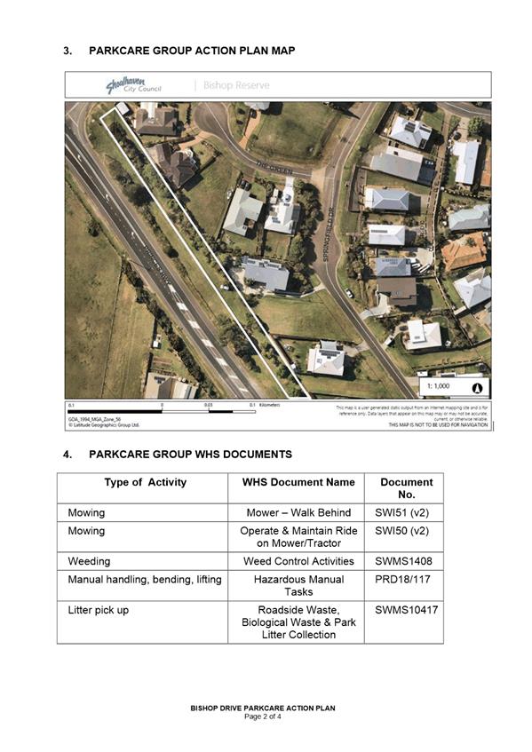
|

|
Development
& Environment Committee – Tuesday 11 May 2021
Page
0
|
|
|
Development
& Environment Committee – Tuesday 11 May 2021
Page
0
|
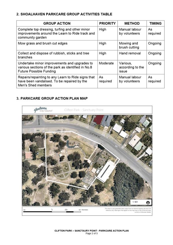
|
|
Development
& Environment Committee – Tuesday 11 May 2021
Page
0
|
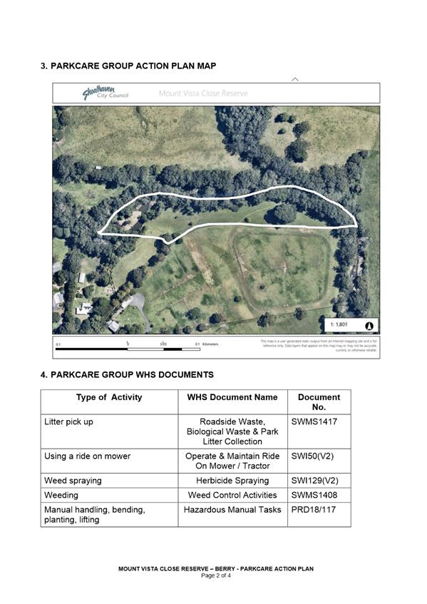
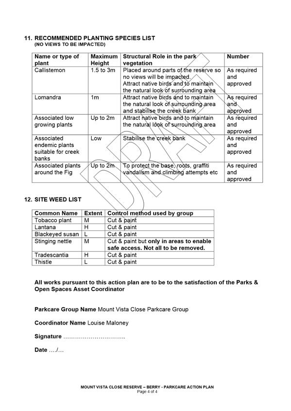
|
|
Development
& Environment Committee – Tuesday 11 May 2021
Page
0
|
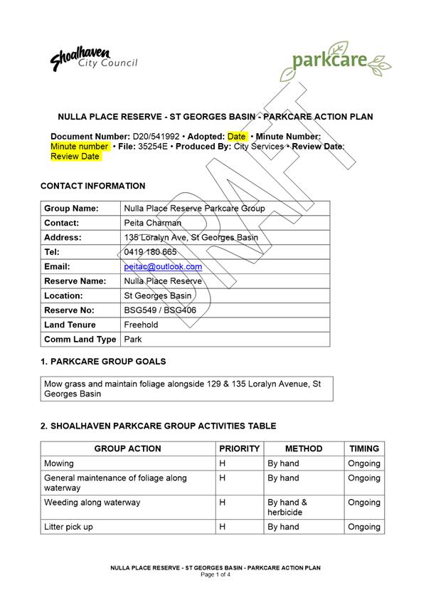
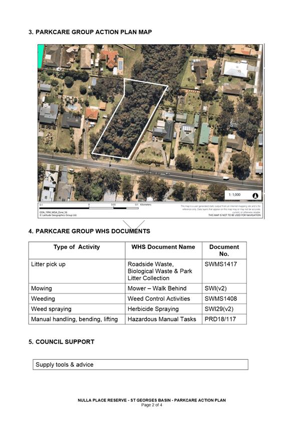
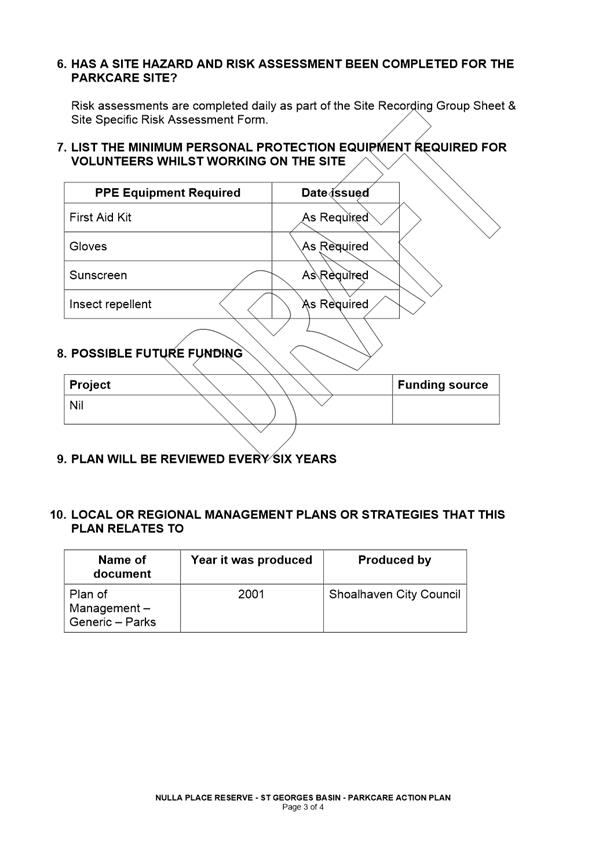
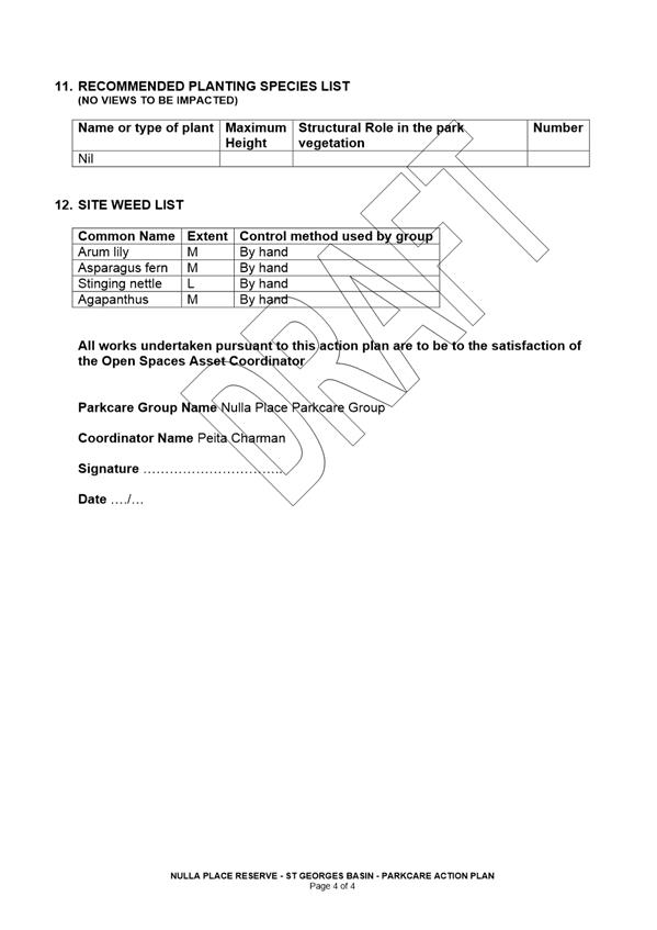
|
|
Development
& Environment Committee – Tuesday 11 May 2021
Page
0
|
DE21.45 Development
Application – 39 The Lake Circuit, Culburra Beach – Lot 1553 DP
12278
DA. No: DA20/2120/4
HPERM Ref: D21/102976
Department: Certification
& Compliance
Approver: Phil
Costello, Director - City Development
Attachments: 1. s4.15
Assessment Report - 39 The Lake Cct Culburra Beach - Lot 1553 DP 12278
(under separate cover) ⇨
2. Draft
Determination - 39 The Lake Cct, Culburra Beach - Lot 1553 DP 12278 -
Detached Garage (under separate cover) ⇨
3. Plans - 39 The Lake Cct, Culburra
Beach - Lot 1553 - DP 12278 ⇩
Description of Development: Construction of a
detached garage ancillary to an existing dwelling house
Owner: P & S McGuire
Applicant: Nest Residential Design
Notification Dates: 12/11/2020 – 28/11/2020
and 11/1/2021 – 27/1/2021
No. of Submissions: 5 (from different
households) in objection
Purpose
/ Reason for consideration by Council
On 9 February 2021, Councillors
called in DA20/2120 due to the significant public interest (MIN21.75).
|
Recommendation (Item to be determined under delegated authority)
That Development Application DA20/2120 for construction of a
detached garage ancillary to an existing dwelling house at Lot 1553 DP 12278, 39 The Lake Circuit, Culburra
Beach be approved subject to the recommended conditions of consent contained
in Attachment 2 of this report.
|
Options
1. Approve the
Development Application (DA) in accordance with the recommendation of this
report.
Implications: This would allow the
applicant to pursue construction of the development.
2. Refuse the
application.
Implications: Council would need to
determine the grounds on which the application is refused, having regard to
section 4.15(1) considerations.
3. Alternative
recommendation.
Implications: Council will need to specify an alternative
recommendation and advise staff accordingly.
Location Map
Figure 1: Location Map
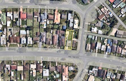
Background
Subject Land
The site is identified as Lot 1553, DP12278, 39 The Lake
Circuit, Culburra Beach.
Site & Context
The site is zoned R2 Low Density
Residential under the Shoalhaven Local Environmental Plan 2014 (SLEP 2014).
The site is accessed
from The Lake Circuit and it contains an existing dwelling house and a concrete
driveway/hardstand area which extends into the rear yard.
The surrounding area is residential in character and the site
is adjoined by low density residential development to the north, south, east,
and west.
Proposed Development
The proposal relates to the
construction of a detached garage (11m x 11.88m) ancillary to an existing
dwelling house. The garage comprises a vehicle/boat storage area and an
attached workshop area. The garage has a floor area of 119.82m² and has a
peak height of 4.2m above natural ground level.
Figure 2: Site Plan
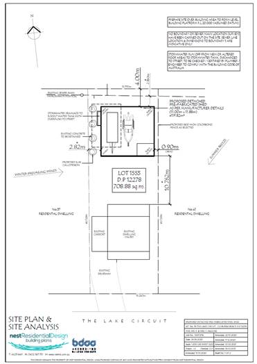
Figure 3: Floor Plan, Elevations and Sections
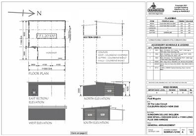
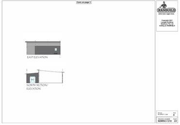
History
The following
provides details on pre-lodgement discussions, post-lodgement actions and
general site history for context:
The application
was lodged on 23 October 2020 and it was notified to adjoining
properties. In response to submissions received during the community
consultation / notification process and following discussions with
Council’s Assessing Officer, amended plans and information were provided
on 14 December 2020 and further amended plans were provided on 16 February
2021.
Issues
Council’s Development Control Plan (DCP) Controls:
The application proposes some
performance-based solutions with regard to the Shoalhaven Development
Control Plan 2014 (SDCP 2014).
The application proposes
performance-based solutions for both the maximum floor area and wall height set
out in Chapter G12 (A33.2 – Table 4).
Acceptable solution A33.2 -Table
4 specifies that garages and other similar structures within the R2 Low Density
Residential zone and on lots with a land area <2000m² are to have a
maximum gross floor area of 110m² and a maximum wall height from ground
level (existing) to eave of 3.0m.
The proposal includes the construction of a
detached garage with a gross floor area of 119.82m² and wall height of 3.5
m. This represents a 9.82m² (8.92%) departure
to the gross floor area control and a 0.5 m (17% departure to the wall height
control set by A33.2 – Table 4.
Applicant’s Submission
The Applicant has provided the following justification for the
proposed performance-based solutions:
Note: The application only seeks a departure
to A33.2- Table 4. Performance Criteria P33.1, P33.2 and P33.3 are applicable;
P34.1 – P35.6 are not relevant when considering a departure to A33.2
– Table 4. Nevertheless, the Applicant has also provided commentary
addressing P34.1 – P35.6.
|
Applicant’s
Justification for performance-based solutions
|
|
As
part of the Development Application, we hereby request council consideration
and support for a minor variation to Shoalhaven City Council’s
Development Control Plan 2014 (SDCP2014) for the proposed Wall Height &
Gross Floor Area of the structure.
Part 8.1
of Chapter G12 of SDCP2014 states that the ‘acceptable solution’
for Ancillary Structures wall heights do not exceed 3.00m & Gross Floor
Area does not exceed 110.0m².
The
proposed pre-fabricated steel shed wall is at a maximum height of 4.20m at
the highest point with a 3.00m wall height on the lowest.
When
evaluated in comparison to the DCP constraints for a wall than the variation
to the 3.00m wall height ‘acceptable solution’ at the worst point
is calculated to be approximately 40%.
The
proposed pre-fabricated steel shed has an overall gross floor area of
119.82m². The variation to the 110.0m² gross floor area
‘acceptable solution’ for the whole site calculated to be
approximately 8.9272%
Whilst
the proposed development does not match the ‘acceptable
solutions’ for the wall height or floor area, we believe that the
‘performance criteria’ is satisfied:
P33.1
– The bulk and scale of new development, particularly on the perimeter
of the development site, or where that locality or development site has
heritage significance and/or distinctive character, is:
· Compatible, consistent, and sympathetic to the bulk and
scale of existing development in the locality.
· Sympathetic with the streetscape and complements the
existing and desired future character of the area.
Comment: The proposed
pre-fabricated steel shed will be complimentary to the existing dwelling and
will be well screened by existing established trees / vegetation as well as
additional natives to create a screen from the street. We believe that the
adjoining properties will not have any adverse effect in regard to solar
access caused by the proposed development.
The
proposed shed will not be out of character for the area as a number of
properties also have large storage sheds/garages. These include No’s
19, 27, 35, 37, 51, 53, 57 & 67 The Circuit, Culburra Beach.
P33.2
– The size of a garage, or other similar structure, used in conjunction
with a dwelling is appropriate for the garaging of resident’s vehicles.
Comment:
The size of the proposed pre-fabricated steel shed is 11.00m x
11.88m (119.82m² (excluding open hardstand area)) is larger than the
110m² ‘acceptable solution’ under Part 8.1 of Chapter G12 of
SDCP2014. (Table 4).
The proposed pre-fabricated
steel shed will provide weather-proof and secure storage of the owner’s
personal larger vehicles not practical to store anywhere else on the
premises.
The proposed will be utilized
as an onsite storage area and workshop.
P33.3 The size of the
non-habitable structure is appropriate for its purpose.
Comment:
As noted above we feel the size of the structure meets the intended purpose
of a safe & secure area for the Owners vehicles.
P34.1 The height of
development:
· Is
compatible with the existing or desired future character of the area.
· Minimises
adverse amenity impacts associated with overlooking and overshadowing of
adjoining properties.
· Relates to
the land.
Comment:
We feel this proposal meets these points.
P34.2 In rural zones,
environmental and coastal locations, the height, and bulk of dwellings is
compatible with the rural, environmental, or coastal context in which they
are located.
Comment:
We feel this proposal meets these points
P35.1 The front setback is
generally consistent with adjoining development and does not undermine the
integrity of prevailing building lines.
Comment:
The proposed pre-fabricated shed will not undermine the integrity of
prevailing building lines, assessing the building line for The Lake Circuit.
P35.2 The location and siting
of the building complements the existing setbacks in proximity to the site,
foreshore (if applicable) and the streetscape.
Comment:
We feel the position of the proposed pre-fabricated shed will complement the
existing streetscape.
P35.3 The proposed
development is setback and of a scale that is relative to the street reserve
width, in such a way to ensure pedestrians do not feel buildings are
overbearing.
Comment:
The proposed pre-fabricated shed is set back far enough to not be over
bearing & the scale of the proposed development will not impact the
existing scale of the buildings that already exist on the street.
P35.4 Setbacks avoid loss of
view, undue overshadowing, and provide / maintain privacy (visual and
acoustic), traffic safety and maintain adequate daylight and sunlight access.
Comment:
We believe the structure will provide minimal loss of amenity to the
adjoining development through loss of privacy, views, overshadowing solar
access of the like.
P35.6
Adequate levels of light and ventilation to adjoining buildings, landscaping,
services, and infrastructure are protected.
Comment:
We feel these points are protected with the proposed pre-fabricated shed.
P35.7 The proposal maintains
adequate provision for on-site car parking.
Comment: The proposed
pre-fabricated shed will allow for adequate on-site car parking that is
undercover.
|
Discussion
The proposed
development will result in a 9.82m² (8.92%) departure to the
maximum gross floor area control for garages and a 0.5m (17%) departure to the
wall height control set by A33.2 – Table 4.
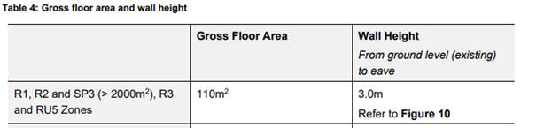
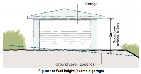
The relevant performance criteria are:
|
P33.1 – The bulk and scale of new
development, particularly on the perimeter of the development site, or where
that locality or development site has heritage significance and/or
distinctive character, is:
· Compatible, consistent, and sympathetic
to the bulk and scale of existing development in the locality.
· Sympathetic with the streetscape and
complements the existing and desired future character of the area.
|
|
P33.2 - The size of a garage, or other similar
structure, used in conjunction with a dwelling is appropriate for the
garaging of resident’s vehicles.
|
|
P33.3 – The size of the non-habitable structure
is appropriate for its purpose.
|
The proposed garage is set back 4m from the north (rear)
boundary, 0.9m from the eastern (side) boundary and 2.82m from the western
(side) boundary. These setback distances are consistent with the setback
distances set out in the Shoalhaven DCP 2014 and are consistent with other
garages, sheds and other residential development observed in the immediate
locality. The garage is set back 10.76m from the existing dwelling on site.
These setback distances provide adequate separation between boundaries and
ensure solar access, ventilation and privacy is maintained to adjoining
properties. The setback distances also allow for landscaping along the western
boundary to soften the development.
The proposed departures to the acceptable solutions are
relatively minor and would not have a significant impact on the amenity of the
area or adjoining properties.
The proposed garage has been designed and sited to mitigate
the impact of the proposed variations to adjoining development and the public
domain. The detached garage is compatible with adjoining development and does
not detract from the existing streetscape amenity. The proposed garage is of
comparable size to other sheds/garages observed on adjoining properties and in
the near vicinity of the development site.
Figure 4: Aerial imagery of subject site
(highlighted) showing comparable sized sheds/garages on adjoining properties
and within the vicinity of the subject site.
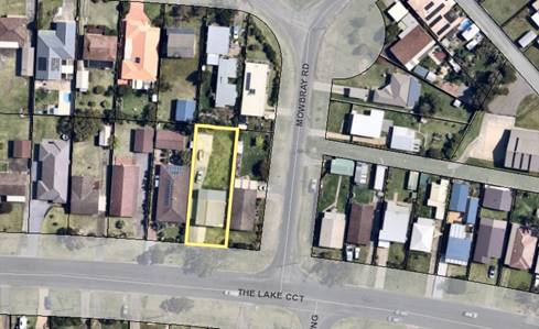
The Applicant has indicated that the purpose of the shed is to
provide storage for vehicles and also provide a workshop space. The Applicant
has provided details of the vehicles (boat and caravan) intended to be stored
within the garage and it is noted that these vehicles each have an overall
length of approximately 8-9m and a width of approximately 2-3m. The garage
dimensions allow for these vehicles to be stored and also for some manoeuvring
and circulation space around the vehicles.
Figure 5: Specifications of vehicles intended
to be stored within the garage.
The proposed detached
garage is considered to be of an appropriate size for its intended use and
provides secure and all-weather storage for personal vehicles, tools and gym
equipment and also provides a workshop area.
Figure 6: Extract from Site Plan showing
intended usage of shed.
Figure 7: Extract from Floor Plan
showing area to be used as a workshop.
It is recommended
the performance-based solution be supported for the following reasons:
· The
proposed detached garage is suitably designed and located and is compatible
with adjoining development.
· The
proposed detached garage is located behind the existing dwelling and will not
have an adverse impact on the existing streetscape or amenity of the
surrounding area.
· The
proposed detached garage is a non-habitable building and the privacy between
adjoining residences is maintained.
· Comparable
sized sheds/garages are observed on adjoining properties and in the vicinity of
the proposed development site.
· The
proposal is consistent with Performance Criteria P33.1, P33.2 and P33.3 of
Chapter G12 Shoalhaven DCP 2014.
Planning Assessment
The DA has been assessed under
s4.15(1) of the Environmental Planning and Assessment Act 1979.
Please refer to Attachment 1.
Consultation and Community
Engagement:
The development
application was notified to adjoining properties on two occasions because of
amendments to the proposed design.
Notification was undertaken in accordance with Council’s
Community Consultation Policy with letters being sent within a 25m buffer of
the site, during the period 12 November 2020 – 28 November 2020 and 11
January 2021 – 27 January 2021.
A total of five (5) objections (from different households)
were received in relation to the development. Key issues raised as a result of
the notification are provided below.
|
Objection Raised
|
Assessing
Officer Comments
|
|
Stormwater
|
The existing stormwater is sent to an old absorption
trench within the rear yard. The applicant proposes to install a charged line
to the street.
The proposed development will improve how stormwater
is managed onsite.
|
|
Impact on birdlife
|
The proposed development maintains an appropriate
setback from the existing mature trees on adjoining properties.
The application proposes
planting to encourage birdlife and soften the proposed development.
|
|
Bulk, scale, and design aesthetic
|
The floor space ratio FSR including the proposed
development equates to 0.40: 1.
The development is compatible with existing
development within the vicinity and does not detract from existing
streetscape amenity.
Similar sized sheds are observed on adjoining
properties and in the immediate locality and the overall bulk of the proposed
garage is not excessive.
|
|
Overshadowing
|
The proposed garage has a peak height of 4.2m and is
suitably set back from property boundaries and will not unreasonably
overshadow adjoining dwellings.
The proposed development complies with the NSW Land
and Environment Court – Planning Principle: Sunlight – Access to
Sunlight.
|
|
Privacy
|
The proposed garage is a non-habitable building, and
the development maintains adequate privacy to adjoining residences.
The following photographs show the view from rear
yards of adjoining properties looking towards the proposed shed location.
View from 11 The Triangle (adjoining property to the
north) looking towards the proposed shed location. The proposed shed will be
screened from view by existing vegetation and structures.
View from 37 The Lake Circuit (adjoining property to
the west) looking towards proposed shed location. The proposed shed location
will be obscured from view by existing and proposed vegetation.
View from 41 The Lake Circuit
(adjoining property to the east) looking towards the proposed shed location.
The Proposed shed will be screed/obscured from view by existing structures.
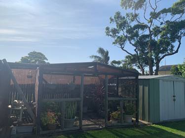
|
|
Boundary fence issues with adjoining property to the
east.
|
Council is not involved in boundary fence disputes.
Property owners may wish to discuss boundary fence issues separately.
|
Financial Implications:
There are potential cost
implications for Council in the event of a refusal of the application. Such
costs would be associated with defending an appeal in the Land and Environment
Court of NSW.
Legal Implications
A section 8.2 review and / or an
appeal with the Land and Environment Court are possible if the application is
refused.
Summary and Conclusion
The proposed development is
compliant with the provisions of SLEP 2014, and it is considered that
the proposed performance-based solutions to SDCP 2014 are supportable
and that the proposed development is consistent with the performance criteria
specified in SDCP 2014.
This application has been
assessed having regard for Section 4.15 (Matters for consideration) under the EP&A
Act 1979 and has been subjected to detailed analysis of the main issues
identified in this report, being departures from SDCP 2014 acceptable
solutions. These issues have also been investigated and addressed by the
applicant.
Having regard to the assessment, the proposal is considered
capable of support as there are no substantive planning reasons to warrant
refusal. It is recommended the application be approved subject to the
recommended conditions of consent as per Attachment 2.
|
|
Development
& Environment Committee – Tuesday 11 May 2021
Page
0
|
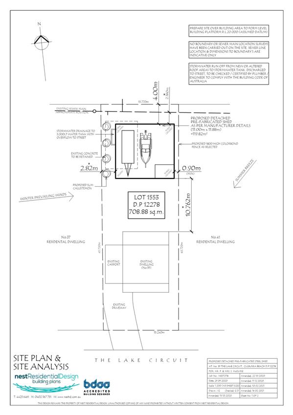
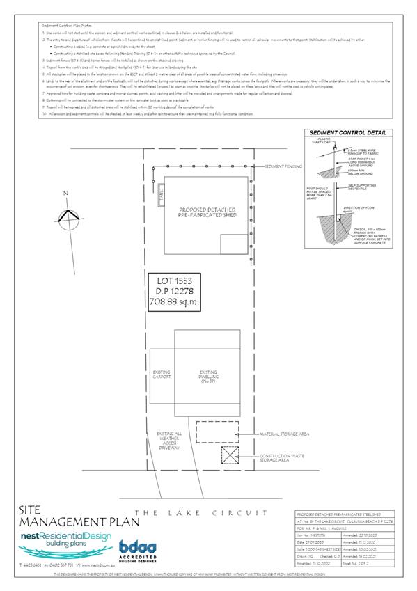
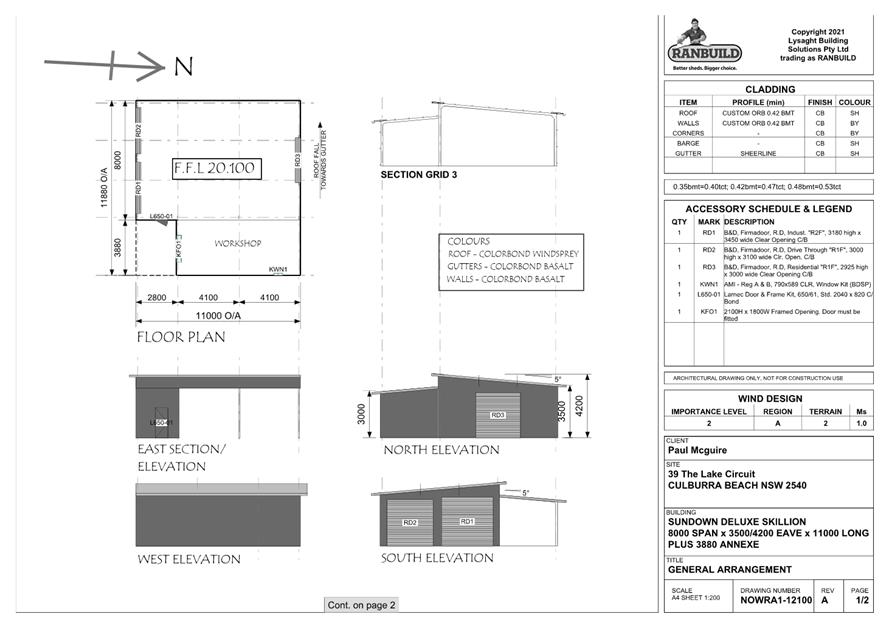
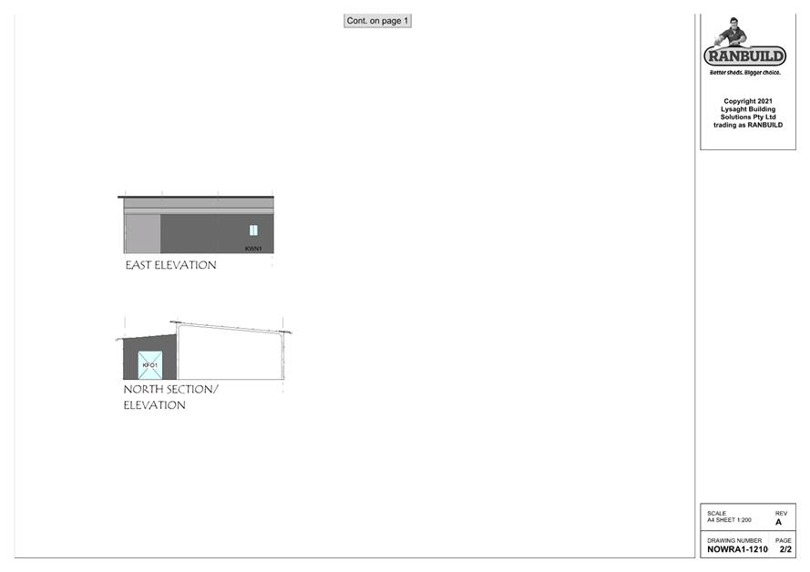
|
|
Development
& Environment Committee – Tuesday 11 May 2021
Page
0
|
DE21.46 DA20/1970
– 1178 Comerong Island Road, Numbaa – Lot 2 DP 1077521
DA. No: DA20/1970/4
HPERM Ref: D21/100273
Department: Development
Services
Approver: Phil
Costello, Director - City Development
Attachments: 1. Clause
4.6 Written Request - Lot 2 DP 1077521 - 1178 Comerong Island Rd Numbaa ⇩
2. Planning
Report - 1178 Comerong Island Rd Numbaa - Lot 2 DP 1077521 (under
separate cover) ⇨
3. Draft Determination - 1178
Comerong Island Rd Numbaa - Lot 2 DP 1077521 (under separate cover) ⇨
Description
of Development: Construction of
an industrial building for use as a boat building and repair facility.
Owner: Shoalhaven City Marina Pty Ltd
Applicant: JN (Qld)
Notification Dates: 2-18 December 2020
No. of Submissions: One (1) submission
Purpose
/ Reason for consideration by Council
The proposed building exceeds
the height of building limitation under clause 4.3, Shoalhaven Local
Environmental Plan 2014, by a maximum extent of 4m (being 36.36%). The proposed
building is 15m high.
Council
can in this instance assume the concurrence of the Secretary; however, the
extent of the contravention requires referral to the elected Council for
consideration.
|
Recommendation (Item to be determined under delegated authority)
That Development Application DA20/1970
for construction of an industrial building for use as a boat building and
repair facility at Lot 2 DP 1077521, 1178 Comerong Island Road, Numbaa be
approved subject to the recommended conditions of consent contained in
Attachment 3 of this report.
|
Options
1. Approve the development
application (DA) in accordance with the recommendation of this report.
Implications: This would
allow the applicant to pursue construction of the development.
2. Refuse the
application.
Implications: Council would
need to determine the grounds on which the application is refused, having
regard to section 4.15(1) considerations.
3. Alternative
recommendation.
Implications: Council will
need to specify an alternative recommendation and advise staff accordingly.

Figure 1 – Location Map
(Whole)
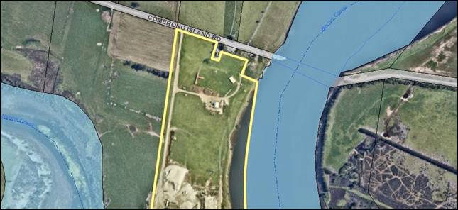
Figure 2 – Location Map
(Part)
Background
Proposed Development
The DA seeks approval for the construction of an industrial
building for use as a boat building and repair facility.
The proposed
building is to comprise three (3) floor levels and a mezzanine level, and to be
constructed of Colorbond steel (‘Ironstone’ in colour) with the
following numerical characteristics:
|
Length
|
120m
|
|
Width
|
66m
|
|
Height (Max)
|
15m
|
|
Gross Floor
Area
|
7,995sqm
|
This
subject application has been prepared for a prospective tenant who is seeking
to use the site for the manufacture of larger marine craft and maritime
components than can be serviced in the originally approved building. The new
tenant represents a different target market to that of the original development
consent.
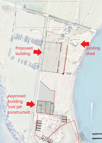
Figure 3 – Site Plan
showing proposed, approved and existing development on site
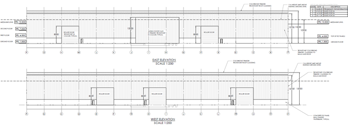 Figure 4 – East and West Elevations
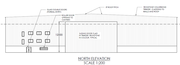
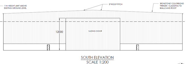
Figure 5 – North and
South Elevations
It is noted there
is an existing development consent on the subject site (DA84/2166, as modified)
for “Boat Building and Repairs,
Excavation of Boat Mooring Facilities and Ancillary Buildings”. This
is for a separate building to the one proposed under this application, in the
southern portion of the site (refer Figure 3). The building height for the
building under DA28/2166, as modified, is approximately 10.5m high, and 52.2m x
69m in width and length, and is constructed of Colorbond and concrete
materials. Approval was granted in May 2020 to modify this existing consent to
increase the size of the existing boat basin to accommodate the servicing of
larger marine craft, reflecting the current recreational boat market
(DS18/1469).
Subject Land
The development site comprises Lot 2 DP 1077521 (1178
Comerong Island Road, Numbaa). Refer to Figure 1.
Site & Context
The development site:
§ Contains an existing storage shed in the north-eastern
corner (refer Figure 3 and 5a) along with other temporary structures associated
with the approved boat building and repair facility (Figure 5b). The existing
boat basin is in the southern portion of the site.
§ Is zoned RU1 Primary Production (refer Figure 6). The site
is 14.08ha in area.
§ Is identified as being wholly flood prone land.
§ Has existing access to Comerong Island Road.
§ Adjoins land comprising of dairy farms with the exception
of the caretaker’s residence on Comerong Island Road for the Comerong
Island Ferry.
§ Directly adjoins land zoned SP2 Infrastructure
(Port/Wharf/Boating Facilities, to the north), RU1 Primary Production (to the
north and west), and E2 Environmental Conservation (to the south). The site is
adjacent to Berry’s Canal in the lower section of the Shoalhaven River.
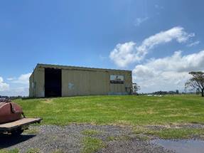
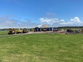
Figure 5a and 5b –
Photographs of the existing buildings onsite
The zone objectives are provided
below as they are a consideration in assessing and considering a variation
request with regard to clause 4.6, which is discussed later in this report.
The RU1 Primary Production zone
objectives are:
§ To encourage sustainable primary industry production by
maintaining and enhancing the natural resource base.
§ To encourage diversity in primary industry enterprises and
systems appropriate for the area.
§ To minimise the fragmentation and alienation of resource
lands.
§ To minimise conflict between land uses within this zone and
land uses within adjoining zones.
§ To conserve and maintain productive prime crop and pasture
land.
§ To conserve and maintain the economic potential of the land
within this zone for extractive industries.
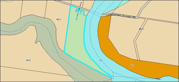
Figure 6 – Zoning
Extract
Approvals History
§ DA84/2166 – Boat Building and Repairs, The Excavation
of Boat Mooring Facilities and the Erection of Buildings Ancillary thereto.)
– Approved: 13/09/1989
§ In accordance with the provisions of Section 102 of the Environmental
Planning and Assessment Act 1979 (EP&A Act) – Modification to
DA84/2166 – Modifying Condition 3(a) – Approved: 10/11/1989
This was in
relation to the required floor height of the caretakers flat.
§ DS99/1229 – Modification to DA84/2166 – Modifying Conditions
1, 7 and 18 – Approved: 12/01/2000
This modified
the description of the development to ‘Boat Building & Repairs &
Excavation of Boat Mooring Facilities & Ancillary Buildings’ and
introduced staging of the development in three (3) stages being:
Stage 1: Assembly Factory Building, Administration Building and
associated paving, landscaping, staff & visitor parking (10 spaces) and
security fencing.
Stage 2: Moulding Factory Building, Building and associated paving,
landscaping, staff & visitor parking (12 spaces) and security fencing.
Stage 3: Extension of Assembly Factory Building, Residence &
opening of Boat Basin to Berry’s Canal.
This also
modified the car parking requirements and replaced the condition in relation to
water supply and roadworks contributions with construction materials and
colours requirements along with a requirement to ensure buildings are located
and designed so as to have minimal visual impact on the existing landscape.
§ DS12/1325 – Modification to DA84/2166 – Inserting Conditions
26 and 27 – Approved: 18/10/2012
This allowed
the removal of excess stockpiled material from the site (i.e. material that is
currently onsite that is in addition to what is required to allow the
construction of the building platform as required by the issued development
consent). The maximum amount of stockpiled material to be removed must not
exceed 6,800m³. Screening and washing of the excess material on the site
prior to its removal via road was permitted only for a period of six (6) months
from the date of commencement, after which this was to cease and the area of
works stabilised/revegetated. There were also other requirements included in
relation to these works prior to the commencement of and during works. The
submission of a dilapidation report for the section of road 0.5km east of Jindy
Andy Lane to the subject site entrance; and survey of the area of the site
where the remaining material is stockpiled were also required.
§ DS14/1168 – Modification to DA84/2166 – Modifying Conditions
26(b), 26(d) and 26(e)I. – Approved: 02/07/2014
This extended
the ability to process sand and remove from the subject site for a period of
six (6) months from recommencement of haulage and notice being given to
Council. It also permitted deferral of the preparation of a dilapidation report
for a period of three (3) months from the recommencement of haulage to allow
finalisation of the Voluntary Planning Agreement (VPA) which is proposed as
part of modification application DS14/1014 to pay a road maintenance levy of
between 75 cents and $1.40 per tonne of material hauled along Comerong Island
Road from the site. In the event that the VPA is finalised, the dilapidation
reporting requirement of DS12/1325 was to be deleted from the consent.
This also
required prior to the commencement of haulage, either an irrevocable bank
guarantee or alternatively a cash deposit, to cover the cost of works that may
be required if the road as identified above is damaged from the associate
works; and also permitted extended hours and days of operation and haulage
during the initial three (3) month period.
§ DS14/1331 – Modification to DA84/2166 – Modifying 26(b),
26(d), 26(e)I, 26(f) and 26(g) – Approved: 06/01/2015
This extended
the consent for screening, washing and removal of excess stockpiled material on
the subject site for a period of two (2) months until 06/03/2015.
It also
permitted deferral of the preparation of a dilapidation report for a period of
one (1) month from approval of this application; permitted extended hours and
days of operation and haulage until 06/03/2015; permitted deferral of
stabilisation and revegetation of the area where works approved under DS12/1325
and other associated amendments proposed as part of this application have been
undertaken within one (1) month of completion or within 30 months of informing
Council of commencement of works, whichever comes first; and permitted deferral
of the preparation of a new dilapidation report and survey of the area of the
site where the remaining material is stockpiled, to within 30 months of
informing Council of commencement of works.
§ DS14/1014 – Modification to DA84/2166 – Modifying Conditions
1, 3(a), 3(b), 3(c), 26 (introductory paragraph before 26(a)), 26(a), 26(b),
26(d), 26(e)I., 26(f) and 26(g) and Inserting Conditions 28-35 – Approved:
22/04/2015
This modified
the location and floor levels of the boat building factory and methods of
construction. The building height was approved at approximately 10.5m.
It also
approved concurrent commencement of remaining stages and consideration of the
VPA as referred to above (see DS14/1168). All works/requirements as detailed in
this Agreement were to be complied with and completed prior to issue of the
Occupation Certificate for the development.
§ DS16/1568 – Modification to DA84/2166 – Modifying Conditions
1, 26 (introductory paragraph before 26(a)), 26(b), 26(e), 26(e)I., 33 and
Inserting Condition 26(d)III. – Approved: 21/04/2017
This
increased the size of the boat basin by 4,700sqm.
§ DS18/1469 – Modification to DA84/2166 – Modifying Conditions
1, 3(b) and 33 and Inserting Conditions 26(h), 32A and 36 – Approved:
04/05/2020
This
reconfigured the location of the existing boat building factory pad and
building structure and amended the geometry of the basin to allow for waterway
access from the boat basin into the factory.
It is noted
that the VPA as referred to above was signed on 22 May 2015 and it is
understood the works/requirements as detailed in this Agreement are yet to be
completed. No Occupation Certificate has been issued for this development.
Subject Application
History
§ This current
application was lodged on 18 September 2020.
§ As a result of detailed assessment of the application, additional
information was requested from the applicant on five (5) occasions – 30 September
2020, 18 December 2020, 22 December 2020, 23 February 2021 and 9 March 2021.
These requests were generally in relation to the non-compliance with the
building height limit, stormwater and wastewater management, landscaping,
traffic impact, civil works and after further detail as to what was proposed as
part of the application.
§ On 24 November 2020, 23 December 2020, 18 January 2021, 1 March 2021 and
11 March 2021, the applicant submitted additional information, which was
subsequently referred to the relevant sections of Council for comment.
§ Draft
conditions of consent were forwarded to the applicant for comment on 26 March
2021.
§ No comments were provided.
Issues
Clause 4.3 (Height of
buildings) of SLEP 2014
Clause 4.3 of SLEP 2014 contains
controls for the maximum height of buildings and specifically outlines that the
maximum height of a building must not exceed the height shown on the
‘Height of Buildings Map’ that supports SLEP 2014 or if land is not
mapped a building must not exceed 11m.
In this instance, the
‘Height of Buildings Map’ has no specific maximum building height
provisions for the development site. As such, the maximum height of any
building, under this clause, must not exceed 11m as required by subclause (2A).
The development does not comply with this development standard as it will have
a maximum height of 15m, see Figure 7 height plane analysis. This represents a
variation to the numerical standard of 36.36%.
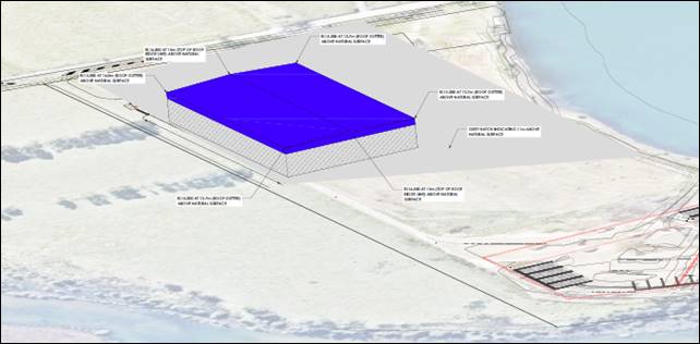
Figure 7 – Height plane
analysis (The blue
area depicts the portion of the proposed building above the maximum height
control)
Clause 4.6 (Exceptions to
development standards) of SLEP 2014
Development
consent may, subject to clause 4.6, be granted for development even though the
development would contravene a development standard imposed by this or any
other environmental planning instrument.
The applicant has submitted a
written request to justify the contravention of the height of buildings
development standard pursuant to the requirements of clause 4.6 of SLEP 2014.
Refer to Attachment 1 for the detailed request made by the applicant and
Council’s assessment. The following provides Council’s review
(summary) of the request for a height variation in relation to the requirements
of clause 4.6. Refer to the attached assessment report (Attachment 2)
for additional detail.
Council is required to consider subclauses (3), (4) and (5) of Clause 4.6.
Clause 4.6(3)-(5) are extracted from SLEP 2014 below:
(3) Development consent must not be
granted for development that contravenes a development standard unless the
consent authority has considered a written request from the applicant that
seeks to justify the contravention of the development standard by
demonstrating—
(a) that compliance with the
development standard is unreasonable or unnecessary in the circumstances of the
case, and
(b) that there are sufficient
environmental planning grounds to justify contravening the development
standard.
(4) Development consent must not be
granted for development that contravenes a development standard unless—
(a) the consent authority is
satisfied that—
(i) the applicant’s
written request has adequately addressed the matters required to be
demonstrated by subclause (3), and
(ii) the proposed development
will be in the public interest because it is consistent with the objectives of
the particular standard and the objectives for development within the zone in
which the development is proposed to be carried out, and
(b) the concurrence of the
Planning Secretary has been obtained.
(5) In deciding whether to grant
concurrence, the Planning Secretary must consider—
(a) whether contravention of the
development standard raises any matter of significance for State or regional
environmental planning, and
(b) the public benefit of
maintaining the development standard, and
(c) any other matters required
to be taken into consideration by the Planning Secretary before granting
concurrence.
Clause
4.6(3)(a) – Compliance with the Development Standard is Unreasonable or
Unnecessary in the Circumstances of the Case
It is considered that the
applicant has satisfactorily demonstrated that compliance with the development
standard is unreasonable or unnecessary in the circumstances of the case for
the following reasons:
1. The
applicant’s justification is supported as the objectives of the
development standard are achieved notwithstanding non-compliance with the
standard.
2. The proposed
height of the building is directly correlated with the use of the building
given the size of the vessels to be built and repaired within the building and
specific circumstances of their boat fit-out activities. The increase in
building height is necessary to accommodate a gantry crane which assists in the
general construction operation for a new boat build and lowers the operational
risks associated with workplace health and safety.
3. Council has
previously approved the subject site for boat building and repairs and the
proposed building is considered to be compatible with the height, bulk and
scale of the character of this locality and the RU1 zone, given the design presented
to Council inclusive of landscaping. While the proposed building is larger than
existing and approved structures on the site, the new building is appropriate
for the approved use on the site and does not detract from the rural character
of the area having regard to the setting in which the proposed shed will be
situated and its isolation from adjoining properties.
4. Approval has
been recently granted to increase the size of the existing boat basin to
accommodate the servicing of larger marine craft reflecting the current
recreational boat market. The height of this building will support this demand.
5. Any potential
physical impacts on surrounding development are capable of being acceptable
(subject to the regulatory controls and conditions associated with the ongoing
management of the site operations).
Clause
4.6(3)(b) – Are there Sufficient Environmental Planning Grounds to
Justify Contravening the Development Standard?
The consent authority must form
the positive opinion that the applicant’s written request has adequately
addressed those matters required to be demonstrated by clause 4.6(3)(b).
In
this regard, the proposed portion of the development that contravenes the
development standard is justified on environmental planning grounds because it
is necessary to promote the orderly and economic use and development of land.
In
this regard, the applicant has stated:
“It is appropriate to address
the age of the existing consent for boat mooring, boat building and ancillary
services. The original DA was granted in 1989 following the gazettal of the
attachment of an enabling clause in the 80’s that allowed for the
development to be approved two years later. In the ensuing 31 years since the
approval was granted, the Australian boat building industry has evolved to the
point today where the median size of a leisure sailing or motorized vessel now
exceeds 46 foot and is about to evolve further into the adoption of multihulls
and the current median leisure boat class of 52 foot length overall. This
development has been thwarted by a range of impediments and delays that have
finally been able to be addressed.
The proposed development will
provide the required opportunity for boat building that is the optimal use for
this land that is adjacent to Council’s current ferry infrastructure. As
such, the proposed development will deliver the orderly and economic use of
land that ensures that inappropriate uses are not placed in direct vicinity of
each other.”
Secondly,
the orderly and economic use and development of land demonstrates that
compliance would be unreasonable and unnecessary under clause 4.6(3)(a) because
if the proposed building height was not to be
supported, the building would not be able to be used for its specific purpose,
that is, to build boats of up to 72 “feet” (21.9456 metres)
and in so doing, would remove the viability of the development and existing
approved operations onsite, and as stated by the applicant “make it
impossible to keep abreast of current and future boat building market
expectations”.
Further to this, the proposal
will aid the continuity and modernisation of the existing land uses, encourage
additional employment opportunities, facilitates the continued utilisation of
the boat building facility and has the potential to provide for a use that does
not significantly conflict with the operation of existing or proposed
development both on the site or surrounding properties.
Additional
environmental planning grounds which distinguish it from other potential
requests to vary the height of building development standard are summarised
below:
1. Consideration
should be given to the height of building development standard being a default
height limitation. The default height is not the result of a detailed strategic
review or visual impact assessment of the area.
2. The proposed
development is of an overall height, scale, bulk, design and external
appearance that is appropriate for the use of the building, and compatible with
the existing and proposed continuation of the use of the site as a boat
building facility. It is also considered that there would be no adverse visual
impact due to the setting in which the building is situated.
3. The isolated and
unique features of the site mean the additional height above the 11m maximum
building height will not result in unreasonable overshadowing, overlooking or
amenity impacts on neighbouring sites.
Clause
4.6(4)(a)(ii) – Will the Proposed Development be in the Public Interest
Because it is Consistent with the Objectives of the Particular Standard and
Objectives for Development within the Zone in Which the Development is Proposed
to be Carried Out?
Clause
4.6(4)(a)(ii) states that development consent must not be granted for
development that contravenes a development standard unless the proposed
development will be in the public interest because it is consistent with the
objectives of the particular standard and the objectives for development within
the zone in which the development is proposed to be carried out.
An
assessment of the objectives of the zone and development standard is provided
below. As detailed further below, the proposed departure from the development
standard is considered to be in the public interest as the proposal is
consistent with these objectives.
Zone Objectives
Pursuant
to the provisions of the SLEP 2014, the land is zoned RU1 Primary
Production.
The
objectives of this zone are as follows:
· To encourage sustainable primary industry production by
maintaining and enhancing the natural resource base.
· To encourage diversity in primary industry enterprises and
systems appropriate for the area.
· To minimise the fragmentation and alienation of resource
lands.
· To minimise conflict between land uses within this zone and
land uses within adjoining zones.
· To conserve and maintain productive prime crop and pasture
land.
· To conserve and maintain the economic potential of the land
within this zone for extractive industries.
The
proposal is not inconsistent with the zone objectives as:
§ It will enhance the
natural resource of land adjacent to Berry’s Canal by utilising this land
for a purpose that is uniquely complementary to the existing uses of the canal
(i.e. for boating and related marine leisure activities).
§ It will provide boat
building services that complement the existing industrial marine facility and
services currently provided by Council through the Comerong Island Ferry; but
will also diversify the land use/industry in the locality (i.e. which is
predominantly dairy farming and cropping).
§ The location of the
development in relation to the Council-owned and operated Comerong Island Ferry
and the approved boat basin on the subject site will ensure the integration of
these complementing activities is not lost.
§ The proposed development will not impact the primary industry
enterprises on neighbouring agricultural lands or impact productive prime crop
and pasture land.
Development
Standard Objectives
Pursuant
to the provisions of the SLEP 2014, the development standard proposed to be
varied is clause 4.3 Height of buildings.
The
objectives of this standard are as follows:
a) to ensure that buildings are compatible with the height,
bulk and scale of the existing and desired future character of a locality,
b) to minimise visual impact, disruption of views, loss of
privacy and loss of solar access to existing development,
c) to ensure
that the height of buildings on or in the vicinity of a heritage item or within
a heritage conservation area respect heritage significance.
The proposal
complies with the standard objectives as:
§ The height, bulk and scale
of the building is consistent with the desired future marine industrial
character, (noting there is an approval for a building and the activities being
conducted in the locality – refer to Figure 3 and text below the heading
“Site & Context” in this report) of the Numbaa locality,
given the approved boat building facility. Further to this, as indicated by the
applicant, the proposed height is less than the height of grain silos and
milking sheds located on neighbouring properties.
§ The development is
sufficiently sited and designed to minimise visual impact, and any loss of
privacy and solar access to existing development on adjoining land. It is noted
that there are very few sensitive receivers present and no concerns have been
raised during the assessment of this application.
§ There are no heritage
items or heritage conservation areas proximate to the subject site.
Clause 4.6 (4)(b) – Concurrence of the Secretary has
been obtained
Council may assume concurrence. In
this instance, the extent of the contravention needs to be referred to
the elected Council for consideration.
Clause
4.6(5)(a) – Would Non-Compliance Raise any Matter of Significance for
State or Regional Planning?
The
contravention does not raise any matters of significance having regard to State
or regional environmental planning. It does not have implications for any State
Environmental Planning Policies in the locality or impacts which are considered
of a State or regional scale.
Clause
4.6(5)(b) – Is There a Public Benefit of Maintaining the Planning Control
Standard?
In the
judgement of Ex Gratia P/L v Dungog Council [2015] (NSWLEC 148),
Commissioner Brown of the NSW LEC outlined that the question that needs to be
answered in relation to the application of clause 4.6(5)(b) is “whether
the public advantages of the proposed development outweigh the public
disadvantages of the proposed development”.
The
applicant is to demonstrate that there will be better planning outcomes
achieved through variation to the development standard as opposed to strict
compliance with the development standard or amending the application to reduce
the extent of the variation.
In
this regard, it is considered that strict compliance with the development
standard and a reduction of the building height to achieve compliance
would not result in a better outcome. The extent of
the departure from the height control, whilst numerically large is essential
for the efficient operation of the boat building and repair facility. It
is further noted that due to the unique circumstances of the site, and existing
and proposed use, the contravention would not set a precedent for a
departure of this development standard in this location having regard to the
particular use of the proposed building.
Summary
and conclusion with regard to clause 4.6
The written submission provided by
the applicant is considered to satisfy the requirements of clause 4.6(3), (4)
and (5) and in this regard the proposed height variation is considered to
warrant approval.
Planning Assessment
The DA has been assessed under
s4.15(1) of the Environmental Planning and Assessment Act 1979. Please refer to
Attachment 2.
No further issues are raised
under that assessment with the application otherwise compliant with the
relevant and applicable planning controls for the site and the proposed use.
Conditions of consent are recommended to address potential impacts of the proposed
use such as noise emissions from the building, requirements to avoid spills of
oils, petroleum products and the like, and hours of operation which will assist
in mitigating potential noise impacts from trucks at night-time.
Council’s internal referrals
have assessed the application as being satisfactory with conditions of consent
recommended to address matters such as widening of Comerong Island Road in
parts, stormwater drainage and flooding.
Consultation
and Community Engagement:
One (1) public submission was
received from DPIE Biodiversity & Conservation Division and National Parks
& Wildlife Service in relation to Council’s notification of the
development. The notification was made in accordance with Council’s
Community Consultation Policy with letters being sent within a 200m buffer of
the site, during the period 2 to 18 December 2020.
Key issues raised as a result of
the notification are provided below.
§ Consideration
of DPIE guidelines;
§ How
current proposal aligns with the approved DA;
§ Water
quality; and
§ Threatened
shorebirds.
The assessment of the
application by both Council’s assessing officer and Environmental Health
Officer considered the matters raised in the submission and concluded that the
application should be (conditionally) supported.
A detailed analysis can be found in the attached section
4.15 assessment report at Attachment 2.
Financial Implications:
There are potential cost
implications for Council in the event of a refusal of the application. Such
costs would be associated with defending an appeal in the Land and Environment
Court of NSW.
Legal Implications
A section 8.2 review or an
appeal with the Land and Environment Court are possible if the application is
refused.
Summary and Conclusion
The applicant’s submission
has provided sufficient justification to demonstrate that given the specific
circumstances of this case that the 11m height limit is unreasonable, there is
sufficient environmental planning grounds to justify contravention of the
height requirement and that the proposal is in the public interest and should
be supported.
Further, there are no matters of concern or non-compliances
that would warrant the refusal of the application. Accordingly, it is
recommended that DA20/1970 is approved subject to the recommended conditions of
consent as per Attachment 3.
|
|
Development
& Environment Committee – Tuesday 11 May 2021
Page
0
|

|

|
Development
& Environment Committee – Tuesday 11 May 2021
Page
0
|
DE21.47 SF10804
– 104 Taylors Lane, Cambewarra – Lot 3 DP 851823
DA. No: SF10804/4
HPERM Ref: D21/148654
Department: Development
Services
Approver: Phil
Costello, Director - City Development
Attachments: 1. Planning
Report - Taylors Lane Cambewarra - Lot 3 DP 851823 (under separate cover)
⇨
2. Determination - Taylors Lane
Cambewarra - Lot 3 DP 851823 (under separate cover) ⇨
Description
of Development: Staged residential subdivision to
create 217 Torrens Title allotments, including 213 residential allotments,
three (3) open space allotments, one (1) residue lot, and demolition of
existing structures, earthworks, and provision of roads, drainage and utility
infrastructure along with associated landscaping works
Owner: KI & JG Tompson
Applicant: Watersplash Lane Pty Ltd
Notification Dates: 25 November 2020 to 9 December
2020
No. of Submissions: One (1)
Purpose / Reason for consideration by Council
On 1 December 2020, it was resolved
by the Development and Environment Committee:
“That in relation to SF10804 – 104 Taylors
Lane, Cambewarra – Lot 3 DP 851823:
1. The report be received for information; and
2. SF10804 be called in for determination by the elected
Council on the basis of public interest in the Development” (MIN20.892).
Whilst this report recommends
approval, in accordance with the provisions of clause 6.1, Shoalhaven Local
Environmental Plan 2014, Council cannot grant development consent for the
subject subdivision until the Secretary of NSW Department of Planning Industry
& Environment (DPIE) has provided written certification that satisfactory
arrangements have been made to contribute to the provision of designated State
public infrastructure for the development, as the land is within an urban
release area.
The Department has advised
Council that satisfactory arrangements are not currently in place. Details are
provided later in this report.
|
Recommendation (Item to be determined under delegated authority)
That:
1. Development Application SF10804 for staged residential
subdivision to create 217 Torrens Title allotments, including 213 residential
allotments, three (3) open space allotments, one (1) residue lot, and
demolition of existing structures, earthworks, and provision of roads,
drainage and utility infrastructure along with associated landscaping works at Lot 3 DP 851823, 104 Taylors Lane, Cambewarra be
approved subject to the recommended conditions of consent contained in
Attachment 2 of this report, and receipt of written
certification that satisfactory arrangements have been made to contribute to
the provision of designated State public infrastructure.
2. No access is to be
permitted to Taylors Lane at this time and that a suitable turning head is to
be submitted to and approved by Council prior to the issue of a Subdivision
Works Certificate for all road termination points.
|
Options
1. Approve the
development application (DA) in accordance with the recommendation of this
report. No access is to be permitted to Taylors Lane at this time and a
suitable turning head is to be submitted to and approved by Council.
Implications: This would allow the applicant to pursue
construction of the development via a Subdivision Works Certificate. However,
this can only occur, when the consent is issued which is contingent on
satisfactory arrangements being provided by the NSW Department of Planning,
Industry & Environment (DPIE).
Further, it is noted that the
temporary removal of access to Taylors Lane and the requirement for temporary
vehicle turning area at the end of each terminating road and/or stage may temporarily
impact lot yield until through access is provided in the future, however it
allows consideration of the tree retention issue outlined in this report.
2. Approve the
application as per 1. Above and include the deferral of approval of the
proposed large lots within Stage 4B.
Implications: This would
allow the applicant to pursue construction of the development in part and
resolve the design of the currently proposed large lots to potentially include additional
small lot production if Council saw merit in this.
3. Defer any
approval of the application until a decision has been made by Council on the
upgrade of Taylors Lane and associated treatment of existing trees.
Implications: This would enable
the subdivision to be reconsidered in light of the investigations.
4. Refuse the
application.
Implications: Council would
need to determine the grounds on which the application is refused, having
regard to section 4.15(1) considerations.
5. Alternative
recommendation.
Implications: Council will
need to specify an alternative recommendation and advise staff accordingly.
Figure 1 – Location Map
Background
Proposed Development
The DA seeks approval for staged residential subdivision to create
217 Torrens Title allotments, including 213 residential allotments, three (3)
open space allotments, one (1) residue lot, and demolition of existing
structures, earthworks, and provision of roads, drainage and utility
infrastructure along with associated landscaping works.
The
subdivision is proposed to be delivered in eight (8) stages as depicted at
Figure 2.
Figure 2 – Subdivision Plan
Figure 3 – Landscape Master Plan
Subject Land
The development site comprises Lot 3 DP 851823 (104 Taylors
Lane, Cambewarra). Refer to Figure 1.
Site & Context
The development site:
§ Is within the Moss Vale Road South Urban Release Area (URA) and contains
an existing dwelling, with swimming pool, tennis court, and a number of
associated outbuildings in the southern portion of the site.
§ Contains dense pockets of mature stands of vegetation in the southern
portions. Scatterings of individual mature pasture trees are also present
across the site. Six (6) dams are located across the site.
§ Has historically been used for rural residential and agricultural
purposes, predominantly grazing.
§ Has a central north/south ridgeline traversing the site, with the land
generally sloping towards the Bomaderry Creek catchment.
§ Is zoned R1 General Residential, E2 Environmental Conservation, E3
Environmental Management and SP2 Infrastructure. Only the R1 zoned portion of
the site is within the Urban Release Area.
§ Is 25.25ha in area.
§ Is identified as part flood prone land and being of aboriginal cultural
heritage significance.
§ Is identified as “Scenic Protection” in the northern
section, adjacent to Moss Vale Road.
§ Has frontage to Moss Vale Road and Taylors Lane.
§ Adjoins land zoned R1 General Residential, E2 Environmental
Conservation, E3 Environmental Management, SP2 Infrastructure and RU1 Primary
Production.
Figure 4 – Zoning Extract
History
The following provides details on pre-lodgement
discussions, post-lodgement actions and general site history for context:
§ The proposed development was discussed with the applicant
at a pre-lodgement meeting on 30 January 2019. Council responded to a number of
questions and issues for discussion in relation to open space distribution,
ongoing ownership and maintenance of E3 zoned land, utilities infrastructure
delivery timeframe, and a number of engineering items.
§ The DA was lodged on 9 June 2020. The description of the
application was as follows:
“Staged
residential subdivision to create 232 Torrens Title allotments, including 228
residential and four (4) open space allotments, and demolition of existing
structures, earthworks, and provision of roads, drainage and utility
infrastructure along with associated landscaping works”.
§ On 23 June 2020 Council resolved to defer a decision on the
upgrade of Taylors Lane as part of the Far North Collector Road project and
undertake a review of the zoning and planning controls applicable to land
around Taylors Lane (MIN20.419) as follows:
MIN20.419
That Council:
1. Undertake the following reviews, with the assistance of consultants
if required given current Council staff commitments, considering both the
required road project and desire for retention of the trees:
a. Review Shoalhaven Development Control
Plan 2014 Chapter NB3: Moss Vale Road South Urban Release Area
b. Review the existing zoning and potential planning controls
for the area between Moss Vale Road and the edge of the Urban Release Area
2. As part of the reviews consider all relevant options to
retain the existing trees that are currently a feature of Taylors Lane and how
they could be successfully retained and integrated into the future urban
development enabled by the existing zones;
3. Reconsider the current appropriateness of the existing R3
Medium Density, B1 Neighbourhood
Centre and SP2 Infrastructure (educational establishment) zones at the eastern
end of Taylors Lane as part of the review process.
4. Receive a briefing, if appropriate/needed, and a subsequent report
on the reviews and to enable decisions to be made regarding the interrelated
Taylors Lane issues.
5. Defer the decision on the proposed upgrading of Taylors Lane,
Cambewarra in association with the Far North Collector Road pending the reviews
and further community consultation as part of them.
The review that is currently underway will consider options
for how the existing trees along Taylors Lane could be retained and integrated
into future urban development. At this stage the outcomes of the review are
unknown. The consultant recently submitted its draft review report to Council
following several workshops in March where input was sought from local
stakeholders (landowners and developers) in the review area. It is acknowledged
that the proposed layout plan has been prepared generally on the basis of the
indicative layout plan for Moss Vale Road South URA as adopted in the relevant
DCP Chapter and may or may not be consistent with the outcomes of the review.
§ As a result of detailed assessment of the DA, additional information
was requested from the applicant on three (3) occasions – 11 June 2020,
10 July 2020 and 2 September 2020. The information requested was particular in
that it sought to ensure the proposed road layout reflected the Stage 1
approval within the URA (Development Consent SF10632) and to ensure the
subdivision aligned with the Indicative Layout Plan (ILP), in accordance with
the provisions of Chapter NB3 of Shoalhaven Development Control Plan 2014 (SDCP
2014).
On 12 March 2021 the applicant submitted the amended DA
requested by Council.
§ Council amended the description of this application on 19
March 2021 to the following description as a result of amended DA documentation
being submitted:
“Staged
residential subdivision to create 222 Torrens Title allotments, including 214
residential allotments, seven (7) open space allotments, one (1) residue lot,
and demolition of existing structures, earthworks, and provision of roads,
drainage and utility infrastructure along with associated landscaping works”
§ Council further amended the
description of this application on 19 April 2021 to the current description
(with the agreement of the applicant), following detailed assessment and
Council’s Subdivision Engineer recommendation.
Issues
Acceptable Solution A1.1 of Control 7.1 Indicative
Layout Plan of Chapter NB3, SDCP 2014
There is a non-compliance with A1.1 of Control 7.1 Indicative
Layout Plan in relation to the ILP. The ILP requires a number of roads to
connect through to the adjoining properties to the west, Lot 6 DP 1256748
(known as 126 Taylors Lane, Cambewarra) and Lot 2 DP 851823 (known as 118
Taylors Lane, Cambewarra).
Figure 5 – Indicative Layout Plan
indicating the subject site in red
Applicant’s Submission
The applicant has not proposed
all of these road connections, with only Roads 13, 16, 20, 23 and 27 providing
connection. The applicant has contended that this design conforms. Refer to
Figure 2.
Figure 6 below, which has been prepared by Council, combines
the proposed subdivision design and the ILP to confirm the differences.
However, it is important to note that this is conceptual only in order to
identify general differences. It is not survey accurate and is intended to
provide a pictorial illustration of the road connections.
 Figure 6 – Subdivision Plan
overlaid onto Indicative Layout Plan
Figure 6 – Subdivision Plan
overlaid onto Indicative Layout Plan
Discussion
It is considered that the
proposed layout remains consistent with the objectives of this chapter and the
relevant performance criteria. It does not undermine the integrity of the DCP
in that suitable connections between the subdivisions will be provided. The
design will provide a well-connected and legible movement network.
Although
the Council’s Subdivision Engineer is supportive of the current design,
the Engineer has recommended prior to the issue of a Subdivision Works
Certificate, an amended subdivision plan be submitted to Council for approval.
The amended plan is to include a stub for a local road on the western side of
Road 25 between Road 16 and Road 27 generally in the location of proposed Lot
261 as outlined in Figures 2 and 9 of this chapter, or an alternative location
as agreed to by Council.
It is noted that pre-lodgement
discussions have been held with the developer of the adjoining land (being 126
Taylors Lane, Cambewarra) and their proposed road design appears to be
consistent with this subject design and recommended amendment. The additional
road will allow future allotments on this adjoining land to have road frontage.
Council’s resolution in June 2020 is also noted (as
referenced earlier in this report), however, it has not been acted upon.
Accordingly, the review that is considering options for how the existing trees
along Taylors Lane could be retained and integrated into future urban
development, is incomplete.
The below excerpts from the submitted subdivision and
demolition plans confirm the extent of the subject site that has frontage to
Taylors Lane.
Figure 7 – Excerpts from
Subdivision Plan and Demolition Plan
From figure 7 above it is noted that approx. 20 trees are
nominated for removal adjoining proposed road 25 to the east and a similar
number in the proposed road reserve. Removal of trees associated with possible
road connection to Taylors Lane from road 25 have not been shown. Given the
status of the Council resolution, it is considered that no access should be
permitted to Taylors Lane at this time and that a suitable turning head be
submitted to and approved by Council.
It is acknowledged that this along with the
requirement for temporary vehicle turning area at the end of each terminating
road and/or stage may temporarily impact lot yield until through access is
provided in the future.
Regardless, it is considered that
this variation can be supported by Council.
Mandatory Control (4) of Control 7.3 Subdivision Design
of Chapter NB3, SDCP 2014
There is a non-compliance with
Mandatory Control (4) of Control 7.3 Subdivision Design and the design
of the street blocks. The blocks are to be rectangular in shape with the length
and width (excluding road verges) to be a maximum of 100m x 70m in areas where
small lots are proposed and rear lane access or shared driveways are located;
and 200m x 70m in all other areas.
Three (3) blocks of small lots exceed 100m in length by
approximately 5% and one (1) block of standard lots which is split by a
‘linear park’ and otherwise exceed the 200m length. Refer to Figure
7.


Figure 8 – Excerpts from
Subdivision Plan (Street Blocks)
Applicant’s Submission
The applicant has provided the following justification in the
submitted Design Verification Statement (dated 11/03/2021) for the proposed
variation:
“The option to split this
block with a road would create an undesirable connection to a laneway which
would encourage use by traffic that was no accessing lots immediately fronting
the laneway. The long block is visually split by the linear park and we believe
this meets the intent of the standard.”
Discussion
It is considered that the variation proposed to the design
of the street blocks is still consistent with the objectives of this chapter
and the relevant performance criteria. The integrity
of the outcome envisaged is maintained. Council’s Subdivision Engineer
has raised no concerns in relation to this matter.
Accordingly, this variation can be
supported by Council.
Acceptable Solution A10.1 of Control 7.8 Open Space
System of Chapter NB3, SDCP 2014
There is a non-compliance with A10.1 of Control 7.8 Open
Space System in relation to the proposed Lots 504-507 (referenced as
‘linear parks’) (refer to Figure 8). This is inconsistent with the
Indicative Layout Plan (ILP) as shown in Figures 5 and 6.

Figure 9 – Excerpts from
Subdivision Plan (‘Linear Parks’)
Applicant’s Submission
The applicant has proposed these ‘linear parks’
to be landscaped with trees, shrubs and ground covers, and to contain
pedestrian footpaths in order to provide links between the Boulevards and
residential areas. The ‘linear parks’ are to also incorporate
pedestrian seating for future residential amenity. The applicant believes these
parks will provide considerable pedestrian connectivity and amenity. The parks
are proposed to be handed back to Council post completion of construction as
open space area, to form public realm areas for the estate.
Discussion
Detailed assessment has
confirmed that these four (4) lots are to be considered as ‘road
reserve’ and are not ‘open space’. Council’s Roads
Assets Manager, as the future asset custodian of these proposed ‘linear
parks’/pathway reserves has however endorsed retaining these lots under
public road dedication rather than public reserves. These will still provide
the intended pedestrian permeability within the subdivision.
Subject to a condition of consent as recommended by
Council’s Subdivision Engineer (should this application be determined by
approval) the ‘linear parks’ are to contain a meandering 2m wide
concrete shared path for the full extent of the parks, to be embellished with
turf and to be provided with public lighting for the entirety of the alignment
of the shared path. The path and landscaping need to be designed to ensure that
there is no maintenance burden or potential safety issue in the future.
It is considered that the removal of the roads in this
location that were envisioned under the DCP has not resulted in a connectivity
issue. Pedestrian connectivity is however being maintained via these
‘linear parks’.
Applicant’s Comments / Issues
Northern Perimeter Road
During the assessment of the application, Council raised
concerns with the layout and inconsistency with the Indicative Layout Plan
(ILP), in accordance with A1.1, Control 7.1 Indicative Layout Plan, Chapter
NB3, Shoalhaven Development Control Plan 2014 (SDCP 2014), particularly in
relation to the location of the northern perimeter road and through road
connections/alignments and how it related to that approved as part of
Development Consent SF10632 as modified, being the adjoining subdivision
development to the east.
One of the key issues was the location of the perimeter road
(Road 10) which was eventually adjusted by the applicant in amended DA
documentation.
However, the applicant held the view that the originally
proposed location of the road was a superior design as it better addressed the
interface between Moss Vale Road and the URA by ensuring a landscaped street
and the articulated fronts of homes being visible from Moss Vale Road and not
linear back fences of properties. It also avoided the privacy conflict which occurs
in the DCP by having back yards face Moss Vale Road.
Council had concern with the siting
of the road within the E3 zone, as the intended function of this zone as per Control
7.9 Landscape Strategy, Chapter NB3, SDCP 2014 is environmental corridor/scenic protection area to be
rehabilitated and revegetated.
Further, the ILP does not include
any perimeter road along the northern edge of the Large Lot Residential area.
The large lots are intended to be serviced only by the local street to the south.
Council acknowledged that this may result in larger/deeper lots >1000sqm
which fall short of the DCP density requirement (10-14 lots/ha), however, what
is considered more important is that this area achieves its desired character
as a rural transition zone.
In keeping with the desired
rural-transition character of the large lot residential area, fencing along the
URA edge is intended to be semi-rural post-and-wire or post-and-rail. This is
the foreseen D outcome in the DCP and is consistent with the land’s
‘rural edge’ context. It should be noted that the large lots are
separated from Moss Vale Road by a section of E3 zoned land with a minimum
width of 75m. This is a substantial buffer which should ameliorate visual
impacts from Moss Vale Road
However, there is also a theoretical
ability for the larger lots to be further developed/subdivided. In this regard,
if Council is supportive of the proposal and thus the DCP, it must be aware
that there cannot be a guarantee that future more dense development will not be
applied for. The land is zoned R1 and permits a range of uses. To
this end, Council may have to turn its mind to exploring the possibility of an
alternative zone to tighten controls in this area to maintain the larger lots
as a rural/urban interface or reconsider the large lot requirement in the DCP
in favour of smaller lots in conjunction with a landscape treatment plan for
the E4 area.
The developer suggested an
alternative location of the perimeter road, which effectively deleted these
larger lots. The solution was not supported as the location of the road and
intended character of the area as specified in the DCP, was considered
important to retain.
Splitting the DA
The applicant also sought to
“split the DA” as a way forward to enable a part approval to be
issued (refer to an indicative plan below in Figure 9). This was in order to
exclude the developable land north of the tree-lined boulevard and include lots
on both sides of the boulevard to ensure the built form along this road is
complete but allow them to resolve matters including the optimal location of
Road 10, the inclusion of additional small lot product, and the area and shape
of open space Lot 502.

Figure 10 – Deferring an
area of the subdivision until later
Although the applicant’s
consideration to satisfying Council’s DCP requirements was appreciated as
well as what they were trying to achieve in principle, this amended approach as
presented was not supported as the matter of Road 10 was fundamental to the
development design.
Staging
The applicant has also sought to have flexibility in staging
the works.
There is no issue with this in principle, however, the
applicant has specified stages on plan. The consent reflects this staging. In
the event that the developer wishes to build stages to ‘suit’, more
detail is required. There would be no issue with staging release, if all (or
relevant) roads are constructed. The importance of staging is to ensure that
not only the subdivision is constructed in a logical and orderly manner, but
that the lots are released, and houses built in an orderly manner as far as
practicable, having regard to provision infrastructure etc.
Planning Assessment
The DA has been assessed under
s4.15(1) of the Environmental Planning and Assessment Act 1979. Please refer to
Attachment 1.
Consultation and Community
Engagement
One (1) public submission was received in relation to
Council’s notification of the development. The notification was made in
accordance with Council’s Community Consultation Policy with letters
being sent within a 500m buffer of the site, during the period 25 November 2020
to 9 December 2020.
The key issue raised as a result of the notification was in
relation to the submitted traffic assessment and concern as to the effect of
the subdivision on the proposed use of Taylors Lane.
The assessment of the
application considered the matters raised in the submission and concluded that
the application should be (conditionally) supported.
Financial Implications
There are potential cost
implications for Council in the event of a refusal of the application. Such
costs would be associated with defending an appeal in the Land and Environment
Court of NSW.
Legal Implications
A section 8.2 review or an
appeal with the Land and Environment Court are possible if the application is
refused.
Summary and
Conclusion
The proposed development is
compliant with the provisions of SLEP 2014 and is broadly consistent with the
SDCP 2014 (albeit for the alternative solutions proposed under Chapter NB3).
This application has been
subjected to detailed analysis and is considered capable of support as there
are no substantive planning reasons to warrant refusal. As mentioned in the
report, the application is unable to be determined until such time the
satisfactory arrangements have been made to contribute to the provision of
designated State public infrastructure for the development, as the land is
within an urban release area.
Accordingly, it is recommended
it is approved subject to the recommended conditions of consent as per
Attachment 2 once satisfactory arrangements have been made.
|
|
Development
& Environment Committee – Tuesday 11 May 2021
Page
0
|
DE21.48 Modification
Application No. DS20/1619 – 2 Lawrence Ave & 61 Kinghorne St Nowra
– Lot 2 DP 1264717 (formally known as Lot 2 DP 1243710) & Lot 1 DP
1243710
DA. No: DS20/1619/4
HPERM Ref: D21/142797
Department: Development
Services
Approver: Phil
Costello, Director - City Development
Attachments: 1. Determination
- Modified Consolidated Approval - 2 Lawrence Ave & 61 Kinghorne St Nowra -
Lot 2 DP 12464717 (formerly known as Lot 2 DP 1243710) & Lot 1 DP 1243710
(under separate cover) ⇨
2. Assessment Report - S4.55 - 2
Lawrence Ave & 61 Kinghorne St Nowra - Lot 2 DP 1243710 (formerly known as
Lot 2 DP 1243710) & Lot 1 DP 1243710 (under separate cover) ⇨
Description
of Development: Four (4) storey mixed commercial
and residential development consisting of three (3) levels of commercial
premises and one (1) level of residential units comprising 3 x 3-bedroom
apartments – S4.55(1A) Modification Application seeking minor alterations
and modification to conditions of consent.
Owner: Kingla Property Pty Ltd & Janack
Nominees Pty Ltd
Applicant: Foxrun Commercial Building Pty Ltd
Notification Dates: 12 January 2021 to 28 January
2021
No. of Submissions: Nil
Purpose
/ Reason for consideration by Council
Council resolved on 7 April 2020
(MIN20.240) with respect to COVID-19 Response, that:
“The delegation to the CEO be rescinded to determine a
development application by refusal until the end of COVID-19 crisis.
The refusal of a development application
must only be by Council/Committee resolution.”
On 6 April 2021, City
Development recommended part approval, part refusal of the above s4.55(1A)
Modification Application to the Development & Environment Committee
Meeting. At this meeting Council resolved (MIN21.171) in addition to seeking a
further report:
That Council:
1. Determine
by way of approval the proposed modifications to conditions of consent other
than Conditions 17 and 33.
2. That
in respect of Condition 17 a further report be submitted to Council in respect
of contributions and any discount conditions applicable or other legal issues
arising from State legislation or case law in respect of varying the car
parking.
3. That
in respect of Condition 33, access design standards for Lawrence Avenue, a
further report be submitted to the next meeting of the Development &
Environment Committee proposing an interim solution to pedestrian access issues
(including disability access).
|
Recommendation (Item to be determined under delegated authority)
That:
1. The proposed modifications to
Condition 33(a) and 33(c) be determined by means of approval according to the
draft determination at Attachment 1.
2. The proposed modifications to
Conditions 17 and 33(b) of Development Consent No. DA18/2326 lodged as part of
Modification Application No. DS20/1619 be determined by way of refusal.
3. Council issue a part approval which
incorporates modifications to the conditions of consent which were approved
at the Development & Environment Committee Meeting (MIN21.171) on 6 April
2021.
|
Options
1. Part approval of the
application in accordance with the draft determination at Attachment 1. (The
request to modify Conditions 17 and 33(b) are refused for the reasons contained
in this report)
Implications: The development
would proceed in accordance with the conditions of the draft modified
development consent. The applicant can however apply for a section 8.2 review
of Council’s decision and/or lodge an appeal with the NSW Land and
Environment Court against Council’s decision
2. Approval
of the application in full.
Implications: Council would
have to provide the environmental planning reasons / why the section 4.55
application could be approved, that is, provide planning reasons to support the
development, having regard to section 4.15 considerations.
3. Alternative
recommendation.
Implications: Council will
need to specify an alternative recommendation and advise staff accordingly.
Location
Map
 Figure 1 – Location Map (2 Lawrence
Ave shown in blue and 61 Kinghorne Street in yellow)
Figure 1 – Location Map (2 Lawrence
Ave shown in blue and 61 Kinghorne Street in yellow)
Background
The
applicant (Foxrun Commercial Building Pty Ltd) lodged a Modification
Application under section 4.55(1A) of the Environmental Planning and Assessment
(hereafter EP&A Act) 1979 to modify Development Application No. DA18/2326
relating to a four-storey mixed-use commercial and residential development at 2
Lawrence Avenue Nowra. The purpose for the application is to seek minor
alterations and additions to the layout of the approved development as well as
modification to certain conditions of consent.
The following summarises the
applicant’s proposed modification to the conditions of the consent:
Conditions being
considered as part of current Report:
· Condition
17 – ‘Contributions for Additional Services and/or
Facilities’:
The applicant proposes a
reduction in car parking contributions calculation having regard for the
following (Council’s discussion in report below):
o Reworking of car parking
layout providing a net increase of one (1) space.
o Additional lift bay and
associated shaft resulting in a minor decrease of 9.9m2 of
commercial GFA compared with the approved development (i.e., 3.3m2
of GFA across the ground, first and second levels).
o Request
for consideration for the parking rate applying to the ground floor commercial
area to be assessed under the rate of 1 space per 40m² (applicable to
office development under SDCP Chapter G21) as opposed to 1 space per 24m²
(applicable to retail development under SDCP Chapter G21).
· Condition
33 – ‘Access Design Standards’:
Modify to refer to ‘Prior
to Commencement of Work’ as opposed to ‘Prior to Construction
Certificate. Also seek to modify Parts A, B, and C having regard for the
following:
o Part A – Removal of
mandatory requirement for compliance with a 3% crossfall to a design as
approved by Council.
o Part B – Proposed
removal of this requirement until Council’s design for the amended road
reserve has been determined.
o Part
C – Replacement of ‘Kinghorne St’ with ‘Lawrence
Ave’ given incorrect street address was nominated.
Conditions determined by
the Development & Environment Committee by means of approval in accordance
with MIN21.171:
· Condition
1 – ‘General’:
Proposed modification to the
approved plans as follows:
o Amended stormwater layout with
discharge via Kinghorne St.
o Revision of finished floor
levels (FFL) within the proposed building.
o Construction of a fire rated
access door and jamb within the lift shift on each level.
o Minor alterations related to
windows, balustrades, and balconies.
o Deletion of garden bed upon
entry to the basement carpark to permit installation of an electrical
substation.
o Designation
of a second future lift and shaft between ground floor level and second floor
level as part of the modified proposal and new ‘service room’ and
shaft on the third level. The incorporation of the future lift and shaft
results in a reduction in the size of the presently approved lift and results
in the removal of the ‘store’ on each level presently marked on the
approved plans. These works result in a reduction in floor area of 3.3m2
across each level.
· Condition
29 – ‘Design Standards’:
Modify to refer to ‘Prior to Commencement of
Works’ as opposed to ‘Prior to Construction Certificate.
· Condition
34 – ‘Stormwater Drainage Design and On-Site Detention’:
Insertion of the line ‘Prior to the commencement of
works within the road reserve’ at the beginning of the condition.
· Condition
35 – ‘Stormwater Drainage Design and On-Site Detention’:
Proposed modification to this condition to accord with the
amended stormwater design proposed for disposal within Kinghorne St.
· Condition
37 – relating to onsite detention storage:
Modify to refer to ‘Prior to works commencing’
as opposed to ‘Prior to Construction Certificate.
· Condition
47 – ‘Nature Strip Reinstatement Works’:
Proposed rewording of Condition 47 to align with the
modified Condition 35 and the amended stormwater design proposed for disposal
within Kinghorne St.
· Condition
72 – ‘Covenant & restriction as to User for Stormwater
Controlled Systems’:
Proposed rewording of condition
having regard for the following:
o There
is no mechanical pump out systems nor any charged lines being proposed.
Subject Land
The site principally comprises Lot
2 DP 1264717 (formerly known as Lot 2 DP 1243710 prior to the acquisition of
the part of the land for the purpose of road widening) at No. 2 Lawrence Ave
Nowra. Refer to Figure 1.
The neighbouring property, Lot 1
DP 1243710 at No. 61 Kinghorne St Nowra, also forms part of the subject site
for this development application (refer Figure 1). No. 61 Kinghorne
Street Nowra has a recent approval for a similar four-storey mixed use
commercial and residential development by the same developer (DA18/2325). The
services, including the driveway access and stormwater disposal under the
subject application (DA18/2326) and the development consent for No. 61
Kinghorne Street (DA18/2325) are interrelated and thus both properties are affected
by the proposed development.
The development consent for No. 61 Kinghorne Street Nowra
(DA18/2325) remains unaffected by the proposed modifications under this subject
application.
Site & Context
The development site:
· Lot 2 is partially constructed with an approved four (4)
storey mixed use commercial and residential building following the issue of
Partial Construction Certificate No. CC20/1109.
· Lot 1 is partially constructed with a separate approved
four (4) storey mixed use commercial and residential building following the
issue of Partial Construction Certificate No. CC19/2075 & CC20/1108.
· Has an area of 1,965.5m².
· Is zoned B3 Commercial Core (refer Figure 2 below).
· Is
not identified as being either bushfire prone or flood prone.
· Has a minor slope
downwards from a high point of approximately 13m AHD in the south-western
corner at Lawrence Ave towards a low point of approximately 9m AHD in the
northern eastern part adjacent to Kinghorne St.
· Is cleared of
large-scale vegetation given its location within the Nowra CBD area.
· Is
located within the southern part of the Nowra CBD area and is surrounded by
mixed commercial development.
Figure 2 – Location and Zoning Map
highlighting No. 2 Lawrence Ave Nowra
History
The following
provides a summary of the approval history for the subject development and a
timeline of events following the lodgement of DS20/1619 with Council:
|
Event
|
Date
|
|
Development Approval (DA18/2326) issued for a four (4)
storey mixed use commercial and residential building.
|
04.10.2019
|
|
Modification Application (DS20/1001) – seeking a
reduction in the car parking contributions payable under Condition 17 was
formally refused by Council.
|
07.04.2020
|
|
Partial Construction Certificate No. CC20/1109 issued for
the construction of the basement car parking area and up to the ground floor
level of the building. A Construction Certificate has yet to be issued for
the remainder of the proposed works (including but not limited to, the first
to third floors).
|
24.02.2020
|
|
Modification Application No. DS20/1619, the subject of
this report, lodged with Council seeking minor alterations and modifications
to conditions of consent.
|
22.12.2020
|
|
Internal referral made to Shoalhaven Water, Development
Engineer, and City Services.
|
12.01.2021
|
|
Responses to internal referrals were received by
Development Services. Recommendations provided (refer Report at Attachment 2)
include partial approval and partial refusal of the proposed modification to
the conditions.
|
05.03.2021
|
|
A meeting was held with Development Services, Development
Engineering, Building & Compliance to identify key conditions required to
be modified.
|
10.03.2021
|
|
Email received from the applicant seeking to include
additional conditions for modification.
|
15.03.2021
|
|
A further meeting was held between Development Services,
Development Engineering, and the applicant was held to accurately confirm the
conditions of consent to be modified.
|
17.03.2021
|
|
Email correspondence between applicant and Council
confirming the conditions to be amended. In this email exchange, the
applicant concurred with Council’s following statement:
“Please be aware that
where the requirement has been removed from prior to CC to now prior to the
commencement of works, that this is at some (your) risk. In the event
that there is an unexpected finding Council is unable to foreshadow how that
situation may be dealt with or resolved. Prior to CC affords due
process and opportunity for peer review and checking”.
|
17.03.2021
|
|
Development & Environment Committee Resolution No.
MIN21.171 given supporting the City Development recommendation of approval
for Conditions 1, 29, 34, 35, 37, 47, and 72, however requesting further
details and clarity regarding the proposed modifications to Condition 17 and
33.
|
06.04.2021
|
Issues
1. Condition
17: Proposed Modification to Car Parking Contributions
Resolution:
That in respect of Condition
17 a further report be submitted to Council in respect of contributions and any
discount conditions applicable or other legal issues arising from State
legislation or case law in respect of varying the car parking.
Proposed modification
The original application
(DA18/2326) was approved under Chapter G21 – Car Parking & Traffic of
the Shoalhaven Development Control Plan (SDCP) 2014 (Version 3), which was
amended by Version 4 on 23 October 2020.
Section 5.1 – Car Parking
Schedule of Version 3 states the following parking requirements:
· Shop
Top Housing – 1.5 spaces per dwelling of 56m2 - 85m2
and 2 spaces per dwelling of 86m2 or greater with a 25% discount
applicable as the site is within 200m radius of the Nowra CBD.
· Commercial
Premises – 1 space per 24m2 at ground level and 1
space per 40m2 of floor space above ground level.
Table 1 below provides a breakdown of the total car parking
required and the total car parking provided for the development as proposed to
be modified:
|
Table 1 – Development Data
|
|
DS20/1619 – 2
Lawrence Avenue, Nowra
|
|
Level
|
Land Use
|
Area
|
Parking Rate
|
Required parking
|
Total Car parking required
|
|
Ground
|
Commercial
|
319.7m²
|
1 / 24m2
|
319.7/24 = 13.32
|
39.2 spaces
|
|
First
|
Commercial
|
453.7m2
|
1 / 40m2
|
453.7/40 = 11.34
|
|
Second
|
Commercial
|
401.7m2
|
1 / 40m²
|
401.7/40 = 10.04
|
|
Third
|
Residential
|
Unit 1 106m2
Unit 2 125m2
Unit 3 106m2
|
2 spaces
2 spaces
2 spaces
|
6 x .75 = 4.5 or 5 spaces
|
|
Total Car Parking provided
|
21 spaces
|
|
Parking Shortfall
|
18.2 spaces
|
|
The modified proposed development includes 21 spaces
(5 – residential & 16 – commercial) and results in a net
increase of 1 space in comparison to the approved development. This is
given Spaces 21 and 22 are proposed whilst Space 20 is proposed to be turned
into an electrical substation.
The above calculations also account for designation of a second future lift and shaft
between the Ground Floor and Second Floor Level as part of the modified
proposal. The inclusion of the future lift and shaft results in a reduction
in the size of the presently approved lift and removal of the
‘store’. These works result in a reduction of 9.9m² in
commercial gross floor area across the entire development (3.3m² across
the ground, first, and second floor levels) compared with the development as
originally approved.
It is highlighted that the reduction of floor area
on the Third Floor is inconsequential with regard to parking as the
residential parking is calculated per bedroom/unit.
The 18.20 space shortfall is proposed to be paid through
s7.11 car parking contributions. The reduced car parking contribution rate is
listed within the Report below (refer Shoalhaven Development Plan 2019).
|
Applicant’s Submission
The applicant has sought a
reduction in the shortfall of car parking spaces from 19.7 spaces (under the
original approval – DA18/2326) to 14.11 spaces based on the
applicable parking rate for the proposed ground floor ‘commercial’
uses and the relevant definition for potential uses of this space. The
following representations have been made by the applicant to support their
position:
Representations made by applicant as
part of their correspondence dated 15 March 2021:
· “The
attached plans indicate a reworking of the carparking layout, where an
additional 2 x spaces are provided - (Nos 21 & 22 - located adjacent
“Centrelink” Boundary).
· With
the addition of a second lift shaft, and minor re-configuration of the
connecting floors there is a reduction in floor space which impacts on car
parking area calculations.
· Discussions,
which have been on foot for the duration of this application, the proponents
and all others involved (including Council officers, and various Councillors)
recognise that while being technically within the CBD, Lawrence Avenue is
unquestionably NOT a retail precinct.
· However,
it is unfortunately within a zoning that technically identifies the Lot for
retail on the ground floor level, which in turn attracts a carparking space / m2
ratio of 1 per 24 m2, vs 1 per 40m² for commercial office
space.
· It
is our position that the ground floor space will only be used for commercial office
space. We have deliberately NOT made any provision in the design for
café type development as neither that type of operation, nor any other
retail activity will ever be suitable for the building that is being built, and
the location as noted is not attractive in any way to retail activity.”
Additionally:
· “The
ground floor is being technically built to meet the requirements of the NCC for
a class 6 building to satisfy the zoning only.
· To
further support this position, a report prepared by Bitzios Consulting
(previously provided to Council Officers), having undertaken a review of
‘office’ parking rates from nearby Councils is summarised as
follows:
o Goulburn
Mulwaree Council, specifies the parking rate of 1 space per 40m² GFA for
an office premises.
o Moss Vale
(Wingecarribee Shire Council) specifies a parking rate for a commercial
development of more than one storey to follow the RMS Guide for Traffic
Generating Developments (i.e., 1 space per 40m2 GFA).
o Shellharbour
DCP specifies a parking rate of 1 per 40m²
o Wollongong DCP specifies a
parking rate of 1 per 60m² in the city centre and 1 per 40m² city-
wide.”
Representations made by
applicant as part of their correspondence dated 5 April 2021 in response to the
Council Development & Environment Committee report:
“The property falls within the B3 Commercial Core
zoning, and therefore CAN be used as a retail space per:
“There is nothing preventing the area becoming a
retail precinct in the future in accordance with its zoning potential".
· Ironically,
Council themselves accept that Lawrence Ave is in reality far from a retail
precinct.
“Council notes that retail
development already exists in this area of the CBD ………
“.
· Is
factually incorrect. Lawrence Ave has no such development. Commercial business,
not retail, extend for the full length of Lawrence Avenue.
"Food and drink premises, restaurants and shops are
well established on Kinghorne street right up to the intersection with Plunkett
street, while around the corner in Worrigee street a range of retail
premises operate down to the corner of Kinghorne street”.
· The above
statement is agreed, however does not relate to Lawrence Ave, nor is there any
visual or effective connection between Lawrence Ave and Kinghorne St. Lawrence
Ave is a “back alley” while Kinghorne and Worrigee St are major
thoroughfares. Any retail venture proposed for Lawrence Ave would be
doomed to fail.
Exempt and Complying Development
considerations.
The Proponent has previously sought legal opinion on how
Council might condition the development so that should there be a change of
usage from commercial space to retail space.
An opinion and suggested clauses have been included in
our submission from PDC Lawyers that suggests Council could condition the development,
such that if retail was to be taken up, then further car parking contributions
would be made.
Council’s opinion that a “restrictive s88B
covenant would be highly likely to be varied or set aside if development
is otherwise considered appropriate for approval …” is considered
moot. The issue is not whether retail development is considered allowable
within the zone, but that should that occur appropriate carparking
contributions would be payable.
We again request that Council
agree to the calculation for car spaces to the ground floor level of the
Lawrence Ave development be based on a more appropriate rate of 1 space per 40m²
which is consistent with the use of the building”.
Discussion
The following discussion is
provided which addresses:
i. Comments and
questions raised during the Development and Environment Committee Meeting held
on 6 April 2021.
ii. Comments and
representations made by the applicant above.
iii. Reasons
why the proposed modification to Condition 17 should be refused.
i. Comments and
questions raised during the Development and Environment Committee Meeting held
on 6 April 2021.
- Other
Applicable Contributions Discounts
Council’s Policy No.
POL20/23 ‘COVID-19 Contributions Discount Subsidy Policy’, would
apply to any development contributions (including car parking contributions)
levied with respect to the development.
Under Section 2.2, the Policy
provides the following:
“The Policy requires full payment of the
development contributions required to be paid under a development consent for
the Eligible Development. Council will then pay an amount of 50% of the
development contributions paid (subject to the exclusions in section 2.3 below)
as a discount subsidy once the Council’s Chief Executive Officer,
or his delegate, determines that the Eligible Development has reached the
following stage, and after a request for the discount subsidy has been received
from the owner of the land (or other party as agreed to by the Chief Executive
Officer, or his delegate) on which the Eligible Development is to be carried
out:
· Buildings:
Approximately 25% completion - Being completion of the slab for the entire
development or stage of development. The development cannot have received an
Occupation Certificate”.
As described above, Council has
resolved to pay an amount of 50% of the development contributions as a
subsidy back to the applicant if the requirements of the Policy are met.
The car parking contribution
amount under Condition 17 is proposed by Council to be reduced to the following
(accounting for the additional parking space proposed by the applicant and 3.3m²
reduction in gross floor area across the ground, first, and second floor
levels):
Proposed Charge
|
01 CARP
3001
|
Car parking provision
at Egans Lane, 8 Lawrence Ave, Collins Way, Bridge Road, Lamonds Lane, 9
Haigh Avenue & 67 Kinghorne Street
|
$27,722.47
|
18.2
|
$504,548.95
|
$0.00
|
$504,548.95
|
|
Actual charge
following the issue of Council’s subsidy according to POL20/23:
|
$252,274.48
|
Therefore, the actual
development contribution charge which applies following the application of the
subsidy would be only $252,274.48 – which would be 50% of that
listed in the above charge of $504,548.95.
Any further reduction in the car parking contributions
offered to the applicant would be in addition to the existing discount /
subsidy already given above.
- Clarification
on definitions and potential land uses
At the Development and
Environment Committee on 6 April 2021 it was requested that an outline of
permissible uses that may occupy the ground floor tenancy be provided, and an
example of the types of use that could ultimately use the space.
The B3 Commercial Core zone
permits commercial premises with consent under the SLEP 2014. Commercial
premises is a group term which includes business premises, office premises
and retail premises. The B3 zone also permits any land use which is not
listed as prohibited in the Land Use Table. There are no notable uses that are
prohibited in the Land Use Table that fall within the group term of commercial
premises. Accordingly, any uses within the following definitions would be
permissible with consent under the group term of commercial premises:
retail premises means a building or
place used for the purpose of selling items by retail, or hiring or displaying
items for the purpose of selling them or hiring them out, whether the items are
goods or materials (or whether also sold by wholesale), and includes any of the
following—
(a) (Repealed)
(b) cellar
door premises,
(c) food
and drink premises,
(d) garden
centres,
(e) hardware
and building supplies,
(f) kiosks,
(g) landscaping
material supplies,
(h) markets,
(i) plant
nurseries,
(j) roadside
stalls,
(k) rural
supplies,
(l) shops,
(la) specialised
retail premises,
(m) timber
yards,
(n) vehicle
sales or hire premises,
but does not include highway service centres, service stations,
industrial retail outlets or restricted premises.
business premises means a building or
place at or on which—
(a) an occupation, profession, or trade (other than an
industry) is carried on for the provision of services directly to members of
the public on a regular basis, or
(b) a service is provided directly to members of the public
on a regular basis,
and includes a funeral home and, without limitation, premises such as
banks, post offices, hairdressers, dry cleaners, travel agencies, internet
access facilities, betting agencies and the like, but does not include an
entertainment facility, home business, home occupation, home occupation (sex
services), medical centre, restricted premises, sex services premises or
veterinary hospital.
office premises means a building or
place used for the purpose of administrative, clerical, technical, professional
or similar activities that do not include dealing with members of the public at
the building or place on a direct and regular basis, except where such dealing
is a minor activity (by appointment) that is ancillary to the main purpose for
which the building or place is used.
It is also noted that medical centres and educational
establishments are also permissible with development consent in the zone
which could be potential occupants of the ground floor tenancy.
- Placement
of a Restriction within the Section 88B Instrument prohibiting use of the
Ground Floor Level for Retail purposes
The applicant proposed as part
of a previous application (Modification Application No. DS20/1001), already
considered by Council, the following:
“Restriction
on the title of the property. A s88B instrument could be executed to restrict
the use of the ground floor of the building. The wording of the restriction if
imposed, would mean that: the ground floor of the property must not be used for
any purpose other than office accommodation without complying with condition 17
of development consent DA18/2326 dated 4 October 2019 as modified”.
Council determined DS20/1001
under delegated authority by means of refusal on 7 April 2020. The following
comments are made which details why DS20/1001 was not supported and why a
Section 88B Restriction is not capable of support:
· A
restrictive Section 88B covenant is highly likely to be set aside by the Land
and Environment Court (LEC) should a future Development Application for a
retail use be received and be otherwise capable of support.
· A
precedent has already been made by the LEC where a restrictive Section 88B
Restriction was set aside which has implications for any such restriction
imposed in relation to the subject proposal. This precedent was set as part of
the decision, D’Alterio v Newcastle City Council [2017] NSWLEC
1058.
· In
expert planning evidence provided by Garry Fielding (for the applicant) as part
of the case, it was argued that:
65 In contrast Mr Fielding argues that the
restriction should not be rigidly applied, but should attract the same
flexibility as other controls on the basis of an appropriate merit assessment
of the development.
In the Decision Dickson C
provides the following findings:
73 Following careful consideration of the
evidence and reading the title contained in Exhibit 4 I accept the
applicant’s submission of the reading of the restriction. I am satisfied
that, subject to the merit assessment of the remaining issues in the case,
there are no substantive issues in relation to the restriction that would
warrant the refusal to vary the height restriction contained in the 88B
instrument in this case.
Based upon the above LEC
Decision, Council (and the LEC on Appeal) needs to apply flexibility in its
approach to Section 88B Restrictions and determine applications upon their
merit and in accordance with the applicable planning controls. As such, should
a Development Application for a retail use of the ground floor of the development
be received which is capable of support based upon compliance with relevant
Acts, plans, and policies, Council would not have grounds upon which to refuse
the application despite any section 88B Restriction applying.
In summary, it is not
appropriate to use restrictions under Conveyancing legislation to prevent
planning outcomes that are permissible in legal environmental planning
instruments.
It is also noted that to change
the use from office to retail under exempt or complying provisions under State
Environmental Planning Policy (Exempt and Complying Development Codes) 2008
(further discussed below) does not require consideration of section 88B
Restrictions, and in effect carry no weight in preventing the change of use
occurring.
- Deferment
of 50% of the Contributions Charge until a future Change of Use Development
Application (DA) is received
The applicant proposed as part
of a previously refused application (Modification Application No. DS20/1001),
the following which is similar in nature to the discussion at the Development
and Environment Committee meeting held on 6 April 2021 suggesting a deferment
of 50% of the contributions charge until a future change of use DA is received:
“Condition
of consent – Requirement for additional payment of 5.4ETs should the use
change and additional car parking be required”.
Council determined DS20/1001
under delegation by means of refusal on 7 April 2020. The following comments
are made which details why DS20/1001 was not supported and why deferment of 50%
of the contribution charge until a future Change of Use DA is received is not
capable of support:
· In
accordance with Section 2.20A of the State Environmental Planning Policy
(Exempt and Complying Development Codes) 2008, a change of use from one
type of commercial premises to another type of commercial premises (i.e., such
as a Business Premises, Office Premises, or Shop) is able to be carried out as
exempt development without the need for any form of approval in some
circumstances (See Figure 3). The repercussions of this Policy are that Council
may never have the opportunity to recoup the remaining 50% of the car parking
contribution which is being held in abeyance.
o Notes:
§ Circumstances
upon which a commercial change of use cannot be carried out as exempt
development are listed under Section 2.20B of the Policy.
§ Definitions for the Business
Premises, Office Premises, and Shop are contained within the Standard
Instrument – Principle Local Environmental Plan. The definitions of
Business Premises and Office Premises is provided earlier in this report.
shop means premises that sell merchandise
such as groceries, personal care products, clothing, music, homewares,
stationery, electrical goods or the like or that hire any such merchandise, and
includes a neighbourhood shop and neighbourhood supermarket, but does
not include food and drink premises or restricted premises.
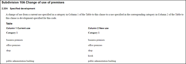
Figure 4 – Excerpt from Subdivision
10A of Part 2 of SEPP (Exempt and Complying Development Codes) 2008
· In
accordance with Part 5 – Commercial and Industrial Alterations Code of
the State Environmental Planning Policy (Exempt and Complying Development
Codes) 2008, a change of use from one type of commercial premises to
another type of commercial premises which does not fall into the category of
exempt, can be carried out as complying development (refer Figure 5). Complying
Development Certificates are issued by private certifiers as common practice,
who are not bound to review previous development consents issued by Council.
Again, the repercussions are that Council may never have the opportunity to
recoup the remaining 50% of the car parking contribution which is being held in
abeyance. It is noted that these provisions allow for change of use to a food
and drink premises and medical centre (unlike the exempt
provisions).
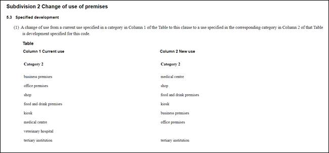
Figure 5 – Excerpt from Subdivision
2 of Part 5 of SEPP (Exempt and Complying Development Codes) 2008
· In
the event a DA is received for a future change of use application, there would
be a distinct lack of clarity on who would be required to pay the remaining 50%
of the contributions which are being held in abeyance. An Occupation
Certificate would already have been issued to the developer which confirms that
they have complied with all conditions and requirements. It is therefore likely
that the charges would then be required to be paid by the applicant for the
change of use DA – which is likely to be a small business owner. The
outstanding charges are substantial and not readily apparent to an applicant
under normal due diligence enquiry.
· In the event
a DA is received for a future change of use application, there would be a
distinct lack of clarity on whether the remaining 50% of the car parking
contribution which is being held in abeyance can actually be charged. This is
because Section 5.2.2 – Car Parking Waiver – Change of Use in
Traditional Retail Centres of the Shoalhaven Development Control Plan 2014
waivers the requirement for any further car parking to be provided for a change
use DA lodged within the Nowra CBD area.
ii. Applicant
representations made in their correspondence to Council dated 5 April 2021in
regard to Council report statements.
Applicant comment – “There
is nothing preventing the area becoming a retail precinct in the future in
accordance with its zoning potential" – Ironically, Council
themselves accept that Lawrence Ave in reality is far from a retail precinct.
· Council
Response: Council is referring to the fact a change of use from one type of
commercial premises to a retail premises (i.e., such as a shop) can be
undertaken either as exempt development or as complying development (as
discussed earlier in the Report). There are therefore no legislatory
provisions which prevent retail development from being established on
Lawrence Avenue.
Applicant comment – “Council
notes that retail development already exists in this area of the
CBD…“ – Is factually incorrect. Lawrence Ave has no such
development. Commercial business, not retail, extend for the full length of
Lawrence Avenue.
· Council
Response: The above quote referenced by the applicant is only part of a
sentence within a paragraph which describes where retail development has been
established with respect to the development site. For clarity, Council’s
full paragraph from the Report to the Development and Environment Committee
Meeting held on 6 April 2021 reads as follows:
Council notes that retail development already exists in
this area of the CBD, highlighting its viability and potential for the proposed
ground floor commercial spaces to be used as a retail premises. Food and drink
premises, restaurants and shops are well established on Kinghorne Street, right
up to the intersection with Plunkett Street; while around the corner along
Worrigee Street, a range of retail premises operate down to the corner of
Kinghorne Street. This site has connectivity from Kinghorne Street.
Applicant comment – "Food
and drink premises, restaurants and shops are well established on Kinghorne
street right up to the intersection with Plunkett street, while around the
corner in Worrigee street a range of retail premises operate down to the corner
of Kinghorne street” – The above statement is agreed, however
does not relate to Lawrence Ave, nor is there any visual or effective
connection between Lawrence Ave and Kinghorne St. Lawrence Ave is a “back
alley” while Kinghorne and Worrigee St are major thoroughfares. The
applicant also states that “Any retail venture proposed for Lawrence
Ave would be doomed to fail”.
· Council
Response: Council’s zoning of the site as B3 – Commercial Core in
accordance with the Shoalhaven Local Environmental Plan (SLEP) 2014 reflects
Council’s ongoing and future intentions for the property. Objective No. 1
for Zone B3 states the following:
To provide a wide range of retail, business, office,
entertainment, community, and other suitable land uses that serve the needs of
the local and wider community.
Council recognises that Lawrence Ave is presently occupied
predominantly by commercial office developments. However, Council’s
zoning reflects the future and ongoing intentions for the property which is
inclusive of retail developments. For clarity, a ‘Retail Premises’
is defined under the SLEP 2014 as any of the following:
· cellar door premises,
· food and drink premises,
· garden centres,
· hardware and building supplies,
· kiosks,
· landscaping material supplies,
· markets,
· plant nurseries,
· roadside stalls,
· rural supplies,
· shops,
· specialised retail premises,
· timber yards,
· vehicle sales or hire premises,
Applicant comment – “The Proponent has
previously sought legal opinion on how Council might condition the development
so that should there be a (highly unlikely) change of usage from commercial
space to retail space.
An opinion and suggested
clauses have been included in our submission from PDC Lawyers that suggests
Council could condition the development, such that if retail was to be taken
up, then further car parking contributions would be made.
Council’s opinion that
a “restrictive s88B covenant would be highly likely to be varied or
set aside if development is otherwise considered appropriate for approval
….” is considered moot. The issue is not whether retail
development is considered allowable within the zone, but that should that occur
appropriate carparking contributions would be payable.
We again request that Council
agree to the calculation for car spaces to the ground floor level of the
Lawrence Ave development be based on a more appropriate rate of 1 space per 40m²
which is consistent with the use of the building.
· Council
Response: Having regard to existing legal precedents which have been set as
discussed in the Report above, Council cannot impose a restrictive covenant
that prevents a particular type of development from being established.
Conversely, Council cannot impose a condition of consent restricting the use of
the ground floor to a specific type of commercial premises contrary to zoning
provisions. A development consent cannot potentially seek to prevent a lawful
use, as permitted by a planning instrument. This would result in a
condition of consent contrary to the prevailing legislation.
iii. Further reasons why
the proposed modification to Condition 17 should be refused.
· Support
for a reduction in the car parking contributions for the development equates to
a departure to the car parking requirements for the development in accordance
Section 5.1 – Car Parking Schedule of Council’s DCP Chapter G21
– Car Parking and Traffic. It will create a precedent which can be used
by future developers seeking a relaxation of Council’s car parking
requirements.
· Car parking
contributions go towards Council’s Project No. 01 CARP 3001. This is an
important fund which enables Council to undertake works to provide and maintain
public car parks within CBD area. The nature of the project is further
described within the Shoalhaven Contributions Plan accessible to community
members on the Council website (see https://cp.shoalhaven.nsw.gov.au/projects/01carp3001).
In particular the following comments are made regarding the project:
o The aim is to provide car parking to meet future retail and
commercial demand.
o The project is critical for the coordinated approach to the
supply of 900 car parking spaces in the central business district.
o Funds collected will be applied to the
provision of public parking.
In order for the above listed works to continue to be able
to be undertaken to the satisfaction of the local community, it relies upon
funds generated as part of 01 CARP 3001. A reduction in the funds received
resulting from a relaxation in the car parking contributions has the potential
to reduce the functionality and capability of this ongoing project.
· The
site is mapped within the B3 Commercial Core Zone in accordance with the SLEP
2014 and is therefore formally part of the CBD area. There is nothing
preventing the area becoming a retail precinct in the future in accordance with
its zoning potential.
· Section
5.1 – Car Parking Schedule of Council’s DCP Chapter G21 – Car
Parking and Traffic (originally adopted on 22 October 2014) was only recently
reviewed by Council.
The review included a revisiting of the required car
parking rate for ‘Commercial Premises’ within Zone B3 –
Commercial Core. Following the review, Council reaffirmed that the parking rate
of one (1) space per 24m² within Zone B3 represents a modern and
up-to-date representation of the parking requirements for a new commercial
development within the Nowra CBD area. Version 4 of SDCP 2014 Chapter G21 was
subsequently adopted at Council’s Development and Environment Committee
Meeting held on 6 October 2020.
· While
the development is mapped as requiring a 1 space per 24m2 for ground
floor B3 Commercial Core Commercial Premises, it receives a concession in that
it benefits from the 25% discount for this location in regard to the residential
component.
The calculations given in Table 1 identifying a shortfall
of 18.20 spaces is therefore considered to be reasonable, soundly based on
Council’s adopted DCP noting also there is a concession in place (25%)
and therefore appropriate.
To account for the additional parking space proposed by
the applicant and the 3.3m² reduction in gross floor area across the
ground, first, and second floor levels – the car parking contribution
amount under Condition 17 would be reduced as follows:
Approved
Charge
|
01 CARP
3001
|
Car parking
provision at Egans Lane, 8 Lawrence Ave, Collins Way, Bridge Road, Lamonds
Lane, 9 Haigh Avenue & 67 Kinghorne Street
|
$27,178.89
|
19.51
|
$530,260.14
|
$0.00
|
$530,260.14
|
Proposed Charge
|
01 CARP
3001
|
Car parking
provision at Egans Lane, 8 Lawrence Ave, Collins Way, Bridge Road, Lamonds
Lane, 9 Haigh Avenue & 67 Kinghorne Street
|
$27,722.47
|
18.2
|
$504,548.95
|
$0.00
|
$504,548.95
|
2. Issues
– Condition 33(b) – Proposed Removal of Requirement for a Type 4
Footpath – Condition 33(b)
Resolution:
That
in respect of Condition 33, access design standards for Lawrence Avenue, a
further report be submitted to the next meeting of the Development &
Environment Committee proposing an interim solution to pedestrian access issues
(including disability access).
Proposed Modification
Condition 33 requires detailed
engineering design plans for footpath works in the Lawrence Ave road reserve to
be submitted to Council. The purpose of the modification to Condition 33 is to:
· Amend
the timing of the requirement for the submission of engineering plans from
being required ‘prior to Construction Certificate’ to ‘prior
to the commencement of works within the road reserve’. Council is
supportive of this request.
· Amend
Condition 33(a) to outline that the footpath must achieve a crossfall of at
least 3% or a design as approved by Council. Council is supportive of
this request.
· Amend
Condition 33(b) to delete this part of the condition in its entirety. Council
is not supportive of this request and further discussion is provided below.
· Amend
Condition 33(c) to refer to Lawrence Ave instead of Kinghorne St.
Council is supportive of this request.
Condition 33(b) outlines:
“…
Details are to be shown on the engineering design plans and must incorporate
the following:
(b) Provision of a Type 4 part-width concrete pathway in accordance with the
Streetscape Technical Manual”
Council’s Streetscape
Technical Manual provides design and construction detail for the nominated Town
and Village Centres in Chapter G18 – Streetscape Design for Town and
Village Centres of the SDCP 2014. This Chapter applies as the development
includes a proposal for a commercial, mixed use, and shop top housing
development in the Nowra CBD.
The purpose of the Streetscape
Technical Manual is to establish a uniform design and material palette for
Shoalhaven City Council (SCC), while also providing guidelines for each Town
and Village to ensure their character is represented in the streetscapes. The
manual states that the document is “used to condition Development
Consents as a basis for the design of the streetscapes by SCC and by
individuals as part of developments” (emphasis added).
A ‘Type 4 Footpath’
(refer description at Figure 4) is listed as a requirement under
Council’s Streetscape Technical Manual for this area of the Nowra CBD and
was duly conditioned as a requirement by Council’s Development
Engineering Group under the original consent.
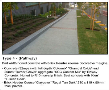
Figure 4 – Type 4 Footpath Streetscape
Technical Manual
Chapter
G18 – Streetscape Design for Town and Village Centres of the SDCP 2014 -
Acceptable Solution A6.3 specifies the following requirement:
“Where the footpath/pathway design in the
Streetscape Technical Manual differs to the existing footpath design, the new
footpath is to be provided as per the Streetscape Technical Manual”.
The existing footpath design
differs from the design listed under the Streetscape Technical Manual and
therefore, the new footpath requires a design which accords with the Manual.
The applicant’s proposed deletion of this condition would result in a
non-compliance and departure from Acceptable Solution A6.3.
The Lawrence Avenue frontage of
the site is mapped on the Land Reservation
Acquisition Map and was
formally acquired by Council for the purpose of road widening in December 2020.
Notwithstanding, Council’s City Services section was consulted as
part of the modified development application referral process. In their
response, City Services clarified that no redesign plan has presently been
undertaken for the acquisition area or for the remainder of Lawrence Ave. City
Services further indicated that the required redesign is not planned in the
near future and in fact, may not occur for a number of years.
Applicant’s Submission
Representations made by
applicant as part of their correspondence dated 15 March 2021:
“The procurement process of the
land is complete, and Council has carried out on site survey works identifying
the location of the adjusted road reserve and western boundary [Council note:
The land has since been procured for road widening]. The streetscape of the
neighbouring property to the South of Lot B (frontage to the
‘Centrelink’ Building) comprises extensive brick paving.
There are complications present with
the interface of Lot B frontage and the ‘Centrelink’ pavers to the
south with regard to Council’s requirements for cross fall. The current
paving has cross falls from the current boundary of Lot B ranging between 5.1%
– 9%, with the alignment of the existing footpath having a grade of 8.3%.
The land acquisition will impact
adversely at both the south and north ends of Lot B frontage. Compounding the
issue is a dual driveway apron extending beyond the north boundary line of Lot
B across the adjoining property ‘Inspirations Paint’.
While it is incumbent on the
Proponents to provide access from the site it would not be expected that their
responsibility would extend beyond the boundaries. Given the above it is
proposed to not make any changes to the existing footpath or streetscape of
Lawrence avenue frontage.
Levels for
the proposed road acquisition are unknown, and Council is unlikely to be in a
position to provided proper design levels for the Proponent to work with. It is
proposed to provide a wide access pathway from the existing footpath to the
main entrance of the building. The pathway will be located at suitable grades
to provide access for people with a disability in accordance with NCC.”
Representations made by
applicant as part of their 5 April 2021 correspondence relating to the 6 April
2021 Development & Environment Committee Meeting:
“It is proposed that a ‘Type 4’ part
width concrete footpath in accordance with Council’s ‘Streetscape
Technical Manual’ be constructed,
necessitating the removal of the existing plain concrete
footpath.
We have presented our arguments in support of our
application. However, we have not been made aware of Council’s reasoning
for rejecting our application until this report.
Briefly from the report it appears that Council argues
that a departure from the Streetscape Technical Manual is not warranted,
quoting “Performance Criteria P6” which states: ‘Allow for
convenient and equitable pedestrian travel through the provision of
footpaths/pathways in centres. Footpath design is consistent to encourage
visual continuity and legible centres.
Council further argues:
· That to
not provide a Type 4 path would not provide “visual continuity”.
· Would be
for an indefinite time, as a full acquisition of Lawrence Ave is unknown
· Would set
a precedent for any future development along Lawrence Ave.
RESPONSE: It is difficult to
understand the argument of “continuity” and “precedent being
set" for any future development of Lawrence Ave when considering the
current paths on both the western and eastern side of the road.
According to the Streetscape Technical Manual map / plan
for the Nowra town centre, Type 4 is indicated for both sides of Lawrence Ave,
commencing at Worrigee St, and extending through to Plunkett St.
However not one development, including the more recent
along the western side, has been provided with a Type 4 path. All is in brick
paving, except that of the public carpark, which has no footpath.
To the eastern side, all paths are plain concrete, except
for the extensive brick paving that fronts the ‘Centrelink’
building. The south side is Worrigee St fronting ‘Inspirations
Paint’ and is designated to be Type 3 (full width honed concrete) but is
a part width plain concrete path.
The north side of Worrigee St is designated to be Type 1
(full width variant) but also is part width concrete.
In terms of “continuity” and for an
“indefinite time” plain concrete would be more appropriate.
Notwithstanding the above that is only addressing
appearance and finishes, the matter of existing levels vs future levels of the
road reserve should be taken into account, as presented in our original
submission.
Discussion
The following discussion is
provided which addresses:
· Comments
and questions raised during the Development and Environment Committee Meeting
held on 6 April 2021.
· Comments
and representations made by the applicant above.
· Reasons why
the proposed modification to Condition 33(b) should be refused.
i. Footpath
Crossfall and Disabled Accessibility
In conjunction with the
applicant, a site inspection was held with Council officers on 2 December 2020
where it was recognised that a crossfall of 3%, which was originally consented
to, would not be able to be achieved. Condition 33(a) is hence proposed to be
modified to include the wording: ‘footpath levels must comply with a
3% cross fall from the boundary to top of kerb, or a design as approved by
Council’. City Development is supportive of the proposed
modifications to Condition 33(a) of the consent, and recognising the unique
circumstances of the site, would be pleased to review a design presented by the
applicant prior to any works commencing, which still proposes appropriate
crossfall grades that permits accessibility across the frontage.
City Development’s
proposal not to support the proposed deletion of Condition 33(b) instead
relates to the design and character of the footpath (i.e., footpath types,
planting details, colour palette, street furniture) and is independent of
disabled accessibility.
ii. Interim Solution for
Footpath until a Final Design is Formulated
In accordance with MIN21.171 of
Council’s Development and Environment Committee Meeting held on 6 April
2021, it was proposed that an interim solution for access design standards and
pedestrian access adjacent to Lawrence Ave be proposed.
City Services is not supportive
of an interim design for the footpath and instead recommends full compliance
with the Streetscape Technical Manual for the following reasons:
· The
Streetscape Technical Manual is a document which was adopted by Council at the
Development & Environment Committee Meeting held on 8 May 2018 with the aim
being to reflect the desired and future pattern for the Nowra Town Centre
streetscape. It is therefore recommended that Council enforce compliance with
the provisions of the document.
· Given
its adoption in May 2018, the Technical Manual recognises that existing
footpath arrangements within the Nowra Town Centre may not comply with the
provisions which are set out and hence any upgrades would need to take place in
a ‘piecemeal’ fashion.
For example, the Technical Manual provides for the
following allowance were considered to be relevant:
“All existing ‘pebblecrete’ and
‘claypave’ (Regal Dark Tan) paver footpaths and pathways shall be
retained if deemed by Council to be in good condition”.
· An
interim design has the potential to represent a variance from the Streetscape
Technical Manual and may set a precedent for future developers who do not wish
to undertake works which comply with the Manual. Setting
precedents has the potential to result in the abandonment of the standards,
resulting in future compliance being unnecessary and unreasonable.
· Whilst
City Services has indicated a design may not be formulated for many years for the
full extent of the Lawrence Ave streetscape, it is likely that the design would
take place according to the provisions shown in the Technical Manual.
Council’s Condition 33(b) requiring the developer undertake a design
which complies with the Manual is therefore considered to be the most
appropriate ‘interim’ solution until the final design is
formulated.
· Any
‘interim’ solution which deviates from the Technical Manual (i.e.
such as maintaining the current status quo) would then place a burden on Council
to undertake the works required to upgrade the footpath from the interim
solution to match the final design. Such a cost is likely to be borne to
Council/community to fund the upgrade instead of the developer.
· As an
example, a similar upgrade to the footpath was recently completed along Berry
St adjacent to the Roxy Theatre – the cost for these works for this
project was estimated at over $200,000 in value. This is representative of the
cost which is likely to be borne the community to fund any future upgrade.
iii. Applicant
representations made in their correspondence to Council dated 5 April 2021.
Applicant comment:
“Briefly from the report it appears that Council
argues that a departure from the Streetscape Technical Manual is not warranted,
quoting “Performance Criteria P6” which states: ‘Allow for
convenient and equitable pedestrian travel through the provision of
footpaths/pathways in centres. Footpath design is consistent to encourage
visual continuity and legible centres.
Council further argues:
· That
to not provide a Type 4 path would not provide “visual continuity”.
· Would
be for an indefinite time, as a full acquisition of Lawrence Ave is unknown
· Would
set a precedent for any future development along Lawrence Ave.
It is difficult to understand the argument of
“continuity” and “precedent being set" for any future
development of Lawrence Ave when considering the current paths on both the
western and eastern side of the road.
· Council
Response: As discussed in the Report above, the Streetscape Technical
Manual is a new document adopted by Council at its Development &
Environment Committee Meeting in May 2018. It recognises that the upgrade of
footpaths to match the desired layout is likely to be undertaken in a piecemeal
fashion having regard for various different existing footpaths, levels, and
arrangements.
The precedent referred to is
non-compliance with A6.3 of Chapter G18 – Streetscape Design for Town and
Village Centres of Council’s Development Control Plan 2014. The precedent
referred to is a relaxation of the standards for future developers who do not
wish to undertake works which comply with the Manual. Setting
precedents has the potential to result in the abandonment of the
standards, resulting in future compliance being unnecessary and unreasonable.
Applicant comment:
“According to the Streetscape Technical Manual map
/ plan for the Nowra town centre, Type 4 is indicated for both sides of
Lawrence Ave, commencing at Worrigee St and extending through to Plunkett St.
However not one development, including the more recent
along the western side, has been provided with a Type 4 path. All is in brick
paving, except that of the public carpark, which has no footpath.
To the eastern side, all paths are plain concrete,
except for the extensive brick paving that fronts the ‘Centrelink’
building. The south side is Worrigee St fronting ‘Inspirations
Paint’ and is designated to be Type 3 (full width honed concrete) but is
a part width plain concrete path.
The north side of Worrigee St is designated to be Type 1
(full width variant) but also is part width concrete.
In terms of “continuity” and for an
“indefinite time” plain concrete would be more appropriate.
Notwithstanding the above that is only addressing
appearance and finishes, the matter of existing levels vs future levels of the
road reserve should be taken into account, as presented in our original
submission.
· Council
Response: The applicant’s comments above reflect the lack of
continuity in the current layout footpaths within Lawrence Ave and within the
surrounding block. The present layout and integration with neighbouring
properties also demonstrates changing and non-compliant crossfalls which can
present dangers for pedestrians and a lack of disabled accessibility.
Council has provided within
Condition 33 appropriate requirements to not only ensure appropriate and
compliant crossfalls across the site but also a design which reflects
Council’s adopted streetscape standards for the future.
Planning Assessment
The DA has been (or will be) assessed under s4.15 of the
Environmental Planning and Assessment Act 1979. Please refer to
Attachment 2.
Consultation and Community
Engagement:
Notification was undertaken in
accordance with Council’s Community Consultation Policy with letters
being sent within a 100m buffer of the site, during the period 12 January 2021
to 28 January 2021.
Nil public objections were
received in relation to Council’s notification of the development.
Financial Implications:
There are potential cost
implications for Council in the event of an outright refusal of the
application.
Legal
Implications
Pursuant to section 8.2 of the Environmental Planning and
Assessment Act 1979, a decision of the Council may be subject of a review by
the applicant in the event of an approval or refusal. If such a review is
ultimately pursued the matter would be put to Council for consideration.
Summary and Conclusion
This application has been
assessed having regard for section 4.15 (Matters for consideration) of the Environmental
Planning and Assessment Act 1979.
For the reasons described in the
Report above, it is considered that the application warrants a partial approval
and partial refusal.
City Development advises that
the proposed modifications to the following conditions of consent are supported
as recommended in the draft consent at Attachment 1:
· Condition
33 – Access Design Standards (Parts (a) and (c) only).
· Condition
17 - Contributions for Additional Services and/or Facilities as proposed by
Council staff.
City Development advises that
the proposed modifications to the following conditions of consent are not
supported for the reasons described in the Report above:
· Condition
17 – Contributions for Additional Services and/or Facilities as requested
by the applicant; and
· Condition
33 – Access Design Standards (Part (b) only).
|

|
Development
& Environment Committee – Tuesday 11 May 2021
Page
0
|
DE21.49 DA20/1966
- 29 Strongs Road, Jaspers Brush - Lot 215 DP 1210788 - Single A-Frame Advert
Sign
DA. No: DA20/1966/4
HPERM Ref: D21/142175
Department: Development
Services
Approver: Phil
Costello, Director - City Development
Attachments: 1. Section
4.15 Assessment Report (under separate cover) ⇨
2. Determination
Document - Refusal ⇩
3. Development
& Environment Committee Report - 2 March 2021 (under separate cover) ⇨
4. Confidential Legal Advice
(Confidential - under separate cover)
Description of Development: Temporary use of land
for the placement of an A-frame advertising sign on a trailer
Owner: Robert Bruce Drewitt Smith
Applicant: Foundation Law Group
Notification Dates: 29 September 2020 – 15
October 2020
No. of Submissions: Nil (0)
Purpose / Reason for consideration
by Council
Council Resolved on 7 April 2020 (MIN20.240) with respect
to COVID- 19 Response, that:
7. To maintain, continue and
encourage as much economic activity as possible Council adopt the following
policies, to be followed by an implementation report from the CEO:
…
k. The delegation to the CEO be rescinded to determine a
development application by refusal until the end of COVID 19 crisis
The
refusal of a development application must only be by Council/Committee resolution
This Report recommends refusal of
the above application and is therefore prepared for consideration by the
Development & Environment Committee in accordance with the 7 April 2020
Resolution of Council.
On 2 March 2021, the Development
Application was reported to the Development & Environment Committee for
determination in accordance with the recommendations of the Council Report
(D21/5069).
The Development & Environment
Committee resolved (MIN21.107) that:
“[T]he matter be deferred
pending legal advice as to whether the construction works being carried out on
the site by Hotondo Homes and their control of the site as the builder would
facilitate a method of approving an advertising sign for the period of
construction works."
Council has now received legal
advice on the permissibility of development for the purposes of the proposed
signage. The ‘confidential’ advice is provided as Attachment 4
to this Report.
|
Recommendation
(Item to be determined under delegated authority)
That
DA20/1966, for the temporary use of land for the placement of an A-frame
advertising sign on a trailer, be determined by way of refusal for the
reasons set out in the Notice of Determination, Attachment 2 to this
report.
|
Options
1.
Refuse the Development Application in accordance with the recommendation.
Implications: The proposal would not proceed. The applicant can however
apply for a section 8.2 review of Council’s decision and/or could lodge
an appeal with the NSW Land and Environment Court against Council’s
decision.
2. Approve the Development Application.
Implications: Council’s legal advice (Attachment 4) does
not specify a planning pathway for approval of the Development Application.
3.
Alternative recommendation.
Implications: Council will need to specify an alternative
recommendation and advise staff accordingly.
Summary and Conclusion
The Council Report (D21/5069 (Attachment
3) and s. 4.15 Assessment Report (Attachment 1) provides an
assessment of a proposal to erect a single, temporary and mobile A-frame
advertising sign with a combined signage area of 24m2 (12m2
front and back) for no more than 52 days in a 12-month in accordance with cl.
2.8 of Shoalhaven Local Environmental Plan 2014 (SLEP 2014), on the land
identified as No. 29 Strongs Road, Jaspers Brush and is legally described as
Lot 215 DP1210788.
The signage has been assessed
against all relevant environmental planning instruments and Shoalhaven
Development Control (DCP) 2014.
The signage does not demonstrate
compliance with State Environmental Planning Policy (SEPP) 64 –
Advertising and Signage, clause (cl.) 2.8(3)(c) of SLEP 2014 and the relevant
provisions of the Chapter G22 of SDCP 2014.
On 2 March 2021, the Development
& Environment Committee resolved (MIN21.107) to defer the determination of
the development application, pending the receipt of legal advice on the
permissibility of the proposed signage.
Council has now received legal
advice on the permissibility of development for the purposes of the proposed
signage. The ‘confidential’ advice is provided as Attachment 4
to this Report.
The legal advice concludes at
paragraph [5.23] and [5.24] that:
“[I]t is open to the Council to conclude that the
proposed advertising is prohibited on the land as it does not satisfy the
requirements of cl 2.8(3) of the LEP.
Even if the advertisement was permissible with consent
under cl 2.8, the Council would nevertheless be precluded from granting consent
because the jurisdictional prerequisites in cl 15 of the Advertising SEPP are
not satisfied.”
The
application is recommended for refusal in accordance with the attached determination
document (Attachment 2).
|
|
Development
& Environment Committee – Tuesday 11 May 2021
Page
0
|
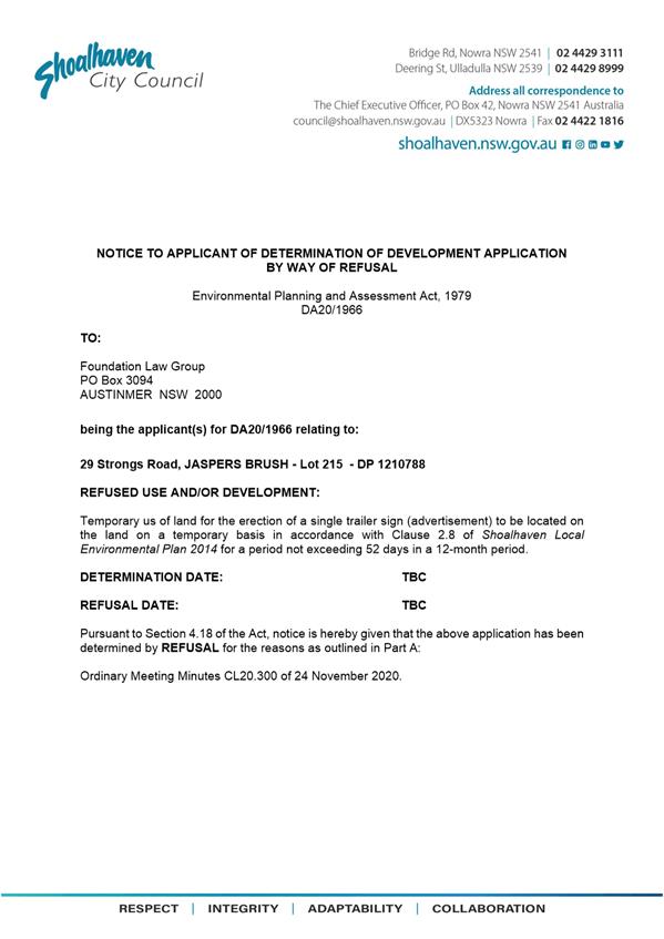
|
|
Development
& Environment Committee – Tuesday 11 May 2021
Page
0
|
DE21.50 DA16/1465
- 173 Kinghorne St and 2 & 4 Albatross Rd Nowra - Lot 1, 29 and 30 DP 25114
DA. No: DA16/1465/4
HPERM Ref: D21/144532
Department: Development
Services
Approver: Phil
Costello, Director - City Development
Attachments: 1. s4.15
Assessment Planning Report (under separate cover) ⇨
2. Determination Document -
Refusal ⇩
Description
of Development: Demolition of existing structures and construction of a mixed-use
development consisting of 55 apartments including 16 x 3-bedroom, 31 x 2
bedroom and 8 x 1-bedroom apartments, a basement car parking area and 3
commercial tenancies at ground floor with frontage to both Kinghorne Street and
Albatross Road
Owner: Bill Zervos and Jasmine Anne Simpson &
John Irwin Gould
Applicant: Lee Carmichael Town Planning (now trading
as) PDC Planners
Notification Dates: 14 June – 14 July 2017
No. of Submissions: Six (6) submissions in
objection and Nil (0) in support.
Purpose
/ Reason for consideration by Council
On 1 October 2019, it was
resolved by the Development and Environment Committee that Development
Application (DA) ‘DA16/1465 – Residential Units and
Commercial Space – 173 Kinghorne Street, Nowra be called in to Council
for determination due to significant public interest.’ (DE19.107)
On 6
October 2020, the Development & Environment Committee resolved (MIN20.728):
“That consideration of Development Application
DA16/1465 – Mixed Use development consisting of 55 residential units and
commercial space on the land known as 173 Kinghorne Street and 2 & 4
Albatross Road, Nowra (Lot 1, 29 and 30 DP 25114) be deferred to the January
2021 Development and Environment Committee Meeting to allow Council to
undertake further traffic investigations in consultation with the
developer.”
Council has taken the following
actions, following the Council resolution:
1. On 18 November 2020,
relevant Council staff met to discuss critical aspects of the Development
Application in particular the Traffic Management Report prepared by
Jones Nicholson Consulting Engineers dated 27 February 2021 (Reference:
CRPT-16020003.01B). The outcomes of the meeting were provided to the applicant
on 26 November 2021 (D20/526133).
2. On 21 December 2020,
Council provided additional information to the applicant in the form of:
‘Outputs’ from Council’s traffic modelling and
Council’s requirements for a future 4 lane cross section of Albatross
Road (D20/563561). Council also offered as part of the forwarding of this
additional information the opportunity to meet further to ensure that all
matters have been addressed relating to traffic and planning issues.
3. On 15 January 2021,
Council notified the applicant via email (D21/16222) that the information
requested in Council’s 21 December 2020 was required to be submitted to
Council in 7 days.
4. On 4 February 2021,
Council emailed the applicant (D21/43579) offering to meet to discuss the
additional information.
5. On 10 February 2021,
Council notified the applicant via email (D21/52704) that the information
requested in Council’s 21 December 2020 was required to be submitted to
Council in 7 days as the applicant had not responded to Council in relation to
the offer of a meeting and the information had not been submitted.
6. On 23 February 2021,
the applicant’s traffic consultant (Stephen Falkner) emailed Council, to
request the following:
· traffic
data on the existing road network from their records; and
· projected
traffic data for 10-year projections (2031).
7. On 12 March 2021,
Council emailed the applicant’s traffic consultant (Stephen Falkner)
(D21/99332) with the following:
· Council’s
most recent tube traffic count for the area; and
· projected
traffic data for 10-year projections (2031).
8. On 24 March 2021,
Council emailed the applicant (D21/117366) to inform them that the application
would be required to be reported to Council in the absence of a formal response
to Council’s email dated 21 December 2020.
9. On 31 March 2021,
the applicant was emailed (D21/127622) to inform them that the additional
information was required to be submitted to Council within 7 days.
The assessing officer has also called and left messages with
the applicant to discuss the application in the intervening period. The
applicant has not responded to Council’s emails and requests for updates.
Options
1. Refuse the
Development Application (DA) in accordance with the recommendation.
Implications: The proposal would not proceed in its current
form. The applicant can, however, apply for a section 8.2 review of
Council’s decision and/or could lodge an appeal with the NSW Land and
Environment Court against Council’s decision.
2. Approve the DA.
Implications: Council would have to provide reasons to support
the development, having regard to section 4.15 of the Environmental Planning
and Assessment Act 1979 (EP&A Act) considerations. Should
Council resolve to approve the DA a suite of conditions would be required to be
drafted for reconsideration by the Development & Environment Committee.
Under some circumstances, third parties (i.e., objectors) can seek a judicial
review of Council’s decision in the NSW Land and Environment Court.
3. Alternative
recommendation.
Implications: Council will need to specify an alternative
recommendation and advise staff accordingly.
Location Map
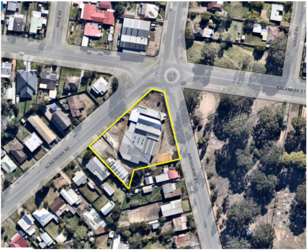
Figure 1 - Extract of the subject site in the local context.
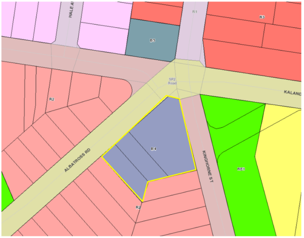
Figure 2 - Extract of the Shoalhaven Local Environmental Plan 2014
Land Use Zoning Map with the subject site
with a yellow border
Background
Post-Lodgement
Key dates are as follows:
· 8
April 2016, the DA was lodged with Council.
· 9
August 2016, Council requested additional information from the applicant in
relation to the design and access arrangements from Albatross Road.
· 16
December 2016, revised plans and additional information was submitted by
the applicant in response to Council’s letter dated 9 August 2016. The
amended plans included modifications to the southern portions of each wing of
the building and deletion of two apartments (reducing the unit yield from 57 to
55 apartments). The reduction in units on the southern portion of the
development was proposed to achieve a more appropriate transition to the
adjoining low-density development.
· 27
February 2017, Council requested additional information from the applicant,
with continued concerns raised in relation to design elements and major concerns
raised in relation to the proposed access/egress onto Albatross Road.
· 7
March 2017, Council met with the applicant to discuss the Planning Proposal
over the site (described below) and continued concerns with the design and
location of access/egress onto Albatross Road.
· 22
March 2017, a further additional
information letter was sent to the applicant to detail the outcomes of the 7
March 2017 meeting and to express continued concerns regarding the proposed
access/egress onto Albatross Road.
· 10 July 2018, Council
met again with the applicant to discuss design and traffic issues.
· 12
September 2018, the applicant lodged concept plans for access/egress to the
development from Kinghorne Street for Council’s consideration (refer to Figure
15).
· 12
October 2018, Council provided feedback to the applicant on the concept
plan, noting that the concept plan addressed the main concern that had been
raised by Council being the relocation of the access from Albatross Road to
Kinghorne Street frontage.
· 18
April 2019, the applicant confirmed that they would not be pursuing
any change to the design of the development which would relocate the access
from Albatross Road to Kinghorne Street frontage.
· 12
August 2019, the applicant submitted a further amended Traffic Report
prepared by Jones Nicholson (D19/280251) to justify the retention of access on
the Albatross Road frontage and to address concerns raised in relation to the
designs apparent inconsistency with State Environmental Planning Policy
(Infrastructure) 2007.
· 1
October 2019, the Development and Environment Committee that Development
Application (DA) ‘DA16/1465 – Residential Units and
Commercial Space – 173 Kinghorne Street, Nowra be called in to Council
for determination due to significant public interest.’ (DE19.107).
· 26
November 2019, the applicant submitted amended plans, acoustic report, and
clause 4.6 variation statement.
· 6
October 2020, the Development &
Environment Committee resolved (MIN20.728):
“That consideration of
Development Application DA16/1465 – Mixed Use development consisting of
55 residential units and commercial space on the land known as 173 Kinghorne
Street and 2 & 4 Albatross Road, Nowra (Lot 1, 29 and 30 DP 25114) be
deferred to the January 2021 Development and Environment Committee Meeting to
allow Council to undertake further traffic investigations in consultation with
the developer.”
Council has taken the following
action in relation to the above matter, following the 6 October 2020 Council
resolution:
1. On
18 November 2020, relevant Council staff met to discuss critical aspects of the
Development Application in particular the Traffic Management Report
prepared by Jones Nicholson Consulting Engineers dated 27 February 2021
(Reference: CRPT-16020003.01B). The outcomes of the meeting were provided to
the applicant on 26 November 2021 (D20/526133).
2. On 21 December 2020, Council provided additional
information to the applicant in the form of: Outputs
from Council’s traffic modelling and Council’s requirements for a
future 4 lane cross section of Albatross Road (D20/563561). Council also
offered as part of the forwarding of this additional information the opportunity to meet further to ensure that all matters
have been addressed relating to traffic and planning issues.
3. On
15 January 2021, Council notified the applicant via email (D21/16222) that the
information requested in Council’s 21 December 2020 was required to be
submitted to Council in 7 days.
4. On
4 February 2021, Council emailed the applicant (D21/43579) offering to meet to
discuss the additional information.
5. On
10 February 2021, Council notified the applicant via email (D21/52704) that the
information requested in Council’s 21 December 2020 was required to be
submitted to Council in 7 days as the applicant had not responded to Council in
relation to the offer of a meeting and the information had not been submitted.
6. On
23 February 2021, the applicant’s traffic consultant (Stephen Falkner)
emailed Council, to request the following:
§ traffic data on the existing road network from their records; and
§ projected traffic data for 10-year projections (2031).
7. On
12 March 2021, Council emailed the applicant’s traffic consultant
(Stephen Falkner) (D21/99332) with the following:
§ Council’s most recent tube traffic count for the area; and
§ projected traffic data for 10-year projections (2031).
8. On
24 March 2021, Council emailed the applicant ( D21/117366)
to inform them that the application would be required to be reported to Council
in the absence of a formal response to Council’s email dated 21 December 2020.
9. On
31 March 2021, the applicant was emailed (D21/127622) to inform them that the
additional information was required to be submitted to Council within 7 days.
Site History and Previous
Approvals
In April 2016, a Planning
Proposal (PP) was lodged concurrently with this DA to rezone the subject site to
enable development of the land as currently proposed.
The previous land zoning (B5
Business Development) only permitted residential development for the purpose of
‘shop top housing’ which would require the entire ground floor to
be developed for commercial use.
The PP sought to amend the
following Land Zoning and Height of Buildings maps in Shoalhaven Local
Environmental Plan 2014 (SLEP 2014):
· Land
Zoning – Sheet LZN_013E - amend zoning of subject land from B5 Business
Development to B4 Mixed Use.
· Height of
Buildings – Sheet HOB_013E - amend maximum height of building from 11m
default height (no mapped) maximum building height as per clause 4.3(2A) of
Shoalhaven Local Environmental Plan (LEP) 2014, to a height determined by the
outcome of the character assessment (maximum of 15m).
On 12 September 2017, the Development Committee resolved
(MIN 17.776) to adopt the PP as exhibited with the following addition:
“to avoid uncertainty,
the width of the part of the site with an 8.5m maximum building height is 9m,
as measured from the southern boundaries of Lot 1 and Lot 30 DP 25114, and
south-eastern and south-western boundaries of Lot 29 DP 25114.”
Under Council’s
delegation, the PP was forwarded to NSW Parliamentary Counsel to draft the
amendment to SLEP 2014 under Section 59(1) of the Environmental Planning and
Assessment Act 1979 (EP&A Act).
On 6 October 2017, Amendment No.
16 to SLEP 2014 was published on the NSW Legislation website and commenced,
bring into effect the zoning and building height changes outlined above.
The following
is a list of relevant approvals for the subject site:
· BA73/1794:
Showroom additions
· BA74/0275: Storage
Shed
· BA76/0601: Car
yard additions
· DA01/2756: Car
service centre – alterations and additions – approved – 9
October 2001.
· DA02/2244:
Commercial Workshop/Shed – approved – 30 August 2002.
The subject site
has operated in the capacity of vehicle servicing, repairs, and sales for a
significant period.
Proposed Development
The Development Application (DA)
is seeking development consent for the demolition of existing structures and
construction of a mixed-use development consisting of 55 apartments,
including:
· 8 x 1-bedroom
apartments
· 31
x 2 bedroom
· 16
x 3 bedroom
· 3
commercial tenancies (total commercial floor area 259m2 (267m2
including bathroom i.e., GFA) at ground floor with frontage to both Kinghorne
Street and Albatross Road.
· A
basement car parking area accessed via Albatross Road with 93 car parking
spaces.
· Construction
of a left turn slip lane (removal of on-street parking) for access into the
basement car park off Albatross Road.
· Construction
of a central median and signage on Albatross Road to control the movement of
traffic in and out of the proposed development (left in and left out movements
only).
A site plan, ground floor,
elevations, landscape plan and photomontages are provided in Figures 3
– 14.
Figure 3 - Site Plan of the proposed development.
Figure 4 - Basement floor plan of the proposed development.
Figure 5 – Elevation of the proposed development (western
elevation – Albatross Road)
Figure 6 - Elevations of the proposed development (eastern
elevation – Kinghorne Street).
 Figure 7 - Elevation of the proposed development (southern
elevation).
Figure 7 - Elevation of the proposed development (southern
elevation).
Figure 8 - Section plans of the proposed development.
Figure 9 - Section plans of the proposed development.
Figure 10 - Landscape plans of the proposed development.
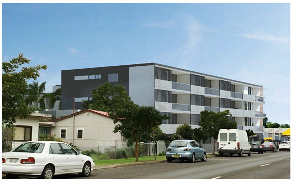
Figure 11 - Photomontage view from the south-eastern (Kinghorne
Street).
Figure 12 - Photomontage view from the north-eastern corner of
Kinghorne and Kalandar Street.
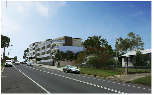
Figure 13 -Photomontage of the south-western elevation of the
development as viewed from Albatross Road.
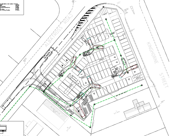
Figure 14 - Extract of engineering design plan
indicating the slip-lane and entry design to the development. The design
includes a central median on Albatross road to limit vehicle movements to a
left in and left out movement.
Subject Land
The subject site comprises 3
lots (subject site) located on the south-western corner of the intersection of
Kinghorne Street, Albatross Road and Kalandar Street. The subject site is
described and legally identified as follows:
· Lot
29 DP 25114 – 4 Albatross Road, Nowra
· Lot
30 DP 25114 – 2 Albatross Road, Nowra
· Lot
1 DP 25114 – 173 Kinghorne Street, Nowra
The site is an irregular shaped
lot with a frontage of 74m to Albatross Road and 60m to Kinghorne Street with a
9.5m corner splay. The site falls gradually to the south-western corner
of the site at Albatross Road.
The combined land area of the
lots is approximately 3,497m2.
Site & Context
An electrical wholesale supply
business (L&H Electrical) occupies the site. The site had previously
operated as a car servicing workshop that serviced and repaired motor vehicles.
The site adjoins established residential uses to the south and west, a tyre
service and residential uses to the north and public open space to the east.
The surrounding development can
be broadly characterised as low-density residential consisting of single and
two storey dwelling houses. Development immediately to the south consists of
free-standing single storey dwellings and associated outbuildings.
Beyond these dwellings and on
land bound by Albatross Road, Kinghorne Street and Albert Street is low density
residential development – mainly of single storey construction and
typically older housing stock.
To the west on the opposite side
of Albatross Road is a continuation of predominately freestanding low-density
dwellings with some multi dwelling housing developments.
To the east on the opposite side
of Kinghorne Street, is a Council park and cemetery.
On the northern side of the
intersection of Albatross Road and Kinghorne Street is an existing tyre shop.
On the eastern side of Kinghorne Street at the intersection with Kalandar
Street Council has recently approved 2 x 4 storey residential flat buildings,
consisting of 91 apartments and basement car park (DA19/1846).
As mentioned earlier, the land
was the subject of a planning proposal to zoning of subject land from B5
Business Development to B4 Mixed Use and amend maximum height of building to
part 14m and 8.5m (transition to low density development to the south. The
Planning Proposal was supported by a Character Assessment prepared by Urbanac
dated May 2017 (D17/257485) which informed the building heights for the site.
The character assessment
discussed the significance of providing transition in development scale and
that a suitable building height will:
“ensure a smooth transition between new
development and existing housing stock and maintain good amenity for the
dwellings immediately adjoining the site.” (P10, of the Character
Assessment by Urbanac.)
Issues
Traffic, Vehicular access and
impacts on the local road network.
The following roads are
proximate to the subject site and will be impacted by the proposed development:
· Princes
Highway – State highway.
· Albatross
Road/Kalandar Street – Regional classified road
· Kinghorne
Street – local road
· Berry
Street – local road
The applicant proposes the
following access and upgrades along the Albatross Road frontage:
· Construct
an 8.15m entry/exit driveway which can accommodate the manoeuvring of a medium
rigid vehicle (MRV) in and out of the proposed development.
· Construct
a basement car parking area accessed via Albatross Road with 93 car parking
spaces. Thirteen stacked car parking spaces have been provided in the basement
car park area. The stacked parking spaces will be allocated to the 3-bedroom
apartments, whereby the management of the car spaces is managed by the
apartment residents themselves.
· Access
to the basement car park is to be managed via security pass and intercom
arrangement.
· Construction
of a left turn slip lane for access into the basement car park off Albatross
Road and removal of the existing car parking on Albatross Road (six (6) spaces)
adjacent to the north western boundary.
· The
construction of a central median and signage be constructed along Albatross
Road to control the movement of traffic in and out of the proposed development.
the central median will force vehicles exiting from the proposed development
into a left turn only movement. Similarly, the construction of a central median
will force vehicles wishing to enter the proposed development into a left turn
in movement only. Vehicles travelling east along Albatross Road will need to
utilise the Kinghorne Street/Albatross Road roundabout to make a U-turn.
The site is capable of being
serviced by an MRV. Swept path plans that have been provided to demonstrate the
ability of a garbage truck to manoeuvre in the basement car park area for
garbage collection.
With regard to the servicing of
the commercial units, the applicant proposes to utilise the existing on-street
parking on the eastern and western sides of Kinghorne Street. A loading
zone can be provided on the western side of Kinghorne Street to provide direct
servicing access to the commercial units. This would require the approval of
the local traffic committee.
State Environmental Planning
Policy (Infrastructure) 2007 (ISEPP)
The subject site has frontage to Albatross Road (MR92),
being a classified regional road. Accordingly, clause 101 of ISEPP applies and
reads as follows:
101
Development with frontage to classified road
(1) The objectives of
this clause are—
(a) to ensure that new
development does not compromise the effective and ongoing operation and
function of classified roads, and
(b) to prevent or
reduce the potential impact of traffic noise and vehicle emission on
development adjacent to classified roads.
(2) The consent
authority must not grant consent to development on land that has a frontage to
a classified road unless it is satisfied that—
(a)
where practicable and safe, vehicular access
to the land is provided by a road other than the classified road,
and
(b) the safety,
efficiency and ongoing operation of the classified road will not be adversely
affected by the development as a result of—
(i) the design of the
vehicular access to the land, or
(ii) the emission of
smoke or dust from the development, or
(iii) the nature, volume
or frequency of vehicles using the classified road to gain access to the land,
and
(c) the development is of a type that is not
sensitive to traffic noise or vehicle emissions, or is appropriately located
and designed, or includes measures, to ameliorate potential traffic noise or
vehicle emissions within the site of the development arising from the adjacent
classified road.
Under subclause 101(2) the
consent authority must not grant consent to development on land that has a
frontage to a classified road unless it is satisfied that the subsequent
considerations have been met by the proposal.
The 3 preconditions in subclause
101(2) are collective. Therefore, any one of the pre-conditions in subclause
101(2) about which Council is not satisfied could prevent the issue of consent:
· Subclause
101(2)(a) (‘where practicable and safe, vehicular access to the land
is provided by a road other than the classified road’), is relevant
because the site has frontage to Kinghorne Street (unclassified at this
location) and Albatross Road (regional classified road at this location).
The applicant has submitted concept plans (D18/355817)
(refer to Figure 15) to demonstrate that practicable and safe, vehicular
access to the land can be provided by a road (Kinghorne Street) other than the
classified road.
In order to determine whether the access to the development
is “practicable”, the Court has established the test in the
case of Modern Motels Pty Ltd v Fairfield City Council [2013] NSWLEC
138, Preston CJ at paragraph [42]:
The phrase
“where practicable” regulates the desired outcome (“vehicular
access to the land is provided by a road other than a classified road”). The
consent authority is precluded from granting consent to a development on land that
has frontage to a classified road unless it is satisfied that the desired
outcome will be
achieved, where
that desired outcome is practicable. That is to say, the practicability
is as to the outcome of providing vehicular access to the land by a road other
than the classified road.
[emphasis added]
The desired outcome is for access to the land to be via the
unclassified local road – Kinghorne Street, which will ensure that the
development does not compromise the effective and ongoing operation and
function of the classified road (Albatross Road).
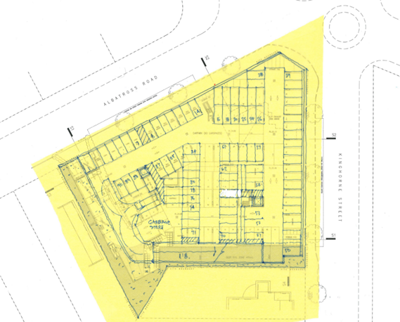
Figure 15 - applicant's submitted concept plan,
demonstrating that access via Kinghorne Street is capable of being achieved.
· Subclause
101(2)(b) (“to prevent or reduce the potential impact of traffic noise
and vehicle emission on development adjacent to classified roads”) is
relevant in that the applicant’s submitted traffic reports do not (in the
view of Council’s Traffic and Transport Unit) establish that the safety,
efficiency and ongoing operation of the classified road would not be adversely
affected by the development as a result of the design of the vehicular access
to the land, and the nature, volume or frequency of vehicles using the
classified road to gain access to the land.
It is noted that on Page 15 of the Traffic Management
Report prepared by Jones Nicholson, dated 27 February 2018 (D18/89444)
concerning the Albatross Road access:
“The proposed Albatross Road access is considered
satisfactory in that it will not impact upon the safety, efficiency and ongoing
operation of Albatross Road. Furthermore, practicable access for all traffic
movements is not achievable from Kinghorne Street to the proposed development.
Therefore, the proposed access from Albatross Road can be approved in meeting
the requirements of SEPP Infrastructure clause 101.”
Council’s Traffic and Transport Unit has considered
all the applicant’s detailed traffic reports and is not satisfied that the access onto Albatross Road demonstrates
compliance with subclauses 101(2)(b)(i) and (iii) of the Infrastructure
SEPP. It follows therefore that the development has not been able to meet
preconditions 101(2)(a) and (b) and that Council therefore has questionable
ability under the ISEPP to approve the development application in its current
form.
· Subclause
101(2)(c) (“the development is of a type that is not sensitive to
traffic noise or vehicle emissions, or is appropriately located and designed,
or includes measures, to ameliorate potential traffic noise or vehicle
emissions within the site of the development arising from the adjacent classified
road”) is relevant, the noise criteria have
been addressed in the submitted Acoustic Report prepared by KA Acoustics
dated 6 November 2019 (D19/423688).
The recommendations of the report
will ensure internal noise levels comply with those specified in Subclause
101(2)(c) are capable of being addressed by
appropriate development consent conditions, if approved.
Car Parking
In
relation to the numerical requirements for car parking for residents and
visitors associated with the residential component of the development, this is
set by Part 3J (Objective 3J-1) of the Apartment Design Guide. Design Criteria
1 of Objective 3J-1 requires that; the minimum car parking requirement for residents and visitors is set out in
the Guide to Traffic Generating Developments, or the car parking requirement
prescribed by the relevant council, whichever is less. Granted that the car parking rates under car parking schedule in Chapter G21: Car Parking and
Traffic in Shoalhaven Development Control Plan 2014 (SDCP 2014) are higher than
the rate set by the Guide to Traffic Generating Developments, the Guide to
Traffic Generating Developments applies.
Parking
rate (Residential):
· 0.6
spaces per 1 bedroom unit.
· 0.9
spaces per 2-bedroom unit.
· 1.40
spaces per 3-bedroom unit.
· 1
space per 5 units (visitor parking).
Residential
parking rate according to unit mix (55 units)
· 8 x
1-bedroom apartments (0.6 x 8) 4.8
spaces
· 31 x 2
bedroom (0.9
x 13) 41.65 spaces
· 16 x 3
bedroom (1.4
x 16) 22.4 spaces
· 55
Units (55
/ 5) 11
visitor car spaces
Total
number of car parking spaces required for residential units = 79.85 spaces
required.
Parking
Rate (Commercial):
The
car parking rate applying to the commercial component of the development is to
be calculated according to Chapter G21: Car Parking and Traffic in SDCP 2014
Commercial
development within land zoned B3 Commercial Core at ground level or where
access to the development is from ground level above an underground level of
car parking is 1 space per 24m2 gross floor area.
The
commercial floor of 267m2 is located at ground level with frontage
to both Kinghorne Street and Albatross Road and is located above an underground
level of car parking. Therefore, 267m2 divided by 24m2 =
11.13 spaces.
Total
of Car Spaces Required: 79.85 (residential) + 11.13 (commercial) = 90.98 spaces
or 91 spaces
Total
of Car Spaces Proposed: 93 spaces
Note:
In accordance with section 5.14 Loss of On-Street Car Parking – Major Developments/ Redevelopments
of Chapter G21 of SDCP2014, it is noted that, where
“major development/
redevelopment is proposed that has frontage to two or more streets, Council
will take into account the loss of on-street car parking spaces arising from
the construction of access, bus embayment’s and car parking restrictions,
where these are directly related to the development proposal and will require
these to be replaced on site.”
The
design of the development including slip lane to provide left turn access to
the development from Albatross road will result in the removal of all on-street
car parking spaces along the Albatross Road development frontage to facilitate
access. This will result in the removal of approximately six (6) on-street car
parking spaces.
Taking
into account the loss of car parking along the Albatross Road frontage (six (6)
on-street spaces) the development is required to provide a total of 97 car
scapes. The development is arguably deficient four (4) spaces.
The
deficiency in car parking is not supported for the following reasons:
· There
are no valid reasons for reducing the number of the car parking spaces required
to service the development.
· The
proposal to provide access to the basement car park via an intercom to provide
security to the basement car park area is unlikely to provide suitable public
access to car parking for those members of the public wishing to visit the
commercial uses and therefore there is likely to be a reliance on on-street car
parking either to the south of the site or along Kinghorne Street. Furthermore,
the location of the security gates and intercom to provide access to the
basement car park is likely to result in unsafe manoeuvring of vehicles should
they fail to gain access to the car park or result in queuing on Albatross Road
should there be technical issues with the security gate (refer to Figure 16)
· The
subject site is located 950m from the Nowra CBD and there is a likelihood that
any customers visiting the site will drive to visit any of the proposed
commercial tenancies or visit a resident of the building. The likely reliance
on vehicles to access the development mean that providing sufficient car
parking is a critical element of the development.
· There
are no public parking facilities in the vicinity of the proposed development
that may reduce the need for sufficient car parking to be provided in
accordance with the car parking schedule.
· The
availability of kerb-side parking opportunities in the vicinity of the proposed
development will be reduced as a result of the proposed access arrangements on
Albatross Road that will remove approximately six (6) on street car parking
spaces.
· The
existing and likely future traffic volumes on the surrounding road network,
traffic circulation and safety are not likely to be improved through a
reduction in on-site car parking.
· The
anticipated impacts of not providing for adequate on-site car parking are
likely to be significant and will impact on the broader locality.
· Strict
compliance with the numerical standard is considered appropriate in the
circumstances where the design and density of the development should respond to
the constraints of the site. Were the residential component of the development
to be considered wholly against the provisions of Chapter G21, the development
would be deficient (including six (6) Albatross Road parking spaces) a total of
eleven (11) spaces.
· The car parking supply proposed to service the site points
to an overdevelopment of the site, potentially an issue with density of
apartments and commercial floor area that is not consistent with the
characteristics of the site.
· The
proposal is likely to set an undesirable precedent granted the nature of the
variation.
· The site is outside of the
contribution area for parking and therefore developer contributions cannot be levied for the shortfall in on-site spaces.
· The development is located in a regional
area. Residents are heavily reliant on private motor vehicles for
transport as opposed to good, accessible, and frequent public transport.
Therefore, adequate parking should be provided.
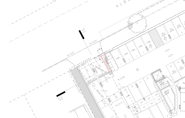
Figure 16 – Extract of the proposed basement plan indicating
the location security door and intercom to gain access to the basement car
park.
Variation to Clause 4.3 Height of Buildings
Development
consent may, subject to clause 4.6, be granted for development even though the
development would contravene a development standard imposed by this or any
other environmental planning instrument.
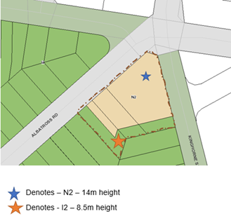
Figure 17 – Height controls applying to the site under the
Shoalhaven Local Environmental Plan 2014
The
application seeks a variation to clause 4.3 in accordance with Clause 4.6 of
SLEP 2014.
Clause 4.3 of SLEP 2014 stipulates the objective and development
standard for the height of buildings in Shoalhaven. Relevantly Clause 4.3(2)
& (2A) state as follows:
(2)
The height of a building on any land is not to exceed the maximum height shown
for the land on the Height of Buildings Map.
The SLEP
2014, through Clause 4.3 sets an 8.5m (I2) height limit for part of the site
and a 14m (N2) height limit for rest of the site.
The 8.5m
height limit applies to a 9m portion of the south eastern portion of the site
extending across all lots subject of the development application where the lot
adjoins the lower density R1 General Residential land to the south.
Parts of
the proposed building exceed the 8.5m (I2) and 14m (N2) height are limited to a
portion of the development.
The
development proposed exceeds the maximum building height as follows:
· 14m height limit by 480mm or 3.4%;
· 8.5m height limit 1.465m or 17.2%; and
· The percentage exceedance of the maximum building height
ranges from 1.4% to 17.2% with the average height limit exceedance being 4.83%.
The
submitted height plane diagrams prepared by Kannfinch Architects illustrate
that the height limit breach and indicate the percentage breach at each point
(Refer to Figure 18 and 19).
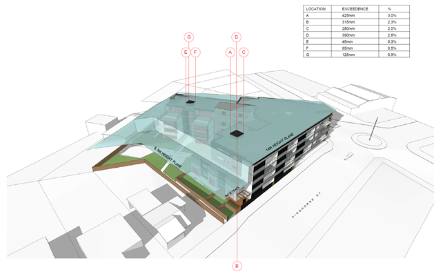
Figure 18 - Height plane instructions
relating to the 14.0m (N2) maximum building height –
south-eastern view from Kinghorne
Street.

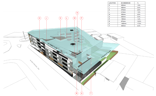
Figure 19 - Height Plane instructions
relating to the 14.0m (N2) and 8.5m (I2) maximum building height - southwestern
view from Albatross Street.
For the reasons detailed in the attached s4.15 Assessment
Report (Attachment 1), it is not considered that the clause 4.6
variation request has satisfied:
1. That
compliance with the development standard is unreasonable or unnecessary in the
circumstances of the case (cl 4.6(3)(a)); and
2. That
there are sufficient environmental planning grounds to justify contravening the
development standard (cl 4.6(3)(b)). The written request needs to demonstrate
both matters.
In conclusion it is considered that the applicant’s
request to vary the development standard as it relates to the maximum building
height should not be supported for the following reasons:
· The
variation request does not demonstrate that compliance with the development
standard would be unreasonable and unnecessary in the circumstances of this
development.
· The
variation request does not demonstrate there are sufficient environmental
planning grounds to justify the contravention, which results in a better
planning outcome than a strictly compliant development in the circumstances of
this particular case.
· Does
not demonstrate the development meets the objectives of the development
standard.
· The
proposed development is for the preceding reasons, not considered to be in the
public interest; and
· The
applicant has failed to demonstrate that there will be better planning outcomes
achieved through variation to the height standard as it relates to the 8.5m
height of building standard associated with a 9m setback to the southern
boundary, as opposed to strict compliance with the development standard or
amending the application to reduce the extent of the variation.
It is noted that the principal reason for not supporting
the variation request relates to the exceedance of the height plane for the
portion of the building fronting Albatross Road.
The exceedance of the maximum building height as it relates
to the 8.5m maximum building height is likely to result in a loss of privacy
and has been demonstrated to result in a loss of solar access to the existing
development (refer to the shadow diagrams prepared by Kannfinch Architects).
The overshadowing of the adjoining residences (No. 6 Albatross Road and No. 175
Kinghorne Street) is exacerbated by the adoption of a 6m setback (opposed to
the required 9m setback) for the portion of the building along the Albatross
road frontage.
The adjoining lots can only be developed as single
dwellings or dual occupancies under the existing R2 Low Density Residential
zoning. The exceedance of the 8.5m maximum building height along the Albatross
Road frontage will exacerbate the blank wall along the southern elevation and
does not serve to create an appropriate transition as anticipated in the PP
associated with the site.
The PP and review of planning controls were undertaken
resulting in a specific conclusion i.e., height. The DA and design submitted
concurrently to the process has however not been adjusted to achieve the height
control. This is of concern as the change to the zone and strategic context has
only been relatively recently ‘made’ and it is already being
varied.
Non-compliance with State
Environmental Planning Policy No 65 – Design Quality of Residential Flat
Development (SEPP 65) and Apartment Design Guide (ADG)
State Environmental Planning
Policy No 65 - Design Quality of Residential Flat Development (SEPP 65) applies to the proposed development which
consists of a new building, of at least 3 storeys and containing at
least 4 or more dwellings.
Council does not have a Design
Review Panel constituted by the Minister of Planning.
In accordance with Clause 28(2)
of the SEPP 65, In determining a development application for consent to
carry out development to which this Policy applies, a consent authority is to
take into consideration (in addition to any other matters that are required to
be, or may be, taken into consideration):
(a) the advice (if any) obtained from the design
review panel, and
(b) the design quality of
the development when evaluated in accordance with the design quality principles,
and
(c) the Apartment Design Guide.
A SEPP 65 Design Statement
has been prepared by a Registered Architect (D20/6044) addressing the
requirements of SEPP 65 and was submitted with the application accordance with
Clauses 50(1A) & 50(1AB) of the EP&A Regulation. The SEPP 65
Design Statement has address Schedule 1 of SEPP 65.
It is considered that the design
quality of the development, when evaluated against the nine design quality
principles does not satisfactorily exhibit exceptional design excellence when
assessed against the following principles:
· Principle 2: Built form and scale
· Principle 3: Density
· Principle 4: Sustainability
· Principle 5: Landscape
· Principle 6: Amenity
|
Schedule 1 Design quality principles
|
|
Design quality principle
|
Comment
|
|
Principle 1: Context and neighbourhood character
Good design responds and contributes to its context.
Context is the key natural and built features of an area, their relationship,
and the character they create when combined. It also includes social,
economic, health and environmental conditions.
Responding to context involves identifying the desirable
elements of an area’s existing or future character. Well designed
buildings respond to and enhance the qualities and identity of the area
including the adjacent sites, streetscape, and neighbourhood.
Consideration of local context is important for all
sites, including sites in established areas, those undergoing change or
identified for change.
|
The
surrounding development may be broadly characterised as low-density
residential housing, consisting of single and two-storey dwelling houses. The
development immediately to the south on Albatross Road and Kinghorne Street
consists of free-standing single storey dwellings and associated
outbuildings.
Beyond
these dwellings and on land bound by Albatross Road, Kinghorne Street and
Albert Street is low-density residential development – mainly of
single-storey construction.
To
the west and on the opposite side of Albatross Road is a continuation of
predominately freestanding low-density dwellings with examples of established
multi-dwelling housing developments.
To
the east, on the opposite side of Kinghorne Street, is a Council park and
cemetery.
On
the northern side of the intersection of Albatross Road and Kinghorne Street
on the western side of Kinghorne Street is an existing tyre shop. On the
eastern side of Kinghorne Street at the intersection with Kalandar Street,
Council has recently approved two - four storey residential flat buildings,
consisting of 91 apartments and basement car park (DA19/1846).
It
is noted that the subject site was the subject of a planning proposal to
zoning of subject land from B5 Business Development to B4 Mixed Use and amend
maximum height of building to part 14m and 8.5m (transition to low density
development to the south. The Planning Proposal was supported by a Character
Assessment prepared by Urbanac Dated May 2017 (D17/257485) which informed the
building heights for the site.
While
it is acknowledged that the desired future character of the locality will
include higher density residential development over a small foot print
commercial space at ground floor it is not considered that the current design
which includes an exceedance into the 8.5m maximum building height provides
an appropriate representation of that future character along the southern
elevation of the Albatross Road frontage.
Despite
Council’s concerns with the transition of the development to the low
scale development to the south, the development is considered to satisfy this
design principle.
|
|
Principle 2: Built form and scale
Good design achieves a scale, bulk and height appropriate
to the existing or desired future character of the street and surrounding
buildings.
Good design also achieves an appropriate built form for a
site and the building’s purpose in terms of building alignments,
proportions, building type, articulation, and the manipulation of building
elements.
Appropriate built form defines the public domain,
contributes to the character of streetscapes and parks, including their views
and vistas, and provides internal amenity and outlook.
|
The
scale and bulk of the building is generally appropriate for the locality when
considering the development in the strategic context of the site and the
desire for a higher density of development to occur from the site.
However,
the proposed setback of the building to the adjoining lower density R2 Low
Density Residential zone does not provide an appropriate transition in built
form or resolve the associated amenity impacts that are associated with the
reduced setback.
The
southern portion of the building does not provide an appropriate transition
to the low-density development to the south. While the applicant has made an
attempt to reduce the bulk and scale of the development through the removal
of two (2) apartments on the southern elevation, this has not overcome the
need for a more suitable transition to the adjoining low-density environment.
The
aesthetics of the building are acceptable with appropriate colours and
finishes.
The
development is not considered to satisfy this design principle.
|
|
Principle 3: Density
Good design achieves a high level of amenity for residents
and each apartment, resulting in a density appropriate to the site and its
context.
Appropriate densities are consistent with the
area’s existing or projected population. Appropriate densities can be
sustained by existing or proposed infrastructure, public transport, access to
jobs, community facilities and the environment.
|
55 units on a site area of
3,509m², has a dwelling density of approximately 1 dwelling per
64m².
SLEP
2014 does not provide a floor space ratio under Clause 4.4 of the plan.
While
the density of development is consistent with that previously approved by
Council in relation to the site on the north-eastern corner of Kinghorne and
Kalandar Street (DA19/1846), it is not considered that the development achieves a high level of amenity for
residents and each apartment. The lack of solar access and ventilation to the single bedroom
apartments is of concern and will result in reduced amenity for occupants of
these units which is not consistent with this principle.
Furthermore, the design of the development does not
demonstrate comprehensive compliance with the ADG as it relates to standards
for:
· Solar access - 13
of 55 apartments (24%) of apartments receive no sunlight between 9am and 3pm
in mid-winter),
· Apartment size and layout – the single bedroom apartment
does not comply with the minimum widths (3.5m provided and 3.6m required)
· Private open space – Several ground floor units do
not provide at least 15sqm (G.04, G.08 and G.09) while other apartments do
not provide a minimum depth of 3m (G0.2, G.03,G.04, G.08, G.10).
· Landscaped deep soil zone for larger
blocks - The total area of deep soil landscaping is 461m2
(13% of the site area). The ADG recommends 15% deep soil zone for sites exceeding 1,500m2.
· Setbacks to the adjoining low-density
development – the
setback of the Albatross portion of the
development adjoining the south western boundary does not appear to comply
with the required 9m setback. 6m is proposed to the 3rd level, however as
this is measured to a balcony it is considered that the setback must be a
minimum of 9m.
· Common circulation and spaces – the maximum number of apartments off a circulation core on a single
level is eight. Lobby B services 11 apartments on levels 01, 02, and 10 apartments
on Level 03. It is noted that the ADG accepts that where this design criteria
cannot be achieved the total units accessed off a circulation core must not
exceed 12.
· Apartment mix - The
mix of one-bedroom units is not considered to provide an appropriate
distribution to suitable locations within the building, with all single
bedroom units provided within the compromised southern side of the V-shaped
design – limiting solar access, ventilation and unit design.
· Car parking - Taking
into account the loss of car parking along the Albatross Road frontage (six
(6) on-street spaces) the development is required to provide a total of 97
car scapes. The development is arguably deficient four (4) spaces.
These non-compliances imply an overdevelopment of the
site.
It
is likely however that the proposed density can be sustained having regard to
existing or proposed infrastructure, public transport, access to jobs,
community facilities and the environment.
The
development is not considered to satisfy this design principle
|
|
Principle 4: Sustainability
Good design combines positive environmental, social and
economic outcomes.
Good sustainable design includes use of natural cross
ventilation and sunlight for the amenity and liveability of residents and
passive thermal design for ventilation, heating and cooling reducing reliance
on technology and operation costs. Other elements include recycling and reuse
of materials and waste, use of sustainable materials and deep soil zones for
groundwater recharge and vegetation.
|
37 of 55 apartments (67%)
receive at least 3 hours direct sunlight between 9.00am and 3.00pm in
mid-winter
13
of 55 apartments (24%) of apartments receive no sunlight between 9am and 3pm
in mid-winter. The ADG design criteria
specified that a maximum of 15% of apartments in a building receive no direct
sunlight between 9 am and 3 pm at mid-winter. The development does not comply
with the maximum number of units receiving no solar access.
The
majority of the proposed apartments have been designed to achieve
satisfactory natural cross ventilation. for the amenity and liveability of
residents and passive thermal design for ventilation, heating and cooling
reducing reliance on technology and operation costs. However, the design of
the single bedroom apartments results in poor solar access and natural
ventilation. There is likely to be a reliance on mechanical heating and
cooling for these apartments.
The
central courtyard and the principal area of communal open space will not
receive adequate solar access during winter. Due to the design of the
development and location of the communal open space areas on the southern
side of the building, the communal open space areas will have compromised
sunlight access, and this does not appear to be capable of resolution without
a significant redesign of the buildings and location of communal open space.
The
proposed development is supported by a BASIX Certificate as required under
the EP&A Regulation; however, this is not reflective of current layout.
Stormwater
is proposed to be reused for gardens in the communal area.
The
development is not considered to satisfy this design principle as it relates
to the design of single bedroom units.
The
development is not considered to satisfy this design principle
|
|
Principle 5: Landscape
Good design recognises that together landscape and
buildings operate as an integrated and sustainable system, resulting in
attractive developments with good amenity. A positive image and contextual
fit of well-designed developments is achieved by contributing to the
landscape character of the streetscape and neighbourhood.
Good landscape design enhances the development’s
environmental performance by retaining positive natural features which
contribute to the local context, co-ordinating water and soil management,
solar access, micro-climate, tree canopy, habitat values and preserving green
networks.
Good landscape design optimises useability, privacy and
opportunities for social interaction, equitable access, respect for neighbours’
amenity and provides for practical establishment and long-term management.
|
The proposed landscaping
meets the minimum deep soil requirements under the ADG. The total area of
deep soil area is 461m2 (13% of the site area). 328m2
(9% of the site area) has a minimum dimension of 6m or larger. These areas
have been designed to accommodate larger trees.
The site exceeds 1500m2
and as such it is appropriate to require 15% of the site as deep soil
landscaped area. Additional deep soil planting could be provided through the
reduction of units / building footprint and providing landscaping along the
Kinghorne and Albatross Road frontages.
Landscape plans have been
reviewed by Council’s landscape architect and are generally
satisfactory when considering the plantings and maintenance arrangements
(subject to recommended conditions if approved).
There are no existing
landscape features of note that would warrant retention.
The development is not
considered to satisfy this design principle.
|
|
Principle 6: Amenity
Good design positively influences internal and external
amenity for residents and neighbours. Achieving good amenity contributes to
positive living environments and resident wellbeing.
Good amenity combines appropriate room dimensions and
shapes, access to sunlight, natural ventilation, outlook, visual and acoustic
privacy, storage, indoor and outdoor space, efficient layouts and service
areas and ease of access for all age groups and degrees of mobility.
|
The proposed development
does not achieve compliance with the ADG as it relates to the minimum
standard for solar access, apartment size and layout, deep soil landscaping
for larger sites, private open space, common circulation and spaces,
apartment mix, car parking as detailed in the ADG compliance table in the
s4.15 Assessment Report – Appendix 1.
The development is not
considered to satisfy this design principle
|
|
Principle 7: Safety
Good design optimises safety and security within the
development and the public domain. It provides for quality public and private
spaces that are clearly defined and fit for the intended purpose.
Opportunities to maximise passive surveillance of public and communal areas
promote safety.
A positive relationship between public and private spaces
is achieved through clearly defined secure access points and well-lit and
visible areas that are easily maintained and appropriate to the location and
purpose.
|
The design is considered to
appropriately address Crime Prevention through Environmental Design (CPTED)
matters and reduces areas of potential concealment/entrapment. Passive
surveillance opportunities are available in the development.
There are defined secure access points and well-lit and visible
areas that are easily maintained and appropriate to the location and purpose.
Entry points are located adjacent to the activated retail zone and designed
to minimise opportunity for loitering.
The residential lobbies and
car park are proposed to operate on secured access. The car park access doors
will operate individually via remote control (or similar) for residents and
retail tenants, with an intercom system for visitors.
The development is
considered to satisfy this design principle.
|
|
Principle 8: Housing diversity and social interaction
Good design achieves a mix of apartment sizes, providing
housing choice for different demographics, living needs and household
budgets.
Well designed apartment developments respond to social
context by providing housing and facilities to suit the existing and future social
mix.
Good design involves practical and flexible features,
including different types of communal spaces for a broad range of people and
providing opportunities for social interaction among residents.
|
The proposed development
provides additional dwellings, with a range of sizes, in an area where
additional housing is needed and is near a variety of services.
The development provides
both communal open space and a communal room. It is noted that the
resident’s room located on the south-west wing of the development has a
compromised and diminutive floor area (20m2) that is not likely to
be used by a broad range of people and is unlikely to provide opportunities
for social interaction among residents.
The development is
considered to satisfy this design principle.
|
|
Principle 9: Aesthetics
Good design achieves a built form that has good proportions
and a balanced composition of elements, reflecting the internal layout and
structure. Good design uses a variety of materials, colours, and textures.
The visual appearance of a well-designed apartment
development responds to the existing or future local context, particularly
desirable elements, and repetitions of the streetscape
|
The architectural treatment
is satisfactory.
The development is
considered to satisfy this design principle.
|
The development is considered to satisfactorily address the
remaining design quality principles.
Clause 30(2) of SEPP 65 requires residential apartment
development to be designed in accordance with the ADG.
The development has been assessed against the ADG and a full
assessment is provided within the s.4.15 Assessment Report (Appendix 1 of this
Report).
Parts 3 and 4 of the ADG provide objectives, design criteria
and design guidance for the siting, design, and amenity of apartment
developments. In accordance with ADGs, development needs to demonstrate how it
meets the objective and design criteria. The design criteria set a clear
measurable benchmark for how the objective can be practically achieved. If it
is not possible to satisfy the design criteria, applications must demonstrate
what other design responses are used to achieve the objective and the design
guidance can be used to assist in this.
The development is non-complaint with the following Objectives
and Design Criteria in Part 3 and 4 of the ADG, as outlined in the table below.
Appendix A to the Section 4.15 Assessment Report (Attachment 1) provides
a full assessment of the proposed development against each of the objectives of
the ADG.
|
Objective
|
Assessment
|
|
3E-1
Deep Soil Zones
Deep
soil zones provide areas on the site that allow for and support healthy plant
and tree growth. They improve residential amenity and promote management of
water and air quality.
On
some sites it may be possible to provide larger deep soil zones, depending on
the site area and context:
•
10% of the site as deep soil on sites with an area of 650m2 - 1,500m2
•
15% of the site as deep soil on sites greater than 1,500m2
|
The total area of deep soil
landscaping is 461m2 (13% of the site area). 328m2 (9%
of the site area) has a minimum dimension of 6m or larger. These areas have
been designed to accommodate larger trees.
The site exceeds 1500m2
and therefore it is appropriate to require 15% of the site as deep soil
landscaped area. Landscape plans have been reviewed by Council’s
landscape architect and are satisfactory, subject to consideration of the
requested changes.
|
|
3F-1
Visual Privacy
Adequate building separation
distances are shared equitably between neighbouring sites, to achieve
reasonable levels of external and internal visual privacy.
|
The adjacent sites to the south
of the development site are zoned R2 Low Density Residential and currently
contain single dwelling houses per lot.
The setback of the Kinghorne
portion of the development to the adjoining southern property boundary
requires a minimum setback of 9m. The setback of this portion of the building
varies for the ground and first floor of between 8m and 9m to windows and
balconies and therefore does not strictly comply with the required 9m
setback.
The setback of the Albatross
portion of the development adjoining the south western boundary does not
appear to comply with this requirement. 6m is proposed to the 3rd level,
however as this is measured to a balcony it is considered that the setback
must be a minimum of 9m.
|
|
Separation between windows and
balconies is provided to ensure visual privacy is achieved. Minimum required
separation distances from buildings to the side and rear boundaries are as
follows (for building heights up to 12m):
Habitable rooms and balconies:
6m
Non-habitable rooms: 3m
Note: Apartment
buildings should have an increased separation distance of 3m (in addition to
the requirements set out in design criteria 1) when adjacent to a different
zone that permits lower density residential development to provide for a
transition in scale and increased landscaping (figure 3F.5)
|
|
3H-1
Vehicle Access
Vehicle access points are
designed and located to achieve safety, minimise conflicts between
pedestrians and vehicles and create high quality streetscapes.
|
Vehicle
access is provided at the southern end of the development along Albatross
Road. The vehicular access is generally incorporated into the
building’s façade. Security gates have been setback from the
frontage. While Council does not raise any concern with the design or
integration of the access into the building from a strictly aesthetic
standpoint it is noted that the car park entry and access should be located
on secondary streets or lanes where available.
The
basement car park and manoeuvring are to be designed to comply with the
Australian Standards and Chapter G21: Car Parking and Traffic.
The
proposal to access the development from the Regionally Classified Road
(Albatross Road) is not supported and the applicant has been encouraged to
provide access via the unclassified local road (Kinghorne Street).
Under
the ISEPP, a consent authority must not grant consent to development on land
that has a frontage to a classified road unless it is satisfied that, among
other things, ‘where practicable, vehicular access to the land is
provided by a road other than the classified road’.
It is considered that
consent must not be granted for access off Albatross Road if practicable
vehicular access is available to the site from a road other than the
Albatross Road (that being Kinghorne Street). The applicant has submitted
concept plans (D18/355817) indicating that there was practicable vehicular
access from Kinghorne Street. This approach is reflected in the Land and
Environment Court judgements.
|
|
3J-1
Bicycle and Car Parking
Car
parking is provided based on proximity to public transport in metropolitan
Sydney and centres in regional areas.
|
Total
number of car parking spaces required for residential units = 79.85 spaces
required.
The
car parking rate applying to the commercial component of the development is
to be calculated according to Chapter G21: Car Parking and Traffic in SDCP
2014
Commercial
development within land zoned B3 Commercial Core at ground level or where
access to the development is from ground level above an underground level of
car parking is 1 space per 24m2 gross floor area.
The
commercial floor of 267m2 is located at ground level with frontage to both
Kinghorne Street and Albatross Road and is located above an underground level
of car parking. Therefore, 267m2 divided by 24m2 = 11.13 spaces.
Total
of Car Spaces Required: 79.85 (residential) + 11.13 (commercial) = 90.98
spaces or 91 spaces
Total
of Car Spaces Proposed: 93 spaces
Note:
In accordance with section 5.14 Loss of On-Street Car Parking – Major
Developments/ Redevelopments of Chapter G21 of SDCP2014, it is noted that:
“major
development/ redevelopment is proposed that has frontage to two or more
streets, Council will take into account the loss of on-street car parking
spaces arising from the construction of access, bus embayment’s and car
parking restrictions, where these are directly related to the development
proposal and will require these to be replaced on site.”
The
design of the development including slip lane to provide left turn access to
the development from Albatross road will result in the removal of all
on-street car parking spaces along the Albatross Road development frontage to
facilitate access. This will result in the removal of approx. six (6)
on-street car parking spaces.
Taking
into account the on-street car parking loss along the Albatross Road frontage
(six (6) on-street spaces) the development is required to provide a total of
97 car scapes.
The
development is deficient four (4) spaces.
Excavation
of the site has been minimised in the placement of the car park access at the
lowest point in the site.
The
car parking area has been designed to suit the site which is triangular.
However, a logical layout is generally achieved.
The
car park protrudes above ground level greater than 1m however this is solely
along the Albatross Road frontage and extends for less than 50% of the
frontage. To minimise the visual impact appropriate colours are to be
utilised and varied materials for balustrades located above the car parking
area.
Mixture
of natural ventilation and a mechanical exhaust are to be utilised.
|
|
3J-2
Bicycle and Car Parking
Parking and facilities are
provided for other modes of transport.
|
Each resident has access to a
secure storage cage which is large enough to accommodate a bicycle.
Residential visitor and customer bicycle spaces are proposed in the form of
post mounted bike rails within the road reserve, should Council require them.
|
|
4A-1
Solar and Daylight Access
To optimise the number of
apartments receiving sunlight to habitable rooms, primary windows, and
private open space.
|
37 of
55 apartments (67%) receive at least 3 hours direct sunlight between 9.00am
and 3.00pm in mid-winter
13 of
55 apartments (24%) of apartments receive no sunlight between 9am and 3pm in
mid-winter.
While
the applicant has argued that the non-compliance with the Design Criteria is “due
to limitations imposed by the site configuration, southern slope and
orientation” it is noted that there are limited site constraints
and there is opportunity to reduce the number of internal facing apartments
and the design of dual aspect apartments overlooking the internal communal
open space area and either Albatross or Kinghorne Street.
Of
concern is that there are only two single bedroom apartments located on the
third level that achieve the minimum daylight access with no lower-level
single bedroom apartments receiving any solar access.
The
minor non-compliance with the requirement that no less than 70% of apartments
in a building receive a minimum of 3 hours direct sunlight could be readily
accepted were the design to exceed the 15% of apartments in a building
receiving no direct sunlight between 9 am and 3 pm at mid-winter.
The
substantial non-compliance with the maximum number of apartments receiving no
direct sunlight between 9 am and 3 pm at mid-winter is a significant concern
and will significantly increase the reliance on artificial lighting and
heating, reduce energy efficiency and residential amenity.
The
design attempts to maximise the number of north facing apartments and limit
the number of single aspects south facing apartments, however, it is noted
that the internal facing single aspect apartments provided limited or no
solar access. It is considered further consideration of the design to further
limit single aspect southerly facing apartments would provide increased solar
access and amenity to future residents.
It
is noted that, where possible, the building design maximises the number of
living areas with a northerly aspect ensuring a high level of amenity is
achieved. Services areas are generally provided to the rear or in central
locations minimising their impact on the most desirable areas of the
apartments.
|
|
1. Living
rooms and private open spaces of at least 70% of apartments in a building
receive a minimum of 2 hours direct sunlight between 9 am and 3 pm at
mid-winter in the Sydney Metropolitan Area and in the Newcastle and
Wollongong local government areas.
|
|
2. In
all other areas, living rooms and private open spaces of at least 70% of
apartments in a building receive a minimum of 3 hours direct sunlight
|
|
3. between
9 am and 3 pm at mid-winter. A maximum of 15% of apartments in a building
receive no direct sunlight between 9 am and 3 pm at mid-winter.
|
|
No.
|
|
4D-3 Apartment Size and
Layout
Apartment layouts are designed
to accommodate a variety of household activities and needs.
|
The open plan designs allow for
a range of activities to happen in the kitchen and living spaces.
1-bedroom apartment widths are
3.5m - this is marginally under 3.6m. The non-compliance is marginal and does
not impede the usable area of the living rooms and would not likely have a
significant detrimental impact on the amenity of the dwelling or resident use
of the units impacted. However, it is noted that the design of the single
bedroom units is once again impacted by the proposed design.
|
|
1. Master bedrooms have a minimum area of
10m2 and other bedrooms 9m (excluding wardrobe space)
|
|
1. Bedrooms have a minimum dimension of 3m
(excluding wardrobe space)/.
|
|
2. Living rooms or combined living/dining
rooms have a minimum width of:
• 3.6m for studio and
1-bedroom apartments
• 4m for 2- and 3-bedroom
apartments
|
|
3. The width of cross-over or cross-through
apartments are at least 4m internally to avoid deep narrow apartment layouts
|
|
4E-1
Private Open Space and Balconies
Apartments provide appropriately
sized private open space and balconies to enhance residential amenity.
1. All apartments are required
to have primary balconies as follows:
Studio: 4m2
1 Bedroom: 8m2, 2m
minimum depth
2 Bedroom: 10m2, 2m
minimum depth
3 Bedroom: 12m2, 2.4m
minimum depth
The minimum balcony depth to be
counted as contributing to the balcony area is 1m.
2. For apartments at ground
level or on a podium or similar structure, a private open space is provided
instead of a balcony. It must have a minimum area.
of 15m2 and a minimum
depth of 3m.
|
All
balconies exceed the minimum area for the respective unit types. All
balconies have a minimum depth of 2m.
A
number of the ground floor units do not provide at least 15sqm (G.04,
G.08 and G.09) while other apartments do not provide a minimum depth
of 3m (G0.2, G.03,G.04, G.08, G.10).
|
|
4F-1 Common Circulation and
Spaces
Common circulation spaces
achieve good amenity and properly service the number of apartments.
1. The maximum number of
apartments off a circulation core on a single level is eight.
|
Common spaces are provided with
solar access, natural ventilation and allow for universal access.
Lobby
B services 11 apartments on levels 01, 02, and 10 apartments on Level 03. The
corridors have been designed with light slots to capture natural light and
ventilation to maintain amenity.
*
Note: Where design criteria 1 is not achieved, no more than 12 apartments
should be provided off a circulation core on a single level
|
|
2. For buildings of 10 storeys
and over, the maximum number of apartments sharing a single lift is 40
|
|
4K-2
Apartment Mix
The apartment mix is distributed
to suitable locations within the building.
|
The mix of one-bedroom units is
not considered to provide an appropriate distribution to suitable locations
within the building.
The single bedroom units are
limited to the southern elevation of the V-shaped building design which has
resulted in units with severely compromised solar access, ventilation and
private open space that will likely result in units with diminished amenity.
The irregular floor plans will also result in odd-shaped rooms and the
potential loss of the use of usable space within these units.
It is considered that the single
bedroom units should be spread more evenly throughout the development to
enable these units a greater likelihood for increased amenity
|
State Environmental
Planning Policy (Building Sustainability Index: BASIX) 2004 (SEPP
(BASIX))
The provisions of SEPP (BASIX)
apply to the site. In accordance with the requirements of SEPP BASIX,
Certification for each dwelling has been submitted with the development
application.
Clause 55A of the Environmental
Planning and Assessment Regulation 2000 (EP&A Regulation) allows for a
development application to be amended provided a new BASIX certificate is
submitted to account for those amendments. An amended BASIX Certificate, to
reflect amended plans was not submitted with the amended application.
Council cannot issue
development consent without the provision of a new BASIX Certificate that
reflects the amended application i.e., 55 residential units.
Planning
Assessment
The DA has been (or will be)
assessed under s4.15 of the Environmental Planning and Assessment Act
1979. Please refer to Attachment 1.
Policy
Implications
A key policy consideration is
height.
Currently, there is an 8.5m and 14m height limit which applies to the site
under SLEP 2014.
The
development proposed exceeds the maximum building height as follows:
· 14m
height limit by 480mm or 3.4%;
· 8.5m
height limit 1.465m or 17.2%; and
· The
percentage exceedance of the maximum building height ranges from 1.4% to 17.2%
with the average height limit exceedance being 4.83%.
The variation has been addressed
by the applicant via a formal clause 4.6 variation statement. The matter is
discussed in the attached section 4.15 report in further detail (Attachment
1) and has been considered previously in this Report.
Consultation
and Community Engagement:
Six (6) public submissions were
received in relation to Council’s notification of the development.
Six (6) were objections to the development. Nil (0) were in support of
the development. The notification was made in accordance with
Council’s Community Consultation Policy with letters being sent within a
m buffer of the site. The application was notified for a period of 30 days and
advertised in the local papers in accordance with Council’s Community
Consultation Policy
Key issues raised as a result of
the notification are provided below:
· Traffic
impacts on local road network
· Impact
of additional cars parking on the on-street car parking
· Amenity
impacts associated with overlooking and overshadowing
· Insufficient
justification and planning purpose to support the PP.
· The
bulk and scale of the development is not consistent with the low scale
development to the south of the site and the site would be better developed for
multi-dwelling housing.
· The
proposed setbacks of the development to the southern boundary are not
appropriate
· The
pedestrian access point to the development on the Kinghorne Street frontage
will result in safety and security issues
The planning concerns raised by
the submitters are addressed in the attached section 4.15 report in further
detail (Attachment 1).
Financial
Implications:
There are potential cost
implications for Council in the event of a refusal of the application. Such
costs would be associated with defending any appeal in the Land and Environment
Court, should the applicant utilise appeal rights afforded under the Environmental
Planning and Assessment Act 1979 (EP&A Act).
Legal
Implications
Pursuant to section 8.2 of the
EP&A Act, a decision of the Council may be subject of a review by the
applicant in the event of approval or refusal. If such a review is ultimately
pursued (if the recommendation is not adopted), the matter would be put to
Council for consideration.
Alternatively, an applicant may
also appeal to the Court against the determination pursuant to section 8.7 of
the EP&A Act.
Summary
and Conclusion
This
application has been assessed having regard for section 4.15 (Evaluation) under
the EP&A Act. Based upon the s4.15 Assessment Report (Attachment 1)
it is recommended that Development Application No. DA16/1465 be refused for the
following reasons.
1. Non-compliance
with SEPP 65 in relation to the Apartment Design Guide (s4.15(1)(a)(i) of the
EPA Act);
The development fails to satisfy
clause 30(2)(a) and (b) of SEPP 65, in that the development does not
demonstrate that adequate regard has been given to:
(a) the
design quality principles (Principle 2: Built form and scale; Principle
3: Density; Principle 4: Sustainability; Principle 5: Landscape; Principle 6:
Amenity), and
(b) the
objectives specified in the Apartment Design Guide for the relevant design
criteria (3E-1 Deep Soil Zones, 3F-1 Visual Privacy, 3H-1 Vehicle
Access, 3J-1 Bicycle and Car Parking, 3J-2 Bicycle and Car Parking, 4A-1 Solar
and Daylight Access, 4D-3 Apartment Size and Layout, 4E-1 Private Open Space
and Balconies, 4F-1 Common Circulation and Spaces, 4K-2 Apartment Mix).
2. The
proposal exceeds the maximum building height development standard under clause
4.3 of SLEP 2014. The applicant’s written request to vary the maximum
building height development standard has not adequately addressed matters
required to be demonstrated by clause 4.6(3)(a) and (b) of SLEP 2014. The
clause 4.6 Variation Request does not provide sufficient environmental planning
grounds to support the variation, nor that compliance is unnecessary or
unreasonable. (s4.15(1)(a)(i) of the EPA Act).
3. The
development has failed to satisfy Council of preconditions clause 101(2)(a) and
(b) of the ISEPP (s4.15(1)(a)(i) of the EPA Act).
In accordance with clause
101(2)(a) and (b) of the ISEPP, Council must not grant consent to development
on land that has a frontage to a classified road unless it is satisfied that:
(a) where
practicable and safe, vehicular access to the land is provided by a road other
than the classified road, and
(b) the
safety, efficiency and ongoing operation of the classified road will not be
adversely affected by the development as a result of:
(i) the
design of the vehicular access to the land, or
(ii) the
emission of smoke or dust from the development, or
(iii) the nature,
volume or frequency of vehicles using the classified road to gain access to the
land
4. Clause
55A of the Environmental Planning and Assessment Regulation 2000 allows
for a development application to be amended provided a new BASIX certificate is
submitted to account for those amendments. An amended BASIX Certificate, to
reflect amended plans was not submitted with the amended application.
5. The
proposed development is inconsistent with the Objectives, Performance Criteria
and Acceptable Solutions as they relate to the following provisions of Chapter
G21: Car Parking and Traffic Shoalhaven Development Control Plan 2014 (SDCP
2014) (s4.15(1)(a)(iii) of the EPA Act):
(a) 5.2
Traffic.
(b) 5.4
Access.
(c) 5.14
Loss of On-Street Car Parking – Major Developments/ Redevelopments.
6. The
development is likely to have adverse impacts on the built environment
(s4.15(1)(b) of the EPA Act).
7. The
site is not suitable for the development as proposed (s4.15(1)(c) of the EPA
Act).
8. The
development is not in the public interest (s4.15(1)(e) of the EPA Act).
|
|
Development
& Environment Committee – Tuesday 11 May 2021
Page
0
|
|
|
Development
& Environment Committee – Tuesday 11 May 2021
Page
0
|
DE21.51 Northern
Coastal Management Program Advisory Committee - Amendment to Terms of Reference
HPERM Ref: D21/149763
Department: Environmental
Services
Approver: Phil
Costello, Director - City Development
Attachments: 1. Draft
Terms of Reference (under separate cover)
Reason for Report
Update the Terms of Reference as per the request of the
North Coastal Management Program Advisory Committee through item NC21.3 on the
17 March 2021.
|
Recommendation
(Item to be determined under delegated authority)
That
the amended Terms of Reference – North / Central / Southern Coastal
Management Program Advisory Committees be adopted by Council.
|
Options
1. Council adopts the amended Terms of
Reference – North / Central / Southern Coastal Management Program Advisory
Committees.
Implications: The Terms of Reference for the North
/ Central / Southern Coastal Management Program Advisory Committees are amended
to specify geographic boundaries and include all Council managed beaches.
2. Council rejects the amendments.
Implications: Terms of Reference remain unchanged,
against the request from the North Committee.
Background
The Terms of Reference were
adopted by Council on 6 October 2020 with MIN20.736, the amendment is to
further include the words “all Council managed beaches” and the
specific geographic boundaries each North / Central / Southern - Coastal
Management Program Advisory Committee is responsible for.
This amendment will provide
clearer Terms of Reference for the Committees to be guided by and was requested
by the North Committee through item NC21.3 on 17 March 2021.
|
|
Development
& Environment Committee – Tuesday 11 May 2021
Page
0
|
DE21.52 Quarterly
Review for Compliance Matters
HPERM Ref: D21/154126
Department: Certification
& Compliance
Approver: Phil
Costello, Director - City Development
Attachments: 1. Penalty
Notices & Warnings Issued - Quarterly Review - City Development - January
to March 2021 ⇩
Reason for Report
At Council’s Ordinary meeting held on 13 November 2018
it was resolved to receive a detailed quarterly report on compliance activities
(MIN18.907).
This report provides information
on the period from 1 January 2021 to 31 March 2021 (third quarter 2020/2021).
|
Recommendation (Item to be determined under delegated authority)
That
Council receive the quarterly report on compliance matters for information.
|
Options
1. Council receives
the report for information.
Implications: Nil
2. Council receives
the report and provides additional direction for future reports.
Implications: Any changes or additional matters can
be added to future reports.
Report
Compliance activities are completed by the following Teams
within City Development:
(a) Compliance Team:
Development compliance matters including unauthorised development, development
not in accordance with development consent, minor land, and water pollution
incidents (including building sites), land use management issues, fire safety
and swimming pool safety issues.
(b) Environmental Health:
Pollution incidents (noise and water), environmental incidents, food shops and
the operation of on-site sewage waste management facilities.
(c) Parking: All parking
offences.
(d) Rangers: Animal
control, littering, unauthorised camping, rubbish dumping and other
environmental offences.
This report provides Councillors with an update on the
penalties issued (number, type, and ticket value), penalty reviews dealt with
by the Review Panel and any Local or Land and Environment Court matters
determined or progressing.
This report relates to January - March
2021 (third quarter).
Penalties Issued During the
Period
A combined total of 1,845 penalty notices were issued by the
Teams during the period. These penalties have a face value of $398,699. Historically
Council stands to receive approximately 70% of this ticketed figure.
A total of 239 warnings were issued during the period.
Attachment 1 to this report provides a breakdown of the
penalties and cautions issued.
The following is a summary of the penalties issued for each
team:
|
Team
|
Number Issued
|
Total Amount
|
% of total amount
|
Warnings issued
|
|
Compliance
|
18
|
$29,380
|
7.5%
|
55
|
|
Compliance – Fire Safety
|
0
|
0
|
0
|
0
|
|
Compliance – Pools
|
5
|
$1,980
|
.50%
|
23
|
|
Environmental Health
|
3
|
$1,320
|
.35%
|
0
|
|
Rangers – Animal issues
|
149
|
$62,145
|
15.5%
|
22
|
|
Rangers – Environmental issues
|
108
|
$17,350
|
4.35%
|
75
|
|
Parking
|
1557
|
$285,974
|
71.8%
|
63
|
|
Sewer Management Facility
|
0
|
0
|
0
|
1
|
|
Total
|
1,845
|
$398,149
|
100%
|
239
|
Penalties Related to
Compliance issues
The following details are
provided in relation to compliance penalty notices issued this period:
a) Narrawallee
($3,330): Two penalty notice issued to the owner of the premises. The
penalty notices relate to earthworks within an E2 Environmental Conservation
zone - Development without consent – any other case – Individual -
$3000 and operation of onsite sewage
management system - Section 626(3) of the Local Government Act 1993 -
$330. A further two (2) warning notices
were issued, these would have amounted to $3,330.
The concern relates to the installation of a moveable
dwelling with connection to services and removal of vegetation in the E2 zone.
b) Beaumont
($4,500): Two penalty notices issued to the owner of the premises. The
penalty notices relate to earthworks – development without development
consent – any other case –
Individual - $3000 and development
without development consent – class 1a or 10 building – Individual.
A further six (6) warning
notices were issued, these would have amounted to $10,500.
The concerns relate to the
unauthorised construction of 2 x retaining walls, access ramp and the placement
of 4 x shipping containers without consent.
c) Ulladulla
($3,000): One penalty notice issued to the contractor - development without consent - class 1a or 10 -
building – Corporation ($3000).
The matter related to the
unauthorised demolition of garage and partial demolition of dwelling containing
asbestos.
d) Burrill
Lake ($3,000): Two penalty notices issued to the owner of the premises
– 2 x development without consent - class 1a or 10 - building –
Individual ($1500). A further four (4) warning notices were issued, these would
have amounted to $6,000.
The concerns raised pertain
to the unauthorised construction of a shed and a timber retaining wall in the
rear of the yard.
e) Morton
($3,000): Two penalty notices issued to the previous owner’s -
development without development consent - class 1a or 10 building –
Individual ($1500). A further two (2) warning notices were issued to both
owners, these would have amounted to $660.
f) Morton
($550): One penalty notice issued to the contractor – not provide
notice of work to plumbing regulator ($550). A further three (3) warning
notices were issued to the contractor, these would have amounted to $3,700.
The concern relates to the conversion of an existing approved class 10a building
to a detached habitable room including kitchen, solid fuel heater and bathroom
with on-site sewage management facility on bushfire prone land.
g) Sanctuary
Point ($3,000): Two penalty notices issued to the owners of the premises - development without development consent – class
1a or 10 building – Individual ($1500). A further two (2) warning notices
were issued to the owners, these would have amounted to $3,000.
The matter related to the
construction of timber retaining walls on the northern and southern boundary
not considered Exempt Development. Assessment revealed the retaining walls to
have been constructed over Council’s sewer asset in the sewer easement on
the boundary.
h) Nowra
Hill ($1,500): One penalty notice issued to the owners - development
without development consent – class 1a or 10 building – Individual
($1,500). A further nine (9) warning notices were issued to the owners, these
would have amounted to $13,500.
The issue relates to the
unauthorised construction of a water supply facility (dam). The owners are
currently in the process of regularising the structure.
i) Falls
Creek ($4,500): Three penalty notices issued to the owners –
development without development consent – class 1a or 10 building –
Individual ($1,500). A further five (5) warning notices were issued, these
would have amounted to $7,500.
The penalty notices were
issued for the unauthorised construction of deck additions to the rear of the
dwelling, construction of a shed and the construction of a farm shed at the
premises.
j) Tomerong
($1,500): One penalty notice issued to the owner - development without development
consent - class 1a or 10 building – Individual ($1,500). A further two
(2) warning notices were issued relating to the unauthorised construction of a
deck and swimming pool. These would have amounted to $3,000.
k) Comerong
Island ($1,500): One penalty notice issued to the owner - development without development consent - class 1a or
10 building – Individual ($1,500).
The penalty notice relates
to the unauthorised construction of a revetment wall located adjacent to the
Shoalhaven River.
Warnings Related to Compliance issues
A total of 55 warning notices were issued for compliance matters in the
period and these equate
to $85,990 in ticket face value. Potentially the Compliance Team could have
issued $115,370 in penalties for the period. The caution rate is approximately
75%.
Penalty Infringement Panel Reviews
During the period, the review panel met on 11 March 2021 and considered
one (1) penalty infringement notice.
(a) Development without
development consent – class 1a or 10 building with a penalty amount of
$1,500
The penalty notices subject
to the review relate to an approved detached garage and detached shed that were
both modified to create a secondary dwelling without consent.
Other issues forming part of
the investigation were the placement of a shipping container on the lot and the
alleged permanent occupation of a caravan which was not associated with the
main dwelling nor the unauthorised secondary dwelling.
Council received a complaint
that the garage was being rented out separately to the main dwelling and a
shipping container had been placed on the lot.
The unauthorised works were
not NCC compliant and as such have placed the tenants at risk as the buildings
are not ‘fit for purpose or safe for occupation’.
The owner has financially
gained from the additional tenancy created by the unauthorised works.
The owner advised Council of
their intention to regularise the works, however neither a Building Information
Certification nor a Development Application for the change of use from a garage
to a secondary dwelling have not been lodged, despite a Formal Restore Works
Order being issued.
On review of a submission
from the offender it was determined the penalty should stand.
Local Court Matters
Nil
Land and Environment Court matters
A Section 34(1) conference was
held via Microsoft Teams on 29 March 2021 concerning the Class 1 Land &
Environment Court appeal of Council’s Cease Use Order of the unauthorised
dwelling at Lot 87 Abernethys Rd Budgong.
The Acting Commissioner
terminated the conference, and the matter is listed for hearing on 27, 28 and
29 July 2021. The Cease Use Order was suspended by the Commissioner until the
date of the hearing.
Compliance Merits Received This Quarter
During the period, the
Compliance Team received a total of 171 Merits, and these are detailed in the
following table.
|
Type of Merits Received
|
Number Received
|
Percentage of total
|
|
Asbestos issues
|
5
|
|
|
Building Works - Not in Accordance Consent
|
30
|
|
|
Building Works - Without Consent
|
57
|
|
|
Defective Building Works
|
3
|
|
|
Earthworks - Without Consent
|
10
|
|
|
Erosion Control - Building Sites
|
3
|
|
|
Erosion Control - Subdivision sites
|
2
|
|
|
Land Use - Without Consent
|
27
|
|
|
Sewerage Management Facility
|
0
|
|
|
Special event – without consent
|
2
|
|
|
Stormwater Runoff - Building Site
|
18
|
|
|
Swimming Pool Fencing Inspection
|
10
|
|
|
Vegetation Clearing - Without Consent
|
4
|
|
|
TOTALS
|
171
|
|
Development without consent
remains the highest percentage of all complaints received (33%).
Development not in accordance
with consent (17%) is also high and this reflects the expectation of the
community to keep developments true to the approval.
Land use without consent (15%)
is higher than normal for this period. This increase is most likely attributed
to relaxed restrictions of Covid-19. Council has received a larger number of
concerns relating to premises being used as wedding/function/event and B&B premises.
Ranger Activities
(a) Dog
Attacks: Rangers received and attended 71 reports of dogs attacking
during the period. Of these reports, 39 investigations have been completed with
14 penalty notices issued (i.e., 14 x $1,320 = $18,480). A further 32 matters
remain under investigation.
(b) Beach Patrols:
Rangers completed 1,506 beach patrols during this quarter. A total of 77 dog
owners have been spoken to with 273 dogs sighted. A total of 38 penalty notices
have been issued with 4 official warnings and 29 verbal cautions given.
(c) Illegal Dumping: Rangers have
documented 151 new illegal dumping incidents within the Shoalhaven.
Council’s Assets & Maintenance Division and Parks & Operations
Division have collectively removed 57.93 tonnes of illegally dumped waste to
the value of $15,646.
Statistics show Rangers are
proactive in the fight against illegal dumping with additional patrols being
conducted of known ‘Hot Spots’. It is important the community
continue to be our eyes and ears and report incidents to Rangers. A description
of the vehicle together with its registration is vital evidence and can lead to
identifying the perpetrator.
(d) EPA
- Illegal Dumping Grant: Rangers have received grant funding through
DPI/EPA for establishing baseline data under the ‘Clean up and prevention
program grants’. This project will aim to increase public reporting of
illegal dumping within the Shoalhaven region and identify key ‘Hot Spot
Areas’ requiring additional prevention measures such as gates, mounds,
bollards and signage. This is particularly an issue in the central coastal
area.
(e) Pop
Up Ranger Stall: Rangers have commenced a new initiative to raise public
awareness by conducting a number of ‘Pop Up Stalls – Information
Sessions’ within the LGA.
These information sessions
provide the public with an opportunity to speak directly with Rangers, check
animal registrations and obtain education material surrounding all things
Rangers such as, responsible pet ownership, foreshore vandalism, littering,
illegal dumping, and parking safety.
This service is provided to
both permanent residents and visitors alike. The information sharing is
valuable in obtaining quality base line on our service and the feedback from
the public is positive.
(f) Animal Shelter:
The Shoalhaven Animal Shelter recorded
214 adoptions for the quarter and the Animal Shelter Facebook page now has more than 15,400 followers.
The Facebook page has a
weekly “Did You Know” post which shares information about
responsible pet ownership in the Shoalhaven with 7 posts during the period.
This has included pet registration requirements, desexing assistance,
researching breeds before buying and education about health and welfare.
During March Shoalhaven
Animal Shelter collaborated with the Animal Welfare League in conducting a
cheap desexing for dogs program where desexing costs were heavily reduced.
|
|
Development
& Environment Committee – Tuesday 11 May 2021
Page
0
|
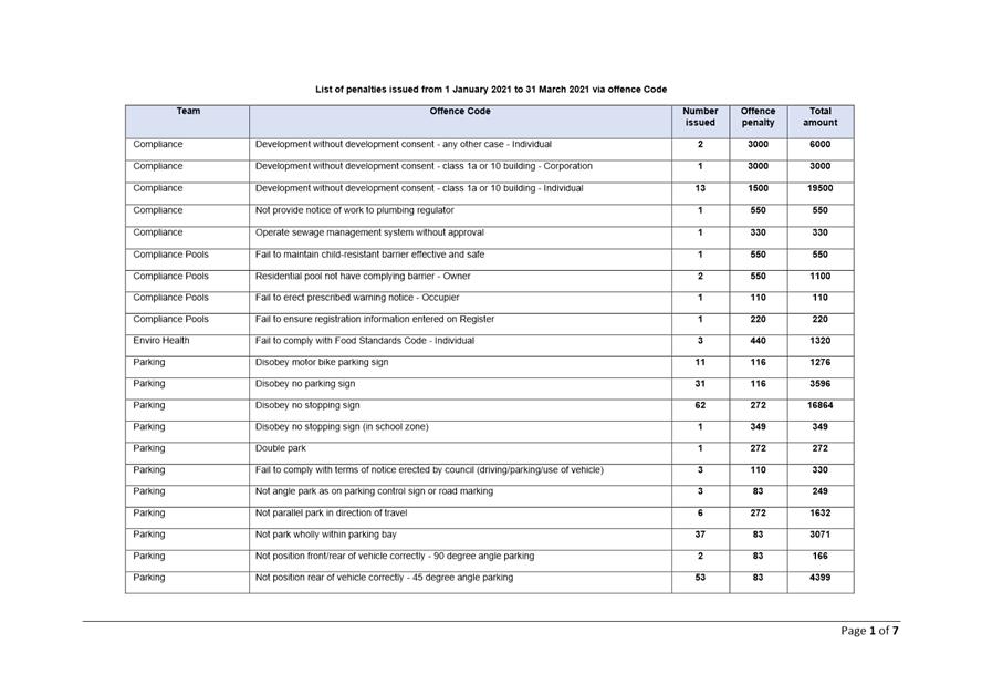
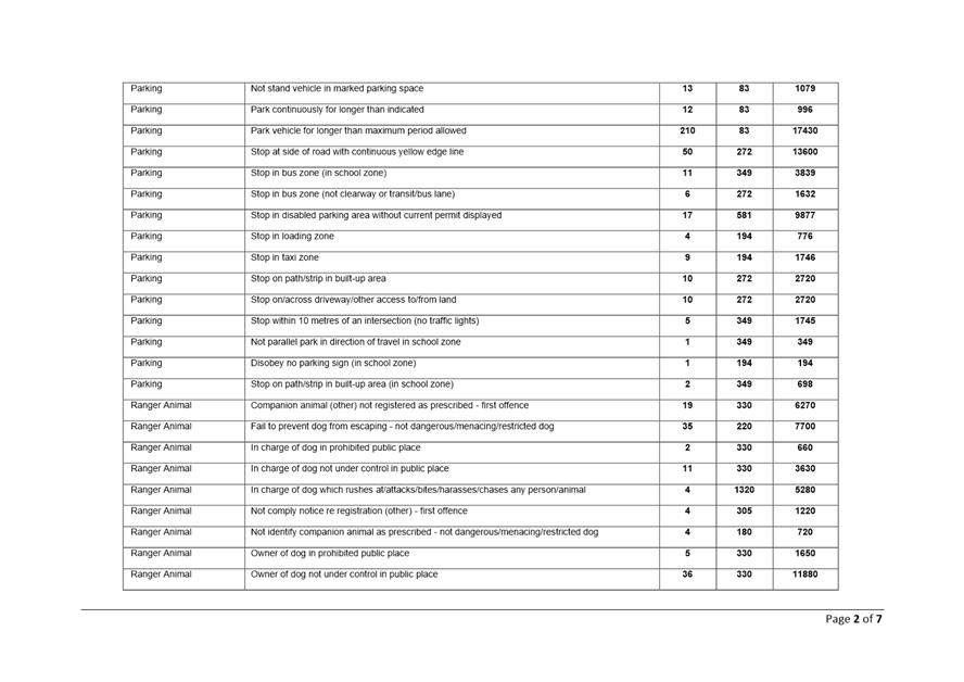
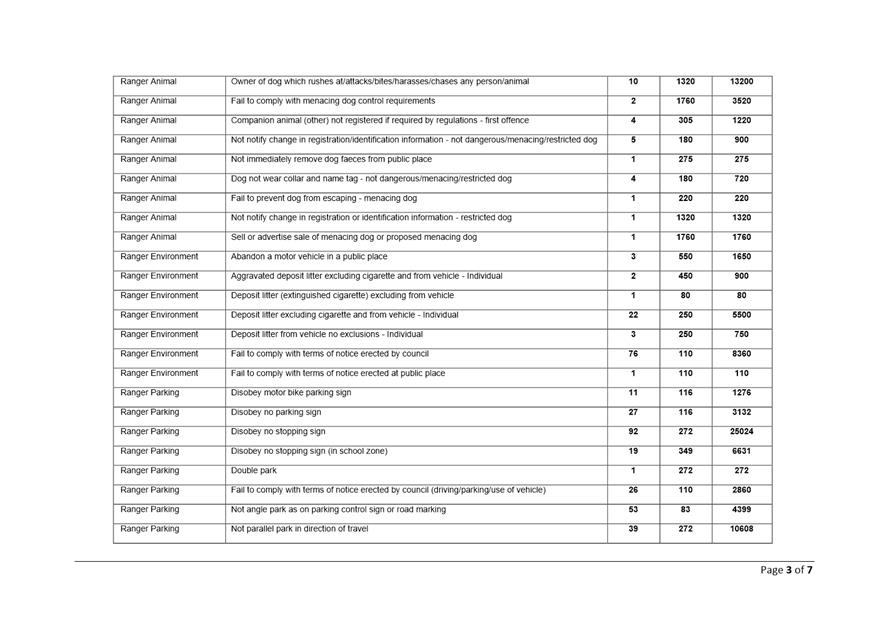
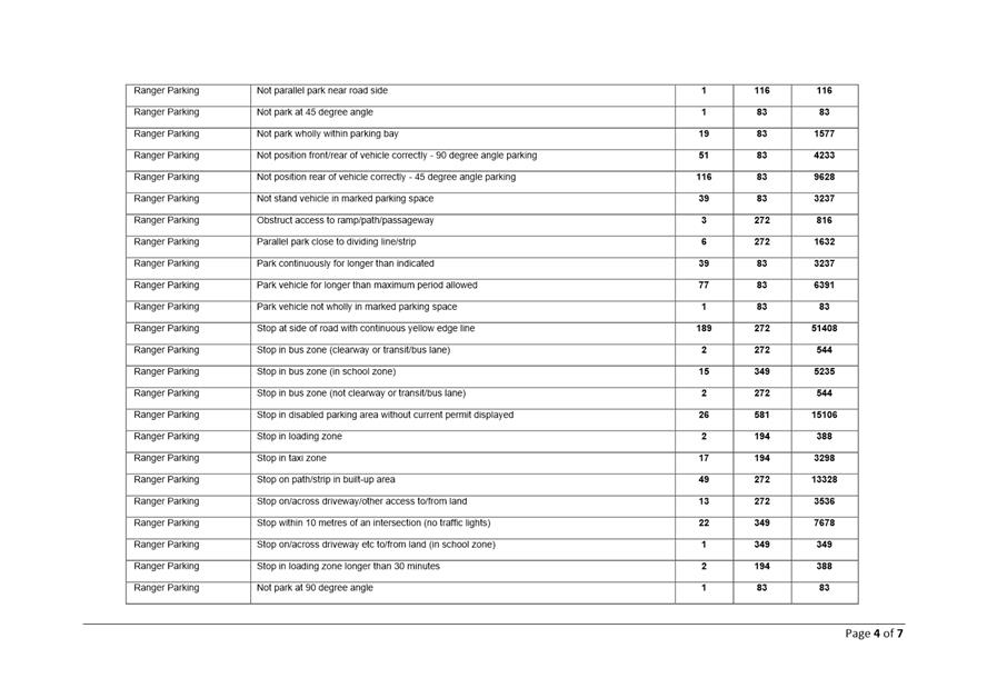
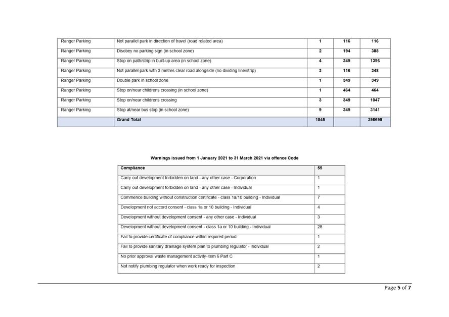
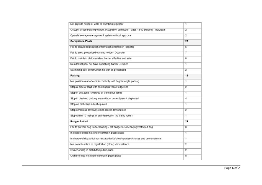
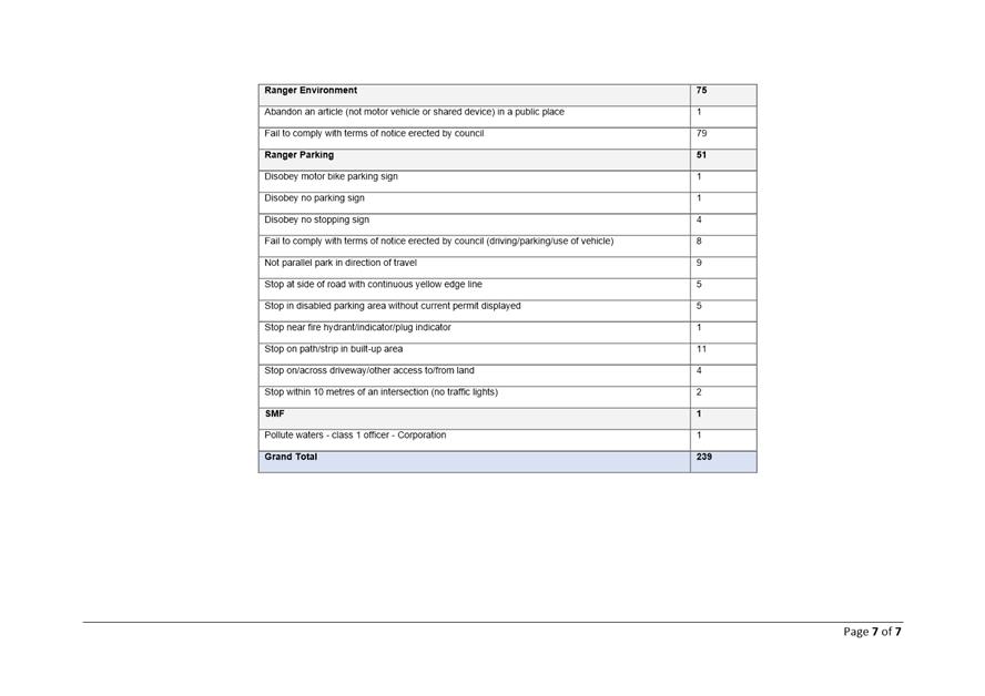
|
|
Development
& Environment Committee – Tuesday 11 May 2021
Page
0
|
Local Government Amendment (governance &
planning) act 2016
Chapter
3, Section 8A Guiding principles for councils
(1)
Exercise of functions
generally
The
following general principles apply to the exercise of functions by councils:
(a) Councils should provide strong
and effective representation, leadership, planning and decision-making.
(b) Councils should carry out functions
in a way that provides the best possible value for residents and ratepayers.
(c) Councils should plan
strategically, using the integrated planning and reporting framework, for the
provision of effective and efficient services and regulation to meet the
diverse needs of the local community.
(d) Councils should apply the
integrated planning and reporting framework in carrying out their functions so
as to achieve desired outcomes and continuous improvements.
(e) Councils should work
co-operatively with other councils and the State government to achieve desired
outcomes for the local community.
(f) Councils should manage
lands and other assets so that current and future local community needs can be
met in an affordable way.
(g) Councils should work with
others to secure appropriate services for local community needs.
(h) Councils should act fairly,
ethically and without bias in the interests of the local community.
(i) Councils should be
responsible employers and provide a consultative and supportive working
environment for staff.
(2) Decision-making
The
following principles apply to decision-making by councils (subject to any other
applicable law):
(a) Councils should recognise
diverse local community needs and interests.
(b) Councils should consider social
justice principles.
(c) Councils should consider the
long term and cumulative effects of actions on future generations.
(d) Councils should consider the
principles of ecologically sustainable development.
(e) Council decision-making should
be transparent and decision-makers are to be accountable for decisions and
omissions.
(3) Community participation
Councils
should actively engage with their local communities, through the use of the
integrated planning and reporting framework and other measures.
Chapter
3, Section 8B Principles of sound financial management
The
following principles of sound financial management apply to councils:
(a) Council spending should be responsible and
sustainable, aligning general revenue and expenses.
(b) Councils should invest in responsible and
sustainable infrastructure for the benefit of the local community.
(c) Councils should have effective financial
and asset management, including sound policies and processes for the following:
(i) performance management
and reporting,
(ii) asset maintenance and
enhancement,
(iii) funding decisions,
(iv) risk management practices.
(d) Councils should have regard to achieving
intergenerational equity, including ensuring the following:
(i) policy decisions are made
after considering their financial effects on future generations,
(ii) the
current generation funds the cost of its services
Chapter
3, 8C Integrated planning and reporting principles that apply to councils
The
following principles for strategic planning apply to the development of the
integrated planning and reporting framework by councils:
(a) Councils should identify and prioritise key
local community needs and aspirations and consider regional priorities.
(b) Councils should identify strategic goals to
meet those needs and aspirations.
(c) Councils should develop activities, and
prioritise actions, to work towards the strategic goals.
(d) Councils should ensure that the strategic
goals and activities to work towards them may be achieved within council
resources.
(e) Councils should regularly review and
evaluate progress towards achieving strategic goals.
(f) Councils should maintain an
integrated approach to planning, delivering, monitoring and reporting on
strategic goals.
(g) Councils should collaborate with others to
maximise achievement of strategic goals.
(h) Councils should manage risks to the local
community or area or to the council effectively and proactively.
(i) Councils should make appropriate
evidence-based adaptations to meet changing needs and circumstances.