Development & Environment Committee
Meeting Date: Tuesday,
01 October, 2019
Location: Council
Chambers, City Administrative Building, Bridge Road, Nowra
Time: 5.00pm
Membership (Quorum - 5)
Clr Joanna Gash - Chairperson
Clr Greg Watson
All Councillors
Chief Executive Officer or nominee
Please note: The proceedings of this meeting
(including presentations, deputations and debate) will be webcast and may be
recorded and broadcast under the provisions of the Code of Meeting Practice. Your attendance at this meeting is taken
as consent to the possibility that your image and/or voice may be recorded and
broadcast to the public.
Agenda
1. Apologies / Leave of Absence
2. Confirmation of Minutes
· Development
& Environment Committee - 3 September 2019................................... 1
3. Declarations of Interest
4. Call Over of the Business Paper
5. Mayoral Minute
6. Deputations and Presentations
7. Notices of Motion / Questions on Notice
Notices of Motion / Questions on Notice
DE19.94...... Notice of Motion - Call In DA19/1841 - 44 Duncan
Street, Huskisson........ 17
8. Reports
Planning Environment & Development
DE19.95...... Development Application 18/2115 – 171B
Strongs Rd JASPERS BRUSH – Lot 2 & DP 778594.................................................................................................... 18
DE19.96...... Development Application – No. 20, Lot 3 in
DP 539866, The Wool Road Vincentia...................................................................................................................... 51
DE19.97...... Proposed Public Exhibition - Planning Proposal
(PP043) - Additional Permitted Use - South Nowra Industrial Expansion
Zone...................................................... 74
DE19.98...... Urban Greening Strategy and Voluntary
Compensatory Tree Planting Policy 81
DE19.99...... NSW Heritage Grants 2019-2020: Shoalhaven Local
Heritage Assistance Fund...................................................................................................................... 86
DE19.100.... Nowra-Bomaderry Retail Review - Exhibition
Outcomes and Proposed Implementation............................................................................................. 90
DE19.101.... St Andrews Way/Berry's Bay & Woollamia
Sewerage Schemes - Waiving of Fees for Approval to Operate On-site Sewage
Systems......................................... 105
DE19.102.... Formation of Collingwood Beach Dunecare Group -
Progress Report..... 108
DE19.103.... Initial Consideration - Proponent Initiated
Planning Proposal - Danjera Dam Camping & Recreation Area...................................................................................... 111
DE19.104.... Tomerong Quarry - Lot 4 DP 775296 Parnell Rd
DA90/1912................... 115
DE19.105.... Submission - Proposed New Regulatory Framework -
Short Term Rental Accommodation.......................................................................................... 121
DE19.106.... Ministerial Representations - Chapter G4 Tree
& Vegetation Management - Shoalhaven DCP2014................................................................................ 125
9. Confidential
Reports
Nil
Development
& Environment Committee
Delegation:
Pursuant to
s377(1) of the Local Government Act 1993 (LG Act) the Committee is
delegated the functions conferred on Council by the Environmental Planning
& Assessment Act 1979 (EPA Act), LG Act or any other Act or delegated
to Council, as are specified in the attached Schedule, subject to the following
limitations:
i. The
Committee cannot make a decision to make a local environmental plan to classify
or reclassify public land under Division 1 of Part 2 of Chapter 6 of the LG
Act;
ii.
The Committee cannot review a section 8.11 or
section 8.9 EPA Act determination made by the Council or by the Committee
itself;
iii.
The Committee cannot exercise any function delegated
to the Council which by the terms of that delegation cannot be sub-delegated;
iv.
The Committee cannot exercise any function which
s377(1) of the LG Act provides cannot be delegated by Council; and
v.
The Committee cannot exercise a function which
is expressly required by the LG Act or any other Act to be exercised by
resolution of the Council.
Schedule
a. All
functions relating to the preparation, making, and review of local
environmental plans (LEPs) and development control plans (DCPs) under Part 3 of
the EPA Act.
b. All
functions relating to the preparation, making, and review of contributions
plans and the preparation, entry into, and review of voluntary planning
agreements under Part 7 of the EPA Act.
c. The
preparation, adoption, and review of policies and strategies of the Council in
respect of town planning and environmental matters and the variation of such
policies.
d. Determination
of variations to development standards related to development applications
under the EPA Act where the development application involves a development
which seeks to vary a development standard by more than 10% and the application
is accompanied by a request to vary the development standard under clause 4.6
of Shoalhaven Local Environmental Plan 2014 or an objection to the application
of the development standard under State Environmental Planning Policy No. 1
– Development Standards.
e. Determination
of variations from the acceptable solutions and/or other numerical standards
contained within the DCP or a Council Policy that the Chief Executive Officer
requires to be determined by the Committee
f. Determination
of development applications that Council requires to be determined by the
Committee on a case by case basis.
g. Review
of determinations of development applications under sections 8.11 and 8.9 of
the EP&A Act that the Chief Executive Officer requires to be determined by
the Committee.
h. Preparation,
review, and adoption of policies and guidelines in respect of the determination
of development applications by other delegates of the Council.
i. The
preparation, adoption and review of policies and strategies of the Council in
respect to sustainability matters related to climate change, biodiversity,
waste, water, energy, transport, and sustainable purchasing.
j. The
preparation, adoption and review of policies and strategies of the Council in
respect to management of natural resources / assets, floodplain, estuary and
coastal management.
Minutes of the Development & Environment Committee
Meeting Date: Tuesday,
3 September 2019
Location: Council
Chambers, City Administrative Building, Bridge Road, Nowra
Time: 5.00pm
The following members
were present:
Clr Amanda Findley
Clr Joanna Gash -
Chairperson
Clr Patricia White
Clr John Wells
Clr John Levett
Clr Nina Digiglio
Clr Annette Alldrick
Clr Kaye Gartner
Clr Mitchell Pakes
Clr Greg Watson
Clr Bob Proudfoot
Mr Stephen Dunshea -
Chief Executive Officer
|
Apologies / Leave of Absence
|
Apologies
were received from Clr Kitchener and Clr Guile.
|
Confirmation of the Minutes
|
|
RESOLVED
(Clr White / Clr Pakes) MIN19.609
That the Minutes of the Development & Environment
Committee held on Tuesday 06 August 2019 be confirmed.
CARRIED
|
Nil.
|
Call Over of the
Business Paper
|
|
The following items were called
up for debate:
DE19.78, DE19.79, DE19.80,
DE19.81, DE19.82, DE19.83, DE19.84, DE19.85, DE19.86, DE19.87, DE19.88,
DE19.90, DE19.91.
The remaining item (DE19.89)
was resolved en bloc (Clr Wells / Clr Gash) at this time. It is marked with
an asterisk (*) in these Minutes.
|
Deputations and Presentations
DE19.78 - Notice of Motion -
Gravel Quarry - Termeil & Tomerong (Page 11)
Ms Kate Child, representing
Tomerong Community Forum, addressed the meeting and spoke in favour of the recommendation.
DE19.79 - Notice of Motion -
Support for Shoalhaven Netball Association - Court Refurbishment (page 13)
Sue Malley, representing Shoalhaven
Netball Association, addressed the meeting and spoke in favour of the
recommendation.
DE19.86 - Proponent Initiated
Planning Proposal - Lot 1 DP 949932 - Taylors Lane, Cambewarra (Page 47)
Mr Michael Park, representing
Cambewarra Ventures, addressed the meeting and spoke in favour of the recommendation.
Mr Terry Barratt, representing
the Shoalhaven Branch of the Australian Conservation Foundation, addressed the
meeting and spoke in favour of the recommendation.
DE19.88 - Presentation of
petition in opposition to exploratory drilling/mining for fossil fuels in the
Great Australian Bight (Page 76)
Ms Monica Mudge, representing
Treading Lightly in the Mud, wishes to address the meeting and spoke in favour
of the recommendation.
|
Procedural
Motion - Bring Item Forward
|
|
RESOLVED (Clr Pakes / Clr Wells) MIN19.610
That the following matters be
brought forward for consideration:
· DE19.79
- Notice of Motion - Support for Shoalhaven Netball Association - Court
Refurbishment
· DE19.88
- Presentation of petition in opposition to exploratory drilling/mining for
fossil fuels in the Great Australian Bight
· DE19.78
- Notice of Motion - Gravel Quarry - Termeil & Tomerong
· DE19.86
- Proponent Initiated Planning Proposal - Lot 1 DP 949932 - Taylors Lane,
Cambewarra
CARRIED
|
Notices of Motion / Questions
on Notice
|
DE19.79 Notice
of Motion - Support for Shoalhaven Netball Association - Court Refurbishment
|
HPERM Ref:
D19/296544
|
|
Recommendation (Item to be determined under
delegated authority)
That it be noted that the Chief Executive Officer will
provide a letter of support for the Shoalhaven Netball Association grant
applications to the Office of Sport Clubs Grant and an infrastructure grant
with the NSW Government, for the refurbishment of their courts located at the
corner of Park Road and John Purcell Way, Nowra.
|
|
RESOLVED (Clr Gash / Clr Pakes) MIN19.611
That it be noted that the Chief Executive Officer will
provide a letter of support for the Shoalhaven Netball Association grant
applications to the Office of Sport Clubs Grant and an infrastructure grant
with the NSW Government, for the refurbishment of their courts located at the
corner of Park Road and John Purcell Way, Nowra.
CARRIED
|
|
DE19.88 Presentation
of petition in opposition to exploratory drilling/mining for fossil fuels in
the Great Australian Bight
|
HPERM Ref:
D19/289312
|
|
Recommendation (Item to be determined under
delegated authority)
That having considered the petition and background
information presented in the report, Council determine its position on the
matter.
|
|
RESOLVED (Clr Findley / Clr
Proudfoot) MIN19.612
That Council:
1. Join
other councils to protect the Great Australian Bight and oppose all
exploratory drilling and mining for fossil fuels in the Great Australian
Bight;
2. Write
to relevant State and Federal Members of Parliament;
3. Write
to Victorian councils that have already opposed this to express
Council’s support for their position;
4. Request
that the Federal Government treat Shoalhaven City Council as a stakeholder
and inform us duly of the progress of Equinor’s application; and
5. Write
to all Coastal Councils in NSW, NSW Coastal Council (NSW Department of
Planning, Industry and Environment) and the Australian Coastal Councils
Association Incorporated to advise them of Council’s decision and
encourage their support.
For: Clr
Findley, Clr Gash, Clr White, Clr Wells, Clr Levett, Clr Digiglio, Clr
Alldrick, Clr Gartner, Clr Pakes, Clr Watson, Clr Proudfoot and Stephen
Dunshea
Against: Nil
CARRIED
|
|
DE19.78 Notice
of Motion - Gravel Quarry - Termeil & Tomerong
|
HPERM Ref:
D19/293256
|
|
Recommendation (Item to be determined under
delegated authority)
That Staff compile a report on
the following in relation to the Non Designated Extractive Industry –
Gravel Quarry at Portion 42, Parish of Termeil, Monkey Mountain Road, Termeil
and the mooted intention of the Operators of that Quarry to begin gravel
extraction at Tomerong Quarry Lot 4 DP 775296 Parnell Road Tomerong under
existing DA90/1912:
1. Monkey
Mountain Road Quarry DA 95/3365
Consent to operate was
apparently for five years from 29th April 1996 to 29th
April 2001 with an extraction rate not to exceed 30,000 cubic metres per
annum.
a. Is
an EPA Licence required for crushing and grinding at this or any quarry if
the extraction rate exceeds 30,000 cubic metres per annum.
b. What
evidence does Council have that this extraction rate was not exceeded at the
Monkey Mountain Quarry in any 12 month period since approval was given in
April 1996.
c. On
what legal basis or consent was the Quarry operating after 29th
April 2001.
d. Is
the Council satisfied that there has been no illegal clearing of trees on the
site.
e. Given
the proximity of the site to Termeil Creek, are particular licences required
from the Office of Water or the EPA to protect the catchment.
f. Can
Council provide assurance that the operators are complying with all Approved
Regulatory Authority documents.
g. Can
Council confirm that the Quarry has not operated beyond the 2 hectare
extraction area described in the General Conditions of Consent.
2. Tomerong Quarry DA90/1912
Tomerong Quarry ceased
operating in July 2017 and the DA and EPA Licence were surrendered in
February 2018.
a. Can
Council give written assurance that compliance with DA90/1912 and subsequent
modifications will be strictly enforced before any operator is permitted to
resume extraction of material at the Tomerong site.
b. Can
Council provide an update on the progress of rehabilitation at the Quarry as
required in the original consent, and has the former operator of the quarry,
Shoalhaven Quarries, been subject to enforcement of this condition as was
promised in a report to Council at the Strategy and Assets Committee Meeting
on 15th May 2018 in response to a resolution at the Strategy and
Assets Committee Meeting on 23rd January 2018.
c. Can
Council provide a summary of investigation and testing for pollution in and
around the Tomerong Quarry site including the dumping of asbestos and in
particular an allegation brought to Council in April 2018 that a significant
amount of asbestos has been buried under a long mound on the south eastern
side of the quarrying area and other places.
d. Have the
owners of Lot 4 DP 775296 Parnell Road Tomerong been informed of this alleged
illegal asbestos dumping outside the quarry area on their land and can
Council confirm that the site has been registered as contaminated.
|
|
Motion (Clr Levett / Clr Digiglio)
That Staff
compile a report on the following in relation to the Non Designated
Extractive Industry – Gravel Quarry at Portion 42, Parish of Termeil,
Monkey Mountain Road, Termeil and the mooted intention of the Operators of
that Quarry to begin gravel extraction at Tomerong Quarry Lot 4 DP 775296
Parnell Road Tomerong under existing DA90/1912:
1. Monkey
Mountain Road Quarry DA 95/3365
Consent to operate was
apparently for five years from 29th April 1996 to 29th
April 2001 with an extraction rate not to exceed 30,000 cubic metres per
annum.
a. Is
an EPA Licence required for crushing and grinding at this or any quarry if
the extraction rate exceeds 30,000 cubic metres per annum.
b. What
evidence does Council have that this extraction rate was not exceeded at the
Monkey Mountain Quarry in any 12 month period since approval was given in
April 1996.
c. On
what legal basis or consent was the Quarry operating after 29th
April 2001.
d. Is
the Council satisfied that there has been no illegal clearing of trees on the
site.
e. Given
the proximity of the site to Termeil Creek, are particular licences required
from the Office of Water or the EPA to protect the catchment.
f. Can
Council provide assurance that the operators are complying with all Approved
Regulatory Authority documents.
g. Can
Council confirm that the Quarry has not operated beyond the 2 hectare
extraction area described in the General Conditions of Consent.
2. Tomerong
Quarry DA90/1912
Tomerong Quarry ceased operating
in July 2017 and the DA and EPA Licence were surrendered in February 2018.
a. Can
Council give written assurance that compliance with DA90/1912 and subsequent
modifications will be strictly enforced before any operator is permitted to
resume extraction of material at the Tomerong site.
b. Can
Council provide an update on the progress of rehabilitation at the Quarry as
required in the original consent, and has the former operator of the quarry,
Shoalhaven Quarries, been subject to enforcement of this condition as was
promised in a report to Council at the Strategy and Assets Committee Meeting
on 15th May 2018 in response to a resolution at the Strategy and
Assets Committee Meeting on 23rd January 2018.
c. Can
Council provide a summary of investigation and testing for pollution in and
around the Tomerong Quarry site including the dumping of asbestos and in
particular an allegation brought to Council in April 2018 that a significant
amount of asbestos has been buried under a long mound on the south eastern
side of the quarrying area and other places.
d. Have the
owners of Lot 4 DP 775296 Parnell Road Tomerong been informed of this alleged
illegal asbestos dumping outside the quarry area on their land and can
Council confirm that the site has been registered as contaminated.
3. That staff
investigate the possibility of introducing a planning proposal to rezone so
that “extractive industries” are no longer permissible at the
site.
4. That
Council communicate regularly with the community with respect to developments
at the Tomerong quarry site.
|
|
amendment (RESOLVED) (Clr Watson / Clr Wells) MIN19.613
That:
1. Staff
compile a report on the following in relation to the mooted intention of the
Operators of the Quarry to begin gravel extraction at Tomerong Quarry Lot 4
DP 775296 Parnell Road Tomerong under existing DA90/1912:
Tomerong Quarry ceased
operating in July 2017 and the DA and EPA Licence were surrendered in
February 2018.
a. Can
Council give written assurance that compliance with DA90/1912 and subsequent
modifications will be strictly enforced before any operator is permitted to
resume extraction of material at the Tomerong site.
b. Can
Council provide an update on the progress of rehabilitation at the Quarry as
required in the original consent, and has the former operator of the quarry,
Shoalhaven Quarries, been subject to enforcement of this condition as was
promised in a report to Council at the Strategy and Assets Committee Meeting
on 15th May 2018 in response to a resolution at the Strategy and
Assets Committee Meeting on 23rd January 2018.
c. Can
Council provide a summary of investigation and testing for pollution in and
around the Tomerong Quarry site including the dumping of asbestos and in
particular an allegation brought to Council in April 2018 that a significant
amount of asbestos has been buried under a long mound on the south eastern
side of the quarrying area and other places.
d. Have the
owners of Lot 4 DP 775296 Parnell Road Tomerong been informed of this alleged
illegal asbestos dumping outside the quarry area on their land and can
Council confirm that the site has been registered as contaminated.
2. Staff
investigate the possibility of introducing a planning proposal to rezone so
that “extractive industries” are no longer permissible at the
site.
3. Council
communicate regularly with the community with respect to operations at the
Tomerong quarry site.
For: Clr
Wells, Clr Gash, Clr White, Clr
Pakes, Clr Watson and Stephen Dunshea
Against: Clr Findley,
Clr Levett, Clr Digiglio, Clr Alldrick, Clr Gartner and Clr Proudfoot
CARRIED on the CASTING VOTE of
the Chair
The AMENDMENT became the MOTION.
THE MOTION WAS PUT
For: Clr Findley, Clr Gash, Clr White, Clr Wells,
Clr Levett, Clr Digiglio, Clr Alldrick, Clr Gartner, Clr Pakes, Clr Watson,
Clr Proudfoot and Stephen Dunshea
Against:
Nil
CARRIED
|
|
DE19.79 Notice of Motion -
Support for Shoalhaven Netball Association - Court Refurbishment
|
HPERM Ref: D19/296544
|
|
Item
dealt with earlier in the meeting see MIN19.611.
|
Reports
Note: Clr Gartner left
the meeting at 6.57pm.
|
DE19.86 Proponent
Initiated Planning Proposal - Lot 1 DP 949932 - Taylors Lane, Cambewarra
|
HPERM Ref:
D19/271794
|
|
Recommendation (Item to be determined under
delegated authority)
That Council:
1. Accept
the proponent initiated Planning Proposal for land within Lot 1 DP 949932,
Taylors Lane, Cambewarra as a possible ‘major’ Planning Proposal
that Council will take forward dependent of the outcome of Part (2) of this
resolution.
2. Undertake
an independent Riparian Lands Study for the subject land, at the
proponent’s expense, that includes rigorous assessment of the riparian
land function and watercourse classification.
3. If
the outcome of the Riparian Lands Study shows the PP has merit to proceed,
develop a Planning Proposal in Council’s format, for submission to the
NSW Department of Planning, Industry and Environment (DPIE) for initial
Gateway determination, and report back to Council when a response is
received.
4. Receive
a further report to determine how to proceed, if the Riparian Lands Study
does not provide clear justification for the Planning Proposal.
|
|
RESOLVED (Clr Wells / Clr Pakes) MIN19.614
That Council:
1. Accept
the proponent initiated Planning Proposal for land within Lot 1 DP 949932,
Taylors Lane, Cambewarra as a possible ‘major’ Planning Proposal
that Council will take forward dependent of the outcome of Part (2) of this
resolution.
2. Undertake
an independent Riparian Lands Study for the subject land, at the
proponent’s expense, that includes rigorous assessment of the riparian
land function and watercourse classification.
3. If
the outcome of the Riparian Lands Study shows the PP has merit to proceed,
develop a Planning Proposal in Council’s format, for submission to the
NSW Department of Planning, Industry and Environment (DPIE) for initial
Gateway determination, and report back to Council when a response is
received.
4. Receive
a further report to determine how to proceed, if the Riparian Lands Study
does not provide clear justification for the Planning Proposal.
For: Clr
Findley, Clr Gash, Clr White, Clr Wells, Clr Levett, Clr Digiglio, Clr
Alldrick, Clr Pakes, Clr Watson, Clr Proudfoot and Stephen Dunshea
Against: Nil
CARRIED
|
Note: Clr Levett left the
meeting at 6.58pm.
|
DE19.80 Exhibition
- Proposed Development Control Plan and Contribution Plan Amendments -
St Georges Basin Village Centre
|
HPERM Ref:
D19/150814
|
|
Recommendation (Item to be determined under
delegated authority)
That Council:
1. Endorse
the preparation of the housekeeping amendment to Chapter N23: St Georges
Basin Village Centre of Shoalhaven Development Control Plan (DCP) 2014
(Attachment 1) which in part includes the changes resolved by Council on 7
May 2019 (MIN19.287).
2. Exhibit
the following for a minimum period of 28 days in accordance with legislation:
a. Housekeeping
amendments to Chapter N23: St Georges Basin Village Centre of Shoalhaven DCP
2014 (Attachment 1).
b. Deletion
of the Shoalhaven Contributions Plan 2019 project 03ROAD2113 (St Georges
Basin Village Centre Service Lane).
3. Receive
a further report following the public exhibition to consider submissions
received and to consider finalisation of the draft Amendment.
4. Notify
affected landowners and the Basin Villages Forum of this resolution and
future exhibition arrangements.
|
|
RESOLVED (Clr Proudfoot / Clr White) MIN19.615
That Council:
1. Endorse
the preparation of the housekeeping amendment to Chapter N23: St Georges
Basin Village Centre of Shoalhaven Development Control Plan (DCP) 2014
(Attachment 1) which in part includes the changes resolved by Council on 7
May 2019 (MIN19.287).
2. Exhibit
the following for a minimum period of 28 days in accordance with legislation:
a. Housekeeping
amendments to Chapter N23: St Georges Basin Village Centre of Shoalhaven DCP
2014 (Attachment 1).
b. Deletion
of the Shoalhaven Contributions Plan 2019 project 03ROAD2113 (St Georges
Basin Village Centre Service Lane).
3. Receive
a further report following the public exhibition to consider submissions
received and to consider finalisation of the draft Amendment.
4. Notify
affected landowners and the Basin Villages Forum of this resolution and
future exhibition arrangements.
For: Clr
Findley, Clr Gash, Clr White, Clr Wells, Clr Digiglio, Clr Alldrick, Clr
Pakes, Clr Watson, Clr Proudfoot and Stephen Dunshea
Against: Nil
CARRIED
|
|
DE19.81 Draft
Low Density Residential Amendment - Shoalhaven DCP 2014 (DCP2014.25) - Post
Exhibition Consideration and Finalisation
|
HPERM Ref: D19/256782
|
|
Recommendation (Item to be determined under
delegated authority)
That Council:
1. Adopt
the draft Low Density Residential Amendment (the Amendment) as exhibited,
with the inclusion of the changes to draft Chapter G12 as highlighted in
Attachment 1 and shown in Attachment 2.
2. Notify
the adoption of the Amendment in local newspapers in accordance with the
requirements of the Environmental Planning and Assessment Act 1979 and
Regulations.
3. Rescind
existing Chapter G12: Dwelling Houses, Rural Worker's Dwellings, Additions
and Ancillary Structures of Shoalhaven Development Control 2014 when the
Amendment is made effective.
4. Advise
key stakeholders, including relevant industry representatives, of this
decision, and when the Amendment will be made effective.
|
|
Note: Clr Gartner
returned to the meeting at 6.58pm and Clr Levett returned to the meeting at
6.59pm.
|
|
RESOLVED (Clr Pakes / Clr White) MIN19.616
That this Item be deferred to a
Councillor briefing to allow consideration and discussion of Clr Pakes’
proposed amendments prior to the next Council meeting.
For: Clr
Findley, Clr Gash, Clr White, Clr Wells, Clr Levett, Clr Alldrick, Clr
Gartner, Clr Pakes, Clr Watson, Clr Proudfoot and Stephen Dunshea
Against: Clr Digiglio
CARRIED
|
|
DE19.82 Planning
Proposal - Land Use Zones & Building Height Controls - Ulladulla Town
Centre
|
HPERM Ref:
D19/261192
|
|
Recommendation (Item to be determined under
delegated authority)
That Council:
1. Resubmit
the Planning Proposal proposing changes to the planning controls in part of
the Ulladulla Town Centre to the NSW Department of Planning, Industry and
Environment as required by the Gateway Determination.
2. Proceed
to place the Planning Proposal on public exhibition and invite community
feedback in accordance with the Gateway Determination.
3. Receive
a subsequent report on the outcome of the public exhibition period and to
enable the Planning Proposal to be finalised.
|
|
RESOLVED (Clr Proudfoot / Clr
Wells) MIN19.617
That Council:
1. Resubmit
the Planning Proposal proposing changes to the planning controls in part of
the Ulladulla Town Centre to the NSW Department of Planning, Industry and
Environment as required by the Gateway Determination.
2. Proceed
to place the Planning Proposal on public exhibition and invite community
feedback in accordance with the Gateway Determination.
3. Receive
a subsequent report on the outcome of the public exhibition period and to
enable the Planning Proposal to be finalised.
For: Clr
Findley, Clr Gash, Clr White, Clr Wells, Clr Levett, Clr Digiglio, Clr
Gartner, Clr Pakes, Clr Watson, Clr Proudfoot and Stephen Dunshea
Against: Clr Alldrick
CARRIED
|
|
DE19.83 Update
- The Review of Subdivision Provisions Planning Proposal (PP027)
|
HPERM Ref:
D19/262580
|
|
Recommendation (Item to be determined under
delegated authority)
That Council:
1. Endorse
the continuation of the Review of Subdivision Provisions Planning Proposal
(PP027) and proceed to exhibit PP027 (as amended by the Gateway
determination) as per the legislative and Gateway determination
requirements.
2. Receive
a further report following the conclusion of the public exhibition period.
3. Receive
a further report on the outcomes of the review being undertaken by Professor
Ryan and the options available (if any) to progress the exclusion of
Greenwell Point, Kangaroo Valley, Bawley Point, Kioloa, Depot Beach, Durras
North from the Low-Rise Medium Density Housing Code.
4. Advise
key stakeholders of this decision and the resultant exhibition arrangements,
including relevant Community Consultative Bodies and Development Industry representatives.
|
|
RESOLVED (Clr Proudfoot / Clr
Findley) MIN19.618
That Council:
1. Endorse
the continuation of the Review of Subdivision Provisions Planning Proposal
(PP027) and proceed to exhibit PP027 (as amended by the Gateway
determination) as per the legislative and Gateway determination
requirements.
2. Receive
a further report following the conclusion of the public exhibition period.
3. Receive
a further report on the outcomes of the review being undertaken by Professor
Ryan and the options available (if any) to progress the exclusion of
Greenwell Point, Kangaroo Valley, Bawley Point, Kioloa, Depot Beach, Durras
North from the Low-Rise Medium Density Housing Code.
4. Advise
key stakeholders of this decision and the resultant exhibition arrangements,
including relevant Community Consultative Bodies and Development Industry
representatives.
For: Clr
Findley, Clr Gash, Clr White, Clr Wells, Clr Levett, Clr Digiglio, Clr
Alldrick, Clr Gartner, Clr Pakes, Clr Watson, Clr Proudfoot and Stephen
Dunshea
Against: Nil
CARRIED
|
|
DE19.84 Proposed
Housekeeping Amendment - Shoalhaven Development Control Plan 2014 - Chapter
G2: Sustainable Stormwater Management and Erosion/Sediment Control
|
HPERM Ref:
D19/263024
|
|
Recommendation (Item to be determined under
delegated authority)
That Council:
1. Endorse
the initial draft Housekeeping Amendment to Chapter G2: Sustainable
Stormwater Management and Erosion/Sediment Control and the Dictionary of
Shoalhaven Development Control Plan 2014 (draft Amendment) at Attachment 1
and support the exhibition of the draft Amendment for a period of at least 28
days as per legislative requirements.
2. Advise
key stakeholders, including relevant industry representatives, of this
decision and the exhibition arrangements in due course.
3. Receive
a further report on the draft Amendment following the conclusion of the
public exhibition period to consider feedback received, any necessary adjustments
and the finalisation of the amendment.
|
|
RESOLVED (Clr Proudfoot / Clr
Alldrick) MIN19.619
That Council:
1. Endorse
the initial draft Housekeeping Amendment to Chapter G2: Sustainable
Stormwater Management and Erosion/Sediment Control and the Dictionary of
Shoalhaven Development Control Plan 2014 (draft Amendment) at Attachment 1
and support the exhibition of the draft Amendment for a period of at least 28
days as per legislative requirements.
2. Advise
key stakeholders, including relevant industry representatives, of this
decision and the exhibition arrangements in due course.
3. Receive
a further report on the draft Amendment following the conclusion of the
public exhibition period to consider feedback received, any necessary
adjustments and the finalisation of the amendment.
For: Clr
Findley, Clr Gash, Clr White, Clr Wells, Clr Levett, Clr Digiglio, Clr
Alldrick, Clr Gartner, Clr Pakes, Clr Watson, Clr Proudfoot and Stephen
Dunshea
Against: Nil
CARRIED
|
|
DE19.85 Biosecurity
Act 2015 - Weed Management Plans
|
HPERM Ref:
D19/268306
|
|
Recommendation (Item to be determined under
delegated authority)
That
Council endorse the following Weed Management Plans:
1. Alligator
weed
2. Blackberry
3. Coolatai Grass
4. Giant Parramatta Grass
5. Salvinia
6. Bitou bush
7. Boneseed
8. Fireweed
9. Lantana
10. Water hyacinth
|
|
RESOLVED (Clr Digiglio / Clr
Wells) MIN19.620
That Council:
1. Endorse
the following Weed Management Plans:
a. Alligator
weed
b. Blackberry
c. Coolatai Grass
d. Giant Parramatta Grass
e. Salvinia
f. Bitou bush
g. Boneseed
h. Fireweed
i. Lantana
j. Water
hyacinth
2. Continue
to look for alternative methods to improve weed management that are safer
into the future.
For: Clr
Findley, Clr Gash, Clr White, Clr Wells, Clr Levett, Clr Digiglio, Clr
Alldrick, Clr Gartner, Clr Pakes, Clr Watson, Clr Proudfoot and Stephen
Dunshea
Against: Nil
CARRIED
|
|
DE19.86 Proponent Initiated Planning Proposal - Lot 1 DP 949932 - Taylors Lane,
Cambewarra
|
HPERM Ref: D19/271794
|
|
Item dealt with earlier
in the meeting see MIN19.614.
|
|
DE19.87 Novation
Request - Voluntary Planning Agreement - Seaspray Close - Narrawallee
|
HPERM Ref:
D19/279715
|
|
Recommendation (Item to be determined under
delegated authority)
That Council agree to the amended Deed of Novation, presented
as Attachment 1 to this report, related to the Voluntary Planning Agreement
that is in place for land at Narrawallee owned by Hanson South Coast Pty Ltd.
|
|
RESOLVED (Clr Findley / Clr
Wells) MIN19.621
That Council:
1. Agree
to the amended Deed of Novation, presented as Attachment 1 to this report,
related to the Voluntary Planning Agreement that is in place for land at
Narrawallee owned by Hanson South Coast Pty Ltd.
2. Approach
the Biodiversity Conservation Trust to seek the purchase of Seaspray Close,
Narrawallee as an addition to the Garrads Reserve.
For: Clr
Findley, Clr Gash, Clr White, Clr Wells, Clr Levett, Clr Digiglio, Clr
Alldrick, Clr Gartner, Clr Pakes, Clr Watson, Clr Proudfoot and Stephen
Dunshea
Against: Nil
CARRIED
|
|
DE19.88 Presentation of Petition in Opposition to Exploratory
Drilling/Mining for Fossil Fuels in the Great Australian Bight
|
HPERM Ref: D19/289312
|
|
Item
dealt with earlier in the meeting see MIN19.612.
|
Items marked with an *
were resolved ‘en block’.
|
DE19.89 Grant
application - Grey Headed Flying Fox Berry Camp
|
HPERM Ref:
D19/259892
|
|
RECOMMENDATION*
(Clr Wells / Clr Gash)
That Council:
1. Accept
the maximum grant of $50,000 from Local Government
NSW, if the application is successful.
2. Provide
an in-kind contribution from existing operational budgets, a maximum of
$50,000, of Environmental Services officers time; and
3. Write to
Local Government NSW thanking them for the grant funding, if the application
is successful.
|
|
DE19.90 West
Culburra Development Proposal - NSW Land & Environment Court Matter
|
HPERM Ref:
D19/292580
|
|
Recommendation (Item to be determined under
delegated authority)
That Council consider the separate confidential report
on this matter in accordance with Section 10A(2)(g) of the NSW Local
Government Act 1993.
|
|
RESOLVED (Clr Pakes / Clr White) MIN19.622
That Council consider the separate confidential report
on this matter in accordance with Section 10A(2)(g) of the NSW Local
Government Act 1993.
CARRIED
|
|
DE19.91 Drought
Impact on Shoalhaven Water Supplies
|
HPERM Ref:
D19/277621
|
|
Recommendation (Item to be determined under
delegated authority)
That Council note:
1. The
current water supply situation with Shoalhaven storages and Shoalhaven River
flows.
2. The
proposed strategy to implement Level 1 water restrictions on 23 September
2019, in accordance with Council’s Drought Management Plan, should no
significant rainfall be experienced and the outlook for rain remains low.
|
|
RESOLVED (Clr Findley / Clr
Wells) MIN19.623
That Council:
1. Note
the current water supply situation with Shoalhaven storages and Shoalhaven
River flows.
2. Note
the proposed strategy to implement Level 1 water restrictions on 23 September
2019, in accordance with Council’s Drought Management Plan, should no significant
rainfall be experienced and the outlook for rain remains low.
3. Write
to the Hon Shelley Hancock, MP, Member for South Coast and the Hon Gareth
Ward, MP, Member for Kiama seeking their support in approaching the Minister
for Water, Property and Housing with respect to the Shoalhaven Water Sharing
Plan.
4. At
the appropriate time, write to the Hon Melinda Pavey, MP, Minister for Water,
Property and Housing, requesting a meeting to discuss aspects of the review
of the Shoalhaven Water Sharing Plan.
For: Clr
Findley, Clr Gash, Clr White, Clr Wells, Clr Levett, Clr Digiglio, Clr
Alldrick, Clr Gartner, Clr Pakes, Clr Watson, Clr Proudfoot and Stephen
Dunshea
Against: Nil
CARRIED
|
|
Procedural
Motion - Matters of Urgency
|
|
Motion (Clr Findley / Clr Gash)
That the following additional
items be introduced as a matter of urgency:
1. The
following Development Applications:
a. DA19/1102
- 252 Princes Hwy Ulladulla (Cnr of Pitman Ave) – Manufactured Home
Estate
b. DA19/1692
- Princes Hwy Ulladulla (Cnr of Ilett St Mollymook) – Aged Care
Facility
2. Intersection
of Pitman Avenue and Princes Highway.
|
|
The Chairperson ruled
the matters as urgent due to the level of public interest.
|
|
DE19.92 Additional
Item - Development Applications - Ulladulla - Extension of public submission
period
|
|
RESOLVED (Clr Findley / Clr Pakes) MIN19.624
That Council extend the public submission period on
the following Development Applications for 21 days AFTER the Roads and
Maritime Service have issued their response to the applications:
· DA19/1102
- 252 Princes Hwy Ulladulla (Cnr of Pitman Ave) – Manufactured Home
Estate
· DA19/1692
- Princes Hwy Ulladulla (Cnr of Ilett St Mollymook) – Aged Care
Facility
For: Clr
Findley, Clr Gash, Clr White, Clr Wells, Clr Levett, Clr Digiglio, Clr
Alldrick, Clr Gartner, Clr Pakes, Clr Watson, Clr Proudfoot and Stephen
Dunshea
Against: Nil
CARRIED
|
|
DE19.93 Additional
Item - Intersection of Pitman Avenue and Princes Highway, Ulladulla
|
|
RESOLVED (Clr Findley / Clr Gash)
MIN19.625
That the Chief Executive Officer
undertake an investigation into historical correspondence in respect to the
Pitman Ave and Princes Hwy intersection treatment. The purpose of the
investigation is to give background to the Roads and Maritime Service to
build their understanding of the community’s desires for a safe and
passable intersection with some consideration for a roundabout or other
treatment that makes access and egress from Pitman Ave timely and safe.
For: Clr
Findley, Clr Gash, Clr White, Clr Wells, Clr Levett, Clr Digiglio, Clr
Alldrick, Clr Gartner, Clr Pakes, Clr Watson, Clr Proudfoot and Stephen
Dunshea
Against: Nil
CARRIED
|
Confidential Reports
Pursuant to Section 10A(4) the public were invited to make
representation to the meeting before any part of the meeting is closed, as to whether
that part of the meeting should be closed.
No members of the public made representations.
|
RESOLVED (Clr Wells / Clr Pakes) MIN19.626
That the press and
public be excluded from the Meeting, pursuant to section 10A(1)(a) of the
Local Government Act, 1993, to consider the following items of a confidential
nature.
CDE19.1 West
Culburra Development Proposal - NSW Land & Environment Court Matter
Advice concerning litigation, or advice as comprises
a discussion of this matter, that would otherwise be privileged from
production in legal proceedings on the ground of legal professional
privilege.10(A)(2)(g)
There is a public interest
consideration against disclosure of information as disclosure of the
information could reasonably be expected to prejudice any court proceedings
by revealing matter prepared for the purposes of or in relation to current or
future proceedings or prejudice the fair trial of any person, the impartial
adjudication of any case or a person’s right to procedural fairness.
CARRIED
|
The meeting moved into
confidential the time being 7.47pm.
The meeting moved into
open session, the time being 7.57pm.
Report from confidential session
The following resolutions
of the meeting, whilst closed to the public, were made public.
|
CDE19.1 West
Culburra Development Proposal - NSW Land & Environment Court Matter
|
HPERM Ref:
D19/277454
|
|
RESOLVED MIN19.627C
That Council:
1. Not
proceed to apply to join the Land and Environment Court (LEC) proceedings
regarding the refusal of the West Culburra development proposal.
2. Be
represented at the Conciliation Conference on 14/15 November 2019 by senior
member(s) of Council Staff or Councillor Watson. The focus of such
representation is to reflect the presentation previously made to the
Independent Planning Commission.
3. Continue
to work cooperatively with the applicant on solutions required to achieve
stated outcomes in regard to the subject proposal and subsequent reports be
provided to Council if needed in this regard.
For: Clr
Gash, Clr White, Clr Wells, Clr Pakes, Clr Watson, Clr Proudfoot and Stephen
Dunshea
Against: Clr Findley,
Clr Levett, Clr Digiglio, Clr Alldrick and Clr Gartner
CARRIED
|
There being no further
business, the meeting concluded, the time being 7.59pm.
Clr Gash
CHAIRPERSON
|

|
Development
& Environment Committee – Tuesday 01 October 2019
Page
17
|
DE19.94 Notice
of Motion - Call In DA19/1841 - 44 Duncan Street, Huskisson
HPERM Ref: D19/316168
Submitted
by: Clr John Levett
Purpose / Summary
The following Notice of Motion, of which due notice has been
given, is submitted for Council’s consideration.
|
Recommendation (Item to be
determined under delegated authority)
That Council call in the Development Application DA19/1841
- 44 Duncan Street, Huskisson due to public interest.
|
Background
I call this application to
Council in response to the public reaction which has the view that this
development will not preserve and enhance the amenity and natural character of
the locality. The height and floor space ratio proposed exceed those permitted
in an R3 Medium Density Zoning. The DA does not meet the test for balanced
growth in that its size and location are not in keeping with the character of
Huskisson.
Note by the CEO
The proposal is for the
demolition of an existing dwelling and erection of a 4 storey residential flat
building with basement carparking. The application was officially receipted by
Council on 29 August 2019 and is currently on public notification until 3
October.
|
|
Development
& Environment Committee – Tuesday 01 October 2019
Page
39
|
DE19.95 Development
Application 18/2115 – 171B Strongs Rd JASPERS BRUSH – Lot 2 &
DP 778594
DA. No: DA18/2115/4
HPERM Ref: D19/240144
Group: Planning
Environment & Development Group
Section: Development
Services
Attachments: 1. Draft
Determination ⇩
2. Planning
Report – S4.15 Assessment (under separate cover) ⇨
3. Applicant Response to
Submissions ⇩
Description of Development: Temporary use of land
for events/ functions including weddings
Owner: Brigrath No. 2 Pty Ltd
Applicant: SET Consultants Pty Ltd
Notification Dates: The application was notified
on two separate occasions on 10 October 2018 to 25 October 2018 and 1 February
2019 to 16 February 2019
No. of
Submissions: 16 submissions were received to the first notification
and all submissions were in objection to the application. Following the second
notification, a total of 85 submissions were received to the application, one
in support and 84 submissions in opposition to the application.
Purpose
/ Reason for consideration by Council
On 26 March 2019, at an Ordinary
Meeting of Council, it was resolved that Council call-in DA18/2115 for
determination by the elected Council due to the public interest with the number
of submissions lodged with Council (MIN19.161).
That Council ‘call-in’ the following
Development Application for determination by the elected Council
1. DA18/2115 for
171B Strongs Road, Berry due to the public interest with the number of
submissions lodged with Council
2018 – 17 submissions
2019 – 60 plus resubmissions of 11
In accordance with the
resolution, the development application is to be determined by the Council.
Options
1. Refuse the Development
Application (DA) in accordance with the recommendation.
Implications: The proposal would not proceed. The applicant
can however apply for a section 8.2 review of Council’s decision and/or
could lodge an appeal with the NSW Land and Environment Court against
Council’s decision.
2. Approve the DA.
Implications: Council would have to provide the grounds to
support the proposal, that is, provide reasons to support the development,
having regard to section 4.15 considerations. This would require a further
report to Council attaching a suite of conditions. Under some
circumstances, third parties (i.e. objectors) can seek a judicial review of
Council’s decision in the NSW Land and Environment Court.
3. Alternative
recommendation.
Implications: Council will need to specify an alternative
recommendation and advise staff accordingly.
Location Map
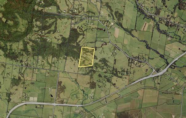
Figure 1: Location Map
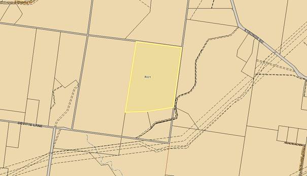
Figure 2: Zoning Map
Background
Proposed Development
The application
(DA18/2115) was lodged on 2 October 2018, seeking development consent for
development described in the Statement of Environmental Effects (SEE) prepared
by SET Consultants dated 11 September 2018 as: “the proposed temporary
use of land for private functions and events (weddings ceremonies and
receptions)” on the land at 171B Strongs Rd Berry (Lot 2 DP
778594). The DA was made pursuant to clause 2.8 of Shoalhaven Local
Environmental Plan 2014 (SLEP 2014).
The SEE lodged with the DA
described the development as follows:
1) The maximum number of
people to attend a function on site is limited to 130 people.
2) No more than 52 events per
year is proposed. The 52 events are made up of functions such as weddings and
receptions.
3) The functions (weddings)
will be limited to a single weekend day with an absolute finishing time of 12pm. The site being accessed over the weekend for set up.
4) Marquees will be erected
the preceding work day to the function and removed the following work day, in
the location specified in the site layout plan.
5) Catering for the event
will be provided by external catering companies. Food will be cooked offsite
and brought to the site to be reheated.
6) No on-site liquor licence
is required as the guests will be responsible for providing alcohol.
7) All guests other than the
bridal party (or attendees of small conferences) will access the site via a
mini bus service.
8) Portable toilets are to be
brought onto site and placed in the designated location by a hire company. The
facilities will be removed the following day/work day by the hire company.
9) The existing bathroom
facilities within the dwelling will not be available for use by guests
before/during or after the function.
10) No guests will remain
onsite following the function and no camping is to occur on site.
Based on the submitted site
plan, four (4) possible locations around the existing dwelling were identified
as marquee areas and three (3) portable toilet locations specified. No
permanent structures were proposed.
On 30 January 2019, following
referral advice and the formal notification process, the applicant amended
the proposal.
The proposed amendments on page
7 of the revised Operation Management Plan (OMP) dated 25 January 2019
(Ref:L103619) prepared by SET Consultants details as follows:
· The
maximum number of people to attend a function on site is limited to 60
people.
· No more
than 26 events per year is proposed. The 26 events are made up of
functions such as weddings, receptions and small conferences.
· The
functions (weddings) will be limited to a single weekend day with an absolute
finishing time of 12am (midnight). The site being accessed over the weekend for
set up purposes.
· Marquees
will be erected the preceding work day to the function and be removed the
following work day, in the location specified in the site layout plan.
· Catering
for the event will be provided by external catering companies. Food will be
cooked offsite and brought to the site to be reheated.
· No
on-site liquor licence is required as the guests will be responsible for
providing alcohol.
· All
guests other than the bridal party (or attendees of small conferences) will
access the site via a mini bus service. Guests will not be allowed to drive
themselves to the event. This will be enforced as part of the terms and
conditions signed by the hiring party.
· The
hiring party will be required to inform the management team if attendees
include person with disabilities so assistance can be arranged if required.
· Portable
toilets are to be brought onto site and placed in the designated location by a
hire company. The facilities will be removed the following day/work day by the
hire company.
· The
existing bathroom facilities within the dwelling will not be available for use
by guests before/during or after the function.
· No
guests will remain onsite following the function and no camping is to occur on
site.
The revised
OMP also states that:
“The Property Manager will
provide waste bins for the event. The owner/management will be responsible for
the removal of all rubbish from the site.”
As part of
the amended proposal, the marquee locations were reduced from four (4)
locations to one (1) adjacent to the existing dwelling. The applicant
also clarified that:
“..the
existing swimming pool will not be used as part of the events taking place on
the site.
Additional lighting will be supplied
to the site for use during the wedding functions. Lighting will be setup prior
the event taking place. If portable flood lighting is used, the events manager
will ensure that they are directed towards the existing structures onsite, and
that lighting is not pointing towards surrounding properties.
The existing dwelling will not be
used for the events and functions. All facilities to be used for the reheating
and serving of food will be transported to site by the hired caterers. All
waste and cleaning will be done off site by the caterers.”
Mini-buses will pick up the
wedding guests from their accommodation and transport them to the wedding
venue. They will remain parked onsite and transport the guests back to their
accommodation after the event.
On-site parking spaces are
provided within the existing gravel areas for the bridal party, catering and
entertainment staff (or attendees of small conferences). There is enough
space for 22 vehicles in the designated parking area as shown on the revised
site plan. The proponent has indicated that all guests attending
functions/weddings at the site will attend by mini-bus.
The proposal is to use the
spaces around the existing dwelling house, not the house itself, to erect
temporary marquees, the temporary amenities areas for the placement of mobile
bathrooms/toilets, and temporary car parking for mini-buses.
In accordance with the submitted
Environmental Noise Impact Assessment Proposed Function Venue (Acoustic
Report) prepared by Harwood Acoustics dated 14 August 2018 D18/344082), the
proposal involves live or amplified music on occasion. The report was prepared
based on a maximum of 130 guests, four (4) marquee locations and live or
amplified music on occasion. The acoustic report stated on page 10 that:
“The main sources of noise associated with the
proposal will be amplified music and human voice noise. Consideration is also
given to motor vehicles accessing the property as well as any mechanical plant
servicing the functions.”
Recommendations are made in
Section 7 of the Acoustic Report to reduce the level of noise emission to
within acceptable limits at all receptors. These include limiting the
level of amplified music played, erecting 1.6m high temporary sound barrier
screens around marquees in certain locations and establishing a noise and traffic
management plan. The acoustic report concluded on page 4 as follows:
“Providing these
recommendations are implemented and maintained, the acceptable (emphasis
added to this expression as this is a significant point with regard to the
assessment discussed later in this report) noise limits set by the EPA and
required by Shoalhaven City Council can be met at all receptor
locations.”
Based on the
amended OMP, the onsite property manager and relevant site staff are to remain
on-site, or in reasonable proximity, for the duration of the function at to
ensure the level of noise emission is within acceptable limits set by the
Acoustic Report. In the event of an incident taking place during the
event, a register will be maintained by the events management team.
Evacuation of the site during an emergency, such as a bushfire, will be
undertaken in accordance with the OMP.
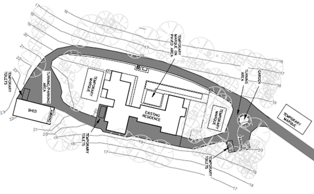
Figure 3: Original site plan showing 4 marquees
locations and 3 portable toilets locations
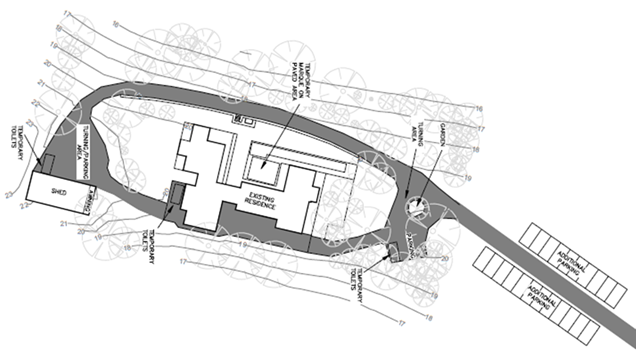
Figure 4: Revised site plan showing 1 temporary
marquee location,
3 portable toilets locations and
additional parking spaces
Subject Land
The
subject site:
· Is
located at 171B Strongs Road, Jasper Brush and is legally identified as Lot 2
DP 778594.
· Is
zoned RU1 Primary Production and has an area of 20.73ha.
· Is
accessed by a right of carriageway off Strongs Road, with a driveway that
enters Lot 2 from the east of the site.
· Contains
an existing dwelling house, swimming pool and an ancillary shed.
· Is
surrounded by other rural properties, which contain similar buildings to the
subject site.
· Is
identified as bushfire prone land.
· Is identified as
“Riparian Land” on the Riparian lands and Watercourses map and is
identified as “Biodiversity – habitat corridor” or
“Biodiversity – significant vegetation” on the Terrestrial
Biodiversity map. However, the proposed temporary use does not propose any
clearing of significant vegetation on-site and is not located in the immediate
vicinity of the areas identified as containing Biodiversity.
· Is
not identified as Potentially Contaminated Land (PCL).
· Is identified as
containing class 5 acid sulfate soils.
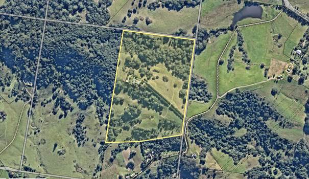
Figure 5: Expanded aerial view of the subject
site and surrounding developments
Site & Context
The dwelling is in the middle of the site with the land
sloping away on either side to the south west and north east, with several
unnamed watercourses traversing the site. The nearest neighbouring
dwelling is located approximately 350m to the south west of the site. The
surrounding areas are predominantly large rural properties with agricultural
and rural lifestyle activities similar to what is present on the subject site.
History
The lot was created by
subdivision in 1988. The site is accessed via Right of Way (ROW) (8m
wide) off Strongs Road. The ROW mentioned above
provides access to the subject site and other properties being 171A, 171C
– 171F Strongs Rd.
In 1985, a dwelling was approved
via DA85/2732. A review of Council’s records has indicated that
there has been a variety of DAs and Building Approvals (BAs) for dwelling
additions including a swimming pool.
Post-Lodgement
The following correspondence has
taken place with the applicant following the lodgement of the DA:
· 20 November 2018
– Council requested additional information to
address matters relating to hours of operation, noise, parking arrangement
and traffic issues, the maximum number of quests, disabled access, marquees
details, portable toilets and BCA issues related to the existing swimming pool
and concerns raised by submitters.
· 18 December 2018
– Council requested additional information (2) to address matters
relating to proposed lighting, existing toilet within the house, wastewater
disposal, portable toilets and food preparation.
· 30 January 2019
and 7 March 2019 – The applicant submitted additional information to
address the matters raised by Council in the requests of 20 November 2018 and
18 December 2018.
· 10 April 2019 -
Council requested additional information (3) relating to clause 2.8 of the SLEP
2014 and how clause 2.8(3)(b) has been met, noise and amenity impacts, other
concerns raised by submitters, food preparation and proposed marquees.
The applicant was advised to review relevant court cases and submitted acoustic
report.
· 6
May 2019 – Council received amended OMP and response letter to address
the issues raised in Council’s email dated 10 April 2019. The applicant
stated that:
“Clauses 2.8(1) and 2.8(3)(b) are considered to be
achieved as the submitted Acoustic Report stated that “Providing these
recommendations are implemented and maintained, the acceptable noise limits set
by the EPA and required by Shoalhaven City Council can be met at all receptor
locations”. The acceptable noise limits set by the EPA and required
by Shoalhaven City Council are thought to be not adversely impacting on
adjoining land. It should also be noted that the Acoustic Report
submitted with this application assessed the noise of a 130 guest event which
has since been reduced to 60 guests. Given the significantly reduced
scale of the proposed temporary use of the site, we believe that Council can be
satisfied that the development meets the requirements of Clause 2.8 of the SLEP
2014.”
The applicant also requested that:
“Council complete their determination based on the
information provided to date in regard to this application”.
Issues
Shoalhaven Local
Environmental Plan 2014 – Clause 2.3 - Zone objectives and Land Use Table
The subject land is zoned RU1
Primary Production under the SLEP 2014, with the following stated objectives:
· To
encourage sustainable primary industry production by maintaining and enhancing
the natural resource base.
· To
encourage diversity in primary industry enterprises and systems appropriate for
the area.
· To
minimise the fragmentation and alienation of resource lands.
· To
minimise conflict between land uses within this zone and land uses within
adjoining zones.
· To
conserve and maintain productive prime crop and pasture land.
· To
conserve and maintain the economic potential of the land within this zone for
extractive industries.
When considering a development
application, the consent authority must have regard for the objectives of the
zone (clause 2.3 of the SLEP 2014). The applicant (in the original SEE
dated 11 September 2018, page 12 and 14) provided the following commentary
regarding the land use table and zone objectives:
“…The proposal is consistent with the
controls applicable to the land under SLEP 2014…
The proposed temporary use of a site would be defined as
a function centre, and a function centre is prohibited under the RU1 Primary
Production zone. A function centre is defined as follows under the LEP:
Function centre means a building or place
used for the holding of events, functions, conferences and the like, and
includes convention centres, exhibition centres and reception centres, but does
not include an entertainment facility.
Whilst the land use table lists the development for a
function centre as prohibited, the SLEP2014 acknowledges that there are
circumstances, depending on the use where there is opportunity to allow a
prohibited land use temporarily. This involves the application of provisions
contained in Clause 2.8 temporary use of land.”
The proposed development is not considered to be entirely
consistent with all relevant objectives of the RU1 zone. It was
identified that the proposed temporary use would have the potential to result
in land use conflicts and adversely impact on adjoining land and/or the amenity
of the neighbourhood.
The surrounding areas are predominantly
large rural properties with agricultural and rural lifestyle activities with
minimal noise and traffic generation. Given the location of the
subject site and nature of the proposal for commercial purposes including the
use of amplified music during events/functions, the proposal would generate
noise issues that would impact on the quiet rural lifestyle. The noise generated
would be above the normal noise generation for a dwelling and without
appropriate measures in place, the proposal will have an adverse impact on
adjoining land and rural ambience of the locality.
Shoalhaven Local Environmental Plan 2014 – clause 2.8
- Temporary use of land
The proposal is best
characterised as a Temporary Use of land for the purpose of a Function
Centre under SLEP 2014. In accordance with the Land Use Table to the
RU1 Primary Production zone development for the purposes of “function centres”
is not listed under item 2 or 3 as permitted without consent or permitted with
consent and is therefore prohibited within the zone.
The development is lodged on the basis that clause
2.8(1)-(3) Temporary use of land under SLEP 2014 is nominated to apply.
Clause 2.8(1)-(3) is reproduced below:
2.8 Temporary use of
land
(1) The objective of this clause
is to provide for the temporary use of land if the use does not compromise
future development of the land, or have detrimental economic, social, amenity
or environmental effects on the land.
(2) Despite any other provision
of this Plan, development consent may be granted for development on land in any
zone for a temporary use for a maximum period of 52 days (whether or not
consecutive days) in any period of 12 months.
(3) Development consent must not
be granted unless the consent authority is satisfied that:
(a) the
temporary use will not prejudice the subsequent carrying out of development on
the land in accordance with this Plan and any other applicable environmental
planning instrument, and
(b) the temporary use will not
adversely impact on any adjoining land or the amenity of the neighbourhood,
and
(c) the temporary use and
location of any structures related to the use will not adversely impact
on environmental attributes or features of the land, or increase the risk of
natural hazards that may affect the land, and
(d) at the end of the temporary
use period the land will, as far as is practicable, be restored to the
condition in which it was before the commencement of the use.
Clause 2.8(2) permits the
operation of a temporary use for a maximum period of 52 days (whether or not
consecutive days) in any period of 12 months. The amended activity seeks
approval for 26 days per year.
Under clause 2.8(3) development
consent must not be granted unless the consent authority is satisfied that
clause 2.8(3)(a)-(d) are complied with. An assessment of the proposal
against the provisions of clause 2.8(3) is detailed below.
“Clause 2.8(3)(a) the temporary use will not prejudice the
subsequent carrying out of development on the land in accordance with this Plan
and any other applicable environmental planning instrument, and…”
The
proposed temporary use of the land for a function centre and wedding venue will
be located within existing cleared areas close to the existing structures on
site as indicated within the amended site plan. A temporary marquee and
portable toilets will be utilised on-site and cooking facilities and food for
the event will be provided by external catering companies. All waste and
cleaning will be undertaken off-site, by the caterers. No guest camping
is proposed. The proposed temporary use of the land will not result in
significant unacceptably irreversible changes to the continued use of the site.
It is considered that the
temporary use of land will not prejudice the subsequent development of the land
in accordance with clause 2.8(3)(a).
“Clause 2.8(3)(b) the temporary use will not adversely
impact on any adjoining land or the amenity of the neighbourhood,
and…”
In order to properly consider
this matter, it is appropriate to review case law relating to the function of
clause 2.8 and the nature of a temporary use of land. The operation of
clause 2.8 as it relates to Standard Instrument Local Environmental Plan (of
which the SLEP 2014 is a Standard Instrument LEP) has been considered by the
Land and Environment Court of NSW in the leading judgement of: Marshall
Rural Pty Limited v Hawkesbury City Council and Ors [2015] NSWLEC 197.
Marshall Rural Pty Limited
v Hawkesbury City Council [2015] NSWLEC 197
The Marshall case involved a
challenge by a neighbour to a development consent for the temporary use of barn
buildings as a function centre issued by Hawkesbury City Council on a rural
holding which was otherwise used for the holding of polo tournaments.
The development consent
authorised the function centre use for up to 28 days in any 12 month period and
the consent was granted for a period of 2 years.
Acting Justice Moore (Moore AJ)
described the nature of the test for development applications made pursuant to
clause 2.8 at [113] – [116] as follows:
113 The nature of the activities that are capable of
being permitted by an application invoking cl 2.8 are, I remind myself,
activities that are otherwise prohibited in a zone.
114 That any application that is sought to be approved
for such a prohibited use seeks a significant indulgence for such a substantial
departure from the planning controls applicable to a zone is reflected in two
aspects of the clause.
115 The first arises with respect to the temporal
limitation mandated by the clause if such an otherwise prohibited use is to be
permitted. This aspect of the clause was the subject of Marshall Rural’s
first complaint, a complaint dealt with and dismissed in my rejection of Ground
1.
116 The second element engaged by these proceedings is
the requirement that the proposal will “not adversely impact”
in the fashion specified in cl 2.8(3)(b). This test, cast in absolute terms
reflecting the seriousness with which an application of this nature is required
to be assessed, puts a very high hurdle in the path of any such application.
The placing of such a hurdle requires that the Council must approach the
consideration and determination of any such application with a marked degree of
precision and caution.
A matter for the consent
authority to consider carefully is what Moore AJ describes at [116] as a
“very high hurdle” in the path of any application for
approval under clause 2.8. That is the requirement in clause 2.8(3)(b) that
the temporary use of land “will not adversely impact on any adjoining
land or the amenity of the neighbourhood”. As his Honour
pointed out in Marshall Rural this provision is cast in absolute terms: any
adverse impact is sufficient to require the refusal of such an application.
Moore AJ stipulated that the
clause 2.8 test is ‘absolute’ and that the temporary use must have
not have an adverse impact on any adjoining land or the amenity of the
neighbourhood. This case strongly demonstrates that when a use is
prohibited in the zone, but the LEP provides for temporary use of the land in a
manner that is otherwise prohibited, that use is still fundamentally prohibited
in nature within that zone.
As the current application has
been made pursuant to clause 2.8, Council must be satisfied that the proposed
development “will not adversely impact on any adjoining land or the
amenity of the neighbourhood”.
The applicant responded in their
letter dated 6 May 2019 (Ref: L103619, page 1 & 2) to address this clause:
“Clauses 2.8(1) and 2.8(3)(b) are considered to be
achieved as the submitted Acoustic Report stated that “Providing these
recommendations are implemented and maintained, the acceptable noise limits set
by the EPA and required by Shoalhaven City Council can be met at all receptor
locations”. The acceptable noise limits set by the EPA and required
by Shoalhaven City Council are thought to be not adversely impacting on
adjoining land.
It should also be noted that the Acoustic Report
submitted with this application assessed the noise of a 130 guest event which
has since been reduced to 60 guests. Given the significantly reduced
scale of the proposed temporary use of the site, we believe that Council can be
satisfied that the development meets the requirements of Clause 2.8 of the SLEP
2014.”
“We would like to confirm that the owner is
satisfied with the submitted information regarding DA18/2115. Again, we believe
that the information provided meets the requirements of the SLEP 2014,
including Clause 2.8 Temporary Use of Land. The concerns raised by the
community were acknowledged and resulted in the significant reduction of the
number of guests (now 60), number of events (now 26), and proposed marquee
locations. Community submissions are considered to have been addressed
appropriately. We would appreciate if Council could complete their
determination of this application using the provide information to date.”
Any development application made pursuant to clause 2.8 of
the LEP must have no adverse impact on any adjoining land or the amenity
of the neighbourhood rather than an acceptable impact.
The proposed development is
located in a large rural property in RU1 zone with the nearest neighbouring
dwelling located approximately 350m to the south of the site.
The proposed location for the
marquee is a ridge feature of the site, where any use of amplified music as
proposed, could be heard from any adjoining properties. The surrounding
areas are predominantly large rural properties with agricultural and rural
lifestyle activities with minimal noise and traffic generation.
Given the location of the
subject site and nature of the proposal for commercial purposes including the
use of amplified music during events/functions, the proposal would generate
noise that would impact on the quiet rural lifestyle. Amplified music in
a rural setting is not an everyday or common ‘rural’ noise and is
therefore potentially an adverse impact on amenity enjoyed by occupants of the
bucolic landscape.
It is important to note that
this application was notified on two (2) separate occasions in accordance with
Council’s Community Consultation Policy for Development
Applications. During the first notification period there were 16
submissions received objecting to the proposal.
During the second round of
notification, there were 84 submissions
objecting to the proposal on amenity grounds and one (1) submission in
support. The concerns raised mainly related to noise, amenity impact,
traffic generation and anti-social behaviour.
The development application was
supported by an Acoustic Report prepared by Harwood Acoustics dated 14 August
2018. The Acoustic Report was prepared based on maximum 130 guests, four
(4) marquee locations and live or amplified music on occasion. The report
stated that the main sources of noise associated with the proposal will include
amplified music, guest noise and motor vehicle movements. A brief
statement is included on page 10 the report to address Clause 2.8(3)(b) of the
SLEP as follows:
“Given the low noise level of 35 dBA as an
assessment criterion in this instance and the separation distance to the
nearest properties, we are of the opinion that compliance with the
Intrusiveness Criterion of 35 dBA satisfies the above requirement.”
Recommendations are made in Section
7 of the Acoustic Report to reduce the level of noise emission to within
acceptable limits at all receptors. The Acoustic Report concluded on page 4
that:
“Providing these recommendations are implemented
and maintained, the acceptable noise limits set by the EPA and required
by Shoalhaven City Council can be met at all receptor locations.”
The Acoustic Report did not
address how the proposal complies with clause 2.8(3)(b) or demonstrate that the
proposed temporary use will have no adverse impact on any adjoining land or the
amenity of the neighbourhood. It concludes that the impacts are ‘acceptable’.
There is no doubt that a reduction in the scale of the development will reduce
potential impacts but documentation has not been provided which provides certainty
or comfort that the impacts will not be adverse.
It appears that the test
explained by Moore AJ has not been applied or satisfied as there are impacts
generated by the proposal and those impacts are considered adverse, that is,
being negative to residents and their amenity.
As Moore AJ pointed out in Marshall
Rural case, any adverse impact is enough to require refusal of such
an application. As previously mentioned, the locality is a quiet rural
area. Any intrusion of unusual noise be it music or otherwise, is likely
to disturb the rural ambience. The disturbance in this context is
potentially adverse.
Based on a review of the
documentation submitted with the application including the acoustic report, it
is considered that the proposal does not satisfy clause 2.8(3)(b). This
is considered a reason to inform the recommendation for refusal.
“Clause 2.8(3)(c) the temporary
use and location of any structures related to the use will not adversely impact
on environmental attributes or features of the land, or increase the risk of
natural hazards that may affect the land, and…”
The temporary use of land itself
will not adversely impact on environmental attributes of the land or features
of the site as the temporary marquees and portable toilets will be installed
within the existing cleared areas close to the dwelling house on site. On-site
parking spaces are provided within the existing gravel areas for the bridal
party, catering and entertainment staff (or attendees of small
conferences). All guests other than the bridal party (or attendees of
small conference) will access the site via a mini-bus service, therefore
reducing and limiting conflicts with vehicle traffic in the locality and noise
impact on adjoining properties.
The site is identified as bushfire
prone land. As stated in the recommendations provided as part of the
Bushfire Assessment Report, a Bushfire Emergency Evacuation Management Plan
would be required, in accordance with the RFS Guidelines prior to functions
commencing, if approved.
Such a plan would be required to
address issues such as; contacts in the event of an emergency, evacuation
points and procedures for guests and staff, and location of emergency water
sources.
A site-specific emergency
management plan is also required to be prepared for each event and include
event-specific information such as forecasted fire danger of the day, number of
occupants on the site including protocols for accounting for occupants on the
site during the events and staff emergency role.
“Clause 2.8(3)(d) at the end of the temporary
use period the land will, as far as is practicable, be restored to the
condition in which it was before the commencement of the use.”
As per the submitted SEE, at the
end of each temporary use period, the site will be returned to pre-event
condition.
Suitability of the site for the development (EPA Act section
4.15(1)(c))
Applicant’s submission:
“The
proposed temporary use is consistent with the rural character of the
surrounding area. The subject site has a scenic rural backdrop, and can be
considered as being a picturesque location. The rural landscape of the site can
provide the perfect location for a wedding with a rural, country outdoor feel.
Locations similar to the subject site are highly sought-after locations for
wedding functions. The proposal aims to provide a location for wedding events
to harness the surround natural beauty, while still preserving it for future
uses. The proposal does not have any adverse impacts in terms of privacy,
overshadowing, agricultural capacity or outlook to neighbouring properties, and
will not have a negative influence on the natural environment.”
Contrary to the applicant’s opinion, the assessment has
concluded that the site is not considered to be suitable for the development for
the following reasons:
· The
proposal is prohibited within the zone and is inconsistent with the objectives
of the RU1 zone.
· Non-compliance with clause 2.8(3)(b) as it will adversely affecting
the underlying rural nature of the land and the amenity of the rural area and
bucolic lifestyle as enjoyed by adjoining rural residents. The submitted acoustic report does not
satisfactorily demonstrate that there will not be adverse amenity effects upon
adjoining properties or upon the residents in the locality.
· Without
adequate measures in place to remove any impacts,
particularly acoustic impacts, it is not considered that the proposal is
compatible with the existing and future development in the locality.
Owner’s Consent for
works within the ROW
The ROW mentioned earlier in
this report, provides access to the subject site and other properties being
171A, 171C – 171F Strongs Rd. Therefore, any proposed works to
upgrade the existing ROW or to provide a passing bay as recommended by
Council’s Development Engineer as a result of this application would
require owners’ consent from other properties owners, benefiting from the
ROW prior to the commencement of any works carried out. Owner’s
consent has not been provided. Affected owners have objected to the proposal.
The Public Interest
The development has been
assessed against state and local environmental planning instruments, and the
development control plan and related guidelines for the Shoalhaven City
Council. The assessment identified the development does not comply with the
objectives of the zone and clause 2.8(3)(b) of the SLEP 2014. It is
acknowledged that neighbouring residents have concerns with the proposed
development, particularly in regard to noise and traffic impacts.
Council is aware of other
existing/approved similar temporary function venues in rural areas within
Shoalhaven region. Council is now however aware of the recent ruling and
guidance issued by the Land and Environment Court. Further, approving this
application could potentially set an undesirable precedent. Additionally,
the results of the noise assessment indicate noise levels would be within
‘acceptable’ limits rather than an absence of adverse impact.
Accordingly, the granting of development consent is not considered to be in the
public interest.
Planning
Assessment
The DA has been assessed under
s4.15 of the EP&A Act1979. Please refer to Attachment 2.
Policy
Implications
There are no immediate specific
policy implications that arise from this matter should the recommendation be
adopted.
However, following receipt of
large number of submissions from the community in relation to development
applications made under clause 2.8, an information report was prepared to
obtain direction from Council regarding a potential review of clause 2.8 of the
SLEP 2014. This will provide Council with the necessary information to
adequately respond to community concerns and make an informed decision on
whether any amendments to clause 2.8 are required.
On 7 May 2019, at the Development
& Environment Committee Meeting (MIN19.285), it was resolved that Council:
1. Proceed to review the
operation and effect of the current Clause 2.8 (Temporary use of land) in
Shoalhaven Local Environmental Plan 2014.
2. Advise relevant
stakeholders (all CCBs, Development/Tourism Industry, Shoalhaven Tourism
Advisory Group) of this decision and engage them during the Review.
3. Receive a further
report outlining the findings of the Review and options to revise the clause as
appropriate.
Additionally, Destination Sydney Surrounds South (DSSS) is
undertaking research into the growth of the destination wedding and conference
business in rural locations. The project is examining the contribution
and demand for weddings and conferences in the DSSS region. The project
is also investigating the management of land use approvals and
‘issues’ associated with the current planning system.
Consultation and Community
Engagement:
This
application has been notified on two (2) occasions.
The first notification
period was from 10 October 2018 to 25 October 2018. The notification was made
in accordance with Council’s Community Consultation Policy for
Development Applications (including subdivision) and the Formulation of
Development Guidelines and Policies with letters being sent to the owners
of properties within a 100m buffer of the site. 16 submissions were
received by Council objecting to the proposal.
Following the submission of
revised plans/supporting documents, the DA was re-notified to adjoining
properties in accordance with the Policy, from 1 February 2019 to 16 February
2019, with letters being sent to the owners of properties within 100m buffer of
the site and to those people who made submissions during the first round of
notification. During the second round of notification, a total of 85
submissions were received by Council. One (1) submission in support and
84 submissions were in opposition to the development application.
The applicant’s response to submissions is shown at Attachment
3.
The key issues identified
in objection to the development through notification process may be generally
summarised as follows:
|
Summary of Public Submissions
|
|
Submission in Objection
|
Comment
|
|
Permissibility and suitability of the site for the proposed
development.
|
Clause 2.8 affords opportunity for uses that would
otherwise be prohibited to be considered on a temporary basis. However,
as mentioned in this report, the test in determining if the impacts are
acceptable is high with the decision in the Marshall Rural case
setting a high bar, in that there should be no adverse impacts. As Moore
pointed out in Marshall Rural case, any adverse impact is
enough to require refusal of such an application.
In response to the submissions received, Council has
considered the applicant’s site plan, supporting documents and relevant
constraints of the site and adjoining development. It is considered that the
subject site is not suitable for the proposed development in accordance with
section 4.15(1)(c) of the EP&A Act for the following reasons:
· The
proposal is prohibited within the zone.
· The
proposal is inconsistent with the objectives of the zone.
· The
proposal is inconsistent with the context of the area.
· There
will be significant adverse amenity impacts resulting from the development.
Therefore, the proposal is recommended for refusal.
|
|
Approval of any future applications utilising clause 2.8
must not be granted other than as a one-off event for a family function.
|
Any future applications to be assessed under all
relevant legislation and policies prevailing at the time.
This clause currently permits the operation of the
temporary use for a maximum period of 52 days (whether or not consecutive
days) in any period of 12 months if the use does not compromise future development of the land, or
have detrimental economic, social, amenity or environmental effects on the
land.
|
|
The proposal contravenes SLEP clause 2.8 particularly
clause 2.8(3)(b) as such temporary use of land will adversely impact on adjoining
land or amenities of the neighbourhood. Quiet rural lifestyle will be highly
affected.
|
It is acknowledged that the submitted acoustic report
did not satisfactorily address clause 2.8(3)(b) and that the proposed
development will have adverse amenity impacts. Therefore, the proposal is
recommended for refusal.
|
|
Reference is made to the decision of the Court, Marshall
Rural Pty Ltd v Hawkesbury City Council and Ors [2015] NSWLEC 197,
highlights that when a use is prohibited in a zone, that use is fundamentally
prohibited in the zone, irrespective as to whether the statutory instrument
provides for a "temporary use" of that otherwise prohibited
activity. Submitters raised that this court case should be considered during
assessment and decision making.
|
Valid points raised in the court case have been
considered during assessment of this application.
The submitted Acoustic Report is considered
insufficient to provide certainty regarding noise impacts. As
mentioned, the report concludes impacts to be acceptable as opposed to not be
adverse. This is not considered adequate having regard to the test
applied by the Court.
|
|
Approval of this DA will set undesired precedent in rural
area and Shoalhaven region
|
There are already several existing clause 2.8 approvals
in operation. In reviewing any modifications for these approvals, the
recent decision of the Marshall case will be considered. However, there
may be other decisions in the future which impact on the assessment of
applications. Additionally, Council will have the benefit of
those clause 2.8 applications being operational which will assist in
identifying if there have been any adverse impacts. With a new
application, it is more difficult as a very convincing and comprehensive
application is required to confirm that there are no adverse impacts.
|
|
The main issue raised by neighbouring residents is the
impact of noise from the proposed development and the cumulative impact of
that noise in combination with existing function venues in the area.
Excessive noise from loud music, guests and vehicles on
the day/s of preparation, day/s of the event and day of dismantling/clean-up
will impact on amenity of neighbouring properties.
|
The Acoustic Report makes recommendations on noise
attenuation measures to ensure that noise levels remain within acceptable
limits.
As mentioned above, the submitted Acoustic Report is
insufficient and noise impacts on adjoining properties have not been
satisfactorily addressed. Therefore, the application is recommended for
refusal.
|
|
Potential impact upon the environment
|
As no further building work is proposed to be undertaken,
no vegetation or habitat areas would be impacts. Additionally, the proposed
temporary marquees and portable toilets will be installed on already cleared/concreted
areas. No requirements would be necessary with regard to the environment.
|
|
The proposed 1.6m noise screen is not considered effective
to reduce the noise impacts
|
As per the submitted Acoustic Report, the 1.6m high noise
screen is required for marquees erected in locations 2, 3 and 4 and no
additional screening is required for the marquee at location 1 given the
attenuation due to the existing dwelling to the closest receptors.
On 30 January 2019, the application was amended to reduce
the marquees to one (1). Based on the Acoustic Report, no additional
screening is required for the marquees at location 1. No additional noise
screen has been proposed as a result of the amendment to the proposal.
|
|
Notification process - Many local residents have not been
notified by Council or given the opportunity to make a submission.
|
Notification of the development application was carried
out in accordance with the requirements of Council’s Community
Consultation Policy and the EP&A Regulation.
Council typically accepts submissions after the closure of
the formal exhibition period in circumstances where an application is under
assessment.
Additionally, this application as are all applications, is
viewable on DA Tracking.
|
|
The proposal does not comply with clause 2.8 of the SLEP
2014 as it does not count a day before the event and a day after the event to
dismantle the marquees – submitter suggested no more than 12
events/year
|
In accordance with the judgement in the Marshall Rural
case, the number of days on which the temporary use is carried out does not
include days spent preparing for or packing up following the actual
events. Restrictions would be placed on the timeframe for when
set-up/pack-up can take place should the DA be approved. A condition would be
placed in the consent (if approved) requiring no more than 26 events per
year. Any non-compliance with this requirement would be investigated by
Council as a compliance matter.
|
|
12 midnight finish will impact on the amenity of
neighbouring properties. Submitters suggested the event(s) finish by
10pm.
|
Should the DA be approved, recommended conditions could be
placed in the consent. Any non-compliance with this requirement would be
investigated by Council as a compliance matter.
|
|
Amenity impact from vehicles’ headlights and
proposed lighting within/surrounding the proposed marquees
|
Any impact from vehicles’ headlight and proposed
lighting within/surrounding the proposed marquees would be temporary and
restricted to weekends only. The brightness of the proposed portable lighting
within/surrounding the proposed marquees could be adjusted to acceptable
levels if required. As per the supporting document, the event manager would
be responsible to ensure that the portable lighting does not point towards
surrounding properties. Light spill is something that could also be
potentially ‘adverse’.
|
|
Increased traffic impacts on road condition and safety of
road users, livestock, native animals and increase the level of roadkill. The
submitter suggested the applicant provide speed limit sign, passing lane on
steep hill
|
The existence of native animals
and livestock in the locality is acknowledged. Any increase in traffic would
however be temporary and restricted to weekends only. Further, use of mini-buses
would further decrease the potential number of vehicles on the road and
reduce potential conflict between vehicles and pedestrians.
Council’s Development Engineer has reviewed the
application and has raised no objection to the proposal in relation to the
traffic impacts due to its temporary nature. As per the Development
Engineer’s recommendation, conditions of consent requiring suitable
passing bays and the right of way to be sign-posted stating the road is
private could be imposed in the event of an approval. This matter would
however need to be explored with regard to owner’s consent.
|
|
Increase traffic movements will significantly increase
wear and tear and maintenance cost of the narrow gravel road, degrade the
amenity and increase danger to all users of the road.
|
Any increase in traffic would be temporary and would be
restricted to weekends only and is to be limited through the use of buses. As
per the response provided from the Development Engineer to the internal
referral, the access would be provided to meet the requirements of the
largest vehicle such as a bus or a truck (for pick-up and drop-off of
equipment).
The increase in traffic does have the potential for
adverse impact.
The DA is recommended for refusal.
|
|
The proposed 52 events in any 12 months is not considered
“temporary” under Clause 2.8 of the SLEP.
|
The proposal was amended on 30 January 2019 to reduce the
number of events from 52 to 26 events per year. The 26 events are made up of
functions such as weddings, receptions and small conferences.
|
|
Concerns regarding the impact of the development on the
habitat of native species occupying the site and potential for an increase in
human-animal encounters.
|
The existence of native vegetation on and adjacent to the
site is acknowledged. However, no trees or habitat areas are proposed to be
affected as functions and temporary structures would be held within existing
cleared areas.
|
|
Concerns raised regarding additional impacts due to setup
and pack-up requirements for event organisers before and following the
events.
|
Concerns regarding the additional time taken for set-up
and dismantling of temporary structures is acknowledged.
|
|
Increase noise impact and bad behaviour Serving alcohol
without liquor licence will increase.
|
As per supporting documents, no on-site liquor licence is
required as the guests will be responsible for providing their own alcohol.
In this regard, an onsite manager would be required to be
present at all times as well as standard procedures to enact in the event of excessive
alcohol consumption. A condition could be imposed to reflect this should the
DA be approved.
|
|
Parking issues
|
Adequate parking spaces to accommodate the minibuses,
bridal party, caterer and entertainer’s vehicles including guests
attending small conference/business meetings have been provided on-site as
shown on the amended site plan. Council’s Development Engineer has
reviewed the application and has raised no objection to the proposal in
relation to the parking arrangement subject to the imposition of conditions
of consent, if an approval were to eventuate.
|
|
Impact on property values
|
There is no evidence to support the claim that adjoining
property values would be adversely affected if the development as currently
proposed is approved. It is noted that possible adverse impacts on property
values is not a relevant prescribed planning consideration that Council can
take into consideration in the assessment of a development application.
|
|
The submitter suggested applicant gives notice to resident
before the commencement of the events.
|
Should the DA be approved, a condition could be included
in a development consent requiring advance notice to be given to residents.
|
|
The proposal results in unacceptable impacts in relation
to the disposal of waste.
|
As per submitted supporting documents, waste facilities
are to be provided for each event and removed following each event.
|
|
Concerns raised that mini-buses would not be used by
guests and guests driving their own vehicles instead.
|
Should the DA be approved, a condition could be included
requiring that all guests other than bridal party, caterer and
entertainer’s vehicles, will be transported to/from the site via the
hired mini-buses to/from the guests’ accommodation elsewhere.
Again, however this would require adherence by the beneficiary of the consent
and potentially compliance monitoring.
|
|
The submitted Noise Impact Assessment is insufficient. It
does not satisfactorily address the potential noise impacts associated with
the proposed development.
|
Having regard to the court decision Marshall Rural Pty
Limited v Hawkesbury City Council and Ors [2015] NSWLEC 197, the
temporary use must have no adverse impact on any adjoining land or the
amenity of the neighbourhood rather than an acceptable impact.
The Acoustic Report did not satisfactorily resolve the
issue of adversity.
|
|
Concerns were raised regarding events/functions management
as follow:
· How
the function will be monitored
· Who
is responsible to ensure the events and guests comply with conditions of
consent if approved.
|
If approved, a condition could be imposed requiring a
register of complaints is to be kept and a management audit be undertaken
yearly that is required to be submitted to Council (i.e. details on
complaints received, details on actions/additional measures implemented and
record of functions held). This would give Council an opportunity to assess
impacts from the venue. The Events Manager will be responsible to ensure all
recommendation outlined in the OMP are in place for the duration of the
event.
However, seeking a complaint register or monitoring
regime, implies future ‘issues’ that is, it could be argued that
such a condition foreshadows potential for adverse impacts which is what must
be avoided. As mentioned throughout this report, there must be no adverse
impacts.
|
|
The 'Temporary use of land' is going to occur every single
Saturday night of the entire year, along with the associated noise and road
disruptions. The use of clause 2.8 should only apply to "one off' events
only.
|
This clause permits the
operation of a temporary use for a maximum period of 52 days (whether or not
consecutive days) in any period of 12 months if the use does not compromise future development
of the land, or have detrimental economic, social, amenity or environmental
effects on the land. (The proposal was modified, seeking 26 events.)
Concerns in this regard are
acknowledged. Should the DA be approved, Council could impose a
condition advising that a 12-month approval is granted – following
which a modification could be required to provide for an extension to the
operating period. Any issues arising during the 12-month period would then be
considered as part of the next application.
However, as mentioned elsewhere throughout this report,
the DA is recommended for refusal.
|
|
The use of rural property for commercial activity is not
considered appropriate
|
Certain land uses including commercial activities are
permitted with development consent in rural zone providing they comply with
relevant planning provisions.
|
|
Submitters raised that the amendments to the proposal to
reduce the number of guests from 130 to 60, 52 events to 26 and 4 marquees
locations to one do not result in an absence of adverse impact.
|
It is acknowledged that the significantly reduced scale of
the proposed development will reduce impacts. However, given the
location of the site and proposed amplified music to be played during
functions, it is considered that the proposed reduction of the number of
guests, events and marquees locations will result in an acceptable impact
rather than an absence of adverse impacts.
|
|
Concerns were raised regarding other similar applications
that are currently assessed by Council.
|
These concerns are acknowledged. However, each application
is assessed on its own merit having regard to the particulars of each
application.
|
|
Submission in support
|
|
The event has a positive economic impact and landowners
should be able to utilise their properties with the appropriate consent from
Council.
|
Noted
|
Financial Implications:
There are potential cost
implications for Council in the event of a refusal of the application. Such
costs would be associated with defending any appeal in the NSW Land and
Environment Court, should the applicant utilise appeal rights afforded under
the EP&A Act.
Legal Implications
Pursuant to section 8.2 of the
EP&A Act, a decision of the Council may be subject of a review by the
applicant in the event of an approval or refusal. If such a review is
ultimately pursued (if the recommendation is adopted) the matter would be put
to Council for consideration. Alternatively, an applicant who is
dissatisfied with the determination of the application by the Council may also
appeal to the Court against the determination pursuant to section 8.7 of the
EP&A Act. Applicants can choose to do both, setting aside the Appeal
pending resolution of the review, noting there are time limitations with
respect to lodging applications for review and appeal.
Summary and Conclusion
This application has been assessed having regard for section
4.15 (Matters for consideration) under the EP&A Act. Having
regard to the assessment, the proposal is not considered capable of
support. Reasons for refusal are provided below and can also be found at
Attachment 1 to this report.
|
1.
|
The
information submitted with the development application does not satisfy the
objectives of the RU1 Primary Production zone, which Council must have regard
for under clause 2.3(2) of the Shoalhaven Local Environmental Plan 2014,
(section 4.15(1)(a)(i) of Environmental Planning and Assessment Act,
1979).
|
|
2.
|
The
information submitted with the development application does not satisfy
clause 2.8(3), which Council must be satisfied of when granting development
consent to an application for the temporary use of land under Shoalhaven
Local Environmental Plan 2014, (section 4.15(1)(a)(i) of Environmental
Planning and Assessment Act, 1979).
|
|
3.
|
The
information submitted with the development application does not
satisfactorily demonstrate that the site is suitable for the proposed
development. (Section 4.15(1)(c) of Environmental Planning and Assessment
Act, 1979).
|
|
4.
|
Having
regard to the inconsistency with the objectives of the zone and clause 2.8(3)
under Shoalhaven Local Environmental Plan 2014, the granting of development consent is not considered to be in the
public interest. (Section 4.15(1)(e) of Environmental Planning and
Assessment Act, 1979).
|
|

|
Development
& Environment Committee – Tuesday 01 October 2019
Page
41
|

|
|
Development
& Environment Committee – Tuesday 01 October 2019
Page
50
|
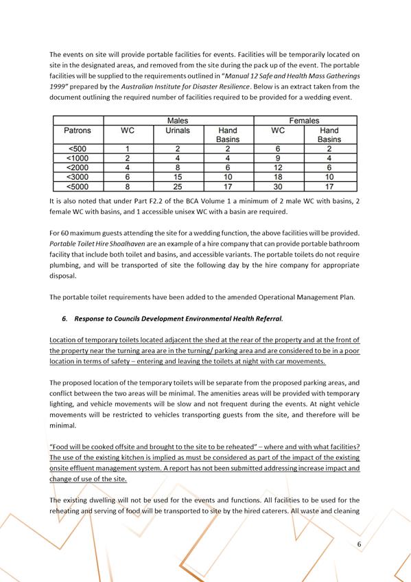
|

|
Development
& Environment Committee – Tuesday 01 October 2019
Page
64
|
DE19.96 Development
Application – No. 20, Lot 3 in DP 539866, The Wool Road Vincentia
DA. No: DA18/1736/4
HPERM Ref: D19/213103
Group: Planning
Environment & Development Group
Section: Building
& Compliance
Attachments: 1. Reasons
for refusal ⇩
2. Approved
site plan for Secondary Dwelling approved under CD16/1166 ⇩
3. Amended
site plan dated 5 February 2019 ⇩
4. Plan
of proposed strata subdivision (amended plan Rev 2) ⇩
5. Vehicle
turning path plan for rear dwelling (revised plan dated 9 April 2019) ⇩
6. Sketch
plan of private open space areas ⇩
7. Sketch
plan of landscaped area ⇩
8. Section
4.15 Assessment Report (under separate cover) ⇨
9. Checklist
for SDCP 2014 Chapter G11 (Dual occupancy subdivision) (under separate cover) ⇨
10. Checklist for SDCP
2014 Chapter G13 (Dual occupancy development) (under separate cover) ⇨
Description of Development: Change of use to dual
occupancy and strata subdivision
Owner: SJ
and JC Vickery
Applicant: PDC
Planners
Notification Dates: 27 July to 13
August 2018
No. of Submissions: No submissions received.
Purpose
/ Reason for consideration by Council
This application was called in
by Council at its Ordinary meeting held on 25 June 2019 (MIN19.449).
The development does not satisfy the vehicle manoeuvring
requirements of SDCP (2014) Chapter G21. The application is recommended
for refusal.
|
Recommendation
(Item to be determined under delegated authority)
That Council refuse Development
Application DA18/1736 for change of use to dual occupancy and strata
subdivision at lot 3 DP539866, 20 The Wool Road Vincentia, for the reasons
set out in Attachment 1.
|
Options
1. Refuse the
application as recommended.
Implications: The application would not proceed. The
applicant can apply for a Section 8.2 review of Council’s decision
and/or could lodge an appeal with the Land and Environment Court against
Council’s decision.
2. Council defer
the matter and conduct a site inspection
Implications: To understand the on-site constraints
associated with the proposed turning circles.
3. Alternative
recommendation
Implications: Council
will need to specify an alternative recommendation and advise staff accordingly.
Location Map
The location of the
subject site is shown on the map below at Figure 1.
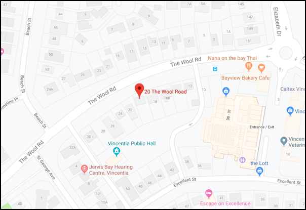
Figure 1 – Location map (Source: Google Maps)
Background
Proposed Development
The application proposes to change the use of the site from a
principal dwelling and a secondary dwelling to a dual occupancy with strata
subdivision.
The site currently contains a
two-storey dwelling located towards the front of the site that was constructed
in the 1970s (the “principal dwelling”) and a single storey
dwelling located at the rear of the site that was constructed in 2016 as a
“secondary dwelling” (CD16/1166). The secondary dwelling was
approved by a private certifier as a complying development (see approved site
plan at Attachment 2 and extract of site plan at Figure 7).
The only physical work proposed
in this application is the construction of a vehicle turning area associated
with the existing secondary dwelling. The proposed site plan indicates the
proposed turning area is at Attachment 3.
The reason for changing the approved use from the combination
of a principal dwelling and secondary dwelling to a dual occupancy is to avoid
the prohibition of secondary dwellings being subdivided as per Clause 24
of the Affordable Housing SEPP.
The proposed subdivision is under the Strata Titles Act and
proposes three lots:
· Lot
1 has an area of 331.2 m2 and will contain the two-storey principal
dwelling at the front of the site.
· Lot
2 has an area of 293.3 m2 and will contain the single storey
secondary dwelling at the rear of the site.
· A
common property lot of 77.4 m2 will contain the shared driveway and
some landscaping.
SLEP 2014 has no minimum lot size for strata subdivisions.
Provided the development meets the requirements for dual occupancy the use is
permissible within the R1 General Residential zone. An extract of the proposed
strata subdivision is shown at Figure 2 below and the full plan can be seen at Attachment
4.
The secondary dwelling was
approved as Complying Development under State Environmental Planning Policy
(Affordable Rental Housing) 2019. Clause 24 of that Policy provides as follows:
“24 No
subdivision
A
consent authority must not consent to a development application that would
result in any subdivision of a lot on which development for the purposes of a
secondary dwelling has been carried out under this Division.”
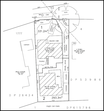
Figure 2 – Subdivision sketch plan
A new application for a dual occupancy does permit a pathway
for subdivision. However, the proposal must satisfy all the requirements for
dual occupancy for this to occur. The main issue of non-compliance is vehicle
manoeuvring and this cannot be satisfied.
Subject Land
The subject land is known as 20
The Wool Road Vincentia and legally described as Lot 3 on DP539866. The subject
site is a regular shaped allotment with a total area of 695.6m2. The
subdivision sketch submitted with the application shows the site area as 701.9m2
and this is incorrect. Torrens title subdivision requires a minimum lot size of
700m2 (excluding the access handle). It would be permissible to
achieve strata title subdivision as there is no minimum lot size.
The site has frontage of 17.855m
to The Wool Road and a rear boundary of 15m with the Coles Carpark. The western
side boundary is 41.034m and the eastern side boundary 41.637m. The site slopes
gently from the rear to The Wool Road. Along the full length of the
eastern boundary is a 3.048m wide stormwater drainage easement for underground
infrastructure.
The site is zoned R1 General
Residential under Shoalhaven LEP 2014.
A recent aerial photograph of
the site and surrounds is shown at Figure 3 below.
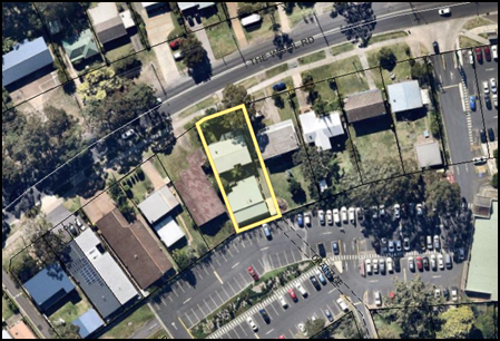
Figure 3 – Recent aerial photograph of site and
surrounds
The site is developed with an
existing two storey dwelling at the front of the site and more recent single
storey secondary dwelling at the rear of the site. There is an existing
concrete driveway providing vehicular access to The Wool Road.
Parking was not required to be
provided for the secondary dwelling under the provisions of the Affordable
Housing SEPP. A gravel driveway extension and stacked parking for two cars has
been provided for the secondary dwelling. These site features are shown in the
photographs in figures 4, 5 and 6 below.
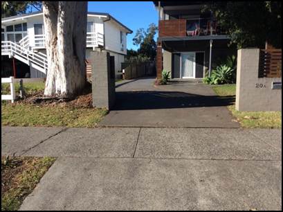
Figure 4 – Photograph of existing driveway
entrance
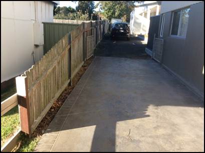
Figure 5 – Photograph of driveway passing along
the side of the front (principal) dwelling and car parked next to the rear
(secondary) dwelling.
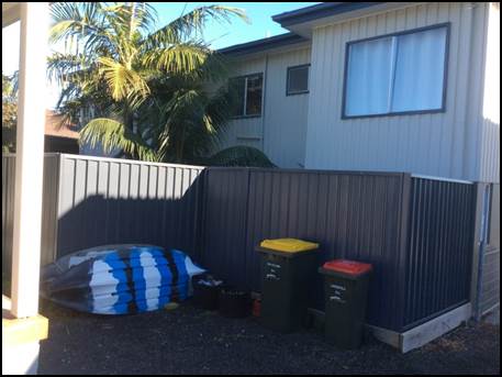
Figure 6 – Photograph of the space between the
two dwellings where the vehicle turning area is proposed
Site & Context
As depicted in Figures 1 and 2
above, the site is located within close proximity to the commercial centre of
Vincentia. The Wool Road at this location is a wide two-lane carriageway with
double unbroken centre lines and a 50 kph speed limit.
The site is surrounded to the
north, east and west by residential development of mixed ages and styles. The
Vincentia Shopping Centre carpark adjoins the land’s southern boundary.
The existing driveway is 70m from the exit lane from the Coles
Carpark and 180m to the roundabout at the junction of The Wool Road and
Elizabeth Drive.
History
The lot was created by subdivision in 1969 and the front
(principal) dwelling was erected under BA70/692. Alterations and additions were
approved in 1974 under BA74/1425.
The approved layout for the principal dwelling has habitable
rooms contained on the upper floor. The ground floor contains a carport,
garage, laundry and WC. It appears the ground floor has been converted to
habitable rooms at some stage in the past. Council has no record of any
approvals being granted for this change of use of the ground floor.
The secondary dwelling was erected following approval of a
complying development certificate under CD16/1166. The occupation certificate
for this dwelling was issued on 29 November 2016. The approved site plan under
CD16/1166 is contained in Attachment 2.
A secondary dwelling proposed under the Affordable Housing
SEPP is not required to provide car parking. However, a proposed secondary
dwelling is required to provide an area of dedicated private open space that
meets the minimum area and dimension requirements.
As depicted in Figures 7 and 8 below, the approved private
open space area for the secondary dwelling is now compromised by the proposed
vehicle turning bay in order to satisfy the parking and manoeuvring
requirements that apply for dual occupancies.
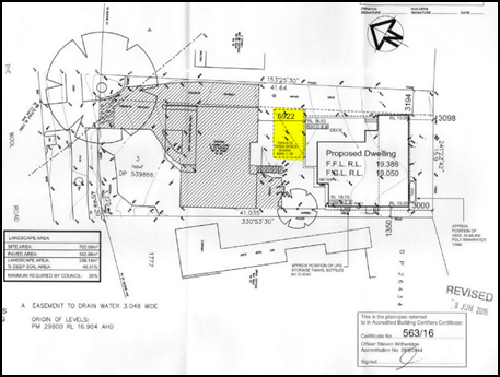
Figure 7 – Approved site plan for secondary
dwelling under CD16/1166. The approved private open space area is
highlighted in yellow.
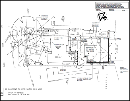
Figure 8 – Amended site plan dated 5 February
2019 for the proposed dual occupancy (Note the turning area shown in the space
between the two buildings).
The applicant was advised by email on 11 June 2019 and 24 June
2019 that an application for a dual occupancy was to be recommended for refusal
and was offered the opportunity to withdraw the application. The application
was called in by Council at its Ordinary meeting based on Public Interest.
Issues
Unapproved conversion of ground floor to habitable rooms
As noted above under the
‘History’ heading, the known approved use of the ground floor of
the front (principal) dwelling is carport, garage, laundry and WC.
Partial ground floor plans
submitted by the applicant on 17 June 2019 show the ground floor is used as
bedrooms, TV room and rumpus room. It is clear from the external inspection of
the building that there is no access for vehicles available to the ground floor
area, as shown on the photograph at Figure 9 below.
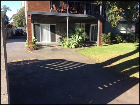
Figure 9 – Photograph of the street elevation of
the front (principal) dwelling. The ground floor door on the left is
where the approved carport entry was located. The ground floor window to
the right of the building is where the approved garage entry was located.
Applicant’s Submission
The applicant has made no
specific submission on this issue.
Discussion
The loss of at least two car
spaces behind the building line has resulted in car spaces being located forward
of the building line.
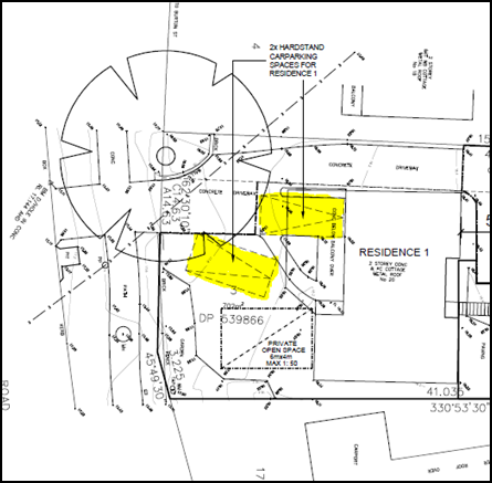
Figure 10 – Original site plan dated 26 April
2018 showing the proposed two car spaces for the front (principal) dwelling
within the front building setback
Vehicle manoeuvring and parking provision for the front
dwelling
The two required uncovered car
parking spaces provided for the principal dwelling are in front of the building
line and the layout of the spaces does not permit vehicles to enter and exit in
a forward direction. This is a requirement for dual occupancy developments
gaining ingress/egress on busy roads.
Applicant’s Submission
The applicant contends that the
parking and manoeuvring for the front dwelling is existing, is typical of the
locality and has proven to be satisfactory.
Discussion
The arrangement is “existing”
because parking spaces previously provided in the carport and garage behind the
building line have been converted to habitable rooms.
There are similar arrangements
for single dwellings in the vicinity, but this site is seeking approval for
dual occupancy with vehicles from two separate occupancies accessing The Wool
Road in a reversing movement.
The erection of a secondary
dwelling at the rear of the site has deprived the front dwelling of the
opportunity to have two car spaces behind the building line and to provide a
suitable turning area to allow vehicles to enter and leave in a forward
direction.
The parking and access
arrangements for the front dwelling do not meet the fundamental requirement in
DCP Chapter G21 for vehicles to enter and exit in a forward direction.
The existing car space located
under the first-floor deck does not provide the required access clearance of 1
metre to the ground floor doorway as required by Australian Standard AS2890.1.
This variation to DCP Chapter G21 requirements is not consistent with the
objectives of the Chapter and is not supported.
Vehicle manoeuvring and parking provision for the rear
dwelling
Two ‘stacked’ or
‘tandem’ parking spaces are provided next to the rear dwelling,
along with a turning area in the space between the front and rear dwellings.
This layout is shown on the extract from the site plan at Figure 11 below.
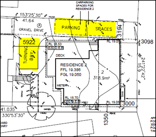
Figure 11 – Parking and turning area layout for
rear (secondary) dwelling
Applicant’s Submission
The applicant states that the
parking and turning area for the rear dwelling are workable and has submitted
turning circle plans. The most recent of these turning circle plans is shown
below at Figure 12 and is also at Attachment 5.
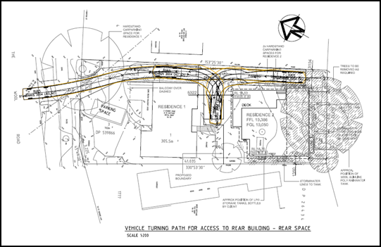
Figure 12 – Turning path plan for the rear
dwelling
Discussion
The parking and turning area
plan for the rear dwelling has several problems and these were identified in
referral responses from Council’s Development Engineer:
· The
turning area does not provide the minimum 300mm clearance required by
Australian Standard AS2890.1 between the vehicle turning path and the adjoining
buildings.
The turning path plan is based on the 85th
percentile vehicle, meaning that the turning area would not work satisfactorily
for a larger vehicle. The tightness of the turning path means that occupants
may be less inclined to turn the vehicle and end up reversing out of the site
onto The Wool Road. The turning path therefore falls short of satisfying the
objectives (iii), (v), and (vi) of SDCP Chapter G21, as detailed below.
· The
stacked parking for the rear dwelling is not supported by the Development
Engineer, because the front vehicle will occupy the turning area when the rear
vehicle wishes to leave the site. This will result in the rear vehicle
reversing along the full length of the driveway and onto The Wool Road. Again,
the arrangement does not satisfy objectives (iii), (v) and (vi) of SDCP Chapter
G21.
The turning area also removes
the private open space area approved for the rear dwelling as a secondary
dwelling under Complying Development application DCD16/1166 (refer to approved
site plan for CD16/1166 at Figure 7 above).
This variation to DCP Chapter
G21 requirements is not consistent with the objectives of the Chapter and is
not supported.
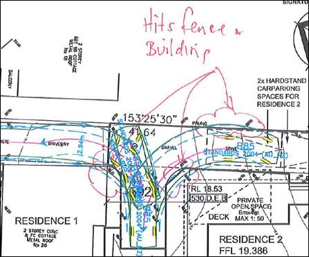
Figure 13 – Turning
paths marked up by development engineer.
Planning Assessment
The application has been
assessed under S4.15 of the Environmental Planning and Assessment Act 1979
(Refer Attachment 8). There are separate checklists for the assessment
under SDCP Chapters G11 (Subdivision) and G13 (Dual occupancy) respectively at Attachment
9 and Attachment 10.
Policy Implications
State Environmental Planning Policy (Affordable Rental
Housing) 2009
The Affordable Housing SEPP
contains a number of aims at clause 3. Clause 3(b) is relevant to secondary
dwellings approved under the SEPP and provides as follows:
“(b) to
facilitate the effective delivery of new affordable rental housing by providing
incentives by way of expanded zoning permissibility, floor space ratio bonuses
and non-discretionary development standards”.
The non-discretionary
development standards include that secondary dwellings approved under the SEPP
are not required to provide any parking spaces.
The prohibition on subdivision
is clearly intended to ensure the retention of secondary dwellings in the stock
of affordable rental housing. If subdivided a secondary dwelling could be
owner-occupied and would therefore be lost from the rental housing stock.
It is not in the public interest
for this to occur.
SDCP 2014 Chapter G21 Car Parking and Traffic
Among the objectives of Chapter 21 of SDCP 2014 are the
following:
iii. Ensure
that car parking areas are functional and operate efficiently.
iv. Ensure
that car parking areas (are) visually attractive.
v. Ensure
that car parking facilities are safe and meet the needs of users.
vi. Ensure
that all vehicles enter and leave a site in forward direction and that the
manoeuvring of vehicles does not take place within the road reserve, but within
the subject site.
These objectives are expressed in the Performance Criteria and
Acceptable Solution in the DCP Chapter.
The Car Parking Schedule in Section 5.1 of Chapter 21
specifies these requirements for dual occupancy developments:
A minimum of one on-site car parking space shall be
provided behind the building line for each dwelling having a gross floor area
of 125m2 or less, except where the dwelling contains three bedrooms
or rooms capable of use as a bedroom, where two car spaces shall be provided
behind the building line.
A minimum of two on-site car parking spaces shall
be provided behind the building line for each dwelling having a gross floor
area exceeding 125m2.
The applicant has accepted that 2 car spaces are required for
each of the dwellings on the site. However, the two spaces proposed for the
front dwelling are both in front of the building line.
Acceptable Solution A5.1 requires that development must be
designed so that vehicles enter and leave the premises in a forward direction.
This requirement echoes Objective vi in Chapter 21 of SDCP 2014.
As noted earlier in this report, vehicles parked in the two spaces
provided for the front dwelling are not capable of exiting in a forward
direction. The layout of the two car spaces for the rear dwelling also results
in a vehicle being unable to leave in a forward direction due to the tight
turning circle provided.
Consequently, the requirement for all vehicles to enter and
exit in a forward direction should not be varied in the case of this
application.
Consultation and Community
Engagement:
The application was notified to
owners of adjacent and adjoining properties within a 25 metre buffer, in
accordance with Council Community Consultation Policy. The notification
commenced on 27 July 2018 and concluded on 13 July 2018.
No submissions were received
during the notification period.
Financial Implications:
If the application is appealed,
it will result in costs to Council in defending the appeal. This is not a
matter Council should consider in determining a development application.
Accordingly, it should not be given any weight in Council’s decision.
Legal Implications
If the application is refused,
or if the applicant is dissatisfied with Council’s determination, the
applicant can appeal to the Land and Environment Court.
Summary and Conclusion
This application presents
Council with a situation not seen previously, where an applicant is seeking to
‘convert’ an existing approval for a secondary dwelling into an
approval for a dual occupancy. This would circumvent the prohibition on
subdivision that applies under the Affordable Housing SEPP. It would also give
further development capacity which is not available under the SEPP used to
approve the secondary dwelling. The public interest considerations of this are
outlined above under the ‘Policy Implications’ heading.
The proposal does not
satisfactorily meet DCP requirements for a dual occupancy, in terms of parking
provision and vehicular ingress and egress.
The unapproved conversion of the
ground floor of the front (principal) dwelling to habitable rooms removes the
two vehicle parking spaces that were available behind the building line and
places Council in the position of tacitly approving an unlawful change of use.
If Council were of the mind to approve this application, then consideration
should be given to converting the lower ground floor area of the principal
dwelling back to carparking. This can be added as a condition of approval.
The application is recommended
for refusal.
|
|
Development
& Environment Committee – Tuesday 01 October 2019
Page
66
|
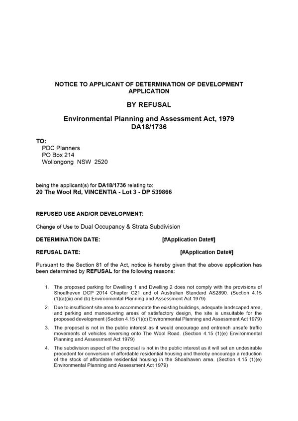
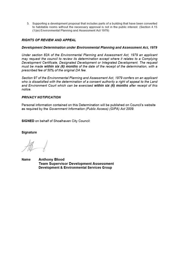
|
|
Development
& Environment Committee – Tuesday 01 October 2019
Page
67
|
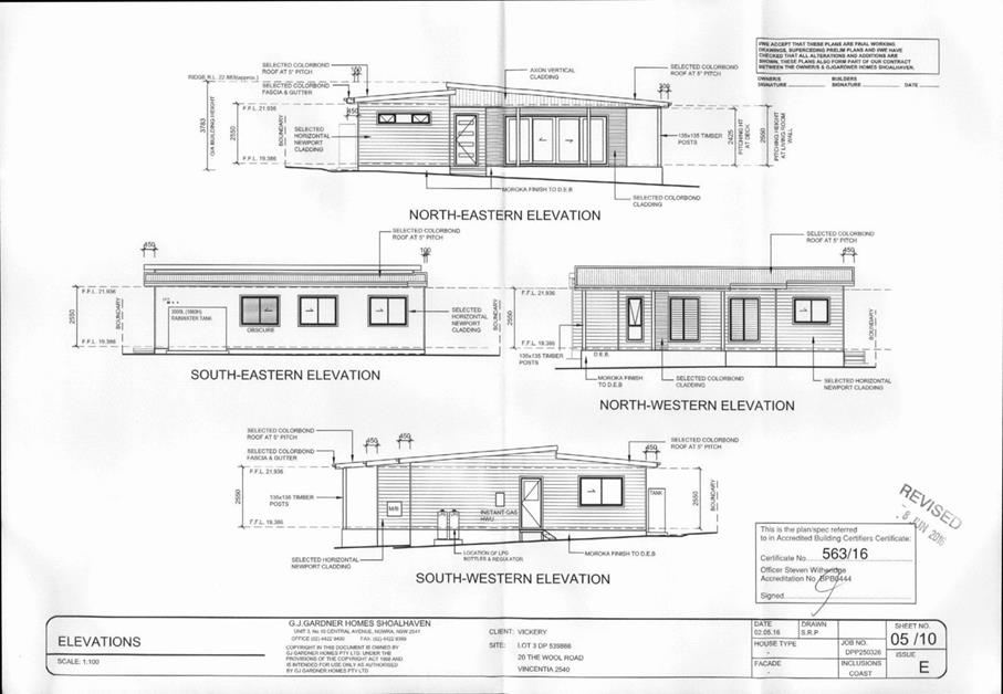
|
|
Development
& Environment Committee – Tuesday 01 October 2019
Page
68
|
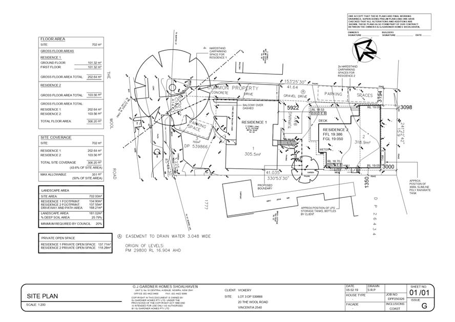
|
|
Development
& Environment Committee – Tuesday 01 October 2019
Page
69
|
|
|
Development
& Environment Committee – Tuesday 01 October 2019
Page
71
|
|
|
Development
& Environment Committee – Tuesday 01 October 2019
Page
72
|
|
|
Development
& Environment Committee – Tuesday 01 October 2019
Page
73
|
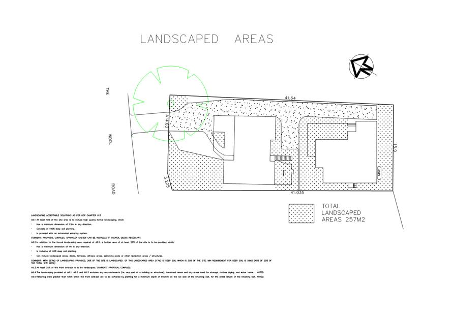
|
|
Development
& Environment Committee – Tuesday 01 October 2019
Page
76
|
DE19.97 Proposed
Public Exhibition - Planning Proposal (PP043) - Additional Permitted Use
- South Nowra Industrial Expansion Zone
HPERM Ref: D19/284727
Group: Planning
Environment & Development Group
Section: Strategic
Planning
Attachments: 1. Public
Agency Referral Response - NSW Rural Fire Service ⇩
2. Planning Proposal - Pre
Gateway Version - South Nowra Industrial land - Additional Use (under separate
cover) ⇨
Purpose / Summary
Obtain the required Council
Resolution to publicly exhibit the subject Planning Proposal (PP).
|
Recommendation
(Item to be determined under delegated authority)
That Council:
1. Endorse
Planning Proposal (PP043) – Additional Permitted Use – South
Nowra Industrial Expansion Zone, updated to include the responses of Public
Agency Consultation, for Public Exhibition for a minimum period of 28 days.
2. Receive
a further report that provides the results of the Public Exhibition period
and recommends the next steps to finalise the Planning Proposal.
|
Options
1. Proceed as
recommended
Implications: This is the preferred option as it
will ensure that the PP is progressing in accordance with the previous Council
resolution and the Gateway determination that has been received.
2. Do not proceed
as recommended and advise on an alternative.
Implications: This is not recommended as it could
potentially delay the PP progressing.
Background
The Development Committee
resolved on 11 September 2018 (MIN18.696.6) that Council:
Directs the General Manager to prepare a planning
proposal and submit it for Gateway Determination seeking to confirm a dwelling
entitlement on each of the individual properties within the industrially zoned
area.
This resolution responds, in
part, to representations from the South Nowra Disadvantaged Landholders Group
(Landholder Group) following a meeting that was held with the Mayor, Council
staff and Kiama MP Gareth Ward on 18 July 2018, and detailed to Council in the Report
to Development Committee of 11 September 2018 (DE.18.64).
A key concern of the Landholder
Group is potential uncertainty around the lawfulness of continuing and/or
expanding their current land uses (e.g. Dwellings) given the change of zoning
to industrial that has occurred in this area.
Notwithstanding, it is noted
that 24 of the 28 subject properties most likely benefit from ‘existing
use rights’ in accordance with Division
4.11 of the Environmental Planning and Environment Act 1979
(the Act), and therefore have a lawful mechanism to continue and even
expand their current uses. This is confirmed by the NSW Department of Planning
and Environment’s (DPIE) Gateway Determination Report.
It is noted that the Landholder
Group does not necessarily represent the views of all owners of the individual
properties.
Subject Land
The subject land is located in
South Nowra/Nowra Hill, to the south of the existing Flinders Industrial
Estate, and is made up of 28 properties as shown in Figure 1 below.
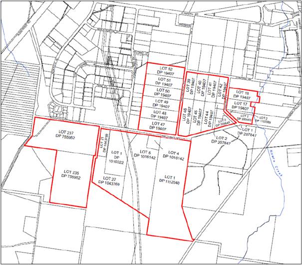
Figure
1 – Subject Land
Land Use Zoning & Zoning History
The subject land is now
predominantly zoned for industrial use (IN1), with some environmental (E2, E3)
and rural zoning (RU2), under the provisions of Shoalhaven Local Environmental
Plan 2014 (LEP 2014), as shown in Figure 2 below.
Prior to the commencement of LEP
on 22 April 2014 the land was partly zoned Rural 1(c)(Rural Lifestyle) and
Rural 1(d)(General) under the previous Shoalhaven LEP 1985 (LEP 1985), as shown
in Figure 3 below.
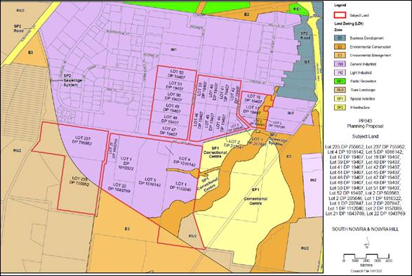
Figure
2 – Land Use Zoning, Shoalhaven LEP 2014
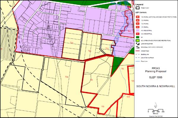
Figure
3 – Land Use Zoning, Shoalhaven LEP 1985
Planning Proposal &
Gateway Determination
The PP (Attachment 2)
seeks to permit/confirm a ‘dwelling house’ as an ‘additional
permitted use’ on each lot within the subject land, under Clause 2.5 of
the Shoalhaven LEP 2014.
The PP also currently proposes a
ten-year time limit for development consent to be granted under Clause 2.5.
This is a balanced approach that recognises the current situation and also the
strategic future direction for the land. It is suggested that this ‘time
limit’ can be increased in the future if required. It is not recommended
to initially set a longer ‘time limit’ as it may unnecessarily
discourage industrial investment, and that is inconsistent with the zoning of
the land and its future strategic direction. It is stressed that irrespective
of the outcome of the PP, including any form of a ‘sunset clause’
or ‘time limit’ will be of no impact on the ‘existing use
rights’ that exist in accordance with the Act, now or in the
future.
In accordance with the Council
resolution the PP was prepared and submitted to the NSW Government for Gateway
determination. The determination was received on 19 June 2019.
Council is authorised to be the
local plan making authority for the PP, subject to conditions as detailed in
the Gateway determination. The timeframe for completing the LEP amendment is 12
months.
Relevant documents, including
but not limited to the PP and the Gateway determination, can be viewed on the
NSW Government’s LEPs Online Website.
Public Agency Engagement
The Gateway determination
includes a requirement to consult with NSW Rural Fire Service (RFS) prior to
the public exhibition of the PP.
This has occurred and NSW RFS
raised no objections to the proposal subject to a requirement that any future
development of the land complies with Planning for Bushfire Protection 2006
or any subsequent version.
The response from NSW RFS is provided as Attachment 1.
Community Engagement
The purpose of this report is to
seek Council endorsement to publicly exhibit the PP, in accordance with the
Gateway determination, requirements of the Act, and Council’s Community
Engagement Policy. This will occur for a minimum of 28 days, as soon as
possible following the Council resolution.
The PP will be updated to
include the results of the consultation with NSW RFS, prior to public
exhibition.
The public exhibition will provide a formal opportunity for
the affected landowners to comment on the detail of the PP, including the
proposed time limitation/’sunset’ clause.
Policy Implications
The subject land is currently
zoned industrial and provides a longer-term supply of employment land in the
Nowra-Bomaderry area. This longer-term bank of land is acknowledged as being
regionally significant in the Illawarra-Shoalhaven Regional Plan.
The PP provides a shorter-term
confirmation that the existing residential uses can continue in the meantime
with some security.
Financial Implications
The PP is being managed within
the existing Strategic Planning budget.
Risk Implications
The resultant outcome from the
PP may have impacts on the uptake of the subject land for industrial uses,
which is the strategic and desired future use of the land.
|

|
Development
& Environment Committee – Tuesday 01 October 2019
Page
80
|
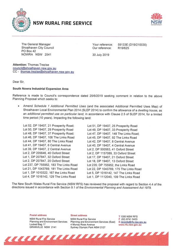
|
|
Development
& Environment Committee – Tuesday 01 October 2019
Page
83
|
DE19.98 Urban
Greening Strategy and Voluntary Compensatory Tree Planting Policy
HPERM Ref: D19/266523
Group: Planning
Environment & Development Group
Section: Environmental
Services
Attachments: 1. Urban
Greening Strategy - Summary (under separate cover) ⇨
2. Sutherland
Shire Council Urban Tree and Bushland Policy (under separate cover) ⇨
3. Wollongong
City Council Urban Greening Strategy 2017-2037 (under separate cover) ⇨
4. Urban greening strategies
reviewed ⇩
Purpose / Summary
To provide options and clarification
from Council on;
· a
“tree replacement policy” in line with those of other Councils
(MIN18.955) and
· the
Notice of Motion (MIN19.330) for Council to work with the building and
development industry to establish a compensatory tree planting policy.
A tree replacement policy
would assist to halt the loss of the urban tree canopy and reinstate tree cover
in the city that has been reduced over time due to development pressure.
|
Recommendation
(Item to be determined under delegated authority)
That Council
1. Commence
development of an overarching urban greening strategy in-line with other
Australian and regional Councils to meet objectives within the Community
Strategic Plan 2027, Integrated Strategic Plan 2018, Delivery Program and
Operational Plan 2019-2020 and Illawarra Shoalhaven Regional Plan, that
includes a compensatory tree replacement policy (except where a development
application has triggered entry into the NSW Biodiversity Offset Scheme).
2. Hold
a Councillor workshop so that Councillors can provide input into the
development of the draft Strategy and Policy.
3. Following
the Councillor workshop report back to Council the draft Strategy and Policy
for endorsement for public exhibition.
4. Endorse
the NSW LGA Increasing Resilience to Climate Change grant applied for
in September 2019 to enable Council to undertake a tree canopy audit within
urban areas to determine tree canopy and land use distributions, vegetation
change and priority areas for potential planting and urban greening to assist
in implementation of Council resolution (MIN18.955).
|
Options
1. As recommended.
Implications: This will allow Council resources to
be allocated to hold a Councillor workshop to guide the framework, objectives
and preparation of an overarching urban greening strategy which would include a
compensatory tree replacement policy and allow various options to be considered
along with the broader community. This approach will address multiple
objectives and strategies outlined in the Community Strategic Plan 2027,
Integrated Strategic Plan 2018, Delivery Program and Operational Plan 2019-2020
and Illawarra Shoalhaven Regional Plan 2036 as well as the NSW
Government’s Climate Change Policy Framework.
2. Partially adopt
recommendations as above.
Implications: This would depend on the nature of
any recommendation.
3. Not adopt any
recommendations.
Implications: potential for a net loss of tree
canopy and associated impacts
4. Alternative
recommendation.
Implications: Unknown.
Background
Council officers have been reviewing the work of other
councils (see attachments 1 to 4), with the aim of developing an overarching
urban greening strategy and compensatory tree planting policy in-line with
Council resolutions as follows;
At the Ordinary meeting of Council
on 28 May 2019 Council resolved (MIN19.330) that:
Council staff work with the
building and development industry in an endeavour to establish a voluntary
compensatory tree planting policy. The meaningful negotiations would include,
but not be restricted to, the following:
1. Pre-clearing tree audit.
2. A
commitment to a one-for-one replacement of trees whose height is greater than
an agreed height.
3. Careful
selection of replacement sites such as council reserves and private land whose
owners have indicated a desire to participate in the programme.
4. An
acknowledgement of the “45-degree rule” and the respect of
neighbouring properties regarding future overshadowing at the planting sites
could be factored into the discussion.
5. Publicising
the initiative giving praise to the industry as to the way that they
optimistically committed to the voluntary code.
6. The
General Manager provide a report back with the matters raised in the General
Managers Note contained in the report.
At the Strategy &
Assets Committee meeting on 11 December 2018, the Committee resolved
(MIN18.955) that Council:
1. Receive
the St Georges Basin urban canopy study area report prepared by the University
of Technology Sydney for information.
2. Review
relevant current policies, with the exception of the 45-degree rule, to
consider opportunities to better protect and enhance the urban tree canopy.
3. Consider
a city wide, or larger area audit to better inform Council on the economic,
social and environmental value of trees in urban areas. (Refer to 2019/20
Budget considerations.)
4. Consider
a subsequent report on the detail of a possible “tree replacement
policy” in line with those of other Councils and the previous Council
resolution (MIN18.733).
Shoalhaven has a diverse range
of scenic landscapes with the tree canopy (in both urban and natural areas)
adding to the character and attractiveness of the area. The Shoalhaven’s
natural assets, liveability and amenities are a key factor driving tourism,
business, development and investment. Trees are critical in the continuation of
healthy urban environments through ecological, social and economic functions.
However, nationally, there is
tree canopy loss in urban areas as a result of development activities (e.g. new
subdivisions) or tree removals authorised via exemption provisions relating to
tree removal.
Council staff have investigated
the issues raised in the above resolutions and seek a resolution of Council to
present options and to clarify direction in response to those resolution at a
Councillor workshop in the first instance.
With respect to investigations
and reviews undertaken to date, there is currently no local strategic approach
to replacing trees on public or private landholdings as most fall outside the
NSW Biodiversity Management Act. Species selection, specifications and
site-specific design for new or replacement plantings across all land types are
the type of issues that would need to be considered.
Other Councils (both
metropolitan and regional) have implemented urban forest/greening strategies to
help reduce tree loss and retain tree canopy within urban centres (see attachment
1) in response to reports such as the Technical guidelines for urban green
cover in NSW (OEH, 2015) and the Enabling Adaptation Reports (OEH, 2017).
Sutherland Shire Council has
implemented a tree replacement policy of 4:1 for single dwellings, 8:1 for dual
occupancies, medium and high density development and commercial development
which can be planted either on council owned lands or on the applicant’s
property as part of an Urban Tree and Bushland Policy in order to stem the loss
of tree canopy (SSC, 2019).
Wollongong City Council has an existing Tree Management
Permit policy which allows for removal of trees on private lands under
application via a permit system (WCC, 2013). They have recently developed an
Urban Greening Strategy to create a coordinated approach to managing urban
vegetation (WCC, 2017). This provides an overarching strategy in order to
achieve a number of interconnected community goals and objectives set out in
strategic plans and delivery programs (see attachment 3).
Community Engagement
Further consultation with
business and community would be anticipated with the proposed adoption of tree
replacement policy as part of an encompassing Urban Greening Strategy.
Policy Implications
Adopting a Tree Replacement Policy as part of an overall Urban
Greening Strategy satisfies the objectives of Council’s three primary
strategic and operational plans and the Shoalhaven Illawarra Regional Plan.
Financial Implications
The economic value of trees
is not considered at present in existing policies. Assessment of trees as an
economic asset in line with other Councils around Australia including those in
our region, will help to reinforce the importance of trees within the
Shoalhaven. To implement Council resolution, MIN18.955 above, a Local
Government NSW (LGNSW) Increasing Resilience to Climate Change grant was
applied for on 2 September 2019. If successful this will provide funding to
enable Council to undertake a tree audit across the Shoalhaven LGA to determine
tree canopy and land use distributions, vegetation change and priority areas
for tree planting and urban greening across. This work will inform future
development of a strategy and policy and provide data to inform various future
Council planning including the CSP and DPOP. The grant applications are likely
to be determined by the end of 2019.
|
|
Development
& Environment Committee – Tuesday 01 October 2019
Page
85
|
|
|
Development
& Environment Committee – Tuesday 01 October 2019
Page
89
|
DE19.99 NSW
Heritage Grants 2019-2020: Shoalhaven Local Heritage Assistance Fund
HPERM Ref: D19/289172
Group: Planning
Environment & Development Group
Section: Strategic
Planning
Purpose / Summary
Present the applications
received for the Shoalhaven Local Heritage Assistance Fund for the 2019-2020
financial year and seek endorsement to allocate funding to eligible applicants.
|
Recommendation (Item to be determined
under delegated authority)
That
Council endorse the allocation of the Shoalhaven Local Heritage Assistance
Funds for the 2019-2020 program as listed in Table 1 within the
report; and reallocate any declined offers amongst the remaining successful
and eligible applicants if required.
|
Options
1. Endorse the proposed allocation of
Shoalhaven Local Heritage Assistance Funds for the 2019-2020 program as listed
in Table 1 in this report.
Implications:
This will see the allocated budget amount being
used on appropriate local heritage projects in accordance with the established
process.
2. Adopt an alternate recommendation.
Implications:
This option is not preferred as it would not be
in keeping with the established process for these grants, which involves
seeking applications from interested owners.
Background
Council has a long-term
commitment to local heritage, demonstrated through the ongoing support of the
NSW Heritage Grants. The grant funding provided by the NSW Office of
Environment and Heritage (OEH) assists Council to employ a Heritage Advisor and
to run an annual Local Heritage Assistance Fund to provide grants of up to
$5,000 for a wide range of small heritage projects including general
maintenance, adaptive reuse, or sympathetic alterations/additions for heritage
items.
The conservation of
Shoalhaven’s cultural heritage by property owners is clearly beneficial
to the broader community and visitors to the area. These grants, although
small, show that Council and the NSW State Government are committed to helping
owners to conserve and enhance their properties for future generations. These
heritage projects demonstrate Council’s commitment to heritage
conservation management and promoting cultural sustainability, heritage tourism
and the Community Strategic Plan.
NSW Heritage Grant funding was
sought under the Local Heritage Places (Shoalhaven Local Heritage Assistance
Fund). Council was offered and has accepted a grant of up to $5,500 per
annum (ex GST) for 2019-2020.
Shoalhaven Local Heritage
Assistance Fund - Process
An advertisement was placed in
local newspapers on 10 July 2019, calling for applications from owners of
heritage items to participate in the 2019-2020 Shoalhaven Local Heritage
Assistance Fund Grant Program. Council also wrote to potential applicants
who had previously expressed an interest in the program to inform them of the
call for applications.
At the close of the application
period on 9 August 2019, thirteen (13) applications were received. As
Council does not currently have a Heritage Advisor, the applications were
assessed by Council staff and peer reviewed by a heritage consultant (Louise
Thom, Council’s most recent Heritage Advisor), in accordance with OEH
guidelines.
It has been deemed that nine (9)
of the thirteen (13) applications qualified for grant funding, with the
successful applications having a total estimated value of $91,191.33 ex
GST. Details of the recommended successful applications together with the
recommended grant amounts (total of $22,500 ex GST) are shown in Table
1.
The four (4) unsuccessful
applications were considered ineligible for the following reasons:
· 51
and 53 Queen Street, Berry (dwellings) – Non-listed heritage items.
Funding is primarily used to assist LEP heritage listed items as a priority
over non-listed heritage items.
· 71
Princes Highway, Milton (former Town Hall) – The proposal is for a new
all-weather noticeboard for the Milton Ulladulla Historical Society, rather
than conservation or maintenance of an actual item.
· 137
Princes Highway, Milton (dwelling) – The proposal is for the repair of
the existing front fence which does not appear to be original and therefore has
a very low significance. The fence currently blocks views to the dwelling and
could be said to be intrusive. Repairing the fence as is would potentially not
be a good conservation outcome.
The priorities for allocation of
funding are based on the assessment criteria noted on the grant
application. A grant assessment matrix is also used to score
applications, based on their merit. For the current round, grant
applications are welcomed from across Shoalhaven.
Given that OEH recommends
councils consider short term and longer-term funding priorities for the local
heritage fund, in future, Council could consider a more targeted approach for
particular area/s of strategic importance for heritage grant
applications. This approach could support wider strategic planning
projects.
Table 1: Shoalhaven Local Heritage Assistance Fund Program – Proposed
Grant Allocation – 2019-2020
|
Project Location
|
Heritage Item
|
Description of Project
|
Project Cost
(ex GST)
|
Suggested Grant Amount
|
|
3 Pulman Street, Berry
|
Colonial weatherboard cottage (former curate’s
cottage)
|
Painting front of house
|
$25,860.00
|
$2,500.00
|
|
117 Pyree Lane, Pyree
|
“Somerset House”— Federation
weatherboard farmhouse and trees
|
Verandah repairs
|
$6,930.00
|
$1,600.00
|
|
13 Pulman Street, Berry
|
Farmhouse and Broughton Creek former grist mill
(former Tindal’s farm).
|
Replace 5 aluminium windows and fan light with
original style cedar windows
|
$10,450.00
|
$3,000.00
|
|
1180 Bolong Road, Coolangatta
|
Former Berry Estate brick schoolmaster’s
residence including garden and former weatherboard Berry Estate school
|
Re-gutter schoolmaster’s residence and
removal/grinding of Camphaloral tree
|
$5,272.70
|
$2,350.00
|
|
22-24 Jervis Street, Nowra
|
Victorian Italianate residence and garden
|
Installation of garden edging, entrance pathway,
plantings and removal of TV aerial
|
$7,060.45
|
$2,400.00
|
|
94B Tannery Road, Berry
|
“Woodside Park”—dairy farm complex
and gatehouse
|
Repair, reglaze and paint downstairs windows
|
$8,454.55
|
$1,900.00
|
|
175 Jindy Andy Lane, Numbaa
|
“Edinglassie Lodge” – Federation
Weatherboard Farmhouse
|
Repairs to verandah post, deck, bearers, joints and
guttering
|
$8,253.64
|
$2,700.00
|
|
138 Moss Vale Road, Kangaroo Valley
|
Relocated Victorian weatherboard school (former
Beaumont School)
|
Surface water diversion and wombat exclusion
measures.
|
$9,900.00
|
$3,000.00
|
|
70 Wason Street, Milton
|
Victorian weatherboard worker’s cottage
|
Replace roofing, including capping, flashing, gutter
and battens
|
$9,010.00
|
$3,050.00
|
|
TOTAL
|
$102,986.33 ex GST
|
$22,500.00
ex GST
|
The above recommended grant amounts have been calculated based
on a base score attributed to the relevant works based on the grant assessment
matrix and then calculated as a percentage of total funds available.
It is noted that successful
applicants are required to match the grant amount offered by Council on a
‘dollar-for-dollar’ basis and must complete the required works by
Friday 27 March 2020.
Community Engagement
The Shoalhaven Local Heritage
Fund Program 2019-2020 was advertised in local newspapers on 10 July
2019. A link was provided to Council’s website for relevant
information on eligibility and assessment criteria. Direct advice was
also provided to people who had previously expressed an interest in the
program.
Financial Implications
The funding offer from the NSW
Government for the 2019-2020 financial year is up to $5,500 (ex GST) per annum,
with a funding formula of at least $1: $1 (NSW Government: Council). Recurrent
funding to match the Grant, plus additional funding continues to be provided in
Council’s annual budget.
For the 2019-2020 financial
year, the recommended overall amount of funding for the Shoalhaven Local
Heritage Assistance Fund is $22,500 and Council’s current budget
allocation is $21,315. This means initially there will be a shortfall of
$1,185 which will need to be allocated to this budget. This will be
managed within the Strategic Planning budget and will be recouped when OEH
reimburse the grant funding to Council.
Council should also ensure that
at least a similar level of funding is provided in the 2020-2021 financial year
to cover Council’s required financial commitment for that period (a grant
of up to $5,500 has been accepted by Council for this period).
|
|
Development
& Environment Committee – Tuesday 01 October 2019
Page
91
|
DE19.100 Nowra-Bomaderry
Retail Review - Exhibition Outcomes and Proposed Implementation
HPERM Ref: D19/293966
Group: Planning
Environment & Development Group
Section: Strategic
Planning
Attachments: 1. Assessment
recommendations, submission feedback and staff comments/recommendations ⇩
Purpose / Summary
Present an overview of the
submissions received in response to the public exhibition of the Nowra-Bomaderry
Centres – Retail & Centres Planning Assessment that was prepared
for Council. The report also identifies the options available to implement the
recommendations of this assessment and seeks Council’s endorsement on a
way forward.
|
Recommendation
(Item to be determined under delegated authority)
That Council:
1. Commission
a detailed, city-wide retail supply and demand analysis modelled on forecast
future population growth to inform its strategic land use planning
activities.
2. Prepare
a Planning Proposal to enable consideration of amendments to Shoalhaven
Local Environmental Plan 2014 to:
a. Introduce
a new local provision to support retail activity in Nowra CBD.
b. Change
the zone objectives for B3 Commercial Core and B4 Mixed Use zones to support
retail activity in Nowra CBD, and
c. Exclude
general and speciality shops from the South Nowra bulky goods retail area.
3. Commence
a detailed project to examine the location, size and function of the planned
retail centres intended to service the Moss Vale Road Urban Release Areas and
the land use zones associated with the southern centre.
4. Identify
Planning Priorities in its Local Strategic Planning Statement to:
a. Develop
a city-wide retail strategy to identify the amount and type of retail floor
space required across all retail zones and centres, and
b. Develop
place-based strategies to guide the future growth and development of Nowra
CBD and Bomaderry.
|
Options
1. As recommended.
Implications: This option
presents a framework of future strategic land-use planning work to implement
selected recommendations from the Nowra-Bomaderry Centres – Retail
& Centres Planning Assessment.
2. Make an
alternative resolution that recognises the limitations of our current evidence
base to inform retail planning and exclude (in part or full), the
recommendation to amend current planning controls to support retail activity in
Nowra CBD (Recommendation 2, parts a-c).
Implications: This option provides time to
undertake an analysis of retail demand and supply modelled on future population
growth and develop a broader retail strategy. This work will provide a robust
evidence base to inform a revisit of this component of the Nowra-Bomaderry
Centres – Retail & Centres Planning Assessment recommendations.
3. Not proceed with
the implementation of selected recommendations from the Nowra-Bomaderry
Centres – Retail & Centres Planning Assessment.
Implications: This option is open to Council but
would result in no action on the Assessment that has been undertaken arising
from out of centre retail approvals at Bomaderry.
Background
In 2016, Council commissioned
independent consultants David Broyd Consulting Services & Urbacity to
prepare the Nowra-Bomaderry
Centres – Retail & Centres Planning Assessment. This
assessment reviewed the existing planning controls and hierarchy of
existing/proposed retail centres across the Nowra-Bomaderry area to:
1. Determine if the
existing hierarchy established in the adopted Nowra-Bomaderry Structure Plan
(2006) remains valid or if an alternative hierarchy would better respond to
current and future retail scenarios.
2. Identify measures to
maintain or strengthen the preferred hierarchy, principally through changes to
planning and development controls.
The review was triggered by the
approval of two significant, out-of-centre retail developments in Bomaderry
adjacent to the Princess Highway in 2016 (Woolworths and ALDI supermarkets).
These supermarkets, when constructed, will provide the community north of
Shoalhaven River additional shopping options. However, the supermarket
locations are not consistent with the adopted Structure Plan and will
potentially deliver an additional centre or centres not anticipated in the
planned hierarchy. These supermarkets and any associated outcomes could have a
significant impact on the long-term viability of existing and planned retail
centres in the Nowra-Bomaderry area.
The detailed Assessment,
completed in 2017, provides an overview of the strategic context and statutory
planning controls for retail development. It reviews the strength and
relationship of existing and proposed centres, including Nowra CBD, and
provides a comparative analysis of similar centres in Maitland, Coffs Harbour,
Port Macquarie and Shellharbour. The assessment concludes with a detailed and
comprehensive set of recommendations to possibly guide future strategic
land-use planning activities.
Whilst the Assessment has been
completed, Council has not yet endorsed any of its findings or recommendations.
The Assessment has however been considered by Council on several occasions.
This included a Council workshop to prioritise the recommendations into short,
mid, and long-term actions, and examine options to implement the
recommendations.
The recommendations can be summarised
as follows:
· Develop
a vision to guide the future development of the CBD.
· Develop
a new Retail Centres Policy.
· Incorporate
elements of the Nowra-Bomaderry Structure Plan into the Local Strategic
Planning Statement.
· Review
the planning controls applying to retail and business zones across the
Nowra-Bomaderry area.
· Amend
planning controls to require new retail developments to demonstrate how they
complement and support retail activity in the CBD.
· Review
development controls for the CBD to identify opportunities to improve the
public domain.
· Investigate
the development of Council land in the CBD for a variety of uses to help
increase economic activity.
· Review
the size and location of the planned super-market based local centres previously
identified to service the Moss Vale Road Urban Release Areas.
· Develop
a strategy to guide the revitalisation of Bomaderry.
On 14 August 2018, Council
resolved to publicly exhibit the Assessment and the rationalised set of
priorities arising from the Council workshop process. The exhibition took place
between November 2018 and January 2019.
Community Consultation Outcomes
Seventeen (17) submissions were
received from a range of property owners, retail companies/representative
groups, community groups, and individuals. Copies of the submissions will be
available in the Councillors Room for review prior to the meeting.
The submissions indicated
general support for the exercise recognising the need to facilitate increased
economic activity in the CBD, including through public domain improvements, and
to help respond to the potential impacts of unplanned out-of-centre retail
developments.
The following table summarises
the key feedback.
|
Submitter
|
Summary
|
|
Business owners/Landowners
|
· Encourage
the implementation of as many of the recommendations as possible.
· Identify
impacts of out-of-centre retail developments, ad-hoc decision making, and the
absence of a coordinating strategy.
· Recognise
the contribution of poor access, low quality facades, and anti-social
behaviour to the decline of the CBD.
· Request the
reprioritisation, from medium to high, of the review of the proposed retail
centres associated with the Moss Vale Road Release Areas.
|
|
Pride of Bomaderry
(Community Consultative Body)
|
· Support
the recommendations relating to the Bomaderry centre.
· Raise
concerns about economic decline of Bomaderry and the contribution of historic
planning decisions to this decline.
· Request the
reprioritisation, from low to high, of future strategic planning review
activities for the Bomaderry centre.
|
|
Large format retailers
|
· Express
caution about the proposed prohibition of shops in the South Nowra bulky
goods retail area.
· Oppose
proposed measures to limit the size of shops in mixed-use areas.
· Actions
to strengthen retail activity in one centre should not be to the detriment of
other centres.
· Request
flexible planning controls to allow retailers to expand and evolve in
response to retailing preferences.
· The
planned extension of the Stockland shopping centre should be integrated with
CBD.
· Support
recommendations to promote the primacy of Nowra CBD and strengthen identified
retail centres.
|
|
Individuals
|
· Nowra
CBD and Bomaderry are threatened by out-of-centre retail developments.
· Council
should support small, local businesses in its decision making.
· Oppose
a new multiplex cinema in Nowra CBD.
· Raise concerns about
the development of a new Discount Department Store.
|
Attachment 1 aligns the feedback received in
response to the public exhibition with the recommendations of the Assessment.
It also provides a detailed comment against each.
Proposed Next Steps
The implementation of all or a
selection of the recommendations provided by the Assessment requires a
strategic, coordinated approach to identify priorities. This will ensure an
appropriate focus and resourcing of actions to ensure effective and accurate
implementation. The Assessment and Council’s subsequent prioritisation
exercise identified three priority categories: short (6 to 12 months), mid (1
to 2 years) and long-term (2+ years) actions. The proposed next steps will also
require integration into the existing Strategic Planning Works Program.
Short-term Actions
The Assessment relies on the
retail demand data prepared to inform the development of the Nowra-Bomaderry
Structure Plan. The Assessment did not refresh this 2007/2008 data with a
contemporary analysis of current or future retail demand modelled on forecast
population growth – a fundamental evidence base to inform strategic land
use planning activities for retail activities and centres.
To help us plan to provide our
communities with the shops and services they need and support the growth of our
existing retail centres into active, vibrant and attractive places we need to
understand the amount, type and location of new retail space required over the
next 20-years. The primary recommendation of this report is for Council to commission
a detailed, city-wide retail supply and demand analysis modelled on forecast
future population growth to inform its strategic land use planning activities.
Such analysis will help:
1. Develop a coordinated
strategy for retail planning, including the potential establishment of a
centre’s hierarchy, across Shoalhaven (not just Nowra-Bomaderry).
2. Identify the amount and
type of future floor space required across all retail zones, including discount
department stores and a multiplex cinema.
3. Create place-based
strategies to guide the future growth, development and revitalisation of
existing retail centres, including the CBD.
4. Review the
appropriateness of current planning and development controls, acknowledging
they were established in 2014.
5. Revisit the location and
size of planned, but not yet delivered, retail centres to ensure they
efficiently service new communities.
6. Ensure effective and
accurate implementation of the recommendations made by the Assessment.
Other short-term actions include
amending current planning controls to:
1. Support a critical mass
of retail and economic activity in the CBD - a recognised regional centre
providing jobs, shops and services to Illawarra-Shoalhaven communities, and
2. Confirm the future
development of the South Nowra bulky goods retail area for bulky goods
retailers, reserving land for shops requiring a large floor area.
This will involve:
1. Introducing a new local
clause into the LEP to require proponents of out of centre retail development
to demonstrate how they complement and support retail activity in the Nowra CBD
and explain/outline why the proposed development cannot take place in the CBD
(e.g. lack of suitable or appropriately sized site, unreasonably priced land,
inability to negotiate with landowners etc.).
2. Changing the zone
objectives for the B3 Commercial Core and B4 Mixed Use zones to complement the
new clause.
3. Amending the
permissibility of the B5 Business Development zone applied to the South Nowra
bulky goods retail area to exclude new general and speciality shops (e.g.
clothing and grocery stores). This would not affect the operation of already
approved shops or complementary uses such as service station or takeaway food
and drink premises.
Current work on revising current
and drafting new development controls for various precincts in and around Nowra
CBD will also continue.
Mid to Long-term Actions
The completion of the recommended
retail supply and demand analysis will allow for the development of a broader
retail strategy. This strategy can consider the changing nature of the retail
industry, which includes increasing competition from online retailers and the
NSW Government’s evolving retail planning policy. It will guide future
strategic planning activity to ensure the required amount of retail floor space
is delivered in the right locations. It may also identify a centres hierarchy
to prioritise future planning work for existing centres, examining options for
expansion and renewal.
A good understanding of retail
demand and supply and the many factors affecting retail planning also allows
the preparation of place-based strategies for Nowra CBD and Bomaderry. There is
a clear need to develop an overarching strategy to guide the continued
development and revitalisation of Nowra CBD. This work will involve the community
and will be guided by a vision developed with stakeholders. Such a strategy
will ultimately be delivered through revised planning and development controls.
It will also examine the ways Council can use its property to help increase
economic activity through direct residential and commercial development and
other contributory elements open space or car parking. Bomaderry also requires
an examination of its future role and the opportunities available to revitalise
this centre.
The inclusion of these high-level
actions in the new Local Strategic Planning Statement will provide an
appropriate mechanism to ensure they are given weight, adequately resourced,
and their implementation monitored. This Statement, which is currently being
developed, will set a City-wide vision, planning priorities and actions to
guide Council’s strategic land-use planning activities for the next 20
years.
Current planning work for the
Moss Vale Road North Urban Release Area provides the best opportunity to
examine the size, location and function of the centres planned to service both
Moss Vale Road Urban Release Areas (North and South). Current work is focused
on refining the planning controls applying to the northern release area. There
is thus a need to undertake a related project to review the
commercial/school/recreation zone adjacent to the southern release area. This
does need to occur in a timely manner given what is occurring in this general
area.
Other Actions
There are several other
recommendations which would benefit from a contemporary retail analysis. These
include the proposals to limit retail floor space or the size of shops in mixed
use zones and the rezoning of the mixed-use area adjacent to the Princes
Highway in Bomaderry.
Conclusion
This report presents a framework
of future strategic land-use planning work to implement selected
recommendations from the Nowra-Bomaderry Centres – Retail &
Centres Planning Assessment and address the feedback received in response
to the public exhibition of this document. It is recommended that Council:
1. Commission a
detailed, city-wide retail supply and demand analysis modelled on forecast
future population growth to inform its strategic land use planning activities.
2. Prepare a
Planning Proposal recommending amendments to Shoalhaven Local Environmental
Plan 2014 to:
a. Introduce a new
local provision to support retail activity in Nowra CBD.
b. Change the zone
objectives for B3 Commercial Core and B4 Mixed Use zones to support retail
activity in Nowra CBD, and
c. Exclude general
and speciality shops from the South Nowra bulky goods retail area.
3. Examine the
location, size and function of the planned retail centres intended to service
the Moss Vale Road Urban Release Areas.
4. Identify
Planning Priorities in its Local Strategic Planning Statement to:
a. Develop a
city-wide retail strategy to identify the amount and type of retail floor space
required across all retail zones and centres, and
b. Develop
detailed place-based strategies to guide the future growth and development of
Nowra CBD and Bomaderry.
Community Engagement
The Nowra-Bomaderry Centres – Retail & Centres
Planning Assessment was publicly exhibited between November 2018 and
January 2019. A total of seventeen submissions were received in response to
this exercise. All the recommendations are subject to processes with their own
community participation requirements. A city-wide retail strategy and
placed-based strategies for the CBD and Bomaderry will need to be informed by
various stakeholders, while Planning Proposals will be exhibited in accordance
with relevant Gateway Determinations.
Policy
Implications
This report presents a framework of future strategic
land-use planning work to implement selected recommendations from the Nowra-Bomaderry
Centres – Retail & Centres Planning Assessment. This work is
required to continue to plan for the growth and development of existing retail
centres to ensure Shoalhaven’s communities are provided with the shops
and services they need.
Financial Implications
This report presents a framework of future strategic
land-use planning work to implement selected recommendations from the Nowra-Bomaderry
Centres – Retail & Centres Planning Assessment. The
implementation of his framework will need to be managed through resource
allocation and prioritisation of the existing Strategic Planning Works Program.
These impacts can be considered once Council determines the action it will
take.
Risk Implications
No implications at this stage.
|
|
Development
& Environment Committee – Tuesday 01 October 2019
Page
100
|
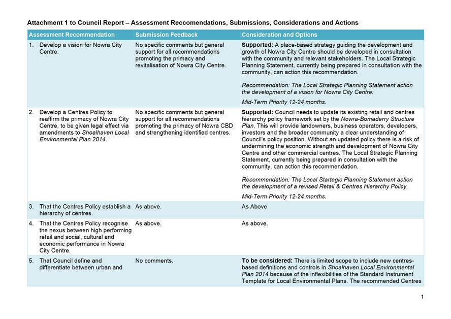
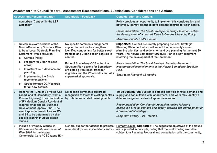
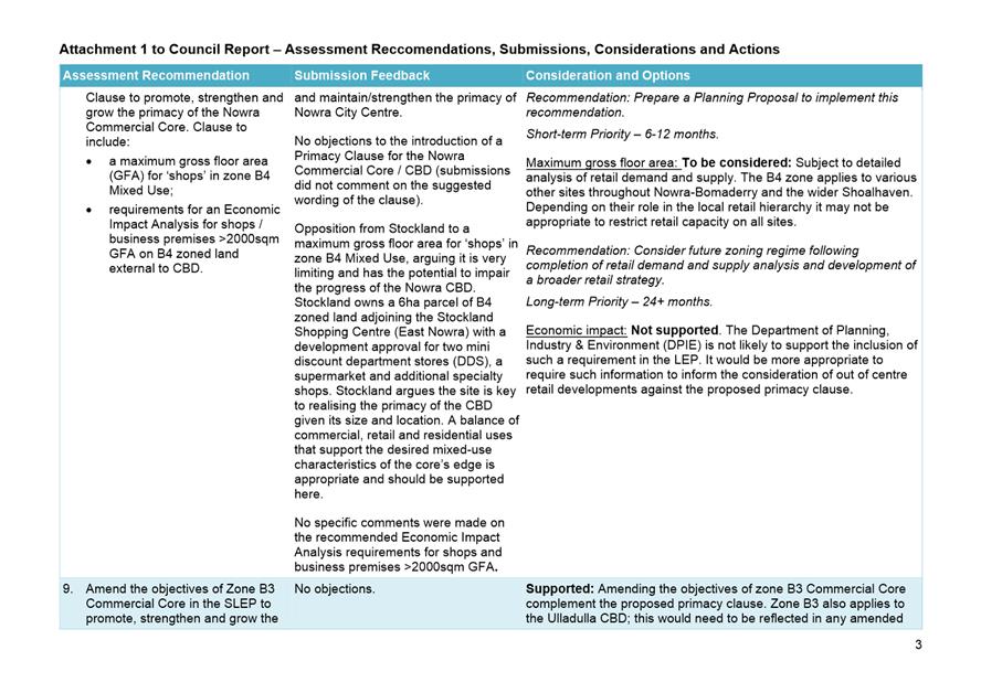
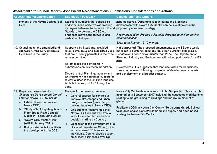
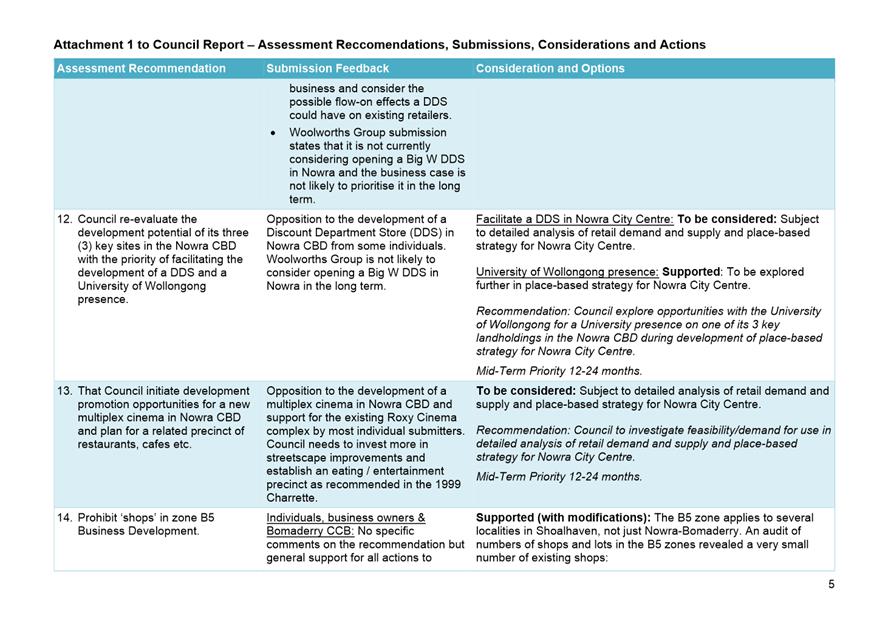
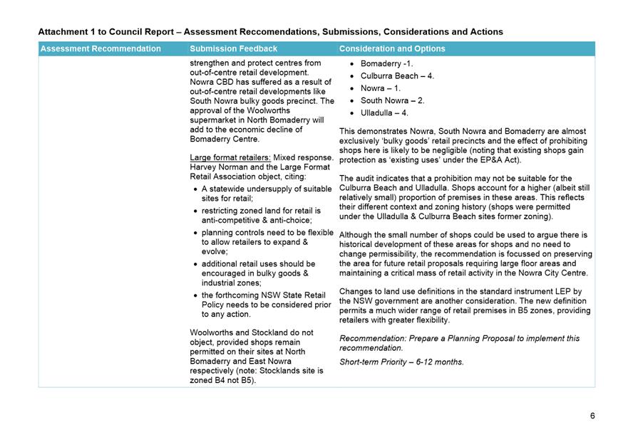
|
|
Development
& Environment Committee – Tuesday 01 October 2019
Page
107
|
DE19.101 St
Andrews Way/Berry's Bay & Woollamia Sewerage Schemes - Waiving of Fees for
Approval to Operate On-site Sewage Systems
HPERM Ref: D19/305033
Group: Planning
Environment & Development Group
Section: Environmental
Services
Purpose / Summary
To obtain endorsement to waive
the fees to property owners for approval to operate on-site sewage management
systems for properties in the St Andrews Way/Berry’s Bay and Woollamia
Sewerage Schemes until completion of construction. Any annual risk
inspections required during this period are proposed to be funded through
Council’s sewer fund as a means to manage risk until the sewerage schemes
are completed.
|
Recommendation
(Item to be determined under delegated authority)
That:
1.
Council endorse the waiving of “Approval to Operate Systems of
Sewage Management” and associated inspection fees for property owners
within the St Andrews Way/Berry’s Bay and Woollamia Sewerage Schemes,
during the construction phase of the schemes.
2. Any
annual risk inspections required through the construction of the schemes be
funded from Council’s sewer fund.
|
Options
1. Adopt the
recommendation.
Implications: Property owners and Council will
continue to meet legislative and policy requirements. There will be an
estimated additional cost of $16,400 to Shoalhaven Water’s Sewerage
budget, which will be adjusted at the next quarterly review.
2. Not adopt the
recommendation
Implications: The affected property owners will be
required to pay Council’s adopted fees for approval to operate a system
of sewage management, which may be for a short period only.
3. Other direction
as Council decides.
Implications: Any implications relating to
legislative responsibility, cost, policy and risk need to be considered.
Background
Council has previously resolved
that construction of the Woollamia and St Andrews Way/Berry’s Bay
Pressure Sewerage Schemes be completed by the end of the 2019/2020 financial
year.
Until such time that properties
are connected to the reticulated pressure sewerage schemes, a current approval
to operate the existing on-site sewage management systems is required under
section 68 Local Government Act, 1993.
The requirement for Approval to
Operate is ongoing until the completion of the sewerage schemes. Approval to
Operate is issued for a period of one or five years, depending on the potential
risk to the environment and public health of operating the systems. Renewals
are required at the expiration of each approval period.
There are 31 properties in the
Woollamia Sewerage Scheme and 26 in the St Andrews Way/Berry’s Bay
Sewerage Scheme where Approval to Operate is due for renewal within the current
financial year.
Given the current program to
connect the Schemes to sewer and the potential for property owners to pay fees
for a full year and not realise that year value (due to the schemes being
completed), it is proposed that the inspection and administrative fees
associated with the Approval to Operate be funded from the sewer fund, and not
be levied on individual property owners. This cost is estimated to be $16,400.
As
approval to operate is still required under legislation, a desk-top approval
process will be completed, and a 5-year approval issued for systems on all
properties within both the Woollamia and St Andrews Way/Berry’s Bay
Sewerage Schemes.
With the impending connection to
sewer, inspections would not be completed on those properties where systems are
operating at a lower risk. These properties are in the Woollamia Sewerage
Scheme area.
At least one more risk
inspection will be conducted of the onsite sewage management system located at
each property within the St Andrews Way/Berry’s Bay Sewerage Scheme.
These systems are considered high risk due to several factors, including
previous known system failures and proximity to the Berry’s Bay oyster
lease area.
Council will continue to take
any compliance action in accordance with Council’s compliance policy and
procedures, should any system failures in either location be reported to
Council.
Community Engagement
Council has consulted with the
affected property owners throughout the sewerage scheme project. Council has
communicated the on-going requirement for approval to operate from both a
legislative and operational risk perspective.
Representations from affected
property owners have been received requesting that the fees for Approval to
Operate be waived. All affected residents will be informed of Council’s
decision.
Policy Implications
Property owners will continue to
have a current Approval to Operate and Council will ensure that systems are
being operated in accordance with the legislated performance criteria. This
ensures that both property owners and residents are meeting Council policy and
legislative requirements.
The recommendation only relates
to properties located within the Woollamia and St Andrews Way/Berry’s Bay
Sewerage Schemes and as such there is no widespread policy implication.
Ensuring
that at least one more annual inspection is completed of the systems at St
Andrews Way/Berrys Bay will manage the potential risk of these systems until
the sewer is connected.
Financial Implications
There will be an additional cost
to Shoalhaven Water’s Sewer Fund of approximately $16,400.
Adjustments will be made to the
Sewer Fund as part of the next quarterly budget review.
Risk Implications
Nil. Property owners will
continue to legally operate their on-site sewage systems until the sewer is
connected. Council will fulfil its legislative and policy responsibilities.
Ensuring that at least one more
annual inspection is completed of the systems at St Andrews Way/Berrys Bay will
manage the potential risk of these systems until the sewer is connected.
|
|
Development
& Environment Committee – Tuesday 01 October 2019
Page
110
|
DE19.102 Formation
of Collingwood Beach Dunecare Group - Progress Report
HPERM Ref: D19/308998
Group: Planning
Environment & Development Group
Section: Environmental
Services
Purpose / Summary
To inform Council of the
progress on the establishment of Collingwood Beach Dunecare Group.
|
Recommendation (Item to be determined
under delegated authority)
That Council receive the progress
report, regarding the formation of the Collingwood Beach Dunecare Group, as
per Council resolution (MIN19.318).
|
Options
1. As per the recommendation
Implications: The group will continue to meet and
take an active role in the management of the Collingwood Beach dune area
between Susan St and Moona Moona Creek
2. Alternative recommendation.
Implications: These will depend on the nature of
any recommendations.
Background
At its Ordinary Meeting of the
28 May 2019, Council resolved (MIN19.318):
That staff take all necessary
steps required to form a Collingwood Beach Dunecare Group for the Susan Street
to Moona Creek section of the dunes. A particular focus on the recruitment
of nearby residents would be absolutely essential, with other residents being
most welcome to apply
The management of
‘Dunecare’ groups aligns with Council’s Bushcare Program and
there are two other volunteer groups that operate under the tag of
‘Dunecare’. These are the Mollymook Dunecare/Bushcare Group and the
Currarong Dunecare Group.
In June 2019, Council sent out
flyers to residents/ratepayers surrounding Collingwood Beach, (400 flyers)
seeking interest from individuals to volunteer with the new Collingwood Beach
Dunecare Group.
Following this, forty (40)
individuals registered. The first meeting – an ‘Introduction
Session’ was held on 31 August, with twelve (12) members attending. At
this session, the following topics where covered:
· Hazard
identification and risk assessment
· Introduction
to the plants present within the dunes, both natives and weeds
· A
site inspection was carried out, with identification of the actions within
existing plans and progress against these; and
· Nominations
were also sought for the group volunteer coordinator role.
A week following the
Introduction Session, an email was sent to all volunteers who had registered
with the Collingwood Beach Dunecare Group, seeking nominations for the Dunecare
Group Volunteer Coordinator. Following this, Dawn Thompson was confirmed as the
volunteer coordinator for the group.
The next steps will be to
further develop work activities and to timetable such activities in a way that
suits the group’s members. Activities will adhere to the approved
policies and the plans for the reserve. Primarily, the Collingwood Beach
Dune Vegetation Action Two-year Trial Plan and the Vincentia -
Collingwood Beach Reserve Bushcare Action Plan – 2008.
Volunteer uniforms, tools and
materials will be made available and further safety inductions held for
newcomers to forthcoming sessions.
Community Involvement and
Engagement
During the establishment of the
Collingwood Beach Dune Care Group, Council staff have been working directly
with the community. A number of onsite meetings and discussions have occurred.
These are explained in Table 1 below.
Table 1: The steps that
have been completed to date
|
21/06/2019
|
Telephone discussion between
Council’s Bushcare Coordinator and Collingwood Beach Preservation Group
(CBPG) Coordinator about the new Dunecare group. Information on how to
register was forwarded to the CBPG Coordinator. Registrations started being
received by Council.
|
|
Late June
|
Collingwood Beach Dunecare
Group established in Council’s database and posted on Council’s
website, with the Council’s Bushcare Coordinator number listed as the
website contact.
|
|
06/07/2019
|
Bushcare Coordinator met with
members of CBPG to discuss the formation of the new group.
|
|
12/07/2019
|
Flyers distributed to
residences close to Collingwood Beach, from Moona Moona Creek to Church St.
400 flyers were distributed.
|
|
Late July
|
Telephone discussion between
Bushcare Coordinator with the volunteer coordinator of the Vincentia Bushcare
Group regarding the formation of the Dunecare Group, emphasising that all
were welcome to join.
|
|
12/08/2019
|
Email sent to those registered
or registering as an invitation to the Introduction Session held on 31 August
|
|
27/08/2019
|
Bushcare Coordinator met with
a small group of Collingwood Beach residents that couldn’t attend the
Introduction Session.
|
|
31/08/2019
|
Introduction Session held
|
|
9/09/2019
|
Collingwood Beach Dunecare
Group Volunteer coordinator established
|
It is expected that ongoing
promotion of the actions and achievements of the Dune Care group will occur via
standard Council’s communication methods ( such as media releases, get
involved site, newsletters etc). Communications staff are also working on enhancing
the Council website specifically the section relating to Environmental Care
(Bushcare, Parkcare, Dune Care) to ensure updated content and detail is
provided. This page will also include an enhanced online form which can be
completed by future volunteers for a range of environmental care volunteer
opportunities. This will enable future new participants to easily register
their interest in assisting Council in their management of the environment.
|

|
Development
& Environment Committee – Tuesday 01 October 2019
Page
113
|
DE19.103 Initial
Consideration - Proponent Initiated Planning Proposal - Danjera Dam Camping
& Recreation Area
HPERM Ref: D19/309365
Group: Planning
Environment & Development Group
Section: Strategic
Planning
Attachments: 1. Danjera
Dam - Concept Site Plan ⇩
Purpose / Summary
Present a proponent initiated
Planning Proposal (PP) request for the Danjera Dam Camping and Recreation Area
for initial consideration to enable a Gateway determination to be obtained.
|
Recommendation
(Item to be determined under delegated authority)
That Council:
1. Support
the Planning Proposal request for the Danjera Dam Camping & Recreation
Area submitted for Shoalhaven Water.
2. Prepare
and submit the required Planning Proposal documentation to the NSW Department
of Planning, Industry and Environment for Gateway determination, and
dependent on the outcome proceed to exhibit the PP and report back to Council
post-exhibition.
3. Advise
the proponent of this resolution.
|
Options
1. Support the PP
request, request a Gateway determination and should a favourable determination
be received proceed to publicly exhibit the proposal. This is the preferred
approach and the matter will be reported back to Council through the process as
needed or if issues arise.
Implications: This is consistent with Councils
previous resolution to proceed with a PP to assist with the resolution and
management of the camping area in this location.
2. Not proceed
further with the PP.
Implications: This would be inconsistent with the
previous resolution of Council in this regard and would effectively limit
future management options.
3. Take an
alternative course of action.
Implications: This will depend on the nature of any
decision.
Background
The subject land is Part Lots 1,
4 and 5 DP252338 and Lot 1 DP217080. The land is owned by Council, classified
as “operational” land under the Local Government Act 1993, and
administered by Shoalhaven Water. The land is currently zoned E2 Environmental
Conservation under Shoalhaven Local Environmental Plan (LEP) 2014 which does
not permit “camping grounds”.
In 2002, a Schedule 9 -
Allowance Clause was inserted into then Shoalhaven LEP 1985 to enable tourist
facilities at the site. However, in the process of preparing Shoalhaven
LEP 2014, the provision in LEP 1985 was not transferred as a result of a
request from the NSW Government that ‘Additional Permitted Uses’ be
kept to a minimum.
In 2015 Council resolved to
support a PP over the subject land to again provide for ‘camping
grounds’ in the LEP. This PP received a favourable Gateway determination
but was discontinued in 2017.
Following a detailed report on
the possible redevelopment of the Danjera Dam Camping Area, Council resolved
(in part) on 13 November 2018 to:
Prepare a new planning proposal
based on limiting camping to the main camping area adjacent to the dam, as
outlined in the Future Directions Report and conceptualised in the attachment
to the report.
The attachment referred to in this
resolution is provided as Attachment 1.
Planning Proposal Request
Shoalhaven Water submitted a PP
request in May 2019, seeking to permit “camping grounds” as a
defined use at the Council owned Danjera Dam camping area located at Yalwal to
enable this use to be formalised/managed.
This report presents the PP
request for initial Council consideration to enable a Gateway determination to
be obtained.
The PP request received from
Shoalhaven Water can be viewed on the internet at:
http://doc.shoalhaven.nsw.gov.au/DisplayDoc.aspx?record=D19/163677
The PP request is supported by
detailed attachments covering bushfire, biodiversity and onsite sewerage management.
An initial review of the PP
request was undertaken by relevant staff. One issue that was raised at this
point is whether the proposed use is a ‘primitive campground’ or a
‘campground’ under Local Government (Manufactured Home Estates,
Caravan Parks, Camping Grounds and Moveable Dwellings) Regulation 2005.
However, at this point, the relevant LEP Dictionary Definition is
‘camping ground’. The issue raised can be further
considered/resolved as part of the subsequent processes following the amendment
of the LEP.
Whilst a range of detailed
assessments have been prepared to support this PP request, it is likely that
detailed issues could emerge through the Gateway determination and PP process.
Early consultation will thus be
undertaken with relevant NSW Government Agencies including NSW Rural Fire
Service, NSW Office of Environment & Heritage and NSW Crown Lands (or their
new equivalents) and prior to the formal public exhibition of the PP. This
could raise matters that will require detailed consideration in association
with Shoalhaven Water. Any additional studies that are required as a result
will also need to be funded by Shoalhaven Water.
Given both the history of use
and previous planning background (the provision previously existed in the LEP)
this request is considered minor given this context and has sound
justification.
Community Engagement
The PP will be formally
exhibited for community comment at the appropriate point consistent with the
requirements of the Gateway determination. Adjacent landowners will be directly
advised of the public exhibition arrangements to give them the opportunity to
review and comment on the PP.
Policy Implications
The LEP does not currently allow
for the requested use which is part of the management solution for the Danjera
Dam Camping and Recreation Area. As such the PP is the only way to adjust the
LEP to assist with this solution.
Financial Implications
This PP request is being managed
in accordance with Councils Planning Proposal (rezoning) Guidelines on a cost
recovery basis. Shoalhaven Water paid the required initial lodgement fee for
this request and will be required to pay the necessary processing/management
fees in accordance with Council’s Fees & Charges.
Risk Implications
If the PP is not supported, it
will be difficult to implement the management solutions for the area that has
been a problematic location for Council.
|
|
Development
& Environment Committee – Tuesday 01 October 2019
Page
114
|
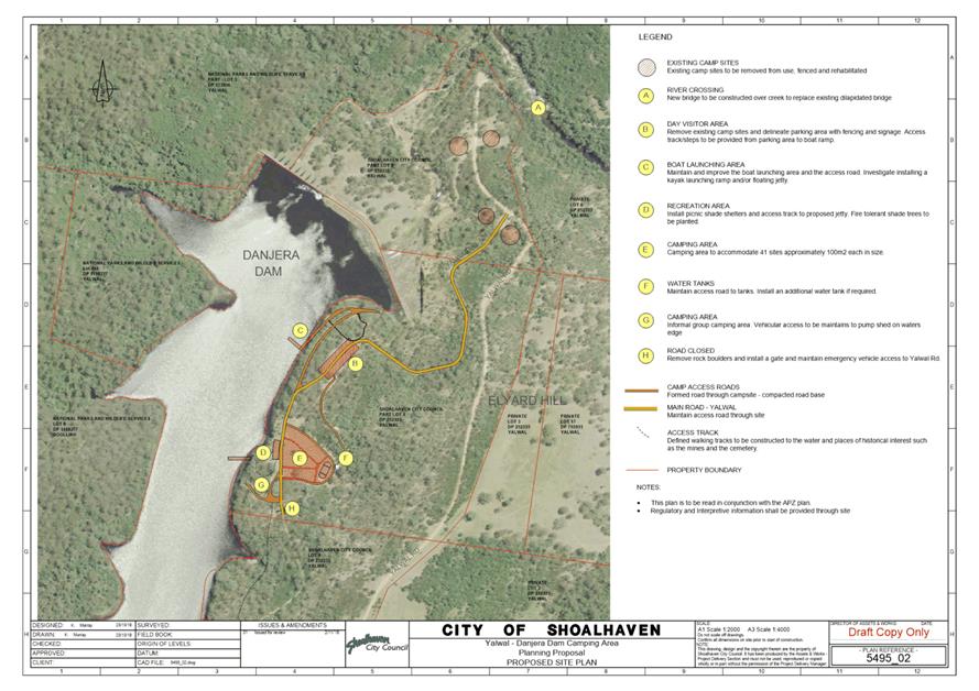
|
|
Development
& Environment Committee – Tuesday 01 October 2019
Page
120
|
DE19.104 Tomerong
Quarry - Lot 4 DP 775296 Parnell Rd DA90/1912
HPERM Ref: D19/315873
Group: Planning
Environment & Development Group
Section: Building
& Compliance Services
Purpose / Summary
At Council’s Development & Environment Committee
Meeting held on the 3 September 2019, it was resolved that staff compile a
report to answer specific questions on Tomerong Quarry (Item 1 of
MIN19.613).
This report provides a response to each question asked in Item
1 of MIN19.613.
|
Recommendation
(Item to be determined under delegated authority)
That Council receive this report on Tomerong Quarry
for information.
|
Options
1. Council receive the
report for information.
Implications: Nil
2. Council determine an
alternative recommendation.
Implications: Council’s Compliance Officers
will work on satisfying the requirements of the alternative recommendation.
Background
At the Development and Environment Committee meeting held on 3
September 2019, Council resolved the following:
That:
1. Staff
compile a report on the following in relation to the mooted intention of the
Operators of the Quarry to begin gravel extraction at Tomerong Quarry Lot 4 DP
775296 Parnell Road Tomerong under existing DA90/1912:
Tomerong Quarry ceased
operating in July 2017 and the DA and EPA Licence were surrendered in February
2018.
a. Can
Council give written assurance that compliance with DA90/1912 and subsequent
modifications will be strictly enforced before any operator is permitted to
resume extraction of material at the Tomerong site.
b. Can
Council provide an update on the progress of rehabilitation at the Quarry as
required in the original consent, and has the former operator of the quarry,
Shoalhaven Quarries, been subject to enforcement of this condition as was
promised in a report to Council at the Strategy and Assets Committee Meeting on
15th May 2018 in response to a resolution at the Strategy and Assets
Committee Meeting on 23rd January 2018.
c. Can
Council provide a summary of investigation and testing for pollution in and
around the Tomerong Quarry site including the dumping of asbestos and in
particular an allegation brought to Council in April 2018 that a significant
amount of asbestos has been buried under a long mound on the south eastern side
of the quarrying area and other places.
d. Have the
owners of Lot 4 DP 775296 Parnell Road Tomerong been informed of this alleged
illegal asbestos dumping outside the quarry area on their land and can Council
confirm that the site has been registered as contaminated.
2. Staff
investigate the possibility of introducing a planning proposal to rezone so
that “extractive industries” are no longer permissible at the site.
3. Council
communicate regularly with the community with respect to operations at the
Tomerong quarry site.
This report provides detailed answers to the questions raised
in Item 1 of minute MIN19.613. With respect to the other two items listed
in the minute, the following update is provided:
· Staff
will report separately on the possibility of introducing a planning proposal to
rezone the land; and
· Compliance
staff will communicate regularly with the community concerning the operations
at Tomerong Quarry.
Report
The following advice is provided to address the issues raised
in item 1 of MIN19.613:
1. Tomerong
Quarry ceased operating in July 2017 and the DA and EPA Licence were
surrendered in February 2018.
The last known blast at the Tomerong Quarry was on 7 April
2017. The last known time SCE trucks removed material from the site was
in late July 2017.
The comment that the DA and EPA licence were surrendered is
incorrect as neither have been surrendered.
(a) Development Consent:
The development consent (DA90/1912) and the approved modifications (DS02/1087, DS03/1325 and DS06/1039) have not been
surrendered by the owner of the premises. These will remain active until the
consent expires on 6 November 2020 or unless the owner surrenders it
beforehand.
(b) EPA Licence:
Council’s Compliance Officer contacted the EPA shortly after learning the
owners of the premises intended to recommence operations at the site to remove
the won material that exists on the quarry floor. The EPA confirmed the
licence had not been surrendered but merely transferred to the owner of the
premises. This transfer from SCE to In-Ja-Ghoodji Lands Incorporated occurred
on 1 June 2018.
The EPA advised they had placed several conditions on the
licence and these need to be completed prior to quarrying operations
recommencing. These requirements are listed in the ‘Notice of
Variation of Licence No 3532’ issued by the EPA and dated 30 August 2018
and include the following:
U1.1 Prior to the recommencement of extractive
activities at the premises, including the transportation of any stockpiled
quarried materials the licensee must install fit for purpose equipment and/or
measures at the premises to prevent the tracking of mud, dust and debris onto
the roadways outside the premise’s boundary.
U1.2 Prior to the recommencement of
extractive activities at the premises, including the transportation of any
stockpiled quarried materials the licensee must ensure that the section of
internal roadway between Gumden Lane and the weighbridge at the premises has a
surface layer that prevents the generation of dust from vehicle usage,
including trucks.
U1.3 Prior to the recommencement of
extractive activities at the premises, including the transportation of any
stockpiled quarried materials the licensee must repair the sealed section of
the internal roadway between Parnell Road and the weighbridge at the premises
so that it has a surface layer that prevents the generation of dust from
vehicle usage, including trucks.
U1.4 No later than 14 days prior to the
recommencement of extractive activities at the premises, including the
transportation of any stockpiled quarried materials the licensee must provide a
written report to the EPA's Regional Manager Operations, South East that
demonstrates the works as required by conditions U1.1 to U1.3 have been
implemented at the premises. This report is to be submitted by any of the
following means:
· Post
- PO Box 622 Queanbeyan NSW 2620
· Email
- queanbeyan@epa.nsw.gov.au
It is understood from discussions with the owner and lessee
that works have commenced on site to complete these items.
1a. Can Council give
written assurance that compliance with DA90/1912 and subsequent modifications
will be strictly enforced before any operator is permitted to resume extraction
of material at the Tomerong site.
Council’s Compliance Team have met with both the landowners,
In-Ja-Ghoondji Lands Inc, and their lessee, Hisway Pty Ltd, to discuss the way
forward. As a result of these discussions, letters were sent to both the owner
and the lessee on 3 September 2019. The letters are similar in content
and generally advise that the following needs to be address before quarrying
operations recommence:
· Conditions 4 and 6:
a landscape and rehabilitation plan are to be prepared and submitted to Council
for approval.
· Condition 7:
Verification that the sediment and erosion control measures as specified in the
Erosion and Sedimentation Control Plan are still in place and in serviceable
condition.
· Condition 9(d) and
9(e): Confirmation that the holding tanks and water cart are on site
and in serviceable condition in accordance with Conditions 9(d) & 9(e).
· Condition 9 and 11:
Prior to the crushing plant commencing operations Council is to be provided
evidence that Consent Conditions 9 and 11 have been addressed.
· Condition 15:
Confirmation that the all-weather dust free parking area has been provided is
in serviceable condition.
· Condition 16:
Confirmation that the all-weather dust free standing/parking area for plant
& equipment has been provided.
· Conditions 18 and 19:
Council is to be provided with written confirmation that the fuel storage area
remains compliant.
· Condition 22:
An agreement is to be signed off between the operator and Council concerning
the standard to which Parnell Road and Gumden Lane are to be maintained.
Council’s Compliance Team have also advised it will
require additional information from either In-Ja-Ghoondji Lands Inc or Hisway
Pty Ltd at regular intervals during the operation of the quarry. These
include the following:
· Documentation on
the quantity of material being exported daily to demonstrate that no more than
1000 tonnes per day is being exported from the site (Condition 14(h)).
· Written
documentation of truck movements to and from the site to demonstrate compliance
with hours of operation (Condition 11(c) and 11(f)).
· Written
confirmation that water from the eastern most of the two dams located to the
north of the quarry is not being utilised for operations associated with the
quarry. This dam did not form part of the Consent and was constructed for use
associated with the agricultural pursuits on the land only.
Council’s Compliance Team have also highlighted the
need for the owner and the lessee to comply with the conditions associated with
the EPA Licence (regulated by the EPA) and the Road Rules associated with heavy
vehicles on public roads (regulated by the NSW Police Service and Road and
Maritime Services).
Finally, both the owner and the lessee were encouraged to
liaise with the Tomerong Community Forum in order that all concerns might be
tabled and addressed.
1b. Can
Council provide an update on the progress of rehabilitation at the Quarry as
required in the original consent, and has the former operator of the quarry,
Shoalhaven Quarries, been subject to enforcement of this condition as was
promised in a report to Council at the Strategy and Assets Committee Meeting on
15/05/2018 in response to a resolution at the Strategy and Assets Committee
Meeting on 23/01/2019.
Council’s Compliance Team spent a lot of time working
with the landowners encouraging them to allow Council to pursue the previous
lessee to rehabilitate the quarry. The main issue was the previous lessee
had to be allowed back on site to complete the investigations and report in the
first instance, and then they needed permission to re-enter the site to
complete the associated works. This took the best part of 2018 to reach a
verbal approval to move this forward.
Independently of the above, Council’s Compliance,
Environmental and Development Assessment staff had met on several occasions to
discuss what was needed in the rehabilitation plan. With this determined,
Council’s legal representative wrote to the previous lessee and indicated
our intention to pursue them to prepare a plan of rehabilitation and then carry
out the works. Not surprisingly, there was opposition from the previous
lessee. Council’s Compliance Staff worked with its legal
representative and had set a course of action for moving this forward.
This was to be Class 4 action in the Land and Environment Court to seek Court
orders to have the works completed.
Unbeknown to Council’s Compliance Staff, the
landowners had transferred the licence to themselves and signed a lease to have
the won materials withdrawn from the quarry floor. Council’s legal
representative advised it would no longer be possible to pursue the previous
licensee and the proposed Class 4 action was not pursued.
On 3 September 2019, the owners of the premises were sent a
notice of intention to give a development control order requiring them to
prepare and submit a detailed landscape and rehabilitation plan for the
quarry. This notice was identical to the requirements being sort by the
Compliance Team from the previous licensee of the site. Amongst other
things, this notice requires the plan to include the following:
o A
site rehabilitation management plan
o Community
consultation during the preparation of the plan and once the plan has been
finalised
o Desired
outcomes to consider the future needs of the owners, a maximum batter of
250, regeneration with endemic native species, no truck movements to
Parnell Road and a dilapidation report to Gumden Lane and the repair of any
damage.
o Identification
of the rehabilitation area
o Protection
of existing native vegetation, fauna and regeneration
The representation period for this notice expires on 1
October 2019. It is envisaged the order will be sent out shortly after
the expiry period. As Council must consider any representations made as a
result of this notice, it is possible the final order could be amended and/or
delayed.
As discussed at Council’s Development and Environment
Committee meeting held on 3 September 2019, this rehabilitation plan is
required to be completed and submitted to Council for approved prior to
quarrying operations recommencing. This has also been made clear in the
correspondence sent to both the owner and the new lessee.
1c Can Council
provide a summary of investigation and testing for pollution in and around the
Tomerong Quarry site including the dumping of asbestos and in particular an
allegation brought to Council in April 2018 that a significant amount of
asbestos has been buried under a long mound on the south eastern side of the
quarrying area and other places.
The testing of the quarry site was undertaken by the EPA
and not Council. The EPA made this report public and presented it to the
Tomerong Community Forum on 31 July 2018. The results of the EPA testing
did not identify any breaches of recognised health standards.
Council engaged the services of an Occupational Hygienist
to undertake testing of water tanks, dams and roads from several properties in
the vicinity of the quarry. The initial testing identified some
anomalies, and these resulted in some follow up testing. The anomalies
were not related to quarrying activities. The final report on the testing
has been made public and it was presented to the Tomerong Community Forum on 18
February 2019. The results of the testing did not identify any breaches
of recognised health standards.
With respect to the anonymous complaint alleging asbestos
dumping on the site, this was a separate issue to the quarrying operations, and
it was directed towards the landowners and not the previous lessee. Some
considerable time was spent working with the landowners on this issue.
The delays were mainly attributed to the landowner seeking funding assistance
for the testing.
It was found that funding assistance was not available
given the ownership of the land. On 22 June 2019, the landowners were
issued with a notice of intention to have the report prepared.
Following consideration of representations to the notice,
Council issued the Development Control Order on 2 September 2019. Testing
is required to be undertaken by 08/10/2019 and a hazardous substance management
plan be submitted to Council by 29/10/2019 (if hazardous substances located).
Should the landowners not undertake the testing within the
required time frame, Council intends to exercise its power to have the testing
undertaken. The costs associated with this testing plus any administration
costs incurred by Council will be charged back to the landowners.
1d. Have the owners of Lot
4 DP 775296 Parnell Road Tomerong been informed of this alleged illegal
asbestos dumping outside the quarry area on their land and can Council confirm
that the site has been registered as contaminated.
The landowners have been advised of the allegations and
this is detailed in 1c above. The site has not been registered as
contaminated as no verification is available at this time.
Land will only be considered as contaminated if there is
documentary evidence confirming the existence of contaminates and the site
cannot otherwise be adequately remediated.
|
|
Development
& Environment Committee – Tuesday 01 October 2019
Page
124
|
DE19.105 Submission
- Proposed New Regulatory Framework - Short Term Rental Accommodation
HPERM Ref: D19/316058
Group: Planning
Environment & Development Group
Section: Strategic
Planning
Attachments: 1. Draft
Short Term Rental Accommodation Submission (under separate cover) ⇨
Purpose / Summary
Provide a brief overview of the
proposed new regulatory framework for short term rental accommodation (STRA) in
NSW and obtain Council endorsement for the submission that was made.
|
Recommendation
(Item to be determined under delegated authority)
That Council
1. Endorse
the draft submission that was made on the proposed Short Term Rental
Accommodation reform package (provided as Attachment 1 to this report)
and advise the NSW Government accordingly.
2. Continue
to play an active role, as required, in this important matter and received
future reports as needed.
|
Options
1. Endorse the
draft submission that has been provided on this matter, a copy of which is
provided as Attachment 1.
Implications: This is the preferred option given
that the draft submission is detailed and covers a range of points that are
important to Council and is consistent with the previously resolved positions
on STRA.
2. Adjust the draft
submission and provide to the NSW Government.
Implications: This will depend on the nature of any
resolved adjustments.
3. Not make a
submission
Implications: This option is not recommended as the
proposed reforms are relevant to Shoalhaven and could have a significant
impact.
Background
Council has consistently been
active in responding to proposed reforms related to STRA and has held the view
that any regulatory framework should have a ‘light touch’, be clear
and workable and not place an additional administrative or compliance burden on
Council.
Council made a detailed
submission in November 2018 to the proposed NSW planning framework for STRA
based on a report to Council dated 13 November 2018. This previous framework
only related to the planning aspects of the NSW Governments STRA reforms and
did not provide an opportunity to review and comment on the associated aspects
such as the proposed Code of Conduct.
On the 14 August 2019 the NSW
Government released a more complete draft regulatory framework package related
to STRA for comment that includes:
· Draft
State Environmental Planning Policy (Short-term rental accommodation) 2019
· Draft
Code of Conduct for the Short-term rental accommodation industry
· Draft
Fair Trading Amendment (Code of Conduct for Short-term rental accommodation
industry) 2019
· Draft
Environmental Planning and Assessment (Short-term rental accommodation)
Regulation 2019
· Short-term
rental Accommodation Fire Safety Standard
The exhibition material also
includes a Discussion Paper on the new regulatory framework that provided a
good overview of its components. The following diagram from the Discussion
Paper also provides a simple overview of the components and how they are
intended to fit together.
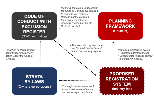
Overview
– Proposed Integrated STRA Framework
The proposed reform package can
be accessed on the internet at the following link:
https://www.planningportal.nsw.gov.au/exhibition/have-your-say-short-term-rental-accommodation-reforms
Comments on the proposed reform
package were due by 11 September 2019 (extended till 25 September 2019).
Council Submission
Given the comment timeframes
involved, it was not possible to review the more extensive package and report a
proposed submission through Council by the originally nominated timeframe of 11
September 2019. As such it was agreed with the NSW Department of Planning,
Industry and Environment (DPIE) that a draft submission would be provided, and
the matter would be reported to Council for endorsement in due course.
The attached (Attachment 1)
draft submission was provided to DPIE on 11 September 2019 and was prepared
with feedback from relevant Sections within Council including Tourism, Building
& Compliance and Environmental Services. Council staff also participated in
a teleconference on the proposed reforms arranged by Local Government NSW which
was also valuable in identifying general Council concerns.
The draft submission provides
detailed comment regarding:
· Tourism
role/importance
· The
overall package and how it fits together
· Proposed
SEPP
· STRA
Definition
· Existing
use rights
· Need
for a development application pathway
· Exempt
and complying development
· Number
of days (note: Council previously resolved to accept the general permissibility
under the reforms of 365 days)
· Bushfire
provisions
· Flood
prone land provisions
· Code
of Conduct
· Proposed
registration system
· Proposed
exclusion register
· Compliance
· Fire
safety standards
· DCP
Provisions
The new draft package contains
provisions in regard to what could be considered to be ‘existing use
rights’ given the current STRA situation in Shoalhaven – our LEP
has allowed STRA essentially as ‘exempt’ development since 2006. As
such it appears that any currently operating STRA may benefit from
‘existing use rights’. Clause 15(2) of the draft SEPP covers this
situation and currently reads as follows:
· Development
that was commenced before the commencement of this Policy and that was,
immediately before that commencement, exempt development in accordance with an
environmental planning instrument that was amended by this Policy may be
continued as if this Policy had not commenced.
As such, importantly for
Shoalhaven any currently operating STRA will not need to follow the planning
pathways that could ultimately arise from the draft SEPP. There are however
still some issues that need to be clearly confirmed – specifically are
‘exiting use’ premises still added to the register and is there a
need for them to install the essential fire safety measures?
The draft submission concludes
with a request that the NSW Government draw these reforms to a conclusion in a
timely manner to remove the current uncertainty, ensure that there is a
continued dialogue with Local Government on the final provisions and release
clear advisory material to ensure there is broader community awareness of the
new system when it comes in.
Conclusion
It is recommended that Council
endorse the draft submission that was made on the proposed STRA reform package,
advise the NSW Government of this decision and continue to play an active role
as required in this important matter.
Community Engagement
The NSW Government’s
package of proposed reforms was out for community comment from 14 August until
25 September 2019. The package was available for review on the DPIE website.
Policy Implications
The SEPP will remove relevant
provisions from Council’s three existing LEP’s given that on its
commencement the NSW wide planning framework for STRA will take over.
The continued role of Councils
existing DCP
Chapter G16 – Short Term Rental Accommodation is raised in the
submission.
Financial Implications
Reviewing/commenting on this
matter is being managed within the existing Strategic Planning budget.
|
|
Development
& Environment Committee – Tuesday 01 October 2019
Page
126
|
DE19.106 Ministerial
Representations - Chapter G4 Tree & Vegetation Management - Shoalhaven
DCP2014
HPERM Ref: D19/316102
Group: Planning
Environment & Development Group
Section: Strategic
Planning
Attachments: 1. Letter
- NSW Minister for Planning & Public Spaces - Tree & Vegetation
Management DCP ⇩
Purpose / Summary
Detail representations received
from the NSW Minister for Planning & Public Spaces in this regard to enable
Council to consider a response/position.
|
Recommendation
(Item to be determined under delegated authority)
That Council
1. Determine
relevant action having regard to options provided below or other appropriate
actions,
2. Advise
the NSW Minister for Planning & Public Spaces of this decision and keep
him advised of the progress of the review/possible amendment to the DCP.
|
Options
1. Note the request
received from the Minister that essentially requests that Council reconsider
the current provisions in this regard and advise the Minister of
Council’s decision to retain the current provisions for the overriding
reason of public safety, noting that Council is also considering policy options
to address tree loss within the City more generally.
Implications: This will see the retention of the
current 45 degree rule unchanged in the DCP and the Minister will be advised of
this and the reasons for its retention. Council originally introduced the
provision into its then Tree Preservation Order (TPO) in 2004 as a result of a
court case that followed the death of man at a property in South Nowra in 1998.
The provision provides private landowners the ability to
consider the management of trees on their own property, particularly where they
hold safety concerns. It also removes Council staff from the assessment process
and leaves any decision concerning the potential risk of a tree to the owner of
the land or their contractor. Council has reaffirmed the relevant provisions on
a number of occasions, most recently in September 2018 when it was resolved
that Council:
1. Re-affirm it’s “45
degree-rule“ tree removal policy
2. Staff
prepare a draft policy on “compensatory tree planting“ following
the legal removal of trees in our city. This policy would need to address, but
not be restricted to the following
a. Suitable sites to plant new
trees, especially in non-residential locations.
b. The ideal new tree to old
tree ratio.
c. The possibility of
recoupment costs.
d. The investigation of similar
policies that may exist in other municipal areas
2. Commence a
review of the DCP Chapter G4, along with outcomes associated with the use of
the 45 degree rule, to consider the possible amendment or removal of the
current 45 degree rule.
Implications: This would enable various options,
including removal, to be further investigated along with the broader community.
3. Make a
resolution to take the necessary steps to immediately remove the 45 degree rule
– Section 5.2.3 (d) from DCP Chapter G4.
Implications: This would enable the DCP to be
amended to remove the 45 degree rile from the DCP. Due process would need to be
followed in this regard.
Background
Council has received a letter
from the NSW Minister for Planning & Public Spaces, the Hon. Rob Stokes MP
regarding the impact of Shoalhaven Development Control Plan 2014 (DCP) on the
urban tree canopy in Shoalhaven.
This letter was triggered by
representations to the Minister from Justin Field MLC regarding the exemption
provided by Clause 5.2.3(d) within Chapter G4 – Tree and Vegetation
Management that enables residents/owners to self-assess tree removal and does
not require Council consent where the terms of the exemption are met. The
provision in question has become commonly known as the ‘45 degree
rule’.
Mr Field suggests that this
provision is being used by businesses pursuing work and has resulted in the
loss of a large number of significant urban trees. He also suggests that
Council is not meeting requirements set by the NSW Environmental Planning
and Assessment Act 1979 (the Act) to conserve biodiversity and ecological
integrity.
As a result, the Minister has
been asked to use his authority under the Act to direct Council to remove the
exemption from its DCP.
The Minister in his letter to
Council notes the following (key statements underlined):
While I strongly support
local Councils in determining planning rules and acknowledge the work Council
is doing to protect and enhance urban tree canopy in the Shoalhaven area, I
agree with Mr Fields’s concerns.
I appreciate that tree
management requires balancing risk to public safety and property with the
numerous benefits provided by trees. However, I am concerned that
Shoalhaven’s broad exemption is out of step with other Councils.
I would appreciate if you
could look into this matter and investigate whether the amendments made to
your DCP in 2004 have led to perverse outcomes.
Given the Minister’s strong
statements it is felt appropriate that Council should formally consider the
matter to enable staff to respond appropriately. It should also be noted that
there is no readily available date on tree removal in the Shoalhaven that can
be referenced, thus the issue of outcomes is one that would require further
investigation.
The Minister’s letter and
associated correspondence are provided as Attachment 1.
Current DCP Provision –
Commentary
The Council first resolved to
introduce the 45 degree rule into its Tree Preservation Order (TPO)/Tree
Management Policy. Part (e) of the resolution included the following regarding
schedule 4 of the TPO:
· Tree
works on private land where any part of a tree is above a line 45 degrees from
the vertical extension of the wall of any building on the land measured
from its base; or
· Tree
works within six (6) metres of an approved dwelling on the same land; or
three (3) metres of an approved garage or outbuilding; zoned residential under
Shoalhaven Local Environmental Plan 1985.
Schedule 4 of the TPO outlined
various ‘exemption’ scenario’s where the order did not apply
and as such consent was not required.
The 45 degree rule arose from
consideration arising from the court case: Timbs v Shoalhaven City Council
[2004] NSWCA 81 (1 April 2004).
This provision has been carried
forward by subsequent Councils in DCP (replaced TPO) provisions associated with
tree and vegetation management since 2004.
Currently Chapter G4 of the
Shoalhaven DCP2014 covers ‘tree and vegetation management’ and can
be viewed on the internet at:
http://dcp2014.shoalhaven.nsw.gov.au/content/tree-and-vegetation-management
The following is an extract from the DCP:
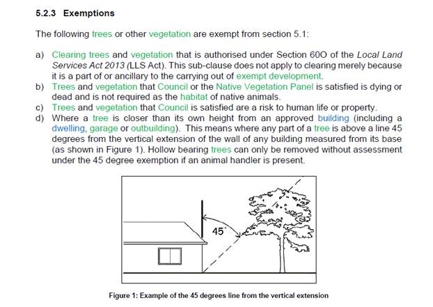
Various ‘housekeeping’ type amendments have been
made to the DCP chapter since 2014. Whilst concerns surrounding the 45 degree
rule have been raised by community members and others as parts of these
processes and more generally, Council has consistently retained the provision
in the DCP
Conclusion
There has been some community
concern associated with the current 45 degree rule in the DCP. It now appears
that this has been taken forward via approaches to relevant State Government
representatives.
The most recent letter from the
NSW Minister for Planning & Public Spaces (Attachment 1) raises
concerns with the current DCP provision. In this regard it is noted that the
under Section 3.46 of the Act, the Minister may: “direct a council to
make, amend or revoke a development control plan in the time and manner
specified in the direction”.
It is noted in a recent newspaper
article that the Minister has also recently questioned the tree management
approach being taken/proposed by the Inner West Council that enables trees
within 3 metres of a dwelling to be removed without consent.
Council has been doing a range
of work in a broader sense in regard to tree and vegetation
management/retention, including:
· Urban
tree canopy example audit at St. Georges Basin
· New
urban release area planning – working to ensure retention of significant
vegetation into the intended public reserve system and additional public domain
planning.
· Tree
replacement policy – draft reported to this meeting.
Council needs to consider how it
wants to respond to the Minister’s letter and specifically whether it
wishes to retain, modify or remove the 45 degree rule.
Community Engagement
The current DCP Chapter has been
prepared and amended consistent with public notification requirements set in
legislation. Any proposed amendment that arises from this report would need to
be notified for public review and comment as part of the process.
Policy Implications
Council has consistently
retained the 45 degree rule in its planning schemes since 2004. Any change in
this regard would need to be given due consideration as it would represent a
change in policy.
Financial Implications
There are currently no direct
financial implications arising from this report. Should Council resolved, for
instance, to amend the DCP then this would be undertaken within the Strategic
Planning budget.
|
|
Development
& Environment Committee – Tuesday 01 October 2019
Page
132
|
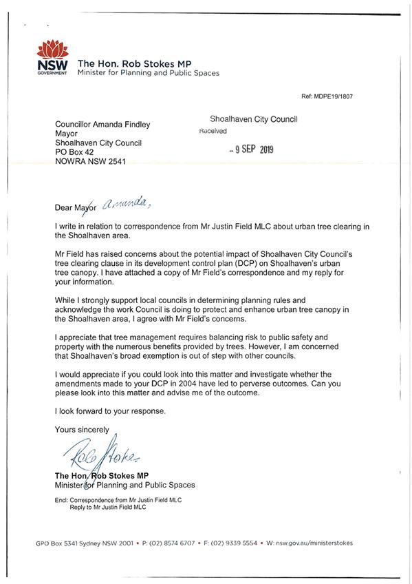
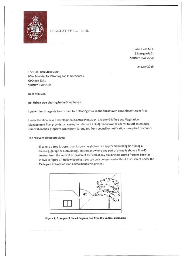
|
|
Development
& Environment Committee – Tuesday 01 October 2019
Page
134
|
Local Government Amendment (governance &
planning) act 2016
Chapter
3, Section 8A Guiding principles for councils
(1)
Exercise of functions
generally
The
following general principles apply to the exercise of functions by councils:
(a) Councils should provide strong
and effective representation, leadership, planning and decision-making.
(b) Councils should carry out
functions in a way that provides the best possible value for residents and
ratepayers.
(c) Councils should plan
strategically, using the integrated planning and reporting framework, for the
provision of effective and efficient services and regulation to meet the
diverse needs of the local community.
(d) Councils should apply the
integrated planning and reporting framework in carrying out their functions so
as to achieve desired outcomes and continuous improvements.
(e) Councils should work
co-operatively with other councils and the State government to achieve desired
outcomes for the local community.
(f) Councils should manage
lands and other assets so that current and future local community needs can be
met in an affordable way.
(g) Councils should work with
others to secure appropriate services for local community needs.
(h) Councils should act fairly,
ethically and without bias in the interests of the local community.
(i) Councils should be
responsible employers and provide a consultative and supportive working
environment for staff.
(2) Decision-making
The
following principles apply to decision-making by councils (subject to any other
applicable law):
(a) Councils should recognise
diverse local community needs and interests.
(b) Councils should consider social
justice principles.
(c) Councils should consider the
long term and cumulative effects of actions on future generations.
(d) Councils should consider the
principles of ecologically sustainable development.
(e) Council decision-making should
be transparent and decision-makers are to be accountable for decisions and
omissions.
(3) Community participation
Councils
should actively engage with their local communities, through the use of the
integrated planning and reporting framework and other measures.
Chapter
3, Section 8B Principles of sound financial management
The
following principles of sound financial management apply to councils:
(a) Council spending should be responsible and sustainable,
aligning general revenue and expenses.
(b) Councils should invest in responsible and
sustainable infrastructure for the benefit of the local community.
(c) Councils should have effective financial
and asset management, including sound policies and processes for the following:
(i) performance management
and reporting,
(ii) asset maintenance and
enhancement,
(iii) funding decisions,
(iv) risk management practices.
(d) Councils should have regard to achieving
intergenerational equity, including ensuring the following:
(i) policy decisions are made
after considering their financial effects on future generations,
(ii) the
current generation funds the cost of its services
Chapter
3, 8C Integrated planning and reporting principles that apply to councils
The
following principles for strategic planning apply to the development of the
integrated planning and reporting framework by councils:
(a) Councils should identify and prioritise key
local community needs and aspirations and consider regional priorities.
(b) Councils should identify strategic goals to
meet those needs and aspirations.
(c) Councils should develop activities, and
prioritise actions, to work towards the strategic goals.
(d) Councils should ensure that the strategic
goals and activities to work towards them may be achieved within council
resources.
(e) Councils should regularly review and
evaluate progress towards achieving strategic goals.
(f) Councils should maintain an
integrated approach to planning, delivering, monitoring and reporting on
strategic goals.
(g) Councils should collaborate with others to
maximise achievement of strategic goals.
(h) Councils should manage risks to the local
community or area or to the council effectively and proactively.
(i) Councils should make appropriate
evidence-based adaptations to meet changing needs and circumstances.