Shoalhaven Natural Resource & Floodplain
Management Committee
Meeting Date: Wednesday,
18 April, 2018
Location: Shoalhaven
Entertainment Centre - Mezzanine Conference Room, Bridge Road, Nowra
Time: 4:00pm
Addendum Agenda
Reports
SN18.9........ Technical peer review of the River Road
Foreshore Shoalhaven Heads: Assessment of the Coastal Management Options Report
by MHL.................................... 1
SN18.10...... Undertaking a Scientific Analysis of the
Shoalhaven Dredging Program.... 15
SN18.11...... Proposed Millards Creek and Currarong Creek Flood
Study Projects........ 20
|

|
Addendum Agenda - Shoalhaven
Natural Resource & Floodplain Management Committee – Wednesday 18
April 2018
Page
4
|
SN18.9 Technical
peer review of the River Road Foreshore Shoalhaven Heads: Assessment of the
Coastal Management Options Report by MHL.
HPERM Ref: D18/75302
Group:
Section: Environmental
Services
Attachments: 1. MHL
Technical Review
Purpose / Summary
To
advise the Committee of the technical peer review by Edward Couriel from Manly
Hydraulics Laboratory (MHL), of the River Road Foreshore Shoalhaven Heads:
Assessment of the Coastal Management Options Report prepared by Water Research
Laboratory (WRL) UNSW.
|
Recommendation:
That Council
1. Receive
the Manly Hydraulics Laboratory technical review of the WRL River Road
Coastal Option Report titled MHL2595 – Review of River Road
Foreshore, Shoalhaven Heads: Assessment of Coastal Management Options Report
dated February 2018, for information; and
2. Subject
to availability of funding, incorporate the following technical information
in the detailed design of any future coastal erosion remediation control
structure at the River Road foreshore precinct:
a. Coastal
erosion remediation structure be designed for a more conservative large river
entrance opening to reduce the risk of failure.
b. A
minimum design life of 25 years for coastal erosion remediation structure be
adopted.
|
Options
1. As per the
recommendation.
Implications: Proceeding with the option endorsed
by MHL‘s technical review, to undertake design incorporating the above
technical information as per the MHL technical review recommendation. Designing
the foreshore erosion remediation structures to a minimum design life of 25
years and for a large river entrance opening is likely to increase the cost of
the structure. This will need to be costed as part of the detailed design
process.
2. Recommend
alternative options for the detailed design of the River Road coastal foreshore
erosion remediation.
Implications: This would depend on the alternative
option.
Background
The 2016 east coast low storm
resulted in a moderate flood (Natural Disaster declared 2016) and a major
coastal storm which impacted beaches and foreshores across the City.
This impact included coastal
erosion of 1000 meters of riverbank on the Shoalhaven River at River Road,
Shoalhaven Heads. In response to this erosion at River Road, Council engaged
the University of NSW Water Research Laboratory (WRL) to undertake an
assessment of the coastal management options to manage this erosion.
In August 2017, WRL produced the
River Road Foreshore, Shoalhaven Heads: Assessment of Coastal Management Options,
Technical Report, prepared by their team of experienced coastal and estuarine
engineers.
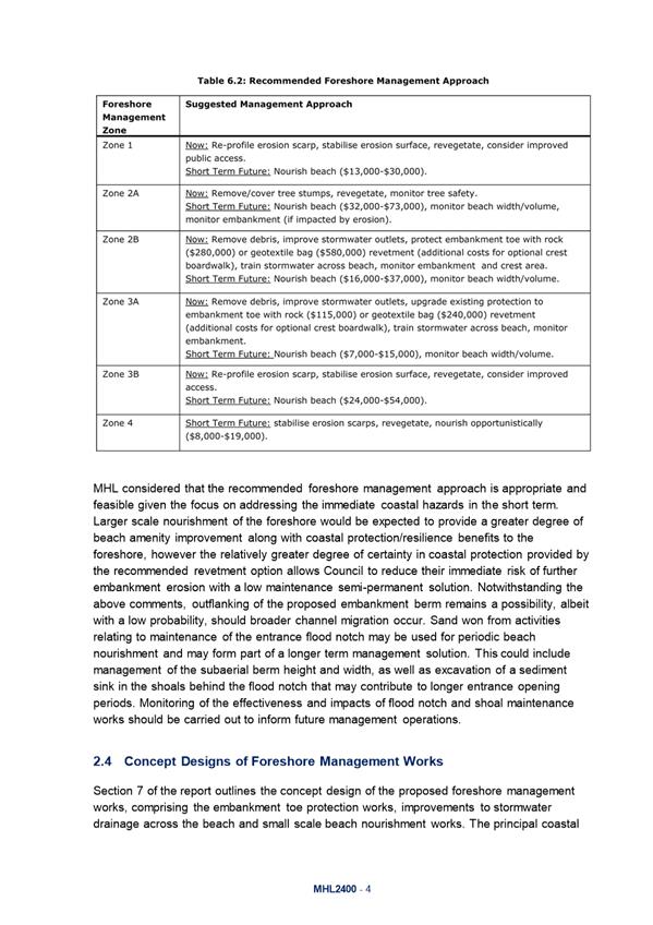
The technical report divides the
foreshore area up into six (6) prioritised zones based on coastal hazard and
geo-technical risks impacting each zone. The study identified nine (9)
management options:
1. Do nothing
2. Monitoring with no
active management works
3. Monitoring in
combination with management works
4. Relocating existing
sand located within the beach area
5. Stabilisation of
erosion scarps and revegetation
6. Protection structures
(rock or geotextile revetment)
7. Repairs and
improvements to stormwater outlets on the beach
8. Improvements to
stormwater control across the beach
9. Nourishment of the
beach
The report recommends which of
the nine (9) foreshore management options are best suited to each foreshore
management zone, as outlined in the figures below.
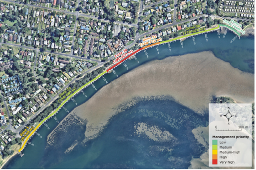
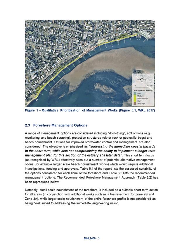
Figure 1: Qualitative
Prioritisation of the Foreshore Management Zones
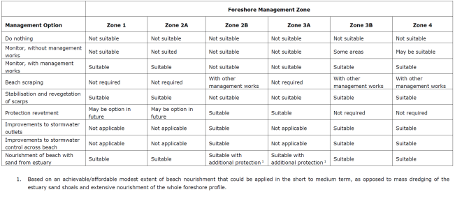
Figure 2: Suitability of
Management Options for the Foreshore Zones
Consultation on the WRL
technical report has was undertaken with the Shoalhaven Heads Community Forum
members, Shoalhaven Heads Estuary Taskforce and the Shoalhaven Heads community.
The community identified the
need to address and manage the storm water impacts and maintain the visual
amenity.
Stormwater management and
discharge is Council’s Asset and Works priority and a specialist
stormwater design is needed with soft engineering options to be included. These
conditions will provide erosion remediation of the whole frontage in one
project, as requested by the community.
Upon the communities’
request, Council sought a technical peer review of the WRL report and engaged
Edward Couriel, Director, Manly Hydraulics Laboratory (MHL).
MHL are the technical arm of NSW
Public Works Division. Edward Couriel is a qualified Coastal Engineer and has
over 20 years’ experience in coastal and estuarine engineering studies
and is well placed to provide a pragmatic coastal engineering review of the WRL
Technical Report. A copy of the MHL report is contained within Attachment 1.
The review recommends that a
larger entrance scenario be adopted for the design of erosion control
structures, as discussed in the WRL options report. The design modifications
are expected to have a minor construction cost increase and an improved asset
class and lifespan.
MHL also recommended that
Council undertake a comparison of the life cycle cost and benefits of the WRL
recommended 10-year design life of the erosion control structure compared with
a longer serviceable life cycles of 25 and 50 years.
The peer review also highly
recommended beach nourishment to some degree, as part of any longer-term
foreshore management options adopted. As this may be warranted due to the
potential benefits and cost savings of this management option, given the extensive
environmental approvals associated with the sand nourishment options, the peer
review recommended exploring sourcing sand behind the river entrance flood
notch, where a “wet notch” was trialled in the 1990’s.
It is recommended that this
option be reviewed as part of the 2018 Lower Shoalhaven River Flood Risk
Management Study and the associated review of the Shoalhaven River Entrance
Management Plan.
If this is a viable option, it
would provide, along with the maintenance of the dry flood notch, a moderate
sand supply for repeat sand nourishment to the River Road foreshore areas and
potentially extend the “life of the next entrance breakout”.
Community Engagement
Extensive community consultation
has already taken place in the development of the WRL foreshore management
options report via the Shoalhaven Heads Estuary Taskforce and the Shoalhaven
Heads Community Forum and at a community drop-in session at the Shoalhaven
Heads community centre on Sunday 9 April 2017.
The community identified the
need to address stormwater management and retain the visual and recreational
amenity of the River Rd foreshore in any management options undertaken.
Members of the Shoalhaven Heads
Estuary Taskforce requested Council obtain a technical peer review of the WRL
report by another suitably qualified and experienced coastal engineer to assess
if the recommended management options outlined in the WRL report are the best
possible options. This technical review was completed as described above.
Financial Implications
In October 2017, Council, in
consultation with the Shoalhaven Heads Community Forum, applied to the NSW
Regional Growth – Environmental and Tourism – Restart NSW grant
program for $1, 588,000 to undertake the coastal erosion management options
recommended by WRL. Of this $1,588,000, Council would be contributing $550,000
for the storm water management works, rock protection and revegetation works.
The cost of the peer review undertaken by MHL was $2,500.
The MHL peer review recommends
designing the foreshore erosion remediation structures to a minimum design life
of 25 years and for a large river entrance opening. This is likely to increase
the cost of the structure, as larger sized rocks will be required. This will
need to be costed as part of the detailed design process.
|

|
Addendum Agenda - Shoalhaven
Natural Resource & Floodplain Management Committee – Wednesday 18
April 2018
Page
14
|
|

|
Addendum Agenda - Shoalhaven
Natural Resource & Floodplain Management Committee – Wednesday 18
April 2018
Page
19
|
SN18.10 Undertaking
a Scientific Analysis of the Shoalhaven Dredging Program
HPERM Ref: D18/80719
Group: Planning
Environment & Development Group
Section: Environmental
Services
Purpose / Summary
To provide information on what
scientific indicators could be used to undertake a scientific analysis/study of
the 2016 Shoalhaven Citywide Dredging Program.
|
Recommendation
:
1. Receive
the report for information; and
2. Include
the development and implementation of a scientifically based environmental monitoring
and evaluation program in the project brief and
design of any future dredging projects and other large-scale Council
projects. This will ensure that:
· the
implementation and success of projects can be monitored and evaluated;
· reduce the risk
of failure of environmental controls and mitigation measures and potential
increased project costs;
· ensure
compliance with legislative obligations; and
· learn valuable
lessons for future projects to avoid and minimise potential environmental and
community impacts and therefore save resources, time and money.
The scale of an environmental
monitoring and evaluation program would be dependent upon the scale of the
proposed project and potential direct and indirect environmental impacts.
|
Options
1. As recommended.
Implications: The development
and implementation of a scientifically rigorous environmental monitoring and
evaluation program for any future dredging projects will need to be included in
the project brief to ensure resources and budget are allocated. The number of
parameters included in and the size of the program would depend upon the scale
of the proposed project, its location and potential environmental impacts.
2. Council propose
alternative recommendation
Implications: Would depend on the recommendation
Background
At the Committee meeting of 22
November 2017, the Committee resolved:
“That
Council staff consider the Shoalhaven Natural Resources and Floodplain
Management Committee’s request to undertake a scientific analysis of the
dredging and report back to the Committee on how staff can undertake this and
how the University of Wollongong can be incorporated into this.”
In
2016, Council undertook the following dredging and creek/dune protection
projects:
· Currambene
Creek Navigation Channel (removal of a small quantity of rock only);
· Sussex
Inlet Navigation Channel;
· Sussex
Inlet Canals (Rivera Keys Estate);
· Lake
Conjola Configuration Dredging; and
· Mollymook
Beach Dune Protection (Blackwater Creek).
The Shoalhaven Dredging Project,
Review of Environmental Factors (REF), prepared by Royal Haskoning DHV (2015),
recommended the monitoring listed below. The main aim of the REF was to design
the project to avoid direct environmental impacts. The purpose of the creek and
dune protection works was to restore eroded dune and foreshore areas and
protect assets.
Monitoring of dredged areas – Using
hydrographic surveys to monitor the dredge area prior to and immediately
following the dredging works to determine the dredge depth and width. The REF
recommended that these hydrographic surveys be continued biannually for the
first year and annually for the following four years to assess the changes in
sediment composition and changes in the dredge channel morphology.
Monitoring of nourishment areas – Surveys of
nourished areas at Lake Conjola, Sussex Inlet and Mollymook Beach to gain an
understanding of the behaviour of the nourishment material. It was recommended
that these nourishment areas should be surveyed annually for 3 years post
nourishment.
The REF also recommended that photographic monitoring be
undertaken of all nourishment areas.
This monitoring is being
undertaken by Council. A copy of the REF can be viewed on Council’s
website.
https://shoalhaven.nsw.gov.au/LinkClick.aspx?fileticket=2SA6vO8kPYQ%3d&portalid=3
Scientific Indicators for
Assessing Dredging Impacts
In order to undertake additional
monitoring, quantitative data would need to have need been collected pre and
post dredging works. This would provide the ability to analyse pre and post
conditions to enable any meaningful analysis of changes in estuary health as a
result of dredging.
The commonly used scientific
indicators for analysing the health of intermittently closed and opened lakes
and lagoons (ICOLLS) on the NSW Coast are tidal regimes, channel morphology,
water quality, estuarine vegetation health, marine species numbers and habitat
health and benthic macroinvertebrate population health.
It must be noted that there are
many factors that influence or affect estuary health, including the indicators
above. Careful selection of indicators is necessary to ensure that meaningful
data is collected and that it is the actual impact of dredging that is being
monitored rather than just general estuary health.
Below is a discussion of
potential indicators that could be used to monitor estuary health as part of a
dredging project.
Potential Indicators
Tidal Regime
– Although the aim of dredging works is not to create or prolong the
opening of the estuaries, data on the changes in the range of tidal variation
in the estuaries yearly tidal planes, the average water levels and the tidal
prisms could be used to analyse any tidal changes and water levels prior to and
post dredging. Other variables that would affect this data, include the
condition of the estuary entrance and or any artificial openings.
Is this data available?
Water level and tidal data is available via the gauges located within Sussex
Inlet and Lake Conjola.
Estuary channel morphology
– Large scale dredging can change estuary channel morphology (depth &
width) which may affect tidal velocities and in turn change the pattern and
dimensions of shoaling and scouring in estuary entrances. Useful data collected
on channel morphology can show specific areas where scouring or accretion has
occurred pre and post dredging. The use of hydro-surveys is one method that can
be used to assess channel morphology, as well as analysis of aerial
photographic data and digital satellite.
Is this data available?
Council undertook hydro-surveys of the actual dredge sites during dredging and
after works were completed. Aerial photography is readily available and fairly
easy to assess, however, the use of digital satellite data is not available and
is relatively expensive.
Water quality –
The collection of water quality data is one of the key indicators used to
assess the health of estuaries.
Turbidity levels were monitored
during the actual dredging works. Turbidity levels are a useful indicator to
use to assess water quality effects of dredging due to the disturbance of
sediments. Other water quality data that could be collected pre and post
dredging works to assess likely impacts, include dissolved oxygen levels,
nitrogen (TN), temperature, salinity and phosphorous (TP). Although in
order to get any meaningful data that would show any impacts of dredging on
water quality for pre and post dredging, the testing would need to be
undertaken within close proximity to the dredging location. As turbidity levels
remained within REF trigger levels no additional water quality monitoring was
undertaken.
Is this data available?
– As part of Council’s water quality data monitoring program,
samples are collected and analysed for Lake Conjola, Sussex Inlet
and Currambene Creek. Water quality tests include temperature, dissolved
oxygen, faecal coliforms (CFU/100ml), enterococci (cfu/100ml), phosphorus
(mg/L) and total nitrogen (mg/L). This data is available for pre and post
dredging, however the water quality test sites are located between 300 metres
to 500 metres from the dredge sites and therefore an indicator of general
estuary health not dredging. Results of Council’s water quality
monitoring program can be found on Council’s AquaData website at https://www.shoalhaven.nsw.gov.au/Environment/Aqua-Data
Estuarine vegetation
health – To assess the ecological impacts on estuarine
vegetation from any dredging activities accurately, the vegetation communities
need to be mapped and their condition assessed. The vegetation communities
including seagrasses, saltmarsh, mangroves and swamp oak forest (casuarina) can
be impacted by changes in water level, velocities and quality. Pre and post
monitoring of the health and condition of these estuarine vegetation
communities in locations that could be affected by a dredging project should be
undertaken in order to quantify changes in vegetation health.
Is this data available?
There is broad scale mapping available of vegetation types for each of the
estuaries. As part of the Shoalhaven Dredging REF individual threatened species
and threatened ecological communities were identified and assessed. The
dredging works were designed to avoid direct impact on estuarine vegetation.
Marine species populations
– Some marine fish species utilise estuaries for short periods of time,
at a specific period of their life cycle whilst others spend longer periods of
time within estuaries. It has been estimated that 60% by weight of the NSW
commercial fish catch consisted of species that are dependent on estuaries at
some stage of their life cycle (Edgar 2001).
The use of fish and prawn
population health to estimate the health of estuaries is difficult and
problematic. As different species benefit or increase in estuaries that are in
a closed state whilst others may not be tolerant of a closed entrance
conditions. Jones and West (2005) in their study of seagrass fish communities
in six NSW South Coast ICOLL’s, found that artificially opening the
entrance of Lake Conjola to alleviate flooding resulted in the loss of large
seagrass beds and subsequent decline in recruitment of economically important
fish species to that area.
Their research indicated that
artificial openings of lakes or carrying out entrance works, should be done
with great caution as the impact of these activities on fish communities
remains largely unpredictable (Jones & West 2005).
What data is available?
– The NSW Department of Primary Industries - Fisheries may
have data on fish populations.
Benthic macroinvertebrates
populations – The abundance and diversity of macroinvertebrates
is often used as an indicator to assess the condition and health of an estuary,
river or stream.
In order to undertake any
scientific analysis using this indicator, detailed sample surveys of population
within the estuary at each dredging location and control sites would need to be
collected pre and post dredging activities to be able to quantitatively assess
potential impacts, if any on the population.
What data is available?
– Nil
Conclusion
In conclusion, further scientific analysis of the 2016
dredging works, other than the monitoring that has already been carried out, is
not feasible for the additional indicators discussed above, because baseline
conditions were not collected before the commencement of the dredging. The aim
of the dredging REF was to avoid direct impacts and included other mitigation
measures.
There is reliable water quality data available to analyse
the changes in estuary health pre and post dredging operations. However, this
data is limited by the location of Council’s existing water quality
testing sites and would only provide information about general estuary health
and not changes in estuary health as a result of dredging. Water quality
monitoring, in accordance with NSW Environment Protection Authority (EPA)
requirements, for turbidity was carried out during dredging operations.
Turbidity remained within acceptable levels.
There is also reliable data available to assess tidal
regimes. However, given the smaller scale of the dredging works, and the that
fact that dredging had minimal influence on the estuary openings, this
indicator is unlikely to identify changes to estuary health as a result of the
dredging.
Future monitoring programs could
be designed and implemented in collaboration with a research institution such
as the University of Wollongong. To address the request by the Committee for
“scientific analysis of the dredging”, any future monitoring
and evaluation program could consider the collection of pre and post dredging
data using the following scientific indicators:
· Tidal regimes
· Channel morphology
· Water quality
· Estuarine
vegetation distribution and health
· Marine species
population health and benthic macroinvertebrate population health
Financial Implications
Any scientific analysis and
collection of data for the purposes of assessing changes to the health of
estuaries as a result of dredging activities will require additional resources
and financial input. Therefore, a monitoring and evaluation program needs to be
included as part of the overall project. There is opportunity to partner with
research organisations and seek funding for monitoring.
Risk Implications
The risk implications for not
undertaking any scientific analysis of the dredging programs/works nominated in
this report are, at this time, minimal. Works have been completed and no direct
adverse impacts detected nor any indication of adverse indirect impacts. It is
relevant however, to consider additional environmental monitoring associated
with future dredging operations, depending on the scale of the proposal,
longevity and identified environmental concerns in the particular area.
|

|
Addendum Agenda - Shoalhaven
Natural Resource & Floodplain Management Committee – Wednesday 18
April 2018
Page
20
|
SN18.11 Proposed
Millards Creek and Currarong Creek Flood Study Projects
HPERM Ref: D18/68633
Group: Planning
Environment & Development Group
Section: Environmental
Services
Purpose / Summary
To inform the Committee and
Council of the success in receiving grant funding from NSW Office of
Environment and Heritage (OEH) for the Millards Creek Flood Study and Currarong
Creek Flood Study.
|
Recommendation
The Committee recommends that
Council:
1. Accept the OEH grant of $88,666
toward the cost of the flood study for Millards Creek;
2. Council allocate $44,333 from the
2017/18 Flood Programme budget (Job Number 15706) as Council’s
contribution to the Millards Creek Flood Study;
3. Accept the OEH grant of $77,000
toward the cost of the flood study for Currarong Creek; and
4. Council allocate $38,500 from the
2017/18 Flood Programme budget (Job Number 15706) as Council’s
contribution to the Currarong Creek Flood Study;
|
Options
1. As recommended
Implications: Funding for
the Millards Creek Flood Study of $88,666.67 and Currarong Creek Flood Study of
$77,000.00 have been provided under the NSW State Government ‘Floodplain
Management Program’ on a 2:1 basis. Council’s contribution of
$44,333 for Millards Creek and $38,500 for Currarong Creek comes from the
existing Floodplain Program budget.
2. The Committee could choose to provide
an alternative recommendation for future consideration by Council.
Implications: Unknown
Background
Both projects are the first
stage of the Floodplain Management process, where Council and the community are
seeking to identify the flooding problem of Millards Creek and Currarong Creek,
and its tributaries.
Preparation of the technical
brief for the flood studies has commenced. The next step will be to seek
quotations from suitably qualified consultants via a tender process.
Proposed Millards Creek Flood
Study
Millards Creek is located within
the Milton-Ulladulla urban area. The watercourse starts from Slaughterhouse Road
Milton and discharges into Ulladulla Harbour. There is a history of overland
flooding effecting residential properties within the Millards Creek catchment.
A number of site specific studies exist, however, they do not capture the
catchment holistically. The proposed flood study, will not only look at
Millards Creek and its unnamed tributaries but will also consider overland
flows. The information available about this catchment is minimal and thus the
flood study would give Council better intelligence.
Proposed Currarong Creek
Flood Study
Currarong Creek originates from
the highlands of Beecroft Peninsula, flows through the Currarong Township and discharges
to the Tasman Sea. Black Caves Creek joins Currarong Creek near the Currarong
Road Bridge, and the combined flow discharges to the ocean.
Currarong is famous for its
tourist attractions such as Abrahams Bosom Reserve and Point Perpendicular
Lighthouse and lookout. No site-specific flood studies exist and the current
information available about this catchment is minimal. The flood study would
give Council better intelligence for both development controls and flood
response.
Community Engagement
Advancing Council’s
long-term floodplain management program ensures that economic, social and
environmental factors relating to the management of floodplains within the
Shoalhaven are considered, documented and implemented in Council’s
planning programs and policies.
The community will be engaged
throughout the duration of the project. Typically, a flood study project
includes an initial mail-out and notifications via electronic media to inform
residents and ratepayers within the flood study area. Community meetings and drop
in sessions would typically be conducted throughout the project. In
addition to this, the Shoalhaven Natural Resources and Floodplain Management
Committee would be consulted throughout the duration of the project.
Financial Implications
Funding for the Millards Creek Flood Study of $88,666.67 and
Currarong Creek Flood Study of $77,000.00 have been provided under the NSW
State Government ‘Floodplain Management Program’ on a 2:1
basis. Council’s contribution of $44,333 for Millards Creek and
$38,500 for Currarong Creek comes from the existing Floodplain Program budget.
The project is for the provision
of consultancy works and will not have any direct or immediate implications on
Council’s assets.
The tendering and studies will
be undertaken by consultants who will be managed by the Natural Resources and
Floodplain Unit of Council.
Risk Implications
No risk implications are applicable if Council undertakes
both studies. Council will gain valuable information about the flood behaviour
for both catchments, which will inform future land use planning and flood
emergency management processes.
Council has a statutory responsibility for land use planning
and management under the Environmental Planning and Assessment Act. If Council
decides not to undertake these studies, the risk may be poor land use planning
and emergency management for these areas. In addition, obligations under the
Floodplain Development Manual (2005) will not be met.