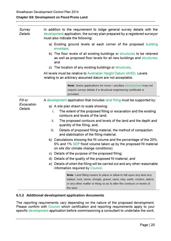
|

|
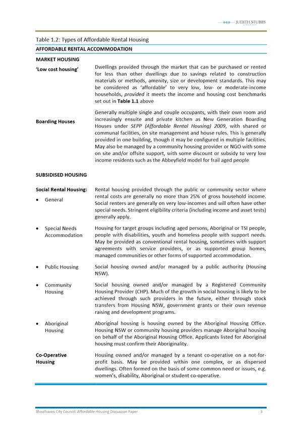
Development Committee
– Monday 07 November 2016
|
Development Committee
Meeting Date: Monday, 07 November, 2016
Location: Council
Chambers, City Administrative Building, Bridge Road, Nowra
Attachments (Under Separate Cover)
Index
4. Reports
DE16.4 Exhibition
Outcomes/Finalisation - Shoalhaven Development Control Plan 2014 - Draft
Amendment No 5 - Stage 2 Housekeeping
Attachment
1... Development Committee Report 3/5/16 - draft Amendment No. 5 Shoalhaven DCP
2014........................................................... 2
Attachment
2... Summary of Submissions - DCP Stage 2 Amendment No. 5 65
Attachment
3... Submission Attachment - Natural Resources & Floodplain Unit - Site
specific controls - DCP G9 - Updated Flood Risk Management Study and Plan................................................................................ 70
Attachment
4... Post Exhibition Changes - Track Changes PDF version DCP2014 Chapter G9:
Development on Flood Prone Land................. 73
DE16.5...... Development
of an Affordable Housing Strategy for Shoalhaven
Attachment
1... Affordable Housing Background Report............................ 136
Attachment
2... Affordable Housing Discussion Paper................................ 325
Attachment
3... Framework for Affordable Housing Strategy..................... 396
DE16.8...... Development
Application – 25 Junction Street, Nowra – Lot 1 DP 81167 DP
Attachment
1... Draft Development Consent............................................... 409
Attachment
2... Section 79C Planning Assessment Report......................... 426
Attachment
3... Draft Refusal....................................................................... 450
|

|
Development Committee
– Monday 07 November 2016
Page
2
|


|

|
Development Committee
– Monday 07 November 2016
Page
43
|


|
|
Development Committee
– Monday 07 November 2016
Page
47
|


|
|
Development Committee – Monday 07 November 2016
Page 65
|
|
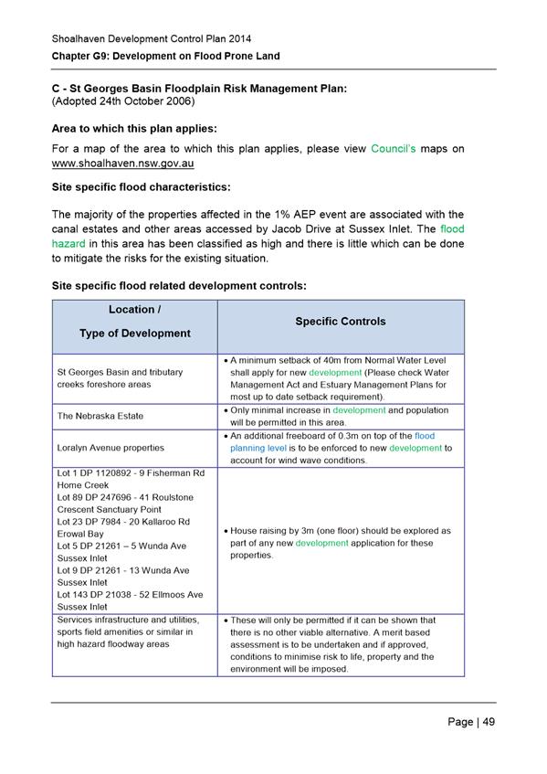
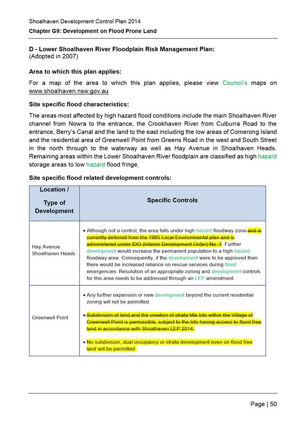
Submission
|
Submission Summary
|
Comments
|
Recommendations
|
|
External submission
|
|
No. 1
D16/170061
|
a) Submission
from Cowman Stoddart Pty Ltd on behalf of landowners of 1 Greens Road,
Greenwell Point. Land is zoned R2 Low Density Residential with a minimum lot
size of 500m2 in Shoalhaven LEP 2014. Seek to enable the subdivision of the
size in accordance with the provisions of the LEP.
b) Supports
the proposed changes to Part D of Schedule 5 of G9: Development on Flood
Prone Land. Proposed provisions will potentially allow client to subdivide
their land in Greenwell Point. Current DCP provisions which
prohibit the subdivision of land within Greenwell Point are inconsistent with
the LEP zoning provisions and Section 74BA of the Environmental Planning
& Act (EP&A Act).
c) Note
that the provisions outlined in the current Part D Schedule 5 of Chapter G9
indicate that they have been imposed pursuant to the recommendations of the
Lower Shoalhaven River Floodplain Risk Management Plan (LSRFRMP). The LSRFRMP
does not specifically stipulate that subdivision should be prohibited within
Greenwell Point.
|
Support noted.
The exhibited change reflects Council’s
resolved position of 15 December 2015 (MIN15.813) to allow the subdivision
and creation of strata title lots within the Village of Greenwell Point
subject to whether strata or real property having access to flood free land,
in compliance with Shoalhaven LEP 2014.
In relation to Greenwell Point the LSRFRMP
identifies significant flood risk issues including significant flood
affectation (e.g. in a 1 in 10 year flood event, 137 buildings will be
flooded above floor level); and lack of flood free access (Greenwell Point
Road is cut-off regularly). It states that the existing residential area
should not be expanded, and that “…significant new development
should be prevented but may need to be considered on its merits due to
increasing development pressures.”
The intent of the previous provisions was to
prevent increases to the population density in any areas (flood prone or
flood free) with restricted evacuation access. Council’s Natural
Resources and Flood Unit have raised concerns with the proposed amendment and
this issue is further discussed later in this table.
|
No changes recommended regarding this submission,
however this issue is discussed further in response to submission 3.
|
|
Internal submissions
|
|
No. 2
D16/160001
|
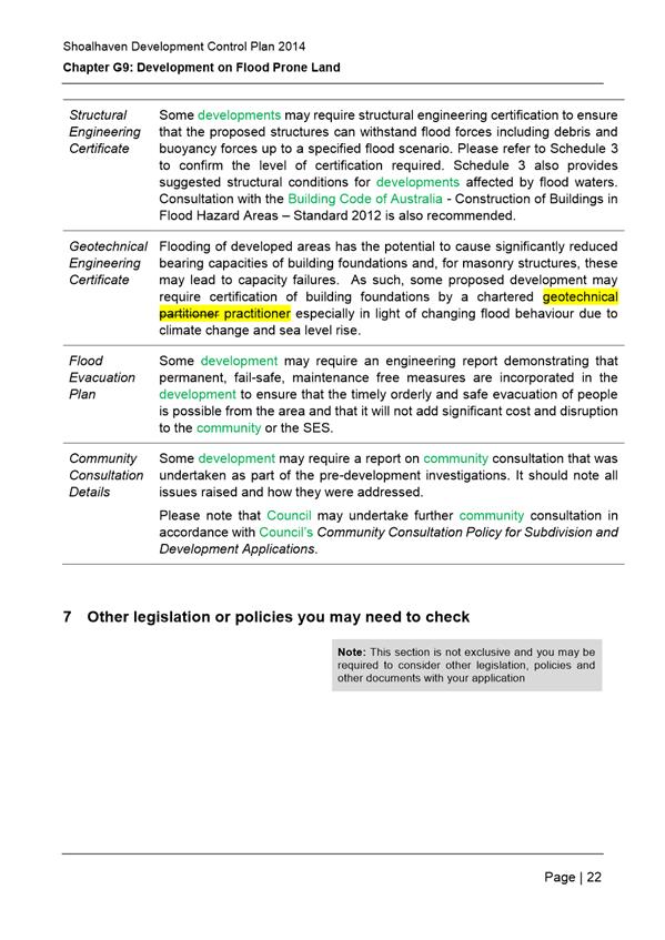
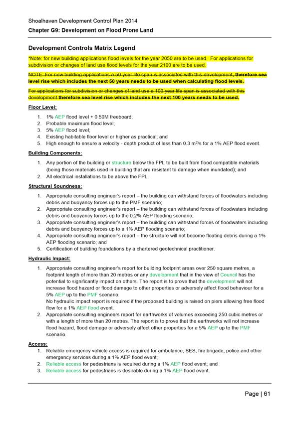
Correction of a typo error on page 23: ‘chartered
geotechnical partitioner’ should read ‘chartered
geotechnical practitioner’.
|
Minor typographical change supported.
|
Recommendation:
Correct minor typing error on page 23 to read
‘chartered geotechnical practitioner’.
|
|
No. 3
D16/196266
D16/285902
|
Council’s Natural Resources Floodplain Unit
ran staff workshops on the proposed amendments and has suggested the
following edits as a result of feedback received at the workshops.
Minor edits:
· Section 5, 5.1, part iv: remove
‘to’ at the beginning of the dot point
· Section 6.1.3: first dot point:
should say ‘section 5’ not ‘section 9’
· Section 6.2: step 8: refer to
‘section 8’, not ‘section 7’
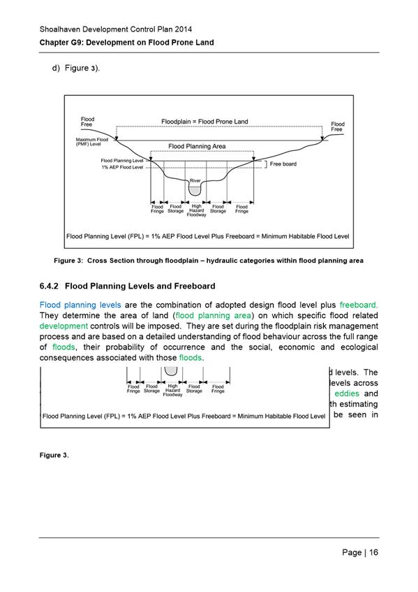
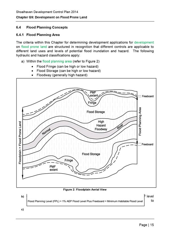
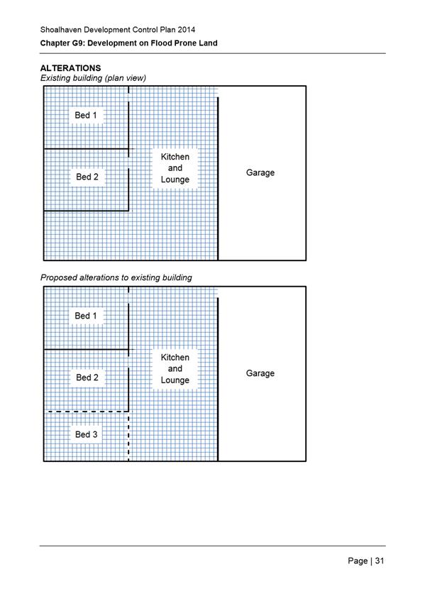
· Section 6.4.1, Figure 3: text
in figure should say ‘minimum habitable floor level’, not
‘minimum floor level’
· Schedule 6:
Fix the page numbering on the
Development Controls Matrix Legend and add an asterisk at the end of each
point under the heading ‘floor level’.
Under the Development Controls
Matrix Legend: change the two sentences to read “*Note: for new
building applications flood levels for the year 2050 are to be used.
For applications for subdivision or changes of land use flood levels for the
year 2100 are to be used.” Add an asterisk at the end of each
point under the heading “floor level”
Comments received at the staff workshops indicated
that the current wording and format is unclear.
|
Minor editorial changes supported.
Review of current wording and formatting is
outside of the scope of this current housekeeping amendment. The current
wording and formatting should be simplified through a future amendment to
Chapter G9: Development on Flood Prone Land.
|
Recommendation:
Amend Chapter G9 to implement the following
changes:
- Section
5.1, iv. (page 5) – remove ‘to’ at the beginning of the dot
point.
- Section
6.1.3: first dot point: replace ‘section 9’ with ‘section
5’
- Section
6.2: step 8: replace ‘section 7’, with ‘section
8’
- Section
6.4.1, Figure 3: text in figure should say ‘minimum habitable floor
level’, not ‘minimum floor level’
- Schedule
6: Update page numbering
- Schedule
6: Include an asterisk at the end of each point under the heading
‘floor level’.
- Schedule
6: Fix the page numbering on the Development Controls Matrix Legend and add
an asterisk at the end of each point under the heading ‘floor level’.
- Schedule
6: Generic - Under the Development Controls Matrix Legend: change the two
sentences to read “*Note: for new building applications flood levels
for the year 2050 are to be used. For applications for subdivision or
changes of land use flood levels for the year 2100 are to be used.”
Add an asterisk at the end of each point under the heading “floor
level”
Recommendation:
Undertake a future review of Chapter G9:
Development on Flood Prone Lane to improve the readability of controls with
simplified wording and formatting.
|
|
|
Councils Natural Resources and Floodplain Unit
does not support the proposed change to Schedule 5, D, to allow subdivision
within Greenwell Point given that it is inconsistent with the remainder of
the Chapter and the Lower Shoalhaven River Floodplain Risk Management Study
and Plan (FRMSP).
The Chapter does not support subdivision if it
increases the potential population density in any areas (flood prone or flood
free) with restricted evacuation access. The FRMSP includes this as a
recommended control due to the significant flood risk within Greenwell Point,
and the isolation and loss of essential services that will occur, even to
flood free properties, in the event of a 1% AEP flood event, or larger.
It is recommended the controls in this row are returned to how they are
stated in the adopted FRMSP.
The Natural Resources and Floodplain Unit raised
concerns that Council had inadequate information when the Development
Committee resolved to amend Part D in Schedule 5 of Chapter G9 to allow
subdivision subject to properties having access to flood free land, in
compliance with Shoalhaven LEP 2014.
|
Following a Notice of Motion, Council resolved on
15 December 2015 to amend Part (D) in Schedule 5 of Chapter G9 (MIN15.813) to
allow the subdivision and creation of strata title lots within the Village of
Greenwell Point subject to the property having access to flood free land, in
compliance with Shoalhaven LEP 2014.
A DCP control cannot prohibit possible development
in the LEP, however the concerns raised warrant some consideration to ensure
outcomes from the Lower Shoalhaven River FRMSP are acknowledged. To alleviate
flood risk and ensure suitable controls are provided, it is recommended that
this issue be deferred to allow further investigation into possible
alternative provisions that could be included in the LEP. Consistency with
the FRMSP is important to ensure Council’s planning documents include
suitable controls consistent with the Floodplain Development Manual and
Guidelines and to ensure Council is acting in good faith when providing flood
risk controls to ensure legal indemnity is maintained. Legal advice is
required to clarify the situation.
|
Recommendation:
a) Defer the draft changes to
Chapter G9: Development on Flood Prone Land relating to subdivision in
Greenwell Point to seek legal advice and to consider alternative provisions
in the LEP to implement development controls identified in the Lower
Shoalhaven River Floodplain Risk Management Plan.
b) Revert to the original wording
in the Part D, Schedule 5 in Chapter G9 to replace the second doing point
with the following wording:
“No
subdivision, dual occupancy or strata development even on flood free land
will be permitted.”
|
|
|
Need to update Schedule 5 to reflect the recently
adopted FRMSPs for: Kangaroo River, Bomaderry Creek, Nowra and Browns Creeks,
Currambene and Moona Moona Creeks and Tabourie Lake. The site specific
controls from the FRMSPs need to be added to Schedule 5. Requested update to
Schedule 5 included as an attachment to submission.
|
Support the requested changes to include relevant
controls from the adopted FRMSPs for
Kangaroo River, Bomaderry Creek, Nowra and Browns
Creeks, Currambene and Moona Moona Creeks and Tabourie Lake.
|
Recommendation:
Update Schedule 5 to include site specific
controls from updated FRMSPs in accordance with Attachment 3 of the report.
|
|
No. 3
D16/302546
|
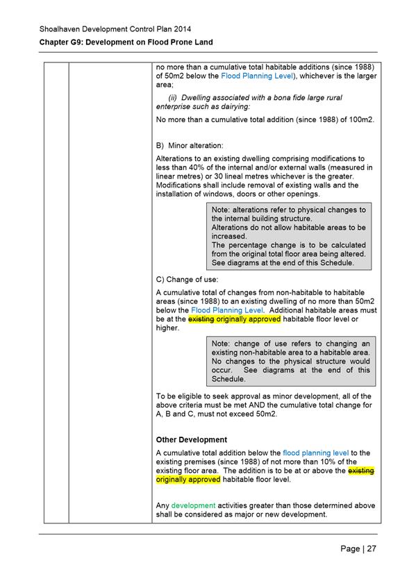
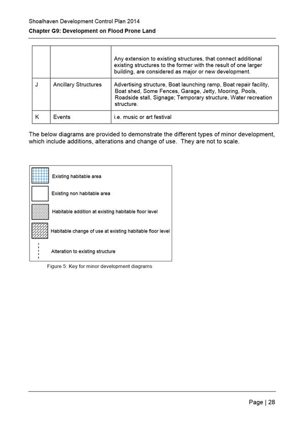
Schedule 1, row I (minor development) of Chapter
G9: clarify that ‘existing habitable floor level’ is the
originally approved habitable floor level.
Development Consents currently include conditions
that apply to pools in the flood plain, however there are no controls in
Chapter G9. Requests the inclusion of ‘Pools’ in Schedule 1, J
– Ancillary Structures.
|
Support the requested changes to clarify the
development controls and existing development conditions.
|
Recommendation:
Amend Chapter G9 Schedule 1 as follows:
- Row
I (minor development): clarify that ‘existing habitable floor
level’ is the originally approved habitable floor level
- Insert
‘Pools’ in the Schedule in Row J (Ancillary Structures).
|
|
No. 3
D16/287356
|
Provides the definitions of flood planning area,
flood planning level and flood prone land for both the DCP and Shoalhaven
Floodplain Development Manual.
States that Section 6.4 in Chapter G9 goes into
further detail about flood planning area and flood planning level, though
none of the definitions respond to the LEP. The definitions used by the
Flooding Unit for adopted flood risk management plans and studies are as per
the Floodplain Development Manual. The Definition of Flood Planning Area in
the Manual is the 1% + 0.5m (flood planning level) and this is not referring
to the Flood Planning Area map in the SLEP 2014.
Definition of flood prone land needs to be amended
in DCP G9 as it refers to the “Flood Prone Map” in SCC office
which no longer exists.
|
The concerns regarding conflicting definitions for
Flood Planning Area, Flood Planning Level and Flood Prone Land in the LEP
& DCP are valid.
The Dictionary and Clause 7.3 Flood Planning in
Shoalhaven LEP 2014 do not provide clear definitions except for Clause 7.3
(5) which provides the following definition:
‘flood planning
level’ means the level of a 1:100 ARI (average recurrent interval)
flood event plus 0.5 metre freeboard.
Clause 7.3 (4) in the LEP states that words or
meanings used in this clause has the same meaning as it has in the Floodplain
Development Manual (ISBN 0 7347 5476 0) published by the NSW Government
in April 2005, unless it is otherwise defined in this clause.
To ensure consistency between the LEP and DCP
provisions, it is recommended that the DCP definitions be updated to
reference the definition of ‘flood planning level’ in LEP Clause
7.3 and to replace the definitions of ‘flood prone land’ and
‘flood planning area’ as per the Floodplain Development Manual.
|
Recommendation:
Amend the DCP Dictionary, Chapter G9 and Chapter
G10 to update definitions of ‘Flood Planning Area’, ‘Flood
Planning Level’ (FPLs) and ‘Flood Prone Land’ as follows:
a) Refer
to the SLEP 2014 definition of ‘Flood Planning Level’ as per
Clause 7.3 (4) by colouring the term ‘flood planning level’ blue
throughout Chapter G9 and G10 to indicate an LEP dictionary definition as per
Chapter G1 Introduction of Shoalhaven DCP 2014.
b) Replace
the exhibited dictionary definitions for ‘Flood Planning Area’
and ‘Flood Prone Land’ as per the Floodplain Development Manual:
· ‘Flood planning
area’ is the area of land below the FPL and thus subject to flood
related development controls. The concept of flood planning area
generally superseded the “flood liable lands” concept in the 1986
Manual; and
· ‘Flood prone land’
is the land susceptible to flooding by the PMF event. Flood prone land
is synonymous with flood liable land.
c) Amend
the note boxes in Section 1 Purpose in Chapter G9 and G10 provide explanatory
information regarding the updated definitions.
d) Update
Chapter G9 and G10 to reflect the revised dictionary definitions as required.
|
|

|
Development Committee – Monday 07 November 2016
Page 69
|
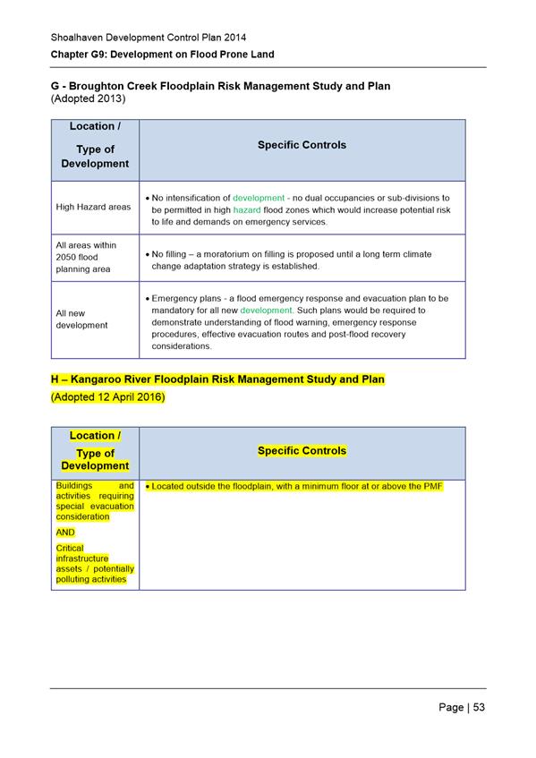
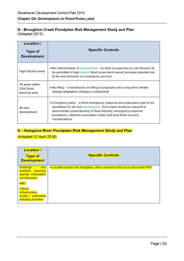
H – Kangaroo River Floodplain Risk Management
Study and Plan
(Adopted 12 April 2016)
|
Location /
Type of Development
|
Specific Controls
|
|
Buildings and activities requiring
special evacuation consideration
AND
Critical infrastructure assets /
potentially polluting activities
|
· Located outside the floodplain, with a
minimum floor at or above the PMF
|
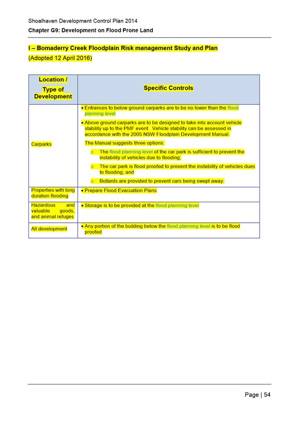
I
– Bomaderry Creek Floodplain Risk management Study and Plan
(Adopted 12 April 2016)
|
Location /
Type of Development
|
Specific Controls
|
|
Carparks
|
· Entrances to below ground carparks are to
be no lower than the flood planning level
· Above ground carparks are to be designed
to take into account vehicle stability up to the PMF event. Vehicle
stability can be assessed in accordance with the 2005 NSW Floodplain
Development Manual.
The Manual suggests three options:
o The flood planning level of the car park
is sufficient to prevent the instability of vehicles due to flooding;
o The car park is flood proofed to prevent
the instability of vehicles dues to flooding; and
o Bollards are provided to prevent cars
being swept away.
|
|
Properties with long duration flooding
|
· Prepare Flood Evacuation Plans
|
|
Hazardous and valuable goods, and animal
refuges
|
· Storage is to be provided at the flood
planning level
|
|
All development
|
· Any portion of the building below the
flood planning level is to be flood proofed
|
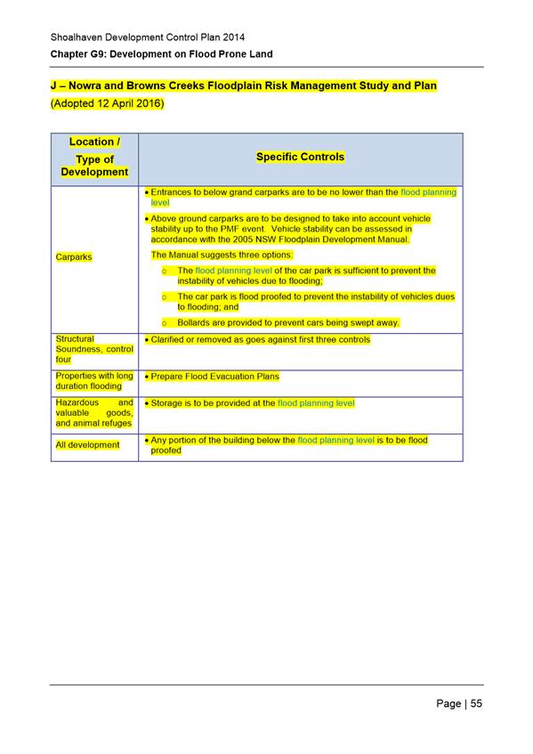
J
– Nowra and Browns Creeks Floodplain Risk Management Study and Plan
(Adopted 12 April 2016)
|
Location /
Type of Development
|
Specific Controls
|
|
Carparks
|
· Entrances to below grand carparks are to
be no lower than the flood planning level
· Above ground carparks are to be designed
to take into account vehicle stability up to the PMF event. Vehicle
stability can be assessed in accordance with the 2005 NSW Floodplain
Development Manual.
The Manual suggests three options:
o The flood planning level of the car park
is sufficient to prevent the instability of vehicles due to flooding;
o The car park is flood proofed to prevent
the instability of vehicles dues to flooding; and
o Bollards are provided to prevent cars
being swept away.
|
|
Structural Soundness, control four
|
· Clarified or removed as goes against
first three controls
|
|
Properties with long duration flooding
|
· Prepare Flood Evacuation Plans
|
|
Hazardous and valuable goods, and animal
refuges
|
· Storage is to be provided at the flood planning
level
|
|
All development
|
· Any portion of the building below the
flood planning level is to be flood proofed
|
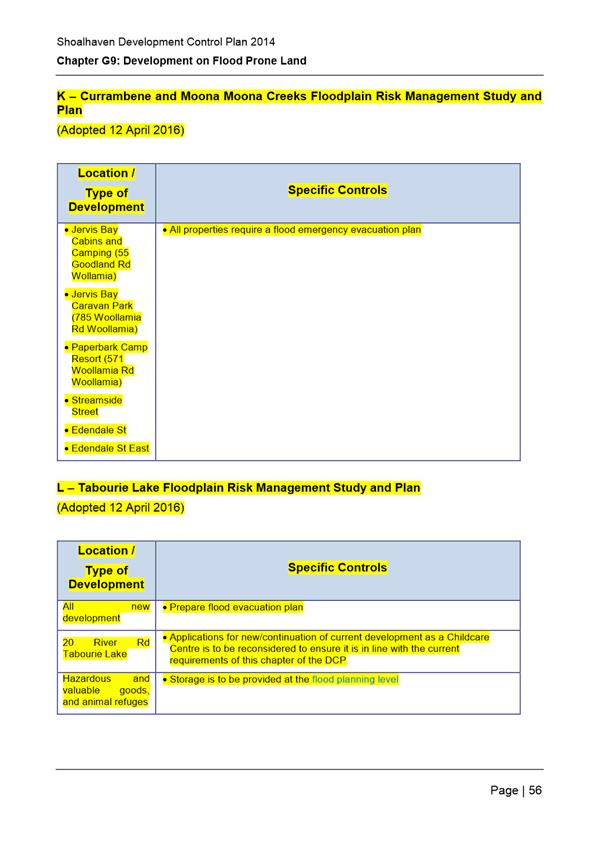
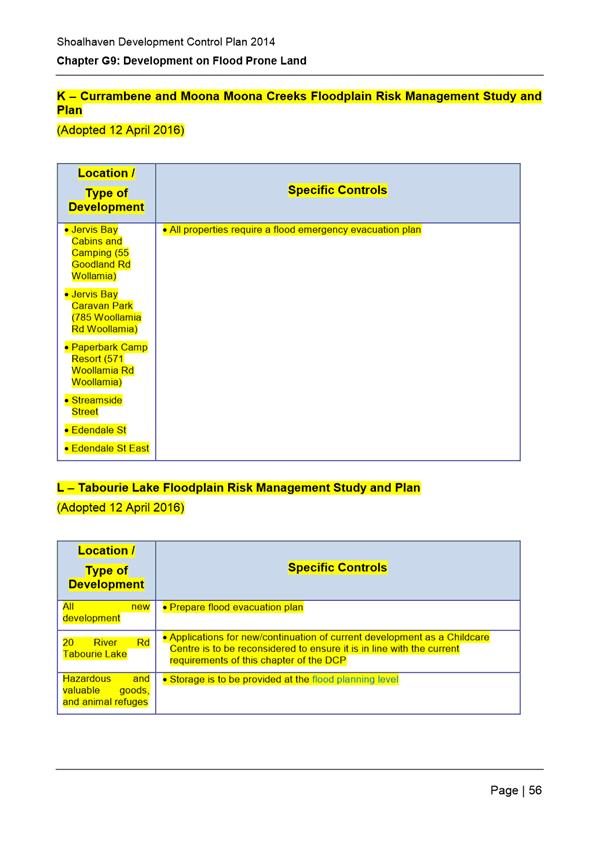
K – Currambene and Moona Moona Creeks Floodplain
Risk Management Study and Plan
(Adopted 12 April 2016)
|
Location /
Type of Development
|
Specific Controls
|
|
· Jervis Bay Cabins and Camping (55
Goodland Rd Wollamia)
· Jervis Bay Caravan Park (785 Woollamia Rd
Woollamia)
· Paperbark Camp Resort (571 Woollamia Rd
Woollamia)
· Streamside Street
· Edendale St
· Edendale St East
|
· All properties require a flood emergency
evacuation plan
|
L – Tabourie Lake Floodplain Risk Management
Study and Plan
(Adopted 12 April 2016)
|
Location /
Type of Development
|
Specific Controls
|
|
All new development
|
· Prepare flood evacuation plan
|
|
20 River Rd Tabourie Lake
|
· Applications for new/continuation of
current development as a Childcare Centre is to be reconsidered to ensure it
is in line with the current requirements of this chapter of the DCP
|
|
Hazardous and valuable goods, and animal
refuges
|
· Storage is to be provided at the flood
planning level
|
|
|
Development Committee
– Monday 07 November 2016
Page
72
|


|

|
Development Committee
– Monday 07 November 2016
Page
113
|

|

|
Development Committee
– Monday 07 November 2016
Page
117
|


|
|
Development Committee
– Monday 07 November 2016
Page
135
|


|

|
Development Committee
– Monday 07 November 2016
Page
165
|
|
|
Development Committee
– Monday 07 November 2016
Page
166
|

|
|
Development Committee
– Monday 07 November 2016
Page
181
|
|
|
Development Committee
– Monday 07 November 2016
Page
182
|
|
|
Development Committee
– Monday 07 November 2016
Page
183
|
|
|
Development Committee
– Monday 07 November 2016
Page
185
|
|
|
Development Committee
– Monday 07 November 2016
Page
188
|
|
|
Development Committee
– Monday 07 November 2016
Page
189
|


|
|
Development Committee
– Monday 07 November 2016
Page
243
|
|

|
Development Committee
– Monday 07 November 2016
Page
246
|
|
|
Development Committee
– Monday 07 November 2016
Page
252
|
|
|
Development Committee
– Monday 07 November 2016
Page
253
|
|
|
Development Committee
– Monday 07 November 2016
Page
260
|
|
|
Development Committee
– Monday 07 November 2016
Page
266
|
|
|
Development Committee
– Monday 07 November 2016
Page
274
|
|
|
Development Committee
– Monday 07 November 2016
Page
275
|
|
|
Development Committee
– Monday 07 November 2016
Page
281
|
|
|
Development Committee
– Monday 07 November 2016
Page
287
|

|

|
Development Committee
– Monday 07 November 2016
Page
319
|
|
|
Development Committee
– Monday 07 November 2016
Page
324
|

|
|
Development Committee
– Monday 07 November 2016
Page
346
|
|
|
Development Committee
– Monday 07 November 2016
Page
347
|
|
|
Development Committee
– Monday 07 November 2016
Page
357
|
|
|
Development Committee
– Monday 07 November 2016
Page
358
|
|
|
Development Committee
– Monday 07 November 2016
Page
365
|
|
|
Development Committee
– Monday 07 November 2016
Page
371
|
|
|
Development Committee
– Monday 07 November 2016
Page
377
|
|
|
Development Committee
– Monday 07 November 2016
Page
394
|

|
|
Development Committee
– Monday 07 November 2016
Page
395
|
Shoalhaven City Council:
Framework
for Affordable Housing Strategy

September 2016
This
framework has been prepared for
Shoalhaven
City Council
By

The Old Post Office
231
Princes Hwy, Bulli NSW 2516
Ph: 02
4283 7300
Fax: 02
4283 7399
info@judithstubbs.com.au
www.judithstubbs.com.au
Table of Contents
1 Background 3
2..... Purpose
of Affordable Housing Strategy 3
3..... Outline
of Contents of the Affordable Housing Strategy 3
3.1...... Rationale
for Strategy 3
3.2..... Affordable Housing Definition,
Principles and KPIs 4
3.3..... Potential Strategies and Mechanisms to
Deliver Affordable Housing 5
3.3.1............ Overview of Mechanisms
and Strategies 5
3.4..... Short-term Strategies: Direct
Intervention (‘Column 4’ above) 7
3.4.1............ Provision of Affordable
Housing on Council or Public Land 7
3.5..... Medium Term Strategies: Facilitative
Intervention (‘Column 2’ above) 8
3.5.1 Removing Planning
Impediments and/or Opening up Development Opportunities for Affordable Housing
Types 8
3.5.2............ Incentive-based
variations to facilitate affordable housing 10
3.6..... Longer-Term Strategies: Mandatory
Intervention (‘Column 3’ above) 11
3.6.1............ Mandating Affordable and
Low Cost Dwelling Types 11
3.7..... Administration 12
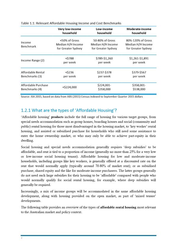
1 Background
This
document provides an outline of the proposed Shoalhaven Affordable Housing
Strategy (Strategy) that will be prepared for Shoalhaven City
Council (Council). The Strategy will be based on evidence of local
affordable housing need, the planning and housing market context, and will
outline achievable strategies and mechanisms that are most likely to be
effective the local context. This evidence is set out in:
JSA (2016) Affordable Housing
Background Report, Shoalhaven City Council; and
JSA (2016) Affordable
Strategic Discussion Paper, Shoalhaven City Council.
The Strategy
will be designed to be implemented in a number of key stages over the next
10 years, focussing initially on strategies that are most likely to have a
practical impact upon the supply of affordable housing, in particular, the
development of surplus or under-utilised Council land in partnership with other
government or community agencies and/or the private sector.
It
will also provide for ongoing and sustainable engagement of Council in
affordable housing through longer-term strategies related to relevant planning
mechanisms, amendments to relevant planning instruments, and monitoring the
effectiveness of the Strategy against relevant key performance
indicators (KPIs) over time.
2 Purpose of Affordable Housing
Strategy
The
proposed Strategy will provide Council with legal, feasible, equitable
and sustainable strategies and mechanisms to address priority affordable
housing needs and issues in the Shoalhaven Local Government Area (LGA).
The
proposed Strategy will also seek to provide leadership and
guidance on affordable housing needs and responses to government, the community
and private sector, and the wider community so that a range of efforts by
various stakeholders are supported.
3 Outline of Contents of the Affordable
Housing Strategy
The
following provides a broad outline of the contents of the proposed Strategy.
3.1 Rationale for Strategy
· The
proposed Strategy will set out rationale for the Strategy
including:
o Brief
summary of the nature and extent of local affordable housing need, and
strategies most likely to be effective in the local context based on Judith
Stubbs and Associates (JSA) reports;
o Issues
related to social, economic and environmental benefits and the public interest;
o Brief
statement of Council’s role and statutory ability in relation to
affordable housing;
o Target
groups most relevant in the local context.
3.2 Affordable
Housing Definition, Principles and KPIs
The proposed
Strategy will set out the following:
· Affordable
Housing definition in accordance with relevant legislation;
· Affordable
Housing benchmarks related to income, and relevant costs of rental and purchase
accommodation for relevant target groups;
· Key
principles related to the provision of affordable housing, including:
o Locational
criteria to meet to needs of lower income residents, demographic change and
environmental sustainability;
o Economic
feasibility;
o Diversity
and social equity;
o Engagement
and partnership;
o Efficient
use of community resources.
· Potential
KPIs for monitoring implementation of the Strategy, including:
· Increase in supply of
affordable housing (market and non-market);
· Increase in supply of
lower cost housing types/products;
· Reduction in local
homelessness;
· Reduction in very low
and low income households in housing stress;
· Retention of diverse
income, age and employment groups.
3.3 Potential
Strategies and Mechanisms to Deliver Affordable Housing
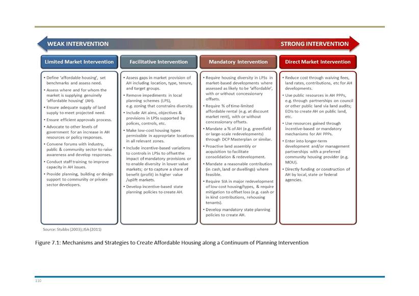
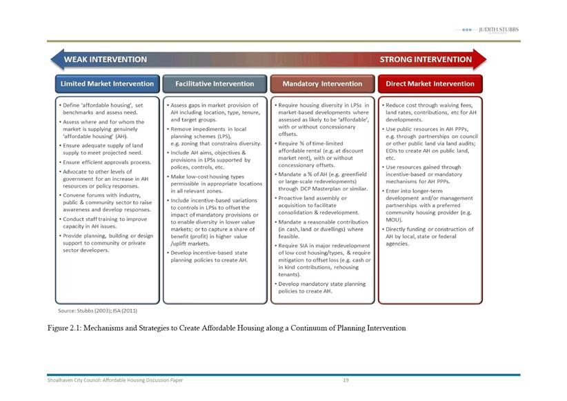
3.3.1 Overview of Mechanisms and Strategies
There
are a wide range of potential strategies available to Shoalhaven City Council
to increase affordable housing in the LGA.
The
proposed Strategy will first provide an overview of strategies available
to Council to increase the supply of affordable housing in terms of nature and
degree of market intervention (see JSA (2011) Affordable Housing Strategic
Framework below). These strategies range from ‘light’ planning
intervention (Column 1) in the market to strong intervention (Column 3) or direct
provision of affordable housing (Column 4).
Some
of these strategies are more likely to be effective in the local context. Those
most effective, and most favoured by Council, will be prioritised in the
proposed Strategy, as outlined below. Each strategy will be succinctly
stated with the rationale, relevant calculations, modelling and data, etc.,
provided in attachments or schedules to the proposed Strategy.
It
is noted that actions associated with ‘Column 1’, such as housing
market research, the establishment of affordable housing definitions and
benchmarks, and the development of a Strategy form part of this strategy
work (see Sections 3.1 and 3.2 above).
|

|
Development Committee
– Monday 07 November 2016
Page
400
|
Figure 3.1:
Mechanisms and Strategies to Create Affordable Housing along a Continuum of
Planning Intervention
|
|
Development Committee
– Monday 07 November 2016
Page
401
|
3.4 Short-term Strategies: Direct Intervention (‘Column
4’ above)
3.4.1 Provision
of Affordable Housing on Council or Public Land
Rationale
The
vast majority of demand for affordable housing, based on current housing stress
and affordability data, is likely to come from very low income households
(small and family). Affordable rental is particularly important.
The
direct creation of social and affordable rental housing for diverse groups
including older pensioners, people with a disability and very low and low
income singles, couples and family households will be necessary to meet the
growing need for such housing in the future.
An
effective way of delivering affordable housing is through development of such
housing on public (including Council) land as a development and/or management
partnership with a registered community housing provider (CHP) such as Southern
Cross Community Housing and/or the private sector.
Such
land can be developed under a variety of contractual arrangements - by Council
acting alone; or in conjunction with a partnering agency or agencies, such as a
CHP and/or private sector partner. Financially, the arrangement can be
structured in a number of ways, depending on Council’s preference.
Likewise, risk can be shared at a level appropriate to the needs and
preferences of partnering agencies.
JSA
conducted preliminary economic modelling on several development options on
Council sites in Nowra-Bomaderry, Jervis Bay – St Georges
Basin and Ulladulla from a list provided by Council staff. Each option modelled
could at least break even, or provide a small profit. This depends on the mix
of dwellings and controls governing the site, and whether a New Generation
Boarding House component is included, with the latter tending to improve the
financial viability of the development due to the higher dwelling yield.
Strategies
In
accordance with the preliminary recommendations in the Affordable Housing
Strategic Discussion Paper, the following will be developed further as key
strategies:
1. More
detailed investigation of sites originally used for modelling, and/or other
potential partnership sites (to be determined in consultation with Council
staff and/or Council), including strategies and recommendations on preferred
sites;
2. Nomination
of at least three appropriate sites for affordable housing developments and/or
as part of mixed tenure developments (one in each of the main urban areas), and
development of preferred options regarding tenure mix, dwelling type, target
group, development and management partnership arrangements, financing, desired
yield and rate of return, etc.;
3. Identification
of one site owned by Council or another public authority large enough to
support the development of a demonstration project showcasing good design in
entry level dwellings on smaller lots, that could also provide for some shared
equity purchase for low income households as well as some affordable rental;
4. Strategies,
based on further investigation, of shared equity purchase models with a local
community housing provider such as Southern Cross Community Housing, and
outline of a locally appropriate model if relevant;
5. Further
investigation of the potential for such a development on a privately owned
greenfield site, and appropriate mechanisms, funding and legal agreements to
implement an appropriate model or demonstration project.
3.5 Medium
Term Strategies: Facilitative Intervention (‘Column 2’ above)
3.5.1 Removing Planning Impediments and/or Opening up
Development Opportunities for Affordable Housing Types
Increasing
opportunities for and feasibility of smaller strata dwellings
Rationale
Enabling
the proper operation of the market is important in ensuring that diverse and
affordable housing products can be delivered to key target groups, and the
wider Shoalhaven community. It is important to ensure that there are no
impediments to the operation of the market in delivering the type of housing
that is affordable to the highest need target groups, and opening up
opportunities for market delivery where possible.
General
affordability will be increased through increasing the supply of smaller (one
and two bedroom) strata dwellings, particularly within 400-600 metres of the
main urban centres. A high proportion of this stock is likely to enter the
private rental market at the lower cost end.
A
number of impediments to the development of such stock were identified in the Affordable
Housing Background Report. Addressing these as medium-term strategies would
be an effective way of increasing lower cost and affordable housing through the
market.
Strategies
In
accordance with the preliminary recommendations in the Affordable Housing
Strategic Discussion Paper, the following will developed further as key
strategies:
1. Ensuring
that sufficient developable land zoned R1, R3 and B4 is available within
400-600 metres of the Nowra-Bomaderry, Jervis Bay – St Georges Basin, and
Milton-Ulladulla town centres.
2. Ensuring
that there is sufficient developable land zoned R1 in future greenfield release
areas.
3. Review
of existing controls in appropriate areas within 400-600 metres of
Nowra-Bomaderry, Jervis Bay – St Georges Basin, and Ulladulla to increase
of the FSR for medium density development (multi dwelling housing) to 0.5:1,
with specific recommendations on relevant provisions in Environmental Planning
Instruments (EPIs) and Shoalhaven Development Control Plan 2014.
Character and design controls will also be considered to ensure that new
development is appropriately designed.
4. Further
investigation on effective ways of reducing parking requirements for smaller
one and two bedroom apartments where those apartments are close to town centres
and public transport in Nowra-Bomaderry, Jervis Bay-St Georges Basin, and
Ulladulla, and/or extending the current parking discount to these areas, and/or
increasing the parking discount.
‘New
Generation’ and Supported Boarding Houses
Rationale
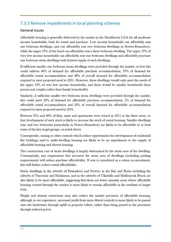
Increasingly,
boarding houses, particularly ‘New Generation’ boarding houses
under State Environmental Planning Policy (SEPP) (Affordable Rental Housing)
2009 are providing affordable accommodation to diverse very low and low
income households. As noted, these are likely to fill an important gap from a
range of very low and low income retirees, workers, and other singles and
couples without an asset.
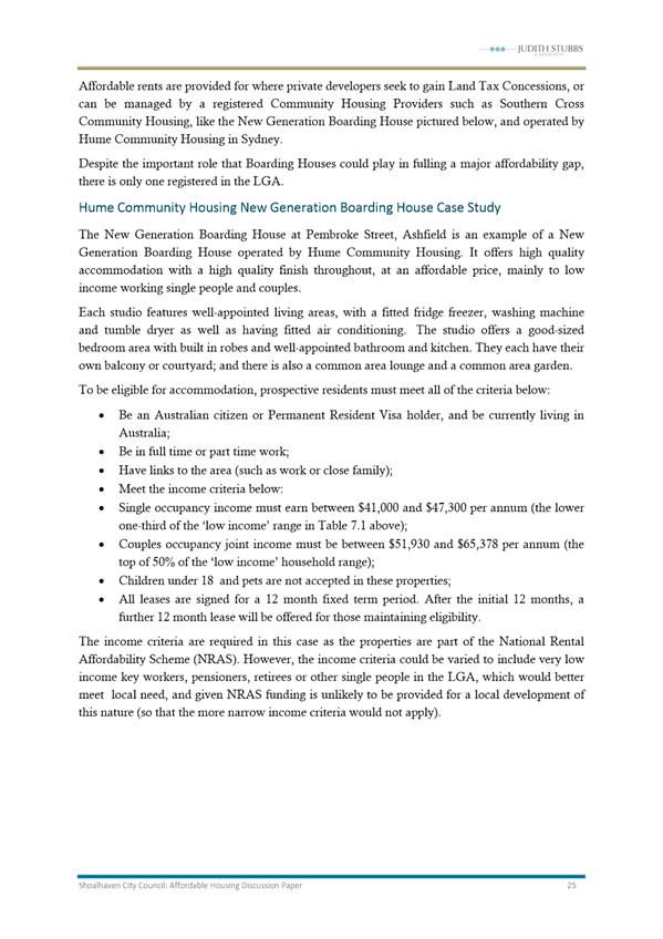
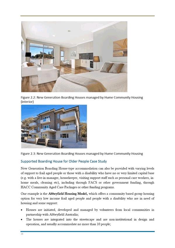
Despite
the important role that boarding houses could play in fulfilling a major
affordability gap for very low and low income single people and couples,
including key workers, there is currently only one registered in the LGA. There
are good models of boarding houses, and these can be adapted in the Shoalhaven
context, both in terms of guidelines for private and community sector
proponents, and as part of a model development on public land.
Strategies
A
range of strategies will be further developed, including the following:
1. Active
promotion and support for the development of high quality, ‘new
generation’ boarding houses in appropriate locations to ensure retention
of the boarding house long term in the three main urban centres with developers
and the community through means such as publication of guidelines, production
of promotional material, educational materials and favourable consideration of
applications .
2. Extending
incentives outlined above to new, purpose built boarding house construction.
3. Development
of guidelines consistent with State Government Policy and Legislation to
support the development of good design and management of ‘new
generation’ boarding houses taking into account local needs and the
housing market context.
Caravan
Parks and Manufactured Home Estates
Rationale
Caravan
parks are an important source of affordable accommodation in Shoalhaven.
On-site vans and manufactured homes, and sites which are rented where residents
place their own home, have the potential to be affordable to all low income
households and some very low income households. However, there appears to be a
decreasing supply of permanent sites through conversion to tourist uses in some
areas; and there appears to be demand/price pressure on parks and manufactured home
estates (MHEs) that offer a reasonable level of permanent sites.
Preliminary Recommendations
A
range of strategies will be further developed, including the following:
1. Development
of guidelines to encourage a higher proportion of permanent sites within
caravan parks and MHEs that are principally tourist-oriented developments, and
provide for a higher proportion of such sites in licensing arrangements.
2. Identification
(if possible) of two additional potential sites for residential caravan parks
or MHEs, close to transport and/or services in areas such as Nowra and
Ulladulla, which could be developed as an alternative housing model and managed
by a community housing provider, as part of the proposed Strategy.
3.5.2 Incentive-based
variations to facilitate affordable housing
Rationale
Consider
market-based incentives, where an opportunity to vary planning controls
is provided to a developer and tied to a demonstrated affordable housing
outcome. For example, reduced parking requirements may be provided where
strata dwellings of a maximum size are provided in specified areas or
precincts. These dwellings are provided through the market, but are more likely
to remain lower cost or more affordable in the context of the local housing
market, especially in lower cost localities.
It
is preferred that the mechanism is clearly set out in a Council Policy
(for example, a Voluntary Planning Agreement Policy) for transparency and
consistency, and is subject to a formal agreement.
Potential
Strategies
The
following strategies will be further investigated, and where relevant
recommended.
General
1. Develop
of a Voluntary Planning Agreement Policy with regard to incentive-based
approaches to affordable housing, with a model VPA provided.
Market-based incentives
2. Potential
reduction of parking requirements in appropriate locations to those set out in SEPP
(Affordable Rental Housing) 2009 where smaller one and two bedroom
apartments are constructed (for example, in accordance with the SEPP plus 10%).
3. Potential
expansion of the areas covered by Council’s existing ‘parking
discount’ where such dwellings are constructed in Nowra-Bomaderry, Jervis
Bay – St Georges Basin, and Ulladulla within 400 metres of the town
centres, and/or a further increase in the discount.
4. Potential
variations to controls tied to specified affordable housing outcomes with
associated design and character controls, e.g.:
o Increase
of the FSR for medium density development (multi dwellings housing) to 0.5:1 in
appropriate areas within 400-600 metres of Nowra-Bomaderry, Jervis Bay –
St Georges Basin, and Ulladulla where a developer provides a specified
proportion of smaller one and two bedroom dwellings (for example, in accordance
with the SEPP plus 10%).
5. A
more fine-grained analysis of the feasibility of density and/or height bonuses,
or other planning incentive schemes, in high value markets such as Huskisson
and parts of Ulladulla, and strategies related to relevant areas and
development of provisions as appropriate.
3.6 Longer-Term
Strategies: Mandatory Intervention (‘Column 3’ above)
3.6.1 Mandating
Affordable and Low Cost Dwelling Types
Rationale
Setting
DCP targets for the types of dwellings that are affordable to those most in
need of affordable housing is likely to be an effective mechanism for creation
of diverse housing for the wider community. Such mechanisms are equitable where
mandating such dwellings does not constitute an undue impost on the viability
of development for relevant target groups. One and two bedroom strata dwellings
are the most affordable conventional housing types in the local housing
context. Entry level project homes (3 bedrooms, with 1 bathroom and 1 car
space) on smaller lots are likely to be affordable to low income purchasers.
Strategies
In
accordance with the preliminary recommendations in the Affordable Housing
Strategic Discussion Paper, the following will be further developed as
long-term strategies, with specific provisions as relevant:
1. Mandating
a proportion of 1 bedroom, 1 bathroom dwellings with a maximum floor
area of 50-55 m2 in multi dwelling housing developments and
residential flat developments in areas within 400 metres of the town
centres of Nowra-Bomaderry, Jervis Bay – St Georges Basin and Ulladulla
(for example, 1 dwelling in 5 or 20% of dwellings).
2. Mandating
a proportion of 2 bedroom, 1 bathroom dwellings with a maximum floor
area of 70-75 m2 in multi dwelling housing developments and
residential flat developments in areas within 600 metres of the town
centres of Nowra-Bomaderry, Jervis Bay – St Georges Basin and Ulladulla
(for example, 2 dwelling in 5 or 40% of dwellings).
3. Development
of a Masterplan DCP approach to greenfield developments in accordance
with Part 6 of the Shoalhaven LEP, potentially including the following
types of requirements:
· A
proportion of lots to be allocated to multi dwelling housing (for example, 10%
of lots), with mandatory provisions for smaller 2 bedroom stock (i.e. 2
bedroom, 1 bathroom dwellings with a maximum floor area of 70 or 75 m2);
· A
proportion of lots be allocated as smaller lots (for example, 10% of lots or 5%
of the masterplan area as 350 m2 lots);
· A
proportion of separate houses of a specified size (for example, 2 and 3 bedroom
dwellings with 1 bathroom and a maximum floor area of 120 m2).
4. Development
of a performance criteria-based approach in an early stage of new
release areas, with criteria related to housing type and affordability
benchmarks.
5. Further
investigate the potential to facilitate a demonstration project on a
larger site owned by Council or that of another public authority to show good
practice in this regard.
3.7 Administration
Strategies
A
range of strategies related to the monitoring, management and administration of
Strategy, and any Affordable Housing Program resulting from this, will
be developed relateing to and including:
· EOIs
and partnering arrangements;
· Reporting
against KPIs;
· Administration of
affordable housing resources generated, etc.
|
|
Development Committee
– Monday 07 November 2016
Page
407
|
 NOTICE TO APPLICANT OF DETERMINATION OF
APPLICATION
NOTICE TO APPLICANT OF DETERMINATION OF
APPLICATION
DEVELOPMENT CONSENT
Environmental Planning and Assessment Act, 1979
DA16/1369
TO:
Mr Lee Carmichael
LCTP
76 Berry Street
NOWRA NSW 2540
being the applicant for DA16/1369 relating to:
Lot 1 DP81167, 25
Junction Street, Nowra
APPROVED
DEVELOPMENT:
Demolition of shed, erection of medium
density development (2 x 3 bedroom and 1 x 2 bedroom single storey dwellings)
DETERMINATION DATE: TBA
Pursuant to the Section 81 of the Act,
notice is hereby given that the above application has
been
determined by granting consent, subject to the conditions listed below.
CONSENT
TO OPERATE FROM: TBA
CONSENT TO LAPSE ON: TBA
In accordance with Section 95 of the Act, development
consent of the erection of a building does not lapse if building, engineering
or construction work relating to the building or work is physically commenced
on the land to which the consent applies before the lapse date.
DETAILS OF CONDITIONS
The conditions of consent and reasons for such conditions
are set out as follows:
PART A
CONDITIONS
OF A GENERAL NATURE, INCLUDING A DESCRIPTION OF THE PROPOSED DEVELOPMENT
General
1. This
consent relates to the demolition of shed, erection of medium density development (2 x 3 bedroom and 1 x 2 bedroom single storey
dwellings) as illustrated on the plans and
supporting documentation with the following references, as modified by the
following conditions. The development must be carried out in accordance
with this consent.
|
Plans
prepared by Hotondo South Coast Pty Ltd Job No NEST1247
|
|
Drawing
No.
|
Rev
No
|
Name
of plan.
|
Date
|
|
Sheet
1 of 11
|
|
Cover
sheet and BASIX commitments
|
22
July 2016
|
|
Sheet 2 of 11
|
|
Site
plan and site analysis
|
22 July 2016
|
|
Sheet 3 of 11
|
|
Floor
plan Units 1 &2
|
22 July 2016
|
|
Sheet 4 of 11
|
|
Typical
section No. 1
|
22 July 2016
|
|
Sheet 5 of 11
|
|
East
and south elevations Units 1 & 2
|
22 July 2016
|
|
Sheet 6 of 11
|
|
West
and north elevation Units 1 & 2
|
22 July 2016
|
|
Sheet 7 of 11
|
|
Floor
plan Unit 3
|
22 July 2016
|
|
Sheet 8 of 11
|
|
Typical
section No. 2
|
22 July 2016
|
|
Sheet 9 of 11
|
|
East
and south elevations Unit 3
|
22 July 2016
|
|
Sheet 10 of 11
|
|
West
and north elevation Unit 3
|
22 July 2016
|
|
Sheet 11 of 11
|
|
Landscape
plan
|
22 July 2016
|
|
|
|
Elevation
from Junction Street
|
22 July 2016
|
|
Statement of Environmental Effects dated 22 July 2016 prepared by
Nest Residential Design Pty Ltd
|
|
Concept Stormwater Drainage Plan prepared by SET Consultants Pty Ltd
|
|
BASIX Certificate No. 70833M_02 dated 18 April 2016
|
|
Waste Minimisation and Management Plan (Demolition) prepared by
Daniel Jones
|
|
Waste Minimisation and Management Plan (Construction) prepared by
Hotondo Homes
|
Notes:
· Any
alteration to the plans and/or documentation must be submitted for the approval
of Council. Such alterations may require the lodgement of an application
to amend the consent under s96 of the Act, or a fresh development application.
No works, other than those approved under this consent, must be carried
out without the prior approval of Council.
· Where
there is an inconsistency between the documents lodged with this application
and the following conditions, the conditions will prevail to the extent of that
inconsistency.
· Copies
of the approved plans must be retained on site along with any other relevant
plans such as construction and site management.
2. The
demolition of shed, erection of medium density
development (2 x 3 bedroom and 1 x 2 bedroom single storey dwellings) must not be occupied or the use must not commence until all relevant
conditions of development consent have been met or unless other satisfactory
arrangements have been made with council (i.e. a security).
Occupation
Certificate
3. An Occupation
Certificate must be issued by the Principal Certifying Authority (PCA) before
any building is used or occupied.
Note: Refer to Part F (Conditions
that must be complied with before an Occupation Certificate can be issued or
building occupied) of this development consent for additional requirements in
relation to the above condition.
Basix
4. All
the commitments listed in the relevant BASIX Certificate for the development
must be fulfilled in accordance with Clause 97 A (2) of the Environmental
Planning & Assessment Regulation 2000. A relevant BASIX Certificate
means:
· A BASIX
Certificate that was applicable to the development when this development
consent was determined (or if the development consent is modified under section
96 of the Environmental Panning & Assessment Act 1979, a BASIX Certificate
that is applicable to the development when this development consent is
modified); or
· if a replacement
BASIX Certificate accompanies any subsequent application for a construction
certificate, the replacement BASIX Certificate; and
· a BASIX
Certificate has the meaning given to that term in the Environmental Planning
& Assessment Regulation 2000.
PART B
CONDITIONS
THAT MUST BE COMPLIED WITH BEFORE WORK CAN COMMENCE
Principal
Certifying Authority/Construction Certificate
5. The following must be undertaken before any building works
associated with the development can commence:
a) a Principal Certifying
Authority (PCA) must be appointed; and
b) a Construction
Certificate must be obtained from either Council or an accredited certifier.
Notice of Commencement
6. Notice must be given to
Council at least two days prior to the commencement of building
work. (The attached form ‘Notice of Commencement of Building or
Subdivision Work and Appointment of Principal Certifying Authority’ is to
be completed and returned to Council.)
7. Prior to the
commencement of works (at least 2 days) Council must be advised in writing of
the name and 24 hour contact number of the designated person/company nominated
by the developer to be responsible for construction of all engineering works
including erosion and sediment control measures and their maintenance.
The person/company nominated must be a suitably qualified, experienced and
practicing engineer or surveyor. The supervisor will be required to
verify the works have been completed in accordance with the design and
specification.
Fencing
8. Prior to the
commencement of any works the building site is to be fenced with a fence
suitable to prevent access to the site by members of the public and any
unauthorised persons.
Footpath
Tree Retention and Protection
9. The existing Jacaranda
tree within the footpath must be retained and protected from any damage during
works at the site. No excavation must occur inside the drip line of the
tree without the prior written consent of Council.
10. Prior
to the commencement of any works on the site, a fence must be installed
around the extremity of the dripline of the tree to be retained to create an
exclusion zone. The fence:
a) must include the full
extent of the unsealed area of the footpath, being equivalent to the drip line
of the tree;
b) must satisfy the
minimum acceptable standard of 3-strand wire fence with star pickets at 1.8
metre centres;
c) must be signposted to
restrict activities from the exclusion zone that may injure tree root systems
or compact soil;
d) must be maintained for
the duration of the project to prevent any access within the tree drip line.
Site Management Plan
11. The site must be managed to
minimise nuisance during construction in this regard the following as relevant
must be provided in a site management plan:
a) details
of what actions are proposed to ensure safe access to and from the site and
what protection will be provided to the road and footpath area from building
activities, crossings by heavy equipment, plant and materials delivery and
static load from cranes, concrete pumps and the like (note: neighbouring
access driveways must not be obstructed);
b) the
proposed method of loading and unloading excavation machines, building
materials and formwork within the site;
c) the
proposed areas within the site to be used for the storage of excavated
material, construction materials and waste containers during the construction
period;
d) how
it is proposed to ensure that soil/excavated materials is not transported on
wheels or tracks of vehicles or plant and deposited on the roadway;
e) the
proposed method of support to any excavation adjacent to adjoining buildings or
the road reserve. The proposed method of support is to be certified by an
accredited certifier in civil engineering.
The site management plan must be approved by an
accredited certifier prior to the commencement of work. The applicant may also
wish to include details of dust management in this plan (refer to conditions
later in this consent).
Demolition
Generally
12. The
following requirements must be met for any demolition work:
a) Demolition work must be
carried out in accordance with Australian Standard AS2601-2001: The Demolition
of Structures;
b) Suitable measures must
be taken to ensure that there is no adverse effect to occupants of adjoining
buildings and the public by the generation of dust and/or noise during
demolition;
c) Protection must be
afforded to users of any adjoining public places by the provision of suitable
hoardings;
d) Precautions must be
taken in accordance with the requirements of SafeWork NSW in respect of:
(i) protection of
site workers and the public;
(ii) asbestos handling and
disposal where applicable;
e) The developer must
comply with the conditions of the attached Shoalhaven Water notice with
respect to the temporary capping off of water service and sewer junction.
Demolition Involving
Asbestos
13. The following conditions must be
complied with in respect of asbestos materials found during demolition
activities:
a) Demolition works
involving the removal and disposal of asbestos cement must only be undertaken
by contractors who hold a current WorkCover Class 2 (Restricted) Asbestos
Licence;
b) Fourteen (14) days prior
to the commencement of any demolition works involving asbestos, all
immediate neighbours must be notified in writing of the intention to carry out
asbestos demolition works. Copies of these written notifications must be
retained and provided to Council upon request.
c) Documentary evidence in
the form of tip receipts from an approved Waste Management Facility must be
obtained demonstrating the appropriate disposal of any asbestos waste.
Tip receipts must be provided to Council at the completion of demolition works
and prior to any further works on the site.
d) Following the removal
of the bonded asbestos and prior to further works being carried out on the
site, a clearance certificate from an independent person with a current
WorkCover Class 2 (Restricted) Asbestos Licence in accordance with the National
Occupational Health and Safety Commission Code of Practice for the Safe Removal
of Asbestos is to be obtained and submitted to Council.
Archival Recording
14. That an archival record of the
dwelling is to be made prior to demolition. The record must be
deemed satisfactory by Council prior to the removal of the building.
Reference is to be made to the Photographic Recording of Heritage Items using
Film or Digital Capture by the NSW Heritage Office, 2001, revised, 20014 and
2006
Inspection of Existing
Assets
15. The developer or his agent must
undertake a site inspection and document any evidence of damage to the public
assets prior to commencement of work. A copy of the inspection documentation
is to be provided to Council prior to the commencement of works. Failure to
adequately identify existing damage will result in all damage detected by
Council after completion of the work being repaired at the developer’s
expense.
Sign – Supervisor Contact
Details
16. Prior to the
commencement of any works, the person/company responsible for the construction
of all works must erect a sign at the front of the property/site in a visible
position with that person/company’s name, license number, site address
and contact number, and the name of the Principal Certifying Authority,
accreditation number and telephone number, where the Principal Certifying
Authority is not the Council.
Note: This condition is prescribed
under the Environmental Planning and Assessment Regulation 2000.
Builders’ Toilet
17. Before commencing building
operations, a builder’s water closet accommodation must be provided to
Council’s satisfaction.
A
chemical toilet may be used on the site or alternatively the site may be
provided with temporary closet accommodation connected to Council’s sewer
where sewer is available and operational. Under no circumstances will pit
toilets or similar be accepted by Council.
Residential
Building Work
18. Any licensed
contractor(s) performing residential building work valued at $12,000 or more
must obtain indemnity insurance as required by the Home Building Act
1989. Evidence of such insurance must be provided to the Principal
Certifying Authority (PCA) before building works commence.
Notes:
· This
condition is prescribed under the Environmental Planning and Assessment
Regulation 2000.
· If
appointment as PCA, Shoalhaven City Council WILL NOT INSPECT any building
work unless evidence of indemnity insurance has been provided. A copy
of the Certificate of Insurance will suffice.
Existing
services
19. The
developer or agent must check that the proposed works are not affected by or do
not affect any Council, electricity, telecommunications, gas or other services.
All services, existing and proposed, above or below ground are to be shown
accurately on the engineering plans including longitudinal sections with
clearances to proposed infrastructure clearly labelled. Any required
alterations to services will be at the developer’s expense.
Works
Within the Road Reserve
20. Prior to undertaking any works within an existing road
reserve, the contractor must obtain the consent of Council under Section 138 of
the Roads Act, 1993. The following details must be submitted to Council to
obtain the s.138 consent:
a) Any pavement design required by this consent;
b) Traffic Control Plan (TCP) to provide protection for those
within and adjacent to the work site, including the vehicular and pedestrian
public. The TCP must comply with the current RMS’s manual Traffic
Control at Work Sites. Warning and protective devices must comply with
the provisions of AS 1742.3 – 2002 Traffic Control Devices for Works on
Roads. The plan must be prepared, signed and certified by a person
holding the appropriate RMS accreditation, a copy of which is to be submitted
with the plan;
c) Insurance details;
d) Name and contact information of the person/company
appointed to supervise the construction;
e) Should the contractor want a single 138 approval to cover
works additional to road, drainage and site regrading (e.g. water supply,
sewerage, landscaping, etc), details of such works should be forwarded to the
designer of the Traffic Control Plan. Copies of the layout plans and work
method statements of these additional works are to be submitted to the
Subdivision Manager in conjunction with the 138 application for road and
drainage works;
f) Where the Traffic Control/Management Plan requires a
reduction of the speed limit, a ‘Direction to Restrict’ must be
obtained from Council for other roads and submitted with the section 138
application.
Note:
All works undertaken within or adjacent to a public road must be
provided with traffic control in accordance with the Traffic Control Plan as a
minimum. As a result of changing conditions, additional traffic control
measures may be required to comply with the WH&S Act and (Safe Work)
WorkCover requirements. Such control must be in place and maintained to
these requirements during the construction of the works. NB: Traffic
includes both vehicular and pedestrian.
PART C
CONDITIONS
THAT MUST BE COMPLIED WITH BEFORE A CONSTRUCTION CERTIFICATE CAN BE ISSUED
Design
Standards
21. Engineering design plans and
specifications for the work referred to in this consent are to be submitted for
approval.
a) Details of internal
civil works must be submitted to nominated accredited certifier (Private
Certifier or Council) for approval.
b) Details of all proposed
works in the road reserve must be submitted and approved by Council prior to
the issue of a Construction Certificate for the approved development.
c) All civil works are to
be in accordance with Council’s Engineering Design Specifications and
Development Construction Specifications current at the time of construction
unless otherwise specified in this consent.
Note: All works within the road
reserve must be approved by Council under Section 138 of the Roads Act 1993.
Engineering plan checking fees are applicable as per Council’s adopted
fees and charges. Contact should be made with Council’s Development
Engineer for a fee quote. All fees must be paid upon the lodgement of the
detailed engineering plans for checking.
Access
Design Standards
22. If the driveway
is going to be removed and replaced then a standard concrete gutter layback and
footpath crossing must be designed at the driveway entrance in accordance with
Council’s Standard Drawings Plan Nos. 5104-07, 2026-05 and Fig D1.20
(Engineering Design Specification).
Where kerb
and gutter exists, the plans must be detailed to ensure road seal and pavement
is to be removed to a sufficient width to permit placing of formwork and the
laying and compacting of suitable pavement material (1m minimum offset to lip
line).
Stormwater
Drainage Design
23. Major and
minor drainage systems must be designed by a qualified practising engineer in
accordance with Council’s Engineering Design Specifications section D5
(Stormwater Drainage Design) and DCP 2014 – Chapter G2: Sustainable
Stormwater Management and Erosion/Sediment Control. The minor and major
systems must be designed for 20% AEP for residential and also have
consideration for the 1% AEP rainfall events respectively.
On-Site
Detention
24. On-site
detention storage for stormwater runoff from the site must be provided such
that the discharge from the site for design storm events up to and including
the 100 year average recurrence interval does not exceed the pre-developed
conditions. Details must be submitted to Council or an accredited certifier for
approval prior to the issue a construction certificate. All flow discharging
from on-site detention is to be via gravity flow to an approved discharge
location. Automatic pump out systems from on-site detention will not be
allowed.
Internal
Access / Driveway Design
25. The internal driveway and car
parking must be designed for light vehicular loading with a flexible compacted
pavement minimum thickness of 200mm, surfaced with 30mm of AC10 asphaltic
concrete or two coat bitumen seal using 14mm and 7mm aggregate; or
to a coloured, patterned concrete standard; or with paving bricks suitable
for light vehicular loading in accordance with AS 4455- 1997.
26. The garage to Unit 2 is to be
extended to provide a minimum length of 6500 mm clear of the laundry area so as
to provide a minimum 1 metre width of access clear of the parking space area.
Or, alternatively the laundry room is to be enlarged by a minimum of 1 metre in
depth (i.e. east/west direction) to permit the laundry to be used without
encroaching into the garage space.
The above details must be shown on
the plans submitted for issue of the Construction Certificate.
Exterior
Materials
27. Exterior materials (excluding
windows and other glazing) are to be non-reflective and of a texture and colour
which blend with the existing surroundings. White, light grey or bright
colours are not acceptable. Metal roofing and wall cladding must be pre‑coloured
at the manufacturing stage. Water tanks must be coloured to match either
the roof or walls. The following colour schedule is approved:
§ Walls
– brick (Velour mid-brown) and cladding (Dune)
§ Roof
- Basalt
§ Trim
– as selected
Council’s written approval must be obtained for any
changes to the approved colour schedule.
Erosion
and Sediment Control
28. A Soil and Water Management Plan
(SWMP) and accompanying specifications for the construction phase of the works,
prepared by a suitably qualified and experienced person and based on the
Landcom manual - “Soils and Construction, Managing Urban Stormwater, Vol
1, 4th Edition, March 2004”, must be lodged with the nominated Certifier
for works within the proposed lot and to Council for works in the road reserve
for approval. The SWMP must include, but is not limited to:
a) location and type of
proposed erosion and sediment control measures;
b) location of vegetated
buffer strips, unstable slopes, boggy areas, and restricted “no
access” areas;
c) maintenance program for
all soil and water management measures;
d) disposal site for silt
removed from sediment traps; and
e) standard construction
drawings for proposed soil and water management measures.
These controls must be installed before the commencement
of work, maintained for the life of the project and until such time that the
site is stabilised.
Construction
Management Plan (traffic & parking)
29. Details of the proposed method of
dealing with construction traffic are to be submitted to Council for approval
by the Council’s Engineering Coordinator or Delegate. The details
must include but are not limited to the following:
a) stabilised site
construction access location;
b) proposed haulage routes
for delivery of materials to the site and spoil disposal from the site;
c) estimated timing of
construction works in the form of a Gant chart or similar;
d) parking arrangements
for construction employees and contractors.
Contributions
for additional services and/or facilities
30. This development will generate a
need for additional services and/or facilities as described in Council’s Contributions
Plan 2010, as itemised in the following tables.
|
Project
|
Description
|
Rate
|
Qty
|
Total
|
|
01AREC2006
|
Northern Shoalhaven Sports Stadium
|
$538.78
|
1.2
|
$646.54
|
|
01AREC2008
|
Planning Area 1 - Active recreation facility
upgrades
|
$196.97
|
1.2
|
$236.36
|
|
01AREC3007
|
Nowra Swimming Pool Expansion
|
$383.53
|
1.2
|
$460.24
|
|
01CFAC2003
|
Nowra District Community Centre
|
$136.69
|
1.2
|
$164.03
|
|
01CFAC2012
|
Nowra District Integrated Youth Services Centre
|
$30.69
|
1.2
|
$36.83
|
|
CWAREC2004
|
Synthetic Hockey Field Facility
|
$78.41
|
1.2
|
$94.09
|
|
CWCFAC0003
|
Shoalhaven City Arts Centre
|
$35.28
|
1.2
|
$42.34
|
|
CWCFAC0004
|
Shoalhaven Mobile Childrens Services
|
$11.68
|
1.2
|
$14.02
|
|
CWCFAC0005
|
Shoalhaven Multimedia & Music Centre
|
$11.60
|
1.2
|
$13.92
|
|
CWCFAC0006
|
Shoalhaven City Library Extensions
|
$307.55
|
1.2
|
$369.06
|
|
CWCFAC2002
|
Shoalhaven Multi-Purpose Cultural & Convention
Centre
|
$1,426.07
|
1.2
|
$1,711.28
|
|
CWFIRE2001
|
Citywide Fire & Emergency services
|
$127.86
|
1.2
|
$153.43
|
|
CWFIRE2002
|
Shoalhaven Fire Control Centre
|
$187.06
|
1.2
|
$224.47
|
|
CWMGMT3001
|
Contributions Management & Administration
|
$531.71
|
1.2
|
$450.18
|
|
CWOREC2001
|
Embellishment of Icon and District Parks and Walking
Tracks
|
$228.50
|
1.2
|
$274.20
|
|
MACFAC2002
|
Northern Shoalhaven Community Transport and Family
Support Services
|
$7.20
|
1.2
|
$8.64
|
|
MACFAC4001
|
Northern Shoalhaven Integrated Children's Services
|
$43.63
|
1.2
|
$52.36
|
|
TOTAL
|
|
|
|
$4,951.98
|
|
|
|
|
|
|
|
|
|
|
Contribution rates are adjusted
annually on 1st July in accordance with the indexation formula
indicated in the Contributions Plan (currently the implicit price deflator) and
the total contribution levied will be adjusted accordingly at the time of
payment. (ie contributions are calculated on the rate applicable at the
date of payment, not the date of development consent.)
A total contribution, currently
assessed at the sum of $4,951.98 (i.e. 2016/2017 rate) or as indexed in future
years, must be paid to Council before the issue of a Construction Certificate.
Contributions Plan 2010
may be inspected at the Council Administrative Offices, Bridge Road, Nowra and
Deering Street, Ulladulla.
Water and Sewer Conditions and Contributions
31. All
conditions listed on the Shoalhaven Water Development Application Notice under
the heading “PRIOR TO THE ISSUE OF A CONSTRUCTION CERTIFICATE” must
be complied with and accepted by Shoalhaven Water. The authority issuing the
Construction Certificate for the development must obtain written approval from
Shoalhaven Water allowing a Construction Certificate to be issued. This
also applies to approved staged developments.
|
Note: Relevant details, including monetary contributions
(where applicable) under the Water Management Act 2000, are given on the
attached Notice issued by Shoalhaven Water.
|
For further information and clarification regarding the
above please contact Shoalhaven Water’s Development Unit on (02) 4429
3111.
Amended
Landscape Plan
32. The applicant must lodge an amended
landscape plan with Council prior to the issue of a Construction Certificate
for the approved development. The plan may be approved by Council or an
accredited certifier. The amended landscape plan must be prepared by a
qualified landscape architect or landscape designer and include the following
plantings and details:
a) is prepared having regard to
the provisions of Shoalhaven DCP 2014 Chapter G3: Landscaping Design
Guidelines;
b) includes a Planting Schedule
that includes symbol, botanical name, common name, pot size, mature height,
spacing and quantity for each species used in the landscape plan;
c) planting of a hedge of mature
height of at least 1.8m along the street boundary of Acmena Smithii or
similar hedging species, at maximum 600mm centres;
d) planting of at least 1 tree
and two large shrubs in the area shown as ‘turf’ north of the
driveway and forward of Unit 1;
e) the construction of 150mm
high barrier kerb for the full length of the boundary between the driveway and
the area shown as ‘turf” as described above;
f) landscaping of the strip
garden bed along the eastern boundary at the beginning of the driveway;
g) mulching of all landscaped
areas to a depth of 75mm;
h) location of common
tap/taps/irrigation system to permit all landscape works to be adequately
watered; and
i) a maintenance plan for
a 26 week period.
PART D
CONDITIONS RELATING TO THE APPROVED WORK AND SITE
MANAGEMENT
Street Numbering of
Dwellings
33. Street numbering must comply with
the State Government’s Comprehensive Property Addressing System (CPAS),
and Council’s Property Address Numbering Policy. Street numbering
of the development must be as follows:
Common
Property Address: 25 Junction St, NOWRA
Unit 1: 1/25
Junction St, NOWRA
Unit 2:
2/25 Junction St, NOWRA
Unit 3: 3/25
Junction St, NOWRA
The allocated house numbers must
be shown on the Construction Certificate plans. Where plans
and details are provided to service suppliers, numbers must be in accordance
with the above.
Construction
Hours
34. To limit the impact of the
development on adjoining owners, all construction work must be restricted to
the hours of 7.00am to 6.00pm Monday to Friday and 8.00am to 3.00pm
Saturdays. No construction work must take place on Sundays or Public
Holidays.
Impact of Works on Others
35. The following general conditions must be adhered to;
a) Runoff
currently entering the site from uphill properties must not be obstructed nor
redirected from entering the site, other than by works in accordance with a
plan approved by Council or to increase the quantity or concentration of
surface runoff entering adjoining properties.
b) Any
damage to the existing kerb & gutter, footpaths, pathways, road pavements,
reserves or any other public infrastructure that occurs during development
works must be repaired by the developer. Restoration must be to the
satisfaction of Council.
c) Existing
roads, footpaths and reserves adjacent to and nearby the site must be kept
clear of soil, debris, materials and equipment except in accordance with the
Traffic Control Plan or as otherwise approved in writing by Council.
d) All construction work is to be carried out so that at any
time adjoining property owners are not deprived of an all weather access or
subjected to additional storm water runoff during the period of construction.
Building
Code of Australia
36. All building work must be carried
out in accordance with the requirements of the Building Code of Australia.
Note: This condition is prescribed under the
Environmental Planning and Assessment Regulation 2000.
Excavations, Retaining
Walls and Drainage
37. All excavations and backfilling
must be executed safely and in accordance with appropriate professional
standards. All excavations must be properly guarded and protected to
prevent a danger to life or property.
If required by the grade of the site and soil conditions,
suitable retaining walls with appropriate agricultural and stormwater drainage
must be provided to prevent the movement of soil and subsequent nuisance to
adjoining properties. All roof and surface stormwater from the site must
be conveyed to a legal point of discharge.
Access Design
Standards
38. A heavy duty concrete gutter
layback and footpath crossing must be designed at the driveway entrance in
accordance with Council’s Standard Drawings Plan Nos. 5104-07, 2026-05
and Fig D1.20 (Engineering Design Specification).
Where kerb and gutter exists, the plans must be detailed
to ensure road seal and pavement is to be removed to a sufficient width to
permit placing of formwork and the laying and compacting of suitable pavement
material (1m minimum offset to lip line).
Waste Minimisation and Management
39. All waste must be contained within the site
during construction and then be recycled in accordance with the approved Waste
Minimisation and Management Plan (WMMP) or removed to an authorised waste
disposal facility, unless otherwise agreed to by Council in writing. No
waste must be placed in any location or in any manner that would allow it to
fall, descend, blow, wash, percolate or otherwise escape from the site.
Compliance with
the WMMP must be demonstrated by the
retention of relevant receipts. These must be submitted to Council upon
request.
Note: “Waste” has
the same meaning as the definition of “waste” in the Protection of
the Environment Operations Act 1997.
Noise
40. The noise from all construction
activities associated with the development is to comply with Section 5 and 6 of
the NSW Environment Protection Authority's Interim Construction Noise
Guideline.
Dust Management
41. Dust emissions must be confined
within the site boundary. The following dust control procedures may be employed
to comply with this requirement.
· Erection of dust
screens around the perimeter of the site;
· Securely covering
all loads entering or exiting the site;
· Use of water
sprays across the site to suppress dust;
· Covering of all
stockpiles of soil remaining more than 24 hours; and
· Keeping excavation
surfaces moist.
Details of proposed measures must
be provided to the Certifying Authority prior to the commencement of
work. Details may be included in the site management plan required by a
condition earlier in this consent.
Landscaping
42. Landscaping
must be carried out in accordance with the approved landscape plan.
Fencing
43. The side and rear boundaries of the
site are to be fenced to a height of 1.8 metres prior to the issue of an
occupation certificate. Any fencing visible from the public road or
adjacent to the walls of the dwelling at No. 27 Junction Street must be of
bricks that match the approved wall colour. The colour of the fencing is
to be consistent with the colours shown on Sheet 76 (Streetscape and Colour
Selections) of the approved plans. The fence along the driveway forward of
the front building line is to reduce to 900mm in height at the front property
boundary.
Clothes Drying Facilities
44. Each of the units
must be provided with an external clothes drying facility at a rate of 7.5 m of
clothes line per dwelling. The clothes drying facilities must be located
and screened so that they are not visible from the public street.
Lighting – Internal Public Areas
45. Lighting is
to be provided to the internal driveways, pedestrian paths, shared areas and
building entries in accordance with AS/NZS 1158 - Road Lighting Pedestrian
Area, Category P Lighting, Performance and Installation Design Requirements.
PART
E
CONDITIONS
THAT RELATE TO ONGOING MANAGEMENT OF THE PROPOSED DEVELOPMENT
Site
Management and Maintenance
46. The development must be managed
so that :
a) The visitor car parking
spaces within the site must not be used for the storage of goods or caravans
and the like and must be available for use by visitors at all times; and
b) The development must be kept
in good order and repair at all times, this includes landscaping, stormwater
management, condition of the driveway and the like.
Garbage
Bin Storage
47. Garbage bins (for both general
waste and recyclable waste) associated with the ongoing occupancy of the approved
development must be stored in areas which are not visible from a public
place. When not required to be available for collection they must be
stored in the private area provided for each unit.
Noise
48. Noise
levels from the premises from pumps, air conditioners or pool filtration
equipment (measured using the L10 noise level descriptor) must not
exceed the background noise level in any octave band (measured using the L90
noise level descriptor) by more than 5 dB(A) when measured at the
boundary of the closest residential premises.
PART F
CONDITIONS
THAT MUST BE COMPLIED WITH BEFORE AN OCCUPATION CERTIFICATE CAN BE ISSUED OR
BUILDINGS OCCUPIED
49. Prior to the issue of an
Occupation Certificate for the approved development:
a) the
requirements of conditions 22 (stormwater design), 23 (on site detention), 24
and 25 (driveway and parking), 36 (excavations, retaining walls etc), 41
(landscaping), 42 (fencing), 43 (clothes drying facilities), 44 (lighting);
b) a Compliance
Certificate or Certificates must be obtained from Council for all works within
the road reserve;
c) the applicant must submit to
Council certification and/or documentation confirming that the building has
been constructed in accordance with the details and commitments listed in the
BASIX Certificate for the development.
50. A Certificate of Compliance (CC)
under Section 307 of Division 5 of Part 2 of Chapter 6 of the Water Management
Act 2000 must be obtained to verify that all necessary requirements for matters
relating to water supply and sewerage (where applicable) for the development
have been made with Shoalhaven Water. A Certificate of Compliance must be
obtained from Shoalhaven Water after satisfactory compliance with all
conditions as listed on the Development Application Notice and prior to the
issue of an Occupation Certificate.
Verification
of Works
51. Works as executed’ (WAE)
plans certified by a consulting engineer or registered surveyor for all new
works within the road reserve as required by this development consent must be
submitted to Council for review and records upon completion of the works. The
certification must state the information shown on the plans is a true and
accurate representation of the constructed works. The WAE information is to be
marked in red is to be provided on a copy of the Council approved plans. Where
works are not within the tolerances specified in Council’s Development
Construction Specifications, the certifying engineer / surveyor ,must confirm,
in writing, the works still comply with the intent of the original design,
specifications and relevant Australian Standards.
PART G
REASONS
FOR CONDITIONS
Conditions
of consent have been imposed to:
1. Ensure the
proposed development:
a) achieves the
objects of the Environmental Planning and Assessment Act, 1979;
b) complies with the
provisions of all relevant environmental planning instruments;
c) is consistent with the
aims and objectives of Council’s Development Control Plans, Codes and
Policies.
2. Ensure
that the relevant public authorities and the water supply authority have been
consulted and their requirements met or arrangements made for the provision of
services to the satisfaction of those authorities.
3. Meet
the increased demand for public amenities and services attributable to the
development in accordance with Section 94 of the Environmental Planning and
Assessment Act, 1979.
4. Ensure
the protection of the amenity and character of land adjoining and in the
locality of the proposed development.
5. Minimise
any potential adverse environmental, social or economic impacts of the proposed
development.
6. Ensure
that all traffic, carparking and access requirements arising from the
development are addressed.
7. Ensure the development
does not conflict with the public interest.
PART H
OTHER
COUNCIL APPROVALS
Section
68 Local Government Act
Approval
to Connect to the Reticulated Sewerage System
1. Approval
for Sewerage, Plumbing and Stormwater Drainage is granted subject to the
following conditions:
General
2. In accordance with the
Plumbing and Drainage Act 2011, plumbers and drainers must submit the following
documents to Shoalhaven City Council.
a) Notice of Work is to be
issued to Shoalhaven City Council no later than two (2) business days prior to
the commencement of any work.
b) A Certificate of
Compliance is to be issued to Shoalhaven City Council and to the person for
whom the work was carried out on completion of the final inspection.
c) A sewer service diagram
is to be issued to Shoalhaven City Council and the owner of the land or the
owner’s agent at the completion of the drainage works.
3. All plumbing and
drainage work must comply with the Plumbing Code of Australia and Australian
Standard AS/NZS 3500, and the relevant NSW amendments.
Inspections
4. Council must be given at
least 24 hours’ notice to allow for the inspections of:
|
Type of Inspection:
|
Stage of Construction:
|
|
Internal drainage
|
All internal drainage pipework installed and under hydraulic test,
including any required bedding material, and prior to backfilling.
|
|
Hot and cold water service
|
All pipework installed and under hydraulic test.
|
|
External drainage
|
Pipework installed and under hydraulic test, septic tank installed or
sewer connected (which ever applicable)
|
|
Final inspection of drainage works
|
All drainage works including stormwater
|
Both the internal and external
drainage lines are to be under Hydraulic test at the time of the inspection.
Before
Commencing Construction
5. The builder should
locate the position and depth of the sewer junction before commencing
construction, to ensure that the top of the overflow gully is a minimum of
900mm above the soffit of the sewer main. Copies of sewer main diagrams
issued by Council must be treated as a guide only when locating the junction
position.
Yard
Gully
6. A minimum height of
150mm must be maintained between the top of the overflow yard gully riser and
the lowest fixture connected to the drain. The height must be measured
vertically from the overflow level of the gully riser, or from the invert level
of the overflow pipe, to the appropriate point given in Table 4.3 of AS3500.
The minimum height between the top of the overflow yard gully riser, or the
invert of the overflow pipe, and the surrounding ground surface level must be
75mm, except where the gully riser is located in a path or a paved area where
it must be finished at a level so as to prevent the ponding and ingress of
water into the drainage system.
Site
Management – Stormwater
7. Stormwater from the development, including
surface water falling on paved areas and driveways, is to be conveyed to the
street gutter in Junction Street via drainage designed and constructed in
accordance with AS/NZS 3500.3.2 – Stormwater drainage and the Building
Code of Australia. Stormwater must not be discharged onto and/or cause
any nuisance to any neighbouring properties for the life of the development.
Rainwater
Facility - Aboveground
8. Water
stored in the tank must be plumbed into the dwelling such that it is supplied
to each of the fixtures listed in the BASIX Certificate for the property.
Plumbing must be in accordance with the current edition of the AS/NZS 3500
National Plumbing & Drainage Code.
It will be necessary to install,
maintain and repair the facility so that it functions in a safe and efficient
manner in accordance with the current editions of AS/NZS 3500 National Plumbing
and Drainage Code and the New South Wales Code of Practice Plumbing and
Drainage.
The tank inlet must be located a
minimum of 500mm below the outlet of the eave gutter.
The tank is to be installed on a
firm flat and stable platform in accordance with manufacturer’s
recommendations. Tanks located over fill material should be placed on a
concrete slab.
Pumps must be located and
installed to minimize any potential noise nuisance to surrounding residents,
and in the case of a permanent electric pump, must be installed by a licensed
electrician. Pump performance must achieve a minimum 300 Kpa output.
Overflow from the tank must be
directed into an existing storm water system.
Any town water top-up of the tank
must be by indirect connection by means of a visible “air gap”,
external to the rainwater tank, in accordance with the provisions of the
National Plumbing and Drainage Code, AS/NZS 3500 – Minimum air gap
requirements.
Marking and labelling of
rainwater services must be in accordance with AS 1345 – “Identification
of the contents of pipes, conduits and ducts” including distribution
pipes, rainwater pipes and tank outlets.
PART I
ADVICE
ABOUT RIGHTS OF REVIEW AND APPEAL
Development
Consent under Environmental Planning and Assessment Act, 1979
Section 97 of the Environmental Planning and Assessment
Act, 1979 confers on an applicant who is dissatisfied with the determination of
a consent authority a right of appeal to the Land and Environment Court which
can be exercised within twelve (12) months after receipt of this notice.
Approvals
under Local Government Act, 1993
Section
100 of the Local Government Act, 1993 provides that an applicant may request
Council to review its determination of an application.
Section
176 of the Local Government Act, 1993 provides that an applicant who is
dissatisfied with the determination of the Council may appeal to the Land and
Environment Court. The appeal must be made within twelve (12) months
of the date of determination.
PART K
GENERAL
ADVICE TO APPLICANT
Privacy
Notification
Personal information contained on this Development Consent
and any associated documents will be published on Council’s website as
required by the Government Information (Public Access) (GIPA) Act 2009.
Disclaimer
– s88B restrictions on the use of land
The applicant should note that there could be covenants in
favour of persons other than Council restricting what may be built or done upon
the subject land. The applicant is advised to check the position before
commencing any work.
Under clause C 1.9A of Shoalhaven Local Environmental Plan
2014 agreements, covenants or instruments that restrict the carrying out of the
proposed development do not apply to the extent necessary to enable the
carrying out of that development, other than where the interests of a public
authority is involved.
Inspections
If Council is the appointed PCA for this project, a minimum
twenty-four (24) hours’ notice must be given to Council to make an
inspection of the work.
DBYD Enquiry -
‘Dial Before You Dig’
In order to avoid risk to
life and property it is advisable that an enquiry be made with “Dial
Before You Dig” on 1100 or www.dialbeforeyoudig.com.au
prior to any excavation works taking place to ascertain the location of
underground services.
SIGNED on behalf of
Shoalhaven City Council:
Signature
Name
|
|
Development Committee – Monday 07 November 2016
Page 423
|
Section 79C Planning Assessment Report
 DA16/1369
- Multi Dwelling Housing Development – 25 Junction Street, Nowra
DA16/1369
- Multi Dwelling Housing Development – 25 Junction Street, Nowra
1. Executive Summary
· The
proposal seeks approval for demolition of a shed, the erection of 2 x 3 bedroom
units and 1 x 2 bedroom single storey units, with garages. The Community
title subdivision was formally withdrawn from the application on 14 October
2016. The development is permissible, subject to development consent
under the Shoalhaven Local Environmental Plan 2014.
· The
owner is Janack Pty Limited and applicant Lee Carmichael Town Planning
(replacing Hotondo Homes).
· The
property is located at 25 Junction Street, Nowra.
· The
proposal was amended on 2 occasions during the assessment process, with the
amendments being notified to objectors.
· The
application was notified on 3 occasions resulting in 7 objections on the first
occasion, 6 during the second and nil on the third.
· The
subdivision component was referred to the Development Committee on 10 October
2016. The matter was put to Committee given the variation to the
development standard being 350m2. As part of the
recommendation made by the Committee, the development application was called up
for consideration.
· The
proposal has been assessed under section 79C of the Environmental Planning and
Assessment Act 1979 and as a result, no major objectionable issues or matters
were identified which would warrant refusal of the application.
Accordingly, conditional approval is being recommended.
Figure
1 – photomontage of proposed development
2. Background
2.1 Proposal
The application proposes removal of an existing shed.
Construction of a 2 x 3 bedroom and 1 x 2 bedroom single storey dwellings.
The application does not propose removal of the existing
residence as the intention is to obtain a Complying Development Certificate
(CDC). Development Consent has been granted for the relocation of the
dwelling to a property in Milton via Development Consent DA16/1675.
The Development Application (DA) was lodged in March
2016. It has had a lengthy assessment largely attributable to design
issues including streetscape impacts and some non-compliances which were
essentially resolved through the assessment process. Significantly, this
included the removal of parking in the front setback area and a substantial
change to the building design changing it from a modern contemporary design
trend with low pitched skillion roofs to a more conservative traditional hipped
roof form.
2.2 Subject Site and
Surrounds
The subject land, being Lot 1 in
DP 81167, 25 Junction St, Nowra is within an established residential area zoned
R1 – General Residential under the Shoalhaven Local Environmental Plan
2014 (SLEP 2014). It has direct frontage to Junction Street and is
vicinity to heritage items but is not heritage listed itself.
The land has a regular
rectangular shape with an area of 815.69 square metres and is joined by single
dwellings on either side. St Michael’s Catholic Primary School adjoins at
the rear. The site has a slight fall away from the street and does not
contain and easements. Sewer is connected.
The site is occupied by an older
style weatherboard and iron roof cottage. A fibro single storey garage is
also situated on the site. A large Jacaranda tree is located in the road
reserve. The tree is to be retained. The site is located in an
older established part of Nowra containing a mixture of dwelling types.
The site is located about 450m
from the Shoalhaven River which triggers consideration of the State’s
State Environmental Planning Policy 71 – Coastal Protection, which is
discussed in further detail later in this report.
2.3 Background
information concerning the application
Prelodgement
No prelodgement meetings were
held with respect to the DA. There were no information discussions about
the proposal with Council assessment staff.
Post Lodgement
The DA was lodged on 29 March
2016. Following initial neighbour notification which yielded 7
objections, and referral advice from Council’s Heritage Advisor, amended
plans were submitted. The amendments included the removal of the car
space located in the front building setback area.
The application was renotified
and further objections were received. There were 6 on this second
occasion. Council’s engineer highlighted concerns with turning and
parking. The assessing officer also identified other design issues.
The applicant was invited to respond and a further revision was made.
The issue with the lot size, that is, the lots being under the
350 square metres minimum was drawn to the attention of the applicant who
considered withdrawal of this subdivision component of the application.
The applicant was advised that the policy departure would require the matter to
be put before Council. On 18 August 2016 the applicant confirmed that the
subdivision component would be retained. The subdivision was reported to
Development Committee on 10 October 2016.
Council on 10 October 2016 resolved:
1. That the
variation to the minimum lot size not be supported
2. That Council
review the zoning in this location with a view to change to R2 in Central Nowra
3. If necessary the
General Manager report back to the Development Committee on the 79c assessment
for the subject application, given the extent of public interest in the
development application.
4. The General
Manager also report back on Development Guidelines that could be adopted to
assist in preserving the character of central Nowra. In addition could Council
report back on ways that it could work with the Old Houses Our History group to
identify the most significant streetscapes for additional consideration for
preservation / protection
After the meeting on 10 October 2016, the application was
formally amended to delete the subdivision component.
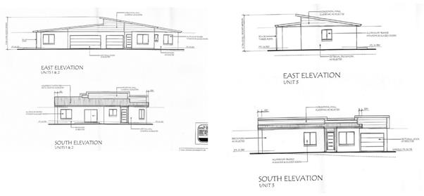
Figure
2 – Original Proposal
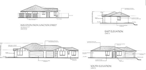
Figure
3 – Development under consideration as modified
2.4 Planning
Framework
In summary the following
apply and will be discussed in the section 79C assessment:
· State
Environmental Planning Policy 71 – Coastal Protection;
· State
Environmental Planning Policy 55 – Remediation of Land;
· State
Environmental Planning Policy (BASIX) 2004;
· Shoalhaven
Local Environmental Plan 2014;
· Shoalhaven
DCP 2014; and
· Contribution
Plan 2010.
3. Section 79C Assessment
Statement of Compliance /
Assessment
3.1 S79C(1)
(a) (i – iv) Any planning instrument, draft instrument, Development
Control Plan, Planning Agreement, Regulation and coastal zone management plan
that applies to the land
State Environmental Planning
Policy (SEPP) No.71 – Coastal Protection:
The intention of this SEPP is to protect the unique
attributes of the NSW Coast. The aims of the SEPP are numerous but are
intended to protect and manage the natural, cultural, recreation and economy
attributes of the coast by ensuring access, preserving aboriginal heritage,
visual amenity of the coast, protect the natural environment, and ensure that
development is appropriate and protects natural scenic quality. The SEPP
requires certain development applications to be referred to the Director
General of the Department of Planning and Environment. These developments
are in the sensitive coastal zone.
The DA for 25 Junction St, Nowra is not within the
sensitive coastal location and referral is not required.
In summary, the development is located some distance from
the coast / Shoalhaven River and largely due to the distance from the coast and
location in an established urban area, the proposal is not expected to
compromise the NSW Coastline or Coastal Policy.
Council is required to consider the matters listed in
clause 8 of the SEPP when determining a development application. The
provisions of this clause relating to development in the coastal zone have been
considered. Specifically, it is considered that the proposal:
· is not inconsistent with the aims of the Policy;
· has no impact on existing public access to the foreshore;
· will not impede opportunities for new public access;
· is not unsuitable having regard to its type, location and
design and relationship with the surrounding area;
· will have no detrimental impact on the amenity of the
foreshore;
· will have no significant impact on the scenic qualities of
the coast;
· will have no impact on the conservation of animals and
plants within the meaning of the Threatened Species Conservation Act 1995;
· is not relevant to measures to conserve fish and marine
vegetation;
· will have no impact on existing wildlife corridors;
· will have no interaction with coastal processes and coastal
hazards;
· will have no impact on measures to reduce the potential for
conflict between land and water based coastal activities;
· will have no adverse impact on measures to protect the
cultural places, values, customs, beliefs and traditional knowledge of
Aboriginals;
· will have no impact on water quality of coastal
waterbodies;
· will have no impact on the conservation and preservation of
items of heritage, archaeological or historical significance;
· will have no measurable cumulative impact on the
environment; and
· Will implement measures to ensure that water and energy
usage is efficient.
The issue of heritage is explored further under the heading
Shoalhaven Local Environmental Plan 2014 below.
Clauses 14, 15 and 16 of the Policy set out further
considerations relating to public access, effluent disposal and stormwater
about which Council must be satisfied before granting consent. In this
regard it is noted that:
· the development will not impede or diminish the physical,
land-based right of access of the public to or along the coastal foreshore (cl.
14);
· the development will be connected to Council’s sewer
and no effluent is to be disposed of by a non-reticulated system (cl. 15);
· The development will not discharge untreated stormwater to
any body of water or rock platform (cl.16).
State
Environmental Planning Policy (SEPP) No.55 – Remediation of Land:
SEPP 55 requires Council to consider whether the land is
contaminated. Council has no evidence that the land is or has been
contaminated or used for a purpose likely to result in contamination.
There is no evidence of prior activities or landfilling that could give rise to
contamination. The land appears to have been used for residential
purposes for most of the last century. Consequently it is highly unlikely
that the land is contaminated.
The
garage and existing house may contain some asbestos materials.
Appropriate conditions of consent can be imposed, if consent is granted, to
ensure safe removal and disposal of any asbestos.
State Environmental Planning Policy (Building
Sustainability Index: BASIX) 2004:
BASIX
commitments have been identified on the plans and a BASIX Certificate
submitted. Any development consent, if issued, will be conditioned to
require all commitments on the submitted BASIX Certificate to be complied with
prior to issue of an Occupation Certificate.
Shoalhaven
Local Environmental Plan 2014 (SLEP 2014)
Summary
· Land
Use Table: The land is zoned R1 General Residential under SLEP 2014. The
proposal is defined as multi dwelling housing which is permissible with
consent in this zone. Further, in the assessment of a DA, Council via
clause 2.3 (2) Council must have regard to the zone objectives.
· Clause
4.3 (Height of buildings): The proposal does not exceed the maximum
height limit of 11m.
· Clause
5.5 (Development within the Coastal zone): This clause largely parallels
the considerations under SEPP 71.
· Clause
5.10 – Heritage conservation. Whilst the building is not a heritage
item nor located in a heritage conservation area, the street itself is
acknowledged as a heritage item.
· Clause
7.1 (Acid sulfate soils). The land is identified as Class 5. No
issues arise as a result of the proposed development.
· Clause
7.9 (HMAS Albatross Airspace Operations). The proposal is well under the
90m limitation that applies in the area under the Defence (Area Control)
Regulation.
Clause
2.3 (2) – Zone Objectives
The land
is zoned R1 – General Residential. The objectives of the zone are:
· To
provide for the housing needs of the community.
· To
provide for a variety of housing types and densities.
· To
enable other land uses that provide facilities or services to meet the day to
day needs of residents.
· To
identify land suitable for future urban expansion.
Having
regard to the objectives of the zone, the development will provide additional
housing and be of a type and location which will provide for housing choice and
variety in a location close to the CBD.
Accordingly,
the proposal is considered not to be inconsistent with the objectives of the
zone.
Clause 5.10 – Heritage Conservation
The site or buildings on the site are not identified as
heritage items. However the development is considered development within
vicinity of an item. The heritage status of the street has been
acknowledged by listing the street, as locally significant, notably referring
to the Jacaranda trees which contribute to the landscape value of the
area.
Whilst concern was expressed with respect to the private
open space and fence in front of the development, Council’s Heritage
Advisor noted that the fence does not extend across the entire frontage.
The advisor recommended the following to address this issue
and removal of the dwelling:
· That an archival record of the dwelling is to be made prior
to demolition. The record must be deemed satisfactory by Council prior to
the removal of the building. Reference is to be made to the Photographic
Recording of Heritage Items using Film or Digital Capture by the NSW
Heritage Office, 2001, revised, 20014 and 2006.
· The turf area at the front of the dwelling is to be
landscape with trees and shrubs and a border constructed to prevent cars
driving onto the area.
The above have been incorporated into the draft conditions
of consent.
Shoalhaven Development Control Plan
Summary
· Chapter G3 – Landscape Design Guidelines
· Chapter G7 – Waste Minimisation and Management
Controls
· Chapter G14 – Other Residential Development
Chapter ** - Car Parking and Traffic
Chapter
G3: Landscaping Design Guidelines
The application includes a concept
landscaping plan which generally complies with the requirements of G3.
The Heritage Advisor has recommended that the areas shown as ‘turf”
at the front of the dwelling is to be landscaped with trees and shrubs and a
border constructed around the perimeter to prevent cars from driving on to this
area. Conditions of consent can be imposed to amend the landscaping
plan in accordance with the Heritage Advisor’s recommendation and to
ensure that landscaping is completed in accordance with the plan prior to the
issue of an occupation certificate.
There is a numeric departure from the
standard reuqired for landscaping in chapter G14 (see below and as discussed in
the table summarising public submissions). The departure has been
calculated to be less than 10%. Refer to section 3.4 of this report.
Chapter G7: Waste Minimisation and Management Controls
Separate
waste minimisation and management plans (WMMP) were submitted for demolition
and construction. Ongoing waste will be managed through kerbside
collection using Council’s domestic waste collection service. There
is adequate street frontage for this to occur. A condition of consent is
recommended to require compliance with the WMMP and for bins to be stored
within private areas when not placed out for collection. Conditions are
required and can be imposed with respect to demolition and asbestos management,
if found during demolition.
SDCP 2014 - Chapter G14: Other Residential Development
The application has been assessed against the
provisions of this chapter of the DCP and generally complies. A detailed
assessment against G14 can be seen the Checklist attached.
Conditions are required to address the following:
· lighting for all pedestrian paths, shared
areas, parking area and building entries;
· SW notice;
· individual water meters (covered in the SW notice);
· amended landscape plan to address Heritage Advisor’s
recommendations;
· fencing forward of the building line and visible from the street to
be of a material other than metal, and adjoining driveway to be of masonry
construction to provide adequate acoustic privacy to adjoining residence;
· fencing on boundaries to be 1.8 m high to provide adequate privacy;
· noise condition to limit AC and pump noise;
· protection of footpath tree; and
· front fence and hedging.
Chapter G21 - Car Parking and Traffic
The development generally complies with the provisions of this
chapter of the DCP. Council’s Development Engineer identified
inadequate manoeuvring area for the garage for Unit 3. This has been
addressed in the second version of amended plans by widening the garage.
Also an issue is the location of the laundry in the garage of Unit 2 and
resultant inadequate room for access. The applicant has provided a detail
plan showing how a typical car can be parked in the garage while allowing 1m
access to the laundry.
Contribution Plan 2010
|
Project
|
Description
|
Rate
|
Qty
|
Total
|
|
01AREC2006
|
Northern
Shoalhaven Sports Stadium
|
$538.78
|
1.2
|
$646.54
|
|
01AREC2008
|
Planning
Area 1 - Active recreation facility upgrades
|
$196.97
|
1.2
|
$236.36
|
|
01AREC3007
|
Nowra
Swimming Pool Expansion
|
$383.53
|
1.2
|
$460.24
|
|
01CFAC2003
|
Nowra
District Community Centre
|
$136.69
|
1.2
|
$164.03
|
|
01CFAC2012
|
Nowra
District Integrated Youth Services Centre
|
$30.69
|
1.2
|
$36.83
|
|
CWAREC2004
|
Synthetic
Hockey Field Facility
|
$78.41
|
1.2
|
$94.09
|
|
CWCFAC0003
|
Shoalhaven
City Arts Centre
|
$35.28
|
1.2
|
$42.34
|
|
CWCFAC0004
|
Shoalhaven
Mobile Childrens Services
|
$11.68
|
1.2
|
$14.02
|
|
CWCFAC0005
|
Shoalhaven
Multimedia & Music Centre
|
$11.60
|
1.2
|
$13.92
|
|
CWCFAC0006
|
Shoalhaven
City Library Extensions
|
$307.55
|
1.2
|
$369.06
|
|
CWCFAC2002
|
Shoalhaven
Multi-Purpose Cultural & Convention Centre
|
$1,426.07
|
1.2
|
$1,711.28
|
|
CWFIRE2001
|
Citywide
Fire & Emergency services
|
$127.86
|
1.2
|
$153.43
|
|
CWFIRE2002
|
Shoalhaven
Fire Control Centre
|
$187.06
|
1.2
|
$224.47
|
|
CWMGMT3001
|
Contributions
Management & Administration
|
$531.71
|
1.2
|
$450.18
|
|
CWOREC2001
|
Embellishment
of Icon and District Parks and Walking Tracks
|
$228.50
|
1.2
|
$274.20
|
|
MACFAC2002
|
Northern
Shoalhaven Community Transport and Family Support Services
|
$7.20
|
1.2
|
$8.64
|
|
MACFAC4001
|
Northern
Shoalhaven Integrated Children's Services
|
$43.63
|
1.2
|
$52.36
|
|
TOTAL
|
|
|
|
$4,951.98
|
A total of $4,951.98 in
section 94 conditions is to be levied.
Draft Instruments
There are no draft instruments that apply to the site or
development or no coastal zone management plans.
Environmental Planning and Assessment Regulation 2000
With respect to the Regulations, the following comments are
made.
· The Coastal Policy – this is enforced via State
Environmental Planning Policy No. 71 – Coastal Protection.
· AS2601 – the demolition of structures. In the
event that a development consent is issued and demolition is required, Council
typically requires the demolition to be undertaken into accordance with
relevant standards and requirements including AS2601. This sets out
requirements for the planned demolition of buildings and certain other
structures so that the risk to workers and other site personnel and the public
is minimised. It covers the methods and safety procedures as well as
protection of adjoining buildings, the immediate environment and site.
3.2 Likely
impact of the development on the natural and built environmental and social and
economic impacts in the locality
Threatened Species
The site is cleared of
native vegetation and has been used for residential purposes for about 100
years. There is no relevant habitat on or near the site.
Consequently it is considered that the development will have no impact on
threatened species.
Waste disposal
Management plans have
been provided.
Noise
and odour
Construction noise will be managed by a condition limiting
construction activity to normal hours. There are no unusual sources of
odour likely.
Traffic/access
Increased traffic will result from the development.
However Junction Street in this area is lightly trafficked and well capable of
accommodating the likely increased traffic movements. Access is in
accordance with Council’s design standards for this class of development.
Car parking has been assessed as satisfactory and numerically compliant with
Council’s controls.
Context and Setting
The
surrounding development is characterised by single dwellings on relatively
large blocks of land. As noted elsewhere, this section of Junction St is
remarkably consistent in its character, with noteworthy features being
consistent roof forms and slopes building setbacks, and low front fences
separating public space from private. The second version of the amended
plans has addressed most of these contextual issues.
Drainage
The land falls very slightly to the rear. A concept
drainage plan by SET Consultants (refer Council’s reference D16/113903)
has been submitted and demonstrates gravity drainage of roofed and paved areas
to the street gutter. This plan can be referenced as part of the suite of
approved plans in the event of approval of the application.
Sediment and Erosion Control
No plan addressing this issue
has been submitted. This is a matter that can be
‘conditioned’.
Social
and Economic Issues
The
development, if approved will provide additional housing in a desirable area,
close and convenient to town. It will provide for additional housing
supply and choice.
There
will be short term impacts with respect to construction work and jobs.
It is not considered that there
will be adverse social or economic impacts as a result of 3 new dwellings,
albeit that the neighbours are aggrieved about the proposal.
Solar
access
No
shadow diagrams were submitted with the application, but as the development is
completely single storey and of a relatively low height, solar access to
neighbours is not likely to be significantly affected. It is not
unreasonable to expect a single storey development to be constructed on R1
land. Solar access within the development has been considered under G13.
Tree
removal
There
are no significant trees on the site. There is a large Jacaranda tree on
the footpath which is to be retained.
3.3 Suitability
of the site
The site is zoned for this type
of development. It is permissible with consent. There are no
obvious physical impediments to development.
3.4 Any submittions
made in accordance with the Act or Regulations
|
Issue
|
Comment
|
|
First set of plans
|
|
Development will have a significant impact on the heritage
significance of Junction Street and its important role in the cultural life
of the town
|
This has been considered in the assessment of the
application. The second set of amended plans are considered to be
acceptable.
|
|
Existing interwar house is a prime example of the architecture
of the period and its removal will detract from the streetscape.
|
As the site is not itself heritage-listed, removal or
demolition of the house is a complying development and does not require
development approval. Advice from the Heritage Advisor is that it would
be preferable to retain the existing dwelling.
|
|
Development will irreversibly change the attractiveness
and ambience of the neighbourhood and Nowra’s heritage precinct.
|
The second set of amended plans including a more
compatible roof form and are considered to be acceptable.
|
|
Plans and documentation initially submitted with the
application are inadequate.
|
Shortcomings have been addressed.
|
|
Development is not sympathetic to existing development.
|
The second set of amended plans are considered to be
acceptable.
|
|
Will have social and economic impacts and impacts on
amenity of surrounding residences.
|
Social and economic impacts of one small three unit
development will be minimal. Amenity impacts have been considered in
G14 Checklist Refer to HPERM Ref D16/251471 (also attached to this report).
|
|
Loss of visual and acoustic privacy
|
Development is single storey. Both impacts have been
assessed in G14 Checklist.
|
|
Additional vehicle movements will increase hazards to
vehicular and pedestrian traffic
|
Additional vehicle movements will result but are
considered to be marginal. Junction Street is wide and has relatively
low levels of traffic.
|
|
Does not provide minimum of 35 sq m private open space
|
Units 1 and 3 comply. Unit 2 is deficient by 30% (35
sqm required, 25 sq m provided). However clothesline and water tank are
located in the narrower parts of the open space that does not count towards
the 35 sq m, so the resulting area is functional.
|
|
Acoustic privacy of neighbours will be affected by driveway
|
Adequate acoustic privacy will be obtained for adjoining
residences with condition for 1.8 m boundary fence and usual condition to
manage AC noise.
|
|
Application does not address SEPP 71
|
Has been addressed in Council assessment – no real
impact for this site.
|
|
Heritage impact not adequately addressed
|
Heritage Advisor has considered initial and amended plans
and finds the amended plans acceptable subject to upgraded landscaping.
|
|
Inadequate on-site parking will lead to parking congestion
in Junction Street
|
Parking complies with Council DCP including a reduction of
1 car space (deletion of visitor’s space) in accordance with CBD
parking bonus. Overflow parking may occur from time to time in Junction
St.
|
|
Three units in this location is an overdevelopment
|
Proposal is consistent with zoning and DCP floor space
density measures. Development is 9.8% below the minimum landscaped
area. This is a function of the development having a large footprint
due to being all single storey.
|
|
Development will cause conflict in the local community
|
There is no evidence that this will occur.
|
|
Infrastructure in the area is inadequate to cater for
increased density
|
Infrastructure is generally quite adequate for the
development.
|
|
Development will have an adverse impact on the economic
and tourism values and benefits flowing from the retention of the historical
character of this part of Nowra
|
With the changes in the second set of amended plans, the
impact of the development on the streetscape will be minimised. There
is no evidence that this development will have an adverse economic or tourism
impact.
|
|
Existing house should be retained and/or adaptively reused
or kept as part of a dual occupancy with a new dwelling at the rear.
|
Existing house is not heritage listed so it can be removed
without the need for development consent.
|
|
Drainage is an issue in the vicinity and development will
exacerbate that. Excessive impervious area will cause drainage problems
|
A concept drainage design has been provided that drains
all roofed and sealed areas to the street gutter.
|
|
Additional noise from garbage collection vehicles
|
Two additional collections at this location is considered
to have a very minor impact.
|
|
Additional impact from light emissions
|
Minor if any impact.
|
|
Development will have an impact on the bird and wildlife
population in the area
|
There is no evidence for this. There will be more
plantings in the new development than exist at the present, with between 25
and 30 native shrubs and small trees, potentially providing more habitat for
birds in particular.
|
|
Development will decrease the value of surrounding
properties
|
There is no evidence supporting this assertion.
|
|
Development environment that allows this type of
development is due to short-sighted and mistaken legislative framework
foisted on local communities by the State government
|
This is not an issue for Council to consider in assessing
this application.
|
|
Amended plans
|
|
Amended plans have deleted the visitors car space –
loss of on-site parking
|
Deletion of visitor’s space is consistent with DCP
Chapter 21 Nowra CBD 200m parking discount area.
|
|
Driveway still of gunbarrel design
|
Applicant has provided as much landscaping around driveway
as is consistent with adequate vehicular manoeuvring areas. The
driveway is not disimilar to illustrations for this type of development in
Council’s DCP – see figure 1 on Page 7 of Chapter G14.
|
|
SEE is inconsistent with plans
|
Later version of SEE submitted with second set of amended
plans has addressed the inconsistency.
|
|
Amended timber slat fence is no more sympathetic to the
locality
|
Fence is modelled on similarly styled but lower fences in
Junction St (eg No. 31 Junction St).
|
|
Amended plans do not respond adequately to heritage
advisor’s concerns
|
Heritage Advisor has considered initial and amended plans
and finds the amended plans acceptable subject to upgraded landscaping.
|
|
Landscape area does not meet Council’s minimum
requirements
|
Development is 9.8% below the minimum landscaped
area. This is a function of the development having a large footprint
due to being all single storey.
|
|
Clothesline and water tank in front yard of Unit 1 do not
make for better presentation
|
Water tank has been relocated to behind front building
line. Clothes line will be screened by the 1.8 m high front fence.
|
|
Development is still not sympathetic
|
The second set of amended plans are considered to be
acceptable.
|
|
Drainage still an issue
|
A concept drainage design has been provided that drains
all roofed and sealed areas to the street gutter.
|
|
SEE is incorrect is stating that there are no heritage
items within 250m
|
Agreed – White House (30 Junction St) is opposite
and former convent (22 Junction St) is within 80 metres. Junction St
and the grounds of St Michael’s Catholic Church directly adjoin the
site.
|
|
Sewerage system appears not to have sufficient capacity
for existing development
|
Shoalhaven Water has advised that system has adequate
capacity (see D16/206663).
|
3.5 The public
interest
There are no significant matters of public interst with
repect to the devleopment. As a result of the matter being considered by
Council however on 10 October 2016, it is evident that the community is
concerned about the character of the locality and what this type of deveopment
may do to that character.
3.6 Other relevant
matters
Easements/Restrictions on the use of the land
There are no known easements apparent burdening
the land.
Safety and Security
No formal Safer by Design Assessment has been
conducted. Council’s planning documents do not require the
submission of same and the applicant has not submitted an assessment of this
type. However, aspects of the principles of Safer by design are
indirectly referenced in Section 5.1.1 of Chapter G14 of Shoalhaven DCP
2014. Typical of most residential unit developments of this type, there
is good surveillance of communal areas from the ground floor living areas of
all units and clear separation of public and private outdoor spaces by way of
fences and gates. Performance criteria P1.2 (Ch. G14, SDCP 214) requires
that adequate light is provided to all pedestrian paths, shared areas, parking
areas and building entries, and a condition of consent reinforcing this
requirement could be imposed.
Cut and Fill
Finished floor levels and site levels are shown
on the plans submitted with the application. Generally the development
works with the existing landform and cut and fill is limited to the minimum
required to provide appropriate construction pads for each building.
Flooding
The subject site is not identified as being flood prone on
Council’s mapping.
Footpath Provision
There is an existing footpath at the frontage of the site.
3.7 Referrals
(Internal/External)
Building Surveyor
Council has not been nominated
as the PCA. Applicants / developers have the option of using Council or a
private certifier.
Fire and sound separation
between attached Units 1 and 2 must comply with the fire and sound separation
deemed to satisfy provisions of the BCA 2015 Volume 2. A minimum FRL of
60/60/60 must be achieved.
HPERM Ref D16/95402.
Development Engineer
Recommended
conditions are listed in D16/146712 and are included in the draft determination
notice.
Heritage Advisor
The Heritage Advisor (HA) did not support the first set of
plans (see D16/107076). The HA supported second set of amended plans subject
to conditions requiring an archival record to be made of the existing
dwelling prior to demolition and for the ‘turf’ area at the front
of the site to be landscaped with trees and shrubs and a border constructed
around the perimeter to prevent cars from driving onto that area (See HPERM Ref
D16/164604).
Shoalhaven Water (SW)
No objection to the development subject to the imposition
of the usual SW condition and the attachment of the SW notice to any consent
(see HPERM Ref D16/205717).
GIS Unit
Provided street numbers for individual units.
3.8 Options
Options available to
Council are:
· Refuse the application;
· approve as proposed, with or without conditions;
3.9 Delegation of
Authority
The application has
been called up to Council for consideration and determination.
4. Conclusion
This application has been
assessed having regard to the Matters for Consideration under section 79C of
the Environmental Planning and Assessment Act 1979. Following a detailed
assessment, it is considered that Development Application No. 16/1369 can be
supported subject to suitable conditions being imposed as detailed in this
report.
With respect to the current planning framework, which this
application must be assessed under there are no substantive planning reasons to
warrant refusal.
There are no major deficiencies or overwhelming reasons to
warrant refusal.
Recommendation
It is recommended that the application be approved
subject to conditions.
|
|
Development Committee – Monday 07 November 2016
Page 437
|
DCP Chapter
G14 – Medium Density Housing (DA16/1369 – Assessment) Attachment to
s79C Report
|
Control
|
Objectives
|
Performance Criteria
|
Acceptable solution
|
Proposed under DA16/1369
(assessment against acceptable solutions and performance
criteria))
|
Compliance with DCP and other comments
|
|
5.1.1 Security, site facilities and services
|
Refer to DCP
|
P1.1 – Buildings
adjacent to public or communal streets or public space are designed to allow
casual surveillance and should have at least one habitable room’s
window facing that area.
|
|
Unit 1 has good surveillance. Units 2 and 3
have minimal surveillance of public areas but do have at least one window
each
|
Complies
|
|
|
|
|
A1.1 – Shared entries
to buildings should serve a maximum of twelve dwellings.
|
No shared entries
|
NA
|
|
|
|
P1.2 – Adequate light
is provided to all pedestrian paths, shared areas, parking area and building
entries.
|
|
No information on lighting provided – can
comply
|
Will comply with condition.
|
|
|
|
P1.3 – Adequate
open-air clothes drying facilities are easily accessible to all residents
|
P1.4 – External
clothes drying facilities are to be provided at a rate of 7.5m of line per
dwelling, unless clothes drying facilities are provided within units.
|
Drying areas shown on plans for each unit
|
Complies
|
|
|
|
and are visually screened
from the street.
|
|
Unit 1 Drying area is within the front setback but
is screened by the proposed courtyard wall
|
Complies
|
|
|
|
P1.4 – Garbage bin
areas, mail boxes and external storage facilities are sited and designed for
attractive visual appearance and for efficient and convenient use.
|
A1.1 – A garbage
pick-up area capable of accommodating one garbage bin per dwelling (wheelable
type) should be provided at the public road frontage.
A1.3 – If the garbage
pick-up area is to be a bin storage area, it should be:
· Designed to conceal its contents from the view of
public places and adjacent properties;
· Provided with a water tap for washing down purposes
and drained to connect to the main sewer;
· Roofed to comply with Council’s requirements;
· Located to be readily accessible from within the
site and serviceable from the adjoining roadway.
A1.5 – Individual
mailboxes should be located close to each ground floor dwelling entry, or a
mailbox structure close to the major pedestrian entry to the site and
complying with the requirements of Australia Post.
|
There is no communal bin storage area. Each
unit has adequate private outdoor area for bin storage. There is
adequate frontage for bins to be placed on the street, as proposed, for
collection.
A bank of three letterboxes
is proposed at the driveway entry.
|
Complies
|
|
|
|
P1.5 – Adequate
storage areas and clothes drying facilities are provided.
|
|
|
Complies
|
|
|
|
P1.6 – Adequate
numbering system and signage is provided.
|
|
|
Will comply with condition.
|
|
|
|
P1.7 – The design and
provision of public utilities, including sewerage, water, electricity, street
lighting, telephone and gas services to conform to the cost-effective
performance measures of the relevant servicing authority.
|
A1.6 – Individual
water meters will be required to assist the individual billing of dwelling
units.
A1.7 – You should
ensure that services and utilities including electricity, gas, water, sewer,
roads and drainage are available for the initial development and ongoing
development needs.
|
Individual meters for services including water and
electricity.
Services are available in
the area. Sewer and water will be subject to conditions provided by
Shoalhaven Water.
|
Will comply with conditions.
|
|
|
|
P1.8 – Compatible
public utility services to be coordinated in common trenching in order to
minimise construction costs for underground services.
|
|
Can be achieved
|
Complies
|
|
|
|
P1.9 – Development to
be within locations where reticulated water supply services, complying with
the requirements for domestic and firefighting purposes, is available.
|
|
Subject to conditions by Shoalhaven Water
|
Will comply with conditions.
|
|
5.2.1 Site planning and layout
|
Refer to DCP
|
P2 – The site
analysis informs the site layout.
|
A2.1 – The proposed
site layout implements the findings of a site analysis.
|
Site analysis indicates awareness of site fall,
location of services, approximate location of immediately adjoining
buildings, north point, sources of winter and summer winds. No
recognition of street character.
|
Partially succeeds.
|
|
|
|
P3.1 – The site
layout integrates with the surrounding development through:
|
|
|
|
|
|
|
· Adequate pedestrian, cycle and vehicle links to
street and open space networks;
|
|
Site provides adequate pedestrian and vehicle links
to Junction St
|
|
|
|
|
· Buildings facing streets and public open spaces;
|
A3.1 – Each dwelling
should have a sense of address, either fronting the street or having its
front door visible from the street.
|
Unit 1 complies. Unit 2 front door addresses
internal driveway. Unit 3 front door is not visible even from the
internal road.
|
|
|
|
|
· Buildings, streetscape and landscape design relating
to the site topography and to the surrounding neighbourhood character.
|
|
Amended plans now have hipped roof design which is
far more compatible with neighbourhood character.
|
Adequate level of compliance
|
|
|
|
P3.2 – The site
layout takes into account existing streetscape conditions and maintains a
reasonable level of amenity.
|
A3.2 – Any two storey
component is to be located to minimise the visual intrusion and shading on
adjacent private open space.
A3.3 – Private open
space and garages should be located to the rear of dwellings to avoid the
need for high fences to the street.
|
No two storey component.
Private open space for Unit
1 is located between the building and the street and requires high fencing to
provide adequate privacy and screening.
|
Additional fencing and/or landscaping treatment
required to minimise the impact of the POS forward of the building line.
|
|
|
|
P3.3 – The site
layout enhances personal safety and minimises potential for crime and
vandalism.
|
A3.7 – The units at
the front should provide surveillance of the street and the entrance to the
development.
|
Achieved.
|
Complies
|
|
|
|
P3.4 – Dwellings are
sited and designed to maximise solar access to living areas.
|
|
Unit 1 has one north facing window in the Lounge
room. Unit 2 has a north facing window in the Lounge room and one in
the Kitchen. Unit 3 has good solar access and orientation with solar
access to Bedroom 1, Kitchen and Dining rooms. Garages for Units 1 and
2 impair opportunities for solar access to Unit 1. Reasonable access is
achieved but solar access to living areas is not maximised.
|
Acceptable level of compliance
|
|
|
|
P3.5 – Open space
areas contribute to the character of the development, provide for a range of
activities, are cost-effective to maintain, and contribute, wherever
possible, to stormwater management.
|
|
All Units have some private open space areas
available. As far as is possible to ascertain, this performance criteria
is met.
|
|
|
|
|
P3.6 – In areas
exposed to significant areas of off-site noise (the site layout) assist(s) in
minimising noise entry.
|
|
No known sources of significant off-site noise.
|
NA
|
|
|
|
P3.7 – The visual
impact of ancillary landscaping or retaining structures is considered.
|
A3.9 – The visual
impact of retaining walls must be taken into consideration in your
application.
|
Minimal if any retaining walls.
|
Complies
|
|
|
|
|
Additional acceptable
solutions:
|
|
|
|
|
|
|
A3.4 – The driveway
alignment should be designed to avoid a gun-barrel effect down the side
boundary.
|
Driveway is aligned to the eastern boundary with a
narrow landscape strip. Amended plans have slightly reduced the
dominance of the driveway.
|
Acceptable
|
|
|
|
|
A3.5 – Living area
windows are not located adjacent to a shared driveway at ground floor level.
|
Units 1 and 2 have Lounge Room windows located next
to driveway. Amended plans have not altered this relationship.
A3.5 does not relate to any particular Performance Criteria, however it is
related to amenity and noise impacts. The non-compliance is considered
to be minor having regard to the small number of dwellings serviced by the
driveway.
|
Acceptable
|
|
|
|
|
A3.6 – Units are
clustered around a central communal open space area.
|
No central communal open space areas
|
NA
|
|
|
|
|
A3.8 – You should
design your main habitable rooms to overlook the communal space and avoid
overlooking adjoining properties.
|
See 3.6. Overlooking is avoided due to single
storey nature.
|
Complies
|
|
5.2.2 Scale and density
|
Refer to DCP
|
P4 – The scale of new
development is compatible with and sympathetic to the scale and bulk of
existing development in the locality, particularly on the perimeter of the
site, or where that locality or development site has some heritage significance
or distinctive character.
|
A4.1 – The maximum
floor space ratio for medium density development on any other site (ie other
than where FSR applies under SLEP 2014) is 0.35 (total gross floor area: site
area).
A4.2 – The
landscaping area provided on the site must be at least 35% of the site.
A4.3 – The remaining
area of the site should accommodate driveways, parking areas, drying yards
etc.
|
FSR is 0.30 – complies.
Landscaped area is
0.32. This is 9.8% below the minimum required.
|
Landscaped area is slightly deficient.
|
|
5.2.3 Density bonus
|
Refer to DCP
|
Refer to DCP
|
Refer to DCP
|
|
NA
|
|
5.2.4 Streetscape and building appearance
|
Refer to DCP
|
P6.1 – The scale and
appearance of new development is compatible and sympathetic to existing
development in the locality, particularly where the development site or its
surrounds has some heritage significance or distinctive character.
|
A6.1– A statement of
environmental effects should demonstrate how the proposal fits in with the
existing streetscape.
A6.2 – Street elevations
for all buildings facing public and communal streets show:
· buildings adjacent to the public street address the
street by having a front door and/or living room windows facing the street;
· the difference in building height between existing buildings
and new development is not more than one storey when viewed from the public
street;
· building design, roof form and detailing visible
from public areas are not in strong visual contrast with the character of
surrounding development;
· buildings with a maximum unarticulated length of 15m
to the public street frontage: punctuation by bay windows, verandahs,
balconies or wall offsets is considered to be adequate articulation;
· buildings (are) detailed or articulated to enable
individual dwellings to be identified from public roads.
|
SEE states that the proposal is sympathetic to the
existing streetscape but does not demonstrate how it does that.
· Public street is satisfactorily addressed
· No difference in building height
· The amended plans show a hipped roof form that is
consistent with surrounding development, where roof forms of main buildings
are consistently hipped, or gabled and hipped, with roof pitches of 20
degrees or greater.
· Unit 1 is satisfactorily articulated.
· Unit 1 addresses the street. The entry for
Unit 2 only obliquely addresses the street. The entry for Unit 3 is not
visible from the public street and only obliquely addresses the internal
driveway. However Units 2 and 3 do address the internal driveway.
|
Junction Street has a distinctive and consistent
character. The amended proposal’s roof form and slope are far
more compatible with that character.
|
|
|
|
P6.2 – The
streetscape reflects the functions and traffic volume of the street and is
designed to encourage pedestrian access and to support a sense of place and
street identity.
|
|
As far as can be ascertained, the proposal complies.
|
Complies
|
|
|
|
P6.3 – Parking and
garages do not dominate the frontage of the development.
|
|
Amended plan lodged removed the proposed visitor car
space in the front setback area.
|
Complies
|
|
|
|
P6.4 – Provision is
made for appropriate street tree planting having regard to the appearance and
role of the street, solar access requirements and utility services.
|
|
There is an existing large Jacaranda tree in the
footpath which is proposed to be retained.
|
Complies
|
|
|
|
P6.5 – The frontage
of buildings and their entries address the street.
|
|
Unit 1 addresses the street. The entry for
Unit 2 only obliquely addresses the street. The entry for Unit 3 is not
visible from the public street and only obliquely addresses the internal
driveway. However Units 2 and 3 do address the internal driveway.
|
Acceptable
|
|
|
|
P6.6 – The building
design, detailing and finish provide an appropriate scale to the street, add
visual interest and enable differentiation between dwellings when viewed from
public streets.
|
|
Amended plans still show Unit 2 as not
differentiated from Unit 1 due to the shared roof. Front door for Unit
3 is not visible from street frontage. However the buildings do provide
an appropriate scale to the street. Each dwelling has an identifiable
entry, even if not all are visible from the public road.
|
Acceptable
|
|
|
|
P7 – Existing
dwellings which contribute to streetscape character, as well as items of
heritage or conservations significance are retained, incorporated and
sympathetically treated.
|
A7.1 – A development
application must demonstrate that items of heritage or conservation
significance are retained and sympathetically treated.
|
Existing dwelling is to be removed from the
site. However Heritage Advisor has indicated acceptance of its removal.
|
NA
|
|
5.2.5 Setbacks
|
Refer to DCP
|
P8.1 – Front setbacks
are generally consistent with those of adjoining development, though not
necessarily identical. Some variations to minimum setbacks can be
considered particularly where such variations are used to create streetscape
variety and interest.
|
A8.1 – Setbacks from
the street boundary should be:
· 5.5m for single storey;
· 9m for over one storey;
· 3m from a secondary frontage on corner sites.
|
Building setback is 5.5m which is considered to be
acceptable.
|
Complies
|
|
|
|
P8.2 – The setbacks
of buildings are related to their height and the width of the street, in such
a way to ensure pedestrians do not feel buildings are overbearing.
|
|
Buildings are single storey and have 5.5m setback
– not overbearing.
|
Complies
|
|
|
|
Setback provide space for
residents to feel an adequate sense of visual and acoustic privacy when using
rooms fronting the street.
|
|
Only Unit 1 adjoins the public street. It has
a 5.5 m setback, with Lounge, Kitchen, Dining and Bedroom 3 all being located
on this elevation. The private open space for Unit 1 and the outdoor
living area (unroofed concrete deck) adjoining the dining area lie within the
front building setback. This is separate from the street by a 1.8 m
high fence on the property boundary,
|
Complies
|
|
|
|
P9.1 – Setback are
progressively increased to reduce bulk and overshadowing while maintaining
adequate daylight and sunlight.
|
A9.1 – Side or rear
boundary setbacks are to be at least 1m, with this setback increased to 1.5m
where the wall contains windows to habitable rooms.
|
All setback comply with the exception of Unit 1, the
wall containing Bedroom 2 and Bathroom, which is approximately 1 m from the
side boundary. It is considered however that this is a minor variation
and that adequate daylight and sunlight should be available to these rooms.
|
Complies
|
|
|
|
P9.2 – Buildings are
designed so that there is no significant loss of amenity to surrounding
dwellings.
|
A9.2 – The length of
walls that are set back at either of these distances will be limited to 50%
of the length of the adjacent side boundary. These side and rear
setbacks will be increased to 2 metres and 3 metres respectively for walls
which are located outside of the above 50% length.
|
The length of walls next to the western boundary at
1m or 1.5 m totals 22.9 m which is 57% of the length of the boundary.
The remaining length of wall (Unit 3) is approximately 2m but needs to be 3m
as it contains a window to a habitable room (Bedroom 2). This lack of
compliance triggers the need to consider whether the P9.2 is met. The
western boundary adjoins the rear boundary of 78 Shoalhaven St and the side
boundary of 23 Junction St. In both cases it is considered that there
should be no significant loss of amenity.
|
Complies
|
|
|
|
P10 - With integrated
development, buildings may be built to the internal boundaries, to
maximise privacy for neighbouring dwellings and their private open space.
|
A10.1 – In integrated
housing developments, walls may be built to internal side and rear boundaries
where:
· Maximum wall height is 3.5m unless matching an
existing or simultaneously constructed wall;
· Maximum wall length is 50% of each of the abutting property
boundaries.
|
NA – not integrated development.
|
NA
|
|
5.2.6 Building envelope and siting
|
Refer to DCP
|
P11 – Buildings are
sited and of such length and height that there is no significant loss of
amenity to surrounding dwellings. This can be achieved through:
· Building siting and height that are related to land
form, with minimal cut and fill;
· Building forms that enable a sharing of views with
neighbours;
· Minimising building bulk to reduce impact on
neighbours and on the public street;
· Building heights similar to those in the public
streetscape, with higher buildings sited behind and out of direct views from
the street;
· Building walls limited in length and height, to
minimise the impact on neighbours;
· Adequate separation between facing dwellings for
privacy.
|
Building envelope
A11.1 – The maximum
height of the building complies with the height controls in Shoalhaven LEP
2014.
A11.2 – Buildings are
sited within a building envelope set out in Figure 7 on page 15 of the DCP.
Allowable encroachments
to envelope
A11.3 – Provided
the distance to the boundary is not less than 1m, fascias, gutters,
downpipes, eaves up to 0.6m, masonry chimneys, flues, pipes, domestic fuel
tanks, cooling or heating appliances or other services may encroach beyond the
building envelope.
The following may encroach without
restriction:
· pergolas, screen or sunblinds, light fittings,
electricity or gas meters, aerial; and
· unroofed terraces, landings, steps or ramps not more
than 1m in height.
Buildings near waterways
A11.4 – Sites
adjoining waterways or waterway reserves should refer to the controls in G6
(areas of Coastal Management) of this DCP.
Daylight and sunlight
A11.5 – Dwellings
should be sited to comply with the Building Code of Australia by locating
windows:
· to face a court or other outdoor space open to the
sky, or an open verandah, open carport or the like;
· not less than 1.5m from any facing building.
|
Building complies with A1.1, A11.2 and A11.3.
A11-4 is not relevant.
Complies with A11.5.
|
Complies
|
|
5.2.7 Views, visual privacy and acoustic privacy
|
Refer to DCP
|
View sharing
P12.1 – All property
owners should be able to develop their property within the established
planning guidelines; however, existing views should not be substantially
affected where it is possible to design for the sharing of views.
P12.2 – Views,
including heritage or familiar dominant landmarks which are recognised and
valued by the community, are not obscured by new development.
|
|
Development is all single storey and there are no
particular views that will be affected. There are substantial trees at
the rear of the property that limit views and at the same time will remain as
part of the views beyond the property.
|
Complies
|
|
|
|
Visual privacy
P12.3 – The privacy
of buildings and outdoor spaces is protected taking into account projected
community expectations.
P12.4 – Direct
overlooking of internal living areas and private open spaces of other
dwellings is minimised by building layout, location and design of windows and
balconies, screening devices and landscape or by remoteness.
|
A12.1 – A minimum 9m
separation should be provided between the windows of habitable rooms
of facing dwellings that abut a public or communal street. This should
be increased to 12m for windows above first floor level.
A12.2 – Direct views
between living area windows of adjacent dwellings should be screened
or obscured where:
· ground and first floor windows are within an area
described by taking a 9m radius from any part of the window of the adjacent
dwelling. An areas so defined is described as a “privacy
sensitive zone’; and
· other floor windows are within a privacy sensitive
zone described by a 12m radius.
A12.3 – Direct views
from living areas of dwellings into the principal area of private open
space of other dwellings should be screened or obscured within a privacy
sensitive zone described by a 12m radius.
A12.4 – Direct views
described in A12.2 and A12.3 above may be obscured by one of the following
measures:
· on relatively flat sites by 1.8m high solid fences
or walls between ground floor level windows or between a dwelling and open
space;
· on sloping sites by screening that has a maximum
area of 25% openings, is permanently fixed and is made of durable materials,
or by landscape screening (either by existing dense vegetation or new
planting) to achieve screening effectiveness within three years; offsetting
windows by a distance sufficient to limit views between windows;
· have sill heights of 1.7m above floor level; or
· have fixed translucent glazing in any part of the
window within 1.7m of the floor level.
|
A12.1 does not apply.
A12.2 – Lounge room
window of Unit 1 is 6.7m from house at No 27 Junction St. Lounge room
window of Unit 2 is 6m from wall of house at 27 Junction St. A 1.8 m
high boundary fence is the most effective means to provide adequate
screening. Existing fence (colorbond metal) is no more than 1.5 m.
There is adequate visual
privacy provided between the units in the development.
|
Complies with condition for 1.8m high fence on side
boundaries.
|
|
5.2.8 Acoustic privacy
|
Refer to DCP
|
A13 – Site layout and
building design protect internal living and sleeping areas from
uncontrollable high levels of external noise and minimise transmission of
sound through the building structure.
|
A13.1 – Site layouts
should ensure visitor parking areas and streets have a line of sight
separation of at least 3m from bedroom windows.
A13.2 – Doors and
windows of adjacent dwellings should be separated by a distance of at least
3m.
A13.3 – Shared walls
and floors between dwellings should be constructed to limit noise
transmission and, where possible, bedrooms of one dwelling do not adjoin
living area or garages of adjacent dwellings.
A13.4 – Dwellings
adjacent to high levels of uncontrollable external noise should be designed
to minimise the entry of that noise.
A13.5 – Site layout
should separate active recreational areas, parking areas, vehicle accesses,
and service equipment areas from bedroom areas of dwellings, and minimise the
entry of high levels of external noise to dwellings.
A13.6 – Mechanical
plant or equipment should be designed and located to minimise noise nuisance.
|
A13.1 - Units comply; Side wall of house at 27 is
assumed to contain some bedroom windows and is within 2.5 metres of edge of
driveway of No. 25. Proposed 1.8 m fence should provide adequate noise
minimisation. Metal fence may need to be replaced by masonry to achieve
noise reduction.
A13.2 – Complies.
A13.3 – Garage of
Unit 2 adjoins bedroom of Unit 1 via party wall. Not desirable but
appropriate noise transmission construction will satisfy.
A13.4 – Not relevant.
A13.5 – Generally
complies.
A13.6 – No plant
proposed but standard condition about AC and pump noise will be imposed.
|
Will comply with conditions re upgrading side
boundary fence to No 27 and AC noise.
|
|
5.2.9 Useable open space
|
Refer to DCP
|
P14.1 – Open space is
clearly defined to distinguish between communal and private open space.
|
|
Complies.
|
Complies
|
|
|
|
P14.2 – Open space
areas are of dimensions to suit the projected requirements of the dwelling
occupants, and to accommodate some outdoor recreational needs as well as
providing space for service functions.
|
A14.1 – A minimum of
35m2 of private open space is to be provided per dwelling with a
minimum dimension of 2.5m.
|
Units 1 and 3 comply. Unit 2 is deficient by
30% (35 sq m required, 25 sq m provided. However clothesline and water
tank are located in the narrower parts of the open space that does not count
towards the 35 sq m, so the resulting area is functional.
|
Complies with PC.
|
|
|
|
P14.3 – Part of the
private open space is capable of serving as an extension of the function of
the dwelling for relaxation, dining, entertainment, recreation and
children’s play, and is accessible from the main living area of the
dwelling.
|
A14.2 – One part of
the minimum private open space area must have a usable minimum area of 25m2
and a minimum dimension of 4m. This space must be directly accessible
from a living area of the dwelling
|
Units 1 and 2 comply. Unit 3 provides only 21
sq m that is at least 4 m in width. However it is well-located and has
an ideal northerly aspect.
|
Complies with PC.
|
|
|
|
P14.4 – Open space is
located to take advantage of outlook and natural features of the site, (and
to) take account of the impact on adjoining dwellings on privacy and
overshadowing.
|
A14.3 – Screening is
to be provided where necessary to ensure privacy to users of the open space.
|
Proposed condition re 1.8 m
high fence will address A14.3
|
Complies
|
|
|
|
P14.5 – Orientation
of the open space helps to achieve comfortable year round use.
|
|
Amended plans demonstrate
some afternoon sun access to the POS areas for Units 1 and 2.
|
Acceptable.
|
|
|
|
P14.6 – Open space
around dwellings is allocated to individual units as far as practicable to
facilitate management, and to minimise communal space and associated body
corporate maintenance costs.
|
|
|
Complies
|
|
|
|
P14.7 – Unpaved or
unsealed landscaped areas are maximised and are designed to facilitate
on-site infiltration of stormwater run-off subject to soil drainage
conditions.
|
|
Generally complies.
|
Complies
|
|
|
|
P14.8 – Major
existing trees are retained wherever practical through appropriate siting of
dwellings and structures.
|
|
Only major tree is the
Jacarandah on the footpath which is to be retained.
|
Will comply with
condition to protect footpath tree during construction.
|
|
5.2.10 Car parking
|
Refer to DCP
|
P15.1 – Parking
requirements for any development has regard to the number and size of
dwellings proposed.
|
|
Parking complies with
DCP. Applicant has amended proposal to take advantage of CBD parking
discount by removing the former proposed visitor space which had an adverse
impact on the streetscape.
|
Complies
|
|
|
|
P15.2 – The design of
driveways and parking areas has regard to the safety of pedestrian, cyclists
and vehicles.
|
|
Amended plans have
addressed the issue of access to the laundry in the garage of Unit 2.
|
Complies
|
|
|
|
P15.3 – Vehicles are
able to enter and exit the site in a forward direction and stack parking
arrangements are avoided.
|
|
Earlier problems with the turning area for Unit 3
garage have been addressed by widening the garage to improve manoeuvring
area.
|
Complies.
|
|
|
|
P15.4
– The visual dominance of driveways and garages/carports is minimised
by:
· avoiding long straight sections of driveway;
· the selection of paving materials eg decorative
paving and brick banding;
· breaking up the appearance of driveways with
landscaping and screen planting;
· garage and carport designs that add visual interest
to the development.
|
|
Amended plans have slightly
improved the dominance of the driveway.
|
Acceptable.
|
|
|
|
P15.5 – The area of driveways are designed to
minimise the volume of stormwater runoff and increase the area available for
landscaping.
|
|
Driveway area cannot be
minimised any further.
|
Complies
|
|
|
|
P15.6 – All car
parking spaces are adequately drained, marked and designated on the site.
|
|
|
|
|
|
|
|
A15.1 - The minimum
dimension of an entrance way is to be 3m. The driveway itself is not to
be less than 3m wide with adequate turning areas provided.
|
Minimum width is OK.
With the widening of the garage for Unit 3 (amended plans submitted 4 Aug)
turning areas are now considered to be adequate.
|
Complies.
|
|
|
|
|
A15.2 - Where parking is
provided in separate garages, the turning area should be increased to 6.5m
with a minimum garage entrance width of 2.7m.
|
|
Complies
|
|
|
|
|
A15.3 - The grade of
driveways should not exceed 20%.
|
|
Complies
|
|
5.2.11 Fencing and walls
|
Refer to DCP
|
P16.1 – The design
sets out the role of proposed front fences and walls where they are a
component of the streetscape of a public street.
|
|
|
|
|
|
|
P16.2 – Front fences
and walls:
|
|
|
|
|
|
|
· enable some outlook from buildings to the street for
safety and surveillance;
|
|
Unit 1 retains views from front door, kitchen and
lounge to street.
|
Complies
|
|
|
|
· assist (if used) in highlighting entrances and in
creating a sense of communal identity within the streetscape;
|
|
Neutral
|
|
|
|
|
· are designed and detailed to provide visual interest
to the streetscape;
|
|
Proposed fence is 1.8 m high with brick columns and
vertical timber slats.
|
|
|
|
|
· are constructed of materials compatible with
proposed housing, and with attractive visible examples of fences and walls in
the streetscape to offer a sense of continuity; and
|
A16.3 – Front fences
and walls should be designed to use similar or compatible materials to that
used in attractive buildings in the locality
A16.4 – The use of
metal fencing materials is not encouraged and if used they should not be
visible from public places.
|
A16.3 – fence is of similar materials to house
at 31 Junction St
A16.4 – front fence is not metal
|
Will comply with conditions
|
|
|
|
· are compatible with facilities in the street
frontage area, such as mailboxes and garbage collection areas.
|
|
Complies
|
|
|
|
|
P16.3 – The use
and/or design of fences and walls in streetscapes of significance are
appropriate to the heritage or environmental context of the site.
|
|
The character of this section of Junction St is
quite consistent, with low, continuous fences forming the boundary between
public and private space. Junction St itself is a heritage item.
There is one high fence surrounding a Victorian era property at 22 Junction
St, but all other fences are lower. .
|
The fence is for part of
the frontage. With landscaping and the existing substantial street
vegetation, this is a reasonable design solution.
|
|
|
|
P16.4 – Front fences
and walls enable, where necessary and appropriate, the creation of private
open space between the building and the street.
|
|
This solution has been adopted.
|
Satisfactory.
|
|
|
|
|
A16.1 – Front fences
and walls should not be higher than 1.2m if solid. This height may be
increased to 1.8m if the fence has openings that make it at least 50%
transparent.
|
Applicant has aimed at providing transparency by introducing
vertical timber slatting between brick piers. While more porous than a
solid brick fence it does not achieve 50% transparency and if it did would
not provide adequate privacy to the open space area for Unit 1.
|
See comment at P16.3
above.
|
|
|
|
|
A16.2 – Solid
front fences that are 1.8m high will only be supported where:
· the main private open space is in front of the
dwelling; or
· the site is located on a main or arterial road with
high traffic volumes;
· the site is not located in an area with an
established heritage character;
· the width is limited to 75% of the frontage where
private open space fronts the street and some surveillance of the street is
maintained from the dwelling;
· fences do not exceed 10m in length without some
articulation or detailing to provide visual interest.
|
· Main private open space is in front of the dwelling
· Site is not located on a road with high traffic
volumes
· Site is in an area with an established heritage
character
· Width is less than 50% of the frontage and some
surveillance is provided from the street.
· Fence is less than 10m in length and is detailed by
inclusion of timber slatting.
|
See comment at P16.3
above.
|
|
5.3 Residential flat
buildings and shop top housing
|
Refer to DCP
|
Refer to DCP for detail
|
|
NA
|
NA
|
|
|
Development Committee
– Monday 07 November 2016
Page
446
|
NOTICE TO
APPLICANT OF DETERMINATION OF DEVELOPMENT APPLICATION
BY REFUSAL
Environmental Planning and Assessment
Act, 1979
DA16/1369
TO:
Mr Lee Carmichael
LCTP
76 Berry Street
NOWRA NSW 2541
being the applicant(s) for DA13/1369 relating to:
Lot 1 DP 81167, 25 Junction Street, Nowra
REFUSED USE AND/OR DEVELOPMENT:
Demolition of shed, erection of medium density development (2 x 3 bedroom and 1 x
2 bedroom single storey dwellings)
DETERMINATION DATE: TBA
REFUSAL DATE: TBA
Pursuant
to the Section 81 of the Act, notice is hereby given that the above application
has been determined by REFUSAL for the following reasons:
1. Pursuant to Section
79C(1)(a)(iii) of the Environmental Planning and Assessment Act, 1979 the
proposed development does not satisfy the provisions Shoalhaven Development
Control Plan 2014, Chapter G14 – Other Residential Accommodation in that
it not does not achieve the 35% required as an acceptable solution to satisfy
Performance Criteria P4 in Section 5.2.2 Scale and Site Density, it is
inconsistent with the Streetscape and Building Appearance objectives
detailed in Section 5.2.4, the front fence is of a type, scale and nature which
is incompatible with Performance Criteria P16.3, Section 5.2.11 Fencing and
Walls.
2. Pursuant to Section 79C(1)(b)
Environmental Planning and Assessment Act, 1979 the proposed development will
have an unacceptable impact in terms of the streetscape character noting that
the street is listed as a Heritage Item in the Shoalhaven Local Environmental
Plan 2014 and therefore will have an adverse impact on the amenity enjoyed by
residence in proximity to the site.
3. Pursuant
to Section 79C(1)(e) Environmental Planning and Assessment Act, 1979 the
proposed development is not in the public interest.
RIGHTS
OF REVIEW AND APPEAL
Development
Determination under Environmental Planning and Assessment Act, 1979
Under section 82A of the Environmental Planning and
Assessment Act, 1979 an applicant may request the council to review its
determination except where it relates to a complying development certificate,
designated development or integrated development. The request must be made within twelve (12)
months of the date of the receipt of the determination, with the prescribed
fee.
Section
97 of the Environmental Planning and Assessment Act, 1979 confers on an
applicant who is dissatisfied with the determination of a consent authority a
right of appeal to the Land and Environment Court which can be exercised within
six (6) months after receipt of this notice.
PRIVACY NOTIFICATION
Personal information
contained on this Development Consent Modification and any associated documents
will be published on Council’s website as required by the Government
Information (Public Access) (GIPA) Act 2009.
SIGNED on
behalf of Shoalhaven City Council:
Signature
Name