Development & Environment Committee
Meeting Date: Tuesday,
07 May, 2019
Location: Council
Chambers, City Administrative Building, Bridge Road, Nowra
Time: 5.00pm
Membership (Quorum - 5)
Clr Joanna Gash - Chairperson
Clr Greg Watson
All Councillors
General Manager or nominee
Please note: The proceedings of this meeting
(including presentations, deputations and debate) will be webcast and may be
recorded and broadcast under the provisions of the Code of Meeting Practice. Your attendance at this meeting is taken
as consent to the possibility that your image and/or voice may be recorded and
broadcast to the public.
Agenda
1. Apologies / Leave of Absence
2. Confirmation of Minutes
· Development
& Environment Committee - 2 April 2019.............................................. 1
3. Declarations of Interest
4. Call Over of the Business Paper
5. Mayoral Minute
6. Deputations and Presentations
7. Notices of Motion / Questions on Notice
Nil
8. Reports
Planning Environment & Development
DE19.26...... Outcomes - Shoalhaven Local Heritage Assistance
Fund 2018-2019.......... 9
DE19.27...... Proposed Amendment - Shoalhaven Development
Control Plan 2014 - Low Density Residential.................................................................................................... 22
DE19.28...... Proposed Review - Shoalhaven LEP 2014 - Clause
2.8 Temporary Use of Land...................................................................................................................... 31
DE19.29...... Proposed Council Submission - Discussion
Paper: Proposed Standard Instrument LEP Local Character Overlay....................................................................... 34
DE19.30...... Public Exhibition Outcomes - Planning Proposal
(PP023) - Anson Street, St Georges Basin - Building Heights............................................................................... 55
DE19.31...... Exhibition Outcomes - Draft Council Policy
- Electric Vehicle (EV) Charging Stations on Public Land.............................................................................................. 81
DE19.32...... Proposed Submission - Aboriginal Land Claim
No.25421 and Part Claims No.42499, 42454, 42448 and 42485 - Ulladulla............................................................ 96
DE19.33...... Update - Planning Proposal - Warrah Road,
Bangalee............................. 114
DE19.34...... Options - Review of Proposed Service Lane, St
Georges Basin Village Centre - Shoalhaven DCP 2014 and Shoalhaven Contributions
Plan 2010........... 128
DE19.35...... Development Application – SF10671 proposed
2 lot subdivision at Lot 9 DP792386 (no.96) Princes Hwy Milton........................................................................ 137
DE19.36...... RD18/1007 – 315 Princes Highway Bomaderry
– Lot 2 DP 777260......... 148
DE19.37...... Lake Tabourie Boardwalk Replacement.................................................... 176
DE19.38...... Timeframes and Status for Lake Conjola Coastal
Management Program Application - NSW Coast and Estuary Grant Program................................................... 181
9. Confidential
Reports
Nil
|

|
Development
& Environment Committee – Tuesday 07 May 2019
Page
|
Development & Environment Committee
Delegation:
Pursuant to
s377 (1) of the Local Government Act 1993 the Committee is delegated the
functions conferred on Council by the Environmental Planning & Assessment
Act 1979 (EPA Act), Local Government Act 1993 (LG Act) or any other Act or
delegated to Council, as are specified in the attached Schedule, subject to the
following limitations:
i. The
Committee cannot make a decision to make a local environmental plan to classify
or reclassify public land under Division 1 of Part 2 of Chapter 6 of the LG
Act;
ii.
The Committee cannot review a section 8.11 or
section 8.9 EPA Act determination made by the Council or by the Committee
itself;
iii.
The Committee cannot exercise any function delegated
to the Council which by the terms of that delegation cannot be sub-delegated;
iv.
The Committee cannot exercise any function which
s377(1) of the LG Act provides cannot be delegated by Council; and
v.
The Committee cannot exercise a function which
is expressly required by the LG Act or any other Act to be exercised by
resolution of the Council.
Schedule
a. All
functions relating to the preparation, making, and review of local
environmental plans (LEPs) and development control plans (DCPs) under Part 3 of
the EPA Act.
b. All
functions relating to the preparation, making, and review of contributions
plans and the preparation, entry into, and review of voluntary planning
agreements under Part 7 of the EPA Act.
c. The
preparation, adoption, and review of policies and strategies of the Council in
respect of town planning and environmental matters and the variation of such
policies.
d. Determination
of variations to development standards related to development applications
under the EPA Act where the development application involves a development
which seeks to vary a development standard by more than 10% and the application
is accompanied by a request to vary the development standard under clause 4.6
of Shoalhaven Local Environmental Plan 2014 or an objection to the application
of the development standard under State Environmental Planning Policy No. 1
– Development Standards.
e. Determination
of variations from the acceptable solutions and/or other numerical standards
contained within the DCP or a Council Policy that the General Manager requires
to be determined by the Committee
f. Determination
of development applications that Council requires to be determined by the
Committee on a case by case basis.
g. Review
of determinations of development applications under sections 8.11 and 8.9 of
the EP&A Act that the General Manager requires to be determined by the
Committee.
h. Preparation,
review, and adoption of policies and guidelines in respect of the determination
of development applications by other delegates of the Council.
i. The
preparation, adoption, and review of policies and strategies of the Council in
respect to sustainability matters related to climate change, biodiversity,
waste, water, energy, transport, and sustainable purchasing.
j. The
preparation, adoption and review of policies and strategies of the Council in
respect to management of natural resources / assets, floodplain, estuary and
coastal management.
Minutes of the Development & Environment Committee
Meeting Date: Tuesday,
2 April 2019
Location: Council
Chambers, City Administrative Building, Bridge Road, Nowra
Time: 5.00pm
The following members
were present:
Clr Amanda Findley
Clr Joanna Gash -
Chairperson
Clr John Wells
Clr John Levett
Clr Nina Digiglio
Clr Annette Alldrick
Clr Kaye Gartner
Clr Bob Proudfoot
Mr Russ Pigg - General
Manager
|
Apologies / Leave of Absence
|
Apologies were received from
Clr White, Clr Pakes, Clr Kitchener, Clr Guile and Clr Watson.
|
Confirmation of the Minutes
|
|
RESOLVED (Clr Findley / Clr
Digiglio) MIN19.204
That the Minutes of the
Development & Environment Committee held on Tuesday 05 March 2019 be
confirmed.
CARRIED
|
Nil
|
Call Over of the
Business Paper
|
|
RESOLVED (Clr Gash / Clr Wells) MIN19.205
That
the Chairperson Call Over all the items on the Agenda.
CARRIED
|
Mayoral Minutes
Nil
Deputations and Presentations
DE19.18
- Update - Planning Proposal - Lot 4 DP83425, Beach Road, Berry
Mr Matt Philpott, representing
Allen Price & Scarratts, addressed the meeting and spoke for the
recommendation.
DE19.21
- Development Application No.18/1844 – 120 Macleans Point Road, Sanctuary
Point – Lot 653 DP 27855
Mr Greg Edwards, representing
Basin View Forum and Sanctuary Point Community Pride, addressed and spoke
against the recommendation.
Dr Judith Stubbs, representing
the owners of the land, addressed the meeting and spoke to the recommendation.
DE19.24 - Further Update - Possible Heritage Listing -
Former Huskisson Anglican Church
Dr Shirley Fitzgerald addressed
the meeting and spoke for the heritage listing.
Mr Ian Deck, representing the Anglican Church, addressed the
meeting and spoke against the recommendation.
Mr Stephen Bartlett, representing Kamsley Pty Ltd, addressed
the meeting and spoke against the recommendation.
|
Procedural
Motion - Bring Item Forward
|
|
RESOLVED (Clr Wells / Clr
Digiglio) MIN19.206
That the following matters be
brought forward for consideration:
· DE19.18 - Update
- Planning Proposal - Lot 4 DP83425, Beach Road, Berry
· DE19.21 -
Development Application No.18/1844 – 120 Macleans Point Road, Sanctuary
Point – Lot 653 DP 27855
· DE19.24 -
Further Update - Possible Heritage Listing - Former Huskisson Anglican Church
CARRIED
|
Reports
|
DE19.18 Update
- Planning Proposal - Lot 4 DP83425, Beach Road, Berry
|
HPERM Ref: D19/40102
|
|
Recommendation (Item to be determined under
delegated authority)
That Council:
1. Amend
the Planning Proposal (PP) for Lot 4 DP83425, Beach Road, Berry to:
a. Reflect
the revised maps provided with the report; and
b. List
the Aboriginal Scarred Tree identified on the site as an item of Aboriginal
Heritage
2. Submit
the revised PP to the NSW Department of Planning and Environment for
consideration as required by the Gateway determination.
3. Undertake
the necessary Government Agency consultation prior to public exhibition as
required by the Gateway determination.
4. Prepare
a draft site-specific Development Control Plan (DCP) chapter to support the
PP.
5. Publicly
exhibit the PP and supporting draft DCP chapter, subject to completion of the
above matters.
6. Advise
the proponent of this resolution.
|
|
RESOLVED (Clr Proudfoot / Clr Wells) MIN19.207
That Council:
1. Amend
the Planning Proposal (PP) for Lot 4 DP83425, Beach Road, Berry to:
a. Reflect
the revised maps provided with the report; and
b. List
the Aboriginal Scarred Tree identified on the site as an item of Aboriginal
Heritage
2. Submit
the revised PP to the NSW Department of Planning and Environment for
consideration as required by the Gateway determination.
3. Undertake
the necessary Government Agency consultation prior to public exhibition as
required by the Gateway determination.
4. Prepare
a draft site-specific Development Control Plan (DCP) chapter to support the
PP.
5. Publicly
exhibit the PP and supporting draft DCP chapter, subject to completion of the
above matters.
6. Advise
the proponent of this resolution.
For: Clr
Findley, Clr Gash, Clr Wells, Clr Levett, Clr Digiglio, Clr Alldrick, Clr
Gartner, Clr Proudfoot and Russ Pigg
Against: Nil
CARRIED
|
|
DE19.21 Development
Application No.18/1844 – 120 Macleans Point Road, Sanctuary Point
– Lot 653 DP 27855
|
HPERM Ref: D19/70515
|
|
Recommendation (Item to be determined under
delegated authority)
That Development Application
No.18/1844 be determined by way of approval subject to the imposition of
suitable conditions of consent as contained in attachment 1.
|
|
RESOLVED (Clr Findley / Clr Proudfoot) MIN19.208
That:
1. Council
defer consideration of DA18/1844 120 Macleans Point Road, Sanctuary Point
– Lot 653 DP 27855, pending the General Manager providing a
supplementary report to Council in respect of
a. restrictions
on smoking in the area near the nursery/garden centre
b. stormwater
c. the
ongoing management of the boarding house
2. The
report be brought to the April Ordinary meeting of Council.
For: Clr
Findley, Clr Gash, Clr Wells, Clr Levett, Clr Digiglio, Clr Alldrick, Clr
Gartner, Clr Proudfoot and Russ Pigg
Against: Nil
CARRIED
|
|
DE19.24 Further
Update - Possible Heritage Listing - Former Huskisson Anglican Church
|
HPERM Ref: D19/99451
|
|
Recommendation (Item to be determined under
delegated authority)
That Council
1. Receive
the report for information.
2. Note
the letter received from the Heritage Council of NSW on 27 March 2019.
3. Decide
whether it wishes to reconsider its previous resolved position in this regard
and consider the possible heritage significance of the site through the LEP
listing process.
|
|
Motion
(Clr Wells / Clr Gash)
That Council
1. Receive
the report for information.
2. Note
the letter received from the Heritage Council of NSW on 27 March 2019.
For: Clr
Gash, Clr Wells and Russ Pigg
Against: Clr Findley,
Clr Levett, Clr Digiglio, Clr Alldrick, Clr Gartner and Clr Proudfoot
LOST
|
|
RESOLVED (Clr Levett / Clr Alldrick) MIN19.209
That Council
1. Receive
the report for information
2. Note
the letter received from the Heritage Council of NSW on 27 March
2019
3. Seek
to list the site in the Local Environmental Plan (LEP) as a Local Heritage
Item through the formal planning proposal process.
4. Authorise
staff to endeavour to add this to the next Housekeeping Amendment dealing
with Heritage in June 2019.
5. Encourage
the proponents (i.e. the land owner and the proposed developer) and the
community to come together in an endeavour to reach an agreed outcome.
For: Clr
Findley, Clr Levett, Clr Digiglio, Clr Alldrick, Clr Gartner and Clr
Proudfoot
Against: Clr Gash, Clr
Wells and Russ Pigg
CARRIED
Note: A rescission motion was received on this item.
|
|
DE19.19 Draft
Planning Proposal - Review of Subdivision Provisions - Shoalhaven LEP 2014
|
HPERM Ref: D19/59990
|
|
Recommendation (Item to be determined under
delegated authority)
That Council:
1. Endorse
the Review of Subdivision Provisions Planning Proposal (PP027) (Attachment 1)
and submit it to the NSW Department of Planning and Environment for a Gateway
determination.
2. Following
receipt of the Gateway determination, exhibit PP027 as per legislative and
Gateway determination requirements.
3. Receive
a further report following the conclusion of the public exhibition period.
4. Advise
key stakeholders of this decision, including relevant Community Consultative
Bodies and Development Industry representatives.
|
|
RESOLVED (Clr Findley / Clr Digiglio) MIN19.210
That Council:
1. Endorse
the Review of Subdivision Provisions Planning Proposal (PP027) (Attachment 1)
and submit it to the NSW Department of Planning and Environment for a Gateway
determination.
2. Following
receipt of the Gateway determination, exhibit PP027 as per legislative and
Gateway determination requirements.
3. Receive
a further report following the conclusion of the public exhibition period.
4. Advise
key stakeholders of this decision, including relevant Community Consultative
Bodies and Development Industry representatives.
For: Clr
Findley, Clr Gash, Clr Wells, Clr Levett, Clr Digiglio, Clr Alldrick, Clr
Gartner, Clr Proudfoot and Russ Pigg
Against: Nil
CARRIED
|
|
DE19.20 Sustainability
Program Update
|
HPERM Ref: D19/58433
|
|
Recommendation (Item to be determined under
delegated authority)
That Council:
1. Adopt
the recommendations outlined in the report – Attachment 1.
2. Endorse
the development of a Sustainability Policy for Council.
3. Endorse
the development of a Sustainability Action Plan for Council.
Authorise the General Manager
(Director Planning, Environment & Development) to establish a reference
Group consisting of interested Councillors and appropriate staff to advance
1, 2 and 3 above, and that at least quarterly progress reports are provided
to Council.
|
|
RESOLVED (Clr Wells / Clr Findley) MIN19.211
That Council:
1. Adopt
the recommendations outlined in the report – Attachment 1.
2. Endorse
the development of a Sustainability Policy for Council.
3. Endorse
the development of a Sustainability Action Plan for Council.
4. Authorise
the General Manager (Director Planning, Environment & Development) to
establish a reference Group consisting of interested Councillors and
appropriate staff to advance 1, 2 and 3 above, and that at least quarterly
progress reports are provided to Council.
For: Clr
Findley, Clr Gash, Clr Wells, Clr Levett, Clr Digiglio, Clr Alldrick, Clr
Gartner, Clr Proudfoot and Russ Pigg
Against: Nil
CARRIED
|
|
DE19.21 Development
Application No.18/1844 – 120 Macleans Point Road, Sanctuary Point
– Lot 653 DP 27855
|
HPERM Ref: D19/70515
|
|
Item dealt with earlier
in the meeting see MIN19.208
|
|
DE19.22 Shoalhaven
River Estuary Coastal Management Program - Acceptance of NSW OEH Grant -
Coast and Estuary Grant Program
|
HPERM Ref: D19/82267
|
|
Recommendation
That Council:
1. Accept
the NSW OEH grant funds of $75,000, for the preparation of Shoalhaven River
Estuary Coastal Management Program, over two (2) years.
2. Provide
matching funds of $75,000 over two (2) years from the existing coastal
management planning budget as previously resolved (MIN17.1087) to match the
$75,000 offered by the NSW Government, to prepare Shoalhaven City
Council’s Coastal Management Program (CMP) for the Shoalhaven River
Estuary.
3. Write
to the NSW Minister for Environment, Heritage and Local Government, thanking
them for the grant funding offer.
|
|
Recommendation (Clr
Findley / Clr Wells)
That Council:
1. Accept
the NSW OEH grant funds of $75,000, for the preparation of Shoalhaven River
Estuary Coastal Management Program, over two (2) years.
2. Provide
matching funds of $75,000 over two (2) years from the existing coastal
management planning budget as previously resolved (MIN17.1087) to match the
$75,000 offered by the NSW Government, to prepare Shoalhaven City
Council’s Coastal Management Program (CMP) for the Shoalhaven River
Estuary.
3. Write
to the NSW Minister for Environment, Heritage and Local Government, thanking
them for the grant funding offer.
For: Clr
Findley, Clr Gash, Clr Wells, Clr Levett, Clr Digiglio, Clr Alldrick, Clr
Gartner, Clr Proudfoot and Russ Pigg
Against: Nil
CARRIED
|
|
DE19.23 Exhibition
Outcomes and Proposed Finalisation - Shoalhaven Contributions Plan 2019
|
HPERM Ref:
D18/375094
|
|
Recommendation (Item to be determined under
delegated authority)
That Council:
1. Adopt
the Shoalhaven Contributions Plan 2019 as exhibited with the proposed
amendments described in Table 2 of this report and proceed to finalise the
plan.
2. Give
effect to the Shoalhaven Contributions Plan 2019 by publishing a written
notice in local newspapers in accordance with legislation.
3. Notify
development industry representatives, Community Consultative Bodies and those
who made submissions, of Council’s decision.
4. Endorse
the position that all funds from deleted projects are to remain within each
relevant planning area and be transferred to a “recoupment fund”,
with those funds used as Council's apportionment towards projects and to
provide seed funding for community infrastructure projects identified in the
revised contributions plan.
5. Endorse
the preparation of a future amendment to the adopted Shoalhaven Contributions
Plan 2019 to:
a. update
project costings, apportionment, and timeframes,
b. clarify
calculation of credits, when contributions are charged for
industrial/commercial subdivision, dedication of land and works in kind, and
how merit assessment for miscellaneous development types is to be undertaken;
and
c. address
general housekeeping matters that may arise.
|
|
RESOLVED (Clr Findley / Clr Proudfoot) MIN19.212
That Council:
1. Adopt
the Shoalhaven Contributions Plan 2019 as exhibited with the proposed
amendments described in Table 2 of this report and proceed to finalise the
plan.
2. Give
effect to the Shoalhaven Contributions Plan 2019 by publishing a written
notice in local newspapers in accordance with legislation.
3. Notify
development industry representatives, Community Consultative Bodies and those
who made submissions, of Council’s decision.
4. Endorse
the position that all funds from deleted projects are to remain within each
relevant planning area and be transferred to a “recoupment fund”,
with those funds used as Council's apportionment towards projects and to
provide seed funding for community infrastructure projects identified in the
revised contributions plan.
5. Endorse
the preparation of a future amendment to the adopted Shoalhaven Contributions
Plan 2019 to:
a. update
project costings, apportionment, and timeframes,
b. clarify
calculation of credits, when contributions are charged for
industrial/commercial subdivision, dedication of land and works in kind, and
how merit assessment for miscellaneous development types is to be undertaken;
and
c. address
general housekeeping matters that may arise.
For: Clr
Findley, Clr Gash, Clr Wells, Clr Levett, Clr Digiglio, Clr Alldrick, Clr
Gartner, Clr Proudfoot and Russ Pigg
Against: Nil
CARRIED
|
|
DE19.24 Further
Update - Possible Heritage Listing - Former Huskisson Anglican Church
|
HPERM Ref: D19/99451
|
|
Item dealt with earlier
in the meeting see MIN19.209
|
|
DE19.25 Two
(2) Bushcare Group Action Plans - Review
|
HPERM Ref: D19/99736
|
|
Recommendation (Item to be determined under
delegated authority)
That Council adopt the following
two (2) reviewed Bushcare Group Action Plans:
1. Warden Head; and
2. Bangalee Reserve.
|
|
RESOLVED (Clr Findley / Clr Gash)
MIN19.213
That Council adopt the following two
(2) reviewed Bushcare Group Action Plans:
1. Warden Head; and
2. Bangalee Reserve.
For: Clr
Findley, Clr Gash, Clr Wells, Clr Levett, Clr Digiglio, Clr Alldrick, Clr
Gartner, Clr Proudfoot and Russ Pigg
Against: Nil
CARRIED
|
Note: A Rescission Motion was
received in relation to DE19.24 - Further Update - Possible Heritage Listing -
Former Huskisson Anglican Church signed by Clr Wells, Clr Gash and Clr Pakes.
There being no further
business, the meeting concluded, the time being 8.15pm.
Clr Gash
CHAIRPERSON
|

|
Development
& Environment Committee – Tuesday 07 May 2019
Page
0
|
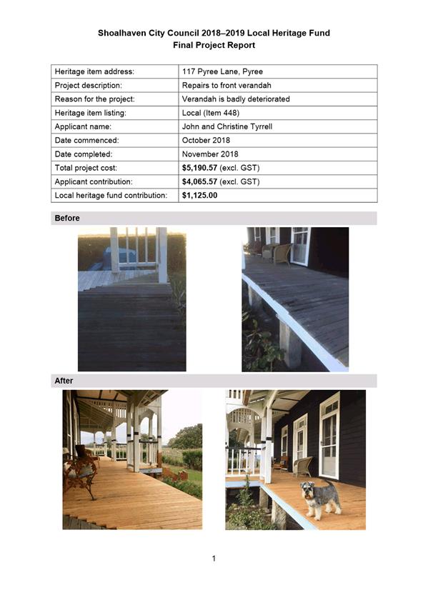
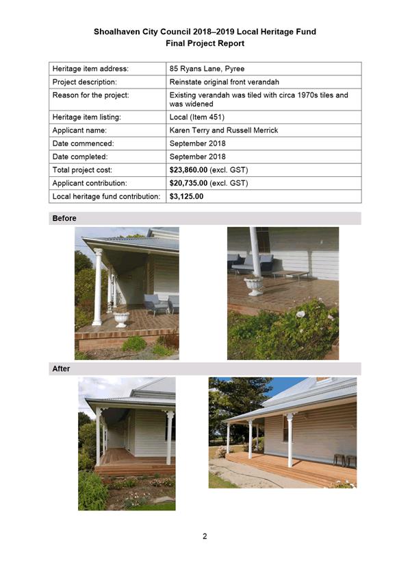
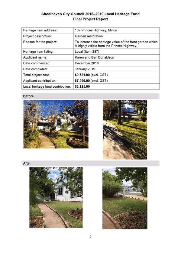
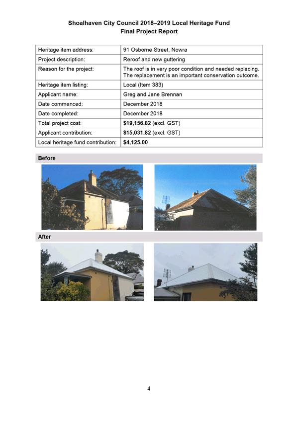
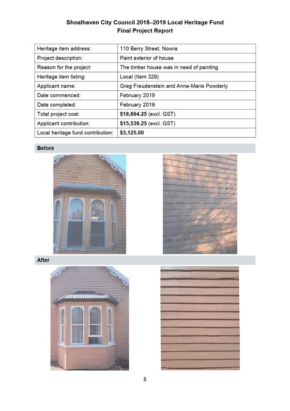
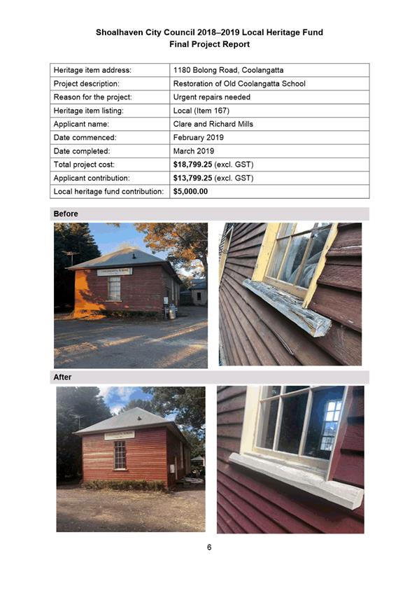
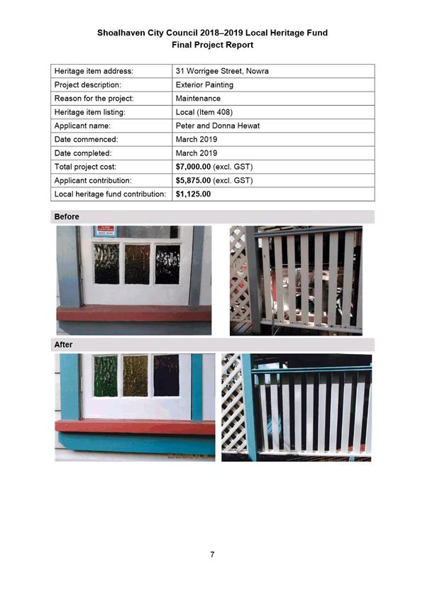
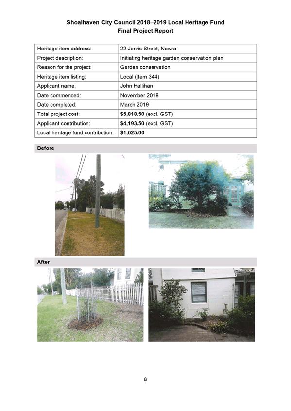
DE19.26 Outcomes
- Shoalhaven Local Heritage Assistance Fund 2018-2019
HPERM Ref: D19/66849
Group: Planning
Environment & Development Group
Section: Strategic
Planning
Attachments: 1. 2018-2019
Final Project Report - Local Heritage Assistance Fund ⇩
2. Revised Shoalhaven Heritage
Strategy 2019-2022 ⇩
Purpose / Summary
Detail the outcomes of the
Shoalhaven Local Heritage Assistance Program 2018-2019 and adopt the revised
Shoalhaven Heritage Strategy for 2019-2022 to enable the program to
continue.
|
Recommendation (Item to be
determined under delegated authority)
That Council:
1. Receive
the annual Summary Project Report (Attachment 1), detailing the outcomes of
the Local Heritage Assistance Fund Program 2018-2019, for information.
2. Adopt
the revised Shoalhaven Heritage Strategy 2019-2022 (Attachment 2).
|
Options
1. Adopt the
recommendation.
Implications: This is preferred as it will enable
the outcomes of the 2018-2019 Program to be received for information (via the
Summary Project Report – Attachment 1) and enable Council’s
Heritage Strategy for the years 2019-2022 to be adopted to enable the program
to continue.
It will allow this year’s
program to be finalised so that Council can claim reimbursement of NSW Heritage
Grant funding.
2. Adopt an alternative
recommendation.
Implications: Depending on the nature of any
alternative recommendation, this may not be in keeping with the established
process and will possibly prevent the finalisation of this year’s
program. This may prevent Council making a claim for reimbursement under the
NSW Heritage Grants funding, particularly if Council’s Heritage Strategy
is not revised.
Background
Council has continued its
commitment to local heritage projects by supporting the NSW Heritage Grants.
The grant funding provided by the NSW Government assists the Council to employ
a Heritage Advisor and to run an annual Local Heritage Assistance Fund to
provide grants of up to $5,000 for a wide range of small heritage projects
including general maintenance, adaptive reuse, or sympathetic
alterations/additions to heritage items.
The conservation of
Shoalhaven’s cultural heritage by its owners is clearly beneficial to the
broader community and visitors to the area. These grants, although small, show
that Council and the NSW State Government are committed to helping owners to
conserve and enhance their properties for future generations. These heritage
projects contribute to heritage conservation management, promote cultural
sustainability and encourage heritage tourism.
NSW Heritage Grants Program
2018-19
NSW Heritage Grant funding was
accepted under the following streams:
· Local
Heritage Places (Shoalhaven Local Heritage Assistance Fund) – Council has
accepted a grant offer of up to $7,500 (ex GST) for the 2018-19 financial year,
with a funding formula of $1: $1 (OEH: Council). The claim for reimbursement
needs to be made by 15 May 2019.
· Local Government
Heritage Advisors – Council has accepted a grant offer of up to
$8,000 (ex GST) for the 2018-19 financial year towards providing a Heritage
Advisory Service for Shoalhaven. The claim for reimbursement needs to be made
by 15 May 2019.
Community Engagement
The Shoalhaven Local Heritage
Fund Program 2018-2019 was advertised in local newspapers on 20 June 2018 and
included a link to Council’s website for relevant information on
eligibility and assessment criteria. Direct advice was also provided to persons
who had previously expressed an interest in the program.
Policy Implications
As part of the funding agreement
for the Local Government Heritage Advisors Grant and to enable a claim for
re-imbursement, Council is required to submit a four-year Heritage Strategy
covering 2018-2019.
As such, the Shoalhaven
Heritage Strategy 2018-2021 requires minor revisions to ensure it is
correct to cover the required period. A few minor edits are also proposed.
Refer to Attachment 2.
The Shoalhaven Heritage Strategy
notes that the Heritage Advisor is to inspect all completed projects to ensure
compliance with the application details and sound conservation practice. In the
current absence of a Heritage Advisor, this process has been undertaken by
Council staff, with input from a Heritage Consultant as required.
Financial Implications
Shoalhaven Local Heritage
Assistance Fund (Local Heritage Places Grant)
The funding offer from the NSW
Government for the 2018-2019 financial year is up to $7,500 (ex GST) per annum,
with a funding formula of $1: $1 (NSW Government: Council). Therefore,
Council needs to ensure it maintains its matching contribution in the budget of
up to $7,500.
Local Government Heritage
Advisors Grant
The funding offer from the NSW
Government for the 2018-2019 financial year is up to $8,000 (ex GST), with a
funding formula of $1: $1 (NSW Government: Council). Therefore, Council needs
to ensure it maintains its matching contribution in the budget of up to $8,000.
|
|
Development
& Environment Committee – Tuesday 07 May 2019
Page
0
|
|

|
Development
& Environment Committee – Tuesday 07 May 2019
Page
0
|
|
|
Development
& Environment Committee – Tuesday 07 May 2019
Page
0
|
DE19.27 Proposed
Amendment - Shoalhaven Development Control Plan 2014 - Low Density Residential
HPERM Ref: D19/106139
Group: Planning
Environment & Development Group
Section: Strategic
Planning
Attachments: 1. Draft
Chapter G12: Dwelling Houses and Other Low Density Residential Development
(under separate cover) ⇨
2. Draft Dictionary (under
separate cover) ⇨
Purpose / Summary
Obtain the required resolution
to exhibit the draft amendment to the Low Density Residential Chapter (G12) of
Shoalhaven Development Control Plan (DCP) 2014.
|
Recommendation
(Item to be determined under delegated authority)
That Council:
1. Support
the exhibition of the draft Low Density Residential Amendment to Shoalhaven
Development Control Plan 2014 for a period of 28 days as per legislative
requirements.
2. Receive
a further report on the draft Low Density Residential Amendment following the
conclusion of the public exhibition period.
3. Continue
to investigate the possibility of an off-site mature tree replacement scheme
for Shoalhaven in line with MIN18.955(4) and receive a future report on this
matter.
4. Advise
key stakeholders, including relevant industry representatives, of this
decision.
|
Options
1. As recommended.
Implications: This is the preferred option as it
will enable the resolution of operational issues and matters that require
clarification to improve the function of the Chapter.
The Amendment will also result
in provisions that holistically consider local character and context, good
quality design, amenity, universal design (optional) and more broadly the
public interest.
2. As recommended
with the Councillor-suggested changes (in part or full) as outlined in Table 2
and Table 3 of this report.
Implications: This will
depend on the extent of any changes. The staff comments in Table 2 - 3 explain
the intent of the proposed provisions and resulting implications as
appropriate. Any changes to Attachment 1 and 2 should be considered in the
context of the DCP as a whole, and more specifically the Medium Density DCP
Amendment (Chapter
G13 of the DCP), as a number of the provisions in this draft Amendment are
the same or similar.
3. Adopt an
alternative recommendation.
Implications: This will
depend on the extent of any changes and could delay the implementation of
updated and more appropriate low density residential development provisions.
4. Not adopt the
recommendation.
Implications: This could stop the implementation of
more appropriate and better structured low density residential development
provisions.
Background
Amendment Context
Council resolved on 2 June 2015
to commence a large-scale systematic review/amendment of Shoalhaven DCP 2014 to
address several existing Council resolutions and other matters identified since
the commencement of the original plan on 22 October 2014.
Stage 5 of the review/amendment
included the review of the DCP Chapters related to subdivision and residential
development, namely:
· Chapter
G11: Subdivision of Land.
· Chapter
G12: Dwelling Houses, Rural Workers’ Dwellings, Additions and Ancillary
Structures.
· Chapter
G13: Dual Occupancy Development.
· Chapter
G14: Other Residential Development.
The Medium Density Amendment to
Shoalhaven DCP 2014 addressed Chapter G13 and G14; and came into effect on 31
October 2018. An amendment to Chapter G11 is identified as a priority project
on the Strategic Planning Works Program and will be reported separately to
Council for consideration in due course.
The updating of Chapter G12 is considered as part of this
reported amendment.
The Draft Low Density
Residential Amendment
The proposed draft Low Density
Residential Amendment includes:
· The
repeal of existing Chapter
G12.
· Proposed
new Chapter G12: Dwelling Houses and Other Low Density Residential Development
(Attachment 1).
· Proposed
consequential amendment to the DCP Dictionary (Attachment 2).
The proposed new Chapter G12
applies to:
· Dwelling
houses, including additions and alterations.
· Rural
workers’ dwellings, including additions and alterations.
· Relocation
of second-hand dwellings.
· Detached
habitable rooms.
· Secondary
dwellings.
· Ancillary
structures.
· Non-habitable
structures on vacant land.
Essentially, the draft Amendment
proposes to improve the function of low density residential and ancillary
development controls, address policy gaps and operational issues or matters
that need clarification that have been identified since the Shoalhaven DCP 2014
originally became effective on 22 October 2014.
In January 2019, the draft Low
Density Residential Amendment was initially reported to the Development &
Environment Committee seeking a resolution to exhibit. The most notable
components of the draft Amendment are outlined in the following table:
Table 1: Summary of the Draft Amendment
|
Theme
|
Proposed content
|
|
General
|
· Introduction
of a more logical layout, consisting of general controls that apply to all
low density residential (and ancillary) development and further controls
based on the proposed land use.
|
|
General Controls
|
· Introduction
of provisions that encourage the retention where possible of mature
shade/large canopy trees, vegetation and shrubs.
|
|
Dwelling Houses, Rural Workers’ Dwellings and
Associated Development
|
· Introduction
and/or clarification of provisions relating to:
- Noise
generating equipment.
- Minimum
landscape requirements (based on Codes SEPP complying development
requirements).
- Private
open space requirements.
- Laundries
in garages.
- Storage.
- Detached
habitable rooms/studios.
- Universal
design (only applies when an applicant designs a dwelling to be accessible or
adaptable).
- Bin
storage, presentation and collection.
· Refinement
of provisions relating to the relocation of secondary dwellings.
|
|
Secondary Dwellings
|
· Deletion
of existing provisions relating to ‘granny flats’.
· Introduction
of provisions for ‘secondary dwellings’ to supplement the
relevant provisions within the Affordable Rental Housing SEPP; e.g. visual
and acoustic privacy, solar and daylight access.
|
|
Ancillary Structures
|
· Introduction
of eave height for garages (or similar structures) in the R1, R2 and SP3
(> 2000m2), R3 and RU5 zones.
· Greater
consideration of solar and daylight access.
· Introduction
of provisions regarding swimming pools.
|
|
Non-Habitable Structures on Vacant Land
|
· Introduction
of new provisions regarding non-habitable structures on vacant land, e.g.
density, height, setbacks and solar/daylight access.
|
|
Dictionary
|
· Introduction
of new terms to support draft Chapter G12: Detached habitable room, Detached
studio, Solar access and Solar collector.
· Deletion
of the Detached habitable room (existing definition) and Granny flat
definitions.
|
The Committee resolved (MIN19.5)
to “defer this matter pending a workshop of Councillors, before the
Proposed Amendment – Shoalhaven DCP 2014 – Low Density Residential
is placed on draft exhibition”.
In accordance with the
resolution, a Councillor workshop was held on 25 March 2019, with six (6)
Councillors were in attendance. Feedback from the Councillor workshop was
generally supportive; however, some changes were suggested as outlined in the
following table.
Table 2: Summary of Suggested Changes from Councillor Workshop
|
Issue
|
Suggested Change
|
Staff Comment
|
|
1
|
Section 5.6 Trees and Vegetation
Opportunity for replacement trees to be replanted
elsewhere (e.g. Council owned land or public land) and at the scale of 2-3
replacement trees for each mature tree lost.
|
This suggestion has merit and has been successfully
implemented in other local government areas in NSW (e.g. Sutherland
Shire).
On 11 December 2018, Council also resolved
(MIN18.955(4)) to “Consider a subsequent report on the detail of a
possible ‘tree replacement policy’ in line with those of other
Councils and the previous Council resolution (MIN18.733).”
It is recommended that these investigations be
undertaken and reported back to Council prior to any amendments to the DCP
being made in this regard.
|
|
2
|
Section 6.2.3 Landscaping
Amend the note associated with
Acceptable Solution A19.1 to make it clear that decks and hardstand areas are
counted towards meeting landscape requirements.
|
This change could be made; however, it is noted that
Shoalhaven LEP 2014 defines landscaped area as:
a part of a site used for growing plants,
grasses and trees, but does not include any building, structure or hard paved
area
The definition in the LEP excludes decks and hardstand
areas from landscaped areas and prevails to the extent of any
inconsistency with the DCP.
|
|
3
|
Section 6.2.4 Private Open
Space
In relation to Acceptable
Solution A20.1, replace “at least 50m2” with “not less than
50m2”.
|
This change appears to have minimal implications and
the wording has been updated at Attachment 1.
|
Councillors were also provided
the opportunity to submit further feedback on the proposed Amendment during a
two-week period following the workshop. One set of comments was received from
Clr Watson.
The following table provides a
summary of Clr Watson’s comments, as well as staff commentary in relation
to the issues presented.
Table 3: Summary of Councillor Submission
|
Issue
|
Submission Summary
|
Staff Comment
|
|
1
|
The DCP is too prescriptive. It should be clearly
performance based to avoid assessment staff taking a tough line on
everything.
|
The draft Amendment follows the established
‘performance-based’ model where the acceptable solutions
represent the preferred solution, but not necessarily the only solution.
It is reasonable for a DCP to guide applicants in
regard to desired outcomes in that these can be considered in the design
process. If an acceptable solution cannot be readily achieved, a performance
solution is always able to be put forward.
Further advice would be required to identify which
provisions within the Chapter require modifications, beyond those outlined
below.
|
|
2
|
Section 5.6 – Trees and Vegetation
The whole of Section 5.6 should be removed as large
shade trees can cause structural damage, harbour white ants and breach the
45-degree rule. There is no space for large shade trees on small
blocks.
|
The basis of the comment is acknowledged. The whole
section has been established to retain existing mature shade/large canopy
trees, vegetation and shrubs wherever practicable.
This has been drafted into the commentary, objectives,
performance criteria and acceptable solution. Applications would be assessed
on a site by site basis as to the practicality of retention.
|
|
3
|
Section 6 Dwelling Houses, Rural Workers’
Dwellings and Associated Development
On large properties, rural workers dwellings should
provide for separation depending on the site and the location of services.
|
There is nothing in the proposed Amendment that restricts
the separation of a rural workers dwelling from a dwelling house. It would be
more appropriate for the DCP to remain silent and allow applicants to respond
accordingly.
|
|
4
|
Section 6.1.2 Height and Setbacks
It is too restrictive; if most of the houses in a
street are single story a two-story dwelling cannot be erected.
|
Acceptable Solution A13.3 does not act to
prohibit a two-storey dwelling next to a single storey dwelling. It is noted
that this provision has also been adopted in the recent Medium Density
Amendment to the DCP (refer to Chapter
G13).
|
|
The restriction on overshadowing recreation space is
over the top and cannot always be complied with on small lots.
|
Acceptable Solution A13.2 seeks only to minimise
the shading of adjacent private open space. Acceptable Solution A18.3
further quantifies that 10m2 of private open space for the
adjacent dwelling should receive at least 3 hours of direct sunlight at the
winter solstice. It is reasonable for a DCP to guide applicants in regard to
desired outcomes in that these can be considered in the design process.
|
|
Front setbacks are too restrictive. Insert the
word ‘generally’.
|
Except for introducing general rear and battle-axe
setbacks, the provisions in the draft Amendment are as existing.
Instead of adding the word ‘generally’ to Acceptable Solutions
A14.1-A14.3, it is suggested more appropriate to rely on the existing mechanism
in the DCP which enables provisions to be varied (refer to Chapter
1: Introduction of the DCP).
|
|
5
|
Section 6.2.3 Landscaping
35% landscaping is too restrictive and should be
flexible because of other restrictions.
|
This provision is existing and has also been
adopted in the recent Medium Density Amendment to the DCP (refer to Chapter
G13).
It would be more appropriate for the DCP to retain
this provision for consistency with Chapter G13 and rely on the mechanism in
the DCP which enables provisions to be varied (refer to Chapter
1: Introduction of the DCP). It is reasonable for a DCP to guide
applicants in regard to desired outcomes, in that these can be considered in
the design process.
|
|
6
|
Section 6.2.4 Private Open Space
Insert the word “generally” to enable a
private open space forward of the building line where there are constraints
behind the front building line.
|
The provisions in the draft Amendment relating to
private open space seek to ensure privacy, safety, opportunities for active
and passive outdoor recreational activities and consider impact on the
streetscape. These matters are generally best achieved when the private open
space is located behind the building line.
It would be more appropriate for the DCP to retain the
proposed private open space provisions and rely on the mechanism in the DCP
which enables provisions to be varied (refer to Chapter
1: Introduction of the DCP). Again, It is reasonable for a DCP to guide
applicants in regard to desired outcomes, in that these can be considered in
the design process.
|
|
7
|
Section 6.2.5 Storage and Laundry Facilities
Supports the provisions, however notes that the garage
dimensions are too small.
|
Section 6.2.5 does not prescribe garage
dimensions, except to demonstrate minimum dimensions of a car and circulation
space where a laundry is proposed in a garage.
Chapter
G21 sets a 2.6m x 5.5m dimension per space in a garage, however Council
could decide to set larger garage space dimensions. Further direction would
be required in this regard and any changes may require an amendment to
Chapter G21.
|
|
8
|
Section 6.2.6 Car parking
This section should be less prescriptive particularly
in respect of carports where they are being retrospectively added.
|
It is assumed that this comment relates to Acceptable
Solution A24.2 which requires car parking to be wholly located behind the
building line.
Where a carport is proposed, the setbacks in the DCP
are to be considered which would set the structure behind (or aligned) with
the front building line. To require otherwise may have the result that
parking in front of the building line becomes the norm, and as such it is
considered more appropriate to rely on the mechanism in the DCP which enables
provisions to be varied (refer to Chapter
1: Introduction of the DCP).
|
|
9
|
Section 6.3.1 Building Form, Design and Materials
Defeats in some cases the ability to have a two-car
garage.
|
Acceptable Solution A26.2 specifies that the width of
garage facades, where they address the street, shall not exceed 9m or 50% of
the length of the frontage, whichever is the lesser. The purpose of this
provision is to balance the elements along the front façade and to
also enable the integration of elements (like doors and windows) which
enhance the streetscape and promote passive surveillance. This provision has
been adopted in the recent Medium Density Amendment to the DCP (refer to Chapter
G13).
|
|
Same with front door, some designs look good with a
side entrance. It is not possible for all balconies to overlook a public
space.
|
Front doors, windows and balconies enable passive
surveillance opportunities which is in the broader public interest. It would
be more appropriate to rely on the mechanism in the DCP which enables
provisions in the DCP to be varied (refer to Chapter
1: Introduction of the DCP). Again, it is reasonable for a DCP to guide
applicants in regard to desired outcomes, in that these can be considered in
the design process.
|
|
10
|
Section 6.3.2 Detached Habitable Rooms and Studios
The controls on detached rooms should purely be
performance-based dependant on the site constraints. There is nothing
wrong with the current provisions.
|
The provisions for detached
habitable rooms have been strengthened and made more specific.
Following consideration of
legal advice submitted by an applicant in relation a development application
for a detached habitable room, it is considered appropriate to include:
· Specific
objectives relating to detached habitable rooms.
· An
all-weather connection between the principal dwelling and the detached
habitable room.
· A
numeric standard to define what ‘close proximity’ means in
relation to the principal dwelling.
|
|
Should be re-worded to generally be no further than 10m
from the dwelling. There are often cases where structures exist which may be
converted to studios etc.
|
The purpose of this provision is to reinforce that
detached habitable rooms are to function as part of the principal dwelling.
Council will consider applications on a case by case basis and it would be
more appropriate to rely on the mechanism in the DCP which enables provisions
to be varied (refer to Chapter
1: Introduction of the DCP).
|
|
11
|
Section 8.2 Building Form and Design
There should be more flexibility with garages.
|
It is assumed that this comment relates to Acceptable
Solution A40.2 which specifies that the width of garage façades, where
they address the street, shall not exceed 9m or 50% of the length of the
frontage, whichever is the lesser. Refer to the related commentary at Issue 9
in this table.
This provision could be changed by Council; however,
it would be appropriate to consider A26.2 and A40.2 together.
|
Conclusion
The recommendation seeks to
proceed with Option 1 which reflects the general consensus that Council staff
took from the Councillor workshop. However, it is noted that Option 2 would see
the changes suggested in the workshop (issues 1 and 2 at Table 2) and the
Councillor submission (Table 3) made to the draft Amendment package prior to
exhibition (in part or full), should Council wish to pursue that option. It is
noted that Option 2 requires some clarification in relation to certain content
which can be sought prior to proceeding to exhibition.
Community Engagement
The draft Low Density Residential
Amendment will be publicly exhibited for at least 28 days in accordance with
legislative requirements at the Nowra Administrative Building. Documentation
will also be available on Council’s website and at the Ulladulla
Administrative Buildings. Development Industry representatives will be directly
notified of the exhibition arrangements.
Policy Implications
The draft Low Density
Residential Amendment seeks to introduce user-friendly DCP provisions in a
logical structure that address gaps in policy and respond to operational
matters that have arisen following the passing of time. Should the
Amendment not proceed, these fundamental concerns will not be addressed.
It is proposed that draft Chapter
G12: Dwelling Houses and Other Low Density Residential Development will
ultimately replace existing Chapter G12: Dwelling Houses, Rural Workers’
Dwellings, Additions and Ancillary Structures.
Financial Implications
The draft Low Density
Residential Amendment to Shoalhaven DCP 2014 will continue to be resourced
within the existing Strategic Planning budget.
Risk Implications
Should the draft Low Density Residential Amendment not
proceed, there is a risk that Council will not be able to respond to low
density residential development in a way that holistically considers matters
such as local character and context, good quality design and amenity and more
broadly the public interest. This could result in poor built form and
liveability outcomes for both residents and the broader community. There are
also matters that need to be revised to ensure the planning controls continue
to operate as expected/intended and resolve inconsistencies.
|
|
Development
& Environment Committee – Tuesday 07 May 2019
Page
0
|
DE19.28 Proposed
Review - Shoalhaven LEP 2014 - Clause 2.8 Temporary Use of Land
HPERM Ref: D19/109574
Group:
Section: Strategic
Planning
Purpose
/ Summary
Obtain direction from Council
regarding a potential review of Clause 2.8 (Temporary use of land) in
Shoalhaven Local Environmental Plan (LEP) 2014.
|
Recommendation
(Item to be determined under delegated authority)
That Council:
1. Proceed
to review the operation and effect of the current Clause 2.8 (Temporary use
of land) in Shoalhaven Local Environmental Plan 2014.
2. Advise
relevant stakeholders (all CCBs, Development/Tourism Industry, Shoalhaven
Tourism Advisory Group) of this decision and engage them during the Review.
3. Receive
a further report outlining the findings of the Review and options to revise
the clause as appropriate.
|
Options
1. Adopt the
recommendation.
Implications: This is the
preferred option as it will provide Council with the necessary information to
adequately respond to community concerns and make an informed decision on
whether any amendments to Clause 2.8 are required.
2. Adopt an
alternative recommendation.
Implications: The
implications will depend on the extent of any changes. Depending on its
nature, an alternative recommendation could either delay any proposed
amendments to Clause 2.8 or result in amendments with unforeseen implications.
3. Not adopt the
recommendation.
Implications: This option is not preferred as the
community continue to raise concerns regarding the approval of Development
Applications made under Clause 2.8. Without a wholistic review, Council
will continue to potentially react individually to community submissions and
complaints during the assessment and operation of these temporary uses.
Background
Clause 2.8 is an optional Clause
within the NSW Government’s Standard Instrument LEP, which means that
Councils can choose whether to include it within their LEP. Council opted to
include the clause as part of the preparation of Shoalhaven LEP 2014.
Clause 2.8 allows development
consent to be granted for any development in any zone for a maximum
period of 52 days in any 12-month period. Under this Clause, consent may be
granted regardless of land use permissibility and any other land use
restrictions within the LEP. For example, a function centre may be able to
obtain consent in the RU1 or RU2 zones under Clause 2.8 even though it is not
expressly permissible via the relevant land use table.
The current wording of Clause
2.8 in the Shoalhaven LEP 2014 is as follows:
“2.8 Temporary use of land
1) The objective of
this clause is to provide for the temporary use of land if the use does not
compromise future development of the land, or have detrimental economic,
social, amenity or environmental effects on the land.
2) Despite any other
provision of this Plan, development consent may be granted for development on
land in any zone for a temporary use for a maximum period of 52 days (whether
or not consecutive days) in any period of 12 months.
3) Development consent
must not be granted unless the consent authority is satisfied that:
a) the temporary use
will not prejudice the subsequent carrying out of development on the land in
accordance with this Plan and any other applicable environmental planning
instrument, and
b) the temporary use
will not adversely impact on any adjoining land or the amenity of the
neighbourhood, and
c) the temporary use
and location of any structures related to the use will not adversely impact on
environmental attributes or features of the land, or increase the risk of
natural hazards that may affect the land, and
d) at the end of the
temporary use period the land will, as far as is practicable, be restored to
the condition in which it was before the commencement of the use.
4) Despite subclause
(2), the temporary use of a dwelling as a sales office for a new release area
or a new housing estate may exceed the maximum number of days specified in that
subclause.
5) Subclause
(3) (d) does not apply to the temporary use of a dwelling as a sales office
mentioned in subclause (4).”
Since the commencement of
Shoalhaven LEP 2014, community concerns have been raised in relation to various
development applications made under Clause 2.8. Most of these concerns are
focused around applications for temporary function centres (e.g. wedding
venues) in rural and environmental zones and/or relate to issues such as:
· Inappropriate
location.
· Undesirable
behaviour.
· Amenity
(noise, dust, light spill).
· Flora
and fauna impacts.
· Actual
“Temporary” nature of the use/development.
· Lack
of services.
· Waste
collection.
Recent examples of community
concerns in relation to function centre applications under Clause 2.8 include:
· 2819A Moss
Vale Road, Barrengarry - 25 submissions received – majority raised issues.
· 179
Cedar Springs Road, Kangaroo Valley - 26 submissions received – majority
raised issues.
· 171B
Strongs Road, Jaspers Brush - 105 submissions received (at date of writing)
– majority raised issues. It is noted that this application has been
‘called-in” for determination by Council (MIN19.161).
Initial investigations have
found that several Councils across NSW have amended Clause 2.8 over time by:
· Reducing
the allowable timeframe from the standard 52 days.
· Limiting
the application of Clause 2.8 so that it does not apply to certain zoned land
(e.g. land zoned RU2 Rural Landscape).
· Creating specific
land use exceptions to Clause 2.8. (i.e. defining uses that the clause does not
apply to).
Conclusion
Given the current community
concern regarding the ongoing application of Clause 2.8 it would be prudent for
Council to investigate the merit of these concerns and consider possible
adjustments to the current clause.
It is intended that the further
report to Council would summarise the findings of the more detailed review and
identify whether any amendments to Clause 2.8 would be beneficial, and if so,
their nature.
Community Engagement
The review will include
consultation with relevant stakeholders (all CCBs, Development/Tourism Industry
representatives, Shoalhaven Tourism Advisory Group etc.) to ensure that any
amendments are responsive to the broader interests of the wider community.
It is noted that the tourism
sector utilises Clause 2.8 for events including weddings, functions and
temporary markets. These events are primarily located in rural and
environmental zones due to the amenity of the natural landscape and are a large
driver for out-of-season visitors to Shoalhaven.
As such, the Shoalhaven Tourism
Advisory Group and Tourism Industry will be directly consulted to ensure that
the proposed amendments balance the concerns of both the businesses operating
under the Clause and the residents/ratepayers impacted by the temporary
developments.
Should the review recommend
amendments to Clause 2.8, any resulting Planning Proposal would ultimately be
exhibited for comment in accordance with Council’s Community Engagement
Policy to ‘inform’ and ‘consult’ and relevant
legislative requirements.
Financial Implications
Based on the recommended
approach, there are no immediate financial implications for Council and the
review will be resourced within the existing Strategic Planning budget.
Risk Implications
There is currently an increase
in community objections to temporary use developments (predominantly function
centres) being considered under Clause 2.8 of Shoalhaven LEP 2014.
Reviewing Clause 2.8 will allow
Council to be proactive in considering community objections whilst balancing
the interests of the tourism industry.
|
|
Development
& Environment Committee – Tuesday 07 May 2019
Page
0
|
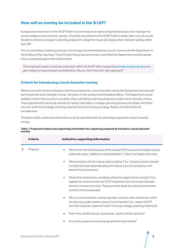
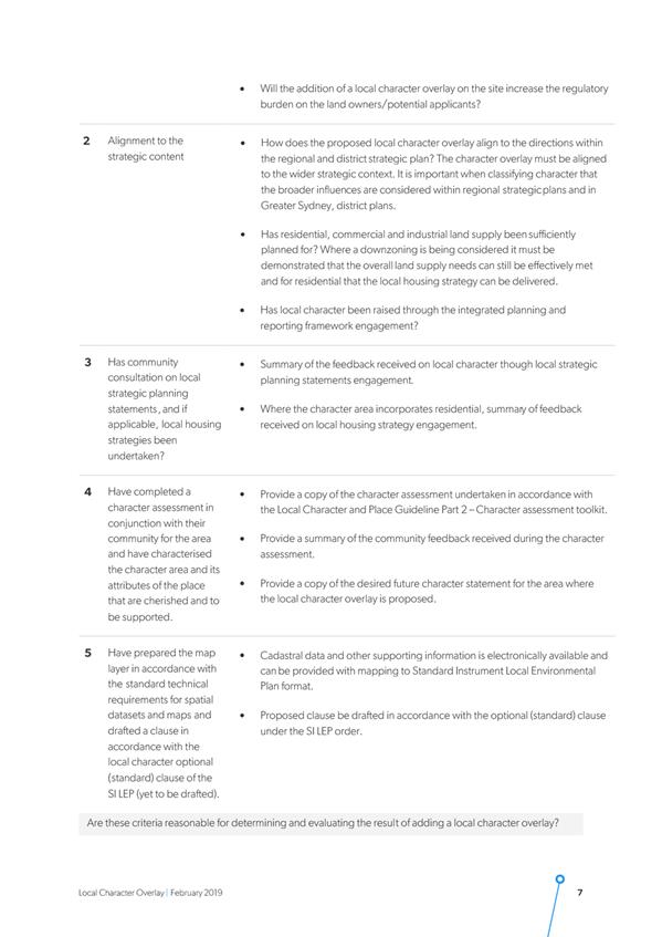
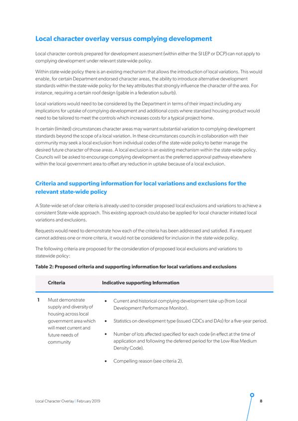
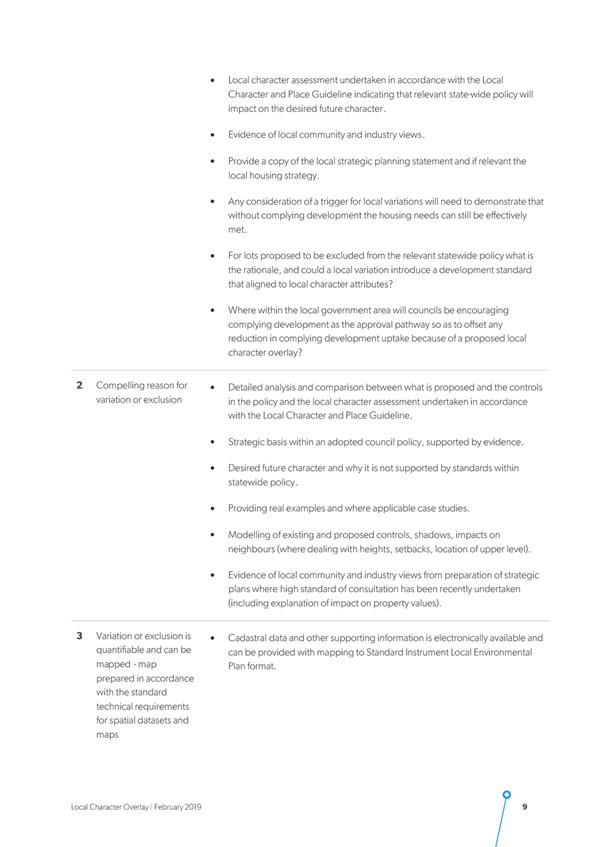
DE19.29 Proposed
Council Submission - Discussion Paper: Proposed Standard Instrument LEP
Local Character Overlay
HPERM Ref: D19/121980
Group: Planning
Environment & Development Group
Section: Strategic
Planning
Attachments: 1. Proposed
Council Submission - Discussion Paper on a Proposed Standard Instrument LEP
Local Character Overlay ⇩
2. Discussion Paper - Local
Character Overlays ⇩
Purpose / Summary
Advise of the public exhibition
by the NSW Department of Planning and Environment (DP&E) of a Discussion
Paper on a proposed Standard Instrument LEP Local Character Overlay and obtain
endorsement to make the submission at Attachment 1.
|
Recommendation
(Item to be determined under delegated authority)
That Council make a submission
(Attachment 1 of this report) to the NSW Department of Planning and
Environment in relation to its Discussion Paper on a proposed Standard
Instrument LEP Local Character Overlay.
|
Options
1. Endorse Attachment
1 as Council’s submission on the Discussion Paper and proposed Local
Character Overlay.
Implications: This is the preferred option as it
will enable Council to provide a submission highlighting matters that should be
considered.
2. Amend Attachment
1 and include additional comments as necessary and submit.
Implications: This option will still enable Council
to provide a submission; however, the implications of any changes are unknown
and may require closer consideration or refinement which may delay Council’s
submission.
3. Not make a
submission.
Implications: This is not recommended as it would
prevent Council from having any input and the opportunity to identity issues
for consideration or resolution would potentially be missed.
Background
As part of the amendments to the
NSW Environmental Planning & Assessment Act 1979 that commenced in March
2018 the following new objectives were added to the Act:
· to
promote the sustainable management of built and cultural heritage (including
Aboriginal cultural heritage)
· to
promote good design and amenity of the built environment
The NSW Government is working to
strengthen the role of ‘character’ in the NSW planning system in
recognition of its importance to local communities and the need to appropriately
manage the effects of population growth and change on local character and
amenity. A range of material on local character is now available in the
DP&E website at the following link:
https://www.planning.nsw.gov.au/Policy-and-Legislation/Local-Character
The DP&E have also released
a Discussion Paper for comment which explores the proposal to introduce a
‘local character overlay’ in the form of a map and supporting local
clause into the Standard Instrument Local Environmental Plan (LEP). A copy of
the Discussion Paper is at Attachment 2. The Discussion Paper is also
available on the internet at the above link and any feedback needs to be
provided by 20 May 2019.
The Discussion Paper is one of
several tools and resources released by the DP&E and the NSW Government
Architect to ensure that strategic planning recognises and enhances the local
character of places and is informed by what the community values about its
area.
Local character overlays were
first identified as a potential mechanism for embedding local character into
the planning framework in the DP&E’s January 2018 Planning Circular PS 18–00 Respecting and
enhancing local character in the planning system.
The Planning Circular, which is
also available via the above link, acknowledges that:
· areas
with a strong sense of local character are desirable places to live and work
and support strong communities. A strong sense of local character should be an
objective in planning for all communities;
· areas
that build on existing local character contribute to the vitality and viability
of centres;
· investing
in local character can drive economic development and opportunity, particularly
in regional areas;
· respecting
character does not mean that new development cannot occur; instead, it means
that a design-led approach needs to be implemented which builds on the valued
characteristics of individual neighbourhoods and places;
· communities
are concerned about the effects of new development on the character and amenity
of their neighbourhood;
· local
community engagement is essential in defining and planning for a desired future
character of an area.
The proposed character overlay
consists of an additional map layer and a supporting local clause in the LEP.
The map layer would identify defined character areas and the supporting clause
would establish additional assessment requirements to ensure that development
proposals meet local character aspirations. The proposed clause could require
applicants to:
· meet
development controls within the LEP clause; and/or
· meet
development controls within a DCP; and/or
· submit
a ‘statement of consistency’ with the desired future character for
the area, as set out in a desired future character statement adopted by
Council.
Should the proposed change come
to fruition, it will be up to Council to decide whether it wants to use the
overlay and clause in the Shoalhaven LEP 2014 (SLEP). To do this Council would
need to prepare a Planning Proposal (PP) addressing criteria established by the
DP&E.
Ideally any PP of this nature
would follow Council’s draft Local Strategic Planning Statement (LSPS)
and Growth Management Strategy and would need to consider any community
feedback received on local character as part of these projects. Council would
also need to undertake character assessments for each proposed character area
and provide a summary of community feedback received on those assessments.
At this stage the proposed
character overlay is only intended for specific or defined areas with
significant or exceptional character values where the broader zone objectives
in the LEP do not provide sufficient direction to manage change and support
local character.
The Discussion Paper suggests
that the proposed character overlay could trigger local variations and, in
exceptional circumstances, local exclusions, from state-wide policy. For
instance, Complying Development under State Environmental Planning Policy
(Exempt and Complying Development Codes) 2008 could be subject to alternate
local development standards or could be excluded altogether in character areas.
Local variations or exclusions would not be automatic but would need to be
specifically requested and justified by Council.
Draft Council Submission
Given the nature of this
proposal it is recommended that Council make a submission on the Discussion
Paper.
The proposed Council submission
(see Attachment 1) provides responses to key questions asked in the
Discussion Paper. The key comments in the proposed submission are as follows:
· the
character of many of Shoalhaven’s towns and villages is valued highly by
the community. Local character was raised more than any other issue in
community submissions received in the recent exhibition of Council’s
Growth Management Strategy review (GMS). There was also substantial community
interest in the draft settlement character statements that were exhibited
alongside the GMS.
· the
proposed local character overlay and supporting clause in the Standard
Instrument LEP is generally supported. Council may consider introducing it in
the SLEP for certain areas in Shoalhaven, subject to consultation with affected
communities and endorsement from the elected Council to prepare PPs on a case
by case basis.
· the
LEP is considered to be the most appropriate place for character controls
because it has the statutory weight to ensure that they are considered and
implemented effectively. This is important given how important local character
is to many communities in Shoalhaven.
· linking
the LEP clause to a statement of desired future character for each character
area would be a good way to implement the community’s character
aspirations set out in the LSPS and other Council strategies. Council recently
exhibited a set of draft character statements for each of its settlements to
inform the preparation of the GMS review and LSPS. The final character statements
could inform a future character overlay in the SLEP.
· any
local character overlay should be accompanied by clear and measurable
development controls so that development proposals can be meaningfully assessed
against it and uncertainty is minimised;
· a
local character overlay should automatically exclude or vary State
Environmental Planning Policies (SEPPs) such as Complying Development under SEPP
(Exempt and Complying Development Codes) 2008. These SEPPs permit a wide
range of significant and comparatively homogenous developments without
requiring adequate consideration of local character. Since the overlay is only
intended for areas with significant or exceptional character values, it is
considered self-evident that it should automatically exclude or vary these
SEPPs in the same way that the heritage conservation overlay does.
Conclusions
At present there is limited
opportunity in the LEP, other than through individual heritage listing or
establishment of Heritage Conservation Areas, to strengthen consideration of
character impact. Council has been grappling with how to manage character
impacts arising from development in areas like the older part of Berry and the
medium density zones to the west of the Nowra CBD. This proposal could
ultimately provide an additional opportunity for Council to consider and to
appropriately manage this issue through the LEP.
Community Engagement
The Discussion Paper is on
public exhibition between 28 February and 20 May 2019 to provide an opportunity
for Council, community members and industry stakeholders to provide comments
and feedback.
Policy Implications
None at this stage. If the
DP&E introduce the proposed character overlay and local clause into the
Standard Instrument LEP in the future, Council would have the option to prepare
a Planning Proposal to introduce it into the Shoalhaven LEP for selected areas
or settlements. Any amendments in this regard will be separately considered and
reported to Council as needed in the future.
|

|
Development
& Environment Committee – Tuesday 07 May 2019
Page
0
|

|
|
Development
& Environment Committee – Tuesday 07 May 2019
Page
0
|

|
|
Development
& Environment Committee – Tuesday 07 May 2019
Page
0
|
DE19.30 Public
Exhibition Outcomes - Planning Proposal (PP023) - Anson Street, St Georges
Basin - Building Heights
HPERM Ref: D19/106974
Group: Planning
Environment & Development Group
Section: Strategic
Planning
Attachments: 1. Submissions
Summary - 2019 Exhibition - Planning Proposal - Anson Street, St Georges Basin ⇩
Purpose / Summary
Detail the outcomes of the
recent exhibition of this Planning Proposal (PP) and consider the resultant
next steps to finalise this proposal.
|
Recommendation
(Item to be determined under delegated authority)
That Council
1. Proceed
to organise a Public Hearing for Planning Proposal No. PP023 that applies to
part of Lot 1 and Lot 6 DP 1082382, Anson Street, St Georges Basin.
2. Consider
a further report on this matter and its possible finalisation following the
Public Hearing.
|
Options
1. Resolve not to
hold Public Hearing (with reasons), adopt the PP as exhibited and exercise
delegation to make the resultant Plan.
Implications: This option is open to Council and
would enable the PP to be finalised by Council. In resolving not to hold the Public
Hearing, as requested by one of the submissions, it will be necessary to
indicate the reasons. These could include:
· One
submission requested a Public Hearing (being the landowner’s town
planner).
· Council
considers that the issues raised are not of such significance that they should
be the subject of a public hearing
· Community
and landowner views are established and well known
· Landowner
has had the opportunity to provide comment, the detail of which is clear
· Holding
a Public Hearing is unlikely to change the overriding community view or to
raise any new issues not already known/considered.
If Council resolves to proceed to finalise the PP as
exhibited, it also needs to decide whether, as either a standalone PP or as
part of the regular Housekeeping PPs, to consider establishing a consistent
mapped height of buildings (8.5m) for the other B4 and R1 zoned land to the
north and south of the subject land. This is flagged in the letter from the
Department that accompanied the Gateway determination and is also raised in the
landowner’s submission to the PP. It may also be supported by the broader
community given the concerns that have arisen with the potential development of
the subject land.
2. Resolve not to
hold a Public Hearing (with reasons), resolve to adopt the PP, but not exercise
the delegation to make the Plan.
Implications: This option
is also open to Council and would enable the PP to be finalised by Council.
Given the contentious nature of this PP, the Council could opt not to use its delegations
to make the Plan and write to the NSW Department of Planning & Environment
and advise them of this decision. This would essentially mean that Council
adopts and finalises the PP and then requests the Department to consider and
make the resulting Plan.
3. Proceed to hold
a Public Hearing prior to considering whether to adopt the PP.
Implications: If it was considered that the issues
raised are of such significance that a public hearing should be held, the
hearing would need to be independently chaired and a report prepared. The
outcomes of the public exhibition period and the Public Hearing would then be
reported back to Council to consider.
4. Proceed with an
amended PP
Implications: Depending
on the nature of any amendments, for example changing the proposed height from
8.5m to another height, the PP may require an amended Gateway determination and
need to be re-exhibited to enable the community and landowner to comment.
5. Discontinue the
PP process
Implications: This would see the existing height
limit of 13m remain in place contrary to the Council’s original intent
when it proposed the PP and contrary to community opposition.
Background
The PP covers part (eastern) of
Lot 1 and Lot 6 DP 1082382, Anson Street, St Georges Basin, both of which are
owned by Mr D DeBattista.
The subject land is currently
zoned B4 Mixed Use and R1 General Residential under Shoalhaven LEP2014 as shown
on the following map from the PP:
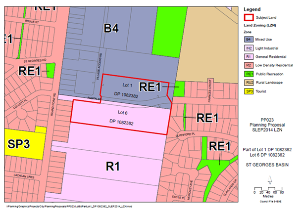
Current
Land Use Zones – Shoalhaven LEP2014
Note: the zoning of the
subject land is not proposed to be changed via this PP.
As part of the Shoalhaven Local
Environmental Plan (LEP) 2014 process a 13-metre mapped height of buildings
control was applied to the subject land following a submission from the
landowner. The height in the surrounding areas under the LEP is a mix of 8 metres,
8.5 metres and up to 11 metres – see map below.
Council resolved on 6 December
2016 to:
Retain the current 8m height control over the western
part of Lot 1 DP 1082382 and prepare a planning proposal to amend the height of
buildings map over the remainder of Lot 1 and the whole of 6 DP1082382 Anson
Street, St Georges Basin and remove the current 13m height and replace with
8.5m mapped height.
This triggered the start of a PP
process to reduce the mapped height of buildings control from 13 metres to 8.5
metres. The following maps from the PP show the current and proposed height of
buildings in this location:
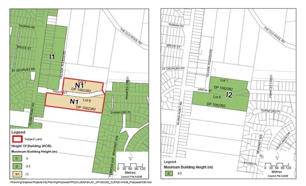
Comparison
Maps – Height of Buildings
Current
Shoalhaven LEP2014 and Planning Proposal
Note:
‘uncoloured’ or white on the above maps means the current general
height control under LEP Clause 4.3(2A) of up to 11 metres applies in these
areas.
Following the December 2016
Council resolution, the Gateway determination for the PP was signed on 29
November 2017. The determination enabled the PP to proceed with conditions,
including Government Agency consultation, community consultation (minimum 28
days) and a completion timeframe of 12 months (extended until 29 November
2019).
The accompanying letter from the
NSW Department of Planning & Environment (DP&E) also confirmed that the
‘Plan making powers’ had been delegated to Council and recommended
that Council also consider reviewing the adjoining 11 metre building height
control to ensure a consistent approach in the area.
Following the issuing of the
Gateway determination, the PP was publicly exhibited from 20 December 2017
until 2 February 2018.
On 14 December 2018 the Land and
Environment Court of NSW declared in DeBattista
v Minister for Planning and Environment [2018] NSWLEC 202 that the community consultation
process was void and of no effect.
Council elected to address the
defects in the PP and recommence the community consultation process. As a
result, this report presents the outcomes of the most recent public exhibition
process.
Public Exhibition
The PP was publicly exhibited
for review and comment from 27 February until 29 March 2019 (31 days)
inclusive. The PP was available at Council’s Administrative Centre in
Nowra and on Council’s website during this time.
The exhibition package
contained:
· Newspaper
Public Notice
· Explanatory
Statement
· Planning
Proposal document
The exhibition package can still
be viewed on Council’s internet site at the following link under the
heading “Planning documents on exhibition”:
http://www.shoalhaven.nsw.gov.au/My-Council/Public-exhibition/Documents-on-exhibition
In addition to the public notice
in the South Coast Register, the affected land owner, local Community
Consultative Body (CCB) (Basin Villages Forum) and others were directly advised
in writing of the public exhibition arrangements.
As a result of the public
exhibition period a total of 217 submissions were received. The next section of
this report provides further commentary with regard to the submissions
received.
Overview - Submissions
Attachment 1 provides a summary of each of the
submissions received during the exhibition period. Copies of the actual
submissions will also be available for review in the Councillors’ Room
prior to the meeting.
The following is the numerical
break-up of the 217 submissions received:
· Support:
167 (includes 3 community petitions containing 483 signatures)
· Comment:
49
· Oppose:
1
In addition to the detail in Attachment
1, the following is an overview of the submissions and where relevant staff
comment is provided.
Support (167)
The bulk of the submissions received
were of a brief nature and detailed the following main themes or reasons for
supporting the exhibited PP or opposing the current 13m height:
Overall – believe
proposed 8.5m will be a better and more appropriate planning outcome that still
recognises the intent of strategic planning documents. Do not want
overdevelopment.
Previous Decision –
decision to raise the height to 13m as part of the new LEP was wrong and needs
to be corrected. Current height is not soundly based and was against staff
advice.
Character – current
height is inconsistent with the existing and future desired character of area.
Concerned about the development that could result – 4 storey developments
inappropriate for the area. Destroy its character and create an undesirable
precedent. Development should be set at 8.5m consistent with other developments
and buildings that are 1-2 storeys in height.
Amenity – 13m
development will have a range of amenity impacts including noise,
overshadowing, loss of village feel and privacy concerns, particularly on
adjacent development. Some mentioned overcrowding and a move to the area to get
away from high rise development. Believe 8.5m development will enable amenity
to be maintained.
Visual Impact – 13m
or 4 storey developments will be out of place in area and will have visual
impacts. Will potentially block views to St Georges Basin. 8.5m is more in
keeping with existing development and will help minimise visual impacts.
Environment – 13m
will have environmental impacts. Concerns raised regarding potential stormwater
impacts and associated impacts on the water quality of St Georges Basin. Some
submissions refer to illegal clearing that may have occurred.
Infrastructure/Services
– current and proposed infrastructure does not support development that
is possible under the current 13m height. Proposed height of 8.5m is more
manageable. Traffic and parking concerns raised. Inadequate public transport.
Impacts and pressure on existing schools, community services and emergency
services.
Viability/Land values –
questions over the viability of development under the 13m height. Proposed
height does not sterilise the land by encouraging economically unviable
development. Smaller development of villas/townhouses and some commercial more
suitable. Concerns about impact of 13m development on existing land values.
Social Impacts –
Multi level development more suited to larger centres of Nowra and Ulladulla.
Question who will occupy the proposed units, is there even a demand? Concerned
about potential for low cost housing next to hotel/bottle shop. Will there be
employment opportunities for the new residents? Not convinced development (13m)
is in the community interest.
The following community groups
made submissions in support of the PP:
Basin Villages Forum (CCB)
– Believe the current 13m height control was an erroneous decision
previously made without supporting planning basis.
The proposed 8.5m height is
supported by infrastructure, is consistent with the existing and desired
character, is sympathetic with existing built form and natural features, allows
sustainable growth that is planned and managed, provides an appropriate
density, protects and improves scenic quality, does not sterilise the land by
allowing economically non-viable development and also recognises the intent of
strategic planning documents for the site. Look forward to approval of the PP.
Jervis Bay Regional Alliance
– PP will resolve an erroneous decision. Believe there was no
justification for the original change that occurred.
The proposed height is supported
by infrastructure, will provide an appropriate density, recognises the intent
of strategic planning documents, allows for careful urban growth and does not
sterilise the land. Congratulate Council on the initiative.
Comment (49)
The submissions that are
categorised as ‘comments’ do not expressly note support or
otherwise for the exhibited PP. Rather they generally comment negatively or in
opposition to high rise unit development generally or as proposed under the
approved and proposed developments that relate to the site.
Like the submissions in support,
the ‘comment’ submissions raise jobs, infrastructure, traffic,
parking, character, services, social impacts, appropriate height, school
capacity, overshowing, environmental and various other concerns
Oppose (1)
The submission from Cowman
Stoddart Pty Ltd on behalf of affected landowner, Mr D DeBattista, provides
the following reasons for objecting to the PP:
Ad hoc Planning Proposal
– Is not being pursued for proper planning reasons. Trying to thwart
development proposal currently before Court. Height reduction would have effect
of prohibiting the development. Client invested money based on existing
controls.
Acknowledge can amend planning
controls – should occur strategically, following due process. Should
review height limits in the overall area, not just client’s land. Gateway
determination includes statement about revising the 11m height control on
adjacent land to ensure a consistent approach in the area.
Have failed to undertake broader
review. Propose a more stringent height on the subject land when compared to
adjacent and same R1 and B4 zones without strategic justification.
The 2016 Council resolution on
Strategic Planning Works Program included the following: undertake
assessment of the urban areas in the Bay and Basin area. Height should be
considered in an exercise like this. Have failed to act on the resolution. The
July 2017 Works Program does not include the project - suggests there is not a
high priority or need to review the planning provisions in this locality,
including building heights.
Failure to undertake this
broader consideration reinforces view that PP is premature and specifically
intended to thwart the proposal before Court. There is no strategic process
underpinning. It should result from a broader review. PP has not been subject of
such an assessment and is premature.
Staff
Comments – The PP does not thwart development of
the land, though it would mean that the concept proposals currently the subject
of appeals in the Court would be hard to justify unless a savings provision was
included in the Plan. It is unusual to include savings provisions in amendments
to LEPs and the Department has not required one to be included. Should the PP
be adopted and the LEP be amended then the new height becomes one of the
principal controls for consideration for the Court but does not necessarily
prohibit the development.
The Council resolved to
request the General Manager prepare a report considering options for reducing
the height limit for this land on 25 October 2016 and then to prepare the PP on
6 December 2016. The development application currently before the NSW Land and
Environment Court was lodged with the Council on 24 March 2017, some months
after the date the Council resolved to prepare the PP. There is therefore no
substance in the suggestion that the PP was specifically intended to thwart the
proposal before the Court.
Councils are able to
undertake amendments to their planning controls following the processes set in
legislation. This does not necessarily need to follow or be an outcome of a
strategic planning process. In this regard, for example, it is noted that the
current 13m height control resulted from an individual submission received
during the Shoalhaven LEP2014 process. It did not result from a strategic or
more detailed investigation to establish a specific height for the subject land
or the broader locality.
The actual Gateway
determination that was issued for this PP dated 29 November 2017 does not,
as suggested, require or recommend that Council review the current adjoining
11m building height controls to ensure a consistent approach in the St Georges
Basin Area. This recommendation is actually in the covering letter from the NSW
Department of Planning that accompanied the determination and it is noted in
the letter for Council to ‘consider’.
The recommendation from the
Department regarding reviewing the overall 11m building height control is still
open to Council to consider should it wish to ensure consistency in the area,
but it was not a recommendation or requirement of the Gateway determination,
otherwise this would have been addressed prior to the PP proceeding to public
exhibition.
Undertaking a review of the
11m building height control that currently applies to the adjoining land that
is similarly zoned B4 and R1 is discussed in this report as an option that
Council can consider.
The current Strategic
Planning Works Program that was adopted by Council on 5 June 2018 does include
an active ‘high priority’ project to review the Shoalhaven Growth
Management Strategy, as part of this the Jervis Bay Settlement Strategy will
also be reviewed. This is the outcome of the previous Council resolution
referred to in the submission re “an assessment of the urban areas in the
Bay and Basin area”. This will essentially be a higher order
consideration of the opportunities for additional new longer term urban areas
in the Jervis Bay-St Georges Basin area and will not necessarily focus on
reviewing or setting building heights in existing urban areas.
Council has commenced the
review of the Shoalhaven Growth Management Strategy and an initial Discussion
Paper was released for comment in late 2018.
Inconsistency with s117
Directions – PP must demonstrate consistency with Ministerial
Directions, including Directions 1.1 Business & Industrial Zones and 3.1
Residential Zones.
The Directions outline
circumstances where a PP may be inconsistent if the planning authority can
satisfy the Department the inconsistences are: justified by strategy, justified
by study, in accordance with a Regional Plan or minor.
PP justifies Direction 1.1 and
3.1 inconsistencies on basis of minor significance (range of reasons provided
in PP to support this). Have contrary view – PP cannot be considered
minor.
Council’s own PP
Guidelines define a ‘minor’ PP as needing one or more specialist
study – this PP relies on two specialist studies. Thus, cannot be
considered ‘minor’.
Just because the PP only applies
to a small portion of the similarly zoned land in the area and City, this alone
should not form the justification for the PP. Dangerous precedent for ad-hoc
proposals that are not consistent with strategic planning.
No consideration given to
potential lost housing yield. Reduced opportunity here will potentially lead to
pressure on urban fringe - Contrary to objectives of Direction 3.1. Also, no
broader review undertaken of similarly zoned land.
Fail to provide sufficient
justification that PP is minor. If it is not minor, then needs to be justified
by a strategy or study – in the absence of this justification, the PP
should not proceed as it will be inconsistent with Directions 1.1 and 3.1.
Staff Comments
– The views regarding the consistency of the PP with the Ministerial
Directions are noted, however the PP contains Council’s justification for
the inconsistency with the Directions. Briefly the justifications in the PP
document are as follows:
Direction 1.1 –
inconsistencies are of minor significance because:
· PP
relates to small defined area at St Georges Basin and does not propose to
change its zone.
· The
part in the B4 zone comprises a small portion (0.92%) of the overall B4 zoned
land in the City.
· Proposed
height is more consistent with existing provisions that apply to other B4 zoned
land in the St Georges Basin Town Centre that is mapped at 8.0 metres in the
LEP.
Feasibility analysis also considers the
Direction’s objectives and the inconsistency is also potentially
justified by this analysis.
Direction 3.1 -
inconsistencies are of minor significance because:
· PP
relates to small defined area at St Georges Basin and does not propose to
change its zone.
· Existing
zones will still provide for a variety of housing types and choices.
· Affects
only a 1.97ha portion, or approximately 19%, of the R1 zoned land in this
location.
· Subject
land comprises small portion (0.14%) of the total R1 zoned land within the
City.
The Feasibility analysis also provides some relevant
commentary in this regard.
The covering letter from the
NSW Department of Planning & Environment that accompanied the 2017 Gateway
determination also indicates that “I have also agreed, as delegate of the
Secretary, the Planning Proposal’s inconsistency with Section 117
Directions 1.1 Business and Industrial Zones and 3.1 Residential Zones are
justified in accordance with the Directions”.
The Department is obviously
comfortable with the PP’s inconsistency with the directions in question,
otherwise they would not have issued the Gateway determination or would have
required additional justified, possibly prior to exhibition, which was not the
case.
In regard to the comments
about not meeting the ‘minor’ designation under Council’s own
PP Guidelines, it is noted in part in the ‘Purpose’ section of the
Guidelines that:
“It provides a
framework for all PPs within the City with a particular focus on issues
associated with proponent initiated PPs”.
The focus of the Guidelines
is mainly on circumstances when the Council will consider proponent-initiated
PP’s and the process that they need to follow, not the present
circumstances where the PP is initiated by the Council.
Irrespective of the
submissions conclusion that the PP should not proceed on the basis that it will
be inconsistent with Ministerial Directions 1.1 and 3.1, in issuing the Gateway
determination the NSW Department of Planning & Environment concluded that
any inconsistency is justified in accordance with the Direction. Thus, the PP can
be considered.
Inconsistency with broader
strategic planning framework – PP is unable to demonstrate
consistency with broader planning strategies: Illawarra-Shoalhaven Regional
Plan, Jervis Bay Settlement Strategy and Coastal Design Guidelines.
It does not articulate how
reducing height (and residential density) will achieve the objectives of these
strategies. The PP is not consistent with their objectives.
The Character
Assessment and Urban Design Review states the strategies have strong themes
around recognising existing character – this is not correct. Their
objectives seek to meet changing demand, with development character to meet
existing or desired future character (including up to 4 storeys in height).
Staff Comments
– The PP is not considered to be inconsistent with the objectives of the
strategies. The planning strategies in question are by their nature broad and
high level. They are not specific about, for example, proposed heights of
building at St Georges Basin. It is also noted that the underlying zones are
not proposed to be changed and as such a range of activities are still able to
be considered which is in keeping with the intent of the strategies.
The PP indicated that overall
it is ‘not inconsistent’ with the broad goals of the Regional Plan.
The Regional Plan does, for example, encourage growth in locations where
population growth is already occurring, such as the Nowra Centre that is
identified as a ‘major regional centre’ in the plan. Vincentia and
Ulladulla are also identified under the Plan as ‘regional centres’,
but St Georges Basin is not identified. Centres in Shoalhaven that are
identified as a focus for increased housing activity include Nowra-Bomaderry,
Huskisson and Ulladulla.
The Regional Plan goes on to
note that, based on planning analysis of existing urban areas, and current
market conditions multi-unit development is likely to occur in parts of
Wollongong and Kiama, apartments in metro Wollongong and a lesser extent Kiama
and dual occupancies in Huskisson and Berry. It also acknowledged that demand
for multi-unit housing is uneven. It suggests that a ‘place-based’
approach consider centres that have access to transport.
It is noted that the
‘urban renewal’ section of the Jervis Bay Settlement Strategy does
encourage “mixed use developments in commercial centres, including shop
top housing”. It is however not specific about setting heights in
centres. The PP still allows growth or urban renewal as the underlying zones
are retained unchanged. These zones combined with the proposed height of 8.5m
still enable a range of development opportunities, including shop-top housing,
town houses, dual occupancies and villas, all of which are more suitable and in
character than four storey residential flat buildings and four-storey shop-top
housing.
Under
the NSW Coastal Design Guidelines, St Georges Basin on its own is considered to
be a ‘coastal town’. The Guidelines note that ‘coastal
towns’ are small centres with populations between 3,000 and 20,000.
Council’s population forecast data indicates that the 2019 population of
the combined St Georges Basin – Basin View area is estimated at 4,658.
If
the ‘coastal town’ designation is accepted, the Guidelines note the
following relevant issues:
· Under
pressure to grow
· More
at risk from impact of increased traffic and potential loss of identity
· Less
likely to benefit from public transport and less able to accommodate large
scale new buildings than cities
· Existing
character can easily be lost to suburban sprawl or tall buildings
In
the commentary on ‘Desired Future Character’ for ‘coastal
towns’ the Guidelines, amongst other considerations, suggests the
following are relevant in this circumstance:
Buildings
· Predominant
building types in town centres are small apartment buildings, mixed use, shop
top housing, town houses, terraces, detached houses/commercial/retail,
education and civic buildings.
· Predominant
building types in suburban area include small apartment buildings, town houses,
semi-detached and detached dwellings.
· Development
is predominantly low scale.
Height
· Generally
heights of up to four storeys in town centres.
· Generally
heights of up to two storeys in suburban areas.
· Heights
are subject to place-specific urban design studies. New development is
appropriate to the predominant form and scale of surrounding development
(either present or future), surrounding landforms and the visual setting of the
settlement.
Thus,
whilst it is noted that the Guidelines indicate that up to four storeys
may be appropriate in town centres they also go on to advise that heights are
also subject to place-specific urban design studies. The subject land also sits
outside the ‘neighbourhood centre’ identified in the existing DCP.
In
this case a specific urban design review was undertaken, and it concluded that
a two-storey maximum on this site would create a modest transition of a maximum
of one storey between existing and new development which is consistent with the
existing character of the surrounding area.
Regarding
the suggestion in the submission that the Character Assessment and Urban Design
Review is wrong and is suggesting the existing strategies have strong themes
around recognising existing character, it is noted that the three documents in
question include commentary (in some cases limited) on existing character and
desired future character. For example, the Jervis Bay Settlement Strategy
includes the following commentary in the ‘Urban Renewal’ Section:
“The
challenge is to ensure that future demands for housing and accommodation can be
achieved without detrimental impacts on the Region’s natural attributes,
are consistent with urban servicing and infrastructure capabilities, and are
designed to complement rather than detract from the Region’s
Character”.
The
Coastal Design Guidelines also includes the following comment in the
‘Forward’ from the then NSW Minister for Planning, Dr Andrew
Refshauge MP:
“This
direction gives importance to the special
qualities of each and every place. It recognises what these qualities are and
offers design solutions which maintain a rich and diverse coast for everyone.
The Guidelines provide a best practice framework for ensuring that design
reflects the character of different places”.
Thus,
the existing strategies recognise the importance of existing character and
protecting it wherever possible. They equally also recognise desired future
character and the need to establish this through appropriate processes giving
due consideration to what is existing.
Desired
character of development –
Attempt to justify height reduction based on the surrounding development,
particularly residential areas to east and west. The example areas are zoned
R2.
The R2
zone focusses on low density development primarily of detached housing.
Objectives of R1 and B4 zones focus on different development forms, not
low-density housing, and a range of higher density housing forms are
permissible.
The PP
tries to justify the height also on the DCP for the adjacent neighbourhood
centre which seeks to limit height to a bulk/scale related to existing
surrounds/natural attributes. DCP provisions are subservient to LEP. Subject
land not part of neighbourhood centre. DCP identifies higher density housing as
suitable land use for site – reducing height would not be consistent with
this.
Support
material fails to integrate the desired future character for the land that is
zoned differently to other referenced land. Zones permit higher density, not
appropriate to set same height as is applied to lower density zones. Should also
investigate similarly zoned lands.
Inappropriate
to compare R2 zoned land with R1/B4 zoned land. Fail to demonstrate sufficient
strategic planning merit to reduce height.
Staff
Comments – Irrespective of
the zoning of surrounding or adjacent land it is still reasonable and
appropriate to consider the existing and likely form (e.g. building height) of
development in these areas to enable impacts associated with overshadowing,
amenity etc. to be better managed. Not that this was the sole basis for justifying
the height reduction.
The
comment that DCPs are subservient to LEPs is acknowledged. However, the B4
zoned land (part of which is in the same ownership as the subject land) to the
west of the subject land that is within the ‘neighbourhood centre’
identified in the DCP is already mapped at 8.0m in the LEP.
The
part of the subject land that is zoned B4 is subject to the provisions of the
DCP. In this area that is shown on the DCP map as “#Future Uses See
Statement#”, the following ‘performance criteria’ and
‘acceptable solutions’ are relevant:
Performance
Criteria - The land adjoining the Neighbourhood Centre may be used for a number
of uses which support the economic viability of the area.
Acceptable
Solutions - Appropriate land use activities may include Seniors Living, Tourist
accommodation establishments, Tourist and Recreation Facilities, Higher Density
and Medium Density Housing.
There
are a range of other provisions in the DCP that are relevant to this part of
the subject land and that are also relevant regarding desired development
outcomes, including:
· need
to retain vegetation to promote habitat for yellow bellied glider and treed
amenity.
· building
design to reinforce neighbourhood character while promoting good innovative
design which delights and interests the local community.
· Building
mass/scale should complement rather than dominate its natural surroundings.
Also
looking back at the original Planning Statement (1985) for the then Business
3(g)(development) zoned part of the land (part now zoned B4) gives an insight
into the original thinking behind the larger zone in this location and what it
was envisaged it would become. The Statement notes the following
‘objective’:
“To
promote the development of a small neighbourhood shopping centre, together with
associated activities to serve the local area”.
The
Statement goes on to note that “recreation/tourist
accommodation/residential uses to be on the higher land towards the east and
north”.
As
such the original Statement was silent on the form of residential use and its
height/density.
Character
is not solely determined by the existing zoning of land; various considerations
come into play and not just the fact that an existing zone allows a more
intensive form of development. In this regard the long established DCP for this
area includes various provisions relevant to character and development
outcomes.
It
is also still open to Council to consider whether it also wishes to review the
current height of buildings control that applies to the other B4 and R1 zoned
land in this area. Most of the other B4 zoned land to the north is currently
vegetated and largely undeveloped. The other R1 zoned land to the south is
currently occupied by a manufactured home village (Rosedale Village) made up of
predominantly low scale single storey dwellings, large vegetated lots with
single dwellings. Further south is another area of B4 zoned land that is
occupied by the Aveo Retirement Village which is made up of predominantly
single storey development.
The
community has raised strong concerns about the nature of the development that
could occur on the subject land under its current zoning and height of building
control. Depending on the nature of future development on the remaining B4 and
R1 zoned areas there is the potential for future community concern. As such it
may also be appropriate to review the current general height provision of 11m
that applies to these areas and determine whether it needs to ultimately be
consistent with the subject land or a specific height applied.
Feasibility
analysis – Existing height could
actually ‘sterilise’ land is not justified. There are various
scenarios possible under current zones and height. If 13m development is not
financial, will do something else that is permissible (e.g. multi dwelling
housing) and that will deliver a suitable return.
Staff
Comments – The Feasibility
Assessment referred to is a reasonable assessment of what could eventuate if a
potentially unrealistic height control is retained on the land and the
expectations that are created as a result.
Concluding Comments
– There is insufficient strategic planning merit to justify the
change. It should not proceed and not be supported by Council. If Council
decides to proceed, then a public hearing is requested, with the results to be
considered before Council decides whether to make the plan.
Staff Comment:
As noted, the existing underlying zones will be retained and along with the
proposed building height of 8.5m; this will still enable a range of possible
land uses that would complement and build on the existing St Georges Basin
centre consistent with the broad intent of existing strategies.
In regard to the public
hearing request, the Gateway determination that was issued on 29 November 2017
includes the following condition:
“A public hearing is not
required to be held into the matter by any person or body under Section
56(2)(e) of the Act. This does not discharge Council from any obligation it may
otherwise have to conduct a public hearing (for example, in response to a
submission or if reclassifying land).”
The previous Section 57(5) of
the NSW Environmental Planning & Assessment Act also provided that, if:
“(1) a
person making a submission on a planning proposal requests a public hearing; and
(2) the
Council considers that the issues raised in the submission are of such
significance that they should be the subject of a hearing,
the relevant planning authority (in this case Council)
is to arrange a public hearing on the issues raised in the submission”.
However, this legislative
provision has been repealed.
The NSW Department of
Planning & Environment’s Guide to Preparing Local Environmental Plans
however still includes Section 6.5.3 Public Hearings which says that a Planning
Proposal Authority (PPA), in this case Council, can decide to conduct a public
hearing into any issue associated with a PP. A person making a submission on a
PP can also request that a public hearing be held into the issues raised in
their submission. If the PPA considers that the issues raised are of such
significance that they should be the subject of a hearing, then PPA must
arrange a public hearing.
Whilst there is no
legislative requirement to hold a public hearing, it is prudent for Council to
consider whether the issues raised in this submission are significant enough that
they need to be the subject of a public hearing. The following comments are
offered on relevant considerations in this regard:
Give proper consideration to the issues raised
– The submission received from Cowman Stoddart Pty Ltd on behalf of the
affected landowner is detailed and documents various comments and concerns
regarding the PP. An overview of the information contained in the submission
(full copy available for review in Councillors’ Room prior to meeting) is
provided above and where relevant Council staff comment is provided on the
issues raised. Thus, Council can properly consider the issues raised in
determining whether to proceed with the PP.
Has landowner had sufficient opportunity to make
representations about the proposed height limit change – The
submission received from the landowner is a detailed focus of this report and
he (or his representatives) will be afforded an opportunity to give a
deputation to the Committee when this matter is considered. This will provide a
further opportunity for the landowner to make direct representations to the
Committee on the PP.
Whether a public hearing would facilitate public
debate about the desirability of the proposed change – A
public hearing is not an end in itself. Its function would be to inform
potential outcomes where the views of the community are not otherwise known. In
this instance a Public Hearing would provide an additional opportunity for both
the landowner and the community to express their views on the PP. However as
outlined in this report there is widespread community support for the PP and
the proposed height of 8.5m, no alternative commentary was received, other than
from the landowner and his representatives. The debate has been conducted by
the community already. As such it is unlikely that a Public Hearing would
result in a change in community views on the PP or greater understanding of the
issues.
Issues raised with PP – only one (1)
of the two hundred and seventeen (217) submissions received by Council objected
to the PP, raising several issues to support this objection. This submission
was received from Cowman Stoddart Pty Ltd on behalf of the landowner. The
issues raised are detailed in this report, along with Council staff commentary
where relevant.
Would a Public Hearing assist Council to consider the
issues raised in the submission – This would potentially
provide an opportunity for the issues raised in the submission to be further
outlined, discussed and documented. However, it is envisaged that these will
most likely be the same as the points already raised in the written submission
that Council has received. As such holding a Public Hearing may not actually
further assist Council consider the issues being raised and is not likely to
result in new matters that have not been considered.
Council essentially has two options in this regard to the
Public Hearing request:
Option 1 – Not hold a Public Hearing and proceed to
consider the finalisation of the PP without one. If this option is taken it
will be necessary to record Council’s consideration of the request and
its reasons for deciding why a Public Hearing is not required in this instance.
Option 2 – Resolve to hold a Public Hearing on the
PP. This would involve giving notice of the Public Hearing arrangements in a
local newspaper and letting relevant parties know the arrangements at least
twenty-one (21 days) before the date of the hearing. The hearing would need to
be independently chaired and a report prepared. The outcomes of the public
exhibition period and the Public Hearing would then be reported to Council to
consider.
Conclusions
There is obviously community
interest in the subject land and the PP that has been exhibited as shown by the
number of submissions that supported or commented on the proposal.
Council needs to consider the
next steps that it wishes to take regarding the PP. In this regard as part of
the submission from the affected landowner, that objected to the PP, it was
requested that Council hold a Public Hearing prior to considering the finalisation
of the PP.
As discussed in the report it
may prudent to hold the requested Public Hearing before considering the
finalisation, or otherwise, of the PP, noting the principal reason for doing so
is that the issues raised are of such significance that they should be the
subject of such hearing.
Also, as discussed in the report, should Council ultimately
decide to proceed to finalise the PP, it would also be appropriate to consider
applying a consistent mapped height of buildings (e.g. 8.5m) to the other
adjacent B4 and R1 zones in this location. This could be done via a stand-alone
PP or as part of one of the Housekeeping PP’s.
Community Engagement
The PP was formally public
exhibited in accordance with the Gateway determination from 27 February until
29 March 2019 (31 days) inclusive. This report details the submissions received
as a result of the public exhibition.
Council has received a request
to hold a Public Hearing regarding the PP and needs to decide whether to hold
one. If a Public Hearing is held, this will provide a further opportunity for
comment engagement.
Policy Implications
Given that similar zones exist
to the north and south of the subject land, Council needs to decide whether to
also adjust the height of buildings provision for this similarly zoned land to
reflect the outcome of this PP when determined.
This would ensure that a
consistent height control also applies to the adjacent B4 and R1 zones, that
are currently unmapped and rely on the general 11m height provision. This could
be done as a standalone PP or as part of a future Housekeeping PP.
It is noted that most of the
remaining B4 zoned land is vegetated and undeveloped. The R1 zone is however
already partially developed as 1 to 2 storey development, with the remainder
undeveloped and vegetated. There is the potential that applying a lesser height
control (e.g. 8.5m) may be resisted by the affected landowners but may also be
supported by the broader community given the issues that have arisen with the
proposed development of the subject land.
Financial Implications
This PP is currently being
managed within the existing Strategic Planning budget.
Risk Implications
The December 2018 Land &
Environment Court Judgement regarding this PP is the subject of an appeal to
the NSW Court of Appeal, the outcome of which is unknown at this point.
There is also the potential that
if a Public Hearing is not held this could create grounds for further legal
challenge.
|
|
Development
& Environment Committee – Tuesday 07 May 2019
Page
0
|
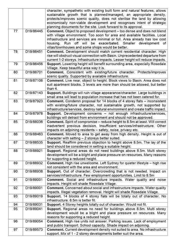
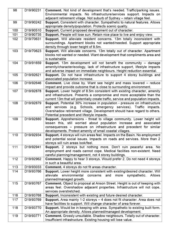
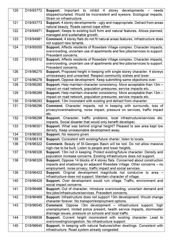
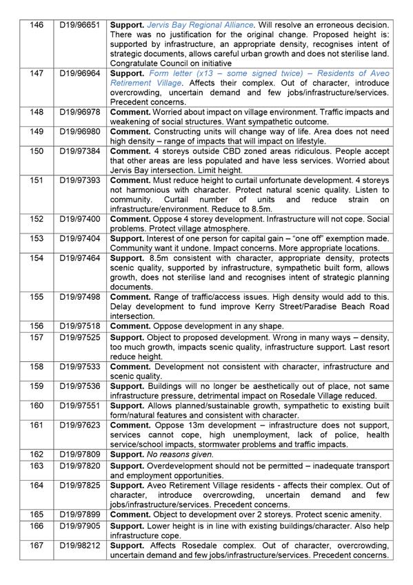
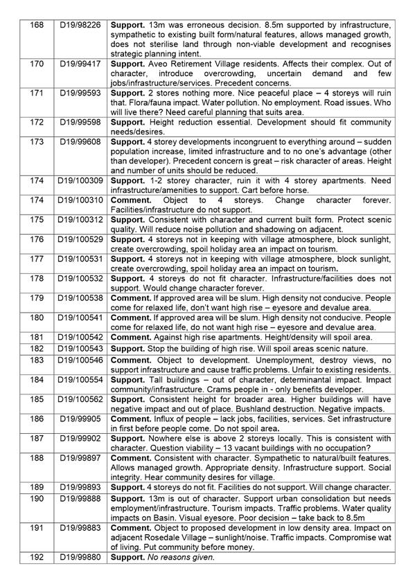
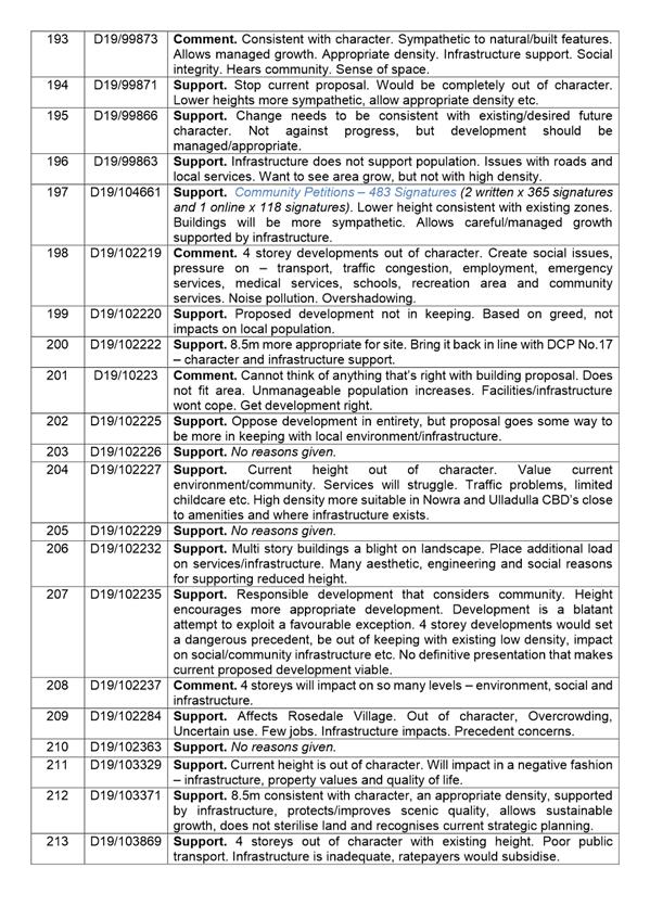

|

|
Development
& Environment Committee – Tuesday 07 May 2019
Page
0
|
DE19.31 Exhibition
Outcomes - Draft Council Policy - Electric Vehicle (EV) Charging Stations
on Public Land
HPERM Ref: D19/47332
Group: Planning
Environment & Development Group
Section: Strategic
Planning
Attachments: 1. Public
Exhibition Submission Summary ⇩
2. Draft Electric Vehicle
Charging Stations on Public Land Policy - Post Exhibition Changes ⇩
Purpose / Summary
Consider the submissions received during the public exhibition
of the Draft Electric Vehicle Charging Stations on Public Land Policy (draft
Policy) and finalise the Policy.
|
Recommendation
(Item to be determined under delegated authority)
That Council:
1. Adopt
and finalise the draft Electric Vehicle Charging Stations on Public Land
Policy, as exhibited, with the inclusion of changes identified in Attachment
2.
2. Advise
key stakeholders and those that made submissions of this decision.
3. Continue
to consider Electric Vehicle policy developments and opportunities as they
arise.
|
Options
1. Adopt the
recommendation.
Implications: This is the preferred option as it
will establish a policy position to guide the potential installation of
electric vehicle (EV) charging stations on public land in Shoalhaven.
2. Adopt an
alternative recommendation.
Implications:
This will depend on the extent of any changes and/or could postpone the
adoption of the policy regarding the installation of EV charging stations on
public land.
3. Not proceed with
the policy.
Implications: This option is not preferred as it
will mean that Council does not have a policy position to guide prospective
providers and decision makers in the installation of EV charging stations on
public land.
Background
Several prospective providers of
EV charging stations (e.g. NRMA, ActewAGL) have previously approached Council
to install EV charging stations on public land. As Council has no clear
position on EV charging stations, the proposals have not progressed at this
point.
On 27 March 2018, Council
resolved (MIN18.199(2)) to:
Prepare a policy position on the Electric Vehicle
Charging facilities that seek to use public land, including public reserves,
road reserves, car parks and other freehold land used as open space.
On 13 November 2018, Council
resolved (MIN18.917) to:
1.
Endorse the Draft Electric Vehicle (EV) Charging Station on Public Land Policy
and publicly exhibit for a period of 28 days;
2.
Notify key stakeholders of the exhibition arrangements; and
3. Receive a
further report on the outcome of the public exhibition and to finalise the
Policy.
It is important to note that the
following relevant developments have taken place since November 2018:
· The
NRMA selected a private site (Berry Bowling Club) for the installation of an EV
charging station in Berry and this has opened.
· Infrastructure
Australia has identified that an EV charging network is a high priority.
· The
NSW Government has released the NSW
Electric and Hybrid Vehicle Plan which is a significant advancement in
Government policy in support of EVs and EV charging infrastructure. In relation
to EV charging stations the key actions include:
- Co-invest
in fast chargers in regional NSW on major regional corridors (this is largely
private sector driven).
- Co-invest
in fast chargers in commuter car parks (this is largely private sector driven).
- Adopt
preferred charging standards (note: the draft Policy contains standards that
are consistent with current NSW Government position).
- Develop
guidelines for the installation of charging points in road side service
centres.
- Support
EV charging through strategic land use planning and guides.
· The
NSW Government (Transport for NSW) has opened the ‘NSW Electric Vehicle
Charging Program’ which aims to facilitate and engage in partnerships between
the public and private sector for the delivery of EV charging stations across
metropolitan commuter carparks and key regional road networks (including the
Princes Highway, for example).
Community Engagement
In accordance with the November
2018 resolution, the draft Policy was publicly exhibited for a period of
forty-one (41) days, from 12 December 2018 to 1
February 2019. The exhibition period was extended to give ample opportunity for
community and stakeholder feedback over the Christmas period.
The public exhibition material
included an explanatory statement and a copy of the draft Policy which could be
viewed at Council’s:
· Administration
centres in Nowra and Ulladulla.
· Website
exhibition page.
· Website
‘Get Involved’ page (166 visits).
The following
key stakeholders were directly notified of the exhibition and were invited to
make comment:
· All Community Consultative Bodies (CCBs).
· Business and Tourism Chambers.
· Industry Representatives.
· All
prospective providers of EV charging station infrastructure who had previously
approached Council (e.g. NRMA).
· Member
Councils of the ‘Cities Power Partnership’.
· Technical
experts in the EV sphere.
Five (5) submissions were
received during the exhibition period, including submissions from Clr Wells
(No.1), Wingecarribee Shire Council (No.3) and Kangaroo Valley Community
Association/Kangaroo Valley Chamber of Tourism & Commerce (No.5).
All submissions were supportive
of the development of the policy and the provision of EV charging
infrastructure in Shoalhaven.
A
detailed summary of the submissions with Council staff comment is provided in Attachment
1. Copies of the actual submissions received will be available for review
in the Councillors Room prior to the meeting.
Where relevant, the submissions
have informed proposed amendments to the exhibited draft Policy which are shown
at Attachment 2 and are briefly summarised below:
· ‘draft’
will be removed from the Policy.
· Include
provisions that link the Policy to the NSW Government’s Future
Transport 2056 document for consistency.
· Delete
the following Glossary Items (as they are redundant and/or superseded):
- CCS
(Combo 2) Connector.
- Type
1 Connector.
- Type
2 Connector.
· Add
the following Glossary Items:
- Ancillary
Infrastructure.
- CCS2
(this replaces CCS (Combo 2) Connector)
- CHAdeMO.
- Type
2 Socket.
· Specify that
Council does not have to be part of a competitive or expression of interest
process if directly providing EV charging stations on public land.
· Specify
that the electricity network can be upgraded to be suitable for a relevant EV
charger (at the cost of the applicant) if it does not have existing capacity.
· Include
provisions for consideration of reliable cellular/mobile network –
efficient operation of an EV charging station relies on this.
· Clarify
that any associated signage must be consistent with relevant standards.
· Update
Section 6.3 for consistency with industry standards based on further advice
from technical experts and consideration of Future Transport 2056.
· Update
Section 7 to include Sub Section 7.1 Terms of Lease Licence, and Sub
Section 7.2 Public/Private Partnership – to clarify that a
lease/licence is required, fees may be charged and to provide a mechanism for
Council to enter into partnership agreements for the installation and operation
of EV charging station infrastructure, if desired.
· Associated
administrative changes.
The proposed amendments to the
exhibited document (deletions and additions) are clearly highlighted within Attachment
2.
Financial Implications
The finalisation of the Policy
will be managed within existing budgets.
All costs associated with the
installation of EV charging stations (and related infrastructure) on public
land will be at the cost of the applicant. This also applies to the maintenance
and future decommissioning of any EV charging station (and related
infrastructure) on public land, if required by Council.
Specific detail relating to
financial charges, leases and licencing is not included in the draft Policy;
however, there is adequate provision for Council to impose specific fees, lease
and licence agreements and to enter into partnerships etc. on a case-by-case
basis as proposals arise.
Risk Implications
The draft Policy will assist to
mitigate against the potential piecemeal use of public land for EV charging
stations, unmitigated environmental impacts, inadequate network of EV
infrastructure for users and loss of tourism potential.
The Policy will be revised and
updated as needed when EV policy, provision, use etc. continues to evolve and
emerge.
|

|
Development
& Environment Committee – Tuesday 07 May 2019
Page
0
|
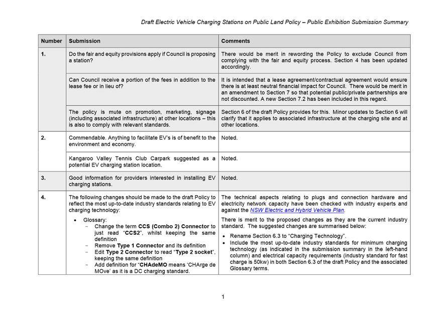
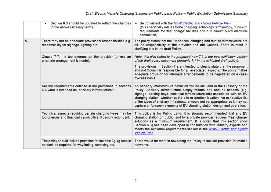
|
|
Development
& Environment Committee – Tuesday 07 May 2019
Page
0
|
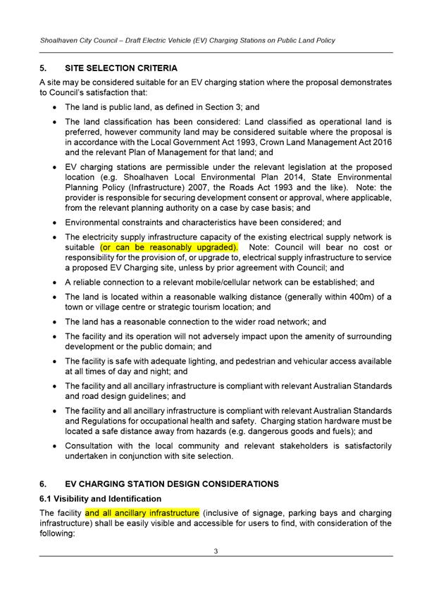
|
|
Development
& Environment Committee – Tuesday 07 May 2019
Page
0
|
DE19.32 Proposed
Submission - Aboriginal Land Claim No.25421 and Part Claims No.42499, 42454,
42448 and 42485 - Ulladulla
HPERM Ref: D19/103982
Group: Planning
Environment & Development Group
Section: Strategic
Planning
Attachments: 1. Request
For Information - Aboriginal Land Claims (ALCs) 25421 / Part Claims 42454 /
42448 / 42499 / 42485 - Ulladulla ⇩
2. Map
- Council Utilities - Aboriginal Land Claims (ALCs) 25421 / Part Claims 42454 /
42448 / 42499 / 42485 - Ulladulla ⇩
3. Overview of Contributions
Plan 1993 Projects - 05ROAD0006 & 05ROAD0008 ⇩
Purpose / Summary
Obtain endorsement to make a
submission on Aboriginal Land Claim (ALC) Numbers 25421 (full) and part claims
42499, 42454, 42448 and 42485 at Ulladulla, which are now being investigated
for determination by the NSW Government.
|
Recommendation
(Item to be determined under delegated authority)
That Council notify the NSW
Department of Industry – Crown Lands Aboriginal Land Claims
Investigation Unit that:
1. In
relation to part Claim Numbers 42448 and 42485 over Lot 16 DP 1105304:
a. Council
has no objection to these claims subject to:
i. The
exclusion of land identified for the planned future southern extension of St
Vincent Street, which also contains Council infrastructure for drainage and
wastewater disposal; and
ii. The
exclusion of land on the western boundary that contains Council
infrastructure for wastewater disposal.
2. In
relation to Claim No. 25421 and part Claim Numbers 42499 and 42454 over Part
Lot 245 DP 755967, and part Claim Numbers 42448 and 42485 over Lots 286 &
287 DP 755967 and Lot 2 DP 631894:
a. Council
does not support these claims because at the date of claim lodgement:
i. The
land was likely to be needed for an essential public purpose, being the
planned future southern extension of St Vincent Street and connector road and
roundabout to the Princes Highway; and
ii. The
land contains a significant amount of Council infrastructure for drainage,
water supply and wastewater disposal that services the southern Ulladulla
area.
|
Options
1. Advise the NSW
Department of Industry (DoI) – Crown Lands Aboriginal Land Claims
Investigation Unit (ALCIU) that Council has no objection to part ALC Numbers
42448 and 42485 over Lot 16 DP 1105304 subject to the exclusion of land
identified for the planned future southern extension of St Vincent Street, and
land on the western boundary that contains existing Council infrastructure that
is not currently protected by an easement. However, Council does not support
ALC Number 25421 and Part Claims 42499 and 42454 over Part Lot 245 DP 755967,
and Part Claims 42448 and 42485 over Lots 286 & 287 and Lot 2 DP 631894
because, at the date of claim lodgement, the land was likely to be needed for
an essential public purpose and contained a substantial amount of drainage,
water and wastewater infrastructure that services the south Ulladulla area.
Implications: This is the preferred option, as it
enables Council to assist DoI with their investigations into the status of the
land at the date the claims were lodged. This option ensures that the land that
is subject to the planned future southern extension of St Vincent and
associated connector road and roundabout to the Princes Highway is preserved
for this significant project, which will enable the orderly development of the
surrounding employment lands.
2. Provide
alternative advice to the DoI as directed by Council.
Implications: This option is not preferred, having
regard to the known history of the land at the date the claims were lodged.
3. Not respond to
the invitation to comment on these ALCs.
Implications: This is not preferred as it does not
enable Council to present evidence to DoI regarding the status of the land at
the date the claims were lodged.
Background
Council received advice from DoI
on 5 March 2019 that ALC Number 25421 and part Claim Numbers 42499, 42454,
42448 and 42485 at Ulladulla, were under investigation for determination.
These claims were lodged over
land in the Industrial / Bulky Goods precinct at South Ulladulla, which is subject
to a future road project that has been identified for over forty (40) years.
The investigation of these claims was initiated at Council’s request to
resolve the claims and provide some certainty for the future viability of the
Council road project and the subsequent development of the surrounding
employment lands.
The claims affect the land as
follows (as shown in Figure 1):
· ALC
No. 25421 – Part Lot 245 DP 755967
· Part
ALC No. 42499 (blanket claim) – Part Lot 245 DP 755967
· Part
ALC No. 42454 (blanket claim) – Part Lot 245 DP 755967
· Part
ALC No. 42448 (blanket claim) – Lots 286 & 287 DP 755967, Lot 16 DP
1105304 and Lot 2 DP 631894
· Part
ALC No. 42485 (blanket claim) - Lots 286 & 287 DP 755967, Lot 16 DP 1105304
and Lot 2 DP 631894
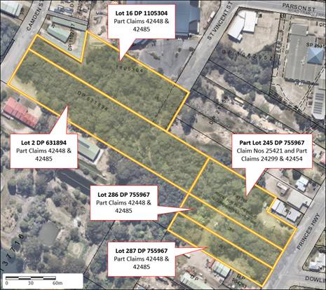
Figure 1: Aerial image of the subject
land, outlined in orange.
Council has been asked
to provide comment on the claims (see Attachment 1) and specifically
whether, at the date the claims were lodged, the subject land was:
· Lawfully
used or occupied
· Needed
or likely to be needed for an essential public purpose.
Any comment, assertion
or statement that is made by Council should be as at the date of claim
lodgement (see below) and must be supported by evidence.
· ALC
No. 25421 – lodged 3 June 2010
· Part
ALC Nos. 42454 & 42448 – part of the blanket claims lodged 15
December 2016
· Part
ALC Nos. 42499 & 42485 – part of the blanket claims lodged 19
December 2016
Council has been granted an extension of time until 17 May
2019 to respond to the claims to enable the matter to be reported for
consideration.
Overview Summary of the
Subject Land
As noted above, the subject land
consists of five (5) lots that are located within the Industrial / Bulky Goods
Precinct at South Ulladulla. The land is bounded by the Princes Highway to the
east, Camden Street to the west, and other Industrial / Bulky Goods-zoned land
to the north and south, including the former Ulladulla Sewage Treatment Plant
(STP). Council is not Trust Manager for any of the five lots affected by the
claims.
The land is subject to a future
Council road project that is identified within Council’s Contributions
Plan (CP) 2010 (Project 05ROAD3008),
as shown in Figure 2 below. This project is recognised as a critical piece of
infrastructure to enable the orderly development of the surrounding employment
lands and provide connectivity to the future Milton-Ulladulla Bypass, with the
land being earmarked for this project for over forty years.
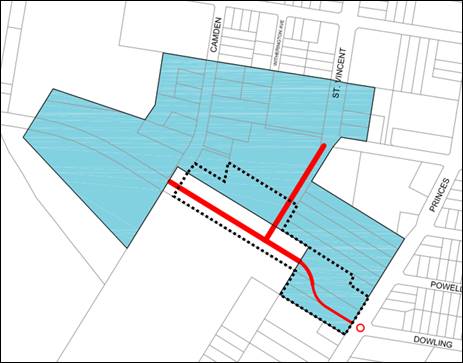
Figure 2: Extract from Council's
Contributions Plan 2010 Road Project 05ROAD3008,
subject land outlined in black dashed line, future road shown in red.
A summary of each of the affected lots is provided below.
Lot 16 DP 1105304
Has an area of approximately
8,647m2 and is zoned IN2 Light Industrial. The land is reserved for
“Future Public Requirements” and was gazetted as such on 29 June
2007. It adjoins the Dunn & Lewis Centre to the north and is affected by
the proposed future extension of St Vincent Street along the south-western
extent of the lot.
The land is heavily vegetated
and does not contain any structures; however, it does contain some Council
utilities for wastewater and drainage (as shown in Attachment 2), some
of which are protected by existing easements measuring 2.4 and 20m wide.
Lot 2 DP 631894
Has an area of approximately
1.38ha and is zoned part IN2 Light Industrial and part B5 Business Development.
The land is reserved for “Future Public Requirements” and was
gazetted as such on 29 June 2007. It adjoins the former Ulladulla STP site and
is affected by the proposed future extension of St Vincent Street and Connector
Road to the Princes Highway. It should be noted that this lot was formerly
owned by Council; however, it was transferred to Crown Lands on 7 November
1983.
The land is heavily vegetated
except for a small clearing on the western corner, which is used for informal
access to the adjoining land to the south. The land does not contain any
structures; however, does contain a significant number of Council utilities for
wastewater, water supply and drainage, which are not currently protected by any
easements.
Part Lot 245 DP 755967
Has an area of approximately
5,950m2 and is zoned part IN2 Light Industrial and part B5 Business
Development. The land is reserved for “Future Public Requirements”
and was gazetted as such on 15 May 1968. It adjoins the Princes Highway to the
east, and the south-western corner is affected by the proposed future Connector
Road to the Princes Highway, although the final alignment is yet to be
determined.
The land is predominantly
vegetated, although there is a clearing with direct access from the highway
that appears to be used for informal parking for neighbouring businesses. The
land does not contain any structures; however, it does contain Council
utilities for wastewater and drainage, which are not currently protected by any
easements.
Lot 286 DP 755967
Has an area of approximately
3,430m2 and is zoned part IN2 Light Industrial and part B5 Business
Development. The land is reserved for “Future Public Requirements”
and was gazetted as such on 29 June 2007. A large portion of the lot is
affected by the proposed future Connector Road to the Princes Highway and the
roundabout intersection.
The land is predominantly
vegetated and does not contains any structures; however, it does contain
Council utilities for wastewater and drainage, which are not currently
protected by any easements.
Lot 287 DP 755967
Has an area of approximately
3,430m2 and is zoned IN2 Light Industrial. The land is reserved for
“Future Public Requirements” and was gazetted as such on 29 June
2007. A large portion of the lot is affected by the proposed future Connector
Road to the Princes Highway and the roundabout intersection.
The land is predominantly vegetated
and does not contain any structures; however, it does contain Council utilities
for wastewater and drainage, which are not currently protected by any
easements.
Overview of Future Road
Project
As noted earlier in this report,
all five (5) lots are subject to a Council road project that is identified in
Council’s CP 2010, being Project Code 05ROAD3008. The
project involves:
· Southern
extension of St Vincent Street;
· Connector
road between Camden Street and the Princes Highway (which will be extended to
the west to connect to the future Milton-Ulladulla Bypass); and
· Roundabout
intersection at Connector Road / Princes Highway / Dowling Street.
This project was retained during
the recent review of the CP 2010 as it is deemed critical to enabling
the orderly development of surrounding employment lands and connection to the
future bypass. It should be noted that Council formally endorsed the revised CP
on 2 April 2019, and this will become effective on 29 May 2019 as the CP
2019.
Project History
The project was initially identified in the late 1970s-early
1980s during the preparation of the Milton-Ulladulla Planning Scheme Proposal,
which was used to inform the preparation of the Shoalhaven Local
Environmental Plan (SLEP) 1985. This report predicted that St Vincent
Street would play a more important role in the local street network and
proposed to extend the road to the south and link this to the Princes Highway,
which was subsequently identified in the SLEP
1985 (see Figure 3).
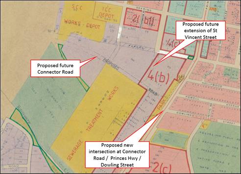
Figure 3: Extract from the SLEP 1985,
dated 12/12/1984, identifying the proposed road alignment.
A further study of the
Milton-Ulladulla arterial road system in 1987 predicted that future traffic
demand in the Milton-Ulladulla area would increase significantly and
recommended a two-stage solution, being the extension of St Vincent Street, and
construction of a new Connector Road to the future bypass and intersection at
the Princes Highway. The two projects were subsequently included in
Council’s CP
1993 as Project Codes 05ROAD0006 and 05ROAD0008, with the aim of
enabling the orderly and logical development of surrounding employment lands,
diverting heavy vehicular traffic away from nearby residential areas and, in
the longer term, connecting to the future Southern Link Road/Milton-Ulladulla
Bypass and possible future urban expansion area. An overview of these projects
is provided in Attachment 3. An amendment
to the CP 1993 in 2000 saw the two projects amalgamated to form the
current project 05ROAD3008, which was then incorporated into the CP 2010 and
subsequently retained through the recent CP review.
It is important to note that
this project has been identified as part of the long-term strategy for the
Milton-Ulladulla road network for forty (40) years and the project has been
gradually refined over the years as Council moves closer toward project
delivery. Although detailed survey and design works for this road have not yet
been undertaken, Council still intends to construct this road and intersection
at the appropriate time as demand increases and contributions are levied.
Thus, it is important for these
claims to be resolved in a timely manner to enable Council to have some certainty
over the viability of this future road project and also the development of
surrounding employment lands.
Impact of Native Title
In addition to the subject ALCs, the land is also affected
by the blanket Native Title Claim that was lodged by the South Coast People
over the South Coast of NSW in August 2017. The Native Title Claim does not
prevent Council from undertaking the necessary works required for the road if
the land remains in public ownership. However, if the ALCs are granted, Council
will be unable to negotiate land acquisition or the creation of easements with
the benefitting Aboriginal Land Council until Native Title has been determined.
This does have the potential to delay the project.
Summary of Claims
As noted above, a total of five
(5) ALCs have been lodged over the subject land and are now the subject of
investigation by DoI. Four of these claims are part of the “blanket”
claims that were lodged by the NSW Aboriginal Land Council in December 2016.
The following comments are
provided regarding Council’s interests in relation to each claim.
Claim Number 25421
Lodged over the entire Part Lot
245 DP 755967 on 3 June 2010. At the date of claim lodgement, the land was
vacant apart from some Council utilities, being a gravity-fed sewer main that
was installed in 1976 and a stormwater drainage line that was installed in
1972. This infrastructure is not currently protected by an easement. As noted
earlier in this report, the land has been identified for an essential public
purpose, being a road, for over forty years.
Thus, Council should not support
this claim on the basis that, at the date of claim, the land was likely to be
needed for an essential public purpose.
Part Claim Numbers 42454 and
42499
Part of the blanket claims
lodged on 15 and 19 December 2016, respectively, and affects the entire Part
Lot 245 DP 755967. As noted above, at the date of claim lodgement the land was
identified for a future Council road project and was vacant apart from some
Council utilities that are not protected by an easement.
Thus, Council should not support
this part of the claims on the basis that, at the date of claim, the land was
likely to be needed for an essential public purpose.
Part Claim Numbers 42485 and
42448
Part of the blanket claims that
were lodged on 15 and 19 December 2016, respectively, and affect Lots 286 &
287 DP 755967, Lot 16 DP 1105304 and Lot 2 DP 631894. As noted above, at the
date of claim lodgement the land was vacant; however, it did contain a
substantial number of Council utilities, being water supply, wastewater and
stormwater drainage, as shown in Attachment 2.
As noted earlier in this report,
the land has been identified for an essential public purpose, being a road, for
over forty years. For Lot 16 DP 1105304, the proposed alignment of the future
extension of St Vincent Street is relatively straightforward and can be
accommodated within the 20m wide easement on the eastern portion of the lot.
Thus, Council should not object to the part of the claims that affect Lot 16
subject to the exclusion of land identified for the future extension of St
Vincent Street, and the area along the western boundary that contains Council
wastewater infrastructure.
However, Council should not support the parts of the claims
that affect Lot 286 & 287 DP 755967 and Lot 2 DP 631894, as detailed survey
and design work has not yet been undertaken and the precise alignment of this
section of the road is not known. Thus, to protect the future road corridor and
existing Council utilities, it would be prudent to refuse these parts of the
claims on the basis that, at the date of claim lodgement, the land was likely
to be needed for an essential public purpose.
Financial Implications
There are no direct financial
implications in providing this advice to DoI. As Council is not Trust Manager
for the land, there is no financial responsibility for Council regarding
maintaining the land; however, Council is responsible for the maintenance of
all Council utilities located on the land.
Should the claims be refused
(except for part of Lot 16 DP 1105304 noted above), the alignment of the future
road reserve will be protected, which will provide certainty for the future
viability of the road and development of the surrounding employment lands.
Council will continue to be responsible for the maintenance of all Council
utilities located on the land.
Should the claims be granted
subject to the creation of easements for existing Council utilities, the future
of the road project will be uncertain as Council will be unable to enter
negotiations to acquire the land from the benefiting Aboriginal Land Council
until Native Title has been determined, which could take many years.
Risk Implications
There is no risk to Council in
providing this information to DoI, as it ensures that all relevant information
is made available to assist in determining these claims.
Should the claims be refused,
the alignment of the future road corridor will be protected, which will provide
some certainty for the future development of the surrounding employment lands
and connection to the future Milton-Ulladulla Bypass.
Should the claims be granted,
the land will be transferred into private ownership, which will present
significant challenges for Council in acquiring the land at the appropriate
time due to the land also being affected by the undetermined Native Title
claim.
|
|
Development
& Environment Committee – Tuesday 07 May 2019
Page
0
|
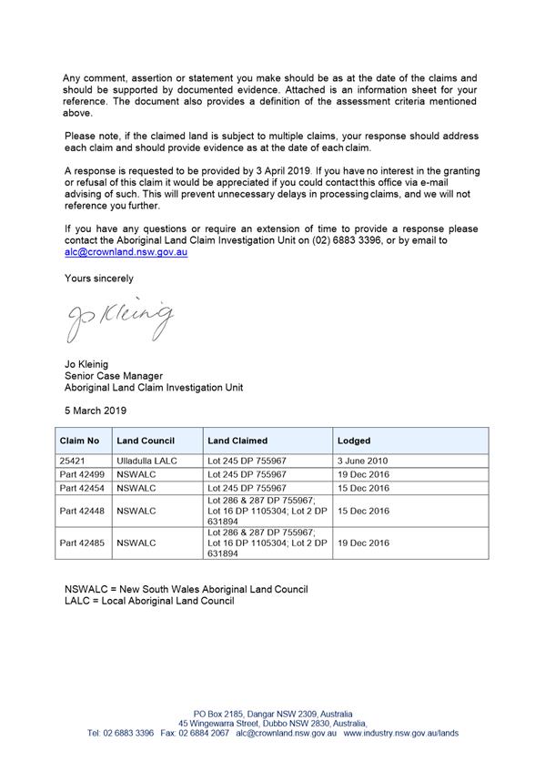

|
|
Development
& Environment Committee – Tuesday 07 May 2019
Page
0
|
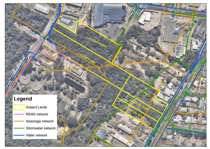
|
|
Development
& Environment Committee – Tuesday 07 May 2019
Page
0
|
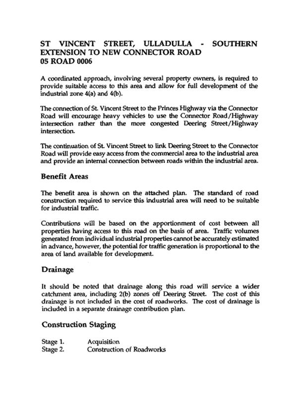
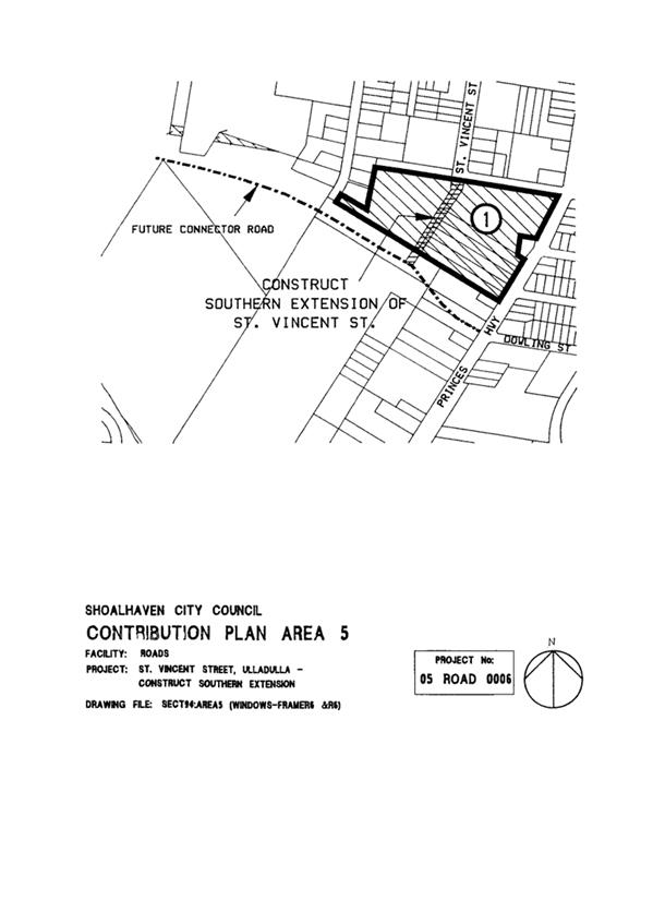
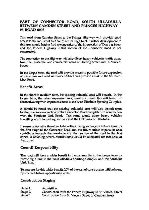
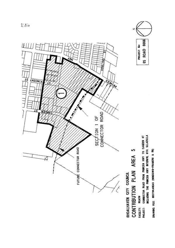
|
|
Development
& Environment Committee – Tuesday 07 May 2019
Page
0
|
DE19.33 Update
- Planning Proposal - Warrah Road, Bangalee
HPERM Ref: D19/39829
Group: Planning
Environment & Development Group
Section: Strategic
Planning
Attachments: 1. Traffic
Assessment Report (under separate cover) ⇨
2. Proponent's
Bushfire Assessment Report (under separate cover) ⇨
3. Proponent's
request to biodiversity certify the Warrah Road PP ⇩
4. Aboriginal Cultural Heritage
Assessment (Confidential - under separate cover)
Purpose / Summary
Update Council on the Planning
Proposal (PP) covering land at Warrah Road, Bangalee, and obtain approval to
proceed to publicly exhibit the PP.
|
Recommendation
(Item to be determined under delegated authority)
That Council:
1. Prepare
and submit a revised PP to seek a revised Gateway determination for the
Warrah Road PP that:
a. Reflects
the revised zone and lot size maps provided in this report
b. Includes
provisions relating to the subdivision of the residual environmental and
rural land into no more than four allotments
2. Apply
to the NSW Office of Environment and Heritage to biodiversity certify the PP.
3. Not
commence the requirements under Part 6 of the LEP to actually release this
land for urban development until after BOTH the duplication of the Princes
Highway/Shoalhaven River Bridge and the Far North Collector Road are
complete.
4. Place
the PP and biodiversity certification application on public exhibition,
subject to the receipt of a satisfactory revised Gateway determination.
5. Advise
the proponent, affected land owners and previous submitters of this
resolution.
6. Consider
adding the review of the southern component of the Crams Road Urban Release
Area as a new project to the Strategic Planning Works Program that is
developed for 2019/2020.
|
Options
1. As recommended.
Implications: This will essentially result in the
following outcomes:
a) The PP will be updated
based on the revised lot size and zoning maps provided in this report. These
maps are consistent with the results of the specialist studies that have been
undertaken for the PP.
b) The PP will be updated
to include arrangements for the private management of the residual rural and
environmental land.
c) The necessary steps
will be taken to have the PP biodiversity certified, locking in the development
footprint and conservation areas.
d) The PP and
biodiversity certification application will be publicly exhibited concurrently.
The outcomes of the exhibitions will be reported back to Council for
consideration.
2. Not seek a
revised Gateway determination
Implications: The current Gateway determination
provides some flexibility with lot sizes. It is also possible to biodiversity
certify and exhibit the PP without a new Gateway determination. However, some
of the proposed changes to the zone map will require an amendment to the
Gateway determination to secure a more certain outcome, as will the proposed
outcomes in respect of the residual private land. It is considered that these
outcomes warrant seeking of a new Gateway determination.
3. Adopt different
arrangements for the PP
Implications: Advice can be provided as needed if
Council wish to consider different arrangements for the PP.
4. Not proceed with
the PP
Implications: The PP is consistent with the
strategic planning framework. It has previously been supported by Council and
will resolve the deferred status of the land under the current LEP. As such
this option is not favoured.
Background
Introduction
The overall Crams Road Urban
Release Area (URA) was originally identified in the Nowra-Bomaderry Structure
Plan (NBSP). The subject land was part of the original URA.
The NBSP stated that a range of
investigations, including biodiversity, would need to be completed to determine
the potential extent of residential development.
Due to conflicting biodiversity
studies, part of the Crams Road URA was ultimately ‘deferred’ from
the Shoalhaven LEP 2014 to enable further investigations to be undertaken to
determine an appropriate development footprint for the subject land.
In 2014, the owners (Southbank
Land Pty Ltd/Huntingdale Developments Pty Ltd) of Lot 24 DP714096, Warrah Road,
Bangalee submitted a PP to commence the process to resolve the zoning of the
site. In an attempt to reconcile the conflicting biodiversity studies over the
subject land, Council engaged NGH Environmental Pty Ltd in early 2015 to
undertake an independent peer review of the biodiversity studies that existed
over the site and make recommendations to inform a PP.
In December 2015, Council
resolved to prepare and advance a PP based on the findings of the peer review.
The Warrah Road PP (PP005) was subsequently submitted to the NSW Department
of Planning and Environment (DP&E) and a Gateway determination issued on 12
July 2016. The Gateway determination allowed the PP to proceed subject to
several terms and conditions.
On 8 August 2017 the Development
Committee considered a report on this PP and resolved that Council:
1. Adopt
the attached Land Use Zone (Attachment 5) and Lot Size (Attachment 6) maps as
the basis for preparing the specialist studies required to enable public
exhibition of the Planning Proposal.
2. Forward these
maps to the NSW Department of Planning and Environment with a request to revise
the Gateway determination that:
a. Reflects
the proposed new development footprint;
b. Removes
condition 1, which is covered by the new footprint;
c. Removes
items (c) and (d) from condition 2 in the current determination; and
d. Adds
a condition allowing the minimum lot size of 1500 m2 to be revised
if appropriately supported by the traffic and bushfire assessments undertaken
for the planning proposal.
3. That the proposal be reported back to
Council prior to exhibition.
A revised PP was sent to
DP&E on 5 September 2017. On 10 April 2018 DP&E issued a revision to
the Gateway determination that rejected Council’s proposed zoning and lot
size maps. Specifically, DP&E rejected the proposed ‘squaring
up’ of the development footprint where it would have resulted in some
residential development occurring within the ‘remediation area’
under the former Native Vegetation Act 2003 that affects part of the subject
land.
The PP area, as amended by the
requirements of the 2018 Gateway determination, was then investigated in
relation to Aboriginal Heritage, Traffic and Bushfire. The traffic and bushfire
studies are provided as attachments to this report. The Aboriginal
Heritage assessment contains sensitive information and will be provided to
Councillors separately to this report.
Aboriginal Cultural Heritage
Assessment
The Aboriginal Cultural Heritage
Assessment prepared for the proponent concluded:
“The current ACHA
report is sufficient supporting documentation to inform the Aboriginal
archaeological assessment of the Gateway Planning Proposal. There are no
Aboriginal archaeological constraints to the rezoning of the subject land and
no further archaeological work is required prior to the submission of the
Planning Proposal.”
It is considered that this ACHA
report is suitable to allow the public exhibition of the PP and referral to the
NSW Office of Environment and Heritage (OEH).
Traffic Assessment
Council commissioned and managed
the Traffic Assessment (Attachment 1) for this PP because of the
community concerns with this aspect of the proposal. This assessment considered
the impacts of development of the subject land on the existing road network and
the road infrastructure requirements for the development. It also modelled and
considered the time it would take to evacuate the development area in the event
of a bushfire.
The assessment investigated seven (7) intersections between
the subject land, Moss Vale Road and the Princes Highway as shown below:
Intersections
Considered in Traffic Assessment
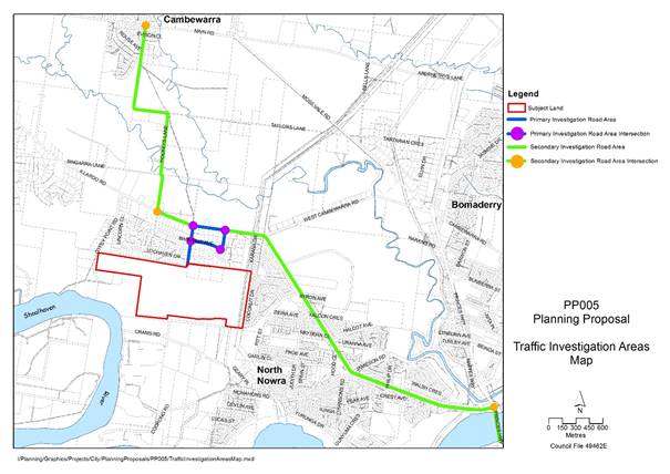
The traffic assessment did not
recommend the opening of the current closed section of Warrah Road between
Bimbimbie Avenue and Illaroo Road. All modelling assumed that this road would not
be opened.
The intersection modelling found
that all the intersections except for the intersection of Illaroo Road and the
Princes Highway (IRPH intersection) will continue to satisfactorily operate
with relatively minor augmentation if development were to proceed. The
modelling predicts that the IRPH intersection will fail (reach a peak time
level of service F) in 2022 without the development and in 2021 with the
development. That is, the release of this land will accelerate the failure of
this intersection by one year.
The report also modelled the
traffic conditions following the duplication of the Princes Highway Bridge and
associated intersection improvements at the IRPH intersection. The report
assumed this work would follow the Far North Collector Road. It predicts that
after the bridge duplication (and therefore the Far North Collector Road) the
intersection will satisfactorily operate with or without the development.
Under the Urban Release Area
(URA) provisions in the LEP, Council can rezone this land but defer its release
until such time that infrastructure issues are resolved and a DCP is in place.
In this scenario, Council would rezone the land but its actual
‘release’ would be deferred until a later date when a DCP is
prepared to allow development and satisfactory infrastructure is
planned/provided.
The release of this URA (Crams
Road) is currently envisaged as the last phase in the current planning
for growth in the Nowra-Bomaderry area that was identified under the Structure
Plan. In late 2017 Council adopted the following phasing approach:
Phase 1 – Mundamia and
Worrigee
Phase 2 – Moss Vale
Road South and Moss Vale Road North
Phase 3 – Cabbage Tree
Lane
Phase 4 – Crams Road
All landowners within the URAs
were written to and advised of this phasing.
Council is currently actively
working to release the URAs in Phase 2 and staff time is currently dedicated to
that. It is not envisaged at this stage that the detailed planning for Phase 4
will commence for some time and will need to be considered in the preparation
of future Council Strategic Planning Works Programs.
As such It is recommended that
in this case, Council proceed with the PP to finalise the zoning of land
whilst also resolving not to prepare a DCP (under Part 6 of the LEP) and
associated infrastructure plans until after both the duplication of the Princes
Highway Shoalhaven River bridge and the Far North Collector Road are complete
and actual ‘release’ is needed in terms of the overall area.
The traffic assessment otherwise
found no issues that significantly impact on the progression of the PP.
Bushfire Assessment
The proponent’s Bushfire
Assessment (Attachment 2) concluded:
“The (proposal) exceeds
the minimum “Deemed-to-Satisfy” specifications set out in Chapter 4
(Performance Based Control) and the aim and objectives of Planning for Bushfire
Protection 2006 and affords occupants of the future dwellings adequate
protection from exposure to a bushfire.”
It is considered that this
bushfire report is suitable to allow the public exhibition of the PP after
referral to the NSW Rural Fire Service (RFS). Additional work may be required
at the Development Control Plan stage of the process to ensure a satisfactory
bushfire planning outcome, including access/egress.
Revised PP Maps
Following the completion of
these studies the PP maps were reviewed considering the Gateway determination
and a new set of maps were prepared that have been informed by the assessments.
Noting that the subject land is currently “deferred” from the LEP
various map layers are required. The proposed revised maps (and existing
extracts) are provided below:
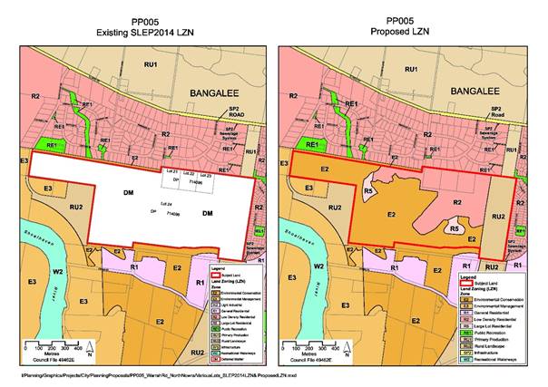
Existing and
Proposed Zone Map
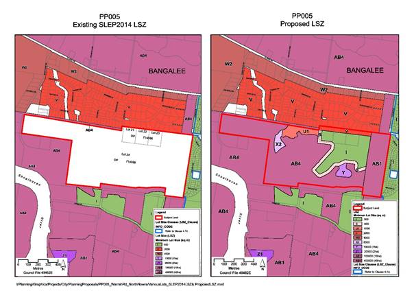
Existing and
Proposed Lot Size Map
Existing and
Proposed Watercourses Map
Existing and
Proposed Height of Buildings Map
Existing and
Proposed Acid Sulfate Soils Map
Existing and
Proposed Clauses Map
Existing and
Proposed Urban Release Areas Map
Whilst the proposed zone and
minimum lot size maps may look complicated/detailed they have been worked up to
recognise various matters and set an outcome.
It is recommended that the
proposed maps shown above be adopted for inclusion in the PP that will be
exhibited for comment.
Biodiversity Certification
On 18 December 2018, Council
received written advice (see Attachment 3) from the proponent that they
wish to also biodiversity certify this PP. Biodiversity certification is an
arrangement that allows a proponent to “lock in” environmental
conservation and impacts at the PP stage so that these matters do not need to
be addressed at the development application stage. It is the approach that
Council has previously adopted for the Halloran Trust Lands PPs.
Council staff met with officers
from DP&E and OEH to discuss this request and both agencies advised that
they support the approach of biodiversity certifying this PP.
It is recommended that Council
apply to OEH to biodiversity certify this PP.
Management of the Residual
Land
The eventual development of the
land will most likely result in approximately 55 hectares of residual land.
This includes 43 hectares of land to be zoned E2 – Environmental Conservation
and 12 hectares of land to be zoned RU2 – Rural Landscape that will form
part of the Western Bypass Corridor around Nowra-Bomaderry.
The landowner has indicated that
they do not wish to dedicate the land to Council. This means that if Council wished
to acquire it as a public reserve, which is not necessarily the case, it would
need to purchase the land through an acquisition process.
The proponent has instead
indicated they would wish to subdivide the residual E2 land into three (3) lots
with each lot being partially in the urban release area. Essentially, the
environmental land will then be connected to one of three dwelling sites within
the development footprint.
This proposed arrangement is
broadly considered satisfactory because:
- The E2 land
is proposed as an offset as part of the biodiversity certification of the site.
This means that the land will be subject to a binding conservation agreement
with funding available in perpetuity for the future land owner.
- Council
taking ownership of the land will not necessarily result in an improved
conservation outcome.
- The proposed
subdivision will allow for a subdivision into manageable parcels that can be
better supervised by a land owner.
- Purchasing
the land in this instance offers poor value for money because its purpose as a
biodiversity reserve will be achieved with the land remaining in private
ownership.
The proponent has also advised
that they do not wish to dedicate the land identified as part of the future
road corridor for the Princes Highway bypass of Nowra. Given the likely
timeframe for the delivery of this bypass, it is not desirable to acquire this
land at this time. The proponent instead proposes a similar arrangement to the
E2 zoned land, with only one dwelling site being linked to the road corridor
land. They are proposing to separate the ownership of road corridor land and
the E2 land.
If Council is agreeable to this
approach, it will be necessary to insert a subclause into Clause 4.1E of the
LEP. This is recommended as an outcome of this report.
The Gateway Determination
The proposed changes to the PP
will require the current Gateway determination to be amended because:
- A new R5
zone is proposed for 3 lots on the edge of the development area (i.e. the R5
zone is not listed in the Gateway determination).
- A new clause
is proposed to allow the subdivision of the E2 and RU2 as outlined above.
- There is a
Gateway condition relating to the remediation areas on site that will be
breached by a small amount (approx. 400 m2) to allow for roads into
the development. OEH have verbally indicated that this would be
acceptable if the PP is biodiversity certified.
- There are
ambiguities in the current Gateway determination that could create difficulties
when the PP reaches the finalisation step in the process.
Accordingly, it is recommended that Council seek an amended
Gateway determination for this PP to enable it to then move forward to formal
public exhibition.
Community Engagement
Assuming DP&E issue a
favourable Gateway determination for the proposed amendments the PP would be
ready to refer to RFS and then place on public exhibition. This exhibition
would be undertaken in accordance with Council’s PP Guidelines as a Broader
Impact Major PP. It is noted that there has been considerable community
interest in this PP previously and this is likely to be the case moving
forward.
It is recommended that Council
resolve to exhibit the PP if a favourable Gateway determination is received. If
not, the matter will be reported back to Council.
Policy Implications
Once the likely development
future of the subject land is resolved, the other area that possibly requires
Council’s reconsideration is the other remaining component of the Crams
Road URA.
The history of the Crams Road
URA is covered in the earlier reports on this matter. Through the Shoalhaven
LEP2014 process the southern parts of the URA were zoned R1 General Residential
and the northern part was ‘deferred’ from the LEP. The following
extracts from the LEP mapping provide an overview of the two areas.
Given the physical separation of
the two parts of the URA and the zoned configuration of the southern part that
is focussed along Crams Road there is a need to have a closer look at how the
southern areas could possibly develop. This review will also need to consider
whether it is practical, depending on potential yield, servicing etc. that this
part (southern) is retained as a URA.
As such it is also recommended
that Council consider adding the review of the southern part of the Crams Road
URA as a new project on the Strategic Planning Works Program when it is
reconsidered in coming months.
Financial Implications
This PP is being funded on a
100% cost recovery basis by the proponent in accordance with Council’s PP
Guidelines.
|

|
Development
& Environment Committee – Tuesday 07 May 2019
Page
0
|
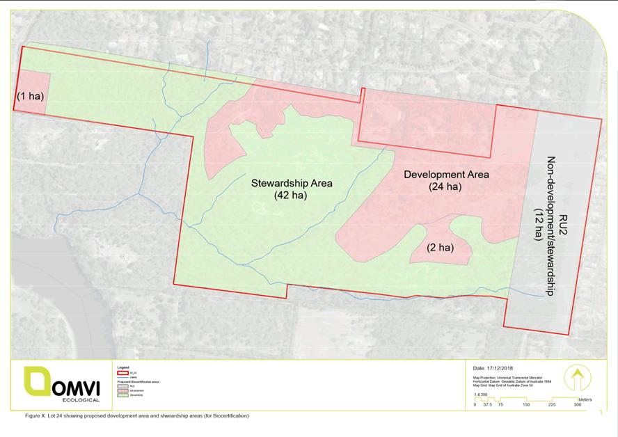
|
|
Development
& Environment Committee – Tuesday 07 May 2019
Page
0
|
DE19.34 Options
- Review of Proposed Service Lane, St Georges Basin Village Centre - Shoalhaven
DCP 2014 and Shoalhaven Contributions Plan 2010
HPERM Ref: D19/119586
Group: Planning
Environment & Development Group
Section: Strategic
Planning
Attachments: 1. Plans
- Draft 90% Civil Engineering Drawings - Proposed Service Lane St Georges Basin
(under separate cover) ⇨
2. Shoalhaven DCP 2014 Chapter
N23 St Georges Basin Village Centre - Supporting Map ⇩
Purpose / Summary
Review proposed service lane
currently identified in Shoalhaven Development Control Plan (the DCP) 2014
Chapter N23: St Georges Basin Village Centre and Shoalhaven Contributions Plan
(the CP) 2010 (Project 03ROAD2113) having regard to the updated engineering
design, construction costs and land valuations.
|
Recommendation
(Item to be determined under delegated authority)
That Council:
1. In
recognition of the broader Strategic Plan for St Georges Basin Village
Centre, reaffirm the proposed Service Lane identified in Shoalhaven
Development Control Plan (DCP) 2014 Chapter N23: St Georges Basin Village
Centre with minor changes following design approval of the updated
engineering design plans.
2. Prepare
an amendment to the Shoalhaven Contributions Plan (CP) 2019 to:
a. Delete
the project 03ROAD2113 St Georges Basin Service Lane as a standalone project
and include the proposed Service Lane in Project 03ROAD2023 St Georges Basin
Village Access Road and Traffic Facilities that is part of the Village Road
Network required to facilitate the development of the overall B4 Mixed Use
zone and support the future population growth in St Georges Basin.
b. Include
the updated engineering design, land valuation and construction cost
estimates in the updated project.
c. Identify
the remaining works for construction in the CP Project 03ROAD2023 Village
Access Road and update the project cost estimates for the remaining works.
3. Depending
on the outcome of the proposed amendment to Shoalhaven Contributions Plan
2019:
a. Fund
initial expenditure on the first stage of the service lane works to provide
essential rear lane access to the properties 144-152 Island Point Road and
land acquisition using recoupment funds that may be available following the
adoption of the Shoalhaven Contributions Plan 2019 or through general revenue
allocations in the future Capital Works Program of up to $600,000 (2018/19
Indexed Estimate for 63% of the Project Costs rounded up) and request a
further report should more than this amount be required.
b. Include
the construction of the remaining section of the St Georges Basin Village
Centre Service Lane and Village Access Road in Council’s capital works
planning.
c. Recoup
the expended funds through Section 7.11 development contributions levied by
Shoalhaven Contributions Plan 2010 for future development.
4. Prepare
a minor housekeeping amendment to Shoalhaven DCP 2014 Chapter N23: St Georges
Basin Village Centre to reflect the updated design for the proposed service
lane and include the final design approved engineering plans as a supporting
document.
5. Undertake
a broader review of Shoalhaven DCP Chapter N23: St Georges Basin Village
Centre to complete/update the precinct planning for the “Future
Uses” area identified in the DCP Chapter Supporting Map as part of
Council’s Strategic Planning Works Program.
6. Advise
the applicant of DA17/2435 of the intended changes and support a future
application under Council’s Policy Payment of Development
Contributions and Section 64 Headworks Charges by Deferment or Instalments
(under Special Circumstances) to defer the payment of contributions
levied in the development consent for Project 03ROAD2113 of $45,541.91
(2018/19 Financial Year) until the future of the Service Lane is resolved and
consider waiving of the requirement for a bank guarantee given the
circumstances incumbered by the applicant through this review process.
7. Advise
the affected landowners of this resolution and the next steps.
|
Options
1. Adopt the
recommendation outlined above.
Implications:
The detailed work arising from the Council resolution of
28 August 2018 has flagged a substantial potential increase to the total
project cost. The resultant Equivalent Tenement (ET) amount would be a
substantial development cost to landowners/developers and it would not be
appropriate to burden landowners with this amount of contributions.
Demand still exists for the proposed
service lane as part of the overall local road network that is critical for the
longer-term development of the B4 Mixed Use zone area in St Georges Basin
Village Centre identified in Shoalhaven DCP 2014 Chapter N23: St Georges Basin
Village Centre
Amending the CP to combine the service lane and the
village access road projects mean the wider Contribution Area would contribute
to the service lane. The nexus between the wider Village Access Road and
service lane to the anticipated development can be generally
established/argued. The demand for both projects exists to deliver local roads
and a service lane to facilitate coordinated and managed development of the
overall village centre that will service the growing population and needs of
the broader St Georges Basin community.
In planning for a wider village centre, the overall
community need must be considered. It is acknowledged that the restriction on
front access to properties along Island Point Road burdens 5 of the 8
commercial properties that adjoin the service lane; however, the future
amenity, redevelopment potential and vehicle and pedestrian safety on Island
Point Road must also be considered in the longer-term planning for the centre.
2. Retain the
proposed service lane and front vehicular access restriction in Shoalhaven DCP
2014, remove Council’s intention to deliver the service lane as a
Contributions Project and require each landowner/developer to design and
construct rear service lane access from the existing partially constructed
service lane with a ‘Right of Carriageway’ of 4.2m along the rear
of each property to enable clear sign distances and vehicle manoeuvrability in
the service lane.
Minor variations to the service lane design can be
considered on a case by case basis to consider site constraints etc. Council
could also consider removing the requirement to include a footpath and provide
a low speed environment through this option, recognising the laneway as a
service laneway only.
Implications:
This option would still potentially deliver the planned
outcome and not require a financial contribution from Council. It however would
potentially impact on the coordinated delivery of the service lane and would
require each landowner/developer to facilitate the service lane as part of the
development of their land. This may result in a “staggered” uptake
of the rear lane pending development of individual allotments and would
discourage pedestrian movements via the laneway. The issue of ongoing
maintenance of the laneway would also need to be considered with a preference
that a service lane of this type be ultimately transferred to Council and
managed as a public road.
If Council resolves to retain the service lane in the DCP
but remove the project from the CP, the DCP should be amended to require the
creation of ‘Right of Carriageways’ or easements through future
developments to ensure service lane access, site distances and that
manoeuvrability is not restricted by future development close to the rear boundary.
3. Remove the
proposed service lane from the DCP and CP and allow front access from Island
Point Road to the four (4) relevant properties, excluding Lot 45 DP 25550 where
vehicle access from Island Point Road would not be practical.
Implications:
Whilst this option can be pursued, the proposed service
lane has existed in the DCP since 1998 as part of the St Georges Basin village
centre plans and has been reinforced through subsequent Council decisions. As
the broader B4 Mixed Use area is developed and the population increases, there
will potentially be further demand for retail/ commercial activities in this
area to support the population. The proposed service lane allows for
coordinated servicing arrangements and higher potential amenity, safety and
capacity for redevelopment for the commercial properties on Island Point Road
in the longer term.
If Council resolves to remove the proposed service lane
from the DCP and CP and to allow front access from Island Point Road. Lot 45 DP
25550 should be excluded from this change given distance from the Tasman Road
intersection and future roundabout at this intersection. Truck manoeuvrability
for larger service vehicles will also be difficult to achieve on Island Point
Road given the traffic volume and pedestrian/vehicle safety.
Council will ultimately need to update the relevant
provisions via amendments to the DCP and CP that follow the legislative
process. The applicant (Harpley) would also be required to redesign the
development to provide access from Island Point Road.
Background
This report seeks Council’s direction on the future of
the proposed service lane in the St Georges Basin Village Centre. Following the
Council resolutions of 28 August 2018 and 8 May 2018 (reproduced below), draft
engineering design drawings and updated project costs have now been obtained
and are detailed in this report.
Ordinary Meeting - 28 August 2018
That Council, depending
on the outcome of detailed design review, commit to funding the upfront costs
for the construction of the remaining section of the St Georges Basin Village
Centre Service Lane identified in Contribution Project (CP) 03ROAD2113
through:
1. Funding
the initial expenditure of the works and land acquisition using recoupment
funds that may be available following the completion of the Shoalhaven
Contributions Plan review or through general revenue allocations in the future
Capital Works Program of up to $200,000 (2018/19 Indexed Estimate for
Project Costs rounded up) and request a further report should it require
more than this amount.
2. Recouping
the expended funds through Section 7.11 development contributions levied by
Shoalhaven Contributions Plan 2010 for future development.
3. Including
the design and construction of the remaining section of the St Georges Basin
Village Centre Service Lane with an additional minimum width of 4.2m within
properties that adjoin the existing service lane area adjacent to the IGA
supermarket in Council’s capital works planning.
4. Commencing
the process of land acquisition for land required for the ultimate construction
of the service lane and existing service areas identified in CP 03ROAD2113 to
allow full public access in the service lane.
Development Committee Meeting - 8 May 2018
That Council:
1. Resolve
to reaffirm the current requirements of Chapter N23: St Georges Basin, Village
Centre, SDCP 2014 and Shoalhaven Contributions Plan 2010 (SCP 2010) in support
of the rear service lane arrangement to have one-way access, noting the
available width; and
2. Receive
a report on providing the road using recoupment of section 7.11 (former s 94)
contributions funds once the review of the current contributions plan is
complete.
The proposed service lane in
question has existed since 1998 when it was added to the then DCP 17 - St
Georges Basin Village Centre. Prior to 1998 the previous DCP version included a
shared access arrangement from Island Point Road.
Through the assessment of
DA17/2435 (Harpley) for a commercial building in the area, there have been
various and ongoing discussions including two reports to Council in 2018 on the
future of the service lane and the controls in the DCP that currently restrict
vehicle access from Island Point Road for five (5) properties along Island
Point road.
The current DCP Chapter N23 can
be viewed on the internet at:
http://dcp2014.shoalhaven.nsw.gov.au/content/st-georges-basin-village-centre
A copy of the supporting map
that is part of the DCP is included as Attachment 2 to this report.
The proposed service lane
between Village Access Road and Island Point Road contained in the DCP was also
included in Shoalhaven Contributions Plan 2010 in May 2010. The CP project
detail can be viewed at:
http://www3.shoalhaven.nsw.gov.au/Section94/Document1.aspx?ProjectCode=03ROAD2113
Recent Considerations
Development Application,
DA17/2435 for a 2-storey commercial building at 148 Island Point Road, St
Georges Basin was lodged in November 2017. During the assessment process, the
DA was reported to Council in May 2018 and August 2018 (resolutions above) and
the key issue of the proposed service lane was discussed at both meetings.
In August 2018, Council resolved
to pursue the initial funding of $200,000 for the Contributions Project,
depending on the outcome of the detailed design, so that it could start ahead
of schedule. The Contributions Project is 100% apportioned to development and
the timeframe is ‘development dependent’. This means that Council
would recoup the full cost of the service lane through future development
contributions levied on relevant landowners/ developers through future
development approvals on the land. The current project estimate for the
CP is $197,306.92 with a contribution rate of $12,331.68 per Equivalent
Tenement (ET). The number of ETs that are ultimately payable depends on the
type of development proposed.
The current cost estimates in
the CP Project were based on rough concept design costs and land valuations
from 2010. The current estimates also assume that land was dedicated as part of
the supermarket development, however the development consent allowed an option
of dedication or providing a ‘right of access’. The ‘right of
access’ option has now been executed and therefore the land acquisition
costs still need to be accounted for in the total project costs unless
dedication occurs.
Following the resolution of
August 2018, Council engaged an external firm to prepare engineering design
drawings for the proposed service lane in accordance with the DCP and CP
concept plans. A land valuation was also obtained to update the value of the
area identified for acquisition in the CP Project map based on a m2 rate. The
engineering design plans are now at 90% concept design stage and include plans
for acquisition, demolition, traffic (including future one-way access to Island
Point Road) and manoeuvrability for servicing vehicles (see Attachment 1).
Based on the updated/detailed
design provided at Attachment 1, the construction estimates have now
increased to $530,000 and the total land valuation is now between $178,000 and
$409,000 (approximate) based on a m2 rate.
Depending on the area required
for possible land acquisition from the existing supermarket site, the revised
project costs are now estimated between $718,900 and $950,000 (approximate).
This is a substantial increase to the earlier cost estimate and would result in
a contribution rate of between $44,930 and $59,365 per ET.
This ET amount would be a
substantial development cost to landowners and Council now needs to decide
whether the proposed service land is still viable as a standalone project and
if the financial burden to landowners and future developers is
acceptable/justifiable.
The following table provides a
breakdown of the current (2010) and updated (2019) project costings.
Table 1: Comparison table of updated and current cost estimates for CP
project 03ROAD2113 – St Georges Basin Service Lane
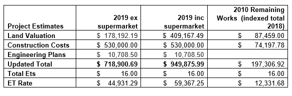
Considering the updated project costs, the following
possible funding arrangements could be considered for the proposed service
lane:
1. Amending the
project to change the apportionment from 100% with Council contributing to some
of the costs.
This option would require funds from Council’s
general revenue (or from within the CP funding if possible) which is not
recommended given other priorities and the fact that this service lane does not
benefit the wider rate base.
Even if Council decided to pay 50% of the project costs,
for example, there is still a substantial increase to ET rate.
2. Deleting the
project from the Contributions Plan and requiring landowners to facilitate the
proposed service lane identified in the DCP.
This option would not require a financial contribution
from Council, but would reduce the coordination of the service lane and would
require the landowner/developer to facilitate this service lane through the
redevelopment of their land as part of the development assessment
process.
This does not provide the best outcome for the amenity of
Island Point Road and the village, the capacity of the site for redevelopment,
or the safety of pedestrians/vehicles on Island Point Road. There have been
other examples of private car parking/servicing arrangements that have resulted
in poor outcomes. Right of Carriageways can often lead to civil disputes
without clear plans for maintenance. Council would most likely still ultimately
be drawn into this option if pursued.
3. Including the
proposed Service Lane in the larger project 03ROAD2023 St Georges Basin Village
Access Road and Traffic Facilities (preferred option).
Through a review of the recently adopted Shoalhaven
Contributions Plan 2019 and the projects in St Georges Basin Village Centre,
particularly 03ROAD2023, it has been identified that the demand still exists
for the other proposed service lane and access road. This lane will support the
retail and fringe commercial area as part of the local road network and is
critical for the development of the broader B4 Mixed Use zone area in St
Georges Basin Village Centre.
The option of amending the CP to combine the service lane in
question with the Village Access Road means the wider Contribution Area would
contribute to the service lane. There is a nexus between the future
service lane and the wider contribution area.
The existing nexus for the CP Project 03ROAD2023 St Georges Basin Village is detailed
below:
“The project is a critical part of the
local road network and necessary to enable land zoned 3(g) Business
(Development Area) (now B4 Mixed Use in Shoalhaven LEP 2014) to the east of
Island Point Road to develop”.
The current indexed amount for this project is
$3,110,322.04 with an ET rate of $7,672.23 spread across potentially 405 future
ETs. The timing for delivery is 2012/2016 and part of the Village Access Road
has been constructed at the entry points as a Council delivery project and
through a ‘works-in-kind’ agreement in lieu of contributions though
the Supermarket Development. The remaining costs given increases to construction
costs in recent years should be estimated and included in any amendment to the
CP.
If Council resolves to include the proposed service lane
in with the Village Access Road project, the total cost will increase to
$4,056,200 (approximate) and the ET rate will increase to $10,015.30.
This option is perhaps the most suitable to ensure the proposed
service lane can continue as planned, be delivered through the CP and to
provide the best outcome for the future development and resulting population
growth in St Georges Basin.
Conclusion
More detail has now been
obtained on the potential cost and options to implement the service lane that
is identified in the DCP and CP.
Given the costs involved Council
needs to decide how to best take this matter forward, acknowledging that there
is still merit in the thinking behind the original service lane concept. The
preferred option presented in the report would see the service lane retained in
the CP, with the cost spread over a larger area.
Community Engagement
Any proposed amendments to DCP
and CP will need to be publicly exhibited for a minimum period of 28 days and
further landowner and broader community feedback will be undertaken at that
point.
A letter was sent to landowners
affected by the current Contributions Project 03ROAD2113 on 11 April 2019
providing background on the proposed service lane and advising that a report on
the future of the service lane will be considered by Council at the May
Development & Environment Committee Meeting. This letter provided an
opportunity for initial feedback and any that is received will be presented to
Councillors at a briefing before the Committee meeting.
Policy Implications
Depending on the decision,
Council will ultimately need to update the relevant provisions in the DCP and
the CP. Council will be required to follow certain procedures to amend these plans
including public exhibition.
Financial Implications
There is currently no funding
available or set aside for acquisitions or project delivery for the proposed
Service Lane; however, Council previously resolved to consider the initial
funding of $200,000 through general revenue or potential CP recoupment funds.
Seed funding to deliver the
remainder of the service lane will be required from general revenue or
potential CP pool funds that may be available following the completion of the
Contributions Plan review prior to development in this area and recoupment
through levied development contributions.
|
|
Development
& Environment Committee – Tuesday 07 May 2019
Page
0
|
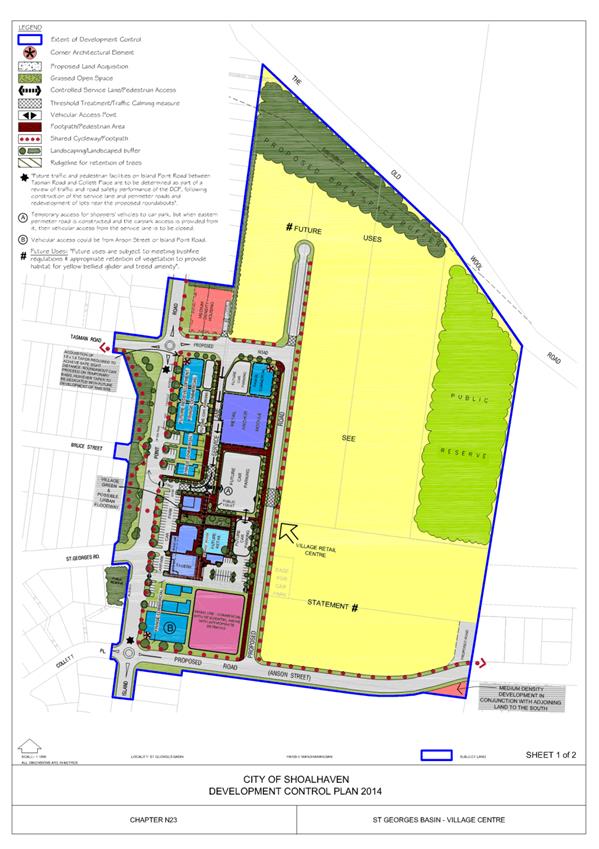
|
|
Development
& Environment Committee – Tuesday 07 May 2019
Page
0
|
DE19.35 Development
Application – SF10671 proposed 2 lot subdivision at Lot 9 DP792386
(no.96) Princes Hwy Milton
DA. No: SF10671
HPERM Ref: D19/84342
Group: Planning
Environment & Development Group
Section: Development
Services
Attachments: 1. Draft
Conditions of Development Consent (under separate cover) ⇨
2. Section 4.15 Assessment
Report (under separate cover) ⇨
Description of Development: Proposed 2 Lot
subdivision of Lot 9 DP792386 Princes Hwy Milton
Owner: J & N Pryor
Applicant: Phillip Brown Surveyor
Notification Dates: 13 – 28 September 2018
No. of Submissions: One (1) objection
Purpose
/ Reason for consideration by Council
This application is reported for
determination, in accordance with Section 3.3.5. of the Council Policy–
‘Dealing with Development Applications Lodged by Council Staff or
Councillors’, POL16/235. One of the land owners is a staff
member within the development assessment section of the Planning, Environment
and Development (PED) Group.
Additionally, the application
involves the use of a narrow laneway as a primary frontage for a proposed
vacant block of land, therefore is inconsistent with Council’s interim
policy - Development Adjoining Narrow Laneways POL18/55.
|
Recommendation
(Item to be determined under delegated authority)
Council resolve with respect to the
development application SF10671, proposed 2 lot subdivision of Lot 9 DP792386
Gumley Lane, Milton, to:
1. Support
the variation to Council Interim Policy 18/55, and use of Gumley Lane for
access,
2. Support
the development and determine the application by way of approval subject to
conditions of consent, as outlined in the attached Draft Consent, Attachment
1.
|
Options
1. Support
the recommendation.
Implications: Should the application be approved,
it would enable the subdivision to occur, providing an additional vacant block
in the Milton Village.
2. Alternatively,
the Council may choose to not support the application, and determine the
application, by way of refusal.
Implications: Should the application be refused, the applicant
is able to take the matter further, by way of a Section
8.2 Review of Determination or an Appeal to the Land and Environment Court
(LEC).
Location
The subject land is Lot 9
DP792386 (No.96) Gumley Lane, Milton. The land is situated between Church
Street and Gordon Street, on the northern side of the Princes Highway, Milton.
The land falls away from the Highway, to the north towards Gumley Lane.
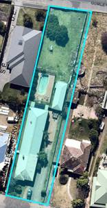
Figure1
– Subject land – Location Figure
2 – Subject Land
Background
Proposed Development
The application is for a 2 lot
Torrens title subdivision (and removal of 3 fruit trees). Proposed Lot 91
will continue to utilise existing access to/from the Highway, including the
existing dwelling, garage and swimming pool, with an area of 929.5m2.
The proposed vacant lot, Lot 92
will have a total area of 502.8m2.
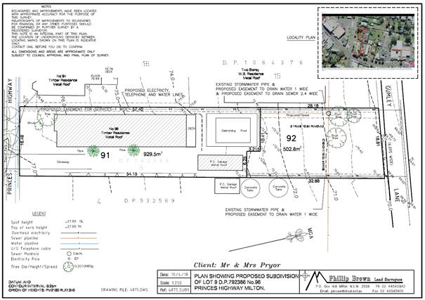
Figure 3 – Proposed
Subdivision
History
The application was lodged in
April 2018. (Prior to exhibition and/or adoption of the interim policy for Development
Adjoining Narrow Laneways.) Following requests for additional information,
and receipt of that additional information, including revised plan and
Statement of Environmental Effects (SEE), in May 2018, and later in September
2018, the application was notified, and referrals made. A further revised plan
was submitted December 2018; however, the applicant has confirmed the original
plan is the plan for assessment (see Figure 3 above).
Referral comments have been
received from other sections of Council. Where appropriate and relevant,
conditions have been included in the draft consent. Refer to Attachment
1.
Zoning
The subject land is zoned R2
under Shoalhaven Local Environmental Plan 2014 (SLEP 2014). The objectives of
the zone are:
· To provide for the housing needs of the community within a
low density residential environment.
· To enable other land uses that provide facilities or
services to meet the day to day needs of residents.
· To provide an environment primarily for detached housing
and to ensure that other development is compatible with that environment.
The proposal is not inconsistent
with the zone and the staff assessment is in agreement with the
applicant’s statement in support of the zone objectives:
·
“the proposal results in the creation of an allotment to contain a new
detached residential dwelling and therefore increases the supply of available
housing’
· The
subject site is within an area developed with single dwelling houses on
reasonably sized allotments, and this application continues this pattern of
development;
·
It will result in development that is compatible with the surrounding area,
replicating the subdivision undertaken on the adjoining land to the west; and
· It
is well located, being close to the commercial and health care facilities
provided within Milton”
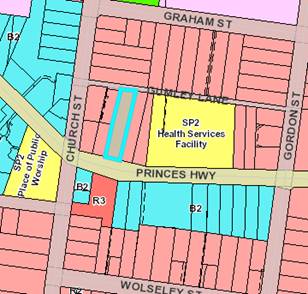
Figure 4 – Zoning of the
land
Issues
Clause 5.10 Shoalhaven Local Environmental Plan 2014 (SLEP
2014) – Heritage Conservation
There are several heritage items
identified within the vicinity of the subject land.
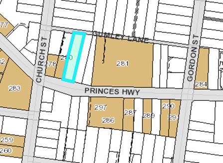
Figure 5 – extract of GIS
Heritage mapping overlay
Applicant’s Submission
The proposed lot will be vacant,
future development will be undertaken in consideration of the requirements of
SLEP 2014 and SDCP 2014. Further, the applicant notes that, “it is not
expected that any adverse impacts arise on the heritage significance of the
identified heritage items located in the vicinity of the subject site”.
Comment
Council is required to consider the extent to which the
proposal will affect the heritage significance of these heritage items. The
proposal is for a 2-lot subdivision; in itself it will have little impact. To
an extent, future impacts of any residential development will be mitigated by
the size of the lot. Further, any future development will be assessed
with regard to the relevant planning considerations at that point in time.
DCP 2014 Chapter G11
Refer to the detailed assessment report, Attachment 2.
The development meets the objectives and performance criteria
set out in G11.
With regard to A79.2 (lot dimensions / width): This issue is
addressed in detail in the assessment report.
Importantly, the variation will not result in a lot with
deficient area for a dwelling. Dimensions are acceptable taking into account
the large variety of dwelling designs available.
Applicant’s Submission & Comment
A variation statement has been submitted. The applicant
advises that the variation is sought due to location of a proposed common
boundary to enable retention of existing dwelling, garage and pool, plus suitable
setbacks.
As mentioned previously, the new lot will have adequate area
and dimensions, suitable for future development. The departure is considered
minor and will not result in any adverse impacts.
The proposed boundary enables the existing development, which
is a substantial investment, including the garage, which is the only covered
car accommodation for proposed lot 91, to be retained.
“It is considered that the proposed allotment size
and shape, whilst slightly less than the 30m required, will not adversely
impact the amenity or environment of the locality and will, despite not
strictly complying, still achieve the performance criteria of Section 5.13 of
Chapter G11 of Shoalhaven DCP. Given these circumstances it is considered
that the proposed allotment depth of Lot 92 is justified.”
Planning Assessment
This application has been
assessed in accordance with the requirements of section 4.15 of the
Environmental Planning and Assessment Act 1979 (EPA Act 1979). (Attachment 2.)
A draft consent has also been
prepared, see Attachment 1, noting that a positive recommendation has been made
in light of a favourable s4.15 assessment.
Policy Implications
Shoalhaven Development
Control Plan 2014 (SDCP 2014)
The alternate solution to A79.2 of Chapter G11 of SDCP2014
is of a minor nature, for only part of the lot 92. The DCP requires the lot
have a depth of 30m. Proposed lot 92 varies from 30.85m to 28.16m. The proposed
lot would be readily able to be further developed and is of sufficient
area/dimensions to ensure such future development can be in compliance with
relevant policies and requirements. The alternate solution meets the objectives
and performance criteria of the acceptable solution.
Council Policy POL16/235 Dealing with Development Applications Lodged by
Council Staff of Councillors.
As one of the landowners is a
Council employee, the assessment of the development application has been
undertaken considering Council Policy POL16/235 Dealing with Development
Applications Lodged by Council Staff or Councillors. The Policy provides
that development applications lodged by (or on behalf of) Council staff or
Councillors must be dealt with in the normal manner in accordance with
Council’s policies and procedures and establishes a protocol for contact
between the staff member (or Councillor) and the assessing officer.
Clause 3.3 of the Policy
establishes criteria which, if triggered, require the reporting of the DA to
Council for determination.
“Generally, any DA lodged where the applicant
and/or land owner is a Council staff member or Councillor, the DA should be
processed in the normal manner, which may include determination under delegated
authority. Nevertheless, if one (1) or more of the following matters are
triggered, the DA is to be reported to the elected Council for determination:
3.3.5. The applicant and/or land owner is a staff member
within the development assessment sections of the Planning, Environment and
Development (PED) Group; and
3.3.6. The extent of any public perception of a possible
conflict of interest that may exist between the DA lodged and the
applicant’s and/or landowner’s relationship with the PED Group
(i.e., relevant assessment staff).”
In this instance, one of the landowners
in an employee within the Development Section of the PED Group.
Interim POL18/55 -
Development Adjoining Narrow Laneways
This interim policy was adopted
by Council on 6 November 2018 and seeks to ensure that the use of laneways by
new developments does not cause adverse effects, for example, traffic and
amenity impacts.
The provisions of this Policy
include:
a. Laneways are
not to be used as primary frontages, except in cases where the laneway is the
only legal and practical access.
b. Development
proposals to increase vehicular access and servicing along narrow laneways that
have a road reserve width of less than 10m, are generally not supported.
Intensification of lots with rear lane access would need to propose access and
servicing from the primary street.
c. Development
proposals to increase vehicular access and servicing along laneways that have a
road reserve width of 10m or greater may be supported where Council can be
satisfied that:
i. The
development results in minimal impact on existing residential amenity and
ii. Provision
of infrastructure, car parking and waste collection is adequate to facilitate
the development.
d. Where
Area Specific Development Control Plan Chapter exists, it prevails over the
interim policy position.
e. That
this policy apply until suitable development controls are in place in
Shoalhaven DCP 2014.
Applicant’s Submission
The applicant comments:
· “Suitable
amenity will be provided in the future development of proposed Lot 92’;
· Proposed
lot 92 can be developed in a manner consistent with the requirements of the
Shoalhaven DCP Chapter G12 – Dwelling Houses, Rural Worker’s
Dwelling, Additions and Ancillary Structures;
· Gumley
Lane is properly constructed, provided with a sealed surface, and kerb and gutter
along the northern edge, and therefore adequate infrastructure is already
available for waste collection. Indeed, waste collection is already
required due to the extent of established development along the laneway;
· Gumley
Lane is well utilised, providing access for a number of residential properties
(including land to the west where it is the only access) and the Milton
Ulladulla Hospital;
· The
proposal will generate very little traffic along Gumley Lane (9 trips per day)
when compared with traffic that is already generated by the Milton Ulladulla
Hospital.”
Comment
The proposal is inconsistent with the interim policy, because
it proposed that the laneway would be the primary frontage for a future
dwelling.
The interim policy is an interim measure until specific
measures and development controls for development fronting laneways are in
place.
However, in this case:
a) The lot has frontage to
both the Princes Highway and Gumley Lane. Access to the Princes Highway for the
proposed lot is not practical because;
a. There is an existing
dwelling/garage etc that is to be retained, preventing physical access the
Princes Hwy, and
b. In accordance with the
State Environmental Planning Policy (SEPP) Infrastructure 2007, where there is
alternate access, development must not be approved with access to a classified
road, i.e. the Highway.
b) Gumley Lane currently
has a road reserve width of 6.095m. The lane is used to access several
rear/side yards for dwellings, and the Milton Hospital and associated
carpark.
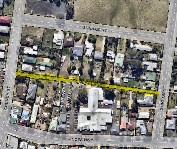
Figure 6 –
Gumley Lane Milton
c) One additional lot is a
minimal impact in this location; and
d) The proposed lot layout
and size will adequately address provision of infrastructure and future onsite
car parking. Currently waste collection services do not service the
laneway, it is possible for waste to be collected via Church Street to the west,
approx. 40m away.
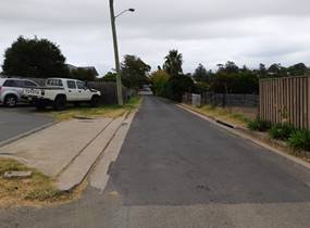
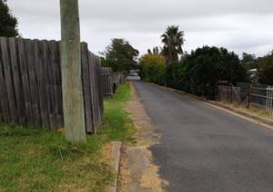
Figure 7 Gumley Lane (14/3/19) Figure
8 Gumley Lane (14/3/19)
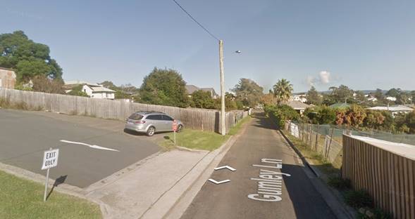
Figure
9 - Looking west along Gumley Lane – subject land on left, past carpark
exit
Consultation and Community
Engagement:
One (1) public submission was
received in relation to Council’s notification of the development. The
notification was made in accordance with Council’s Community Consultation
Policy with letters being sent within a 25m buffer of the site. The
notification was for a 2-week period, from 14 till 28 September 2019.
Key issues raised in that submission include heritage and
Gumley Lane.
Heritage
Concern expressed relating to
comments made by the applicant regarding the heritage listing of the adjacent
property at 94 Princes Hwy, as being dismissive, particularly regarding views.
Comment
The potential impact on the adjoining and nearby Heritage items
has been considered.
The proposed vacant lot is the
lower part of the land. There is an existing 2 storey modern (2008 approved)
dwelling erected immediately to the west of the proposed vacant lot, which also
faces Gumley Lane. This proposal, (i.e. subdivision) by itself will not have a
visual impact. Future development on the proposed lot will be assessed on its
own merit.
Use of Gumley Lane
Council needs to upgrade Gumley
Lane. The rapid growth of the community and hospital does and will put pressure
on the lane.
If the application is approved,
a request has been made that:
1) Gumley Lane be made
one way.
2) “foot traffic
needs also to be looked at as there is not formed footpath for
pedestrians”
3) “No
parking” restriction would have to be applied in the lane to prevent
vehicles from parking in the lane and further impeding traffic flow
“As a regular user of
this lane I can assure you that there is no room for two cars to pass without
one moving onto what is an unformed pedestrian footpath/unformed gutter on the
northern side of the road. Cars leaving the IGA parking area often use
the lane to access Gordon Street.”
Comment
This proposal is consistent with
land / development immediately to the west.
Further, SEPP (Infrastructure)
2007 states:
“(2) The consent authority must
not grant consent to development on land that has a frontage to a classified
road unless it is satisfied that:
(a) where practicable and
safe, vehicular access to the land is provided by a road other than the
classified road, and….”
Gumley Lane provides a practicable and safe alternative.
Financial Implications:
In the immediate term, there are
unlikely to be any cost implications or issues for Council noting that this
development will only generate approximately 9 vehicle trips per day. Noting
that the hospital uses the lane along with an existing approved dwelling, the
additional lot will not have a significant impact.
In the longer term, should other
like applications be received/approved, then there may be reason for Council to
undertake improvements to Gumley Lane, including potential road widening,
directional signage, drainage and kerb and gutter works.
At this point in time however
there is no specific DCP or contributions plan for potential future engineering
works, such as kerb and gutter on the southern side of the lane.
Observing the proposed lot is on
the southern side of the lane, which does not have kerb and gutter, the draft
consent includes a requirement for provision of kerb and guttering for the lot
frontage.
It is likely however that this may
need to be deferred to enable Council to consider whether it will consider
further road widening in the laneway. In previous applications for subdivisions
in proximity to the site, one of the subdivisions did not require widening, in
relation to another widening was required. With the latter application, monies
were paid for kerb and gutter works, however these works did not
eventuate.
The kerb and gutter issue could be resolved
post-determination. For example, a bond / bank guarantee arrangement with respect
to the kerb and gutter (southern side).
Legal Implications
Should the application not be approved, the applicant has
the right to seek a formal Review and/or Appeal.
Summary and Conclusion
With regard
to the interim policy for Development adjoining Narrow Laneways, it is noted
that the application was lodged in April 2018, prior to the policy being
adopted in November 2018. Irrespective, this policy has been taken into
account. Whilst the laneway will be the main frontage for the lot, the laneway
has been sealed and kerbed on one side and services a major development, being
the hospital. Additionally, the laneway access satisfies the provisions of a
SEPP which provides a safe an alternative access to the classified road, being
the Highway.
Proposed Lot 91 comprises the
southern portion of the site and there will be no change to the existing access
and use of that part of the land. Proposed lot 91 will have an area of 929.5m2.
Proposed Lot 92 comprises the northern portion of the site, fronting Gumley
Lane, and will have an area of 502.8m2, compliant with lot size
controls.
The application includes
· Consideration
under Council’s Interim Laneway policy POL18/34; and
· An
alternate solution to A79.2 of Chapter G11 SDCP 2014.
Gumley Lane is different to many
other laneways:
· It
has been used for many years as access for the Hospital;
· It
is sealed;
· the
northern side of the lane does have kerb and gutter and stormwater is
provided;
· Pedestrians
can access the hospital via either the Highway or Gumley Lane;
· This
proposal, for one additional lot when compared to the number of vehicles using
the Hospital/carpark. Whilst no counts have been made of the lane, the
additional lot adding 9 potential extra movements is relatively insignificant;
and
· It
provides for a safe and practical alternative access for development observing
the requirements of the SEPP (Infrastructure) 2007.
The application has been
favourably assessed having regard to section 4.15 (Evaluation) under the Environmental
Planning and Assessment Act 1979. As such, it is recommended that Development
Application No. SF10671 be approved subject to appropriate conditions of
consent.
|
|
Development
& Environment Committee – Tuesday 07 May 2019
Page
0
|
DE19.36 RD18/1007
– 315 Princes Highway Bomaderry – Lot 2 DP 777260
DA. No: RD18/1007/4
HPERM Ref: D19/114426
Group: Planning
Environment & Development Group
Section: Development
Services
Attachments: 1. Determination
of Development Application - Refusal ⇩
2. Site
Plan ⇩
3. Landscape
Plan ⇩
4. Aerial
Perspective ⇩
5. Assessment
Report (under separate cover) ⇨
6. Water
Quality Report (under separate cover) ⇨
7. Amended Landscaping Plan -
Review of Determination ⇩
Description
of Development: Demolition of
existing structures and construction of a staged multi-dwelling housing
development comprising 40 dwellings
Owner: Sabra Company Pty Ltd
Applicant: Sabra Company Pty Ltd
Notification Dates: 12 March 2019 to 27 March 2019
No. of Submissions: Two (2) in Objection
Purpose
/ Reason for consideration by Council
In accordance with section
8.3(4)(b) of the Environmental Planning and Assessment Act 1979 (the
Act), a Review of Determination Application lodged in accordance with section
8.2 of the Act is to be conducted by another delegate of Council who is not
subordinate to the delegate who made the determination or decision. A
determination of such review must be made within 6 months of the original
determination date.
As the initial Development
Application was determined by way of Refusal by Council’s Acting Group
Director – Planning, Environment, & Development Group, the subject
application is required to be determined by the Development & Environment
Committee.
|
Recommendation
(Item to be determined under delegated authority)
That Council:
1. Reaffirm
the determination (refusal) of DA18/1000, dated 30 November 2018, for the
demolition of existing structures and construction of a staged multi-dwelling
housing development comprising 40 dwellings at Lot 2 DP 777260, 315 Princes
Highway, Bomaderry.
2. Reissue
the determination notice removing the first reason for refusal as Endeavour
Energy has conditionally supported the proposal.
|
Options
1. Reaffirm the
decision to refuse the application in accordance with the recommendation of
this report.
Implications: This would result in the
determination remaining in place. An appeal with the Land and Environment Court
is possible in the event of a refusal of the application. There is no
ability for further review (section 8.2(3)).
2. Support the
development.
Implications: Council could choose,
following the consideration of the section 8.2 application, to support and
ultimately approve the development application if it considers that the
provisions of section 4.15(1) have been satisfactorily addressed. Council would
need to provide reasons for supporting the development. Any such approval would
be conditional and require a further report to Council detailing draft
conditions.
3. In considering
this report and supporting information, Council may express general support for
the proposed development and, having regard to the legislative timeframes
associated with the Review process, invite the applicant to submit a new
development application, particularly addressing the issues of noise
attenuation within residential units (Clause 102
of the State Environmental Planning Policy (Infrastructure) 2007), increase in landscaping and reduction of impact on
adjoining development and acceptable stormwater disposal concept.
Implications: This option would need to be
adopted in conjunction with option 1, due to legislative timeframes; it would
also provide a general direction for the applicant to achieve a positive
outcome.
Background
Division 8.2 Reviews,
Environmental Planning and Assessment Act 1979
An application lodged under
section 8.2 allows an applicant to request a consent authority to review a
determination or decision which they made. After conducting its review, the
relevant consent authority (in this instance Council) may reaffirm or change
its determination or decision.
Proposed Development
The applicant sought approval as
part of the Development Application (DA18/1000) to develop the site by
undertaking the following works:
· Demolition
– Demolition of existing structures including a disused commercial
building (southern part) and concrete slab (northern part).
· Staged
Multi-Dwelling Development – Construction of a multi–dwelling
housing development consisting of a total of 40 x 3-bedroom, two storey
dwellings together with an internal road network, visitor car parking areas,
and landscaping/open space.
Plans and documentation
depicting the proposed development are provided at Attachments 2, 3 and 4.
The Assessment Report of DA18/1000 is provided at Attachment 5.
Subject Land
The development site is
described as Lot 2 in DP 777260 and is located at No. 315 Princes Highway
Bomaderry. Figure 1 – Location Map (see below) depicts the
property and its location with respect to the surrounding locality.
Figure 1 – Location Map
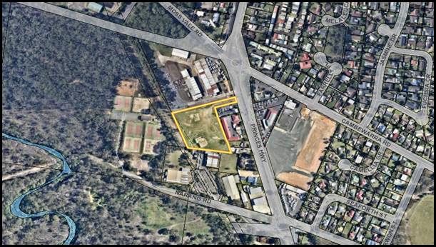
Site & Context
The following provides a
description of the property and its context with respect to neighbouring and
surrounding development sites:
· Contains
an existing disused industrial building in the southern part and disused
concrete pad in the northern part with the remainder of the site being vacant;
· Has
a minor slope downwards from a high point adjacent to Princes Highway towards a
low point at the western rear boundary;
· Is
a battle-axe lot where the sole point of vehicular access is obtained via the
access handle to the Princes Highway;
· Is
zoned B4 Mixed Use subject to the Shoalhaven Local Environmental Plan (SLEP) 2014
(refer Figure 2 – Zoning Extract below);
· Is
surrounded by a mix of uses including Council-owned land occupied by tennis
courts to the west, an existing building used for indoor recreation purposes to
the south, an existing commercial building occupied by several tenants to the
north, and a mixture of existing detached residential development and tourist
and visitor accommodation to the east; and
· The
site is located within close vicinity to the location of the approved Aldi
Supermarket (Lot 54 DP 747129 Narang Road, Bomaderry) and Woolworths
Supermarket (320 Princes Highway, Bomaderry).
Figure
2 – Zoning Extract
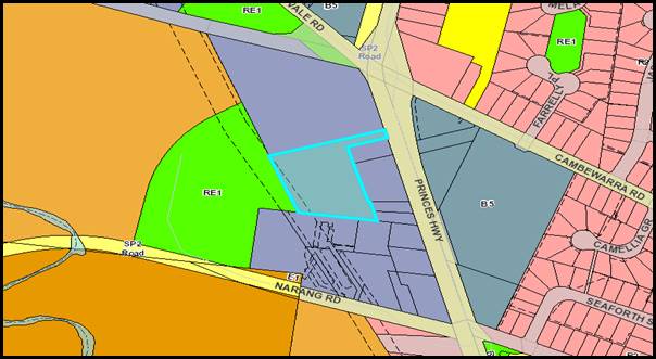
History
The following provides details
on post-lodgement actions and general site history for context:
· The
Development Application was determined by way of refusal on 30 November 2018
for the following reasons:
“1. The information submitted
with the development application does not satisfactorily demonstrate that the
development addresses the matters for consideration under Clause 45 of the
State Environmental Planning Policy (Infrastructure) 2007. (Section
4.15(1)(a)(i) of Environmental Planning and Assessment Act, 1979)
2. The information
submitted with the development application does not satisfactorily demonstrate
that the development addresses the matters for consideration under Clause 102
of the State Environmental Planning Policy (Infrastructure) 2007. (Section
4.15(1)(a)(i) of Environmental Planning and Assessment Act, 1979)
3. The information
submitted with the development application does not satisfy the objectives of
the B4 Mixed Use zone, which Council must have regard for under Clause 2.3(2)
of the Shoalhaven Local Environmental Plan 2014. (Section 4.15(1)(a)(i) of Environmental
Planning and Assessment Act, 1979)
4. Insufficient
information has been submitted to demonstrate compliance with the requirements
of chapter G2 Sustainable Stormwater Management and Erosion/Sediment Control of
the Shoalhaven Development Control Plan 2014, particularly as it relates to the
design of the drainage system. (Section 4.15(1)(a)(iii) of Environmental
Planning and Assessment Act, 1979)
5. The development in
its current form does not satisfy the objectives and performance criteria of
chapter G3: Landscaping Design Guidelines of Shoalhaven Development Control
Plan 2014. (Section 4.15(1)(a)(iii) of Environmental Planning and Assessment
Act, 1979)
6. The development in
its current form does not satisfy the objectives and performance criteria of
chapter G14: Other Residential Accommodation of Shoalhaven Development Control
Plan 2014, particularly as it relates to 5.22 Scale and Site Density. (Section
4.15(1)(a)(iii) of Environmental Planning and Assessment Act, 1979)
7. The development in
its current form does not satisfy the objectives and performance criteria of
chapter G21: Car Parking and Traffic of Shoalhaven Development Control Plan
2014, particularly as it relates to 5.7 Landscape Design and 5.9 Construction
Requirements. (Section 4.15(1)(a)(iii) of Environmental Planning and Assessment
Act, 1979).
8. The information
submitted with the development application does not satisfactorily demonstrate
that there will not be significant adverse amenity affects upon adjoining
properties or upon the future residents of the development. (Section 4.15(1)(b)
of Environmental Planning and Assessment Act, 1979)
9. The information
submitted with the development application does not satisfactorily demonstrate
that the site is suitable for the proposed development. (Section 4.15(1)(c) of Environmental
Planning and Assessment Act, 1979)
10. Having regard to the variations
to planning controls within the Shoalhaven Development Control Plan 2014 and
the inconsistency with the objectives of the zone under Shoalhaven Local
Environmental Plan 2014, the granting of development consent is not considered
to be in the public interest. (Section 4.15(1)(e) of Environmental Planning and
Assessment Act, 1979).”
· A
section 8.2 Application to review this determination was lodged on 4 December
2018 disagreeing with the determination and offering up the following as
addressing the reasons for refusal:
1. Clause 45 of State Environmental Planning Policy
(Infrastructure) 2007 relates (in part) to development to be carried out within
or immediately adjacent to an easement for electricity purposes (whether or not
the electricity infrastructure exists). Subclause 45(2) states that before
determining an application, the consent authority must:
(a) give written notice to the electricity supply
authority for the area in which the development is to be carried out, inviting
comments about potential safety risks, and
(b) take into consideration any response to the
notice that is received within 21 days after the notice is given.
The stated
reason for refusal is that the information submitted with the development
application does not satisfactorily demonstrate that the development addresses
the matters for
consideration under Clause 45 of State Environmental Planning Policy
(Infrastructure) 2007.
Therefore, the onus for satisfying
the requirements of Clause 45 lies with Council as the consent authority,
rather than being a requirement for information to be provided by an applicant.
As such, it is considered that the
basis for this reason for refusal is flawed and is therefore invalid.
2. Clause
102 of State Environmental Planning Policy (Infrastructure) 2007 relates to the
impact of road noise or vibration on non-road development and applies to
development for residential accommodation, where it is adjacent to a road with
an average annual daily traffic (AADT) volume of more than 20,000 vehicles
(based on the traffic volume data published on the website of RMS). Under this
clause, a consent authority must not grant to development unless it is satisfied
that appropriate measures will be taken to achieve the nominated noise
criteria.
The RMS data indicates that the
Princes Highway at Bomaderry carries an AADT volume of 22,000 vehicles.
However, although the site has a narrow battle-axe handle that fronts the
Princes Highway and provides vehicular and pedestrian access to the site, the
site itself, is not located adjacent to the road corridor and is separated by
the allotments on which the Avaleen Lodge Motor Inn and Bomaderry Motor Inn are
located. As such, these buildings provide an acoustic buffer and separation
between the Princes Highway and the proposed development and it is considered
that the proposed development will not be adversely affected by road noise or
vibration.
3. The
stated objectives of the B4 Mixed Use zone are:
(a) To
provide for a mixture of compatible land uses.
(b) To
integrate suitable business, office, residential, retail and other development
in accessible locations to maximise public transport patronage and encourage walking
and cycling.
The proposed residential land use is
considered to be compatible with the surrounding land uses. Further, it is
noted that the proposed residential land use of the land was chosen in
preference to a significantly larger mixed-use development that incorporated a
commercial component – as was discussed with Council at the Pre-DA stage.
Having regard to the B4 Mixed Use zoning, the 11m height limit set under
Shoalhaven DCP 2014 and that a maximum floor space ratio for the site is not
prescribed under the LEP, three different concept schemes (Options A, B &
C) were presented at the Pre-DA meeting, as detailed below. The proposed built
form in each of these options were between 3 and 6 storeys and incorporated
both residential and non-residential floor space.
· Option A
– 4 storey mixed use development comprising 150 apartments in 4 blocks,
2,124m2 commercial/retail
floor space, including a child care centre.
· Option B
– 3-4 storey mixed use development comprising 100 apartments in 6 blocks,
1,822m² commercial/retail
floor space including a child care centre.
· Option C - 3-6 storey mixed use development with a green
roof and ‘punched’ courtyards, comprising 165 apartments and 2,992m2 of
commercial/retail floor space.
Despite not all schemes complying with the 11m height
limit, it was noted that each of these development types were permissible with
consent. However, following a discussion with Council’s (then) Section
Manager – Development after the meeting, Council’s officer advised
that the concept schemes could not be supported in the form presented at the
Pre-DA meeting and a built form more compatible with the existing surrounding
scale should be investigated.
4. The applicant has continuously worked with
Council officers to address all requests for additional information regarding
the stormwater drainage design for the proposed development and on several
occasions, further information was sought. It is considered that the stormwater
drainage design can be amended to satisfy all concerns raised by Council.
5. The proposed landscaping for the site
incorporates a combination of soft and hard landscaping, as well as turf cell
and is considered to provide a suitable landscaping scheme for the site. The
objectives of Chapter G3 of Shoalhaven DCP 2014 are to:
i. Blend new developments, where
appropriate, into the existing streetscape and neighbourhood character.
ii. Enhance the appearance, amenity and energy
efficiency of new developments for the users and for the community in general.
iii. Provide landscaping within a development
that relates to the scale and type of existing elements in the neighbouring
landscape.
It is considered that the landscape scheme for the
proposed development achieves these objectives and provides a suitable
landscape context and setting for the proposed development.
6. The applicant decided not to pursue a
commercial component on the site and instead, proposed a purely residential
scheme, that took advantage of the sites B4 Mixed Use zoning (i.e. not within
an R3 Medium Density Residential environment), but proposed a built form
similar to multi dwelling housing set in the context of an ‘integrated
community’. The design ‘ideology’ is that while the height of
the proposed development has been capped at two storeys to be more in keeping
with the existing surrounding built form, in terms of density, it is more akin
to a residential flat building that could otherwise be built with consent on
the site. However, for the purpose of categorising the proposed development
under the LEP land use table, the development is referred to as a
multi-dwelling housing development.
As a
consequence of this categorisation, Council’s assessment of the proposed
development has been based on the provisions for multi dwelling housing set out
in Chapter G14: Other Residential Accommodation of Shoalhaven DCP 2014.
However, it is respectfully submitted that while these controls would be
suitable for a multi-dwelling housing development in an R3 Medium Density
Residential zone, to seek to rely on these controls for a development in a B4
Mixed Use zoning is contrary to the zoning objectives.
Council has
indicated that the scale and density of the proposed development is
unsatisfactory and is contrary to the objectives and performance criteria of
Chapter G14: Other Residential Accommodation in Shoalhaven DCP 2015. However,
it is considered that the site has the environmental capacity to support a
higher residential density than would be acceptable in an R3 Medium Density
Residential zone and the proposed density is appropriate for this site, where
it is located on a major traffic thoroughfare, with good access to public
transport and in proximity to a range of retail and commercial facilities
accessible by walking and cycling.
Council’s
attention is drawn to the provisions of Section 4.15(3A) of the Environmental
Planning & Assessment Act 1979 which states:
(3A) Development control
plans
If a
development control plan contains provisions that relate to the development
that is the subject of a development application, the consent authority:
(a) if those provisions set standards with respect
to an aspect of the development and the development application complies with
those standards—is not to require more onerous standards with respect to
that aspect of the development, and
(b) if those provisions set standards with respect
to an aspect of the development and the development application does not comply
with those standards—is to be flexible in applying those provisions and
allow reasonable alternative solutions that achieve the objects of those
standards for dealing with that aspect of the development, and
(c) may consider those provisions only in connection
with the assessment of that development application.
In this subsection, standards include performance
criteria.
Having regard to subclause 4.15(3A)(b), it is considered
that the flexible application of the DCP controls is appropriate with respect
to the proposed development.
It is considered that the proposed development, when
considered in its context, has sufficient planning merit such that the strict
application of the DCP controls is unwarranted in the circumstances. The
proposed development will add to the housing choice and diversity in the
locality, consistent with the emerging and desired mixed-use environment.
There is currently no dominant character or built form in
the locality. However, commensurate with the above objectives, as an emergent
mixed use urban area, the proposed multi dwelling housing development will
contribute to the achievement of this mixed-use character through the integration
of residential development in a location with good access to public transport
services.
The redevelopment of this site will provide a quality
multi dwelling housing development that represents an appropriate scale and
built form in this location. The relationship of the building to the
surrounding residential and non-residential development is acceptable and the
proposed development will not have an unreasonable impact on the adjoining
properties in terms of aural and visual privacy, overshadowing, traffic and
parking etc.
7. The proposed on-site parking provision
complies with the numerical requirements of Shoalhaven DCP 2014. The internal
circulation design provisions including aisle widths, bay dimensions will
accord with the requirements of AS2890.1 & 6. There will be a two-way
circulation arrangement with quite satisfactory provision for turning and
manoeuvring.
8. The proposed development is considered to
be appropriate for the existing and likely future context and setting of the
locality. The redevelopment of this site will provide a quality multi dwelling
housing development that represents an appropriate scale and built form in this
location. The relationship of the building to the surrounding residential and
non-residential development is acceptable and the proposed development will not
have an unreasonable impact on the adjoining properties in terms of aural and
visual privacy, overshadowing, traffic and parking etc. The proposed
development is considered to be a significantly more modest scheme that the
zoning and environmental capacity of the site would allow for.
The proposed development is considered to be appropriate
for the existing and likely future context and setting of the locality. The
redevelopment of this site will provide a quality residential development that
represents an appropriate scale and built form in this location. The
relationship of the building to the surrounding residential and non-residential
development is acceptable and the proposed development will not have an unreasonable
impact on the adjoining properties in terms of aural and visual privacy,
overshadowing, traffic and parking etc. The two-storey built form is compatible
with the height of surrounding residential development and the relationship and
separation between the proposed development and the adjoining residential
properties is such that appropriate visual and acoustic privacy will be
maintained. There will also be no overshadowing impacts on the adjoining
residential uses arising from the proposed development.
9. The site is considered suitable for the
proposed development for the following reasons:
· the site has the environmental capacity to support the
proposed residential density and built form.
· the site is zoned to accommodate this type and form of
development;
· the nature and form of the proposed development is
generally consistent with the development controls which apply to the site;
· the scale and nature of the development is compatible with
existing and anticipated future development in the locality;
· the size and dimensions of the land are suitable for the
scale of the proposed development;
· the site will have access to all utility services to
accommodate the demand generated by the proposed development;
· the proposed development is unlikely to result in any
adverse traffic impacts; and
· the proposed development will not result in any
unacceptable or material environmental impacts in relation to adjoining and
surrounding properties, particularly in terms of overshadowing, views, privacy
(aural and visual), solar access and natural ventilation.
10. As discussed earlier, it is considered
that the proposed development is entirely consistent with the objectives of the
B4 Mixed Use zone and the proposed development is in the public interest. The
proposed development represents the orderly, economic use and development of
the subject land, and the proposed density is well within the environmental
capacity of the site. The development proposed under this application is
considered to be both reasonable and appropriate in the context of the site.
The development will have positive social and economic benefits in terms of
creating additional resident population that will in turn support local
businesses and services. The proposal provides a responsive design in terms of
its relationship with adjoining development and establishes an appropriate
human scale through sound urban design principles, whilst ensuring that
environmentally sustainable principles are incorporated.
Issues
Review of Determination
Reason for Refusal No. 1
– Non-Compliance with Clause 45 of State Environmental
Planning Policy (Infrastructure) 2007
The Development Application (DA18/1000) was externally
referred to Endeavour Energy for comment on 15 January 2018 due to the vicinity
of the development to an existing easement (30.48m wide) for transmission lines
which partially traverses the southern and western corner of the site.
The following pertinent comments were raised by Endeavour
Energy in their referral response provided on 5 February 2018:
“Some of the
dwellings (Blocks 4 and 6) are proposed to be constructed against the easement
area. All parts of the building must be outside of the easement i.e.
porches, verandahs, awnings, pergolas, balconies, architectural features as
well as the eaves and gutters / downpipes or any type of projections from
external walls such as stairs, chimneys, services etc. must not encroach the
easement area and this applies regardless of the Council’s allowable
building setbacks etc. under its development controls. From the elevations and
the Parking Floor Plan it appears parts of the dwellings may encroach the
easement area?
There are driveways,
stormwater pipes, onsite stormwater detention tank, fencing, landscaping etc.
located within the easement area.
Endeavour Energy’s
preference is for no activities or encroachments to occur within its easement
areas. However, if this is not reasonably possible and the proposed works
(as is the case here) will encroach/affect Endeavour Energy’s
easements, contact must first be made with the Endeavour Energy’s
Easements Officer, Jennie Saban.”
Council referred revised plans
to Endeavour Energy for further comment, however the applicant failed to
address the original concerns with the following comments provided by Endeavour
Energy in correspondence received on 31 October 2018:
Comparing the original and revised site plans below there
appears to be no revisions made to the plans in regard to the easement area.
Endeavour Energy has noted that the request for additional information etc.
does not appear to address the easement. Endeavour Energy’s Easements
Officer, Jennie Saban, has advised that the applicant has not contacted her to
discuss the proposed controlled activities and encroachments in the easement
area.
Accordingly, the objection to the Development Application
and the recommendations and comments previously made by Endeavour Energy remain
valid.
In accordance with Clause 45 of the ISEPP, the consent
authority is required to ‘take into consideration any response to the notice that is
received within 21 days after the notice is given’. Considering Endeavour Energy’s
above objection to the proposal, the assessment officer (as the consent
authority) considered that Clause 45 of the ISEPP had not been satisfactorily
addressed.
Following lodgement of the s8.2 Review of Determination
Application, Council conducted a further external referral with Endeavour
Energy on 3 March 2019 who provided the following pertinent comments:
Since Endeavour Energy’s submission made to Council
on 5 February 2018 the applicant has been in contact with Endeavour
Energy’s Easements Officer, Jennie Saban, who has provided the following
advice regarding progress in resolving the easement management issues related
to the Development Application:
· 27
February 2019. Email to Council copied to Sabra Company advising that:
After careful review, Endeavour Energy will give
conditional approval for the DA18/1000 with the following requirements to be
confirmed at construction certificate phrase:
1. That
low voltage service conductor running parallel to the side boundary will be
placed underground.
2. A report is
provided by an electrical engineer/ASP that the earthing of any structures
(e.g.; drainage pits etc.) complies with Australian/New Zealand Standards
As/NZS 3000:2018.
· 25
March 2019. Email received from the Director of
AA Power Engineering, Ali Alaouie, including the attached earthing design.
The email indicates ‘Please note this earthing is to comply with
AS3000 and a certificate is to be provided by the electrician at the end of the
job’.
The applicant has advised Endeavour Energy that no parts
whatsoever of the proposed dwellings / town houses will encroach the easement
area for the 33 kV high voltage overhead power lines. Based on the foregoing
and the further recommendations and comments Endeavour Energy’s
submission made to Council on 5 February 2018, Endeavour Energy has no
objection to the Development Application.
Based upon the above advice provided by Essential Energy and
the requirement of Clause 45 of the ISEPP to ‘take into consideration any response to the
notice that is received within 21 days after the notice is given’, it is considered that the applicant has
now demonstrated compliance with Clause 45 of the ISEPP.
Conclusion: Reason for Refusal No. 1 be should be
removed from the determination notice, if the recommendation is adopted.
Reason for Refusal No. 2 –
Non-Compliance with Clause 102 of State Environmental Planning Policy
(Infrastructure) 2007
Clause 102 of the State Environmental Planning Policy
(Infrastructure) 2007 provides that this section is applicable to land in or
adjacent to the road corridor for a freeway, tollway or transitway or any other road with an annual average daily
traffic volume of more than 20,000 vehicles (based on the traffic volume data
published on the website of RMS) and that the consent authority considers is
likely to be adversely affected by road noise or vibration:
(a) residential
accommodation,
(b) a
place of public worship,
(c) a
hospital,
(d) an
educational establishment or centre-based child care facility.
It was noted by the assessment officer that the proposed development
is for the purpose of residential accommodation (being a multi-dwelling housing
development) and has direct frontage to a freeway with a traffic volume of more
than 20,000 vehicles.
Clause 102(3) of the ISEPP requires that a consent authority
is not permitted to grant consent to a development unless it is satisfied that
appropriate measures would be undertaken to ensure that;
(a) in any bedroom in the
residential accommodation—35 dB(A) at any time between 10 pm and 7 am,
(b) anywhere else in the
residential accommodation (other than a garage, kitchen, bathroom or
hallway)—40 dB(A) at any time.
Given the very high traffic volume of the Princes Highway and
the sensitive nature of the proposed land use, the development has the
potential to be adversely affected by traffic noise. It was noted in the
initial assessment of the Development Application that the applicant has not
addressed how the development would comply with the requirements of Clause 102.
In their submission provided as part of the Review of
Determination Application, the applicant provided that given the separation of
the allotment by the Avaleen Lodge Motor Inn and Bomaderry Motor Inn the
development would not be adversely affected by road noise or vibration.
Whilst this is noted, no evidentiary proof (such as the
submission of an Acoustic Noise Report) has been provided to confirm that the
ambient noise levels of the dwellings located closest to the Princes Highway
would comply with the specified noise levels stated within Clause 102(3).
As such Council’s position that the applicant has not
satisfactorily demonstrated compliance with Clause 102 of the ISEPP has not
changed.
Conclusion: Reason for Refusal No. 2 should
therefore be retained within the determination notice issued to the applicant.
Reason for Refusal No. 3 –
Non-Compliance with the objectives for the B4 Mixed Use Zone under the
Shoalhaven Local Environmental Plan (SLEP) 2014.
In the assessment of the initial Development Application, the assessment
officer identified that insufficient consideration was given to the impact of
the development on the amenity of adjoining properties and the treatment of
common boundaries. Further, whilst the residential development is in an
accessible location, it was identified that the proposal would have the
potential to result in land use conflicts. The assessment officer therefore
determined that the proposal does not satisfy the objectives of Zone B4.
The zone objectives are:
· To provide a mixture of compatible land uses.
· To integrate suitable business, office, residential, retail
and other development in accessible locations so as to maximise public
transport patronage and encourage walking and cycling.
The applicant provides within the Review of Determination
Application that ‘the proposed residential land use is considered to
be compatible with the surrounding land uses’. However, it is noted
that no further reasoning was provided as to why/how the proposal would be
compatible with the surrounding land uses. It is also noted that no further
consideration was given to the treatment of common boundaries as a measure to
reduce amenity impacts upon sensitive land uses within the locality.
No changes have been proposed to the design of the
development, including the number of proposed dwellings, the layout, or
positioning of perimeter roads with respect to the property boundaries. In this
regard it is assessed that the proposal still does not provide for a mixture of
compatible land uses where suitable business, office, residential,
retail, and other development are integrated.
Given the vastly differing nature of land uses bordering the
site, it is assessed that the interface between neighbouring land uses is not
sufficient and needs to be further addressed through increased separation
and/or buffering through landscaping to maintain suitable levels of visual and
acoustic amenity within the locality. It is considered that the current
proposal would result in a reduction in acoustic and visual amenity for
residents of the site as well as for occupants of neighbouring properties and
is therefore not considered to be compatible or suitable in its
current form.
Conclusion: Reason for Refusal No. 3 should be
retained within the determination notice issued to the applicant.
Reason
for Refusal No. 4 – Insufficient information submitted to demonstrate
compliance with Chapter G2 Sustainable Stormwater Management and
Erosion/Sediment Control of the Shoalhaven Development Control Plan 2014.
As part of the initial Development Application, the applicant
submitted a Concept Stormwater Drainage Plan detailing how stormwater would be
disposed from the impervious surface areas associated with the development. As
per the submitted plan, a series of pits and pipes were proposed to collect
runoff throughout the development, discharging to an on-site detention tank in
the north-western corner of the site via a gross pollutant trap.
Overflow drainage from the detention tank was then proposed to
be discharged via a pipe over the adjoining Council reserve, discharging to an
existing Council stormwater main.
As part of Council’s response to the submitted concept
plan, the applicant was advised of the following issues relating to the
submitted drainage design (following a review of the proposal by
Council’s Development Engineer):
Consideration should be given to the layout of the line,
which includes several changes of direction (some up to 90 degrees). As per
Council’s engineering design specifications, pits are required at all
changes of direction. A drainage long section plan should be provided to assess
the suitability of the proposal, taking into account the effect of the
deflections in the line.
The capacity of the existing pit and outlet pipe on the
south-western corner of the tennis courts is also unknown. It appears that (at
least a proportion of) the drainage from the tennis courts enters this pit.
It was noted by the assessment officer that Council’s
Development Engineer was generally satisfied with the proposal, subject to the
submission of amended drainage concept plans and consideration given to
assessing pollutant loads from the development, and the provision of
calculations to ensure that Council’s stormwater main has the capacity to
cater for the additional loads produced by the proposed development.
A further information request was sent to the applicant
seeking to address the matters raised by the Development Engineer; however,
further design detail to the satisfaction of the Development Engineer was not
provided.
The assessment officer therefore determined that insufficient
information was submitted to permit compliance with Chapter G2 Sustainable
Stormwater Management and Erosion/Sediment Control of the Shoalhaven
Development Control Plan 2014.
As part of their Review of Determination Application, the
applicant provided the following documentation to assist in satisfying the
concerns raised by the Development Engineer:
· Amended
Stormwater Drainage Concept Plans depicting pits at each change of direction;
· Drainage
long section plan and associated velocity/flow calculations;
· Plans
for a proposed stormwater drainage easement through the Council reserve area;
and
· Water
Quality Report identifying pre-and post-development flow calculations (Attachment
6).
Whilst the applicant has submitted amended drainage
documentation addressing the Development Engineer’s concerns, specific
reference is made to the submitted Water Quality Report which provides the
following:
· The
post-developed site would increase the pollutant load (TSS volume) from the
pre-developed state from 27.447kg to 40.478kg which represents a 47.5% per
annum increase. The report further states that, with the inclusion of turf cell
paving, the pollutant load would be reduced to below the pre-developed levels.
Council’s Development
Engineer’s advice regarding the turf cell pavement is noted, in
particular the following comments:
Evidence provided by the applicant supports
Council’s initial view that the proposed paving is not suitable for the
proposed purpose, i.e. as a high use circulation roadway within a medium
density development. It is more suitable as a parking bay, i.e. where a vehicle
is likely to park and remain all day, rather than a roadway which is subject to
traffic. This is a situation that will see the surface subject to potentially
hundreds of vehicle movements each day. Regardless of the strength of the
product, this is a level of traffic that will lead to the turf wearing out.
Given the above comments, it is
assessed that whilst pollutants may be reduced initially, given the likelihood
that the turf cell would wear out, it is likely that pollutant loads would
eventually increase to above the pre-developed levels.
As such the concerns raised by
the Development Engineer remain outstanding and Council’s position that
insufficient information has been submitted to demonstrate compliance with
Chapter G2 Sustainable Stormwater Management and Erosion/Sediment Control of
the Shoalhaven Development Control Plan 2014 has not changed.
Conclusion: Reason
for Refusal No. 4 should be retained within the determination notice issued to
the applicant.
Reason
for Refusal No. 5 – The development in its current form does not satisfy the
objectives and performance criteria of chapter G3: Landscaping Design
Guidelines of Shoalhaven Development Control Plan 2014.
As part of the assessment of the
initial Development Application, the assessment officer noted the following
with regard to deficiencies with the submitted Landscape Plan:
· The
development is well set back from the Princes Hwy with only the access handle providing
an interface with the streetscape. However, with regard to the adjoining
development it is noted that only a minor landscaping buffer is proposed as a
transition between adjoining developments. Along the eastern boundary there is
an approximate 1m landscaping strip with mainly shrubs proposed and one tree.
Further to the south, where the development adjoins dwelling houses, this
increases to allow for more substantial plantings.
· Along
the southern and western boundaries there is largely no landscape buffer,
excepting the corners of the site. Although it is noted that there is
commercial development to the south and a Council public reserve to the west
(buffered by an electricity easement). Along the northern boundary there is an
approximate 0.55m landscape buffer, which is an insufficient width for
substantial plantings. This does increase along the access handle.
· Personal
safety has been sufficiently considered as landscaping will not provide
opportunities for concealment and is generally consistent with CPTED
principles.
· Landscaping
must be in accordance with the principles of Appendix 5 of ‘Planning for
Bush Fire Protection 2006’ as per NSW RFS comments.
Further to the above comments
regarding the submitted Landscape Plan, it was also noted by the assessment
officer that, under Chapter G14 of the SDCP 2014, 35% of the site must be
landscaped.
In October 2018 Chapters G13
– Dual Occupancy Development and G14 – Other Residential
Development were combined into one Chapter being G13 – Medium Density and
Other Residential Development.
While Chapter G13 does not apply
in this instance, as the application was lodged prior to its adoption, it is
worth noting that it would require 10% of the site to be high quality
landscaping and a further 20% of the site to be landscaped. While this
additional 20% may include areas such as decks, terraces, swimming pools and
other recreation areas/structures it does not include driveways or parking
spaces. It was estimated that only 19% of the site was proposed to be
landscaped when not including ‘turf-cell’ paved driveway and
parking spaces given their intended use fundamentally conflicts with the
functioning of landscaped areas.
Going to the point made by the
applicant about the role of a Development Control Plan, it is acknowledged that
a Development Control Plan is a document providing guidance for developers and
Council and that there are options to conform to acceptable solutions or
satisfy performance solutions and ability to assess development with some
flexibility. In this instance, observing the number of units, building
footprint and concentration of development, amenity for occupants is important
and to this end the provision of good quality landscaping would be beneficial
for occupants, and in this regard, the original assessment not supporting the
design remains relevant.
Figure 3 – Landscape Plan extract


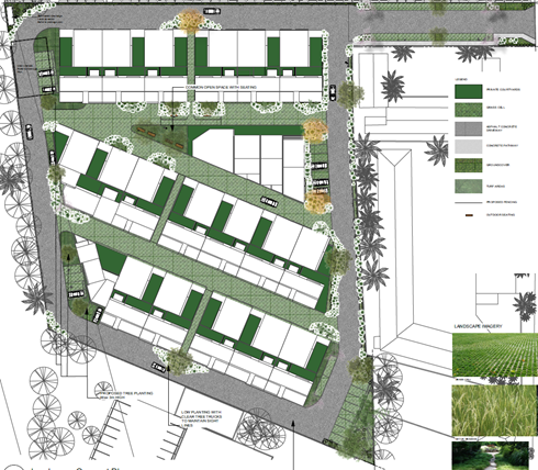
As part of the Review of Determination Application, the
applicant submitted an updated Landscape Plan (Attachment 7). However,
it was noted that minimal changes were made to the landscape design as was
recommended by the assessment officer in the initial assessment. It is
therefore assessed that the amended Landscape Plan still does not
satisfactorily address the objectives and performance criteria of Chapter G3:
Landscaping Design Guidelines of Shoalhaven Development Control Plan 2014.
Conclusion: Reason for
Refusal No. 5 should be retained within the determination notice issued to the
applicant.
Reason for Refusal No. 6 – The development in its current form does not satisfy the
objectives and performance criteria of chapter G14: Other Residential
Accommodation of Shoalhaven Development Control Plan 2014, particularly as it
relates to 5.22 Scale and Site Density.
As part of the assessment of the initial Development
Application, the assessment officer found that the proposed floor space ratio
for the development would be 0.46:1, which represents a 31% variation to
Acceptable Solution A4.1 of Chapter G14 of the SDCP 2014 which states a maximum
floor space ratio of 0.35:1. This equates to a numerical departure of
1,258m².
In the response to Reason for Refusal No. 6, the applicant
provides the following:
While the height of the proposed development has been
capped at two storeys to be more in keeping with the existing surrounding built
form, in terms of density, it is more akin to a residential flat building that
could otherwise be built with consent on the site. However, for the purpose of
categorising the proposed development under the LEP land use table, the
development is referred to as a multi-dwelling housing development.
Council disagrees with the statement that the development is
more akin to a residential flat building than a multi-dwelling housing
development. For the purpose of the assessment, the SLEP 2014 defines a
multi-dwelling housing development as ‘3 or more dwellings (whether attached or detached) on one lot
of land, each with access at ground level, but does not include a residential
flat building’ and
a residential flat building as ‘a building containing three or more
dwellings, but does not include an attached dwelling or multi dwelling
housing’.
As per the above comments, the definitions for multi-dwelling
housing and a residential flat building are not interchangeable. They are
completely different developments and separately and distinctly characterised
(legally defined in planning definitions).
It is assessed that the proposal is a multi-dwelling housing
development given there are more than three dwellings, all of which are
accessed at ground level whereas the development could not be accurately
described as a single building which contains dwellings where such dwellings
are not necessarily accessed at ground level.
Whilst there may be capacity to consider a higher density,
this should not be at the expense of future residential amenity of the intended
occupants.
It is noted that no alteration has been made to the design of
the development as it pertains to site coverage and the proposed site coverage
remains 0.46:1, which is a 31% departure from the stated acceptable solution.
It is therefore assessed that the development as proposed does not
satisfactorily address the objectives or performance criteria of chapter G14:
Other Residential Accommodation of Shoalhaven Development Control Plan 2014,
particularly as it relates to 5.22 Scale and Site Density.
Conclusion: Reason
for Refusal No. 6 should be retained within the determination notice issued to
the applicant.
Reason for Refusal No. 7 – The development in
its current form does not satisfy the objectives and performance criteria of
Chapter G21: Car Parking and Traffic of Shoalhaven Development Control Plan
2014, particularly as it relates to 5.7 Landscape Design and 5.9 Construction
Requirements.
In their response to Reason for Refusal No. 7, the
applicant provides the following:
The
internal circulation design provisions including aisle widths, bay dimensions
will accord with the requirements of AS2890.1 & 6. There will be a two-way
circulation arrangement with quite satisfactory provision for turning and
manoeuvring.
The reasons given by the assessment officer for the refusal
of the Development Application are due to non-compliance with Section 5.7
– Landscape Design and Section 5.9 – Construction Requirements.
The following comments are provided with regard to the
proposal’s non-compliance with these sections:
Section 5.7
The amended Landscape Plan submitted by the applicant
maintains a nominal setback of 1.0m to the eastern side boundary and 0.55m to
the northern side boundary. However, no buffer has been provided to either the
southern or western boundaries. It is further noted that there is a general
lack of landscaping throughout the development – reference is also made
in this regard to the aforementioned variation proposed to the general
landscaping requirements of the development.
Section 5.9
The applicant has maintained their proposal for the use of
turf paving throughout the development which does not meet the general design
and construction standard for a medium density residential development
specified within A13.4 – Chapter G21 of the SDCP 2014. The aforementioned
comments provided by the Development Engineer are noted where it was identified
that the evidence provided by the applicant supports Council’s initial
view that the proposed paving is not suitable for the proposed purpose.
Given that no alterations have been made to the proposal
which would enable compliance Sections 5.7 and/or 5.9, the reason for refusal
remains valid.
Conclusion: Reason
for Refusal No. 7 should be retained within the determination notice issued to
the applicant.
Reason for Refusal No. 8 – The development in
its current form does not satisfactorily demonstrate there will not be
significant adverse amenity affects upon adjoining properties or upon future
residents.
The applicant identifies in their response to Reason for
Refusal No. 8 that:
‘the
proposed development will not have an unreasonable impact on the adjoining
properties in terms of aural and visual privacy, overshadowing, traffic and
parking etc’ and further that ‘the relationship and
separation between the proposed development and the adjoining residential
properties is such that appropriate visual and acoustic privacy will be
maintained’.
No evidentiary proof has been provided by the applicant
that the proposal would not have an unreasonable impact upon the amenity of
neighbouring properties, as it relates to visual amenity, acoustic amenity, and
traffic.
To the contrary, it is noted that submissions have been
received either from neighbours or by representatives acting on behalf of
neighbours, formally objecting to the development on amenity grounds.
It is considered that the proposal would have an
unreasonable impact on the adjoining properties in terms of aural and visual
privacy, overshadowing, traffic and parking due to the following reasons;
· No interface (i.e. such as landscaping) separating the
proposal and the adjoining uses being tourist and visitor accommodation,
residences, indoor recreation facility, open space, and commercial premises.
· No landscaping or buffer between the perimeter road and the
southern and western side boundaries and the minimal landscaping and buffer to
the eastern and northern side boundaries.
· Forty proposed dwellings would result in a large number of
traffic movements per day along the perimeter road and would result in impacts
associated with acoustic amenity.
· Lack of landscaping or separation along boundaries would
provide reduced visual and acoustic privacy for guests of neighbouring motor
inns and residences.
It is further noted that no redesign of the development has
been undertaken from the original proposal.
It is therefore considered that the proposal does not
satisfactorily demonstrate that there will not be significant adverse amenity
affects upon neighbouring and surrounding properties.
Conclusion: Reason
for Refusal No. 8 should be retained within the determination notice issued to
the applicant.
Reason for Refusal No. 9 – The information submitted with the development application
does not satisfactorily demonstrate that the site is suitable for the proposed
development.
As part of the assessment of the initial Development
Application, the assessment officer noted that the site would not be suitable
for the proposed multi-dwelling housing development for the following reasons:
· It
will result in poor amenity for adjoining properties.
· It
will result in inadequate amenity for the future residents of the development.
· There
has been insufficient consideration of the interface with adjoining properties
and land uses and will likely result in land use conflicts.
· The
development in its current format is an overdevelopment of the site.
As part of their Review of Determination Application, the
applicant provided that the site would be suitable for the proposed development
for the following reasons:
· The site is zoned to accommodate this type and form of
development;
· The nature and form of the proposed development is
generally consistent with the development controls which apply to the site;
· The scale and nature of the development is compatible with
existing and anticipated future development in the locality;
· The size and dimensions of the land are suitable for the
scale of the proposed development;
· The site will have access to all utility services to
accommodate the demand generated by the proposed development;
· The proposed development is unlikely to result in any
adverse traffic impacts; and
· The proposed development will not result in any
unacceptable or material environmental impacts in relation to adjoining and
surrounding properties, particularly in terms of overshadowing, views, privacy
(aural and visual), solar access and natural ventilation.
It is agreed that the site is suitably zoned, is of a
configuration that could accommodate multi dwelling development however the
review of the determination made by the assessment officer found that the
proposed development would not provide a quality residential development with
respect to amenity for occupants. In particular it is found that the current
format provides for a substantial development footprint (31% variation to site
coverage requirement and a 46% variation to landscaping requirement).
The extent of the development on the site means that there
is significant site coverage to the detriment of amenity. There is insufficient
separation between the development and land uses on neighbouring sites. An
example of the insufficient separation is the lack of landscaping buffer
provided between the development and surrounding land uses, particularly as it
pertains to the perimeter road.
Figure
4 – Landscape Plan extract showing permitter road relative to boundary
and adjoining motel development

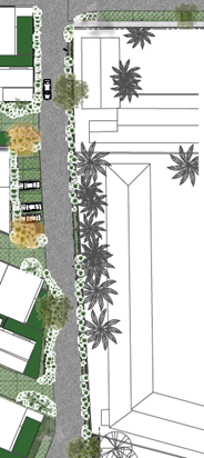
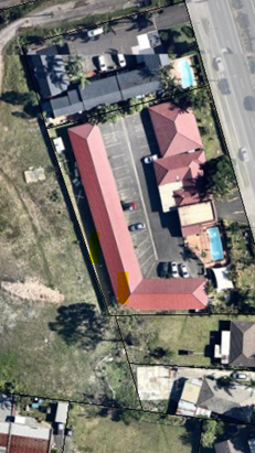
Conclusion: Reason
for Refusal No. 9 should be retained within the determination notice issued to
the applicant.
Reason for Refusal No. 10 – Having regard to
variations to planning controls and inconsistency with objectives, the granting
of development consent is not considered to be in the public interest.
As part of their assessment of the initial Development
Application, the assessment officer noted that the development would not be
within the public interest for the following reasons:
There has been insufficient consideration of the amenity
afforded to future residents of the development. Similarly, there has been
insufficient consideration of the impacts upon adjoining properties and how the
development is compatible with the future desired character of the area.
As part of their Review of Determination Application, the
applicant provided that the development would be within the public interest,
with the following response being provided:
The proposed development represents the orderly, economic
use and development of the subject land, and the proposed density is well
within the environmental capacity of the site. The development proposed under
this application is considered to be both reasonable and appropriate in the
context of the site. The development will have positive social and economic
benefits in terms of creating additional resident population that will in turn
support local businesses and services. The proposal provides a responsive
design in terms of its relationship with adjoining development and establishes
an appropriate human scale through sound urban design principles, whilst
ensuring that environmentally sustainable principles are incorporated.
Whilst it is acknowledged that an increased resident
population would potentially provide an economic benefit to local businesses
within the locality, it is considered that the proposed density is of concern.
The scale of development having regard to the density and site cover is likely
to result in impacts upon both residents within the locality and
residents/guests of surrounding developments due to the limited setback and
buffering/separation between structures and in particular the limited
separation between neighbouring properties and the perimeter road.
It is considered that, whilst the design of each individual
dwelling is sound, the design is not responsive in terms of its relationship
with adjoining developments for the aforementioned reasons.
Additionally, whilst the development will provide a type of
housing in addition to conventional single dwellings, there is no variety in
housing form or choice within the proposed complex. The design is
relatively homogenous in architecture and internal layout with all being 3 bedrooms.
Conclusion: Reason
for Refusal No. 10 should be retained within the determination notice issued to
the applicant.
Planning Assessment
The DA has been assessed under
s4.15 (as at the time of assessment) of the Act. This ‘assessment’
is a formal review under the relevant provisions of the Act, having specific
regard to the reason for the refusal.
Consultation and Community
Engagement:
Notification was undertaken in
reference to the proposed development as part of the original Development
Application for a two (2) week period between 20 April 2018 and 5 May 2018 and
as part of the Review of Determination Application for a two (2) week period
between 12 March 2019 and 27 March 2019. Six (6) public submissions were
received within these notification periods. Six (6) were in objection to the
development. Zero (0) were in support of the development. The notification was
made in accordance with Council’s Community Consultation Policy with
letters being sent within a 120m buffer of the site.
Key issues raised as a result of
the notification are provided below.
· Noise Impact;
· Amenity/Privacy
Impact;
· Traffic Impact;
· Construction
Sequence;
· Emergency Services
Access;
· On-Site Waste
Service Collection;
· Chapter G3
(Landscaping) Objectives;
· Chapter G14 (Other
Development) Objectives;
· Commercial Impact;
· Floor Space Ratio
Variation;
· Location of Car
Parking;
· Lighting Impacts;
· Car Parking
Impacts (Construction Period) upon Approved Aldi Development;
· Car Parking
Impacts (Operational Period) upon Approved Aldi Development; and
· Amenity Impacts for
Future Residents given the Close Proximity to Approved Loading Dock of Aldi
Supermarket.
Financial Implications:
There are potential cost
implications for Council in the event of a refusal of the application. Such
costs would be associated with defending any appeal in the Land and Environment
Court of NSW.
Legal Implications
An appeal with the Land and
Environment Court is possible in the event of a refusal of the application.
Summary and Conclusion
To summarise, the key issues
concerning the proposal remain the same with the original application excepting
concerns by Endeavour Energy.
The request to formally review
the application DA18/1000 has been undertaken in accordance with Division 8.2
(Reviews) under the Act, also having regard to relevant provisions of section
4.15 (Evaluation). As such, it is
recommended that the refusal be reaffirmed. If Council is inclined to support
the recommendation for refusal, it is however recommended that the Determination
be reissued removing the first reason for refusal. This matter has been
resolved given that Endeavour has decided to conditionally support the
proposal.
|

|
Development
& Environment Committee – Tuesday 07 May 2019
Page
0
|
|
|
Development
& Environment Committee – Tuesday 07 May 2019
Page
0
|
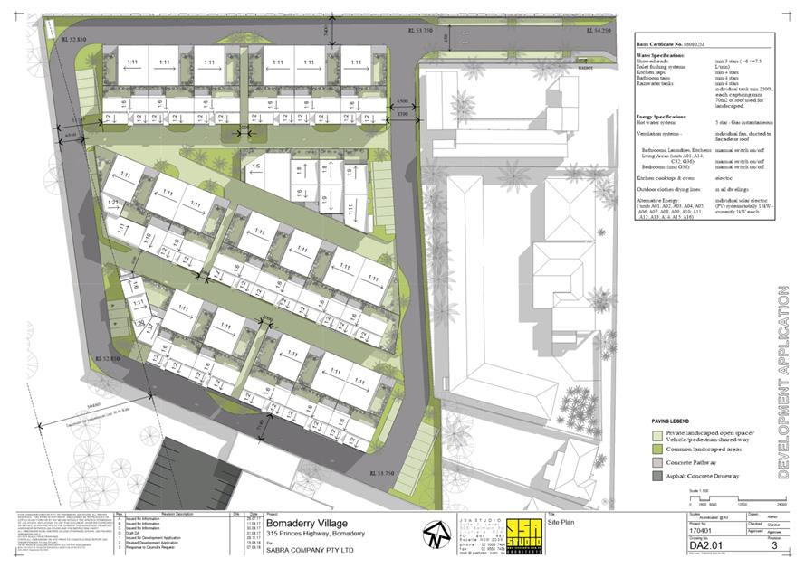
|
|
Development
& Environment Committee – Tuesday 07 May 2019
Page
0
|
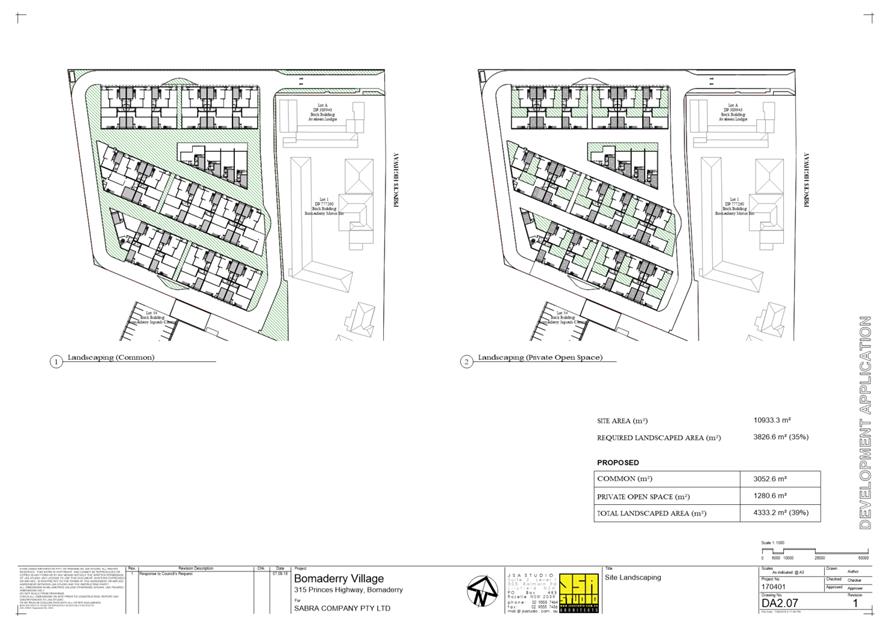
|
|
Development
& Environment Committee – Tuesday 07 May 2019
Page
0
|
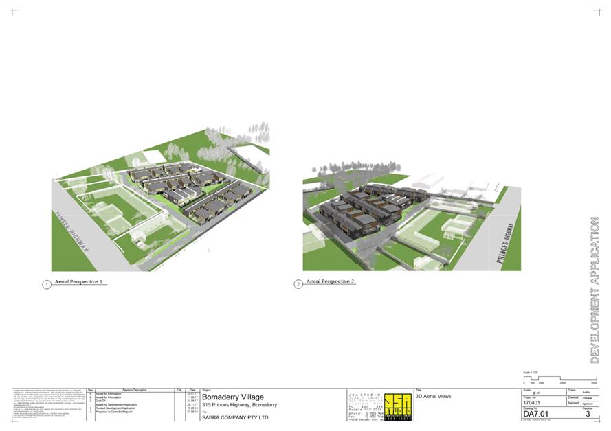
|
|
Development
& Environment Committee – Tuesday 07 May 2019
Page
0
|
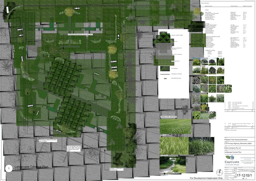
|
|
Development
& Environment Committee – Tuesday 07 May 2019
Page
0
|
DE19.37 Lake
Tabourie Boardwalk Replacement
HPERM Ref: D19/119129
Group: Planning
Environment & Development Group
Section: Environmental
Services
Attachments: 1. Tabourie
Lake Residents and Ratepayers Association - Request to Rebuild Lake Tabourie
Boardwalk ⇩
Purpose / Summary
Advise Council on the next
stage of the Lake Tabourie Boardwalk replacement.
|
Recommendation
(Item to be determined under delegated authority)
That Council:
1. Commit
to revoting $212,520 from Coastal Foreshore Erosion Works (75742) capital
works budget from 2018/19 financial year to 2019/20 financial year to fund
the design and construction of the replacement boardwalk.
2. Progress
to design of a replacement boardwalk, to a standard that increases the asset
resilience to future coastal hazards, and includes:
a. Geotechnical
assessments and land survey
b. Review
of Environmental Factors including
i. Aboriginal
Heritage assessment
ii. Native
Title claim assessment
3. Commit
to construction of a new boardwalk at Lake Tabourie, to replace the
previously destroyed one, using Fibreglass Reinforced Polymer (FPR)
materials.
|
Options
1. As recommended.
Implications: Meets community expectations and
provides a public asset that will have a longer asset life and decreased
“whole of life” cost. The boardwalk will also have a higher level
of protection from coastal hazards.
2. Replace the
boardwalk to previous standard (like for like/treated pine),
Implications: This would have a lower initial
construction cost; however, the “whole of life” cost would be
higher, and the asset life would be shorter. The asset would also be more
vulnerable to coastal hazards.
3. Council
determine an alternative recommendation.
Implications: unknown
Background
The June 2016 an East Coast Low
(ECL) storm demolished the existing timber boardwalk and caused minor erosion
of the sandy southern shoreline of Lake Tabourie. Following the storm Council
assessed the damage and public risk. Due to the extent of the damage, the
structure was removed.
At the time, it was decided not
to replace the boardwalk, due to a lack of funds, given the financial strains
placed on Council’s coast and estuary budgets due to the extent of damage
to coastal assets following the 2016 ECL. A decision was made at the time to
install an interim measure of Holey Belt, underlain with sand nourishment to
provide a relatively flat surface for access to the main beach.
The 2017
Interim works included the following
1. Removal of undermined
trees and redundant fence assets essential to allow machine access
2. Sand nourishment, and
3. Installation of
temporary Holey Belt, on the walk way of the alignment of the previous
boardwalk.
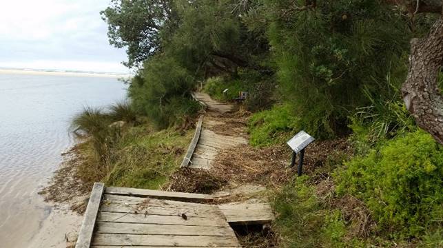
Figure
1: Lake Tabourie Boardwalk, damaged following East Coast Low, July 2016
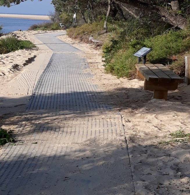
Figure
2, Interim Holey Belt in place, February 2018
Council has been undertaking
on-going maintenance of the Holey Belt interim structure over the last 24
months, mainly in relation to the loss of sand caused by lake processes, that
forms the foundations of the Holey Belt.
This initial interim measure has
provided safe access for the less abled people, elderly and prams to the main
beach. All communication with the Tabourie Lake Residents and Ratepayers
Association has been that the community see the Holey Belt as only a temporary
solution, with an expectation that Council will replace the boardwalk.
Community Engagement
Consultation with the Tabourie
Lake Residents and Ratepayers started during the storm event and continued in
the recovery phases where an interim placement of the Holey Belt was undertaken
and maintained. As per the attached correspondence from the Tabourie Lake
Residents and Ratepayers Association in late 2016, the community requested that
the boardwalk be replaced by a structure that provides the same functions as
the previous boardwalk in the longer-term.
Council staff recently meet with
the executive of the Tabourie Lake Residents and Ratepayers Association on 8
April 2019, to discuss the preferred options based on the following.
Option 1: Continue with the
Holey Belt structure
Option 2: Design and construct
the replacement of the boardwalk as per previous standard (treated pine).
Option 3: Design and construct
the replacement boardwalk to a higher standard to be able to withstand coastal
hazards, i.e. pier down to a depth that would make the structure more robust to
impacts of future coastal storms. Construct the boardwalk out of Fibreglass
Reinforced Polymer (FRP), with a guarantee 100-year life span on the material.
At the meeting the association
were clear that the community preference was to replace the boardwalk. Given
the instability of the lake entrance and higher frequency of intense coastal
storms predicted by climate modelling, the preferred option was Option 3.
Financial Implications
The estimated cost for Option 3,
based on the Lake Conjola Boardwalk construction cost, would be as follows.
· Design
(Inc. Geotech), surveys, Aboriginal Heritage assessment and Review of
Environmental Factors = $60,000
· Construction
of the boardwalk, using a combination of FRP and Enviro Deck® = $133,200
(based on $1,800 per linear metres x 74 metres)
The total estimated cost for the
replacement of the Lake Tabourie boardwalk would be $193,200, allowing for a
10% contingency of $19,320; the total project cost would be $212,520. Currently
Council’s capital budget for Coastal Foreshore Erosion Works (75742) has
a budget of $401,390, with $150,000 committed towards current capital projects
in 2018/19 year.
To fund the replacement of the
Lake Tabourie boardwalk would require Council to revote the $212,520 into the
2019/20 year. Council has begun the preliminary design and geotechnical works;
however, will need the funds revoted to allow time for the approvals and
construction.
Risk Implications
The interim Holey Belt option
has served well to date; however, since installation, our region has had lower
than average rainfall and no coastal storm events have occurred. However, the
Holey Belt is likely to continue to fail once increased rainfall occurs, and
will continue to pose a public risk when the lake level rises, and the
foreshore sand base becomes less stable.
|
|
Development
& Environment Committee – Tuesday 07 May 2019
Page
0
|
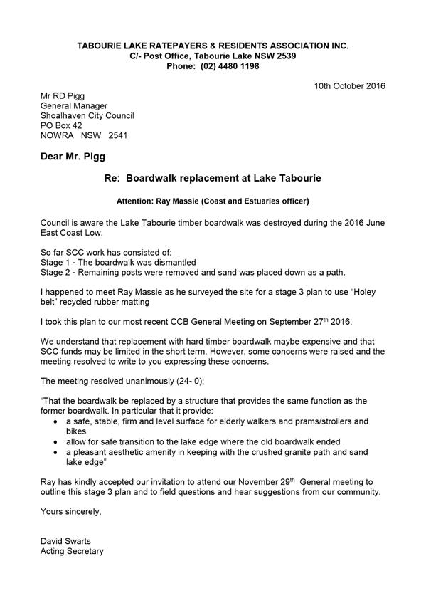
|
|
Development
& Environment Committee – Tuesday 07 May 2019
Page
0
|
DE19.38 Timeframes
and Status for Lake Conjola Coastal Management Program Application - NSW Coast
and Estuary Grant Program
HPERM Ref: D19/124684
Group: Planning
Environment & Development Group
Section: Environmental
Services
Attachments: 1. Lake
Conjola Coastal Management Program Preparation Application ⇩
Purpose / Summary
To provide Council with an
update on the Lake Conjola Coastal Management Program grant application to NSW
Coast and Estuary – Planning Stream Grant Program 2018/19.
|
Recommendation (Item to be determined
under delegated authority)
That Council receive the Lake
Conjola Coastal Management Program Application report for information.
|
Options
1. As per recommendation
Implications: The grant application will continue
to be assessed by the NSW Office of Environment (NSW OEH) for value for money
and technical rigour.
2. Propose an alternative recommendation
Implications: This would depend on the content of
the recommendation
Background
At the Ordinary meeting of Council on 26 March 2019, Council
resolved (Part 8 MIN19.4) to receive the following report.
8. Report
timeframe and priority status for preparation of Coastal Management Plan for
Lake Conjola to Council.
At a meeting held on 5 February
2019, with the representatives of the Lake Conjola Community Association,
Councillors, Council staff, State Government Agencies Staff and the Member for
South Coast, Hon. Shelly Hancock MP, it was decided by consensus to prepare a
standalone Coastal Management Program for Lake Conjola, as per the requirements
of the NSW Coastal Management Manual and the Act.
Council officers then proceeded
to prepare a draft application to the NSW OEH Coast and Estuary Planning Stream
Grant Program. A meeting was held with representatives of the Lake Conjola
Community Association on 14 February 2019, to get input into the scope and
contents of the grant application.
Following this, the draft
application was sent to the Lake Conjola Community Association to provide
feedback on the draft application. The application was also sent to the Office
of Environment and Heritage (OEH) for feedback via the Regional Coast and
Estuary Senior Officer.
Council received feedback from
both OEH and the Lake Conjola Community Association, in March 2019. This
feedback and comments were incorporated into the grant application, which was
submitted to NSW OEH on 10 April 2019.
The closing dates for the Coast
and Estuary Planning Stream Application is 30 June 2019, Council has received a
confirmation email from the NSW Coast and Estuary Grant Unit acknowledging the
acceptance of the Preparation of Lake Conjola Coastal Management Program
application.
Timeframe for the development
of the CMP
The project plan provided within
the application for financial assistance outlines project milestones for the
development of the CMP and their corresponding completion dates. This project
plan was developed and reviewed with the assistance of NSW Office of
Environment and Heritage, based on their knowledge and experience in the
delivery of CMPs. The grant application sets the timeframe of commencement in
April 2020 and preparation of the final document in August 2021, however this
is dependent upon the grant application being successful and the timing of the
grant determination and notification.
The milestones and activities
that refer to assessing lake process, hazards and risks include flood risk and
entrance management.
The project plan is presented in
Section 12 of the attached document - Lake Conjola Coastal Management Program
Preparation Application (D19/124621). This is an updated version of the grant
application that was provided to OEH to include activity costs. A copy has been
provided to the Conjola Community Association.
Community Engagement
Council has undertaken the
following community engagement in the preparation of the Lake Conjola Coastal
Management Program application.
1. Initial meeting with
Lake Conjola Community Association representatives to identify the need for a
stand-alone Coastal Management Program for Lake Conjola – 6 February 2019
2. Follow up meeting with
the Lake Conjola Community Association to develop the grant application –
14 February 2019
3. Draft application sent
to the Lake Conjola Community Association for feedback and comments – 19
March 2019
4. Feedback received from
the Lake Conjola Community Association on grant application and incorporated
into application – 26 March 2019
5. Grant application
submitted to NSW OEH – 10 April 2019
Policy Implications
The preparation of the Coastal
Management Plan for Lake Conjola, will incorporate an assessment of both the
current Lake Conjola Interim Entrance Management Policy 2013 and the Lake
Conjola Estuary Management Plan 2015.
Financial Implications
If the Lake Conjola Coastal
Management Program grant is successful, Shoalhaven Council will be required to
fund 50% of the cost, which will be $140,000 over two years.
Risk Implications
The preparation of a costal
management program is a requirement of the NSW Coastal Management Act 2016, the
Coastal SEPP 2018 and the NSW Coastal Manual Part 1. Without a certified
Coastal Management Program (CMP), Shoalhaven Council would not be eligible to
apply for funding to undertake coastal management actions that are not identified
in a CMP.
Any review of the Lake Conjola
Estuary Management Plan or the Entrance Management Policy is required to be
done as part of the development of a Coastal Management Program, as per the
requirements of the NSW Coastal Management Act 2016.
|
|
Development
& Environment Committee – Tuesday 07 May 2019
Page
0
|
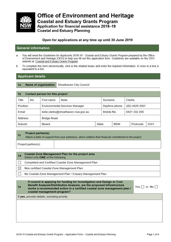
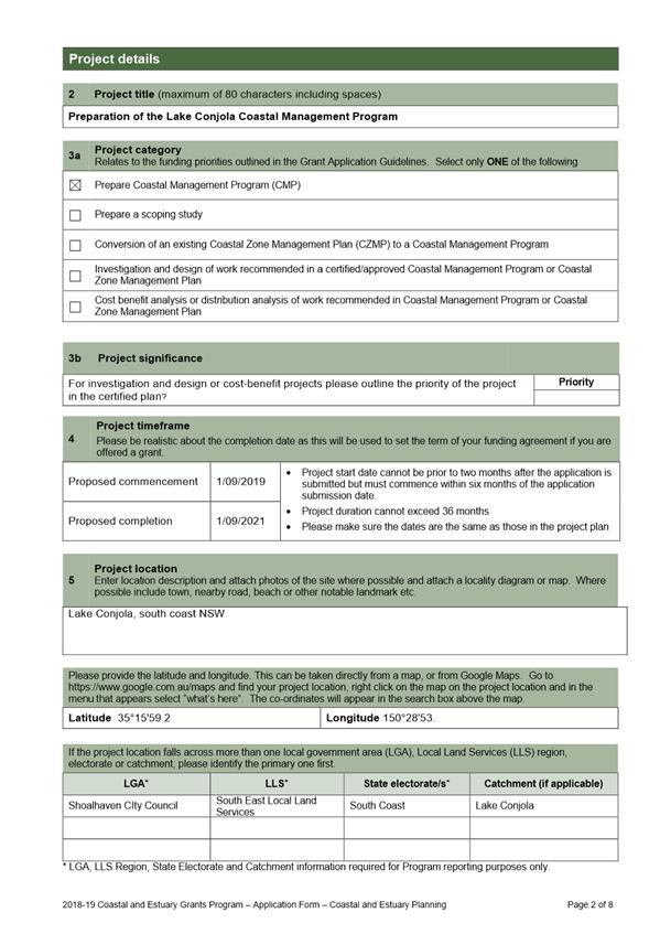
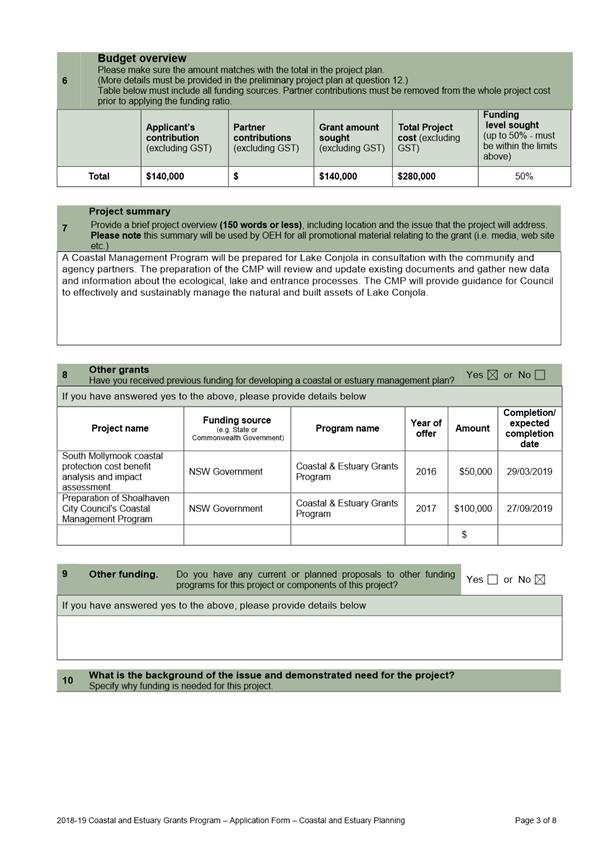
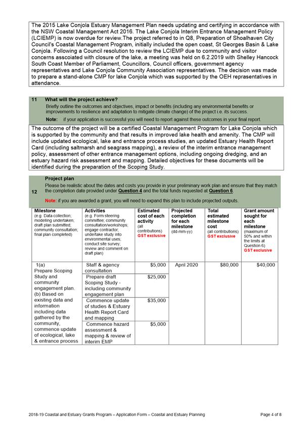
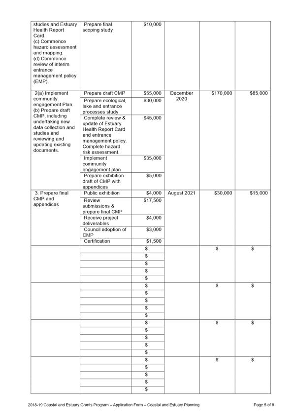
|
|
Development
& Environment Committee – Tuesday 07 May 2019
Page
0
|
Local Government Amendment (governance &
planning) act 2016
Chapter
3, Section 8A Guiding principles for councils
(1)
Exercise of functions
generally
The
following general principles apply to the exercise of functions by councils:
(a) Councils should provide strong
and effective representation, leadership, planning and decision-making.
(b) Councils should carry out
functions in a way that provides the best possible value for residents and
ratepayers.
(c) Councils should plan
strategically, using the integrated planning and reporting framework, for the
provision of effective and efficient services and regulation to meet the
diverse needs of the local community.
(d) Councils should apply the
integrated planning and reporting framework in carrying out their functions so
as to achieve desired outcomes and continuous improvements.
(e) Councils should work
co-operatively with other councils and the State government to achieve desired
outcomes for the local community.
(f) Councils should manage
lands and other assets so that current and future local community needs can be
met in an affordable way.
(g) Councils should work with
others to secure appropriate services for local community needs.
(h) Councils should act fairly,
ethically and without bias in the interests of the local community.
(i) Councils should be
responsible employers and provide a consultative and supportive working
environment for staff.
(2) Decision-making
The
following principles apply to decision-making by councils (subject to any other
applicable law):
(a) Councils should recognise
diverse local community needs and interests.
(b) Councils should consider social
justice principles.
(c) Councils should consider the
long term and cumulative effects of actions on future generations.
(d) Councils should consider the
principles of ecologically sustainable development.
(e) Council decision-making should
be transparent and decision-makers are to be accountable for decisions and
omissions.
(3) Community participation
Councils
should actively engage with their local communities, through the use of the
integrated planning and reporting framework and other measures.
Chapter
3, Section 8B Principles of sound financial management
The
following principles of sound financial management apply to councils:
(a) Council spending should be responsible and
sustainable, aligning general revenue and expenses.
(b) Councils should invest in responsible and
sustainable infrastructure for the benefit of the local community.
(c) Councils should have effective financial
and asset management, including sound policies and processes for the following:
(i) performance management
and reporting,
(ii) asset maintenance and
enhancement,
(iii) funding decisions,
(iv) risk management practices.
(d) Councils should have regard to achieving
intergenerational equity, including ensuring the following:
(i) policy decisions are made
after considering their financial effects on future generations,
(ii) the
current generation funds the cost of its services
Chapter
3, 8C Integrated planning and reporting principles that apply to councils
The
following principles for strategic planning apply to the development of the
integrated planning and reporting framework by councils:
(a) Councils should identify and prioritise key
local community needs and aspirations and consider regional priorities.
(b) Councils should identify strategic goals to
meet those needs and aspirations.
(c) Councils should develop activities, and
prioritise actions, to work towards the strategic goals.
(d) Councils should ensure that the strategic
goals and activities to work towards them may be achieved within council
resources.
(e) Councils should regularly review and
evaluate progress towards achieving strategic goals.
(f) Councils should maintain an
integrated approach to planning, delivering, monitoring and reporting on
strategic goals.
(g) Councils should collaborate with others to
maximise achievement of strategic goals.
(h) Councils should manage risks to the local
community or area or to the council effectively and proactively.
(i) Councils should make appropriate
evidence-based adaptations to meet changing needs and circumstances.