Development Committee
Meeting Date: Tuesday,
11 September, 2018
Location: Council
Chambers, City Administrative Building, Bridge Road, Nowra
Time: 5.00pm
Membership (Quorum - 5)
Clr Joanna Gash - Chairperson
Clr John Levett
All Councillors
General Manager or nominee
Please note: The proceedings of this meeting
(including presentations, deputations and debate) will be webcast and may be
recorded and broadcast under the provisions of the Code of Meeting Practice. Your attendance at this meeting is taken
as consent to the possibility that your image and/or voice may be recorded and
broadcast to the public.
Agenda
1. Apologies / Leave of Absence
2. Confirmation of Minutes
· Development
Committee - 14 August 2018................................................................. 1
3. Declarations of Interest
4. Mayoral Minute
5. Deputations and Presentations
6. Notices of Motion / Questions on Notice
Nil
7. Reports
DE18.61...... Exhibition Outcomes and Next Steps - Nowra
Riverfront Entertainment and Leisure Precinct - Proposed Planning Controls
Report............................................ 13
DE18.62...... Exhibition Outcomes - Planning Proposal - 9
Browns Road South Nowra - Caravan Park............................................................................................................... 36
DE18.63...... Berry Heritage Investigation Project - Future
Direction............................... 52
DE18.64...... South Nowra Industrial Zoned Area - Future
Direction................................ 62
DE18.65...... Low Rise Medium Density Housing Code - Request
for Deferred Commencement Extension...................................................................................................... 71
DE18.66...... Proposed 2017 Housekeeping Amendment to
Shoalhaven Local Environmental Plan 2014 - Instrument Changes.......................................................................... 76
8. Confidential
Reports
Nil
|

|
Development
Committee – Tuesday 11 September 2018
Page
|
Development Committee
Delegation:
Pursuant to
s377 (1) of the Local Government Act 1993 the Committee is delegated the
functions conferred on Council by the Environmental Planning & Assessment
Act 1979 (EPA Act), Local Government Act 1993 (LG Act) or any other Act or
delegated to Council, as are specified in the attached Schedule, subject to the
following limitations:
i. The
Committee cannot make a decision to make a local environmental plan to classify
or reclassify public land under Division 1 of Part 2 of Chapter 6 of the LG
Act;
ii.
The Committee cannot review a section 8.11 or
section 8.9 EPA Act determination made by the Council or by the Committee
itself;
iii.
The Committee cannot exercise any function delegated
to the Council which by the terms of that delegation cannot be sub-delegated;
iv.
The Committee cannot exercise any function which
s377(1) of the LG Act provides cannot be delegated by Council; and
v.
The Committee cannot exercise a function which
is expressly required by the LG Act or any other Act to be exercised by
resolution of the Council.
Schedule:
a. All
functions relating to the preparation, making, and review of local
environmental plans (LEPs) and development control plans (DCPs) under Part 3 of
the EPA Act.
b. All
functions relating to the preparation, making, and review of contributions
plans and the preparation, entry into, and review of voluntary planning
agreements under Part 7 of the EPA Act.
c. The
preparation, adoption, and review of policies and strategies of the Council in
respect of town planning and environmental matters and the variation of such
policies.
d. Determination
of variations to development standards related to development applications
under the EPA Act where the development application involves a development
which seeks to vary a development standard by more than 10% and the application
is accompanied by a request to vary the development standard under clause 4.6
of Shoalhaven Local Environmental Plan 2014 or an objection to the application
of the development standard under State Environmental Planning Policy No. 1
– Development Standards.
e. Determination
of variations from the acceptable solutions and/or other numerical standards
contained within the DCP or a Council Policy that the General Manager requires
to be determined by the Committee
f. Determination
of development applications that Council requires to be determined by the
Committee on a case by case basis.
g. Review
of determinations of development applications under sections 8.11 and 8.9 of
the EP&A Act that the General Manager requires to be determined by the Committee.
h. Preparation,
review, and adoption of policies and guidelines in respect of the determination
of development applications by other delegates of the Council.
Minutes of the Development Committee
Meeting Date: Tuesday,
14 August 2018
Location: Council
Chambers, City Administrative Building, Bridge Road, Nowra
Time: 5.02pm
The following members
were present:
Clr Joanna Gash -
Chairperson
Clr Patricia White
Clr John Levett
Clr Nina Cheyne
Clr Annette Alldrick
Clr Kaye Gartner
Clr Andrew Guile
Clr Greg Watson
Clr Mark Kitchener
Clr Bob Proudfoot
Clr John Wells (left
7.06pm)
Clr Mitchell Pakes
Mr Russ Pigg - General
Manager
The Chairperson read a statement advising those present that
the proceedings of this meeting (including presentations, deputations and
debate) will be webcast and may be recorded and broadcast under the provisions
of the Code of Meeting Practice.
|
Apologies / Leave of Absence
|
An
apology was received from Clr Findley.
|
Confirmation of the Minutes
|
|
RESOLVED (Clr Cheyne / Clr
Levett) MIN18.600
That
the Minutes of the Development Committee held on Tuesday 03 July 2018 be
confirmed.
CARRIED
|
Nil.
Deputations and Presentations
DE18.50
- Proposed New Commercial Development - 16 Additional Motel Rooms at the
Bangalee Motel - Lot 100, DP 1057897, 180 Queen Street, BERRY - DA17/1359
(Page 6)
Mr Stuart Coughlan spoke against the recommendation.
Mr Anthony Houghton (Berry Chamber of Commerce and
Tourism) spoke for the recommendation.
DE18.53 – Development
Application - DA17/1678 – 87 Tallwood Ave, Mollymook Beach – Lot 51
DP1193578 (page 65)
Ms Jan Gregory (Ulladulla Forum)
spoke against the recommendation.
Mr Tony Freeman (Molnar Freeman
Architects) spoke for the recommendation.
DE18.58 – Development
Application DA17/2435 - 148 Island Point Road, St. Georges Basin - Lot 43 DP
25550 - Access and Section 7.11 (94) Contributions (Page 95)
Mr Travis Harpley spoke
for the recommendation.
Reports
|
Procedural
Motion - Bring Item Forward
|
|
RESOLVED (Clr Pakes / Clr Wells) MIN18.601
That the matter of items DE18.50,
DE18.53, DE18.58 and DE18.56 be brought forward for consideration.
CARRIED
|
|
DE18.50 Proposed
New Commercial Development - 16 Additional Motel Rooms at the Bangalee Motel
- Lot 100, DP 1057897, 180 Queen Street, BERRY - DA17/1359.
|
HPERM Ref:
D18/169024
|
|
Recommendation (Item
to be determined under delegated authority)
That Development Application
DA17/1359 for the construction of two, 2 storey motel buildings consisting of
16 units and associated site works on the land at 180 Queen Street, Berry -
Lot 100, DP 1057897 be approved subject to the recommended conditions of
consent contained in Attachment 6 to this report.
|
|
RESOLVED (Clr Guile / Clr Wells) MIN18.602
That Development Application
DA17/1359 for the construction of two, 2 storey motel buildings consisting of
16 units and associated site works on the land at 180 Queen Street, Berry -
Lot 100, DP 1057897 be approved subject to the recommended conditions of
consent contained in Attachment 6 to this report.
For: Clr
Gash, Clr White, Clr Wells, Clr Levett, Clr Cheyne, Clr Alldrick, Clr Guile,
Clr Pakes, Clr Watson, Clr Kitchener, Clr Proudfoot and Russ Pigg
Against: Clr
Gartner
CARRIED
|
|
DE18.53 Development
Application - DA17/1678 – 87 Tallwood Ave, Mollymook Beach – Lot
51 DP1193578
|
HPERM Ref:
D18/223258
|
|
Recommendation (Item to be determined under
delegated authority)
That Council:
1. Confirm
that it supports, pursuant to clause 4.6 (exceptions to development
standards) of SLEP 2014, the applicant’s request to vary the maximum
building height standard of 11m to increase the existing maximum building
height from 13.514 to 14.714m; and
2. Refer
the development application (DA17/1678) back to staff for determination.
|
|
Motion
(Clr Guile / Clr Levett)
That Council:
1. Does
not support the applicant’s request to vary the maximum building height
standard for the development; and
2. Refers the development application
(DA17/1678) back to staff for determination.
For: Clr
Levett, Clr Gartner, Clr Guile and Clr Pakes
Against: Clr Gash, Clr
White, Clr Wells, Clr Cheyne, Clr Alldrick, Clr Watson, Clr Kitchener, Clr
Proudfoot and Russ Pigg
lost
|
|
MOTION (RESOLVED) (Clr Gash / Clr
Cheyne) MIN18.603
That Council:
1. Confirms
that it supports, pursuant to clause 4.6 (exceptions to development
standards) of SLEP 2014, the applicant’s request to vary the maximum
building height standard of 11m to increase the existing maximum building
height from 13.514 to 14.714m; and
2. Refers the development application
(DA17/1678) back to staff for determination.
|
|
procedural Motion (Clr White / Clr
Wells)
That
the MOTION be PUT.
CARRIED
|
|
The
MOTION was PUT and CARRIED.
For: Clr
Gash, Clr White, Clr Wells, Clr Cheyne, Clr Watson, Clr Kitchener, Clr
Proudfoot and Russ Pigg
Against: Clr
Levett, Clr Alldrick, Clr Gartner, Clr Guile and Clr Pakes
|
|
DE18.58 Development
Application DA17/2435 - 148 Island Point Road, St. Georges Basin - Lot
43 DP 25550 - Access and Section 7.11 (94) Contributions
|
HPERM Ref:
D18/261085
|
|
Recommendation (Item to be
determined under delegated authority)
That Council:
1. Commit
to funding the upfront costs for the construction of the remaining section of
the St Georges Basin Village Centre Service Lane identified in Contribution
Project (CP) 03ROAD2113 through:
a. Funding
the initial expenditure of the works and land acquisition using recoupment
funds that may be available following the completion of the Shoalhaven
Contributions Plan review or through general revenue allocations in the
future Capital Works Program of up to $200,000 (2018/19 Indexed Estimate for
Project Costs rounded up) and request a further report should it require more
than this amount.
b. Recouping
the expended funds through Section 7.11 development contributions levied by
Shoalhaven Contributions Plan 2010 for future development.
c. Including
the design and construction of the remaining section of the St Georges Basin
Village Centre Service Lane with an additional minimum width of 4.2m within
properties that adjoin the existing service lane area adjacent to the IGA
supermarket in Council’s capital works planning.
d. Commencing
the process of land acquisition for land required for the ultimate
construction of the service lane and existing service areas identified in CP
03ROAD2113 to allow full public access in the service lane.
2. Continue
to assist the applicant of DA17/2435 to facilitate the required interim
access arrangements until the St Georges Basin Village Centre Service Lane is
constructed.
3. Request
Council’s Strategic Planning team to provide advice to the applicant of
DA17/2435 to recommend available methods to reduce the monetary amount of
Development Contributions payable.
4. Include
the updated service lane design and costing in a future amendment to
Shoalhaven Contributions Plan 2010 and Shoalhaven Development Control Plan
(DCP) 2014 Chapter N23: St Georges Basin Village if necessary.
|
|
RESOLVED (Clr Proudfoot / Clr
White) MIN18.604
That
Council.
1. Prepare
a detailed design review of the remaining section of the St Georges Basin
Village Centre Service Lane identified in Contribution Project (CP)
03ROAD2113 to establish what can now be practically achieved and if necessary
report the outcome back to Council.
2. Continue
to assist the applicant of DA17/2435 to facilitate the required interim
access arrangements until the St Georges Basin Village Centre Service Lane is
constructed.
3. Request
Council’s Strategic Planning team to provide advice to the applicant of
DA17/2435 to recommend available methods to reduce the monetary amount of
Development Contributions payable.
4. Include
the updated service lane design and costing in a future amendment to
Shoalhaven Contributions Plan 2010 and Shoalhaven Development Control Plan
(DCP) 2014 Chapter N23: St Georges Basin Village if necessary.
For: Clr
Gash, Clr White, Clr Wells, Clr Levett, Clr Cheyne, Clr Alldrick, Clr
Gartner, Clr Guile, Clr Pakes, Clr Watson, Clr Kitchener, Clr Proudfoot and
Russ Pigg
Against: Nil
CARRIED
|
|
RECOMMENDATION
(Clr Proudfoot / Clr White)
That Council depending on the
outcome of detailed design review, commit to funding the upfront costs for
the construction of the remaining section of the St Georges Basin Village
Centre Service Lane identified in Contribution Project (CP) 03ROAD2113
through:
1. Funding
the initial expenditure of the works and land acquisition using recoupment
funds that may be available following the completion of the Shoalhaven
Contributions Plan review or through general revenue allocations in the
future Capital Works Program of up to $200,000 (2018/19 Indexed Estimate for
Project Costs rounded up) and request a further report should it require more
than this amount.
2. Recouping
the expended funds through Section 7.11 development contributions levied by
Shoalhaven Contributions Plan 2010 for future development.
3. Including
the design and construction of the remaining section of the St Georges Basin
Village Centre Service Lane with an additional minimum width of 4.2m within
properties that adjoin the existing service lane area adjacent to the IGA
supermarket in Council’s capital works planning.
4. Commencing
the process of land acquisition for land required for the ultimate
construction of the service lane and existing service areas identified in CP
03ROAD2113 to allow full public access in the service lane.
For: Clr
Gash, Clr White, Clr Wells, Clr Levett, Clr Cheyne, Clr Alldrick, Clr
Gartner, Clr Guile, Clr Pakes, Clr Watson, Clr Kitchener, Clr Proudfoot and
Russ Pigg
Against: Nil
CARRIED
|
|
DE18.56 Draft
Medium Density Amendment - Shoalhaven Development Control Plan 2014 - Post
Exhibition Consideration and Finalisation
|
HPERM Ref:
D18/234448
|
|
Recommendation
That Council:
1. Adopt
the draft Medium Density Amendment as exhibited, with the inclusion of the
changes to draft Chapter G13 as highlighted in Attachment 1.
2. Acknowledge
that the dual occupancy, manor house and multi dwelling housing (terraces)
provisions in the draft Amendment satisfy the requirements of the
Environmental Planning and Assessment Regulation 2000 with regards to the
application of the new Low Rise Medium Density Design Guide for Development
Applications.
3. Notify
the adoption of the Medium Density DCP Amendment in local newspapers in
accordance with the requirements of the Environmental Planning and
Assessment Act 1979 and Regulations.
4. Rescind
the following existing Shoalhaven Development Control 2014 chapters when the
Medium Density Amendment is made effective:
a. Chapter
G13: Dual Occupancy Development.
b. Chapter
G14: Other Residential Development.
5. Advise
key stakeholders, including relevant industry representatives, of this
decision, and when the Medium Density Amendment will be made effective.
|
|
RECOMMENDATION (Clr Guile
/ Clr Pakes)
That Council:
1. Adopt
the draft Medium Density Amendment as exhibited and as per attachment 1, but
with the following additional changes:
a. Delete
any reference to ‘Mandatory Controls’ as such content would be contrary
to Section 4.15 (3A) of the EPA Act 1979, which requires the council to be flexible in applying DCP provisions and allow
reasonable alternative solutions that achieve the objects of those standards
for dealing with an aspect of a proposed development. The current DCP if
adopted would lead to breaches of the EPA Act if mandatory controls were
contained within it.
b. Delete reference to minimum lot size
of 1000m2 for battle-axe lots in A1.1.
c. Amend Figure 3 and table 2 such that
a maximum setback to a secondary street is 5m for dual occupancy dwellings on
corner lots.
d. Amend Table 2 to remove reference to
4m rear setback to dwellings and replace with 3m (average) rear setback.
e. Amend Table 4 to remove reference to
4m rear setback to dwellings.
f. Amend A6.2 to read:
A6.2: In addition to the formal
landscaping area required at A6.1, a further area of at least
20% of the site is to be provided, which:
i. Has a minimum dimension of 1m in any
direction.
ii. Is inclusive of 40% deep soil planting.
iii. Can Include landscaped area, decks, terraces,
alfresco areas, swimming pools or other recreation areas / structures.
g. Amend A11.3 to add the words
‘where practicable’.
h. Delete Section 5.33 of the DCP in
its entirety.
i. Delete Section 5.3.4 of
the DCP in its entirety.
j. Delete Section 5.3.6 of
the DCP in its entirety.
k. Amend A28.2 such that the setback
required is only 5.5m and not 7.2m.
l. Amend Section 5.4.3 by:
i. Deleting
reference to “Mandatory Controls”
ii. Amending item 1 to read as follows:
Mandatory Controls:
All Class 1a and 2 developments, as defined in
the Building Code of Australia, must
provide accessible or adaptable housing at the following
rate:
Developments containing 3 -10 dwelling –
1 dwelling.
Developments containing 11 – 40
dwellings – 2 dwellings.
Development containing 41 – 60 dwellings
– 3 dwellings.
Development containing 61 – 80 dwellings
– 4 dwellings.
Developments containing 81 – 100
dwellings – 5 dwellings.
m. Amend
A34.1 to state:
The required proportion of new Class 1a or 2 dwellings,
should:
Be
designed so the dwelling can be easily and affordably adaptable at a later
date.
2. Notify
the adoption of the Medium Density DCP Amendment in local newspapers in
accordance with the requirements of the Environmental Planning and
Assessment Act 1979 and Regulations.
3. Rescind
the following existing Shoalhaven Development Control 2014 chapters when the
Medium Density Amendment is made effective:
a. Chapter
G13: Dual Occupancy Development.
b. Chapter
G14: Other Residential Development.
4. Advise
key stakeholders, including relevant industry representatives, of this
decision, and when the Medium Density Amendment will be made effective.
5. Should
the resolution of Council be substantially different from the draft Medium Density
Amendment as exhibited, further advertisement and community engagement occur.
For: Clr
Gash, Clr White, Clr Wells, Clr Levett, Clr Cheyne, Clr Alldrick, Clr
Gartner, Clr Guile, Clr Pakes, Clr Watson, Clr Kitchener, Clr Proudfoot and
Russ Pigg
Against: Nil
CARRIED
|
Clr
Wells left the meeting, the time being 7.06pm.
|
Procedural
Motion - Adjournment of Meeting
|
|
RESOLVED (Clr Guile / Clr Pakes) MIN18.605
That the meeting be adjourned
until 7.26pm.
CARRIED
|
Note: The meeting
adjourned, the time being 7.06pm.
Note: The meeting
reconvened, the time being 7.32pm
When the following
members were present:
Clr Joanna Gash -
Chairperson
Clr Patricia White
Clr John Levett
Clr Nina Cheyne
Clr Annette Alldrick
Clr Kaye Gartner
Clr Andrew Guile
Clr Greg Watson
Clr Mark Kitchener
Clr Bob Proudfoot
Clr Mitchell Pakes
Mr Russ Pigg - General
Manager
|
Procedural
Motion - Bring Item Forward
|
|
RESOLVED (Clr Gash / Russ Pigg) MIN18.606
That the matter of items DE18.59,
DE18.52 and DE18.57 be brought forward for consideration.
CARRIED
|
|
DE18.59 Collingwood
Beach Dune Vegetation Management
|
HPERM Ref:
D18/260749
|
|
Recommendation (Item
to be determined under delegated authority)
That Council endorse the Draft
Collingwood Beach Vegetation two-year trial Action Plan
to enable implementation of the actions contained within the Plan.
|
|
RESOLVED (Clr White / Clr Gash) MIN18.607
That Council endorse the Draft
Collingwood Beach Vegetation two-year trial Action Plan to enable
implementation of the actions contained within the Plan.
For: Clr
Gash, Clr White, Clr Levett, Clr Cheyne, Clr Alldrick, Clr Gartner, Clr
Guile, Clr Pakes, Clr Watson, Clr Kitchener, Clr Proudfoot and Russ Pigg
Against: Nil
CARRIED
|
|
DE18.52 Proposed
South Nowra Internal Service Road Alignment Redesign - Contributions Plan
Project
|
HPERM Ref:
D18/190275
|
|
Recommendation (Item
to be determined under delegated authority)
That Council:
1. Endorse
the proposed draft road alignment and staging of the South Nowra Internal
Service Road as identified in the concept drawings and costing (Attachments
3-4).
2. Commence
the review of the Contributions Plan projects that relate to the subject land
– 01ROAD3104 and 01ROAD3105.
3. Commence
the preparation of development control plan provisions for the subject land
addressing:
a. Onsite
stormwater detention measures.
b. Building
setbacks and landscaping.
c. Reduce
vehicle access and egress to the Princes Highway.
d. Any
other issues that may be identified during preparation.
4. Prepare
a further report seeking a resolution to publicly exhibit the draft
development control plan provisions and Contributions Plan amendment.
5. Advise
the owners of the subject land, adjacent land owners and relevant community
groups of this decision, noting the opportunity for formal consultation later
in the process.
|
|
RESOLVED (Clr Proudfoot / Clr
Gash) MIN18.608
That Council:
1. Endorse
the proposed draft road alignment and staging of the South Nowra Internal
Service Road as identified in the concept drawings and costing (Attachments
3-4 to the report).
2. Commence
the review of the Contributions Plan projects that relate to the subject land
– 01ROAD3104 and 01ROAD3105.
3. Commence
the preparation of development control plan provisions for the subject land
addressing:
a. Onsite stormwater detention
measures.
b. Building setbacks and landscaping.
c. Reduce vehicle access and egress to
the Princes Highway.
d. Any other issues that may be
identified during preparation.
4. Prepare a further report seeking a
resolution to publicly exhibit the draft development control plan provisions
and Contributions Plan amendment.
5. Advise the owners of the subject
land, adjacent land owners and relevant community groups of this decision, noting
the opportunity for formal consultation later in the process.
For: Clr
Gash, Clr White, Clr Levett, Clr Cheyne, Clr Alldrick, Clr Gartner, Clr
Guile, Clr Pakes, Clr Watson, Clr Kitchener, Clr Proudfoot and Russ Pigg
Against: Nil
CARRIED
|
|
DE18.57 Coastal
Hazards Review - Proposed Amendments - Shoalhaven Local Environmental Plan
2014 and Shoalhaven Development Control Plan 2014
|
HPERM Ref:
D18/242202
|
|
Recommendation (Item
to be determined under delegated authority)
That Council:
1. Endorse
the Coastal Hazards Review Planning Proposal (PP026) (Attachment 1) and
submit it to the NSW Department of Planning and Environment for a Gateway
determination.
2. Following
receipt of the Gateway determination, concurrently exhibit PP026 and draft
Chapter G6: Coastal Management Areas of Shoalhaven Development Control Plan
2014 (Attachment 2), for a period of 28 days as per legislative
requirements.
3. Support
the preparation of the online coastal hazard mapping based on current coastal
risk data.
4. Receive
a further report on PP026 and draft Chapter G6: Coastal Management Areas
following the conclusion of the public exhibition period.
5. Advise
key stakeholders, including relevant Community Consultative Bodies, of this
decision.
|
|
RESOLVED (Clr Alldrick / Clr
White) MIN18.609
That Council:
1. Endorse
the Coastal Hazards Review Planning Proposal (PP026) (Attachment 1) and
submit it to the NSW Department of Planning and Environment for a Gateway
determination.
2. Following
receipt of the Gateway determination, concurrently exhibit PP026 and draft
Chapter G6: Coastal Management Areas of Shoalhaven Development Control Plan
2014 (Attachment 2), for a period of 28 days as per legislative requirements.
3. Support
the preparation of the online coastal hazard mapping based on current coastal
risk data.
4. Receive
a further report on PP026 and draft Chapter G6: Coastal Management Areas
following the conclusion of the public exhibition period.
5. Advise
key stakeholders, including relevant Community Consultative Bodies, of this
decision.
For: Clr
Gash, Clr White, Clr Levett, Clr Cheyne, Clr Alldrick, Clr Gartner, Clr
Guile, Clr Pakes, Clr Watson, Clr Kitchener, Clr Proudfoot and Russ Pigg
Against: Nil
CARRIED
|
|
DE18.51 Nowra-Bomaderry
Retail Hierarchy Review - Next Steps
|
HPERM Ref:
D18/202166
|
|
Recommendation (Item
to be determined under delegated authority)
That Council:
1. Place
the Nowra-Bomaderry Centres & Retail Assessment 2017 (David Broyd
& Urbacity) on public exhibition for a minimum period of 28 days.
2. Receive
a further report following the public exhibition to consider any
submissions/comments received and determine the next steps.
|
|
RESOLVED (Clr Gartner / Clr
White) MIN18.610
That Council:
1. Place
the Nowra-Bomaderry Centres & Retail Assessment 2017 (David Broyd
& Urbacity) on public exhibition for a minimum period of 28 days.
2. Receive
a further report following the public exhibition to consider any submissions/comments
received and determine the next steps.
For: Clr
Gash, Clr White, Clr Levett, Clr Cheyne, Clr Alldrick, Clr Gartner, Clr
Guile, Clr Kitchener and Russ Pigg
Against: Clr
Pakes, Clr Watson and Clr Proudfoot
CARRIED
|
|
DE18.52 Proposed South Nowra Internal Service Road Alignment
Redesign - Contributions Plan Project
|
HPERM Ref: D18/190275
|
|
Item dealt with earlier
in the meeting see MIN18.608.
|
|
DE18.53 Development
Application - DA17/1678 – 87 Tallwood Ave, Mollymook Beach – Lot
51 DP1193578
|
HPERM Ref: D18/223258
|
|
Item dealt with earlier
in the meeting see MIN18.603.
|
|
DE18.55 Design
Review Panel Establishment and NSW State Design Review Panel Pilot Program
Nomination
|
HPERM Ref:
D18/233892
|
|
Recommendation (Item to be determined under
delegated authority)
That Council:
1. Support
the expansion of the Wollongong Design Review Panel for use by other councils
in the Illawarra-Shoalhaven region, including Shoalhaven.
2. Trial
the referral of certain development applications to the Wollongong Design
Review Panel for advice.
3. Nominate
a local panel member for the pilot NSW State Design Review Panel from the
shortlisted applicants provided by the Government Architect NSW or a panel
member with the required expertise and strong local knowledge and advise
Government Architect NSW of Council’s nomination.
|
|
RESOLVED (Clr Watson / Clr Pakes)
MIN18.611
That
Council:
1. Defer
consideration of using the Wollongong Design Review Panel for Industry
consultation.
2. Nominate
on a case-by-case basis its representative on the pilot NSW State Design
Review Panel.
For: Clr
Gash, Clr White, Clr Levett, Clr Cheyne, Clr Alldrick, Clr Gartner, Clr
Guile, Clr Pakes, Clr Watson, Clr Kitchener, Clr Proudfoot and Russ Pigg
Against: Nil
CARRIED
|
|
DE18.54 Release
of the Local Strategic Planning Statements Guideline for Councils
|
HPERM Ref:
D18/233878
|
|
Recommendation (Item
to be determined under delegated authority)
That Council receive this report,
advising of the release by the NSW Department of Planning & Environment
of the Local Strategic Planning Statements Guidelines for Councils,
for information.
|
|
RESOLVED (Clr Pakes / Clr White) MIN18.612
That Council receive this report,
advising of the release by the NSW Department of Planning & Environment
of the Local Strategic Planning Statements Guidelines for Councils,
for information.
For: Clr
Gash, Clr White, Clr Levett, Clr Cheyne, Clr Alldrick, Clr Gartner, Clr Guile,
Clr Pakes, Clr Watson, Clr Kitchener, Clr Proudfoot and Russ Pigg
Against: Nil
CARRIED
|
|
DE18.56 Draft Medium Density Amendment - Shoalhaven Development
Control Plan 2014 - Post Exhibition Consideration And Finalisation
|
HPERM Ref: D18/234448
|
|
Item
dealt with earlier in the meeting.
|
|
DE18.57 Coastal Hazards Review - Proposed Amedments - Shoalhaven
Local Environmental Plan 2014 and Shoalhaven Development Control Plan 2014
|
HPERM Ref: D18/242202
|
|
Item
dealt with earlier in the meeting see MIN18.609.
|
|
DE18.58 Development Application DA17/2435 - 148 Island Point
Road, St. Georges Basin - Lot 43 DP 25550 - Access And Section
7.11 (94) Contributions
|
HPERM Ref: D18/261085
|
|
Item
dealt with earlier in the meeting see MIN18.604.
|
|
DE18.59 Collingwood Beach Dune Vegetation Management
|
HPERM Ref: D18/260749
|
|
Item
dealt with earlier in the meeting see MIN18.607.
|
|
Procedural
Motion - Matters of Urgency
|
|
RESOLVED (Clr Proudfoot / Clr
White) MIN18.613
That an additional item in
relation to DA18/1844 – Boarding Houses – 120 Macleans Point
Road, Sanctuary Point (Lot 653 DP 27855) be introduced as a matter of
urgency.
CARRIED
|
|
The
Chairperson ruled the matter as urgent due to extensive public interest.
|
|
DE18.60 Additional
item - Development Application - Macleans Point Road, St Georges Basin
|
|
RESOLVED (Clr Proudfoot / Clr
White) MIN18.614
That DA18/1844 – Boarding
Houses – 120 Macleans Point Road, Sanctuary Point (Lot 653 DP 27855) be
called to Council for determination due to significant public interest.
For: Clr
Gash, Clr White, Clr Levett, Clr Cheyne, Clr Alldrick, Clr Gartner, Clr
Guile, Clr Pakes, Clr Watson, Clr Kitchener, Clr Proudfoot and Russ Pigg
Against: Nil
CARRIED
|
There being no further
business, the meeting concluded, the time being 8.14pm.
Clr Gash
CHAIRPERSON
|

|
Development
Committee – Tuesday 11 September 2018
Page
0
|
DE18.61 Exhibition
Outcomes and Next Steps - Nowra Riverfront Entertainment and Leisure Precinct -
Proposed Planning Controls Report
HPERM Ref: D18/218690
Group: Planning
Environment & Development Group
Section: Strategic
Planning
Attachments: 1. Summary
of Submissions (under separate cover)
2. Submission
- NSW Department of Planning and Environment ⇩
3. Submission - NSW Roads and
Maritime Services ⇩
Purpose / Summary
Report the outcomes of the exhibition of Nowra Riverfront
Entertainment and Leisure Precinct Proposed Planning Controls Report to Council
and obtain endorsement to proceed to the next stage.
|
Recommendation (Item to be
determined under delegated authority)
That Council:
1. Endorse
the Nowra Riverfront Leisure and Entertainment Precinct Strategic Direction:
Review & Analysis and Proposed Planning Controls Reports as exhibited and
with the following changes to the Proposed Planning Controls Report:
a. Amend
the Indicative Future Road Local / Alignment on the key development parameters
mapping including the closure of Pleasant Way as per Variation B of the
report and illustrate an additional road connection off Hawthorn Avenue to
Princes Highway.
b. Include
further justification for the change in Land Use Zone and Height of Building
in Scenic Drive, Wharf Road, Bridge Road and Pleasant Way and Graham Lodge
sub-precincts in accordance with Section 9.1 Ministerial Direction 1.1
Business and Industrial Zones and 3.1 Residential Zones.
c. Amend
the Bridge Road and Scenic Drive sub-precincts to include additional text
which notes that the future development of these sub-precincts will be
subject to additional investigation once the detail design of the Nowra
Bridge project is complete.
d. Amend
Figure 43 and supporting text to categorise Bridge Road sub-precinct as Level
3 high level of uncertainty around the impact to development outcomes as a
result of the acquisition associated with the Nowra Bridge project.
2. Prepare
a Planning Proposal for Mandalay Avenue sub-precinct to amend the Land Use
Zones, Height of Buildings and Floor Space Ratio as per the exhibited
Proposed Planning Controls Report and submit to Department of Planning &
Environment for Gateway determination.
3. Prepare
a Planning Proposal for the remaining sub-precincts as per the Staging Plan
(except for Bridge Road and Scenic Drive sub-precincts) as per the exhibited
Proposed Planning Controls Report and with the following additional
considerations:
a. Reflect
the latest Concept Design for the Nowra Bridge Project.
b. Consider
reduction in Height of Building and Floor Space Ratio to address flooding
impacts.
c. Consider
B4 Mixed Use as an alternative zone for the Wharf Road precinct, and
Additional Permitted Uses to enable the activation of the riverfront.
d. Prior
to submitting to NSW Department of Planning & Environment for Gateway
determination, report the matter to Council.
4. Prepare
a Development Control Plan Chapter to be inserted into Shoalhaven Development
Control Plan 2014 for the Nowra Riverfront Precinct, which includes the
controls in the exhibited Proposed Planning Controls Report as per the
Staging Plan (except for Bridge Road and Scenic Drive), and:
a. In
preparing the Draft Development Control Plan Chapter:
i. Review
appropriateness and suitability of flood related controls.
ii. Revise
the key development parameters of each sub-precinct to reflect the latest
Concept Design for the Nowra Bridge Project.
5. Commence
initial preparatory work to clarify the infrastructure required to support
the future development of the precinct and inform a possible Contributions
Plan Amendment for new road, drainage and open space infrastructure projects
and consider a subsequent report on this aspect that details the funding
required to advance the infrastructure design work and identifies a Council
funding source.
6. Notify
all submitters and public authorities of the resolution.
|
Options
1. Adopt the
recommendation.
Implications: This is the preferred option as it
will ensure that Council moves forward with the Nowra Riverfront Leisure and
Entertainment Precinct whilst considering and responding to the Nowra Bridge
project and utilising the most up to date flood information.
Adopting the Nowra Riverfront Leisure and Entertainment
Precinct Strategic Direction: Review & Analysis and Proposed Planning
Controls Reports as exhibited and with the recommended changes will ensure the
future direction for the precinct is established and community / landowner
expectations are met.
Proceeding to a Planning
Proposal (PP) for Mandalay Avenue as a first stage will ensure the enabling of
some development in the precinct whilst the Nowra Bridge project proceeds to
detail design and the Lower Shoalhaven River Floodplain Risk Management Study
and Plan review is completed.
2. Adopt an alternative
recommendation to proceed to prepare a PP for the full precinct with
assumptions to be made for the Nowra Bridge project based on the most recent
Concept Design.
Implications: In taking
this approach, when submitting a PP for Gateway determination there is the
option to request that the masterplan for the precinct be revised after a
Gateway determination is received and relevant studies are completed. There are
risks in proceeding to a PP for the full precinct due to the level of affected
land stemming from the Nowra Bridge project and flooding constraints.
3. Adopt the
exhibited Strategic Direction and Proposed Planning Controls Reports as
exhibited and with the changes as recommended, but do not proceed further at
present and report the matter back to Council following the completion of the
detail design for the new Nowra Bridge and associated Princes Highway
realignment, and the Lower Shoalhaven River Floodplain Risk Management Study
and Plan.
Implications: This is not
preferred as it will mean that development in the broader precinct is stifled
until as early as 2020. Some areas within the broader precinct (i.e. Mandalay
Avenue sub-precinct) are not impacted by either flood or the Nowra Bridge
project and can proceed earlier.
4. Consider providing
for additional development potential (building height and floor space ratio
controls) in the Wharf Road and Scenic Drive sub-precincts above that
identified in the exhibited Strategic Direction and Proposed Planning Controls
Reports, as requested in the major submission received regarding these
sub-precincts.
Implications: the submission in question proposes
an increase in the proposed height of buildings and indicative FSR for Wharf
Road sub-precinct. The increases requested represent a significant change for
the exhibited proposals.
The proposed height of buildings and FSR controls for the
Wharf Road and Scenic Drive precincts were subject to site testing by Councils
project consultants to inform the selected proposed planning controls and
ensure the resulting development outcomes were suitable within the context and
did not create any adverse visual or amenity impacts. As noted later in the
report, development of the scale requested has the potential to cause
significant impact and relatively limited justification has been provided to
support the requested increase in development controls.
Whilst not preferred at this
time, should Council wish to consider increasing the proposed height or
buildings and FSR controls, not necessarily to the full extent requested in the
submission, as part of the subsequent PP and DCP processes then additional
justification work and investigation should be required from the proponents in
this regard.
5. Given the
significance of this planning project, the nature of the submissions received
and the need to consider the implications from the recent announcement
regarding the Nowra Bridge, Council may wish to defer this matter to enable a
more detailed briefing meeting/workshop for Councillors.
Implications: Should Council wish to take this
option it would provide an opportunity to fully consider the matters raised
during the exhibition and in this report, prior to deciding on the next steps
regarding this project.
Background
The Nowra Riverfront Leisure and Entertainment Precinct (the
precinct) is located along the Shoalhaven River and includes land north of Hyam
Street and Graham Street, East of Hawthorn Avenue and West of Shoalhaven Street
as shown in Figure 1.
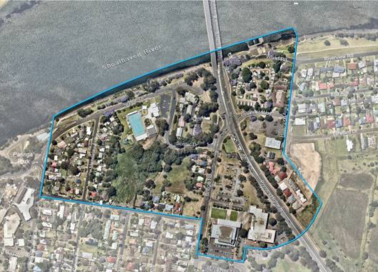
Figure 1 - Nowra Riverfront Leisure and Entertainment
Precinct
For the purposes of this exercise, the overall precinct is
broken into six (6) sub-precincts (see Figure 2 below) which each have
their individual opportunities, constraints and proposed planning controls.
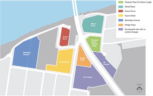
Figure 2 – Sub-precincts within Nowra Riverfront
Leisure and Entertainment Precinct
Council considered a report on the Nowra Riverfront Leisure
and Entertainment Precinct Proposed Planning Controls Report at its meeting on
27 March 2018. Council’s project consultants, Studio GL, also briefed
Councillors on 22 March 2018.
Council resolved (MIN18.207) on 27
March 2018 as follows:
1. Receive
the attached Nowra Riverfront Entertainment and Leisure Precinct Proposed
Planning Controls Report prepared by Studio GL for information and endorse it
being placed on public exhibition for a minimum period of 28 days to enable
community comment.
2. During
the exhibition period, directly consult with NSW Roads and Maritime Services in
relation to the Nowra Bridge Project.
3. Consider
a further report following the exhibition of the Nowra Riverfront Entertainment
and Leisure Precinct Proposed Planning Controls Report that details any
comments received, with a view to proceeding to: prepare a Planning Proposal
for submission for initial Gateway determination to revise relevant Local
Environmental Plan provisions; and a supporting Area Specific Chapter to be
inserted in Shoalhaven Development Control Plan 2014.
4. Receive
a further report on the insurance options for the former Nowra Sailing Club
site.
Public Exhibition
The public exhibition package in
this regard included the following documents:
· Strategic
Direction: Review and Analysis report
· Proposed
Planning Controls Report
· Explanatory
Statement.
The exhibition was available for
viewing at Council’s City Administration Centre in Nowra and on
Council’s website between 25 April and 25 May 2018 (inclusive) to enable
community review and comment. A wide range of direct notifications were also
provided, including to landowners, specific interest groups etc.
During the exhibition period, a
total of fourteen (14) submissions were received, four (4) of which were from
public authorities. Each submission received has been summarised in detail and
responded to in Attachment 1. Copies of the actual submissions will be
available in the Councillor’s Room prior to the Development
Committee Meeting.
The exhibition material can
still be viewed on Council’s website at the following link:
https://shoalhaven.nsw.gov.au/My-Council/Public-exhibition/Documents-on-exhibition
Public Authority Submissions
As part of the exhibition
period, Council notified NSW Department of Planning & Environment
(DP&E) and NSW Roads & Maritime Services (RMS) and sought comment in
relation to the strategic direction and proposed planning controls for the
precinct.
Submissions were received from
four (4) public authorities/within Council and the following is an overview of
these submissions.
DP&E
The submission provided is
summarised below and a copy is provided as Attachment 2.
· Subject
to consideration of detailed PPs, the strategic directions and proposed
planning controls are generally supported.
· The
proposed controls within the sub-precincts demonstrate potential
inconsistencies with Section 9.1 Ministerial Directions, namely:
o Changes
to business zones may be inconsistent with Direction 1.1 Business and
Industrial Zones;
o Changes
to residential zones may be inconsistent with Direction 3.1 Residential Zones;
o Reduction
in building heights may be inconsistent with Directions 1.1 Business and
Industrial Zones and 3.1 Residential Zones.
· Any
inconsistencies with Section 9.1 Ministerial Directions must demonstrate that
the inconsistencies are justified as per the terms of the Directions.
· If
Council intends to use the Strategic Direction and Proposed Planning Controls
Report to justify inconsistencies with the Section 9.1 Directions, it is
recommended that further information be included in the reports to satisfy the
terms of the Directions, particularly the objective.
· Further
justification should be provided for the reduction in height and potential
reduction in permissible residential and employment density, in the Bridge Road
sub-precinct.
Staff Comment
It is noted that DP&E
support the proposals in principle, subject to further suitable detail being
contained in a future PP. The strategic direction and proposed planning
controls intend to reaffirm and realise the actions within the
Illawarra-Shoalhaven Regional Plan that seek to activate the Shoalhaven
Riverfront in this location.
It is recommended that the
exhibited Proposed Planning Controls report be amended to also cover the
following Section 9.1 Ministerial Directions as recommended by DP&E:
- Direction
1.1 Business and Industrial Zones: needs to be addressed in relation to the
proposed zoning and height changes in Scenic Drive, Bridge Road, and Pleasant
Way and Graham Lodge sub-precincts. This direction seeks to encourage
employment growth in suitable locations, protect existing zoned employment land
and support the viability of existing centres. General commentary will be added
in this regard.
- Direction
3.1 Residential Zones: needs to be addressed in relation to the proposed
zoning and height changes in Wharf Road and Bridge Road sub-precincts. This
direction seeks to encourage a variety of housing, make efficient use of
infrastructure and minimise impact of residential development on
employment/resource lands. General commentary will be added in this regard.
RMS
Just prior to the public
exhibition RMS publicly released the “preferred option” for the
Nowra Bridge project. The timing of this release coincided with the reporting
of the draft planning package to Council, which meant that the
consultants’ work did not reflect the preferred option for the Nowra
Bridge Project. Thus, consistent with part 2 of the Council resolution direct
consultation was undertaken in this regard with RMS as part of the exhibition
period.
Council staff notified RMS of
the public exhibition period, and copies of the draft package were provided to
help assess the compatibility of the Nowra Bridge project with the package. In
response to Council’s notification, RMS provided a submission on 25 June
2018. The contents of which are summarised below, and a copy of the submission
is provided as Attachment 3.
· It is understood
that the reports identify possible changes to Shoalhaven
LEP 2014 in terms of zoning, heights and floor space ratios (FSR). It also
recommends a number of design controls that could be incorporated into a
future amendment to the DCP.
· The works currently being undertaken by RMS for the Nowra
Bridge project has the potential to impact upon the smaller catchments that the
Proposed Planning Control (Draft) prepared by Studio GL has identified
(i.e. Scenic Drive Precinct, Wharf Road Precinct, Pleasant Way/Graham Lodge
Precinct and Bridge Road Precinct).
· RMS is currently preparing the environmental assessment for
the Nowra Bridge project. This will contain more details on the preferred
option having regard for community feedback, additional design works
undertaken, etc. RMS anticipates that this will be placed on public exhibition
in late 2018;
· It is important that the location/alignment for the Princes
Highway and its intersections with both Pleasant Way and Bridge Road in Nowra
Riverfront Entertainment and Leisure Precinct package align
with the latest design work RMS is undertaking.
· At this time the exhibited preferred option for the RMS
Nowra Bridge project is based on concept designs. RMS believes that further
detailed design work is required before certainty on the future Princes Highway
road alignment and intersection locations at both Pleasant Way and Bridge
Street can be provided. The detailed design that is required includes, but is
not limited to, more detailed investigation of constraints such as utilities
and geotechnical issues which may impact on the future road alignment and
required setbacks to enable future RMS works.
· The indicative future road location and alignment for the
Princes Highway as detailed in the Proposed Planning Control report is not the
same as the RMS preferred option that has been publicly exhibited by the RMS
for the Nowra Bridge project.
· The Proposed Planning Control report has identified
the area south of the Bridge Road and Pleasant Way/Graham Lodge Precinct as no
change, however the Nowra Bridge project preferred option identifies a new
intersection for Pleasant Way and the Princes Highway on the eastern side of
the Princes Highway.
In addition to consultation as
part of the riverfront precinct work, Council staff met with RMS in relation to
the Nowra Bridge project as part of the public authority consultation required
under the State Environmental Planning (Infrastructure) 2007 (ISEPP) on 5 June
2018. Further to the consultation required under ISEPP, a Councillor Briefing
was held on 23 August 2018 where staff from RMS presented the environmental
assessment and concept design for the new Nowra Bridge. The Nowra Bridge
Environmental Assessment, Response to Submissions and Concept Design plans are
now on public exhibition from 27 August to 28 September 2018. The exhibited
material in this regard is available on the internet at:
http://www.rms.nsw.gov.au/projects/south-coast/nowra-bridges-shoalhaven-river/index.html
Staff comment
It is noted that there are some
inconsistencies between the proposals contained in the exhibited package and
the Nowra Bridge project preferred option and more recently released concept
design and its supporting material. This is a result of the completion of the
draft package ahead of the public release of the preferred option concept plans
and also subsequently the release of the concept design for the bridge just
before this report was completed. Thus, it is recommended that the future
proposed amendments to Shoalhaven LEP 2014 and Shoalhaven Development Control
Plan (DCP) 2014 are consistent with the outcomes of the Nowra Bridge project.
It is noted that significant
changes will be required to the Bridge Road and Scenic Drive sub-precincts
because of the RMS concept design and the land acquisition required to
construct the new bridge crossing, realignment of Princes Highway and
intersection treatments. These sub-precincts will need to be deferred from the
next stage of preparing a PP and DCP in the interim and until such time the
detail design of Nowra Bridge project is available. This will enable a full
understanding of the remaining land after acquisition, to undertake site
testing of potential developments.
It is recommended that the
Indicative Future Road Location / Alignment on the key development parameters
mapping be amended to include the full impacted area as per the latest Concept
Design for the bridge, including closure of Pleasant Way as per Variation B of
the Proposed Planning Controls Report (page 15), and the additional road
connection off Hawthorn Avenue to Princes Highway. The alignment of the latest
Concept Design from RMS will be reflected in future PPs and DCP Chapter.
Council - Recreation,
Community & Culture Section
The submission raised the
following matters:
· The
plan identifies the significance of the riverfront and acknowledges the whole
of community ability to access it without obstructions (either physical or
socially), which is an important element to providing for the community of
Shoalhaven and its visitors. We encourage greater density set back from the
public open space adjacent to the riverfront to provide housing/retail and
commercial elements.
· Acknowledge
the importance of clear links to the CBD, through and to the riverfront
precinct and across to the entertainment precinct to ensure inclusion and
accessibility and greater utilisation of the spaces.
· The
reports should include housing of the David Berry Floodboat at the Nowra
Aquatic Park as per Figure 3 below. This is currently a proposal that we
are seeking grant funding for. It would be fitting for the Floodboat to be
displayed somewhere along the Shoalhaven River where it was originally used.
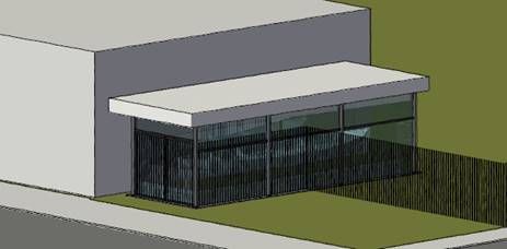
Figure 3 – Concept Design of David Berry
Floodboat, Nowra Aquatic Park
· In
relation to Graham Lodge and surrounding landscape:
o This
building is one of high cultural significance to Shoalhaven with the land grant
to William Graham being given in 1826 and the residence
‘Greenhills’ in evidence shortly after.
o Consistent
with Council’s ‘Graham Lodge – Nowra Interpretation
Plan’ (September 2000) there is a strong potential for the Lodge to be
developed into a historical museum, with collections and interpretation that
encourage awareness of the history of the area.
o There
is a need within 10 years for significant expansion of the Shoalhaven Regional
Gallery and Nowra Library to service the anticipated population growth,
collection and storage needs and state government recommendations for floor
size.
o Arts
and cultural facilities are known to be significant drivers of urban renewal
when done in a way that supports cultural tourism, showcases world leading
architecture and design principles and strengthens employment through related
and ancillary services such as hospitality, accommodation etc.
· It
is recommended that:
o To
support the planning and design principles for this precinct Council are
strongly encouraged to plan for an architecturally significant Regional Gallery
and Library complex, sited in the same precinct as the Entertainment Centre and
current council Administration building with visual and pedestrian linkages to
the heritage listed Graham Lodge. This precinct would become a significant
gateway to Nowra and free up space within the CBD for future development.
o Shoalhaven
and District Historical Society should be approached with an opportunity to
make Graham Lodge into a regionally significant museum as per the
Interpretation Plan and the Conservation Management Plan, 2000.
o Locating
a Regional Gallery, Museum and Library within walkable access and as a visual
precinct, will provide opportunities for shared collection storage and access,
shared visitation across all sites and an engaging public site, making retail,
cafes, restaurant and accommodation more attractive and helping to revitalise
the riverfront precinct.
Staff comment
Creating a permeable and
connected network is one of the key planning and design principles for the
precinct. The importance of improving links from/to the CBD and Civic Precinct,
prioritising east-west connections across the highway, connectivity and links
across and along the river are all acknowledged.
The re-integration of the David Berry
Floodboat is a matter that could be explored as part of a future Amendment to
the Shoalhaven Contributions Plan (CP) 2010 for the provision of open space and
reorientation of the Nowra Aquatic Centre and car park. As a result of the
Nowra Bridge project, there is also the need to possibly consider a suitable
location for a relocated Bicentennial Memorial which currently resides at
Moorhouse Park. Any relocation of these heritage items will need to be guided
by an assessment of heritage impact.
As part of the Nowra Bridge
project, a substantial part of the Bridge Road sub-precinct is proposed for
acquisition. The Council-owned site within the Pleasant Way and Graham Lodge
precinct which houses the State Heritage listed Graham Lodge, is currently
subject to an Expressions of Interest process, whereby a private company has an
option over the land. It is considered that any additional commentary in
relation to the integration of a Regional Gallery and Library Complex on this
site is not appropriate given previous decisions by Council to proceed with its
proposed sale.
Whilst it is not recommended
that the Proposed Planning Controls Report be amended to include the
suggestion, it is noted that the Shoalhaven CP 2010 includes project CWCFA0006
Shoalhaven City Library Extensions (Berry Street, Nowra) which seeks to extend
the current facility. As Council reviews the Shoalhaven CP 2010, consideration
of amending the existing project from an extension to the existing facility, to
the establishment of a new facility may be considered appropriate at this
stage. Any consideration of relocating the existing Library complex and
potentially the Regional Gallery will need to be separately and duly considered
given the potential impact it may have on the Nowra CBD.
Council - Natural Resources
& Floodplain Unit
The submission raised the
following matters:
· Some
of the controls are not supported as they are inconsistent with Chapter G9
Development on Flood Prone Land in Shoalhaven DCP 2014. New DCP controls must
be consistent with the objectives and controls contained within DCP Chapter G9.
· Basement
parking should not be constructed in high hazard flood areas.
· Driveway
crests should be constructed at a minimum 1% AEP (Annual Exceedance
Probability).
· Due
to the catchment size and level of flooding in the precinct, provision of pumps
for managing floodwaters is not appropriate.
· Elevators
and other electrical fittings should be installed above the Flood Planning
Level. A DCP control should be inserted to require this to ensure that future
development in this precinct demonstrate this.
· Consideration of Floor
Level requirements for habitable and commercial areas - the current document is
silent on this; however, it is recommended this is clearly highlighted,
referring to DCP Chapter G9.
· The proposed
planning controls need to consider flood damage.
· Council is
currently reviewing the Lower Shoalhaven River Floodplain Risk Management Study
and Plan. This is due for completion in late 2020. Because of this review,
flood lines and hazards may change.
Staff comment
The Proposed Planning Controls report
identifies that the precinct is largely flood affected to varying degrees and
that DCP Chapter G9 applies and controls development on land at risk of
flooding. The report also notes that confirmation of flood levels and impacts
is required to determine the likely development impacts and the viability of
specific development options as outlined in the report.
It is noted that a consultant
has been commissioned to undertake a review of the Lower
Shoalhaven River Floodplain Risk Management Study and Plan (FRMSP) which
will improve understanding of flood behaviour and impacts, and better inform
management of flood risk in the study area. This work will include the
Riverfront Precinct. It is expected that this process will provide more
contemporary flood affectation information in relation to the precinct and
enable any development controls for this area to be well informed and respond
to the sub-precinct specific flood constraints.
However, whilst the review of
the Lower Shoalhaven River FRMSP has commenced, it is expected to take two
years to complete, with a draft not available till late 2019. As such this has
the potential to significantly impact on the final delivery of this project and
ultimately new development in this area. The update of Lower Shoalhaven FRMSP
information is however needed to ensure that the proposed planning controls,
particularly scale (e.g. height) of development, encourage development outcomes
that are appropriate and do not create adverse flood impact.
In this regard, it is
recommended that the sub-precincts outside of the flood affected area, namely
Mandalay Avenue, proceed to a PP immediately. The remaining precincts could
proceed once the updated flood constraint information is available.
General Community Submissions
A total of ten (10) submissions
were received from the general community, including land and business owners
within the precinct.
One (1) submission included a
significant proposal termed the “Shoalhaven Gateway Project” for
the development of the Wharf Road and Scenic Drive sub-precincts.
Three (3) submissions did not
respond to or comment on the exhibited Council material as such. Rather, they
relate to the submission and proposed concept for the “Shoalhaven Gateway
Project” which includes the current Caravan Park and Motel Site within
the Wharf Road and Scenic Drive sub-precincts. One (1) submission did support
the “Shoalhaven Gateway Precinct” and made comments on the
exhibited materials.
The following is a summary of
the key issues raised in the submissions, and a review of the submission
received from Inspired Property Partners in relation to the “Shoalhaven
Gateway Project”.
Inspired Property Partners
Submission
The submission from Inspired
Property Partners included a written submission, concept plans, vision and 3D
flyover. In addition, the written submission was supplemented by support
letters from both the Riverhaven Motel site and Gateway Caravan Park
landowners; Sailing for Everyone Foundation; Pleasant Way River Lodge
landowner; and a private individual.
The proposed development concept
is over both the Scenic Drive and Wharf Road precincts, specifically Lot 1 DP
624434, Lot 7038 DP 1101416, Lot 5 DP 262460, Lot 1 DP 735303, Lot 101 DP
611544 and Lots 5, 6, 7 DP 209295.
Figure 4 below is an
artist’s impression of the precinct and proposed development concept,
looking south from the Shoalhaven River.
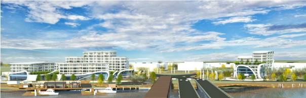
Figure 4 – Artist Impression of Shoalhaven
Gateway Project
The written
submission describes the proposed development concept within the Wharf Road
sub-precinct as follows:
· Proposed
development of buildings between 19.6 to 31.8 metres in height with a 1.3:1 to
1.5:1 FSR.
· The proposal
includes three (3) medium rise buildings on a commercial / public podium. The
upper levels of the buildings are terraced with a primary podium on the second
storey and several smaller podiums above where apartments can link to private
green spaces with views to the waterfront.
· The buildings
include cross boulevards between them to form the basis for an activated
waterfront precinct with the potential for cultural links. The centre of the
boulevards is suggested as potential location for a new site for the Captain
Cook Memorial (currently located on Moorhouse Park – to be relocated as
part of the Nowra Bridge project).
· Potential
redevelopment of the wharf and previous Nowra Sailing Club site to help link
the precinct to the river and revitalise the foreshore.
· The form of the
buildings has been designed to reflect the curves and fluid nature of the Nowra
River on which it is sited. The materiality of the project will be light and
reflective to allow the buildings to form a discourse with their natural
surroundings and also allow visitors to the site to readily enjoy aspects of
both the private commercial spaces and surrounding public boulevards and open
spaces.
Figures 5
and 6 below are an artist’s impression of the Wharf Road
sub-precinct within the proposed development concept.
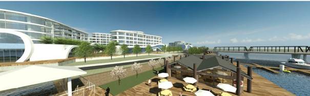
Figure 5 - Artist Impression of Wharf Road
Sub-precinct of Shoalhaven Gateway Project
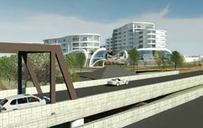
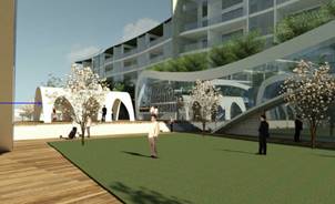
Figure 6 - Artist Impression of Buildings within Wharf
Road Sub-precinct
of Shoalhaven Gateway Project
The written
submission describes the proposed development concept within the Scenic
Drive sub-precinct as follows:
· Proposed
development of buildings between 18 to 32 metres in height.
· The form of the
building flanks the Princes Highway at the foot of the bridge with the entry
located off the Scenic Drive cul-de-sac.
· The form of the
building is split at the rear where the site widens to create two wings
separated by a full height atrium which will allow light into the building.
· To the north there
is a public promenade which carries pedestrians down to the park and
Ben’s Walk. The ground level podium wraps around the building at a level
that sits above the Probable Maximum Flood level.
· Above the ground
floor the building has been compartmentalised to be further designed as either
apartments or hotel style accommodation.
Figures 7
and 8 below are an artist’s impression of the Scenic Drive
sub-precinct within the proposed development concept.
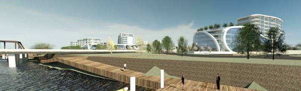
Figure 7 - Artist Impression of Scenic Drive
Sub-precinct of Shoalhaven Gateway Project


Figure 8 - Artist Impression of Buildings within
Scenic Drive Sub-precinct
of Shoalhaven Gateway Project
The written submission raised
the following additional matters:
· Potential link
bridge is proposed between the two sites as indicated on the accompanying
plans. While Council have noted RMS’s hesitation in installing a
pedestrian bridge, it is recommended that this should be considered as it would
alleviate potential congestion around the bridge by connecting both sides of
the foreshore. The footbridge would minimise the number of pedestrians crossing
at the lights. It would also, in a flood event, provide safe access and egress
between sites, both of which are above the PMF.
· To further improve
the planning outcomes and community benefits for the precinct, the following
changes are recommended to the proposed planning controls:
o Maximum building heights and FSR for
the proposed buildings within the Wharf Road and Scenic Drive sub-precincts be
reviewed to facilitate a greater height as illustrated on the accompanying
plans. The increased heights have been justified by achieving the objectives of
the Strategic Direction, specifically:
- To create an attractive place to live
and visit through high quality landscape, signage, built form.
- Encourage tourist
related uses that are appropriate given the flood risk and help create an attractive
gateway into Nowra and expand and activate the riverfront open space.
o Retain the existing B4 Mixed use
zoning in the Scenic Drive sub-precinct.
o Rezone the Wharf Road sub-precinct
from SP3 Tourist to B4 Mixed use.
o The following land uses be included
as Additional Permitted uses by means of a Clause 2.5 Amendment to the LEP
(Schedule 1) within the W2 Recreational Waterways and/or RE1 Public Recreation
zoning to ensure the best use of the wharf precinct for tourist and the
community:
- Information
Centre
- Leisure
equipment hire/sales
- Markets
- River
tours admin/office ticketing
- Water
sports/ boating shop
- Wharf or boating
facilities
Staff Comment
Whilst the proposed development concepts that have been
submitted potentially create a significant gateway development and activate the
river foreshore, significant departures are requested to the Proposed Planning
Controls Report with respect to the scale of development of the Wharf Road and
Scenic Drive sub-precincts. The following is a comparison of the exhibited key
controls and ones suggested in the submission:
Wharf Road
Exhibited heights – range up to a maximum of 18m (5
storeys)
Exhibited FSR – indicative FSR of approximately 1.1
Requested heights - 19.6 to 31.8 metres
Requested FSR - 1.3:1 to 1.5:1
Scenic Drive
Exhibited heights – range up to a maximum of 18 m (5
storeys)
Requested
heights - 18 to 32 metres
As shown above, the submission
proposes/requests an increase in the Height of Buildings by a maximum of 18m
(double the proposed height control for both sub-precincts), and an increase to
the proposed indicative FSR for Wharf Road sub-precinct by 0.3-0.5:1 is
proposed/requested.
The Scenic Drive sub-precinct
did not have a recommended FSR in the exhibited material as it required
additional investigations for flooding, Nowra Bridge project impact, heritage
and access.
The proposed building height and
FSR for the Wharf Road and Scenic Drive precinct were subject to site testing
by the project consultants to inform the selected proposed planning controls
and ensure the development outcomes that would result from the proposed
planning controls were suitable within the context and did not create any
adverse visual or amenity impacts. Enabling development up to 32 metres within
the Wharf Road sub-precinct is considered inappropriate due to the proximity to
low density residential development to the immediate east of Hawthorn Avenue.
Development of that scale has the potential to cause significant impact and
relatively limited justification has been provided to support the requested
increase in development controls. Due to this uncertainty, it is recommended
that the alternative heights and FSR requested in this submission not be
supported at this time.
Given the latest information
from RMS in relation to the Nowra Bridge Project and the land acquisition
required to facilitate it, the development of the Scenic Drive precinct will
not be able to proceed as envisaged in the exhibited Proposed Planning Controls
report. As such, it is recommended that Council defer the PP or DCP over this
sub-precinct to ensure that the most appropriate development outcome can be
achieved based on the new land area and interface with the bridge.
The rezoning of the Wharf Road
sub-precinct to B4 Mixed Use was not recommended by the project consultant due
the potential for conflict and competition with the function of Nowra CBD.
However, in the previous Council report (March 2018), the alternate zoning of
the sub-precinct as B4 Mixed Use was suggested. This may be an option that
could be considered, subject to the addition of a clause within Shoalhaven LEP
2014 which limits the floorplate of particular commercial uses, to ensure that
the hierarchy of commercial centres is not compromised further. The NSW
Government has also made some recent adjustments to the Standard LEP Instrument
regarding retail uses and this will require further consideration in the
preparation of any PP. It is noted that within the SP3 Tourist zone, land uses
which have the potential to help activate the riverfront, including food and
drink premises (includes restaurant or café, take away food and drink
premises, pub, and small bar), function centres, recreation facilities, kiosk,
and more, are permitted with consent. However, it is acknowledged that the B4
zone does allow a broader mix of land uses, including residential.
Within the Wharf Road
sub-precinct, encouraging land uses which can help activate the Riverfront is
supported. The Additional Permitted Uses suggested in this submission would be
largely defined as information and education facility, water recreation
structure, charter and tourism boating facility, markets, shop and business
premises. Within the W2 Recreational Waterways and RE1 Public Recreation zones,
these uses are permitted with consent across the two zones except for shop and
business premises. It is considered that these uses are more appropriately
placed within the sub-precincts and not on the foreshore public land, however
it is acknowledged that the SP3 Tourist zone does not permit shop and business
premises. These uses could be considered as Additional Permitted Uses with
limitations applied to the maximum gross floor area, or alternatively, if the
sub-precinct is zoned B4 Mixed Use these uses will be permitted with consent.
The notion of a pedestrian
bridge that connects the east and west sides of the precinct above the Princes
Highway has some merit, however RMS are the responsible authority and would
need to be consulted in respect to this proposal. Previous correspondence
between Council and RMS in relation to the Nowra Bridge project has highlighted
the benefits of a pedestrian bridge, as suggested in the submission. This
suggestion can be raised as part of continued feedback on the Nowra Bridge
Project.
Remaining Community
Submissions - Key Themes
A number key themes were derived
from the remaining community submissions. The key themes included:
· Accessibility,
including accessibility of the Shoalhaven River for non-motorised water sports
and pleasure craft use
· Improved
connectivity between both sides of the Highway and with the Nowra CBD
· Preservation
of heritage – particularly Graham Lodge, Old Nowra Bridge, Kilsyth (dwelling), Uuna (dwelling), and Rodman Cottage
· Open
Space infrastructure provision
· Overdevelopment
of the riverfront and inconsistency with the human scale and character of Nowra
Staff Comment
The draft package includes
detail to encourage the development of land within the precinct. Whilst it is
noted that improving accessibility with Shoalhaven River, particularly for
non-motorised water sports and pleasure craft, is important, that level of detail
is more appropriate for the concept and detail design stage of the Nowra
Riverfront area. Whilst encouraging this, it must not prevail over the use of
Greys Beach and Paringa Park as the priority locations. However, the
significance of the old Nowra Sailing Club site in terms of its connection to
the use of the Shoalhaven River by watercraft is acknowledged. It is
recommended that additional text be added to Page 44 (of the Planning Controls
Report) requiring that any future development of the old Nowra Sailing Club
site should also ensure that the area can accommodate launching facilities and
other amenities to support the use of Shoalhaven River by watercraft.
Creating a permeable and
connected transport/pedestrian network is one of the key planning and design
principles for the precinct. This principle identifies the importance of
improving links from the CBD and Civic Precinct, and prioritising east-west
connections across the highway, connectivity and links across the river.
In respect to heritage, the
Proposed Planning Controls Report refers to the need to preserve and further
investigate the impact of development on the existing heritage items within the
precinct. The preservation of Graham Lodge has been referenced on page 26 (of
the Planning Controls Report) and recommends that future development of the
sub-precinct is consistent with the Conservation Management Plan for Graham
Lodge.
One of the submissions received
implies that local heritage items are not given preservation status,
specifically “Kilsyth, Uuna, and Rodman
Cottage also deserve specific recommendation of preservation because of its
aesthetic and historical value to the town, as does the entirety of Bridge
Street, which should be preserved”. Both Kilsyth and Uuna are
referred to in specific controls on page 62 (of the Planning Controls Report)
controls 9(a) and 9(b). Rodway Cottage is not located within the Nowra
Riverfront Leisure and Entertainment precinct and therefore has not been
included / considered. Whilst Bridge Road is not heritage listed, the report
does identify the significance of Bridge Road as the original road into Nowra,
and the intention to safeguard its aesthetics is reflected in the future design
character of the sub-precinct and the setbacks from the road. It should also be
noted that its conservation of Nowra Bridge and conversion into a pedestrian /
cyclist thoroughfare has been proposed by RMS, and therefore this will be a key
consideration in how the Wharf Road sub-precinct develops.
Open space infrastructure in the
overall precinct is an important component in the development of the area,
particularly to ensure that the increased densities proposed within the
precinct are offset with sufficient public space. The revitalisation of the
Shoalhaven River foreshore is consistent with the Illawarra-Shoalhaven Regional
Plan which identifies the activation of this area as an action. To ensure that
quality, connected and functional open space is provided within the precinct,
it is recommended that Shoalhaven CP 2010 be amended to include a new open
space project which will require new development in the precinct to pay a
contribution toward the provision of quality open space infrastructure.
The proposed Height of Buildings and
FSR controls have been nominated as a result of investigative work, with the
context, known constraints of the land, views, heritage and the like considered
to determine what has been recommended. To respond to the various constraints
and opportunities of the individual sub-precincts, each has their own specific
Height of Buildings and FSR recommended. To ensure that the human scale is
maintained, controls include street wall height limits and landscaped setbacks
to ensure the bulk and scale of future developments do not appear to dominate
the street.
Community Engagement
The Nowra Riverfront
Entertainment and Leisure Precinct package was publicly exhibited from 25 April
to 25 May 2018 (inclusive). During the exhibition period, a total of 14
submissions were received from the community and public authorities.
Prior to the public exhibition,
Council staff and the project consultants held landowner workshops and
presentations to identify the strategic direction of the precinct and determine
the aspirations of landowners.
The community will continue to
be involved and consulted as this project proceeds, particularly noting that if
Council resolve to amend Shoalhaven LEP 2014 or Shoalhaven CP 2014, the
legislation requires minimum periods for community consultation.
Policy Implications
Preparation of a PP will be
required to modify the zones and height of building development standard in
some of the sub-precincts within the Precinct. The PP will result in an
amendment to Shoalhaven LEP 2014.
Preparation of an area-specific
DCP Chapter for the Nowra Riverfront will also be required. In adopting a DCP
Chapter for this area, existing Chapter N7: Nowra Hotel Site and Civic Precinct
will need to be rescinded.
The impacts of the recently
released detail on the Nowra Bridge project will need to be closely considered
moving forward and this may impact on the eventual content of the PP and DCP.
It is also recommended that
Shoalhaven CP 2010 be amended as appropriate to include additional projects
within the precinct area, including road, drainage and open space projects. An
amendment to the CP will allow development within the precinct to be levied for
infrastructure provision.
It is important that any future
development of the precinct include the provision of quality open space and
other supporting infrastructure.
Financial Implications
Given the potential development
yield resulting from the recommended endorsement of the Nowra Riverfront
Leisure and Entertainment Precinct package, the provision of infrastructure
relating to roads, drainage and open space will incur a significant cost to
Council. Given the nexus between development and infrastructure provision, it
is recommended that the Shoalhaven CP 2010 be amended to include additional
projects relating to road, drainage and open space, to ensure that any development
within the precinct is appropriately levied. A further report will need to be
considered by Council that outlines investigations undertaken of additional
proposed CP projects for the precinct which outline estimated costs for
infrastructure items, and the estimated levy per Equivalent Tenement.
Initial up-front Council funding
is required to progress the relevant engineering investigations and designs to
support the development and redevelopment of this key precinct. Where
appropriate this may be able to be recouped (whole or part) through the Contributions
Plan process.
Additionally, Council should
continue to apply for grant funding, as opportunities arise, to assist with the
delivery of this important precinct. In this regard Council will most likely
need to play a key role in encouraging the redevelopment of this key precinct
through the early provision of infrastructure to stimulate private
investment/development, such as the new high quality open space (and associated
new roads) in the centre of the precinct between the Mandalay Avenue and Hyam
Street sub- precincts
Depending on the availability of
future grant funding opportunities and the scope of them, the following tasks
(but not limited to) could be subject to grant funding applications:
- Site
investigations, including geotechnical investigations;
- Concept
and detail design of the road, drainage and open space infrastructure; and
- Construction
/ delivery of road, drainage and open space infrastructure.
|

|
Development
Committee – Tuesday 11 September 2018
Page
0
|
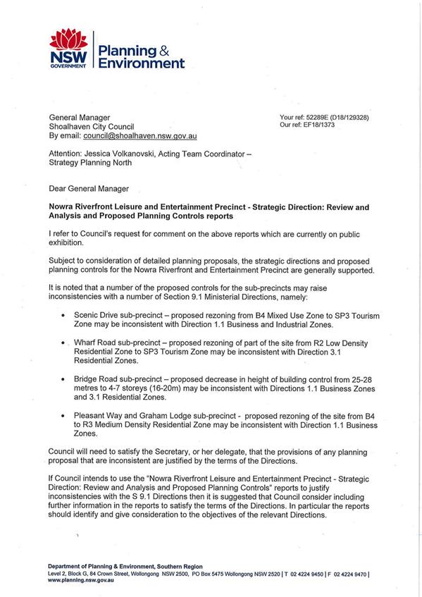
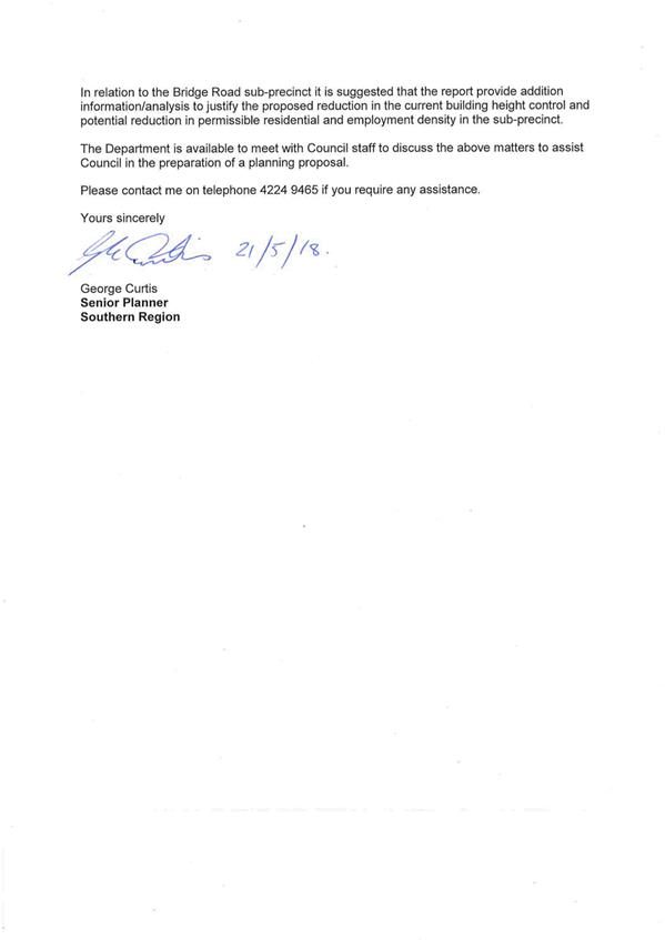
|
|
Development
Committee – Tuesday 11 September 2018
Page
0
|
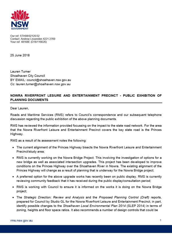
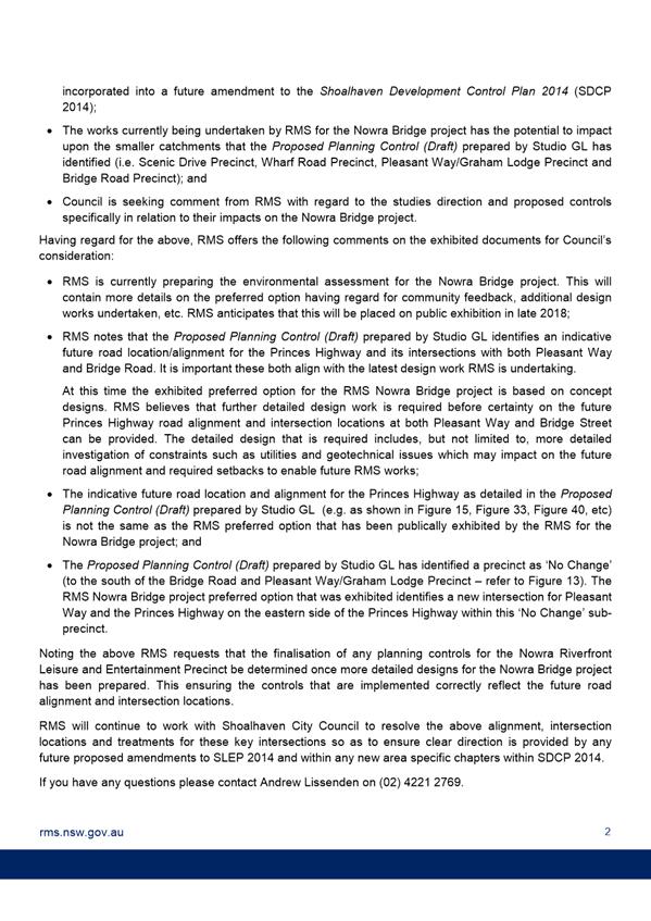
|

|
Development
Committee – Tuesday 11 September 2018
Page
0
|
DE18.62 Exhibition
Outcomes - Planning Proposal - 9 Browns Road South Nowra - Caravan Park
HPERM Ref: D18/228829
Group: Planning
Environment & Development Group
Section: Strategic
Planning
Attachments: 1. Previous
Report to Development Committee - February 2018 ⇩
2. Gateway
Determination - 9 Browns Road South Nowra Caravan Park Planning Proposal ⇩
3. RFS
Advice - 9 Browns Road South Nowra Caravan Park Planning Proposal ⇩
4. Browns Road South Nowra
Caravan Park Planning Proposal - Post Exhibition Version (under separate cover)
Purpose / Summary
To present the outcome of the
formal public exhibition/community consultation for the Planning Proposal (PP)
to permit ‘caravan parks’ as an additional permitted use at Lot 1
DP 1079345, 9 Browns Road, South Nowra and obtain the approval of Council to
proceed to finalise this PP.
|
Recommendation (Item to be
determined under delegated authority)
That the Committee:
1. Adopt
the Planning Proposal PP034 as exhibited, with the minor adjustments detailed
in the report, to make ‘caravan parks’ an additional permitted
use at Lot 1 DP 1079345, 9 Browns Road South Nowra.
2. Forward
Planning Proposal (PP034) to NSW Parliamentary Counsel’s Office to
draft the required amendment to Shoalhaven Local Environmental Plan 2014.
3. Make
the resulting amendment to the Shoalhaven Local Environmental Plan 2014 using
the plan making delegations issued under Section 2.4 of the NSW
Environmental Planning and Assessment Act 1979.
4. Notify
the proponent, submitters and residents of the site when the amendment of
Shoalhaven Local Environmental Plan 2014 is notified.
|
Options
1. Proceed to
finalise the PP.
Implications: This will enable the amendment to the
LEP to be finalised and allow the area with the approved tourist cabins to be
used for long term accommodation without changing the underlying LEP zone.
This is the lowest impact approach to achieve the outcome
sought by the proponent. It will also effectively recognise the ‘existing
use right’ on most of the site, while retaining the existing B5 –
Business Development zone. This is the preferred option.
2. Abandon
the PP.
Implications: This would prevent the rationalisation
of the uses on the site and would leave a relatively small part of the existing
facility not able to be used for longer term accommodation. This option is not
recommended.
Background
The land which is covered by
this PP is Lot 1 DP 1079345, 9 Browns Road, South Nowra as shown on the image
below. The site is an established caravan park with 61 long term sites and 8
approved holiday cabins.
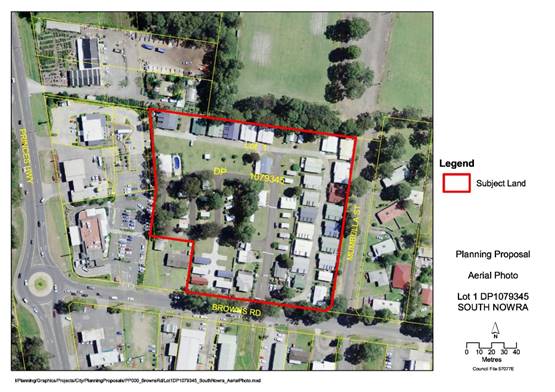
Aerial
Photograph Showing Subject Land - Lot 1 DP 1079345
The subject land is currently
zoned B5 – Business Development under Shoalhaven LEP 2014. ‘Caravan
parks’ are prohibited in the B5 zone, but due to previous approvals for a
caravan park and tourist accommodation, the site has certain ‘existing
use rights’ under the Environmental Planning and Assessment Act 1979.
The land underwent lot
consolidation in 1986 and a small part of the new overall lot did not benefit
from an ‘existing use right’ for a caravan park. In 2004 the
smaller part was developed as a tourist facility comprising 8 tourist cabins,
which cannot be occupied by permanent residents under the current LEP
provisions.
As such the caravan park
currently has 61 long term sites and an area approved for 8 tourist cabins,
which the proponent also wishes to use for long term accommodation.
The proponents (Coastplan Group
on behalf of the owners, Restpoint Holdings) submitted a PP request to amend
Shoalhaven LEP 2014 to allow caravan parks on the entirety of the site as an
‘additional permitted use’ (via inclusion in Schedule 1 of the
LEP). This will essentially allow the whole of the caravan park to ultimately
be used for long term accommodation.
The proponent’s PP request
was considered by the Development Committee on 13 February 2018 (see
Attachment 1) and it was resolved that Council:
1. Prepare a Planning Proposal
to amend Shoalhaven Local Environmental Plan 2014 to permit caravan parks as an
additional permitted use for Lot 1 DP 1079345, No. 9 Browns Road South Nowra.
2. Forward this
Planning Proposal to the NSW Department of Planning and Environment for a
Gateway determination and if granted proceed to exhibition in accordance with
its requirements, following which the matter be reported back to Council.
3. Advise the
proponent of this resolution and that the proposal will be subject to fees and
charges for proponent initiated Planning Proposals, including a requirement
that the full cost of any necessary specialist studies be borne by the
proponent.
Council sought a Gateway
determination from the NSW Department of Planning and Environment (DP&E) on
8 March 2018. This was issued on 2 May 2018 and gave Council delegation to
proceed. A copy of the Gateway determination is provided as Attachment 2.
The Gateway determination
required consultation with the NSW Rural Fire Service and public exhibition of
the PP for a minimum of 28 days.
RFS Consultation
Following the issue of the
Gateway determination the PP was referred to the RFS, who advised that they
have no objection to the PP and a copy of their advice is provided at Attachment
3.
Public Exhibition
The PP
was subsequently publicly exhibited at Council’s Administrative Building
in Nowra from 20 June to 20 July 2018 (inclusive). The PP was also available
for viewing on Council’s website.
The exhibition included a
mailout to adjoining owners and residents of the caravan park and an
advertisement in the South Coast Register.
No submissions were received as
a result.
Conclusions
As detailed above, the PP is of
a minor nature and has been subject to consultation with RFS, residents of the
park and the broader community.
There have been no submissions
or objections to the PP. Proceeding to finalise the PP in accordance with the
recommendation will enable the required LEP amendment to be made and enable the
existing use right on the site to be regularised and allow a modest expansion
of the park for long term residential use.
The PP has been updated since
the exhibition as follows:
· Change
all references to the site being a manufactured home estate to caravan park.
The presence of caravans was confirmed during a site inspection by Council
staff and this is the current approved use.
· Provide
commentary on the outcome of referral of the PP to RFS.
· Provide
commentary on the public exhibition of the PP.
· Update
dates and version numbers.
A copy of the updated PP is
provided as Attachment 4.
Community Engagement
The PP was publicly exhibited
from 20 June to 20 July 2018 (inclusive). The exhibition included a mailout to
adjoining owners and residents of the caravan park and an advertisement in the
South Coast Register.
No submissions were received.
Financial Implications
There are no immediate financial implications for
Council.
|

|
Development
Committee – Tuesday 11 September 2018
Page
0
|
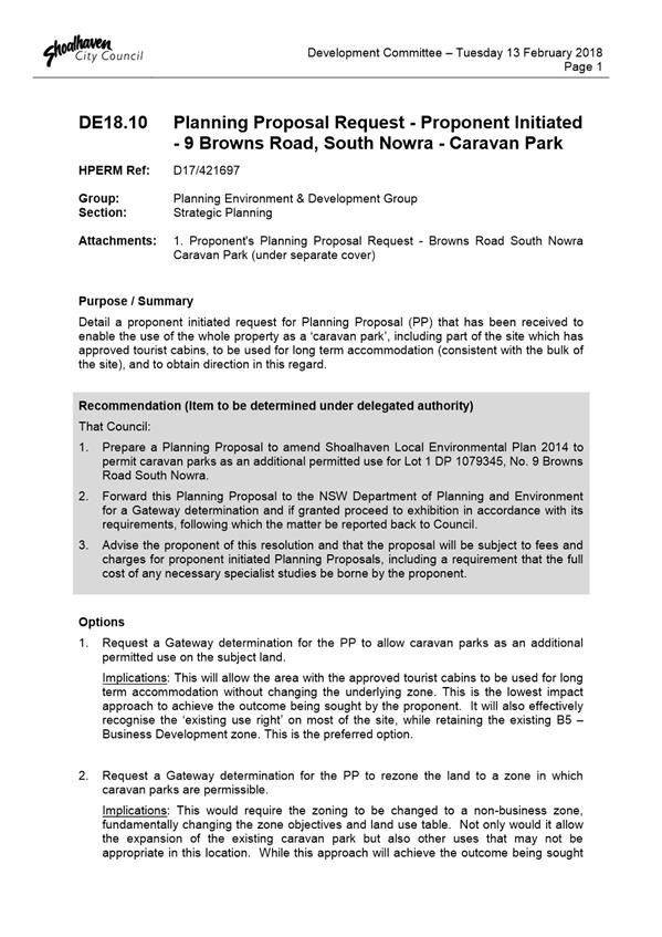
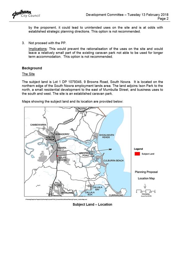
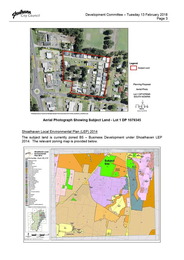
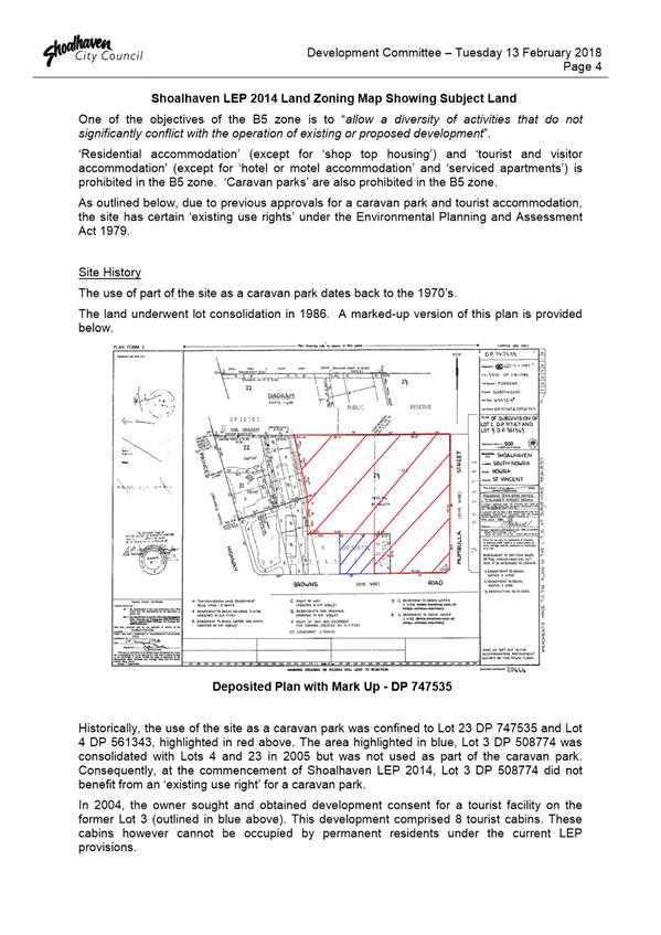
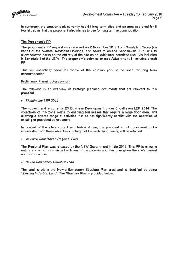
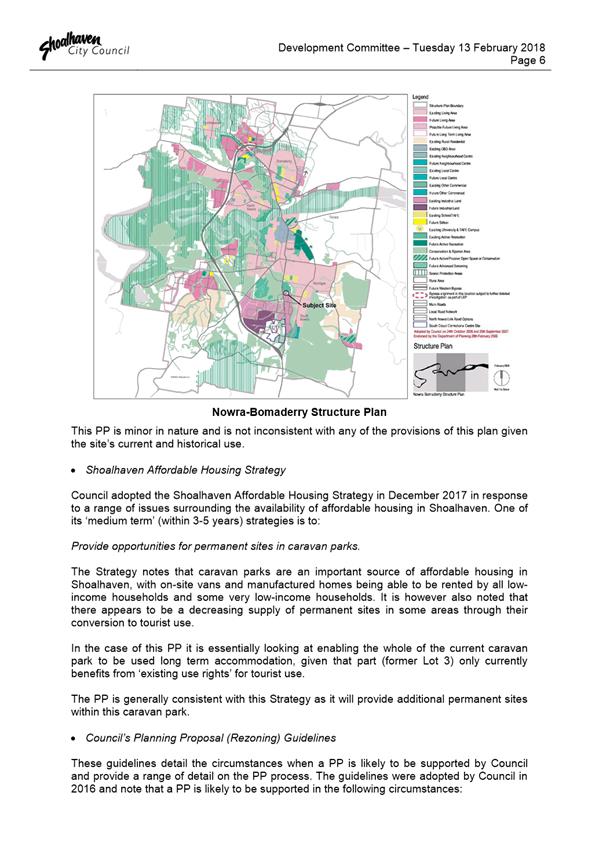
|
|
Development
Committee – Tuesday 11 September 2018
Page
0
|
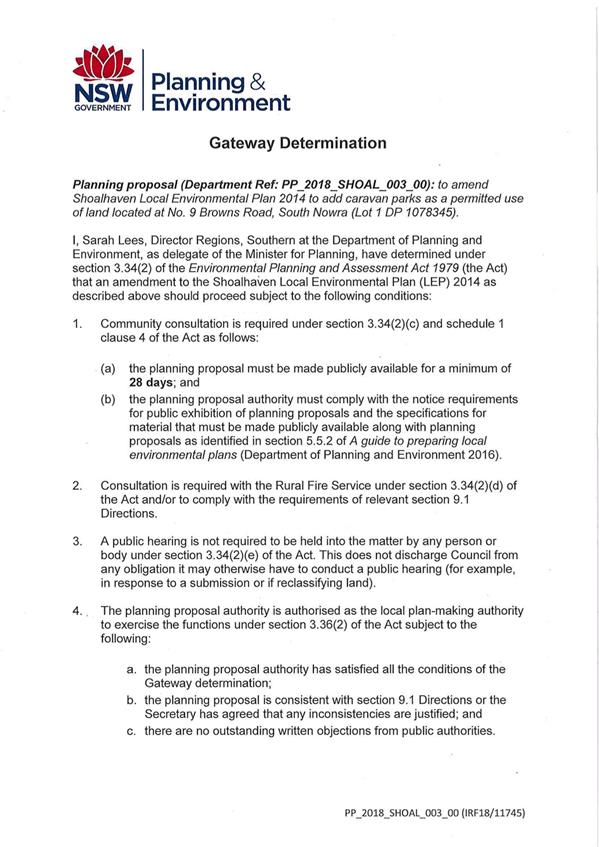
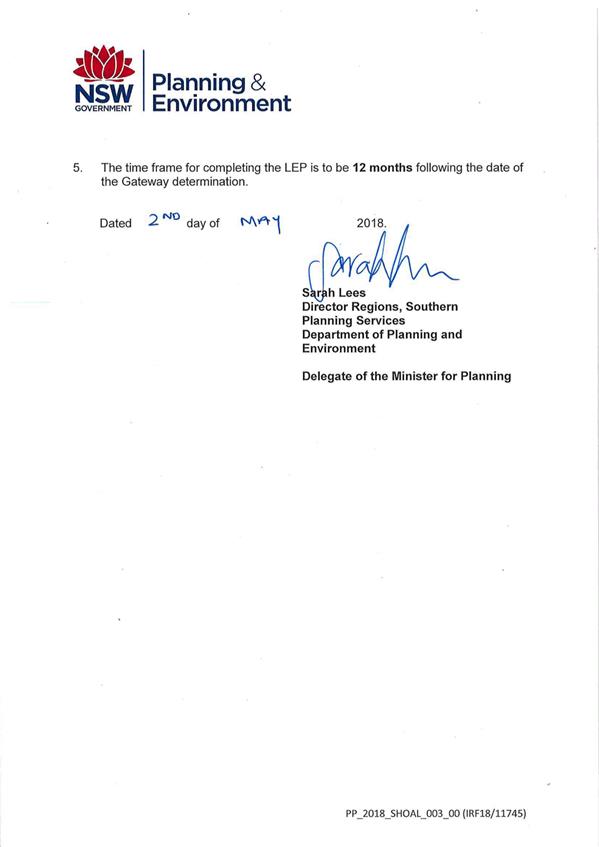
|
|
Development
Committee – Tuesday 11 September 2018
Page
0
|
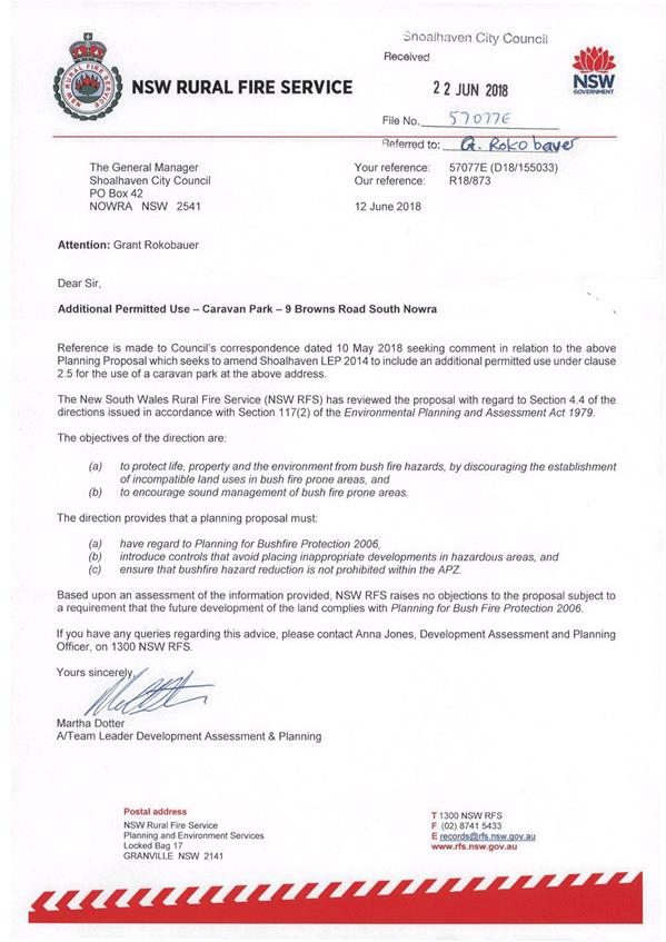
|
|
Development
Committee – Tuesday 11 September 2018
Page
0
|
DE18.63 Berry
Heritage Investigation Project - Future Direction
HPERM Ref: D18/261051
Group:
Section: Strategic
Planning
Attachments: 1. Attachment
1 - Previous Options Report - Berry Heritage Investigations - 17 July 2017 ⇩
Purpose / Summary
Obtain direction regarding the
Berry Heritage Investigation project.
|
Recommendation (Item to be
determined under delegated authority)
That Council:
1. Proceed
with the Berry Heritage Investigations project; to investigate and consider
the 29 properties and 2 smaller Heritage Conservation Areas identified as
possible additional heritage listings for Berry.
2. Commit
to the direct funding of the project (approximately $40,000) via savings from
the quarterly budget review.
3. Notify
relevant stakeholders, including the Berry Forum, of this decision and how
they can be involved as the project progresses.
|
Options
1. As recommended.
Implications: Funds are not available in
existing Strategic Planning budget and as such the option will require a new
financial commitment from Council.
2. Continue to
apply for State heritage grant funding for the project.
Implications: This option is not preferred as it
would delay the project until State funding may be received. It is unlikely
that grant funding will be forthcoming given that the four (4) applications
since 2015 have been unsuccessful. It is noted that the grant application
process is time and resource intensive.
3. Discontinue the
project and remove it from the Strategic Planning Works Program.
Implications: This option is not preferred as no
further heritage listings would be investigated in Berry, which is a
significant historic tourist town. There is the potential for erosion of the
heritage character by unsympathetic development if appropriate heritage protections,
including additional listings, are not considered.
Background
On 17 July 2017, Council’s
Development Committee received an Options Report (see Attachment 1)
regarding future heritage-related strategic planning projects in Berry. The
following was resolved regarding heritage investigations in the Berry urban
area:
1. Pursue Option 1
– Consideration of additional heritage listings for properties outlined
in the report as the appropriate approach to progress heritage investigations
in the Berry urban area.
2. Apply for grant
funding to support Option 1 via the NSW Government’s Heritage Near Me
– Local Heritage Strategic Projects grants program.
Consideration of
Additional Heritage Listings for Berry
The resolved project essentially
seeks to investigate (and in some cases reconsider) the following in relation
to the character of the older residential area of Berry:
· 29
potential additional heritage items (dwellings etc.),
· 2
potential additional Heritage Conservation Areas (HCAs),
· Any
other items warranting greater heritage protection following the passing of
time.
In addition to the field survey
and community consultation processes, a set of heritage inventory sheets
(several of which have been partially prepared) would be revised and completed
to provide the supporting justification required for potential additional
heritage listings in Schedule 5 Environmental Heritage of Shoalhaven Local
Environmental Plan (LEP) 2014.
Council’s Heritage Advisor
recently completed a desktop review of the 29 potential additional heritage
items and 2 potential additional HCAs in relation to:
· Level
intactness of the item/HCA;
· Number
of heritage listed items in the vicinity (intactness of the streetscape); and
· Degree
of heritage significance (according to age and historic value).
The desktop review confirmed the
majority of the 29 items and HCAs earmarked for investigation do warrant
consideration as additional heritage listings.
Grant Funding History
In accordance with the
resolution, grant applications were submitted to the NSW Office of Environment
and Heritage (OEH) in August and November 2017 under their ‘Heritage Near
Me’ program. These applications were unfortunately not successful.
The OEH grants team has
continually encouraged Council to reapply, however the project has continually
not ranked high enough to attract or receive any of the competitive and limited
grant funding available.
A summary of the grant
application history for the project is provided in Table 1 below.
Table
1: History of Berry Heritage Grant Applications
|
Application Date
|
Grant
|
Project Name
|
Outcome
|
|
29 November 2017
|
NSW Heritage Grants Program - Local Government
Heritage Planning Studies
|
‘Berry Historic Township – Community
Driven Heritage Study’ – a review of potential new items and 2
HCA in the Berry Township.
|
Unsuccessful.
OEH advised that while the project had merit and was eligible, it was not
successful due to a large volume of applications and a lack of State
funding.
Only
8 of the 40 applications received funding.
|
|
18 August 2017
|
Heritage Near Me - Local Heritage Strategic Projects
|
EOI for ‘Heritage investigations for the
historic town of Berry – Review of Heritage Study and Inventory’.
|
Unsuccessful.
OEH advised that the project appeared to be eligible through the NSW Heritage
Grants program but would not be eligible for support through the Heritage
Near Me program due to the change in scope from HCA for the Berry township to
considering additional heritage items.
|
|
12 December 2016
|
NSW Heritage Grants Program - Local Government
Heritage Planning Studies
|
Review of the Shoalhaven Heritage Study for the
Berry Township Urban Area.
|
Unsuccessful.
OEH advised that the funding round was oversubscribed and while the
application was eligible, it did not rank as highly as the successful
applications.
Only
7 of the 38 applications received funding.
|
|
15 December 2015
|
NSW Heritage Grants Program - Local Government
Heritage Planning Studies
|
Heritage Conservation Area – Berry Township.
|
Unsuccessful. OEH advised
that the application was not eligible for funding as it did not meet clause
5.2.1 of Local Government Heritage Planning Studies Guideline.
|
Next Steps
The grants that have
unsuccessfully been applied for would have helped fund the required detailed
assessment work that is required to justify the inclusion of additional
heritage items and HCAs in the Shoalhaven LEP2014. Given that the inability to
obtain funding assistance in this regard, Council now needs to consider whether
it is prepared to fund the required work in this regard, so this project can
move forward.
Community Engagement
No community engagement has been
undertaken on this matter as this report seeks a resolution on how to progress
the Berry Heritage Investigations project.
Any proposed amendments to
Shoalhaven LEP 2014 or Shoalhaven Development Control Plan (DCP) 2014 will
include community consultation in accordance with legislative and project
requirements. There will also be a dialogue with affected owners as part
of the initial assessment of properties.
Policy Implications
The outcome of the Berry
Heritage Investigations project may require future amendments to Shoalhaven LEP
2014 or Shoalhaven DCP 2014, which would be reported to Council as required.
Additional DCP controls may be
required to consider heritage and manage character impacts associated with
potential medium density development.
Financial Implications
The Committee previously
resolved (MIN17.481.2) to consider allocating $20,000 from the general budget for
the project; however this funding was not made available in the 2018-19 budget.
The project has not been
successful in receiving any grant funding to date. A future application may or
may not be successful; however, this is unlikely given the pattern of OEH
receiving a high volume of applications but insufficient State funding to
dispense. Continually applying for grant funding is a time and resource
intensive exercise.
Council funding is therefore
required (approximately $40,000) to enable this project to be advance to
completion.
Any future amendments to Shoalhaven
LEP 2014 or Shoalhaven DCP 2014 will be resourced from the existing Strategic
Planning budget.
|
|
Development
Committee – Tuesday 11 September 2018
Page
0
|
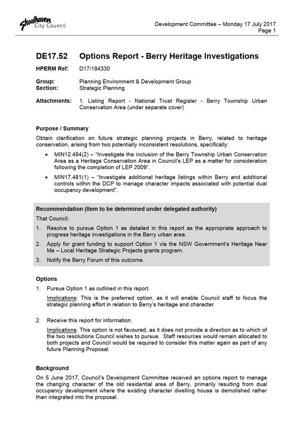
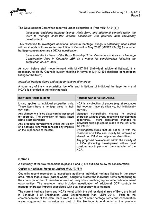
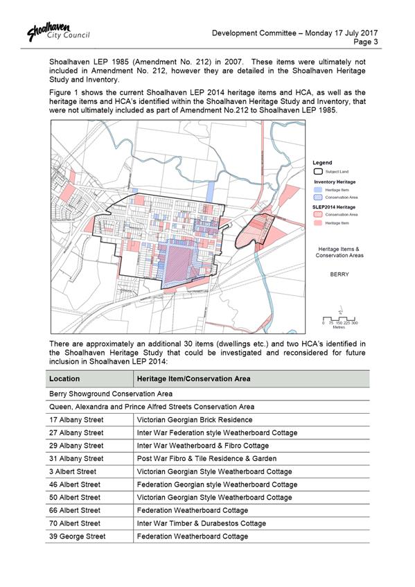
|
|
Development
Committee – Tuesday 11 September 2018
Page
0
|
DE18.64 South
Nowra Industrial Zoned Area - Future Direction
HPERM Ref: D18/273390
Group: Planning
Environment & Development Group
Section: Strategic
Planning
Purpose / Summary
Present representations from
landowners in the South Nowra industrial zoned area and seek direction in this
regard.
|
Recommendation (Item to be
determined under delegated authority)
That Council
1. Receive
the report on the representations made by landowners in South Nowra
Industrial Zoned Area for information.
2. Engage
a suitably qualified and experienced consultant/s to assist Council with the
preparation of proposed development controls and engineering design
investigations for required access roads, drainage infrastructure, land
acquisition and water/sewerage in the South Nowra Industrial Zoned Area.
3. Support
the preparation of an area specific chapter for South Nowra Industrial Zoned
Area in Shoalhaven Development Contribution Plan (DCP) 2014.
4. Support
the preparation of an amendment to Shoalhaven Contributions Plan (CP) 2010 to
include additional Local Contribution Projects to facilitate required
infrastructure works and recoup design and investigation costs.
5. Receive
a future report to consider the draft DCP Chapter and draft CP amendment for
South Nowra Industrial Zoned Area for public exhibition.
|
Options
1. Adopt the
recommendation.
Implications: This will formally enable the
preparation of an area specific DCP Chapter and Contributions Plan project for
the South Nowra industrial area, which will enable a coordinated longer-term
approach to the delivery of industrial land in the area and provide greater
certainty to landowners/developers.
2. Not adopt the
recommendation.
Implications: By not adopting the recommendation,
no immediate planning work will be undertaken for the South Nowra industrial
area and current circumstances will remain. Since the land is identified
for long term industrial use, this planning work could be undertaken in subsequent
years, enabling staff to continue working on other projects already identified
in the 2018-2019 Strategic Planning Works Program.
3. Adopt an
alternative recommendation.
Implications: Will be dependent on the nature of
the alternative recommendation. However, it is noted in the body of the report
that any proposal to remove the current industrial zone, for example, may be
difficult to justify.
Background
On 16 July 2018, the South Nowra
Disadvantaged Landholders Group (Landholder Group) met to compile a list of
discussion points to bring to the attention of Council. On Monday 30 July 2018
the Mayor and Council staff met with the landowners and Kiama MP Gareth Ward to
discuss their concerns.
This report provides an overview
of the landowner’s concerns and seeks Council’s direction on future
planning work in the subject area.
Subject Land
The subject land in question is
located to the south of the existing Flinders Industrial Estate in South Nowra
as shown in Figure 1 below.
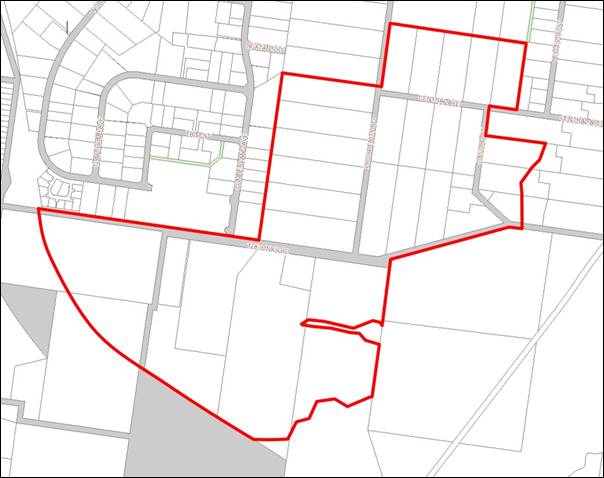
Figure
1 – Subject Land
Land Use Zoning History
The subject land is currently
zoned IN1 General Industrial under Shoalhaven Local Environmental Plan (SLEP)
2014, as shown in Figure 2 below.
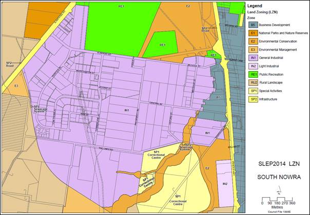
Figure
2 – Land Use Zoning, Shoalhaven LEP 2014
The IN1 zone aims to provide for
a diverse range of industrial and warehouse land uses and activities,
encouragement of employment opportunities, and to support and protect
industrial land for industrial uses.
Prior to the commencement of
SLEP 2014 on 22 April 2014, the land was partly zoned Rural 1(c)(Rural
Lifestyle) and Rural 1(d)(General) under the previous SLEP 1985, as shown in Figure
3 below.
The previous 1(c) zone was
essentially a rural residential zone and enabled a range of agricultural uses
and rural lifestyles as an alternative to urban development forms and servicing
levels. The previous 1(d) General Rural zone provided opportunities for a range
of rural land uses and other development which require siting away from urban
areas.
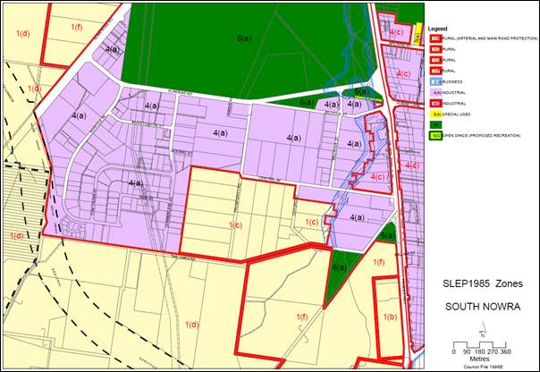
Figure
3 – Land Use Zoning, Shoalhaven LEP 1985
The Nowra-Bomaderry Structure
Plan (NBSP) 2006 was adopted by Council on 25 September 2007 and endorsed by
the NSW Department of Planning on 28 February 2008. One of the key
objectives of the NBSP is to provide sufficient industrial land to meet longer
term future demands (20-30 years), and the Plan was informed by detailed
industrial land supply and demand analysis work.
To meet projected demand, the
NBSP identified an additional 91.8 hectares of land at South Nowra as
“Future Industrial Land”, as an extension of the Flinders
Industrial Estate. As a result, SLEP 2014 zoned this additional area IN1
General Industrial. An additional area between South Coast Correctional Centre
and the future Western Bypass Corridor was also zoned IN1 following landowner
submissions made during the exhibitions of the draft citywide LEP and in
response to the placement of the correctional centre.
The current IN1 General
Industrial zoning is supported by the NSW Governments Illawarra-Shoalhaven
Regional Plan, which aims to support new and expanded industrial activity by
providing well-located and well serviced supplies of industrial land. The South
Nowra industrial zoned area is one of the largest banks of industrial land in
the region and is of strategic importance in meeting the demand for future
employment land in the region in the long term. A key action for the NSW
Government, identified in the Plan, is to support the development of new
industrial land through ongoing collaboration between State and Local
Government and servicing authorities to coordinate infrastructure delivery.
The Regional Plan is also
supported by the Employment Land Guidelines for the Illawarra that
contains principles to help guide land use planning decisions regarding employment
lands.
Both the Regional Plan and its
supporting Guidelines can be viewed on the internet at:
http://www.planning.nsw.gov.au/Plans-for-your-area/Regional-Plans/Illawarra-Shoalhaven/Resources
Landowner Concerns
At the meeting held on 30 July
2018, landowners within the South Nowra IN1 General Industrial area presented
Council with several concerns/issues they are facing because of the zoning and
other factors. A copy of the document provided at this meeting has been
separately provided to Councillors.
The concerns/issues are
summarised below along with comments from Council staff.
1. Strategic
Planning for Flinders Industrial Estate
Landowners raised concern that
Council has no strategic plans in place for the South Nowra industrial area.
Landowners feel they have suffered an unknown outcome for an extended period.
Staff Comment
As discussed earlier in the
report, the IN1 zoning was introduced with the commencement of SLEP 2014. The
background and strategic justification for the zoning change is based upon the
extensive work under the Nowra-Bomaderry Structure Plan, which is endorsed by
both Council and the NSW Government. This Plan looks to the needs of the area
for the next 20-30 years. It was never envisaged that land zoned because of
this plan would, in all cases, be developed or needed immediately. The take up
of land will be somewhat dependent on demographics, market forces and
opportunities (for example significant industry relocating to the area).
It is noted that, different to
the new Urban Release Areas, there is no legal requirement to have supporting
plans (e.g. DCP and CP) in place to directly facilitate or enable the
development of new industrial zoned land. Under Part 6 of the LEP supporting
plans need to be in place for identified URAs before they can be released
(developed). In the case of this land it is acknowledged that development
applications can be lodged and considered now for development that is
consistent with the IN1 zoning, however matters that could require coordinated
or planned outcomes, such as road access and stormwater management, would need
to be considered on a development by development basis. The required outcomes
would most likely then need to be managed on site (e.g. stormwater) or as
conditions of consent (e.g. access).
In the four years since the
commencement of SLEP 2014, several priority strategic planning projects have
been completed and are currently underway. Council’s 2018-2019 Strategic
Planning Works Program that was adopted in June 2018 does not currently include
work on a possible DCP and/or CP for this area, given the existing supply of
industrial land and other priority projects at this time.
However, Council’s
Economic Development section has commenced preliminary strategic planning work
for the South Nowra industrial land expansion and with the assistance of Locale
Consulting have prepared potential draft development controls and concept plans
to inform overall longer-term planning of the Flinders Industrial Estate.
This preliminary planning work
will potentially form part of a new area specific chapter within Shoalhaven DCP
2014, which will provide for the timely and coordinated development and
delivery of industrial land in the South Nowra industrial area in the longer
term. Until these more detailed/specific controls are finalised,
development applications can still be lodged and assessed against the generic
controls within Shoalhaven DCP 2014 Chapter G20 Industrial Development and
other generic chapters relating to industrial development and subdivision
including (but not limited to) Stormwater, Site Analysis and Environmental
Considerations, Car Parking, Subdivision, Landscaping, Flooding, Removal of
Trees and Waste Management.
2. Section
7.11 Developer Contributions and DA Works
Concern was raised over the
costs of developer contributions and development application works, which make
even low scale industrial development unviable for landowners.
Staff Comment
Shoalhaven Contributions Plan
2010 allows Council or an accredited certifier to levy contributions through
the development approval process to help provide community infrastructure or
additional infrastructure to meet demand created by the development.
Shoalhaven Contributions Plan
2010 applies across the entire LGA; however, it does not currently include any
specific projects in the South Nowra industrial area. Any development
applications lodged now for industrial development must provide any additional
infrastructure at full cost to the developer creating the demand, both on and
off site.
However, future planning work
will include the preparation of a lot layout plan and staging plan to help
facilitate a coordinated subdivision, infrastructure planning for the road
hierarchy and drainage, and a Development Contribution Plan project/s to
include access roads, drainage infrastructure and land acquisition.
3. South
Nowra Correctional Centre
Landowners raised concern over
the impacts of the South Nowra Correctional Centre including a decline in
property values, increases in traffic flows and road safety concerns.
Additionally, there were concerns that no contributions were levied on the
Correctional Centre development.
Staff Comment
The South Nowra Correctional
Centre was a State Significant Development (SSD) assessed under the former Part
3A approval process. Being a State Development, there was no requirement for
the Government to pay developer contributions or ability for Council to levy
them. Despite this, significant infrastructure upgrades were however directly
provided to support the development (access, water/sewer etc).
The South Nowra industrial area
currently supports approximately 247 businesses and the employment of 2,358
persons, which is expected to increase by a further 300-400 businesses which
will provide employment for approximately 3000-4000 people over the next 40/50
years. As further development occurs in this area, it is expected that the
level of traffic will continue to increase. Infrastructure to support these
increased levels of traffic, both on and off site, must be provided for by the
developer as a condition of development consent.
It is noted that property
valuations are based on several factors, including planning controls,
environmental constraints, structures on the site, servicing, supply and demand
factors, marketability, surrounding development and locational factors. Fully
serviced lots would receive a higher land valuation than englobo lands.
4. Development
Requirements Under IN1 General Industrial Zoning
Most of the existing lots have
dwellings and current landowners are concerned that they cannot build, extend
or rebuild houses on their land because of the IN1 General Industrial zoning.
Also because of the zoning potential sales have been reduced to those who can afford
a commercial mortgage with a 60% Loan to Value Ratio and a 40% deposit and
ability to service a higher loan. The customer base has also been reduced to
less than 5% of the overall market.
Industrial land values have not
been realised. Any improvements require a development application, supported by
Aboriginal cultural heritage, bushfire, flora and fauna, hydrology, and
environmental impact studies.
The land should be rezoned
Residential (R1, R2, R3, R5) or Environmental (E2, E3, or E4) and owners should
be able to lodge a development application under previous zoning to enable home
extensions, sheds, pools, etc. and be exempt from the current industrial
planning controls.
It has also been suggested that
the land should be given some form of ‘transitional’ zoning or
similar special zoning mechanism that sees it reverting to being able to be
used as it previously was to maintain resident’s lifestyle, whilst also
enabling it to be transitioned to industrial zoning/development as needed.
Staff Comment
Despite the IN1 General
Industrial zone prohibiting uses such as ‘agriculture’ and
‘dwelling houses’ which were permissible under the former 1(c) and
1(d) zones in SLEP 1985, the Environmental Planning and Assessment (EP&A)
Act 1979 and the EP&A Regulation 2000 contains provisions which enable the
continuation of existing lawful uses through ‘existing use
rights’.
The objective of ‘existing
use rights’ is to compromise between the legitimate expectations of
occupiers with the public interest in implementing the objectives of the new
LEP and land zoning. They play an important role where the zoning of an area
has changed through a rezoning or LEP review.
Existing uses can continue to
operate in perpetuity without the need for further approval, provided that the
nature of the use remains the same as that which existed prior to the new LEP
coming into force. The definition of what constitutes an ‘existing
use’ in section 4.65 of the EP&A Act must be carefully applied to the
facts of each case and the onus of establishing ‘existing use
rights’ is on the applicant. It is also noted under 4.66 of the Act that
the existing use is considered abandoned if it ceases to be used for a
continuous period of 12 months.
Part 5 of the EP&A
Regulation that deals with existing uses also provides for the modification of
existing uses, with development consent, including any alteration, extension
to, or rebuilding of a building or work, or any enlargement, expansion or
intensification of the use.
The regulations (Clause 41) specifically
note that an existing use, for example an existing dwelling, may be:
a) Enlarged, expanded or
intensified, or
b) Altered or extended, or
c) Be rebuilt, or
d) Be changed to another
use, but only if the use may be carried out with or without development consent
The regulations also provide
that an existing use that is commercial or light industrial must not be changed
to a similar use unless that change:
a) involves only alterations or
additions that are minor in nature, and
b) does not involve an increase
of more than 10% in the floor space of the premises associated with the
existing use, and
c) does not involve the
rebuilding of the premises associated with the existing use, and
d) does not involve a significant
intensification of that existing use.
As such the concerns regarding extending or rebuilding existing houses are
unfounded given that most existing circumstances are assumed to benefit from
‘exiting use rights’, noting that this would need to be established
and confirmed on a case by case basis as needed.
Even though they are zoned for
different uses, large areas in Shoalhaven are affected by constraints such as
flooding, bushfire and biodiversity. As part of the approval process, the
consent authority must be satisfied that the development is compatible with the
hazard and be designed to avoid or minimise any adverse impacts. It is
acknowledged that they do add additional complexity in bringing land to market,
but this is no different to other zoned development land in the City.
Rezoning of the land is not
recommended, as this would be inconsistent with the NSW Government’s
Illawarra-Shoalhaven Regional Plan and would be unlikely to receive support
from the NSW Department of Planning and Environment. As noted previously in
this report, the South Nowra industrial area is one of the largest reserves of
industrial land in the region and is of strategic importance in meeting the
demand for employment land in the region. There are a range of other NSW
Government planning provisions that aim to project existing industrial land
including the Employment Land Guidelines for the Illawarra and Section
9.1 (formerly Section 117) Direction 1.1 – Business and Industrial Land.
It is specifically noted that
under this Direction 1.1 a Planning Proposal (rezoning) must retain areas and
locations of existing industrial zones, not reduce total potential floor space
areas for industrial uses in industrial zones and ensure new employment areas
are in accordance with an approved strategy. Planning Proposals can only be
inconsistent with this direction when justified by a strategy, a study or are
of minor significance. As such given the strategic planning background and the
requirements of this direction any rezoning of the subject land out of an
industrial zone would be difficult to justify.
The request for a
‘transitional’ zone or approach is also not possible under the
Standard LEP Instrument approach set by the NSW Government as there is no zone
or approach of this nature that can be used. An approach of this nature would
also be problematic as it increases the potential for land use conflict and
reduces the certainty and responsiveness that is provided by a clear zoning.
The comments above in regard the Section 9.1 Direction are also relevant in
this regard.
5. Competition
from Flinders Industrial Estate and Lack of Infrastructure
Landowners are concerned that
the Flinders Estate is in direct competition with them for industrial land
sales and they are disadvantaged because lots in the Flinders Estate are fully
serviced. As ratepayers they believe Council should provide them with sealed
roads, street lighting, stormwater and sewer constructed to industrial
standards. Council should cease all sales and marketing of Flinders Estate and
move works allocations to the subject area.
Staff Comment
To assist bringing industrial
land to market, one of the functions of Council’s Economic Development
section is to develop land in the Flinders Industrial Estate and other
Industrial Estates in the City. Ratepayer funds are not used to provide
infrastructure improvements in the area, rather they are funded directly
through industrial land sales in the Estate. Council provides this service to
assist with the supply of industrial land to support employment growth and
economic development in the City. It is considered inappropriate for Council to
cease all sales and marketing of the Flinders Estate.
Australia operates under a free
market economic system, where land prices are determined by the forces of
supply and demand in the open market. There is nothing stopping other
developers entering the market, developing the infrastructure for a single lot
or group of lots, and submitting a development application for a subdivision
for industrial lots. Council recognises that this can sometimes be difficult,
which is why Council can design and cost the necessary infrastructure and levy
a contribution on a pro rata basis across the development precinct through a
Developer Contributions Plan. As discussed previously, given the number of other
priority projects and existing supply of industrial land, this work is not
included in Council’s adopted 2018-2019 Strategic Planning Works Program
as a current high priority project.
Timeframes
Noting the issues of the
landowners above and the Council staff comments on them, it is recommended that
Council formally resolve to prepare an area specific DCP Chapter and
Development Contributions project for the area to assist with the coordinated
delivery of industrial land in the South Nowra area and provide greater
certainty for landowners and developers.
Given the number of other
priority projects of Council have already committed to in the 2018-2019
Strategic Planning Works Program, consultancy assistance will be required to
complete the work required for the DCP and CP project. Estimated timeframes for
the completion of this work should Council resolve to proceed with it are 12
months to 2 years.
Community Engagement
Wider community engagement has
not been undertaken at this stage. Landowners will continue to be informed of
Council’s decisions as the planning for this area progresses.
It is noted that no detailed
engagement has been undertaken with the affected landowners regarding the
preparatory investigation and planning work that has already been undertaken.
Policy Implications
The proposed DCP and CP for the
South Nowra industrial area is not included in the 2018-2019 Strategic Planning
Works Program which was adopted by Council in June 2018.
The adoption of the
recommendation will see work on this project commence and the projected added
to the Work Program. Given existing staff workloads and other priority
projects, additional resources will be required to complete the work,
particularly in preparing the Contributions Plan project. A recommendation is
included to enable the engagement of a consultant to assist in this regard.
Financial Implications
The engagement of a consultant
to assist with the contributions plan project for the South Nowra industrial
area can be funded initially within the existing Economic Development Budget
and ultimately recouped through Section 7.11 contributions levied on future
development.
Other work associated with this
project will be managed within the existing Strategic Planning Budget.
Risk Implications
The South Nowra Disadvantaged
Landowners Group noted possible legal action in the discussion points provided
at the recent meeting. These points are not covered in this report and
Council’s insurers have been advised.
|
|
Development
Committee – Tuesday 11 September 2018
Page
0
|
DE18.65 Low
Rise Medium Density Housing Code - Request for Deferred Commencement Extension
HPERM Ref: D18/279418
Group: Planning
Environment & Development Group
Section: Strategic
Planning
Attachments: 1. Proposed
Correspondence to the Department of Planning and Environment - Request for
Deferred Commencement Extension ⇩
Purpose / Summary
To obtain endorsement to
request that the Department of Planning and Environment consider a further
deferral to the Low Rise Medium Density Housing Code (the Code), which at
present will commence for Shoalhaven on 1 July 2019.
|
Recommendation (Item to be
determined under delegated authority)
That Council:
1. Submit
the correspondence at Attachment 1 to the Department of Planning and
Environment, requesting up to a further 12-month deferral (until 30 June
2020) for Shoalhaven in relation to the Low Rise Medium Housing Code.
2. Advise
Development Industry Representatives and Community Consultative Bodies of
this resolution, and again should Council be successful in obtaining the
further 12-month extension.
|
Options
1. As recommended.
Implications: A 12-month extension to the deferral
would enable Council to fully prepare and finalise the relevant planning
proposal prior to the commencement of the Code.
This means that the minimum lot size provisions in the
Code relating to dual occupancy and multi dwelling housing (terraces), which
are generally not appropriate to Shoalhaven’s regional and diverse
context, will not apply to Shoalhaven.
2. Not request a
further 12-month extension.
Implications: This option is not preferred as it is
likely that the planning proposal required to insert minimum lot size
provisions in Shoalhaven LEP 2014 will not be notified (completed and in force)
prior to commencement of the Code for Shoalhaven on 1 July 2019. The minimum
lot size in the Code is significantly less than currently required by Council
which could or will have significant built form implications for Shoalhaven,
especially regarding character and on coastal villages.
Background
In July 2018, Council resolved
(MIN18.423) to seek a 12-month deferral from the implementation of the NSW
Government’s Low Rise Medium Density Housing Code (the Code). The Code
enables the consideration of the following medium density development types as complying
development:
· One
and two storey dual occupancies, manor houses and terraces in
Shoalhaven’s R1 General Residential, R3 Medium Density Residential and
RU5 Villages zones; and
· One
and two storey dual occupancies in Shoalhaven’s R2 Low Density
Residential zone.
Council’s request for a
deferral was favourably received and the City of Shoalhaven is now known as a
‘deferred area’ for the purposes of the Code, until 30 June 2019.
The 12-month deferral provides
Council with an opportunity to work towards the preparation and inclusion of
local strategic planning statements in Shoalhaven Development Control Plan
(DCP) 2014 and minimum lot size provisions for certain medium density development
in Shoalhaven Local Environmental Plan (LEP) 2014. This will ensure that the
character and context of Shoalhaven’s existing towns and villages will be
adequately considered during the complying development process, and where
appropriate, maintained into the future.
It is likely that the required
amendments to Shoalhaven DCP 2014 to incorporate the local strategic planning
statements can be finalised prior to 1 July 2014 and the Development Committee
will receive a future report in this regard.
Amendments to Shoalhaven
LEP 2014
The required amendments to
Shoalhaven Local Environmental Plan 2014 to incorporate minimum lot size
provisions for medium density development are unlikely be notified (in force)
before 1 July 2019 due to the potentially detailed and extensive nature of the
planning proposal and the steps Council needs to follow.
The proposed amendments will
seek to introduce a minimum lot size for the parent lot prior to the erection
of a dual occupancy, manor house, multi dwelling housing, multi dwelling
housing (terraces) or residential flat building development. This will also
assist in lifting the restriction on Torrens subdivision following lawful
medium density development.
The introduction of minimum lot
sizes for the erection of medium density development is also critical in
responding to the Code. The Code specifies minimum lot size requirements for
complying development as follows:
· Dual
occupancy - 400m2 or the minimum lot area specified for the land in
Shoalhaven LEP 2014, whichever is the greater.
· Manor
houses – 600m2.
· Multi
dwelling housing (terraces) - 600m2 or the minimum lot area
specified for the land in Shoalhaven LEP 2014, whichever is the greater.
This means that unless Council
includes minimum lot sizes in Shoalhaven LEP 2014, the Code provisions for dual
occupancy and multi dwelling housing (terraces) will apply.
To put this in context,
Shoalhaven DCP 2014 currently requires the size of the parent lot, prior to the
erection of a dual occupancy development, to be 500m2 for attached
dual occupancy, and 700m2 for detached dual occupancy. The minimum
lot size in the Code is 400m2 which is noticeably less than
currently required by Council. This could have significant built form
implications for Shoalhaven, especially around character and on some of our
coastal villages.
The NSW Department of Planning
and Environment have requested that any planning proposal relating to this
matter be received by the end of September 2018. This timeframe cannot be
achieved for several reasons; notably it is considered critical that workshops
are arranged with Councillors to discuss the proposed minimum lot sizes and
other matters related to the planning proposal prior to formally reporting to
Council. As such, it is expected that the matter will be reported to
Development Committee towards the end this year. A planning proposal of this
nature is thus unlikely to be concluded prior to 1 July 2019.
As such, it would be appropriate
to request a further 12-month (up to) extension to the current Code
commencement date. This will enable Council to prepare and finalise the
planning proposal prior to the commencement of the Code. The proposed
correspondence in this regard is at Attachment 1.
It is understood that the City
of Ryde has been successful in obtaining a similar 12-month extension which
means the Code will commence in that local government area on 1 July
2020.
Conclusion
Based on the risk that the
planning proposal to insert minimum lot sizes for medium density development is
unlikely to be finalised by 1 July 2019, it is recommended that Council
formally request that the Department of Planning and Environment consider up to
a 12-month extension to the current Code deferral for Shoalhaven until 30 June
2020.
Community Engagement
It is recommended that
Development Industry Representatives and Community Consultative Bodies are
notified of Council resolution, and again should Council be successful in
obtaining the further 12-month extension.
Any proposed amendments to
Shoalhaven LEP 2014 or Shoalhaven DCP 2014 will include community consultation
in accordance with legislative and project requirements.
A Councillor workshop will be
schedule in due course to discuss the proposed minimum lot sizes and other
matters related to the planning proposal, prior to formally reporting to
Council.
Policy and Risk Implications
The current deferral of the Code
until 30 June 2019, whilst appreciated, is unfortunately unlikely to be enough
time for Council to fully consider all relevant matters and finalise the
planning proposal before 1 July 2019. A further 12-month extension would enable
Council to prepare and finalise the planning proposal prior to the commencement
of the Code.
In the case that a further
deferral is not supported by the Department of Planning and Environment,
Council staff will continue to progress the planning proposal in an expedited
fashion. There is a risk, however, that the planning proposal process will not
be completed prior to 1 July 2019, which would leave Shoalhaven exposed to
minimum lot sizes applicable to complying development that are generally not
appropriate to Shoalhaven’s regional and diverse context.
Financial Implications
There are no direct financial
implications for Council in seeking a further 12-month extension to the
deferral of the Code.
Any future amendments to Shoalhaven
LEP 2014 or Shoalhaven DCP 2014 will be resourced from the existing Strategic
Planning budget.
|
|
Development
Committee – Tuesday 11 September 2018
Page
0
|
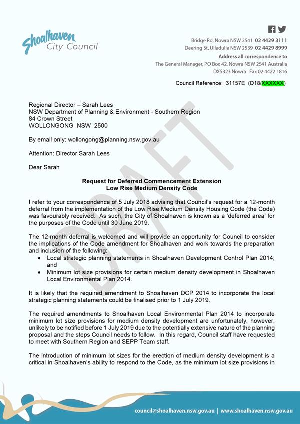
|

|
Development
Committee – Tuesday 11 September 2018
Page
0
|
DE18.66 Proposed
2017 Housekeeping Amendment to Shoalhaven Local Environmental Plan 2014 -
Instrument Changes
HPERM Ref: D18/282538
Group: Planning
Environment & Development Group
Section: Strategic
Planning
Attachments: 1. Draft
Planning Proposal - 2017 Housekeeping Amendment - Instrument Changes (under
separate cover)
Purpose / Summary
To obtain the necessary
resolution to progress the 2017 Housekeeping Amendment – Instrument
Changes Planning Proposal (PP) which seeks to undertake and resolve a range of
necessary housekeeping adjustments and changes to Shoalhaven Local
Environmental Plan (LEP) 2014 that have been picked up during the 2017 calendar
year.
|
Recommendation
(Item to be determined under delegated authority)
That Council:
1. Submit
the 2017 Housekeeping Amendment – Instrument Changes Planning Proposal
(PP033 – Attachment 1) to the NSW Department of Planning and
Environment for a Gateway determination and if favourable, proceed to formal
public consultation in accordance with the terms of the determination.
2. Advise
any relevant community groups of this decision, noting the opportunity for
formal consultation later in the process.
|
Options
1. As
recommended.
Implications: Since the commencement of Shoalhaven
LEP 2014, anomalies and minor issues continue to arise and be identified and
that need to be resolved. The matters related to the LEP instrument that were
identified during 2017 will be corrected through this housekeeping amendment.
Continuously improving the LEP is necessary to ensure it remains current.
2. Adopt an
alternative recommendation.
Implications: Depending on its nature, an
alternative recommendation could delay the resolution of the identified
housekeeping matters.
3. Reject the
recommendation.
Implications: This is not the preferred option as
the identified housekeeping matters will not be resolved.
Background
Shoalhaven LEP 2014 commenced on
22 April 2014. It consolidated planning controls into the one LEP and
transitioned existing controls into the NSW Government’s Standard
Instrument LEP format.
As part of the completion, and
since Shoalhaven LEP 2014 has been in force, Council has identified a number of
housekeeping amendments needed to improve the operation and accuracy of the
Plan. Council continuously reviews Shoalhaven LEP 2014 to ensure it aligns with
strategic documents, is improved where necessary, and delivers positive
outcomes for the community.
Due to the extent of the mapping changes proposed as part of
the 2017 Housekeeping Amendment, the amendment has been split into two PPs:
· 2017 Housekeeping
Amendment – Instrument Changes (this PP).
· 2017 Housekeeping
Amendment – Minor Mapping Changes (future PP). Council will receive a
future report in this regard.
2017 Housekeeping Amendment –
Instrument Changes
This PP covers a variety of
required housekeeping adjustments and amendments to Shoalhaven LEP 2014 to
improve the operation and accuracy of the plan. It responds to issues that were
identified in the 2017 calendar year.
The intended outcome of this PP
is to amend or add provisions to the LEP instrument to improve the Plan’s
operation and address the identified issues. The proposed amendments are
summarised in Table 1 below.
Table 1: Summary of LEP instrument amendments
|
Item
|
Summary of proposed amendment
|
Rationale
|
|
1
|
Amend references to the Crown Lands Act 1989 in
clause 1.9A(2) to reflect the repeal of the Act in June 2018.
|
The Crown Lands Act 1989 was repealed in June
2018 and replaced by the Crown Land Management Act 2016. The
proposed amendment seeks to reflect the new Act and content within.
|
|
2
|
Insert ‘artisan food and drink industry’ as
a land use permitted with consent in the RU1 Primary Production and RU2 Rural
Landscape zones.
|
The NSW Government recently released an amendment to
the Standard Instrument Local Environmental Plan to include provision for a
new land use term ‘artisan food and drink industry’.
This new land use term is a subset of the ‘light
industry’ land use and is permissible wherever ‘light
industry’ is permissible in LEP’s.
As a result, the land use ‘artisan food and
drink industry’ is now permissible with consent in the following
Shoalhaven LEP 2014 zones:
· RU5
Village
· B1
Neighbourhood Centre
· B5
Business Development
· B7
Business Park
· IN1
General Industrial
· IN2
Light Industrial
· IN4
Working Waterfront
It is considered appropriate for the term to also be
permissible with consent in the RU1 Primary Production and RU2 Rural
Landscape zones to support the growing artisan and craft food and drink
industry in Shoalhaven.
It is noted that following similar land uses are already
permissible in the RU1 and RU2 zones in Shoalhaven: intensive plant
agriculture (e.g. viticulture/wineries), cellar door premises, food and drink
premises and rural industries.
|
|
3
|
Insert ‘dual occupancies (attached)’ as a
land use permitted with consent in the E2 Environmental Conservation zone.
|
‘Dual occupancies (attached)’ have limited
additional impact above and beyond the impact of a single dwelling due to the
fact that they are required to be co-located and have a common roofline. As
such, it is considered appropriate for ‘dual occupancies (attached)’
to be permissible with consent in the E2 Environmental Conservation zone.
It should be noted that the use can only be considered
where a dwelling is currently permissible and as such this inclusion will not
create new development opportunities in the E2 zone.
|
|
4
|
Amend clause 4.1(4) Minimum Subdivision Lot Size, to
allow the creation of a lot from a closed road that is smaller than the
minimum lot size shown on the Lot Size Map.
|
The current situation where the lot size map is
applied to roads is causing issues in relation to road closures. The closure
is technically a ‘subdivision’ creating a lot smaller than the
minimum lot size.
It would be appropriate to amend clause 4.1 to
facilitate the creation of lots smaller than the prescribed lot size where
the subdivision is resulting from a road closure.
|
|
5
|
Insert a new subclause to clause 4.1F Minimum
Subdivision Lot Size for Community Scheme and Strata Plan Lots, to make it
clear that clause 4.1F is not subservient to clause 4.1 (Minimum subdivision
lot size).
|
It is proposed to add new wording to clause 4.1F
“This clause applies despite clause 4.1”, to make it clear
that clause 4.1 does not override the provisions of clause 4.1F.
This ensures consistency between clauses in the LEP
and negates any argument that clause 4.1F is subservient to clause 4.1.
|
|
6
|
Amend clause 4.2B(2) Subdivision of Certain Land in
Zone RU1, Zone RU2, Zone RU4, Zone R5 and Zone E4, to only apply to land in a
RU1, RU2 or RU4 zone in relation to prime crop and pasture land given they
are the ‘rural’ zones where agriculture would be expected, noting
that R5 and E4 are essentially residential in nature.
|
Some landowners in areas identified by Clause 4.2B and
mapped as prime crop and pasture land have submitted subdivision applications
supported by detailed site-specific land capability studies indicating that
the subject land is not class 1, 2 or 3 agricultural land. Following
referral, the NSW Department of Primary Industries (DPI) has advised that
they will not be revising the mapping and will not consider site specific
studies. This leaves Council unable to consider these applications other than
by way of refusal.
As part of the preparation of
Shoalhaven LEP 2014, a desktop assessment was undertaken of all the areas to
which this clause applies to determine the appropriate zone. Some areas were
identified in the study as having a character or form of development that is
reflective of lifestyle living or residential rather than small scale
agriculture, e.g. the R5 Large Lot Residential and
E4 Environmental Living zones. It is also noted that the E4 zone does
not permit any form of agriculture.
As such, it is appropriate to amend 4.2B(2) to only
apply the requirement to land in the rural zones RU1, RU2 and RU4.
|
|
7
|
Amend clause 4.2G(4) Boundary Adjustments of Land in
Certain Rural and Environmental Protections Zones, to delete reference to
permissibility of a dwelling following subdivision.
|
The wording of clause 4.2G(4) has caused some
confusion. The subclause appears to create a circular argument with
4.2D(3)(cc) if one of the proposed lots is an existing holding.
Clause 4.2D(3)(cc) ensures that a dwelling can be
approved on lot created under clause 4.2G so it is redundant to specify that
a dwelling must be permissible on a lot after the subdivision.
The removal of the second half of subclause 4 (from
“and…”) would resolve the confusion.
|
|
8
|
In relation to Schedule
1 Additional permitted uses (6) ‘Use of certain land at
Manyana’, update the description of the land
to which Schedule 1 (6) applies.
|
Lot 204 DP 755923 (Por 204) and Lot 1070 DP 836591
have been subdivided, with registration occurring in 2008 and 2011
respectively.
Lot 204 DP 755923 (Portion 204) is now known as Lot 2
DP 1121854, and Lot 1070 DP 836591, Curvers Drive is now known as Lot 2 DP
1161638, Inyadda Drive.
The proposed amendments to this clause seek to reflect
the newly created lots as the land to which the clause applies.
|
|
9
|
In relation to Schedule
2 Exempt Development ‘Temporary events on public land and public
roads and associated temporary structures’, insert
additional criteria in subclause 2 in relation to Crown land that is vested
in Council, or of which Council is the Crown lands manager.
|
The
current wording excludes the operation of the clause to any land to which the
Crown Land Management Act 2016 applies, including where Council is the
Crown land manager or is responsible for the care, control and management of
that land pursuant to the provisions of that Act. A development application
is therefore required for any event on land to which the Crown Land
Management Act 2016 applies. This is not the intent of Council.
As such,
it is appropriate to amend the clause to extend its application to Crown land
of which Council is the Crown lands manager or Crown land which has been
vested in Council pursuant to the Crown Land Management Act 2016.
|
|
10
|
In relation to Schedule
2 Exempt Development, insert new exempt development
criteria relating to:
· A-frame
sign boards and structures.
· Merchandise displays.
|
Shoalhaven
Development Control Plan currently includes a Chapter relating to exempt
development. As it is unlawful for a development control plan to provide an
exemption to a land use where the permissibility of that land use is
prescribed by an environmental planning instrument, it is considered
appropriate to include additional provisions in Schedule 2 Exempt
Development. A development application should not be required in this regard.
Note: The removal of Chapter 3 Exempt Development from the DCP will be
considered in a future report to Council.
Further,
Council also issues a few approvals under Section 68 of the Local
Government Act 1993 in relation to the commercial use of a footpath. The
inclusion of these exempt development types will assist in the timely
processing of these applications.
|
Following endorsement from
Council, the PP will be submitted to the NSW Department of Planning and
Environment for a Gateway determination.
As detailed in the Project Timeline in the PP (Attachment
1), it is anticipated that the LEP amendment will be finalised by July
2019.
Community Engagement
Should the PP receive a favourable Gateway determination,
it will be exhibited for comment in accordance with Council’s Community
Engagement Policy at Level 1 to ‘inform’ and ‘consult’,
and in accordance with the relevant legislative requirements.
The Gateway determination will specify the minimum
exhibition period and any government agencies who should be consulted. Any
directly affected landowners will be advised of the exhibition arrangements in
writing, as will all Community Consultative Bodies.
Financial Implications
There are no immediate financial implications for
Council. The amendment to Shoalhaven LEP 2014 will be resourced from the
Strategic Planning budget.
|
|
Development
Committee – Tuesday 11 September 2018
Page
0
|
Local Government Amendment (governance &
planning) act 2016
Chapter
3, Section 8A Guiding principles for councils
(1)
Exercise of functions
generally
The
following general principles apply to the exercise of functions by councils:
(a) Councils should provide strong
and effective representation, leadership, planning and decision-making.
(b) Councils should carry out
functions in a way that provides the best possible value for residents and
ratepayers.
(c) Councils should plan
strategically, using the integrated planning and reporting framework, for the
provision of effective and efficient services and regulation to meet the
diverse needs of the local community.
(d) Councils should apply the
integrated planning and reporting framework in carrying out their functions so
as to achieve desired outcomes and continuous improvements.
(e) Councils should work
co-operatively with other councils and the State government to achieve desired
outcomes for the local community.
(f) Councils should manage
lands and other assets so that current and future local community needs can be
met in an affordable way.
(g) Councils should work with
others to secure appropriate services for local community needs.
(h) Councils should act fairly,
ethically and without bias in the interests of the local community.
(i) Councils should be
responsible employers and provide a consultative and supportive working
environment for staff.
(2) Decision-making
The
following principles apply to decision-making by councils (subject to any other
applicable law):
(a) Councils should recognise
diverse local community needs and interests.
(b) Councils should consider social
justice principles.
(c) Councils should consider the long
term and cumulative effects of actions on future generations.
(d) Councils should consider the
principles of ecologically sustainable development.
(e) Council decision-making should
be transparent and decision-makers are to be accountable for decisions and
omissions.
(3) Community participation
Councils
should actively engage with their local communities, through the use of the
integrated planning and reporting framework and other measures.
Chapter
3, Section 8B Principles of sound financial management
The
following principles of sound financial management apply to councils:
(a) Council spending should be responsible and
sustainable, aligning general revenue and expenses.
(b) Councils should invest in responsible and
sustainable infrastructure for the benefit of the local community.
(c) Councils should have effective financial
and asset management, including sound policies and processes for the following:
(i) performance management
and reporting,
(ii) asset maintenance and
enhancement,
(iii) funding decisions,
(iv) risk management practices.
(d) Councils should have regard to achieving
intergenerational equity, including ensuring the following:
(i) policy decisions are made
after considering their financial effects on future generations,
(ii) the
current generation funds the cost of its services
Chapter
3, 8C Integrated planning and reporting principles that apply to councils
The
following principles for strategic planning apply to the development of the
integrated planning and reporting framework by councils:
(a) Councils should identify and prioritise key
local community needs and aspirations and consider regional priorities.
(b) Councils should identify strategic goals to
meet those needs and aspirations.
(c) Councils should develop activities, and
prioritise actions, to work towards the strategic goals.
(d) Councils should ensure that the strategic
goals and activities to work towards them may be achieved within council
resources.
(e) Councils should regularly review and
evaluate progress towards achieving strategic goals.
(f) Councils should maintain an
integrated approach to planning, delivering, monitoring and reporting on
strategic goals.
(g) Councils should collaborate with others to
maximise achievement of strategic goals.
(h) Councils should manage risks to the local
community or area or to the council effectively and proactively.
(i) Councils should make appropriate
evidence-based adaptations to meet changing needs and circumstances.