Development Committee
Meeting Date: Tuesday,
08 May, 2018
Location: Council
Chambers, City Administrative Building, Bridge Road, Nowra
Time: 5.00pm
Membership (Quorum - 5)
Clr Joanna Gash - Chairperson
Clr John Levett
All Councillors
General Manager or nominee
Please note: Council’s Code of Meeting Practice
permits the electronic recording and broadcast of the proceedings of meetings
of the Council which are open to the public. Your attendance at this meeting is
taken as consent to the possibility that your image and/or voice may be
recorded and broadcast to the public.
Agenda
1. Apologies / Leave of Absence
2. Confirmation of Minutes
· Development
Committee - 10 April 2018..................................................................... 1
3. Declarations of Interest
4. Mayoral Minute
5. Deputations and Presentations
6. Notices of Motion / Questions on Notice
Nil
7. Reports
DE18.31...... Planning Proposal (Rezoning) Guidelines -
Proposed Revisions................. 7
DE18.32...... Proposed Project Commencement - Shoalhaven Growth
Management Strategy (Version 2).................................................................................................... 20
DE18.33...... Proposed Submission - Discussion Paper: Planning
for the Future of Retail and proposed changes to retail land use definitions........................................... 29
DE18.34...... Exhibition Outcomes and Finalisation –
Shoalhaven Development Control Plan 2014 – Draft Amendment No. 14 –
Proposed Chapter G18 Streetscape Design for Town and Village Centres...................................................................................... 34
DE18.35...... Proposed Submission - Aboriginal Land Claims No.
6427, 26210 and 26251 - Koloona Drive, Watersleigh.......................................................................... 57
DE18.36...... Outcomes - Shoalhaven Local Heritage Assistance
Fund 2017-2018........ 67
DE18.37...... DA17/2435 – 148 Island Point Road, St
Georges Basin – Lot 43 DP 25550 84
DE18.38...... RD18/1002 – 160 Kinghorne Street, Nowra
– Lot 2 DP 566370................. 94
DE18.39...... Proposed Draft Medium Density Amendment -
Shoalhaven Development Control Plan 2014............................................................................................................ 125
DE18.40...... Heritage Investigations - Chinaman's Island, Lake
Conjola...................... 131
DE18.41...... Changes to new legislative provisions relating to
the Joint Regional Planning Panels.................................................................................................................... 140
8. Confidential
Reports
Nil
|

|
Development
Committee – Tuesday 08 May 2018
Page
|
Development Committee
Delegation:
Pursuant to s377 (1) of the
Local Government Act 1993 the Committee is delegated the functions conferred on
Council by the Environmental Planning & Assessment Act 1979 (EPA Act),
Local Government Act 1993 (LG Act) or any other Act or delegated to Council, as
are specified in the attached Schedule, subject to the following limitations:
i. The
Committee cannot make a decision to make a local environmental plan to classify
or reclassify public land under Division 1 of Part 2 of Chapter 6 of the LG
Act;
ii. The
Committee cannot review a s82A or s96AB EPA Act determination made by the
Council or by the Committee itself;
iii. The
Committee cannot exercise any function delegated to the Council which by the
terms of that delegation cannot be sub-delegated;
iv. The Committee
cannot exercise any function which s377(1) of the LG Act provides cannot be
delegated by Council; and
v. The
Committee cannot exercise a function which is expressly required by the LG Act
or any other Act to be exercised by resolution of the Council.
Schedule:
1. All
functions relating to the preparation, making, and review of local
environmental plans (LEPs) and development control plans (DCPs) under Part 3 of
the EPA Act.
2. All
functions relating to the preparation, making, and review of contributions
plans and the preparation, entry into, and review of voluntary planning
agreements under Part 4 of the EPA Act.
3. The
preparation, adoption, and review of policies and strategies of the Council in
respect of town planning and environmental matters and the variation of such
policies.
4. Determination
of variations to development standards related to development applications
under the EPA Act where the development application involves a development
which breaches a development standard by more than 10% and the application is
accompanied by a request to vary the development standard under clause 4.6 of
Shoalhaven Local Environmental Plan 2014 or an objection to the application of
the development standard under State Environmental Planning Policy No. 1
– Development Standards.
5. Determination
of variations from the acceptable solutions and/or other numerical standards
contained within the DCP or a Council Policy that the General Manager requires
to be determined by the Committee
6. Determination
of development applications that Council requires to be determined by the
Committee on a case by case basis.
7. Review
of all determinations of development applications under sections 82A and 96AB
of the EP&A Act.
8. Preparation,
review, and adoption of policies and guidelines in respect of the determination
of development applications by other delegates of the Council.
Minutes of the Development Committee
Meeting Date: Tuesday,
10 April 2018
Location: Council
Chambers, City Administrative Building, Bridge Road, Nowra
Time: 5.00pm
The following members
were present:
Clr Joanna Gash -
Chairperson
Clr Amanda Findley
Clr Patricia White
Clr John Wells
Clr John Levett
Clr Nina Cheyne
Clr Kaye Gartner
Clr Mitchell Pakes
Clr Greg Watson
Clr Mark Kitchener
Clr Bob Proudfoot
Mr Russ Pigg - General
Manager
|
Apologies / Leave of Absence
|
|
RESOLVED (Clr Cheyne / Clr White)
MIN18.255
That:
1. A leave of absence be granted to
Clr Alldrick for the period 10 April 2018 until 15 May 2018 inclusive.
2. An apology be received from Clr
Guile.
CARRIED
|
|
Confirmation of the Minutes
|
|
RESOLVED (Clr White / Clr
Gartner) MIN18.256
That
the Minutes of the Development Committee held on Tuesday 13 March 2018 be
confirmed.
CARRIED
|
Note: Clr Findley advised
that the Mayoral Minute regarding leasing Nowra Neighbourhood Centre for
homeless accommodation arising from the Homelessness Taskforce Shoalhaven will
be submitted to the Strategy & Assets Committee on 17 April 2018.
Nil
Deputations and Presentations
DE18.23 – S96 Modification
Application – Tomerong Quarry – Parnell Rd, Tomerong – Lot 4
DP 775296
Lester Shute spoke for the recommendation.
DE18.28 – Development Application
DA17/2337 – 16 Coolangatta Road, Coolangatta – Lot 1 DP 1204108
Allan Murphy spoke for the recommendation.
The Deputation was made later in the meeting, see MIN18.261.
Reports
|
DE18.23 S96
Modification Application – Tomerong Quarry - Parnell Rd, Tomerong
– Lot 4 DP 775296
|
HPERM Ref: D18/49185
|
|
Recommendation (Item to be determined under
delegated authority)
That the Development Committee
resolve to refuse Application DS16/1532 to modify DA90/1912 to modify
condition 14(h) for the following reasons:
1. The
modification application has not adequately demonstrated that the proposal
will not have adverse environmental impacts on the built environment and
social impacts on the locality. (Section 79C(1)(b) of Environmental Planning
and Assessment Act, 1979)
2. The
information submitted with the modification application does not
satisfactorily demonstrate that the site is suitable for the proposed
modification. (Section 79C(1)(c) of Environmental Planning and Assessment
Act, 1979)
3. Having
regard to the information submitted with the modification application and
having regard to submissions received, the modification of the consent is not
considered to be in the public interest. (Section 79C(1)(e) of Environmental
Planning and Assessment Act, 1979)
|
|
RESOLVED (Clr Wells / Clr Pakes) MIN18.257
That the Development Committee
resolve to refuse Application DS16/1532 to modify DA90/1912 to modify
condition 14(h) for the following reasons:
1. The
modification application has not adequately demonstrated that the proposal
will not have adverse environmental impacts on the built environment and
social impacts on the locality. (Section 79C(1)(b) of Environmental Planning
and Assessment Act, 1979)
2. The
information submitted with the modification application does not
satisfactorily demonstrate that the site is suitable for the proposed
modification. (Section 79C(1)(c) of Environmental Planning and Assessment
Act, 1979)
3. Having
regard to the information submitted with the modification application and
having regard to submissions received, the modification of the consent is not
considered to be in the public interest. (Section 79C(1)(e) of Environmental
Planning and Assessment Act, 1979)
For: Clr
Gash, Clr Findley, Clr White, Clr Wells, Clr Levett, Clr Cheyne, Clr Gartner,
Clr Pakes, Clr Watson, Clr Kitchener, Clr Proudfoot and Russ Pigg
AGAINST:
Nil
CARRIED
|
|
DE18.24 Proposed
Submission - Aboriginal Cultural Heritage Reforms
|
HPERM Ref: D17/362593
|
|
Recommendation (Item to be determined under
delegated authority)
That Council make a submission to
the NSW Office of Environment & Heritage on the proposed Aboriginal
Cultural Heritage Reforms based on the content of this report.
|
|
RESOLVED (Clr Wells / Clr White) MIN18.258
That Council
make a submission to the NSW Office of Environment & Heritage on the
proposed Aboriginal Cultural Heritage Reforms based on the content of this
report.
For: Clr
Gash, Clr Findley, Clr White, Clr Wells, Clr Levett, Clr Cheyne, Clr Gartner,
Clr Pakes, Clr Watson, Clr Kitchener, Clr Proudfoot and Russ Pigg
Against: Nil
CARRIED
|
|
DE18.25 Proposed
Exhibition - Review of Shoalhaven Contributions Plan 2010
|
HPERM Ref: D18/67978
|
|
Recommendation (Item to be determined under
delegated authority)
That Council:
1. Adopt
for exhibition purposes the draft Amendment No. 10 to Shoalhaven
Contributions Plan 2010 as attached;
2. Exhibit
draft Amendment No. 10 for a minimum period of 28 days in accordance with
legislation;
3. Receive
a further report after public exhibition to consider any submissions and to
adopt the amendment for finalisation; and
4. Acknowledge
a further amendment to the Contributions Plan will be necessary once the two
significant projects identified in this report have been revised and adopted
by council.
|
|
RESOLVED (Clr Findley / Clr
White) MIN18.259
That Council:
1. Adopt
for exhibition purposes the draft Amendment No. 10 to Shoalhaven
Contributions Plan 2010 as attached;
2. Exhibit
draft Amendment No. 10 for a minimum period of 28 days in accordance with
legislation;
3. Receive
a further report after public exhibition to consider any submissions and to
adopt the amendment for finalisation; and
4. Acknowledge
a further amendment to the Contributions Plan will be necessary once the two
significant projects identified in this report have been revised and adopted
by council.
For: Clr
Gash, Clr Findley, Clr White, Clr Wells, Clr Levett, Clr Cheyne, Clr Gartner,
Clr Pakes, Clr Watson, Clr Proudfoot and Russ Pigg
Against: Clr
Kitchener
CARRIED
|
|
DE18.26 DA18/1010
– 27 Quinns Lane, South Nowra – Lot 4 DP 519090
|
HPERM Ref: D18/75316
|
|
Recommendation
That Council:
1. Confirm
that it supports, pursuant to clause 4.6 (Exceptions to development
standards) of SLEP 2014, the applicant’s request to vary the height
limit of 11m to 15.63m; and
2. Refer
the development application (DA18/1010) back to staff for determination.
|
|
RECOMMENDATION
(Clr Wells / Clr Findley)
That Council:
1. Confirm
that it supports, pursuant to clause 4.6 (Exceptions to development
standards) of SLEP 2014, the applicant’s request to vary the height
limit of 11m to 15.63m; and
2. Refer
the development application (DA18/1010) back to staff for determination.
For: Clr
Gash, Clr Findley, Clr White, Clr Wells, Clr Levett, Clr Cheyne, Clr Gartner,
Clr Pakes, Clr Watson, Clr Kitchener, Clr Proudfoot and Russ Pigg
Against: Nil
CARRIED
|
|
DE18.27 DE18.16
- Update and Proposed Next Steps - Nowra CBD Fringe Medium Density Study
Recommendations Report - Public Exhibition
|
HPERM Ref: D18/98289
|
|
Recommendation (Item to be determined under
delegated authority)
That Council:
1. Receive
the attached Nowra CBD Fringe Medium Density Study - Recommendations Report
prepared by Studio GL for information and endorse it being placed on public
exhibition for a minimum period of 28 days to enable community comment.
2. Consider
a further report following the exhibition of the Nowra CBD Fringe Medium
Density Study Recommendations Report on any comment received, with a view to
proceeding to: prepare a Planning Proposal for submission for initial Gateway
determination to revise relevant Local Environmental Plan provisions; and a
supporting Area Specific Chapter to be inserted in Shoalhaven Development
Control Plan 2014.
|
|
RESOLVED (Clr Gash / Clr Gartner)
MIN18.260
That Council:
1. Receive the attached Nowra CBD
Fringe Medium Density Study - Recommendations Report prepared by Studio GL
for information and endorse it being placed on public exhibition for a
minimum period of 28 days to enable community comment.
2. Consider
a further report following the exhibition of the Nowra CBD Fringe Medium
Density Study Recommendations Report on any comment received, with a view to
proceeding to: prepare a Planning Proposal for submission for initial Gateway
determination to revise relevant Local Environmental Plan provisions; and a
supporting Area Specific Chapter to be inserted in Shoalhaven Development
Control Plan 2014.
3. Write
to all affected residents as part of the consultation.
For: Clr
Gash, Clr Findley, Clr White, Clr Wells, Clr Levett, Clr Cheyne, Clr Gartner,
Clr Pakes, Clr Watson, Clr Kitchener, Clr Proudfoot and Russ Pigg
Against: Nil
CARRIED
|
|
Procedural
Motion - Deputation
|
|
RESOLVED (Clr Pakes / Clr White) MIN18.261
That a deputation be received
from Mr Allan relating to DE18.28 – Development Application DA17/2337
– 16 Coolangatta Rd, Coolangatta – Lot 1 DP 1204108.
CARRIED
Allan Murphy
spoke for the recommendation.
|
|
DE18.28 Development
Application DA17/2337 – 16 Coolangatta Rd, Coolangatta – Lot 1 DP
1204108
|
HPERM Ref: D18/98711
|
|
Recommendation (Item to be determined under
delegated authority)
That the Committee:
1. Confirms
that it supports the variation to the policy; and
2. Refer
the application back to staff for determination.
|
|
RESOLVED (Clr Findley / Clr
Cheyne) MIN18.262
That the
Committee:
1. Confirms
that it supports the variation to the policy; and
2. Refer
the application back to staff for determination.
For: Clr
Gash, Clr Findley, Clr White, Clr Wells, Clr Levett, Clr Cheyne, Clr Gartner,
Clr Pakes, Clr Watson, Clr Kitchener, Clr Proudfoot and Russ Pigg
Against: Nil
CARRIED
|
|
DE18.29 Additional
Item - Development Application - 160 Kinghorne Street, Nowra
|
|
RESOLVED (Clr White / Clr
Findley) MIN18.263
That
DA17/2242 – 160 Kinghorne Street, Nowra Lot 2 DP 566370 be called in to
Council for review under s8.2(1)(a) of the Environmental Planning and
Assessment Act 1979, due to significant public interest.
For: Clr
Gash, Clr Findley, Clr White, Clr Wells, Clr Levett, Clr Cheyne, Clr Gartner,
Clr Pakes, Clr Watson, Clr Kitchener, Clr Proudfoot and Russ Pigg
Against: Nil
CARRIED
|
|
DE18.30 Additional
Item - Development Application - Bangalee Motel - A10 Princes Highway, Berry
|
|
RESOLVED (Clr White / Clr
Findley) MIN18.264
That
DA17/1359 – Bangalee Motel – A10 Princes Highway, Berry Lot 100
DP 1057897 be called in to Council for determination due to significant
public interest.
For: Clr
Gash, Clr Findley, Clr White, Clr Wells, Clr Levett, Clr Cheyne, Clr Gartner,
Clr Pakes, Clr Watson, Clr Kitchener, Clr Proudfoot and Russ Pigg
Against: Nil
CARRIED
|
There being no further
business, the meeting concluded, the time being 6.08pm.
Clr Gash
CHAIRPERSON
|

|
Development
Committee – Tuesday 08 May 2018
Page
0
|
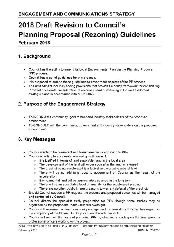
DE18.31 Planning
Proposal (Rezoning) Guidelines - Proposed Revisions
HPERM Ref: D18/16929
Group: Planning
Environment & Development Group
Section: Strategic
Planning
Attachments: 1. Draft
Revised PP Guidelines (under separate cover) ⇨
2. Community Engagement and
Communication Strategy - Revision to PP Guidelines ⇩
Purpose / Summary
Obtain Council’s
endorsement to publicly exhibit proposed revisions to Council’s Planning
Proposal (Rezoning) Guidelines.
|
Recommendation (Item to be
determined under delegated authority)
That Council:
1. Endorse the attached
draft revision to the Planning Proposal (Rezoning) Guidelines for public
exhibition.
2. Exhibit the draft
revision to the Planning Proposal (Rezoning) Guidelines in accordance with
the attached Community Engagement and Communications Strategy.
3. Receive a further
report to consider feedback received during the public exhibition period and
enable finalisation of the Guidelines.
|
Options
1. Endorse the
draft Planning Proposal (PP) Guidelines for
public exhibition, with or without changes.
Implications: The draft
PP Guidelines contain several significant policy positions to ensure that PPs
are managed consistently and transparently. It is considered appropriate
for Council to engage with the community and industry before determining what,
if any, amendments should be made to the guidelines. This option is
preferred.
2. Adopt the draft
PP Guidelines (with or without changes) without public exhibition.
Implications: Council is not legally
obligated to exhibit or consult prior to amending the PP Guidelines, but it is
preferable given the amount of new information
proposed and the importance of the document to the PP process.
3. Not revise the
existing PP Guidelines.
Implications: Some of the
proposed changes to Council’s PP Guidelines address a policy gap that was
identified recently when Council considered a PP request for Hitchcocks Lane,
Berry. This prompted a broader review of the PP Guidelines and the
proposed amendments will provide more certainty, transparency and consistency
in relation to the PP process. Retaining the PP Guidelines in their
current form is not preferred.
Background
Council’s Development
Committee considered a report for a proponent-initiated PP at Hitchcocks Lane,
Berry, on 14 November 2017. That report considered a request by the proponent
to bring forward/accelerate a long term urban investigation area identified in
the Growth Management Strategy (GMS). The report noted that Council does not
have an adopted policy on such requests and it was resolved (MIN17.953) as part
of the decision on that item to:
“…request a
future report that provides options for a policy framework for considering
Planning Proposals that accelerate consideration of an area ahead of its timing
in Council’s adopted strategic plans”.
A subsequent review by Council
staff has concluded that the most appropriate location for this policy is
Council’s Planning Proposal (Rezoning) Guidelines (PP Guidelines). No
other appropriate existing policy or guidance document was identified, and it
is also considered desirable to avoid the unnecessary proliferation of policies
through the creation of an additional new one.
The PP Guidelines were initially
adopted by Council on 26 March 2013 and followed earlier Rezoning Request
Guidelines. The purpose of the PP Guidelines is to outline Council’s
processes and criteria for assessing proponent-initiated PPs. The current PP Guidelines
can be viewed on the internet at:
http://doc.shoalhaven.nsw.gov.au/DisplayDoc.aspx?record=D16/22490
Since the finalisation of the new LEP for Shoalhaven in
2014, a range of proponent-initiated PP requests have been made. These
have progressed through the PP process to varying extents. This experience has
revealed opportunities to improve the PP Guidelines, thus a broader review was
undertaken, the outcome of which is detailed below.
Summary of Key Issues and
Proposed Changes to the PP Guidelines
Updating the PP Process
Diagram
The current PP Guidelines
include a simplified diagram of the PP process. This diagram is now
outdated due to changes made to the PP process by the NSW Government. For
example, PPs are no longer considered by a Local Planning Panel; this role is
now managed internally by the NSW Department of Planning and Environment
(DP&E).
The current diagram also
suggests that all specialist studies need to be completed before the PP
is submitted for Gateway determination. The revised diagram shows that
only studies for “threshold issues” need to be completed before
sending a PP to Gateway. The revised diagram allows for specialist studies in
relation to non-threshold issues to be prepared after the Gateway determination
has been issued.
Other changes to the diagram include:
a) Recognising that
community consultation may occur prior to requesting a Gateway determination;
and
b) Identifying
where in the PP process that fees will be charged.
Future Growth Areas -
Requests to Vary Timing
In accordance with MIN17.953, the
proposed changes to the PP Guidelines include a potential policy framework to
consider requests to accelerate/bring forward longer-term urban investigation
areas that are identified in endorsed Strategies or Plans.
This framework is based on the
DP&E’s Precinct Acceleration Protocol (PAP). The PAP applies to the
Sydney Growth Areas and specifies what a proponent must demonstrate to
accelerate a precinct.
The PAP’s various
requirements can be grouped into three main objectives:
1. A precinct will only be
accelerated if it will be immediately developed. There is no value in
accelerating a precinct otherwise. The PAP requires developers to show
that they have the necessary experience, financial means and legal arrangements
with owners to deliver the precinct as soon as it is released.
2. Only a logical and
workable area of land will be released. The PAP is clear that an accelerated
precinct must be a whole precinct. Accelerating a single lot in isolation
makes infrastructure planning and delivery more difficult and expensive.
It also prevents the proper master planning of development. If a precinct
or part of a precinct is to be released it must be a logical and developable
area of land.
3. Any additional
infrastructure or servicing costs resulting from the acceleration must be borne
by the proponent/developer. The PAP explains in detail the arrangements
that need to be considered in funding infrastructure. The ultimate
outcome is that the government will not incur any additional cost from the
acceleration.
The above requirements have been
adapted for inclusion into the draft PP Guidelines. Additional local provisions
have been added to address the following matters:
4. There must be a need for
land to be released in the local area. The PAP was established in the context
of Sydney’s need for housing supply. It assumes that demand will always
exceed supply even if the precinct is ‘accelerated’. While
the demand for housing and land in Shoalhaven is currently strong, acceleration
requests should only be supported if there is a demonstrated shortfall in urban
land supply in the local area to the extent that would justify the proposed
change in timing.
5. The Sydney Growth
Centres were Biodiversity Certified, meaning that environmental land has
already been identified and that Local Government will not incur the cost of
managing the environmental land. As this is not the case for the investigation
and growth areas in Shoalhaven, ‘acceleration requests’ should only
be supported if the proponent provides for the long-term management of any
environmental land at no cost to Council.
6. To varying extents,
growth areas in Shoalhaven are more remote from a servicing perspective than
the growth areas in Sydney. The draft PP Guidelines recognise this and require
appropriate servicing if a precinct or area is to be accelerated. It also
provides that acceleration should only occur if it will not give rise to
development that is isolated from established urban services.
7. The
draft PP Guidelines also require consideration of the ‘public
interest’ in relation to any the acceleration request.
Specialist Studies
The draft PP Guidelines include
information on how the specialist studies for a PP will be managed. It
outlines which studies will be managed by the proponent and which studies will
be managed by Council. The draft PP Guidelines state that studies will
generally be managed by the proponent under the oversight of Council staff.
The following studies are
however listed as exceptions to this and are to be entirely managed by Council:
a) Heritage studies
(including Aboriginal Cultural Heritage Assessments).
b) Studies where there is a
significant community interest.
c) Studies that have a
particular significance for Council (including Shoalhaven Water) or have a
potential probity issue.
d) Studies that are
otherwise significant from a public interest perspective.
The draft PP Guidelines also require that all studies
for proponent initiated PPs are to be wholly funded by the proponent.
This is consistent with the current long-term practices of Council.
Urban Release Area Provisions
(Part 6 of Shoalhaven LEP 2014)
The draft PP Guidelines outline
the circumstances where Council will apply or consider applying the Urban
Release Area (URA) provisions in Part 6 of Shoalhaven Local Environmental Plan
(LEP) 2014 to the outcome of a PP.
Part 6 of Shoalhaven LEP 2014
requires certain matters to be addressed before the URA land can be subdivided.
This includes preparation of a development control plan (DCP) and making
satisfactory arrangements for the provision of public infrastructure.
The draft PP Guidelines include
guidance on the circumstances in which Part 6 will or will not be used.
Part 6 is proposed to be used:
a) Where an adopted strategy/plan identifies
multiple precincts with differing infrastructure issues and/or delivery
timeframes;
b) Where there is a need to resolve State
public infrastructure or public utility infrastructure before the land can be
subdivided;
c) For major land releases that will be
delivered over a long period of time and that require a staged master planning
approach.
Part 6 is proposed not to be
used in regard to a PP if it:
a) Would defer a critical
issue that could prevent the development from proceeding;
b) Is clearly intended
solely to facilitate the “flipping” of the site;
c) Would result in
unreasonable consultation fatigue for a community;
d) Is
unwarranted having regard to the scale and complexity of the PP.
Biodiversity Certification
Biodiversity
Certification is a streamlined assessment process that allows the impacts on
biodiversity to be fully resolved at the PP stage, thus avoiding the need for
any further biodiversity assessment at subdivision/development stage.
The draft PP Guidelines provide that Council may require
where appropriate/justified that a PP be biodiversity certified.
Development Control Plans
(DCP)
The draft PP
Guidelines include guidance on the form and place
for any DCP controls required to accompany or ultimately support a PP. It
also provides a general policy position that Council does not wish to see
unnecessary site-specific DCP chapters.
Any
new site-specific DCP chapters must achieve substantial planning outcomes.
Planning Agreements and
Contributions Plans
The draft PP Guidelines include
commentary on the use of contributions plans (CPs) and voluntary planning
agreements (VPAs). It outlines the appropriate contexts for each
approach. It also specifies that Council generally prefers VPAs where
possible.
Classification of PPs
The
draft PP Guidelines state that Council broadly classifies PPs as either ‘minor’ or ‘major’ based
on potential impact.
These
are defined as follows:
Minor
PP:
PP for which no more than one (1)
supporting specialist study is required. This includes
‘housekeeping’ PPs (prepared by Council to address minor anomalies
etc) and other minor impact PPs.
Major
PP:
PP for
which two (2) or more specialist studies are required. Major PPs include:
· Local
Impact PP - requires specialist studies that relate only to potential
impacts on the locality; and
· Broader Impact PP - requires at
least one (1) specialist study to address potential impacts beyond the land
directly adjoining the subject land.
This informs community engagement approaches (see following
section) and is used to determine the applicable fee for preparing
proponent-initiated PPs for Gateway determination (as per Council’s fees
and charges).
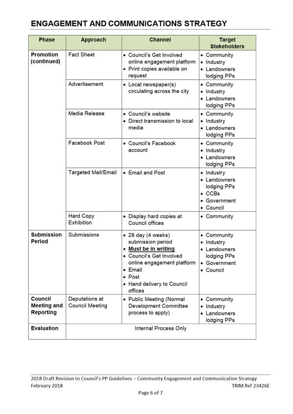
Community Engagement for PPs
The draft PP Guidelines include
an outline of the types of community engagement methods employed for various
classifications of PPs, as summarised in the table below:
|
ü
¿
O
|
=
=
=
|
Generally Required
Determined on a case by
case basis
Generally Not Required
|
Minor PPs
|
Major PPs
|
|
Housekeeping PP
|
Minor Impact PP
|
Local Impact PP
|
Broader Impact PP
|
|
Preliminary notification/consultation
|
|
|
|
|
|
Make available online1 (applies to
proponent-initiated PPs)
|
NA
|
P
|
P
|
P
|
|
Notify directly affected & adjoining landowners
|
¿
|
P
|
P
|
P
|
|
Invite submissions2
|
O
|
O
|
¿
|
¿
|
|
Formal public exhibition phase
|
|
|
|
|
|
Notify directly affected & adjoining landowners
|
¿
|
P
|
P
|
P
|
|
Notify relevant CCBs
|
P
|
P
|
P
|
P
|
|
Newspaper notice(s)
|
P
|
P
|
P
|
P
|
|
Official hard copy display at Council
|
P
|
P
|
P
|
P
|
|
Post on Council’s ‘On exhibition’
webpage
|
P
|
P
|
P
|
P
|
|
Invite submissions
|
P
|
P
|
P
|
P
|
|
Prepare/exhibit explanatory statement
|
¿
|
¿
|
P
|
P
|
|
Prepare/exhibit FAQs
|
O
|
O
|
¿
|
¿
|
|
Article(s) in community newsletter
|
O
|
O
|
¿
|
P
|
|
Media release
|
O
|
O
|
¿
|
P
|
|
Interactive Website (‘Get Involved’)3
|
O
|
O
|
¿
|
¿
|
|
Public hearing4
|
¿
|
¿
|
¿
|
¿
|
|
Information sessions, public meetings, workshops etc.
|
O
|
O
|
¿
|
¿
|
|
Social media
|
O
|
O
|
¿
|
¿
|
Notes:
1. PP request documents are published on
Council’s Planning Proposal webpage: https://shoalhaven.nsw.gov.au/Planning-amp-Building/Strategic-planning/Planning-Proposals
2. Proponents can request a review if
their PP request has not been determined within 90 days of lodgement. This
timeframe limits the opportunity for preliminary community consultation.
3. Council’s ‘Get
Involved’ webpage will be utilised where there is a high level of public
interest in the PP and will generally be used for the duration of the PP
process.
4. Public
hearings are mandatory for PPs involving reclassification of Council land.
DP&E’s Gateway determination will stipulate if a public hearing is
necessary.
The draft guidelines also provide information on
notification of stakeholders prior to Council meetings. This essentially
documents Council’s existing processes.
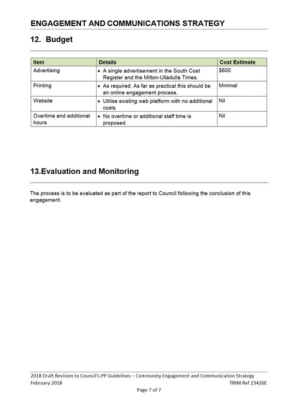
Fees and Charges
Council’s fees and charges for proponent initiated PPs
aim to ensure 100% cost recovery. The fees for preparing ‘minor’
and ‘major’ PPs (definitions provided above) for submission to
Gateway allow up to 40 and 80 hours of staff time respectively. A separate
‘excess staff time’ fee (hourly rate) applies for PPs where the
time allocation is exceeded. A corresponding review of this hourly rate
in Council’s fees and charges has been conducted as part of the review
for the 2018/2019 financial year and necessary adjustments will be made. The
draft PP Guidelines include a framework for determining chargeable staff time
(i.e. inclusions and exclusions).
Community Engagement
It is considered appropriate for Council to engage with the
community and industry before finalising this matter. It is recommended that
the draft PP Guidelines be adopted for exhibition and a further report be
considered by Council following the exhibition and to enable the Guidelines to
be finalised. A detailed Community Engagement and Communications Strategy
has been prepared for this proposal and is attached to this report.
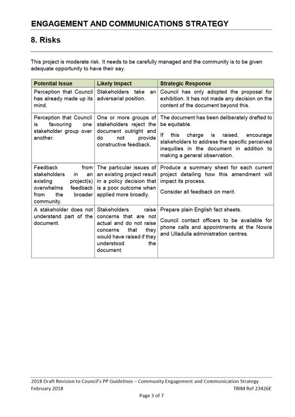
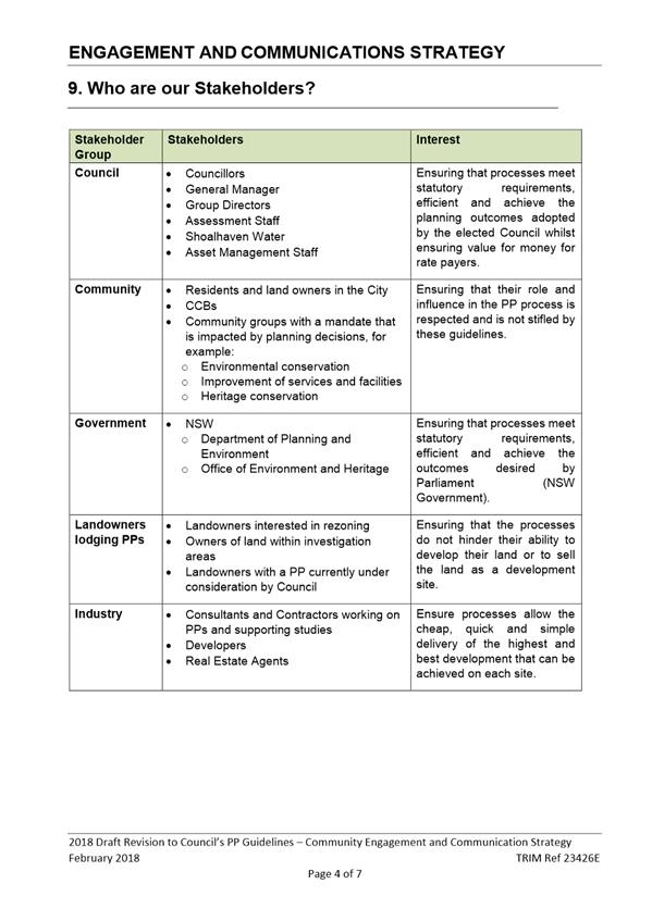
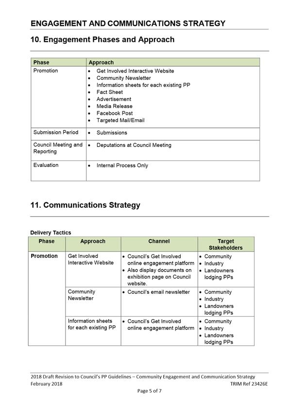
Policy Implications
The draft PP Guidelines contain
several policy positions to help ensure that PPs are managed consistently and
transparently. As noted above, it is proposed to engage with the
community and industry before adopting Council’s policy position in
relation to these matters.
Financial Implications
The review of the PP Guidelines
is being managed within the existing Strategic Planning Budget using existing
staff resources.
|

|
Development
Committee – Tuesday 08 May 2018
Page
0
|

|

|
Development
Committee – Tuesday 08 May 2018
Page
0
|
DE18.32 Proposed
Project Commencement - Shoalhaven Growth Management Strategy (Version 2)
HPERM Ref: D18/30665
Group: Planning
Environment & Development Group
Section: Strategic
Planning
Purpose / Summary
Advise of the proposed
commencement of detailed work to prepare the Shoalhaven Growth Management
Strategy - Version 2 (GMS V2), as per the resolution of Council when the
original Growth Management Strategy - Version 1 (GMS V1) was adopted and to
outline the suggested process to be followed and matters to be considered in
preparing the updated version of the Strategy.
|
Recommendation
(Item to be determined under delegated authority)
That Council
1. Formally
commence the preparation of the Shoalhaven Growth Management Strategy Version
2, and
2. Hold
a detailed Councillor workshop to consider the form and content of the
Shoalhaven Growth Management Strategy Version 2 and the approach to be taken
to prepare it.
|
Options
1. Proceed with the
commencement of the preparation of GMS V2 with the form and content to be the
subject of a Councillor Briefing.
Implications: This is the preferred option as it is
consistent with the previous resolution of Council to prepare GMS V2 and will
allow Council to plan the future direction for our area and accommodate
predicted population increases.
2. Not proceed with
the commencement of the preparation of GMS V2.
Implications: This option is not recommended as the
GMS is the mechanism for setting the strategic direction for the City for the
next 20 years. The current GMS was always intended to be a first stage to
be followed by a second stage. Further, components of the plan are now
outdated and require revision.
Background
In December 2012, Council
adopted the Shoalhaven GMS - Version 1 (GMS V1) which incorporated:
· The key outcomes of the Community Strategic Plan (CSP);
· The strategic directions from existing endorsed structure plans and
settlement strategies (Nowra-Bomaderry Structure Plan, Jervis Bay Settlement
Strategy and Milton-Ulladulla Structure Plan); and
· Provided direction for the remaining settlements where no strategy or
plan existed.
The GMS V1 can be viewed on
Council’s website at
http://shoalhaven.nsw.gov.au/LepRegisterDocuments/Msc/115/GrowthManagementStrategy_Version1.pdf
The GMS was adopted by Council
as a Version 1 (GMS V1), with a Version 2 (GMS V2) to follow which would set
out future actions and policy guidelines to be prepared with the community,
specifically for those areas outside the existing strategy areas that were
identified as having potential for future growth (Berry, Kangaroo Valley,
Wandandian, Fisherman’s Paradise and Lake Tabourie).
The GMS V1, whilst adopted by
Council in December 2012, was not endorsed by the NSW Department of Planning
& Environment until May 2014.
Since its endorsement in 2014 a
range of relevant strategic planning considerations have become relevant such
as the finalisation of the Illawarra-Shoalhaven Regional Plan, a range of NSW
Government planning reforms and the adoption of a new Strategic Planning Works
Program by Council in July 2017.
Strategic Planning Works
Program - Overview
In the new Strategic Planning
Works Program (July 2017), ‘managing future growth’ is identified
as the main priority area in the program. The overarching strategy in this regard
in the adopted Works Program is:
Developing and maintaining a
Growth Management Strategy to provide continued residential development and
infrastructure ‘ahead of the game’.
There are several priority
projects in this area of the Works Program, most of which are currently being
worked on. However most relevant in this regard is the following priority
project:
Priority
Project - Growth Management Strategy version 2:
- Outstanding
investigation areas.
- Relationship
with commercial and industrial land.
- Additional
development opportunities (e.g. Berry expansion).
Regarding the above extract from
the program, it is noted that the ‘Berry expansion’ is now
progressing as a Planning Proposal (PP) following the consideration by Council
in November 2017 of a proponent-initiated request in this regard.
The Works Program also includes
the following other projects that are considered specifically relevant to the
GMS V2 project and these will be discussed later in the report:
Priority
Project - Jervis Bay Settlement Strategy (MIN16.950):
- Review
additional urban development opportunities.
and
Milton-Ulladulla Structure Plan Review:
- Review
additional development opportunities.
The GMS V2 and associated
projects are identified in the Works Program as priority projects and it is now
appropriate, given resourcing opportunities and other relevant requirements
(e.g. legislative changes) to commence work on it.
GMS Version 2 –
Commencement
This report provides detail
regarding the commencement of the preparation of GMS V2, the project scope and
how it is intended to be carried out, for consideration.
Given the length of time that
has elapsed since the adoption of GMS V1, some of the strategic direction in
that document will also need to be revised or reviewed. Updated
constraint information is available for inclusion, such as new or updated flood
studies.
Other strategic documents
identified for review in the Works Program and as such the review of those
strategies could be incorporated in the preparation of the GMS V2, specifically
the reviews of the Jervis Bay Settlement Strategy (JBSS) and the
Milton-Ulladulla Structure Plan (MUSP).
There are also outstanding
resolutions from the preparation of the Shoalhaven Local Environmental Plan
(LEP) 2014 that could be addressed through the GMS V2 such as a review of the
zoning of the Burton Street shops in Vincentia.
An initial overview of the matters to be considered/included
in the GMS V2 are outlined below.
Revised
Strategy timeframe
New
population forecasts are currently being prepared for Shoalhaven by Councils
demographic consultants (.ID) and these new forecasts will have a 20-year
timeframe (at present proposed to be 2020 to 2041).
Thus, for consistency and to
enable future monitoring the GMS V2 should be based on the same timeframe,
which will extend its coverage from 2036 (GMS V1) to 2041.
EP&A Act amendments
Under the recent significant
amendments to the Environmental Planning and Assessment Act 1979 (EP&A
Act), Councils are now required to prepare ‘local strategic planning
statements’ which will set out the 20-year vision for land-use in the
local area, the special character and values that are to be preserved, and how
change will be managed into the future.
The new statements will need to
align with the regional and district plans (where these exist), and
Council’s own priorities in the CSP. Council’s statement can
be prepared for the City as a whole or broken down into Council wards, although
this may not be practical/logical given the size and scale of Shoalhaven.
Councillors are expected to have a lead role in preparing and endorsing these
statements to ensure local views are reflected.
The timing for commencement of
this component of the new legislation is expected mid to late 2019 with
regional councils likely to be required to have statements in place by the end
of 2020.
More detail will shortly be
released on the preparation of these statements, however, discussions with the
DP&E indicate that Council’s ongoing strategic work, such as the GMS
V2, can inform the statements and that there may be scope to align the
processes e.g. if extensive community consultation is undertaken for the GMS
V2, this will not need to be duplicated for the required local strategic
planning statement.
As such it is intended to utilise the GMS V2 process to also
advance and possibly deliver the required ‘strategic planning
statement’ for Shoalhaven.
Relevant
planning documents - consideration
The
following documents be considered in the preparation of the GMS V2:
· Illawarra Shoalhaven Regional Plan (ISRP)
· Current Shoalhaven CSP
· Shoalhaven Affordable Housing Strategy
· Shoalhaven Community Infrastructure Strategic Plan
· Community initiated plans
(e.g. Shoalhaven Heads, Berry etc.), where relevant
Where necessary the relevant
outcomes or actions from these documents and others will need to be
incorporated into the GMS V2.
Proposed
Growth scenarios
The
GMS V1 was based on a growth scenario where development is focused on the
identified growth centres (Nowra-Bomaderry, Jervis Bay – St.Georges
Basin, Sussex Inlet and Milton-Ulladulla), with some growth in a limited number
of settlements that have potential to accommodate additional population in the
longer term or pending detailed work.
There
are some benefits to this approach (e.g. accepted by DP&E and community,
provides an adequate supply of land to meet demand, areas identified are spread
throughout the City and are reasonably free of constraints) and disadvantages
(growth of settlements that may not have services available requiring residents
to travel for work and daily needs).
The
GMS V2 provides the opportunity to consider if this is still the most
appropriate scenario for the growth of Shoalhaven.
Other
potential options for how future demand for development could be met into the
future are briefly outlined below.
1. Northern centric
This scenario
focusses on the primacy of Nowra-Bomaderry (N-B) which is identified as a
‘major regional centre’ in the ISRP. Under this option, NB
would continue to be the focus for growth within the City, with limited
provision of additional land being zoned for new development in the remainder
of the City.
Benefits
Council can focus its planning and other resources in one
location. N-B is already well serviced and upgrading these services is
less costly than providing new services to smaller areas. Growth of N-B
may allow the centre to reach a critical mass of population and jobs which then
attracts large employers and therefore more people. This in turn may encourage
more investment by Government and makes public transport, retail options etc.
more feasible.
Disadvantages
Limitations to this scenario are the geographical size of
Shoalhaven, the spread-out nature of the population and reliance on the Princes
Highway - most of the population would need to travel to N-B for jobs and other
activities, increasing pressure on the Princes Highway. This option may
or may not be favourably viewed by the community outside of N-B. It may also
not be well received by the existing N-B community.
2. Growth centres
This scenario is based on limiting new or future growth to
the three centres identified in the ISRP – N-B, Jervis Bay-St.Georges
Basin and Milton-Ulladulla, with other settlements to remain as per current
zoned areas or Strategies (i.e. Sussex Inlet). Under this option, Council
through the Works Program has indicated a desire to possibly look at additional
greenfield release potential in the broader Jervis Bay-St.Georges Basin and
Milton-Ulladulla areas given the current uptake of existing zoned land in these
areas.
Benefits
This approach allows concentration of resources into the
identified existing higher order centres, maintains and/or builds on current
footprint for other settlements. These centres will still benefit from a level
of concentrated growth to maintain jobs and investment. It also
potentially puts less pressure on the Princes Highway than the northern centric
option.
Disadvantages
Physical and environmental constraints may mean that
insufficient land can be identified in or immediately adjacent to these centres
to accommodate forecasted population growth. Residents of smaller
settlements may not be supportive of services being centralised in these
locations. Also, landowners whose land is identified in GMS V1 for
investigation may be concerned if their land is ultimately removed as a
potential expansion area in favour of other areas closer to existing higher
order settlements.
3. Consolidated
growth
This scenario is based on accommodating future growth by
increasing densities in existing centres, with no further greenfield rezoning,
other than those already identified in strategies.
Benefits
Maintains current footprints of
settlements, retains natural areas, reduces the need for the provision of new
infrastructure, prevents encroachment into agricultural land etc. Also
concentrated growth may make public transport more feasible.
Disadvantages
Likely to see continued change to the character of some
settlements, with a shift in community attitudes needed to be more accepting of
higher density forms of development. Council would also need to focus on
provision and embellishment of open space and services to make this form of
housing more sustainable and attractive. There is a risk of poor quality
urban form requiring preparation of detailed planning controls to ensure good
design outcomes. This approach is unlikely to be palatable to development
industry which have traditionally focused on subdivision/construction of single
dwellings on individual lots in Shoalhaven.
These and other potential
long-term growth options, which could involve variations or a mix of the above,
need to be considered and discussed through the GMS V2 process.
Inclusion
of commercial and industrial land
The
GMS V1 primarily related to future residential growth and development.
The
scope of the GMS V2 should also be expanded to include commercial and
industrial land to consider the supply, location, and take up rates, and if
necessary, identify locations for additional employment land and/or new or
revised provisions for incorporation in the LEP or DCP. This is particularly
relevant as there is a need to ensure that there is sufficient
‘employment’ related land to support future residential growth.
Jervis Bay Settlement
Strategy - Review
The Jervis Bay Settlement
Strategy (JBSS) was finalised 2003 and intended to provide a strategic
framework for residential and rural residential growth in the region for 15-20
years.
In the intervening 15 years,
several of the plan’s actions have been completed, such as the
investigation of the residential potential of Heritage Estates, and others are
only partially completed or have not yet commenced. Consistent with the
Works Program, It is now timely to review the strategy to confirm the direction
for this important area and to also look at issues that have arisen since its
adoption and need to be resolved or further considered, such as the future of
the Burton Street shopping centre given the development of the Vincentia
Marketplace and the Worrowing Heights precinct for which Council has adopted a
precinct plan (February 2018) .
Dependent on the growth scenario
to be pursued, whether a new settlement or area outside existing settlements is
required to meet future demand in the locality may need to be considered.
The Work Program identifies this
as a high priority project. As such, it is logical to include this review as
part of the GMS V2. This will ensure efficiencies and its delivery in a timely
manner as opposed to pursuing the review as a standalone project.
Milton-Ulladulla Structure
Plan – Review
The MUSP was adopted in 1996 and
subsequently implemented through an LEP that was finalised in 2003.
The MUSP was intended to cover
the timeframe to 2020 - it is also therefore timely to review and update the
vision and strategic direction for the area as part of the GMS V2.
The details of the MUSP were
incorporated in GMS V1. Including the review of the MUSP in the GMS V2 project
will increase the scope of works for the project, but while it means additional
work and an extended timeframe for the GMS, it reduces overall workload as
processes such community consultation are not duplicated. The review will
still include confirming/revising desired future character and will identify
how future growth is to be accommodated, depending on the growth scenario
chosen.
Incorporating both the reviews
of the JBSS and MUSP into the GMS V2 project means that the projects will not
be delayed, to allow any one of them to be undertaken or completed. The
review of the MUSP is also identified as a project in the Work Program.
GMS V1 Investigation areas
The GMS V1 nominates a limited
number of settlements outside those covered by detailed strategies or plan that
may have potential for additional growth or expansion in the longer term,
subject to further investigation. These areas are:
· Berry
· Kangaroo
Valley
· Wandandian
· Fisherman’s
Paradise and
· Lake
Tabourie
Dependent on the overall growth
scenario decided on for the future, these areas may need to be revised and
possibly updated considering any new information that Council now holds (e.g.
new and updated flood studies) or any areas that have or are being considered
in detail through a separate planning process (e.g. Kangaroo Valley short term
area which has already been rezoned through a PP).
Character Statements
The GMS V1 identified several
areas where ‘desired future character’ statements would be prepared
in conjunction with the community to be included in the GMS V2. These
locations include the five investigation areas identified above and the
following areas:
· Shoalhaven
Heads
· Greenwell
Point
· Orient
Point
· Manyana
and Cunjurong Point
· Bendalong/North
Bendalong
· Lake
Conjola
· Conjola
Park
· Kioloa
· Bawley
Point
· Pebbly
Beach
· Depot
Beach
· North
Durras
Council may wish to prepare
these character statements just for these settlements or for all settlements in
Shoalhaven. These could be developed through community workshops and/or
online surveys and feed into the ‘local planning statement/s’ that
Council is required to deliver because of the recent legislative change.
Identification of key sites
Council may wish to consider the
inclusion of ‘key sites’ including key waterfront locations,
gateway areas, regional parks etc in the GMS V2 project. This could assist
determine what the aspirations are for these areas and whether the current land
use controls are consistent with these aspirations or require revision.
Rural Residential Supply
Submissions made during the
Shoalhaven LEP 2014 process requested provision or consideration of additional
rural residential areas.
These requests were largely
‘deferred’ for future consideration and given that it has been
nearly 20 years since the finalisation of the Rural Plan (Amendment No. 127 to
Shoalhaven LEP 1985 commenced in 1999), it may be timely to look at the current
supply of rural residential or lifestyle land by area, the remaining subdivision
potential of the zoned land and take up rates over time.
It should be noted that the NSW
Department of Primary Industries are in the process of identifying regionally
significant agricultural land and it may be prudent to defer identification of any
potential new areas of rural residential land until this process is completed.
Phasing of the review
The GMS V2 is proposed to be broken up
into the following phases (simplified):
Phase 1 – Planning and
information/data gathering
This phase will commence with a
Councillor Briefing to inform and agree on the scope of the GMS V2
project. Once the scope of the project has been set, staff can commence
gathering information or data and updating regarding or to inform the
preparation of:
· population
projections (currently being undertaken with .ID)
· supply/demand
of land (residential, rural residential, commercial and industrial)
· identification
of needs/gaps
· Relevant/outstanding
actions from ISRP, JBSS, MUSP etc.
· updated
constraint mapping, particularly flooding
· Growth
scenarios based on level and location of demand.
· Draft
character statements for settlements nominated in V1 (or as determined).
This phase may also require
additional studies to undertaken to determine supply and demand and to identify
needs e.g. analysis of commercial and industrial land supply across the City.
Consideration of key infrastructure constraints (water, sewer and electricity)
will also be important at this stage.
Phase
2 - Early consultation phase
This phase will involve
consultation initial engagement or consultation with the NSW State Government
and the community to get initial feedback on growth scenarios and/or other
components of the GMS. There will also be targeted consultation with
those communities where draft character statements have been prepared.
Phase 3 – Revised GMS
Preparation
In this phase, staff will
analyse the results of early consultation and then prepare a draft GMS document
and mapping for Council consideration. This will include a summary of actions,
priorities, and timeframes/triggers.
Phase 4 Exhibition and
consultation
Once the draft document has been
prepared and accepted by Council, a more formal exhibition process will be
undertaken. This is likely to involve community information sessions in
several locations, digital and physical displays of exhibition material,
possible interactive digital material etc.
Phase 5 – Finalisation
The outcomes of the community
consultation will be considered, and changes made where required through the
Council reporting process.
At the end of this phase Council
can then adopt the plan and refer it to the DP&E for endorsement (key
step).
Phase 6 - Implementation
The actions and priorities from
the GMS V2 will feed into the Strategic Planning Works Program for individual
implementation.
Councillor
Workshop
Given the large range of matters
to be considered, it is proposed to hold an initial Councillor Workshop to assist
and determine the scope of the GMS V2 and to set the foundations for a detailed
project plan.
Once this has occurred, staff
will hold an initial meeting with DP&E to discuss the project and identify
any additional matters for inclusion or any issues.
If necessary, the matter will be
reported back to Council for information and consideration once these two steps
have been undertaken.
Community
Engagement
Given the scale and the nature
of the project, it is intended to undertake two phases of community
engagement/consultation as a minimum through processes outlined above. This
consultation will be undertaken in line with Council’s Community Engagement
Policy. The GMS V2 is a Citywide High Impact project.
Policy
Implications
The GMS V2 will set the
direction for future growth in Shoalhaven and will be implemented through
resulting projects to be included on the Strategic Planning Works Program which
may include PPs and development control plan and contribution plan amendments.
It is also intended that this
project/process inform the preparation of Council’s ‘local
strategic planning statement’ under the recent amendments to the EP&A
Act.
Financial
Implications
The GMS V2 can initially be
undertaken with the Strategic Planning budget, however, additional funding may
be required to fund consultant studies, community engagement etc. depending on
the final scope of the project and this will be the subject of future reports
as required.
|
|
Development
Committee – Tuesday 08 May 2018
Page
0
|
DE18.33 Proposed
Submission - Discussion Paper: Planning for the Future of Retail and proposed changes
to retail land use definitions
HPERM Ref: D18/127062
Group: Planning
Environment & Development Group
Section: Strategic
Planning
Purpose / Summary
Advise of the release of a
Discussion Paper on ‘Planning for the Future of Retail’ by the NSW Department
of Planning and Environment (DP&E), outline associated proposed amendments
to retail land use definitions in the Standard Instrument Local Environment
Plan (LEP) and obtain endorsement to make a submission based on the content of
this report
|
Recommendation (Item to be
determined under delegated authority)
That Council make a submission
to the NSW Department of Planning and Environment on the Discussion Paper: Planning
for the Future of Retail and the associated amendments proposed to retail
land use definitions in the Standard Instrument LEP, based on the content of
this report.
|
Options
1. Make a
submission based on the content of this report.
Implications: This is the preferred approach as it
enables Council to make a submission and have our feedback considered by the
DP&E in moving forward with the future policy direction for retail land use
planning in NSW.
2. Not make a
submission on the proposed changes.
Implications: The opportunity to comment on the
Discussion Paper and proposed amendments to the Standard Instrument LEP will be
missed.
Background
DP&E
have developed a Discussion
Paper (‘Planning for the
Future of Retail’) that describes how the NSW planning system could
address the increasingly dynamic retail sector. The Discussion Paper sets out
potential new directions for a NSW Retail Strategy. It identifies the
ways in which customer trends are shaping retail today and proposes new
initiatives aimed at modernising our retail planning framework and achieving
the right balance of customer and community amenity.
The
Discussion Paper puts forward three potential approaches:
1. Better
local strategic planning of retail;
2. Modern
approach to retail development that reflects a range of retail formats in
centres; and
3. Adaptability
and certainty for retail – developing a planning system that has the
flexibility yet certainty to allow for innovative, contemporary retail
solutions that match customer need while also bringing wider benefits to local
areas.
DP&E
have also identified potential amendments that could be made to the Standard
Instrument LEP to improve the planning system for retailing. The initial
proposed amendments are:
· Proposed new definition for ‘artisan
premises’ to be permissible wherever ‘light industry’ is
permissible (currently permissible in RU5, B5, B7, IN1, IN2 and IN4 zones) -
Council can add to other zones via an amendment to the LEP if appropriate. The
proposed new definition is as follows:
Artisan premises – a building or place used to produce and/or
process foods and beverages on site, without being fully automated. It
can also include:
a. A
restaurant or café;
b. Tastings;
c. Tours;
d. Sales;
and
e. Workshops.
· Amended definition for ‘garden centres’ to
clearly differentiate between the principle purpose and other permitted
complementary uses (currently permissible in RU5, B2, B3, B4, B5, B7, IN1 and
IN2 zones). The proposed amended definition
is as follows:
Garden centre – a building or place where the principle purpose
is the sale of:
a. Plants;
and/or
b. Landscaping
and gardening supplies and equipment.
A garden centre may also
include a restaurant or cafes and the sale of:
a. Outdoor
furniture and furnishing;
b. Barbeques;
c. Shading
and awnings;
d. Pools,
spas and associated supplies;
e. Items
associated with the construction, maintenance and improvement of outdoor areas;
f. Pets
and pet supplies;
g. Fresh
produce.
· New definition for ‘local distribution
premises’ to be permissible wherever a ‘warehouse or distribution
centre’ is permissible (currently permissible in B5, B7, IN1 and IN2
zones) - Council can add to other zones via an amendment to the LEP if
appropriate.
Local distribution
premises – a building or
place used for storing or handling items purchased or ordered for local
delivery, but from which no retail sales are initiated.
· New definition for ‘neighbourhood
supermarkets’ to be permissible in the B1 zone and where
‘shops’ are permissible (currently permissible in RU5, B2, B3, B4,
and B5 zones). ‘Neighbourhood supermarkets’ will also be
limited in size to 1500m2.
Neighbourhood supermarket – a shop selling food and other household items
where the selection of goods is organised on a self-service basis.
· Amended definition for ‘bulky goods premises’
to be known as ‘specialised retail premises’. It is proposed
that this use will replace ‘bulky goods premises’ wherever it is
permissible (currently permissible in RU5, B2, B3, B4, B5, B7, IN1 and IN2
zones).
Specialised retail
premises – a building or
place used to sell, display or hire:
a. automotive
parts and accessories;
b. camping,
outdoor and recreation goods;
c. electric
light fittings;
d. animal
supplies;
e. floor,
wall and window coverings;
f. furniture,
bedding, furnishing, fabrics and manchester and homewares;
g. household
appliances, household electrical goods and home entertainment goods;
h. party
supplies;
i. swimming
pools and spas;
j. office
equipment and supplies;
k. baby
and children’s goods, children’s play equipment and accessories;
l. BBQs,
fireplaces and gas appliances;
m. Sporting,
cycling, leisure, fitness goods and accessories; or
n. Goods
and accessories which:
§ Require
a large area for handling, display and storage of goods; or
§ Require
direct vehicle access to the building by customers for the purpose of loading
or unloading goods into or from their vehicles after purchase or hire.
It does not include the sale
of food, clothing or footwear unless it falls into one of the above categories.
As
reported to the Development Committee in December 2017, the DP&E were
previously proposing an amendment to the definition of ‘bulky goods
premises’ in the Standard Instrument LEP. They have decided not to
proceed with that proposed amendment and are now proposing to replace
‘bulky goods premises’ with the new land use term of
‘specialised retail premises’ as outlined above.
The
Discussion Paper and proposed land use definition amendments are currently on
public exhibition until 18 May 2018, with the exhibition material available for
viewing on DP&E’s website at:
www.planning.nsw.gov.au/Policy-and-Legislation/Retail-planning/Retail
Proposed Submission
The need to respond to the
changing nature of retailing is appreciated. However, better local retail
strategic planning is favoured as this allows for the development of
appropriate locality specific solutions.
The continued ‘one size
fits all’ approach, such as the introduction of a State Environmental
Planning Policy (SEPP), would not be supported as the needs and development
pressures in the Sydney CBD, for example, are very different from the needs and
development pressures in a regional centre like Nowra or Ulladulla. The
Discussion Paper recognises this to a degree, however this recognition needs to
continue through future reforms so that any future policies allow for local
variations.
The detail of the proposed
future reforms arising from the Discussion Paper need to be discussed in detail
with the broader community and specifically local Councils.
At this stage, the following
proposed initiatives are supported:
· The
setting of criteria for emerging centres to minimise impact on existing
centres. Agree with the need for support for existing centres,
particularly the revitalisation of main streets. The proposal for DP&E to
provide guidance to individual Councils to identify the future direction of
retail in their area is generally welcomed.
· The
use of ‘open’ zones in business and industrial zones (supported by
an updated land use matrix to assist in interpretation) but noting that it can
sometimes create uncertainties. However, the use of ‘open’ zones in
residential zones is not supported as communities prefer certainty as to what
can be developed in their residential neighbourhoods.
Note: The Standard Instrument LEP provides for
‘open’ and ‘closed’ zones. In ‘open’ zone
the uses that are not specifically listed as permitted without consent or
prohibited are permissible with consent. As such ‘open’ zones allow
a degree of flexibility. In ‘closed’ zones on the other hand,
prohibited and permitted with or without consent uses are specifically listed.
Thus ‘closed’ zones are tighter in terms of what can be undertaken
in them.
· The
development of an ‘innovation in retail’ clause to be added to the
Standard Instrument LEP to allow undefined uses to be assessed against
established criteria and on merit.
Generally, the ongoing review of
Standard Instrument LEP is supported to ensure it is contemporary and meets the
needs of the community and appreciates the opportunity to comment. In relation
to the specific amendments proposed, it is proposed that the following comments
will be made:
Artesian
premises - Support the inclusion of this
land use and would like to see it able to be permissible in rural zones, for
example RU1 and RU2. For regional areas, this is generally where these
types of uses are likely to be situated/appropriate. It is acknowledged
that Council can amend its own LEP to include this land use in those zones, but
this takes time and resources for each individual council to implement. As such
its implementation through the Standard Instrument LEP should be considered.
Local
distribution premises – It appears
that the intention is that these premises are to be of a scale appropriate for
local deliveries and that this would mitigate amenity impacts such as the
extent of traffic movements, the size of the vehicles and required floor area.
However, the proposed definition is vague considering there is no definition of
local (i.e. is local a neighbourhood, a town, a local government area?) and
there is nothing in the definition to ensure minimal amenity impacts. Further
consultation and dialogue is required regarding this definition and its use.
Specialised
retail premises - The proposed
definition is very open which may result in small format shops, for example, in
traditional industrial and bulky goods areas which may compete with existing
centres. This seems somewhat at odds with the dialogue in the Discussion Paper
around renewing main streets.
There
are generally no concerns with the proposed new definition of Neighbourhood
supermarket and the amended definition of Garden centre.
Community
Engagement
The
Discussion Paper and proposed land use definition amendments are currently on
public exhibition for community comment, with exhibition materials available
for viewing on DP&E’s website at: http://www.planning.nsw.gov.au/Policy-and-Legislation/Retail-planning/Retail
DP&E is accepting
submissions and feedback on the proposed amendment until 5pm Friday, 18 May
2018.
Policy
Implications
Any update to the Standard
Instrument LEP will automatically update Shoalhaven LEP 2014. If these
amendments are made, Council will need to consider if the new definitions (artesian
premises, local distribution premises and neighbourhood supermarkets)
should also in made permissible in other zones.
Work is also continuing with the
Council project to review the retail hierarchy in the Nowra-Bomaderry area. The
proposed changes that are foreshadowed in the Discussion Paper will potentially
impact on this and as such are being considered in more detail as part of this
project. It is envisaged that the Nowra-Bomaderry Retail Hierarchy Review will
be the subject of a further Councillor Briefing and Council report in coming
months.
|
|
Development
Committee – Tuesday 08 May 2018
Page
0
|
DE18.34 Exhibition
Outcomes and Finalisation – Shoalhaven Development Control Plan 2014
– Draft Amendment No. 14 – Proposed Chapter G18 Streetscape Design
for Town and Village Centres
HPERM Ref: D18/74047
Group: Planning
Environment & Development Group
Section: Strategic
Planning
Attachments: 1. Submissions
Summary ⇩
2. Draft
Development Control Plan Chapter G18 Streetscape Design for Town and Village
Centres ⇩
3. Draft
Streetscape Technical Manual (under separate cover) ⇨
4. Subject
Streets Map (under separate cover) ⇨
5. Draft Development Control
Plan Dictionary (under separate cover) ⇨
Purpose / Summary
· Report
the outcomes of the public exhibition of Shoalhaven Development Control Plan
(DCP) 2014 Draft Amendment No. 14 - Chapter G18: Streetscape Design for Town
and Village Centres; and
· Adopt
and finalise the amendment to the DCP and Streetscape Technical Manual with
minor amendments as outlined in this report.
|
Recommendation
(Item to be determined under delegated authority)
That Council:
1. Receive
the report on the submissions received during the exhibition of Shoalhaven
Development Control Plan 2014 Draft Amendment No. 14 - Chapter G18:
Streetscape Design for Town and Village Centres and its supporting documents
(Streetscape Technical Manual and Development Control Plan Dictionary) for
information.
2. Adopt
Shoalhaven Development Control Draft Amendment No. 14 - Chapter G18:
Streetscape Design for Town and Village Centres and its supporting documents,
(Streetscape Technical Manual and Development Control Plan Dictionary), as
exhibited with minor amendments as outlined in the report and provided in Attachments
2 to 5.
3. Note
for future consideration, when appropriate, the priority streetscape renewal
projects identified in the submissions.
4. Notify
the adoption of Shoalhaven Development Control Plan 2014 Amendment No. 14 -
Chapter G18: Streetscape Design for Town and Village Centres and its
supporting documents (Streetscape Technical Manual and Development Control
Plan Dictionary) in local newspapers in accordance with the requirements of
the Environmental Planning & Assessment Act 1979 and Regulations.
5. Notify
submitters and the NSW Department of Planning & Environment of the
adoption of Shoalhaven Development Control Plan 2014 Amendment No. 14 -
Chapter G18: Streetscape Design for Town and Village Centres and its
supporting documents, Streetscape Technical Manual and Development Control
Plan Dictionary.
|
Options
1. Adopt the
recommendation.
Implications: This is the preferred option as it
will enable Council to consider the submissions received during the public
exhibition and make minor amendments to the exhibited documents where
appropriate.
Adoption of Shoalhaven DCP 2014 Amendment No. 14 will
provide controls and a technical manual to guide inclusion of appropriate and
complementary streetscape embellishments for future developments in nominated town
and village centres, or developments of a certain scale.
The Streetscape Technical Manual
will also provide Council, when undertaking works, a document to refer to with
palettes prepared for individual town and village centres. This will
ensure that all works, both undertaken by developers and Council, are
consistent / cohesive and are complementary to the character of the town or
village in which it is located.
2. Adopt an
alternative recommendation.
Implications: Depending on the nature of an alternative
decision, this could delay the adoption of Chapter G18 to Shoalhaven DCP 2014
and potentially require re-exhibition of the Chapter and supporting documents.
Background
During the preparation of the
new Citywide DCP in 2014 (Shoalhaven DCP 2014), space for Chapter G18:
Streetscape Design for Town and Village Centres was reserved, as given the time
constraints the Chapter had not been prepared.
Draft Amendment No. 14 to Shoalhaven
DCP 2014 implements a previous position of Council to undertake a review of the
former DCP 80 - Streetscape Guidelines for Paving and Tree Planting in the
Nowra CBD and replace it with a new DCP Chapter that applies more broadly
to the City
The draft DCP Chapter introduces
streetscape design controls for subject streets in thirteen (13) nominated town
and village centres throughout the City that have a defined centre and
commercial presence. The draft DCP chapter also applies to specific land uses
including commercial premises, mixed use development, multi-dwelling housing,
attached dwelling, residential flat building, shop top housing or seniors
housing development.
The draft DCP Chapter is
supported by a Subject Streets Map (identifies the streets subject to the
application of the draft DCP chapter) and Streetscape Technical Manual
containing design and construction technical detail for footpaths, planting,
colour palettes, street furniture and unique features for each of the nominated
centres. A generic design has also been prepared for use in other
localities. The overall DCP Dictionary was also amended to add new definitions
in relation to footpaths and pathways when using this new DCP Chapter.
In November 2017, the
Development Committee considered a report on the draft DCP Chapter and
supporting documents to proceed to prepare and publicly exhibit the
documentation. The Committee resolved (under delegation) that Council:
1. Prepare
and publicly exhibit Draft Chapter G18 Streetscape Design for Town and Village
Centres and Dictionary of Shoalhaven DCP 2014 for a six (6) week period and in
accordance with the Environmental Planning & Assessment Regulation 2000.
2. Advise
relevant Community Consultative Bodies of the public exhibition.
3. Receive a
further report on the draft Chapter G18 Streetscape Design for Town and Village
Centres following the conclusion of the public exhibition period.
Public Exhibition
In accordance with the above
resolution, draft DCP Chapter G18 was originally placed on public exhibition
from Wednesday 29 November 2017 and Friday 12 January 2018 (inclusive).
The exhibition was extended a further 14 days until Friday 26 January 2018 in
response to a request from a Community Consultative Body (CCB).
The public exhibition involved
the following:
- Public
notification of the exhibition in local newspapers, including a second notice
in relation to the public exhibition extension;
- Letters
sent to relevant CCB’s; and
- Copies of the
draft DCP Chapter G18, Draft changes to the Dictionary Chapter, Supporting
Maps, Streetscape Technical Manual and Plain English explanatory statement were
available at Council’s Nowra and Ulladulla Administration Building and on
Council’s website.
After the exhibition period,
staff were requested to attend a meeting of the Basin Villages Forum to discuss
the draft DCP Chapter and supporting documents. At this meeting the use of
street furniture and fixtures which utilise sustainable or recycled materials
was suggested as an appropriate consideration in the future. Given the
Streetscape Technical Manual is a supporting technical guideline of Council, it
has the potential to be amended without needing to go through the necessary
steps associated with a DCP Amendment. Where Council explores the use of street
furniture and fixtures that are made of sustainable or recycled materials, the
Streetscape Technical Manual can be updated to include any new or additional
products when appropriate.
Submissions
Four (4) formal submissions were
received during the exhibition period including one (1) internal submission
from Council’s Natural Resource and Floodplain Unit, and three (3)
external submissions from CCB’s/community groups.
A detailed summary of the
submissions with a response to all comments raised is provided in Attachment
1. Copies of the submissions will also be available for Councillors to view
in the Councillor’s Room prior to the meeting.
A brief summary of these submissions
is outlined in the table below:
|
Submitter
|
Brief summary
|
Staff Comment
|
|
Internal
|
|
Natural Resources and
Floodplain Unit
|
Concerns with several tree and
shrub species included in the Streetscape Technical Manual which are known to
be invasive or environmental weeds in parts of NSW or Shoalhaven.
|
Streetscape Technical
Manual amended to replace the species identified as known environmental weeds
and invasive species.
|
|
External
|
|
Kangaroo Valley
Community Association Inc. in conjunction with the Kangaroo Valley Chamber of
Tourism and Commerce (KVCTC)
|
Support the amendment with emphasis on maintaining
continuity of street furniture in Kangaroo Valley.
What is the status of DCP No. 66 (now Chapter N1 Kangaroo
Valley).
How much money would be allocated to Kangaroo Valley and
what timeframe would the works be completed?
The pavement type does not reflect the existing situation.
Request that the area be expanded to apply to other areas
such as Hampden Bridge.
Raised several specific comments
in relation to the Streetscape Technical Manual – Footpath and pathway
Details including Type 3 with the Aboriginal paving imprints, use of concrete
for kerb material, option for planting as an alternative to grass. Plant
Palette and Street Furniture.
|
Noted.
Chapter N1 still applies, and where there are any inconsistencies,
the controls within the area specific chapter prevail to the extent of the
inconsistency.
Budgeting and timeframes for streetscape renewal
projects are outside the scope of this DCP amendment. Works will either
be completed as development occurs, or when Council allocates a budget
towards streetscape renewal projects.
The paving plan demonstrates the future desired outcome.
The aim of the DCP Chapter is to create legible centres,
if the application of the DCP is extended to areas beyond the town or village
centre, this desired aim is likely to be lost or diluted. The DCP
Chapter may still apply in other areas where specific land use types are
proposed.
Type 3 pathways have been
amended to the extent that it only includes Aboriginal paving imprints in
certain locations (as per the submission recommendation), and planting has
been included as an alternative to grass. Bin enclosures have been increased
in size, and concrete material has been identified for kerb construction.
|
|
Berry Forum
|
The chapter does not address building finishes.
Relocating power lines underground within Queen Street
shopping precinct would significantly improve the attractiveness of the town
centre.
Full support for the objectives and controls.
No indication of when the works will be completed.
Attention drawn to several streetscaping issues which should be given
priority to improve connectivity, amenity and safety in Berry.
|
The controls contained within the DCP only relate to
the ‘public domain’ which is between the kerb and the front
property boundary line.
It is agreed that this would be a positive outcome,
however this is outside the scope of the DCP.
Noted.
In relation to the identified ‘priority
works’, it is recommended that they be noted for future
consideration, when appropriate.
|
|
Shoalhaven
Heads Community Forum
|
Support for the amendment and
request for Council to adopt the Shoalhaven Heads Landscape Master Plan.
|
Noted
|
It should be noted that the
submissions received from CCB’s or community groups in Kangaroo Valley
identified their thoughts on priority areas for actual future streetscape
renewal projects. Whilst the draft DCP Chapter does not specifically
result in the immediate commencement of streetscape renewal projects as it is
development related/driven, the identification of these priority areas should
be noted and considered when Council does proceed to undertake streetscape
renewal projects in these areas.
Post-Exhibition Amendments
Resulting from the submissions
received during the public exhibition period, minor amendments are proposed to
address the submissions and other functional matters.
The amended DCP Chapter is
provided as Attachment 2 and amended Streetscape Technical Manual is
provided as Attachment 3. No changes have been made to the
exhibited Subject Streets Map provided as Attachment 4 or Draft
Dictionary Chapter provided as Attachment 5. The post exhibition
amendments are summarised below.
Draft Chapter G18: Streetscape
Design for Town and Village Centres
The exhibited draft DCP Chapter
has been amended to highlight terms defined in the Dictionary of Shoalhaven DCP
2014 or Shoalhaven LEP 2014 – this is consistent with the formatting of
the existing DCP Chapters.
Streetscape Technical Manual
· Replace the
following tree and shrub species with the identified alternatives to address
concerns that the species are known invasive species and environmental weeds:
o Replace Fraxinus
griffithii with Tristania ‘Luscious’
o Replace Pistacia chinensis
with Pyrus calleryana cultivars
o Replace Agapanthus sp
with Dianella sp
o Replace Dietes bicolour
with Lomandra sp & cultivars
o Replace Gleditsa
triacanthus with Backhousia myrtifolia
o Replace Robina pseudoacacia
with Melaleuca decora
o Replace Nandina domestica
with Nandina cultivars as shown
o Replace Duranta erecta
with Melaleuca thymifolia
o Replace Limonium sp
with Liriope muscari ‘Amethyst’
o Replace
Spiraea sp with Olearia phlogopappa or cultivars
· Amend
Type 3 Pathway diagrams for Kangaroo Valley to limit decorative paving stencils
to the northern side of Moss Vale Road and to allow planting as an alternative
to grass on the property boundary side.
· Amend
specifications for Kangaroo Valley garbage bin enclosure to a commercially
available model designed to accommodate a 240-litre bin.
Some other minor amendments have
also been made following recent operational feedback received from
Council’s Project Delivery Design Units and District Engineers, as
outlined below, to ensure the current practice and recent changes are
reflected.
· Amend
seating in Junction Court, Nowra - Delete Seating Type 2 from Junction Court
and update images for Seating Type 1 (p.18). This reflects recent
refurbishments made to seating in Junction Court.
· Insert
additional design and construction details for Type 2 and 4 Pathways for Nowra
(p. 4 to 7) - Type 2 Pathway includes honed concrete with aggregate and
resin banding. Type 4 Pathway includes honed concrete with brick paver
header course.
· Insert
additional design and construction specifications for street lighting in
Huskisson Town Centre (p. 12).
· Update
photos in Huskisson Section following repainting in October 2017 (p. 3).
· Additional
Typical Sawcut Joint Details inserted for Shoalhaven Heads, Kangaroo Valley,
Bomaderry, Nowra, Culburra Beach, Vincentia, Sanctuary Point, St Georges Basin,
and Standard Details Sections.
· Paving notations
added to Berry, Shoalhaven Heads, Kangaroo Valley, Bomaderry, Nowra, Culburra
Beach, Huskisson, Sussex Inlet, Milton and Ulladulla Sections.
Community
Engagement
Through the exhibition of the
Amendment, Council has met its legislative requirements under the Environmental
Planning & Assessment Act in this regard and provided an opportunity for
the community to review the Amendment and make comment.
The subsequent adoption of the Amendment and the date it
becomes effective will be notified in the local newspapers in accordance with
legislation. The NSW Department of Planning and Environment, submitters
and CCBs will be notified when the Amendment becomes effective.
Policy
Implications
The draft DCP Chapter is proposed to be a new chapter within
Shoalhaven DCP 2014. Adoption of the Chapter will form Council policy
which future development will need to consider.
Financial
Implications
Preparation and finalisation of the draft DCP Chapter and
supporting documents has been completed within the existing Strategic Planning
budget.
Risk
Implications
If Draft Chapter G18 and its
supporting documents are not implemented, there is a risk that streetscape
design will not be adequately considered in future Development Applications,
which may result in a haphazard approach to streetscape design and the eventual
deterioration of the unique streetscape character within nominated town and
village centres in Shoalhaven. Draft Chapter G18 and its supporting
documents are expected to mitigate against these risk implications.
|

|
Development
Committee – Tuesday 08 May 2018
Page
0
|
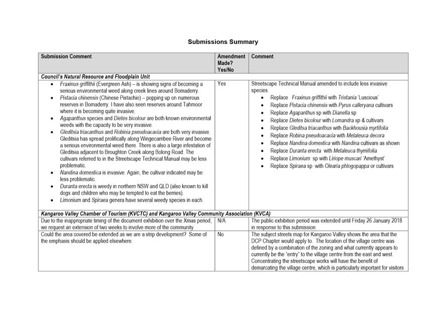
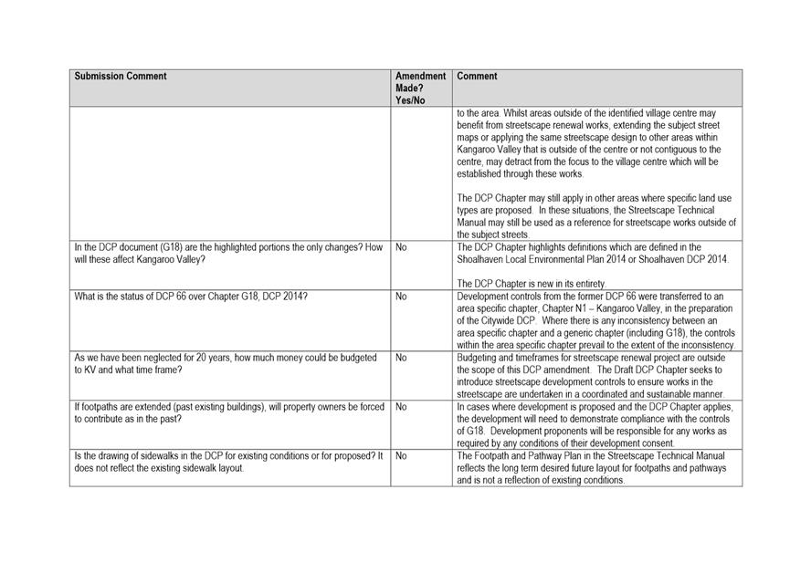
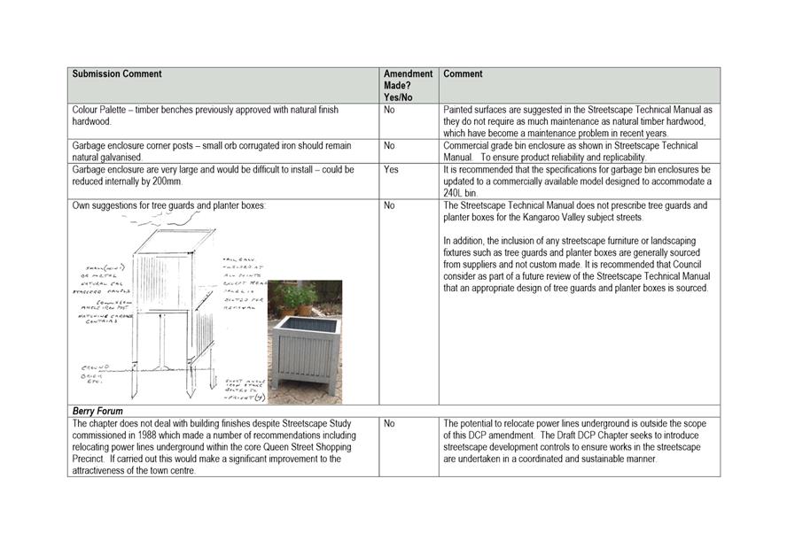
|
|
Development
Committee – Tuesday 08 May 2018
Page
0
|
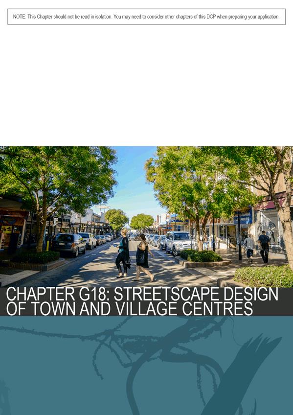
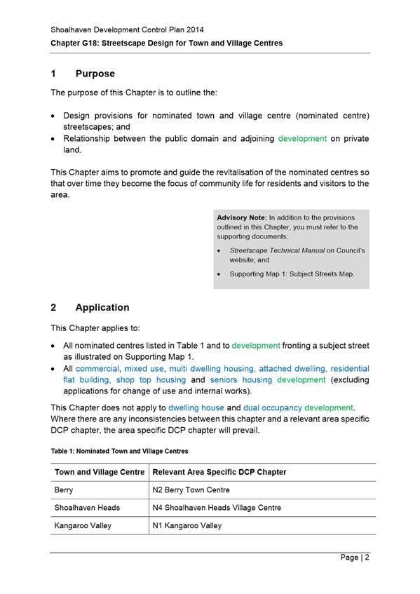
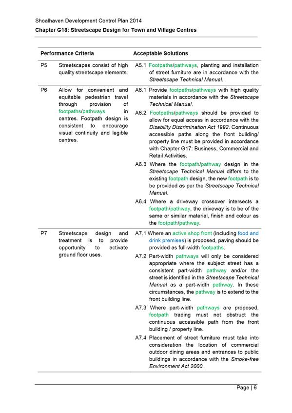
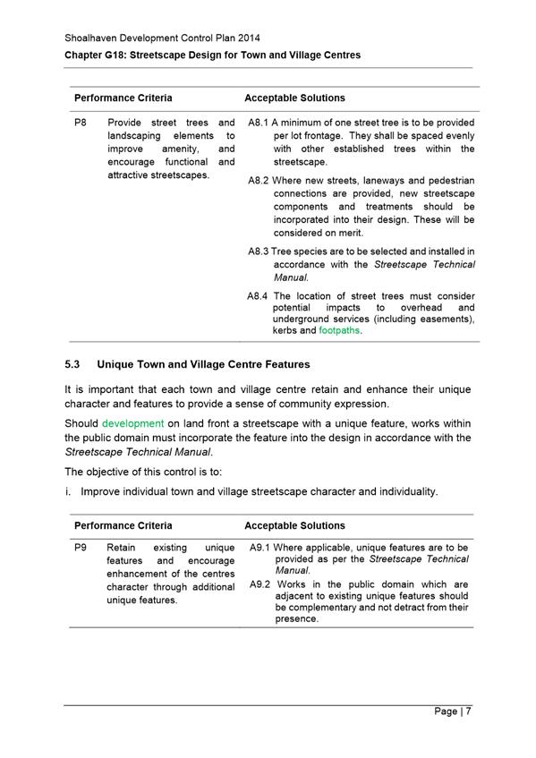
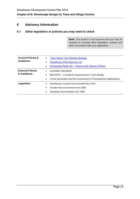
|
|
Development
Committee – Tuesday 08 May 2018
Page
0
|
DE18.35 Proposed
Submission - Aboriginal Land Claims No. 6427, 26210 and 26251 - Koloona Drive,
Watersleigh
HPERM Ref: D18/104373
Group: Planning
Environment & Development Group
Section: Development
Services
Attachments: 1. Map
- Lot 7310 DP 1152344 - Koloona Drive Watersleigh - ALC 6427 26210 and 26251 ⇩
2. Request for Information - ALC
6427 26210 and 26251 - Lot 7310 DP 1152344 - Koloona Drive Watersleigh ⇩
Purpose / Summary
Obtain direction regarding Aboriginal Land Claims (ALC)
numbers 6427, 26210 and 26251 at Koloona Drive, Watersleigh, which are now
being investigated for determination by the NSW Government.
Note: This matter is being reported to the May 2018
Development Committee due to the need to meet an extended deadline to provide
comment.
|
Recommendation (Item to be
determined under delegated authority)
That Council notify the NSW
Department of Industry – Crown Lands Aboriginal Land Claims
Investigation Unit that it does not support Aboriginal Land Claim Numbers
6427, 26210 and 26251 over Lot 7310 DP 1152344 at Koloona Drive, Watersleigh,
for the following reasons:
1. In
relation to Claim No.6427, at 31 March 2000, the land:
a. Formed
part of the Bangalee Reserve and was being lawfully used for its reserve
purpose of “Public Recreation”; and
b. Contained
Council infrastructure that was used for this purpose, being the
‘Forest Walk’ walking trail and viewing barrier.
2. In
relation to Claim No. 26210, at 21 June 2010, the land formed part of the
Bangalee Reserve and was being lawfully used for its reserve purpose of
“Public Recreation”.
3. In
relation to Claim No. 26251, at 21 June 2010, the land:
a. Formed
part of the Bangalee Reserve and was being lawfully used for its reserve
purpose of “Public Recreation”; and
b. Contained
Council infrastructure that was used for this purpose, being the
‘Forest Walk’ walking trail and viewing barrier.
|
Options
1. Advise NSW
Department of Industry (DoI) – Crown Lands Aboriginal Land Claims
Investigation Unit (ALCIU) that Council does not support ALC Numbers 6427,
26210 and 26251 as at the date of lodgement for all three claims the land
formed part of the Bangalee Reserve and was being lawfully used for its reserve
purpose of “Public Recreation”, and a portion of the land contained
existing Council infrastructure to facilitate this use.
Implications: This is the preferred option, as it
enables Council to assist DoI with their investigations into the status of the
land at the date the claims were lodged, and ensure that the land, which forms
part of the Bangalee Reserve, continues to be made available for public use
consistent with its reserve purpose. This option also recognises that the
land is an important community asset for a range of public recreational uses,
which may no longer be possible if the land is transferred into private
ownership.
2. Advise DoI
– Crown Lands ALCIU that Council has no objection to the granting of ALC
No’s 6427, 26210 and 26251, subject to either the exclusion of land
containing Council infrastructure and the Koloona Drive road reserve, or the
creation of easements to protect this infrastructure and enable ongoing maintenance
of Koloona Drive.
Implications: This option is not preferred.
Although this option will still enable Council to assist DoI with their
investigations, it does suggest that Council does not have any interest in the
land other than the formed infrastructure, nor does it recognise that the
remainder of the land is being used by members of the public for recreational
purposes.
However, should Council resolve not to object to the
claims, this option will still enable the protection of Council assets that are
located on the western portion of Lot 7310 DP 1152344, and the Koloona Drive
road reserve.
3. Provide
alternative advice to the DoI as directed by Council.
Implications: This option is not preferred, as the
advice provided to DoI needs to be justified and, as such, may not be
consistent with the known history of the land at the date the claims were
lodged.
4. Not respond to
the invitation to comment on these ALCs.
Implications: This is not preferred as it does not
enable Council to present evidence to DoI regarding the status of the land at
the date the claims were lodged.
Background
Council received advice from DoI
on 1 March 2018 that ALC numbers 6427, 26210 and 26251 at Koloona Drive,
Watersleigh, were under investigation for determination.
These claims were lodged over
land that is now identified as Lot 7310 DP 1152344, Koloona Drive, Watersleigh
(see Attachment 1). This land forms part of the Bangalee Reserve and the
claims affect the land as follows:
· ALC
No. 6427 - Entire Lot 7310 DP 1152344;
· ALC
No. 26210 - Part of Lot 7310 DP 1152344 east of Koloona Drive; and
· ALC
No. 26251 - Part of Lot 7310 DP 1152344 west of Koloona Drive.
Council has been asked to
provide comments on the claims (see Attachment 2) and specifically
whether, at the date the claims were lodged, the subject land was:
· Lawfully
used or occupied
· Needed
or likely to be needed for an essential public purpose
Any comment, assertion or
statement that is made by Council should be as at the date of the lodgement of
the claims (see below) and be supported by evidence:
· ALC
No. 6427 – lodged 31 March 2000
· ALC
No. 26210 – lodged 21 June 2010
· ALC
No. 26251- lodged 21 June 2010
Council has been granted an extension of time until 16 May
2018 to respond to the claims to allow the matter to be reported for
consideration.
Overview Summary of the
Subject Land
The subject land is identified
as Lot 7310 DP 1152344 and forms part of the Bangalee Reserve north of the
Shoalhaven River, as shown in Figure 1 below. The land is identified as Crown
Reserve R80062 (gazetted 28/12/1973) with the Reserve Purpose of “Public
Recreation” and Council is the Trust Manager for the Reserve.
Figure 1: Location of the subject land, outlined in yellow.
The subject land has an area of
51.5 hectares and is zoned E2 Environmental Conservation under Shoalhaven Local
Environmental Plan (LEP) 2014. It is bounded on all sides by other large
parcels of land zoned E2 Environmental Conservation and E3 Environmental
Management - which is either privately owned, owned by Council or is Crown
Land.
The land is heavily vegetated
and predominantly vacant, however parts of the land do contain some Council
infrastructure that is used for the reserve purpose of public recreation, being
the ‘Forest Walk’ walking trail and viewing barrier. This
infrastructure is maintained by Council. The approximate location of this
infrastructure is shown in Figure 2 below. There are no other Council
assets or formed infrastructure located on the land.
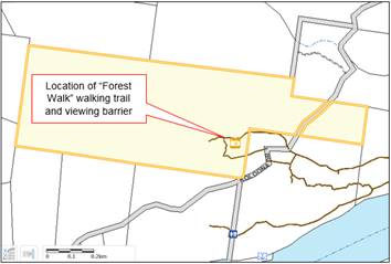
Figure 2: Approximate location of Council infrastructure:
Forest Walk walking trail and viewing barrier.
Bangalee Reserve
As noted above, the subject land
forms part of the Banglaee Reserve that is managed by Council. The subject land
was formally gazetted as an addition to the reserve on 28 December 1973 with
the reserve purpose of “Public Recreation”. The overall Reserve is
of great recreational and cultural heritage value to the area, providing
several facilities for public recreation including picnic facilities, toilet
block, jetty access to the Shoalhaven River and various walking trails.
As shown in Figure 2 above, the ‘Forest Walk’
walking trail and viewing barrier are located on part of the subject land; however,
the absence of formal infrastructure on the remainder of the subject land does
not prevent the land being utilised by the public for other recreational purposes.
The subject land is known to be used regularly for bushwalking, birdwatching,
mountain biking, orienteering and the like, which is consistent with its
current Crown Reserve purpose of “Public Recreation”.
Alignment of the Koloona
Drive Road Reserve
As shown in Figures 1 and 2, the land is split into two
portions by the Koloona Drive road reserve. It is noted, due to
historical reasons, that many existing Council managed and maintained roads are
constructed partly or wholly outside the designated road reserve, particularly
in rural areas and/or where they run through Crown Land. Thus, a survey will be
necessary to determine the actual location of Koloona Drive in relation to the
subject land, to ensure Council is able to effectively maintain the road in
this location if the claims are granted.
Comment Summary
As noted above, a total of three (3) ALC’s have been
lodged over the subject land and are now the subject of investigation by DoI.
The following comments are provided regarding Council’s interests in
relation to each claim.
Claim Number 6427
Was lodged over the whole of the
subject land on 31 March 2000. At the date of claim, the land formed part
of the overall Bangalee Reserve, and was being lawfully used for the Crown
Reserve purpose of “Public Reserve”. As shown in Figure 2,
there is some Council infrastructure on part of the site to the west of Koloona
Drive, being the ‘Forest Walk’ walking trail and viewing barrier,
which was in place at the date of claim. However, as noted above, even though
there is no existing infrastructure over most of the site, this does not
prevent the remainder of the land from being generally used by the public for
recreational purposes such as bushwalking, birdwatching, mountain biking,
orienteering and the like.
Previously on 19 December 2000, Council resolved not to
support ALC No. 6427 on the basis that the land was required for an essential
public purpose (MIN00.1622). It is considered that this position remains
the same, this Council should not support this claim on the basis that, at the
date the claim was lodged, the land was being lawfully used for its reserve
purpose of “Public Recreation” and contained some formal
infrastructure to facilitate this use.
Claim Number 26210
Was lodged over that portion of the
site to the east of Koloona Drive on 21 June 2010. As noted above, at the date
of claim lodgement, the land formed part of the Bangalee Reserve and was being
lawfully used for the Crown Reserve purpose of “Public Reserve”.
Thus, Council should not support this claim on the basis that, at the date of
claim the land was being lawfully used for its reserve purpose of “Public
Recreation”.
Claim Number 26251
Was lodged over that portion of
the site to the west of Koloona Drive on 21 June 2010. At the date of
claim, the land formed part of the Bangalee Reserve, and was being lawfully
used for the Crown Reserve purpose of “Public Reserve”. Council
infrastructure is also located on part of the Lot, as shown in Figure 2.
Council’s position on this
claim remains the same as that of ALC 6427. Thus, Council should not support
ALC No.26251 on the basis that, at the date of claim, the land was being
lawfully used for its reserve purpose of “Public Recreation” and it
also contained formal infrastructure to facilitate this use.
Financial Implications
There are no direct financial implications in providing this
advice to DoI. Should the claims be refused, Council will continue to be Trust
Manger for the land and bear the responsibility of maintaining the land and any
of its associated infrastructure, and the Koloona Drive Road reserve.
Should the claims be granted subject to either the exclusion
of land containing Council infrastructure and the Koloona Drive road reserve,
or the creation of easements to protect existing Council assets, it is
anticipated that any costs associated with both surveying the land and the
creation appropriate easements (if required) will be met by DoI or the
benefitting land council (either Nowra Local Aboriginal Land Council or the NSW
Aboriginal Land Council).
Any ongoing costs associated with the maintenance of the
existing walking trail or viewing platform will continue to be met by Council
for the foreseeable future, as per the existing arrangement with Crown Lands.
Risk Implications
There is no risk to Council in
providing this information to DoI, as it ensures that all relevant information
is made available to assist in determining these claims.
Should the claims be refused,
the public can continue to gain access to the land and utilise it for its
reserve purpose of “Public Recreation”.
Should the claims be granted
subject to the exclusion of certain land or the creation of easements, Council
will continue to gain access to existing assets and infrastructure, and the
public will still be able to make use of the walking trails; however, access to
the remainder of the land may be prohibited should it be transferred into
private ownership.
|
|
Development
Committee – Tuesday 08 May 2018
Page
0
|
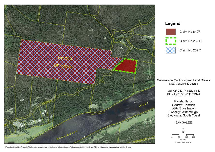
|
|
Development
Committee – Tuesday 08 May 2018
Page
0
|
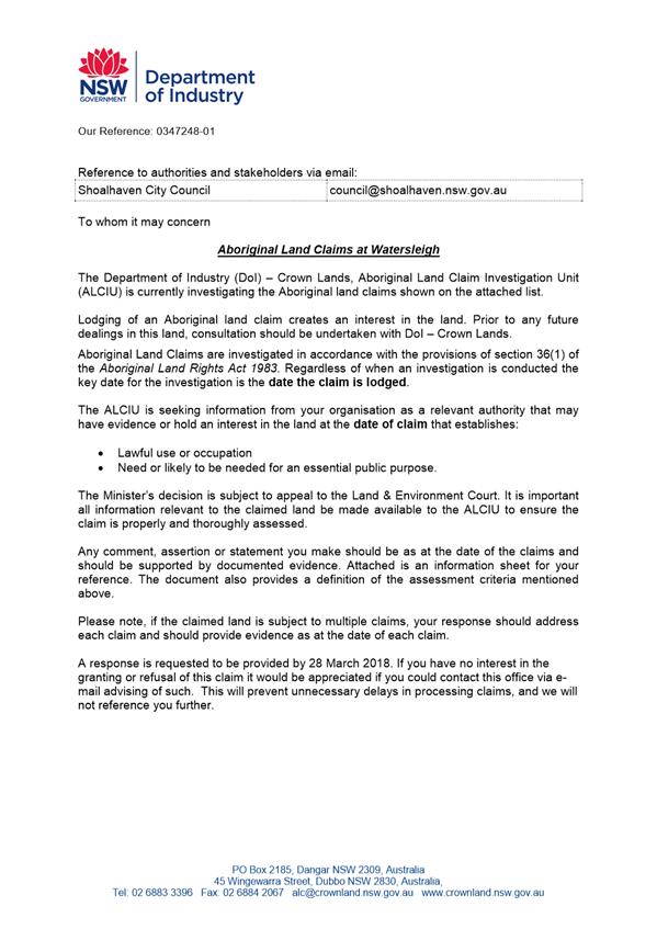
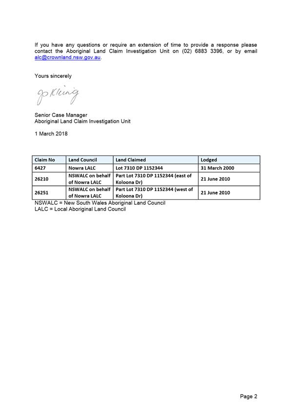

|
|
Development
Committee – Tuesday 08 May 2018
Page
0
|
DE18.36 Outcomes
- Shoalhaven Local Heritage Assistance Fund 2017-2018
HPERM Ref: D18/115416
Group: Planning
Environment & Development Group
Section: Strategic
Planning
Attachments: 1. Annual
Summary Project Report ⇩
2. Revised
Shoalhaven Heritage Strategy 2018-2021 ⇩
3. Current Shoalhaven Heritage
Strategy 2017-2020 ⇩
Purpose / Summary
Detail the outcomes of the
Shoalhaven Local Heritage Assistance Program 2017-2018 and adopt the revised
Shoalhaven Heritage Strategy for 2018-2021 to enable the program to
continue.
|
Recommendation (Item to be
determined under delegated authority)
That Council:
1. Receive
the annual Summary Project Report (Attachment 1), which details the
outcomes of the Local Heritage Assistance Fund Program 2017-2018, for
information.
2. Adopt
the revised Shoalhaven Heritage Strategy 2018-2021 (Attachment 2).
|
Options
1. Adopt the
recommendation.
Implications: This option is preferred as it will
enable the outcomes of the Shoalhaven Local Heritage Assistance Fund Program
2017/2018 to be received for information (via the Summary Project Report) and
enable Council’s Heritage Strategy for the years 2018-2021 to be adopted
to enable the program to continue.
This will allow this year’s program to be finalised
so that Council can claim reimbursement of NSW Heritage Grant funding.
2. Adopt an
alternative recommendation.
Implications: Depending on the nature of any alternative
recommendation, this may not be in keeping with the established process and
will possibly prevent the finalisation of this year’s program, and
prevent Council making a claim for reimbursement under the NSW Heritage Grants
funding, particularly if Council’s Heritage Strategy is not adopted.
Background
Council has continued its
commitment to local heritage projects by supporting the NSW Heritage
Grants. The grant funding provided by the NSW Office of Environment and
Heritage (OEH) assists Council to employ a Heritage Advisor and to run an
annual Local Heritage Assistance Fund to provide grants of up to $5,000 for a
wide range of small heritage projects including general maintenance, adaptive
reuse, or sympathetic alterations/additions for heritage items.
The conservation of
Shoalhaven’s cultural heritage by its owners is clearly beneficial to the
broader community and visitors to the area. These grants, although small,
show that Council and the NSW State Government are committed to helping owners
to conserve and enhance their properties for future generations. These
heritage projects contribute to heritage conservation management, promote
cultural sustainability and encourage heritage tourism.
NSW Heritage Grants Program
2017-18 and 2018-19
NSW Heritage Grant funding was
accepted under the following streams:
· Local
Heritage Places (Shoalhaven Local Heritage Assistance Fund) – Council has
accepted a grant offer of up to $7,500 per annum (ex GST) for both the 2017-18
and 2018-19 financial years, with a funding formula for both years of $1: $1
(OEH: Council). The claim for reimbursement needs to be made by 15 May
2018.
· Local
Government Heritage Advisors – Council has accepted a grant offer
of up to $8,000 per annum (ex GST) for both the 2017-18 and 2018-19 financial
years towards providing a Heritage Advisory Service for Shoalhaven. The
claim for reimbursement needs to be made by 15 May 2018.
Community
Engagement
The Shoalhaven Local Heritage
Fund Program 2017/2018 was advertised in local newspapers on 19 July 2017 and
included a link to Council’s website for relevant information on
eligibility and assessment criteria. Direct advice was also provided to
persons who had previously expressed an interest in the program.
Policy
Implications
In recent years, Council has
been required to submit a four-year heritage strategy to claim reimbursement of
the Local Government Heritage Advisor grant. In this regard, a major
review and amendment of the Heritage Strategy has been undertaken by staff and
Council’s Heritage Advisor and requires adoption by Council. The
current Strategy is included as Attachment 3 to enable comparison with
the revised version.
Financial
Implications
Shoalhaven Local Heritage
Assistance Fund (Local Heritage Places Grant)
The funding offer from OEH for
the 2017-18 and 2018-19 years is up to $7,500 (ex GST) per annum, with a
funding formula for both years of $1: $1 (OEH: Council). Therefore,
Council needs to budget at least $15,000 each year to be able to provide the
grant payments to successful applicants as OEH requires Council to first spend
the money then claim reimbursement of the grant by 15 May 2018.
For the 2017/18 financial year
Council’s budget allocation is $21,000 and the recommended amount of
funding for the Shoalhaven Local Heritage Assistance Fund for 2017-18 is
$22,500. This means there will initially be a shortfall of $1,500 which
will need to be allocated to this budget and this will be managed within the
current overall Strategic Planning budget. These funds will be able to be
recouped when Council receives reimbursement of the grant funding by OEH.
Council will need ensure that a
similar level of funding is provided in the 2018-19 financial years to cover
Council’s required financial commitment for that period.
Local
Government Heritage Advisors Grant
The funding offer from OEH for
the 2017-18 and 2018-19 financial years is up to $8,000 (ex GST) per annum,
with a funding formula for both years of $1: $1 (OEH: Council).
Therefore, Council will need to contribute at least $16,000 to claim
reimbursement of the maximum grant amount offered of $8,000.
For the 2017-18 financial year
Council’s budget currently includes $15,000. The additional $1,000
required to make up the $16,000 required will be managed within the current
overall Development Services budget. These funds will be able to be recouped
when Council receives reimbursement of the grant funding by OEH.
Council will need to ensure that
sufficient funding is provided in the 2018-19 financial year budget to cover
Council’s required financial commitment for this period.
|
|
Development
Committee – Tuesday 08 May 2018
Page
0
|
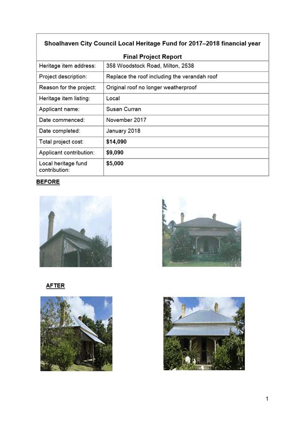
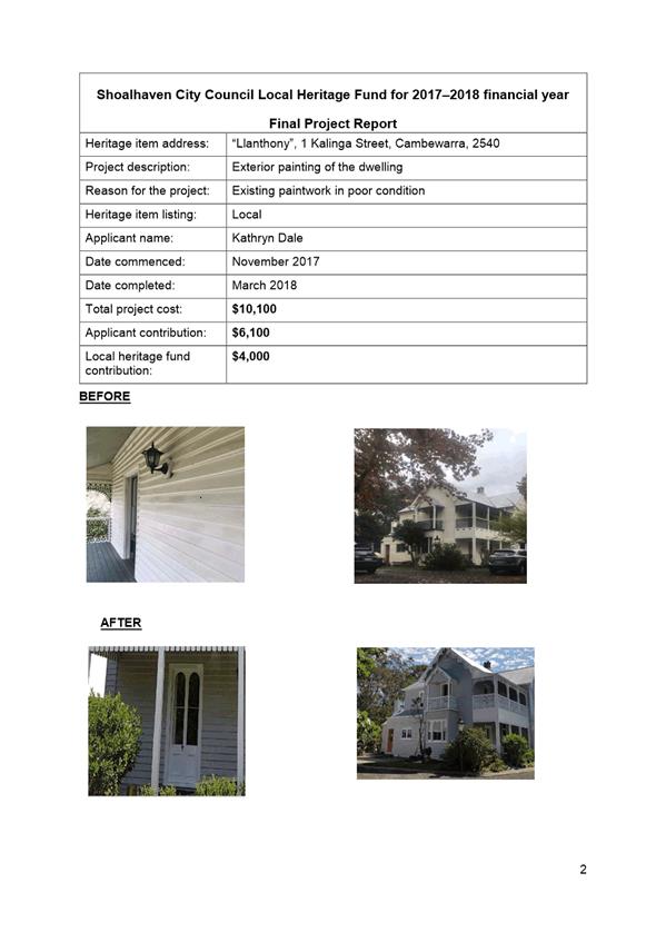
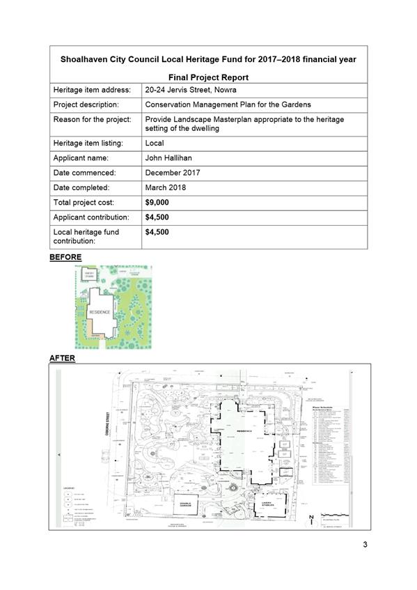
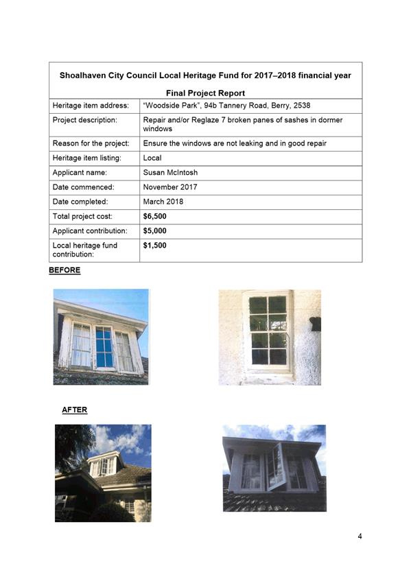
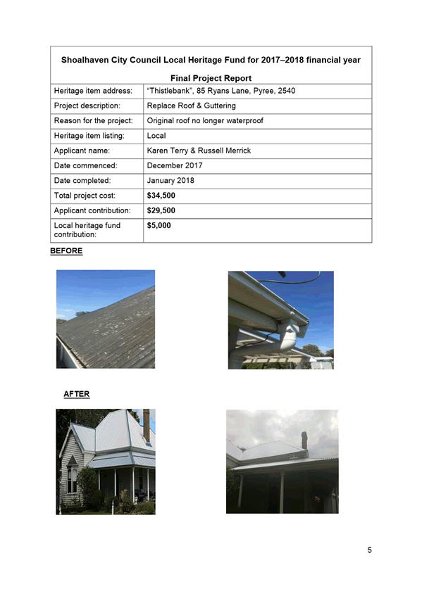
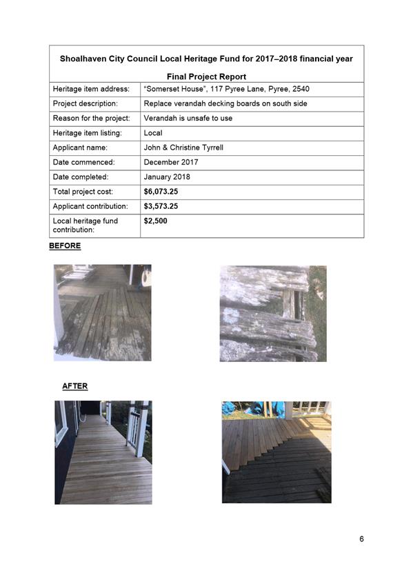
|
|
Development
Committee – Tuesday 08 May 2018
Page
0
|
|

|
Development
Committee – Tuesday 08 May 2018
Page
0
|


|
|
Development
Committee – Tuesday 08 May 2018
Page
0
|
DE18.37 DA17/2435
– 148 Island Point Road, St Georges Basin – Lot 43 DP 25550
DA. No: DA17/2435/4
HPERM Ref: D18/124969
Group: Planning
Environment & Development Group
Section: Development
Services
Attachments: 1. Cover
Letter - To the General Manager - Lot 43 DP 25550 - 148 Island Point Rd St
Georges Basin ⇩
Description of Development: Two (2) Storey
Commercial Building
Owner: T J Harpley & E Bellinato
Applicant: I Architecture
Notification Dates: 7 March 2018 to 22 March 2018
No. of Submissions: Nil
Purpose / Reason for consideration
by Council
This report seeks
Council’s direction with respect to the provisions concerning rear lane
access as detailed in Chapter N23: St Georges Basin, Village Centre, Shoalhaven
Development Control Plan 2014 (SDCP 2014) having regard to potential financial
implications.
|
Recommendation (Item to be determined
under delegated authority)
That Council resolve to reaffirm the current requirements
of Chapter N23: St Georges Basin, Village Centre, SDCP 2014 and Shoalhaven
Contributions Plan 2010 (SCP 2010) in support of the rear service lane
arrangement to have one-way access, noting the available width.
|
Options
1. Reaffirm the current requirements of
Chapter N23, SDCP 2014, in accordance with the recommendation of this report;
and acquire a section of the subject site and adjoining properties for the
one-way rear service lane. (Note Council could also consider an easement
for access over the land in lieu of acquisition which would require other sites
to be treated similarly.)
Implications: Potential costs associated with land
acquisition. It is noted that project 03ROAD2113 in SCP 2010 is for the St
Georges Basin Village Centre Service Lane, the service lane subject to this
report and current Development Application (DA).
As such, contributions will be levied for any approved development
within the catchment area of the project for the provision of this
infrastructure item. Alternatively, Works-in-Kind may be able to be
undertaken in association with development.
One-way movement is practical, noting the available width and legal
mechanisms in place (i.e. easements). However, there is an issue with the
infrastructure/design, which impacts on some vehicles using the lane, namely
articulated vehicles (i.e. with a long wheel base).
2. Not to pursue the acquisition of land
and the requirements of Chapter N23, SDCP 2014 and SCP 2010.
Implications: Council will ultimately need to update the
relevant provisions of Chapter N23 and SCP 2010. Resolving to do so would
require a formal DCP and CP Amendment which must follow certain procedures
under the relevant legislation. The applicant would also be required to
redesign the development to provide access from Island Point Rd.
Figure
1 – Location Map
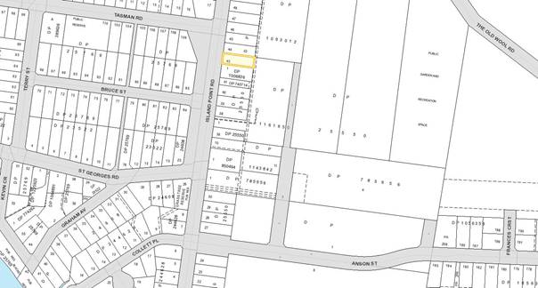
Background
Proposed Development
The DA seeks approval for a two
(2) storey commercial building including office, storage space, show room, and
loading dock. Use of the building is proposed to be subject to future
application for first occupancy.
Vehicular access is proposed
from the service lane/road at the rear of this site, generally in accordance
with Chapter N23, SDCP 2014.
The service lane at the rear of
the subject site, is required to have a 5.5m carriageway width between formed
kerb and guttering on both sides. The section of the site adjoining the service
lane at a width of 4.2m is to be dedicated (using the expression in the DCP) to
Council, incorporating a 2m footpath. The lane access is to be one way north to
south.
The development is required to
be setback 14m from the footpath adjoining the service lane to allow for onsite
parking and landscaping (minimum width of 2m).
A 4.2m wide easement for right
of way currently burdens Lot 2 DP 1093012 (The Old Wool Road, St Georges Basin)
to allow for access from Island Point Road and benefits Lot 1 DP 1161650 (the
IGA site, 136 Island Point Road, St Georges Basin). The “Transfer
Granting Easement” included the following condition:
“The
Transferor grants to the Transferee and Authorised Users the right to pass and
repass over the site of the easement for all lawful purposes by vehicle, but
only over the vehicular trafficable surfaces”.
Figure
2 – Site Plan
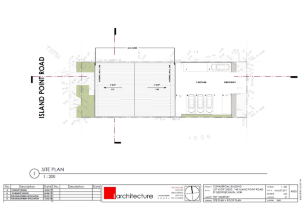
Figure
3 – East/West Elevations
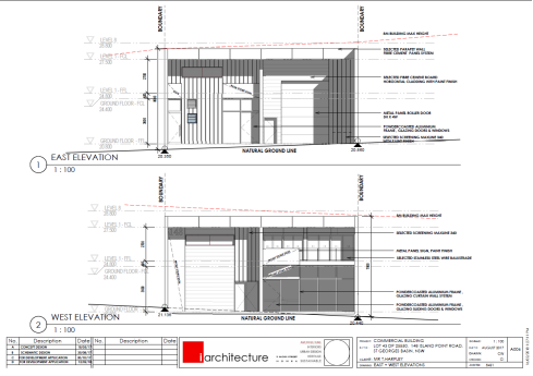
Subject Land
The development site comprises
Lot 43 DP 25550 (148 Island Point Road, St Georges Basin). Refer to Figure 1
for the location and Figure 4 below.
Site & Context
The
development site:
§ Currently contains a shed structure for storage and is
predominantly cleared of vegetation;
§ Is zoned B4 Mixed Use and has an area of 695.55sqm;
§ Is identified as being wholly bush fire prone land;
§ Has a primary frontage to Island Point Road and
proposed secondary frontage to an unnamed service lane at the rear of the site.
Vehicular access is existing from Island Point Road but proposed from the
service lane; and
§ Adjoins land zoned R2 Low Density Residential and B4
Mixed Use under the Shoalhaven Local Environmental Plan 2014 (SLEP 2014) as
illustrated in Figure 4.
Figure
4 – Zoning Extract
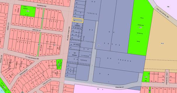
History
The following provides details on post-lodgement
actions and general site history for context:
§ The application was lodged on 20 November 2017.
§ On 30 November 2017, a written request was forwarded
to the owner of the adjoining IGA site, stating:
“Reference is made to the approved development at the abovementioned
properties involving “construction of a 2,145sqm retail centre
development, comprising a supermarket and retail shops, toilet amenities,
service road and associated car parking spaces in Stage 1 and construction of
an eastern driveway crossing and footpath in the road reserve along the eastern
boundary in Stage 2.”
Development
Application DA17/2435 has recently been submitted to Council for a proposed two
(2) storey commercial building at 148 Island Point Road (Lot 43 DP 25550),
which adjoins your property. In accordance with the requirements of Chapter
N23, Shoalhaven Development Control Plan 2014, vehicular access is to be via a
one-way (north to south) service lane/road at the rear of this site.
This
service lane/road was required by Condition 64 of the abovementioned
Consolidated Development Consent, which states the following:
“64. The developer must either:
a) Create a legal right of way over
the proposed service road within Lot 1 DP1093012, as depicted in Interim Layout
Plan – Appendix A dated 2 May, 2008, in favour of Shoalhaven City Council
and those authorised by it; or alternatively,
b) Dedicate the proposed service
road within Lot 1 DP1093012, as depicted in Interim Layout Plan –
Appendix A dated 2 May, 2008, as a public laneway under the care, control and
maintenance of Council.”
Council’s
records indicate that this has not been satisfied.
Accordingly,
as this was required to be complied with prior to the issue of an Occupation
Certificate for the approved development, Council requests that this be
addressed as a matter of urgency, considering that the currently proposed
development at 148 Island Point Road is reliant on this service lane/road.”
§ On 6 February 2018, Solari & Stock Lawyers
confirmed by facsimile that their client is “prepared to proceed with
this matter on the basis of a grant of a right of way, rather than dedication
as a public road.”
§ SDCP 2014 seeks to have a public lane/roadway via land
dedication, however, at this stage an easement in favour of Council is being
pursued as the owner is reluctant to dedicate. Further to this, there is no
agreement in place or mechanism to facilitate the ‘dedication of
land’.
§ On 7 February 2018, Solari & Stock Lawyers were
requested to proceed to act on this and prepare the relevant documentation as
soon as possible.
§ On
22 February 2018, the applicant submitted a written request to Council
(Reference No. 8431, dated 16/02/2018) seeking confirmation as to whether the
requirements of Chapter N23: St Georges Basin, Village Centre, SDCP 2014 will
be fully implemented and immediately actioned by Council; and if so, will
Council proceed to resume the affected land at the rear of the subject land and
the other affected nearby properties. Refer to Attachment 1.
§ On 8 March 2018, a copy of the Interim Layout Plan
– Appendix A (as referenced in Figure 5) was forwarded to Solari
& Stock Lawyers, and highlighted in yellow to clarify the extent of the
right of way, to be variable width from a minimum 4.2m to an approximate
maximum of 8.4m, to allow for two-way movement along a section of the easement.
A copy of
the Ultimate Layout Plan – Appendix B, dated 2 May 2008 (see Figure
6) was included for their reference. This plan is the subject of an existing
Positive Covenant which requires the additional works detailed in this plan
(creation of the new access into the Village Access Road and the one-way
movement of traffic through the site via the service lane). This Ultimate
Layout Plan shows the service lane [providing for one-way traffic flow
exiting the site onto Island Point Rd. to be completed by the developer “upon
completion of the approved perimeter roads”, as required by the DCP.
To date the perimeter roads have not been completed and therefore the Ultimate
Plan is not required to be enacted.
 Figure 5 – Interim Layout

Figure
6 – Ultimate Layout
Planning Assessment
The DA has been (or will be)
assessed under s4.15 (formerly s79C) of the Environmental Planning and
Assessment Act 1979.
Consultation and Community
Engagement:
Notification was undertaken in
accordance with Council’s Community Consultation Policy with letters
being sent within a 60m buffer of the site, including the St Georges Basin
Chamber of Commerce during the period 7 March 2018 to 22 March 2018.
No submissions were received in
relation to Council’s notification of the development.
Financial Implications:
There are cost implications for
Council in the event of land acquisition. Despite this, acquisition is
identified in the contribution rate breakdown for project 03ROAD2113 which
identifies the need for land acquisition in order to provide for the road
infrastructure. In 2010, land acquisition was estimated to cost $87,459.00.
To date, there have been no
monetary contributions paid towards the subject contribution project,
however Development Consent DA07/1059 for the adjacent IGA Supermarket included
a Works-in-Kind Agreement to deliver part of the road
infrastructure.
Council is reviewing SCP 2010,
which involves reviewing and rationalising projects. Through the review, it is
proposed that out of the 179 projects which are currently identified in the CP,
88 are proposed for deletion. The subject laneway, is not proposed for deletion
or modification.
The proposed development is also
considered to increase the demand for community facilities in accordance with
SCP 2010. The development is most aptly characterised as a Commercial Office
for the purpose of calculating contributions under SCP 2010. The approximate gross floor area is 366.6sqm, with
192.6sqm at ground level (including one third of the loading dock area as it is
not considered that the entire 140sqm will be utilised for the loading or unloading
of goods) and 174sqm on the first storey.
Accordingly, a total contribution, currently
assessed at the sum of $76,661.36 (i.e. 2017/2018 rate) or as indexed in future
years would be payable by the applicant to Council before the issue of a Construction
Certificate.
Should Council resolve to not pursue the
laneway (03ROAD2113), there would need to be a formal resolution to prepare an
amendment to Chapter N23 of SDCP 2014 and SCP 2010.
Undertaking this amendment could result in the
reduction of contributions levied by approximately $44,605.22. It must be noted
that under the current legislation, contributions for this project will need to
be levied up until the CP Amendment is finalised and adopted. This means that,
if a Development Consent is issued prior to the CP Amendment being made, the
development will still be required to pay contributions toward 03ROAD2113. Once
the contribution project is deleted, any levies paid towards 03ROAD2113 will be
transferred to a ‘recoupment fund’ (in accordance with
Council’s resolution MIN17.197).
If the applicant is prepared to amend their DA
based on the amendments to SDCP 2014 and SCP 2010 in order to benefit from the
deletion of references to the laneway, determination of the DA could still
occur, however Council needs to be aware that this would be a variation to SDCP
2014 and contributions payable as detailed above.
Deletion of the CP project and
an amendment to Chapter N23 to reflect deletion of the laneway is not
preferred.
The laneway provides a separate
access for service vehicles to 10 development sites within the catchment area.
Providing service vehicle access at the rear of these sites will have multiple
benefits to Island Point Road including but not limited to improved
presentation to the street, overall improvements to the streetscape, and
improved pedestrian and vehicular safety. An issue for Council to consider is
land acquisition with respect to the properties immediately north of the
subject site, in order to achieve legal access to Lot 43, the subject site of
the current DA.
Legal Implications
The applicant has queried who is
to construct the rear access. As the subject laneway is listed as a project in
the CP, Council would ordinarily be responsible for delivering this
infrastructure project. However, the works may be undertaken via a
Works-In-Kind (WIK) agreement. The costs associated with any such arrangement
or other agreement will require documentation to be prepared at the
applicant’s expense.
With regard to land acquisition,
if the provisions of Chapter N23 are implemented, this involves an area of
approximately 4.2m in width and 15.24m in length. As noted above, land
acquisition associated with the laneway is included in the contribution rate
for 03ROAD2113.
It is acknowledged that the IGA
building on the adjoining site has been constructed resulting in a narrower
access than desirable. As referenced earlier in this report, there is currently
no easement for access to allow for legal and practical access, however, this
is still in the process of being negotiated.
While easements will allow for
access, they are not considered the best solution. Ideally the laneway should
be a public lane/road, however, the expense to acquire the land would be
considerable.
There is an alternative, which
would be to create an easement for access over the applicant’s land
however this does not satisfy the requirement for dedication albeit it achieves
the same result (noting that there is an easement over the IGA land and land to
the north). If this approach were to be taken, it would have to be
consistently applied to the other affected lots north and south of the
development site.
Summary and Conclusion
In accordance with the
recommendation and details of this report, Council needs to reaffirm the current
requirements of Chapter N23: St Georges Basin, Village Centre, SDCP 2014 and
Shoalhaven Contributions Plan 2010 (SCP 2010) in support of the rear service
lane arrangement with one-way access.
While acknowledging the financial
implications, this arrangement will allow for improved presentation to Island
Point Road, overall improvements to the streetscape, and improved pedestrian
and vehicular safety in the area.
|

|
Development
Committee – Tuesday 08 May 2018
Page
0
|
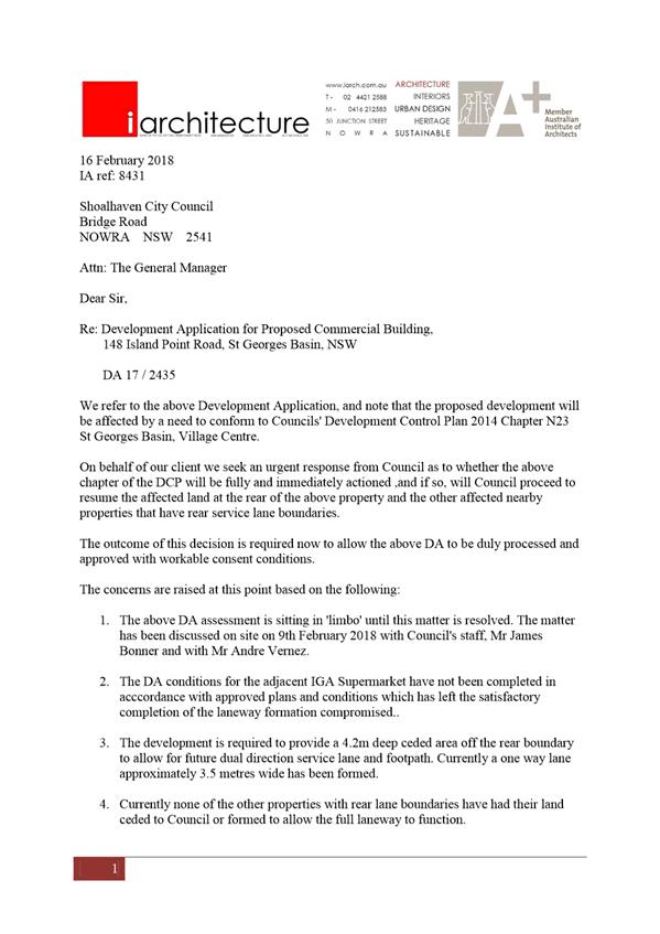
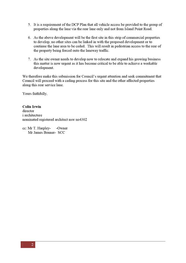
|
|
Development
Committee – Tuesday 08 May 2018
Page
0
|
DE18.38 RD18/1002
– 160 Kinghorne Street, Nowra – Lot 2 DP 566370
DA. No: RD18/1002/4
HPERM Ref: D18/133417
Group: Planning
Environment & Development Group
Section: Development
Services
Attachments: 1. Submission
- Rhonda Mackenzie for Rosemary Petheram ⇩
2. Plan
- Site ⇩
3. Plan
- Stormwater ⇩
4. Plan
- Elevations - Eastern & Western - Pg 2 - Units 1 & 2 ⇩
5. Plan
- Elevations Northern & Southern Pg 1 - Units 1 & 2 ⇩
6. Plan
- Elevations - Eastern & Western - Pg 2 - Units 3 & 4 ⇩
7. Plan
- Elevations - Northern & Southern Pg 1 - Units 3 & 4 ⇩
8. Plan
- Elevations - Eastern & Western - Pg 2 - Units 5 & 6 ⇩
9. Plan - Elevations
- Northern & Southern Pg 1 - Units 5 & 6 ⇩
Description of Development: Demolition of Existing
Dwelling and Ancillary Outbuildings and Construction of Multi Dwelling Housing
– Six (6) Dwellings
Owner: CJM Capital Pty Ltd
Applicant: PDC Planners
Notification Dates: 6 April 2018 to 21 April 2018
No. of Submissions: One (1) in objection
Purpose / Reason for consideration
by Council
Councillors called in the section
8.2 application (application to review a determination or decision of a consent
authority under the Environmental Planning and Assessment Act 1979) due to
“significant public interest” on 10 April 2018.
|
Recommendation (Item to be determined
under delegated authority)
That Council resolve to reaffirm
the determination (refusal) of DA17/2242, dated 15 December 2017 for the
demolition of an existing dwelling and ancillary outbuildings and
construction of multi dwelling housing – six (6) dwellings at Lot 2 DP
566370, 160 Kinghorne Street, Nowra.
|
Options
1. Reaffirm the decision to refuse the
application in accordance with the recommendation of this report.
Implications: This would result in the determination remaining
in place. An appeal with the Land and Environment Court is possible in the
event of a refusal of the application. There is no ability for further
review (section 8.2(3)).
2. Approve the application.
Implications: Council could choose, following the consideration
of the section 8.2 application, to approve the development application if it
considers that the provisions of section 4.15(1) have been satisfactorily
addressed. Any such approval would be conditional and require a further report
to Council detailing draft conditions. Council would need to provide planning
reasons to justify the decision.
3. Alternative recommendation.
Implications: Council could specify an alternative
recommendation and advise staff accordingly.
Figure
1 – Location Map
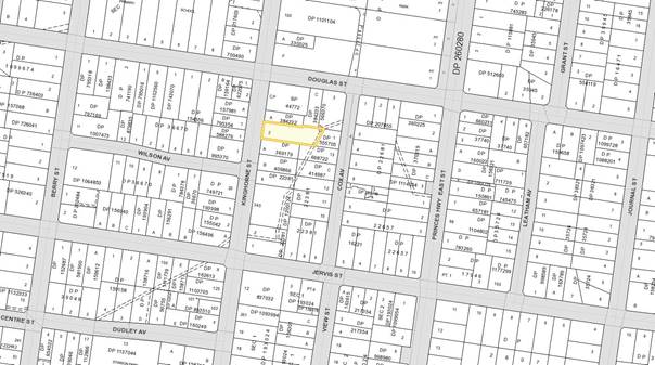
Background
Division 8.2 Reviews,
Environmental Planning and Assessment Act 1979
A section 8.2 application allows
an applicant to request a consent authority review a determination or decision
made by them. After conducting its review, the consent authority (in this
instance Council) may confirm or change the determination or decision.
It is noted that in accordance
with the provisions of section 8.10(1) under the Environmental Planning and
Assessment Act 1979, an appeal by an applicant may be made only within six (6)
months after the date the decision appealed against is notified.
Proposed Development
DA17/2242 sought approval for
the demolition of the existing dwelling and ancillary outbuildings and
construction of multi dwelling housing – six (6) dwellings with:
§ 6 x 3 bedrooms; and
§ 8 car spaces.
Please refer to Attachments
2–9 for plans submitted with the DA.
Subject Land
The development site comprises
Lot 2 DP 566370 (160 Kinghorne Street, Nowra). Refer to Figure 1.
Site & Context
The
development site:
§ Contains
an existing dwelling with two (2) detached outbuildings and minimal established
vegetation and slopes downhill from Kinghorne Street;
§ Is
zoned R3 Medium Density Residential and 1,382sqm in area;
§ Has
existing access from Kinghorne Street; and
§ Adjoins
land zoned R3 Medium Density Residential under the Shoalhaven Local
Environmental Plan 2014 (SLEP 2014) as illustrated in Figure 2.
Figure
2 – Zoning Extract
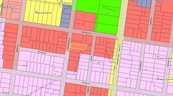
History
The following provides details on post-lodgement
actions and general site history for context:
§ The DA was determined by refusal on 15 December 2017
for the following reasons:
“1. The development has not
adequately addressed the provisions of Control 5 (of Chapter G7) of Shoalhaven
Development Control Plan 2014. No waste minimisation and management plan has
been submitted with the development application, particularly with regard to
required demolition works, and reference to any asbestos or hazardous material
that may be transported to any of the Council waste facilities. (Section
79C(1)(a)(iii) of Environmental Planning and Assessment Act, 1979).
2. The development is
inconsistent with the provisions of Controls 5.2.1, 5.2.2, 5.2.4, 5.2.5, 5.2.9
and 5.2.11 (of Chapter G14) of Shoalhaven Development Control Plan 2014. The
proposed development will not integrate into the existing streetscape nor make
a positive contribution to the character of the existing and desired future
streetscape of the locality. The development is deficient in the provision of
private open space with respect to the area, dimensions and amenity for future
residents. There are multiple departures proposed to this Chapter which
suggests an overdevelopment of the site. (Section 79C(1)(a)(iii) of
Environmental Planning and Assessment Act, 1979).
3. The development is
inconsistent with the provisions of Controls 5.1, 5.4 and 5.7 (of Chapter G21)
of Shoalhaven Development Control Plan 2014. The number of proposed onsite car
parking spaces is deficient, the site is located outside of the 200m parking discount
area and no discount for parking is available. (Section 79C(1)(a)(iii) of
Environmental Planning and Assessment Act, 1979).
4. The
development application has not adequately demonstrated that the proposal will
not have adverse environmental impacts on the built environment and social
impacts on the locality. (Section 79C(1)(b) of Environmental Planning and
Assessment Act, 1979.)
5. The information
submitted with the development application does not satisfactorily demonstrate
that the site is suitable for the proposed use. (Section 79C(1)(c) of
Environmental Planning and Assessment Act, 1979).
6. Having regard to the
information being submitted with the development application to address the
relevant provisions of Shoalhaven Development Control Plan 2014, the granting
of development consent is not considered to be in the public interest. (Section
79C(1)(e) of Environmental Planning and Assessment Act, 1979).”
The section 8.2 application to review this
determination was lodged on 29 March 2018, disagreeing with the determination
and offering up the following as addressing the reasons for refusal:
“1) A detailed WMMP is not
required at DA stage. Council should refer to its own waste management
guidelines which form part of Chapter G7 of the SDCP 2014. The guidelines
clearly state at Section 4.1 that for development where a Construction
Certificate is required, a WP shall be submitted at the Construction
Certificate Stage. This is not a valid reason for refusal. Additionally, it is
not a document Council requires as part of an application for development
consent, pursuant to Schedule 1 of the Environmental Planning and Assessment
Regulation 2000.
2) As Council would know, the
Shoalhaven DCP 2014 is a performance based document. Section 4.15 (3A) of the EPA Act clearly states that
where a DCP contains provisions that relate
to the development that is the subject of a development application the consent
authority [emphasis added]:
(a) if those provisions set
standards with respect to an aspect of the development and the development
application complies with those standards—is not to require more onerous
standards with respect to that aspect of the development, and
(b) if those provisions set
standards with respect to an aspect of the development and the development
application does not comply with those standards—is to be flexible in
applying those provisions and allow reasonable alternative solutions that
achieve the objects of those standards for dealing with that aspect of the
development, and
(c) may consider those provisions
only in connection with the assessment of that development application.
In this
subsection, standards include performance criteria.
The
parts of the DCP referred to within reason 2 of the Refusal were addressed by
the applicant and we stand by the assessment and subsequent additional
information supplied to Council.
We
refute the suggestion that the development would not be compatible with
streetscape. The design of the
development is sound, and to illustrate this, we have produced photomontages.
These demonstrate, along with all other
information provided to Council with the development application that it fits comfortably within the
streetscape. We stand by the commentary already provided to Council with respect to streetscape and
the character of the area.
Further,
we refute the suggestion that what is proposed represents an overdevelopment of
the site. Sound justification for
the proposal has been provided in this regard.
3) We provided detailed
reasons and justification for the car parking arrangements proposed. We stand by this justification.
4) The proposal will have
only positive impacts on the built environment and the suggestion that this proposal may have negative social impacts on the
locality is simply fanciful and is not supported on either legal or planning grounds. The proposal involves
construction of what we believe to
be much needed medium density housing within a designated medium density zone
and within walking distance to the Nowra
CBD.
5) We have supplied ample
information to the Council which clearly demonstrates the site is suitable for the proposed use. The Council came to the
conclusion that the site was suitable for the proposed use 5 years ago when it approved the same plan set.
This opinion was then later
reaffirmed when the Council zoned the site R3 Medium Density in 2014.
6) The proposal is clearly within
the public interest. The proposal is consistent with the objectives of the R3 zone and permissible. The proposal in our
view is consistent with Council’s DCP 2014 – a performance based document that must be
applied flexibly by the Council. Further to this, we note that there was no submission from
members of the public or neighbouring property owners in response to the proposal.”
Issues / Discussion
Review of Determination
Reason for Refusal No. 1
– No waste management plan.
No
waste minimisation and management plan was submitted with the development
application, and as requested by Council’s Waste Services, the plan
required for subject demolition works, particularly referencing any asbestos or
hazardous material that may be transported to any of the Council waste
facilities. It is also noted that demolition works can commence prior to the
issue of a Construction Certificate, hence the need for this plan prior to
determination of the application. (Section 4.15(1)(a)(iii) of Environmental
Planning and Assessment Act, 1979). Whilst a condition could be imposed to
capture a Waste Management Plan, this is not desirable given the potential for
asbestos waste in the building having regard to the age of the structure.
It
is noted that the demolition works could be the subject of a Complying
Development Certificate (CDC).
Reason for
Refusal No. 2 – The development is inconsistent with the
provisions of Controls 5.2.1, 5.2.2, 5.2.4, 5.2.5, 5.2.9 and 5.2.11 (of Chapter
G14) of Shoalhaven Development Control Plan 2014, (Section 4.15(1)(a)(iii) of
Environmental Planning and Assessment Act, 1979), demonstrated as follows:
§ 5.2.1
Site Planning and Layout
A3.1 Each dwelling should
have a sense of address, either fronting the street or having its front door
visible from the street.
Unit 1 does
not satisfy the requirements of A11.2 (of Control 5.2.4 below) as it does not
adequately address or face Kinghorne Street by having a front door and/or
living room windows facing or visible to the street. The street address or
rather door facing the street is important in that a building
‘faces’ the street and provides a clear entry and matches other
development nearby which includes single dwellings. This is also something that
is referred to in the State Government’s Design Guide for Low Rise and
Medium Density Development, acknowledging that access points and windows
provide street activation / address and passive surveillance.
Figure
3 – Western (Street) Elevation of Unit 1
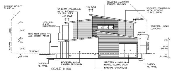
A3.2 Any
two-storey component is to be located to minimise the visual intrusion and
shading on adjacent private open space.
There is a
comment in the submitted Statement of Environmental Effects that “with
respect to overshadowing, it is clear that the development will not affect any
adjoining lands in an unacceptable way. Only part of each dwelling is two
storey”.
The applicant
has stepped the upper level of each unit in from the southern boundary to enhance
solar access and amenity to the adjoining site and their private open space.
However, no shadow diagrams have been submitted with the application to support
the above comment and confirm impacts to adjoining properties.
A3.3
Private open space and garages should be located to the rear of dwellings to
avoid the need for high fences to the street.
This is a
non-compliance with respect to Unit 1. The applicant contends that the proposal
complies, stating that “the layout of the development is such that
potential impacts on adjoining land would be acceptable in context of a
residential area which is undergoing change”.
The currently proposed 1.8m high
brick fence incorporating a powder coated aluminium slatted screen and site
layout is not considered compatible with surrounding neighbourhood
character. The majority of front fences in Kinghorne Street are low set.
Whilst an area may be undergoing change in built form, articulation and scale
must relate to the local character of the area and context.
Although landscaping with a low
hedge or dense mixed plantings can be planted forward of, and for the length of,
the fence to soften any impact and allow for some surveillance of the street
from Unit 1, the need for the fence is resulting from an inability to provide
adequate private open space behind the building line and is a of the site
coverage of the development.
§ 5.2.2
Scale and Site Density
A4.1 The
maximum floor space ratio for medium density development on the site is 0.35:1
(total gross floor area : site area). See Figure 3 for floor space ratio
example.
A ratio of 0.37:1 is proposed,
being a 2.9% variation (40.1sqm).
The applicant has provided the
following justification for the proposed variation:
“The objectives and
performance criteria are met as follows:
a. The
scale of the development is compatible with surrounding development despite the
variation requested;
b. The
design and layout of the development has merit. All units proposed are of two
storey construction. This minimises the amount of living space at ground level
which in turn results in smaller building footprints and more open space.
c. The
additional GFA proposed has in no way affected the ability for all required car
parking to be provided on site.
d. The
site is within a designated R3 medium density zone where low density
development (single dwellings) is typically not permitted. The site is
surrounded by other land which is zoned for medium density development. The
additional GFA proposed therefore is not expected to unfairly impact upon any
lower order development types (i.e. low density development).
e. Council’s
medium density code specifies a standard FSR of 0.35:1 for multi-unit
development across all land use zones where multi-unit development is allowed.
The same FSR therefore applies within the R1 general residential zone and the
R3 medium density residential zone. Given that the site is zoned R3 and that
unlike the R1 zone, no low density development is permitted, the Council should
give more favourable consideration to this proposal and allow increased
densities within the R3 zone over and above what is allowed within the R1 zone.
f. Further
to e) above, it is interesting to note that within the R3 zone, residential
flat buildings are permissible. The medium density code applies to residential
flat buildings, however for such proposals, the code does not set a maximum
FSR. The point to be made here is that the owners of the site are within their
rights to lodge a DA for a residential flat building with an FSR far greater
than 0.35:1. Rather, the option of a lower density multi-unit development has
been pursued and this is considered to be a better outcome for the area with
far less impacts on adjoining land.
g. The
proposal generally complies with setback criteria (except for some minor
variations);
h. The
proposal generally complies with outdoor private recreation requirements and
minimum areas are met in this regard.
i. Also
of note is the imbalance between Council’s policies for differing
development types. For example, Council’s development controls for single
dwellings and dual occupancies allow for an FSR of 0.5:1 within lower density
residential zones. It makes no sense for medium density development to have a
lower FSR than that allowed for single dwellings and dual occupancies.
j. Generally
speaking, the site is located in an area where increased density should be
encouraged. The site is within walking distance to the commercial core of
Nowra.
k. The
Council approved the same development in 2011 over the subject land. This
development application seeks to simply re-instate that development consent
which has now lapsed.”
It is agreed that a 0.35:1 floor
space ration for an R3 zone is at odds with the objectives which aim to provide
for higher density housing noting that dwellings are able to achieve 0.5.
The variation is considered minimal in context and consistent with the
objectives of the DCP chapter and the relevant performance criteria.
However, the scale of the
development is not entirely compatible with and sympathetic to the scale and
bulk of the existing character of the locality.
It is also noted that although
this exact development was previously approved under Development Consent DA11/2257
on 18 May 2012, the approval has since lapsed. This previous application was
assessed under previous controls applying at that point in time. The fact
that there was a previous approval is not a reason to support the application
again. Circumstances have changed with regard to assessment criteria.
The development as it stands,
must have regard to the current strategic controls. Accordingly,
whilst there is no issue with the higher floorspace, the cumulative impact of
the non-compliances is considered an indicator that there is too much
development on the site.
A4.2 The
landscaping area provided on the site must be at least 35% of the site.
Thirty-three
(33) % landscaping is proposed, being a 2% variation (24.7sqm).
The applicant has provided the following
justification for the proposed variation:
“The
objectives and performance criteria are met as follows:
a. The
scale of the development is compatible with surrounding development despite the
variation requested;
b. Each
unit has sufficient private open space, so the variation to landscaping is not
of any real consequence to end users of the development;
c. The
shortfall does not result in the development being inappropriate in terms of
its design relationship to adjoining development;
d. The
extent of the variation is not significant.”
It is considered that the
variation proposed is minimal in isolation and the proposal is consistent with
the objectives of the chapter and the relevant performance criteria. However,
the justification put forward by the applicant has not addressed the unique
circumstances as to why the variation is being sought.
Due to the other multiple
departures to SDCP 2014, again it suggests an overdevelopment of the site. If
the development were to be redesigned, then compliance with this solution could
be achieved. The variation requested is therefore not supported.
§ 5.2.4
Streetscape and Building Appearance
A11.1 A
statement of environmental effects should demonstrate how the proposal fits in
to the existing streetscape.
The
submitted Statement of Environmental Effects does not adequately address this.
The
applicant contends that:
“the dwellings proposed
are to be finished using materials and colours that are common in contemporary
dwelling design. The dwellings are of a design that is compatible with the
established character of the immediate locality” and “it is
demonstrated that the proposal is sound with respect to impacts to the
streetscape”.
In an email
dated 23 October 2017, the applicant strongly disagreed that the
proposal is out of character with the area, stating:
“You have referred to another
development located at 25 Junction St Nowra and suggested that there may be
similarities between projects. This is not the case, reasons for this are as
follows:
a. The
site at 25 Junction St was located within the vicinity of multiple heritage
items. Junction St itself is mapped as being heritage listed. There are no
heritage items within the vicinity of 160 Kinghorne St Nowra.
b. The
location has been subject of redevelopment including 168 Kinghorne St
(multi-unit development), 60 Jervis St (multi unit development), 154 Kinghorne
St (residential flat building), 104 Douglas St (residential flat building).
c. The
streetscape is varied with buildings from multiple eras including brand new
builds.
d. The
development in its current form was approved by the Council in 2012. There were
no issues with the design of the development when this occurred. Nothing about
the locality has changed since then, except for more modern multi- unit
developments being constructed.”
It is not
disputed that the site is not in a heritage precinct or adjoins heritage
items. However, it is still important that new development is compatible
with and sympathetic to the scale and bulk of existing development in the
locality, particularly on the perimeter of the site.
An analysis
of local context and character should be undertaken with all developments, even
where areas are changing to ascertain unique attributes that may warrant
retention and respect where new development is proposed.
Nowra has
some unique buildings and streetscapes and a certain character which provides a
sense of identity. The design, as proposed provides a
stark contrast with the adjoining development particularly with the skillion
roof design typically found in new urban areas.
Figure 4 – Photo Montages of Development
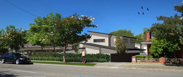
It is
unclear how this development will integrate into the existing streetscape and
make a positive contribution to the character of the existing and desired
future streetscape, reinforcing the function of the street and sensitive to the
landscape and environmental conditions of the locality. A modification of the
front unit incorporating some traditional/conventional designs would assist in
integrating the development into the street.
As mentioned
earlier, the exact development design that was previously approved by Council
(now lapsed) has been presented with this application. The applicant needs to
have regard to the current strategic controls. The applicant has also
provided examples of developments approved. The examples were approved prior to
commencement of these newer controls.
A11.2
Street elevations for all buildings facing public and communal streets show:
§ Buildings adjacent to the public street address the
street by having a front door and/or living room windows facing the street;
§ The difference in building height between existing
buildings and new development is not more than one storey when viewed from the
public street;
§ Building design, roof form and detailing visible from
public areas are not in strong visual contrast with the character of
surrounding development;
§ Buildings with a maximum unarticulated length of 15m
to the public street frontage. Punctuation by bay windows, verandahs, balconies
or wall offsets is considered to be adequate articulation; and
§ Buildings detailed or articulated to enable individual
dwellings to be identified from public roads.
Unit 1 does
not adequately address Kinghorne Street by having a front door and/or living
room windows facing or visible to the street. The proposed building design is
also in some contrast to the character of surrounding development having regard
in particular to the colours, materials, roof form and window design.
The photos
below show the development site, dwellings to the south and north of the site
as well as opposite the development site.
 Figure
5 – Existing Streetscape
Figure
5 – Existing Streetscape
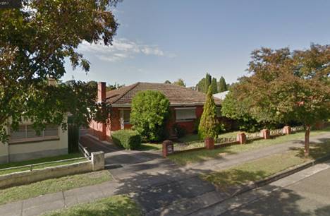
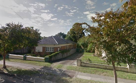

§ 5.2.5
Setbacks
A8.1
Setbacks from the street boundary should be:
§ 5.5m for single storey
§ 9m for over one storey
§ 3m from a secondary frontage on corner sites.
Part of the
single storey section of Unit 1 (approximately 4.4m in length – living
room) is proposed 5.27m from the front boundary, being a 4.1% variation. The
applicant contends that the proposal complies.
The variation proposed is
numerically minimal and consistent with the objectives of the chapter and the
relevant performance criteria. The front setback is generally consistent with
the setbacks of adjoining development.
However, due to the other
multiple departures to SDCP 2014, again it suggests an overdevelopment of the
site. If the development were to be redesigned, then compliance with this
solution could be achieved. The variation requested is not supported.
§ 5.2.9
Useable Open Space
A14.1 A
minimum of 35m² of private open space is to be provided per dwelling with
a minimum dimension of 2.5m.
Units 1
– 5 do not have a minimum 35sqm of private open space with a minimum
dimension of 2.5m (as detailed below). Unit 6 is currently compliant.
§ 24sqm for Unit 1, being a 31.4% variation (11sqm) from
the minimum. 9sqm adjacent to the driveway is not included as only
approximately 1.7m in width.
§ 14sqm for Unit 2, being a 60% variation (21sqm) from
the minimum. 8sqm adjacent to the common side boundary with Unit 3 is not
included as only approximately 2.2m in width.
§ 14sqm for Unit 3, being a 60% variation (21sqm) from
the minimum. 8sqm adjacent to the common side boundary with Unit 2 is not
included as only approximately 2.2m in width.
§ 14sqm for Unit 4, being a 60% variation (21sqm) from
the minimum. 8sqm adjacent to the common side boundary with Unit 5 is not
included as only approximately 2.2m in width.
§ 14sqm for Unit 5, being a 60% variation (21sqm) from
the minimum. 8sqm adjacent to the common side boundary with Unit 4 is not
included as only approximately 2.2m in width.
The applicant contends that Unit
1 and 6 are compliant and has provided the following justification for the
proposed variations:
“The objectives and performance criteria are met as
follows:
1) The
unit that is subject of this variation request has a sufficient area of private
open space to meet user needs. In this regard, each unit has an area for
private recreation, clothes drying and landscaping.
2) The
orientation of the private open space for the affected unit is satisfactory.
3) Each
area of POS is clearly defined.
4) Each
unit has a private courtyard area that is useable.
5) The
extent of the variation is minor (only 3m2)
6) Each
area of POS is accessible from a living area and it will serve as an extension
of living space.
7) The
orientation of each area of POS is acceptable.
8) Each
of the affected units has multiple areas of private open space which is
considered favourable.”
The variation in area for
private open space proposed is substantial (being up to 60%) and this is only
to achieve the minimum requirement. It is noted that the applicant has included
landscaping area (i.e. raised garden beds) in their calculations as part of
each private open space. Landscaping should be incorporated to screen these
spaces and ensure ‘privacy’, not to be included in the actual
space.
The spaces proposed (i.e.
especially Unit 2 – 5) are not consistent with the objectives of the
chapter and the relevant performance criteria. They would particularly not be
suitable for the requirements of future occupants, considering each unit
contains three (3) bedrooms.
Figure
6 – Site Plan
A14.2 One
part of the minimum private open space area must have a usable minimum area of
25m2 and a minimum dimension of 4m. This space must be directly
accessible from a living area of the dwelling.
Each unit
does not have a minimum 25sqm of usable private open space with a
minimum dimension of 4m (as detailed below). Variation is sought.
§ 24sqm for Unit 1, being a 4% variation (1sqm) from the
minimum. This area is only approximately 2.9m in width and is located forward
of the unit (adjacent to the street) and directly accessible from the dining
room.
§ 14sqm for Unit 2, being a 44% variation (11sqm) from
the minimum. This area is only approximately 3.1m in width and is located
forward of the unit (adjacent to the driveway) and directly accessible from the
living room.
§ 14sqm for Unit 3, being a 44% variation (11sqm) from
the minimum. This area is only approximately 3.1m in width and is located
forward of the unit (adjacent to the driveway) and directly accessible from the
living room.
§ 14sqm for Unit 4, being a 44% variation (11sqm) from
the minimum. This area is only approximately 3.1m in width and is located
forward of the unit (adjacent to the driveway) and directly accessible from the
living room.
§ 14sqm for Unit 5, being a 44% variation (11sqm) from
the minimum. This area is only approximately 3.1m in width and is located
forward of the unit (adjacent to the driveway) and directly accessible from the
living room.
§ 19sqm for Unit 6, being a 24% variation (6sqm) from
the minimum. This area is located at the rear of the unit and directly
accessible from the dining room.
Figure
7 – Usable Private Open Space (Highlighted for Unit 5)

The applicant contends that Unit
1 and 6 are compliant and has provided the following justification for the
proposed variations:
“The objectives and performance criteria are met as
follows:
1) The
unit that is subject of this variation request has a sufficient area of private
open space to meet user needs. In this regard, each unit has an area for
private recreation, clothes drying and landscaping.
2) The
orientation of the private open space for the affected unit is satisfactory.
3) Each
area of POS is clearly defined.
4) Each
unit has a private courtyard area that is useable.
5) The
extent of the variation is minor (only 3m2)
6) Each
area of POS is accessible from a living area and it will serve as an extension
of living space.
7) The
orientation of each area of POS is acceptable.
8) Each
of the affected units has multiple areas of private open space which is
considered favourable.”
The variation in area for a
usable part of the private open space proposed is substantial (being up to 44%)
and this again is only to achieve the minimum requirement. It is noted that the
applicant has included landscaping area (i.e. raised garden beds) in their
calculations. Landscaping should be incorporated to screen these spaces and
ensure ‘privacy’, not to be included in the actual space.
The spaces proposed (i.e.
especially Unit 2 – 5) are not consistent with the objectives of the
chapter and the relevant performance criteria. They would particularly not be
suitable for the requirements of future occupants, considering each unit
contains three (3) bedrooms. The reduced area will also not be able to
accommodate outdoor recreational needs or provide space for service functions.
Clothes drying facilities, rainwater tanks and waste bins should not to be
located in these areas. There are rear areas which provide for clothes
drying however the useable area for recreation is minimal.
The amount of space, configuration
of the space is such that it does not satisfy Council’s minimum.
The State’s Low Rise Medium Density Design Guide states: “The
size of an open space should be proportional to the size of a dwelling to allow
all members of the household to sit around a table.”
Due to the other multiple
departures to SDCP 2014, again it suggests an overdevelopment of the site. The
variation requested is not supported.
§ 5.2.11
Fencing and Walls
A16.1
Front fences and walls should not be higher than 1.2m if solid. This height may
be increased to 1.8m if the fence has openings that make it at least 50%
transparent.
The front
fence design at 1.8m in height is not considered compatible with surrounding
neighbourhood character. The majority of front fences in Kinghorne Street are
low set at a maximum 1.5m in height.
Although landscaping with a low
hedge or dense mixed plantings can be planted forward of and for the length of
the fence to soften any impact and allow for some surveillance of the street
from Unit 1, the need for the fence results from the amount of development on
the site and that the front unit having its private open space in this location
(which can be permitted by the DCP (see below)) however, this design solution
has evolved given the site planning and extent of development on the site.
A16.2
Solid front fences that are 1.8m high will only be supported where:
§ the main private open space is in the front of the
dwelling; or
§ the site is located on a main or arterial road with
high traffic volumes;
§ the site is not located in an area with an established
heritage character;
§ the width is limited to 75% of the frontage where
private open space fronts the street and some surveillance of the street is
maintained from the dwelling; and
§ Fences do not exceed 10m in length without some
articulation or detailing to provide visual interest.
Reason for
Refusal No. 3 – The development is inconsistent with the
provisions of Controls 5.1, 5.4 and 5.7 (of Chapter G21) of Shoalhaven
Development Control Plan 2014, (Section 4.15(1)(a)(iii) of Environmental
Planning and Assessment Act, 1979), demonstrated as follows:
§ 5.1
Car Parking Schedule
|
Summary - Multi Dwelling
Housing
· 1 space per
small dwelling (under 55m2)
· 1.5 spaces
per medium dwelling (56-85m2)
· 2 spaces per
dwelling of 86m2 or greater
The
above parking rate includes visitor spaces.
At
least one space per unit should be provided for the sole benefit of each
unit.
Any
parking provided on site, exceeding the minimum requirements above, should be
provided as visitor spaces.
A 30%
car parking space discount is to be applied to development within a 200m
radius of the Nowra CBD (excluding Shop top housing) – Figure 1.
Shop
top housing development within a 200m radius of the Nowra CBD is to receive a
25% car parking space discount.
|
The proposed
dwelling units are greater than 86sqm and each require two (2) onsite car
parking spaces, being a total of 12 spaces.
Eight (8)
onsite car parking spaces are proposed, being a 33.3% variation.
No discount is available as the
subject site is not identified within the 200m parking discount area shown in
Figure 1.
The applicant has provided the
following justification for the proposed variation:
“Chapter G21 of the Shoalhaven DCP has been
examined and for this development, the DCP indicates that a total of 9 spaces
are required. In this instance 8 car parking spaces are proposed.
In this regard, car parking is to be provided for 6
vehicles within garages and 2 spaces within designated parking spaces.
The shortfall of 1 car parking space is considered
acceptable for the following reasons:
1) The
subject land is some of the closest zoned medium density land to the Nowra CBD.
It is located only 250m from the business area. It is located within 120m of
the local primary school. The need for each household to own or want to own two
cars is considered to be very low. It is considered entirely feasible for a
household residing in the proposed development not to own a car.
2) It
does not make sense to require a medium density development within walking
distance to the Nowra CBD, the most densely populated economic and services hub
of the Shoalhaven, to have the same car parking requirements for a site in
Basin View or Culburra for example.
3) Kinghorne
St is a main road. It is and always has been used by residents in the area for
on street parking. The road is of sufficient width whereby the presence of
parked cars on either side of the street does not affect the ability of the
road to function. Whilst it is acknowledged that there is a requirement for car
parking for medium density developments to be provided on site, it cannot be
ignored or discounted that there is substantial scope for cars to park on
street in a perfectly legal and safe manner should all onsite parking spaces be
utilised.
4) The
provisions of Chapter G21 are such that a parking discount for medium density
development applies to a lot within 200m of the Nowra CBD. In this instance the
subject land is located 300m from the B4 mixed use business zone beginning on
Plunkett St in Nowra. The site is an easy 500m walk to the main street
(Junction St).
5) The
map above as taken from Chapter G21 has been analysed and it is the case that
the subject land is within closer walking distance to Junction St compared to
other land mapped as being within the discount area. Land located to the north
of the discount area is within 1klm walking distance to Junction St, whilst the
subject land is located only 500m. If the 30% discount were applied, only 6
parking spaces would be required to be provided on site.
On the basis of the above, it is requested that the
Council accept the quantity of parking proposed.”
Council has consistently
required compliance with car parking controls. Generally, the Shoalhaven
has a heavy reliance on private vehicles for transport.
Whilst the site is approximately
80m from the edge of the discount area, the deficiency of four (4) spaces is
not considered a minor departure. Furthermore, as there is no frequent public
transport and the site still requires a substantial walk to the CBD, adequate
parking should be provided for residents. It is not unreasonable to project
that each dwelling will have at least 2 vehicles associated with its occupancy,
thus creating a significant parking shortfall on the site.
Due to the other multiple
departures to SDCP 2014, again it suggests an overdevelopment of the site. The
variation requested is not supported.
§ 5.4
Access
Non-compliance
with A5.9. The driveway is required to be located a minimum of 1m from the side
boundary, however, is directly adjacent to the side boundary adjoining 158
Kinghorne Street for a length of 10m.
The applicant has provided the
following justification for the proposed variation:
“The performance criteria are met as follows:
The location of the driveway does not present any safety
issues;
The design of the driveway is such that it allows for two
cars to safely pass at the entry point of the development. By having a
landscape strip of 1m all the way to the front property boundary, this would
result in the driveway being too narrow to allow two way traffic within the
site at the entry point.
The location of the driveway will not impact on the
amenity of the adjoining property. If a 1m wide landscaping strip were in place
at the subject location, this would do little to reduce potential amenity
impacts for the neighbouring dwelling.
The majority of the side boundary has a 1m+ wide
landscaping strip as required.”
Due to the other multiple
departures to SDCP 2014, this departure in conjunction with the others,
suggests that the site contains “too much” and that adjustments
should be made to not only achieve greater compliance but importantly amenity
for occupants.
The variation requested is not
supported.
§ 5.7
Landscape Design
A10.1 Perimeter
planting to screen the proposed car park is to be defined in your landscape
plan. The minimum width of perimeter planting is 3m and 1m for driveways.
Note:
Council may consider a reduction in the minimum width of perimeter planting
around car parks on smaller sites from 3m to 1m where it can be justified by
the applicant that the reduction in landscaping will not create any adverse
impacts on surrounding development/amenity.
The
applicant contends that the proposal complies, stating that:
“A10.1 clearly applies to
public car parks. It is argued that the driveway services private property and
the provisions of A10.1 should not apply.
In any case, the comments above are
made in relation to the acceptable solution (A5.9) which suggests a 1m wide landscape
strip is required.”
As detailed under A5.9 above,
the variation requested is not supported.
Reason for Refusal No. 4 –
The development application has not adequately demonstrated that the
proposal will not have adverse environmental impacts on the built environment
and social impacts on the locality. (Section 4.15(1)(b) of
Environmental Planning and Assessment Act, 1979)
The
applicant has not made any changes to the proposal since the determination,
notably the private open space, and car parking, which are serious concerns and
affecting residential amenity for future occupants. In this regard, this reason
for refusal remains valid, unless the multiple non-compliances already detailed
in this report are addressed via design modifications.
Reason for Refusal No. 5 –
The information submitted with the development application does not
satisfactorily demonstrate that the site is suitable for the proposed use.
(Section 4.15(1)(c) of Environmental Planning and Assessment Act, 1979)
The multiple
non-compliances and the cumulative impacts suggest that the amount of
development relative to the site is a concern.
Reason for Refusal No. 6 –
Having regard to the information being submitted with the development
application to address the relevant provisions of Shoalhaven Development
Control Plan 2014, the granting of development consent is not considered to be
in the public interest. (Section 4.15(1)(e) of Environmental Planning and
Assessment Act, 1979)
As above,
this reason for refusal remains, unless the multiple non-compliances already
detailed in this report are addressed. The impacts of the development are
likely to be such that future occupants are affected as well as adjoining
neighbours.
Regard must also be given to the
submission received in relation to Council’s notification of the section
8.2 application, in objection to the development. (Section 4.15(1)(d) of
Environmental Planning and Assessment Act, 1979) – see details below.
Planning Assessment
The DA was assessed under s79C
(as at the time of assessment) of the Environmental Planning and Assessment Act
1979.
Consultation and Community
Engagement:
Notification was undertaken as
per the original DA in accordance with Council’s Community Consultation
Policy with letters being sent within a 60m buffer of the site during the
period 6 April 2018 to 21 April 2018.
One (1) public submission was
received in relation to Council’s notification of the application. This
was in objection to the development. (Attachment 1.)
Key issues raised were:
§ Scale
of the development;
§ Landscaping/open
space;
§ Amenity;
§ Onsite
car parking; and
§ Stormwater
disposal.
Financial Implications:
There are potential cost
implications for Council in the event of a refusal of the application. Such
costs would be associated with defending any appeal in the Land and Environment
Court of NSW.
Legal Implications
An appeal with the Land and
Environment Court is possible in the event of a refusal of the application.
Summary and Conclusion
The proposal involves a number
of departures and variations to Shoalhaven Development Control Plan 2014 to
enable the development to occur on the property. While some of these variations
are numerically small, each one is a result of the overall size of the
development in relation to the site area.
Numerous variations are sought
that relate to overall site density of the development, being:
· floor
space ratio,
· landscaping,
· front
setbacks,
· size
of private open space areas,
· front
fence height,
· number
of parking spaces.
The key concerns are open space
and car parking.
The determination of Development
Application No. DA17/2242 has been reviewed in accordance with Division 8.2
(Reviews) under the Environmental Planning and Assessment Act 1979, having regard
for Section 4.15 (Matters for consideration) under the Environmental Planning
and Assessment Act 1979. As such, it is recommended that the refusal be
reaffirmed.
|
|
Development
Committee – Tuesday 08 May 2018
Page
0
|
|
|
Development
Committee – Tuesday 08 May 2018
Page
0
|
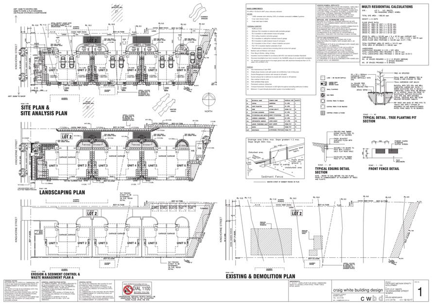
|
|
Development
Committee – Tuesday 08 May 2018
Page
0
|
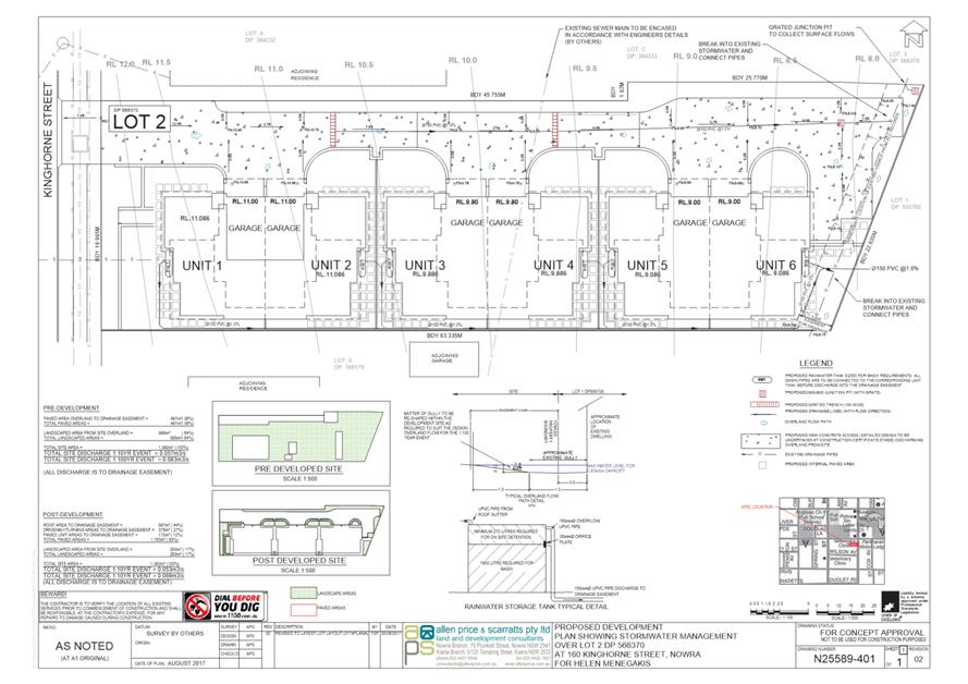
|
|
Development
Committee – Tuesday 08 May 2018
Page
0
|
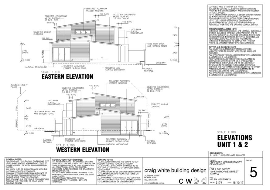
|
|
Development
Committee – Tuesday 08 May 2018
Page
0
|
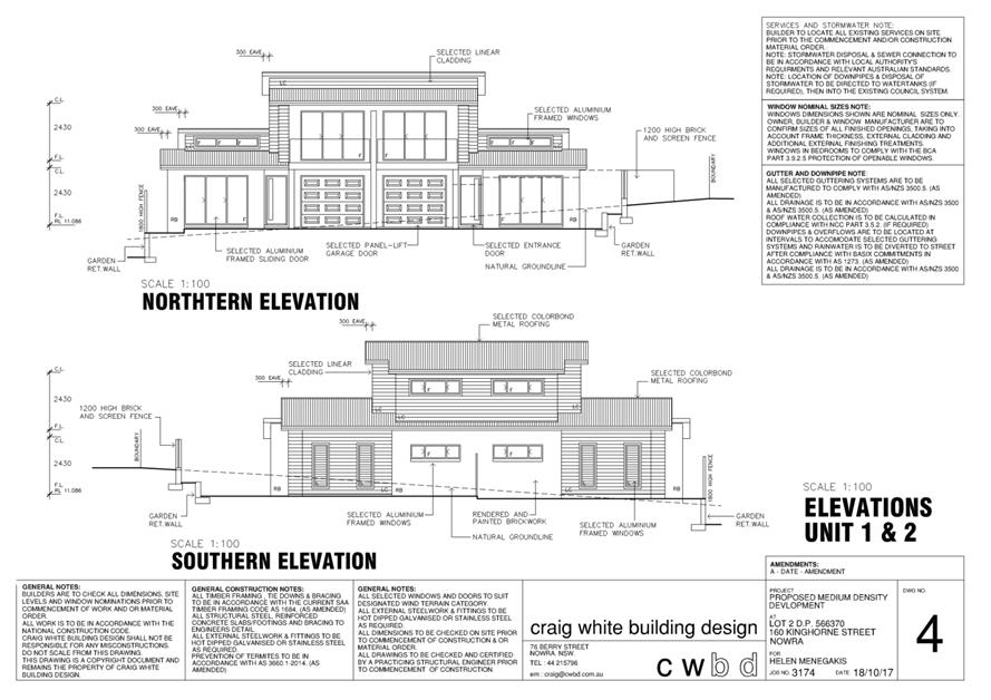
|
|
Development
Committee – Tuesday 08 May 2018
Page
0
|
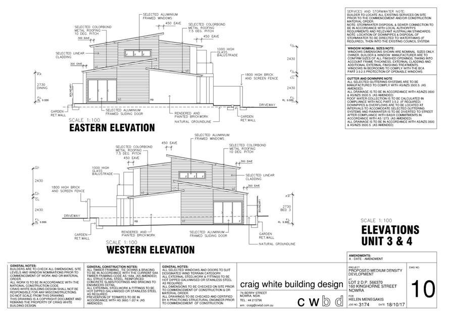
|
|
Development
Committee – Tuesday 08 May 2018
Page
0
|
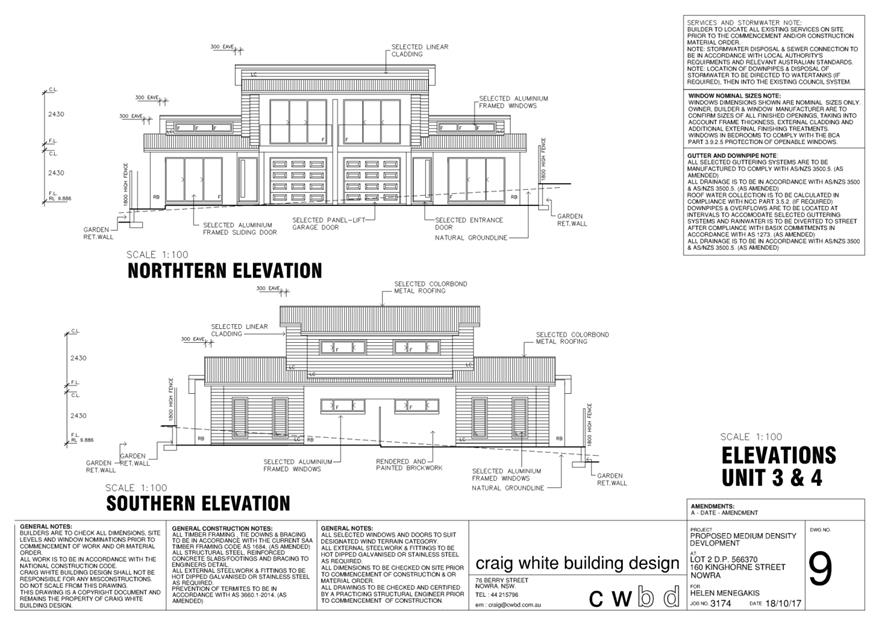
|
|
Development
Committee – Tuesday 08 May 2018
Page
0
|

|
|
Development
Committee – Tuesday 08 May 2018
Page
0
|
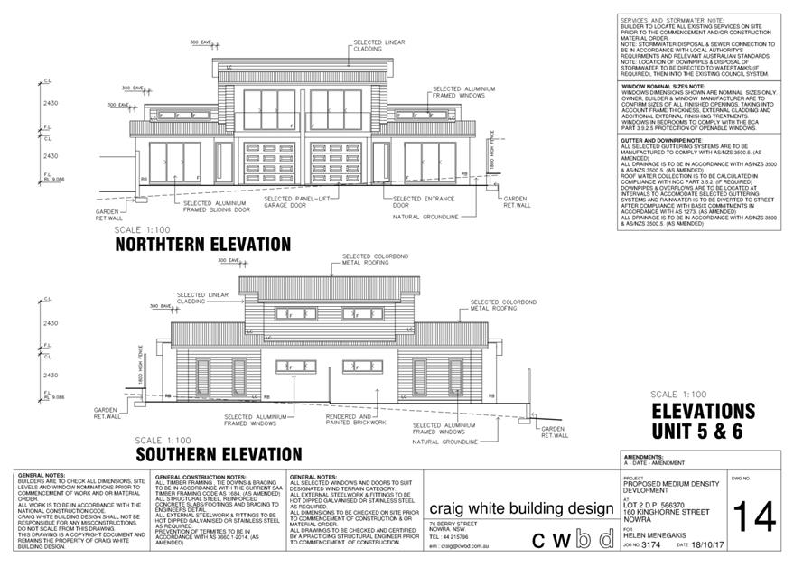
|
|
Development
Committee – Tuesday 08 May 2018
Page
0
|
DE18.39 Proposed
Draft Medium Density Amendment - Shoalhaven Development Control Plan 2014
HPERM Ref: D18/125082
Group: Planning
Environment & Development Group
Section: Strategic
Planning
Attachments: 1. Draft
Chapter G13: Medium Density and Other Residential Development (under separate
cover) ⇨
2. Draft Dictionary (under
separate cover)
Purpose / Summary
Obtain
the required resolution to commence the formal exhibition of the draft Medium
Density Amendment to Shoalhaven Development Control Plan (DCP) 2014.
|
Recommendation (Item to be
determined under delegated authority)
That Council:
1. Support
the exhibition of the draft Medium Density Amendment to Shoalhaven
Development Control Plan 2014 for a period of 28 days as per legislative
requirements.
2. Receive
a further report on the draft Medium Density Amendment following the conclusion
of the public exhibition period.
3. Advise
key stakeholders, including relevant industry representatives, of this
decision.
|
Options
1. As recommended.
Implications: This is the preferred option as it
will enable Council to respond to the Dual Occupancy Review, Low Rise Medium
Density Housing Code and Design Guide and identified operational
issues. This will result in medium density provisions that
holistically consider local character and context, appropriate density, good
quality design, amenity, universal design and more broadly the public
interest.
2. Adopt an
alternative recommendation.
Implications: This will depend on the extent of any
changes and could postpone the implementation of more appropriate medium
density residential development provisions.
3. Not adopt the
recommendation.
Implications: This could stop or postpone the
implementation of more appropriate medium density residential development
provisions. This option is not preferred as the ‘status quo’
approach will continue to result in poor built form and liveability outcomes
for both residents and the broader community.
Background
Council’s Development
Committee resolved, under delegation, on 2nd June 2015 to commence a
large-scale systematic review/amendment of Shoalhaven DCP 2014 to address
several existing Council resolutions and other matters identified since the
commencement of the original plan on 22 October 2014. Stage 5 of the
review/amendment included the review of DCP Chapters related to subdivision and
residential development, namely:
· Chapter
G11: Subdivision of Land.
· Chapter
G12: Dwelling Houses, Rural Worker’s Dwellings, Additions and Ancillary
Structures.
· Chapter
G13: Dual Occupancy Development.
· Chapter
G14: Other Residential Development.
Dual Occupancy Review
In January 2016, Council’s
Development Committee also considered a report on a development application for
the strata subdivision of an existing attached dual occupancy in Milton
(DA14/1662) which did not comply with the minimum lot size prescribed by
Shoalhaven Local Environmental Plan (LEP) 2014.
At the meeting, it was resolved
to support the variation to the minimum lot size (MIN16.8), and:
That Council’s policy position on locations where
subdivision of dual occupancy can be permitted be reviewed, and that this
review include consideration of strata subdivision options where more
appropriate.
Following this resolution,
Council staff undertook a review of dual occupancy development and its
subdivision in Shoalhaven which considered:
· Council’s
policy position on locations where subdivision of dual occupancy can be
permitted;
· The dual occupancy
subdivision provisions in Shoalhaven DCP 2014; and
· Investigated the
appropriateness of Torrens, community and strata title dual occupancy subdivision.
In June 2016, Councillors were
briefed on the outcome of the dual occupancy review, namely that:
· Subdivision does
not essentially change the appearance of the development as it usually occurs
later.
· Consideration
should first be given to the timely inclusion of better-quality design controls
in Shoalhaven DCP 2014 to improve the standard of the finished development.
· Future
consideration may be given to the expansion of dual occupancy subdivision areas
throughout the city (e.g. Berry) if deemed necessary following a Shoalhaven DCP
2014 amendment.
The review of design related
provisions is also considered relevant to other forms of medium density
residential development that are currently addressed in DCP Chapter G14: Other
Residential Development.
Essentially the work Council
staff have been undertaking in this regard and its timing was also cognisant of
the reforms being undertaken by the NSW Government and the potential that they
may be finally released at some point during Councils review process.
Low Rise Medium Density
Housing Code and Design Guide
The
NSW Department of Planning and Environment (DP&E) released the new Low Rise Medium
Density Housing Code amendment to the State
Environmental Planning Policy (Exempt and Complying Development Codes) 2008
(Codes SEPP), and the supporting Low Rise Medium
Density Design Guide on 6 April 2018.
The Low
Rise Medium Density Housing Code and Design Guide are set to commence on 6 July
2018. They will fill the gap in complying development policy in the Codes SEPP
by introducing provisions that will apply to low rise medium density housing
types including the following:
· Dual
occupancies (i.e. attached, detached and ‘one above the other’).
· Multi
dwelling housing (terraces).
· Manor
homes.
The new Code will apply:
· Across
NSW in the R1, R2, R3 and RU5 zones, where medium density housing is permitted
under a Council LEP;
· To
development of dual occupancy, manor house of terraces may only be carried out
if the development is permitted within the zone under the relevant Council LEP;
and
· The
development must meet certain minimum lot size requirements set via the
relevant Council LEP or as applied by the Code.
Accompanying the amendment to
the Codes SEPP is the Design Guide which is a comprehensive set of design
guidelines that present a state-wide approach to promote well designed and
environmentally sustainable medium density development that contributes
positively to the existing character of an area. It is noted that Council
is not required to adopt the Design Guide for the purpose of assessing
development applications for medium density development i.e. it only applies in
relation to complying development under the Codes SEPP.
This latest package of planning
reforms by the NSW Government has several implications for Shoalhaven DCP 2014,
most notably the fact that the above land uses can be undertaken as complying
development in relevant existing zones which means that Shoalhaven LEP 2014 and
Shoalhaven DCP 2014 will have no effect and Council will potentially not
assesses proposed development.
It is important to ensure that
difference between the state mandated complying development provisions and the
Shoalhaven DCP 2014 provisions is not too vast, to ensure that there is not a
significant difference between the products when viewed from the public
domain. As such, Council staff have undertaken a review of the content of
the Design Guide to identify components that could be appropriately integrated
into Shoalhaven DCP 2014.
Proposed Medium Density
Amendment to Shoalhaven DCP 2014
Following the release of the Low
Rise Medium Density Housing Code and Design Guide and the outcomes of the Dual
Occupancy Review, it is considered appropriate to proceed and commence the
Medium Density Amendment to Shoalhaven DCP 2014 focusing on the following existing
chapters (and supporting information):
· Chapter
G13: Dual Occupancy Development.
· Chapter
G14: Other Residential Development.
· Dictionary.
It is noted that
amendments/reviews to the following Shoalhaven DCP 2014 Chapters are also still
identified as priority projects in the Strategic Planning Works Program and
will be reported separately to Council for consideration in due course:
· Chapter
G11: Subdivision of Land.
· Chapter
G12: Dwelling Houses, Rural Worker’s Dwellings, Additions and Ancillary
Structures.
The draft Medium Density
Amendment package includes the following proposed draft Chapter (and supporting
changes to the Dictionary):
· Draft
Chapter G13: Medium Density Development and Other Residential Development (Attachment
1); and
· Draft
Dictionary (Attachment 2).
Draft Amendment proposes to
combine the coverage of the current Chapters G13 and G14 and applies to land
where dual occupancy, multi dwelling housing, multi dwelling housing
(terraces), attached dwellings, semi-detached dwellings, manor houses,
integrated housing development, residential flat buildings, shop top housing,
seniors housing, boarding houses, group homes and hostels are permissible with
development consent. As such the proposed chapter will apply to
residential developments above a single dwelling. It also considers the more complex
issues relating to medium and higher density residential development arising
from the:
· Low
Rise Medium Density Housing Code and Design Guide.
· Outcomes
of the Dual Occupancy Review.
· Resolutions
of Council.
· Operational
issues or matters that need clarification that have been identified since the
Shoalhaven DCP 2014 became effective on 22 October 2014.
Notable components of the draft
Amendment are outlined in the following Table:
|
Theme
|
Proposed content
|
|
General
|
· Consolidation
of Chapter G13 and Chapter G14 content to streamline the provisions relating
to medium density development (above a single dwelling). The content
has been refined to reduce redundancy, bring the chapter in line with current
DCP requirements and modernise the content to current industry
standards.
· Expansion
of applicable land uses to include the following new terms: multi dwelling
housing (terraces) and manor houses.
|
|
Medium
Density: Principle Controls
|
· Introduction
of amalgamation and feasibility requirements. Supporting written
evidence is required demonstrating that lot consolidation/amalgamation is not
feasible as a result of negotiations and reasonable financial offers for
certain development (e.g. dual occupancy in the R3 Medium Density Residential
zone).
· Introduction
of more appropriate floor space ratio (density) provisions of 0.5:1 to 0.7:1
depending on the land use and zone.
· Refinement
and expansion of setback provisions.
· Refinement
of landscaping provisions:
- 10%
of the site area is to include high quality formal landscaping.
- 20%
of the site area is to include general landscaping.
- At
least 35% of the front setback is to be landscaped.
· Refinement
of driveway provisions, including avoidance of a ‘gun-barrel’
effect down a side boundary.
|
|
Medium
Density:
Siting
the Development
|
· More
comprehensive provisions to address public domain interface as well as local
character and context.
· Requirement
to consider cumulative impact of clustering development in certain contexts.
|
|
Medium
Density: Amenity
|
· Greater
consideration of building separation and visual and acoustic privacy.
· Introduction
of requirements for laundry facilities placed in garages, communal open space
provisions for multi dwelling housing and tandem parking requirements for
dual occupancy development.
· Introduction
of minimum ceiling heights and provisions relating to dwelling size and
layout.
· Private
open space:
- Requirement
that private open space must be located behind the front building line.
- Refinement
of minimum areas of private open space.
|
|
Medium
Density: Configuration and Design
|
· Reintroduction
of provisions clarifying attachment of dual occupancy.
· General
design considerations such as variation, materials, co-joining of double
garages and fencing.
· Universal
design (adaptability and accessibility):
- Introduction
of rates for provision of accessible and adaptable housing.
- New class
1a or 2 dwellings to meet a gold standard as per the Livable
Housing Design Guidelines.
Note: feedback will also be sought during
the public exhibition period as to whether a ‘silver’ or
‘platinum’ standard would be more appropriate.
|
|
Medium
Density: Environment
|
Detailed provisions for bin
storage, presentation and collection arrangements.
|
|
Residential
flat buildings, seniors housing, boarding houses and group homes
|
New objectives, performance
criteria and acceptable solutions tying back to the relevant State
Environmental Planning Policies.
|
|
Dictionary
|
Introduction of new terms to
support draft Chapter G13: accessible, adaptable, communal open space,
external clothes drying facilities, formal landscaping, laneway, primary
frontage, secondary frontage, stacked parking and tandem parking.
|
Community
Engagement
The draft Medium Density
Amendment will be publicly exhibited for 28 days in accordance with legislative
requirements at the Nowra Administrative Building. Documentation will
also be available on Council’s website and at the Ulladulla Administrative
Buildings.
A targeted Industry Forum was
held on 26 October 2016 to discuss the review of the relevant Shoalhaven DCP
2014 chapters related to medium density development. Further industry
consultation will be undertaken during the public exhibition period if required/appropriate.
Policy
Implications
The draft Medium Density
Amendment seeks to respond to the Dual Occupancy Review, Low Rise Medium
Density Housing Code and Design Guide and identified operational issues.
In doing so, draft Chapter G13: Medium Density Development and Other
Residential Development will ultimately replace existing Chapters G13: Dual
Occupancy Development and G14: Other Residential Development.
Financial
Implications
The draft Medium Density
Amendment to Shoalhaven DCP 2014 will continue to be resourced within the
existing Strategic Planning budget.
Risk
Implications
Should the draft Medium Density
Amendment not proceed, there is a risk that Council will not be able to respond
to the increasing demand for medium density development in a way that
holistically considers local character and context, appropriate density, good
quality design, amenity, universal design and more broadly the public
interest. This could result in poor built form and liveability outcomes
for both residents and the broader community. There are also matters that need
to be revised to ensure the planning controls continue to operate as
expected/intended and resolve inconsistencies.
|
|
Development
Committee – Tuesday 08 May 2018
Page
0
|
DE18.40 Heritage
Investigations - Chinaman's Island, Lake Conjola
HPERM Ref: D18/128260
Group: Planning
Environment & Development Group
Section: Strategic
Planning
Attachments: 1. Representation
Response - Hon. Shelley Hancock ⇩
2. Heritage
Assessment - Chinaman's Island (under separate cover) ⇨
3. Department of Industry -
Crown Lands Correspondence ⇩
Purpose / Summary
Obtain direction on the potential local heritage listing (in the
Local Environmental Plan) of the remaining cottages and archaeological remains
of a timber railway located on Chinaman’s Island in Lake Conjola.
|
Recommendation (Item to be
determined under delegated authority)
That Council:
1. Support
the listing of the former timber railway on Chinaman’s Island as an
archaeological site in Schedule 5 of Shoalhaven Local Environmental Plan 2014
and include the item in the upcoming Heritage Housekeeping Amendment to
Shoalhaven Local Environmental Plan 2014.
2. Not
support the listing of the remaining cottages on Chinaman’s Island as
local heritage items in Schedule 5 of Shoalhaven Local Environmental Plan
2014.
3. Support
the mitigation recommendations for the partial or total removal of the
remaining cottages as outlined in the Louise Thom Heritage Assessment
(Attachment 2):
a. Full
archival recording.
b. Preparation
of a Heritage Interpretation Strategy and provision of interpretive
information at Lake Conjola.
c. Provision
of a copy of the Heritage Assessment to the Shoalhaven City Library and each
of the remaining leaseholders.
4. Advise
the remaining leaseholders, Conjola Community Association and Department of
Industry - Crown Lands of this decision.
|
Options
1. As recommended.
Implications: This is the preferred option as it
will commence the process to list the former timber railway on Chinaman’s
Island as an archaeological site in Schedule 5 of Shoalhaven Local
Environmental Plan (LEP) 2014. Further, the future partial or total
demolition of the remaining cottages will be mitigated by the steps outlined in
part 3 of the above recommendation. It is noted that the mitigation
approach is supported by Department of Industry (DoI) – Crown Lands.
2. List the
cottages and the former timber railway in Schedule 5 of Shoalhaven LEP 2014.
Implications: This option is not preferred. The
heritage listing of the cottages will not protect them from demolition by the
Crown as per Section 4.33 of the Environmental Planning and Assessment Act
1979 (EP&A Act). Upon demolition of the cottages, Council
would also be required to prepare a Planning Proposal (PP) to remove the
listing of the cottages from Schedule 5 of Shoalhaven LEP 2014 which is a
resource intensive process.
3. Adopt an
alternative recommendation.
Implications: Depending on its nature, an
alternative recommendation could delay the process to consider heritage
potential at Chinaman’s Island.
4. Reject the
recommendation.
Implications: This is not the preferred option as
the heritage potential at Chinaman’s Island will not be resolved.
Background
Chinaman’s Island is in
Lake Conjola, north of the existing urban area as shown in Figure 1
below.
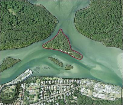
Figure 1: Chinaman’s Island, Lake Conjola
Chinaman’s Island is owned
by the NSW Government and is managed by DoI – Crown Lands. Early
last century, 12 lots were offered for lease by ballot on a Permissive
Occupancy (lease) basis.
Several small cottages were
subsequently constructed by the leaseholders during the 1940’s and
1950’s, with some used permanently and others as holiday cottages.
During the 1970’s, the
leaseholders were informed by the Crown that the cottages would be demolished
when the last surviving occupant passed away.
Of the 12 original cottages:
· 5
have been demolished (the last of was removed in 2012).
· 4
are earmarked for removal.
· 3
are subject to a current lease (1 is permanently occupied and 2 are used for
holiday purposes.
The Island is currently zoned E2
Environmental Conservation under Shoalhaven LEP 2014 which reflects its
location in an environmentally sensitive water body and the significant
vegetation/habitat identified on the Island. The Island is located less
than 500 metres from oyster leases and Lake Conjola itself is used extensively
for recreational activities.
Given its location, the island
is flood prone and categorised as a high hazard floodway. The risk to
occupants is increased given that the island itself may be completely inundated
in larger flood events, and access to and from the island would be
dangerous. The island is also partly mapped as bushfire prone.
The cottages were constructed
from weatherboard and fibro-cement sheeting which contain asbestos.
Previous consents for demolition have contained conditions regarding the safe
removal of asbestos.
The Interim Heritage Order
and Heritage Significance
In 2015, relatives of the
leaseholders petitioned the NSW Government to issue an Interim Heritage Order
(IHO) under the NSW Heritage Act 1977 to preserve the remaining
cottages.
On 12 July 2016 the NSW Minister
for Heritage advised that he had resolved not to proceed with an IHO for the
cottages. Due to the urgency of the situation (possible pending
demolition), the Minister recommended that Council assess the likely
significance of the cottages with a view to possibly listing them as local
heritage items in Shoalhaven LEP 2014.
In addition, the Minister
recommended that the Crown undertake an archival recording of the remaining
cottages to record the historic stories of the cottages for future generations.
Heritage Assessment
Report
On 6 December 2016, under
delegation, Council’s Development Committee resolved (MIN16.942) that
Council:
1. Seek
advice from the member of South Coast the Hon Shelley Hancock as to her support
for the heritage value of the cottages on Chinaman’s Island;
2. Seek
support from the Local Member to make representations to the Minister
3. Subsequent to
parts 1) and 2) Council undertake a heritage assessment of the Chinaman’s
Island cottages to determine their heritage significance.
4. If
required a further report back to council on this matter.
By way of written
correspondence, advice was sought from the Hon. Shelley Hancock Member for the
South Coast on 23 December 2016. A response was received on 5 September
2017 (Attachment 1) noting that representations had previously been made
to the NSW Minister of Heritage, however support was extended to Council to
investigate the heritage value of the cottages.
As such, Louise Thom Heritage
was engaged by Council to prepare a heritage assessment for the cottages on
Chinaman’s Island. The Heritage Assessment (Attachment 2)
concluded that the Chinaman’s Island Cottages were rare and
representative and should be listed as an item of local heritage item in
Schedule 5 of Shoalhaven LEP 2014. However, should the partial or total
removal of cottages be proposed, the Heritage Assessment has pragmatically
identified that the following would mitigate against the loss:
· Full
archival recording.
· Preparation
of a Heritage Interpretation Strategy and provision of interpretive information
at Lake Conjola in a location where Chinaman’s Island can be viewed.
· Provision
of a copy of the Heritage Assessment to Shoalhaven City Library and each of the
remaining lease holders.
The Heritage Assessment also
identified the potential existence of the archaeological remains of a former
timber railway on the island which was associated with a former timber depot
and timber operation. The Heritage Assessment also recommends that it
should be protected as an archaeological item in Schedule 5 of Shoalhaven LEP
2014.
It is noted that the cottages
and timber railway were not identified or considered through the Shoalhaven
Heritage Study that essentially lead to the Heritage Schedule that is now
contained in Shoalhaven LEP 2014.
Department of Industries
– Crown Lands
DoI – Crown Lands have
provided advice to Council (Attachment 3) outlining that the Minister
administering the Crown Lands Act 1989 does not support the listing of
the cottages as an item of local heritage in Schedule 5 of Shoalhaven LEP
2014. Even if the cottages are heritage listed, DoI – Crown Lands
have advised that they will continue to revoke the leases upon the
passing of the leaseholders.
It is DoI – Crown Lands
position that the heritage listing of these cottages would have significant
cost and management implications for Government. The buildings are not
considered suitable for continued long-term use for residential purposes or for
redevelopment for a new use. Given the poor condition of the cottages and
the fact that they contain asbestos and are located on an island with limited
supporting infrastructure, DoI – Crown Lands have advised that they
cannot justify maintaining the structures based on the potential heritage
significance alone, nor do they have the funding available to do so.
As such, they consider that the
environmental value in returning the Island to its natural state outweighs the
merits of retaining the cottages and that it would be in the greater public
interest to recognise the use of the Island by other means (e.g. archival
recording). It is noted that the DoI – Crown Lands Strategic Plan
for Chinaman’s Island includes the removal of all cottages, the rehabilitation
of the grounds and reservation for public recreation and environmental
protection.
It is noted that DoI –
Crown Lands:
· Does
not object to the listing of the former timber railway as an archaeological
site in Schedule 5 of Shoalhaven LEP 2014; and
· Has
committed to undertake an archival recording of the remaining cottages as well
as develop a heritage interpretation strategy and interpretive signage.
Relevant Legislative
Considerations
Under Clause 5.10 Heritage
Conservation of Shoalhaven LEP 2014, demolition of listed heritage items is
permitted with development consent. As such, should Council proceed to list the
remaining cottages in the LEP, DoI – Crown Lands must obtain development
consent from Council prior to the demolition of the cottages.
It is noted that under the
provisions of Section 4.33 Determination of Crown Development Applications of
the EP&A Act, a Council must not refuse a development application lodged by
the Crown, except with the approval of the Minister.
As such, Council could not refuse a development application
for the demolition of the remaining Chinaman’s Island cottages without
concurrence from the NSW Minister for Planning.
Conclusion
As outlined above, it is the
intention of DoI – Crown Lands to discontinue the remaining three leases
at the passing of each surviving leaseholder and subsequently demolish the
remaining cottages.
Should Council resolve to list
the cottages in Schedule 5 of Shoalhaven LEP 2014, the process could include
the following steps:
· Shoalhaven
LEP 2014 is amended to include the cottages in Schedule 5 via the Planning
Proposal process (Note: would still ultimately need to be agreed to by the NSW
Government).
· DoI
– Crown Lands could still submit a development application to demolish
the cottages. Council cannot refuse the development application.
· DoI
– Crown Lands could then still proceed to demolish the cottages.
· Shoalhaven
LEP 2014 would then need to be amended again to remove the listed cottages from
Schedule 5 via the Planning Proposal process.
Importantly, the provisions of
the EP&A Act limit Council’s ability to protect the remaining
cottages, regardless of whether they are ultimately heritage listed. As
such, it is recommended that the remaining cottages on the Island not be
heritage listed. Instead an emphasis should be placed on the mitigation
measures outlined in the Heritage Assessment. This will also mitigate
against the need for a subsequent PP to remove the cottages from Schedule 5 of
Shoalhaven LEP 2014 following the demolition of the cottages which remains the
intent of DoI – Crown Lands.
There would be value in listing
the former timber railway as an archaeological site in Schedule 5 of Shoalhaven
LEP 2014.
Community
Engagement
No formal community engagement
has been undertaken at this stage. The representative of the remaining
leaseholders (and relatives) has been advised that this matter will be
presented to Council’s Development Committee for consideration.
Any future PP to include items
in Schedule 5 of Shoalhaven LEP 2014 would be subject to the exhibition
requirements set out in the Gateway determination in accordance with the
relevant legislation. This will involve notifying all adjoining landowners,
relevant community groups and other interested parties.
Policy
Implications
Inserting and deleting items in
Schedule 5 of Shoalhaven LEP 2014 can only be undertaken via a PP. As
such, should the cottages be listed as heritage items, another PP would be
required to remove the listing should the cottages be demolished. PPs are
generally resource and time intensive.
Financial
Implications
There are no immediate financial
implications for Council. Any future amendments to Shoalhaven LEP 2014
and Shoalhaven DCP 2014 would be resourced from the Strategic Planning budget.
Risk
Implications
It is the future intention of
DoI – Crown Lands to appoint Council as trustee of the reserve, charged
with care, control and management. Council staff would be reluctant to
support such a request whilst the remaining cottages are located on the Island
due to the risk associated with the ongoing maintenance of the cottages (e.g. vandalism,
unauthorised occupations, asbestos etc.).
|
|
Development
Committee – Tuesday 08 May 2018
Page
0
|
|

|
Development
Committee – Tuesday 08 May 2018
Page
0
|
|
|
Development
Committee – Tuesday 08 May 2018
Page
0
|
DE18.41 Changes
to new legislative provisions relating to the Joint Regional Planning Panels
HPERM Ref: D18/132059
Group: Planning
Environment & Development Group
Section: Development
Services
Attachments: 1. Letter
from the Dept of Planning & Environment concerning legislative provisions
relating to planning panels ⇩
Purpose / Summary
To inform Council of new
legislative provisions relating to the Sydney District and (Joint) Regional
Planning Panels.
The changes impact a current
nominated member(s). In this regard, this report seeks to update and
confirm the list of representatives for Shoalhaven City Council on the Regional
Planning Panel.
|
Recommendation
That:
1. The
Development Committee receive this report for information.
2. A new
nominee(s) be considered and recommended for Council’s representation
on the Regional Planning Panel.
3. The Panel
Secretariat be contacted reaffirming current and new members.
|
Options
1. As recommended
– reaffirm and nominate a new member or members for the Regional Planning
Panel.
Implications: This will satisfy the new provisions
pertaining to panel membership.
2. Resolve
alternatively and advise staff accordingly.
Implications: The implications would depend
on the resolution.
Background
On 26 September 2017 at an
Ordinary Meeting of Council, a report was considered. The purpose of the
report was:
To confirm the list of Council representatives on Other
Committees or Organisations Outside of Council.
The recommendation:
That Council resolve the representative membership
of Councillors and other delegates on other Committees or Organisations Outside
of Council for the period to 30 September 2018
was adopted.
On 5 October 2017 Council wrote
to the Secretariat of the Joint Regional Planning Panel advising:
Following Council’s Ordinary Meeting, which
was held on 26 September 2017, Council reviewed its representation of
committees and organisations outside of Council.
Clr Levett and Clr Watson have been appointed as
the representatives for the Joint Regional Planning Panel with alternates Clr
Patricia White and Mr Ernie Royston.
Please find contact information below.
Financial Implications
A sitting fee of $400.00 is paid
to the Council and Community Representatives.
Risk Implications
If the new provisions are not
observed, there is potential for non-compliance with legislation.
Details
Membership
Amendments to the Environmental
Planning and Assessment Act 1979 (the Act) came into force on 1 March
2018. A key change in the Act now means that property developers
and real estate agents are no longer eligible to sit as either state-nominated
or council-nominated Panel members.
Accordingly, Council must review
the nominated Panel members and ensure their continuing eligibility to
participate. Any changes to the council-nominated members must be relayed
to the Planning Panels Secretariat at least two weeks prior to any scheduled
meeting.
Councillor Levett has formally
advised that he will no longer be attending and participating in Regional Panel
Meetings as a result of the changes. In this regard, a new member is
required. Councillors may also choose to consider the current
representatives.
There have been other changes
concerning Panels including:
Other Changes
1. The
threshold for general development has changed to a Capital Investment Value of
$30M for regionally significant development.
2. Panel
determinations can now be the subject of a review (under section 8.2 of the
Act) however the review must be by members other than those who made the
original decision.
3. Panel
meetings are to be recorded with the recording made available on the Panel
website. The Panels Secretariat has arranged for audio recording specialist
to record meetings however where Council are equipped to make recordings those
services and assistance will be sought instead.
4. The
title of the Regional Planning Panel has changed, with the preceding word
“Joint” now omitted.
Conclusion
In light of Councillor
Levett’s advice, a new representative must be selected. The
Secretariat must be advised following the decision.
More information about the
Panels is available via the following links:
http://www.planningpanels.nsw.gov.au/AboutUs/tabid/64/language/en-AU/Default.aspx
http://www.planning.nsw.gov.au/Assess-and-Regulate/Development-Assessment/Joint-Regional-Planning-Panels
|
|
Development Committee
– Tuesday 08 May 2018
Page
0
|
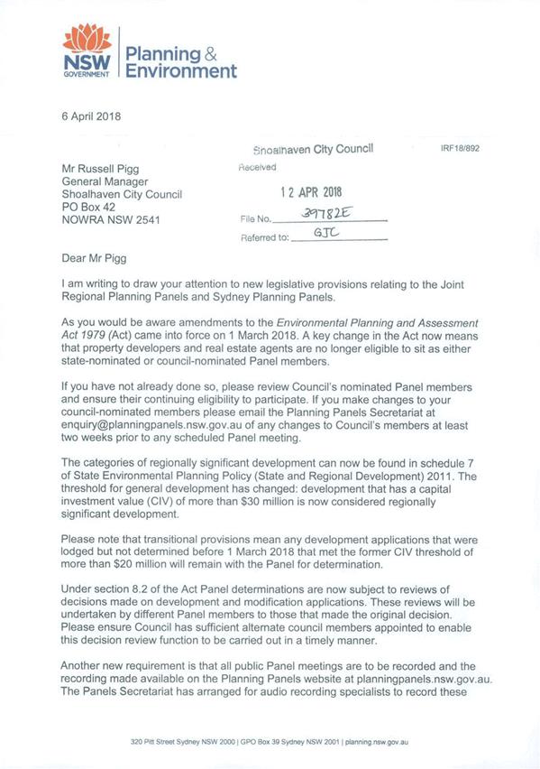
|
|
Development
Committee – Tuesday 08 May 2018
Page
0
|
Local Government Amendment (governance &
planning) act 2016
Chapter
3, Section 8A Guiding principles for councils
(1)
Exercise of functions
generally
The
following general principles apply to the exercise of functions by councils:
(a) Councils should provide strong
and effective representation, leadership, planning and decision-making.
(b) Councils should carry out functions
in a way that provides the best possible value for residents and ratepayers.
(c) Councils should plan
strategically, using the integrated planning and reporting framework, for the
provision of effective and efficient services and regulation to meet the
diverse needs of the local community.
(d) Councils should apply the
integrated planning and reporting framework in carrying out their functions so
as to achieve desired outcomes and continuous improvements.
(e) Councils should work
co-operatively with other councils and the State government to achieve desired
outcomes for the local community.
(f) Councils should manage
lands and other assets so that current and future local community needs can be
met in an affordable way.
(g) Councils should work with
others to secure appropriate services for local community needs.
(h) Councils should act fairly,
ethically and without bias in the interests of the local community.
(i) Councils should be
responsible employers and provide a consultative and supportive working
environment for staff.
(2) Decision-making
The
following principles apply to decision-making by councils (subject to any other
applicable law):
(a) Councils should recognise
diverse local community needs and interests.
(b) Councils should consider social
justice principles.
(c) Councils should consider the
long term and cumulative effects of actions on future generations.
(d) Councils should consider the
principles of ecologically sustainable development.
(e) Council decision-making should
be transparent and decision-makers are to be accountable for decisions and
omissions.
(3) Community participation
Councils
should actively engage with their local communities, through the use of the
integrated planning and reporting framework and other measures.
Chapter
3, Section 8B Principles of sound financial management
The
following principles of sound financial management apply to councils:
(a) Council spending should be responsible and
sustainable, aligning general revenue and expenses.
(b) Councils should invest in responsible and
sustainable infrastructure for the benefit of the local community.
(c) Councils should have effective financial
and asset management, including sound policies and processes for the following:
(i) performance management
and reporting,
(ii) asset maintenance and
enhancement,
(iii) funding decisions,
(iv) risk management practices.
(d) Councils should have regard to achieving
intergenerational equity, including ensuring the following:
(i) policy decisions are made
after considering their financial effects on future generations,
(ii) the
current generation funds the cost of its services
Chapter
3, 8C Integrated planning and reporting principles that apply to councils
The
following principles for strategic planning apply to the development of the
integrated planning and reporting framework by councils:
(a) Councils should identify and prioritise key
local community needs and aspirations and consider regional priorities.
(b) Councils should identify strategic goals to
meet those needs and aspirations.
(c) Councils should develop activities, and
prioritise actions, to work towards the strategic goals.
(d) Councils should ensure that the strategic
goals and activities to work towards them may be achieved within council
resources.
(e) Councils should regularly review and
evaluate progress towards achieving strategic goals.
(f) Councils should maintain an
integrated approach to planning, delivering, monitoring and reporting on
strategic goals.
(g) Councils should collaborate with others to
maximise achievement of strategic goals.
(h) Councils should manage risks to the local
community or area or to the council effectively and proactively.
(i) Councils should make appropriate
evidence-based adaptations to meet changing needs and circumstances.