Development Committee
Meeting
Date: Tuesday,
13 March, 2018
Location: Council Chambers, City Administrative Building, Bridge Road, Nowra
Time: 5.00pm
Membership (Quorum - 5)
Clr Joanna Gash - Chairperson
Clr John Levett - Deputy Chairperson
All Councillors
General Manager or nominee
Please note:
Council’s Code of Meeting Practice permits the electronic recording and
broadcast of the proceedings of meetings of the Council which are open to the
public. Your attendance at this meeting is taken as consent to the possibility
that your image and/or voice may be recorded and broadcast to the public.
Agenda
1. Apologies / Leave of
Absence
2. Confirmation of Minutes
· Development
Committee - 13 February 2018.............................................................. 1
3. Declarations of Interest
4. Mayoral Minute
5. Deputations and
Presentations
6. Notices of Motion /
Questions on Notice
Nil
7. Reports
DE18.15...... Proposed Policy - Development
Potential of Narrow Laneways across Shoalhaven........................................................................................................................ 9
DE18.16...... Update and Proposed Next Steps -
Nowra CBD Fringe Medium Density Study Recommendations Report - Public
Exhibition............................................. 23
DE18.17...... Proponent Initiated Planning
Proposal - Lot 3 DP 846470 Jervis Bay Road, Falls Creek............................................................................................................ 36
DE18.18...... Exhibition - Draft Works in Kind
Agreement - DA15/1102 - 21 Beach Street, Huskisson..................................................................................................... 49
DE18.19...... Nowra CBD Contributions Discount
Subsidy Policy - Review..................... 52
DE18.20...... Exhibition Outcome and
Finalisation - Draft Amendment No 22 - Shoalhaven Development Control Plan 2014
- Chapter N19: Huskisson Mixed Use Zones 57
DE18.21...... Aboriginal Land Claim No.41831 -
Illaroo.................................................... 64
DE18.22...... SF10586 – 11 Grahams Rd,
Meroo Meadow – Lot 2 DP 861948............... 77
8. Confidential
Reports
Nil
|

|
Development
Committee – Tuesday 13 March 2018
Page iii
|
Development Committee
Delegation
THAT pursuant
to s377 (1) of the Local Government Act 1993 the Committee is delegated the
functions conferred on Council by the Environmental Planning & Assessment
Act 1979 (EPA Act), Local Government Act 1993 (LG Act) or any other Act or
delegated to Council, as are specified in the attached Schedule, subject to the
following limitations:
i. The Committee cannot make a decision to make a local environmental
plan to classify or reclassify public land under Division 1 of Part 2 of
Chapter 6 of the LG Act;
ii. The Committee cannot review a
s82A or s96AB EPA Act determination made by the Council or by the Committee
itself;
iii. The Committee cannot exercise any
function delegated to the Council which by the terms of that delegation cannot
be sub-delegated;
iv. The Committee cannot exercise any
function which s377(1) of the LG Act provides cannot be delegated by Council;
and
v. The Committee cannot exercise a
function which is expressly required by the LG Act or any other Act to be
exercised by resolution of the Council.
Schedule
a. All
functions relating to the preparation, making, and review of local
environmental plans (LEPs) and development control plans (DCPs) under Part 3 of
the EPA Act.
b. All
functions relating to the preparation, making, and review of contributions
plans and the preparation, entry into, and review of voluntary planning
agreements under Part 4 of the EPA Act.
c. The
preparation, adoption, and review of policies and strategies of the Council in
respect of town planning and environmental matters and the variation of such
policies.
d. Determination
of variations to development standards related to development applications
under the EPA Act where the development application involves a development
which seeks to vary a development standard by more than 10% and the application
is accompanied by a request to vary the development standard under clause 4.6 of
Shoalhaven Local Environmental Plan 2014 or an objection to the application of
the development standard under State Environmental Planning Policy No. 1
– Development Standards.
e. Determination
of variations from the acceptable solutions and/or other numerical standards
contained within the DCP or a Council Policy that the General Manager requires
to be determined by the Committee
f. Determination
of development applications that Council requires to be determined by the
Committee on a case by case basis.
g. Review
of determinations of development applications under sections 82A and 96AB of
the EP&A Act that the General Manager requires to be determined by the
Committee.
h. Preparation,
review, and adoption of policies and guidelines in respect of the determination
of development applications by other delegates of the Council.
Minutes of the Development Committee
Meeting
Date: Tuesday,
13 February 2018
Location: Council Chambers, City Administrative Building, Bridge Road, Nowra
Time: 5.02pm
The
following members were present:
Clr
Amanda Findley
Clr
Joanna Gash - Chairperson
Clr
Patricia White
Clr John
Wells
Clr John
Levett
Clr Nina
Cheyne
Clr Kaye
Gartner
Clr
Mitchell Pakes
Clr Greg
Watson
Clr Mark
Kitchener
Clr Bob
Proudfoot
Mr Russ
Pigg - General Manager
|
Apologies / Leave of Absence
|
Apologies
were received from Clr Guile and Clr Alldrick.
|
Confirmation of the Minutes
|
|
RESOLVED (Clr Wells / Clr White)
MIN18.77
That
the Minutes of the Development Committee held on Monday 22 January 2018 be
confirmed.
CARRIED
|
Clr Watson – less than significant non pecuniary
declaration of interest - DE18.8 Worrowing Heights Precinct
Plan and Strategic Directions Report - Public Exhibition Outcomes – Clr Watson may be called in as a
witness to matters in court that are alleged to involve one of the property
owners –– will leave room and will not take part in the discussion
or vote.
Deputations and
Presentations
Mr
Daniel McConell addressed the Committee in relation to DE18.8 Worrowing
Heights Precinct Plan and Strategic Directions Report - Public Exhibition
Outcomes
Mr Gavin
Maberly-Smith – representing Rest Point Holdings P/L addressed the
Committee in relation to DE18.10 Planning Proposal - 9 Browns Road South Nowra
– Caravan Park
Mr John
Willmott – representing Mr Babington addressed the Committee in relation
to DE18.11 Planning Proposal - Building Height Review - Southern Part of
Ulladulla CBD
Dr
Morgan Sant addressed the Committee in relation to DE18.12 Aboriginal
Land Claims 7780, 7781 and 41110 – Rose Street, Hyams Beach
|
Procedural Motion - Bring Item Forward
|
|
RESOLVED (Clr Pakes / Clr Proudfoot)
MIN18.78
That the matters
of the following items be brought forward for consideration.
- DE18.8 Worrowing Heights Precinct Plan and Strategic
Directions Report - Public Exhibition Outcomes
- DE18.10 Planning Proposal - 9 Browns Road South Nowra –
Caravan Park
- DE18.11
Planning Proposal - Building Height Review - Southern Part of Ulladulla
CBD
- DE18.12
Aboriginal Land Claims 7780, 7781 and 41110 – Rose Street,
Hyams Beach
CARRIED
|
|
DE18.8 Worrowing Heights
Precinct Plan and Strategic Directions Report - Public Exhibition Outcomes
|
HPERM
Ref: D17/392947
|
|
Recommendation (Item to be determined under delegated authority)
That
1. Council receive the submissions provided in
respect of the draft Worrowing Heights Precinct Plan and Strategic Directions
Report for information.
2. Council adopt the Worrowing Heights Precinct
Plan and Strategic Directions Report as exhibited and with the following
changes:
a. Insert a new section “2.2 Regional
Context” including an explanation of the Illawarra-Shoalhaven Regional
Plan and Jervis Bay Settlement Strategy;
b. Insert comments with respect to European,
Australian and Aboriginal Cultural Heritage within Section 2.4.1 General
Features – Land Use Planning;
c. Insert comments with respect to biodiversity
values and corridors within Section 2.4.3 Precinct Flora and Fauna;
d. Insert comments with respect to environmental
impacts of bushfire hazard risk management within Section 2.4.4 Bushfire;
e. Revise Figure 9: Preferred Precinct Plan to
note that the retention of habitat/biodiversity corridor (width and extent)
and the extent and nature of any developable land will be subject to the
outcome of detailed studies; and
f. Insert two extra Suggested Additional
Detailed Studies within Section 4.4; Aboriginal Cultural Heritage Assessment
and European & Australian Cultural Heritage Assessment.
3. Council write to the NSW Department of
Planning & Environment to seek endorsement of the Worrowing Heights
Precinct Plan and Strategic Directions Report.
4. The review of the Jervis Bay Settlement
Strategy continues to be undertaken in accordance with Council’s
adopted Strategic Planning works program and as part of this consider the
incorporation of the Worrowing Heights Precinct Plan
and Strategic Directions Report as an input into the
review of the Jervis Bay Settlement Strategy.
5. The proponent initiated request for Planning
Proposal for 1310 Naval College Road, Worrowing Heights, which seeks to amend
Shoalhaven Local Environmental Plan 2014 to change the zone from RU2 Rural
Landscape to SP3 Tourist and increase the height limit to 18 metres to enable
the development of a six-storey hotel resort/serviced apartment complex not
be supported by Council.
6. Council advise landowners, submitters and
State Government Agencies to the Draft Worrowing Heights Precinct Plan and
Strategic Directions Report of Council’s resolution in this regard.
|
|
RESOLVED (Clr Gartner / Clr Cheyne)
MIN18.79
That:
1. Council receive the submissions provided in
respect of the draft Worrowing Heights Precinct Plan and Strategic Directions
Report for information.
2. Council adopt the Worrowing Heights Precinct
Plan and Strategic Directions Report as exhibited and with the following
changes:
a. Insert a new section “2.2 Regional
Context” including an explanation of the Illawarra-Shoalhaven Regional
Plan and Jervis Bay Settlement Strategy;
b. Insert comments with respect to European,
Australian and Aboriginal Cultural Heritage within Section 2.4.1 General
Features – Land Use Planning;
c. Insert comments with respect to biodiversity
values and corridors within Section 2.4.3 Precinct Flora and Fauna;
d. Insert comments with respect to environmental
impacts of bushfire hazard risk management within Section 2.4.4 Bushfire;
e. Revise Figure 9: Preferred Precinct Plan to
note that the retention of habitat/biodiversity corridor (width and extent)
and the extent and nature of any developable land will be subject to the
outcome of detailed studies; and
f. Insert two extra Suggested Additional
Detailed Studies within Section 4.4; Aboriginal Cultural Heritage Assessment
and European & Australian Cultural Heritage Assessment.
3. Council write to the NSW Department of
Planning & Environment to seek endorsement of the Worrowing Heights
Precinct Plan and Strategic Directions Report.
4. The review of the Jervis Bay Settlement
Strategy continue to be undertaken in accordance with Council’s adopted
Strategic Planning works program and as part of this consider the
incorporation of the Worrowing Heights Precinct Plan
and Strategic Directions Report as an input into the
review of the Jervis Bay Settlement Strategy.
5. Council to defer consideration of the
Planning Proposal for 1310 Naval College Road, Worrowing Heights, to enable
the matter to be discussed with the proponent.
6. Council advise landowners, submitters and
State Government Agencies to the Draft Worrowing Heights Precinct Plan and
Strategic Directions Report of Council’s resolution in this regard.
Clr Watson – less than significant non pecuniary
declaration of interest - DE18.8 Worrowing Heights
Precinct Plan and Strategic Directions Report - Public Exhibition Outcomes – Clr Watson may be called in as a
witness to matters in court that are alleged to involve one of the property
owners –– will leave room and will not take part in the
discussion or vote.
For: Clr Findley, Clr Gash, Clr White, Clr Wells, Clr Levett, Clr
Cheyne, Clr Gartner, Clr Pakes, Clr Proudfoot and Russ Pigg
Against: Clr Kitchener
CARRIED
|
|
DE18.10 Planning Proposal Request -
Proponent Initiated - 9 Browns Road, South Nowra - Caravan Park
|
HPERM
Ref: D17/421697
|
|
Recommendation (Item to be determined under delegated authority)
That Council:
1. Prepare a Planning Proposal to amend
Shoalhaven Local Environmental Plan 2014 to permit caravan parks as an
additional permitted use for Lot 1 DP 1079345, No. 9 Browns Road South Nowra.
2. Forward this Planning Proposal to the NSW
Department of Planning and Environment for a Gateway determination and if
granted proceed to exhibition in accordance with its requirements, following
which the matter be reported back to Council.
3. Advise the proponent of this resolution and
that the proposal will be subject to fees and charges for proponent initiated
Planning Proposals, including a requirement that the full cost of any
necessary specialist studies be borne by the proponent.
|
|
RESOLVED (Clr Cheyne / Clr Gartner)
MIN18.80
That Council:
1. Prepare a Planning Proposal to amend
Shoalhaven Local Environmental Plan 2014 to permit caravan parks as an
additional permitted use for Lot 1 DP 1079345, No. 9 Browns Road South Nowra.
2. Forward this Planning Proposal to the NSW
Department of Planning and Environment for a Gateway determination and if
granted proceed to exhibition in accordance with its requirements, following
which the matter be reported back to Council.
3. Advise the proponent of this resolution and
that the proposal will be subject to fees and charges for proponent initiated
Planning Proposals, including a requirement that the full cost of any
necessary specialist studies be borne by the proponent.
Note: Clr Watson returned to the meeting, the time being 6.11pm.
For: Clr Findley, Clr Gash, Clr White, Clr Wells, Clr Levett, Clr
Cheyne, Clr Gartner, Clr Pakes, Clr Watson, Clr Kitchener, Clr Proudfoot and
Russ Pigg
Against:
Nil
CARRIED
|
|
DE18.11 Planning Proposal - Building
Height Review - Southern Part of Ulladulla CBD
|
HPERM
Ref: D18/17734
|
|
Recommendation (Item to be determined under delegated authority)
That Council:
1. Endorse Planning
Proposal (PP030) Building Height Review – Southern Part of Ulladulla
CBD (Attachment 1) and submit to the NSW
Department of Planning & Environment for a Gateway determination.
2. Notify Ulladulla
& Districts Community Forum, affected landowners and key stakeholders of
this decision and of further opportunities to be involved as this matter
progresses.
|
|
RESOLVED (Clr White / Clr Gash) MIN18.81
That Council:
1.
Endorse Planning Proposal (PP030) Building
Height Review – Southern Part of Ulladulla CBD (Attachment 1)
with the following change:
a) Include the land that is covered by the proponent initiated PP025
(i.e. land known as Lots 1-7, 9 DP 21597 and Lot CP SP 42583, St Vincent and
Deering Streets, Ulladulla) with a mapped height of 11m in line with the
outcomes of the Review of Building Heights Report endorsed by Council on 14
November 2017 (MIN17.954).
2.
Submit the modified Planning Proposal to the NSW Department of Planning & Environment for a Gateway
determination.
3.
Notify Ulladulla & Districts Community
Forum, affected landowners and key stakeholders of this decision and of
further opportunities to be involved as this matter progresses.
For: Clr Findley, Clr Gash, Clr White, Clr Wells, Clr Levett, Clr
Cheyne, Clr Gartner, Clr Pakes, Clr Watson, Clr Kitchener, Clr Proudfoot and
Russ Pigg
Against:
Nil
CARRIED
|
|
DE18.12 Aboriginal Land Claims Numbers
7780, 7781 and 41110 - Rose Street, Hyams Beach
|
HPERM
Ref: D18/18069
|
|
Recommendation (Item to be determined under delegated authority)
That Council notify the NSW Department of Industry – Crown Lands
Aboriginal Land Claims Investigation Unit that Council:
1. Does not support the granting of ALC Numbers
7780 and 7781 over Lot 79 DP 755907 and two Part Lots 78 DP 755907 at Rose
Street, Hyams Beach.
2. Has no objection to the granting of ALC
Number 41110 over the two Part Lots 78 DP 755907 at Rose Street, Hyams Beach,
subject to any agreements, easements of rights of way required by Council
being excluded from the claims, or being resolved as part of the
determination of the Claim.
|
|
RESOLVED (Clr Watson / Clr Pakes)
MIN18.82
That Council
1.
Notify the NSW Department of Industry –
Crown Lands Aboriginal Land Claims Investigation Unit that Council:
a.
Does not support the granting of ALC Numbers
7780 and 7781 over Lot 79 DP 755907 and two Part Lots 78 DP 755907 at Rose
Street, Hyams Beach.
b.
Has no objection to the granting of ALC Number
41110 over the two Part Lots 78 DP 755907 at Rose Street, Hyams Beach,
subject to any agreements, easements of rights of way required by Council
being excluded from the claims, or being resolved as part of the
determination of the Claim.
2.
Once the land claim has been dealt with, that
the General Manager immediately report back to Council
a.
On the options to change the reservation to
permit community use over Lot 79
b.
Opportunities to appoint a community group to
undertake the restoration and renovations of the building
For: Clr Findley, Clr Gash, Clr White, Clr Wells, Clr Levett, Clr
Pakes, Clr Watson, Clr Kitchener, Clr Proudfoot and Russ Pigg
Against: Clr Cheyne and Clr Gartner
CARRIED
|
Reports
|
DE18.7 Proposed Submission -
Draft Greener Places Policy
|
HPERM
Ref: D18/19106
|
|
Recommendation (Item to be determined under delegated authority)
That Council make a submission to the Government Architect NSW on the
draft Greener Places policy based on the content of this report.
|
|
RESOLVED (Clr Findley / Clr Wells)
MIN18.83
That Council make a submission to the
Government Architect NSW on the draft Greener Places policy based on
the content of this report.
For: Clr Findley, Clr Gash, Clr White, Clr Wells, Clr Levett, Clr
Cheyne, Clr Gartner, Clr Watson, Clr Kitchener, Clr Proudfoot and Russ Pigg
Against:
Clr Pakes
CARRIED
|
|
DE18.8 Worrowing
Heights Precinct Plan and Strategic Directions Report - Public Exhibition
Outcomes
|
HPERM Ref: D17/392947
|
|
Item
dealt with earlier in the meeting see MIN18.79
|
|
DE18.9 Shoalhaven DCP 2014 - Amendment
No. 8 - Flood Chapters G9 and G10
|
HPERM
Ref: D17/419590
|
|
Recommendation (Item to be determined under delegated authority)
That Council:
1. Adopt for exhibition purposes draft Amendment
No. 8 to Shoalhaven Development Control Plan 2014 which includes amendments
to Chapter 9 Development on Flood Prone Land, Chapter
G10 Caravan Parks in Flood Prone Areas, and the Dictionary (detailed in Attachment 1); and
2. Exhibit the draft Amendment together with the
associated Planning Proposal (PP012) – Review of Flood Controls for a
minimum period of 28 days in accordance with legislation; and
3. Receive a further report after public
exhibition to consider any submissions and to adopt the amendment for
finalisation.
|
|
RESOLVED (Clr Findley / Clr White)
MIN18.84
That Council:
1. Adopt for exhibition purposes draft Amendment
No. 8 to Shoalhaven Development Control Plan 2014 which includes amendments
to Chapter 9 Development on Flood Prone Land, Chapter
G10 Caravan Parks in Flood Prone Areas, and the Dictionary (detailed in Attachment 1); and
2. Exhibit the draft Amendment together with the
associated Planning Proposal (PP012) – Review of Flood Controls for a
minimum period of 28 days in accordance with legislation; and
3. Receive a further report after public
exhibition to consider any submissions and to adopt the amendment for
finalisation.
For: Clr Findley, Clr Gash, Clr White, Clr Wells, Clr Levett, Clr
Cheyne, Clr Gartner, Clr Kitchener, Clr Proudfoot and Russ Pigg
Against: Clr Pakes and Clr Watson
CARRIED
|
|
DE18.10 Planning
Proposal Request - Proponent Initiated - 9 Browns Road, South Nowra - Caravan
Park
|
HPERM Ref: D17/421697
|
|
Item
dealt with earlier in the meeting see MIN18.80
|
|
DE18.11 Planning
Proposal - Building Height Review - Southern Part of Ulladulla CBD
|
HPERM Ref: D18/17734
|
|
Item
dealt with earlier in the meeting see MIN18.81
|
|
DE18.12 Aboriginal
Land Claims Numbers 7780, 7781 and 41110 - Rose Street, Hyams Beach
|
HPERM Ref: D18/18069
|
|
Item
dealt with earlier in the meeting see MIN18.82
|
|
DE18.13 Development Application DA17/1958
– 99 Sunset Strip, Manyana – Lot 115 DP 31711
|
HPERM
Ref: D18/23344
|
|
Recommendation
That the Development Committee recommends:
1. Council exercise the Secretary’s
assumed concurrence under clause 4.6 and support the 60% variation to the
maximum building height development standard of 7.5m set by clause 4.3 of
Shoalhaven LEP 2014 for alterations and additions to existing residence on
Lot 115 DP 31711, 99 Sunset Strip, Manyana to a maximum building height of
12m;
2. The application be referred back to staff for
determination.
|
|
RECOMMENDATION (Clr Wells / Clr White)
That the Development Committee recommends:
1. Council exercise the Secretary’s
assumed concurrence under clause 4.6 and support the 60% variation to the
maximum building height development standard of 7.5m set by clause 4.3 of
Shoalhaven LEP 2014 for alterations and additions to existing residence on
Lot 115 DP 31711, 99 Sunset Strip, Manyana to a maximum building height of
12m;
2. The application be referred back to staff for
determination.
CARRIED
|
|
DE18.14 Development Application – 56
Red Gum Drive Ulladulla – Lot 506 DP 1235307
|
HPERM
Ref: D18/24118
|
|
Recommendation
That the Development Committee recommends that:
1. Council exercise the Secretary’s
assumed concurrence under clause 4.6 and support the 11.3% variation to the
500m2 minimum lot size set by clause 4.1 of Shoalhaven Local Environmental
Plan 2014 for Lot 2 at 443.6 m2 (555.7m2 with the
access handle) for subdivision of the dual occupancy to be erected at Lot 506
DP 1235307, 56 Red Gum Drive Ulladulla; and
2. The mapping anomaly in relation to clause
4.1A in this location is included in a future housekeeping planning proposal
to amend Shoalhaven Local Environmental Plan 2014; and
3. The application be referred back to staff for
determination.
|
|
RECOMMENDATION (Clr Wells / Clr White)
That the Development Committee recommends that:
1. Council exercise the Secretary’s
assumed concurrence under clause 4.6 and support the 11.3% variation to the
500m2 minimum lot size set by clause 4.1 of Shoalhaven Local Environmental
Plan 2014 for Lot 2 at 443.6 m2 (555.7m2 with the
access handle) for subdivision of the dual occupancy to be erected at Lot 506
DP 1235307, 56 Red Gum Drive Ulladulla; and
2. The mapping anomaly in relation to clause
4.1A in this location is included in a future housekeeping planning proposal
to amend Shoalhaven Local Environmental Plan 2014; and
3. The application be referred back to staff for
determination.
CARRIED
|
There
being no further business, the meeting concluded, the time being 6.49pm.
Clr Gash
CHAIRPERSON
|

|
Development Committee – Tuesday 13 March 2018
Page 9
|
DE18.15 Proposed Policy -
Development Potential of Narrow Laneways across Shoalhaven
HPERM Ref: D17/397661
Group: Planning Environment & Development Group
Section: Development Services
Attachments: 1. Desktop Assessment
Culburra Laneways - Development Potential ⇩
Purpose / Summary
Identify
current/emerging issues associated with development on narrow laneways across
Shoalhaven, that have arisen as a result of two Development Applications (DA)
at Allerton Lane at Culburra Beach.
In response to
these issues, seek direction from Council on the establishment of an
‘interim’ policy position regarding the development of such
laneways across the City. The resolved interim policy position will then
inform a subsequent review and potential housekeeping amendment to Shoalhaven
Development Control Plan (DCP) 2014.
|
Recommendation (Item to be determined under delegated authority)
That Council:
1. Establish an ‘interim’ policy
position in relation to development on narrow laneways in Shoalhaven that
includes:
a. Laneways are not to be used as primary
frontages.
b. Development proposals to increase densities
along narrow laneways that have a road reserve width of less than 10m are not
supported.
c. Development proposals to increase densities
across along laneways that have a road reserve width of 10m or greater may be
supported where Council can be satisfied that:
i. The
development results in minimal impact on existing residential amenity, and
ii. Provision
of infrastructure, car parking and waste collection is adequate to facilitate
the development.
2. Undertake a review of Shoalhaven Development
Control Plan 2014 to:
a. Identify any gaps in planning policy in
relation to development in laneways.
b. Prepare development controls that may allow
for sympathetic infill development or increased densities in certain laneways
across Shoalhaven consistent with Council’s adopted policy decision.
3. Receive a further report to endorse the
reviews to Shoalhaven Development Control Plan 2014, prior to public
exhibition.
|
Options
1. Adopt
the recommendation to establish an ‘interim’ policy position in
this regard and based on this undertake a review of the Shoalhaven DCP 2014 to
establish appropriate controls.
Implications: This is the preferred option, as it will help mitigate future
ad-hoc development outcomes from occurring along narrow laneways that do not
have the capacity to support increased densities.
This option will also enable Council to
consider a possible amendment to the Shoalhaven DCP 2014 to enable future
development that is sympathetic to residential amenity and neighbourhood
character, and that is able to be supported by existing infrastructure networks
and services.
The recommendation means that development
will not be supported where laneways are less than 10m and where greater than
10m, the development must treat the laneway as a rear access.
2. Adopt
an alternative recommendation.
Implications: Depending on the nature of the alternative recommendation this
could create certain risks. This may also establish a precedent with
respect to increased densities in laneways and use of laneways and primary
frontages.
3. Not adopt the recommendation.
Implications: This is not preferred. Council does not currently have a policy
position on developments that propose to utilise rear laneways for primary
vehicular access and frontage. Narrow rear laneways across Shoalhaven are
typically not designed to cope with the same level of traffic, and do not have
the same level of infrastructure and services as primary streets.
Approval of individual DA’s along
these laneways without first establishing a policy position would set an
undesirable precedent for potentially inappropriate development along narrow
laneways, with potentially detrimental impacts on existing infrastructure and
neighbourhood amenity.
Background
Council is
currently in receipt of the following two DA’s on separate sites that
adjoin Allerton Avenue at Culburra Beach:
1. SF10588 – 15 Allerton
Avenue, Culburra Beach
· Lodgement date: 18 May 2017
· Proposal: Two (2) lot residential subdivision
2. DA17/1992 – 19 Allerton
Avenue, Culburra Beach
· Lodgement date: 8 August 2017
· Proposal (as originally submitted): Detached dual occupancy and
two-lot Torrens title subdivision
Both applications as originally submitted
sought to utilise Allerton Lane (situated to the rear of Allerton Avenue) as a
primary frontage for future development. A map showing the subject sites
is provided below (Figure 1).
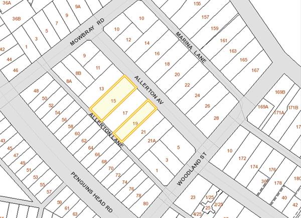
Figure 1 - Subject Sites - 15 and 19
Allerton Avenue, Culburra Beach
Although each of these applications, in
isolation, do not raise critical concerns in terms of infrastructure provision
and impact on amenity, the lodgement of two applications in a three-month
period on sites close to each other triggered a review of the existing
situation and Council’s planning controls regarding the use of rear
laneways as a primary frontage for future development. This was considered
necessary to do given the growing potential for people to seek to redevelop for
higher uses along these laneways.
At present, the development controls within
the Shoalhaven Local Environmental Plan (LEP) 2014 and the Shoalhaven DCP 2014
do not explicitly exclude this land from being developed for increased
densities (i.e. residential subdivision or dual occupancy development).
This report does not seek to make a
determination on either of these applications, rather it covers the following:
· Highlights the policy gap that presently exists regarding future
development off or adjacent to narrow laneways across Shoalhaven,
· Identifies the physical limitations of these laneways, and
· Discusses potential precedents that could be set by allowing these
laneways to be used as a primary frontage for future development.
Summary of
Development Applications
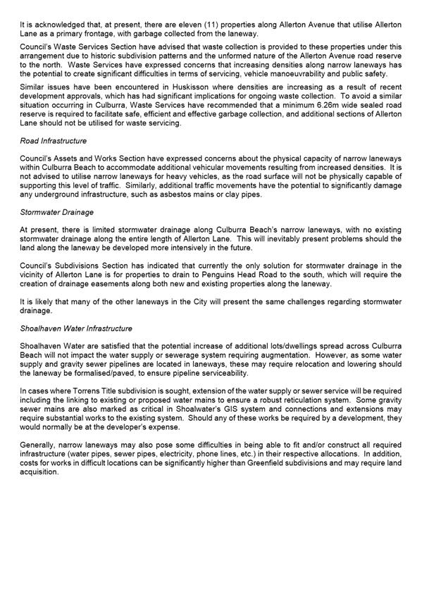
As noted above, two DA’s have been
lodged that propose to utilise the narrow rear lane of Allerton Lane as a
primary access and frontage for future development.
Council staff
have identified a number of issues in the assessment of each of these
applications regarding the use of Allerton Lane for primary access.
Impacts such as the capacity of existing infrastructure, impacts on ageing
infrastructure, car parking, pedestrian safety and waste collection are all
relevant.
In determining
these applications, there is a potential that a precedent will be set for
future development along similar laneways throughout Shoalhaven.
The two
applications, one for subdivision and the other for a development and
subdivision also demonstrate a slightly different assessment regime which
further highlights the need for a consistent policy position and approach.
SF10588 – 15 Allerton Avenue,
Culburra Beach
This application is currently under
assessment by Council staff and seeks to subdivide the existing lot into two,
with one lot (containing an existing dwelling) continuing to gain access from
Allerton Avenue, and the proposed additional lot to the rear utilising Allerton
Lane as its primary frontage.
The initial stages of the assessment raised
some concerns regarding waste collection - Council’s Waste Services
Section noted that the narrow width of the Allerton Lane was insufficient for
waste collection for the proposed vacant lot.
Neighbouring landowners were notified of
the application and at the time of writing, no submissions had been received
regard to this application.
At the time, a meeting was held between the
applicant, landowner and relevant Council officers to discuss a way forward. An
interim agreement was reached to enable the proposed lot to be serviced by
waste collection from nearby Mowbray Road or Woodland Street and no other
significant concerns were raised at that point regarding the use of the laneway
as a primary road frontage.
Following the subsequent lodgement of the
second DA at 19 Allerton Avenue (as detailed below), Council staff became aware
of the potential impacts of increasing densities along the laneway. It
was determined that a formal policy position should be sought from Council
regarding future development along not only Allerton Lane, but also other
narrow laneways across the Shoalhaven, a process that could delay the
determination of, and provide future direction for, this application.
DA17/1992 – 19 Allerton Avenue,
Culburra Beach
DA17/1992 is currently under assessment by
Council staff and originally proposed a detached dual occupancy development
including two-lot Torrens title subdivision, retention of the existing dwelling
fronting Allerton Avenue, and construction of a new dwelling utilising Allerton
Lane as a primary frontage.
The initial stages of the assessment saw a
number of significant concerns raised by Council officers, including the:
· Narrow road reserve width:
o Is
insufficient for garbage collection;
o Is
unsuitable for two-way traffic and on-street car parking;
o May
not be capable of supporting essential infrastructure, including kerb and
gutter, stormwater drainage, footpaths, street lighting, etc.
· Potential cost of upgrading the road surface to accommodate
increased traffic;
· Lack of available stormwater infrastructure;
· Impact on amenity for existing residents and neighbourhood
character; and
· Impact on amenity and safety for future occupants, whose dwellings
will front a narrow, poorly lit laneway with views to back fences.
Neighbouring
landowners were notified of the application and four (4) submissions were
received during this process objecting to the proposal. The submissions
raised concerns with the proposed use of the laneway
for primary access and the impacts this would have on existing residents and
neighbourhood amenity, including:
· Impacts of car
parking on vehicular movement along the laneway
· Visitor car parking
restricting rear-lane access to garages/carports for existing residents; and
· Resident safety and
amenity.
Because of the concerns, the applicant for
DA17/1992 has substantially modified the proposal to comply with
Council’s existing planning controls to move forward with the
application. Amended plans were submitted to Council on 22 December 2017,
and are currently under assessment. The application now proposes partial
demolition of the existing dwelling to gain access to a new dwelling to the
rear, which will be accessed via an access handle from Allerton Avenue.
The rear laneway is no longer proposed to be utilised as a primary frontage.
Although this application has been
substantially modified and no longer proposes to utilise the laneway for
primary access, there is still a need for Council to consider the development
potential of these laneways, and establish appropriate development controls to
ensure future development occurs in an appropriate manner.
History of
Laneways
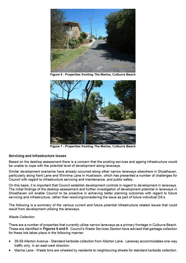
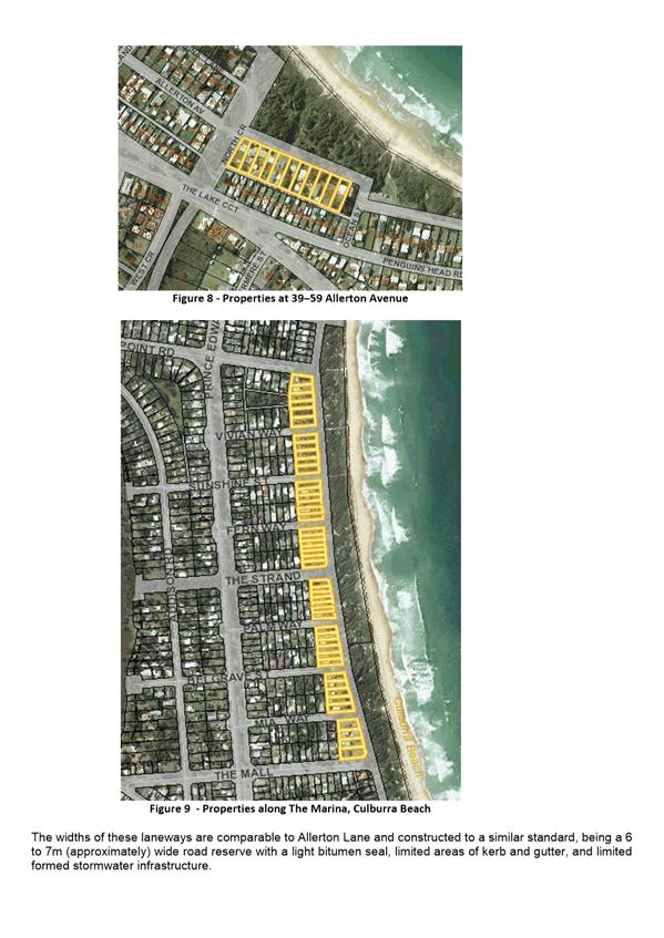
Allerton Lane,
which runs parallel to Allerton Avenue and Penguins Head Road, is a 20ft (6.1m)
wide narrow rear laneway and one of many similar laneways found in Culburra
Beach and across the wider Shoalhaven. Although Allerton Lane is
formed with a gravel surface and light bitumen seal, and contains water supply
and reticulated sewer infrastructure, there is a distinct absence of other
formal infrastructure and services along most of the laneway including
stormwater drainage, formed kerb and gutter, street lighting, pedestrian
footpaths and waste collection locations.
Laneways of
this nature form part of the historic subdivision pattern of many towns and
villages in the Shoalhaven, and were not intended to be utilised as a primary
frontage for dwellings or other residential accommodation. The laneways were historically designed to allow access to the rear of properties
for services such as ‘night cart’ collection and milk/ice box
deliveries, and later, secondary vehicular access. At present, most
narrow rear laneways within Culburra Beach are used by residents to gain access
to detached garages/outbuildings in their backyards, or for direct rear-yard
access for the parking of boats, caravans, and the like.
Approximately
50% of properties along Allerton Lane have a rear access to the laneway and detached
garages/outbuildings that are directly accessed from the laneway. The
detached structures are generally built close to the boundary.
Although many
properties that have rear access to Allerton Lane, or other laneways of a
similar nature, could be considered to have a dual frontage, there are
challenges that are faced when considering their potential use of these as a
primary frontage for future development. For example, the laneways are
not designed to cope with the same level of traffic as primary streets and are
generally not constructed to the same standard. Similarly, narrow lanes
can present significant manoeuvring difficulties for vehicles, particularly
when turning into garages and driveways at 90-degrees. They are also often
physically incapable of being serviced by Council’s garbage collection
services and other large service vehicles. Thus, most laneways do not
have the necessary infrastructure in place to enable the same level of
development that is found along existing primary streets.
If the purpose
of the laneways was proposed for increased densities or extensive infill
development, then significant functional and redesign implications would need
to be considered to address reasonable amenity, safety and accessibility for
all users including existing residents. This potentially raises
significant financing and logistical issues, and may not be able to be
accommodated in some instances.
To assess the potential impact of infill
development in laneways, a desktop assessment was undertaken of Culburra Beach
to understand the development potential of sites with laneway access. It
should be noted that this assessment was broad and based on existing planning
controls within the Shoalhaven LEP 2014 and DCP 2014, including, land use zone
and minimum lot size. The assessment did not consider specific site
constraints including but not limited to topography, vegetation, coastal
hazards, or existing site-specific development.
In summary the desktop assessment
identified 21 laneways within Culburra Beach that provide potential secondary
access to 234 existing allotments. Laneways were found to be either 6m
wide, 9m wide or 12m wide. In summary, only four laneways are constructed
to a bitumen seal standard and deemed suitable for primary access and kerbside
waste collection. However, there is a hypothetical potential for a
further 298 dwellings in Culburra Beach as a result of maximising all
subdivision and dual occupancy potential along existing lanes, including gravel
and vegetated laneways. This would have significant implications
including but not limited to infrastructure, stormwater drainage, access and
movement, parking congestion, waste truck access, neighbourhood character,
built form, amenity, noise, privacy and surveillance. Due to this
significant development potential and associated implications, it is considered
pertinent that a policy position is established in relation to development on
narrow laneways.
A copy of the full desktop assessment is
also provided as Attachment 1.
Precedent
The approval of
any of the current applications has the potential to set a precedent for future
development in laneways of a similar nature across Shoalhaven. The
approval of any one of these DAs may result in an undesirable outcome that
could lead to an overuse of laneways for a purpose for which they were not
originally intended.
Policy
Issues
There is some
merit in facilitating small secondary dwellings in laneways, essentially
emulating rear outbuildings that do not detract from the existing character,
primary street pattern and building densities. Both State Government and
Council’s current planning controls allow for increased development in
areas where laneways are located. For example:
· Subdivision of
residential zoned land that meets the minimum lot size prescribed by Shoalhaven
LEP 2014.
· Development for the
purposes of dual occupancies (attached where the land area is greater than 500m2,
detached where the land area is greater than 700m2)
· Subdivision of land
that contains an existing approved dual occupancy and multi dwelling housing
development under Clause 4.1A of Shoalhaven LEP 2014 (prescribed areas with a
350m2 and 400m2 minimum lot size).
· Secondary dwellings.
It is also
noted that SEPP (Affordable Rental Housing) 2009 also permits secondary
dwellings as Complying Development. The Jervis Bay Settlement Strategy and
other broader policy documents also highlight the opportunities that exist for
urban renewal and increasing densities, particularly in settlements that have limited
or no outward expansion potential.
To assist with
this, it is considered appropriate that an amendment be undertaken to
Shoalhaven DCP 2014 to establish appropriate controls to manage development
outcomes in laneways. A scope of works will be prepared for a DCP
Amendment once a policy position has been adopted by Council and a review of
the existing controls within the DCP undertaken. In the
‘interim’ this report recommends a policy approach that will be
utilised until the DCP Amendment is completed.
Community
Engagement
Wider community
engagement regarding future laneway development has not been undertaken at this
stage.
Any potential
future amendment to the Shoalhaven DCP 2014 will involve extensive consultation
with relevant stakeholders and the community in accordance with the Environmental
Planning & Assessment Regulations 2000.
Policy Implications
The purpose of
this report is to seek a formal resolution of Council to establish a clear
‘interim’ policy position with regard to the future development of
lots with dual frontages to narrow laneways across Shoalhaven.
The two DAs
when considered with regard to the recommended policy position demonstrates the
following:
· SF10588 – As
there is no structure proposed as part of the application, there is a risk a
future CDC for a dwelling could follow.
· DA17/1992 –
The redesign of the dual occupancy is now consistent with the recommended
interim policy in that it re-orients the development to face Allerton Avenue
and is accessed, and has its waste collection from Allerston Avenue.
Depending on
the resolution of Council, this may lead to a future amendment to Shoalhaven
DCP 2014.
Financial
Implications
Should Council
resolve to amend Shoalhaven DCP 2014, this would be undertaken within the
existing Strategic Planning budget.
Risk Implications
Approval of
individual DA’s along narrow laneways could result in a problematic
precedent being set that would lead to an overuse of laneways for a purpose for
which they are not intended. The immediate and cumulative negative
impacts of such developments on infrastructure, services, neighbourhood
character and amenity for existing and future residents is significant.
Conclusion
A determination
is not being sought with respect to the DAs but rather the DAs highlight the
need for a policy position. The issue with the subdivision DA, is that a
subsequent CDC could be sought and obtained which will result in a development
facing a narrow laneway. If other similar development ensues there will
be a cumulative impact with respect to waste collection, car parking,
stormwater etc.
|
|
Development Committee – Tuesday 13 March 2018
Page 16
|
|

|
Development Committee – Tuesday 13 March 2018
Page 22
|
DE18.16 Update and Proposed
Next Steps - Nowra CBD Fringe Medium Density Study Recommendations Report -
Public Exhibition
HPERM Ref: D17/407927
Group: Planning Environment & Development Group
Section: Strategic Planning
Attachments: 1. Nowra Medium Density
Recommendations Report (under separate cover) ⇨
2. Response from Department of Planning and Environment - Nowra CBD
Fringe Medium Density Study Draft Recommendations Report ⇩
Purpose / Summary
Report the
outcomes of the Nowra CBD Fringe Medium Density Study – Recommendations
Report (Recommendations Report) undertaken for Council by urban design
consultants, Studio GL, and obtain endorsement to release it to enable public
comment.
|
Recommendation (Item to be
determined under delegated authority)
That Council:
1. Receive the attached Nowra CBD Fringe Medium
Density Study - Recommendations Report prepared by Studio GL for information
and endorse it being placed on public exhibition for a minimum period of 28
days to enable community comment.
2. Consider a further report following the
exhibition of the Nowra CBD Fringe Medium Density Study Recommendations
Report on any comment received, with a view to proceeding to: prepare a
Planning Proposal for submission for initial Gateway determination to revise
relevant Local Environmental Plan provisions; and a supporting Area Specific
Chapter to be inserted in Shoalhaven Development Control Plan 2014.
|
Options
1. Adopt
the Recommendations Report for public exhibition and consider a further report
following the exhibition on the need for a PP (and supporting DCP Chapter) to
establish a new Heritage Conservation Area (HCA), and amend building heights
and land use zoning in the study area.
Implications: This is the preferred option as it will enable the community to
comment on the Recommendations Report which contains suggested controls that
could subsequently be inserted into the Development Control Plan (DCP) and inform
a PP to establish Local Environmental Plan (LEP) controls to conserve the
character of the study area.
2. Consider
changes to the proposed LEP and DCP recommendations contained within the
Recommendations Report prior to public exhibition.
Implications: This option is not preferred. The Recommendations Report has
been developed through extensive testing and community consultation. Any
changes to the draft controls contained in it may delay the public exhibition
of the Recommendations Report and could impact on the ability to conserve the
character of the study area.
3. Not proceed further with this matter.
Implications: This option is not recommended given the work that has already
been undertaken and the community engagement that has already occurred.
Background
In 2016,
following receipt of development applications for medium density developments,
Council recognised that areas to the west and south of the Nowra CBD (study
area), which are predominately now zoned R1 General Residential, R2 Low Density
Residential and R3 Medium Density Residential, had the potential to undergo
significant change.
Increasing
development pressure in the area was acknowledged as having the capacity to
change the area’s existing character, which is currently predominately
detached single storey dwellings on larger lots, with interspersed heritage
items.
In November
2016, Council considered a report on ‘Central Nowra Residential Zones
– Character Related Development Controls’. This covered the
engagement of urban design consultants, Studio GL (consultants) to undertake a
review and analysis of the character of Central Nowra and provide recommendations
on suitable mechanisms to maintain its character whilst also facilitating an
appropriate mix of densities and high-quality housing.
In
consideration of the report, Council resolved to:
1. Finalise the character analysis that is
currently underway in central Nowra, including the planned consultation with
the Old Houses Our History group, landowners and other key stakeholders.
2. Following the completion of the character
analysis, Council:
a. Receive a further report on the outcomes of the
consultant’s work including recommendations on suitable mechanisms to
protect the character of central Nowra.
b. Identify specific locations to be considered
for a back zoning to an R2 Low Density Residential Zone, where appropriate.
c. Prepare a set of detailed planning and
character development controls that seek to maintain the character of the
central Nowra area.
Separately, Council resolved (in part) on 8
August 2017, in adopting the Nowra CBD Urban Design Planning Controls, that:
8. Council receive a further report to consider a wider
Heritage Conservation Area to the west of the Nowra CBD Commercial Core Area as
part of the project that is underway in this regard.” (MIN17.685).
The study area for this piece if work is
shown in Figure 1 below. In completing the Recommendations Report,
the consultants undertook a review of the current LEP and DCP controls,
photographic study, spatial analysis and a series of workshops with Council
staff, Councillors, local community members, land owners and development
industry representatives.
The consultants have now completed the
Nowra CBD Fringe Medium Density Study – Recommendations Report and a copy
is provided as Attachment 1.
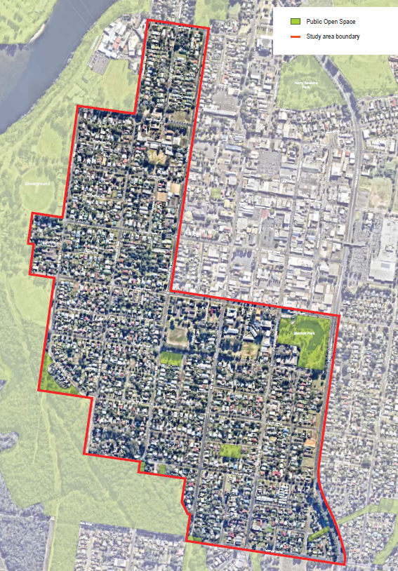
Figure 1 – Study Area (outlined in
red)
Recommendations
Report - Findings Overview
As per Council’s resolution of
November 2016, the consultants undertook an analysis of the study area and have
developed potential draft development controls that would enable opportunities
for high quality and sympathetic medium density housing without fundamentally
damaging/altering the existing character of the area.
The study area, as shown in Figure 1, is
located to the west and south of the Nowra CBD, and is one of the oldest
residential areas of Nowra. It was also noted that the study area
contains a high number of late 19th and early 20th
Century houses which form considerable evidence of Nowra’s early
development and expansion, particularly in the area to the west of the
CBD. During the community workshops, it was noted that these buildings
and areas, with their substantially intact streetscapes, have an attractive
character that is highly valued by residents and the wider community.
The study area contains several listed
heritage items (identified in the Local Environmental Plan) and no complete
HCA’s. There is however a small HCA along Plunkett Street that is
partially within the study area (shown in Figure 2 below).
There is some sentiment from the community
that, without adequate protection and controls, the character of the area may
be irreversibly changed, damaged or lost.
Local Character
The study area is characterised not only by
many older houses, but also a combination of elements in the public and private
realm, which can be grouped into three domains; land, urban form and built
form.
It was noted that every property, public
place or piece of infrastructure contributed to the overall neighbourhood
character, whether great or small. It is the combination of the
underlying land, urban structure, and built form that establishes neighbourhood
character. The following is a brief overview of the three components that exist
in the study area:
The Land
The area is generally undulating, with an
overall fall to the floodplain to the north and east. High points have
northerly mountain views. Key tree-lined streets include Junction Street,
North Street, sections of Shoalhaven Street, Douglas Street and Berry Street.
The Urban Form
The area has an underlying 200m by 200m
grid based east-west structure with 20m wide road reserves. Most blocks
are further divided with a 15m or 20m wide mid-block road. While the
majority of lots are narrow and deep, there is a large variety in lot size and
shape. Streets have upright kerbs, wide grassed verges and some have
concrete footpaths. Public parks and open space tend to lie on the edges
of the study area and open space has an informal, bushland character.
The Built Form
The area has a diverse range of existing
dwelling styles, including Victorian and Federation houses, Californian
bungalows, simple mid-century fibro houses, dwellings from the 1970s, 1980s and
1990s, as well as more recent developments. The majority are detached
single storey dwellings, although many recent developments include slab on
ground, brick veneer villas and townhouses. Where front fences are
provided, they are predominately low and partially open. Front setbacks
vary greatly, side setbacks are often small but tend to be wider on one side,
and rear setbacks often contain large trees. Parking is generally to the
side or rear of dwellings.
The Recommendations Report provides a
detailed commentary on the range of things that make up the local character.
Consultants
Recommendations
The Recommendations
Report makes the following recommendations that could be considered by Council
to respond to this issue consistent with the earlier resolutions.
LEP Recommendations
The consultants reviewed the following
existing controls in Shoalhaven LEP 2014:
· Heritage items and HCA;
· Building heights; and
· Land use zoning.
As a result, various changes to the above
controls within the study area have been recommended for consideration and
these are summarised below.
Heritage and conservation
1. Assess
the area’s heritage significance and, if justified, establish a HCA as
shown via the blue dashed land in Figure 2. The area has the
highest concentration of older dwellings.
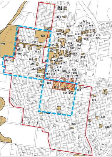
Figure 2
– Recommended HCA boundary (blue dashed outline)
Key to the
above map:
Red
line – study area boundary. Brown colour - existing heritage items. Red
hatch – existing HCA
2. Consider
whether the boundaries to any future HCA should include whole properties, or
alternatively only be along streets.
3. Identify
items of heritage value as well as contributory and non-contributory items
within any future HCA, to help future development respect the character of the
area/zone. Contributory and non-contributory items could then be
identified in a DCP Chapter.
Building heights
The recommended possible changes to
building heights are summarised below (the numbers correspond with those shown
in Figure 3).
1. Reduce the
building height to the west of the CBD between North Street and Plunkett Street
to a maximum of 8.5m (currently 11m). As noted previously, this area has
the highest concentration of older dwellings and is consistent with the
recommended HCA boundary.
2. Reduce the
maximum building height to the south of the CBD between Plunkett Street, Jervis
Street, Osbourne and Kinghorne Street to 8.5m (currently 11m). This area
also has a concentration of older dwellings and is consistent with the
recommended HCA boundary.
3. Increase the
maximum building height along Shoalhaven Street and along Colyer Street north
of North Street and south of Hyam Street to 11m (currently 8.5m).
4. Increase the
maximum building height of the lots bounded by Bainbridge Crescent, Douglas
Street, Osbourne Street, and Jervis Street to 11m (currently 8.5m).
5. Increase the
maximum building height of the lots with a current height limit of 7.5m along
the north-west edge of the study area to 8.5m. Note, this will ensure
consistency with adjoining land and the current height control is a carryover
from the previous Foreshore DCP that set the height of the first development
lot back from a waterbody at 7.5m.
These possible
changes are shown graphically on Figure 3 below, along with the existing LEP
building heights.
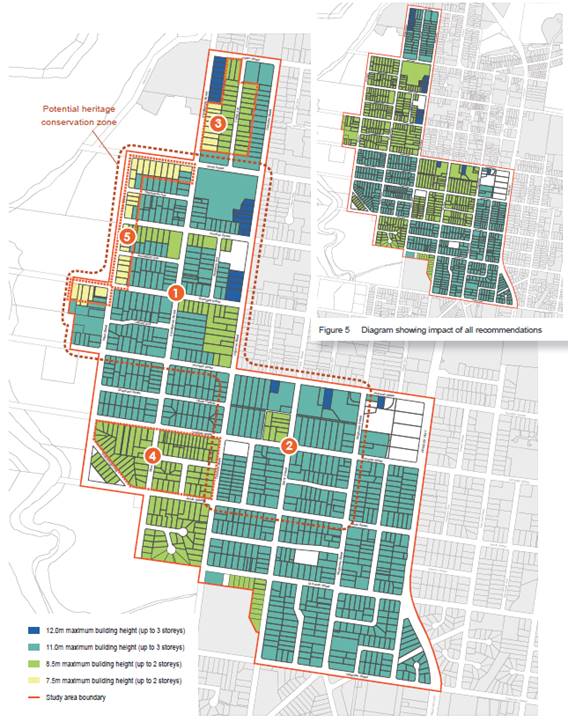
Figure 3 – Existing & Recommended
Building Heights
Land use zoning
The recommended possible changes to the
land use zoning are summarised below (the numbers correspond with those shown
in Figure 4.
1. Retain
the area of R3 Medium Density as this is well located land near the CBD.
Local character can be adequately considered by the provisions of the HCA,
reduced building heights and new DCP controls.
2. Change
the zone of the lots bound by Bainbridge Crescent, Douglas Street, Osborne
Street, and Jervis Street to R1 General Residential (from R2), subject to
advice regarding bushfire. This area has fewer older dwellings, some very
large lots and a concentration of fibro dwellings. The zoning change
suggested would still allow single dwellings, but would also allow a range of
other residential housing types.
3. Change
the zoning of the block to the west of the
Princes Highway from R1 General Residential to R3 Medium Density, subject to
consultation with NSW Roads and Maritime Services. Changing the zoning of
areas with fewer heritage items outside the HCA should provide the incentive to
replace individual dwelling houses with purpose built development that can
create a buffer to the highway, whereby the design could mitigate some of the
noise issues and use may well be of a rental/shorter term nature.
4. Change
the zoning of the block to the north of North Street, south of Hyam Street and
west of the hospital to either R1 or B4 to enable greater development in this
well-located area close to the hospital. The B4 Mixed Use zoning could
enable future medical uses, whereas an R1 General Residential zoning could be
more appropriate if purely residential uses are preferred. It was noted
that through site links would need to be considered, and this recommendation
would change the existing character of Colyer Avenue.
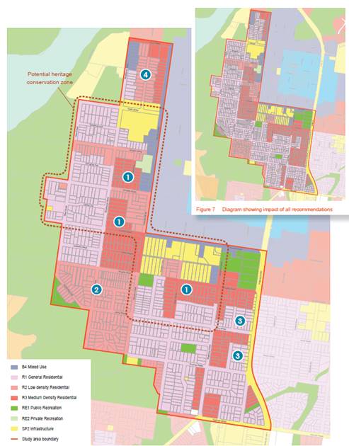
Figure 4 – Existing & Recommended
Land Use Zoning
Depending on the approach Council wishes to
take, at a minimum, it is preferred that a HCA be applied to the area mapped in
Figure 2, rather than extending the number of items individually
heritage listed. The HCA will ensure that the special character, setting
or streetscape of the area is retained, rather than more specific
considerations that apply to individual heritage items.
Preliminary advice from Council’s
heritage advisor has demonstrated that some areas and streets with a high level
of intactness can demonstrate key historic periods. These streets are of
a scale, character and built form continuity that is significant as it provides
important physical evidence of the development history of the town of
Nowra. An expanded HCA would have many benefits
including:
· Greater certainty for existing owners and future buyers that the
amenity of the area will be protected.
· Positive contribution to property values through the maintenance of
original features and heritage qualities of residential buildings.
· Future proposed development will need to consider how it will
protect, preserve and reinforce the existing character of the HCA. All
new development within a HCA should acknowledge the established heritage values
of the existing place or building and respond by seeking to avoid any reduction
in its value or any undesirable intrusion into the streetscape.
· Protect against inappropriate development that may detract from
individual properties and the unique identity of the HCA.
· Limiting complying development to ensure all new development is
assessed by Council and appropriate consideration can be given to the impact on
the existing heritage character of the area.
· Infill development must achieve a sympathetic relationship with the
HCA.
Should the option of a HCA be pursued
further following the proposed public exhibition, additional heritage
assessment work may be required to support any future PP, either prior to
submission for Gateway determination or following as a condition of any
determination received.
DCP Recommendations
Chapter 4 of the Recommendations Report (Attachment
1) includes recommendations for new DCP controls that could apply
specifically to the study area.
These recommended controls would support
the overarching LEP controls noted above and ensure that buildings are designed
in such a way that their location, size and appearance all help to improve the
character of a street or area. It is noted that without these area
specific DCP controls, development could still potentially occur that is not
sympathetic to the heritage character of the area.
The recommended controls address building
and floor heights, street setbacks, side setbacks, rear setbacks, landscaped
area, private open space, streetscape interface, access and parking and
architectural appearance.
The recommended DCP controls include
Performance Criteria and Acceptable Solutions that would encourage development
that respects the existing or desired future character of the study area.
The full set of recommended controls have been tested and refined in a staff
workshop to ensure that they are usable.
The report can form the basis of a new Area
Specific Chapter in the Shoalhaven DCP 2014. Before proceeding to prepare
this DCP Chapter, it is recommended that the Recommendations Report be publicly
exhibited and as part of that process, a further community workshop will be
held to assist understanding and gain feedback.
Advice from NSW Department of
Planning & Environment (DP&E)
Given that the Recommendations Report
contains a range of possible changes to the LEP, a copy was provided to
DP&E to get initial feedback. Their response is provided as Attachment
2.
DP&E in their response noted that a
Planning Circular had recently been released relating to “Stepping up
planning and designing for better places: respecting and enhancing local
character” (16 January 2018). The circular provides detail of tools
available for Council’s to incorporate consideration of local character
into strategic planning and detailed planning for places.
DP&E indicated that they would be
willing to consider many of the changes detailed in the Recommendations Report,
subject to adequate justification being provided through any future PP.
Community
Engagement
In May and June 2017, the project
consultant undertook workshops with landowners, community, Councillors and
development industry representatives to obtain feedback about how development
controls for the study area could encourage a mix of density and high-quality
housing, consistent within the existing zoning, whilst also respecting existing
character. The feedback obtained through the workshops was used to inform
the Recommendations Report.
It is
recommended that the Recommendations Report should now be publicly exhibited
for a minimum period of 28 days to enable the community to comment on its
recommendations. As part of this exhibition process, follow up workshop
with landowners, the community and development representatives are also planned
to be held.
Should the
changes to the LEP and DCP recommended in the Recommendations Report proceed
they will be separately consulted on and notified as requited by legislation.
Policy Implications
LEP
Amendment
Preparation of
a PP to establish a HCA, amend height of building heights and land use zonings
in the study area will ultimately amend Shoalhaven LEP 2014.
DCP
Amendment
As noted above
the Recommendations Report can form the basis of a new Area Specific DCP
Chapter. This process will involve an amendment to Shoalhaven DCP 2014 to add a new chapter.
Financial
Implications
The current
work is being undertaken and managed within the existing Strategic Planning
budget and is in accordance with the Council endorsed Strategic Planning Works
Program.
|
|
Development Committee – Tuesday 13 March 2018
Page 32
|

|

|
Development Committee – Tuesday 13 March 2018
Page 35
|
DE18.17 Proponent Initiated
Planning Proposal - Lot 3 DP 846470 Jervis Bay Road, Falls Creek
HPERM Ref: D18/7710
Group: Planning Environment & Development Group
Section: Strategic Planning
Attachments: 1. Executive Summary -
Proponent's Draft Planning Proposal ⇩
2. Proponents Draft Subdivision Layout ⇩
Purpose / Summary
Present a proponent initiated Planning
Proposal (PP) that has been received to permit a community title subdivision at
Lot 3 DP 846470 Jervis Bay Road, Falls Creek and obtain direction in this
regard.
|
Recommendation (Item to be
determined under delegated authority)
That Council:
1. Prepare a Planning Proposal to:
a. Permit a community title subdivision of Lot 3
DP 846470 Jervis Bay Road Falls into rural residential lots and a
neighbourhood environmental conservation lot; and
b. Rezone the land to part R5 – Large Lot
Residential and part E2 - Environmental Conservation.
2. Submit this Planning Proposal to the NSW
Department of Planning and Environment for a Gateway determination.
3. Advise the NSW Department of Planning &
Environment that the following studies are considered appropriate as part of
the post Gateway stage of the Planning Proposal to determine the actual
subdivision potential (prior to public exhibition):
a. Flora and fauna assessment
b. Onsite wastewater management plan
c. Water quality and stormwater management
d. Bushfire hazard assessment
e. Traffic study
f. Visual impact assessment
4. Receive a report once all the above studies
have been completed to determine the number and size of lots prior to public
exhibition of the Planning Proposal.
5. Advise the proponent of this resolution and
that the proposal will be subject to fees and charges for proponent initiated
Planning Proposals, including a requirement that the full cost of all
specialist studies be borne by the proponent.
|
Options
1. Request
a Gateway determination for the PP that:
a. Permits a community title subdivision of Lot 3 DP 846470 Jervis Bay
Road Falls; and
b. Rezones the land to part R5 - Large Lot Residential and part E2 -
Environmental Conservation.
Implications: This will enable the community title subdivision and provide a
clear environmental outcome for the vegetated and/or environmentally sensitive
land which comprises approx. 60% of the subject land. It is consistent
with the approach taken by Council when ‘lot averaging’ was first
introduced into the Shoalhaven LEP 1985. For example, Lot 5 Havilland Street,
Conjola Park (Locality 7 in Shoalhaven Local Environmental Plan (LEP) 2014) is
currently subject to a lot averaging provision and an environmental protection
zone that limits where the smaller lots can be created. This option is
the preferred option, noting that a decision on the number and size of the
proposed will be made later in the process (i.e. prior to public exhibition)
once all the required studies have been completed.
2. Request
a Gateway determination for the PP that permits a community title subdivision
of Lot 3 DP 846470 Jervis Bay Road Falls without rezoning the residual land to
E2.
Implications: This will allow the community title
subdivision without increasing environmental protection for the majority of the
land. This option is not preferred.
3. Not
proceed with the PP.
Implications: This will not allow the community title
subdivision and the corresponding environmental outcome for the majority of the
land. This option is not preferred.
Background
The Site
The subject land to which this proponent
initiated PP relates is Lot 3
DP 846470 Jervis Bay Road, Falls Creek, which is located on the southern edge
of the Falls Creek Large Lot Residential precinct. The land to the south is
part of the Tomerong State Forest. The land to the west is forested land
in private ownership, and is zoned RU2 – Rural Landscape. The large
lot residential precinct of Falls Creek adjoins the subject land to the north
and east.
Maps showing the subject land and its
location are provided below:
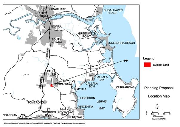
Subject
Land – Location
The subject land is crossed by an
east-flowing watercourse adjacent to its northern boundary. This watercourse is
a tributary of Currambene Creek, which flows into the Jervis Bay Marine Park.
The subject land has distinct cleared and
vegetated areas as can be seen in the aerial photograph provided below. The
watercourse is located within the vegetated part of the site. The cleared part
contains a dwelling house, outbuildings and two (2) earth dams.
The proponent has provided a flora and
fauna assessment of the site. This assessment concluded that the vegetation
communities present are not threatened ecological communities. It also
did not find any threatened plant species on the site. The assessment
noted, however, the presence of Green and Gold Bell Frogs and Grey-Headed
Flying-Foxes on the site. There was also evidence of Glossy
Black-Cockatoo foraging on the site.
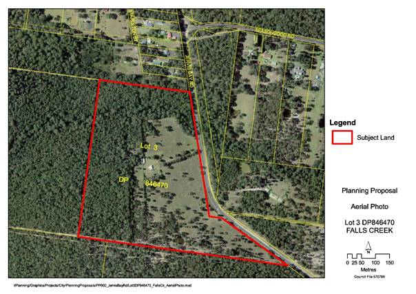
Aerial Photograph – Lot 3 DP 846470
The
Proponent’s PP
The proponent’s PP was received on 27
November 2017 from Cowman Stoddart Pty Ltd (on behalf of the owner T Pasialis)
and seeks to permit the subdivision of the land into a community scheme
comprising 12 lots and a neighbourhood property lot as an additional permitted
use under Schedule 1 of the LEP. The lots are proposed to have a minimum
area of 5,635 m2. The PP was accompanied by a Development
Application (DA) that was also submitted for a 12-lot community title
subdivision consistent with the PP.
The proponent’s submission includes a
draft PP document, the executive summary of which is attached to this report (Attachment
1). This draft PP was accompanied by a Flora and Fauna Assessment,
Bushfire Protection Assessment, Onsite Effluent Disposal Report, NSW Roads
& Maritime (RMS) advice, and an Aboriginal Heritage Information Management
System (AHIMS) search for the site.
The proponent also lodged a DA for the
subdivision of the land concurrently with the PP. The assessment of this
DA will occur in parallel with the PP process, but it will not be able to be
approved prior to the making of a plan amendment.
Preliminary Planning Assessment
The following is an overview of relevant
strategic planning documents that are relevant to this proposal.
· Shoalhaven LEP 2014
The subject land is currently zoned part
RU2 Rural Landscape (3%) and part R5 Large Lot Residential (97%) under
Shoalhaven LEP 2014. The objectives of the RU2 zone relate to conserving
and maintaining rural landscape and facilitating primary industries. The
objectives of the R5 zone relate to providing large lot housing while avoiding
adverse environmental, social and economic impacts.
The LEP prescribes a minimum lot size of 40
ha for the RU2 zoned part of the site and a potential 2 ha minimum lot size for
the R5 zoned part of the site. The proponent contends that this gives rise to a
development potential of 12 lots for the 24.5 ha of R5 zoned land. However,
this is only a theoretical maximum yield. The actual yield is likely to
be lower given the site’s constraints.
The RU2 zoned part of the site is mapped
under the LEP as having biodiversity significance. This area is part of
the Jervis Bay habitat corridor system.
Parts of the subject land are also
identified on the flood planning area map that forms part of the LEP.
This relates to the watercourse that runs through the land.
Existing and Proposed Zones– Lot 3 DP 846470
· Illawarra-Shoalhaven Regional Plan
The Regional Plan was released by the NSW
Government in late 2015. Direction 2.1 - Provide sufficient housing
supply to suit the changing needs of the region adopts the forecasts and
planning intent of Shoalhaven GMS 2014, which is discussed below.
· Shoalhaven Growth Management Strategy (GMS) and the Jervis Bay
Settlement Strategy (JBSS)
Council initially considered the
suitability of this land for rural residential development in 1993 when it
received a rezoning request from the then owners of the land. This request was
ultimately rolled into the ‘Rural Plan’ being prepared by Council
at the time. The Department of Urban Affairs and Planning, however,
“deferred” the zoning of this site (amongst others) when the Rural
Plan amendment was finalised in 1999 (LEP Amendment No 127).
The Jervis Bay Settlement Strategy (2003)
recognised the unresolved situation that applied to the land. It provided
at Part 10.4 that the deferred rural residential land “will be further
investigated for (its) potential to provide increased rural living
opportunities for the Region”. The intention of the JBSS is for lots
to be no smaller than one (1) hectare (as had been proposed in the LEP
Amendment No. 127) subject to the constraints of the land.
The 2014 GMS recognised that the situation
was still unresolved and provided at part 5.2.4 that “the existing
rural residential deferred areas… to accommodate increased densities will
be investigated and resolved”. Some of these deferred areas
were considered in the Falls Creek / Woollamia Deferred Areas PP that was
adopted by Council in 2017. The subject land was not part of that PP.
The JBSS considered in its discussion of
density that an absolute minimum lot size of 1 ha should be allowed in the
previously rural residential deferred areas. This PP would potentially result
in a minimum lot size of 5000 m2 on part of the site as part of a
community title scheme. This is inconsistent with the 1 ha minimum expected by
strategy. This could result in adverse and visual impacts on the landscape
character in the locality. This impact will need to be assessed as part of the
process and the PP should only proceed if it is satisfactory in this regard.
Subject to the outcome of a visual impact
assessment (yet to be undertaken) there is an argument that in a community
title scheme the area of the neighbourhood property should be considered in
determining the density of the development (i.e. lot averaging). In this case,
better environmental outcomes would be achieved by this approach because the
environmentally sensitive land will be managed under a community title scheme
as opposed to it potentially being in fragmented private ownership. The merits
of this argument will be informed by the investigations that will be undertaken
should Council resolve to progress the PP. If the lot averaging argument is
accepted, most of the resulting lots may be far lower than one lot per hectare
limit contemplated by strategy, subject to detailed assessment.
The proponent’s use of the current
minimum lot size to determine a theoretical yield of 12 lots is not
consistent the intent of the GMS to review densities in the previously deferred
areas. The investigation demanded by these strategies is to consider the
potential of the land in the context of its constraints. Should Council resolve
to support this PP, the ultimate lot size and yield will be informed by
investigations into the land’s constraints and capability, consistent
with the GMS and JBSS. This may be more or less than 12 lots depending on the outcomes
of the investigation.
There is a comparable case at Lot 4 DP
608099, 50 Mortimer Road Falls Creek. This land was included in the same
“deferred” area as the subject land and has a similar
history. Rather than pursuing a lot averaging approach, via a PP, the
owner obtained development consent for a subdivision in which each lot complied
with the current 2 ha minimum lot size. The result was a four (4) lot
subdivision of a 20 ha parcel (one lot per 5 ha). This density was the
result of the constraints of that particular site. It is noteworthy,
however, that each lot created had a developable area that was less than 1 ha,
with the remainder of each lot being fragmented environmental land.
In conclusion, the proposed minimum lot
size is inconsistent with the 1 ha minimum noted in the JBSS/GMS for
investigation. However, it is considered that the PP is consistent with the
underlying intent of these strategies subject to the outcomes the detailed
assessments and it will potentially result in a more desirable environmental
outcome.
It is considered that this PP can be
supported as a consequence of the particular provisions in the GMS that relate
to the Falls Creek/Woollamia Deferred Areas and given the particular historic
circumstances of the case. Given this it will also not set a precedent
for the rezoning of rural land elsewhere in the city.
· Council’s Planning Proposal (Rezoning) Guidelines
These guidelines detail the circumstances
when a PP is likely to be supported by Council and provide a range of detail on
the PP process. The guidelines were adopted by Council in 2016 and note
that Council is likely to support a PP in the following circumstances:
· Proposed amendment is supported by Council or State Government
strategy or plan.
· Clear zoning anomaly exits on site.
· Proposed amendment is considered to be minor in nature and has been
sufficiently justified to Council.
The guidelines also note that the proponents
should have pre-lodgement dialogue with Council staff before formally lodging a
PP. Some limited dialogue took place in this regard during 2015.
The guidelines make it clear that
PP’s that are not supported by a strategy or plan and are considered speculative
will generally not be supported by Council.
As discussed above, it is considered that
the PP request is generally consistent with the underlying intent of the JBSS
and GMS (subject to visual impact assessment). Thus, it is consistent
with these guidelines as a result.
NSW Guide to Preparing Planning
Proposals
The NSW Guide to Preparing Planning
Proposals provides an assessment framework for PP’s. This framework
requires the planning authority (Council) to answer a number of questions in
determining the merit of a PP. These are considered below:
Q1. Is the Planning Proposal a result of
any strategic study or report?
As discussed above, it is considered that
the PP request is generally consistent with the underlying intent of the JBSS
and GMS (subject to visual impact assessment). Thus, it is consistent
with these guidelines as a result.
Q2. Is the Planning Proposal the best
means of achieving the objectives or intended outcomes, or is there a better
way?
The PP process is the most appropriate
mechanism to allow the community title subdivision to occur on the land.
The actual detail of the PP and its provisions will need to be determined
following the outcomes of specialist studies.
Q3. Is the Planning Proposal consistent
with the objectives and actions of the applicable regional, sub-regional or
district plan or strategy (including any exhibited draft plans or strategies)?
The Illawarra-Shoalhaven Regional Plan is
the relevant regional strategy. There is no relevant sub-regional or district
plan for this area. The proposal is consistent with this plan as detailed
earlier in this report.
Q4. Is the Planning Proposal consistent
with a Council’s local strategy or other local strategic plan?
The JBSS and the GMS are the relevant local
strategies. As discussed above, the proposal is generally consistent with
these strategies.
Q5. Is the Planning Proposal consistent
with applicable State Environmental Planning Policies?
Various technical matters will need to be
further investigated to demonstrate consistency with the relevant State
Environmental Planning Policies. There are however no apparent inconsistencies
at this stage.
Q6. Is the Planning Proposal consistent
with applicable Ministerial Directions?
No inconsistencies with any of the
Ministerial Directions have been identified at this stage, noting that further
investigations will be undertaken if Council resolves to progress the PP. It
should also be noted that the proponent’s proposed development footprint
encompasses identified Green and Golden Bell Frog habitat. This report
identifies a potential modified footprint which excludes this habitat.
Q7. Is there any likelihood that
critical habitat or threatened species, populations or ecological communities,
or their habitats, will be adversely affected as a result of the proposal?
The site contains threatened fauna species
and forms part of a habitat corridor. The conservation of this land is an
outcome that is to be achieved by this PP. The current extent of large
lot residential development proposed by the proponent is considered to be
unsatisfactory in this regard at present because it will isolate populations of
Green and Golden Bell Frogs. The PP that is recommended adopts an altered
footprint for rural residential development so that these frog habitats will be
within the neighbourhood property that is to be used only for conservation
purposes.
Q8. Are there any other likely
environmental effects as a result of the Planning Proposal and how are they
proposed to be managed?
A number of technical matters will need to
be investigated to demonstrate that the PP is satisfactory with regard to a
range of environmental effects.
Q9. Has the Planning Proposal adequately
addressed any social and economic effects?
A number of technical matters will need to
be investigated to demonstrate that the PP is satisfactory with regard to its
impact on the landscape character of the locality.
Q10. Is there adequate public
infrastructure for the Planning Proposal?
The infrastructure requirements for the PP
will be determined by the number of lots into which the land can be
subdivided. If the yield is substantial, then it may be necessary to
prepare an infrastructure delivery strategy that would then be implemented with
the development of the land.
Q11. What are the views of State and
Commonwealth public authorities consulted in accordance with the Gateway
determination?
The required consultation will be
undertaken if the PP proceeds.
Conclusion
As detailed above, subject to the outcomes
of detailed investigations, there is some merit in supporting this PP in an
amended form. If Council supports advancing the PP, it is recommended that a
Gateway determination be sought that provides for:
1. The permissibility of a community title subdivision of Lot 3 DP
846470 Jervis Bay Road Falls into rural residential lots and a neighbourhood
environmental conservation lot in terms similar to the existing “lot
averaging” provisions of Clause 4.2B of the LEP.
2. The rezoning of part of the land to E2 - Environmental Conservation
as shown in the figure below.
3. A
requirement for a limit on the number of rural residential lots that may be
created on the land based on the findings of the following specialist studies:
a. Flora
and fauna assessment
b. Onsite
wastewater management plan
c. Water
quality and stormwater management
d. Bushfire
hazard assessment
e. Traffic
study
f. Visual
impact assessment
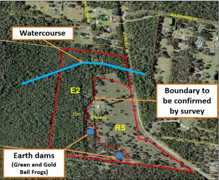
Lot 3 DP 846470 - Aerial Photograph with Proposed Zone Boundary and
key environmental features
Community
Engagement
Upon receipt of the proponent’s PP
the surrounding landowners were notified in writing and provided an opportunity
to review the documentation. No submissions were received.
If the PP proceeds, public exhibition will
be required including advertising in a local newspaper and a mail out to
surrounding landowners. The Gateway determination will also set required
consultation requirements.
Policy Implications
It is considered that the PP will be
consistent with the underlying intent of the JBSS and GMS (subject to visual
impact assessment). Should this PP proceed Council will separately need
to re-consider at the appropriate point the remaining area of R5 zoned land on
the adjacent property to the west, given that this land will most likely be
left isolated and difficult to develop.
Financial
Implications
The PP will be
prepared on a 100% cost recovery basis to be funded by the proponent. Infrastructure
requirements for the proposal are to be thoroughly investigated in the PP
process to ensure that there are no adverse impacts on Council’s adopted
budget and forward estimates.
|

|
Development Committee – Tuesday 13 March 2018
Page 44
|
|

|
Development Committee – Tuesday 13 March 2018
Page 46
|
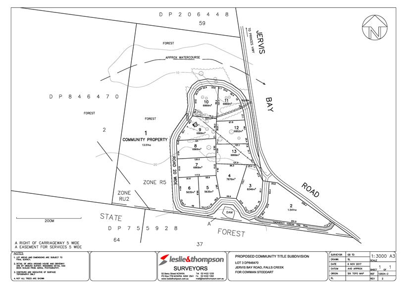
|
|
Development Committee – Tuesday 13 March 2018
Page 47
|
DE18.18 Exhibition - Draft
Works in Kind Agreement - DA15/1102 - 21 Beach Street, Huskisson
HPERM Ref: D18/46170
Group: Planning Environment & Development Group
Section: Strategic Planning
Attachments: 1. Draft Works in Kind
Agreement - DA15/1102 (under separate cover) ⇨
Purpose / Summary
Advise of the
receipt of a draft Works in Kind (WIK) Agreement for works that have been
undertaken associated with DA15/1102 (4 tourist cabins) at 21 Beach Street,
Huskisson, and request endorsement of the draft WIK agreement to enable it to
proceed to public exhibition.
|
Recommendation (Item to be
determined under delegated authority)
That Council:
1. Accept and proceed to publicly exhibit the
draft Works in Kind agreement for 21 Beach Street, Huskisson (associated with
DA15/1102) for a period of 28 days in line with the Environmental Planning
and Assessment Regulation 2000; and
2. Receive a further report to consider the
outcomes of the exhibition and enable the finalisation of the Works in Kind
agreement.
|
Options
1. Accept
the draft WIK agreement and proceed to publicly exhibit it.
Implications: This would enable the WIK Agreement to progress. It will be
reconsidered by Council after the exhibition and to enable the consideration of
any submissions received.
2. Do
not publicly exhibit the WIK agreement
Implications: As the work has already been done on behalf of Council as part of
DA15/1102, it would be unreasonable not to proceed with the WIK agreement as it
is the mechanism by which Council can reimburse the developer for the work
undertaken that Council is no longer required to fund and complete.
Background
On 16 December
2015, Council approved a development application (DA15/1102) which allowed for
the construction of four new tourist cabins at the rear of 21 Beach Street
Huskisson. Drainage work external to the property was required for the
development to proceed.
The required
drainage work forms part of an existing contribution project in Councils
Contributions Plan - 03ROAD0062 Unnamed Lane (Huskisson).
On 7 April
2016, development contributions were paid by the developer which included
$16,405.25 for 03ROAD0062.
The project
covers the construction of a lane as well as further work for stormwater and
drainage. The figure below shows the project area (in red), and the affected
properties (in blue). The blue properties are the only ones that are required
to pay contributions for the development of the laneway. The value of the
stormwater and drainage work in the project is $9,212 (as of March 2014).
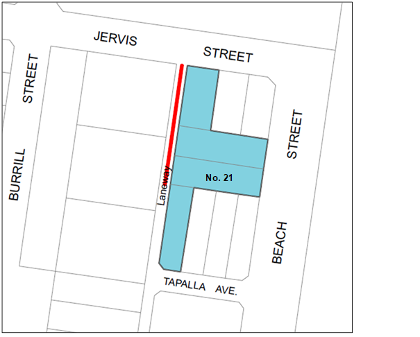
Extract from 03ROAD0062, Shoalhaven Contribution Plan 2010
The developer
has now completed the stormwater and drainage works outlined in project
03ROAD0062. The developer is now requesting a refund of $9212 plus CPI,
that is, $9,983.38 from project 03ROAD0062.
Council’s
Assets Section has been consulted and agree that a refund of this amount is
fair and reasonable for the works completed. The agreement for this is outlined
in the Draft WIK Agreement at Attachment 1.
To enable this
to progress to resolution, it is required that the Agreement be publicly
exhibited for a period of at least 28 days. After exhibition the matter
will be reported back to Council for final consideration, together with a
summary of any submissions received.
Following its
adoption and finalisation, Council is then able to reimburse the required
amount to the developer.
Community
Engagement
There are four
properties that are directly affected by this agreement; the landowners will be
notified directly by mail. The WIK agreement will also be notified in the
local newspaper and will be available for viewing at Council’s
Administration Buildings in Nowra and Ulladulla and on Council’s website.
The period of public exhibition is 28 days as is required by the Environmental
Planning and Assessment Regulation 2000.
Financial
Implications
Council will be
providing a refund to the value for the project that is estimated (plus CPI) in
the Shoalhaven Contributions Plan 2010 but will now not have to fund and carry
out this component of the project. There are no further financial
implications to Council.
|
|
Development Committee – Tuesday 13 March 2018
Page 50
|
DE18.19 Nowra CBD
Contributions Discount Subsidy Policy - Review
HPERM Ref: D18/52690
Group: Planning Environment & Development Group
Section: Strategic Planning
Attachments: 1. Nowra CBD Contributions
Discount Subsidy Policy ⇩
Purpose / Summary
Advise of the
feedback from Nowra CBD Revitalisation Committee, Nowra CBD Business Chamber,
and the Shoalhaven Business Chamber on the proposal to rescind
the Nowra CBD Contributions Discount Subsidy Policy (the Policy), and obtain a decision on the future of the Policy.
|
Recommendation (Item to be
determined under delegated authority)
That Council:
1. Continue the operation of the Nowra CBD
Contributions Discount Subsidy Policy; and
2. Consider, as part of the 2018/2019 Budget,
allocating an annual budget of $50,000 for the operation of the Nowra CBD
Contributions Discount Subsidy Policy.
|
Options
1. Continue the operation of the Policy and consider the allocation of
an annual budget to fund its operation.
Implications: This option is consistent with the feedback from the Nowra CBD
Revitalisation Committee and will allow for the Policy to continue, however a
funding source to support it needs to be clarified.
2. Rescind
the Policy.
Implications: Rescinding the Policy is likely to have minimal impact as the
Policy has only been utilised twice since it was established in 2014.
Background
The Nowra CBD
Contributions Discount Subsidy Policy (Attachment 1) was put in place to
encourage redevelopment within the Nowra CBD by providing a discount subsidy
for the cost of car parking contributions for small to medium developments.
The Shoalhaven Contributions
Plan 2010 allows Council to levy contributions on new development for the
provision of essential community infrastructure. Where a commercial development
cannot meet all their parking requirements on-site, a developer has the option
of paying a monetary contribution in lieu of providing on-site parking.
In the Nowra CBD, the current contribution rate for car parking is $26,278.26
per space.
The subsidy was
first introduced in response to concerns raised by the development industry and
others that the cost of current car parking contributions was inhibiting
development in the Nowra CBD. Council resolved to subsidise car parking
contributions by 50% as a trial measure, to hopefully stimulate new
development. This was intended to encourage redevelopment within the
Nowra CBD through the provision of a short-term discount subsidy applied to the
Nowra Car Parking Contributions Project. Council initially adopted the
Nowra CBD Contributions Discount Subsidy Policy on 28 October 2014.
The policy is primarily
aimed at small to medium development scenarios that generally have a net
development area of less than 1,500m2 and excludes supermarkets,
clubs, and hotel and motel developments. The policy operates separately, and in
isolation of, Council’s Contributions Plan and the discount subsidy is to
be paid from Council’s general revenue funds and not from the
contribution projects funds.
If Council
continues its operation, a potential funding source will need to be identified
in its annual Budget for the period of the subsidy. The amount required
each year cannot be accurately predicted as it is dependent on take up,
however, based on previous subsidy payments, an amount of $50,000 should be
sufficient. The status of the subsidy can be monitored through Council’s
quarterly budget reviews.
At the
Development Committee meeting held on 12 September 2017, Council deferred the
matter to enable feedback to be sought from the Nowra CBD Revitalisation
Strategy Committee, the Nowra CBD Business Chamber, and the Shoalhaven Business
Chamber.
Letters were
sent to the Nowra CBD Business Chamber and the Shoalhaven Business Chamber with
no response received. The matter was considered by the Nowra CBD
Revitalisation Strategy Committee on 31 January 2018 and it was resolved that:
The Nowra CBD Revitalisation Strategy Committee supports the
continuation of the Nowra CBD Contributions Discount Subsidy Policy.
As such, on
this basis it is recommended that the Nowra CBD Contributions Discount Subsidy
Policy continue, and consideration be given to the budget required to support
its operation. The Policy will be reviewed again in the future following
the election of a new Council, when all Council policies are reviewed for
continuation.
Community
Engagement
The Nowra CBD Revitalisation Strategy
Committee, the Nowra CBD Business Chamber, and the Shoalhaven Business Chamber
were provided the opportunity to comment on the future of the Policy.
The Nowra CBD Revitalisation Strategy
Committee resolved to support the continuation of the Policy.
Financial
Implications
If the Policy continues, Council needs to consider a funding source
for the Policy as the money cannot be taken from the relevant contribution
project. The amount required cannot be accurately predicted, however, it
should at least be a similar amount to the current expenditure. Thus, an amount
of $50,000 is recommended. The status of this can be monitored through
Council’s quarterly budget reviews.
|
|
Development Committee – Tuesday 13 March 2018
Page 52
|
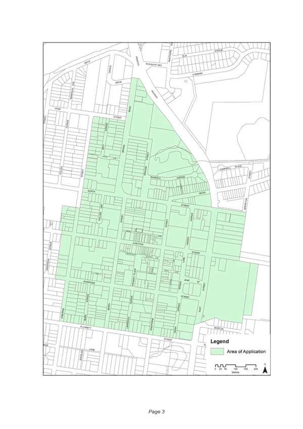
|
|
Development Committee – Tuesday 13 March 2018
Page 55
|
DE18.20 Exhibition Outcome and
Finalisation - Draft Amendment No 22 - Shoalhaven Development Control Plan 2014
- Chapter N19: Huskisson Mixed Use Zones
HPERM Ref: D18/47058
Group: Planning Environment & Development Group
Section: Strategic Planning
Attachments: 1. Draft DCP Amendment No 22
- Chapter N19: Huskisson Mixed Use Zones (under separate cover) ⇨
2. Report - Development Committee Meeting - 10 October 2017 ⇩
Purpose / Summary
Report the outcomes of
the public exhibition of draft Amendment No 22 to Shoalhaven Development
Control Plan (DCP) 2014 - Chapter N19: Huskisson Mixed Use Zones to enable it
to proceed to adoption and finalisation.
|
Recommendation (Item to be
determined under delegated authority)
That Council:
1. Adopt Amendment No.
22 to Shoalhaven Development Control Plan 2014 as exhibited, with the
following minor amendment:
a. Highlighting of LEP and DCP dictionary terms.
2. Notify
the adoption of Amendment No 22 to Shoalhaven
Development Control Plan 2014 in the local newspapers in accordance with the
requirements of the NSW Environmental Planning & Assessment Act 1979 and
Regulations.
|
Options
1. Adopt
the recommendation to adopt Amendment No 22 to DCP Chapter N19: Huskisson Mixed
Use Zones with minor changes.
Implications: This is the preferred option. It will allow controls to be
incorporated from the adopted DCP No. 99 Huskisson B4 Mixed Use Zone Precincts
which was endorsed in 2014, and address other functional anomalies in the
Chapter.
2. Adopt an alternative recommendation.
Implications: Dependent on the changes requested, this may delay the adoption of
the Amendment to the DCP Chapter.
3. Not adopt the recommendation to amend the DCP
Chapter.
Implications: This is not a preferred option as amendments to the DCP Chapter are required to incorporate the
omitted controls from DCP No 99 Huskisson B4 Mixed Use
Zone Precincts and improve its functionality and
legibility.
Background
The detailed background to this draft
amendment is detailed in a report to the 10 October 2017 Development Committee
meeting – see Attachment 2.
Essentially in a review of the DCP Chapter,
it was identified that some of the controls that were adopted as part of the Amendment No. 2 to DCP 99 - Huskisson B4 Mixed Use Zone
Precincts were inadvertently missed as part of the adoption of the Citywide DCP.
Thus, a draft DCP amendment was prepared to
reintroduce the omitted controls, and address other functional anomalies
including consistent wording, deletion of duplicated or
contradictory controls, address additional recent concerns raised by Councils Traffic
Unit and Waste Services Section, minimise conflict between pedestrians and
vehicles, and simplify the wording of existing controls relating to the three
laneways covered by the DCP Chapter.
Council’s Development Committee
resolved on 10 October 2017 to:
1. Prepare and publicly exhibit the
proposed amendments to Draft Chapter N19 Huskisson Mixed Use Zones of
Shoalhaven Development Control Plan 2014 for a minimum period of 28 days in
accordance with the Environmental Planning & Assessment Act 1979.
2. Advise the relevant Community
Consultative Body (Huskisson Woollamia Community Voice) of the public
exhibition.
3. Report the outcomes of the
public exhibition period to Council when appropriate.
As a result, DCP Amendment No 22 (Attachment
1) was publicly exhibited in accordance with the statutory requirements
from 25 October to 24 November 2017 (inclusive).
No submissions were received in respect to
the DCP Amendment. Thus, it is recommended that the DCP Amendment be adopted
and finalised as exhibited with the only change being the highlighting for
consistency of LEP and DCP dictionary terms.
Further Amendments to DCP Chapter N19:
Mixed Use Zones
In the report to Council’s
Development Committee on 10 October 2017, it was noted that issues were raised
outside of the scope of works for Amendment No 22 and that they be considered
as part of a future amendment to Chapter N19: Mixed Use
Zones.
This consideration will be undertaken as
part of Amendment No 10 (Area Specific Review) to Shoalhaven DCP 2014 that will
be reported to Council at the appropriate point.
Community
Engagement
Draft Amendment
No. 22 to the DCP was publicly exhibited from Wednesday 25 October until Friday 24 November 2017 (inclusive) at the City
Administration Centre, Bridge Road, Nowra.
Owners of land
covered by the DCP Chapter and the Huskisson-Woollamia Community Voice (the
local CCB) were directly advised of the exhibition.
During the
exhibition period, no submissions were received.
Policy Implications
If adopted, DCP Amendment No. 22 will
finalise an amendment to Shoalhaven DCP 2014, Chapter N19: Huskisson Mixed Use
Zones.
Risk Implications
If Council does not resolve to amend the
DCP chapter, public safety could be at risk due to the narrow width of waste
collection in Kent Lane, Winnima Lane and Unnamed Lane. Amendment No 22
intended to mitigate against these risk implications.
|
|
Development Committee – Tuesday 13 March 2018
Page 58
|
|
|
Development Committee – Tuesday 13 March 2018
Page 62
|
DE18.21 Aboriginal Land Claim
No.41831 - Illaroo
HPERM Ref: D18/48784
Group: Planning Environment & Development Group
Section: Strategic Planning
Attachments: 1. Request for Information -
Aboriginal Land Claim - Illaroo ⇩
2. Special Lease - Bundanon Trust ⇩
Purpose / Summary
To obtain direction regarding any proposed
comment Council should make in regard to Aboriginal Land Claim (ALC) No. 41831
at Illaroo.
Note: This matter is being reported to the Development Committee to meet
an extended deadline to provide comment.
|
Recommendation (Item to be
determined under delegated authority)
That Council:
1. Notify the NSW
Department of Industry – Crown Lands Aboriginal Land Claims
Investigation Unit that Council has no objection to
the granting of Aboriginal Land Claim No.41831 at Illaroo, subject to the
following being excluded from the Claim, or being resolved as part of the
determination of the Claim:
a. Agreements to achieve the outcomes of the
Bundanon Masterplan.
b. Easements/rights of way or similar to
maintain legal and practical access.
c. Easements to establish and maintain Asset
Protection Zones.
d. Preservation of the environmental
significance of the area by ensuring that the registered wildlife sanctuary
and threatened species habitats are not compromised, and existing environmental
initiatives can continue.
e. Preservation of the cultural significance of
the area, as demonstrated on the Commonwealth Heritage Listing.
|
Options
1. Notify
the NSW Department of Industry (DoI) – Crown Lands Aboriginal Land Claims
Investigation Unit (ALCIU) that Council does not object to the granting of ALC
No. 41831 subject to agreements and easements being excluded from the claim or
resolved as part of the determination of the claim.
Implications: This is the preferred option as it enables Council to respond to
DoI, consistent with the advice provided by Bundanon Trust.
2. Provide alternative advice to DoI regarding ALC No. 41831 as
directed by Council.
Implications: This option is not
preferred, as the advice provided to DoI needs to be justified and as such may
not be consistent with known history of the land at the date the claims were
lodged. Any other position would potentially be inconsistent with the
Bundanon Trust’s submission.
3. Not respond to the DoI regarding ALC No.41831.
Implications: This is not preferred as it does not allow Council to present
evidence that the lands which are being claimed have been reserved for future
public purpose or are part of a wildlife refuge.
Background
Council received advice from DoI on 19
January 2018 that ALC No.41831 is now under investigation for determination.
The claim is over parcels of land that form part of the “Bundanon”
Estate at Illaroo, which is managed by the Bundanon Trust.
The subject land is shown at Figure 1,
and comprises the following:
· Lot 7315 DP 1166783; and
· Lot 12 (Por 12) & 13 (Por 13) DP 751273

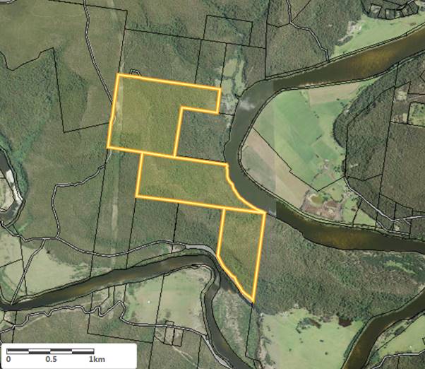
Figure 1 – Aerial image - Subject land – ALC No.41831
Council has been asked to provide comments
on the claim (Attachment 1) and specifically whether, at the date the
claim was lodged, the subject land was:
· Lawfully used and/or occupied, or
· Needed or likely to be needed for an essential public purpose.
Any comment, assertion or statement
provided regarding Councils interest in the land, should be as at the date of
the claim, being 24 November 2016 and be supported by evidence. The
claim was lodged by the NSW Aboriginal Land Council.
Council has been granted an extension of
time to respond to the claims to allow the matter to be reported for
consideration.
Summary of the Subject Land
The subject land comprises three separate
lots situated between Bundanon Road and the Shoalhaven River.
The surrounding lots are all managed by the
Bundanon Trust, with the exception Lot 15 DP 751273, that adjoins Lot 7315 DP (to the north), which is owned
by the Nowra Local Aboriginal Land Council.
Lot 15 DP 751273 was subject to a previous
ALC (No.6393) in 2000. Council resolved on 19 December 2000 to support
the claim and on 7 December 2015 the claim was granted, and the land proceeded
to be transferred to the Nowra Local Aboriginal Land Council (LALC). This
highlights that land mapped as under the ownership of ‘Bundanon
Trust’ is land which can be claimed by Nowra LALC as the Bundanon Trust
is an agency arm of the Federal Government.
The following is an overview of the three
lots covered by the current claim and comment where relevant:
· Lot 7315 DP 1166783
Lot 7315 is the largest of the three lots
and borders Lot 101 DP 751273, which is the site proposed for the Bundanon
Trust Masterplan.
Part of Bundanon Road exists in the western
section of Lot 7315, although there is no formal road reserve in place. Whilst
this 5.3km section of road which traverses the subject site is not a legal road
reserve, Council’s Assets and Works have indicated that this section of
Bundanon Road has likely been formed and maintained by Council in the past. In
determining the claim, an easement or similar over this portion of land is
required in order to retain the legal and practical access for this section of
Bundanon Road.
· Lot 7315 DP 1166783 & Lot 13 DP 751273
(Por 13)
Lot 7315 and Lot 13 are subject to an
altered Special Licence (LI 194561) granted to the Bundanon Trust under Section
34 of the Crown Lands Act 1989 in September 2016. A copy of the
altered Special Licence is provided as Attachment 2. The purpose of the
Special Licence is for the preservation of bushland. The alteration to this
Special Licence followed the removal of Lot 15 DP 751273 from the licence after
the lot was granted to Nowra LALC through a previous claim (No.6393).
Further, Crown Lands have advised that
these two lots are part of Reserve No. 751273 for ‘future public
requirements’, originally notified 29 June 2007. This reserve is
Crown land held by the Bundanon Trust under Licence No. 194561 and commenced on
31 March 1993.
· Lot 12 DP 751273 (Por 12)
Lot 12 is part of the Bundanon Wildlife
Refuge, which was gazetted 17 September 1982 (see Figure 2).
Further, Crown Lands has advised Council
that this lot is part of Reserve No. 87526 for ‘future Public
Requirements’ notified 28 November 1969. It is Crown land held by
Bundanon Trust under expired Special Lease – LS 189571 (formerly Special
Lease 1988/1 for business purposes which expired 31 December 2009).
The Bundanon Trust occupy Lot 12 under the
holding provisions of the Crown Lands (Continued Tenures) Act 1989
following the expiry of the Special Lease. Dealing I212864 shows that the
Special Lease was transferred from the Boyd Family to the Bundanon Trust on 24
March 1993.
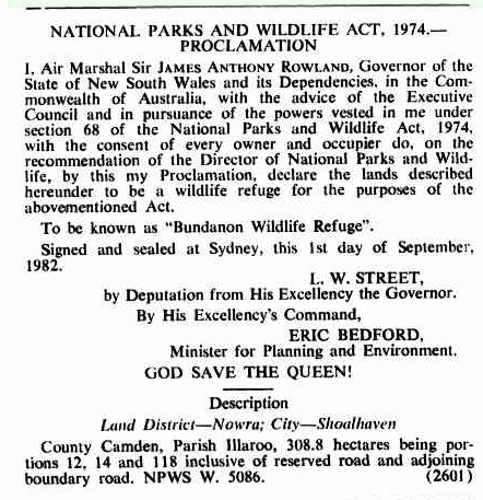
Figure
2 – National Parks and Wildlife Act 1974 Gazettal
Engagement –
Bundanon Trust
As part of the consideration of this claim,
Council staff contacted Bundanon Trust. It is acknowledged that this is not a
formal or typical requirement of considering ALC’s. However, given the
community interest in this facility it was considered prudent.
Bundanon Trust advised that they had been
notified of the claim by DoI and were making a separate submission. A
copy of their draft submission will be available in the Councillor’s
room. The following is a summary of their points:
· Bundanon
Trust raises no objection to the Claim in principle.
· Granting
of the Claim may affect various interests the Bundanon Trust has in the land
subject to the ALC including:
- Achieving
the development outcomes of the Bundanon masterplan;
- The
establishment and maintenance of an Asset Protection Zone (APZ) within Lot
7315;
- Maintaining
fire safety egress across Lot 7315;
- Maintaining
unimpeded access to Lot 118;
- Preserving
the environmental significance of the area by ensuring that the registered
wildlife sanctuary and threatened species habitats are not compromised, and
existing environmental initiatives can continue; and
- Preserving
the cultural significance of the area – as demonstrated by its listing on
the Commonwealth Heritage List.
· A
deferred commencement development consent exists over Riversdale. The requirements
of this include the creation and maintenance of an asset protection zone (APZ)
which is required to go over a small part of Lot 7315 (subject to this ALC).
· The
subject land provides access to other Trust managed properties, including:
- Lot 7315 which has been historically used for fire-trail access to
the Riversdale property, enabling emergency vehicles to access the site.
- Lot 12 provides
the only access to the Eearie Park and Bundanon properties. It was noted
that it is unclear whether the road reserve adjacent to Lot 12 is part of the
ALC.
· Lot 7315 and Lot 13 are subject to a Special Licence and Lot 12 is
subject to a Special Lease. The Trust would like to maintain these for
the foreseeable future.
· The land surrounding Bundanon Trust is considered of cultural
significance and is registered on the National Heritage List. The listing
sites the significant views from the properties which were painted by Arthur
Boyd, Sidney Nolan and others, and the inspiration of the landscape to generations
of Australian artists.
· Lots 7315 and 12 are of considerable cultural significance in modern
Australian art history as they were the location of significant artworks
painted by Boyd and Nolan.
· Bundanon Trust is a registered Wildlife Sanctuary. The subject land
has significant biodiversity and provides habitat to 13 threatened species.
· Bundanon Trust has invested considerably in a major environmental
initiative on portions abutting these lots, with significant private and public
funds invested, which may be at risk should the custodianship of these
portions be transferred to others.
· It is critically important that the historical and ongoing social,
cultural and ecological interests in Lots 7315, 12 and 13 are not affected.
Consequently, it is considered that Council
should not object to the granting of ALC No. 41831, consistent with the
submission from Bundanon Trust, subject to conditions relating to creation of
easements for access and APZ, and Agreements relating to the achievement of the
Bundanon Masterplan and ongoing preservation of the subject sites environmental
and cultural significance.
Risk Implications
There is no
risk to Council in providing this advice to DoI, as it ensures that all
relevant information is made available to assist in determining these land
claims.
There is a risk
that if the claim is granted without establishing easements / right of ways,
any legal and practical access to both Bundanon Road and to other properties
managed by the Bundanon Trust (Riversdale) may be complicated or severed.
|
|
Development Committee – Tuesday 13 March 2018
Page 67
|
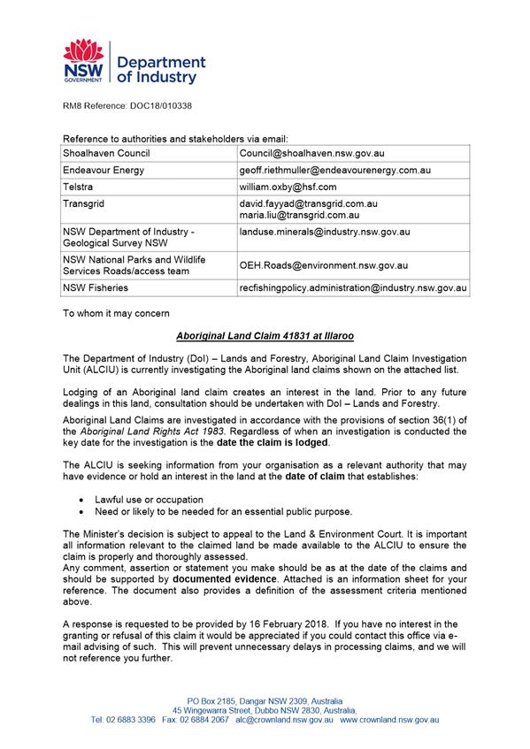
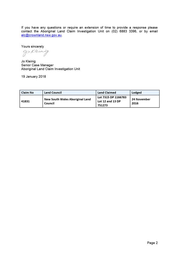
|
|
Development Committee – Tuesday 13 March 2018
Page 71
|
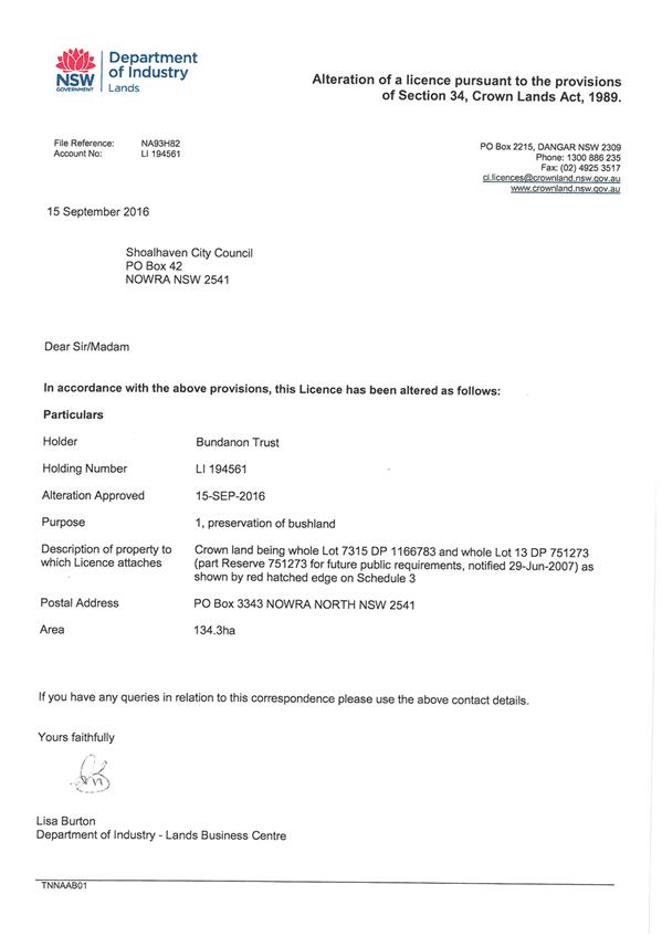
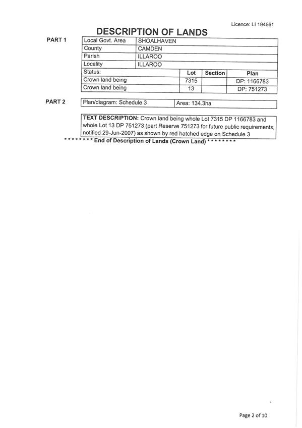
|

|
Development Committee – Tuesday 13 March 2018
Page 74
|
DE18.22 SF10586 – 11
Grahams Rd, Meroo Meadow – Lot 2 DP 861948
DA. No: SF10586/4
HPERM Ref: D18/55215
Group: Planning Environment & Development Group
Section: Development Services
Attachments: 1. SF10586 - Plan of
Proposed Subdivision - Lot 2 DP 861948 - 11 Grahams Rd, Meroo Meadow ⇩
Description of Development: Two (2) Lot Rural Subdivision
Owner:
Kerry Hutton Pty Ltd
Applicant:
Lee Carmichael Town Planning
Notification Dates: 15 May to 30 May 2017
No. of Submissions: Nil
Purpose / Reason for consideration by Council
This purpose of
this report is to seek Council’s direction as to whether a Restriction
placed on the Section 88B Instrument of the subject land should be removed. The
Restriction states that the lot cannot be further subdivided.
The Restriction
was imposed by Council via a condition of consent in the most recent
subdivision approval for the site (SF7377).
Should the removal of the Restriction be supported and the current
application (SF10586) be determined by way of approval, a condition of consent
would be included in any consent issued requiring the Restriction be removed
prior to the issue of a Subdivision Certificate for SF10586.
|
Recommendation (Item to be
determined under delegated authority)
That the Committee:
1. Confirms
that it supports the removal of the Restriction that was placed on the
section 88B Instrument of the subject land under SF7377; and
2. Refer
the application (SF10586) back to staff for determination.
|
Options
1. Resolve
to support the removal of the Restriction that was placed on title via the
section 88B Instrument of under SF7377.
Implications: The
deletion of the Restriction would enable Council to consider determining the
current application (SF10586) by way of approval.
2. Resolve
to not support the removal of the Restriction that was placed on title via the
section 88B Instrument under SF7377.
Implications: The
application would either need to be withdrawn by the applicant or refused
consent by Council, as any approval is contingent on the Restriction being
removed.
Background
Proposed Development
The current
application (SF10586) seeks approval for the subdivision of the existing
91.73ha lot into two lots that would have the following Lot numbers and areas:
· Proposed
Lot 201 (western half of site) – 51.521ha
· Proposed
Lot 200 (eastern half of site) – 40.207ha
See Attachment 1 for the Plan of Proposed
Subdivision prepared by Johnson Procter Surveyors (Surveyor’s Reference:
89045, dated 08/02/2017) (document D17/144901).
The areas are compliant with the controls
within the Shoalhaven Local Environmental Plan 2014 (SLEP 2014).
Subject Land
The subject
site is 11 Grahams Rd, Meroo Meadow (legally known as Lot 2 DP 861948).
Figure
1 – Location Map
(with
Shoalhaven Local Environmental Plan 2014 (SLEP 2014) zoning overlay)
Site & Context
The subject site:
· Is a rural site utilised predominantly as a dairy farm by the owners
(Hutton family) and is located in Meroo Meadow surrounded by other rural
properties;
· Is zoned RU1 Primary Production and has an overall area of 91.73ha;
· Has a minimum lot size of 40ha as mapped in the SLEP 2014 Minimum
Lot Size map;
· Is divided into two halves by Grahams Rd and has access via three
driveways; one from each of the two lot halves to Grahams Rd and a third to
Boxsells Ln to the south;
· Is not mapped as either bushfire prone land or within the Flood
Planning Area;
· Contains various sheds and outbuildings to support the agricultural
use of the land as well as three dwellings. These dwellings would be located on
the respective proposed lots and have the following informal names:
|
Informal
dwelling name
|
To be located
on proposed lot
|
Approved
|
Details of
approval
|
|
The Residence
|
Lot 201 (western
lot)
|
Pre-1964
|
N/A
|
|
The Cottage
|
Lot 201 (western
lot)
|
Yes – as
rural worker’s dwelling
|
DA94/1145 (approved 27/04/1994) & BA94/2901 (approved
11/11/1994)
|
|
The Dairy
|
Lot 200 (eastern
lot)
|
Pre-1964 –
No*
|
N/A
|
*The Dairy dwelling has a more complicated history which
is detailed later in this report. Figure 2 below shows the location of the
three dwellings.
Figure 2 –
Location Map (Aerial photo with informal dwelling names)
History
i) Original
land ownership: The current site is an amalgamation
of two original 1964 holdings as outlined in blue and orange in Figure 3 below.
Figure
3 – Original 1964 holding ownership
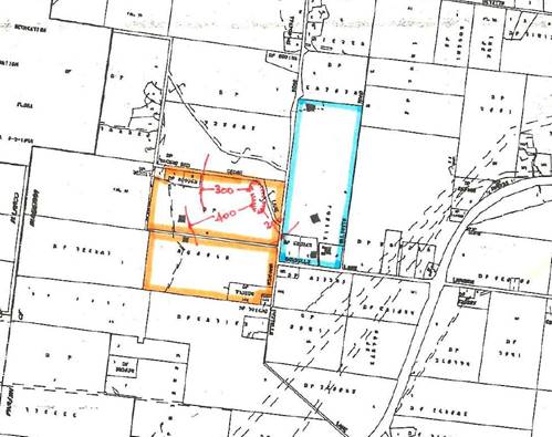
Each lot exhausted its
ability to create three concessional lots during the 1970s and 1980s.
ii) Building
Application BA92/2637: Lodged 30/04/1992 and
approved 16/06/1992
Under BA92/2637, Council
approved a new dwelling on what is now Lot 1 DP 861948 (108 Grahams Rd, Meroo
Meadow) – see Figure 4 below. However, this approval included a condition
stating that the existing dwelling known as The Dairy was to be made
uninhabitable. This was as per Condition 12 of BA92/2637 which states:
“The existing
dwelling on site shall be rendered uninhabitable by the removal of all fittings
and fixtures upon completion of the new building. The building then shall only
be used for storage purposes.”
Figure 4 – Identification of Lot 1 DP 861948 (108 Grahams Rd,
Meroo Meadow) which contains the dwelling approved under BA92/2637:
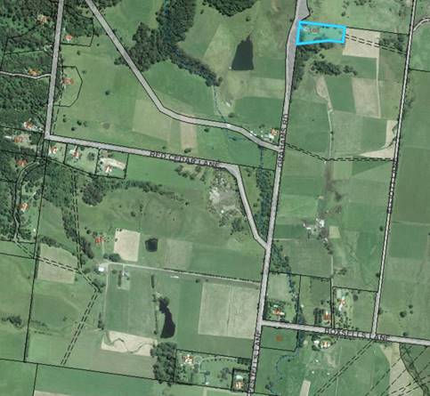
iii) Most
recent subdivision approval – SF7377: Lodged
25/08/1992 and approved 20/09/1993
SF7377 proposed:
· Boundary
adjustment of the then two (2) existing lots. As detailed previously, these
lots were created as residue lots after excision of the total concessional lot
potential from the two (2) separate 1964 existing holdings to which these lots
originally related;
· To
create a proposed Lot 1 having an area of 1 hectare. This lot (see Figure 4
above) would contain the dwelling approved under BA92/2637. The dwelling was
under construction at the time SF7377 was lodged; and
· To
create the now subject Lot 2 which has an area of 91.783ha. This lot
consolidated the two original 1964 holdings;
SF7377 was assessed under Council’s previous Shoalhaven Local
Environmental Plan 1985 (SLEP 1985). The minimum lot size for this site under SLEP
1985 was 40ha as it currently still is under SLEP 2014.
· Given the proposed boundary adjustment to create Lot 1 would have
resulted in a lot of only 1 hectare, the applicant lodged an Objection to a
development standard under State Environmental Planning Policy No. 1 –
Development Standards (SEPP 1).
· The variation was to create an undersized lot by way of a boundary
adjustment (i.e. not the actual creation of a new lot, as the ability to create
concessional lots had already been exhausted as previously detailed).
· A report summarising the proposal and recommending that Council
resolve to support the SEPP 1 Objection was put to Council at a meeting of
17/08/1993. Council resolved to support the SEPP 1 Objection,
subject to there being the creation of a restriction as to user on the
resulting 91.73ha lot, prohibiting its further subdivision.
· Council staff wrote to the then NSW Department of Planning seeking
their concurrence to vary the minimum lot size requirement as per the SEPP 1
Objection, in a letter dated 23/08/1993. The Department’s concurrence was
subsequently provided in a letter dated 13/09/1993.
· Consequently, consent for SF7377 was granted on 20/09/1993.
Conditions 3 and 6 are of relevance to the current application and currently
read as follows:
|
Extract of conditions of consent from
SF7377
|
|
RESTRICTIONS
3. For the purpose of registering, of
Restrictions as to User under Section 88B of the Conveyancing Act, the
following covenants shall apply to the subdivision:
(a) Proposed lot 2 shall not be further subdivided
CONDITIONS OF A GENERAL NATURE
6. The Director of the Department of
Planning has concurred to this subdivision provided the existing dwelling is
replaced by the dwelling located on proposed lot 1. The existing dwelling is to
be made incapable of occupation prior to release of the final survey plans.
|
Note: “The dwelling on proposed Lot 1” is the dwelling that was approved under BA92/2637. “The
existing dwelling” to be made uninhabitable is The Dairy.
· The Restriction was created and registered on the Section 88B
Instrument.
· However, a review of all of Council’s records relating to the
subject site do not confirm that The Dairy dwelling was made uninhabitable.
Council subsequently released the Subdivision Certificate for SF7377 on
05/09/1996. The subdivision was officially registered on 12/09/1996.
· The application was referred to the NSW Department of Agriculture
who had concerns about the proposal, given it is Prime 3 Crop and Pastureland,
but from a review of the SF7377 file, it seems it was ultimately
Council’s suggestion to place the Restriction on the land. The Department
of Planning concurred.
Issues
Given it was the
elected Council’s original decision (on recommendation of Council staff)
to support the creation of the Restriction on the Section 88B Instrument and
this was affected via Condition 3 of the SF7377 development consent, it is
staff’s opinion that the proposed removal of the Restriction needs to be
reported back to Council for consideration, which is the overall purpose of
this report.
Applicant’s
Submission
The applicant has provided justification within the submitted
Statement of Environmental Effects (SEE) as to why the proposal overall is
considered worthy of support.
In summary, the subdivision and ‘de facto’ approval of
The Dairy dwelling would allow the land east of Grahams Rd to be more
effectively managed as a dairy farm. It would also allow for succession
planning for the younger members of the Hutton family to continue their long-standing
association with the land and its use of the land for agricultural purposes.
If the removal of the Restriction is supported, the applicant has
proposed that Council:
· Include
a condition of consent requiring a Section 96 modification application to be
lodged that would modify the existing SF7377 subdivision consent so as to
delete Conditions 3 and 6; and
· Include
a condition of consent requiring that the Section 88B Instrument relating to
the current DP 861948 be modified so that the Restriction is removed prior to
the issue of a Subdivision Certificate.
Note: Condition 12 of
BA92/2637 that also required The Dairy dwelling to be rendered uninhabitable
was not mentioned in the SEE. However, the deletion of this Condition would
also need to be conditioned in any consent issued for SF10586.
Discussion
In summary:
· The
Dairy is effectively an unauthorised dwelling that should have been made
uninhabitable but seemingly this matter was not identified by Council at the
time a Subdivision Certificate for SF7377 was issued. According to the SEE for
the current application, the Dairy has been continually occupied since both
BA92/2637 and SF7377 were approved;
· Under
the current SF10586 application, both the proposed Lot 201 (west of Grahams Rd)
and Lot 200 (east of Grahams Rd) would be above the minimum lot size of 40ha,
thus automatically having dwelling entitlement under normal circumstances;
· The
proposal under the current SF10586 application would not be inconsistent with
the objectives of the site’s RU1 Primary Production zoning.
· The
Residence and The Cottage would be located on the proposed Lot 201 to the west
of Grahams Rd. The Residence has ‘de facto’ approval having existed
since before 1964 and The Cottage was approved as a rural worker’s
dwelling under DA94/1145 and BA94/2901;
· The
applicant is seeking to use the current SF10586 application to regularise the
use of The Dairy by requesting conditions be placed on any consent issued
requiring the previous Conditions 3 and 6 under SF7377 to be deleted.
Planning Assessment
The DA has been
assessed under s79C of the Environmental Planning and Assessment Act 1979.
Other than for the complicated site history which has been previously detailed,
there are no other planning grounds that would be grounds for a refusal of the
application. If the removal of the Restriction is not supported, the
application would need to either be withdrawn or refused.
Policy Implications
Nil.
Consultation and
Community Engagement:
In accordance with Council’s Community Consultation Policy for
Development Applications the application was notified as follows:
· Individual property owners were notified of the proposal (within a
100m radius of the site – 25 letters sent. The notification period was
from 15/05/2017 to 30/05/2017;
· The DA and supporting documentation are on display at
Council’s City Administrative Centre, Nowra as well as on Council’s
website through DA Tracking.
No submissions were received.
Financial
and Legal Implications:
There are
potential financial costs and legal implications for Council in the event of a
refusal of the application. Such costs and implications would be associated
with defending an appeal in the NSW Land and Environment Court.
Summary
and Conclusion
If the removal of the Restriction is not supported and the applicant
does not withdraw the application, the application will need to be refused.
This could result in financial costs and legal implications to Council as
stated above.
Despite the site’s complicated history and in support of the
application, both resulting lots would meet the minimum lot size, the site has
(and has only ever had) a 40ha minimum lot size both under SLEP 1985 and SLEP
2014, and the proposal is not inconsistent with the objectives of the
site’s RU1 Primary Production zoning. Accordingly, support is
recommended.
|
|
Development Committee – Tuesday 13 March 2018
Page 82
|
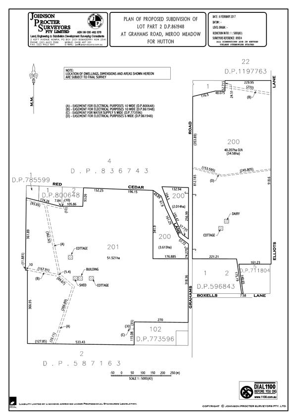
|
|
Development Committee – Tuesday 13 March 2018
Page 83
|
Local Government Amendment
(governance & planning) act 2016
Chapter 3, Section 8A Guiding principles for
councils
(1)
Exercise of
functions generally
The following general principles apply to the exercise
of functions by councils:
(a) Councils should
provide strong and effective representation, leadership, planning and decision-making.
(b) Councils should
carry out functions in a way that provides the best possible value for
residents and ratepayers.
(c) Councils should plan
strategically, using the integrated planning and reporting framework, for the
provision of effective and efficient services and regulation to meet the
diverse needs of the local community.
(d) Councils should
apply the integrated planning and reporting framework in carrying out their
functions so as to achieve desired outcomes and continuous improvements.
(e) Councils should work
co-operatively with other councils and the State government to achieve desired
outcomes for the local community.
(f) Councils
should manage lands and other assets so that current and future local community
needs can be met in an affordable way.
(g) Councils should work
with others to secure appropriate services for local community needs.
(h) Councils should act
fairly, ethically and without bias in the interests of the local community.
(i) Councils
should be responsible employers and provide a consultative and supportive
working environment for staff.
(2) Decision-making
The following principles apply to decision-making by
councils (subject to any other applicable law):
(a) Councils should
recognise diverse local community needs and interests.
(b) Councils should
consider social justice principles.
(c) Councils should
consider the long term and cumulative effects of actions on future generations.
(d) Councils should
consider the principles of ecologically sustainable development.
(e) Council
decision-making should be transparent and decision-makers are to be accountable
for decisions and omissions.
(3) Community
participation
Councils should actively engage with their local
communities, through the use of the integrated planning and reporting framework
and other measures.
Chapter 3, Section 8B Principles of sound
financial management
The following principles of sound financial management
apply to councils:
(a) Council spending should be
responsible and sustainable, aligning general revenue and expenses.
(b) Councils should invest in
responsible and sustainable infrastructure for the benefit of the local
community.
(c) Councils should have effective
financial and asset management, including sound policies and processes for the
following:
(i) performance
management and reporting,
(ii) asset
maintenance and enhancement,
(iii) funding decisions,
(iv) risk management
practices.
(d) Councils should have regard to
achieving intergenerational equity, including ensuring the following:
(i) policy
decisions are made after considering their financial effects on future
generations,
(ii) the current generation funds the cost of its
services
Chapter 3, 8C Integrated planning and reporting
principles that apply to councils
The following principles for strategic planning apply
to the development of the integrated planning and reporting framework by
councils:
(a) Councils should identify and
prioritise key local community needs and aspirations and consider regional
priorities.
(b) Councils should identify
strategic goals to meet those needs and aspirations.
(c) Councils should develop
activities, and prioritise actions, to work towards the strategic goals.
(d) Councils should ensure that the
strategic goals and activities to work towards them may be achieved within
council resources.
(e) Councils should regularly review
and evaluate progress towards achieving strategic goals.
(f) Councils should maintain
an integrated approach to planning, delivering, monitoring and reporting on
strategic goals.
(g) Councils should collaborate with
others to maximise achievement of strategic goals.
(h) Councils should manage risks to
the local community or area or to the council effectively and proactively.
(i) Councils should make
appropriate evidence-based adaptations to meet changing needs and
circumstances.