Shoalhaven Natural Resource & Floodplain
Management Committee
Meeting Date: Thursday,
23 November, 2017
Location: Ulladulla
Civic Centre, Princes Highway, Ulladulla
Time:
4.00pm
Please note: Council’s
Code of Meeting Practice permits the electronic recording and broadcast of the
proceedings of meetings of the Council which are open to the public. Your
attendance at this meeting is taken as consent to the possibility that your
image and/or voice may be recorded and broadcast to the public.
Agenda
1. Election of Chairperson
2. Apologies
3. Confirmation of Minutes
· Shoalhaven
Natural Resource & Floodplain Management Committee -
7 September 2017........................................................................................................ 1
4. Declarations of Interest
5. Reports
SN17.21...... Updates on the Shoalhaven River and St Georges
Basin Floodplain Risk Management Study & Plan and Shoalhaven River Levee
Flood Damage Restoration 2017 project.................................................................................................... 8
SN17.22...... Flood Mitigation Projects – Flood
Information Sign Project ........................ 13
SN17.23...... Currarong Coastal Erosion Remediation
Detailed Design Progress Report November 2017...................................... 15
SN17.24...... Shoalhaven Dredging Survey Report........................................................... 24
6. General Business
|

|
Shoalhaven Natural Resource & Floodplain Management Committee – Thursday
23 November 2017
Page
ii
|
Membership
Clr Findley – Chairperson
All Councillors
General Manager or nominee
Community representatives:-
David McCorkell
Duncan Marshall
Ian Stewart
Dr Michael Brungs
Dirk Treloar
Annie Boutland
Helen Moody
David Reynolds
Kaye Milsom
Brett Stevenson
Chris Grounds
Mike Clear
Paul Beckett
Robyn Flack
Peter Hanson
Government Agency representatives:-
Jerrinja LALC
Ulladulla LALC
NPWS
SRCMA
OEH
RMS
DPI Fisheries
Local Lands Service
Crown Lands
NSW Office of Water
Jervis Bay Marine Park Authority
SES
Quorum – Three (3) provided that a minimum of one
Councillor and two community representatives are present.
Objective
To foster sustainable management of Shoalhaven’s
natural resources including floodplains, coast and estuaries.
Role of Committee
1. Provide
overall guidance for the management of natural resource management including
floodplain management, estuary management and coastal zone management in
accordance with Federal, State and Local Government Policy and Legislative
instruments;
2. Advise
Council on natural resource management including floodplain management, estuary
management and coastal zone management matters;
3. Formulate
agreed vision, goals, objectives, and targets sought from the Natural Resource
Management Plans;
4. Facilitate
the preparation of Natural Resources Management Plans;
5. Provides
input into the identification of management options for Natural Resources
Management Plans;
6. Facilitate
broad community consultation;
7. Monitor
State and Federal Government natural resource management direction and advises
Council on appropriate response;
8. Monitor
advances in knowledge and science of natural resource management issues (such
as sea level rise and climate change) and integrate this knowledge in new
Natural Resource Management Plans as well as in the review of existing Plans;
and
9. Make
recommendations for Council consideration.
Minutes of the Shoalhaven Natural Resource & Floodplain
Management Committee
Meeting Date: Thursday,
7 September 2017
Location: Sussex
Inlet Community Centre, Thompson St, Sussex Inlet
Time: 4.05
pm
The following members
were present:
Clr Amanda Findley -
Chairperson
Clr Kaye Gartner
Clr Mark Kitchener
Clr John Levett
Clr Patricia White
Mr Duncan Marshall
Dr Michael Brungs
Mr Dirk Treloar
Ms Helen Moody
Mr David Reynolds
Mr Brett Stevenson
Mr Chris Grounds
Mr Mike Clear
Mr Paul Beckett
Mr Peter Hanson
Ms Robyn Flack
Mr Bill McInnes
Mr Ian Borrowdale
Mr Danny Wiecek
Mr Matt Carr
Mr Jillian Reynolds
Mr Jason Carson
Mr Phil Costello -
Director, Planning Environment and Development (General Manager’s
nominee)
Others present:
Ms Kelie Clarke -
Environmental Services Manager
Alasdair Stratton –
Natural Resources & Floodplain Unit Manager
Jessica Rippon –
Executive Manager, Communications
Coralie Bell –
Section Manager, Tourism
Ray Massie – Coast
& Estuaries Officer
Janice Natt –
President, Safe Navigation Action Group
Clr Findley acknowledged
the Traditional Owners of the land by paying respect to Elders past and
present.
|
Apologies / Leave of Absence
|
An apology was received
from Clr Cheyne, David McCorkell, Ian Stewart, Annie Boutland, Kaye Milsom,
John Murtagh, Allan Lugg, Ian Stewart and David Zerafa.
|
Confirmation of the Minutes
|
|
RESOLVED (By consent)
That the Minutes of the
Shoalhaven Natural Resource & Floodplain Management Committee held on
Tuesday 06 June 2017 be confirmed.
CARRIED
|
Presentations
Robyn Flack provided a
PowerPoint presentation on behalf of the Shoalhaven Heads Estuary Task
Force. Robyn advised that the Task Force is seeking the support and
assistance of the Shoalhaven Natural Resources and Floodplain Management
Committee with regard to protecting Shoalhaven Heads from flood, erosion events
and sea level rise by relocating the sand within the basin to protect the river
bank and meet the recreation, tourism and boating needs of the community.
The Committee discussed
the information provided by Robyn later in the meeting under Item SN17.17.
|
SN17.12 Coralie
Bell - Tourism Manager - Sustainable Tourism Model
|
HPERM Ref:
D17/287525
|
|
Coralie Bell, Tourism
Manager, provided the Committee with an update regarding the Sustainable
Tourism Model currently being drafted, noting the four cornerstones of
sustainable tourism, community, environment, economy and customer.
The issue of the
importance of National Parks in tourism and was raised. Coralie assured the
Committee that Tourism is working on building relationships with the National
Parks and Wildlife Service (NPWS) and confirmed that NPWS has a
representative member on Council’s Shoalhaven Tourism Advisory
Group.
The Committee agreed
that balance and sustainability is important and discussed:
- Sustainable growth and balance
with economic growth
- Pets on beaches
- Threat to shorebirds
- Unspoilt campaign
- Caravanning and camping
- Promotion of tourism in the
Shoalhaven for the “off” season, for instance, food and wine
and inland touring
Coralie spoke about the
interactive reporting tool “Dashboard”, which is currently under
development, noting that when it is at the draft stage it will come back to
the Committee for feedback. Coralie suggested that the Committee view the
Tourism Optimisation Management (TOMM) Model used by Kangaroo Island http://www.tourkangarooisland.com.au/tourism-optimisation-management
The following members
expressed an interest in providing feedback on Council’s Sustainable
Tourism Model:
- David Reynolds
- Brett Stevenson
- Mike Clear
- Chris Grounds
- Jason Carson
- Clr Levett
- Dirk Treloar
- Paul Beckett
- Helen Moody
- Matt Carr
|
|
SN17.13 Jessica
Rippon - Communications Executive Manager - Integrated Strategic Plan
|
HPERM Ref:
D17/287536
|
|
Jessica Rippon, Communications Executive Manager,
provided an overview of Council’s Integrated Strategic Plan (ISP) and
spoke about how the environment fits into the long term planning for Council.
The ISP can be viewed on Council’s website http://shoalhaven.nsw.gov.au/My-Council/Integrated-Strategic-Plan
Jessica spoke about the
ISP key priorities and key indicators.
Kelie Clarke noted that
Council is seeking to embed the environmental strategies into its Strategic
Plan, so the environment is a consideration in everything it does.
The issue of loss of
habitat and impingement of urban development was raised. Clr Gartner
spoke about the purpose of Council’s Sustainable Futures Committee
including its focus on efficiency measures, environmentally sustainable
living and business.
|
Reports
|
SN17.14 Crown
Land Management Act 2016
|
HPERM Ref:
D17/240505
|
|
The issue of the South
Pacific Heathland Reserve Trust was raised by Helen Moody and Clr Findley
suggested that the Trust may wish to write to the relevant Minister
requesting that the trust stays in trust and David Reynolds may wish to write
an individual letter to the Minister.
|
|
Recommendation (Item to be determined under
delegated authority)
That the Shoalhaven Natural
Resource and Floodplain Management Committee receive the report for
information.
|
|
RESOLVED (Clr White / Helen
Moody)
That:
1.
The Shoalhaven Natural Resource and Floodplain Management Committee
receive the report regarding the Crown Management Act 2016 for information.
2.
Any further updates be reported to the Shoalhaven Natural Resource and
Floodplain Management Committee.
CARRIED
|
|
SN17.15 Consideration
of a possible additional membership for an Oyster Farmer/Primary Industry
Producer
|
HPERM Ref:
D17/216648
|
|
Members
discussed the issue and it was suggested if the SNRFMC needed input from a
special interest group they could be invited to address the Committee.
|
|
Recommendation
That the Committee adopt the
report for information and not recommend to Council an increase in
membership.
|
|
RESOLVED (Chris Grounds / David
Reynolds)
That the Shoalhaven Natural Resources & Floodplain
Management Committee:
1.
Adopt the report for information.
2.
Not recommend to Council an increase in membership.
3. Invite special interest group/s to address the
Committee should specific knowledge or input be required.
CARRIED
|
|
SN17.16 Update
on preparation of the Scoping Study for Council's Coastal Management Plan
|
HPERM Ref:
D17/248599
|
|
Kelie Clarke advised
that the Scoping Study will not be placed on public exhibition, and will go
to Council for adoption. Once the Study has been adopted a consultant will be
engaged.
Kelie asked the
Committee to nominate three (3) community members to participate in a working
group with staff to assist in the development and preparation of the Scoping
Study for Council’s Coastal Management Plan.
Chris Grounds, Brett
Stevenson and Dirk Treloar volunteered to participate in the working group.
The
draft document can be made available to interested members of the committee
and the draft Scoping Study will be reported back to the Committee for
information.
|
|
Recommendation
The Committee nominate three (3)
community members to participate in a working group with staff to assist in
the development and preparation of Scoping Study for Council’s Coastal
Management Plan as required by the NSW Government’s Stage 2 Coastal
Reforms.
|
|
RESOLVED (By consent)
The Shoalhaven Natural Resource
& Floodplain Management Committee nominates Chris Grounds, Brett
Stevenson and Dirk Treloar to participate in a working group with staff to
assist in the development and preparation of Scoping Study for
Council’s Coastal Management Plan as required by the NSW
Government’s Stage 2 Coastal Reforms.
CARRIED
|
Addendum Reports
|
SN17.17 Robyn
Flack - Shoalhaven Heads Estuary Taskforce Presentation
|
HPERM Ref:
D17/289719
|
|
NSW Grant funding applications
and Shoalhaven Heads Estuary Taskforce River Road Stormwater and Erosion
Control project has been shortlisted for a formal grant application with the
NSW Department of Premier and Cabinet.
Council has looked at the storm
water drains and the engineering team that undertook the investigation
advised that the drains could not be removed but could be consolidated and
improved. $300,000 will be committed for the upgrade of stormwater drains. It
has been identified that rock riventment work needs to be done and a grant
application has been lodged for these costs to be covered. Other work
included in the grant application is for restoration of the foreshore.
Concerns were raised by Robyn
Flack with regard to moving the stormwater drains and discussion followed.
Kelie reassured Robyn that
Council will continue to work with the community to deliver a good outcome
for Shoalhaven Heads that looks good and addresses the environmental
problems.
|
|
RESOLVED
(Clr White / Robyn Flack)
That
the Shoalhaven Heads Community Forum continue to work with Council staff on
the overall project of the grant application
CARRIED
|
|
SN17.18 University
of Wollongong - Coastal hazard assessment based on sediment budgeting,
Southern NSW - ARC Research Partnership Grant Application
|
HPERM Ref:
D17/260528
|
|
Clr Levett left at 5.29
pm
Kelie Clarke spoke
about the requirements of the reforms. The research project is partnering
with the Office of Environment and Heritage and University of Wollongong.
This is a pilot project.
|
|
Recommendation
That Council commit to providing $5,000 per year over
three (3) years (2017/18, 2018/19 & 2019/20) from Council’s coast
and estuaries program (15931) to the University of Wollongong towards the Coastal
hazard assessment based on sediment budgeting, southern NSW project, if the
grant application is successful
|
|
Recommendation
(By consent)
That Council commit to
providing $5,000 per year over three (3) years (2017/18, 2018/19 &
2019/20) from Council’s coast and estuaries program (15931) to the
University of Wollongong towards the Coastal hazard assessment based on
sediment budgeting, southern NSW project, if the grant application is
successful.
CARRIED
|
|
SN17.19 Announcement
of 2017/18 and 2018/19 Coast and Estuary Program Grant Funding Opportunities
- Seeking feedback from SNR&FC
|
HPERM Ref: D17/275098
|
|
Alasdair
Stratton, Natural Resources & Floodplain Unit Manager, asked the
Committee for their input regarding selection and prioritisation of potential
grant projects, noting that 2 or 3 applications would be submitted.
The
Committee provided input on the selection and identified three priorities for
potential grant application projects.
|
|
Recommendation (Item to be determined under
delegated authority)
Receive the report for
information and provide input on the selection and prioritisation of
potential grant application projects.
|
|
RESOLVED (By consent)
That
the Shoalhaven Natural Resource & Floodplain Management Committee:
1.
Receive the report for information
2.
Identify the following three (3) priorities for potential grant
application projects
o Mollymook
Foreshore Emergency Works
o Remediation
Action Plan – Broughton Creek Floodplain
o Nature
Assisted Beach Enhancement (NAB) for the Shoalhaven’s 40 Beach
Compartments
CARRIED
|
Other business
|
SN17.20 Additional
Item: Developing a strategic approach and associated planning for management,
conservation and protection of the natural environment
|
|
Duncan Marshall submitted an
additional agenda item on behalf of Ian Stewart and the following was tabled
for the Committee’s consideration.
Background: At the
last Committee meeting a motion in relation to Council developing a strategic
approach and associated planning for the management, conservation and
protection of the natural environment was unanimously carried with only one
dissenting view. It will be important for this Committee to be advised of the
progress being made in developing and implementing such a strategic approach.
Committee members will then be
able to make an ongoing contribution to help inform, shape, monitor and
review this strategy, especially in relation to the high level vision,
values, principles, goals and priorities.
Council's current strategic
approach includes the tourism promotion view that high levels of sustained
growth and development are both desirable and feasible. This appears to be at
odds with what the community stated unequivocally during the recent
consultation and also what is actually sustainable before the area changes
dramatically and the natural environment and sensitive ecosystems are
damaged.
There is mounting evidence that
increasing numbers of visitors and residents are changing this once
relatively 'unspoilt' area. It is also clear that development pressure is
encroaching on areas that are sensitive to human impacts, such as Narrawallee
/ Mollymook and Vincentia / Jervis Bay, where significant areas of the
natural environment have been and are continuing to be bulldozed and
transformed into suburban residential areas and commercial precincts.
At the very least the
implications of these current strategic directions should be considered
carefully by this Committee as an important part of our role and
responsibility.
In view of these current
strategic directions all activity for increasing tourism numbers should take
account of the implications of this for impacted areas. So that ratepayers
are not bearing the burden, all tourism developments should be required to
establish a business case which includes a contribution of funds for required
infrastructure, maintenance and compliance costs to preserve our natural
environment.
One related matter is also
pressing. It is the responsibility of NPWS to manage areas under their direct
control. Council however has a shared responsibility, for the impact of their
contentious dog walking policy for example, for what they are encouraging
(through the very active 'pet friendly' / 'unspoiled Shoalhaven' tourism
promotions) and directing (through signage) dog owners to access vulnerable,
unspoiled beach environments and ecosystems. At the very least there is an
urgent need for information and awareness raising, regulation and compliance
controls to manage the increasing impacts of human activity in sensitive
areas such as Conjola / Narrawallee. Ideally this should be aligned and jointly
undertaken by Council and NPWS.
|
|
RESOLVED (By consent)
1. The
following motions submitted by Ian Stewart be considered by Staff and
reported back to the Shoalhaven Natural Resource & Floodplain Management
Committee:
a. Strategic
approach progress - the Committee be regularly advised of the progress being
made in developing and implementing Council's strategic approach to managing
the natural environment so that committee members are able to make an ongoing
contribution to help inform, shape, monitor and review this strategy,
especially in relation to the high level vision, values, principles, goals
and priorities.
b. Evaluating
development impacts
i.
Implications of the current strategic directions on the natural
environment, especially in relation to tourism and residential development
impacts, should be considered carefully by this Committee as an important
part of our role and responsibility.
ii.
All tourism developments should be required to establish a business
case which includes a contribution of funds for required infrastructure,
maintenance and compliance costs to preserve our natural environment
c. Practical
collaborative management of impacts - Shared responsibility with NPWS for
information and awareness raising, regulation and compliance controls to
manage the increasing impacts of human activity, such as dog walking in
sensitive natural environments, should be aligned and jointly undertaken.
2. Ian Stewart
and other relevant Committee members to be invited to a meeting so that Staff
can brief members further on Council’s strategic approach.
CARRIED
|
There being no further
business, the meeting concluded, the time being 6.25
pm.
Clr Amanda Findley
CHAIRPERSON
|

|
Shoalhaven Natural
Resource & Floodplain Management Committee – Thursday 23 November
2017
Page
8
|
SN17.21 Updates
on the Shoalhaven River and St Georges Basin Floodplain Risk Management Study
& Plan and Shoalhaven River Levee Flood Damage Restoration 2017 project
HPERM Ref: D17/348457
Group: Planning
Environment & Development Group
Section: Environmental
Services
Attachments:
1. Shoalhaven River Levee August 2015 and
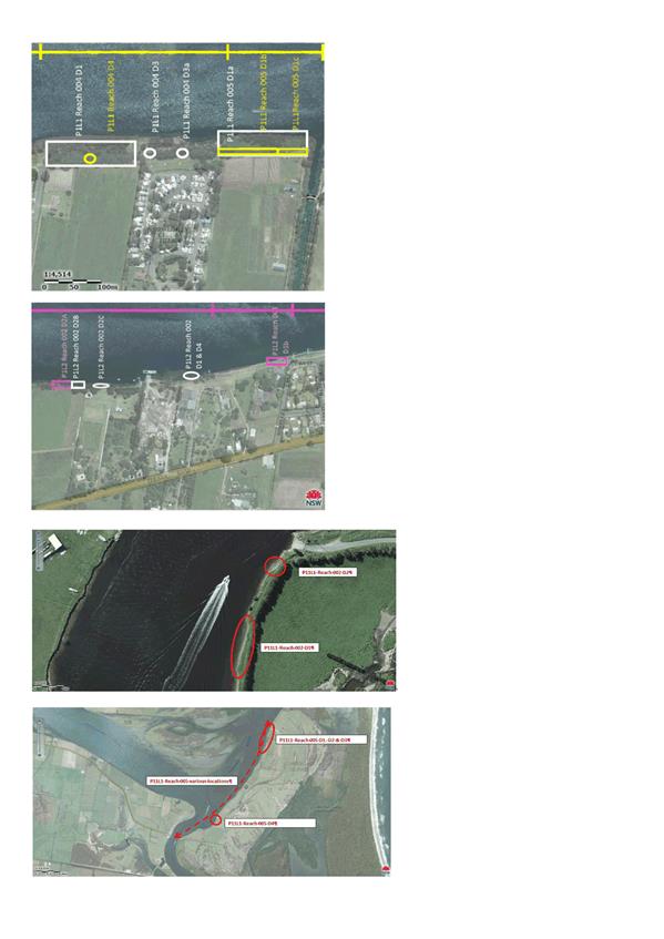
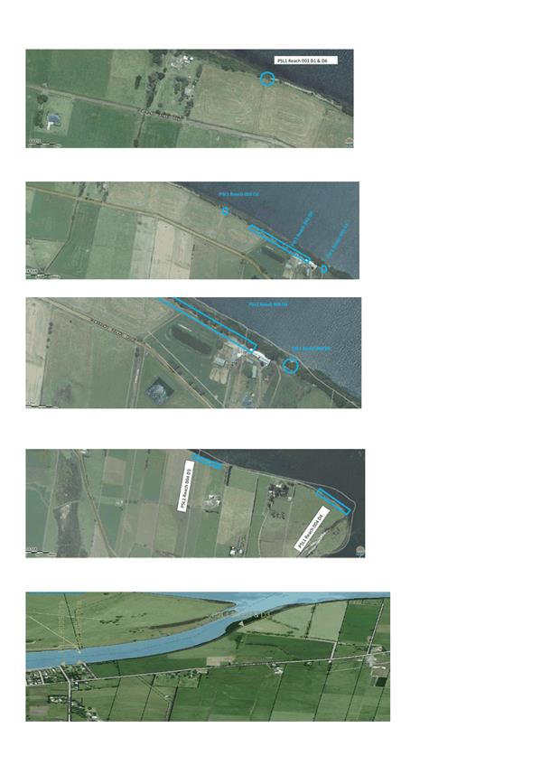
June 2016 Flood Damage sites including Levee Audit Defect sites ⇩
Purpose / Summary
The purpose of this report is to
inform the Committee about the updates on Shoalhaven River and St Georges Basin
Floodplain Risk Management Study & Plan and Shoalhaven River Levee Flood
Damage Restoration 2017 projects.
|
Recommendation
(Item to be determined under delegated authority)
That Committee receive the report for information.
|
Options
1. The committee receive the report for
information.
Implications: Nil.
2. The Committee could choose to provide
an alternative recommendation for future consideration by Council.
Implications: Unknown
Background
Flood Levee Restoration
Project 2017:
Shoalhaven City Council has commenced a project to repair
damaged sections of the Shoalhaven River Levees. This work will repair damage
that occurred during the August 2015 flood, June 2016 flood and levee audit
defects (levee audit done by Royal Haskoning Pty Ltd in May 2015). See
attachment 1 for the defect locations.
Council subsequently went
out to tender in March/April 2017 and again in July 2017
seeking tenders for the restoration works. No complying tenders
were received and as a result of the request process.
The lack of complying tenders
was obviously a concern to Council and reflective of marketplace conditions
experienced at this time. Council’s project team, including Public Works
Advisory Project Management team, undertook a review of the project with a view
to breaking it down into components that may be more attractive to prospective
tenderers.
As a result the following
actions were undertaken;
· Four tender
packages were created from the initial single tender, as per Council resolution
dated 27 June 2017.
· A detailed survey
of the levee was undertaken to give a greater level of detail of the damage to
the levee and give Council further insight into the work required, particularly
in regard to volumes of fill and levee heights,
· Council contacted
several flood affected councils and relevant state agencies to find out
suitable contractors to create a targeted contractor panel. Based on the
search, Council created a targeted panel of 25 contractors that includes the
local contractors that are experienced in carrying out such works .
· Council received
the pre-approval letter from NPWS to conduct repair works at their property at
Comerong Island. Council is pursuing Crownlands license to get the license
prior to engage a contractor.
· Council
resolved on 27 June 2017 that the ‘contract document and any other
associated documents be executed on behalf of the Council in accordance with Cl
165 of the Local Government Regulation by the General Manager (Director of
Planning, Environment and Development)’. This approach will save time by
avoiding council meeting delays.
Having regard to the delays as
outlined above Council has lodged an application for an extension of time in
regard to the Natural Disaster Relief Authority (NDRA) grant funding, such
extension would take the project deadline to 30/06/2019. Council also submitted
revised NDRA claims for August 2015 and June 2016 flood damages, to cover
additional expenditures having regard to the Review of Environmental Factors.
The outcomes of both the revised claims are pending.
Finally, Council released two
tenders on 19 October with a closing date on 16 November 2017 to repair levees
at the highest priority sites at Terara and Comerong Island. It is hoped
that a suitably qualified contractor can be engaged by December 2017. A
separate tender package for the levee at Numbaa is expected to be released
later in November 2017 followed by the engagement of a contractor by Feb/March
2018. The remaining levee sites that have time restrictions in it will be
released by April 2018 followed by a contractor engagement in June 2018.
Floodplain Risk Management
Study and Plan – Lower Shoalhaven River and St Georges Basin:
Council called Tenders for the
Lower Shoalhaven River Floodplain Risk Management Study & Plan and the St
Georges Basin Floodplain Risk Management Study & Plan on 16 May 2017, which
closed at 10:00 am on 8 June 2017. Council received three (3) tenders at
the time of closing.
Council resolved to select
Cardno as the preferred tenderer. In addition, Council resolved to allocate the
additional Council contribution and seek the maximum allowable increase of 30%
grant funding from NSW Office of Environment and Heritage (OEH) to allow
commencement of the Lower Shoalhaven River Floodplain Risk Management Study
& Plan and the St Georges Basin Floodplain Risk Management Study & Plan
tender.
Council received additional
funding allocation from NSW OEH, increasing funding by 50% of the original
grant amount. Council would be required to cater for the remaining shortfall as
resolved above.
An amended workplan has been
submitted to NSW OEH and approved, and Council now has commenced engaging
Cardno to undertake both the Lower Shoalhaven River Floodplain Risk Management
Study & Plan and the St Georges Basin Floodplain Risk Management Study
& Plan.
Community Engagement
Flood Levee Restoration
Project 2017:
Council’s
floodplain engineers and property unit officers have visited private properties
and met with property owners to discuss access and levee repair works to be
conducted on their properties. Council received 21 signed Deeds from the
damaged levee affected private property owners and is negotiating to get the
remaining 2 Deeds of Agreement signed by the relevant property owners.
Floodplain Risk Management Study and Plan – Lower
Shoalhaven River and St Georges Basin:
Advancing
Council’s long-term floodplain management program ensures that economic,
social and environmental factors relating to the management of floodplains
within the Shoalhaven are considered, documented and implemented in
Council’s planning programs and policies.
Policy Implications
Flood Levee Restoration
Project 2017:
Council manages levees in the
Lower Shoalhaven River area, which are identified in Council’s Asset
Management Plan for Flood Mitigation Structures’.
Financial Implications
Floodplain Risk Management Study and Plan – Lower
Shoalhaven River and St Georges Basin:
Funding for
the Lower Shoalhaven River and St Georges Basin Floodplain Risk Management
Study and Plan has been provided for under the NSW State Government
‘Floodplain Management Program’ on a 2:1 basis.
Council’s matching 1/3 contribution comes from the existing general
Floodplain Management Program budget.
An
additional Council contribution is required to complete both studies and plans.
Council resolved to fund the short fall (MIN17.635C).
The project
is for the provision of consultancy works and will not have any direct or
immediate implications on Council’s assets. The studies will be
undertaken by consultants who will be managed by staff from the Natural Resources
and Floodplain Unit of Council.
Risk Implications
Flood Levee Restoration
Project 2017:
Council resolved to undertake all flood levee restoration
works to repair 2015 and 2016 flood damage including high priority levee audit
defects, while waiting for the revised NDRA outcomes. There is no guarantee
that Council’s revised NDRA grant funding claims will be successful.
|

|
Shoalhaven
Natural Resource & Floodplain Management Committee – Thursday 23
November 2017
Page
11
|
|
|
Shoalhaven
Natural Resource & Floodplain Management Committee – Thursday 23
November 2017
Page
13
|
SN17.22 Flood
Mitigation Projects – Flood Information Sign Project
HPERM Ref: D17/352147
Group: Planning
Environment & Development Group
Section: Environmental
Services
Purpose / Summary
The purpose of this report is to
inform Committee about the updates in relation to Council minute D15/314859 -
part h) - Council install flood level signage from previous floods in public
locations.
|
Recommendation (Item to be determined
under delegated authority)
That the Committee endorse the
proposed locations of historical flood level signage.
|
Options
1. The committee supports the
recommendation
Implications: Nil
2. The Committee could choose to provide
an alternative recommendation for furture consideration by Council.
Implications: Unknown
Background
Council minute D15/314859 - part
h) - Council resolved in the above minute to place flood information signs highlighting
the height/water level of previous floods in various public places in flood
effected areas of the Shoalhaven. It is recommended that the signs be installed
at the following locations:
· Nowra;
· Shoalhaven
Heads;
· Terara;
· Greenwell
Point;
· Erowal
Bay;
· Sanctuary
Point;
· Basin
View;
· Sussex
Inlet;
· Lake
Conjola;
· Burrill
Lake;
· Lake
Tabourie
The project will involve
investigation and identification of locations, the design of the flood signs
unique to each location. Flood studies and Floodplain Risk Management Studies
are available to assist with historial flood information.
The intention of this project is
not to install flood gauge markers for roads, or explain flood escape routes,
as this is the responsibility of the NSW State Emergency Service (SES) as the
response agency. Rather it is a flood awarens raising exercise.
The current status is that
potential locations have been selected via desktop anaylsis and physical
inspection of these site will occur in the near future.
Community Engagement
When the locations have been
established and concept sign design(s) have been prepared, consultation will
need to be undertaken with the following stakeholders:
· Shoalhaven
Natural Resources and Floodplain Committee;
· Local
CCB’s;
· Schools;
· Relevant
Council staff.
· SES
An education program will be
established for the community after the completion of the project.
Financial Implications
The project is fully funded
under the Flood Programme Budget and a dedicated project officer within Council
has been assigned to complete this project by the end of this financial year
(2017/18).
|
|
Shoalhaven
Natural Resource & Floodplain Management Committee – Thursday 23
November 2017
Page
15
|
SN17.23 Currarong
Coastal Erosion Remediation
Detailed Design Progress Report November 2017
HPERM Ref: D17/361283
Group: Planning
Environment & Development Group
Section: Environmental
Services
Attachments:
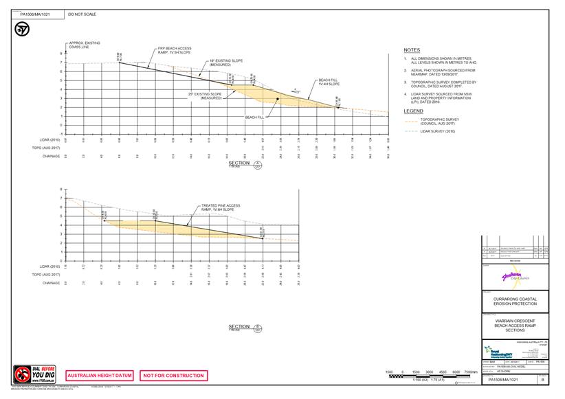
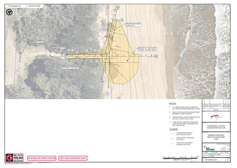
1. Warrain Crescent
- Beach Access Ramp Sections ⇩
2. Warrain
Crescent - Beach Access Ramp Plan ⇩
3. Warrain
Crescent - Beach Nourishment Plan ⇩
4. Report -
Durability of Wagners Composite Fibre Technologies ⇩
Purpose / Summary
Advise committee that Royal
Haskoning DHV have substantially progressed detailed design work including
design for early replacement of a western beach access lost in the 2016 storm.
|
Recommendation
That Council:
1. Undertake detailed design, review of
environmental factors (REF) and seek necessary permits and approvals for the
Currarong Coastal Erosion Remediation project; and
2. Include community and government
agency consultation during the detailed design and REF process; and
3. Place the final detailed design and
REF on public exhibition and report back to Council the outcome of the
exhibition; and
4. Once necessary permits and approvals
are obtained and Council has resolved to commence construction, complete the erosion
remediation project construction including design amendments for the western
beach access mound.
5. Should the necessary permits and
approvals be obtained, construct a temporary access (Warrain Crescent Beach
Access Ramp Plan, Drawing #PA1506/MA/1021, Royal HaskoningDHV) at Warrain
Crescent, as soon as possible whilst continuing with the detailed design
process for the remediation project.
|
Options
1. As recommended. Complete detailed
design and review of environmental factors (REF) as scheduled and seek
necessary approvals to undertake coastal management works at Currarong. Should
the necessary permits and approvals be obtained to allow the construction of a
temporary access at Warrain Crescent, these works should be completed as soon
as possible whilst completing the detailed design for the overall remediation
project
Implications: Works carried out as programmed.
2. Alternative recommendation.
Implications: Potential for increased time and
cost.
Background
Community concerns remain that
the timeline to progress the project and replace a beach access mound and
interim access provisions by Christmas 2017 will not be met. The
complexity of the task is significant, with a high likelihood the requirement
to undertake a cost benefit analysis (CBA) to assess coastal management options
at Currarong in accordance with the new Draft NSW Coastal Management Manual
will be triggered. This will depend upon the final cost estimate for the
proposed work. This process would introduce a new delay. A CBA is currently
being worked through to assess coastal management options at South Mollymook.
The draft Manual which sets out
the requirements for a CBA can be viewed at http://www.environment.nsw.gov.au/resources/coasts/150805-cost-benefit-analysis.pdf
Royal HaskoningDHV has recently
completed predesign investigations, which are included in the first preliminary
draft of the Currarong Coastal Erosion Protection Report. This report is still
in draft form and more details will need to be added following internal and
external consultation. The Review of Environmental Factors (REF) is due to commence
in November. The principle obstacle to rapidly progress works remains the
Aboriginal artefacts in the beach face at Warrain Crescent and Beecroft Avenue
portions. The Aboriginal Cultural Heritage Assessment Report (ACHAR) and
Aboriginal Heritage Impact Permit (AHIP) applications are complete and have
been submitted to NSW government. The REF will consider the environmental
impacts on the estuary aquatic and terrestrial flora and fauna.
A design review has been requested by Council staff to
direct the construction access along the disturbed land portion east of the
creek boat ramp, where the entrance spit was built in the late
1960’s. This will allow construction impact to be removed from the
tidal creek. It will also provide improved material stockpile access to
contractors and eventually beach access to licenced beach haul fishermen and
access for maintenance operations importantly minimising impact on the Marine
Park Authority estuary.
Community Engagement
Council has engaged the
Currarong community with full and frank discussion in December 2016 with the
outcome endorsing Council to proceed to detailed design for the single groyne
sand nourishment at Warrain Crescent, and rock armour for the Beecroft Avenue
portion. This discussion included the key State Government Agencies
involved in the project.
A project Risk Assessment will be undertaken on completion
of a Draft REF and Draft detailed design drawings with the Currarong CCB in
November 2017, to ensure community agreement with the major project elements
and No Regrets agreement to proceed to construction.
Financial Implications
Project delay is a likely consequence that needs
consideration as the Coastal Reserve Fund has a $400,000 commitment for this
financial year, which may not be drawn from until approvals are gained in early
2018 at best.
Risk Implications
Project risks will be assessed
during the detailed design process due to commence in November 2017.
|

|
Shoalhaven Natural
Resource & Floodplain Management Committee – Thursday 23 November
2017
Page
17
|
|
|
Shoalhaven
Natural Resource & Floodplain Management Committee – Thursday 23
November 2017
Page
18
|
|
|
Shoalhaven
Natural Resource & Floodplain Management Committee – Thursday 23
November 2017
Page
19
|

|
|
Shoalhaven Natural
Resource & Floodplain Management Committee – Thursday 23 November
2017
Page
20
|
|

|
Shoalhaven Natural
Resource & Floodplain Management Committee – Thursday 23 November
2017
Page
24
|
SN17.24 Shoalhaven
Dredging Survey Report
HPERM Ref: D17/382332
Group: Planning
Environment & Development Group
Section: Environmental
Services
Attachments:
1. Conjola
Community Association - Dredging Analysis Submission (under separate cover) ⇨
2. Summary
of Dredging Survey Results - September 2017 (under separate cover) ⇨
Purpose / Summary
As per the resolution of the Shoalhaven
Natural Resources and Floodplain Management Committee SN17.6 on 6 June 2017 the
Committee is provided with a this report on the positive and negative feedback
from the community on dredging at Sussex Inlet and Lake Conjola.
|
Recommendation (Item to be determined
under delegated authority)
That the SNRFM Committee receive
the report on the community feedback survey on the dredging program at Sussex
Inlet and Lake Conjola for information.
|
Options
1. The Committee receive the report on
dredging survey for information
Implications: Nil
2. The Committee decide on other
recommendation
Implications: Depend on the recommendation
Background
At the Shoalhaven Natural
Resources and Floodplain Management Committee meeting of 6 June 2017 a report
was provided on the results of the post-dredging monitoring at Currambene
Creek, Sussex Inlet and Lake Conjola as part of the NSW Crown Lands licensing
condition requirements. The report gave an overview of dredging program and
provided data on the changes to the dredging channels in the 6 months post
dredging at Sussex Inlet and Lake Conjola.
Part 2 of the Committee’s resolution
required the following:
A further report be provided to
the Committee collating positive and negative feedback about the dredging
program from the communities where the dredging took place.
Following this, Council
undertook a community survey via the “Get Involved” website to get
feedback on the social, environmental and economic impact of the dredging on
the communities of Sussex Inlet and Lake Conjola.
The survey was undertaken from 15
August 2017 to 13 September 2017 and asked participants to register and
nominate if they lived or regularly visited ether Sussex Inlet and/or Lake
Conjola, which then took them to questions specifically related to each
estuary. The online survey was a series of multiple choice questions as
follows, asking participants to choose from strongly agree, agree, I
don’t know, disagree or strongly disagree and blank:
1. Has dredging at
……been environmentally positive?
2. Has dredging at
……been socially positive?
3. Has dredging
at…….been economically positive?
A general feedback section was included relating to the dredging
at both Lake Conjola and Sussex Inlet, which participants could provide further
information.
The survey webpage had 464 views and 216 visits, the majority
of surveys were completed in the first week, as shown below in Figure 1.
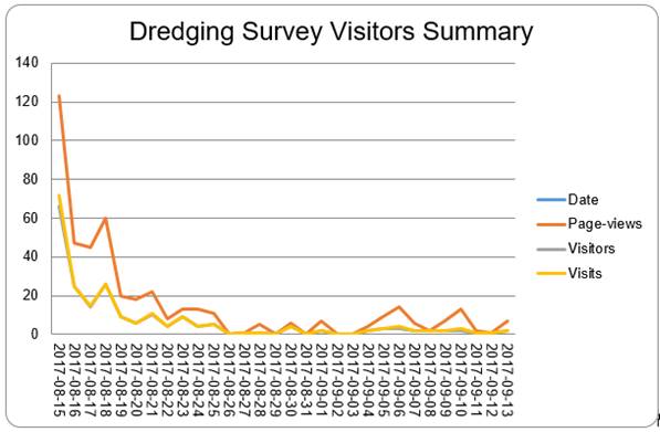
Figure 1 –
Summary of Visitors/Page Views for Dredging Survey
Lake Conjola Surveys
Results
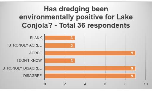
Figure 2 – Results of survey on environmental
impacts of dredging – Lake Conjola
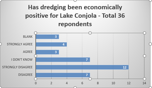
Figure 3 - Results of survey on economic impacts
of dredging – Lake Conjola
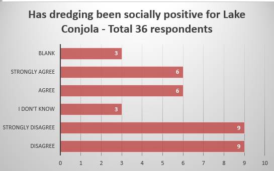
Figure 4 - Results of survey on social impacts of
dredging – Lake Conjola
Sussex Inlet Survey Results
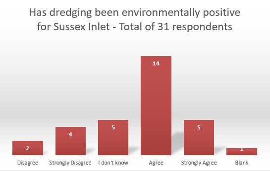
Figure 5 – Results of survey on environmental
impacts of dredging – Sussex Inlet
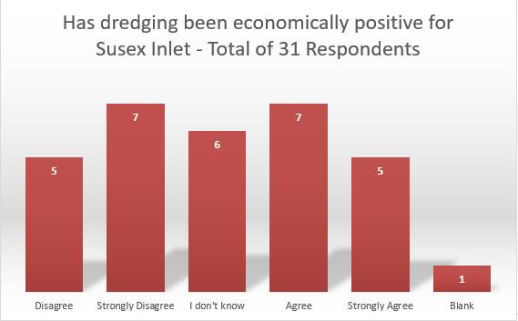
Figure 6 – Results of survey on economic impacts of
dredging – Sussex Inlet
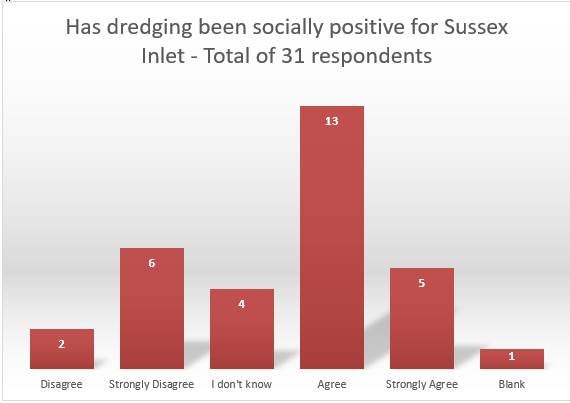
Figure 7 – Results of survey on social impacts of
dredging – Sussex Inlet
Survey respondents also provided general feedback to the
survey at both Sussex Inlet and Lake Conjola, these are provided in the
attached summary spreadsheet. Additionally to the on-site survey results two
formal submission were received as follows:
1. Critical Review, Analysis &
Assessment of Lake Conjola Dredging Activity - Lake Conjola Community
Association, August 2017.
2. Dredging of Shoalhaven ICOLl's –
Lake Conjola, National Parks Association – Milton Electorate.
Copies of both these submissions are attached to the
report.
Community Engagement
The survey was distributed to Council’s
Consultative Bodies, Natural Resource & Floodplain Committee, Frontline
News subscribers, Sussex Inlet Marine Rescue, Sussex Inlet Navigation Action
Group and also via a media release, Council Facebook and in the Council
Neighbourhood Newsletter.
Policy Implications
The results of the survey can be
used to provide input into the development of coastal management programs and
any dredging programs that Council may consider in the future.
Financial Implications
The survey had little financial
implications, other than staff time required to develop the survey and review
results. However, the feedback from the survey should be considered when
accessing the economic impact of dredging on Council resources.
Risk Implications
Results of survey should be considered when assessing the
environmental, economic and social risk implications of future dredging
programs.