Shoalhaven Traffic Committee
Meeting Date: Tuesday,
13 June, 2017
Location: Jervis
Bay Room 3, City Administrative Centre, Bridge Road, Nowra
Time:
9.30
am
Please note: Council’s
Code of Meeting Practice permits the electronic recording and broadcast of the
proceedings of meetings of the Council which are open to the public. Your
attendance at this meeting is taken as consent to the possibility that your
image and/or voice may be recorded and broadcast to the public.
Agenda
1. Apologies
2. Confirmation of Minutes
· Shoalhaven
Traffic Committee - 9 May 2017............................................................... 1
3. Business Arising from Previous Minutes
4. Reports of the Convenor
TC17.34...... Intersection Priority - Intersection Sydney Ave /
Derwent St / Sealark Rd, Callala Bay (PN 1861)....................................................................................................... 6
TC17.35...... No Stopping Zone - Halloran Street, Vincentia (PN
3180)............................ 8
TC17.36...... Line Marking - Lotus Street, Hyams Beach (PN
3396)................................ 10
TC17.37...... Bridge Load Limit & One Lane Treatment -
Bengalee Creek Bridge, Koloona Dr, Bangalee (PN 3398)..................................................................................... 12
TC17.38...... No Stopping Zone - Francis Ryan Reserve Car Park,
Sanctuary Point (PN 3403)...................................................................................................................... 14
TC17.39...... Regulatory Signage & Line Marking - Plunkett
St and Haigh Avenue, Nowra (PN3404)...................................................................................................................... 16
TC17.40...... Edge Line Marking - Main Road, Cambewarra (PN
3405).......................... 18
TC17.41...... Regulatory Signage & Line Marking - Nowra
Hill Road, Nowra Hill (PN 3406) 20
TC17.42...... Bridge Load Limit - Chisolms Creek Bridge,
Bundewallah Road, Bundewallah (PN 3407)............................................................................................................. 22
TC17.43...... Regulatory Signage - Car Park Service Agreement -
Aldi, Kinghorne St, Nowra (PN 3408)............................................................................................................. 24
TC17.44...... Upgrade T-intersection to CHR - Intersection of
Forest Rd & Callala Beach Rd, Wollumboola (PN 3409)............................................................................... 26
5. General Business
Note:
The next meeting will be held on Tuesday 11 July 2017.
|

|
Shoalhaven
Traffic Committee – Tuesday 13 June 2017
Page
ii
|
Membership
Mr Martin Upitis
Ms Amy Thomson
Sergeant Mick Tebbutt
Mr Alan Trass
Mr Stuart Coughlan
Clr Jo Gash
Clr Andrew Guile
Clr Patricia White
The Shoalhaven Traffic Committee is a technical review
committee, not a committee of Council under the Local Government Act 1993. The
Roads and Maritime Services (RMS) has delegated certain powers to Council under
the Transport Administration Act 1988 (Section 50). A condition of this
delegation is that Council must take into account the Traffic Committee
recommendations.
There are four formal members of the Traffic Committee, each
of whom has a single vote only. The members are representatives from:
- NSW Police Force
- RMS
- Shoalhaven City Council
- Local State Member of Parliament (for the location of the
issue to be voted upon)
If the RMS or NSW Police Force disagrees with any Traffic
Committee recommendation, or Council’s resolution (on any Traffic
Committee recommendation), they may lodge an appeal with the Regional Traffic
Committee for determination. The appeal must be lodged in writing within
14 days of the date of notification in writing. Any action relative to
any issue under appeal must cease until the matter is determined. The
Regional Traffic Committee is chaired by an independent chairperson and
submissions and representations are welcomed from all interested parties.
Council cannot amend a Traffic Committee recommendation. The
Council can only: adopt the Traffic Committee recommendation; not adopt the
Traffic Committee recommendation, or request the Traffic Committee reconsider
the issue.
The full guide to the delegation to Council’s for
the regulation of traffic can be viewed at RMS
Website
Minutes of the Shoalhaven Traffic Committee
Meeting Date: Tuesday,
9 May 2017
Location: Seven
Mile Room, Level 1, City Administrative Centre, Bridge Road, Nowra
Time: 9.35
am
The following members
were present:
Mr Martin Upitis - Assets
Manager
Mr Alan Trass
Mr Stuart Coughlan
Clr Patricia White
– left the meeting at 9.45 am
Ms Amy Thomson –
RMS
Others Present:
Wayne Schnoor –
Transport Engineering Officer
Kristian Pinochet –
RMS
|
Apologies / Leave of Absence
|
Nil
|
Confirmation of the Minutes
|
|
RESOLVED (By consent)
That the Minutes of the
Traffic Committee held on Tuesday 11 April 2017 be confirmed.
CARRIED
|
|
Business Arising from Previous Minutes
|
Nil
Reports of the Convenor
|
TC17.20 Centre
Line Marking and No Stopping Extension - Tallwood Avenue, Mollymook Beach (PN
3341)
|
HPERM Ref:
D17/133442
|
|
Recommendation (By consent)
That the General Manager
(Director Assets and Works) be advised that the Shoalhaven Traffic Committee
has no objection to the proposed centre line marking and the No Stopping zone
extension in Tallwood Avenue, Mollymook Beach, as detailed in TRAF 2017/20,
which includes:
1. extension
of the existing double barrier (BB) centre line marking along Tallwood
Avenue, from its intersection with Mitchell Parade to its intersection with
Jones Avenue.
2. extension
of the existing No Stopping zone approximately 35m on the northern side of
Tallwood Avenue from the frontage of 88 Tallwood Avenue to the boundary of 86
Tallwood Avenue and 56 Jones Avenue.
|
|
TC17.21 Crossing
Upgrades - Cambewarra Rd, Bomaderry, Moss St, Osborne St and North St, Nowra,
Emmett St, Callala Bay, Hawken Rd, Tomerong and Green St, Ulladulla (PN 3362)
|
HPERM Ref:
D17/133450
|
|
Recommendation (By consent)
That the General Manager (Director
Assets and Works) be advised that the Shoalhaven Traffic Committee has no objection
to the upgrade the existing crossings to raised thresholds adjacent to the
following schools; Bomaderry Public School, Cambewarra Road, Bomaderry;
Tomerong Public School, Hawken Road, Tomerong; St Michaels Catholic Primary
School, North Street & Osborne Street, Nowra; Callala Bay Public School,
Emmett Street, Callala Bay and Ulladulla Public School, Green Street,
Ulladulla and the upgrade of the kerb extensions adjacent to Nowra High
School, Moss Street, Nowra to a pedestrian crossing, as detailed in plan TRAF
2017/21 a, b, c, d, e, f and g.
|
|
TC17.22 No
Stopping Zone - Intersection Princes Highway and Crescent Street, Ulladulla
(PN 3380)
|
HPERM Ref:
D17/133462
|
|
Recommendation (By consent)
That the General Manager
(Director Assets and Works) be requested to arrange for the installation of a
No Stopping zone on the eastern side of Princes Highway for a distance of 20m
immediately south of its intersection with Crescent Street, Ulladulla, as
detailed in TRAF 2017/22.
|
|
TC17.23 Double
Barrier Centre Line Marking - Sanctuary Point Rd, Sanctuary Point (PN 3381)
|
HPERM Ref:
D17/133493
|
|
Recommendation (By consent)
That the General Manager
(Director Assets and Works) be requested to arrange for the installation of
double barrier centre line marking along Sanctuary Point Road for a distance
60m north and 75m south of Edmund Street intersection, Sanctuary Point, as
detailed in TRAF 2017/23.
|
|
TC17.24 No
Stopping Zone - Duncan Street, Vincentia (PN 3382)
|
HPERM Ref:
D17/133496
|
|
Recommendation (By consent)
That the General Manager
(Director Assets and Works) be requested to arrange for the installation of a
10m No Stopping zone in the hammer head (turning area) opposite property
number 90 & 92 Duncan Street, Vincentia, as detailed in TRAF 2017/24.
|
|
TC17.25 Centre
Line Marking & Warning Signage - Donlan Road & Garside Road,
Mollymook Beach (PN 3383)
|
HPERM Ref:
D17/133506
|
|
Recommendation (By consent)
That the General Manager
(Director Assets and Works) be requested to arrange for the installation of
the following line marking and signage, at the intersection of Donlan Road
and Garside Road, Mollymook Beach, as detailed in TRAF 2017/25:
1. 60m
of double barrier line marking along Donlan Road, centred across its
intersection with Garside Road, ensuring a 10m break at the intersection.
2. a
T-intersection warning sign on the minor approach to the intersection of
Garside Road and Donlan Road.
|
|
TC17.26 Car
& Trailer Combination Only Parking - Boat Harbour, Bendalong (PN 3384)
|
HPERM Ref: D17/133515
|
|
Recommendation (By consent)
That the General Manager
(Director Assets and Works) be requested to arrange for the installation of
the following line marking and signage changes at the Boat Harbour Beach Boat
Ramp Area, Bendalong, as detailed in TRAF 2017/26:
1. two
(2) marked ‘CAR / TRAILER COMBINATION ONLY’ parking spaces
between the two existing boat ramps at boat harbour beach. As a trial to be
reviewed after the 2017/2018 summer period.
2. a
23m 'CAR / TRAILER COMBINATION ONLY' zone, on the southern side of the
‘headland overflow’ parking.
|
|
TC17.27 Parking
Restrictions - Red Point Road, Bendalong (PN 3385)
|
HPERM Ref:
D17/133526
|
|
Recommendation (By consent)
That the General Manager
(Director Assets and Works) be requested to arrange for the installation of a
140m (approx.) No Stopping zone on the western side of Red Point Road from
its intersection with Boronia Street to its intersection with Waratah Street,
Bendalong, as detailed in TRAF 2017/27.
|
|
TC17.28 No
Stopping Zone - Lister Court, Hyams Beach (PN 3390)
|
HPERM Ref:
D17/133527
|
|
Recommendation (By consent)
That the General Manager (Director
Assets and Works) be requested to arrange for the installation of a 30m
(approx.) No Stopping zone on the southern side of Listrer Court adjacent to
the access to 6 Lister Court, Hyams Beach, as detailed in TRAF 2017/28.
|
|
TC17.29 Disabled
Parking Space - Crookhaven Heads Boat Ramp, Culburra Beach (PN 3391)
|
HPERM Ref:
D17/133535
|
|
Recommendation (By consent)
That the General Manager (Director
Assets and Works) be requested to arrange for the installation of a disabled
parking space at the Crookhaven Boat Ramp, Culburra Beach, as detailed in
TRAF 2017/29.
|
|
TC17.30 Disabled
Parking Space - Parkes Crescent, Callala Beach (PN 3392)
|
HPERM Ref:
D17/133541
|
|
Recommendation (By consent)
That the General Manager (Director
Assets and Works) be advised that the Shoalhaven Traffic Committee has no
objection to the previously installed disabled parking space and associated
shared zone in Parkes Crescent, Callala Beach adjacent to Parkes Crescent
Park as detailed in TRAF 2017/30.
|
|
TC17.31 Road
Weight Restriction - Upper Kangaroo River Road, Barrengarry (PN 3393)
|
HPERM Ref:
D17/133549
|
|
Recommendation (By consent)
That the General Manager (Director
Assets and Works) be requested to arrange for the installation of ‘no
trucks’ R6-10-2B and ‘gross load limit 10t’ R6-4B signage
at the Council gate located on Upper Kangaroo River Road, Barrengarry, 12km
from the intersection of Moss Vale Road, as detailed in TRAF 2017/31.
|
|
TC17.32 Raised
Pedestrian Crossing - West Birriley Street and North Tarawal Street,
Bomaderry (PN 3351)
|
HPERM Ref:
D17/142524
|
|
Recommendation (Martin Upitis / Stuart
Coughlan)
That the General Manager (Director
Assets and Works) be advised that the Shoalhaven Traffic Committee has no
objection to the installation of a raised pedestrian crossing at the curve on
West Birriley Street and North Tarawal Street, Bomaderry as detailed in TRAF
2017/32.
carried
For: Martin
Upitis, Stuart Coughlan
Against: Amy
Thomson
|
General Business
|
TC17.33 Additional
Item - Nowra Issues - Speeding and Drainage Quinns Lane, Traffic Lights in
Moss St, Parking at Hospital, Pedestrian Crossing in North St.
|
|
Allan Trass raised the
following issues:
- Speeding on Quinns Lane and Old
Southern Road
- Drainage issues on Quinns Lane
with regard to changes to the causeway over the creek
- Traffic lights at Moss St,
during the middle of the day the lights are only on green going in an
easterly direction for a short time. This is not enough time for the
amount of cars coming from that direction. A few farmers are
affected who use the route during the day in between school times.
- Parking on either side of
driveways near the hospital may cause issues for residents.
- Consideration be given to moving
the pedestrian crossing on North Street.
|
There being no further
business, the meeting concluded, the time being 10.05
am.
CHAIRPERSON
|

|
Shoalhaven
Traffic Committee – Tuesday 13 June 2017
Page
6
|
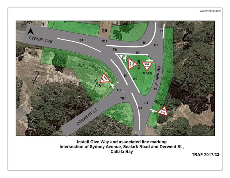
TC17.34 Intersection
Priority - Intersection Sydney Ave / Derwent St / Sealark Rd, Callala Bay (PN
1861)
HPERM Ref: D17/184264
Convenor: Martin Upitis
Attachments:
1. TRAF 2017-33 - Intersection Priority -
Sydney Ave / Derwent St / Sealark Rd Callala Rd ⇩
|
Recommendation
That the General Manager (Director Assets and Works) be
requested to arrange for the installation of the following Give way and
associated line marking changes at the intersection of Sydney Avenue, Sealark
Road and Derwent Street, Callala Bay, as detailed in the attached plan TRAF
2017/33:
1. Give Way (R1-2B) signage and
associated hold line (TB/TB1) line marking control on all minor legs of the
intersection
2. 25m of single barrier (B1) line
marking for the northern leg of Sealark Road
3. 35m of single barrier (B1) line
marking for the southern leg of Sealark Road with a 7m break at the
intersection of Derwent Street
4. 15m of single barrier (B1) line
marking on the western intersection approach with a 15m gap prior to the
splayed edge (E1) line markings
5. Edge (E1) and continuity (C1) line
marking to delineate the central island whilst permitting through movements
along Sealark Road
|
Details
Council has been requested by
the Callala Bay Community Association and local residents to review the priority
arrangement at the Intersection of Sydney Avenue Sealark Road, and Derwent
Street, Callala Bay.
Concern has been received
regarding the existing layout of the intersection.
In view of addressing the
concerns raised, Council is proposing to install a line marking and signage
solution as detailed in the attached plan. This arrangement consists of the
following:
a) Give
Way (R1-2B) signage and associated hold line (TB/TB1) line marking control on
all minor legs of the intersection
b) 25m of
single barrier (B1) line marking for the northern leg of Sealark Road
c) 35m
of single barrier (B1) line marking for the southern leg of Sealark Road with a
7m break at the intersection of Derwent Street.
d) 15m
of single barrier (B1) line marking on the western intersection approach with a
15m gap prior to the splayed edge (E1) line markings
e) Edge
(E1) and continuity (C1) line marking to delineate the central island whilst
permitting through movements along Sealark Road.
The proposed changes will aid
motorists in negotiating the intersection by providing clear priority and
delineation.
Consultation was carried out
with the Callala Bay Community Association who supported the proposal.
|

|
Shoalhaven
Traffic Committee – Tuesday 13 June 2017
Page
7
|
|
|
Shoalhaven
Traffic Committee – Tuesday 13 June 2017
Page
8
|
TC17.35 No
Stopping Zone - Halloran Street, Vincentia (PN 3180)
HPERM Ref: D17/184300
Convenor: Martin Upitis
Attachments:
1. TRAF 2017/34 -
No Stopping Zone - Halloran St, Vincentia ⇩
|
Recommendation
That the General Manager
(Director Assets and Works) be requested to arrange for the installation of a
33m No Stopping zone on the western side of Halloran Street, Vincentia
between Seabreeze Street and Moona Creek Road as detailed in the attached
plan TRAF 2017/34.
|
Details
The Committee may recall previous discussions in relation to
No Stopping zones in Halloran Street, Vincentia.
Council has been requested by the local community to review
parking restrictions along the western side of Halloran Street between its
intersection with Moona Creek Road and Seabreeze Street, Vincentia.
Concern has been raised regarding vehicles parking in this
location restricting two way traffic flow along Halloran Street.
In view of addressing the concerns raised, Council is
proposing to install a No Stopping zone on the western side of Halloran Street
(for a distance of 33m) to join the existing No Stopping zones at the Halloran
Street and Seabreeze Street intersection.
The impact of the proposal will mean that motorists will be
unable to stop on the western side of Halloran Street between its intersections
with Moona Creek Road and Seabreeze Street.
Consultation was carried out with adjacent property owners
and the Vincentia Ratepayers and Residents Association (VRRA).
Two submissions were received
one submission supported the proposal, whilst one submission opposed the
proposal. No response was received from the VRRA.
|
|
Shoalhaven
Traffic Committee – Tuesday 13 June 2017
Page
9
|
|

|
Shoalhaven
Traffic Committee – Tuesday 13 June 2017
Page
10
|
TC17.36 Line
Marking - Lotus Street, Hyams Beach (PN 3396)
HPERM Ref: D17/184311
Convenor: Martin Upitis
Attachments:
1. TRAF 2017-35 -
Line Marking - Lotus St Hyams Beach ⇩
|
Recommendation
That the General Manager
(Director Assets and Works) be requested to arrange for the installation of
give way (TB/TB1) hold line markings, pavement arrows, guide posts and edge
(E1) line marking changes in Lotus Street, Hyams Beach, as detailed in the
attached plan TRAF 2017/35.
|
Details
The Hyams Beach Villagers Association have raised concerns
regarding vehicles parking in the middle of the vegetated island and traveling
in the wrong direction along Lotus Street.
In view of addressing the concerns raised, Council is
proposing to install Giveway (TB/TB1) hold line markings, pavement arrows,
guide posts and edge (E1) line marking.
The Hyams Beach Villagers
Association support the proposal.
|
|
Shoalhaven
Traffic Committee – Tuesday 13 June 2017
Page
11
|

|
|
Shoalhaven
Traffic Committee – Tuesday 13 June 2017
Page
12
|
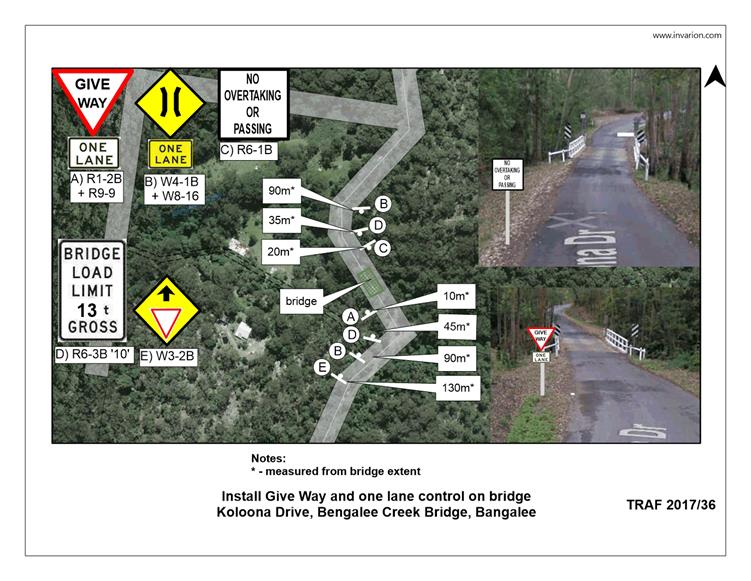
TC17.37 Bridge
Load Limit & One Lane Treatment - Bengalee Creek Bridge, Koloona Dr,
Bangalee (PN 3398)
HPERM Ref: D17/184331
Convenor: Martin Upitis
Attachments:
1. TRAF 2017-36 -
Bridge Load Limit & One Lane Treatment - Bengalee Creek, Bangalee ⇩
|
Recommendation
That the General Manager
(Director Assets and Works) be advised that the Shoalhaven Traffic Committee
has no objection to the installation of a 13 tonne gross bridge load limit
and one lane controls on the Bengalee Creek Bridge, Koloona Drive, Bangalee
as detailed in the attached plan TRAF 2017/36.
|
Details
Structure Name: KOLOONA DR – 2.189 km - Bridge
Structure Identifier: 43507
Road Name: Koloona Drive
Crossing: Bangalee Creek
Council’s Asset Unit has recently assessed the
structural integrity of the Bangalee Creek Bridge, Koloona Drive, Bangalee.
The outcome of this assessment requires load limiting of the
bridge to ensure public safety and asset protection.
Council is proposing to install a gross bridge load limit of
13 tonnes and one lane controls on the Bangalee Creek Bridge. The attached plan
has been designed in accordance with AS1742.2-4.6.2.
|

|
Shoalhaven
Traffic Committee – Tuesday 13 June 2017
Page
13
|
|
|
Shoalhaven
Traffic Committee – Tuesday 13 June 2017
Page
14
|
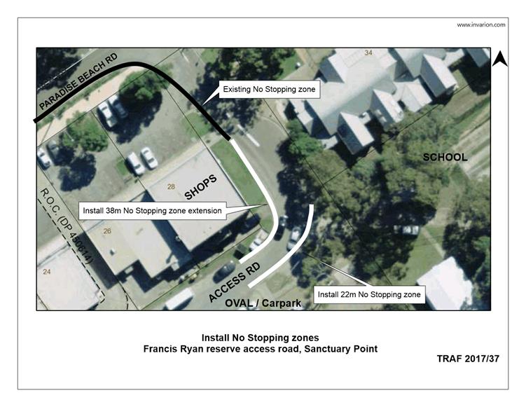
TC17.38 No
Stopping Zone - Francis Ryan Reserve Car Park, Sanctuary Point (PN 3403)
HPERM Ref: D17/184363
Convenor: Martin Upitis
Attachments:
1. TRAF 2017-37 -
No Stopping Zone - Francis Ryan Reserve Car Park, Sanctuary Point ⇩
|
Recommendation
That the General Manager
(Director Assets and Works) be requested to arrange for the installation of
the following changes at the Francis Ryan Reserve car park Access Road,
Sanctuary Point as detailed in the attached plan TRAF 2017/37:
1. Install a 22m No Stopping zone on the
eastern side of the access road covering the car park entrance and footpath.
2. Extend the existing western No
Stopping zone 38m south.
|
Details
Council has been requested to review parking restrictions on
the access road and road reserve adjacent to Francis Ryan Reserve, Sanctuary
Point.
Concerns were raised regarding vehicles parking in front and
across the footpath and car park entrance within the access road.
In view of addressing the safety concerns raised, Council is
proposing to extend the existing western No Stopping zone 38m south, and
install a 22m No Stopping zone on the eastern side of the access road across
the car park entrance and footpath layback.
The impact of the proposal will mean that motorists will be
unable to stop in these locations.
Consultation was carried out with the Basin Villages Forum,
Sanctuary Point Public School and P&C Association, adjacent property
owners, Francis Ryan Reserve User Groups and the Sanctuary Point Youth &
Community Centre.
No submissions received.
|
|
Shoalhaven
Traffic Committee – Tuesday 13 June 2017
Page
15
|
|
|
Shoalhaven
Traffic Committee – Tuesday 13 June 2017
Page
16
|
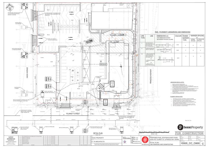
TC17.39 Regulatory
Signage & Line Marking - Plunkett St and Haigh Avenue, Nowra (PN3404)
HPERM Ref: D17/184376
Convenor: Martin Upitis
Attachments:
1. Attachment -
TRAF 2017-38 - Signs & Lines Plan - Plunkett St & Haigh Ave, Nowra ⇩
|
Recommendation
That the General Manager (Director
Assets and Works) be advised that the Shoalhaven Traffic Committee has no
objection to the proposed signage and line marking plan associated with the
development of No.103 Plunkett Street and No.18 Haigh Avenue, Nowra, as
detailed in the attached plan TRAF 2017/38, subject to the following:
1. Internal motorbike parking signage be
installed as R5-1-4 ‘motor bikes only’ signage.
2. Relocate the internal pedestrian
crossing which crosses the drive through, further to the west.
3. Installation of pedestrian crossing
signage (R3-1B) on the westbound approach of the crossing in accordance with
AS 1742.10-2009.
4. The 2 hour (2P) sign time restricted
parking sign on the southern side of Plunkett Street, reflect the existing
8.30am-6pm Mon-Fri 8.30am-12.30pm Sat time restriction.
|
Details
Applicant: RG Property Ten Pty Ltd
Owner: RG Property Ten Pty Ltd - Lot 101 DP 1176270 (No.103)
Plunkett Street and Lot 1 DP 781046 (No.18) Haigh Avenue, Nowra
DA15/2291 – Construction of a service station (BP),
food and drink premises (McDonalds), car parking, signage and associated works.
A signage and line marking plan
has been submitted for the committee’s consideration
|
|
Shoalhaven
Traffic Committee – Tuesday 13 June 2017
Page
17
|
|
|
Shoalhaven
Traffic Committee – Tuesday 13 June 2017
Page
18
|
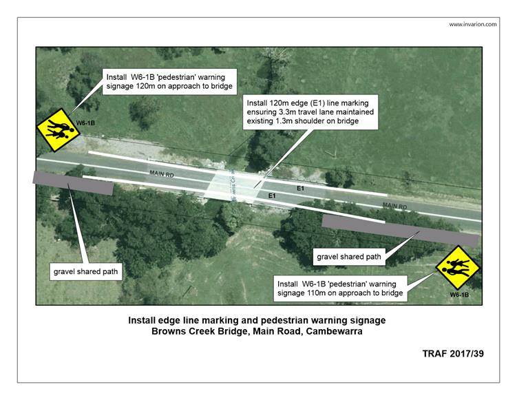
TC17.40 Edge
Line Marking - Main Road, Cambewarra (PN 3405)
HPERM Ref: D17/184411
Convenor: Martin Upitis
Attachments:
1. TRAF 2017-39 -
Edge Line Marking - Main Rd Cambewarra ⇩
|
Recommendation
That the General Manager (Director
Assets and Works) be requested to arrange for the installation of 120m of
edge (E1) line marking on both sides of the Browns Creek Bridge, Main Road,
Cambewarra as detailed in the attached plan TRAF 2017/39.
|
Details
The Cambewarra Community, with support from Council, are
currently constructing a 1.5m wide gravel pedestrian path along the southern
side of Main Road, Cambewarra.
Path users will need to cross the Browns Creek Bridge on
Main Road, Cambewarra.
To improve safety for pedestrians using the bridge Council is
proposing to install 120m of edge (E1) line marking to delineate the southern and
northern travel lanes from the shoulder on the approach and departure.
Additionally Council will be
installing Pedestrian warning signs 80m either side of the Browns Creek Bridge.
|
|
Shoalhaven
Traffic Committee – Tuesday 13 June 2017
Page
19
|
|
|
Shoalhaven
Traffic Committee – Tuesday 13 June 2017
Page
20
|
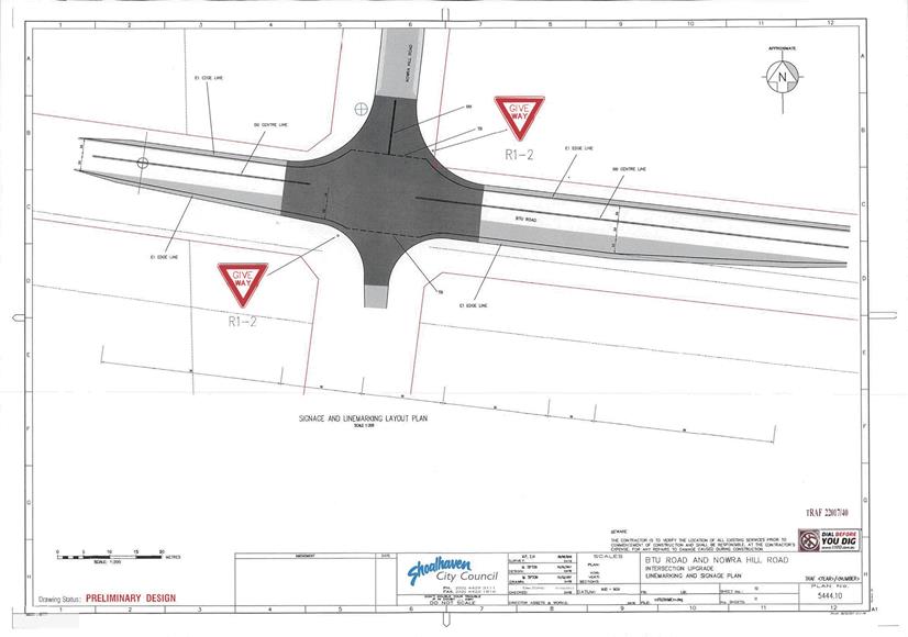
TC17.41 Regulatory
Signage & Line Marking - Nowra Hill Road, Nowra Hill (PN 3406)
HPERM Ref: D17/184429
Convenor: Martin Upitis
Attachments:
1. TRAF 2017-40 -
Signage & Line Marking - Intersection Upgrade - BTU Rd & Nowra Hill Rd ⇩
|
Recommendation
That the General Manager (Director
Assets and Works) be advised that the Shoalhaven Traffic Committee has no
objection to the proposed signage and line marking plan associated upgrade of
the intersection of BTU Road and Nowra Hill Road to a BAR / BAL, as detailed
in the attached TRAF 2017/40, subject to:
1. The Give Way hold line to be
reflected as TB/TB1 hold line markings
2. The southern edge (E1) line marking
to be installed along the travel lane
|
Details
Applicant: Shoalhaven City Council
Owner: Shoalhaven City Council - Lot 1 DP 227233 (No.19) BTU
Road, Nowra Hill
DA15/2567 – Construction of an animal shelter.
Council is proposing to construct a new animal shelter at 19
BTU Road, a condition of this development is the construction of a BAR / BAL.
Accordingly, a regulatory
signage and line marking plan has been submitted for the committee’s
consideration.
|
|
Shoalhaven
Traffic Committee – Tuesday 13 June 2017
Page
21
|
|

|
Shoalhaven
Traffic Committee – Tuesday 13 June 2017
Page
22
|
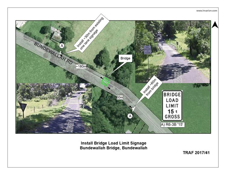
TC17.42 Bridge
Load Limit - Chisolms Creek Bridge, Bundewallah Road, Bundewallah (PN 3407)
HPERM Ref: D17/184442
Convenor: Martin Upitis
Attachments:
1. TRAF 2017-41 -
Bridge Load Limit - Chisolms Creek Bridge, Bundewallah Rd, Bundewallah ⇩
|
Recommendation
That the General Manager (Director
Assets and Works) be advised that the Shoalhaven Traffic Committee has no
objection to the installation of a 15 tonne gross bridge load limit on the
Chisolms Creek Bridge, Bundewallah Road, Bundewallah as detailed in the
attached plan TRAF 2017/41.
|
Details
Structure Name: BUNDEWALLAH RD – 1.212 Km ‐ Bridge
Structure Identifier: 43481
Road Name: Bundewallah Road
Crossing: Chisolms Creek
Council Asset Unit has recently assessed the structural
integrity of the Chisolms Creek Bridge, Bundewallah Road, Bundewallah.
The outcome of this assessment requires the load limiting of
the bridge to ensure public safety and asset protection.
Council is proposing to install
a gross bridge load limit of 15 tonnes. The attached plan has been designed in
accordance with AS1742.2-4.6.2.
|
|
Shoalhaven
Traffic Committee – Tuesday 13 June 2017
Page
23
|
|
|
Shoalhaven
Traffic Committee – Tuesday 13 June 2017
Page
24
|
TC17.43 Regulatory
Signage - Car Park Service Agreement - Aldi, Kinghorne St, Nowra (PN 3408)
HPERM Ref: D17/184478
Convenor: Martin Upitis
Attachments:
1. TRAF 2017/42 -
Regulatory Signage / Car Park Service Agreement - Aldi Kinghorne St Nowra ⇩
|
Recommendation
That the General Manager (Director
Assets and Works) be advised that the Shoalhaven Traffic Committee has no
objection to the proposed regulatory signage to be installed within the Aldi
car park to time restrict parking to 2 hour (2P) between the times of 8am and
4pm Monday to Friday and between the times of 8am to 4pm Saturday To Sunday,
Kinghorne Street, Nowra as detailed in the attached plan TRAF 2017/42.
|
Details
Council has been requested by the owners of Aldi, Kinghorne
Street, Nowra to patrol and enforce restrictions within their off-street carpark.
As part of this Car Park Service Agreement a signage and
line marking plan has been submitted for the committee’s consideration.
This agreement will allow
Council’s Ranger Services to enforce 2 hour (2P) parking restriction
within the car parking area between the times of 8am and 4pm Monday to Friday,
and between the times of 8am to 4pm Saturday to Sunday.
|
|
Shoalhaven
Traffic Committee – Tuesday 13 June 2017
Page
25
|

|
|
Shoalhaven
Traffic Committee – Tuesday 13 June 2017
Page
26
|
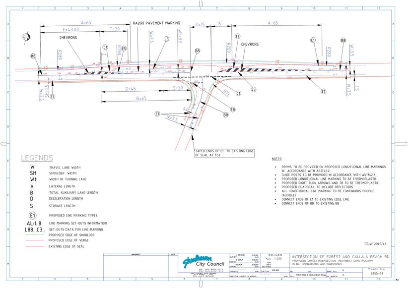
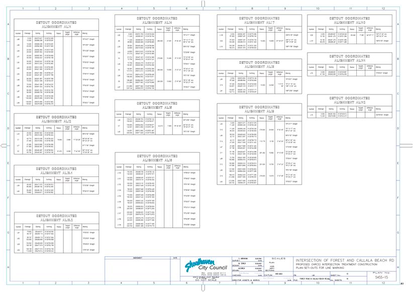
TC17.44 Upgrade
T-intersection to CHR - Intersection of Forest Rd & Callala Beach Rd,
Wollumboola (PN 3409)
HPERM Ref: D17/184507
Convenor: Martin Upitis
Attachments:
1. TRAF 2017/43 -
Signage & Line Marking Plan - Forest Rd / Callala Beach Rd, Wollumboola ⇩
|
Recommendation
That the General Manager (Director
Assets and Works) be advised that the Shoalhaven Traffic Committee has no
objection to the proposed signage and line marking plan associated with the upgrade
of the intersection of Forest Road and Callala Beach Road, Woollumboola, to a
CHR (S) as detailed in the attached plan TRAF 2017/43, subject to the
following:
1. The
double barrier (BB) centre line marking in Callala Beach Road terminating at
the TB hold line.
|
Details
Council has received funding under the 2016/17 Federal
Government Blackspot Program to upgrade the existing Give Way controlled
T-intersection at the intersection of Forest Road and Callala Beach Road,
Wollumboola.
A signage and line marking plan has been submitted for the
committee’s consideration.
The works involve upgrading the
intersection to a CHR (S) treatment to address crashes at the intersection.
|

|
Shoalhaven
Traffic Committee – Tuesday 13 June 2017
Page
27
|