Shoalhaven Traffic Committee
Meeting Date: Tuesday,
09 May, 2017
Location: Jervis
Bay Room 3, City Administrative Centre, Bridge Road, Nowra
Time:
9.30
am
Please note: Council’s
Code of Meeting Practice permits the electronic recording and broadcast of the
proceedings of meetings of the Council which are open to the public. Your
attendance at this meeting is taken as consent to the possibility that your
image and/or voice may be recorded and broadcast to the public.
Agenda
1. Apologies
2. Confirmation of Minutes
· Traffic
Committee - 11 April 2017................................................................................ 1
3. Business Arising from Previous Minutes
4. Reports of the Convenor
TC17.20...... Centre Line Marking and No Stopping Extension -
Tallwood Avenue, Mollymook Beach (PN 3341)............................................................................................ 4
TC17.21...... Crossing Upgrades - Cambewarra Rd, Bomaderry,
Moss St, Osborne St and North St, Nowra, Emmett St, Callala Bay, Hawken Rd,
Tomerong and Green St, Ulladulla (PN 3362)....................................................................................................... 6
TC17.22...... No Stopping Zone - Intersection Princes Highway
and Crescent Street, Ulladulla (PN 3380)............................................................................................................. 15
TC17.23...... Double Barrier Centre Line Marking - Sanctuary
Point Rd, Sanctuary Point (PN 3381)...................................................................................................................... 17
TC17.24...... No Stopping Zone - Duncan Street, Vincentia (PN
3382)........................... 19
TC17.25...... Centre Line Marking & Warning Signage -
Donlan Road & Garside Road, Mollymook Beach (PN 3383).......................................................................................... 21
TC17.26...... Car & Trailer Combination Only Parking - Boat
Harbour, Bendalong (PN 3384) 23
TC17.27...... Parking Restrictions - Red Point Road, Bendalong
(PN 3385).................... 26
TC17.28...... No Stopping Zone - Lister Court, Hyams Beach (PN
3390)........................ 29
TC17.29...... Disabled Parking Space - Crookhaven Heads Boat
Ramp, Culburra Beach (PN 3391)...................................................................................................................... 31
TC17.30...... Disabled Parking Space - Parkes Crescent, Callala
Beach (PN 3392)...... 33
TC17.31...... Road Weight Restriction - Upper Kangaroo River
Road, Barrengarry (PN 3393)...................................................................................................................... 35
TC17.32...... Raised Pedestrian Crossing - West Birriley Street
and North Tarawal Street, Bomaderry (PN 3351).................................................................................. 37
5. General Business
Note:
The next meeting will be held on Tuesday 13 June 2017
|

|
Shoalhaven
Traffic Committee – Tuesday 09 May 2017
Page
iii
|
Membership
Mr Martin Upitis
Ms Amy Thomson
Sergeant Mick Tebbutt
Mr Alan Trass
Mr Stuart Coughlan
Clr Jo Gash
Clr Andrew Guile
Clr Patricia White
The Shoalhaven Traffic Committee is a technical review
committee, not a committee of Council under the Local Government Act 1993. The
Roads and Maritime Services (RMS) has delegated certain powers to Council under
the Transport Administration Act 1988 (Section 50). A condition of this
delegation is that Council must take into account the Traffic Committee
recommendations.
There are four formal members of the Traffic Committee, each
of whom has a single vote only. The members are representatives from:
- NSW Police Force
- RMS
- Shoalhaven City Council
- Local State Member of Parliament (for the location of the
issue to be voted upon)
If the RMS or NSW Police Force disagrees with any Traffic
Committee recommendation, or Council’s resolution (on any Traffic
Committee recommendation), they may lodge an appeal with the Regional Traffic
Committee for determination. The appeal must be lodged in writing within
14 days of the date of notification in writing. Any action relative to
any issue under appeal must cease until the matter is determined. The
Regional Traffic Committee is chaired by an independent chairperson and
submissions and representations are welcomed from all interested parties.
Council cannot amend a Traffic Committee recommendation. The
Council can only: adopt the Traffic Committee recommendation; not adopt the
Traffic Committee recommendation, or request the Traffic Committee reconsider
the issue.
The full guide to the delegation to Council’s for
the regulation of traffic can be viewed at RMS
Website
Minutes of the Shoalhaven Traffic Committee
Meeting Date: Tuesday,
11 April 2017
Location: E-meeting
The following members
voted:
Mr Martin Upitis - Assets
Manager
Mr Mick Tebbutt
Mr Alan Trass
Mr Stuart Coughlan
Ms Amy Thomson
|
Apologies / Leave of Absence
|
Nil
|
Confirmation of the Minutes
|
|
RESOLVED (By consent)
That the Minutes of the
Traffic Committee held on Tuesday 14 March 2017 be confirmed.
CARRIED
|
|
Business Arising from Previous Minutes
|
Nil
Reports of the Convenor
|
TC17.15 Proposed
Parking Restrictions - Nowra Hill Public School (PN 3369)
|
HPERM Ref: D17/108135
|
|
Recommendation
That the General Manager
(Director Assets and Works) be advised that the Shoalhaven Traffic Committee
has no objection to the installation of the following parking restrictions on
the land adjacent to Nowra Hill Public School, BTU Road, Nowra Hill as
detailed in the attached plan TRAF 2017/15:
1. 50m
No Stopping zone along the existing footpath within Department of Justice and
Attorney General Land, with installation to be arranged by the Department of
Defence.
2. 18m
time restricted No Parking zone (8.00am-9.30am 2.30pm-4.00pm School Days)
along the school boundary, with the installation to be arranged the General
Manager (Director Assets and Works).
3. 50m
No Stopping zone along the school boundary, with installation to be arranged
by the General Manager (Director Assets and Works).
|
|
Recommendation
(By consent)
That the General Manager
(Director Assets and Works) be advised that the Shoalhaven Traffic Committee
has no objection to the installation of the following parking restrictions on
the land adjacent to Nowra Hill Public School, BTU Road, Nowra Hill as
detailed in the attached plan TRAF 2017/15:
1. 50m
No Stopping zone along the existing footpath within Department of Justice and
Attorney General Land, with installation to be arranged by the Department of
Defence.
2. 18m
time restricted No Parking zone (8.00am-9.30am 2.30pm-4.00pm School Days)
along the school boundary, with the installation to be arranged the General
Manager (Director Assets and Works).
3. 50m
No Stopping zone along the school boundary, with installation to be arranged
by the General Manager (Director Assets and Works).
|
|
TC17.16 Proposed
No Stopping Zone - Morschel Avenue, North Nowra (PN 3373)
|
HPERM Ref:
D17/108188
|
|
Recommendation
That the General Manager
(Director Assets and Works) be requested to arrange for the extension of the
existing No Stopping zone on the eastern side of Morshel Avenue 7m south of
its current location, North Nowra, as detailed in the attached TRAF 2017/16.
|
|
Recommendation
(By consent)
That the General Manager
(Director Assets and Works) be requested to arrange for the extension of the
existing No Stopping zone on the eastern side of Morshel Avenue 7m south of
its current location, North Nowra, as detailed in the attached TRAF 2017/16.
|
|
TC17.17 Proposed
Line Marking Amendments - Intersection Cambewarra Rd & Railway St,
Bomaderry (PN 3387)
|
HPERM Ref:
D17/108200
|
|
Recommendation
That the General Manager
(Director Assets and Works) be requested to arrange for the relocation of the
existing Stop hold line (TF/TB1) markings and associated double barrier (BB)
centre line marking 3.3m east of its current location at the intersection of
Railway Street and Cambewarra Road, Bomaderry, as detailed in the attached
TRAF 2017/17.
|
|
Recommendation
(By consent)
That the General Manager
(Director Assets and Works) be requested to arrange for the relocation of the
existing Stop hold line (TF/TB1) markings and associated double barrier (BB)
centre line marking 3.3m east of its current location at the intersection of
Railway Street and Cambewarra Road, Bomaderry, as detailed in the attached
TRAF 2017/17.
|
|
TC17.18 Proposed
Stop Sign & Line Marking - Intersection Royal Mantle Dr & Red Gum Dr,
Ulladulla (PN 3388)
|
HPERM Ref: D17/108232
|
|
Recommendation
That the General Manager
(Director Assets and Works) be requested to arrange for the installation of
the following changes at the intersection of Royal Mantle Drive and Red Gum
Drive, Ulladulla, as detailed in the attached TRAF 2017/18:
1. A
Stop sign and associated hold line markings (TF/TB1) on Royal Mantle Drive at
its intersection with Red Gum Drive.
2. 50m
of double barrier (BB) centre line marking along Red Gum Drive, ensuring a
10m break in the centre across the intersection of Royal Mantle Drive.
|
|
Recommendation
(By consent)
That the General Manager
(Director Assets and Works) be requested to arrange for the installation of
the following changes at the intersection of Royal Mantle Drive and Red Gum
Drive, Ulladulla, as detailed in the attached TRAF 2017/18:
1. A
Stop sign and associated hold line markings (TF/TB1) on Royal Mantle Drive at
its intersection with Red Gum Drive.
2. 50m
of double barrier (BB) centre line marking along Red Gum Drive, ensuring a
10m break in the centre across the intersection of Royal Mantle Drive.
|
|
TC17.19 Proposed
Keep Clear Pavement Marking - Bridge Road, Nowra (PN 3389)
|
HPERM Ref:
D17/108248
|
|
Recommendation
That the General Manager
(Director Assets and Works) be requested to arrange for the installation of
KEEP CLEAR pavement markings in the northbound travel lane of Bridge Road,
Nowra, adjacent to the Fire Station, as detailed in the attached TRAF
2017/19.
|
|
Recommendation
(By consent)
That the General Manager
(Director Assets and Works) be requested to arrange for the installation of
KEEP CLEAR pavement markings in the northbound travel lane of Bridge Road,
Nowra, adjacent to the Fire Station, as detailed in the attached TRAF
2017/19.
|
There being no further
business, the meeting concluded.
Martin Upitis
CHAIRPERSON
|

|
Shoalhaven
Traffic Committee – Tuesday 09 May 2017
Page
4
|
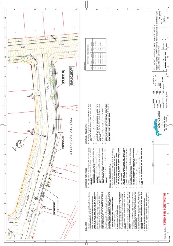
TC17.20 Centre
Line Marking and No Stopping Extension - Tallwood Avenue, Mollymook Beach (PN
3341)
HPERM Ref: D17/133442
Convenor: Martin Upitis
Attachments:
1. TRAF 2017/20 - Tallwood Avenue, Mollymook
Beach ⇩
|
Recommendation
That the General Manager
(Director Assets and Works) be advised that the Shoalhaven Traffic Committee
has no objection to the proposed centre line marking and the No Stopping zone
extension in Tallwood Avenue, Mollymook Beach, as detailed in the attached
plan TRAF 2017/20, which includes:
1. extension of the existing double
barrier (BB) centre line marking along Tallwood Avenue, from its intersection
with Mitchell Parade to its intersection with Jones Avenue.
2. extension of the existing No Stopping
zone approximately 35m on the northern side of Tallwood Avenue from the
frontage of 88 Tallwood Avenue to the boundary of 86 Tallwood Avenue and 56
Jones Avenue.
|
Details
The Committee may recall previous discussions regarding the
raised pedestrian crossing to be installed on Tallwood Avenue, Mollymook Beach.
As part of the raised pedestrian crossing project (between
Carroll Avenue and Jones Avenue) it is proposed to extend the current centre
line marking on Tallwood Avenue from Mitchell Parade to Jones Avenue to link up
to the line marking for the crossing. This will provide a continuous centre
line from Carroll Avenue to Mitchell Parade (allowing for a gap at the
intersection of Jones Avenue).
Due to the width and alignment of Tallwood Avenue at this
location, Council will need to extend the No Stopping zone on the northern side
of Tallwood Avenue from its current extent in front of 88 Tallwood Avenue to
the boundary of 86 Tallwood Avenue and 56 Jones Avenue (a distance of
approximately 35m).
Consultation was carried out with affected property owners
and the Ulladulla and Districts Community Forum.
Two submissions were received. One submission supports the
proposal whilst one submission objected to the No Stopping zone due to the loss
of on-street parking. Traffic Unit has discussed the proposed with the objector
and following the provision of additional detailed information, the objector
has accepted the explanation and that there is no other alternative option.
|
|
Shoalhaven
Traffic Committee – Tuesday 09 May 2017
Page
5
|
|

|
Shoalhaven
Traffic Committee – Tuesday 09 May 2017
Page
6
|
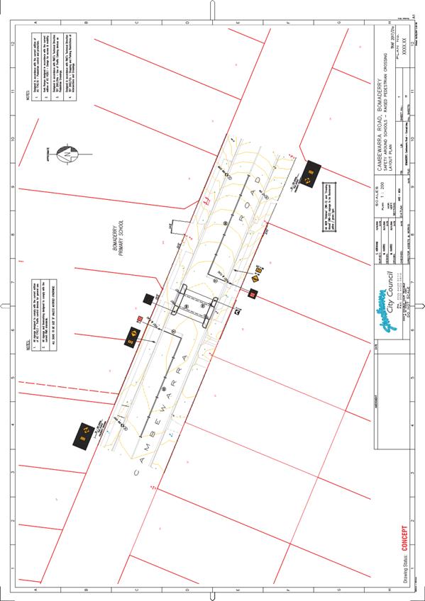
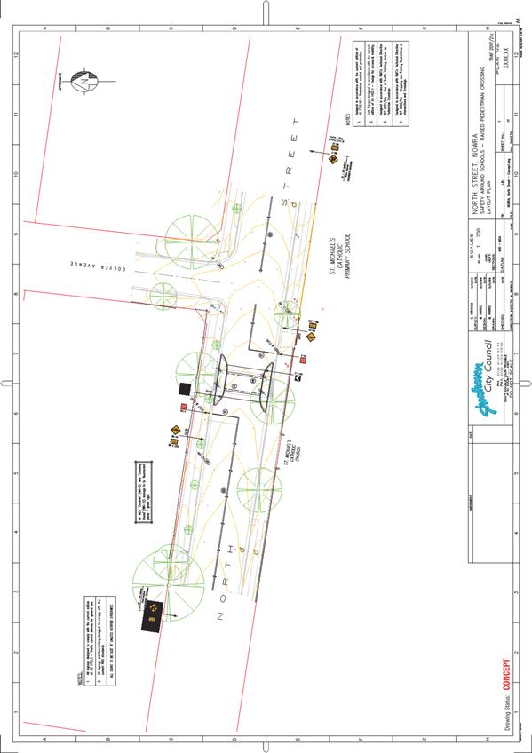
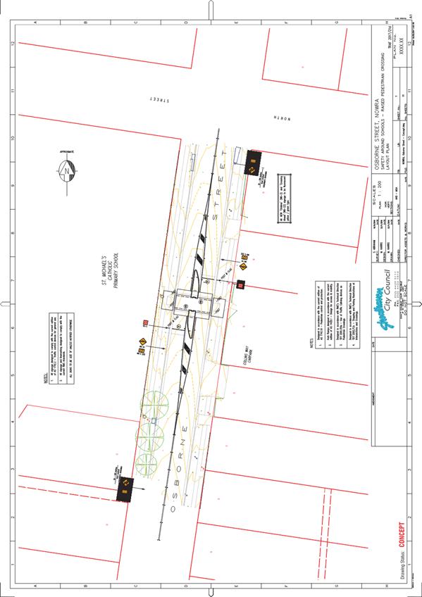
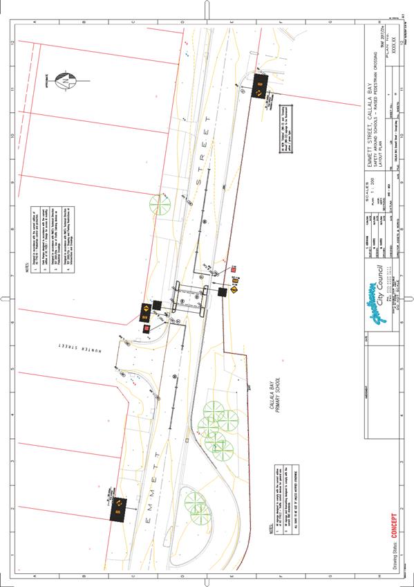
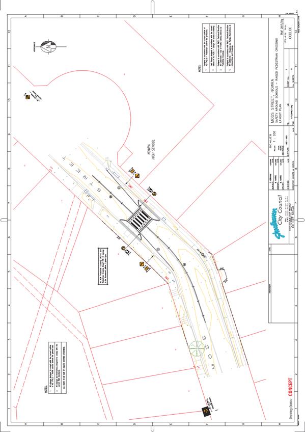
TC17.21 Crossing
Upgrades - Cambewarra Rd, Bomaderry, Moss St, Osborne St and North St, Nowra,
Emmett St, Callala Bay, Hawken Rd, Tomerong and Green St, Ulladulla (PN 3362)
HPERM Ref: D17/133450
Convenor: Martin Upitis
Attachments:
1. TRAF 2017/21a -
Crossing Upgrade - Cambewarra Rd, Bomaderry ⇩
2. TRAF
2017/21b - Crossing Upgrade - Hawken Rd, Tomerong ⇩
3. TRAF
2017/21c - Crossing Upgrade - North St, Nowra ⇩
4. TRAF
2017/21d - Crossing Upgrade - Osborne St, Nowra ⇩
5. TRAF
2017/21e - Crossing Upgrade - Emmett St, Callala Bay ⇩
6. TRAF
2017/21f - Crossing Upgrade - Green St, Ulladulla ⇩
7. TRAF
2017/21g - Crossing Upgrade - Moss St, Nowra ⇩
|
Recommendation
That the General Manager (Director
Assets and Works) be advised that the Shoalhaven Traffic Committee has no
objection to the upgrade the existing crossings to raised thresholds adjacent
to the following schools; Bomaderry Public School, Cambewarra Road, Bomaderry;
Tomerong Public School, Hawken Road, Tomerong; St Michaels Catholic Primary
School, North Street & Osborne Street, Nowra; Callala Bay Public School,
Emmett Street, Callala Bay and Ulladulla Public School, Green Street,
Ulladulla and the upgrade of the kerb extensions adjacent to Nowra High
School, Moss Street, Nowra to a pedestrian crossing, as detailed in the
attached plan TRAF 2017/21 a, b, c, d, e, f and g.
|
Details
Council has been successful in gaining funding from the
State Government to upgrade existing crossings under the Pedestrian Infrastructure
around Schools program adjacent to the following schools; Bomaderry Public
School, Cambewarra Road, Bomaderry; Tomerong Public School, Hawken Road,
Tomerong; St Michaels Catholic Primary School, North Street, Nowra; Nowra High
School, Moss Street, Nowra; Callala Bay Public School, Emmett Street, Callala
Bay and Ulladulla Public School, Green Street, Ulladulla.
In addition, Council will also be upgrading the existing
crossing on Osbourne Street, Nowra adjacent to St Michaels Catholic Primary
School.
For each of the crossings, the proposal is to raise the
level of each crossing (construction of a ramped threshold) to physically slow
traffic at these locations. All crossings are currently children’s
crossings with the exception of Moss Street which is kerb extensions only. Moss
Street is proposed to be marked as a pedestrian crossing.
Two rounds of consultation were carried out with the relevant
schools, affected property owners / residents and relevant CCB’s.
In the first round of consultation, Council advised affected
property owners / residents of the existing children’s crossing being
nominated to be upgraded to a raised children’s crossing.
One submission received did not support the proposal
advising that the raised threshold proposed for Cambewarra Road will create a
high level of noise, especially from the large volume of trucks using the road.
There is not expected to be any increase in overall sound pressure level and
accordingly, the resident was advised that Council would be prepared to engage
an independent noise consultant to measure noise levels before and after
construction of the children’s crossing. Council received no further
response.
In the second round of consultation, Council advised all
Schools, affected property owners / residents and relevant CCB’s that
Council was successful in its funding application to upgrade the existing
children’s crossings.
No submissions were received in the second round of
consultation.
A signage and line marking plan
for each crossing has been submitted for the Committee’s consideration.
|

|
Shoalhaven
Traffic Committee – Tuesday 09 May 2017
Page
8
|
|

|
Shoalhaven
Traffic Committee – Tuesday 09 May 2017
Page
9
|
|
|
Shoalhaven
Traffic Committee – Tuesday 09 May 2017
Page
10
|
|

|
Shoalhaven
Traffic Committee – Tuesday 09 May 2017
Page
11
|
|
|
Shoalhaven
Traffic Committee – Tuesday 09 May 2017
Page
12
|
|
|
Shoalhaven
Traffic Committee – Tuesday 09 May 2017
Page
13
|
|
|
Shoalhaven
Traffic Committee – Tuesday 09 May 2017
Page
14
|
|
|
Shoalhaven
Traffic Committee – Tuesday 09 May 2017
Page
15
|
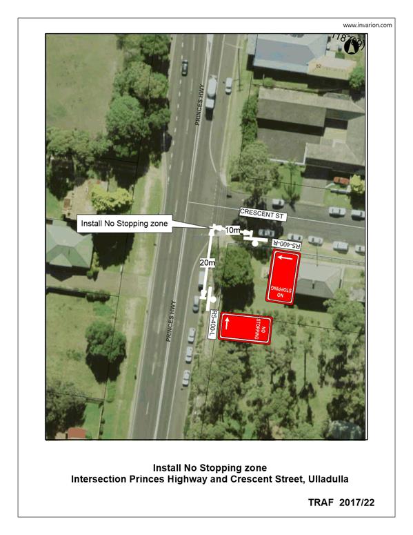
TC17.22 No
Stopping Zone - Intersection Princes Highway and Crescent Street, Ulladulla (PN
3380)
HPERM Ref: D17/133462
Convenor: Martin Upitis
Attachments:
1. TRAF 2017/22 -
Princes Highway and Crescent Street, Ulladulla ⇩
|
Recommendation
That the General Manager
(Director Assets and Works) be requested to arrange for the installation of a
No Stopping zone on the eastern side of Princes Highway for a distance of 20m
immediately south of its intersection with Crescent Street, Ulladulla, as
detailed in the attached plan TRAF 2017/22.
|
Details
Council has been requested to review parking restrictions at
the intersection of Crescent Street and the Princes Highway, Ulladulla.
Concern was raised regarding vehicles parking on the south
eastern side of the intersection restricting sight distance for vehicles
exiting Crescent Street onto the Princes Highway.
In view of addressing the concerns raised, Council is
proposing to install a 20m No Stopping zone along the Princes Highway south of
its intersection with Crescent Street.
The impact of this proposal will mean that motorists will be
unable to park in this location.
Consultation was carried out with the affected property
owner and the Ulladulla & Districts Community Forum, and both were in
support of the proposal.
|
|
Shoalhaven
Traffic Committee – Tuesday 09 May 2017
Page
16
|
|
|
Shoalhaven
Traffic Committee – Tuesday 09 May 2017
Page
17
|
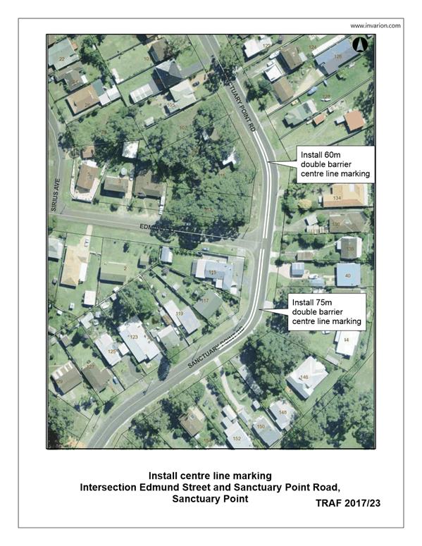
TC17.23 Double
Barrier Centre Line Marking - Sanctuary Point Rd, Sanctuary Point (PN 3381)
HPERM Ref: D17/133493
Convenor: Martin Upitis
Attachments:
1. TRAF 2017/23 -
Sanctuary Point Rd, Sanctuary Point ⇩
|
Recommendation
That the General Manager
(Director Assets and Works) be requested to arrange for the installation of
double barrier centre line marking along Sanctuary Point Road for a distance 60m
north and 75m south of Edmund Street intersection, Sanctuary Point, as
detailed in the attached plan TRAF 2017/23.
|
Details
Council has been requested to investigate delineating the
travel lanes on Sanctuary Point Road adjacent to its intersection with Edmund
Street.
Concern has been raised regarding vehicles travelling in the
centre of the road around the curves in Sanctuary Point Road.
Council’s Traffic Unit conducted an on-site inspection
of the location and noted that due to the curves proximity to the Edmund Street
intersection and the restricted sight distance at the bends, the installation
of centre line marking is warranted.
In view of addressing the concern raised, Council is
proposing to install double barrier centre line marking in Sanctuary Point Road
for a distance of approximately 135m (60m north and 75m south of Edmund Street
intersection.
The impact of this proposal will mean that motorists will be
unable to park within 3m of the marked centre line.
Consultation was carried out with affected property
owners/residents and the Basin Villages Forum.
Seven submissions were received. Three submissions received
support the proposal and four submissions received did not support the proposal
due to impacts on resident on-street parking. No submission was received from
the Basin Villages Forum.
|

|
Shoalhaven
Traffic Committee – Tuesday 09 May 2017
Page
18
|
|
|
Shoalhaven
Traffic Committee – Tuesday 09 May 2017
Page
19
|
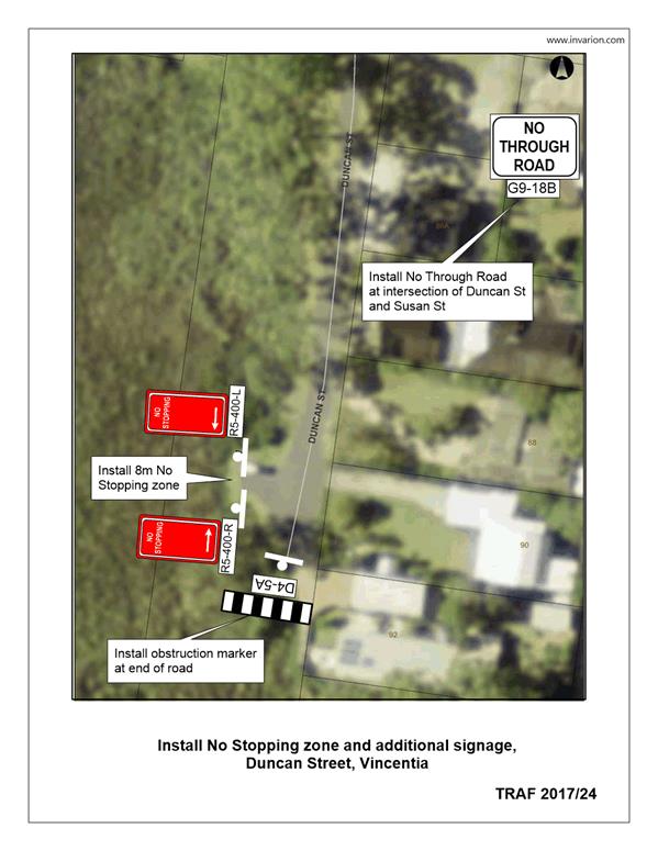
TC17.24 No
Stopping Zone - Duncan Street, Vincentia (PN 3382)
HPERM Ref: D17/133496
Convenor: Martin Upitis
Attachments:
1. TRAF 2017/24 -
Duncan Street, Vincentia ⇩
|
Recommendation
That the General Manager
(Director Assets and Works) be requested to arrange for the installation of a
10m No Stopping zone in the hammer head (turning area) opposite property
number 90 & 92 Duncan Street, Vincentia, as detailed in the attached plan
TRAF 2017/24.
|
Details
Concern has been raised regarding vehicles parking in the
hammerhead turning area at the end of Duncan Street, Vincentia.
Council constructed the turning area to facilitate the
turning movements of emergency and service vehicles in 2012, however cars
parking in this location prevent these movements.
To address these concerns Council is proposing to install a
10m No Stopping zone in turning area.
The impact of this proposal will mean that motorists will be
unable to stop in this location.
Consultation was carried out with affected property owners
and the Vincentia Ratepayers & Residents Association.
One submission was received neither for nor against the
proposal. No submission was received from the Vincentia Ratepayers &
Residents Association.
|
|
Shoalhaven
Traffic Committee – Tuesday 09 May 2017
Page
20
|
|
|
Shoalhaven
Traffic Committee – Tuesday 09 May 2017
Page
21
|
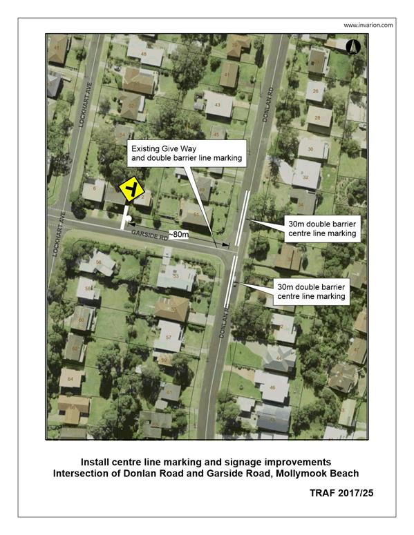
TC17.25 Centre
Line Marking & Warning Signage - Donlan Road & Garside Road, Mollymook
Beach (PN 3383)
HPERM Ref: D17/133506
Convenor: Martin Upitis
Attachments:
1. TRAF 2017/25 -
Garside Road & Donlan Road, Mollymook Beach ⇩
|
Recommendation
That the General Manager
(Director Assets and Works) be requested to arrange for the installation of
the following line marking and signage, at the intersection of Donlan Road
and Garside Road, Mollymook Beach, as detailed in the attached plan TRAF
2017/25:
1. 60m of double barrier line marking
along Donlan Road, centred across its intersection with Garside Road, ensuring
a 10m break at the intersection.
2. a T-intersection warning sign on the
minor approach to the intersection of Garside Road and Donlan Road.
|
Details
Council has been requested to investigate improving
delineation of the travel lanes and warning of the intersection of Garside Road
and Donlan Road, Mollymook Beach.
Concern was received regarding vehicles driving in the
centre of the road and braking heavily on approaches to the intersection.
In view of addressing the concerns raised, Council is
considering installing double barrier centre line marking along Donlan Road for
30m on the northern and 30m on the southern side of the Garside Road
intersection. In addition to this Council is proposing to install an intersection
warning signage on the minor approach to the intersection.
Consultation was carried with affected property owners and
the Ulladulla & Districts Community Forum.
Three submissions were received in support of the proposal
noting that on-street parking would not be impacted by the proposal. There was
no submission received from the Ulladulla & Districts Community Forum.
|
|
Shoalhaven
Traffic Committee – Tuesday 09 May 2017
Page
22
|
|
|
Shoalhaven Traffic
Committee – Tuesday 09 May 2017
Page
23
|
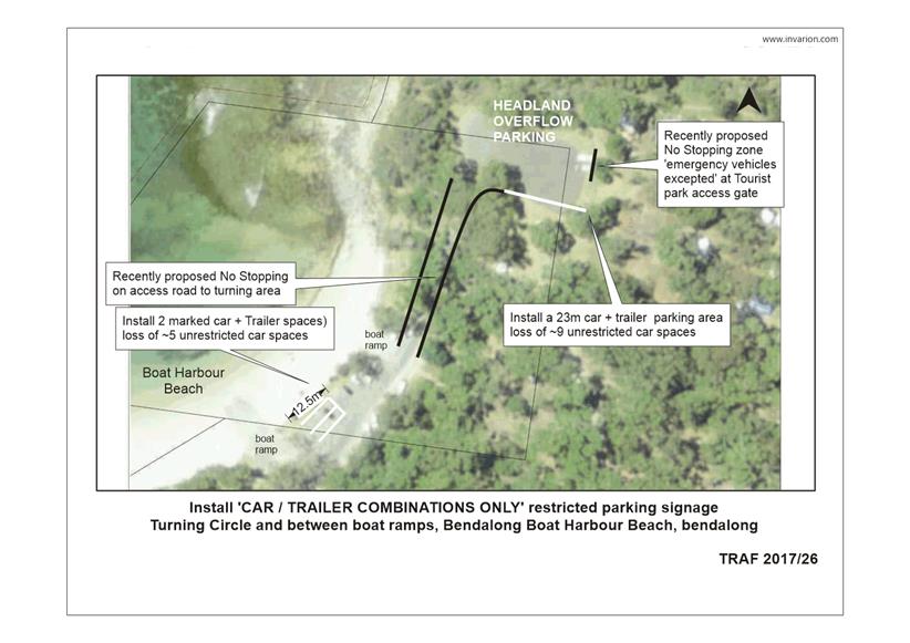
TC17.26 Car
& Trailer Combination Only Parking - Boat Harbour, Bendalong (PN 3384)
HPERM Ref: D17/133515
Convenor: Martin Upitis
Attachments:
1. TRAF 2017/26 -
Boat Harbour Bendalong ⇩
|
Recommendation
That the General Manager
(Director Assets and Works) be requested to arrange for the installation of
the following line marking and signage changes at the Boat Harbour Beach Boat
Ramp Area, Bendalong, as detailed in the attached plan TRAF 2017/26:
1. two (2) marked ‘CAR / TRAILER
COMBINATION ONLY’ parking spaces between the two existing boat ramps at
boat harbour beach. As a trial to be reviewed after the 2017/2018 summer
period.
2. a 23m 'CAR / TRAILER COMBINATION ONLY'
zone, on the southern side of the ‘headland overflow’ parking.
|
Details
Council has been requested by the Red Head Villages
Association and the local fishing community to review the existing parking
facilities at the boat harbour beach boat ramp, Bendalong.
The community raised concerns with the lack of dedicated car
and trailer combination parking spaces adjacent to the boat ramps, as use of
the boat ramps by boat users was inhibited due to the boat ramp parking area
being parked out by other motorists.
In view of addressing the concerns raised, Council had
consulted to install the following changes:
a) four (4) marked ‘CAR / TRAILER COMBINATION
ONLY’ parking spaces between the two existing boat ramps at boat harbour
beach.
b) a 23m (approx.) ‘CAR / TRAILER COMBINATION
ONLY’ parking area on the southern side of the ‘headland overflow’
parking.
Consultation was carried out with all property owners within
the Bendalong Village, the Red Point Tourist Park and the Red Head Villages
Association.
A total of eleven submissions were received.
One submission did not support the proposal.
Four submissions supported the proposal
Three submissions partly supported the proposal (only
supporting the headland parking proposal)
One submission received was neither for nor against the
proposal.
The Red Head Villages Association support the changes to
address the parking congestion, however acknowledged that there is no perfect
solution due to the number of stake holders.
Following the outcome of community consultation, Council is
considering installing the following:
a) two (2) marked ‘CAR / TRAILER COMBINATION
ONLY’ parking spaces between the two existing boat ramps at boat harbour
beach. As a trial to be reviewed after the 2017/2018 summer period and reported
to LTC.
b) a 23m 'CAR / TRAILER COMBINATION ONLY' zone, on the
southern side of the ‘headland overflow’ parking.
The impact of this proposal will mean the loss of 15
(approx.) unrestricted parking spaces to accommodate 9 car / trailer spaces.
|

|
Shoalhaven
Traffic Committee – Tuesday 09 May 2017
Page
25
|
|
|
Shoalhaven
Traffic Committee – Tuesday 09 May 2017
Page
26
|
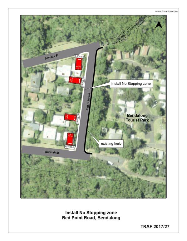
TC17.27 Parking
Restrictions - Red Point Road, Bendalong (PN 3385)
HPERM Ref: D17/133526
Convenor: Martin Upitis
Attachments:
1. TRAF 2017/27 -
Red Point Road, Bendalong ⇩
|
Recommendation
That the General Manager
(Director Assets and Works) be requested to arrange for the installation of a
140m (approx.) No Stopping zone on the western side of Red Point Road from
its intersection with Boronia Street to its intersection with Waratah Street,
Bendalong, as detailed in the attached plan TRAF 2017/27.
|
Details
Council has been requested by the Red Head Villages Association
and the local community to review parking within Red Point Road, Bendalong.
Concerns were raised regarding vehicles parking on both
sides of Red Point Road, Bendalong, reducing two way traffic to one travel lane
- particularly in peak holiday times.
Council consulted with the Bendalong community and the Red
Head Villages Association on the following options:
· Option 1 - No Stopping
zone western side
This proposal will prevent
vehicles parking on the western side of the Red Point Road
· Option 2 - 1 Hour (1P)
time restricted parking western side
This proposal will only permit
vehicles to park for a maximum of 1 hour on the western side of Red Point Road.
· Option 3 - Off-set
double barrier centre line marking
This proposal will prevent vehicles
from parking within 3m of the centre line marking, off-set to permit parking on
the eastern (kerbed) side of Red Point Road.
· Option 4 - No change to
existing parking arrangements
Letters were sent out to all property owners in the
Bendalong Village and the Red Head Villages Association.
A total of 24 submissions were received. A summary of the
submissions is as follows:
13 (54%) prefer
Option 1
1 (4%)
prefer Option 2
2 (8%)
prefer Option 3
8 (33%)
prefer Option 4
The Red Head Villages Association supported option 1.
Following the outcome of community consultation, it is
proposed to install a 140m (approx.) No Stopping zone on the western side of
Red Point Road from the intersection of Boronia Street to the intersection of
Waratah Street.
|
|
Shoalhaven
Traffic Committee – Tuesday 09 May 2017
Page
28
|
|
|
Shoalhaven
Traffic Committee – Tuesday 09 May 2017
Page
29
|
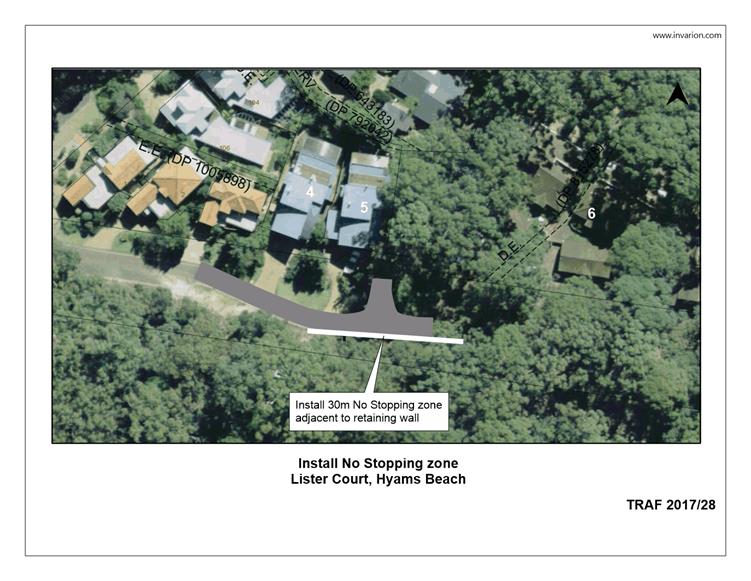
TC17.28 No
Stopping Zone - Lister Court, Hyams Beach (PN 3390)
HPERM Ref: D17/133527
Convenor: Martin Upitis
Attachments:
1. TRAF 2017/28 -
Lister Court, Hyams Beach ⇩
|
Recommendation
That the General Manager (Director
Assets and Works) be requested to arrange for the installation of a 30m
(approx.) No Stopping zone on the southern side of Listrer Court adjacent to
the access to 6 Lister Court, Hyams Beach, as detailed in the attached plan
TRAF 2017/28.
|
Details
Council has been requested to restrict parking on the
southern side of Lister Court, Hyams Beach, adjacent to the existing retaining
wall.
It has been advised that parking in this location restricts
through traffic movements and use of the existing hammer head turning area at
the end of the court.
In view of addressing the concerns raised, Council is
proposing to install a 30m No Stopping zone on the southern side of Lister
Court, along the retaining wall adjacent to the access to 6 Lister Court.
Consultation was carried out with affected property owners
and the Hyams Beach Villagers Association.
The Hyams Beach Villagers
Association and three submissions support of the proposal.
|
|
Shoalhaven
Traffic Committee – Tuesday 09 May 2017
Page
30
|
|
|
Shoalhaven
Traffic Committee – Tuesday 09 May 2017
Page
31
|
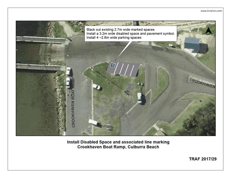
TC17.29 Disabled
Parking Space - Crookhaven Heads Boat Ramp, Culburra Beach (PN 3391)
HPERM Ref: D17/133535
Convenor: Martin Upitis
Attachments:
1. TRAF 2017/29 -
Crookhaven Boat Ramp, Culburra Beach ⇩
|
Recommendation
That the General Manager (Director
Assets and Works) be requested to arrange for the installation of a disabled
parking space at the Crookhaven Boat Ramp, Culburra Beach, as detailed in the
attached plan TRAF 2017/29.
|
Details
Council has been requested to consider the installation of a
disabled parking space at the Crookhaven Boat Ramp, Orient Point.
Council has recently completed
works on an accessible fishing platform and a disabled parking space is proposed
to be installed as part of this project.
|
|
Shoalhaven
Traffic Committee – Tuesday 09 May 2017
Page
32
|
|
|
Shoalhaven
Traffic Committee – Tuesday 09 May 2017
Page
33
|
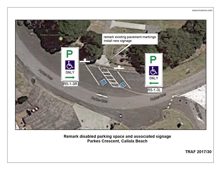
TC17.30 Disabled
Parking Space - Parkes Crescent, Callala Beach (PN 3392)
HPERM Ref: D17/133541
Convenor: Martin Upitis
Attachments:
1. TRAF 2017/30 -
Parkes Crescent, Callala Beach ⇩
|
Recommendation
That the General Manager (Director
Assets and Works) be advised that the Shoalhaven Traffic Committee has no
objection to the previously installed disabled parking space and associated
shared zone in Parkes Crescent, Callala Beach adjacent to Parkes Crescent
Park as detailed in the attached plan TRAF 2017/30.
|
Details
Council has previously installed two disabled spaces within
Parkes Crescent, Callala Beach, as part of a Reserve upgrade project however
the installation was not reported through Council. A review of the location
noted that new signage and line remarking was required.
As such the item has been
submitted for the committee’s consideration.
|
|
Shoalhaven
Traffic Committee – Tuesday 09 May 2017
Page
34
|
|
|
Shoalhaven
Traffic Committee – Tuesday 09 May 2017
Page
35
|
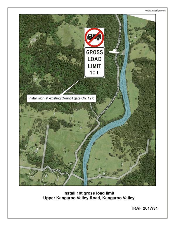
TC17.31 Road
Weight Restriction - Upper Kangaroo River Road, Barrengarry (PN 3393)
HPERM Ref: D17/133549
Convenor: Martin Upitis
Attachments:
1. TRAF 2017/31 -
Upper Kangaroo River Road, Barrengarry ⇩
|
Recommendation
That the General Manager (Director
Assets and Works) be requested to arrange for the installation of ‘no
trucks’ R6-10-2B and ‘gross load limit 10t’ R6-4B signage
at the Council gate located on Upper Kangaroo River Road, Barrengarry, 12km
from the intersection of Moss Vale Road, as detailed in the attached plan
TRAF 2017/31.
|
Details
Following landslides in 2015, land slip repair work was
conducted along the last 2km of Upper Kangaroo River Road, Barrengarry.
Council has been requested by Geotechnical Engineers
following an assessment of the repaired section, to install an advisory 10
tonne weight restriction on the last 2km of Upper Kangaroo River Road, with a
maximum load limit of 20 tonne’s for loads approved by the Roads Asset
Manager.
To advise the public and
residents of these restrictions, it is proposed to install a ‘no
trucks’ R6-10-2B and ‘gross load limit 10t’ R6-4B at the
Council gate located on Upper Kangaroo River Road, Barrengarry, 12km from the
intersection of Moss Vale Road.
|
|
Shoalhaven
Traffic Committee – Tuesday 09 May 2017
Page
36
|
|
|
Shoalhaven
Traffic Committee – Tuesday 09 May 2017
Page
37
|
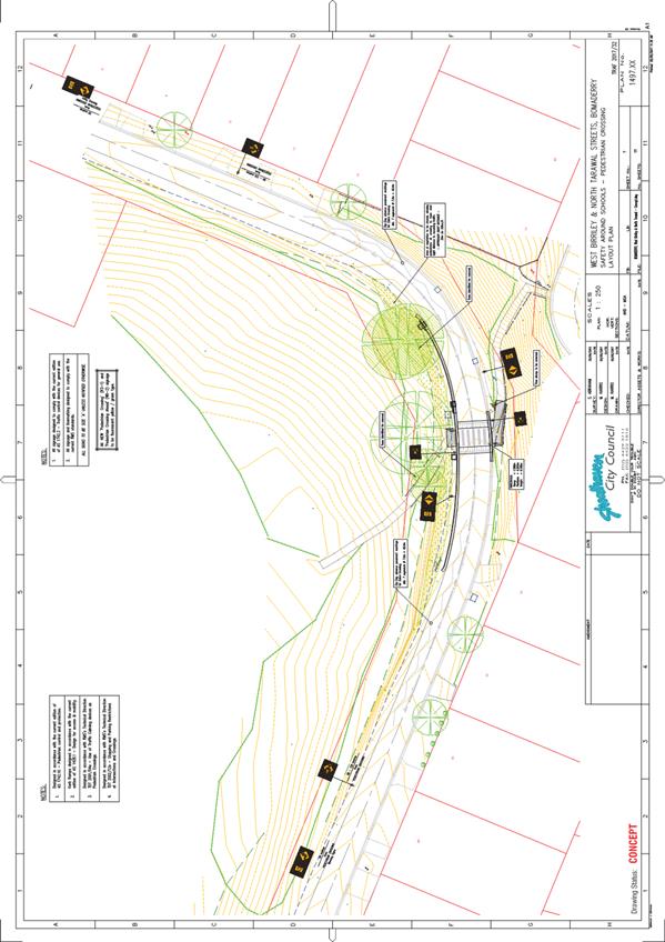
TC17.32 Raised
Pedestrian Crossing - West Birriley Street and North Tarawal Street, Bomaderry
(PN 3351)
HPERM Ref: D17/142524
Convenor: Martin Upitis
Attachments:
1. TRAF 2017/32 -
West Birriley St & North Tarawal St, Bomaderry ⇩
|
Recommendation
That the General Manager (Director
Assets and Works) be advised that the Shoalhaven Traffic Committee has no
objection to the installation of a raised pedestrian crossing at the curve on
West Birriley Street and North Tarawal Street, Bomaderry as detailed in the
attached plan TRAF 2017/32.
|
Details
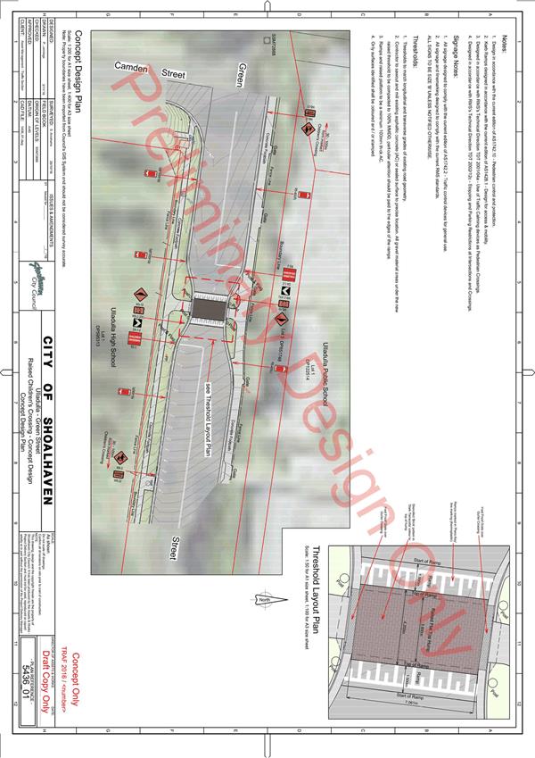
The Committee may recall previous discussions regarding the
proposed pedestrian refuge to be installed at the curve of West Birriley Street
and North Tarawal Street, Bomaderry, under the NSW Active Transport Program.
Council, at its meeting on 20 December 2017 adopted the
Shoalhaven Traffic Committee’s recommendation to install a pedestrian
refuge at the curve of West Birriley Street and North Tarawal Street.
Bomaderry.
Following the recommendation Council staff carried out
detailed design for the crossing, however potholing of the trunk main indicated
the main was not where it was expected to be, and is very shallow, and in rock,
and right where the proposed road widening was designed to be. It is not
possible to build over the main, as it is very old and shallow.
To move the main to widen the road (per the pedestrian
refuge design) would mean the project would not be built by the end June
deadline, and would cost significantly more than the budget.
As an alternative to a pedestrian refuge at this location it
is proposed to install a raised marked foot crossing.
Accordingly a revised design has been prepared which does
not require road widening/impact on the trunk main.
The proposal is for a raised marked foot crossing to still
achieve the desired pedestrian safety improvements, but via a different
treatment.
There are numerous raised crossings in operation throughout
Shoalhaven city (including many around schools) and these have become very
popular and welcomed by the community, not just to improve pedestrian safety
but they have proven very effective in reducing speeds right at the crossing
point.
The subject crossing is used by three schools as well as
users of the adjacent Bomaderry sports complex (basketball stadium, swimming
pool, tennis courts, cricket and football fields). The schools and the
management committees of the sports fields all support the need for the
pedestrian crossing improvements.
The attached design has been prepared in accordance with
standards, and includes the associated signs/lines and vegetation clearing
works to achieve the required minimum sight distances required on the
approaches to the treatment.
|
|
Shoalhaven
Traffic Committee – Tuesday 09 May 2017
Page
39
|