Shoalhaven Traffic Committee
Meeting Date: Tuesday,
14 February, 2017
Location: Jervis
Bay Room 3, City Administrative Centre, Bridge Road, Nowra
Time:
9.30
am
Please note: Council’s
Code of Meeting Practice permits the electronic recording and broadcast of the
proceedings of meetings of the Council which are open to the public. Your
attendance at this meeting is taken as consent to the possibility that your
image and/or voice may be recorded and broadcast to the public.
Agenda
1. Apologies
2. Confirmation of Minutes
· Traffic
Committee - 13 December 2016...................................................................... 1
3. Business Arising from Previous Minutes
4. Reports of the Convenor
TC17.1........ Bus Zone - River Road, Sussex Inlet (PN 896)............................................. 5
TC17.2........ No Stopping Zone - Red Point Road, Bendalong (PN
3343)......................... 7
TC17.3........ Regulatory Signage and Line Marking - Flinders
Road, South Nowra (PN 3353)........................................................................................................................ 9
TC17.4........ No Stopping Zone - Farrelly Place, Bomaderry (PN
3356)......................... 17
TC17.5........ Edge Line Marking - Bridge Road, Nowra (PN 3357).................................. 19
TC17.6........ Regulatory Signage and Line Marking - Turpentine
Road, Jerrawangala (PN 3358)...................................................................................................................... 21
TC17.7........ Proposed Roundabout - St Vincent Street and
Church Street, Ulladulla (PN 3359)...................................................................................................................... 22
TC17.8........ Line Marking Amendments - Cow Creek Bridge,
Sussex Inlet Road, Sussex Inlet (PN 3360)............................................................................................................. 24
TC17.9........ Centre Line Marking - Burrill Street South,
Ulladulla (PN 3361).................. 26
5. General Business
Note: The next meeting will be
held on Tuesday 14 March 2017.
|

|
Shoalhaven
Traffic Committee – Tuesday 14 February 2017
Page
ii
|
Membership
Mr Martin Upitis
Mr Kristian Pinochet
Sergeant Mick Tebbutt
Mr Alan Trass
Mr Stuart Coughlan
Clr Jo Gash
Clr Andrew Guile
Clr Patricia White
The Shoalhaven Traffic Committee is a technical review
committee, not a committee of Council under the Local Government Act 1993. The
Roads and Maritime Services (RMS) has delegated certain powers to Council under
the Transport Administration Act 1988 (Section 50). A condition of this
delegation is that Council must take into account the Traffic Committee
recommendations.
There are four formal members of the Traffic Committee, each
of whom has a single vote only. The members are representatives from:
- NSW Police Force
- RMS
- Shoalhaven City Council
- Local State Member of Parliament (for the location of the
issue to be voted upon)
If the RMS or NSW Police Force disagrees with any Traffic
Committee recommendation, or Council’s resolution (on any Traffic
Committee recommendation), they may lodge an appeal with the Regional Traffic
Committee for determination. The appeal must be lodged in writing within
14 days of the date of notification in writing. Any action relative to
any issue under appeal must cease until the matter is determined. The
Regional Traffic Committee is chaired by an independent chairperson and
submissions and representations are welcomed from all interested parties.
Council cannot amend a Traffic Committee recommendation. The
Council can only: adopt the Traffic Committee recommendation; not adopt the
Traffic Committee recommendation, or request the Traffic Committee reconsider
the issue.
The full guide to the delegation to Council’s for
the regulation of traffic can be viewed at RMS
Website
Minutes of the Shoalhaven Traffic Committee
Meeting Date: Tuesday,
13 December 2016
Location: Jervis
Bay Rooms, City Administrative Centre, Bridge Road, Nowra
Time: 9.35am
The following members
were present:
Mr Martin Upitis - Assets
Manager
Mr Mick Tebbutt
Mr Alan Trass
Ms Jade Marsh
Clr Patricia White
Others Present:
Daniel Dunston –
Traffic Investigation Officer
|
Apologies / Leave of Absence
|
Stuart Coughlan
|
Confirmation of the Minutes
|
|
RESOLVED (By consent)
That the Minutes of the
Traffic Committee held on Tuesday 11 October 2016 be confirmed.
CARRIED
|
|
Business Arising from Previous Minutes
|
Nil
Reports of the Convenor
|
TC16.23 Proposed
No Stopping Zone (PN3217) - Bayview Avenue, Hyams Beach
|
HPERM Ref:
D16/383460
|
|
Recommendation (By consent)
That General Manager (Director
Assets and Works) be requested to arrange for the installation of a 140m time
restricted No Stopping zone ‘10am-5pm October to April Inclusive’
on the southern side of Bayview Avenue, Hyams Beach as detailed in the
attached plan TRAF 2016/85.
|
|
TC16.24 Proposed
Double Barrier Line Marking (PN 3349) - Cyrus Street, Hyams Beach
|
HPERM Ref:
D16/383556
|
|
Recommendation (By consent)
That General Manager (Director
Assets and Works) be requested to arrange for the installation of 35m double
barrier centre line marking and edge line marking around the corner of Cyrus
Street and Aster Street, Hyams Beach, adjacent to the Chinamans Beach access
to assist in maintaining 3m wide travel lanes, as detailed in the attached
plan TRAF 2016/96.
|
|
TC16.25 Proposed
Time Restricted No Stopping Zone (PN 3350) - Cyrus Street, Hyams Beach
|
HPERM Ref:
D16/383595
|
|
Recommendation (By consent)
That General Manager (Director
Assets and Works) be requested to arrange for the installation of a 55m No
Stopping time restricted zone ‘10am-5pm October to April inclusive’
at the southern end of Cyrus Street, Hyams Beach adjacent to the pedestrian
access to Seamans Beach, as detailed in the attached plan TRAF 2016/97.
|
|
TC16.26 Proposed
Regulatory Signage and Line Marking Plans (PN 3259) - Bayswood Estate,
Vincentia
|
HPERM Ref:
D16/383677
|
|
Recommendation (By consent)
That the General Manager (Director
Assets and Works) be advised that the Shoalhaven Traffic Committee has no
objection to the proposed regulatory signage and line marking at the
intersection of Seagrass Avenue and Trawler Street, Vincentia as detailed in
the attached plan TRAF 2016/86.
|
|
TC16.27 Proposed
Stewart Place Bus Interchange Upgrade (PN 3287) - Stewart Place, Nowra
|
HPERM Ref:
D16/383716
|
|
Recommendation (By consent)
That General Manager (Director
Assets and Works) be advised that the Shoalhaven Traffic Committee has no
objection to the proposed signage and line marking at the Stewart Place Bus
Interchange, Nowra as detailed in the attached plan TRAF 2016/87.
|
|
TC16.28 Proposed
No Stopping Zone (PN 3326) - Red Point Road, Bendalong
|
HPERM Ref:
D16/383734
|
|
Recommendation (By consent)
That General Manager (Director
Assets and Works) be requested to arrange for the installation of a No
Stopping zone for a distance of approx. 320m on the southern side of Red
Point Road, Bendalong as detailed in the attached plan TRAF 2016/88.
|
|
TC16.29 Proposed
Disabled Parking Restriction Amendment (PN 3335) - Dolphin Court Car Park,
Boree St, Ulladulla
|
HPERM Ref:
D16/383778
|
|
Recommendation (By consent)
That General Manager (Director
Assets and Works) be advised that the Shoalhaven Traffic Committee has no
objection to the proposed 1 hour (1P) disabled parking space restrictions
within the Coles Car Park (Dolphin Court), Boree Street, Ulladulla as
detailed in the attached plan TRAF 2016/89.
|
|
TC16.30 Proposed
Roundabout (PN 3340) - Intersection Deering St and Jubilee Ave, Ulladulla
|
HPERM Ref:
D16/383804
|
|
Recommendation (By consent)
That General Manager (Director
Assets and Works) be advised that the Shoalhaven Traffic Committee has no
objection to the proposed signage and line marking at the proposed roundabout
at the intersection of Deering Street and Jubilee Avenue, Ulladulla, as
detailed in the attached plan TRAF 2016/90.
|
|
TC16.31 Proposed
Raised Pedestrian Crossing (PN 3341) - Tallwood Ave, Mollymook Beach
|
HPERM Ref:
D16/383819
|
|
Recommendation (By consent)
That General Manager (Director
Assets and Works) be advised that the Shoalhaven Traffic Committee has no
objection to the proposed signage and line marking at the proposed pedestrian
crossing on Tallwood Avenue, Mollymook Beach, as detailed in the attached
plan TRAF 2016/91.
|
|
TC16.32 Proposed
Shared Path and Pedestrian Refuges (PN 3342) - Mitchell Pde, Mollymook Beach
|
HPERM Ref:
D16/383834
|
|
Recommendation (By consent)
That the General Manager
(Director Assets and Works) be advised that the Shoalhaven Traffic Committee
has no objection to the proposed signage and line marking at the proposed
pedestrian refuge treatment and shared path in Mitchell Parade, Mollymook
Beach north and south of Tallwood Avenue as detailed in the attached plan
TRAF 2016/92.
|
|
TC16.33 Proposed
Double Barrier Line Marking (PN 3345) - Intersection Waldegrave Cres / Murray
St, Vincentia
|
HPERM Ref:
D16/383849
|
|
Recommendation (By consent)
That the General Manager
(Director Assets and Works) be requested to arrange for the installation of
the following, as detailed in the attached plan TRAF 2016/93:
1.
100m of double barrier (BB) centre line marking on Murray Street,
Vincentia adjacent to its intersections with Waldegrave Crescent, providing
10m breaks at its intersections
2.
30m of double barrier (BB) centre line marking on Waldegrave Crescent
at the approaches of Murray Street, Vincentia
|
|
TC16.34 Proposed
Line Marking Amendments - Mitchell Pde, Mollymook Beach
|
HPERM Ref:
D16/383860
|
|
Recommendation (By consent)
That the General Manager
(Director Assets and Works) be requested to arrange for the installation of
the following, as detailed in the attached plan TRAF 2016/94:
1. Amend
the current edge line marking located in front of 74 and 76 Mitchell Parade,
such that it ties into the driveway access of 76 Mitchell Parade delineating
a 3.5m wide travel lane from on-street parking providing two additional
parking spaces
2. Remove
the current edge line marking tapers adjacent to 28 & 59 Mitchell Parade
providing an additional parking space
3. Install
edge line marking on the eastern and western side of Mitchell Parade between
28 & 61 Mitchell Parade, delineating 3.5m wide travel lanes and 3m wide
parking lanes
4. Relocate
the existing No Stopping sign adjacent to property 59 Mitchell Parade 1.5m
north providing one additional parking space in this location
|
|
TC16.35 Proposed
Car and Trailer Parking (PN 3347) - Nielson Lane Boat Ramp, Sussex Inlet
|
HPERM Ref:
D16/383877
|
|
Recommendation (By consent)
That the General Manager
(Director Assets and Works) be requested to arrange for the installation of
‘car / trailer combinations only’ restricted parking signage on
the southern side of the Nielson Lane Boat Ramp, Sussex Inlet as detailed in
the attached plan TRAF 2016/95.
|
|
TC16.36 Proposed
Pedestrian Refuge (PN 3351) - Intersection West Birriley Street & North
Tarawal Street Bomaderry
|
HPERM Ref: D16/383902
|
|
Recommendation (By consent)
That the General Manager (Director
Assets and Works) be advised that the Shoalhaven Traffic Committee has no
objection to the proposed signage and line marking as detailed in the
attached plan TRAF 2016/98.
|
|
TC16.37 Proposed
Regulatory signage & Line Marking (PN 3352) - Orion Beach Shared Path,
Vincentia
|
HPERM Ref:
D16/383926
|
|
Recommendation (By consent)
That the General Manager
(Director Assets and Works) be advised that the Shoalhaven Traffic Committee
has no objection to the proposed regulatory signage and proposed improvements
for the Orion Beach Shared Path, Vincentia. As detailed in the attached plan
TRAF 2016/99.
|
There being no further
business, the meeting concluded, the time being 10.10
am.
Martin Upitis
CHAIRPERSON
|

|
Shoalhaven
Traffic Committee – Tuesday 14 February 2017
Page
5
|
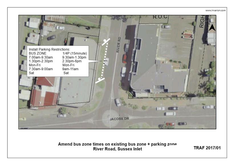
TC17.1 Bus
Zone - River Road, Sussex Inlet (PN 896)
HPERM Ref: D17/41018
Convenor: Martin Upitis
Attachments:
1. Bus Zone Operating Time Amendment - River
Rd, Sussex Inlet ⇩
|
Recommendation
That the General Manager
(Director Assets and Works) be requested to arrange for amendments to the
existing bus zone and 1/4P (15 minute) parking zone located on the western
side of River Road, north of Jacobs Drive, Sussex Inlet, as detailed in the
attached plan TRAF 2017/01 to the following operation:
BUS ZONE 1/4P
(15minute)
7:00am-9.30am 9.30am-1.30pm
1.30pm-2.30pm 2.30pm-6:00pm
Mon-Fri Mon-Fri
7:30am-9:00am 9am-11:00am
Sat Sat
|
Details
The Committee may recall
previous discussions in relation to the existing bus zone and 1/4P minute
parking zone on the western side of River Road, north of Jacobs Drive, Sussex Inlet.
The existing bus zone and 1/4P
parking zone is currently time restricted to:
BUS ZONE 1/4P
(15minute)
8.30am-9.30am 9.30am-1.30pm
1.30pm-2.30pm 2.30pm-6:00pm
Mon-Fri Mon-Fri
8.30am-9:00am 9am-11:00am
Sat Sat
Council has been requested by
bus companies servicing the Sussex Inlet area to extend the operating times of
the current restrictions present at the bus zone adjacent to the National Bank
from 8.30am-9.30am to 7:00am - 9:30am Mon – Fri and from 8:30am-9:00am to
7:30am-9:30am Saturdays.
In view of addressing the
request, Council is considering amending the existing bus zone and 1/4P (15
minute) parking zone to:
BUS ZONE /4P
(15 minute)
7.00am-9.30am 9.30am-1.30pm
1.30pm-2.30pm 2.30pm-6.00pm
Mon-Fri Mon-Fri
7.30am-9.00am 9.00am-11.00am
Sat Sat
Consultation was carried out
with affected property owners / business operators, Shoal Bus and the Sussex
Inlet Community Forum.
Two
submissions were received in support of the proposal
|
|
Shoalhaven
Traffic Committee – Tuesday 14 February 2017
Page
6
|
|

|
Shoalhaven
Traffic Committee – Tuesday 14 February 2017
Page
7
|
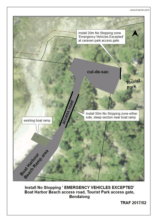
TC17.2 No
Stopping Zone - Red Point Road, Bendalong (PN 3343)
HPERM Ref: D17/41135
Convenor: Martin Upitis
Attachments:
1. Proposed No
Stopping Zones - Red Point Rd, Bendalong ⇩
|
Recommendation
That the General Manager (Director Assets and Works) be
requested to arrange for the installation of the following No Stopping zones
as detailed in the attached plan TRAF 2017/02:
1.
a 20m No Stopping zone ‘emergency vehicles excepted at the tourist
park access gate at the headland cul-de-sac
2.
a 50m (approx.) No Stopping zone on the eastern and western sides of
the narrow access way north of the boat harbour beach boat ramp that leads to
the headland cul-de-sac
|
Details
Council has been requested to consider implementing parking
restrictions across the north western access gate to the Bendalong Caravan Park
in the cul-de-sac at the end of the boat harbour beach access road, Bendalong,
as part of the Rural Fire Services Community Protection Plan.
In view of addressing the request, Council is considering
the installation of a 20m No Stopping zone - 'emergency vehicles excepted'
across the north western access gate to the Bendalong Caravan Park.
In addition to this request, Council is considering the
installation of a 50m No Stopping zone on the eastern and western side of the
narrow access way north of the boat ramp that leads to the large cul-de-sac.
The impact of the proposal will mean that motorists will be
unable to stop within the No Stopping zones, however the proposed zones will
assist with traffic flow in the area. Emergency vehicles will be able to stop
within the No Stopping zone 'emergency vehicles excepted' adjacent to the
access gate.
These proposed restrictions are in addition to the recently
installed 320m No Stopping zone installed on the southern (uphill) side of the
boat harbour beach access road.
Consultation was carried out with the Red Head Villages
Association and the Bendalong Point Tourist Park.
Red Head Villages have no
objection to the proposal.
|

|
Shoalhaven
Traffic Committee – Tuesday 14 February 2017
Page
8
|
|

|
Shoalhaven
Traffic Committee – Tuesday 14 February 2017
Page
9
|
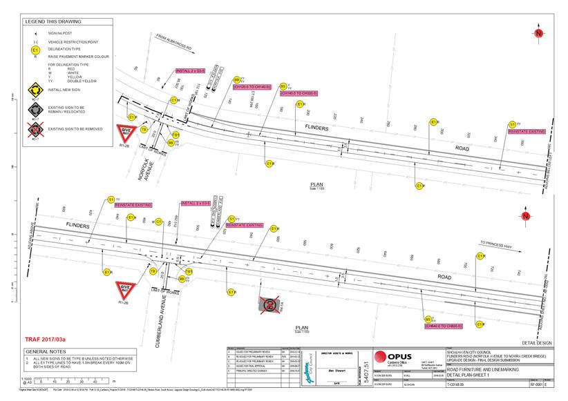
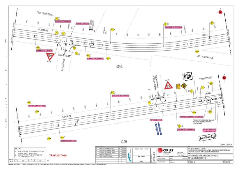
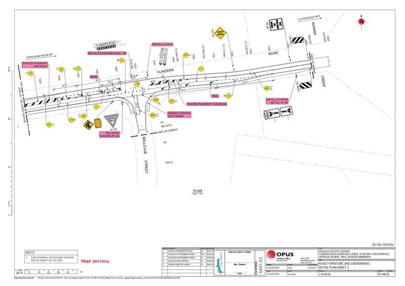
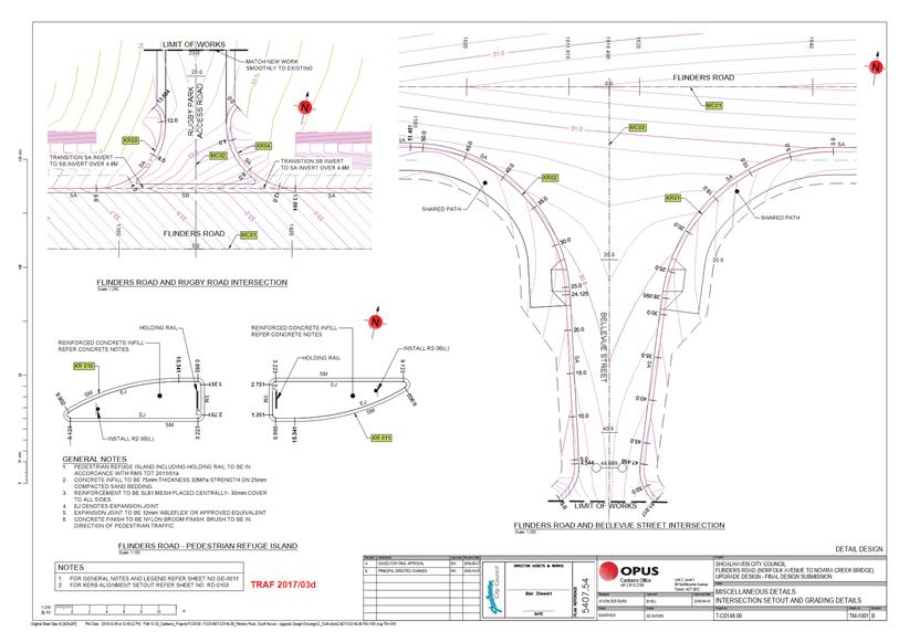
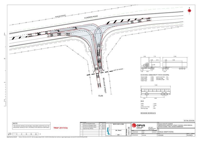
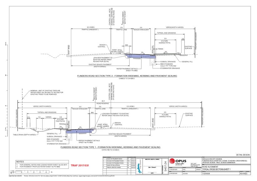
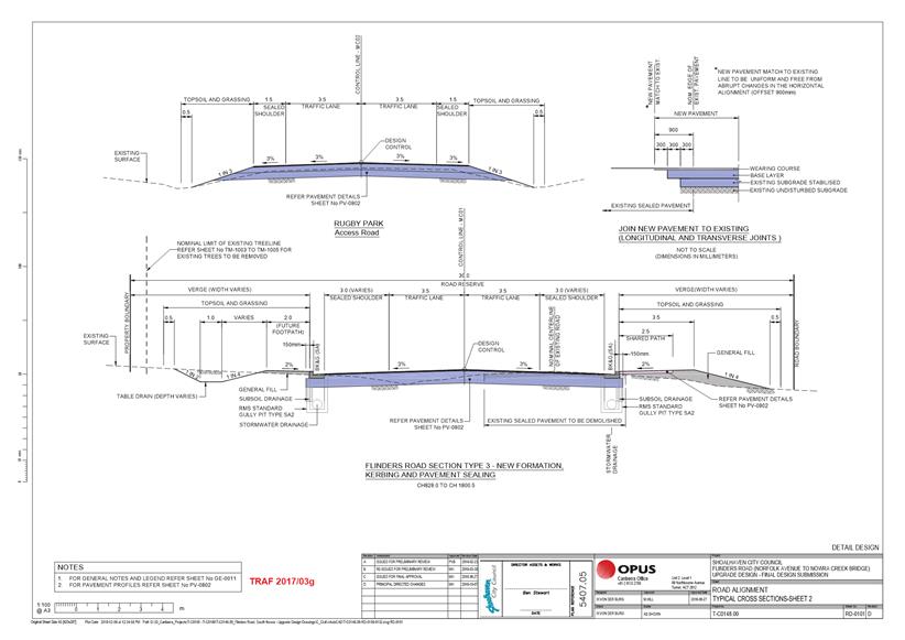
TC17.3 Regulatory
Signage and Line Marking - Flinders Road, South Nowra (PN 3353)
HPERM Ref: D17/41158
Convenor: Martin Upitis
Attachments:
1. Regulatory
Signage & Line Marking Plan - Flinders Rd, South Nowra ⇩
|
Recommendation
That the General Manager
(Director Assets and Works) be advised that the Shoalhaven Traffic Committee
has no objection to the proposed regulatory signage and line marking on
Flinders Road, South Nowra as detailed in the attached plan TRAF 2017/03.
|
Details
Council has been successful in securing funding from the
Federal Government under the Black Spot Program and heavy vehicle funding as
part of the route upgrade of Flinders Road, South Nowra (Norfolk Avenue to
Nowra Creek).
Proposed works include widening the full length of Flinders
Road (between Norfolk Avenue and Nowra Creek) to prevent run off road crashes
and local intersection improvements as a consequence of the road widening.
Vegetation clearing of the full length plus the installation of guardrail where
necessary to protect hazardous culverts or poles.
A signage and line marking plan
for the Flinders Road upgrade has been submitted for the Committee's
consideration.
|
|
Shoalhaven
Traffic Committee – Tuesday 14 February 2017
Page
10
|
|

|
Shoalhaven
Traffic Committee – Tuesday 14 February 2017
Page
17
|
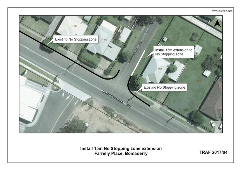
TC17.4 No
Stopping Zone - Farrelly Place, Bomaderry (PN 3356)
HPERM Ref: D17/41184
Convenor: Martin Upitis
Attachments:
1. Proposed No
Stopping Zone Extension - Farrelly Pl, Bomaderry ⇩
|
Recommendation
That the General Manager
(Director Assets and Works) be requested to arrange for the extension of the
existing No Stopping zone on the eastern side of Farrelly Place, Bomaderry by
15m to the north as detailed in the attached plan TRAF 2017/04.
|
Details
Council has been advised of concerns with vehicles parking
on the eastern side of Farrelly Place, Bomaderry.
Concerns were raised by a resident following proposed
Bomaderry Woolworths site being fenced off. Historically this land had been
used as overflow parking for motorists accessing the nearby businesses.
In view of addressing the concerns raised, Council is
considering extending the existing No Stopping Zone by 15m on the eastern side
of Farrelly Place, adjacent to its intersection with Cambewarra Road.
The impact of this proposal will mean that motorists will be
unable to stop in this location.
Consultation was carried out with affected property owners
and the Pride of Bomaderry.
No submissions were received
|
|
Shoalhaven
Traffic Committee – Tuesday 14 February 2017
Page
18
|
|
|
Shoalhaven
Traffic Committee – Tuesday 14 February 2017
Page
19
|
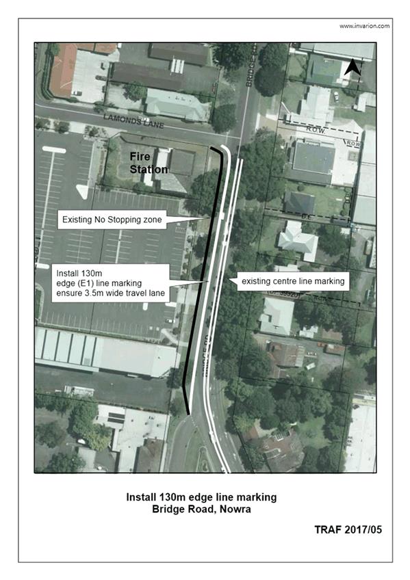
TC17.5 Edge
Line Marking - Bridge Road, Nowra (PN 3357)
HPERM Ref: D17/41195
Convenor: Martin Upitis
Attachments:
1. Proposed Edge
Line Marking - Bridge Road, Nowra ⇩
|
Recommendation
That the General Manager
(Director Assets and Works) be requested to arrange for the installation of
130m edge (E1) line marking off-set 3.5m from the existing centreline marking
on the western side of Bridge Road, Nowra from its intersection with North
Street to Lamonds Lane as detailed in the attached plan TRAF 2017/05.
|
Details
Council has been requested to install edge line marking on
the western side of Bridge Road, Nowra adjacent to the fire station to improve
delineation between the travel lane and the parking lane.
It is noted that the western side of bridge road in this
location is a No Stopping zone.
In view of addressing the request, Council is considering
installing 130m of edge line marking on the western side of Bridge Road
extending from its intersection with North Street to its intersection with
Lamonds Lane, maintaining a 3.5m wide travel lane.
The proposed line marking will assist in delineating a 3.5m
wide travel lane, and aid in delineating vehicles 2-3m (approx.) away from the
face of kerb aiding fire station vehicles when entering and exiting from the
fire station.
Consultation was carried out with affected property owners.
No submissions were received.
|
|
Shoalhaven
Traffic Committee – Tuesday 14 February 2017
Page
20
|
|

|
Shoalhaven
Traffic Committee – Tuesday 14 February 2017
Page
21
|
TC17.6 Regulatory
Signage and Line Marking - Turpentine Road, Jerrawangala (PN 3358)
HPERM Ref: D17/41223
Convenor: Martin Upitis
Attachments:
1. Regulatory
Signage and Line Marking - Turpentine Rd, Jerrawangala (under separate cover) ⇨
|
Recommendation
That the General Manager
(Director Assets and Works) be advised that the Shoalhaven Traffic Committee
has no objection to the proposed line marking on Turpentine Road,
Jerrawangala as detailed in the attached plan TRAF 2017/06.
|
Details
Council has recently completed stages 2 & 3 of the
upgrade to Turpentine Road, Jerrawangala.
Part of these works included sealing Turpentine Road from
Chainage 4600 to Chainage 8870.
As such a plan showing the
proposed line marking and regulatory signage have been submitted for the
Committee's consideration.
|
|
Shoalhaven
Traffic Committee – Tuesday 14 February 2017
Page
22
|
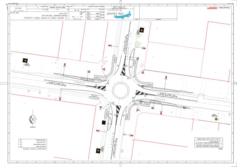
TC17.7 Proposed
Roundabout - St Vincent Street and Church Street, Ulladulla (PN 3359)
HPERM Ref: D17/41240
Convenor: Martin Upitis
Attachments:
1. Proposed
Roundabout - St Vincent St / Church St, Ulladulla ⇩
|
Recommendation
That the General Manager
(Director Assets and Works) be advised that the Shoalhaven Traffic Committee
has no objection to the roundabout and associated line marking and signage at
the intersection of St Vincent Street and Church Street, Ulladulla as
detailed in the attached plan TRAF 201/07.
|
Details
Council is completing a 2016/17 Federal Governamnet Black
Spot Program funded project at the intersection of St Vincent Street and Church
Street, Ulladulla to address cross traffic crashes at the intersection.
Proposed works include the construction of a single lane,
mountable roundabout with associated pavement works, concrete infill, painted
splitter islands on all approaches to the roundabout and and associated
regulatory signage.
A signage and linemarking plan
for the installation of a roundabout at the intersection of St Vincent Street
and Church Street, Ulladulla has been submitted for the Committee's
consideration.
|
|
Shoalhaven
Traffic Committee – Tuesday 14 February 2017
Page
23
|
|
|
Shoalhaven
Traffic Committee – Tuesday 14 February 2017
Page
24
|
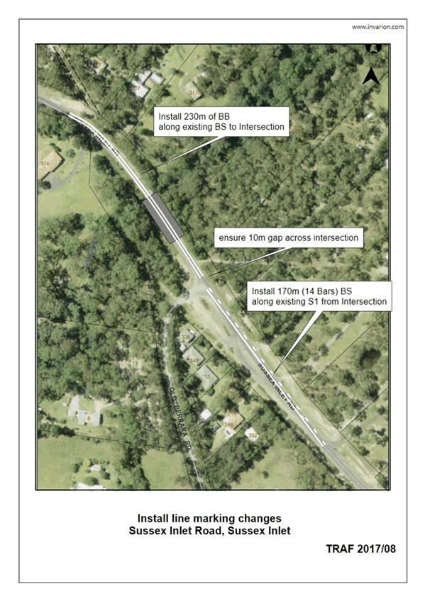
TC17.8 Line
Marking Amendments - Cow Creek Bridge, Sussex Inlet Road, Sussex Inlet (PN
3360)
HPERM Ref: D17/41259
Convenor: Martin Upitis
Attachments:
1. Line Marking
Amendments - Sussex Inlet Rd, Sussex Inlet ⇩
|
Recommendation
That the General Manager
(Director Assets and Works) be requested to arrange for the installation of
230m (approx.) double barrier (BB) centre line marking and 170m (approx.) BS
centre line marking along Sussex Inlet Road ensuring a 10m break at its
intersection with Old Berrara Road, as detailed in the attached plan TRAF
2017/08.
|
Details
Council has been advised of concerns with motorists
overtaking on Cow Creek Bridge, Sussex Inlet Road, Sussex Inlet.
Access to Old Berrara Road is adjacent to Cow Creek Bridge
and traffic heading east need to turn right just after the bridge. Although the
speed limit has been reduced for this section, overtaking is allowed on the
bridge. This has resulted in a number of near misses when cars attempting to
turn right into Old Berrara Road have experienced being overtaken as they turn.
Council has been requested to extend the double barrier line
marking across the bridge to prevent motorists overtaking at this intersection
Traffic Unit staff inspected the
site and noted that extending the double barrier line marking 230m (approx.) across
Cow Creek Bridge to the intersection of Old Berrara Road would aid in preventing
motorists overtaking on Cow Creek bridge, whilst still allowing adequate
overtaking opportunities past the Old Berrara Road intersection.
|
|
Shoalhaven
Traffic Committee – Tuesday 14 February 2017
Page
25
|
|
|
Shoalhaven
Traffic Committee – Tuesday 14 February 2017
Page
26
|
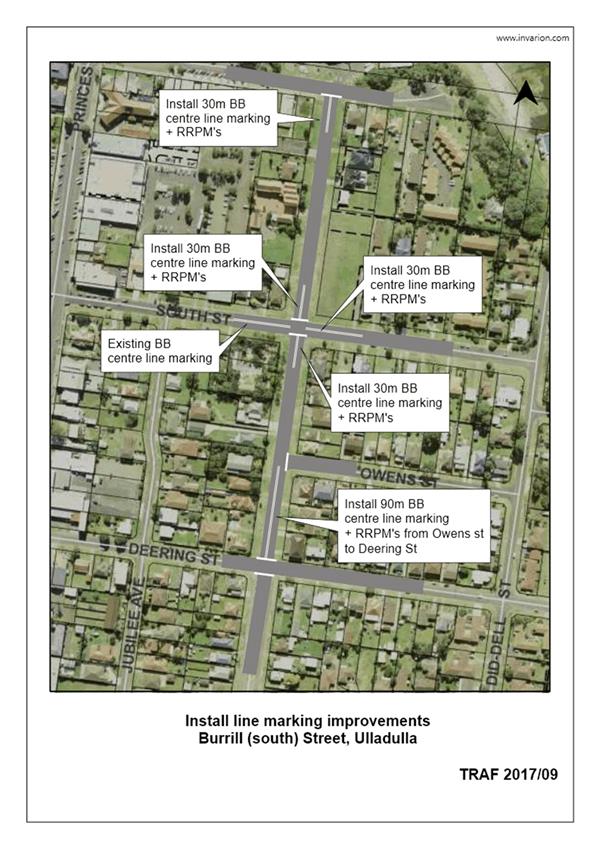
TC17.9 Centre
Line Marking - Burrill Street South, Ulladulla (PN 3361)
HPERM Ref: D17/41265
Convenor: Martin Upitis
Attachments:
1. Centre Line
Marking - Burrill Street South, Ulladulla ⇩
|
Recommendation
That the General Manager
(Director Assets and Works) be requested to arrange for the installation of
the following delineation measures as detailed in the attached plan TRAF
2017/09:
1. 30m of double barrier centre line
marking and RRPMs on all approaches to the intersection of Burrill Street
(south) and South Street, Ulladulla
2. 30m of double barrier centre line
marking and RRPMs at the intersection of Burrill Street (south) and Wason
Street, Ulladulla
3. 90m of double barrier centre line
marking and RRPMs from the intersection of Deering Street to the intersection
of Burrill Street (south) and Owens Street, Ulladulla
|
Details
Council has been requested to improve delineation along
Burrill Street (south), Ulladulla and its intersections.
In view of addressing the
request, Council is proposing to install 30m of double barrier centre line
marking and RRPMs on the approaches to the South Street intersection, 30m of
double barrier centre line marking and RRPMs at the intersection of Wason
Street and 90m of double barrier centre line marking and RRPMs from the
intersection of Deering Street to the intersection of Owens Street.
|

|
Shoalhaven
Traffic Committee – Tuesday 14 February 2017
Page
27
|