Shoalhaven Traffic Committee
Meeting Date: Tuesday,
13 December, 2016
Location: Jervis
Bay Rooms, City Administrative Centre, Bridge Road, Nowra
Time:
9.30am
Please note: Council’s
Code of Meeting Practice permits the electronic recording and broadcast of the
proceedings of meetings of the Council which are open to the public. Your
attendance at this meeting is taken as consent to the possibility that your
image and/or voice may be recorded and broadcast to the public.
Agenda
1. Apologies
2. Confirmation of Minutes
· Shoalhaven
Traffic Committee - 11 October 2016...................................................... 1
3. Business Arising from Previous Minutes
4. Reports of the Convenor
TC16.23...... Proposed No Stopping Zone (PN3217) - Bayview
Avenue, Hyams Beach.. 4
TC16.24...... Proposed Double Barrier Line Marking (PN 3349) -
Cyrus Street, Hyams Beach........................................................................................................................ 6
TC16.25...... Proposed Time Restricted No Stopping Zone (PN
3350) - Cyrus Street, Hyams Beach........................................................................................................................ 8
TC16.26...... Proposed Regulatory Signage and Line Marking
Plans (PN 3259) - Bayswood Estate, Vincentia....................................................................................................... 10
TC16.27...... Proposed Stewart Place Bus Interchange Upgrade
(PN 3287) - Stewart Place, Nowra...................................................................................................................... 12
TC16.28...... Proposed No Stopping Zone (PN 3326) - Red Point
Road, Bendalong...... 14
TC16.29...... Proposed Disabled Parking Restriction Amendment
(PN 3335) - Dolphin Court Car Park, Boree St, Ulladulla.............................................................................. 16
TC16.30...... Proposed Roundabout (PN 3340) - Intersection
Deering St and Jubilee Ave, Ulladulla...................................................................................................................... 18
TC16.31...... Proposed Raised Pedestrian Crossing (PN 3341) -
Tallwood Ave, Mollymook Beach...................................................................................................................... 20
TC16.32...... Proposed Shared Path and Pedestrian Refuges (PN
3342) - Mitchell Pde, Mollymook Beach............................................................................................................ 22
TC16.33...... Proposed Double Barrier Line Marking (PN 3345) -
Intersection Waldegrave Cres / Murray St, Vincentia..................................................................................... 24
TC16.34...... Proposed Line Marking Amendments - Mitchell Pde,
Mollymook Beach... 26
TC16.35...... Proposed Car and Trailer Parking (PN 3347) -
Nielson Lane Boat Ramp, Sussex Inlet...................................................................................................................... 30
TC16.36...... Proposed Pedestrian Refuge (PN 3351) -
Intersection West Birriley Street & North Tarawal Street Bomaderry........................................................................... 32
TC16.37...... Proposed Regulatory signage & Line Marking
(PN 3352) - Orion Beach Shared Path, Vincentia....................................................................................................... 34
5. General Business
Note:
The next meeting will be held on Tuesday 14 February 2017.
|

|
Shoalhaven
Traffic Committee – Tuesday 13 December 2016
Page
iii
|
Membership
Mr Martin Upitis
Mr Jesse Fogg
Sergeant Mick Tebbutt
Mr Alan Trass
Mr Stuart Coughlan
Clr Jo Gash
Clr Andrew Guile
Clr Patricia White
The Shoalhaven Traffic Committee is a technical review
committee, not a committee of Council under the Local Government Act 1993. The
Roads and Maritime Services (RMS) has delegated certain powers to Council under
the Transport Administration Act 1988 (Section 50). A condition of this
delegation is that Council must take into account the Traffic Committee
recommendations.
There are four formal members of the Traffic Committee, each
of whom has a single vote only. The members are representatives from:
- NSW Police Force
- RMS
- Shoalhaven City Council
- Local State Member of Parliament (for the location of the
issue to be voted upon)
If the RMS or NSW Police Force disagrees with any Traffic
Committee recommendation, or Council’s resolution (on any Traffic
Committee recommendation), they may lodge an appeal with the Regional Traffic
Committee for determination. The appeal must be lodged in writing within
14 days of the date of notification in writing. Any action relative to
any issue under appeal must cease until the matter is determined. The
Regional Traffic Committee is chaired by an independent chairperson and
submissions and representations are welcomed from all interested parties.
Council cannot amend a Traffic Committee recommendation. The
Council can only: adopt the Traffic Committee recommendation; not adopt the
Traffic Committee recommendation, or request the Traffic Committee reconsider
the issue.
The full guide to the delegation to Council’s for
the regulation of traffic can be viewed at RMS
Website
Minutes of the Shoalhaven Traffic
Committee 11 October 2016
Page 1
Minutes of the Shoalhaven Traffic Committee
Meeting Date: Tuesday,
11 October 2016
Location: Jervis
Bay Room 3, City Administrative Centre, Bridge Road, Nowra
Time: 9.35am
The following members
were present:
Mr Martin Upitis - Assets
Manager
Mr Kristian Pinochet
Mr Alan Trass
Mr Stuart Coughlan
Clr Patricia White
Others Present:
Daniel Dunstan –
Traffic Investigation Officer
|
Apologies / Leave of Absence
|
Nil
|
Confirmation of the Minutes
|
|
RESOLVED (By consent)
That the Minutes of the
Traffic Committee held on Tuesday 13 September 2016 be confirmed.
CARRIED
|
|
Business Arising from Previous Minutes
|
Nil
Reports of the Convenor
|
TC16.16 Proposed
Line Marking Amendments - Mount Agony Road, East Lynne (PN 1717) 1691E
|
HPERM Ref:
D16/313345
|
|
Recommendation (By consent)
1. That
the General Manager (Director Assets and Works) be requested to arrange for
the amendment of centre line marking on Mount Agony Road and North Durras
Road, on a trial basis with conditions to be monitored and reviewed in 12
months’ time, as detailed in TRAF 2016/77, by removing the existing
double barrier (BB) line marking and installing the following line marking
changes:
a. North
Durras Road (Ch.0 Mawson Street intersection)
i. Ch.
1.60 – 145m BS, 121m S1, 145m BS – 411m (downhill designed at 70 km/h)
ii. Ch.
3.70 – 120m BS, 75m S1, 120m BS – 315m (straight designed at 60
km/h)
b. Mount
Agony Road (Ch.0 North Durras Road intersection)
i. Ch.
1.50 – 145m BS, 160m S1, 145m BS – 450m (downhill designed at 70
km/h)
ii. Ch.
2.00 – 120m BS, 160m S1, 120m BS – 400m (straight designed at 60
km/h)
|
|
TC16.17 Proposed
Give Way Sign - Intersection Hayward Road & Hayward Road (private),
Wandandian (PN 1723) 6324E
|
HPERM Ref:
D16/313397
|
|
Recommendation (By consent)
That the General Manager
(Director Assets and Works) be requested to arrange for the installation of a
Give Way (R1-2B), associated TB/TB1 line marking and double barrier line
marking at the intersection of Haywards Road and Haywards (Private) Road,
Wandadian as detailed in plan TRAF 2016/78.
|
|
TC16.18 Proposed
No Stopping Zone - Pitt Street, North Nowra (PN 3268) 2932E
|
HPERM Ref:
D16/313432
|
|
Recommendation (By consent)
That the
General Manager (Director Assets and Works) be requested to arrange for the
installation of a No Stopping zone (approximately 2m) either side of the
driveway access to property no. 100 Pitt Street, North Nowra as detailed in
plan TRAF 2016/79.
|
|
Note:
The Committee discussed alternative ways in which to make information
available to Councillors prior to the Shoalhaven Traffic Committee meetings
to enable opportunity to provide comments/feedback. The Committee agreed,
that at the time public consultation occurs, an electronic copy of the public
consultation information is to be sent to Councillors.
|
|
TC16.19 Proposed
Give Way Sign - Dalwah Street, Bomaderry (PN 3320) 1667E
|
HPERM Ref:
D16/313471
|
|
Recommendation (By consent)
1. That
the General Manager (Director Assets and Works) be requested to arrange for
the installation of the following delineation measures at the intersection of
Tarawara Street and Dalwah Street, Bomaderry as detailed in plan TRAF
2016/80:
a. a
Give Way sign and associated TB/TB1 hold line marking
b. 55m
double barrier (BB) line marking with a 10m break
c. A
W2-4B (L) side road junction warning sign 60m on the western approach to the
intersection
|
|
TC16.20 Proposed
No Right Turn - Buchan Street, Mollymook (PN 3331) 1704E
|
HPERM Ref:
D16/313505
|
|
Recommendation (By consent)
That the General Manager (Director Assets and Works)
be requested to arrange for the installation of a No Right Turn (left turn
only) treatment at the intersection of Golf Avenue and Buchan Street,
Mollymook as detailed in plan TRAF 2016/82.
|
|
TC16.21 Proposed
Roundabout - Kerry Street, Sanctuary Point (PN 3332) 3218E
|
HPERM Ref:
D16/313559
|
|
Recommendation (By consent)
That the General Manager (Director Assets &
Works) be advised that the Shoalhaven Traffic Committee has no objections to
the proposed traffic facility at the intersection of Kerry Street and
Paradise Beach Road, Sanctuary Point as detailed in TRAF 2016/83.
|
|
TC16.22 Proposed
Roundabout - Sussex Inlet Road & Golf Course Way, Sussex Inlet (PN 3333)
SF10425-03
|
HPERM Ref:
D16/313591
|
|
Recommendation (By consent)
1. That
the General Manager (Director Assets and Works) be advised that the
Shoalhaven Traffic Committee has no objection to the proposed roundabout at
the intersection of Golf Course Way and Sussex Inlet Road, Sussex Inlet as
detailed in plans (26751_103_Rev2, 26751_107_Rev2 and 26751_108_Rev2) TRAF
2016/84 a, b &c, subject to:
a. Being
the main access road into the subdivision, the full length of Road 01 travel
lanes are to be increased from 3.5m to 4.5m wide
b. The
angle of the splayed line marking in the splitter islands on Sussex Inlet
Road are to be amended to 45 degrees in accordance with AS1742.2
c. Other
matters to be adressed in accordance with Shoalhaven Development Control plan
2014 (chapter S2: Badgee urban release area) to mitigate any adverse
environmental impacts on residents.
|
|
Clr White
asked if the proposed changes will allow sufficient turning room into
driveways for car and truck access. It was confirmed that vehicle
turning requirements were considered in the proposal and are appropriate.
|
There being no further
business, the meeting concluded, the time being 10.00am.
Martin Upitis
CHAIRPERSON
|

|
Shoalhaven
Traffic Committee – Tuesday 13 December 2016
Page
4
|
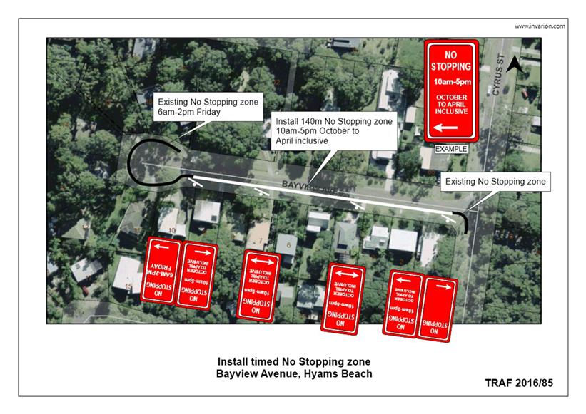
TC16.23 Proposed
No Stopping Zone (PN3217) - Bayview Avenue, Hyams Beach
HPERM Ref: D16/383460
Convenor: Martin Upitis
Attachments:
1. TRAF 2016/85 - Proposed No Stopping Zone -
Bayview Ave, Hyams Beach ⇩
|
Recommendation
That General Manager (Director
Assets and Works) be requested to arrange for the installation of a 140m time
restricted No Stopping zone ‘10am-5pm October to April Inclusive’
on the southern side of Bayview Avenue, Hyams Beach as detailed in the
attached plan TRAF 2016/85.
|
Details
Council has been requested by the Hyams Beach Villagers
Association to review parking restrictions within Bayview Avenue, Hyams Beach.
Council has been advised that parked vehicles are restricting
the movement of vehicles into and out of Bayview Avenue.
In view of addressing the concern, Council is considering
installing a time restricted No Stopping zone (10am-5pm October to April
inclusive), for a distance of 140m on the southern side of Bayview Avenue,
extending from the existing No Stopping zone at the intersection of Cyrus
Street and Bayview Avenue, to the existing time restricted No Stopping zone
(6am-2pm Fridays) in the cul-de-sac.
The impact of the proposal will mean that motorists will be
unable to park on the southern side of Bayview Avenue, between the times of
10am-5pm, during the months of October to April inclusive.
Traffic Unit staff have inspected the location and noted
that a No Stopping zone along the southern side of the road would aid in
alleviating traffic congestion.
Consultation was carried out with affected property owners
and the Hyams Beach Villagers Association. Nine submissions were received.
Seven submissions support the proposal whilst two submissions did not support
the proposal due to lack of kerb and gutter on the eastern side of Baysview
Avenue and the impact to resident’s access to on-street parking. The
proposal is supported by the Hyams Beach Villagers Association.
|

|
Shoalhaven
Traffic Committee – Tuesday 13 December 2016
Page
5
|
|

|
Shoalhaven Traffic
Committee – Tuesday 13 December 2016
Page
6
|
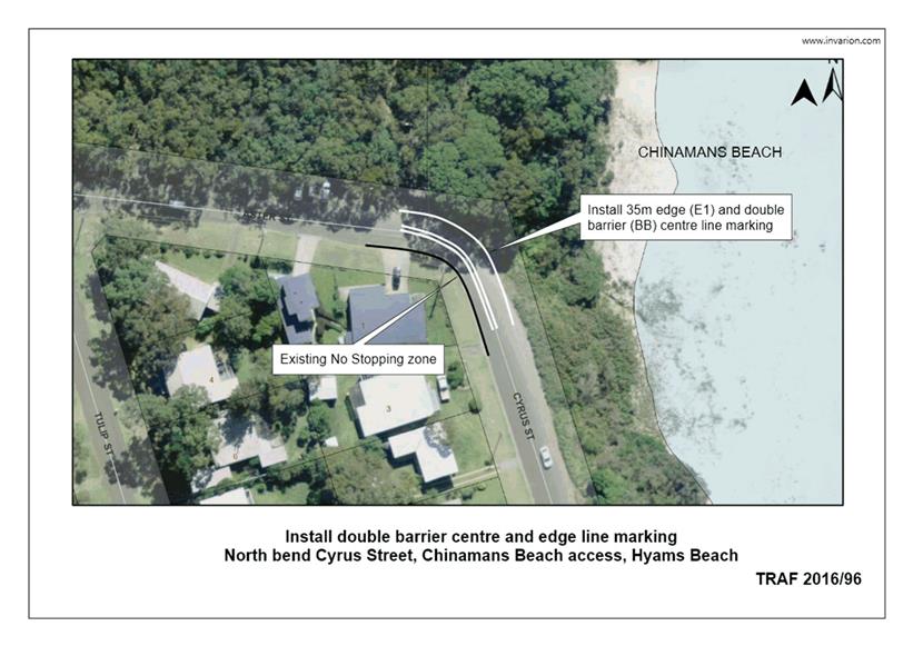
TC16.24 Proposed
Double Barrier Line Marking (PN 3349) - Cyrus Street, Hyams Beach
HPERM Ref: D16/383556
Convenor: Martin Upitis
Attachments:
1. TRAF 2016/96 -
Proposed Double Barrier Line Marking - Cyrus St, Hyams Beach ⇩
|
Recommendation
That General Manager (Director Assets
and Works) be requested to arrange for the installation of 35m double barrier
centre line marking and edge line marking around the corner of Cyrus Street
and Aster Street, Hyams Beach, adjacent to the Chinamans Beach access to
assist in maintaining 3m wide travel lanes, as detailed in the attached plan
TRAF 2016/96.
|
Details
Council has been advised of concerns with vehicles parking
at the northern corner of Cyrus Street and Aster Street adjacent to Chinaman's
Beach entrance, Hyams Beach.
Parking in this location restricts two-way traffic flow
around the bend and impacts on pedestrian movements.
Council is proposing to install 35m double barrier centre
line marking and edge line marking around the bend to assist in delineating two
3m wide travel lanes in both directions.
NSW road rules prevent parking within 3m of double barrier
line marking.
Consultation was carried out with affected property owners.
No submissions were received in
relation to the proposal
|
|
Shoalhaven
Traffic Committee – Tuesday 13 December 2016
Page
7
|
|
|
Shoalhaven
Traffic Committee – Tuesday 13 December 2016
Page
8
|
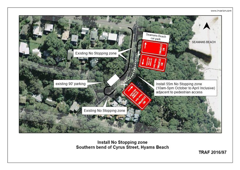
TC16.25 Proposed
Time Restricted No Stopping Zone (PN 3350) - Cyrus Street, Hyams Beach
HPERM Ref: D16/383595
Convenor: Martin Upitis
Attachments:
1. TRAF 2016/98 -
Proposed Time Restricted No Stopping Zone - Cyrus St, Hyams Beach ⇩
|
Recommendation
That General Manager (Director
Assets and Works) be requested to arrange for the installation of a 55m No
Stopping time restricted zone ‘10am-5pm October to April inclusive’
at the southern end of Cyrus Street, Hyams Beach adjacent to the pedestrian
access to Seamans Beach, as detailed in the attached plan TRAF 2016/97.
|
Details
Council has been advised of concerns with vehicles parking
at the southern end of Cyrus Street adjacent to the pedestrian access to
Seamans Beach, Hyams Beach.
Parking in this location restricts two way traffic flow
around the bend which has limited sight distance.
In view of addressing the concerns raised, Council is
considering installing a time restricted No Stopping zone during the peak
period (10am-5pm October to April inclusive), for a distance of 55m on the
south eastern side of Cyrus Street adjacent to the Seamans beach access.
The impact of the proposal will mean that motorists will be
unable to park along the south eastern side of Cyrus Street in this location,
between the times 10am-5pm, October to April inclusive.
Consultation was carried out
with affected property owners and Hyams Beach Villagers Association. Two
submissions were received, one supports the proposal and one is against the
proposal, citing greater impact on parking within Silver Strand Circuit.
|

|
Shoalhaven
Traffic Committee – Tuesday 13 December 2016
Page
9
|
|
|
Shoalhaven
Traffic Committee – Tuesday 13 December 2016
Page
10
|
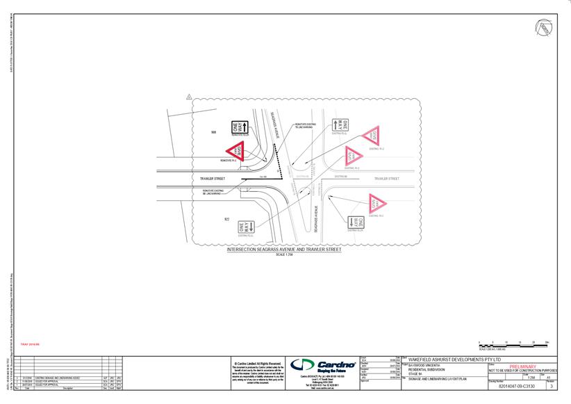
TC16.26 Proposed
Regulatory Signage and Line Marking Plans (PN 3259) - Bayswood Estate,
Vincentia
HPERM Ref: D16/383677
Convenor: Martin Upitis
Attachments:
1. TRAF 2016/86 -
Proposed Regulatory Signage & Line Marking Plans - Bayswood Estate,
Vincentia ⇩
|
Recommendation
That the General Manager (Director
Assets and Works) be advised that the Shoalhaven Traffic Committee has no
objection to the proposed regulatory signage and line marking at the
intersection of Seagrass Avenue and Trawler Street, Vincentia as detailed in
the attached plan TRAF 2016/86.
|
Details
Applicant: Stockland Development PTY LTD
Owner: Stockland Development PTY LTD
SF9786 – Lot 802 DP 1022286 - Stage 9a - Bayswood
Estate, Vincentia
The Committee may recall previous discussions in relation to
the Stockland's Development at Vincentia.
A Regulatory signage and line
marking plan for Stage 9a, Bayswood Estate, Vincentia has been submitted for
the Committee's consideration
|
|
Shoalhaven
Traffic Committee – Tuesday 13 December 2016
Page
11
|
|

|
Shoalhaven
Traffic Committee – Tuesday 13 December 2016
Page
12
|
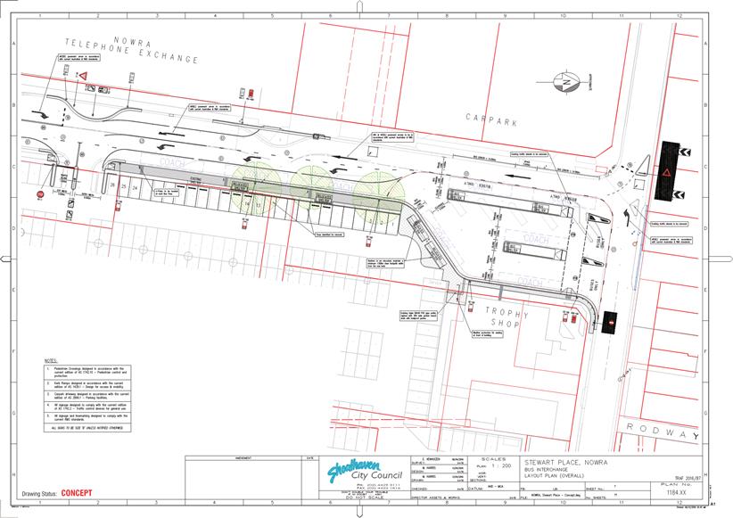
TC16.27 Proposed
Stewart Place Bus Interchange Upgrade (PN 3287) - Stewart Place, Nowra
HPERM Ref: D16/383716
Convenor: Martin Upitis
Attachments:
1. TRAF 2016/87 -
Stewart Place Bus Interchange, Nowra ⇩
|
Recommendation
That General Manager (Director Assets
and Works) be advised that the Shoalhaven Traffic Committee has no objection
to the proposed signage and line marking at the Stewart Place Bus
Interchange, Nowra as detailed in the attached plan TRAF 2016/87.
|
Details
Council has committed funding in the 2016/17 financial year
towards the upgrade of the Stewart Place Bus Interchange.
Council at its meeting on 16 August 2016 adopted the
following:
That Council complete the full upgrade works identified
at the bus interchange in Stewart Place, Nowra including but not limited to
additional bus parking and improved passenger access, through the replacement
of kerb and gutter, footpaths, service relocation and realigning access to the
car park at a cost of $254,000 and be funded by;
a) Country Passenger Transport Infrastructure Grants
Scheme funding of $ 39,000 currently allocated within the Traffic Facilities
Program for Stage 1 2016/17
b) Additional funding of $215,000 for Stage 2 to be
allocated to the Traffic Facilities Program (2016/17), by reallocation of
General Fund from the capital roads program 2016/17 and the roads program funds
be sourced and committed from unallocated Roads to Recovery funds;
c) Works for Stage 1 commence in the 2016/2017 financial
year to meet the funding milestone and Stage 2 to be progressed concurrently to
minimise disruption to passengers
A detailed plan has been submitted for the Committee's
consideration.
It is proposed to close the northern entry to the Stewart
Place car park (located south of the existing bus interchange. The existing
southern exit only access (north of Worrigee Street) will be widened to
accommodate entry and exit. As a consequence of closing the northern car park
access, the current two way traffic arrangement in Stewart Place will be
altered by extending the one way traffic flow further south. As a result of the
altered arrangement, access to the driveway adjacent to the Telstra tower will
be from Stewart Place via Schofields Lane.
Consultation was carried out with affected property owners
and bus companies. One submission was received in support of the proposal.
|
|
Shoalhaven
Traffic Committee – Tuesday 13 December 2016
Page
13
|
|
|
Shoalhaven Traffic
Committee – Tuesday 13 December 2016
Page
14
|
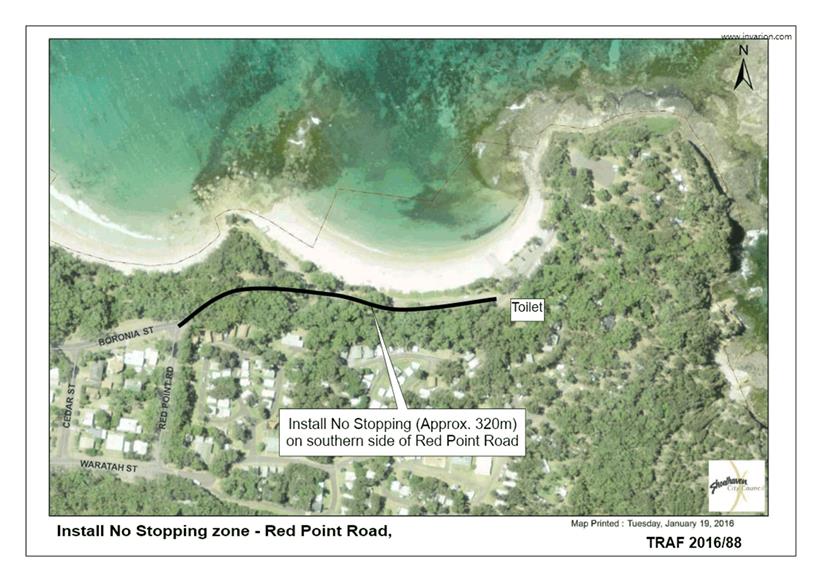
TC16.28 Proposed
No Stopping Zone (PN 3326) - Red Point Road, Bendalong
HPERM Ref: D16/383734
Convenor: Martin Upitis
Attachments:
1. TRAF 2016/88 -
Proposed No Stopping Zone - Red Point Rd, Bendalong ⇩
|
Recommendation
That General Manager (Director
Assets and Works) be requested to arrange for the installation of a No
Stopping zone for a distance of approx. 320m on the southern side of Red
Point Road, Bendalong as detailed in the attached plan TRAF 2016/88.
|
Details
Council has been requested to consider installing a No
Stopping zone on the southern side of Red Point Road, Bendalong, opposite the
grassed parking area, due to parked vehicles restricting vehicle movement along
Red Point Road.
In view addressing the request, Council is considering
installing a No Stopping zone approximately 320m on the southern side of Red
Point Road. The proposed No Stopping zone will extend from the (western)
intersection of Boronia Street and Red Point Road to the power pole opposite
the (eastern) car park toilets.
The impact of this proposal will mean that motorists will be
unable to park in this location
Consultation was carried out with property owners of
surrounding streets, the Red Head Villages Association and the Bendalong Point
Tourist Park.
Eight submissions (one verbal) were received. Six of the
submissions support the proposal and one objected to the proposal. The proposal
is supported by the Red Head Villages Association.
|
|
Shoalhaven
Traffic Committee – Tuesday 13 December 2016
Page
15
|
|
|
Shoalhaven
Traffic Committee – Tuesday 13 December 2016
Page
16
|
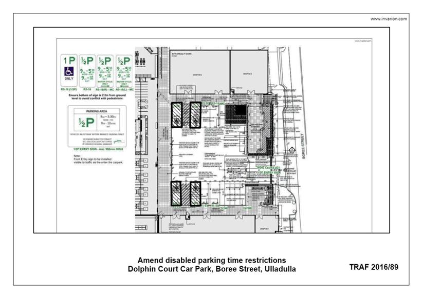
TC16.29 Proposed
Disabled Parking Restriction Amendment (PN 3335) - Dolphin Court Car Park,
Boree St, Ulladulla
HPERM Ref: D16/383778
Convenor: Martin Upitis
Attachments:
1. TRAF 2016/89 -
Dolphin Court Car Park, Boree St, Ulladulla ⇩
|
Recommendation
That General Manager (Director
Assets and Works) be advised that the Shoalhaven Traffic Committee has no
objection to the proposed 1 hour (1P) disabled parking space restrictions within
the Coles Car Park (Dolphin Court), Boree Street, Ulladulla as detailed in
the attached plan TRAF 2016/89.
|
Details
Council has been advised of concerns regarding the current
time restrictions on disabled parking spaces within the patrolled private Coles
Car Park (Dolphin Court), Boree Street, Ulladulla.
This carpark is under an agreement with the property owner
and Council for Council Rangers to enforce parking restrictions within the car
park.
In view of addressing the concerns, the car park owners
Sheffield Crest have agreed to amend the time restriction of the four existing
disabled parking spaces in the Coles car park (Dolphin Court) from half hour
(1/2P) parking to 1 hour (1P) parking.
The proposed time extension will
allow disabled patrons a more appropriate time period to utilise the zone.
|
|
Shoalhaven
Traffic Committee – Tuesday 13 December 2016
Page
17
|
|
|
Shoalhaven
Traffic Committee – Tuesday 13 December 2016
Page
18
|
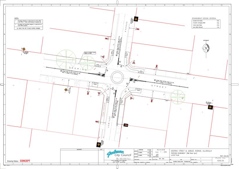
TC16.30 Proposed
Roundabout (PN 3340) - Intersection Deering St and Jubilee Ave, Ulladulla
HPERM Ref: D16/383804
Convenor: Martin Upitis
Attachments:
1. TRAF 2016/90 -
Proposed Roundabout - Deering St / Jubilee Ave, Ulladulla ⇩
|
Recommendation
That General Manager (Director
Assets and Works) be advised that the Shoalhaven Traffic Committee has no
objection to the proposed signage and line marking at the proposed roundabout
at the intersection of Deering Street and Jubilee Avenue, Ulladulla, as
detailed in the attached plan TRAF 2016/90.
|
Details
Council is completing a 2016/17 Federal Government Black
Spot Program funded project at the intersection of Deering Street and
Jubilee Avenue, Ulladulla to address cross traffic crashes at the intersection.
Proposed works include the construction of a single lane
mountable rubber roundabout with concrete infill, painted splitter islands on
all approaches to the roundabout and associated regulatory signage.
A signage and line marking plan for the installation of a
roundabout at the intersection of Deering Street and Jubilee Avenue, Ulladulla
has been submitted for the Committee's consideration.
Consultation was carried out with affected property owners,
bus companies and the Ulladulla & Districts Community Forum.
No submissions were received.
|
|
Shoalhaven
Traffic Committee – Tuesday 13 December 2016
Page
19
|
|
|
Shoalhaven
Traffic Committee – Tuesday 13 December 2016
Page
20
|
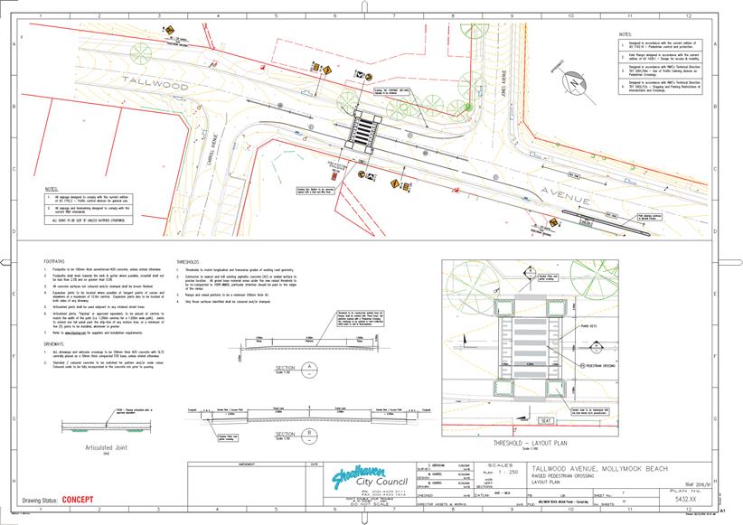
TC16.31 Proposed
Raised Pedestrian Crossing (PN 3341) - Tallwood Ave, Mollymook Beach
HPERM Ref: D16/383819
Convenor: Martin Upitis
Attachments:
1. TRAF 2016/91 -
Raised Pedestrian Crossing - Tallwood Ave, Mollymook Beach ⇩
|
Recommendation
That General Manager (Director
Assets and Works) be advised that the Shoalhaven Traffic Committee has no
objection to the proposed signage and line marking at the proposed pedestrian
crossing on Tallwood Avenue, Mollymook Beach, as detailed in the attached
plan TRAF 2016/91.
|
Details
Council has been successful in gaining funding under the NSW
Active Transport Program in the 2016/17 financial year towards the provision of
a raised pedestrian crossing in Tallwood Avenue, Mollymook Beach (between
Carroll Avenue and Jones Avenue).
The proposed works are in response to requests received over
a number of years from the community to address pedestrian safety in Tallwood
Avenue.
The proposed project aims to complete the following:
1. The installation of a raised, marked pedestrian crossing
that incorporates kerb extensions with landscaping. New signage and line
marking in accordance with standards will also be installed.
2. Removal of the existing bus shelter adjacent to the new
shopping centre at the location of the crossing. A new bike rack and seat will
be installed in this location. A new slim bus shelter will be installed at the
location of the recently located bus zone between the driveways of the new
shopping centre. Additional path widening works will also be carried out at
this location to accommodate the new bus shelter.
Consultation was carried out
with property owners/business operators, relevant bus companies and Ulladulla
& Districts Community Forum (UDCF). The proposal is unanimously supported
by UDCF and broadly supported by the community
|

|
Shoalhaven
Traffic Committee – Tuesday 13 December 2016
Page
21
|
|
|
Shoalhaven
Traffic Committee – Tuesday 13 December 2016
Page
22
|
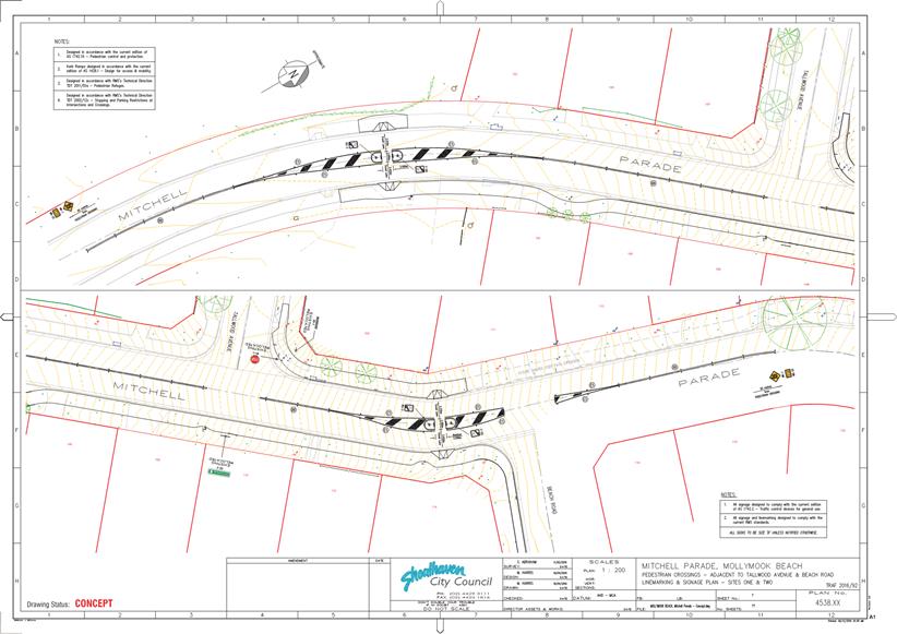
TC16.32 Proposed
Shared Path and Pedestrian Refuges (PN 3342) - Mitchell Pde, Mollymook Beach
HPERM Ref: D16/383834
Convenor: Martin Upitis
Attachments:
1. TRAF 2016/92 -
Shared Path/Pedestrian Refuges - Mitchell Pde, Mollymook Beach ⇩
|
Recommendation
That the General Manager
(Director Assets and Works) be advised that the Shoalhaven Traffic Committee
has no objection to the proposed signage and line marking at the proposed
pedestrian refuge treatment and shared path in Mitchell Parade, Mollymook
Beach north and south of Tallwood Avenue as detailed in the attached plan
TRAF 2016/92.
|
Details
Council is proposing to construct a shared path in 2016/17
financial year along the eastern side of Mitchell Parade and extending into the
southern side of Beach Road, Mollymook Beach. As part of the proposal, Council
will be installing two new pedestrian refuges on Mitchell Parade, north and
south of Tallwood Avenue to improve pedestrian safety.
The path and crossing works are to be part funded under the
NSW Government's Active Transport program (50%) with Council funding 50%.
A concept plan for the proposed shared path and pedestrian
refuges has been submitted for the Committee's consideration.
Extensive consultation was
undertaken with the community and presented at the Ulladulla & Districts
Community Forum (UDCF) meeting. The proposal was unanimously supported by UDCF
and broadly supported by the community.
|
|
Shoalhaven
Traffic Committee – Tuesday 13 December 2016
Page
23
|
|
|
Shoalhaven
Traffic Committee – Tuesday 13 December 2016
Page
24
|
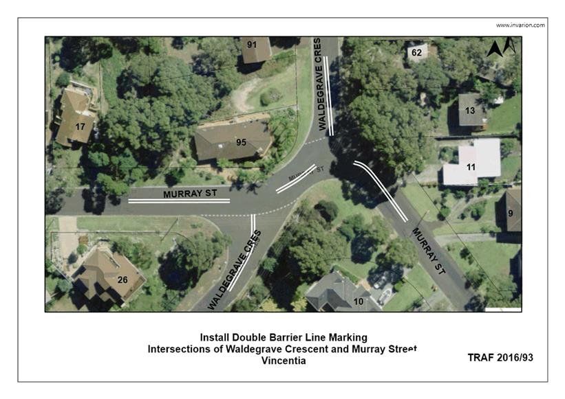
TC16.33 Proposed
Double Barrier Line Marking (PN 3345) - Intersection Waldegrave Cres / Murray
St, Vincentia
HPERM Ref: D16/383849
Convenor: Martin Upitis
Attachments:
1. TRAF 2016/93 -
Proposed Double Barrier Line Marking - Murray St / Waldegrave Cres, Vincentia ⇩
|
Recommendation
That the General Manager
(Director Assets and Works) be requested to arrange for the installation of
the following, as detailed in the attached plan TRAF 2016/93:
a. 100m of double barrier (BB) centre
line marking on Murray Street, Vincentia adjacent to its intersections with
Waldegrave Crescent, providing 10m breaks at its intersections
b. 30m of double barrier (BB) centre
line marking on Waldegrave Crescent at the approaches of Murray Street,
Vincentia
|
Details
Council has been advised of concerns with the current levels
of delineation surrounding the intersection of Murray Street and Waldegrave
Crescent, Vincentia.
In view of addressing the concerns raised, Council’s
Traffic Unit is considering installing 100m of double barrier line marking
around the curves of Murray Street adjacent to its intersections with
Waldegrave Crescent, providing 10m breaks at its intersection with Waldegrave
Crescent. Additionally, Council is considering installing 30m lengths of double
barrier centre line marking on the Waldegrave Crescent approaches to Murray
Street.
As the intersection of Waldegrave Crescent and Murray Street
is a staggered intersection, the proposed linemarking will provide clearer
delineation of the travel lanes around the curve on Murray Street at its
intersection with Waldegrave Crescent.
Consultation was carried out with affected
residents/property owners, Nowra Coaches and Vincentia Ratepayers and Residents
Association.
Two submissions were received in
support of the proposal. The proposal is supported by the Vincentia Ratepayers
and Residents Association.
|

|
Shoalhaven
Traffic Committee – Tuesday 13 December 2016
Page
25
|
|
|
Shoalhaven
Traffic Committee – Tuesday 13 December 2016
Page
26
|
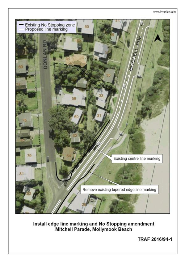
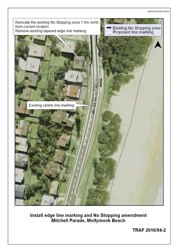
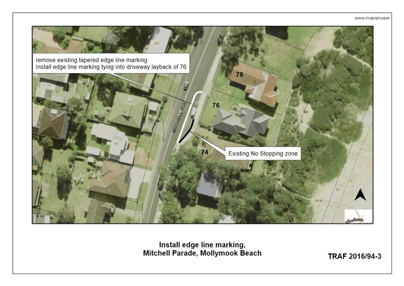
TC16.34 Proposed
Line Marking Amendments - Mitchell Pde, Mollymook Beach
HPERM Ref: D16/383860
Convenor: Martin Upitis
Attachments:
1. TRAF 2016/94 -
Proposed Line Marking Amendments - Mitchell Pde, Mollymook Beach ⇩
|
Recommendation
That the General Manager
(Director Assets and Works) be requested to arrange for the installation of
the following, as detailed in the attached plan TRAF 2016/94:
1. Amend the current edge line marking
located in front of 74 and 76 Mitchell Parade, such that it ties into the
driveway access of 76 Mitchell Parade delineating a 3.5m wide travel lane
from on-street parking providing two additional parking spaces
2. Remove the current edge line marking
tapers adjacent to 28 & 59 Mitchell Parade providing an additional
parking space
3. Install edge line marking on the
eastern and western side of Mitchell Parade between 28 & 61 Mitchell
Parade, delineating 3.5m wide travel lanes and 3m wide parking lanes
4. Relocate the existing No Stopping
sign adjacent to property 59 Mitchell Parade 1.5m north providing one
additional parking space in this location
|
Details
Staff from Council's Traffic
Unit reviewed the existing edge line marking on Mitchell Parade due to the
existing line marking and no stopping zones unnecessarily restricting parking between
the northern and southern intersections of Donlan Road, and propose the
following adjustments:
a) Amend the current edge line
marking located in front of 74 and 76 Mitchell Parade, such that it ties into
the driveway access of 76 Mitchell Parade delineating a 3.5m wide travel lane
from on-street parking providing two additional parking spaces
b) Remove the current edge line
marking tapers adjacent to 28 & 59 Mitchell Parade providing an additional
parking space
c) Install edge line marking on
the eastern and western side of Mitchell Parade between 28 & 61 Mitchell
Parade, delineating 3.5m wide travel lanes and 3m wide parking lanes
d) Relocate the existing No
Stopping sign adjacent to property 59 Mitchell Parade 1.5m north providing one
additional parking space in this location
The ammendments to signage and
line marking in this location will aid in delineating traffic along Mitchell
Parade from the provided parking lanes whilst adding additional on-street
parking. The new line marking will aid in delineating traffic on approach to
the reduced width section of Mitchell Parade between properties 59 and 74.
Consulation was carried out with
affected property owners and the Ulladulla & Districts Community Forum. One
submission was received in support of the proposal.
|
|
Shoalhaven
Traffic Committee – Tuesday 13 December 2016
Page
27
|
|
|
Shoalhaven
Traffic Committee – Tuesday 13 December 2016
Page
29
|
|
|
Shoalhaven
Traffic Committee – Tuesday 13 December 2016
Page
30
|
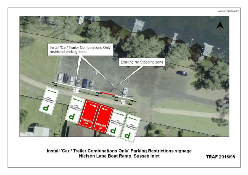
TC16.35 Proposed
Car and Trailer Parking (PN 3347) - Nielson Lane Boat Ramp, Sussex Inlet
HPERM Ref: D16/383877
Convenor: Martin Upitis
Attachments:
1. TRAF 2016/95 -
Proposed Car and Trailer Parking - Nielson Lane, Sussex Inlet ⇩
|
Recommendation
That the General Manager
(Director Assets and Works) be requested to arrange for the installation of
‘car / trailer combinations only’ restricted parking signage on
the southern side of the Nielson Lane Boat Ramp, Sussex Inlet as detailed in
the attached plan TRAF 2016/95.
|
Details
Council has been requested to install car and trailer only
parking signage adjacent to the Nielson Lane boat ramp, Sussex Inlet.
Council provides 10 un-marked spaces adjacent to the boat
ramp for the parking of car and boat trailer combinations. These spaces are
provided to decrease the impact of these combinations parking in surrounding
streets.
To reinforce to motorists that the provided parking is for
car and trailer parking only, Council is proposing to install 'car / trailer
combinations only' parking restriction signage adjacent to these spaces.
Consultation was carried out with the Sussex Inlet Community
Forum and relevant user groups.
No submissions were received in
relation to the proposal.
|
|
Shoalhaven
Traffic Committee – Tuesday 13 December 2016
Page
31
|
|
|
Shoalhaven
Traffic Committee – Tuesday 13 December 2016
Page
32
|
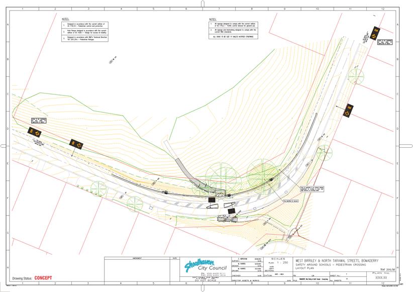
TC16.36 Proposed
Pedestrian Refuge (PN 3351) - Intersection West Birriley Street & North
Tarawal Street Bomaderry
HPERM Ref: D16/383902
Convenor: Martin Upitis
Attachments:
1. TRAF 2016-98 -
Proposed Pedestrian Refuge West Birriley St & North St Bomaderry ⇩
|
Recommendation
That the General Manager (Director
Assets and Works) be advised that the Shoalhaven Traffic Committee has no
objection to the proposed signage and line marking as detailed in the
attached plan TRAF 2016/98.
|
Details
Council has been successful in
gaining funding under the NSW Active Transport Program in the 2016/17 financial
year towards the provision of a pedestrian refuge at the intersection of North
Tarawal Street and West Birriley Street, Bomaderry.
The proposed works are in
response to requests received over a number of years from the community to
address pedestrian safety at this intersection.
Consultation was carried out
with affected property owners/residents, local schools and the Pride of
Bomaderry.
No submissions were received in
relation to the proposal.
|
|
Shoalhaven
Traffic Committee – Tuesday 13 December 2016
Page
33
|
|
|
Shoalhaven
Traffic Committee – Tuesday 13 December 2016
Page
34
|
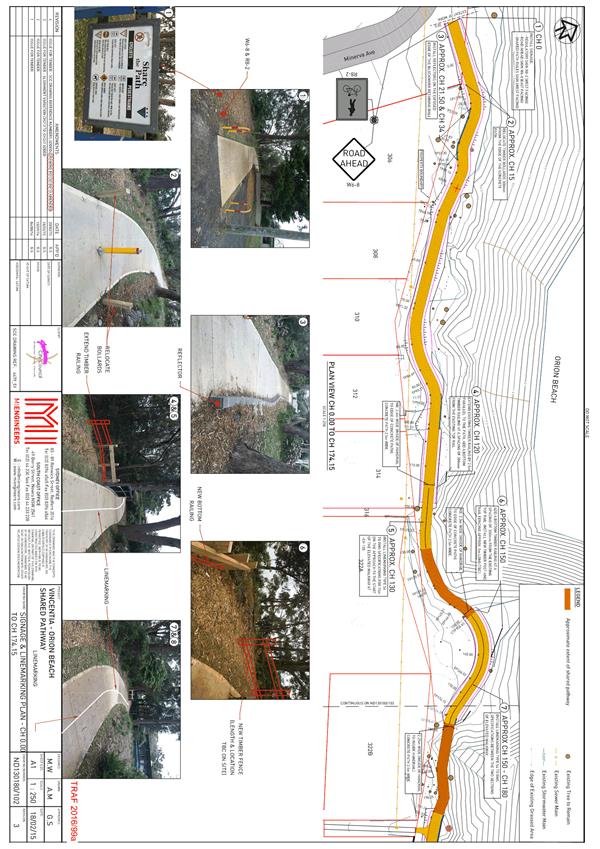
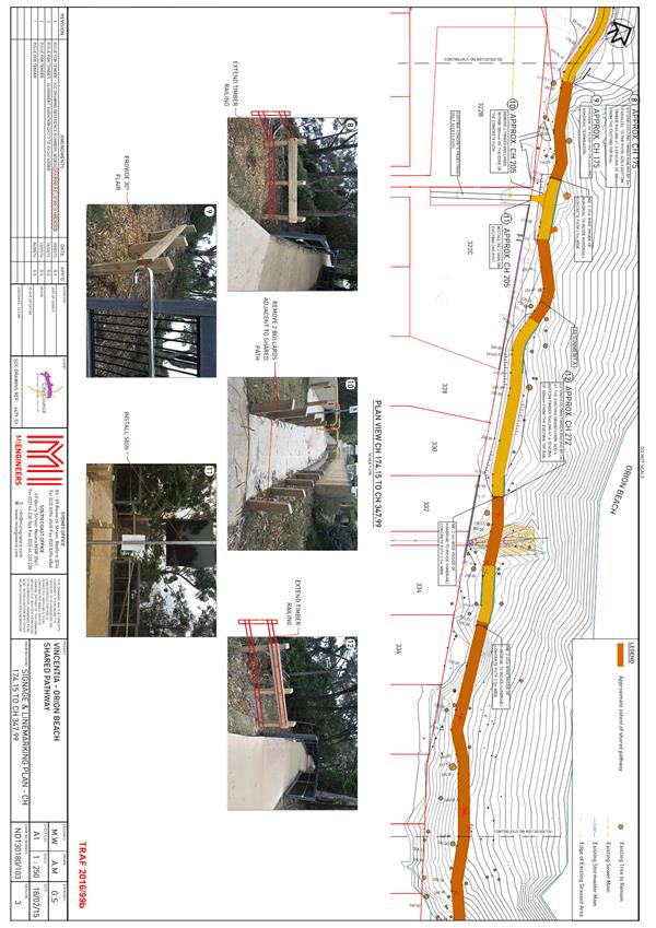
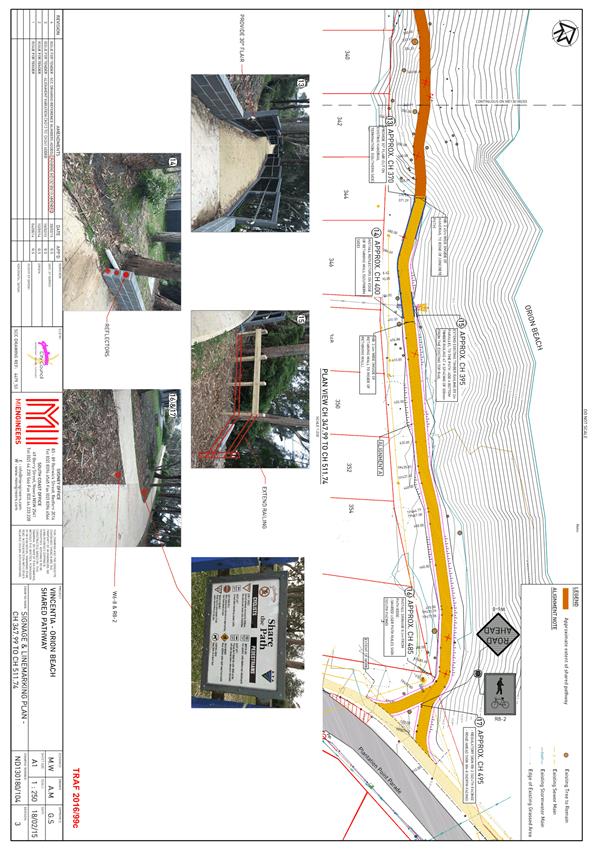
TC16.37 Proposed
Regulatory signage & Line Marking (PN 3352) - Orion Beach Shared Path,
Vincentia
HPERM Ref: D16/383926
Convenor: Martin Upitis
Attachments:
1. TRAF2016-99 -
Proposed Regulatory Signage & Line Marking - Orion Beach Shared Path ⇩
|
Recommendation
That the General Manager
(Director Assets and Works) be advised that the Shoalhaven Traffic Committee
has no objection to the proposed regulatory signage and proposed improvements
for the Orion Beach Shared Path, Vincentia. As detailed in the attached plan
TRAF 2016/9.
|
Details
Regulatory signage and line
marking was not provided as part of the construction of the Orion Beach path
project.
Further, Council has now been
advised of safety concerns regarding the newly constructed path.
In view of addressing the concerns
raised, Council is proposing to install additional signage and line marking
(including regulatory shared path signage) as well as additional delineation
measures (reflectors) and fence/barrier modifications.
|
|
Shoalhaven
Traffic Committee – Tuesday 13 December 2016
Page
35
|