Shoalhaven Natural Resource & Floodplain
Management Committee
Meeting Date: Tuesday,
29 November, 2016
Location: Jervis
Bay Rooms 1-3, Level 3, Nowra Administrative Centre, Nowra
Time:
5.00
pm
Please note: Council’s
Code of Meeting Practice permits the electronic recording and broadcast of the
proceedings of meetings of the Council which are open to the public. Your
attendance at this meeting is taken as consent to the possibility that your
image and/or voice may be recorded and broadcast to the public.
Agenda
1. Apologies
2. Confirmation of Minutes
· Shoalhaven
Natural Resource & Floodplain Management Committee - 20 July 2016..................................................................................... 1
3. Declarations of Interest
4. Reports
SN16.2........ Community engagement on Coastal Management - Our
Coast Our Lifestyle................................................................................. 4
SN16.3........ Shoalhaven Coastal Hazard Review........................................... 6
SN16.4........ 2016/17 Flood Program Update.................................................. 9
SN16.5........ Shoalhaven River Levee Repair Works update......................... 13
SN16.6........ June 2016 Storm Remediation Response ................................ 20
SN16.7........ Natural Resources and Floodplain Management
Committee - Terms of Reference - review .................................................... 35
SN16.8........ Water Quality Remote Sensor Installation -
Shoalhaven Heads 42
SN16.9........ Sea Level Rise Projection in Shoalhaven -
Science & Policy.... 44
SN16.10...... Current Methods of Protection of the Environment.................... 52
5. General Business
|

|
Shoalhaven
Natural Resource & Floodplain Management Committee – Tuesday 29
November 2016
Page
iii
|
Membership
Clr Findley – Chairperson
All Councillors
General Manager or nominee
Community representatives:-
Jessica Zealand
David McCorkell
Duncan Marshall
Ian Stewart
Dr Michael Brungs
Dirk Treloar
Annie Boutland
Thomas Booler
Helen Moody
David Reynolds
Kaye Milsom
Brett Stevenson
Chris Grounds
Mike Clear
Paul Beckett
Government Agency representatives:-
Jerrinja LALC
Ulladulla LALC
NPWS
SRCMA
OEH
RMS
DPI Fisheries
Local Lands Service
Crown Lands
NSW Office of Water
Jervis Bay Marine Park Authority
SES
Quorum – Three (3) provided that a minimum of one
Councillor and two community representatives are present.
Objective
To foster sustainable management of Shoalhaven’s
natural resources including floodplains, coast and estuaries.
Role of Committee
1. Provide
overall guidance for the management of natural resource management including
floodplain management, estuary management and coastal zone management in
accordance with Federal, State and Local Government Policy and Legislative
instruments;
2. Advise
Council on natural resource management including floodplain management, estuary
management and coastal zone management matters;
3. Formulate
agreed vision, goals, objectives, and targets sought from the Natural Resource
Management Plans;
4. Facilitate
the preparation of Natural Resources Management Plans;
5. Provides
input into the identification of management options for Natural Resources
Management Plans;
6. Facilitate
broad community consultation;
7. Monitor
State and Federal Government natural resource management direction and advises
Council on appropriate response;
8. Monitor
advances in knowledge and science of natural resource management issues (such
as sea level rise and climate change) and integrate this knowledge in new
Natural Resource Management Plans as well as in the review of existing Plans;
and
9. Make
recommendations for Council consideration.
Minutes of the Shoalhaven Natural Resource & Floodplain
Management Committee
Meeting Date: Wednesday,
20 July 2016
Location: Vera
Hatton Gallery, Lady Denman Huskisson
Time: 4.00pm
Clr Findley
Clr White – left 5.30pm
Duncan Marshall
David Reynolds
Chris Grounds
Mike Clear
Brett Stevenson
Mike Brungs
Ian Stewart
Dirk Treloar
Helen Moody
Annie Boutland
Davd McCorkell
Alex Deura - NPWS
Matt Carr - JBMP
Habib Ullah – OEH
Allan Lugg – DPI Fisheries
John Murtagh – OEH
Oscar Garratt-Symes – OEH
Others Present:
Russ Pigg – General Manager
– left 5.40pm
Tim Fletcher – Planning and
Development Services Director
Kellie Lowe – Environmental
Services Manager
Isabelle Ghetti – Natural
Resources and Floodplain Manager
Ailsa Schofield – Senior
Floodplain Engineer
Penny Lumb - Coast &
Estuaries Assistant
Ray Massie – Coast and
Estuaries Officer
Jessica Rippon - Communications
Executive Manager
1.
Acknowledgement of Aboriginal Elders Past and Present
Clr Findley acknowledged the
Aboriginal land owners past and present
Apologies:
Apologies were received from Clr
Kitchener, David Zerafa – NSW Office of Water, Kaye Milsom, Thomas
Booler, Bill McInnes – SES, Paul Beckett
2.
Minutes of Previous Meeting
It was advised that Allan Lugg
was not present at the previous meeting.
MOTION: Moved:
Consent
RESOLVED that the Minutes of the
meeting of the Shoalhaven Natural Resources and Floodplain Management Committee
held on Wednesday 6 April 2016 be confirmed with the following change:
·
Remove Allan Lugg from members present
CARRIED
3.
Introduction of Members and Staff
The Committee members and staff
introduced themselves and the area they represent.
4.
Additional Item – Jessica Rippon – Community Engagement
Policy Presentation File
# Jessica
Rippon provided a presentation on the Community Engagement Policy.
Jessica advised that the new
model focuses on different people leading the engagement to achieve particular
outcomes i.e. the committee could lead conversations/engagement.
5.
Procedural Motion – Bring Item Forward
PROCEDURAL MOTION: Moved:
Consent
That the matter of Item 3, Page 16
- Sea Level Rise Projection in Shoalhaven: Science and Policy be brought
forward for consideration.
CARRIED
6.
(Item 3) SN16.1 Sea Level Rise Projection in Shoalhaven: Science and
Policy File 53021E
It was advised that Isabelle
Ghetti would provide a background briefing on the chronology of Council’s
consideration but the reasons for Council resolutions could not be addressed
entirely by staff as not all Councillors from all wards were present to
represent their decisions.
# A
PowerPoint presentation was provided to the Committee. The PowerPoint
slides were from a Councillor Briefing by the consultant in addition to the
staff report.
Note: Clr White left the meeting,
the time being 5.30pm.
The Legal advice mentioned in the
presentation was questioned by a number of members of whether it could be made
available. Tim Fletcher advised that Council would reserve its legal
privilege for this legal advice and was not in a position to make the advice
public.
Question on Notice –
Has Council already or is it possible to do projections on costs of possible
damage to properties and infrastructure?
Note: Russ Pigg left the meeting,
the time being 5.40pm
Brett Stevenson stated that the
Hesse and Modra reference needs to be removed from the Policy as it is not
allowed to be used as titled references, he believes this is grounds for a
review.
Ian Stewart stated that a policy
requires greater analysis, descriptions and guidance rather than a skeletal
decision of Council.
Tim reinforced that this Council
process begun with the State Government set of SCR figures, then the State
Government allowed Councils to set their own levels. These levels are
then used to make our policy documents.
The Committee questioned what is
an appropriate planning horizon? As the projections not yet reality; why stop
at 2100?
Duncan Marshall advised that
there were a number of questions and that policy needs to be reviewed earlier
than 7 years. It was advised that his prediction is much higher than
Council’s and would not support a policy that has an 85% chance of
flawed. The research is vast and contributions in the debate are huge.
The purpose of the graph shown
as part of the presentation in relation to Council’s adopted SLR
projections, was to illustrate the projections. Council adopted individual SLR
projections for 2030, 2050 and 2100, no guidance was given in relation to the
trajectory between the 2050 and 2100 projections. During the discussion the
General Manager advised the Committee that it was his understanding that the
Council considered that there would be a gradual SLR from the 2050 projection
(0.23m) to the 2100 projection (0.36m).
MOTION: Moved:
Consent
RECOMMENDED that Council
consider as part of their review process of existing Sea Level Rise Policy
review adopting a precautionary principle to sea level rise policy/adaption to
climate change and that future policies include a statement of intent that
informs a more detailed policy position including a scientifically supported
planning horizon for the Shoalhaven.
Note: The Committee
expressed their concerns on the apparent lack of a credible and widely accepted
competent scientific basis upon which the current Council adopted their policy.
CARRIED
MOTION: Moved:
Consent
RECOMMENDED that Council:
a)
Consider adopting a more holistic approach managing Sea Level Rise and
Climate change risk.
b)
Adopt a four year review cycle for the above mentioned policies.
c)
Report back to the committee if the peer review of the legal advice
known as Attachment D on 10 February 2015 was undertaken.
CARRIED
7.
Additional Item – Sub Committee to be Formed File
MOTION: Moved:
Consent
RESOLVED that a small
subcommittee of Chris Grounds, Mike Clear, OEH John Murtagh, Brett Stevenson,
Clr Findley be convened to consider the existing Terms of Reference in relation
to the Community Engagement, the structure, function and operation of the Committee
and provide comment for further consideration by the committee.
CARRIED
8.
(Item 4) Sea Level Rise Projection in Shoalhaven: Science and Policy File 50242E
Duncan advised this item will be
withdrawn and to be resubmitted to the next Committee meeting.
# It
was advised that the Addendum report that was submitted to the Strategy and
Assets Committee 19 July 2016 that may provide some answers. This will be
attached to the minutes.
9.
(Item 2) 2016/17 Coastal, Estuary and Flood Programs overview File 4355E,
3406E, 30596E
It was advised that the
consultants are finalising their report at the moment and would be able to
present to the Committee and to the Councillors. An additional meeting
will scheduled in the near future to provide the outcomes.
MOTION: Moved:
Consent
RESOLVED that the Shoalhaven
Natural Resources and Floodplain Management Committee receive the report
regarding the 2016/17 Coastal, Estuary and Flood Programs overview for
information.
10.
Additional Item – Paul Beckett – Current Methods of
Protection of the Environment
Paul Beckett sent a statement to
be read. It has been attached to the minutes and will be discussed at the
next meeting.
There being no further business,
the meeting concluded, the time being 6.34 pm.
Clr Findley
CHAIRPERSON
|

|
Shoalhaven
Natural Resource & Floodplain Management Committee – Tuesday 29
November 2016
Page
5
|
SN16.2 Community
engagement on Coastal Management - Our Coast Our Lifestyle
HPERM Ref: D16/351599
Group: Planning
& Development Services Group
Section: Environmental
Services
Attachments:
1. Our Coast Our Lifestyle -Shoalhaven Coastal
Management community engagement report (under separate cover)⇨
Purpose / Summary
To provide an overview of the
outcomes of a significant community engagement program on coastal management in
the Shoalhaven - Our Coast our Lifestyle.
|
Recommendation
That Council
1. Place the full report on
Council’s website and inform the community via media release and emails
to stakeholders who participated in this project
2. The outcomes of ‘Our Coast Our
Lifestyle’ inform the development of a future Coastal Management
Program for the Shoalhaven.
|
Options
1. Support the recommendation of this
report.
Implications: This will ensure that the community
desires are considered in the development of a Coastal Management Program for
the Shoalhaven that responds to the State Government coastal reform program.
2. The Committee could recommend and
alternative option to Council.
Implications: Unknown
Background
Council engaged community
consultation experts ‘Straight Talk’ to develop a community
engagement strategy and deliver a suite of communication and engagement
activities relating to coastal management. The project was funded by
Office of Environment & Heritage (OEH) and overseen by a technical
committee comprising of Council staff (coastal management and community
engagement) and State Government staff (OEH, Crown Lands and Fisheries).
The purpose of the engagement
was to:
· Educate
the community on coastal risks and coastal management options; and
· Understand
community preferences for management options and factors Council should be
considering when making decisions on coastal management.
A suite of activities were delivered from mid-March to
mid-July 2016 under the title ‘Our Coast, Our Lifestyle’. The
project attracted over 1,650 participants and provided robust evidence of the
community views about coastal management.
A significant feature of this evidence was the consistency
of views expressed by different community cohorts and across the various
engagement activities undertaken.
Nicola Wass from Straight Talk will address the Committee
during the meeting and provide an overview of the project, key activities
undertaken and key findings.
A report on this project was compiled by Straight Talk and
is provided in attachment to this report.
Policy Implications
Under the NSW State Government
Coastal Reforms and new Coastal Management Act 2016, Council in developing a
Coastal Management Program, must gather and consider community views. The
‘Our Coast Our Lifestyle’ project will be able to inform the
development of a Coastal Management Program for the Shoalhaven that will also
build on the existing draft Coastal Zone Management Plan 2012.
|

|
Shoalhaven Natural
Resource & Floodplain Management Committee – Tuesday 29 November
2016
Page
7
|
SN16.3 Shoalhaven
Coastal Hazard Review
HPERM Ref: D16/361774
Group: Planning
& Development Services Group
Section: Environmental
Services
Purpose / Summary
To inform the Committee that the
draft Shoalhaven Coastal Hazard Review is now available.
|
Recommendation
That the committee:
1. Receive the presentation on the draft
Shoalhaven Coastal Hazard Review.
2. Recommend Council consider placing
the draft Shoalhaven Coastal Hazard Review on public exhibition.
|
Options
1. As recommended
Implications: This recommendation ensures that
Council sea level rise decision and Coastal Hazard study align; it also ensures
that new information collated since 2009 is appropriately considered in
determining coastal hazards for the Shoalhaven coast.
2. The Committee could chose an
alternative recommendation to make to Council.
Implications: unknown
Background
Coastal hazards of the
Shoalhaven coastline were mapped and identified in 2009 based on coastal
engineering studies undertaken as part of the risk assessment to inform the
draft Shoalhaven Coastal Zone Management Plan 2012. That mapping took into
account sea level rise (SLR) benchmarks under the previous NSW government SLR
policy statement (DECCW, 2009) which set SLR benchmarks of 40cm above 1990 sea
levels by 2050 and 90 cm above 1990 levels by 2100.
The State Government through its
stage 1 coastal reforms, which came into effect in January 2013, asked NSW
coastal Councils to adopt their own sea level rise projections. In response,
Council in partnership with Eurobodalla Council and with funding and technical
assistance from OEH, engaged expert consultants to develop a South Coast
Regional Sea Level Rise Policy and Planning response framework. That document
was not adopted by Council, however the study informed the decision by
Councillors to adopt the following sea level rise projections on 10 February
2015:
· 100mm for 2030;
· 230
mm for 2050; and
· 350mm for 2100.
The revised SLR projections
adopted by Council triggered a review of the coastal hazard mapping for the
areas of the Shoalhaven coast identified in the map below.
The review also incorporated
additional data that has become available since the 2009 coastal hazard
assessment, including:
· Photogrammetry
data
· LiDAR
ground level information
· Bathymetric
surveys
· Field
survey transects
· Post
storm survey information
· Coastal
compartments information
The review also uses advances in
analysis techniques developed by consultant Advisian.
Advisian staff will present the
methodology and findings of the review at the meeting.
Community Engagement
It is recommended that the draft Coastal Hazard Review be
placed on public exhibition and that all submissions received be reported back
to Council for consideration.
Policy Implications
Council practice is that
all policies should be reviewed within 12 months of an election of a new
Council.
It is anticipated that the sea
level rise (SLR) policy adopted by Council on 10 February 2015 will be
presented for Council’s consideration at the Strategy and Assets
Committee on 13 December 2016.
If Council decides to readopt
its policy then the draft Shoalhaven Coastal Hazard review could be exhibited
as it will be in line with Council adopted policy position.
If Council chooses to change its
SLR projections, the draft Shoalhaven Coastal Hazard review will need to be
updated to consider the new policy position. It is anticipated that this could
be done relatively quickly and at minimal cost.
|
|
Shoalhaven
Natural Resource & Floodplain Management Committee – Tuesday 29
November 2016
Page
10
|
SN16.4 2016/17
Flood Program Update
HPERM Ref: D16/345608
Group: Planning
& Development Services Group
Section: Environmental
Services
Purpose / Summary
To inform the Committee of the
current projects being conducted as part of Council’s Floodplain
Management Program and seek the Committee’s support to write to the
Office of Environment and Heritage for advice on reviewing adopted Floodplain
Risk Management Studies and Plans in catchments where catchment characteristics
or modelling inputs have changed.
|
Recommendation
That the Committee recommend that
Council write to the Office of Environment and Heritage to seek direction on
how adopted Floodplain Risk Management Studies and Plans are to be revised in
light of changes to modelling inputs or catchment characteristics.
|
Options
1. Adopt as recommended
Implications: This ensures the future review of
adopted Floodplain Risk Management Studies and Plans is in line with State
Government requirements and meets Council’s needs as outlined in the
Floodplain Development Manual (2005).
2. The Committee could choose an
alternate recommendation.
Implications: Unknown
Background
OEH Floodplain Management
Program - Grant applications
Council receives grant funding
from State Government’s Office of Environment and Heritage (OEH) to
undertake projects under their Floodplain Management Program.
Grant funding is provided to
Council on a 2:1 basis, with grant applications sought each financial year.
The Floodplain Management
Program provides grant funding to:
· Develop flood
studies;
· Develop
floodplain risk management studies and plans (FRMSP); and
· Implement flood
mitigation options identified in floodplain risk management plans.
Council has received advice that
the two grant applications submitted for the 2016/2017 financial year have been
successful. Council will therefore be conducting a review of the Lower
Shoalhaven River and the St Georges Basin Floodplain Risk Management Studies
and Plans. The grant amounts are for $166,667.67 and $61,000 respectively.
The brief for the reviews will
focus on:
· updating the 1990
Shoalhaven River flood study model which uses a now outdated CELLS model and
updating the current 2D model for St Georges Basin;
· modelling and assessing
Council's adopted local sea level rise projections;
· including minor
flood events of March 2012, June 2013, August 2015 and June 2016 for model
calibration;
· developing
information which feeds into Council and emergency services flood planning and
management; and
· updating the cost
benefit analysis maintaining the use of current methodology.
The Shoalhaven River FRMSP
review will also focus on:
· reviewing the Shoalhaven
River entrance management policy using the outcome of the new modelling; and
· reviewing the
flood benefit and management of the Shoalhaven River levees.
The Committee will be asked to
provide comments for these projects once the draft briefs have been prepared.
Review of adopted Floodplain
Risk Management Studies and Plans
Following NSW government
rescinding its Sea Level Rise Policy Statement, Council adopted sea level rise
projections for the year 2050 and 2100. These projections are used to
remap existing flood information (i.e. Conjola and Burrill Lakes).
It is important for
Council’s adopted flood information to be representative of adopted sea
level rise projections. Therefore requiring review of modelled data and
associated FRMSPs.
Using the Lower Shoalhaven River
and St Georges Basin FRMSP as examples, grant funding to conduct a review in
light of Council’s adopted sea level rise projections was sought off OEH
but was not granted. As sea level rise projections will continue to
change in the future Council will need to continue to review adopted flood
information and the associated FRMSP as this occurs.
In addition to this, since the
adoption of the Broughton Creek FRMSP, Roads and Maritime Services (RMS) have
commenced work on the Berry bypass which includes a diversion of Town Creek to
Bundewallah Creek. This diversion is now in place. Council, in
partnership with members of the Berry community, have conducted channel
realignment works along Princess and Alexandra St. These works have led
to changes to flooding in these areas.
Council engaged Cardno (the
flood consultant who conducted the FRMSP) to remodel the catchment to determine
the current impact of flooding. This work has been completed and the new
flood modelling has been adopted by Council. A review of the FRMSP has
not been conducted.
Council has been made aware that
without a review of adopted FRMSPs the revised modelled flood information does
not meet Council’s obligations as set out in the Floodplain Development
Manual (2005).
Council wishes to ensure flood
information is representative of catchment conditions and Council’s
adopted policies. It has therefore remodelled this information and wishes
to use it for planning and development purposes. Council is concerned
that if a full formal review of the adopted FRMSPs is required that this
information may not be made available for use for a number of years, potentially
providing misleading flood information for planning and development
purposes. Advice from OEH on what triggers a review and the extent of
this review would be welcomed.
Given these types of reviews
will be occurring relatively regularly in the future, and have previously not
been supported by receipt of grant funding from OEH, Council needs to be aware
of the process required to conduct this work. Council also needs to know
what technical support will be provided by OEH to conduct this work if grant
funding is not provided, or the work is conducted as a non-grant funded project.
It is for this reason support from the Shoalhaven Natural Resources and
Floodplain Management Committee is being sort to seek formal advice from
OEH.
Targeted repair to damaged
levees - Shoalhaven River catchment
Targeted repair to damaged
levees in the Shoalhaven River catchment has commenced with the Review of
Environmental Factors currently being conducted. A separate detailed
report to the Committee has been prepared on this project. This is a
priority project for the flood team in the coming 12 months.
Shoalhaven Flood Alert
Network
Council maintains a network of
water level and rain gauges that are part owned by Council and the Bureau of
Meteorology (BoM). There are 21 water level gauges and 46 rain gauges
throughout the LGA. In the Shoalhaven River catchment alone there are 12
water level gauges and 17 rain gauges.
The gauges feed into BoMs flood
alert network, providing Council live access to data recordings through the Enviromon
software. The benefit of having this secondary Enviromon software and
data recording is that it provides back up to BoMs system, allows information to
be interrogated, and allows email alerts which are triggered by certain water
levels or rainfall amounts to be set
The service level agreement
between the Natural Resources and Floodplain Unit and the Communications
Section of Shoalhaven Water is currently being updated to ensure the system
continues to be maintained and function at its highest level.
In addition to gauges, water
level boards are present at gauge sites so that visual checks of the water
level can occur. This is most beneficial during a flood event, when the
gauges are most likely to fail due to debris, dynamic changes in rainfall and
water level, gauges being damaged due to extreme weather.
In many locations Manly
Hydraulics Laboratory (MHL) has gauges alongside or joining Council’s
gauges. The benefit of having two gauges in the one location is that
information can be validated should one system fail. It also allows cost
savings and knowledge sharing for sites with joint infrastructure.
In the coming year Council will
be implementing recommendations of adopted FRMSP and working with local SES
Units to identify locations for the installation of additional gauges and water
level boards.
Tomerong water level gauge was
destroyed in the August 2015 flood. This gauge provides vital information
to the SES, aiding them in their flood planning and response during a flood
event. Council has received confirmation that Natural Disaster Relief and
Recovery Arrangements (NDRRA) funding will be provided to replace this
gauge. Council is in the process of ordering the required components so
the re-installation can occur as quickly as possible.
Tabourie Entrance Management
Policy review
Following the completion of the
Tabourie Lake FRMSP and the storm event in June this year Council is reviewing
the Entrance Management Policy for Tabourie Lake. The draft proposal was
sent to the Committee for comments which have been provided to the
consultant.
The current Entrance Management Policy
can be found at the below link:
http://doc.shoalhaven.nsw.gov.au/Displaydoc.aspx?Record=D11/170871
Community Engagement
Community engagement is a core
part of all work conducted by the Natural Resources and Floodplain Unit.
Without support from the Shoalhaven Natural Resources and Floodplain Management
Committee, State Government agencies and community members the work we complete
would not be possible. Ongoing engagement ensures work is understood and
supported.
Financial Implications
A number of projects are being
funded from Council’s existing budgets. The Shoalhaven River and St
Georges Basin FRMSP will be 2/3 funded by OEH and 1/3 funded by Council.
Council’s portion of funding is currently available within existing
budgets.
Funding to replace the Tomerong
water level gauge is being provided by NDRRA funding.
Funding for levee work is
outlined in the separate report.
Risk Implications
Ensuring these projects are
conducted allows Council to conduct floodplain management in a manner which
reduces risk to individuals, the community and infrastructure within the
floodplain.
|

|
Shoalhaven Natural
Resource & Floodplain Management Committee – Tuesday 29 November
2016
Page
14
|
SN16.5 Shoalhaven
River Levee Repair Works update
HPERM Ref: D16/346291
Group: Planning
& Development Services Group
Section: Environmental
Services
Attachments:
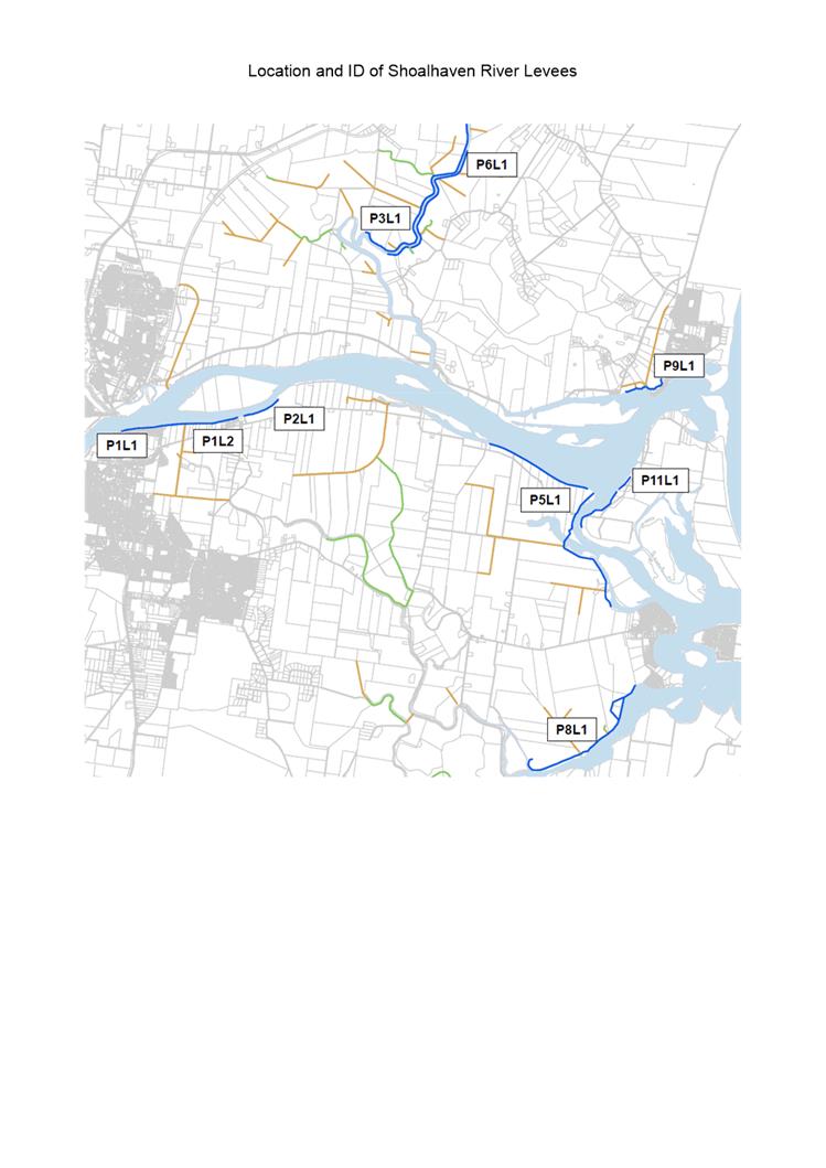
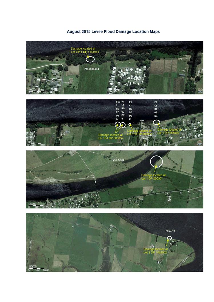
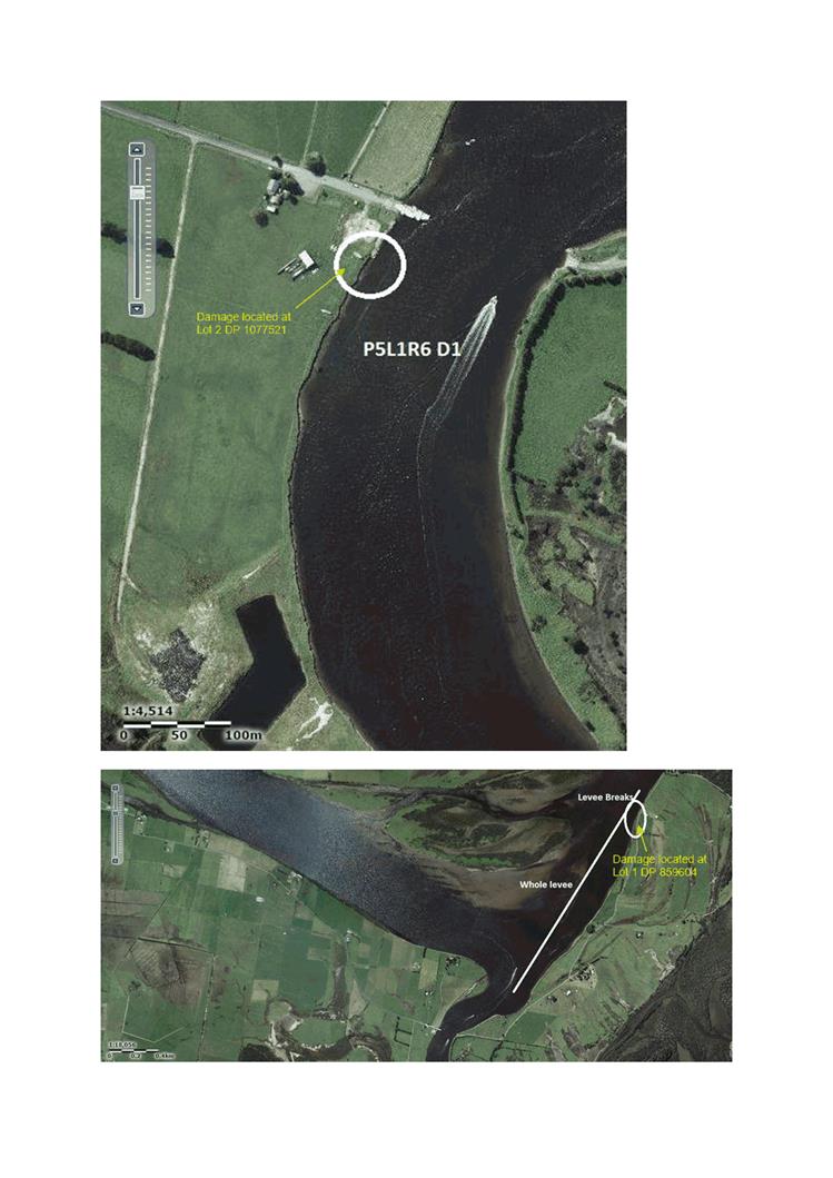
1. Location and ID
of Shoalhaven River Levees ⇩
2. Lower
Shoalhaven River Levee Audit Report (under separate cover) ⇨
3. August
2015 Flood Damage Location Map ⇩
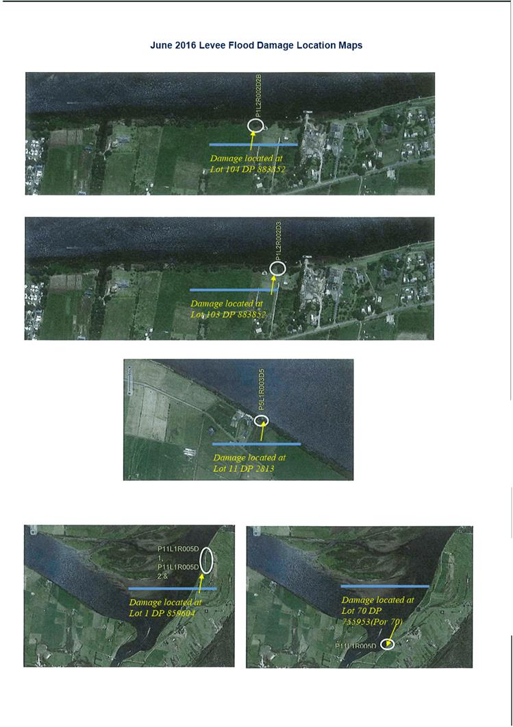
4. June 2016
Flood Damage Location Map ⇩
Purpose / Summary
The purpose of this report is to
inform the Committee on the status of the Shoalhaven River levee repair works
and to advise that Council has been successful in obtaining funding under the
2015 National Disaster Relief Assistance Program.
|
Recommendation
That Council:
1. Write to the Minister for the National
Disaster Relief Assistance Program funding thanking him for providing the
funding to Council to repair the 2015 flood levee damages.
2. Note that based on the successful
2015 National Disaster Relief Assistance Program funding application, works
will be prioritised to utilise the NDRA funding and Council contribution to
undertake levee repairs.
|
Options
1. The Committee supports the
recommendation.
Implications: Ensures funding is received and levee
works can proceed.
2. The Committee provide an alternative
recommendation for future consideration by Council.
Implications: Unknown
Background
Council manages the Lower
Shoalhaven River flood mitigation levees (26.1 km) which were constructed in
the 1970s and 1980s. There are two levee categories, category 1 levees
which protect residential settlements and category 2 levees which predominately
protect farmland and farming buildings from the impacts of flooding (Attachment
1: Location and ID of Shoalhaven City Council Flood Levees). In 2005, part of
the Category 1 levee known as the Terara levee was upgraded to its current
design standard.
In May 2015 Council had the
levees audited by Royal HaskoningDHV (Attachment 2: Lower Shoalhaven River
Levee Audit Report). The audit identified a number of defects in the
levees. Subsequent to the levee audit, two East Coast lows in August 2015
(Attachment 3: August 2015 Levee Flood Damage Location Map) and June 2016
(Attachment 4: June 2016 Levee Flood Damage Location Map) caused additional
damage or defects.
Council has put in a claim for
funding under the National Disaster Relief Assistance Program (NDRA) to repair
the flood damages caused in 2015 amounting to $1.13 million. NSW Public Works
were engaged immediately after the August 2015 flood to inspect and prepare
estimates to repair the levee system to pre-flood condition. Council also
submitted a NDRA claim to repair damages caused in June 2016. NDRA is a
joint funding initiative from Commonwealth and State Governments to provide
disaster relief and recovery payments and infrastructure restoration to help
communities recover from the effects of natural disasters.
Category 1 levees are identified
as critical infrastructure as they provide protection from riverine flood
inundation to residential properties. The repair of these was therefore
identified as a high priority. Due to limited funding availability
Council resolved (MIN16.119a&b) to only advance the restoration of category
1 flood levees damaged during the August 2015 flood and repair the high
priority defects identified during the levee audit, prior to knowing the NDRA
2015 outcome. Now that Council has been notified that its NDRA 2015 funding
application was succesful, it is recommended that works be prioritised to
utilise the NDRA funding and Council contribution to undertake levee repairs.
It is necessary to conduct the
repairs so that levees can continue protecting people and property from river
flooding and to ensure existing damaged levee sections are not damaged further.
Deed of Agreements (DoA) are
being sent to property owners who will be affected by the levee repair works. DoA
will allow Council to conduct the current levee repair works and future
maintenance work on levees located on private properties . The Levee audit identified
levee crest damages caused by cattle trampling and vehicles. Council will
repair these unacceptable defects in the first instance. It is made clear
in the DoA that any further damages occuring due to incorrect use of the levees
are the responsibility of the landholder to repair.
Ecological Consultants Australia
have commenced the Review of Environmental Factors (REF). Following
completion of the REF the works will go out to tender so that a suitably
qualified contractor can be appointed to do the works. Works are expected
to commence in the new year.
Community Engagement
Council’s Floodplain
Engineers and Property Unit Officer have met with property owners to discuss
access and levee repair works to be conducted on their properties. Ecological
Consultants Australia has visited levees located on private properties and
discussed relevant matters with the property owners.
DoA sent to affected property
owners will include a cover letter explaining the project. A follow up
site visit was conducted to meet owners to discuss the DoA further. Comments
received from property owners have been taken into account and reflected in
revised DoA. The property owners have generally been supportive of the works.
Policy Implications
Council’s Asset Management
Plan for flood mitigation drainage structures documents the required inspection
and maintenance of the Sholahaven River levee system.
Financial Implications
Council has
an annual maintenance budget of apprixametly $100,000 for flood mitigation
drainage structures assets, which include, 50 flood mitigation drains (total
length of 48.5km), 9 Levee banks (total length of 23.5km), 60 flood gates, 3 weirs
and 14 bridges. This budget is not sufficient to maintain these assets to
their designed standards and is not sufficient to respond to flood damages.
Council previosuly committed an
additional $660,000 to conduct works. Currently $300,000 has been made
available from the Flood Mitigation Maintenance and Flood Levee Repairs budgets
for this financial year (2016/17). A report to Council will be prepared
following engagement of the preferred tender to advise Council if more funds
will be required to conduct the works.
The result of Councils claims
for funding under NDRA to repair the flood damages caused in 2015 ($1.13
million) was successful and 2016 ($272,470) is currently unknown.
Risk Implications
It is necessary to conduct the
repairs so that the levees can continue protecting people and property from
river flooding and to ensure existing damaged levee sections are not damaged
further.
|
|
Shoalhaven
Natural Resource & Floodplain Management Committee – Tuesday 29
November 2016
Page
17
|
|

|
Shoalhaven
Natural Resource & Floodplain Management Committee – Tuesday 29
November 2016
Page
18
|
|
|
Shoalhaven
Natural Resource & Floodplain Management Committee – Tuesday 29
November 2016
Page
20
|
|
|
Shoalhaven
Natural Resource & Floodplain Management Committee – Tuesday 29
November 2016
Page
21
|
SN16.6 June
2016 Storm Remediation Response
HPERM Ref: D16/347267
Group: Planning
& Development Services Group
Section: Environmental
Services
Attachments:
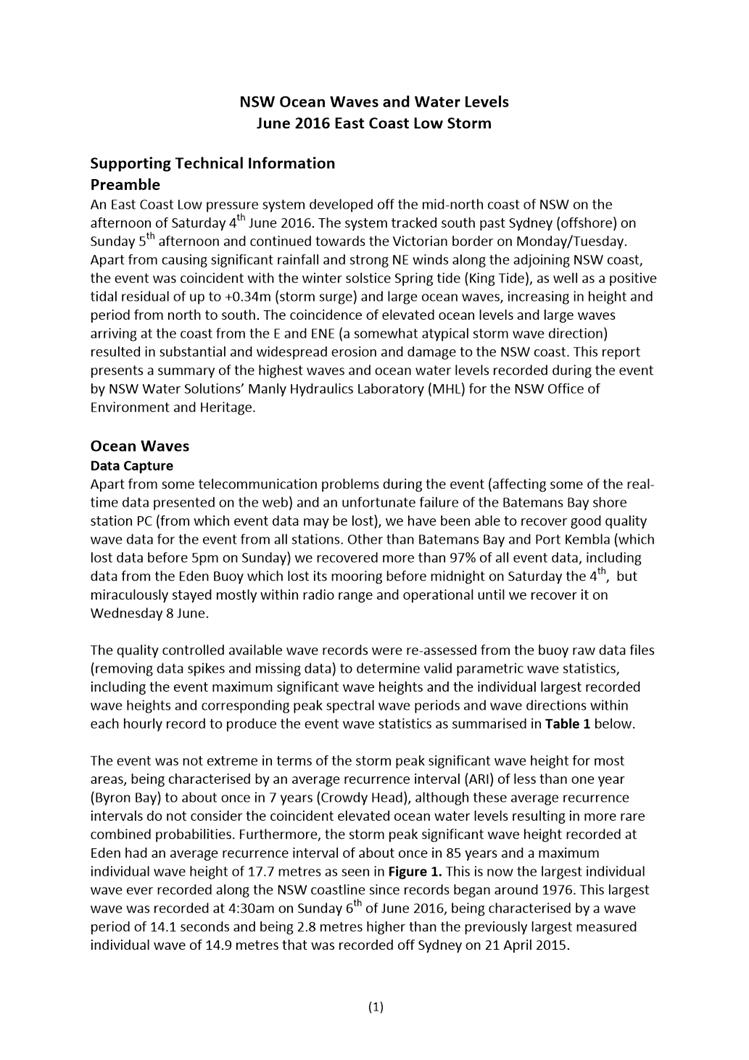
1. NSW Ocean Waves
and Water Levels - June 2016 East Coast Low Storm - Supporting Technical
Information ⇩
2. Currarong
Coastal erosion management - public meeting - hand out (under separate cover) ⇨
Purpose / Summary
To inform the Committee on the
status of responses to the 4 – 7 June 2016 East Coast Low flood / coastal
storm event in coastal areas.
|
Recommendation
That the Committee recommend that
Council
1. Proceed
with detailed design, Review of Environmental Factors, Aboriginal Heritage
assessment for long-term coastal erosion management works at Currarong
including a trial geotextile sand groyne and sand nourishment. That further
community consultation be undertaken as part of this process.
2. Council
recognise the opportunity provided by the August 2015 and June 2016 East
Coast Lows to investigate adaptive strategies to the management of
Council’s Coastal Assets such as retreat, relocate and/or
rationalisation of the number of assets where possible.
|
Options
1. Adopt the
recommendation of this report
Implications: This will allow progress of long-term
erosion management at Currarong and more effective coastal assets management.
2. The Committee
could provide an alternate recommendation to Council
Implications: unknown
Background
Following the June 2016 East
Coast Low event (overview provided in Attachment 1), reports to Council were
prepared to provide an overview of damages and a priority list of repair
works. In response, Council allocated $500,000 with $350,000 for coastal
management priority works and $150,000 for restoration works in the immediate
vicinity of adjoining Holiday Haven Tourist Parks (min 16.586).
This report provides an update
on status of repairs to date.
Ulladulla Harbour
foreshore protection
The June 2016 storm caused major
erosion of a 30-metre section of the existing rear harbour revetment and the
loss of the tidal beach affecting park infrastructure and public amenity.
Response:
· Post
storm survey investigations completed;
· Hazard management
installed and undermined park furniture removed or relocated;
· Site meetings held
with Roads & Maritime Services (RMS), Office of Environment & Heritage
(OEH) and Crown Lands;
· RMS
funding applied for but denied;
· Contractor
engaged to undertake remediation works including extension of protection and
rock fill of the upper embankment and beach scraping as well as relocating sand
from the southern beach fronting the boat ramp carpark. Works are
expected to occur in November/December 2016 at an approximate cost of $50,000.
Community consultation:
· Media release
issued on 11 November 2016 to advise community of planned restoration works.
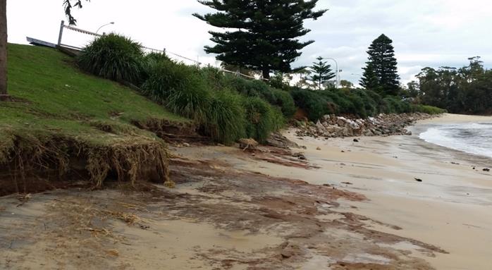
Figure1:
Impacts of June 2016 storm on Ulladulla Harbour foreshore
Currarong Beach
The June storm caused significant
beach sand loss under elevated tide and NE storm conditions along Warrain
Crescent and damages to park and road assets at the rock pools and Dolphin
Reserves.
Response:
· Short
term safety and clean up measures included temporary hazard fencing and
remediation of parks infrastructures around Abrahams Bosom reserve carpark sand
recovery and rock pools remediation completed at a cost of $25,000;
· Beach
access hazard closure and reshaping of beach access at Peel St and Currarong
Creek completed;
· Land
survey of erosion profiles as part of beach erosion monitoring program;
· Community
consultation, public meeting, in September 2016 by Coastal Engineer from Royal
Haskoning to discuss short and long term responses;
· REF
completed and relevant permits obtained for short-term works; and
· Coastal
engineering advice and Aboriginal Heritage assessment informed short-term works
(beach scraping and nourishment) and step access replacement (limited to two)
along Warrain Crescent contracted. Soil Conservation Service was
contracted to do the works in early November at an approximate cost of
$150,000; the works required Aboriginal Land Council supervision given the
sensitivity of the site.
Next Steps/community consultation:
· The
community meeting at Currarong was attended by approximately 125 community
members. The meeting clearly highlighted that a trial geotextile sand
groyne is the recommended option by three coastal experts and OEH to manage
long-term erosion at Currarong.
A hand out was distributed to the participants at the
community meeting (refer attachment 2). At the meeting community members
were invited to make submissions to Council. At the time of writing this report
11 submissions have been received. Four (4) submissions are in support of
the trial geotextile sand groyne. Five (5) do not support the groyne due
to concerns on impacts (visual and environmental) and cost. One (1)
submission is silent as to whether it supports or not supports the groyne, and
another raises concerns but acknowledges something needs to be done. A
submission from the Currarong Progress Association advised that at their
November meeting, there was unanimous support for the consultant’s
recommendations for longer term management of the beach and dunes.
· It
is recommended that Council progress with detailed design, REF and Aboriginal
Heritage Assessment for long-term response including a trial geotextile sand
groyne installation and beach nourishment.
· Further
community consultation to be undertaken as part of this process including
opportunities to rationalise number of access ways.
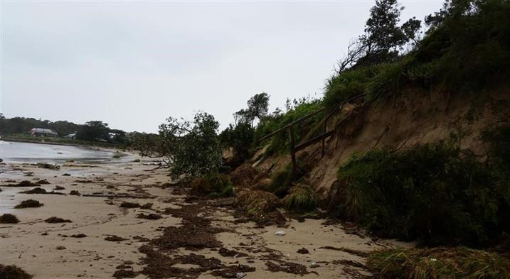
Figure 2: Eight
beach access stairs were destroyed at Currarong along Warrain Crescent by the
June 206 storm
Lake Tabourie
The 80m foreshore boardwalk was
lifted during the combined ocean storm/flood event and damaged beyond repair.
Response:
· Short
term responses included hazard signage, temporary fencing with the staged
removal of the structure completed with post foundations removed prior to
September school holidays to make site safe; and
· Land
survey was completed in late September and confirmed existing land level
provided reasonable access along the estuary foreshore within the current
“open entrance” scenario and reasonable access levels within the
intervention level for Tabourie entrance of 1.2m AHD.
Next Steps/community
consultation:
· Council
staff will continue discussions with the community to confirm a reasonable
outcome for this popular foreshore walking precinct, noting the significant
conflict between foreshore access and threatened Shorebird nesting areas for
migratory shorebirds (Hooded Plover and Little Tern) and the availability for
beach access from the Beach Road carpark.
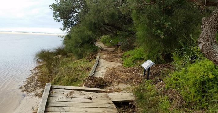
Figure 3: Damaged Lake Tabourie boardwalk
Shoalhaven Heads
The River Rd estuary foreshore
experienced moderate erosion impact as the flood notch breached and allowed the
significant ocean swell / king tide to enter and combine with local catchment
flooding.
The Shoalhaven open beach access
ways were damaged and beach erosion warning signs in place since the 2015 event
were upgraded during September.
Response:
· Contactors
were engaged to reshape the main beach access points for public safety with
other beach access points remaining closed;
· Tree
inspection along the River Road foreshore led to the removal of 45 dangerous
trees that are included in a monitoring program;
· Building
waste has emerged from bank failures containing asbestos, a monitoring program
has commenced with removal of asbestos;
· Land
survey and comparative survey has commenced to monitor erosion of the River
Road frontage;
· Water
Research Laboratory (WRL) has been engaged to develop a remediation design,
with the pub frontage identified as a priority area due to risk; and
· Contractors
wereengaged to undertake additional ‘make safe’ works along the
River Rd foreshore including beach scraping to cover exposed tree root plates
that present a public risk, and spread tree mulch left on site from initial
dangerous tree removal.
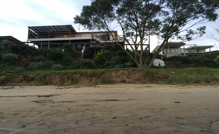
Figure 4:
Eroded foreshore along River Road, Shoalhaven Heads
Next Steps/community
consultation:
· Council
staff and WRL are to attend a public meeting organised by the Shoalhaven Heads
Community Forum on 7 December 2016 to discuss management options for River Road
erosion.
Mollymook Beach
The south end of the beach
damage included exposure of the Golf Club protective gabion wall and inundation
of the Ocean St road stormwater system and damage to the sandstone retaining
wall.
The Blackwater creek sand
nourishment area suffered minor damages.
The creek training wall at north
end of the beach was damaged.
Response:
· Repair
to the northern creek retaining wall was completed in October 2016 where a
section of rock gabions was replaced with geotextile sand bags (cost $25,000);
· Minor
beach reshaping to beach access and repair of sand nourishment at Blackwater
Creek was completed in October 2016;
· The
gabion structure partly protecting the Golf Club and shared path was exposed
and damaged and is alsoapproaching the end of its useful life. Regular
inspections of gabion structure to monitor public risk will continue (in
particular from protruding gabion structure’s wire); and
· Inspection
and risk assessment of pathways undertaken by Recreation Community and Culture.
Next Steps/community
consultation:
· Royal Haskoning
have drafted a Foreshore Stabilisation at Mollymook Beach (South) for long term
protection of the southern end of Mollymook beach including sewer pump station,
Golf Club, shared pathway, Golf Avenue Road reserve and extending to the Surf
Club precinct; and
· Consultation
with the Golf Club, OEH, Council’s asset custodians (road, stormwater,
sewer, and shared path) is required to define a preferred option and funding
scheme before detailed design and environmental assessments can progress.
Figure 5: Eroded gabion
protection structure at Mollymook Surf Club
Culburra
Beach
Southern beach access ways were
damaged from The Haven north along the entire beach with some rock outcrops
uncovered.
Response:
· Short
term response included preliminary staff inspection and engagement of
contractors to inspect and reshape some beach access points where feasible.
Nest steps:
· Inspection
and repair work will continue in the 2016-17 financial year under the annual
Coastal Risk Assessment in July.
Vincentia
Collingwood Beach stormwater
outlets were inundated and erosion occurred at the bridge abutments of the
shared pathway along Collingwood Beach.
Beach access points at
Plantation Point were damaged.
Response:
· Repair
of the bridge abutments additional rock protection was completed in October;
and
· Plantation
Point access (north east) closed due to risk to users, repairs/upgrade
scheduled to access point near play equipment prior to Christmas.
Next step/community
consultation:
· Inspection
and repair work will continue in the 2016-17 financial year under the annual
Coastal Risk Assessment in July and relocation of undermined furniture; and
· Consultation
with community to continue to assess potential to rationalise number of access
ways to the beach at Plantation Point.
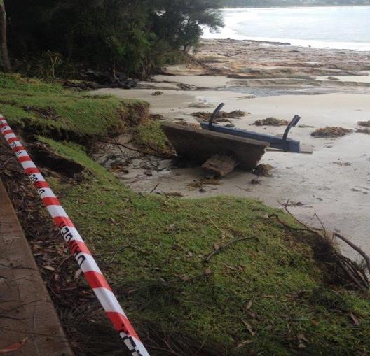
Figure 6: Erosion along the shared path at Vincentia
Greenwell Point Foreshore
Existing shoreline protection
structures at Adelaide St were eroded.
The shared footpath at Titania
Park was eroded/undermined.
The sandstone wharf site which
was damaged in 2015 was further undermined.
Responses:
· Hazard
areas immediately isolated with hazard signage and barriers;
· Beach
scraping of shared cycleway frontage completed; and
· Minor
repairs of damaged rock protection and recreation beaches completed.
Next steps:
· Programmed
repairs of rock protection assets; and
· Design
of heritage sandstone wharf precinct is in preparation for heritage permit
application.
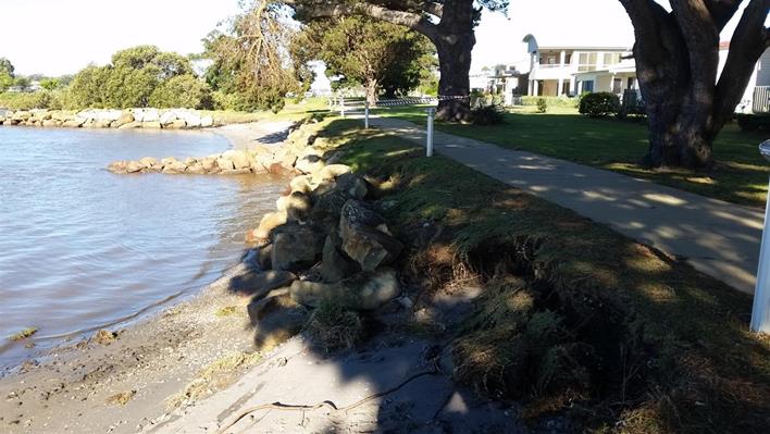
Figure 7: Erosion along the shared path at Greenwell Point
Bendalong Coastal
Headlands
The E/NE storm was shown to
increase in intensity in south coast locations with Bega experiencing a 1 in 85
year event. As experienced at Currarong, exposed north facing sites such
as Bendalong experienced a long period of wave damage with the spring tide
allowing wave attack at the rear of the beach.
Responses:
· Cunjurong
Point - main stair access point to Green Island undermined needing emergency
barriers and beach scraping to reinstate;
· Bendalong
Headland - several beach access ways undermined with scour depths of 1.5m on a
cobble beach unexpected and requiring extension of star treads of over 2m; and
· Kioloa
Beach Caravan Park - potentially hazardous erosion scarp requiring warning
signage and barriers.
Bendalong Boat Harbour
The storm scoured several areas
in the bay uncovering Aboriginal midden deposits and shell deposits. Sections
of this high use park are unstable placing Council assets and visitors at risk
from tree fall and embankment collapse. The Office of Environment and
Heritage (OEH) heritage staff have inspected the site and provided preliminary
advice and detailed assessment has commenced to accompany a landscape master
plan for the reserve. Contractors have been engaged to place safety
fencing in high public risk areas and place rock bollards in unstable road
verges to manage high public risk for the coming season.
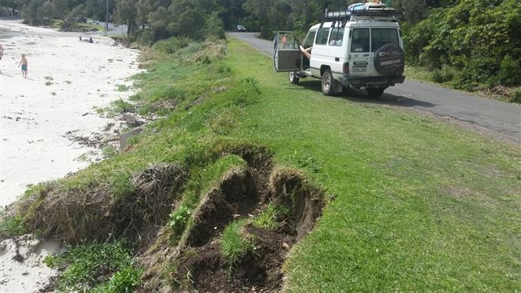
Figure 8: Erosion along
Bendalong Boat Harbour foreshore
Community Engagement
Most sites discussed above will
require further community consultation.
The East Coast low provided an
opportunity to inform and educate the Shoalhaven community. The event and its
impacts were documented in a special edition of Council’s Frontline News
accessible at:
http://doc.shoalhaven.nsw.gov.au/DisplayDoc.aspx?record=D16/279931
Financial Implications
Council’s Coastal and
Estuary Assets Management Plan guides the management of beach access ways in
the Shoalhaven. Council has about 220 beach access ways that for most
were built in the 80s under the State Beach Improvement Program that followed
the devastating storms of the 70s. These access ways are regularly
maintained to keep them safe and useable, however most are approaching the end
of their useful life and most are in need of major repair and replacement.
On average, a new access ways costs $25,000 with an annual allocation of
$50,000 for coastal access capital works, Council is faced with a major
budgetary challenge. With many parks assets (tables and seats) being
removed or relocated and beach accesses being damaged and closed as a result of
the June East Coast low, we now have the opportunity to apply some adaptive
strategies to our coastal assets. Reducing the number of coastal access ways in
areas that are ‘over serviced’ would allow savings to be channelled
towards upgrading the retained assets. At beaches where this approach is
now appropriate, discussion and consultation with affected communities will
occur.
|

|
Shoalhaven Natural
Resource & Floodplain Management Committee – Tuesday 29 November
2016
Page
30
|
|
|
Shoalhaven
Natural Resource & Floodplain Management Committee – Tuesday 29
November 2016
Page
35
|
SN16.7 Natural
Resources and Floodplain Management Committee - Terms of Reference - review
HPERM Ref: D16/351800
Group: Planning
& Development Services Group
Section: Environmental
Services
Attachments:
1. NRFMC - draft
terms of reference - comments from fisheries⇩
2. NRFMC -
reviewed terms of reference ⇩
Purpose / Summary
To ask the Committee to consider
the reviewed terms of reference.
|
Recommendation
That the Committee discuss and
consider adoption of the revised Terms of Reference provided in attachment 2
of this report.
|
Options
1. Adopt the recommendation of this
report
Implications: The new terms of reference recognise
the role of the Committee in regard to community consultation
2. Adopt and alternate recommendation to
Council
Implications: unknown
Background
At its last meeting the
Committee:
RESOLVED that a small subcommittee of Chris
Grounds, Mike Clear, OEH John Murtagh, Brett Stevenson, Clr Findley be
convened to consider the existing Terms of Reference in relation to the
Community Engagement, the structure, function and operation of the
Committee and provide comment for further consideration by the committee.
Draft terms of reference were
developed by the subcommittee and circulated to the full committee for
comments.
Comments were received from NSW
DPI fisheries (refer attachment 1).
The terms of reference have been
reviewed in track changes in view of the comments received and are provided in
attachment 2 for the committee’s consideration.
|
|
Shoalhaven
Natural Resource & Floodplain Management Committee – Tuesday 29
November 2016
Page
36
|
|
|
Shoalhaven Natural
Resource & Floodplain Management Committee – Tuesday 29 November
2016
Page
40
|
|
|
Shoalhaven
Natural Resource & Floodplain Management Committee – Tuesday 29
November 2016
Page
42
|
SN16.8 Water
Quality Remote Sensor Installation - Shoalhaven Heads
HPERM Ref: D16/362315
Group: Planning
& Development Services Group
Section: Environmental
Services
Purpose / Summary
To advise the Committee of
progress in water quality monitoring technology employed by the Council.
|
Recommendation
(Item to be determined under delegated authority)
That the Committee receive the
report for information.
|
Options
1. As recommended.
Implications: nil.
2. The Committee
could chose an alternative recommendation to Council.
Implications: unknown
Background
A second remote water quality
sensor has been deployed off-shore from Shoalhaven Heads (the other one being
at Broughton Creek).
The
buoy and Aqua-lab sensor (pictured) were supplied and installed by Australian
Laboratory Services for Council, in consultation with Roads and Maritime
Services (RMS).
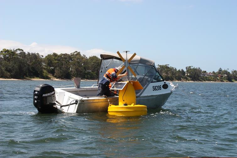
Remote
telemetry from the sensors means that data will be able to be obtained in
real-time on Council’s website by searching Aqua-Data and clicking on the
Shoalhaven River buoy picture to view the live data.
http://shoalhaven.nsw.gov.au/Environment/Aqua-Data
At this stage water quality
readings for salinity, turbidity, electrical conductivity and temperature will
be available. It is anticipated that pH and dissolved oxygen probes will be
made accessible in the near future as well.
Community Engagement
Council’s adopted estuary
management plans identify the need for Council to continue its water quality
monitoring program at our beaches, estuaries and waterways. The Shoalhaven
Heads Estuary Taskforce recommended that Council carry out additional regular
monitoring of the Shoalhaven River estuary at Shoalhaven Heads.
Conclusion
Installation of the water
quality sensor and buoy means that water quality will be able to be
continuously monitored and results streamed live to the Council and the
community through Council’s AquaData website.
|
|
Shoalhaven
Natural Resource & Floodplain Management Committee – Tuesday 29
November 2016
Page
44
|
SN16.9 Sea
Level Rise Projection in Shoalhaven - Science & Policy
HPERM Ref: D16/351224
Submitted by: Duncan Marshall
Attachments:
1. Previous report⇩
2. Minute
from Previous meeting⇩
|
Recommendation (Item to be determined
under delegated authority)
Submitted to the Committee for
discussion.
|
This item was deferred from the
previous meeting on 20 July 2016.
Details
This item has several aspects,
including the impacts of natural events, of "squatting" on the beach
reserves, of encroachment of public built assets, of vandalism, or of
manipulation of Council (and state) foreshore conservation policy.
There is significant loss (or
risk of loss) of foreshore vegetation on dues or beaches at or above high tide
mark. Such loss of vegetation threatens further or accelerated loss of dune or
reserve areas. The loss of vegetation is aggravated by:
· Severe storm
events (which naturally occur)
· Neglect of
restoration (and/or protection) after severe storm events undermine original or
replanted vegetation
· Long-term
"parking" of dinghies, small sailing boats, trailers, and other
objects that reduce the area of dune or beach that is vegetated and retained by
the roots of that vegetation
· Development of
hard surfaces with big run-off immediately adjoining the due or beach head, and
· Proposed reduction
of vegetation to enhance views (for example at Collingwood Beach).
|
|
Shoalhaven Natural
Resource & Floodplain Management Committee – Tuesday 29 November
2016
Page
45
|
|

|
Shoalhaven
Natural Resource & Floodplain Management Committee – Tuesday 29
November 2016
Page
46
|
|
|
Shoalhaven
Natural Resource & Floodplain Management Committee – Tuesday 29
November 2016
Page
52
|
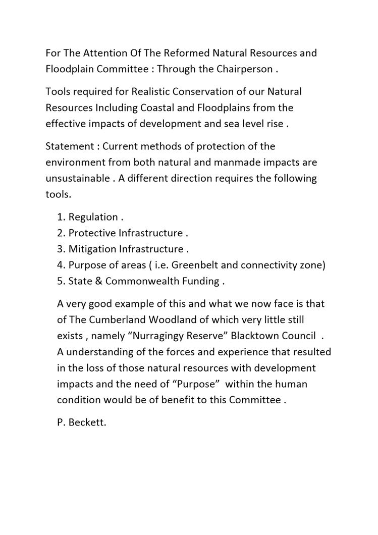
SN16.10 Current
Methods of Protection of the Environment
HPERM Ref: D16/351252
Submitted by: Paul Beckett
Attachments:
1. Statement &
Minute from previous meeting⇩
|
Recommendation (Item to be determined
under delegated authority)
Submittee to the Committee for
discussion.
|
This item was deferred from the
previous meeting on 20 July 2016.
Details
Paul Beckett sent a statement to
be read at the previous meeting. A copy of the minute from the previous
meeting and the statement are attached.
|
|
Shoalhaven
Natural Resource & Floodplain Management Committee – Tuesday 29
November 2016
Page
53
|