Development Committee
Meeting Date: Monday,
07 November, 2016
Location: Council
Chambers, City Administrative Building, Bridge Road, Nowra
Time:
4.00
pm
Membership (Quorum - 5)
Clr Patricia White - Chairperson
All Councillors
General Manager or nominee
Please note: Council’s Code of Meeting Practice
permits the electronic recording and broadcast of the proceedings of meetings
of the Council which are open to the public. Your attendance at this meeting is
taken as consent to the possibility that your image and/or voice may be
recorded and broadcast to the public.
Agenda
1. Apologies / Leave of Absence
2. Confirmation of Minutes
· Development
Committee - 10 October 2016............................................................... 1
3. Declarations of Interest
Deputations
4. Reports
DE16.4........ Exhibition Outcomes/Finalisation - Shoalhaven
Development Control Plan 2014 - Draft Amendment No 5 - Stage 2 Housekeeping ......................................... 4
DE16.5........ Development of an Affordable Housing Strategy
for Shoalhaven................ 9
DE16.6........ Draft Huskisson Foreshore Masterplan -
Exhibition Outcomes & Process Finalisation ...................................................................................................................... 12
DE16.7........ Development Application – No.160 Bolong
Road, Bomaderry – Lot 1 DP 838753...................................................................................................................... 25
DE16.8........ Development Application – 25 Junction
Street, Nowra – Lot 1 DP 81167 DP 34
DE16.9........ Possible Planning Proposal - The Wool Road, St
Georges Basin .............. 39
DE16.10...... Central Nowra Residential Zones - Character
Related Development Controls 44
5. Confidential
Reports
Nil
|

|
Development
Committee – Monday 07 November 2016
Page
ii
|
Development Committee
Delegation:
THAT
pursuant to s377 (1) of the Local Government Act 1993:
A. The Committee is delegated the functions
conferred on Council by the Environmental Planning & Assessment Act 1979
(EPA Act), Local Government Act 1993 (LG Act) or any other Act or delegated to
Council, as are specified in the attached Schedule, subject to the following
limitations:
i. The
Committee cannot make a decision to make a local environmental plan to classify
or reclassify public land under Division 1 of Part 2 of Chapter 6 of the LG
Act;
ii. The Committee cannot review a s82A or
s96AB EPA Act determination made by the Council or by the Committee itself;
iii. The Committee cannot exercise any function
delegated to the Council which by the terms of that delegation cannot be
sub-delegated;
iv. The Committee cannot exercise any function
which s377(1) of the LG Act provides cannot be delegated by Council; and
v. The Committee cannot exercise a
function which is expressly required by the LG Act or any other Act to be
exercised by resolution of the Council.
Schedule:
1. All
functions relating to the preparation, making, and review of local
environmental plans (LEPs) and development control plans (DCPs) under Part 3 of
the EPA Act.
2. All
functions relating to the preparation, making, and review of contributions
plans and the preparation, entry into, and review of voluntary planning
agreements under Part 4 of the EPA Act.
3. The
preparation, adoption, and review of policies and strategies of the Council in
respect of town planning and environmental matters and the variation of such
policies.
4. Determination
of variations to development standards related to development applications
under the EPA Act where the development application involves a development
which breaches a development standard by more than 10% and the application is
accompanied by a request to vary the development standard under clause 4.6 of
Shoalhaven Local Environmental Plan 2014 or an objection to the application of
the development standard under State Environmental Planning Policy No. 1
– Development Standards.
5. Determination
of variations from the acceptable solutions and/or other numerical standards
contained within the DCP or a Council Policy that the General Manager requires
to be determined by the Committee
6. Determination
of development applications that Council requires to be determined by the
Committee on a case by case basis.
7. Review
of all determinations of development applications under sections 82A and 96AB
of the EP&A Act.
8. Preparation,
review, and adoption of policies and guidelines in respect of the determination
of development applications by other delegates of the Council.
Minutes of the Development Committee
Meeting Date: Monday,
10 October 2016
Location: Council
Chambers, City Administrative Building, Bridge Road, Nowra
Time: 4.00pm
The following members
were present:
Clr Patricia White -
Chairperson
Clr Amanda Findley
Clr Joanna Gash
Clr John Wells
Clr John Levett
Clr Nina Cheyne
Clr Annette Alldrick
Clr Kaye Gartner
Clr Andrew Guile
Clr Mitchell Pakes
Clr Greg Watson
Clr Bob Proudfoot
Mr Russ Pigg - General
Manager
|
Election
of Chairperson
|
|
The General Manager Mr Russ Pigg called
for nominations from the floor. Mr Pigg informed the meeting that two
nominations had been received for the position of Chairperson of the
Development Committee, the nominations being for Clr White, and Clr
Proudfoot.
Mr Pigg called for a show of hands
and declared Clr White the Chairperson for the Development Committee on a
count of 8 votes.
|
|
RESOLVED (Clr Gash / Clr Wells) MIN16.1
That
Clr White be appointed the Chair of the Development Committee.
CARRIED
|
|
Apologies / Leave of Absence
|
Apologies were received
from Clr Kitchener
|
Confirmation of the Minutes
|
|
RESOLVED (Clr Wells / Clr Gash) MIN16.760
That
the minutes of the Development Committee Meeting held on Tuesday 2 August
2016 be confirmed.
CARRIED
|
Clr Findley –
DE16.3 - NSW Heritage Grants Program 2016/2017 - Shoalhaven Local Heritage
Assistance Fund Program less than significant non pecuniary interest
declaration – will leave the room and will not take part in discussion or
vote – one of the applicants is known to her.
Deputations
Jennifer Parkin addressed
the Committee in relation to item CL16.1 Development Application – 25
Junction Street, Nowra – Lot 1 DP 81167.
Presentations
Nil
Reports
|
DE16.1 Development
Application – 25 Junction Street, Nowra – Lot 1 DP 81167
|
HPERM Ref:
D16/301955
|
|
Recommendation (Item to be determined under
delegated authority)
That the Committee:
1. Confirm
that it supports the variation to the minimum lot size for lots 1-4 to 265,
195, 155 and 204.5 square metres respectively; and
2. The
Development Aplication be determined under delegated authority.
|
|
RESOLVED (Clr Watson / Clr Guile) MIN16.761
1.
That the variation to the minimum lot size not be supported
2.
That Council review the zoning in this location with a view to change
to R2 in Central Nowra
3.
If necessary the General Manager report back to the Development
Committee on the 79c assesment for the subject application, given the extent
of public interest in the development application.
4.
The General Manager also report back on Development Guidelines that
could be adopted to assist in preserving the character of central Nowra. In
addition could Council report back on ways that it could work with the Old
Houses Our History group to identify the most significant streetscapes for
additional consideration for preservation / protection
CARRIED
For: Clr
Findley, Clr Gash, Clr Wells, Clr White, Clr Levett, Clr Cheyne, Clr
Alldrick, Clr Gartner, Clr Guile, Clr Pakes, Clr Watson, Clr Proudfoot and
Russ Pigg
Against: Nil
|
|
DE16.2 Planning
Proposal (PP 017) - Shoalhaven LEP 2014 - Shoalhaven Animal Shelter -
Assessment of Submissions
|
HPERM Ref:
D16/298138
|
|
Recommendation (Item to be determined under
delegated authority)
That the Development Committee:
1. Adopt
the Planning Proposal as exhibited; and
2. Forward
the Planning Proposal to the NSW Parliamentary Counsel to draft the amendment
to the Shoalhaven Local Environmental Plan 2014 and enable it to proceed to
finalisation.
|
|
RESOLVED (Clr Wells / Clr Gash) MIN16.762
That the Development Committee:
1. Adopt
the Planning Proposal as exhibited; and
2. Forward
the Planning Proposal to the NSW Parliamentary Counsel to draft the amendment
to the Shoalhaven Local Environmental Plan 2014 and enable it to proceed to
finalisation.
CARRIED
For: Clr
Findley, Clr Gash, Clr Wells, Clr White, Clr Levett, Clr Cheyne, Clr
Alldrick, Clr Gartner, Clr Guile, Clr Pakes, Clr Watson, Clr Proudfoot and
Russ Pigg
Against: Nil
|
|
DE16.3 NSW
Heritage Grants Program 2016/2017 - Shoalhaven Local Heritage Assistance Fund
Program
|
HPERM Ref:
D16/300392
|
|
Recommendation (Item to be determined under
delegated authority)
The Committee endorse the
allocation of Shoalhaven Local Heritage Assistance Funds for the 2016/2017
program listed in Attachment 1 to this report.
|
|
Clr
Findley – DE16.3 - NSW Heritage Grants Program 2016/2017 - Shoalhaven
Local Heritage Assistance Fund Program less than significant non pecuniary
interest declaration – left the room and did not take part in
discussion or vote – one of the applicants is known to her.
|
|
RESOLVED (Clr Wells / Clr Watson) MIN16.763
The Committee
endorse the allocation of Shoalhaven Local Heritage Assistance Funds for the
2016/2017 program listed in Attachment 1 to this report.
CARRIED
For: Clr
Gash, Clr Wells, Clr White, Clr Levett, Clr Cheyne, Clr Alldrick, Clr
Gartner, Clr Guile, Clr Pakes, Clr Watson, Clr Proudfoot and Russ Pigg
Against: Nil
|
There being no further
business, the meeting concluded, the time being 5.00pm.
Clr White
CHAIRPERSON
|

|
Development
Committee – Monday 07 November 2016
Page
4
|
DE16.4 Exhibition
Outcomes/Finalisation - Shoalhaven Development Control Plan 2014 - Draft
Amendment No 5 - Stage 2 Housekeeping
HPERM Ref: D16/298267
Group: Planning
& Development Services Group
Section: Strategic
Planning
Attachments:
1. Development Committee Report 3/5/16 - draft
Amendment No. 5 Shoalhaven DCP 2014 (under separate cover)⇨
2. Summary
of Submissions - DCP Stage 2 Amendment No. 5 (under separate cover)⇨
3. Submission
Attachment - Natural Resources & Floodplain Unit - Site specific controls -
DCP G9 - Updated Flood Risk Management Study and Plan (under separate cover)⇨
4. Post
Exhibition Changes - Track Changes PDF version DCP2014 Chapter G9: Development
on Flood Prone Land (under separate cover)⇨
Purpose / Summary
The purpose of this report is to:
- Detail the submissions received during the exhibition
of draft Amendment to Shoalhaven Development Control Plan (DCP) 2014 and
consider changes resulting from submissions;
- Adopt the Amendment with recommended changes and
rescind a previous related policy; and
- Make the Amendment effective by providing the required
public notice and simultaneously rescinding the relevant existing Shoalhaven
DCP 2014 chapters and policies of Council.
|
Recommendation
(Item to be determined under delegated authority)
That the Development Committee:
1. Note the submissions received during
the exhibition of Shoalhaven DCP 2014 Draft Amendment No. 5 - Stage 2
Housekeeping
2. Adopt Amendment No.5 to Shoalhaven
DCP 2014 as exhibited with the inclusion of the following changes to respond
to the submissions as per Attachment 2 - Submission Summary Table:
a. Minor editorial changes in Chapter
G9: Development on Flood Prone Land; and
b. Content changes in Chapter G9:
Development on Flood Prone Land, Chapter G10: Caravan Parks in Flood Prone
Areas and the Dictionary as outlined in Attachment 2 and Attachment 4.
c. Defer the draft changes to Chapter
G9: Development on Flood Prone Land relating to subdivision in Greenwell
Point to seek legal advice and to consider alternative provisions in
Shoalhaven Local Environmental Plan 2014 to implement development controls
identified in the Lower Shoalhaven River Floodplain Risk Management Plan. Prepare
an additional report following the receipt of legal advice to outline
possible alternative provisions.
3. Rescind Council Policy: POL 12/118
Finders Estate – Zincalume Roofs
4. Undertake a future review of DCP
Chapter G9: Development on Flood Prone Lane to improve the readability of
controls with simplified wording and formatting
5. Notify the adoption of Amendment No.5
to Shoalhaven Development Control Plan 2014 in the local newspapers in
accordance with the requirements of the Environmental Planning &
Assessment Act 1979 and Regulations
6. Notify the NSW Department of Planning
& Environment and those who made a submission on this matter that
Amendment No.5 to Shoalhaven DCP 2014 has been adopted.
|
Options
1. Adopt the recommendation
Implications: This is the preferred option as it
will enable Council to consider the submissions received during the exhibition
period and make minor typographical and content changes where appropriate.
This will also enable finalisation of this amendment to
the DCP which will:
- Increase the readability/usability of the document;
- Streamline relevant development related controls;
- Address matters of ongoing operational importance;
- Rescind POL 12/118 – Flinders Estate –
Zincalume roofs; and,
- Amend the following chapters of Shoalhaven DCP 2014
the DCP Dictionary:
§ Chapter
G6 – Coastal Management Areas
§ Chapter
G9 – Development on Flood Prone Land
§ Chapter
G10 – Caravan Parks in Flood Prone Areas
§ Chapter
G17 – Business, Commercial and Retail Activities
§ Chapter
G20 – Industrial Development
§ Chapter
NB1 – Mundamia Urban Release Area.
2. Adopt an alternative recommendation
Implications: Depending on its nature, this could
delay the progress of Shoalhaven DCP 2014 Housekeeping Amendment works program.
Background
Context
Shoalhaven DCP 2014 was prepared
to meet the requirements of the planning reforms, initiated by the NSW
Government. The reforms required that only one DCP apply to an area of land,
and this must be effective within six months of the commencement of a
Council’s new Local Environmental Plan (LEP).
The Shoalhaven LEP 2014
commenced on 22 April 2014 and the Shoalhaven DCP 2014 became effective on the
22 October 2014. As a result of the tight six month preparation time frame,
Council resolved on 14 October 2014 to consider all major issues raised in the
submissions as future (‘housekeeping’) amendments to Shoalhaven DCP
2014.
The background to this
Housekeeping Amendment is detailed in the report to the Development Committee
Meeting on 3 May 2016. This report is provided as Attachment 1.
The Development Committee (under
delegation) resolved on 3 May 2016 to:
a) Publicly
exhibit Shoalhaven DCP 2014 Housekeeping Amendment No 5 Draft Stage 2
Housekeeping Amendment which includes changes to chapters:
· G6 – Coastal Management Areas;
· G9 – Development on Flood Prone Land;
· G10 – Caravan Parks in Flood Prone Areas;
· G17 – Business, Commercial and Retail
Activities;
· G20 – Industrial Development;
· NB1 – Mundamia Urban Release Area;
· Dictionary.
b) Publicly
exhibit the Shoalhaven DCP 2014 Housekeeping Amendment No 5 Draft Stage 2
Housekeeping Amendment for a minimum period of 28 days in accordance with
legislation.
c) Consider
a further report after public exhibition of the draft amendments to:
· Consider any submissions received;
· Rescind POL 12/118 – Flinders Estate –
Zincalume Roofs; and
· Adopt the Stage 2 Housekeeping Amendments for
finalisation.
Public exhibition:
Shoalhaven DCP 2014 Draft
Amendment No. 5 - Stage 2 Housekeeping (the Amendment) was publicly exhibited
for a period of 31 days from Wednesday 1 June until Friday 1 July 2016.
The community engagement
strategy for the exhibition included:
- Public notification of the exhibition in local
newspapers
- A plain English explanatory statement
- Outline of key changes proposed to each chapter
provided as a Table of Changes at the beginning of each chapter
- Three internal workshops were run for Council staff by
members of the Natural Resources and Floodplain Unit on 27 June 2016
- Copies of the exhibition material was available on
Councils internet site and for viewing at Council’s Nowra Administration
Building and Ulladulla Branch Office.
Submissions:
A total of three (3) submissions
were received during the exhibition period relating to Chapter G9: Development
on Flood Prone Land. 1 submission was received on behalf of a landowner and two
internal Council submissions were received. A brief summary of these
submissions are outlined below in the table below:
|
Submission
No.
|
Author
|
Brief Summary
|
|
1
|
External
- Planning Consultant Cowman Stoddart on behalf of the landowners of 1 Greens
Road, Greenwell Point
|
Supports the change to site
specific controls in Schedule 5 of Chapter G9: Development on Flood Prone
Land.
|
|
2
|
Internal – Strategic
Planning
|
Minor typographical error.
|
|
3
|
Internal – Natural
Resources and Floodplain Unit
|
Minor editorial changes and a
number of content changes.
|
A detailed summary of the
submissions and any proposed recommendations arising from them is provided in
the table in Attachment 2. Due to the number of changes recommended resulting
from submissions, a copy of the exhibited draft Chapter G9 with recommended
changes tracked is included as Attachment 4. Copies of the actual written
submissions will be available for Councillors to view in the Councillor
Information Folder prior to the meeting.
Through the current review of
this chapter, outdated zoning information has been identified in the specific controls
for Hay Avenue, Shoalhaven Heads Part D, Schedule 5 of the chapter. This
section refers to the deferred zoning prior to the commencement of Shoalhaven
LEP 2014. The wording of this section has been updated in the track changes
version of the draft DCP Chapter G9: Development on Flood Prone Land included
as Attachment 4
Subdivision in Greenwell
Point
Following a Notice of Motion,
Council resolved on 15 December 2015 to amend Part (D) in Schedule 5 of Chapter
G9 (MIN15.813):
allow the subdivision of land and the
creation of strata title lots within the Village of Greenwell Point subject to
the lots whether strata or real property having access to flood free land, in
compliance with Shoalhaven LEP 2014.
The submission from
Council’s Natural Floodplain Unit has questioned this change.
The submission highlights a broader issue regarding controls recommended in the
Lower Shoalhaven River Floodplain Risk Management Plan (FRMSP) and whether it
is appropriate to include these controls in the DCP.
A DCP control cannot prohibit
possible development in the LEP, however the concerns raised warrant further
consideration to ensure outcomes from the Lower Shoalhaven River FRMSP are
acknowledged. Council is generally afforded protection from liability under
section 733 of the Local Government Act when making decisions if it acts in
good faith; following the provisions of an adopted Floodplain Plan would
usually ensure such protection. To clarify this matter and alleviate flood risk
through suitable development controls, it is recommended that this issue be
deferred to allow consideration of legal advice and further investigation into
possible alternative LEP provisions. Consistency with the FRMSP is important to
ensure Council’s planning documents include suitable controls consistent
with the Floodplain Development Manual and Guidelines and to ensure Council is
acting in good faith when providing flood risk controls to ensure legal
indemnity is maintained. Legal advice is needed to clarify potential liability
issues relating to development controls identified in the FRMSP and
Council’s duty to alleviate flood risk.
The Lower Shoalhaven FRMSP was
prepared in accordance with the Floodplain Development Manual and Guidelines.
The development controls are the last stage in the process and implement the
actions of the plan. Council staff are concerned that the resolution of
Council, to change development controls are inconsistent with the FRMSP and
therefore Council could be seen to have provisions in a DCP that are not
consistent with the ‘good faith’ test in regards to Section
733 of the Local Government Act. Legal advice is required to clarify this issue
and it is recommended that advice be sought before any changes are made to the DCP.
Council’s policy position (as per the resolution) is still in place at
this stage pending further consideration of legal advice and a further report.
The FRMSP identifies that areas
in Greenwell Point as well as Greenwell Point Road are classified as high
hazard floodway and includes the following:
“The
township of Greenwell Point experiences access and evacuation difficulties in
as little as the 10% AEP design event and greater... Greenwell Point Road is
the only access route for Greenwell Point and closure of this road can occur
relatively early in a flood event, resulting in the whole town (developed area)
becoming isolated from Nowra and any essential services it provides…
There
is little, if any, opportunity to raise this road because it crosses the main
floodplain and has the potential to dam water and change the nature of flooding
in the area. The road would need to be raised significantly (refer Figure 8) to
provide flood free access in the 1% AEP event and substantial waterway openings
would then be required to minimise the adverse hydraulic impacts for surrounding
properties…
Land
not classified as flood prone should have similar low density restrictions
because the entire area can be isolated from services such as fresh water,
sewer and electricity during major flood events. Even though there will be no threat
to property in the flood free areas there will still be a burden for emergency
services because of the isolation. Any further expansion or new development
beyond the current residential zoning should not be permitted at all
(Shoalhaven Lower FRMSP, 2008, page 43)”
As detailed in the FRMSP, the
evacuation access issues in Greenwell Point are a major issue. Increased
density through subdivision or new development will only increase the existing
burden on emergency services and put an increased population at risk during a
flood event. . Council needs to clarify and resolve the difference between
zoning provisions in the SLEP2014 that imply further development rights and the
recommendations of the Shoalhaven Lower FRMSP 2008, which place restrictions on
development intensification.
Community Engagement
Through the exhibition of the
Amendment, Council has met its legislative requirements in this regard and
provided an opportunity for the community to review the Amendment and make
comment. The summary of submissions and staff comments/recommendations are provided
as Attachment 2.
The subsequent adoption of the
Amendment and the date it becomes effective will be notified in the local
newspapers in accordance with legislation. The NSW Department of Planning &
Environment and any submitters will be notified when the Amendment becomes
effective.
Policy Implications
By adopting the recommendations
of this report, Council staff will finalise the Amendment, make effective the
changes and simultaneously replace the existing relevant Shoalhaven DCP 2014
chapters and rescind POL 12/118 – Flinders Estate – Zincalume
Roofs. This will resolve current concerns relating to the ongoing operation and
usability of Shoalhaven DCP 2014.
Financial Implications
Based on the recommended
approach, there are no immediate financial implications for Council.
Finalisation of the Amendment will be resourced within the existing Strategic
Planning budget.
|

|
Development
Committee – Monday 07 November 2016
Page
9
|
DE16.5 Development
of an Affordable Housing Strategy for Shoalhaven
HPERM Ref: D16/312373
Group: Planning
& Development Services Group
Section: Strategic
Planning
Attachments:
1. Affordable
Housing Background Report (under separate cover)⇨
2.
Affordable Housing Discussion Paper (under separate cover)⇨
3. Framework
for Affordable Housing Strategy (under separate cover)⇨
Purpose / Summary
To provide an update on the
initial work undertaken by Judith Stubbs and Associates in relation to the
development of an Affordable Housing Strategy for Shoalhaven and obtain Council
endorsement to continue with the preparation of the draft strategy based on the
strategic framework.
|
Recommendation (Item to be determined
under delegated authority)
That the Development Committee
1. Receive the Affordable Housing
Background Report, Discussion Paper and Strategic Framework prepared by
Judith Stubbs and Associates as the initial stages of the development of an
Affordable Housing Strategy for Shoalhaven for information
2. Make the Background Report,
Discussion Paper and Strategic Framework publicly available and endorse the
continued preparation of a draft Affordable Strategy for Shoalhaven based on
the Strategic Framework.
3. Receive a future report on the draft
Affordable Housing Strategy for Shoalhaven, to enable it to be fully
considered prior to proceeding to community consultation/engagement
4. Arrange for Dr Judy Stubbs to brief
Council, when appropriate, on the Affordable Housing Strategy work for
Shoalhaven
|
Options
1. As recommended
Implications: this is the preferred option as it
will enable the work completed to date to be publicly released, given the broad
community interest in this important issue, and work to continue on the
development of an Affordable Housing Strategy for Shoalhaven.
2. Adopt an alternative recommendation
Implications: This may result in changes to the
project that could complicate the desired outcomes, leading to inefficiencies
as well as additional costs to Council. It may also delay the adoption of a
policy position on this important social and community issue.
3. Not adopt the recommendation
Implications: This would postpone or prevent the
development of an Affordable Housing Strategy for Shoalhaven.
Background
Following the consideration of a
Notice of Motion, Council resolved on 15 September 2015 (MIN15.631), that the
General Manager:
develop an initial discussion paper and Councillor
Briefing to consider achievable and short term initiatives and options that
will lead to a council report adopting an ‘Affordable Housing
Strategy’ in Shoalhaven City.
Background Report
As a result of the resolution,
Council engaged Judith Stubbs and Associates (JSA) in late 2015 to develop and
present an initial affordable housing discussion paper.
The purpose of this paper was to
outline achievable and feasible options and strategies that would increase the
supply of affordable housing in Shoalhaven for relevant target groups in
appropriate locations, with evidence based recommendations regarding those
likely to be most effective in the local housing market context.
To inform the discussion paper,
JSA also produced a Shoalhaven Affordable Housing Background Report
which provided detailed research, analysis and calculations regarding the
demographic housing market, policy and planning context of Shoalhaven, and an
analysis and critical review of the range of potential strategies and
mechanisms likely to be most effective in this context.
The background report is
provided as Attachment 1.
Affordable Housing Discussion
Paper
The Shoalhaven Affordable
Housing Discussion Paper provides a summary of the evidence presented in
the background report, an overview of the main mechanisms and strategies likely
to be effective in the local context and preliminary recommendations for
Council’s consideration should it choose to proceed to prepare an
Affordable Housing Strategy for Shoalhaven.
Dr Judy Stubbs presented the
discussion paper to a Councillor briefing on the 17 March 2016. Consistent with
the discussion at the briefing, JSA were then engaged to prepare a strategic
framework for an Affordable Housing Strategy.
The discussion paper is provided
as Attachment 2.
Framework for an Affordable
Housing Strategy
The Shoalhaven City Council:
Framework for an Affordable Housing Strategy provides an outline of the
proposed Shoalhaven Affordable Housing Strategy (strategy) that will be
prepared by JSA for Council. It is based on evidence of local affordable
housing need, the planning and market context, and will outline achievable
strategies and mechanisms that are most likely to be effective in the local
context.
The evidence is set out in the
background report and discussion paper. The strategy will be designed to be
implemented in a number of key stages over the next 10 years, focusing
initially on strategies that are most likely to have a practical impact on the
supply of affordable housing, in particular, the development of surplus or underutilised
Council land in partnership with government or community agencies and/or the
private sector.
The strategy will also provide
for ongoing and sustainable engagement of Council in affordable housing through
longer term strategies related to relevant planning mechanisms, amendments to
relevant planning instruments and monitoring its effectiveness against key
performance indicators over time.
The framework document is
provided as Attachment 3.
Next Steps
JSA are continuing to work up a
possible draft Affordable Housing Strategy for Shoalhaven consistent with the
framework that is discussed above and detailed in Attachment 3. When available
the draft strategy will be reported to Council for formal consideration prior
to proceeding to broader community engagement and consultation. Arrangements
will be made for Dr Judy Stubbs to brief Council as part of the consideration
of the detailed draft strategy.
In the meantime, given the broad
interest in this issue there is a need to publicly release the material that
has been prepared to date given that it could be useful to industry groups,
community service agencies and others.
Community Engagement
When the draft Affordable
Housing Strategy is completed there will be detailed engagement and
consultation with relevant bodies, interested parties and the broader
community.
Policy Implications
The discussion paper and
background report have identified possible changes to Council’s policies
and planning controls. These will be examined and evaluated as part of the draft
strategy based on effectiveness and feasibility in respect to Shoalhaven. Any
resulting changes to policy will ultimately be considered following the
adoption of the strategy.
Financial Implications
The current strategy work is
being undertaken and managed within the Strategic Planning budget.
Depending on the strategies or
actions that are ultimately pursued, there could be financial
implications/considerations for Council and these will be discussed as
required.
|
|
Development
Committee – Monday 07 November 2016
Page
12
|
DE16.6 Draft
Huskisson Foreshore Masterplan - Exhibition Outcomes & Process Finalisation
HPERM Ref: D16/312632
Group: Planning
& Development Services Group
Section: Strategic
Planning
Attachments:
1. Survey
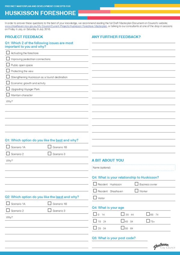
Questionnaire - Public Exhibition - Huskisson Masterplan - SJB⇩
Purpose / Summary
To report the outcomes of the draft
Huskisson Foreshore Masterplan exhibition and community consultation to Council
for information and consideration.
|
Recommendation (Item to be determined
under delegated authority)
That Council
1. Adopt the draft Huskisson Foreshore
Masterplan with the following changes:
a. Remove the four development scenarios
for 59 Owen Street and any content that specifically relates to the
development scenarios; and
b. Identify priority projects to
implement the Wider Town Centre Concept Plan.
2. Commence the process to amend
Shoalhaven Development Control Plan 2014 Chapter N18 – Huskisson Town
Centre to include relevant aspects of the Urban Design Principles and Wider
Town Centre Concept Plan, and to restrict development above ground level on
59 Owen Street.
3. Using the material gathered during
the preparation of the draft Masterplan prepare a preferred option for the
site that is consistent with the proposed ‘community’ classification
and that maintains the view, for possible incorporated into a management plan
for the site that supports the proposed ‘community’
classification.
4. Advise submission makers, the
Huskisson Chamber of Business and Tourism and the Huskisson -Woollamia
Community Voice of this resolution and provide a letter of thanks to the
members of the Community Reference Group who assisted with this project.
|
Options
1. Adopt the recommendations of this
report.
Implications: This option is preferred as it allows
Council to incorporate many of the agreed principles and concepts from the
Huskisson Foreshore Masterplan into Shoalhaven DCP 2014 - Chapter N18. The
process to amend the DCP will involve community consultation and notification. This
option will ensure that future development within the foreshore precinct is
reflective of the community’s expectations for the Huskisson Town
Centre.
2. Not adopt the Huskisson Foreshore
Masterplan.
Implications: Whilst Council’s decision to
reclassify 59 Owen St to ‘community’ has altered the basis of the
Masterplan process over this area, it is still recommended that Council adopt
the Masterplan to ensure that the community’s views and aspirations for
the Huskisson foreshore are considered in the future planning and development
of the town centre.
3. Adopt the Huskisson Foreshore
Masterplan and select a preferred Masterplan Scenario.
Implications: Following Council’s decision to
reclassify 59 Owen St to ‘community’, it is highly unlikely that
any of the development scenarios in the Masterplan could be achieved. If
Council adopt a preferred scenario, it is likely to create unrealistic
expectations and/or unnecessary concern in the community.
Background
Council purchased 59 Owen
Street, Huskisson in early 2015 and resolved on 17 March 2015 to prepare a
masterplan for the Huskisson Foreshore precinct and investigate several preliminary
development concepts for 59 Owen Street.
The overall foreshore precinct
includes the subject site (59 Owen Street) through to the existing Huskisson
Hotel and the foreshore area to the north, as shown in Figure 1 below.
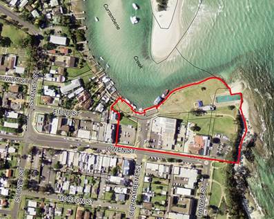
Figure 1 - Subject Land
Council subsequently engaged SJB
Architects Pty Ltd in August 2015 to prepare a masterplan for the Huskisson
Foreshore Precinct and a range of development concepts for 59 Owen Street to
guide the future use/development of the area.
As part of the process, Council also
established a Community Reference Group (CRG) made up of representatives from
the local Business Chamber, Tourism group, Community Consultative Body, specific
interest groups, general public, adjoining land owners and wharf operators.
The project consultant worked
with the CRG to identify the key strengths and opportunities of the precinct
which were then used to develop a set of key urban design principles. The key
design principles were used as a foundation to develop the draft Masterplan and
potential development scenarios (four).
Draft Huskisson Foreshore
Masterplan
The draft Masterplan presents a
vision and principles for the precinct, a wider town centre concept plan and
four development concepts for 59 Owen Street, the adjoining road reserve and
the Club Jervis Bay site. A copy of the exhibited draft Masterplan document
is available on Councils internet site at:
http://shoalhaven.nsw.gov.au/My-Council/Current-Projects/Huskisson-Foreshore-Masterplan
A hard copy of the document will
also be available in the Councillors room prior to the meeting.
The project webpage (link
provided above) contains a wide range of background material related to this
project including; CRG workshop presentations, progress reports, enquiry by
design workshop overview, exhibition questionnaire, interactive Masterplan
website and 3D models of the four development options.
Wider Town Centre Masterplan
Concept
The Wider Town Centre Master
Plan (Section 4.1 & 4.2 of the draft Masterplan document) identifies
strategic objectives and wider town centre improvements that respond to the
ideas of what makes a great waterfront destination. The objectives focus
on taking advantage of the water views, providing improved interaction with the
water, ensuring development in the town centre caters for a range of different
price points, encouraging optimal movement around the town centre (for both
vehicles and pedestrians), and encouraging the principle of ‘ten things
to do’ which make a great place.
During the community
consultation period, submissions and survey responses indicated a large amount
of support for some of the proposed objectives including upgraded amenity and
facilities at Voyager Memorial Park, improved through-block connections,
activation of the foreshore, and a new activated promenade as part of Voyager
Memorial Park upgrades.
An opportunity still exists to
incorporate many of the agreed principles and concepts from the Huskisson
Foreshore Masterplan related to the wider town centre into Shoalhaven Development
Control Plan (DCP) Chapter N18 – Huskisson Town Centre to ensure that
future development within the foreshore precinct is reflective of the
community’s expectations for the Huskisson Town Centre.
Draft Foreshore Masterplan
Options
The exhibited draft Masterplan
contained four (4) possible development scenarios and these are summarised
below:
Scenario 1A and 1B
Scenario 1A incorporates a large open space area (1,450m2)
with potential commercial development along the wharf edge (not visible from
street level) on 59 Owen Street. Three to four (3-4) storey mixed use
development was proposed for 2 Currambene Street (Club Jervis Bay site) with
ground floor activated frontages along Owen Street and Voyager Park. Upgrades
to Currambene Street and Owen Street were also proposed as part of this
scenario.
Scenario 1B is a variation to 1A in that it proposed the
addition of a small lightweight, primarily glazed pavilion along the Owen
Street frontage of 59 Owen Street. The pavilion was shown running east-west in
the concept images, however, the Masterplan highlighted that it could also be
positioned to run north-south. All other aspects of Scenario 1A and 1B
were the same and the Scenarios are shown in Figure 2 and Figure 3 below.

Figure 2 – Scenario 1A (note - pavilion not included
on 59 Owen Street)

Figure
3 – Scenario 1B (note - pavilion included on 59 Owen Street)
Scenario 2
Scenario 2 proposed the
introduction of a 3 storey mixed use development on 59 Owen Street. The
slimline building located on the west of the block included an open space area
to the east of the site which would connect with a new open space area created
by the suggested closure of the Currambene Street road reserve. Four to
five (4-5) storey mixed-use development on 2 Currambene Street (Club Jervis Bay
site) would be setback from the street and compensated with additional height
to allow the entire existing view aperture of 65 metres to remain.
The closure of the Currambene
Street road reserve and setting development back on the club site resulted in a
larger public open space (2,260m2) which flowed directly down to the wharf and
Voyager Memorial Park. A new service loop would be provided for service
vehicles to access the new developments and the wharf. Scenario 2 is
shown in Figure 4 below.
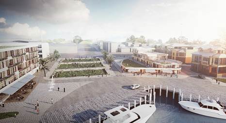
Figure 4 – Scenario 2
Scenario 3
Scenario 3 proposed the full
development of 59 Owen Street based on the current planning controls contained
within the existing DCP, with a 4 storey mixed use building including ground
floor activation. The proposal to close the Currambene Street road
reserve was also included in this scenario to provide a new public open space
(1,200m2) to connect to the wharf and Voyager Memorial Park. This scenario also
included a service loop for service vehicles. Scenario 3 d is shown in Figure 5
below.

Figure 5 – Scenario 3
The development scenarios were
informed by a preliminary geotechnical investigation and preliminary
environmental site assessment prepared by SMEC Australia Pty Ltd and a market
analysis and feasibility assessment completed by Charter Heck Kramer Pty Ltd.
This work was undertaken to ensure the development options were realistic and
achievable. While both reports are technical in nature, and difficult to
interpret and understand, they were exhibited with the draft Masterplan for the
sake of transparency and to ensure the community had complete access to all of
the relevant information.
Public Exhibition/Community
Consultation Overview
The draft Huskisson Foreshore
Masterplan was publicly exhibited for two months from 15 June to 10 August 2017
at Council’s Administrative Centre in Nowra and on Council’s
website.
To support the exhibition,
Council developed an interactive Masterplan website and 3D model to assist the
community in interpreting and understanding the different scenarios in the
Masterplan.
Overall, the draft Foreshore
Masterplan was viewed on Council’s website nearly 5,000 times, with 2,495
people viewing the designated project page, 1,718 people viewing the
interactive Masterplan website and 682 people viewing the 3D Model.
During the exhibition period,
Council facilitated a specific information session for tourism operators in the
Jervis Bay area and a two day community drop-in session on site in Huskisson
which was attended by over 300 people. Council also developed a survey
form that was made available at the drop-in session and on Council’s
website. A copy of the survey form is provided as Attachment 1 to
this report.
Outcomes of the exhibition
Council received a total of 440
submissions during the exhibition period including 325 completed survey forms
and 115 written submissions. Copies of the submissions received will be available
in the Councillors rooms prior to the Development Committee meeting and the
survey results and key issues raised in the submissions are detailed and discussed
below.
Survey Results
A total of 325 survey forms were
completed with 81% of all respondents identifying ‘protecting the
view’ as one of the two most important issues for the Huskisson foreshore
precinct. Over 58% of respondents also identified ‘public open
space’, while 33% identified ‘maintaining the character of
Huskisson’ and 16% nominating ‘strengthening Huskisson as a tourist
destination’ as one of the two most important issues for the Huskisson
foreshore precinct. An overview of the survey responses is provided in
Figure 6 below.
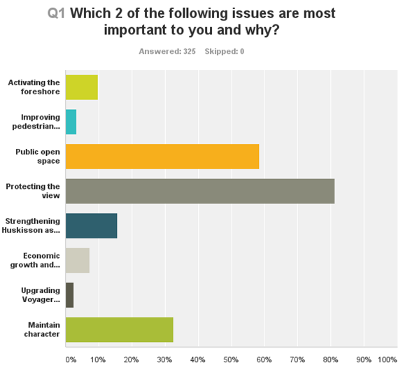
Figure 6 – Survey Results, Important Issues for
the Foreshore Precinct
Survey respondents were asked to
nominate both their preferred and least preferred of the four scenarios from
the draft Masterplan. As shown in Figure 7 below, nearly 66% of all
respondents nominated Scenario 1A as their preferred option, 17% nominated
Scenario 2, 8% Scenario 1B and only 2% nominated Scenario 3. In relation
to the least preferred option, 86% of respondents nominated Scenario 3, 4%
nominated Scenario 1A and approximately 1% nominated Scenarios 2 and 1B.

Figure 7 – Survey Results, Preferred Scenario
Key Issues - Maintaining the
View
A total of 102 submissions made
reference to protecting or enhancing the view, and therefore it should remain
free from development at or above the Owen Street ground level.
Many of the submissions recommended that the site should either remain
completely free from development, or alternatively, the roof top open space in
Scenario 1A should amphitheatre down towards the foreshore to further protect
the existing view.
Staff Comments
The view across 59 Owen
Street was a key consideration throughout the draft Masterplan process.
Each of the scenarios were tested to assess their impacts on the existing view,
from different points along Owen Street. Scenario 1A has the least impact
on the current view from Owen Street level. Scenario 2 provided an option to
include development above ground on 59 Owen Street, while still maintaining a
full 65m wide view aperture, albeit in a modified location. As per the March
2015 Council resolution, the draft Masterplan explored a range of development
options for 59 Owen Street, including options that would impact to a
significant or lesser extent on the view from Owen Street.
It appears that around
40 submissions were composed without having viewed the exhibited draft Masterplan
and assumptions were made based on other information that was available whilst
the Masterplan was on public exhibition.
The potential for the open
space to be of an amphitheatre nature was raised in the CRG meetings. In this
regard it is noted that Allan Jack + Cottier Architects had previously prepared
an amphitheatre park concept for the ‘Heart of Huskisson’
group. As a result the consultant further tested Scenario 1A and 1B to
determine whether commercial development could occur at the wharf level, while also
providing an amphitheatre park down towards the foreshore. The site has a
natural fall of 4m towards the foreshore, and a leasable commercial floor space
requires a minimum floor to floor height of 4.1m. This means that an amphitheatre
(open space) above a commercial development would be extremely difficult and
expensive to achieve, and would require significant excavation of the Crown
land along the foreshore, which may or may not be possible. Given the
cost and difficulty in achieving this outcome, the Masterplan incorporated
commercial development underneath the Owen Street level, without an amphitheatre
open space.
Inconsistency with Council
Resolution
A total of 16 of the submissions
raised concerns that the Masterplan process was inconsistent with the original
Council resolution (January 2015) to purchase the land, which stated that
(MIN15.3) Council proceed immediately to consider development options for
the subject property which do not compromise views from the Owen Street
Huskisson.
Staff Comments
Following the purchase of 59
Owen Street, Council subsequently resolved in March 2015 to prepare a
Masterplan that explore development several concepts for the site. This
subsequent resolution superseded the original Council resolution, and determined
how the Masterplan process was undertaken.
Thus Council staff engaged
the community in good faith to prepare a draft Masterplan for the foreshore
precinct in accordance with the March 2015 resolution of the Council.
Development Feasibility /
Intrinsic Value of the View
During the public exhibition
period a number of concerns were raised with Council staff about the
development feasibility assessment that was prepared to help inform the draft
Masterplan scenarios. A number of submissions suggested that the draft
Masterplan process had been in fact been driven by development feasibility and
raised concerns about the need and motive for including a feasibility
assessment in the draft Masterplan.
There were also concerns raised
in relation to the feasibility assessment given that it did not consider the
intrinsic value of the view to tourism and visitation. It was essentially
suggested that the view was a key tourism attractor and that its loss or any
impact on it could in turn have a negative impact on tourist visitation. A
number of submissions also argued that the feasibility assessment was flawed
given that it did not put a financial value on maintaining the view across 59
Owen Street.
Staff Comments
The feasibility assessment
was undertaken as an important aspect of the draft Masterplan to ensure that
the four scenarios were realistic and achievable, and to enable Council to ultimately
make an informed decision in relation to the future development of the
site. The outcomes of the draft Masterplan were never directly influenced
or dictated by development feasibility, but rather, like any decision to fund
infrastructure, it was considered important for Council to understand the
potential cost to the community before ultimately selecting a preferred
scenario. It is noted that even developing the site as an improved open space
will not be without a cost to Council.
In relation to the intrinsic
value of the view, there is no widely accepted and robust methodology of
financially valuing a view. While there have been some attempts at
valuing views and open space in different studies, the methodologies are highly
subjective and not broadly accepted in the industry. Nevertheless, the
importance of the view was reflected in every other aspect of the draft Masterplan,
from developing the design principles through to designing and refining the
development concepts for the site. Each of the development concepts thus
provides for a varying degree of view to Currambene Creek.
The outcomes of the
preliminary feasibility assessment are shown in the Table below. It
should be noted that the revenue outlined below was based on Council selling
the completed development. Given that Council has resolved to reclassify
the land to ‘community’, the total net revenue would likely be
significantly lower than the revenue outlined in the table below.
|
Feasibility Outputs
|
|
|
Scenario
|
Scenario
1A
|
Scenario 1B
|
Scenario 2
|
Scenario 3
|
No Development
|
|
|
Total
cost including land purchase price and construction cost
|
$4.8m
|
$5.0m
|
$9.2m
|
$14.9m
|
$3m
plus embellishment
|
|
|
Total
net revenue from development
|
$2.8m
|
$3.3m
|
$8.6m
|
$18.4m
|
$0
|
|
|
Total
cost to Council
|
$2m
|
$1.7m
|
$0.6m
|
+$3.5m
|
$3m
plus embellishment
|
|
Club Jervis Bay Proposal
During the public exhibition
period, Auric International made a submission that proposed to relocate Club
Jervis Bay as part of a redeveloped 5-6 storey mixed use development on 59 Owen
Street. The submission also proposed a redevelopment of the existing Club
Jervis Bay site for a 7 storey mixed use development. A range of third
party material was available in the community during the exhibition period in
regard to this specific proposal, including a flyer released by the Club
providing an overview of the proposed redevelopment
Staff Comments
While the Auric International
proposal stated that it was largely consistent with Scenario 2, the proposal
included a significantly more intensive development than outlined in the draft Masterplan.
A number of concerns were raised with Council staff during the exhibition
period that the Auric proposal had influenced the Scenarios in the
Masterplan. However, neither the Council staff managing the draft Masterplan
nor Council’s consultants were aware of the Auric proposal until it was
formally submitted during the exhibition period for the draft Masterplan.
Resolution to reclassify
Council resolved on 14 October
2016 to proceed to reclassify 59 Owen Street as ‘community’ land
under the Local Government Act 1993 (MIN16.688).
Council recently notified its
intent to reclassify the land in accordance with the requirements of the Local
Government Act 1993 and this matter will be reported back to the Council in due
course.
Staff Comments
The reclassification of 59 Owen
Street will significantly impact on Council’s ability to achieve any of
the development scenarios outlined in the draft Masterplan. A ‘community’
classification restricts Council’s ability to sell the site and creates
significant constraints in relation to commercial leases. To achieve any
of the scenarios outlined in the draft Masterplan, Council would need to accept
significant risk in developing the site, given the restrictions on sale or
lease. Alternatively, Council could try and enter into a public private partnership
(PPP) to develop the site, but again, it would be highly unlikely that a
developer would be willing to invest in a development given the restrictions on
leasing.
Given the Council’s strong
support for a ‘community’ classification, and the community
campaign that led to that decision, it is highly unlikely that any of the draft
Masterplan scenarios as presented could be achieved on the site.
Conclusion
The draft Huskisson Foreshore Masterplan was developed
through extensive consultation with the community, and included a series of
urban design principles, a wider town centre concept plan and four separate
potential development scenarios. The decision to reclassify the land to
‘community’ means that each of the development scenarios is unlikely
to be achievable.
However, it is still recommended that Council adopt the
draft Masterplan with the exception of the four development scenarios.
This will allow Council to commence the process to incorporate many of the
agreed principles and concepts from the Huskisson Foreshore Masterplan into
Shoalhaven DCP 2014 - Chapter N18, and ensure that future development within
the foreshore precinct is reflective of the community’s expectations for
the Huskisson Town Centre. The process to amend the DCP will
provide a further opportunity for community engagement/comment.
It is also recommended that, utilising the material gathered
during the preparation of the draft Masterplan that a preferred option be
prepared for the site that is consistent with the proposed
‘community’ classification and that maintains the view (a key
outcome from the recent community consultation). This preferred option could
then inform or be incorporated into a management plan for the site, that is
likely to be required under the proposed ‘community’
classification.
Community Engagement
The draft Masterplan was developed with extensive community
consultation, including regular consultation with the CRG and a two-day Enquiry
by Design workshop with the wider community which took place in late October
2016. During the exhibition period, Council and the project consultants
facilitated a specific information session for tourism operators and a two-day
drop in session on site in Huskisson that was attended by more than 300
people.
Council staff and the project consultants tried to engage
the community constructively and in good faith throughout the entire draft Masterplan
process, and over 4,500 people viewed the draft Masterplan through
Council’s website alone. There was significant community interest
in the draft Masterplan project, and the community were engaged extensively
throughout.
The community’s efforts in contributing to the draft Masterplan
are appreciated and the specific input provided by the members of the CRG
should be formally recognised.
Financial Implications
The Huskisson Foreshore
Masterplan project was managed within existing budgets.
|

|
Development
Committee – Monday 07 November 2016
Page
22
|
|

|
Development
Committee – Monday 07 November 2016
Page
24
|
DE16.7 Development
Application – No.160 Bolong Road, Bomaderry – Lot 1 DP 838753
DA. No: DA14/2161-03
HPERM Ref: D16/314387
Group: Planning
& Development Services Group
Section: Development
Services
Attachments:
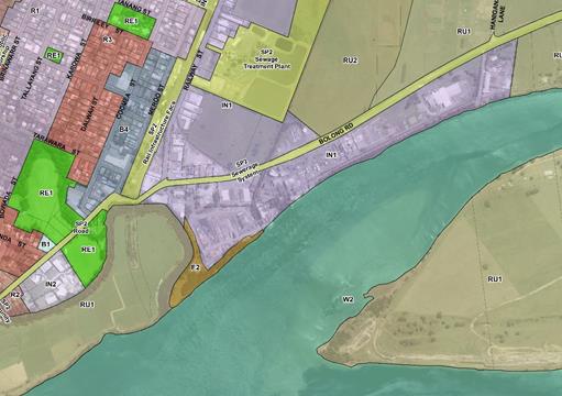
1. Overall site plan
- showing where new silos are located.⇩
2. Elevation
of new silos and existing structures that are adjoining /adjacent⇩
Description of Development: Two (2) additional
grain silos and associated infrastructure
Owner: Manildra Energy Australia Pty Ltd
Applicant: Brian Hanley, Shoalhaven Starches
Notification Dates: 22 October 2014 to 24 November
2014
No. of Submissions: No submissions received in
objection or in support
Purpose
/ Reason for consideration by Council
To
seek direction from Council on a policy variation relating to the 11m height of
buildings standard in Clause 4.3 (Height of Buildings) of the Shoalhaven Local
Environmental Plan 2014 (SLEP 2014).
The
application has had a protracted assessment given that the works were
undertaken without development consent.
|
Recommendation
(Item to be determined under delegated authority)
That the Committee:
1. Confirm
that it supports, pursuant to Clause 4.6 (Variation to development standards)
of SLEP 2014, the applicant’s request to vary the height limit of 11m
to 34.12m; and
2. Refer
the development application (DA14/2161) back to staff for determination.
|
Options
1. Resolve to
support the requested variation to the maximum height of buildings requirement.
Implications: This would enable Council to issue a
development consent for the existing structures subject to conditions which
would include, but not be limited to, the submission of engineering
certification and Building Code of Australia (BCA) compliance certification.
Council will also need to consider enforcement/compliance action in relation to
works being undertaken without development consent or a construction
certificate.
2. Resolve not to
support the proposed variation to the maximum height of buildings requirement.
Implications: This would result in the applicant
needing to reconsider the design of the proposal and for Council to commence
enforcement proceedings to have the constructed buildings removed or modified.
This may result in the applicant appealing Council’s refusal in the Land
and Environment Court.
3. Resolve to
modify the recommendations contained in this report.
Implications: This would require the Committee to provide
direction to staff.
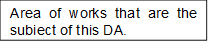
Location Map


Background
Proposed Development
The Development Application (DA)
seeks consent to erect two additional silos at the Shoalhaven Starches factory
complex. Each silo has a maximum height above ground level, including all
associated infrastructure, of 34.12 metres and a diameter of 10 metres. The
silos have a height of 28 metres, the associated walkways above the silos have
a maximum height of 31.6 metres and the top end of the infrastructure servicing
the silos has a maximum height of 34.12 metres. Each silo is capable of
holding 1,300 metric tonnes of grain which will be used to provide a ‘relief’
supply only and will be constructed of galvanised steel and positioned on
structural steel legs. See Attachment 1 for a copy of the DA plans.
Subject Land
The subject land is known as Lot
1 DP 838753 (No.160) Bolong Road, Bomaderry. It has an area of 3.53
hectares and forms part of the Shoalhaven Starches factory complex.
Site & Context
The site adjoins Bolong Road to
the north, the Shoalhaven River to the south and land that forms part of the
Shoalhaven Starches factory complex to the east and west. It is zoned IN1
General Industrial under the SLEP 2014 and is identified as being affected by
both contamination and flooding. The proposal is permissible within the
zone and is considered compatible with the character of the area.
History
The DA was received by Council
on 18 September 2014. After DA was lodged a site visit was undertaken as
part of the assessment process. At this site visit it was apparent that
the two silos that are the subject of the DA were already in place/had been
constructed. Further discussions were had with the applicant at that time
during which it was acknowledged that construction had been undertaken prior to
obtaining a development consent or obtaining a construction certificate.
This application, now in effect
will serve to regularise the situation by providing a ‘land use’ or
planning approval for the structures.
Issues
Clause 4.3 (Height of buildings) of the Shoalhaven Local
Environmental Plan 2014
Clause 4.3 contains controls for
the maximum height of buildings and specifically outlines that the maximum
height of a building must not exceed the height shown on the ‘Height of
Buildings Map’ that supports the SLEP 2014 or if there is no map it must
not exceed 11 metres.
The ‘Height of Buildings
Map’ has no specific maximum building height provisions for the subject
site. As such, the maximum height of any building, under this clause,
must not exceed 11 metres as required by Clause 4.3(2A). The two silos
covered by this DA meet the criteria of a ‘building’ as defined in
the SLEP 2014 as the definition, in part, includes “any structure or
part of a structure”. The development therefore does not comply
with this development standard as the silos and supporting infrastructure will
be above the 11 metre height requirement with the structures having a maximum
height of 34.12 meters. This representing a 310% variation to the numerical
standard.
Whilst these structures exceed
the 11metres height, there are numerous other tall structures in the complex.
Applicant’s Submission
The applicant has requested an
exemption to this development standard and has provided a detailed assessment
pursuant to the requirements of Cluse 4.6 (Exemptions to development standards)
which is discussed in greater detail below. The applicant has advised that:
“Shoalhaven Starches have a preference for the use
of rail for delivery of raw materials as opposed to the use of heavy vehicles
using the road network” and
“over recent years there have been ongoing closures
of the Illawarra South Coast rail line due to re-construction of the Kiama
track; flooding; storm damage; as well as traffic and rail accidents. During
these closures the ability to use rail for the supply of grain and flour has
been restricted, which has resulted in interruptions to the factory
production operations.”
The additional silos therefore
will enable the Shoalhaven Starches factory operations to continue during
periods when the rail line is not operational. The applicant in their
submission outlining that strict compliance with the provisions of Clause
4.3(2A) is unreasonable and unnecessary having regard for the specific
circumstances associated with this application and is consistent with the
objectives of Clause 4.3(1) as the silos structures:
· Are
not dissimilar to existing structures on the site in terms of height bulk and
scale;
· Will
have minimal visual impact having regard for the scale/size of adjoining
structures. The main vantage point being from the south where the development
given its location adjacent to the sites southern boundary is visible from
residents in Riverview Road and Terara. The silo structures that form
part of this application being under the height of adjoining structures and
will be in the “silhouette’” of the existing factory complex;
· Will
not result in additional overshadowing of the adjoining foreshore areas having
regard for the shadows cast by the existing development and the nature of the
foreshore in this locality; and
· Will
not impact upon heritage items as the development site is not subject to a
heritage listing nor in the vicinity of a heritage item or heritage
conservation area.
Discussion
With reference to the objectives
of Clause 4.3 and the general requirements of Clause 4.3, the assessment
concludes:
· Council
is satisfied that the proposed buildings are not inconsistent with the height,
bulk and scale of existing and desired future character of the locality.
This being due to the industrial nature of the development site and adjoining
sites which reflects the sites zoning. In addition, the development site
currently contains a number of large buildings that are comparable in
size. Specifically the buildings adjacent to the location of the silos
have heights which vary from 30.6m above the ground to 34.78m above the ground
(refer to Attachment 2);
· Council
is satisfied that the silos location will have minimal visual impact, will not
diminish views or result in loss of privacy/solar access. While it is
acknowledged that the proposal will result in two structures that will be
visible, the bulk and scale of these structures is not dissimilar to that of
the other existing industrial type development associated with the current use
of the site. The silos themselves are the same height as three (3)
existing silos that are currently placed adjacent to the location of the silos
covered by this DA, are sited within the silhouette of the existing factory
complex and do not extend past the existing skyline created by the existing
factory; and
· The
subject site is not subject to a heritage listing under the provisions of the
SLEP 2014 nor is it sited within or close to a heritage item or a heritage
conservation area
Clause 4.6 (Exceptions to development standards) of the
Shoalhaven Local Environmental Plan 2014
Clause 4.6 contains the specific
requirements relating to the variation of a development standard where it can
be shown that strict compliance is unreasonable or unnecessary in the
circumstances of the case and where there are sufficient environmental planning
grounds to justify contravening the development standard. Before applying the
requirements of Clause 4.6 the consent authority must be satisfied that the
standard for which the departure is sought is a development standard and not a
matter which would prohibit the proposal.
Applicant’s Submission
The applicant as per the
requirements of Clause 4.6(3) and Clause 4.6(4)(a)(i) of the SLEP 2014, has
submitted a written request for an exemption to the required maximum 11 meter
height limit as it applies to this DA. In summary, the applicant’s
written request has provided justification for the departure from the 11m
height limit against the specific requirements of 4.6(3). The applicant, in
part, providing the following justification:
“Under these circumstances it is my view that this
objection made pursuant to Clause 4.6 is well founded and strict compliance
with Clause 4.3(2A) of Shoalhaven LEP 2014 would be unreasonable under the
specific circumstances of this case as:
· The
objectives that underpin the development standard outlined in Clause 4.3 of
Shoalhaven LEP are achieved notwithstanding non-compliance with the development
standard.
· This
proposal is consistent with state and regional planning provisions applying to
this land.
· The
proposal is consistent with the objectives of the IN1 zone that applies to the
land.
· Despite
non-compliance with the eleven metre height restriction, the proposal is
consistent with the stated objectives of Clause 4.3 as they relate to the
height of building requirements as outlined above in this written request.
· The
proposed development is representative of the prevailing character of the
locality, i.e. industrial development within an industrial zone.
· The
proposed silos are of a form, bulk and height consistent with buildings already
existent on the development.
· The
underlying purpose of the silos would be defeated if compliance was required as
restricted height would limit silage capacity and therefore compliance is
unreasonable. Such would have an adverse impact on the ongoing operations on
the site.
· The
subject site is eminently suitable for the proposal development.
Although well considered, the eleven metre height
restriction for the broader Shoalhaven encapsulated within Clause 4.3 should
not be rigidly enforced as a development standard in all cases.
This submission demonstrates that the variation to the
development standard sought by this proposal is consistent with the objectives
of the state, regional and local planning provisions for this site. It is my
opinion that strict compliance with this development standard under the
specific circumstances of this case would be unreasonable and unnecessary.”
The applicants submission has
also detailed how the development will be in the public interest as the
proposal is not inconsistent with the objectives that are detailed in Clause
4.3 (refer to discussion above) as well as being consistent with the objectives
of an IN1 zone that apply to the land. In relation to the objectives of the IN1
zone the applicant has advised the following:
· “By
siting the silos within an existing factory complex the development is ensuring
that land that is zoned for industrial purposes is fully utilised for that
purpose;
· The
silos will provide additional grain storage which will minimise stoppages to
production caused by disruptions due to stoppages along the rail network. As
such the development will support and protect both the industrial use of the
subject site and the employment opportunities provided by Shoalhaven Starches;
· The
siting of the silos adjacent to buildings of similar form, height, shape and
characteristics ensures the proposal does not significantly alter the visual
impacts of the Shoalhaven Starches site. Thereby minimising the effect of this
development on other land uses.”
The submission also details that
that the concurrence of the Director-General can be assumed in this case as the
proposal is consistent with state and regional environmental planning
provisions that apply to the land and in the applicants view the proposal is in
the public interest (refer to discussion above).
Discussion
The assessment concludes that
the 11 metre height limit in Clause 4.3 is a development standard which can be
varied using Clause 4.6 of SLEP 2014 (i.e. regard has been had for the
definition of ‘development standard’ in the Environmental Planning
and Assessment Act 1979 (EPA Act). The written submission provided by the
applicant is considered to satisfy the requirements of Clause 4.6(3) and Clause
4.6(4) and in summary the objectives underpinning Clause 4.3 have been
achieved. As such, compliance with the 11metre height development
standard is unreasonable, and there are sufficient environmental grounds to
justify contravention of the height requirement and the proposal is in the
public interest for the following reasons:
· The
proposed structures are not inconsistent with the height, bulk and scale of the
existing and desired future character of the locality. Staff in forming this
opinion have had regard for the industrial nature of the development site and
adjoining sites which is reflective of the sites zoning, as well as the fact
that the development site currently contains a number of large buildings that
are comparable in size to what this DA is seeking approval for. As
detailed by the applicant the adjacent buildings have heights which vary from
30.6 metres above ground to 34.78 metres above ground (refer to Attachment 2);
· The
silos location will have minimal visual impact, will not diminish views or
result in loss of privacy/solar access. While it is acknowledged that the
proposal will result in two (2) structures that will be visible from the south,
the bulk and scale of these structures is not dissimilar to that of the other
existing industrial type development associated with the current use of the site.
The silos themselves are the same height as three (3) existing silos that are
currently placed adjacent to the location of the silos covered by this
DA. In addition, they are sited within the silhouette of the existing
factory complex and do not extend past the existing skyline created by the
existing factory;
· The
development site is note subject to a heritage listing under the provisions of
the SLEP 2014 nor is it sited within or close to a heritage item or heritage
conservation area;
· The
sole intent of the structures is to store large quantities of grain which
requires silos of the size proposed. The provision of reduced size
structures would limit the ability to store/hold material and potentially
impact upon the operation of the existing facility should access via the rail
line at any time in the future be temporarily restricted;
· The
silos are in the public interest as they are not inconsistent with the
objectives of Clause 4.3 and the IN1 zone (refer to discussion above) and are
not inconsistent with applicable state and regional planning provisions that
apply to the land;
· The
silos will involve minimal environmental impacts as the majority of works are
above ground and will not impact upon existing flooding or contamination
issues; and
· Concurrence
from the Director-General is not required and can be assumed for this DA as per
the guidelines prepared by the Department of Planning and Environment (Planning
Circular PS 08-003 issued on 9 May 2008).
Planning Assessment
The associated DA assessment
will be finalised under Section 79C of the EPA Act following consideration of
the policy issue that is the subject of this report.
Consultation and Community
Engagement:
No public submissions were received during Council’s
notification of the DA. The notification was made in accordance with
Council’s Community Consultation Policy with letters being sent within a
1 kilometre buffer of the site which included Burraga/Pig Island and properties
to the south in Terara (including along Riverview Road, Ferry Lane and both
sides of Terara Road including the Terara village). The DA was also
notified in the paper on two (2) occasions and were displayed on
Council’s website. The notification was for a period of 33 days.
Financial Implications:
If the DA is contested (appealed
in the Land and Environment Court) it will result in potential costs to Council
as a result of defending the appeal.
Legal Implications
If the requested variation is
not supported and the DA subsequently refused, or if the applicant is
dissatisfied with Council’s determination, the applicant has the right of
appeal to the Land and Environment Court.
The matter has also been
referred to Council’s Compliance Team for consideration and action.
Summary and Conclusion
While it is acknowledged that
the numerical departure to the height requirement is large and the structures
have been built without development consent and a construction certificate, the
placement of the two silos in the location proposed is in an area that has a
number of other structures/buildings of similar or greater height.
The applicant’s submission
has provided sufficient justification to demonstrate that given the specific
circumstances of this case, that the 11m height limit is unreasonable, there is
sufficient environmental planning grounds to justify contravention of the
height requirement and that the proposal is in the public interest and should
be supported.
|

|
Development
Committee – Monday 07 November 2016
Page
30
|
|
|
Development
Committee – Monday 07 November 2016
Page
31
|
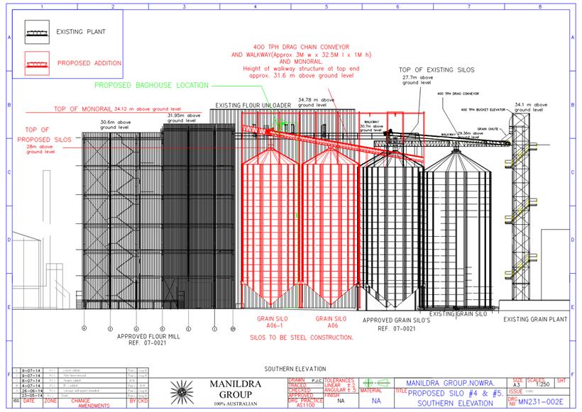
|
|
Development
Committee – Monday 07 November 2016
Page
32
|
DE16.8 Development
Application – 25 Junction Street, Nowra – Lot 1 DP 81167 DP
DA. No: DA16/1369/4
HPERM Ref: D16/316144
Group: Planning
& Development Services Group
Section: Development
Services
Attachments:
1. Draft Development
Consent (under separate cover)⇨
2. Section
79C Planning Assessment Report (under separate cover)⇨
3. Draft
Refusal (under separate cover)⇨
Description of Development: Three (3) Single
Storey Dwellings
Owner: Janack Nominees Pty Ltd
Applicant: Formerly Hotondo Homes, Lee Carmichael
Town Planning (LCTP as of 14 October 2016)
Notification Dates: 5 – 20 April 2016, 1- 16
June 2016 and 1 – 12 August 2016.
No. of Submissions: Seven (7) objections -
first notification, Six (6) - second and nil for the third. No
submissions were made in support.
Purpose
/ Reason for consideration by Council
The Council considered the
subdivision component of the development application (DA) on 10 October
2016. This report is in response to item 3 of the resolution which is
reproduced in full below. Further, the applicant has amended the DA to
remove the subdivision component of the development.
1. That the
variation to the minimum lot size not be supported
2. That Council
review the zoning in this location with a view to change to R2 in Central Nowra
3. If necessary the
General Manager report back to the Development Committee on the 79c assessment
for the subject application, given the extent of public interest in the
development application.
4. The General
Manager also report back on Development Guidelines that could be adopted to
assist in preserving the character of central Nowra. In addition could Council
report back on ways that it could work with the Old Houses Our History group to
identify the most significant streetscapes for additional consideration for
preservation / protection
|
Recommendation
(Item to be determined under delegated authority)
That the Committee grant consent
to Development Application DA16/1369 for a multi-unit housing development, comprising,
3 single storey units with garages (2 x 3 bedroom and 1 x 2 bedroom) in
accordance with the conditions as detailed in Attachment 1.
|
Options
1. Determine the DA
conditional approval as recommended in the section 79C assessment report.
Refer to Attachments 1 and 2. This option allows the development to
proceed as proposed and will provide for additional dwelling choice close to
the Nowra CBD. .
Implications: This option is unlikely to satisfy the adjoining
neighbours. The neighbours could chose to exercise their appeal
rights (on process not merit) in the Land and Environment Court
2. Refuse the DA and state
reasons for refusal based on planning grounds. Refer to Attachment 3
– reasons for Refusal.
Implications: The neighbours may be satisfied with this
outcome and the status quo would be maintained. However the applicant
would most likely pursue the refusal in the Land and Environment Court.
3. Adopt an alternative
recommendation and provide direction to staff.
Location
Background
Proposed Development
The DA proposes removal of an
existing shed. Construction of a 2 x 3 bedroom and 1 x 2 bedroom single storey
dwellings.
The DA does not propose removal
of the existing residence as the intention is to obtain a Complying Development
Certificate (CDC). Complying Development is a fast track approval process
for straightforward development types that meets specific criterial which can
be determined by a Council or accredited certifier without the need for a full
development application.
Development Consent has been
granted for the dwelling to be relocated to a property in Milton via
Development Consent DA16/1675.
Subject Land
The subject land is within an
established residential area zoned R1 – General Residential under the
Shoalhaven Local Environmental Plan 2014 (SLEP 2014). It has direct
frontage to Junction Street and is vicinity to heritage items but is not
heritage listed itself.
The land has a regular
rectangular shape with an area of 815.69 square metres and is joined by single dwellings
on either side. St Michael’s Catholic Primary School adjoins at the
rear. The site has a slight fall away from the street and does not
contain any easements. Sewer is connected.
Site & Context
The site is occupied by an older
style weatherboard and iron roof cottage. A fibro single storey garage is
also situated on the site. A large Jacaranda tree is located in the road
reserve. The site is located in an older established part of Nowra containing a
mixture of dwelling types.
The site is located about 450m
from the Shoalhaven River which triggers consideration of the State’s
State Environmental Planning Policy 71 – Coastal Protection.
History
The DA was lodged in March
2016. The DA had a lengthy assessment largely attributable to design
issues including streetscape impacts and some non-compliances which were
essentially resolved through the assessment process. Significantly, this
included the removal of parking in the front setback area and a substantial
change to the building design changing it from a modern contemporary design
with low pitched skillion roof to a more traditional hipped roof form evident
in the street.
Issues
In short, there were two key
issues with this application.
· The
variation to the development standard being 350 square metres for the
subdivision. The standard is called up via clause 4.1C of the Shoalhaven
Local Environmental Plan 2014.
· The
design and density compatibility of the development with the character of the
area. The area contains a mixture of dwellings, including older style
homes, some of which are heritage ‘listed’ (in the SLEP
2014). The street is ‘listed’.
The subdivision component of the
application has now been withdrawn. It is noted that whilst the
subdivision has been withdrawn, the applicant may, as is the case with any
multi dwelling housing development, chose to lodge a subsequent application for
subdivision for either Strata or Community Title or pursue Strata subdivision
title via Part 6 of the State Environmental Planning Policy (SEPP) (Exempt and
Complying Development Codes) 2007. Under this SEPP, Strata subdivision
can be complying development in certain circumstances. The Complying
Development Certificate (CDC) can be issued by Council or a private certifier and
does not require a formal development application.
The attached section 79C report
discusses issues of streetscape, character and heritage.
Planning
Assessment
The DA has been assessed under
s79C of the Environmental Planning and Assessment Act 1979. The assessment
considers matters prescribed by s79C including but not limited to planning
instruments, Council’s Development Control Plan, site suitability,
impacts of the development and public interest.
Policy Implications
The key planning controls are
the Shoalhaven Local Environmental Plan 2014 and Shoalhaven Development Control
Plan 2014.
Shoalhaven Local
Environmental Plan 2014 (SLEP 2014) [
The application proposes multi
dwelling housing. The development is permissible
Shoalhaven Development
Control Plan (DCP) 2014
A detailed assessment has been
made against the DCP and is attached. The DCP contains various chapters
including a specific chapter on multi dwelling housing. The proposal has
been assessed against the DCP and is considered generally satisfactory. There
are some minor variations which are detailed in the section 79C report and
associated checklist.
Consultation and Community
Engagement:
Seven (7) public submissions
were received in relation to Council’s notification of the development.
Six (6) were received following a second notification and nil following the
third and final notification. All were objections to the
development. The notification was made in accordance with Council’s
Community Consultation Policy.
Key issues raised as a result of
the notification included (but were not limited to):
· impact
on heritage;
· unsympathetic
development;
· the
existing building should be retained;
· parking
and traffic impacts;
· inadequate
on-site parking;
· adverse
impacts on the economy and tourism; and
· drainage.
Further details on the above
issues raised are provided in the section 79C Assessment Report.
Financial Implications:
In the event that Council
decides to refuse the development, the applicant has the right to lodge an
appeal with the Land and Environment Court. Litigation has cost
implications for Council. Further, the objectors could also seek to
challenge Council’s decision if approved, however this can legally only
relate to the process followed by Council not the merits of the application.
Again, this has potential cost implication for Council.
Legal Implications
An appeal with the Land and
Environment Court is possible with respect to either an approval or
refusal. The applicant also has the option to request an 82A Review in
the event of a refusal which would mean that the matter would be brought before
the Council again for reconsideration. A request for a Review or the
lodgement of an appeal must be made within 6 months of the date of
determination.
Summary and Conclusion
The proposal has been assessed
under section 79C of the Environmental Planning and Assessment Act 1979 and
found to be satisfactory. There have been no substantive planning
reasons or significant defects with the application to justify recommending a
refusal.
The modifications to the design,
have improved the street appearance of the development which is considered a
key concern, notably the roof design. Conditions have been recommended which
will assist in mitigating any impact and addressing any detailed issues.
With specific regard to the zone
objectives contained in the Shoalhaven Local Environmental Plan 2014 and
Council’s development controls, the development is considered capable of
support.
|
|
Development Committee
– Monday 07 November 2016
Page
36
|
DE16.9 Possible
Planning Proposal - The Wool Road, St Georges Basin
HPERM Ref: D16/319525
Group: Planning
& Development Services Group
Section: Strategic
Planning
Purpose / Summary
To obtain Council direction on a
possible Planning Proposal (PP) for Lot 7 DP 827728 and Lot 218 1071257, The
Wool Road, St Georges Basin given the policy issues involved.
|
Recommendation (Item to be determined
under delegated authority)
1. Provide in principle support for the
proposal to jointly rezone Lot 7 DP 827728 and Lot 218 1071257, subject to
the following:
a. Any loss of industrial zoned land
being offset by the identification of new industrial zoned land.
b. A detailed biodiversity assessment
being completed prior to formally considerring a Planning Proposal over the
site.
c. An
odour asssessment being completed within the identified buffer area around
the Sewerage Treatment Plant following Gateway determination.
2. Seek initial input from the NSW Department
of Planning and Environment in regard to the proposed Planning Proposal,
particularly in regard to the strategic issue of maintenance of industrial
zoned land.
3. Notify the proponents of the Council
resolution, the outcome of consultation with the NSW Department of Planning
and Evironment and the studies that need to be prepared to support a formal
Planning Proposal.
4. Encourage the proponents to have
early discussions with the Basin Villages Forum in regard to the Planning
Proposal should it proceed to formal lodgement.
5. Report back to Council when a formal
Planning Proposal has been lodged, following the completion of the necessary
studies.
|
Options
1. Adopt the recommendation outlined
above.
Implications – this option is
preferred as the proposal has some strategic merit, and it allows Council to
consider the environmental impacts of the proposal before formally considering
the PP for Gateway determination. It also gives the proponents some ‘policy’
certainty (albeit with conditions) before they prepare the full range of
studies required to support a PP.
2. Not support the proposed Planning
Proposal.
Implications – this option
is not preferred, as the proposal is considred to have some strategic merit, subject
to a detailed biodiveristy assessment and other required studies.
3. Give an alternate direction to staff
on Council’s preferred direction for this proposed Planning Proposal.
Background
Council recently received
preliminary PP information from Tovedale Developments to consider the jointly
rezoning Lot 218 DP 1071257 (eastern parcel) from IN2 Light Industrial to a low
density residential zone, and Lot 7 DP 827728 (western parcel) from RU2 Rural
Landscape to IN2 Light Industrial under Shoalahven Local Environmental Plan
(LEP) 2014. Both parcels are owned by the company.
The proposal essentially seeks
to allow for new residential development, whilst also maintaining a stock of
industrial zoned land within the St Georges Basin area for the future. The
subject lands and their existing land use zones are shown in Figure 1 below.
Figure 1: Current Land Use Zones
Prior to receiving the
preliminary PP information, Council staff had been involved in preliminary
discussions with the proponent, who originally proposed to rezone Lot 218 DP
1071257 (eastern parcel) from IN2 Light Industrial to a low density residential
zone as a possible stand alone rezoning.
However, the original proposal
was considered to be potentially inconsistent with Section 117 Ministerial
Direction 1.1 - Business and Industrial Zones, which seeks to ensure that
Planning Proposals do not reduce total potential floor space area for
industrial uses. Therefore, Council staff advised the proponent that the
proposal on its own would be unlikely to be supported by the Department of
Planning and Environment (DP&E) due to this incosistency.
To address this incosistency,
the current proposal seeks to offset the loss of industrial land by also
rezoning Lot 7 DP 827728 (western parcel) from RU2 Rural Landscape to IN2 Light
Industrial.
However, the current proposal,
whilst seeking to maintain a stock of industrial zoned land for the future, may
result in an overall reduction in industrial zoned land. Given that this
issue is key to the proposal, the report seeks in principal support from
Council from a policy perspective, so that the matter can be discussed with the
NSW D P & E prior to the proponent possibly undertaking the necessary
studies to support a formal PP.
In regard to Lot 218 DP 1071257
(eastern parcel), it is understood that a development consent was issued over
the subject land for in 1991 (SF7083) for a resi-industrial subdivision
comprising 37 residential/industrial lots. Again it is undestood that this
subdivision consent has been secured and could be acted on. The proponents have
suggested that given the approved 37 lots covered an area of 11.53 ha and given
that half of each lot would be used for residential purposes and the other half
for industrial use that 5.76 ha would end up allocated to light industrial use.
The proponents have also noted that Lot 7 DP 827728 (western parcel) has an
area of 5.77 ha and as such they see this joint proposal as essentially
maintaining the status quo in terms of zoned industrial land supply.
It ia also noted that Lot 7 DP
827728 (western parcel) is within the area identified in the former Jervis Bay
Regional Environmental Plan (REP) as a “new urban release” area. As
a result the Jervis Bay Settlement Strategy (2003) identifies Lot 7 and
adjoining land as a “possible urban expansion”.
Additional
studies to support a Planning Proposal
As outlined above, the proponent
has submitted preliminary PP information and is seeking in principal support
from the Council and advice from the D P & E on the policy issue
prior to undertaking the additional strategic work required to support a formal
PP.
If Council is to give in
principle support for the proposal to proceed further and the policy issue is
resolved, a number of environmental assessments will still need to be
undertaken over the subject land, particularly over Lot 7 DP 827728 (western
parcel), which is proposed to be rezoned from a rural to an industrial
zone.
A detailed biodiversity
assessment needs to be undertaken on the subject lot to determine the presence
of any endangered flora or fauna prior to consideration of rezoning the site.
The proponents consultant has identified the likely presence of an Endangered
Ecological Community (EEC) on Lot 7 (see Figure 2 below) and a more detailed
assessment is required that considers the impact of the proposed rezoning on
the EEC.
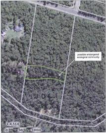
Figure 2: Extract from preliminary biodiversity
assessment
A number of other threatened
species are known to exist in this locality. Lot 7 has habitat consistent
with that often used by these threatened fauna species and further surveys will
be needed to examine the importance of these resources for any resident
threatened species. The critically endangered orchid Pterostylis
Ventricosa is also known to exist in this locality, and the additional
biodiversity assessment will need to include targeted surveys for this species.
The additional biodiversity
assessment will need to determine if or how much of the site is High
Conservation Value (HCV) land, and these areas will potentially need to remain
in a rural or environmental protection zone. As this site is being used to
offset the loss of industrial land (and therefore allow the proposal to be
considered), it is recommended that the biodiversity assessment be completed
prior to Council considering a formal PP over the site.
As shown in Figure 3 below, Lot
218 DP 1071257 (eastern parcel) is entirely within the LEP buffer area for the
adjacent St.Georges Basin Sewerage Treatment Plant and it is recommended that
an odour assessment be prepared if the proposal recieves a Gateway
determination, to consider the potential impact of this issue on the proposed
rezoning.
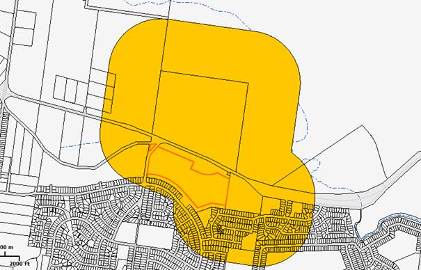
Figure 3: Sewerage Treatment Plant Buffer
Community Engagement
If a formal PP is lodged and
ultimately supported by Council and the NSW Department of Planning &
Environment, the PP will be exhibited in accordance with the requirements of
the Environmental Planning and Assessment Act 1979 and any other requirements
as determined by the Gateway process.
Council may also carry out
informal notification of the formal PP after it is lodged and before it is
initially considered by Council. This will provide adjoining owners and the
broader community an early opportunity to review the formal PP.
It is also recommeded that the
proponents be encouraged to have early discussions with the Basin Villages
Forum in regard to the PP should it proceed further to formal lodgement.
Policy Implications
Approval of the PP will require
an amendment to Shoalhaven LEP 2014 through a formal PP process.
This is essentially a joint
rezoning of two separate, but linked parcels of land. Thus should, for whatever
reason (eg. biodiversity constraints) one of the parcels be found to be
constrained or its development limited, then the rezoning may not be able to
proceed.
Financial Implications
The proponent will be required
to pay the Planning Proposal fees in accordance with Council’s fees and
charges if and when they submit a formal PP. The proponent is also required to
fund and/or undertake any studies associated with the PP.
|

|
Development
Committee – Monday 07 November 2016
Page
41
|
DE16.10 Central
Nowra Residential Zones - Character Related Development Controls
HPERM Ref: D16/320236
Group: Planning
& Development Services Group
Section: Strategic
Planning
Purpose / Summary
To report on the engagement of an urban design consultant to
undertake an analysis of the character of central Nowra and provide
recommendations on suitable mechanisms to maintain character and encourage an
appropriate mix of density and high quality housing, following the recent
Council resolution in this regard.
|
Recommendation (Item to be determined
under delegated authority)
That Council:
1. Finalise the character analysis that
is currently underway in central Nowra, including the planned consultation
with the Old Houses Our History group, landowners and other key stakeholders.
2. Following the completion of the
character analysis, Council:
a. Receive a further report on the
outcomes of the consultants work including recommendations on suitable
mechanisms to protect the character of central Nowra.
b. Identify specific locations to be
considered for a backzoning to an R2 Low Density Residential Zone, where
appropriate.
c. Prepare a set of detailed planning
and character development controls that seek to maintain the character of the
central Nowra area.
|
Options
1. Adopt the recommendation – this
will enable the character analysis work that is currently being undertaken to
be completed and then consider specific areas for back zoning arising from the
detailed character analysis and targeted consultation.
Implications: This will provide a complete analysis
of the study area to then allow for an informed decision on a preferred
approach moving forward. This could be achieved through potential rezoning,
additional heritage provisions and/or detailed development controls.
2. Proceed to review and revise the zones
in central Nowra prior to the consultants works being completed
Implications: Back zoning properties that are
currently zoned R1 and R3 in central Nowra would be inconsistent with State and
Council Strategy, and contrary to the recent background research completed for
affordable housing in the area. It is unlikely that the Department of
Planning & Environment would support a back zoning for the purposes of
preserving the character of central Nowra without sufficient justification, and
given that there may be other more suitable options. As such the character
analysis work could assist in this regard.
Background
Urban design consultants, Studio
GL Pty Ltd have recently been engaged to undertake a review of the residential
zoned area to the west and south west of the Nowra CBD to consider how recent
medium density developments have and could continue to impact on or influence
the character of the area, and recommend ways in which development controls
could encourage a mix of density and high quality housing consistent within the
existing zones, whilst respecting the existing character of central Nowra.
The consultant has already
acknowledged that the existing character of this area is predominantly detached
single storey dwellings on large sites with a number of heritage items located
throughout. Approved and proposed development in this area is showing the
influence of development pressures and the replacement of existing housing with
new development has the capacity to irreversibly change the character of the
area.
The work underway initially
involves undertaking an analysis and review of the area to the west and the
south of the Nowra CBD which is predominantly zoned R1 General Residential, R2
Low Density Residential and R3 Medium Density Residential (as outlined in red
in Figure 1) under Shoalhaven Local Environmental Plan (LEP) 2014.
The primary objective of this
work is to review whether recent development applications are typical of what
can be expected under the current controls and the likely impact of leaving the
current controls unchanged. The initial stage will involve an analysis
and review of the area to identify typical character areas guided by the
current zoning and desired future character. As part of this first stage
it is proposed that a workshop be held with key stakeholders including the
‘Old Houses, Our History’ (OHOH) group to identify their objectives
and vision for the future development of this area.
The work
will also involve a review of how other Councils have addressed similar
challenges in encouraging greater variety and increased medium density housing
without unduly influencing the existing character. The study will finally
recommend what, if any, controls are required to encourage an appropriate mix
of density and high quality housing in the study area going forward. It
is anticipated that the detailed character analysis will be completed by the
end of November, prior to a targeted consultation with landowners, the OHOH
group and other relevant stakeholders.
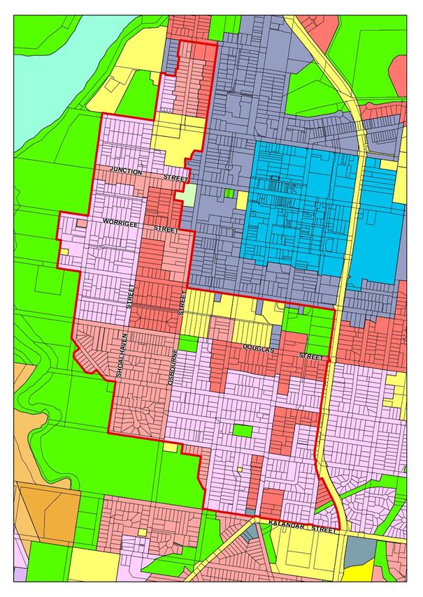
Figure 1 –
Study Area (outlined in red)
Since engaging Studio GL Pty Ltd,
Council’s Development Committee considered a Development Application (DA)
at 25 Junction Street Nowra, and resolved under delegation, in part (MIN
16.761):
2. That Council review the zoning in
this location with a view to change to R2 in Central Nowra
….
4. The General Manager also
report back on Development Guidelines that could be adopted to assist in
preserving the character of central Nowra. In addition could Council report
back on ways that it could work with the Old Houses Our History group to
identify the most significant streetscapes for additional consideration for
preservation / protection.
The second part of the resolution
predetermines the outcome of the work currently being undertaken by Studio GL
Pty Ltd without considering the analysis of character and the
consultant’s recommendations on suitable mechanisms to encourage an
appropriate mix of density and high quality housing. The fourth part of
the resolution can be achieved through the work which the consultant has been
engaged to do.
Current zoning
The study area is predominantly
zoned under Shoalhaven LEP2014 for residential purposes being R1, R2 and R3
with some small pockets of SP2 Infrastructure (Schools and Places of Public
Worship), RE1 Public Recreation and B4 Mixed Use.
The study area underwent some
changes in zones at the introduction of the Shoalhaven Local Environmental Plan
(LEP) 2014. The rationale for the changes were based on the strategic
direction and implementation of the Nowra-Bomaderry Structure Plan (2008) which
had identified that residential land within 800m of the Nowra CBD to the west
and the south as having potential to increase population living in close
proximity to the centre. Increasing the population in this area was seen
to have a positive impact on the vitality of the Nowra CBD by providing
increased housing close to the centre, decreasing dependency on private
vehicles, and making use of existing infrastructure. This is also consistent
with the more recent work being undertaken for Council in regard to housing
affordability, which has identified a significant undersupply of affordable
housing in close proximity to key centres.
Undertaking a review of the
zones with a view to changing areas in central Nowra to the R2 Low Density
Residential zoning will result in a potential ‘back zoning’ which
is inconsistent with endorsed Council and State Government Strategies being the
Nowra-Bomaderry Structure Plan and more recent Illawarra-Shoalhaven Regional
Plan. In particular, there are directions in these plans related to
providing sufficient housing supply and choice, and supporting housing
opportunities close to existing services, jobs and infrastructure in the
region’s centres. The Nowra Centre is specifically identified in
the Regional Plan as a higher order centre. On this basis, it is considered
unlikely that the Department of Planning & Environment would support a
planning proposal to back zone the land to R2 Low Density Residential, without
sufficient justification. Therefore, it is recommended that Council
finalise the character analysis, before considering specific areas to pursue
for back zoning.
Community Engagement
As part of the current character
analysis work that is currently being undertaken, Council’s consultant
will facilitate a workshop with relevant stakeholders including the OHOH
group. Their input will involve identifying their objectives and vision for
the future development of the area and also potentially key areas or sites to
be given specific consideration.
|
|
Development
Committee – Monday 07 November 2016
Page
45
|
Local Government Amendment (governance &
planning) act 2016
Chapter
3, Section 8A Guiding principles for councils
(1)
Exercise of functions
generally
The
following general principles apply to the exercise of functions by councils:
(a) Councils should provide strong
and effective representation, leadership, planning and decision-making.
(b) Councils should carry out functions
in a way that provides the best possible value for residents and ratepayers.
(c) Councils should plan
strategically, using the integrated planning and reporting framework, for the
provision of effective and efficient services and regulation to meet the
diverse needs of the local community.
(d) Councils should apply the
integrated planning and reporting framework in carrying out their functions so
as to achieve desired outcomes and continuous improvements.
(e) Councils should work
co-operatively with other councils and the State government to achieve desired
outcomes for the local community.
(f) Councils should manage
lands and other assets so that current and future local community needs can be
met in an affordable way.
(g) Councils should work with
others to secure appropriate services for local community needs.
(h) Councils should act fairly,
ethically and without bias in the interests of the local community.
(i) Councils should be
responsible employers and provide a consultative and supportive working
environment for staff.
(2) Decision-making
The
following principles apply to decision-making by councils (subject to any other
applicable law):
(a) Councils should recognise
diverse local community needs and interests.
(b) Councils should consider social
justice principles.
(c) Councils should consider the
long term and cumulative effects of actions on future generations.
(d) Councils should consider the
principles of ecologically sustainable development.
(e) Council decision-making should be
transparent and decision-makers are to be accountable for decisions and
omissions.
(3) Community participation
Councils
should actively engage with their local communities, through the use of the
integrated planning and reporting framework and other measures.
Chapter
3, Section 8B Principles of sound financial management
The
following principles of sound financial management apply to councils:
(a) Council spending should be responsible and
sustainable, aligning general revenue and expenses.
(b) Councils should invest in responsible and
sustainable infrastructure for the benefit of the local community.
(c) Councils should have effective financial
and asset management, including sound policies and processes for the following:
(i) performance management
and reporting,
(ii) asset maintenance and
enhancement,
(iii) funding decisions,
(iv) risk management practices.
(d) Councils should have regard to achieving
intergenerational equity, including ensuring the following:
(i) policy decisions are made
after considering their financial effects on future generations,
(ii) the
current generation funds the cost of its services
Chapter
3, 8C Integrated planning and reporting principles that apply to councils
The
following principles for strategic planning apply to the development of the
integrated planning and reporting framework by councils:
(a) Councils should identify and prioritise key
local community needs and aspirations and consider regional priorities.
(b) Councils should identify strategic goals to
meet those needs and aspirations.
(c) Councils should develop activities, and
prioritise actions, to work towards the strategic goals.
(d) Councils should ensure that the strategic
goals and activities to work towards them may be achieved within council
resources.
(e) Councils should regularly review and
evaluate progress towards achieving strategic goals.
(f) Councils should maintain an integrated
approach to planning, delivering, monitoring and reporting on strategic goals.
(g) Councils should collaborate with others to
maximise achievement of strategic goals.
(h) Councils should manage risks to the local
community or area or to the council effectively and proactively.
(i) Councils should make appropriate
evidence-based adaptations to meet changing needs and circumstances.